aircore drilling planned at challa following encouraging
TRANSCRIPT

Level 2, Suite 9, 389 Oxford Street Mt Hawthorn Western Australia 6016
Phone +61 (0)7 5580 9094 Email: [email protected]
www.platinaresources.com.au Platina Resources Limited | ABN 25 119 007 939 | ASX: PGM
ASX Announcement
7 October 2021
Aircore drilling planned at Challa following encouraging soil sampling program.
Platina Resources Limited (ASX: PGM) is planning an air core drilling program at the Challa Gold Project in Western Australia after receiving encouraging gold assay results from a comprehensive five phase soil geochemical survey.
The program consisted of 3,525 soil samples and used an innovative sampling method developed by the Australian research organisation, CSIRO. A number of drilling targets have been identified and will now be tested by aircore drilling once a Land Use Agreement has been signed with the traditional landowners, and an archaeological site clearance completed.
Platina Managing Director Corey Nolan said significant geochemical drill targets were found below the ubiquitous transported sheet wash soils that cover most of the tenements – see Figures 1 to 5.
“Platina’s proposed aircore drilling program will test these targets while also considering the interpreted structures developed from the regional aeromagnetic data,” Mr Nolan said.
“The technique has been successfully applied to other under cover gold discoveries in the Yilgarn like Bronzewing and Jundee.
“The aim of the aircore program is to define primary targets for future reverse circulation drilling and we’re looking forward to getting started ahead of summer and the cyclone season,” he said.
The Challa tenements, E58/552 and E58/553, cover 293km2 and are located in-between the prolific Mt Magnet and Sandstone gold districts in Western Australia, 500km north-east of Perth.
The Sandstone province has produced over 1.3 million ounces of gold from numerous underground and open pit mining operations, while Mt Magnet produced over 6 million ounces since discovery in 1891. Nearby, the Youanmi Gold Mine produced 670,000 ounces of gold throughout its lifetime, and is currently the focus of new resource drilling of high-grade gold lodes.

2
The Challa Gold Project lies in-between the prolific Mt Magnet and Sandstone gold districts in Western Australia at the southwest end of the Paynesville Gold Trend.
This announcement was authorised by Mr Corey Nolan, Managing Director of Platina Resources Limited.
For more information:
Corey Nolan Gareth Quinn Managing Director Corporate Affairs Manager Phone +61 (0)7 5580 9094 Mobile: 0417 711 108 [email protected] [email protected]

3
ABOUT PLATINA RESOURCES
Platina is an Australian-based company focused on returning shareholder value by advancing early-stage metals projects through exploration, feasibility, permitting and into development.
The company has interests in the following projects:
• Xanadu Gold Project (100% interest) – located in the Ashburton Basin in Western Australia in close proximity to the Mt Olympus gold project, a multi-million ounce gold endowment;
• Challa Gold Project (100% interest) – Platina has acquired a 100% interest in the Challa Gold Project located between the prolific Mt Magnet and Sandstone gold districts in Western Australia, 500km north-east of Perth.
• Platina Scandium Project (100%) – located in central New South Wales, the project is one of the largest and highest-grade scandium deposits in the world, which has the potential to become Australia’s first scandium producer with cobalt, platinum and nickel credits.
• Munni Munni (30% interest) – Situated in the Pilbara region of Western Australia, the project is one of Australia’s most significant Platinum Group Metal occurrences. Munni Munni also has potential for conglomerate hosted gold and is a joint venture with Artemis Resources Limited.
• Investment in Blue Moon Zinc Corporation (6 million shares in TSXV listed MOON) – the Blue Moon Zinc Project has a NI43-101 resource which is open at depth and along strike and has favorable metallurgy.
• Investment in Major Precious Metals (49 million shares in NEO listed SIZE) – Major is a Canadian junior mining and exploration company whose flagship Skaergaard Project hosts one of the world’s largest undeveloped gold deposits and one of the largest palladium resources outside of South Africa and Russia.
For more information please see: www.platinaresources.com.au
DISCLAIMER
Statements regarding Platina Resources’ plans with respect to its mineral properties are forward-looking statements. There can be no assurance that Platina Resources’ plans for development of its mineral properties will proceed as currently expected. There can also be no assurance that Platina Resources will be able to confirm the presence of additional mineral deposits, that any mineralisation will prove to be economic or that a mine will successfully be developed on any of Platina Resources’ mineral properties.
REFERENCES TO PREVIOUS ASX RELEASES
The information in this report that relates to Exploration Results were last reported by the company in compliance with the 2012 Edition of the JORC Australasian Code for Reporting of Exploration Results, Mineral Resources and Ore Reserves in market releases dated as follows:
• Platina acquires gold project in prolific gold province, 11th June 2020
The company confirms that it is not aware of any new information or data that materially affects the information included in the market announcements referred above and further confirms that all material assumptions underpinning the exploration results contained in those market releases continue to apply and have not materially changed.
COMPETENT PERSON STATEMENT
The information in this Report that relates to Challa exploration results is based on information reviewed and compiled by Mr Phil Jones who is an independent consultant geologist and Member of the Australian Institute of Geoscientists (AIG) and Australian Institute of Mining and Metallurgy (AusIMM). Mr Jones has sufficient experience which is relevant to this style of mineralisation and type of deposit under consideration and to the overseeing activities which he is undertaking to qualify as a Competent Person as defined in the 2004 and 2012 Editions of the “Australasian Code for Reporting of Exploration Results, Minerals Resources and Ore Reserves’. Mr Jones consents to the inclusion in the report of the matters based on his information in the form and context in which it appears.

4
Overview of the Completed Soil Sampling Program
Soil sampling targeting aeromagnetic and outcropping mineralisation was completed across the tenement package. The program using an innovative sampling method developed by the Australian research organisation, CSIRO, and consisted of 3,525 soil samples.
Figure 1: Soil geochemistry sample locations.
The results from the main target areas (C, D, E, F, G, H and I – see Figure 1 for locations), including all the results from the last phase of sampling, colour coded by Au grade are depicted in the following figures as follows.

5
Figure 2: Areas C and D (see Figure 1 for locations) colour coded soil sampling results.

6
Figure 3: Area E (see Figure 1 for location) colour coded soil sampling results.
Figure 4: Areas F and G (see Figure 1 for locations) colour coded soil sampling results.

7
Figure 5: Areas H and I (see Figure 1 for locations) colour coded soil sampling results.

8
JORC Code Table
Section 1: Sampling Techniques and Data
Criteria JORC Code explanation Commentary
Sampling techniques • Nature and quality of sampling (e.g. cut channels, random chips, or specific specialised industry standard measurement tools appropriate to the minerals under investigation, such as down hole gamma sounds, or handheld XRF instruments, etc.). These examples should not be taken as limiting the broad meaning of sampling.
• Include reference to measures taken to ensure sample representivity and the appropriate calibration of any measurement tools or systems used.
• Aspects of the determination of mineralisation that are Material to the Public Report.
In cases where ‘industry standard’ work has been done this would be relatively simple (e.g. ‘reverse circulation drilling was used to obtain 1m samples from which 3 kg was pulverised to produce a 30 g charge for fire assay’). In other cases more explanation may be required, such as where there is coarse gold that has inherent sampling problems. Unusual commodities or mineralisation types (e.g. submarine nodules) may warrant disclosure of detailed information.
Rock Sampling:
• Each rock sample is a composite of approximately 5 pieces of rock collected from within a 3m radius of the recorded GPS sample point to give a total sample weight of approximately 1 kg to 2 kg.
• The samples were secured before being driven to the laboratory by the sampler.
• At the laboratory (ALS, Perth), the samples were crushed and pulverised using industry standards.
• The samples were assayed for Au using method AU-AA25 = Ore grade 30g fire assay with AA finish.
• Laboratory standard QA/QC procedures were carried out.
Soil Sampling
• Each soil sample was collected from the surface below trees and screened using a 1mm sieve to give a total sample weight of approximately 0.5 kg.
• The samples were secured before being driven to the laboratory by the sampler.
• At the laboratory (ALS, Perth), the samples were pulverised using industry standards.
• The samples were assayed for Au and multi-elements using method AUME-ST44 = Trace Au ppb.
• Laboratory standard QA/QC procedures were carried out.

9
Criteria JORC Code explanation Commentary
Drilling techniques Drill type (e.g. core, reverse circulation, open-hole hammer, rotary air blast, auger, Bangka, sonic, etc.) and details (e.g. core diameter, triple or standard tube, depth of diamond tails, face-sampling bit or other type, whether core is oriented and if so, by what method, etc.).
No drilling carried out by Platina.
Drill sample recovery • Method of recording and assessing core and chip sample recoveries and results assessed.
• Measures taken to maximise sample recovery and ensure representative nature of the samples.
Whether a relationship exists between sample recovery and grade and whether sample bias may have occurred due to preferential loss/gain of fine/coarse material.
No drilling carried out by Platina.
Logging • Whether core and chip samples have been geologically and geotechnically logged to a level of detail to support appropriate Mineral Resource estimation, mining studies and metallurgical studies.
• Whether logging is qualitative or quantitative in nature. Core (or costean, channel, etc.) photography.
• The total length and percentage of the relevant intersections logged.
No drilling carried out by Platina.
Sub-sampling techniques and sample preparation
• If core, whether cut or sawn and whether quarter, half or all core taken.
• If non-core, whether riffled, tube sampled, rotary split, etc. and whether sampled wet or dry.
• For all sample types, the nature, quality and appropriateness of the sample preparation technique.
• Quality control procedures adopted for all sub-sampling stages to maximise representivity of samples.
• Measures taken to ensure that the sampling is representative of the in situ material collected, including for instance results for field duplicate/second-half sampling.
Not applicable. No drilling carried out by Platina.
10
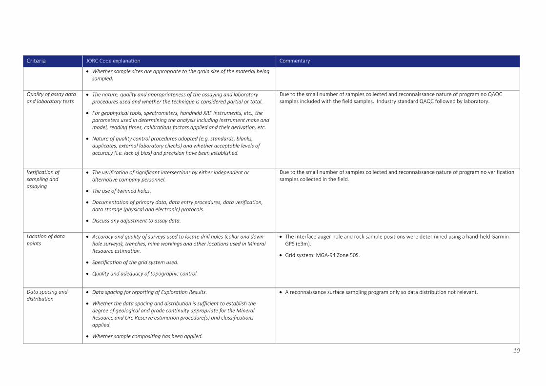
Criteria JORC Code explanation Commentary
• Whether sample sizes are appropriate to the grain size of the material being sampled.
Quality of assay data and laboratory tests
• The nature, quality and appropriateness of the assaying and laboratory procedures used and whether the technique is considered partial or total.
• For geophysical tools, spectrometers, handheld XRF instruments, etc., the parameters used in determining the analysis including instrument make and model, reading times, calibrations factors applied and their derivation, etc.
• Nature of quality control procedures adopted (e.g. standards, blanks, duplicates, external laboratory checks) and whether acceptable levels of accuracy (i.e. lack of bias) and precision have been established.
Due to the small number of samples collected and reconnaissance nature of program no QAQC samples included with the field samples. Industry standard QAQC followed by laboratory.
Verification of sampling and assaying
• The verification of significant intersections by either independent or alternative company personnel.
• The use of twinned holes.
• Documentation of primary data, data entry procedures, data verification, data storage (physical and electronic) protocols.
• Discuss any adjustment to assay data.
Due to the small number of samples collected and reconnaissance nature of program no verification samples collected in the field.
Location of data points
• Accuracy and quality of surveys used to locate drill holes (collar and down-hole surveys), trenches, mine workings and other locations used in Mineral Resource estimation.
• Specification of the grid system used.
• Quality and adequacy of topographic control.
• The Interface auger hole and rock sample positions were determined using a hand-held Garmin GPS (±3m).
• Grid system: MGA-94 Zone 50S.
Data spacing and distribution
• Data spacing for reporting of Exploration Results.
• Whether the data spacing and distribution is sufficient to establish the degree of geological and grade continuity appropriate for the Mineral Resource and Ore Reserve estimation procedure(s) and classifications applied.
• Whether sample compositing has been applied.
• A reconnaissance surface sampling program only so data distribution not relevant.

11
Criteria JORC Code explanation Commentary
Orientation of data in relation to geological structure
• Whether the orientation of sampling achieves unbiased sampling of possible structures and the extent to which this is known, considering the deposit type.
• If the relationship between the drilling orientation and the orientation of key mineralised structures is considered to have introduced a sampling bias, this should be assessed and reported if material.
• A reconnaissance surface sampling program only so data orientation not relevant.
Sample security • The measures taken to ensure sample security. • The samples were driven by the collector securely to the laboratory with appropriate documentation listing sample numbers, sample batches, and required analytical methods and element determinations.
Audits or reviews • The results of any audits or reviews of sampling techniques and data. No audits have been conducted.
12
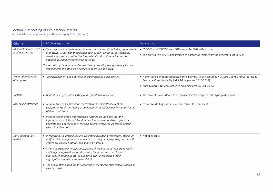
Section 2 Reporting of Exploration Results (Criteria listed in the preceding section also apply to this section.)
Criteria JORC Code explanation Commentary
Mineral tenement and land tenure status
• Type, reference name/number, location and ownership including agreements or material issues with third parties such as joint ventures, partnerships, overriding royalties, native title interests, historical sites, wilderness or national park and environmental settings.
The security of the tenure held at the time of reporting along with any known impediments to obtaining a licence to operate in the area.
• E58/552 and E58/553 are 100% owned by Platina Resources.
• The only Native Title Claim affected the area was rejected by the Federal Court in 2015.
Exploration done by other parties
• Acknowledgment and appraisal of exploration by other parties. • Historical exploration conducted principally by Aarex Resources NL (1996-1997), and Corporate & Resource Consultants Pty Ltd & BR Legendre (2016-2017)
• Apex Minerals NL were active in adjoining areas (2004-2006).
Geology • Deposit type, geological setting and style of mineralisation. • The project is considered to be prospective for orogenic lode-type gold deposits.
Drill hole Information • A summary of all information material to the understanding of the exploration results including a tabulation of the following information for all Material drill holes:
• If the exclusion of this information is justified on the basis that the information is not Material and this exclusion does not detract from the understanding of the report, the Competent Person should clearly explain why this is the case.
• No known drilling has been conducted on the tenements.
Data aggregation methods
• In reporting Exploration Results, weighting averaging techniques, maximum and/or minimum grade truncations (e.g. cutting of high grades) and cut-off grades are usually Material and should be stated.
• Where aggregate intercepts incorporate short lengths of high grade results and longer lengths of low grade results, the procedure used for such aggregation should be stated and some typical examples of such aggregations should be shown in detail.
• The assumptions used for any reporting of metal equivalent values should be clearly stated.
• Not applicable.
13
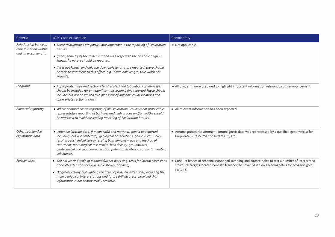
Criteria JORC Code explanation Commentary
Relationship between mineralisation widths and intercept lengths
• These relationships are particularly important in the reporting of Exploration Results.
• If the geometry of the mineralisation with respect to the drill hole angle is known, its nature should be reported.
• If it is not known and only the down hole lengths are reported, there should be a clear statement to this effect (e.g. ‘down hole length, true width not known’).
• Not applicable.
Diagrams • Appropriate maps and sections (with scales) and tabulations of intercepts should be included for any significant discovery being reported These should include, but not be limited to a plan view of drill hole collar locations and appropriate sectional views.
• All diagrams were prepared to highlight important information relevant to this announcement.
Balanced reporting • Where comprehensive reporting of all Exploration Results is not practicable, representative reporting of both low and high grades and/or widths should be practiced to avoid misleading reporting of Exploration Results.
• All relevant information has been reported.
Other substantive exploration data
• Other exploration data, if meaningful and material, should be reported including (but not limited to): geological observations; geophysical survey results; geochemical survey results; bulk samples – size and method of treatment; metallurgical test results; bulk density, groundwater, geotechnical and rock characteristics; potential deleterious or contaminating substances.
• Aeromagnetics: Government aeromagnetic data was reprocessed by a qualified geophysicist for Corporate & Resource Consultants Pty Ltd.
Further work • The nature and scale of planned further work (e.g. tests for lateral extensions or depth extensions or large-scale step-out drilling).
• Diagrams clearly highlighting the areas of possible extensions, including the main geological interpretations and future drilling areas, provided this information is not commercially sensitive.
• Conduct fences of reconnaissance soil sampling and aircore holes to test a number of interpreted structural targets located beneath transported cover based on aeromagnetics for orogenic gold systems.