aircraft accident report 3/2014 accident report 3/2014 report on the accident to agusta a109e,...
TRANSCRIPT

AIRCRAFT ACCIDENT REPORT 3/2014
Report on the accident toAgusta A109E, G-CRST
Near Vauxhall Bridge, Central Londonon 16 January 2013
AIR
CR
AFT A
CC
IDEN
T REPO
RT 3/2014
G-C
RST
AAIBAir Accidents Investigation Branch

AIRCRAFT ACCIDENT REPORT 3/2014
Report on the accident toAgusta A109E, G-CRST
Near Vauxhall Bridge, Central Londonon 16 January 2013
AIR
CR
AFT A
CC
IDEN
T REPO
RT 3/2014
G-C
RST
AAIBAir Accidents Investigation Branch

AIRCRAFT ACCIDENT REPORT 3/2014
Air Accidents Investigation Branch
Report on the accident toAgusta A109E, G-CRST
Near Vauxhall Bridge, Central Londonon 16 January 2013
This investigation has been conducted in accordance with Annex 13 to the ICAO Convention on International Civil Aviation,
EU Regulation No 996/2010 and The Civil Aviation (Investigation of Air Accidents and Incidents) Regulations 1996.
The sole objective of the investigation of an accident or incident under these Regulations is the prevention of future accidents and incidents. It is not the purpose of such
an investigation to apportion blame or liability.
Accordingly, it is inappropriate that AAIB reports should be used to assign fault or blame or determine liability, since neither the investigation nor the reporting process has been
undertaken for that purpose.
ii
Printed in the United Kingdom for the Air Accidents Investigation Branch
This report contains facts which have been determined up to the time of publication. This information is published to inform the aviation industry and the public of the general circumstances of accidents and serious incidents.
Extracts may be published without specific permission providing that the source is duly acknowledged, the material is reproduced accurately and it is not used in a derogatory manner or in a misleading context.
Published 9 September 2014
© Crown Copyright 2014
iii© Crown Copyright 2014
Air Accidents Investigation BranchFarnborough HouseBerkshire Copse RoadAldershotHampshire GU11 2HH
August 2014
The Right Honourable Patrick McLoughlinSecretary of State for Transport
Dear Secretary of State
I have the honour to submit the report by Mr Julian Firth, an Inspector of Air Accidents, on the circumstances of the accident to Agusta A109E, registration G-CRST, near Vauxhall Bridge, Central London on 16 January 2013. Yours sincerely
Keith ConradiChief Inspector of Air Accidents


v
Air Accident Report: 3/2014 G-CRST EW/C2013/01/02
© Crown Copyright 2014 Contents
Contents
Synopsis........................................................................................................................... 1
1 Factual information ................................................................................................ 21.1 History of the flight .......................................................................................... 2
1.1.1 Narrative of events ............................................................................ 21.1.2 Text messages and phone calls ........................................................ 81.1.3 Witness information .......................................................................... 9
1.1.3.1 Thames Radar controller ................................................ 91.1.3.2 Other witness information ............................................. 10
1.2 Injuries to persons ......................................................................................... 10
1.3 Damage to the helicopter .............................................................................. 10
1.4 Other damage ................................................................................................11
1.5 Personnel information ................................................................................... 121.5.1 Pilot ................................................................................................. 12
1.6 Aircraft information ........................................................................................ 121.6.1 Aircraft description .......................................................................... 121.6.2 Cockpit instruments ........................................................................ 131.6.3 GPS devices ................................................................................... 13
1.6.3.1 Terrain and obstacle warning........................................ 141.6.3.2 Database update .......................................................... 15
1.7 Meteorological information ............................................................................ 151.7.1 Met Office report ............................................................................. 151.7.2 Redhill Aerodrome Weather ........................................................... 171.7.3 London City Airport weather ............................................................ 18
1.7.3.1 Meteorological forecast issued at 0459 hrs .................. 181.7.3.2 Meteorological conditions at 0750 hrs .......................... 18
1.7.4 London Heathrow Airport weather .................................................. 181.7.4.1 Meteorological forecast issued at 0457 hrs .................. 181.7.4.2 Meteorological conditions at 0750 hrs .......................... 19
1.7.5 London Heliport weather ................................................................. 19
1.8 Aids to navigation .......................................................................................... 19
1.9 Communications ........................................................................................... 191.9.1 Notice to Airmen (NOTAM) .............................................................. 191.9.2 UK Aeronautical Information Service (AIS) ..................................... 20
1.10 Aerodrome information ................................................................................. 201.10.1 General ........................................................................................... 201.10.2 Weather minima .............................................................................. 201.10.3 Circuits ............................................................................................ 20

vi
Air Accident Report: 3/2014 G-CRST EW/C2013/01/02
© Crown Copyright 2014 Contents
1.11 Flight recorders ............................................................................................. 211.11.1 Radar .............................................................................................. 21
1.11.1.1 Use of autopilot............................................................. 221.11.2 Data from onboard electronics ........................................................ 231.11.3 CCTV .............................................................................................. 231.11.4 Helicopter operations along H4 in December 2012 ........................ 23
1.12 Wreckage and impact information ................................................................ 25
1.13 Medical and pathological information ............................................................ 26
1.14 Fire ................................................................................................................ 26
1.15 Survival aspects ............................................................................................ 26
1.16 Tests and research ........................................................................................ 26
1.17 Organisational and management information ............................................... 261.17.1 Civil Aviation Publication (CAP) 393, Air Navigation: the Order and the Regulations ........................................................ 26
1.17.1.1 Rule 5 of the Rules of the Air Regulations as applied to the building and crane ............................. 28
1.17.2 UK Aeronautical Information Publication (AIP) ............................... 301.17.2.1 Non-IFRflightsintheLondonCTR .............................. 301.17.2.2 SpecialVFRflights ....................................................... 301.17.2.3 LondonHeliport ............................................................ 311.17.2.4 Restricted Area R157, Hyde Park................................. 311.17.2.5 Air Navigation Obstacles .............................................. 311.17.2.6 VFR routes in Controlled Airspace (CAS)..................... 31
1.17.3 CAP 493, Manual of Air Traffic Services (MATS) Part 1 ................. 311.17.3.1 SpecialVFRflights ....................................................... 311.17.3.2 AirTrafficControlClearances....................................... 321.17.3.3 VFRflightsinClassDairspace .................................... 32
1.17.4 LondonTerminalControl(Swanwick)–MATSPart2:Heathrow .... 321.17.5 LondonTerminalControl(Swanwick)–MATSPart2:Thames ...... 321.17.6 ATC procedures .............................................................................. 33
1.17.6.1 NATS Temporary Operating Instruction (TOI)............... 331.17.6.2 NATS Supplementary Instruction (SI) ........................... 33
1.17.7 The Operator’s Operations Manual ................................................. 341.17.8 Use of personal electronic devices (PEDs) in aircraft. .................... 341.17.9 Safeguarding of aerodromes and airspace ..................................... 34
1.17.9.1 TheTownandCountryPlanning(Safeguarded aerodromes, Technical Sites and Military Explosives Storage Areas) Direction 2002 ................... 341.17.9.2 Comment from the Department for Transport............... 361.17.9.3 CAP 738, Safeguarding of Aerodromes ....................... 361.17.9.4 Comments from the CAA Directorate of Airspace Policy 36

vii
Air Accident Report: 3/2014 G-CRST EW/C2013/01/02
© Crown Copyright 2014 Contents
1.18 Additional information ................................................................................... 371.18.1 Description of the crane .................................................................. 37
1.18.1.1 Cranes within Central London ...................................... 391.18.2 Planning considerations .................................................................. 39
1.18.2.1 The LPA Planning Applications Committee report into the development at St George Wharf .................... 391.18.2.2 London Heliport ............................................................ 40
1.18.3 Single European Rules of the Air (SERA) ....................................... 401.18.4 Regulation (EU) 73/2010, Requirements on the quality of aeronautical data and aeronautical information for the single European sky .................................................................. 411.18.5 Defence Geographic Centre (DGC) ................................................ 421.18.6 VFR Charts ..................................................................................... 421.18.7 Relevant international developments .............................................. 43
1.18.7.1 National Transportation Safety Board (NTSB) Safety Recommendations ............................................ 431.18.7.2 FAA Notice of Proposed Rulemaking (NPRM) ............. 441.18.7.3 HEMS operations ......................................................... 441.18.7.4 Operational Risk Assessment Programs ...................... 451.18.7.5 Helicopter Terrain Awareness and Warning System (HTAWS)....................................................................... 451.18.7.6 Federal Aviation Regulations ....................................... 461.18.7.7 The European Helicopter Safety Team ......................... 46
2 Analysis ................................................................................................................ 472.1 Aircraft serviceability ..................................................................................... 47
2.2 The collision with the crane ........................................................................... 47
2.3 Decision making ............................................................................................ 482.3.1 The decision to depart from Redhill Aerodrome .............................. 482.3.2 The decision to divert to London Heliport ....................................... 49
2.4 Distractions ................................................................................................... 50
2.5 Flight rules and procedures .......................................................................... 512.5.1 The accident flight ........................................................................... 512.5.2 Flights on the helicopter routes ....................................................... 512.5.3 Non-IFR flights in the London City CTR .......................................... 522.5.4 Non-IFR flight in controlled airspace ............................................... 532.5.5 ATC Procedures .............................................................................. 53
2.6 Obstacles ...................................................................................................... 542.6.1 Notification of obstacles .................................................................. 542.6.2 Advance notification of obstacles .................................................... 56
2.7 Pre-flight planning and risk assessment ....................................................... 57
2.8 HTAWS ......................................................................................................... 58

viii
Air Accident Report: 3/2014 G-CRST EW/C2013/01/02
© Crown Copyright 2014 Contents
3 Conclusions .......................................................................................................... 60
(a) Findings ........................................................................................................ 60
(b) Causal Factors .............................................................................................. 62
(c) Contributory Factor ....................................................................................... 62
4 Safety Recommendations ................................................................................... 63
Appendices
Appendix 1 Explanation of IFR and VFR ......................................................................65
Appendix 2 ICAO definitions of airspace ......................................................................66
Appendix 3 EHEST Pre-flight Risk Assessment ...........................................................68
Appendix 4 New Federal Aviation Regulations .............................................................70

ix
Air Accident Report: 3/2014 G-CRST EW/C2013/01/02
© Crown Copyright 2014 Glossary of abbreviations
GLOSSARY OF ABBREVIATIONS USED IN THIS REPORT
AAIB Air Accidents Investigation BranchADQIR Aeronautical Data Quality
Implementing Regulationagl above ground levelAIC Aeronautical Information CircularAIP Aeronautical Information
PublicationAIS Aeronautical Information ServiceAIRAC Aeronautical Information
Regulation and Controlamsl above mean sea levelANO Air Navigation OrderASD Aerodrome Standards
DepartmentATC Air Traffic Control ATIS Automatic Terminal Information
SystemATZ Aerodrome Traffic ZoneCAA Civil Aviation AuthorityCAP Civil Aviation PublicationCAS Controlled AirspaceCCTV closed-circuit televisionCFIT Controlled Flight Into Terrain°C,M Celsius, magneticCTR Control ZoneCVR Cockpit Voice RecorderDCLG Department for Communities
and Local GovernmentDfT Department for TransportDGC Defence Geographic CentreDVOF Digital Vertical Obstruction FileEASA European Aviation Safety AgencyEHEST European Helicopter Safety TeamFAA Federal Aviation Administration
(USA)FAR Federal Aviation Regulations
(USA)FDR Flight Data Recorderft feetft/min feet per minuteGPS Global Positioning SystemH4 Hotel 4
hdg headingHEMS Helicopter Emergency Medical
ServicehPa hectopascal (equivalent unit to
mb)hrs hours (clock time as in 1200 hrs)HTAWS Helicopter Terrain Awareness
and Warning SystemIFR Instrument Flight RulesIMC Instrument Meteorological
Conditionskg kilogram(s)km kilometre(s)kt knot(s)LPA Local Planning Authoritiesm metre(s)MATS Manual of Air Traffic ServicesMHz megahertzmin minutesMOD Ministry of DefenceNATS National Air Traffic ServicesNCD no cloud detectednm nautical mile(s)NOTAM Notice to AirmenNPRM Notice of Proposed RulemakingNTSB National Transportation Safety
Board (USA)ODPM Office of the Deputy Prime
MinisterPED personal electronic devicesQNH altimeter pressure setting to
indicate elevation amslRVR Runway Visual RangeSERA Single European Rules of the AirSI Supplementary InstructionTAWS Terrain Awareness and Warning
SystemTOI Temporary Operating InstructionUTC Co-ordinated Universal Time
(GMT)VFR Visual Flight RulesVMC Visual Meteorological Conditions


1
Air Accident Report: 3/2014 G-CRST EW/C2013/01/02
© Crown Copyright 2014 Synopsis
Air Accidents Investigation Branch
Aircraft Accident Report No: 3/2014 (EW/C2013/01/02)
Registered Owner and Operator: Owned by Castle Air Ltd; operated by Rotormotion
Aircraft Type: Agusta A109E
Nationality: British
Registration: G-CRST
Place of Accident: St George Wharf, Vauxhall, London
Date and Time: 16 January 2013 at 0759 hrs
Synopsis
At 0820 hrs on 16 January 2013 the Air Accidents Investigation Branch (AAIB) was notified that a helicopter flying over central London had collided with a crane and crashed into the street near Vauxhall Bridge. A team of AAIB inspectors and support staff arrived on the scene at 1130 hrs.
The helicopter was flying to the east of London Heliport when it struck the jib of a crane, attached to a building development at St George Wharf, at a height of approximately 700 ft amsl in conditions of reduced meteorological visibility. The pilot, who was the sole occupant of the helicopter, and a pedestrian were fatally injured when the helicopter impacted a building and adjacent roadway.
The investigation identified the following causal factors:
1. The pilot turned onto a collision course with the crane attached to the building and was probably unaware of the helicopter’s proximity to the building at the beginning of the turn.
2. The pilot did not see the crane or saw it too late to take effective avoiding action.
The investigation identified the following contributory factor:
1. The pilot continued with his intention to land at the London Heliport despite being unable to remain clear of cloud.
Ten Safety Recommendations have been made.

2
Air Accident Report: 3/2014 G-CRST EW/C2013/01/02
© Crown Copyright 2014 Section 1 - Factual Information
1 Factual information
1.1 Historyoftheflight
1.1.1 Narrative of events
The pilot of G-CRST arrived at Redhill Aerodrome at approximately 0630 hrs in preparation for a flight to Elstree Aerodrome. He intended to collect a client there and take him and another passenger to the north of England.
The helicopter, callsign Rocket 2, lifted at 0735 hrs and departed to the north climbing to 1,270 ft amsl1 (see Figure 1). The pilot called Thames Radar on frequency 125.625 MHz at 0736 hrs and stated that he was en route from Redhill Aerodrome to Elstree Aerodrome and wished to route overhead London Heliport (near Battersea) with a Special Visual Flight Rules (Special VFR) clearance2. He was cleared to transit the London Control Zone (CTR) via Battersea, under Special VFR, not above an altitude of 1,000 ft. Immediately after this clearance was issued, the Tower controller from London Heliport contacted the Thames Radar controller to advise that the heliport would be open at 0800 hrs. The helicopter descended to 970 ft amsl before entering the London CTR.
At 0742 hrs, G-CRST was abeam London Heliport at an altitude of 1,070 ft heading approximately north. It crossed the River Thames, altered track left towards Holland Park and then turned right on track to a point immediately to the east of Brent Reservoir. At 0745 hrs, when 2 nm southeast of the reservoir, ATC amended the helicopter’s clearance to “not above 2,000 ft”.
G-CRST climbed to 1,470 ft on track towards Elstree Aerodrome and cleared the northern boundary of the London CTR at 0746 hrs before beginning a descent. At 0748:15 hrs, the pilot told ATC that he was “trying to find a hole” through which to let down and the helicopter passed Elstree Aerodrome in a descent through 1,200 ft amsl before reaching a minimum altitude of 870 ft amsl. At 0749 hrs, G-CRST was 2 nm north-west of Elstree Aerodrome when it climbed and turned right onto a south-easterly track towards central London.
1 See Section 1.11.1 for an explanation of how altitudes used in this report were derived.2 See Section 1.17.1 for an explanation of Special VFR (Special Visual Flight Rules) and applicable
weather limitations. See Appendix 1 for a general explanation of Visual and Instrument Flight Rules (VFR and IFR) and associated Visual and Instrument Meteorological Conditions (VMC and IMC).

3
Air Accident Report: 3/2014 G-CRST EW/C2013/01/02
© Crown Copyright 2014 Section 1 - Factual Information
Figure 1
Track flown by G-CRST derived from Heathrow Airport radar
At 0751 hrs, Thames Radar broadcast London City Airport ATIS3 information ‘J’ which reported a visibility of 700 m, a Runway Visual Range (RVR) of 900 m, freezing fog and broken cloud with a base 100 ft above the airport. Thirty seconds later, the pilot of G-CRST asked to route back to Redhill Aerodrome via the London Eye and received the reply:
“rocket 2 approved via the london eye not above altitude 1,500 feet vfr if you can or special vfr, qnh 1012”.
The pilot replied:
“yeah, we can, 1012 and not above 1,500, vfr or special vfr rocket 2”.
G-CRST climbed to 1,470 ft amsl for the transit. At 0753 hrs, the controller asked:
3 Automatic Terminal Information Service.
1
2
3
4
07:53 Pilot reported “VMC on top”
07:55 Client sent text to pilot saying that London Heliport was open.
Pilot asked ATC “is Battersea open?”
Southbound track
Nor
thbo
und
trac
k
1
2
London Heathrow Airport
London Elstree Aerodrome
Redhill Aerodrome
London City Airport4
3
Key
4
Air Accident Report: 3/2014 G-CRST EW/C2013/01/02
© Crown Copyright 2014 Section 1 - Factual Information
“rocket 2 do you have vmc or would you like an ifr transit?”
The pilot replied:
“i have good vmc on top here, that’s fine, rocket 2”.
At 0755 hrs, G-CRST was put under radar control and one minute later, the pilot asked:
“rocket 2, is battersea open do you know?”
After being told that London Heliport was open, the pilot said:
“if i could head to battersea that would be very useful”.
The controller replied:
“i’ll just have a chat with them, see what their cloud is looking like”
At 0757:33 hrs, the Thames Radar controller made contact with the Tower controller at the heliport (which was not yet open), told him that Rocket 2 wished to divert to the heliport and asked what the weather was like there. The Tower controller asked where Rocket 2 had come from and why he wanted to divert to the heliport. The Thames controller said that Rocket 2 had been unable to land at Elstree and that it “looks as if he wants to let down with you”. The Tower controller said that the London Heliport was not a diversion aerodrome but that he would check to see if Rocket 2 could be accepted.
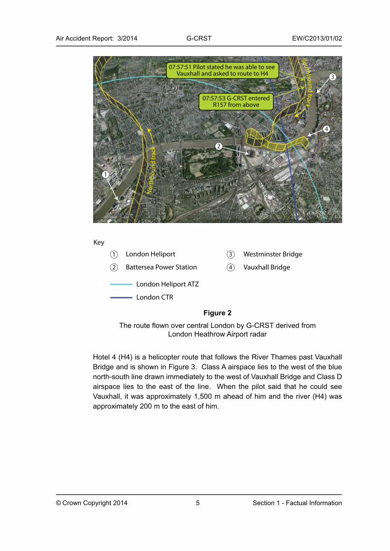
At 0757:51 hrs, towards the end of this conversation, g-crst was abeam Westminster Bridge at 1,570 ft amsl and the pilot transmitted:
“rocket 2, i can actually see vauxhall, if i could maybe head down to hotel 3… hotel 4, sorry”.
5
Air Accident Report: 3/2014 G-CRST EW/C2013/01/02
© Crown Copyright 2014 Section 1 - Factual Information
Figure 2
The route flown over central London by G-CRST derived fromLondon Heathrow Airport radar
Hotel 4 (H4) is a helicopter route that follows the River Thames past Vauxhall Bridge and is shown in Figure 3. Class A airspace lies to the west of the blue north-south line drawn immediately to the west of Vauxhall Bridge and Class D airspace lies to the east of the line. When the pilot said that he could see Vauxhall, it was approximately 1,500 m ahead of him and the river (H4) was approximately 200 m to the east of him.
1
2
London Heliport
Battersea Power Station
London Heliport ATZ
London CTR
07:57:51 Pilot stated he was able to see Vauxhall and asked to route to H4
07:57:53 G-CRST enteredR157 from above
Key
3
4
2
1
Southbound track
Nor
thbo
und
trac
k
Westminster Bridge
Vauxhall Bridge4
3

6
Air Accident Report: 3/2014 G-CRST EW/C2013/01/02
© Crown Copyright 2014 Section 1 - Factual Information
Figure 3
Helicopter route H4 near Vauxhall Bridge
The ATC controller replied:
“rocket 2, you can hold on the river for the minute between vauxhall and westminster bridges and i’ll call you back”.
G-CRST was flying south parallel to the west bank of the River Thames and, as it passed Westminster Bridge, it began to descend and turn right. At 0758:24 hrs, G-CRST was approaching the north bank of the river, 0.5 nm west of Vauxhall Bridge The controller transmitted:
“rocket 2 battersea are just trying to find out if they can accept the diversion”
The pilot acknowledged, after which the controller continued:
“and you can make it quite a wide hold, you can go as far as london bridge”.
The helicopter crossed the north bank of the Thames at 970 ft amsl heading south-west and began a right turn through north onto a south-easterly heading which took it back over the river. It was by now level at an altitude of approximately 770 ft and altered course to follow the river east towards Vauxhall Bridge (see Figure 4).

7
Air Accident Report: 3/2014 G-CRST EW/C2013/01/02
© Crown Copyright 2014 Section 1 - Factual Information
Figure 4
G-CRST Final radar track derived from Heathrow Airport radar.Note: positions are joined by straight lines but the track
may have been curved
At 0759:04 hrs, the London Heliport Tower controller asked the Thames controller whether Rocket 2 was visual with the river and was told that he was. The Tower controller said that Rocket 2 would therefore be accepted at the heliport. At 0759:13 hrs, the ATC controller transmitted:
“rocket 2 yeah battersea diversion approved you’re cleared to battersea”.
The pilot replied:
“lovely thanks rocket 2”.
The ATC controller continued:
“rocket 2 contact battersea one two two decimal niner”.
The pilot replied:
“two two nine, thanks a lot”.
1
2
3
1
2
Vauxhall Bridge
Building at St George Wharf
Key
3
Altitude amsl + 50 ft
07:59:13 ATC cleared the pilotto proceed to London Heliport
07:59:21 Pilot commenced �naltransmission acknowledging
the frequency change
Main wreckage location
Righ
t-hand turn

8
Air Accident Report: 3/2014 G-CRST EW/C2013/01/02
© Crown Copyright 2014 Section 1 - Factual Information
This exchange ended at 0759:22 hrs when G-CRST was approximately 250 m south-west of Vauxhall Bridge. The final two recorded radar positions show a turn to the right at 770 ft amsl, initiated abeam a building development at St George Wharf, approximately 275 m from the south-east end of Vauxhall Bridge. The helicopter struck a crane attached to the building. The final recorded radar position was at 0759:24 hrs at an altitude of 770 ft amsl.
1.1.2 Text messages and phone calls
At 0649 hrs, the pilot received a call from another pilot who was a colleague from a different helicopter operation. The pilot reportedly told his colleague that the weather was clear at Redhill Aerodrome and at his final destination but he expressed his concern about the weather at Elstree. The pilot told his colleague that he felt under pressure to go ahead with the flight that morning but he had decided to cancel it.
Another pilot (Witness A) was aware of the flights planned by the pilot of G-CRST. He stated to the investigation that the pilot phoned him at 0706 hrs to tell him that the weather at Redhill was clear and that he was going to collect a passenger from Elstree. The pilot said there was fog at Elstree but he was going to fly overhead to see for himself.
At 0718 hrs, the client called the pilot to discuss the weather. The client stated to the investigation that the pilot said he thought the weather might clear earlier than forecast. The client said he would drive to Elstree and call the pilot to keep him advised.
The client reported that, at 0731 hrs, having noticed how poor the weather was during his journey, he called the pilot to suggest that he should not take off until he (the client) had reached Elstree and observed the weather. According to the client, the pilot replied that he was already starting the engines and so the client repeated his suggestion that the pilot should not take off.
The client stated that, at approximately 0750 hrs, he phoned London Heliport and was told that it was open.
Table 1 shows text messages that were sent to or by the pilot during the morning.

9
Air Accident Report: 3/2014 G-CRST EW/C2013/01/02
© Crown Copyright 2014 Section 1 - Factual Information
Time From To Text0630 Pilot Client Weather ok up north but freezing fog at
Elstree and Luton not clearing between 8-10am I’ve got same at Redhill keep you posted
0640 Pilot Operator Freezing fog all London airports ok up north have text [client] clearing between 8-10
0705 Witness A Pilot Give me a call as I have checked weather and freezing fog around at the moment
0729 Pilot Client I’m coming anyway will land in a field if I have to
0743 Pilot Witness A Can’t see batts0744 Witness A Pilot Ok0747 Pilot Witness A VFR on top at 1500 feet0748 Witness A Pilot But can you land?0751 Pilot Witness A No hole hdg back to red0753 Witness A Pilot Ok0753 Pilot Client Over Elstree no holes I’m afraid hdg back to
Redhill least we tried chat in 100755 Client Pilot Battersea is open0755 Pilot Operator Can’t get in Elstree hdg back assume clear
still0755 Operator Pilot Yes it’s fine still here. NB. This text was not
read
Table 1
Text messages sent to or by the pilot
1.1.3 Witness information
1.1.3.1 Thames Radar controller
The Thames Radar controller issued the clearance “vfr or special vfr” to give the pilot flexibility in Class D airspace and expected the pilot to apply the appropriate rules according to his flight conditions. When the pilot reported that he was “vmc on top” the controller thought that, because the cloud at London Heathrow and London City Airports was reported as broken4, the pilot was probably able to see the surface5. The controller noted that the pilot was required to state if he was unable to comply with his ATC clearance.
4 Broken cloud means cloud coverage of 5 - 7 oktas (eighths).5 See Sections 1.17.1 and 1.17.2.2.

10
Air Accident Report: 3/2014 G-CRST EW/C2013/01/02
© Crown Copyright 2014 Section 1 - Factual Information
When the pilot said that he could see Vauxhall and asked to route towards helicopter route H4, the controller presumed that the pilot could see the river and was flying under VFR. When the controller instructed the pilot to hold between Vauxhall and Westminster Bridges, he realised his mistake6 immediately and corrected it at the first opportunity by extending the hold to London Bridge.
1.1.3.2 Other witness information
A witness reported that he saw the helicopter between 0755 hrs and 0756 hrs as it passed near Russell Square heading south towards the west bank of the River Thames7. The witness commented that the helicopter seemed to be “flying actually in the low cloud”. Another witness, standing in Ranelagh Gardens, north-west of the northern end of Chelsea Bridge, saw the helicopter in its right turn through a heading of north-west onto a south-easterly heading back towards the river. He reported that it was a “clear bright frosty morning” and he could see the Battersea Power Station chimneys (which are approximately 800 m from the centre of Ranelagh Gardens). A witness standing on Westminster Bridge reported that the “top half of the building [at St George Wharf] was entirely obscured” by cloud. A witness crossing Waterloo Bridge approximately 30 minutes after the accident reported that “the lower side of the cloud appeared to have a lot of variations – like upturned cumulous. The structure was such that the visibility would have changed quite quickly as these lumps of fog rolled in”. A witness standing in the vicinity of Vauxhall Bridge saw the helicopter emerge out of some cloud as it flew towards his location. He reported that the cloud was “swirling around” and, although the main body of the building remained clear of cloud, the top of the building was “in and out of the mist”. He did not witness the impact but, approximately 10 to 20 seconds after he heard it, the top of the building was visible.
1.2 Injuries to persons
The pilot and a pedestrian on Wandsworth Road suffered fatal injuries in the accident. The driver of a van parked in the New Covent Garden Flower Market loading bay received a serious leg injury when struck by the falling wreckage of the gearbox and rotor head.
1.3 Damage to the helicopter
The collision of the helicopter with the crane’s jib resulted in immediate disruption to the structure of the helicopter’s main rotor blades and their separation from the main rotor head. As the collision progressed, damage was caused to the fuselage structure above the cockpit, followed by the separation of the fairing,
6 See Section 1.17.2.1.7 G-CRST passed the witness’s location at 0757:11 but it was established that no other helicopter was in
the area at the time and the investigation considered that the witness had, in fact, seen G-CRST.

11
Air Accident Report: 3/2014 G-CRST EW/C2013/01/02
© Crown Copyright 2014 Section 1 - Factual Information
rotor head and main gearbox from the upper fuselage of the helicopter. The main rotor head and gearbox diverged from the rest of the helicopter and landed separately with additional impact damage caused as they struck the ground. The vertical stabiliser and tail rotor of the helicopter detached from the tail boom as the helicopter made contact with a building, just before striking the ground. The ground impact caused further extensive damage to the remaining fuselage, with the majority of the main helicopter wreckage then consumed by a post-impact fire.
1.4 Other damage
The collision with the crane resulted in the outboard section of the crane’s jib structure detaching from near the point of impact to the tip of the jib. The released section fell to the ground, landing across the eastbound carriageway of Nine Elms Lane, adjacent to the base of the crane, causing damage to the road surface and building site hoardings. The inboard section of the jib remained attached to the crane at its pivot point, but hanging vertically. As the jib section of the crane was free to rotate horizontally, limited damage occurred to the tower section of the crane.
A residential building adjacent to the crane suffered minor structural damage, including broken glass panels, from impact by detached sections of the helicopter’s main rotor blades as they fell vertically. The detached rotor head and gearbox from the helicopter landed in the loading bay of the nearby flower market, striking and damaging a delivery van.
The tail of the helicopter struck a low-rise building immediately prior to its impact with the ground, resulting in structural damage to the building. The subsequent impact of the main fuselage with the pavement adjacent to the building destroyed a boundary wall and created a shallow crater which also ruptured the water main below. As the fuselage hit the ground and continued to travel forward onto the road, the fuel from the aircraft ignited, resulting in an area of fire damage which encompassed the two adjacent building fronts, street furniture and the road surface from the initial ground impact to the final resting position of the fuselage. The surface of the road suffered considerable heat damage, as the stationary fuselage was consumed by fire.
A number of vehicles on Wandsworth Road, close to the point of impact of the main fuselage, suffered heat damage or were damaged by liberated wreckage debris. Two cars suffered severe fire damage, with the one closest to the final location of the fuselage wreckage being completely burnt out.

12
Air Accident Report: 3/2014 G-CRST EW/C2013/01/02
© Crown Copyright 2014 Section 1 - Factual Information
1.5 Personnel information
1.5.1 Pilot
Age: 50 yearsLicence: Air Transport Pilot’s LicenceInstrument Rating: Valid until 31 May 2013Licence Proficiency Check: Valid until 30 November 2013Line Check: Valid until 31 January 2013Medical: Class 1 valid until 9 March 2013 for single pilot air transport operations carrying passengersFlying experience*: Total all types: 10,234 hours Total on type: Not known Last 90 days: 30 hours Last 28 days: 9 hours Last 24 hours: 0 hours
* The most recent logbook entry seen by the investigation was for 3 March 2012, at which point the pilot had logged 9,716 rotorcraft and 218 fixed wing flying hours. Records provided by operators for which the pilot flew were used to generate the information recorded above and to show that the pilot flew 989 hours on type between 1 January 2008 and 5 January 2013.
According to the company for which the pilot was operating, on 12 December 2012 the pilot flew to London Heliport (which is 2.2 nm from Vauxhall Bridge), during which the helicopter approached and departed from/to the west.
1.6 Aircraft information
1.6.1 Aircraft description
The Agusta A109E is a high performance, multi-purpose helicopter. The fuselage is approximately 11 metres long, 2 metres wide and 3.5 metres tall. It has a maximum gross weight limit of 2,850 kg and a maximum speed of 168 kt. With the appropriate instrument fit, it is approved for single pilot VFR and IFR flight. The cockpit seats up to two pilots and the rear cabin can accommodate six passengers. It is powered by two Pratt and Whitney PW206C turboshaft engines and has a fully articulated main rotor head with four main rotor blades.
To the rear of the passenger cabin are fuel tanks, a baggage compartment and electrical equipment bay. Above the cabin, located on the engine deck, are the two engines which drive the main gearbox. This gearbox then drives the main rotor head and tail rotor drive shaft. The tail boom of the helicopter is attached to the main fuselage and locates the twin-bladed tail rotor and gearbox, the vertical fin and the horizontal stabiliser. The helicopter has a retractable, tricycle landing gear.

13
Air Accident Report: 3/2014 G-CRST EW/C2013/01/02
© Crown Copyright 2014 Section 1 - Factual Information
The accident helicopter was serial number 11017 and was manufactured by Agusta in 1998. At the last log book entry prior to the accident, the airframe had accumulated 2,304.5 flight hours since new. The engines were original to the airframe and had the same number of hours since new. The helicopter had previously been operated in the UK on the USA register but was transferred to the UK register in 2007 as G-WRBI. The Certificate of Airworthiness was issued in 2011 when the aircraft was re-registered as G-CRST. No open maintenance defects were recorded in the aircraft’s Technical Log.
1.6.2 Cockpit instruments
Figure 5 shows a photograph of the cockpit of G-WRBI, taken in March 2009 by the aircraft owner, who stated that it was representative of the cockpit fit of G-CRST at the time of the accident.
Figure 5
G-WRBI cockpit fit (picture courtesy of Castle Air)
1.6.3 GPS devices
The helicopter was fitted with two panel-mounted GPS units, a Bendix King KMD 150 and Garmin 430, both of which have a colour moving-map display.
The Garmin 430 can provide navigation, communications, and terrain and obstacle warning functionality. There are two memory card slots provided to allow the integration of database information. Typically one would be used for navigation data and the other to provide terrain and obstacle information. Each card can be accessed from a quick-release slot on the front of the device.
KMD150 GPS
Garmin 430 GPS / NAV / COM

14
Air Accident Report: 3/2014 G-CRST EW/C2013/01/02
© Crown Copyright 2014 Section 1 - Factual Information
1.6.3.1 Terrain and obstacle warning
If a valid database and three dimensional position fix is available, the Garmin 430 will be able to display terrain and obstacles relative to the helicopter altitude and position. For obstacle avoidance, the display features a number of different symbols representing the different levels of alert and types of obstacle (Figure 6).
Figure 6
Garmin 430 obstacle alerts
In addition, the device can use flight path data to trigger an alert in respect of terrain or obstacles which may present a hazard. If an alert is triggered, the ‘TERRAIN’ page provides a flashing ‘TERRAIN’ annunciation8 in the lower left-hand corner ‘annunciator field’ (Figure 7). There is an option to inhibit this annunciation although the symbols in Figure 6 will still be available. When activated, this will be displayed on the ‘annunciator field’ as ‘TER INHB’.
Figure 7
Garmin 430 TERRAIN page showing TERRAIN annunciation
8 Annunciation is the same regardless of whether the alert relates to terrain or an obstacle.
TERRAIN annunciation

15
Air Accident Report: 3/2014 G-CRST EW/C2013/01/02
© Crown Copyright 2014 Section 1 - Factual Information
The device is not intended to be used to manoeuvre around obstacles. It is not mandatory for the GPS to be used in flight and pilots can choose to inhibit the terrain warning when they consider spurious warnings to have become a nuisance distraction.
The manufacturer advises in its documentation that the Garmin 430 has not been certified as meeting the requirements of TSO-C151b or TSO-C1949 (FAA Technical Standard Orders relating to terrain awareness and warning systems). As such it is not an approved instrument for flight in IMC and the obstacle information displayed should only be considered advisory. At the time of the accident the obstacle data used in these devices were not subject to regulatory oversight.
The Bendix King KMD150 unit also has the capability to display obstacles but this system does not provide warning alerts during flight.
1.6.3.2 Database update
The GPS units fitted to G-CRST were destroyed in the post-impact fire and it was not possible to determine their database revision status at the time of the accident. The terrain and obstacle database to which the GPS manufacturer refers on its website is available on a subscription basis and updated on a 56-day cycle.
Operators can download database updates and transfer the data to GPS units in individual aircraft. As the GPS unit is a customer option rather than standard equipment, updates are not a scheduled maintenance requirement in the helicopter manufacturer’s maintenance planning document and, in the case of G-CRST, were not logged by the maintenance provider as a maintenance action. The operator stated that it updated GPS databases annually in March and had not updated the database in G-CRST because it received the aircraft in May 2012.
1.7 Meteorological information
1.7.1 Met Office report
The Met Office produced a general report of the meteorological conditions prior to and at the time of the accident. A large ridge of high pressure centred over Finland extended a slack, mainly east to south-easterly flow across southern England which had stagnated overnight. The air mass was particularly cold, with air temperatures well below freezing across the area. Much of the area was prone to widespread low cloud, poor visibility and patches of freezing fog. Cloud bases were in the range of 100 ft to 400 ft agl at 0800 hrs. Visibility was
9 The equivalent European standards are ETSO-C151b and C194.

16
Air Accident Report: 3/2014 G-CRST EW/C2013/01/02
© Crown Copyright 2014 Section 1 - Factual Information
generally below 4,000 m with several areas of London, including London City Airport, reporting freezing fog with visibility of approximately 700 m. Freezing fog was forecast for Redhill and Elstree Aerodromes and at London Heliport until 1000 hrs.
The surface pressure analysis chart is shown at Figure 8 and the forecast weather chart, valid for the time of flight and issued at approximately 2130 hrs the previous evening, is shown at Figure 9. The forecast for area C, the area within which the flight was planned to be flown, was for: isolated areas of freezing fog with a visibility of 200 m; occasional areas of three- to seven-eighths stratus cloud cover with a base of between 200 ft and 600 ft amsl and tops up to 1,500 ft amsl. Locally, in areas of freezing fog, the base of cloud was expected to be on the surface. The freezing point was forecast to be between the surface and 1,000 ft agl (occasionally 2,000 ft agl).
Figure 8
Surface analysis chart valid at 0600 UTC on 16 January 2013

17
Air Accident Report: 3/2014 G-CRST EW/C2013/01/02
© Crown Copyright 2014 Section 1 - Factual Information
Figure 9
Forecast weather below 10,000 feet
1.7.2 Redhill Aerodrome Weather
Information from the Redhill Aerodrome Common Automatic Weather Station ATIS on 16 January 2013 showed that, between 0720 hrs and 0804 hrs, the wind at the aerodrome was variable in direction at 1 kt, the temperature was between -5°C and - 6°C, and the visibility was between 1,300 m and 5,000 m. Throughout the period, the system was reporting “no cloud detected” (NCD). Figure 10 is an image showing the weather conditions at Redhill Aerodrome at 0730 hrs.

18
Air Accident Report: 3/2014 G-CRST EW/C2013/01/02
© Crown Copyright 2014 Section 1 - Factual Information
Figure 10
Image of the weather at Redhill Aerodrome at 0730 hrs on 16 January 2013
1.7.3 London City Airport weather
1.7.3.1 Meteorological forecast issued at 0459 hrs
Wind was forecast to be from 080° at 4 kt with 800 m visibility in freezing fog and broken cloud at 100 ft. Temporarily, the visibility was forecast to be 300 m.
1.7.3.2 Meteorological conditions at 0750 hrs
The wind was variable in direction at 2 kt. The visibility was 700 m in freezing fog, although the runway visual ranges (RVR) for Runways 09 and 27 were above 1,500 m. There was broken cloud at 100 ft, and the temperature and dew point were -3°C.
1.7.4 London Heathrow Airport weather
1.7.4.1 Meteorological forecast issued at 0457 hrs
Wind was forecast to be from 040° at 4 kt with a visibility of 2,500 m in mist, scattered cloud at 200 ft and broken cloud at 400 ft. Temporarily, 1,200 m visibility was forecast with broken cloud at 100 ft. There was a 30% probability that, temporarily, the visibility would be 700 m in freezing fog.

19
Air Accident Report: 3/2014 G-CRST EW/C2013/01/02
© Crown Copyright 2014 Section 1 - Factual Information
1.7.4.2 Meteorological conditions at 0750 hrs
The wind was from 050° at 5 kt. The visibility was 3,600 m in haze and there was broken cloud at 400 ft, temporarily 500 ft. The temperature was -2°C and the dew point was -3°C.
1.7.5 London Heliport weather
The weather at the London Heliport at 0800 hrs was: calm surface wind, 5,000 m visibility in mist and overcast cloud at 700 ft agl10.
1.8 Aids to navigation
The helicopter was fitted with two GPS systems. Refer to Section 1.6.3.
1.9 Communications
1.9.1 Notice to Airmen (NOTAM)
The following NOTAM11 relating to the crane was valid at the time of the accident:
Q) EGTT/QOBCE/IV/M/ AE/000/008/5129N00007W001 B) FROM: 13/01/07 17:00C) TO: 13/03/15 23:59 E) HIGH RISE JIB CRANE (LIT AT NIGHT) OPR WI 1NM 5129N 00007W, HGT 770FT AMSL (VAUXHALL, CENTRAL LONDON), OPS CTC 020 7820 3151 12-10-0429/AS 2.
The following is a plain language translation:
‘In the London Flight Information Region an obstacle has been erected affecting both instrument and visual traffic. Aerodrome and en route traffic is affected. The obstacle is from the surface up to 800 ft amsl and is positioned within a 1 nm radius of 51°29’ N 000° 07’W. The obstacle will be in place from 1700 hrs on 7 Jan 2013 to 2359 hrs on 15 March 2013. It is a high rise jib crane (lit at night extending to 770 ft amsl).’
The base of the building is approximately 0.42 nm from the NOTAM reference point on a bearing of 102°M.
10 London Heliport elevation is 18 ft amsl.11 NOTAM: Notice to Airmen.
20
Air Accident Report: 3/2014 G-CRST EW/C2013/01/02
© Crown Copyright 2014 Section 1 - Factual Information
1.9.2 UK Aeronautical Information Service (AIS)
The operator’s Operations Manual required NOTAMs to be provided to crews and appropriate NOTAMs and current charts to be carried on each flight. NOTAM information can be accessed from the AIS website but the last time the pilot logged in to his personal account was January 2010. However, if a pilot checks NOTAMs using a third party provider only the activity of the third party is visible to the system. The operator’s pilot brief for the flight did not contain NOTAM information and the pilot’s awareness of relevant NOTAMs prior to the accident could not be confirmed.
1.10 Aerodrome information
1.10.1 General
London Heliport is situated on the east bank of the River Thames three nautical miles south-west of Westminster Bridge. The Aerodrome Traffic Zone (ATZ), which is Class A airspace, has a 2 nm radius and an upper limit of 2,000 ft. Prior permission is required before using the heliport and traffic is cleared to the heliport by ATC under a Special VFR clearance.
The UK AIP entry for the heliport warns pilots that the skyline has changed due to continuing recent development of buildings along the riverside within the heliport circuit.
1.10.2 Weather minima
For helicopters inbound to or departing from the heliport, the weather minima are a reported heliport meteorological visibility of 1,000 m or greater and a cloud ceiling of 600 ft agl or greater. The heliport is closed if the meteorological conditions are below these minima.
1.10.3 Circuits
The circuit pattern at London Heliport is shown in Figure 11.
The traffic circuit is a non-standard shape established over the River Thames between Chelsea Bridge and Putney Railway Bridge and is flown at 1,000 ft amsl. The crosswind and base legs are reduced to turns which should be made, as far as practicable, over the river and above 500 ft agl.

21
Air Accident Report: 3/2014 G-CRST EW/C2013/01/02
© Crown Copyright 2014 Section 1 - Factual Information
Figure 11
Map of circuit procedures at the London Heliport(UK AIP: AD 2-EGLW-4-1)
1.11 Flight recorders
The helicopter was not fitted or required to be fitted with a Flight Data Recorder (FDR) or Cockpit Voice Recorder (CVR). A number of recorded data sources were available, including radar and radio transmissions which have been used to help compile the history of the flight.
1.11.1 Radar
The helicopter’s radar position and Mode S altitude were provided to the AAIB by NATS. The helicopter was captured on the Heathrow, Bovingdon, Pease Pottage, Debden and Gatwick radar heads. The Heathrow radar was the closest to the St George Wharf development, 12 nm miles away, recording aircraft position and altitude every four seconds.
The altitude recorded by the radar head is sourced from the helicopter’s transponder which transmits altitude, rounded to the nearest 100 ft. The transponder altitude is based on the standard pressure setting of 1013.2 hPa. Altitudes quoted in this report have been corrected to the pressure setting in use by the pilot, which was 1012 hPa, and rounded to the nearest 10 ft.

22
Air Accident Report: 3/2014 G-CRST EW/C2013/01/02
© Crown Copyright 2014 Section 1 - Factual Information
Rounding of altitude to the nearest 100 ft has a significant impact on calculating vertical speed. For example, a radar recorded descent of 200 ft over four seconds can represent a rate of descent range between 1,500 ft per min and 4,500 ft per min.
1.11.1.1 Use of autopilot
The helicopter manufacturer was asked to review the final stages of the radar track to determine whether it was likely that the autopilot was being used. Specifically, the manufacturer was asked whether the right-hand turn shown in Figure 4 was characteristic of a turn performed by the autopilot.
The manufacturer confirmed that the autopilot is limited to a maximum of 20º bank angle in a turn and that the minimum radius of turn depends on the airspeed as the helicopter enters the turn. It was confirmed that this right-hand turn was flown tighter than is possible by the autopilot, suggesting that it was flown manually.
In addition, once the turn was complete and the helicopter began tracking eastbound along H4, the recorded attitude fluctuated between 570 and 770 ft (Figures 4 and 12). Over one four second period, the recorded altitude reduced by 200 ft, equivalent to a vertical speed in excess of -1,500 ft per min. Autopilot control of altitude in this helicopter is limited to a vertical speed of ±1,000 ft per min indicating that the autopilot was not being used to control altitude at this point.
Figure 12
G-CRST altitude profile with ±50 ft markersNote: altitudes are joined by straight lines; track may have been curved

23
Air Accident Report: 3/2014 G-CRST EW/C2013/01/02
© Crown Copyright 2014 Section 1 - Factual Information
1.11.2 Data from onboard electronics
Avionics recovered from the helicopter wreckage were examined for possible recorded data. Both the panel-mounted GPS devices and the Electronic Engine Controllers (EECs) were identified but, due to the significant heat and impact damage, data recovery was not possible.
In addition, a bag was recovered near the accident site containing an Airbox Clarity 1.0 portable GPS, still in its storage bag. This device was not fire damaged but had suffered significant impact damage. It was successfully downloaded at the AAIB but contained no flight path tracks from the day of the accident.
1.11.3 CCTV
CCTV was collected from the development at St George Wharf which contained multi-camera views of the development. The collision with the crane was not recorded but a number of cameras captured falling debris from the crane after impact and one captured the helicopter just prior to impact.
This camera had a wide-angle lens, positioned at the base of the building, pointing upwards. The recorded video showed a silhouette moving against, or possibly in, the cloud background a few seconds before G-CRST collided with the crane. Two seconds after the silhouette disappeared from view, pieces of debris from the impact could be seen falling to the ground. The timing and subsequent debris fall gave confidence that the silhouette was G-CRST. Still images from the video are shown in Figures 13 and 14 with an arrow pointing to the helicopter. Movement of the silhouette is more clearly represented in the CCTV recording.
1.11.4 Helicopter operations along H4 in December 2012
A review of the use of H4 eastbound past the building at St George Wharf was performed for the month of December 2012. NATS provided recorded radar data which amounted to 46 helicopters meeting these criteria. Due to the positional accuracy of radar, it was not possible to determine exactly where each helicopter was positioned as it passed the building and crane, or whether each guaranteed a 500 ft clearance (see section 1.17.1.1). It was possible to analyse the altitude (to within ± 50 ft) at which each passed the building and crane on H4.
Of the 46 eastbound tracks, 36 were at or below 1,270 ft amsl so would have had to take some form of lateral deviation from the south bank to ensure 500 ft clearance from the building and crane. Only three of these flights had a cloud base of less than 1,300 ft. Twelve helicopters passed the building and crane at

24
Air Accident Report: 3/2014 G-CRST EW/C2013/01/02
© Crown Copyright 2014 Section 1 - Factual Information
Figure 13
View from the St George Wharf CCTV camera, looking from the base of the building showing G-CRST silhouette
Figure 14
View from the St George Wharf CCTV camera, looking from the base of the building showing G-CRST silhouette
25
Air Accident Report: 3/2014 G-CRST EW/C2013/01/02
© Crown Copyright 2014 Section 1 - Factual Information
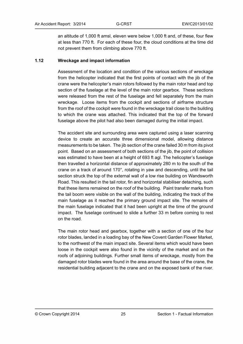
an altitude of 1,000 ft amsl, eleven were below 1,000 ft and, of these, four flew at less than 770 ft. For each of these four, the cloud conditions at the time did not prevent them from climbing above 770 ft.
1.12 Wreckage and impact information
Assessment of the location and condition of the various sections of wreckage from the helicopter indicated that the first points of contact with the jib of the crane were the helicopter’s main rotors followed by the main rotor head and top section of the fuselage at the level of the main rotor gearbox. These sections were released from the rest of the fuselage and fell separately from the main wreckage. Loose items from the cockpit and sections of airframe structure from the roof of the cockpit were found in the wreckage trail close to the building to which the crane was attached. This indicated that the top of the forward fuselage above the pilot had also been damaged during the initial impact.
The accident site and surrounding area were captured using a laser scanning device to create an accurate three dimensional model, allowing distance measurements to be taken. The jib section of the crane failed 30 m from its pivot point. Based on an assessment of both sections of the jib, the point of collision was estimated to have been at a height of 693 ft agl. The helicopter’s fuselage then travelled a horizontal distance of approximately 280 m to the south of the crane on a track of around 170°, rotating in yaw and descending, until the tail section struck the top of the external wall of a low rise building on Wandsworth Road. This resulted in the tail rotor, fin and horizontal stabiliser detaching, such that these items remained on the roof of the building. Paint transfer marks from the tail boom were visible on the wall of the building, indicating the track of the main fuselage as it reached the primary ground impact site. The remains of the main fuselage indicated that it had been upright at the time of the ground impact. The fuselage continued to slide a further 33 m before coming to rest on the road.
The main rotor head and gearbox, together with a section of one of the four rotor blades, landed in a loading bay of the New Covent Garden Flower Market, to the northwest of the main impact site. Several items which would have been loose in the cockpit were also found in the vicinity of the market and on the roofs of adjoining buildings. Further small items of wreckage, mostly from the damaged rotor blades were found in the area around the base of the crane, the residential building adjacent to the crane and on the exposed bank of the river.

26
Air Accident Report: 3/2014 G-CRST EW/C2013/01/02
© Crown Copyright 2014 Section 1 - Factual Information
1.13 Medical and pathological information
A Consultant Forensic Pathologist registered with the Home Office performed a post-mortem on the pilot. The post-mortem was observed by a Consultant Pathologist from the Department of Aviation Pathology at the Royal Air Force Centre of Aviation Medicine, who reported that the pilot died from injuries caused when the helicopter struck the ground. There were no pathological or toxicological factors which could have caused or contributed to the accident.
1.14 Fire
The helicopter had approximately 500 kg of Jet A1 fuel onboard at the time of the accident. At the point of the high energy impact with the ground, immediate and extensive disruption of the fuel tanks resulted in a proportion of the released fuel being vaporised, creating an explosive fuel/air mix. Following ignition, the mixture deflagrated12, resulting in an extensive flame front. This caused widespread heat damage to the adjacent buildings but, due to the open environment of the road, there was no significant blast damage. The remaining fuel continued to burn in sustained fires along the road. The main wreckage of the fuselage and a car adjacent to it were consumed by fire, whilst fires in the other vehicles and buildings in the proximity were extinguished by London Fire Brigade.
1.15 Survival aspects
Following the destruction of the main rotor blades in the initial collision with the crane jib, the helicopter could no longer sustain flight and fell ballistically to the ground. The post-mortem report confirmed that the forces experienced by the pilot at ground impact were not survivable. The pedestrian suffered fatal burn injuries in the ensuing fuel fire.
1.16 Tests and research
Nil.
1.17 Organisational and management information
1.17.1 Civil Aviation Publication (CAP) 393, Air Navigation: the Order and the Regulations13
Section 2 of CAP 393 details the Rules of the Air Regulations. Section 1 of the Rules, Interpretation, states at paragraph 1 (k) that a Special VFR flight means a flight:
12 Deflagration is a rapid but subsonic explosive combustion of the fuel/air mix.13 See Appendix 1 for further explanation of Visual and Instrument Flight Rules.

27
Air Accident Report: 3/2014 G-CRST EW/C2013/01/02
© Crown Copyright 2014 Section 1 - Factual Information
‘in the course of which the aircraft …remains clear of cloud and with the surface in sight.’
Section 3, Low Flying Rule, details in Rule 5 the low-flying prohibitions with which aircraft must comply unless exempted by Rule 6. The prohibitions in Rule 5 include:
‘Except with the written permission of the CAA, an aircraft shall not be flown closer than 500 feet to any person, vessel, vehicle or structure;’
and:
‘Except with the permission of the CAA, an aircraft flying over a congested area of a city town or settlement shall not fly below a height of 1,000 feet above the highest fixed obstacle within a horizontal radius of 600 metres of the aircraft.’
Exemptions in Rule 6 states that:
‘Any aircraft shall be exempt from the 500 feet rule when landing and taking off in accordance with normal aviation practice;’
and:
‘Any aircraft shall be exempt from the 1,000 feet rule if it is flying on a Special VFR flight;’
and:
‘Any aircraft shall be exempt from the 1,000 feet rule if it is operating in accordance with the procedures notified for the route being flown.’
The sector of Helicopter Route H4, Isle of Dogs to Vauxhall Bridge, is established and notified for the purpose of Rule 6.
Section 5, Visual Flight Rules, states that an aircraft flying within Class D airspace below Flight Level 100:
‘shall remain at least 1,500 m horizontally and 1,000 feet vertically away from cloud and in a flight visibility of at least 5 km.’

28
Air Accident Report: 3/2014 G-CRST EW/C2013/01/02
© Crown Copyright 2014 Section 1 - Factual Information
Below 3,000 ft amsl, a helicopter is deemed to have met this requirement if it:
‘remains clear of cloud, with the surface in sight and in a flight visibility of at least 1,500 m.’
1.17.1.1 Rule 5 of the Rules of the Air Regulations as applied to the building and crane
Rule 5 requires an aircraft to be flown no closer than 500 ft to any structure. Figure 15 shows a representation of the building and the crane as a cylinder of 770 ft elevation. The 500 ft clearance required by any passing helicopter is marked in red. If flying at 1,000 ft agl, a helicopter would be required to pass at least 444 ft from the south bank of the River Thames, assuming the south bank represents the edge of the building.
Figure 15
Building and crane with shaded areas showing less than 500 ft clearance (not to scale; for illustrative purposes only)
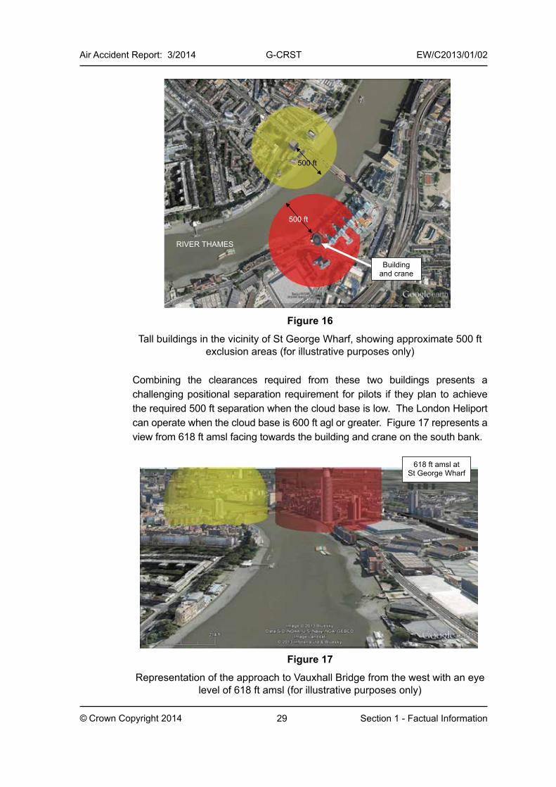
On the opposite side of the River Thames to this building, adjacent to Vauxhall Bridge, is a building approximately 240 ft tall, set back from the river bank by approximately 140 ft. Although not as tall as the building at St George Wharf, there are implications for maintaining 500 ft clearance from both buildings when flying at low level or if there is passing traffic on the opposite bank (see Figure 16). The River Thames is approximately 800 ft wide adjacent to the St George Wharf.
29
Air Accident Report: 3/2014 G-CRST EW/C2013/01/02
© Crown Copyright 2014 Section 1 - Factual Information
Figure 16
Tall buildings in the vicinity of St George Wharf, showing approximate 500 ft exclusion areas (for illustrative purposes only)
Combining the clearances required from these two buildings presents a challenging positional separation requirement for pilots if they plan to achieve the required 500 ft separation when the cloud base is low. The London Heliport can operate when the cloud base is 600 ft agl or greater. Figure 17 represents a view from 618 ft amsl facing towards the building and crane on the south bank.
Figure 17
Representation of the approach to Vauxhall Bridge from the west with an eye level of 618 ft amsl (for illustrative purposes only)
16
Building and crane
500 ft
500 ft
RIVER THAMES
618 ft amsl at St George Wharf
30
Air Accident Report: 3/2014 G-CRST EW/C2013/01/02
© Crown Copyright 2014 Section 1 - Factual Information
1.17.2 UK Aeronautical Information Publication (AIP)
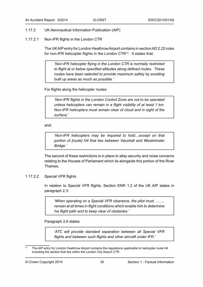
1.17.2.1 Non-IFRflightsintheLondonCTR
TheUKAIPentryforLondonHeathrowAirportcontainsinsectionAD2.22rulesfornon-IFRhelicopterflightsintheLondonCTR14.Itstatesthat:
‘Non-IFR helicopter flying in the London CTR is normally restricted to flight at or below specified altitudes along defined routes. These routes have been selected to provide maximum safety by avoiding built up areas as much as possible.’
Forflightsalongthehelicopterroutes:
‘Non-IFR flights in the London Control Zone are not to be operated unless helicopters can remain in a flight visibility of at least 1 km. Non-IFR helicopters must remain clear of cloud and in sight of the surface;’
and:
‘Non-IFR helicopters may be required to hold…except on that portion of [route] H4 that lies between Vauxhall and Westminster Bridge.’
ThesecondoftheserestrictionsisinplacetoallaysecurityandnoiseconcernsrelatingtotheHousesofParliamentwhichliealongsidethisportionoftheRiverThames.
1.17.2.2 SpecialVFRflights
In relation toSpecial VFR flights, SectionENR1.2 of theUKAIP states inparagraph2.3:
‘When operating on a Special VFR clearance, the pilot must …….. remain at all times in flight conditions which enable him to determine his flight path and to keep clear of obstacles.’
Paragraph2.6states:
‘ATC will provide standard separation between all Special VFR flights and between such flights and other aircraft under IFR.’
14 TheAIPentryforLondonHeathrowAirportcontainstheregulationsapplicabletohelicopterrouteH4includingthesectionthatlieswithintheLondonCityAirportCTR.

31
Air Accident Report: 3/2014 G-CRST EW/C2013/01/02
© Crown Copyright 2014 Section 1 - Factual Information
1.17.2.3 London Heliport
The UK AIP entry for the London Heliport contains weather minima in section AD 3.21 which, for inbound and departing helicopters, are:
‘a reported Heliport meteorological visibility of 1,000 m or greater and a cloud ceiling of 600 ft or greater.’
1.17.2.4 Restricted Area R157, Hyde Park
The area in Figure 3, north and west of the red boundary, forms part of R157 which extends from the surface to an altitude of 1,400 ft. Flight within R157 is permitted by helicopters flying on H4 and by aircraft meeting certain other conditions listed in Section ENR 5.1 of the UK AIP. On this flight, G-CRST was only permitted to fly in R157 while on H4.
1.17.2.5 Air Navigation Obstacles
Section ENR 5.4 of the UK AIP contains a link to an electronic file containing data regarding en route obstacles standing 300 ft agl and above. En route obstacle data used in the AIP are currently provided by the Defence Geographic Centre (DGC) (see section 1.18.5).
1.17.2.6 VFR routes in Controlled Airspace (CAS)
Most main and regional airports within Great Britain are protected by CAS – usually a Class D CTR although London Heathrow Airport CTR is currently Class A airspace – and the CAS often sits above built-up areas. For example, large areas of London, Birmingham, Manchester, Edinburgh and Glasgow sit beneath CAS. Some of the airports use standard VFR routes for inbound, outbound and transiting traffic and these routes are notified through the relevant airport’s entry in the UK AIP.
1.17.3 CAP 493, Manual of Air Traffic Services (MATS) Part 1
1.17.3.1 Special VFR flights
Section 1, Chapter 3, Paragraph 3.1 of MATS Part 1 considers the provision of standard separation and states:
‘Standard vertical or horizontal separation shall be provided, unless otherwise specified, between: IFR flights and Special VFR flights; and Special VFR flights.’
Standard separation may be reduced when authorised by the CAA and published in MATS Part 2 for the particular ATC unit.

32
Air Accident Report: 3/2014 G-CRST EW/C2013/01/02
© Crown Copyright 2014 Section 1 - Factual Information
1.17.3.2 Air Traffic Control Clearances
Section 1, Chapter 4, Paragraph 4.4 of MATS Part 1 warns that ATC clearances do not constitute an authority to violate regulations. It states that:
‘Controllers should not issue clearances which imply permission to breach regulations. This is especially relevant in respect of the low flying rules.’
1.17.3.3 VFR flights in Class D airspace15
Section 3, Chapter 1, Paragraphs 1.28 and 1.29 of MATS Part 1 consider the passing of meteorological information to pilots of VFR flights operating to or from aerodromes in Class D airspace. In respect of helicopters during the day, when the reported meteorological conditions at aerodromes in Class D airspace reduce below a visibility of 1,500 m and/or a cloud ceiling of 1500 feet, ATC will advise the pilot and ask the pilot to specify the type of clearance required. A VFR clearance will not be issued by day in circumstances when the reported visibility at the aerodrome is below 1,500 m.
1.17.4 London Terminal Control (Swanwick) – MATS Part 2: Heathrow
MATS Part 2 for Heathrow Airport gives instructions to air traffic controllers on their responsibilities and duties in respect of low-level operations in the London Heathrow and London City CTRs. It states that:
‘Helicopters operating on the published helicopter routes are required to remain in a flight visibility of at least 1km;’
and:
‘Between Kew Bridge and Vauxhall Bridge, separation exists between traffic….instructed to remain north side of the River Thames and traffic which has been instructed to remain south side of the River.’
1.17.5 London Terminal Control (Swanwick) – MATS Part 2: Thames
MATS Part 2 for Thames Radar states that, within the City CTRs, geographical separation is deemed to exist between:
‘traffic…… which has been instructed to remain north of the River Thames and traffic which has been instructed to remain south.’
15 See Appendix 2 for further explanation of airspace classifications.
33
Air Accident Report: 3/2014 G-CRST EW/C2013/01/02
© Crown Copyright 2014 Section 1 - Factual Information
1.17.6 ATC procedures
Following this accident, NATS carried out a review into VFR flight within control zones and, although there were no recommendations directly related to the accident flight, NATS concluded that there were two areas where improvements could be made.
1.17.6.1 NATS Temporary Operating Instruction (TOI)
After the accident, NATS issued a TOI stating that, between the London Heliport and London Bridge, helicopters were not to be instructed to fly on the south bank of the River Thames while simultaneously restricted to altitudes below 1,300 ft. In circumstances where a pilot reported, or a controller suspected, that a helicopter restricted to the south bank of the river could not comply with Rule 5 (for example due to the cloud base reported at London Heathrow or City Airports), the helicopter’s route was not to be restricted to the south bank of the river.
NATS commented that the measures were likely to delay traffic departing the London Heliport when geographical separation was being used to separate Special VFR traffic on route H4, and when London City Airport traffic was approaching Runway 09 (in which circumstances helicopters were restricted to a maximum altitude of 1,000 ft).
The procedures introduced by the TOI were made permanent on 24 October 2013.
1.17.6.2 NATS Supplementary Instruction (SI)
The procedures for passing meteorological information to flights operating under VFR to and from aerodromes within Class D airspace allow VFR clearances to be issued based upon the reported meteorological visibility16. NATS issued a Supplementary Instruction (SI) to extend these procedures to aircraft transiting Class D airspace.
In marginal weather conditions, and subject to workload, controllers would pass to pilots of transiting VFR and Special VFR aircraft the reported meteorological visibility should it fall to or below 5 km and the reported cloud ceiling should it fall to or below 1,500 feet aal. The visibility and cloud base would be as reported at London City Airport or, if that information was unavailable, London Heathrow Airport. Below these weather minima, controllers would ask pilots to specify the type of clearance required.
The SI noted that it is the pilot’s responsibility to determine whether or not the relevant VMC can be maintained.
16 See Section 1.17.3.3.

34
Air Accident Report: 3/2014 G-CRST EW/C2013/01/02
© Crown Copyright 2014 Section 1 - Factual Information
1.17.7 The Operator’s Operations Manual
Part A of the Operator’s Operations Manual detailed the responsibilities and duties of the Chief Pilot (who was also the Flight Safety Officer), the duty Operations Manager and the pilots operating flights. There was no flight-by-flight requirement for the various post holders to engage with pilots in the decision whether or not to operate a flight and there was no formal pre-flight risk assessment process. However, it was expected that pilots would liaise with duty personnel or the Chief Pilot as required in fulfilling their responsibility to ensure the safe operation of the helicopter.
1.17.8 Use of personal electronic devices (PEDs) in aircraft.
UK Aeronautical Information Circular (AIC) 1/2004, Use of Portable Electronic Devices in Aircraft, reminds operators that it is their responsibility to prevent interference with aircraft systems that might be caused by electromagnetic radiation from PEDs. The operator’s Operations Manual required the commander to ensure that passengers were briefed on restrictions on the use of portable electronic devices.
In its Safety Notice Number SN-2013/003, Flight Crew Distraction, published after the accident, the CAA commented that mobile phones are useful tools in aviation operations but states that:
‘flight crew members must not allow such devices to distract them from focusing on the duties and responsibilities related to the flight.’
The safety notice also states that:
‘except in emergency [mobile phones] should not be used in flight.’
1.17.9 Safeguarding of aerodromes and airspace
1.17.9.1 The Town and Country Planning (Safeguarded Aerodromes, Technical Sites and Military Explosives Storage Areas) Direction 2002
On 27 January 2003, a Joint Circular was issued by the Office of the Deputy Prime Minister, ODPM Circular 01/2003, entitled The Town and Country Planning (Safeguarded Aerodromes, Technical Sites and Military Explosives Storage Areas) Direction 2002. It was an updated direction following the transfer of responsibility for the official safeguarding of civil aerodromes and technical sites from the CAA to the operators of such aerodromes and technical sites.
The Direction requires Local Planning Authorities (LPA) to consult the operator of an aerodrome or technical site before granting planning permission for the
35
Air Accident Report: 3/2014 G-CRST EW/C2013/01/02
© Crown Copyright 2014 Section 1 - Factual Information
development of land nearby in circumstances where a safeguarding map exists in relation to the aerodrome or technical site. A safeguarding map, certified by the CAA, is issued for the purpose of the Direction in relation to officially safeguarded aerodromes or technical sites in the UK. The safeguarding process aims to determine the safety implications of planning applications for developments that lie within the approach, takeoff or circuit areas of officially safeguarded aerodromes. Safeguarding maps show the extent of the safeguarded area and the types of development upon which consultation is required.
London’s Heathrow and City Airports are officially safeguarded aerodromes but London Heliport is not. Operators of aerodromes which are not officially safeguarded are advised to establish a consultation procedure between themselves and the LPA, and LPAs are asked to respond sympathetically to requests for non-official safeguarding.
ODPM Circular 01/2003 is silent in relation to safeguarding airspace for which no safeguarding map has been issued from the potential effects of the construction of tall buildings.
ODPM Circular 01/2003 states that:
‘The Civil Aviation Authority is responsible for recording all air navigation obstacles in the United Kingdom.’
‘Obstacles’ are defined in the Circular as any building or works extending 91.4 m (300 ft) or more above ground level. LPAs are:
‘asked to inform the CAA about new developments anywhere within their area which involves an obstacle as soon as [planning] permission has been granted.’
In addition, LPAs are:
‘asked to supply [position, height and descriptive] information to the Civil Aviation Authority about obstacles not previously notified, and to notify it of any which no longer exist.’
Responsibility for the planning system in Scotland is devolved to the Scottish Government and Scottish Government Planning Circular 2/2003 contains similar provisions to ODPM Circular 1/2003. There is no equivalent document in Northern Ireland.
36
Air Accident Report: 3/2014 G-CRST EW/C2013/01/02
© Crown Copyright 2014 Section 1 - Factual Information
1.17.9.2 Comment from the Department for Transport
The Department for Transport (DfT) commented that the purpose of ODPM Circular 01/2003 is to safeguard the operation and development of designated aerodromes which are, by their nature, immovable. To apply aerodrome safeguarding more generally, for example to airspace or helicopter routes, would constitute a significant policy change which might require the appointment or establishment of a body to represent airspace interests and would introduce new regulatory burdens.
In the absence of the special circumstances that apply to officially safeguarded aerodromes, it would be more appropriate for matters relating to airspace and helicopters to be considered in the context of individual planning applications via normal planning processes. Early engagement in the planning process would allow the aviation community to present its case in respect of objections to individual planning applications.
1.17.9.3 CAP 738, Safeguarding of Aerodromes
Under the Transport Act 2000, the CAA is required to maintain a high standard of safety in the provision of air traffic services, and to secure the most efficient use of airspace consistent with the safe operation of aircraft and the expeditious flow of air traffic. CAP 738 indicates that the CAA has particular regard to applications for the construction of tall buildings in the Central London area that may impact upon the safety or efficiency of existing airspace arrangements.
Appendix C of CAP 738, London Tall Buildings Policy, discusses safeguarding policy for London airspace and defines an area known as the London Tall Buildings Development Area (see Figure 18). The CAA will support an objection by London Heathrow or City Airports to a proposed development within this area when the development’s height would be in excess of 1,000 feet amsl.
1.17.9.4 Comments from the CAA Directorate of Airspace Policy
The CAA publishes air navigation obstacles but does not conduct any activity to ‘record’ them where recording includes a process to ensure that relevant data is submitted to be recorded. ODPM Circular 01/2003 asks LPAs to inform the CAA about developments containing an obstacle but does not require them to do so. If a given LPA does not contain an officially safeguarded aerodrome within its area of responsibility, it might not see the Circular and therefore be unaware that it is being asked to report obstacles to the CAA.
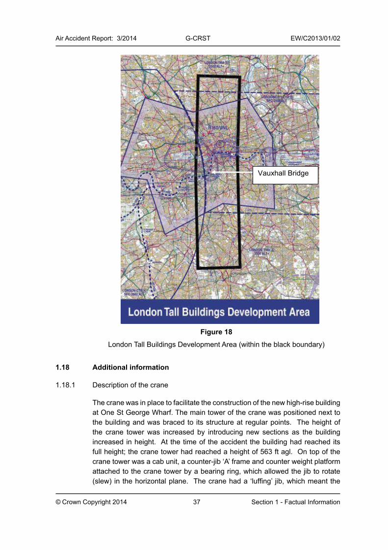
37
Air Accident Report: 3/2014 G-CRST EW/C2013/01/02
© Crown Copyright 2014 Section 1 - Factual Information
Figure 18
London Tall Buildings Development Area (within the black boundary)
1.18 Additional information
1.18.1 Description of the crane
The crane was in place to facilitate the construction of the new high-rise building at One St George Wharf. The main tower of the crane was positioned next to the building and was braced to its structure at regular points. The height of the crane tower was increased by introducing new sections as the building increased in height. At the time of the accident the building had reached its full height; the crane tower had reached a height of 563 ft agl. On top of the crane tower was a cab unit, a counter-jib ‘A’ frame and counter weight platform attached to the crane tower by a bearing ring, which allowed the jib to rotate (slew) in the horizontal plane. The crane had a ‘luffing’ jib, which meant the
Vauxhall Bridge

38
Air Accident Report: 3/2014 G-CRST EW/C2013/01/02
© Crown Copyright 2014 Section 1 - Factual Information
full length of the jib pivoted in the vertical plane. During out-of-service periods, such as overnight, the jib was parked in the ‘minimum jib’ position, at a 65° angle above the horizontal. At the time of the accident this gave a total height from the ground to the tip of the jib of 723 ft agl.
The crane was lit at night with red lights, both on its tower and jib. The tower lighting consisted of mains powered steady red lights at approximately 50 m intervals. The jib lighting was provided by solar powered lights. The Air Navigation Order (ANO) requires the lighting to be of medium intensity (2,000 candela) and that the obstacle be lit at night only.
Figures 19 and 20 are images of the building at St George Wharf taken on 22 September 2012 and 18 February 201317. The images show that the development had been dominant on the skyline for a considerable period before the accident. The developer reported that the top of the building would have been approximately 607 ft amsl on 12 December 2012, the last date for which there was evidence that the pilot of G-CRST had flown in the vicinity of Vauxhall Bridge.
Figure 19
Image of the building taken on 22 September 2012
17 Although taken after the accident this image is an accurate representation of the condition of the building on the day of the accident because construction was halted while the damaged crane was replaced.
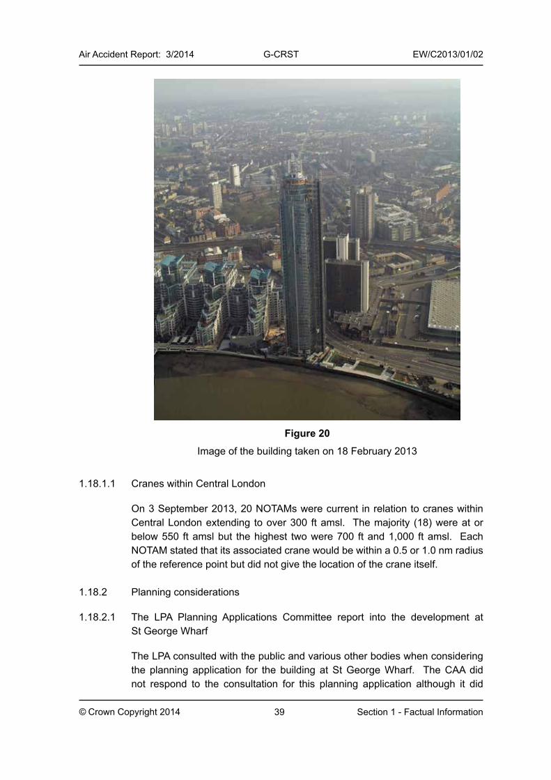
39
Air Accident Report: 3/2014 G-CRST EW/C2013/01/02
© Crown Copyright 2014 Section 1 - Factual Information
Figure 20
Image of the building taken on 18 February 2013
1.18.1.1 Cranes within Central London
On 3 September 2013, 20 NOTAMs were current in relation to cranes within Central London extending to over 300 ft amsl. The majority (18) were at or below 550 ft amsl but the highest two were 700 ft and 1,000 ft amsl. Each NOTAM stated that its associated crane would be within a 0.5 or 1.0 nm radius of the reference point but did not give the location of the crane itself.
1.18.2 Planning considerations
1.18.2.1 The LPA Planning Applications Committee report into the development at St George Wharf
The LPA consulted with the public and various other bodies when considering the planning application for the building at St George Wharf. The CAA did not respond to the consultation for this planning application although it did

40
Air Accident Report: 3/2014 G-CRST EW/C2013/01/02
© Crown Copyright 2014 Section 1 - Factual Information
respond to the consultation for two previous planning applications relating to the same site and its responses were referred to in the LPA report. In its earlier responses, the CAA stated that the height of the proposed development would not have an impact on the integrated airspace management arrangements for London City and London Heathrow Airports and therefore no objection was raised on those grounds. It pointed out that the site lay alongside a helicopter route which followed the river, was fairly close to the London Heliport and, should the structure be approved, it would need to be lit in accordance with the aeronautical lighting requirements.
1.18.2.2 London Heliport
St George Wharf lies just outside London Heliport ATZ and does not impinge upon its takeoff and climb surfaces (Figure 11). Nevertheless, in August 2008, the heliport operator sent an e-mail to the Aerodrome Standards Department (ASD) 18 at the CAA in relation to this development to try and gain clarification on the interests of the heliport (protecting the ATZ and takeoff and climb surfaces) and the wider CAA interest of protecting helicopters transiting the ATZ or flying along the designated helicopter routes. In January 2009, the heliport operator sent an e-mail to the CAA in relation to en route safeguarding. The operator commented that, in conditions of reduced cloud base, the development at St George Wharf appeared to raise a conflict between standard operating altitudes on helicopter route H4 and a pilot’s obligation to adhere to Rule 5, the Low-Flying Rule. There was no further evidence available in respect of either of these emails to indicate whether or not any conclusion was reached in relation to the matters raised.
1.18.3 Single European Rules of the Air (SERA)
Commission Implementing Regulation (EU) 923/2012, dated 26 September 2012, lays down common rules of the air and operational provisions regarding services and procedures in air navigation. The Regulation has been applicable since 4 December 2012 although Member States were permitted to delay the application of its provisions until 4 December 2014. The UK took advantage of this derogation from the Regulation in order to analyse the impact of SERA upon UK regulations and the CAA published some proposals for consultation19.
SERA.5001, VMC visibility and distance from cloud minima, contains in Table S5-1 flight visibilities and distances from cloud that constitute VMC for different classes of airspace and altitude bands. Within Class D Airspace at and below 3,000 ft amsl, VFR require a flight visibility of 5 km and a distance
18 ASD is now the Aerodrome and Air Traffic Standards Division (AATSD).19 Consultation on the Implementation of Commission Implementing Regulation (EU) No 923/2012 of
26 September 2012 (Standardised European Rules of the Air) in the United Kingdom, published by Directorate of Airspace Policy, CAA.

41
Air Accident Report: 3/2014 G-CRST EW/C2013/01/02
© Crown Copyright 2014 Section 1 - Factual Information
from cloud of 1,500 m horizontally and 1,000 ft vertically. There are no reduced flight visibility criteria for helicopters. In its consultation document, the CAA acknowledged that this might lead to an increase in demand for air traffic services which service providers might not always be able to meet.
SERA.5005, Visual Flight Rules, states that, except when taking off or landing or with permission from the competent authority, a VFR flight:
‘shall not be flown over the congested areas of cities…at a height less than 300 m (1,000 ft) above the highest obstacle within a radius of 600 m from the aircraft.’
In its consultation document, the CAA proposed to apply exemptions to SERA.5005 in a similar form to the exemptions currently contained in Rule 6 of the Rules of the Air Regulations.
SERA.5010, Special VFR in control zones, states that, for Special VFR flights within a control zone, pilots of helicopters must remain in a flight visibility of not less than 800 m. ATC controllers must ensure that ground visibility at the controlling aerodrome within the control zone is not less than 800 m and that the cloud ceiling20 is not less than 600 ft. In its consultation document, the CAA proposed to apply these provisions to aircraft intending to take off or land at an aerodrome within a control zone but not to aircraft transiting the control zone.
1.18.4 Regulation (EU) 73/2010, Requirements on the quality of aeronautical data and aeronautical information for the single European sky
Regulation (EU) 73/2010, known as the Aeronautical Data Quality Implementing Regulation (ADQIR), lays down requirements on the quality of aeronautical data and information in terms of its accuracy, resolution and integrity. It applies to the origination, production, storage, handling, processing, transfer and distribution of the data and information. The scope of the Regulation includes data held within the UK AIP and, therefore, the regulation applies to en route obstacles contained in section ENR 5.4, Air Navigation Obstacles. Full compliance with the ADQIR is required by the end of June 2017.
At the time of publication of this report, the CAA was undertaking work to implement the provisions of the Regulation in conjunction with the DfT, Department for Communities and Local Government (DCLG) and the Ministry of Defence (MOD). The intention was to put in place a robust system for the reporting of obstacles but no decision had been made on how the system should be managed or to which body the LPAs would report obstacle information. It
20 ‘Ceiling’ as defined in SERA means the height above the ground or water of the base of the lowest layer of cloud below 6,000 m (20,000 ft) covering more than half the sky. This definition differs from the UK text but the CAA proposes to accept the SERA definition.

42
Air Accident Report: 3/2014 G-CRST EW/C2013/01/02
© Crown Copyright 2014 Section 1 - Factual Information
was possible that the State would need to designate new bodies to manage the functions required by the Regulation. The CAA did not anticipate handling aeronautical data because it considered that this would conflict with its role as regulator.
1.18.5 Defence Geographic Centre (DGC)
The DGC delivers geographical information in support of defence objectives and one of its activities is to produce the UK Digital Vertical Obstruction File (DVOF). Although there is no State obligation to do so, the DGC passes DVOF data to the CAA and AIS for inclusion in the AIP. There is no legislation requiring the DGC to be notified of either the construction or demolition/removal of vertical structures but the CAA, when notified about obstructions over 300 ft agl, passes the data to the DGC. At the time of writing, the DGC expected to provide the CAA with as accurate a dataset as possible to begin the ADQIR process and, thereafter, expected to be a customer for the ADQIR-compliant product.
The building at St George Wharf was not notified to the DGC but one of its staff members noticed the building while off duty in London and added it to the database on 16 August 2012. The updated dataset was promulgated on 20 September 2012 via AIRAC21 10/12 which was published by NATS.
According to the operator, the GPS database in G-CRST had not been updated since May 2012. Therefore, the database would not have contained the building at St George Wharf as an obstacle.
1.18.6 VFR Charts
The CAA produces 1:250,000 and 1;500,000 scale charts which include the central London area and a 1:50,000 scale chart of the helicopter routes in the London CTRs. The charts generally show land obstacles standing above 300 ft agl and a small number of lower obstacles for landmark purposes. However, on the 1:500,000 scale chart, within a marked area over central London, the only obstacle depicted is a building known as “The Shard”, at 1,016 ft agl (1,023 ft amsl). On the 1:250,000 chart, three obstacles (near the London Heliport) are depicted in the central London area in addition to The Shard. Both charts include a note stating:
‘Numerous obstacles exist within the defined area, not exceeding 1,016 ft agl.’
21 AIRAC: Aeronautical Information Regulation and Control. AIRAC is the means by which a state promulgates changes to aeronautical information.

43
Air Accident Report: 3/2014 G-CRST EW/C2013/01/02
© Crown Copyright 2014 Section 1 - Factual Information
The charts contain a warning that:
‘Information is taken from best available sources but is not guaranteed complete.’
The building at St George Wharf is within the central London area, stands less than 1,016 ft agl and is not depicted on either chart.
The 1:50,000 Helicopter Chart generally depicts obstacles contained in the AIP section ENR 5.4, although the map contains a note stating that:
‘Numerous obstacles exist within the Docklands area not exceeding 799 ft agl.’
The chart also contains a note stating that obstacle information is not guaranteed to be complete.
AIS was not notified about the building at St George Wharf in time to include it in Helicopter Chart Edition 15 which was published on 20 September 2012. The building is expected to be included in Edition 16 scheduled for publication on 18 September 2014.
1.18.7 Relevant international developments
1.18.7.1 National Transportation Safety Board (NTSB) Safety Recommendations
Between 1992 and 2009, the Federal Aviation Authority (FAA) in the USA recorded 210 accidents involving helicopters similar in size and design to G-CRST. Of these, 135 accidents, resulting in 126 fatalities, involved helicopters conducting air ambulance operations (sometimes referred to as HEMS22 operations). The remaining accidents occurred during conventional commercial passenger transport operations. The US NTSB carried out a safety study (NTSB/SIR-06/0123) into the high accident rate during this period and also made several recommendations as a result of specific accidents.
Shortly after the study was published, the NTSB made safety recommendations to require HEMS operators to develop flight risk evaluation programs (Recommendation A-06-13) and to use formalised dispatch and flight following procedures (Recommendation A-06-14)24.
Following the investigation into a fatal S-76 (N579EH), Controlled Flight into Terrain (CFIT) accident in the Gulf of Mexico in March 2004, the NTSB made
22 HEMS: Helicopter Emergency Medical Service23 Available: http://www.ntsb.gov/doclib/safetystudies/SIR0601.pdf24 Available: http://www.ntsb.gov/doclib/recletters/2006/A06_12_15.pdf

44
Air Accident Report: 3/2014 G-CRST EW/C2013/01/02
© Crown Copyright 2014 Section 1 - Factual Information
a recommendation that all new US registered turbine-powered rotorcraft certificated for six or more passengers be equipped with Helicopter Terrain and Warning System (TAWS) (Recommendation A-06-1925).
1.18.7.2 FAA Notice of Proposed Rulemaking (NPRM)
As a result of the NTSB findings and recommendations, the FAA issued Notice of Proposed Rulemaking (NPRM) 2010–2486226 to introduce a number of safety related changes. The FAA determined that most of the safety issues identified applied equally to commercial passenger operations as they did to HEMS operations and that the majority of the proposed safety changes should be applied across the industry. Of the changes proposed by the NPRM, the most relevant to this accident are:
● A requirement for increased VFR flight planning, including a requirement to document these procedures in the operator’s operations manual.
● A requirement for air ambulance certificate holders to implement pre-flight risk analysis programs.
● A requirement for helicopter air ambulance operators to fit a Helicopter Terrain Awareness and Warning System (HTAWS) compliant with TSO-C194.
1.18.7.3 HEMS operations
In its statement of the problem to be addressed, the NPRM describes the operating characteristics of HEMS operations. It describes operations that are often time-sensitive and crucial to getting critically ill or injured patients to a medical facility as efficiently as possible, suggesting that this might influence flight crews to fly under circumstances that they otherwise would not. These operations are often conducted in challenging circumstances, such as at low altitudes and under varied weather conditions. Operations are conducted year round, in rural and urban settings, in mountainous and non-mountainous terrain, during the day and at night, and under different flight rules and meteorological conditions. Remote landing sites pose additional challenges because they are often unfamiliar to a pilot and, unlike an airport or heliport, may contain hazards such as trees, buildings, towers, wires and uneven terrain.
25 Available: http://www.ntsb.gov/doclib/recletters/2006/A06_19_23.pdf26 Available: http://www.gpo.gov/fdsys/pkg/FR-2010-10-12/pdf/2010-24862.pdf

45
Air Accident Report: 3/2014 G-CRST EW/C2013/01/02
© Crown Copyright 2014 Section 1 - Factual Information
1.18.7.4 Operational Risk Assessment Programs
The concept of risk assessment adopted by the FAA in its NPRM is that:
‘the pilot’s authority to decline a flight assignment is supreme, while his decision to accept a flight is subject to review if risks are identified.’
Critically, once a pilot has declined a flight assignment:
‘management personnel should not continue the risk assessment pertaining to that flight in an effort to override the pilot’s decision.’
Examples of Operational Risk Assessment Programs are given in Appendix E to NTSB/SIR-06/01). A pre-flight risk assessment would consider, for example: obstructions and terrain along the route; minimum altitudes; human factors such as personal stress, fatigue and experience; weather along the route; whether another operator has refused the flight request; and strategies for mitigating risks identified, including documenting management personnel’s approval to accept the flight when the risks are elevated.
1.18.7.5 Helicopter Terrain Awareness and Warning Systems (HTAWS)
In its NPRM, the FAA discusses the benefits of HTAWS which it believes would help prevent accidents involving, inter alia CFIT, inadvertent flight into IMC, and operations at night. In the USA, turbine-powered fixed-wing aircraft with six or more passenger seats are already required to fit a Terrain Awareness and Warning System (TAWS). TAWS fitted to helicopters can produce nuisance warnings which reduce their effectiveness, especially in the low level environment where there are many hazards associated with terrain and obstacles. However, the FAA believes that HTAWS, in taking into account helicopter-specific factors, can ‘prevent warnings to pilots of terrain or obstacles that do not immediately pose a hazard’. The FAA believes that the decrease in nuisance warnings increases the usefulness of the equipment.
NTSB recommendation A-06-19, recommended that all new turbine-powered helicopters with six or more passenger seats should be required to fit TAWS. The FAA decided that its proposal to fit HTAWS should be limited to air ambulance operators because their helicopters spend a higher proportion of flight time operating at night, off airways and into unfamiliar landing areas. Consequently, it was felt that HEMS operations would benefit more from fitting HTAWS than other commercial operations.

46
Air Accident Report: 3/2014 G-CRST EW/C2013/01/02
© Crown Copyright 2014 Section 1 - Factual Information
1.18.7.6 Federal Aviation Regulations
In February 2014, the proposals from the NPRM outlined above were adopted as Federal Aviation Regulations (FAR) Part 135 Rules 135.605, Helicopter terrain awareness and warning system (HTAWS), 135.615, VFR Flight Planning, and 135.617, Pre-flight Risk Analysis. The Rules will be effective from April 2015. Relevant text from the rules is contained in Appendix 4.
1.18.7.7 The European Helicopter Safety Team
The European Helicopter Safety Team (EHEST) is a voluntary organisation which, according to its website27, includes representatives from manufacturers, operators, research organisations, regulators and accident investigators. EHEST has no regulatory powers but aims to:
‘improve aviation safety by complementing regulatory action by voluntarily encouraging and committing to cost-effective safety enhancements. In addition, the EHEST initiative implements actions of the European Aviation Safety Plan 2012-2015.’
EHEST developed a ‘Pre-departure Risk Assessment Check List’28 that can be used by pilots (and technicians) on a pre-shift or per-flight basis to identify elevated risk that should be mitigated. The pilot answers a series of questions relating to risk factors which are scored 0 to 2. The total score categorises the risk to the flight as: ‘Acceptable’, ‘Caution’, or ‘High Risk’. Risk mitigating actions must be applied in relation to any question with a risk level of 2 (‘High Risk’) regardless of whether the overall score categorises the overall risk to the flight as ‘Acceptable’. The EHEST risk assessment tool relating to single pilot passenger transport flights is shown in Appendix 3.
27 http://easa.europa.eu/essi/ehest/main-page/participants/28 http://easa.europa.eu/essi/ehest/2012/06/pre-departure-check-list/

47
Air Accident Report: 3/2014 G-CRST EW/C2013/01/02
© Crown Copyright 2014 Section 2 - Analysis
2 Analysis
2.1 Aircraft serviceability
Review of the helicopter’s technical log and maintenance records did not reveal any relevant issues and no extant deferred defects were recorded. No evidence was found that would indicate the helicopter had not been maintained or certified in accordance with applicable regulations. The pilot did not report any problems with the helicopter in any of his radio transmissions, including the one immediately prior to impact. The radar track from the accident flight was consistent with the aircraft responding normally to control inputs and no evidence of a pre-impact failure was found during assessment of the wreckage. It was therefore considered unlikely that a technical defect was causal or contributory to the accident.
2.2 The collision with the crane
The pilot either did not see the crane or saw it too late to take effective avoiding action. It was not clear whether the pilot saw the building to which the crane was attached.
Analysis of the three-dimensional model and physical evidence from the accident site indicated that the helicopter struck the crane at a point where its separation from the building was approximately 105 ft. The pilot was required to maintain 500 ft separation from the building in accordance with Rule 5, the Low Flying Rule of the Rules of the Air Regulations. Pilots maintain separation from obstacles using a visual assessment of 500 ft and there will be variability between individuals in the actual separation achieved. However, 105 ft is significantly less than 500 ft and was considered to be outside the bounds of variability. It was concluded that the pilot flew too close to the building not because he misjudged 500 ft separation but because he either did not see the building or because he disregarded Rule 5.
The pilot previously flew near to Vauxhall Bridge on 12 December 2012, according to the operator, and the building was already a significant landmark by that time. However, that flight went no further east than the heliport and so it is possible the pilot was not aware of the building. The presence of the building had been notified through the NOTAM system but the pilot had not briefed himself on NOTAMs using his personal account on the AIS website and his pilot brief for the flight did not contain NOTAM information. It was not determined whether he accessed NOTAM information via a third party provider and therefore no conclusion could be drawn as to whether or not the pilot was aware, in advance, of the existence and height of the building and crane.
48
Air Accident Report: 3/2014 G-CRST EW/C2013/01/02
© Crown Copyright 2014 Section 2 - Analysis
Witness evidence showed that the cloud structure in the area was changing quickly, the base of the cloud was uneven in nature and the top of the building was periodically shrouded in cloud. The helicopter was seen by a witness to appear out of the cloud as it flew along the River Thames towards Vauxhall Bridge and radar evidence of G-CRST at that time showed its altitude varying between 570 ft and 770 ft amsl with, at one point, a rate of descent in excess of 1,500 ft per min. CCTV evidence taken from the base of the development showed an indistinct silhouette of the helicopter two seconds before the collision. The general weather forecast was for widespread low cloud and there was overcast cloud at 700 ft agl (718 ft amsl) at the time of the accident approximately 2 nm west at London Heliport. It was likely, therefore, that the pilot was trying to maximise his altitude beneath a variable and restrictive cloud base and was, on occasion, flying within the base of the cloud. In these circumstances, and even when the helicopter was just clear of the cloud in its own vicinity, horizontal visibility was likely to have been restricted.
Had G-CRST been well below the base of the cloud, the pilot would probably have seen the part of the building that was also below the cloud and would have had to disregard Rule 5 in order to fly as close to the building as he did. To have deliberately flown 105 ft from the building would have reduced the margin for error and increased the risk of a collision considerably. It was not possible to determine the actual in-flight visibility but the evidence available suggested that the helicopter was not significantly below the base of the cloud and the pilot probably had restricted horizontal visibility. On balance therefore, it is probable that the pilot did not see the building or crane.
2.3 Decision making
2.3.1 The decision to depart from Redhill Aerodrome
It is clear from text message records and witness evidence that the pilot knew before flight that there was fog at Elstree Aerodrome. In a telephone conversation with a colleague at 0649 hrs, he said he was going to cancel the flight because of the weather despite feeling under pressure to continue with it. At 0706 hrs, he reportedly told Witness A that he intended to fly over Elstree to check the weather for himself and, at 0729 hrs, he sent a text to the client saying that he would be “coming anyway will land in a field if i have to”.
The pilot was subject to operational and commercial pressures and was required to consider their associated risks when making the decision to operate the flight. The weather conditions at Redhill Aerodrome had begun to clear (see Figure 10) and the pilot would have been able to return there if the weather at Elstree Aerodrome reflected the forecast. He therefore had a safe contingency plan before departure. However, the weather forecast indicated that a large

49
Air Accident Report: 3/2014 G-CRST EW/C2013/01/02
© Crown Copyright 2014 Section 2 - Analysis
proportion of the flight was likely to be conducted above the cloud or fog, icing was likely during flight within cloud and there was a low probability of being able to land at Elstree Aerodrome because there was no instrument approach procedure.
As an example of a risk assessment process, the EHEST risk assessment tool in Appendix 3 shows that there were two environmental risk factors associated with the flight which might have indicated elevated risk. The flight was likely to be conducted to a large degree above fog or cloud and would therefore score 2 for the condition ‘Cloud: flight between or on top of the cloud’. There was no instrument approach procedure at Elstree but any intention to descend to minimum safe altitude in cloud, while looking for a clear area into which the helicopter could descend further, would have scored 2 for the condition ‘Icing: possible icing if entering visible moisture conditions’. Each of these conditions would have required risk mitigation measures to be taken regardless of the overall risk score for the flight. It could not be determined whether the use of such a risk assessment tool would have caused the pilot to obtain a second opinion or change his decision whether to takeoff but the theme is explored further in Section 2.7.
2.3.2 The decision to divert to London Heliport
At 0753 hrs, the pilot sent a text message to the client which showed that his intention was to return to Redhill Aerodrome. At 0755 hrs, the client sent him a text saying that London Heliport was open and, at 0756 hrs, the pilot asked ATC to confirm this was the case. When told the heliport was open, the pilot said that it would be “very useful” if he could proceed there, indicating that he was considering this option. The fact that the helicopter subsequently descended while the pilot was waiting to be cleared to the heliport suggests that his intention was to divert there.
The pilot knew before departure that there was widespread freezing fog over London. He had been unable to see the heliport when he overflew it 14 minutes earlier or to find a gap in the cloud when he attempted to make an approach to Elstree Aerodrome. It was likely, therefore, that he knew that the flying conditions he would encounter at low level would be close to the limits for flight under VFR. The pilot did not know the current weather conditions at London Heliport when the helicopter began to descend. The fact that the heliport was open indicated only that there was at least 1,000 m visibility and a 600 ft agl cloud base.
At 0757:48 hrs, G-CRST was at 1,570 ft amsl abeam Westminster Bridge when the pilot reported that he could see “vauxhall” and asked to route onto H4. He was cleared to hold “on the river…..between vauxhall and westminster bridges”. Westminster Bridge and H4 (the river) were immediately to his left and H4 led

50
Air Accident Report: 3/2014 G-CRST EW/C2013/01/02
© Crown Copyright 2014 Section 2 - Analysis
south directly to Vauxhall Bridge, approximately 1,500 m ahead of him, but the pilot did not take this direct route. Instead, the helicopter proceeded towards a different section of H4, descended into R157 without permission (it was not yet on H4), and entered Class A airspace. It is possible that adverse weather conditions prevented a descent onto the nearest section of H4 and that the pilot was manoeuvring to remain clear of cloud while descending towards the section of H4 west of Vauxhall Bridge. The need to descend into R157 before reaching H4, if he was aware that it had happened, might have caused him to review the suitability of his plan. Even if such a review took place, G-CRST continued to descend towards H4.
The need to vary height so close to the base of the cloud, including at one point using a rate of descent in excess of 1,500 ft per min, indicated that the cloud base was probably variable and very close to the minimum allowable altitude for flight along H4, which is governed by the 500 ft separation rule. The need to fly so close to the limits might also have triggered a review by the pilot of the suitability of the conditions but, if it did, it did not lead him to conclude that he should turn around or climb to find better weather conditions.
The flying time from Redhill Aerodrome to overhead London Heliport is short, so the operational advantage of waiting at the heliport rather than the aerodrome is not obvious. The pilot might have thought that the client intended to drive to the heliport and that to position the helicopter there in advance of the client’s arrival would be advantageous from a commercial perspective. This seemed likely given that the pilot appeared to decide to divert to the heliport immediately after he learned from the client that it was open.
As G-CRST proceeded towards Vauxhall Bridge from abeam Westminster Bridge, it entered R157 and Class A airspace without permission, and encountered conditions that were probably marginal for flight under Special VFR. Reviewing a plan in light of changing circumstances enables a pilot to check the continued validity of that plan and change it if necessary. Whether or not the pilot carried out periodic reviews of his plan to proceed to the heliport, he did not change his decision despite the increasingly challenging circumstances.
2.4 Distractions
The pilot sent five text messages and received five text messages during the 25 minute flight. These messages, along with four before flight, were used to exchange information, some of which the pilot appeared to have used to make operational decisions. The CAA acknowledges the utility of mobile phones but is concerned that they can distract pilots from their primary role and should not be used except in an emergency. At 0751 hrs, the Thames radar controller broadcast the latest weather conditions at London City Airport and, at the same

51
Air Accident Report: 3/2014 G-CRST EW/C2013/01/02
© Crown Copyright 2014 Section 2 - Analysis
time, the pilot sent a short text message. It could not be determined whether the act of composing and sending the message distracted the pilot from taking note of the weather information. It is likely, however, that it was a text message that prompted his decision to divert to London Heliport. The pilot last read and sent text messages approximately four minutes before the collision with the crane. He was using the radio to talk to ATC until a few seconds before impact and the investigation considered it unlikely that he was distracted at the same time by composing a text message.
The pilot was cleared by ATC to contact London Heliport, which would have required a change of radio frequency. His response to this transmission ended at 0759:22 hrs, two seconds before the last recorded radar position. It is possible, therefore, that the pilot was distracted by the act of changing frequency as he entered the turn towards the building.
2.5 Flight rules and procedures
2.5.1 The accident flight
The controller offered the pilot of G-CRST a choice of a VFR or Special VFR clearance through the London City CTR but did not know under which flight rules the pilot was operating at any given time. When the pilot reported that he was “vmc on top”, the controller used the fact that London City Airport was reporting broken cloud to infer that the pilot could probably still see the ground although this presumption did not confirm the flight rules under which the pilot was operating. If clear of cloud and in sight of the surface, as the controller presumed, the pilot was able to operate under VFR or Special VFR. If VFR, the pilot was required to observe the 1,000 ft separation clause within Rule 5 and maintain a minimum flight visibility of 1,500 m. If Special VFR, the pilot was exempt from the 1,000 ft separation clause and required to maintain a minimum flight visibility of 1,000 m. At 0758:03 hrs, G-CRST was descending through 1,270 ft amsl and was separated laterally by approximately 275 m (902 ft) from Millbank Tower, the top of which is 387 ft amsl. From this point, the flight was operating under Special VFR because it required an exemption from the 1,000 ft separation clause of Rule 5. Pilots are required to inform ATC if they are unable to comply with their clearance but the pilot of G-CRST had been cleared to proceed under VFR or Special VFR.
2.5.2 Flights on the helicopter routes
Reciprocal traffic on the helicopter routes is deemed separated when westbound traffic routes along the north bank of the River Thames and eastbound traffic routes along the south bank. Rule 5 applies, so any pilot routing along the south bank of the river and passing within 500 ft vertically of the top of the crane (whose elevation the associated NOTAM stated was 770 ft amsl), or the

52
Air Accident Report: 3/2014 G-CRST EW/C2013/01/02
© Crown Copyright 2014 Section 2 - Analysis
building (elevation 607 ft amsl) once the crane is removed, would be in breach of the ANO. The building at St George Wharf has therefore increased the local minimum allowable altitude along the south bank to 1,100 ft (based on the building). It has consequently had the effect of preventing two-way traffic on H4 when London City Airport is using Runway 09 (when traffic on H4 is limited to 1,000 ft amsl) or when the cloud base is below 1,200 ft.
ATC controllers should not issue clearances which imply permission to breach regulations but it is possible that they did so inadvertently during the period between the construction of this building and implementation of the amended ATC procedures introduced by NATS after the accident. During this period, traffic instructed to route along the south bank of the River Thames, while also restricted to altitudes below 1,300 ft amsl, would have had to break Rule 5 in order to comply with the instruction. Although AIS was informed about the construction of the building at St George Wharf as part of the AIRAC cycle, the significance for the control of traffic on H4 was not anticipated. Pilots on the helicopter routes are responsible for obstacle clearance, not ATC, and the building and crane were notified to pilots through the NOTAM system. There was no requirement for NATS to consider the building further in relation to non-IFR flights.
2.5.3 Non-IFR flights in the London City CTR
VFR helicopter flights over central London, operating within the London City CTR but not on the helicopter routes, must maintain 1,500 m visibility and observe the separation requirements of Rule 5 by remaining at least 1,000 ft above obstacles within a 600 m radius of the helicopter’s position. The CAA 1:50,000 Helicopter Chart generally depicts obstacles standing 300 ft agl and above and so, for practical purposes, 1,400 ft is the minimum altitude at which pilots of VFR flights can be sure they are complying with Rule 5 in respect of obstacles not marked on this chart1. Currently, the only areas within the London City CTR that limit flights to a minimum altitude of 1,400 ft amsl are Restricted Areas R157, R158 and R159 which contain obstacles standing up to 707 ft, 984 ft and 806 ft amsl respectively. Outside these areas, pilots of VFR flights restricted to a maximum altitude of 1,200 ft, for example, would be required to discriminate visually between unmarked obstacles standing up to 200 ft amsl (which they would clear by 1,000 ft) and unmarked obstacles standing between 201 and 299 ft amsl (which they would not). Pilots would then be required to avoid the higher unmarked obstacles by 600 m horizontally, which is difficult in practice. The situation would be more restrictive for pilots using CAA 1:250,000 or 1:500,000 scale charts on which only a very few obstacles are depicted below 1,016 ft agl in the central London area.
1 Assuming an elevation of up to 100 ft amsl for ground in the London area, a 299 ft unmarked obstacle would stand up to 399 ft amsl. Consequently, 1,400 ft amsl would be the minimum altitude to guarantee 1,000 ft vertical separation.
53
Air Accident Report: 3/2014 G-CRST EW/C2013/01/02
© Crown Copyright 2014 Section 2 - Analysis
Flight under Special VFR permits lower minimum altitudes because it is not necessary to comply with the 1,000 ft clause of Rule 5. The demand for Special VFR clearances is expected to increase following the adoption of the Single European Rules of the Air (SERA) because VFR traffic operating within Class D airspace will be required to maintain 1,000 ft vertically clear of cloud as well as 1,000 ft clear of obstacles. Consequently, any cloud base of 2,400 ft or below is likely to lead to an increased demand for Special VFR clearances. The CAA acknowledges that this might increase ATC workload.
It is likely that more tall buildings will be constructed which will, along with their associated cranes, increase the number of permanent or temporary obstacles to be avoided by pilots. On one day selected at random during the investigation, there were NOTAMs relating to 20 cranes in Central London standing up to 1,000 ft amsl. In practice, pilots would need to avoid the 1 or 2 nm diameter circle within which the NOTAM stated the obstacle was located until the obstacle itself was identified (unless the flight’s altitude provided sufficient vertical separation). In these circumstances, although obstacle clearance is solely the pilot’s responsibility when a flight is operated under VFR or Special VFR, on or off the helicopter routes, the lower the maximum altitude permitted by an ATC clearance, the more difficult it is for a pilot to comply with Rule 5. Non-compliance with Rule 5 or the higher workload required in these circumstances to maintain compliance each represents a potential hazard to flight safety.
2.5.4 Non-IFR flight in controlled airspace
Much of the discussion in the previous two paragraphs also applies to non-IFR flights, on or off notified VFR routes, within the Class D airspace that protects other main and regional airports throughout the UK. The need to avoid new, and sometimes unmarked, obstacles is likely to increase the minimum practical Rule 5-compliant VFR or Special VFR altitude. Conversely, ATC may wish to limit maximum altitudes in accordance with the requirement to separate Special VFR from IFR traffic in Class D airspace, a requirement that is likely to increase with the expected increase in Special VFR clearances.
2.5.5 ATC Procedures
The construction of more tall obstacles will affect pilots and the control of air traffic especially in relation to the need to comply with Rule 5 and knowledge of those obstacles would be useful for ATC. Aircraft on published VFR routes are constrained laterally and so the height of obstacles the aircraft would encounter when cleared along a route would be predictable. Aircraft operating VFR but not on published routes are not constrained to follow a particular lateral path even if cleared to route between two points and so the height of obstacles

54
Air Accident Report: 3/2014 G-CRST EW/C2013/01/02
© Crown Copyright 2014 Section 2 - Analysis
the aircraft would encounter when subject to a VFR clearance would be less predictable. Nevertheless, controllers should not be placed in the position (because their procedures have not been adapted to take account of recently constructed obstacles) of inadvertently issuing clearances compliance with which would breach regulations. Obstacles, permanent or temporary, are notified through the AIRAC cycle, which provides an opportunity to consider the effect of those obstacles on ATC procedures. Therefore, the following Safety Recommendations are made:
Safety Recommendation 2014-025
It is recommended that the Civil Aviation Authority require UK Air Navigation Service Providers to assess the effect of obstacles, notified through the UK Aeronautical Information Regulation and Control cycle, on operational procedures relating to published VFR routes near those obstacles, and modify procedures to enable pilots to comply simultaneously with ATC instructions, and the Air Navigation Order and Commission Implementing Regulation (EU) 923/2012 as applicable.
Safety Recommendation 2014-026
It is recommended that the Civil Aviation Authority require UK Air Navigation Service Providers to assess the effect of obstacles, notified through the UK Aeronautical Information Regulation and Control cycle, on operational procedures for controlling non-IFR flights within the Control Areas and Control Zones surrounding UK airports, and modify procedures to enable pilots to comply simultaneously with ATC instructions, and the Air Navigation Order and Commission Implementing Regulation (EU) 923/2012 as applicable.
2.6 Obstacles
2.6.1 Notification of obstacles
ODPM Circular 01/2003, written in the context of safeguarding, states that the CAA is responsible for recording all obstacles within the UK but, although data is published in relation to known obstacles, the process in place does not ensure that all relevant data is submitted. The crane at St George Wharf was notified correctly through the NOTAM system and the building was added to the UK DVOF and notified to AIS. However, the building was added to the UK DVOF by coincidence rather than as the result of a systematic process of notification of en route obstacles.

55
Air Accident Report: 3/2014 G-CRST EW/C2013/01/02
© Crown Copyright 2014 Section 2 - Analysis
ODPM Circular 01/2003 asks LPAs to inform the CAA when planning permission is granted for developments that include obstacles and Scottish Government Planning Circular 2/2003 has a similar purpose. When notified of obstacles, the CAA passes the data to the DGC, and the DGC passes the data to AIS as part of the AIRAC cycle. However, planning authorities are not required to inform the CAA and, unless an LPA has a safeguarded aerodrome within its area of responsibility, its officers might not have read the Circular and might be unaware of its content.
The Department for Transport stated that it expects Regulation (EU) 73/2010 (ADQIR) to lead to a robust system of obstacle data collection, reporting, storage and publication, and might require the State to designate new bodies to manage these functions. However, the ADQIR does not specify the time within which notification of new obstacle data must occur and full compliance is not required until the end of June 2017. Therefore the following Safety Recommendation is made:
Safety Recommendation 2014-027
It is recommended that the Department for Transport implement, as soon as practicable, a mechanism compliant with Regulation (EU) 73/2010 and applicable to the whole of the UK for the formal reporting and management of obstacle data, including a requirement to report data relating to newly permitted developments.
In order to improve the sharing of obstacle data as soon as possible, the following Safety Recommendations are made:
Safety Recommendation 2014-028 It is recommended that the Department for Transport remind all recipients of the Office of the Deputy Prime Minister Circular 01/2003 that they are requested to notify the Civil Aviation Authority:
1. whenever they grant planning permission for developments which include an obstacle
2. about obstacles not previously notified
3. about obstacles previously notified that no longer exist.

56
Air Accident Report: 3/2014 G-CRST EW/C2013/01/02
© Crown Copyright 2014 Section 2 - Analysis
Safety Recommendation 2014-029
It is recommended that The Scottish Government remind all recipients of Planning Circular 2/2003 that they are requested to notify the Civil Aviation Authority:
1. whenever they grant planning permission for developments which include an obstacle
2. about obstacles not previously notified
3. about obstacles previously notified that no longer exist.
2.6.2 Advance notification of obstacles
Two-way traffic has been restricted on H4 in some circumstances, and ATC controllers might have inadvertently given clearances implying permission to breach the ANO, not following a policy decision to make changes but as an unanticipated result of the LPA granting planning permission for the development at St George Wharf. It is possible that the cumulative effects of future development along the banks of the River Thames will further restrict the use of H4 or even render it unusable. It is important, therefore, that the aviation community is notified about the imminent construction of obstacles so that procedures can be adapted accordingly. It might also be considered important for the aviation community to be notified at the planning stage about the proposed construction of en route obstacles, especially in the vicinity of VFR routes within controlled airspace, so objections can be made if deemed appropriate. In this way, for example, the potential closure of H4 would be a considered result of discussion rather than an unanticipated effect of a future planning decision.
ODPM Circular 01/2003 and Scottish Government Planning Circular 2/2003 require the aviation community to be consulted at the planning stage in relation to obstacles within the safeguarded areas surrounding major airports. There is no equivalent process in place in relation to the construction of en route obstacles. CAP 738 discusses the CAA’s role in relation to tall buildings in the Central London area that may affect existing airspace arrangements but provisions within the document are written in the context of safeguarding. When asked to comment upon the proposed development at St George Wharf as part of the planning process, the CAA pointed out that it was alongside H4 but there was no process in place to trigger a discussion of the potential impact on the helicopter routes. In 2009, the heliport operator raised concerns with the CAA that the then-proposed development at St George Wharf raised a conflict between standard operating altitudes on helicopter route H4 and a pilot’s obligation to adhere to Rule 5. This does not appear to have led to further discussion or action.

57
Air Accident Report: 3/2014 G-CRST EW/C2013/01/02
© Crown Copyright 2014 Section 2 - Analysis
The DfT commented that to apply safeguarding more generally to include airspace would require a policy change and might introduce new regulatory burdens, but early engagement in the planning process would allow the aviation community to present its objections to individual planning applications. Currently, the process of safeguarding is the only systematic way by which early engagement in the planning process is possible and it does not capture planning applications for en route obstacles. Therefore:
Safety Recommendation 2014-030
It is recommended that the Department for Transport implement measures that enable the Civil Aviation Authority to assess, before planning permission is granted, the potential implications of new en route obstacles for airspace arrangements and procedures.
2.7 Pre-flightplanningandriskassessment
The FAA determined that safety issues related to HEMS operations were applicable to other types of commercial helicopter operations. The features of HEMS operations set out in Section 1.18.7.3 could be used to describe on-demand VIP passenger transfer operations, as conducted by the operator of G-CRST, and other UK commercial helicopter operations. Although only a small proportion of flights carry critically ill or injured passengers, pilots will often be subject to pressures – real or perceived – to complete the task. These pressures might lead pilots to continue with flights in circumstances where otherwise they would not and it is possible that this played a part in the accident pilot’s decision to take off and, subsequently, to continue towards London Heliport in adverse weather conditions.
The changes to FAR Part 135 introduced by the FAA, although applicable to HEMS operations, may also contain beneficial safety improvements with respect to UK commercial helicopter operations. In particular, the proposals relating to pre-flight risk assessment and VFR flight planning are worthy of consideration in relation to: the decision to accept a flight; continued operation in adverse weather conditions; low level flight in the vicinity of terrain or obstacles; and short notice or en route changes to flight objectives and planning.
A process such as the EHEST Pre-departure Risk Assessment tool might also have positive safety benefits because its use might have prompted the pilot to seek management approval before accepting the flight. Furthermore, it might have highlighted two elevated risk factors and caused risk-mitigating procedures to be put in place before departure.
The EASA reviews European regulations against those in the US for standardisation purposes but rulemaking changes in Europe require a review

58
Air Accident Report: 3/2014 G-CRST EW/C2013/01/02
© Crown Copyright 2014 Section 2 - Analysis
and consultation period of typically five years or more prior to implementation. Some of the changes made by the FAA are directly relevant to this accident and could provide immediate safety benefits ahead of potential rulemaking changes by the EASA. Therefore:
Safety Recommendation 2014-031
It is recommended that the Civil Aviation Authority review Federal Aviation Regulations Part 135 Rules 135.615, VFR Flight Planning, and 135.617, Pre-flight Risk Analysis, to assess whether their implementation would provide safety benefits for those helicopter operations within the UK for which it is the regulatory authority.
Safety Recommendation 2014-032
It is recommended that the European Aviation Safety Agency review Federal Aviation Regulations Part 135 Rules 135.615, VFR Flight Planning, and 135.617, Pre-flight Risk Analysis, in advance of the scheduled regulatory standardisation programme, to assess whether their immediate implementation would provide safety benefits for helicopter operations within Europe.
2.8 HTAWS
The FAR Part 135 Rule 135.605 requirement to fit HTAWS to helicopters used in air ambulance operations does not extend to other commercial operations using helicopters certificated for six or more passengers, as recommended by the NTSB. However, safety issues relating to HEMS operations are considered by the FAA to be applicable to other commercial helicopter operations and it is reasonable to expect that there would be safety benefits should HTAWS be fitted to commercial helicopters more generally. In particular, benefits expected by the FAA in relation to CFIT, inadvertent flight into IMC and night operations could also be expected in UK commercial helicopter operations.
Although G-CRST was fitted with a non-TSO-C194 compliant obstacle awareness system, it was not possible to determine whether it was in use at the time of the accident. However, even if it had been, the database loaded into the system did not include the building to which the crane was attached and so its use is unlikely to have altered the outcome. It is possible that, had G-CRST been fitted with a TSO-C194 or ETSO-C194 approved system with a current database, the pilot would have had greater obstacle awareness such that he would not have turned towards the building.
The helicopter routes through London are VFR routes and clearance from obstacles is to be achieved visually by remaining in the appropriate VMC.
59
Air Accident Report: 3/2014 G-CRST EW/C2013/01/02
© Crown Copyright 2014 Section 2 - Analysis
However, one of the benefits of HTAWS, highlighted by the FAA, is for the improvement of safety should a pilot inadvertently enter IMC. This probably occurred intermittently in the minute leading up to this accident. It is also a risk associated with low level flight within the UK more generally. Therefore:
Safety Recommendation 2014-033
It is recommended that the Civil Aviation Authority assess whether mandating the use of Helicopter Terrain Awareness and Warning Systems compliant with Technical Standard Order C194 or European Technical Standard Order C194 would provide safety benefits for helicopter operations within the UK for which it is the regulatory authority.
Safety Recommendation 2014-034
It is recommended that the European Aviation Safety Agency assess whether mandating the use of Helicopter Terrain Awareness and Warning Systems compliant with Technical Standard Order C194 or European Technical Standard Order C194 would provide safety benefits for helicopter operations within Europe.

60
Air Accident Report: 3/2014 G-CRST EW/C2013/01/02
© Crown Copyright 2014 Section 3 - Conclusions
3 Conclusions
(a) Findings
1. The pilot was properly licensed and qualified to conduct the flight.
2. No evidence was identified of a pre-existing technical defect that was causal or contributory to the accident.
3. The pilot was aware that there was freezing fog over London and that there was a possibility that it would be present at Elstree Aerodrome.
4. The weather at Redhill Aerodrome was suitable for the helicopter’s departure.
5. The pilot did not land at Elstree Aerodrome because the weather was unsuitable.
6. Unable to land at Elstree Aerodrome, the pilot requested ATC clearance to return to Redhill Aerodrome.
7. The pilot was cleared by ATC to transit the London CTR under VFR or Special VFR at his discretion.
8. While en route to Redhill Aerodrome, the pilot received a text from the client telling him that London Heliport was open and the pilot asked ATC to confirm that this was the case.
9. Having been told that London Heliport was open, it is probable that the pilot’s intention was to land there.
10. London Heliport is closed when its reported meteorological conditions are below a visibility of 1,000 m and a cloud ceiling of 600 ft agl.
11. The pilot did not know the current weather conditions at London Heliport at the time the helicopter began its descent towards the River Thames.
12. The pilot was operating under Special VFR from the time the helicopter began its descent towards the River Thames.
13. The helicopter entered restricted area R157 without permission.
14. The pilot was probably unable to remain continuously clear of cloud as the helicopter approached Vauxhall Bridge.

61
Air Accident Report: 3/2014 G-CRST EW/C2013/01/02
© Crown Copyright 2014 Section 3 - Conclusions
15. The pilot did not adjust his plan to land at London Heliport when he encountered increasingly challenging weather conditions as the helicopter descended towards, and routed onto, helicopter route H4.
16. ATC cleared the pilot to proceed to London Heliport and he began a turn towards the building at St George Wharf. At the time he began the turn, he was probably unaware of the building’s proximity.
17. The pilot was possibly distracted by the task of changing radio frequency as he entered the turn towards the building.
18. The helicopter struck a crane attached to the building. At the point of impact, the helicopter was approximately 105 ft from the building.
19. The presence of the crane at St George Wharf was notified through the NOTAM system.
20. There is no requirement for Local Planning Authorities to notify the CAA when granting planning permission for obstacles extending above 300 ft agl when those obstacles are outside safeguarded areas.
21. Between the time of construction of the building and implementation of amended ATC procedures, ATC controllers possibly, and inadvertently, issued clearances compliance with which would breach Rule 5 of the Rules of the Air Regulations.
22. Two-way traffic along helicopter route H4 is no longer possible in certain circumstances using current procedures following construction of the building at St George Wharf.
23. The building at St George Wharf was added to the UK DVOF by coincidence rather than through a systematic process.
24. The building at St George Wharf was not included in the helicopter’s obstacle databases.
25. There is no effective system in place to anticipate the potential effects of new obstacles on existing airspace arrangements when the obstacles are outside safeguarded areas.

62
Air Accident Report: 3/2014 G-CRST EW/C2013/01/02
© Crown Copyright 2014 Section 3 - Conclusions
(b) Causal Factors
1. The pilot turned onto a collision course with the crane attached to the building and was probably unaware of the helicopter’s proximity to the building at the beginning of the turn.
2. The pilot did not see the crane or saw it too late to take effective avoiding action.
(c) Contributory Factor
1. The pilot continued with his decision to land at the London Heliport despite being unable to remain clear of cloud.

63
Air Accident Report: 3/2014 G-CRST EW/C2013/01/02
© Crown Copyright 2014 Section 4 - Safety Recommmedations
4 Safety Recommendations
4.1 Recommendation 2014-025: It is recommended that the Civil Aviation Authority require UK Air Navigation Service Providers to assess the effect of obstacles, notified through the UK Aeronautical Information Regulation and Control cycle, on operational procedures relating to published VFR routes near those obstacles, and modify procedures to enable pilots to comply simultaneously with ATC instructions, and the Air Navigation Order and Commission Implementing Regulation (EU) 923/2012 as applicable.
4.2 Recommendation 2014-026: It is recommended that the Civil Aviation Authority require UK Air Navigation Service Providers to assess the effect of obstacles, notified through the UK Aeronautical Information Regulation and Control cycle, on operational procedures for controlling non-IFR flights within the Control Areas and Control Zones surrounding UK airports, and modify procedures to enable pilots to comply simultaneously with ATC instructions, and the Air Navigation Order and Commission Implementing Regulation (EU) 923/2012 as applicable.
4.3 Recommendation 2014-027: It is recommended that the Department for Transport implement, as soon as practicable, a mechanism compliant with Regulation (EU) 73/2010 and applicable to the whole of the UK for the formal reporting and management of obstacle data, including a requirement to report data relating to newly permitted developments.
4.4 Recommendation 2014-028: It is recommended that the Department for Transport remind all recipients of the Office of the Deputy Prime Minister Circular 01/2003 that they are requested to notify the Civil Aviation Authority:
1. whenever they grant planning permission for developments which include an obstacle
2. about obstacles not previously notified
3. about obstacles previously notified that no longer exist.
4.5 Recommendation 2014-029: It is recommended that The Scottish Government remind all recipients of Planning Circular 2/2003 that they are requested to notify the Civil Aviation Authority:
1. whenever they grant planning permission for developments which include an obstacle
2. about obstacles not previously notified
3. about obstacles previously notified that no longer exist.

64
Air Accident Report: 3/2014 G-CRST EW/C2013/01/02
© Crown Copyright 2014 Section 4 - Safety Recommmedations
4.6 Recommendation 2014-030: It is recommended that the Department for Transport implement measures that enable the Civil Aviation Authority to assess, before planning permission is granted, the potential implications of new en-route obstacles for airspace arrangements and procedures.
4.7 Recommendation 2014-031: It is recommended that the Civil Aviation Authority review Federal Aviation Regulations Part 135 Rules 135.615, VFR Flight Planning, and 135.617, Pre-flight Risk Analysis, to assess whether their implementation would provide safety benefits for those helicopter operations within the UK for which it is the regulatory authority.
4.8 Recommendation 2014-032: It is recommended that the European Aviation Safety Agency review Federal Aviation Regulations Part 135 Rules 135.615, VFR Flight Planning, and 135.617, Pre-flight Risk Analysis, in advance of the scheduled regulatory standardisation programme, to assess whether their immediate implementation would provide safety benefits for helicopter operations within Europe.
4.9 Recommendation 2014-033: It is recommended that the Civil Aviation Authority assess whether mandating the use of Helicopter Terrain Awareness and Warning Systems compliant with Technical Standard Order C194 or European Technical Standard Order C194 would provide safety benefits for helicopter operations within the UK for which it is the regulatory authority.
4.10 Recommendation 2014-034: It is recommended that the European Aviation Safety Agency assess whether mandating the use of Helicopter Terrain Awareness and Warning Systems compliant with Technical Standard Order C194 or European Technical Standard Order C194 would provide safety benefits for helicopter operations within Europe.
Air Accident Report: 3/2014 G-CRST EW/C2013/01/02
© Crown Copyright 2014 App1 - 1
Appendix 1
Explanation of IFR and VFR
Flights in UK airspace are operated in accordance with Visual Flight Rules (VFR) or Instrument Flight Rules (IFR). The weather conditions that dictate which rules are applicable are known as Visual Meteorological Conditions (VMC) and Instrument Meteorological Conditions (IMC).
VFR are the basic requirements for operating an aircraft and all pilots are qualified as a minimum to operate to these rules. If the minimum conditions for VMC are not present then VFR flights are not permitted to take place.
Should weather conditions deteriorate below the required VMC minima1 for cloud and visibility, then Instrument Meteorological Conditions (IMC) exist and the flight must operate under the more stringent requirements of IFR. For an aircraft to be flown in IMC it must be fitted with the necessary approved instrumentation and the pilot must hold an appropriate instrument rating (qualification).
IFR are also, for the most part, mandatory within controlled airspace and an IFR flight plan must be filed to operate within it. This enables Air Traffic Control (ATC) to apply the required levels of separation to aircraft operating within controlled airspace and for traffic information to be provided to IFR traffic operating outside controlled airspace, so that the pilots can separate themselves sufficiently from other aircraft and obstacles.
In general, separation standards are not applied by ATC to or between VFR flights and therefore separation from other aircraft and objects remains the responsibility of the pilot in command of a VFR flight. The exception to this applies in Class C Airspace, where ATC will separate VFR from IFR but not VFR from VFR flights.
1 Further Information can be found in the CAA VFR guidance leaflet available on the CAA website http://www.caa.co.uk/docs/64/VFR_Guide_2011_update.pdf

Air Accident Report: 3/2014 G-CRST EW/C2013/01/02
© Crown Copyright 2014
Appendix 2
App 2 - 1
ICAOdefinitionsofairspace
There are currently six classes of airspace under ICAO Standards and Recommended Practices; these are allocated depending on the need to control access to airspace and the nature of the activity that takes place within it.
Classes A, C & D require an air traffic control clearance to enter the airspace and receipt of an air traffic control service is mandatory.
Class G is uncontrolled in that any aircraft may use the airspace under The Rules of the Air and although an air traffic service may be available it is not mandated.
Classes E and F are not widely used in the UK and no UK airspace is currently designated as Class B.
The application of a particular airspace classification to a particular volume of airspace will depend principally upon the number of air traffic movements within it, the complexity of IFR operations within it and also upon the safety hazards posed to public transport flights operating under IFR.

Air Accident Report: 3/2014 G-CRST EW/C2013/01/02
© Crown Copyright 2014
Appendix 2 (cont)
App 2 - 2
An Overview of the Different Classes of Airspace in the UK
Class A Class C Class D
IFR flights only
(Special VFR flights are permitted within a Class A control zone)
All flights provided with air traffic control service and are separated from each other
IFR and VFR flights permitted
All flights provided with air traffic control service
IFR flights are separated from other IFR flights and VFR flights
VFR flights are separated from IFR flights and receive traffic information in respect of all other flights
IFR and VFR flights permitted
All flights provided with air traffic control service
IFR flights are separated from other IFR flights and receive traffic information with respect to VFR flights
VFR flights receive traffic information in respect of all other flights
Class E Class F Class G
IFR and VFR flights permitted
IFR flights are provided with air traffic control service and are separated from other IFR flights
All flights receive traffic information as far as is practical
Uncontrolled
IFR and VFR flights permitted
All participating IFR flights receive an air traffic advisory service
All flights can receive an flight information service, if requested
Uncontrolled
IFR and VFR flights permitted
All flights can receive a flight information service, if requested

Air Accident Report: 3/2014 G-CRST EW/C2013/01/02
© Crown Copyright 2014 App 3 - 1
Appendix 3
EHEST Pre-flight Risk Assessment
PRE-FLIGHT RISK MANAGEMENT CHECKLIST0 0
1 1
2 2
MITIGATION
No problems. Physically in shape.
Nuisance, not completely in shape.
Headache, cold, fever, toothache.
No medications in the last 24 hours.
Over the counter medication.
Prescription medication. Attention and driving impairing medication.
Well slept.
Moderate sleep or no sleep in the last 13 hours.
Poor sleep.
No fatigue. First flight of the day
Duty day: less than 10 hours, more than 2 flights
Duty day: more than 10 hours, more than 4 flights
Adequately nourished and hydrated.
Flight conducted during breakfast, lunch or dinner time. 4 to 6 hours without eating. 2 to 4 hours without drinking.
More than 6 hour from last meal. More than 4 hours without drinking. Hot weather and no drinking water on board.
Physiologically relieved.
Medium mission duration with no rest facilities available.
Long mission duration with no rest facilities available.
Not emotionally involved.
Emotionally involved. Little private problems.
Emotionally stressed. Legal, financial or family problems.
Over 1000 hous total flight time.
Between 300 and 1000 hous total flight time.
Below 300 hours total flight time.
Over 300 hours flight time on type.
Between 100 and 300 hours flight time on type.
Below 100 hours flight time on type.
Within 1 month.
Between 1 and 3 months.
Over 3 months (not to consider recurrency flight).
Adequate. Thorough planning.
Aproximate or experience based. Empiric calculation.
Rushed or inadequate.
Well before scheduled flight.
Not scheduled flight requested with some planning time allowed.
Immediate flight.
Well known. Last landing or take off within a month.
Partially known. Last landing or take off within three months.
New place.
VFR.
VMC IFR or night flight.
IMC IFR.
Yes.
Partially.
Not.
None.
Less than 2.
More than 2.
Done.
Not done, but supposed within limits by experience.
Not done and near aircraft limitation.
Well under limits.
Close to limits only in cruise conditions.
Close to limits during most part of the flight.
Day.
Dawn or dusk.
Night.
Good.
Marginal VMC.
IMC.
Light.
Sustained.
Strong or gusting.
No rain.
Light rain.
Showers or thunderstorms.
No snow
Light snow
Heavy snow
No clouds within working altitude.
Marginal ceiling.
Flight between or on top the clouds. Mountains obscured. X XNo icing conditions.
Marginal icing conditions.
Probable icing if entering in visible moisture conditions. X XRural (flat…)
City, suburban
Mountainous, overwater, tropical forest, desert…
Low value mission. Easily cancelable flight.
Medium value mission but alternate transport or flight delay are feasible.
High value. To be completed as soon as possible.
TOTAL SCORE: ACCEPTABLE 4 ACCEPTABLE 4Questions number: 27 27
Questions missing: 25 25
X
0
CREW
Initi
al S
core
Fina
l Sco
re
PERSONAL CONDITIONS
Physical 0 0
Medication 0 0
0
Physiologic 0 0
Sleep 0 0
Fatigue 0 0
0
Last flight on type 0 0
Food & drink
RECENCY
Total flight time 0
Emotion 0
0
Mission scheduling 0 0
0
OPERATING BASE
Planning 0 0
Flight time on type 0
AIRCRAFTHelicopter fitted for the mission
0 0
Departure and Arrival places
0 0
Flight rules 0 0
Performance (weight and density altitude)
0 0
ENVIRONMENT
Known anomalies 0 0
Loadsheet 0 0
Time of flight 0 0
Rain 0 0
Meteorological conditions
0 0
Wind 0 0
0
Snow 0 0
Clouds 2 2
Icing 2 2
Terrain 0
EXTERNAL PRESSURE
Mission importance 0 0
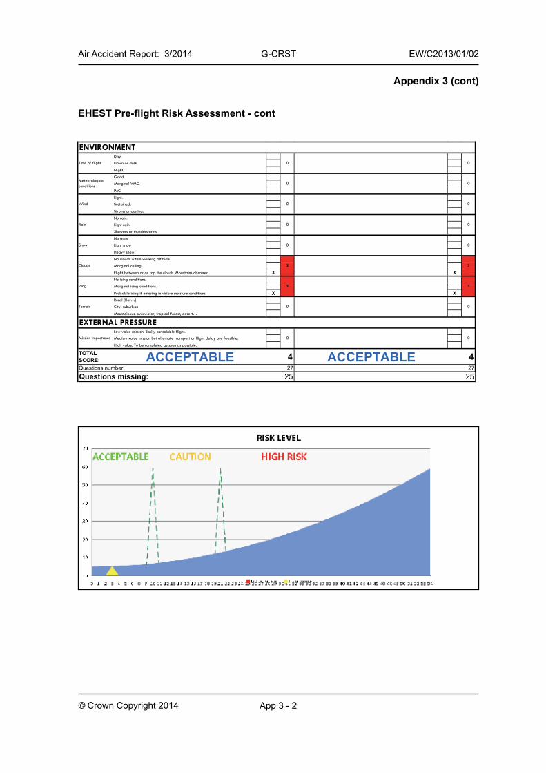
Air Accident Report: 3/2014 G-CRST EW/C2013/01/02
© Crown Copyright 2014 App 3 - 2
Appendix 3 (cont)
PRE-FLIGHT RISK MANAGEMENT CHECKLIST0 0
1 1
2 2
MITIGATION
No problems. Physically in shape.
Nuisance, not completely in shape.
Headache, cold, fever, toothache.
No medications in the last 24 hours.
Over the counter medication.
Prescription medication. Attention and driving impairing medication.
Well slept.
Moderate sleep or no sleep in the last 13 hours.
Poor sleep.
No fatigue. First flight of the day
Duty day: less than 10 hours, more than 2 flights
Duty day: more than 10 hours, more than 4 flights
Adequately nourished and hydrated.
Flight conducted during breakfast, lunch or dinner time. 4 to 6 hours without eating. 2 to 4 hours without drinking.
More than 6 hour from last meal. More than 4 hours without drinking. Hot weather and no drinking water on board.
Physiologically relieved.
Medium mission duration with no rest facilities available.
Long mission duration with no rest facilities available.
Not emotionally involved.
Emotionally involved. Little private problems.
Emotionally stressed. Legal, financial or family problems.
Over 1000 hous total flight time.
Between 300 and 1000 hous total flight time.
Below 300 hours total flight time.
Over 300 hours flight time on type.
Between 100 and 300 hours flight time on type.
Below 100 hours flight time on type.
Within 1 month.
Between 1 and 3 months.
Over 3 months (not to consider recurrency flight).
Adequate. Thorough planning.
Aproximate or experience based. Empiric calculation.
Rushed or inadequate.
Well before scheduled flight.
Not scheduled flight requested with some planning time allowed.
Immediate flight.
Well known. Last landing or take off within a month.
Partially known. Last landing or take off within three months.
New place.
VFR.
VMC IFR or night flight.
IMC IFR.
Yes.
Partially.
Not.
None.
Less than 2.
More than 2.
Done.
Not done, but supposed within limits by experience.
Not done and near aircraft limitation.
Well under limits.
Close to limits only in cruise conditions.
Close to limits during most part of the flight.
Day.
Dawn or dusk.
Night.
Good.
Marginal VMC.
IMC.
Light.
Sustained.
Strong or gusting.
No rain.
Light rain.
Showers or thunderstorms.
No snow
Light snow
Heavy snow
No clouds within working altitude.
Marginal ceiling.
Flight between or on top the clouds. Mountains obscured. X XNo icing conditions.
Marginal icing conditions.
Probable icing if entering in visible moisture conditions. X XRural (flat…)
City, suburban
Mountainous, overwater, tropical forest, desert…
Low value mission. Easily cancelable flight.
Medium value mission but alternate transport or flight delay are feasible.
High value. To be completed as soon as possible.
TOTAL SCORE: ACCEPTABLE 4 ACCEPTABLE 4Questions number: 27 27
Questions missing: 25 25
X
0
CREW
Initi
al S
core
Fina
l Sco
re
PERSONAL CONDITIONS
Physical 0 0
Medication 0 0
0
Physiologic 0 0
Sleep 0 0
Fatigue 0 0
0
Last flight on type 0 0
Food & drink
RECENCY
Total flight time 0
Emotion 0
0
Mission scheduling 0 0
0
OPERATING BASE
Planning 0 0
Flight time on type 0
AIRCRAFTHelicopter fitted for the mission
0 0
Departure and Arrival places
0 0
Flight rules 0 0
Performance (weight and density altitude)
0 0
ENVIRONMENT
Known anomalies 0 0
Loadsheet 0 0
Time of flight 0 0
Rain 0 0
Meteorological conditions
0 0
Wind 0 0
0
Snow 0 0
Clouds 2 2
Icing 2 2
Terrain 0
EXTERNAL PRESSURE
Mission importance 0 0
EHEST Pre-flight Risk Assessment - cont

Air Accident Report: 3/2014 G-CRST EW/C2013/01/02
© Crown Copyright 2014 App 4 - 1
Appendix 4
New Federal Aviation Regulations
Text relevant to this report from FAR Part 135 Rules 135.605, 135.615 and 135.617 is shown below.
FAR Part 135 Rule 135.605, Helicopter terrain awareness and warning system (HTAWS).
(a) After April 24, 2017, no person may operate a helicopter in helicopter air ambulance operations unless that helicopter is equipped with a helicopter terrain awareness and warning system (HTAWS) that meets the requirements in TSO-C194 and Section 2 of RTCA DO-309.
(b) The certificate holder’s Rotorcraft Flight Manual must contain appropriate procedures for—
(1) The use of the HTAWS; and
(2) Proper flight crew response to HTAWS audio and visual warnings.
FAR Part 135 Rule 135.615, VFR flight planning
(a) Pre-flight. Prior to conducting VFR operations, the pilot in command must—
(1) Determine the minimum safe cruise altitude by evaluating the terrain and obstacles along the planned route of flight;
(2) Identify and document the highest obstacle along the planned route of flight; and
(3) Using the minimum safe cruise altitudes in paragraphs (b) (1)–(2) of this section, determine the minimum required ceiling and visibility to conduct the planned flight by applying the weather minimums appropriate to the class of airspace for the planned flight.
(b) Enroute. While conducting VFR operations, the pilot in command must ensure that all terrain and obstacles along the route of flight are cleared vertically by no less than the following:
(1) 300 feet for day operations.
(2) 500 feet for night operations.
(c) Reroutingtheplannedflightpath. A pilot in command may deviate from the planned flight path for reasons such as weather conditions or operational considerations. Such deviations do not relieve the pilot in command of the weather requirements or then

Air Accident Report: 3/2014 G-CRST EW/C2013/01/02
© Crown Copyright 2014 App 4 - 2
Appendix 4 (cont)
requirements for terrain and obstacle clearance contained in this part and in part 91 of this chapter. Rerouting, change in destination, or other changes to the planned flight that occur while the helicopter is on the ground at an intermediate stop require evaluation of the new route in accordance with paragraph (a) of this section.
(d) Operations manual. Each certificate holder must document its VFR flight planning procedures in its operations manual.
FAR Part 135 Rule 135.617, Pre-flight risk analysis
(a) Each certificate holder conducting helicopter air ambulance operations must establish, and document in its operations manual, an FAA-approved pre-flight risk analysis that includes at least the following—
(1) Flight considerations, to include obstacles and terrain along the planned route of flight, landing zone conditions, and fuel requirements;
(2) Human factors, such as crew fatigue, life events, and other stressors;
(3) Weather, including departure, en route, destination, and forecasted;
(4) A procedure for determining whether another helicopter air ambulance operator has refused or rejected a flight request; and
(5) Strategies and procedures for mitigating identified risks, including procedures for obtaining and documenting approval of the certificate holder’s management personnel to release a flight when a risk exceeds a level predetermined by the certificate holder.
(b) Each certificate holder must develop a pre-flight risk analysis worksheet to include, at a minimum, the items in paragraph (a) of this section.
(c) Prior to the first leg of each helicopter air ambulance operation, the pilot in command must conduct a pre-flight risk analysis and complete the pre-flight risk analysis worksheet in accordance with the certificate holder’s FAA-approved procedures. The pilot in command must sign the pre-flight risk analysis worksheet and specify the date and time it was completed.
(d) The certificate holder must retain the original or a copy of each completed pre-flight risk analysis worksheet at a location specified in its operations manual for at least 90 days from the date of the operation.

Unless otherwise indicated, recommendations in this report are addressed to the appropriate regulatory authorities having responsibility for the matters with which the recommendation is concerned. It is for those authorities to decide what action is taken. In the United Kingdom the responsible authority is the Civil Aviation Authority, CAA House, 45-49 Kingsway, London WC2B 6TE or the European Aviation Safety Agency, Postfach 10 12 53, D-50452 Koeln, Germany.

AIRCRAFT ACCIDENT REPORT 3/2014
Report on the accident toAgusta A109E, G-CRST
Near Vauxhall Bridge, Central Londonon 16 January 2013
AIR
CR
AFT A
CC
IDEN
T REPO
RT 3/2014
G-C
RST
AAIBAir Accidents Investigation Branch