al afpm conference big creek drainage study...al afpm conference october 2014 2 3 big creek basin...
TRANSCRIPT

BIG CREEK DRAINAGE STUDY
AL AFPM CONFERENCE
October 2014

2

3

Big Creek basin data collection
Hydrologic modeling
Hydraulic modeling
Flood mitigation projects
STUDY ELEMENTS
4

Data collected consisted of the following:
GIS data for Shelby and Tipton counties
Lidar Data
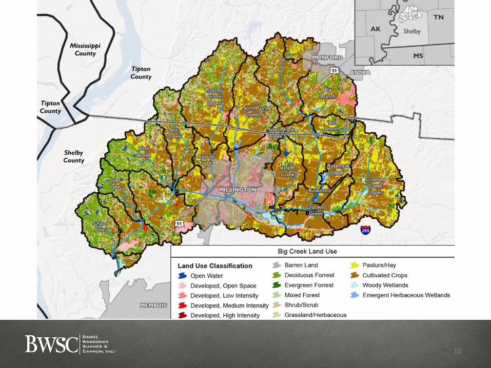
Soils/Land Use Data
Nexrad Data
Field survey channel cross-sections and bridge data
75 additional cross-sections
Drainage studies
Previous Corps studies
DATA COLLECTION
5

HEC-HMS & HEC-GeoHMS Model used
100-year and 500-year design flows
HYDROLOGIC MODEL
6

7

8

9
10

11


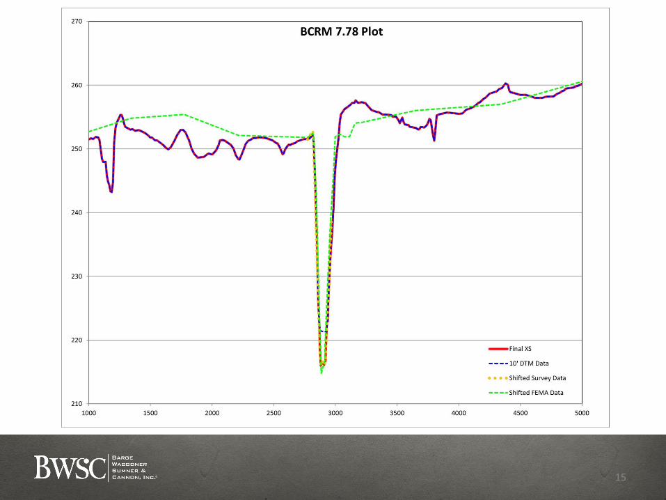
HEC-RAS & HEC-GeoRAS models for water surface elevations
Extended model upstream into Tipton County
100-year and 500-year water surface elevations
May, 2010 water surface elevations for model validation
HYDRAULIC MODEL
13

14
15

MAY 2010 HIGHWAY 51 FLOOD INUNDATION
16

MAY 2010 SINGLETON PARKWAY
17

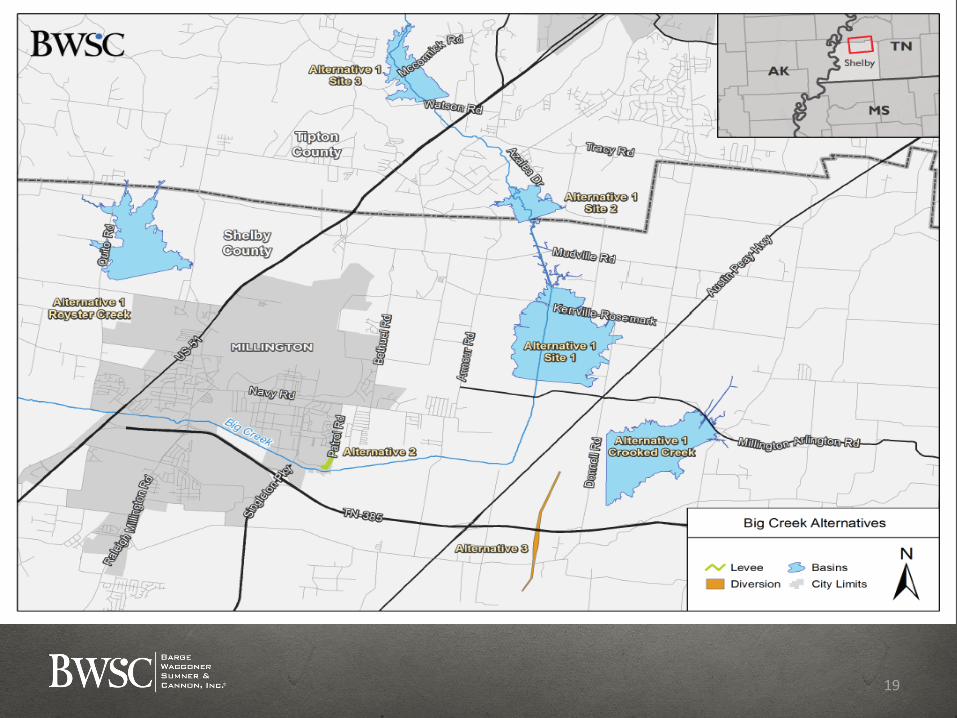
Identify flooding locations and conceptual projects to mitigate
flooding
Mitigation alternatives
Alternative 1 - Temporary detention upstream
Alternative 2 - Enhanced protection
Alternative 3 - Diversion of high flows
FLOODING MITIGATION
18
19

20
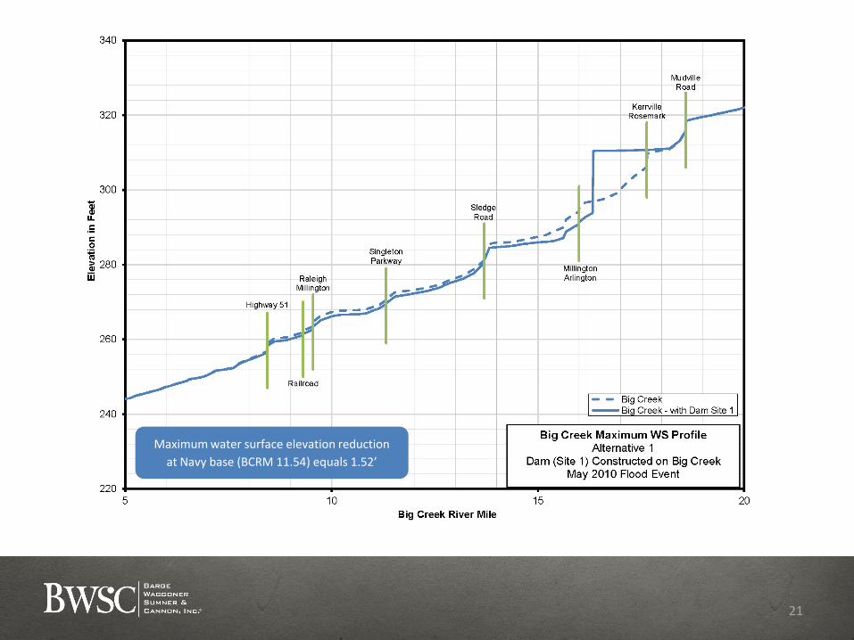
Maximum water surface elevation reduction
at Navy base (BCRM 11.54) equals 1.52’
21

Effective at reducing water surface elevations
Significant land acquisition
Moderate to high total project cost depending on site or
combination of sites selected
BIG CREEK ALTERNATIVE 1 – FINDINGS
22

23

Prevents flooding of Navy base due to levee overtopping
No significant effect on water surface elevations
No land acquisition
Lower project cost
BIG CREEK ALTERNATIVE 2 – RAISE EAST LEVEE FINDINGS
24

25

Maximum water surface elevation reduction of 1.04’
at RM 11.54 (Just upstream of Singleton Pkwy.)
26

Effective in reducing water surface elevations
Minimal land acquisition
High construction cost (two new bridges)
BIG CREEK ALTERNATIVE 3 – HIGH FLOW DIVERSION FINDINGS
27
28
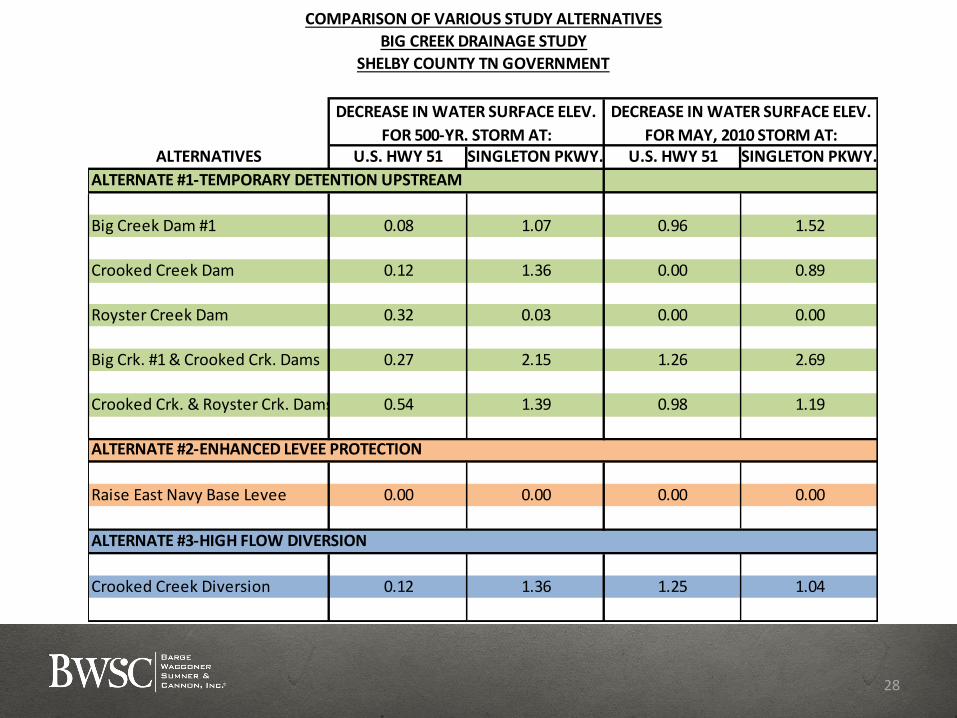
ALTERNATIVES U.S. HWY 51 SINGLETON PKWY. U.S. HWY 51 SINGLETON PKWY.
ALTERNATE #1-TEMPORARY DETENTION UPSTREAM
Big Creek Dam #1 0.08 1.07 0.96 1.52
Crooked Creek Dam 0.12 1.36 0.00 0.89
Royster Creek Dam 0.32 0.03 0.00 0.00
Big Crk. #1 & Crooked Crk. Dams 0.27 2.15 1.26 2.69
Crooked Crk. & Royster Crk. Dams 0.54 1.39 0.98 1.19
ALTERNATE #2-ENHANCED LEVEE PROTECTION
Raise East Navy Base Levee 0.00 0.00 0.00 0.00
ALTERNATE #3-HIGH FLOW DIVERSION
Crooked Creek Diversion 0.12 1.36 1.25 1.04
DECREASE IN WATER SURFACE ELEV.
FOR 500-YR. STORM AT:
DECREASE IN WATER SURFACE ELEV.
FOR MAY, 2010 STORM AT:
SHELBY COUNTY TN GOVERNMENT
BIG CREEK DRAINAGE STUDY
COMPARISON OF VARIOUS STUDY ALTERNATIVES

Develop and evaluate additional potential projects
Evaluate combinations of projects
WORK GOING FORWARD
29
