ala wai flood risk management project honolulu, hawaii
TRANSCRIPT
U.S. Army Corps of Engineers Honolulu District
Ala Wai Flood Risk Management Project Honolulu, Hawaii
Engineering Documentation Report
Department of the Army
U.S. Army Corps of Engineers, Honolulu District Fort Shafter, Hawaii
July 16, 2020

U.S. Army Corps of Engineers Honolulu District
Ala Wai Flood Risk Management Project Honolulu, Hawaii
Engineering Documentation Report
i
EXECUTIVE SUMMARY
ES‐1 Purpose The purpose of this Engineering Documentation Report (EDR) is to (i) document technical analysis completed following Congressional authorization of the project for construction, (ii) identify system modifications and the technical basis for those recommendations, and (iii) provide the engineering and data foundation for a future Validation Study. The EDR is not a decision document and solely investigates project feature modifications from a technical perspective. Final recommendations related to modifications of project features will be made with full consideration that modifications to project features are technically sound, economically justified, and environmentally and socially acceptable. This work will occur jointly through completion of a Validation Study and supplemental National Environmental Policy Act (NEPA) document. ES‐2 Project Objective, Scope, and Authorization The project objective is to reduce the depth and lateral extent of overland inundation during a 1% Annual Estimated Probability (AEP) storm event thereby reducing the risk of loss of life and long‐term economic damages to the public and private sectors within the 19 square miles of the Ala Wai Watershed, O’ahu, Hawaii. To meet these objectives, results of the Integrated Environmental Impact Statement and Feasibility Study completed in December 2017 recommended a linked system of debris and detention structures and a flood barrier system intended to (i) detain short duration, high intensity rainfalls in the upper watersheds at the source, (ii) reducing and offsetting peak discharges to more manageable flows into the Ala Wai Canal at the base of the watershed, and (iii) increase storage capacity of the Ala Wai Canal. The Record‐of‐Decision was signed in September 18, 2018 by the Assistant Secretary of the Army for Civil Works (ASA (CW)) and funded by the Bi‐Partisan Budget Act (BBA) of 2018, (P.L. 115‐123), under the Long‐Term Disaster Recovery Investment Program for an authorized cost of $345,076,000.
ES‐3 Updated Modeling Results and Feature Recommendations The HEC 1‐dimensional (1D), steady state hydraulic model developed in the feasibility phase was advanced using an unsteady state 1D/2‐Dimension (1D/2D) model with 1D analysis in the stream channels and 2D flow in the overbank areas. Significant differences were observed between the two model results. Notable differences include (i) more extensive inundation across the base of the watershed and (ii) the anticipated water surface elevation reductions were not realized due to insufficient detention capacity and flow constraints along the routing. Consequently, modified risk management features were evaluated to mitigate these emergent findings. Central to the modified approach is a shift in concept from temporary storm water detention in the upper watersheds to enhanced conveyance within existing routing throughout the watershed. The proposed changes to the Feasibility Study outlined in this EDR includes (i) the removal of six detention basins from the upper watershed, (ii) the addition of limited flood walls at two locations, upstream of the Woodlawn Bridge, and the reach between Date Street to the Ala Wai canal, (iii) the addition of two bypass diversion culverts around the Woodlawn Drive Bridge stream reach and at the base of the Makiki channel into the Ala Wai Canal, and (iv) the consolidation of two pump stations into a single larger pump station.

U.S. Army Corps of Engineers Honolulu District
Ala Wai Flood Risk Management Project Honolulu, Hawaii
Engineering Documentation Report
ii
U.S. Army Corps of Engineers Honolulu District
Ala Wai Flood Risk Management Project Honolulu, Hawaii
Engineering Documentation Report
iii
ES‐4 Draft Cost Estimate and Economics Rough‐order‐of‐magnitude cost estimates and a preliminary economic analysis were conducted to gauge project trajectory based on early concepts in development. Project First Cost for the recommended modifications at Budget Year 2020 levels is $376M, including a 29% contingency, $48M. The median preliminary rough‐order‐of‐magnitude Benefit‐to‐Cost Ratio is 2.48. These metrics will be revised as more engineering details are developed.
ES‐5 Environmental Considerations The Final Integrated Feasibility Study with Environmental Impact Study was approved through a Record of Decision by the ASA (CW) signed on September 18, 2018. The State of Hawaii requires compliance with Hawaii Environmental Protection Act (HEPA) in addition to NEPA for the non‐Federal Sponsor to participate in any project that requires public lands or public funding in accordance with Hawaii Revised Statutes Chapter 343 (HRS 343). As of the publication of this EDR, the HEPA document is still going through non‐Federal processes for proposal and acceptance.
The recommendations in this EDR have not gone through the rigorous or required NEPA analysis, such as Endangered Species Act, National Historic Preservation Act, Clean Water Act, nor has agency coordination been initiated for the recommendations. As part of a Validation Study in the next phase, the conceptual recommendations presented in this EDR will be advanced in design to conduct the appropriate level of supplemental environmental analysis. Commensurate with the level of supplemental environmental analysis, a supplemental environmental document will be developed and included in the Validation Study.
However, in developing the recommended modifications to system features, extensive community and stakeholder outreach was conducted. This outreach and collaboration is documented in Appendix D of this EDR. The intent behind the outreach was to parallel the engineering effort with a cursory review of impacts to the environment and community. This parallel effort was a consideration in developing the final recommended system of features.
U.S. Army Corps of Engineers Honolulu District
Ala Wai Flood Risk Management Project Honolulu, Hawaii
Engineering Documentation Report
1
Contents 1 PURPOSE ..................................................................................................................................................... 1
Engineering Documentation Report ................................................................................................... 1
Project Objective, Scope, and Authorization ...................................................................................... 1
2 BACKGROUND............................................................................................................................................. 1
Project Objective ................................................................................................................................ 1
Prior Studies........................................................................................................................................ 2
Authorization ...................................................................................................................................... 2
Non-Federal Sponsorship ................................................................................................................... 3
Public Outreach .................................................................................................................................. 3
3 PROJECT SCOPE AT FEASIBILITY .................................................................................................................. 3
Overview of Watershed ...................................................................................................................... 3
4 PRECONSTRUCTION ENGINEERING AND DESIGN ....................................................................................... 4
5 Hydrologic and Hydraulic Models ............................................................................................................... 5
HEC-RAS 1D Feasibility and 1D/2D PED Phases .................................................................................. 5
Hydraulic and Hydrologic Model Findings .......................................................................................... 5
6 System Optimization Analysis................................................................................................................... 10
Upper Watershed (West) – Makiki Valley ........................................................................................ 10
6.1.1 Physical Description (Makiki Feature) ...................................................................................... 10
6.1.2 Intended Purpose (Makiki Feature) .......................................................................................... 11
6.1.3 Assessment (Makiki Feature).................................................................................................... 11
6.1.4 Modifications Evaluated (Makiki) ............................................................................................. 13
6.1.5 Proposed Modification and Path Forward (Makiki) ................................................................. 14
Upper Watershed (Central) – Manoa Valley .................................................................................... 15
6.2.1 Physical Description (Manoa Features) .................................................................................... 16
6.2.2 Intended Purpose from Feasibility Study (Manoa Features) .................................................... 18
6.2.3 Assessment (Manoa Features) ................................................................................................. 18
6.2.4 Modifications Evaluated (Manoa) ............................................................................................ 20
6.2.5 Proposed Modification and Path Forward (Manoa) ................................................................. 24
Palolo Valley ..................................................................................................................................... 25
6.3.1 Physical Description (Palolo Feasibility Features) .................................................................... 25
6.3.2 Intended Purpose from Feasibility Study (Palolo Feasibility Features) .................................... 26

U.S. Army Corps of Engineers Honolulu District
Ala Wai Flood Risk Management Project Honolulu, Hawaii
Engineering Documentation Report
2
6.3.3 Assessment (Palolo Feasibility Features) .................................................................................. 26
6.3.4 Modifications Evaluated (Palolo) .............................................................................................. 28
6.3.5 Proposed Modifications and Path Forward (Palolo)................................................................. 30
Lower Watershed ............................................................................................................................. 31
6.4.1 Golf Course Detention Basin .................................................................................................... 31
6.4.2 Floodwalls and Pump Station ................................................................................................... 32
Summary ........................................................................................................................................... 37
7 Cost Estimate ............................................................................................................................................ 40
Project Description ........................................................................................................................... 40
Basis of Estimate and Quantity ......................................................................................................... 43
Total Project Cost Summary ............................................................................................................. 44
8 Economics ................................................................................................................................................. 45
9 Conclusion and Recommendation ............................................................................................................ 46
Conclusion ........................................................................................................................................ 46
Recommendation ............................................................................................................................. 47
Appendices
A – Hydrology & Hydraulic Analysis
B – Economics
C – Cost Engineering
D – Community Engagement

U.S. Army Corps of Engineers Honolulu District
Ala Wai Flood Risk Management Project Honolulu, Hawaii
Engineering Documentation Report
1
1 PURPOSE Engineering Documentation Report
The purpose of this Engineering Documentation Report (EDR) is to (i) document the technical analysis completed following Congressional authorization of the project for construction, (ii) identify system modifications and the technical basis for those recommendations, and (iii) provide the engineering and data foundation for a Validation Study. The EDR is not a decision document and solely investigates project feature modifications from a technical perspective. Final recommendations related to modifications of project features will be made with full consideration that modifications to project features are technically sound, economically justified, and environmentally and socially acceptable. This work will occur jointly through completion of a Validation Study and supplemental National Environmental Policy Act (NEPA) document.
Project Objective, Scope, and Authorization The project objective is to reduce the depth and lateral extent of overland inundation during a 1% Annual Exceedance Probability (AEP) storm event thereby reducing the risk of loss of life and long-term economic damages to the public and private sectors within the 19 square miles of the Ala Wai Watershed, O’ahu, Hawaii. To meet these objectives, results of the Final Feasibility with Integrated Environmental Impact Statement (FFEIS) completed in December 2017 recommended a linked system of debris and detention structures and a flood barrier system intended to (i) detain short duration, high intensity rainfalls in the upper watersheds at the source, (ii) reducing and offsetting peak discharges to more manageable flows into the Ala Wai Canal at the base of the watershed, and (iii) increase storage capacity of the Ala Wai Canal. The Record-of-Decision was signed by the ASA (CW) on September 18, 2018 and funded by the BBA 2018 (P.L. 115-123), under the Long-Term Disaster Recovery Investment Program for an authorized cost of $345,076,000.
2 BACKGROUND Project Objective
The objective of the Ala Wai Canal Flood Risk Management Project is to reduce riverine flood risks in the Ala Wai Watershed. Flooding associated with a 1% AEP 24-hour rainfall event would affect approximately 1,358 acres within the Ala Wai Watershed, including over 3,000 properties with an estimated $1.14 billion in structural damages at 2016 price levels. All routing, mapping, and design concepts were based on the 1% AEP storm event for the purpose of reducing, but not eliminating overland inundation. In response to identified flood-related issues and opportunities, a series of flood risk management measures were identified during the Feasibility stage: six in-stream debris and detention basins in the upper reaches of Makiki, Manoa and Palolo streams, one standalone debris catchment, three multi-purpose detention areas in open spaces throughout the developed watershed, floodwalls averaging 4 feet high along both sides of approximately 1.9 miles of the Ala Wai Canal, two pump stations, and an early flood warning system. The in-stream debris and detention basin, multi-purpose, and detention basins will be collectively referred to as detention basins throughout the balance of this document unless noted otherwise for specific technical purposes.
U.S. Army Corps of Engineers Honolulu District
Ala Wai Flood Risk Management Project Honolulu, Hawaii
Engineering Documentation Report
2
Prior Studies The Ala Wai Canal Project reconnaissance phase was completed in September 1999, indicating Federal interest in assisting the State of Hawaii in the restoration of the Ala Wai Canal and authorizing the project to continue into the feasibility phase. The reconnaissance phase request was initiated by the State of Hawaii Department of Land and Natural Resources (DLNR) in April 1999, who sought a comprehensive management and restoration plan to restore aquatic habitat and biological diversity in the Ala Wai Canal and upstream tributaries.
Separately, an Ala Wai Flood Study was completed in 2001, documenting a high flood hazard associated with potential overtopping of the Ala Wai Canal. The study was initiated by request of the DLNR Land Division in September 1998, to determine the potential flood risk to the Waikiki area. The results of this technical study established federal interest in investigating flood risk management in the canal. As a result, a flood risk management objective was added to the Ala Wai Canal project, expanding the project to focus both on ecosystem restoration and flood risk management in the canal area.
The Manoa Watershed Project was initiated in 2006 by the U.S. Department of Agriculture Natural Resources Conservation Service (NRCS), following a 2004 flood that resulted in millions of dollars in damages to Manoa, which also encompasses the University of Hawaii. The project provided detailed topographic mapping, hydrologic and hydraulic modeling, and identification of potential measures to address specific flood problems within Manoa Valley, with all findings summarized in the 2008 Manoa Technical Report. However, due to limited funding the project was terminated before any measures could be implemented.
The Ala Wai Canal Project feasibility phase was initiated in July 2002, following USACE approval for continuance from reconnaissance phase. A Feasibility Cost-Share Agreement (FCSA) was executed between USACE and the DLNR in 2001 with objectives to address both ecosystem restoration and flood risk management along the Ala Wai Canal. Following the 2004 Manoa flood the FCSA was amended to include not only the lower canal, but also the upstream portions of the Ala Wai Watershed. In 2007, the project re-started, incorporating the information developed in the Manoa Watershed Project. However, in 2012, ecosystem restoration was eliminated as a study objective, as it was determined that the biological resources within the watershed had regional significance however not sufficient national significance to adequately justify ecosystem restoration as an objective. The project was renamed from Ala Wai Canal Project to Ala Wai Canal Flood Risk Management Project prior to the release of the final Feasibility with Integrated Environmental Impact Statement (FEIS) release in 2017. A report by the Chief of Engineers was signed in December 2017 and a Record of Decision for the EIS was signed by the ASA (CW) in September 2018, concluding the feasibility phase of the Ala Wai Canal Flood Risk Management Project.
Authorization The Ala Wai Canal Flood Risk Management Project completed the Feasibility Study in December 2017 when the Chief of Engineers for the US Army Corps of Engineers submitted the Chief's Report to Congress. The Record of Decision for the Environmental Impact Statement was signed by the Assistant Secretary of the Army for Civil Works on September 18, 2018, and was transmitted to the State of Hawaii for adoption. The Project was funded for Construction by the Bi-Partisan Budget Act of 2018 (P.L. 115-123) under the Long-term Disaster Recovery Investment Program with an authorized cost of $345,076,000. The program allows
U.S. Army Corps of Engineers Honolulu District
Ala Wai Flood Risk Management Project Honolulu, Hawaii
Engineering Documentation Report
3
for single phase design and construction, as well as a deferred payment option, to expedite funding and execution of projects.
Non-Federal Sponsorship On 21 August 2019, the Honolulu City Council passed Resolution 19-182 to authorize participation in completing the design, engineering, and construction (including engineering services during construction of the project) as the Non-Federal Sponsor, and as such will contribute a minimum of 35 percent, and up to a maximum of 50 percent, of construction costs pending the receipt of $125M of funding from the State of Hawaii. The Non-Federal sponsor has not executed a partnership agreement as of July 2020.
Public Outreach Public outreach efforts from October 2019 to March 2020 included small, focus group meetings with identified stakeholders. Detailed findings and minutes of these meetings can be found in Appendix D, and summarized briefly as follows:
• Manoa businesses – A&B Properties (Manoa Marketplace), University of Hawaii CTAHR, and the Innovation Center are aware of possible modifications in the Woodlawn Bridge area, and willing to discuss possible easements.
• Canoe paddlers – Flood warning estimated timeframe of 2 hours is unrealistic for alerting canoe clubs, travel/arrival to canoe docks (minimum 3 people), disassemble canoes, load canoes to trailers, transport canoes (maximum 6 at a time) from flood areas to safety zone, and restart the process to remove the remaining canoes. Preference is to build berm in front of canoes with passive gate or ramp for ingress/egress to canal.
• Stream habitat – Proposed mitigation at Falls 7 & 8 in upper Manoa Valley are potentially more damaging to native species habitat, allowing for passageway of invasive species. More investigation is needed.
• Parks & Rec – concerns for proposed detention basins at parks due to clean up time and cost; preference is for underground detention.
• Farmers & agricultural organizations – previous concerns for altering stream flow were clarified; detention basins allow for natural stream flow for 99% of the time and only in large storm events will the basins hold water temporarily.
• Schools – A berm along the west bank of the Manoa-Palolo (M-P) Channel will be extended to Date Street Bridge to reduce flood risk to the Ala Wai Elementary and Iolani School campuses. Hokulani Elementary requires emergency access through Kanewai Field, should it be used as a detention basin.
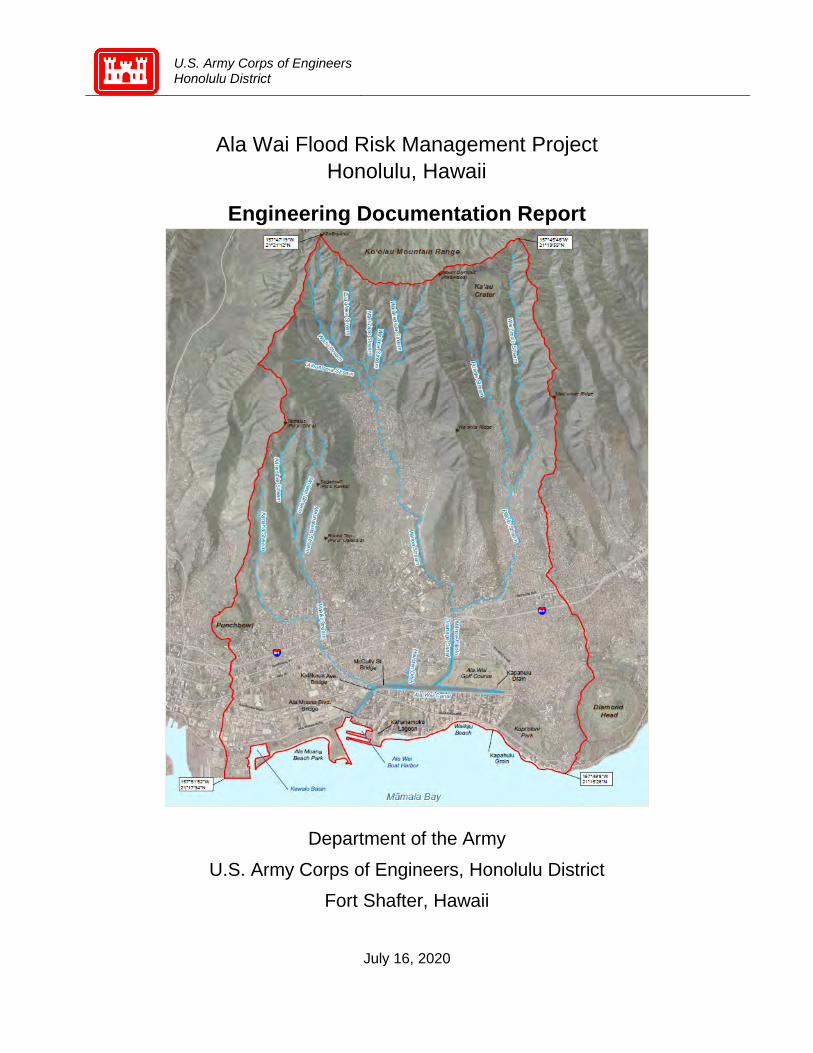
3 PROJECT SCOPE AT FEASIBILITY Overview of Watershed
The Feasibility Recommended Plan consists of eleven structural and two-nonstructural features located across three narrow, steep valleys feeding into the Ala Wai Canal located at the base of the Ko’olau mountain range in a highly urbanized area most well-known for the Waikiki District. Each feature was designed as a component of a linked system intended to (1) detain short duration, high intensity rainfalls in

U.S. Army Corps of Engineers Honolulu District
Ala Wai Flood Risk Management Project Honolulu, Hawaii
Engineering Documentation Report
4
the upper watersheds long enough to offset peak discharges to more manageable flows collection points located at the base of the watershed, and (2) increase storage capacity of the Ala Wai Canal to better contain flood waters thereby substantially reducing risk of life and property loss. The eleven structural features originally planned for the Ala Wai flood risk management project are described in Figure 1.
Figure 1: Ala Wai Watershed project features as authorized from the Feasibility Study
4 PRECONSTRUCTION ENGINEERING AND DESIGN From project authorization and funding in September 2018 through April 2020, the preconstruction engineering and design (PED) phase largely consisted of progressing Hydrologic Engineering Center’s River Analysis System (HEC-RAS) 1D hydrologic and hydraulic modeling to more comprehensive HEC-RAS 1D/2D models to advance design; and the development of potential system modifications to mitigate and incorporate model results in order to achieve the Congressionally authorized level of risk reduction. In brief overview, HEC-RAS 1D/2D model results indicated the desired benefits could not be achieved with the originally planned flood risk management system without modifications. In concept, the system modifications contemplated entailed a shift from temporary detention in the upper watersheds, Modification 3A in the FRM Feasibility Study, to improving conveyance through densely urbanized areas until flow discharge into the Ala Wai Boat Harbor, similar to Modification 2A identified in the FRM
U.S. Army Corps of Engineers Honolulu District
Ala Wai Flood Risk Management Project Honolulu, Hawaii
Engineering Documentation Report
5
Feasibility Study. In addition to hydraulic modeling and engineering analysis, the PED effort also included updating cost estimates, economic analyses, execution schedule, and public outreach. The main points of each of these elements are presented in the main body of the report and discussed in detail in the attached appendices.
5 Hydrologic and Hydraulic Models HEC-RAS 1D Feasibility and 1D/2D PED Phases
The Project Delivery Team (PDT) advanced the 1-dimensional (1D), steady state hydraulic model developed to support the Feasibility Study to an unsteady 1D/2D model, which models the stream channels in 1D and overbank areas as 2D flow, to model the hydrodynamics of the watershed. The modeling used an updated software application (HEC-RAS v5.0.7) to incorporate unsteady state flow. With improved simulation capabilities, HEC-RAS 1D/2D integrates the timing of storm flows, 2-dimensional analysis, more refined terrain elevations, and comprehensive precipitation data to more accurately approximate multi-directional overland flow patterns.
The unsteady state simulations were used to capture flows with respect to time, which enabled the generation and simultaneous comparison of the rising and falling limbs, and peak discharges of the hydrographs at more than 900 cross sections throughout the watershed. This comparison enabled a more accurate representation of coincident inflows throughout the watershed at any given time to help establish safe, appropriate, compliant, and cost-effective design parameters. Additionally, the unsteady state model incorporates and routes the variable flows with adjustments for channel roughness, geometry, and constrictions like bridges and debris blockages. The unsteady models ability to simulate changes to the hydrograph, flow, and water surface elevation over time allow for more accurate representation of hydraulic routing of flow through the watershed while the 2-D flow areas allow for a more accurate representation of how water leaving the channel flows through the overbank areas.
Terrain and topography input were improved with the use of Light Detection and Ranging (LIDAR) remote sensing survey data across the project area. Survey data was also collected using Total Station instrumentation at select, crucial locations identified by the modeling team. The greater density and accuracy of the land survey data improved the understanding of topography and most representative boundary conditions across the study area.
The input for precipitation was estimated based on the NOAA Atlas 14 database using the average rainfall across the entire basin, consistent with the approach used in the Feasibility Study for equivalent comparison. Precipitation estimates were also estimated with the same database to account for varied rainfall in each of the sub-basins of watershed, in order to better to account for orthographic effects up each of the respective valleys, of which Manoa is the largest of the three valley systems. Details of the hydraulic and hydrologic modeling, including spatially varied precipitation analysis across sub-basins, are presented in Appendix A, Hydrologic and Hydraulic Models.
Hydraulic and Hydrologic Model Findings Results of the modeling indicate different baseline conditions for Future Without Projects (FWOP) conditions between the 1D model generated during the feasibility phase and the 1D/2D model updated during the design phase. The following summarizes the key findings from the modeling effort.

U.S. Army Corps of Engineers Honolulu District
Ala Wai Flood Risk Management Project Honolulu, Hawaii
Engineering Documentation Report
6
• Insufficient Detention - the capacity volume and retention time in the detention basins were insufficient to achieve the benefits modeled in the Feasibility Study. Capacity as modeled in the feasibility study was not possible, given the physical constraints at a number of sites
• Overbank Storage - improved terrain data combined with the greater capabilities of 2D simulation allowed more accurate overbank storage calculations, which significantly changed the volume distribution of flood water in the system
• More Accurate Boundary Conditions – more accurate topographic data facilitated the development of more representative boundary conditions, which reduced lateral constraints and broadened the extent of inundation at the base of the watershed
• In-Stream Impediments – Unsteady state modeling combined with 2D capabilities allowed improved simulation of in-channel constraints which forced flow out of bank at multiple bridge crossings
• Increased Out-of-Bank Routing - better quality terrain data identified areas of lower elevations with hydraulic connectivity, where rather than going into storage, flow overtopped the channel banks and increased localized pooling and inundation
Variances in water surface elevations (WSE) from the Feasibility Study emerged as the project advanced through HEC-RAS 1D/2D simulations towards detailed design. Water surface elevations between the 1D and 1D/2D models are presented in Table 1 below and show that the anticipated reductions in feasibility could not be achieved with the authorized system features. Average differences in WSE varied by approximately -1 to -2.5 feet in the valleys, and up to -5.75, -6.74, and -3.80 feet within specific reaches in the Makiki, Manoa, and Palolo Valleys, respectively. The “Difference” columns in Table 1 below compare water surface elevations, with negative values indicating a reduction and positive values indicating an increase to WSE. Cross sections correlating to Table 1 WSEs are presented in Figure 2. Cross sections were located based on positions relative to key topographic and urban infrastructure features, representative distribution along routing throughout the watershed, and proximity to stream gages.
Reach/ Cross Section ID
Feasibility PED EDR (Feasibility)*
1D FWOP
1D With FFEIS
Project
1D Difference
1D/2D FWOP
1D/2D With FFEIS
Project
1D/2D Difference
Ala
Wai
Can
al Ala Wai Lower @1477 3.6 2.9 -0.7 4.5 5.3 0.8
Ala Wai Middle @4847 7.4 6.2 -1.2 7.2 8.9 1.7
Ala Wai Upper @8015 8.3 6.9 -1.4 7.4 9.4 2.0
Average Difference -1.1 1.5
Mak
iki V
alle
y
Kanaha Ditch @1874 72.5 69.9 -2.6 74.3 74.3 0.0 Kanaha Ditch @3005 78.6 78.4 -0.2 79.9 79.9 0.0
Kanaha Split @1394 43.0 42.9 -0.1 N/A N/A N/A Makiki Lower @Fern 1719 7.4 6.7 -0.7 10.3 10.4 0.1
Makiki Lower @Beretania 4325 33.9 27.8 -6.1 37.5 37.2 -0.3
Makiki Upper @Wilder 6606 71.6 70.2 -1.4 70.1 70.1 0.0
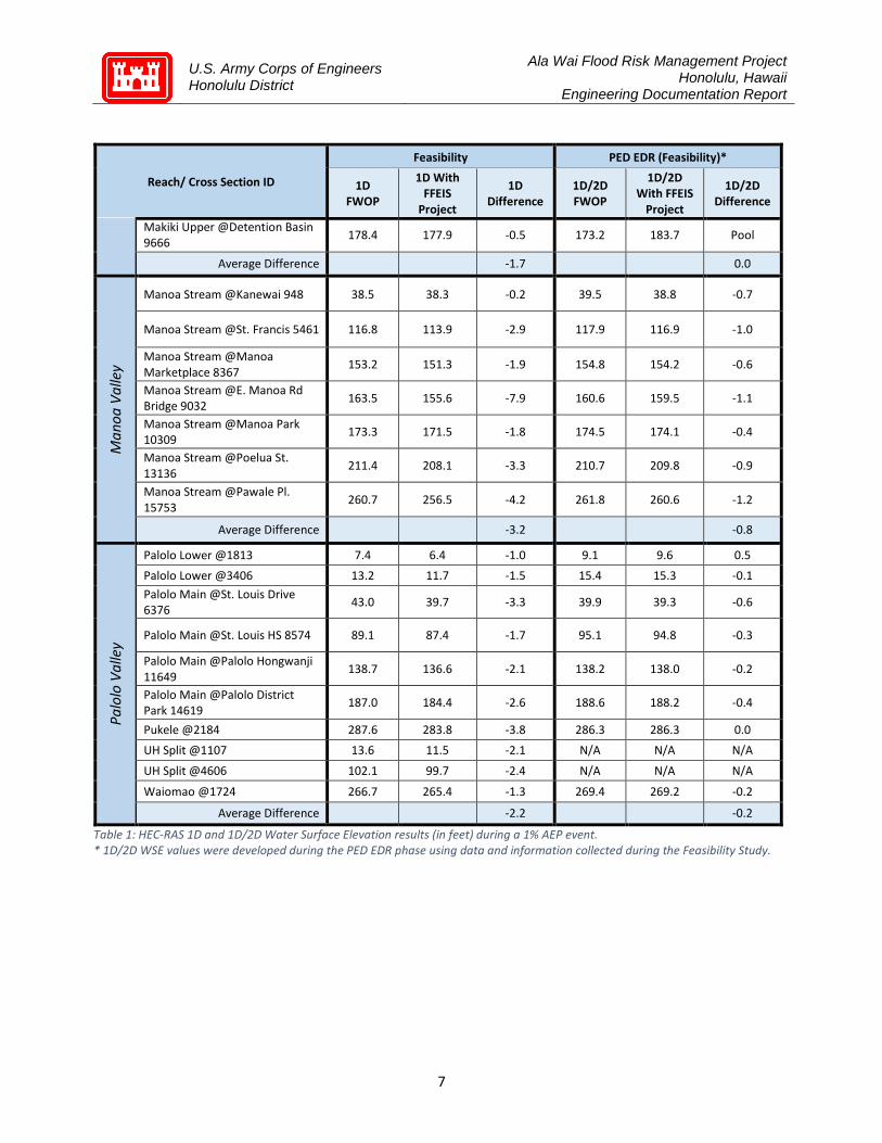
U.S. Army Corps of Engineers Honolulu District
Ala Wai Flood Risk Management Project Honolulu, Hawaii
Engineering Documentation Report
7
Reach/ Cross Section ID
Feasibility PED EDR (Feasibility)*
1D FWOP
1D With FFEIS
Project
1D Difference
1D/2D FWOP
1D/2D With FFEIS
Project
1D/2D Difference
Makiki Upper @Detention Basin 9666 178.4 177.9 -0.5 173.2 183.7 Pool
Average Difference -1.7 0.0
Man
oa V
alle
y
Manoa Stream @Kanewai 948 38.5 38.3 -0.2 39.5 38.8 -0.7
Manoa Stream @St. Francis 5461 116.8 113.9 -2.9 117.9 116.9 -1.0
Manoa Stream @Manoa Marketplace 8367 153.2 151.3 -1.9 154.8 154.2 -0.6
Manoa Stream @E. Manoa Rd Bridge 9032 163.5 155.6 -7.9 160.6 159.5 -1.1
Manoa Stream @Manoa Park 10309 173.3 171.5 -1.8 174.5 174.1 -0.4
Manoa Stream @Poelua St. 13136 211.4 208.1 -3.3 210.7 209.8 -0.9
Manoa Stream @Pawale Pl. 15753 260.7 256.5 -4.2 261.8 260.6 -1.2
Average Difference -3.2 -0.8
Palo
lo V
alle
y
Palolo Lower @1813 7.4 6.4 -1.0 9.1 9.6 0.5 Palolo Lower @3406 13.2 11.7 -1.5 15.4 15.3 -0.1 Palolo Main @St. Louis Drive 6376 43.0 39.7 -3.3 39.9 39.3 -0.6
Palolo Main @St. Louis HS 8574 89.1 87.4 -1.7 95.1 94.8 -0.3
Palolo Main @Palolo Hongwanji 11649 138.7 136.6 -2.1 138.2 138.0 -0.2
Palolo Main @Palolo District Park 14619 187.0 184.4 -2.6 188.6 188.2 -0.4
Pukele @2184 287.6 283.8 -3.8 286.3 286.3 0.0 UH Split @1107 13.6 11.5 -2.1 N/A N/A N/A
UH Split @4606 102.1 99.7 -2.4 N/A N/A N/A
Waiomao @1724 266.7 265.4 -1.3 269.4 269.2 -0.2
Average Difference -2.2 -0.2
Table 1: HEC-RAS 1D and 1D/2D Water Surface Elevation results (in feet) during a 1% AEP event. * 1D/2D WSE values were developed during the PED EDR phase using data and information collected during the Feasibility Study.

U.S. Army Corps of Engineers Honolulu District
Ala Wai Flood Risk Management Project Honolulu, Hawaii
Engineering Documentation Report
8
Figure 2: Cross section ID locations
The differences between the HEC-RAS 1D model conducted in feasibility and the HEC-RAS 1D/2D simulations generated during the PED phase are illustrated below in Figure 3, Figure 4, and Figure 5. Figure 3 shows the HEC-RAS 1D model results without project features in place relative to HEC-RAS 1D model results with the mitigation measures from the Feasibility Study in place. Figure 4 illustrates the HEC-RAS 1D/2D model results without project features relative to the HEC-RAS 1D/2D model results with the Feasibility Study project features in place, primarily detention basins. Figure 5 compares the more current HEC-RAS 1D/2D without project conditions to HEC-RAS 1D/2D results with the proposed EDR modifications in place, which emphasize enhanced conveyance rather than detention. Notable differences from the Feasibility Study phase to the current stage in PED include (1) more extensive inundation across the base of the watershed when the north-south trending boundary conditions were adjusted, and (2) as shown in Figure 4 and the negative WSE benefits from Table 1, inundation increased from future without project conditions to future with FFEIS project conditions, and (3) the anticipated WSE reductions were not realized due to insufficient detention capacity and flow constraints along the routing. Consequently, modifications to the risk management features were evaluated to mitigate these emergent findings.
Cross Section ID
FFEIS Features

U.S. Army Corps of Engineers Honolulu District
Ala Wai Flood Risk Management Project Honolulu, Hawaii
Engineering Documentation Report
9
Figure 3: Inundation Depths 1D Future Without Project (left) versus 1D Future With FFEIS Project (right) in a 1% AEP event. Depth models generated May 2019 using data collected during the Feasibility Study.
Figure 4: Inundation Depths 1D/2D Future Without Project (left) versus 1D/2D Future With FFEIS Project (right) in a 1% AEP event. Depth models generated May 2019 using data collected during the Feasibility Study.
Figure 5: Inundation Depths 1D/2D Future Without Project (left) versus 1D/2D Future With EDR Recommended Modifications (right) in a 1% AEP event. Depth models generated May 2020 using data collected in the PED EDR phase.
U.S. Army Corps of Engineers Honolulu District
Ala Wai Flood Risk Management Project Honolulu, Hawaii
Engineering Documentation Report
10
6 System Optimization Analysis The following is an overview of the (1) physical description and purpose of the authorized structural features, (2) an assessment of how the features perform relative to the planned benefits after HEC-RAS 1D/2D modelling, and (3) system optimizations evaluated to achieve the flood risk management system objectives authorized by Congress. The features are discussed with respect to physical characteristics, risk management benefits, and recommended modifications for further evaluation in a project Validation Study.
The authorized project from the FFEIS consists of eleven structural features located across three narrow, steep valleys feeding into the Ala Wai Canal located at the base of the Ko’olau mountain range in a highly urbanized area most well-known for the Waikiki District, see Figure 1.
Each feature was designed as a component of a linked system intended to (1) detain short duration, high intensity rainfalls in the upper watersheds at the source, (2) delay and offset peak discharges to more manageable flows into the Ala Wai Canal at the base of the watershed, and (3) increase storage capacity of the Ala Wai Canal to substantially reduce risk to public safety, public infrastructure, and the economy.
Following the HEC-RAS 1D/2D results, modifications to the system were evaluated to achieve the intended benefits and evaluations included (1) increasing the storage capacity by raising the top of the detention basins and floodwall heights, (2) expanding the storage capacity of the detention basins through excavation, (3) re-siting the structures to more suitable locations, and (4) increasing detention times by optimizing discharge rates from the basins using flow control methods.
Upper Watershed (West) – Makiki Valley The Makiki Valley is the westernmost and smallest of the three valleys comprising the Ala Wai Watershed. The authorized project included one structural feature in Makiki Valley, a debris and detention basin placed on steep and narrow lands in the upper reaches of the valley.
6.1.1 Physical Description (Makiki Feature) The Makiki Debris and Detention Basin, as previously recommended in the FFEIS is approximately 36 feet high and 100 feet across with an arch culvert to allow natural and small event flows to pass. The feature included a concrete spillway above the culvert, a debris catchment feature located on upstream end of culvert, and approximately 150 feet of rip-rap for energy dissipation and scour protection downstream of culvert. Excavation of approximately 3,035 cubic yards (CY) was planned to provide the required detention volume upstream of berm and support construction of a new access road. As Figure 6 illustrates, the feature is located in a narrow, steep valley between two roads with public and private property on both sides of the stream.

U.S. Army Corps of Engineers Honolulu District
Ala Wai Flood Risk Management Project Honolulu, Hawaii
Engineering Documentation Report
11
6.1.2 Intended Purpose (Makiki Feature) The purpose of the feature during feasibility was to temporarily detain peak flows and reduce overbank flooding at multiple choke points, including narrow historic channels and several reaches underneath mid- and high-rise apartment buildings downstream through the highly urbanized Moiliili and McCully neighborhoods.
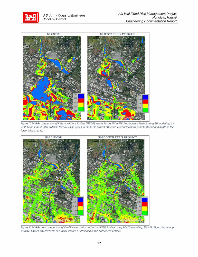
6.1.3 Assessment (Makiki Feature) Results of HEC-RAS 1D/2D modeling indicate insufficient storage capacity to reduce overbank flooding through the length of the stream. A comparison of HEC-RAS 1D With Project- Feasibility Study Plan (FSP) and the 1D Future Without Project (FWOP) showed valuable benefits with the recommended detention basin as proposed in the Feasibility Study (Figure 7). However, the HEC-RAS 1D/2D modeling in Figure 8 indicate that (a) inundation is shallower, and therefore less damaging than originally estimated, and (b) there is very little difference in the lateral extent or depth of flooding with the detention basin in place. With the benefit of more comprehensive modeling in the PED phase, it was determined that the detention basin proposed in feasibility is unable to achieve the benefits anticipated, in part because there is less flooding than originally estimated.
Figure 6: Makiki Debris and Detention Basin Feasibility Study design plans
U.S. Army Corps of Engineers Honolulu District
Ala Wai Flood Risk Management Project Honolulu, Hawaii
Engineering Documentation Report
12
1D FWOP 1D WITH FFEIS PROJECT
Figure 7: Makiki comparison of Future Without Project (FWOP) versus Future With FFEIS authorized Project using 1D modeling, 1% AEP. Flood map displays Makiki feature as designed in the FFEIS Project effective in reducing both flood footprint and depth in the lower Makiki area.
1D/2D FWOP 1D/2D WITH FFEIS PROJECT
Figure 8: Makiki area comparison of FWOP versus With authorized FFEIS Project using 1D/2D modeling, 1% AEP. Flood depth map displays limited effectiveness of Makiki feature as designed in the authorized project.
U.S. Army Corps of Engineers Honolulu District
Ala Wai Flood Risk Management Project Honolulu, Hawaii
Engineering Documentation Report
13
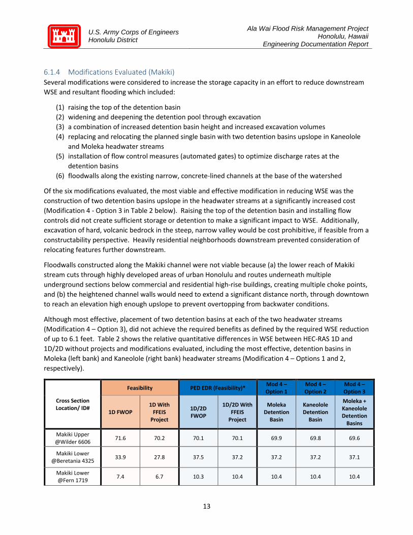
6.1.4 Modifications Evaluated (Makiki) Several modifications were considered to increase the storage capacity in an effort to reduce downstream WSE and resultant flooding which included:
(1) raising the top of the detention basin (2) widening and deepening the detention pool through excavation (3) a combination of increased detention basin height and increased excavation volumes (4) replacing and relocating the planned single basin with two detention basins upslope in Kaneolole
and Moleka headwater streams (5) installation of flow control measures (automated gates) to optimize discharge rates at the
detention basins (6) floodwalls along the existing narrow, concrete-lined channels at the base of the watershed
Of the six modifications evaluated, the most viable and effective modification in reducing WSE was the construction of two detention basins upslope in the headwater streams at a significantly increased cost (Modification 4 - Option 3 in Table 2 below). Raising the top of the detention basin and installing flow controls did not create sufficient storage or detention to make a significant impact to WSE. Additionally, excavation of hard, volcanic bedrock in the steep, narrow valley would be cost prohibitive, if feasible from a constructability perspective. Heavily residential neighborhoods downstream prevented consideration of relocating features further downstream.
Floodwalls constructed along the Makiki channel were not viable because (a) the lower reach of Makiki stream cuts through highly developed areas of urban Honolulu and routes underneath multiple underground sections below commercial and residential high-rise buildings, creating multiple choke points, and (b) the heightened channel walls would need to extend a significant distance north, through downtown to reach an elevation high enough upslope to prevent overtopping from backwater conditions.
Although most effective, placement of two detention basins at each of the two headwater streams (Modification 4 – Option 3), did not achieve the required benefits as defined by the required WSE reduction of up to 6.1 feet. Table 2 shows the relative quantitative differences in WSE between HEC-RAS 1D and 1D/2D without projects and modifications evaluated, including the most effective, detention basins in Moleka (left bank) and Kaneolole (right bank) headwater streams (Modification 4 – Options 1 and 2, respectively).
Cross Section Location/ ID#
Feasibility PED EDR (Feasibility)* Mod 4 – Option 1
Mod 4 – Option 2
Mod 4 – Option 3
1D FWOP 1D With
FFEIS Project
1D/2D FWOP
1D/2D With FFEIS
Project
Moleka Detention
Basin
Kaneolole Detention
Basin
Moleka + Kaneolole Detention
Basins
Makiki Upper @Wilder 6606 71.6 70.2 70.1 70.1 69.9 69.8 69.6
Makiki Lower @Beretania 4325 33.9 27.8 37.5 37.2 37.2 37.2 37.1
Makiki Lower @Fern 1719 7.4 6.7 10.3 10.4 10.4 10.4 10.4

U.S. Army Corps of Engineers Honolulu District
Ala Wai Flood Risk Management Project Honolulu, Hawaii
Engineering Documentation Report
14
Kanaha Ditch @3005 78.6 78.4 79.9 79.9 79.9 79.9 79.9
Kanaha Ditch @1874 72.5 69.9 74.3 74.3 74.3 74.3 74.3
Table 2: Water Surface Elevation (in feet) within Makiki Valley, with comparisons between HEC-RAS 1D and 1D/2D conditions, as well as comparisons of Modification 4 options evaluated in Makiki during a 1% AEP storm event. * 1D/2D WSE values were developed during the PED EDR phase using data and information collected during the Feasibility Study.
Figure 9: Water Surface Elevation Differences (in feet), comparing 1D/2D Future Without Project conditions to various Mod 4 Options in Makiki Valley, 1% AEP.
With updated 1D/2D modeling, the maximum benefit with dual detention basins at the headwater streams (Modification 4 – Option 3) is 0.5 feet of WSE reduction at cross section 6606. Further downstream at cross section 4325, the dual detention basin WSE reduction is 0.4 feet, which is 5.7 feet less reduction than anticipated in feasibility.
Additionally, Figure 9 compares the WSE differences between HEC-RAS 1D with the planned projects in place and the HEC-RAS 1D/2D with projects. The modifications evaluated clearly illustrate (1) 1D modeling results over-estimated the WSE reductions with project conditions, and (2) the benefits of the detention basins relative to no detention basins are negligible, less than 0.5 feet. This can be seen by the minimal effects of the most effective of the HEC-RAS 1D/2D modifications evaluated, two detention basins across the two headwater streams as illustrated in Modification 4 – Option 3 (green line).
6.1.5 Proposed Modification and Path Forward (Makiki) After evaluating several modifications and optimizations, it was determined that detention basin(s) located in the upper watershed of Makiki Valley will not achieve the required risk reduction, particularly when

U.S. Army Corps of Engineers Honolulu District
Ala Wai Flood Risk Management Project Honolulu, Hawaii
Engineering Documentation Report
15
considered relative to an estimated $22M construction cost. Therefore, pending final evaluation during the Validation Study, the detention basin in Makiki Valley has been removed from the flood risk management system in the absence of an effective engineering solution. Findings from the hydrologic and hydraulic analysis in Makiki Valley necessitated a conceptual shift from maximizing flood water detention to enhanced conveyance to manage flood risk.
To manage the storm flow at the base of the watershed, a 1,500 linear foot by 20-foot wide and 10-foot deep box culvert beginning immediately east of the confluence of the Makiki channel with the Ala Wai Canal (Figure 10) was included in the system solution at this time. The diversion culvert increases channel capacity to handle the backwater flooding in Makiki Stream at its confluence with the Ala Wai Canal as well as collect and reroute overland flow that would normally flow into the canal but is now blocked by floodwalls near the Hawaii Convention Center. The impact to WSE has not yet been fully evaluated as part of this study and recommend further evaluation for performance optimization, environmental impacts, and cost effectiveness as part of the Validation Study.
Figure 10: Conceptual footprint of Makiki Diversion
In summary, removal of the detention basin from the upper Makiki Valley and the addition of a diversion culvert at the base of the Makiki channel is recommended. HEC-RAS 1D/2D System Model (Manoa Modification 9), incorporates this recommendation.
Upper Watershed (Central) – Manoa Valley The Manoa Valley is the largest of the three watersheds flowing to the Ala Wai Canal and as such offers the most opportunity to achieve the flood risk management objectives in the lower watershed at the Ala Wai canal. The Feasibility Study recommended two debris/detention basins, one detention basin, one stand-alone debris catchment, and one multi-purpose detention basin in Manoa Valley, which is predominantly residential as well as the home to University of Hawaii at Manoa, the largest campus in the University of Hawaii System. From highest to lowest elevation, the four detention basins are Waihi, Waiakeakua, Woodlawn Ditch, and Kanewai. The debris catchment structure is located in the Manoa Stream in the vicinity of Manoa Valley District Park.

U.S. Army Corps of Engineers Honolulu District
Ala Wai Flood Risk Management Project Honolulu, Hawaii
Engineering Documentation Report
16
6.2.1 Physical Description (Manoa Features) 6.2.1.1 Waihi Debris & Detention Basin This is an earthen in-stream structure, approximately 42 feet high and 477 feet across the Waihi Stream with a box culvert to allow small storm flows to pass and a concrete spillway above culvert with grouted rip-rap on upstream and downstream side. A debris catchment feature is located on the upstream end of culvert with approximately 150 feet of rip-rap for energy dissipation and scour protection downstream of culvert. A new, 20-foot wide access road was planned for maintenance, which would require acquisition of private property through the land acquisition and/or easement of private property (Figure 11).
6.2.1.2 Waiakeakua Debris & Detention Basin This is an earthen in-stream structure approximately 37 feet high and 401 feet across the Waiakeakua Stream with similar features as the Waihi structure, including the construction of a 20-foot wide access road. Waiakeakua and Waihi structures are frequently considered in connection with one another due to their location in adjacent ravines and high elevation in the Manoa valley. Land acquisition and/or easement actions would be required to construct and maintain this structure (Figure 12).
Figure 11: Waihi Debris and Detention Basin footprint as designed in Feasibility
Figure 12: Waiakeakua Debris and Detention Basin footprint as designed in Feasibility

U.S. Army Corps of Engineers Honolulu District
Ala Wai Flood Risk Management Project Honolulu, Hawaii
Engineering Documentation Report
17
6.2.1.3 Woodlawn Ditch Detention Basin This is a three-sided detention basin (Figure 13) with earthen berms approximately 15 feet high and 840 total linear feet with an arch culvert to allow small storm flows to pass and a concrete spillway above culvert with grouted rip-rap on upstream and downstream sides.
Figure 13: Woodlawn Ditch Detention Basin footprint as designed in Feasibility
6.2.1.4 Manoa In-Stream Catchment This is an in-stream debris catchment structure consisting of steel posts anchored into a concrete pad approximately 8 feet wide and 60 feet across; steel posts designed to be 7 feet above grade, evenly spaced on 4-foot centers along the width of the concrete pad (Figure 14).
Figure 14: Manoa In-stream Debris Catchment cross section design from Feasibility

U.S. Army Corps of Engineers Honolulu District
Ala Wai Flood Risk Management Project Honolulu, Hawaii
Engineering Documentation Report
18
6.2.1.5 Kanewai Detention Basin This feature is a multi-purpose detention basin with earthen berms approximately 9 feet high at the perimeter of multi-use recreation fields adjacent to the Hokulani Elementary School. This detention basin has a grouted rip-rap inflow spillway along the bank of Manoa Stream to allow high flows to enter the basin and an existing drainage discharge pipe on City and County of Honolulu property at south end of basin to allow water to re-enter stream (Figure 15).
6.2.2 Intended Purpose from Feasibility Study (Manoa Features) The purpose of the structural features is to temporarily detain peak flows and reduce overbank flooding at multiple choke points, primarily overtopping of the Woodlawn Bridge which results in flooding at the University of Hawaii and further downslope towards the Moiliili district.
6.2.3 Assessment (Manoa Features) Results of the HEC-RAS 1D/2D, unsteady state modeling indicate the features planned during the feasibility study produced a favorable reduction in WSE, although not at the levels anticipated with the 1D, steady state model. The most notable variance was in the vicinity of Cross Section 9032 upstream of Woodlawn Bridge in the reach adjacent to the Manoa Marketplace. As shown in Table 3, there was a WSE difference of -1.2 feet as estimated by the HEC-RAS 1D/2D model compared to a difference of -7.9 feet with the HEC-RAS 1D during feasibility. Negative values of the WSE difference indicate a reduction to the water surface elevation. This is particularly relevant because modelling consistently showed overtopping at the Woodlawn Bridge, which is consistent with observations in 2004 when the University of Hawaii campus sustained $84 million of flood damage in a 4% AEP event (Figure 16). Observations of flooding during the 2004 storm event corresponded closely to the HEC-RAS 1D/2D FWOP model results. Although hydrologic data from the 2004 storm event was limited, hydrographs were used to calibrate the model to the extent possible.
Figure 15: Kanewai Field Multi-Purpose Detention Basin footprint as designed in Feasibility

U.S. Army Corps of Engineers Honolulu District
Ala Wai Flood Risk Management Project Honolulu, Hawaii
Engineering Documentation Report
19
Figure 16: October 2004 Flood, Debris Blockage and Car Damage at Woodlawn Bridge, Manoa Stream
Reach/ Cross Section ID
Feasibility PED EDR*
1D FWOP 1D With
FFEIS Project
Difference 1D/2D FWOP
1D/2D With FFEIS
Project Difference
Man
oa V
alle
y
Manoa Stream @Kanewai 948 38.5 38.3 -0.2 39.5 38.8 -0.7 Manoa Stream @St. Francis 5461 116.8 113.9 -2.9 117.9 116.9 -0.9
Manoa Stream @Manoa Marketplace 8367 153.2 151.3 -2.0 154.8 154.2 -0.6
Manoa Stream @E. Manoa Rd Bridge 9032 163.5 155.6 -7.9 160.6 159.5 -1.2
Manoa Stream @Manoa Park 10309 173.3 171.5 -1.8 174.5 174.1 -0.4
Manoa Stream @Poelua St. 13136 211.4 208.1 -3.3 210.7 209.8 -0.9
Manoa Stream @Pawale Pl. 15753 260.7 256.5 -4.2 261.8 260.6 -1.2
Table 3: Comparison of HEC-RAS 1D and 1D/2D differences in water surface elevation, With and Without FFEIS Project Conditions in Manoa Valley, 1% AEP. * 1D/2D WSE values were developed during the PED EDR phase using data and information collected during the Feasibility Study.
On average, there was 74% more WSE reduction estimated in the 1D steady state model during the feasibility phase when compared to the 1D/2D unsteady state model results with structural features in place. Significantly, with HEC-RAS 1D/2D modeling, there was -1.2 feet of WSE difference, with negative numbers indicating WSE reduction, at the East Manoa Road Bridge cross section with the Waihi, Waiakeakua, and Woodlawn detention basins in place where the 1D model results estimated a -7.9 foot difference. On average, less than -1 foot of WSE difference was estimated with the planned structures in place using HEC-RAS 1D/2D, which indicates the features recommended during the feasibility phase with the technical limits of 1D steady state modeling would not achieve the desired risk management benefits to the system. As observed elsewhere in the watershed, the difference between the HEC-RAS 1D and 1D/2D results was due to a combination of (a) steady versus unsteady state flow, (b) how overbank storage is estimated, (c) routing characteristics, particularly at urban constrictions like bridge substructures, and (d) differences due to hydrologic model inputs for rainfall conditions.

U.S. Army Corps of Engineers Honolulu District
Ala Wai Flood Risk Management Project Honolulu, Hawaii
Engineering Documentation Report
20
In addition to evaluating the WSE at each cross section throughout the routing system, the stream reach between the (1) East Manoa Bridge at the Woodlawn Bridge and (2) the confluence of the M-P channel and the Ala Wai Canal were two locations of significant interest. Historical events and model simulations indicate consistent overtopping at the Woodlawn Bridge, which results in flooding down valley through the university and residential neighborhoods to the base of the watershed. The second point of interest is the confluence of the M-P channel and the Ala Wai Canal because without engineering mitigation measures, this is the highest WSE in the Ala Wai canal and has a decisive impact on the extent and depth of inundation in neighborhoods and businesses at the base of the watershed, north and south of the canal.
6.2.4 Modifications Evaluated (Manoa) The HEC-RAS 1D/2D unsteady state modeling efforts to advance the feature designs began with the authorized project, which included Waihi and Waiakeakua detention basins, and the Woodlawn Ditch features. Results of this modeling effort indicated overtopping at the Woodlawn Bridge as indicated in Figure 17.
These results prompted a hydraulic analysis of the Manoa Marketplace stream reach to assess if the bridge structure was creating the overtopping, and if so, could the conditions be rectified to eliminate flooding. The analysis was further supported by widespread community supposition that debris blockage at the bridge was the cause of the 2004 flood that damaged the neighborhood and the University of Hawaii. Construction as-built drawings from the State of Hawaii Department of Land and Natural Resources Manoa Stream Improvements at Woodlawn Drive Bridge Project completed in late 2019 were incorporated into the hydraulic model to maximize accuracy. Results of the model at the 1% AEP indicate overtopping in this reach would occur with detention basins in place and the entire bridge structure removed. These findings indicated that the capacity of the stream channel itself in the Manoa Marketplace area would overtop on its own independent of the Woodlawn bridge structure and debris blockage. These findings drove an unequivocal requirement for a solution at the vicinity of the Manoa Marketplace to prevent future flooding, and which would concurrently benefit the entire system.
Numerous options were evaluated to maximize the flood risk management benefits in Manoa Valley and throughout the Ala Wai system. These modifications focused on eliminating or minimizing risk to life, property, and the environment to the maximum extent possible consistent with USACE directives. All of the modifications evaluated included a bypass at Woodlawn Drive Bridge, and included assessment of stand-alone and combined modifications, several of which were previously considered during the feasibility
Figure 17: HEC-RAS 1D/2D modeling results with Waihi and Waiakeakua optimized illustrates water still jumps bank at Woodlawn Bridge, 1% AEP.

U.S. Army Corps of Engineers Honolulu District
Ala Wai Flood Risk Management Project Honolulu, Hawaii
Engineering Documentation Report
21
phase and prior efforts based on accepted engineering practices and community input. This broader list of modifications evaluated included the following measures:
• increased heights of detention basins • combining the Waihi and Waiakeakua detention basins into a single, larger feature • alternative basin alignments • optimized outlet configurations • automated flood gates • re-evaluation of the Manoa District Park and other similar green spaces for temporary storage • deepening the stream bottom and routine maintenance at critical reaches downstream of East
Manoa Bridge • floodwalls at key, low lying stream reaches • construction of bypass culvert at the Woodlawn Bridge stream reach to maintain flow within the
stream banks
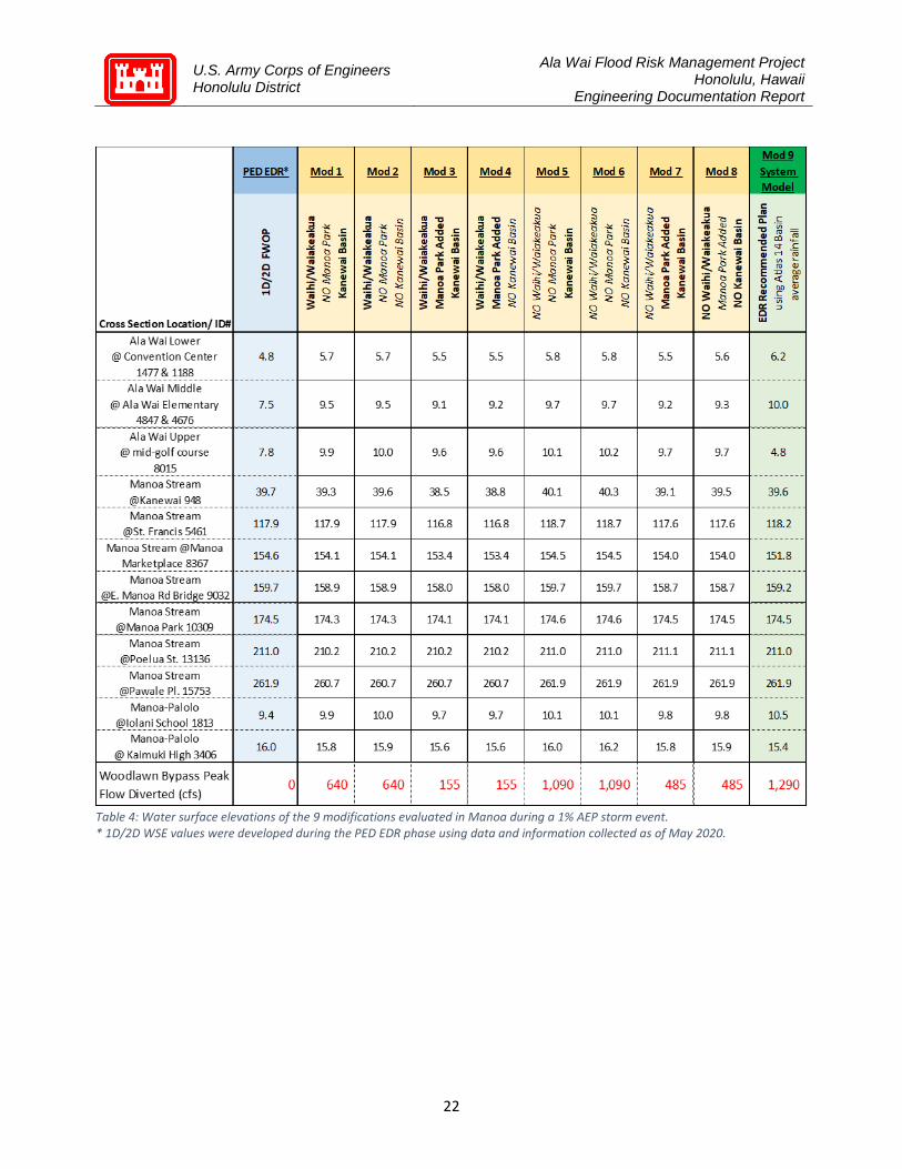
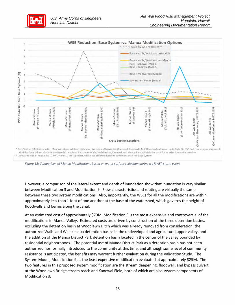
The optimized measures resulted in nine different modification concepts, as shown in Table 4 and Figure 18 below. Based on the 1D/2D model results, the Woodlawn Ditch Detention Basin provided inconsequential benefit and was thus removed from further analysis. Of the nine modifications evaluated, Modification 3 (retention of Waihi, Waiakeakua, Kanewai and addition of Manoa District Park detention basins) demonstrates the most reduction in WSE throughout the routing, the greatest difference in the range of approximately 1.7 feet at Cross Section East Manoa Bridge (9032), when compared to the System Model, Modification 9 (removal of Waihi, Waiakeakua, no addition of Manoa District Park, retention of Kanewai detention basin and addition of Woodlawn Bypass) reduction of approximately 0.5 feet at that same area. These results suggest temporary detention of high intensity rainfall in the upper and central valley sufficiently reduces flow in the Manoa Stream, such that when combined with a bypass system at the Woodlawn Bridge, placement of the Waihi, Waiakeakua, and Manoa District Park features produce the most favorable WSE reductions.
U.S. Army Corps of Engineers Honolulu District
Ala Wai Flood Risk Management Project Honolulu, Hawaii
Engineering Documentation Report
22
Table 4: Water surface elevations of the 9 modifications evaluated in Manoa during a 1% AEP storm event. * 1D/2D WSE values were developed during the PED EDR phase using data and information collected as of May 2020.
U.S. Army Corps of Engineers Honolulu District
Ala Wai Flood Risk Management Project Honolulu, Hawaii
Engineering Documentation Report
23
However, a comparison of the lateral extent and depth of inundation show that inundation is very similar between Modification 3 and Modification 9. Flow characteristics and routing are virtually the same between these two system modifications. Also, importantly, the WSEs for all the modifications are within approximately less than 1 foot of one another at the base of the watershed, which governs the height of floodwalls and berms along the canal.
At an estimated cost of approximately $70M, Modification 3 is the most expensive and controversial of the modifications in Manoa Valley. Estimated costs are driven by construction of the three detention basins, excluding the detention basin at Woodlawn Ditch which was already removed from consideration; the authorized Waihi and Waiakeakua detention basins in the undeveloped and agricultural upper valley, and the addition of the Manoa District Park detention basin located in the center of the valley bounded by residential neighborhoods. The potential use of Manoa District Park as a detention basin has not been authorized nor formally introduced to the community at this time, and although some level of community resistance is anticipated, the benefits may warrant further evaluation during the Validation Study. The System Model, Modification 9, is the least expensive modification evaluated at approximately $25M. The two features in this proposed system modification are the stream deepening, floodwall, and bypass culvert at the Woodlawn Bridge stream reach and Kanewai Field, both of which are also system components of Modification 3.
Figure 18: Comparison of Manoa Modifications based on water surface reduction during a 1% AEP storm event.

U.S. Army Corps of Engineers Honolulu District
Ala Wai Flood Risk Management Project Honolulu, Hawaii
Engineering Documentation Report
24
6.2.5 Proposed Modification and Path Forward (Manoa) The recommended system modification for the Manoa Valley is Modification 9 which consists of (a) stream deepening with a natural bedrock bottom to increase capacity, improve grade to enhance in-channel flow, and help reduce reoccurring sedimentation at the Woodlawn Drive Bridge (b) floodwalls along the Manoa Marketplace reach tying into the Woodlawn Drive Bridge where flood waters historically leave the stream; these floodwalls are essentially an extension of existing walls north of East Manoa Road Bridge, and (c) a box culvert bypass to capture, re-route, and return approximately 1,100 cubic feet per second of excess flow around the constriction at the Woodlawn Bridge to the Manoa Stream (Figure 19). Benefits with the System Model in place can be seen in Figure 20.
Figure 20: Comparison of the 1D/2D FWOP (left) to the 1D/2D Future with Modification 9 System Model (right) in Manoa Valley, 1% AEP
Figure 19: Woodlawn Bridge modifications as proposed in Modification 9 System Model)

U.S. Army Corps of Engineers Honolulu District
Ala Wai Flood Risk Management Project Honolulu, Hawaii
Engineering Documentation Report
25
Flood proofing the bridge to effectively address potential debris blockages at the bridge was evaluated, determined viable, and will be addressed during the Validation Study and detailed design phases. Areas of additional engineering effort, NEPA evaluation, and community input to better assess cost, community, and environmental impacts include (a) spatially varied rainfall estimates within valley sub-basins, (b) alternate bypass routing and optimization, which may include additional debris catchment features and floodwalls upstream (c) the use of Manoa District Park as a potential detention basin, and (d) berm height adjustments at the Kanewai field. These features will be further assessed for estimated cost, economic benefit, and environmental impacts during the Validation Study with supplemental NEPA efforts.
Palolo Valley The Palolo Valley is the easternmost valley in the Ala Wai watershed. The planned structural features consist of two debris and detention basins placed across the Pukele and Waiomao Streams, respectively, which merge into the Palolo Stream downstream near the head of the valley. Palolo Stream routes through various residential neighborhoods throughout the length of the valley and is contained by a concrete lined channel with vertical walls until joining the Manoa Stream immediately downslope of the University of Hawaii prior to entering the Ala Wai Canal. Structural features at Pukele and Waiomao Stream require real estate acquisition from private landowners.
6.3.1 Physical Description (Palolo Feasibility Features) 6.3.1.1 Pukele This feature consists of an earthen debris and detention basin approximately 35 feet high and 82 feet across with a box culvert to allow small storm flows to pass and a concrete spillway above culvert with grouted rip-rap on upstream and downstream sides. A debris catchment feature is located on upstream end of culvert with approximately 150 feet of rip-rap for energy dissipation and scour protection downstream of culvert. Excavation of approximately 14,330 CY is required to provide detention volume upstream of berm and a new access road to be constructed for maintenance (Figure 21).
Figure 21: Pukele Debris and Detention Basin footprint as designed in Feasibility

U.S. Army Corps of Engineers Honolulu District
Ala Wai Flood Risk Management Project Honolulu, Hawaii
Engineering Documentation Report
26
6.3.1.2 Wai’oma’o This feature is an earthen debris and detention basin approximately 34 feet high and 275 feet across with similar components as the Pukele structure. Estimated excavation of approximately 3,060 CY is required to provide the necessary detention volume upstream of the berm and a new access road to be constructed for maintenance (Figure 22).
6.3.2 Intended Purpose from Feasibility Study (Palolo Feasibility Features) Both the Pukele and Waiomao debris and detention basins were sited to detain the maximum amount of storm water as practicable and to regulate the release of flow thereby flattening and reducing the peak flow discharge. The peak flow reductions were intended to prevent flooding in the lower Palolo Valley and the combined inflow and potential inundation at the confluence with the Manoa stream.
6.3.3 Assessment (Palolo Feasibility Features) Analysis of the 1D/2D modeling indicates that while stormwater flow with the presence of the detention basins provide some benefit, the flow still exceeds the ability of the channel to contain peak discharges at multiple locations throughout the routing. Overtopping most notably occurs at the multiple, small bridges where the substructures create constraints and force flow out of the channel. Consequently, even with detention basins in place, flows at peak discharge are not reduced sufficiently to prevent overtopping at bridge constraints and resulting shallow flooding. Additionally, given minimal impact to the flow in the main reaches in Palolo Valley, there is no effective reduction of WSE in the M-P Channel.
Figure 22: Waiomao Debris and Detention Basin footprint as designed in Feasibility
U.S. Army Corps of Engineers Honolulu District
Ala Wai Flood Risk Management Project Honolulu, Hawaii
Engineering Documentation Report
27
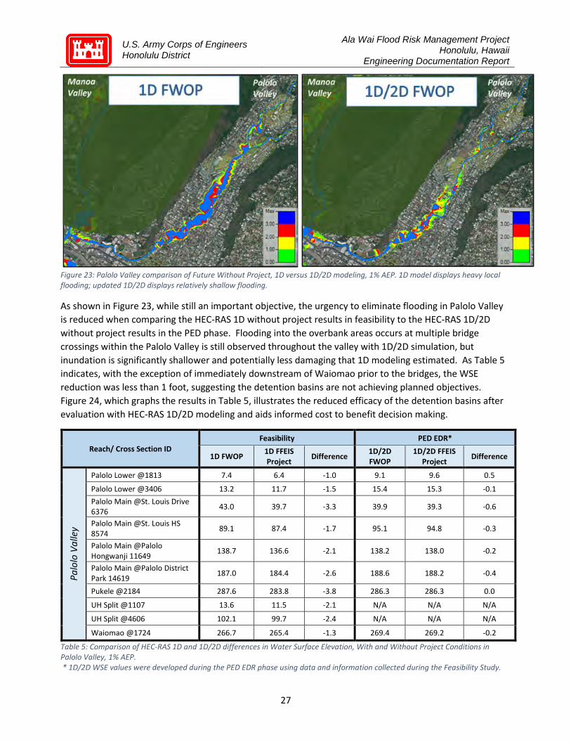
Figure 23: Palolo Valley comparison of Future Without Project, 1D versus 1D/2D modeling, 1% AEP. 1D model displays heavy local flooding; updated 1D/2D displays relatively shallow flooding.
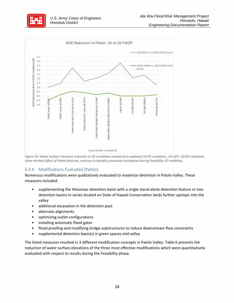
As shown in Figure 23, while still an important objective, the urgency to eliminate flooding in Palolo Valley is reduced when comparing the HEC-RAS 1D without project results in feasibility to the HEC-RAS 1D/2D without project results in the PED phase. Flooding into the overbank areas occurs at multiple bridge crossings within the Palolo Valley is still observed throughout the valley with 1D/2D simulation, but inundation is significantly shallower and potentially less damaging that 1D modeling estimated. As Table 5 indicates, with the exception of immediately downstream of Waiomao prior to the bridges, the WSE reduction was less than 1 foot, suggesting the detention basins are not achieving planned objectives. Figure 24, which graphs the results in Table 5, illustrates the reduced efficacy of the detention basins after evaluation with HEC-RAS 1D/2D modeling and aids informed cost to benefit decision making.
Reach/ Cross Section ID Feasibility PED EDR*
1D FWOP 1D FFEIS Project Difference 1D/2D
FWOP 1D/2D FFEIS
Project Difference
Palo
lo V
alle
y
Palolo Lower @1813 7.4 6.4 -1.0 9.1 9.6 0.5
Palolo Lower @3406 13.2 11.7 -1.5 15.4 15.3 -0.1 Palolo Main @St. Louis Drive 6376 43.0 39.7 -3.3 39.9 39.3 -0.6
Palolo Main @St. Louis HS 8574 89.1 87.4 -1.7 95.1 94.8 -0.3
Palolo Main @Palolo Hongwanji 11649 138.7 136.6 -2.1 138.2 138.0 -0.2
Palolo Main @Palolo District Park 14619 187.0 184.4 -2.6 188.6 188.2 -0.4
Pukele @2184 287.6 283.8 -3.8 286.3 286.3 0.0
UH Split @1107 13.6 11.5 -2.1 N/A N/A N/A
UH Split @4606 102.1 99.7 -2.4 N/A N/A N/A
Waiomao @1724 266.7 265.4 -1.3 269.4 269.2 -0.2
Table 5: Comparison of HEC-RAS 1D and 1D/2D differences in Water Surface Elevation, With and Without Project Conditions in Palolo Valley, 1% AEP. * 1D/2D WSE values were developed during the PED EDR phase using data and information collected during the Feasibility Study.
U.S. Army Corps of Engineers Honolulu District
Ala Wai Flood Risk Management Project Honolulu, Hawaii
Engineering Documentation Report
28
Figure 24: Water Surface Elevation reduction in 1D conditions compared to updated 1D/2D conditions, 1% AEP. 1D/2D conditions show minimal effect of Palolo features, contrary to benefits previously anticipated during Feasibility 1D modeling.
6.3.4 Modifications Evaluated (Palolo) Numerous modifications were qualitatively evaluated to maximize detention in Palolo Valley. These measures included:
• supplementing the Waiomao detention basin with a single stand-alone detention feature or two detention basins in-series located on State of Hawaii Conservation lands further upslope into the valley
• additional excavation in the detention pool • alternate alignments • optimizing outlet configurations • installing automatic flood gates • flood proofing and modifying bridge substructures to reduce downstream flow constraints • supplemental detention basin(s) in green spaces mid-valley
The listed measures resulted in 3 different modification concepts in Palolo Valley. Table 6 presents the reduction of water surface elevations of the three most effective modifications which were quantitatively evaluated with respect to results during the Feasibility phase.

U.S. Army Corps of Engineers Honolulu District
Ala Wai Flood Risk Management Project Honolulu, Hawaii
Engineering Documentation Report
29
Feasibility PED EDR* Modification 1 Modification 2 Modification 3
Cross Section Location/ ID#
1D FWOP
1D With FFEIS
Project
1D/2D FWOP
1D/2D With FFEIS
Project
Pukele FFEIS design,
Waiomao @402 w/ Gate
Pukele Debris Catchment only, Waiomao @402
w/ Gate
Pukele Debris Catchment only, Waiomao @580
w/ Gate
Waiomao Stream @1724 266.7 265.4 269.4 269.2 268.4 268.4 267.2
Pukele Stream @2184 287.6 283.8 286.3 286.3 286.3 286.4 286.4
Palolo Stream @Palolo District
Park 14619 187.0 184.4 188.6 188.2 188.0 188.0 187.6
Palolo Stream @Palolo
Hongwanji 11649 138.7 136.6 138.2 138.0 138.0 138.0 137.9
Palolo Stream @St. Louis HS
8574 89.1 87.4 95.1 94.8 94.8 94.8 94.2
Palolo Stream @St. Louis Drive
6376 43.0 39.7 39.9 39.3 39.3 39.4 39.0
Table 6: 1% AEP Water Surface Elevation (in feet) within Palolo Valley, with comparisons between HEC-RAS 1D and 1D/2D conditions, as well as comparisons of Modifications evaluated in Palolo.
Figure 25: 1% AEP Water Surface Elevation Differences (in feet), comparing 1D/2D Future Without Project conditions to various Modifications in Palolo Valley.
U.S. Army Corps of Engineers Honolulu District
Ala Wai Flood Risk Management Project Honolulu, Hawaii
Engineering Documentation Report
30
With the exception of Cross Section 1724 located immediately downstream of the detention basin in the upper reaches of the Waiomao Stream headwaters, the beneficial reduction of water levels was less than 1 foot based on the 1D/2D model.
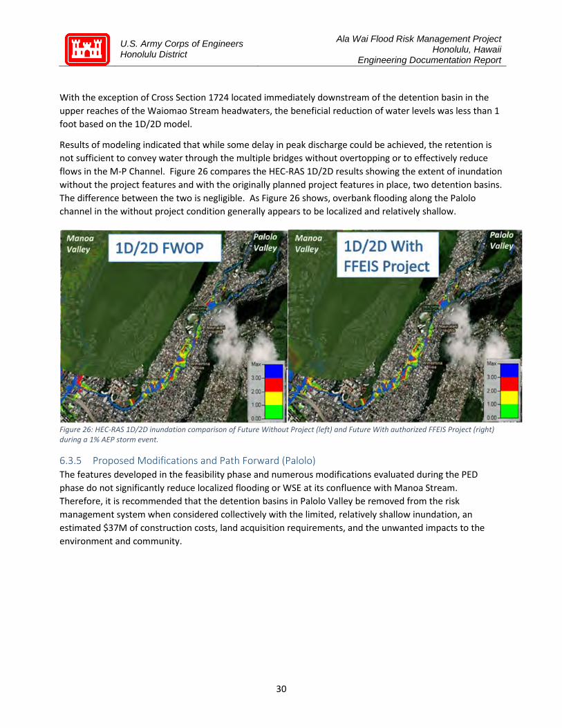
Results of modeling indicated that while some delay in peak discharge could be achieved, the retention is not sufficient to convey water through the multiple bridges without overtopping or to effectively reduce flows in the M-P Channel. Figure 26 compares the HEC-RAS 1D/2D results showing the extent of inundation without the project features and with the originally planned project features in place, two detention basins. The difference between the two is negligible. As Figure 26 shows, overbank flooding along the Palolo channel in the without project condition generally appears to be localized and relatively shallow.
Figure 26: HEC-RAS 1D/2D inundation comparison of Future Without Project (left) and Future With authorized FFEIS Project (right) during a 1% AEP storm event.
6.3.5 Proposed Modifications and Path Forward (Palolo) The features developed in the feasibility phase and numerous modifications evaluated during the PED phase do not significantly reduce localized flooding or WSE at its confluence with Manoa Stream. Therefore, it is recommended that the detention basins in Palolo Valley be removed from the risk management system when considered collectively with the limited, relatively shallow inundation, an estimated $37M of construction costs, land acquisition requirements, and the unwanted impacts to the environment and community.

U.S. Army Corps of Engineers Honolulu District
Ala Wai Flood Risk Management Project Honolulu, Hawaii
Engineering Documentation Report
31
Lower Watershed 6.4.1 Golf Course Detention Basin 6.4.1.1 Physical Description (Golf Course) Detention basin with earthen berm ranging from 3 to 7 feet above grade, generally located around the north and east perimeter in an alignment to maximize storage capacity. A grouted rip-rap spillway along bank of M-P Drainage Channel is planned to optimize flow into the basin.
6.4.1.2 Intended Purpose from Feasibility Study (Golf Course) This feature owned by the City is used as a revenue generating municipal golf course during the majority of time, and as a detention basin during extreme flood events. In collaboration with the Non-Federal sponsor, this 134-acre feature will be designed to offer an enhanced golf and recreation venue year-round, as well as maximize storage capacity of flood water for an inundation period of 10 hours during an assumed 24-hour 1% AEP event. During storm events, flood waters will be diverted from the northwestern corner of the course into the debris and detention basin, then drain under gravity into the adjacent Ala Wai Canal to the south.
6.4.1.3 Assessment (Golf course) Results of HEC-RAS 1D/2D, unsteady state modeling indicate the planned berm alignment at the northern and eastern perimeter prevent overland flow from uplands north from reaching the Ala Wai Canal and consequently induced flooding. Hydraulic modeling shows the sheet flow was pushed eastward, flanking the berm and increased inundation along a major north/south thoroughfare, Kapahulu Avenue.
6.4.1.4 Modifications Evaluated (Golf course) Several modifications were considered for this feature to maximize the volume of temporary storage and concurrently allow overland flow from upland sources north and east through the golf course to the canal without impediment. The berm alignments were also considered as a key component of a floodwall system to manage risk in the areas immediately west of the M-P channel. Modifications evaluated for this feature included the conceptual design and modeling of several measures:
• multiple berm alignments • optimized inlet configurations • use of flood gates • a series of weirs and subbasins within the primary berm structure to maximize detention • several diversion configurations bisecting the golf course
Figure 27: Golf course detention basin berm alignment on north and east sides as designed during Feasibility

U.S. Army Corps of Engineers Honolulu District
Ala Wai Flood Risk Management Project Honolulu, Hawaii
Engineering Documentation Report
32
6.4.1.5 Proposed Modification and Path Forward (Golf course) The modified berm alignment illustrated in Figure 28 is recommended to maximize flood water storage and facilitate overland flow to the canal. Additional modifications to the floodwalls are discussed in the following section. Further economic and environmental impacts will be evaluated during the recommended Validation Study with supplemental NEPA efforts.
6.4.2 Floodwalls and Pump Station 6.4.2.1 Physical Description (Floodwalls and Pump Station) This is the major flood risk management feature in the system and consists of a combination of concrete floodwalls and earthen berms along north and south sides and full length of the canal. Two pump stations to facilitate the removal of storm flows routed to the canal from interior drainage and one-way, backflow gates installed at existing drain pipes throughout the length of the Ala Wai Canal were proposed during the feasibility phase.
6.4.2.2 Intended Purpose from Feasibility Study (Floodwalls and Pump Station) The flood barrier system provides essential protection of the most urbanized and lowest elevations at the base of the Ala Wai watershed and is expected to perform as anticipated, with modifications for water surface levels and integrated with cultural and historic aesthetics. The flood barriers afford increased temporary storage capacity and conveyance to the harbor, while accounting for a USACE estimated sea level rise of 2.8 feet over the next 50 years.
Figure 28: Flood barrier system alignment and modifications at the Ala Wai Golf Course

U.S. Army Corps of Engineers Honolulu District
Ala Wai Flood Risk Management Project Honolulu, Hawaii
Engineering Documentation Report
33
6.4.2.3 Assessment (Floodwalls and Pump Station) Figure 29 shows the results from the HEC-RAS 1D/2D hydraulic modeling without the placement of the floodwalls and pump stations. As the figure demonstrates, widespread flooding ranging in depth to greater than 3-feet will occur in densely urbanized neighborhoods north and south of the canal without flood risk
management measures. The areas of deepest inundation, greater than 3 feet, are the (a) lower portions of the University of Hawaii campus north of H-1 and west of the M-P channel, (b) north of the Ala Wai Canal and west of the M-P channel in the area of the Ala Wai Elementary and ‘Iolani Schools, and (c) Ala Wai Golf Course north of the canal and east of the M-P channel. Significant inundation depths are also observed in the McCully and Moiliili neighborhoods north of the Ala Wai Canal.
Figure 30 shows the extent of inundation with the presence of the flood barrier system, with modifications discussed in the following section, which include (a) the removal of six upper watershed detention basins, (b) stream deepening, limited floodwalls, and a bypass culvert at Manoa Marketplace, (c) a box culvert at Makiki, (d) a single pump plant at the confluence of the M-P Channel and the Ala Wai Canal, and (d) optimized berm alignment along the canal and Golf Course detention basin. A comparison between the two inundation maps, with and without project features, indicates the flood barrier
Figure 29: Footprint and inundation depth in the lower watershed estimated by HEC-RAS 1D/2D Future Without Project (FWOP) conditions, 1% AEP
Figure 30: Footprint and inundation depth in the lower watershed estimated by HEC-RAS 1D/2D Future With System Model Project conditions, 1% AEP
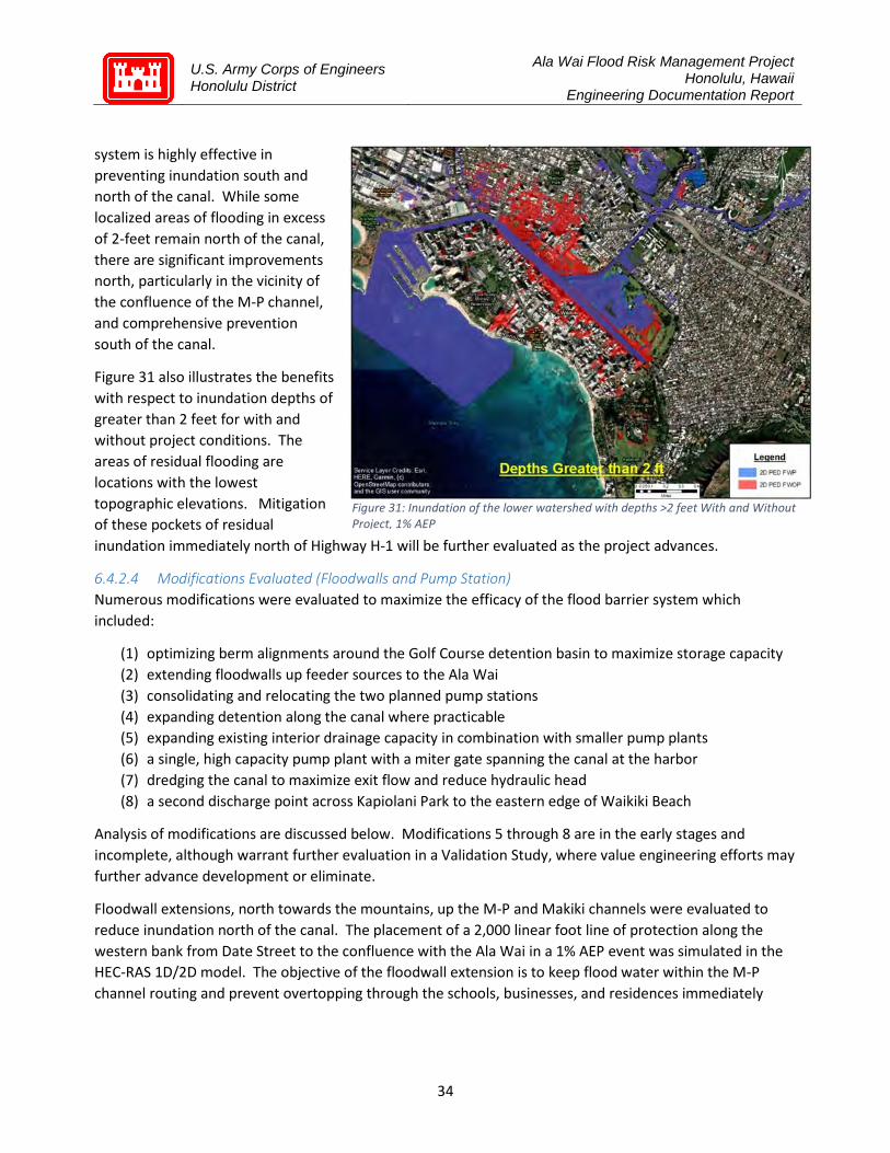
U.S. Army Corps of Engineers Honolulu District
Ala Wai Flood Risk Management Project Honolulu, Hawaii
Engineering Documentation Report
34
system is highly effective in preventing inundation south and north of the canal. While some localized areas of flooding in excess of 2-feet remain north of the canal, there are significant improvements north, particularly in the vicinity of the confluence of the M-P channel, and comprehensive prevention south of the canal.
Figure 31 also illustrates the benefits with respect to inundation depths of greater than 2 feet for with and without project conditions. The areas of residual flooding are locations with the lowest topographic elevations. Mitigation of these pockets of residual inundation immediately north of Highway H-1 will be further evaluated as the project advances.
6.4.2.4 Modifications Evaluated (Floodwalls and Pump Station) Numerous modifications were evaluated to maximize the efficacy of the flood barrier system which included:
(1) optimizing berm alignments around the Golf Course detention basin to maximize storage capacity (2) extending floodwalls up feeder sources to the Ala Wai (3) consolidating and relocating the two planned pump stations (4) expanding detention along the canal where practicable (5) expanding existing interior drainage capacity in combination with smaller pump plants (6) a single, high capacity pump plant with a miter gate spanning the canal at the harbor (7) dredging the canal to maximize exit flow and reduce hydraulic head (8) a second discharge point across Kapiolani Park to the eastern edge of Waikiki Beach
Analysis of modifications are discussed below. Modifications 5 through 8 are in the early stages and incomplete, although warrant further evaluation in a Validation Study, where value engineering efforts may further advance development or eliminate.
Floodwall extensions, north towards the mountains, up the M-P and Makiki channels were evaluated to reduce inundation north of the canal. The placement of a 2,000 linear foot line of protection along the western bank from Date Street to the confluence with the Ala Wai in a 1% AEP event was simulated in the HEC-RAS 1D/2D model. The objective of the floodwall extension is to keep flood water within the M-P channel routing and prevent overtopping through the schools, businesses, and residences immediately
Figure 31: Inundation of the lower watershed with depths >2 feet With and Without Project, 1% AEP

U.S. Army Corps of Engineers Honolulu District
Ala Wai Flood Risk Management Project Honolulu, Hawaii
Engineering Documentation Report
35
west. Modeling results with particle flow lines showing the direction and intensity of flow without and with project structural features in place are shown in Figure 32 and Figure 33.
These results clearly illustrate the benefits of the floodwall extension along the western bank of the M-P channel. As the project progresses, the model outputs and engineering solutions will be explored to improve flows through and around the Date Street Bridge substructure to manage flows into the Kaimuki High School athletic fields and Date Street.
The use of extended floodwalls along Makiki channel was also explored. Modeling results indicate the floodwalls would need to extend a significant distance to reach a topographic elevation high enough to overcome the WSE and commensurate hydraulic head at the confluence with the Ala Wai Canal. Additionally, the floodwalls would need to be constructed for long distances on the top of existing historic walls or in narrow channels through densely urbanized businesses and residences. These structures often butt directly against the tops of this narrow, vertical-walled storm water channel (Figure 34).
Figure 32: Storm water flow direction and velocity Without Project (1% AEP) at confluence of M-P and Ala Wai canal
Figure 33: Storm water flow direction and velocity With Project at confluence of M-P and Ala Wai canal, 1% AEP
Figure 34: Makiki channel looking north from King Street

U.S. Army Corps of Engineers Honolulu District
Ala Wai Flood Risk Management Project Honolulu, Hawaii
Engineering Documentation Report
36
Also, two reaches of the channel are routed below high-rise buildings further complicating construction and significantly increasing cost. A diversion culvert was examined rather than pursue extending floodwalls due to logistical and cost challenges. A culvert with approximate dimensions of 1,500 feet long by 20 feet wide by 10 feet deep to supplement the conveyance of floodwater was considered. After a series of models, including supplemental small pumps, it was determined that a culvert beginning at the Makiki channel running parallel to the canal to a discharge point near the boat harbor would significantly reduce backwater conditions and prevent overtopping of the channel in the McCully and Moiliili area. Modeling results in Figure 30 reflect floodwalls along the M-P channel and the Makiki diversion culvert as shown in Figure 35 below.
Figure 35: Flood barrier system modifications and alignment in the lower watershed
Consolidating the two pump stations into a single pump station and relocating the pump plant was also evaluated. The consolidation to one pump station and relocating the plant on the northern side of the canal, east of the confluence with the M-P channel would eliminate the requirement of approximately 4,000 linear feet of floodwall on the southern side of the Ala Wai canal. The consolidation of two pump stations into one would also reduce the overall facility footprint, improve efficacy of existing internal stormwater drainage in the Kapahulu area, decrease construction efforts, and reduce long-term maintenance requirements on the Non-Federal Sponsor.
Additionally, realigning the floodwall on the canal in front the Hausten Ditch area was also evaluated. Further consideration of the flood barrier alignment and effort to increase flood water detention, prompted the concept to remove the planned floodwalls along this section of the canal. The walls fronting the canal would be replaced with earthen berms along the sides and back perimeter of Hausten Ditch and
U.S. Army Corps of Engineers Honolulu District
Ala Wai Flood Risk Management Project Honolulu, Hawaii
Engineering Documentation Report
37
the Ala Wai Community Park athletic fields to increase canal reservoir capacity. The flood gate originally proposed at the canal wall would be moved from immediately adjacent to the Ala Wai canal back to the northern perimeter at the back of this detention area spanning Hausten Ditch.
6.4.2.5 Proposed Modifications and Path Forward The flood barrier system shown in Figure 35 will significantly reduce or eliminate inundation throughout the lower watershed north and south of the Ala Wai canal, therefore recommend advancing the (1) modified berm alignments around the western half of the golf course, (2) extended floodwalls or berms on the eastern bank of the M-P channel from Date Street to the Ala Wai canal, and (3) expanding the Hausten Ditch detention feature, (4) additional optimization efforts at the base of the Makiki channel, and (5) consolidating the two pump stations into a single station at the confluence of the M-P channel and the Ala Wai canal. Also recommend continued optimization to maximize functionality, enhance environmental benefits, and integrate aesthetics consistent with USACE policy.
Summary In summary, while the project objective remains the same, the approach has evolved based on more current and accurate data, and hydraulic modeling tools as the plan advanced in the planning, engineering, and design phase. Results of the HEC-RAS 1D/2D unsteady state modeling and accompanying engineering analysis support a shift from flow detention in the upper watersheds to improved conveyance for greater control and risk management throughout the linked system. Key findings are summarized below:
Upper Watershed - Makiki Valley, Manoa, and Palolo Valleys
• Extent of inundation was not as severe as estimated with HEC-RAS 1D modeling in Makiki and Palolo Valleys, therefore the requirements and benefits of detention basins in the upper watersheds were reduced
• Significant flooding was observed throughout Manoa Valley in HEC-RAS 1D steady and HEC-RAS 1D/2D unsteady state modeling, particularly in the Manoa Marketplace stream reach
• Overtopping at the Woodlawn Drive Bridge occurs without the presence of the bridge due to stream channel constraints, which are amplified by the presence of the bridge substructure and historic debris blockages
• HEC-RAS 1D/2D modeling showed storage capacity of detention basins could not be cost effectively expanded in the upper valleys to reduce flows enough to prevent overtopping at numerous constrictions along the routing
• Compensatory mitigation measures at Falls 7 & 8 in Manoa Valley will be further evaluated and coordination will be done with Resource agencies
• Recommend replacing the Makiki detention basin planned in upper Makiki Valley with a culvert diversion at the confluence with the Ala Wai canal pending further engineering investigation
• Recommend removing Waihi, Waiakeakua, and Woodlawn Ditch detention basins and improve conveyance at the Manoa Marketplace stream reach with stream deepening coupled with routine maintenance, floodwalls, and a culvert bypass at the Woodlawn Drive Bridge to keep storm flow within the stream channel and prevent downstream flooding of neighborhoods and University of Hawaii campus

U.S. Army Corps of Engineers Honolulu District
Ala Wai Flood Risk Management Project Honolulu, Hawaii
Engineering Documentation Report
38
• Recommend replacing Waiomao and Pukele detention basins with floodwalls extended northward from the Ala Wai canal to the Date Street Bridge to maintain storm flow within the stream channel and prevent flooding of the neighborhood, ‘Iolani and Ala Wai Elementary schools
Lower Watershed – Ala Wai Canal, Golf Course, Hausten Ditch
• Widespread flooding will occur across the base of the Ala Wai watershed, north and south of the Ala Wai canal in a 1% annual exceedance probability event
• HEC-RAS 1D/2D modeling predicts higher flows and volumes in the Ala Wai canal than estimated in HEC-RAS 1D, steady state modeling resulting in an increase in water surface elevation of approximately 2 feet
• Consolidation of two large capacity pump stations into a single 4,000 cubic feet per second pump station at the confluence of the M-P channel and the Ala Wai canal eliminates 4,000 linear feet of floodwall on the south bank of the canal
• Pump station(s) at the eastern end of the Ala Wai canal enhances efficacy of existing interior storm water drainage in the Kapahulu and Diamond Head neighborhoods
• Recommend advancing flood barrier concept along the Ala Wai canal with detailed engineering and design analysis to cost-effectively optimize functionality, environmental, and community benefits
• Implementation of the recommended modifications eliminates flood depths of greater than 2 feet north and south of the canal by 95% and 100%, respectively
Figure 36 graphically summarizes the recommended modifications to the flood risk management features planned during the feasibility phase.

U.S. Army Corps of Engineers Honolulu District
Ala Wai Flood Risk Management Project Honolulu, Hawaii
Engineering Documentation Report
39
Figure 36: Recommended modifications to the authorized FFEIS Project as detailed in this Engineering Documentation Report
U.S. Army Corps of Engineers Honolulu District
Ala Wai Flood Risk Management Project Honolulu, Hawaii
Engineering Documentation Report
40
7 Cost Estimate Project Description
The project consists of various measures to manage flood risk in the Manoa, and Ala Wai subwatersheds. The measures included in the proposed modified plan are indicated in Table C-1.
Measures such as relocations, berms, channel deepening, floodwalls, and diversion structures are located in the upper watershed for Manoa. Measures in the Ala Wai Canal area include utility relocations, levees, floodwalls, pump stations, flood gates, and diversion structures. The project also includes cultural monitoring during construction.
The 2016 Ala Wai Canal Feasibility Study has been updated with the following major changes:
1. The Ala Wai Floodwall cross section has become more robust to include deep sheetpile for seepage and piles for stability. Additionally it has become taller and been located farther from the canal, which now conflicts with roadways, curb and gutters, lighting, traffic signs, and trees. For the purposes of the Rough-Order-of-Magnitude cost estimate, a conservative T-wall foundation system vice a less extensive foundation system proposed during the feasibility phase has been included to incorporate findings from the 1D/2D modeling. A global stability analysis which will provide additional engineering details to help clarify the most suitable foundation system is in progress and scheduled for completion in August 2020.
2. The Ala Wai Floodwall length has been reduced by approximately 4,000 linear feet on the southern alignment from the eastern terminus at the library to the confluence of the M-P Channel and Ala Wai canal.
3. The number of pump plants has been reduced by one. However, the pumping capacity has greatly increased from 1337 cfs/pump plant to 4000 cfs. Additionally, the pump plant now crosses the Ala Wai Canal, where before it was located on land.
4. The length of the golf course levee has been reduced based on the new location almost cutting the golf course in half. A weir option has been included, however, the sediment basin has been eliminated.
5. A floodwall has been added along the M-P Channel extending from the Ala Wai Canal northward to Date Street.
6. A flood control structure has been added along the Makiki Stream, and the Hausten Ditch flood control structure has been relocated farther upstream.
7. A stream diversion structure has been added to divert the Makiki Stream to a different entry point into the Ala Wai canal.
8. Floodwalls have been added to the Manoa Stream upstream of Woodlawn Bridge. 9. Channel deepening has been added downstream of the Woodlawn Bridge. 10. The Manoa Stream in-stream catchment basin has been deleted. 11. Six upper watershed detention basins have been identified for elimination and funds reallocated:
Makiki Debris/Detention Basin (D/DB), Waihi D/DB, Waiakeakua D/DB, Woodlawn Ditch DB, Waiomao D/DB, and Pukele D/DB.
12. A berm along the southern side of Manoa Valley District Park has been added.

U.S. Army Corps of Engineers Honolulu District
Ala Wai Flood Risk Management Project Honolulu, Hawaii
Engineering Documentation Report
41
13. The elimination of the mitigation measures at Falls 7/8 and the associated adaptive management. In the future, mitigation measures and alternatives will be added based upon the updated project features and environmental impact analysis.
Table C-1 shows a comparison between the modifications shown in the Feasibility Study versus the EDR plan.
Table C-1. Measures
Summary of the Feasibility Plan compared to the EDR Recommended Modifications
Flood Risk Management
Measure
Feasibility Description EDR Modifications Description
Waihi Debris and Detention Basin
Earthen structure, approximately 42 feet high and 477 feet across; box culvert to allow small storm flows to pass; concrete spillway above culvert with grouted rip-rap on upstream and downstream side; debris catchment feature located on upstream end of culvert; approximately 150 feet of riprap for energy dissipation and scour protection downstream of culvert. New access road to be constructed for construction and O&M.
Eliminate and reallocate funds
Waiakeakua Debris and Detention Basin
Earthen structure, approximately 37 feet high and 401 feet across; arch culvert to allow small storm flows to pass; concrete spillway above culvert with grouted rip-rap on upstream and downstream side; debris catchment feature located on upstream end of culvert; approximately 150 feet of riprap for energy dissipation and scour protection downstream of culvert.
Eliminate and reallocate funds
Woodlawn Ditch Detention Basin
Three-sided berm, approximately 15 feet high and 840 feet across; arch culvert to allow small storm flows to pass; concrete spillway above culvert with grouted rip rap on upstream and downstream side.
Eliminate and reallocate funds
Mānoa In-stream Debris Catchment
Concrete pad, approximately 8 feet wide and 60 feet across; steel posts (up to approximately 7 feet high) evenly spaced 4 feet apart along concrete pad.
Eliminate and reallocate funds
Kanewai Field Multi-Purpose Detention Basin
Earthen berm, approximately 9 feet high, around 3 sides of the field; grouted rip-rap inflow spillway along bank of Mānoa Stream to allow high flows to enter the basin; existing drainage pipe at south end of basin to allow water to re-enter stream.
Earthen berm, approximately 9 feet high, around 3 sides of the field; grouted rip rap inflow spillway along bank of Mānoa Stream to allow high flows to enter the basin; existing drainage pipe at south end of basin to allow water to re-enter stream.
Wai‘ōma‘o Debris and Detention Basin
Earthen structure, approximately 34 feet high and 275 feet across; box culvert to allow small storm flows to pass; concrete spillway above culvert, with grouted rip-rap on upstream and downstream side; debris catchment feature located on upstream end of culvert; approximately 150 feet of riprap for energy dissipation and scour protection downstream of culvert. Excavation of approximately 3,060 yd3 to provide required detention volume upstream of berm; new access road to be constructed for construction and O&M.
Eliminate and reallocate funds

U.S. Army Corps of Engineers Honolulu District
Ala Wai Flood Risk Management Project Honolulu, Hawaii
Engineering Documentation Report
42
Flood Risk Management
Measure
Feasibility Description EDR Modifications Description
Pūkele Debris and Detention Basin
Earthen structure, approximately 35 feet high and 82 feet across; box culvert to allow small storm flows to pass; concrete spillway above culvert with grouted rip-rap on upstream and downstream side; debris catchment feature located on upstream end of culvert; approximately 150 feet of riprap for energy dissipation and scour protection downstream of culvert. Excavation of approximately 14,330 yd3 to provide required detention volume upstream of berm; new access road to be constructed for construction and O&M.
Eliminate and reallocate funds
Makiki Debris and Detention Basin
Earthen structure, approximately 36 feet high and 100 feet across; arch culvert to allow small storm flows to pass; concrete spillway above culvert with grouted rip-rap on upstream and downstream side; debris catchment feature located on upstream end of culvert; approximately 150 feet of riprap for energy dissipation and scour protection downstream of culvert. Excavation of approximately 3,035 yd3 to provide required detention volume upstream of berm; new access road to be constructed for construction and O&M.
Eliminate and reallocate funds
Ala Wai Canal Floodwalls
Concrete floodwalls ranging up to approximately 4 feet high, offset from existing Canal walls.
Concrete floodwalls ranging up to approximately 6 feet high, offset even further from existing Canal walls.
Existing stairs to be extended and new ramps to be installed to maintain access to Canal; floodgate to be installed near McCully Street.
Existing stairs to be extended and new access gates to be installed to maintain access to Canal.
T-Wall foundation system Change to more conservative T-wall foundation system. A global stability analysis which will provide additional engineering details to help clarify the most suitable foundation system is in progress and scheduled for completion in August 2020.
Left bank floodwall extends from eastern terminus at the Waikiki Library to the mouth of the canal at Ala Wai Boat Harbor, approximately 9,711 linear feet in length.
Left bank floodwall extends from confluence of the M-P Channel and Ala Wai Canal to the mouth of the canal at Ala Wai Boat Harbor, approximately 5,740 linear feet in length.
Right bank floodwall extends from the confluence of the M-P Channel and Ala Wai Canal to the mouth of the canal at Ala Wai Boat Harbor.
Right bank floodwall extends from the confluence of the M-P Channel and Ala Wai Canal to the mouth of the canal at Ala Wai Boat Harbor.
A floodwall has been added along the M-P channel extending from the Ala Wai Canal northward to Date Street.
Two pump stations to accommodate storm flows and gates installed at existing drainage pipes to prevent backflow from the Ala Wai Canal during a flood event.
One pump station at the Manoa- Pālolo confluence traversing the canal to accommodate storm flows, and gates installed at existing drainage pipes to prevent backflow from the Ala Wai Canal during a flood event.
Each pump station has a pumping capacity of 1337 cfs; two pump plants total capacity of 2,674 cfs.
Pumping capacity increased to 4000 cfs to incorporate findings from 1D/2D modeling.
Both pump stations located on land, one fronting the Waikiki Library on the eastern terminus of the canal and the other located on the golf course.
The pump plant now crosses the Ala Wai Canal where before it was located on land.

U.S. Army Corps of Engineers Honolulu District
Ala Wai Flood Risk Management Project Honolulu, Hawaii
Engineering Documentation Report
43
Flood Risk Management
Measure
Feasibility Description EDR Modifications Description
Hausten Ditch Berm and Community Park Berm
Concrete floodwalls and an earthen berm (approximately 4.3 feet high) to provide detention for local drainage; install concrete wall with four slide gates adjacent to the upstream edge of the existing bridge to prevent a backflow from the Ala Wai Canal during a flood event.
An earthen berm (approximately 5.5 feet high) to provide flood control from an elevated Ala Wai Canal; install concrete wall with one slide gate upstream of the existing bridge to prevent a backflow from the Ala Wai Canal during a flood event. The current location of the berm will require the relocation of the existing Boat House. Expansion of detention basin into Ala Wai Community Park.
Ala Wai Golf Course Multi-Purpose Detention Basin
Earthen berm, on average 2.7 feet high, around the north and east perimeter of the golf course.
Earthen berm, ranging from 3 to 7 feet around the north perimeter extending thru the middle of the existing golf course. Weir option includes added berm on west perimeter and south (western half) border of the golf course.
Grouted rip rap inflow spillway along bank of Mānoa-Pālolo Drainage Canal to allow high flows to enter the basin.
Grouted rip rap inflow spillway along bank of Mānoa-Pālolo Drainage Canal to allow high flows to enter the basin.
Sediment basin within western portion of golf course. Sediment basin has been eliminated. Floodgate across the main entrance road. Ramp up and over the levee for the main entrance road. Passive drainage back into Ala Wai Canal. Passive drainage back into Ala Wai Canal.
Flood warning System
Installation of 3 real-time rain gages (Mānoa, Makiki, and Pālolo streams) and 1 real-time streamflow or stage gage (Ala Wai Canal) as part of flood warning system for Ala Wai Watershed.
Installation of 3 real-time rain gages (Mānoa, Makiki, and Pālolo streams) and 1 real-time streamflow or stage gage (Ala Wai Canal) as part of flood warning system for Ala Wai Watershed.
Makiki Stream Diversion Structure
A diversion structure consisting of a stream inlet, 3 each 1,500 linear feet of 6’x10’ RCB’s, a junction box, and an outlet structure is proposed to bypass flows to downstream of the Kalakaua Bridge. A major Jack and bore construction operation will be required under/through the Kalakaua Bridge.
Mānoa Valley District Park Berm
Earthen berm, approximately 8 feet high with 2.5 H on 1 V side slopes, along the south side of the field; existing drainage pipe at south end of basin to allow water to re-enter stream.
Woodlawn Diversion and Ancillary structures
A diversion structure consisting of a stream inlet, a 1,257 linear foot 14’x10’ RCB, and an outlet structure is proposed to bypass flows before reaching the Woodlawn bridge. A major utility relocation will be required for this diversion relocation.
Deepening of the stream downstream of Woodlawn Bridge for approximately 1,100 linear feet.
Concrete floodwalls ranging up to approximately 19.63 feet high (new T-walls). Construction of these walls will be very difficult due to real estate constraints.
Basis of Estimate and Quantity This updated feasibility cost estimate is based on an email from CEMVN-ED-T which included hand sketches and quantities. Input for the estimate was obtained from the Project Delivery Team (PDT). Following
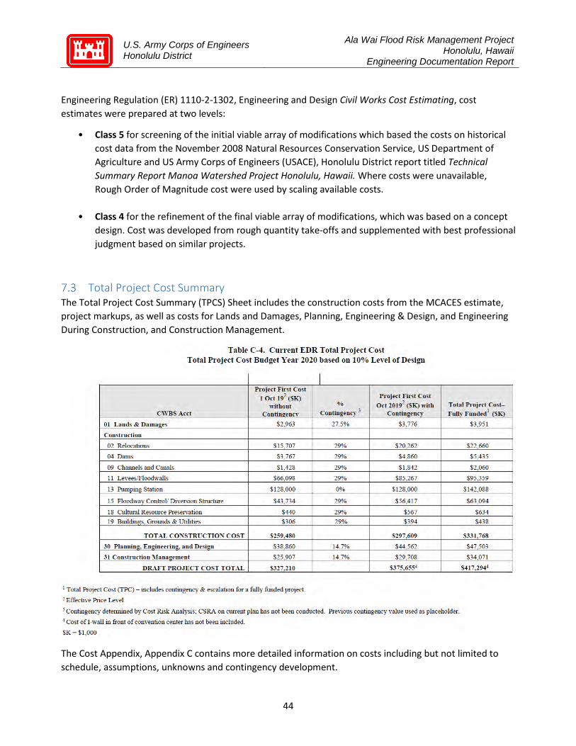
U.S. Army Corps of Engineers Honolulu District
Ala Wai Flood Risk Management Project Honolulu, Hawaii
Engineering Documentation Report
44
Engineering Regulation (ER) 1110-2-1302, Engineering and Design Civil Works Cost Estimating, cost estimates were prepared at two levels:
• Class 5 for screening of the initial viable array of modifications which based the costs on historical cost data from the November 2008 Natural Resources Conservation Service, US Department of Agriculture and US Army Corps of Engineers (USACE), Honolulu District report titled Technical Summary Report Manoa Watershed Project Honolulu, Hawaii. Where costs were unavailable, Rough Order of Magnitude cost were used by scaling available costs.
• Class 4 for the refinement of the final viable array of modifications, which was based on a concept design. Cost was developed from rough quantity take-offs and supplemented with best professional judgment based on similar projects.
Total Project Cost Summary The Total Project Cost Summary (TPCS) Sheet includes the construction costs from the MCACES estimate, project markups, as well as costs for Lands and Damages, Planning, Engineering & Design, and Engineering During Construction, and Construction Management.
The Cost Appendix, Appendix C contains more detailed information on costs including but not limited to schedule, assumptions, unknowns and contingency development.
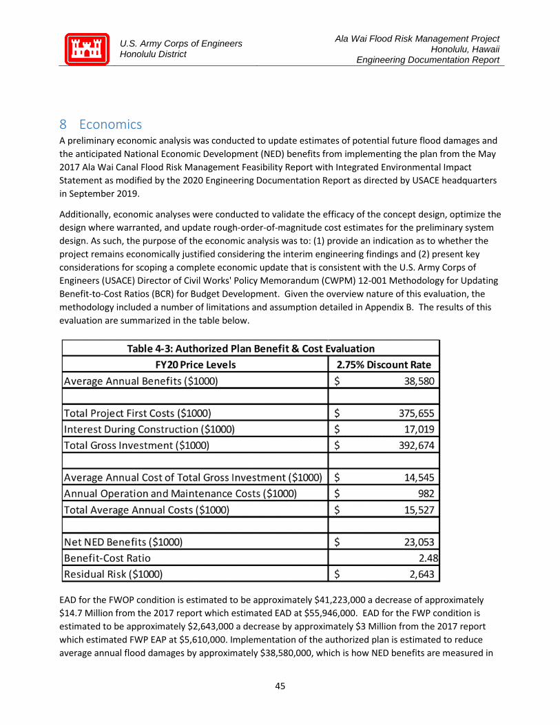
U.S. Army Corps of Engineers Honolulu District
Ala Wai Flood Risk Management Project Honolulu, Hawaii
Engineering Documentation Report
45
8 Economics A preliminary economic analysis was conducted to update estimates of potential future flood damages and the anticipated National Economic Development (NED) benefits from implementing the plan from the May 2017 Ala Wai Canal Flood Risk Management Feasibility Report with Integrated Environmental Impact Statement as modified by the 2020 Engineering Documentation Report as directed by USACE headquarters in September 2019.
Additionally, economic analyses were conducted to validate the efficacy of the concept design, optimize the design where warranted, and update rough-order-of-magnitude cost estimates for the preliminary system design. As such, the purpose of the economic analysis was to: (1) provide an indication as to whether the project remains economically justified considering the interim engineering findings and (2) present key considerations for scoping a complete economic update that is consistent with the U.S. Army Corps of Engineers (USACE) Director of Civil Works' Policy Memorandum (CWPM) 12-001 Methodology for Updating Benefit-to-Cost Ratios (BCR) for Budget Development. Given the overview nature of this evaluation, the methodology included a number of limitations and assumption detailed in Appendix B. The results of this evaluation are summarized in the table below.
EAD for the FWOP condition is estimated to be approximately $41,223,000 a decrease of approximately $14.7 Million from the 2017 report which estimated EAD at $55,946,000. EAD for the FWP condition is estimated to be approximately $2,643,000 a decrease by approximately $3 Million from the 2017 report which estimated FWP EAP at $5,610,000. Implementation of the authorized plan is estimated to reduce average annual flood damages by approximately $38,580,000, which is how NED benefits are measured in
U.S. Army Corps of Engineers Honolulu District
Ala Wai Flood Risk Management Project Honolulu, Hawaii
Engineering Documentation Report
46
this economic evaluation. AAC is estimated at $15,527,000, using the FY20 Federal discount rate of 2.75% and over a 50-year period of analysis. BCR is estimated to be 2.48 and net NED benefits are estimated to be $23,053,000. Residual risk in this evaluation is approximately $2,643,000, annually. All reported dollar values are in FY20 price levels. This evaluation is preliminary and is expected to change during a Validation Study.
As noted in the economics report in Appendix B, the preliminary evaluation indicates that estimated damages during a 1% AEP storm event would be substantial. Further, there is a solid basis to expect the project remains economically justified based on early conceptual optimizations and commensurate rough-order-of-magnitude project costs. However, this supposition should be confirmed with an updated, comprehensive analysis that complies with USACE requirements for economic updates.
9 Conclusion and Recommendation Conclusion
In October, 2018, the design phase of the Ala Wai Canal Flood Control Project kicked off with a modeling effort to update from a HEC RAS 1D steady flow model to a HEC RAS 1D/2D unsteady flow model. In May, 2019, after the modeling was completed, the Honolulu District brought in the Risk Management Center, Dam Safety Center, Levee Safety Center, as well as experts from across the USACE Enterprise to assess the risk and uncertainties associated with the system features and changes in the engineering data. It was determined that in order for the system to perform as authorized by Congress, modifications to the system features were necessary.
In September, 2019, the Honolulu District presented its findings to the USACE Vertical Team with a recommendation to investigate modifications to system features necessary for the system to perform as authorized. The Director of Civil Works at USACE directed (September 28, 2019) Honolulu District to investigate modifications to system features and document recommendations in an Engineering Documentation Report. It was directed that the EDR would be incorporated into a Validation Report approved by the Division Commander to serve as the Decision Document for post authorization change.
This EDR is not a decision document, it is a technical document to capture changes in engineering data and outline recommended modifications to system features. The EDR determined that there is still a justified flood risk management project in the Ala Wai Canal project area, as well as a technical recommendation to achieve flood risk reduction as authorized by Congress.
The EDR recommends the removal of debris and detention basins in the upper watershed, as well as detention basins at Woodlawn Ditch and a standalone debris catch structure in Manoa Stream. The recommendation includes the addition of a Woodlawn bypass structure and ancillary measures to reduce flood risk at the Manoa Marketplace, University of Hawaii at Manoa, and the lower watershed communities. The EDR also recommends the addition of a Makiki Stream bypass culvert to reduce risk of backwater flooding from the Ala Wai Canal, as well as reducing flood risk in the lower watershed of the Makiki community. Finally, the EDR recommends modifications to authorized features at Kanewai, Hausten Ditch, Ala Wai Golf Course, and Ala Wai Canal flood barriers with pump stations.


U.S. Army Corps of Engineers Honolulu District
Appendix A
Hydrology & Hydraulic Analysis

A-1
Introduction The Ala Wai Canal Flood Risk Management project is located on the island of Oahu in urbanized
Honolulu, Hawaii. The project would protect metropolitan Honolulu, the University of Hawaii, and
Waikiki, Hawaii's economic center for tourism. The population at risk includes approximately 65,000
residents and an additional 200,000 transient visitors to the watershed daily (tourists, workers,
students, etc.). Project features originally included the following eleven individual structural elements
and two non-structural components as carried forward from the feasibility study:
• Six debris/detention basins in upper stream reaches
• One stand-alone debris catchment structure
• Three multi-purpose detention basins
• Floodwalls along Ala Wai Canal (including pump stations for interior drainage)
• Flood warning system (non-structural)
• Fish and wildlife mitigation (non-structural)
The canal overtopped and previously flooded Waikiki during the November 1965 and December 1967
storms, as well as during the passage of Hurricane Iniki in 1992. In October 2004, a storm flooded
Manoa Valley, causing $85M in damages to the University of Hawaii, including the loss of irreplaceable
documents in one of the libraries. Early Modeling efforts indicated that a one percent annual flood
exceedance event would result in damages to more than 3,000 structures in the watershed, with total
damages of over $1.14B,with the majority of the damage in the downstream area of Waikiki.
Basin Description The Ala Wai Watershed encompasses approximately 16.2 square miles and includes the drainages of
Manoa, Palolo, Makiki, McCully, Moiliili, and Waikiki. The Manoa and Palolo streams join to form the
Manoa-Palolo Canal. The Manoa-Palolo Canal, Makiki Stream, and three low lying drainage areas empty
into the Ala Wai Canal, a two-mile long, man-made waterway constructed in the 1920s to drain
wetlands, allowing the development of the Waikiki area.
The upper reaches of the basin are very steep and rocky and incised into the Ko’olau Volcano. This
portion of the watershed ranges from 40 to approximately 2400 feet in elevation. The Makiki and
Manoa basins typically receive more than 160 inches of rain annually, while the Palolo valley receives
less.
The lower portion of the basin is much less steep, and is extremely urbanized. Significant portions of this
are impervious surfaces, with sewer system drainage actively directing most of the runoff in less intense
events. The Ala Wai Canal and Waikiki basin receives about 30 inches of annual rainfall. High-Intensity
rainfall on steep slopes of the small drainage basin can produce very flashy flood events. Time to peak is
usually less than 1 hour and even for large intense storms, the rise and recession of the flood
hydrograph usually occurs with 6 hours.
Previous Modeling Efforts - Hydrology A model of the watershed was developed in 2008 by Oceanit. Modifications were made to the model
and report in March 2016, August 2016, and February 2017. This effort is detailed in the Ala Wai Canal
Flood Risk Management Study O’ahu, Hawai’i Final Feasibility Study Report with integrated
Environmental Impact Statement Appendix A – Hydrolog`y and Hydraulic Engineering.

A-2
A list of previous reports with descriptions is included in section 2.2 “previous hydrologic and hydraulic
models and studies.” These include:
Federal Emergency Management Agency’s National Flood Insurance Program Study (FEMA,
1979)
Ala Wai Canal Improvement Project, Storm Water Capacity Study (Edward K. Noda and
Associates, 1994)
Ala Wai Flood Study (USACE, 2001)
Ala Wai Watershed Analysis (Townscape Inc. and Dashiell, 2003)
Hydrology and Hydraulics Study, Flood of October 30, 2004, Manoa Stream (USACE, 2006)
Final Hydrology Report, Manoa Watershed Project (Oceanit 2008a)
Final Hydraulic Analysis Report, Manoa Watershed Project (Oceanit, 2008b)
Technical Summary Report, Manoa Watershed Project (Oceanit, 2008c)
Final Hydrology Report, Ala Wai Watershed Project (Oceanit, 2008d)
Final Drainage Evaluation Report, Ala Wai Canal Watershed Project (Oceanit, 2008e)
Conceptual Engineering Report, Ala Wai Canal Flushing System & Ala Wai Golf Course Detention
System (Mitsunaga & Associates, Inc., 2014)
Project Scope - Hydrology In an effort to improve upon and extend previous modeling efforts the project the following
adjustments were made to the 2016 Ala Wai Hydrology Efforts. These efforts are divided into updates
that were completed for the EDR and updates that will be included in a final Hydrology and Hydraulics
Report.
EDR Scope:
Update model to most recent published version (HEC-HMS Version 4.3)
Subbasin adjustments and recalibration to better match exact locations of future upstream
detention basins.
Hydrology and Hydraulics Report Scope:
Creation of different geometries for a peaked and non-peaked routing, including the
applications of peaking factors (25%, 33.3%, and 50%) for use in routing the Probable Maximum
Precipitation.
Creation of Probable Maximum Precipitation (PMP) using HMR 39 methodology to include an:
o Entire Basin PMP
o Individual PMP for the six upstream detention basins
Completion of various PMP Sensitivities.
Routing of final PMF and Frequency Events with modified geometries.
Routing uncertainty simulation for upper and lower bounds
Compiling a final report for inclusion with the hydraulics updates.
As will be detailed in this appendix, upper basin project features have largely been removed and a single
without project geometry was continued for the final frequency, uncertainty, and PMF routings.
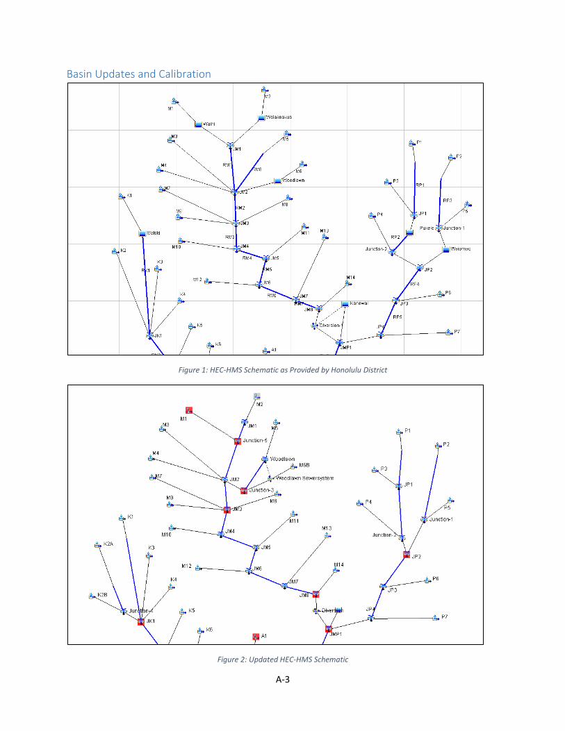
A-3
Basin Updates and Calibration
Figure 1: HEC-HMS Schematic as Provided by Honolulu District
Figure 2: Updated HEC-HMS Schematic

A-4
Changes to the base HEC-HMS model geometry include: splitting the K2 Subbasin in order to have an
appropriate inflow location at the upstream of Kanaha Stream in HEC-RAS; Redividing and routing the
M5 and M6 Subbasins to better match actual location and flow condition for the prospective Woodlawn
Dam, as well as adding the effects of the local sewer system, which would route water upstream and
back into the dam; Redividing and routing the M1 and M3 Subbasins to better match actual location of
the prospective Waihi Dam; Splitting the Routing Reach 1 so that the flows upstream and downstream
were better matched the locations for the prospective Waiakeakua and Waihi Dams, as well as better
aligning the junction of the two streams; Redividing and routing the K1 and K3 Subbasins to better
match actual location of the prospective Makiki Dam; Adjusting the RK1 routing reach to better match
the handoff location from K1; and Routing Subbasin P5 so that it doesn’t route though the prospective
Waiomao Dam. The final change to the basin geometry was the removal of the reservoir system that
represented the routing in the Ala Wai Canal, in order to save time and as no data was found that
validated the input values. For the purposes of this study, only HEC-RAS was used to route the 2
dimensional behavior of the flow through the channel. A table of final Subbasin names and drainage
areas are provided at the end of this report for model verification.
Split subbasins and other modifications were matched to the next downstream computation point
combining all of the geometry changes for that area. They were matched to either the flows from the
provided existing conditions basin, and the 1967, 2004, and 2006 calibration basins, or the flows from
multiple frequency routings. Only the Manoa-Palolo portion of the basin was available for the 2006
event. Calibration methodology depended on when in the study the changes were made, the earliest
changes were based on the calibration and averaged basins, while the later changes were changed by
matching the downstream routing of calibrated frequency data.
The model time step was later reduced from the five minute calibration time step to a one minute time
step for the peaking procedure. Therefore, each of the below new basins were also run on a one minute
time step to ensure that there were no significant deviations from the calibrated results.
As part of the update to HEC-HMS version 4.3 an index method is now required to route Muskingum-
Cunge Routing reaches. Per the recommendation of HEC, the “celerity” method was used with an index
celerity of 5 ft/s. No adjustments to calibration were made at this point, as changes to flow calculation
results were minor.
It was also discovered throughout the study that a significant amount of flow can “back up” behind
bridges and in some cases escape into the overbanks. The HEC-HMS model is well calibrated to the
2004, 2006, and 1967 events. However, the ability of the model to represent these effects is
questionable beyond the magnitude of these calibration events. For large events (i.e. the 1% event) it is
recommended that the HEC-RAS model be used to report stream routing near and downstream of
constrictions.
Coincident Upstream Detention Basin Design Efforts Multiple variations of Dam Culvert, Spillway, and Storage were modeled in an effort to better
understand the system response for each of the upstream dams (Waiakeakua, Waihi, Woodlawn,
Pukele, Waiomao, and Makiki). Initial excavation, spillway, and dam data for each iteration was provided
by the Seattle Design Team. The excavation was pulled in the HEC-RAS 5.05 Mapper and merged with
LiDAR provided by the Hawaii District. Reasonable culvert elevations and lengths were determined from
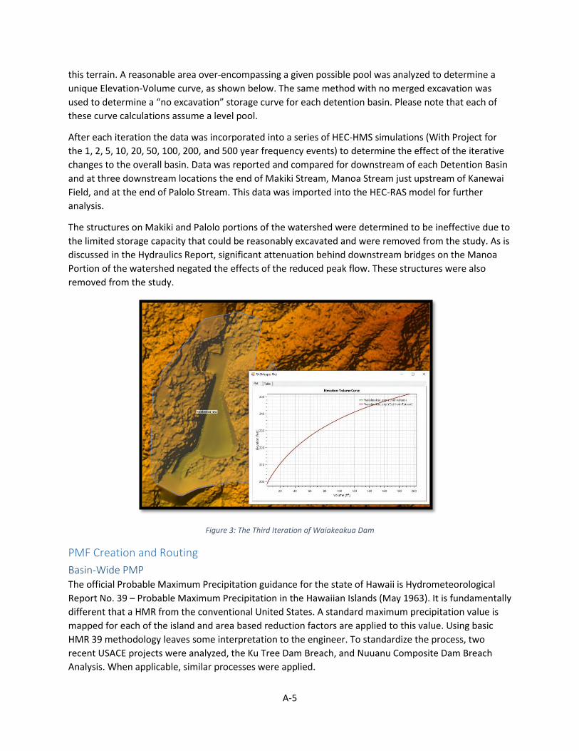
A-5
this terrain. A reasonable area over-encompassing a given possible pool was analyzed to determine a
unique Elevation-Volume curve, as shown below. The same method with no merged excavation was
used to determine a “no excavation” storage curve for each detention basin. Please note that each of
these curve calculations assume a level pool.
After each iteration the data was incorporated into a series of HEC-HMS simulations (With Project for
the 1, 2, 5, 10, 20, 50, 100, 200, and 500 year frequency events) to determine the effect of the iterative
changes to the overall basin. Data was reported and compared for downstream of each Detention Basin
and at three downstream locations the end of Makiki Stream, Manoa Stream just upstream of Kanewai
Field, and at the end of Palolo Stream. This data was imported into the HEC-RAS model for further
analysis.
The structures on Makiki and Palolo portions of the watershed were determined to be ineffective due to
the limited storage capacity that could be reasonably excavated and were removed from the study. As is
discussed in the Hydraulics Report, significant attenuation behind downstream bridges on the Manoa
Portion of the watershed negated the effects of the reduced peak flow. These structures were also
removed from the study.
Figure 3: The Third Iteration of Waiakeakua Dam
PMF Creation and Routing
Basin-Wide PMP The official Probable Maximum Precipitation guidance for the state of Hawaii is Hydrometeorological
Report No. 39 – Probable Maximum Precipitation in the Hawaiian Islands (May 1963). It is fundamentally
different that a HMR from the conventional United States. A standard maximum precipitation value is
mapped for each of the island and area based reduction factors are applied to this value. Using basic
HMR 39 methodology leaves some interpretation to the engineer. To standardize the process, two
recent USACE projects were analyzed, the Ku Tree Dam Breach, and Nuuanu Composite Dam Breach
Analysis. When applicable, similar processes were applied.

A-6
Figure 4: HMR 39 Figure 5-10
There are two types of PMP estimates listed in HMR 39, a small basin with uniform hydrologic features
and a larger basin. The small basin process was applied to create individual PMP’s for the upstream
detention basins. The larger basin process was applied to create a PMP for the entire watershed. The
larger basin PMP starts with the georeferenced figure 5-10 (above) and an areal reduction based on the
basin size and duration.
Upper Detention Basins PMP’s Upper Detention Basin PMP were also calculated for each of the potential dams. The upper detention
basins Probable Maximum Precipitation methodology is similar to the PMP for larger basins, with the
removal of all area reduction factors.
HMS Basin Modifications for PMP Routing Several modifications to the existing conditions model were required to route the PMP correctly. EM
1110-2-1417 states "ground conditions that affect losses during the PMS (Probably Maximum Storm)
should be the most severe that can reasonable exist in conjunction with such an event.” The current
existing conditions model uses an average of all calibrated parameter. Therefore the SCS Curve Number
parameter in the loss tab was set to the calibrated factor that produced the lowest loss rate. The initial
losses were also set to the averaged initial losses instead of the standard of zero inches for all subbasins.
This calibration dataset is more appropriate to the sudden flashy type storm experienced on Oahu. A
sensitivity analysis was done to verify that this did not significantly adjust the final PMF. The maximum
difference was 0.3%.
ER 1110-8-2(FR) states that it is assumed that the outlet structure is assumed to be not operable or
blocked during a PMF run, unless there is a design in place to specifically maintain the flow through the
structure at such high flows. After discussion with the Hawaii District and the Seattle District Design
Team, it was determined that the Makiki, Waihi, Waiakeakua, Pukele, and Waiomao structures will have
debris structures in place to allow water to continue to flow though the outlet culverts. Woodlawn does
not have this feature, and the outlet culvert was removed for PMP/PMF runs.
It should also be noted that all structures are to begin the PMF routing with the detention ponds filled to
a spillway elevation, or the elevation that would occur after a ½ PMF and five day dry period. Due to the
A-7
flashy nature of the basin the ½ PMF option is not appropriate, and all drainage basin pools were set to
spillway elevation for the beginning of all PMP/PMF simulations.
Peaking is required by EM-1110-8-2(FR) Paragraph 8b. The standard peaking effort for a subbasin is to
peak transform values only using a one inch in one hour rainfall event. However, this is not appropriate
for the small size of the watershed (the smallest subbasin is 0.055 square miles). It was determined that
a ten minute storm was the largest event that could be reasonably peaked up to 50%. A smaller rainfall
event is not recommended because of the minimum one minute time step limit.
The basin was peaked in series. First, all of the subbasins were peaked to 25, 33.3, and 50 percent. Then
the reaches were peaked so that each of the upstream detention basins reached a 25, 33.3, and 50
percent peaked inflow. Finally, the entire basin was peaked so that the inflow of the canal reached 25,
33.3, and 50 percent.
PMF routing A simulation of the PMP/PMF with and without project construction was been completed for entire
watershed and upstream detention basins. The simulations use a peaking of 50% in the upper
watershed and 33% lower watershed. The 50% peaking factor was selected because of a very steep, less
urbanized upper portion of the watershed. The 33% peaking factor was selected for the much flatter,
highly urbanized area with significant sewer system effects in the lower portions of the watershed.
Additional Sensitivities to the PMF were also completed.
Final PMP rainfall and all sensitivity analyses were routed through HEC-HMS. The final PMP rainfall
routing in HMS and key sensitivity analyses were also routed though HEC-RAS to produce more accurate
stream flow routing and inundation mapping. The PMF Routing and results are further described in the
Hydrology and Hydraulics Analysis Report.
Frequency Routings (Without Project Only) Frequency Based routings for a variety of basin modifications including: existing conditions, entire
project complete (detention basins have no excavation), entire project complete (detention basins have
reasonable excavation), entire project complete except Waiomao, Pukele, and Makiki Detention Basins,
and a final study modification were scoped for this project. Many of these scenarios have been routed.
However, after the elimination of the upper watershed features from the project, a single existing
condition geometry appropriate for both the no project and for the “lower watershed features only was
routed for final reporting.
Frequency Routings Frequency data taken from NOAA Atlas 14 was imported from the previous study. This report covers
only a single basin-averaged hyetograph for each frequency. Multiple iterations of confidence intervals
(i.e. 90% bounds), distribution (i.e. spatially varied), and calculation methods (i.e. HEC-WAT and
Balanced Hydrographs) are discussed in a separate Hydrology and Hydraulics Analysis Report.
NOAA Atlas 14 precipitation frequency estimates are point values (not area averaged) derived from a
frequency analysis of all observed meteorological data available at the time of the study. A 50% value
with 90% confidence intervals are published for each point of an area for a variety of temporal and
frequency categories. The creation of this data is discussed in the NOAA report Precipitation-Frequency

A-8
Atlas of the United States: Volume 4 Version 3: Hawaiian Islands, Published in 2009 and revised in 2011.
The table below shows the data provided in the Metrologic Model within HEC-HMS.
Table 1: HEC-HMs Meteorologic Model Input Data
Frequency Interval/Model Name
5 Minutes
15 Minutes
1 Hour
2 Hours
3 Hours
6 Hours
12 Hours
24 Hours
1 Year 0.38 0.66 1.40 1.87 2.12 2.74 3.35 3.92
2 Year 0.47 0.80 1.72 2.33 2.71 3.49 4.29 5.18
5 Year 0.61 1.04 2.22 3.04 3.54 4.58 5.68 6.96
10 Year 0.72 1.24 2.64 3.61 4.21 5.46 6.80 8.39
20 Year 0.81 1.49 3.05 4.15 4.94 6.28 8.00 9.95
50 Year 1.02 1.75 3.74 5.09 5.94 7.69 9.61 12.05
100 Year 1.16 1.99 4.25 5.78 6.74 8.74 10.92 13.77
200 Year 1.31 2.25 4.82 6.53 7.61 9.86 12.30 15.60
500 Year 1.53 2.62 5.61 7.57 8.82 11.42 14.23 18.18
The data was incorporated into a series of HEC-HMS simulations to determine the effect of the iterative
changes to the overall basin, as well as the final “without project” basin for each frequency. Please note
that within the HEC-HMS Metrologic model the point data is converted to an area value using the TP40
Area Reduction Method. The results from these routings are shown in the tables below. As described
earlier, a significant amount of flow can “back up” behind bridges and in some cases escape into the
overbanks. The HEC-HMS model is well calibrated to the 2004, 2006, and 1967 events. However, the
ability of the model to represent these effects is questionable beyond the magnitude of these
calibration events. For large events (i.e. the 1% event) it is recommended that the HEC-RAS model be
used to report the two dimensional effects of stream routing near and downstream of constrictions, as
well as though the entirety of the Ala Wai Canal.

A-9
Subbasin Drainage Areas and Frequency Routing Tables
Table 2: Listing of Subbasins with Drainage Areas (Mi2)
Subbasin Name Drainage Area (Mi2)
A1 0.453
A2 0.467
A3 0.303
A4 0.338
A5 0.319
A6 0.197
A7 0.620
A8 0.124
K1 1.075
K2A 0.328
K2B 0.522
K3 0.152
K4 0.251
K5 0.162
K6 0.402
M1 0.942
M10 0.262
M11 0.190
M12 0.749
M13 0.295
M14 0.254
M2 1.073
M3 0.765
M4 0.179
M5 0.500
M6B 0.248
M7 0.246
M8 0.055
M9 0.111
P1 0.665
P2 1.036
P3 0.481
P4 0.450
P5 0.306
P6 0.682
P7 0.445
W1 0.162
W2 0.129
W3 0.175
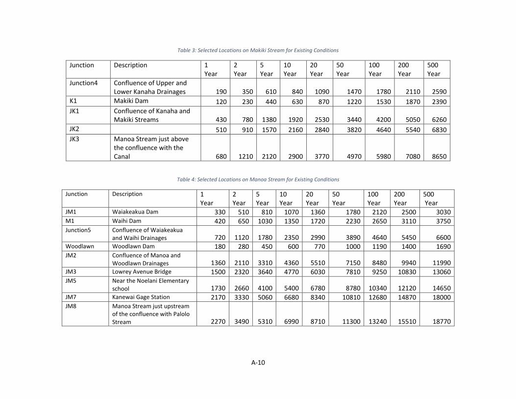
A-10
Table 3: Selected Locations on Makiki Stream for Existing Conditions
Junction Description 1 Year
2 Year
5 Year
10 Year
20 Year
50 Year
100 Year
200 Year
500 Year
Junction4 Confluence of Upper and Lower Kanaha Drainages 190 350 610 840 1090 1470 1780 2110 2590
K1 Makiki Dam 120 230 440 630 870 1220 1530 1870 2390
JK1 Confluence of Kanaha and Makiki Streams 430 780 1380 1920 2530 3440 4200 5050 6260
JK2 510 910 1570 2160 2840 3820 4640 5540 6830
JK3 Manoa Stream just above the confluence with the Canal 680 1210 2120 2900 3770 4970 5980 7080 8650
Table 4: Selected Locations on Manoa Stream for Existing Conditions
Junction Description 1 Year
2 Year
5 Year
10 Year
20 Year
50 Year
100 Year
200 Year
500 Year
JM1 Waiakeakua Dam 330 510 810 1070 1360 1780 2120 2500 3030 M1 Waihi Dam 420 650 1030 1350 1720 2230 2650 3110 3750 Junction5 Confluence of Waiakeakua
and Waihi Drainages 720 1120 1780 2350 2990 3890 4640 5450 6600 Woodlawn Woodlawn Dam 180 280 450 600 770 1000 1190 1400 1690 JM2 Confluence of Manoa and
Woodlawn Drainages 1360 2110 3310 4360 5510 7150 8480 9940 11990 JM3 Lowrey Avenue Bridge 1500 2320 3640 4770 6030 7810 9250 10830 13060 JM5 Near the Noelani Elementary
school 1730 2660 4100 5400 6780 8780 10340 12120 14650 JM7 Kanewai Gage Station 2170 3330 5060 6680 8340 10810 12680 14870 18000 JM8 Manoa Stream just upstream
of the confluence with Palolo Stream 2270 3490 5310 6990 8710 11300 13240 15510 18770

A-11
Table 5: Selected Locations on Palolo Stream for Existing Conditions
Junction Description 1 Year
2 Year
5 Year
10 Year
20 Year
50 Year
100 Year
200 Year
500 Year
JP1 Pukele Dam 160 380 780 1140 1550 2130 2600 3120 3860
P2 Waiomao Dam 230 460 830 1160 1540 2060 2480 2950 3610
Junction-1 Confluence of Upper and Lower Waiomao Drainages 350 660 1160 1600 2080 2760 3320 3920 4780
JP3 USGS Stream Gage 16247000 1020 1910 3310 4510 5840 7700 9210 10870 13190
JP4 Palolo Stream just upstream of the confluence with the Manoa Stream 1210 2230 3820 5160 6630 8700 10360 12180 14750

A-12
Previous Modeling Efforts - Hydraulics The original study was developed using the HEC-RAS (Hydrologic Engineering Center - River Analysis
System) computer program, version 4.1.0 for hydraulic modeling (U.S. Army Corps of Engineers, 2010).
This HEC-RAS model was created by joining separate HEC-RAS models of Makiki, Manoa, and Palolo
Streams and Manoa-Palolo Drainage and Ala Wai Canals. The HEC-RAS model of Manoa Stream is
documented in the Final Hydraulic Report, Manoa Watershed Project (Oceanit, 2008b) and the separate
models for the Makiki and Palolo Streams and the Manoa-Palolo Drainage and Ala Wai Canals were
originally created by Oceanit and West Consultants by July 2009 and then corrected and merged
together by the U.S. Army Corps of Engineers by November 2009. In 2013 the merged model was then
updated again to be more accurate. This model consisted of 8 rivers, 13 reaches, 1,287 cross sections,
of which 476 are interpolated, 49 bridges (this includes culverts), 2 inline weirs, and 16 lateral weirs. This
effort is detailed in the Ala Wai Canal Flood Risk Management Study O’ahu, Hawai’I Final Feasibility
Study Report with integrated Environmental Impact Statement Appendix A – Hydrology and Engineering.
Project Scope - Hydraulics In an effort to improve upon and extend previous modeling efforts the project the following
adjustments were made to the 2016 Ala Wai Hydraulic Efforts. These efforts are divided into updates
that were completed for the EDR and updates that will be included in a final Hydrology and Hydraulics
Report.
EDR Scope:
Update model to most recent published version (HEC-RAS Version 5.0.7)
Modify Geometry to include 2 dimensional (2D) areas for the overbanks where needed
Review bridges, tunnels and other existing features in previous model
Incorporate new terrain data and modify in areas where new features will be added
Incorporate land cover data for 2D roughness values
Update model to unsteady flow which is needed for 2D modeling and re-link model to new HEC-
HMS flows as discussed in the Hydrology section
Calibrate and validate updated model to the 2004, 2006, and 1967 events.
Creation of multiple geometries for project features.
Hydrology and Hydraulics Report Scope:
Routing of final Frequency Events with different modified geometries.
Routing uncertainty simulation for upper and lower bounds
Compiling a final report for inclusion with the hydraulics updates.
As will be detailed in this report, upper basin project features have largely been removed and a single
without project geometry was continued for the final frequency and uncertainty routings.

A-13
Geometry Updates
Figure 5: Original HEC-RAS Geometry Schematic
Figure 6: Updated HEC-RAS Geometry Schematic

A-14
The updated hydraulic modeling was developed using the HEC-RAS (Hydrologic Engineering Center -
River Analysis System) computer program, version 5.0.7. This version of HEC-RAS has the capability to
model 1D and 2D flows. The updated HEC-RAS model utilizes the same 1D channel cross-section data
but the overbank areas are modeled with 2D grids rather than having the 1D cross-sections extend into
the overbank or in some cases creating false “stream reaches” to model the overbank. The hydraulic
modeling was also converted to an unsteady analysis from steady flow analysis in the previous study.
The unsteady flow analysis will better account for the volume of the storm and the timing of the
coincident flows on the multiple reaches. Also, some of the longer culverts were converted to lids to
allow more cross-sections over longer lengths which will increase stability and to better account for flow
transfer to the overbanks between the confining sections. Other changes included updating the channel
roughness, making specific bridge modifications based on field visit, adding a bridge for Kapiolani Blvd
on the lower Makiki Reach, modifying roughness in the overbanks to account for buildings, and
switching to uniform lateral inflow to better distribute local inflows when appropriate. The downstream
extent of the model was extended into the ocean so that the downstream boundary condition does not
unintentionally force potential errors in the canal. Finally, a better quality terrain was implemented for
the study.
The updated hydraulic model uses 1D cross-section for the channel and 2D storage areas for the
overbanks except for the Pukele and Waiomao Reaches which used the same cross-section data from
the previous study due to the 1D nature of these areas. In addition, the upstream portions of Kanaha
and Makiki also used the full cross-section extent in areas that were suitable for 1D modeling. For areas
with 2D storage areas, the original 1D cross-sections were trimmed back to the channel area. This
included trimming back bridge data and other structures data to the trimmed cross-sections. So the
original channel data in the 1D cross-sections was retained for this study. In addition, since the
overbanks are now modeled with 2D areas, the “dummy” reaches from the previous study were
removed since the 2D would be to more appropriately model these areas.
Bridge data from the previous model was utilized in the updated model. Site visits were conducted on
several bridges to verify dimensions and the model was updated accordingly. In addition, the Kapiolani
Blvd Bridge on the downstream of Makiki was added to the model and the Woodlawn Bridge on Manoa
was updated reflect recent improvements to the channel at the bridge. The updated model also
converted the culverts and bridges on the Makiki Reach to cross-sections with lids. This was done to
increase stability in the area and to more appropriately model the longer culverts that go underground
for several city blocks. Having cross-sections with lids, allows multiple cross-sections of the length of the
culvert rather than having a cross-sections only on the upstream and downstream ends of the culverts.
Since the culverts were underground, the top of the lids were artificially raised to prevent water from
flowing over the top of the lids since most water would flow into the overbank areas if the water surface
elevations rise high enough and flow on top of the lids was not deemed to be realistic.
2D areas are used extensively throughout the model for the overbank areas due to the 2D nature of the
overbanks. In total seven 2D storage areas are used to represent the overbank areas of the Kanaha,
Makiki, Manoa, Palolo, and Ala Wai channels. The average cell size is approximately 80 ft with the
largest cell being approximately 200 ft. There are almost 200 breaklines in the model to more accurately
model hydraulically significant features with some breaklines having spacing as small as 10 ft cells. There
are approximately 31,000 cells across the seven 2D storage areas.

A-15
Manning’s ‘n’ values for the 1D sections were estimated based on site visits throughout the watershed
and along the multiple stretches of the channels. Due to the lack of calibration data throughout the
watershed, the roughness was estimated based on a consensus of several senior hydraulic engineers
that participated in the site visits to ensure reasonable values were used for the channels. Since the 1D
cross-sections were only used to model the channel portion, a composite ‘n’ value was used for the
entire channel portion which would include the sides of the channels. The roughness of the 2D areas
was based off of the 2011 Coastal Change Analysis Program (C-CAP) Land Cover for Oahu. The land cover
data was supplemented with building footprints from a 2009 dataset from the National Geospatial-
Intelligence Agency (NGA). Manning’s roughness for some land cover fields were estimated using values
from Mattocks, C., and C. Forbes, 2008: A real-time, event-triggered storm surge forecasting system for
the state of North Carolina. Ocean Model. The figure below shows the values used for the 2D land cover
data. For building, a high ‘n’ value was used to reduce conveyance but allow for some storage of the
water.
Figure 7: Manning’s ‘n’ values for 2D Land Cover
Lateral structures were used to transfer flow between the 1D channel sections to the 2D flow areas. For
most of these connections, the “normal 2D equation domain” was used as the overflow computational
method since the connection represented overland flow and not a weir type structure. However, some
connections were modeled using the weir equation because these areas had walls or other features that
may act like weirs such as the Makiki Reach and the lateral structure connecting the Manoa Reach to the
Kanewai Field. In addition, some lateral structures were manually edited in locations where the terrain
data was not properly defining some features. For example, the lateral structures along the Makiki were
raised to match the top of bank since this is a concrete lined channel, with known dimension. The lateral

A-16
structure on the east bank of the Manoa reach between Kanewai Field and the confluence with Palolo
was modified with survey data that was collected to better define a wall along Koali Rd. The lateral
structure elevations were also modified on the Makiki reach where lids were used to prevent the flow
over the lateral structures since the flow would be underground and could not realistically overtop the
lateral.
Several inline structures were used in the model to more accurately model steep drops in the channel
profile. An example, is the steep concrete drop off just upstream of Lowrey Ave and the waterfall that is
on the downstream end of the Manoa Channel just upstream of the confluence with the Palolo Channel.
Internal hydraulic structures were used in multiple locations in the 2D storage areas. It was determined
that the median barrier along H-1 could impact the flow path but it was not included in the terrain. Plans
were located and the median was found to be approximately 4’8” in height. The height of the median
barrier was added to the underlying terrain to represent this barrier. The median barrier was not
modeled along H-1 where there were underpasses under H-1 since the median would not obstruct the
flow under the bridges. Other features modeled as connections include several project features such as
the Golf Course berm, Hausten Ditch berms, Kanewai Field berm, and the Woodlawn Detention Basin
berm.
Topographic data for the hydraulic model is primarily based on airborne light detection and ranging
(LIDAR) data. The terrain used for this study was generated from 3 different data sources. The terrain
data included SHOALS (Scanning Hydrographic Operational Airborne LiDAR Survey) data, LiDAR that was
originally collected prior to February 21, 2007 by Airborne1, and bathymetric survey data that was
conducted by Oceanit on May 12, 2008. The LIDAR data was collected, processed, and verified by
Oceanit and their sub consultants in late 2006 and early 2007. The LIDAR data has an accuracy of 45 cm
(1.5 ft) horizontal, 37 cm (1.2 ft) vertical and was processed with 1 ft horizontal point spacing. Datum of
data is NAD 1983 HARN projected into Stateplane_Hawaii_3_FIPS_5103_Feet horizontal and mean sea
level vertical.
The quality of the terrain data used in the HEC-RAS model has been improved compared to the terrain
data that was provided for the original model. The figures below show the difference between the
datasets. It’s suspected the reduction in the quality of the terrain data resulted due to conversions that
were deemed necessary during the original study. The documentation from the previous study indicates
that the terrain data was converted to a TIN (Triangulated Irregular Network) for the application of HEC-
GeoRAS which may be the cause of the triangulated areas in the floodplain. The mountainous appear to
match the LiDAR for the current study and only the flat floodplains areas seem to have been degraded in
the previous study. The higher quality terrain as part of the current study was also modified to remove
some bridge decks that were not properly removed so that water could move freely in these areas. In
addition, the channel data from the existing HEC-RAS cross-sections was used to burn-in channel
bathymetry in the terrain in order to provide improved mapping for the channels. Finally, the terrain for
some scenarios was modified to include some of the proposed structures such as Makiki Detention
Basin, Pukele Detention Basin, Waiomao Detention Basin, and a deeper sedimentation basin within the
golf course.

A-17
Figure 8: Terrain Data provided with Original Model
Figure 9: Terrain Data used in the Updated HEC-RAS Model

A-18
Boundary Conditions Since the updated HEC-RAS model is using unsteady flow compared to the steady flow that was used in
the previous study, flow hydrographs were needed for the model. The results from the HEC-HMS
frequency flows were used throughout the RAS model. The downstream boundary condition of the Ala
Wai Canal was modeled as a stage hydrograph using a stage of 2.05 ft MSL for the existing conditions
and 2.50 ft for the future conditions. The 2.05 ft MSL elevation represents a high sea level rise base
condition predicted for the year 2025. The 2.5 ft MSL elevation represents an intermediate sea level rise
for the year 2075. The years 2025 and 2075 represent the bounds of the estimated 50 year design life.
The sea level rise elevation used for 2025 and 2075 were determined as part of the National Economic
Development plan.
Additional boundary conditions were placed on the 2D storage areas near the coast which included a
normal depth boundary condition to allow for the water to exit the system since at this point the water
would enter the ocean. The 2D boundary was cut-off such that the tide levels would not be high enough
to back into the 2D storage areas. The tables below include the boundary conditions used in HEC-RAS
for the without project conditions and the proposed features condition.
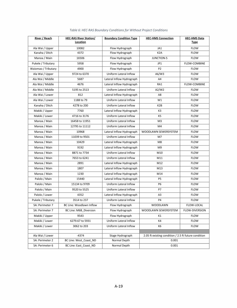
A-19
Table 6: HEC-RAS Boundary Conditions for Without Project Conditions
River / Reach HEC-RAS River Station/ Location
Boundary Condition Type HEC-HMS Connection HEC-HMS Data Type
Ala Wai / Upper 10082 Flow Hydrograph JA1 FLOW
Kanaha / Ditch 4372 Flow Hydrograph K2A FLOW
Manoa / Main 16506 Flow Hydrograph JUNCTION-5 FLOW
Pukele / Tributary 5958 Flow Hydrograph JP1 FLOW-COMBINE
Waiomao / Tributary 4900 Flow Hydrograph P2 FLOW
Ala Wai / Upper 9724 to 6370 Uniform Lateral Inflow A6/W3 FLOW
Ala Wai / Middle 5687 Lateral Inflow Hydrograph A4 FLOW
Ala Wai / Middle 4676 Lateral Inflow Hydrograph RA1 FLOW-COMBINE
Ala Wai / Middle 5195 to 2513 Uniform Lateral Inflow A2/W2 FLOW
Ala Wai / Lower 812 Lateral Inflow Hydrograph A8 FLOW
Ala Wai / Lower 1188 to 79 Uniform Lateral Inflow W1 FLOW
Kanaha / Ditch 4278 to 200 Uniform Lateral Inflow K2B FLOW
Makiki / Upper 7760 Lateral Inflow Hydrograph K3 FLOW
Makiki / Lower 4716 to 3176 Uniform Lateral Inflow K5 FLOW
Manoa / Main 16458 to 11951 Uniform Lateral Inflow M3 FLOW
Manoa / Main 12795 to 11112 Uniform Lateral Inflow M4 FLOW
Manoa / Main 10968 Lateral Inflow Hydrograph WOODLAWN SEWERSYSTEM FLOW
Manoa / Main 11039 to 9501 Uniform Lateral Inflow M7 FLOW
Manoa / Main 10429 Lateral Inflow Hydrograph M8 FLOW
Manoa / Main 9192 Lateral Inflow Hydrograph M9 FLOW
Manoa / Main 8871 to 7734 Uniform Lateral Inflow M10 FLOW
Manoa / Main 7653 to 6241 Uniform Lateral Inflow M11 FLOW
Manoa / Main 2891 Lateral Inflow Hydrograph M12 FLOW
Manoa / Main 1807 Lateral Inflow Hydrograph M13 FLOW
Manoa / Main 1230 Lateral Inflow Hydrograph M14 FLOW
Palolo / Main 15440 Lateral Inflow Hydrograph P5 FLOW
Palolo / Main 15134 to 9709 Uniform Lateral Inflow P6 FLOW
Palolo / Main 9520 to 5525 Uniform Lateral Inflow P7 FLOW
Palolo / Lower 4352 Lateral Inflow Hydrograph A3 FLOW
Pukele / Tributary 3514 to 237 Uniform Lateral Inflow P4 FLOW
SA: Perimeter 7 BC Line: Woodlawn Inflow Flow Hydrograph WOODLAWN FLOW-LOCAL
SA: Perimeter 7 BC Line: M6B_Diversion Flow Hydrograph WOODLAWN SEWERSYSTEM FLOW-DIVERSION
Makiki / Upper 9543 Flow Hydrograph K1 FLOW
Makiki / Lower 6279.67 to 5931 Uniform Lateral Inflow K4 FLOW
Makiki / Lower 3062 to 203 Uniform Lateral Inflow K6 FLOW
Ala Wai / Lower -4374 Stage Hydrograph 2.05 ft existing condition / 2.5 ft future condition
SA: Perimeter 2 BC Line: West_Coast_ND Normal Depth 0.001
SA: Perimeter 6 BC Line: East_Coast_ND Normal Depth 0.001

A-20
Table 7: HEC-RAS Boundary Conditions for Proposed Project Conditions
River / Reach HEC-RAS River Station/ Location
Boundary Condition Type HEC-HMS Connection HEC-HMS Data Type
Ala Wai / Upper 10082 Flow Hydrograph JA1 FLOW
Kanaha / Ditch 4372 Flow Hydrograph K2A FLOW
Manoa / Main 16506 Flow Hydrograph JUNCTION-5 FLOW
Pukele / Tributary 5958 Flow Hydrograph JP1 FLOW-COMBINE
Waiomao / Tributary 4900 Flow Hydrograph P2 FLOW
Ala Wai / Upper 9724 to 6370 Uniform Lateral Inflow A6/W3 FLOW
Ala Wai / Middle 5687 Lateral Inflow Hydrograph A4 FLOW
Ala Wai / Middle 4676 Lateral Inflow Hydrograph RA1 FLOW-COMBINE
Ala Wai / Middle 5195 to 2513 Uniform Lateral Inflow A2/W2 FLOW
Ala Wai / Middle 812 Lateral Inflow Hydrograph A8 FLOW
Ala Wai / Middle 1188 to 812 Uniform Lateral Inflow W1 FLOW
Kanaha / Ditch 4278 to 200 Uniform Lateral Inflow K2B FLOW
Makiki / Upper 7760 Lateral Inflow Hydrograph K3 FLOW
Makiki / Lower 4716 to 3176 Uniform Lateral Inflow K5 FLOW
Manoa / Main 16458 to 11951 Uniform Lateral Inflow M3 FLOW
Manoa / Main 12795 to 11112 Uniform Lateral Inflow M4 FLOW
Manoa / Main 10968 Lateral Inflow Hydrograph WOODLAWN SEWERSYSTEM FLOW
Manoa / Main 11039 to 9501 Uniform Lateral Inflow M7 FLOW
Manoa / Main 10429 Lateral Inflow Hydrograph M8 FLOW
Manoa / Main 9192 Lateral Inflow Hydrograph M9 FLOW
Manoa / Main 8871 to 7734 Uniform Lateral Inflow M10 FLOW
Manoa / Main 7653 to 6241 Uniform Lateral Inflow M11 FLOW
Manoa / Main 2891 Lateral Inflow Hydrograph M12 FLOW
Manoa / Main 1807 Lateral Inflow Hydrograph M13 FLOW
Manoa / Main 1230 Lateral Inflow Hydrograph M14 FLOW
Palolo / Main 15440 Lateral Inflow Hydrograph P5 FLOW
Palolo / Main 15134 to 9709 Uniform Lateral Inflow P6 FLOW
Palolo / Main 9520 to 5525 Uniform Lateral Inflow P7 FLOW
Palolo / Lower 4352 Lateral Inflow Hydrograph A3 FLOW
Pukele / Tributary 3514 to 237 Uniform Lateral Inflow P4 FLOW
SA: Perimeter 7 BC Line: Woodlawn Inflow Flow Hydrograph WOODLAWN FLOW-LOCAL
SA: Perimeter 7 BC Line: M6B_Diversion Flow Hydrograph WOODLAWN SEWERSYSTEM FLOW-DIVERSION
Makiki / Upper 9543 Flow Hydrograph K1 FLOW
Makiki / Lower 6279.67 to 5931 Uniform Lateral Inflow K4 FLOW
Makiki / Lower 3062 to 203 Uniform Lateral Inflow K6 FLOW
Ala Wai / Lower -4374 Stage Hydrograph 2.05 ft existing condition / 2.5 ft future condition
SA: Perimeter 2 BC Line: West_Coast_ND Normal Depth 0.001
SA: Perimeter 6 BC Line: East_Coast_ND Normal Depth 0.001
Bypass / Reach 1 1033.5 Flow Hydrograph Steady 25 cfs
Bypass / Reach 1 0 Normal Depth 0.001
Ala Wai / Upper 6270 Elevation Controlled Gates Gate Structure at Pump Station
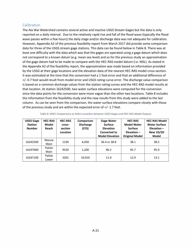
A-21
Calibration The Ala Wai Watershed contains several active and inactive USGS Stream Gages but the data is only
reported on a daily interval. Due to the relatively rapid rise and fall of the flood wave (typically the flood
wave passes within a few hours) the daily stage and/or discharge data was not adequate for calibration.
However, Appendix A2 of the previous feasibility report from March 2017 did provide some comparison
data for three of the USGS stream gage stations. This data can be found below in Table 8. There was at
least one difficulty with the data which was that the gages are operated using a gage datum which does
not correspond to a known datum (e.g. mean sea level) and so for the previous study an approximation
of the gage datum had to be made to compare with the HEC-RAS model datum (i.e. MSL). As stated in
the Appendix A2 of the feasibility report, the approximation was made based on information provided
by the USSG at their gage locations and the elevation data of the nearest HEC-RAS model cross-section.
It was estimated at the time that the conversion had a 1 foot error and that an additional difference of
+/- 0.7 foot would result from model error and USGS rating curve error. The discharge value comparison
is based on a common discharge values from the station rating curves and the HEC-RAS model results at
that location. At station 16242500, two water surface elevations were computed for the conversion
since the data points for the conversion were more vague than the other two locations. Table 8 includes
the information from the feasibility study and the new results from this study were added to the last
column. As can be seen from the comparison, the water surface elevations compare closely with those
of the previous study and are within the expected error of +/- 1.7 feet.
Table 8: WSEL Comparisons at Select Locations between USGS Gages and HEC-RAS Model Outputs
USGS Gage Station Number
HEC-RAS Model Reach
HEC-RAS cross-
section Location
Comparison Discharge
(CFS)
Gage Water Surface
Elevation Converted to
Model Elevation
HEC-RAS Model Water
Surface Elevation –
Original Model
HEC-RAS Model Water Surface
Elevation – New 1D/2D
Model
16242500 Manoa Main
1230 4,450 36.4 or 38.8 38.1 38.2
16247000 Palolo Main
9520 1,200 96.2 95.7 95.9
16247100 Palolo Lower
3201 10,910 11.9 12.9 13.1
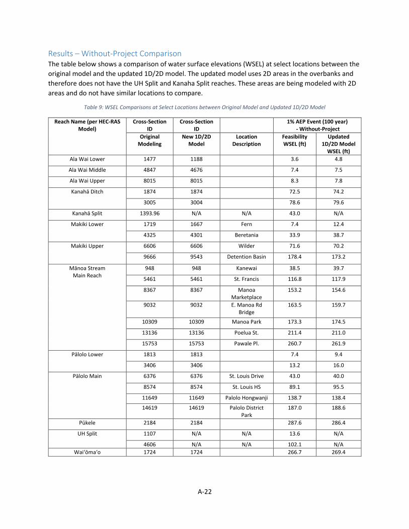
A-22
Results – Without-Project Comparison The table below shows a comparison of water surface elevations (WSEL) at select locations between the
original model and the updated 1D/2D model. The updated model uses 2D areas in the overbanks and
therefore does not have the UH Split and Kanaha Split reaches. These areas are being modeled with 2D
areas and do not have similar locations to compare.
Table 9: WSEL Comparisons at Select Locations between Original Model and Updated 1D/2D Model
Reach Name (per HEC-RAS Model)
Cross-Section ID
Cross-Section ID
1% AEP Event (100 year) - Without-Project
Original Modeling
New 1D/2D Model
Location Description
Feasibility WSEL (ft)
Updated 1D/2D Model
WSEL (ft)
Ala Wai Lower 1477 1188 3.6 4.8
Ala Wai Middle 4847 4676 7.4 7.5
Ala Wai Upper 8015 8015 8.3 7.8
Kanahā Ditch 1874 1874 72.5 74.2
3005 3004 78.6 79.6
Kanahā Split 1393.96 N/A N/A 43.0 N/A
Makiki Lower 1719 1667 Fern 7.4 12.4
4325 4301 Beretania 33.9 38.7
Makiki Upper 6606 6606 Wilder 71.6 70.2
9666 9543 Detention Basin 178.4 173.2
Mānoa Stream Main Reach
948 948 Kanewai 38.5 39.7
5461 5461 St. Francis 116.8 117.9
8367 8367 Manoa Marketplace
153.2 154.6
9032 9032 E. Manoa Rd Bridge
163.5 159.7
10309 10309 Manoa Park 173.3 174.5
13136 13136 Poelua St. 211.4 211.0
15753 15753 Pawale Pl. 260.7 261.9
Pālolo Lower 1813 1813 7.4 9.4
3406 3406 13.2 16.0
Pālolo Main 6376 6376 St. Louis Drive 43.0 40.0
8574 8574 St. Louis HS 89.1 95.5
11649 11649 Palolo Hongwanji 138.7 138.4
14619 14619 Palolo District Park
187.0 188.6
Pūkele 2184 2184 287.6 286.4
UH Split 1107 N/A N/A 13.6 N/A
4606 N/A N/A 102.1 N/A
Wai‘ōma‘o 1724 1724 266.7 269.4

U.S. Army Corps of Engineers Honolulu District
Appendix B
Economic Analysis
Honolulu District
Ala Wai Canal Flood Risk Management
Study, O’ahu, Hawai’i
Engineering Documentation Report (EDR)
Economics Appendix
June 2020

Ala Wai Canal Economics Appendix U.S. Army Corps of Engineers Engineering Documentation Report Honolulu District
i | P a g e
(Page Intentionally Left Blank)
Ala Wai Canal Economics Appendix U.S. Army Corps of Engineers Engineering Documentation Report Honolulu District
ii | P a g e
Table of Contents Acronyms ...................................................................................................................................................... ii
1 Executive Summary ............................................................................................................................... 1
1.1 Purpose & Overview ..................................................................................................................... 1
1.2 Key Findings .................................................................................................................................. 2
2 Study Area ............................................................................................................................................. 3
3 Evaluation Method................................................................................................................................ 5
3.1 Limitations of Evaluation .............................................................................................................. 5
4 Economic Evaluation ............................................................................................................................. 7
4.1 Economic Evaluation Assumptions ............................................................................................... 7
4.2 Economic Flood Damage Assessment ........................................................................................... 7
4.3 National Economic Development (NED) Benefit Evaluation......................................................... 9
4.4 Economic Evaluation Conclusion ................................................................................................ 10
5 Recommendations & Conclusion ........................................................................................................ 11
Attachment 1: Draft Total Project Cost Summary (PED) .......................................................................... A‐1
Attachment 2: Future Without‐Project Condition 2D Inundation Depths ‐ 1% AEP ................................ A‐2
Attachment 3: Future With‐Project Condition 2D Inundation Depths ‐ 1% AEP ...................................... A‐3
List of Figures Figure 1: Overview of the Ala Wai Watershed ............................................................................................. 4
List of Tables Table 4‐1: Without‐Project Rough Order of Magnitude EAD Calculations ................................................... 8 Table 4‐2: With‐Project Rough Order of Magnitude EAD Calculations ........................................................ 8 Table 4‐3: Authorized Plan Benefit & Cost Evaluation .................................................................................. 9 Table 4‐4: Current ROM Change in Key Economic Metrics Compared to Feasibility Report ..................... 10
Acronyms 1D – One‐Dimensional 2D – Two‐Dimensional AAB – Average Annual Benefits AAC – Average Annual Costs AEP – Annual Exceedance Probability BCR – Benefit‐to‐Cost Ratio CWPM – Civil Works’ Policy Memorandum

Ala Wai Canal Economics Appendix U.S. Army Corps of Engineers Engineering Documentation Report Honolulu District
iii | P a g e
DDF – Depth‐Damage Function DRV – Depreciated Replacement Value EAD – Expected Annual Damage EDR – Engineering Documentation Report EGM – Economic Guidance Memorandum ER – Engineering Regulation FRM – Flood Risk Management FWOP – Future Without‐Project FWP – Future With‐Project FY – Fiscal Year H&H – Hydrology & Hydraulics HEC‐FDA ‐ Hydrologic Engineering Center’s Flood Damage Reduction Analysis HEC‐GeoFDA – Hydrologic Engineering Center’s Geospatial Flood Damage Reduction Analysis IDC – Interest During Construction NED – National Economic Development PDT – Project Delivery Team PED – Preconstruction Engineering and Design PL – Price Level ROM – Rough Order of Magnitude SI – Structure Inventory TPCS ‐ Total Project Cost Summary USACE – United States Army Corps of Engineers VS – Validation Study
Ala Wai Canal Economics Appendix U.S. Army Corps of Engineers Engineering Documentation Report Honolulu District
1 | P a g e
1 Executive Summary 1.1 Purpose & Overview The purpose of this document is to present the methods and findings of a cursory economic analysis that was conducted to update estimates of potential future flood damages in the Ala Wai Watershed and the anticipated National Economic Development (NED) benefits from implementing the authorized plan from the May 2017 Ala Wai Canal Flood Risk Management Feasibility Report with Integrated Environmental Impact Statement as modified by the 2020 Engineering Documentation Report as directed by USACE headquarters in September, 2019. The plan from the May 2017 report included the following features: improvements to the flood warning system, six in‐stream debris and detention basins in the upper reaches of Makiki, Mānoa and Pālolo streams, one standalone debris catchment feature, three multi‐purpose detention areas in open spaces through the developed watershed, and concrete floodwalls averaging 4 feet in height along one or both sides of approximately 1.9 miles of the Ala Wai Canal (including two pump stations). Additional analyses were undertaken during the Preconstruction Engineering and Design (PED) phase to refine the project design, validate its effectiveness, and update project costs. As such, the purpose of this analysis is to: (1) provide an indication as to whether the project remains economically justified in light of these updates and (2) present key considerations for scoping a complete economic update, approximately around the Fiscal Year (FY) 2021 timeframe, that is consistent with the U.S. Army Corps of Engineers (USACE) Director of Civil Works' Policy Memorandum (CWPM) 12‐001 Methodology for Updating Benefit‐to‐Cost Ratios (BCR) for Budget Development. The economic evaluation in the feasibility report used the results and outputs from one‐dimensional (1D) steady‐state hydraulic modeling to assess the forecasted flood damages in the Future Without‐Project (FWOP) condition and the NED benefits in the Future With‐Project condition. Recent hydraulic modeling efforts in the PED phase used a two‐dimensional (2D) unsteady‐state hydraulic model. The 2D unsteady‐state hydraulic model revealed changes in average flood depths, stages, and inundation boundaries for all assessed flood frequencies across the watershed when compared to the results of the 1D steady‐state hydraulic model. Consequently, it is anticipated key metrics presented in the feasibility report have changed due to the changes in the hydraulic modeling and minor adjustments made to project features in the PED phase. Furthermore, refined total project costs are expected to increase. Primary metrics of concern are the following: expected annual damages (EAD) for the FWOP and FWP conditions, average annual cost (AAC), average annual benefits (AAB), net NED benefits, the benefit‐to‐cost ratio (BCR), and residual risk. Due to the changes and refinements in the hydraulic modeling coupled with the anticipated increasing total project cost and modifications to project features in the PED phase, the project delivery team (PDT) deemed it necessary to begin evaluating how these changes have affected key economic metrics in the feasibility report. The economic evaluation documented in this report provides a cursory analysis that gives an indication of changes in EAD for the FWOP and FWP conditions, AAC, AAB, net NED benefits, BCR, and residual risk. This cursory analysis provides rough order of magnitude (ROM) estimates for all of the previously listed metrics. The ROM estimates are intended to give the PDT and vertical team a sense of the direction and potential magnitude of the change in key economic metrics and are not intended to be used for final comparison purposes when attempting to assess how key economic metrics have changed due to changes in the hydraulic modeling, modifications to project features in
Ala Wai Canal Economics Appendix U.S. Army Corps of Engineers Engineering Documentation Report Honolulu District
2 | P a g e
PED, or changes in estimated project costs. Furthermore, while the cursory economic analysis conducted is useful for providing ROM estimates, it does not provide a level of detail that is sufficient to make any major decisions about the Ala Wai Canal Flood Risk Management Study that are based solely on the economics. 1.2 Key Findings EAD for the FWOP condition is estimated to be approximately $41,223,000 a decrease of approximately $14.7 Million from the 2017 report which estimated EAD at $55,946,000. EAD for the FWP condition is estimated to be approximately $2,643,000 a decrease by approximately $3 Million from the 2017 report which estimated FWP EAP at $5,610,000. Implementation of the authorized plan is estimated to reduce average annual flood damages by approximately $38,580,000, which is how NED benefits are measured in this economic evaluation. AAC is estimated at $15,527,000, using the FY20 Federal discount rate of 2.75% and over a 50‐year period of analysis. BCR is estimated to be 2.48 and net NED benefits are estimated to be $23,053,000. Residual risk in this evaluation is approximately $2,643,000, annually. All reported dollar values are in FY20 price levels. As noted above, this evaluation is preliminary and is expected to change during a validation study. Overall, the economic evaluation demonstrates that project benefit estimates will decrease where project cost estimates increase. The results of this cursory analysis does help validate that there is a significant flooding problem in the study area and the limited analysis done, which focused on structures, contents, vehicles, and streets in the 1% AEP floodplain, indicates that estimated damages are substantial. Based upon this cursory level of analysis, there is a strong reason to believe that the project remains economically justified, although, this should be confirmed with an updated analysis that complies with USACE requirements for economic updates. Given that the general direction and magnitude of the change in key economic metrics are now better understood, future study efforts which examine these changes in more detail would provide the PDT and vertical team with an understanding of if the changes made in PED fall within the Chief of Engineers’ discretionary authority and if the authorized plan still provides both sufficient economic benefits and protection for the community within the watershed.

Ala Wai Canal Economics Appendix U.S. Army Corps of Engineers Engineering Documentation Report Honolulu District
3 | P a g e
2 Study Area The Ala Wai Watershed is located on the southeastern side of the island of O‘ahu and includes the Makiki, Mānoa, and Pālolo streams, all of which drain to the Ala Wai Canal. The Canal is a 2‐mile‐long waterway constructed during the 1920’s to drain extensive coastal wetlands, thus allowing development of the Waikīkī District. A large portion of the watershed, including most of Waikīkī, is highly susceptible to flooding. A high risk of flooding exists within the watershed because of the natural geography, coupled with aging and undersized flood conveyance infrastructure. Based on the peak flows computed for this study, it is estimated that the Ala Wai Canal has the capacity to contain about a 4‐percent annual exceedance probability (AEP) flood before overtopping the banks. The risk of flooding is exacerbated by the flashy nature of the streams in the watershed, with heavy rains flowing downstream extremely quickly due to steep topography and relatively short stream systems. Figure 1, illustrated on the subsequent page, provides an overview map of the Ala Wai Watershed.
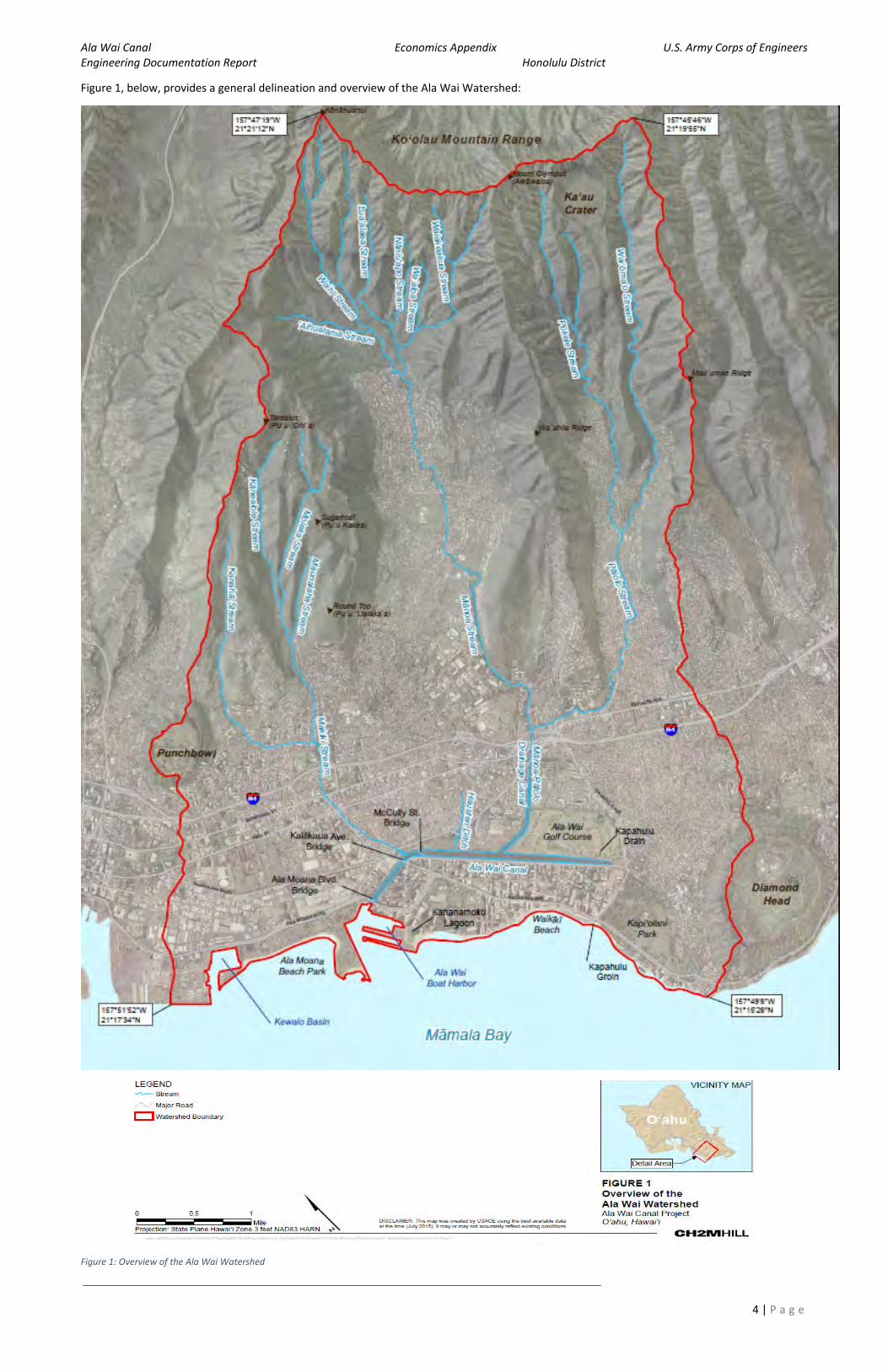
Ala Wai Canal Economics Appendix U.S. Army Corps of Engineers Engineering Documentation Report Honolulu District
4 | P a g e
Figure 1, below, provides a general delineation and overview of the Ala Wai Watershed:
Figure 1: Overview of the Ala Wai Watershed
Ala Wai Canal Economics Appendix U.S. Army Corps of Engineers Engineering Documentation Report Honolulu District
5 | P a g e
3 Evaluation Method Microsoft Excel and ArcGIS Pro were used to perform all of the analysis and calculations in the economic evaluation for this document. An updated Structure Inventory (SI) from the feasibility study was imported into ArcGIS Pro along with shapefiles for the inundation boundaries of the 1% AEP flood for both the FWOP and FWP conditions. Centroids from the SI which were impacted by two feet of flooding or more in each condition were identified and input into the Microsoft Excel spreadsheet. The authorized project is expected to reduce flood risk up to the 1% AEP flood; therefore, the 1% AEP flood was deemed to be the most appropriate flood event to analyze for this cursory analysis. Assessing flood frequencies below the 1% AEP flood would yield no useful information when comparing the FWOP and FWP conditions and assessing flood frequencies above the 1% AEP flood would be minimally beneficial in understanding the overall flood impacts to structures in the watershed. Given the general time and resource constraints of this analysis, assessing flood impacts at 2 feet of flooding for the 1% AEP flood was deemed to be the most useful in producing ROM estimates. In the feasibility study, damage reaches that were located around the Ala Wai Canal contained structures that were most severely impacted by flood damages. Given that these same damage reaches of concern mostly show inundation depths of approximately 2 feet or greater at the 1% AEP flood in the 2D hydraulic modeling, it was determined 2 feet of flooding would be the most useful flood depth to analyze for this cursory analysis.
Structures, vehicles, and streets were grouped by occupancy type and content values were assigned to structures as a ratio of the total structure value; these ratios are analogous with the ratios used in the feasibility study.
Depth‐damage functions (DDFs) from the feasibility study were imported into the Excel spreadsheet and cross‐referenced with the identified impacted items in the SI, their monetary values, and occupancy types to calculate how much damage would occur at two feet of flooding. The total expected damage was summed for structures, contents, vehicles, and streets for the FWOP and FWP conditions. Expected annual damages (EAD) were calculated in Microsoft Excel based on the total expected damage, the flood frequencies at which the PDT identified starting damages for the FWOP and FWP conditions, and values used to appropriately weigh EAD.
Updated draft project costs for the authorized plan were imported into the Excel spreadsheet from a recent Total Project Cost Summary (TPCS), provided by the PDT’s cost engineer. Interest during construction (IDC) was calculated and costs were annualized in order to compare against AAB.
Updated ROM estimates for key metrics were consolidated into tables to use in this report to support key findings, recommendations, and conclusions.
3.1 Limitations of Evaluation The evaluation employed a method that is useful for providing an indication of the direction and potential magnitude of the change in key economic metrics, however, this cursory analysis has a number of limitations. The key limitations to consider are:
1) Flood damages are the same for all damaging events;
2) The analysis does not account for damages to any structures, contents, vehicles, or streets inundated by depths of less than 2 feet;

Ala Wai Canal Economics Appendix U.S. Army Corps of Engineers Engineering Documentation Report Honolulu District
6 | P a g e
3) The analysis does not account for additional damages to structures, contents, vehicles, or streets that result from depths in excess of 2 feet;
4) The analysis does not account for damages to structures, contents, vehicles, or streets in the zone between the 1% and 0.2% AEP floodplains;
5) The analysis assumes that all structures, contents, vehicles, and streets that are inundated by depths of 2 feet for the 1% AEP flood would also be inundated by more probable events;
6) The analysis applies a simple non‐damaging assumption of the 4% AEP for all structures, contents, vehicles, and streets included in the damage estimate;
7) The analysis is not risk‐based and does not account for uncertainties in key hydrologic and hydraulic (H&H) and economic variables.
Given the limitations of this evaluation, future estimates for FWOP damages and FWP benefits that are derived from more robust economic modeling and evaluation efforts may be substantially different than the estimates provided. Table 4‐4, which shows ROM changes in key metrics between this evaluation and the feasibility report, is intended only to provide an indication of the general direction (an increase, decrease, or no change) and rough estimate of the magnitude of the change. The numbers reported in Table 4‐4, and throughout the rest of this document, should be understood to have a relatively low level of confidence, as this is a cursory analysis.
Ala Wai Canal Economics Appendix U.S. Army Corps of Engineers Engineering Documentation Report Honolulu District
7 | P a g e
4 Economic Evaluation 4.1 Economic Evaluation Assumptions Important assumptions employed in the economic evaluation are:
1) All reported results and metrics are ROM estimates which are only intended to show the direction and general magnitude in the change of key economic metrics from the feasibility report;
2) All inputs in this analysis are estimates and, therefore, subject to varying degrees of uncertainty;
3) All monetary values are stated in FY20 (October 2019) price levels, per the Economic Guidance Memorandum (EGM) 20‐01;
4) The FY20 Federal discount rate of 2.75% was used for annualizing values over a 50‐year period of analysis;
5) All structural computations were based on updated residential, commercial, public, and street depreciated replacement values (DRVs) and do not include land values;
6) All annualized benefits were calculated using an end‐of‐year discounting method;
7) Land use and population data were held constant;
8) ROM economic damages and benefits were developed using available data.
4.2 Economic Flood Damage Assessment EAD calculations in this economic evaluation were intended to provide a rough order of magnitude estimate for flood damages to structures, contents within structures, vehicles, and streets in the Ala Wai Watershed for the FWOP and FWP conditions. Total average damages were calculated, using DDFs, for structures impacted at two feet of flooding under the FWOP and FWP conditions. Total average damages were then weighted by different calculated values to produce an expected value for flood damages at different flood frequencies and the results were summed to forecast a final estimate for EAD over a 50‐year period of analysis. Table 4‐1 and Table 4‐2, below, outline the calculations that were performed to determine EAD for the FWOP and FWP conditions:

Ala Wai Canal Economics Appendix U.S. Army Corps of Engineers Engineering Documentation Report Honolulu District
8 | P a g e
Table 4‐1: Without‐Project Rough Order of Magnitude EAD Calculations
Table 4‐2: With‐Project Rough Order of Magnitude EAD Calculations
Return Period ACE Inundation Depth (Ft) Structure Damage Range Avg Damage Equivalent Damage
2 0.5 0 0
0.3 ‐$ ‐$ 5 0.2 0 0
0.1 ‐$ ‐$ 10 0.1 0 0
0.05 ‐$ ‐$ 20 0.05 0 0
0.01 ‐$ ‐$ 25 0.04 0 0
0.002 553,619$ 852$ 26 (Damages Begin) 0.038 2 1,107,237$
0.018 1,107,237$ 20,441$ 50 0.02 2 1,107,237$
0.01 1,107,237$ 11,072$ 100 0.01 2 1,107,237$
0.005 1,107,237$ 5,536$ 200 0.005 2 1,107,237$
0.003 1,107,237$ 3,322$ 500 0.002 2 1,107,237$
EAD 41,223$
Table 4‐1: Without‐Project Rough Order of Magnitude EAD Calculations ($1000)
Return Period ACE Inundation Depth (Ft) Structure Damage Range Avg Damage Equivalent Damage
2 0.5 0 0
0.3 ‐$ ‐$ 5 0.2 0 0
0.1 ‐$ ‐$ 10 0.1 0 0
0.05 ‐$ ‐$ 20 0.05 0 0
0.01 ‐$ ‐$ 25 0.04 0 0
0.02 ‐$ ‐$ 50 0.020 0 0
0.01 ‐$ ‐$ 100 0.01 0 0
0.0001 166,230$ 16$ 101 (Damages Begin) 0.0099 2 332,461$
0.0049 332,461$ 1,629$ 200 0.005 2 332,461$
0.003 332,461$ 997$ 500 0.002 2 332,461$
EAD 2,643$
Table 4‐2: With‐Project Rough Order of Magnitude EAD Calculations ($1000)
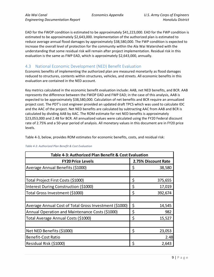
Ala Wai Canal Economics Appendix U.S. Army Corps of Engineers Engineering Documentation Report Honolulu District
9 | P a g e
EAD for the FWOP condition is estimated to be approximately $41,223,000. EAD for the FWP condition is estimated to be approximately $2,643,000. Implementation of the authorized plan is estimated to reduce average annual flood damages by approximately $38,580,000. The FWP condition is expected to increase the overall level of protection for the community within the Ala Wai Watershed with the understanding that some residual risk will remain after project implementation. Residual risk in this evaluation is the same as FWP EAD, which is approximately $2,643,000, annually. 4.3 National Economic Development (NED) Benefit Evaluation Economic benefits of implementing the authorized plan are measured monetarily as flood damages reduced to structures, contents within structures, vehicles, and streets. All economic benefits in this evaluation are contained in the NED account. Key metrics calculated in the economic benefit evaluation include: AAB, net NED benefits, and BCR. AAB represents the difference between the FWOP EAD and FWP EAD; in the case of this analysis, AAB is expected to be approximately $38,580,000. Calculation of net benefits and BCR require an annualized project cost. The PDT’s cost engineer provided an updated draft TPCS which was used to calculate IDC and the AAC of the project. Net NED benefits are calculated by subtracting AAC from AAB and BCR is calculated by dividing AAB by AAC. The ROM estimate for net NED benefits is approximately $23,053,000 and 2.48 for BCR. All annualized values were calculated using the FY20 Federal discount rate of 2.75% and a 50‐year period of analysis. All monetary values in this document are in FY20 price levels. Table 4‐3, below, provides ROM estimates for economic benefits, costs, and residual risk: Table 4‐3: Authorized Plan Benefit & Cost Evaluation
FY20 Price Levels 2.75% Discount Rate
Average Annual Benefits ($1000) 38,580$
Total Project First Costs ($1000) 375,655$ Interest During Construction ($1000) 17,019$ Total Gross Investment ($1000) 392,674$
Average Annual Cost of Total Gross Investment ($1000) 14,545$ Annual Operation and Maintenance Costs ($1000) 982$ Total Average Annual Costs ($1000) 15,527$
Net NED Benefits ($1000) 23,053$ Benefit‐Cost Ratio 2.48
Residual Risk ($1000) 2,643$
Table 4‐3: Authorized Plan Benefit & Cost Evaluation
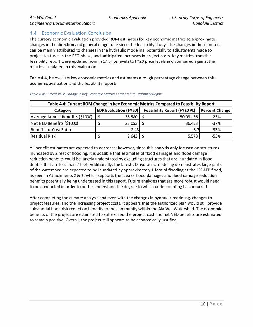
Ala Wai Canal Economics Appendix U.S. Army Corps of Engineers Engineering Documentation Report Honolulu District
10 | P a g e
4.4 Economic Evaluation Conclusion The cursory economic evaluation provided ROM estimates for key economic metrics to approximate changes in the direction and general magnitude since the feasibility study. The changes in these metrics can be mainly attributed to changes in the hydraulic modeling, potentially to adjustments made to project features in the PED phase, and anticipated increases in project costs. Key metrics from the feasibility report were updated from FY17 price levels to FY20 price levels and compared against the metrics calculated in this evaluation. Table 4‐4, below, lists key economic metrics and estimates a rough percentage change between this economic evaluation and the feasibility report: Table 4‐4: Current ROM Change in Key Economic Metrics Compared to Feasibility Report
All benefit estimates are expected to decrease; however, since this analysis only focused on structures inundated by 2 feet of flooding, it is possible that estimates of flood damages and flood damage reduction benefits could be largely understated by excluding structures that are inundated in flood depths that are less than 2 feet. Additionally, the latest 2D hydraulic modeling demonstrates large parts of the watershed are expected to be inundated by approximately 1 foot of flooding at the 1% AEP flood, as seen in Attachments 2 & 3, which supports the idea of flood damages and flood damage reduction benefits potentially being understated in this report. Future analyses that are more robust would need to be conducted in order to better understand the degree to which undercounting has occurred. After completing the cursory analysis and even with the changes in hydraulic modeling, changes to project features, and the increasing project costs, it appears that the authorized plan would still provide substantial flood risk reduction benefits to the community within the Ala Wai Watershed. The economic benefits of the project are estimated to still exceed the project cost and net NED benefits are estimated to remain positive. Overall, the project still appears to be economically justified.
Category EDR Evaluation (FY20) Feasibility Report (FY20 PL) Percent Change
Average Annual Benefits ($1000) 38,580$ 50,031.56$ ‐23%Net NED Benefits ($1000) 23,053$ 36,453$ ‐37%Benefit‐to‐Cost Ratio 2.48 3.7 ‐33%Residual Risk 2,643$ 5,578$ ‐53%
Table 4‐4: Current ROM Change in Key Economic Metrics Compared to Feasibility Report
Ala Wai Canal Economics Appendix U.S. Army Corps of Engineers Engineering Documentation Report Honolulu District
11 | P a g e
5 Recommendations & Conclusion The cursory economic analysis conducted was useful for providing ROM estimates, but does not provide a level of detail that is sufficient to make any major decisions about the Ala Wai Canal Flood Risk Management Study that are based solely on the economics. As noted, the intent of this analysis was to provide a general estimate of the magnitude and direction of the change for key economic metrics based on new hydraulic modeling, project feature modifications, and updated draft total project costs. Additionally, this analysis was meant to reveal if further study efforts pertaining to the economics would be warranted in the future. Based on the results of this analysis, the following recommendations should be considered:
1) The Hydrologic Engineering Center’s Geospatial Flood Damage Reduction Analysis (HEC‐GeoFDA) software should be used in conjunction with the Hydrologic Engineering Center’s Flood Damage Reduction Analysis (HEC‐FDA) software to obtain future refined and more precise estimates for key economic metrics;
2) Future efforts should be made to validate whether the changes made to the project in PED fall
within the Chief of Engineers’ discretionary authority;
3) The PDT and vertical team should consider continuing to pursue a Validation Study (VS) to obtain refined economic damage and benefit estimates.
Overall, the economic evaluation anticipates that project benefits will decrease while project costs increase. In addition to the economic evaluation documented in this appendix, updated inundation mapping, provided by H&H, shows that while the extent of the floodplain has increased, it appears that average flood depths in the watershed have generally decreased between the 1D and 2D hydraulic models. Consequently, economic damages would be expected to decrease, on average, in the watershed, which would likely also lead to a reduction in project benefits. The results of this cursory analysis help validate that there is a significant flooding problem in the study area and the limited analysis done that focused on structures, contents, vehicles, and streets in the 1% AEP floodplain indicates that estimated damages are substantial. Based upon this cursory level of analysis, there is a strong reason to believe that the project remains economically justified, although, this should be confirmed with an updated analysis that complies with USACE requirements for economic updates. Please reference CWPM 12‐001, Engineering Regulation (ER) 1105‐2‐100, and ER 1105‐2‐101. The general relationship between NED benefits and project costs is something that is managed and balanced carefully for FRM studies and projects. Given that the general direction and magnitude of the change in key economic metrics is now better understood, future study efforts, such as a Validation Study, which examine these changes in more detail, would provide the PDT and vertical team with an understanding of if the changes made in PED fall within the Chief of Engineers’ discretionary authority and if the authorized plan still provides both sufficient economic benefits and flood protection for the community within the watershed.

Ala Wai Canal Economics Addendum U.S. Army Corps of Engineers Engineering Documentation Report Honolulu District
A‐1 | P a g e
Attachment 1: Draft Total Project Cost Summary (PED)
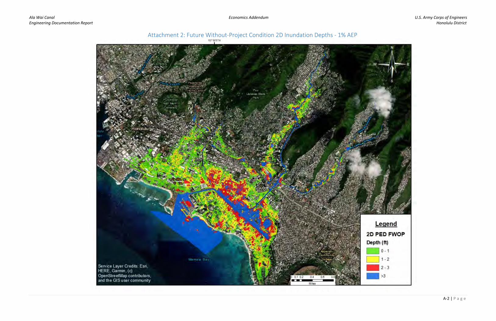
Ala Wai Canal Economics Addendum U.S. Army Corps of Engineers Engineering Documentation Report Honolulu District
A‐2 | P a g e
Attachment 2: Future Without‐Project Condition 2D Inundation Depths ‐ 1% AEP
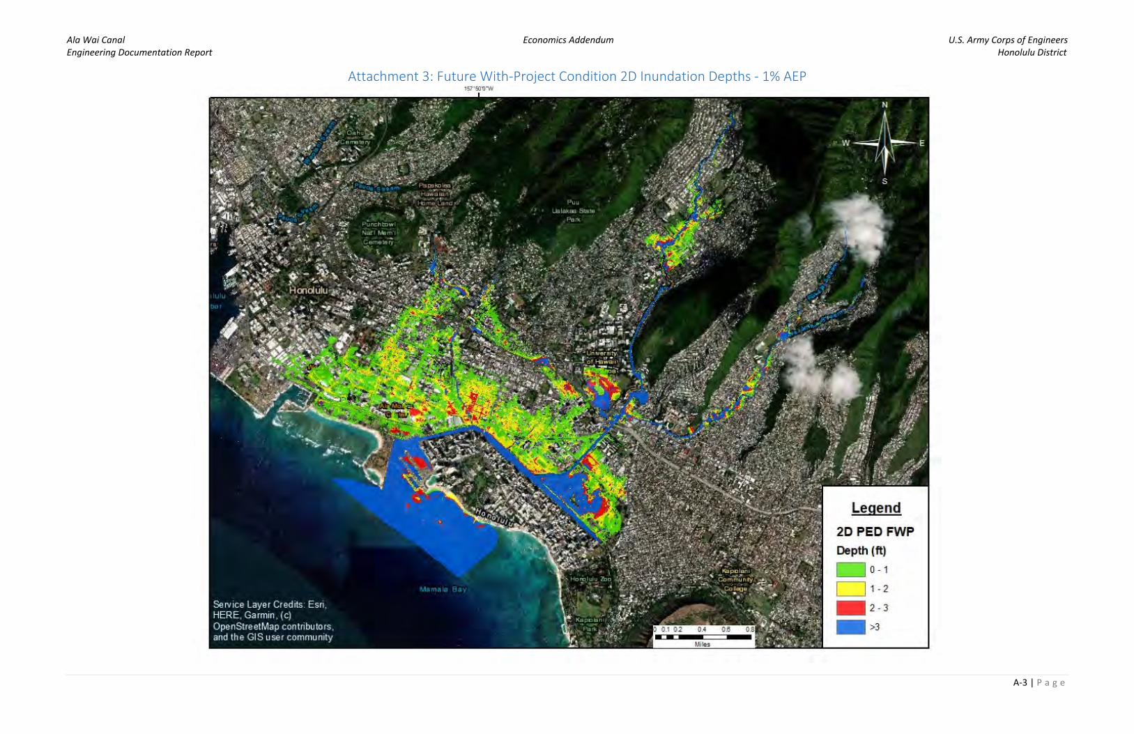
Ala Wai Canal Economics Addendum U.S. Army Corps of Engineers Engineering Documentation Report Honolulu District
A‐3 | P a g e
Attachment 3: Future With‐Project Condition 2D Inundation Depths ‐ 1% AEP
ALA WAI CANAL FRM PROJECT O’AHU, HAWAI’I
ENGINEERING DOCUMENTATION REPORT
APPENDIX C COST ENGINEERING
C1 Cost Report

ALA WAI CANAL FRM PROJECT O’AHU, HAWAI’I
ENGINEERING DOCUMENTATION REPORT
SECTION 209 OF FLOOD CONTROL ACT OF 1962 (PUBLIC LAW 87-874)
APPENDIX C1
COSTS
(PN#102703)
(Rev 14 July 2020) THIS DOCUMENT IS BASED ON THE INFORMATION AVAILABLE AT THE TIME OF PUBLICATION (May 29, 2020). The Corps of Engineers planning process is dynamic and responsive to public and stakeholder input; it is possible that the content herein may change as a result of review comments received. This document does not necessarily represent the perspective of higher review levels within the agencies involved or the Executive Branch of the federal government.

C-i
ALA WAI CANAL FRM PROJECT O’AHU, HAWAI’I
ENGINEERING DOCUMENTATION REPORT
APPENDIX C
COSTS 1. PROJECT DESCRIPTION .............................................................................................C-1 2. BASIS OF ESTIMATE AND QUANTITY ....................................................................C-5 3. ESTIMATED DESIGN AND CONSTRUCTION SCHEDULE ...................................C-5 4. ACQUISITION PLAN ....................................................................................................C-6 4.1. Estimate ..................................................................................................................... 4.2. Sub-Contracting ......................................................................................................... 5. PROJECT CONSTRUCTION ........................................................................................C-6 5.1. Mobilization, Demobilization and Preparatory Work ............................................... 5.2. Surveys ...................................................................................................................... 5.3. Disposal ..................................................................................................................... 5.4. Features and Discussion ............................................................................................ 6. COST ESTIMATE ASSUMPTIONS..............................................................................C-8 6.1. Effective Price Level ...........................................................................................C-8 6.2. Construction Cost Estimate .................................................................................C-8 6.3. Labor Rates ..........................................................................................................C-8 6.4. Labor and Equipment Productivity ......................................................................C-8 6.5. Equipment Rates ..................................................................................................C-8 6.6. Material Rates ......................................................................................................C-8 6.7. Escalation .............................................................................................................C-8 6.8. Functional Costs ..................................................................................................C-8 6.9. Estimate Assumptions .......................................................................................C-10 6.10. Contingencies by Feature or Sub-Feature .........................................................C-11 6.11. Total Project Cost Summary ..............................................................................C-12
C-ii
TABLES C-1 Measures ..........................................................................................................................C-2 C-2 Estimated Project Schedule .............................................................................................C-5 C-3 Estimated Construction Duration ....................................................................................C-6 C-4 Current EDR Total Project Cost ....................................................................................C-13 ATTACHMENTS
EDR Total Project Cost Summary Sheet ............................................................................ C-15
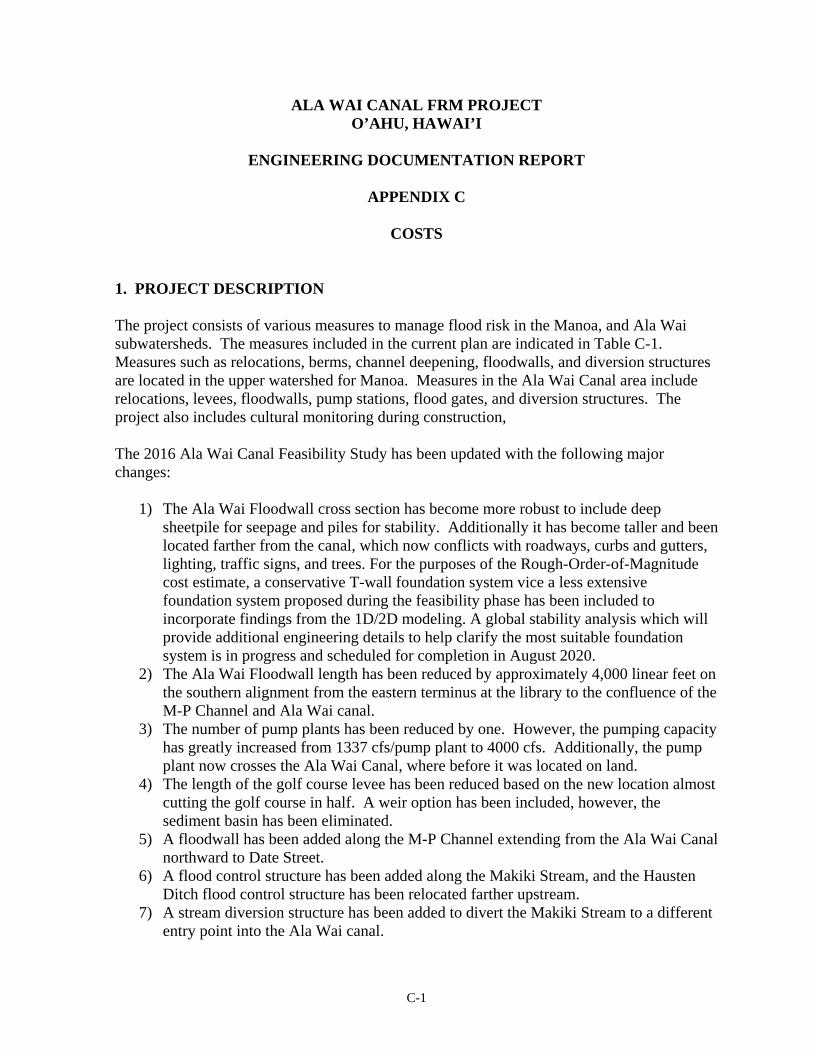
C-1
ALA WAI CANAL FRM PROJECT O’AHU, HAWAI’I
ENGINEERING DOCUMENTATION REPORT
APPENDIX C
COSTS
1. PROJECT DESCRIPTION The project consists of various measures to manage flood risk in the Manoa, and Ala Wai subwatersheds. The measures included in the current plan are indicated in Table C-1. Measures such as relocations, berms, channel deepening, floodwalls, and diversion structures are located in the upper watershed for Manoa. Measures in the Ala Wai Canal area include relocations, levees, floodwalls, pump stations, flood gates, and diversion structures. The project also includes cultural monitoring during construction, The 2016 Ala Wai Canal Feasibility Study has been updated with the following major changes:
1) The Ala Wai Floodwall cross section has become more robust to include deep sheetpile for seepage and piles for stability. Additionally it has become taller and been located farther from the canal, which now conflicts with roadways, curbs and gutters, lighting, traffic signs, and trees. For the purposes of the Rough-Order-of-Magnitude cost estimate, a conservative T-wall foundation system vice a less extensive foundation system proposed during the feasibility phase has been included to incorporate findings from the 1D/2D modeling. A global stability analysis which will provide additional engineering details to help clarify the most suitable foundation system is in progress and scheduled for completion in August 2020.
2) The Ala Wai Floodwall length has been reduced by approximately 4,000 linear feet on the southern alignment from the eastern terminus at the library to the confluence of the M-P Channel and Ala Wai canal.
3) The number of pump plants has been reduced by one. However, the pumping capacity has greatly increased from 1337 cfs/pump plant to 4000 cfs. Additionally, the pump plant now crosses the Ala Wai Canal, where before it was located on land.
4) The length of the golf course levee has been reduced based on the new location almost cutting the golf course in half. A weir option has been included, however, the sediment basin has been eliminated.
5) A floodwall has been added along the M-P Channel extending from the Ala Wai Canal northward to Date Street.
6) A flood control structure has been added along the Makiki Stream, and the Hausten Ditch flood control structure has been relocated farther upstream.
7) A stream diversion structure has been added to divert the Makiki Stream to a different entry point into the Ala Wai canal.

C-2
8) Floodwalls have been added to the Manoa Stream upstream of Woodlawn Bridge. 9) Channel deepening has been added downstream of the Woodlawn Bridge. 10) The Manoa Stream in-stream catchment basin has been deleted. 11) Six upper watershed detention basins have been identified for elimination and funds
reallocated: Makiki Debris/Detention Basin (D/DB), Waihi D/DB, Waiakeakua D/DB, Woodlawn Ditch DB, Waiomao D/DB, and Pukele D/DB.
12) A berm along the southern side of Manoa Valley District Park has been added. 13) The elimination of the mitigation measures at Falls 7/8 and the associated adaptive
management. In the future, mitigation measures and alternatives will be added based upon the updated project features and environmental impact analysis.
Table C-1 shows a comparison between the modifications shown in the Feasibility Study versus the EDR modified plan.
Table C-1. Measures
Summary of the Feasibility Plan compared to the EDR Recommended Modifications Flood Risk
Management Measure
Feasibility Description EDR Modifications Description
Waihi Debris and Detention Basin
Earthen structure, approximately 42 feet high and 477 feet across; box culvert to allow small storm flows to pass; concrete spillway above culvert with grouted rip-rap on upstream and downstream side; debris catchment feature located on upstream end of culvert; approximately 150 feet of riprap for energy dissipation and scour protection downstream of culvert. New access road to be constructed for construction and O&M.
Eliminate and reallocate funds
Waiakeakua Debris and Detention Basin
Earthen structure, approximately 37 feet high and 401 feet across; arch culvert to allow small storm flows to pass; concrete spillway above culvert with grouted rip-rap on upstream and downstream side; debris catchment feature located on upstream end of culvert; approximately 150 feet of riprap for energy dissipation and scour protection downstream of culvert.
Eliminate and reallocate funds
Woodlawn Ditch Detention Basin
Three-sided berm, approximately 15 feet high and 840 feet across; arch culvert to allow small storm flows to pass; concrete spillway above culvert with grouted rip rap on upstream and downstream side.
Eliminate and reallocate funds
Mānoa In-stream Debris Catchment
Concrete pad, approximately 8 feet wide and 60 feet across; steel posts (up to approximately 7 feet high) evenly spaced 4 feet apart along concrete pad.
Eliminate and reallocate funds
Kanewai Field Multi-Purpose Detention Basin
Earthen berm, approximately 9 feet high, around 3 sides of the field; grouted rip-rap inflow spillway along bank of Mānoa Stream to allow high flows to enter the basin; existing drainage pipe at south end of basin to allow water to re-enter stream.
Earthen berm, approximately 9 feet high, around 3 sides of the field; grouted rip rap inflow spillway along bank of Mānoa Stream to allow high flows to enter the basin; existing drainage pipe at south end of basin to allow water to re-enter stream.
Wai‘ōma‘o Debris and Detention Basin
Earthen structure, approximately 34 feet high and 275 feet across; box culvert to allow small storm flows to pass; concrete spillway above culvert, with grouted rip-rap on upstream and downstream side; debris catchment feature located on upstream end of culvert;
Eliminate and reallocate funds

C-3
Flood Risk Management
Measure
Feasibility Description EDR Modifications Description
approximately 150 feet of riprap for energy dissipation and scour protection downstream of culvert. Excavation of approximately 3,060 yd3 to provide required detention volume upstream of berm; new access road to be constructed for construction and O&M.
Pūkele Debris and Detention Basin
Earthen structure, approximately 35 feet high and 82 feet across; box culvert to allow small storm flows to pass; concrete spillway above culvert with grouted rip-rap on upstream and downstream side; debris catchment feature located on upstream end of culvert; approximately 150 feet of riprap for energy dissipation and scour protection downstream of culvert. Excavation of approximately 14,330 yd3 to provide required detention volume upstream of berm; new access road to be constructed for construction and O&M.
Eliminate and reallocate funds
Makiki Debris and Detention Basin
Earthen structure, approximately 36 feet high and 100 feet across; arch culvert to allow small storm flows to pass; concrete spillway above culvert with grouted rip-rap on upstream and downstream side; debris catchment feature located on upstream end of culvert; approximately 150 feet of riprap for energy dissipation and scour protection downstream of culvert. Excavation of approximately 3,035 yd3 to provide required detention volume upstream of berm; new access road to be constructed for construction and O&M.
Eliminate and reallocate funds
Ala Wai Canal Floodwalls
Concrete floodwalls ranging up to approximately 4 feet high, offset from existing Canal walls.
Concrete floodwalls ranging up to approximately 6 feet high, offset even further from existing Canal walls.
Existing stairs to be extended and new ramps to be installed to maintain access to Canal; floodgate to be installed near McCully Street.
New access gates to be installed to maintain access to Canal.
T-Wall foundation system Change to more conservative T-wall foundation system. A global stability analysis which will provide additional engineering details to help clarify the most suitable foundation system is in progress and scheduled for completion in August 2020.
Left bank floodwall extends from eastern terminus at the Waikiki Library to the mouth of the canal at Ala Wai Boat Harbor, approximately 9,711 linear feet in length.
Left bank floodwall extends from confluence of the M-P Channel and Ala Wai Canal to the mouth of the canal at Ala Wai Boat Harbor, approximately 5,740 linear feet in length.
Right bank floodwall extends from the confluence of the M-P Channel and Ala Wai Canal to the mouth of the canal at Ala Wai Boat Harbor.
Right bank floodwall extends from the confluence of the M-P Channel and Ala Wai Canal to the mouth of the canal at Ala Wai Boat Harbor.
A floodwall has been added along the M-P channel extending from the Ala Wai Canal northward to Date Street.
Two pump stations to accommodate storm flows and gates installed at existing drainage pipes to prevent backflow from the Ala Wai Canal during a flood event.
One pump station at the Manoa- Pālolo confluence traversing the canal to accommodate storm flows, and gates installed at existing drainage pipes to prevent backflow from the Ala Wai Canal during a flood event.
Each pump station has a pumping capacity of 1337 cfs; two pump plants total capacity of 2,674 cfs.
Pumping capacity increased to 4000 cfs to incorporate findings from 1D/2D modeling.

C-4
Flood Risk Management
Measure
Feasibility Description EDR Modifications Description
Both pump stations located on land, one fronting the Waikiki Library on the eastern terminus of the canal and the other located on the golf course.
The pump plant now crosses the Ala Wai Canal where before it was located on land.
Hausten Ditch Berm and Community Park Berm
Concrete floodwalls and an earthen berm (approximately 4.3 feet high) to provide detention for local drainage; install concrete wall with four slide gates adjacent to the upstream edge of the existing bridge to prevent a backflow from the Ala Wai Canal during a flood event.
An earthen berm (approximately 5.5 feet high) to provide flood control from an elevated Ala Wai Canal; install concrete wall with one slide gate upstream of the existing bridge to prevent a backflow from the Ala Wai Canal during a flood event. The current location of the berm will require the relocation of the existing Boat House. Expansion of detention basin into Ala Wai Community Park.
Ala Wai Golf Course Multi-Purpose Detention Basin
Earthen berm, on average 2.7 feet high, around the north and east perimeter of the golf course.
Earthen berm, ranging from 3 to 7 feet around the north perimeter extending thru the middle of the existing golf course. Weir option includes added berm on west perimeter and south (western half) border of the golf course.
Grouted rip rap inflow spillway along bank of Mānoa-Pālolo Drainage Canal to allow high flows to enter the basin.
Grouted rip rap inflow spillway along bank of Mānoa-Pālolo Drainage Canal to allow high flows to enter the basin.
Sediment basin within western portion of golf course. Sediment basin has been eliminated. Floodgate across the main entrance road. Ramp up and over the levee for the main entrance road. Passive drainage back into Ala Wai Canal. Passive drainage back into Ala Wai Canal.
Flood warning System
Installation of 3 real-time rain gages (Mānoa, Makiki, and Pālolo streams) and 1 real-time streamflow or stage gage (Ala Wai Canal) as part of flood warning system for Ala Wai Watershed.
Installation of 3 real-time rain gages (Mānoa, Makiki, and Pālolo streams) and 1 real-time streamflow or stage gage (Ala Wai Canal) as part of flood warning system for Ala Wai Watershed.
Makiki Stream Diversion Structure
A diversion structure consisting of a stream inlet, 3 each 1,500 linear feet of 6’x10’ RCB’s, a junction box, and an outlet structure is proposed to bypass flows to downstream of the Kalakaua Bridge. A major Jack and bore construction operation will be required under/through the Kalakaua Bridge.
Mānoa Valley District Park Berm
Earthen berm, approximately 8 feet high with 2.5 H on 1 V side slopes, along the south side of the field; existing drainage pipe at south end of basin to allow water to re-enter stream.
Woodlawn Diversion and Ancillary structures
A diversion structure consisting of a stream inlet, a 1,257 linear foot 14’x10’ RCB, and an outlet structure is proposed to bypass flows before reaching the Woodlawn bridge. A major utility relocation will be required for this diversion relocation. Deepening of the stream downstream of Woodlawn Bridge for approximately 1,100 linear feet. Concrete floodwalls ranging up to approximately 19.63 feet high (new T-walls). Construction of these walls will be very difficult due to real estate constraints.
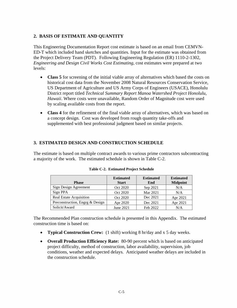
C-5
2. BASIS OF ESTIMATE AND QUANTITY This Engineering Documentation Report cost estimate is based on an email from CEMVN-ED-T which included hand sketches and quantities. Input for the estimate was obtained from the Project Delivery Team (PDT). Following Engineering Regulation (ER) 1110-2-1302, Engineering and Design Civil Works Cost Estimating, cost estimates were prepared at two levels:
Class 5 for screening of the initial viable array of alternatives which based the costs on historical cost data from the November 2008 Natural Resources Conservation Service, US Department of Agriculture and US Army Corps of Engineers (USACE), Honolulu District report titled Technical Summary Report Manoa Watershed Project Honolulu, Hawaii. Where costs were unavailable, Random Order of Magnitude cost were used by scaling available costs from the report.
Class 4 for the refinement of the final viable array of alternatives, which was based on a concept design. Cost was developed from rough quantity take-offs and supplemented with best professional judgment based on similar projects.
3. ESTIMATED DESIGN AND CONSTRUCTION SCHEDULE The estimate is based on multiple contract awards to various prime contractors subcontracting a majority of the work. The estimated schedule is shown in Table C-2.
Table C-2. Estimated Project Schedule
Phase Estimated
Start Estimated
End Estimated Midpoint
Sign Design Agreement Oct 2020 Sep 2021 N/A Sign PPA Oct 2020 Mar 2021 N/A Real Estate Acquisition Oct 2020 Dec 2021 Apr 2021 Preconstruction, Engrg & Design Apr 2020 Dec 2021 Apr 2021 Solicit/Award June 2021 Feb 2022 N/A
The Recommended Plan construction schedule is presented in this Appendix. The estimated construction time is based on:
Typical Construction Crew: (1 shift) working 8 hr/day and x 5 day weeks.
Overall Production Efficiency Rate: 80-90 percent which is based on anticipated project difficulty, method of construction, labor availability, supervision, job conditions, weather and expected delays. Anticipated weather delays are included in the construction schedule.

C-6
Table C-3. Estimated Construction Duration
Recommended Plan
Construction Start Feb 2022 Construction End Sep 2024 Midpoint Apr 2023
Construction Windows: None
Overtime: This estimate contains no overtime to complete the project. 4. ACQUISITION PLAN
4.1. Estimate: The estimate is based on a three separate contracts being awarded to the Prime Contractor with multiple sub-contractors. The acquisition strategy is assumed as Full and Open Invitation for Bid for the Ala Wai and Manoa project features, except the Pump Station. The pump station is assumed to a Design Build acquisition strategy. The prime contractor will be responsible for oversight of the contract overseeing the work performed by subcontractors.
4.2. Sub-Contracting: For the Recommended Plan estimate, the subcontractors are
broken out as:
Hauling Subcontractor Material Suppliers (concrete, soil, rocks, pipes) Disposal Costs Concrete Subcontractor Paving Subcontractor Electrical Subcontractor Landscaping Subcontractor Surveying Subcontractor Professional Services
It is assumed that the prime contractor will subcontract all of the work except sitework. 5. PROJECT CONSTRUCTION 5.1. Mobilization, Demobilization and Preparatory Work Mobilization/Demobilization: The estimate for this study assumes the Contractors will be from Oahu. This does not exclude any work effort to contractors from other locations during the bidding process. Temporary Facilities: The estimate includes the assumption office trailers and temporary utilities for the Prime Contractor and Government. The electricity will be supplemented by diesel generator. This assumption is covered by the Job Office Overhead percentage.

C-7
5.2. Surveys: Assume site pre-construction survey and layout, survey during construction and installation of three benchmarks per site. 5.3. Disposal: Approved on-island landfill with green waste and excavated rock to a recycler. 5.4. Features and Discussion
Site Access: The sites are located in urban Honolulu, Island of Oahu. Where access to the construction site is not available, new access roads will be constructed. This assumption will be refined in the PED phase.
Borrow Areas: The borrow sources is assumed from an on-island commercial source. Borrow areas for topsoil and impervious fill is assumed to be from on-island.
Construction Methodology: The construction methodology will be industry standard.
Unusual Conditions (Soil, Water, and Weather): Locations in perpetual streams are assumed dewatered using cofferdams. Actual dewatering plan will be determined by the Contractor performing the work after award of the construction project. The project schedule includes anticipated weather delays.
Unique Techniques of Construction 1: The construction of the Floodwalls upstream of the Woodlawn Bridge will be difficult. Innovative solutions for the construction of the floodwalls upstream of the Woodlawn Bridge will be required. These solutions have not been accounted for in this estimate. An alternative construction method for this reach will be required and may cost substantially more than what is indicated in the current estimate. Time and design did not allow for an accurate capturing of cost for this area.
Unique Techniques of Construction 2: The construction of the Makiki Stream Diversion Structure will be difficult. The construction will require penetration through the Kalakaua Bridge. Additionally, placement of the 18’x10’ RCB may have to be done from the canal instead of from land. Allowances were used since very little information was provided for cost estimating of this diversion structure.
Equipment and Labor Availability: The cost assumes equipment and labor is readily available on Oahu or from the other locations.
Environmental Concerns: Standard Best Management Practices such as silt fences, gravel entrances to the contractor’s storage area are included in the estimate.

C-8
6. COST ESTIMATE ASSUMPTIONS
6.1. Effective Price Level: Project costs are presented in October 2019 (1Q2020) dollars. 6.2. Construction Cost Estimate. The construction cost estimate was developed using MCACES 2nd Generation estimating software in accordance with ER 1110-2-1302, Civil Works Cost Engineering, 15 Sep 2008; UFC 3-740-05, Handbook: Construction Cost Estimating, 8 November 2010, Change 1, June 2011. The construction cost estimate was prepared using MII Version 4.4.2, and the latest 2016 English Cost Book, quotes on major material items, and 2016 Equipment Library (Region 10).
6.3. Labor Rates. The labor rates used are Davis Bacon wage rates for the State of Hawaii General Decision Number HI20190001 9/20/2019 HI1 for building, heavy (heavy and dredging), highway, and residential construction types for all counties in Hawaii statewide. 6.4. Labor and Equipment Productivity: No overtime hours have been included in the MCACES estimate. The estimate includes an overall Productivity factor of 80-90 percent which is based on anticipated project difficulty, method of construction, labor availability, supervision, job conditions, weather and expected delays.
6.5. Equipment Rates - Equipment rates were derived from EP1110-1-8 Equipment Ownership and Expenses Schedule for Region 10 published April 2016. The price level date for this manual is assumed to be Jan 2016. A 6% adjustment factor was included in the MCACES estimate to normalize the costs to 1st Quarter 2020.
6.6. Material Rates – Minor Material costs were derived from CB16EN – MII English Cost Book 2016. The price level date for this Cost Book is assumed to be Jan 2016. A 15.92% adjustment factor was included in the MCACES estimate to normalize the costs to 1st Quarter 2020. Quotes were received for major material cost items and were overridden within the MCACES estimate. 6.7. Escalation: Escalation has been calculated within the estimate. Once labor, equipment, and material prices were normalized an escalation factor was included at the owner level to escalate the overall estimate to a price level date of Oct 2019. The price level of the MCACES estimate is Oct 2019. Price levels within the Total Project Cost Summary have been escalated from price levels of the construction cost estimate to the midpoint of construction indicated in Table C-3. 6.8. Functional Costs: Functional costs using the Civil Works Breakdown Structure (CWBS) associated with this work were developed from quantity take-offs using hand sketches and excel spreadsheets, historical costs and input from PDT members as follows:
01 – Lands and Damages: This account covers Real Estate costs for Construction. The initial estimate for real estate costs were derived from the tax map key for full replacement. Market cost will be determined at TSP level by an appraiser. Based on
C-9
real estate’s judgment, TMK costs are typically much lower than market costs. Real Estate costs have not been updated since the 2016 Feasibility Study. 04 – Dams: This account covers detention berms. The detention berm basis consists of a trapezoidal shaped structure on land to prevent drainage in certain areas. The interior of the detention berm consists of impermeable fill. The spillway consists of a concrete top with 2’ thick riprap on the upstream side and downstream side of the sloped part of the structure. An access road will be constructed for O&M maintenance. 09 – Channels and Canals: This account covers cost for channel deepening in the Manoa Stream downstream of Woodlawn Bridge.
11 - Levees and Floodwalls: This account covers cost for levees and floodwalls. The Floodwalls is constructed of concrete with a sheet pile cutoff along the Ala Wai Canal. The floodwalls in the Manoa Stream are assumed to be T-walls without sheetpile cutoff walls. The levee/berm consists of compacted impermeable fill and grass. 13 – Pumping Plant: This covers the pump station near the confluence of the Manoa-Palolo and Ala Wai Canal. Historical pricing was obtained. Cost differences are not included in the Cost and Schedule Risk Analysis. Pump station design will be further refined in the PED phase. 15 – Floodway Control and Diversion Structures: This account covers slide gates along the Ala Wai Canal for interior drainage. Additionally, this account includes diversion structures to reroute flows of the Manoa Stream and the Makiki Stream. 18 – Cultural Resource Preservations: This account covers cultural monitoring during construction. The cost for this account was developed by the PDT Archeologist. Further investigations will be conducted during the PED phase. 19 – Buildings, Grounds and Utilities: This account covers the cost for a flood warning system. The initial flood warning system cost was based on historical costs obtained from the USGS. The location & type of stream gauge system will be determined after a study during PED determines the flood warning thresholds required. The initial estimate assumes 4 gauges, one each for Makiki, Palolo, Manoa Watershed, and the Ala Wai Canal.
30 – Planning, Engineering and Design (PED): This account covers all costs associated with Planning, Engineering, and Design. The costs are based on 15 percent of the construction cost. The 15% includes 1.5% Project Management, 3% for Planning & Environmental Compliance, 6% Engineering & Design, 1% Engineering Tech Reviews, .5% Contracting and Reprographics, 1.5% EDC, .5% Planning during construction, and 1% Project Operations for a total of 15% of the construction cost features. These percentages were supplied by Project Manager. This cost also covers the design of the Pump Plant even though the acquisition strategy is assumed to be a Design/Build contract. The unit price developed for the Pump Plant does not include a Design Fee.
C-10
31 Construction Management (CM): This account covers supervision and administration costs during construction. The costs are based on 10 percent of the construction cost. The 10% includes 7.5% Construction Management (including QC), 1% Project Operations, and 1.5% Project Management for a total of 10% of the construction cost features. These percentages were supplied by Project Manager. 6.9. Estimate Assumptions: Key assumptions used for estimating the construction cost of the proposed alternative are as follows:
1) Analysis performed on major cost items based on level of design. The recommended plan is at approximately a 10 percent level of design.
2) Excavated material associated with the feature will be calculated for the structure. It is
assumed rocks will be screened out for excavations consisting of soil and rock. Areas of cleared and grubbed material will be mulched. Soil, rocks, and green waste will be hauled off site for either disposal or recycling.
3) The floodwalls in the Manoa stream are assumed to be constructed within a cofferdam with a bypass pipe to allow the streams to flow. It is assumed the construction of cofferdams will assist in keeping the structure construction area dry while the stream is normally flowing. The construction of the Floodwalls upstream of the Woodlawn Bridge will be difficult. Innovative solutions for the construction of the floodwalls upstream of the Woodlawn Bridge will be required. These solutions have not been accounted for in this estimate. An alternative construction method for this reach will be required and may cost substantially more than what is indicated in the current estimate. Time and design did not allow for an accurate capturing of cost for this area.
4) Access to structures will be constructed and used as permanent access roads for operations and maintenance (O&M). Entrances to access roads will be restricted by use of a chain link fence.
5) Actual site of the Ala Wai Floodwalls is approximate. The footprint of the floodwalls
will be refined during PED.
6) The site location/design solution of the Makiki Stream diversion structure is conceptual. There are many unknown associated with the cost estimate which based solely on assumptions. This solution will need to be further refined.
7) The pump stations are assumed to be similar to three pump stations located in New Orleans, LA. These are the 17th Street Canal Project, Orleans Avenue, and London Avenue Pump Plants. The pump plant costs are based on 4000 cfs. Historical Design/Build costs are used to price the pump. The historical costs are assumed to include contingency. The design will be refined in the PED phase. 1 pump plant is included in the MCACES estimate. NOTE: Since historical costs are assumed to
C-11
include contingency, no contingency is shown in the contingency column in Table C-4 since the contingency is in the unit price derivation.
8) General percentage markups have been used in the recommended plan estimate for
both the prime contractor and subcontractors. 6.10. Contingencies by Feature: Current Headquarters USACE guidance requires a formal analysis on all projects where the projected cost exceeds $40 million. In accordance with ER 1110-2-1302 and ECB 2007-17, 10 Sep 2007, Cost Risk Analysis was used to identify and measure the cost impact of project uncertainties within the estimated total project cost. Oracle Crystal Ball analysis was used to develop contingencies for the original Recommended Plan. Contingencies are added to the cost estimate based on results of risk analysis. Table C-4 summarizes the contingency amounts. NOTE: The CSRA has not been updated for this revision. The previous calculated contingency percentage was used for the preparation of this estimate. Notable additions to risk are the locating of impermeable fill, and the construction of the floodwalls in the Manoa Stream, the Manoa Stream diversion structure, and the construction of the Makiki Stream diversion structure.
Unknowns that could affect the project costs and design assumptions prior to the detailed PED phase include:
Site relocation of measures Under-designed floodwall footings Variation in estimated quantities Increased compliance with viewing planes, historical features or recreational
access Additional appurtenances for features Unanticipated cultural deposits or artifacts Changes in Acquisition strategy Changes in bid schedule Unexpected contaminated soils Dewatering and control of water uncertainties Unexpected geotechnical or ground water issues Unanticipated underground utilities Increased landfill disposal rates Further refinement of designs based on refinement of hydraulic models Delays in real estate acquisition or funding Increased permitting regulations affecting designs Community opposition Responsibility of O&M between City and State Government Changes in interior drainage leading to the canal Changes in material to construct the hydraulic structures Changes in structural foundation designs
C-12
Changes to adaptive management and duration Restrictions of public access during construction to recreational areas Traffic delays during construction of the features Unseasonal weather delays (hurricanes, tsunamis, flooding) during construction Unanticipated phasing requirements Single or multiple contracts over multiple years. Locating Impervious Fill Floodwall construction in the Manoa Stream Area cost factor used for Pump Plant unit cost development
Real Estate Contingency was based on judgment by the Real Estate Project Delivery Team for the recommended plan. TMK costs are typically much lower than market costs. The Real Estate Contingency typically covers fluctuation of the appraised value for land. Additional contingency has been added based on the Cost and Schedule Risk Analysis to cover other risks such as footprint increase of the detention basins once a full design is achieved. Real Estate costs have not been updated since the approved Feasibility Study.
6.11. Total Project Cost Summary: The Total Project Cost Summary (TPCS) Sheet includes the construction costs from the MCACES estimate, project markups, as well as costs for Lands and Damages, Planning, Engineering & Design, and Construction Management.
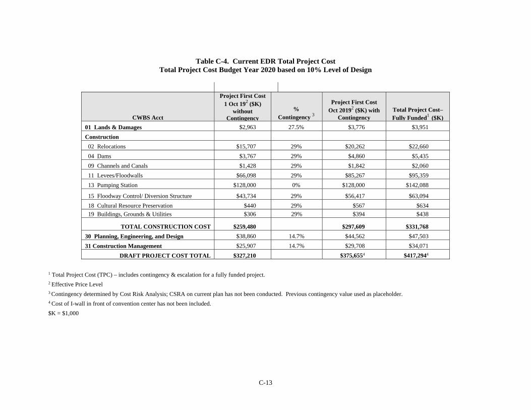
C-13
Table C-4. Current EDR Total Project Cost
Total Project Cost Budget Year 2020 based on 10% Level of Design
CWBS Acct
Project First Cost 1 Oct 192 ($K)
without Contingency
% Contingency 3
Project First Cost Oct 20192 ($K) with
Contingency
Total Project Cost– Fully Funded1 ($K)
01 Lands & Damages $2,963 27.5% $3,776 $3,951 Construction 02 Relocations $15,707 29% $20,262 $22,660 04 Dams $3,767 29% $4,860 $5,435 09 Channels and Canals $1,428 29% $1,842 $2,060 11 Levees/Floodwalls $66,098 29% $85,267 $95,359 13 Pumping Station $128,000 0% $128,000 $142,088
15 Floodway Control/ Diversion Structure $43,734 29% $56,417 $63,094 18 Cultural Resource Preservation $440 29% $567 $634 19 Buildings, Grounds & Utilities $306 29% $394 $438
TOTAL CONSTRUCTION COST $259,480 $297,609 $331,768
30 Planning, Engineering, and Design $38,860 14.7% $44,562 $47,503 31 Construction Management $25,907 14.7% $29,708 $34,071
DRAFT PROJECT COST TOTAL $327,210 $375,6554 $417,2944
1 Total Project Cost (TPC) – includes contingency & escalation for a fully funded project. 2 Effective Price Level 3 Contingency determined by Cost Risk Analysis; CSRA on current plan has not been conducted. Previous contingency value used as placeholder. 4 Cost of I-wall in front of convention center has not been included. $K = $1,000

C-14
Cost Appendix Attachments

**** TOTAL PROJECT COST SUMMARY **** Printed:7/10/2020 Page 1 of 6
PROJECT: DISTRICT: Honolulu District PREPARED: 7/10/2020PROJECT NO:#102703 POC: CHIEF, ENGINEERING & CONSTRUCTION, Todd C. BarnesLOCATION: Honolulu, Island of Oahu, Hawaii
This Estimate reflects the scope and schedule in report; Ala Wai Canal Feasibility Study updated Feb 2020
Program Year (Budget EC): 2020Effective Price Level Date: 1 OCT 19
Spent Thru:WBS Civil Works COST CNTG CNTG TOTAL ESC COST CNTG TOTAL 10/1/2019 INFLATED COST CNTG FULL
NUMBER Feature & Sub-Feature Description ($K) ($K) (%) ($K) (%) ($K) ($K) ($K) ($K) ($K) (%) ($K) ($K) ($K) A B C D E F G H I J K L M N O
02 RELOCATIONS $15,707 $4,555 29.0% $20,262 0.0% $15,707 $4,555 $20,262 $0 $20,262 11.8% $17,566 $5,094 $22,66004 DAMS $3,767 $1,092 29.0% $4,860 0.0% $3,767 $1,092 $4,860 $0 $4,860 11.8% $4,213 $1,222 $5,43509 CHANNELS & CANALS $1,428 $414 29.0% $1,842 0.0% $1,428 $414 $1,842 $0 $1,842 11.8% $1,597 $463 $2,06011 LEVEES & FLOODWALLS $66,098 $19,169 29.0% $85,267 0.0% $66,098 $19,169 $85,267 $0 $85,267 11.8% $73,922 $21,437 $95,35913 PUMPING PLANT $128,000 $0 0.0% $128,000 0.0% $128,000 $0 $128,000 $0 $128,000 11.0% $142,088 $0 $142,08815 FLOODWAY CONTROL & DIVERSION STRU $43,734 $12,683 29.0% $56,417 0.0% $43,734 $12,683 $56,417 $0 $56,417 11.8% $48,910 $14,184 $63,09418 CULTURAL RESOURCE PRESERVATION $440 $128 29.0% $567 0.0% $440 $128 $567 $0 $567 11.8% $492 $143 $63419 BUILDINGS, GROUNDS & UTILITIES $306 $89 29.0% $394 0.0% $306 $89 $394 $0 $394 11.0% $339 $98 $438
____________ __________ ____________ _________ _________ ____________ ____________ _________ _________ _______________CONSTRUCTION ESTIMATE TOTALS: $259,480 $38,129 $297,609 0.0% $259,480 $38,129 $297,609 $0 $297,609 11.5% $289,127 $42,641 $331,768
01 LANDS AND DAMAGES $2,963 $813 27.5% $3,776 0.0% $2,963 $813 $3,776 $0 $3,776 4.6% $3,100 $851 $3,951
30 PLANNING, ENGINEERING & DESIGN $38,860 $5,701 14.7% $44,562 0.0% $38,860 $5,701 $44,562 $0 $44,562 6.6% $41,400 $6,103 $47,503
31 CONSTRUCTION MANAGEMENT $25,907 $3,801 14.7% $29,708 0.0% $25,907 $3,801 $29,708 $0 $29,708 14.7% $29,695 $4,377 $34,071
PROJECT COST TOTALS: $327,210 $48,445 14.8% $375,655 $327,210 $48,445 $375,655 $0 $375,655 11.1% $363,322 $53,972 $417,294
CHIEF, ENGINEERING & CONSTRUCTION, Todd C. Barnes
PROJECT MANAGER, Jeffrey A. Herzog ESTIMATED TOTAL PROJECT COST: $417,294
CHIEF, REAL ESTATE, Ashley N. Klimaszewski
TOTAL PROJECT COST (FULLY FUNDED)
TOTAL FIRST COST
PROJECT FIRST COST (Constant Dollar Basis)
Ala Wai Canal
Civil Works Work Breakdown Structure ESTIMATED COST
Filename: 14 - Ala Wai TPCS 10 July 2020.xlsxTPCS

**** TOTAL PROJECT COST SUMMARY **** Printed:7/10/2020 Page 2 of 6
**** CONTRACT COST SUMMARY ****
PROJECT: DISTRICT: Honolulu District PREPARED: 7/10/2020LOCATION: Honolulu, Island of Oahu, Hawaii POC: CHIEF, ENGINEERING & CONSTRUCTION, Todd C. BarnesThis Estimate reflects the scope and schedule in report; Ala Wai Canal Feasibility Study updated Feb 2020
1-Oct-19 2020 1-Oct-19 1 OCT 19
RISK BASED WBS Civil Works COST CNTG CNTG TOTAL ESC COST CNTG TOTAL Mid-Point INFLATED COST CNTG FULL
NUMBER Feature & Sub-Feature Description ($K) ($K) (%) ($K) (%) ($K) ($K) ($K) Date (%) ($K) ($K) ($K) A B C D E F G H I J P L M N O
Makiki Watershed02 RELOCATIONS $0 $0 0.0% $0 0.0% $0 $0 $0 0 0.0% $0 $0 $004 DAMS $0 $0 0.0% $0 0.0% $0 $0 $0 0 0.0% $0 $0 $009 CHANNELS & CANALS $0 $0 0.0% $0 0.0% $0 $0 $0 0 0.0% $0 $0 $011 LEVEES & FLOODWALLS $0 $0 0.0% $0 0.0% $0 $0 $0 0 0.0% $0 $0 $013 PUMPING PLANT $0 $0 0.0% $0 0.0% $0 $0 $0 0 0.0% $0 $0 $015 FLOODWAY CONTROL & DIVERSION STRU $0 $0 0.0% $0 0.0% $0 $0 $0 0 0.0% $0 $0 $018 CULTURAL RESOURCE PRESERVATION $0 $0 0.0% $0 0.0% $0 $0 $0 0 0.0% $0 $0 $019 BUILDINGS, GROUNDS & UTILITIES $0 $0 0.0% $0 0.0% $0 $0 $0 0 0.0% $0 $0 $0
____________ __________ _________ ____________ _________ _________ ____________ _________ _________ _______________CONSTRUCTION ESTIMATE TOTALS: $0 $0 0.0% $0 $0 $0 $0 $0 $0 $0
01 LANDS AND DAMAGES $0 $0 0.0% $0 0.0% $0 $0 $0 2021Q3 4.6% $0 $0 $0
30 PLANNING, ENGINEERING & DESIGN1.5% Project Management $0 $0 0.0% $0 0.0% $0 $0 $0 0 0.0% $0 $0 $03.0% Planning & Environmental Compliance $0 $0 0.0% $0 0.0% $0 $0 $0 0 0.0% $0 $0 $06.0% Engineering & Design $0 $0 0.0% $0 0.0% $0 $0 $0 0 0.0% $0 $0 $00.5% Reviews, ATRs, IEPRs, VE $0 $0 0.0% $0 0.0% $0 $0 $0 0 0.0% $0 $0 $00.5% Life Cycle Updates (cost, schedule, risks) $0 $0 0.0% $0 0.0% $0 $0 $0 0 0.0% $0 $0 $00.5% Contracting & Reprographics $0 $0 0.0% $0 0.0% $0 $0 $0 0 0.0% $0 $0 $01.5% Engineering During Construction $0 $0 0.0% $0 0.0% $0 $0 $0 0 0.0% $0 $0 $00.5% Planning During Construction $0 $0 0.0% $0 0.0% $0 $0 $0 0 0.0% $0 $0 $01.0% Project Operations $0 $0 0.0% $0 0.0% $0 $0 $0 0 0.0% $0 $0 $0
31 CONSTRUCTION MANAGEMENT7.5% Construction Management $0 $0 0.0% $0 0.0% $0 $0 $0 0 0.0% $0 $0 $01.0% Project Operation: $0 $0 0.0% $0 0.0% $0 $0 $0 0 0.0% $0 $0 $01.5% Project Management $0 $0 0.0% $0 0.0% $0 $0 $0 0 0.0% $0 $0 $0
CONTRACT COST TOTALS: $0 $0 $0 $0 $0 $0 $0 $0 $0
PROJECT FIRST COST(Constant Dollar Basis)Civil Works Work Breakdown Structure
Estimate Prepared:Effective Price Level:
Program Year (Budget EC):Effective Price Level Date:
Ala Wai Canal
TOTAL PROJECT COST (FULLY FUNDED)ESTIMATED COST
Filename: 14 - Ala Wai TPCS 10 July 2020.xlsxTPCS
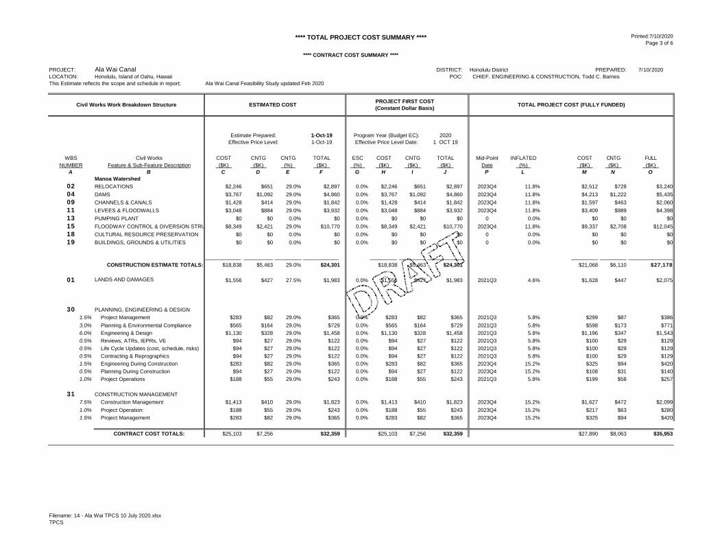
**** TOTAL PROJECT COST SUMMARY **** Printed:7/10/2020 Page 3 of 6
**** CONTRACT COST SUMMARY ****
PROJECT: DISTRICT: Honolulu District PREPARED: 7/10/2020LOCATION: Honolulu, Island of Oahu, Hawaii POC: CHIEF, ENGINEERING & CONSTRUCTION, Todd C. BarnesThis Estimate reflects the scope and schedule in report; Ala Wai Canal Feasibility Study updated Feb 2020
1-Oct-19 2020 1-Oct-19 1 OCT 19
WBS Civil Works COST CNTG CNTG TOTAL ESC COST CNTG TOTAL Mid-Point INFLATED COST CNTG FULLNUMBER Feature & Sub-Feature Description ($K) ($K) (%) ($K) (%) ($K) ($K) ($K) Date (%) ($K) ($K) ($K)
A B C D E F G H I J P L M N OManoa Watershed
02 RELOCATIONS $2,246 $651 29.0% $2,897 0.0% $2,246 $651 $2,897 2023Q4 11.8% $2,512 $728 $3,24004 DAMS $3,767 $1,092 29.0% $4,860 0.0% $3,767 $1,092 $4,860 2023Q4 11.8% $4,213 $1,222 $5,43509 CHANNELS & CANALS $1,428 $414 29.0% $1,842 0.0% $1,428 $414 $1,842 2023Q4 11.8% $1,597 $463 $2,06011 LEVEES & FLOODWALLS $3,048 $884 29.0% $3,932 0.0% $3,048 $884 $3,932 2023Q4 11.8% $3,409 $989 $4,39813 PUMPING PLANT $0 $0 0.0% $0 0.0% $0 $0 $0 0 0.0% $0 $0 $015 FLOODWAY CONTROL & DIVERSION STRU $8,349 $2,421 29.0% $10,770 0.0% $8,349 $2,421 $10,770 2023Q4 11.8% $9,337 $2,708 $12,04518 CULTURAL RESOURCE PRESERVATION $0 $0 0.0% $0 0.0% $0 $0 $0 0 0.0% $0 $0 $019 BUILDINGS, GROUNDS & UTILITIES $0 $0 0.0% $0 0.0% $0 $0 $0 0 0.0% $0 $0 $0
____________ __________ _________ ____________ _________ _________ ____________ _________ _________ _______________
CONSTRUCTION ESTIMATE TOTALS: $18,838 $5,463 29.0% $24,301 $18,838 $5,463 $24,301 $21,068 $6,110 $27,178
01 LANDS AND DAMAGES $1,556 $427 27.5% $1,983 0.0% $1,556 $427 $1,983 2021Q3 4.6% $1,628 $447 $2,075
30 PLANNING, ENGINEERING & DESIGN1.5% Project Management $283 $82 29.0% $365 0.0% $283 $82 $365 2021Q3 5.8% $299 $87 $3863.0% Planning & Environmental Compliance $565 $164 29.0% $729 0.0% $565 $164 $729 2021Q3 5.8% $598 $173 $7716.0% Engineering & Design $1,130 $328 29.0% $1,458 0.0% $1,130 $328 $1,458 2021Q3 5.8% $1,196 $347 $1,5430.5% Reviews, ATRs, IEPRs, VE $94 $27 29.0% $122 0.0% $94 $27 $122 2021Q3 5.8% $100 $29 $1290.5% Life Cycle Updates (cost, schedule, risks) $94 $27 29.0% $122 0.0% $94 $27 $122 2021Q3 5.8% $100 $29 $1290.5% Contracting & Reprographics $94 $27 29.0% $122 0.0% $94 $27 $122 2021Q3 5.8% $100 $29 $1291.5% Engineering During Construction $283 $82 29.0% $365 0.0% $283 $82 $365 2023Q4 15.2% $325 $94 $4200.5% Planning During Construction $94 $27 29.0% $122 0.0% $94 $27 $122 2023Q4 15.2% $108 $31 $1401.0% Project Operations $188 $55 29.0% $243 0.0% $188 $55 $243 2021Q3 5.8% $199 $58 $257
31 CONSTRUCTION MANAGEMENT7.5% Construction Management $1,413 $410 29.0% $1,823 0.0% $1,413 $410 $1,823 2023Q4 15.2% $1,627 $472 $2,0991.0% Project Operation: $188 $55 29.0% $243 0.0% $188 $55 $243 2023Q4 15.2% $217 $63 $2801.5% Project Management $283 $82 29.0% $365 0.0% $283 $82 $365 2023Q4 15.2% $325 $94 $420
CONTRACT COST TOTALS: $25,103 $7,256 $32,359 $25,103 $7,256 $32,359 $27,890 $8,063 $35,953
Civil Works Work Breakdown Structure
Estimate Prepared: Program Year (Budget EC):Effective Price Level: Effective Price Level Date:
Ala Wai Canal
ESTIMATED COST PROJECT FIRST COST(Constant Dollar Basis) TOTAL PROJECT COST (FULLY FUNDED)
Filename: 14 - Ala Wai TPCS 10 July 2020.xlsxTPCS
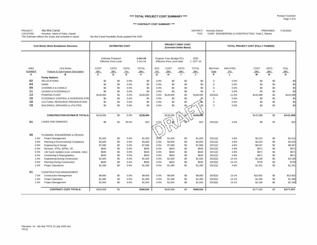
**** TOTAL PROJECT COST SUMMARY **** Printed:7/10/2020 Page 4 of 6
**** CONTRACT COST SUMMARY ****
PROJECT: DISTRICT: Honolulu District PREPARED: 7/10/2020LOCATION: Honolulu, Island of Oahu, Hawaii POC: CHIEF, ENGINEERING & CONSTRUCTION, Todd C. BarnesThis Estimate reflects the scope and schedule in report; Ala Wai Canal Feasibility Study updated Feb 2020
1-Oct-19 2020 1-Oct-19 1 OCT 19
WBS Civil Works COST CNTG CNTG TOTAL ESC COST CNTG TOTAL Mid-Point INFLATED COST CNTG FULLNUMBER Feature & Sub-Feature Description ($K) ($K) (%) ($K) (%) ($K) ($K) ($K) Date (%) ($K) ($K) ($K)
A B C D E F G H I J P L M N OPump Stations
02 RELOCATIONS $0 $0 0.0% $0 0.0% $0 $0 $0 0 0.0% $0 $0 $004 DAMS $0 $0 0.0% $0 0.0% $0 $0 $0 0 0.0% $0 $0 $009 CHANNELS & CANALS $0 $0 0.0% $0 0.0% $0 $0 $0 0 0.0% $0 $0 $011 LEVEES & FLOODWALLS $0 $0 0.0% $0 0.0% $0 $0 $0 0 0.0% $0 $0 $013 PUMPING PLANT $128,000 $0 0.0% $128,000 0.0% $128,000 $0 $128,000 2023Q3 11.0% $142,088 $0 $142,08815 FLOODWAY CONTROL & DIVERSION STRU $0 $0 0.0% $0 0.0% $0 $0 $0 0 0.0% $0 $0 $018 CULTURAL RESOURCE PRESERVATION $0 $0 0.0% $0 0.0% $0 $0 $0 0 0.0% $0 $0 $019 BUILDINGS, GROUNDS & UTILITIES $0 $0 0.0% $0 0.0% $0 $0 $0 0 0.0% $0 $0 $0
____________ __________ _________ ____________ _________ _________ ____________ _________ _________ _______________
CONSTRUCTION ESTIMATE TOTALS: $128,000 $0 0.0% $128,000 $128,000 $0 $128,000 $142,088 $0 $142,088
01 LANDS AND DAMAGES $8 $2 30.0% $10 0.0% $8 $2 $10 2021Q3 4.6% $8 $2 $10
30 PLANNING, ENGINEERING & DESIGN1.5% Project Management $1,920 $0 0.0% $1,920 0.0% $1,920 $0 $1,920 2021Q2 4.8% $2,012 $0 $2,0123.0% Planning & Environmental Compliance $3,840 $0 0.0% $3,840 0.0% $3,840 $0 $3,840 2021Q2 4.8% $4,024 $0 $4,0246.0% Engineering & Design $7,680 $0 0.0% $7,680 0.0% $7,680 $0 $7,680 2021Q2 4.8% $8,047 $0 $8,0470.5% Reviews, ATRs, IEPRs, VE $640 $0 0.0% $640 0.0% $640 $0 $640 2021Q2 4.8% $671 $0 $6710.5% Life Cycle Updates (cost, schedule, risks) $640 $0 0.0% $640 0.0% $640 $0 $640 2021Q2 4.8% $671 $0 $6710.5% Contracting & Reprographics $640 $0 0.0% $640 0.0% $640 $0 $640 2021Q2 4.8% $671 $0 $6711.5% Engineering During Construction $1,920 $0 0.0% $1,920 0.0% $1,920 $0 $1,920 2023Q3 14.1% $2,190 $0 $2,1900.5% Planning During Construction $640 $0 0.0% $640 0.0% $640 $0 $640 2023Q3 14.1% $730 $0 $7301.0% Project Operations $1,280 $0 0.0% $1,280 0.0% $1,280 $0 $1,280 2021Q2 4.8% $1,341 $0 $1,341
31 CONSTRUCTION MANAGEMENT7.5% Construction Management $9,600 $0 0.0% $9,600 0.0% $9,600 $0 $9,600 2023Q3 14.1% $10,952 $0 $10,9521.0% Project Operation: $1,280 $0 0.0% $1,280 0.0% $1,280 $0 $1,280 2023Q3 14.1% $1,460 $0 $1,4601.5% Project Management $1,920 $0 0.0% $1,920 0.0% $1,920 $0 $1,920 2023Q3 14.1% $2,190 $0 $2,190
CONTRACT COST TOTALS: $160,008 $2 $160,010 $160,008 $2 $160,010 $177,055 $2 $177,057
Estimate Prepared: Program Year (Budget EC):
Ala Wai Canal
Civil Works Work Breakdown Structure
Effective Price Level: Effective Price Level Date:
ESTIMATED COST PROJECT FIRST COST(Constant Dollar Basis) TOTAL PROJECT COST (FULLY FUNDED)
Filename: 14 - Ala Wai TPCS 10 July 2020.xlsxTPCS

**** TOTAL PROJECT COST SUMMARY **** Printed:7/10/2020 Page 5 of 6
**** CONTRACT COST SUMMARY ****
PROJECT: Ala Wai Canal DISTRICT: Honolulu District PREPARED: 7/10/2020LOCATION: Honolulu, Island of Oahu, Hawaii POC: CHIEF, ENGINEERING & CONSTRUCTION, Todd C. BarnesThis Estimate reflects the scope and schedule in report; Ala Wai Canal Feasibility Study updated Feb 2020
1-Oct-19 Program Year (Budget EC): 2020 1-Oct-19 Effective Price Level Date: 1 OCT 19 FULLY FUNDED PROJECT ESTIMATE
WBS Civil Works COST CNTG CNTG TOTAL ESC COST CNTG TOTAL Mid-Point INFLATED COST CNTG FULLNUMBER Feature & Sub-Feature Description ($K) ($K) (%) ($K) (%) ($K) ($K) ($K) Date (%) ($K) ($K) ($K)
A B C D E F G H I J P L M N OAla Wai Canal - FW/Golf Course
02 RELOCATIONS $13,461 $3,904 29.0% $17,365 0.0% $13,461 $3,904 $17,365 2023Q4 11.8% $15,054 $4,366 $19,42004 DAMS $0 $0 0.0% $0 0.0% $0 $0 $0 0 0.0% $0 $0 $009 CHANNELS & CANALS $0 $0 0.0% $0 0.0% $0 $0 $0 0 0.0% $0 $0 $011 LEVEES & FLOODWALLS $63,050 $18,285 29.0% $81,335 0.0% $63,050 $18,285 $81,335 2023Q4 11.8% $70,512 $20,449 $90,96113 PUMPING PLANT $0 $0 0.0% $0 0.0% $0 $0 $0 0 0.0% $0 $0 $015 FLOODWAY CONTROL & DIVERSION STRU $35,385 $10,262 29.0% $45,647 0.0% $35,385 $10,262 $45,647 2023Q4 11.8% $39,573 $11,476 $51,04918 CULTURAL RESOURCE PRESERVATION $411 $119 29.0% $531 0.0% $411 $119 $531 2023Q4 11.8% $460 $133 $59319 BUILDINGS, GROUNDS & UTILITIES $0 $0 0.0% $0 0.0% $0 $0 $0 0 0.0% $0 $0 $0
____________ __________ _________ ____________ _________ _________ ____________ _________ _________ _______________
CONSTRUCTION ESTIMATE TOTALS: $112,307 $32,569 29.0% $144,877 $112,307 $32,569 $144,877 $125,600 $36,424 $162,024
01 LANDS AND DAMAGES $1,400 $384 27.4% $1,784 0.0% $1,400 $384 $1,784 2021Q3 4.6% $1,465 $402 $1,866
30 PLANNING, ENGINEERING & DESIGN1.5% Project Management $1,678 $487 29.0% $2,165 0.0% $1,678 $487 $2,165 2021Q3 5.8% $1,776 $515 $2,2913.0% Planning & Environmental Compliance $3,357 $973 29.0% $4,330 0.0% $3,357 $973 $4,330 2021Q3 5.8% $3,552 $1,030 $4,5826.0% Engineering & Design $6,714 $1,947 29.0% $8,661 0.0% $6,714 $1,947 $8,661 2021Q3 5.8% $7,103 $2,060 $9,1640.5% Reviews, ATRs, IEPRs, VE $559 $162 29.0% $722 0.0% $559 $162 $722 2021Q3 5.8% $592 $172 $7640.5% Life Cycle Updates (cost, schedule, risks) $559 $162 29.0% $722 0.0% $559 $162 $722 2021Q3 5.8% $592 $172 $7640.5% Contracting & Reprographics $559 $162 29.0% $722 0.0% $559 $162 $722 2021Q3 5.8% $592 $172 $7641.5% Engineering During Construction $1,678 $487 29.0% $2,165 0.0% $1,678 $487 $2,165 2023Q4 15.2% $1,933 $561 $2,4930.5% Planning During Construction $559 $162 29.0% $722 0.0% $559 $162 $722 2023Q4 15.2% $644 $187 $8311.0% Project Operations $1,119 $324 29.0% $1,443 0.0% $1,119 $324 $1,443 2021Q3 5.8% $1,184 $343 $1,527
31 CONSTRUCTION MANAGEMENT7.5% Construction Management $8,392 $2,434 29.0% $10,826 0.0% $8,392 $2,434 $10,826 2023Q4 15.2% $9,664 $2,803 $12,4671.0% Project Operation: $1,119 $324 29.0% $1,443 0.0% $1,119 $324 $1,443 2023Q4 15.2% $1,289 $374 $1,6621.5% Project Management $1,678 $487 29.0% $2,165 0.0% $1,678 $487 $2,165 2023Q4 15.2% $1,933 $561 $2,493
CONTRACT COST TOTALS: $141,681 $41,066 $182,747 $141,681 $41,066 $182,747 $157,918 $45,773 $203,691
Effective Price Level:
Civil Works Work Breakdown Structure ESTIMATED COST PROJECT FIRST COST(Constant Dollar Basis) TOTAL PROJECT COST (FULLY FUNDED)
Estimate Prepared:
Filename: 14 - Ala Wai TPCS 10 July 2020.xlsxTPCS

**** TOTAL PROJECT COST SUMMARY **** Printed:7/10/2020 Page 6 of 6
**** CONTRACT COST SUMMARY ****
PROJECT: Ala Wai Canal DISTRICT: Honolulu District PREPARED: 7/10/2020LOCATION: Honolulu, Island of Oahu, Hawaii POC: CHIEF, ENGINEERING & CONSTRUCTION, Todd C. BarnesThis Estimate reflects the scope and schedule in report; Ala Wai Canal Feasibility Study updated Feb 2020
1-Oct-19 Program Year (Budget EC): 2020 1-Oct-19 Effective Price Level Date: 1 OCT 19 FULLY FUNDED PROJECT ESTIMATE
WBS Civil Works COST CNTG CNTG TOTAL ESC COST CNTG TOTAL Mid-Point INFLATED COST CNTG FULLNUMBER Feature & Sub-Feature Description ($K) ($K) (%) ($K) (%) ($K) ($K) ($K) Date (%) ($K) ($K) ($K)
A B C D E F G H I J P L M N OFlood Warning System
02 RELOCATIONS $0 $0 0.0% $0 0.0% $0 $0 $0 0 0.0% $0 $0 $004 DAMS $0 $0 0.0% $0 0.0% $0 $0 $0 0 0.0% $0 $0 $009 CHANNELS & CANALS $0 $0 0.0% $0 0.0% $0 $0 $0 0 0.0% $0 $0 $011 LEVEES & FLOODWALLS $0 $0 0.0% $0 0.0% $0 $0 $0 0 0.0% $0 $0 $013 PUMPING PLANT $0 $0 0.0% $0 0.0% $0 $0 $0 0 0.0% $0 $0 $015 FLOODWAY CONTROL & DIVERSION STRU $0 $0 0.0% $0 0.0% $0 $0 $0 0 0.0% $0 $0 $018 CULTURAL RESOURCE PRESERVATION $28 $8 29.0% $37 0.0% $28 $8 $37 2023Q3 11.0% $32 $9 $4119 BUILDINGS, GROUNDS & UTILITIES $306 $89 29.0% $394 0.0% $306 $89 $394 2023Q3 11.0% $339 $98 $438
____________ __________ _________ ____________ _________ _________ ____________ _________ _________ _______________
CONSTRUCTION ESTIMATE TOTALS: $334 $97 29.0% $431 $334 $97 $431 $371 $108 $478
01 LANDS AND DAMAGES $0 $0 0.0% $0 0.0% $0 $0 $0 0 0.0% $0 $0 $0
30 PLANNING, ENGINEERING & DESIGN1.5% Project Management $5 $1 29.0% $6 0.0% $5 $1 $6 2020Q1 0.0% $5 $1 $63.0% Planning & Environmental Compliance $10 $3 29.0% $13 0.0% $10 $3 $13 2020Q1 0.0% $10 $3 $136.0% Engineering & Design $20 $6 29.0% $26 0.0% $20 $6 $26 2020Q1 0.0% $20 $6 $260.5% Reviews, ATRs, IEPRs, VE $2 $0 29.0% $2 0.0% $2 $0 $2 2020Q1 0.0% $2 $0 $20.5% Life Cycle Updates (cost, schedule, risks) $2 $0 29.0% $2 0.0% $2 $0 $2 2020Q1 0.0% $2 $0 $20.5% Contracting & Reprographics $2 $0 29.0% $2 0.0% $2 $0 $2 2020Q1 0.0% $2 $0 $21.5% Engineering During Construction $5 $1 29.0% $6 0.0% $5 $1 $6 2023Q2 13.0% $6 $2 $70.5% Planning During Construction $2 $0 29.0% $2 0.0% $2 $0 $2 2023Q2 13.0% $2 $1 $21.0% Project Operations $3 $1 29.0% $4 0.0% $3 $1 $4 2020Q1 0.0% $3 $1 $4
31 CONSTRUCTION MANAGEMENT7.5% Construction Management $25 $7 29.0% $32 0.0% $25 $7 $32 2023Q2 13.0% $28 $8 $371.0% Project Operation: $3 $1 29.0% $4 0.0% $3 $1 $4 2023Q2 13.0% $4 $1 $51.5% Project Management $5 $1 29.0% $6 0.0% $5 $1 $6 2023Q2 13.0% $6 $2 $7
CONTRACT COST TOTALS: $418 $121 $539 $418 $121 $539 $460 $133 $593
Estimate Prepared:Effective Price Level:
Civil Works Work Breakdown Structure ESTIMATED COST PROJECT FIRST COST(Constant Dollar Basis) TOTAL PROJECT COST (FULLY FUNDED)
Filename: 14 - Ala Wai TPCS 10 July 2020.xlsxTPCS

U.S. Army Corps of Engineers Honolulu District
Appendix D
Community Engagement

U.S. Army Corps of Engineers Honolulu District
Ala Wai Flood Risk Management Project Honolulu, Hawaii
EDR Appendix D – Community Engagement
D‐i
Contents 1 BACKGROUND ............................................................................................................................................ 1
Background ......................................................................................................................................... 1
1.1.1 Federal Background .................................................................................................................... 1
1.1.2 Hawaii Environmental Regulations ............................................................................................. 1
1.1.3 Project Description ..................................................................................................................... 1
Communications Guidance ................................................................................................................. 2
Outreach phases ................................................................................................................................. 2
2 Feasibility with Integrated EIS (FEIS) Phase (2002‐2017) ........................................................................... 3
Public Involvement in FEIS phase ....................................................................................................... 3
Community Opposition in FEIS Phase ................................................................................................. 5
3 Post‐Feasibility Phase (2018‐2019) ............................................................................................................ 6
Non‐Federal Sponsor .......................................................................................................................... 6
3.1.1 State Funding: Senate Bill 77 SD3 HD1 ....................................................................................... 6
3.1.2 Honolulu City Council – Formation of the PIG and hiring of Oceanit ......................................... 6
USACE Public Outreach Efforts during Post‐FEIS Phase ..................................................................... 7
3.2.1 3/19/2019: Town Hall Meeting .................................................................................................. 7
3.2.2 5/28/2019: Ala Moana/ Kakaako NB meeting ............................................................................ 8
3.2.3 5/31/2019: Ala Wai Watershed Collaboration meeting at Iolani School ................................... 9
3.2.4 6/12/2019: Palolo Neighborhood Board meeting .................................................................... 10
3.2.5 6/17/2019: Industry and Innovation Day ................................................................................. 13
3.2.6 7/18/2019: Makiki/Tantalus/Lower Punchbowl Neighborhood Board meeting ..................... 14
3.2.7 8/8/2019: Insights on PBS ........................................................................................................ 14
3.2.8 8/13/19: Waikiki Neighborhood Board meeting ...................................................................... 14
3.2.9 8/15/2019: Makiki/Tantalus/Lower Punchbowl Neighborhood Board meeting ..................... 16
3.2.10 8/19/2019: Community meeting sponsored by CCH City Council PIG ..................................... 17
3.2.11 8/21/2019: Kaimuki Neighborhood Board meeting ................................................................. 18
3.2.12 10/1/2019: Oceanit’s Alternatives (appeared as guest) .......................................................... 20
3.2.13 Other Outreach Meetings in the Post‐FEIS phase .................................................................... 25
4 EDR Modifications Phase (October 2019 – May 2020) ............................................................................ 25
Public Involvement in EDR Modifications Phase .............................................................................. 25
4.1.1 Focus Group Meetings .............................................................................................................. 25

U.S. Army Corps of Engineers Honolulu District
Ala Wai Flood Risk Management Project Honolulu, Hawaii
EDR Appendix D – Community Engagement
D‐ii
4.1.2 One‐on‐One meetings .............................................................................................................. 26
4.1.3 Other Outreach Efforts during the EDR Modifications Phase .................................................. 26
Lessons Learned in EDR Modifications Phase................................................................................... 35
5 Key Messages ........................................................................................................................................... 36
Risk Reduction and Resiliency .......................................................................................................... 36
Building Solutions for Ala Wai .......................................................................................................... 36

U.S. Army Corps of Engineers Honolulu District
Ala Wai Flood Risk Management Project Honolulu, Hawaii
EDR Appendix D – Community Engagement
D‐1
1 BACKGROUND Background
1.1.1 Federal Background The Ala Wai Canal (also known as the Ala Wai Watershed) Flood Risk Management project was investigated under Section 209 of the Flood Control Act of 1962 (Public Law 87‐874). The Feasibility Cost Sharing Agreement was executed between the U.S. Army Corps of Engineers (USACE) Pacific Ocean Honolulu (POH) district and the State of Hawaii Department of Land and Natural Resources (DLNR) in January 2001 (amended in November 2012), for a total estimated cost of $10.1M, including work‐in‐kind of $2.385M. From 16‐19 October 2012, a SMART (specific, measurable, attainable, risk informed, timely) planning re‐scoping charette refocused the study from multipurpose, including ecosystem restoration, to solely a flood risk management study. The federal National Environmental Policy Act Final Feasibility Report with integrated Environmental Impact Statement (NEPA FFEIS) was completed in September 2017. A Chief’s Report for the project was signed on 21 December 2017. The Record of Decision was signed by the ASA (CW) on 13 September 2018, thereby completing the federal feasibility phase. The project was funded for Construction by the Bi‐Partisan Budget Act of 2018 under the Long‐term Disaster Recover Investment Program (LDRIP) with an authorized cost of $345,076,000. The program allows for single phase design and construction, as well as a deferred payment option to expedite funding and execution of projects.
1.1.2 Hawaii Environmental Regulations The federal NEPA FFEIS was transmitted to the State of Hawaii (SOH) in October 2018 for review and acceptance by the SOH in compliance with the requirements of Hawaii Revised Statutes (HRS) Chapter 343, commonly referred to as the Hawaii Environmental Policy Act (HEPA). Subsequently, pursuant to a memorandum of agreement between SOH and the City and County of Honolulu (CCH) signed 19 September 2019 and follow up letter dated 20 September 2019, the Governor designated the Mayor of Honolulu to accept the HEPA Final Feasibility with Integrated EIS (HEPA FFEIS) as the Governor’s representative. As of May 2020, the document is still under review with the SOH and has yet to be proposed to the CCH for acceptance.
Litigation from opposition group Protect Our Ala Wai Watersheds (POAWW), has inhibited the SOH from providing the minimum 35% cost share for the project until the HEPA FFEIS is accepted. The CCH will not sign a Project Partnership Agreement (PPA) with the USACE until the SOH’s funds are received. Thus, in order to execute a PPA, as a first step, the HEPA FFEIS needs to be completed, proposed, and accepted.
1.1.3 Project Description The Ala Wai Watershed encompasses approximately 19 square miles and includes the drainages of Manoa, Palolo, Makiki, Waikiki, and the surrounding areas. Waikiki is the primary economic engine for the state, providing seven percent of the gross state product; nine percent of the state and county tax revenues, and seven percent of the civilian jobs. These streams drain into the Ala Wai Canal, a two‐mile long, man‐made waterway constructed in the 1920s to drain wetlands, allowing the development of the Waikiki area. Within this densely populated urban footprint, there are approximately 160,000 residents and over 79,000 daily visitors. The canal overtopped and previously flooded Waikiki during the November 1965 and December 1967 storms, as well as during the passage of Hurricane Iniki in 1992. In October 2004, a storm flooded Manoa Valley, causing $85M in damages to the University of Hawaii, including the loss of

U.S. Army Corps of Engineers Honolulu District
Ala Wai Flood Risk Management Project Honolulu, Hawaii
EDR Appendix D – Community Engagement
D‐2
irreplaceable documents in one of the libraries. Modeling efforts indicate that a one percent annual flood exceedance event would result in damages to more than 3,000 structures in the watershed, with total damages of over $1.14B, with the majority of the damage in the downstream area of Waikiki.
The Recommended Plan from the feasibility study consists of six debris and detention basins (Makiki, Waihi, Waiakeakua, Woodlawn Ditch, Waiomao, Pukele) in the upper watershed valleys, one stand‐alone debris catchment structure (Manoa Park), three multi‐purpose detention basins (Kanewai Field, Ala Wai Golf Course, Hausten Ditch) in the lower urban areas, floodwalls along the Ala Wai Canal (to include two pump stations for interior drainage), an early floodwarning system, and mitigation to Falls 7 & 8. Of these 13 measures, six of them require private property acquisition or easements (Waiakeakua, Woodlawn Ditch, Manoa in‐stream debris, Waiomao, Pukele, and Falls 7 & 8). Aside from Falls 7 & 8 (which will be evaluated after completion of the EDR), the remaining five sites with private property acquisition have been eliminated from the newly recommended system, which was based on updated modeling and data as provided in this EDR report.
Communications Guidance The USACE planning guidance specifies that open channels of communication should be developed and maintained with the public in order to give full consideration of public views and information throughout the project. Critical components of the public involvement effort should include (1) disseminating project‐related information, (2) understanding the public’s desires, needs, and concerns, (3) providing for consultation with the public before decisions are reached, and (4) taking into account the public’s views (USACE ER 1105‐2‐100).
Outreach phases For the purpose of this EDR, community outreach efforts were broken into three phases, (1) Feasibility with Integrated EIS (FEIS), (2) Post‐Feasibility, and (3) Modifications for Engineering Documentation Report.
(1) FEIS Phase Efforts conducted during the FEIS phase addressed primarily the National Environmental Policy Act (NEPA) and Hawaii Environmental Policy Act (HEPA) public engagement requirements, as well as the National Historic Preservation Act (NHPA) Section 106 required consultation with native Hawaiian organizations (NHO). The timeline for public engagement during the FEIS phase is depicted in Figure 1 below.

U.S. Army Corps of Engineers Honolulu District
Ala Wai Flood Risk Management Project Honolulu, Hawaii
EDR Appendix D – Community Engagement
D‐3
Figure 1: Timeline for public engagement during Feasibility with Integrated EIS (FEIS) phase
(2) Post‐Feasibility Phase Following the completion of the Feasibility phase in 2018, a lot of misinformation about the project was circulated throughout the community. Efforts in the post‐FEIS phase primarily focused on informing and educating the public with accurate and timely information about the project features, its need, and purpose. During this time, the PDT also worked to advance the hydrologic modeling from 1D steady state to 2D unsteady state HEC‐RAS. With updated information and model results, the PDT recommended modifications to the previously authorized system. In October 2019, the PDT was given approval to complete an Engineering Documentation Report to study the modifications necessary to effectively construct a system with benefits within the given authority.
(3) EDR Modifications Phase From October 2019 to March 2020, the PDT engaged with community with to discuss the updated modeling, results, and modifications under investigation. The PDT continued to engage all interested parties as well as identified stakeholders to design a modified system with community input.
Outreach efforts conducted within each phase, communications challenges, and lessons learned are summarized below.
2 Feasibility with Integrated EIS (FEIS) Phase (2002‐2017) Public Involvement in FEIS phase
From the start of the Feasibility Study in 2002 until the completion of the Final FEIS in 2017, the PDT comprehensively addressed USACE policies as well as specific regulatory requirements for consultation. Specifically, NEPA and HRS Chapter 343 required public involvement as part of the EIS review process. NHPA Section 106 required consultation with interested parties and NHOs as part of a Federal agency’s consideration of the effects of their proposed undertaking of historic properties.
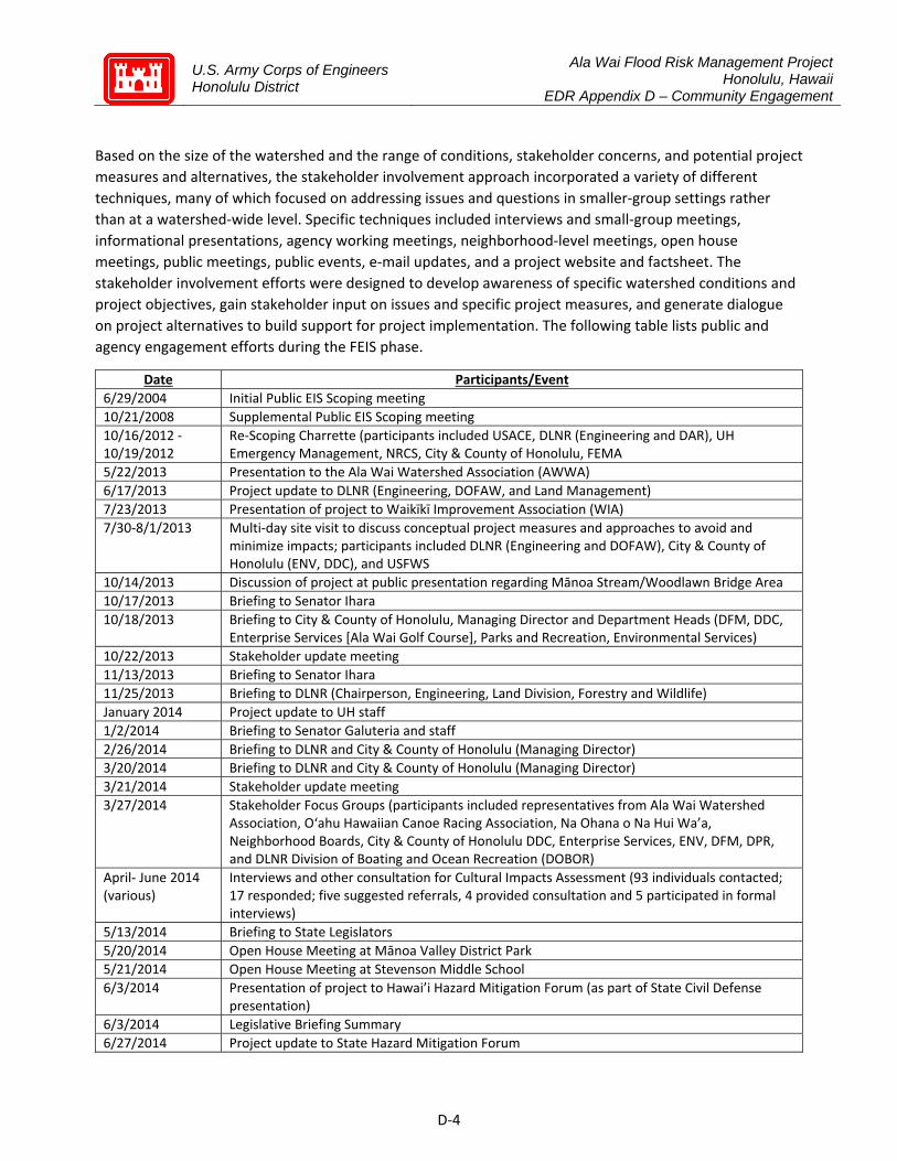
U.S. Army Corps of Engineers Honolulu District
Ala Wai Flood Risk Management Project Honolulu, Hawaii
EDR Appendix D – Community Engagement
D‐4
Based on the size of the watershed and the range of conditions, stakeholder concerns, and potential project measures and alternatives, the stakeholder involvement approach incorporated a variety of different techniques, many of which focused on addressing issues and questions in smaller‐group settings rather than at a watershed‐wide level. Specific techniques included interviews and small‐group meetings, informational presentations, agency working meetings, neighborhood‐level meetings, open house meetings, public meetings, public events, e‐mail updates, and a project website and factsheet. The stakeholder involvement efforts were designed to develop awareness of specific watershed conditions and project objectives, gain stakeholder input on issues and specific project measures, and generate dialogue on project alternatives to build support for project implementation. The following table lists public and agency engagement efforts during the FEIS phase.
Date Participants/Event
6/29/2004 Initial Public EIS Scoping meeting 10/21/2008 Supplemental Public EIS Scoping meeting 10/16/2012 ‐ 10/19/2012
Re‐Scoping Charrette (participants included USACE, DLNR (Engineering and DAR), UH Emergency Management, NRCS, City & County of Honolulu, FEMA
5/22/2013 Presentation to the Ala Wai Watershed Association (AWWA) 6/17/2013 Project update to DLNR (Engineering, DOFAW, and Land Management) 7/23/2013 Presentation of project to Waikīkī Improvement Association (WIA) 7/30‐8/1/2013 Multi‐day site visit to discuss conceptual project measures and approaches to avoid and
minimize impacts; participants included DLNR (Engineering and DOFAW), City & County of Honolulu (ENV, DDC), and USFWS
10/14/2013 Discussion of project at public presentation regarding Mānoa Stream/Woodlawn Bridge Area 10/17/2013 Briefing to Senator Ihara 10/18/2013 Briefing to City & County of Honolulu, Managing Director and Department Heads (DFM, DDC,
Enterprise Services [Ala Wai Golf Course], Parks and Recreation, Environmental Services) 10/22/2013 Stakeholder update meeting 11/13/2013 Briefing to Senator Ihara 11/25/2013 Briefing to DLNR (Chairperson, Engineering, Land Division, Forestry and Wildlife) January 2014 Project update to UH staff 1/2/2014 Briefing to Senator Galuteria and staff 2/26/2014 Briefing to DLNR and City & County of Honolulu (Managing Director) 3/20/2014 Briefing to DLNR and City & County of Honolulu (Managing Director) 3/21/2014 Stakeholder update meeting 3/27/2014 Stakeholder Focus Groups (participants included representatives from Ala Wai Watershed
Association, O‘ahu Hawaiian Canoe Racing Association, Na Ohana o Na Hui Wa’a, Neighborhood Boards, City & County of Honolulu DDC, Enterprise Services, ENV, DFM, DPR, and DLNR Division of Boating and Ocean Recreation (DOBOR)
April‐ June 2014 (various)
Interviews and other consultation for Cultural Impacts Assessment (93 individuals contacted; 17 responded; five suggested referrals, 4 provided consultation and 5 participated in formal interviews)
5/13/2014 Briefing to State Legislators 5/20/2014 Open House Meeting at Mānoa Valley District Park 5/21/2014 Open House Meeting at Stevenson Middle School 6/3/2014 Presentation of project to Hawai’i Hazard Mitigation Forum (as part of State Civil Defense
presentation) 6/3/2014 Legislative Briefing Summary 6/27/2014 Project update to State Hazard Mitigation Forum

U.S. Army Corps of Engineers Honolulu District
Ala Wai Flood Risk Management Project Honolulu, Hawaii
EDR Appendix D – Community Engagement
D‐5
8/14/2014 Presentation of project at the 10th Annual Hawai’i Floodplain Manager’s Conference 10/9/2014 Briefing on project status to State Civil Defense 10/14/2014 Project update to USFWS and DAR 10/21/2014 Presentation of project to Waikīkī Businesses (including WIA, Hawai’i Hotel and Lodging
Association, and Waikīkī BIA); WIA annual meeting 10/23/2014 EIS Preparation Notice (EISPN) published in OEQC’s Environmental Bulletin 11/3/2014 Briefing to DLNR and City & County of Honolulu (Managing Director’s staff) 11/24/2014 Briefing to DLNR, City & County of Honolulu Directors, and key Waikīkī community groups
(Waikīkī Improvement Association [WIA] and Waikīkī Business Improvement Association) 12/17/2014 Meeting with SHPO to discuss APE 1/13/2015 Hawai’i Hazard Mitigation Workshop (including DLNR, CCH, and Waikīkī Businesses) 1/23/2015 Project update to USFWS and DAR (specifically related to mitigation development) 2/26/2015 Meeting with SHPO to discuss effects determinations and mitigation 2/27/2015 Project update to USGS (specifically related to mitigation development) 3/25/2015 Presentation of project at Pacific Risk Management Ohana Conference 3/27/2015 Discussion of project at Ala Wai Partnership Working Group 3/31/2015 Briefing to State Representative Calvin Say (with representatives from the Research
Corporation of the UH, UH Sea Grant Program, CCH, and Department of Land and Natural Resources)
4/14/2015 Site visit with USFWS and NFS 5/26/2015 Project update to EPA, USFWS, DAR, and DOFAW 6/3/2015 Meeting with SHPO to discuss Programmatic Agreement 6/4/2015 Discussion of project impacts with USFWS 6/29/2015 Discussion of project with USFWS and NOAA/NMFS 7/8/2015 Meeting with O‘ahu Island Burial Council (OIBC) to discuss project 7/29/2015 Discussion of project impacts with USFWS, NMFS and DAR 9/30/2015 Public meeting at Washington Middle School
Table 1: Public and Agency Engagement efforts during FEIS phase
Detailed supporting documentation of the above listed outreach efforts can be found in Appendix G of the FEIS.
Community Opposition in FEIS Phase Despite efforts for outreach and public awareness, many stakeholders and property owners directly impacted by the footprint of the USACE Recommended Plan did not understand the need, concept, or purpose of the project. Many of their concerns were documented in the comment letters submitted for the Draft FEIS in 2015, and briefly summarized as follows:
Removal of ecosystem restoration from scope Project should focus on measures to improve water quality in the canal Lack of stakeholder engagement Not In My Back Yard (NIMBY) opposition Validity of data and models used to develop recommended plan Dislike of physical characteristics of recommended plan Dislike of requirements to construct recommended plan Maintenance concerns

U.S. Army Corps of Engineers Honolulu District
Ala Wai Flood Risk Management Project Honolulu, Hawaii
EDR Appendix D – Community Engagement
D‐6
3 Post‐Feasibility Phase (2018‐2019) Shortly following a Record of Decision in September 2018, the Ala Wai FRM was funded with Emergency Supplemental funds under the Bi‐Partisan Budget Act of 2018, Long‐term Disaster Recovery Investment Program. The program allows for a single phase design and construction as opposed to a more traditional design phase and subsequent construction phase. In addition, a deferred payment option for the NFS allows for expedited funding and project execution.
During this phase, with authorization and funds made available to advance the designs to the next stage, the Project Delivery Team (PDT) advanced the 1‐dimensional steady‐state hydrologic model developed to support the Feasibility Study to a 2‐dimensional unsteady‐state simulation of the watershed. Results of the modeling indicated different baseline conditions between the 1D model generated during the Feasibility phase and the updated 2D model.
Community engagement during this phase primarily consisted of neighborhood board presentations as well as a single large community meeting in March 2019. Much of the communication efforts during this phase focused on informing and educating the public with accurate project information, while correcting misinformation being fed by opposition groups.
Non‐Federal Sponsor
3.1.1 State Funding: Senate Bill 77 SD3 HD1 With project authorization and immediate funding provided due to the 2018 Emergency Supplemental funds, Hawaii was somewhat caught off guard. The previous schedule allowed for several years to pass before funding and now the state was scrambling to procure the funds necessary to meet their portion of the cost‐share agreement.
In early 2019, Governor Ige requested $125M for the project in the state’s 2019 budget, but the measure did not move forward. House Finance Committee Chairwoman Sylvia Luke viewed the project and funding as a city, not state responsibility. Initially state officials did not view the funding failure as a major setback given the federal government was willing to take the money in future installments. However, the state didn’t count on the city’s reluctance to serve as a sponsor on a project that wasn’t fully funded and would therefore require the city to assume more risk.
Instead, the State of Hawaii planned the raise the Non‐Federal share of funds by selling certificate of participation (COP) bonds, which don’t require legislative approval like general obligation funds.
As discussed in Section 1.1.2, State funding is on hold until litigation from an HRS 343 EIS is completed.
3.1.2 Honolulu City Council – Formation of the PIG and hiring of Oceanit From February to April 2019, seven out of the eight neighborhood boards in the watershed passed resolutions asking to halt the Ala Wai flood control project. The only board not to pass a resolution was Waikiki, the primary economic driver of the state for tourism and the area standing to gain the most from flood mitigation features.
In May 2019, the Honolulu City Council voted to adopt Resolution 19‐108, amending the membership of the Permitted Interaction Group (PIG), to investigate matters related to the Ala Wai Canal Flood Risk Management Project.

U.S. Army Corps of Engineers Honolulu District
Ala Wai Flood Risk Management Project Honolulu, Hawaii
EDR Appendix D – Community Engagement
D‐7
City Council lawmakers drafted Resolution 19‐145 in June 2019, requesting the Mayor postpone signing the PPA until other alternatives could be evaluated.
In July 2019, Honolulu City Council passed Resolution 19‐145, expressing concern over the lack of community engagement and lack of governmental transparency with the project. They also supported exploring alternative measures including ecosystem restoration as viable alternatives to detention basins and concrete walls.
Shortly afterward, a “permitted interaction group” consisting of City Council members Carol Fukunaga, Ann Kobayashi and Tommy Waters paid private consultant Oceanit $100,000 to conduct community outreach and solicit alternatives to the corps’ original plan.
In October 2019, Oceanit presented their community outreach findings at a large public meeting. The community prefers flood gates and pumps and retractable walls to control flooding at the Ala Wai Canal. They also support underground detention basins in the upper reaches of the watershed and dryland and wetland plots to dissipate energy and hold flood waters. They also urge dredging and cleanup of the canal. Other suggestions include: ecosystem restoration such as green infrastructure, water quality improvement, stream maintenance, repurposed storm water and creating an Ahupua’a of Waikiki recovery to control flooding in surrounding neighborhoods that wasn’t addressed in the USACE plan.
Following completion of community outreach, the City Council PIG provided more funds for Oceanit to evaluate alternatives to the USACE recommended plan. Honolulu Mayor Kirk Caldwell also requested the PDT include the PIG to the Executive Leadership Team (ELT). Councilwoman Carol Fukunaga in turn, requested that Oceanit be included to the ELT as the PIG’s designated representative.
Since November 2019, Oceanit has been included at both Senior Executive Board (SEB) as well as ELT meetings. The PDT has been working with Oceanit and exchanging files as needed.
USACE Public Outreach Efforts during Post‐FEIS Phase Public outreach and communications after receiving project authorization and funding consisted primarily of presentations at neighborhood board meetings, as well as a single large town hall meeting. Details of these meetings are listed below.
3.2.1 3/19/2019: Town Hall Meeting State of Hawaii’s DLNR and the City and County of Honolulu’s Department of Design and Construction, partnered with USACE to host a town hall meeting at the Manoa Valley District Park Gymnasium.
The meeting consisted of presentations about the need for resiliency on the island of Oahu in the face of climate change, emergency preparedness, and an update on the project. The public also were given opportunity to ask questions about the project.
No minutes or recorded video could be found for this meeting.
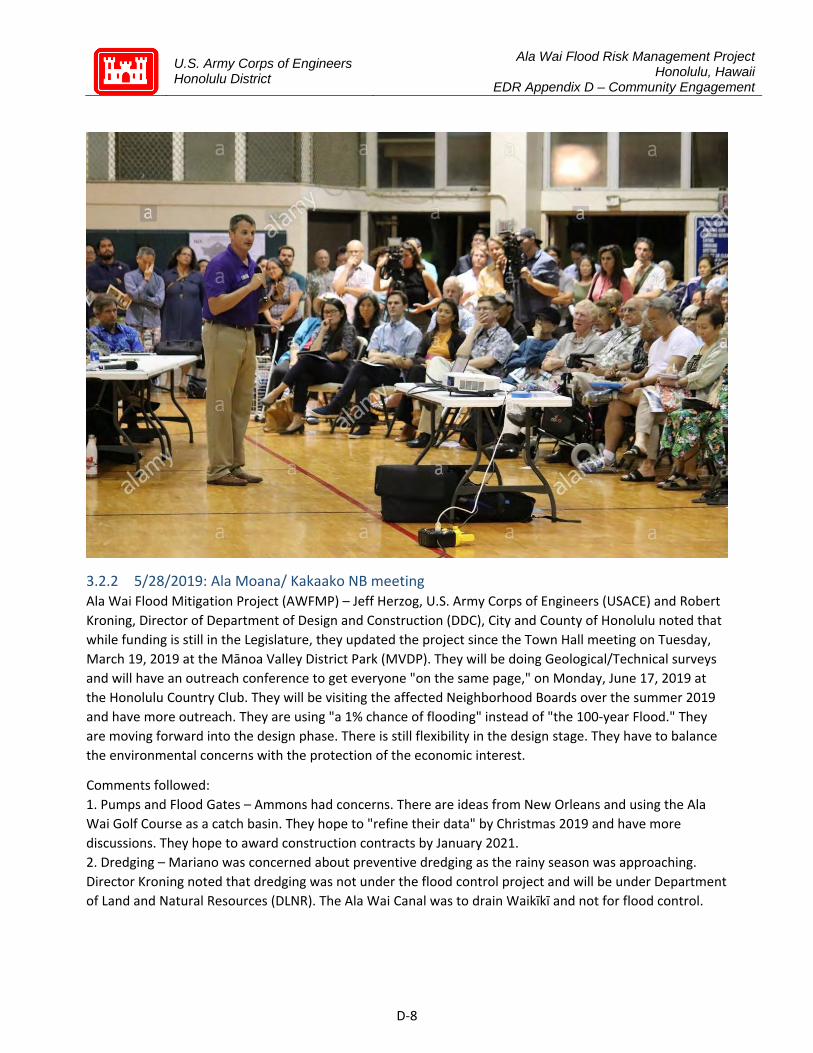
U.S. Army Corps of Engineers Honolulu District
Ala Wai Flood Risk Management Project Honolulu, Hawaii
EDR Appendix D – Community Engagement
D‐8
3.2.2 5/28/2019: Ala Moana/ Kakaako NB meeting Ala Wai Flood Mitigation Project (AWFMP) – Jeff Herzog, U.S. Army Corps of Engineers (USACE) and Robert Kroning, Director of Department of Design and Construction (DDC), City and County of Honolulu noted that while funding is still in the Legislature, they updated the project since the Town Hall meeting on Tuesday, March 19, 2019 at the Mānoa Valley District Park (MVDP). They will be doing Geological/Technical surveys and will have an outreach conference to get everyone "on the same page," on Monday, June 17, 2019 at the Honolulu Country Club. They will be visiting the affected Neighborhood Boards over the summer 2019 and have more outreach. They are using "a 1% chance of flooding" instead of "the 100‐year Flood." They are moving forward into the design phase. There is still flexibility in the design stage. They have to balance the environmental concerns with the protection of the economic interest.
Comments followed: 1. Pumps and Flood Gates – Ammons had concerns. There are ideas from New Orleans and using the Ala Wai Golf Course as a catch basin. They hope to "refine their data" by Christmas 2019 and have more discussions. They hope to award construction contracts by January 2021. 2. Dredging – Mariano was concerned about preventive dredging as the rainy season was approaching. Director Kroning noted that dredging was not under the flood control project and will be under Department of Land and Natural Resources (DLNR). The Ala Wai Canal was to drain Waikīkī and not for flood control.

U.S. Army Corps of Engineers Honolulu District
Ala Wai Flood Risk Management Project Honolulu, Hawaii
EDR Appendix D – Community Engagement
D‐9
3. Land Acquisition – Some properties will be used for the various parts of the project, in the upper parts. Director Kroning assured everyone that the City does not want to acquire more land. Some small parcels will be easements and some parcels will be used for the construction period and returned after. 4. Ala Moana Boulevard – There were concerns about the Ala Moana/Kakaʻako Neighborhood Board No. 11 area. Director Kroning does not want to add flood areas, but will work towards bettering the area. 5. Internal Drainage Issues – They will have an early warning system, which will help the district. 6. Land Acquisition – Komine asked about "fair market value." The USACE will not do the land acquisition. After 60% to 90% of the design phase, then they will develop a land acquisition plan that the partner will execute, according to State of Hawaiʻi and federal land acquisi on laws. 7. More Outreach Opportunities – The Pālolo Neighborhood Board will be on Wednesday, June 12, 2019 and other meetings are scheduled for Makiki/Tantalus/Lower Punchbowl Neighborhood Board No. 10, Kaimuki, and Waikīkī. Also, there will be more meetings after the surveys to August 2019. Herzog was personally concerned with communication. 8. Ala Wai Golf Course – Franklin Chung was concerned about the Ala Wai Golf Course. Herzog mentioned that it could be re‐configured. Director Kroning said it would remain 18 holes. 9. Neighborhood Boards Opposition – Brian Bagnall mentioned that seven (7) Neighborhood Boards have passed resolutions opposing this project. He pointed out the Ala Wai Promenade was the result of the Ala Moana/Kakaʻako Neighborhood Board No. 11 ini a ve and it was highlighted at the recent return of the Hōkūleʻa from its world tour. Building a four (4)‐foot wall around the canal would not "fit." Director Kroning noted that public safety is a priority and the concrete walls may be modified. Every delay will give the chance of danger to increase. 10. Costs – A community person pointed out the State will not sign off on the $125 million partnership and it may cost $1 million a year for maintenance. The estimated damage to O‘ahu, if nothing is done, is $1.4 billion and may increase, due to more development. David Watase had other comments about their presentation.
RESIDENTS' AND COMMUNITY CONCERNS Ala Wai Flood Mitigation Project (AWFMP) – Dave Watase gave an update. As of Thursday, May 2, 2019, the Legislature did not pass the $125 million to fund the project, due to the seven (7) Neighborhood Boards' opposition. The Mayor and the Governor are in discussions about the funding and the partnership agreement, which the Mayor will probably sign, according to Department of Design and Construction (DDC) Director Robert Kroning. On the Governor's side, he has to review the HEPA rules, which did not engage public input. Watase urged everyone to continue the fight and sign the online petition.
3.2.3 5/31/2019: Ala Wai Watershed Collaboration meeting at Iolani School The Ala Wai Watershed Collaboration (AWWC) is a network of over 60 community stakeholders from government, civil society, business, and academia, who have converged as the AWWC to discuss and solve the challenges of the Ala Wai Watershed together. AWWC’s collective vision for the watershed includes reducing flood risk to people and infrastructure, improving water quality and ecosystem functions, enhancing opportunities for residents and visitors to have fulfilling connections to place through culture and place‐based experiences and curricula, and improving quality of life and recreation opportunities in the watershed.
U.S. Army Corps of Engineers Honolulu District
Ala Wai Flood Risk Management Project Honolulu, Hawaii
EDR Appendix D – Community Engagement
D‐10
Ala Wai Canal Flood Risk Management Project: The US Army Corps of Engineers provided updates on the current project process and status on the Ala Wai Canal Flood Risk Management Project. The $345 million flood management project is the largest single project currently under consideration in the watershed. Although the scope of this project is limited to addressing flood mitigation, based on justifications required for federal funding, Army Corps with its local State, and City partners are working to identify ways in which this project can provide multiple benefits and align with other efforts and projects.
The project is currently at a 30% design level; at this level, the overall budget, schedule, and functions of the project features are decided, which is to slow down floodwater as it flows towards the ocean and enhance the capacity of the Ala Wai Canal and Ala Wai Golf Course to retain peak volume of flash floods through a combination of berms, levies, and walls. However, the siting and sizing of each feature, as well as the materials and techniques used have not been decided, and innovative solutions and feedback are welcome. Starting at the end of June, the Corps will gather additional topographic data to enhance the water flow modeling from 1D to a 2D model that considers depth and specific topography in the siting and sizing of features. The Army Corps invited businesses, academia, and non‐profit organizations to participate in a June 17 Industry Day where participants are encouraged to present and discuss innovative technologies, materials, or practices that can provide flood mitigation benefits as well as other co‐benefits.
City Updates: The Department of Design and Construction (DDC) representing the City & County of Honolulu provided updates on the commitment of local partners (State and City) to sponsor the project through signing a Project Participation Agreement (PPA). Although no state funding was directly appropriated this legislative session, State and City remain committed to moving the project forward with a number of changes and revisions to the floodwall design and retention basin sizing and location. DDC emphasized that this project is only one of many projects and efforts that are needed and the City welcomes ongoing input and partnerships to address additional priorities. DDC provided the example that the City DES is intending to introduce biofiltration and water features that divert part of the stream through the Ala Wai Golf Course, while maintaining the full functionality of the course. Over the next several months, Army Corps and the City will be co‐presenting project updates at neighborhood board meetings.
Discussion: AWWC members discussed various tradeoffs that need to be balanced in a watershed that has been significantly altered by development and urbanization, and highlighted the AWWC network as a helpful space for an open dialogue about these tradeoffs and joint initiatives to advance multiple objectives. There was broad consensus from government and non‐government members that many incentives and technologies are needed, including rain barrels, rain gardens, pervious paving, and reforestation, and regulation or incentives to implement best practices on private property, for example via a stormwater fee. Specifically, members discussed the difficult tradeoffs between stakeholders who would be impacted by retention basins and the benefits of vulnerable populations in dense urban floodplain such as Moʻiliʻili. Stakeholders also highlighted the need for more public risk and disaster awareness, and improved communications about what the flood mitigation project does and does not do.
3.2.4 6/12/2019: Palolo Neighborhood Board meeting US Army Corps of Engineers (USACE) Proposed Ala Wai Flood Risk Mitigation Project: USACE Project Manager Jeffrey A. Herzog reported the following:

U.S. Army Corps of Engineers Honolulu District
Ala Wai Flood Risk Management Project Honolulu, Hawaii
EDR Appendix D – Community Engagement
D‐11
Update: Herzog commented that following the deferment of SB77, the City and State are discussing a potential path forward and that the USACE is regularly communicating with them. Herzog reported that the next step is to award a geographical and topographic survey based off of the public lands that were given rights of entry on June 25 from the DLNR Land Board. He reported that the USACE will do a sediment characterization as well as a geotechnical boring to determine what the subsurface looks like along the Ala Wai Canal and Public Lands/Watershed areas. The contract will be awarded in June 22, 2019. He commented that there will follow 120 days for the contractor to develop the schedule, acquire permits, and coordinate with the USACE and the community. The surveying will begin in the late summer and early fall 2019.
Flood Modeling Update: Herzog reported the USACE updated their modeling over the last nine (9) months and described the changes. He commented that the level of analysis that was done during feasibility was to determine if the project had a federal interest and could be done in an environmentally acceptable way according to federal law. The USACE works in partnership with a sponsor, in this case the DLNR. The State and City will determine if there is a path forward on the project.
Feedback: Herzog provided a response to community feedback on the project. He commented that the flood modeling that the USACE used on the project is the industry standard. He added that in the State of Hawaii, the USACE has a good track record with flood mitigation projects, commenting that their flood mitigation projects protected the Hilo community during the floods in 2018. He commented that the USACE will not design the project like the one at Ha'aione Valley constructed in 1962. He commented that on June 17, 2019 the USACE will have an Industry and Innovation outreach day to bring together many non‐profits and other organizations to bring key stakeholders together to discuss flood mitigation solutions. He commented that the USACE will better communicate with the community moving forward. Herzog responded to concerns with maintenance, commenting that Article II F‐ I of the legal agreement outlines the sponsor's obligation to communicate the project with the community and establishment of a flood plain management plan. Herzog reported that the project is meant to address river and watershed flood hazards coming off of the Koolau Mountains, passing through the watershed, and exiting out of the canal. He clarified it is not meant to address coastal hurricane storm damage or coastal erosion.
Hack suggested a time limit of 1 minute per speaker, Secretary Nakayama to be timer. Questions, comments, and concerns followed: 1. Climate Change: Resident Chung commented that he does not believe in man‐made climate change, but supports the project to the extent that it impacts the Ala Wai Golf Course as a flood plain. Herzog responded that Director Kroening met with the administrators of Ala Wai Golf Course, commenting that there is a plan to revitalize the golf course and better utilize its function as a flood plain. He commented that no change that would induce flooding on another, especially the neighboring schools of Iolani School and Ala Wai Elementary School. 2. Alternative Solutions: A resident recommended using existing channeling segments in conjunction with a mechanical element to create an earlier drain basin to flood Palolo Park, among other solutions that would better utilize existing infrastructure. Herzog responded that they must minimize impacts on private lands as much as possible. 3. Local Streams: Resident Steven Holmes asked and Herzog responded that the local sponsors would maintain the streams. Resident Holmes expressed concerns with the local sponsor's abilities to maintain

U.S. Army Corps of Engineers Honolulu District
Ala Wai Flood Risk Management Project Honolulu, Hawaii
EDR Appendix D – Community Engagement
D‐12
the streams. Herzog responded that Article II F‐ I requires the sponsor to create a flood plain management plan, which ought to address those concerns. 4. Flooding: A resident expressed concerns that the project will flood other communities. 5. Changing Designs: Resident Hughes asked and Herzog responded that there is room for flexibility in changing the design features and moving the sites to minimize the impact to the community. He commented that the concept of reducing the upstream flow to minimize downstream impact will not change. 6. Changes: Sydney Lynch asked and Herzog responded that the idea of ecosystem restoration was not carried forward after 2012. He commented that he has committed to Senator Moriwaki and DLNR to look into ecosystem restoration. Herzog commented that they are working to make changes to the project features, part of which will be relocating some and changing the sizes based off of performance requirements. 7. Viable Alternatives: Resident Dave Watase expressed concerns with the lack of alternatives when the project was originally proposed, expressing doubts that the stakeholders have been effectively involved. Watase expressed concerns with the modeling used and Herzog responded that the 10 and 100 year flood maps appear similar because the watershed is relatively deep, meaning that a significant volume of water may cause a deceptively small rise in the visible flood area. 8. Financial Justification: Resident Watase expressed concerns with the lack of financial justification for the retention basin ($3 million in damage). 9. Lack of Notification: Resident Pete Arnold expressed concerns with the lack of notification for those impacted by the project, commenting that the community does not trust the USACE. He commented that the community does not appreciate the non‐collaborative attitude that the USACE approached the project with. He added that the land value will significantly drop due to the project. 10. Ecosystem: Resident Andrea described her experience and efforts with her students and other teachers in understanding and maintaining the health of the Ala Wai Watershed. She commented that the project needs to better address concerns related to the ecosystem. She commented that there are other systemic problems with the watershed that need to be addressed, concluding that the project is to narrowly focused. 11. Extreme Weather: Resident Jordan Wong asked and Herzog responded that they must conduct a qualified risk assessment with the U.S. Army Dam Safety Center of Expertise. They are required to meet State and Federal requirements to survive extreme weather events. 12. Lack of Personal Stake: Resident Fannie Cline expressed concerns with the lack of personal stake of the staff of USACE in the impact of the project. She commented that the community does not want USACE to impact the watershed with their project. Herzog responded that there are members of their staff with ties to those areas impacted by the community. 13. Project Concerns: A resident expressed concerns that the project will flood the nearby homes, the negative impact on the environment, and the lack of representation from their elected officials in regards to this project. Herzog responded that HSE Say has been very active in conversations with the USACE, especially with ecosystem restoration. Herzog responded that the trees will be replaced as well mitigation to reduce the impact on the black damsel fly. 14. Ancestor Practices: A resident expressed appreciation to the USACE representative for engaging with the community on this occasion. She commented that the community ought to look to how those that came before took care of the stream before exploring other options.

U.S. Army Corps of Engineers Honolulu District
Ala Wai Flood Risk Management Project Honolulu, Hawaii
EDR Appendix D – Community Engagement
D‐13
15. Historical Flooding: Resident Bruce Lum asked what historical flooding data was explored during the planning of the project. Herzog responded that as of now, given the current state of the watershed which has changed from its historic condition, the project asks that the USACE best protect the people living in the watershed. Resident Lum recommended exploring natural, proper, and resilient land‐use and Herzog responded that the questions they explore is how to responsibly create flood parks, create resilience within the flood plain, and create a flood plain management plan. He concluded that the approach must be more systemic. Hack requested Herzog attend to any further questions or comments privately with residents. He stated he would be available until 9:30 PM.
3.2.5 6/17/2019: Industry and Innovation Day Ala Wai Watershed Flood Risk Management Project Manager Jeff Herzog addressed more than 100 local industry, academia and engineering innovators at the Ala Wai Watershed Flood Risk Management project’s Industry and Innovation Day at Honolulu Country Club. Project managers, engineers and leadership from the U.S. Army Corps of Engineers (USACE) Honolulu District also provided information and networked with the industry representatives and contractors. The Corps‐sponsored event provided industry with latest updates to project elements and performance requirements, while also allowing industry the opportunity to provide comments, perspectives and brainstorm about the project development process.

U.S. Army Corps of Engineers Honolulu District
Ala Wai Flood Risk Management Project Honolulu, Hawaii
EDR Appendix D – Community Engagement
D‐14
3.2.6 7/18/2019: Makiki/Tantalus/Lower Punchbowl Neighborhood Board meeting Ala Wai Watershed Project: Jeff Herzog of the United States Army Corps of Engineers (USACE) reported the following updates. • Current Status: The USACE has not signed a partnership with the State of Hawaii. • Changes to Existing Model: The USACE Hydraulic Engineering Center (HEC) model was updated with consideration to underground water issues. The Hundred Year Model has also been updated as each year has a one (1) percent chance of a catastrophic storm event with a .02 percent chance of freak storms. • Contact Information: Herzog provided contact information. [email protected]; [email protected]; CEPOH‐[email protected]; and (808) 835‐4004.
Questions, comments, and concerns followed: 1. Underground Caves: Klink inquired if the USACE has taken the underground consideration of the caves in Moiliili and Herzog responded that the updated model has taken the new terrain mapping of the caves into consideration of potential overflow and damage point. 2. Sea Level: Kawano inquired about climate change and sea level rise mitigation and Herzog responded that the lasting effects of sea level rise are taken into consideration for the proposed 2025 construction.
3.2.7 8/8/2019: Insights on PBS Jeff Herzog (USACE project manager), Robert Kroning (Director of City & County of Honolulu Department of Design and Construction), Dr. Kenneth Kaneshiro (Hawaii Exemplary Foundation), Dave Watase (Palolo property owner; founder of Stop Ala Wai organization) faced off in an hour‐long debate of the Ala Wai flood control project.
3.2.8 8/13/19: Waikiki Neighborhood Board meeting Ala Wai Watershed Flood Plan: Design and Construction (DDC) Director Robert Kroning and Jeff Herzog of the United States Army Corps of Engineers (USACE) provided a handout and reported the following updates. • Current Status: The USACE has not signed a partnership with the State of Hawaii, but there is no current expiration of funds. The decision regarding partnerships is not at the USACE level.

U.S. Army Corps of Engineers Honolulu District
Ala Wai Flood Risk Management Project Honolulu, Hawaii
EDR Appendix D – Community Engagement
D‐15
• Changes to Existing Model: The USACE Hydraulic Engineering Center (HEC) model was updated with consideration to divergent elevations of terrain. The project’s purpose is to protect Makiki and Moiliili areas from flooding as they have different depths due to different elevations. • Contact Information: Herzog provided contact information. [email protected]; [email protected]; CEPOH‐[email protected]; and (808) 835‐4004.
Questions, comments, and concerns followed: 1. Terrain: Smith inquired about a large designated space in the map provided in the Watershed Plan. Director Kroning responded that the space represents a large gathering area for water. Smith raised concerns that the area represented in the map contains high rises with elderly residents. 2. Ala Wai Golf Course: A resident raised concerns regarding the effects of the Ala Wai Watershed Project on the Ala Wai Golf Course, citing a Danielle Tucker report The Golf Club Radio Show from Saturday, August 3, 2019. Another resident inquired if the Ala Wai Watershed Project has factored in sea level rise that could damage the golf course. Director Kroning responded that inquiries to golf courses may be directed to Enterprise Services. 3. Alternative Models: A resident inquired if there are alternative models to the current watershed project and Herzog responded that an alternative model is in place but all plans must regard native freshwater fish upstream migrations. 4. Current model: A resident raised concerns that if the current model will not be in place before the “100 year flood”, it will be a waste of funds. Another resident inquired if there is a measure of failure/success for the current model and Kroning responded that USACE will let the City and County of Honolulu know if the project stays on target. A Palolo resident inquired about the amount of funds factoring into the quality of the project and Herzog responded that the current plan is relegated to surveying the minimum impact to vehicles and homes. Erteschik raised concerns regarding status of current model and Herzog responded that the project is being adjusted due to community concerns, stating that community interactions are required to mitigate impact on local residents. Senator Sharon Moriwaki added that with not project partner, the watershed project cannot move forward. 5. Residential Feedback: Residents Sean Connelly and Dave Watase reiterated concerns regarding the aesthetics and negative impacts to the upstream communities as retention basins may be placed there. Resident Watase suggested a floodgate within the Ala Wai Canal to reduce the need for a wall along the Makai side, to which Herzog responded that a floodgate and pump system were considered before being found to be environmentally unacceptable due to the sediment runoff on coral offshore. Herzog also advised that any concerns based on Environmental Impact Statements (EIS) must also consider updates to the current model. Resident Connelly suggested that the flood mitigation should model itself after the Charles River Dam in Boston. Chair Finley requested updates from Herzog and Director Kroning.

U.S. Army Corps of Engineers Honolulu District
Ala Wai Flood Risk Management Project Honolulu, Hawaii
EDR Appendix D – Community Engagement
D‐16
3.2.9 8/15/2019: Makiki/Tantalus/Lower Punchbowl Neighborhood Board meeting City Councilmember Carol Fukunaga: Councilmember Fukunaga circulated a handout and reported the following: • Resolution 19‐182: The Council’s Executive Matters and Legal Affairs (EMLA) Committee will hear Resolution 19‐182, relating to the Ala Wai Flood Risk Management Project, on Tuesday, August 20, 2019.
Letter to Mayor Kirk Caldwell, urging him not to sign a partnership agreement with the U.S. Army Corps of Engineers (USACE) and Letter to Governor David Ige et al, requesting them not to accept the Final Environmental Impact Statement (EIS) for the proposed Ala Wai Flood Mitigation Project (AWFMP): Chair Ross combined two (2) agenda items and opened the floor to discussion: • Office of Environmental Quality Control (OEQC): Scott Glenn, OEQC Director, provided an overview for the EIS process and clarified that an EIS is a disclosure and not a permit. An EIS is intended to balance environmental factors and other factors for projects by collecting and providing information for permits. EIS’ may be required under various project triggers, such as using State or County land or funds. There are three (3) levels of environmental review, an exemption, an environmental assessment, and an EIS. There are four (4) stages to the EIS which each include comment periods. • Resident Dave Watase: Resident Dave Watase voiced opposition to the AWFMP and voiced concerns regarding the February 2019 Board meeting where the Board approved a resolution which was not publicly distributed. Resident Watase requested the Board defer action on the draft letters to the Mayor and Governor until after the upcoming AWFMP community meeting. Resident Watase circulated a handout. • Department of Design and Construction (DDC): Robert Kroning, DDC Director, reported that the City supports signing a partnership agreement with the USACE and wishes to proceed with the AWFMP to retain Federal funds. Director Kroning voiced concerns regarding climate change and potential natural disasters. Director Kroning stated that alternatives for the AWFMP have been analyzed by the USACE who have the expertise to determine if plans are feasible or not. Environmental concerns have been taken into account and the AWFMP intends to be as non‐intrusive as possible. Director Kroning clarified that the AWFMP could be terminated later into the project if necessary. • USACE: Jeff Herzog, USACE, circulated handouts and clarified that the USACE was able to proceed and work towards a design without signing a partnership agreement under the Emergency Supplemental 2018

U.S. Army Corps of Engineers Honolulu District
Ala Wai Flood Risk Management Project Honolulu, Hawaii
EDR Appendix D – Community Engagement
D‐17
Federal Legislation. USACE is currently in the stage of data gathering and refinement and any changes to the plan will be based on data and input from partners.
Questions, comments, and concerns followed: 1. Alternatives: Nakahara recommended sharing and explaining alternatives to the public so they understand why alternatives are not feasible. Herzog responded that the USACE is working to make information public. 2. Renderings: Chang inquired when renderings for the project will be available. Herzog responded that renderings are included in the project’s feasibility study. Herzog clarified that the information has been updated and USACE is working to make information public. 3. Communication: Young voiced confusion regarding the project’s current stage and how the project progresses to the next phase. Young voiced concerns regarding a lack of communication and advocated for an open forum. Chair Ross reminded the assembly of the upcoming meeting for the AWFMP.
Mitchell moved and Young seconded the Motion to defer action. The Motion WAS ADOPTED by MAJORITY VOTE, 9‐1‐0; (AYE: Agustin, Chang, Farden, Mitchell, Nakahara, Ross, Kalakau, Steelquist, and Young; NAY: Tipton; ABSTAIN: None).
3.2.10 8/19/2019: Community meeting sponsored by CCH City Council PIG Honolulu City Council sponsored community meeting at the Neil Blaisdell Center, prompted by community concern for Ala Wai flood project. Introduction of the Permitted Interaction Group (PIG), consisting of Councilmembers Carol Fukunaga, Ann Kobayashi, and Tommy Waters, and new city hired engineering consultant, Oceanit.
Questions & comments from community: Palolo Valley
USACE said materials to be used in detention basin, have a 50 yrs warranty. City & County are you paying for cost if failure occurs. 50 yrs isn’t much for a 100 yr flood! Maintenance + Failure cost!
The City is short staffed w/ no money to maintain new debris dams. Existing debris dams are filled w/ boulders sediment & invasive grass. They pose serious threats to neighbors. How will maintenance for debris dams be paid for? Is the plan to use a stormwater fee?
The problem with flooding makai of Makiki, Manoa & Palolo is because the 2nd outlet to the ocean for the Ala Wai was not completed. Complete the 2nd outlet!
Kaimuki What are the alternatives to the wall & detention basin designs? Are floodgates, drilling a big
stormdrain underneath Waikiki realistic?
Manoa Maintain & clean stream (Manoa) up to Paradise Park. Aloha Aina Stop Ala Wai Project
Ala Wai Golf Course Support project & support using Ala Wai Golf Course more!
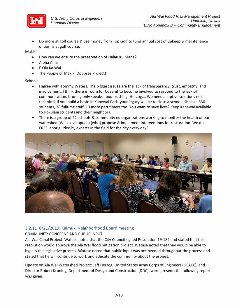
U.S. Army Corps of Engineers Honolulu District
Ala Wai Flood Risk Management Project Honolulu, Hawaii
EDR Appendix D – Community Engagement
D‐18
Do more at golf course & use money from Top Golf to fund annual cost of upkeep & maintenance of basins at golf course.
Makiki How can we ensure the preservation of Halau Ku Mana? Aloha Aina E Ola Ka Wai The People of Makiki Opposes Project!!
Schools I agree with Tommy Waters. The biggest issues are the lack of transparency, trust, empathy, and
involvement. I think there is room for Oceanit to become involved to respond to the lack of communication. Kroning only speaks about rushing. Herzog…. We need adaptive solutions not technical. If you build a basin in Kanewai Park, your legacy will be to close a school: displace 330 students, 38 fulltime staff, 10 more part timers too. You want to save lives? Keep Kanewai available to Hokulani students and their neighbors.
There is a group of 22 schools & community ed organizations working to monitor the health of our watershed (Waikiki ahupuaa) [who] propose & implement interventions for restoration. We do FREE labor guided by experts in the field for the city every day!
3.2.11 8/21/2019: Kaimuki Neighborhood Board meeting COMMUNITY CONCERNS AND PUBLIC INPUT Ala Wai Canal Project: Watase noted that the City Council signed Resolution 19‐182 and stated that this resolution would approve the Ala Wai flood mitigation project. Watase noted that they would be able to bypass the legislative process. Watase noted that public input was not heeded throughout the process and stated that he will continue to work and educate the community about the project.
Update on Ala Wai Watershed Project: Jeff Herzog, United States Army Corps of Engineers (USACE), and Director Robert Kroning, Department of Design and Construction (DDC), were present; the following report was given:

U.S. Army Corps of Engineers Honolulu District
Ala Wai Flood Risk Management Project Honolulu, Hawaii
EDR Appendix D – Community Engagement
D‐19
• Project Details: Herzog noted that the USACE is not authorized to work unilaterally and stated that they need civic partnership to complete their plan. Herzog noted that there had been a milestone placed on Wednesday, July 31, 2019 for the plans approval and stated that it has passed. Herzog noted that they are working with the City and County of Honolulu and stated that the City Council has passed Resolution 19‐182 that assisted in releasing limited funds to the project. Herzog noted that they will be working with the DDC. Herzog detailed the updated flood plain model for the region with a peak hydrograph map. The project was designed to effect the river and flood conditions. The project was not meant to affect the current ground water issues of the region. Herzog noted that the McCully and Moili’ili regions are major flood risks. Herzog noted USACE’s attempts to be transparent, attend Neighborhood Board Meetings, and is continuing to receive community input. Herzog asked for the resident’s assistance in mitigating any impact on their community.
• Update from the Department of Design and Construction (DDC): Director Kroning noted that the project can only occur with a partnership and stated that the City and County of Honolulu wants to be the partner. Director Kroning noted that there has been growing misinformation about the project that has been growing. Director Kroning noted that the City and County of Honolulu believes that their most important duty is keeping the public safe and stated that this issue is bigger than parks and playgrounds. Director Kroning noted his belief that the City and County of Honolulu is going in the right direction. Director Kroning stated that there will not be massive concrete canals, dams, or changes to the existing stream. Director Kroning noted that the City and County of Honolulu is fully engaged in the project. Director Kroning noted that the need to find a project and plan that works. Director Kroning stated that the City and County of Honolulu will halt the project if they do not like its direction and noted that there have not been any agreements signed yet.
Questions and comments followed: 1. Effects of Sea Level Rise: Senator Ihara asked for a map that shows threat of sea level rise and asked if an improved storm water system is in the Environmental Impact Study. Herzog noted that there were no plans by USACE to work off an improved storm water system or to address it. Herzog noted that their plans assume for the effects of a 2 ½ foot king tide and a 2.8 foot sea level rise over 50 years. Herzog noted that their wall heights would be based off of water coming from the mauka and the effects of the sea level rise. Herzog noted that some storm water backup is incorporated within their plans. Watase asked and Herzog noted that the maps depict the region without the project’s flood mitigation and stated that their plans include a 2.8 foot sea level rise. Watase asked and Herzog noted that just subtracting the proposed sea level rise would not be a fair representation of the graph. Herzog noted that they would need to integrate the effect of the current drainage system within their statistics moving forward and stated that this may account for part of the rise of sea level effects. 2. Project Funding: Senator Ihara asked about USACE’s 15 billion dollar project budget from the federal government and asked where the over a billion dollar allocation for the project would go. Herzog noted that the 15 billion dollar allocation is part of a long term contingency plan from USACE that would fund 27 projects. Herzog noted that some of the funds were spent on previous projects that needed reevaluation and stated that he will continue to update the community with current information. 3. Top Golf: Chung noted his disbelief in climate change and stated that he supports the project due to the work done near the Ala Wai Golf Course. Chung noted that more work done near the golf course would be
U.S. Army Corps of Engineers Honolulu District
Ala Wai Flood Risk Management Project Honolulu, Hawaii
EDR Appendix D – Community Engagement
D‐20
better for the community and stated that the Top Golf project would be checked by the USACE presence in the region and stated that Top Golf would increase the regional revenue. 4. Effects of Surrounding Community: Chung asked how the project would affect ‘Iolani School and Ala Wai Golf Course. Director Kroning noted that Top Golf does not have any say within the project and stated that the entire golf course was planned to assist in flood mitigation. Director Kroning noted that ‘Iolani School is affected by the water flowing through regional streams. Chinen asked if a four (4) foot wall wuld be installed and if public input would be heard on the subject. Herzog noted that their feasibility plan will not be the planned used due to improving data. Director Kroning noted that the most important thing is that it functions and stated that they are continually receiving public input. Senator Ihara noted his disagreement. Director Kroning noted their attempts to be environmentally friendly and effective. Director Kroning noted that funding can sometimes have tight deadlines and stated that they are not rushing the planning and design phases. Herzog noted that any changes to the plan would require public input and stated a need to build trust. Gardner asked about public input stopping previous projects and Herzog noted that the Wailele Stream project has gone through nine (9) different plans. Gardner noted that the community wants to know that their input matters. Herzog noted that the Wailele Stream project is still going through the process. Herzog recommended that changes to the plan are made through engineering data. Senator Ihara noted that the 2.8 foot sea rise was added after the original draft and before the resolution’s completion. Senator Ihara asked that king tides be properly defined to the community. Senator Ihara stated that properly addressing sea rise across the state would assist in creating a functioning plan to combat sea level rise in the future.
State Senator Les Ihara – Senator Ihara was present; the following report was given: • Ala Wai Canal Project: Senator Ihara noted that 15 billion dollars have been allocated for USACE projects and stated that 27 projects from the original 54 projects were removed from their docket before the budget was approved. Senator Ihara noted that their budget has 1.1 billion dollars in unallocated funds. Senator Ihara noted that the City and County of Honolulu Departments have not attended Neighborhood Board meetings for the last 18 months.
3.2.12 10/1/2019: Oceanit’s Alternatives (appeared as guest) Oceanit was hired in a separate but parallel effort to listen to community concerns and come up with alternatives to the USACE recommended plan. The Honolulu City Council Permitted Interaction Group, consisting of Councilmembers Ann Kobayashi, Carol Fukunaga, and Tommy Waters, funded this effort.
In September 2019, Oceanit hosted five community outreach meetings for various stakeholders across the watershed. In a public meeting held at the Ala Wai Elementary School on October 1st, Oceanit delivered a summary of community inputs and alternatives, and the next steps of the project. The USACE PDT and City and County partners were invited as guests to listen and hear the community’s concerns and ideas.
Community ideas included alternative infrastructures, moveable storm barriers, ecosystem restoration, flood gates and pumps, and retractable walls to control possible flooding. Participants also were given the opportunity to provide additional comments and questions. The next phase of work will include a review of the original USACE plan, a review of the recent updates by the Corps, and a review and analysis of alternatives to reach a recommended approach.
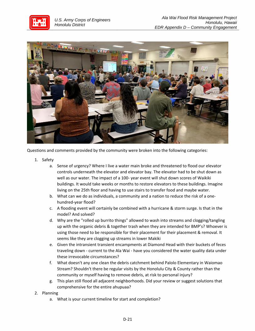
U.S. Army Corps of Engineers Honolulu District
Ala Wai Flood Risk Management Project Honolulu, Hawaii
EDR Appendix D – Community Engagement
D‐21
Questions and comments provided by the community were broken into the following categories:
1. Safety a. Sense of urgency? Where I live a water main broke and threatened to flood our elevator
controls underneath the elevator and elevator bay. The elevator had to be shut down as well as our water. The impact of a 100‐ year event will shut down scores of Waikiki buildings. It would take weeks or months to restore elevators to these buildings. Imagine living on the 25th floor and having to use stairs to transfer food and maybe water.
b. What can we do as individuals, a community and a nation to reduce the risk of a one‐hundred‐year flood?
c. A flooding event will certainly be combined with a hurricane & storm surge. Is that in the model? And solved?
d. Why are the "rolled up burrito things" allowed to wash into streams and clogging/tangling up with the organic debris & together trash when they are intended for BMP’s? Whoever is using those need to be responsible for their placement for their placement & removal. It seems like they are clogging up streams in lower Makiki
e. Given the intransient transient encampments at Diamond Head with their buckets of feces traveling down ‐ current to the Ala Wai ‐ have you considered the water quality data under these irrevocable circumstances?
f. What doesn't any one clean the debris catchment behind Palolo Elementary in Waiomao Stream? Shouldn't there be regular visits by the Honolulu City & County rather than the community or myself having to remove debris, at risk to personal injury?
g. This plan still flood all adjacent neighborhoods. Did your review or suggest solutions that comprehensive for the entire ahupuaa?
2. Planning a. What is your current timeline for start and completion?

U.S. Army Corps of Engineers Honolulu District
Ala Wai Flood Risk Management Project Honolulu, Hawaii
EDR Appendix D – Community Engagement
D‐22
b. What happens to your plan when the PPA is signed probably end of Nov. Won't the project be "locked in place" at that time?
c. What is the timetable for arriving at consensus? What happens if mayor signs PPA in the meantime?
d. My time is valuable. I expected SPECIFIC PLANS like USACE released this week. Very disappointed this moment.
e. Didn't the Corp already rule out gates and pumps? Train left the station? Design plan already complete?
f. Can the scope be adjusted to include water/flood management beyond the stream area? ie. possibility of including flood management strategies in surrounding neighborhoods before rain is in the stream/current scope area?
g. What is your assurance Army Corps will change the plan given they have said the funding is for the project "as is" and any changes may void the funding?
h. What is the plan for the Hausten Ditch? 3. Community Alternatives
a. Which one of the community suggestions is the most practical? b. SERIOUS POLLUTION REDUCTION AND FLOOD MITIGATION when done together lead to
different design solutions including constructed wetlands in Ala Wai Golf Course & Kapiolani Park
c. Which are the viable alternatives? d. Why don’t we study the way Netherlands/Holland is doing? The top world country
underwater (regarding gov technology) ‐ (1) internet research (2) meeting with Dutch engineers (3) twin Dutch city with Honolulu???
e. What alternatives to detention basins in Manoa mauka would Oceanit recommend? f. Will the revised plan with the change in detention basins be approved by HQ? At what
time? g. To preserve the fragile beauty of our island that is being ruined by taller and danger
buildings plus too much concrete, I ask that 4' high concrete walls on Ala Wai are not a part of the solution
h. Recommend 5 Step Solution: (1) Focus retention basin at Ala Wai golf course (2) Dredge Ala Wai to its original 25ft depth (3) Create feral pig exclusion zone within watershed (4) Continuous fresh seawater pumping from Kapahulu groin (5) Instantaneous floodwater pumping and flood gates at Ala Wai bridge
i. Why not add a flood gate with pumps at Ala Moana Blvd & dredge the Ala Wai canal deeper?
4. Oceanit Engagement & Communication a. What (specific) alternatives to the current Corp. plan is Oceanit researching? b. I understand that Oceanit is helping to facilitate dialog and find the sweetspot compromise.
But, mayor and governor & City Council are rushing toward debt financing & a signed PPA, without consideration of a dialog or suggestion process

U.S. Army Corps of Engineers Honolulu District
Ala Wai Flood Risk Management Project Honolulu, Hawaii
EDR Appendix D – Community Engagement
D‐23
c. Will Oceanit evaluate or give an opinion on whether the community & affected stakeholders are adequately engaged during the Draft EIS process on the rescoped Ala Wai Project in October 2012?
d. I’m not a computer person, how do I get in touch with anyone? e. Though its the first meeting, not much information given. Alternatives!! f. Engineering is the first step to a solution. Community ownership & respect for the
watershed Mauka & Makai. How can we get government and the community pieces be integral to the puzzle?
g. I am a neighborhood board member and it has been very unclear as to how to engage with Oceanit. I would like to be added to the distribution list and invited to future community engagement meetings. Mahalo!
h. Will this Oceanit process prevent the PPA from being signed? i. Does Oceanit have any specific USACE plan changes to recommend? j. Why didn't the Corp investigate more fully the user groups? I paddle canoes @McCully and
they didn't solicit any inputs from the start k. When will the next meeting be? Where, when, time? Public notice in multiple medias
please! l. When was community input first solicited for this project? (Patrick at Oceanit said the
project was engineered/designed several years ago) m. Are you part of or talking with USACE? Are they committed to working with you and within
their monetary allowances? How do you hope to yield the Army Corps decisions, the community desires, and the state, city and federal deadlines or time restraints?
n. Do you have a way to keep community group leaders involved in your meetings until your suitable resolution is reached?
o. Will Oceanit validate or invalidate the USACE (1) alternative 3a (2) data collection and usage (3) methodology (4) flood modeling (5) property damage claims (6) community‐generated alternatives
p. You have identified & compiled information. What is the next step? 5. Ala Wai Canal
a. As a resident of the impacted community for 50 years, I haven't seen the need to wall the Ala Wai Canal to prevent flooding of Waikiki. How sure are you that flooding will affect Waikiki and surrounding areas?
b. If you are planning for the 100‐year event, what is your plan to maintain your "drainage system" and who is responsible if/when its not maintained properly?
c. The Ala Wai canal was designed in 1920 but built with two outlets to the ocean. Where is the feasibility analysis of this permanent solution?
d. Suggestion: Ala Wai golf course detention basin should be greatly expanded to accommodate flood and its intake inflows should be greatly enlargened to ensure that flood water really enter into the Ala Wai Golf Course detention basin

U.S. Army Corps of Engineers Honolulu District
Ala Wai Flood Risk Management Project Honolulu, Hawaii
EDR Appendix D – Community Engagement
D‐24
e. If you proceed with this project, how will the approx 11 canoe clubs have access to the canal, where will we relocate? There are more than 11 canoe clubs during high school season
f. How was the height of the 4' determined? Instead a 2' wall was erected along the Waikiki side of the Ala Wai it would not look or feel like a "wall" and at 2' would provide a nice seating area for Waikiki residents & tourists because it should be built with similar rock to make the wall look continuous. At 2' I find it hard to believe that the Waikiki wall would be breached before significant back flow would flood Iolani School, Ala Wai Park and the golf course first.
g. (1) Do the engineers use the Ala Wai Park (2) Do they paddle? (3) Do they help with stream canal cleanups? Please come paddle with us. Let us show you the problems & the trash. www.friendsofkcc.org
h. A Moiliili wall on the Ala Wai canal without a wall (or berm) on the Manoa palolo canal will let ala wai school flood because it is 2 feet lower than the Waikiki side
i. (1) Seems there are three projects in pipeline related to Ala Wai (a) Pedestrian bridge (b) Ala Wai cleaning (Genki balls), and (c) this project. Is it coordinated at all? (2) View of Ala Wai is very important. Is it considered to build earthen levees instead of concrete wall?
6. Environment a. What is the carbon footprint of the Waikiki tourist industry including airline fuel & how
does this relate to global warming & risk of 100‐year flood? b. How is ecosystem/habitat restoration going to be incorporated? How will there be
transparency in the suitable resolutions so that the community is aware of proposed designs as they are being developed? And can we have a say?
c. Has there been any plans to implement indigenous knowledge ‐ specifically the Ahupuaa system of stream management in which the community helps in maintaining the streams and channels?
d. Can the City's Department of Planning & Permitting develop new laws & restrictions for more green space & less concrete to absorb rainwater & have less drainage into our streams & streets?
e. Something that Pat Sullivan said was doing a more comprehensive plan but done incrementally, perhaps focusing first on flood mitigation, followed by habitat restoration. This is backwards since habitat restoration could in fact, mitigate much of the community's concerns.
f. With pollution of near‐shore marine ecosystem ‐ with the current USACE design ‐ which does not address clean water/water quality ‐ contamination of coral reef ecosystem will be more frequent, not even a 100‐year event at even a "rain bomb" event year mauka will result in siltation & organic pollutants in the coral reef ecosystem
g. Why hasn't sea level rise been taken into consideration? Would sea level rise be counterproductive to flood pumps in the Ala Wai?
h. While the focus is on flood mitigation, without a more holistic/systems‐thinking approach the intent of what the USACE current project design will not be sustainable in the long term ‐ will a more comprehensive approach be considered in order to implement a much more effective solution to the flood issue?
U.S. Army Corps of Engineers Honolulu District
Ala Wai Flood Risk Management Project Honolulu, Hawaii
EDR Appendix D – Community Engagement
D‐25
i. As part of the project, shouldn't the Corps establish a sensor technology throughout the watershed from the top of the mountain into the coral reef ecosystem to monitor any changes in the watershed. This will serve as an indicator of what is working & what is not, when contaminants are entering the stream systems!
7. Miscellaneous a. There is a new Colonel in charge or a new person in charge of USACE. Have you been
involved in conversation regarding modification? What might these modifications be? b. In the chief's report, sea level rise is considered in this Ala Wai USACE project. Also, chief
report says state through DLNR is to operate & maintain the USACE project. How did state responsibility get transferred to the city?
c. Is the Army Corps or anyone else require to do any mitigation projects in the project areas or offsite related to this project?
d. What are the disposition items compartmentalized? It is a process from a beginning to perpetual ongoing maintenance and utilization. Why not use the Ahupuaa model because it works?
e. • 300 ft tall earthen detention basin failure because of lack of maintenance. • Most earthen dams are flatter lands & not in a stream that has steep side • Sea level rise will affect the Ala Wai Canal & Waikiki if any flood water reached the canal • Hoomaluhia's basin isn't like Palolo, Waikiki, Manoa
f. You mention experts from UH, and other groups are a part of data sharing for this project. What data specifically (water quality, hydrology, rainfall) is being shared and by whom? and how does this contribute to the project?
3.2.13 Other Outreach Meetings in the Post‐FEIS phase SEEQS Public Charter School STEM Outreach Loi and Farming Operations Meeting
4 EDR Modifications Phase (October 2019 – May 2020) Public Involvement in EDR Modifications Phase
Public outreach and communications following authorization to proceed with modifications consisted of continued neighborhood board presentations as well as small, focus group meetings with identified stakeholder groups. Brochures were created for distribution at these meetings, detailing updated modeling and project updates. Project materials and updates were sent to an email distribution list and also uploaded to the USACE project website.
4.1.1 Focus Group Meetings Department of Parks and Recreation Manoa Businesses Farming & Agriculture DOE/Schools Canoe Paddlers & Water Sports Organizations
U.S. Army Corps of Engineers Honolulu District
Ala Wai Flood Risk Management Project Honolulu, Hawaii
EDR Appendix D – Community Engagement
D‐26
4.1.2 One‐on‐One meetings LYCA Manoa Chinese Cemetery University of Hawaii, Office of Project Delivery Tour of Ala Wai canal area with Councilman Tommy Waters Mana Maoli (teleconference) Halau Ku Mana UH Aquatic Expert, Cory Yap Kumuola Foundation Innovation Center A&B Properties (Manoa Marketplace) UH College of Tropical Agriculture (CTAHR) Be Ready Manoa Ala Wai Community Gardens
4.1.3 Other Outreach Efforts during the EDR Modifications Phase 4.1.3.1 10/29/2019: Protect Our Ala Wai Watershed ‐ Forum for Alternatives (appeared as guest)
Jeff Herzog, Westley Chun, Cindy Acpal, and Jay Gaudlitz attended A Forum for Alternatives to the Ala Wai Flood Mitigation Project, sponsored by opposition group Protect Our Ala Wai Watersheds.
Presentations and information tables were setup for various community groups to share their ideas. Some of these included:
Imaikalani Winchester/Halau Ku Mana Cory Yap/UH Manoa Center for Conservation Research and Training/Na Wai ‘Ekolu Dr. Brad Romine/University of Hawaii Sea Grant College Program Bruce Black/Polynesian Voyaging Society Genki Ala Wai Project Oysters as water cleaners Flood gate and pump system Underground detention basins
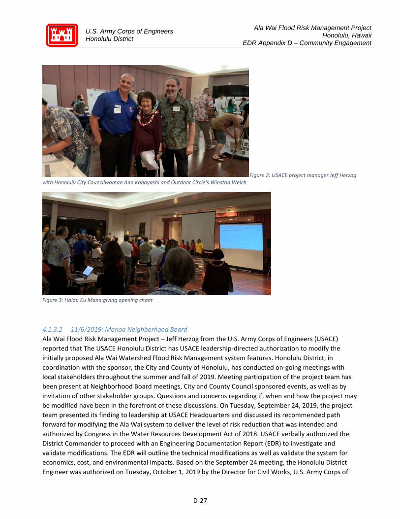
U.S. Army Corps of Engineers Honolulu District
Ala Wai Flood Risk Management Project Honolulu, Hawaii
EDR Appendix D – Community Engagement
D‐27
Figure 2: USACE project manager Jeff Herzog with Honolulu City Councilwoman Ann Kobayashi and Outdoor Circle's Winston Welch
Figure 3: Halau Ku Mana giving opening chant
4.1.3.2 11/6/2019: Manoa Neighborhood Board
Ala Wai Flood Risk Management Project – Jeff Herzog from the U.S. Army Corps of Engineers (USACE) reported that The USACE Honolulu District has USACE leadership‐directed authorization to modify the initially proposed Ala Wai Watershed Flood Risk Management system features. Honolulu District, in coordination with the sponsor, the City and County of Honolulu, has conducted on‐going meetings with local stakeholders throughout the summer and fall of 2019. Meeting participation of the project team has been present at Neighborhood Board meetings, City and County Council sponsored events, as well as by invitation of other stakeholder groups. Questions and concerns regarding if, when and how the project may be modified have been in the forefront of these discussions. On Tuesday, September 24, 2019, the project team presented its finding to leadership at USACE Headquarters and discussed its recommended path forward for modifying the Ala Wai system to deliver the level of risk reduction that was intended and authorized by Congress in the Water Resources Development Act of 2018. USACE verbally authorized the District Commander to proceed with an Engineering Documentation Report (EDR) to investigate and validate modifications. The EDR will outline the technical modifications as well as validate the system for economics, cost, and environmental impacts. Based on the September 24 meeting, the Honolulu District Engineer was authorized on Tuesday, October 1, 2019 by the Director for Civil Works, U.S. Army Corps of

U.S. Army Corps of Engineers Honolulu District
Ala Wai Flood Risk Management Project Honolulu, Hawaii
EDR Appendix D – Community Engagement
D‐28
Engineers, to negotiate an updated agreement with the City and County of Honolulu that allowed for modifications to the system. The draft agreement, transmitted to the City and County on Friday, October11, 2019 for review, is currently being negotiated. The Ala Wai project team and non‐Federal sponsor are in the process of evaluating modifications to the project, including options suggested by the community through public engagement. As we are evaluating project modifications, we will continue listening and engaging with the community.
Questions, comments, and concerns followed: 1. Project Changes: Watson raised concerns with modifications to the plan and changes to the core elements of the project. Fukumoto asked if the initial plans stated in the City Council resolution are now changed. Herzog responded that Article 1A, project description, is being currently being negotiated. 2. Funding: Kinney asked if there is funding for the project. Herzog responded that he does not have that information. Fukumoto asked about the deadline for state funding. 3. Support: A community member noted that the USACE has been professionally been dealing with flood mitigation for many years and that the community should give this project a chance. 4. Detention Basins: A community member asked if the USACE would consider moving, altering, or not building the six (6) detentions basins. Another community member raised concerns with the detention dams being in Mānoa. 5. Parks: A community member asked about the potential flooding of Mānoa Valley District Park. 6. Community Changes: A community member raised concerns with potential changes that will be made in the community. 7. Native Practices: A community member asked if changes to the land will reflect the native Hawaiian culture and practices. W. Chun responded that any modifications will require coordination and consultation. 8. Environmental Impact Statement (EIS): A community member raised concerns with the EIS.
Watson moved and Fukumoto seconded to defer the remainder of New Business on the agenda to the next meeting. The motion was ADOPTED by UNANIMOUS CONSENT, 11‐0‐0 (AYE: Armstrong, Budar, Carroll, Chun, Fukumoto, Funk, Grace, Kawano, Kinney, Lewis, and Watson; NAY: None; ABSTAIN: None).
4.1.3.3 11/7/2019: McCully/Moiliili Neighborhood Board
Ala Wai Flood Mitigation Project: Jeff Herzog, project manager of the US Army Corps of Engineers (USACE) distributed handouts and reported the following: • Project Modification Evidence: The main question asked when attending forums is to provide proof that USACE is making changes to the project. Herzog noted he is committed to update the community and address changes. He reported their Washington DC leadership sent written evidence that authorizes them to move forward and allow modifications to the Ala Wai Project. USACE received a PPA draft to update the project description to be negotiated with the City. • Still Flooding and Downstream Impacts: USACE found out what does not work and modeling on the flyer shows that the Woodlawn Bridge area would still be flooded. He noted they need to investigate historical data and downstream impacts, such as diverting water into the culvert at UHM. • Community Engagement: Herzog noted his commitment to keep the community engaged and to contact him through various means for more information.
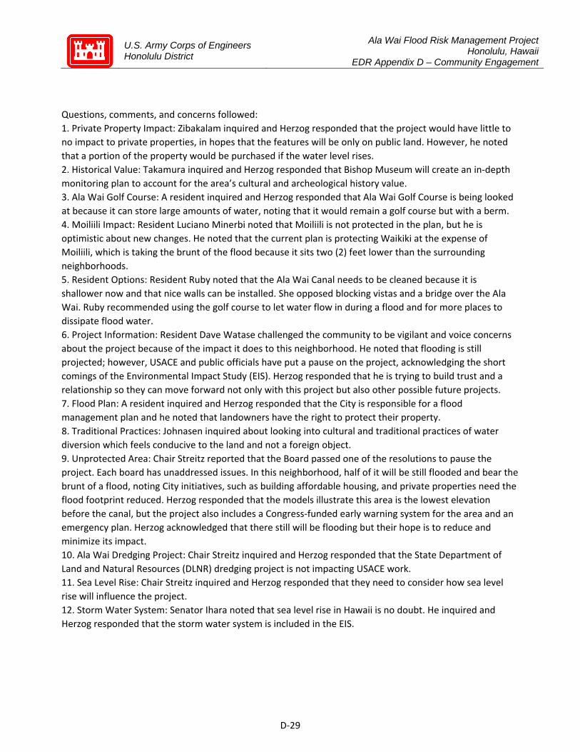
U.S. Army Corps of Engineers Honolulu District
Ala Wai Flood Risk Management Project Honolulu, Hawaii
EDR Appendix D – Community Engagement
D‐29
Questions, comments, and concerns followed: 1. Private Property Impact: Zibakalam inquired and Herzog responded that the project would have little to no impact to private properties, in hopes that the features will be only on public land. However, he noted that a portion of the property would be purchased if the water level rises. 2. Historical Value: Takamura inquired and Herzog responded that Bishop Museum will create an in‐depth monitoring plan to account for the area’s cultural and archeological history value. 3. Ala Wai Golf Course: A resident inquired and Herzog responded that Ala Wai Golf Course is being looked at because it can store large amounts of water, noting that it would remain a golf course but with a berm. 4. Moiliili Impact: Resident Luciano Minerbi noted that Moiliili is not protected in the plan, but he is optimistic about new changes. He noted that the current plan is protecting Waikiki at the expense of Moiliili, which is taking the brunt of the flood because it sits two (2) feet lower than the surrounding neighborhoods. 5. Resident Options: Resident Ruby noted that the Ala Wai Canal needs to be cleaned because it is shallower now and that nice walls can be installed. She opposed blocking vistas and a bridge over the Ala Wai. Ruby recommended using the golf course to let water flow in during a flood and for more places to dissipate flood water. 6. Project Information: Resident Dave Watase challenged the community to be vigilant and voice concerns about the project because of the impact it does to this neighborhood. He noted that flooding is still projected; however, USACE and public officials have put a pause on the project, acknowledging the short comings of the Environmental Impact Study (EIS). Herzog responded that he is trying to build trust and a relationship so they can move forward not only with this project but also other possible future projects. 7. Flood Plan: A resident inquired and Herzog responded that the City is responsible for a flood management plan and he noted that landowners have the right to protect their property. 8. Traditional Practices: Johnasen inquired about looking into cultural and traditional practices of water diversion which feels conducive to the land and not a foreign object. 9. Unprotected Area: Chair Streitz reported that the Board passed one of the resolutions to pause the project. Each board has unaddressed issues. In this neighborhood, half of it will be still flooded and bear the brunt of a flood, noting City initiatives, such as building affordable housing, and private properties need the flood footprint reduced. Herzog responded that the models illustrate this area is the lowest elevation before the canal, but the project also includes a Congress‐funded early warning system for the area and an emergency plan. Herzog acknowledged that there still will be flooding but their hope is to reduce and minimize its impact. 10. Ala Wai Dredging Project: Chair Streitz inquired and Herzog responded that the State Department of Land and Natural Resources (DLNR) dredging project is not impacting USACE work. 11. Sea Level Rise: Chair Streitz inquired and Herzog responded that they need to consider how sea level rise will influence the project. 12. Storm Water System: Senator Ihara noted that sea level rise in Hawaii is no doubt. He inquired and Herzog responded that the storm water system is included in the EIS.
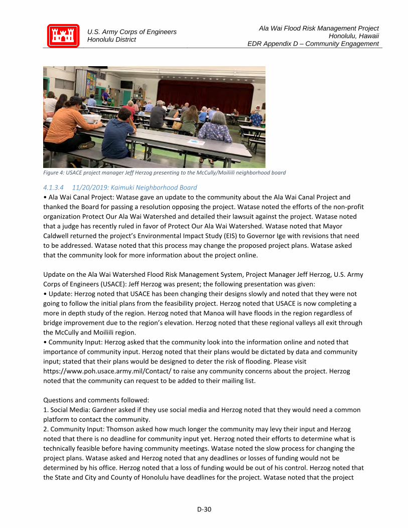
U.S. Army Corps of Engineers Honolulu District
Ala Wai Flood Risk Management Project Honolulu, Hawaii
EDR Appendix D – Community Engagement
D‐30
Figure 4: USACE project manager Jeff Herzog presenting to the McCully/Moiliili neighborhood board
4.1.3.4 11/20/2019: Kaimuki Neighborhood Board
• Ala Wai Canal Project: Watase gave an update to the community about the Ala Wai Canal Project and thanked the Board for passing a resolution opposing the project. Watase noted the efforts of the non‐profit organization Protect Our Ala Wai Watershed and detailed their lawsuit against the project. Watase noted that a judge has recently ruled in favor of Protect Our Ala Wai Watershed. Watase noted that Mayor Caldwell returned the project’s Environmental Impact Study (EIS) to Governor Ige with revisions that need to be addressed. Watase noted that this process may change the proposed project plans. Watase asked that the community look for more information about the project online. Update on the Ala Wai Watershed Flood Risk Management System, Project Manager Jeff Herzog, U.S. Army Corps of Engineers (USACE): Jeff Herzog was present; the following presentation was given: • Update: Herzog noted that USACE has been changing their designs slowly and noted that they were not going to follow the initial plans from the feasibility project. Herzog noted that USACE is now completing a more in depth study of the region. Herzog noted that Manoa will have floods in the region regardless of bridge improvement due to the region’s elevation. Herzog noted that these regional valleys all exit through the McCully and Moiliili region. • Community Input: Herzog asked that the community look into the information online and noted that importance of community input. Herzog noted that their plans would be dictated by data and community input; stated that their plans would be designed to deter the risk of flooding. Please visit https://www.poh.usace.army.mil/Contact/ to raise any community concerns about the project. Herzog noted that the community can request to be added to their mailing list. Questions and comments followed: 1. Social Media: Gardner asked if they use social media and Herzog noted that they would need a common platform to contact the community. 2. Community Input: Thomson asked how much longer the community may levy their input and Herzog noted that there is no deadline for community input yet. Herzog noted their efforts to determine what is technically feasible before having community meetings. Watase noted the slow process for changing the project plans. Watase asked and Herzog noted that any deadlines or losses of funding would not be determined by his office. Herzog noted that a loss of funding would be out of his control. Herzog noted that the State and City and County of Honolulu have deadlines for the project. Watase noted that the project

U.S. Army Corps of Engineers Honolulu District
Ala Wai Flood Risk Management Project Honolulu, Hawaii
EDR Appendix D – Community Engagement
D‐31
can proceed up to awarding contracts and stated that the funding comes from the 2015‐2017 funding period. Watase noted that there are 58 projects that have been approved from the funding period and asked if they all have power purchase agreement (PPA) signed. Herzog noted that he is unsure how many of these projects are in a similar circumstance as Hawai’i. Senator Ihara noted his desire to recreate trust between the community and USACE. Senator Ihara noted his opposition to USACE increasing the amount of mistrust and fear in the community. Herzog noted their encouragement from the models to protect the community while building trust. 3. Funding: A resident asked about the possible loss of funding as the project continues. Herzog noted that USACE is still updating their models for the project and stated that the funds do not have an expiration. Watase noted that the project has used reports that have a project loss of more than a million dollars and Herzog noted that these numbers were based off previous reports. Herzog stated that they will be reevaluating these numbers and noted that new models will have data for resident safety during emergencies.
4.1.3.5 1/14/2020: Waikiki Neighborhood Board
U.S. Army Ala Wai Flood Project Update: Jeff Herzog of the United States Army Corps of Engineers (USACE) reported that research from 2012 to 2017 did not have accurate outreach and community input. The USACE will commit to a monthly newsletter to keep the community informed. Herzog also reported that the upstream areas will require management along with attention paid to the native ecosystem. Mayor Caldwell suggested a Private Interaction Group (PIG) be used to get feedback from the community.
Questions, comments, and concerns followed. 1. Environment Impact Statement (EIS): Merz inquired if the USACE has a supplemental EIS. 2. Ala Wai Golf Course: A resident inquired if the Ala Wai Golf Course will be taken into consideration with the project going forward and Herzog responded that, as the project is not projected to be completed until 2024 to 2026, he will need to get back to the Board and residents. 3. Project Status: Senator Moriwaki inquired if the project is still moving forward and Herzog responded that the project will move forward until the USACE is instructed to do otherwise.
4.1.3.6 3/12/2020: Diamondhead/Kapahulu/St. Louis Neighborhood Board
Army Corps of Engineers Ala Wai Flood Mitigation Plan Update: Jeff Herzog, Army Corps of Engineers (USACE) project manager, circulated an illustrated handout describing the Ala Wai Flood Mitigation Project (AWFMP) and reported the following: • Background: Herzog outlined previous studies which resulted in the USACE being directed by Congress in 2012 to focus on flood mitigation efforts for the Ala Wai Canal, as they could not justify an ecosystem restoration project.
He added that USACE is working with other groups to address ecosystem restoration concerns in partnership with the AWFMP. • Update: USACE has begun modifying the AWFMP's system features and modeling, and is taking community input, engineering data, and modeling into consideration as they move the project forward. The project is currently investigating different flood mitigation options that are available to determine which options are feasible. The USACE is sharing these different options through small stakeholder meetings to communicate and work with community groups and residents. Within the next 90 days the USACE should

U.S. Army Corps of Engineers Honolulu District
Ala Wai Flood Risk Management Project Honolulu, Hawaii
EDR Appendix D – Community Engagement
D‐32
be able to determine which options are technically feasible to reduce the flood risk enough to meet Congressional authorization, at which point the USACE will investigate the environmental impact of the different options over the next nine (9) months to determine the level of supplemental documentation needed for the project’s National Environmental Protection Act (NEPA) review document, whether this will be an Environmental Impact Statement (EIS), Environmental Assessment (EA) or Finding of No Significant Impact (FONSI) over the next nine (9) months. • Maps: Maps were provided in the handout which outlined flooding projections without the project at varying annual exceedance probability rain events. • Contact Information: For more information contact [email protected] or visit https://www.poh.usace.army.mil/missions/civil‐works/civil‐works‐projects/ala‐wai‐flood‐risk‐management‐project/.
Questions, comments, and concerns followed: 1. Ala Wai Golf Course: Resident Franklin Chung questioned man‐made climate change and the original premise of the necessity of the project, but welcomed the project keeping its focus on the 150‐acre Ala Wai Golf Course, and commented that it is not needed upstream or by the canal. He advocated for using the federal funds to upgrade the golf course so it can serve as both a golf course and flood plain, and also using City revenue generated from TopGolf for the annual maintenance of the golf course and cleaning up the flood plain so the recreational golf course will stay green for many decades to come. He added that along with not subscribing to climate change, he believes there is no reason to change the golf course to a park with 1,000 more trees, or to a marshland or kalo farms. Herzog responded with the following comments: • The USACE has determined that the flood mitigation project is necessary based on scientific data used in determining what is actually occurring and what will be necessary for the community’s adaptability and resiliency during large weather events by reducing flood risk. • USACE fully concurs with maximizing the use of the golf course because the golf course is at the lowest elevation and would have 250 acre‐feet of floodwater storage, but this will not completely solve the problem because it is the end point of the runoff from the Ko‘olau mountains to the ocean. • The city’s storm drainage system also runs through the golf course from both the Kaimuki High School side and the Kapahulu Avenue side, and because of the cumulative effects in accordance with Section 106E, the floodwater storage berm will need to be cut toward the Kapahulu side. Herzog clarified that this project is not associated with TopGolf, and the overland floodwater flow will remain status quo and will continue to flood through this area of the golf course and around the clubhouse. He added that he will be addressing these points with resident Chung. 2. Communication: Resident Armentrout voiced approval of the USACE improving communication with the community and expressed gratitude for the updates on working toward the solutions. 3. Coordination: Resident Dave Watase voiced approval of the updated plans and the new approach the USACE is taking to coordinate and build trust with residents and take the right approach on the project. 4. Funding: Resident Watase expressed concern regarding hearing from others that funding for the project will be lost if the Project Partnership Agreement (PPA) is not signed by March or April, and that the USACE has already hired a consultant to work on the Supplemental EIS. Herzog responded that the project is Congressionally authorized and that he is not involved in funding, however he will continue working on the project in a responsible manner to complete it properly for as long as he is assigned to the project. 5. Hokulani Elementary School: A resident voiced concerns regarding impacts caused by the AWFMP and advocated keeping the AWFMP away from Hokulani School and the surrounding homes. The resident added that the City and the State should be cleaning the streams to prevent flooding. Herzog responded that in December 2019 an island‐wide stream cleaning permit was jointly approved to allow the City to clean the streams. Herzog noted that jurisdictional and coordination issues between the State, City and
U.S. Army Corps of Engineers Honolulu District
Ala Wai Flood Risk Management Project Honolulu, Hawaii
EDR Appendix D – Community Engagement
D‐33
private property owners make stream cleaning difficult. 6. Models: Beutel inquired about the difference between 1D and 2D models. Herzog clarified that 1D models are more cost effective and faster, and use data to predict where water will flow and determine the mitigation cost, while 2D models are more costly and take more time, however they are more accurate and use more data to calculate the effects of a full storm and the design the mitigation plan.
7. Map Accuracy: Beutel questioned the accuracy of the maps that were presented, and Herzog clarified that the maps were only probability projections of where maximum flooding could occur. 8. Flood Gates: Beutel inquired if flood gates and pumps at the end of the Ala Wai Canal are still being considered. Herzog responded that the USACE has determined that pumps would be necessary, although the final details are being worked out. Herzog added that additional features in the Manoa Marketplace area will be necessary. 9. New Modeling: Sayama inquired when the public can expect to see 2D modeling that shows the effects of the AWFMP with project conditions. Herzog responded that this should be available in the next 90 days with the engineering documentation report. 10. Data Updates: Sayama inquired how frequently the USACE updates their data, and Herzog responded that USACE has to update modeling, cost and economics data every three (3) years and is currently updating these during 2020. Sayama inquired and Herzog responded that the modeling updates do not always require updating the investigation and modification process. 11. Detention Basins: Resident Minerbi noted the modifications under investigation that include elimination of the Makiki and Palolo Valley detention basins, and inquired why the Kanewai detention basin remains on the project list. Herzog responded that the USACE is looking at eliminating the Makiki and Palolo basins because the Makiki Stream goes underground and any added features would result in flooding, thus the focus is being shifted into the lower Makiki neighborhood; and Palolo has numerous bridge constrictions which will limit water flow. He confirmed that the Kanewai basin is still included because it sits near a flood‐prone and risky area, and Kanewai will remain as a large 30 acre‐feet green open space with a recessed spillway to return the water to the stream. 12. Inspections: Resident Minerbi expressed doubt that the City could maintain such a project, and Herzog responded that the USACE routinely does their own inspections of their projects to ensure protections from injury or property loss. 13. Emergency Supplemental Projects: A resident inquired and Herzog responded that Hurricane Katrina in New Orleans is being used as a learning experience by Congress to fund and prepare future Emergency Supplemental projects such as the AWFMP to be fully funded and constructed, instead of allocating piecemeal remedies over decades. 14. Condemning Homes: L. Wong inquired if the project is still contemplating the controversial condemnation of homes in Manoa and Palolo. Herzog responded that originally 32 properties were impacted by the AWFMP and four (4) in Palolo required full purchase. He noted that this would be the responsibility of the non‐federal sponsor, either the City or the State, and the plan was to purchase property at appraised value and no purchases would be made until the design phase. Herzog added that since the Palolo stream features were removed from the project they are not looking at acquiring any property, however flowage easements and access easements may be necessary to purchase, as portions of the Palolo Stream are owned by various property owners. 15. Ala Wai Wall: L. Wong inquired if a four (4) foot concrete wall is still planned to be built around the Ala Wai Canal, because this must be reviewed by the State Historic Preservation Division and it is not in the budget. Herzog responded that a flood barrier along the Ala Wai Canal may be necessary, however there are different options such as an earthen berm on the mauka side. Herzog clarified that if a wall is built it will be required to blend in with the green landscape, such as a lava rock wall, blue rock wall or moss wall, etc.,
U.S. Army Corps of Engineers Honolulu District
Ala Wai Flood Risk Management Project Honolulu, Hawaii
EDR Appendix D – Community Engagement
D‐34
so it will be more than just a concrete slab. He added that no walls would be needed behind a pump station that evacuates the flood water, such as at one of the stream confluences. 16. TopGolf: L. Wong commented on the Topgolf development proposed to be in the Ala Wai flood plain, and being informed by Topgolf that they will determine how to integrate with the flood plain during development of their own EIS. Herzog responded that USACE has communicated with Topgolf that there will be cumulative impacts under Section 106E, which TopGolf will have to plan around. He explained that the area must be left open for the future without project conditions, i.e., to leave an open area at the golf course; and the AWFMP berm will not protect Topgolf by blocking floodwaters and thus induce flooding into the surrounding community. 17. Floodwater Detention and Storage: Matson inquired and Herzog clarified that a large section of the golf course beginning at the clubhouse will be used by the AWFMP for flood storage. Matson expressed concerns about TopGolf obstructing overland flow from the Kapahulu Avenue area to the floodwater detention and storage areas, and inquired how the USACE would circumnavigate floodwater around TopGolf. Herzog responded that the overland flow cannot be detained, so TopGolf will be responsible for elevating or otherwise protecting their structures. 18. Other Impacts: Matson noted concerns previously presented about Topgolf pilings puncturing the underground karst water cave system and aquifer, and the diversion of runoff from the impervious field surface and intrusion of synthetic turf chemical cleaners into the Ala Wai Canal, and she inquired about locating the floodwater detention areas closer to Kapahulu Avenue, instead of farther into the golf course to avoid such misplaced projects. Herzog responded that the City's storm drainage system pushes water ‘ewa from the Kaimuki High School area, and makai through the golf course from the Kapahulu area. He noted if all the water is brought into the golf course for detention, then any capacity for flood storage from the Manoa‐Palolo Canal will be lost, and it will fill up too quickly to be efficient. Matson noted that this was the point of the question and that the existing conditions provide the strongest basis for water percolation and retention, instead of creating 7.3 acres of impervious surfaces proposed by the Topgolf project which appears to be a major impediment. 19. Sea Level Rise: Matson inquired about sea level rise coming from the makai side and justifying what the AWFMP is trying to accomplish without a wall around Waikiki. Herzog responded that a wall around Waikiki would be under the jurisdiction of another authority, and the sea level rise analysis is detailed in the USACE engineering appendix A‐3. He added that other variables are also taken into consideration leading to the backwater elevation that is also accounted for, such as the City’s determination of 3.2 feet and the USACE’s determination of 2.9 feet. He noted that this is the intermediate level variance within global as well as UH analyses of sea‐level rise and backwater elevation.

U.S. Army Corps of Engineers Honolulu District
Ala Wai Flood Risk Management Project Honolulu, Hawaii
EDR Appendix D – Community Engagement
D‐35
Figure 5: USACE project manager Jeff Herzog presenting at the Diamond Head/ St. Louis Heights/ Kapahulu neighborhood board meeting
Lessons Learned in EDR Modifications Phase Both the City partner and leaders of opposition groups praised the progress in communication during this phase. Key actions taken during this phase include:
Opening lines of communication directly with key stakeholders, including opposition groups. Project updates emailed to those who request to be on an email distribution list. Posting updated materials to the USACE project website. Holding focus group meetings with identified stakeholders PRIOR to technical team coming up with
technical solutions.
Areas where the team could improve on opening communications include: Further dissemination of messages through social media (Facebook, twitter, etc.) Video link to meetings for those who would like to attend meetings virtually. Video recording of meetings for those who were unable to make the meeting.

U.S. Army Corps of Engineers Honolulu District
Ala Wai Flood Risk Management Project Honolulu, Hawaii
EDR Appendix D – Community Engagement
D‐36
5 Key Messages These key messages were developed by the Communications CPCX, following their visit to Honolulu in November 2019 to advise on and develop a Communications Plan for the project.
Risk Reduction and Resiliency The Ala Wai Canal Flood Risk Management Project will help reduce the risk of flooding from large
storms in the Ala Wai Watershed. Flooding cannot be eliminated but the Project will help reduce imminent risks to life, safety, and
property for these communities. Building flood resilience requires partnerships across all levels of government and community.
o Corps is working with local and state partners and engaging in meaningful public participation to support increased regional resilience, including risk awareness, preparedness and response. For example, the Corps and its project partners are integrating climate change
considerations (including sea‐level change) into project design.
Building Solutions for Ala Wai The Corps is evaluating actions to reduce risk from flooding based on several criteria, primarily:
o technical and environmental feasibility (for example, can a flood reduction option be built or engineered in balance with the ecosystem?)
o economic feasibility (for example, is this option a cost‐effective way of reaching the project goals)
Critical to this effort is the consideration of the potential effects of these actions on how people live, work, travel, and recreate in the Ala Wai watershed.
o Mutual respect for the historic, cultural, and economic significance of the watershed and its uses is integral to this effort.
The Corps and its project partners are committed to proactively informing and engaging with the Ala Wai community and other stakeholders to reach acceptable and sustainable flood risk reduction solutions.
o Outreach actions will: build public understanding of the potential engineering and design options, help ensure that accurate information is easily accessed and understood, and encourage public input toward final project designs that are both sensitive to these
communities and effectively meet project goals. Currently the Corps is meeting with the community to understand concerns and learn about local
interests, plans, and projects that may warrant consideration in project development. Meaningful and continued collaboration can deliver a project that protects the community and
infrastructure while serving as a model for how future projects on Oahu can be delivered.