poh-2018-00104 (ala wai canal dredging and improvements
TRANSCRIPT

1
POH-2018-00104 (Ala Wai Canal Dredging and Improvements, Waikīkī, O‘ahu, HI)
Public Notice Fact Sheet What’s going on?
The U.S. Army Corps of Engineers Regulatory Branch (Corps) is reviewing an application from the State of Hawai‘i Department of Land and Natural Resources (DLNR). DLNR is proposing to improve the Ala Wai Canal with the following: [1] maintenance dredge the Ala Wai Canal (from the Ala Moana Boulevard Bridge to the Kapahulu Library) and portions of the Mānoa-Pālolo Drainage Canal (MPDC) (from Date Street to the Ala Wai Canal); [2] repair two sections of the Ala Wai Canal walls; and [3] remove up to four existing Hawaiian Electric Company (HECO) cables and twelve concrete slabs protecting the cables in the Ala Wai Canal. The Corps is conducting a public notice (i.e. asking for comments from the public) about DLNR’s proposed project as part of the Department of Army permitting review. This fact sheet was created to clarify information presented in the public notice.
Have a comment or question specifically about this project, but don’t see it addressed on the fact sheet below? Please send an email to [email protected] before November 21, 2018 and include this number in the email title: POH-2018-00104.
1. Why dredge Ala Wai Canal? The Ala Wai Canal serves as an essential drainageway and sediment basin for the Ala Wai watershed. Over time, the build-up of sediments into the Ala Wai Canal has affected the canal’s sediment- and water-holding capacity, reducing the canal’s ability to temporarily contain and then release storm water when there are heavy storm events. Reductions in the Ala Wai Canal’s capacity increases risks associated with flooding and leads to more sediment discharged into the ocean.
Removing accumulated sediment from the Ala Wai Canal and MPDC would increase
water depths in the proposed dredge areas, which would improve the Ala Wai Canal’s capacity to hold sediment and water, reducing the risk of flooding and related problems in surrounding areas during big storms. The DLNR also anticipates that conditions would improve for recreational use of the Ala Wai Canal and its surrounding environment.
2. Minor, temporary impacts to paddler access in Ala Wai Canal. Generally, dredging
activities would allow watercraft passage on one side of the dredging barge and would not block popular access points or canoe launch sites. However, there would be temporary periods during maneuvering of dredging equipment when access must be restricted to maintain public safety. Construction activities would be temporarily modified and/or stopped during special events that use the canal, e.g., regattas or other water-related activities. These periods of temporary work stoppage would be determined by DLNR through on-going coordination that was started in 2016 with area canoe/kayak clubs, users, and organizations. Prior to construction DLNR would develop a communication plan with contact information (phone number, e-mail, or other means) where the public can obtain information on project progress and/or provide input and would reach out to paddling groups. DLNR expects that, in the long term, the dredging would improve navigation of the Ala Wai Canal.
3. Minor, temporary impacts to walking/bike paths and surrounding parks.

2
Generally, during construction, access to sidewalks/pathways and parks would be maintained. However, some areas may require temporary closure to protect the public during construction. These areas would be provided with an alternative access. Small portions of parks are also under consideration for staging and materials storage. To ensure public safety, access to these areas would be temporarily modified but would not prevent public use of the parks or access to the shoreline. The existing bike path on the mauka side of the canal and along the Ala Wai Neighborhood/Community Park may need to be temporarily used for construction access. If possible, the bike path would be rerouted so it can continue to be safely used. Any work that results in damage to these facilities would be restored to pre-construction conditions by the contactor when the project is completed. Prior to construction DLNR would develop a communication plan with contact information (phone number, e-mail, or other means) where the public can obtain information on project progress and/or provide input.
4. Minor impacts to traffic/parking. Construction-related work may require the temporary
closure of roads and the use of limited parking along Ala Wai Boulevard and within the surrounding parks. As required, traffic controls such as safety cones, signage, and/or flag personnel would be implemented to alert motorists and the public to the presence of construction workers and personnel, and to exercise caution. The use of parking stalls along Ala Wai Boulevard would be limited to only select locations that front the stairwells leading into the canal. This use of parking is for the contractor to deliver materials and equipment to the job site and would be temporary lasting only for the time needed to complete the work. The major project activity involving dredging is not expected to affect parking.
5. Approximately one year of noise impacts. The overall duration of the project is expected
to be approximately one year. Noise levels would temporarily increase due to use of equipment needed for dredging and construction. During construction, noise would conform to regulatory requirements and any work at night or weekends and holidays would be subject to strict requirements for a noise variance. The period of construction to be requested for coverage in a Community Noise Variance application1 (request for permission to do work activities that make noise outside of normal workday hours), would include the following:
• Mondays through Fridays: 6:00 p.m. to 10:00 p.m. • Saturdays: 6:00 p.m. to 10:00 p.m. • Sundays and Holidays: 9:00 a.m. to 10:00 p.m.
6. Minor temporary impacts to views only during construction. The presence of
construction equipment in and along the Ala Wai Canal and MPDC would be visible during construction. However, construction sites would be maintained in a clean and organized manner, equipment would be confined to work areas, dredging operations would take place primarily at the water surface, and work on the canal walls and stairs would be at or near grade. The design of the repairs to the walls and potentially the stairs will be consulted with the State Historic Preservation Division and are proposed to be consistent with existing style of the Ala Wai Canal and surrounding area.
7. Minimal impact to air quality. The proposed project may temporarily affect ambient air
quality within the vicinity of the project site through increased fugitive dust and odors arising 1 pursuant to HAR § 11‐46‐7(j)(1-3)

3
from the canal during dredging and from exhaust emissions from construction vehicles and equipment. The contractor would implement an effective dust control plan and only use equipment that is in proper operating condition to ensure compliance with State regulations.
8. No effect on surfing. As part of the proposed dredging, a barge would be moored to the
east of the Magic Island parking lot at Ala Moana Beach Park. The barge mooring area is approximately 0.46 miles away from the nearest surf spot, Ala Moana Bowls. See the figure at the end of the public notice for the location of surf spots relative to construction staging and barge mooring areas.
9. Temporary short-term impacts to water quality. During dredging and/or cable and
concrete slab removal, water in portions of the Ala Wai Canal and MPDC may temporarily appear cloudy or brown due to sediment on the bottom getting stirred up. These areas would be isolated from the rest of the waterway using a silt curtain wall and containment boom (like a temporary wall in the water around the work area). DLNR would monitor water quality in the waterways during dredging and cable/slab removal to ensure the isolation of the work areas is effective. The DLNR anticipates that the proposed dredging project, which would remove sediment and organic matter, some of which contains pollutants, would improve water quality in the Ala Wai Canal, MPDC, and nearshore waters in the long-term.
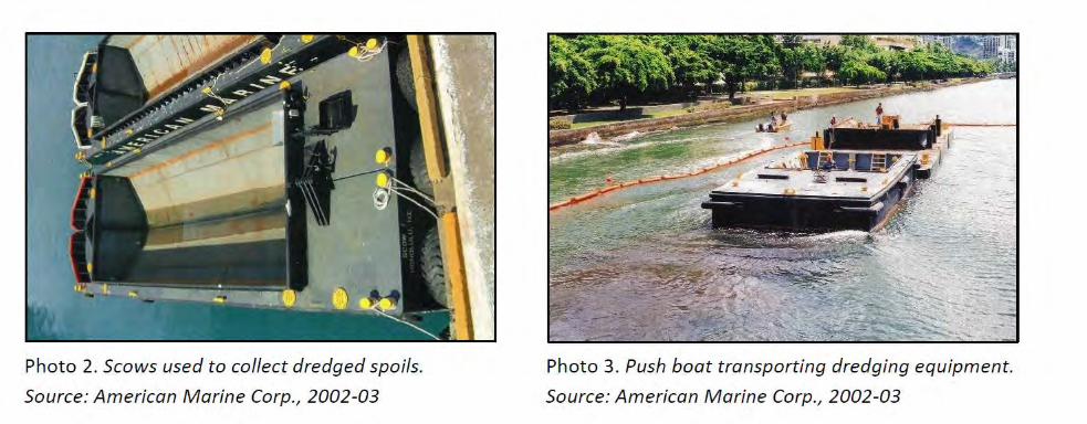
10. Where would the dredged material go? Sediment removed from the canals must be
tested for pollutants prior to dredging to properly categorize the material and determine its suitability for either ocean disposal and/or upland placement/disposal. Specially constructed barges (called scows) would be used to collect dredged sediment. Sediment suitable for ocean disposal would be placed at the U.S. Environmental Protection Agency’s (EPA) designated South O‘ahu Ocean Dredged Material Disposal Site (ODMDS) located in the ocean 4 nautical miles south of the Honolulu International Airport (HNL). Placement at this site requires approval by the Corps and the EPA. For any materials determined unsuitable by the EPA for ocean disposal, upland disposal/placement would be considered for disposal at the PVT Landfill in Nānākuli, the Reef Runway at HNL, or other approved State land disposal site.
11. Status of planning. An Environmental Impact Statement (EIS) was prepared to evaluate
possible alternatives, assess potential environmental impacts and define appropriate mitigation measures for the project. The Final EIS was accepted by the Chairperson of the DLNR on November 13, 2017. DLNR is working with regulatory agencies to obtain permits for the project, including a Department of Army permit, Section 401 Water Quality Certification, and Coastal Zone Management Federal Consistency Determination (all currently under review). Later permit approvals would include a National Pollutant Discharge Elimination System permit for construction stormwater and a Community Noise Variance.
Want to learn more about DLNR’s FEIS? Read the Final EIS online at the Office of
Environmental Quality’s online EA/EIS Library at the following link: http://oeqc2.doh.hawaii.gov/EA_EIS_Library/2017-11-23-OA-FEIS-Ala-Wai-Canal-Dredging-
and-Improvements.pdf.

Notes:
¯
¯
Potential Staging and Mooring Locations
Legend
Project Location
Staging Area Location Option (not to scale)
Barge Mooring Location Option (not to scale)
R. M. Towill Corporation
0 800 1,600400Feet
Ala Wai Canal Dredging and Improvements
Honolulu, Island of O‘ahu, Hawai‘i
O'ahu
Project Location
Pacific Ocean
Ala Wai CanalManoa-Palolo Draina ge Canal
Ala WaiElementary School
Kapahulu Library
McC
ully Street
Ala WaiCommunity
Park
Ala WaiNeighborhood
Park
Surf Spot

PUBLIC NOTICE US Army Corps of Engineers, Honolulu District
Regulatory Branch (CEPOH-RO) Public Notice Date: October 23, 2018 Building 230 Expiration Date: November 21, 2018 Fort Shafter, Hawaii 96858-5440 Permit File Number: POH-2018-00104
FEDERAL PUBLIC NOTICE
Interested parties are hereby notified that an application has been received for a Department of the Army permit for certain work in waters of the United States as described below and shown on the attached drawings. APPLICANT: Ms. Suzanne Case Department of Land and Natural Resources 1151 Punchbowl Street, Room 221 Honolulu, Hawaii 96813 WATERWAY AND LOCATION OF THE PROPOSED WORK: The proposed project is located in the Ala Wai Canal between the Kapahulu Library and the Ala Moana Boulevard Bridge at 21.283122°, -157.826563°,TMKs (1) 2-3-036:000 and (1) 2-3-034:000 and in the Manoa-Palolo Drainage Canal between Date Street and the Ala Wai Canal, Honolulu, Island of Oahu, Hawaii. PROPOSED PROJECT PURPOSE: Basic Project Purpose: to maintain the Ala Wai Canal Overall Project Purpose: to maintain the Ala Wai Canal, an important sedimentation basin, drainage way, and aquatic recreation site in Honolulu, and to remove physical obstacles to future maintenance dredging in the Ala Wai Canal PROPOSED PROJECT DESCRIPTION:
The proposed project is the maintenance of the Ala Wai Canal and the Manoa-Palolo Drainage Canal (MPDC) including maintenance dredging, the replacement of a 750-foot section of the Ala Wai Canal wall, and the removal of Hawaiian Electric Company’s (HECO’s) cables and concrete panels.
The DLNR proposes to dredge an approximately 9,500 foot-long area in the Ala
Wai Canal between the Kapahulu Library and the Ala Moana Boulevard Bridge by mechanical method using an excavator with a clamshell-bucket mounted to a moored barge. The excavator would place the dredged material onto a screen on an adjacent hopper scow. Large rocks and debris screened out of the dredged material would be permanently disposed of at the PVT Landfill in Nanakuli. The finer grain material that

passes through the screen would be collected by the hopper scow and pumped through a submerged high-density polyethylene pipe to a bottom dump scow staged in the turning basin of the Ala Wai Boat Harbor. If the EPA approves the dredged material for ocean disposal, the bottom dump scow would travel approximately four nautical miles south of the project area two to three times per day to dispose of the dredged material at the USEPA’s South Oahu Ocean dredged material disposal site (ODMDS). If the dredged material is not approved by the USEPA, the material would first be dewatered in uplands and then permanently disposed of at the PVT Landfill in Nanakuli, the Reef Runway at HNL, or at other approved State land disposal sites.
The proposed dredging in the Ala Wai Canal to a depth of -7 feet to -11 feet below
the Mean Lower Low Water (MLLW) line with an approximately two-foot allowable overdredge is anticipated to result in approximately 234,800 cubic yards of dredged material. Dredging in the Ala Wai Canal would be conducted in four sections, each isolated with turbidity curtains until the disturbed material has settled following completion of dredging in that section. Mechanical dredging by the same method would be conducted in an approximately 2,000 foot-long area in the MPDC between Date Street and the confluence of the MPDC with the Ala Wai Canal. The MPDC would be dredged to a depth of -2 feet to -9 feet below MLLW with an approximately two-foot allowable overdredge and is anticipated to result in approximately 32,000 cubic yards of dredged material.
The DLNR also proposes to replace a 750-foot long section of wall in the Ala Wai
Canal adjacent to Ala Wai Community Park. Repairs to the 750-foot long section of wall would involve the permanent removal of approximately 115 cubic yards of existing concrete rubble mound wall, the permanent installment of a new concrete wall, including 170 cubic yards of concrete with steel reinforcing, 140 cubic yards of concrete and steel reinforcing for footings, and the temporary excavation and disturbance of approximately 2,295 cubic yards of soil for access and site preparation for the wall replacement. The wall repair area would be isolated by a 50-foot wide by 750-foot long coffer dam.
The removal of four sections of existing HECO cables and twelve 8-foot wide by 20-
foot long concrete slabs in the Ala Wai Canal would be conducted by open trench method utilizing hydraulic jetting, assisted by divers with hand tools, and removal of the cables and slabs by barge-mounted excavator with a bucket. The removed sections of cables would be temporarily placed on the working barge, cut over a containment area in one of the three upland staging areas, and capped using a heat shrinkable polymer seal. The remaining ends on either side of the removed section of cable would be capped with lead and then with an outer layer of heat shrinkable polymer and secured to the canal bottom with eight one-cubic yard pre-cast concrete blocks. The removed slabs and cables would be recycled or disposed of in a construction and demolition debris landfill, such as PVT Landfill.
Equipment would be staged in uplands on Staging Area A, located adjacent to the
McCully Street Bridge at TMK (1) 2-3-034: 033, and Staging Areas B and C, located within the Ala Wai Neighborhood / Community Park at TMK (1) 2-7-036: 001. Terrestrial

staging areas would be returned to original condition or better following completion of the proposed work, including stabilization with grass. A 150-foot wide by 350-foot long barge also used for staging would be moored for the approximately one-year duration of the project in the corner of the Ala Wai Boat Harbor turning basin on the east side of Magic Island in Ala Moana Beach Park. One bottom dump scow used to transport dredged material to the ODMDS would be moored in the turning basin of the Ala Wai Boat Harbor at all times. Additional Best Management Practices (BMPs) would include the use of a curtain wall and containment booms around the wall repair and cable and slab removal locations, with an additional turbidity curtain at the Ala Wai bridge. All BMPs would be left in place until the sediment suspended by each activity has settled out.
Avoidance and Minimization: The applicant has informed the Corps that it is not possible to avoid or minimize the impacts associated with the proposed work as avoidance and minimization would not allow the project purpose to be met. The applicant considered delaying the project but, other than the construction timeframe, the delayed project would otherwise be the same as the proposed project. The applicant would include BMPs to minimize project impacts, particularly use of a curtain wall and containment booms around each of the wall repair, dredging, and cable and slab removal locations, to be left in place until the sediment suspended by each activity has settled out. The applicant would require the use of scow sensor instrumentation during the transport of the dredged material to the ODMDS to ensure that the bottom dump scow is not leaking in transit. Mitigation: The applicant has not proposed mitigation for the project. AUTHORITY: A Department of the Army permit is required pursuant to:
Section 10 of the Rivers and Harbors Act of 1899 (33 U.S.C. 403) - To perform work in or affecting navigable waters of the United States.
Section 404 of the Clean Water Act (33 U.S.C. 1344) - Discharge dredged or fill material into waters of the United States. The Corps’ public interest review will consider the guidelines set forth under Section 404(b) of the Clean Water Act (40 CFR 230).
Section 103 of the Marine Protection, Research and Sanctuaries Act of 1972 (33 U.S.C. 1413) - Transport dredged material for the purpose of dumping it into ocean waters. The Corps’ public interest review will consider the criteria established under authority of Section 102(a) of the Marine Protection, Research and Sanctuaries Act of 1972, as amended (40 CFR Parts 220 to 229), as appropriate.
WATER QUALITY CERTIFICATION: The proposed action will result in a discharge of dredged or fill material into a water of the U.S. and will require authorization from the Corps in accordance to Section 404 of the Clean Water Act of 1972 (CWA). Under Section 401 of the CWA (Public Law 95-217), the Corps may not issue a permit for the described work until the applicant obtains a certification, or waiver of certification, from

the State of Hawaii, Department of Health – Clean Water Branch (DOH-CWB). The DOH-CWB issued a final Water Quality Certification, WQC0971, on October 19, 2018. COASTAL ZONE MANAGEMENT ACT CERTIFICATION: The proposed activity may affect land or water uses in the Coastal Zone. Under Section 307(c)(3) of the Coastal Zone Management Act of 1972, as amended by 16 U.S.C. 1456(c)(3), the Corps may not issue a permit for the described work until the applicant obtains a Federal Consistency Concurrence from the State of Hawaii, Department of Business, Economic Development, and Tourism – Office of Planning. HISTORIC PROPERTIES: Pursuant to Section 106 of the National Historic Preservation Act (NHPA), our assessment of the project leads us to a preliminary determination that the Ala Wai Canal (listed on the Hawai’i Register of Historic Places, State Inventory of Historic Properties (SIHP) # 50-80-14-9757) is within the permit area. Therefore, consultation with the State of Hawaii, Department of Land & Natural Resources, Historic Preservation Division (SHPD), Office of Hawaiian Affairs, and the applicable Native Hawaiian Organizations will be conducted independent of this public notice. Note: the MPDC, Kalākaua Avenue Bridge, McCully Street Bridge, and Date Street Bridge are eligible for listing on the National/State Register of Historic Places, however, no structural repairs are proposed to these resources and therefore no impacts are anticipated. A Cultural Impact Assessment of the project area was undertaken by Scientific Consultant Services, Inc. Hawai‘i and LX Gollin Research Hawai‘i, LLC., in consultation with the SHPD and included in the Final Environmental Impact Statement (FEIS) for the project. ENDANGERED SPECIES: Pursuant to Section 7 of the Endangered Species Act (ESA), federal agencies must consult with the National Marine Fisheries Service (NMFS) and/or U.S. Fish and Wildlife Service (USFWS) on any action that may affect a species listed (or proposed for listing) under the ESA as threatened or endangered or any designated critical habitat. Based on the project location, the following protected species and critical habitat have the potential to occur near the project location: Hawaiian Hoary Bat (Lasiurus cinereus semotus), Endangered Hawaiian Stilt (Himantopus mexicanus knudseni), Endangered Hawaiian Coot (Fulica americana alai), Endangered Hawaiian Duck (Anas wyvilliana), Endangered Hawaiian common gallinule/Moorhen (Gallinula galeata sandvicensis), Endangered Green Sea Turtle (Chelonia mydas), Threatened Hawksbill Turtle (Eretmochelys imbricata), Endangered Hawaiian Monk Seal, (Monachus schauinslandi), Endangered Main Hawaiian Islands Insular False Killer Whale (Pseudorca crassidens), Endangered

Sei Whale (Balaenoptera borealis), Endangered Blue Whale (Balaenoptera musculus), Endangered Sperm Whale (Physeter macrocephalus), Endangered Oceanic Whitetip shark (Carcharhinus longimanus), threatened Giant manta ray (Manta birostris), threatened
Preliminary determinations indicate that the described activity may affect an endangered or threatened species or its critical habitat. Consultation under Section 7 of the Endangered Species Act of 1973 (87 Stat. 844) will be initiated. A permit decision for the proposed activity will not be issued until the consultation process is completed. ESSENTIAL FISH HABITAT: The proposed work is being evaluated for possible effects to Essential Fish Habitat (EFH) pursuant to The Magnuson-Stevens Fishery Conservation and Management Act (MSA), as amended by the Sustainable Fisheries Act of 1996 (Public Law 104-267), which requires all Federal agencies to consult with the National Marine Fisheries Service on all actions, or proposed actions, permitted, funded, or undertaken by the agency, that may adversely affect Essential Fish Habitat. The Honolulu District includes areas of EFH as Fishery Management Plans. We have reviewed the January 20, 1999, Western Pacific Fishery Management Council’s Environmental Assessment to locate EFH area as identified by NMFS. Preliminary determinations indicate that the described activity will have an adverse effect on EFH. Consultation under MSA is required for the described activity. A permit decision for the proposed activity will not be issued until the consultation process is completed. FEDERAL EVALUATION OF APPLICATION: The decision whether to issue a permit will be based on an evaluation of the probable impact including cumulative impacts of the proposed activity on the public interest. That decision will reflect the national concern for both protection and utilization of important resources. The benefit which reasonably may be expected to accrue from the proposal must be balanced against its reasonably foreseeable detriments. All factors which may be relevant to the proposal will be considered including the cumulative effects thereof; among those are conservation, economics, aesthetics, general environmental concerns, wetlands, historic properties, fish and wildlife values, flood hazards, floodplain values, land use, navigation, shoreline erosion and accretion, recreation, water supply and conservation, water quality, energy needs, safety, food and fiber production, mineral needs, considerations of property ownership and, in general, the needs and welfare of the people. The Corps of Engineers is soliciting comments from the public; Federal, state, and local agencies and officials; and other interested parties in order to evaluate the direct, indirect, and cumulative impacts of this proposed activity. Any comments received will be considered by the Corps of Engineers to determine whether to issue, modify, condition or deny a permit for this proposal. To make this decision, comments are used to assess impacts on endangered species, historic properties, water quality, general environmental effects, and the other public interest factors listed above.

PUBLIC HEARING: Comments are also used to determine the need for a public hearing and to determine the overall public interest of the proposed activity. Any person may request, in writing, within the comment period specified in this notice, that a public hearing be held to consider this application. Requests for public hearings shall state clearly and concisely, the reasons and rationale for holding a public hearing. The District Commander will then decide if a hearing should be held. COMMENT AND REVIEW PERIOD: Comments on this public notice should be made in writing via conventional mail or e-mail. Comments will be accepted and made part of the record and will be considered in determining whether it would be in the public interest to authorize this proposal. Conventional mail comments should be sent to
U.S. Army Corps of Engineers, Honolulu District Regulatory Branch, Attn: Ms. Vera Koskelo Building 230 Fort Shafter, Hawaii 96858-5440.
Alternatively, comments may be emailed to [email protected]. Reference POH-2018-00104 in the subject heading of the email. In order to be accepted, e-mail comments must originate from the author’s e-mail account. All e-mail comments should be sent to [email protected] Both conventional mail and e-mail comments must include the DA permit number POH-2018-00104, and the commentor’s name, address, and phone number. All comments whether conventional mail or e-mail should be received by the close of business on November 21, 2018. PRIVACY & CONFIDENTIALITY: It should be noted that materials submitted as part of the permit application become part of the public record and are thus available to the general public under the procedures of the Freedom of Information Act (FOIA). Submissions should not include any information that the submitter seeks to preserve as confidential. If you have any questions about this project or the permit process, please contact Ms. Vera Koskelo via telephone at (808) 835-4310 or via email at [email protected].
Jamie R. Hyslop Acting Chief, Regulatory Branch


Request for Determination Ala Wai Canal Dredging and Improvements April 2018
3
Figure 1. Project Location

Request for Determination Ala Wai Canal Dredging and Improvements April 2018
4
Figure 2. General Plan

Request for Determination Ala Wai Canal Dredging and Improvements April 2018
15
Figure 8. Dredged Sediment Disposal Locations


