alewife revitalization - alewife urban design study phase
TRANSCRIPT

Alewife Revitalization City of Cambridge Massachusetts
James L Sullivan City Manager
Cambridge City Council The Honorable Thomas W Danehy Mayor
Councillor Lawrence W Frisoli Vice-Mayor Councillor Kevin P Crane
Councillor Francis H Duehay
Alewife Urban Design Study Phase II
Community Development Department Urban Design Section
Councillor Saundra Graham Councillor Mary Ellen Preusser Councillor Walter J Sullivan Councillor Alfred E Vellucci Councillor David A Wylie
Credits
City of Cambridge Community Development Department David R Vickery Assistant City Manager
The Alewife Urban Design Team Christian W Dame - Project Development Coordinator Michael Robinson - Head of Urban Design Donald Balcom - Zoning Administrator Alan Ward - Special Urban Design Consultant Margaret Michel - Graphics and Research Coordinator
Publication Design George Vogt - Art Director Joan Levy - Cartographer
Additional Participating Community Development Staff Dennis Carlone (urban design) Maxine Novek (graphics) Dick Easler (transportation) John Hixon (transportation) Dan Weisberg (transportation) Kathy Spiegelman (historical research) Bruce Hendler (landscape architecture) Juanita Paige (clerical) Mary Gilmer (clerical) David Gallo (work-study)
This study was funded in part by a grant from the Urban Mass Transportation Administration and in part by a grant from the Department of Housing and Urban Development Part of the pubshylication cost was provided by the Alewife Businessmens Associashytion through the Cambridge Chamber of Commerce Special thanks are extended to The Massachusetts Bay Transportation Authority the Massachusetts Department of Public Works the Alewife Task Force the Cambridge Chamber of Commerce Office of Economic Development the Alewife Businessmens Association North Cambridge and Cambridge Highland neighshyborhood residents and the many Alewife businessmen who have generously shared their views and hopes for the area
April 1919 5M
ale wife (ai WIfe) Pomolobus pseudoharengus a small river herring found along the Atlantic coast and landlocked in certain lakes of North America especially in New England
The fish has a deep body and is heavily built forward thus the comparison with an alewife the name given to a hearty sevenshyteenth-century English alehouse keeper
The alewife is like a herrin but it has a bigger beDie therefore called an alewife A Dictionary of Americanisms 1675
ii
Table of Contents
Overview of the Study Introduction to Alewife I
I 3
Man -Made Features 5
Land Uses 7 9
Improvements Already Planned 12 12 14 14 14 16 16
Location Natural Features
History
Employment Taxes
Alewifes Development Potential HardSoft Analysis
The Urban Design Plan Introduction Previous Alewife Studies Goals of the Plan Conclusion A Roadway and Infrastructure Improvement Program 17
18 19
Program Elements Program Costs
B Open Space Improvement Program 20 20 21
Program Goals Program Elements
iv
4
7
to
C Development Policies 24 District 1 Alewife Station 28
30 32 34
District 2 Alewife Boulevard District 3 Parkway District District 4 W R Grace
D Growth Program 36 36 39 40 42 43 43 44 47 49 49 54 54
Suggested Alewife Rezoning Conclusion A Growth Management Program
Safeguarding the Environment Implementation
The Public Sector The Private Sector
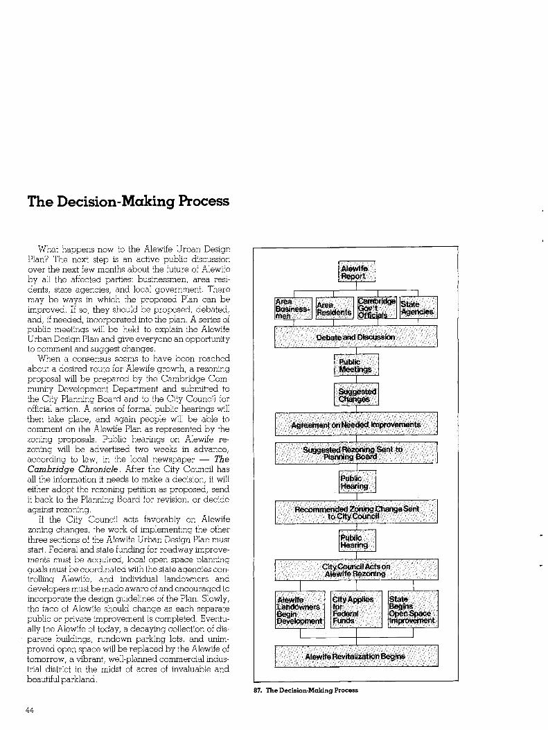
The DeciSion-Making Process Bibliography Appendix One
District Development Policies Appendix Two
Tables
iii
Overview of the Study
Why Plan for Alewife Now Alewife once an important job and tax producing
center in Cambridge is now in the midst of transition It is changing from the unplanned industrial area which evolved in the 1940s and 1950s into an office research and service oriented center To date the transition has been slow Some industrial buildings have been rehabilitated for new uses and a few new buildings have been constructed mostly small scale structures Now large-scale development is being discussed by major land owners with the potential for dramatic changes Major public improvements planned for Alewife in the near future include a new Massachusetts Bay Transit Authority transit station and associated roadways Taken together these factors promise an increased pace and scale of growth at Alewife in the next twenty years
For these reasons Cambridge citizens must now ask themselves what kind of Alewife development is desirable and how much of it is appropriate The Alewife urban design study is an effort by the City of Cambridge to address these questions and plan for the revitalization of a declining industrial area The study is intended 1) to evaluate the potential for growth and change 2) to investigate the benefits and costs to the community of new development in the area 3) to formulate a comprehensive plan to manage growth at Alewife and 4) to outline a course of future city actions to revitalize Alewife
Whats Happened So Far
Over the past two years the Cambridge Comshymunity Development Department has been working with area businessmen and neighborhood residents to determine the major community issues involved in growth at Alewife The initial result of this planning process was a rezoning of the North Cambridge neighborhood This re-zoning reduced the allowable residential density for the neighborhood protecting it from land speculation and conversion to apartments frequently associated with high growth areas
The Alewife Urban Design Plan marks the beshyginning of public discussion to determine the future of the Alewife industrial areas This discussion must inshyvolve the full range of Cambridge interests businesses residents and public officials In the next few months a series of discussion meetings about Alewife will be held to explain the proposed Urban Design Plan to hear suggestions for imshyproving the plan and finally to reach a consensus about Alewifes future
Why continue this
1 WestCambridgeFreightYards
2 Typical Industrial Area Surface Condition
3 RecentHighRiseDevelopment
4 Industrial Buildings Crowding an inadequate local street
iv
when this is possible
5 Little River Alewifesunapprecjated natural resource
6 Abt Associates An example ofcreative office site planning and design
7 Bolt Beranek and Newman Largerdevelopmentneednotbe unattractive
8 AlewifeBrookParkway Landscaping major highways can imprave the area image
Why Have An Urban Design Plan
An accepted Urban Design Plan evolved through the participation of all Cambridge interests conshycerned can help the city to structure Alewife change and strongly influence the course of private developshyment The Plan will indicate needed public improveshyments such as new streets expansion of the water and sewer systems and open space improvements to mold future development into a planned and orderly district Next a set of land use controls and zoning regulations will encourage a desirable mixture of land use at Alewife and prevent unwanted activities Urban design gUidelines developed as part of the Plan will help prevent adverse impact on the natural environment and protect nearby residential neighshyborhoods Design gUidelines also help to improve the image of the area
The result of the Urban Design Plan should be the revitalization of Alewife If the plan is develshyoped and executed properly new development should lead to many new jobs and a substantially expanded tax base without negatively affecting residential neighborhoods or over-extended city services
How Can You Be Involved You can be involved in the community planning
process for Alewife by discussing the issues raised in this publication with your friends and neighbors You should also attend public discussion meetings to be held in the next few months to state your views
Once a consensus Urban Development Plan is reached the Cambridge Community Development Department will prepare new zoning proposals for Alewife A zoning petition will be sent to the Camshybridge Planning Board and to the City Council for consideration Formal hearing notices will then appear in local newspapers You are encouraged to attend these hearings and comment on the Plan When the zoning issues are settled a final Urban Design Plan will be prepared and implemented
If you would like more information please write to Alewife Urban Design Study Cambridge Community Development
Department 57 Inman Street Cambridge Massachusetts 02139 or you can contact the Alewife Urban Design Team Chris Dame Michael Robinson or Don Balcom at 498-9034
v
Introduction To Alewife
Location Today Alewife is an underutilized industrial area
located in the northwestern corner of Cambridge where Massachusetts State Route 2 meets the Alewife Brook Parkway The area encompasses approxshyimately 370 acres everything north of Concord Aveshynue along the Parkway to the Arlington town line and west to the town of Belmont
Within a 30-minute drive of Alewife are Logan International Airport the commercial and governshymental districts of Boston and many desirable resishydential communities including the entire City of Cambridge (see Figure 10) Also found nearby are many major educational institutions including Harvard University and Massachusetts Institute of Technology providing a continuous source of techshynical expertise and skilled personnel
The Alewife area enjoys excellent transportation access from regional highways like Route 2 and the Alewife Brook Parkway It is serviced by an MBTA commuter rail line Boston and Maine Railroad freight lines and numerous MBTA bus routes conshynecting to the metropolitan subway system at Harvard Square
Surrounded on three sides by parkland the area is graced with an abundance of open space (see Figure 12) To the north lies the Metropolitan District Comshymissions Alewife Reservation 115 acres of open space dedicated as a natural area To the south is Fresh Pond Reservation a 315-acre city-owned
recreation area featuring a nine-hole municipal golf course and a 166-acre lake To the east is the Citys Russell Field athletic facility A 55-acre city park is also proposed for the old abandoned Cambridge Dump in the next five years
In summary Alewifes excellent location with regional highway access and proximity to Bostons commercial and governmental center its natural amenities and its existing markets and labor sources combine to make the Alewife area potentially one of the most highly attractive deshyvelopment sites in the entire Boston region
11 Little River at AD Little OfficeComplex
10 Thirty-MinuteDrivingTime 12 Adjacent Open Space Locations reachable from Alewife by car include mast Route 128 commushy Alewife is surrounded by open space private areas-Blair Pond municishynities as well as the Port ofBoston and Logan International Airport pal parks-Fresh Pond the proposed City park Russell Field and
Arlingtons Thorndike Field plus state areas-the MDCs Alewife Reservation andAlewife Brook Park
13 AreaContext 16 RegionalContext The Alewife Study Area includes all the shaded porion-roughly 370 Alewife is found where Route 2 enters Cambridge at the Arlington and
acres ofopen space industrial andcommercial land Belmont town lines It will soon be served by the extension of the MBTA RedLine
14 Parkingat AD little Office Complex The predominant land use in Alewife today is surface porking lots
17 Traffic Congestion onAlewife Brook Parkway Slowly moving automobiles characterize area roadways today
Alewife Reservation
Industrial Triangle
IndOstrial Quadrangle
15 Alewife Subdistricts The Alewife area can be divided into a number of distinctly different land use zones
2
Natural Features The natural environment at Alewife is both an inshy
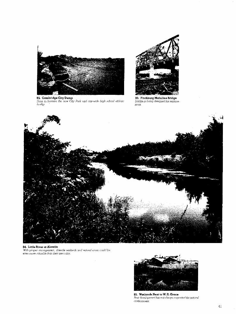
ducement and an obstacle to new development There is an abundance of public open space or parHand in the immediate area with connections to the regional open space system Such features offer exceptional natural amenities for development as well as providing a buffer for nearby residential neighborhoods
There are however a number of environmental drawbacks that must be considered One example is Alewifes hydrology The water table in the entire area is quite close to the surface complicating founshydations and the provision of utilities Furthermore the lOO-year floodplain of the Alewife Brook watershed covers some of the most attractive development areas (see Figure 18) The Cambridge Conservation Commission exercises statutory responsibility for protecting designated wetlands and floodplains like those found at Alewife This means that new construcshytion will have to be well planned It must avoid conshy
18 100 Year Floodplain Gray shaded areas represent land considered to be within the] 00 year floodplain and subject to specked development contrals Black shaded areas represent permanent standing water bodies
tributing to future flooding in the area and damage to important conservation lands to win Conservation Commission approval
Alewifes surface geology poses other potential problems In general area soils resulted from the acshycumulation of glacial lakebed sediment of fine silts and clays with peat deposits developing over time The result is a topsoil of considerable depth to bedrock and low bearing-capacity soils A recent study commissioned by the city identified seven soil groups at Alewife each having different developshyment characteristics (see Figure 19) The studys major conclusion was that the poor bearing nature of these soils necessitates special costly foundation design for all buildings over three stories high This is one more indication of the need for careful and cooperative planning for growth at Alewife by both public agencies and private interests
19 Alewife Soil Conditionsand Development Costs Premium foundation costs increase from Soil Zone ] to Soil Zone 6 See Appendix Two Table 5 for cost detmls
20 AlewifeWater Features 1886 21 Alewife Water Features 1978 Today Alewife Brook survives only in an underground culvert and the smallpondshave disappeared completely
3
Man-Made Features
It is equally important for Alewifes future to consider its man-made features For example over 80 of the privately-owned land at Alewife is presently covered either by buildings street paving or parking lots This condition severely aggravates the areas hydrology problem during periods of intense rainfall The large amount of impervious ground cover prevents natural drainage of storm water adding to the areas flooding problems Obviously new development must correct this situashytion through improved site planning and landscaping to provide as much natural drainage as possible
Alewifes water and sewer services also need upshygrading Todays utilities are the result of unplanned industrial growth over the last forty years Even under the moderate demands of present users the system experiences difficulties because of limited
22 Circulation Although travel along Alewife sedgesis facihtated by the regional highway system the unlimshed character of the looal street system is awkward and inefficient
capacity settlement of pipes dead-ended water lines and the general age of the network
As for auto and truck traffic Alewifes streets and roadways are hard pressed for a variety of reasons The existing road pattern is fragmented and incomshyplete Recent traffic studies have shown that for all practical purposes it is operating at capacity today Historically the Little River and the Boston and Maine Railroad tracks have been barriers to free northsouth movement
Improving traffic flow depends on finding a way to bridge these barriers as well as completing Alewifes local street system Obviously along with major new development in this area must come substantial changes in Alewifes roads
24 Impervious Cover Gray shaded areas show land covered with paving or building allowing little natural drainage
Finally the bUildings in the area also need attenshytion Many of the industrial structures at Alewife are approaching the end of their useful life they will need major capital improvements in the near future Some like the former Adley Freight Terminal have suffered so extensively from ground settlement over the years that they now have no practical hope of recovery and must be replaced altogether Owners and ocshycupants of Alewife buildings are facing major decisions about renewal and reuse of aging buildshyings This would appear to be the ideal time for the public and private sectors to consider altershynative choices for Alewife s future
23 Natural and Man-Made Barriers Numerous obstacles exist to free movement within Alewife same natural -Alewife Reservation and the LittJe River others man-made-the railroad hnes
4
History
25 ice Cutting at Fresh Pond Ballous Pictorai 1855 The Hilfinger ice houses once stood on the site of Glacken Playground
L SANDS MANUFACTUIBR OF
Face and Common Bricks
Brick Yard- Garden corner Walden St North Cambridge
26 Sands Brickyard Advertisement Cambridge Directory 1874 Site is now St Peters Field
28 New England Brick Company Circa 1930 site of the new City Park
-~ JJi JJ H J JJ 0 ~ J
BY LWILLARD
29 Jerrys Pit A photograph circa 1945 showing New England Brick Company in the background
27 Fresh Pond Hotel Thislithograph fram 1845 shows the site ofKingsley Park
5
bull I
bull 11
~
30 1873 31 1900
~
~~~~ ~t
~~lf~
~ bull bulli a
bull
32 1917 33 1940
34 1960 35 1978
30middot5 Historical GrowthPatterns of Alewife Drawmgs show gradual development of jndusirjal and resjdenlial areas jn close proxjmjfy over the last century
6
Land Uses Alewifes 370 acres and 223 buildings accomshy
modate a mixed pattern of land uses ranging from residential to heavy industry (see Figure 36)This hapshyhazard land use pattern reflects the incremental growth of the area as well as zoning regulations The industrial zoning categories for Alewife now allow virshytually all land uses except residential with no setbacks no landscaping no sideyard requirements and no height limits There are in fact very few land use restrictions at Alewife
Looking at the resulting use of the land two surprising observations can be made over 25 of the area is used for warehousing rather than inshydustryor commerce and over 20 of the area is vacant awaiting more productive times There would appear to be ample room for change at Alewife today even without displacement of an existing business or destruction of an existing building
3S Land Use at Alewife
D Open S[X1ce
Q Hotel Residential
~ Retail Service
[[[[] InstitutionalGovernmental
~ Industry Warehousewholesale
[ll]Jllj Research amp DevelopmentGeneral Office
bull Vacant
Employment In the past employment at Alewife has been an
important resource for the City of Cambridge Roughly 140 businesses provided about 5000 jobs in 1974 or 6 percent of the total city employment (see Table I) Since most of the jobs occurred in the indusshytrial areas it is easy to see that blue collar employshyment was and is an important asset
Today the employment picture is changing Recent expansions have been in the research and deshyvelopment fields On the other hand some of the industrial firms which have traditionally been large employers have either cut back operations or anshynounced intentions to relocate outside the city If this trend continues as expected Alewife employment will shift decisively in favor of non-blue collar jobs
The shift should create more total jobs perhaps of a more diversified nature than the area has provided in the past An analysis of jobs produced per acre of land used today shows that industrial and wareshyhousing operations call for far fewer jobs on an average than the technical office and service operashytions that have begun to move into the area (see Appendix Two Table II)
If Alewife is to continue as a major employment center for Cambridge efforts must be made to retain existing employers through improving the business climate at Alewife as well as to attract new businesses to the area Alewifes recent experience seems to be follOWing a national trend industrial firms moving to non-urban locations and being replaced in urban areas by a variety of office retail service and resishydentialland uses In the case of Alewife fortunately the incoming non-industrial land uses should in the long run produce more job opportunities for Camshybridge residents
Table 1 Alewife Employment
SubArea Jobs Total Study Area Jobs A D Little 1318 26 Triangle 583 12 Quadrangle 2256 45 Fresh Pond 875 17 Total 5032 100
bullSource Alewife Businessmens Survey 1974
7
37 Residential 40 RetailandService
38 Industrial 41 Transportation and Institutional
39 Office
37middot41 ExistingLandUsePatterns Diagrams showpattern olindividualland uses in the Alewife area
8
Taxes The final consideration in planning Alewifes future
is the net tax effect of new development At the 1978 Cambridge tax rate the total tax value of the area today is approximately $30175000 or an average assessed value per square foot of land of $214 This compares to the city-wide average of $258 per square foot
A study of assessed value by land use (see Table 2) reveals some interesting facts Apartment-residential land use has the highest tax value followed closely by office hotel and service-related land uses The predominant area land uses industry and warehousshying fall well below the Alewife average as tax producers Thus given current trends traditional industrial uses are being replaced by higher tax proshyducing as well as job producing land uses
Table2 Assessed Valuationshy1978 Alewife Land Uses
Assessed Assessed Land Uses Value in Thousands ValueSq Ft Hotel 6701 $314 Heavy Industry 27465 201 Light Industry 12902 158 Open SpaceRecreation 117 006 Research amp Development
General Office 64801 560 Retail 23043 191 Residential 1-3 units 4981 128 Residential Apartments 52860 588 Service 17936 236 Transportation Utilities Communications 8523 084 Vacant 8294 035 WarehouseWholesaling ___4_9_28__4 143
Total $277007 $200
The cost of municipal services used must be balshyanced against the taxes paid to the City by various land uses A recent Cost Revenue Study undertaken by the City attempted to determine the ratio of municipal costs generated by various land uses comshypared to total taxes paid by these land uses throughshyout the city (see Table 3) Looking at the results the land uses expanding at Alewife today appear to produce more in taxes and generally cost less to the City than the more land intensive industrial uses which are being displaced From a munishycipal cost standpoint then current Alewife trends would also seem to be encouraging
Table 3 Tax Revenue Generated by Cambridge Land Uses Compared to $100 Cost for Municipal Services
Revenue to Use Cost Ratio Housing 050 Stores 143 Auto Related Retail 549 Wholesale 165 Factory 239 Technical Office 184 General Office 301 Utilities and Communication 3274 Recreation 20 Hotels 344 Parking Lots 1767 Vacant Land 255 Warehousing and Trucking 549
bullCity of Cambridge Cost-Revenue Study - Part I 1976
Ratio of 100 or more means land use pays more in taxes than it costs the City of Cambridge in municipal services
42 Boston EdisonTransformer Yard Utilities demand few municipal services in return for taxes However they contribute litde to the visual environmentandcreate few jobs
9
Improvements Already Planned
The face of Alewife will change dramatically in the next few years even without an Alewife Urban Design Plan as various state agencies begin long awaited transportation projects
They include the following
1 Route 2 Ramps - The Massachusetts Departshyment of Public Works is presently conducting enshyvironmental studies preparatory to beginning design of new roadways at Alewife Ramps from Route 2 are intended to channel MBTA-bound traffic directly into the new Alewife station complex by-passing congested Alewife Brook Parkway A major benefit to the City of Cambridge is that traffic destined for the triangle area will also have direct access to Route 2 Completion of the Route 2 ramps are expected to coincide with the opening of the MBTA facility
2 Route 2 Rotary - As part of the Alewife highshyway project the dangerous rotary at Dewey and Almy Circle is scheduled to be replaced with a sigshynalized I intersection with new access into the W R Grace Company area
3 New Alewife MBTA Station - After years of planning the MBTAs Red Line Extension is now under construction The Alewife Station complex as proposed includes a 2000-car parking garage a major bus station and an underground transit station with entrances on both sides of Alewife Brook Parkshyway
4 Rindge Avenue Intersection - In response to Cambridges desire to prohibit through traffic on Rindge Avenue the MBTA will redesign and conshystruct a new Rindge AvenueAlewife Brook Parkway intersection to prohibit physically most through traffic on Rindge Avenue
5 Fitchburg Mainline Bridge - The MDCs aging parkway bridge long closed to truck traffic because of its poor condition is now being redeSigned with replacement planned in the near future
6 Russell Field - The MBTA will construct new neighborhood open space on the site of the present city football field in return for its use as a construction staging and storage area during Red Line construction
7 North Cambridge Linear Park - After the Red Line tunnel along the Fitchburg Freight Railroad Line is completed the surface will be landscaped into a new city park connecting residential areas with the new Russell Field and transit station
8 Cambridge City Dump - Also as part of the Red Line project the MBTA will provide the fill and money necessary to convert the 55-acre unused city dump into a new high school athletic complex conshytaining practice and play fields for all city school sports Additional land will be available for passive recreation areas
Other Alewife changes unrelated to the Red Line are also being investigated For example the City of Cambridge is attempting to persuade the MDC to replace the two dangerous Concord Avenue rotaries with more efficient signalized intersections Also the recent completion of the Fresh Pond Master Plan will enable the City to begin gradual improvement of this important regional open space resource As a result of all these physical improvements the entire Alewife area will become more attractive for development
10
43 Improvements in Various Stages of Planning and Construction 1 direct ramps from Route 2 to the new Alewife station 2 signalized intershysection to replace the present rotary 3 new META station and 2000 car parking garage 4 redesigned Rindge A venue intersection to prohibit through traffic 5 new MDC parkway bridge 6 META-financed linear park andRussell Field re-use 7 new Red Line subway 8 new City athletic facilities on old dump site Unnumbered circles show signalized intershysections suggested by City ofCambridge
45 Model of Future Alewife Station and Garage Complex The 2000 car parking facility and transit station is planned to be openedin 1982-83 (Model courtesy oJ META and Wallace Floyd Ellenzweig and Moore Architects)
44 MBTARedlineRoute Black shows the existing system solid gray indicates the extension presently under construction anddashed gray represents proposed future extension
46 Section through Alewife Station and Garage
II
Alewifes Development Potential
It is difficult for the casual observer to grasp the tremendous size and growth potential of the Alewife area Alewife is approximately equal in total size to Bostons entire Back Bay district Although Back Bay took 50 years to be developed as planned it conshytinues to change today It is easy to see then that developing Alewife will be a long process that may never be completed but just as in the case of Back Bay it is important to establish a planning structure early to guide development along advantageous lines
Change is already underway The type and scale of new Alewife building activity is strikingly different from past Alewife construction and the pace of change appears to be accelerating An example is the Abt Associates office research complex on Wheeler Street beginning its fourth expansion The Abt complex features quality architectural design special landscaping and recreational amenities Bolt Beranek and Newmans new 90000 square feet research and development facility on Concord Avenue completed in 1975 is another example of innovative and well-deSigned development In 1978 five businesses announced intentions either to construct new facilities at Alewife or to rehabilitate existing bUildings Other major landowners are beginning to discuss publicly large scale developshyment projects
What makes Alewife so attractive as a developshyment area There are a variety of factors
1 Valuable Underutilized Land and Buildings Alewife has 37 of the industrially-zoned land in Cambridge but only 10 of the total industrial floor space Overall it contains 21 of all non-residential land in the city but only 12 of the total non-residenshytial floor space (see Appendix Two Table 7) As heavy industrial activities at Alewife begin to decline new opportunities are created for the reuse of valuable land and buildings
2 Large Parcel Land Ownership There are only about 100 land parcels at Alewife ranging in size up to 25 acres with an average size of 25 acres This encourages larger scale development
because land assembly normally a complicated and costly process involving many different landowners is either Simplified greatly or unnecessary
3 Available Vacant Land Sixty-eight of Alewifes 370 acres are currently vacant and available for immediate development These acres under existing zoning represent 7728000 square feet of untapped development potential This is about two times more than the total built floor space at Alewife today
4 Good Market Prospects v
Gladstone Associates a profeSSional real estate marshyketing consultant examined the question of market prospects for Alewife development in a 1977 study done in conjunction with the MBTA Red Line extenshysion Forecasting for the period to 1985 only Gladstone found a market at Alewife for up to 3300 units of hOUSing 700000 square feet of office space 560000 square feet of retail space 500 hotel rooms and 50 additional acres of industrial development shywith or without the Red Line extension Gladstone cites as the reasons excellent highway access availshyability of land and the areas ability to attract regionalshyserving large-scale uses (see Appendix Two Table 8)
HardSoft Analysis To identify the magnitude of change that might
occur in Alewife in the next years a determination must be made about which parcels will be susceptible to development pressures The usual method is a hardsoft study First the study estimates the hard land uses that are likely to remain over the next decade then it estimates soft uses which are likely to be replaced by new development Utilizing factors such as age and condition of existing structures parcel size and stated intentions of property owners 50 Alewife parcels were identified as prime developshyment sites (see Figure 49) These parcels represent approximately 125 acres of land and they form the basis for the projected land use changes and proposed zoning districts in the Alewife Urban Design Plan
12
49 ParcelsMosLikelytoDe~~d to remain Outhned Black figu~s ~ow bUjil~gs ht~uscePtible to developmentareGS are sad parce s aug forces
74 bull Back Bay Size Comparison Back Bay from the Public Garden Alewife is about the same Size as Basion sh ws a map of Back Boy laid over to Massachusetts A venue The dJQgram s a the Alewife area
48 Land Ownership d mmedJate development Inforshy I orcels reo y lOr 1 J Ii
Shaded areas ore vacan Ph f orcels is included in Appenwx womotion on the size and owners ip a p Table 10
13
42 37 35
36
20
The Urban Design Plan
Introduction The Alewife Urban Design Plan is not a blueprint for
physical change of the Alewife area It is instead a framework for advantageous and profitable developshyment by private landowners which can also yield sigshynificant benefits to all Cambridge citizens by creating new job opportunities by significantly increasing the citys tax base by removing visual blight and ecolshyogical hazards and by adding to the useable open space in the area In short it could build a better Alewife working and living environment for everyone
Since the days of massive urban renewal projects are over the Alewife Urban Design Plan depends on a partnership between public and private interests to remake Alewife In addition to proposing specific physical changes the plan suggests a way in which to coordinate public and private decision-making A successful partnership would create a renewed and vital officecommercialindustrial center for Cambridge
Previous Alewife Studies Planning necessitates making assumptions about a
desirable future In the case of Alewife identifying peoples desires for change and the potential of the area is not difficult there has been a long public planning process about Alewife and many previous studies have been produced The proposed Urban Design Plan builds on lessons learned during discusshysions about Alewifes future over the last few years inshyvolVing the Alewife Task Force the Alewife Businessshymens Association North Cambridge and Cambridge Highlands residents and city regional and state planning officials Incorporated in whole or in part in the Plan are the recommendations contained in the Alewife Task Force Land Use Report the Alewife Urban Design Study Phase I Report the Harvard-Tufts Student Teams Alewife Park Study the Alewife Task Force Open Space Sub-committee Report as well as various state and local technical reports The debt of the Alewife Urban Design Plan to these preceding enshydeavors is gratefully acknowledged
Utilizing the recommendations which surfaced during the Alewife discussions it is possible to distill a list of general goals to gUide formulation of an Alewife Urban Design Plan
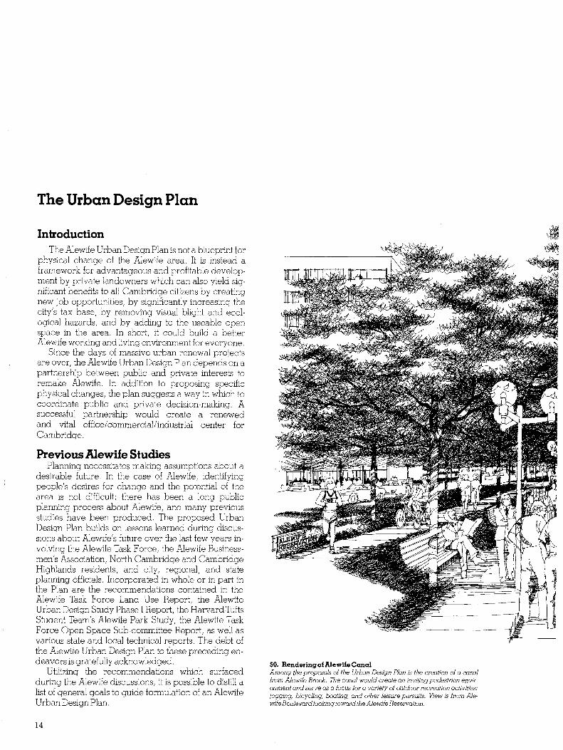
50 Rendering of Alewife Canal Among the proposals of the Urbon Design Plan is the creation of a canal from Alewife Brook The canal would create an inviting pedestrian envirmiddot anment and serve as a focus for a variety of outdoor recreation activities jogging bicycling boating and other leisure pursuits View is from Alemiddot wife Boulevard looking toward the Alewife Reservation
14
Goals of the Plan 1 Encourage appropriate development Land use change at Alewife should take advantage of Camshybridges worldwide reputation as a center for research and development Research and development firms laboratories technical offices and related light manushyfacturing are highly supportable land uses They should be allowed in the zoning and emphasized most heavily in private promotional activities
2 Discourage inappropriate development There is considerable land available for development at Alewife and it comprises one of the few remaining economic growth areas in the city This land should not be wasted on uses which are either undesirable or more appropriate elsewhere Heavy manufacturing extensive warehousing major retailing and service uses such as auto repair should be prohibited or subshystantially restricted Housing while it may be approshypriate in some locations should generally be restricted
3 Upgrade the image of the area Visually much of the Alewife industrial area is blighted and confusing to the un-initiated The character of the area is not that of a high quality office and industrial park Improving the areas physical image is essenshytial especially at the edges and entrances An imshyproved circulation system better parking arrangeshyments more landscaping and better site planning will encourage high quality development This will result in sound economic growth as well as an improved image
Conclusion Managing Alewifes future in an intelligent
way is the task set for the Alewife Urban Design Plan If the plan works as expected it could yield as much as $300000000 in new building conshystruction 8500 construction jobs as many as 18000 newpermanent jobs and an expansion of the Citys tax base up to $21000000 Equally important however Alewife development will not be at the expense of the areas natural environment nor create unanticipated demands upon municipal services
4 Limit the scale of development Existing Aleshywife development is about one-eighth of what could be built under existing zoning Massive development is undesirable however because of the impacts it would have on roadways public services natural areas and nearby neighborhoods Substantially more development than exists today can be accommoshydated but it is in everyones interest that it be more closely regulated Development should occur in appropriate areas and at appropriate densities and heights
5 Protect residential neighborhoods Fortunshyately most of Alewife is isolated from residential disshytricts thereby avoiding the conflict of larger scale non-residential development occurring next to estabshylished neighborhoods Areas such as Cambridge Highlands near the Tobin School and along Alewife Brook Parkway require closer regulation The range of allowed uses should be limited and the scale of development should be reduced to provide a gentle transition from residential to non-residential areas
6 Protect public open space Alewife industrial area is surrounded by public open space the Alewife Reservation Fresh Pond Reservation and the proshyposed city parks This proximity creates both opporshytunities and problems On the one hand nearness to park land and its amenities enhances developability On the other the fragile nature of such resources requires that special safeguards be taken Any new development near Alewife public open space should be sensitive to impacts on these natural systems
TheAlewife Urban Design Plan will be discussed in four major sections Each of these is an important component in the plan to improve Alewife
ARoadway and Infrastructure Improvement Program
B Open Space Improvement Program CDevelopment Policies DGrowth Management Program
16
A Roadway and Infrastructure The Alewife Urban Design Plan begins by adshy
dressing long-standing public infrastructure (street sewer and water) problems Alewifes streets like its buildings evolved in an incremental and unplanned fashion over the last four decades In many areas continuous asphalt paving extends from building to building with no delineation of the public right-ofshyway In others streets are connected only through parking lots or private ways Needless to say most streets are below City standards for width curbs gutters storm sewers sidewalks street trees and lighting The sewer and water system is in a similar state The general impression of Alewife projected from its public space is that of a run-down area
51 RindgeAvenueExtension Many streets in Alewife are presently inadequate to service existing businesses orpossible future development
53 Example of Improvement Possible Alewife Boulevard Addingadditional rightmiddot ofmiddot way to existing streets could result in a pleasant sofe andmore efncient circulotion system
The Urban Design Plan suggests changing that image A whole new roadway system built to acceptshyable standards must be designed and constructed and an upgrading of storm and sanitary sewers as well as water service must be undertaken
Alewifes new roadway system should feature both local streets and new arterial streets In order to function properly it should complete the missing connections between streets and create a link over the railroad lines to Route 2 and the regional highway system Investing in new roadshyways and municipal services is the first step in revitalizing Alewife
52 ConcordAvenue along FreshPond Reservation Area roadways lock adequate sidewalks tree plantings and other public amenities
17
Program Elements The major features of the roadway and infrastrucshy
ture improvement program are
1 Route 2 Access Road As explained earlier the Massachusetts Department of Public Works is planning to construct a connecting ramp from Route 2 to the new MBTA stationgarage complex at Alewife That ramp will also connect to the Rindge Avenue Extension in the Triangle The Route 2 ramp is critical for the long-range developshyment of Alewife because it provides industrial area traffic with direct access to the regional highway system bypassing Alewife Brook Parkway
2 Alewife Brook Parkway Parkways were originally intended as travelways within a parklike setting Today we find that Alewife Brook Parkway has become just another heavilyshytraveled traffic artery There are few trees and much of the original right-of-way has been lost to parking lots or private use Unsightly development has been allowed to spring up nearby Alewife Brook Parkway has the potential of becoming park-like again with landscaping pedestrian paths and visual amenities if the City and the Metropolitan District Commission act in concert The first step in turning the parkway around has been taken by the MDG
The ailing and unsightly Fitchburg railroad bridge is under design for replacement Now it is up to the City to more effectively regulate adjacent land uses so as not to detract from the parkway The MDC may then take further steps to improve the open space within the parkway right-of-way and to reclaim it as a link in the regional open space system
3 Concord Avenue Concord Avenue the major roadway serving the Quadrangle is also the major entry into the City from Belmont The Avenue today is four lanes wide with highly contrasting uses and forms on its two sides The north side contains mostly one- and two-story industrial or commercial buildings without landscapshying setbacks or trees The south side Fresh Pond Reservation contains beautiful trees along most of its length but only a small dirt path for pedestrians instead of sidewalks Both sides clearly need to be improved for public use
It is proposed that Concord Avenue be treated as a parkway much like the Alewife Brook Parkway with special design provisions Its four travel lanes would be divided by a planted median strip and new street trees would be prOVided on the entire length of both sides A bicycle path and sidewalk would also be constructed on the Fresh Pond side as a compleshyment to the reservations recreation activities Altogether these changes would create an attractive gateway to Cambridge and do much to upgrade the image of the Alewife area
4 Alewife Boulevard The centerpiece of the proposed Alewife local street system is the replacement of Rindge A venue Extenshysion and Smith Place with Alewife Boulevard Alewife Boulevard would be the major new local artery - a four-lane street with a landscaped median Most importantly it would connect the Quadrangle and the Triangle across the Boston and Maine tracks thereby linking the Quadrangle areas directly to Route 2 via Ramp Street and the Triangle parcels to Concord A venue The present intersection of Concord Avenue and Smith Place would also be improved to accommoshydate the new Boulevard
An Alewife Boulevard would serve several funcshytions First it would serve to organize local traffic cirshyculation into safer and more efficient patterns Next it would relieve some of the traffic pressures on Alewife Brook Parkway by allowing industrial area traffic to reach Route 2 directly Since it would parallel much of the land now available for development it would promote development in those areas Finally it would be a new visual amenity running through the center of the whole Alewife area
5 Park Street Just as Alewife Boulevard would serve as the main northsouth connector for Alewife a proposed new roadway called Park Street would serve as the east west link Park Street a four-lane undivided roadshyway would be created out of New Street part of the Fresh Pond Shopping Center parking lot and some of the B amp M railroad right-of-way It would connect Alewife Boulevard with the Shopping Center and Fresh Pond Parkway (the design of the new MDC parkway bridge allows sufficient width under the bridge to accommodate a new street) Park Street would prOVide parallel service to Concord Avenue bypassing one of the rotaries (or signalized intersecshytions if they are replaced) It would also connect Alewife employment areas with the major Alewife shopping area and with the new City Park recreashytion area
6 Local Streets Besides major roadways improvements are also sugshygested for Alewifes smaller streets Better access must be prOvided to interior industrial areas which are poorly served today The proposed plan indicates two types of street improvements upgrading existing streets to city standards and the construction of new streets on designated private ways or unused railroad spurs The suggested network is the result of discusshysions with area landowners area planning studies and professional traffic and engineering analysis As planning studies continue new links may be added and some of those now proposed may be deleted The important objective is to end up with a workable local street circulation system
18
54 Roadway Improvement Program Numbers arekeyed to djsGussjon ofproposed jmpravement3 jn text
Program Costs The costs of completing the proposed Alewife
Roadway and Infrastructure Improvement Program - streets and roadways sewer and water lines landshyscaping and street lighting - have been estimated using professional engineering criteria by the Cambridge Public Works Department
Some of these cost~ may be underwritten by private landowners and developers either through right-of-way contributions or actual construction of some roadway segments since private landowners stand to gain directly from improved access and utilities The high cost of extensively reorganizing and rebuilding Alewifes streets and roadways means that implementation will undoubtedly have to be undershy
Table 4 Alewife Roadway Improvement Costs Street Name Total Improvement Costs Sunny Road $ 924000 Wilson Road 331000 Mooney Street 1004000 Wyeth Street 375000 Moulton Street 466000 Fawcett Street 333000 Wheeler Street 409000 Park Street 3106000 Concord Avenue 2074000 Steel Street 773000 Alewife Boulevard 4500000
$14295000 NOTE These figures include engineering and contingency costs and building demolition costs
taken in phases as money and right-of-way become Approximate estimates only uSIng engineering rules-af-thumb
available but the result should be well worth the wait
19
B Open Space Today Alewife stands as the missing link in a series
of open spaces which could be connected into a regshyional system much like Bostons Emerald Necklace A system of open spaces parks and parkways could begin at the Charles River and extend across Mount Auburn Cemetery to Fresh Pond Reservation With improvements to Alewife Brook Parkway the netshywork could link the Alewife reservation with Spy Pond in Arlington and the open space corridor along Alewife Brook Parkway to the Mystic River Open space could also be incorporated into private development
Alewife would then become the center of a new open space system Links would exist to Belmont Center Arlington Center Porter Square and Davis Square Area residents could easily reach Alewife to work shop and play Realizing Alewifes full potential depends on a comprehensive Open Space Improveshyment Program
55 Regional Open Space System Alewjfe has the potential to become the focus of a regional open space system
Program Goals The major goals of the Open Space Improvement
Program are 1) to encourage the evolution of an open space network through coordinated development of public and private open space 2) to continue to preserve and manage existing open space areas such as Fresh Pond and Alewife Reservation 3) to create open space linkages to adjacent neighborhoods park areas and commercial centers 4) to encourage landscape screening between new development and public open space 5) to protect wetlands from the impacts of new development as directed under the Massachushysetts Wetlands Protection Act 6) to insure that development within the 100 year flood plain does not adversely impact the natural systems of the area or lead to increased flooding and 7) to encourage developers to adequately siteshyplan and landscape property to improve the enshyvironmental character ofAlewife
57 Junction of AlewifeBrook and Little River One of the goals of the open space improvement plan is to conserve and improve existing natural resources
56 OlmsteadsEmeraldNecklace Bostons open space system is an example ofAlewjfes potential value as a regional open space resource
20
Program Elements Applying the above goals on an area-by-area
basis it is possible to identify a series of public and private actions that would convert Alewife from an underutilized industrial area into a major regional open space resource
1 Alewife Reservation The Alewife Reservation is 115 acres of open space which the Metropolitan District Commission has done little to improve as a natural resource A comshybination of wetlands shallow marshes and abanshydoned agricultural fields it is naturally turning into a shrub swamp and much of its potential value will be lost if action is not taken
Alewife Reservation offers the unique opportunity to create a wildlifenature preserve in the midst of a highly urbanized area This can only happen howshyever if the MDC and the City of Cambridge plan now for the future of the reservation
The Urban Design Plan proposes that the MDC improve the Reservation through the institution of a conservation management program The management program would attempt to create a balshyanced ecological order to improve the diversity of wildlife habitats and to allow some passive recreation use of the reservation by humans To succeed the conservation management program would have to designate specific uses for different sections of the Reservation
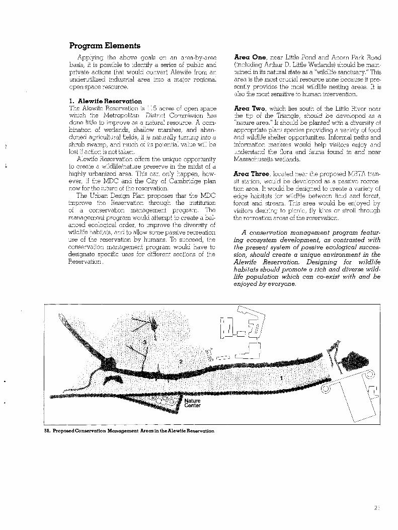
58 Proposed Conservation Management Areas in theAlewife Reservation
Area One near Little Pond and Acorn Park Road (including Arthur D Little Wetlands) should be mainshytained in its natural state as a wildlife sanctuary This area is the most crucial resource zone because it preshysently provides the most wildlife nesting areas It is also the most sensitive to human intervention
Area Two which lies south of the Little River near the tip of the Triangle should be developed as a nature area It should be planted with a diversity of appropriate plant species providing a variety of food and wildlife shelter opportunities Informal paths and information markers would help visitors enjoy and understand the flora and fauna found in and near Massachusetts wetlands
Area Three located near the proposed MBTA transhysit station would be developed as a passive recreashytion area It would be designed to create a variety of edge habitats for wildlife between field and forest forest and stream This area would be enjoyed by visitors desiring to picnic fly kites or stroll through the recreation areas of the reservation
A conservation management program featurshying ecosystem development as contrasted with the present system of passive ecological successhysion should create a unique environment in the Alewife Reservation Designing for wildlife habitats should promote a rich and diverse wildshylife population which can co-exist with and be enjoyed by everyone
21
59 Open Space Improvement Program Numbers arekeyed to discussion ofproposedimprovemenlB in text
2 Alewife Nature Center It is further proposed that the MDC or the City of Cambridge purchase one or two acres at the tip of the Triangle to provide a Museum to complement the Alewife Reservation nature areas The museum could become the main visitor center providing informa tion convenient access and off-street parking
3 Blair Pond Blair Pond and the Wellington Brook are a waterway and a wetland area near the Belmont town line They are presently in private ownership The Cambridge Conservation Commission and the Alewife Task Force have long been interested in securing public ownership of Blair Pond The Program suggests that at least part of Blair Ponds edge remain accessible to the general public and that the entire waterbody and wetland be protected from development by a conshyservation easement
4 Russell Field After construction staging on Russell Field for the Red Line extension is completed the MBTA has agreed to rebuild neighborhood open space on this lO-acre site The exact nature of the facilities located there will be decided in consultation with the North Cambridge neighborhood One part of the new neighborhood park on Russell Field will be a direct pedestrian connection from Dudley Street to the Alewife transit stations east entry Access rights to the station through the W R Grace Company land will be preserved by the MBTA
5 Jerrys Pond Jerrys Pond is another Alewife waterbody presently in private ownership The pond once served as a neighborhood recreation spot for ice skating and swimming The Open Space Program proposes that Jerrys Pond be cleaned up and expanded to act as an amenity for nearby W R Grace Company develshyopment The pond needs dredging and its banks need easing and landscaping It could also be stocked to promote fishing and boating activities Eventually Jerrys Pond should be acquired as public open space and be added to an expanded Russell Field Recreation Area
22
SO Preliminary Plan for the Cambridge City Park 1 Football and Track Field 2 Field House 3 Soccer Field 4 Baseball 5 Football Practice Field S Tennis Courts 7 SoftballS Baseball 9 Soccer and Football Practice Field 10 Soccer and Field Hockey 11 Basketball Courts 12 Existing Softball Field 13 Tennis Courts
6 North Cambridge Linear Park With the coming of the Red Line extension railroad service on the Fitchburg Freight Cut-off through North Cambridge will be discontinued After the tunnel for the subway is built along the right-of-way it will be covered over and the surface will be landshyscaped into a new city park The new linear park will feature small play areas plantings open recreation areas and pathways connecting North Cambridge residential areas with Davis Square Somerville the new Russell Field recreation area and the transit station beyond Again final design of the linear park will involve the neighborhood
7 City Park Under an agreement between the City of Cambridge and the META some of the rock and dirt removed during Red Line tunnel construction will be brought to the 55-acre site of the old Cambridge City Dump at the edge of Alewife The City has long planned to convert this unused faCility into a recreation area or park and the Red Line extension presented an opportunity for the City to acquire large amounts of necessary excavated material to fill the dump A proshyfessional geotechnical consultant was employed to determine surcharging requirements and steps necessary to deal with potential gas problems A landscape design firm then developed the master plan for a new City Park
The new park will become the primary city-wide athletic complex replacing the present one on Russell Field It will feature one football field and track facility an associated field house five playfields for soccer or football two baseball and three softball fields 14 tennis courts two basketball courts and two totlots The remainder of the area will be landshyscaped and planted appropriately The entire cost for the athletic facilities will be paid by the META in return for disrupting Russell Field
S1 Proposed Pedestrian and Bicycle Paths Dark lines show potential pedestrian and bicycle paths which could connect Alewife with the surrounding region
8 Open Space Protection and Enhancement The final element of the Open Space Program is the protection of existing open space and encourageshyment of new open space areas through local land use regulations As will be explained in the zoning discusshysion attempts will be made to rezone sensitive Alewife environmental areas to prevent future develshyopment At the same time special land use regulation techniques will be suggested to encourage private developers to incorporate the maximum amount of useable open space areas in new private developshyment projects Ultimately the product should be a well-balanced visually pleasing and highly useable open space environment at Alewife
9 Pedestrian and Bicycle Paths Developing an open space system at Alewife involves not only the creation of recreation areas but also connections between them A path system for pedestrians and bicycles would 1) visually and physically unify the area 2) provide alternative passageways safe from the noise and hazards of automobile traffic and 3) encourage alternative modes of travel to and from Alewife thereby increasing its overall accessibility
The Alewife Task Force Open Space Subcomshymittee completed a detailed study of an Alewife path system The Open Space Program has adopted many of their recommendations adding other paths as the opportunity became available (see Figure 61) The path system would be realized by encouraging appropriate public agencies to acquire and maintain rights-of-way for pedestrian and bicycle use incorshyporating such rights-of-way in larger Alewife imshyprovement projects
23
C Development Policies Rather than create a masterplan for new develshy
opment on a parcel-by-parcel basis the Alewife Urban Design Plan proposes to establish a series of design principles and guidelines (with specific recomshymendations for a few key sites) to encourage approshypriate development of the Alewife area These design recommendations form the Development Policies porshytion of the plan
Development Policies are goal statements which attempt to do several important things 1) set limits on the size and magnitude of new development 2) establish the environmental quality of the overall area and 3) phase the growth ofnew building activity to avoid potential problems The Development Policies seek to coshyordinate public and private actions at Alewife to effect immediate and qualitative improvements in the physical and social environment of the area
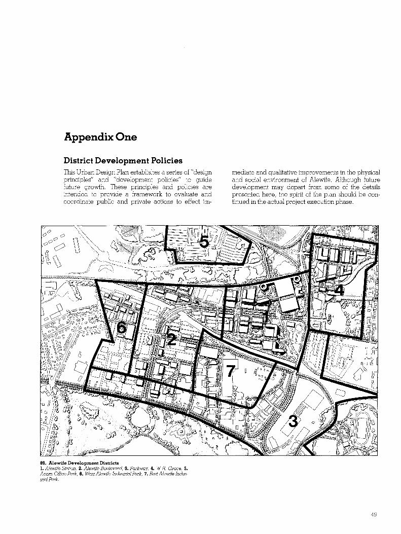
Since Alewife is so large and its nature varies so widely from area to area it was divided into seven development districts so that Development Policies could be tailored to local conditions and potential for change (see Figure 65) Development Policies in the form of design principles have been prepared for each district (see Appendix One) but only the first four districts have major design components needing detailed discussion Although future development may in fact depart from the details suggested here the spirit of the District Development Policies should be respected during implementation
62 View Down Alewife Boulevard Looking toward Belmont from the META [Xlrking garage showing possible omce and commercial buildings in the Alewife Station District Alewife Station will be a unique activity center New buildings will feature retail and service activities on lower floors and office housing or hotel above Shopping arcades and pedestrian bridges couId connect buildmiddot ings and the new station A major hotel is shown next to the MBTA facility with a variety ofshops restaurants and terraces
63 (Overleaf) The Alewife Urban Design Plan
24
Alewife Boulevard
CQ tt tt
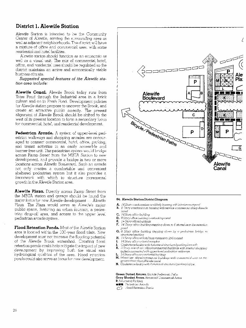
District 1 Alewife Station Alewife Station is intended to be the Community Center of Alewife serving the surrounding area as well as adjacent neighborhoods The district will have a mixture of office and commercial uses with some residential and hotel facilities
Alewife station should function as an economic as well as a visual unit The mix of commercial hotel office and residential uses should be regulated so the district maintains an active and economically viable business climate
Suggested special features of the Alewife stashytion area include
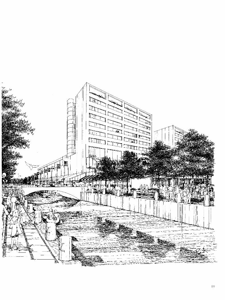
Alewife Canal Alewife Brook today runs from Yates Pond through the Industrial area in a brick culvert and on to Fresh Pond Development policies for Alewife station propose to uncover the Brook and create an attractive public amenity The present alignment of Alewife Brook should be shifted to the west of its present location to form a secondary focus for commercial hotel and residential development
Pedestrian Arcade A system of upper-level pedshyestrian walkways and shopping arcades are encourshyaged to connect commercial hotel office parking and transit activities in an easily accessible and barrier-free unit The pedestrian system would bridge across Ramp Street from the MBTA Station to new development and provide a bridge in two or more locations across Alewife Boulevard Such an arcade not only creates a comfortable and convenient sheltered pedestrian system but it also provides a framework with which to structure incremental growth in the Alewife Station area
Alewife Plaza Directly across Ramp Street from the MBTA station and garage should be found the major focus for new Alewife development - Alewife Plaza The Plaza would serve as Alewifes major public space featuring an urban fountain a pedesshytrian drop-off area and access to the upper level pedestrian arcade system
Flood Retention Ponds Most of the Alewife Station area is located within the lOO-year flood plain New development must not increase the flooding potential of the Alewife Brook watershed Creating flood retention ponds could help mitigate the impact of new development by improving both the visual and hydrological qualities of the area Flood retention ponds could also serve as focus for new development
Alewife Canal
64 Alewife Station District Diagram
A 14 Story condominium or elderly housing with interior courtyard B 8 Story condominium housing with service commerclal along Alewife
canal C 14 Story office building D 8 Story office building overlooking canal E 14 Story office buildings F 14 Story office building stepping down to 6 stories near the retention
pond G 8 Story office building stepping down by a pedestrian bridge to
structured parking H 14 Story office or hotel (approximately 250rooms) 1 l4Storyofficeorhotelcomplex J Conference facility with 4 stories ofstructured parking beneath K 5 Story mixed use officecommercial buildings with interior shopping
galleria connected with upperlevel pedestrian walkways L 14 Story office orresidenlJal bwldlng M Mixed use officecommerciol buildings with commercial uses on the
ground floorolong Alewife canal N Conference facility with 4 stories ofstructuredparking below
Green Dotted Arrows Bicycle Pedestrian Paths Gray Shaded Areas Preferred Commercial Areas P Structured Parking bullbullbull Pedestrian Arcade W Flood Retention Ponds
28
Jerrys Pond
66 Location Key Alewife Station District
65 Alewife Development Districts 1 Alewjfe Station 2 Alewife Boulevard 3 Parkway 4 wR Grace 5 Acorn Office Park 6 West Alewife Industrial Park 7 East Alewife Industrial Park
67 River Walk San Antonio Texas A fYJrk-like setting in the midst ofa commercial area this is an example of what Alewife Canal might look like (see Figure 50)
68 Rendering of an Alewife Shopping Arcade Office buildings along Alewife Boulevard should coniJin a variety of lower floor retmj andcommercial facilities to serve employees and visitors
29
District 2 Alewife Boulevard Alewife Boulevard is the newly created roadway conshynecting Rindge Avenue extension across the Fitchshyburg mainline to Smith Place The Boulevard is intended to serve as the major internal access road for new office-research and development activities at Alewife The suggested design of Alewife Boulevard is intended to create a special and unique image a four-lane roadway with a landscaped median street trees wide sidewalks for pedestrians and bicycles ornamental street lighting and street furniture for bus stops and sitting areas Its visual and environmental qualities should create a quality image for the Bouleshyvard and attract prestigious land uses
Special development features of the Alewife Boulevard district include
Alewife Fire Station In the triangle just as Alewife Boulevard curves south to cross the tracks a new fire station is proposed
A fire station would provide badly needed protecshytion for expanding Alewife business as well as the entire western portion of Cambridge
The station would be located on the small trishyangular site otherwise unsuitable for development The area around the station would be developed as a park Since the fire station is located along the main visual axis of Alewife Boulevard it should contain a strong vertical element perhaps a spire or a tower This would pleasantly terminate the long view down the Boulevard from Alewife Station and give addishytional visual orientation to the district
Alewife Nature Center At the tip of the Indusshytrial Triangle a nature museum is proposed The museum would serve as the main visitor center for Alewife Reservation
The museum should have permanent features like a display of the geological or landscape history of the Alewife area Along with exhibition spaces the museum could contain facilities for seminars and community meetings and perhaps special observashytion facilities to view the Reservation Museum staff could also conduct tours of the Alewife Reservation to promote better awareness of the importance of Massachusetts wetlands
69 Location Key Alewife Boulevard District
Bellows Pond Where Moulton Street meets the railroad spur there stands today several hundred square feet of debris-filled water Because of the areas low water table what appears to be a drainage ditch is in reality a permanent Alewife wetland
After roadway work at Moulton Street and Wilson Road is completed the opportunity will exist to convert the Bellows Pond wetlands into a more valushyable water amenity This would not only improve the flood retention capacity of the floodplain but also create a new visual amenity for nearby development
Parking Garage In the same area as the new pond a parking garage of 400-600 cars is sugshygested Improved roadways and new development will create a critical need for parking If large surface parking lots are to be avoided structural parking garages must be promoted A joint-venture municishypalprivate parking garage in this general area is one way to meet the increased demand for additional parking
30
Fire
-~-~ -shyIJ L~~jAlewife
Boulevard
E
~ Blacks Nook
70 Alewife Boulevard District Diagram
A 8 Story corporate office buildjng F Newhrestofjonondpork B 8 Story olfjceresearch buildjng G Nature center wjlh access to AlewHe Reservafjon C 5 Story olfjceresearch buildjng D Newly-created water retention area Bellows Pond P Structured Parkjng E Blacks Nook Pond wjfh newlounajn BjcyclelPedestrjan Paths dotted green arrows
31
District 3 Parkway District Alewife Brook Parkway and Concord Avenue are the major arteries servicing Alewife today They are also the major entries into Cambridge from the northwest Boston region For this reason they are of prominent symbolic as well as strategic importance
Alewife Boulevard and Concord Avenue need to be upgraded with street tree plantings new curbs and gutters expanded sidewalks and attractive street lighting Curb cuts should be limited primary access to businesses along the roads should if possible be provided from internal area roadways The rights-ofshyway should be expanded to accommodate additional landscaping New buildings should be required to be set back from the right-of-way with generously landshyscaped front yards Parking and service areas should occur behind buildings screened from view Strip commercial and highway-service activities should be closely controlled through a stringent design review process
The environmental image of the Parkway district can and should be improved but it will take time If the general principles can be established now new development can begin the slow process of bringing about that change
Special development features in the Parkway District include
Blacks Nook In certain areas along Concord A veshynue views should be opened into the Fresh Pond Reservation by selectively pruning (not cutting down) existing trees and shrubs One area selected for such treatment is the Blacks Nook area The visual axis established by Alewife Boulevard can terminate at Blacks Nook creating a view into Fresh Pond
MDe Bridge The MDC is currently designing a reshyplacement bridge for the current parkway bridge over the Fitchburg Mainline The Development Polshyicies suggest that the new bridge be designed in a style that will be visually compatible with the landshyscaped parkway image that this plan is promoting
Urban Gateways Alewife has two major entries to the City of Cambridge one at Blanchard Road and Concord A venue the other at the junction of Route 2 and Alewife Brook Parkway These create an opporshytunity to project a positive image of Cambridge and to announce special events or happenings in the city to area travelers
Gateways can be created by special street signs special landscape treatment or both Gateway locashytions must be carefully selected and individually designed
Special consideration must be given to the scale and character of the gateway site speed and viewing angle of the observer and safety and maintenance features of the final design
71 Parkway District Diagram
A 6 Story omceresearch building B 6 Story officeresearch building C 8 Story office building D 8 Story office bwlding stepping down to 5 stories near Concord
Avenue E 8 Story office building F 5 Story technical office G 5 Story expansion ofoffjcecommercial activity
Green Dotted Arrows BicyclePedestrian Paths Gray Arrows New Access Roads P Structured Parking
72 Location Key Parkway District
32
73-74 Urban Gateway for OBrien Highway EXisting condition is contrasted with proposed signing and landscaping treatment for one entrance to Cambridge
33
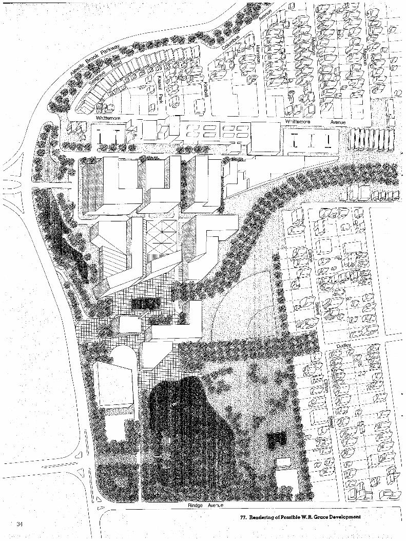
v__________________________~R~in~dg~e~~A~ve~n~u~e~____________________________________------------------1 77 Rendering of Possible W R Grace Development
34
00 gt II
75 W R Grace District Diagram
A 8 Storyhotel with related commercial activity on ground floor at Grace Plaza
B 5 Story hotel andbanquet facilities with swimming pooland recreation facilities on roofdeck
C 5 Story atrium space which serves as the main lobby of the hotel with restauranfE andrelated commercial on the main floor
D 5 Story shopping galleria with 2 levels of commercial with hotel and conference facilities above
E 8 Story general office building with related service commercial activity on the ground floor at GracePlaza
F 5 Story conference facility associated with the hotel office complex Ground floor retail along the galleria 4 levels ofparking
G 8 Story office building or condominium housing with views oriented toward Russell Field
H 4 Story office building or condominium housing with some conference orcommunityactivity facilities 2 levels ofparking
I 5 Story condominium housing or general office space with views oriented toward Russell Field andJerrys Pond I levelofparking
J 3 Story commercial building with cales and restaurants which extend their activities on to GracePlaza during the summermonths
K I Story A1BTA station entry with vertical clock tower andnewsstand L 8 Story general office building with associated level parking garage M 8 Story general office building with associated 7levelparking garage N 8 Story general office building with associated 7level parking garage
Top level ofthe garage is used for recreational activities O 8 Story general office building or condominium housing Q 5 Story general office orcondominium housing
76 Location Key W R Grace District
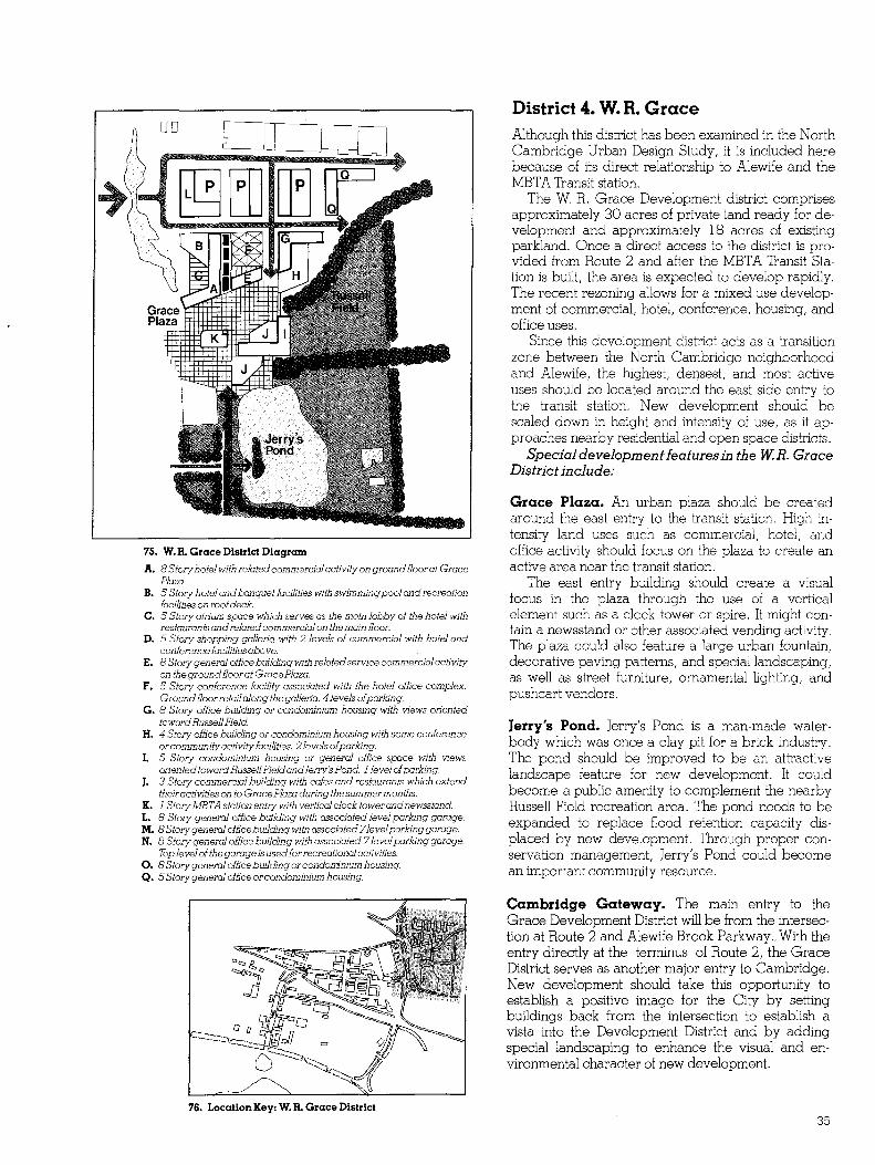
District 4 W R Grace Although this district has been examined in the North Cambridge Urban Design Study it is included here because of its direct relationship to Alewife and the MBTA Transit station
The W R Grace Development district comprises approximately 30 acres of private land ready for deshyvelopment and approximately 18 acres of existing parkland Once a direct access to the district is proshyvided from Route 2 and after the MBTA Transit Stashytion is built the area is expected to develop rapidly The recent rezoning allows for a mixed use developshyment of commercial hotel conference housing and office uses
Since this development district acts as a transition zone between the North Cambridge neighborhood and Alewife the highest densest and most active uses should be located around the east side entry to the transit station New development should be scaled down in height and intensity of use as it apshyproaches nearby residential and open space districts
Special development ieaturesin the WR Grace District include
Grace Plaza An urban plaza should be created around the east entry to the transit station High inshytensity land uses such as commercial hotel and office activity should focus on the plaza to create an active area near the transit station
The east entry building should create a visual focus in the plaza through the use of a vertical element such as a clock tower or spire It might conshytain a newsstand or other associated vending activity The plaza could also feature a large urban fountain decorative paving patterns and special landscaping as well as street furniture ornamental lighting and pushcart vendors
Jerrys Pond Jerrys Pond is a man-made watershybody which was once a clay pit for a brick industry The pond should be improved to be an attractive landscape feature for new development It could become a public amenity to complement the nearby Russell Field recreation area The pond needs to be expanded to replace flood retention capacity disshyplaced by new development Through proper conshyservation management Jerrys Pond could become an important community resource
Cambridge Gateway The main entry to the Grace Development District will be from the intersecshytion at Route 2 and Alewife Brook Parkway With the entry directly at the terminus of Route 2 the Grace District serves as another major entry to Cambridge New development should take this opportunity to establish a positive image for the City by setting buildings back from the intersection to establish a vista into the Development District and by adding special landscaping to enhance the visual and enshyvironmental character of new development
35
D Growth Management ( Suggested Alewife Rezoning With its tremendous development potential the
Alewife area is a valuable city resource which will playa significant role in shaping the economic health of the city during the last part of this century But Alewife also contains sensitive environmental areas vital to the city and to the region The challenge for Cambridge is to find a way to guide change in this area which will capitalize on its economic potential while protecting and enhancing its environmental amenities
With the goals of the Urban Design Plan in mind current broad-based Alewife zoning was examined on an area by area basis and revisions to support the Plan were developed The suggested new Alewife zoning is more attuned to locational differences and natural features of the area The new districts would change several important aspects of the existing land use controls
For example permitted densities and types of new land use would be more limited than today and height limitations which do not exist now would be instituted Open space areas would be placed in special categories to prevent development and large scale development projects would be encouraged to add to the open space of the area The new zoning would promote denser development in those areas farther away from existing residential neighborshyhoods One final note new Alewife Zoning is not intended to drive existing industrial businesses out of the area Such industries would not only be allowed to continue operating indefinitely at Alewife but in fact could even expand somewhat Eventually howshyever if these industries leave the area the new zoning would insure that replacement land uses would add to the upgraded business center that is the aim of the Alewife Urban Design Plan
Proposed Alewife rezoning would establish nine zoning districts in the area as well as two overlay districts to provide additional controls in certain sensitive places
1 Acorn Office Park Three factors need to be considered in thinking about the future of the area First it serves as an entrance to Alewife and to the entire City of Cambridge and has great symbolic importance Second it is virtually surshyrounded by wetlands Third AD Littles renowned research complex is the areas principal occupant Continuation and expansion of high quality research and development activity should logically be encourshyaged here and further strip commercial developshyment similar to the smaller scale uses in the area should be discouraged A medium density office district is suggested
District Designation Office 2 (revised regulations) for complete information see City of Cambridge Zoning Ordinance
Allowed Uses general and technical offices laboratories and other research facilities
Conditional Permitted Uses residential up to 72 dwelling units per acre
Maximum Floor Area Ratio 20
Height Limit 85 feet
2 Alewife Reservation This large marsh land and floodplain area plays a variety of critical environmental roles wildlife habshyitat floodplain storage area nature laboratory passhysive recreation area and visual relief in the urban landscape While the reservation is under the control of the MDC local zoning should reflect the reality of the area rather than continuing its present industrial classification
District Designation Open Space - OS
Allowed Uses conservation park or recreation-related
Conditionally permitted uses statutorily exempt religious educational and governmental uses permitted only after notice to Planning Board and public hearing
Maximum Floor Area Ratio 025
Height Limit 35 feet
36
78 Existing Zoning
IA light industry lB heavy industry IC office research manufacturing
with overlay district lA-I light industry with restrictions BA business
BA-l business with restrictions A-I single family residence
B twomiddot family residence Col multifamily residence C-2 C-3 O-S open space
79 Proposed Alewife Zoning
1 Office 2 2 Open Space 3 Omce 2 with Special District Overlay
Zone 4 Industry A 5 Office 2 6 Industry A 7 Business C 8 Industry A-l 9 Open Space
10 Shaded area represents Fbrkway Overlay District
37
3 Alewife StationAlewife Boulevard Area Several conditions existing or planned suggest that the Triangle may experience strong pressures for large scale development high visibility large parcel size under limited ownership primarily soft land uses possible direct access to Route 2 and a new transit station with direct connections to Cambridge and Boston While development pressures may evenshytually be greater here than elsewhere in Alewife they will probably be late in coming due to current uncershytainties about the status of planned transportation imshyprovements If there is any location in Alewife where higher density mixed-use development should occur it is near the new transit station Therefore it is imporshytant that land use regulation decision-making today not preclude such development from occurring later
District Designation Office-2 (revised regulations)
Allowed Uses general and technical offices laboratories and other research facilities
Conditionally Permitted Uses residential up to 72 dwelling units per acre
Maximum Floor Area Ratio 20
Height Limit 85 feet
Special Provisions a Special District Overlay Zone is being considered This would permit under certain conditions higher density mixed office commercial hotel and residential uses plus maximum FAR of 30 and maximum height of 200 feel Larger scale development would be encouraged closer to the transit station
4 West Alewife Industrial Park Two things are important to realize in discussing future development in the western end of the Quadshyrangle the area around the former Adley Trucking terminal It is more isolated than other Alewife indusshytrial areas both in terms of access and visibility Also it abuts the Cambridge Highlands residential neighshyborhood Because of these conditions it is suggested that the area be rezoned to allow a somewhat broader range of uses than is permitted in the office districts suggested elsewhere but tighter bulk and height regulations should be established
District Designation Industry A (revised regulations)
Allowed Uses general and technical offices laboratories and other research facilities light manufacturing
Conditionally Permitted Uses heavy manufacturing wareshyhousing
Maximum Floor Area Ratio 15
Height Limit 65 feet 35 feet within 100 feet of a residence or residential district
5 Alewife BoulevardWest Concord Avenue Area The plans for Alewife Boulevard should create a prestige image for the central part of the quadrangle and create a connection over the railroad tracks to the triangle This should enhance its development potential Similarly eventual improvement of Concord Avenue will improve the areas image and create development value Under these circumshystances it would appear that strip commercial land uses which are allowed today should be avoided The medium density office district would seem to be appropriate
District Designation Office-2 (revised regulations)
Allowed Uses general and technical offices laboratories and
other research facilities
Conditionally Permitted Uses residential up to 72 dwellingshy
units per acre
Maximum Floor Area Ratio 20
Height Limit 85 feet
Special Provisions in the case of Concord Avenue see disshy
cussion of Parkway Overlay District below
6 East Alewife Industrial Park It is important to encourage industrial uses as well as commercial and office uses to locate and expand at Alewife A combination of office and industrial develshyopment is therefore planned for the interior part of the Quadrangle from Wheeler Street to Moulton Street As in the case of the Western Quadrangle a wider range of land uses would be allowed but height and bulk requirements would be more restricshytive than in office districts
District Designation Industry A (revised regulations)
Allowed Uses general and technical offices laboratories and other research facilities light manufacturing
Conditionally Permitted Uses heavy manufacturing wareshyhousing
Maximum Floor Area Ratio 15
Height Limit 65 feet 35 feet within 100 feet of a residence or a residential district
7 Alewife Brook Parkway Commercial Area The Parkway from the Fitchburg Mainline railroad tracks to the Concord Avenue Rotary is now almost exclusively commercial in usage Although the Parkshyway experiences traffic problems and congestion the future of this area would clearly appear to be one of commercial use although the extent and magnitude of change should be limited
District Designation Business C
Allowed Uses retail service commercial offices and resishydential up to 36 dwelling units per acre (residential Col requireshyments)
Maximum Floor Area Ratio 20
Height Limit 55 feet
Special Provisions off-street parking requirements
38
8 New StreetBay State Road Area Tighter regulation of development in the existing industrial district behind Fresh Pond Shopping Center appears to be warranted because of its proxshyimity to the new City Park and the Concord Avenue residential areas The light industry and office district used elsewhere next to low density residential and open spaces areas would seem to be appropriate
District Designation Industry A-I
Allowed Uses light industry offices small scale convenience retail
Conditionally Permitted Uses limited heavy industry wareshyhouse limited residential
Maximum Floor Area Ratio 10
Height Limit 45 feet
9 Fresh Pond Like the MDCs Alewife Reservation the zoning designation of the Citys Fresh Pond Reservation is inshyconsistent with its use Rezoning the reservation to an open space district would reflect the realities of the area It would also provide public review of any future development which is proposed by governshyment agencies For a description of the Open Space district see 2 above
10 Parkway Overlay District In addition to the new base zoning districts for Alewife a second layer of regulations is proposed for the areas along the major roadways These regulashytions collectively designated as a Parkway Overlay District would be intended to achieve certain objecshytives of the urban design plan including upgrading the physical image of the area and protecting public space If adopted the Parkway Overlay District would extend up to 200 feet in depth along Alewife Brook Parkway Concord Avenue New Street Alewife Boulevard (Smith Place) and Fresh Pond Parkway Among the potential mandatory regulations in the district would be limitations on certain commershycial uses greater front yard setbacks special site design and landscaping requirements and sign controls Additional building height up to 85 feet might be permitted for buildings which are stepped back from the roadway Development subject to planned unit development review would be exempt from these regulations
Conclusion A Growth Management Program
Transformation of the Alewife industrial area from its present condition to a high quality well-functionshying employment center will be a gradual process
There is no evidence that there will be any wholeshysale land clearance as in an urban renewal project nor is there likely to be a single massive public imshyprovement project as in the construction of a suburban industrial park or a new town The new Alewife will emerge as countless public and private decisions are made over a period of years The Growth Management Program suggested by the Alewife Urban Design Plan will provide a framework for influencing those decisions and guiding change
80 Jerrys Pond and WR Grace Company
81 UnderutilizedRailroad Yards In the Alewjfe Industrial Area
39
Safeguarding the Environment
There are many unanswered questions about future development at Alewife especially about its impacts on sensitive natural environmental areas nearby The exact extent of impacts is impossible to predict in advance It is possible to identify problem areas and to take steps to reduce or eliminate potenshytial harmful effects by regulating development properly
The Urban Design Plan attempts to do this On the basis of available information it encourages well deshysigned development in appropriate locations and at appropriate densities It also eliminates the possibility of inappropriate development in environmentally sensitive areas Other public regulations like the wetshylands hearing process will ensure that Alewife development will not add to the longstanding hydrolshyogy problems in the area But more needs to be done as the Plan is implemented
Full development at Alewife will bring with it all the usual effects of building in an urban area plus some that would not exist in other areas of Cambridge The most visible impact is likely to be increased traffic volume on Alewife streets and roadways Preliminary traffic studies have already been completed about these effects and the recommendations of those studies have been figured into the recommended roadway improvement program (for more information see Appendix Two Table 9) An upcoming Alewife
roadway environmental impact study will assess air and water quality impacts caused by additional traffic generated by new development The Urban Design Plan proVides state roadway planners much needed information for making realistic assumptions about long range Alewife development in order to predict potential impacts to the environment and find steps necessary to counteract them
When the results of the DPW EIS are known near the end of 1979 additional measures by the City of Cambridge to control the adverse impacts of large scale development may have to be added to the Alewife Urban Design Plan For example to further limit impacts to delicate natural areas tighter land use restrictions and greater setback requirements may have to be enacted by City Council Also it may become necessary to design special traffic control procedures to keep Alewife traffic out of residential areas The need for such actions will become clearer when the DPW studies are completed
In the meantime the Urban Design Plan attempts to deal with adverse impacts that can reasonably be foreseen through circulation improvements imshyproving the drainage of the area controlling develshyopment publishing design guidelines and creating a public process for review of large scale development proposals - the Special District Overlay Zone
If the proposed Alewife urban design plan is impleshymented the result should be an improved natural and man-made environment at Alewife
40
82 Cambridge City Dump 83 Fitchburg Mainline Bridge Soon to become the new City Park and city-wide high school athletic Bridge is being designed for replaceshyfacility ment
84 Little Hiver at Alewife With proper management Alewife wetlands and natural areas could be even more valuable than they are today
85 Wetlands Next to WR Grace Past development has not always respected the natural environment
41
Implementation
Implementation is a long-term multistage process involving a cooperative effort by the public and prishyvate sectors In order to encourage private investors to build responsibly at Alewife the City must provide the supporting municipal infrastructure of streets and sidewalks and water and sewer On the other hand businessmen and landowners can help to implement the Alewife Urban Design Plan by donating needed rights-of-way for streets and roadways and helping to
defray the cost of infrastructure improvements A coshyoperative approach to implementation demands that planning begin as soon as possible to match governshyment and private money for maximum effectiveness
If local tax dollars alone were relied on to impleshyment the Alewife Urban Design Plan it would be many years before the plan could be realized The City is therefore investigating a variety of federal and state funding sources to implement pieces of the plan
86 Public and Private Implementation Dark gray areas are Public Sector responsibility Light gray areas are Private Sector responsibility
42
The Public Sector Several potential sources of funding have been
identified and will be pursued in the months ahead
Economic Development Administration (EDA)-Technical Assistance Grants
The Federal Department of Commerce sponsors a program to help communities solve problems and reshymove roadblocks in the way of economic growth One of the basic needs at Alewife is additional planshyning and engineering studies A technical studies grant could provide the means to complete these reconnaissance efforts
EDA-Public Works and Development Facilities Grant In designated target areas EDA provides funds to complete the infrastructure necessary to attract new industry and encourage business expansion Since Cambridge is eligible for funding and since infrashystructure improvements are the first order of busishyness this program would seem tailor-made for Alewife A grant application is being prepared
Urban Development Action Grant The Department of Housing and Urban Developshyments new program to match private investment and public improvements is another potential Alewife reshysource Since the City already has $68 million in UDAG funds for East Cambridge utilizing this proshygram for another Cambridge area may be some time away
Other Federal Programs A variety of other more specialized programs may also be tapped to implement the Plan For example Alewife Boulevard and Concord A venue upgrading are eligible for funding under the Department of Transportations Urban Systems Program because they would be a major part of the Citys transporshytation system
These sources will be investigated further as special needs are identified by the technical studies ahead
Commercial Area Revitalization District Plan Recently the State Department of Community Affairs instituted a program of tax-exempt revenue bond financing for commercial area revitalization In order to qualify municipalities must submit a Commercial Area Revitalization District Plan (CARD) for approval Then private commercial and industrial enterprises seeking to make capital improvements become eligible for special tax-exempt bonds usually at below market rates If the Urban Design Plan is accepted as a CARD Alewife businesses could qualify for such financing for making improveshyments and for new development which in turn could assist the City in implementing parts of the Urban Design Plan
The Private Sector Realizing the maximum potential of Alewife
depends on responsible and effective decisionshymaking by the private sector also More awareness and cooperation among Alewife landowners and businessmen could significantly increase the chances of creating a better Alewife environment for everyshyone The Alewife Businessmens Association is a good beginning as a mechanism to coordinate private decision-making and to educate private sector interests about larger Alewife concerns
Sometimes a more formal cooperative relationship among landowners and businessmen has been found useful in large scale development areas like Alewife Legal partnerships like private development corporashytions can prove advantageous in planning and conshystructing large projects including mutually beneficial amenities Whether or not an Alewife development corporation is needed should become clearer as development begins
43
The Decision-Making Process
What happens now to the Alewife Urban Design Plan The next step is an active public discussion over the next few months about the future of Alewife by all the affected parties businessmen area resishydents state agencies and local government There may be ways in which the proposed Plan can be improved If so they should be proposed debated and if needed incorporated into the plan A series of public meetings will be held to explain the Alewife Urban Design Plan and give everyone an opportunity to comment and suggest changes
When a consensus seems to have been reached about a desired route for Alewife growth a rezoning proposal will be prepared by the Cambridge Comshymunity Development Department and submitted to the City Planning Board and to the City Council for official action A series of formal public hearings will then take place and again people will be able to comment on the Alewife Plan as represented by the zoning proposals Public hearings on Alewife reshyzoning will be advertised two weeks in advance according to law in the local newspaper - The Cambridge Chronicle After the City Council has all the information it needs to make a decision it will either adopt the rezoning petition as proposed send it back to the Planning Board for revision or decide against rezoning
If the City Council acts favorably on Alewife zoning changes the work of implementing the other three sections of the Alewife Urban Design Plan must start Federal and state funding for roadway improveshyments must be acquired local open space planning goals must be coordinated with the state agencies conshytrolling Alewife and individual landowners and developers must be made aware of and encouraged to incorporate the design guidelines of the Plan Slowly the face of Alewife should change as each separate public or private improvement is completed Eventushyally the Alewife of today a decaying collection of disshyparate buildings rundown parking lots and unimshyproved open space will be replaced by the Alewife of tomorrow a vibrant well-planned commercial indusshytrial district in the midst of acres of invaluable and beautiful parkland
87 The Decision-Making Process
44
88 The Alewife Urban Design Plan For further information contact Cambridge Community Development Department 498-9034
45
Bibliography
Abend Norman A Alewife Area Employee Survey Camshybridge MA Community Development Department Technical Memorandum November 1976
_________ Recommendations for Traffic Imshyprovements in the Alewife North Cambridge Area Camshybridge MA City of Cambridge June 1977
_________ Traffic Analysis - AlewifeNorth Cambridge Area Cambridge MA City of Cambridge May 1977
Alewife Task Force Alewife Cambridge MA Alewife Task Force September 1976
_________ Alewife Land Use Issues Boston MA Alewife Task Force August 1975
_________ Alewife Open Space Objectives and Recommendations for the Development of a Fark and Open Space Network Boston MA Alewife Task Force 1978
Cambridge Community Development Department A Discusshysion of Alternative Alewife Roadway Improvements Camshybridge MA CCDD August 1978
_________ A Preliminary Discussion of Alewife Development Potential Cambridge MA CCDD August 1978
_________ A Preliminary Discussion ofAlewife Revitalization Cambridge MA CCDD October 1978
_________ Cambridge City Dump Site Reuse Analysis Cambridge MA CCDD March 1973
_________ Cambridge Recreational Open Space Plan Cambridge MA CCDD April 1977
_________ Cost-Revenue Study Cambridge MA CCDD March 1976
_________ East Cambridge Riverfront Plan Cambridge MA CCDD May 1978
_________ Land Use Element Plan Cambridge MA CCDD August 1976
________ Neighborhood Profiles 9 10 11 and 12 Cambridge MA CCDD 1974 and 1975
_________ W R Grace Site Development Camshybridge MA CCDD October 1977
Cambridge Historical Commission North West Cambridge Cambridge MA CHC 1977
Central Transportation Planning Staff Traffic Forecasts for the Alewife Brook META Station Area Boston MA CTPS July 1977
David A Crane and ParinerslDACP Inc Alewife Urban Design Alternatives Report Cambridge MA Cambridge Community Development Department February 1977
_________ Alewife Urban Design Inventory Report Cambridge MA Cambridge Community Development Department January 1977
_________ Alewife Urban Design Study Phase One Report Cambridge MA Cambridge Community Developshyment Department March 1977
Emmet Alan Cambridge Massachusetts Tlie Changing of a Landscape Cambridge MA 1977
Environmental Design Press Parking Lot Landscape Developshyment Boston MA Center for Landscape Architectural Educashytion and Research 1976
Fay Spofford and Thorndike Inc Environmental Overview Summary Update - Proposed Roadway Improvements in the Alewife Corridor Boston MA Massachusetts Department of Public Works May 1977
Gladstone Associates Red Line NWMarket Demand StudyshyFinal Report Newport RI Metropolitan Area Planning Counshycil August 1977
Haley and Aldrich Inc Preliminary Study ofSubsurface Conshyditions and Evaluation of Foundation Requirements shyAlewife Area Cambridge MA Cambridge Community Develshyopment Department January 1978
_________ Subsurface Study - Alewife Area - Summary Report Cambridge MA Cambridge Community Development Department January 1978
HarvardTufts Student Team Alewife Park Study Cambridge MA Alewife Task Force Spring 1976
_________ Alewife Resolving Environmental and Economic Conflicts Cambridge MA Alewife Task Force September 1976
Interdisciplinary Environmental Planning Cambridge Wetshylands Identification Classification Evaluation Cambridge MA Cambridge Conservation Commission August 1978
Roy Mann Associates Inc Fresh Pond Reservation Master Plan Cambridge Community Development Department 1978
U S Department of Transportation - Urban Mass Transportashytion Administration Final Environmental Impact Statement - Red Line Extension Harvard Square to Arlington Heights Boston MA Massachusetts Bay Transportation Authority August 1977
Wallace Floyd Ellenzweig Moore Inc Alewife Station and Garage Design Criteria Report Boston MA MBTA Sepshytember 1976
47
I
i I I I I
i I I I I I I I I I I I I I I I I I I I I I I I I I I I I I I I I I I I I I I I I I I I I
I I I I
i I I I I I I I I I I I I I I I I I I I I I I I I I I I I I I I I I I I I I I I I I I I
i I I I I
Appendix One
District Development Policies This Urban Design Plan establishes a series of design principles and development policies to guide future growth These principles and policies are intended to provide a framework to evaluate and coordinate public and private actions to effect imshy
mediate and qualitative improvements in the physical and social environment of Alewife Although future development may depart from some of the details presented here the spirit of the plan should be conshytinued in the actual project execution phase
89 Alewife Development Districts 1 Alewife Stution 2 Alewife Boulevard 3 Parkway 4 W R GraceS Acorn Office Park 6 West Alewife Industrial Park 7 East Alewife Indusmiddot triaJ Park
49
General Alewife Principles
Recognize differences within the Alewife area and treat each District (see map) appropriately in terms of developshyment regulations and public improvements
Create an environmental image in Alewife which estabshylishes parkways and boulevards as prestigious business locations
Encourage development on individual parcels which will contribute to an upgrading of economic activity and add diversity to job opportunities
Develop in Alewife a wide range of public and private open space amenities
Organize flood retention areas as public amenities and incorporate them into a publicly accessible open space netshywork in Alewife
Minimize the amount of surface parking and impervious cover built in new development to help mitigate Alewifes hydrology problems
Solve hydrology problems in an organized and cooperashytive effort among land owners
Design Guidelines Use Limit the range of industrial and commercial uses presently allowed in Alewife
Reduce the scale and amount of potential development allowed in Alewife today
Set building and parking lots back from public open spaces and residential areas
Scale Limit building height near public open space and residenshytial areas
Allow greatest building height around the MBTA transit station and garage
Form Maximize potential views to open space from new developshyment through building arrangement and orientation
Arrange bUildings and private open space within individshyual development parcels so that they contribute to a unified open space system in Alewife
Design building massing and orientation to minimize shadows on open spaces boulevards and parkways
Linkages Develop parkways and boulevards as linear open space connectors
Develop pedestrianbicycle paths in private development which connect to public paths
Design Details Encourage landscaped courtyards which frame views to parkways and open space
Encourage articulated building facades and rooflines parshyticularly those fronting on boulevards parkways and open spaces to prevent blank or uninteresting building walls
Use building materials such as steel metal panels glass block tile and glass to reflect the high-technology image of the proposed research and development activity at Alewife
Incorporate major building signs into building facades or develop signs as interesting landscape features Business signs should not be visually intrusive or dominate the visual environment of the district
Place store or shop signs into a sign band on building facades or place inside display windows
Encourage trademarks and symbols as the only projecting signs in new development
Centralize refuse storage and screen such areas from view from all public ways and open spaces
Eliminate unnecessary barriers to free movement by the disabled
Screen parking areas from view from Alewife Boulevard Alewife Canal and Alewife Reservation
Development District No I Alewife Station
Principles Create a highly visible and active community center for Alewife and the surrounding area
Encourage coordinated development with a broad range of daynight uses
Encourage new development to maximize transit usage by employees customers and other visitors
Reclaim Alewife Brook as a significant visual amenity creating a new water feature Alewife Canal At the same time use the canal for expanded flood retention
Create a strong and inviting pedestrian environment around Alewife Canal
Create direct pedestrian linkages from the MBTA Station and garage to new development through upperlevel pedestrian bridges wherever possible
Design Guidelines Use Discourage free-standing shopping centers
Encourage mixed-use development in the approximate percentages 15 commercial 15 housing 15 hotel 10 conference and 45 office
Encourage housing to provide 24-hour use of the district
Require structured parking facilities for large scaled mixed-use development
Scale Limit the floor area ratio in the district to 30 Limit building height to a maximum of 200 feet under Special Distrct Overlay conditions
Limit building height within 100 feet of Alewife Boulevard right-of-way to 55 feet
Limit building height along the western side of Alewife Canal to 55 feet to prevent shading of the Canal
Limit building height to 45 within 100 of Alewife reservashytion Maintain a 20-foot building setback from the Alewife Canal easement Maintain a 25-foot building setback from Alewife Boulevard
Set back buildings from Alewife Reservation at least 20 feet
50
Form Build to the building setback line along Alewife Boulevard
Establish a principal front wall plane along Alewife Canal
Concentrate commercial activity along pedestrian shopping arcades and Alewife Canal
Respect the grid created by Alewife Boulevard and Alewife Canal
Limit curb cuts on Alewife Boulevard
Linkages Provide direct pedestrian access from the transit station to new development
Encourage a pedestrian arcade along the east side of Aleshywife Canal
Create a visual axis which extends along Alewife Bouleshyvard and ends in a focal element at Jerrys Pond
Design Details Create an active urban plaza as a primary focus for new development activity at the corner of Alewife Boulevard and Ramp Street
Maintain retail continuity along all shopping arcades and along the east side of Alewife Canal It is suggested that 50 percent of this commercial frontage should be occupied with retail commercial use
Develop colorful active uses on all ground floor areas with at least 50 percent transparency in the building facade to enliven and enrich the pedestrian environment
Encourage decorative paving such as brick quarry tile or granite for all plazas and sidewalks
Provide in all large public plazas seating areas shade and flowering trees reflecting pools or fountains information kiosks exhibition areas or other public amenities
Develop along Alewife Canal small scale plazas for outshydoor cafes street vending retail marketing and outdoor exhibitions
Development District No2 Alewife Boulevard
Principles Encourage high quality development that contributes to an overall upgrading of economic activity and job opporshytunities within the area
Design new development to reinforce the park-like image of Alewife Boulevard
Design Alewife Boulevard to be a linear open space connector
Design Alewife Boulevard as a regional wildlife corridor connecting Fresh Pond Reservation with Alewife Resshyervation
Use abandoned portions of freight rail rights-of-way for pedestrian bicycle paths and as landscape buffer areas
Design Guidelines Uses Encourage office research and development activity
Minimize surface parking
Consider wholesale trade and industrial uses as secondary less desirable uses
Scale Limit the floor area ratio in the District to 20 as a matter of right
Limit building height to a maximum of 85 feet as a matter of right
Maintain a building setback of 25 feet from Alewife Boulevard
Limit bUilding height to 45 feet within 100 feet of Alewife Reservation
Maintain a minimum of 20 feet of building setback from Alewife Reservation
Form Arrange new development so that it respects the grid formed by the proposed street system
Encourage a variety of building heights from 5 to 8 stories
Limit curb cuts on Alewife Boulevard Provide direct access to all service areas and parking areas from secondshyary streets
Linkages Create a pedestrianbicycle path to Belmont Center along the northern side of the Fitchburg Maine line
Create a visual axis which extends along Alewife Bouleshyvard across Concord Avenue and terminates in a vertical fountain in Blacks Nook Pond
Create a bicyclepedestrian path along Alewife Boulevard and along Park Street to the new City Park to be develshyoped on the Cambridge Dump
Design Details Develop private open space amenities along Alewife Boulevard that are attractive and accessible to the public
Create a landscaped buffer between new development and the Fitchburg Maine Line
Create an edge embankment for Alewife Boulevard Bridge that is gently sloping and planted with trees and shrubs
Create a vertical element associated with the Nature Center to terminate the visual axis created down Steel Street and to use as an observation tower
Develop colorful active uses at the ground floor level with at least 50 transparency in the building facade to enliven and enrich the pedestrian environment
Encourage decorative paving such as brick quarry tile or granite for all plazas and sidewalks
Screen parking areas from view of Alewife Boulevard and Alewife Reservation
51
Development District No3 Parkway District
Principles Develop parkways and boulevards as open space conshynectors
Develop parkways and boulevards as regional wildlife corshyridors connecting the Charles River Fresh Pond Alewife Reservation and other open spaces along Alewife Brook
Insure a gradual transition from new development to Fresh Pond Reservation to prevent visual intrusion
Create a safe and attractive pedestrian environment for pedestrians and bicyclists
Design Guidelines Use Encourage office research and development activities
Allow residential use only on a case-by-case basis
Discourage auto-oriented uses such as fast food restaurants and other highway commercial uses
Concentrate commercial activity on Alewife Brook Parkshyway
Minimize surface parking in new development
Scale Limit the front edge of buildings abutting Alewife Brook Parkway and Concord Avenue to 55 feet and step back taller portions of those buildings
Maintain a minimum building setback of 25 feet from Aleshywife Boulevard Alewife Brook Parkway and Concord Avenue
Maintain a minimum parking lot setback of 25 feet along Alewife Brook Parkway and Concord Avenue
Form Arrange buildings and parking areas to create an attractive front yard to contribute to the parklike character of adjacent open space and roadways
Orient primary building elevations toward Alewife Brook Parkway Concord Avenue and Alewife Boulevard
Limit curb cuts on Alewife Boulevard Alewife Brook Parkshyway and Concord Avenue
Linkages Create safe and convenient pedestrian crossings along Alewife Brook Parkway and Concord Avenue
Create pedestrianbicycle paths along Alewife Brook Parkshyway and Concord Avenue
Encourage additional pedestrianbicycle paths to be built in private development which connect to public paths
Design Details Develop colorful active uses at the ground floor level with at least 50 transparency in the building facade to enliven and enrich the pedestrian environment
Encourage decorative paving such as brick quarry tile or granite for all plazas and sidewaIks
Screen all parking areas from view from Alewife Bouleshyvard Alewife Brook Parkway and Concord Avenue
Development District No4 W R Grace Area
Principles Encourage a high quality mixed-use development that marks the entry to Cambridge from Route 2
Create an active landscaped urban plaza around the east entry to the MBTA transit station
Make landscape improvements to Alewife Brook Parkway to create a park-like setting
Encourage development in which the first phase occurs around the east entry to the transit station and in phase with the construction of Alewife Station and Garage
Encourage structured parking in all phases of development in the District
Establish Jerrys Pond as a public open space amenity featuring boating fishing and skating activities
Design Russell Field Park to have both passive and active recreation areas
Scale Allow under special conditions a maximum floor area ratio of 20 and a maximum building height of 85 feet
Locate highest bUildings around the east entry to the MBTA transit facility
Step down building height as it nears residential or open space areas
Design Guidelines Use Allow mixed-use development of office hotel convention retail and housing
Locate housing near the transit station and near open space to take advantage of mass transit use and views to Jerrys Pond or Russell Field Park
Locate retail uses adjacent to Grace Plaza on the ground level or in a shopping arcade that extends from Grace Plaza
Minimize development impacts on Whittemore Avenue and Clifton Street
Encourage structured parking in all phases of development
Design building massing and orientation to minimize shadows on Grace Plaza parkways and open space Encourage small scale courtyards off major pedestrian paths
Create a public plaza at the north end of Jerrys Pond
Establish a bus turn-around adjacent to the east entry to the MBTA Transit Station from Rindge Avenue
Create a landscaped area at the corner of Alewife Brook Parkway and Rindge Avenue near Jerrys Pond to establish a new environmentaI image for the entry to North Camshybridge Neighborhood
Linkages Extend the visual axis created down Alewife Boulevard to Jerrys Pond
52
Create a roadway hierarchy in the district in which access to hotels and parking garages are first order roadways with service and emergency access occurring on limited access paths
Design Details Enliven Grace Plaza by developing colorful active ground floor uses with large transparent surfaces colorful signs ornamental lighting awnings and landscaping
Encourage retail uses to extend into Grace Plaza with small sales pavilions cafes landscaped courtyards and street vendors and entertainers
Make the MBTA east entry building the focal point of Grace Plaza by building a tall vertical element in that space
Create a major water feature in Grace Plaza
Locate restaurants and cafes to take advantage of view of Jerrys Pond
Establish a landscaped buffer between Jerrys Pond and Rindge A venue
Encourage decorative paving such as brick quarry tile and granite for all plazas and sidewalks
Screen all parking areas from view from Alewife Brook Parkway public open spaces and residential areas
Connect the linear park from Davis Square to Grace Plaza and the transit entry
Extend a landscaped pedestrianbicycle path from Dudley Street to Grace Plaza and the transit entry
Connect Grace Plaza with a pedestrian path around Jerrys Pond
Create pedestrianbicycle paths along both sides of Alewife Brook Parkway
Extend Grace Plaza under Alewife Brook Parkway to conshynect to the MBTA parking and transit faCility
Development District No5 Acorn Office Park
PrinCiples Create a prestigious office research and development park in the district
Screen parking from view from Alewife Reservation
Insure a gradual transition from new development to Aleshywife Reservation to prevent visual intrusion
Discourage development on wetland areas
Design Guidelines Uses Promote high quality office research and development activity
Prohibit highway commercial activity
Allow residential uses under special conditions
Scale Limit the floor area ratio in the district to 20
Limit building height to a maximum of 85 feel
Limit building height to 45 feet within 100 feet of Alewife Reservation
Maintain a minimum bUilding and parking lot setback of 50 feet from Alewife Reservation
Development Districts 6 and 7 West Alewife Industrial Park East Alewife Industrial Park
Principles Promote the reuse of existing industrial buildings
Minimize the impacts of new development on the bordershying residential district
Design Guidelines Use Promote research and development activity
Discourage warehouse distribution and heavy industrial uses
Scale Limit building height to a maximum of 65 feel
Limit bUilding height within 100 feet of a residential district to 35 feet
Limit the Floor Area Ratio to 15
Maintain a minimum building setback of 50 feet from a residential property
Design Details Locate new loading areas completely off-street and screened from view from all public ways open spaces or residential areas
53
Appendix Two
Table 5 Results of Subsurface Study - Alewife Area
Premium Foundation Costs Utility Corridor Per Sq Ft of Total Floor Area Treatment Cost
for Building with Per Lin Ft
Soil Zone I-Level 5-Levels 8-Levels
1 $100-150 $030-040 $155-165 $5-$10
2 185-235 065-075 180-190 5-10
3 295-345 055-065 195-205 25-35
4 220-270 060-070 185-195 25-35
5 380-430 220-230 195-205 100-125
6 425-475 220-230 195-205 100-125
Source Subsurface Study - Alewife Area - Summary Report Haley and Aldrich Inc Table I
Table 6 Comparison of Tax Revenues generated by various Cambridge land uses as compared to every $100 cost for Municipal Services
Land Use Revenue to Cost Ratio
Housing 050 Stores 143 Auto Related Retail 549 Wholesale 165 Factory 239 Technical Office 184 General Office 301 Utilities and Communication 3274 Recreation 20 Hotels 344 Parking Lots 1767 Vacant Land 255 Warehousing and Trucking 549
Ratio of 100 or more means land use pays more in taxes than in costs the City of Cambridge in municipal services
Source Cost Revenue Study -- Part L Direct City Services Costs and Revenue by Fuaction Cambridge Community Development Table VI Pg24
Table 7 Alewife Industrial Area Land Use Study
Alewife Area
Type of Land Use Building
Floor Area Site Area in Acres F AR
Percent 01 Total Area
Service Retail OfficeRampD Industrial WarehOUSing 2118300 Hotel Institutional
Government Transportation
Communication Utilities
607885 I00 l280
156000
232500
4507 31 2658 87
13301 37 49 73
518 103
10371
11 8
118 15
16
327
Totals 4118965 31818 100
City of Cambridge Building
Type of Land Use Floor Area
Service Retail 3932000 OfficeRampD 8727500 Industrial Warehousing 13286200 Hotel 822800 Institutional
Government 7321200 Transportation
Communication Utilities
Totals 34092700
Site Area Percent 01 in Acres FAR Total Area
1372 66 115 2806 71 23 3596 85 296
80 236 6
2512 67 207
1712 115
12108 100
54
Table 8 Forecast of Market Demand - Alewife Station Area 1975-1985
Datum Most Likely Range Upper Limit
Residential Single Family 75 units 0shy 200 units 300 units Multi-Family 900 units 600-1800 units 3000 units --shyTotal 975 units 600-2000 units 3300 units
Office 300000 SF 100000-500000 SF 700000 SF
Retail Convenience 40000 SF 15000-40000 SF 60000SF Shoppers 120000SF 30000-500000 SF 500000 SF --shyTotal 160000 SF 45000-540000 SF 560000 SF
HotelMotel 300 rooms 200-400 rooms 500 rooms
Industrial 20 acres 0-50 acres 50 acres
Market Rate units only does not include potential to construct below-market units Includes one and two family structures detached and attached units Includes three or more units per structure The high end of this range will likely be achieved only if public policy encourages this type of development and if development sites become available
Source Red Line NW Market Demand Study - Summary Report Gladstone Associates Table 3 pg 7
Table 9 Preliminary Forecast of Net Increase in Alewife Auto Usage as a result of Proposed New Development
Area Daily Trips AM Peak Hr PM Peak Hr (both ways) In Out In Out
WRGrace 11500 680 230 375 650 Triangle 23900 1810 520 820 1720 Quadrangle 12500 2040 400 200 1580 Total 47900 4530 1150 1395 3950
1 Net increase refers only to total trips resulting from development minus trips ocshycurring today from land uses which will be displaced over time if new developshyment occurs
Note These are not forecasts of total future Alewife traffic nor are increases foreshycasted here additive to existing Alewife traffic volumes Comprehensive traffic forecast and assignment studies must be completed in order to identify accurately future Alewife traffic volumes and assignment to parshyticular roadways
Source Cambridge Community Development Transportation Planning Section
Table 10 Alewife Land Ownership by Parcel See Figure 48 page 13
Parcel Sq Ft Acres Parcel Sq Ft Acres
1 Humble Oil Refining Co 73180 168 46 Spinelli 98171 226 2 Martignetti 283300 650 47 Cooperative Reserve Supply Inc 92622 213 3 A D Little 1086289 2493 48 Cooperative Reserve Supply Inc 82500 190 4 Steele Basket Company 37500 86 49 Sands Taylor amp Woods Co 71940 165 5 Concord Turnpike Realty Trust 50000 ll5 50 Anderson amp McQuaid 23106 53 6 William Bulton 57960 133 51 Rex Lumber Company 130987 301 7 A D Little 261435 600 52 Tenva Realty Corp 59334 136 8 Dodge Realty Trust 120115 276 53 Stic Clip Manufacturing Co Inc 53600 123 9 Jeanette amp Marcia Yanofsky 107158 246 54 Wilson Realty Trust 309901 704
10 Peter A Prasse amp Co Inc 152628 350 55 Arthur amp Paul Arakelian Co 29784 68 11 Bethlehem Steel Company 148104 340 56 Francis H Curtin Insurance Co 25000 57 12 West End Iron WorkB 681729 1565 57 Angel amp Richard Parseghian 12000 27 13 John T Spinelli 82576 190 58 John T Spinelli 45526 105 14 Moore Investment Trust 143717 330 59 Carl Heinrich Corp 14864 34 15 Jack Katz 43236 99 60 Affiliate Realty Trust 36847 85 16 John D Lyons Inc 33867 77 61 John T Spinelli 38081 87 17 Martin Quinley Orchard 16172 33 62 Alice Arakehan 19500 48 18 MBTA 340000 780 63 Del Realty Trust 37196 85 19 Lehigh Trust 93890 215 64 Concord Realty Trust 73035 168 20 W R Grace 1119711 2570 65 Comstock amp Westcott Inc 73371 168 21 Fresh Pond Shopping Center 706709 1622 66 William amp Eleanor Wagner 21400 49 22 County Seat Cafe Inc 68907 158 67 Sancta Maria Hospital 14200 33 23 Mary ODonnell 26206 60 68 Sancta Maria Hospital 225828 518 24 A Tramontazzi 26456 61 69 Spintone Realty Trust 23213 53 25 1 amp V Adamian 72800 167 70 City of Cambridge 100000 238 26 R amp L Gargill 48750 112 71 The FairbankB Company 38699 88 27 Cambridge Redevelopment Authority 55750 128 72 John T Spinelli 72506 165 28 John A White 152178 349 73 John T Spinelli 21756 50 29 Robert M Malloy 20382 47 74 Horn Bros Inc 72358 166 30 Robert A Jones amp 75 Cambridge Electric Light Co 17000 39
George Najarian 29400 67 76 A O Wilson 37200 85 31 Tropical Banana Co Inc 20853 48 77 Trabino Giovanni Conniff 20694 48 32 Pondview Realty Trust 59815 137 78 Wilson Cambridge Realty Trust 60033 138 33 Anna T Tucker 366374 841 79 Spinelli 18981 44 34 Abt Assoc Inc 120362 276 80 SISA 33600 77 35 M E Baker Co 79200 182 81 John T Spinelli 53100 122 36 Ruby amp Richard Fawcett 37 Fantasia Land Corp 38 Robert Gair Company 39 Julia Wasserman
47863 110316 213093
20523
108 253 489
47
82 Yellow Properties Inc 83 Achorn Steel Co 84 James Farina Corp 85 Tenva Realty Corp
257969 53567
149514 40961
592 123 342
94 40 Pennsylvania Mutual Life 51520 118 86 Benjamin B Goodman 60000 133 41 Realtech Corp 76500 42 Senpek Realty Corp 54400 43 Realtech Corp 214488 44 Harper amp Shuman 34268 45 Moulton Realty Inc 92370
Parcels containing large vacant areas ready for development Source Tax Assessors Records shy 1978
176 125 493
79 211
87 Wilson Cambridge Realty Trust 88 Harvard College 89 Andersonamp McQuaid 90 Charles J Maliandy 91 Israel amp Dora Ratner Trust 92 Salem Realty Trust
48732 296459
50056 50036 48015 93932
112 688 115 115 110 215
Table 11 JobsAcre of Alewife Land Use Total
LandUse SubmiddotArea Study ADL Triangle Quadrangle Fresh Pond Area
Hptel 217 275 237 Heavy Industry 169 230 194 Light Industry 309 78 62 Institutional Government Open Space Recreation 90 90 Research amp DevelopOff 1234 505 875 926 Retail 144 274 239 Residential 1-3units Residential Apartments Service 115 337 653 246 429 Transpl Utilities Constr Vacant WWholesalel Warehouse 69 104 84 Total 265 114 163 BO 139
Source 1976 Alewife Employers Survey
56
Illustration Credits
1-9 10 II
12-13 14
15-16 17
184 25-28
29
30-41 42
43-44 45
46
47-49 50
51-52 53
54-55 56 57
58-59 60
61 62
63-66 67 68
69-72 73-74 75-76
77 78-79 80-85 86-89
Aerial Photograph Aerial Photos of New England Stephen Wheeler photograph Cambridge Community Development Stephen Wheeler photograph Cambridge Community Development Stephen Wheeler photograph Cambridge Community Development Norman Abend Traffic Consultant Cambridge Community Development Cambridge Historical Commission Cambridge Planning Board Cambridge Historical Commission Collection Cambridge Community Development Stephen Wheeler photograph Cambridge Community Development Photograph Steve Rosenthal architect Wallace Floyd Ellenzweig and Moore Inc courtesy MBTA Architect Wallace Floyd Ellenzweig and Moore Inc courtesy MBTA Cambridge Community Development Rendering Daniel Raih Stephen Wheeler photographs Rendering Alan Ward Cambridge Community Development Alan Ward photograph Stephen Wheeler photograph Cambridge Community Development Cambridge Community Development interpretation of the Carol R Johnson and Associates Master Plan for the City Dump Site Cambridge Community Development Rendering Daniel Raih Cambridge Community Development Everett and La Barbara Fly photograph Rendering Daniel Raih Cambridge Community Development Renderings Bruce Hendler Cambridge Community Development Rendering Joan Levy Cambridge Community Development Stephen Wheeler photographs Cambridge Community Development
57

Credits
City of Cambridge Community Development Department David R Vickery Assistant City Manager
The Alewife Urban Design Team Christian W Dame - Project Development Coordinator Michael Robinson - Head of Urban Design Donald Balcom - Zoning Administrator Alan Ward - Special Urban Design Consultant Margaret Michel - Graphics and Research Coordinator
Publication Design George Vogt - Art Director Joan Levy - Cartographer
Additional Participating Community Development Staff Dennis Carlone (urban design) Maxine Novek (graphics) Dick Easler (transportation) John Hixon (transportation) Dan Weisberg (transportation) Kathy Spiegelman (historical research) Bruce Hendler (landscape architecture) Juanita Paige (clerical) Mary Gilmer (clerical) David Gallo (work-study)
This study was funded in part by a grant from the Urban Mass Transportation Administration and in part by a grant from the Department of Housing and Urban Development Part of the pubshylication cost was provided by the Alewife Businessmens Associashytion through the Cambridge Chamber of Commerce Special thanks are extended to The Massachusetts Bay Transportation Authority the Massachusetts Department of Public Works the Alewife Task Force the Cambridge Chamber of Commerce Office of Economic Development the Alewife Businessmens Association North Cambridge and Cambridge Highland neighshyborhood residents and the many Alewife businessmen who have generously shared their views and hopes for the area
April 1919 5M
ale wife (ai WIfe) Pomolobus pseudoharengus a small river herring found along the Atlantic coast and landlocked in certain lakes of North America especially in New England
The fish has a deep body and is heavily built forward thus the comparison with an alewife the name given to a hearty sevenshyteenth-century English alehouse keeper
The alewife is like a herrin but it has a bigger beDie therefore called an alewife A Dictionary of Americanisms 1675
ii
Table of Contents
Overview of the Study Introduction to Alewife I
I 3
Man -Made Features 5
Land Uses 7 9
Improvements Already Planned 12 12 14 14 14 16 16
Location Natural Features
History
Employment Taxes
Alewifes Development Potential HardSoft Analysis
The Urban Design Plan Introduction Previous Alewife Studies Goals of the Plan Conclusion A Roadway and Infrastructure Improvement Program 17
18 19
Program Elements Program Costs
B Open Space Improvement Program 20 20 21
Program Goals Program Elements
iv
4
7
to
C Development Policies 24 District 1 Alewife Station 28
30 32 34
District 2 Alewife Boulevard District 3 Parkway District District 4 W R Grace
D Growth Program 36 36 39 40 42 43 43 44 47 49 49 54 54
Suggested Alewife Rezoning Conclusion A Growth Management Program
Safeguarding the Environment Implementation
The Public Sector The Private Sector
The DeciSion-Making Process Bibliography Appendix One
District Development Policies Appendix Two
Tables
iii
Overview of the Study
Why Plan for Alewife Now Alewife once an important job and tax producing
center in Cambridge is now in the midst of transition It is changing from the unplanned industrial area which evolved in the 1940s and 1950s into an office research and service oriented center To date the transition has been slow Some industrial buildings have been rehabilitated for new uses and a few new buildings have been constructed mostly small scale structures Now large-scale development is being discussed by major land owners with the potential for dramatic changes Major public improvements planned for Alewife in the near future include a new Massachusetts Bay Transit Authority transit station and associated roadways Taken together these factors promise an increased pace and scale of growth at Alewife in the next twenty years
For these reasons Cambridge citizens must now ask themselves what kind of Alewife development is desirable and how much of it is appropriate The Alewife urban design study is an effort by the City of Cambridge to address these questions and plan for the revitalization of a declining industrial area The study is intended 1) to evaluate the potential for growth and change 2) to investigate the benefits and costs to the community of new development in the area 3) to formulate a comprehensive plan to manage growth at Alewife and 4) to outline a course of future city actions to revitalize Alewife
Whats Happened So Far
Over the past two years the Cambridge Comshymunity Development Department has been working with area businessmen and neighborhood residents to determine the major community issues involved in growth at Alewife The initial result of this planning process was a rezoning of the North Cambridge neighborhood This re-zoning reduced the allowable residential density for the neighborhood protecting it from land speculation and conversion to apartments frequently associated with high growth areas
The Alewife Urban Design Plan marks the beshyginning of public discussion to determine the future of the Alewife industrial areas This discussion must inshyvolve the full range of Cambridge interests businesses residents and public officials In the next few months a series of discussion meetings about Alewife will be held to explain the proposed Urban Design Plan to hear suggestions for imshyproving the plan and finally to reach a consensus about Alewifes future
Why continue this
1 WestCambridgeFreightYards
2 Typical Industrial Area Surface Condition
3 RecentHighRiseDevelopment
4 Industrial Buildings Crowding an inadequate local street
iv
when this is possible
5 Little River Alewifesunapprecjated natural resource
6 Abt Associates An example ofcreative office site planning and design
7 Bolt Beranek and Newman Largerdevelopmentneednotbe unattractive
8 AlewifeBrookParkway Landscaping major highways can imprave the area image
Why Have An Urban Design Plan
An accepted Urban Design Plan evolved through the participation of all Cambridge interests conshycerned can help the city to structure Alewife change and strongly influence the course of private developshyment The Plan will indicate needed public improveshyments such as new streets expansion of the water and sewer systems and open space improvements to mold future development into a planned and orderly district Next a set of land use controls and zoning regulations will encourage a desirable mixture of land use at Alewife and prevent unwanted activities Urban design gUidelines developed as part of the Plan will help prevent adverse impact on the natural environment and protect nearby residential neighshyborhoods Design gUidelines also help to improve the image of the area
The result of the Urban Design Plan should be the revitalization of Alewife If the plan is develshyoped and executed properly new development should lead to many new jobs and a substantially expanded tax base without negatively affecting residential neighborhoods or over-extended city services
How Can You Be Involved You can be involved in the community planning
process for Alewife by discussing the issues raised in this publication with your friends and neighbors You should also attend public discussion meetings to be held in the next few months to state your views
Once a consensus Urban Development Plan is reached the Cambridge Community Development Department will prepare new zoning proposals for Alewife A zoning petition will be sent to the Camshybridge Planning Board and to the City Council for consideration Formal hearing notices will then appear in local newspapers You are encouraged to attend these hearings and comment on the Plan When the zoning issues are settled a final Urban Design Plan will be prepared and implemented
If you would like more information please write to Alewife Urban Design Study Cambridge Community Development
Department 57 Inman Street Cambridge Massachusetts 02139 or you can contact the Alewife Urban Design Team Chris Dame Michael Robinson or Don Balcom at 498-9034
v
Introduction To Alewife
Location Today Alewife is an underutilized industrial area
located in the northwestern corner of Cambridge where Massachusetts State Route 2 meets the Alewife Brook Parkway The area encompasses approxshyimately 370 acres everything north of Concord Aveshynue along the Parkway to the Arlington town line and west to the town of Belmont
Within a 30-minute drive of Alewife are Logan International Airport the commercial and governshymental districts of Boston and many desirable resishydential communities including the entire City of Cambridge (see Figure 10) Also found nearby are many major educational institutions including Harvard University and Massachusetts Institute of Technology providing a continuous source of techshynical expertise and skilled personnel
The Alewife area enjoys excellent transportation access from regional highways like Route 2 and the Alewife Brook Parkway It is serviced by an MBTA commuter rail line Boston and Maine Railroad freight lines and numerous MBTA bus routes conshynecting to the metropolitan subway system at Harvard Square
Surrounded on three sides by parkland the area is graced with an abundance of open space (see Figure 12) To the north lies the Metropolitan District Comshymissions Alewife Reservation 115 acres of open space dedicated as a natural area To the south is Fresh Pond Reservation a 315-acre city-owned
recreation area featuring a nine-hole municipal golf course and a 166-acre lake To the east is the Citys Russell Field athletic facility A 55-acre city park is also proposed for the old abandoned Cambridge Dump in the next five years
In summary Alewifes excellent location with regional highway access and proximity to Bostons commercial and governmental center its natural amenities and its existing markets and labor sources combine to make the Alewife area potentially one of the most highly attractive deshyvelopment sites in the entire Boston region
11 Little River at AD Little OfficeComplex
10 Thirty-MinuteDrivingTime 12 Adjacent Open Space Locations reachable from Alewife by car include mast Route 128 commushy Alewife is surrounded by open space private areas-Blair Pond municishynities as well as the Port ofBoston and Logan International Airport pal parks-Fresh Pond the proposed City park Russell Field and
Arlingtons Thorndike Field plus state areas-the MDCs Alewife Reservation andAlewife Brook Park
13 AreaContext 16 RegionalContext The Alewife Study Area includes all the shaded porion-roughly 370 Alewife is found where Route 2 enters Cambridge at the Arlington and
acres ofopen space industrial andcommercial land Belmont town lines It will soon be served by the extension of the MBTA RedLine
14 Parkingat AD little Office Complex The predominant land use in Alewife today is surface porking lots
17 Traffic Congestion onAlewife Brook Parkway Slowly moving automobiles characterize area roadways today
Alewife Reservation
Industrial Triangle
IndOstrial Quadrangle
15 Alewife Subdistricts The Alewife area can be divided into a number of distinctly different land use zones
2
Natural Features The natural environment at Alewife is both an inshy
ducement and an obstacle to new development There is an abundance of public open space or parHand in the immediate area with connections to the regional open space system Such features offer exceptional natural amenities for development as well as providing a buffer for nearby residential neighborhoods
There are however a number of environmental drawbacks that must be considered One example is Alewifes hydrology The water table in the entire area is quite close to the surface complicating founshydations and the provision of utilities Furthermore the lOO-year floodplain of the Alewife Brook watershed covers some of the most attractive development areas (see Figure 18) The Cambridge Conservation Commission exercises statutory responsibility for protecting designated wetlands and floodplains like those found at Alewife This means that new construcshytion will have to be well planned It must avoid conshy
18 100 Year Floodplain Gray shaded areas represent land considered to be within the] 00 year floodplain and subject to specked development contrals Black shaded areas represent permanent standing water bodies
tributing to future flooding in the area and damage to important conservation lands to win Conservation Commission approval
Alewifes surface geology poses other potential problems In general area soils resulted from the acshycumulation of glacial lakebed sediment of fine silts and clays with peat deposits developing over time The result is a topsoil of considerable depth to bedrock and low bearing-capacity soils A recent study commissioned by the city identified seven soil groups at Alewife each having different developshyment characteristics (see Figure 19) The studys major conclusion was that the poor bearing nature of these soils necessitates special costly foundation design for all buildings over three stories high This is one more indication of the need for careful and cooperative planning for growth at Alewife by both public agencies and private interests
19 Alewife Soil Conditionsand Development Costs Premium foundation costs increase from Soil Zone ] to Soil Zone 6 See Appendix Two Table 5 for cost detmls
20 AlewifeWater Features 1886 21 Alewife Water Features 1978 Today Alewife Brook survives only in an underground culvert and the smallpondshave disappeared completely
3
Man-Made Features
It is equally important for Alewifes future to consider its man-made features For example over 80 of the privately-owned land at Alewife is presently covered either by buildings street paving or parking lots This condition severely aggravates the areas hydrology problem during periods of intense rainfall The large amount of impervious ground cover prevents natural drainage of storm water adding to the areas flooding problems Obviously new development must correct this situashytion through improved site planning and landscaping to provide as much natural drainage as possible
Alewifes water and sewer services also need upshygrading Todays utilities are the result of unplanned industrial growth over the last forty years Even under the moderate demands of present users the system experiences difficulties because of limited
22 Circulation Although travel along Alewife sedgesis facihtated by the regional highway system the unlimshed character of the looal street system is awkward and inefficient
capacity settlement of pipes dead-ended water lines and the general age of the network
As for auto and truck traffic Alewifes streets and roadways are hard pressed for a variety of reasons The existing road pattern is fragmented and incomshyplete Recent traffic studies have shown that for all practical purposes it is operating at capacity today Historically the Little River and the Boston and Maine Railroad tracks have been barriers to free northsouth movement
Improving traffic flow depends on finding a way to bridge these barriers as well as completing Alewifes local street system Obviously along with major new development in this area must come substantial changes in Alewifes roads
24 Impervious Cover Gray shaded areas show land covered with paving or building allowing little natural drainage
Finally the bUildings in the area also need attenshytion Many of the industrial structures at Alewife are approaching the end of their useful life they will need major capital improvements in the near future Some like the former Adley Freight Terminal have suffered so extensively from ground settlement over the years that they now have no practical hope of recovery and must be replaced altogether Owners and ocshycupants of Alewife buildings are facing major decisions about renewal and reuse of aging buildshyings This would appear to be the ideal time for the public and private sectors to consider altershynative choices for Alewife s future
23 Natural and Man-Made Barriers Numerous obstacles exist to free movement within Alewife same natural -Alewife Reservation and the LittJe River others man-made-the railroad hnes
4
History
25 ice Cutting at Fresh Pond Ballous Pictorai 1855 The Hilfinger ice houses once stood on the site of Glacken Playground
L SANDS MANUFACTUIBR OF
Face and Common Bricks
Brick Yard- Garden corner Walden St North Cambridge
26 Sands Brickyard Advertisement Cambridge Directory 1874 Site is now St Peters Field
28 New England Brick Company Circa 1930 site of the new City Park
-~ JJi JJ H J JJ 0 ~ J
BY LWILLARD
29 Jerrys Pit A photograph circa 1945 showing New England Brick Company in the background
27 Fresh Pond Hotel Thislithograph fram 1845 shows the site ofKingsley Park
5
bull I
bull 11
~
30 1873 31 1900
~
~~~~ ~t
~~lf~
~ bull bulli a
bull
32 1917 33 1940
34 1960 35 1978
30middot5 Historical GrowthPatterns of Alewife Drawmgs show gradual development of jndusirjal and resjdenlial areas jn close proxjmjfy over the last century
6
Land Uses Alewifes 370 acres and 223 buildings accomshy
modate a mixed pattern of land uses ranging from residential to heavy industry (see Figure 36)This hapshyhazard land use pattern reflects the incremental growth of the area as well as zoning regulations The industrial zoning categories for Alewife now allow virshytually all land uses except residential with no setbacks no landscaping no sideyard requirements and no height limits There are in fact very few land use restrictions at Alewife
Looking at the resulting use of the land two surprising observations can be made over 25 of the area is used for warehousing rather than inshydustryor commerce and over 20 of the area is vacant awaiting more productive times There would appear to be ample room for change at Alewife today even without displacement of an existing business or destruction of an existing building
3S Land Use at Alewife
D Open S[X1ce
Q Hotel Residential
~ Retail Service
[[[[] InstitutionalGovernmental
~ Industry Warehousewholesale
[ll]Jllj Research amp DevelopmentGeneral Office
bull Vacant
Employment In the past employment at Alewife has been an
important resource for the City of Cambridge Roughly 140 businesses provided about 5000 jobs in 1974 or 6 percent of the total city employment (see Table I) Since most of the jobs occurred in the indusshytrial areas it is easy to see that blue collar employshyment was and is an important asset
Today the employment picture is changing Recent expansions have been in the research and deshyvelopment fields On the other hand some of the industrial firms which have traditionally been large employers have either cut back operations or anshynounced intentions to relocate outside the city If this trend continues as expected Alewife employment will shift decisively in favor of non-blue collar jobs
The shift should create more total jobs perhaps of a more diversified nature than the area has provided in the past An analysis of jobs produced per acre of land used today shows that industrial and wareshyhousing operations call for far fewer jobs on an average than the technical office and service operashytions that have begun to move into the area (see Appendix Two Table II)
If Alewife is to continue as a major employment center for Cambridge efforts must be made to retain existing employers through improving the business climate at Alewife as well as to attract new businesses to the area Alewifes recent experience seems to be follOWing a national trend industrial firms moving to non-urban locations and being replaced in urban areas by a variety of office retail service and resishydentialland uses In the case of Alewife fortunately the incoming non-industrial land uses should in the long run produce more job opportunities for Camshybridge residents
Table 1 Alewife Employment
SubArea Jobs Total Study Area Jobs A D Little 1318 26 Triangle 583 12 Quadrangle 2256 45 Fresh Pond 875 17 Total 5032 100
bullSource Alewife Businessmens Survey 1974
7
37 Residential 40 RetailandService
38 Industrial 41 Transportation and Institutional
39 Office
37middot41 ExistingLandUsePatterns Diagrams showpattern olindividualland uses in the Alewife area
8
Taxes The final consideration in planning Alewifes future
is the net tax effect of new development At the 1978 Cambridge tax rate the total tax value of the area today is approximately $30175000 or an average assessed value per square foot of land of $214 This compares to the city-wide average of $258 per square foot
A study of assessed value by land use (see Table 2) reveals some interesting facts Apartment-residential land use has the highest tax value followed closely by office hotel and service-related land uses The predominant area land uses industry and warehousshying fall well below the Alewife average as tax producers Thus given current trends traditional industrial uses are being replaced by higher tax proshyducing as well as job producing land uses
Table2 Assessed Valuationshy1978 Alewife Land Uses
Assessed Assessed Land Uses Value in Thousands ValueSq Ft Hotel 6701 $314 Heavy Industry 27465 201 Light Industry 12902 158 Open SpaceRecreation 117 006 Research amp Development
General Office 64801 560 Retail 23043 191 Residential 1-3 units 4981 128 Residential Apartments 52860 588 Service 17936 236 Transportation Utilities Communications 8523 084 Vacant 8294 035 WarehouseWholesaling ___4_9_28__4 143
Total $277007 $200
The cost of municipal services used must be balshyanced against the taxes paid to the City by various land uses A recent Cost Revenue Study undertaken by the City attempted to determine the ratio of municipal costs generated by various land uses comshypared to total taxes paid by these land uses throughshyout the city (see Table 3) Looking at the results the land uses expanding at Alewife today appear to produce more in taxes and generally cost less to the City than the more land intensive industrial uses which are being displaced From a munishycipal cost standpoint then current Alewife trends would also seem to be encouraging
Table 3 Tax Revenue Generated by Cambridge Land Uses Compared to $100 Cost for Municipal Services
Revenue to Use Cost Ratio Housing 050 Stores 143 Auto Related Retail 549 Wholesale 165 Factory 239 Technical Office 184 General Office 301 Utilities and Communication 3274 Recreation 20 Hotels 344 Parking Lots 1767 Vacant Land 255 Warehousing and Trucking 549
bullCity of Cambridge Cost-Revenue Study - Part I 1976
Ratio of 100 or more means land use pays more in taxes than it costs the City of Cambridge in municipal services
42 Boston EdisonTransformer Yard Utilities demand few municipal services in return for taxes However they contribute litde to the visual environmentandcreate few jobs
9
Improvements Already Planned
The face of Alewife will change dramatically in the next few years even without an Alewife Urban Design Plan as various state agencies begin long awaited transportation projects
They include the following
1 Route 2 Ramps - The Massachusetts Departshyment of Public Works is presently conducting enshyvironmental studies preparatory to beginning design of new roadways at Alewife Ramps from Route 2 are intended to channel MBTA-bound traffic directly into the new Alewife station complex by-passing congested Alewife Brook Parkway A major benefit to the City of Cambridge is that traffic destined for the triangle area will also have direct access to Route 2 Completion of the Route 2 ramps are expected to coincide with the opening of the MBTA facility
2 Route 2 Rotary - As part of the Alewife highshyway project the dangerous rotary at Dewey and Almy Circle is scheduled to be replaced with a sigshynalized I intersection with new access into the W R Grace Company area
3 New Alewife MBTA Station - After years of planning the MBTAs Red Line Extension is now under construction The Alewife Station complex as proposed includes a 2000-car parking garage a major bus station and an underground transit station with entrances on both sides of Alewife Brook Parkshyway
4 Rindge Avenue Intersection - In response to Cambridges desire to prohibit through traffic on Rindge Avenue the MBTA will redesign and conshystruct a new Rindge AvenueAlewife Brook Parkway intersection to prohibit physically most through traffic on Rindge Avenue
5 Fitchburg Mainline Bridge - The MDCs aging parkway bridge long closed to truck traffic because of its poor condition is now being redeSigned with replacement planned in the near future
6 Russell Field - The MBTA will construct new neighborhood open space on the site of the present city football field in return for its use as a construction staging and storage area during Red Line construction
7 North Cambridge Linear Park - After the Red Line tunnel along the Fitchburg Freight Railroad Line is completed the surface will be landscaped into a new city park connecting residential areas with the new Russell Field and transit station
8 Cambridge City Dump - Also as part of the Red Line project the MBTA will provide the fill and money necessary to convert the 55-acre unused city dump into a new high school athletic complex conshytaining practice and play fields for all city school sports Additional land will be available for passive recreation areas
Other Alewife changes unrelated to the Red Line are also being investigated For example the City of Cambridge is attempting to persuade the MDC to replace the two dangerous Concord Avenue rotaries with more efficient signalized intersections Also the recent completion of the Fresh Pond Master Plan will enable the City to begin gradual improvement of this important regional open space resource As a result of all these physical improvements the entire Alewife area will become more attractive for development
10
43 Improvements in Various Stages of Planning and Construction 1 direct ramps from Route 2 to the new Alewife station 2 signalized intershysection to replace the present rotary 3 new META station and 2000 car parking garage 4 redesigned Rindge A venue intersection to prohibit through traffic 5 new MDC parkway bridge 6 META-financed linear park andRussell Field re-use 7 new Red Line subway 8 new City athletic facilities on old dump site Unnumbered circles show signalized intershysections suggested by City ofCambridge
45 Model of Future Alewife Station and Garage Complex The 2000 car parking facility and transit station is planned to be openedin 1982-83 (Model courtesy oJ META and Wallace Floyd Ellenzweig and Moore Architects)
44 MBTARedlineRoute Black shows the existing system solid gray indicates the extension presently under construction anddashed gray represents proposed future extension
46 Section through Alewife Station and Garage
II
Alewifes Development Potential
It is difficult for the casual observer to grasp the tremendous size and growth potential of the Alewife area Alewife is approximately equal in total size to Bostons entire Back Bay district Although Back Bay took 50 years to be developed as planned it conshytinues to change today It is easy to see then that developing Alewife will be a long process that may never be completed but just as in the case of Back Bay it is important to establish a planning structure early to guide development along advantageous lines
Change is already underway The type and scale of new Alewife building activity is strikingly different from past Alewife construction and the pace of change appears to be accelerating An example is the Abt Associates office research complex on Wheeler Street beginning its fourth expansion The Abt complex features quality architectural design special landscaping and recreational amenities Bolt Beranek and Newmans new 90000 square feet research and development facility on Concord Avenue completed in 1975 is another example of innovative and well-deSigned development In 1978 five businesses announced intentions either to construct new facilities at Alewife or to rehabilitate existing bUildings Other major landowners are beginning to discuss publicly large scale developshyment projects
What makes Alewife so attractive as a developshyment area There are a variety of factors
1 Valuable Underutilized Land and Buildings Alewife has 37 of the industrially-zoned land in Cambridge but only 10 of the total industrial floor space Overall it contains 21 of all non-residential land in the city but only 12 of the total non-residenshytial floor space (see Appendix Two Table 7) As heavy industrial activities at Alewife begin to decline new opportunities are created for the reuse of valuable land and buildings
2 Large Parcel Land Ownership There are only about 100 land parcels at Alewife ranging in size up to 25 acres with an average size of 25 acres This encourages larger scale development
because land assembly normally a complicated and costly process involving many different landowners is either Simplified greatly or unnecessary
3 Available Vacant Land Sixty-eight of Alewifes 370 acres are currently vacant and available for immediate development These acres under existing zoning represent 7728000 square feet of untapped development potential This is about two times more than the total built floor space at Alewife today
4 Good Market Prospects v
Gladstone Associates a profeSSional real estate marshyketing consultant examined the question of market prospects for Alewife development in a 1977 study done in conjunction with the MBTA Red Line extenshysion Forecasting for the period to 1985 only Gladstone found a market at Alewife for up to 3300 units of hOUSing 700000 square feet of office space 560000 square feet of retail space 500 hotel rooms and 50 additional acres of industrial development shywith or without the Red Line extension Gladstone cites as the reasons excellent highway access availshyability of land and the areas ability to attract regionalshyserving large-scale uses (see Appendix Two Table 8)
HardSoft Analysis To identify the magnitude of change that might
occur in Alewife in the next years a determination must be made about which parcels will be susceptible to development pressures The usual method is a hardsoft study First the study estimates the hard land uses that are likely to remain over the next decade then it estimates soft uses which are likely to be replaced by new development Utilizing factors such as age and condition of existing structures parcel size and stated intentions of property owners 50 Alewife parcels were identified as prime developshyment sites (see Figure 49) These parcels represent approximately 125 acres of land and they form the basis for the projected land use changes and proposed zoning districts in the Alewife Urban Design Plan
12
49 ParcelsMosLikelytoDe~~d to remain Outhned Black figu~s ~ow bUjil~gs ht~uscePtible to developmentareGS are sad parce s aug forces
74 bull Back Bay Size Comparison Back Bay from the Public Garden Alewife is about the same Size as Basion sh ws a map of Back Boy laid over to Massachusetts A venue The dJQgram s a the Alewife area
48 Land Ownership d mmedJate development Inforshy I orcels reo y lOr 1 J Ii
Shaded areas ore vacan Ph f orcels is included in Appenwx womotion on the size and owners ip a p Table 10
13
42 37 35
36
20
The Urban Design Plan
Introduction The Alewife Urban Design Plan is not a blueprint for
physical change of the Alewife area It is instead a framework for advantageous and profitable developshyment by private landowners which can also yield sigshynificant benefits to all Cambridge citizens by creating new job opportunities by significantly increasing the citys tax base by removing visual blight and ecolshyogical hazards and by adding to the useable open space in the area In short it could build a better Alewife working and living environment for everyone
Since the days of massive urban renewal projects are over the Alewife Urban Design Plan depends on a partnership between public and private interests to remake Alewife In addition to proposing specific physical changes the plan suggests a way in which to coordinate public and private decision-making A successful partnership would create a renewed and vital officecommercialindustrial center for Cambridge
Previous Alewife Studies Planning necessitates making assumptions about a
desirable future In the case of Alewife identifying peoples desires for change and the potential of the area is not difficult there has been a long public planning process about Alewife and many previous studies have been produced The proposed Urban Design Plan builds on lessons learned during discusshysions about Alewifes future over the last few years inshyvolVing the Alewife Task Force the Alewife Businessshymens Association North Cambridge and Cambridge Highlands residents and city regional and state planning officials Incorporated in whole or in part in the Plan are the recommendations contained in the Alewife Task Force Land Use Report the Alewife Urban Design Study Phase I Report the Harvard-Tufts Student Teams Alewife Park Study the Alewife Task Force Open Space Sub-committee Report as well as various state and local technical reports The debt of the Alewife Urban Design Plan to these preceding enshydeavors is gratefully acknowledged
Utilizing the recommendations which surfaced during the Alewife discussions it is possible to distill a list of general goals to gUide formulation of an Alewife Urban Design Plan
50 Rendering of Alewife Canal Among the proposals of the Urbon Design Plan is the creation of a canal from Alewife Brook The canal would create an inviting pedestrian envirmiddot anment and serve as a focus for a variety of outdoor recreation activities jogging bicycling boating and other leisure pursuits View is from Alemiddot wife Boulevard looking toward the Alewife Reservation
14
Goals of the Plan 1 Encourage appropriate development Land use change at Alewife should take advantage of Camshybridges worldwide reputation as a center for research and development Research and development firms laboratories technical offices and related light manushyfacturing are highly supportable land uses They should be allowed in the zoning and emphasized most heavily in private promotional activities
2 Discourage inappropriate development There is considerable land available for development at Alewife and it comprises one of the few remaining economic growth areas in the city This land should not be wasted on uses which are either undesirable or more appropriate elsewhere Heavy manufacturing extensive warehousing major retailing and service uses such as auto repair should be prohibited or subshystantially restricted Housing while it may be approshypriate in some locations should generally be restricted
3 Upgrade the image of the area Visually much of the Alewife industrial area is blighted and confusing to the un-initiated The character of the area is not that of a high quality office and industrial park Improving the areas physical image is essenshytial especially at the edges and entrances An imshyproved circulation system better parking arrangeshyments more landscaping and better site planning will encourage high quality development This will result in sound economic growth as well as an improved image
Conclusion Managing Alewifes future in an intelligent
way is the task set for the Alewife Urban Design Plan If the plan works as expected it could yield as much as $300000000 in new building conshystruction 8500 construction jobs as many as 18000 newpermanent jobs and an expansion of the Citys tax base up to $21000000 Equally important however Alewife development will not be at the expense of the areas natural environment nor create unanticipated demands upon municipal services
4 Limit the scale of development Existing Aleshywife development is about one-eighth of what could be built under existing zoning Massive development is undesirable however because of the impacts it would have on roadways public services natural areas and nearby neighborhoods Substantially more development than exists today can be accommoshydated but it is in everyones interest that it be more closely regulated Development should occur in appropriate areas and at appropriate densities and heights
5 Protect residential neighborhoods Fortunshyately most of Alewife is isolated from residential disshytricts thereby avoiding the conflict of larger scale non-residential development occurring next to estabshylished neighborhoods Areas such as Cambridge Highlands near the Tobin School and along Alewife Brook Parkway require closer regulation The range of allowed uses should be limited and the scale of development should be reduced to provide a gentle transition from residential to non-residential areas
6 Protect public open space Alewife industrial area is surrounded by public open space the Alewife Reservation Fresh Pond Reservation and the proshyposed city parks This proximity creates both opporshytunities and problems On the one hand nearness to park land and its amenities enhances developability On the other the fragile nature of such resources requires that special safeguards be taken Any new development near Alewife public open space should be sensitive to impacts on these natural systems
TheAlewife Urban Design Plan will be discussed in four major sections Each of these is an important component in the plan to improve Alewife
ARoadway and Infrastructure Improvement Program
B Open Space Improvement Program CDevelopment Policies DGrowth Management Program
16
A Roadway and Infrastructure The Alewife Urban Design Plan begins by adshy
dressing long-standing public infrastructure (street sewer and water) problems Alewifes streets like its buildings evolved in an incremental and unplanned fashion over the last four decades In many areas continuous asphalt paving extends from building to building with no delineation of the public right-ofshyway In others streets are connected only through parking lots or private ways Needless to say most streets are below City standards for width curbs gutters storm sewers sidewalks street trees and lighting The sewer and water system is in a similar state The general impression of Alewife projected from its public space is that of a run-down area
51 RindgeAvenueExtension Many streets in Alewife are presently inadequate to service existing businesses orpossible future development
53 Example of Improvement Possible Alewife Boulevard Addingadditional rightmiddot ofmiddot way to existing streets could result in a pleasant sofe andmore efncient circulotion system
The Urban Design Plan suggests changing that image A whole new roadway system built to acceptshyable standards must be designed and constructed and an upgrading of storm and sanitary sewers as well as water service must be undertaken
Alewifes new roadway system should feature both local streets and new arterial streets In order to function properly it should complete the missing connections between streets and create a link over the railroad lines to Route 2 and the regional highway system Investing in new roadshyways and municipal services is the first step in revitalizing Alewife
52 ConcordAvenue along FreshPond Reservation Area roadways lock adequate sidewalks tree plantings and other public amenities
17
Program Elements The major features of the roadway and infrastrucshy
ture improvement program are
1 Route 2 Access Road As explained earlier the Massachusetts Department of Public Works is planning to construct a connecting ramp from Route 2 to the new MBTA stationgarage complex at Alewife That ramp will also connect to the Rindge Avenue Extension in the Triangle The Route 2 ramp is critical for the long-range developshyment of Alewife because it provides industrial area traffic with direct access to the regional highway system bypassing Alewife Brook Parkway
2 Alewife Brook Parkway Parkways were originally intended as travelways within a parklike setting Today we find that Alewife Brook Parkway has become just another heavilyshytraveled traffic artery There are few trees and much of the original right-of-way has been lost to parking lots or private use Unsightly development has been allowed to spring up nearby Alewife Brook Parkway has the potential of becoming park-like again with landscaping pedestrian paths and visual amenities if the City and the Metropolitan District Commission act in concert The first step in turning the parkway around has been taken by the MDG
The ailing and unsightly Fitchburg railroad bridge is under design for replacement Now it is up to the City to more effectively regulate adjacent land uses so as not to detract from the parkway The MDC may then take further steps to improve the open space within the parkway right-of-way and to reclaim it as a link in the regional open space system
3 Concord Avenue Concord Avenue the major roadway serving the Quadrangle is also the major entry into the City from Belmont The Avenue today is four lanes wide with highly contrasting uses and forms on its two sides The north side contains mostly one- and two-story industrial or commercial buildings without landscapshying setbacks or trees The south side Fresh Pond Reservation contains beautiful trees along most of its length but only a small dirt path for pedestrians instead of sidewalks Both sides clearly need to be improved for public use
It is proposed that Concord Avenue be treated as a parkway much like the Alewife Brook Parkway with special design provisions Its four travel lanes would be divided by a planted median strip and new street trees would be prOVided on the entire length of both sides A bicycle path and sidewalk would also be constructed on the Fresh Pond side as a compleshyment to the reservations recreation activities Altogether these changes would create an attractive gateway to Cambridge and do much to upgrade the image of the Alewife area
4 Alewife Boulevard The centerpiece of the proposed Alewife local street system is the replacement of Rindge A venue Extenshysion and Smith Place with Alewife Boulevard Alewife Boulevard would be the major new local artery - a four-lane street with a landscaped median Most importantly it would connect the Quadrangle and the Triangle across the Boston and Maine tracks thereby linking the Quadrangle areas directly to Route 2 via Ramp Street and the Triangle parcels to Concord A venue The present intersection of Concord Avenue and Smith Place would also be improved to accommoshydate the new Boulevard
An Alewife Boulevard would serve several funcshytions First it would serve to organize local traffic cirshyculation into safer and more efficient patterns Next it would relieve some of the traffic pressures on Alewife Brook Parkway by allowing industrial area traffic to reach Route 2 directly Since it would parallel much of the land now available for development it would promote development in those areas Finally it would be a new visual amenity running through the center of the whole Alewife area
5 Park Street Just as Alewife Boulevard would serve as the main northsouth connector for Alewife a proposed new roadway called Park Street would serve as the east west link Park Street a four-lane undivided roadshyway would be created out of New Street part of the Fresh Pond Shopping Center parking lot and some of the B amp M railroad right-of-way It would connect Alewife Boulevard with the Shopping Center and Fresh Pond Parkway (the design of the new MDC parkway bridge allows sufficient width under the bridge to accommodate a new street) Park Street would prOVide parallel service to Concord Avenue bypassing one of the rotaries (or signalized intersecshytions if they are replaced) It would also connect Alewife employment areas with the major Alewife shopping area and with the new City Park recreashytion area
6 Local Streets Besides major roadways improvements are also sugshygested for Alewifes smaller streets Better access must be prOvided to interior industrial areas which are poorly served today The proposed plan indicates two types of street improvements upgrading existing streets to city standards and the construction of new streets on designated private ways or unused railroad spurs The suggested network is the result of discusshysions with area landowners area planning studies and professional traffic and engineering analysis As planning studies continue new links may be added and some of those now proposed may be deleted The important objective is to end up with a workable local street circulation system
18
54 Roadway Improvement Program Numbers arekeyed to djsGussjon ofproposed jmpravement3 jn text
Program Costs The costs of completing the proposed Alewife
Roadway and Infrastructure Improvement Program - streets and roadways sewer and water lines landshyscaping and street lighting - have been estimated using professional engineering criteria by the Cambridge Public Works Department
Some of these cost~ may be underwritten by private landowners and developers either through right-of-way contributions or actual construction of some roadway segments since private landowners stand to gain directly from improved access and utilities The high cost of extensively reorganizing and rebuilding Alewifes streets and roadways means that implementation will undoubtedly have to be undershy
Table 4 Alewife Roadway Improvement Costs Street Name Total Improvement Costs Sunny Road $ 924000 Wilson Road 331000 Mooney Street 1004000 Wyeth Street 375000 Moulton Street 466000 Fawcett Street 333000 Wheeler Street 409000 Park Street 3106000 Concord Avenue 2074000 Steel Street 773000 Alewife Boulevard 4500000
$14295000 NOTE These figures include engineering and contingency costs and building demolition costs
taken in phases as money and right-of-way become Approximate estimates only uSIng engineering rules-af-thumb
available but the result should be well worth the wait
19
B Open Space Today Alewife stands as the missing link in a series
of open spaces which could be connected into a regshyional system much like Bostons Emerald Necklace A system of open spaces parks and parkways could begin at the Charles River and extend across Mount Auburn Cemetery to Fresh Pond Reservation With improvements to Alewife Brook Parkway the netshywork could link the Alewife reservation with Spy Pond in Arlington and the open space corridor along Alewife Brook Parkway to the Mystic River Open space could also be incorporated into private development
Alewife would then become the center of a new open space system Links would exist to Belmont Center Arlington Center Porter Square and Davis Square Area residents could easily reach Alewife to work shop and play Realizing Alewifes full potential depends on a comprehensive Open Space Improveshyment Program
55 Regional Open Space System Alewjfe has the potential to become the focus of a regional open space system
Program Goals The major goals of the Open Space Improvement
Program are 1) to encourage the evolution of an open space network through coordinated development of public and private open space 2) to continue to preserve and manage existing open space areas such as Fresh Pond and Alewife Reservation 3) to create open space linkages to adjacent neighborhoods park areas and commercial centers 4) to encourage landscape screening between new development and public open space 5) to protect wetlands from the impacts of new development as directed under the Massachushysetts Wetlands Protection Act 6) to insure that development within the 100 year flood plain does not adversely impact the natural systems of the area or lead to increased flooding and 7) to encourage developers to adequately siteshyplan and landscape property to improve the enshyvironmental character ofAlewife
57 Junction of AlewifeBrook and Little River One of the goals of the open space improvement plan is to conserve and improve existing natural resources
56 OlmsteadsEmeraldNecklace Bostons open space system is an example ofAlewjfes potential value as a regional open space resource
20
Program Elements Applying the above goals on an area-by-area
basis it is possible to identify a series of public and private actions that would convert Alewife from an underutilized industrial area into a major regional open space resource
1 Alewife Reservation The Alewife Reservation is 115 acres of open space which the Metropolitan District Commission has done little to improve as a natural resource A comshybination of wetlands shallow marshes and abanshydoned agricultural fields it is naturally turning into a shrub swamp and much of its potential value will be lost if action is not taken
Alewife Reservation offers the unique opportunity to create a wildlifenature preserve in the midst of a highly urbanized area This can only happen howshyever if the MDC and the City of Cambridge plan now for the future of the reservation
The Urban Design Plan proposes that the MDC improve the Reservation through the institution of a conservation management program The management program would attempt to create a balshyanced ecological order to improve the diversity of wildlife habitats and to allow some passive recreation use of the reservation by humans To succeed the conservation management program would have to designate specific uses for different sections of the Reservation
58 Proposed Conservation Management Areas in theAlewife Reservation
Area One near Little Pond and Acorn Park Road (including Arthur D Little Wetlands) should be mainshytained in its natural state as a wildlife sanctuary This area is the most crucial resource zone because it preshysently provides the most wildlife nesting areas It is also the most sensitive to human intervention
Area Two which lies south of the Little River near the tip of the Triangle should be developed as a nature area It should be planted with a diversity of appropriate plant species providing a variety of food and wildlife shelter opportunities Informal paths and information markers would help visitors enjoy and understand the flora and fauna found in and near Massachusetts wetlands
Area Three located near the proposed MBTA transhysit station would be developed as a passive recreashytion area It would be designed to create a variety of edge habitats for wildlife between field and forest forest and stream This area would be enjoyed by visitors desiring to picnic fly kites or stroll through the recreation areas of the reservation
A conservation management program featurshying ecosystem development as contrasted with the present system of passive ecological successhysion should create a unique environment in the Alewife Reservation Designing for wildlife habitats should promote a rich and diverse wildshylife population which can co-exist with and be enjoyed by everyone
21
59 Open Space Improvement Program Numbers arekeyed to discussion ofproposedimprovemenlB in text
2 Alewife Nature Center It is further proposed that the MDC or the City of Cambridge purchase one or two acres at the tip of the Triangle to provide a Museum to complement the Alewife Reservation nature areas The museum could become the main visitor center providing informa tion convenient access and off-street parking
3 Blair Pond Blair Pond and the Wellington Brook are a waterway and a wetland area near the Belmont town line They are presently in private ownership The Cambridge Conservation Commission and the Alewife Task Force have long been interested in securing public ownership of Blair Pond The Program suggests that at least part of Blair Ponds edge remain accessible to the general public and that the entire waterbody and wetland be protected from development by a conshyservation easement
4 Russell Field After construction staging on Russell Field for the Red Line extension is completed the MBTA has agreed to rebuild neighborhood open space on this lO-acre site The exact nature of the facilities located there will be decided in consultation with the North Cambridge neighborhood One part of the new neighborhood park on Russell Field will be a direct pedestrian connection from Dudley Street to the Alewife transit stations east entry Access rights to the station through the W R Grace Company land will be preserved by the MBTA
5 Jerrys Pond Jerrys Pond is another Alewife waterbody presently in private ownership The pond once served as a neighborhood recreation spot for ice skating and swimming The Open Space Program proposes that Jerrys Pond be cleaned up and expanded to act as an amenity for nearby W R Grace Company develshyopment The pond needs dredging and its banks need easing and landscaping It could also be stocked to promote fishing and boating activities Eventually Jerrys Pond should be acquired as public open space and be added to an expanded Russell Field Recreation Area
22
SO Preliminary Plan for the Cambridge City Park 1 Football and Track Field 2 Field House 3 Soccer Field 4 Baseball 5 Football Practice Field S Tennis Courts 7 SoftballS Baseball 9 Soccer and Football Practice Field 10 Soccer and Field Hockey 11 Basketball Courts 12 Existing Softball Field 13 Tennis Courts
6 North Cambridge Linear Park With the coming of the Red Line extension railroad service on the Fitchburg Freight Cut-off through North Cambridge will be discontinued After the tunnel for the subway is built along the right-of-way it will be covered over and the surface will be landshyscaped into a new city park The new linear park will feature small play areas plantings open recreation areas and pathways connecting North Cambridge residential areas with Davis Square Somerville the new Russell Field recreation area and the transit station beyond Again final design of the linear park will involve the neighborhood
7 City Park Under an agreement between the City of Cambridge and the META some of the rock and dirt removed during Red Line tunnel construction will be brought to the 55-acre site of the old Cambridge City Dump at the edge of Alewife The City has long planned to convert this unused faCility into a recreation area or park and the Red Line extension presented an opportunity for the City to acquire large amounts of necessary excavated material to fill the dump A proshyfessional geotechnical consultant was employed to determine surcharging requirements and steps necessary to deal with potential gas problems A landscape design firm then developed the master plan for a new City Park
The new park will become the primary city-wide athletic complex replacing the present one on Russell Field It will feature one football field and track facility an associated field house five playfields for soccer or football two baseball and three softball fields 14 tennis courts two basketball courts and two totlots The remainder of the area will be landshyscaped and planted appropriately The entire cost for the athletic facilities will be paid by the META in return for disrupting Russell Field
S1 Proposed Pedestrian and Bicycle Paths Dark lines show potential pedestrian and bicycle paths which could connect Alewife with the surrounding region
8 Open Space Protection and Enhancement The final element of the Open Space Program is the protection of existing open space and encourageshyment of new open space areas through local land use regulations As will be explained in the zoning discusshysion attempts will be made to rezone sensitive Alewife environmental areas to prevent future develshyopment At the same time special land use regulation techniques will be suggested to encourage private developers to incorporate the maximum amount of useable open space areas in new private developshyment projects Ultimately the product should be a well-balanced visually pleasing and highly useable open space environment at Alewife
9 Pedestrian and Bicycle Paths Developing an open space system at Alewife involves not only the creation of recreation areas but also connections between them A path system for pedestrians and bicycles would 1) visually and physically unify the area 2) provide alternative passageways safe from the noise and hazards of automobile traffic and 3) encourage alternative modes of travel to and from Alewife thereby increasing its overall accessibility
The Alewife Task Force Open Space Subcomshymittee completed a detailed study of an Alewife path system The Open Space Program has adopted many of their recommendations adding other paths as the opportunity became available (see Figure 61) The path system would be realized by encouraging appropriate public agencies to acquire and maintain rights-of-way for pedestrian and bicycle use incorshyporating such rights-of-way in larger Alewife imshyprovement projects
23
C Development Policies Rather than create a masterplan for new develshy
opment on a parcel-by-parcel basis the Alewife Urban Design Plan proposes to establish a series of design principles and guidelines (with specific recomshymendations for a few key sites) to encourage approshypriate development of the Alewife area These design recommendations form the Development Policies porshytion of the plan
Development Policies are goal statements which attempt to do several important things 1) set limits on the size and magnitude of new development 2) establish the environmental quality of the overall area and 3) phase the growth ofnew building activity to avoid potential problems The Development Policies seek to coshyordinate public and private actions at Alewife to effect immediate and qualitative improvements in the physical and social environment of the area
Since Alewife is so large and its nature varies so widely from area to area it was divided into seven development districts so that Development Policies could be tailored to local conditions and potential for change (see Figure 65) Development Policies in the form of design principles have been prepared for each district (see Appendix One) but only the first four districts have major design components needing detailed discussion Although future development may in fact depart from the details suggested here the spirit of the District Development Policies should be respected during implementation
62 View Down Alewife Boulevard Looking toward Belmont from the META [Xlrking garage showing possible omce and commercial buildings in the Alewife Station District Alewife Station will be a unique activity center New buildings will feature retail and service activities on lower floors and office housing or hotel above Shopping arcades and pedestrian bridges couId connect buildmiddot ings and the new station A major hotel is shown next to the MBTA facility with a variety ofshops restaurants and terraces
63 (Overleaf) The Alewife Urban Design Plan
24
Alewife Boulevard
CQ tt tt
District 1 Alewife Station Alewife Station is intended to be the Community Center of Alewife serving the surrounding area as well as adjacent neighborhoods The district will have a mixture of office and commercial uses with some residential and hotel facilities
Alewife station should function as an economic as well as a visual unit The mix of commercial hotel office and residential uses should be regulated so the district maintains an active and economically viable business climate
Suggested special features of the Alewife stashytion area include
Alewife Canal Alewife Brook today runs from Yates Pond through the Industrial area in a brick culvert and on to Fresh Pond Development policies for Alewife station propose to uncover the Brook and create an attractive public amenity The present alignment of Alewife Brook should be shifted to the west of its present location to form a secondary focus for commercial hotel and residential development
Pedestrian Arcade A system of upper-level pedshyestrian walkways and shopping arcades are encourshyaged to connect commercial hotel office parking and transit activities in an easily accessible and barrier-free unit The pedestrian system would bridge across Ramp Street from the MBTA Station to new development and provide a bridge in two or more locations across Alewife Boulevard Such an arcade not only creates a comfortable and convenient sheltered pedestrian system but it also provides a framework with which to structure incremental growth in the Alewife Station area
Alewife Plaza Directly across Ramp Street from the MBTA station and garage should be found the major focus for new Alewife development - Alewife Plaza The Plaza would serve as Alewifes major public space featuring an urban fountain a pedesshytrian drop-off area and access to the upper level pedestrian arcade system
Flood Retention Ponds Most of the Alewife Station area is located within the lOO-year flood plain New development must not increase the flooding potential of the Alewife Brook watershed Creating flood retention ponds could help mitigate the impact of new development by improving both the visual and hydrological qualities of the area Flood retention ponds could also serve as focus for new development
Alewife Canal
64 Alewife Station District Diagram
A 14 Story condominium or elderly housing with interior courtyard B 8 Story condominium housing with service commerclal along Alewife
canal C 14 Story office building D 8 Story office building overlooking canal E 14 Story office buildings F 14 Story office building stepping down to 6 stories near the retention
pond G 8 Story office building stepping down by a pedestrian bridge to
structured parking H 14 Story office or hotel (approximately 250rooms) 1 l4Storyofficeorhotelcomplex J Conference facility with 4 stories ofstructured parking beneath K 5 Story mixed use officecommercial buildings with interior shopping
galleria connected with upperlevel pedestrian walkways L 14 Story office orresidenlJal bwldlng M Mixed use officecommerciol buildings with commercial uses on the
ground floorolong Alewife canal N Conference facility with 4 stories ofstructuredparking below
Green Dotted Arrows Bicycle Pedestrian Paths Gray Shaded Areas Preferred Commercial Areas P Structured Parking bullbullbull Pedestrian Arcade W Flood Retention Ponds
28
Jerrys Pond
66 Location Key Alewife Station District
65 Alewife Development Districts 1 Alewjfe Station 2 Alewife Boulevard 3 Parkway 4 wR Grace 5 Acorn Office Park 6 West Alewife Industrial Park 7 East Alewife Industrial Park
67 River Walk San Antonio Texas A fYJrk-like setting in the midst ofa commercial area this is an example of what Alewife Canal might look like (see Figure 50)
68 Rendering of an Alewife Shopping Arcade Office buildings along Alewife Boulevard should coniJin a variety of lower floor retmj andcommercial facilities to serve employees and visitors
29
District 2 Alewife Boulevard Alewife Boulevard is the newly created roadway conshynecting Rindge Avenue extension across the Fitchshyburg mainline to Smith Place The Boulevard is intended to serve as the major internal access road for new office-research and development activities at Alewife The suggested design of Alewife Boulevard is intended to create a special and unique image a four-lane roadway with a landscaped median street trees wide sidewalks for pedestrians and bicycles ornamental street lighting and street furniture for bus stops and sitting areas Its visual and environmental qualities should create a quality image for the Bouleshyvard and attract prestigious land uses
Special development features of the Alewife Boulevard district include
Alewife Fire Station In the triangle just as Alewife Boulevard curves south to cross the tracks a new fire station is proposed
A fire station would provide badly needed protecshytion for expanding Alewife business as well as the entire western portion of Cambridge
The station would be located on the small trishyangular site otherwise unsuitable for development The area around the station would be developed as a park Since the fire station is located along the main visual axis of Alewife Boulevard it should contain a strong vertical element perhaps a spire or a tower This would pleasantly terminate the long view down the Boulevard from Alewife Station and give addishytional visual orientation to the district
Alewife Nature Center At the tip of the Indusshytrial Triangle a nature museum is proposed The museum would serve as the main visitor center for Alewife Reservation
The museum should have permanent features like a display of the geological or landscape history of the Alewife area Along with exhibition spaces the museum could contain facilities for seminars and community meetings and perhaps special observashytion facilities to view the Reservation Museum staff could also conduct tours of the Alewife Reservation to promote better awareness of the importance of Massachusetts wetlands
69 Location Key Alewife Boulevard District
Bellows Pond Where Moulton Street meets the railroad spur there stands today several hundred square feet of debris-filled water Because of the areas low water table what appears to be a drainage ditch is in reality a permanent Alewife wetland
After roadway work at Moulton Street and Wilson Road is completed the opportunity will exist to convert the Bellows Pond wetlands into a more valushyable water amenity This would not only improve the flood retention capacity of the floodplain but also create a new visual amenity for nearby development
Parking Garage In the same area as the new pond a parking garage of 400-600 cars is sugshygested Improved roadways and new development will create a critical need for parking If large surface parking lots are to be avoided structural parking garages must be promoted A joint-venture municishypalprivate parking garage in this general area is one way to meet the increased demand for additional parking
30
Fire
-~-~ -shyIJ L~~jAlewife
Boulevard
E
~ Blacks Nook
70 Alewife Boulevard District Diagram
A 8 Story corporate office buildjng F Newhrestofjonondpork B 8 Story olfjceresearch buildjng G Nature center wjlh access to AlewHe Reservafjon C 5 Story olfjceresearch buildjng D Newly-created water retention area Bellows Pond P Structured Parkjng E Blacks Nook Pond wjfh newlounajn BjcyclelPedestrjan Paths dotted green arrows
31
District 3 Parkway District Alewife Brook Parkway and Concord Avenue are the major arteries servicing Alewife today They are also the major entries into Cambridge from the northwest Boston region For this reason they are of prominent symbolic as well as strategic importance
Alewife Boulevard and Concord Avenue need to be upgraded with street tree plantings new curbs and gutters expanded sidewalks and attractive street lighting Curb cuts should be limited primary access to businesses along the roads should if possible be provided from internal area roadways The rights-ofshyway should be expanded to accommodate additional landscaping New buildings should be required to be set back from the right-of-way with generously landshyscaped front yards Parking and service areas should occur behind buildings screened from view Strip commercial and highway-service activities should be closely controlled through a stringent design review process
The environmental image of the Parkway district can and should be improved but it will take time If the general principles can be established now new development can begin the slow process of bringing about that change
Special development features in the Parkway District include
Blacks Nook In certain areas along Concord A veshynue views should be opened into the Fresh Pond Reservation by selectively pruning (not cutting down) existing trees and shrubs One area selected for such treatment is the Blacks Nook area The visual axis established by Alewife Boulevard can terminate at Blacks Nook creating a view into Fresh Pond
MDe Bridge The MDC is currently designing a reshyplacement bridge for the current parkway bridge over the Fitchburg Mainline The Development Polshyicies suggest that the new bridge be designed in a style that will be visually compatible with the landshyscaped parkway image that this plan is promoting
Urban Gateways Alewife has two major entries to the City of Cambridge one at Blanchard Road and Concord A venue the other at the junction of Route 2 and Alewife Brook Parkway These create an opporshytunity to project a positive image of Cambridge and to announce special events or happenings in the city to area travelers
Gateways can be created by special street signs special landscape treatment or both Gateway locashytions must be carefully selected and individually designed
Special consideration must be given to the scale and character of the gateway site speed and viewing angle of the observer and safety and maintenance features of the final design
71 Parkway District Diagram
A 6 Story omceresearch building B 6 Story officeresearch building C 8 Story office building D 8 Story office bwlding stepping down to 5 stories near Concord
Avenue E 8 Story office building F 5 Story technical office G 5 Story expansion ofoffjcecommercial activity
Green Dotted Arrows BicyclePedestrian Paths Gray Arrows New Access Roads P Structured Parking
72 Location Key Parkway District
32
73-74 Urban Gateway for OBrien Highway EXisting condition is contrasted with proposed signing and landscaping treatment for one entrance to Cambridge
33
v__________________________~R~in~dg~e~~A~ve~n~u~e~____________________________________------------------1 77 Rendering of Possible W R Grace Development
34
00 gt II
75 W R Grace District Diagram
A 8 Storyhotel with related commercial activity on ground floor at Grace Plaza
B 5 Story hotel andbanquet facilities with swimming pooland recreation facilities on roofdeck
C 5 Story atrium space which serves as the main lobby of the hotel with restauranfE andrelated commercial on the main floor
D 5 Story shopping galleria with 2 levels of commercial with hotel and conference facilities above
E 8 Story general office building with related service commercial activity on the ground floor at GracePlaza
F 5 Story conference facility associated with the hotel office complex Ground floor retail along the galleria 4 levels ofparking
G 8 Story office building or condominium housing with views oriented toward Russell Field
H 4 Story office building or condominium housing with some conference orcommunityactivity facilities 2 levels ofparking
I 5 Story condominium housing or general office space with views oriented toward Russell Field andJerrys Pond I levelofparking
J 3 Story commercial building with cales and restaurants which extend their activities on to GracePlaza during the summermonths
K I Story A1BTA station entry with vertical clock tower andnewsstand L 8 Story general office building with associated level parking garage M 8 Story general office building with associated 7levelparking garage N 8 Story general office building with associated 7level parking garage
Top level ofthe garage is used for recreational activities O 8 Story general office building or condominium housing Q 5 Story general office orcondominium housing
76 Location Key W R Grace District
District 4 W R Grace Although this district has been examined in the North Cambridge Urban Design Study it is included here because of its direct relationship to Alewife and the MBTA Transit station
The W R Grace Development district comprises approximately 30 acres of private land ready for deshyvelopment and approximately 18 acres of existing parkland Once a direct access to the district is proshyvided from Route 2 and after the MBTA Transit Stashytion is built the area is expected to develop rapidly The recent rezoning allows for a mixed use developshyment of commercial hotel conference housing and office uses
Since this development district acts as a transition zone between the North Cambridge neighborhood and Alewife the highest densest and most active uses should be located around the east side entry to the transit station New development should be scaled down in height and intensity of use as it apshyproaches nearby residential and open space districts
Special development ieaturesin the WR Grace District include
Grace Plaza An urban plaza should be created around the east entry to the transit station High inshytensity land uses such as commercial hotel and office activity should focus on the plaza to create an active area near the transit station
The east entry building should create a visual focus in the plaza through the use of a vertical element such as a clock tower or spire It might conshytain a newsstand or other associated vending activity The plaza could also feature a large urban fountain decorative paving patterns and special landscaping as well as street furniture ornamental lighting and pushcart vendors
Jerrys Pond Jerrys Pond is a man-made watershybody which was once a clay pit for a brick industry The pond should be improved to be an attractive landscape feature for new development It could become a public amenity to complement the nearby Russell Field recreation area The pond needs to be expanded to replace flood retention capacity disshyplaced by new development Through proper conshyservation management Jerrys Pond could become an important community resource
Cambridge Gateway The main entry to the Grace Development District will be from the intersecshytion at Route 2 and Alewife Brook Parkway With the entry directly at the terminus of Route 2 the Grace District serves as another major entry to Cambridge New development should take this opportunity to establish a positive image for the City by setting buildings back from the intersection to establish a vista into the Development District and by adding special landscaping to enhance the visual and enshyvironmental character of new development
35
D Growth Management ( Suggested Alewife Rezoning With its tremendous development potential the
Alewife area is a valuable city resource which will playa significant role in shaping the economic health of the city during the last part of this century But Alewife also contains sensitive environmental areas vital to the city and to the region The challenge for Cambridge is to find a way to guide change in this area which will capitalize on its economic potential while protecting and enhancing its environmental amenities
With the goals of the Urban Design Plan in mind current broad-based Alewife zoning was examined on an area by area basis and revisions to support the Plan were developed The suggested new Alewife zoning is more attuned to locational differences and natural features of the area The new districts would change several important aspects of the existing land use controls
For example permitted densities and types of new land use would be more limited than today and height limitations which do not exist now would be instituted Open space areas would be placed in special categories to prevent development and large scale development projects would be encouraged to add to the open space of the area The new zoning would promote denser development in those areas farther away from existing residential neighborshyhoods One final note new Alewife Zoning is not intended to drive existing industrial businesses out of the area Such industries would not only be allowed to continue operating indefinitely at Alewife but in fact could even expand somewhat Eventually howshyever if these industries leave the area the new zoning would insure that replacement land uses would add to the upgraded business center that is the aim of the Alewife Urban Design Plan
Proposed Alewife rezoning would establish nine zoning districts in the area as well as two overlay districts to provide additional controls in certain sensitive places
1 Acorn Office Park Three factors need to be considered in thinking about the future of the area First it serves as an entrance to Alewife and to the entire City of Cambridge and has great symbolic importance Second it is virtually surshyrounded by wetlands Third AD Littles renowned research complex is the areas principal occupant Continuation and expansion of high quality research and development activity should logically be encourshyaged here and further strip commercial developshyment similar to the smaller scale uses in the area should be discouraged A medium density office district is suggested
District Designation Office 2 (revised regulations) for complete information see City of Cambridge Zoning Ordinance
Allowed Uses general and technical offices laboratories and other research facilities
Conditional Permitted Uses residential up to 72 dwelling units per acre
Maximum Floor Area Ratio 20
Height Limit 85 feet
2 Alewife Reservation This large marsh land and floodplain area plays a variety of critical environmental roles wildlife habshyitat floodplain storage area nature laboratory passhysive recreation area and visual relief in the urban landscape While the reservation is under the control of the MDC local zoning should reflect the reality of the area rather than continuing its present industrial classification
District Designation Open Space - OS
Allowed Uses conservation park or recreation-related
Conditionally permitted uses statutorily exempt religious educational and governmental uses permitted only after notice to Planning Board and public hearing
Maximum Floor Area Ratio 025
Height Limit 35 feet
36
78 Existing Zoning
IA light industry lB heavy industry IC office research manufacturing
with overlay district lA-I light industry with restrictions BA business
BA-l business with restrictions A-I single family residence
B twomiddot family residence Col multifamily residence C-2 C-3 O-S open space
79 Proposed Alewife Zoning
1 Office 2 2 Open Space 3 Omce 2 with Special District Overlay
Zone 4 Industry A 5 Office 2 6 Industry A 7 Business C 8 Industry A-l 9 Open Space
10 Shaded area represents Fbrkway Overlay District
37
3 Alewife StationAlewife Boulevard Area Several conditions existing or planned suggest that the Triangle may experience strong pressures for large scale development high visibility large parcel size under limited ownership primarily soft land uses possible direct access to Route 2 and a new transit station with direct connections to Cambridge and Boston While development pressures may evenshytually be greater here than elsewhere in Alewife they will probably be late in coming due to current uncershytainties about the status of planned transportation imshyprovements If there is any location in Alewife where higher density mixed-use development should occur it is near the new transit station Therefore it is imporshytant that land use regulation decision-making today not preclude such development from occurring later
District Designation Office-2 (revised regulations)
Allowed Uses general and technical offices laboratories and other research facilities
Conditionally Permitted Uses residential up to 72 dwelling units per acre
Maximum Floor Area Ratio 20
Height Limit 85 feet
Special Provisions a Special District Overlay Zone is being considered This would permit under certain conditions higher density mixed office commercial hotel and residential uses plus maximum FAR of 30 and maximum height of 200 feel Larger scale development would be encouraged closer to the transit station
4 West Alewife Industrial Park Two things are important to realize in discussing future development in the western end of the Quadshyrangle the area around the former Adley Trucking terminal It is more isolated than other Alewife indusshytrial areas both in terms of access and visibility Also it abuts the Cambridge Highlands residential neighshyborhood Because of these conditions it is suggested that the area be rezoned to allow a somewhat broader range of uses than is permitted in the office districts suggested elsewhere but tighter bulk and height regulations should be established
District Designation Industry A (revised regulations)
Allowed Uses general and technical offices laboratories and other research facilities light manufacturing
Conditionally Permitted Uses heavy manufacturing wareshyhousing
Maximum Floor Area Ratio 15
Height Limit 65 feet 35 feet within 100 feet of a residence or residential district
5 Alewife BoulevardWest Concord Avenue Area The plans for Alewife Boulevard should create a prestige image for the central part of the quadrangle and create a connection over the railroad tracks to the triangle This should enhance its development potential Similarly eventual improvement of Concord Avenue will improve the areas image and create development value Under these circumshystances it would appear that strip commercial land uses which are allowed today should be avoided The medium density office district would seem to be appropriate
District Designation Office-2 (revised regulations)
Allowed Uses general and technical offices laboratories and
other research facilities
Conditionally Permitted Uses residential up to 72 dwellingshy
units per acre
Maximum Floor Area Ratio 20
Height Limit 85 feet
Special Provisions in the case of Concord Avenue see disshy
cussion of Parkway Overlay District below
6 East Alewife Industrial Park It is important to encourage industrial uses as well as commercial and office uses to locate and expand at Alewife A combination of office and industrial develshyopment is therefore planned for the interior part of the Quadrangle from Wheeler Street to Moulton Street As in the case of the Western Quadrangle a wider range of land uses would be allowed but height and bulk requirements would be more restricshytive than in office districts
District Designation Industry A (revised regulations)
Allowed Uses general and technical offices laboratories and other research facilities light manufacturing
Conditionally Permitted Uses heavy manufacturing wareshyhousing
Maximum Floor Area Ratio 15
Height Limit 65 feet 35 feet within 100 feet of a residence or a residential district
7 Alewife Brook Parkway Commercial Area The Parkway from the Fitchburg Mainline railroad tracks to the Concord Avenue Rotary is now almost exclusively commercial in usage Although the Parkshyway experiences traffic problems and congestion the future of this area would clearly appear to be one of commercial use although the extent and magnitude of change should be limited
District Designation Business C
Allowed Uses retail service commercial offices and resishydential up to 36 dwelling units per acre (residential Col requireshyments)
Maximum Floor Area Ratio 20
Height Limit 55 feet
Special Provisions off-street parking requirements
38
8 New StreetBay State Road Area Tighter regulation of development in the existing industrial district behind Fresh Pond Shopping Center appears to be warranted because of its proxshyimity to the new City Park and the Concord Avenue residential areas The light industry and office district used elsewhere next to low density residential and open spaces areas would seem to be appropriate
District Designation Industry A-I
Allowed Uses light industry offices small scale convenience retail
Conditionally Permitted Uses limited heavy industry wareshyhouse limited residential
Maximum Floor Area Ratio 10
Height Limit 45 feet
9 Fresh Pond Like the MDCs Alewife Reservation the zoning designation of the Citys Fresh Pond Reservation is inshyconsistent with its use Rezoning the reservation to an open space district would reflect the realities of the area It would also provide public review of any future development which is proposed by governshyment agencies For a description of the Open Space district see 2 above
10 Parkway Overlay District In addition to the new base zoning districts for Alewife a second layer of regulations is proposed for the areas along the major roadways These regulashytions collectively designated as a Parkway Overlay District would be intended to achieve certain objecshytives of the urban design plan including upgrading the physical image of the area and protecting public space If adopted the Parkway Overlay District would extend up to 200 feet in depth along Alewife Brook Parkway Concord Avenue New Street Alewife Boulevard (Smith Place) and Fresh Pond Parkway Among the potential mandatory regulations in the district would be limitations on certain commershycial uses greater front yard setbacks special site design and landscaping requirements and sign controls Additional building height up to 85 feet might be permitted for buildings which are stepped back from the roadway Development subject to planned unit development review would be exempt from these regulations
Conclusion A Growth Management Program
Transformation of the Alewife industrial area from its present condition to a high quality well-functionshying employment center will be a gradual process
There is no evidence that there will be any wholeshysale land clearance as in an urban renewal project nor is there likely to be a single massive public imshyprovement project as in the construction of a suburban industrial park or a new town The new Alewife will emerge as countless public and private decisions are made over a period of years The Growth Management Program suggested by the Alewife Urban Design Plan will provide a framework for influencing those decisions and guiding change
80 Jerrys Pond and WR Grace Company
81 UnderutilizedRailroad Yards In the Alewjfe Industrial Area
39
Safeguarding the Environment
There are many unanswered questions about future development at Alewife especially about its impacts on sensitive natural environmental areas nearby The exact extent of impacts is impossible to predict in advance It is possible to identify problem areas and to take steps to reduce or eliminate potenshytial harmful effects by regulating development properly
The Urban Design Plan attempts to do this On the basis of available information it encourages well deshysigned development in appropriate locations and at appropriate densities It also eliminates the possibility of inappropriate development in environmentally sensitive areas Other public regulations like the wetshylands hearing process will ensure that Alewife development will not add to the longstanding hydrolshyogy problems in the area But more needs to be done as the Plan is implemented
Full development at Alewife will bring with it all the usual effects of building in an urban area plus some that would not exist in other areas of Cambridge The most visible impact is likely to be increased traffic volume on Alewife streets and roadways Preliminary traffic studies have already been completed about these effects and the recommendations of those studies have been figured into the recommended roadway improvement program (for more information see Appendix Two Table 9) An upcoming Alewife
roadway environmental impact study will assess air and water quality impacts caused by additional traffic generated by new development The Urban Design Plan proVides state roadway planners much needed information for making realistic assumptions about long range Alewife development in order to predict potential impacts to the environment and find steps necessary to counteract them
When the results of the DPW EIS are known near the end of 1979 additional measures by the City of Cambridge to control the adverse impacts of large scale development may have to be added to the Alewife Urban Design Plan For example to further limit impacts to delicate natural areas tighter land use restrictions and greater setback requirements may have to be enacted by City Council Also it may become necessary to design special traffic control procedures to keep Alewife traffic out of residential areas The need for such actions will become clearer when the DPW studies are completed
In the meantime the Urban Design Plan attempts to deal with adverse impacts that can reasonably be foreseen through circulation improvements imshyproving the drainage of the area controlling develshyopment publishing design guidelines and creating a public process for review of large scale development proposals - the Special District Overlay Zone
If the proposed Alewife urban design plan is impleshymented the result should be an improved natural and man-made environment at Alewife
40
82 Cambridge City Dump 83 Fitchburg Mainline Bridge Soon to become the new City Park and city-wide high school athletic Bridge is being designed for replaceshyfacility ment
84 Little Hiver at Alewife With proper management Alewife wetlands and natural areas could be even more valuable than they are today
85 Wetlands Next to WR Grace Past development has not always respected the natural environment
41
Implementation
Implementation is a long-term multistage process involving a cooperative effort by the public and prishyvate sectors In order to encourage private investors to build responsibly at Alewife the City must provide the supporting municipal infrastructure of streets and sidewalks and water and sewer On the other hand businessmen and landowners can help to implement the Alewife Urban Design Plan by donating needed rights-of-way for streets and roadways and helping to
defray the cost of infrastructure improvements A coshyoperative approach to implementation demands that planning begin as soon as possible to match governshyment and private money for maximum effectiveness
If local tax dollars alone were relied on to impleshyment the Alewife Urban Design Plan it would be many years before the plan could be realized The City is therefore investigating a variety of federal and state funding sources to implement pieces of the plan
86 Public and Private Implementation Dark gray areas are Public Sector responsibility Light gray areas are Private Sector responsibility
42
The Public Sector Several potential sources of funding have been
identified and will be pursued in the months ahead
Economic Development Administration (EDA)-Technical Assistance Grants
The Federal Department of Commerce sponsors a program to help communities solve problems and reshymove roadblocks in the way of economic growth One of the basic needs at Alewife is additional planshyning and engineering studies A technical studies grant could provide the means to complete these reconnaissance efforts
EDA-Public Works and Development Facilities Grant In designated target areas EDA provides funds to complete the infrastructure necessary to attract new industry and encourage business expansion Since Cambridge is eligible for funding and since infrashystructure improvements are the first order of busishyness this program would seem tailor-made for Alewife A grant application is being prepared
Urban Development Action Grant The Department of Housing and Urban Developshyments new program to match private investment and public improvements is another potential Alewife reshysource Since the City already has $68 million in UDAG funds for East Cambridge utilizing this proshygram for another Cambridge area may be some time away
Other Federal Programs A variety of other more specialized programs may also be tapped to implement the Plan For example Alewife Boulevard and Concord A venue upgrading are eligible for funding under the Department of Transportations Urban Systems Program because they would be a major part of the Citys transporshytation system
These sources will be investigated further as special needs are identified by the technical studies ahead
Commercial Area Revitalization District Plan Recently the State Department of Community Affairs instituted a program of tax-exempt revenue bond financing for commercial area revitalization In order to qualify municipalities must submit a Commercial Area Revitalization District Plan (CARD) for approval Then private commercial and industrial enterprises seeking to make capital improvements become eligible for special tax-exempt bonds usually at below market rates If the Urban Design Plan is accepted as a CARD Alewife businesses could qualify for such financing for making improveshyments and for new development which in turn could assist the City in implementing parts of the Urban Design Plan
The Private Sector Realizing the maximum potential of Alewife
depends on responsible and effective decisionshymaking by the private sector also More awareness and cooperation among Alewife landowners and businessmen could significantly increase the chances of creating a better Alewife environment for everyshyone The Alewife Businessmens Association is a good beginning as a mechanism to coordinate private decision-making and to educate private sector interests about larger Alewife concerns
Sometimes a more formal cooperative relationship among landowners and businessmen has been found useful in large scale development areas like Alewife Legal partnerships like private development corporashytions can prove advantageous in planning and conshystructing large projects including mutually beneficial amenities Whether or not an Alewife development corporation is needed should become clearer as development begins
43
The Decision-Making Process
What happens now to the Alewife Urban Design Plan The next step is an active public discussion over the next few months about the future of Alewife by all the affected parties businessmen area resishydents state agencies and local government There may be ways in which the proposed Plan can be improved If so they should be proposed debated and if needed incorporated into the plan A series of public meetings will be held to explain the Alewife Urban Design Plan and give everyone an opportunity to comment and suggest changes
When a consensus seems to have been reached about a desired route for Alewife growth a rezoning proposal will be prepared by the Cambridge Comshymunity Development Department and submitted to the City Planning Board and to the City Council for official action A series of formal public hearings will then take place and again people will be able to comment on the Alewife Plan as represented by the zoning proposals Public hearings on Alewife reshyzoning will be advertised two weeks in advance according to law in the local newspaper - The Cambridge Chronicle After the City Council has all the information it needs to make a decision it will either adopt the rezoning petition as proposed send it back to the Planning Board for revision or decide against rezoning
If the City Council acts favorably on Alewife zoning changes the work of implementing the other three sections of the Alewife Urban Design Plan must start Federal and state funding for roadway improveshyments must be acquired local open space planning goals must be coordinated with the state agencies conshytrolling Alewife and individual landowners and developers must be made aware of and encouraged to incorporate the design guidelines of the Plan Slowly the face of Alewife should change as each separate public or private improvement is completed Eventushyally the Alewife of today a decaying collection of disshyparate buildings rundown parking lots and unimshyproved open space will be replaced by the Alewife of tomorrow a vibrant well-planned commercial indusshytrial district in the midst of acres of invaluable and beautiful parkland
87 The Decision-Making Process
44
88 The Alewife Urban Design Plan For further information contact Cambridge Community Development Department 498-9034
45
Bibliography
Abend Norman A Alewife Area Employee Survey Camshybridge MA Community Development Department Technical Memorandum November 1976
_________ Recommendations for Traffic Imshyprovements in the Alewife North Cambridge Area Camshybridge MA City of Cambridge June 1977
_________ Traffic Analysis - AlewifeNorth Cambridge Area Cambridge MA City of Cambridge May 1977
Alewife Task Force Alewife Cambridge MA Alewife Task Force September 1976
_________ Alewife Land Use Issues Boston MA Alewife Task Force August 1975
_________ Alewife Open Space Objectives and Recommendations for the Development of a Fark and Open Space Network Boston MA Alewife Task Force 1978
Cambridge Community Development Department A Discusshysion of Alternative Alewife Roadway Improvements Camshybridge MA CCDD August 1978
_________ A Preliminary Discussion of Alewife Development Potential Cambridge MA CCDD August 1978
_________ A Preliminary Discussion ofAlewife Revitalization Cambridge MA CCDD October 1978
_________ Cambridge City Dump Site Reuse Analysis Cambridge MA CCDD March 1973
_________ Cambridge Recreational Open Space Plan Cambridge MA CCDD April 1977
_________ Cost-Revenue Study Cambridge MA CCDD March 1976
_________ East Cambridge Riverfront Plan Cambridge MA CCDD May 1978
_________ Land Use Element Plan Cambridge MA CCDD August 1976
________ Neighborhood Profiles 9 10 11 and 12 Cambridge MA CCDD 1974 and 1975
_________ W R Grace Site Development Camshybridge MA CCDD October 1977
Cambridge Historical Commission North West Cambridge Cambridge MA CHC 1977
Central Transportation Planning Staff Traffic Forecasts for the Alewife Brook META Station Area Boston MA CTPS July 1977
David A Crane and ParinerslDACP Inc Alewife Urban Design Alternatives Report Cambridge MA Cambridge Community Development Department February 1977
_________ Alewife Urban Design Inventory Report Cambridge MA Cambridge Community Development Department January 1977
_________ Alewife Urban Design Study Phase One Report Cambridge MA Cambridge Community Developshyment Department March 1977
Emmet Alan Cambridge Massachusetts Tlie Changing of a Landscape Cambridge MA 1977
Environmental Design Press Parking Lot Landscape Developshyment Boston MA Center for Landscape Architectural Educashytion and Research 1976
Fay Spofford and Thorndike Inc Environmental Overview Summary Update - Proposed Roadway Improvements in the Alewife Corridor Boston MA Massachusetts Department of Public Works May 1977
Gladstone Associates Red Line NWMarket Demand StudyshyFinal Report Newport RI Metropolitan Area Planning Counshycil August 1977
Haley and Aldrich Inc Preliminary Study ofSubsurface Conshyditions and Evaluation of Foundation Requirements shyAlewife Area Cambridge MA Cambridge Community Develshyopment Department January 1978
_________ Subsurface Study - Alewife Area - Summary Report Cambridge MA Cambridge Community Development Department January 1978
HarvardTufts Student Team Alewife Park Study Cambridge MA Alewife Task Force Spring 1976
_________ Alewife Resolving Environmental and Economic Conflicts Cambridge MA Alewife Task Force September 1976
Interdisciplinary Environmental Planning Cambridge Wetshylands Identification Classification Evaluation Cambridge MA Cambridge Conservation Commission August 1978
Roy Mann Associates Inc Fresh Pond Reservation Master Plan Cambridge Community Development Department 1978
U S Department of Transportation - Urban Mass Transportashytion Administration Final Environmental Impact Statement - Red Line Extension Harvard Square to Arlington Heights Boston MA Massachusetts Bay Transportation Authority August 1977
Wallace Floyd Ellenzweig Moore Inc Alewife Station and Garage Design Criteria Report Boston MA MBTA Sepshytember 1976
47
I
i I I I I
i I I I I I I I I I I I I I I I I I I I I I I I I I I I I I I I I I I I I I I I I I I I I
I I I I
i I I I I I I I I I I I I I I I I I I I I I I I I I I I I I I I I I I I I I I I I I I I
i I I I I
Appendix One
District Development Policies This Urban Design Plan establishes a series of design principles and development policies to guide future growth These principles and policies are intended to provide a framework to evaluate and coordinate public and private actions to effect imshy
mediate and qualitative improvements in the physical and social environment of Alewife Although future development may depart from some of the details presented here the spirit of the plan should be conshytinued in the actual project execution phase
89 Alewife Development Districts 1 Alewife Stution 2 Alewife Boulevard 3 Parkway 4 W R GraceS Acorn Office Park 6 West Alewife Industrial Park 7 East Alewife Indusmiddot triaJ Park
49
General Alewife Principles
Recognize differences within the Alewife area and treat each District (see map) appropriately in terms of developshyment regulations and public improvements
Create an environmental image in Alewife which estabshylishes parkways and boulevards as prestigious business locations
Encourage development on individual parcels which will contribute to an upgrading of economic activity and add diversity to job opportunities
Develop in Alewife a wide range of public and private open space amenities
Organize flood retention areas as public amenities and incorporate them into a publicly accessible open space netshywork in Alewife
Minimize the amount of surface parking and impervious cover built in new development to help mitigate Alewifes hydrology problems
Solve hydrology problems in an organized and cooperashytive effort among land owners
Design Guidelines Use Limit the range of industrial and commercial uses presently allowed in Alewife
Reduce the scale and amount of potential development allowed in Alewife today
Set building and parking lots back from public open spaces and residential areas
Scale Limit building height near public open space and residenshytial areas
Allow greatest building height around the MBTA transit station and garage
Form Maximize potential views to open space from new developshyment through building arrangement and orientation
Arrange bUildings and private open space within individshyual development parcels so that they contribute to a unified open space system in Alewife
Design building massing and orientation to minimize shadows on open spaces boulevards and parkways
Linkages Develop parkways and boulevards as linear open space connectors
Develop pedestrianbicycle paths in private development which connect to public paths
Design Details Encourage landscaped courtyards which frame views to parkways and open space
Encourage articulated building facades and rooflines parshyticularly those fronting on boulevards parkways and open spaces to prevent blank or uninteresting building walls
Use building materials such as steel metal panels glass block tile and glass to reflect the high-technology image of the proposed research and development activity at Alewife
Incorporate major building signs into building facades or develop signs as interesting landscape features Business signs should not be visually intrusive or dominate the visual environment of the district
Place store or shop signs into a sign band on building facades or place inside display windows
Encourage trademarks and symbols as the only projecting signs in new development
Centralize refuse storage and screen such areas from view from all public ways and open spaces
Eliminate unnecessary barriers to free movement by the disabled
Screen parking areas from view from Alewife Boulevard Alewife Canal and Alewife Reservation
Development District No I Alewife Station
Principles Create a highly visible and active community center for Alewife and the surrounding area
Encourage coordinated development with a broad range of daynight uses
Encourage new development to maximize transit usage by employees customers and other visitors
Reclaim Alewife Brook as a significant visual amenity creating a new water feature Alewife Canal At the same time use the canal for expanded flood retention
Create a strong and inviting pedestrian environment around Alewife Canal
Create direct pedestrian linkages from the MBTA Station and garage to new development through upperlevel pedestrian bridges wherever possible
Design Guidelines Use Discourage free-standing shopping centers
Encourage mixed-use development in the approximate percentages 15 commercial 15 housing 15 hotel 10 conference and 45 office
Encourage housing to provide 24-hour use of the district
Require structured parking facilities for large scaled mixed-use development
Scale Limit the floor area ratio in the district to 30 Limit building height to a maximum of 200 feet under Special Distrct Overlay conditions
Limit building height within 100 feet of Alewife Boulevard right-of-way to 55 feet
Limit building height along the western side of Alewife Canal to 55 feet to prevent shading of the Canal
Limit building height to 45 within 100 of Alewife reservashytion Maintain a 20-foot building setback from the Alewife Canal easement Maintain a 25-foot building setback from Alewife Boulevard
Set back buildings from Alewife Reservation at least 20 feet
50
Form Build to the building setback line along Alewife Boulevard
Establish a principal front wall plane along Alewife Canal
Concentrate commercial activity along pedestrian shopping arcades and Alewife Canal
Respect the grid created by Alewife Boulevard and Alewife Canal
Limit curb cuts on Alewife Boulevard
Linkages Provide direct pedestrian access from the transit station to new development
Encourage a pedestrian arcade along the east side of Aleshywife Canal
Create a visual axis which extends along Alewife Bouleshyvard and ends in a focal element at Jerrys Pond
Design Details Create an active urban plaza as a primary focus for new development activity at the corner of Alewife Boulevard and Ramp Street
Maintain retail continuity along all shopping arcades and along the east side of Alewife Canal It is suggested that 50 percent of this commercial frontage should be occupied with retail commercial use
Develop colorful active uses on all ground floor areas with at least 50 percent transparency in the building facade to enliven and enrich the pedestrian environment
Encourage decorative paving such as brick quarry tile or granite for all plazas and sidewalks
Provide in all large public plazas seating areas shade and flowering trees reflecting pools or fountains information kiosks exhibition areas or other public amenities
Develop along Alewife Canal small scale plazas for outshydoor cafes street vending retail marketing and outdoor exhibitions
Development District No2 Alewife Boulevard
Principles Encourage high quality development that contributes to an overall upgrading of economic activity and job opporshytunities within the area
Design new development to reinforce the park-like image of Alewife Boulevard
Design Alewife Boulevard to be a linear open space connector
Design Alewife Boulevard as a regional wildlife corridor connecting Fresh Pond Reservation with Alewife Resshyervation
Use abandoned portions of freight rail rights-of-way for pedestrian bicycle paths and as landscape buffer areas
Design Guidelines Uses Encourage office research and development activity
Minimize surface parking
Consider wholesale trade and industrial uses as secondary less desirable uses
Scale Limit the floor area ratio in the District to 20 as a matter of right
Limit building height to a maximum of 85 feet as a matter of right
Maintain a building setback of 25 feet from Alewife Boulevard
Limit bUilding height to 45 feet within 100 feet of Alewife Reservation
Maintain a minimum of 20 feet of building setback from Alewife Reservation
Form Arrange new development so that it respects the grid formed by the proposed street system
Encourage a variety of building heights from 5 to 8 stories
Limit curb cuts on Alewife Boulevard Provide direct access to all service areas and parking areas from secondshyary streets
Linkages Create a pedestrianbicycle path to Belmont Center along the northern side of the Fitchburg Maine line
Create a visual axis which extends along Alewife Bouleshyvard across Concord Avenue and terminates in a vertical fountain in Blacks Nook Pond
Create a bicyclepedestrian path along Alewife Boulevard and along Park Street to the new City Park to be develshyoped on the Cambridge Dump
Design Details Develop private open space amenities along Alewife Boulevard that are attractive and accessible to the public
Create a landscaped buffer between new development and the Fitchburg Maine Line
Create an edge embankment for Alewife Boulevard Bridge that is gently sloping and planted with trees and shrubs
Create a vertical element associated with the Nature Center to terminate the visual axis created down Steel Street and to use as an observation tower
Develop colorful active uses at the ground floor level with at least 50 transparency in the building facade to enliven and enrich the pedestrian environment
Encourage decorative paving such as brick quarry tile or granite for all plazas and sidewalks
Screen parking areas from view of Alewife Boulevard and Alewife Reservation
51
Development District No3 Parkway District
Principles Develop parkways and boulevards as open space conshynectors
Develop parkways and boulevards as regional wildlife corshyridors connecting the Charles River Fresh Pond Alewife Reservation and other open spaces along Alewife Brook
Insure a gradual transition from new development to Fresh Pond Reservation to prevent visual intrusion
Create a safe and attractive pedestrian environment for pedestrians and bicyclists
Design Guidelines Use Encourage office research and development activities
Allow residential use only on a case-by-case basis
Discourage auto-oriented uses such as fast food restaurants and other highway commercial uses
Concentrate commercial activity on Alewife Brook Parkshyway
Minimize surface parking in new development
Scale Limit the front edge of buildings abutting Alewife Brook Parkway and Concord Avenue to 55 feet and step back taller portions of those buildings
Maintain a minimum building setback of 25 feet from Aleshywife Boulevard Alewife Brook Parkway and Concord Avenue
Maintain a minimum parking lot setback of 25 feet along Alewife Brook Parkway and Concord Avenue
Form Arrange buildings and parking areas to create an attractive front yard to contribute to the parklike character of adjacent open space and roadways
Orient primary building elevations toward Alewife Brook Parkway Concord Avenue and Alewife Boulevard
Limit curb cuts on Alewife Boulevard Alewife Brook Parkshyway and Concord Avenue
Linkages Create safe and convenient pedestrian crossings along Alewife Brook Parkway and Concord Avenue
Create pedestrianbicycle paths along Alewife Brook Parkshyway and Concord Avenue
Encourage additional pedestrianbicycle paths to be built in private development which connect to public paths
Design Details Develop colorful active uses at the ground floor level with at least 50 transparency in the building facade to enliven and enrich the pedestrian environment
Encourage decorative paving such as brick quarry tile or granite for all plazas and sidewaIks
Screen all parking areas from view from Alewife Bouleshyvard Alewife Brook Parkway and Concord Avenue
Development District No4 W R Grace Area
Principles Encourage a high quality mixed-use development that marks the entry to Cambridge from Route 2
Create an active landscaped urban plaza around the east entry to the MBTA transit station
Make landscape improvements to Alewife Brook Parkway to create a park-like setting
Encourage development in which the first phase occurs around the east entry to the transit station and in phase with the construction of Alewife Station and Garage
Encourage structured parking in all phases of development in the District
Establish Jerrys Pond as a public open space amenity featuring boating fishing and skating activities
Design Russell Field Park to have both passive and active recreation areas
Scale Allow under special conditions a maximum floor area ratio of 20 and a maximum building height of 85 feet
Locate highest bUildings around the east entry to the MBTA transit facility
Step down building height as it nears residential or open space areas
Design Guidelines Use Allow mixed-use development of office hotel convention retail and housing
Locate housing near the transit station and near open space to take advantage of mass transit use and views to Jerrys Pond or Russell Field Park
Locate retail uses adjacent to Grace Plaza on the ground level or in a shopping arcade that extends from Grace Plaza
Minimize development impacts on Whittemore Avenue and Clifton Street
Encourage structured parking in all phases of development
Design building massing and orientation to minimize shadows on Grace Plaza parkways and open space Encourage small scale courtyards off major pedestrian paths
Create a public plaza at the north end of Jerrys Pond
Establish a bus turn-around adjacent to the east entry to the MBTA Transit Station from Rindge Avenue
Create a landscaped area at the corner of Alewife Brook Parkway and Rindge Avenue near Jerrys Pond to establish a new environmentaI image for the entry to North Camshybridge Neighborhood
Linkages Extend the visual axis created down Alewife Boulevard to Jerrys Pond
52
Create a roadway hierarchy in the district in which access to hotels and parking garages are first order roadways with service and emergency access occurring on limited access paths
Design Details Enliven Grace Plaza by developing colorful active ground floor uses with large transparent surfaces colorful signs ornamental lighting awnings and landscaping
Encourage retail uses to extend into Grace Plaza with small sales pavilions cafes landscaped courtyards and street vendors and entertainers
Make the MBTA east entry building the focal point of Grace Plaza by building a tall vertical element in that space
Create a major water feature in Grace Plaza
Locate restaurants and cafes to take advantage of view of Jerrys Pond
Establish a landscaped buffer between Jerrys Pond and Rindge A venue
Encourage decorative paving such as brick quarry tile and granite for all plazas and sidewalks
Screen all parking areas from view from Alewife Brook Parkway public open spaces and residential areas
Connect the linear park from Davis Square to Grace Plaza and the transit entry
Extend a landscaped pedestrianbicycle path from Dudley Street to Grace Plaza and the transit entry
Connect Grace Plaza with a pedestrian path around Jerrys Pond
Create pedestrianbicycle paths along both sides of Alewife Brook Parkway
Extend Grace Plaza under Alewife Brook Parkway to conshynect to the MBTA parking and transit faCility
Development District No5 Acorn Office Park
PrinCiples Create a prestigious office research and development park in the district
Screen parking from view from Alewife Reservation
Insure a gradual transition from new development to Aleshywife Reservation to prevent visual intrusion
Discourage development on wetland areas
Design Guidelines Uses Promote high quality office research and development activity
Prohibit highway commercial activity
Allow residential uses under special conditions
Scale Limit the floor area ratio in the district to 20
Limit building height to a maximum of 85 feel
Limit building height to 45 feet within 100 feet of Alewife Reservation
Maintain a minimum bUilding and parking lot setback of 50 feet from Alewife Reservation
Development Districts 6 and 7 West Alewife Industrial Park East Alewife Industrial Park
Principles Promote the reuse of existing industrial buildings
Minimize the impacts of new development on the bordershying residential district
Design Guidelines Use Promote research and development activity
Discourage warehouse distribution and heavy industrial uses
Scale Limit building height to a maximum of 65 feel
Limit bUilding height within 100 feet of a residential district to 35 feet
Limit the Floor Area Ratio to 15
Maintain a minimum building setback of 50 feet from a residential property
Design Details Locate new loading areas completely off-street and screened from view from all public ways open spaces or residential areas
53
Appendix Two
Table 5 Results of Subsurface Study - Alewife Area
Premium Foundation Costs Utility Corridor Per Sq Ft of Total Floor Area Treatment Cost
for Building with Per Lin Ft
Soil Zone I-Level 5-Levels 8-Levels
1 $100-150 $030-040 $155-165 $5-$10
2 185-235 065-075 180-190 5-10
3 295-345 055-065 195-205 25-35
4 220-270 060-070 185-195 25-35
5 380-430 220-230 195-205 100-125
6 425-475 220-230 195-205 100-125
Source Subsurface Study - Alewife Area - Summary Report Haley and Aldrich Inc Table I
Table 6 Comparison of Tax Revenues generated by various Cambridge land uses as compared to every $100 cost for Municipal Services
Land Use Revenue to Cost Ratio
Housing 050 Stores 143 Auto Related Retail 549 Wholesale 165 Factory 239 Technical Office 184 General Office 301 Utilities and Communication 3274 Recreation 20 Hotels 344 Parking Lots 1767 Vacant Land 255 Warehousing and Trucking 549
Ratio of 100 or more means land use pays more in taxes than in costs the City of Cambridge in municipal services
Source Cost Revenue Study -- Part L Direct City Services Costs and Revenue by Fuaction Cambridge Community Development Table VI Pg24
Table 7 Alewife Industrial Area Land Use Study
Alewife Area
Type of Land Use Building
Floor Area Site Area in Acres F AR
Percent 01 Total Area
Service Retail OfficeRampD Industrial WarehOUSing 2118300 Hotel Institutional
Government Transportation
Communication Utilities
607885 I00 l280
156000
232500
4507 31 2658 87
13301 37 49 73
518 103
10371
11 8
118 15
16
327
Totals 4118965 31818 100
City of Cambridge Building
Type of Land Use Floor Area
Service Retail 3932000 OfficeRampD 8727500 Industrial Warehousing 13286200 Hotel 822800 Institutional
Government 7321200 Transportation
Communication Utilities
Totals 34092700
Site Area Percent 01 in Acres FAR Total Area
1372 66 115 2806 71 23 3596 85 296
80 236 6
2512 67 207
1712 115
12108 100
54
Table 8 Forecast of Market Demand - Alewife Station Area 1975-1985
Datum Most Likely Range Upper Limit
Residential Single Family 75 units 0shy 200 units 300 units Multi-Family 900 units 600-1800 units 3000 units --shyTotal 975 units 600-2000 units 3300 units
Office 300000 SF 100000-500000 SF 700000 SF
Retail Convenience 40000 SF 15000-40000 SF 60000SF Shoppers 120000SF 30000-500000 SF 500000 SF --shyTotal 160000 SF 45000-540000 SF 560000 SF
HotelMotel 300 rooms 200-400 rooms 500 rooms
Industrial 20 acres 0-50 acres 50 acres
Market Rate units only does not include potential to construct below-market units Includes one and two family structures detached and attached units Includes three or more units per structure The high end of this range will likely be achieved only if public policy encourages this type of development and if development sites become available
Source Red Line NW Market Demand Study - Summary Report Gladstone Associates Table 3 pg 7
Table 9 Preliminary Forecast of Net Increase in Alewife Auto Usage as a result of Proposed New Development
Area Daily Trips AM Peak Hr PM Peak Hr (both ways) In Out In Out
WRGrace 11500 680 230 375 650 Triangle 23900 1810 520 820 1720 Quadrangle 12500 2040 400 200 1580 Total 47900 4530 1150 1395 3950
1 Net increase refers only to total trips resulting from development minus trips ocshycurring today from land uses which will be displaced over time if new developshyment occurs
Note These are not forecasts of total future Alewife traffic nor are increases foreshycasted here additive to existing Alewife traffic volumes Comprehensive traffic forecast and assignment studies must be completed in order to identify accurately future Alewife traffic volumes and assignment to parshyticular roadways
Source Cambridge Community Development Transportation Planning Section
Table 10 Alewife Land Ownership by Parcel See Figure 48 page 13
Parcel Sq Ft Acres Parcel Sq Ft Acres
1 Humble Oil Refining Co 73180 168 46 Spinelli 98171 226 2 Martignetti 283300 650 47 Cooperative Reserve Supply Inc 92622 213 3 A D Little 1086289 2493 48 Cooperative Reserve Supply Inc 82500 190 4 Steele Basket Company 37500 86 49 Sands Taylor amp Woods Co 71940 165 5 Concord Turnpike Realty Trust 50000 ll5 50 Anderson amp McQuaid 23106 53 6 William Bulton 57960 133 51 Rex Lumber Company 130987 301 7 A D Little 261435 600 52 Tenva Realty Corp 59334 136 8 Dodge Realty Trust 120115 276 53 Stic Clip Manufacturing Co Inc 53600 123 9 Jeanette amp Marcia Yanofsky 107158 246 54 Wilson Realty Trust 309901 704
10 Peter A Prasse amp Co Inc 152628 350 55 Arthur amp Paul Arakelian Co 29784 68 11 Bethlehem Steel Company 148104 340 56 Francis H Curtin Insurance Co 25000 57 12 West End Iron WorkB 681729 1565 57 Angel amp Richard Parseghian 12000 27 13 John T Spinelli 82576 190 58 John T Spinelli 45526 105 14 Moore Investment Trust 143717 330 59 Carl Heinrich Corp 14864 34 15 Jack Katz 43236 99 60 Affiliate Realty Trust 36847 85 16 John D Lyons Inc 33867 77 61 John T Spinelli 38081 87 17 Martin Quinley Orchard 16172 33 62 Alice Arakehan 19500 48 18 MBTA 340000 780 63 Del Realty Trust 37196 85 19 Lehigh Trust 93890 215 64 Concord Realty Trust 73035 168 20 W R Grace 1119711 2570 65 Comstock amp Westcott Inc 73371 168 21 Fresh Pond Shopping Center 706709 1622 66 William amp Eleanor Wagner 21400 49 22 County Seat Cafe Inc 68907 158 67 Sancta Maria Hospital 14200 33 23 Mary ODonnell 26206 60 68 Sancta Maria Hospital 225828 518 24 A Tramontazzi 26456 61 69 Spintone Realty Trust 23213 53 25 1 amp V Adamian 72800 167 70 City of Cambridge 100000 238 26 R amp L Gargill 48750 112 71 The FairbankB Company 38699 88 27 Cambridge Redevelopment Authority 55750 128 72 John T Spinelli 72506 165 28 John A White 152178 349 73 John T Spinelli 21756 50 29 Robert M Malloy 20382 47 74 Horn Bros Inc 72358 166 30 Robert A Jones amp 75 Cambridge Electric Light Co 17000 39
George Najarian 29400 67 76 A O Wilson 37200 85 31 Tropical Banana Co Inc 20853 48 77 Trabino Giovanni Conniff 20694 48 32 Pondview Realty Trust 59815 137 78 Wilson Cambridge Realty Trust 60033 138 33 Anna T Tucker 366374 841 79 Spinelli 18981 44 34 Abt Assoc Inc 120362 276 80 SISA 33600 77 35 M E Baker Co 79200 182 81 John T Spinelli 53100 122 36 Ruby amp Richard Fawcett 37 Fantasia Land Corp 38 Robert Gair Company 39 Julia Wasserman
47863 110316 213093
20523
108 253 489
47
82 Yellow Properties Inc 83 Achorn Steel Co 84 James Farina Corp 85 Tenva Realty Corp
257969 53567
149514 40961
592 123 342
94 40 Pennsylvania Mutual Life 51520 118 86 Benjamin B Goodman 60000 133 41 Realtech Corp 76500 42 Senpek Realty Corp 54400 43 Realtech Corp 214488 44 Harper amp Shuman 34268 45 Moulton Realty Inc 92370
Parcels containing large vacant areas ready for development Source Tax Assessors Records shy 1978
176 125 493
79 211
87 Wilson Cambridge Realty Trust 88 Harvard College 89 Andersonamp McQuaid 90 Charles J Maliandy 91 Israel amp Dora Ratner Trust 92 Salem Realty Trust
48732 296459
50056 50036 48015 93932
112 688 115 115 110 215
Table 11 JobsAcre of Alewife Land Use Total
LandUse SubmiddotArea Study ADL Triangle Quadrangle Fresh Pond Area
Hptel 217 275 237 Heavy Industry 169 230 194 Light Industry 309 78 62 Institutional Government Open Space Recreation 90 90 Research amp DevelopOff 1234 505 875 926 Retail 144 274 239 Residential 1-3units Residential Apartments Service 115 337 653 246 429 Transpl Utilities Constr Vacant WWholesalel Warehouse 69 104 84 Total 265 114 163 BO 139
Source 1976 Alewife Employers Survey
56
Illustration Credits
1-9 10 II
12-13 14
15-16 17
184 25-28
29
30-41 42
43-44 45
46
47-49 50
51-52 53
54-55 56 57
58-59 60
61 62
63-66 67 68
69-72 73-74 75-76
77 78-79 80-85 86-89
Aerial Photograph Aerial Photos of New England Stephen Wheeler photograph Cambridge Community Development Stephen Wheeler photograph Cambridge Community Development Stephen Wheeler photograph Cambridge Community Development Norman Abend Traffic Consultant Cambridge Community Development Cambridge Historical Commission Cambridge Planning Board Cambridge Historical Commission Collection Cambridge Community Development Stephen Wheeler photograph Cambridge Community Development Photograph Steve Rosenthal architect Wallace Floyd Ellenzweig and Moore Inc courtesy MBTA Architect Wallace Floyd Ellenzweig and Moore Inc courtesy MBTA Cambridge Community Development Rendering Daniel Raih Stephen Wheeler photographs Rendering Alan Ward Cambridge Community Development Alan Ward photograph Stephen Wheeler photograph Cambridge Community Development Cambridge Community Development interpretation of the Carol R Johnson and Associates Master Plan for the City Dump Site Cambridge Community Development Rendering Daniel Raih Cambridge Community Development Everett and La Barbara Fly photograph Rendering Daniel Raih Cambridge Community Development Renderings Bruce Hendler Cambridge Community Development Rendering Joan Levy Cambridge Community Development Stephen Wheeler photographs Cambridge Community Development
57
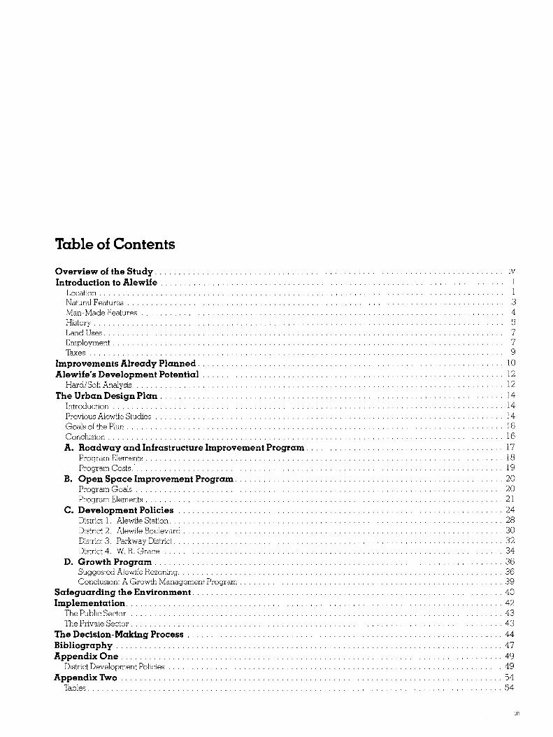
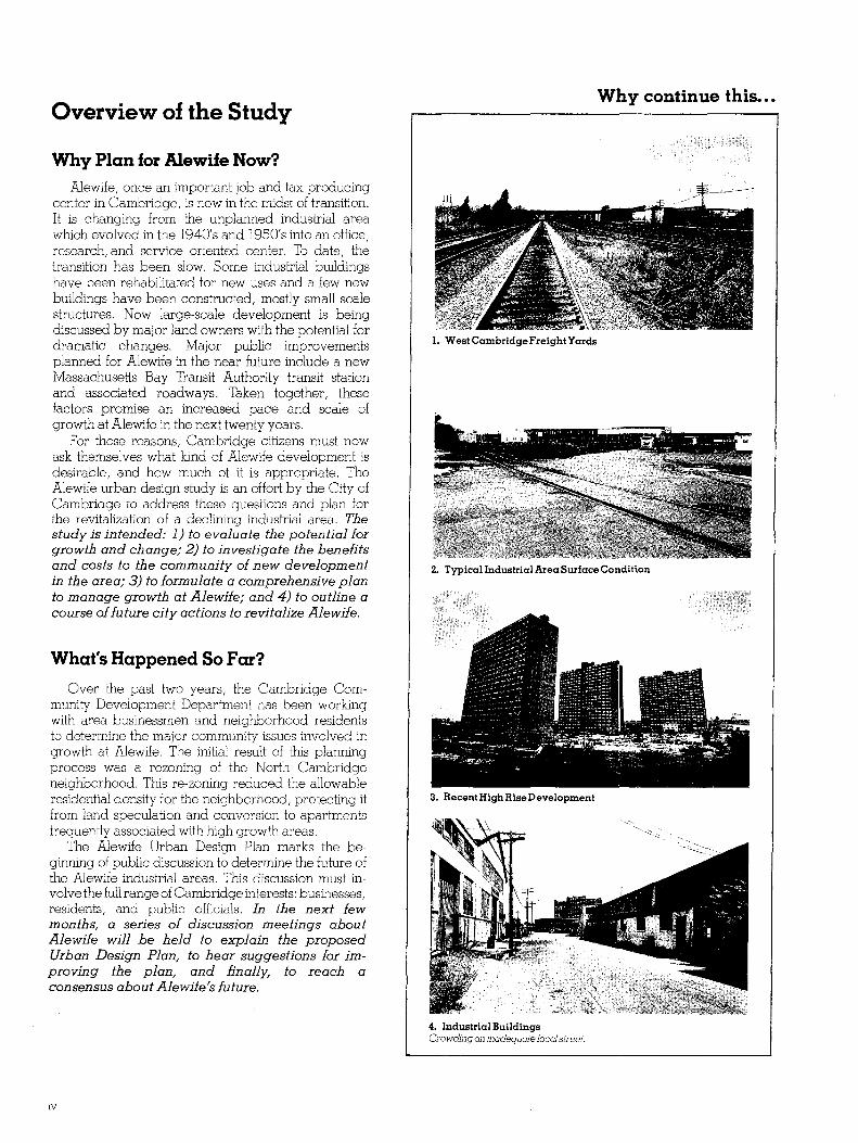
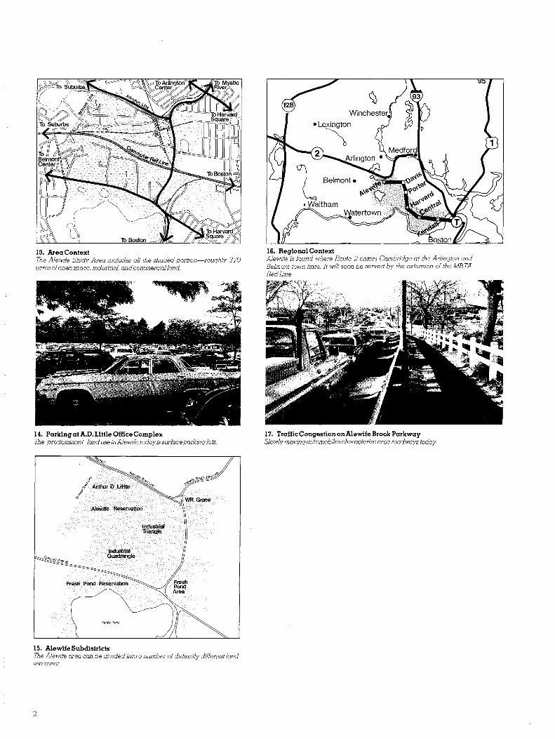
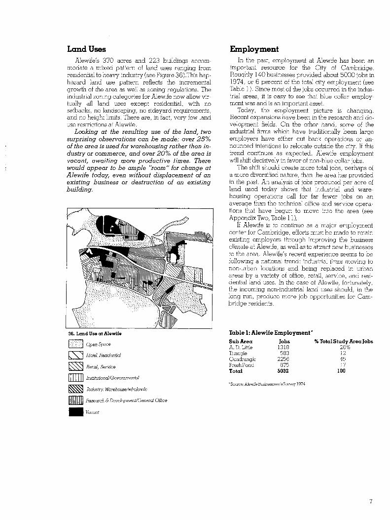