cleanup and revitalization through urban development optimization
DESCRIPTION
Architectural research for a prorposed development in the current Pandacan Oil Depot conducted by students from Pamantasan ng Lungsod ng MaynilaTRANSCRIPT

1

2
CHAPTER I - INTRODUCTION
I. HISTORICAL BACKGROUND
History of Environmental Hazards
Although the oil depot was established in 1914,
shortly after the Spanish-American War, a series of recent
events have struck the adjacent communities and the
greater Metro
Manila area with a sense of urgency to reclaim their right
to a safe and healthy environment. In 2001, Mayor Lito
Atienza passed Manila City Ordinance 8027, reclassifying
the depot zone from industrial to commercial, mandating
the removal of the depots. Rather than relocating,
Chevron, Petron and Shell came into a Memorandum of
Understanding (MOU) with the City of Manila. The MOU,
signed by Mayor Atienza and the three oil companies,
legally surpassed Ordinance 8027. The oil companies
additionally filed petitions with Manila Regional Trial Court
seeking injunctions to suspend the ordinance from taking
effect (Alternative Shell Report, 2004). The MOU resulted
in a minimal scale down of the depot and the
commemoration of the adjacent park that simultaneously
serves as a buffer zone. In 2002, the Asian branch of Time
Magazine cited Philippine intelligence officials recognizing
the Pandacan oil depot as a target for terrorism after an
explosion on a public transit system was traced to a South
East Asian-based terrorist group, Jemaah Islamiah. During
the first bucket brigade in the Philippines and throughout
Asia in 2003, United Front to Oust Oil Depots (UFO-OD) in
collaboration with Global Community Monitor conducted
air testing with household materials, such as buckets,
throughout the communities that border the fences of oil
depots. Professional lab results found alarming levels of
benzene in the air. University of the Philippines College of
Medicine (UP) also reported abnormal levels of lead in
urine samples and diagnosed the majority of patients
tested with median neuropathy or nerve damage. The UP
health study also shows a lower rate of neuropathy as the
distance from the oil depot increases. Since the bucket
brigade in 2003, catastrophic spills and explosions have

3
alarmed the Pandacan community. In 2005, an estimated
40,000 liters of diesel fuel overflowed from a Chevron-
operated pipeline leading from Batangas to Pandacan. In
2006, a single-hull vessel contracted by Petron Oil
Company, carrying 528,000 gallons of industrial bunker oil
sunk off of the west coast of Guimaras. The spill continues
to spread, contaminating hundreds of kilometers of
coastline with sticky oil in Guimaras, Iloilo and Negros
Occidental. 1
Relocation Debacle
In 2001, the 3 oil companies and the Department of
Energy (DOE) entered into a memorandum of agreement
(MOA) providing for a formulation of a "master plan" for the
relocation of the Pandacan oil terminals. Then Manila
Mayor Lito Atienza approved City Ordinance No. 8027,
reclassifying the land use of the Pandacan oil depot area
from Industrial II to Commercial I. In 2002, with the 6-
month deadline looming, the city of Manila and the DOE
entered into a memorandum of understanding (MOU),
1 Activists Confront Oil Companies. www.resistinc.org. Accessed August 05, 2014
stating that "the scaling down of the Pandacan oil depot
terminals was the most viable and practicable option."
Mayor Atienza approved City Ordinance No. 8119 or the
“Manila Comprehensive Land Use Plan and Zoning
ordinance of 2006” that reclassified the oil depot area into
a High Density Residential/Mixed Use Zone in 2006. In
2007, The Supreme Court (SC), deciding on the petition
for mandamus filed by the Social Justice Society against
Mayor Atienza in December 2002, ruled that Atienza
should immediately enforce Ordinance No. 8027. The
objective of the ordinance is to protect the residents of
Manila from the catastrophic devastation that will surely
occur in case of a terrorist attack on the Pandacan
Terminals. Later in 2008, The SC ruled that Ordinance No.
8027 was valid and constitutional, and there were no
impediments to enforce it. The court also said that
Ordinance No. 8119 did not repeal the first ordinance.
Mayor Alfredo Lim approved City Ordinance No. 8187,
which was filed months before the final SC decision. It
amended Ordinance No. 8119 and reclassified the
Pandacan oil depot into a heavy industrial zone, therefore

4
allowing the stay of the 3 oil companies there in 2009.
Three years after, in 2012, the city council enacted City
Ordinance No. 8283, amending Ordinance No. 8187, and
reverted the area back to its high-density
commercial/mixed use zone classification. It also gave the
oil companies until January 2016 to relocate their
Pandacan terminals. After a few months, Lim vetoed
Ordinance No. 8283. The city council reversed Lim's veto,
but the mayor vetoed it again in October, saying that the
Pandacan oil depot played a critical role in the supply of
petroleum products not only in Metro Manila but the entire
country as well. Finally, this April 2014, Mayor Estrada
chose to enforce Ordinance No. 8283, and reiterated the
Jan 31, 2016 deadline to the oil companies to relocate
from the Pandacan oil depot.2
A. Background of the Problem
Pandacan Oil Depot is a 33-hectare industrial zone
which houses the so-called Big Three Oil Companies –
2 TIMELINE: Pandacan oil depot relocation debacle. www.rappler.com. Accessed August 05,2014
Petron, Shell and Caltex (now Chevron), and supplies the
fuel needs of Metro Manila and nearby provinces. Over the
years, the risk of road accidents, product spills, and threats
to security and health for the tankers and public have
increased. Concerned people in the area have been
complaining about the intense and alarming odor emitted
by the giant oil depots that lie on the banks of Pasig River.
Several incidents related to the oil depot have proven that
the oil storage facilities adversely affect the environment
and pose a danger to the health and lives of Manila
residents.
In February 1997, two Shell oil tankers exploded
inside their premises of the oil depot complex. In 1999, a
pipeline leak was the source of fires in Muntinlupa City
with one fatality. In January 2008, a tanker burst into
flames at the foot of the Nagtahan fly-over, killing one and
wounding another. Not too long ago, in July 2010, the
FPIC underground pipeline leak caused panic and anxiety
among residents as water mixed with oil in the basement
of the West Tower Condominium in Barangay Bangkal,
5
Makati.3
Studies from the University of the Philippines
Manila found out that exposure to refined petroleum
products causes neurophysical effects amongst the
residents near the Pandacan Oil Depot. The number of
cases of neurophysical disorders in the area has been
progressively increasing. In the same year, a health survey
proved that the air in and surrounding the oil depot contain
high levels of Benzene. Benzene is known to increase the
risk of cancer and wreaks havoc on the nervous,
respiratory, and immune systems.
The concern about the threat to human lives arose
due to the 9/11 terrorist attack on the World Trade Center
in New York. 4 The very close proximity of Malacañang in
the depot invites possibility of terrorist attacks for the great
destruction it can cause.
3 A CENTURY-OLD CHALLENGE. The oil depots in Pandacan. Interkasyon.com. Accessed August 05, 2014 4 Planning Workshop for the Dismantling of the Oil Depot in Pandacan: Enforcing Ordinance No. 8283. Summary of Workshop Output by NGO Program Secretariat
Several city ordinances are approved reclassifying
the area from industrial to commercial to mixed use zone.
Despite all of this, the oil storage facilities still did not
conform to the land use of the area. The inconformity to
the zoning and land use plan of the oil depot results to
numerous environmental hazards that pose threat to the
lives and health of the people and the community.
The local residents in the vicinity of the oil storage
facilities are very much dependent in the depot as most of
the inhabitants are working there. The oil depot provides
many programs and benefits for the people. As the
relocation pursue, many people will be unemployed. The
welfare of the residents especially those who are
employed in the depot is one of the concerns that needs to
be addressed.
B. Background of the Study
On April 03, 2014 Manila Mayor Joseph Estrada
gave the oil companies in the Pandacan oil depot until Jan
31, 2016 to shut down their oil storage facilities and

6
relocate to another area.5 Once the Big 3 oil companies
leave it in 2016, the 33-hectare area will be nothing but
brownfield. Expansion, redevelopment, or reuse of the oil
depot may be complicated by the presence of
contamination. The owners of the oil storage facilities will
have trouble selling the vacant sites, as potential liability
for cleanup costs and environmental contamination is
something to worry about. As a result, the site will end up
being abandoned, decreasing the tax base of the area and
becoming the source of diseases in the community.
The redevelopment of brownfields can provide
many benefits to the public, including an increased tax
base, the creation of new jobs, the utilization of existing
infrastructure, and the removal of blight.6 The potential for
harm, both to human beings and to the wider environment,
will have to be considered, especially if any contamination
is to be left on the site. Through Brownfield
Redevelopment, public health and environmental hazards
posed by the site will be reduced.
5 TIMELINE: A Pandacan Oil Depot Relocation debacle. www.rappler.com. Accessed August 05, 2014 6 Brownfield Redevelopment. www.umich.edu. Accessed August 05, 2014
The redevelopment process includes revitalization
of the area. Developers integrate cleanup and construction
activities. Detailed plans are prepared for streamlining the
process and ensuring all issues are resolved so that the
redevelopment process runs smoothly. Progressively,
transformation of the area will be expected once
commercial and residential buildings rise on it as the
expected outcome of this study.
C. Background of the Project
As the relocation of the 3 big oil companies pursue
in 2016, many land developers will be eager in proposing
different projects for the transformation of Pandacan Oil
Depot. Thus, as the proponents of this study, a part of the
33-hectare area is to be developed into a Business Park
once the redevelopment of the brownfield land is deemed
to be successful. The objective of this project is
construction and rehabilitation of a part of the 33-hectare
area of Pandacan Oil Depot and to develop structures and
communities that have a combination of residential,
business and retail uses in the area.

7
Unfortunately, the uncertainty of rehabilitation costs
for contaminated sites intimidate potential developers and
investors, hence prolonging the cleanup and
redevelopment of the site. Several companies in the
Philippines offer brownfield management solutions to
rejuvenate and reuse abandoned sites.
Once the cleanup and redevelopment process
progresses, the construction of the Business Park in the
area proceeds. The oil depot has an additional advantage
residing beside the Pasig River. Commercial structures will
benefit from this advantage having land and water
approaches which will encourage the transformation of the
area. This project will promote urban renewal which is
what Manila needs nowadays and will open new
opportunities to the residents of Pandacan as they enjoy
the ease of proximity to so many options.
II. STATEMENT OF THE PROBLEM
Brownfield lands are contaminated lands that are
left abandoned and undeveloped, which pose a threat to
the community if left unresolved. Through brownfield
redevelopment, a vast array of vacant, abandoned, and
underutilized property that, if properly managed for
environmental health and safety issues, can be very
desirable for redevelopment.7 One of the main issues
involving brownfield redevelopment is the concern over
legal liability. The uncertainty of rehabilitation costs for
contaminated sites can frighten away many potential
developers and investors.8
This study aims to create an architectural solution
that will maximize the potentials of brownfields and at the
same time introduce a new trend on sustainability which
will give way to a development that will provide
opportunities in enriching Pandacan and employment for
the residents. Specifically, the proponents target to answer
the following questions:
1. How can brownfield redevelopment and reuse help
Pandacan Oil Depot in eliminating the threat in the
7 Michigan Brownfield Redevelopment Innovation: Two Decades of Success (2010) p.1 8 Brownfield Redevelopment. www.umich.edu. Accessed August 05, 2014
8
health and lives of the people caused by the
brownfield land?
2. Can Brownfield Redevelopment be helpful for these
communities?
3. What can the proposed Business Park offer to
encourage revitalization of the area?
4. How can the proposed Business Park address the
existing problems of the local residents as the
relocation of the oil storage facilities pursue?
III. SIGNIFICANCE OF THE STUDY
The residual levels are acceptable for an industrial
site. However, standards for a mixed-used development
are more stringent. The change of use triggered the
intensified testing programs and research of the soil
condition of Pandacan Oil depot.9
Last October 9, 2004 HRA (Health Risk
Assessment) of soil and water content of Pandacan oil
depot were conducted by DENR (Department Environment
9 Pandacan Scale Down Project. p. 22
and Natural Resources). Samples were collected from the
surface soil, subsurface soil and groundwater of the site
and found that the content of water and soils includes
mineral oil, some chemical compounds; traces of metals:
barium and vanadium (possibly from the soil originally
used for reclaiming the site) and traces of pesticides
including Organochlorines (“Drins”). These were the
‘hazards’ identified. These hazardous elements are threat
in environment and human health.
When the oil storage facilities relocate, the site will
be a brownfield land. When abandoned brownfield lands
are left neglected, contaminants may migrate off-site,
creating hazards on the nearby community. Therefore, in
order for the site to be safe and at the same time be useful
for human habitation, a brownfield redevelopment will be
established.
Brownfield redevelopment seeks to environmentally
assess existing brownfield properties, prevent further
contamination, safely cleanup polluted properties, and
design plans for reuse. It promotes a sustainable

9
development for the proposed Business Park. By this
process, the site helps to improve the quality of the
environment in the community and removes real and
perceived threats to health and safety.
Communities may experience many environmental,
social and economic benefits from brownfield
redevelopment that:
Removes actual and potential sources of land,
water and air contamination
Recovers desirable locations, allowing for smarter
growth through urban intensification
Removes or renovates abandoned and derelict
buildings, decreasing the risk of injury, vandalism
and arson
Preserves historical landmarks and heritage
architecture
Beautifies urban landscapes
Revives older urban communities and surrounding
areas
Locates new development in areas where better
use can be made of existing municipal infrastructure
and services such as transit
Increases property assessment values and the
resulting tax base, leading to increased revenue for
governments
Reduces urban sprawl
Preserves greenfield land, which may be productive
farmland or environmentally significant land.10
The proposed Business Park will provide many job
opportunities especially to those who will be greatly
affected by the relocation of the oil storage facilities. This
will be a waterfront development that offers various
activities and lifestyle choices, along with a majestic view
through the buildings oriented towards the Pasig River.
The local residents will be rest assured that their health
and security will no longer be in danger and a sustainable
and lively community will be developed.
10 Brownfield Redevelopment: What You Should Know. cielap.org. Accessed August 05, 2014

10
IV. GOALS AND OBJECTIVE OF THE STUDY
The main goal of this proposal is to provide a
solution that will transform the oil storage facilities into a
development which will benefit the residents of Manila
particularly those in Pandacan, and at the same time will
generate income, through brownfield redevelopment.
While the objectives include:
Promoting brownfield redevelopment solution in
reusing and revitalization of contaminated lands
which supports sustainability
Informing developers on the benefits of
redeveloping brownfields instead of greenfield.
Introducing a new trend in addressing the problem
regarding environmental remediation that support
redevelopment
Developing and taking advantage of the potentials
of the site.
Educating people around the vicinity on what are
the benefits of brownfield redevelopment that can
help the environment and their way of living.
Developing a Business Park that will address the
problems of the site and the local residents
Justifying the proposed Business Park as the
subject of revitalization for the community of
Pandacan.
V. SCOPE AND LIMITATIONS OF THE STUDY
This study is directed by the rules and regulations
set by the PD 1096 also known as The National
Building Code of the Philippines , other laws
concerning and governing the proposal, also, by the
parameters given by the local government
standards and with the guidance of the local
government of the City of Manila.
For the present owners, this study is not intended to
forcedly relocate the existing structure or to give a
bad impression to the function of the depot; it is only
to empower and provide a solution to the problem
and not to impose the damages inflicted by the oil
depot both to the residents and the environment.
The study will focus on the process of brownfield
11
redevelopment and to the Business park which will
be developed in the Shell perimeter of the chosen
lot and not the entire property of the Pandacan oil
depot.
This study excludes the fields of structural, sanitary,
mechanical, electrical, and electronics engineering.
This study is limited to the information, statistics and
literature obtained by the researchers up to their
corresponding stretch.
This study would deal with the following:
o Design feasibility (Background,
Significance & Related literature, Statement
of the Design Problem)
o Research (Deeper study on Brownfield
Redevelopment and the local availability of
the treatment needed)
o Architectural Analysis (Space
Requirements, User and Vehicular Traffic
Circulation, Design Standards and
Circulation, Site Selection, Inventory &
Assessment, Land Use & Zoning)
o Design Synthesis (Architectural Design
Concept & Philosophy, Working Drawings)
The proposal is an income-generating development,
so the proposal will be concerned on the profit and
therefore the research on revenue will be
significant, as the return of venture for profitable
facilities or structure are parts of the study. The
return of investment of the development will be
observed and defended.
12
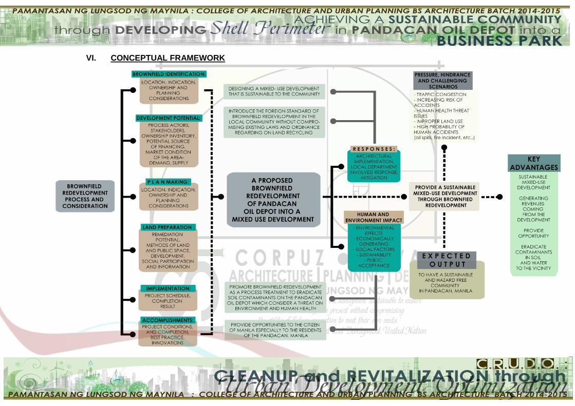
VI. CONCEPTUAL FRAMEWORK

13
VII. DEFINITION OF TERMS
Benzene - found in the air from emissions from burning
coal and oil, gasoline service stations, and motor vehicle
exhaust.
Blight - something that spoils or damages something, a
disease that affects plants, or a general state of neglect
and disrepair in an urban area.
Business Park - an area specially designated and
landscaped to accommodate business offices. All of the
work that goes on here is commercial and can be
residential
Brownfield - According to the Small Business Liability
Relief and Brownfields Revitalization Act of 2001, a
brownfield is defined as a real property, the expansion,
redevelopment, or reuse of which may be complicated by
the presence or potential presence of a hazardous
substance, pollutant, or contaminant.
Brownfield redevelopment - cleaning up of sites that
help improve the quality of the environment in the
community and removes real and perceived threats to
health and safety.
Community - a group of people who live in the same area
Department of Environment and Natural Resources
(DENR) - the executive department of the Philippine
government responsible for governing and supervising the
exploration, development, utilization, and conservation of
the country's natural resources.
Drins – also called Organochlorine. Insecticides that are
among the oldest, most toxic, and most environmentally
destructive synthetic pesticides. These chemicals were
used extensively in agriculture, forestry, and in home pest.
They target the central nervous system, and many of them
are suspected to cause cancer.
Greenfield - used in construction and development to
14
reference land that has never been used (e.g. green or
new), where there was no need to demolish or rebuild any
existing structures.
Health Risk Assessment (HRA) - health questionnaire,
used to provide individuals with an evaluation of their
health risks and quality of life.
Mixed Use Development - development that blends
residential, commercial, cultural, institutional, and where
appropriate, industrial uses.
Neurophysical disorder - cerebral dysfunction from any
physical cause manifested by changes in mood, behavior,
perception, memory, cognition, or judgment and/or
psychophysiology.
Oil Spill - an accidental release of oil into a body of water,
as from a tanker, offshore drilling rig, or underwater
pipeline, often presenting a hazard to marine life and the
environment.
Ordinance No. 8283 - reclassifies the Pandacan oil depot
area from industrial to commercial, which will force the oil
companies to transfer their storage facilities.
Petroleum - a kind of oil that comes from below the
ground and that is the source of gasoline and other
products
Revitalization - the process of making something grow,
develop, or become successful again.
Sustainability - to ensure that actions and decisions today
do not inhibit the opportunities of future generations. The
main idea of sustainability is to concentrate on
environmental conditions to achieve a designed product
with maximum internal attributes of environment so that it
can minimize the undesirable aspects of these
constructions.
Urban Sprawl - the unplanned, uncontrolled spreading of
urban development into areas adjoining the edge of a city.
15

16

17
CHAPTER II - REVIEW OF RELATED LITERATURE,
STUDIES AND STRUCTURES
I. LITERATURE
A. Local
A CENTURY-OLD CHALLENGE | The oil depots in
Pandacan
By: Mari-An C. Santos, InterAksyon.com
This article introduces Pandacan as a neighborhood
rich in history. According to this article, the genesis of
Pandacan can be traced back to the year 1574. It was a
home to one of the heroic Gomburza, Father Jacinto
Zamora. Other prominent Pandacan residents include the
father of Philippine Opera Ladislao Bonus, pioneering
Filipina doctor Paz Mendoza Guazon, revolutionary leader
Apolinario Mabini, and sports celebrity Jacinto Ciria-Cruz.
What used to be a farming community became partly
industrial during the American occupation. Shell
established facilities in 1914, Caltex (now Chevron) in
1917, and Petron in 1922. The area was destroyed as a
consequence of the Second World War but revived soon
after.
The proponents found out in this article that
Pandacan Oil Depot is a 33-hectare compound that
houses the storage facilities and distribution terminals of
the so-called Big 3: Chevron, Petron, and Shell. The
guarded and fenced facility is in the city of Manila, in close
proximity to densely populated areas Pandacan, Paco,
Sta. Mesa, and Sta. Ana. Along the same riverbank, less
than two kilometers away, lies the seat of the nation’s
power, Malacañang Palace. The First Philippine Industrial
Corporation (FPIC) is in charge of the underground
pipeline system that runs from the oil refineries in
Batangas to the Pandacan oil depot
This article explains the Ordinances approved
regarding the classification of Pandacan in terms of land
use. These are dependent on the administration governing
the City of Manila. Examples are Ordinance No. 8027 that
re-classified Pandacan from an industrial to commercial
area in 2001. In 2009, the area was re-classified as a

18
heavy indusrial zone under Ordinance No. 8187. In late
2012, Ordinance No. 8283 re-classified the area as a high-
intensity commercial zone, thus giving the oil depot until
2016 to relocate.
Moreover, this article is indeed helpful for the
researchers as an overview of the history and problems
about Pandacan Oil Depot which will be the site for the
proposed development. It has been very vocal about the
needs to remove and rehabilitate the area. Plans for the
area include not only removing hazardous facilities but
also utilization of the area that will be vacated. Jobs will
surely increase when the large complex is opened up to
businesses as well as sports complex, cultural venues,
entertainment centers, parks, hospital, schools, and low-
cost housing. Not to mention, the unquantifiable benefits of
a cleaner environment
What’s a brownfield?
Philippine Daily Inquirer
By Amado de Jesus
This editorial explains the importance of brownfields
in choosing a site for a building project and expounds the
challenges, planning process and remediation techniques
in brownfields.
According to this article, reusing and rehabilitating
damaged land instead of developing virgin land is a
sustainable practice. It reduces pressure on undeveloped
land resource. In almost all countries there are many
cases of prime development areas like riverfront sites,
industrial waste sites, abandoned warehouses and others
with access to public transportation and inner-city core
activity. These sites could be redeveloped into mixed
housing and commercial projects, or community gardens
and orchards, and many other land uses.
Moreover, the planning process includes visual
inspection of the current use of the land and a study of its
past use through documents and interviews. If the findings
19
show signs of possible toxic materials in the land like lead,
arsenic or asbestos, the process becomes more intensive.
Sampling of the soil, soil gas, ground water, surface water
or sediment is made to determine the type and quantity of
contaminants. A work plan is then made on how the site
will be cleaned up for the intended use. Once the work
plan is approved, the developer may avail of tax credits,
loans or grants. The cleanup of a particular site can be
monitored at the local level. New owners of brownfields
may not be liable for contaminants created in the past, but
they have to comply with certain requirements prescribed
by law.
Furthermore, there are several ways to apply
remediation techniques in a contaminated brownfield
depending on the type and location of the contaminant.
Remediation techniques include removal of contaminants
from the site; others are treated on site, while others are
contained on site so as not to spread. In the case of
diesel-contaminated soil, some of the shallow soil is
excavated and aerated so that volatile hydrocarbons will
be released before the soil is removed from the site. The
remaining soil is covered with several feet of clean fill.
To sum it up, brownfield redevelopment is very
much a part of the effort to reduce our ecological footprint,
which is the impact of human activity on the land and its
finite resources. The most important consideration
however is public safety and health.
REPUBLIC ACT No. 9593 otherwise known as
Tourism Act of 2009 and Its Implementing Rules and
Regulations
This particular section contributes on to how the
proponents will consider the existing brownfields in the oil
depot to develop Tourism Enterprise Zones (TEZs) for the
purpose of developing the Philippine Tourism industry as
engine of socioeconomic growth.
This document includes pertinent information for
this study such as the following:
Tourism Enterprise zones (TEZs) are classified as

20
1. Greenfield Tourism Zones – which are areas
with new or pioneer development, or
2. Brownfield Tourism Zones – which are areas
with existing infrastructures or development as
determined by the TIEZA (Tourism Infrastructure
and Enterprise Zone Authority)
Registered TEZ operators and enterprises are entitled to
the following fiscal and non-fiscal incentives.
1. Income Tax Holiday (ITH)
New enterprises in Greenfield and Brownfield
Tourism Zones shall be entitled to six (6)
years ITH from start of business operations,
which may be extended up to a maximum of
six (6)
years if the enterprise undertakes substantial
expansion or upgrade prior to the expiration
of its first six(6) years
An existing enterprise in a Brownfield Zone
may avail of a maximum of six (6) years non-
extendible ITH if it undertakes extensive
expansion or upgrade of facilities.
Net operating losses for any taxable year
immediately preceding the current taxable
year which had not been previously offset as
deduction from gross income, may be carried
over as deduction from gross income for the
next six (6) consecutive years immediately
following the year of the loss.
B. Foreign
Brownfields: A Comprehensive Guide to Redeveloping
Contaminated Property, Third Edition
by Todd S. Davis, Scott A. Sherman
This book provides a step-by-step, solution-oriented
look at the environmental and economic challenges of
redeveloping contaminated property. Beginning with a
thorough explanation that puts brownfields redevelopment
into a current context, this guide then focuses on the most
important legal, business, financial and political issues

21
associated with redeveloping contaminated real estate.
Brownfields provides an exceptional insights and
strategic advice from experts in various disciplines. It also
includes discussions about the basic science for dealing
with contaminated property effectively and it offers detailed
and current information about the important elements of
each state's voluntary cleanup program.
This book provides the detailed background necessary
to make informed decisions and offers practical advice for
implementing effective strategies for change. It helps the
proponents:
Find new funding sources to finance the brownfield
redevelopment
Interpret federal and state laws governing liability
for the cleanup of brownfield sites
Evaluate current State Voluntary Cleanup
Programs, including financial and tax incentives,
eligible or excluded properties, cleanup standards,
and liability protections
Develop a strategy for getting the brownfields deal
done
Understand basic science and emerging concepts
involved in risk-based science used to cost-
effectively address contaminated property
Gain insight into key issues from experts on
managing environmental liabilities
Commercial and Mixed-Use Development: Code
Handbook
July 1, 2009 Oregon Transportation and Growth Management
Program
This code handbook provides guidance for
encouraging commercial and mixed-use development that
follows Smart Development principles through public policy
and land use ordinances.
According to this handbook, commercial
development is constantly reinventing itself. After
relocating in strip-malls, commercial development is now
returning to America’s downtowns and main streets. These
areas are experiencing a renaissance, as people

22
seek more intimate and pedestrian-friendly shopping
experiences. Suburban commercial centers and corridors,
too, are being transformed. Cities are converting
brownfields into urban villages with housing, retail,
entertainment, and civic uses, and e-commerce is
spawning small businesses in old warehouses and along
main streets. All of these innovations pose opportunities
and challenges for managing growth in our communities.
This Handbook is a guide to encouraging
“smart” commercial and mixed-use development
through public policy and land use ordinances.
The guidance is based on the following
Smart Development principles.
Efficient Use of Land Resources. Efficiency means urban
development is compact and uses only as much land as is
necessary.
Full Utilization of Urban Services. Use existing service
capacity where available. Size new facilities to meet
planned needs. This principle recognizes that we must
make the most of our infrastructure investments.
Mixed Use. Mixed-use development brings compatible
land uses closer together.
Transportation Options. Options should include walking,
bicycling, and public transit, where it is available or may be
provided in the future.
Detailed, Human–Scaled Design. Smart design is
attractive design that is pedestrian–friendly and
appropriate to community character and history.
These principles are “smart” ways of building a
community, providing numerous benefits to all citizens.
They represent the wise use of resources (both financial
and natural resources), sound management of public
facilities, and the building of community. The principles are
both financially successful and publicly responsible.
This Handbook benefits the proponents because it
provides strategies, best practices, and model ordinances
for implementing Smart Development in commercial and
mixed use areas. Specifically, the Oregon Highway Plan

23
(OHP) and the OHP’s Land Use and Transportation Policy
are referenced.
II. STUDIES
A. Local
PANDACAN RESIDENTS’ PERCEPTION, ATTITUDE
AND BEHAVIOR TOWARDS HEALTH AND SAFETY
RISKS
Unpublished Thesis, University of the Philippines College of Mass
Communication
This study, which sought to determine the
perceptions, attitudes and behaviors of Pandacan
residents toward health and safety risks, conducted a
survey and focus group discussions among Pandacan
residents. Attitudes were measured by the level of
agreement towards various health and safety practices
while behavior was measured by the adherence to these
practices. The risk which the residents generally
considered as alarming, dreadful, shocking and
depressing was the incidence of fire; this was due to their
past experiences of residential fires. Attitudes towards
health and safety practices were divided among
respondents. On the other hand, data on behavior
generally implied that residents adhere to these health and
safety practices. Findings revealed that respondents were
knowledgeable on health and safety risks pertinent in their
area; the information they get from various sources, with
the local government unit (barangay) as the most cited and
credible source. Risk perception was associated with
proximity to the location oil depots while familiarity did not
have a significant link with perception.
The presence of oil depots posed certain risks on
the residents particularly on health and safety. This study
determined several health risks such as respiratory
ailments, skin ailments, blood-related disorders, immune
and nervous system-related illness, cancer as well as
vomiting and headaches. Security threats such as terrorist
attacks, toxic chemicals and incidence of fire that may be
linked with the presence of oil depots were also given.

24
This thesis study is beneficial to the proponents
because it has proven that Pandacan Oil Depot has been
posing a threat to the health, safety and security of the
people since then. The said study verified that as for the
topic on safety and security, local residents indeed
recognized that there were risks tied with the presence of
oil depot particularly the possibility of explosions, fires and
terrorist attacks.
ADAPTIVE REUSE OF PANDACAN OIL DEPOT
by Michael T. Querido
This study elaborates Planned Unit Development
(PUD) where everything is on one cluster as the most
appropriate solution in transforming Pandacan Oil Depot
when the companies vacate the site.
In this study, the researcher enumerates what
Planned Unit Development (PUD) controls and promotes.
These are the following:
A mixture of both land uses and dwelling types with
at least one of the land uses being regional in
nature
The clustering of residential land uses providing
public and common open space
Increased administrative discretion to a local
professional planning staff while setting aside
present land use regulations and rigid plat approval
processes
The enhancement of the bargaining process
between the developer and government
municipalities which in turn strengthens the
municipality's site plan review and control over
development for potentially increased profits due to
land efficiency, multiple land uses, and increased
residential densities.
This study will be useful for the proponents because
designating PUDs or offering them as a development
option are good techniques to motivate redevelopment of
brownfields or vacant properties in urban centers. PUDs
are generally directed at market rate developments, but
subsidized projects can locate in PUDs as well. Because
25
of the special nature of PUDs, and their potential to create
housing forms that differ from neighboring properties, cities
often stipulate affordable housing as a PUD component
through development agreements or in exchange for
density bonuses. This can be particularly helpful for
growing, expensive housing markets and for ensuring that
affordable housing is developed as a part of new dense
and diverse development.
B. Foreign
The Role of Brownfields Redevelopment in the
Rejuvenation of an Older Industrial City: A Case Study
of Two Successful Brownfields Reuse Projects in
Baltimore, Maryland
Bachelors of Arts, University of Montana, Missoula, Montana, 1993
by Gregory William Lewis
This thesis investigates federal and state
brownfields policies and reviews contemporary brownfields
literature and through a case study approach, it explains
how state and federal policies created a climate conducive
to brownfields redevelopment in Baltimore, Maryland. By
analyzing two successful Baltimore projects, the research
shows how the reuse of brownfields had a positive “ripple-
effect” that helped precipitate neighborhood-level
investment and revitalization.
This study examines two relatively early brownfields
remediation projects: a former Montgomery Wards retail
and distribution facility and a former Proctor and Gamble
soap manufacturing plant, both in Baltimore, Maryland.
Much of the foundation for this study is based on the need
to further analyze the positive changes that take place
after the development project.
In summary, this thesis demonstrates that the
transformations of Montgomery Park and Tide Point were
not chance occurrences. It took aggressive public policy to
overcome the stigma associated with industrial properties
and today the sites fill the wants and needs of thousands
of Marylanders. Not only have the sites become urban
workplaces, the redevelopment projects are saving
valuable undeveloped lands and restoring prosperity to
Baltimore.

26
Around Montgomery Park and Tide Point the blight
and abandonment are gone and the neighborhoods are
being transformed and rejuvenated; these are two
examples of great restoration efforts in an aging industrial
city.
This thesis is beneficial to the proponents because
it explains insight on how best to utilize brownfields
redevelopment to curb land-consumption. A better
understanding of how and why state and federal policies
exist and highlighting significant economic benefits will
help push reuse projects to the forefront of the country’s
need to address steady population growth and associated
land development needs.
SOCIO-ECONOMIC REVITALIZATION THROUGH
BROWNFIELD RECLAMATION
by Corrin James Breeding
The purpose of this thesis is to investigate if socio-
economic revitalization can be achieved through
brownfield reclamation. From the late 19th century to the
early 20th century, the core of major cities in the United
States witnessed a tremendous growth in population size
and industrial infrastructure. After the Great Depression
and suburbanization, many industrial sites were
abandoned and left to become undesirable locations.
Today these forgotten brownfield sites are a
handicap to the environment because they have been
ignored. Most of them are too hazardous to allow human
contact within certain vicinity. As the structures that once
housed workers and manufacturing products crumble to
the ground, more chemicals and pollutants seep into the
soil and local bodies of water. The quality and state of the
environment degrades in the process. This has
devastating effects on the health of local citizens,
ecosystems and neighborhoods if not rectified.
The design proposal offered in this text showcases
many ways that the Phillip’s Metals and G-36 site can be
utilized for the socio-economic benefit of both the local
neighborhoods and entire city. First and foremost, a clean

27
and safer environment is created. Even if all that was done
to the site was eliminating the debris and contaminant
sources, it would still provide improvements to the area.
The soil would be more stable to sustain plant life and the
water that flows in 2nd Creek would become suitable to
support wildlife.
In this project bioremediation serves a dual
purpose. Since land farming is a form of bioremediation it
can become a teaching tool to educate people in the
neighboring communities and throughout the city on
farming techniques. Even though it is unlikely that this
notion would motivate individuals to conduct farming on a
grand scale, it could inspire people to start small home
gardens or even community gardens. If these communities
were given further guidance on how to grow and maintain
crops it could promote scenarios where people could make
financial gains by selling their produce. These ideas could
potentially stimulate the community socially since it would
take a collective effort (communication amongst the
members) to take care of the gardens. A step further and
the idea of creating jobs and/or incentives for the citizens
could come into fruition. Children can even get involved to
witness natural processes in their environment therefore
better connecting them to the natural world.
Placing new infrastructure (buildings, roads, etc.) on
a site usually requires manual labor. An intense amount of
effort would go into the construction and maintenance of
the proposed site which would generate several jobs in the
process. A task of this proportion would require skilled
professionals such as landscape architects, engineers,
architects, chemists, horticulturalists, etc. to achieve the
goal of redeveloping on these brownfields. Once the
infrastructure is operating a new wave of economic
opportunities is presented
In the proposed design, the implementation of
mixed-use buildings is a key component. This will create a
unique setting where affordable housing and commercial
units fuse into one festive market space that offers many
experiences. The affordable housing would allow residents
to save money while the owners of the businesses make
economic gains. The city would benefit from tax money

28
newly redeveloped land would generate. The current state
of the property is actually costing the city environmentally
and economically since it is not being used or maintained.
The final product provided by this thesis document
benefits the proponents because it presents viable
solutions to environmental, social and economic concerns.
With large amounts of brownfield land available to reclaim
it would benefit the city to not only expand the business
district areas but provide its citizens with a unique
experience in the process. Taking into account the people
living in disadvantaged neighborhoods, there are ways to
involve them in the process. Their environment could
potentially become a tool used to deliver them from all of
the harsh conditions.
III. STRUCTURES
A. Local
Rockwell Centre
Rockwell Centre in Makati which is also located
along the Pasig River banks is an old 15.5 – hectare
thermal power plant operated by Lopez owned – Manila
Electric Railroad and Light Company. Rockwell Center
began its construction in 1998. The design of the centre
was carried out by international architectural firm
Skidmore, Owings, Merril under the direction of former
design partner Larry Oltmanns.
Known to many as a 'city within a city', Rockwell
Center was envisioned as a mixed-use development to
fulfill the needs of a growing community of residents,
tenants and professionals who put their confidence in the

29
Rockwell brand of luxury and lifestyle. It was once a
brownfield left by its past use as a thermal power plant.
Through redevelopment of brownfield, the lands of
Meralco’s former thermal plant site transformed into a
high-end living environment, now the Rockwell Center.
The Rockwell Center has been successfully developed
into a self-contained, mixed-use community consisting of
seven high-rise upscale residential towers, two office
buildings, a lifestyle shopping mall, a city club, and a
leading business graduate school.
Bonifacio Global City (BGC)
Bonifacio Global City was once called Fort McKinley when
the United States government first acquired in 1902.
Three years after the Philippines gained independence
from the United States, Fort McKinley was turned over to
the Philippine government. In 1957, it was renamed Fort
Bonifacio after Andres Bonifacio – the father of Philippine
Revolution.
The RA 7227, otherwise known as the Bases
Conversion & Development Act of 1992• gave birth to
Bonifacio Global City. A total of 440 hectares of raw land
served as military base was converted into alternative
productive use.
In 2003, Ayala Land, Inc. and Evergreen Holdings,
Inc. entered into a landmark partnership with BCDA to help
reshape and redevelop Bonifacio Global City into a
development where office buildings, residential
condominiums, mall and retail shops. This area that once
synonymous to war was turned into a world class business
and residential centre today.

30
The development of the Bonifacio Global City is
controlled through the Declaration of Covenants,
Conditions and Restrictions, Design Standards and
Guidelines and codes, rules and regulations relating to
land development, building construction, including the
Philippine Codes on environmental protection, structural,
electrical, mechanical, sanitation/plumbing, fire safety, as
well as statutes on enhanced mobility of disabled persons,
and any amending or new legislation.
UP-Ayala Land Technohub
The U.P.–Ayala Land TechnoHub is an information
technology hub jointly developed by the University of the
Philippines Diliman and property developer Ayala
Land. It occupies 20 hectares within the 37.5 hectares of
the U.P. North Science and Technology Park. The entire
development was listed as an approved IT Park by the
Philippine Economic Zone Authority (PEZA) and ideal for
Business Process Outsourcing firms. Fourteen low-rise
corporate buildings, designed for the development of
science and technology, are built, around which are a
man-made lagoon and natural landscaping to boost the
park’s objectives of refreshing the body and invigorating
the mind
A center retail area with a fountain plaza and
conical towers serves as convergence point and
emphasizes the technological focus. This environmentally-
sustainable park has systems for district cooling, water
recycling, and storm water management.
B. Foreign
Flat Branch Park
Former Bulk Oil Terminal Returns as a Center of Community Activity

31
In the early nineteenth century, the property served
as the market square for the City of Columbia. From 1908-
1968, it was utilized as a bulk oil terminal for the Missouri,
Kansas and Texas Railroad (MKT). In 1977, the MKT
abandoned the section of track and the City of Columbia
converted the land into a hiking, biking, and fitness trail
with a National Rails-to-Trails Conversion grant—one of
the first awarded in the United States. In 1997, the city
received a $40,000 grant from the Missouri Department of
Natural Resources to remove a dilapidated building on the
property. After demolition of the abandoned petroleum
facility, soil contamination was found and the city applied
for an EPA Brownfields grant to assist with the cleanup.
The Cleanup grant was awarded in 2003. Throughout the
cleanup process, over 7,500 cubic yards of oil-
contaminated soil were removed from the property, as well
as 12,000 gallons of contaminated water.
Key accomplishments:
Secured $200,000 in funding from EPA to assist
with the cleanup of 1.11 acres of contaminated
land, which was completed in less than a year.
Leveraged $427,352 in local funding; $321,587 in
donations; and a $149,850 Land and Water
Conservation Fund Grant for a total of
approximately $900,000.
Removed 7,500 cubic yards of contaminated soil
and 12,000 gallons of contaminated water.
Revitalized an area in the heart of the business
district that serves as an example of how public and
private funding can result in success.
Honored by the Midwestern chapter of the
International Society of Arboriculture for the

32
project’s landscaping and tree planting.
Outcome:
Flat Branch Park now serves as a center of
community activity with a playground, spray grounds,
benches, a storm water rain garden, an amphitheater,
sculptures by a local artist and a gazebo that may be
reserved for special events. The landscaping at the park
received the Gold Leaf Award from the Midwestern
Chapter of the International Society of Arborculture (ISA).
This award is given annually to an individual or community
that has used landscaping to enhance environmental
protection, conservation and beautification. In June 2008,
the park hosted the Twilight Festival and offered a variety
of activities for families and kids each Thursday night. In
addition to the activities, the park serves as a trailhead for
the MKT Nature and Fitness Trail which extends over eight
miles and connects many of Columbia’s parks. The trail is
also part of the American Discovery Trail which extends
from Delaware to California and passes through towns and
cities, highlighting cultures, heritages and landscapes.
Robertson On The River
Former Textile Mill Cleaned Up and Transformed into Affordable
Housing
Constructed in 1890, the Robertson Mill operated
as a mill for yarn production and various other textile
products until it was closed in the early 1990s. The
property remained vacant until the Weir Corporation
purchased it in 2003 from Combined Realty Trust. The mill
was a blight and safety concern for the historic Weir
Village community due to the soil contaminated with
polyaromatic hydrocarbons (PAH) and lead from the
railroad easements that serviced the mill, and asbestos.

33
Key accomplishments:
More than $15 million in redevelopment funding
leveraged from local, state, and public entities
6.5 acres cleaned up and 40 redevelopment jobs
leveraged.
Soil excavation, lead and asbestos removal, and
removal of Underground Storage Tanks (USTs) was
funded by a $140,000 Brownfields RLF Loan and a
$148,000 Brownfields RLF subgrant from the City of
Taunton
Outcome:
EPA awarded a $52,000 cleanup grant to the non-
profit Weir Corporation for the redevelopment of the
140,000-square-foot historic Robertson Mill with its
partner, Combined Realty Trust, into 64 units of affordable
rental housing, 18,000 square feet of commercial space, a
community meeting room, and a 100-foot wide Riverfront
Park. On November 16, 2004, groundbreaking ceremonies
were held for the Robertson on the River apartment
complex. Less than a year later, on October 31, 2005, a
grand opening ceremony was held for the complex, which
has 20 one-bedroom, 34 two-bedroom, and 10 three-
bedroom apartments and offers affordable rent to
households earning between 30 and 60 percent of the
median income. Currently, 63 of the 64 apartments are
occupied with over 120 people living at Robertson on the
River and two new businesses are located on the first
floor.

34
35
CHAPTER III – REASEARCH DESIGN AND
METHODOLOGY
In this thesis proposal, the methodology is divided into
two phases, the first phase is the cross sectional approach
which examines the issues concerning the brownfield
redevelopment, its impact and significance to the city. The
second phase uses longitudinal approach in determining
the feasibility of the process of brownfield redevelopment
in Pandacan Oil depot and the Business Park that will be
constructed to improve the socio-economic status of
Pandacan, Manila.
I. CROSS SECTIONAL AND LONGITUDINAL
APPROACH
A cross-sectional study is based on observations of
phenomena at a single point in time, while the longitudinal
study involves analyzing data at different points in time
(Babbie 2010). In this study, the cross-sectional analysis
will determine whether or not areas adjacent to brownfields
exhibit a significantly different socio-economic composition
when compared to the whole city where the brownfield is
located. The hypothesis is that areas adjacent to
brownfields will exhibit higher minority and lower income
residents compared to the average of the city in which the
brownfield located.
II. STUDY AREA
This particular project will utilize a part of Pandacan
oil depot as the site for the study. Identifying the proper
site within the depot is important since the aim is to
provide a better environment for the local residents and
the community as well. Facts gathered form different
government agencies and departments that includes data
and maps of Pandacan oil depot, the history and
speculated site contaminants, will help in identifying the
specific site the proponents will work on. This study will
conduct a site selection within the perimeters of Pandacan
oil depot. The criteria for site selection in this study will be
discussed.
A. Site Selection Analysis
Site selection indicates the practice of new facility
location, both for business and government. Site selection
36
involves measuring the needs of a new project against the
merits of potential locations.
1. Steps in Site Selection
The site selection process involves a series of data
collection and evaluation activities that become specific in
each subsequent step of the process. Each step evaluates
the suitability of the criteria. The evaluation move in a
methodical manner, addressing the more detailed criteria
as the process proceeds.
The following steps were established by the
proponents of this thesis relying on the same foreign
studies.
Step 1: Confirm Readiness. The purpose of readiness
review is to assess when to begin the formal and informal
site selection activities, to determine whether there are any
significant changes in the assumption of the Feasibility
Study and Site and Design Prospectus and to identify the
emerging issues and information that can have impact on
site selection.
Step 2: Develop the Work Plan. Creating and using Wok
Plan establishes a framework for organizing and leading
the site selection effort.
Step 3: Conduct Search for Sites. The search for the
potential site requires an understanding regarding to
property acquisition, as well as the familiarity with real
estates and the development activities in the local
community.
Step 4: Evaluate a Long List. Site selection parameters are
needed. Typically, the most suitable area will be chosen
and another analysis for that chosen area will be
conducted. In this study, the proponents used a Phasing
method to determine the boundaries to be developed.
Step 5: Evaluate Recommended Site. The purpose of this
step is to assess the site chosen for the study. The
inherent pressures and conflicts will be considered in the
completion of analysis and evaluation.

37
2. Site Selection Elements
This study establishes a set of basic site selection
elements and offers suggested evaluation criteria for rating
the elements. Although this study incorporates an internal
weighting factor (a list of few key ranking criteria elements
which have high cost impacts in more than one sub-
category) it does not prescribe the importance of most
selection elements but rather, incorporates a weighting
system whereby a district or community can assign a
range of importance to each element. It is recognized that
information for all the elements cannot always be
determined nor are all elements applicable to every site.
However, detail and rigor in addressing the elements is
important for an effective evaluation.
The selection elements are as follows:
a) Social and Land Use Factors
Site Surveying
The geological and hydrological structure of the site is
indeed important in determining what kind of development
is suitable for the site.
Accessibility to the site
The main entrances and the main road abutting the site
also have to be noted. Easy accessibility to the site is very
important for any kind of project.

38
Major Landmarks
After spotting the major landmarks, analyze the integrity of
their existence in close proximity to the site. It is essential
to know as to what kind of impact these structures would
have on a site.
Proximity to other facilities
Accessibility for the facilities such as Fire Control
Department,
Police Assistance Unit, Local Barangay Hall(s), Health
Services and the like shall be observed and analyzed.
Orientation of the site
Orientation of site will help in orienting the structure
correctly in the process of designing.
Sustainability Factors
It is important to satisfy three important principles of Green
Architecture which aims at Sustainability:
Energy Efficiency
Water Efficiency
Material Efficiency
Site Services
Study of services on site is also very important. The major
site services include:
Water Supply
Electricity Lines
Drainage Lines
b) Construction Cost Factors
Socio-Economic Characteristics
The community should be able to accept the construction
of the site. Readily available market and buy back centers
is good to be near the location of the site. Public
acceptance of the treatment must be observed.
Economic feasibility
The site location and detailed site analysis will give an idea
of the economic feasibility of the project. It means that the
type of building or construction you are looking forward to
proposing a site would be a successful venture or not
depending on the conditions of the site.

39
c) Operation and Maintenance Cost Factors
After the absolute study of the site, one can
conclude the kind of project to be executed, its feasibility
and also its sensitivity to be shown towards designing the
structure and the site as well.
3. Weighing Factor
Assigning weighing factors to the analysis is an
opportunity to apply its values to the evaluation process so
that the final scores for each site reflect issues involved at
the local level. This is often accomplished through
community surveys, public meetings and other forums for
developing consensus among the parties affected by the
school project. A suggested scale of weighting factors is
shown below.
Weighting Factors
1 = undesirable
2 = desirable
3 = highly desirable
4. Applying Ranking Criteria
Following the assignment of the weighting factors,
each selection element is evaluated according to
established criteria and ranked on the simple five point
scale from 0 to 4. The table below gives a suggested
definition of each ranking score:
Social and Land Use Factors
CRITERIA: RATING:
Size of Site
Proximity to Population to be Served
Proximity to Future Expansion of Community
Proximity to Important Existing Facilities
Year-round Accessibility
Site Topography
Road Access
Visibility, Safety of Driveways
Driveway Conflicts and Internal Circulation

40
Safe Routes to School for Pedestrians and Bicycles
Roadway Capacity, Safety Needs
Aesthetic Value
Sun Orientation
Site Drainage
Proximity to Natural Hazards
Zoning/Land Use
Proximity to Fire Response
Equipment
Flooding
Existing Site Development
Access to Outdoor
Recreation/Learning
Noise
Wetlands
Potential for Hazardous Materials
TOTAL:
Construction Cost Factors
CRITERIA: RATING:
Soils/Foundation Conditions
Availability of Water Utilities
Availability of Sewer Utilities
Availability of Electric Power
Availability of Fuel
Storage/Distribution
Year-round Accessibility
Driveway Conflicts and Internal Circulation
Roadway Capacity, Safety Needs
Ease of Transporting Construction
Materials
Site Cost
Existing Site Development

41
Operational and Maintenance Cost Factors
CRITERIA: RATING:
Safe Routes to School for Pedestrians and Bicycles
Site Drainage
Flooding
Site Erosion
Sun Orientation
Protection from Elements
Proximity to Natural Hazards
Alternative Energy Sources
Site Evaluation Summary Table
CRITERIA: S I T E
PHASE I
PHASE II
PHASE III
Social and Land Use Factors
Construction Cost Factors
Maintenance and Operating Cost Factors
After the specific site is selected, a site inventory
will be put together to gain more knowledge on the present
state as well as how it influenced the adjacent community.
Site visits, collecting vast amounts of inventory, photo
documentation, more literature reviews and interviewing
local residents will be carried out to successfully achieve
the goal.
Comprehensive analysis was the next step in the
process. The site selected will undergo a thorough study.
The potential contaminants will be identified on the site.
The potential user groups will be observed and the needs
of the community will be taken into account. For a solution
to be put together, more literature reviews and case
studies will be completed to identify what development
best fit the chosen site. The analysis will be diagrammed in
a way that viewers could comprehend the information
relevant to this thesis.
Once the analysis is complete and the proper
solutions for this brownfield site along with the neighboring
42
communities are identified, detailed drawings were used
as a method of design investigation and design
communication.
III. SOURCES OF DATA
The main nutrient of a research is the data. It must be
gathered meticulously and analyzed well to know how
relevant it is for the project. The following are the sources
of data collected.
A. Library
The library is the oldest and most widely used in
researching. This facility will provide a wide range of
sources readily available for use. The proponents will
mostly be dependent on libraries because brownfield
redevelopment has no standards yet in the country so, the
proponents will introduce this process for public
acceptance. The following will be the libraries to be visited:
Pamantasan ng Lungsod ng Maynila Library
PLM College of Architecture and Urban Planning
CAD Room
Mapua Institue of Technology Library
De La Salle University Library
B. Government Data
Statistical data, census, laws and the like coming from
the government research associated to the Pandacan oil
depot will be part of this thesis. All information is to be
gathered for examining and counterchecking the data
presented. The following will be the government agencies
to be visited:
Department of Environment and Natural Resources
(Environmental Management Bureau)
Department of Agriculture (Bureau of Soils)
City Planning and Development Office – Manila City
Hall
NGO Program Secretariat
Manila District Traffic and Parking Bureau
Drafting and Surveying Department – Manila City
Hall
43
C. Interviews
Several people are known to be experts of the area of
study. The researchers are in need of firsthand information
from these people and this information will surely be
relevant to the proposal. Some interviewees are the
operational staff of the company specialized in
redeveloping brownfields. The proponents also need to
interview the lot owners of Pandacan oil depot, barangay
chairman, residents near the vicinity of the depot and other
people who are very much concerned about the relocation
of the oil storage facilities. The following will be the set of
interviewees relevant to this proposal:
Arch. Marlou B. Campaner (CPDO, Manila City
Hall)
Engr. Gil F. Ferareza Sr. (Environmental
Management Specialist, EMB – NCR)
Atty. Donna Gasgonia (Board Regent of UDM,
Legal Aid, M.O.)
Von Francis C. Mesina (Executive Director, NGO
Program Secretariat)
Frujan Gabican Villareal (MDTPB)
Zaldy Magdaleno (Barangay 847 Secretary)
D. Surveys
Surveys are significant to this study. Areas near
Pandacan oil depot are to be surveyed to know how the
public would accept the process of brownfield
redevelopment and the proposed Business Park if it is
brought up to construction. Surveys will give a clear view
of the data. This will also play as evidence to strengthen
this study.
The following will be the sample survey to be
disseminated to the local residents in the vicinity of the
study area.

44
Listed below is a set of questions to be answered by the
residents, barangay officers and other persons involved in
the vicinity of Pandacan Oil Depot.
1. Are you aware of the upcoming relocation of
Pandacan Oil Depot in Batangas this 2016?
2. Are you familiar in the process of Brownfield
Redevelopment or Land Remediation?
3. Are you in favor of the relocation? If yes,
4. What is/are the reason/s that made you agree in the
relocation?
a) Risk for human health
b) Unpleasant smell of gasoline
c) It destroys the environment because of
pollutant
emission
d) Can cause fire and other massive accidents
e) All of listed above
f) Others: Please specify:
____________________________________
____________________________________
____
5. What structure or development do you prefer in
replace to the oil storage facilities?
Please check at least three (3).
o School
o Commercial Mall
o Hotel
o Condominium
o BPO Office Building
o Hospital
o Wet and dry market
o Commercial Stall/s
o Parking Building
o Museum or Exhibit Gallery
E. Ocular Inspection
Site inspection will give on-hand data on the
existing condition of the Pandacan oil depot. Since the soil
condition is important in this study, several data would be
gathered through inspection.

45
46
CHAPTER IV - THEORETICAL FRAMEWORK
AND ARCHITECTURAL PROGRAMMING
I. FEASIBILITY STUDY
This study aims to provide an architectural solution
that would aid the existing and future problems
encountered by the community of Pandacan due to the
contaminated site that will be left by the oil storage facility
when the 3 big oil companies leave it on 2016. This
proposal intends to promote brownfield redevelopment
solution in reusing and revitalization of contaminated lands
which supports sustainability. While brownfield properties
are more complex to develop than traditional greenfield
properties (properties which have never been previously
developed), the benefits of redevelopment far outweigh the
costs. In fact, in many cases, leaving these properties idle
presents liability risks and financial losses, not to mention
the potential impacts to the environment and human
health.11
11 A Practical Guide to Brownfield Redevelopment in Ontario, p.7
Many of the soils located on the brownfield sites in
the study area have been labeled as contaminated and
investigations are being conducted by the storage facilities
itself to better assess the area. A similar study in the City
of Knoxville presented that contaminants such as
polychlorinated biphenyls (PCBs), polynuclear aromatic
hydrocarbons (PAHs), lead based paint, asbestos
containing buildings materials, industrial chemicals
including chlorinated solvents, creosote, and various
priority pollutant metals may be found in an oil storage
facility. Therefore it can be assumed that some of these
chemicals may be present in the depot. Some of these
chemicals can originate from materials found in buildings
(lead and asbestos mainly) and others can come from
machinery or similar items used for industrial practices.
These chemicals can have devastating effects in the air,
water and soil.
Parcels of land in the depot are believed to be
contaminated by petroleum hydrocarbons including
gasoline and diesel. These chemicals usually originate
from vehicular or heavy machinery used on site. Since this

47
area housed several factories and oil tanks that relied on
the railroad system to transport goods, it is safe to assume
that this is where the chemicals came from. Petroleum
spills can have devastating environmental effects if it gets
into the soil or water.
Pandacan Oil Depot as a brownfield site is plagued
with contaminants that are harmful to the environment and
the inhabitants that live in close range to them. For these
parcels of land to be reused they must be remediated. In
this investigation to achieve an architectural solution
through brownfield reclamation, the Shell perimeter in
Pandacan oil depot will be chosen as the site of this study.
The main concern of Barangay officials is the
welfare of the residents, particularly those who are
employed in the oil depot. The presence of the oil depot
provides programs for delinquent youths, skills
development, environment-based seminars, medical
services, and employment.12 Employment and livelihood of
the people directly affected by the relocation of the oil
12 Workshop Report (NGO Program Secretariat), p. 4
storage facilities is at risk. To address this problem, this
study will propose a development that will produce job
opportunities during and after the cleanup and remediation
process.
This redevelopment of such is not new anymore to
our country. Rockwell Centre in Makati which is also
located along the Pasig River banks is an old 15.5 –
hectare thermal power plant operated and owned by
Lopez Group of Companies. Rockwell Center began its
construction in 1998. The design of the centre was carried
out by international architectural firm Skidmore, Owings,
Merril under the direction of former design partner Larry
Oltmanns. The Rockwell Center includes high-rise office
buildings, condominium towers, a law and business
schools and a shopping mall.
Bonifacio Global City (BGC) in Taguig, an old
military camp was converted, in 2003 by Ayala Land, Inc.
and Evergreen Holdings, Inc. partnered with Bases
Conversion and Development Authority; into a
development where office buildings, residential
48
condominiums, mall and retails shops. This area that once
synonymous to war was turned into a world class business
and residential center today. BGC effectively links all this
developments by properly and intensively using not an
ordinary public parks and spaces.
BGC and Rockwell Center’s successful stories is an
epitome that Pandacan Oil Depot once vacated by the oil
companies; by proper execution of plans, and strict
administration will surely be another world-class
development in Manila and in the country.
The proposed business park will sit on an 11.5-
hectare land which is the present perimeter of Shell,
Philippines Inc. This will complement the rapid urban
growth of the city by incorporating multi-use development
components, environmental sustainability and riverfront
principles to achieve balance between the built and natural
environment. The proponents envision having a mall,
condominium units, BPO offices, parking building,
apartment building and lush landscaping and pedestrian
promenades that will create a relaxing foreground.
This proposal will be endorsed by the Philippine
Green Building Council which will promote green building
practices to the industry to ensure a sustainable
development. Having a foreign consultant to facilitate the
cleanup and remediation process, and the Ayala Land
Corporation, Megaworld, and other investors for financial
assistance, this study is deemed viable and this
development is a necessity of the community and the local
residents that will reduce life threatening contaminants in
the site, improve public safety, create a healthy and living
environment, generate income, and produce more jobs for
the people.
II. SITE UTILIZATION AND LAND-USE STUDIES
A. Soil Type
This soil map shows that there are different soil
types within the site boundaries. Understanding the soil
characteristics is important for this project in determining
the development potentials of the site
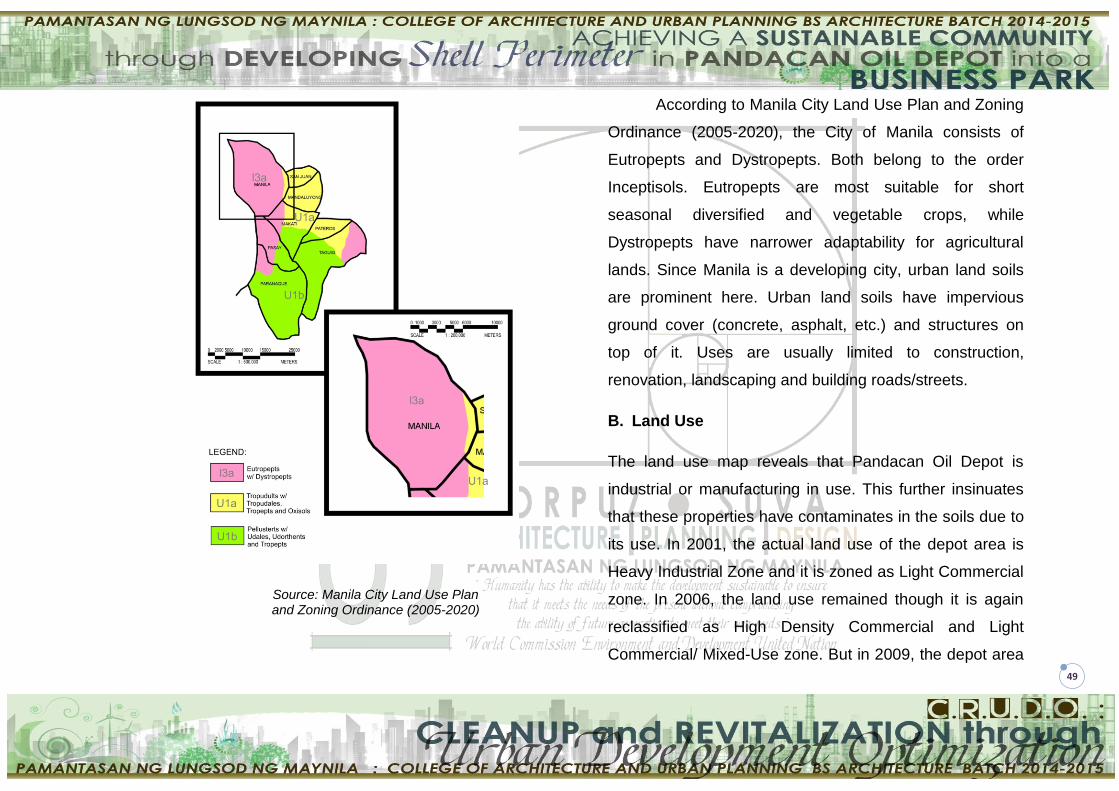
49
Source: Manila City Land Use Plan and Zoning Ordinance (2005-2020)
According to Manila City Land Use Plan and Zoning
Ordinance (2005-2020), the City of Manila consists of
Eutropepts and Dystropepts. Both belong to the order
Inceptisols. Eutropepts are most suitable for short
seasonal diversified and vegetable crops, while
Dystropepts have narrower adaptability for agricultural
lands. Since Manila is a developing city, urban land soils
are prominent here. Urban land soils have impervious
ground cover (concrete, asphalt, etc.) and structures on
top of it. Uses are usually limited to construction,
renovation, landscaping and building roads/streets.
B. Land Use
The land use map reveals that Pandacan Oil Depot is
industrial or manufacturing in use. This further insinuates
that these properties have contaminates in the soils due to
its use. In 2001, the actual land use of the depot area is
Heavy Industrial Zone and it is zoned as Light Commercial
zone. In 2006, the land use remained though it is again
reclassified as High Density Commercial and Light
Commercial/ Mixed-Use zone. But in 2009, the depot area

50
was reclassified as a Heavy Industrial Zone, thus making
the land use conforming. In 2012, the area was reverted
back to its High Density Commercial and Light Commercial
/ Mixed-Use zone giving the area until 2016 to relocate.
The proposed development in the study area is a Business
Park consisting of a Mall, BPO offices, parking building,
vertical housing and open spaces thus compliant to the
current zone of Pandacan Oil Depot.
Legend:
Residential
Commercial
Industrial
Institutional
C. Development Controls
The National Building Code of the Philippines with
its Revised Implementing Rules and Regulations has
provided development controls to determine the maximum
development potential of a lot.
1. Sizes and Dimensions of Courts
Minimum sizes of courts and yards and their least
dimensions shall be governed by the use, type of
construction, and height of the building as provided
hereunder, provided that the minimum horizontal
dimension of said courts and yards shall be not less than
2.00 meters. All inner courts shall be connected to a street
or yard, either by a passageway with a minimum width of
1.20 meters or by a door through a room or rooms.
The required open space shall be located totally or
distributed anywhere within the lot in such a manner as to
provide maximum light and ventilation into the building
R
e
s
i
d
e
n
t
i
a
l
R
e
s
i
d
e
n
t
i
a
l
R
e
s
i
d
e
n
t
i
a
l
R
e
s
i
d
e
n
t
i
a
l

51
YARD – the required open space left between the
outermost face of the building/structure and the property
lines, e.g., front, rear, right and left side yards. The width of
the yard is the setback. Yards prescribed for Commercial,
Industrial, Institutional and Recreational Buildings are
shown in the table below.
YARD
Type of Residential Use/Occupancy
R -1
(m)
R – 2 R – 3 R – 4
(Indiv.
lot/unit)
(m)
R – 5
(m) Basic
(m)
Max
(m)
Basic
(m)
Max
(m)
Front 4.50 3.00 8.00 3.00 8.00 4.50 6.00
Side 2.00 2.00 2.00 -
2.00
(opti
onal)
2.00
(optional
)
3.00
Rear 2.00 2.00 2.00 - 2.00 2.00 3.00
Residential 5 (R – 5)/Condominiums which will be
developed in the proposed Business Park will conform to
the minimum dimensions of yards which is 6.00 meters in
front and 3.00 meters both in the sides and rear.
2. Total Open Spaces within Lot (TOSL)
These are the courts, yards, gardens, light wells,
uncovered driveways, access roads and parking spaces,
which consist of two types:
Paved or tiled (hardscape area); sub-classification
of open space shall fall under Maximum Allowable
Impervious Surface Areas (ISA) within the Total Lot
Area (TLA) and
Unpaved areas within the lot that are with exposed
soil and planted (softscaped), i.e., the Unpaved
Surface Areas (USA); this sub-classification is the
true open space.

52
Building/Structure Use
or Occupancy
(or Land Use)
% of Total Lot Area (TLA)
Duly Approv
ed Zoning
Max Allowable PSO
Max Allowa-ble ISA (Paved Open
Spaces)
Min USA
(Unpa-ved
Open Space
s)
TOSL (ISA + USA)
Commercial
Commercial 3
(Comm – 3)
80 (without firewall)
15 5 20
90 (with
firewall) 5 5 10
The zoning of the study area as per approved by
the City Zoning Ordinance and its IRR is classified as
Comm – 3. Therefore the total open spaces within lot as
will be applied to the proposed Business Park is 20% of
the Total Lot Area. The Percentage of Site Occupancy
(PSO) plus the Total Open Spaces within Lot (TOSL) is
equal to the Total Lot Area (TLA).
3. Setbacks for Commercial, Industrial, Institutional
and Recreational Buildings
Road Right-of-Way
(RROW) Width (meters)
Front (meters)
Side (meters)
Rear (meters)
30.00 & above 8.00 5.00 5.00
25.00 to 29.00 6.00 3.00 3.00
20.00 to 24.00 5.00 3.00 3.00
10.00 to 19.00 5.00 2.00 2.00
Below 10.00 5.00 2.00 2.00
The study area which is the Shell perimeter is
bounded by a 8-m RROW, thus having the minimum
setbacks of 5.00 meters in front and 2.00 meters both in
the sides and the rear.
4. Building Height Limit
Building Height Limit (BHL) is the maximum height
to be allowed for buildings/ structures based on their
proposed use or occupancy. The BHL shall be generally
measured from the established grade line to the topmost

53
portion of the proposed building/structure. BHL excludes
the height of permitted/allowed projections above the roof
of the building/structure, e.g., signage, mast, antenna,
telecom tower, beacons and the like.
Character of Use or
Occupancy
Type of Building/ Structure
Building Height Limit (BHL)
Number of allowable
storeys/floors above
established grade
Meters above highest grade
Residential R – 5
Condominiums 12 – 18
36.00 – 54.00
Commercial C – 3
Commercial – 3 16 – 60
48.00 – 180.00
D. City Ordinance No. 8119
1. Zoning
The city ordinance no. 8119 is an ordinance
adopting the Manila Comprehensive Land Use Plan and
Zoning Regulations of 2006. Under this, the Pandacan Oil
Depot is classified under a C-3/MXD Zone. This ordinance
has provided Land Use Intensity Control that shall be
observed in the a C-3/MXD Zone.
(Source: PANDACAN PUD., CPDO)

54
Land Use Maximum
PLO Maximum
FAR
Commercial/Mixed Use High Intensity Commercial/Mixed
Use C3/MXD 0.80 7
PLO – Percentage of Land Occupancy
FAR – Floor Area Ratio
A C-3/MXD Zone shall be used primarily for high
intensity mixed use and commercial developments for
trade, business activities and service industries. The
service area covers a metropolitan to national scale of
operations. Enumerated below are the allowable uses:
1. All uses in C-2/MXD Zone provided that in case of a
residential building it shall have commercial
footprints
2. Manufacture of wood furniture including upholstered
3. Manufacture of rattan furniture including
upholstered
4. Manufacture of box beds and mattresses
5. Small-scale commercial warehousing activity
6. Large-scale commercial warehousing activity
(strictly located at District I)
7. Other commercial activities and those not
elsewhere classified
2. Height Regulations
Building height must conform to the height restrictions
and requirements of the Air Transportation Office (ATO),
as well as the requirements of the National Building Code,
the Structural Code, as well as all laws, ordinances, design
standards, rules and regulations related to land
development and building construction and the various
safety codes.
Public Open Space Zone
In Public Open Space Zone, no building or structure shall
be higher than ten (10) meters above the highest natural
grade line and provided it conforms with the zone’s
prescribed LUIC.
All Other Zones
There is no fixed building Height limit except those
prescribed by the Air Transportation Office (ATO) and
other government regulations. Within these zones, building

55
heights shall be based on the prescribed FLOOR Area
Ratio (FAR).
III. SITE DATA
A. Historical Background of the Site
Source: Social Justice Society vs. Atienza, G.R. No. 156052, 13
February 2008
The Pandacan Oil Depot, formerly largely
uninhabited, was ideal for various emerging industries as
the nearby river facilitated the transportation of goods and
products. In the 1920s, it was classified as an industrial
zone. Among its early industrial settlers were the oil
companies. Shell established its installation there on
January 30, 1914. Caltex (now Chevron) followed suit in
1917 when the company began marketing its products in
the country. In 1922, it built a warehouse depot which was
later converted into a key distribution terminal. The
corporate presence in the Philippines of Esso (Petron’s
predecessor) became more keenly felt when it won a
concession to build and operate a refinery in Bataan in
1957. It then went on to operate a state-of-the-art lube oil
blending plant in the Pandacan Terminals where it
manufactures lubes and greases.
On December 8, 1941, the Second World War
reached the shores of the Philippine Islands. Although
Manila was declared an open city, the Americans had no
interest in welcoming the Japanese. In fact, in their
zealous attempt to fend off the Japanese Imperial Army,
the United States Army took control of the Pandacan
Terminals and hastily made plans to destroy the storage
facilities to deprive the advancing Japanese Army of a
valuable logistics weapon. The U.S. Army burned unused
petroleum, causing a frightening fire. The fire consequently
destroyed the Pandacan Terminals and rendered its
network of depots and service stations inoperative.
After the war, the oil depots were
reconstructed. Pandacan changed as Manila rebuilt
itself. The three major oil companies resumed the
operation of their depots. But the district was no longer a
sparsely populated industrial zone; it had evolved into a

56
bustling, hodgepodge community. Today, Pandacan has
become a densely populated area inhabited by about
84,000 people, majority of whom are urban poor who call it
home. Aside from numerous industrial installations, there
are also small businesses, churches, restaurants, schools,
daycare centers and residences situated
there. Malacañang Palace, the official residence of the
President of the Philippines and the seat of governmental
power, is just two kilometers away. There is a private
school near the Petron depot. Along the walls of the Shell
facility are shanties of informal settlers. More than 15,000
students are enrolled in elementary and high schools
situated near these facilities. A university with a student
population of about 25,000 is located directly across the
depot on the banks of the Pasig river.
The 33-hectare Pandacan Terminals house the oil
companies’ distribution terminals and depot facilities. The
refineries of Chevron and Shell in Tabangao and Bauan,
both in Batangas, respectively, are connected to the
Pandacan Terminals through a 114-kilometer underground
pipeline system. Petron’s refinery in Limay, Bataan, on the
other hand, also services the depot. The terminals store
fuel and other petroleum products and supply 95% of the
fuel requirements of Metro Manila, 50% of Luzon’s
consumption and 35% nationwide. Fuel can also be
transported through barges along the Pasig River or tank
trucks via the South Luzon Expressway."
B. Annual Precipitation
According to Corona’s Classification (1920),
Manila’s climate belong to the 1st type in which has two
pronounced seasons – dry from November to April and
wet duringthe rest of the year.
A climate station by the Philippine Atmospheric,
Geophysical and Astronomic Services (PAGASA) provide
daily monitoring of climate variables such as rainfall
depths. Air temperature, wind speeds and directions, dry
and wet bulb temperature, relative humidity, cloudiness
and barometric schedule (PAGASA 2002)

57
(Source: http://nababaha.com)
C. Flood Prone Areas
The illustration above shows that the project area is
a high flood hazard due to its close proximity to the Pasig
River and Estero de Pandacan where the water height
reaches up to 1.5 meters. A proposed solution to this
problem is to add drainage system within the vicinity and
to improve the pavement system of the roads.
D. Seismicity
The City of Manila is physically vulnerable to
earthquake related hazards such as liquifaction and
ground shaking. A vulnerability analysis of various areas in
Manila is shown below Geological risks of various of
Manila.
BUILDING VULNERABILITY ZONES

58
E. Waterways and Esteros
The study area is situated along the banks of Pasig
River. Within and beside this area resides the Estero de
Pandacan which is the longest estero with a total length of
about 4966 meters lying on the southern part of the Pasig
River. Waterfront development is strategized in the
proposed Business Park in which the development will be
oriented towards the water as the front door. At present,
the Pasig River is categorized as class C water or only for
navigation use. The riverfront will be enhanced with well-lit
outdoor commercial activities that will enhance its image.
This side of Manila will be developed as a city by the river
that will push away industrial activities at the outskirts of
the city and will encourage major activity places.
F. Vegetative Cover
The vast majority of the vegetative cover on site is
along its borders. The plants up against the perimeter of
the Shell terminals provide a decent air quality buffer and
noise barrier against the oil storage facilities. This
complements the site and attractive plant material should
be put in place to beautify the area.
G. Impervious surfaces
Impervious surfaces are abundant within the project
perimeter. This mainly consists of roads, withered concrete
foundations and asphalt parking lots. Implementing
pervious surfaces (once the soil condition becomes less of
a problem) will be implemented to promote sustainable
design and eliminate the amount of chemicals present in
the soil.
H. Existing Circulation
Currently there are no pedestrian friendly
thoroughfares that lead individuals to the site or that
encourage exploration through it. This will be enhanced to
inspirevisitors to use the space. While a major road pass
near the borders of the site, only two small, underutilized
roads goes through the area. This concern will be
addressed when pedestrian safety is considered.

59
BASED ON CADASTRAL MAP OF PANDACAN DISTRICT MANILA : DRAFTING AND SURVEYING DEPARTMENT iN MANILA CITY HALL www.googlemap.com
IV. SITE SELECTION
A. Site Description
The Pandacan Oil Depot is a 33-hectare compound in
Pandacan district in Manila, Philippines, that houses the
storage facilities and distribution terminals of three major
players in the country's petroleum industry, namely Caltex
(a petroleum brand name of Chevron Corporation), Petron,
and Shell. The oil depot takes its roots from separate
establishments by these oil companies.
On the Southwestern side of the facility are Barangays
833 and 834. Many of the residents within the area work at
the terminals of Shell, Caltex and Petron. Shell Pandacan
Installation is one of the major petroleum product
installations of Pilipinas Shell Petroleum Corporation. It
supplies about 50% of total demand for fuel, 90% lubricant
requirements, and 25% of chemical needs nationwide.
Because of this, there are numerous transactions daily and
tanker loading operations inside the installation. Pandacan
Installation is the distribution center of refined oil products
like lubricants, greases, weatherkotes, bitumen and
chemicals. It has facilities for receiving, storing, blending,
and packaging of petroleum products. The installation
stores a variety of petroleum products in tanks.
B. Phasing
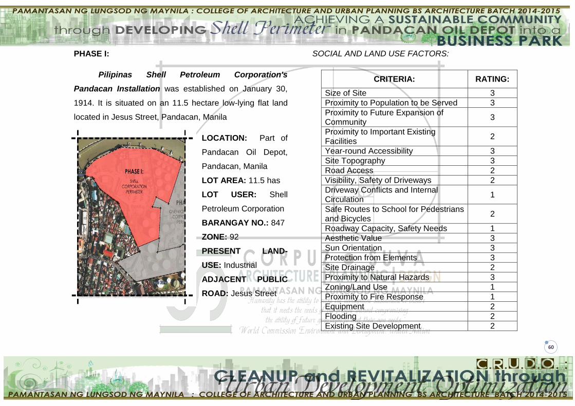
60
PHASE I:
Pilipinas Shell Petroleum Corporation's
Pandacan Installation was established on January 30,
1914. It is situated on an 11.5 hectare low-lying flat land
located in Jesus Street, Pandacan, Manila
LOCATION: Part of
Pandacan Oil Depot,
Pandacan, Manila
LOT AREA: 11.5 has
LOT USER: Shell
Petroleum Corporation
BARANGAY NO.: 847
ZONE: 92
PRESENT LAND-
USE: Industrial
ADJACENT PUBLIC
ROAD: Jesus Street
SOCIAL AND LAND USE FACTORS:
CRITERIA: RATING:
Size of Site 3
Proximity to Population to be Served 3
Proximity to Future Expansion of Community
3
Proximity to Important Existing Facilities
2
Year-round Accessibility 3
Site Topography 3
Road Access 2
Visibility, Safety of Driveways 2
Driveway Conflicts and Internal Circulation
1
Safe Routes to School for Pedestrians and Bicycles
2
Roadway Capacity, Safety Needs 1
Aesthetic Value 3
Sun Orientation 3
Protection from Elements 3
Site Drainage 2
Proximity to Natural Hazards 3
Zoning/Land Use 1
Proximity to Fire Response 1
Equipment 2
Flooding 2
Existing Site Development 2

61
Flooding 2
Existing Site Development 2
Access to Outdoor 2
Noise 2
Potential for Hazardous Materials 2
TOTAL: 53
CONSTRUCTION COST FACTORS:
CRITERIA: RATING:
Soils/Foundation Conditions 3
Availability of Water Utilities 3
Availability of Sewer Utilities 3
Availability of Electric Power 3
Availability of Fuel 3
Storage/Distribution 2
Year-round Accessibility 3
Driveway Conflicts and Internal Circulation
1
Roadway Capacity, Safety Needs 1
Ease of Transporting Construction 2
Materials 2
Site Cost 3
Existing Site Development 3
TOTAL: 32
OPERATIONAL AND MAINTENANCE COST FACTORS:
CRITERIA: RATING:
Safe Routes to School for Pedestrians and Bicycles
2
Site Drainage 3
Flooding 1
Site Erosion 1
Sun Orientation 3
Protection from Elements 2
Proximity to Natural Hazards 2
Alternative Energy Sources 2
TOTAL: 16
PHASE II:
The Caltex Terminal is bounded by Estero De
Pandacan in the West, Pasig River in the North and Petron
in the South.

62
LOCATION: Part of Pandacan Oil Depot, Pandacan,
Manila
LOT AREA: - hectares
LOT USER : Chevron (CALTEX) Corporation
BARANGAY NO.: 833 and 834
ZONE: 91
PRESENT LAND-USE: Industrial
PUBLIC ROAD ADJACENT: none
SOCIAL AND LAND USE FACTORS:
CRITERIA: RATING:
Size of Site 1
Proximity to Population to be Served 2
Proximity to Future Expansion of Community
1
Proximity to Important Existing Facilities 1
Year-round Accessibility 3
Site Topography 3
Road Access 1
Visibility, Safety of Driveways 3
Driveway Conflicts and Internal Circulation
3
Safe Routes to School for Pedestrians and Bicycles
2
Roadway Capacity, Safety Needs 2
Aesthetic Value 3
Sun Orientation 3
Protection from Elements 3
Site Drainage 1
Proximity to Natural Hazards 1
Zoning/Land Use 3
Proximity to Fire Response 1
Equipment 1
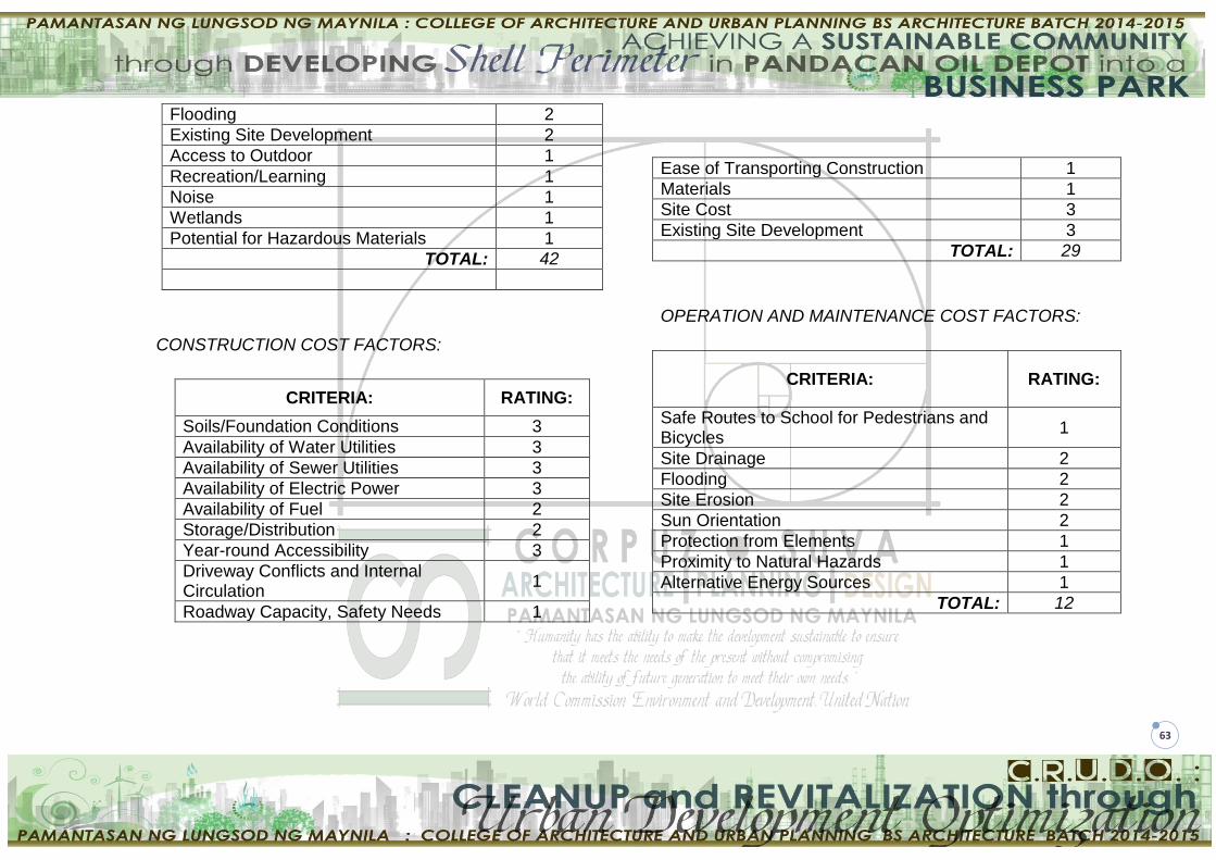
63
Flooding 2
Existing Site Development 2
Access to Outdoor 1
Recreation/Learning 1
Noise 1
Wetlands 1
Potential for Hazardous Materials 1
TOTAL: 42
CONSTRUCTION COST FACTORS:
CRITERIA: RATING:
Soils/Foundation Conditions 3
Availability of Water Utilities 3
Availability of Sewer Utilities 3
Availability of Electric Power 3
Availability of Fuel 2
Storage/Distribution 2
Year-round Accessibility 3
Driveway Conflicts and Internal Circulation
1
Roadway Capacity, Safety Needs 1
Ease of Transporting Construction 1
Materials 1
Site Cost 3
Existing Site Development 3
TOTAL: 29
OPERATION AND MAINTENANCE COST FACTORS:
CRITERIA: RATING:
Safe Routes to School for Pedestrians and Bicycles
1
Site Drainage 2
Flooding 2
Site Erosion 2
Sun Orientation 2
Protection from Elements 1
Proximity to Natural Hazards 1
Alternative Energy Sources 1
TOTAL: 12

64
PHASE III:
Petron Corporation is the largest oil refining and
marketing company in the Philippines. Supplying nearly
40% of the country’s oil requirements, the company’s
world-class products and quality services fuel the lives of
millions of Filipinos. Petron’s vision is to be the leading
provider of total customer solutions in the energy sector
and its derivative businesses.
LOCATION: Part of Pandacan Oil Depot, Pandacan,
Manila
LOT AREA: - hectares
LOT USER: Petron Corporation
BARANGAY NO.: 833 and 834
ZONE: 91
PRESENT LAND-USE: Industrial
PUBLIC ROAD ADJACENT: Beata Street. And Jesus
Street
SOCIAL AND LAND USE FACTORS:
CRITERIA: RATING:
Size of Site 3
Proximity to Population to be Served 3
Proximity to Future Expansion of Community
3
Proximity to Important Existing Facilities
2
Year-round Accessibility 2
Site Topography 3
Road Access 2
Visibility, Safety of Driveways 2
Driveway Conflicts and Internal Circulation
2

65
Safe Routes to School for Pedestrians and Bicycles
1
Roadway Capacity, Safety Needs 1
Aesthetic Value 1
Sun Orientation 2
Protection from Elements 1
Site Drainage 2
Proximity to Natural Hazards 2
Zoning/Land Use 2
Proximity to Fire Response 2
Equipment 2
Flooding 2
Existing Site Development 1
Access to Outdoor 2
Recreation/Learning 1
Noise 2
Wetlands 1
Potential for Hazardous Materials 2
TOTAL: 49
CONSTRUCTION COST FACTORS:
CRITERIA: RATING:
Soils/Foundation Conditions 3
Availability of Water Utilities 3
Availability of Sewer Utilities 3
Availability of Electric Power 3
Availability of Fuel 2
Storage/Distribution 2
Year-round Accessibility 3
Driveway Conflicts and Internal Circulation 2
Roadway Capacity, Safety Needs 1
Ease of Transporting Construction 1
Materials 2
Site Cost 2
Existing Site Development 2
TOTAL: 29
OPERATION AND MAINTENANCE COST FACTORS:
CRITERIA: RATING:
Safe Routes to School for Pedestrians and Bicycles
2
Site Drainage 2
Flooding 2
Site Erosion 2
Sun Orientation 2
Protection from Elements 2
Proximity to Natural Hazards 2
Alternative Energy Sources 1
TOTAL: 15
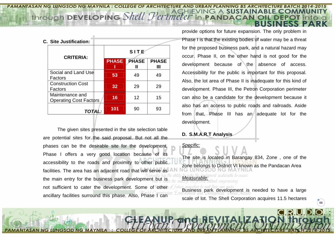
66
C. Site Justification:
CRITERIA: S I T E
PHASE I
PHASE II
PHASE III
Social and Land Use Factors
53 49 49
Construction Cost Factors
32 29 29
Maintenance and Operating Cost Factors
16 12 15
TOTAL:
101 90 93
The given sites presented in the site selection table
are potential sites for the said proposal. But not all the
phases can be the desirable site for the development.
Phase I offers a very good location because of its
accessibility to the roads and proximity to other public
facilities. The area has an adjacent road that will serve as
the main entry for the business park development but is
not sufficient to cater the development. Some of other
ancillary facilities surround this phase. Also, Phase I can
provide options for future expansion. The only problem in
Phase I is that the existing bodies of water may be a threat
for the proposed business park, and a natural hazard may
occur. Phase II, on the other hand is not good for the
development because of the absence of access.
Accessibility for the public is important for this proposal.
Also, the lot area of Phase II is inadequate for this kind of
development. Phase III, the Petron Corporation perimeter
can also be a candidate for the development because it
also has an access to public roads and railroads. Aside
from that, Phase III has an adequate lot for the
development.
D. S.M.A.R.T Analysis
Specific:
The site is located in Barangay 834, Zone , one of the
zone belongs to District VI known as the Pandacan Area
Measurable:
Business park development is needed to have a large
scale of lot. The Shell Corporation acquires 11.5 hectares
67
of the perimeter in Pandacan oil depot that can provide
adequate spaces for the proposal and for the option of
future expansion.
Achievable:
With the help of Ayaland Corporation, the local
government unit (LGU) and the participation of the
residents of Pandacan Manila with the compliance to R.A
1096 or The National building Code of the Philippines and
local ordinances acting upon, the proposed project will be
achievable after 10 years or less.
Realistic:
Soil contaminated site of Pandacan oil depot would be a
threat for the environment and most importantly to human
health. The relocation of the depot will give the opportunity
for the developer to develop the site. The business park
proposal will be a great idea in planning to provide a
sustainable community. But like any other project the
success of this proposal is dependent to the developer and
to the acceptance of the public.
Time-Bound:
The process of Brownfield redevelopment treatment of the
site to become usable for human structures will take at
least 10years of curing. The proponents must have a plan
to the for it to generate income while still in the process of
treatment. For this reason, the investors will get their
financial investment while preparing for the business park
development construction. The project must be timely
observed.
E. S.W.O.T Analysis
Strength:
The site is relatively flat (according to NAMRIA :
Topographic and Mapping Survey Division)
Has an access to (traverse by) Philippine National
Railroad.
Accessible to Pasig River (Seat of Power).
The site is situated near residential, commercial and
institutional areas which can be a good option for
this kind of development.

68
The strengths will be improved by the following
accordingly:
Considering as an asset of the site because of
being relatively flat. Proper planning of the
proposed business park shall be meticulously
observed.
Road widening can be an option in providing good
access for the expected volume of users.
Weaknesses:
The existing road is too narrow for this kind of
development.
Having an adjacency in bodies of water (Pasig
River, Estero de Pandacan) can also be a
weakness.
The public is not familiar to brownfield
redevelopment that will be using in treating the
contaminated soil of the site.
Informal settlers surrounded the site. It may
discourage the possible user of the development.
The site possesses columns and slabs because of
its previous use.
The site is contaminated with chemical materials
came from the oil storage.
The weaknesses will be obviated by the following:
Providing seawall in perimeter of the site to prevent
the risk flood from the river.
Brownfield redevelopment treatment can eradicate
soil contaminants present in the site.
Opportunities:
The project will provide opportunities primarily to the
Pandacan residents.
The proposal can uplift the land value of Pandacan
Oil Depot by the development of the proponents
(Comparison of the Taxes of oil depot to the
proposed business park will be observed).
The project will provide opportunity for the
community to live healthier and cleanlier
environment due to the sustainability of the
development compared to the industrial zone of the
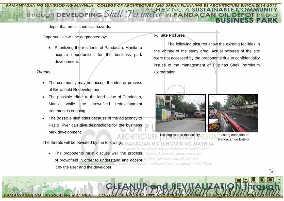
69
depot that emits chemical hazards.
Opportunities will be augmented by:
Prioritizing the residents of Pandacan, Manila to
acquire opportunities for the business park
development.
Threats:
The community may not accept the idea or process
of Brownfield Redevelopment.
The possible effect to the land value of Pandacan,
Manila while the brownfield redevelopment
treatment is ongoing.
The possible high tides because of the adjacency to
Pasig River can give destructions for the business
park development.
The threats will be obviated by the following:
The proponents must discuss well the process
of brownfield in order to understand and accept
it by the user and the developer.
F. Site Pictures
The following pictures show the existing facilities in
the vicinity of the study area. Actual pictures of the site
were not accessed by the proponents due to confidentiality
issues of the management of Pilipinas Shell Petroleum
Corporation.
Existing road in the vicinity Existing condition of
Pandacan de Estero

70
V. PLANNING CONSIDERATIONS AND DESIGN
STANDARDS
A cleanup and remediation process should take place
in treating the contaminated land of the depot. Cleaning
the site will remove the toxic wastes present which pose a
danger to the health of the existing and potential users.
After this process, the development of the proposed
Business Park follows. The Business Park will consist of a
Mall, BPO offices, condominium, parking building, vertical
housing, open spaces and parks. The location of the site
should take advantage of its adjacency to the Pasig River.
A waterfront development should be implemented for the
enhancement of the city image. The roads for circulation
and access are a major problem in the site. Road widening
is proposed to address this problem. Open spaces, parks
and gardens will be incorporated so as to develop a
peaceful and relaxing environment. The existing plants will
be retained and additional native plants will be added for
aesthetic purposes and to serve as noise buffers up
against the adjacent residential area.
The view of Pasig River outside the
guarded fence of the oil depot
Adjacent Carlos P. Garcia
High School
Residential areas in the vicinity of
the depot. Some of which are
informal settlements
The dirty and unsanitized estero
beside the study area.

71
A. General Guidelines
1. Each proposed building should have a distinct
architectural concept that is consistent in theme but
rich in subtle variation.
2. Buildings within Business Park should be designed
to provide a clear, unified, and easily identifiable
image. Methods to achieve this include using similar
architectural styles and materials, complementary
roof forms, signs, colors, and decorative pavement.
3. All buildings should relate visually to one another,
be compatible with adjacent buildings, and not
obscure desirable views, such as the Pasig River,
from nearby proposed buildings.
4. Encouraged architectural qualities and design
elements for business park buildings are:
a. Building modulation indentations and
architectural details;
b. Building entry accentuation;
c. Screening of equipment and storage areas; and
d. Landscaping to soften building exteriors and
buffer between uses.
B. Height and Mass
The height and mass of business park buildings
should consider the visual and physical relationship to
adjacent uses. A structure that dominates its environment
by its relativesize is strongly discouraged.
1. The mass of a larger building should be broken
down into a group of buildings clustered into
traditional building compounds or a campus setting
to create a sense of community and shelter.
2. Building design should employ clean, simple,
geometric forms and coordinated massing to
produce overall unity, scale, and interest.
3. Varying building heights/massing and setbacks to
define different functions such as offices and
warehousing is encouraged.
C. Building Design
1. Variety in building forms should be employed to
create visual character and interest.
2. Facades with a high level of visual interest from
both vehicular and pedestrian viewpoints are

72
encouraged. The exterior character of all buildings
should enhance pedestrian activity in their
immediate vicinities.
3. Long unbroken building facades should be broken
up with architectural details. Facades with varied
front setbacks are encouraged to provide visual
interest.
4. Rear and side wall elevations should provide
building offsets and architectural details similar to
the front facade.
5. Entrances to individual buildings should be readily
identifiable to visitors through the use of recesses or
pop-outs, roof elements, columns, or other
architectural elements.
D. Roofs
1. Roofs should be integral to the architectural theme
of business park buildings and contribute to the
visual continuity. Rooflines of business park
buildings should include variations to avoid long,
continuous planes.
2. Rooftops should be considered as design elements
from various viewpoints: at ground level, from other
buildings, and from adjacent perimeter roadways.
Mixing roof forms on buildings creates variety in the
“roofscape.” Roofs should also be interesting when
seen from above in higher buildings.
3. Rooftop equipment should be screened from view
on all four sides by architectural features integrated
with the design of the building.
4. Roof design shall allow solar panels to be
integrated into the roof design, flush with the roof
slope. Building orientation and shading design
should minimize solar gain and maximize daylight
harvesting.
E. Materials and Color
1. Roof design shall allow solar panels to be
integrated into the roof design, flush with the roof
slope. Building orientation and shading design
should minimize solar gain and maximize daylight
harvesting.

73
2. Materials should be chosen to withstand abuse by
vandals or accidental damage by machinery. False
facades and other simulated materials and
ornamentation are discouraged.
3. Clear or lightly tinted low-e glass (glazing) should
be used, particularly at pedestrian levels where
transparency between indoor and outdoor spaces is
desirable.
4. The uses of various siding material (i.e. masonry,
concrete texturing, cement, or plaster to produce
effects of texture and relief that provide architectural
interest) are encouraged.
5. Storage containers or accessory structures shall be
architecturally treated on all four exterior sides of
the building.
6. Storage containers or accessory structures shall be
architecturally treated on all four exterior sides of
the building.
7. The use of compatible colors in a single facade or
composition is required. Compatible colors add
interest and variety while reducing building scale
and breaking up plain walls.
8. A color palette should be used on business park
buildings to help reduce their perceived size.
Contrasting trim and color bands that help break up
the vertical monotony of flat walls are encouraged.
9. Brightly colored and highly reflective roof surfaces,
including unpainted galvanized metal roofing and
illuminated roofing, are prohibited.
F. Parking and Circulation
A fundamental development objective for all sites is the
safe and efficient movement of vehicles and pedestrians
with the least amount of impact to the surrounding
properties.
1. Sufficient paved, off-street parking shall be provided
onsite with assigned spaces that are compliant with
the National Building Code of the Philippines. No
required parking shall be permitted on any public
street or access road or at any place other than the
paved parking spaces provided.
2. Parking shall be designed to minimize conflicts

74
between automobiles and pedestrians and create a
clearly organized system of entrances, driveways,
and parking lots, while still providing adequate and
convenient parking spaces.
3. Vehicular access to any site shall be designed to
encourage an efficient, smooth flow of traffic in
relationship to other driveways, street curvature,
site distances, median cuts, and other common
traffic engineering criteria. Paved areas and curb
cuts should be minimized.
4. Parking lots and driveways shall be designed for
sufficient movement to avoid conflict with vehicular
traffic in the street.
5. “Gated parking” is discouraged but if required shall
be designed to prevent traffic queuing onto a public
street.
6. Access for each site shall be determined in concert
with the business park’s overall traffic circulation,
capacity needs, and requirements. Full movement
access points on arterial streets shall be located a
minimum of 800 feet from a signalized intersection.
7. Pedestrian circulation should be physically
separated from vehicular circulation as much as
possible to reduce traffic hazards and make the
pedestrian system safer, more efficient, and visually
attractive.
8. Intersections where pedestrian routes cross
vehicular traffic are critical areas and should be
clearly marked for visual identification by both
motorists and pedestrians.
9. At least one sidewalk connection between the
building and the perimeter street is required. Large
parking areas shall have sidewalk connections to
the building entries or ground plaza areas.
10. Commuter bicycle accessibility to and within the
business park is encouraged. Bicycle storage
facilities should be provided.
11. Parking structures should be designed as integral
components of the overall design of the specific
project with related materials and forms
incorporated in both the parking structure and the
buildings served.

75
12. Adjacent properties should be adequately screened
from the parking structures and lots.
13. The design of surface parking lot lighting fixtures
shall be compatible with the architecture used in the
development and not be on poles over 25 feet high.
14. In public parking lots, a higher foot-candle level
should be provided at vehicle driveways, entry
throats, pedestrian paths, plaza areas, and other
activity areas.
15. Parking and security lights will not be obtrusive to
neighboring residential properties.
16. Parking and security lights will not be obtrusive to
neighboring residential properties.
G. Landscaping
1. Landscaping shall preserve and protect the special
attributes of the area and minimize adverse effects
on the natural environment to the greatest extent
possible. Regionally appropriate landscape
treatments are encouraged to create a continuous
landscape character throughout the business park.
2. Landscaping should be in scale with adjacent
buildings and be of an appropriate size at maturity
to accomplish its intended purpose.
3. Elements such as trellises, arcades, terraces, and
patios should be utilized to provide transitional
spaces between the interior and exterior of
buildings. These elements should utilize colors and
materials that unify architectural themes
4. Landscaping should be used to define areas such
as entrances to buildings and parking lots, provide
transition between neighboring properties
(buffering), and provide screening for outdoor
storage, loading and equipment areas.
5. A minimum of 50% of the area should have shade
coverage at tree maturity. Maintenance trimming
must comply with these requirements.
6. Landscaping within courtyards and patios should
include a balance of hardscape and softscape
materials.
7. All metal planters or accessory features shall be
powder-coated galvanized metal.
76
8. Landscaping around the entire base of the building
softens the edge between the parking lot and
building and is encouraged.
9. Pedestrian areas shall be identified and
accentuated by incorporating distinct paving
materials, canopied trees, and extensive
groundcover plantings.
10. A 6-foot or larger landscape strip should be
provided between parking areas and the office
(front) portion of a structure, including a 6” curb.
The use of drought-tolerant trees, shrubs, and
groundcovers is encouraged.
11. A minimum 24” box tree shall be planted
throughout, to establish a mature look at initial
planting, except at entries and accent points where
a minimum 48” box tree shall be used.
12. Trees in paved areas should be provided with “deep
root” barriers, deep root automatic irrigation, and
expandable metal tree grates of adequate size.
Root barriers shall be of a material specifically
designed for containing tree roots. Irrigation shall be
adapted for deep watering.
13. Use of landscape elements adjacent to walls is
encouraged in business park areas to reduce their
visual impact and opportunities for graffiti.
14. Landscaping should be protected from vehicular
encroachment by raised planting surfaces or the
use of curbs.
15. Parking areas should be well-lit and well
landscaped to create the appearance of “cars in a
forest” rather than trees in a parking lot.
16. Continuous planting strips should be provided
between every other row of parking. The strip
should be a minimum of 5’ wide not including a 6”
high curb with a 12” wide concrete strip on both
sides (8’ gross width).
17. Surface parking areas adjacent to primary
circulation corridors shall be screened and/or
buffered with a combination of landscape planting,
berms, and fencing.
18. Landscaped areas should provide sufficient
clearance to fire protection features (i.e.
77
connections, hydrants, and backflow preventers). In
hydrant locations, the canopy height of trees should
be a minimum 6 feet and the clearance radius
around the hydrant should be a minimum of 3 feet.
New planting around fire hydrants shall provide a
minimum of seven feet clearance to allow for plant
growth.
H. Lighting
Landscaped areas should provide sufficient
clearance to fire protection features (i.e. connections,
hydrants, and backflow preventers). In hydrant locations,
the canopy height of trees should be a minimum 6 feet and
the clearance radius around the hydrant should be a
minimum of 3 feet. New planting around fire hydrants shall
provide a minimum of seven feet clearance to allow for
plant growth.
1. The visual impact and amount of spillover light
should be minimized for surrounding uses. High-
mounted, widely spaced pole fixtures that illuminate
large areas from a single source are prohibited.
2. Lighting fixture placement should provide the
appropriate illumination for outdoor areas such as
parking, shipping and receiving, pedestrian
walkways, and work areas.
3. If business park activities and operations occur
during the night, low-level lighting versus high mast
lighting should be provided at driveway entrances.
4. Light spread should be confined to site boundaries.
VI. ARCHITECTURAL PROGRAMMING
A. User Analysis
1. Existing User
a. Community of Pandacan:
- These are the existing people using the site
to be studied. These are the ones to be
served by the development primarily, the
residents of Pandacan, Manila. The
development and the people are dependent
to each other in a way that the development
will provide an opportunity in ensuring that

78
the community will have a cleaner
environment because of the sustainability
advocacy of the proposal. On the other hand
the community fully cooperates with the
development by supporting the advocacy.
2. Potential Users
a. The Developer:
- These users will be in charge of the
development phase of the project. These
people include the companies who will
facilitate the brownfield redevelopment, the
development of the Business Park and the
company for financial support. Also, the
workers for the construction phase are
involved here.
b. The Owner:
- The owner is the one who will finance the
proposal. Adequate space for the owner
should be considered.
c. The Facilitator:
- Since the proposal is a complex
development, the facilitator will be the head
that will implement the proposal for the whole
development.
d. Person with Disability (PWD)
- The proponents must consider the space
allocation for the PWDs. Standard sizes of
each facility must be observed. (see B.P 344
Accessibility Law).
e. Consumers
- These are the people who will purchase the
services of the proposed Business Park.
These are the ones who will serve as the
market of the business area which will make
the project feasible

79
B. Space Analysis
1. Mall
Access Requirements – The proposed mall shall be
designed to accommodate the type and volume of
vehicular traffic anticipated. Site should have controlled
exit and entry points to control the ingress and egress of
potential users at site and vehicular movements.
Building Entrances – The proposed mall should have
clearly defined, highly visible customer entrances with
features such as canopies or porticos, arches, wing walls
and integral planters. It should front the roads on which
they are located, wherever possible.
Seating areas - Seating should be provided at the lobby,
atriums, along corridors or at a designated area.
Designated sitting areas should be easily accessible and
visually linked to the main circulation pathways. For safety
reasons, seats should be placed away from railings
overlooking a void.
Staircases - one of the most important means of travelling
between different levels. Appropriate dimension, materials
and detailing of treads and risers are important for a
comfortable and safe transition between levels in both
directions. Escape staircases are vital in the case of any
emergency for occupants to evacuate. The design of
escape staircases should aim to provide all occupants with
a safe and efficient
Toilets - The toilet is a necessary provision that should be
included as part of the facilities in the mall. It is important
to place them discreetly and yet easily identified and
accessible.
Commercial stalls - Malls tend to be crowded and
cluttered, as such, the narrow lanes may become barriers
to some. It is good practice to ensure that the design of
commercial stalls cater to the convenience of all users
through well designed routes and signage as well as
thoughtful arrangements and layouts.

80
Food Courts and Cafés - It is important to ensure that all
food and beverage places are accessible easily by all
through the provision of appropriate furniture, amenities
and clear circulation paths
Service entrances, loading facilities and storage – These
shall be located at the rear of buildings. They should be
screened from view from residential properties and along
sidewalks and roadways through the use of masonry walls
and landscaping to achieve an opaque screen
Outdoor seating areas – These shall be well landscaped
and incorporated into the overall site design. Outdoor
seating areas should be set back and screened from
parking areas and driving aisles.
2. BPO Office Building
An office building must have flexible and
technologically-advanced working environments that are
safe, healthy, comfortable, durable, aesthetically-pleasing,
and accessible. It must be able to accommodate the
specific space and equipment needs of the tenant. Special
attention should be made to the selection of interior
finishes and art installations, particularly in entry spaces,
conference rooms and other areas with public access.
Workstations –shall be properly equipped with minimum
office equipment.
Meeting Spaces - rooms are developed on a module,
allowing flexibility in space planning: the area of two
medium meeting rooms equals that of one large meeting
room; a medium meeting room can be divided into two
small meeting rooms. If a medium meeting room is under-
utilized, then its space can be converted to two small
meeting rooms or as a small meeting room and an office
or other function.

81
Quiet Rooms - are intended to serve as unscheduled
meeting or workspaces, accommodating private telephone
calls or teleconferences.
Beverage Counters, Kitchenettes - increase the area
allocation for this function in order to incorporate a code
requirement for a double sink as well as space for a
refrigerator, microwave enclosure, water cooler, and
refuge/recycle containers. In many offices, the beverage
counter function has evolved into an informal meeting
place where staff exchange information and generate
ideas.
Equipment/Work Centre - recommended size is 13.9 m²
(1500 mm x 1500 mm grid) to a 14.9 m² (600 mm x 1200
mm grid) module for equipment/work centres. A smaller
workgroup is allotted half of this area.
Storage - An allocation for storage space needed to
accommodate stationery, forms, IT equipment, and
general bulk storage is incorporated into the planning
template. Space for either a free-standing or an enclosed
closet also is provided for visitor coat storage.
Reception Areas - All stand-alone office suites require an
entry and reception function. The planning template
includes a selection of open-area reception facilities:
small (4.2 m²), seating 1 to 2 persons;
medium (8.6 m²), seating 3 to 4 persons; and
large (13.4 m²), seating 5 to 6 persons.
3. Condominium
Space allocations shall provide areas for living,
dining, kitchen, sleeping, toilet and bath, laundry/ drying
area and storage -the minimum sizes of which shall be in
accordance with the requirements of the National Building
Code of the Philippines and its Implementing Rules and
Regulations/referral codes.
Dwelling units - Single occupancy units shall have a
minimum floor area of 18 square meters, however, a net
floor area of 12 square meters may be allowed. The
82
minimum floor area of family condominium units shall be
36 square meters and 22 square meters for open market
and medium cost condominium project respectively.
Parks/Playground (exclusive of easements, access roads,
driveways, parking space) - The minimum area for a single
park/playground shall be 50 square meters. Increments of
3.00 square meters for every additional family dwelling
type in excess of 10 units shall be added.
Parking Space Requirement - The parking slot
requirement for residential and commercial condominium
project snail be in accordance with the provisions of the
National Building Code of the Philippines.
Access Roads - Roads shall serve every building, parking
space, park/playground and service points (e.g. garbage
collection points). Minimum roads or right-of-way shall be 8
meters, 6 meters thereof shall be the carriageway and the
remaining 2 meters shall be developed as
sidewalk/planting strip.
Service Area (Laundry/Drying Area) - Adequate laundry
and drying areas shall be provided.
Reservoir/Water Tank - If the height of the building
requires water pressure in excess of that in the main water
line, a water tank shall be provided.
Mechanical Equipment and Service Areas - Provision of
elevators shall conform to the plans and specifications of
the duly licensed architect/engineer who shall determine
the requirement for elevators including the number of cars,
capacity, safety features and standards, elevator type,
speed and location in relation to the over-all design and
use of the building
Refuse Collection/Disposal - Centralized garbage
depository area and efficient refuse collection and disposal
services shall be provided whether independently or in
conjunction with the city or municipality garbage collection
and disposal services
83
4. Parking Building
Parking Space - Typical parking stall dimensions vary with
the angle at which the stall is arranged in relation to the
aisle. Stall widths (measured perpendicular to the vehicle
when parked) range from 8-1/2 to 9-1/2 feet. The minimum
width for public use parking spaces is 9 feet by 19 feet.
Elevators - shall be located where the door and open cab
are visible to the public using the facility. The shaft and
elevator cab should have glass facing the public view. Any
glass tinting should be minimal to ensure daytime and
nighttime visibility.
Stairwells - must be integrated into the design and footprint
of the parking structure and shall be more than just open
air railings attached to the exterior of the structure.
Office Spaces – These areas are for the administration
staff of the parking building. Minimum size requirements
shall be in accordance to the national building code.
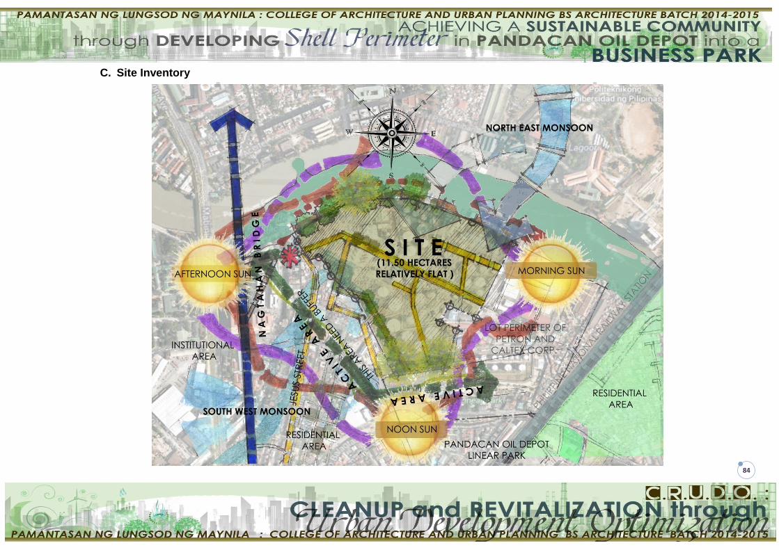
84
C. Site Inventory

85
D. Site Analysis
TOPOGRAPHICAL SETTING:
The site’s topography is relatively flat with some portions
below sea level. During high tide, the sea water goes
about two kilometers inland along the Pasig river towards
its source, the Laguna de Bay a fresh water lake.
HYDROLOGICAL SETTING:
Natural Drainage:
The existing river in the site is the Pasig River. The river
provides main drainage that links to Manila de Bay and
Laguna de Bay.
Existing Waterways and Esteros:
The existing esteros that is near to the site is the Estero de
Pandacan. A waterfront development is desired to take
advantage its proximity to existing waterways and esteros.
SOIL CONDITION:
The major soil in the mapping unit consists of Eutropepts
and Dystropepts. Both belong to the order of inceptisols.
These soil have narrower adaptability for agriculttural
crops and is more desirable for construction purposes.
ANNUAL PRECIPITATION:
According to theCorona’s Classification (1920), Manila’s
climate belong to the 1st type of which has two pronounced
seasons – dry from November to April and wet duringthe
rest of the year.
SEISMICITY:
Pandacan is classified in low risk zone meaning, the
stability of the structures and development is not delicate
in this area.
BUFFER ZONE:
Buffer Elements:
Applying landscape elements such as trees and shrub in
the border near to the Pasig River will serve as a buffer to
the unpleasant odor of Pasig River . On active area buffer
is also needed as the proponents advise.
Prevailing Winds:
Prevailing winds shall be consider in planning a business
park. The buildings should be orientaed as where the
circulation of wind is more prominent for natural ventilation.

86
E. Bubble Space and Matrix Diagrams
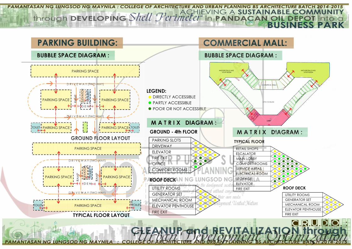
87

88

89

90

91
VII. DESIGN CONCEPT AND PHILOSOPHY
A. Design Philosophy
Humanity has the ability to make development sustainable to ensure that it meets the needs of the present without compromising the ability of the future generation to meet their own needs.
- World Commission Environment and Development
B. Design Concept
Green + Sustainable Design
The concept of the whole development revolves
around Green Architecture and Sustainable Design. The
primary principle of the green concept is that the buildings
in the development serve to reduce many of the harmful
impacts they have on the environment and its inhabitants.
Generally, it revolves around the following issues:
Designing for energy efficiency including the use of
renewal energy sources such as wind, geothermal,
and solar.
Creating a healthy indoor air environment with
adequate ventilation and making material choices
that minimize volatile organic compound (VOC’s)
outgassing within the home.
Providing for the efficient use of water via
appliance, faucet, and shower head choices and in
arid climates by xeriscaping and recycling grey
water and capturing rain water for landscaping and
other non-potable uses.
Sustainable design ensures that the development does
not cause irreversible damage to ecosystem’s health and
does not inhibit the opportunities of future generation.
Applying these concepts to the proposed Business Park, a
healthy and lively community might be developed thus
ensuring to reduce life threatening contaminants in the
site, improve public safety, generate income, and produce
more jobs for the people.

92
VIII. CONCEPTUAL PERSPECTIVES
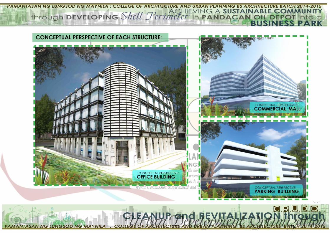
93

94

95
IX. COST ANALYSIS
A. Rough Estimate Of The Proposed Business Park
The data presented for the rough estimate of the
business park is only a basis for cost estimate per square
meter of the total construction cost of each structure.
1. Commercial mall: approximately 13,000-15,000Php
per square meter
Cost Breakdown:
o Foundation and Slab Cost
o Roofing Materials
o Finishes
- Exterior Finishes
- Interior Finishes
- Flooring Finishes
o Plumbing Fixtures and Fit-outs
o HVAC System
- would include heaters and cooling
ducts along with all required
equipment.
o Security System
- would be in place including smoke
and heat detectors along with motion
systems.
o Telecommunication System
o Mechanical System
- Elevators, escalators and stairwells
o Doors and Partitions Materials
o Acoustics Materials
- For ceilings and walls (soundproofing)
o Labor Cost
o Machine and Equipment Cost
Note: The data above is only an approximation of the
Construction Cost per square meter of a Commercial Mall
based on:
o Davis and Langdon Seah Construction Handbook of
the Philippines 2012
o Constructiont Cost Estimate per square meter of
Fisher Mall, Quezon City
Source: Arch. Vavic dela Pasion,uap , designer of

96
the Fisher Mall from, Palafox Associates.
2. BPO Office: approximately 8,000 – 10,000Php per square
meter.
Cost Breakdown:
o Foundation and Slab Cost
o Roofing Materials
o Finishes
- Exterior Finishes
- Interior Finishes
- Flooring Finishes
o Plumbing Fixtures and Fit-outs
o HVAC System
- would include heaters and cooling
ducts along with all required
equipment.
o Security System
- would be in place including smoke
and heat detectors along with motion
systems.
o Telecommunication System
o Mechanical System
- Elevators, escalators and stairwells
o Doors and Partitions Materials
o Acoustics Materials
- For ceilings and walls (soundproofing)
o Labor Cost
o Machine and Equipment Cost
Note: The data above is only an approximation of the
Construction Cost per square meter of a BPO Office based
on:
o Davis and Langdon Seah Construction Handbook of
the Philippines 2012
3. Multi-Storey Parking Building: approximately 6,000 –
12,000Php per square meter.
Cost Breakdown:
o Foundation and Slab Cost
o Roofing Materials
o Finishes
- Exterior Finishes

97
- Interior Finishes
- Flooring Finishes
o Plumbing Fixtures and Fit-outs
o HVAC System (optional)
- would include heaters and cooling
ducts (for admin’s office) along with all
required equipment. (passive cooling
is greatly advised)
o Security System
- would be in place including smoke
and heat detectors along with motion
systems.
o Mechanical System
- Elevators, escalators and stairwells
o Labor Cost
o Machine and Equipment Cost
Note: The data above is only an approximation of the
Construction Cost per square meter of a Multi-Storey
Parking Building based on:
o Davis and Langdon Seah Construction Handbook of
the Philippines 2012
o
4. Condominium: approximately 5,500 - 6,500Php per
square meter.
Cost Breakdown:
o Bath fixtures
o Built In Appliances
o Cabinets
o Carpeting
o Countertops
o Doors
o Excavation
o Exterior Finish
o Exterior Trim
o Final Cleanup
o Finish Carpentry
o Finish Hardware
o Flooring
o Foundation, Piers, Flatwork
o Heating and Cooling Systems

98
o Insulation
o Interior Wall Finish
o Lighting Fixtures
o Painting
o Plumbing Fixtures
o Plumbing Rough-in and Connection
o Roofing, Flashing, Fascia
o Rough Carpentry
o Rough Hardware
o Unit Heating and Cooling
o Windows
o Wiring
Note: The data above is only an approximation of the
Construction Cost per square meter of a Condominium
based on:
o Davis and Langdon Seah Construction Handbook of
the Philippines 2012.
5. Roads and Pathways:
This analysis assumes that the current status of the
site has an inadequate right of way for the expected
volume of users.
Additionally, right of way for Pandacan Oil depot is
8.00 meters wide; it is the only public road that has an
access to the development and to the public. It is critical
information to be able to provide adequate space for traffic
circulation immediately around and to the proposed site.
It is anticipated that semi-trucks and other large
delivery vehicles will be a necessary part of the daily traffic
at the site. With this in mind, care will need to be taken to
ensure that turning radii are adequate to allow for these
types of vehicles.
The cost estimate can be broken down into the
following elements:
o Concrete separated interior sidewalks (1.80 meter
width) – Assumes approximately 2,550Php linear
meter of sidewalk throughout the interior. Cost
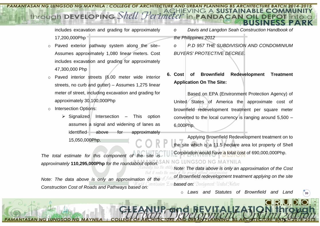
99
includes excavation and grading for approximately
17,200,000Php
o Paved exterior pathway system along the site–
Assumes approximately 1,080 linear meters. Cost
includes excavation and grading for approximately
47,300,000 Php
o Paved interior streets (6.00 meter wide interior
streets, no curb and gutter) – Assumes 1,275 linear
meter of street, including excavation and grading for
approximately 30,100,000Php
o Intersection Options:
Signalized Intersection – This option
assumes a signal and widening of lanes as
identified above for approximately
15,050,000Php.
The total estimate for this component of the site is
approximately 110,295,000Php for the roundabout option.
Note: The data above is only an approximation of the
Construction Cost of Roads and Pathways based on:
o Davis and Langdon Seah Construction Handbook of
the Philippines 2012
o P.D 957 THE SUBDIVISION AND CONDOMINIUM
BUYERS' PROTECTIVE DECREE.
6. Cost of Brownfield Redevelopment Treatment
Application On The Site:
Based on EPA (Environment Protection Agency) of
United States of America the approximate cost of
brownfield redevelopment treatment per square meter
converted to the local currency is ranging around 5,500 –
6,000Php.
Applying Brownfield Redevelopment treatment on to
the site which is a 11.5 hectare area lot property of Shell
Corporation would have a total cost of 690,000,000Php.
Note: The data above is only an approximation of the Cost
of Brownfield redevelopment treatment applying on the site
based on:
o Laws and Statutes of Brownfield and Land

100
revitalization of EPA (Environment Protection
Agency) of United States of America.
o Project Comparison Analysis to a foreign projects
(The Port of Portland: A Brownfield Remediation of
Industrial Lands)
7. Summary of Cost Analysis
X. GOVERNING LAWS
The proposed Business Park will be designed in
accordance and conformity to the following laws and
Ordinance:
Presidential Decree No. 1096 or the National
Building Code of the Philippines
City Ordinance No. 8119
Batas Pambansa Blg. 344 or The Law to Enhance
Mobility of Disabled Persons
Republic Act No. 1185 also known as The Fire
Code of the Philippines
Presidential Decree No. 957 or Subdivision and
Condominium buyer's Protective Decree
Republic Act No. 4726 or The Condominium Act
Republic Act No. 9593 otherwise known as
Tourism Act of 2009 and Its Implementing Rules
and Regulations
Commercial Mall (approx. 37 000 sq. m.)
37 000 x 13 000 Php = 481 000 000.00Php
BPO Office (approx. 1 700 sq.m.)
1 700 x 8 000 Php = 13 600 000.00Php
Parking Building (approx. 2 700 sq. m.)
2 700 x 6 000 Php = 16 200 000.00Php
Apartment Building (approx. 2 100 sq.m.)
2 100 x 5 500 Php = 11 550 000.00Php
Condominium (approx. 2 000 sq. m.)
2 000 x 5 500 Php = 11 000 000.00Php
Roads and Pathways 110 295 000.00Php
Brownfield Redevelopment 690 000 000.00Php
TOTAL: 1 333 645 000.00Php