an aem survey over owens valley, california...22 march 2016 1 an aem survey over owens valley,...
TRANSCRIPT

22 March 2016 1
An AEM Survey Over Owens Valley, CaliforniaTed Asch1 (CA PGp #1038), Jared Abraham1, James Cannia1, Clint Carney2, Andrew Genco3,
Rachel Woolf3, Kristen Pierce3All formerly XRI Geophysics, currently:1. Aqua Geo Frameworks, LLC2. Wyoming Department of Environmental Quality3. XRI Blue

22 March 2016 2
Presentation Outline
• Investigation Objectives
• AEM Data Acquisition
• Processing
• Inversion
• Interpretation

22 March 2016 3
In 1982 William L. Kahrl
The 1986 Marc Reisner
1974 Roman Polanski

22 March 2016 4
Astronaut photograph ISS006‐E‐24783 was taken February 6, 2003, with an Electronic Still Camera equipped with 180 mm lens and is provided by the Earth Sciences and Image Analysis Laboratory at Johnson Space Center. http://earthobservatory.nasa.gov/Newsroom/NewImages/images.php3?img_id=11270
Starting in 1913, the river and streams that fed Owens Lake were diverted by Los Angeles Department of Water and Power (LADWP) into the Los Angeles Aqueduct.
In 2004, the California Department of Fish and Wildlife (CDFW) acquired a 218‐acre (88 ha) parcel at the foot of Owens Lake. Designated the Cartago Wildlife Area in 2007, it is one of the few remaining spring and wetland areas on the shore of Owens Lake.
As part of an air quality mitigation settlement 2014, LADWP is currently shallow flooding 27 square miles 69.9 km2 of the salt pan to try and help minimize alkali dust. There is also about 3.5 square miles 9.1 km2 of managed vegetation being used as a dust control measure.

22 March 2016 5
Project Objectives
Client – Los Angeles Department of Water and Power
Objective ‐ Investigate areas east and west of I‐395 in Owens Valley and northern Owens Lake area
1. Owens Lake ‐ Identify water resources for dust mitigation
2. Alabama Hills & west of I‐395
a) Delineate water resources for input to LADWP canal
b) Delineate bedrock elevation for groundwater model

22 March 2016 6
Project Schedule
1. July 25‐26, 2015 – 652.2 line‐km surveyed over 2 days, approximately 325 line‐km per day acquired by Native American Helicopters (NAH)
2. August, 2015 – Processing, Laterally Constrained Inversion, and multiple Spatially Constrained Inversions by XRI Geophysics under subcontract to NAH
3. August 25, 2015 – Preliminary results presented to LADWP
4. September, 2015 – Analysis performed on AEM Inversion results and delineation of water resources and bedrock surfaces west of I‐395 and northern Owens Lake.
5. September 30, 2015 – Final report delivered by XRI to NAH per contract schedule

22 March 2016 7
AEM Data Acquisition
SkyTEM 508

22 March 2016 8
AEM Data Processing
Low‐Moment
High‐Moment
Coupled
De‐Coupled
Power Line Noise Intensity Map
Coupled
De‐Coupled

22 March 2016 9
Red – CutBlue ‐ Kept
AEM Data Processing
Map of “Cut” and Retained Data Used in the Inversions

22 March 2016 10
Example of Inversion
Aarhus Workbench Inversions Used 30‐Layer Model:• First Layer – 5 m (16 ft)• 2nd to Last Layer – 41 m (133 ft)• Last Layer ‐ Halfspace
Inversion:• ‘Spatially Constrained’ – Along the Current Flight Line
and on Neighboring Flight Lines, Spatially to a Set Distance
• The area was broken into two parts, one for the high conductive lake and one for the resistive valley sides
• Data residual mean 0.6 to 0.7
AEM Numerical Inversion

22 March 2016 11
AEM Flight Lines & Topography
AEM Flight Lines & Faults & Topography
AEM Flight Lines & Geology
Topographic & Geologic Images used in AEM Interpretation
Geology Maps Source USGS

22 March 2016 12
Faults & LineamentsIdentified
Color Scale: 1 – 400 ohm‐m
Color Scale: 1 – 100 ohm‐m
From MWH

22 March 2016 13
Known Faults
Unknown Faults
Paleo‐Channels
Faults & LineamentsIdentified

22 March 2016 14
Interpreted Geologic Structures:• Faults – Known, Unknown• Paleochannels
Faults & LineamentsIdentified

22 March 2016 15
Seismic Horizon 1 Aquifer Delineation, Northern Owens Lake
Near‐Surface Seismic Reflection Lines
Intersected by AEM
Seismic “Soundings”
Water Resources –East of I‐395

22 March 2016 16
Seismic Horizon 1 Aquifer Delineation, Northern Owens Lake
Water Resources –East of I‐395

22 March 2016 17
Seismic Horizon 1 Aquifer Delineation, Northern Owens Lake
Water Resources –East of I‐395

22 March 2016 18
KMZ of Horizon 1 Aquifer Delineation, Northern Owens Lake
Water Resources –East of I‐395

22 March 2016 19
West of I‐395 & the Alabama Hills
Map from MWH

22 March 2016 20
West of I‐395 & the Alabama Hills

22 March 2016 21
West of I‐395 & the Alabama Hills

22 March 2016 22
West of I‐395 & the Alabama Hills

22 March 2016 23
From USGS Report Hollet et al., 1991
West of I‐395 & the Alabama Hills

22 March 2016 24
West of I‐395 & the Alabama Hills
West of I‐395 & the Alabama Hills
Digitization of the Aquifer Top, Bottom, & Thickness
and Bedrock Top
Top
Bottom
Bedrock

22 March 2016 25
West of I‐395 & the Alabama Hills
Digitization of the Aquifer Top, Bottom, & Thickness
and Bedrock Top
Top
Bottom
Bedrock

22 March 2016 26
West of I‐395 & the Alabama Hills
Digitization of the Aquifer Top, Bottom, & Thickness
and Bedrock Top
Top
BottomBedrock
New Bedrock Interpretation

22 March 2016 27
West of I‐395 & the Alabama Hills
Digitization of the Aquifer Top, Bottom, & Thickness
and Bedrock Top
Top
BottomBedrock
New Bedrock Interpretation
After the additions of new wells in the area the bedrock was revised

22 March 2016 28
KMZ of the Aquifer Top, Bottom, Thickness
West of I‐395 & the Alabama Hills

22 March 2016 29
KMZ of the Bedrock Surface
West of I‐395 & the Alabama Hills
22 March 2016 30
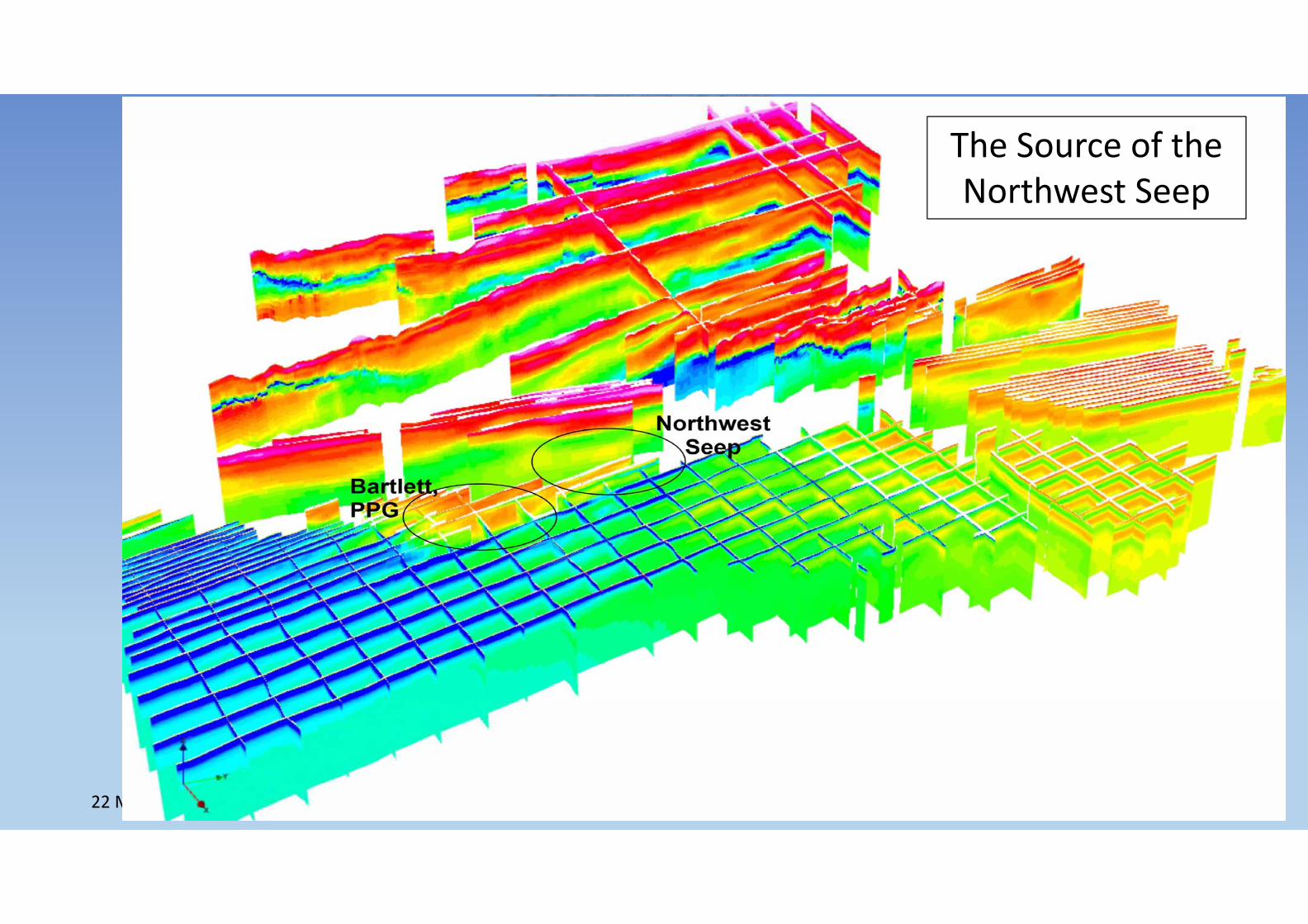
The Source of the Northwest Seep

22 March 2016 31
The Source of the Northwest Seep

22 March 2016 32
The Source of the Northwest Seep
‐31 m‐70 m

22 March 2016 33
The Source of the Northwest Seep
‐103 m
‐218 m
‐238 m
‐2.5 m

22 March 2016 34
Summary
1. 652.2 line‐km surveyed over 2 days.
2. Near‐surface geology including known and unknown faults identified along with paleochannels.
3. Aquifer No. 1 (top, bottom, and thickness) identified by near‐surface seismic further delineated by AEM across northern Owens Lake.
4. Interpreted aquifer top, bottom, and thickness west and southwest of I‐395 and the Alabama Hills.
5. Source paths of seeps/springs on west side of Owens Lake delineated.
6. Deliverables included the report, raw data, processed data, and Google Earth kmz’s.

22 March 2016 35
Acknowledgements
Saeed Jorat, LADWPVictor Harris, MWH Americas, Inc.B.J. Crocker, NAHAlan Stack, NAHKeven Pete, NAHFlemming Effersø, SkyTEMBill Brown, SkyTEM
XRI Geophysics:Ted Asch, AGFJim Cannia, AGFClint Carney, WY DEQAndrew Genco, XRI BlueRachel Woolf, XRI BlueKristen Peirce, XRI BlueTodd Meglich, PRSM Geophysical Consulting

22 March 2016 36
Questions? Comments?