annale van geologiese opname annals of...
TRANSCRIPT

III hpHltl'; • MUll!!!!,
II'
I lIulld;.
I'kl' IH!
(~Iuvhh:l
!IllU{ld'lo :1
~(IL IlfH
Rcpublick van Suid",~frika Republic of South Africa
DEPARTEMENT VAN MINERAAL- EN ENERGIESAKE DEPARTMENT OF MINERAL AND ENERGY AFFAmS
ANNALE VAN GEOLOGIESE OPNAME ANNALS OF GEOLOGICAL SURVEY
Band Volume
14 14 No. 1, 1980
ilLAASLlK 112,00 LOCr,l 4% AVB RO,08 4~, (~ST
82,08 -
1980 Kopiereg voorbehou Copyright reserved
Gedruk deur cn verkrygbaar van die Staatsdrukker, Bosmanstraat, Privaatsak X85, Pretoria, 000] Printed by and obtainable from the Government Printer, Bosman Street, Private Bag X85, Pretoria, Q(X)!
ISBN 0 621 06055 0

Amra/sgeo/, Surt', S. Air., 14(1) (1980), p. 105-115
THE WARM SPRINGS NEAR BURGERS FORT, EASTERN TRANSVAAL
by
LE. Kent·, Ph.D.
Abstract
springs, which have not been described previously, from andalusite hornfels of the Silverton Ponnation of
Pretoria Group at temperatures ranging between 27,7 and . 0 0
,',18/9 C (Voortrekkerbad) and 24,6 to 30,0 C (De Bad). Voor" tnkkcrbad, which rises in a tributary valley of the Spekboom
has a single eye whereas De Bad, which lies 8 km to the in the main valley, comprises a line of springs and
,_"C!f'Ages, The discharges were gauged as 360 mlls and 500 ml/s, f~.rcctive1y, The water of both springs is moderately mineralised. NI' (85-106 mg/I) predominates amongst the cations, and the
I. INTRODUCTION
Two warm springs, 8 km apart, rise on the farms Vmaiuitzicht 343 KT and De Bad 396 KT in the Lydenhurg District of the Transvaal. These have not been described in the literature but· the positions arc shown 011 the 1955 and 1970 editions of the 1, 1000 OOO-scale ~cological map of the Union/Republic of South Africa (Geological Survey). De Bad was shown On a map I'ublished by the writer (! 949).
The spring on Vraaiuitzicht was known to the early Hcttlers as the "Stinkfontein" and was visited by hunters, In 1951 it was developed as a resort by the late Mr H.F. Illlrris who named it Voortrekkerbad. Two swimming pools, one at the eye, and a paddling pool for children were built and accommodation provided. The venture was, however, not successful and the resort closed in the I"te 1960's.
At De Bad only a small bathing pool has been excavated. An area of 17 hectares around the warm IIpring is owned by a Provincial body, the Board for Public Resorts. The nearest accommodation is a motel 10 km from the spring on the road from Lydenburg to Burgersfort. Lydenburg is 49 km from the spring, and Burgersfort 24 km.
'" Former Deputy Director, Geological Survey, Pretoria.
principal anions are HC03' (133-220 mg/l) and Cl (51-94 mg/l). P- ranges between 3,9 and 5,98 mgll.
Voortrekkerbad issues at the intersection of an east-west striking fault and a north"east"Striking dolerite dyke. At De Bad the warm water rises from a north-west"'Striking" fissure or fissure zone. The springs are regarded as resurgences of rainwater falling on adjoining hilly country. The minimum depth of percolation in the convective-artesian systems is estimated as 900 m. Analyses of water from shallow aquifers in the area are presented for comparison.
2. TOPOGRAPHY
De Bad is in the valley of the northerly flowing Spekboom River, a major tributary of the Steelpoort River. Voortrekkerbad lies amongst low hills in a valley formed by a spruit that flows westwards for about 0,6 km to join the Spekboom River (fig. 2.1). From the contours on the 1,50 OOO-topo sheet 2430 CD (BuffelsvIe i) the springs issue at elevations of approximately 880 m (De Bad) and 840 m (Voortrekkerbad). Immediately east of the springs is a range of hills that rises to 1 449 m, 4 km east of De Bad and to 1 326 m, 4 km south"east of Voortrekkerbad. These peaks are along the watershed between the Spekboom and the Ohrigstad Rivers.
At De Bad the valley of the Spekboom River is only about 200 m wide, but 2 km northwards it widens and the river flows over an extensive alluvium-covered plain.
3. GEOLOGY
The warm springs lie in the metamorphic aureole of the Bushveld Complex, the margin of which lies about 6 km to the west of Voortrekkerbad. The country rocks are metamorphosed shale consisting of quartz, biotite and andalusite. A specimen from De Bad contained also a little chlorite. Stratigraphically these are in the Silverton Formation of the Pretoria Group. The original bedding
105

is distinct and shows that the succession dips westwards o
at' north~westwards at low angles, 12-15 on average. Quartz~norite sills associated with the Bushveld Complex intrude the hornfels west and south -west of Voortrekker~ bad (fig. 2.1).
According to Licbcnberg (1964) who geologically mapped an area to the west and to the north of Voor~ trekkerbad, the basal part of the upper 600 m of the hornfcls succession is characterised by the presence of bands of marble up to 1,5 m thick (fig. 2.1). The underlying 600 rn, principally andalusite~cordierite and chiasto~ lite~chlorite hornfe!s, is devoid of carbonate rocks.
Sills of diabase are widespread in the hilly country. The hornfeJs, the almost unmetamorphosed shales and quartzites, and the diabase sills are cut by essentially vertical, north~north-east to north~east~striking· dykes of dolerite. Petrographically these resemble Karoo dole rites and this was also the view of Liebenberg (1964). He reported that there were at least two and possibly three periods of dyke intrusion.
A more or less east-west~striking fault passes through Voortrekkerbad and another, striking about west~north
west, lies about 2 km to the south.
The geological mapping of Naude (fig. 2.1) shows that the second most easterly dyke has intruded along a fault. The dyke which intersects the fault at Voor~ trek kerb ad is intensely jointed and there may have been some movement along it. Liebenberg noted that in a kloof on the farm Fraaiuitzicht 317 KT some 15 km north-west of Voortrekkerbad, a nOrth~striking dyke of dolerite has apparently undergone some shearing, which he related to a nearby north-striking fault. He thus concluded that the faulting was post~Karoo in age. The fault on Fraaiuitzicht joins the large Steelpoort Fault which, in the Burgersfort area, has given rise to numerous splays, all of which trend between north and north~
north-east (Willemse and Frick 1970, p. 163). This faulting is considered by Dr Sharpe * to be penecontem~ poraneous with the Bushveld Complex. The intrusion of the dolerite dykes took place after the faulting.
4. DESCRIPTION OF THE SPRINGS
4.1 VOORTREKKERBAD
According to Harris the spring gave rise to a marshy tract. In excavating he encountered several artifacts, including the nave of a wagon wheel which led him to
name the spring Voortrekkerbad. The actual eye is now covered by masonry and inaccessible. The water issues from an opening in the stone lining of the eastern side of a pool measuring 15 by 18 m. It is not known if any gas
is discharged with the water. No bubbling was obscrV<'d at the point of discharge into the pool. There is general I)' a faint smell of hydrogen sulphide, but the water d()('~ not taste of this gas.
To the north of the spring pool there is a somewhut larger pool that was formerly fed by the overflow. In nn attempt to obtain more and, hopefully, warmer watt'l", Harris drilled two holes. One is situated 8 m from t Iw east side of the northern pool. It is 6,5 m deep and! according to Harris, a pumping test gave a yield 01 45 500 lIh. When not in use the hole sometimes ov(~r· flowed. Normally it was pumped and the water, whlch at 30 QC was slightly warmer than the natural sprir% was heated to supply a block of three bathrooms. '1'111' other borehole which is 25 m away, is 10 m deep. Tlw water-level measured during 1971 was 1,7 m below till'
collar, the same level as the spring. Both holes intersect I'd the warm water conduits.
Intensely jointed dolerite of the north~east~strildll~
dyke was struck when excavating the south-east corlltlt of the pool that is adjacent to the spring. Hornfels cm,,. out in the immediate vicinity. It is not known what rypu of rock was intersected by the boreholes.
4.2 DE BAD
The springs rise at the edge, and near the edge, of ~ steep scrce~strewn slope of hornfels that forms the western flank of the valley of the Spekboom River! There are six separate springs and four well~defincd Sl!lh
pages extending over a distancc of 140 m (fig. 4.1). If most southerly seepage is excluded, the spring Hnr strikes about north-west. To the east of the sprlllHM, there is a grass~covered tract 250 m wide that slopej gently for 200 m down to the river, some 20 m below the principal eyes.
The springs having the largest flows, i.c. 3 and 4, issue from joints in andalusite~bearing hornfels that dJ", westwards at 7 to 80
• The others rise from soil in spots some of which, notably 6 and 8, are marked the growth of reeds. Spring 10, at the southern cnd of line, issues from amongst tufts of grass and the point of emergence is almost certainly higher up slope. The fact that the warm water issues at ",,,.",;,:. elevations indicates that no single fissure is pemlcllbl!;C,' enough to discharge all the water in the system.
The hornfels around Spring 3 has been excavated form a rectangular bathing pool, 8,5 by 1,8 m, di'li<Il!iF into two by a wall just below the surface of the The western side is the face of a major joint that north~west. Other joints, also near-vertical, trend south and north-nonh-east". The thermal
• Personal communication: Dr. M. Sharpe, Bushveld Complex Research Unit, University of Pretoria (March 1980).
106

I,
'iI
" I"
" 1--:..-" I ~
"n,"Orl"'DO""S O<,l,,,,,,,",,, hO(;nQf<lls
"" ,...,.., ""'- mcrlTlCrbon<lo <?- ... <C2) ....... 13°
DE GROOTEBOOM/
~
. ' .'
340 KT I I I
d. ffIJ I I
EJ Alluvium and sUfficial deposits ~ Alluvium cn o),>pcrvlabfscttings
LEGEND LEGENDE
II7l Dolcritc dyke ~ age unccn::tin (may be post-K~roo) ~ ooleri"tg:"'g - oudcrdom onsekcr (mag na-Karoo wces)
1+ -l-+../. j Diabase sill ... younger th"n T ... n~v~i1 S<:qucncc + . -t--" Diabanspbat ... jonger as Opccnvolging Transvaal
r ~:z.i'!1 Quartz-notite sll! ... Bu:;hvdd Complex (::"~=.' Kwartsnorictp!aat - Kompleks Bosvdd
I· -::- .... Q"~tt;" .:: .:.: Kwartsict -= Shely quartzite _--=.... Skalicagtigc kwartsict
Shale fHornfds ... metamorphosed shole -/ Sk:llic/Horingfcls ... gemcraIJlorfos<:erde skalie
o
'" •
-"'-I 00'
Thennal spring Tcrrnicse bron
BoTchol., (water annlyscd) Bootg:lt (water omiced)
Dip and strike as indic3ted on map Hclling cO srrckking SODS op hart B!Ulgetoon
5° Dip dctcnnined by author , Helling bcpaal deur OUtcur
~ Direc(ion of line joining eyes, De Bad Rigting van verbindings!yn tusscn o~, Dc Bnd
'" Fnult " Verskuiwing
}
Mllgaliesberg Quartzite Formation Fonnasie M:Igaliesbcrgkw.:u:tsict
} SiJverton Shale Formation Formnsie Silvertonsknlie
Gcologically mapped by C. Naude, University of f'l:ctoria Geologics gek=eer deur C. Nnudc, Universiteit van f'l:etoria
1 Pmori, Gro~p 1 GroepPretom.
! 0 2 3km HseSH
Fig. 2.1 - Geological map of area showing locality of springs. Gcologicse kaart van gebied wat ligging van bronne aandui .
,,~ " , ~~
!~ ~ ~ , . ,.0

~
o "
., (-1,2m)
Pool for stock Dom vir vee
;;>" ,0 • ~qQ&~fb ~ o~
4,>;~ ...... ;:>fb:OO
0" ..,
Dividing woll
o M;E:ijm,", ~70i;4 ]
-l,2ml 05
OS (-2,Om)
_7 08 (-4,7 m)
Bathing pool,Spring 3 (datum water-level) Swembod, Bran 3 (uitqonQshoogte vir wotervlok)
m 0 m w ~ ~m I, , 1 1 ! ! 1
o
LEGEND Thermal spring Termiese bran
LEGENDE SO Dip of hornfels 7 Helling van horingfels
e9 (-5,7m)
e Seepage of thermal water ~ Principal joints in hornfels·at Spring 3 Sypeling van termiese water Hoofnate in horingfels by 8ron 3
Elevations (approx.) : Datum water-level-pool ot Spring 3 Hoogtes (ongeveer) : Uitgangshoogte vir woterviak-swembod by Bran 3
Fig. 4.1 - Sketch map showing springs and seepages at De Bad (based on compass and tape traverse). Sketskaart wat bronne en sypelinge by De Bad aantoon (gebaseer op kompas- en maatbandmetings).
e 10 (-[loOm)

Table 5.1 Al\AL'iSES OF 1'I1EIH1AL WAn:R
Spring/borehole
1\0. on Piper di;>grl,'"
(fig. 5.1)
Date sampled
Ions
Na +
K<
Sum of cat ions
Cl
IlCO;
C0 2-, PO)
" Sum of anions
D
Sum of items
Electrical conductivity (milli-Siemen/m) at 20 °c
pH
Voortrckkerba d,
Farm Vraaiuitzicht 31.3 KT
2
13 July 1971 2 1, Sept. 1976
019/1 mE/l 019/1 mE/I
n.lI. 0, 12 0,007
9' 3,96 85
4, , 0, 11 2,9 0,07
0,8) 9 0,75
0,65
0,038 0,001 n.a.
0,0.12 n.a.
0,02 n.a.
126, )70 5,951 11,21 5,177
4,2 0,22 0,2)
60 1,41,
0, )0 0,003 n. a.
ni 1 0,00 n. a.
nil 0,00 0,07 0,001
0,40 0,)8
220 3,61 3,36
ni I 0,00 0,00
n.lI. 0,001
)0),50 5,923
n.a. 30 ,9
0,31 0,15
1,20,65
553
8, , 8,21
Soil and Irrigl'l- Water Quality
tion Research Lab., Bydrolo-
stitute, Depart- gical
ment of Agricul_ Institute, De-
tUre and Fishe_
riea, Pretoria.
partment of
Water Affairs,
Forestry and
Environmental
Conser"!\tion,
Pretoria.
mE-/l 1<li11i equivalent/litre.
ilorcholc, Voor t rekkc rba d De Bad, F"rm De Bad )<)6 KT
:'ydro, Hachadodol'l'
13 July 1971 12 July 1971
mg/l mE/l mg/l mE/l
n. a. n.a.
83 3,61 10 1,
" 0,10 5 0,13
0,83 2 0,17
1,00 7 0,35
0,0 1, 0,001
0,00)
0,038 0,001
118,081 5, 172
3,90 0, 21 5,98 0,31
57 1,61 9',
0,45 0,004 0,10 0,001
nil 0,00 ni 1 0,00
nil 0,00 ni I 0,00
0,50 ni 1 0,00
207 ),1 .. 0 2,20
ni 1 0,00 nil 0,00
n.a. n.a.
5,724 5, 161
n.a. n.a.
0,19
409,726 352,501
8, , 8, 3
Soil and Irrigation Research
Institute, Department of
Agriculture and Fisheries,
Pretoria.
108
6
26 Scpt. 197 1952
mg/I mE/l mg/l mE/l
0,17 0,01 nil 0,00
w6 1',61 68
3, , 0,08 2,2 O,O'JI
nil 0,00 0, 'I"
nil 0,00 ,6 O,!io
n.a. n.lI.
n.a. n.a.
109,47 1<,1 1,1
3,24 0, 17 1,,0 0, :11
88 50 1,/,1
n. a. n. a.
n.a. nil 0,011
0,05 nil o,uo
4 0,08 8 0, I!
2,18 116 1,<)1)
nil 0,00 nil
0,01 t.
228,30 4,91 178
0,20
)71,37
8,1,1,
Water Quality
Lab., Hydrolo
gical Research
Institute, De
partment of
Water Affairs,
Forestry and
Environmental
Conservation,
j Pretoria.
n.a.
2
8, )
Soil ond hl'lU!1
tion Ho"«nr,'!!
Institutl>,
DepartmO!l! "I
Agricu}tul'lt ,11,.1
Fishe"!ol'>,
l'retorj".
\". on d ;.1(1 I
{ I'; (1.
I"",;
;.,"" o·
F
Ne
'" c·
,.
::.""
1',1".
{Il,;
,,'
'\Il,'
''''"-,
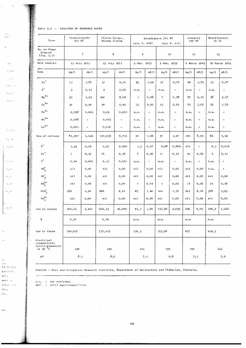
Tlllole 5.2 ANALYSES OF BOREflOLE WATER
Vraaiuitzicht Citrus Co-op., Elandsdoorn )'; 1 KT Luncarty Boschfontein Farm Jlt) KT Norone Siding , 10 KT 15 JT
}lole T. 4107 ;-:01e T. 'I ~') j ~'u. on Piper
diagram 7 8 ( fig. 5.1") 9 10 11 12
Ullte sampled " July 1971 13 July 1971 2 Feb. 1955 2 Feb. 1955 6 March 1962 10 Narch 1962
lOlls mg/I mE/l mg/l mEll mg/l mE/l mgll mE/l mg/l mE/l mg/l mE/I
Na ,
'd 1,87 17 0,7 /1 2J 1,00 17 0,7 1• '" 1,74 1) 0,57
K' 5 0,13 2 0,05 n.a. - n.a. - n.a. - n.a. -
MO 2,
2J 1,92 100 8,02 1 0,08 7 0,58 50 4, 16 ,8 3, 17
C. 2, 10 0,50 ,8 0,90 12 0,60 " 0,65 61 3,05 J5 1,75
F, " 0,09 8 0,0011 0,02 0,001 n.a. - n.a. - n.a. - n.a. -Mn 2' 0,008 - 0,005 - l1.a. - n.a. - n. a. - n.a. -Cu 2' 0,001 - 0,010 - n.a. - n.a. - n.a. - n.a. -
Illlm of cations 81, 107 4,424 1)7,035 9,711 ,6 1,68 J7 1,97 151 8,95 86 5,1.9
F - 1,22 0,06 0,07 0,004 1, , 0,07 0,08 0,004 nil - 0, , 0,016
Cl - 7 0,20 14 0,39 7 0,20 11 0,31 21 0,59 '. 0, 11
-1 O,ltO 0,004 0,15 0,001 n.a. - n. a. - n.a. - n.a. -NO-
2 nil 0,00 nil 0,00 nil 0,00 nil 0,00 nil 0,00 n.a. -
NO; ni 1 0,00 nil 0,00 ni 1 0,00 ni 1 0,00 ni 1 0,00 nil 0,00
SO!- nil 0,00 nil 0,00 , 0,02 , 0,02 1'. 0,29 ". 0,29
,' ..... HCO; 256 1,,20 586 9,61 85 " '" 104 1,70 1191 8, 16 ,08 5,05
C0 2-, nil 0,00 nil 0,00 nil 0,00 ni 1 0,00 nil 0,00 nil 0,00
'.' tium of anions 26 11,62 11,464 600,22 10,005 9',,3 '1,69 116,08 2,0)4 526 9,04 )26,3 5,466
B 0,)0 0,16 n.a. n.a. n.a. n. a.
Sum of items )46,027 737,415 130,3 153,08 677 412,)
1';lectricai ,;onductivity (lIIiIli-Siemen/ml
,,' 20 ·C 450 690 ,4, 170 767 4"
pH 8, , 8,0 7, , 6,8 7, , 7,6
,,01 I,.,., .. Analyst: Soil and JrTigation Research Institute, Department of Agricultur,e and Fisheries, Pretoria.
"I",
",e,,1 11. a_ not analysed.
1(,,,. Inl':/! ,,,illi equivalent/liLre,
;e.'"
,,,-
109

from joint cracks at the southern end of the pool, which has a maximum depth of 0,9 m. A few bubbles of gas rise intermittently to the surface and there is a percep~ tible odour of hydrogen sulphide. Algae in the pool are whitish, As at Voortrekkerbad the water is, however, tasteless.
Springs 4 and 5 flow into a shallow pool, excavated in soil, that is used for watering stock. Spring 8 has been excavated in soil to a depth of about 0,3 m and is used as a wash pool for clothes.
4.3 TEMPERATURES AND FLOWS
Hydro Baths, Machadodorp is given for comparison, as are ana~yses of non~thermal water from boreholes in the vicinity, kindly furnished by the Department of Water Affairs, Forestry and Environme!ltal Conservation (table 5.2). Only one of these boreholes falls on fig. 2.1 -arrows indicate the localities of the remainder,
In 1976 special samples were acidified in the field for determination of trace metals (table 5,3). Special samples were collected in 1971 and 1976 in which the dissolved Hz S was fixed by adding solid CdClz . Unfor· tunately problems arose with these samples and no de terminations of the H2 S content were made.
Temperatures were measured by three calibrated Table 5.3 - DETERMINATIONS OF TRACE METALS maximum thermometers, and the flows by drum and stopwatch,
Voortrekkerbad
Date Temp. (C) Flow (mlls)
Winter 1959 27,7 not measured 13 July 1971 26,2 360 24 Sept. 1976 27,4 not measured
Over the period 1951 to 1959 the temperature in the eye, according to Harris, ranged from 27,7 to 28,9 QC. He mentioned that, when pumped, the borehole next to the north pool yielded cCmuch more" water than the natural eye and was warmer - temperature 30',0 Qc.
Date sampled
Metal (pgll)
Li Cr Mn Fe Co Ni Cu Zn Pb
Voortrekkerbad De Bad
24 Sept. 1976 26 Sept. 1976
< 200 < 200
< 2,5 < 2,5 10 1 25 6
< 5 < 5 4 4
< 2 < 2 5 4
< 10 < 10
When the spring was investigated in 1971 it was no Analyst: longer a resort and it was not possible to d.etermine the
P.L. Kempster, Water Quality Laboratory I Hydrological Research Institute, Dept, of Water Affairs, Forestry and Environmentltl Conservation, Roodeplaat Dam, Tvl (method used was A,A.S: * with preconcentration of the samples by evaporation in KN03 matrix), The analyst reported that the Li values :~I'C
probably much less than 200 pg/I.
effect of this pumping on the natural discharge. At this time both pools had been drained and the natural flow could be measured with a fair degree of accuracy.
De Bad
Date Spring Temp. (C) Flow (mlls)
Winter 1959 3 29,3 not measured 12July 1971 3 28,8; 29,1 * 440 26 Sept. 1976 3 28,5; 29,05* not measured 12 July 1971 4 26,9 35 26 Sept. 1976 4 28,0 not measured 26 Sept. 1976 5 30,0 not measured 13 July 1971 8 24,6 not measured
* Different eyes.
The discharge rates of the other springs were ap~
preciably less than that of 4. The total discharge in July 1971 was estimated as being slightly over 500 mlls.
5. HYDRO CHEMISTRY
Chemical analyses of water from the thermal springs are given in table 5. L An analysis of the water of the
•• Atomic absorption spectroscopy.
The two sets of analyses, 1971 and 1976, arc very similar showing that the solutes had not changed appreciably. This is substantiated by less complcttl analyses by private laboratories of samples collected in 1959 and in 1966 that were kindly made available by Mr Harris and by his successor in title, Mr LS. van <kr WaIt. These have been recalculated on an ionic basi~
(table 5.4).
The water of both Voortrekkerbad and De Bad is only weakly mineralised. Of the cations, Na+ predominate~ and Ca2+ exceeds Mg2+ by a factor of two. The 1976 analysis shows both Ca2+ and Mg2+ as "nil" in the Dc Bad water. The principal anum in the water of bot h thermal springs is HCO;. In Voortrekkerbad it exceed" CI- by a factor of about 4, but in the De Bad water tlw two are present to nearly the same extent. SO~-, on the' other hand, whilst present in an appreciable amount in
110
Voortr both s general
Table
I I Source
I Date sa !ons (n
~ N! ! ,(," !
I Mg2+
(' 2+ >a
F Cl-
I SO~-
IICO, Electri(
% (milli-S
I I'll
i §
n.d.: n
As I
the on! are muc
As hornfel
I the Pre undergl the Pre
I (T.D.S. water,
1. over M
I ill little low. Hi
I zone in diabase
~ arc hig}
Whe 1 horeho
I 5.2) th.
I of the" ''; Luncar ~
llnd on arc cha" the ani
Mg2+ ir these b likely t diabase
• Total

) 11, I1 n
11 IIH'
.v ill Cl
[Hldl;
I. I
Il('ld
H'C'ild
Ir [lrl;
,5
I () 1 )' ,
I. (d nHul
'lhod
)Il of
(ri:.; )
·s 1 C
vcr)'
:ngcd pkll' ed III
le h)'
[1 d<'1
basi~
only nal('S
197()
e I)c
botl1
ceeds
r Il1e
n the nt in
Voortrekkerbad is very low at De Bad. F- is present in both springs in amounts far higher than the 1 mg/l ucnerally set as the upper limit for drinking water .
',,"hIe 5.4 - OLD ANALYSES OF WATER FROM VOORTREKKERBAD
Source Eye of spring Borehole next to north pool
Date sampled 5 Oct. 1959 16 April 1966 Ions (mgll)
Na+ 66,1 78 1<" 11,0 4 Mg2+ 8,4 8,0 Ca2+ 17,9 27,2 F- 3,6 2,4 (r 54,0 50 SO~- 19,2 17 IICO, n.d. 222 Electrical conductivity (milli-Siemen!m) at 20 QC n.d. 500 pll 8,7 7,7
n.d. : not determIned
As regards trace metals the springs are very similar, the only notable difference being that both Mn and Fe arc much more abundant in the Voortrekkerbad water.
As already noted, both thermal springs rise from hornfcls, orginally shale, of the Silverton Formation of the Pretoria Group. Bond (1946, p. 74) in discussing the underground water in the shale members of what is now the Pretoria Group noted that it is a weakly mineralised (T.D.S. * averaging 240 mg!l) temporary carbonate hardwater, generally characterised by slight excess of Ca2+ over Mg2+. He reported that SO~ - is generally present in little more than traces and the Cl- is low and F - very low. His analyses did not include water from the hornfels zone in the Eastern Transvaal but he did note that, near diabase intrusions, soda alkalinity, and thus pH values, are higher.
When compared with the nonwthermal water from boreholes in the hornfc1s in the Burgersfort area (table 5.2) the thermal water is more concentrated. The waters of the boreholes on the farms Elandsdoorn 341 KT and Luncarty 310 KT to the northweast of Voortrekkerbad and on Boschfontein 15 JT to the southwwest of De Bad Ilrc characterised by the predominance of BCO; amongst the anions, low CI- and low to nil F -:- Of the cations
Mg2+ in two boreholcs exceeds Ca 2+. The samples from these boreholes were not collected personally and it is likely that the ones with relatively high Mg2+ are from diabasewinvaded areas. The water from a farm borehole
'" Total dissolved solids.
on Vraaiuit"zicht 343 KT, 1 km southwsouthwwest' of Voortrekkerbad (fig. 2.1) is also marked by predominance of HCO;, but the Cl- is very low compared with the thermal water and F- low. Na+ is the predominant cation and Mg2+ considerably exceeds Ca2+. The relaw
tively high Mg2+ and Fe2+ suggest that the water has been in contact with a mafic rock. This is confirmed by the geological mapping which shows that the southerly extension of a dolerite dyke under the alluvium is very near the borehole. Finally, when the analysis of the water from a borehole at Morone Siding is studied, it is notable that Mg2+ is by far the dominant cation. The borehole, which is 43 m deep, is just within the Bushw
veld Complex having been drilled in weathered harzburw
gite and pyroxenite containing appreciable magnesite.
The water from the shallow aquifers plots in the leftw
hand section of the Piper parallelogram; this is characw
teristic of recently recharged aquifers in which residence time has been short (Van der Linde and Hodgson 1977). The thermal springs, on the other hand, fall in the lower central and lower rightwhand side of the diagram. This indicates longer residence time during which, through ion exchange, Ca2+ and Mg2+ have been partly replaced by Na+. The evolutionary trend is shown in figure 5.1. The hydro chemical difference between the shalloww and deepwcirculating water is also exemplified by the Cl-/HCO, ratio (mE/l). For the shallow aquifers it ranges from 0,02 to 0)8 whereas for Voortrekkerbad it is 0,43 and for De Bad 1,14. This suggests a longer residence period for the De Bad water.
6. SPRING GAS
As previously noted, the eye of Voortrekkerbad is inaccessible and it is not known if gas accompanies the water. Tubes containing gas samples collected at De Bad unfortunately broke in transit.
7. CLASSIFICATION OF THE SPRINGS
The water of the thermal springs is very slightly sulphuretted and is slightly alkaline with Na+ as the predominan't cation and HCO; and CI- as the principal anions. The springs are classed geochemically as Alkaline Soda Carbonate Waters (Bond 1956, p. 159). As the total solutes do not exceed 1 g/l these are not mineral springs as defined by the International Association of Hydrological Sciences and the International Association of Hydrogeologists. The temperatures at the points of emergence arc between 25 QC and 37 QC and the springs are dassed as warm (Kent 1949, p. 233).
Chemically the thermal waters bear a close resemw
blance to that of the Hydro Baths at Machadodorp which also issues from rocks of the Pretoria Group (Kent 1952). There is also a marked "family resemblance"
111

Mg
• Catians/katiane
Fig. 5.1 - Trilinear Piper diagram. Tri/ineer€f Piper-diagram.
112
~
• Thermal water / termiese water
. Non~thermol water/nie~termiese wallH
Cl + F ----->
Anions/onione
to oth, issue fr 1952).
8. OR!
Vaa dyke a tonic n presenc Fe2+- ar
leachinJ lie in 1
especia valleys is gene! air ten 18°C I Weathc struck approx fels is geothcl Pretori: boreho figure i of perc of the geother relative loss of Fourni, dischar, loss to
times n
As 1
north~v
any gee
ASl
passing confirn parallel of whi(
BOND, wat(
Sur.
• F. ¥. •• Miss

20
~ Cl (I
to other alkaline thermal waters in the country that liSue from widely differing types of rocks (Kent 1949, 1952).
8, ORIGIN OF THE THERMAL WATER
Voortrekk~rbad issues at the intersection of a dolerite dyke and a prominent fault. There is evidence that tec~ tonic movement also took place along the dyke and the presence of appreciably more Mg2+, and very much more Fc2+ and Mn2+ than in the De Bad water, suggests some Jeaching of dolerite. The catchment area is considered to lie in the mountains to the east and north~east, more especially where the fault and the dolerite dyke arc in valleys where rain run~off is concentrated. The rainfall is generally between 450 and 500 mm. The mean annual air temperature in the Voorrrekkerbad area is about 18 QC (Lydenburg 16,6 QC; Sekhukhuneland 18,8 QC -
Weather Bureau 1954, p. 106, 108). The warmest water, struck in the shallow borehole, has a temperature of approximately 30 ° C. The geothermal step in the horn~ fels is not known. Bouwer (1954, p. 22) determined a gcothermal step of 85m/C in a 1 280~m succession of Pretoria Group shales and intrusive diabase struck in a borehole in the Klerksdorp District. Assuming that this figure is applicable in the Eastern Transvaal, then a depth of percolation in the fractures of the fault/dyke aquifer of the order of 900 m is indicated. This, on the assumed geothermal step, is a minimum figure as, due to the relatively small discharge, there must be an appreciable loss of geothermal heat in ascent. In this connection, Fournier et aL (1974) consider that only if the rate of discharge exceeds about 200 lImin can very little heat loss to wall rocks be assumed. This figure is about ten times more than the flow of Voortrekkerbad.
As to De Bad, although the springs are aligned in, a north·westerly direction this does not correspond with any geological structure mapped (fig. 2.1).
A study of air photographs did not reveal any linears passing through the springs in any direction. This was confirmed by Walraven *. The spring line is roughly parallel to the traces of thc two faults to the north, onc of which is partly responsible for the emergence of therw
mal water at Voortrekkerbad. It would seem that there is a ,nonhwwest·striking. fracture or fracture zone in the hornfels at De Bad which may not have brought about any appreciable displacement of strata. The intake area for :rainwater is presumably in the hills on one or other, or both sides of the Spekboom River. The water issues at almost 30°C and a depth of circulation in the artesian· convective system of the same order as at Voortrekker· bad is indicated.
The last temperature of water~rock interaction was calculated from the empirical Na - K - Ca equation of Fournier and Truesdell (1973) by De Grys". The figures obtained were 67°C for Voortrckkerbad and 100°C for Dc Bad, which appear to be too high.
9. POSSIBLE EXPLOITATION
As noted, Voortrekkerbad is now closed to the public. Should it be decided to develop De Bad, a bore· hole on the spring line 'between Springs 3 and 5 should tap the fissures feeding the springs and, by pumping, the water now being dissipated through emergence at small eyes and seeps and through evapotranspiration, would be recovered. As at Voortrekkerbad and many other thermal springs, the water pumped should be somewhat warmer than in the present natural eyes. In view of the relatively high fluoride, the water should not be drunk or used for cooking.
10. ACKNOWLEDGEMENTS
Dr. M. Sharpe of the Bushveld Complex Research Unit of the University of Pretoria kindly furnished the geological map of the Voortrekkerbad - De Bad area, which forms part of a mapping project undertaken for the Geological Survey.
I am also indebted to the analysts and in particular to Mr. P.L. Kempster of the Water Quality Laboratory of the Hydrological Research Institute, Department of Water Affairs, Forestry and Environmental Conservation, Pretoria, for undertaking special determinations. My son J onathan, greatly assisted me in the field during the 1971 investigation.
REFERENCES
BOND, G.W., 1947. A geochemical survey of the underground water supplies of the Union of South Africa: Mem. geo!. Surv. S. Afr" 41, 208 p.
• F. Walraven, Geological Survey, Pretoria . •• Miss A. de Grys, Geological Survey, Pretoria.
113
BOUWER, R.F., 1954. Bore-hole temperatures in the Klerksdorp and Orange Free State areas: Bull. geo!. Surv. S. Afr., 22, 35 p.
FOURNIER, R.O. and TRUESDELL, A.H., 1973. An empirical Na-K-Ca geothermometer for natural waters: Geochim. cosmochim. Acta, 37, p. 1 255-1 275.
EOURNIER, R.O., WHITE, D.E. and TRUESDELL, A.H., 1974. Geochemical indicators of subsurface temperature. Part I. Basic assumptions: }. Res. U.S. geo!. Surv., 2(3), p. 259-262.
GEOLOGICAL SURVEY, 1955. Geological Map of the Union of South Africa: Govt Printer, Pretoria.
--------- , 1970. Geological Map of the Republic of South Africa and the Kingdoms of Lesotho and Swazi!and: Govt Printer, Pretoria.
KENT, L.E., 1949. The thermal waters of the Union of South Africa and South West Africa: Trans. geo!. Soc. S. Afr., 52, p.231-264.
114
KENT, L.E., 1952. The medicinal springs of South AfriCll1 Publicity and Travel Bureau, S. Afr. Railways and Harbour~, 21 p.
LIEBENBERG, L., 1964. Die rand van die BosveldstollinHN' kompleks, suid van Burgersfoft, insluitende sekere peridot it·l· liggame en die gemetamorfosecrdc Serie Pretoria: M.St', thesis, Univ. Pretoria (unpubl.).
VAN DER LINDE, P.]. and HODGSON, F.D.I., 1977. nit> gebruik van hidrochemiese tegnieke in grondwatereksploru~!(' in die Venterstadomgewing, Kaapprovinsie: Water S.A" 3(3), p. 166-171.
WEATHER BUREAU, 1954. Climate of South Africa. Pt !j Climate Statistics W.B. 19, Govt Printer, Pretoria.
WILLEMSE, ]. and FRICK, C., 1970. Stroomroof en die inv!(II'1i van verskuiwings op die geomorfologie in die opvanggchh,d van die Steelpoortrivier in Oos-Transvaal: Trans. geo!. Sew, S. Afr., 73(3), p.159-171.
j
Pril