anwar moghal-subsurface geome
DESCRIPTION
It is valuable in understanding subsurface geometryTRANSCRIPT

ABSTRACT
The Potwar sub-basin is located at the northern marginof the Indian Plate, in Pakistan. It is filled with thick Infra-Cambrian evaporites, thin Cambrian to Eocenecalcareous-siliciclastic sediments of Indian Plate andrelatively very thick Miocene-Pliocene molasse depositsof the Indus Foredeep.
The Potwar fold region is a prolific area forhydrocarbon occurrence. The first commercial discoveryfrom the Himalayan Foreland was made in Potwar sub-basin at Khaur in 1914.This sub-basin hosts multiplestructural leads. Hydrocarbons have been reported fromdifferent reservoirs. The Potwar sub-basin hasexperienced severe deformation during Himalayanorogeny in Pliocene to Middle Pleistocene. Regionalunconformities in the stratigraphic profile of the basinreflect the severity of tectonic pulses.
To develop understanding of its structural style, faulttypes, decollement levels and influence of tectonics,transects in a grid fashion and a regional time structuremap at the Base Miocene level have been developed. Thementioned time structure map is also more or lessconformable for deeper horizons.
In the Potwar sub-basin occasionally, surfacegeological features mismatch the subsurface geometry.Interpretation of seismic reflection profiles hasconfirmed two decollement levels; the lower one in theInfra-Cambrian Salt Range Formation and the upper oneat the interface of Eocene and Neogene molassesediments. The structural architecture of the sub-basinhas been strongly influenced by these decollementswhich led to offset and structural variation above andbelow these decollements. The lower decollement is alow angle thrust within Salt Range Formation that carriesthe entire sedimentary section to the south. Forelandverging Salt Range Thrust is the surface manifestation ofthis decollement. It is believed that the structures havebeen formed due to southward propagation of faultsrelated to salt movement activated by southwardthrusting of sedimentary wedge.
Attempt is made to relate hydrocarbon entrapment indistinctive structural domains. The orientation, stylesand geographic distribution of structures and migrationof hydrocarbon from the source beds to reservoir viafault planes is discussed. For the carbonate reservoirs itis considered that faults and flexures have enhancedtheir porosity by developing fractures. In addition, subthrust plays and hydrocarbon plays on different leadsand fairways have been identified. New identified playsinclude popup, sub thrust and “snake-headed”structures, salt-cored anticlines, and associatedimbricate and triangle zones in different parts of this sub-
basin which are considered to be the primary drillingtargets in future. It will open new horizones forhydrocarbon exploration in the Potwar sub-basin,Pakistan.
INTRODUCTION
The Potwar sub-basin is located in the western foothills ofHimalayas in northern Pakistan. It includes the PotwarPlateau, the Salt Range, and the Jhelum Plain. It is boundedin the north by main Boundary Thrust-MBT (recently the termMBT has been challenged by Iqbal and Bannert, 1998 andIqbal et al., 2007 however without indulging in this controversythe term is used as such in the text due to its common use inthe literature) and Salt Range in the south. Jhelum strike-slipfault occurs in the east and Indus River and Kalabagh strike-slip fault in the west. Kohat Plateau is in the western strikeextension of the Potwar sub-basin with relatively severelydeformed structures.
The Potwar sub-basin is filled with thick Pre-Cambrianevaporites overlain by relatively thin platform deposits ofCambrian to Eocene age followed by thick MiocenePliocenemolasse (Figure 1). This whole section has been deformed byintensive Himalayan orogeny in Pliocene to MiddlePleistocene.
The Potwar sub-basin is one of the oldest oil provinces ofthe world, where the first commercial discovery was made in1914 at Khaur. So far, about 150 exploratory wells have beendrilled of which most could not reach target depths due tooperational problems related to extremely high-pressurewater in mollasse deposits, thus were prematurelyabandoned. This abnormal pressure is related to rapiddeposition/burial of molasse deposits, which is furtheraggravated by structural complexities.
The central, western and the eastern parts of the SaltRange / Potwar Plateau have quite different structural styles.Uneven distribution of salt, occurrence of differentdetachment levels, faults and flexures in the basement areamong the possible reasons for structural complexity.Subsurface picture of the Potwar sub-basin demonstratesthat structures are regionally bounded by foreland vergingthrusts. These thrusts are generally trending northeastsouthwest in the eastern part, almost east-west in the centralpart, and northwest-southeast in the western parts of thePotwar sub-basin. There is less distribution of evaporites inthe eastern part where competent rocks (carbonates andsandstones) dominate.
The Jhelum left lateral strike-slip fault in the east and theright lateral strike-slip Kalabagh fault in the west have playedpivotal role in shaping the geometry of the Potwar sub-basin.Due to these faults, the structures in the eastern part of thesub-basin are left stepping whereas in the western part rightstepping en-echelon aligned. The fault splays of the Jhelumand Kalabagh faults extend respectively from east and west tothe central part of the basin where these splays become
Pakistan Journal of Hydrocarbon ResearchVol. 17, (June 2007),p.61-72, 06 Figs.
Subsurface Geometry of Potwar Sub-Basin in Relation toStructuration and Entrapment
M. Anwar Moghal , Muhammad Ishaq Saqi , Abdul Hameed and M. Nawaz Bugti .1 1 1 1
1Pakistan Petroleum Limited, Exploration Department,Karachi, Pakistan.

Fig
ure
1-
Gen
ealized
Str
ati
gra
ph
yo
fP
otw
ar
Su
b-B
asin
(Sch
em
ati
c).
Subsurface Geometry of Potwar Sub-Basin62
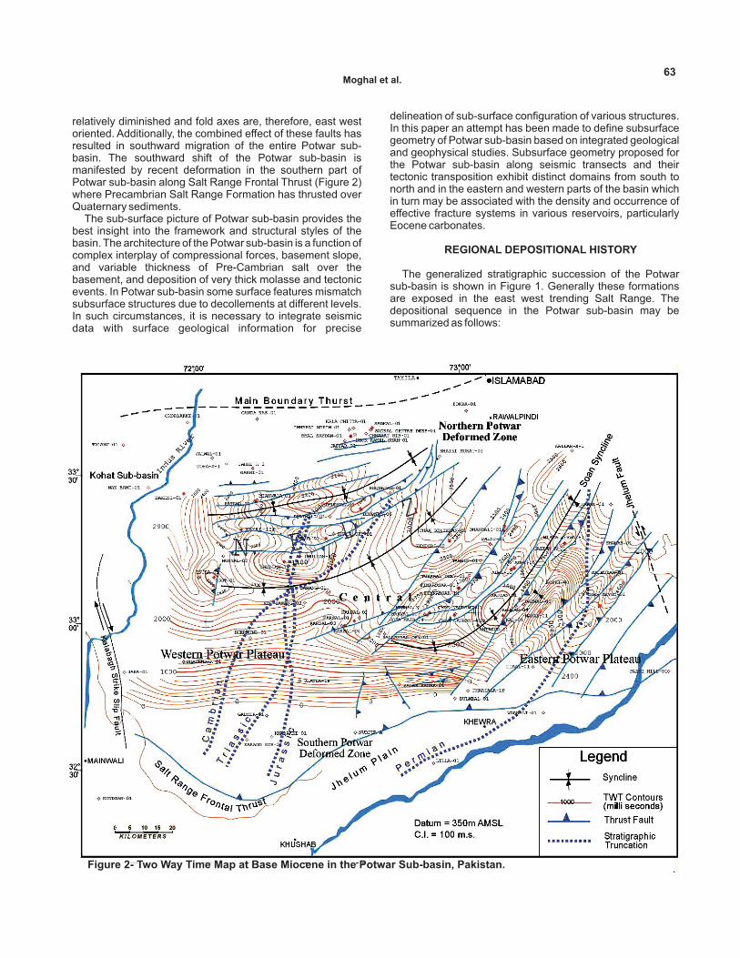
relatively diminished and fold axes are, therefore, east westoriented. Additionally, the combined effect of these faults hasresulted in southward migration of the entire Potwar sub-basin. The southward shift of the Potwar sub-basin ismanifested by recent deformation in the southern part ofPotwar sub-basin along Salt Range Frontal Thrust (Figure 2)where Precambrian Salt Range Formation has thrusted overQuaternary sediments.
The sub-surface picture of Potwar sub-basin provides thebest insight into the framework and structural styles of thebasin. The architecture of the Potwar sub-basin is a function ofcomplex interplay of compressional forces, basement slope,and variable thickness of Pre-Cambrian salt over thebasement, and deposition of very thick molasse and tectonicevents. In Potwar sub-basin some surface features mismatchsubsurface structures due to decollements at different levels.In such circumstances, it is necessary to integrate seismicdata with surface geological information for precise
delineation of sub-surface configuration of various structures.In this paper an attempt has been made to define subsurfacegeometry of Potwar sub-basin based on integrated geologicaland geophysical studies. Subsurface geometry proposed forthe Potwar sub-basin along seismic transects and theirtectonic transposition exhibit distinct domains from south tonorth and in the eastern and western parts of the basin whichin turn may be associated with the density and occurrence ofeffective fracture systems in various reservoirs, particularlyEocene carbonates.
The generalized stratigraphic succession of the Potwarsub-basin is shown in Figure 1. Generally these formationsare exposed in the east west trending Salt Range. Thedepositional sequence in the Potwar sub-basin may besummarized as follows:
REGIONAL DEPOSITIONAL HISTORY
Figure 2- Two Way Time Map at Base Miocene in the Potwar Sub-basin, Pakistan.
Moghal et al.63

The Infra-Cambrian evaporites were deposited in intra-cratonic setting in a basin that extended from Pakistan toTurkey through Iran and Oman. This deposition occurred overthe basement of the Indian Plate. The evaporite sequence isoverlain by Cambrian rocks of Jhelum Group whichcomprises Khewra Sandstone, Kussak, Jutana, andBhaganwala formations. Deposition of the Jhelum Group wasfollowed by a period of limited deposition and/or erosion fromMiddle Cambrian to Early Permian. Therefore, the stratabelonging to these periods are missing in Potwar sub-basin.The Nilawahan Group of early Permian is restricted to theeastern part of Potwar / Salt Range and is predominantly ofcontinental origin. This group includes Tobra Formation,deposited in predominantly glacial environments, DandotFormation of olive green sandstones and claystones, WarchaFormation predominantly red sandstone, and SardhaiFormation's claystone. The Zaluch Group is restricted to thewestern and northern/central part of Potwar / Salt Range. Itincludes marine limestones and claystones of the Amb, theWargal and the Chhidru formations, deposited during the LatePermian. The Triassic formations are Mianwali and Trediandeposited in deep to shallow marine environment and theKingriali formation comprising shallow water dolomite. TheJurassic formations include Datta Sandstone, Shinawari(limestone and shale sequence) and the Samana Suk(Limestone) formations.
The Cretaceous sequence is represented by the clastics ofChichali and Lumshiwal and the carbonates / clays ofKawagarh formations; the later being restricted to thenorthern Kohat Basin, while former is more pervasivelypresent in the western Potwar, Salt Range, and Kohat basin.Mesozoic sediments are present only in the western part ofthe Potwar/Salt Range, as the Base Tertiary unconformityprogressively oversteps Jurassic, Triassic and Permianformations to the east. In the eastern-most Salt Range thissequence directly overlies Cambrian rocks.
Shallow marine foraminiferal limestones and dark greyshale with large foraminifera were deposited during thePaleocene and Eocene times which are marked by a lateritebed at the base of this succession. The Paleocene formationsinclude Hangu Formation that consists of shales, siltstonesand sandstone, Lokhart Limestone and Patala Formationcomprising predominantly limestone and shale, respectively.Deposition of calcareous claystone of the Nammal Formationmarking the beginning of Lower Eocene was followed bymassive shelfal limestones of the Sakesar Formation, whichis overlain by dolomitic limestones and calcareous claystonesof the Chorgali Formation.
Continental collision in the Middle Eocene resulted in theuplift of the Sargodha High, which ended marine deposition inthe area . Oligocene age sediments are missing in the Potwarsub-basin, as during this time the Higher Himalayas werebuilding for the subsequent molasse sedimentation. Theforeland sedimentation in the Potwar sub-basin commencedin Early Miocene, which is represented by fluvial and fluvio-deltaic lithology of Rawalpindi and Siwalik Groups includingMurree, Kamlial, Chinji, Nagri, Dhok Pathan, and Soanformations. The thickness of the molasse sequence generallyincreases towards north.
Following integrated geological and geophysical (seismic)
DATA BASE
data have been used for interpretation and mapping todecipher the sub-surface structures:(1) Regional seismic transects/cross sections consisting of
seismic profiles that were brought to a uniform datum andvertical scale.
(2) Well seismic data including VSP / Check Shot surveys.(3) Available geologic data of the wells.(4) Review of previous studies and compilations.
Though there are several vintages of seismic data, datingfrom 1970s, generally the data quality is good. The well andseismic data, located on or nearby the regional grids havebeen used as an aid for horizon identification with dueconsideration to geological characters.
Time structure contour map at Base Miocene level wasgenerated at 1:500,000 scale which is considered applicableto deeper horizon in the perspective of regional structuralstyles. After interpretation of each transect, it was transposedinto regional time structure map (Figure 2). Through synthesisof seismic transects, well synthetics and geologicalinformation, significant regional unconformity surfaces wererecognized. Interpretation and mapping led to delineation ofvarious regional structural domains with different orientationand styles.
The Salt Range and the Potwar Plateau of Pakistan areparts of the Himalayan foreland fold-and-thrust belt. Thedeformation / structuration in these structural elements haveoccurred as a result of the ongoing collision between theIndian and Eurasian plates. In the Potwar sub-basin at leasttwo main decollement levels have been recognized, i.e. oneat the base of the Eocene molasse sequence and the maindecollement level at the interface of platform deposits andevaporite sequence relating to Infra-Cambrian saltparticularly in the Salt Range and southern Potwar (Figures 3a and 3 c).
Presence of different decollement levels has resulted inoffset of the subsurface structures from their surfacemanifestations. For example, Dhurnal anticlinal structure is asurface monocline and similarly, Missa Keswal and FimKassar (Figure 2) discoveries were made on previously drilledsurface structures by correctly delineating the position of thecrest at depth by reinterpretation of the seismic data.
The main decollement level at the interface of platformsequence and evaporite sequence relates to Pre-Cambriansalt particularly in the Salt Range and southern Potwar. In theeastern part, most of the deformation appears to have beenshifted toward shallower intra-molasse decollement horizonsdue to progressive thinning of the salt layers. There may besome other local decollement levels within under compactedNeogene molasse sediments near the top of KamlialFormation.
The Salt Range, itself an ENE trending structure, separatesthe Potwar sub-basin from the Indus foreland. The lowest E-W
INTERPRETATION METHODS
POTENTIAL DECOLLEMENT LEVEL(S) ANDFAULTING
INTERPRETATION OF SUBSURFACE STRUCTURALMAPPING
Subsurface Geometry of Potwar Sub-Basin64

Fig
ure
3a-
Sei
smic
Tran
sect
acro
ssW
este
rnP
art
of
Po
twar
Su
b-b
asin
.
Moghal et al.65

Fig
ure
3b-
Sei
smic
Tran
sect
acro
ssC
entr
alP
art
of
Po
twar
Su
b-b
asin
.
Subsurface Geometry of Potwar Sub-Basin666

Fig
ure
3c-
Sei
smic
Tran
sect
acro
ssE
aste
rnP
art
of
Po
twar
Su
b-b
asin
.
Moghal et al.67

imbricate Salt Range Frontal Thrust has brought the entiresequence over the Quaternary and it deepens towards northin this area (Figure 2). The structural elements in the area areprimarily compressional, however, the pre-existing normalfaults in the crystalline basement have also played a role inthe formation of structures in the sub-basin (Pennock et al.,1988). A comprehensive picture, depicted through transectsand maps, broadly explain the structuration style in the basin.Anticlinal structures in the Potwar sub-basin have generallysub-latitudinal orientation and the structural complexityincreases in the north due to proximity of collision zone asmanifested by the existence of highly complex NorthernPotwar Deformed Zone (NPDZ) with its southern boundarymarked by Soan syncline (Figure 2). Generally, structures areprogressively more tightly folded and more complexly faultedwhile going from south to north. The folds in this part of thearea are isoclinal and imbricated / overturned with Tertiarysediments exposed in the crests of these structures. Crosssectional balancing studies by various authors show thatthrust stacks of ramp anticlines have accommodated most ofthe shortening in the NPDZ. A triangle zone has also beenformed by shallow decollement (within Neogene) in thefoothill of Khairi Murat Ridge (Figure 3a) (Jadoon et al., 1997).
The structural style of the central, western and easternparts of Potwar sub-basin suggests a marked difference. Inthe central and western parts of Potwar, the deformationappears to have occurred by south-verging thrusting (Figures3a and 3b), whereas in the eastern part the deformation ismainly in northeast-southwest with tight and occasionallyoverturned anticlines separated by broad synclines(Figure3c). This difference may be related to lesser thickness of saltin the Infra-Cambrian in the eastern area and very low dip ofthe basement (1°-1.5°) as compared to central Potwar (2° to3°). Major anticlinal and synclinal features are bounded bymajor thrusts and back thrusts trending almost E-W in thenorthern part, while in eastern part fault trend is almost NE-SW. The paleomagnetic studies have shown that originallythe structural trends developed perpendicular to the transportdirection and subsequently acquired the present alignmentbecause of tectonic rotation as manifested by strike-slipnature of the left lateral Jhelum strike-slip fault (or JhelumBasement Fault of Bannert and Raza 1992). In centralPotwar, structures are mainly fault bounded mostly by thrustsand back thrusts (Figures 4 and 5), while at some places;asymmetric anticlines are bound by a single fault. Based onthe seismic interpretation, the structures in Potwar area maybe divided into:
Pop-up anticlines (Figures 4 and 6)Triangle zones (Figure 5).Snake-head anticlines(Figure 5),Salt cored anticlines (Figure 6)
Excluding the above conventional structures the network oftransects also depicts and confirms existence of sub-thrustclosures situated in Kal/Rajian (Figure 3c), structure beneathToi Banda and in adjacent Nashpa and under Nandrakki faultin the Kohat area.
As mentioned earlier, oil and gas exploration in the Potwar
HYDROCARBON ENTRAPMENT
sub-basin has a long history and seems to have attainedmaturity, but it can still offer some pleasant surprises. Thediscovery at Rajian in the eastern Potwar sub-basin in a sub-thrust play is very encouraging lead for explorationists. InAdhi, Pop-up structure sub-thrust play has also beenidentified and is being focused for exploration (Figure 6).Hence, it opens new plays within the area. It warrants thatbesides conventional and firm structural plays, concentrationhas to be focused on identifying new hydrocarbon plays andfairways through integrated G and G studies. Structures onwhich the wells were prematurely abandoned due tooperational reasons or then considered less economical meritrevisit with new exploration concepts and modern technology.
The play types in the Potwar sub-basin are generallyfaulted anticlinal structures, which are mostly salt cored,occasionally highly asymmetrical to overturned. Theoccurrence of hydrocarbon in various parts of Potwar sub-basin may be related to varying structural styles.
The severe structuration in the eastern part has resulted inabundant fracturing as compared to the western part. Thefracturing in the western part may be attributed to its proximityto the Main Boundary Thrust. Another important reason ofdeformation in the eastern Potwar sub-basin may beattributed to the fact that in that part the ductile salt stratachange to competent sequences of carbonate and sandstonelithologies, which are relatively more brittle to tectonicstresses that are transmitted from the adjacent Himalayas.
The oil and gas discoveries in the eastern part of the PotwarPlateau (generally south of the Soan Syncline) are mostly inthe elongated anticlines, trending NE SW with steeply dippingflank due to salt pop-up.
The hydrocarbons discovered near NPDZ are mostly fromasymmetric E-W oriented anticlines (e.g. Ratana) whereas,those in the north/northwest of Soan Syncline are mainly fromthe symmetric northeastward to eastward trending thrustdecollement Cenozoic anticlines (e.g. Dhurnal, Toot andDakhni fields).
Sub-thrust plays may have significant potential in thePotwar area and merit pursuance. Oil discovery in Rajian wasfirst of its kind in the area. However, difference between singledown-thrown block and sub-thrust block concept may betaken into consideration for closure identification.
The shales of Patala Formation are considered to beestablished source rocks in Potwar sub-basin. The SaltRange Formation also contains oil shale with upto 23 % TOCand some solid bitumen. The occurrence of hydrocarbons inthe older formations (Cambrian, Permian, Jurassic) isexplainable by vertical migration from the footwall across thethrust faults and back thrusts. The faults are likely to act asmajor conduits for the fluids when still located with platformseries.
Besides conventional plays, there exist various nonconventional hydrocarbon plays including:
(i) Sub-thrust (autochthonous) plays in the central andwestern Potwar and NPDZ.
(ii) Eocene carbonate digenetic (matrix porosity) play fairwaybetween Balkassar and Fim Kassar oilfields.
(iii) Datta Sandstone structural / truncation plain in thewestern part, and
(iv) Salt diapers associated plays in the vicinity of theKalabagh strike-slip fault.
Subsurface Geometry of Potwar Sub-Basin68

Moghal et al.
Fig
ure
4-
Geo
seis
mic
Cro
ss-S
ecti
on
Th
rou
gh
Cen
tral/E
aste
rnP
otw
ar
alo
ng
Ch
ak
Belikh
an
,Ta
nw
inB
ain
s,B
hu
bar
Str
uctu
res.
Leg
en
d
69

Fig
ure
5-
Geo
seis
mic
Cro
ss-S
ecti
on
Th
rou
gh
Cen
tral/E
aste
rnP
otw
ar
alo
ng
Ch
ack
Belikh
an
,Tan
win
Bain
s,G
un
gri
l,Q
azia
n,M
ah
esia
nan
dR
oth
as
Str
uctu
res.
Leg
en
d
Subsurface Geometry of Potwar Sub-Basin70

Figure 6- Adhi Structure: a Salt Cored Anticline with Potential Sub-Thrust Play.
In central Potwar, Karsal field has produced about 135,000barrels of oil. Interpretation of recent seismic conducted byPakistan Petroleum Ltd. PPL in 2002 over the area does notindicate any structural closure and it appears that theproducing wells were located apparently on a monocline /flexure nose and the field produced from local permeabilitynetwork associated with updip permeability pinchouts in thevicinity of faults.
Network of seismic transects and transposed geologicalsections provide a framework of structural architecture inthe Potwar sub-basin. This framework, supported byother data, forms a basis for delineation of structuraldomains.Faults and decollement levels have played mostimportant role in structural development of Potwar sub-basin.There are local decollement levels identifiable besidestwo main ones at the interfaces of Eocene and molassesequence and platform and evaporite sequence (SaltRange Formation).Potwar sub-basin is divisible into various zones on thebasis of structural styles. Interpretation of the mappingindicates that the structures in various regional structuraldomains have different orientation and styles.Besides conventional plays, there is significant potentialof finding various non-conventional plays including
CONCLUSIONS
stacked thrust imbricates, which may offer deepexploration targets in numerous culminations,particularly in the NPDZ.Sub-thrust plays have most significant potential for thefuture exploration in Potwar area and merit concertedefforts and pursuance. Oil discovery from one of theseprospects in Rajian was first of its kind in the area, whichhas established suitability of sub-thrust plays forpetroleum accumulation.Seismic acquisition and processing including pre-stacktime and depth migration should be directed towards theenhanced imaging of the geometries of deep-seatedstructures in order to develop better understanding ofthe petroleum system such as migration pathways,thickness of sediments and other factors, e.g.permeability barrier etc.
We are thankful to Editors of PJHR for adapting blindreview policy which helped a lot for improvement of thispaper.Special thanks are also due to our colleagues Mr. MoinRaza Khan and Dr. Muhammad Iqbal who spared theirprecious time to review and provided useful comments.
We are also grateful for the support of PPL's Managementwho initially granted permission to present this paper. We arealso very thankful to the Organizing Committee of PAPG-SPEfor providing the opportunity to present this paper at theirprestigious forum. Mr. Khalid M. Javaid (presently geologist inBP) and Mr. M. Omair Fayyaz are also acknowledged for
ACKNOWLEDGMENTS
Moghal et al.71

providing assistance in preparing good quality figures.
Pennock, S. Edward, Lillie, J. Robert, Agha Sher HamidZaman and Muhammad Yousuf, 1988, StructuralInterpretation of Seismic Reflection Data from the EasternSalt Range and Potwar Plateau, Pakistan, submitted toAAPG Bulletin, 15April1988.
REFERENCES
Bannert, D. and H.A. Raza, 1992, The Segmentation of theIndo-Pakistan Plate Pakistan Journal of HydrocarbonResearch, v. 4, no. 2, p. 5 - 18.
Jadoon, I.A.K., W. Fritsch, A. Kemal and T.M. Jaswal, 1997,Thrust geometries and kinematics in the Himalayanforeland (North Potwar deformation zone), NorthPakistan-Geol. Rundschau, v. 86, p. 120-131.
Iqbal M. and D. Bannert, 1998, Structural Observations of theMargala Hills,Pakistan and the Nature of the MainBoundary Thrust - Pakistan Journal of HydrocarbonResearch, v. 10, p. 41-53.
Iqbal, M., Tariq Baig and Moin Raza Khan, 2007, PetroleumPotential of Kalachitta- Margala Hills Range and adjoiningPeshawar-Hazara Basin, Pakistan - Proceedings of SPE-PAPG, Annual Technical Conference , March 27-28,2007,Islamabad, Pakistan.
PJHRReceived Feb. 1, 2007, revised May 5, 2008 and accepted October 28, 2008.
First the paper was presented in Annual Technical Conference of PAPG - SPE
held in Islamabad, Pakistan, Oct. 03-05, 2003 and published in its proceedings.
Now the paper is being published after subjecting it to refereeing process
outlined by Higher Education Commission , Islamabad, Pakistan.
72Subsurface Geometry of Potwar Sub-Basin