apes ms. tooker 2015. earth’s atmosphere is composed of seven primary compounds: nitrogen (n 2 )...
TRANSCRIPT

THE ATMOSPHERE
APESMs. Tooker
2015

Composition
Earth’s atmosphere is composed of seven primary compounds: Nitrogen (N2 ) 78% Oxygen (O2 ) 21% Water vapor (H2 O) 0-4% Carbon dioxide (CO2 ) <<1% Methane (CH4 ) <<1% Nitrous Oxide (N2 O) <<1% Ozone (O3 ) <<1%

Nitrogen (N2)
Fundamental nutrient for living organisms Nitrogen fixation Returns to the atmosphere through
combustion of biomass

Oxygen (O2 )
Produced through photosynthesis Utilized in cellular respiration

Water Vapor (H2O)
Largest amounts occur near equator, over oceans, and in tropical regions
Responsible for trapping most of the heat in the lower atmosphere
Low in polar areas and deserts

Carbon Dioxide (CO2)
Volume of increased about 25% in the last 300 years due to the burning of fossil fuels and deforestation
Major greenhouse gas Humans are responsible for about 5,500
million tons of CO2 per year.

Methane (CH4 )
Contributes to greenhouse effect Since 1750, methane has increased
about 150% due to use of fossil fuels, coal mining, landfills, and grazers

Nitrous Oxide (N2O)
Sources include burning of fossil fuels, use of fertilizers, burning biomass, deforestation
Average time of a N2O molecule in the atmosphere is approximately 170 years.

Ozone (O3)
97% of ozone is found in the stratosphere (9-35 miles above Earth’s surface)
Absorbs UV radiation Human-made ozone is produced in the
production of photogeochemical smog


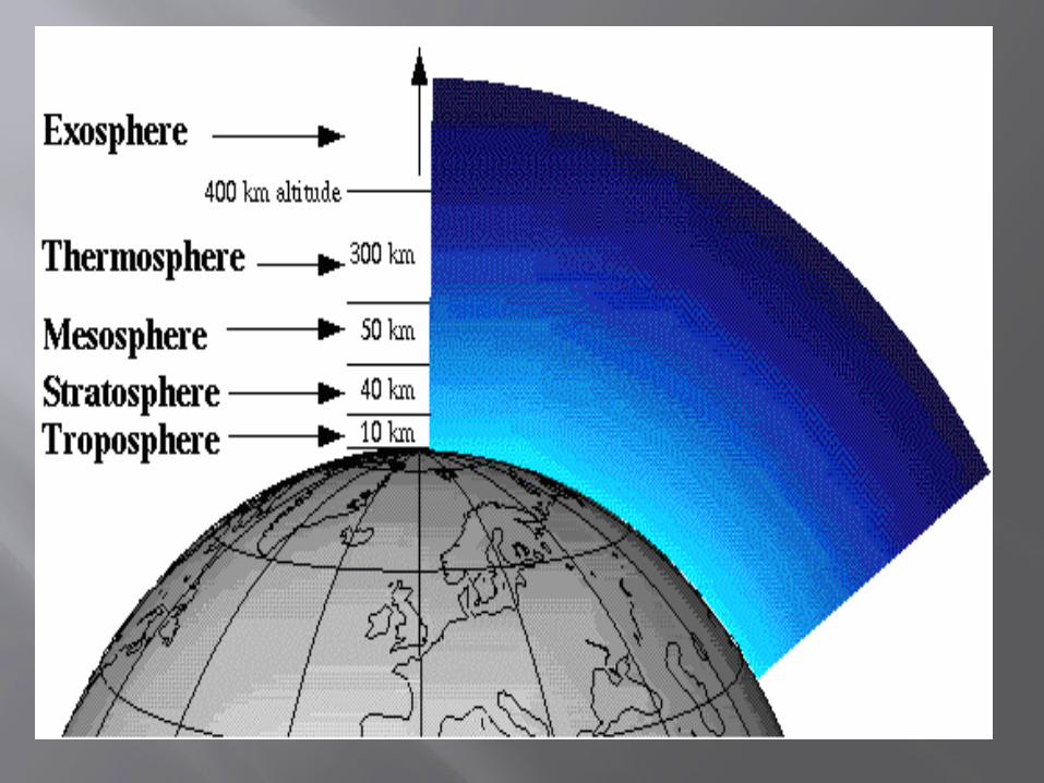
Troposphere
0-7 miles above surface Weather occurs in this zone

Stratosphere
Temperatures increase with altitude due to absorption of heat by ozone.
Ozone is produced by UV radiation and lightning.
Contains the ozone layer

Mesosphere
Temperature decreases with altitude Coldest layer Ice clouds form here Meteors (shooting stars) burn up in this
layer
Ionosphere
Temperature increases with height due to gamma rays, X-rays, and UV radiation
Molecules are converted into ions which results in the aurora borealis (northern lights) and the aurora australis (southern lights)

Weather and Climate Weather:
Caused by the movement or transfer of heat energy which influences:
Temperature Air pressure Humidity Precipitation Available sunshine determined by cloud cover
Wind speed Wind direction

Weather and Climate
Climate: Describes the total of all weather occurring
over a period of time in a given place
Weather and Climate Radiation- the flow of electromagnetic
radiation-the method by which Earth receives solar energy
Conduction- the transfer of heat through a substance that results from difference in temperature between different parts of a substance
Convection- the primary way energy is transferred from hotter to colder regions in the Earth’s atmosphere-primary determinant of weather patterns

Factors that Influence Climate
Evidence for changes in the climate come from data used to measure climate, written accounts, and data from material present at the time. Tree rings Fossilized plants Insect and pollen samples Gas bubbles trapped in glaciers Deep ice samples Dust analysis Isotope ratios in fossilized remains

Factors that Influence Climate
Air Mass- a large body of air that has similar temperatures and moisture content Equatorial, tropical, polar, arctic, continental,
maritime

Factors that Influence Climate
Air Pressure- Decreases with altitude Low pressure usually produces cloudy or
stormy weather High pressure masses contain cool, dense air
that descend toward Earth’s surface and become warmer Usually associated with fair weather

Factors that Influence Climate
Albedo- reflectivity Ocean water-low albedo Landmasses- moderate albedo Snow and ice-highest albedo
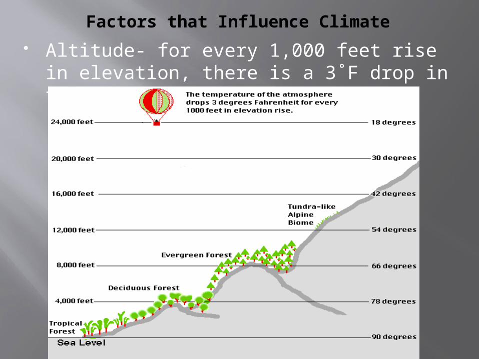
Factors that Influence Climate Altitude- for every 1,000 feet rise in
elevation, there is a 3˚F drop in temperature.

Factors that Influence Climate
Angle of Sunlight- areas closest to the equator receive the most sunlight and there fore higher temperatures

Factors that Influence Climate
Carbon Cycle- The consumption of carbon in the form of
carbon dioxide (CO2) results in cooling. The production of carbon in the form of carbon
dioxide results in warming.

Factors that Influence Climate
Clouds- collections of water droplets or ice crystals suspended in the atmosphere
As warmer air rises, it expands due to increasing air pressure and drops in temperature
The vapor begins to condense forming tiny water particles or ice crystals.

Factors that Influence Climate
Distance to oceans- oceans are thermally more stable than
landmasses Changes in temperature are more extreme in
the middle of the continents than on the coasts
Factors that Influence Climate
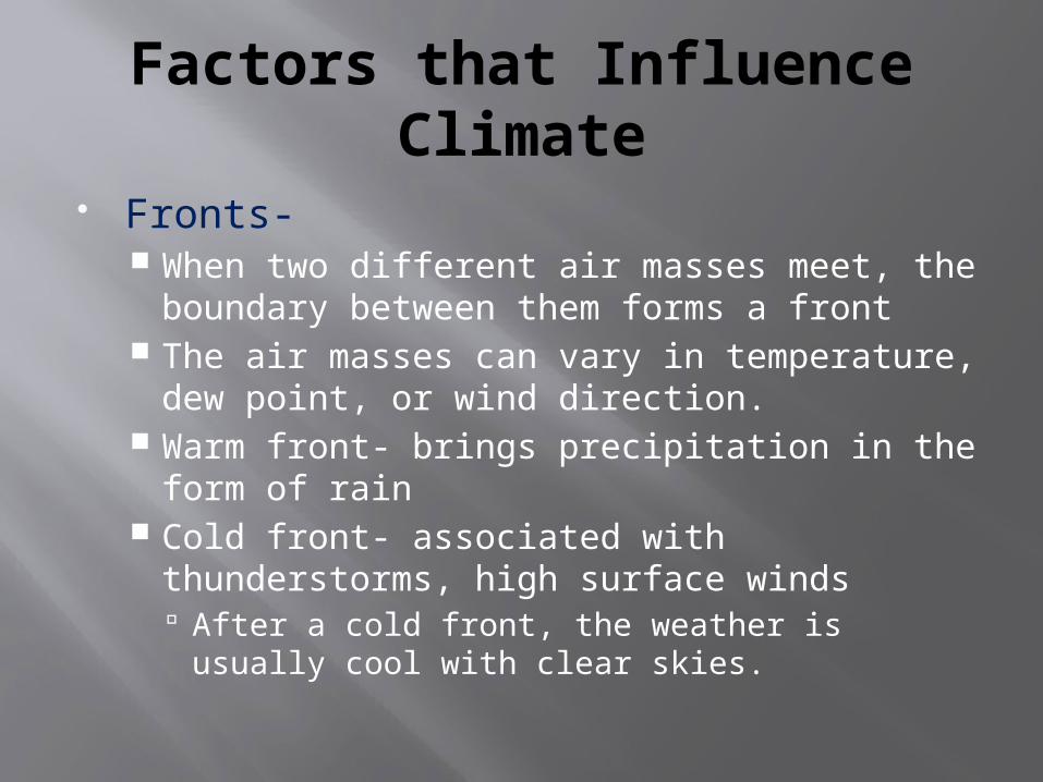
Fronts- When two different air masses meet, the
boundary between them forms a front The air masses can vary in temperature, dew
point, or wind direction. Warm front- brings precipitation in the form of
rain Cold front- associated with thunderstorms,
high surface winds After a cold front, the weather is usually cool
with clear skies.

Factors that Influence Climate
Greenhouse Effect- the most important greenhouse gases are water (H2O), carbon dioxide (CO2), and methane (CH4).
Without this effect, Earth would be cold and inhospitable.
If taken too far, Earth could evolve into a hothouse.

Factors that Influence Climate
Land masses- urbanization and deforestation
Latitude- the higher the latitude, the less solar radiation

Factors that Influence Climate
Mountain Ranges- Influence whether one side of the mountain will receive rain or not (rain shadow effect) The side facing the ocean is the windward side
and receives the most rain The side opposite the ocean is the leeward
side and receives little rain
Factors that Influence Climate
Volcanoes- sulfur-rich volcanic eruptions can eject material into the stratosphere, potentially causing tropospheric cooling and stratospheric warming
Volcanic aerosols exist in the atmosphere for an average of one to three years
Over the course of millions of years, large volumes of volcanic ash deposited in the oceans can cause an increase in iron content in seawater.

Factors that Influence Climate
Human Activity- deforestation, urbanization, release of pollutants including greenhouse gases and the burning of fossil fuels
Acid rain may be produced in urban areas and affect neighboring regions

Atmospheric Circulation
Due to: The rotation of the Earth on its axis Rotation around the sun The tilt of the Earth’s axis
**The sun heats the atmosphere unevenly**

Atmospheric Circulation
Due to: The rotation of the Earth on its axis Rotation around the sun The tilt of the Earth’s axis
**The sun heats the atmosphere unevenly**

Convection Cell

A convection cell can occur in a room.

Wind Patterns
During relatively calm, sunny days, the land warms up faster than the sea. This causes the air above it to become less
dense than the air over the sea, which results in a sea breeze.
A land breeze occurs during relatively calm, clear nights when the land cools down faster than the sea. This results in the air above the land becoming
denser than the air over the sea.
As a result, air moves from the land towards the coast.

Coriolis Effect Once air has been set in motion by the
pressure gradient force, it undergoes an apparent deflection from its path. This deflection is called the “Coriolis Effect”
It is a result of the Earth’s rotation.

Coriolis Effect
In the southern hemisphere, air moving from high to low pressure is deflected to the left by the Coriolis force.
The amount of deflection the air makes is directly related to both the speed at which the air is moving and its latitude. Slowly blowing winds will be deflected only a
small amount, while stronger winders will be deflected more.
Winds blowing closer to the poles will be deflected more than winds at the same speed closer to the equator.
The Coriolis force is zero at the equator.
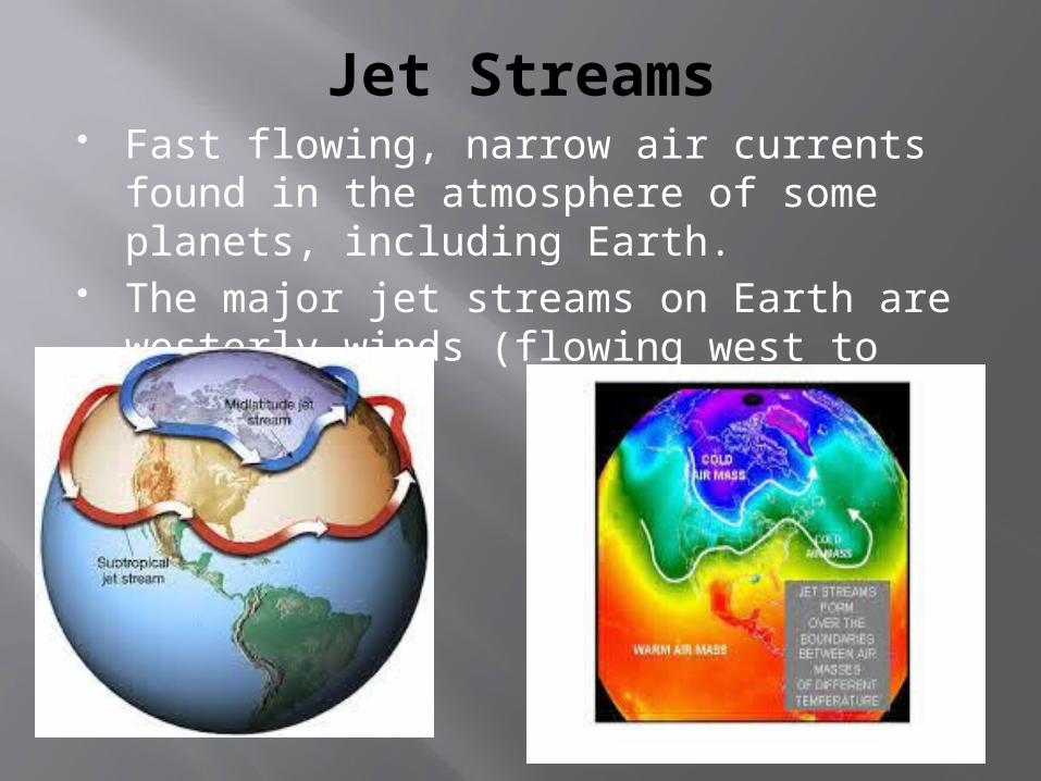
Jet Streams Fast flowing, narrow air currents found in
the atmosphere of some planets, including Earth.
The major jet streams on Earth are westerly winds (flowing west to east).

Worldwide System of Winds
Transports warm air from the equator where solar heating is greatest toward the higher latitudes where solar heating is diminished gives rise to Earth’s climatic zones.
Three types of circulation cells associated with latitude:
Hadley Ferrel Polar

Hadley Air Circulation Cells
Air heated near the equator rises and spreads out north and south.
After cooling in the upper atmosphere, the air sinks back to Earth’s surface within the subtropical climatic zone (between 25˚and 49˚ north and south latitudes).
Surface air from subtropical regions returns toward the equator to replace the rising air.

Hadley Air Circulation Cells
The subtropical regions of Hadley cells are characterized by: Low relative humidity Little cloud formation High ocean evaporation due to low humidity Many of the world’s deserts

Hadley Air Circulation Cells
The tropical wet and dry (or savannah) climate: Dry season more than two months long Annual losses of water through evaporation in
this region exceed annual water gains from precipitation
Ferrel Air Circulation Cells
Develop between 30˚ and 60˚ north and south latitudes.
Descending winds of the Hadley cells diverge as moist tropical air moves toward the poles in winds known as westerlies.

Ferrel Air Circulation Cells
Midlatitude climates: Can have severe winters Defined seasons Both tropical and polar air masses are present Contains broadleaf deciduous and coniferous
evergreen forests
Polar Air Circulation Cells Originate as icy-cold, dry, dense air that
descends from the troposphere to the ground The air meets with warm tropical air from the
midlatitudes. The air then returns to the poles, cooling, and
then sinking Sinking air suppresses precipitation
Thus, the polar regions are deserts (deserts are defined by moisture, not temperature)
Very little water exists in this area because it is tied up in the frozen state as ice.
Annual snowfall is relatively small.

Polar Air Circulation Cells Climates are characterized by:
Low temperatures Severe winters Small amounts of precipitation (most falling in the
summer) Summers are short Temperatures are generally low throughout the
year Two major biomes:
Tundra taiga

The Hadley, Ferrel, and polar cells

El Nino and La Nina Normal State (non-El Nino or La Nina)
conditions Easterly trade winds move water and air warmed
by the sun toward the west. The ocean is generally around 24 inches higher in
the western Pacific and the water about 14˚F warmer.

El Nino Air pressure patterns
in the South Pacific reverse direction
The trade winds decrease in strength and can reverse direction
Pushes the thermocline (Oceanic water layer in which water temperature decreases rapidly with increasing depth)
deeper and decreases the upwelling of nutrient-rich deep water This results in extensive fish
kills off the South American coast.

La Nina The prevailing rain pattern shifts farther
west than normal The winds pile up warm surface water in the
western Pacific. This is the cool phase of ENSO called La
Nina. Unusually cold ocean temperatures in the eastern
equatorial Pacific. Brings wetter than- normal conditions across the
Pacific Northwest, US and both dryer and warmer-than –normal conditions in the southern states.
Winter temperatures are warmer-than-normal in the southeastern US and cooler than normal in the northwest.

La Nina
Increased temperatures in the southeast correlate with substantial increase in hurricanes.
La Nina is also responsible for heavier-than-normal monsoons in India and Southeast Asia.

Monsoons Strong, often violent winds that change
direction with the season. Winds blow from cold to warm regions
because cold air takes up more space than warm air.
Blow from the land toward the sea in winter and from the sea toward land in the summer.