appendix 7 summary of submissions and the environmental ... · swec, 239, 248 3 some of these links...
TRANSCRIPT

Appendix 7
Summary of submissions and the Environmental Protection Authority and theWestern Australian Planning Commission response to the environmental
submissions

10/63
REGIONAL OPEN SPACENo. Points Raised Submissions
RaisingPoints
Total WAPC Comment WAPC Response EPA Recommendation
Areas the subject of varying points of view1 Twin Rivers
a) Support inclusion of all of Lot 211Barnes Ave in ROS because it providesa valuable range of vegetation types andhabitats that are now limited in the area,it provides a passive recreation andeducation resource, it containsthreatened species such as the SouthernBrown Bandicoot and possibly theQuenda, and it is recognised in LIMA'sWaterways Protection Precinct andEPA's System 6 Report.
24, 25, 27,29, 35, 36,38, 42, 44,45, 49, 51,52, 54, 55,58, 59, 62 -65, 69, 79,88, 89, 99,100, 110,126, 149,ABC, 165,177, 184,218, SWEC,WRC
37 Lot 211 is zoned Residential under the Shire of HarveyTPS No.1 and has been recognised as suitable forresidential development in regional and local planningstrategies over many years. Historically, the need for aforeshore reserve along sections of the Collie andBrunswick Rivers adjoining Lot 211 has also beenacknowledged. The foreshore reserve shown in Shire ofHarvey’s current TPS No.1 was originally approved in1993. More recently, the significance of the foreshorereserve as a wildlife corridor, the conservation value ofother remnant vegetation on Lot 211 and the strategicimportance of this site for recreation have beenhighlighted. Accordingly, the WAPC reviewed theforeshore reserve shown in Shire of Harvey TPS No.1 andfound it should be increased to protect regionalconservation and recreation values associated with thesite, but that these values do not justify reservation of theentire site. The Regional Open Space (ROS) reserveproposed by the advertised GBRS, which will more thandouble the size of the existing reserve, was delineatedbased on a technical assessment of conservation andrecreation values and in recognition of the currentResidential zoning. The WAPC commissioned anindependent environmental study to review the adequacyof the proposed ROS. While the study concludes that theentire site has conservation value, it recommends that theenlarged reserve proposed by the GBRS is acceptable inthe circumstances subject to minor modification of theproposed boundary alignment to better protect regionallysignificant natural values and a practical boundary withthe Urban land.
Note.
However, the proposed ROSboundary shall be modifiedas depicted on Map 1Appendix 8). Should it bedecided that virtually thewhole of the site is to bereserved, it is recommendedthat the subdivisionboundary (blue line) asshown Map 1 be permitted.
This boundary allows apractical rounding off ofdevelopment at a roadseparating residential usefrom ROS which isconsistent with WAPCpolicy.
Refer to Section 9.3 fordetails of the EPA’sassessment andrecommendations.
b) ROS over Lot 211 Barnes Ave shouldbe reduced to reflect the GreaterBunbury Structure Plan, local TPS andapproved local structure plan.
231, 232,240, 269
4 The portion of Lot 211 shown on the Greater BunburyStructure Plan (1995) as Parks, Recreation and Drainageis greater than the area reserved Recreation by the Shire ofHarvey TPS No.1. Whilst the ROS boundary proposed bythe GBRS is not consistent with the boundary indicatedon the Greater Bunbury Structure Plan, the purpose of thelatter was not to define the actual reserve boundary but to
Dismiss.
Subject to the modificationof the boundary alignmentreferred to in 1(a) above, theproposed additional area ofROS has regionally
Refer to Section 9.3 fordetails of the EPA’sassessment andrecommendations.

11/63
indicate the general need for a reservation. The GBRSwill define the reservation over Lot 211 required toadequately protect regional conservation and recreationvalues. The investigations undertaken on behalf of theWAPC indicate that subject to modification of theboundary alignment, the proposed additional area of ROShas regionally significant conservation values that shouldbe protected.
significant conservationvalues that should beprotected.
c) No environmental justification forROS boundary over Lot 211 BarnesAve.
232, 240 2 The boundary recommended by the WAPC’s independentenvironmental study is based on environmentalconsiderations including vegetation, wetlands andflooding.
Dismiss. Agree with WAPC response.For further details of theEPA’s assessment andrecommendations also referto Section 9.3.
2 Ocean to Preston River Regional Park.(a) Through detailed vegetation survey,further consideration should be given toincluding additional areas of remnantbushland in the Park around theMaidens and the Tuart Forest andbetween Usher and Hay Park, theBussell Highway and Manea Park (northand south of College Grove) and ManeaPark and the Preston River.
110, 120,C/B, 194,218, SWEC,239, 248
8 Generally, the ability to include additional areas in thePark at this stage is limited because such modificationswould constitute substantial variations to the advertisedGBRS. However, amendments to the Scheme Map can bemade once the GBRS is operational. A future Parkenhancement study shall be undertaken by the WAPC toidentify additional areas suitable for inclusion in the Parkand to determine management priorities and processes forthe Park. Notwithstanding this, some additional areas canbe included in ROS because of their particularcircumstances. For example, the WAPC’s independentenvironmental study concludes that the undevelopedportion of Pt Loc 302 and 303 south of Mosedale Road,Usher, which is Crown land proposed to be zoned Urbanby the GBRS, has regionally significant conservationvalue. As this is Crown land and because of itsconservation value, the GBRS should be amended toreserve this land ROS. The WAPC’s environmental studyrecommends a small corner of Pt Loc 632 east of ParadeRoad be added to the regional park. A submission onbehalf of the main landowner in this area supports thismodification. The EPA’s Service Unit has indicated to theCollege Grove developer an appropriate width for theeast-west open space link to the south of College Groveand the GBRS should be modified to accord with thisadvice. The WAPC’s environmental study concludes thatthe portion of Pt Loc 632 west of Parade Road, two areasadjacent to the proposed north-south ROS corridorbetween Usher and Hay Park, and the proposed Industrial
Uphold in part.
The GBRS shall be modifiedto reserve for ROS theundeveloped portions of PtLoc 302 and 303 south ofMosedale Road, Usher, thesmall corner of Pt Loc 632east of Parade Road. Giventhe previous environmentalstudies in this area, andCouncil and the community'sinvolvement in themanagement of this land, itshould be reserved in ROS.The proposed ROS oversection of the Preston Rivershould be reduced, as shownon Map 3 (Appendix 8).
College Grove- The 200mROS boundary line issupported but shouldadditional ROS be includedit is recommended thatflexibility be allowed indetermining the finalalignment of the northernROS boundary to facilitate a
Note WAPC comment andresponse.The EPA recommends that:a)all of the remnantvegetation on Pt Loc 632 isregionally significant, asshown in Map 11 (Appendix9) , and should be reservedand appropriately managed;b) a corridor between 300and 500m on Lot 1000Bussell Hwy, as indicated inMap 9 (Appendix 9), bereserved in the GBRS andappropriately managedc) All of the remnantvegetation on Reserve 670should be reserved andappropriately managedbecause of its regionalsignificance, faunal habitatvalues and ecological linkageimportance;d)A portion of the remnantvegetation to the north ofReserve 670 should beconserved to provide aconsolidated ecologicallinkage between Reserve 670

12/63
zone over Reserve 670 east of North Boyanup Rd haveregionally significant conservation value. With respect tothe portion of Loc 632 west of Parade Road, it would bemisleading to leave this land zoned Urban in theknowledge that it has regionally significant conservationvalues requiring protection. This land should be zonedUrban Deferred, with the lifting of Urban Deferred to beconditional upon regional conservation values beingprotected. The two areas between Usher and Hay Parkmay be able to be protected within local open space aspart of structure planning. The proposed Industrial zoneover Reserve 670 east of North Boyanup Road isconsistent with the zoning under City of Bunbury TPSNo.7. The WAPC will consider inclusion of these areas inthe Park as part of its future Park enhancement study. TheWAPC’s environmental study identifies two clearedportions of the proposed ROS between Usher and HayPark that could be excluded. These areas form part of anarrow north-south regional conservation/recreationcorridor and removing either from ROS couldcompromise the functions of the corridor. It isrecommended that these areas be retained as ROS andrehabilitated. The study also recommends the reservewidth along sections of the Preston River be reduced.While on conservation grounds there may be justificationfor the reduction, the ROS corridor width should not bereduced below the 1 in 100 year flood line to ensure therecreation values of the river foreshore are notcompromised.
modification to the structureplan which is now with theWAPC for assessment. DEPshould liaise with theproponent and DPI todiscuss the final alignment.See Map 2 (Appendix 8).
It is recommended that thesouthern portion of Lot 670be reserved as ROS. Thenorthern environmentalvalues in the portion of theland is questioned,particularly the cleared areaand as such furtherassessment should beundertaken at the structureplanning, subdivision ordevelopment stage.In relation to the land to thenorth and east of the Lot 670it is recognised that thenatural qualities of the sitesare significant. Furtherassessment should beundertaken at the structureplanning, subdivision ordevelopment stage, orthrough provisions should anamendment to the townplanning scheme besubmitted. See Map 3(Appendix 8).
Once the GBRS isoperational, the WAPC willundertake a study to identifyother areas for protectionand/or inclusion in the Park.The WAPC will alsoconsider whether the Parkcan be enhanced by localopen space through theconsideration of adjoining
and the Preston River; and

13/63
structure plans.
(b) There are opportunities forextensions to the Park from PrestonRiver through Glen Iris to the CollieRiver, Kemerton and the coast andBunbury Regional Park and theDardanup/Boyanup area.
SWEC, 239,248
3 Some of these links are provided for through the GBRSROS network, in combination with planning forundeveloped areas. Further regional-level studies shouldbe undertaken when the GBRS is operational to identifyadditional regionally significant vegetation links and todetermine appropriate protection measures. In the interim,EMM 4 provides for protection of regionally significantvegetation as part of any future GBRS rezoning proposal.
Note.
The WAPC will undertakefurther regional-level studieswhen the GBRS isoperational.
Agree with the WAPCcomment and response.Refer to the EPA’srecommendations to 2(a)above.
(c) ROS over Location 267 NorthBoyanup Rd, apart from portionsreserved in local TPS, should bereplaced by Industrial zone because it isnot consistent with the Greater BunburyStructure Plan, the site does not haveregional conservation value and ROSwould not provide road interfacebetween the Park and industrialdevelopment.
205 1 The Greater Bunbury Structure Plan (1995) recognisesthe conservation value of remnant vegetation in this areaand the need for a conservation/recreation link betweenthe coast and the Preston River. The proposed ROS wouldform part of the Ocean to Preston River Regional Park.The WAPC’s independent environmental studyrecommends the proposed ROS over Location 267 beretained despite vegetation condition to enhance theconservation link provided by the Park.
Dismiss. Agree with the WAPCcomment and determination.
(d) The ROS link between Preston Riverand Manea Park should be north of theBunbury airport.
245 1 ROS link proposed by GBRS between Preston River andManea Park is north of Bunbury Airport.
Note. Refer to the EPA’srecommendations to 2(a)above.
3 Muddy Lakes(a) Objects to ROS over area set aside toprotect Muddy Lakes wetlands becauseit will affect the agricultural productivityof existing businesses.
23, 75, 139,187, 219,223, 224, 250
8 The ROS proposed for the Muddy Lakes wetlands isbased on the boundaries defined in the Lakes EPP. TheWAPC’s independent environmental study concludes thaton their own these lakes have regionally significantnatural values but that they also form part of a largerconservation area that supports natural values ofoutstanding regional significance that should be protected.On this basis, the ROS should remain. It has beenconfirmed through further site surveys with the WRC andDEP that the proposed ROS boundaries are required toprotect these values. There is no doubt that preventingstock access to the ROS, some of which is used forsummer pasture, would have a significant impact on theagricultural productivity of some affected properties.However, stock would not be prevented over this area bythe GBRS until it is in Crown ownership. Even then theremay be an option to lease some of the land back for
Dismiss objection to ROS.
Note the landownersconcerns regarding the effectof preventing access to theROS on the agriculturalproductivity of someproperties.
Once the GBRS isoperational the WAPC willcoordinate preparation of astructure plan for thisgeneral area. Any change tothe ROS boundary wouldrequire an Amendment to theGBRS.
Noted and agree with theWAPC determination.The EPA recommends that:a)the alignment of the ROSreserve boundary aroundMuddy Lakes should remainas shown in the advertisedGBRS; andb)the alignment of the ROSreserve boundary should beamendment to include otherareas of environmentalsignificance pending theoutcome the managementplan to be prepared for thearea;

14/63
grazing until restoration works commence.Notwithstanding these considerations, at some point in thefuture the GBRS will impact on the suitability of someproperties for grazing. It is also likely that this area will besubject to pressure for closer subdivision in the future. Forthese reasons, a structure plan should be prepared todetermine appropriate land use and managementguidelines for the protection and enhancement of coastaland wetland resources in this general area. This could beundertaken in the context of the coastal management planrecommended in 6(c) below.
For further details of theEPA’s assessment andrecommendations refer toSection 9.3.
(b) WRC should conduct a hydrologicalstudy of the Muddy Lakes area todetermine the level of saline incursion,whether wetlands can be reinstated bydrain modifications and establish theneed for and extent of ROS.
223 1 WRC advises that Muddy Lakes are an expression of thelocal aquifer system and that groundwater managementcontributes to maintaining water quality in the lake. WRCalso advises that annual flushing of the lake system withsurface drainage assists in maintaining salinity levels.WRC indicates that there is currently insufficientevidence to demonstrate that drain modifications arerequired to maintain ecological function and that if drainmodifications were determined necessary then furtherhydrological understanding would be required to assessthe impacts of modifications on the lake. The WAPC’sindependent environmental study confirms that theMuddy Lakes area in its current state has regionallysignificant conservation values. However, there will be aneed for a hydrological study in the future to gain a betterunderstanding of the hydrological system and determineappropriate remedial actions to restore conservationvalues of the wetland system.
Note.
There will be a need for ahydrological study in thefuture to gain a betterunderstanding of thehydrological system anddetermine appropriateremedial actions to restoreconservation values of thewetland system.
Noted.Agree with the WAPCcomment.
(c) Only areas within Loc 492 and 41Minninup Rd Stratham proven to havehigh conservation value should beincluded in ROS.
251 1 The WAPC’s independent environmental study concludesthat the majority of the area proposed to be included inROS has natural values of outstanding regionalsignificance. It recommends that the few small portionsthat on their own do not have regionally significantconservation value, form part of the consolidated area andthat excluding these areas from ROS may compromise itsregionally significant values.
Uphold.
The area proposed to bereserved ROS has naturalvalues of outstandingregional significance and theproposed boundaries arerequired to protect thesevalues.
Agree with the WAPCcomment and determination.
(d) The proposed ROS over Lot 1 and PtLot 394 Rich Road, Stratham should bereviewed.
208 1 Refer to WAPC Comments for 3(c) above. Refer to WAPC response for3(c) above.
Refer to EPArecommendation to 3(a).
4 Land north of Leschenault Estuary(a) Support for Rural zoning of Loc 7Buffalo Road.
S/H 1 Apart from along the eastern boundary, Loc 7 BuffaloRoad is proposed to be zoned Rural pending further
Note. Noted

15/63
environmental and planning investigations.(b) Most of Loc 7 Buffalo Rd should bereserved for ROS.
30 1 This land is identified for future urban development in theGreater Bunbury Structure Plan (1995) and Coastal andLakelands Planning Strategy (1999) subject toenvironmental assessment. This environmentalassessment will determine the existence and extent ofnatural areas within the property outside the proposedROS requiring protection.
Dismiss. Agree with the WAPCcomment and determination.
There will also be furtherregional level studies ofregionally significant naturalareas.
(c) ROS boundaries over Loc 7 and 14Buffalo Rd should be reviewed.
S/H 1 The WAPC’s independent environmental study concludesthat while the northern portions of Loc 7 and 14 proposedto be reserved ROS are degraded, they are part of System6 area C66 and represent the previous extent of theLeschenault Estuary. For these reasons, the proposed ROSover the northern portions should remain. The study alsoidentifies two areas along the eastern boundary that couldbe excluded from ROS. WRC have no objection to theeastern ROS boundary being modified.
Uphold.
The proposed ROS boundaryshall be modified inaccordance with Map 8(Appendix 8).
The EPA recommends that:a)the proposed modificationto the alignment of the ROSreserve boundary alignmenton Location 14 is acceptable;andb)the alignment of the ROSreserve boundary onLocation 7 should bereviewed prior to any futurezoning or subdivision on thesubject land, whichevercomes first, and amendedwhere necessary.
(d) ROS should be reduced over Loc 14Buffalo Rd to cover only the area of theremaining wetland on the westerncentral boundary.
176 1 Refer to WAPC Comment for 4(c) above. Uphold in part.
Refer to WAPC Response for4(c) above.
The EPA recommends that:a)the proposed modificationto the alignment of the ROSreserve boundary alignmenton Location 14 is acceptable.
(e) ROS over Loc 7 Buffalo Rd includesa dwelling, sheds and cattle yards andshould be removed pending a proposalto rezone the land for closerdevelopment.
193 1 No evidence has been submitted to demonstrate that theproposed ROS over Loc 7 is inappropriate. The WAPC’sindependent environmental study does not recommendremoval of or modification to the proposed ROS boundaryover Loc 7.
Dismiss. The EPA recommends thatthe alignment of the ROSreserve boundary onLocation 7 should bereviewed prior to any futurezoning or subdivision on thesubject land, whichevercomes first, and amendedwhere necessary.
(f) ROS at the northern end ofLeschenault Estuary is supported andshould be extended.
WRC 1 Refer to WAPC Comments for 4(c) above. The studynotes that land north of Buffalo Rd is classified as aConservation category wetland. This does not justifyinclusion in ROS but does afford some protection. Furtherregional-level studies should be undertaken when the
Note.
The WAPC will undertakefurther regional-level studieswhen the GBRS is
Noted

16/63
GBRS is operational to identify regionally significantnatural areas and determine appropriate protectionmechanisms.
operational.
(g) Port of Bunbury should be relocatedto coastal site south of Binningup.
213 1 Industry 2030 (WAPC, 2000) does not recommend afuture Kemerton Port, but rather improved road and railaccess to the existing Port of Bunbury. Land to the southof Binningup has been identified in the Greater BunburyStructure Plan (1995) and Coastal and LakelandsPlanning Strategy (1999) for future urban developmentsubject to environmental assessment.
Dismiss. Noted.
(h) GBRS should allow for futuredevelopment of Kemerton Port.
268 1 Refer to WAPC comments for 4(g) above. Dismiss. Noted.
(i) Port for Kemerton should not beallowed on land south of Binningup.
SWEC 1 Refer to WAPC comments for 4(g) above. Note. Noted.
5 ROS around Bunbury Port(a) Proposed ROS between Turkey Pointand Preston River is excessive andrestricts access for future port operationsand block of ROS between the PrestonRiver and Newton Dve was acquired bythe Port Authority for expansion of theinner harbour and should be availablefor that purpose in the future.
BPA, 228 2 WRC agrees that the block of ROS for the Preston RiverOxbow can be reduced where the proposed ROS bufferexceeds 50m width. The Bunbury Port Authority, WRCand City of Bunbury also agree that there are highconservation values at the Preston River delta that need tobe protected and that public access to and along theLeschenault Estuary foreshore needs to beaccommodated, but that the ROS proposed by the GBRSis excessive between the western end of the waterbirdhabitat area and the man-made cove. It has been indicatedthat there is an intention to construct a road between portindustry and the estuary foreshore but the location andalignment of such a road has not been set. For thesereasons, the proposed ROS between the western end ofthe waterbird habitat area and the south-west corner of theproposed ROS around the man-made cove should bemodified to be at least 50m from the high water mark.Further revisions to proposed ROS boundaries can beconsidered when more detailed planning for the port areais finalised.
Uphold in part.
The ROS boundariesproposed for the PrestonRiver Oxbow and theLeschenault Estuaryforeshore between TurkeyPoint and Preston River shallbe modified in accordancewith Map 9 (Appendix 8).
The EPA agrees with theproposed modifications.
Refer to Section 6 for furtherdetails of the EPA’sassessment.
(b) ROS between Turkey Point andPreston River should extend to theexisting road.
WRC 1 Refer to WAPC comments for 5(a) above. Dismiss. Agree with WAPC response.
Objection to, or request for review of specific ROS proposals6 Capel Coastal
(a) Land proposed to be included inROS is being effectively managed byexisting landowners and the proposedROS will result in a loss of grazing land
101, S/C,119, 138,146, 204,208, 220,
13 Generally, the coastal foreshore over rural properties inthe Shire of Capel is being effectively managed byexisting landowners. In the absence of a change in use ormanagement of the affected properties, it is likely that the
Uphold in part.
The proposed ROS boundaryshall be modified in
Agree with the WAPCcomment and response.
No further evaluation

17/63
and uncontrolled public access to afragile coastal environment.
223, 228,242, 244, 250
coastal strip will remain on the existing titles underexisting management arrangements for some time.However, reserving this foreshore as ROS under theGBRS provides the Government with a mechanism toconserve the coastal environment if threatened, controlfuture coastal development and provide for future publicaccess and coordinated management in accordance withcoastal planning principles and policies beingimplemented across Western Australia. The proposedROS has been technically reviewed against provisions ofthe draft State Coastal Planning SPP to determine whetherthe proposed reserve width is acceptable. The reviewconcludes that modifications should only be made wherethe proposed ROS width is greater than the developmentsetback recommended by the policy. There are sectionswhere modifications should be made.
accordance withModification Plan 10 & 11(Appendix 8).
required.
(b) Recommended alternative coastalROS boundary over rural property.
101, 242 2 Some sections where boundary modifications arerecommended coincide with alternative boundariesrecommended by landowners.
Refer to WAPC Response for6(a) above.
Agree with the WAPCcomment and response.
No further evaluationrequired.
(c) Coastal management plans requiredto determine appropriate coastal use,development, protection andmanagement.
244, 250 2 A coastal management plan will be prepared for thissection of coastline to provide land use and managementguidelines specific to particular sections. This plan mayresult in some refinements to the coastal foreshore ROSreserve.
Note.
The WAPC will prepare amanagement plan for thissection of coastline.
Agree with the WAPCcomment and response.
(d) ROS should be replaced by zoningand management agreements should beput in place.
223 1 Investigations into alternatives to ROS reservation haveconcluded that while many, including Conservation zones,would protect the foreshore from inappropriatedevelopment, none would provide for future publicaccess. The proposed ROS reserve will not affect thecurrent responsible use and management of this foreshoreby existing landowners and will protect againstinappropriate development, but would also provide forpublic access in the future. For these reasons the proposedROS should be retained.
Dismiss. Noted.
7 Capel River(a) Objects to ROS over propertiesalong the Capel River within thetownsite because it affects existingagricultural uses, is not required forfloodplain management, is excessive forpublic access requirements, that can beaccommodated when future subdivision
S/C, 119,125, 154,170, 180,182, 223, 246
9 A revised ROS boundary for the section of the CapelRiver through the Capel townsite has been prepared inconsultation with the WRC, DEP, Shire of Capel andaffected landowners and through further site surveys. Theboundaries have been revised based on more detailedconsideration of floodplain management, vegetationprotection and public access requirements, as well as the
Uphold in part.The proposed ROS boundaryshall be modified inaccordance with Map 12(Appendix 8).
Agree with the WAPCcomment and response.
The proposed modificationsto the ROS reservealignment are within the areaof the Capel River

18/63
occurs, and encourages uncontrolledpublic access that will affect privacy.
need to recognise existing development. The proposedROS boundary should be modified in accordance with therevised boundary.
Ecological Linkage and theMcLarty/Kemerton/TwinRivers/GwindinupEcological Linkage. Theseareas should be managed toprotect the values of theselinkages and the vegetation(in particular the northernpart of Lot 21 whichsupports Eucalyptuscalophylla) should beconserved. Considerationshould be given torestoration with local nativespecies as part of any futuredevelopment to protect thevalue of the adjacent riverinevegetation in the ROS.
No further evaluationrequired.
(b) Recommended alternative ROSboundary for Capel River through thetownsite.
154, 182 2 The alternative ROS boundary alignments suggested byaffected landowners were considered as part of the reviewof the proposed ROS reserve for the Capel River and werefound to be acceptable modifications.
Uphold.
Refer to WAPC Response for7(a) above.
Agree with the WAPCcomment and response.
Refer to EPA response to7(a) above.
No further evaluationrequired.
(c) ROS should be replaced by zoningand management agreements should beput in place.
223 1 Refer to WAPC Comments for 6(d) above. Dismiss. Noted
8 Other(a) Proposed ROS for Ferguson River inPicton includes an existing residenceand substantial property, including partof a nursery, and it should be reduced.
73, 91 2 The proposed ROS for Ferguson River in Picton does notinclude an existing residence but it has been reviewed inconsultation with the WRC and some modifications havebeen recommended as acceptable.
Uphold in part.
The proposed ROS boundaryshall be modified inaccordance with Map 13(Appendix 8).
Land shall be reservedfor conservationpurposes to provide anappropriate buffer tothe Ferguson River onLot 42080, Picton to therequirements of theWAPC on advice of theDEP and shall only beused for conservationand complementary

19/63
purposes.
Refer to Assessment Sheet15 (Appendix 5).
(b) ROS over western portion of Lot 6Old Coast Rd, Australind and adjoiningLot 46 should be reduced.
150, S/H 2 The proposed ROS provides for a contiguous foreshorereserve along this section of the Leschenault Estuaryeastern bank. While there is an existing retaining wall andfill within the proposed ROS over Lot 6, the WAPCconsiders the existing and potential conservation andrecreation values of this foreshore would be compromisedby a reduced reserve width for these lots. The proposedROS over Lots 6 and 46 should not be reduced.
Dismiss. Agree with the WAPCcomment and determination.
No further evaluationrequired.
(c) Objects to ROS over southernforeshore of Brunswick River east ofAustralind Bypass.
152, 153 2 This area has been identified as under consideration forconservation, protection and reservation in the GreaterBunbury Structure Plan (WAPC, 1995). However, theWAPC’s independent environmental study concludes thatapart from Lot 61, only the riparian corridor should beretained in ROS. A revised ROS boundary has beensurveyed in consultation with the WRC, DEP and thelandowner. Vegetation along the southern boundary of theproposed ROS has been identified in the WAPC’senvironmental study as having conservation value, andEucalyptus woodlands further south as providing aconservation linkage. EMM4 provides for preparation ofan EMP as part of any future GBRS rezoning proposal forthese lots. Otherwise, these values can be considered aspart of future planning for this area.
Uphold in part.
The WAPC supports theamended ROS boundary asshown on EPA's Map 6(Appendix 8).
Agree in part with theWAPC comment anddetermination
Further EPA evaluationrequired (Section 9.1).
(d) Objects to ROS over Lots 5 & 6Estuary Drive, Pelican Point andrecommends alternative ROS boundary.
197, 198 2 The WAPC’s independent environmental study concludesthat the portion of the lots proposed to be reserved ROS aspart of the Leschenault Estuary foreshore is of regionallysignificant conservation value. Accordingly, the proposedROS should remain.
Dismiss. Agree with the WAPCcomment and determination.
No further evaluationrequired.
(e1) Objects to proposed ROS landscapebuffer over industrial land adjacent toproposed Port Access Road reserve inPicton.
MRWA, 267 2 Industry 2030 (WAPC, 2000) recommends a buffer onboth sides of the Glen Iris Service Corridor. The GBRSproposes to include all but the southern portion of therecommended buffer on the western side of the ServiceCorridor in ROS. The buffer on the eastern side isproposed to be zoned Industrial. While there are existingindustrial uses on the western side of the Service Corridorthat do not require separation, the long-term planningobjective for this area is to make the land available foruses compatible with an Urban zone. Some uses permittedin the Urban zone such as residential development wouldrequire separation from the Service Corridor but others
Uphold.
The GBRS should bemodified in accordance withMap 10 (Appendix 8).
Agree with the WAPCcomment and determination.
Further EPA evaluationrequired (Section 9.1).

20/63
may not. Reserving the buffer as ROS would effectivelysterilise that land. A SCA, as an alternative, wouldprovide the necessary control to protect the ServiceCorridor and the flexibility to allow for appropriate usesto be permitted within the buffer. The buffer on both sidesof the Glen Iris Service Corridor should be included in aSCA.
(e2) ROS reservation over wetland onLot 6 Wimbridge St, Picton is notjustified.
267 1 The ROS over Lot 6 between the Wimbridge Roadreserve and the Glen Iris Service Corridor buffer coversan area in excess of 4ha that does not have regionallysignificant environmental value. Given its proximity to afuture regional park, this area would be suitable for futureurban development. This land should be zoned Urban.
Refer to WAPC Response for8(e1) above.
Further EPA evaluationrequired. (Section 10.5)
(e3) ROS boundaries at Picton Watersshould be modified.
270 1 Agreed.In July 2002 the EPA’s Service Unit advised thelandowner of a revised wetland buffer alignment that itsupports. The proposed ROS boundary should bemodified to accord with the revised wetland bufferalignment. Substantial rehabilitation of this wetland isrequired to restore its regional conservation value. Whilethe WAPC is prepared to contribute to the rehabilitationproject, other stakeholders that will benefit from theallocation of ROS in this area and/or the improvementsthat will result from the rehabilitation project should alsocontribute. ROS should not be used for local drainagepurposes.
Refer to WAPC Response for8(e1) above.
Note that all stakeholdersthat will benefit from theallocation of ROS in this areaand/or the improvements thatwill result from rehabilitationshould contribute torehabilitation and that ROSshould not be used for localdrainage purposes.
Further EPA evaluationrequired. (Section 9.4)
(f) Objects to ROS over south eastcorner of Lot 10 Paris Road because ithas no environmental value.
43 1 The proposed ROS provides a buffer between an EPPwetland and land zoned for medium density residentialdevelopment in Shire of Harvey TPS No.1. Accordingly,the ROS should remain to protect the wetland from thepressures of future development.
Dismiss. Agree with the WAPCcomment and determination.
No further evaluationrequired.
(g) Proposed ROS within Kemerton beremoved and land be included in ruralbuffer subject to SCA No.2.
DRD 1 The areas within Kemerton proposed as ROS contain EPPwetlands. Whilst it may be acceptable to manage thesewetlands in a rural environment under normalcircumstances, the fact that they are within the definedboundaries of the Kemerton Industrial estate justifies theirinclusion in ROS. Landcorp, in consultation with DMPR,supports the request for the proposed ROS reserves to beincluded in SCA No.2. However, there will be sufficientcontrols on the use of these areas under the GBRS if theyare reserved as ROS.
Dismiss. Agree with the WAPCcomment and determination.
(h) ROS over southern portions of Lot 5and Pt Lot 1 North Boyanup Rd,Davenport will have a detrimental
151 1 The WAPC’s independent environmental study concludesthat the proposed ROS over the southern portion of Lot 5should be retained because it contains a Priority flora
Uphold in part.
Further assessment should
The EPA recommends thatthe remnant vegetation onLot 1, shown in Map 12

21/63
impact on an area used for irrigatedpasture as part of the existing abattoiroperation and should be deleted.
species and forms an integral part of the Ocean to PrestonRiver Regional Park. The study does, however,recommend that the proposed Preston River foreshoreROS over Pt Lot 1 can be reduced. While there isjustification for the reduction, the ROS corridor widthshould not be reduced below the 1 in 100 year flood lineto ensure the recreation values of the river foreshore arenot compromised.
be undertaken at thestructure planning,subdivision or developmentstage, or through provisionsshould an amendment to thetown planning scheme besubmitted.The land is not located in thePreston River Floodway andtherefore, it is recommendedthat that it should beretained as Industrialpending further assessment.The proposed ROS over PtLot 1 along the PrestonRiver foreshore shall bemodified in accordance withMap 3 (Appendix 8)
(Appendix 9) , be reservedand appropriately managedas part of any future zoning,subdivision and/ordevelopment on the site.toconsolidate the size andshape of the foreshorereserve.
Refer to Section 10.8 forfurther details of the EPA’sassessment andrecommendations.
Refer to Assessment SheetNo. (Appendix 8)
(i) Recommends alternatives to ROSboundary along southern side of HarveyRiver Diversion.
161 1 The WAPC’s independent environmental study concludesthat the area proposed to be reserved ROS is a priority forprotection and that the proposed ROS better protectsregionally significant environmental value than thealternative suggested.
Dismiss. Agree with the WAPCcomment and determination.
No further evaluationrequired.
(j) Objects to ROS over ForrestHomestead property on Preston River,particularly near the heritage homesteaditself.
201 1 The proposed ROS boundary is consistent with thereserve boundary shown on the City of Bunbury TPSNo.7 and recommendations of the Greater BunburyStructure Plan (WAPC, 1995) and Industry 2030 (WAPC,2000). It forms part of the ROS corridor along the PrestonRiver.
Dismiss. Agree with the WAPCcomment and determination.
No further evaluationrequired.
(k) ROS over Pt Lot 1 and Pt Lot 22Cathedral Ave, Australind should bereviewed.
S/H 1 The proposed ROS boundary over these lots generallyfollows the boundary between the riparian zone of theLeschenault Estuary and the Yoongarillup landform,which is a desirable foreshore reserve boundaryalignment.
Note. Noted.
(m) Sections of Lake Preston Rd shouldnot be included in ROS but zoned Rural.
S/H 1 The Lake Preston Road reserve is Crown landimmediately adjacent to Lake Preston. Only this Crownland is proposed as ROS by the GBRS. Whilst theadequacy of this reserve as a foreshore reserve for LakePreston will be reviewed as part of any future rezoning,subdivision or development proposal for adjacentproperties, it would be unlikely that a reduced ROS widthfor the lake foreshore would be consideredenvironmentally acceptable.
Dismiss.This reserve is required as aminimum foreshore reservefor the lake.
Agree with the WAPCcomment and determination.
No further evaluationrequired.
(n) Harvey Tourism Precinct should be S/H 1 The Harvey Tourism Precinct to the west of South Dismiss. Agree with the WAPC

22/63
zoned Urban rather than ROS because itsupports uses that may not becompatible with an ROS reservation.
Western Highway and north of town on the Harvey Riverforeshore is on Crown land and is a tourist attraction ofregional significance. Reserving the precinct ROS isrecognition of this. The existing cafe/restaurant and touristbureau on this land are uses compatible with the ROSreservation.
comment and determination.
No further evaluationrequired.
(o) Objects to ROS over Lots 5 & 6 OldCoast Rd, Australind outside existingforeshore reserve as shown in Shire ofHarvey TPS No.1 and approved throughsubdivision.
233 1 Apart from a section of foreshore on the property adjacentto a bend in the Brunswick River, the ROS proposed bythe GBRS is consistent with the reserve shown by Shire ofHarvey TPS No.1. There is no current subdivisionapproval over this land. At the bend, neither the reserveshown by TPS No.1 nor the proposed ROS follow thefloodway line. As no development is permitted within thefloodway the ROS boundary should be modified at thebend to follow the floodway line.
Dismiss.
The proposed ROS boundaryshall be modified inaccordance withModification Plan 12.
Agree with the WAPCcomment and determination.
No further evaluationrequired.
(p) Loc 5221 Parade Rd and Lot 50Tuart St Bunbury should be reservedPublic Purpose not ROS.
WC 1 These two lots, the first being about 225m2 and thesecond being about 7500m2, contain existing sewer pumpstations. These utilities are not regionally significant in aplanning context. The proposal to include these facilitiesin ROS reserves will not affect their operation.
Dismiss. Agree with the WAPCcomment and determination.
No further evaluationrequired.
(q) Objects to ROS over Loc 492 and 41Minninup Road, Stratham because:(i) the land is ideally situated forresidential, special rural or intensiveagricultural use, its conservation valuehas not been recognised inenvironmental policy or assessed indetail, and the environmental attributesof the property are adequatelyrepresented in reserves elsewhere in thearea; and(ii) Access to Location 492 MinninupRd Stratham is affected by the proposedROS reservation.
251 1 (i) The Greater Bunbury Structure Plan (1995) identifiesthis area as under consideration for conservation, scenicprotection and reservation. The WAPC’s independentenvironmental study concludes that this area has naturalvalues of outstanding regional significance that should beprotected. Accordingly, the proposed ROS should beretained.
(ii) The portion of Location 492 proposed to be includedin ROS will remain on the existing title until the ROS isacquired by the WAPC. Arrangements can be made at thetime of acquisition and transfer to ensure access tobalance portions of properties is provided.
(i) Dismiss.
(ii) Note.
Agree with the WAPCcomment and determination.
Refer to Section 9.6 forfurther details of the EPA’sassessment andrecommendations
(r) Two portions of Pt Lot 1 Parade Rd,Brook Village should be zoned Urbaninstead of ROS because they are suitablefor inclusion in a neighbourhood centresite and area of POS respectively andthere is no environmental justificationfor their ROS reservation.
262 1 The WAPC’s independent environmental study concludesthat the area proposed for inclusion in a neighbourhoodcentre has regionally significant natural values. Theproposed ROS reserve over this area should remain. Thestudy identifies the portion proposed for POS as an areanot supporting regionally significant natural values thatcould be removed from ROS. However, the north-southregional conservation/recreation corridor it is part of isalready narrow. Removing this area from ROS wouldreduce the width of the corridor to about 50m. To
Dismiss. Agree with the WAPCcomment and determination.

23/63
maximise the opportunities to create the corridor, it isrecommended that this area be retained as ROS andrehabilitated.
(s) Proposed western and northern ROSboundaries for Dalyellup Beach Estateshould reflect approved structure plan.
264 1 Agree in part. Uphold.
The zoning for the TouristPrecinct should remain asadvertised (Map 6 –Appendix 8).
Further EPA assessmentrequired.
Refer to Section 10.9 forfurther details of the EPA’sassessment andrecommendations
(t) Centenary Rd, Dalyellup should notbe included in ROS.
S/C 1 Centenary Road is proposed to be included in ROS toincrease the width of the open space link between theTuart Forest and Bussell Highway, as part of the proposedOcean to Preston River Regional Park. Main Roads' draftregional road access plans for this area do not indicate theneed for Centenary Road to remain open. The City ofBunbury's draft Tuart Brook Structure Plan also indicatesthat Centenary Road should be closed. The DPI has givenin-principle support for the closure of Centenary Road.
Dismiss. Agree with the WAPCcomment and determination.No further evaluationrequired.
(u) ROS over southern portion ofGarden of Eaton estate adjacent toMillars Creek should be adjusted toreflect approved Structure Plan.
159, S/D 1 Agree. Uphold.
The proposed ROS boundaryshall be modified inaccordance with Map 8(Appendix 8).
Agree with the WAPCcomment and determination.No further evaluationrequired.
(v) Delete 17m2 of ROS from north eastcorner of Lot 100 Eades St, Glen Iris.
196 1 The subject portion of land forms part of a residentialproperty and has no environmental or recreational valueso it should be zoned Urban.
Uphold.
The proposed ROS boundaryshall be modified inaccordance withModification Plan 19(Appendix 8).
Agree with the WAPCcomment and determination.No further evaluationrequired.
(w) ROS proposed over Ridley Place,Australind should be removed.
S/H 1 Ridley Place provides access to a Leschenault Estuaryforeshore car park, picnic area and boat ramp. Includingsuch an access road in ROS is appropriate.
Dismiss. Agree with the WAPCcomment and determination.No further evaluationrequired.
Recommended additional ROS9 Point Douro
Lot 5 Old Coast Rd, Australind shouldbe protected for recreation and waterbirdhabitat conservation.
110, 121,165, BNG,168, SWEC,WRC, 257
8 The proposed amendment to Shire of Harvey TPS No.1for this site is subject to a separate environmentalassessment. The amendment proposes to modify theUrban/ROS boundary shown on the GBRS. If amodification to the proposed GBRS boundary is requiredas a result of a determination on the related local TPS
Dismiss. Amendment 13 to the Shireof Harvey TPS No 1 (PtDouro) is being formallyassessed by the EPApursuant to Division 3 ofPart IV of the Environmental

24/63
amendment, then the GBRS can be amended at that time. Protection Act 1986. Thescheme amendment proposesto change the alignment ofthe ROS reserve boundary.The boundary changesproposed in the Amendment13 are not included in theGBRS.The ROS reserve boundaryalignment in the GBRS isconsistent with the alignmentcurrently shown in the Shireof Harvey TPS. If theamendment is approved, theGBRS will need to beamended.
10 Major Rivers(a) Concerned that ROS along majorrivers does not extend into rural areas.
87, ABC,WRC, 258
4 ROS is not generally proposed for river foreshores in ruralareas because these section of foreshore are not subject tothe same pressures and demands associated with adjacenturban development. EMM 4 provides for protection ofriparian vegetation as part of any future GBRS rezoningproposal and the need for a foreshore reserve would beconsidered as part of any local rezoning or subdivision.Further regional-level studies should be undertaken whenthe GBRS is operational to identify other sections of riverforeshore in the Rural zone that should be protected and todetermine the appropriate protection mechanism.
Note.
There are adequate measuresin place to ensure protectionof river foreshores isconsidered as part ofplanning proposals.However, the WAPC willundertake further regional-level studies when the GBRSis operational.
Noted.
(b) ROS along the Brunswick Riverforeshore north of the MilleniumIndustrial site should be increased tomaximise protection of the conservationvalues of this corridor.
ABC 1 The ROS proposed by the GBRS generally reflectsapproved foreshore reserves shown on local TownPlanning Schemes and structure plans. In many cases,adjacent areas have already been developed. AdditionalROS is proposed adjacent to the Twin Rivers subdivisionin recognition of the particular recreation andconservation significance of this area. All foreshorereserve boundaries proposed by the GBRS have beendetermined based on technical assessments and providefor a continuous foreshore reserve along the BrunswickRiver from the Millenium Industrial site through to theAustralind Bypass.
Note.
The ROS along theBrunswick River from theMillenium Industrial sitethrough to the AustralindBypass is continuous andsubstantially increases thearea to be protected over Lot211 Barnes Avenue (TwinRivers).
Noted.Refer to Section 9.3 (TwinRivers) for further details ofthe EPA’s assessment andrecommendations
11 Waste Water Treatment Plant on ParisRoad, Australind.a) Northern portion of WWTP on ParisRd, Australind be included in ROS
ABC, 256 2 The WAPC’s independent environmental study concludesthat the northern and western portions of this Crown
It is recommended that theUrban Deferred zoning is
Agree with the WAPCcomment and determination.

25/63
rather than Urban Deferred. reserve contain vegetation of regional conservation value,particularly in terms of providing for an extension to theadjacent Wardandi Reserve, but that the balance eithersupports wastewater treatment infrastructure or isdegraded. Based on this information, the northern andwestern portions of this site should be included in an ROSreserve.
retained except for the areaof ROS delineated onReserve 35061.
Refer to Section 4.1 forfurther details of the EPA’sassessment andrecommendations.
b) Water Corp land abutting theWardandi Reserve should be included inROS.
SWEC 1 Refer to WAPC comment for 11(a) above. Refer to WAPC response for11(a) above.
Agree with the WAPCcomment and determination.
Refer to Section 4.1 forfurther details of the EPA’sassessment andrecommendations
12 Land north of Myalup(a) Lack of conservation connectionbetween Lake Preston and the ocean anddelineation of northern developmentboundary for Myalup is likely to isolateLake Preston and reduce conservationsignificance.
30 1 The Coastal and Lakelands Planning Strategy (WAPC,1999) only permits a dwelling density of one dwelling per5ha north of Myalup subject to environmental criteria.Development at this density would not preventconservation connections between Lake Preston and theocean. There is an opportunity to create a reserveconnection between the lake and the ocean through afuture amendment to the GBRS if that is considerednecessary.
Dismiss. Noted.
The EPA supports thecompletion of the System 6and System 1 update on theSwan Coastal Plain andadjacent Scarps as a 'wholeof government' programthrough a similar co-ordinated approach, as usedfor Bush Forever.
Areas such as this maybeidentified as part of thisprocess.
(b) Land on northern boundary ofMyalup is in pristine condition andrepresents an important conservationand recreation corridor. It is owned byCouncil and managed by the localcommunity.
MCA 1 The GBRS does not propose any additional developmentpressure on this area. The conservation value of this landwould be considered as part of any future rezoning,subdivision or development proposal.
Note. Noted.Refer to 12(a) above.
(c) Western portion of Lot 200 to thenorth of Myalup should be ROS.
S/H 1 The proposed Urban zoning for the western portion of Lot200 in the GBRS is consistent with the Tourist zone inShire of Harvey TPS No.1. Including the additional landin ROS would represent a substantial variation to theadvertised GBRS. EMM 1 provides for the responsibleauthority to require an EMP for any rezoning, subdivisionor development proposal over this land. The need foradditional coastal foreshore reserve should be considered
Dismiss.
To be considered as part ofany future rezoning,subdivision or developmentproposal.
Agree with the WAPCcomment and determination.
No further evaluationrequired.

26/63
as part of such proposals.13 Other
(a) Cokelup Swamp should be reservedin ROS.
30, 209 2 This wetland is protected by the Lakes EPP. The GBRSproposes to include it in the Rural zone, so does notincrease the potential for degradation. EMM 1 and 2provide for protection of EPP wetlands as part of anyfuture rezoning, subdivision or development proposal.
Dismiss. NotedRefer to 12(a) above.
(b) Queries why ROS for Collie Riveradjacent to Treendale subdivision is notcontinuous.
30, 258 2 The proposed ROS for the Collie River adjacent to theUrban zone east of Australind Bypass is consistent withthe foreshore reserve alignment shown on the approvedTreendale Farm Structure Plan and the plans ofsubdivision granted preliminary approval by the WAPC.The WRC has been involved in determining this foreshorereserve boundary alignment. The ROS does not extend tothe southern foreshore of the Collie River because it isproposed to be zoned Rural and will therefore not beexposed to the same pressures and demands as thenorthern foreshore.
Dismiss Agree with the WAPCcomment and determination.
No further evaluationrequired.
(c) Proposed new Urban zone at Harveyshould be included in ROS.
165, WSWA 2 The proposed new Urban zone in Harvey containsexisting pockets of CALM housing in a bushland setting.Only the pockets of housing are zoned residential in Shireof Harvey TPS No.1. Any future rezoning, subdivision ordevelopment proposal would be subject to separateassessment.
It is recognised that thequalities of the site aresignificant and that furtherassessment should beundertaken at the subdivisionor development stage, orshould an amendment to thetown planning scheme besubmitted. Theimplementation of the Peel-Bunbury Bushplan willprovide a further mechanismfor the protection of areas ofregional environmentalsignificance.
Further EPA assessmentrequired.
Refer to Section 4.6 forfurther details of the EPA’sassessment andrecommendations
(d) More land on eastern side ofLeschenault Estuary should be ROS.
WRC, 256 2 Constructed roads are in place along most of the easternforeshore of the Leschenault Estuary. Generally,residential and rural residential lots front these roads tothe east and the natural conditions have been substantiallymodified. These roads represent a physical boundarybetween the Estuary foreshore and development and arethe basis for the proposed ROS boundary alignment. Atthe very north, where a road reserve is not in place, theproposed boundary generally follows the boundarybetween the riparian zone of the Leschenault Estuary andthe Yoongarillup landform, which is a desirable foreshore
Dismiss. Noted.Refer to 12(a) above.

27/63
reserve boundary alignment.(e) McCarley's Swamp, south west ofCapel townsite, should be included in aConservation reserve.
209 1 Refer to WAPC's comment for 13(a) above. Refer to WAPC's response to13(a) above.
NotedRefer to 12(a) above.
(f) Eastern portion of Lot 37 Harris RdPicton be reserved as ROS.
130 1 An EPP wetland is located over this portion of Lot 37 andthe adjoining lot to the east. Industry 2030 (WAPC, 2000)recommends further structure planning for this area,including vegetation and wetland surveys, prior tosubdivision and development. Protection of the wetlandshould be addressed as part of the future structureplanning.
Dismiss. Noted
Refer to 12(a) above.
(g) Boyanup Locations AA 396 and AA107 should be included in ROS to bemanaged with adjoining reserves.
138 1 The GBRS proposes to include each lot in the Rural zoneand EMM 4 provides for protection of regionallysignificant vegetation as part of any future GBRSrezoning proposals. The impact of any local rezoning orsubdivision proposal Notwithstanding this, regional-levelstudies should be undertaken when the GBRS isoperational to identify additional regionally significantremnant vegetation that should be protected and todetermine the appropriate protection mechanism.
Dismiss.
There are adequate measuresin place to ensure protectionof natural values isconsidered as part ofplanning proposals.However, the WAPC willundertake further regional-level studies when the GBRSis operational.
NotedRefer to 12(a) above.
(h) Area in south-east of Basalt buffercontains a wetland and Priority listedplant species and should be included inROS.
138 1 This wetland is protected by the Lakes EPP. The GBRSproposes to include the area referred to in the Rural zone,so does not increase the potential for degradation. EMM 1and 2 provide for protection of regionally significantwetlands and EMM 4 provides for protection of regionallysignificant vegetation as part of any future GBRSrezoning proposal. Refer to WAPC Comments for 12(g)above regarding recommendations for future studies.
Refer to WAPC Response for12(g) above.
NotedRefer to 12(a) above.
(i) Stand of trees along eastern boundaryof Pt Lot 41 Minninup Rd, Strathamshould be included in ROS.
139 1 Refer to WAPC Comments for 12(g) above. Refer to WAPC Response for12(g) above.
The stands of trees can beconserved and managed aspart of future zoning ordevelopment proposals.
(j) Original buffer for Kemerton beincluded in ROS.
ABC 1 The area covered by SCA No.2 represents the bufferrequirements for the proposed Kemerton Industrial zone,as recommended in the Kemerton Expansion Study FinalConcept Plan (WAPC, 2000b). Landcorp intends toacquire some additional properties affected by SCA No.2and has already acquired others. The primary purpose ofSCA No.2 is to provide a buffer for industry at Kemerton,not for conservation or recreation. Including the buffer in
Dismiss. It is the EPA’s opinion that:1) areas of regionally
significant bushlandwithin SCA No. 2should be reserved asROS as a futureamendment to theGBRS; and

28/63
ROS would therefore not reflect the primary purpose ofthe area.
2) Special Control AreaNo. 2 provides adequateseparation betweenproposed industriald e v e l o p m e n t a n dsurrounding landuses toaccommoda te t heimpacts of noise, airquality and risk inaccordance with theEPA’s environmentalobjectives and criteriafor these environmentalfactors.
(k) East-west vegetation link should beprovided between Kemerton andLeschenault Peninsula.
SWEC 1 Refer to WAPC Comments for 12(g) above. Note.
Refer to WAPC Response for12(g) above.
The EPA identified a seriesof regionally importantecological linkages(Appendix 4) which could beachieved through the updateof the remainder of theSystem 6 and part System 1area in a similar co-ordinatedprogram to Bush Forever
(l) Portion of Urban zone south ofDalyellup Beach Rd/Minninup Rdintersection should be ROS.
CALM 1 Agreed.Subject land is shown on approved Dalyellup BeachEstate Structure Plan as Regional Conservation.
Uphold.
GBRS should be modified inaccordance withModification Plan 13.
The EPA recommends thatthe ROS boundary berealigned as shown inAppendix 16 . For furtherdetails of the EPA’sassessment andrecommendations also referto Section 10.9.
(m) Some existing reserves are notincluded in ROS.
WRC 1 No further information has been provided to identifyreserves not included in ROS and none have been found.
Dismiss. Noted
(n) Portions of Lot 21 Cathedral Ave,reserved for recreation by the Shire ofHarvey TPS No.1 Amendment 17should be included in ROS.
WRC 1 The area referred to is local public open space and issufficiently protected under the Shire of Harvey TPSNo.1.
Dismiss. Agree with the WAPCcomment and determination.
(o) North west corner of Pt Lot 632 eastof Parade Rd, Brook Village should beincluded in ROS.
262 1 The WAPC’s independent environmental studyrecommends that this corner should form part of theregional corridor (Map 5 – Appendix 8). The mainlandowner in this area supports the modification. Thenorth-west corner of Pt Lot 632 should be reserved as
Uphold. The EPA recommends thatthe ROS boundary berealigned as shown in Map11 (Appendix 9). For furtherdetails of the EPA’s

29/63
ROS. assessment andrecommendations also referto Section 10.1.
(p) Land fronting Australind Bypassbetween Johnson Rd realignment andproposed Port Access Road should bereserved as ROS.
218 1 This land has been identified as a possible alignment forthe Preston River Diversion Channel. Whilst ROS islikely to be an appropriate reservation for the diversionchannel, matters such as the timing and detailed design ofthe channel are subject to further investigation. In theabsence of this information or any information regardingthe recreation or conservation significance of this landcurrently, the proposed Rural zoning is appropriate.
Dismiss. Agree with the WAPCcomment and determination.
Support for specific proposals14 Proposed ROS for the Collie River flood
plain within Glen Huon, Eaton.30 1 Proposed ROS reflects the floodway for the Collie River. Note. Noted
15 Proposed ROS on northern side of theCapel River mouth.
119 1 The proposed ROS over this area supports plans of thelocal Land Conservation District Council to control accessto and rehabilitate land around the river mouth.
Note. Noted
16 ROS around Millennium Industrial sitein Australind.
S/H 1 This area serves the dual purpose of providing anindustrial buffer and a conservation and recreationresource.
Note. Noted
General17 Lack of justification for ROS areas and
boundary alignments.228 1 Many of the proposed ROS reserves reflect existing
regional conservation and recreation reserves. Both theWAPC and the EPA are reviewing the new ROS reservesto ensure they reflect regional recreation and conservationvalues and modifications to the GBRS will be carried outaccordingly.
Dismiss. Noted.In addition to theEnvironmental Review theEPA has undertakenadditional biological surveysand mapping (Appendix 5)and has also prepared astrategy to identifyregionally significant naturalareas in its consideration ofthe GBRS.
18 Additional ROS should be provided toprotect more poorly representedvegetation complexes.
WSWA 1 The EPA has developed criteria that it will use to assessproposed new zones and reserves under the GBRS interms of their impact on remnant vegetation. Thesecriteria include giving priority to protection of poorlyrepresented vegetation complexes. The WAPC’sindependent environmental study has technicallyreviewed new zones and reserves against the EPA’scriteria for assessing their impact on remnant vegetationand where necessary, has recommended modifications.EMM 4 provides for protection of regionally significantvegetation as part of any future GBRS rezoning proposals.Notwithstanding this, regional-level studies should be
Dismiss.
The WAPC has technicallyreviewed new zones andreserves against the EPA'scriteria and where necessary,has recommendedmodifications. There areadequate measures in placeto ensure protection ofnatural values are consideredas part of planning proposals.
Agree with the WAPCcomment and determination.
Refer to 12(a) above.

30/63
undertaken when the GBRS is operational to identifyadditional regionally significant remnant vegetation thatshould be protected and to determine the appropriateprotection mechanism.
However, the WAPC willundertake further regional-level studies when the GBRSis operational.
19 All threatened flora communities shouldbe included in ROS.
WSWA 1 Of the known areas supporting threatened floristiccommunities in the GBR, over half are within existingreserves and the remaining areas are proposed to be zonedRural. Threatened flora is protected by provisions of theWildlife Conservation Act 1950. Also refer to WAPCcomments for 18 above.
Refer to WAPC response to18 above.
Agree with the WAPCcomment and determination.
Refer to 12(a) above.
ZONES
No. Points Raised SubmissionsRaisingPoints
Total WAPC Comment WAPC Response EPA Recommendation
Kemerton Industrial Zone20 Objection to the expansion of Kemerton
due to impacts on air quality, wastedisposal, water quality, wetlands,bushland, Declared Rare Flora andvisual amenity.
37, 56, 85,124, ABC,165, BNG,168, 210,WSWA,SWEC
11 The State Planning Strategy (WAPC, 1997) identifiesKemerton as a strategic industrial site. The proposedexpanded industrial area is generally consistent withrecommendations of Industry 2030 (WAPC, 2000). Therecommended buffer for Kemerton indicated in theKemerton Expansion Study Final Concept Plan (WAPC,2000b) has been supported by the EPA in terms ofproviding an adequate separation distance for surroundingsensitive uses. SCA No.2 generally includes all propertiesaffected by the recommended buffer and these propertiesare being acquired by Landcorp. EMM 5 requirespreparation of an EMP prior to any subdivision ordevelopment in the Kemerton Industrial zone to ensurethe protection of wetlands, remnant vegetation and DRF istaken into account. The Kemerton Expansion Study FinalConcept Plan designates the ridgeline as a RidgeDevelopment Control Area where development will besubject to special planning controls to ensure visualimpacts are minimised. These special planning controlsshould be included in EMM 5.
Note.
Refer to WAPC Response for23 below.
Agree with the WAPCcomment and determination.The EPA is recommendingthat a condition is imposedon the GBRS requiring thatprior to subdivision ordevelopment, whichever isfirst, being approved withinthe Kemerton Industrial Areaor the Special Control AreaNo. 2 an EnvironmentalManagement Plan is to beprepared and implemented tomanage the potential impactsof the subdivision ordevelopment on remnantvegetation, wetlands,watercourses and visualamenity..Refer to Section 5 for furtherdetails of the EPA’sassessment andrecommendations.Subsequent proposals withinthe Industrial zone may alsorequire referral to the EPAfor detailed assessment inrelation to air quality, noise

31/63
and risk..
21 Lot 6 Wellesley Rd should not form partof the Kemerton expansion area becauseit contains diverse plant species,Declared Rare Flora and Priorityspecies, fauna habitats and lacksmanagement commitments.
53, 110,ABC, 165,BNG
5 The Kemerton Expansion Study Final Concept Plan(WAPC, 2000b) includes the southern portion of Lot 6 ina Vegetation Management Area. Only the portion of theproperty outside the area subject to a conservationcovenant will be available for industrial development.
Dismiss Agree with the WAPCcomment and determination.
No further evaluationrequired.
22 Proposed northern boundary ofKemerton expansion area doesn't reflectthe boundary recommended in Industry2030 Report.
DRD 1 The northern boundary of the proposed Industrial zone atKemerton should be modified to be consistent with theboundary recommended by Industry 2030 (WAPC, 2000).
Uphold
The northern boundary of theKemerton Industrial zoneshall be modified inaccordance withModification Plan 11.
Agree with the WAPCcomment and determination.
No further evaluationrequired.
23 Ridgeline and vegetation managementguidelines for the western and northernexpansion areas of Kemerton need to beprovided in the GBRS to address issuesraised in Industry 2030.
189 1 Refer to WAPC comment for 21 above. Also theKemerton Expansion Study Final Concept Plan (WAPC,2000b) includes the western and northern portions of theKemerton Industrial zone in a Vegetation ManagementArea. EMM 5 should refer to visual amenity to ensurerecommendations regarding development control alongthe ridgeline are implemented through future subdivisionand development proposals.
Uphold in part.
EMM 5 will refer to visualamenity.
Agree with the WAPCcomment and determination.The EPA is recommendingthat a condition is imposedon the GBRS requiring thatprior to subdivision ordevelopment, whichever isfirst, being approved withinthe Kemerton Industrial Areaor the Special Control AreaNo. 2 an EnvironmentalManagement Plan is to beprepared and implemented tomanage the potential impactsof the subdivision ordevelopment on remnantvegetation, wetlands,watercourses and visualamenity..Refer to Section 5 for furtherdetails of the EPA’sassessment andrecommendations
24 Kemerton Industrial zone should bereplaced by single-industry sitesdispersed across the Bunbury-
203 1 There are significant advantages in planning for large-scale strategic industrial estates both in terms ofefficiently providing for the special servicing
Dismiss. Noted

32/63
Wellington region. requirements of those industries and in controlling theimpacts of pollution and risk associated with thoseindustries.
Other Industrial Zones25 Lot 15 Bunbury Industrial Park
(a) Lot 15 should be included in Oceanto Preston River Regional Park.
239 1 The Industrial zoning proposed for Lot 15 by the GBRS isconsistent with the City of Bunbury TPS No.7 and there isan approved structure plan for the area.
Dismiss.
This area has beensignificantly grazed andthere is no evidence of anyregional natural significanceon the site. The site is thesubject of an approvedstructure plan whichidentifies some vegetation inthe south west corner.Further assessment shouldbe undertaken at thesubdivision or developmentstage, or should anamendment to the townplanning scheme besubmitted. Theimplementation of the Peel-Bunbury Bushplan willprovide a further mechanismfor the protection of areas ofregional environmentalsignificance.
It is the EPA’s opinion thatthe remnant vegetation onLot 15 is a significant faunahabitat and effort should bemade to conserve aconsolidated area ofremnant vegetation andappropriately manage theremnant vegetation as partof any future zoning,subdivision and/ordevelopment on the site.For further details of theEPA’s assessment andrecommendations also referto Section 10.3.
(b) Lot 15 should not require detailedvegetation survey as it is subject to anapproved structure plan.
245 1 Given that the land is already zoned for industrialdevelopment in the local TPS, any vegetation survey ofthis area should be undertaken at the subdivision stage.
Dismiss.
A vegetation survey of thisland may be required at thesubdivision stage.
Dismiss.
26 North Capel(a) Area of Industrial zone should bereduced through the operator adoptingbetter practices.
141 1 The effect of noise is likely to extend beyond propertyboundaries regardless of operating practices. ProposedSCA No.3 will provide an adequate separation betweenthe industry and incompatible land uses to ensure noisedoes not exceed acceptable levels.
Dismiss. The boundary of SCA No. 3has been calculated based onnoise emissions modellingfor current and futureindustrial activities.Reducing the width of thebuffer may expose sensitive

33/63
land uses to unacceptablenoise levels.
(b) Object to impact of proposed newIndustrial zone on remnant vegetation.
WSWA 1 The Industrial zone at North Capel, including theproposed new Industrial zone in the north east of theprecinct, has been cleared and supports existingdevelopment.
Dismiss. Agree with the WAPCcomment and determination.No further evaluationrequired.
27 Object to proposed new Industrial zonein Davenport due to impact on remnantvegetation.
WSWA 1 This site extends to the north of the proposed Ocean toPreston River Regional Park east of North Boyanup Road.The WAPC’s independent environmental study concludesthat this site is part of a regionally significant vegetationcorridor extending to the north to the Preston River andrecommends that it should be protected. The proposedIndustrial zoning, however, is consistent with zoning inCity of Bunbury TPS No.7. The WAPC will considerinclusion of this area in the Park as part of its future Parkenhancement study.
Note.
Once the GBRS isoperational, the WAPC willundertake a study to identifyadditional areas forprotection and/or inclusion inthe Ocean to Preston RiverRegional Park.
All of the remnant vegetationon Reserve 670 should bereserved and appropriatelymanaged because of itsregional significance, faunalhabitat values and ecologicallinkage importance.For further details of theEPA’s assessment andrecommendations also referto Section 10.2.
28 SCA should be provided for PrestonIndustrial Park buffer.
186 1 Industry 2030 (WAPC, 2000) recommends preparation ofa number of studies, including noise, air quality and riskmodelling, as part of a structure plan for the area. Thismodelling will identify whether a buffer is required. Thestructure plan will recommend how the buffer should beimplemented.
Dismiss. Noted
29 Integrated drainage system should bedeveloped for existing and proposedindustrial areas in Picton and Preston.
WRC 1 Industry 2030 (WAPC, 2000) recommends preparation ofa number of studies, including a comprehensive water anddrainage management strategy, as part of a structure planfor the area.
Uphold.
To be undertaken as part ofstructure planning for thearea.
Noted
Urban and Urban Deferred Zones30 Object to South Dalyellup Urban
Deferred because it will result inclearing of Tuart woodland, destructionof habitat and an EPP wetland, impacton adjacent conservation reserves andremove an important conservation linkbetween System 6 area C71 and thecoastal ROS south of Dalyellup.
120, 138,141, 165,WSWA,CALM
6 The WAPC’s independent environmental study concludesthat the southern three lots proposed to be zoned UrbanDeferred (Lots 315, 316 and 317) have regionallysignificant conservation value due to the east-west linkthey provide between two conservation areas and thevegetation condition. The study notes that current activityon the property is degrading conservation values. Giventhe conservation values of the southern three lots, it wouldbe inappropriate to indicate their suitability for futureurban development. However, these values may beretained with an appropriate rural use over the land.Accordingly, the southern three lots should be zonedRural and the EPA should note observations from theWAPC's independent environmental study.
Uphold in part.
GBRS shall be modified inaccordance withModification Plan 17. In theinterim it is recommendedthat the land be included in aRegional InterimDevelopment Order toconserve natural values.
Rremnant vegetation on Lots315, 316 and 317 should beconserved and appropriatelymanaged either as a ROSreserve in the GBRS or aspart of future zoning,subdivision and/ordevelopment on the lotsRefer to Section 4.2 forfurther details of the EPA’sassessment andrecommendations

34/63
31 Urban zoning over Pt Lot 302 & 303Ocean Pde and Pt Lot 1 Parade Rd,Shearwater should not be reducedfurther because it has already beensignificantly reduced from the areazoned by City of Bunbury TPS No.6, itis ideal for residential development,such a decision would bring about theneed for further structure planning andthe additional ROS will place a burdenon management authorities.
263 1 Refer to WAPC comments for 2(a) above. Dismiss.
Refer to WAPC response for2(a) above.
Agree with the WAPCcomment and determination.
32 Object to proposed Urban zone overexisting industrial uses at Picton becausesome of these uses have off-site impactsand zoning the land Urban willencourage residential development,which will result in land use conflict.
32 1 The proposed Urban zoning over existing industries willpermit existing industrial uses to continue to operate, withbuffers being provided where required as part of planningfor adjoining land, in accordance with SPP No.4 – StateIndustrial Buffer Policy (WAPC, 1997). This land formspart of a consolidated area that has been identified forfuture urban development in the Greater Bunbury RegionStructure Plan (WAPC, 1995). Zoning the land Urban inthe GBRS allows for a broad range of uses and wouldprevent the introduction or expansion of uses that couldcompromise long-term planning objectives. City ofBunbury TPS No.7 will define uses permitted in regionalUrban zones.
Dismiss. Noted.
33 Land south of Dalyellup Beach Road atWestern end.(a) The proposed Urban zoning for thisland should be ROS.
CALM 1 The inclusion of this land in the Urban zone under theGBRS reflects the approved Dalyellup Beach EstateStructure Plan, which identifies this area for a Touristprecinct. However, the area of the Tourist precinct on theapproved structure plan is larger.
Dismiss.
It is recommended that theportion of the site, asoriginally advertised, beretained for futuredevelopment for Urban(Tourism).Further assessment shouldbe undertaken at thestructure planning,subdivision or developmentstage, or through provisionsshould an amendment tothe town planning schemebe submitted.The area of land betweenthe 'Red' line and the Urban
The remnant vegetationwithin the tourist precinctsite on Pt Loc 497, south ofDalyellup Road Road, is partof regionally significantbushland and ecologicallinkage and should bereserved and appropriatelymanaged.

35/63
zone has significant naturalvalues and should bereserved. Therefore theWAPC recommends thatonly the land shown asUrban be retained and notexpanded to the 'Red' line.See Map 8 (Appendix 8).
(b) The proposed Urban zoning on thecoastal boundary of the Tourist Precinct(as defined on the approved DalyellupBeach Structure Plan) should remain.
264 1 Agreed. Uphold. Refer to 33(a) above
34 Object to Boyanup Urban Deferred dueto impact on a poorly representedvegetation complex and the adjacentState Forest.
WSWA 1 The WAPC’s independent environmental study concludesthat remnant vegetation on Lots 1a, 4a, 66, 97, 138 and139 and along the southern boundary of Loc 4402 is ofregionally significant conservation value and that thisvegetation should be protected. The approved structureplan for this area includes the vegetation on Loc 4402 in aforeshore reserve but identifies the remainder forresidential development. As this area is currently zonedSpecial Rural in Shire of Capel TPS No.7, protection ofthe remnant vegetation can be considered as part of futurerezoning and/or subdivision proposals or as part of astructure plan review.
Dismiss.
The land has been identifiedin a study commissioned bythe WAPC as havingregionally significant naturalvalues. The remnantvegetation either is protectedby the approved structureplan or can be protected aspart of future planningproposals, or throughplanning provisions shouldan amendment to the townplanning scheme besubmitted.
There i s r eg iona l lys i g n i f i c a n t r e m n a n tvegetation on the landproposed to be zoned UrbanDeferred which should beconserved and appropriatelymanaged as part of anyfuture zoning, subdivisionand/or development on thesite.
35 The Capel Urban Deferred zone willimpact on remnant vegetation of theSouthern River Complex, an EPPwetland and possibly DRF and PriorityFlora. The remaining remnantvegetation should be protected.
WSWA 1 The portion of the proposed Urban Deferred zone referredto covered by remnant vegetation represents 16.8% of thetotal site area. More detailed site investigations could berequired at the local rezoning stage to determine theamount of this remnant vegetation that should be retainedin a local recreation reserve.
Note.
The WAPC advises thatthere is no evidence of theregional significance of thisvegetation. If the site didpossess significant naturalqualities it is isolated and ofsuch small size that it isdoubtful that it would beenvironmentally sustainable.Further assessment shouldbe undertaken at thesubdivision or development
The remnant vegetation onLot 35 is a significant faunahabitat and effort should bemade to conserve aconsolidated area ofremnant vegetation andappropriately manage theremnant vegetation as part ofany future zoning,subdivision and/ordevelopment on the siteRefer to Section 10.6 forfurther details on the EPA’sassessment.

36/63
stage, or should anamendment to the townplanning scheme besubmitted. Theimplementation of the Peel-Bunbury Bushplan willprovide a further mechanismfor the protection of areas ofregional environmentalsignificance.
Land suggested for inclusion in an Urban or Urban Deferred Zone36 Land between Binningup and Myalup
should be zoned Urban or UrbanDeferred.
160, 161 2 The inclusion of this land in an Urban or Urban Deferredzone would be a substantial variation to the advertisedversion of the GBRS and would require a separateenvironmental assessment and advertising exercise. Therehas been no evidence submitted to demonstrate that thereis a need to rezone this land to Urban or Urban Deferred.
Dismiss. Noted.No further evaluationrequired.
37 Land south of proposed BinningupUrban zone should be zoned UrbanDeferred even in the absence ofenvironmental assessment because thiszoning would be consistent withrecommendations of the GreaterBunbury Structure Plan and Coastal andLakelands Planning Strategy and liftingthe Urban Deferred could be conditionalupon environmental assessment.
193 1 This land is part of the System 6 C66 area and the Coastaland Lakelands Planning Strategy (1999) identifies it ashaving particular environmental sensitivity or highconservation value. Given that this area has recognisedregional conservation value, an environmental assessmentshould form the basis for determining the acceptability ofareas being zoned for future urban development. Alsorefer to WAPC comments for 36 above.
Dismiss. Agree with the WAPCcomment and determination.
No further evaluationrequired.
38 Land proposed to be zoned Residentialby Shire of Capel TPS No.7Amendment No.3 should be zonedUrban Deferred rather than Urban due toconcerns regarding drainage.
S/C 1 The EPA has determined that Amendment No.3 isenvironmentally acceptable. Both the Shire of Capel andthe WAPC have adopted Amendment No.3 for finalapproval and the amendment has been forwarded to theMinister for Planning and Infrastructure for consideration.The amendment, as adopted by the WAPC, will insert intothe Scheme a requirement for the subdivider to prepare adrainage management strategy as a condition ofsubdivision.
Dismiss.
Drainage issues will beaddressed at the subdivisionstage.
Noted
39 Lot 300 Goodwood Rd, Capel should bezoned Urban Deferred.
109 1 Refer to WAPC's comments for 36 above. A structureplan for the Capel Townsite was included in previousShire of Capel TPS No.5 and this plan identified Lot 300for future urban development. Current TPS No.7 refers tothe need to review this structure plan. Lot 300 should notbe zoned Urban Deferred until the structure plan review iscomplete.
Dismiss. Noted.
40 Boyanup Lot 155 Gelorup west of 77 1 Refer to WAPC comments for 36 above. Dismiss. Noted.
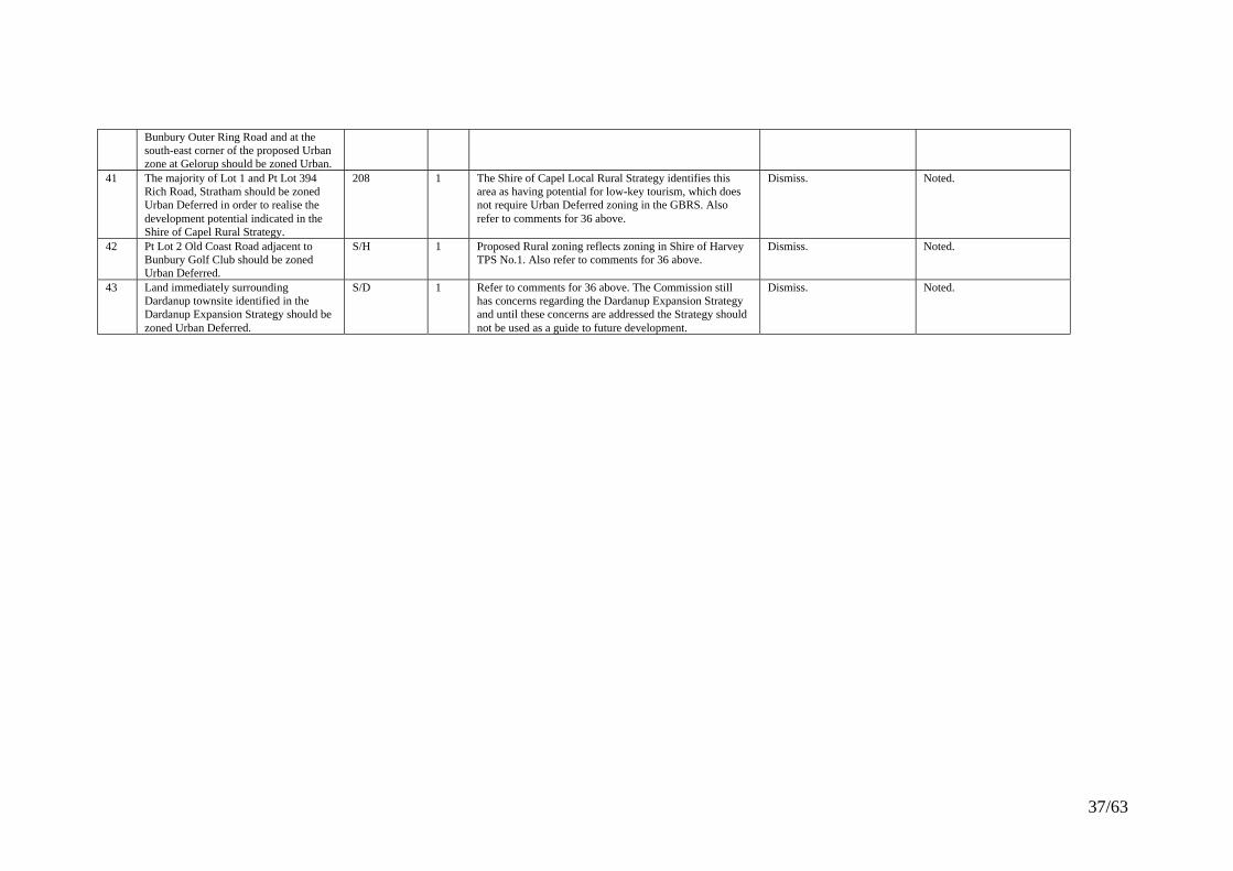
37/63
Bunbury Outer Ring Road and at thesouth-east corner of the proposed Urbanzone at Gelorup should be zoned Urban.
41 The majority of Lot 1 and Pt Lot 394Rich Road, Stratham should be zonedUrban Deferred in order to realise thedevelopment potential indicated in theShire of Capel Rural Strategy.
208 1 The Shire of Capel Local Rural Strategy identifies thisarea as having potential for low-key tourism, which doesnot require Urban Deferred zoning in the GBRS. Alsorefer to comments for 36 above.
Dismiss. Noted.
42 Pt Lot 2 Old Coast Road adjacent toBunbury Golf Club should be zonedUrban Deferred.
S/H 1 Proposed Rural zoning reflects zoning in Shire of HarveyTPS No.1. Also refer to comments for 36 above.
Dismiss. Noted.
43 Land immediately surroundingDardanup townsite identified in theDardanup Expansion Strategy should bezoned Urban Deferred.
S/D 1 Refer to comments for 36 above. The Commission stillhas concerns regarding the Dardanup Expansion Strategyand until these concerns are addressed the Strategy shouldnot be used as a guide to future development.
Dismiss. Noted.

38/63
NON-ROS RESERVES
No. Points Raised SubmissionsRaisingPoints
Total WAPC Comment WAPC Response EPA Recommendation
Port Installations44 Proposed reserve boundaries need to be
reviewed.BPA, 169 2 Refer to WAPC Comments for 5(a) above. Refer to WAPC Response for
5(a) above.Agree with the WAPCcomment and determination.
45 Object to impact of proposed reserve onremnant vegetation.
WSWA 1 The portion of proposed Port Installations reserve to thesouth-east of the Preston River delta contains remnantvegetation associated with the Leschenault Estuaryforeshore. The Port Installations reserve boundary in thisarea should be modified to exclude the foreshorevegetation. Otherwise there is little remnant vegetation inthe proposed port expansion area and its retention shouldbe considered as part of future port expansion proposals.
Uphold in part.
The Port Installationsreserve boundary shall bemodified in accordance withMap 5 (Appendix 8)
Further EPA assessmentrequired.Refer to Section 6.
46 Object to extent of proposed reserve dueto potential impacts on amenity,drainage and groundwater supply.
259 1 The extent of the proposed reserve will not itself impacton amenity, drainage and/or groundwater supply. Futureport expansion proposals may have a potential impact onthese environmental values and these impacts will beconsidered through the assessment of individualproposals.
Dismiss. Further EPA assessmentrequired.
47 Swampy area on Lot 8 Newton Rd, GlenIris is used by swans and otherwaterbirds.
260 1 This wetland is classified as a Multiple Use wetland andhas therefore been substantially modified and retains littleof its original conservation value.
Note. Refer to 12(a) above.
Glen Iris Service Corridor and Port Access Road48 Object to the impact of proposed reserve
corridor on remnant vegetation.WSWA 1 There is little remnant vegetation within the proposed
Glen Iris Service Corridor/Port Access Road reserve.Main Roads has prepared an Environmental Assessmentand Management Plan for the remaining section of thePort Access Road to the south and is in the process ofconfirming the environmental acceptability of particularsections with the DEP. Any minor modifications to thereserve alignment required as a result of theseinvestigations can be incorporated into the GBRS prior tofinalisation.
Dismiss.
This portion of the portAccess Road between theOuter Ring Road and theBoyanup Picton Road iscurrently under review andsubject to furtherassessment. The review ofthe road can be included inthe Preston Industrial AreaStructure Plan. The Schemecan be amended to reflectany new findings that mayarise.It is recommended that thecurrent alignment be
a) The PAR PrimaryRegional Road Reserveshould be realigned to avoidimpacting on:• Area 9: Barbetti's/CSBPLot 5;• Area 10: Bushlandbetween Boyanup/Pictonroad and railway; and• Area 11: FergusonRiver.Refer to Section 7.3 forfurther details of the EPA’sassessment andrecommendations.

39/63
retained until all otheralternative alignments havebeen investigated.
49 Corridor should have a maximum widthof 135m along eastern portion of Pt Lot52.
266 1 The WAPC has approved subdivision to create roadreserves over portion of the land proposed to be reservedROS. The DEP has advised that the approved subdivisionprovides an adequate separation between residential lotsand the Port Access Rail/Road Corridor. The proposedROS boundary should be modified to reflect the approvedsubdivision.
Uphold.
The proposed ROS boundaryshall be modified inaccordance withModification Plan 10.
Agree with the WAPCcomment and determination.
Refer to Section 10.5 forfurther details of the EPA’sassessment andrecommendations
Widening of South Western Highway50 Objection to proposed widening based
on impacts on remnant vegetation.33, 95, 134,WSWA
4 Many sections of the proposed South Western Highwaywidening are over cleared farming land. For thosesections containing remnant vegetation, Main Roads seeksto retain as much remnant vegetation as possible as part ofits road designs. In this regard, the proposed reserve widthfor South Western Highway is 90m. Only 30m of this isrequired for the actual road pavement, 15m of which isalready existing. The remaining 60m can be used toprotect significant remnant vegetation as part of the roaddesign. Main Roads also actively revegetates road vergesand medians to extend or link sections of bushlandadjacent to roads.
Dismiss.
There are few sections of theproposed South WesternHighway widening that affectremnant vegetation and forthose that do there isflexibility to avoid significantstands as part of the roaddesign.
The alignments of theSouth Wester Highwaymeets the EPA’senvironmental objectivesprovided Environmental andNoise/VibrationManagement Plans andVegetation and WaterwayMitigation Strategies areprepared and implemented,when appropriate, to thesatisfaction of the EPA.
Refer to Section 7.2 forfurther details of the EPA’sassessment andrecommendations.
51 Objection to proposed widening basedon the noise and vibration impacts onnearby residents.
33, 134 2 Main Roads must ensure road projects meet base noiselevel objectives either through separation or incorporatingnoise control measures. Potential noise and vibrationimpacts will be assessed at the design and constructionstages.
Dismiss.
To be addressed by MainRoads during design andconstruction stages.
Refer to 50 above.
52 Proposed widening has not been subjectto environmental assessment.
60 1 The proposed South Western Highway wideningalignment has largely been determined by the alignmentof the existing Highway. As part of defining the roadwidening corridor, Main Roads prepared anEnvironmental Status Report, which considers the extentand condition of remnant vegetation on either side of theexisting road reserve. There will be sufficient flexibilitywithin the proposed reservation width to allow the newcarriageway to be designed to avoid significant remnant
Dismiss.
Protection of remnantvegetation can be addressedas part of the road design.
Refer to 50 above.

40/63
vegetation. The design stage of the project may be subjectto a separate environmental assessment.
53 Objection to proposed widening basedon impacts on Weeks Brook and anhistoric Gum Tree.
164 1 Main Roads will consider drainage as part of the roaddesign stage, including minimising the impact on naturaldrainage systems. Potential erosion can be managed byeither engineering or vegetation solutions. If the Gum treeis demonstrated to have cultural or ecologicalsignificance, Main Roads may include its protection in thedesign.
Dismiss.
To be addressed by MainRoads during design andconstruction stages.
Refer to 50 above.
Widening of Bussell Highway54 Object to proposed widening due to
impact on remnant vegetation.WSWA 1 Most of the proposed widening for Bussell Highway
already contains the existing constructed dualcarriageway. There will be sufficient flexibility within theproposed reserve width to allow the remaining sections ofnew carriageway to be designed to avoid significantremnant vegetation. The design stage for these sectionsmay be subject to a separate environmental assessment.The proposed widening adjacent to the future BunburyOuter Ring Road intersection is required to provide for agrade-separated interchange. Removing this proposedwidening would necessitate a redesign of the interchangeand a further widening of the reservation over freeholdland to the east of the intersection. As the proposedwidening would not substantially reduce the conservationvalues of the adjoining conservation reserve or theamenity of adjoining residents, it should be retained.
Dismiss.
The proposed widening willnot reduce the conservationvalues of adjoining reservesand in many cases, theprotection of remnantvegetation can be consideredfurther at the design stage.
The Primary Regional Roadreserve for Bussell Highway,has been widened tofacilitate the upgrading ofthe highway.
The dual carriageway hasbeen constructed for the fulllength of the highway withinthe GBRS area.
55 Object to the noise impact of theproposed widening on residents ofexisting dwelling on Lot 50 BussellHighway, Stratham.
18 1 Bussell Highway is already constructed to dualcarriageway along this section. The proposed wideningwill increase the verge width and will not result in trafficpassing closer to the existing dwelling.
Dismiss. Refer to 54 above.
56 Object to proposed widening because itwill include 100 trees planted on Lot 37Bussell Highway by the owners as abuffer in the road reserve.
191 1 As the proposed road widening is only required toincrease the width of the road verge in this locality, thelandscape buffer planted by the landowners will not bephysically affected.
Dismiss. Refer to 54 above
Bunbury Outer Ring Road57 More investigations required to
determine alignment.213, WSWA 2 Main Roads has prepared an Environmental Assessment
and Management Plan for the Bunbury Outer Ring Roadand is in the process of confirming the environmentalacceptability of particular sections with the DEP. Anyminor modifications to the reserve alignment required as aresult of these investigations can be incorporated into theGBRS prior to finalisation.
Dismiss.
It is recommended that thecurrent alignment beretained until all otheralternative alignments havebeen investigated. Wherenecessary, wetland
Further was undertaken bythe EPA and Main Roads.The EPA recommends thatthe BORR Primary RegionalRoad Reserve should berealigned to avoid impactingon:-Area 1:Dalyellup Reserve(System 6 -Area C71);

41/63
relocation options shouldalso be considered.Changes to the alignment ofthe road will be included asa future amendment to theRegion Scheme.
-Area 3B: Wetland north ofLilydale Road;-Area 4: Lot 2 MilesProperty;-Area 7: HinesRoad/Australind Bypass.Refer to Section 10.4 forfurther details of the EPA’sassessment andrecommendations
Boyanup Bypass58 Proposed alignment cuts through north-
western corner of Boyanup Billabongwetlands area.
107 1 The WAPC’s independent environmental study concludesthat Boyanup Billabong is not regionally significant.Accordingly, the proposed alignment does not need to bemodified at this point. However, the study recommendsthe southern extremity of the proposed alignment bemodified to avoid regionally significant remnantvegetation. The DPI and Main Roads should investigatethe possibility of modifying this section of the proposedreserve prior to finalisation of the GBRS.
Note.
The DPI and Main Roadswill investigate thepossibility of modifying thesouthern extremity of theproposed Boyanup Bypassreserve prior to finalisationof the GBRS.
The EPA recommends thatthe road be designed andconstructed to minimiseimpact on bushland andavoid any direct or indirectimpacts on the BoyanupBillabong.
Refer to Section 7 for furtherdetails of the EPA’sassessment andrecommendations.
59 Proposed alignment will eliminate thedrainage and biological filter designedto trap and store nutrient runoff from theorchard on Loc 22 Junction Street,Boyanup.
255 1 Main Roads considers existing infrastructure in roaddesigns. If the nutrient trap is demonstrated to besignificant and the proposed road alignment is likely toaffect it, Main Roads may include its relocation/replace asa design consideration. Environmental impacts andmanagement plans can be assessed by the EPA at thedesign or construction stages.
Note.
To be considered by MainRoads at the road designstage.
Noted.Agree with the WAPCcomment.
General Comments regarding Proposed Regional Roads Reserves60 Objection to proposed new arterial road
corridors.SWEC 1 The Primary Regional Roads proposals of the GBRS are
identified in Roads 2020: Regional Roads DevelopmentStrategy - South West and Peel (Main Roads, 1997).These roads are required to provide for the effectiveoperation of the regional road network into the future. Theenvironmental impacts of each proposed PrimaryRegional Roads reserve have been considered and eachwill require environmental approval.
Dismiss. Noted.
61 Care should be taken in determiningroad alignments and road design toprotect remnant bushland.
ABC 1 All proposed new regional roads and regional roadwidenings have been reviewed based on their impact onremnant vegetation. Generally it has been determined thatsufficient protection of remnant bushland within the
Note. Noted.The EPA will require thepreparation ofEnvironmental Management

42/63
proposed road reserves can be achieved by sensitivelydesigning the road to avoid remnant vegetation wherepossible.
Plans and VegetationMitigation Strategies prior tothe construction of theregional roads in the GBRS.
62 River foreshores disturbed through theconstruction of bridges for PrimaryRegional Roads reserves should berestored through revegetation.
WRC 1 These concerns can be addressed by Main Roads as partof the management planning for Primary Regional Roadsriver crossings.
Note. Noted. Refer to 61 above.

43/63
SPECIAL CONTROL AREAS
No. Points Raised SubmissionsRaisingPoints
Total WAPC Comment WAPC Response EPA Recommendation
SCA No.1.63 Unsustainable logging needs to be
addressed.PEG, 165,183, 206,SWEC
5 Decisions regarding the use and management of StateForest are not made under planning legislation. Anylogging proposal for areas within public water supplycatchments needs to be accompanied by a managementplan, the principal purpose of which is to demonstratewater quality will not be adversely affected. Both the EPAand WRC assess management plans to ensure biodiversityand water quality are maintained.
Dismiss. Agree with WAPC commentand determination.No further evaluationrequired.
64 Objection to restrictions being imposedupon existing and future land use anddevelopment in SCA No.1.
147, 148, 157 3 These properties are located in declared Priority 2 watersource protection areas. Existing approved uses anddevelopment in these areas would not be affected by SCANo.1. Restrictions would only apply to new land use anddevelopment proposals whether an SCA is created or not.The restrictions do not necessarily prevent use anddevelopment of the land. In many cases, land use anddevelopment typical of rural areas would be permittedsubject to suitable controls and conditions to preventpollution of public drinking water source areas. WRC willprovide advice on these matters in considering futurerezoning, subdivision and development proposals.
Dismiss.
There is a need to ensureland use and development inpublic drinking water supplycatchments do not pollute thewater resource.
Agree with WAPC commentand determination.No further evaluationrequired.
65 Lot 1 Honeymoon Rd, Harvey shouldnot be included in SCA No.1 as it is notthought to be in the Harvey Damcatchment.
172 1 The WRC agrees that Lot 1 should not be included inSCA No.1.
Uphold.The boundary of SCA No.1will be modified to excludethis land.
Agree with WAPC commentand determination.No further evaluationrequired.
.
SCA No.266 Proposed boundary should be modified
to reflect modelled buffer requirementsrather than convenient physical oradministrative boundaries.
112, DRD,ABC, S/H,236, 249, 251
7 The Kemerton Expansion Study -Final Draft Report (BSDConsultants 1997) determined buffer requirements of theGBRS based on risk, noise and air quality impact models.SCA No.2 includes all properties potentially affected byrisk, noise or air quality impacts associated with anyadditional industries in the expanded Kemerton Industrialzone. It also includes land south of the modelled bufferrequirements around the regional landfill facility.Landcorp is acquiring all properties in SCA No.2containing incompatible land uses (ie. residential
Dismiss.
As the buffer requirementsrecommended by theKemerton Expansion Study -Final Draft Report are basedon modelling, a cautiousapproach to defining thebuffer is required.
Refer to Sections 5 & 11.2for further details of theEPA’s assessment andrecommendations.
The EPA is satisified thebuffer has bee appropriatelymodelled and reflects thebuffer requirements ofcurrent and future industrial

44/63
dwellings) and affected or likely to be affected in the shortterm by unacceptable industry impacts.
It is recognised that thequalities of the site aresignificant and that furtherassessment should beundertaken at thesubdivision or developmentstage. The requirement forthe preparation of anEnvironmental ManagementPlan, as part of anyapplication for subdivisionor development in this area,could be included in theGBRS (Refer to section5.3.2.2 of the Scheme text).
activities.
67 Recreation should be permitted. ABC, S/H,S/D
3 There should be a presumption against recreationalactivities that inevitably lead to people being exposed tounacceptable levels of risk. However, there may berecreational uses that, because of their operations, wouldbe compatible and have an acceptable level of risk atcertain locations within SCA No.2. Further consultationwith DMPR, Shire of Harvey and Landcorp should beundertaken to introduce a provision into the GBRS thatwould provide for such uses without permittinginappropriate recreation activities.
Note.
Further consultation withDMPR, the Shire of Harveyand Landcorp required.
Noted.Agree with the WAPCcomment.
68 Land proposed as ROS in Kemerton beincluded in Rural buffer subject to SCANo.2.
DRD 1 Refer to WAPC Comments for 8(g) above. Refer to WAPC response for8(g) above.
Agree with the WAPCcomment and determination.
SCA No.369 Area should be reduced based on
operator adopting better practices.141 1 The boundary of SCA No.3 reflects the projected 35
dB(A) noise level contour identified in modellingconducted on behalf of the operator for existing andultimate industrial activity. SCA No.3 will ensure noresidents are exposed to unacceptable noise levels and theoperator is negotiating with affected landowners regardingcompensation for loss of development rights. Theseinitiatives represent best operating practices.
Dismiss. The boundary of SCA No. 3has been calculated based onnoise emissions modellingfor current and futureindustrial activities.Reducing the width of thebuffer may expose sensitiveland uses to unacceptablenoise levels.
70 Recreation should be permitted. S/D 1 The proponent of the North Capel Industrial Complex hasadvised that some recreation uses may be acceptable inSCA No.3. On this basis, a suitable provision will beprepared for the GBRS in consultation with DMPR, theShire of Capel and the proponent to ensure the
Note.
Further consultation withDMPR, the Shire of Capeland the proponent required.
Noted.Agree with the WAPCcomment.

45/63
proponent’s interests are adequately represented in theconsideration of recreation proposals within SCA No.3.
71 Support for SCA. 268 1 SCA No.3 will prevent the siting of incompatible landuses in areas where they could potentially conflict withindustrial operations in the North Capel Industrial zone.
Note. Noted.
SUPPORTING DOCUMENTS
No. Points Raised SubmissionsRaisingPoints
Total WAPC Comment WAPC Response EPA Recommendation
Environmental Review72 The Environmental Review should not
pre-empt provisions of the Coastal ZoneManagement Policy with respect tocoastal management recommendations.
213 1 The only new proposals of the GBRS along the coast areadditional areas identified for future foreshore reserve.These proposals are consistent with the intent of theCoastal Zone Management Policy’s stated coastal zonemanagement, environmental and community principlesand objectives to protect the conservation values andprovide for public access to the coast. EMM 1 allows thedecision-making authority to require an environmentalmanagement plan for any future coastal rezoning,subdivision or development proposal adjacent to coastalROS. Such proposals will be assessed against relevantcoastal policy such as the Coastal Zone ManagementPolicy.
Note.
The GBRS will implementrecommendations of theCoastal Zone ManagementPolicy.
Noted.
73 The absence of any Site Specific Factorsunder the Coastal Areas and UrbanBushland categories in the SummaryTable is astonishing. More detailedanalysis is required.
213 1 For Coastal Areas, the GBRS does not propose anyadditional impacts on particular coastal sites. Inaccordance with requirements of EMM 1, more detailedanalysis will be undertaken as part of any future coastalrezoning, subdivision or development proposals. ForUrban Bushland, the WAPC’s independent environmentalstudy has contributed to ensuring GBRS proposals do notimpact on regionally significant remnant vegetation,where possible. EMM 4 provides for a vegetation surveyas part of any future GBRS rezoning proposal potentiallyaffecting remnant vegetation.
Note.
More detailed analysis hasbeen undertaken for sitesaffected by GBRS proposals.Detailed analysis of theimpacts of future proposalson remnant vegetation willbe undertaken as part of theirassessment.
Noted.
In addition to theEnvironmental Review theEPA has undertakenadditional biological surveysand mapping (Appendix 5)and has also prepared astrategy to identifyregionally significant naturalareas in its consideration ofthe GBRS.
74 Objection to Section 3.7.3 because itstates that industries with limitedpotential for groundwater contaminationwill be permitted in the PrestonIndustrial Park. This decision should bemade by the EPA.
DRD 1 This section of the Environmental Review will have nobearing on the permissibility of uses in the PrestonIndustrial Park. A comprehensive drainage and watermanagement strategy is required as part of structureplanning for the area and provisions of local TownPlanning Schemes and conditions of subdivision anddevelopment approval will determine permissibility ofuses and drainage management conditions.
Dismiss. Agree with the WAPCcomment.No further evaluationrequired.

46/63
75 Section 5.2 should only requirevegetation management plans for areaswithin Kemerton identified in Industry2030 (WAPC, 2000) and not the industrycore generally. The existing heavyindustry core and proposed expansionarea exclude wetlands of highconservation value, which are protectedby the Lakes EPP.
DRD 1 The WAPC recognises the importance of maximising theopportunities for industrial development in the KemertonIndustrial zone but considers that environmental values ofthe area should also be protected where possible. For thisreason, EMM 5 requires preparation of EMPs prior tosubdivision or development.
Dismiss.
Environmental values of theKemerton Industrial zoneshould be protected wherepossible.
Agree with WAPC commentand determination.
76 Commitment to Preston River Diversionunder Section 5.11.2 should be subjectto environmental approval.
SWEC 1 The Preston River Diversion is not proposed by theGBRS. In the Environmental Review, the secondparagraph under the heading "Regionally SignificantWetlands" states that the EPA has requested formalenvironmental assessment of the Preston River Diversionproposal.
Note. Agree with the WAPCcomment.
77 Water Management Strategy forKemerton(a) Comprehensive strategy should bedeveloped prior to water managementconditions being considered for specificdevelopments.
DRD 1 According to WRC, a comprehensive groundwatermanagement plan is currently being prepared forKemerton to address groundwater allocation andprotection (including wetland water levels) issues.Drainage and nutrient management plans are required aspart of each subdivision or development proposal inKemerton.
Note. Agree with the WAPCcomment.
(b) Strategy should have been releasedwith GBRS for public comment.
165 1 WRC advises that public consultation will be incorporatedinto the approval process for the comprehensivegroundwater management plan referred to in WAPCcomments for 77(a) above.
Dismiss. Noted.
78 Conservation value of Conservation andResource Enhancement categorywetlands should be considered.
WRC 1 EMM 1 provides for an EMP for rezoning, subdivision ordevelopment proposals impacting on wetlands identifiedin an approved Government policy for conservation.Conservation and Resource Enhancement categorywetlands are not identified in an approved Governmentpolicy. It is understood that WRC and EPA are workingtowards addressing this issue. Notwithstanding the statusof these wetlands, the absence of reference toConservation and Resource Enhancement categorywetlands in EMM 1 does not prevent the protection ofenvironmental values associated with those wetlands frombeing considered as part of future rezoning, subdivisionand development proposals.
Note.
The GBRS does not preventthe conservation value ofthese wetlands from beingconsidered as part of futurerezoning, subdivision anddevelopment proposals.
The EPA will have theopportunity to assess thepotential impact of schemesand proposals on wetlandswithin Rural zones and otherareas where it listed as adeferred factor in Section 15.
79 Conservation category wetlandclassification over portion of theKingston Estate should be deleted from
190 1 The Environmental Review reflects the managementcategory assigned to the wetland following acomprehensive assessment of wetlands on the Swan
Dismiss.
The Conservation
Agree with WAPC commentand determination.

47/63
Figure 8. Coastal Plain. As there is no technical evidence to suggestthat this classification is incorrect, there is no reason todelete the classification from the Environmental Review.Appropriate environmental management measures havebeen incorporated into plans for this area to protectconservation values of the wetland.
classification of the wetlandis appropriate. The DEP hashad input into plans for thearea to ensure conservationvalues of the wetland areprotected.
80 Unclear whether Conservation categorywetland on southern boundary ofDalyellup Beach Estate is regionallysignificant.
264 1 The subject wetland is proposed to be included in ROS. Dismiss. Noted.
81 Reference to "water sensitive design innew developments" on Page x ofExecutive Summary should specifyurban, industrial, commercial, roads,railways, agriculture, horticulture andother rural pursuits.
WRC 1 The general reference to "new developments" in theProposed Management Strategy on Page x allows watersensitive design to be required of all new developmentproposals, whether urban or rural. As the ProposedManagement Strategy relates to all new developmentthere is no need to specify particular types of developmentto which it applies.
Dismiss. Noted.
82 EMM 1 should be required for proposalsadjoining watercourses or significant(including Conservation category)wetlands.
WRC 1 EMM 2 provides for preparation of a DNMP as part ofany subdivision or development proposal where drainagemay lead to degradation of a wetland or watercourse.EMM 4 provides for a vegetation survey as part of anyGBRS rezoning that potentially affects riparianvegetation. EMM 1 provides for an EMP for rezoning,subdivision and development proposals affecting wetlandsidentified in an approved Government policy forconservation. While Conservation category wetlands arecurrently not included, it is understood that WRC andEPA are working towards addressing this issue. Also, theprotection of environmental values associated with thesewetlands can be considered as part of future rezoning,subdivision and development proposals. Thesemechanisms will ensure impacts of future proposals onwatercourses and wetlands are addressed as part of theassessment of future proposals.
Dismiss.
The expansion of EMM 1 toinclude watercourses andConservation categorywetlands is not required toprotect their environmentalvalues. There will beadequate mechanismsavailable to ensure theseenvironmental values areprotected as part of futureproposals.
Agree
83 EMM 4 should be made compulsory forall rezonings.
165 1 Vegetation surveys should not be required for rezoningproposals that do not impact on remnant vegetation. Theneed for a vegetation survey should be determined by theresponsible authority, which includes the EPA, whenrezoning proposals are submitted for consideration.
Dismiss.
The need for a vegetationsurvey can be considered aspart of rezoning proposals.
Noted
84 EMM 5 should ensure wastewater re-usefor irrigation within Leschenault Estuarycatchment does not impact onwaterways.
WRC 1 Wastewater disposal from industrial developments inKemerton will be one of the most important issues to beaddressed by the Environmental Management Planrequired under EMM 5. If wastewater is proposed to beused for irrigation, the Environmental Management Plan
Note.
EMM 5 will requirewastewater disposal,including disposal for off-site
Noted

48/63
would need to provide details of the environmentalacceptability of this method of disposal.
irrigation, to be addressed.
85 Concerns about risk associated withKemerton-Bunbury rail link shown onFigure 4.
SWEC 1 Figure 4 shows recommendations of Industry 2030(WAPC, 2000). The Kemerton-Bunbury rail link is not aproposal of the GBRS and any amendment to reserve therail link in the GBRS would require separate publicconsultation and environmental approval.
Dismiss. Noted
Strategic Minerals and Basic Raw Materials Resource Policy86 Basalt Extraction Referral Area
(a) Policy should not be finalised untilthe report on the Gelorup basalt quarriesbuffer requirements is finalised.
S/C, 178 2 "A Technical Assessment of the Effects of Blasting at theGelorup Basalt Quarries" is currently available for publiccomment. This study will be used to determineappropriate planning controls around the quarry. Anychanges to the referral area required as a result of thestudy can be made to the policy once the study isfinalised.
Dismiss. Noted.
(b) Buffer should be removed andmemorials placed on new titles.
178 1 The importance of the basalt resource in this location andthe relatively significant impacts that could beexperienced by a sensitive land use located within the areaof blasting effect warrants the establishment of anappropriate buffer. The implementation mechanism is yetto be determined.
Dismiss. Noted.
(c) Area should be 500m radiusexcluding existing residential areas.
213 1 While the Basalt Extraction Referral Area will bereviewed following finalisation of the related study. It ispremature to adopt a reduced buffer.
Dismiss. Noted.
(d) Basalt Quarry operation should besubject to controls.
213 1 The basalt quarry operation is subject to controls but stillrequires the Basalt Extraction Referral Area to ensureaccess to the basalt resource is not compromised by anincrease in incompatible land uses in the area of blastingeffect.
Dismiss. Agree with WAPCcomment.
87 Environmental value of area south ofCapel shown as a SM&BRMR Policyarea should be protected.
31, 165, 209 3 The policy only defines general areas identified ascontaining mineral or basic raw material deposits. Anyproposal to mine these deposits would be subject to aseparate approval, which may include environmentalassessment. Such an approval would specify the areasfrom which, and the conditions under which minerals andbasic raw materials can be extracted.
Note.
More detailed environmentalassessment will beundertaken for any futureextraction proposals.
The EPA recommends thatthe text of the policy bemodified as outlined inSection 12.4.
88 More detailed environmental assessmentrequired to define areas from whichminerals and basic raw materials can beextracted.
WSWA 1 Refer to comments for 87 above. The EPA recommends thatthe text of the policy bemodified as outlined inSection 12.4.
89 Section 3.1 (ii) relating to buffers shouldbe deleted.
S/D 1 Section 3.1(ii) states that the Policy applies to planningapplications within 500m of SM&BRMR Policy areas.This referral allows DMPR to consider the effect of
Dismiss. Noted.

49/63
planning proposals on the ability to access mineral andbasic raw material resources and to ensure access to thoseresources is maintained.
Public Water Supply Catchment Policy90 Insufficient logging controls. PEG, 165,
183, 206,SWEC
5 Refer to WAPC comments for 63 above. Dismiss. Agree with WAPC commentand response.No further evaluationrequired.
91 The land use permissibility table shouldbe deleted.
S/D 1 Land use permissibility in Public Water SupplyCatchments is determined based on WRC guidelines.These guidelines should be referred to in the GBRS policyto ensure consistency and avoid the need for futureamendments to the GBRS policy.
Uphold.
The land use permissibilitytable in the PWSC Policyshould be deleted.
Agree with WAPC commentand response.
92 Wellington Dam catchment area shouldbe Priority Area 1.
SWEC 1 PWSC Policy areas have been defined based onmanagement requirements for each catchment.Stakeholders are currently considering the mostappropriate uses for the Wellington Dam water supply.The results of this process will determine whether theproposed PWSC Policy areas for the Wellington Damcatchment need to be revised.
Dismiss. Noted
93 Water catchment areas extendingbeyond the GBRS boundary need to beprotected.
SWEC 1 All Public Water Supply Catchments extending outsidethe GBR are protected by provisions of the Country AreasWater Supply Act 1947 and these provisions applywhether the catchment is covered by a regional townplanning scheme or not.
Note. Noted
Strategic Agricultural Resources Policy94 Areas covered by remnant vegetation
should not be included.WSWA 1 The inclusion of areas containing remnant vegetation
within SAR Policy areas does not commit them toagriculture. It only requires the responsible authority tohave regard to potential for agriculture in determiningland use and development proposals. Regional-levelstudies should be undertaken when the GBRS isoperational to identify regionally significant remnantvegetation that should be protected.
Dismiss.
The WAPC will undertakefurther regional-level studieswhen the GBRS isoperational to identifyregionally significantvegetation.
The EPA recommends thatthe text of the policy bemodified as outlined inSection 12.3.
95 State Forest north of Myalup east of thePerth-Bunbury Highway should beincluded.
93 1 CALM will determine the future use of this portion of theState Forest following harvesting of the existing pineplantation. Any proposal to include additional land withinSAR Policy areas can be considered as an amendment tothe policy.
Dismiss. Agree with WAPC commentand response.No further evaluationrequired.
96 Land north of Leschenault Estuaryshould not be included.
WRC 1 The portion of Loc.14 north of Leschenault Estuary to beincluded in ROS should not be included in a SAR Policyarea. Whilst western portions of other lots north of theEstuary included in SAR Policy areas have been mapped
Uphold in part.
The portion of Loc.14 northof Leschenault Estuary to be
Agree with WAPC commentand response.No further evaluationrequired.

50/63
as containing Vasse soils, which do not justify the samelevel of protection for agriculture as the Spearwood soilsto the east, the SAR Policy area boundary is consistentwith lot boundaries rather than soil type boundaries. Thefact that a large proportion of these lots are highly suitablefor intensive agriculture justifies their inclusion in theSAR Policy areas. More detailed analysis of landcapability will be considered as part of any intensiveagriculture proposal.
included in ROS will beexcluded from the SARPolicy area.
97 Planning proposals within 500m of aSAR Policy area should not requirereferral to DEP and Department ofAgriculture.
S/D 1 Planning applications within 500m of SAR Policy areasneed to be referred to DEP and Department of Agricultureto ensure existing agricultural operations or the potentialto use these areas for agriculture are not compromised byincompatible land uses.
Dismiss. Agree with WAPC commentand response.No further evaluationrequired.
Floodplain Management Policy98 Policy should recognise that global
warming will cause sea levels to rise andmust ensure no housing development orfilling occurs on floodplains.
143 1 The policy has been formulated in consultation with WRCand prohibits development or inappropriate land uses infloodways and requires suitable site preparation in floodfringes. The policy will be subject to review and anychanges in floodplain management requirements can beintroduced as part of future review.
Dismiss. Noted.

51/63
GENERALNo. Points Raised Submissions
RaisingPoints
Total WAPC Comment WAPC Response EPA Recommendation
Preserving remnant vegetation99 Need for planning to preserve more
remnant vegetation.34, 82, 86,110, 141,ABC, 165,209, 218,WSWA, 234,SWEC,CALM, 248
14 The GBRS proposes to include over 10 000ha ofadditional land in ROS reserves. The WAPC’sindependent environmental study has reviewed all newzones and reserves proposed by the GBRS that have beenidentified through submissions as impacting on remnantvegetation. Modifications have been recommended whererequired to protect regionally significant vegetation. Inaddition, EMM 1 and 4 provide for protection ofregionally significant vegetation as part of any futureGBRS rezoning proposal. The GBRS also provides amechanism to include in ROS additional regionallysignificant natural areas if determined appropriate. Anyproposal to clear over 1ha of remnant vegetation requiresa separate approval. Notwithstanding these measures,further regional-level studies should be undertaken whenthe GBRS is operational to identify regionally significantremnant vegetation that should be protected and todetermine an appropriate protection mechanism.
Note.
The GBRS will provide avaluable contribution topreserving remnantvegetation in the region.However, the WAPC willundertake further regional-level studies when the GBRSis operational.
The EnvironmentalProtection Amendment Bill2002 is currently beforeParliament. This Billcontains new legislation tocontrol clearing of nativevegetation in WesternAustralia, through acoordinated assessmentprocess run by theDepartment ofEnvironmental Protection.Under the proposed lawsmost instances of clearingwill require a permit.
100 Process for protecting all significantremnant vegetation from inappropriatedevelopment needs to be incorporated.
120, 141,218, WSWA,SWEC,CALM, 248
7 Refer to WAPC's Comments for 99 above. Refer to WAPC's Responsefor 99 above.
Refer to 99 above
101 Lack of detailed vegetation mapping aspart of GBRS preparation.
165, 213,WSWA, 239
4 Refer to WAPC Comments for 99 above. Dismiss.
Refer to WAPC Response for99 above.
Noted.The EPA has undertakenadditional biological surveysand mapping (Appendix 5)and has also prepared astrategy to identifyregionally significant naturalareas in its consideration ofthe GBRS.
102 Regional review of remnant vegetationis required.
DRD, 218,CALM, 248
4 Refer to WAPC's Comments for 99 above. Refer to WAPC's Responsefor 99 above.
Noted.The EPA has undertakenadditional biological surveysand mapping (Appendix 5)and has also prepared astrategy to identifyregionally significant natural

52/63
areas in its consideration ofthe GBRS.
103 Should be a moratorium on landclearing until System 6 Update iscompleted.
141, 165,234, SWEC
4 Refer to WAPC Comments for 99 above. Refer to WAPC's Responsefor 99 above.
Refer to 99 above
104 Objection to any further newdevelopment in areas containingremnant vegetation.
17, 20 2 Refer to WAPC Comments for 99 above. Dismiss.
Refer to WAPC's Responsefor 99 above.
Refer to 99 above
105 Areas of remnant vegetation extendingbeyond GBRS boundary need to beprotected.
SWEC 1 This is obviously outside the jurisdiction of the GBRS.However, there are various other mechanisms available,both within and outside the planning system, for theprotection of significant vegetation. To provideconsistency, certainty and efficiency in decision-makingfurther studies should be undertaken when the GBRS isoperational to identify regionally significant remnantvegetation that should be protected and to determineappropriate protection mechanisms.
Refer to WAPC's Responsefor 99 above.
Refer to 99 above
Preserving wetlands106 All EPP wetlands should be protected
through inclusion in ROS or otherplanning mechanisms.
S/H, 234 2 While some EPP wetlands have been included in ROSbased on surrounding pressures or recommendations ofenvironmental studies, most are proposed to be retained inRural or other zones because they are already protected byprovisions of the Lakes EPP and because the GBRS doesnot increase the potential for their environmental values tobe degraded. EMM 1 provides for EMPs as part of futurerezoning, subdivision and development proposalsincluding or adjacent to EPP wetlands.
Dismiss. Noted.
107 Should be a policy requiring 50 mbuffers around Conservation categorywetlands and site specific buffers aroundResource Enhancement categorywetlands.
WRC 1 Refer to WAPC Comments for 78 above. Refer to WAPC Response for78 above.
Noted.
108 Wetlands in Preston Industrial Parkshould be protected.
SWEC 1 Industry 2030 (WAPC, 2000) recommends a detailedsurvey of wetlands as part of the structure planning for thePreston Industrial Park. Any significant wetlands will beprotected through this process. Future amendment of theGBRS will be required, but the proposed zonings areappropriate pending structure planning.
Note.
Structure planning for thisarea will identify and protectsignificant wetlands.
Noted.
Management of Natural Areas109 Need for management programs for
regionally significant natural areas.113, S/H, 234 3 The management of regionally significant natural areas on
private land is the responsibility of the landowner.However, development in or adjacent to ROS reserves
Note.
The GBRS will place
Noted.

53/63
will be determined by the WAPC. The WAPC willprepare or encourage and assist with the preparation ofmanagement plans for ROS reserves in Crown ownershipas a guide to future development of those areas.Management programs for all ROS reserves over Crownland will be coordinated between the WAPC and otherland management agencies. The GBRS, throughimplementation of its EMMs, also provides a mechanismto protect regionally significant natural areas from theimpacts of future rezoning, subdivision and developmentproposals.
controls on developmentwithin or adjacent to ROSreserves and the WAPC willprepare management plansfor ROS once acquired. TheGBRS will also protectregionally significant naturalareas affected by futureplanning proposals.
110 Study required to measure nutrientinputs into the Leschenault Estuary andset management guidelines for thecatchment.
213, SWEC 2 The EPA has water quality guidelines for the protection ofaquatic ecosystems and WRC has guidelines for bestdrainage and nutrient management practice, which areapplied to rezoning, subdivision and developmentproposals. EMM 2 provides for DNMPs as part of futurerezoning, subdivision and development proposals with thepotential to degrade waterways and these would ensurewater quality guidelines are met. It is noted that a "NoNett Nutrient Increase" policy is applied to theLeschenault Estuary catchment.
Note. Noted.Agree with the WAPCcomment.
111 Concern regarding illegal felling ofJarrah and dumping of rubbish inDardanup Forest Block
66 1 These issues are dealt with by CALM as part of itsmanagement responsibilities under the Conservation andLand Management Act 1984.
Note. Noted.Agree with the WAPCcomment.
112 Provision be made to develop guidelinesfor management of private landadjoining ROS.
ABC 1 EMM 1 provides for EMPs to be prepared for subdivisionor development proposals adjoining ROS. In the absenceof more intensive land use or development, managementfor areas of ROS in Crown ownership would incorporatemeasures to minimise impacts from surrounding landuses.
Note. Noted.
113 Management plan required for LudlowTuart Forest.
SWEC 1 Management plans are prepared by CALM on a prioritybasis and as resources permit and the Ludlow Tuart Forestis on their management plan priority list.
Note. Noted.Agree with the WAPCcomment.
114 Need for better management of riversand wetlands.
234 1 The GBRS generally includes in ROS those riverforeshores and wetlands considered to be exposed to highlevels of activity or disturbance due to adjacentdevelopment. These areas are either already in publicownership or can be acquired by the WAPC and managedappropriately. Through the application of EMMs, theGBRS will ensure other significant wetlands and riverforeshores are protected where there is potential for futurerezoning, subdivision or development proposals to affect
Note.
The GBRS introducesplanning mechanisms thatwill ensure protection andappropriate management ofriver foreshores andwetlands.
Noted.

54/63
their environmental value.115 Environmental management plan should
be prepared for land surrounding LakePreston.
SWEC 1 The WAPC's Coastal and Lakelands Planning Strategy(1999) provides environmentally sensitive planning andland management guidelines for land use anddevelopment adjacent to Lake Preston that can beimplemented through the assessment of rezoning,subdivision and development proposals.
Note. Noted.
General Suggestions on Environmental Improvements116 GBRS should focus more on protecting
the environment and encouragingsustainable development than simplyplanning for economic growth.
183, WSWA,234
3 The GBRS will contribute substantially to environmentalprotection. It will include many recognised regionallysignificant natural areas in ROS to secure protection oftheir environmental values and introduce EMMs that willprotect regionally significant natural areas from potentialimpacts of future rezoning, subdivision and developmentproposals. However, the concept of sustainabledevelopment has broader application than environmentalsustainability. Through the implementation of principlesin the State Planning Strategy (1997) and the closeinvolvement of the EPA and other environmentalrepresentatives in the planning process, the WAPC willensure high regard is given to planning forenvironmentally sustainable development in the context ofthe broader concept when assessing future planningproposals.
Dismiss.
The GBRS contributessubstantially toenvironmental protection andthe WAPC will give dueregard to planning forenvironmentally sustainabledevelopment when assessingfuture planning proposals.
Noted.
117 Planning for GBRS should be based oncharacteristics of, and objectives foreach bioregion.
181 1 The Greater Bunbury Structure Plan (1995), whichprovides the strategic foundation for many of theproposals of the GBRS, defined precincts for the GBRbased on major surface water catchments and functionalgeographic boundaries, as well as existing and potentialland use patterns. The structure plan includesrecommendations to address issues relating to theprotection of environmental values specific to eachplanning unit.
Note.
The GBRS is founded onplanning for bio-physicalplanning units as described inthe Greater BunburyStructure Plan.
Noted.
118 Support for a larger Wellington NationalPark
194 1 The declaration of National Parks is not a function of theplanning process.
Note.
The WAPC will undertakefurther regional studies whenthe GBRS is operational.
Noted
119 The State Forest portion of the LudlowTuart Forest should be included inNational Park in the GBRS.
218 1 Portion of the Ludlow Tuart Forest is already included inNational Park. Consideration of additions to the NationalPark should be addressed through the Conservation andLand Management Act 1984 planning process,particularly through revision of the Forest ManagementPlan.
Dismiss. Noted.

55/63
120 ROS with highest conservation valueshould be purchased as a priority.
ABC 1 The WAPC will consider conservation values whendetermining acquisition priorities.
Note. Noted.
121 ROS areas around Leschenault Estuaryshould be acquired as a priority.
WRC 1 Refer to WAPC Comments for 120 above. The majorityof ROS around the Estuary is already in Crownownership.
Note. Noted.
General comments regarding future planning122 Diversion of the Preston River should
not result in the loss of ROS along theriver foreshore.
WRC 1 The GBRS does not propose diversion of the PrestonRiver. The need for ROS will be considered as part of anyfuture proposal to amend the GBRS to provide areservation for the Preston River Diversion Channel.
Note. Noted.
123 Strategic drainage plans should berequired prior to rezonings under GBRSand urban water management plansshould be required for structure plans.
WRC 1 Drainage will be considered for any GBRS rezoningproposal. Stormwater management is addressed at thestructure planning stage of the planning process. EMM 2provides for preparation of a DNMP for any subdivisionor development where drainage has the potential to impacton a watercourse or wetland.
Note. Noted.
Land use conflict124 Planning must control polluting
development so residents are notaffected.
142 1 The WAPC's SPP No.4 – State Industrial Buffers Policyrequires industrial buffer requirements to be considered inthe assessment of planning proposals. The EnvironmentalProtection Act 1986 empowers the EPA to assess thepotential impact of any proposal for pollutingdevelopment on surrounding or nearby residentialdevelopment.
Note. Noted.
125 GBRS should provide a buffer for DBCabattoir on Lot 6 Wimbridge St, Picton.
267 1 The proposed ROS over the adjoining EPP wetlandprovides a buffer to the north and north west. For othersurrounding areas, the WAPC’s SPP No.4 – StateIndustrial Buffer Policy requires industrial bufferrequirements to be considered in the assessment ofplanning proposals. The buffer requirements for theabattoir would therefore be considered as part of anysurrounding rezoning, subdivision or developmentproposal.
Dismiss.
The buffer requirements forthe abattoir will beconsidered as part of anysurrounding rezoning,subdivision or developmentproposal.
Agree with WAPC commentand determination.
Environmental Assessment Process126 Environmental conditions to be included
in Schedule 6 of the GBRS should beprovided to all decision makingauthorities prior to being finalised.
DRD 1 There will be an opportunity for any persons and bodies tocomment on recommended environmental conditionsduring the appeal period for the EPA's bulletin on theGBRS.
Dismiss.
There is an opportunity forcomment on the EPA'srecommended environmentalconditions within theenvironmental assessmentprocess.
Agree.
Coastal Planning127 Object to further coastal residential 234 1 The GBRS does not propose any new coastal Urban Dismiss. Noted.

56/63
development zones. Any future proposal to zone additional coastal landUrban or Urban Deferred in the GBRS would beconsidered against relevant WAPC strategic and statutorycoastal planning policies and would be subject to separatepublic consultation and environmental assessment.
Groundwater protection128 Protection areas should be declared
around possible public water supplybores, such as the bores proposed forpublic water supply in Preston.
SWEC 1 Wellhead protection zones are declared aroundproclaimed public drinking water source bores. Protectionzones are not enforceable for wellheads in proposedpublic water source areas and would be more likelyimplemented through a structure plan or local TPS thanby the GBRS. In this regard, further structure planning isrequired for the Preston Industrial Park. The need forprotection of bores in this area may be considered as partof the structure plan preparation.
Dismiss. Noted.