appendix a: data register - leicester · appendix a: data register urs scott wilson ref ... flood...
TRANSCRIPT
Leicester City Council Level 2 Strategic Flood Risk Assessment
Final Report February 2012
A-1
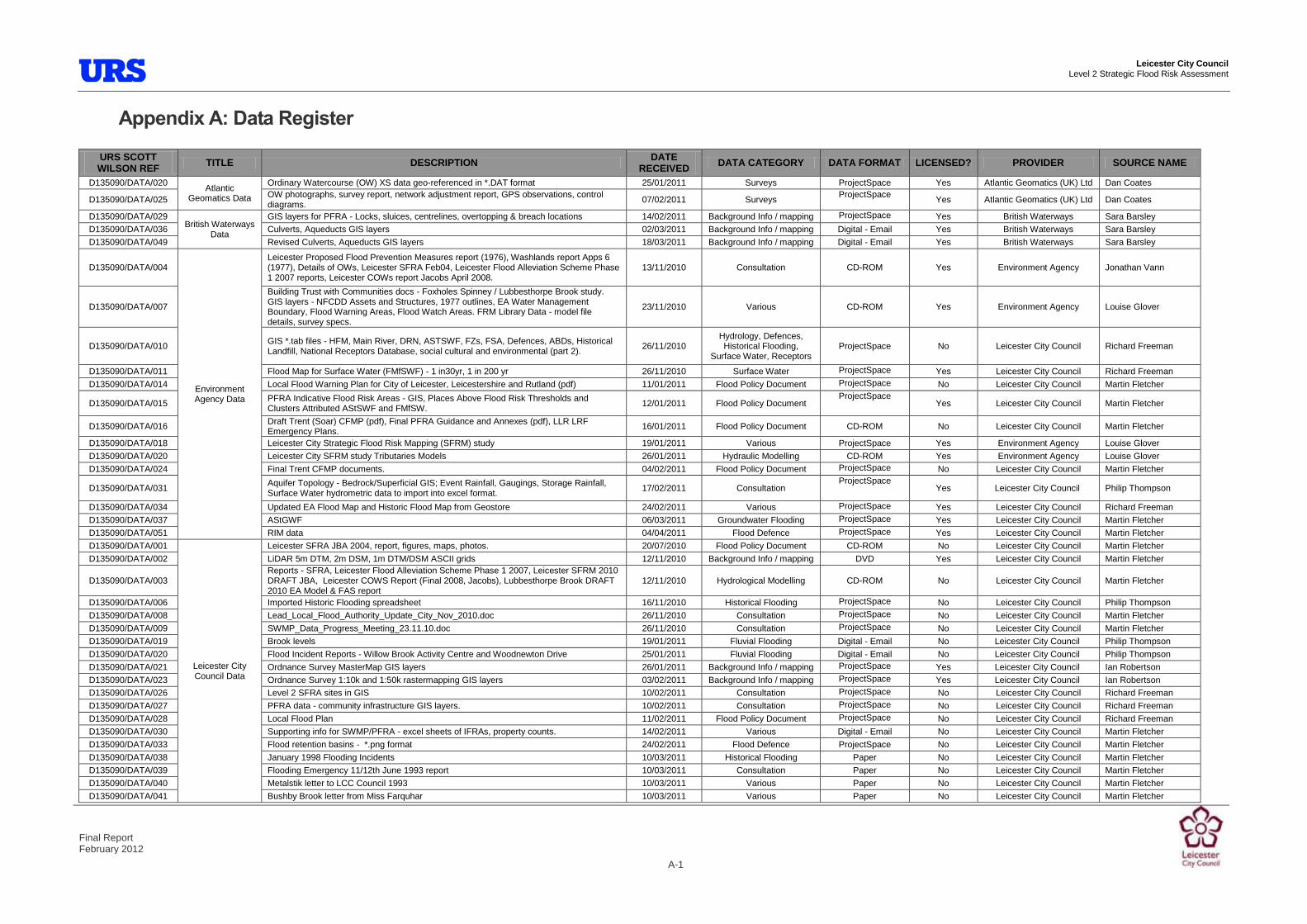
Appendix A: Data Register
URS SCOTT WILSON REF TITLE DESCRIPTION DATE
RECEIVED DATA CATEGORY DATA FORMAT LICENSED? PROVIDER SOURCE NAME
D135090/DATA/020 Atlantic
Geomatics Data
Ordinary Watercourse (OW) XS data geo-referenced in *.DAT format 25/01/2011 Surveys ProjectSpace Yes Atlantic Geomatics (UK) Ltd Dan Coates
D135090/DATA/025 OW photographs, survey report, network adjustment report, GPS observations, control diagrams. 07/02/2011 Surveys
ProjectSpace Yes Atlantic Geomatics (UK) Ltd Dan Coates
D135090/DATA/029 British Waterways
Data
GIS layers for PFRA - Locks, sluices, centrelines, overtopping & breach locations 14/02/2011 Background Info / mapping ProjectSpace Yes British Waterways Sara Barsley
D135090/DATA/036 Culverts, Aqueducts GIS layers 02/03/2011 Background Info / mapping Digital - Email Yes British Waterways Sara Barsley
D135090/DATA/049 Revised Culverts, Aqueducts GIS layers 18/03/2011 Background Info / mapping Digital - Email Yes British Waterways Sara Barsley
D135090/DATA/004
Environment Agency Data
Leicester Proposed Flood Prevention Measures report (1976), Washlands report Apps 6 (1977), Details of OWs, Leicester SFRA Feb04, Leicester Flood Alleviation Scheme Phase 1 2007 reports, Leicester COWs report Jacobs April 2008.
13/11/2010 Consultation CD-ROM Yes Environment Agency Jonathan Vann
D135090/DATA/007
Building Trust with Communities docs - Foxholes Spinney / Lubbesthorpe Brook study. GIS layers - NFCDD Assets and Structures, 1977 outlines, EA Water Management Boundary, Flood Warning Areas, Flood Watch Areas. FRM Library Data - model file details, survey specs.
23/11/2010 Various CD-ROM Yes Environment Agency Louise Glover
D135090/DATA/010 GIS *.tab files - HFM, Main River, DRN, ASTSWF, FZs, FSA, Defences, ABDs, Historical Landfill, National Receptors Database, social cultural and environmental (part 2).
26/11/2010 Hydrology, Defences, Historical Flooding,
Surface Water, Receptors ProjectSpace No Leicester City Council Richard Freeman
D135090/DATA/011 Flood Map for Surface Water (FMfSWF) - 1 in30yr, 1 in 200 yr 26/11/2010 Surface Water ProjectSpace Yes Leicester City Council Richard Freeman
D135090/DATA/014 Local Flood Warning Plan for City of Leicester, Leicestershire and Rutland (pdf) 11/01/2011 Flood Policy Document ProjectSpace No Leicester City Council Martin Fletcher
D135090/DATA/015 PFRA Indicative Flood Risk Areas - GIS, Places Above Flood Risk Thresholds and Clusters Attributed AStSWF and FMfSW. 12/01/2011 Flood Policy Document
ProjectSpace Yes Leicester City Council Martin Fletcher
D135090/DATA/016 Draft Trent (Soar) CFMP (pdf), Final PFRA Guidance and Annexes (pdf), LLR LRF Emergency Plans.
16/01/2011 Flood Policy Document CD-ROM No Leicester City Council Martin Fletcher
D135090/DATA/018 Leicester City Strategic Flood Risk Mapping (SFRM) study 19/01/2011 Various ProjectSpace Yes Environment Agency Louise Glover
D135090/DATA/020 Leicester City SFRM study Tributaries Models 26/01/2011 Hydraulic Modelling CD-ROM Yes Environment Agency Louise Glover
D135090/DATA/024 Final Trent CFMP documents. 04/02/2011 Flood Policy Document ProjectSpace No Leicester City Council Martin Fletcher
D135090/DATA/031 Aquifer Topology - Bedrock/Superficial GIS; Event Rainfall, Gaugings, Storage Rainfall, Surface Water hydrometric data to import into excel format. 17/02/2011 Consultation
ProjectSpace Yes Leicester City Council Philip Thompson
D135090/DATA/034 Updated EA Flood Map and Historic Flood Map from Geostore 24/02/2011 Various ProjectSpace Yes Leicester City Council Richard Freeman
D135090/DATA/037 AStGWF 06/03/2011 Groundwater Flooding ProjectSpace Yes Leicester City Council Martin Fletcher
D135090/DATA/051 RIM data 04/04/2011 Flood Defence ProjectSpace Yes Leicester City Council Martin Fletcher
D135090/DATA/001
Leicester City Council Data
Leicester SFRA JBA 2004, report, figures, maps, photos. 20/07/2010 Flood Policy Document CD-ROM No Leicester City Council Martin Fletcher
D135090/DATA/002 LiDAR 5m DTM, 2m DSM, 1m DTM/DSM ASCII grids 12/11/2010 Background Info / mapping DVD Yes Leicester City Council Martin Fletcher
D135090/DATA/003 Reports - SFRA, Leicester Flood Alleviation Scheme Phase 1 2007, Leicester SFRM 2010 DRAFT JBA, Leicester COWS Report (Final 2008, Jacobs), Lubbesthorpe Brook DRAFT 2010 EA Model & FAS report
12/11/2010 Hydrological Modelling CD-ROM No Leicester City Council Martin Fletcher
D135090/DATA/006 Imported Historic Flooding spreadsheet 16/11/2010 Historical Flooding ProjectSpace No Leicester City Council Philip Thompson
D135090/DATA/008 Lead_Local_Flood_Authority_Update_City_Nov_2010.doc 26/11/2010 Consultation ProjectSpace No Leicester City Council Martin Fletcher
D135090/DATA/009 SWMP_Data_Progress_Meeting_23.11.10.doc 26/11/2010 Consultation ProjectSpace No Leicester City Council Martin Fletcher
D135090/DATA/019 Brook levels 19/01/2011 Fluvial Flooding Digital - Email No Leicester City Council Philip Thompson
D135090/DATA/020 Flood Incident Reports - Willow Brook Activity Centre and Woodnewton Drive 25/01/2011 Fluvial Flooding Digital - Email No Leicester City Council Philip Thompson
D135090/DATA/021 Ordnance Survey MasterMap GIS layers 26/01/2011 Background Info / mapping ProjectSpace Yes Leicester City Council Ian Robertson
D135090/DATA/023 Ordnance Survey 1:10k and 1:50k rastermapping GIS layers 03/02/2011 Background Info / mapping ProjectSpace Yes Leicester City Council Ian Robertson
D135090/DATA/026 Level 2 SFRA sites in GIS 10/02/2011 Consultation ProjectSpace No Leicester City Council Richard Freeman
D135090/DATA/027 PFRA data - community infrastructure GIS layers. 10/02/2011 Consultation ProjectSpace No Leicester City Council Richard Freeman
D135090/DATA/028 Local Flood Plan 11/02/2011 Flood Policy Document ProjectSpace No Leicester City Council Richard Freeman
D135090/DATA/030 Supporting info for SWMP/PFRA - excel sheets of IFRAs, property counts. 14/02/2011 Various Digital - Email No Leicester City Council Martin Fletcher
D135090/DATA/033 Flood retention basins - *.png format 24/02/2011 Flood Defence ProjectSpace No Leicester City Council Martin Fletcher
D135090/DATA/038 January 1998 Flooding Incidents 10/03/2011 Historical Flooding Paper No Leicester City Council Martin Fletcher
D135090/DATA/039 Flooding Emergency 11/12th June 1993 report 10/03/2011 Consultation Paper No Leicester City Council Martin Fletcher
D135090/DATA/040 Metalstik letter to LCC Council 1993 10/03/2011 Various Paper No Leicester City Council Martin Fletcher
D135090/DATA/041 Bushby Brook letter from Miss Farquhar 10/03/2011 Various Paper No Leicester City Council Martin Fletcher
Leicester City Council Level 2 Strategic Flood Risk Assessment
Final Report February 2012
A-2
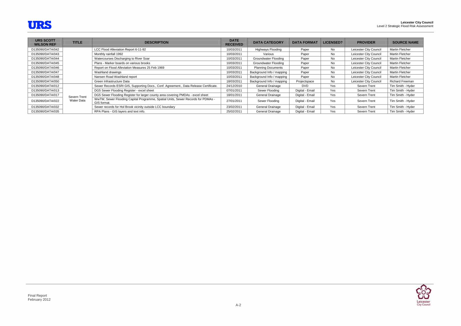
URS SCOTT WILSON REF TITLE DESCRIPTION DATE
RECEIVED DATA CATEGORY DATA FORMAT LICENSED? PROVIDER SOURCE NAME
D135090/DATA/042 LCC Flood Alleviation Report 6-11-92 10/03/2011 Highways Flooding Paper No Leicester City Council Martin Fletcher
D135090/DATA/043 Monthly rainfall 1992 10/03/2011 Various Paper No Leicester City Council Martin Fletcher
D135090/DATA/044 Watercourses Discharging to River Soar 10/03/2011 Groundwater Flooding Paper No Leicester City Council Martin Fletcher
D135090/DATA/045 Plans - Marker boards on various brooks 10/03/2011 Groundwater Flooding Paper No Leicester City Council Martin Fletcher
D135090/DATA/046 Report on Flood Alleviation Measures 25 Feb 1969 10/03/2011 Planning Documents Paper No Leicester City Council Martin Fletcher
D135090/DATA/047 Washland drawings 10/03/2011 Background Info / mapping Paper No Leicester City Council Martin Fletcher
D135090/DATA/048 Nansen Road Washland report 10/03/2011 Background Info / mapping Paper No Leicester City Council Martin Fletcher
D135090/DATA/050 Green Infrastructure Data 18/03/2011 Background Info / mapping Projectspace No Leicester City Council Richard Freeman
D135090/DATA/012
Severn Trent Water Data
Sewer Records ESRI GIS, Supporting Docs., Conf. Agreement., Data Release Certificate. 24/12/2010 General Drainage DVD Yes Severn Trent Tim Smith - Hyder
D135090/DATA/013 DG5 Sewer Flooding Register - excel sheet 07/01/2011 Sewer Flooding Digital - Email Yes Severn Trent Tim Smith - Hyder
D135090/DATA/017 DG5 Sewer Flooding Register for larger county area covering PMDAs - excel sheet 18/01/2011 General Drainage Digital - Email Yes Severn Trent Tim Smith - Hyder
D135090/DATA/022 WwTW, Sewer Flooding Capital Programme, Spatial Units, Sewer Records for PDMAs - GIS format.
27/01/2011 Sewer Flooding Digital - Email Yes Severn Trent Tim Smith - Hyder
D135090/DATA/032 Sewer records for Hol Brook vicinity outside LCC boundary 23/02/2011 General Drainage Digital - Email Yes Severn Trent Tim Smith - Hyder
D135090/DATA/035 RPA Plans - GIS layers and text info. 25/02/2011 General Drainage Digital - Email Yes Severn Trent Tim Smith - Hyder

Prepared for
Leicester Surface Water Management Plan
Part 1 – Surface Water Management Plan Appendix A - Intermediate Assessment of Groundwater Flooding Susceptibility
Phase 2 September 2011

Leicester City Council Leicester Surface Water Management Plan
Revision Schedule Appendix A – Intermediate Assessment of Groundwater Flooding Susceptibility September 2011
REVISION SCHEDULE
Rev Date Details Prepared by Reviewed by Approved by
01 March 2011 Draft Report Trevor Muten Principal Hydrogeologist
Stephen Cox Senior Hydrogeologist
02 March 2011 Final Report Trevor Muten Principal Hydrogeologist
Stephen Cox Senior Hydrogeologist
Jane Sladen Technical Director
03 September 2011
Final Report v2 Stephen Cox Senior Hydrogeologist
Jane Sladen Technical Director
Jane Sladen Technical Director
URS Royal Court Basil Close Chesterfield S41 7SL Tel 01246 209221 Fax 01246 209229 www.ursglobal.com

Leicester City Council Leicester Surface Water Management Plan
i
Table of Contents
Abbreviations ............................................................................................. ii
Glossary .................................................................................................... iii
1 Introduction ..................................................................................... 1
1.1 Groundwater Flooding .................................................................................................... 1 1.2 The Current Report ......................................................................................................... 1
2 Topography, Geology and Hydrogeology ..................................... 2
2.1 Topography and Hydrology ............................................................................................. 2 2.2 Geology .......................................................................................................................... 3 2.3 Hydrogeology ................................................................................................................. 6
3 Assessment of Groundwater Flooding Susceptibility ................ 10
3.1 Groundwater Flooding Mechanisms ............................................................................. 10 3.2 Evidence of Groundwater Flooding ............................................................................... 11 3.3 Groundwater Flooding Susceptibility Datasets .............................................................. 11 3.4 Importance of Long Term Groundwater Level Monitoring ............................................. 12
4 Water Framework Directive and Infiltration SUDS ...................... 14
4.2 Infiltration SUDS Suitability ........................................................................................... 14
5 Conclusions and Recommendations ........................................... 16
5.1 Conclusions .................................................................................................................. 16 5.2 Recommendations ........................................................................................................ 16
6 References ..................................................................................... 18
List of Tables Table 1 Geological Units in the Study Area and their Hydrogeological Significance. List of Figures Figure 1 Topography and Hydrology Map Figure 2 Geological Map – Bedrock Geology Figure 3 Geological Map – Bedrock and Superficial Geology Figure 4 Geological Cross Sections Figure 5 Hydrogeological Conceptualisation of the Mercia Mudstone and Blue Lias Figure 6 BGS Groundwater Flooding Susceptibility Map Figure 6a Schematic demonstrating the importance of long term groundwater level monitoring Figure 7 Infiltration SUDS Suitability (BGS Permeability) Map including Historic Landfills
Leicester City Council Leicester Surface Water Management Plan
ii
Abbreviations
ACRONYM DEFINITION
BGS British Geological Survey
DEFRA Department for Environment, Fisheries and Rural Affairs
EA Environment Agency
LCC Leicester City Council
LiDAR Light Detection and Ranging
ST Severn Trent Water
SUDS Sustainable Drainage Systems
SWMP Surface Water Management Plan

Leicester City Council Leicester Surface Water Management Plan
iii
Glossary
TERM DEFINITION
Aquiclude Formations that may be sufficiently porous to hold water, but do not allow water to move through them.
Aquifer Layers of rock sufficiently porous to hold water and permeable enough to allow water to flow through them in quantities that are suitable for water supply.
Aquitard Formations that permit water to move through them, but at much lower rates than through the adjoining aquifers.
Climate Change Long term variations in global temperature and weather patterns, caused by natural and human actions.
Flood defence Infrastructure used to protect an area against floods, such as floodwalls and embankments; they are designed to a specific standard of protection (design standard).
Floods and Water Management Act
Legislation constituting part of the UK Government‟s response to Sir Michael Pitt‟s Report on the Summer 2007 floods, the aim of which is to help protect ourselves better from flooding, to manage water more sustainably and to improve services to the public.
Fluvial flooding Flooding by a river or a watercourse.
Groundwater Water that is underground. For the purposes of this study, it refers to water in the saturated zone below the water table.
Pluvial Flooding Flooding as a result of high intensity rainfall when water is ponding or flowing over the ground surface before it enters the underground drainage network or watercourse, or cannot enter it because the network is full to capacity.
Risk The product of the probability and consequence of the occurrence of an event.
Sewer flooding Flooding caused by a blockage, undercapacity or overflowing of a sewer or urban drainage system.
Sustainable Drainage Systems
Methods of management practices and control structures that are designed to drain surface water in a more sustainable manner than some conventional techniques. The current study refers to the „infiltration‟ category of sustainable drainage systems e.g. soakaways, permeable paving.

Leicester City Council Leicester Surface Water Management Plan
Intermediate Assessment of Groundwater Flooding Susceptibility September 2011 1
1 Introduction
1.1 Groundwater Flooding
1.1.1 Groundwater flooding occurs as a result of water rising up from the underlying aquifer or from water flowing from springs. This tends to occur after long periods of sustained high rainfall, and the areas at most risk are often low-lying where the water table is more likely to be at shallow depth. Groundwater flooding is known to occur in areas underlain by major aquifers, although increasingly it is also being associated with more localised floodplain sands and gravels.
1.1.2 Groundwater flooding tends to occur sporadically in both location and time, and because of the more gradual movement and drainage of water, tends to last longer than fluvial, pluvial or sewer flooding. When groundwater flooding occurs, basements and tunnels can flood, buried services may be damaged, and storm sewers may become ineffective, exacerbating the risk of surface water flooding. Groundwater flooding can also lead to the inundation of farmland, roads, commercial, residential and amenity areas.
1.1.3 It is also important to consider the impact of groundwater level conditions on other types of flooding e.g. fluvial, pluvial and sewer. High groundwater level conditions may not lead to widespread groundwater flooding. However, they have the potential to exacerbate the risk of pluvial and fluvial flooding by reducing rainfall infiltration capacity, and to increase the risk of sewer flooding through sewer / groundwater interactions.
1.1.4 The need to improve the management of groundwater flood risk in the UK was identified through Defra‟s Making Space for Water strategy. The review of the July 2007 floods
undertaken by Sir Michael Pitt highlighted that at the time no organisation had responsibility for groundwater flooding. The Flood and Water Management Act identified new statutory responsibilities for managing groundwater flood risk, in addition to other sources of flooding and has a significant component which addresses groundwater flooding.
1.2 The Current Report
1.2.1 Leicester City Council has commissioned URS Environment and Infrastructure (UK) Ltd (“URS”) to complete their Surface Water Management Plan (SWMP). A SWMP is a plan which outlines the preferred surface water management strategy in a given location. In this context surface water flooding describes flooding from sewers, drains, groundwater, and run-off from land, small water courses and ditches that occurs as a result of heavy rainfall (DEFRA, March 2010).
1.2.2 The current report provides a detailed assessment of groundwater flooding susceptibility as part of the SWMP Phase 2, and provides recommendations for Phase 3. The following sections outline the geology and hydrogeology in the Leicester City Council (LCC) administrative area. From this analysis:
Potential groundwater flooding mechanisms are identified;
Evidence for groundwater flooding is discussed;
Areas susceptible to groundwater flooding are recognised; and
Recommendations are provided for further investigation.

Leicester City Council Leicester Surface Water Management Plan
Intermediate Assessment of Groundwater Flooding Susceptibility September 2011 2
2 Topography, Geology and Hydrogeology
2.1 Topography and Hydrology
2.1.1 The River Soar, which has a catchment area of 1,384 km2, is a major right bank tributary of the River Trent. It rises near Hinkley in Leicestershire and flows northeast to Leicester where it is joined from the east by the River Sence.
2.1.2 The River Soar flows northwards within the LCC administrative area, with ground levels along the river on the southern boundary of the Leicester City administrative area at 60 maOD to 50 maOD on the northern boundary. Away from the River Soar, the ground elevation rises to above 86 maOD in Braunstone Park to the west of the city, and rising to 93 maOD at the Leicester Golf Club west-southwest of the city centre. There are a number of surface water courses – all tributaries of the River Sour - within the LCC administrative area. The main tributaries of the River Soar in the LCC administrative area are the Melton Brook, Braunstone Brook, Saffron Brook and Bushby Brook; all are shown on Figure 1 and described further below. The Grand Union Canal also passes through the city centre, alongside the River Soar.
2.1.3 The River Soar is maintained by the Environment Agency (EA) (URS Scott Wilson, January 2011), although the City Council‟s parks department is responsible for the section through
Abbey Park and the recreational area on the flood plain at Watermead Bridge. British Waterways have responsibility for the Grand Union Canal and navigable sections of the River Soar through Leicester. The River Soar flows south to north though the City Council area towards Watermead County Park.
2.1.4 Following a severe flood event in 1968, major flood defences were installed, including large diameter flood relief pipes to swiftly divert flood waters down river, away from the city. These measures have protected most residential areas of the city from flooding since their installation.
2.1.5 The route of the River Soar is geologically controlled, flowing along the line of the Soar Fault south of Leicester. The River Soar is heavily modified, with its navigable sections effectively forming connecting reaches of the Grand Union Canal as it passes through Leicester City. It is diverted into a second channel upstream of Frog Island for historic navigation reasons; rejoining the river at the lock and weir structures beside the National Space Centre.
2.1.6 The River Sence is a major tributary of the River Soar, which flows westward from west of Illstone on the Hill some 15 km from Leicester City Centre, into the River Soar south of Leicester City administrative area. The Grand Union Canal runs parallel with the course of the River Sence until turning north southwest of Glen Parva, close to the confluence of the River Sence with the River Soar.
2.1.7 The Lubbesthorpe Brook flows into the River Soar at Kings Lock, immediately upstream of Leicester City‟s south-westerly administrative boundary. A minor tributary – the River Biam – flows to the west of the sports ground, and meets the River Soar above the Lock and Weir at the point where the Grand Union Canal meets the River Soar.
2.1.8 The Braunstone Brook, and its tributary the Gilrose Brook, is a watercourse to the west of Leicester City centre, which rises in the vicinity of the Kirby Fields Industrial Estate and flows east towards Braunstone Park mainly via an underground culvert. The brook re-emerges as an

Leicester City Council Leicester Surface Water Management Plan
Intermediate Assessment of Groundwater Flooding Susceptibility September 2011 3
open channel (referred to as „the Pool‟, as identified on Figure 1) and flows along the southern side of the park in a south easterly direction before a pronounced change of direction to flow north east. The Braunstone Brook is culverted, flowing northward through residential areas prior to its confluence with the River Soar to the southwest of Frog Island. There is evidence to suggest that the section of the Brook downstream of Braunstone Park historically may have been re-routed from its natural course towards the River Soar.
2.1.9 The Western Park Brook is an urban drain flowing eastward from Western Park, under and through the Western Park residential area, into the Braunstone Brook. It is noted that this water course is not shown in the detailed river network (Figure 1) provided by the EA.
2.1.10 The Saffron Brook, and its tributary, the Wash Brook, rise from springs flowing from the Lias east of Oadby, flowing north-westward draining the south-eastern areas of Leicester City before flowing into the Grand Union Canal, south of the railway crossing. The Wash and Saffron Brooks are predominately, or extremely, urbanised catchments with substantive channel modification. The linear mostly piped Queens Road Brook flows into the Saffron Brook east of the Railway at Knighton Fields.
2.1.11 The Holbrook is mainly in a culvert, flowing westward from Oadby through South Knighton, before discharging into the Wash Brook via a culvert and pipe.
2.1.12 The Bushby Brook catchment drains a substantive area of eastern Leicester, and is dominantly an urbanised catchment, with substantive modification. The Bushby Brook rises to the west of Houghton on the Hill, flowing eastwards to Thurnby; where the Thurnby Brook joins the Bushby Brook. The upper catchment of the Bushby Brook is moderately urbanised and dominated by clay and limestone deposits; whereas the lower Bushby Brook catchment is extremely urbanised, totally dominated by the conurbation of Leicester.
2.1.13 The Evington Brook rises from springs east of Leicester City, flowing westward through the city centre and joining the Bushby Brook. The Willow Brook forms the confluence of the Bushby Brook and the Evington Brook. Downsteam of this confluence, the Portwey Brook flows into the Willow Brook. All these sections of urban stream are heavily modified and culverted.
2.1.14 North of the Bushby Brook, the Melton Brook rises as springs in a relatively rural area northeast of Leicester City centre. From its source, the Melton Brook flows westwards past Old Ingarsby, Keyham and the medieval village of Hamilton before entering the city of Leicester at Barkbythorpe Road. The brook finally flows into the River Soar in Rushey Mead beside the foot bridge south of the A563. JBA (2004) established the total area of the Bushby Catchment as 19.4 km2. The upper 15 km2 of the catchment is defined as being moderately sloped and essentially rural above Barkbythorpe Road. The lower 4 km2 of the catchment between Barkbythorpe Road and the River Soar is dominated by extensive urbanisation and channel modification.
2.1.15 The Thurmaston Parish Dyke is a linear culvert or drain, effectively forming a drainage channel from the railway at Thumastone to the Grand Union Canal at Watermead County Park.
2.2 Geology
2.2.1 Figures 2 and 3 provide bedrock and superficial geological information, respectively, for the LCC administrative area and the surrounding area from the BGS 1:50,000 scale geological series. Figure 4 provides a generalised geological cross section for the study area showing

Leicester City Council Leicester Surface Water Management Plan
Intermediate Assessment of Groundwater Flooding Susceptibility September 2011 4
both superficial (Figure 4A) and bedrock (Figure 4B) deposits; these are used to improve the conceptual understanding of the area. The BGS 1:10,000 scale geological series exists for the east of Leicester, should a more detailed geological assessment be required. However, 111 borehole logs and water wells were obtained from the BGS to provide local data (see Figure 3). These help to identify the variable geological conditions that may be encountered by new development, and water strike information can be used to inform the assessment of groundwater flooding susceptibility and the suitability for infiltration SUDS.
Bedrock Geology
2.2.2 The bedrock geology of the area comprises broadly the Middle to Upper Triassic Mercia Mudstone Group to the West of Leicester and the Lower Jurassic Lias Group to the East of Leicester; with a thin layer of the Rhaetian Penarth Group deposits between. The line of the River Soar approximates the boundary between the older Mercia Mudstone to the west, and the younger Lias Group to the east. This reflects the structural control, as the River Soar flows along the line of the Soar Fault1 south of Leicester City, joining the line of other major faults to the north of the city.
2.2.3 The Mercia Mudstone Group in Leicestershire is divided into five Formations, with the youngest forming the bedrock to the east of the River Soar, with the bedrock formation aging with distance westward from Leicester. These are not shown on the BGS digital data, although they can be observed on the BGS paper map.
2.2.4 At the base of the Mercia Mudstone is the Sneinton Formation, with a thickness of up to 90 metres, is an interbedded reddish brown mudstone, siltstone and buff-grey fine- to medium-grained sandstone, with micaceous, pebbly beds in the lower half. The basal beds of the Sneinton Formation tend to have a lower gypsum content than the beds above, and whilst still dominated by mudstones and marls it often has slightly coarser sandstones and pebble beds towards the unconformable contact with the underlying Sherwood Sandstone Group beneath.
2.2.5 Above the Sneinton Formation is the Gunthorpe Formation, which is red-brown mudstone, with subordinate to greenish-grey dolomitic siltstone and fine-grained sandstone, where gypsum veins and nodules are common. The Gunthorpe Formation is up to 70 to 80 metres thick, and forms the bedrock west of approximately 9 km northwest of Leicester City centre.
2.2.6 The Edwalton Formation sits above the Gunthorpe Formation and is red-brown to grey-green mudstone gypsiferous mudstone with green-grey dolomitic siltstones and sandstones. The Edwalton Formation is between 40-50 metres thick, and forms the bedrock of the north-western boundary of Leicester City administrative area.
2.2.7 The upper part of the Edwalton Formation is the Holygate Sandstone Member (now referred to as the Arden Sandstone Formation, as shown on Figure 2), which is a 10 to 15 metre thick grey, interbedded sandstone, forming the bedrock of the Western Park District of Leicester.
2.2.8 Above the Edwalton Formation is the Cropwell Bishop Formation, which is a red-brown or grey-green gypsiferous mudstone with beds of green-grey dolomitic siltstones, sandstones and gypsum. The Cropwell Bishop Formation is 40 to 50 metres thick and forms the bedrock in the western side of Leicester City.
1 It is noted that the Soar Fault and the majority of other faults in the area are only shown on the BGS paper map, not the digital version supplied for Figures 2 and 3.

Leicester City Council Leicester Surface Water Management Plan
Intermediate Assessment of Groundwater Flooding Susceptibility September 2011 5
2.2.9 The Penarth Group is a thin succession of 5 to 6 metre thick grey-green mudstone of the Blue Anchor Formation with 3 to 4 metres thickness of dark, organic-rich mudstones of the Westbury Formation with fine-grained tea-green marls of the Lilistock Formation marking the base of the Lias above. The sediments represent a variety of shallow marine, lagoonal and near-shore environments, reflecting the early stages of submergence of the land surface at the early stages of the shallow seas of the Lower Jurassic. The Penarth Group separates the Mercia Mudstone from the Lias Group above, forming thin bedrock deposits outcropping in a south-southwest to north-northeast strip to the east side of the centre of Leicester City. Although a fairly minor formation, these units of the Penarth Group form the bedrock for significant areas of Leicester City area; notably, for example, Spinny Hills is an outlier of the Cotham Member of the Westbury Formation.
2.2.10 The Lias Group of eastern Leicestershire and Leicester City east of the River Soar comprises of (from oldest to youngest and forming bedrock from west to east) the Blue Lias Formation; the Charmouth Mudstone Formation; the Dyrham Formation; the Marlstone Rock Formation; and the Whitby Mudstone Formation.
2.2.11 The Blue Lias Formation is brown to blue grey mudstone, locally fissile, interbedded with pale grey argillaceous limestone. The Blue Lias Formation has a thickness ranging from 55 to 120 metres thick. This is the dominant bedrock for the south-eastern and eastern areas of Leicester City administrative area.
2.2.12 The Charmouth Mudstone Formation is a grey limestone with occasional limestone beds, and locally ferruginous, phosphatic and sideritic nodules. The Charmouth Mudstone Formation is up to 105 to 180 metres thick.
2.2.13 The Dyrham Formation is a grey micaceous siltstone with beds of sandstone above the Charmouth Formation, and has a thickness of about 15 metres. Above this is the Marlstone Rock Formation (1 to 9 metres thick), which is a ferruginous ooidal limestone and iron grainstone; and above this, the Whitby Mudstone Formation which is a grey mudstone, with locally ferruginous sporadic limestone beds. The Whitby Formation forms a thickness of 40 to 50 metres. The Dyrham Formation and above form the bedrock to the east of Leicestershire, beyond the LCC administrative area. They are mentioned in this report as some springs flowing west lead to the drainage through Leicester. However, this is not seen as dominant; and therefore not a focus of this report.
Superficial Geology
2.2.14 The superficial geology of the Leicester City area consists of Alluvium, River Terrace Deposits, and Glacio-Fluvial Deposits.
2.2.15 The Alluvium forms the bed and flood plain of the River Soar and its tributaries through the centre of Leicester. It comprises of brown and grey clay, silt, sand and gravel, locally rich in organic material.
2.2.16 The River Terrace Deposits are associated with the historic position of the River Soar, and comprise brown gravels and flinty gravels locally with head and organic rich silts and clays. The main deposits are named; notably the Birstall Member, the Wanlip Member and the Syston Member in the south and southeast through the centre to the north of the LCC administrative area.

Leicester City Council Leicester Surface Water Management Plan
Intermediate Assessment of Groundwater Flooding Susceptibility September 2011 6
2.2.17 Along the valleys of the tributaries flowing from the east, there are pockets of Valley Deposits or Colluvium, mainly brown claying silts and sands. These deposits are found particularly along the valleys of the River Soar tributaries flowing through Evington, and Humberstone, for example.
2.2.18 To the east of the city centre, generally at higher elevation than the Valley Deposits, and in interfluves, are areas of Glacio-Fluvial deposits. These are undifferentiated brown to red-brown sand and gravels. Discrete areas of these deposits are particularly noted in Stoughton, Evington, Bushby, Hamilton and Barkby Thorpe areas of Leicester City.
2.2.19 To the east and west of the River Soar Valley and its tributaries, and their associated deposits much of the land area is covered by the Oadby Member Till, which is a grey to yellow brown Lias rich till, with clasts that include flint, chalk and Jurassic rocks. It is part of the Wolston Formation (Catt et al., 2006).
2.2.20 To the east of Leicester, beyond the Leicester City administrative boundary, are the reddish-brown Bytham Sands and Gravel Formation, containing Trias-derived vein quartz and quartzite pebbles.
2.3 Hydrogeology
2.3.1 The hydrogeological significance of the various geological units within the study area is provided in Table 1. The range of permeability likely to be encountered for each geological unit is also incorporated in Table 1, based on the BGS permeability data (Figures 6).
Table 1: Geological Units in the Study Area and their Hydrogeological Significance
Geological Units
Permeability (based on BGS permeability map)
Hydrogeological Significance
Superficial Geology
Alluvium High to very low Variable (but probably an aquitard) River Terrace Deposits (sand and gravel) Very high to high Secondary aquifer Valley Deposits Moderate to very low Variable (probably an aquitard but may locally
form a secondary aquifer) Glacio-Fluvial Deposits Moderate to very low Variable (probably an aquitard but may locally
form a secondary aquifer) Bedrock Geology
Lias Group Moderate to very low Some Aquifer units – notably the Blue Lias; with the clays and fine silts typically forming Aquiclude layers, with local Aquitard layers and a small number of layers forming a secondary aquifer supporting small scale abstraction
Penarth Group Low to very low Aquitard and secondary aquifer Mercia Mudstone Group Low to very low Aquiclude (predominantly) with local Aquitard
layers and a small number of layers forming a secondary aquifer supporting small scale abstraction
„Aquifer‟ - allows significant groundwater movement (see Glossary) „Aquitard‟ - allows some groundwater movement (see Glossary) „Aquiclude‟ - does not allow groundwater movement (see Glossary) „N/A‟ not available
Bedrock Geology
2.3.2 The BGS has designated the Mercia Mudstone Group as a non-aquifer due to the general poor ability to store and transmit significant quantities of water. It is regarded as predominantly

Leicester City Council Leicester Surface Water Management Plan
Intermediate Assessment of Groundwater Flooding Susceptibility September 2011 7
impermeable, with some layers forming a poor aquifer, used locally for minor abstraction for small scale agricultural and domestic supply purposes.
2.3.3 The EA class the Mercia Mudstone Group in the Leicester area as a „Secondary B‟ aquifer - predominantly lower permeability layers which may store and yield limited amounts of groundwater in thin permeable horizons, forming water-bearing horizons within the former non-aquifers.
2.3.4 The Sneinton Formation, at the lower part of the Mercia Mudstone Group, often forms an aquifer, forming numerous small springs along its outcrop in Nottinghamshire. However, this is outside the study area. The other horizons of the Mercia Mudstone Group are not characterised as aquifers.
2.3.5 The physical properties for secondary aquifers in England and Wales (Jones et al., 2000) suggests that hydrogeological investigations specific to the Mercia Mudstone Group has not been undertaken; generally assessed in relation to the Sherwood Sandstone aquifer below.
2.3.6 The Penarth Group is predominantly mudstone, and therefore regarded as an aquitard. Thin beds of silts and fine sands do allow some groundwater movement. As the Penarth Group outcrop runs south-southwest to north-northeast through the eastern side of Leicester City Centre, many of the tributaries flowing from the Lias springs to the east of Leicester flow across the Penarth Group outcrop. These thin beds, therefore, may have a minor hydrogeological affect on perched water tables associated with the Alluvium and the River Terrace Deposits; nonetheless, they are not developed as a groundwater resource.
2.3.7 The Lias Group has a variable lithology, and therefore variable hydraulic properties. The Blue Lias is classified by the EA as a Secondary Aquifer. The groundwater flow within the Blue Lias is controlled by its lithology and bedding, with a series of small springs to the east of Leicester, forming the tributaries of the River Soar that flow through the city.
Superficial Geology
2.3.8 Alluvium and River Terrace Gravel deposits along the course of the River Soar and associated tributaries are classed as Secondary Aquifer by the EA.
2.3.9 The Valley Deposits and Glacio-Fluvial Deposits are also included in the Secondary Aquifer classification.
2.3.10 Because all of the superficial deposits in the Leicester area have a broad range of grain size, the sands and gravels allow effective groundwater movement and groundwater yields, therefore forming secondary aquifer units. However, the clays and silts retard groundwater flow, forming aquitards. Perched water tables and small springs and seepage faces are common in the superficial deposits of Leicester City area. These aquifer units tend to be small and localised, with a small storage capacity. Springs flow after sustained and heavy rainfall – usually in the winter, filling up these aquifer units to overflowing.
2.3.11 Furthermore, the Alluvium is in hydraulic connectivity with the River Soar; and the River Terrace Deposits have the potential to be hydraulically connected with the River Soar flood plain and associated lakes north of the city – such as Watermead County Park. The groundwater level in the Alluvium, therefore, will be a reflection of the water level of the River Soar, and the amount of sustained and heavy rainfall.

Leicester City Council Leicester Surface Water Management Plan
Intermediate Assessment of Groundwater Flooding Susceptibility September 2011 8
2.3.12 Notably, the Oadby Member Till, the Glacial Deposits away from the deposits associated with the river valley and its tributaries cover a substantial area of the catchment. Many of the spring flows feeding the tributaries that flow through Leicester City centre are associated with these silty clays and the respective bedrock beneath.
Groundwater Levels
Bedrock Geology
2.3.13 The EA does not monitor groundwater levels within LCC administrative area. As a consequence, limited groundwater level information is available for this area. Groundwater level data were also requested from the water supply company, Severn Trent Water (ST). However, they do not have any abstraction or observation boreholes in the Leicester area.
2.3.14 Water level information has been obtained from a small number of borehole drilling logs held by the British Geological Survey. Because of this sparse data, it cannot be determined whether these water levels are representative for the Leicester area or controlled by localised constraints. One groundwater level has been identified in the bedrock beneath Leicester City centre, at between 25 and 29 m below ground level (bgl); although no information is available about the long term range in groundwater level fluctuation.
Superficial Geology
2.3.15 The EA does not monitor groundwater levels in the superficial deposits of the LCC administrative area. However, borehole logs have been collated from the BGS and a number of these provide some details of groundwater levels. The boreholes were drilled in different years and so groundwater contours cannot be constructed, although comments on groundwater levels can provide an indication of depth to groundwater.
2.3.16 However, BGS borehole logs indicate that there may be some localised perching of the water table in the Alluvium and River Terrace Deposits; partly controlled by the water level in the River Soar and Grand Union Canal. The groundwater table has generally a greater depth in the bedrock geology aquifers. It is stressed, however, that this is based on the limited available data.
2.3.17 Borehole logs show water table levels in Leicester City have been observed between 3.7 m bgl in Syston Street, 6.6 m bgl at Sanvey Gate and 8.3 m bgl at Waring Street.
Water Supply Abstractions
2.3.18 There are no major groundwater abstractions in the Leicester City area; such that no part of the area is delimited as a Source Protection Zone by the EA.
2.3.19 However, there are a small number of minor groundwater abstractions from the superficial and Blue Lias Formations used for domestic, minor agricultural, industrial and ground source heating purposes. This abstraction will only have a minor impact on the water balance.
2.3.20 The River Soar and its tributaries Water Resources Management Unit have a CAMS status of „Water Available‟, such that water is likely to be available at all flows including low flows, although restrictions may apply.
Leicester City Council Leicester Surface Water Management Plan
Intermediate Assessment of Groundwater Flooding Susceptibility September 2011 9
Artificial Groundwater Recharge
2.3.21 Water mains leakage data for the administrative area of LCC were requested from ST. Unfortunately the water company does not assess leakage estimates at this level of detail. However, for the area of the East Midlands served by ST, the reported leakage level for 2010 was over 180 Ml/d (ST, June 2010), with a planned decrease to approximately 152 Ml/d by 2027. It would be possible to estimate leakage in the Leicester City administrative area by apportioning total leakage for the East Midlands area based on population estimates. This has not been undertaken, but the method could be used in future investigations if a water balance assessment is required.
Surface Water / Groundwater Interactions
2.3.22 Groundwater to surface water interactions are primarily within the Alluvium and River Terrace Deposits. This has been partly restrained by the modification associated with the Grand Union Canal and historic modification of surface water courses notably the culverting of the urban tributaries of the River Soar.
2.3.23 The development of the Watermead Country Park and other water storage on the flood plain of the River Soar has locally enhanced recharge to the Alluvium and thin aquifer units beneath. These are downstream of the city centre, and do not have a control on water levels further south.
2.3.24 Because many of the small urban tributaries flowing to the River Soar from the east, through Leicester City centre, are spring fed, their base flow during the summer months tend to decline and are very low due to the small volumes of natural groundwater storage in the superficial deposit aquifers and Blue Lias beds present in the area. However, they may also be low owing to limited hydraulic connectivity with the superficial geology aquifers resulting from the river channel modifications. Without groundwater level data for the superficial geology aquifers, it is not possible to gain an understanding of the relationship between surface water and groundwater.

Leicester City Council Leicester Surface Water Management Plan
Intermediate Assessment of Groundwater Flooding Susceptibility September 2011 10
3 Assessment of Groundwater Flooding Susceptibility
3.1 Groundwater Flooding Mechanisms
3.1.1 Based on the current hydrogeological conceptual understanding, there is potential for groundwater flooding in the LCC administrative area. There are five key groundwater flooding mechanisms that may exist:
Superficial aquifers along the course of the River Soar (and the associated Grand Union Canal present within the Flood Plain of the River Soar): groundwater flooding may be associated with Alluvium deposits and the sand and gravel River Terrace Gravels deposits where they are in hydraulic continuity with surface water courses. Stream levels may rise following high rainfall events but still remain “in-bank”, and this can trigger a rise in groundwater levels in the associated superficial deposits. The properties at risk from this type of groundwater flooding are probably limited to those with basements / cellars, which have been constructed within the superficial deposits. Within the UK, houses with cellars / basements were largely built within the Victorian era and into the early 1900s. Therefore, the developed areas with properties of this period are more likely to comprise properties with cellars / basements.
Superficial aquifers in various locations: a second mechanism for groundwater flooding
is also associated with River Terrace Deposits (gravel and sand) and sand lenses within the Valley Deposits and Glacio-Fluvial deposits along the tributaries of the River Soar flowing through Leicester City area that occurs where they are not hydraulically connected to surface water courses. Perched groundwater tables can exist within these deposits, developed through a combination of natural rainfall recharge and artificial recharge e.g. leaking water mains. The properties at risk from this type of groundwater flooding are probably limited to those with basements / cellars; and in close proximity to the course of the urban tributaries of the River Soar.
Springs from the Blue Lias feeding tributaries of the River Soar that flow east to
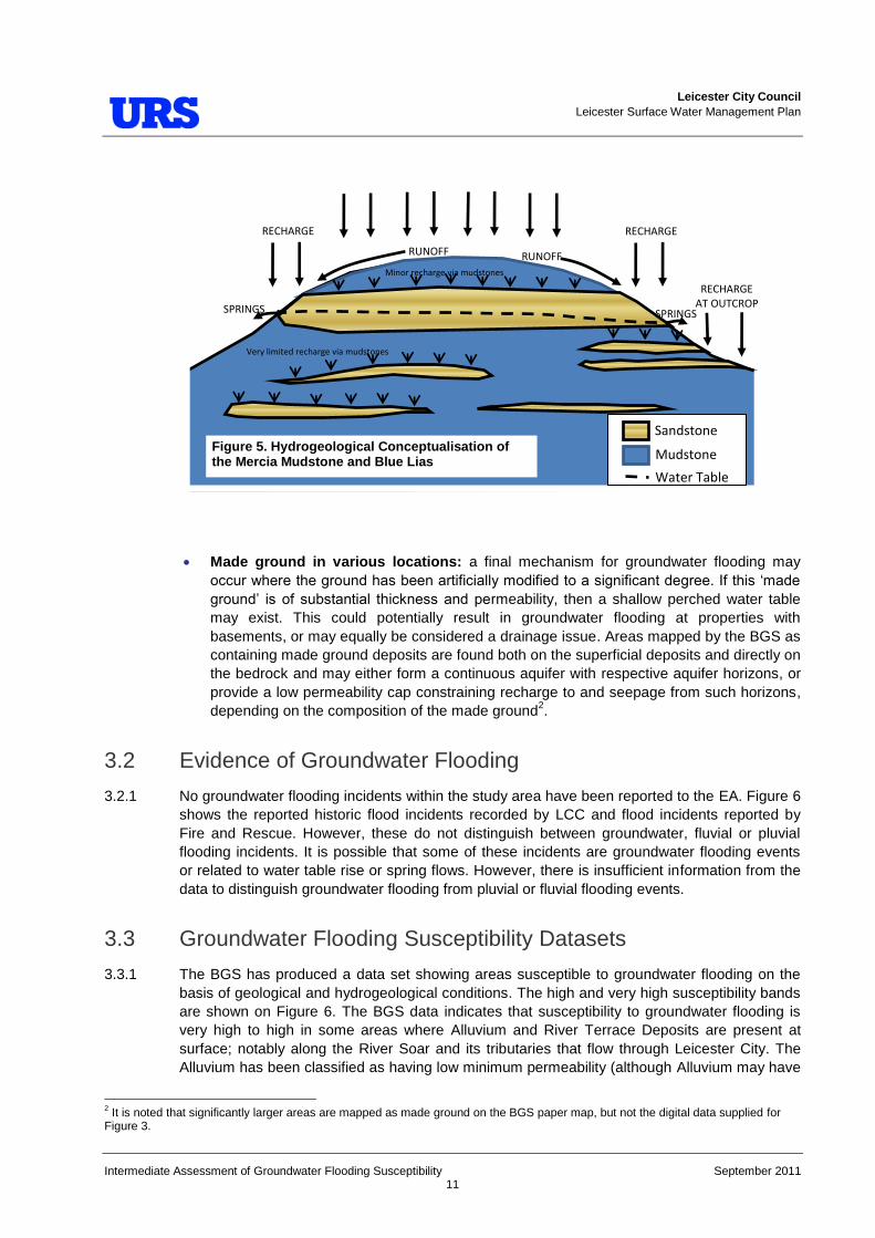
west through LCC administrative area (the Saffron Brook, the Evington Brook, the Holbrook, the Wash Brook, the Bushby Brook, the Willow Brook, the Portwey Brook, the Melton Brook and the Thurmaston Parish Dyke): a third mechanism for groundwater flooding could occur when rainfall recharges the perched water tables within the lenticular water bearing sand lenses within the Lias. These aquifer layers are separated by considerably less permeable clay and silt layers. As the water table rises, springs and seepages may flow at their outcrop. This mechanism is illustrated in Figure 5. The properties at risk from this type of groundwater flooding are probably limited to those with basements / cellars in close proximity to the spring fed tributaries to the east of Leicester.
Springs from the Mercia Mudstone Formation to the south and southwest of LCC
administrative area (the Braunstone Brook, and its tributary the Gilrose Brook, and the Western Park Brook): the thin aquifer units of the Mercia Mudstone Group on the west side of the River Soar overtop and form springs at the head of these minor tributaries. Rainfall recharges the lenses of sandstones in the Mercia Mudstone, which release their storage as springs and seepages at their outcrop when the perched water table rises. This mechanism is similar to that controlling the springs flowing from the perched water table and aquifer horizons of the Lias, and the mechanism is illustrated in Figure 5.
Leicester City Council Leicester Surface Water Management Plan
Intermediate Assessment of Groundwater Flooding Susceptibility September 2011 11
Made ground in various locations: a final mechanism for groundwater flooding may occur where the ground has been artificially modified to a significant degree. If this „made
ground‟ is of substantial thickness and permeability, then a shallow perched water table may exist. This could potentially result in groundwater flooding at properties with basements, or may equally be considered a drainage issue. Areas mapped by the BGS as containing made ground deposits are found both on the superficial deposits and directly on the bedrock and may either form a continuous aquifer with respective aquifer horizons, or provide a low permeability cap constraining recharge to and seepage from such horizons, depending on the composition of the made ground2.
3.2 Evidence of Groundwater Flooding
3.2.1 No groundwater flooding incidents within the study area have been reported to the EA. Figure 6 shows the reported historic flood incidents recorded by LCC and flood incidents reported by Fire and Rescue. However, these do not distinguish between groundwater, fluvial or pluvial flooding incidents. It is possible that some of these incidents are groundwater flooding events or related to water table rise or spring flows. However, there is insufficient information from the data to distinguish groundwater flooding from pluvial or fluvial flooding events.
3.3 Groundwater Flooding Susceptibility Datasets
3.3.1 The BGS has produced a data set showing areas susceptible to groundwater flooding on the basis of geological and hydrogeological conditions. The high and very high susceptibility bands are shown on Figure 6. The BGS data indicates that susceptibility to groundwater flooding is very high to high in some areas where Alluvium and River Terrace Deposits are present at surface; notably along the River Soar and its tributaries that flow through Leicester City. The Alluvium has been classified as having low minimum permeability (although Alluvium may have
2 It is noted that significantly larger areas are mapped as made ground on the BGS paper map, but not the digital data supplied for Figure 3.
Sandstone
Mudstone
Water Table
RUNOFF RUNOFF
RECHARGE RECHARGE
RECHARGE AT OUTCROP SPRINGS SPRINGS
Very limited recharge via mudstones
Minor recharge via mudstones
Figure 5. Hydrogeological Conceptualisation of the Mercia Mudstone and Blue Lias

Leicester City Council Leicester Surface Water Management Plan
Intermediate Assessment of Groundwater Flooding Susceptibility September 2011 12
more permeable sands and gravels), whilst the River Terrace Deposits have very high minimum permeability.
3.3.2 In general, it is thought that the approximate areas identified by the BGS as being susceptible to groundwater flooding, are, as expected. However, it is possible that the various susceptibility categories from „very high‟ to „very low‟ may not be accurate given the poor availability of
groundwater level data to the BGS; the EA does not monitor superficial or bedrock groundwater levels for the study area. Nonetheless, it is possible to compare the BGS susceptibility to groundwater flooding data with the locations of general flooding incidents on Figure 6. This indicates the groundwater conditions may have contributed to a number of the historic flooding incidents within the Leicester City area.
3.3.3 Finally, those areas identified by the BGS as having no susceptibility to groundwater flooding could still be affected where groundwater springs / seepages form minor flows and ponding over impermeable strata. This mechanism may have resulted in the regular ponding of water observed adjacent to the River Soar, at the edges of its flood plain, where it is possible that groundwater seepages from the River Terrace Deposits seep onto the relatively low permeable Alluvium. Likewise, flows in the ephemeral springs feeding the headwaters of the tributaries to the east and to the west of Leicester may lead to localised groundwater flooding.
3.4 Importance of Long Term Groundwater Level Monitoring
3.4.1 Groundwater flow direction, depth to groundwater, topography and the degree of artificial influence in the subsurface (e.g. leaking water mains or groundwater abstractions) play an important role when considering the susceptibly of an area to groundwater flooding. Unfortunately groundwater level data for the superficial aquifers is limited to recorded water strikes or rest water levels on BGS borehole logs, which only provide groundwater levels at one location and for one point in time. Without long term groundwater monitoring, it is not possible to derive groundwater level contours, or understand maximum seasonal fluctuations. Therefore it is not possible to provide a detailed assessment of groundwater flood risk or provide detailed advice on suitability for infiltration SUDS.
3.4.2 It is not sufficient to rely on the work undertaken by developers through the planning application process, unless long term monitoring (several years) is one of the conditions when granting planning permission. Groundwater levels are often only measured once, or, at most, for a number of weeks. It would be advisable for the Council, in combination with the EA, to begin long term monitoring of superficial aquifer groundwater levels. This data would also be useful for understanding groundwater / surface water interactions, which is important when considering the design of fluvial flood defences.
3.4.3 It is also important to understand how changing policies relating to infiltration SUDS can impact groundwater levels. For instance, historic development was limited by the flood plain of the River Soar and associated alluvium and terrace deposits. These areas have subsequently been developed and natural recharge to the aquifer will have reduced, possibly leading to a lowering of groundwater levels if not balanced by an increase in artificial recharge through leaking pipes. The introduction of infiltration SUDS (e.g. soakaways) may slowly reverse this process, leading to a subsequent rise in groundwater levels. This could prevent soakaways from operating and the reduction in unsaturated zone thickness may not be acceptable to the EA owing to its responsibilities under the Water Framework Directive (see Section 4).

Leicester City Council Leicester Surface Water Management Plan
Intermediate Assessment of Groundwater Flooding Susceptibility September 2011 13
3.4.4 Long term groundwater level monitoring (Figure 6a) is required to support decision making with respect to future land development and future co-ordinated investments to reduce the risk and informing the assessment of suitability for infiltration SUDS. Finally, once sufficient data has been collected, it may be suitable to develop a groundwater level warning system using the observation borehole network.
Figure 6a: Schematic demonstrating the importance of long term groundwater level monitoring

Leicester City Council Leicester Surface Water Management Plan
Intermediate Assessment of Groundwater Flooding Susceptibility September 2011 14
4 Water Framework Directive and Infiltration SUDS
4.1.1 The Water Framework Directive approach to implementing its various environmental objectives is based on River Basin Management Plans (RBMP). These documents were published by the EA in December 2009 and they outline measures that are required by all sectors impacting the water environment. The Humber RBMP is considered within the current study since infiltration SUDS have the potential to impact the water quality and water quantity status of aquifers.
4.1.2 The current quantitative assessment for the Soar groundwater unit (GB40402G990600) is „good‟ and the current quality assessment is „good‟. It is also noted there are no water dependent Sites of Special Scientific Interest (SSSI) within the Leicester City administrative area. Gipsy Lane Pit SSSI is located in the northeast part of the study area, although its status is related to geological interest and is therefore not pertinent to the current study.
4.2 Infiltration SUDS Suitability
4.2.1 Improper use of infiltration SUDS could lead to contamination of the aquifers, leading to deterioration in aquifer quality status or groundwater flooding / drainage issues. However, correct use of infiltration SUDS is likely to help improve aquifer quality status and reduce overall flood risk.
4.2.2 EA guidance on infiltration SUDS is available on their website at: http://www.environment-agency.gov.uk/business/sectors/36998.aspx. This should be considered by developers and their contractors, and by LCC when approving or rejecting planning applications. Infiltration SUDS are suitable where aquifers exist, so long as contamination is not introduced to the aquifers, particularly where there are sensitive groundwater receptors, such as licensed groundwater abstractions.
Key Water Level Considerations (Figure 6)
4.2.3 The areas that may be suitable for infiltration SUDS exist where there is a combination of high ground and permeable geology. However, consideration should be given to the impact of increased infiltration SUDS on properties further down gradient. An increase in infiltration / groundwater recharge will lead to an increase in groundwater levels, thereby increasing the susceptibility to groundwater flooding at a down gradient location. This type of analysis is beyond the scope of the current report.
4.2.4 It is important to be aware of groundwater level conditions at a potential development site. As many of the permeable deposits are River Terrace Deposits associated with surface water courses, it will be important to understand the degree of hydraulic continuity between groundwater and surface water. Maximum likely groundwater levels should be assessed, to confirm that soakaways will continue to function even during prolonged wet conditions.
Key Geological Considerations (Figure 7)
4.2.5 The infiltration SUDS suitability assessment shown on Figure 7 is based on permeability data obtained from the BGS. It shows that for much of the Leicester City area the potential for infiltration SUDS is restricted i.e. probably unsuitable where high infiltration rates are required, although there may exist potential for low infiltration rate SUDS in conjunction with attenuation SUDS. In addition, some areas along the course of the River Soar and its urban tributaries will

Leicester City Council Leicester Surface Water Management Plan
Intermediate Assessment of Groundwater Flooding Susceptibility September 2011 15
require enhanced site investigation and assessment prior to establishing their suitability for high infiltration rate SUDS.
4.2.6 Following a review of the BGS data, no part of Leicester City administrative area has been immediately identified as potentially suitable for high infiltration rate SUDS. However, it is noted that this is a high level assessment and only forms an approximate guide to infiltration SUDS suitability; a site investigation is required to confirm local conditions.
Key Water Quality Considerations (Figure 7)
4.2.7 Infiltration SUDS should be located away from areas of historic landfill (as identified in Figure 7) and areas of known contamination or risk of contamination, where possible, to ensure that the drainage does not re-mobilise latent contamination or exacerbate the risk to groundwater quality and possible receptors, such as abstractors, springs and rivers. A preliminary groundwater risk assessment should be included with the planning application.
4.2.8 Restrictions on the use of infiltration SUDS apply to those areas within Source Protection Zones (SPZ). Developers must ensure that their proposed drainage designs comply with the available EA guidance. However, at present there are no SPZ defined within the Leicester City administrative area.

Leicester City Council Leicester Surface Water Management Plan
Intermediate Assessment of Groundwater Flooding Susceptibility September 2011 16
5 Conclusions and Recommendations
5.1 Conclusions
5.1.1 The following conclusions can be drawn from the current study:
The superficial deposits form a small perched aquifer over the bedrock aquiclude across much of the central, southern and northern districts of LCC administrative area. In addition, the localised Valley Deposits and possibly the Glacio-fluvial deposits will behave as aquifers in localised areas. The EA and LCC do not currently monitor groundwater levels in the superficial deposits.
A limited number of borehole logs have been obtained from the BGS. These indicate that the Aluminium and River Terrace Deposits are water bearing and the groundwater table has been observed between around 3.5 and 8.5 m below ground level, No information is available regarding the range of water level fluctuation within the Leicester City area.
A number of potential groundwater flooding mechanisms have been identified. Of significance are those flooding mechanisms associated with the superficial aquifers and their hydraulic continuity with surface water courses. Properties at most risk are those with basements / cellars.
No groundwater flooding incidents within the study area have been reported to the Environmental Agency. Figure 6 shows the reported historic flood incidents recorded by LCC and flood incidents reported by Fire and Rescue. However, these do not distinguish between groundwater, fluvial or pluvial flooding incidents. It is possible that some of these incidents are groundwater flooding events or related to water table rise or spring flows. However, there is insufficient information from the data to distinguish groundwater flooding from pluvial or fluvial flooding events.
The BGS has produced a data set showing areas susceptible to groundwater flooding on the basis of geological and hydrogeological conditions. The map indicates that susceptibility to groundwater flooding is very high to high in some areas where Alluvium and River Terrace Deposits are present at surface; along the course of the River Soar, and its flood plain, and along the course of the spring fed tributaries flowing from the east and the west, though the Leicester City administrative area.
Without long term groundwater monitoring, it is not possible to derive groundwater level contours or understand maximum seasonal fluctuations and potential climate change impacts. Therefore, at this stage, it is not possible to provide a detailed assessment of groundwater flood risk or provide detailed advice on suitability for infiltration SUDS.
5.2 Recommendations
5.2.1 The following recommendations are made based on the current report:
Information on foul sewer leakage and groundwater infiltration could be obtained from ST, if available, to help understand the water balance for the area;
Review site investigation reports held by LCC, to identify whether groundwater level data is held within them. This could be used to enhance the assessment of groundwater flooding susceptibility and infiltration SUDS suitability.
Leicester City Council Leicester Surface Water Management Plan
Intermediate Assessment of Groundwater Flooding Susceptibility September 2011 17
The areas identified as being susceptible to groundwater flooding should be compared with those areas identified as being susceptible to other sources of flooding e.g. fluvial and pluvial. An integrated understanding of flood risk will be gained through this exercise;
As the historic flooding recorded by LCC, and Fire and Rescue, do not distinguish between groundwater, fluvial or pluvial flooding incidents, further evaluation of these events is required to establish which of the reported historic flood events are a result of groundwater flooding rather than fluvial or pluvial flooding.
The impact of infiltration SUDS on water quality and quantity with respect to the Water Framework Directive should be considered further within future investigations including those undertaken by developers;
Monitoring boreholes should be installed in the Alluvium and River Terrace Deposits, fitted with automatic level recording equipment for a period of one year and water quality sampling undertaken. At this point a review of the monitoring network should be undertaken and an update on infiltration SUDS guidance provided;
The proposed monitoring boreholes may assist the EA with water quality and quantity assessments for the next River Basin Management Plan. Therefore, site selection should be agreed with the EA and the necessity for water quality monitoring agreed; and
Construction of a numerical groundwater model for the Alluvium and River Terrace Deposits, and a detailed conceptual model for the minor aquifers affecting flow to the spring-fed tributaries to the West and East of Leicester should be considered, following at least 3 years of groundwater level monitoring that has been undertaken. The model could then be used as a tool for assessing the impact of infiltration SUDS on the aquifer or for modelling water management options.

Leicester City Council Leicester Surface Water Management Plan
Intermediate Assessment of Groundwater Flooding Susceptibility September 2011 18
6 References
British Geological Survey. 1:50,000 Scale Geology Series [Geological Map] Sheet 156 Leicester: Bedrock and Superficial Deposits.
Carney, J.N.; Ambrose, K.; Cheney, C.S.; Hobbs, P.R.N.. 2009 Geology of the Leicester district : sheet description of the British Geological Survey 1:50 000 series Sheet 156 Leicester (England and Wales). Nottingham, UK, British Geological Survey, 110pp.
Catt,J.A., Gibbard P.L., Lowe, J.J, McCarroll, D., Scourse, J.D., Walker, M.J.C. and Wymer, J.J., 2006. Quaternary: Ice sheets and their legacy. In Brenchley, P. J. and Rawson, P. F., 2006. The Geology of England and Wales. pp.429-467.
DEFRA, March 2010. Surface Water Management Plan Technical Guidance.
Environment Agency, July 2006. The Soar Catchment Flood Management Plan. Final Plan.
Environment Agency, December 2009. River Basin Management Plan. Humber River Basin District.
Jeremy Benn Associates Ltd, 2004. Leicester Strategic Flood Risk Assessment, Appendix A: Hydrology Report.
Jones, H K, Morris, B L, Cheney, C S, Brewerton, L J, Merrin, P D, Lewis, M A, MacDonald, A M, Coleby, L M, Talbot, J C, McKenzie, A A, Bird, M J, Cunningham, J, and Robinson, V K., 2000. The physical properties of minor aquifers in England and Wales. British Geological Survey Technical Report, WD/00/4. 234pp. Environment Agency R&D Publication 68.
Severn Trent Water, June 2010. Final Water Resources Management Plan. Severn Trent Water Limited 2010.
URS Scott Wilson, January 2011. Surface Water Management Plan. Inception Report. Leicester City Council.
Scott Wilson, June 2010. Water Cycle Study. Draft Outline Study Report.


Prepared for
Leicester City Council Surface Water Management Plan
Part 2: Level 2 Strategic Flood Risk Assessment
Assessment of flood risks associated with potential major development around Leicester
FInal Report Septemebr 2011

Leicester City Council SWMP - Assessment of flood risks for potential
major development around Leicester
URS/Scott Wilson Royal Court Basil Close Chesterfield S41 7SL Tel 01246 209221 Fax 01246 209229 www.urs-scottwilson.com
This document has been prepared in accordance with the scope of Scott Wilson's appointment with its client and is subject to the terms of that appointment. It is addressed to and for the sole and confidential use and reliance of Scott Wilson's client. Scott Wilson accepts no liability for any use of this document other than by its client and only for the purposes for which it was prepared and provided. No person other than the client may copy (in whole or in part) use or rely on the contents of this document, without the prior written permission of the Company Secretary of Scott Wilson Ltd. Any advice, opinions, or recommendations within this document should be read and relied upon only in the context of the document as a whole. The contents of this document do not provide legal or tax advice or opinion. © Scott Wilson Ltd 2011
Revision Schedule SWMP – Flood risks associated with potential major development around Leicester May 2011
Rev Date Details Prepared by Reviewed by Approved by
01 May 2011 Draft Fay Tivey Flood Risk Consultant
Michael Timmins Principal Consultant
Jon Robinson Technical Director
01 September 2011
Final Victoria Raiment Flood Risk Consultant
Michael Timmins Principal Consultant
Jon Robinson Technical Director

Leicester City Council SWMP - Assessment of flood risks for potential
major development around Leicester
Final Report September 2011
i
Table of Contents
Abbreviations ............................................................................................. ii
Glossary .................................................................................................... iii
1 Introduction ..................................................................................... 5
1.2 Planning Context ............................................................................................................ 5 1.3 Potential Development Sites ........................................................................................... 6 1.4 Aims of the assessment of major developments ............................................................. 7
2 Methodology .................................................................................... 8
2.1 Study Area ...................................................................................................................... 8 2.2 Summary of Potential Major Development Areas ............................................................ 9 2.3 Outline of Methodology ................................................................................................. 10 2.4 Stakeholders ................................................................................................................. 11 2.5 Information/Data Collected ........................................................................................... 11 2.6 Flooding from Rivers ..................................................................................................... 13 2.7 Flooding from the Land ................................................................................................. 14 2.8 Flooding from Groundwater .......................................................................................... 15 2.9 Flooding from Sewers ................................................................................................... 16 2.10 Flooding from Reservoirs, Canals and Other Artificial Sources ..................................... 16 2.11 Consideration of Climate Change ................................................................................. 16
3 Assessment of flood risk to potential major development sites ................................................................................................ 17
3.1 Leicester City Council Core Strategy Policy 5: Ashton Green ....................................... 17 3.2 Charnwood Borough Council Core Strategy Policy 3: East of Thurmaston SUE ........... 22 3.3 Harborough District Council Site at Stretton .................................................................. 29 3.4 Charnwood Borough Council Core Strategy Further Consultation, Alternative
Option E: North of Glenfield / South Anstey SUE .......................................................... 34 3.5 Blaby District Council Core Strategy Policy CS3: Blaby SUE/ Lubbesthorpe Site ......... 41
4 Summary ........................................................................................ 47
Appendix A. Data Register ..................................................................... A
Appendix B. Maps .................................................................................. B
Leicester City Council SWMP - Assessment of flood risks for potential
major development around Leicester
Final Report September 2011
ii
Abbreviations
ACRONYM DEFINITION
AEP Annual Exceedence Probability
AONB Area of Outstanding Natural Beauty BW British Waterways
CFMP Catchment Flood Management Plan DEM Digital Elevation Model DPD Development Plan Documents EA Environment Agency EP English Partnerships
FRA Flood Risk Assessment GIS Geographical Information Systems
GVW Groundwater Vulnerability IDB Internal Drainage Board
LDDs Local Development Documents LDF Local Development Framework LDS Local Development Scheme LCC Leicester City Council
LiDAR Light Detection and Ranging LPA Local Planning Authority
ODPM Office of the Deputy Prime Minister OPSI Office of Public Sector Information PCPA Planning and Compulsory Purchase Act 2004 PPS25 Planning Policy Statement 25: Development and Flood Risk RFRA Regional Flood Risk Assessment RPG Regional Planning Guidance RSS Regional Spatial Strategy SAR Synthetic Aperture Radar SA Sustainability Assessment
SFRA Strategic Flood Risk Assessment SPG Supplementary Planning Guidance SPZ Source Protection Zone SSSI Site of Special Scientific Interest SuDS Sustainable Drainage Systems STW Seven Trent Water

Leicester City Council SWMP - Assessment of flood risks for potential
major development around Leicester
Final Report September 2011
iii
Glossary
TERM DEFINITION
Aquifer A source of groundwater comprising water-bearing rock, sand or gravel capable of yielding significant quantities of water.
Catchment Flood Management Plan
A high-level planning strategy through which the Environment Agency works with their key decision makers within a river catchment to identify and agree policies to secure the long-term sustainable management of flood risk.
Climate Change Both natural and human actions causing long term variations in global temperature and weather patterns.
Culvert A channel or pipe that carries water below the level of the ground.
Flood Defence Infrastructure used to protect an area against floods as floodwalls and embankments; they are designed to a specific standard of protection (design standard).
Floodplain Area adjacent to river, coast or estuary that is naturally susceptible to flooding.
Flood Storage A temporary area that stores excess runoff or river flow often ponds or reservoirs.
Flood Zone 1 This zone comprises land assessed as having a less than 1 in 1000 annual probability of river or tidal flooding in any year (<0.1%).
Flood Zone 2 This zone comprises land assessed as having between a 1 in 100 and 1 in 1000 annual probability of river flooding (1% – 0.1%) or between a 1 in 200 and 1 in 1000 annual probability of tidal flooding (0.5% – 0.1%) in any year.
Flood Zone 3a This zone comprises land assessed as having a 1 in 100 or greater annual probability of river flooding (>1%) or a 1 in 200 or greater annual probability of flooding from the sea (>0.5%) in any year.
Flood Zone 3b
This zone comprises land where water has to flow or be stored in times of flood. SFRAs should identify this Flood Zone (land which would flood with an annual probability of 1 in 20 (5%) or greater in any year or is designed to flood in an extreme (0.1%) flood, or at another probability to be agreed between the LPA and the Environment Agency, including water conveyance routes).
Fluvial Flooding Flooding by a river or a watercourse.
Groundwater Water that is in the ground, this is usually referring to water in the saturated zone below the water table.
Internal Drainage Board
Independent bodies with responsibility of ordinary watercourses within a specified district.
Inundation Flooding
Leicester City Council SWMP - Assessment of flood risks for potential
major development around Leicester
Final Report September 2011
iv
TERM DEFINITION
Local Development Framework
The core of the updated planning system (introduced by the Planning and Compulsory Purchase Act 2004). The LDF comprises the Local Development Documents, including the development plan documents that expand on policies and provide greater detail. The development plan includes a core strategy, site allocations and a proposals map.
Local Planning Authority
Body that is responsible for controlling planning and development through the planning system.
Main River
All watercourses shown as such on the statutory main river maps held by the Environment Agency and the Department of Environment, Food and Rural Affairs, and can include any structure or appliance for controlling or regulating flow of water into, in or out of the channel. The Environment Agency has permissive powers to carry out works of maintenance and improvement on these rivers.
Mitigation Measure An element of development design which may be used to manage flood risk or avoid an increase in flood risk elsewhere.
Pitt Review Sir Michael Pitt undertook an independent review of the Summer 2007 flood events. The full title of the document is „The Pitt Review: Lessons learned from the 2007 floods‟
Risk The combination of probability and consequence of an event occurring.
Sequential Testing A risk based approach in to assessing flood risk, which gives priority in ascending order of flood risk, i.e. lowest risk first.
Sewer Flooding Flooding caused by a blockage or overflowing in a sewer or urban drainage system.
Stakeholder A person or organisation that has an interest in, or affected by the decisions made within a site.
Strata Layer of rock or soil with internally consistent characteristics that distinguishes it from contiguous layers. Each layer is generally one of a number of parallel layers that lie one upon another, laid down by natural forces.
Sustainability Appraisal
A process used to identify if policies, strategies or plans promote sustainable development and further used for improving policies. It is a requirement for Regional Spatial Strategies under the Planning and Compulsory Purchase Act 2004.
Sustainable Drainage System (SuDS)
Drainage methods designed to mimic the natural system. Where practicable should be used in preference to traditional piped drainage systems.
Sustainable Development
Development that meets the needs of the present without compromising the ability of future generations meeting their own needs.
X% Annual Exceedence Probability (AEP) event
Percentage annual exceedence probability (AEP) of occurrence in any one year. For example, a 1 in 200 annual probability event has a 0.5% AEP of occurring in any year.
X% AEP Design Standard
Flood defence that is designed for to protect against a X% AEP event. In events more severe than this the defence would be expected to fail or to allow flooding. For example, defences may be constructed to a standard of protection of 1% AEP.

Leicester City Council SWMP - Assessment of flood risks for potential
major development around Leicester
Final Report September 2011
5
1 Introduction
1.1.1 In December 2010, URS Scott Wilson Ltd was commissioned to undertake a three-part project for Leicester City Council, summarised below:
PART 1: A Phase 1 and Phase 2 Surface Water Management Plan (SWMP) study. This includes hydrological and hydraulic modelling to show areas at risk of fluvial flooding from ordinary watercourses and pluvial flooding for the Leicester Principle Urban Area and produce outputs including recommending “hotspots” for more
detailed study.
PART 2: Provision of a complete Strategic Flood Risk Assessment (SFRA) to PPS25 Level 2 using, where possible, data produced in Part 1 for Leicester. This will require collating the data produced in Part 1 alongside Environment Agency main river data and providing further information on specific potential development sites such as Flood Risk Assessment requirements and outline recommendations for planning policy initiatives
PART 3: Produce coupled sewer/river and floodplain models for some of the most at risk hotspots identified in Part 1. From the modelling, potential interventions to resolve flooding issues will be investigated.
1.1.2 This report forms part of the SWMP and informs both Part 1 and Part 2 of the study. The purpose of this report is to assess the flood risks that potential major development may pose to Leicester City.
1.2 Planning Context 1.2.1 The Planning and Compulsory Purchase Act 2004 (PCPA) requires Local Planning Authorities
(LPAs) to produce Local Development Frameworks (LDFs) to replace the system of Local, Structure and Unitary Development Plans. LDFs are a portfolio of Local Development Documents (LDDs) that collectively deliver the spatial planning strategy for the Local Authority area. Local Development Schemes (LDS) set out the timetable for the production of LDDs. The PCPA requires LDDs to undergo a Sustainability Appraisal (SA), which assists LPAs in ensuring their policies fulfil the principles of sustainability.
1.2.2 Planning Policy Statement 25: Development and Flood Risk (PPS25, 2010) emphasises the active role that LPAs should have in ensuring that flood risk is considered in strategic land use planning. PPS25 indicates that LPAs should ensure the most appropriate use of land to minimise flood risk, where necessary substituting land uses so that development which is categorised as the most vulnerable to flooding is located in the lowest risk areas. In addition, they should take opportunities to reduce flood risk where possible.
1.2.3 Leicester City Council (LCC) held a public consultation on the “Issues and Options” for the
Core Strategy in autumn 2007. Informal public consultation on an emerging Core Strategy took place in summer 2008. Based on the findings from the public and informal consultations, the Council prepared a Core Strategy Submission Document. The document was submitted to the Secretary of States for Communities and Local Government in December 2009 for an Examination in Public by a Planning Inspector. After receiving formal approval from the Planning Inspector, LCC adopted the LDF Core Strategy at its Full Council meeting in

Leicester City Council SWMP - Assessment of flood risks for potential
major development around Leicester
Final Report September 2011
6
November 2010. The Core Strategy contains policies for development in Leicester up to 2026, including proposals for the spatial distribution and the Council‟s preferred strategic sites.
1.2.4 The whole of Leicestershire is part of the Three Cities and Three Counties (6Cs) area which was granted the status of a New Growth Point in 2006. The aim of this new Growth Point status is to deliver 163,000 homes by 2026. In order to meet these growth aspirations (Leicester has a need for over 20,000 new homes within 20 years) and local employment targets, there is need for development beyond the Leicester City Local Authority Boundary. Consequently a number of potential development areas beyond the City boundary are currently being considered / and or developed by surrounding authorities.
1.2.5 In the Leicester Core Strategy, the Principal Urban Area (PUA) of Leicester is the City plus the surrounding built up area in Leicestershire. Much of what is commonly perceived as part of Leicester lies within the neighbouring authorities of Charnwood, Melton, Harborough, Oadby & Wigston, Blaby and Hinckley. It is therefore important to be aware of the interrelationship of growth both within and on the edge, and outside, of the City boundary and consequently the special spatial relationship Leicester shares with its neighbours, and the progress made by other relevant neighbouring Local Authorities in developing their spatial planning strategies. In terms of proposed development beyond the City boundary, at this stage the most relevant neighbouring spatial planning strategies are:
Harborough District Council- The Council published a Core Strategy for 2006-2026 in late 2010 and are set to submit their Core Strategy for examination by April 2011;
Blaby District Council- The Council consulted on a Core Strategy Alternatives Options Paper in November 2008 and are currently progressing the Core Strategy;
Oadby and Wigston Borough Council- The Borough Council formally adopted the Core Strategy on 28th September 2010; and
Charnwood Borough Council- The most recent Core Strategy consultation document the „Charnwood 2026: Planning for Our Next Generation‟, which was published and
subject to consultation in late 2008. The Council are currently progressing the Core Strategy.
1.3 Potential Development Sites 1.3.1 A number of potential major development sites have been included in this study to assess their
possible impacts on flood risk to Leicester City . These include the following potential development areas:
Blaby/Lubbesthorpe Site (Blaby District Council)
Ashton Green (Leicester City Council)
South of Anstey / North Glenfield (Charnwood Borough Council)
East of Thurmaston (Charnwood Borough Council)
Potential site at Stretton, Harborough (Harborough District Council)
1.3.2 The sites were chosen for assessment in consultation with the surrounding Districts following a meeting held between planning officers in June 2010. However, it is important to note that although the sites have been assessed, this does not mean that they have been, or indeed will

Leicester City Council SWMP - Assessment of flood risks for potential
major development around Leicester
Final Report September 2011
7
be, allocated for future development. Furthermore, as a result of this assessment, no greater importance or weight should be inferred on the sites as being taken forward through the LDF Site Allocations process.
1.4 Aims of the assessment of major developments 1.4.1 The aims of the assessments of flood risk for these potential development sites include:
Assess the possible flood risks to and from the potential major development areas on Leicester City.
If applicable, undertake an appraisal of the current condition of flood defence infrastructure and of likely future flood management policy with regard to its maintenance and upgrade.
An appraisal of the probability and consequences of overtopping or failure of flood risk management infrastructure, including an appropriate allowance for climate change.
Definition and mapping of functional floodplain in locations where this is required.
Maps showing the distribution of flood risk across all flood zones from all sources of flooding taking climate change into account.
Suggest guidance on sequential approach within potential development sites and on Exception Test for sites.
Suggest guidance on the preparation of site specific flood risk assessments for sites of varying risk across the flood zones, including information about the potential use of sustainable drainage techniques.
Suggest meaningful recommendations to inform policy, development control and technical issues.

Leicester City Council SWMP - Assessment of flood risks for potential
major development around Leicester
Final Report September 2011
8
2 Methodology
2.1 Study Area 2.1.1 The potential major development areas in the PUA included in this assessment are shown in
Figure 2-1.
Figure 2-1: Leicester SWMP study area and potential major development areas
Potential development
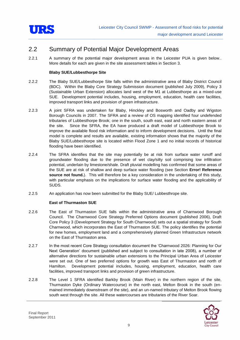
Leicester City Council SWMP - Assessment of flood risks for potential
major development around Leicester
Final Report September 2011
9
2.2 Summary of Potential Major Development Areas 2.2.1 A summary of the potential major development areas in the Leicester PUA is given below..
More details for each are given in the site assessment tables in Section 3.
Blaby SUE/Lubbesthorpe Site
2.2.2 The Blaby SUE/Lubbesthorpe Site falls within the administrative area of Blaby District Council (BDC). Within the Blaby Core Strategy Submission document (published July 2009), Policy 3 (Sustainable Urban Extension) allocates land west of the M1 at Lubbesthorpe as a mixed-use SUE. Development potential includes, housing, employment, education, health care facilities, improved transport links and provision of green infrastructure.
2.2.3 A joint SFRA was undertaken for Blaby, Hinckley and Bosworth and Oadby and Wigston Borough Councils in 2007. The SFRA and a review of OS mapping identified four undefended tributaries of Lubbesthorpe Brook; one in the south, south east, east and north eastern areas of the site. Since the SFRA, the EA have produced a draft model of Lubbesthorpe Brook to improve the available flood risk information and to inform development decisions. Until the final model is complete and results are available, existing information shows that the majority of the Blaby SUE/Lubbesthorpe site is located within Flood Zone 1 and no initial records of historical flooding have been identified.
2.2.4 The SFRA identifies that the site may potentially be at risk from surface water runoff and groundwater flooding due to the presence of wet clay/silty soil comprising low infiltration potential, underlain by limestone/shale. Draft pluvial modelling has confirmed that some areas of the SUE are at risk of shallow and deep surface water flooding (see Section Error! Reference source not found.). This will therefore be a key consideration in the undertaking of this study, with particular emphasis on the implications for surface water flooding and the applicability of SUDS.
2.2.5 An application has now been submitted for the Blaby SUE/ Lubbesthrope site.
East of Thurmaston SUE
2.2.6 The East of Thurmaston SUE falls within the administrative area of Charnwood Borough Council. The Charnwood Core Strategy Preferred Options document (published 2006), Draft Core Policy 3 (Development Strategy for South Charnwood) sets out a spatial strategy for South Charnwood, which incorporates the East of Thurmaston SUE. The policy identifies the potential for new homes, employment land and a comprehensively planned Green Infrastructure network on the East of Thurmaston area.
2.2.7 In the most recent Core Strategy consultation document the „Charnwood 2026: Planning for Our Next Generation‟ document (published and subject to consultation in late 2008), a number of
alternative directions for sustainable urban extensions to the Principal Urban Area of Leicester were set out. One of two preferred options for growth was East of Thurmaston and north of Hamilton. Development potential includes, housing, employment, education, health care facilities, improved transport links and provision of green infrastructure.
2.2.8 The Level 1 SFRA identified Barkby Brook (Main River) in the northern region of the site, Thurmaston Dyke (Ordinary Watercourse) in the north east, Melton Brook in the south (en-mained immediately downstream of the site), and an un-named tributary of Melton Brook flowing south west through the site. All these watercourses are tributaries of the River Soar.
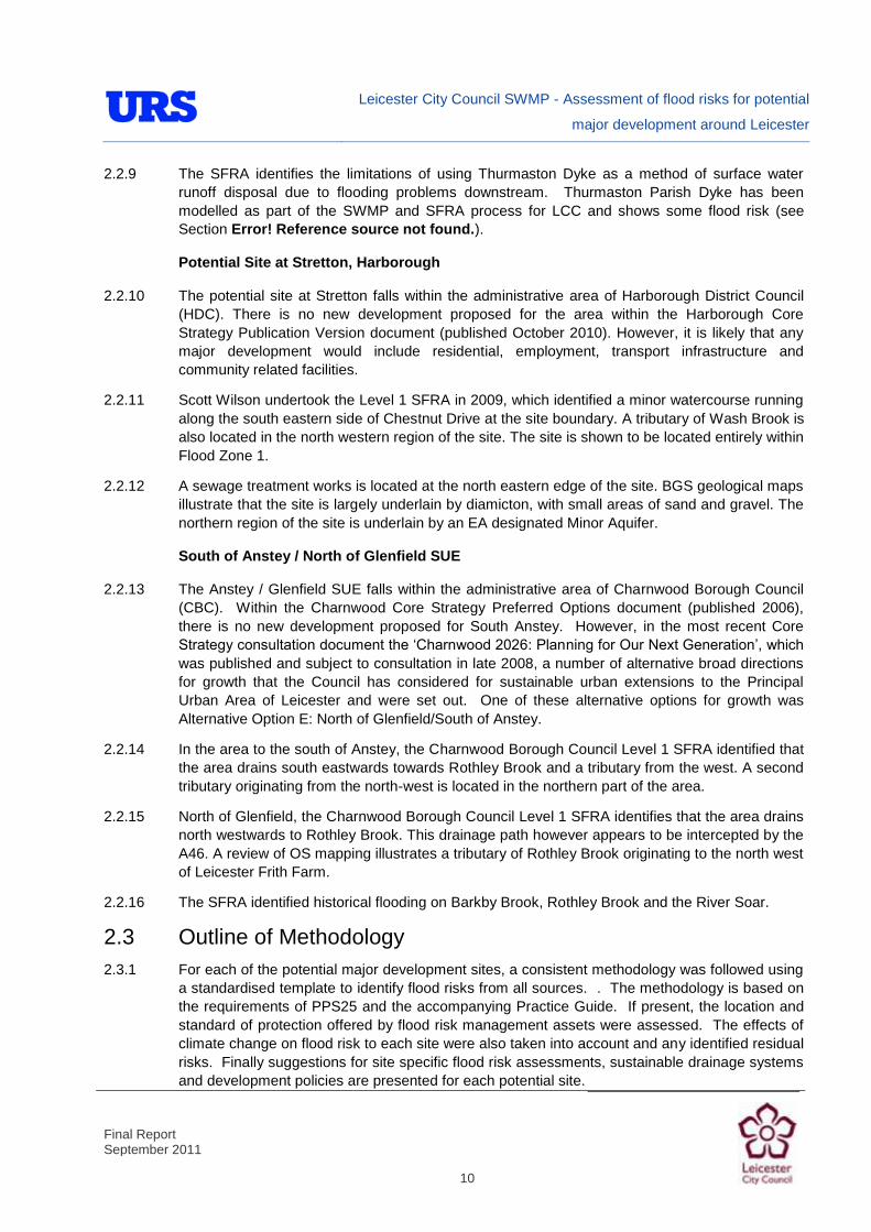
Leicester City Council SWMP - Assessment of flood risks for potential
major development around Leicester
Final Report September 2011
10
2.2.9 The SFRA identifies the limitations of using Thurmaston Dyke as a method of surface water runoff disposal due to flooding problems downstream. Thurmaston Parish Dyke has been modelled as part of the SWMP and SFRA process for LCC and shows some flood risk (see Section Error! Reference source not found.).
Potential Site at Stretton, Harborough
2.2.10 The potential site at Stretton falls within the administrative area of Harborough District Council (HDC). There is no new development proposed for the area within the Harborough Core Strategy Publication Version document (published October 2010). However, it is likely that any major development would include residential, employment, transport infrastructure and community related facilities.
2.2.11 Scott Wilson undertook the Level 1 SFRA in 2009, which identified a minor watercourse running along the south eastern side of Chestnut Drive at the site boundary. A tributary of Wash Brook is also located in the north western region of the site. The site is shown to be located entirely within Flood Zone 1.
2.2.12 A sewage treatment works is located at the north eastern edge of the site. BGS geological maps illustrate that the site is largely underlain by diamicton, with small areas of sand and gravel. The northern region of the site is underlain by an EA designated Minor Aquifer.
South of Anstey / North of Glenfield SUE
2.2.13 The Anstey / Glenfield SUE falls within the administrative area of Charnwood Borough Council (CBC). Within the Charnwood Core Strategy Preferred Options document (published 2006), there is no new development proposed for South Anstey. However, in the most recent Core Strategy consultation document the „Charnwood 2026: Planning for Our Next Generation‟, which
was published and subject to consultation in late 2008, a number of alternative broad directions for growth that the Council has considered for sustainable urban extensions to the Principal Urban Area of Leicester and were set out. One of these alternative options for growth was Alternative Option E: North of Glenfield/South of Anstey.
2.2.14 In the area to the south of Anstey, the Charnwood Borough Council Level 1 SFRA identified that the area drains south eastwards towards Rothley Brook and a tributary from the west. A second tributary originating from the north-west is located in the northern part of the area.
2.2.15 North of Glenfield, the Charnwood Borough Council Level 1 SFRA identifies that the area drains north westwards to Rothley Brook. This drainage path however appears to be intercepted by the A46. A review of OS mapping illustrates a tributary of Rothley Brook originating to the north west of Leicester Frith Farm.
2.2.16 The SFRA identified historical flooding on Barkby Brook, Rothley Brook and the River Soar.
2.3 Outline of Methodology 2.3.1 For each of the potential major development sites, a consistent methodology was followed using
a standardised template to identify flood risks from all sources. . The methodology is based on the requirements of PPS25 and the accompanying Practice Guide. If present, the location and standard of protection offered by flood risk management assets were assessed. The effects of climate change on flood risk to each site were also taken into account and any identified residual risks. Finally suggestions for site specific flood risk assessments, sustainable drainage systems and development policies are presented for each potential site.

Leicester City Council SWMP - Assessment of flood risks for potential
major development around Leicester
Final Report September 2011
11
2.4 Stakeholders 2.4.1 The key stakeholders that were contacted to provide data/information for the SWMP were:
Leicester City Council,
Environment Agency (Midlands Region),
Severn Trent Water,
British Waterways,
British Geological Survey.
2.5 Information/Data Collected 2.5.1 A large quantity of data was collected for the SWMP. A full list of data is included in Appendix A.
Key datasets are summarised below:
Environment Agency Data
2.5.2 The following data was obtained directly from the Environment Agency (Midlands region):
Leicester City Strategic Flood Risk Mapping (SFRM) Study,
Lubbesthorpe Brook hydraulic modelling and flood alleviation study report (draft),
Aquifer typology,
Flood Map for Surface Water,
Indicative Flood Risk Areas,
Local Resilience Forum Emergency Plans,
Rain gaugings,
National Flood and Coastal Defence Database (NFCDD),
Historic Flooding.
2.5.3 The following standard Environment Agency datasets were obtained from LCC (via the Environment Agency Geostore):
Areas Susceptible to Surface Water Flooding,
Flood Map for Surface Water (1 in 30 and 1 in 200 year),
Detailed River Network,
Flood Map,
Historic Flood Map,
Historic Landfill,
National Receptors Database,
Areas Susceptible to Groundwater Flooding.
Leicester City Council Data/Information

Leicester City Council SWMP - Assessment of flood risks for potential
major development around Leicester
Final Report September 2011
12
2.5.4 In addition to the EA datasets provided by the Council, the following data was obtained from LCC:
Ordnance Survey (OS) maps (Mastermap, Streetview, 1:10,000, 1:50,000 and 1:250,000 scale),
Brook Levels,
Flood retention basins,
Green infrastructure data,
LiDAR data,
Level 1 SFRA.
Severn Trent Water
2.5.5 Severn Trent Water (ST) provided a large number of datasets for use in the SWMP, including:
Sewer flooding records (DG5),
Return Period Analysis Plans,
Sewer Flooding Capital Programme,
Asset Records,
Spatial Units,
Waste Water Treatment Works.
British Waterways
2.5.6 British Waterways provided information relating the Grand Union Canal through the study area, including details of culverts, locks, breach and overtopping and weirs.
Data Review
2.5.7 All of the received data has been registered on receipt and its accuracy and relevance reviewed to assess a confidence level for contribution to the SWMP (Table 2-1). Where possible, the information/data was obtained in GIS format, or the raw data was manipulated into this format for use within the study.
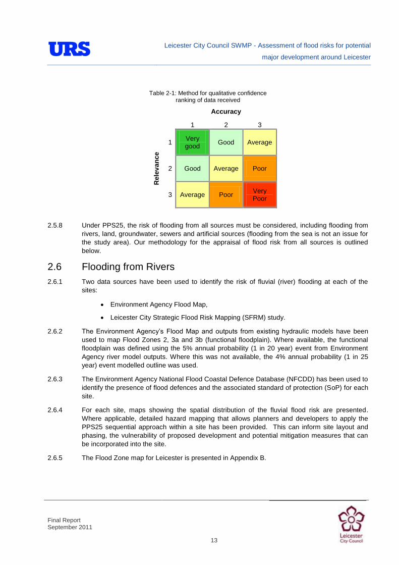
Leicester City Council SWMP - Assessment of flood risks for potential
major development around Leicester
Final Report September 2011
13
Table 2-1: Method for qualitative confidence ranking of data received
Accuracy
1 2 3
Rel
evan
ce
1 Very good
Good Average
2 Good Average Poor
3 Average Poor Very Poor
2.5.8 Under PPS25, the risk of flooding from all sources must be considered, including flooding from rivers, land, groundwater, sewers and artificial sources (flooding from the sea is not an issue for the study area). Our methodology for the appraisal of flood risk from all sources is outlined below.
2.6 Flooding from Rivers 2.6.1 Two data sources have been used to identify the risk of fluvial (river) flooding at each of the
sites:
Environment Agency Flood Map,
Leicester City Strategic Flood Risk Mapping (SFRM) study.
2.6.2 The Environment Agency‟s Flood Map and outputs from existing hydraulic models have been used to map Flood Zones 2, 3a and 3b (functional floodplain). Where available, the functional floodplain was defined using the 5% annual probability (1 in 20 year) event from Environment Agency river model outputs. Where this was not available, the 4% annual probability (1 in 25 year) event modelled outline was used.
2.6.3 The Environment Agency National Flood Coastal Defence Database (NFCDD) has been used to identify the presence of flood defences and the associated standard of protection (SoP) for each site.
2.6.4 For each site, maps showing the spatial distribution of the fluvial flood risk are presented. Where applicable, detailed hazard mapping that allows planners and developers to apply the PPS25 sequential approach within a site has been provided. This can inform site layout and phasing, the vulnerability of proposed development and potential mitigation measures that can be incorporated into the site.
2.6.5 The Flood Zone map for Leicester is presented in Appendix B.

Leicester City Council SWMP - Assessment of flood risks for potential
major development around Leicester
Final Report September 2011
14
2.7 Flooding from the Land 2.7.1 The Pitt Review into the 2007 flood events identified the importance in quantifying the risk of
flooding from land, or „surface water‟ flooding. In response to the Pitt Review, the Environment
Agency released Areas Susceptible to Surface Water Flooding (ASTSWF) Maps in 2008/9. The ASTSWF Maps were the first attempt (1st generation) at quantifying surface water flood risk on a national scale.
2.7.2 The EA‟s Flood Map for Surface Water (FMfSW) was released in 2010 and is the second
generation of national surface water modelling. The FMfSW gives an indication of the broad areas likely to be at risk of surface water flooding. The Maps build upon the 1st generation data as they consider more storm events and the influence of both buildings and the sewer system. The FMfSW picks out natural drainage channels, rivers, low areas in floodplains, and flow paths between buildings. The maps only indicate flooding caused by local rainfall and do not show flooding that occurs from overflowing watercourses, drainage systems or public sewers caused by catchment-wide rainfall events or river flow.
2.7.3 There are known limitations to both the ASTSWF and FMfSW datasets. Due to the simplistic modelling techniques used in deriving the maps, they are not suitable for identifying whether an individual property will flood. In locations where surface water flooding is strongly influenced by topography, the maps may be suitable for identifying where properties are in areas at risk of flooding.
2.7.4 Though the FMfSW is the most up-to-date dataset, there may be instances where the ASTSWF dataset is more appropriate:
Local sewer capacity is able to drain less than 6mm/hr;
Areas are very flat and longer storm durations are more likely to cause flooding than shorter durations.
2.7.5 In Leicester, the FMfSW is considered the most appropriate dataset for quantifying flooding from the land. A suite of maps have been produced that show the FMfSW and anecdotal historic surface water flood events.
2.7.6 Part 1 of the project, detailed direct rainfall (surface water or pluvial) hydraulic modelling has been undertaken using best practice techniques. The pluvial modelling is a further improvement on the 2nd generation FMfSW, as it includes a greater level of detail and resolution. The draft pluvial flooding map is presented in Appendix B.

Leicester City Council SWMP - Assessment of flood risks for potential
major development around Leicester
Final Report September 2011
15
Position Statement May 2011
Pluvial hydraulic modelling
Pluvial modelling is being undertaken as part of the Leicester City SWMP. The pluvial modelling is an improvement on the Environment Agency‟s Flood Map for
Surface Water, as it includes a greater level of detail (resolution).
At the time of writing, the pluvial modelling is in draft format and only results for the 200 year event are available. The draft outputs have been used to undertake an assessment of the risk of surface water flooding to each of the potential major development sites.
The pluvial modelling will be completed in time for the final project deliverables and the relevant sections of the report will be updated accordingly.
2.7.7 The risk of flooding from surface water was assessed for each site using the draft pluvial modelling results and a plan showing the spatial distribution of the risk for each site is included. During the assessment, the draft pluvial modelling results were cross-checked against the ASTSWF and FMfSW datasets to identify any significant differences.
2.8 Flooding from Groundwater 2.8.1 The Environment Agency released the Areas Susceptible to Groundwater Flooding (AStGWF)
dataset to LPAs in March 2011. The AStGWF is a strategic scale map showing groundwater flood areas on a 1km square grid. The dataset was developed by the EA specifically for Lead Local Flood Authorities for use in Preliminary Flood Risk Assessments (PFRAs).
2.8.2 The AStGWF dataset is based on British Geological Society (BGS) data covering consolidated aquifers and superficial deposits. It does not take account of the risk of groundwater flooding as a result of groundwater rebound. The dataset identifies the proportion of each 1km grid square where geological and hydrogeological conditions show that groundwater may emerge. It does not identify the likelihood of groundwater flooding occurring.
2.8.3 An intermediate assessment of groundwater flooding susceptibility has been undertaken as Part 1 of the SWMP project. The report is included in Appendix C. The report includes maps and plans showing BGS historic flood incidents and BGS groundwater flooding susceptibility data. Areas classed as having „Very High‟ or „High‟ susceptibility have been identified. Areas where infiltration SUDS are likely to be appropriate have also been identified using BGS datasets.
2.8.4 The available datasets have been used to qualitatively determine the risk of groundwater flooding at each of the potential major development sites and to identify the suitability of infiltration SUDS.

Leicester City Council SWMP - Assessment of flood risks for potential
major development around Leicester
Final Report September 2011
16
2.9 Flooding from Sewers 2.9.1 Flooding from sewers may occur as a result of insufficient capacity, prolonged and heavy rainfall
or blockage. Severn Trent Water has provided a number of datasets for use on the SWMP and SFRA. The data provided was interrogated against the ST data to determine the risk of flooding from sewers.
2.9.2 It is important to note that ST information relating to historical sewer flooding does not imply a flood risk, as reactive mitigation works may have been undertaken following the flood incident. A map of the DG5 data received is presented in Appendix B.
2.10 Flooding from Reservoirs, Canals and Other Artificial Sources 2.10.1 The locations of reservoirs, canals and artificial flood sources have been identified using
Environment Agency and Ordnance Survey data.
2.10.2 The Grand Union Canal passes through the study area, orientated north-south. Using British Waterways data, OS mapping and LiDAR data, reaches of the canal that are in close proximity to potential major development sites have been assessed to determine the potential risk of breach or overtopping.
2.10.3 There are a number of reservoirs upstream of the study area that may present a residual flood risk. The Environment Agency has produced Reservoir Inundation Mapping (RIM) to broadly quantify the areas at residual risk of flooding from bodies falling under the Reservoirs Act. This dataset has been accessed on the EA website and used to determine residual risk.
2.11 Consideration of Climate Change 2.11.1 The impacts of climate change have been approached in line with PPS25. PPS25 currently uses
the climate projections given in the UK Climate Change Impacts Programme (UKCIP02) and recommends a 20% increase in peak river flow. The PPS25 Practice Guide (section 3.97) notes that pending further work being carried out by Defra and the Environment Agency regarding the impacts of new UK Climate Projections (UKCP09) released in 2009, the UKCIP02 projections are considered adequate.
2.11.2 The Environment Agency Catchment Flood Management Plans (CFMPs), Environment Agency hydraulic models, Ordinary Watercourse modelling and pluvial modelling have been used to provide information on future flood risk in the City.
2.11.3 Available Environment Agency hydraulic modelling outputs that include climate change scenarios have been used to define the increased fluvial flood risk as a result of climate change. Hydraulic modelling (Ordinary Watercourse and pluvial) undertaken as part of this study have included a climate change horizon in line with PPS25.
2.11.4 The effects of climate change on pluvial flood risk will be available for the final version of the SWMP (see the position statement in Section 2.7).

Leicester City Council SWMP - Assessment of flood risks for potential
major development around Leicester
Final Report September 2011
17
3 Assessment of flood risk to potential major development sites
3.1 Leicester City Council Core Strategy Policy 5: Ashton Green
Site Information
Grid Reference SK 570 096
Watercourse Catchment Rothley Brook
Site Area 130ha

Leicester City Council SWMP - Assessment of flood risks for potential
major development around Leicester
Final Report September 2011
18
3.1 Leicester City Council Core Strategy Policy 5: Ashton Green
Existing Use and Topography
Ashton Green is located on the north western edge of Leicester close to the communities of Birstall and Thurcaston in Charnwood Borough. The site is predominantly occupied by open grassland and agricultural farmland, and is therefore considered to be essentially greenfield. The A46 Bypass forms the north-western and northern boundaries of the site. The western, southern and eastern boundaries of the site are predominately bound by residential developments and agricultural land.
The site generally slopes in a north westerly direction from around 90.67m AOD to 71.90m AOD towards Rothley Brook.
Proposed Use and Vulnerability Classification
Ashton Green is identified under policy CS5 of the Core Strategy. The Council envisage that it will be an exemplar of sustainable development, supporting a wide range of sustainable development principles, including reducing carbon impact and climate change (including minimising flood risk).
It is anticipated that the site will provide up to 3,500 new dwellings and associated amenities, up to 10 hectares of employment land, schools, open space and other community facilities. The site also continues to be identified within the saved policies of the Leicester Local Plan (2006) as a housing site under policy H01. However, the original allocation was for residential development only on a smaller site, whereas the Core Strategy identifies a larger mixed use SUE site that can deliver a range of uses over the plan period.
Under PPS25 such residential developments and educational facilities are classed as „more vulnerable‟, and employment development can be classified as „more vulnerable‟ and/or „less vulnerable‟. These vulnerability classifications are considered appropriate in Flood Zones 1 and 2. For residential and educational developments, the Exception Test must be applied for areas falling within Flood Zone 3a.
Should further definition of such employment development be made available at a later stage, identification of their individual PPS25 vulnerability classifications should be re-visited.
Sources of Flood Risk
Rivers
Two small watercourses flowing in a northerly direction have been identified along the western and eastern boundaries of the site. The watercourses are minor tributaries of Rothley Brook and are assumed to provide a drainage mechanism for the existing agricultural land. The watercourses may also present a mechanism for drainage of the adjacent highway.
The two minor watercourses could potentially present a flood risk to the site if the channel capacity becomes exceeded resulting in bank overtopping.
The EA‟s Flood Map does not present Flood Zones associated with the watercourses because the catchment areas are less than 3 km2. The site is therefore shown to be located within Flood Zone 1. However, the small watercourses may still present a flood risk.
EA and LCC data indicates that no historical incidents of fluvial flooding have been recorded at the site. The site is not located within an Environment Agency Flood Warning or Flood Watch Area.

Leicester City Council SWMP - Assessment of flood risks for potential
major development around Leicester
Final Report September 2011
19
3.1 Leicester City Council Core Strategy Policy 5: Ashton Green
Surface water
The draft pluvial modelling results indicate that the risk of flooding from surface water runoff is greater in low-lying areas of the site adjacent to the minor watercourses in the north and east.
EA and LCC Historical Flood Maps illustrate no historical incidents of surface water flooding have been reported at the site.
Groundwater The area of the site near to the drain at the eastern boundary has a „high‟ and „very high‟ susceptibility to groundwater flooding. Since the site is greenfield, any issues with groundwater flooding are unlikely to have been reported.
Sewers The Severn Trent Water DG5 register identifies that there have been no recorded incidents of sewer flooding within the postcode areas covering the site.
Artificial Sources
There are no canals, reservoirs or other artificial sources that may provide a flood risk in the vicinity of the site.
Flood Defence Infrastructure
The NFCDD identifies no raised flood defence infrastructure present at the site or within the local vicinity.
Climate Change
Final pluvial model results will be used to identify the increased risk of surface water flooding as a result of climate change. This will be reported in the final version of the SWMP report (see the position statement in Section 2.7).

Leicester City Council SWMP - Assessment of flood risks for potential
major development around Leicester
Final Report September 2011
20
3.1 Leicester City Council Core Strategy Policy 5: Ashton Green
Residual Flood Risks
At present, the residual risk of flooding at Ashton Green is low. As no flood defences are present along the minor watercourse within the site, no defence breach analysis or analysis of defence overtopping is required.
Recommendations and Suggested Policies
Whilst the watercourses are not Main River, it is recommended that development must not encroach within 8m of the watercourses, which is the EA‟s by-law distance for Main Rivers. This would be beneficial in terms of flood risk and maintenance access. It is recommended that development be „rolled back‟ to a minimum of 20m from the minor watercourses to create „blue corridors‟ which provide public open space / recreation areas near watercourses.
As the site is currently primarily greenfield, any development within the area will increase surface water runoff unless attenuated. SUDS must be implemented to manage surface water runoff from the developed site, and as such reduce the resultant flood risk posed to adjacent/downstream land uses. The use of SUDS will assist in creating an exemplar of sustainable development.
A review of the BGS data showing underlying ground conditions at the site indicates that the site is unsuitable for infiltration SUDS techniques. Attenuation SUDS are therefore likely to be the most appropriate sustainable method of surface water management. This should be considered during the masterplanning stages, as many attenuation techniques generally involve a greater land take (detention basins, swales, etc).
Surface water / pluvial flood risk should inform the site layout, such that „highly vulnerable‟ development is avoided in locations that are shown to be at the greatest risk of pluvial flooding.
Site-Specific FRA Guidance
A site-specific surface water FRA will be required for any development in excess of 1 ha, including those proposed within Flood Zone 1. The FRA will need to consider surface water management.
To ensure sustainable development, the rates and volumes of post-development surface water runoff should be controlled using suitable and adequate SUDS techniques.
If development pressure creates a need to develop within 20m of watercourses:
Detailed hydraulic modelling should be undertaken of the watercourses to determine the extent of Flood Zones 2, 3a and 3b and the potential effects of climate change. Once defined, development should be sequentially allocated, placing land uses of the greatest vulnerability in the areas of lowest flood risk.
Where development within the defined Flood Zone 3a including an allowance for climate change is justifiable, appropriate mitigation and resilience measures should be incorporated both on an individual property-level (such as flood resilient construction) and at a strategic level (such as strategic SUDS or compensatory flood storage on a level-for-level basis).

Leicester City Council SWMP - Assessment of flood risks for potential
major development around Leicester
Final Report September 2011
21
3.1 Leicester City Council Core Strategy Policy 5: Ashton Green
Site-Specific FRA Guidance (cont)
Flood volume displaced as a result of development within the Flood Zone 3a plus an allowance for climate change envelope must be compensated for else where within the site boundary on a „level for level‟ basis. This must be demonstrated using hydraulic modelling as part of the FRA.
The FRA should demonstrate that consideration has been given to the site layout with regards to flood risk from all sources, in line with the recommendations above (sequential approach to site layout).
Due to the susceptibility of groundwater flooding, the risk of groundwater flooding should be quantified by undertaking site-specific investigations. Suitable mitigation measures should be implemented if the investigations show that there is a risk of groundwater flooding, including flood resilient measures and avoiding basements in buildings.
The suitability of infiltration SUDS should be informed by site-specific Ground Investigation (GI).
A site-specific FRA should consider provision of site access and egress, taking into account any requirements of the LCC emergency planning department.
Appropriate mitigation measures should be incorporated that should not increase the risk of flooding to surrounding areas.

Leicester City Council SWMP - Assessment of flood risks for potential
major development around Leicester
Final Report September 2011
22
3.2 Charnwood Borough Council Core Strategy Policy 3: East of Thurmaston SUE
Site Information
Grid Reference SK 630 091
Watercourse Catchment
Barkby Brook & Melton Brook
Site Area 446.7ha
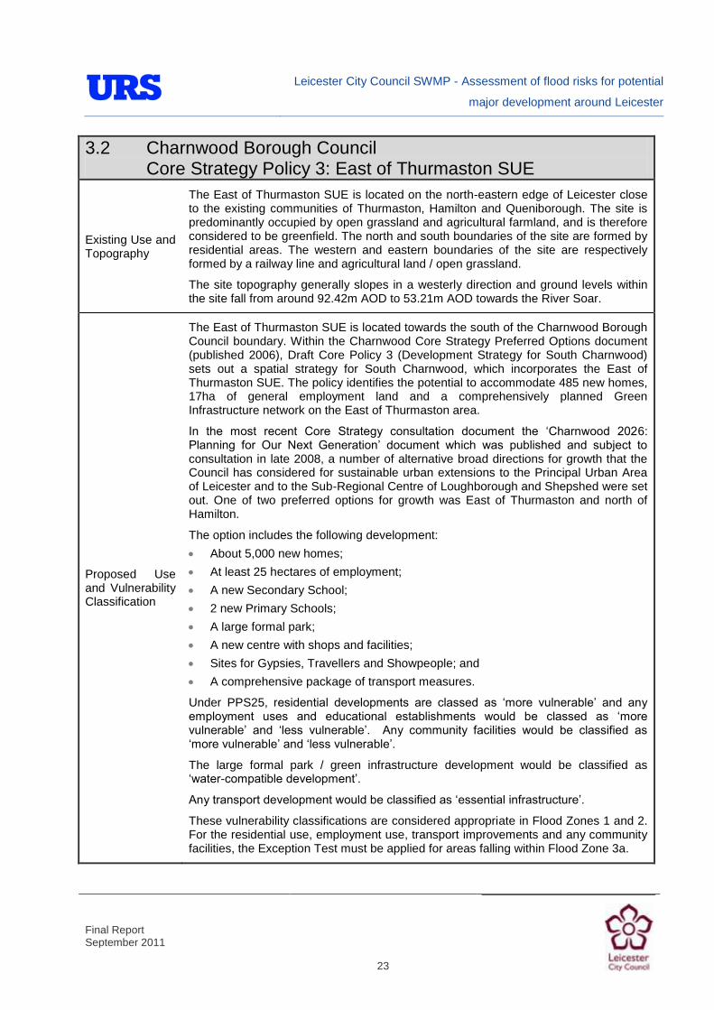
Leicester City Council SWMP - Assessment of flood risks for potential
major development around Leicester
Final Report September 2011
23
3.2 Charnwood Borough Council Core Strategy Policy 3: East of Thurmaston SUE
Existing Use and Topography
The East of Thurmaston SUE is located on the north-eastern edge of Leicester close to the existing communities of Thurmaston, Hamilton and Queniborough. The site is predominantly occupied by open grassland and agricultural farmland, and is therefore considered to be greenfield. The north and south boundaries of the site are formed by residential areas. The western and eastern boundaries of the site are respectively formed by a railway line and agricultural land / open grassland.
The site topography generally slopes in a westerly direction and ground levels within the site fall from around 92.42m AOD to 53.21m AOD towards the River Soar.
Proposed Use and Vulnerability Classification
The East of Thurmaston SUE is located towards the south of the Charnwood Borough Council boundary. Within the Charnwood Core Strategy Preferred Options document (published 2006), Draft Core Policy 3 (Development Strategy for South Charnwood) sets out a spatial strategy for South Charnwood, which incorporates the East of Thurmaston SUE. The policy identifies the potential to accommodate 485 new homes, 17ha of general employment land and a comprehensively planned Green Infrastructure network on the East of Thurmaston area.
In the most recent Core Strategy consultation document the „Charnwood 2026: Planning for Our Next Generation‟ document which was published and subject to consultation in late 2008, a number of alternative broad directions for growth that the Council has considered for sustainable urban extensions to the Principal Urban Area of Leicester and to the Sub-Regional Centre of Loughborough and Shepshed were set out. One of two preferred options for growth was East of Thurmaston and north of Hamilton.
The option includes the following development:
About 5,000 new homes;
At least 25 hectares of employment;
A new Secondary School;
2 new Primary Schools;
A large formal park;
A new centre with shops and facilities;
Sites for Gypsies, Travellers and Showpeople; and
A comprehensive package of transport measures.
Under PPS25, residential developments are classed as „more vulnerable‟ and any employment uses and educational establishments would be classed as „more vulnerable‟ and „less vulnerable‟. Any community facilities would be classified as „more vulnerable‟ and „less vulnerable‟.
The large formal park / green infrastructure development would be classified as „water-compatible development‟.
Any transport development would be classified as „essential infrastructure‟.
These vulnerability classifications are considered appropriate in Flood Zones 1 and 2. For the residential use, employment use, transport improvements and any community facilities, the Exception Test must be applied for areas falling within Flood Zone 3a.

Leicester City Council SWMP - Assessment of flood risks for potential
major development around Leicester
Final Report September 2011
24
3.2 Charnwood Borough Council Core Strategy Policy 3: East of Thurmaston SUE
Proposed Use and Vulnerability Classification
Should further definition of such employment or any leisure development be made available at a later stage, identification of their individual PPS25 vulnerability classifications should be re-visited.
The „water-compatible‟ large formal park development would be appropriate in all flood zones.
Sources of Flood Risk
Rivers
Melton Brook constitutes the southern boundary of this SUE, flowing in a westerly direction. Two small drains flow through the site to their confluence with Melton Brook. Barkby Brook and an unnamed tributary flow through the north of the site in a north westerly and westerly direction, respectively.
The Flood Zones associated with the identified watercourses are derived from broad-scale hydraulic modelling techniques. The Environment Agency has undertaken more detailed hydraulic modelling of Melton Brook, but the upstream extent of the detailed model is located at the south western corner of the site.
The EA‟s Flood Map does not present Flood Zones associated with the remaining watercourses because the catchment areas are less than 3 km2. However, the small watercourses may still present a flood risk.
There is no anecdotal information to suggest that historical flooding has occurred at the site. However, that is not to say that the site has never flooded in the past.
The site is not located in an Environment Agency Flood Warning Area. The area of the site adjacent to the southern site boundary is within a Flood Watch Area („Upper Soar Catchment‟).
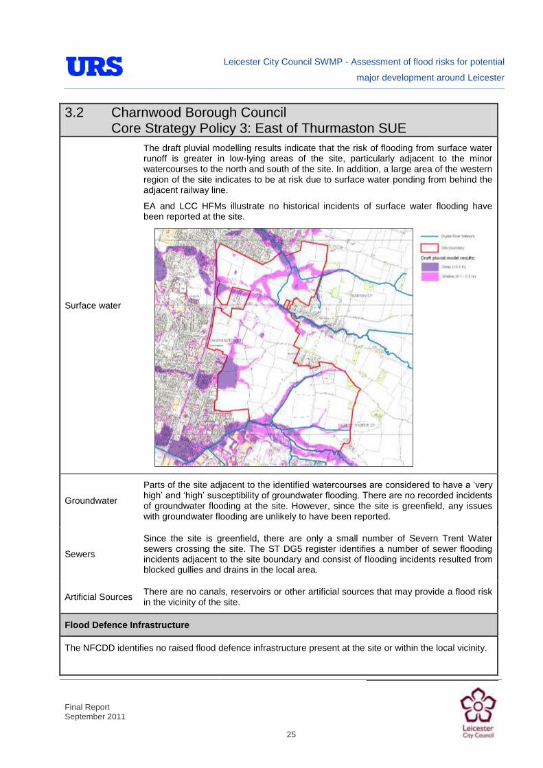
Leicester City Council SWMP - Assessment of flood risks for potential
major development around Leicester
Final Report September 2011
25
3.2 Charnwood Borough Council Core Strategy Policy 3: East of Thurmaston SUE
Surface water
The draft pluvial modelling results indicate that the risk of flooding from surface water runoff is greater in low-lying areas of the site, particularly adjacent to the minor watercourses to the north and south of the site. In addition, a large area of the western region of the site indicates to be at risk due to surface water ponding from behind the adjacent railway line.
EA and LCC HFMs illustrate no historical incidents of surface water flooding have been reported at the site.
Groundwater
Parts of the site adjacent to the identified watercourses are considered to have a „very high‟ and „high‟ susceptibility of groundwater flooding. There are no recorded incidents of groundwater flooding at the site. However, since the site is greenfield, any issues with groundwater flooding are unlikely to have been reported.
Sewers
Since the site is greenfield, there are only a small number of Severn Trent Water sewers crossing the site. The ST DG5 register identifies a number of sewer flooding incidents adjacent to the site boundary and consist of flooding incidents resulted from blocked gullies and drains in the local area.
Artificial Sources There are no canals, reservoirs or other artificial sources that may provide a flood risk in the vicinity of the site.
Flood Defence Infrastructure
The NFCDD identifies no raised flood defence infrastructure present at the site or within the local vicinity.

Leicester City Council SWMP - Assessment of flood risks for potential
major development around Leicester
Final Report September 2011
26
3.2 Charnwood Borough Council Core Strategy Policy 3: East of Thurmaston SUE
Climate Change
PPS25 identifies recommended national precautionary sensitivity ranges for peak rainfall intensities and peak river flows. The available hydraulic models and flood zones in the vicinity of the site do not show the effects of climate change. The effects of climate change on fluvial flood risk should be investigated as part of a site specific FRA (see below).
Final pluvial model results will be used to identify the increased risk of surface water flooding as a result of climate change. This will be reported in the final version of the SWMP report (see the position statement in Section 2.7).
Residual Flood Risks
At present, the residual risk of flooding at the East of Thurmaston SUE is low. As no flood defences are present along the minor watercourse within the site, no defence breach analysis or analysis of defence overtopping is required.
Recommendations and Suggested Policies
It is suggested that development could be rolled back to a minimum of 20m from the minor watercourses to create „blue corridors‟ which provide public open space / recreation areas near watercourses. In general, development should not encroach within 8m of the watercourses, which is the EA‟s by-law distance for Main Rivers. This would be beneficial in terms of flood risk and maintenance access.
Mixed use (mixed vulnerability) development that follows the principles of the PPS25 sequential approach should be applied within the site. For example, the proposed residential and educational building uses could be situated in Flood Zone 1. The remaining „less vulnerable‟ uses could be located within Flood Zone 1 or 2 and where justifiable, Flood Zone 3. This approach can also be applied within buildings, for example commercial development located at ground floor level and residential development above ground floor level in flood risk areas. However, it is suggested that access and egress should still be made available for the residential uses.
The Environment Agency would normally require that flood volume displaced as a result of development within Flood Zone 3a plus an allowance for climate change envelope should be compensated for elsewhere within the site boundary on a „level for level‟ basis.
It is recommended that liaison with the Environment Agency is undertaken to ensure that the Flood Warning Area be extended to include those parts of the site that fall within Flood Zone 3a.
It is suggsted that surface water / pluvial flood risk could inform the site layout, such that „highly vulnerable‟ development is avoided in locations that are shown to be at the greatest risk of pluvial flooding.
As the areas are primarily greenfield, any development within the area could increase surface water runoff (unless attenuated). Therefore, SuDS could be implemented to reduce surface water runoff from the developed site, and as such reduce the resultant flood risk posed to adjacent/downstream land uses.
The Charnwood Strategic Flood Risk Assessment (Entec, 2008) notes that Thurmaston Dyke (also known as Thurmaston Parish Dyke) is severely culverted and constricted and associated with flooding in Thurmaston. Attenuation of surface water to the part of the site draining to this Dyke is therefore crucial.
Leicester City Council SWMP - Assessment of flood risks for potential
major development around Leicester
Final Report September 2011
27
3.2 Charnwood Borough Council Core Strategy Policy 3: East of Thurmaston SUE
Recommendations and Policies (cont)
A review of the BGS data showing underlying ground conditions at the site indicates that the majority of the site is unsuitable for infiltration SUDS techniques. Some small areas may be suitable subject to further detailed site investigations. Attenuation SUDS are therefore likely to be the most appropriate sustainable method of surface water management. This should be considered during the masterplanning stages, as attenuation techniques generally involve a greater land take (detention basins, swales, etc).
Site-Specific FRA Guidance
A site-specific surface water FRA will be required for any development in excess of 1 ha, including those proposed within Flood Zone 1. The FRA will need to consider surface water management.
To ensure sustainable development, it is suggested that the rates and volumes of post-development surface water runoff should be controlled using suitable and adequate SUDS techniques.
If development pressure creates a need to develop within 20m of the watercourses:
Detailed hydraulic modelling could be undertaken of the watercourses to determine the flood depths and the extent of Flood Zones 2, 3a and 3b and the potential effects of climate change. This is because the existing Flood Zones in the area were derived using broadscale, coarse modelling techniques. Once defined, development could be sequentially allocated, placing land uses of the greatest vulnerability in the areas of lowest flood risk.
Where development within the defined Flood Zone 3a including an allowance for climate change is justifiable, appropriate mitigation and resilience measures could be incorporated both on an individual property-level (such as flood resilient construction) and at a strategic level (such as strategic SUDS or compensatory flood storage on a level-for-level basis).
The Environment Agency would normally require that flood volume displaced as a result of development within Flood Zone 3a plus an allowance for climate change envelope should be compensated for elsewhere within the site boundary on a „level for level‟ basis. This would normally be demonstrated using hydraulic modelling as part of the FRA.
Following PPS25, an FRA should demonstrate that consideration has been given to the site layout with regards to flood risk from all sources, in line with the recommendations above (sequential approach to site layout).
Due to the susceptibility of groundwater flooding in some parts of the site, it is suggested that the risk of groundwater flooding should be quantified by undertaking site-specific investigations. Suitable mitigation measures could be implemented if the investigations show that there is a risk of groundwater flooding, including flood resilient measures and avoiding basements in buildings.
The suitability of infiltration SUDS should be informed by site-specific Ground Investigation (GI).
A site-specific FRA would also consider provision of site access and egress, taking into account any requirements of the LCC emergency planning department.
Appropriate mitigation measures could be incorporated that should not increase the risk of flooding to surrounding areas.

Leicester City Council SWMP - Assessment of flood risks for potential
major development around Leicester
Final Report September 2011
28

Leicester City Council SWMP - Assessment of flood risks for potential
major development around Leicester
Final Report September 2011
29
3.3 Harborough District Council Site at Stretton
Site Information
Grid Reference SP 646 994
River Catchment
River Sence & River Soar
Site Area 89 ha

Leicester City Council SWMP - Assessment of flood risks for potential
major development around Leicester
Final Report September 2011
30
3.3 Harborough District Council Site at Stretton
Existing Use and Topography
The potential major development site at Stretton is located on the south eastern edge of Leicester close to the existing communities of Oadby, Wigston and Great Glen. The site is predominantly occupied by open grassland and agricultural farmland, and is therefore essentially considered greenfield. The majority of the site boundaries are formed by agricultural and open grassland. A part of the north western boundary is formed by residential properties.
The site topography gradually slopes towards east and west from around 130.6 mAOD to 114.5 mAOD.
Proposed Use and Vulnerability Classification
The potential major development area is located within the Harborough District Council boundary. There is no new development proposed for the area within the Harborough Core Strategy Publication Version document (published October 2010). However, it is likely that any major development would include residential, employment, transport infrastructure and community related facilities.
If the site was to be developed in this area then the proposed development would be associated with a number of vulnerability classifications.
Under PPS25, residential developments are classed as „more vulnerable‟ and any employment uses and educational establishments would be classed as „more vulnerable‟ and „less vulnerable‟. Any community facilities would be classified as „more vulnerable‟ and „less vulnerable‟.
These vulnerability classifications are considered appropriate in Flood Zones 1 and 2. For the residential use, employment use and any community facilities, the Exception Test must be applied for areas falling within Flood Zone 3a.
Should further definition of such employment or any leisure development be made available at a later stage, identification of their individual PPS25 vulnerability classifications should be re-visited.
Sources of Flood Risk
Rivers
The headwaters of a tributary of Wash Brook rise near the centre of the site and flow in a westerly direction. In addition, a small drain is located on the eastern side of Chestnut Drive. The EA‟s Flood Map does not present Flood Zones associated with the watercourses because the catchment areas are less than 3 km2. The site is therefore shown to be located within Flood Zone 1 (<0.1% AEP of flooding). However, the small watercourses may still present a flood risk. The extents of the modelling of Wash Brook being undertaken as part of the SFRA and SWMP do not extend as far upstream as the Harborough SUE.
There is no anecdotal information to suggest that historical flooding has occurred at the site. However, that is not to say that the site has never flooded in the past.
The site is not located within an Environment Agency Flood Warning or Watch Area.

Leicester City Council SWMP - Assessment of flood risks for potential
major development around Leicester
Final Report September 2011
31
3.3 Harborough District Council Site at Stretton
Surface water
The draft pluvial modelling results indicate that a number of minor areas within the site are at risk from surface water runoff, particularly adjacent to the minor watercourse in the central part of the site.
EA and LCC historical flood records illustrate no historical incidents of surface water flooding have been reported at the site.
Groundwater
Small parts of the site adjacent to the identified watercourses are considered to have a „very high‟ and „high‟ susceptibility of groundwater flooding. There are no recorded incidents of groundwater flooding at the site. However, since the site is greenfield, any issues with groundwater flooding are unlikely to have been reported.
Sewers
There is a foul Severn Trent sewer crossing the site, linking „The Wilderness‟ settlement to the sewer network in Oadby.
The STW DG5 register identifies that there have been no recorded incidents of sewer flooding within the postcode areas covering the site.
Artificial Sources
There are no canals, reservoirs or other artificial sources that may provide a flood risk in the vicinity of the site.
Flood Defence Infrastructure
The NFCDD identifies no raised flood defence infrastructure present at the site or within the local vicinity.

Leicester City Council SWMP - Assessment of flood risks for potential
major development around Leicester
Final Report September 2011
32
3.3 Harborough District Council Site at Stretton
Climate Change
PPS25 identifies recommended national precautionary sensitivity ranges for peak rainfall intensities and peak river flows. As there are no available hydraulic models and flood zones in the vicinity of the site, the effects of climate change are not shown and should therefore be investigated as part of a site specific FRA (see below).
Final pluvial model results will be used to identify the increased risk of surface water flooding as a result of climate change. This will be reported in the final version of the SWMP report (see the position statement in Section 2.7).
Residual Flood Risks
At present, the residual risk of flooding at the Harborough SUE is low. As no flood defences are present along the minor watercourse within the site, no defence breach analysis or analysis of defence overtopping is required.
Recommendations and Suggested Policies
It is suggested that development could be rolled back to a minimum of 20m from the minor watercourses to create „blue corridors‟ which provide public open space / recreation areas near watercourses. In general, development should not encroach within 8m of the watercourses, which is the EA‟s by-law distance for Main Rivers. This would be beneficial in terms of flood risk and maintenance access.
As the site is currently primarily greenfield, any potential development within the area could increase surface water runoff unless attenuated. SUDS could be implemented to manage surface water runoff from the developed site, and as such reduce the resultant flood risk posed to adjacent/downstream land uses.
A review of the BGS data showing underlying ground conditions at the site indicates that the site is unsuitable for infiltration SUDS techniques. Attenuation SUDS are therefore likely to be the most appropriate sustainable method of surface water management. This could be considered during the masterplanning stages, as attenuation techniques generally involve a greater land take (detention basins, swales, etc).
It is suggested that surface water / pluvial flood risk informs the site layout, such that „highly vulnerable‟ development is avoided in locations that are shown to be at the greatest risk of pluvial flooding.
Site-Specific FRA Guidance
A site-specific surface water FRA will be required for any development in excess of 1 ha, including those proposed within Flood Zone 1. The FRA will need to consider surface water management.
To ensure sustainable development, it is suggested that the rates and volumes of post-development surface water runoff should be controlled using suitable and adequate SUDS techniques.
If development pressure creates a need to develop within 20m of the watercourses:
Detailed hydraulic modelling should be undertaken of the watercourses to determine the extent of Flood Zones 2, 3a and 3b and the potential effects of climate change. Once defined, development should be sequentially allocated, placing land uses of the greatest vulnerability in the areas of lowest flood risk.
Leicester City Council SWMP - Assessment of flood risks for potential
major development around Leicester
Final Report September 2011
33
3.3 Harborough District Council Site at Stretton
Site-Specific FRA Guidance (cont)
Where development within the defined Flood Zone 3a including an allowance for climate change is justifiable, appropriate mitigation and resilience measures could be incorporated both on an individual property-level (such as flood resilient construction) and at a strategic level (such as strategic SUDS or compensatory flood storage on a level-for-level basis).
The Environment Agency would normally require that flood volume displaced as a result of development within Flood Zone 3a plus an allowance for climate change envelope should be compensated for elsewhere within the site boundary on a „level for level‟ basis. This would normally be demonstrated using hydraulic modelling as part of the FRA.
Following PPS25, an FRA should demonstrate that consideration has been given to the site layout with regards to flood risk from all sources, in line with the recommendations above (sequential approach to site layout).
Due to the susceptibility of groundwater flooding in some parts of the site, it is suggested that the risk of groundwater flooding should be quantified by undertaking site-specific investigations. Suitable mitigation measures could be implemented if the investigations show that there is a risk of groundwater flooding, including flood resilient measures and avoiding basements in buildings.
The suitability of infiltration SUDS should be informed by site-specific Ground Investigation (GI).
A site-specific FRA would also consider provision of site access and egress, taking into account any requirements of the LCC emergency planning department.
Appropriate mitigation measures could be incorporated that should not increase the risk of flooding to surrounding areas.

Leicester City Council SWMP - Assessment of flood risks for potential
major development around Leicester
Final Report September 2011
34
3.4 Charnwood Borough Council Core Strategy Further Consultation, Alternative Option E: North of Glenfield / South Anstey SUE
Site Information
Grid Reference SK 542 081
River Catchment River Soar
Site Area 128.0 ha
Existing Use and Topography
South Anstey SUE is located in the north eastern edge of Leicester close to the existing communities of Anstey, Glenfield and Groby. The site is predominantly occupied by open grassland and agricultural farmland, and is therefore considered greenfield. The site extends north west and south east of A46 Bypass. The majority of the site boundaries are formed by agricultural and open grassland. The north eastern boundary of the site is formed by the existing urban extent of Anstey.
Rothley Brook flows parallel to the A46 through the centre of the site north and south sections of the site. The site topography generally slopes towards the watercourse from around 109.37m AOD to 62.4m AOD.

Leicester City Council SWMP - Assessment of flood risks for potential
major development around Leicester
Final Report September 2011
35
3.4 Charnwood Borough Council Core Strategy Further Consultation, Alternative Option E: North of Glenfield / South Anstey SUE
Proposed Use and Vulnerability Classification
Within the Charnwood Core Strategy Preferred Options document (published 2006), there is no new development proposed for South Anstey.
However, in the most recent Core Strategy consultation document the „Charnwood 2026: Planning for Our Next Generation‟, which was published and subject to consultation in late 2008, a number of alternative broad directions for growth that the Council has considered for sustainable urban extensions to the Principal Urban Area of Leicester and to the Sub-Regional Centre of Loughborough and Shepshed were set out. One of these alternative options for growth was Alternative Option E: North of Glenfield/South of Anstey.
This option related to 2,462 new dwellings, employment provision, green infrastructure and community facilities including schools.
This option was not identified as the preferred option as it did not perform as well against the range of sustainability criteria as the locations east of Thurmaston. It was considered that an urban extension of this smaller scale would not be able to support the range of services and facilities that are required to deliver a sustainable urban extension in the Borough.
If this option was to be reconsidered during the development of the Core Strategy, then the proposed development would be associated with a number of vulnerability classifications.
Under PPS25, residential developments are classed as „more vulnerable‟ and any employment uses and educational establishments would be classed as „more vulnerable‟ and „less vulnerable‟. Any community facilities would be classified as „more vulnerable‟ and „less vulnerable‟.
The green infrastructure development would be classified as „water-compatible development‟.
These vulnerability classifications are considered appropriate in Flood Zones 1 and 2. For the residential use, employment use and any community facilities, the Exception Test must be applied for areas falling within Flood Zone 3a.
Proposed Use and Vulnerability Classification
Should further definition of such employment or any leisure development be made available at a later stage, identification of their individual PPS25 vulnerability classifications should be re-visited.
The „water-compatible‟ green infrastructure development would be appropriate in all flood zones.

Leicester City Council SWMP - Assessment of flood risks for potential
major development around Leicester
Final Report September 2011
36
3.4 Charnwood Borough Council Core Strategy Further Consultation, Alternative Option E: North of Glenfield / South Anstey SUE
Sources of Flood Risk
Rivers
Rothley Brook flows between the north and south sections of the SUE. Slate Brook flows adjacent to the southern boundary of the northern site to its confluence with Rothley Brook, just downstream of the A46 crossing. The south east of the northern site and the north west of the southern site fall within Flood Zones 2 and 3 associated with Rothley Brook and Slate Brook.
A small drain flows in an easterly direction through the north site. A drain also passes through the southern section of the site, flowing in a northerly direction and beneath Anstey Lane. Upstream of the southern site, there is a small flood relief basin, identifiable from OS mapping. Due to the small catchments associated with these watercourses, there are no associated Environment Agency Flood Zones. However, they may still present flood risk.
The areas of the site falling within Flood Zones 2 and 3 have experienced flooding historically.
The site is not located within an Environment Agency Flood Warning Area. The area of the site adjacent to Rothley Brook falls within the „Rothley Brook in Leicestershrie‟ Flood Watch Area.
Rivers
Surface water
The draft pluvial modelling results indicate that the risk of flooding from surface water runoff is greater in low-lying areas of the site, generally adjacent to Rothley Brook, Slate Brook. Surface water ponding also occurs adjacent to the identified drains passing through the site.

Leicester City Council SWMP - Assessment of flood risks for potential
major development around Leicester
Final Report September 2011
37
3.4 Charnwood Borough Council Core Strategy Further Consultation, Alternative Option E: North of Glenfield / South Anstey SUE
Surface water
EA and LCC HFMs illustrate that there are no historical incidents of surface water flooding have been reported at the site. However, that is not to say that flooding has not occurred in the past.
Groundwater
Areas adjacent to Rothley Brook and Slate Brook are considered to have „high‟ and „very high‟ susceptibility.
There are no recorded instances of groundwater flooding within the site boundary. However, there are some recorded events in Beaumont Leys, just to the east of the site.
Sewers As the site is greenfield, there are no Severn Trent Water sewers serving the site. The Severn Trent DG5 register identifies that there have been no recorded incidents of sewer flooding within the broad postcode areas covering the site.
Artificial Sources
Groby Pool is located just upstream of the site on Slate Brook and Thornton Reservoir is located upstream of the site on Rothley Brook. According to the Reservoir Flood Maps on the Environment Agency‟s website, Groby Pool presents a residual flood risk to the areas of the sites that are immediately adjacent to both Slate Brook and also on Rothley Brook downstream of the confluence with Slate Brook. Thornton Reservoir presents a residual risk of breach to the Rothley Brook corridor, affecting the parts of the site adjacent to the brook.
There are no canals in the vicinity of the site.
Flood Defence Infrastructure

Leicester City Council SWMP - Assessment of flood risks for potential
major development around Leicester
Final Report September 2011
38
3.4 Charnwood Borough Council Core Strategy Further Consultation, Alternative Option E: North of Glenfield / South Anstey SUE
The NFCDD identifies no raised flood defence infrastructure present at the site or within the local vicinity. There is a small flood relief basin upstream of the site, on the small tributary of Rothley Brook, which flows through the southern part of the site.
Climate Change
PPS25 identifies recommended national precautionary sensitivity ranges for peak rainfall intensities and peak river flows. The Environment Agency‟s hydraulic model study of Rothley Brook did not consider climate change.
Final pluvial model results will be used to identify the increased risk of surface water flooding as a result of climate change. This will be reported in the final version of the SWMP (see the position statement in Section 2.7).
Residual Flood Risks
As noted under „Artificial Sources‟, the parts of the site immediately adjacent to Rothley Brook and Slate Brook are considered to be at residual risk of flooding from a breach at Groby Pool and Thornton Reservoir, respectively.
Recommendations and Suggested Policies

Leicester City Council SWMP - Assessment of flood risks for potential
major development around Leicester
Final Report September 2011
39
3.4 Charnwood Borough Council Core Strategy Further Consultation, Alternative Option E: North of Glenfield / South Anstey SUE
It is suggested that development could be rolled back to a minimum of 20m from the minor watercourses to create „blue corridors‟ which provide public open space / recreation areas near watercourses. In general, development should not encroach within 8m of the watercourses, which is the EA‟s by-law distance for Main Rivers. This would be beneficial in terms of flood risk and maintenance access.
Mixed use (mixed vulnerability) development that follows the principles of the PPS25 sequential approach should be applied within the site. For example, the proposed residential and educational building uses could be situated in Flood Zone 1. The remaining „less vulnerable‟ uses could be located within Flood Zone 1 or 2 and where justifiable, Flood Zone 3. This approach can also be applied within buildings, for example commercial development located at ground floor level and residential development above ground floor level in flood risk areas. However, it is suggested that access and egress should still be made available for the residential uses.
The Environment Agency would normally require that flood volume displaced as a result of development within Flood Zone 3a plus an allowance for climate change envelope should be compensated for elsewhere within the site boundary on a „level for level‟ basis.
It is recommended that liaison with the Environment Agency is undertaken to ensure that the Flood Warning Area be extended to include those parts of the site that fall within Flood Zone 3a.
It is suggested that surface water / pluvial flood risk could inform the site layout, such that „highly vulnerable‟ development is avoided in locations that are shown to be at the greatest risk of pluvial flooding.
As the areas are primarily greenfield, any development within the area could increase surface water runoff (unless attenuated). Therefore, SuDS could be implemented to reduce surface water runoff from the developed site, and as such reduce the resultant flood risk posed to adjacent/downstream land uses..
A review of underlying geology indicates that infiltration SUDS may be unsuitable at the site, though site-specific investigations could be undertaken to confirm this. Attenuation SUDS techniques are therefore likely to be more suitable. It is suggested that this be considered when undertaking masterplanning, as most attenuation techniques involve land-take (detention basins, swales, etc.)
Site-Specific FRA Guidance
Leicester City Council SWMP - Assessment of flood risks for potential
major development around Leicester
Final Report September 2011
40
3.4 Charnwood Borough Council Core Strategy Further Consultation, Alternative Option E: North of Glenfield / South Anstey SUE
A site-specific surface water FRA will be required for any development in excess of 1 ha, including those proposed within Flood Zone 1. The FRA will need to consider surface water management.
To ensure sustainable development, it is suggested that the rates and volumes of post-development surface water runoff should be controlled using suitable and adequate SUDS techniques.
If development pressure creates a need to develop within 20m of the watercourses:
Detailed hydraulic modelling could be undertaken of the watercourses to determine the flood depths and the extent of Flood Zones 2, 3a and 3b and the potential effects of climate change. This is because the existing Flood Zones in the area were derived using broadscale, coarse modelling techniques. Once defined, development could be sequentially allocated, placing land uses of the greatest vulnerability in the areas of lowest flood risk.
Where development within the defined Flood Zone 3a including an allowance for climate change is justifiable, appropriate mitigation and resilience measures could be incorporated both on an individual property-level (such as flood resilient construction) and at a strategic level (such as strategic SUDS or compensatory flood storage on a level-for-level basis).
The Environment Agency would normally require that flood volume displaced as a result of development within Flood Zone 3a plus an allowance for climate change envelope should be compensated for elsewhere within the site boundary on a „level for level‟ basis. This would normally be demonstrated using hydraulic modelling as part of the FRA.
Following PPS25, an FRA should demonstrate that consideration has been given to the site layout with regards to flood risk from all sources, in line with the recommendations above (sequential approach to site layout).
Due to the susceptibility of groundwater flooding in some parts of the site, it is suggested that the risk of groundwater flooding should be quantified by undertaking site-specific investigations. Suitable mitigation measures could be implemented if the investigations show that there is a risk of groundwater flooding, including flood resilient measures and avoiding basements in buildings.
The suitability of infiltration SUDS should be informed by site-specific Ground Investigation (GI).
A site-specific FRA would also consider provision of site access and egress, taking into account any requirements of the LCC emergency planning department.
Appropriate mitigation measures could be incorporated that should not increase the risk of flooding to surrounding areas.

Leicester City Council SWMP - Assessment of flood risks for potential
major development around Leicester
Final Report September 2011
41
3.5 Blaby District Council Core Strategy Policy CS3: Blaby SUE/ Lubbesthorpe Site
Site Information
Grid Reference SK 533 014
Catchment River Soar
Site Area 336 ha
Existing Use
Blaby SUE / Lubbesthorpe Site is located on the south western edge of Leicester close
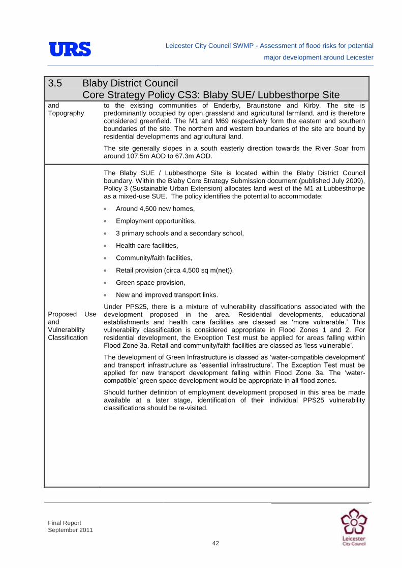
Leicester City Council SWMP - Assessment of flood risks for potential
major development around Leicester
Final Report September 2011
42
3.5 Blaby District Council Core Strategy Policy CS3: Blaby SUE/ Lubbesthorpe Site
and Topography
to the existing communities of Enderby, Braunstone and Kirby. The site is predominantly occupied by open grassland and agricultural farmland, and is therefore considered greenfield. The M1 and M69 respectively form the eastern and southern boundaries of the site. The northern and western boundaries of the site are bound by residential developments and agricultural land.
The site generally slopes in a south easterly direction towards the River Soar from around 107.5m AOD to 67.3m AOD.
Proposed Use and Vulnerability Classification
The Blaby SUE / Lubbesthorpe Site is located within the Blaby District Council boundary. Within the Blaby Core Strategy Submission document (published July 2009), Policy 3 (Sustainable Urban Extension) allocates land west of the M1 at Lubbesthorpe as a mixed-use SUE. The policy identifies the potential to accommodate:
Around 4,500 new homes,
Employment opportunities,
3 primary schools and a secondary school,
Health care facilities,
Community/faith facilities,
Retail provision (circa 4,500 sq m(net)),
Green space provision,
New and improved transport links.
Under PPS25, there is a mixture of vulnerability classifications associated with the development proposed in the area. Residential developments, educational establishments and health care facilities are classed as „more vulnerable.‟ This vulnerability classification is considered appropriate in Flood Zones 1 and 2. For residential development, the Exception Test must be applied for areas falling within Flood Zone 3a. Retail and community/faith facilities are classed as „less vulnerable‟.
The development of Green Infrastructure is classed as „water-compatible development‟ and transport infrastructure as „essential infrastructure‟. The Exception Test must be applied for new transport development falling within Flood Zone 3a. The „water-compatible‟ green space development would be appropriate in all flood zones.
Should further definition of employment development proposed in this area be made available at a later stage, identification of their individual PPS25 vulnerability classifications should be re-visited.

Leicester City Council SWMP - Assessment of flood risks for potential
major development around Leicester
Final Report September 2011
43
3.5 Blaby District Council Core Strategy Policy CS3: Blaby SUE/ Lubbesthorpe Site
Sources of Flood Risk
Rivers
Four unnamed tributaries of Lubbesthorpe Brook flow in an easterly direction through the Blaby SUE / Lubbesthorpe Site. The two tributaries rise within the northern part of the site: one near the northern boundary, the second to the east of Old Warren Farm. The third tributary flows adjacent to Lubbesthorpe Bridle Road, passing beneath it in culvert. The southerly tributary rises to the west of the site, to the south of Hinckley Road and passes beneath Beggar‟s Lane before flowing through the site.
The southern tributary is the only watercourse flowing through the site that is shown to have Environment Agency flood zones associated with it. These flood zones were derived using broadscale modelling techniques.
The EA‟s Flood Map does not present Flood Zones associated with the remaining watercourses because the catchment areas are less than 3 km2. However, the small watercourses may still present a flood risk.
The site is not located within an Environment Agency Flood Warning Area.
Surface water
The draft pluvial modelling results indicate that the risk of flooding from surface water runoff is greater in low-lying areas of the site, particularly adjacent to the minor watercourses flowing through the site. The modelling results also indicate that large parts of the M69 and public roads running adjacent to the minor watercourses may also be at risk of surface water flooding.

Leicester City Council SWMP - Assessment of flood risks for potential
major development around Leicester
Final Report September 2011
44
3.5 Blaby District Council Core Strategy Policy CS3: Blaby SUE/ Lubbesthorpe Site
EA and LCC historical flood records illustrate that there have been no historical incidents of surface water flooding have been reported at the site.
Groundwater
Parts of the site adjacent to the identified watercourses are considered to have a „very high‟ and „high‟ susceptibility of groundwater flooding. There are no recorded incidents of groundwater flooding at the site. However, since the site is greenfield, any issues with groundwater flooding are unlikely to have been reported.
Sewers
As the site is predominantly greenfield, there is no Severn Trent sewer network serving the site. There is a foul sewer that crosses the north of the site, linking the existing urban area to the north west of the site to the urban area to the east of the M1.
The Severn Trent Water DG5 register identifies that there have been no recorded incidents of sewer flooding within the areas covering the site.
Artificial Sources
There are no canals, reservoirs or other artificial sources that may provide a flood risk in the vicinity of the site. The Environment Agency‟s Reservoir Flood Map indicates that the site is not considered to be at residual risk of reservoir breach.

Leicester City Council SWMP - Assessment of flood risks for potential
major development around Leicester
Final Report September 2011
45
3.5 Blaby District Council Core Strategy Policy CS3: Blaby SUE/ Lubbesthorpe Site
Flood Defence Infrastructure
The NFCDD identifies no raised flood defence infrastructure present at the site or within the local vicinity. There is a small flood relief basin just beyond the north western site boundary (adjacent to the existing urban area).
Climate Change
PPS25 identifies recommended national precautionary sensitivity ranges for peak rainfall intensities and peak river flows. The available hydraulic models and flood zones in the vicinity of the site do not show the effects of climate change. The effects of climate change on fluvial flood risk should be investigated as part of a site specific FRA (see below).
Final pluvial model results will be used to identify the increased risk of surface water flooding as a result of climate change. This will be reported in the final version of the SWMP report (see the position statement in Section 2.7).
Residual Flood Risks
At present, the residual risk of flooding at the Blaby SUE / Lubbesthorpe Site is low. As no flood defences are present along the minor watercourse within the site, no defence breach analysis or analysis of defence overtopping is required.
Recommendations and Suggested Policies
It is suggested that development could be rolled back to a minimum of 20m from the minor watercourses to create „blue corridors‟ which provide public open space / recreation areas near watercourses. In general, development should not encroach within 8m of the watercourses, which is the EA‟s by-law distance for Main Rivers. This would be beneficial in terms of flood risk and maintenance access.
Mixed use (mixed vulnerability) development that follows the principles of the PPS25 sequential approach should be applied within the site. For example, the proposed residential and educational building uses could be situated in Flood Zone 1. The remaining „less vulnerable‟ uses could be located within Flood Zone 1 or 2 and when justifiable, Flood Zone 3. The Green Infrastructure would be ideally located in the areas of greatest flood risk (Flood Zone 3a or 3b). This approach can also be applied within buildings, for example commercial development located at ground floor level and residential development above ground floor level in flood risk areas. However, access and egress must still be made available for the residential uses.
The Environment Agency would normally require that flood volume displaced as a result of development within Flood Zone 3a plus an allowance for climate change envelope should be compensated for elsewhere within the site boundary on a „level for level‟ basis.
It is recommended that liaison with the Environment Agency is undertaken to ensure that the Flood Warning Area be extended to include those parts of the site that fall within Flood Zone 3a.
It is suggested that surface water / pluvial flood risk could inform the site layout, such that „highly vulnerable‟ development is avoided in locations that are shown to be at the greatest risk of pluvial flooding.

Leicester City Council SWMP - Assessment of flood risks for potential
major development around Leicester
Final Report September 2011
46
3.5 Blaby District Council Core Strategy Policy CS3: Blaby SUE/ Lubbesthorpe Site
As the site is currently primarily greenfield, any development within the area could increase surface water runoff unless attenuated. SUDS could be implemented to manage surface water runoff from the developed site, and as such reduce the resultant flood risk posed to adjacent/downstream land uses. The use of SUDS will assist in creating an exemplar of sustainable development.
A review of underlying ground conditions using BGS data indicates that it is unlikely that infiltration SUDS will be suitable at the Blaby SUE / Lubbesthorpe Site. This could be confirmed through site specific investigations. If attenuation techniques are the only suitable SUDS, this should be considered from an early stage in the masterplanning process, as attenuation techniques.
Site-Specific FRA Guidance
A site-specific surface water FRA would normally be required for any development in excess of 1 ha, including those proposed within Flood Zone 1. The FRA will need to consider surface water management.
To ensure sustainable development, it is suggested that the rates and volumes of post-development surface water runoff should be controlled using suitable and adequate SUDS techniques.
If development pressure creates a need to develop within 20m of the watercourses:
Detailed hydraulic modelling has been on Lubbesthorpe Brooke to determine the extent of Flood Zones 2, 3a and 3b and the potential effects of climate change. Once finalised, it is suggested that development should be sequentially allocated in accordance with PPS25, placing land uses of the greatest vulnerability in the areas of lowest flood risk.
Where development within the defined Flood Zone 3a including an allowance for climate change is justifiable, appropriate mitigation and resilience measures could be incorporated both on an individual property-level (such as flood resilient construction) and at a strategic level (such as strategic SUDS or compensatory flood storage on a level-for-level basis).
The Environment Agency would normally require that flood volume displaced as a result of development within Flood Zone 3a plus an allowance for climate change envelope should be compensated for elsewhere within the site boundary on a „level for level‟ basis. This would normally be demonstrated using hydraulic modelling as part of the FRA.
Following PPS25, an FRA should demonstrate that consideration has been given to the site layout with regards to flood risk from all sources, in line with the recommendations above (sequential approach to site layout).
Due to the susceptibility of groundwater flooding in some parts of the site, the risk of groundwater flooding could be quantified by undertaking site-specific investigations. Suitable mitigation measures should be implemented if the investigations show that there is a risk of groundwater flooding, including flood resilient measures and avoiding basements in buildings.
Similarly, the suitability of infiltration SUDS could also be informed by site-specific Ground Investigation (GI).
A site-specific FRA should consider provision of site access and egress, taking into account any requirements of the LCC emergency planning department.
Appropriate mitigation measures could be incorporated that should not increase the risk of flooding to surrounding areas.
It is suggested that dry access and egress be maintained for the development. Therefore, if any emergency access routes involve Lubbesthorpe Bridle Road and Beggar‟s Lane, detailed hydraulic modelling of the watercourses will be required to inform crossing requirements (for example the size of culverts/bridge deck levels).

Leicester City Council SWMP - Assessment of flood risks for potential
major development around Leicester
Final Report September 2011
47
4 Summary
4.1.1 The five potential major development areas are all large sites situated on green field areas and generally have limited flood risks. Flood risk for most of the potential development sites tends to concentrate along watercourse routes, where the land is generally lower and so surface water ponding can occur in addition to fluvial flooding. It is also along watercourse corridors that susceptibility to groundwater flooding is highest.
4.1.2 It is therefore suggested that, in accordance with PPS25, site layout and development proposals for the potential major developments is steered away from watercourses. Opportunities to incorporate green spaces or blue corridors along watercourses should be encouraged to reduce the risk of flooding to future development within major development site and to downstream areas.
4.1.3 It is also important to recognise that most of the potential major development sites are upstream of Leicester and therefore have the potential to increase flood risk to the City through increased surface water runoff. As part of the SWMP for LCC, runoff rates are being derived for different development scenarios for each major site. This exercise will estimate the potential increase in surface water runoff volumes from the potential development sites and give an indication of the potential impacts downstream in Leicester.
4.1.4 Where feasible, it is suggested that each of the potential major development sites should incorporate a consistent approach to SUDs to sustainably manage surface water runoff and to reduce the potential for increasing surface water flooding in downstream areas. Severn Trent Water should also be consulted when designing the surface water management systems and drainage strategy for each SUE to ensure that any future drainage scheme that may be adopted is sustainable.
4.1.5 Most importantly, it is suggested that Leicester City Council continue to work with the surrounding Districts to determine how findings from the SWMP can be incorporated into emerging LDF processes to ensure that a consistent and unified approach to managing flood risk in the area is adopted.

Leicester City Council SWMP - Assessment of flood risks for potential
major development around Leicester
Final Report September 2011
A
Appendix A. Data Register

Leicester City Council SWMP - Assessment of flood risks for potential
major development around Leicester
Final Report September 2011
A
Extract from SWMP data register showing data received from LCC
Data ID Data description Date received Relevance Accuracy Confidence
D135090/ DATA/001
Leicester SFRA JBA 2004 (report, figures, maps, photos). 20-Jul-10 1 2 Good
D135090/ DATA/002
LiDAR (topographic) ASCII grids, including 5m DTM, 2m DSM, 1m DTM and 1m DSM.
12-Nov-10 1 1 Very good
D135090/ DATA/003a Leicester SFRA 12-Nov-10 1 2 Good
D135090/ DATA/003b
Leicester Flood Alleviation Scheme Phase 1 report (2007) 12-Nov-10 2 1 Good
D135090/ DATA/003c
Leicester Strategic Flood Risk Mapping Project (2010) Note: Draft format only
12-Nov-10 1 2 (draft) Good
D135090/ DATA/003d
Leicester Critical Ordinary Watercourses (COWs) Final Report (2008)
12-Nov-10 2 1 Good
D135090/ DATA/003e
Environment Agency Lubbesthorpe Brook Flood Alleviation Scheme report (2010) Note: Draft format only
12-Nov-10 1 2 (draft) Good
D135090/ DATA/005
Historic Flooding database (including location, date and cause) 16-Nov-10 1 1 Very good
D135090/ DATA/007
Lead Local Flood Authority update newsletter (November 2010) 23-Nov-10 2 1 Good
D135090/ DATA/009a Historical Flood Map (HFM) GIS layer 23-Nov-10 1 2 Good
D135090/ DATA/009b
Main River GIS layer 23-Nov-10 1 1 Very good
D135090/ DATA/009c Digital River Network GIS layer 23-Nov-10 1 1 Very good
D135090/ DATA/009d
Areas Susceptible to Surface Water Flooding (ASTSWF) GIS layer 23-Nov-10 1 2 Good
D135090/ DATA/009e
Flood Zones GIS layer 23-Nov-10 1 1 Very good
D135090/ DATA/009f Flood Storage Areas GIS layer 23-Nov-10 1 1 Very good
D135090/ DATA/009g Flood defences GIS layer 23-Nov-10 1 1 Very good
D135090/ DATA/009h
Areas Benefiting from Defences GIS layer
23-Nov-10 1 1 Very good
D135090/ DATA/009i Historical Landfill GIS layer 23-Nov-10 2 1 Good
D135090/ DATA/009j National Receptors Database GIS layer 23-Nov-10 1 1 Very good
D135090/ DATA/009k
Social, cultural and environmental (part 2) 23-Nov-10 2 1 Good
D135090/DATA/010
Watercourse/Drainage infrastructure/asset map – Large Paper copy
23-Nov-10 1 1 Very good
D135090/DATA/019
Spreadsheet of Brook levels for historic events. 19-Jan-11 1 2 Good
Leicester City Council SWMP - Assessment of flood risks for potential
major development around Leicester
Final Report September 2011
A
Extract from SWMP data register showing data received from the EA
Data ID Data description Date received Relevance Accuracy Confidence
D135090/ DATA/006a
Building Trust with Communities Guide, including example of Foxholes Spinney / Lubbesthorpe Brook study.
23-Nov-10 1 1 Very good
D135090/ DATA/006b
National Flooding and Coastal Defence Database Assets and Structures GIS layer
23-Nov-10 1 2 Good
D135090/ DATA/006c 1977 flood event outlines GIS layer 23-Nov-10 1 2 Good
D135090/ DATA/006d
EA Water Management Boundary GIS layer 23-Nov-10 2 1 Good
D135090/ DATA/006e Flood Warning Areas GIS layer 23-Nov-10 1 1 Very good
D135090/ DATA/006f Flood Watch Areas GIS layer 23-Nov-10 1 1 Very good
D135090/ DATA/006g FRM Library Data - model file details 23-Nov-10 1 1 Very good
D135090/ DATA/006h
Surveying services standard technical specifications 23-Nov-10 1 1 Very good
D135090/DATA/014
Local Flood Warning Plan for the City of Leicester, Leicestershire and Rutland
11-Jan-11 1 1 Very good
D135090/DATA/015 PFRA Indicative Flood Risk Areas 12-Jan-11 1 1 Very good
D135090/DATA/016
Draft Trent (Soar) Catchment Flood Management Plan, Final PFRA guidance and annexes, Leicester Leicestershire and Rutland Local Resilience Forum.
16-Jan-11 1 1 Very good
D135090/DATA/018
Leicester City Strategic Flood Risk Mapping (SFRM) Final Outputs 19-Jan-11 1 1 Very good
Extract from SWMP data register showing data received from STW
Data ID Data description Date received Relevance Accuracy Confidence
D135090/DATA/012
Sewer records (GIS) and supporting documentation 24-Dec-10 1 1 Very Good
D135090/DATA/013
DG5 sewer flooding register for Leicester City administrative area 07-Jan-11 1 1 Very Good
D135090/DATA/017
DG5 sewer flooding register for Leicester City administrative area plus Strategic Urban Extensions
18-Jan-11 1 1 Very Good

Leicester City Council SWMP - Assessment of flood risks for potential
major development around Leicester
Final Report September 2011
B
Appendix B. Maps
Flood Zone Map EA Flood Warning Map Draft Surface Water Map DG5 Sewer Flooding Map