appendix a fish habitat assessment data form e... · write “d” for dominant beside the most...
TRANSCRIPT

CBCL Limited Appendices
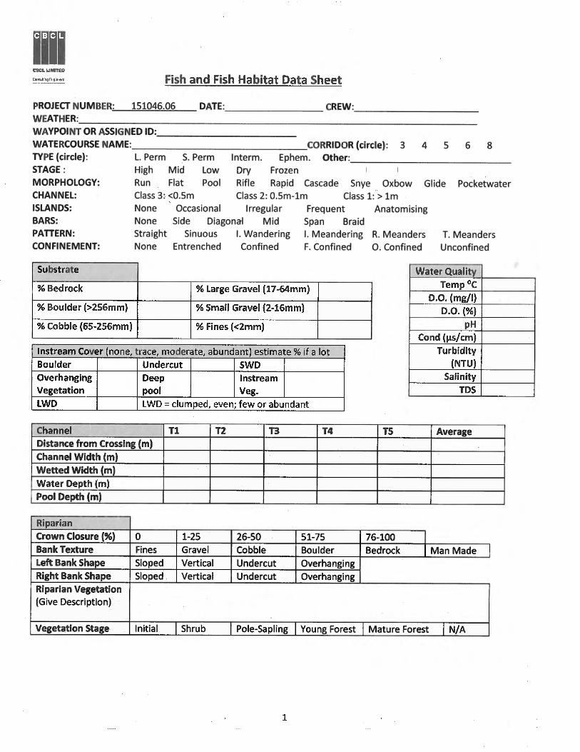
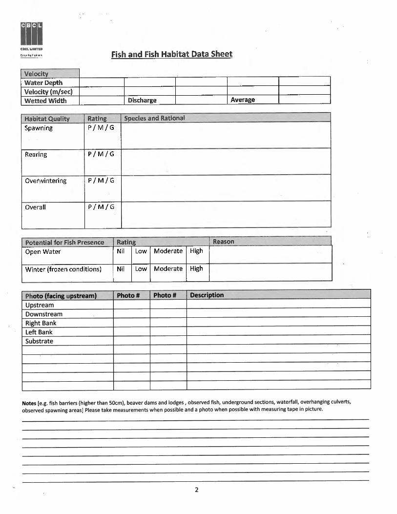
APPENDIX A
Fish Habitat Assessment Data Form

CBCL Limited Appendices
APPENDIX B
Wood Turtle Habitat Assessment Form

CBCL LIMITED Wood Turtle Habitat Assessment Form (Glytemys insculpta)
Part I: Survey Details Date Time Waypoint Stream Name Crew
Part II: Environmental Conditions Temperature (°C) Cloud Cover (5) Wind Speed Precipitation
Wind Speed: Calm – C, Light – L, Moderate – M, Strong – S Precipitation: None – N, Drizzle/Mist – D, Light Rain – L, Moderate or Heavy – M, Other – O (specify)
Part III: Stream Characteristics and Water Quality Temp. (°C) Presence of sand/gravel banks/bars/island (un-vegetated)? Yes/No D.O. (mg/L) Are sand/gravel areas elevated (flood-risk free)? Yes/No pH Are the sand/gravel areas on an east or south facing slope? Yes/No Channel Width (m) Are there deep pools greater than 0.5 m? Yes/No Channel Depth (m) Stream Pattern Straight Sinuous Meandering Other (explain) Flow Conditions Dry Low Mid High Flood (in floodplain) Water Clarity Clear Turbid Tannic Zero Visibility Velocity Flat Slow Moderate Fast Turbulent Dom. Substrate Silt Sand Gravel Cobble Boulder Overwintering Features Root masses of lrg trees Undercut banks Oxbows Lrg woody debris Log jams Boulders
Part IV: Riparian Habitat Check all that apply within 50m of tributary. Write “D” for dominant beside the most prevalent habitat type.
Upland Deciduous Forest Wetland Other (specify) Upland Coniferous Forest Agriculture Upland Mixedwood Forest Sand/Gravel Extraction Pits Upland Shrub-Scrub Residential Shrub Floodplain Commercial Forest Floodplain Industrial Emergent Wetland (herbaceous) Other (specify)
Overstory Density None (<2%) Low (2-20%) Medium (20-80%) High (>80%) Understory Density None (<2%) Low (2-20%) Medium (20-80%) High (>80%) Sunlit Openings (within 50m) None Few Frequent Abundant

CBCL LIMITED Wood Turtle Habitat Assessment Form (Glytemys insculpta)
Observed Food Source Densities. Write N (none), L (low), M (moderate), or H (high) beside each potential food preference.
Raspberries Hawthorn Algae Tadpoles Strawberries Grasses Mushrooms Snails Blueberries Willows Slugs Small fish (trout) Chokecherry Alders Earthworms Moss
Is there evidence of Beaver or Muskrat Dens? Yes/No
Part V: High Risk Habitats Check all that apply within 100 m of the tributary.
Haying Fields Highways Roads (Excluding Highways) ATV Trails Garbage/Recreation
Part V1: Potential for Wood Turtle Habitat Basking Sites. Yes/No Comment: Photos: Foraging Potential. Yes/No Comment: Photos: Nesting Areas. Yes/No Comment: Photos: Overwintering Sites. Yes/No Comment: Photos: Movement Corridors. Yes/No Comment: Photos: Suitable Stream Characteristics. Yes/No Comment: Photos:
Recommend a full wood turtle survey during spring and/or fall: Yes / No

CBCL Limited Appendices
APPENDIX C
Visual Encounter Survey Data Form
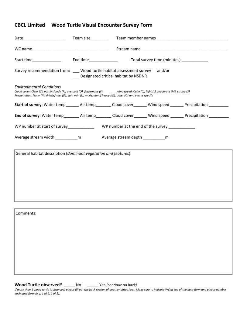
CBCL Limited Wood Turtle Visual Encounter Survey Form Date___________________ Team size________ Team member names ________________________________ WC name__________________________________ Stream name_______________________________________ Start time_____________ End time_____________ Total survey time (minutes) ____________ Survey recommendation from: ___ Wood turtle habitat assessment survey and/or ___ Designated critical habitat by NSDNR Environmental Conditions Cloud cover: Clear (C), partly cloudy (P), overcast (O), fog/smoke (F) Wind speed: Calm (C), light (L), moderate (M), strong (S) Precipitation: None (N), drizzle/mist (D), light rain (L), moderate of heavy (M), other (O) and please specify
Start of survey: Water temp______ Air temp_______ Cloud cover______ Wind speed ______ Precipitation _________ End of survey: Water temp_______ Air temp_______ Cloud cover______ Wind speed ______ Precipitation _________ WP number at start of survey____________ WP number at the end of the survey ____________ Average stream width __________m Average stream depth __________m General habitat description (dominant vegetation and features): Comments:
Wood Turtle observed? _____ No _____ Yes (continue on back) If more than 1 wood turtle is observed, please fill out the back section of another data sheet. Make sure to indicate WC at top of the data form and please number each data form (e.g. 1 of 2, 2 of 2).
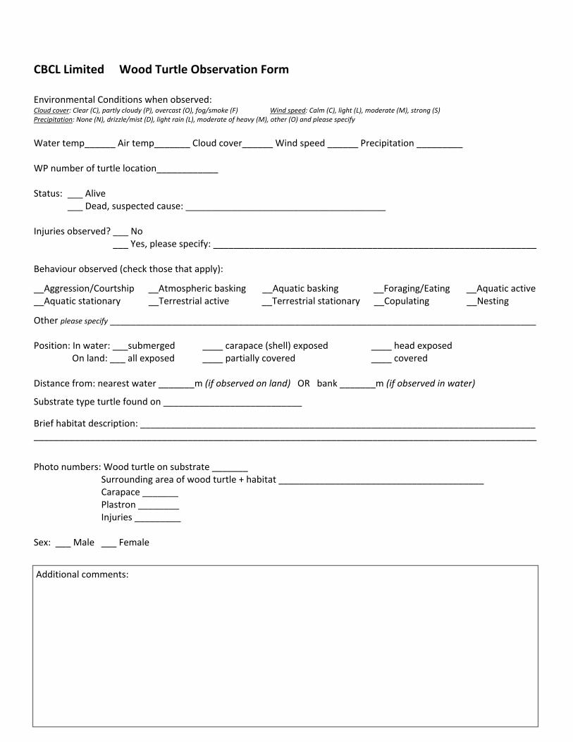
CBCL Limited Wood Turtle Observation Form Environmental Conditions when observed: Cloud cover: Clear (C), partly cloudy (P), overcast (O), fog/smoke (F) Wind speed: Calm (C), light (L), moderate (M), strong (S) Precipitation: None (N), drizzle/mist (D), light rain (L), moderate of heavy (M), other (O) and please specify
Water temp______ Air temp_______ Cloud cover______ Wind speed ______ Precipitation _________ WP number of turtle location____________ Status: ___ Alive ___ Dead, suspected cause: _______________________________________ Injuries observed? ___ No ___ Yes, please specify: _______________________________________________________________ Behaviour observed (check those that apply):
__Aggression/Courtship __Atmospheric basking __Aquatic basking __Foraging/Eating __Aquatic active __Aquatic stationary __Terrestrial active __Terrestrial stationary __Copulating __Nesting
Other please specify ___________________________________________________________________________________ Position: In water: ___submerged ____ carapace (shell) exposed ____ head exposed On land: ___ all exposed ____ partially covered ____ covered Distance from: nearest water _______m (if observed on land) OR bank _______m (if observed in water)
Substrate type turtle found on ___________________________
Brief habitat description: _____________________________________________________________________________ __________________________________________________________________________________________________
Photo numbers: Wood turtle on substrate _______ Surrounding area of wood turtle + habitat ________________________________________
Carapace _______ Plastron ________
Injuries _________ Sex: ___ Male ___ Female
Additional comments:

CBCL Limited Appendices
APPENDIX D
Wood Turtle SARA Permit


CBCL Limited Appendices
APPENDIX E
Watercourse Assessment Location Maps

Surveyed Watercourse - TypeLarge/ Small Permanent
Small Permanent/ Intermittent
Intermittent
Intermittent/ Ephemeral
Ephemeral
!( Water Quality Survey LocationsWood Turtle Visual Encounter Survey Extent (2016)Wood Turtle Visual Encounter Survey Extent (2017)Study AreaNSGC - 1:10,000 Waterbodies
EgertonBrierly Brook
Beaver MeadowMcPhersons Mills
Avondale Station
Barneys River Station
!(
!(
!(
!(!(
!( !(!(
!(
!(!(
WC-4-23-AWC-4-22
WC-4-19
WC-4-21
WC-4-23
WC-4-27
WC-4-28WC-4-20
WC-4-26WC-4-23-B
WC-4-94-C
WC-4-94-A WC-4-25
WC-4-94-B WC-4-94
WC-4-24WC-4-93
Lynch Rd
Germ
ai ne R
d Highway 4
Highway 104
!(
!(!(
!(
WC-4-05
WC-4-75
WC-4-06 WC-4-07WC-4-04
WC-4-03
WC-4-77WC-4-02
WC-4-76
WC-4-79
WC-4-80WC-4-78 WC-4-82WC-4-81
WC-4-01Sutherlands River
Shore Rd
Highway 4
Thorbur n Rd
Lamont Rd
Highway 4
Highway 104 EB Highway 104 WB Highway 104
[
[
!(
!(
!(!(
!( !(!(
!(
!(
!(
!(
!(WC-4-09
WC-4-85
WC-4-13 WC-4-19WC-4-18
WC-4-14
WC-4-86
WC-4-08 WC-4-10WC-4-07
WC-4-89WC-4-91
WC-4-83
WC-4-88
WC-4-12WC-4-17
WC-4-87WC-4-84
WC-4-16
WC-4-15
WC-4-11WC-4-90-A
WC-4-90-B
WC-4-92
Pi ed mont Valley Rd
French River Rd
Highw ay 4
Highway 4
Highway 104
Highway 104
[
0 100 200 300 400 500m
1:12,500
1
2
3
1 2 3Scale when printed at 11"x17"1:12,500
Appendix E - Figure 1Highway 104
Surveyed Watercourses and Water Quality Sampling Locations within the Study Area
Page 1 of 4
Scale when printed at 11"x17"

Surveyed Watercourse - TypeLarge/ Small Permanent
Small Permanent/ Intermittent
Intermittent
Intermittent/ Ephemeral
Ephemeral
!( Water Quality Survey LocationsWood Turtle Visual Encounter Survey Extent (2016)Wood Turtle Visual Encounter Survey Extent (2017)Study AreaNSGC - 1:10,000 Waterbodies
EgertonBrierly Brook
Beaver MeadowMcPhersons Mills
Avondale Station
Barneys River Station
!(
!(!(
!(
!(
!(
!(
!(
!(
!(
!(
!(
!(
!(!(
!(
!(
!(
!(
WC-4-33-A
WC-4-29
WC-4-95-BWC-4-95-A
WC-4-33 WC-4-40
WC-4-43
WC-4-35-D
WC-4-42WC-4-28
WC-4-95
WC-4-32WC-4-31
WC-4-41-B
WC-4-33-B
WC-4-30
WC-4-33-C
WC-4-35-AWC-4-39
WC-4-34-B
WC-4-35-E
WC-4-36
WC-4-33-E
WC-4-43-A
WC-4-35-B
WC-4-34
WC-4-38
WC-4-34-C
WC-4-33-F
WC-4-41
WC-4-101 WC-4-35
WC-4-31-A
WC-4-37-BWC-4-32-A
WC-4-37
WC-4-33-H
WC-4-33-D
WC-4-41-A
WC-4-40-A
WC-4-31-B
WC-4-34-A
WC-4-33-G
WC-4-36-AWC-4-39-A
WC-4-35-C
WC-4-37-A
Kenzieville
Highway 4
High
way 4
Laggan Rd
Highway 104
ManseRd
Rossfield Rd
Barn
eys R
iverW
est S
ideRd
Weavers Mountain Rd
[
!(
!(
!(
!(
!(
!(
!(
WC-4-50
WC-4-43
WC-4-50-EWC-4-50-A
WC-4-51
WC-4-49
WC-4-52
WC-4-53
WC-4-48-BWC-4-48-C
WC-4-44
WC-4-45
WC-4-50-B
WC-4-47
WC-4-54WC-4-50-C
WC-4-46
WC-4-48-A
WC-4-48
WC-4-50-D
Weavers Mountain Rd
4
5
0 100 200 300 400 500m
[
4 5Appendix E - Figure 1
Highway 104Surveyed Watercourses and Water QualitySampling Locations within the Study Area
Page 2 of 4
1:12,500 Scale when printed at 11"x17"

Surveyed Watercourse - TypeLarge/ Small Permanent
Small Permanent/ Intermittent
Intermittent
Intermittent/ Ephemeral
Ephemeral
!( Water Quality Survey LocationsWood Turtle Visual Encounter Survey Extent (2016)Wood Turtle Visual Encounter Survey Extent (2017)Study AreaNSGC - 1:10,000 Waterbodies
EgertonBrierly Brook
Beaver MeadowMcPhersons Mills
Avondale Station
Barneys River Station
!(!(
!(
!(!(
!(
!(
!(
!(
!(
!(
!(
!(
!(
!(
WC-4-102
WC-4-65-G
WC-4-57
WC-4-65 WC-4-65-F
WC-4-61
WC-4-56
WC-4-50-EWC-4-50-A
WC-4-63
WC-4-51
WC-4-58WC-4-62
WC-4-64
WC-4-60
WC-4-55
WC-4-52
WC-4-59
WC-4-65-K
WC-4-53
WC-4-65-A
WC-4-56-B WC-4-65-D
WC-4-50-B
WC-4-65-EWC-4-57-AWC-4-57-B
WC-4-65-H
WC-4-54
WC-4-50-C
WC-4-57-CWC-4-99
WC-4-56-C WC-4-65-I
WC-4-56-A
WC-4-100
WC-4-50-D
WC-4-65-J
WC-4-65-C
Glen Bard
Marshy Hope
Highway 104
Stra thglass Rd
Beaver Mountain Rd
Pushi
e Rd
Old Marshy Hope Rd
Bouchard Rd
Highway 4
[
!(
!(
!( !(
!(
WC-4-57
WC-4-65-F
WC-4-66-B
WC-4-61WC-4-63
WC-4-58
WC-4-62WC-4-64
WC-4-66
WC-4-59
WC-4-66-EWC-4-66-C
WC-4-65-A
WC-4-65-D
WC-4-65-B
WC-4-65-E
WC-4-57-C
WC-4-66-D
WC-4-66-FWC-4-65-C
Grant R
d
Beaver Meadow Rd
Highway 104 WB
Exit 30 Off Ramp Highway 104 EB
Exit 30 On Ramp
Highway 104 WB
Exit 30 On Ramp
Bouc
hard
Rd
Highway104
Beaver Mountain Rd
Beaver Mountain Rd
Highway 4
6
7
0 100 200 300 400 500m
[
6 71:12,500
Appendix E - Figure 1Highway 104
Surveyed Watercourses and Water Quality Sampling Locations within the Study Area
Page 3 of 4
Scale when printed at 11"x17"

Surveyed Watercourse - TypeLarge/ Small Permanent
Small Permanent/ Intermittent
Intermittent
Intermittent/ Ephemeral
Ephemeral
!( Water Quality Survey LocationsWood Turtle Visual Encounter Survey Extent (2016)Wood Turtle Visual Encounter Survey Extent (2017)Study AreaNSGC - 1:10,000 Waterbodies
EgertonBrierly Brook
Beaver MeadowMcPhersons Mills
Avondale Station
Barneys River Station
!(
!(!(
!(
!(!(
!(
!(
WC-4-69
WC-4-72
WC-4-66-BWC-4-66-A
WC-4-70
WC-4-71
WC-4-67
WC-4-66-EWC-4-66-C
WC-4-71-A
WC-4-68
WC-4-97
WC-4-66-D
WC-4-71-B
WC-4-66-FWC-4-66
Highway 4
Gravel Pit Rd
Mill Rd
M ac D
onald
Lan e
Highway 104
Leslie Rd
[
!(
!(!(
!(
!(
WC-4-72WC-4-73
WC-4-70
WC-4-74
WC-4-71
WC-4-98
WC-4-71-A
WC-4-97
WC-4-71-B
WC-4-96
D -18
Rd
Highway 104
Brier
lyB r
o ok R
d
Highway 4
Highway 104 WB
Highway 104 EBHighway 4
Highway 104
8
9
0 100 200 300 400 500m
[
8 9
1:12,500
Appendix E - Figure 1Highway 104
Surveyed Watercourses and Water Quality Sampling Locations within the Study Area
Page 4 of 4
Scale when printed at 11"x17"

_̂ Atlantic Salmon Presence Confirmed
_̂ Atlantic Salmon Presence Assumed
Surveyed WatercourseConfirmed Fish Presence
Very Likely Fish Presence
Potential Fish Presence
No Potential Fish Presence
!( Electrofishing Survey LocationStudy AreaNSGC - 1:10,000 Waterbodies
EgertonBrierly Brook
Beaver MeadowMcPhersons Mills
Avondale Station
Barneys River Station
!(!( !(
!(!(!(
!(!(
!(
!(
!(!(!(!( !(
!(!(!(
!(!(
!(
_̂
WC-4-23-AWC-4-22
WC-4-19
WC-4-21
WC-4-23
WC-4-27
WC-4-28WC-4-20
WC-4-26WC-4-23-B
WC-4-94-C
WC-4-94-A WC-4-25
WC-4-94-B WC-4-94
WC-4-24WC-4-93
Lynch Rd
Germ
ai ne R
d Highway 4
Highway 104
!(!(
!(
!(
!(!(
!(
_̂
WC-4-05
WC-4-75
WC-4-06 WC-4-07WC-4-04
WC-4-03
WC-4-77WC-4-02
WC-4-76
WC-4-79
WC-4-80WC-4-78 WC-4-82WC-4-81
WC-4-01Sutherlands River
Shore Rd
Highway 4
Thorbur n Rd
Lamont Rd
Highway 4
Highway 104 EB Highway 104 WB Highway 104
[
[
!(!(!(
!( !(
!(!(
!(
!(
!(!(
!(
!(
!(!(!(
!( !(
!(!(
!(
!(
_̂
_̂
WC-4-09
WC-4-85
WC-4-13 WC-4-19WC-4-18
WC-4-14
WC-4-86
WC-4-08 WC-4-10WC-4-07
WC-4-89WC-4-91
WC-4-83
WC-4-88
WC-4-12WC-4-17
WC-4-87WC-4-84
WC-4-16
WC-4-15
WC-4-11WC-4-90-A
WC-4-90-B
WC-4-92
Pi ed mont Valley Rd
French River Rd
Highw ay 4
Highway 4
Highway 104
Highway 104
[
0 100 200 300 400 500m
1
2
3
1 2 31:12,500
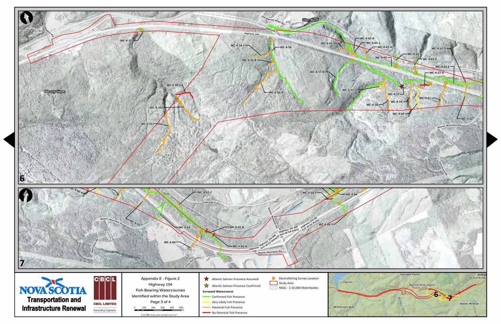
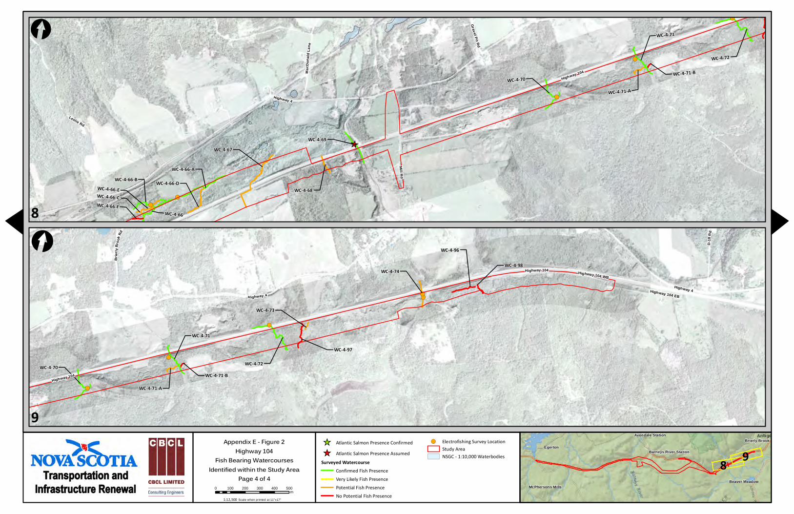
Appendix E - Figure 2Highway 104
Fish Bearing WatercoursesIdentified within the Study Area
Page 1 of 4Scale when printed at 11"x17"

_̂ Atlantic Salmon Presence Confirmed
_̂ Atlantic Salmon Presence Assumed
Surveyed WatercourseConfirmed Fish Presence
Very Likely Fish Presence
Potential Fish Presence
No Potential Fish Presence
!( Electrofishing Survey LocationStudy AreaNSGC - 1:10,000 Waterbodies
EgertonBrierly Brook
Beaver MeadowMcPhersons Mills
Avondale Station
Barneys River Station
!(
!(
!(
!(!(
!(!(!(
!(!(
!(!(
!(!(
!(
!(
!(
!(
!(
!(!(
!(!(!(
_̂_̂
_̂
_̂
WC-4-33-A
WC-4-29
WC-4-95-BWC-4-95-A
WC-4-33 WC-4-40
WC-4-43
WC-4-35-D
WC-4-42WC-4-28
WC-4-95
WC-4-32WC-4-31
WC-4-41-B
WC-4-33-B
WC-4-30
WC-4-33-C
WC-4-35-AWC-4-39
WC-4-34-B
WC-4-35-E
WC-4-36
WC-4-33-E
WC-4-43-A
WC-4-35-B
WC-4-34
WC-4-38
WC-4-34-C
WC-4-33-F
WC-4-41
WC-4-101 WC-4-35
WC-4-31-A
WC-4-37-BWC-4-32-A
WC-4-37
WC-4-33-H
WC-4-33-D
WC-4-41-A
WC-4-40-A
WC-4-31-B
WC-4-34-A
WC-4-33-G
WC-4-36-AWC-4-39-A
WC-4-35-C
WC-4-37-A
Kenzieville
Highway 4
High
way 4
Laggan Rd
Highway 104
ManseRd
Rossfield Rd
Barn
eys R
iverW
est S
ideRd
Weavers Mountain Rd
[
!(
!(
!(!(
WC-4-50
WC-4-43
WC-4-50-EWC-4-50-A
WC-4-51
WC-4-49
WC-4-52
WC-4-53
WC-4-48-BWC-4-48-C
WC-4-44
WC-4-45
WC-4-50-B
WC-4-47
WC-4-54WC-4-50-C
WC-4-46
WC-4-48-A
WC-4-48
WC-4-50-D
Weavers Mountain Rd
4
5
0 100 200 300 400 500m
[
4 51:12,500
Appendix E - Figure 2Highway 104
Fish Bearing WatercoursesIdentified within the Study Area
Page 2 of 4Scale when printed at 11"x17"
_̂ Atlantic Salmon Presence Assumed
_̂ Atlantic Salmon Presence Confirmed
Surveyed WatercourseConfirmed Fish Presence
Very Likely Fish Presence
Potential Fish Presence
No Potential Fish Presence
!( Electrofishing Survey LocationStudy AreaNSGC - 1:10,000 Waterbodies
EgertonBrierly Brook
Beaver MeadowMcPhersons Mills
Avondale Station
Barneys River Station
!(
!(
!(!(!(
!(!(
!(
!(!( !(
!(
!(
!(
!(
!(
!(
_̂
WC-4-102
WC-4-65-G
WC-4-57
WC-4-65 WC-4-65-F
WC-4-61
WC-4-56
WC-4-50-EWC-4-50-A
WC-4-63
WC-4-51
WC-4-58
WC-4-62WC-4-64
WC-4-60
WC-4-55
WC-4-52
WC-4-59
WC-4-65-K
WC-4-53
WC-4-56-B
WC-4-65-D
WC-4-50-B
WC-4-65-EWC-4-57-AWC-4-57-B
WC-4-65-H
WC-4-54
WC-4-50-C
WC-4-57-CWC-4-99
WC-4-56-C WC-4-65-I
WC-4-56-A
WC-4-100
WC-4-50-D
WC-4-65-J
WC-4-65-C
Glen Bard
Marshy Hope
Highway 104
Stra thglass Rd
Beaver Mountain Rd
Pushi
e Rd
Old Marshy Hope Rd
Bouchard Rd
Highway 4
[
!(
!(
!(
!(
!(
!(
!(
!(
!(!(
!(
_̂WC-4-57
WC-4-65-F
WC-4-66-B
WC-4-61
WC-4-63
WC-4-58
WC-4-62
WC-4-64
WC-4-60
WC-4-66
WC-4-59 WC-4-66-EWC-4-66-C
WC-4-65-A
WC-4-65-D
WC-4-65-B
WC-4-65-EWC-4-57-A
WC-4-57-C
WC-4-66-D
WC-4-66-FWC-4-65-C WC-4-66
Grant R
d
Beaver Meadow Rd
Highway 104 WB
Exit 30 Off Ramp Highway 104 EB
Exit 30 On Ramp
Highway 104 WB
Exit 30 On Ramp
Bouc
hard
Rd
Highway104
Beaver Mountain Rd
Beaver Mountain Rd
Highway 4
6
7
0 100 200 300 400 500m
[
6 71:12,500
Appendix E - Figure 2Highway 104
Fish Bearing WatercoursesIdentified within the Study Area
Page 3 of 4Scale when printed at 11"x17"
!(!(
!(
!(
!(WC-4-72
WC-4-73
WC-4-70
WC-4-74
WC-4-71
WC-4-98
WC-4-71-A
WC-4-97
WC-4-71-B
WC-4-96
D -18
Rd
Highway 104
Brier
lyB r
o ok R
d
Highway 4
Highway 104 WB
Highway 104 EBHighway 4
Highway 104
_̂ Atlantic Salmon Presence Confirmed
_̂ Atlantic Salmon Presence Assumed
Surveyed WatercourseConfirmed Fish Presence
Very Likely Fish Presence
Potential Fish Presence
No Potential Fish Presence
!( Electrofishing Survey LocationStudy AreaNSGC - 1:10,000 Waterbodies
EgertonBrierly Brook
Beaver MeadowMcPhersons Mills
Avondale Station
Barneys River Station
!(
!(
!(
!(
!(
!(
_̂WC-4-69
WC-4-72
WC-4-66-BWC-4-66-A
WC-4-70
WC-4-71
WC-4-67
WC-4-66-EWC-4-66-C
WC-4-71-A
WC-4-68
WC-4-97
WC-4-66-D
WC-4-71-B
WC-4-66-FWC-4-66
Highway 4
Gravel Pit Rd
Mill Rd
M ac D
onald
Lan e
Highway 104
Leslie Rd
[
8
9
0 100 200 300 400 500m
[
8 9
Scale when printed at 11"x17"
Appendix E - Figure 2Highway 104
Fish Bearing WatercoursesIdentified within the Study Area
Page 4 of 41:12,500

Baileys Brook
Shore Direct
French R.(Pic Co)
Shore Direct
Shore Direct
Sutherland R.South
R.
Shore Direct
ShoreDirect
St. Mary's R.
Russell Brook
Barneys R.
KnoydartBrk.Shore Direct
Rights River
West R.
ShoreDirect
Shore Direct
[0 1 2 3 4km
Study Area
NSGC - 1: 10 000 Waterbodies
NSGC - 1: 10 000 Rivers/ Streams
Primary Watershed Boundary
Secondary Watershed Boundary
Primary Watershed: Defining RiverFrench River
South River and West River
St. Marys River
West Branch French River
James River
West Barneys River Middle BrookMclver Brook Hartshorn Brook
East Branch French RiverBrowning Brook
Baxter Brook
Russell Brook
Appendix E - Figure 3Highway 104
Watersheds and Named Watercourses Overlapping the Study Area
Page 1 of 1Scale when printed at 11"x17"1:100,000