appendix b biological reconnaissance survey and ceqa analysis
TRANSCRIPT

APPENDIX B
Biological Reconnaissance Survey and CEQA Analysis

This page intentionally left blank.

Report of Findings
Biological Resources Reconnaissance Survey and CEQA Analysis
Minturn Huller Cooperative Project Location: 9080 South Minturn Road Chowchilla, CA 95610 37°10′13.10″ N, 120°18′41.88″ W Permit Sought: Major Modification No. MM12-010
Condition Use Permit No. CUP3678
Prepared for: Environmental Planning Partners, Inc. P.O. Box 627 Sloughhouse, CA 95683 Prepared by: Padre Associates, Inc. 3020 Explorer Drive, Suite 5 Sacramento, CA (916) 857-1601 Dates of Biological Resources Reconnaissance Surveys: December 18, 2012 Date of Report: March 29, 2013

CONTENTS
1 Summary .......................................................................................................................1 2 Introduction....................................................................................................................1
2.1 Purpose of the Study.............................................................................................1 2.2 Applicable Laws and Regulations .........................................................................2 2.3 Project Location ....................................................................................................4 2.4 Project Description ................................................................................................4
3 Methods and Survey Limitations ...................................................................................5 3.1 Methods ................................................................................................................5 3.2 Limitations .............................................................................................................6
4 Survey Results ..............................................................................................................7 4.1 Physical Characteristics ........................................................................................7 4.2 Vegetation and Wildlife .........................................................................................7 4.3 Sensitive Habitats, Special-Status Plants, and Special-Status Wildlfie ................8 4.4 Potentially Jurisdictional Water Resources .........................................................15
5 Project Impact Analysis ...............................................................................................19 5.1 Standards of Significance ...................................................................................19 5.2 Impacts to Biological Resources .........................................................................20
6 References ..................................................................................................................25
TABLES Table 1. Wildlife Species Recorded in Project Vicinity ....................................................9 Table 2. Special-Status Species Reported on the CNDDB, CNPS Inventory, and USFWS Species List for the Matos Dairy Project Area. ................................................ 11 FIGURES Figure 1. Project Location Figure 2. Minturn Huller Facilities Figure 3. Special-status Species Recorded Occurrences Figure 4. NWI Mapped Wetlands


Biological Survey Report 1 Minturn Huller Cooperative Project March 2013 Padre Associates, Inc.
1 SUMMARY
The proposed Minturn Huller project is the expansion of an existing almond hulling and shelling plant located approximately two miles north of the City of Chowchilla in southern unincorporated Merced County. The project site is 100 acres in size and encompasses two parcels: Merced County Assessor’s Parcel Number (APN) 068-190-055 (57.21 acres) and APN 068-190-035 (42.99 acres). The expanded operation would include an additional hammer mill, a commodity barn, a new office, auger lines, and a byproduct storage area. The almond processing plant would involve an additional 61,003 square feet (ft2) of new construction, increasing the project from its current size of 42,690 ft2 to 103,693 ft2. Approximately 3.2 acres of land currently in cropland would be converted for the expansion. All new construction would occur on APN 068-190-055.
A reconnaissance-level biological survey was conducted on December 18, 2012 by biologists from Padre Associates, Inc. (Padre). A number of special-status species, including California tiger salamander (Ambystoma californiense), vernal pool tadpole shrimp (Lepidurus packardi), valley elderberry longhorn beetle (Desmocerus californicus dimorphus), and Sacramento Valley Orcutt grass (Orcuttia inaequalis) have been reported within approximately five miles of the Minturn Huller facility. Other raptors and migratory birds are known to forage in the area, and ground-nesting birds could be disturbed by the project if precautions are not taken as outlined in the Recommendations section.
2 INTRODUCTION
2.1 PURPOSE OF THE STUDY
The purpose of this report is to describe the findings of a biological resources reconnaissance survey and California Environmental Quality Act (CEQA) Analysis conducted for the Minturn Huller Cooperative Expansion Project in Merced County, California. The Biological Reconnaissance Survey was conducted December 18, 2012 to describe and map biological resources at the project site and surrounding areas, and determine whether suitable habitat is present for special-status or sensitive species. The CEQA Analysis included a review of current biological resource databases, previous studies, and current conditions to evaluate the project’s potential impact to biological resources pursuant to CEQA standards.

Biological Survey Report 2 Minturn Huller Cooperative Project March 2013 Padre Associates, Inc.
2.2 APPLICABLE LAWS AND REGULATIONS
Relevant federal, state, and local regulations that govern the biological resources of the project area are briefly explained in this section.
SPECIAL-STATUS PLANT AND WILDLIFE SPECIES
According to CEQA Guidelines §15380, a special-status species is a plant or animal species that is:
• Listed endangered, threatened, or a candidate species under the federal Endangered Species Act (FESA);
• Listed endangered, threatened, or a candidate species under the California Endangered Species Act (CESA);
• Listed as a species of special concern by the California Department of Fish and Wildlife (CDFW), formerly the California Department of Fish and Game, or the Department of Forestry (CDF);
• A plant species that is on the California Native Plant Society’s (CNPS) List 1; and/or • Considered rare, threatened, or endangered under CEQA Guidelines 15380(d) as
the species survival is in jeopardy due to loss or change in habitat. In addition, species protected by specific federal or state acts or local ordinances are considered special-status species.
FEDERAL
Endangered Species Act: FESA was passed to protect species threatened with extinction and provides measures to prevent and alleviate the loss of species and their habitats. The FESA prohibits take of a listed species, as well as trade in endangered or threatened species. If potential exists for a proposed project to adversely affect federally listed, proposed, or candidate species, then consultation with the U.S. Fish and Wildlife Service (USFWS) and/or National Marine Fisheries Service (NMFS) is required.
If there is no federal involvement in a proposed project, the applicant must consult with USFWS and/or NMFS under Section 10 of the FESA. Section 10 of the FESA allows USFWS and/or NMFS to issue a permit for take of a listed species incidental to, and not for the purpose of, carrying out an otherwise lawful activity. The action may not jeopardize the continued existence of a listed species or its critical habitat. A Habitat Conservation Plan (HCP) must be prepared and approved by USFWS prior to issuing a permit under Section 10.
Migratory Bird Treaty Act (MBTA) of 1918. The MBTA protects migratory birds and their nests. Under the Act, it is unlawful to take, import, export, possess, buy, sell,

Biological Survey Report 3 Minturn Huller Cooperative Project March 2013 Padre Associates, Inc.
purchase, or barter any migratory bird. Feathers or other parts, nests, eggs, and products made from migratory birds are also covered by the MBTA. Take is defined as pursuing, hunting, shooting, poisoning, wounding, killing, capturing, trapping, or collecting.
Section 404 of the Clean Water Act. The U.S. Army Corps of Engineers (ACOE) and the U. S. Environmental Protection Agency (EPA) regulate the discharge of dredge and fill material into jurisdictional “waters of the United States” (WoUS) and wetlands under Section 404 of the Clean Water Act.
STATE OF CALIFORNIA
California Endangered Species Act. CESA was enacted to protect fish, wildlife, and plant species in danger of, or threatened with, extinction in the State of California (Fish and Game Code §2051). CESA prohibits “take” of a state-listed species. Take is defined as “hunt, pursue, catch, capture, or kill or attempt to hunt, pursue, catch, capture, or kill” (Fish and Game Code §86).
Unlawful Destruction of Nest or Eggs, Fish and Game Code Section 3503. This section of the California Fish and Game Code prohibits the take, possession or needless destruction of nests or eggs of birds.
Fully Protected Species, Fish and Game Code Sections 3511, 4700, 5050, and 5515. This section of the California Fish and Game Code provides particular and special state protection to a list of 37 wildlife species and prohibits take or possession “at any time” with few exceptions and the CDFW cannot authorize incidental take of fully protected species.
Migratory Bird Treaty Act, Fish and Game Code Section 3513. This section of the California Fish and Game Code complies with and strengthens state support for the MBTA. The section makes it unlawful to take or possess any nongame migratory bird or part of any such migratory nongame bird except under the special provisions in the federal MBTA.
Section 1600 Lake/Streambed Alteration Agreement (LSAA). The CDFW also regulates activities that may impact streambeds or other wetland areas. Completion of a Section 1601-03 LSAA with the CDFW is required before any work begins that will affect jurisdictional wetland areas.

Biological Survey Report 4 Minturn Huller Cooperative Project March 2013 Padre Associates, Inc.
MERCED COUNTY
Merced County Regulations The unincorporated lands of Merced County fall under the jurisdiction of the county. The Open Space/Conservation Element of the Merced County Year 2000 General Plan contains goals, objectives, and policies pertaining to biological resources of Merced County (Merced County, 1990). Those goals, objectives and policies that are relevant to biological resources are presented below:
GOAL 1: Habitats which support rare, endangered or threatened species are not substantially degraded.
Objective 1A: Rare and endangered species are protected from urban development and are recognized in rural areas.
Objective 1B: Local, State and Federally managed lands are recognized.
The Merced County Year 2000 General Plan also contains an Open Space Action Plan (OSAP) referred to in Policy 3 above). The OSAP contains a series of Sensitive Resource Mitigation Principle’s, which “define goals for sensitive wetland, wildlife and vegetation resource mitigation measures and how to select appropriate measures for individual projects and to provide guidelines for successful implementation of those measures.” The OSAP also contains recognition of the need for long-term monitoring to measure the effectiveness of various approaches to mitigation for biological resources and sensitive habitats.
2.3 PROJECT LOCATION
The existing Minturn Huller Cooperative project is located two miles north of the City of Chowchilla and 4.5 miles southwest of the community of Le Grand in southern unincorporated Merced County (Figure 1). The project site is 100 acres on two parcels identified as APN 068-190-055 (57.21 acres) and APN 068-190-035 (42.99 acres). The Minturn Huller Cooperative also stockpiles unprocessed almonds on 51.42 acres of APN 068-190-056 under a rental agreement with the adjacent landowner. The facility is located in Section 7, Township 18 South, Range 16 East, Mount Diablo Base and Meridian (37°10!13.10"N, 120°18!41.88"W) in the Le Grand 7.5-minute U.S. Geological Survey (USGS) quadrangle.
2.4 PROJECT DESCRIPTION
The Minturn Huller Cooperative, Inc. is an almond processing facility that provides hulling and shelling services to orchard growers with the San Joaquin Valley. In operation since 1966, the existing 43,690 ft2 almond hulling and shelling facility includes

Biological Survey Report 5 Minturn Huller Cooperative Project March 2013 Padre Associates, Inc.
five buildings, a hammer mill, commodity barn, a scale, and an auger line to convey almond hulls to storage areas (Figure 2). The existing buildings include two almond hulling and shelling processing plants, one office building, a shop building, and one warehouse barn. Ancillary facilities include a water storage tank, fuel tanks, a 540-kilowatt solar panel station, a storm water detention basin, two open detention ditches, and various truck stage and parking areas. There are also covered and uncovered storage piles of almond hulls.
The expanded operation would include an additional hammer mill, a commodity barn, a new office, auger lines, and a new byproduct storage area. The almond processing plant would involve an additional 61,003 square feet (ft2) of new construction, increasing the amount of structures from its current size of 42,690 ft2 to 103,693 ft2. Approximately 3.2 acres of land currently in crop production will be converted to a new use. All new construction would occur on APN 068-190-055.
3 METHODS AND SURVEY LIMITATIONS
3.1 METHODS
Padre Associates, Inc. (Padre) evaluated the potential biological resources impacts of the Minturn Huller Expansion project through a review of available data and a site visit. Prior to the site visit, Padre conducted a query of California Natural Diversity Database (CNDDB) for the USGS topographic quadrangle for the project area (Le Grand) and for the surrounding eight quadrangles (Plainsburg, Raynor Creek, Chowchilla, Berenda, Kismet, Planada, Owens Reservoir, and Illinois Hill (CDFG, 2012a). The CNDDB record search reports list sensitive species and habitat locations, and provide specific information (e.g., state and federal protection status; global and state rank; CDFW listing status; rare plant status; specific location data; existence status; dates last observed; habitat preferences and other notes) for each recorded occurrence (Figure 3).
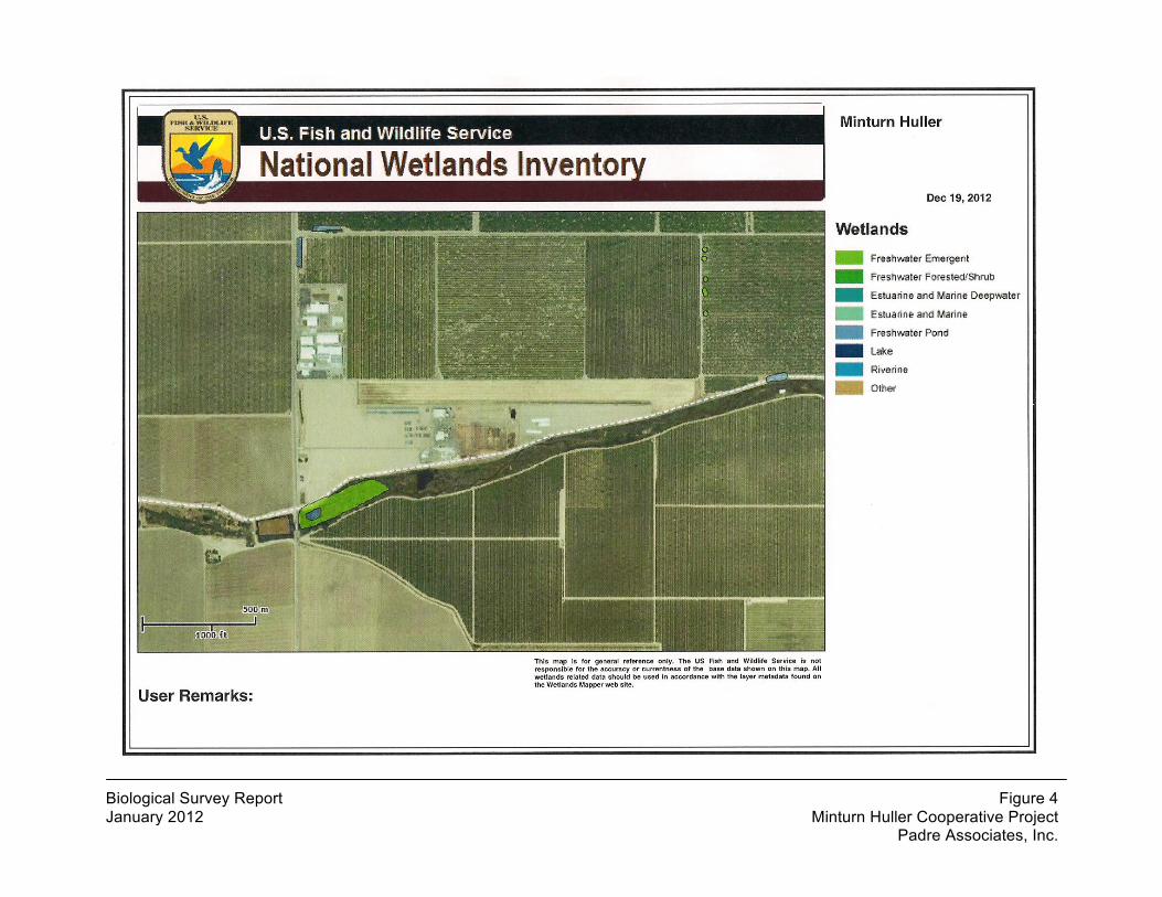
Padre also conducted a query of the California Native Plant Society’s Electronic Inventory (CNPS, 2012) for the same quadrangles to provide information on additional plant species of concern that may occur within the project site and surrounding vicinity. A species list was obtained from the USFWS website for the LeGrand quadrangle to provide information on species of concern to the federal agency that have the potential to occur in the vicinity of the proposed project. A query of the USFWS National Wetland Inventory (NWI) Map for the LeGrand quadrangle was conducted for information regarding known wetlands in the project area (Figure 4).
The results of the database search and location analysis were used to determine: a) if any sensitive resources had been previously reported within or in the immediate local
Biological Survey Report 6 Minturn Huller Cooperative Project March 2013 Padre Associates, Inc.
vicinity of the Minturn facility; and b) what sensitive biological resources should be specifically searched for during the biological reconnaissance survey. Only those species with the potential to occur on the project site were given consideration in this report.
Padre conducted a biological reconnaissance survey of the project area on December 18, 2012. The purpose of the survey was to characterize general biological resources supported by the project site and evaluate the potential for sensitive biological resources to occur on the site and be affected by implementation of the proposed project. The surveys included evaluating primary vegetation cover types, a general assessment of habitat suitability for known local wildlife, and recording observed plant and animal species (Table 1). The December 18, 2012 survey was conducted during the day between 1:00 pm and 3:00 pm. The weather was clear with a temperature of 56o F. Wind was strong at 11 mph with gusts to 20 mph. The reconnaissance survey investigated the entire site, including on-foot evaluations of principal facilities and visual surveys of cropped fields from the vehicle on perimeter roads. Berms along roadsides and all culverts found by the biologists during the reconnaissance surveys were checked for sign of use by the western burrowing owl (Athene cunicularia) and/or San Joaquin kit fox (Vulpes macrotis mutica). Dominant flora and fauna were noted and identified to the lowest possible taxon.
3.2 LIMITATIONS
The reconnaissance-level field survey was conducted in late fall, beyond the blooming period for plant species. The survey was conducted at a reconnaissance level, not a focused or protocol survey level. The survey lasted approximately two hours in mid-afternoon and, therefore, did not include dawn or dusk surveys or extended observations. Also, the site was an active operation and pre-disturbance baseline conditions could not be assessed.

Biological Survey Report 7 Minturn Huller Cooperative Project March 2013 Padre Associates, Inc.
4 SURVEY RESULTS
4.1 PHYSICAL CHARACTERISTICS
The existing Minturn Hulling Cooperative is located on a 100-acre site in an unincorporated area of Merced County. Operations occur within a relatively flat and partially graded area on bare and exposed soil within an undeveloped site. The existing facility contains five structures and numerous ancillary facilities. Environmental infrastructure on site includes storm water detention ponds and drains.
4.2 VEGETATION AND WILDLIFE
Almost the entire facility is devoid of vegetation. The exception is the cropland along the northern perimeter, which, in addition to the agricultural grain crop, had a perimeter comprised of weedy ruderal species including telegraphweed (Heteortheca grandiflora), dove weed (Croton setigerus), Russian thistle (Salsola tragus), redstem filaree (Erodium cicutarium), and black mustard (Brassica nigra). The remainder of the site was for storage piles and processing facilities. Some standing water was observed in the graded, flat processing area due to recent rains, and a storm water detention pond occurs on the site. The Chowchilla River borders the southern perimeter of the site. Broadleaf cattail (Typha latifolia) and red willow (Salix laevigata) occurred along entire width of channel.
As shown in Table 1, wildlife species observed near the facility and in the cropland on the site included American pipit (Anthus rubescens), white-tailed kite (Elanus leucurus), killdeer (Charadrius vociferus), American crow (Corvus brachyrhynchos), house finch (Haemorhous mexicanus), black-tailed hare (Lepus californicus), and others. No ground squirrel colonies or other burrows were observed.
The climate in the project vicinity is hot and dry in the summer, and cold and moist in the winter. Between winter rains are periods of cloudy, foggy or sunny weather. The average winter temperature is 47o F and the average daily maximum temperature during the summer is 95o F (www.weatherunderground.com). The primary soil types on the site are Madera sandy loam, Marguerite loam, Pachappa fine sandy loam, Traver fine sandy loam, and Tujunga loamy sand.
The entire site is managed as an active almond processing facility. No trees are within the portion of the project area, and no ground nests were observed during the December 2012 survey.

Biological Survey Report 8 Minturn Huller Cooperative Project March 2013 Padre Associates, Inc.
Table 1 Wildlife Species Recorded in Project Vicinity Common Name Latin Name
Birds
Western meadowlark Stenella neglecta
Killdeer Charadrius vociferus
Mourning dove Zenaida macroura
White-tailed kite Elanus leucurus
American pipit Anthus rubescens
American crow Corvus brachyrhynchos
House finch Haemorhous mexicanus
Mammals
Black-tailed hare Lepus californicus
4.3 SENSITIVE HABITATS, SPECIAL-STATUS PLANTS, AND SPECIAL-STATUS WILDLIFE
A list of special-status plant and animal species that historically occurred in the vicinity of the project site and vicinity was compiled based on the following:
• A review of previous studies; • Informal consultation with the USFWS via its USFWS internet site
(http://www.fws.gov/sacramento/es/spp_lists/auto_list_form.cfm); and • Queries of the CDFW’s California Natural Diversity Database (CNDDB) and
California Native Plant Society (CNPS) Inventory of Rare and Endangered Plants database (CDFG, 2012; CNPS, 2012).
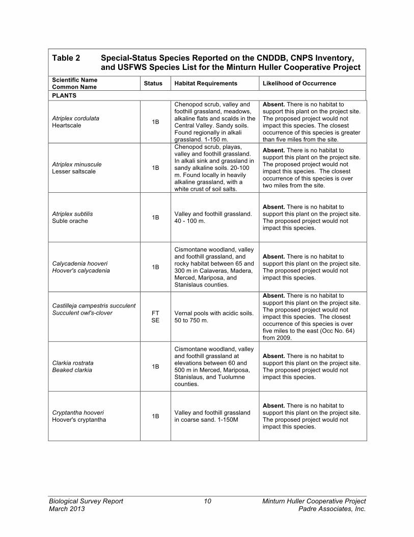
To determine what special-status species occurred in the vicinity of the project area, the CNDDB was queried spatially within a five-mile radius around the project site. Species recorded within 10 miles that may occur in similar habitat were also included in the analyses. The resulting species’ occurrences are mapped in Figure 3. The species identified from these data sources were further assessed for their potential to occur within the project site based upon previously documented occurrences, their habitat requirements, and the quality and extent of any available habitat within the site. The summary of this analysis is presented in Table 2.
The CNDDB and CNPS lists for the nine quadrangle area and the USFWS Species List for the Le Grand quadrangle, identified one natural community, 17 special-status plants, and 20 special-status wildlife species (four invertebrates, two fishes, three amphibians, three reptiles, five birds, and three mammals) (Table 2 and Figure 3).
Sensitive natural communities are those that are considered rare within the region, support sensitive plant and/or wildlife species, or function as corridors for wildlife

Biological Survey Report 9 Minturn Huller Cooperative Project March 2013 Padre Associates, Inc.
movement. The sensitive natural community recorded in the area (Northern Hardpan Vernal Pool) does not occur on the project site or in the immediate vicinity of the project site. However, this sensitive community occurs at the Merced National Wildlife Refuge is located approximately 15 miles to the west.
Neither special-status plants nor habitat that would support special-status plants occur on the project site. The entire site is or was in the recent past managed as an almond processing facility.
Special-status wildlife species that may occur on the site from time to time. The San Joaquin kit fox is known to occur at the Merced National Wildlife Refuge, which is approximately 15 miles from the site, and the San Luis National Wildlife Refuge, which is 27 miles west of the site. The closest occurrence to the project site is within five miles. No sign of San Joaquin kit fox was observed, but they may occur onsite as transient foragers. Although no burrows were observed, it is likely that the project site could support small mammals that provide prey for San Joaquin kit fox. Agricultural access roads open or fallow fields, and irrigation ditches and canals provide an important corridor for the movements of these mammals. There was no vernal pool habitat that could support listed vernal pool invertebrates observed during the reconnaissance survey.
The project site may provide occasional foraging opportunities for a number of additional sensitive wildlife species including various species or raptors and migratory birds that are protected by the Migratory Bird Treaty Act.
Biological Survey Report 10 Minturn Huller Cooperative Project March 2013 Padre Associates, Inc.
Table 2 Special-Status Species Reported on the CNDDB, CNPS Inventory, and USFWS Species List for the Minturn Huller Cooperative Project
Scientific Name Common Name Status Habitat Requirements Likelihood of Occurrence
PLANTS
Atriplex cordulata Heartscale 1B
Chenopod scrub, valley and foothill grassland, meadows, alkaline flats and scalds in the Central Valley. Sandy soils. Found regionally in alkali grassland. 1-150 m.
Absent. There is no habitat to support this plant on the project site. The proposed project would not impact this species. The closest occurrence of this species is greater than five miles from the site.
Atriplex minuscule Lesser saltscale 1B
Chenopod scrub, playas, valley and foothill grassland. In alkali sink and grassland in sandy alkaline soils. 20-100 m. Found locally in heavily alkaline grassland, with a white crust of soil salts.
Absent. There is no habitat to support this plant on the project site. The proposed project would not impact this species. The closest occurrence of this species is over two miles from the site.
Atriplex subtilis Suble orache 1B Valley and foothill grassland.
40 - 100 m.
Absent. There is no habitat to support this plant on the project site. The proposed project would not impact this species.
Calycadenia hooveri Hoover's calycadenia 1B
Cismontane woodland, valley and foothill grassland, and rocky habitat between 65 and 300 m in Calaveras, Madera, Merced, Mariposa, and Stanislaus counties.
Absent. There is no habitat to support this plant on the project site. The proposed project would not impact this species.
Castilleja campestris succulent Succulent owl's-clover
FT SE
Vernal pools with acidic soils. 50 to 750 m.
Absent. There is no habitat to support this plant on the project site. The proposed project would not impact this species. The closest occurrence of this species is over five miles to the east (Occ No. 64) from 2009.
Clarkia rostrata Beaked clarkia 1B
Cismontane woodland, valley and foothill grassland at elevations between 60 and 500 m in Merced, Mariposa, Stanislaus, and Tuolumne counties.
Absent. There is no habitat to support this plant on the project site. The proposed project would not impact this species.
Cryptantha hooveri Hoover's cryptantha 1B Valley and foothill grassland
in coarse sand. 1-150M
Absent. There is no habitat to support this plant on the project site. The proposed project would not impact this species.

Biological Survey Report 11 Minturn Huller Cooperative Project March 2013 Padre Associates, Inc.
Table 2 Special-Status Species Reported on the CNDDB, CNPS Inventory, and USFWS Species List for the Minturn Huller Cooperative Project
Scientific Name Common Name Status Habitat Requirements Likelihood of Occurrence
Delphinium recurvatum Recurved larkspur 1B
Chenopod scrub, valley and foothill grassland, cismontane woodland. On alkaline soils; often in valley saltbush or valley chenopod scrub. Found regionally in slightly alkaline beds of vernal pools. 3-685M.
Absent. There is no habitat to support this plant on the project site. The proposed project would not impact this species.
Eryngium recemosum Delta button-celery SE 1B
Riparian scrub in vernally mesic clay depressions. 3 to 30 m.
Absent. There is no habitat to support this plant on the project site. The proposed project would not impact this species. The closest occurrence of this species is 18 miles to the west (Occ. No. 17) from 1999.
Eryngium spinosepalum Spiny-sepaled button-celery 1B Valley/foothill grassland,
Vernal pool. 80 to 255 m.
Absent. There is no habitat to support this plant on the project site. The proposed project would not impact this species.
Navarretia nigelliformis radians Shining navarretia 1B
Cismontane woodland, valley/foothill grasslands, vernal pools. 76 to 1,000 m.
Absent. There is no habitat to support this plant on the project site. The proposed project would not impact this species.
Neostapfia colusana Colusa grass FT SE
Vernal pools. Usually in large or deep vernal pool bottoms with adobe soils. Found regionally in pools surrounded by valley grassland. Also found on strongly saline Lewis loam, surrounded by non-native grassland.
Absent. There is no habitat to support this plant on the project site. The proposed project would not impact this species. The closest occurrence is 12 miles northwest of the project site. The occurrence was from 2009 (Occ. No. 39).
Orcuttia inaequalis San Joaquin Valley Orcutt grass
FT SE Vernal pools. 10 to 755 m.
Absent. There is no habitat to support this plant on the project site. Closest occurrence is within two miles of project site. The proposed project would not impact this species.
Orcuttia pilosa Hairy Orcutt grass FE SE Vernal pools. 46 to 200 m.
Absent. There is no habitat to support this plant on the project site. The proposed project would not impact this species. The closest occurrence of this species is over 15 miles to the southeast of the project site. The occurrence was from 1987 (Occ. No. 9).
Phacelia ciliate opaca Merced phacelia 1B Valley/foothill grasslands on
alkaline soils. 60 to 150 m.
Absent. There is no habitat to support this plant on the project site. The proposed project would not impact this species.
Sagittaria sanfordii Sanford's arrowhead 1B
Marshes and swamps. In standing or slow-moving freshwater ponds, marshes and ditches. 0-610 m.
Absent. There is no habitat to support this plant on the project site. The proposed project would not impact this species. The closest occurrence of this species is five miles southeast of the site.

Biological Survey Report 12 Minturn Huller Cooperative Project March 2013 Padre Associates, Inc.
Table 2 Special-Status Species Reported on the CNDDB, CNPS Inventory, and USFWS Species List for the Minturn Huller Cooperative Project
Scientific Name Common Name Status Habitat Requirements Likelihood of Occurrence
Tuctoria greenei Greene's tuctoria FE SR Vernal pools. 30 to 1,070 m.
Absent. There is no habitat to support this plant on the project site. Closest occurrence is 4.5 miles east of the project site (Occ. No. 13). The occurrence was from 1986. The proposed project would not impact this species.
SPECIAL STATUS INVERTEBRATES
Branchinecta conservatio Conservancy fairy shrimp FE
Endemic to the grasslands of the northern two-thirds of the central valley; found in large, turbid pools. Regionally inhabits astatic pools located in swales formed by old, braided alluvium, filled by winter/spring rains and lasting until June.
Absent. There is no habitat to support this species on the project site. The proposed project would not impact this species. The closest occurrence of this species is two miles south of the site.
Branchinecta lynchi Vernal pool fairy shrimp FT
Endemic to the grasslands of the central valley, central coast mountains and south coast mountains, in astatic rain-filled pools. Regionally inhabits small, clear-water sandstone depression pools and grassed swale, earth slump or basalt-flow depression pools.
Absent. There is no habitat to support this species on the project site. The proposed project would not impact this species. The closest occurrence of this species is three miles south of the site.
Lepidurus packardi Vernal pool tadpole shrimp FE
Inhabits vernal pools and swales in the Sacramento Valley containing clear to highly turbid water. Pools commonly found in grass bottomed swales of unplowed grasslands. Some pools are mud bottomed and highly turbid.
Absent. There is no habitat to support this species on the project site. The proposed project would not impact this species. The closest occurrence of this species is two miles from the site.
Desmocerus californicus dimorphus Valley elderberry longhorn beetle
FT
Occurrences of the VELB are primarily in the vicinity of moist valley oak woodlands associated with riparian corridors in the lower Sacramento River and upper San Joaquin River drainages (U.S. Fish and Wildlife Service, 1984). Elderberry plants are obligate hosts for the VELB, providing a source of food and broodwood.
Absent. There is no habitat to support this species on the project site. The proposed project would not impact this species. The closest occurrence of this species is two miles from the site.

Biological Survey Report 13 Minturn Huller Cooperative Project March 2013 Padre Associates, Inc.
Table 2 Special-Status Species Reported on the CNDDB, CNPS Inventory, and USFWS Species List for the Minturn Huller Cooperative Project
Scientific Name Common Name Status Habitat Requirements Likelihood of Occurrence
SPECIAL STATUS FISH
Oncorhynchus mykiss Central Valley steelhead and Critical Habitat
FT
Sacramento and San Joaquin River systems, Sacramento-San Joaquin Delta, and San Francisco Bay
Absent. There is no habitat to support this species on the project site. The proposed project would not impact this species.
Hypomesus transpacificus Delta smelt FT
Endemic to the upper Sacramento/San Joaquin Delta, it mainly inhabits the freshwater-saltwater mixing zone of the estuary, except during its spawning season, when in moves into freshwater during the early spring months from March until May.
Absent. There is no habitat to support this species on the project site. The proposed project would not impact this species.
SPECIAL STATUS AMPHIBIANS
Ambystoma californiense California tiger salamander FT CSC
Needs underground refuges, especially ground squirrel burrows and vernal pools or other seasonal water sources for breeding.
Absent. There is no habitat to support this species on the project site. The proposed project would not impact this species. The closest occurrence of this species is 3.5 miles east of the project site (Occ. 307). The occurrence was from 1994.
Rana draytonii California red-legged frog FT CSC
Found in marshes, lakes, reservoirs, ponds, slow parts of streams, and other usually permanent water in lowlands, foothill woodlands and grasslands. Require areas with extensive emergent vegetation. High value habitats are deep-water ponds with dense stands of overhanging willows and a fringe of cattails
Absent. There is no habitat to support this species on the project site. The proposed project would not impact this species. The closest occurrence is 40 miles west of the project site (Occ. No. 901). The occurrence was from 1985.
Spea hammondii Western spadefoot toad CSC
Occurs primarily in grassland habitats; can be found in valley foothill hardwood woodlands. Vernal pools are essential for breeding and egg laying.
Absent. There is no habitat to support this species on the project site. The proposed project would not impact this species. The closest occurrence of this species is three miles from the site.
SPECIAL STATUS REPTILES
Emys (=Clemmys) marmorata Western pond turtle CSC
Ponds, marshes, rivers, streams and irrigation ditches with aquatic vegetation. Needs basking sites and suitable upland habitat (sandy banks or grassy open fields) for egg laying.
Absent. There is no habitat to support this species on the project site. The proposed project would not impact this species. The closest occurrence of this species is 3.5 miles west of the site.

Biological Survey Report 14 Minturn Huller Cooperative Project March 2013 Padre Associates, Inc.
Table 2 Special-Status Species Reported on the CNDDB, CNPS Inventory, and USFWS Species List for the Minturn Huller Cooperative Project
Scientific Name Common Name Status Habitat Requirements Likelihood of Occurrence
Gambelia sila Blunt-nosed leopard lizard FE SE
Resident of sparsely vegetated alkali and desert scrub habitats, in areas of low topographic relief. Seeks cover in mammal burrows, under shrubs or structures.
Absent. There is no habitat to support this species on the project site. The closest occurrence is 14 miles west of the project site (Occ. No. 116). The occurrence was from 1991.
Thamnophis gigas Giant garter snake FT ST
Freshwater marshes and streams. Has adapted to drainage canals and irrigation ditches.
Absent. There is no habitat to support this species on the project site. The proposed project would not impact this species. The closest recent occurrence of this species is 19 miles west of the project site. The occurrence was from 2001 (Occ. No. 161).
SPECIAL STATUS BIRDS
Haliaeetus leucocephalus Bald eagle SE
It is associated with permanent water sources including lakes, reservoirs, and large free-flowing rivers with abundant fish and nearby old-growth trees or snags in mixed stands for perching, roosting, and nesting. It roosts communally in winter in dense, sheltered, remote conifer stands in proximity to feeding areas.
Absent. There is no habitat to support this species on the project site. The proposed project would not impact this species.
Athene cunicularia Western burrowing owl CSC
Uses burrow sites in open, dry annual or perennial grasslands, deserts and scrublands characterized by low-growing vegetation.
Absent. There is no habitat to support this species on the project site. The proposed project would not impact this species.
Buteo swainsoni Swainson's hawk ST
Breeds in stands with few trees in juniper-sage flats, riparian areas and in oak savannah. Requires adjacent suitable foraging areas such as grasslands, or alfalfa or grain fields supporting rodent populations.
Possible foraging. Although this species was not observed during field surveys, and there is no nesting habitat onsite, this species has been recorded within 4.75 miles of the project site.
Buteo regalis Ferruginous hawk BCC
The Ferruginous hawk is an uncommon winter resident and migrant on the Modoc Plateau, Central Valley and Coast Ranges but does not breed in California (Zeiner et al., 1990a). Foraging habitats include open, dry terrain such as grasslands and scrub habitats
Absent. There is no habitat to support this species on the project site. The proposed project would not impact this species.

Biological Survey Report 15 Minturn Huller Cooperative Project March 2013 Padre Associates, Inc.
Table 2 Special-Status Species Reported on the CNDDB, CNPS Inventory, and USFWS Species List for the Minturn Huller Cooperative Project
Scientific Name Common Name Status Habitat Requirements Likelihood of Occurrence
Falco columbarius Merlin
CDFW Watch
Found along sea coast, tidal estuaries, open woodlands, savannas, edges of grasslands and deserts, and farms and ranches. Clusters of trees required for roosting in open country.
Absent. There is no habitat to support this species on the project site. The proposed project would not impact this species. Winter resident.
SPECIAL STATUS MAMMALS
Dipodomys nitratoides exilis Fresno kangaroo rat FE
Historically found in grassland and chenopod scrub communities on the San Joaquin Valley floor from the Merced River to the north and Tulare Lake to the south.
Absent. There is no habitat to support this species on the project site. The nearest occurrence is 17 miles south of the project site. The occurrence is from 1934 (Occ. No. 22).
Vulpes macrotis mutica San Joaquin kit fox FE ST
Annual grasslands or grassy open stages with scattered shrubby vegetation. Need loose-textured sandy soils for burrowing and suitable prey base.
Unlikely. This species or its sign (burrows, tracks, scat) were not observed during field surveys. The closest known records are from over five miles north of the site (Occ. No. 24) from 2001. This species may occur occasionally as a transient, but is not expected to den onsite. The proposed project would not significantly impact this species.
Taxidea taxus American badger CSC
Most abundant in drier open stages of most shrub, forest and herbaceous habitats, with friable soils. Need sufficient food, friable soils and open, uncultivated ground.
Unlikely. This species or its sign (burrows, tracks, scat) were not observed during field surveys. The closest known record is from 1986 (Occ. No. 88) from approximately 11 miles to the south of the site. This species may occur occasionally as a transient, but is not expected to den onsite. The proposed project would not significantly impact this species.
4.4 POTENTIALLY JURISDICTIONAL WATERS/WETLANDS
At the time of the reconnaissance survey, the site had standing water on developed area from recent rains. No potentially jurisdictional wetlands or WoUS were observed on site due to the extensive ground disturbance. However, the NWI map depicts wetlands within the Chowchilla River channel at the southern boundary of the project site.

Biological Survey Report 16 Minturn Huller Cooperative Project March 2013 Padre Associates, Inc.
5 PROJECT IMPACT ANALYSIS
Approval of the Minturn Huller Cooperative project would permit the expansion of the projects structures from its current footprint of 42,690 ft2 to 103,693 ft2 on a 57.21 acre parcel. However, all the areas proposed for expansion would occur within previously disturbed areas that were used for hull storage or for agricultural production. An approximately 3.2 acre cropland area would be converted to hull storage.
5.1 STANDARDS OF SIGNIFICANCE
State CEQA Guidelines and standard professional practice determine whether the Minturn Huller Cooperative expansion project would have a significant environmental effect. The project would have a significant impact on biological resources if it would:
• Result in a substantial adverse effect, either directly or through habitat modification, on any species identified as a candidate, sensitive or special-status species in local or regional plans, policies, or regulations or by CDFW or USFWS;
• Result in a substantial adverse effect on any riparian habitat or other sensitive natural community identified in local or regional plans, policies, or regulations, or by the CDFW or USWFS;
• Result in a substantial adverse effect on wetlands as defined by the Corps under Section 404 of the Clean Water Act or the Regional Water Quality Control Board under the Porter-Cologne Act through direct removal, filling, hydrological interruption, or other means;
• Interfere substantially with the movement of any native resident or migratory fish or wildlife species or with established native resident or migratory wildlife corridors, or impede the use of native wildlife nursery sites;
• Conflict with any local policies or ordinances protecting biological resources, such as a tree preservation policy or ordinance; or
• Conflict with the provisions of an adopted Habitat Conservation Plan, Natural Community Conservation Plan, or other approved local, regional, or state habitat conservation plan;/
• Result in impacts to biological resources that are individually limited, but cumulatively considerable (i.e., the incremental effects of the project are considerable when viewed in connection with the effects of past projects, the effects of other current projects, and the effects of probable future projects).

Biological Survey Report 17 Minturn Huller Cooperative Project March 2013 Padre Associates, Inc.
5.2 IMPACTS TO BIOLOGICAL RESOURCES
Special-Status Species
Plants The likelihood of occurrence of special-status plant species at the site is considered extremely low due to a lack of suitable habitat and ongoing intensive hulling operations (Figure 2). Approval of the Minturn Hulling Expansion project is expected to have less than significant impacts to special-status plants. (No impact)
Wildlife Nesting Birds Throughout Merced County, the conversion of land for agricultural development is resulting in a cumulative and significant loss of foraging and nesting habitat for some special-status and migratory birds. The conversion of 3.2 acres of cropland for the expansion contributes to that cumulative loss. This loss of habitat is cumulatively significant, unavoidable, and unmitigable. The facility potentially provides foraging habitat for a variety of special-status and migratory bird species.
Suitable habitat for ground nesting birds, such as northern harrier, short-eared owl, and horned lark is limited and only expected along the edges of the property. (Potentially significant)
Recommended Mitigation:
To reduce project related impacts to active bird nests and to reduce the potential for construction activities to interrupt breeding and rearing behaviors of birds, the following measures shall be implemented prior to and during construction activities:
1. A preconstruction survey shall be conducted to determine the presence of nesting birds if ground clearing or construction activities will be initiated during the breeding season (February 15 through September 15). The project site and potential nesting areas within 100 feet of the site shall be surveyed 7 to 14 days prior to the initiation of construction. Surveys will be performed by a qualified biologist or ornithologist to verify the presence or absence of nesting birds.
2. Construction shall not occur within a 500-foot buffer surrounding nests of raptors (including burrowing owls) or a 100-foot buffer surrounding nests of migratory birds (including killdeer, mountain plover, black-necked stilt, etc).
3. If construction within these buffer areas is required or if nests must be removed to allow continuation of construction, then approval must be obtained from the CDFW.

Biological Survey Report 18 Minturn Huller Cooperative Project March 2013 Padre Associates, Inc.
Preconstruction surveys and avoidance measures would reduce this impact to less than significant.
Swainson’s Hawk The State-threatened Swainson’s hawk occurs in the project vicinity. No nesting habitat is present for tree-nesting raptors, including Swainson’s hawk, within the proposed project site, therefore, direct impacts to nesting raptors are highly unlikely. However, nest trees are documented within 5-10 miles of the project site, and Swainson’s hawks generally forage within 10 miles of their nest tree, and more commonly within five miles. Because the 3.2 acres of cropland to be converted may provide foraging habitat for small ground dwelling mammals that are prey species for raptors, it will contribute to loss of foraging habitat for the Swainson’s hawk. In the San Joaquin Valley, this loss of habitat is considered cumulatively significant, unavoidable, and unmitigable.
According to the CDFG Staff Report regarding Mitigation for Impacts to Swainson’s Hawks (CDFG, 1994), the following vegetation types are considered small mammal and insect foraging habitat for Swainson’s hawks: alfalfa; fallow fields; beet, tomato, and other low-growing row or field crops; dry-land and irrigated pasture; rice land (when not flooded); and cereal grain crops (including corn after harvest). Because Swainson’s hawk is a State-listed species, and 3.2 acres of potential foraging habitat will be lost, this would be a potentially significant impact, and the following compensatory mitigation would be required. (Potentially significant).
Recommended Mitigation:
The project may adversely affect Swainson’s hawk foraging habitat within the project vicinity or suitable foraging habitat within a 10-mile radius of the project because the project would remove 3.2 acres of Swainson’s hawk foraging habitat. Therefore, the following CDFW-pre approved CEQA mitigation measures shall be required for this project and are hereby incorporated by reference:
1. Protocol Surveys. The project applicant must conduct a protocol-level survey in conformance with the “Recommended Timing and Methodology for Swainson’s Hawk Nesting Surveys in California’s Central Valley,” Swainson’s Hawk Technical Advisory Committee (May 31, 2000). This protocol prescribes minimum standards for survey equipment, mode of survey, angle and distance to tree, speed, visual and audible clues, distractions, notes and observations, and timing of surveys.
a. Nesting surveys can only be performed between January 1 and July 30 and will vary depending on seasonal conditions and the actual nesting period.

Biological Survey Report 19 Minturn Huller Cooperative Project March 2013 Padre Associates, Inc.
b. Surveys must be performed by a qualified raptor biologist.
c. A written report with the pre-construction survey results must be provided to the Planning Department and CDFW within 30 days prior to commencement of construction-related activities. The report shall include: the date of the report, authors and affiliations, contact information, introduction, methods, study location, including map, results, discussion, and literature cited.
d. The project applicant must submit CNDDB forms for Swainson’s hawk occurrences and for any other listed, fully protected, or species of special concern encountered and positively identified during the surveys. www.dfg.ca.gov/biogeodata/cnddb.
2. Nest Avoidance. If the required nesting surveys show there are no active nests within the appropriate radius then no additional mitigation will be required. If active nests are documented on the CNDDB database, or other environmental study, or are discovered during the protocol survey, the project applicant must obtain CESA 2081 Management Authorization prior to the start of construction-related activities. CDFW pre-approved mitigation measures to avoid nest impacts during construction must include:
a. No intensive new disturbances (for example, heavy equipment operation associated with construction, use of cranes or draglines, new rock crushing activities), habitat conversions, or other project-related activities that may cause nest abandonment or forced fledging, should be initiated within a ½-mile (in rural areas) or ¼-mile (in urbanized areas) of an active nest between March 1 and September 15, or August 15 if written CESA 2081 Management Authorization obtained from CDFW prior to such disturbance.
b. Nest trees shall not be removed unless there is no feasible way of avoiding it. If a nest tree must be removed, written CESA 2081 Management Authorization must be obtained from CDFW prior to tree removal. Such written authorization must specify:
i. The tree removal period, which can typically be expected to be between October 1 and February 1.
ii. The conditions required to offset the loss of the nest tree.
c. If disturbances, habitat conversions, or other project-related activities, that may cause nest abandonment or forced fledging, are necessary, within the nest protection buffer zone, monitoring of the nest site by a qualified
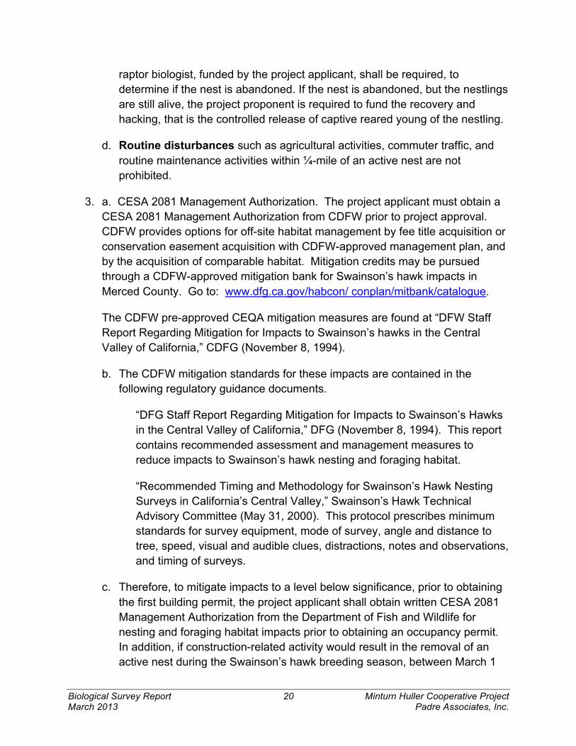
Biological Survey Report 20 Minturn Huller Cooperative Project March 2013 Padre Associates, Inc.
raptor biologist, funded by the project applicant, shall be required, to determine if the nest is abandoned. If the nest is abandoned, but the nestlings are still alive, the project proponent is required to fund the recovery and hacking, that is the controlled release of captive reared young of the nestling.
d. Routine disturbances such as agricultural activities, commuter traffic, and routine maintenance activities within ¼-mile of an active nest are not prohibited.
3. a. CESA 2081 Management Authorization. The project applicant must obtain a CESA 2081 Management Authorization from CDFW prior to project approval. CDFW provides options for off-site habitat management by fee title acquisition or conservation easement acquisition with CDFW-approved management plan, and by the acquisition of comparable habitat. Mitigation credits may be pursued through a CDFW-approved mitigation bank for Swainson’s hawk impacts in Merced County. Go to: www.dfg.ca.gov/habcon/ conplan/mitbank/catalogue.
The CDFW pre-approved CEQA mitigation measures are found at “DFW Staff Report Regarding Mitigation for Impacts to Swainson’s hawks in the Central Valley of California,” CDFG (November 8, 1994).
b. The CDFW mitigation standards for these impacts are contained in the following regulatory guidance documents.
“DFG Staff Report Regarding Mitigation for Impacts to Swainson’s Hawks in the Central Valley of California,” DFG (November 8, 1994). This report contains recommended assessment and management measures to reduce impacts to Swainson’s hawk nesting and foraging habitat.
“Recommended Timing and Methodology for Swainson’s Hawk Nesting Surveys in California’s Central Valley,” Swainson’s Hawk Technical Advisory Committee (May 31, 2000). This protocol prescribes minimum standards for survey equipment, mode of survey, angle and distance to tree, speed, visual and audible clues, distractions, notes and observations, and timing of surveys.
c. Therefore, to mitigate impacts to a level below significance, prior to obtaining the first building permit, the project applicant shall obtain written CESA 2081 Management Authorization from the Department of Fish and Wildlife for nesting and foraging habitat impacts prior to obtaining an occupancy permit. In addition, if construction-related activity would result in the removal of an active nest during the Swainson’s hawk breeding season, between March 1

Biological Survey Report 21 Minturn Huller Cooperative Project March 2013 Padre Associates, Inc.
and September 15, the applicant shall obtain prior written authorization from the U.S. Fish and Wildlife Service to ensure compliance with the Migratory Bird Treaty Act (16 U.S.C. 703-711) to avoid impacts to actively nesting Swainson’s hawks.
Project compliance with CDFW mitigation requirements to avoid “take” of special-status species would reduce this impact to less than significant.
San Joaquin Kit Fox (SJKF) No potential denning habitat is present for San Joaquin kit fox within the facility. Nevertheless, records from the occurrences of San Joaquin kit fox within the Merced National Wildlife Refuge, approximately 15 miles west of the project site, and from the San Luis National Wildlife Refuge, approximately 30 miles northwest away. (Potentially significant)
Because there is the potential for San Joaquin kit foxes and American badgers to occur on site, the Standardized Recommendations for Protection of the San Joaquin Kit Fox Prior to or During Ground Disturbance (USFWS, 1999) shall be followed. The measures that are listed below have been excerpted from those guidelines and will protect San Joaquin kit fox and American badgers (Taxidea taxus).
Recommended Mitigation: 1. Project-related vehicles should observe a daytime speed limit of 20-mph
throughout the site in all project areas, except on county roads and state and federal highways; this is particularly important at night when kit foxes are most active. Night-time operations should be minimized to the extent possible. However, if it does occur, then the speed limit should be reduced to 10-mph. Off-road traffic outside of designated project areas should be prohibited.
3. To prevent inadvertent entrapment of San Joaquin kit foxes or other animals, all excavated, steep-walled holes or trenches more than two feet deep should be covered at the close of each working day by plywood or similar materials. If the trenches cannot be closed, one or more escape ramps constructed of earthen-fill or wooden planks shall be installed. Before such holes or trenches are filled, they should be thoroughly inspected for trapped animals. If at any time a trapped or injured San Joaquin kit fox is discovered, USFWS and CDFW shall be contacted as noted under Measure 11 referenced below.
4. San Joaquin kit foxes are attracted to den-like structures such as pipes and may enter stored pipes and become trapped or injured. All pipes, culverts, or similar structures with a diameter of four-inches or greater that are stored at the site for one or more overnight periods should be thoroughly inspected for kit foxes before

Biological Survey Report 22 Minturn Huller Cooperative Project March 2013 Padre Associates, Inc.
the pipe is subsequently buried, capped, or otherwise used or moved in any way. If a San Joaquin kit fox is discovered inside a pipe, that section of pipe should not be moved until the USFWS has been consulted. If necessary, and under the direct supervision of the biologist, the pipe may be moved only once to remove it from the path of construction activity, until the fox has escaped.
5. All food-related trash items such as wrappers, cans, bottles, and food scraps should be disposed of in securely closed containers and removed at least once a week from the project site.
6. No firearms shall be allowed on the project site.
7. If any San Joaquin kit fox or American badger, or their sign, are detected on site, dogs and cats shall be kept off the project site to prevent harassment, mortality of San Joaquin kit foxes or American badgers, and/or destruction of their dens.
8. Use of rodenticides and herbicides in project areas should be restricted. This is necessary to prevent primary or secondary poisoning of San Joaquin kit foxes and the depletion of prey populations on which they depend. All uses of such compounds should observe label and other restrictions mandated by the U.S. Environmental Protection Agency, California Department of Food and Agriculture, and other state and federal legislation, as well as additional project-related restrictions deemed necessary by the USFWS. If rodent control must be conducted, zinc phosphide should be used because of a proven lower risk to kit fox.
9. A representative shall be appointed by the project proponent who will be the contact source for any employee or contractor who might inadvertently kill or injure a San Joaquin kit fox or who finds a dead, injured or entrapped San Joaquin kit fox. The representative will be identified during the employee education program and their name and telephone number shall be provided to the Service.
10. In the case of trapped animals, escape ramps or structures should be installed immediately to allow the animal(s) to escape, or the USFWS should be contacted for guidance.
11. Any contractor, employee, or military or agency personnel who are responsible for inadvertently killing or injuring a San Joaquin kit fox shall immediately report the incident to their representative. This representative shall contact the CDFW immediately in the case of a dead, injured or entrapped kit fox. The CDFW contact for immediate assistance is State Dispatch at (916) 445-0045. They will contact the local warden or Mr. Paul Hoffman, the wildlife biologist at (916) 934-9309. The USFWS should be contacted at the numbers below.

Biological Survey Report 23 Minturn Huller Cooperative Project March 2013 Padre Associates, Inc.
12. The Sacramento Fish and Wildlife Office and CDFW shall be notified in writing within three working days of the accidental death or injury to a San Joaquin kit fox during project related activities. Notification must include the date, time, and location of the incident or of the finding of a dead or injured animal and any other pertinent information. The USFWS contact is the Chief of the Division of Endangered Species, at the addresses and telephone numbers below. The CDFW contact is Mr. Paul Hoffman at 1701 Nimbus Road, Suite A, Rancho Cordova, California 95670, (530) 934-9309.
13. New sightings of San Joaquin kit fox shall be reported to the CNDDB. A copy of the reporting form and a topographic map clearly marked with the location of where the kit fox was observed should also be provided to the USFWS at the address below.
14. Any project-related information required by the USFWS or questions concerning the above conditions or their implementation may be directed in writing to the U.S. Fish and Wildlife Service at: Endangered Species Division, 2800 Cottage Way, Suite W2605, Sacramento, California, 95825-1846, (916) 414-6620 or (916) 414-6600.
Sensitive Natural Community
No riparian habitats or other sensitive natural communities have been mapped or observed on the site of the Minturn Hulling Cooperative facility. Therefore, the project would not have a substantial adverse effect on any riparian habitats or other sensitive natural communities. (No impact)
Wetlands
No potential jurisdictional WoUS or wetlands have been mapped or were observed at the project site (Figure 4). Therefore, development of the project would not have a substantial adverse effect on federally protected wetlands as defined by Section 404 of the Clean Water Act. (No impact)
Wildlife movement and nursery sites
There are no creeks, valleys, or other wildlife movement corridors would be affected by the project. The Chowchilla River is adjacent to the site, but proposed activities will not occur in the river or the adjacent riparian corridor. Continued operation of the facility would not interfere substantially with wildlife movement or impede the use of wildlife nursery sites. (No impact)

Biological Survey Report 24 Minturn Huller Cooperative Project March 2013 Padre Associates, Inc.
Conflict with policies or ordinances
Approval of the Minturn Hulling Cooperative expansion would not conflict with any Merced County policies or ordinances pertaining to biological resources. (No impact)
Conflict with a Conservation Plan
The Minturn Hulling Cooperative expansion is not located within an area covered by an adopted Habitat Conservation Plan, Natural Community Conservation Plan, or other approved local, regional, or state habitat conservation plan. (No impact)
Cumulative Biological Impacts
The Minturn Hulling Cooperative expansion, which will involve the conversion of 3.2 acres of croplands, will likely contribute to the cumulative loss of foraging habitat for songbirds and raptors in the Merced County area. In the San Joaquin Valley, this loss of habitat is considered cumulatively significant, unavoidable and unmitigable. (Cumulatively significant, unavoidable and unmitigable loss of foraging habitat)
Biological Survey Report 25 Minturn Huller Cooperative Project March 2013 Padre Associates, Inc.
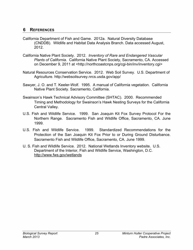
6 REFERENCES
California Department of Fish and Game. 2012a. Natural Diversity Database (CNDDB). Wildlife and Habitat Data Analysis Branch. Data accessed August, 2012.
California Native Plant Society. 2012. Inventory of Rare and Endangered Vascular Plants of California. California Native Plant Society, Sacramento, CA. Accessed on December 9, 2011 at <http://northcoastcnps.org/cgi-bin/inv/inventory.cgi>
Natural Resources Conservation Service. 2012. Web Soil Survey. U.S. Department of Agriculture. http://websoilsurvey.nrcs.usda.gov/app/
Sawyer, J. O. and T. Keeler-Wolf. 1995. A manual of California vegetation. California Native Plant Society. Sacramento, California.
Swainson’s Hawk Technical Advisory Committee (SHTAC). 2000. Recommended Timing and Methodology for Swainson’s Hawk Nesting Surveys for the California Central Valley.
U.S. Fish and Wildlife Service. 1999. San Joaquin Kit Fox Survey Protocol For the Northern Range. Sacramento Fish and Wildlife Office, Sacramento, CA. June 1999.
U.S. Fish and Wildlife Service. 1999. Standardized Recommendations for the Protection of the San Joaquin Kit Fox Prior to or During Ground Disturbance. Sacramento Fish and Wildlife Office, Sacramento, CA. June 1999.
U. S. Fish and Wildlife Service. 2012. National Wetlands Inventory website. U.S. Department of the Interior, Fish and Wildlife Service, Washington, D.C. http://www.fws.gov/wetlands

Figure 1
Project Vicinity
Minturn Huller Facility
kProject Site
Location
0 10 20 30 405
Miles
$

Chowchilla River
DS
DV
DS
DS
DS AG
Figure 2
Cover Type Map
Minturn Huller Facility
0 1,000 2,000 3,000 4,000500
Feet
S M
intu
rn R
oad
Project Site Boundary
Vegetative Cover Types
AG - Agricultural Land (4.7 ac)
DS - Disturbed Land (85.2 ac)
DV - Developed Land (27.5 ac)

Biological Survey Report Figure 3 January 2012 Minturn Huller Cooperative Project Padre Associates, Inc.
!
!
Biological Survey Report Figure 4 January 2012 Minturn Huller Cooperative Project Padre Associates, Inc.
!