appendix b comments on the portageville bridge project's
TRANSCRIPT

Appendix B
Comments on the Portageville
Bridge Project's Draft Scope

Reference 1
Chuck Flansburg

From: Chuck Flansburg <bull-rat@ hotmail.com> To; ~rhessingerQdot.state.ny.us>, ejkrupitzaQdot,state,ny.us>, zrudy.husband ... bate: 9/29/2008 1 1 :45 PM Subject: Portageville Railroad Bridge Replacement Input Attachments: Portageville-R-R-Bridge_Replacement-1dea.j; Portageville RR Bridge.doc
Dear Sir@), I have read the story this past weekend in the Hornell Evening Tribune Online regarding the fate
of the Portageville Railroad Bridge at Letchwonh State Park, New York. Although I am currently in the Navy, I grew up in Hornell, NY. The old iron bridge at Letchworth has always been a favorite place to visit at the park. The bridge itself is iconic of the history of not only the park, but part of the railroading history in western New York State. I have also read up on the scoping documents that are available on the NYSDOT website. I write this letter as input to the public forum slated for October 1st at Mount Morris Visitor Center, since I cannot attend in person! I really wish I could attend though.
My point of view is that a new railroad bridge should be built to carry rail traffic. The old bridge can then be turned over to the state as a historic landmark. 1 have attached to this e-mail a graphic rendering of what I think should be done in regards to the design and location of a new bridge in relation to the old bridge. I am not sure of all the plans that are on the drawing boards at this time, I know that any ather alternative for the rerouting of rail traffic or doing nothing will cost more in the long run. The construction of a new bridge is probably the more cost effective, long term salution. Federal funding could be obtained to aid in the construction of a new bridge.
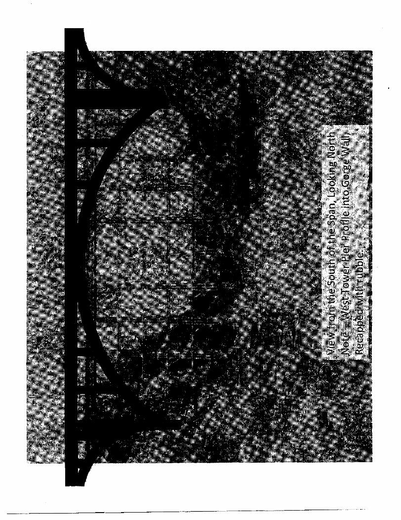
1 will now describe some of the specifics of my ideas. The ideal location for the new bridge is south of the old iron bridge. I think that the new railroad bridge should be a steel-reinforced concrete or steel beam arch for the main span and approach spans. The main span should be a straight line while the approach spans slightly curve from the approach embankments at the top d the gorge. I like the arch idea, because it does not impede the flow of the river, even at storm flood stage. The arch also provides a modern, yet beautifying style to the landscape.
Supports for the bridge invotve two steel-reinforced concrete tower piers that rise up from the gorge. The west tower pier should be profiled into the gorge's western wall, The footing of the tower should be trapezoidal ar hexagonal, and set below the rubble at the floor of the gorge. The rubble removed for construction, then can be replaced along or over the west t~wer pier footing to naturalize the look of the base of the gorge wall, as well as provide scour prolection, The east tower pier, also with a trapezoidal or hexagonal footing, can be set into the gorge floor east of the old canal/towpath, east side of the river. Some of the rubble from tha excavation and profiling for the west tower pier can be used for scour protection at the base of the east tower pier. The approach abutments are of steel-reinforced concrete, and set into the top of the gorge walls. Upon completion, the footprint and operation of the new bridge should have a minimal impact on the environment.
The new railroad right of way can be fenced off from the appr~aches to the old bridge. Then, the fence line can be extended 50 to 100 feet or yards north into the adjacent tree line, perpendicular to the rail right of way. The rail bed on the new bridge can be adjusted to accommodate higher train spoeds with the curvature of the approach spans. 'The deck of the new bridge can also be designed with 8 service catwalk on the northern edge of the bridge. Additional fencing and deck design can be installed as to prevent BASE and bungee jumping, both stunts that arch bridges attract.
As for the old iron bridge, here is my idea. Once the new railroad span is completed, the old span can be turned over to the state as a tourist attraction and historic landmark. Currently, the old bridge is off limits because it is a railroad right of way. The iron bridge can be modifled to accommodate pedestrian and bicycle traffic. A security fence at least 12 feet tall along both sides of the span can allow the iron bridge to provide an awesome vantage point for tourists to view the Letchworth Park gorge? The State of New York, through the park service, can allow tourist access to the bridge with the implementation of dailyfees or passes, For example - $2 per person; $5 per family up to four people; $1 0 per ssasonlcamping pass. Toll collection points can be established at both ends of the bridge, The accumulation 0.1 access fees to the iron bridge, along with private donations, can be used to help offset the cost of maintenance and upkeep. The only possible environmental impact of the old iron bridge, other than current known effects, would be pollution potential of dust and rust during any maintenance, preservation, and painting.
In summary, this has been my input of ideas for the Portageville Railroad Bridge at Letchworth

State park, New York. Whatever aspects of proposals to resolve the issue at hand of dealing with the old iron bridge, I hope a replacement for it can mave forward. I hope the attached graphic also demonstrates the passionate interest that I have to contribute to this cause. Perhaps, federal funding can be obtained to help pay for the new bridge. Anyhow, I wish the best for the progression of the project. Sincerely, Chuck Flansburg 1541 Nelms Ave Norfolk, VA 23502 bull-rat@ hotrnail.com (H) 757-855-7072 (C) 757-284-2520
Want to do more with Windows Live? Learn "10 hidden secrets" from Jamie. http://windowslive.com/connect~posvjamiethom~0n~~pace~.Ii~e.~0m-B10g-cs!50F681 DAD532637!5295. entpy?ocid=TXT-TAGLM-WL-dom ore-092008

From: Chuck Flansburg <bull-ratQhotmail.com> To: <rhessingerQdot.state.ny.us>, <jkrupitzaQdot.state.ny.usr, <rudy.husband ... Date: B/30/2008 1 1 :23 PM Subject: Additional Portageville Bridge Input Attachments: New Portageville FIR Bridge From North View Close.jpg; New Portageville RR B
ridge From North View-jpg: New Portageville RR Bridge From South View.jpg; Potential New Portageville RR Bridge Views.ppt
Sir@), 1 greatly appreciate your reception of my previous input in regards to the situation with the Portageville
railroad bridge. At this time, 1 wish to offer additional graphic input. I have used the powerpoint and picture attachments here to give some perspectives visions of my ideas previously submitted. I hope that these may be of some use in planning a replacement for the old iron bridge. Please let me know how these turn out for you. Thanks!
Chuck Flansbu~g 1541 Nelms Ave Norfolk, VA 23502
See how Windows Mobile brings your life together-at home, work, or on the go. http://clk.atdmt.com/MRT/golmsnnkwxp1020093182rn rt/direct/Ol/


Reference 2
Gail Rogers


SCOPING UPDATE COMMENT FORM PORTAGEVILLE BRIDGE REPLACEMENT PROJECT
You are invited lo comment on the Portageville Bridge Replacement P~aject, and Uie Scopjilg Document, Scoping is the process that identifies relevalt e~~vilanrnental effect8 of an action that must be addressed in a Draft Environmental hnpact Statement.
Name: Address: - Email:
Please add my name to Lhe Portageviile Bridge Replacemcnl Project Mailing Idat. ( \' ,k 0d Comments can be submitted in writing until October 17,2008 to: Mr. Raymond Hessinger, P.E. NY SDOT 50 Wolf Road, Mail Pod 5-4 Albany, Ncw York 12232

Reference 3
Michael Rogers

Freight Bureau
SCOPING UPDATE COMMENT FORM PORTAGEVILLE BRIDGE WEPLACEmNT PROJECT
You are invited lo comment on the Yortageville Bridge Replacement Project, and the Scuping Document. Seoping is the process Lhat identifies relevant eixvironmental elfects of an action that nwsl be addressed in a Draft Environmental ln~pacl Statement.
Kpl lease add my name Lo the Portageville Bridge Replacement Project Mailing Lirf.
Co~n~nents can be submitted in writing until Oc~ober 17,2005 to: Mr, Raymond Hessinger, P.E. NYSDOT 50 Wolf Road, Mail Pod 5-4 Albany, New York 12232

Reference 4
Donna Brown

Reference 5
David W. Parish, President
Livingston County Historical Society


Reference 6
Richard W. Svenson, Director
Division of Environmental Health Protection

STATE OF NEW YORK
Richard F. Daines, M.D. Commissioner
October 16,2008'
Mr. Joe Krupitza New York State Department of Transportation Freight Bureau 50 Wolf Road, Pod 5-4 Albany, NY 12232
RE: DOT Scoping Document: Portageville Bridge Project Town of Portage, Livingston County Town of Genesee Falls, Wyoming County
Dear Mr. Kn~pitza:
Per Mr. Raymond Hessinger's September 11,2008, transmittal letter, we received the Scoping Document for the proposed Portageville Bridge Project, in the Town of Poriage, Livingston County and the: Town of Genesee Pdls, Wyoming County. Regional sWf reviewed the Scoping Document and also contacted both the Livingston and Wyoming County Health Departments about the proposed project and we do not have any connlents or objections. The Wyoming County Health Department would like to be included as an involvedintex-ested party for this project, and it would be greatly appreciated if you could also do the same for the Livingston County Department of Health.
Please be advised that Dr. Howard Freed is the new Director far the Center for Environmental Health and future reports may be directed to his attention. If you have any questions or need contact information far the Wyoming County and Livingston County Health Departments, please contact Claudine Jones Rafferty at (518) 402-75 10,
Riihdrd W. Svcisan, P.E., Director Division of Enviromnental Health Protection
cc: Dr. Freed Mr. Bills/Ms. Jones Rafferty Drs . CaIsodSaZnme-Alfie Drs. HornlGrey
W EGEIVED
oC7 2 0 2008 Freight Bureau
Mr. Van Houten Ms. J EllisonlMr. J. Mazurowski, Livinston County Wealth Depa~rnent Dr. G. CollinsMr. S. Perkins, Wyos-ning County Health Department
N:\dehp\CLAUDINE\Division\LWItPPa~~ddDOTTKevie~~UOTTI~cvie~h\\LsnO\I>OTTCo~w~cnt~lerter~ Purtngvillr Bridge Project

Reference 7
Bill Greene

SCOPING UPDATE COMMENT FORM PORTAGEVILLE BRIDGE REPLACEMENT PROJECT
I 1 You we invited to comment on the Po~tagevilb Bridge Replacement Project, and the Scoping Document, Scoping is the process Lhal identifies releva~il mvironm~nlal eflects d an action that must be addressed in a Draft Environmental Impact Statement.
.A En~ail: d
&Please add my name to the Portageville Bridge Replacement Project Mailing List. n q e & b e r r a+ & t - e m ~ ~ h
Gumme~~ts can be submitted in writing untiI October 17.2008 to: Ml-, Rayrnmd Hcssingcr, P.E. NYSDOT 50 Wolf Road, Mail Pod 5-4 Albany, New Yarlc 52232
Reference 8
Chet McGhee
US Department of the Interior, Bureau of Indian Affairs

i-.rr)*F--ol --A,- --XPl ?il~.v jX_I -IJ-IXT---&-. -*. .x-- v = n - " - " c r % - i i - ---- '--- --awXI"-PC-*--w
' 9 / % i / 2 m ~ o s c ~ h Krqitza - Re: Norfolk Sputhern ~ailwaq, Portageville Bridge L - a,.* . .. .""" . -"..---&a-e-* -' .-.,- - - . , . . X i",. -- - , , . , , .-*. -",*-em Page a- 1 - _i
From: 3aseph Kru pitza To: Chester.Mcghee@ bia.gov CC: Hessinger, Raymond; Madden, John Date: 9/23/2008 10:23 AM Subje& Re: Norfolk Southern Railway, Portageville Bridge
Dear Mr, McGhm:
Thanks for your reply and encouraging suggestbns.
In our public outreach efforts, NYSDOT has mailed a letter and scoping packet to Mr. Maurice John of the Seneca Indian Nation encouraging participation.
Sincerely,
3013 Kmpitza >> 3 [email protected]> 9/23/2008 10;ll AM >>r Mr, Krupitm Our affice received your request for comments on the rehabilitation or replacement of the Norfolk Southern Railway's Portage Viaduct as part of the State's Enviranmental Quality Review Act. While there are currently no federally recognized trlbes iocated In Wyoming County, we encourage your o f f i i to consult with the Seneca Nation of Indians based on the tribe's aboriginal connection wlth that region of New York.
Should you have questions or need additional information, please don't hesitate to contact me,
Chet McGhee Environmental Protection Specialist
U.S. Depamnerit of the Interlor Bureau of Indian Affairs Eastern Regional Office Nashville, TN Phone: 615.564.6834 Fax: 615.564.6571
Joseph R. Krupltza Civll Engineer 1 NYSDOT Freight Bureau 50 Wolf Raad - Mall Pod 5-4 Albany, NY 12232 Phone: (518) 485-0105 Fax: (518) 457-3183

Reference 9
US Department of the Interior, Fish and Wildlife Service

'AC, c-, LUYU WU. -te L I ~ r l s n Z WILDLIFE P. Oi/'ElI
, , United Snatcs D e w b e n t o f the Interior ' '
FISH AND WILDLIFE SERVICE NW Yark Fiald Office
3811 L b m Road Conlmd, NY 13045
Phone! (607) 953-9334 Fw: (607) 753.9689 http:l+.h.gov/northewdny €0
RqWrelinp your: K Letter E FAX: r E ~ I I ~a ted: -a; . , .
~ ~ r ~ ~ ~ + i ~ ~ i & c ~ ~ e n r a rehrbilk&ion af the ~olta~wtlle 5ridge, PIN 493559.301 -- Swnqbt,'cumeh;e t r ) 'Q*'~: lover rhe Gonesee ~ i v e r on t'hr 5ourhern:~ler rail 'line ~t MP SR 361.66
- - .
- - - -
In TownICo~~ty: bownr of Ponapr and ~eneaeeiallr / Llvirigrton and wy;rning C~untlcs, rr(rpeaivaly
PursQant.to t h e Endangered Spec@ Act of 1973'(E$A) (87 Stat. 884, as amende'd; 16 U.S.C. 153f et seq.), the US. Fish'and Wildlik Sewice;'
Ac&rmwlsd$as receipt of your."no effes ondior no impact detenirtaiion, We further ESA mordinatian or twywItz&n is required.
I7 Ackmwledges receipt of y our:detertrnina&. Please provide a ,copy bf your &brmination and swpperting~rnaterials to any Involved Feder'al agency for their final ESA de&rrnihation.
.Is.taking nq adian pursuant td. ESA ar anyather legislation at this time QIUBWDC~~ 'like to be kept P$ ipl(o8ned of project developrn8nta.
A$ a'~jsmindet,~until Ule proposedgroject is r=o$~]ate, we recommend that yo,u;c$bck our website ( h ~ p : . ~ ~ . 1 F N $ . g o v ~ n ~ r t h e ~ 6 U n ~ e d s e c t i ~ n 7 ~ h ~ r n ) every 90 days from the,dqk;ofmtAis letter to ensure #that.ll$bd s d e s presencelabenee informatfin for the proposed project aresls nurrent. Should projed
change or if additional information on Ilabd or proposed species or critical habitat becomes ,avejrllable, this betermination may be mnside5lgd.
\ b
TDTWL P. @l

Reference 10
Kate Kingsley

SCOPING UPDATE CQM[MENT FORM PORTAGEVILLE B GE REPLACEMENT PROJECT
r I
You are invited lo comment on the Pmtageville Bridge Replacemei~t Project, and the Scoping Document. Scophg is the process that identifies relevanl environmental effects of action that must be addressed in a Draft En~riranmental Impact Statement,
Name: Address: . Emzlil:
Cl Please add my name to the Portageville Bridge Replacement Project Mailing List.
Commen:llls can be submitted UI writing until October 17,2008 to: Mr. Raymond Wessinger. P.E. \33T WSDOT 50 Wolf Road, Mail Pod 5-4 Albany, New Yark 12232
F

Reference 11
Edward Hamilton

ATE COMMENT FORM PQRTAGEVILLE BRIDGE REPLACEMENT PROJECT
I You are invited to coinment on the Portageville Bridge Replacement Ptojecl, arid tlze Scopitlg Document. Scoping is Ule proccss that identifies environmental effects of an action that must be addressed in a Draft Environinantal Impact Statement.
Name: Address: Etnail:
h9 Please add my name to the Poltageville Bridge Replacement Project Mailing List.
Co~nments can be submitted in writing until October 1 7,20118 to: Mr. Raymond Nessjnger, P.E.
%ECEIVIED NYSDOT 50 Wolf Road, Mail Pod 5 4
OPT 16 20QB Albany, New York 12232 , ,, I ^it ~ ~ U T B ~ R U

Reference 12
Irene Szabo, Acting Trail Chair
Finger Lakes Trail Conference

FINGER LAKES T IL CONFERENCE, INC. 6111 Visitor Center Road, Mt. Morris, N Y 145'10-9527
Tel(555) 658-9320 * Fax (585) 658-2390
10 October 08
Raymond Hessinger, P. E. WSDOT 50 Wolf Road, Mail Pod 5-4 Albany NY 12232
RECEIVED
OCT 15 2008 Freight Bureau
Scoping Dom~ment Comment:
On behalf of the Finger Lakes Trail Conference and the North Country National Scenic Trail:
There is a heavily-ueed long distance trail system which will be affected by any of these alternatives, where both the: Letchworth Branch of the Finger Lakes Trail AND the Genesee Valley Greenway follow the abandoned railbed of the Pennsylvania RR branch to Rochester, laid upon the previous towpath of the Genesee Valley Canal. Within the park, this trail passes under the current high bridge, parallel to the east bank of the river, just above river level, continues though Portageville village on a few blocks' worth. of streets, then rejoins the railbed just past the crossroads where NY 436 turns east after crossing the river, The trail continues along the old canal prism, now on the west side of the river, to "WMskey Bridge," the next bridge over the Genesee River, roughly a mile south of the village, and continues south parallel to NY 19A. South of Whiskey Bridge the route is ALSO part of the 4600-mile North Country National Scenic Trail.
Therefore any of the proposed alternatives will involve constmction, presumably, above a papular trail in one spot or the other, so the question of whether the trail will be closed temporarily, or safety barriers built above the trail (like snowsheds over railroads in the Sierras?) will have to be addressed. Naturally none of us interested in this trail wants to see it closed, especially since long-distance hikers do use this trail systcm.
Public safety plus historic preservation along this canal conidor will therefore remain a consideration for each alternative.
And one small consideration from me pcrsondly for construction of any safety fencing, whether during construction or on the existing bridge should the park accept it as a pedestrian feature: please remember to include small fmrned cut-outs within mesh for photogr~~phersl
Irene Szabo, Acting Twil Chair, FLTC 6939 Creek Rd Mt. Motria NY 145 10 585/658-432 1 treeweenie@aol. com

Reference 13
Sharon Donovan

--------F--**-l'*- . . - - . , . .. . .,"".. . -. mm2008) , - (- -- j ". Joseph Krup~ha - - Re: ~o$a@vrlle Bridge Project ,,, _ -)___--a*. , .- ~ - u s r L r - r .a*,+,* & '" . +* ,.* -" 6
From: Joseph Krupitza To: Donovan, Sharon CC: Hessingar, byrnond; Madden, John Date: 10/15/2008 9:17 AM Subject: Re: Portageville Bridge Project
Good Morning:
Thanks for your comments on the scoping phase of the project. Your name will be added to the mailing l is t
I f you would like to visit the NYSDOT website regarding the project, please visit:
Xf you scroll down the webpage, there are links to various items pertinent to the project.
Thanks for your time and consideration.
Joe Krupitza >>> "Sharon Donowm" [email protected]> 10/15/2008 9:OO AM >>> I just recently was informed of the plans for the Portageville Bridge Project. I n fact it has been since the public meeting at the Mt. Morris Dam. I hope I am not too late in expressing my concerns for the relocation of a bridge outside the Park. Being a semi-resident of the town of Portagevtlle for 67 years, I can assure you that the pmposed railroad bed and accompanying Bridges are definitely not in the interest of the community nor the environment, For one thing, there are many cemeteries along this route that would have to be moved. There are natural wetlands that would be destroyed, The Green Way would be disrupted, and much wildlife would be impacted, Please add my name and address to the Portageville Erldge Replacement Project Mailing List. Thank you,
Shamn Donovan 56 W. Cherbourg Dr. Cheektowaga, N.Y., 14227
Joseph R. Krupitza Civil Engineer 1 NYSDOT Freight Bureau 50 Wolf Road - Mail Pod 5-4 Albany, NY 12232 Phone: (518) 485-0105 Fax: (518) 457-3183
Reference 14
Dawn Terziani

SCOPING UPDATE COMMENT FORM PORTAGEVILLE BRIDGE REPLACEMENT PROJECT
You are invited to comment on the Portageville Bridge Replacement Project, and the Scoping Document. Scoping is the process that identifies relevant environmental effects of an action that must be addressed in a Draft Environmental Impact Statement.
Name: Address: Email:
Please add my name to the Portageville Bridge Replacemelit Project Mailing Ust .
Comments can be submitted in writing untii October 17,2008 to: Mr. Raymond Hessinger, P.E. NYSDOT 50 Wolf Road, Mail Pod 5-4 Albany, New Yorlc 12232
RECEIVED
nr-r 0s 200C ;;t;~ Bu!,eav

October 5,2008
Attn: Mr. Raymond Hessinger, PE NYSDOT 50 Wolf Rd. mail Pod 5-4 Albany, NY 12232
Vincent & Dawn Terziani 671 2 Route 19A Portageville, N 14536
Dear Mr. Hessinger:
I am writing on behalf of my husband and myself to address our concerns regarding the potential envi- ronmental impacts of the options proposed in your Portageville Bridge Replacement Project.
Our main concerns would be regarding the option 7 which moves the bridge outside the park and essen- tially through our property.. Obviously we would oppose this option for the obvious reasons involving deval- uing our property which we purchased in September 2001.
Our intent in purchasing 50 miles from the city of Rochester was to live outside the city in the country- side where we could avoid pollutants and enjoy living in close proximity to Letchworth park; a park my husband and I both enjoyed the beauty of since our youth, having both been raised in the suburbs of Rochester. During our many excursions in childhood and as adults, never once did we think that the rail- road bridge was ugly or should be removed. Instead, it adds to the historical interest and I often wondered at the structure and wished to ride over the top or view the high falls from that perspective.
For this reason both my husband and myself favor the option 4 which builds a new bridge for Railroad use next to the existing, and gives the old bridge to the park for pedestrian and park use. I would love to see a viable option that joins trails on both side of the park.
But as to environmental concerns of the impact of option 7 there are many things you will need to con- sider besides the unhappy few families that would have their quiet country home turned into a major com- mercial railroad route. Our property at 6712 Route 19A has the railway crossing at a diagonal behind our home on both our 10 acre plot and the surrounding Ayer's productive agricultural plots. Here are the con- cerns we would like addressed in regards to our property and our immediate neighbors:
I. Noise level (am and p.m.), speed of the trains, pollution of the immediate environment, 2. Potential hazardous effects of the loads carried by the railroad in accidents 3. Historical - both ours and our neighbor's home are 150+ year old homes and gambrel
barn of historical significance 4. Neighbors B&B Bottle Tree Farm business, our potential bus, registered as Dawn's
Herbs & Odd Inspirations, Ayer's current farm land used for agriculture a. several herb species grown on land including endangered Echinacea
Tennesseensis used for medicinal purposes, Gingko trees, and I have planted hazelnut trees as a part of the Arbor Foundation hazlenut project, morrel mushrooms in may
b. Existing agricultural use - we rent land to and surrounding land owned by Ayers considered prime agricultural use, potato crops, beans, corn and oatstraw. Land and access would be cut in half with access impeded to some parts
5. Underground springs and possible interference with our streams and our source of well water due to weight, construction and pollution
6. Housing of thoroughbred rescue horse, land access for exercise would be cut off 7. Native American artifacts1 arrowheads fol-lnd on land regularly 8. Would be killing a lot of deer, crosses regular migration route into and from park
pheasant and wild turkey habitat 9. Road crossing for school bus and already dangerous speed 55 mph road with dangerous
curve, plus regular route for many semis some carrying hazardous loads or oversize loads 10. Loss of potential development of land for natural gas
In conclusion, the park has housed the crossing for years and drawn many visitors in spite of its presence. There is no reason to believe that moving it off park grounds will justify ruining surrounding land owners property at a significantly higher cost to tax payers.
Thank you for including us in on any and all meetings that affect these issues.
The ~erziani'-ziuy%c&


Reference 15
Robin Dropkin, Executive Director
Parks and Trails New York

Mr. Krupitz,
Thank you for inviting us to comment an Norfolk Southern Railway's Portage Viaduct rehabilitation/replacernent project. Attached are our comments. We look forward to participating as an interested party.
Fran Gotcslk
Director of Programs and Pollcy
29 Elk Stretri, Albany, NY 12207, www.atnv.org
I- I N E W Y O R K
October 16,2008
Mr. Joseph Krupitza NYSDOT Freight Bureau 50 Wolf Road, Pod 5-4 Albany, NY 12232
Re: PIN 4935.79.301 Norfolk Southern Railway, Portage Viaduct
Dear Mr. Kmpitza:
Thank you for the opportunity ro comment a11 PIN4935.79.301, rehilbilitt?lian or replacement of i l~e Norfolk Southern Railway, Portage Viaduct. Parks & Trails New Yosk wishes to be considered as an interested agency in this project.
Founded in 11285, Parks RL TraiIs New York is a statewide not-for-profit ~nembersllip organization dedicated to enhancing the llealih and quality at life of New Yorkers through the use and enjoyment of a growing network of parks, pedestrian and bicycle trails, greenways, and heritage corridors throughoul the state. Our interest in this project sterns no1 only fiom our colnmitrnerit to protect and revitalize our magnificent stak parks such as Letchwarth, but also from our experience with two trail systems that are located in the park and which would be d i ~ c d y afi'ected by this project, the Letchwafi11 Branch of tile Finger Lakes Trail and the 90-mile Genesee Valley Greenway.
We have reviewed the background information, goals and objectives, and Preliminary List of Alter-ltalives presented in Ihc Scoping Document for the Porrageville Bridge, also kno\m as the High Bridge, and have the following comments:
Impact on aesthetic 1.esource.s - visual impact For many, both today and in generations past, the view of the High Bridge spanning the gorge is Lhe image flitit is emblematic of LRtchworth State Park. In the late 1800s. the High Bridge was tlqe terminus for Pennsylvania Railroad excursion trains that brought day wippers from Rochester to spend the day at the bridge picnicking wld enjoying the river and gorge. Still today the High Bridge is the covcr photo for the 2008 btchwsrth State Park Vacation Guide and the Perry Area Cl~anlbn of Comrncrce and Livi~~gston County Tourism websites represent

the park with photos of the bridge.
Issues to address in the Environmental Imoact Statement (ElS): i. The E1S shouId ensure that the design of any other bridge added to the
view Shed will complement, not comprise, the view of t l~e High Bridge and its natural surroundings.
i+ A preliminary design for any new bridge should be included in the EIS. P Exact location of any new bridge should be detailed in the EIS. The
materials presented did not identify the location for the new bridge making it difficult for us to fully comment on its impact.
Impact on llistoric and archaeological resources Since it i s a contributing element to the Letehworth State Park Nationd and State Register listings, erection of a new bridge in dose proximity to the High Bridge would seriously campromise the integrity of this irnporlant historic resource. As noted above, any design for a new bridge must be executed to minimize impacts on the historic High Bridge. Because it wauld destroy a structure of great importance to the landscape and history of the park, ar; well as the transportation history of the region, we do not support the High Bridge's destruction as part of this project,
Issues to address in the Environmental Imnact Statement: k The EIS should detail maintenance cosu for Ihe existing High Bridge
if it were lo be used only by pedestrians, not 286,000-pound freight wains.
r The EIS should include tlie it111 cost of removal of the bridge by the railroad. lnslead of expending these monies to destroy the bridge, we recommei~d that the money instead be set aside as an endowment or maintenance fund that can be used by the New York Stale Office of Pwks, Recrmtion, and Historic Preservation (OPRHP) to support maintenance and operatian of the bridge as a pedestrian walkway.
Itnpact on open space and recreation The Scoping Document righlly notes that because or its location [he project may present dlort and long-term impacts to availability and enjoyrnetll of land witllin the park. It alao states that '"the project also provides a11 opportunity to enhance the recreational activities within Letchworth Park" and mentions the "opportunity to create a pedestrian bridge crossing connecting trails on either side of the Geneseo River. However, the Scoping Document does not specifically note the existence of two major long-distwcc wails that traverse the east side ofthe park dong the farmer Genesee Valley Canal and Pennsylvania Railroad corridor, the Finger Lakes Trail and Gencsee Valley Greenway, Tllesc trails are located directly under tbe Nigh Bridge and would be impacted by any construction and demolition activities,

Issues to address in the Environmental Impact Statement: ;. The EIS should address the issue of alienation of park land that would
occur with construction of a new bridge parallel to the High Bridge. PTNY opposes park alienation that results in a net loss in the amount of parkland, aesthetic value or recreational opportunities for the same population that is served by the affected parkIand. Furthermore, PTNY supports due considefation of a net gain in parkland or recreational opportunities as mitigation for the alienation. The EIS should detail the full extent of compensation that will be provided to OPRHP as a result of impaels to the land and disruption of activities, temporarily or permanaltly, within the park.
P The EIS should provide compensation to the Finger Lakes Trail Conference and Genesee Valley Greenway Partners in tenns of trail improvemei~tlls or other considerations for the impact of the project on the Finger Lakes Trail and Genesee Valley Greei~wzly. For example, the railroad could provide funds to NYSQPRHP to acquire an easement on adjoining private property that would help create a more stable Genesee Volley Gmenwny and Finger Lakes Trail between the Hjgh Bridge and Route 436 in Porlagevil le,
b The EIS should state specifically what will be done to additionally "enhance the recreational activities" in the park.
k The EIS should provide details on the location and design of any new proposed pedestrian bridge. A pedesl~ian trail bridge at near river level, however, call never take the place of the view that could be gained horn lhc High Bridge 245 feel above the gorge. We strongly encourage the railroad and OPRHP to fully investigate the costs of maintainiag the High Bridge for pedestrian use so ththat at last the public can legitimately a~xd safely have the magnificent views of the Genesee River gorge that tiley have soughl for years.
Without a do~lbt, the operatiotlal constlqaints and maintenance casts imposed on Norfolk Southern by the present 133-year old bridge must be addressed lo ensure the rt&lroad's profitability and competivencss. However, all solutions must be undertaken with keen attentiall to the visual, historic and recreational impacts and the integral role that t l ~ e High Bridge plays in the ptiblic" definition of what is Lctc1:chworth State Park, We look forward to participating in the environmmlal review process.
Sincerely,
Robin Dropkin Executive Director

Reference 16
Bert and Patty Therrien

-.--- -.-* ^p---..-CI ---.--, + - - - - ... ... "*..?^. .- ".,. *r-. -___--- - - ~ ---- + -_.----. ^___
1mbiP) ~ o c e ~ h Krupitza - Portageville High Bridge Scoping Document comments --I_-----.---- , ., - . - .,i.&"
Page ' ---"- -
From: Patty therrien [email protected]> To: <[email protected] Date: 1011 812008 2:11 PM Subject: Portageville High Bridge Scaping Document comments
Dear Mr. Krupitza:
My name is Patricia Therrien. My husband Bert and I own and have reslded at property adjacent to the rail line that passes over the ''High Bridge" far the last 15 years (198 Portageville Rd.). We recently attended the public scoping meeting held October 1st at the Letchworth State Park Visitor Center in Mt. Morris. We very much appreciated the opportunity to view the alternate plans, and ask questions of and speak to representatives from the various agencies. We found all our discussions with them to be very helpful and informative. They encouraged us to submit any questions or concerns we may have regarding the project to you,
We have two concerns, the first of which relates to Norfolk & Southern's goal of attaining speeds of 60 miles per hour across either a newly constructed bridge, or the rehabilitated existing bridge. Of course we moved into our home fully aware that our proximity to the railroad would mean we would need to become accustomed to the noise and rumbling that accompanies the passing of a train. but speeds have historically been 35 mph at most, and more recently around 10 mph given problems with the intqrity of the existing structure. In talklng with members of the NYSDOT they assured us that the most important goal Is to increase the weight-bearing capacity of the bridge so that maximum loads may be carried on this rail line in keeping with the rest of the rall system. They characterized the possibility of following a new alignment through the park that would eliminate the sharp curve on the west side of the river as highly unlikely, and eliminating this curve would be the only real way to bring speeds up to 60 mph. We consider regaining speeds of around 35 mph as tatally reasonable, but if any plans are approved that would bring speeds to 60 mph we would be, frankly, quite worried as the shaking and vibrations that would probably occur would be quite disruptive of the relative peace we enjoy right now,
The other concern we have is regarding our gravel road, which will be the only access to the bridge once construction commences. We know that the size of trucks and heavy equipment traveling countles times a day will be impressive. Several years ago, when Rt. 436 was reconstructed, dump trucks brought fill dirt to a site on our road many times a day and completely destroyed it, as well as making it a complete dusty and dirty mess. The construction company never returned the road to its original condition. We can only imagine how equipment traveling the full length of our road repeatedly will result in its complete breakdown. It is our hope, that prior to the beginning of any construction, at least an oil and stone surface can be applied that will minimize damage and dust that will result from Its frequent and heavy use.
Thank you for taking the time to review these concerns. If you have any questions for us, or if you would like to speak to us further, please feel free to contact us at the above email address, by phone (585) 468-2385, or by mail at:
Mr. and Mrs. Bert Therrien 198 Portageville Rd. Hunt, NY 14846
Sincerely,
Bert and Patty Therrien
Do You Yahoo!? Tired of spam? Yahoo! Mall has the best spam protection around


Reference 17
Andy Beers, Executive Deputy Commissioner
New York State Office of Parks,
Recreation and Historic Preservation

Davld A. Pubreon . Qommor
New York State Office af Parks;, C~mm(asb!+t&t Card AM Recreation and Historic Preservation The Governor Nelaon A. Aooketeller Emjrim Sble Plaza -Agency Building 1, Atbany, New York 12238 www.nysparks,mrn
October 17,2008
Mr. Joe fCrupitza NYSDOT -Freight Burern1 50 Wolf Road Pod 5-4 Albany, NY 12232
Re: PIN 4935.79.301 Norfolk Southern Railway, Portngeville Bridge Southern Ties, MP $12.361.66 Town ofportage, Livineton County Town of: Genesee Falls, Wyoming County
Dear Mr. Kropitza: '
I am providing these comments on the Portngeville Bridge Project Scoping Document dnted August 2008 on behalf of the New Yo& State Office d Parks, Recreation and Historic Preservation (QPRW). Consietcnt with the State Envhrnenta1 Quality Review Act (SEQR), OPRHP is an involved agency far this project. Tfitse comments are being provided for [email protected] into the Scoping document, to assum that issues, concerns and olher information important to our Agency are nddmssed within h e DEIS. These comments . include those ofthe State I-Estorjc Preserv&ti~n Office (SHPO).
Blmnatims -Existing Biidm Alternatives 4,6 and 8 in the Scoping document .include, "lehve existing bridge for Parks use." OPRMP has determined thmt our agency is ]lot in a position ro accept ownership or responsibility for the long-term costs of inaintaining the existing bridge, Therefore, if this option i s to be; included in the alternatives analysis, the DEE will need to quantify the short and long-term financial casts of convdng and mointainjng the existing bridge fbr Park's use, and a180 to identify one or mom publicagencies or private entities (not OPRI3P) htrl would be willing to accept ownership nhd financial rasponsibility. If there is no viable: ownership scenario, the alternatives should be revised to exclirde r l l ie option.
-- -- -- Alrsnar.ive8 - Pedcsbim Trail Crossing Enhancing trailway connections is a major initiative for OPRHP. The bridge replacement project creates nn impoi'tant opportunity to create o pubIic pedestrian crossing, linking existing hiking trails on the mast and west sides of the Genesee River within htchworth State Park, Ths Scoping document and the DEIS should include an analysis of the technical
An Equal Opp~~unllyIAffirmetlVB mlion Agency 0 prlnlodrm mcydlad mpr

and economic feasibility of creating n pedestrian trail crossing as part of the larger project, For example, Alternatives 3 and 5, under which a new bridge woulcl be canstructed at the exjsting location, should inclt~dc an analysis of the feasibility of incorporating a public trail cx~ssing into the design of the bridge sh.uctu1t. Connecting the existing trails on each side of the gorge and providing n unique oppomity to view the gorge would provide significant public benefits nncl would adckess safety concerns from unauthorized pubfjc u s e d the existhg andor n new bridge. The DEI[S should fully identify and describe the range of altelnatives incl uding opportunities for pedestrian acceas. The Agency s!mngly'believes that any design of a newbridge shouldiricl~lde apedeskinn walkway. This inclusion could serve as potendal mitigation for impacts of anew bridge as well as providing transportation enhancements..
Proiecf Goals and Obiectives The Scoping document states, 'Ubjectives wiIl be developed for each goal during the scoping pxocsss to provide specific and meisusable means by which to eval~latt and cornpace project alternatives." OPRHP.. would like to be able to review and partjcipate in the
'
development of these objectives.
Clarification of long term goals for speed, fmquency and size of h'slins across the gorge needs to be described and considered in evalunting impacts from the various alternatives.
Vis~Pll and Aesthetic Resources An analysis of impacts on visual and aesthetic rtsou~ces should consider adverse visual impacts to the Park, the Park visitor exlierience and on the Nationd Register Listing of the . Park, The impact on both the viewshed and nesthetics of alternatives containing both one and two bridges need6 to be addressed, In addition, the impact of increased speeds, numbers of trains and length of tmins on the park environment and visitor experience should be considered.
The design of any new or rehabilitated structure will be impartant in terms of evalunlzng the visual impacts to the park. The type of construction, materials, and+colar, a11 need to be ,
indudedjn a description of the alternatives, Visualizations of any new Mdge pmposals should be shm~d with O H U P and the public, early in the decision-making process, as opp~seid rb waiting until after a pmfelmd alternative hns been selected.
The bridge's drmatlc loLatjon and high visibility from key iiewshed meas within the Park make it something other than a simple baclrground utilitarian s&ucture, The.demolition of the hist~ric bridge would~constitute a negafive impact to historic features and views within 1 the Park. llonatructiol~ of a new Irridge either on 01. near the exisling.digr~rnenf would also constihe a negative impact on the Park. The context of ai?y proposal should clearly note this and include measures in the DEIS to either nddrms or mitigate such impacts through -
- in-,~ardatim~ design, or vqeservation. I I
Histo~ic and Ascheolo~cril Resburces The Scoping document states that the: bridge is a contributing element to thcNn~iand Register listed Letchworlh State Park. Flowever, to further define this statement, more

'description regtuding the significance of the bridge shbuld be included in the DEE. The bridge represents historic transportation, engineering and materials history, as well as an additional layer of land use history within the park. These consideratioa should be clearly noted within the DBIS as part of the historic significance of the bridge. A -
d
Impacts to historic and'cultural resources both inside and outside of the Park shouLd also be considered. Specifically, if there is any track realignment on the east side of the gorge, potential impwm to the Cascade House Hotel which ~ ~ t i ~ t e d immediately to the ~0~1th of the current ~ n o k alignment sho~~ld be considend,
h w t on Plants and Animals The DETS needs to consider impacts to wildlife and vegetation in the park, not just threatened and endangered species and significant ecological communities. .kern within Iscchwoah State Park have been designated 8s n New York State Bird Conservation Area (BCA) which requires agencies take bird oonservation into consideration when d n g planning or management decisions. Lotohworth State Park hm also been identified as an Important Bird Area (BA) by Audubon New York. Impacts to bird populations from noise, thing of construction and frequency and speed of trains should be considered especially dusing breeding and migration,
Impact on Growth and Character of Communitv or Neighborhood The Scoping document states that the proposed bridge project is not expecml to ha& a . significant impact on this category. The impact of more trains, fastw trains, and lager adns should be evaluated in terms of the surrounding communities, and especially when discussing alternative 7, a new tridp outside the Park. The realignment of the track nlso needs to be considered
Pmcesb Since it i s likely that this project wiIl include'either federal funding or permits or npprovals, the provisions of Section 106 of the Nation'al Historic Presuvation Act of 1966 will need to be considered in the project planning. This will include reaching out to interested parties and including consulting pmties during the DEIS process and any review and agreemat ymccss. Also, if nn adverse effect i s the outcome of the Section 106 consultation process, the pioviaions of Section 4 0 of ihe Department of Transportation Acl of 1966 will also nead to be consid~red. In addition, if the projed entails the taking of parkland then this will " trigger Section 6(f) of the Land llnd Wnter Conservneon Fund Act, commonly refei~x%l to as
' the Conversion process. It is important that this EE meet the requirements of a Federal I?IS as welI. OPRHP believer it is critical that federal agencies be notified now of the intent of this m5, which will serve as the notice required for complying with both SEQR and NEPA.
Hazardous Materials ---- The-DEIS ahould ide~ti~y-any-haza~~dous-~em&iation-issu~-tha~would-bem~~ciated~~th.
the alte1native.s of removing or rehabilitating rhe existing bridge. Pogsible concerns are llead paint and asbestos. Has any testing been done reg@uding hazardous w a s s that might be present on the Norfolk Southern propeity as a result of the railroad operations over tlie
I decades of ownership?

Drawings The public scoping meeting only provided drawings for two of the nltemtttive~ poposecl in the Scoping document. The erst proposal detailed the new bridge ns b&ng located approximately 75 feet south uf the existing bridge. This indicated that n s d l amaunt of parkland wo~ild be impacted. The drawing did not include the additional lands that would be required by Norfolk Southern for the maintenanceright-of-way (ROW). This will need to be more clearly delineated in the DELS. Drawings in the DEIS should include the entire taking of parkl~nd that would be required as w d l as my temporary ROW limits required for construction of a replacement slnicture and trolk alignments. These should all be shown on .
plans included in the DEE, All altamativm that include adhng land to the current Norfolk Southern existing ownership needs to 'be defined.
Track Alimment Alternatives and Track &ability The Scoping document states that bridge will be designed to c m y trains at GOrnl3h. the industry standard. It also st~tetes that current m c k alignment limits trains to speeds of 35mph. What is the likelihood that the dipmerit will be modified in the future to accommodate fmm trainti? The DEB shodd consider potential impact of various track rdignments as they approach the bridge. Pamtial plans should be discussed in ternls of potential Speeds and size of trains crossing the gorge m the future. Failure to consider this cauld be seen a$ an improper segmentdiun ofprojects u n b r SEQR.
The plan on display at the scoping mmting indicat& a~eplacement pardld bridge just south of the &%sting biidgt and associated track alignmen? c h a n p approaching a replacement bridge, TheDEIS should pl-ovjde detaiI on the extent of the track d i g n m e ~ ~ t changes in regards to subsurface drninage issues on the westem approach and what impact the extent of addressing the dra~mge issues will have on'adjncent State Park lands both to the south ~ n d north of the track alignment
i
TheDEIS should digcuss how various dtematives will control illegal pedestrian access. Inwsased speeds will also it~crease the probability of derailment, The impacts from a derailment ,should also be discuss@d
Impact on Critical Environmental Areas he DElS should include details and documentatio~l concerning the listing d the Genesee River wirhin ktchworth State Park as a Wild, Scenic and Raaentional E v e r by New York De$artment of Environmenlal Cons~rvation. Also, the DElS should include. details and d~cumenhtion conce~ning the Federal Legislation referred to 8s the Gcnesee River Protection Act ofelY89 which identified the Genesee River for protections afforded lo rivers a
listoil far study for polentiat addition to the National Wild and Scenic River System. As pnrl -.--. -- -of&is andysis,aslekmmn&timAU
bridge whileretainiilg the existing bridge (Alternative 4), which would mult in two bridges at this location, is allowable under the Wild and Scenic River designation.
I tem to be considered CIS "mitigating measyres" for impacts to SCak Pork lands include: 1 ~. - Removd of existing bridge could proviie for m e of existing'concrete abutrnenb and
the construction of a new pedestrian bridge crossing the Crencsee River connecting the '
Hnger Lnke~ Trail - Lctchworth Branch and Pack Trail #7 located on the east side of the river to Park Trail #I located on the west side of the rim. This would also include a new connecting trail pinned to the gor& wall leading aouth from the new pedestlian bridge passing near the blink of Upper Falls and connecting to Trail #1 downstream of ihe Upper Falls.
- Use the existing concrete and stone abutments and piers @ending evaluation of their structural integrity) that were formerly part of the Genesec Valley Canal and Pennsylvania RRilxond, located approximately H mile upseam from the existing Norfalk Southern Brldge. Ifnecessary improving the structural integrity of b s e abutments and piers could prdvide a multiuse light vehicle load rated bridge crossing the Gencsee River. Such a bridge woujd provide a safe crossing of the Genesee River on the Finger Lakes T r d - Letchworth Branch and the Chqesee Valley Greenway, Approaching trail development approaching sucb sr crossing should also be included. Currently h e Finger Lnkes Trail - Fetchworth Branch crosses the Geneam River on the New York State ~ep&mt of Transportation Rt. 436 Bridge which only has vehicle drive lsnes and no sidewalk area The Genesee Valley Greenway has defined a circuitous detour route using county md town roads avoiding the Rt. 436 Bridge.
- Design of overhead pmtection for rm? users traveling under the east side of the bridge. ,
This has been an issue in the past for NmfolL Southern.
- Widen the Park Road whei-e it crosses ~mder the existing bridge abutmmt. This would serve k, reduce the dangers inhererit tn the sharp cave and pe&shittn crossing.
In closing, we want to reitmatethe statement in the Scoping dooumcnt (page 14), 'The project provides an opportunity to enhance the recreational activities within Letchwmth Park." Also this pl'oject has importmt bearing on both historic and natural resources, It is imperativb hat the DEIS thoroughly address each of rhcse resources that are of such importance to our visitors to New York State.
Thank yot~ for the opporL~inity to provide these comments, We look forward to our contitiued parlicipation in this process and to reviewing the DEE.
Executive Deputy Commissioner 1
cc. Wint Aldrich Dan Kane Mark Thornns Rich Parker TomAlworrh

Reference 18
Julian W. Adams, Sr. Historic Sites Restoration Coordinator
New York State Office of Parks,
Recreation and Historic Preservation

k NEW Y O M STAT€ @ David A. Paterson
Govorncr
New York State Office of Parks, Recreation and Historic Preservation H~storic Preservation Field Services Bureau * Peebles Island, PO Box 189, Waterford, New York 12188-0189
51 8-237-8643 www.nysparks.com
October 6. 2008
Joe Krupiua NYSDOT, Freight Bureau 50 Wolf Road. Pod 5-4 Albany, NY 12232
Carol Ash Cornrnlss~oner
I
i Dear MS. Ki-upitza:
Re: PTN 4935.79.301 Norfolk Southern RailwaylPol-tageville Bridge Soutl~ern Tier, MP 361.66 TI0 Portage, Livingston Co. TI0 Genesee Falls, Wyoming Co. 08PRO4896
Thank you for forwarding a copy of the Portngville Bridge Project Scoping Document. The 14jstoric Preservation Field Sewices Burenu of the New York State Office of Parks, Recreation, and l-Tistoric Preservation ( O P W ) has reviewed the informati011 ia accordance with the provisions of Section 14.09 of the New York State Parks, Recreation, and Historic Preservation Act of 1960,
As the Scoping Document states "The Portageville Bridge is included on the National and State Preservation Offices' Listing of Historic Places as a "contributing element" to Letcl~worth State Park.'. Letchworth State Park itself is listed on the National Register of Historic Places, and this bridge, within the boundaries of the park, contributes to its significance. Therefore, any proposed work at the bridge has the possibility of impacting historic resources at Letchwarth.
The proposed altemarives in the scoping document cover all the scenarios we would expect such a d 0 ~ ~ 1 i l i t to .Odrld2. LVe 100k forward to w~riarrg wPil.1 you as h e projcci goes forward.
I look forward to hearing from you. If you have my questions or if 1 can be of any assistance, please call me at (5 18) 237-8643, ext. 3271.
. Historic Sites Restoitatior~ Coardinutor
An Equal OpportunitylhR~rmative Acttorl Ayency 6 pmt& on rcscyzled papa:
- I I

Reference 19
Lesta Ammons, Biologist
US Army Corps of Engineers

REPLY TO
DEPARTMENT OF THE ARMY BUFFALO DISTRICT, CORPS OF ENGINEERS
1776 NlAGARA STREET BUFFALO, NEW YORK 74207-3199
October 15,2008
RECEIVED ocr e o z ~ m
Regulatory Branch
SUBJECT DA Number: 2008-01 754, Scoping Document -New York State Department of Transportation and Norfolk Southern Corporation Portageville Bridge Project
Mr. Raymond Hessinger, P.E. MrSDOT 50 Wolf Road, Mail Pod 5-4 Albany, New York 12232
Dear Nlr. Hessinger,
This is in reference to a request far a response to the Scoping Document for the New York State Department of Transportation and Norfolk Southern Corporati011 Portageville Bridge Project. The proposed project is located at nlile-yost 361.66 dong theNorfolk Southern Corporation's Southern Tier Route across the Genesee River in Letchworlh State Park near the town of Portageville in Livingston County, New York.
We are providing the: foilswing comments based on the information included in ihe Scoping Document dated August 2008 lhat was provided to us. Please note that these comments are preliminmy and we may provide additional comments upon receipt of additional infonnation -and/or documentation.
Purpose and Need The information contained in the s~oping Document indicates that "Objectives will be developed
for each goal during the scoping process.. . "base provide a clear statement of llae purpose and need statement in future documentation once the objectives have been established.
_Alternativeg The idormation contained in the document regarding the method wed in the selection of tie
alternatives listed is limited. Additional i n f o m t i o ~ desc&bing the reasons for the selection of the proposed alternatives, tlze criteria, used during the screening process of the proposed alternatives, and the fafitors used 10 eliminate alternatives from consideration during the screening process should be included in Future, documentation This will provide a more clear understanding of how the screening process was applied to the evaluation o f these alternatives. The screening criteria used regarding tile comparison of innpacts to waters and wetlands of the United States should be clearly addressed. Documentation of ff1e methods used to evaluate the waters and wetlands during the screening process sho~dd be included in rhe evaluatial~ report- This uhlmation will directly relate to h e evaluation of the selection of the least environmentally damaging practicable alternative

SUBJECT: DA Nurnbcr: 2008-00274, Portagmille Bridge Project NYSDOT and Norfolk Soltthorr7 Cnrporafion
Waters - The Genesee River is considered to be Section 10 Navigable waters in the area of the proposed
bridge projecr; therefore, coordination with the United States Coast Guard will be required for this project.
Any fill exceeding one-tenth of an acre proposed to be placed below the ordinary high water mark in Section 1 Q waters will require a, Department of the Army permit. Some activities may be covered under our Nationwide Permit program without the need to provide pre-construction notification to trhe Corps of Engineers.
The Genesee River may be designated as a Wild and Scenic study river in the section of river involved in the proposed project. Any correspondence or coordination wit11 the National Park Service regarding this proposed project should be includ.ed in future documentation.
Wetlands The Scoping Domnent states that a Wetlands Delineation Report will be prepared and
consultation regarding the report will be made with the USACE and the New York State Department of Environmental Conswvztion (NYSDEC). Verification of the delineation of the wetlands in the area should take place prior to calculation of final i~npacts for alternatives advanced to final review o a of the screening process. The delineation report should include diagrams showing both wetlands and waters. The tern "waters" includes perennial streams, intermittent streams, ephemeral streams, and any connecting &&age ways, swales, andlor ditches hat cany flowing water between and m n g waters and wetlands.
Any fill exceeding one-tenth of an acre proposed to be placed in Section 404 waters or wetlands will require a Department of the Army permit. Some activities may be cavered ruder our Nationwide Permit program without the need to provide pre-construction notification to the Corps of Engineers. Discussions of impact to wetlands should also include cumulative, secondary, and indirect impacts. Additionally, as sfated under tlie "Mtmatives" section, documentation af the methods used to evaluate tke waters and wetlands during the screening process should be included in h t u e documentation.
Threatened m d Endangered Species and Plant and Wildlife In future documentation, please include idonnation regardhig field invesiigatjons and/or
consultations with the US Fish and Wildlife Service (USFWS) and New York Natural Heritage Program regarding potential impacts to ternstrial and aquatic wildlife in tile area as well as my potential impacts to threatened and endangered species.
Wiitoric Proncrties In future docwlentation please provide any correspondence resulting from the proposed
coordkilzltion with the New York State Historic Preservation Ofice regarding l'listoric propa4es and archeological resources disc~~ssed in the Scoping Docunlent.
Other - Documei~tation regarding other coordination as described in the Sc~ping Doc~unent such as

SUBJECT: DA Nzinlbw: 2008-00274, Purfagcville Bridge PrtQect NICSDOT ofid Noqolllr Southern Corpo~atiovs
consultation with the, the New York State Depattrnei~t of Enviromnental Consmiion, a ~ d the Fedcrd Emergency Management Associalion for example would also provide illformation that might he necessary fbr our review.
Questions pertaining to this matta should be directed to me at 716-879-4247, by writing to the following address: U.S. Army Corps of Engineers, 1776 Niagara Street, Buffalo, New York 14207, or by e-mail at: les~.m.ammons@,usace.~my.mil
Sincerely,
Biologist

Reference 20
Robert L. Ewing, Environmental Analyst 2
Division of Environmental Permits, NYSDEC

New York State Department sf Environmental Conservation Division of Environmental Permits, 4a Floor 625 Broadway, Albany, New York 12233-1750 Phone: (518) 402-91 67 a FAX: (518) 402-9168
m Web: www.dec.nv.~ov -
Alexander 8. Crannis Commissioner
October 16,2008
NYSDOT, Freight Bureau 50 Wolf Road, Pod 5-4 Albany, New York 12232
Attn: Joe Krupitza
Re: PIN 4935.79301 Narfok Southern Ralway, Portageville Bridge Southern ~ i e r , M1P SR 361.66 Town of Portage, Livingston County Town of Genesee Falls, Wyoming county
RECEIVED
2 0 2k108 Freight Bureau
Dear Mr. h p i t z a :
The New York State Department of Environmental Coilsexvation ("Department" or "DEC") has reviewed the August 2008 Scoping Document for the Drafi Environmental Impact Statement (DEIS) being prepared for the above-referenced project which atails the rehabilitation or replacement o f Norfolk Southan's Portage Viaduct over the Genesee River. As requested, the Department is providing you with the following comments on the Department's likely jurisdictianal involvement with this project and the draft scopirrg document.
From the information provided, it appears that the DEC is an involved agency in the State Environmental Qudity Review Act (Y3EQRA") process (&g jurisdictional authorities below).
2) The Department's Jurisdictions.
As you h a w , SEQRA relies an the Lead Agency to manage the environmental review process but does not cl~ange existing jurisdictions or limit the independent decision-making authority of any involved agencies. In that regard, possible DEC authorizations for the rehabilitation or replacement alternatives proposed for this project qpear to be the following:
Within the baundaries of Letchworth Staie Park, the Genesee River is designated as a

Scenic River under the Wild, Scenic and Recreational Rivers System Act (m Environmental Conservation Law ["'ECL""lrt. 15, Title 27 and its implementing regulations at 6 NYCRR Part 666). Management of sc&c river areas is directed at presewing and restoring their natural scenic quaIities ECL 5 15-2707[Z]Lb][2] and 6 NYCRR 4 666,4p]).
New York State Regulated Freshwater Wetlands PO-3 and PO-14 were identified in the area of the existing Norfolk Southern Railroad, PO-3 is located approximately 240 meters to the east of the existing railroad tracks. PO-14 is located approximately 390 meters to the west of the existing railroad tracks. The DEC has jurisdictional authority over project impacts to state regulated wetlands under the Freshwater Wetlands Act k e ECL Article 24 and its implementing regulations at 6 NYCRR Parts 663-665).
If the project results in probable impacts to threatened or endangered species, the Department will have jurisdiction under ECL Article 11 (see ECL Q 11-0535).
In the vicinity of the bridge, the Genesee River is classified by the Department as "B'" and, as such, is a protected water under ECL Article 1 5 (see ECL 1 5-050 1 [2]). DEC could, therefore, have' jurisdictional authority over potential impacts to the bed, banks and water of the Genesea River in the proposed project area.
3) DEIS Draft Scoping: Documex~t Comments.
ALTERNATIVES section (~arfes 8 & 99,
It should be noted that, except for the repair, rekofitting or the replacement of the existing bridge at the sane location for the same use (existing uses, see 6 NY CRR 5 666.1 3.A.2), the construction of a new rail road bridge within Letchworth State Park would be prohibited @ 6 NYCRR $ 666.13.IC.1).
Retention of the existing bridge as a public road or non-motorized open space recreational use would require a permit under the Wild, Scenic and Recreational Rivers System Act (see 6 NYCRR 5 666.13 - Table ofuse Guidelines at E.5.b). The use would not be grandfathered (see6 N Y C M § 666.13 - Table of Use Guidelii~es at A.l).
ENVIRONMENTAL IMPACTS section
Lead Anencv @age 10)
This section nates that NYSDOT will be the SEQRA lend agency and that NYS OPRHP will be an involved agency in the environmental review process. Given the probable jurisdictions cited above, the DEC should also be identified as an involved agency.

Environmental Consmuences - S~ecific Impact Categories
Impact to Waters bane 122
The DEIS should include delineations of New York State Regulated Freshwater Wetlands PO-3 and PO-14 in the vicinity of alternatives in order to evaluate possible requirements for an Article 24 Freshwater Wetlands Permit &om the Department.
Impacts to Plants and Animals (pane 12- 131
This section will likely describe the general wildlife community, including vegetation, wildlife, habitat, and threatened and endangered species in the project development area, includiiig the presence of invasive species.
- The DElS should indicate that concerns with biodiversity, animal movements and animal mortalities associated with the proposed operational changes for r d traffic though this segment will be addressed as part of the SEQRA review.
- In addition, the Letcl~worth State Park is designated as an Important Bird Area by the National Audubon Society and a Bird Conservation Area by New York State, The bird population within the park is considered primarily non-migratory, and DEC is concerned about both construction-related and operational impacts to avian species. The DEIS should include an i~iventory of the bird population in the area surrou~ding the existing bsidge, as well as at the possible locations for alternative structures, in order to assess potential impacts that may occur due to avian non-migratory activities and behavioral characteristics. This may include consultation with existing Breeding Bird Surveys (BBS), Christmas Bird Counts (CBC), local birding groups, Audubon and Nature Conservancy chapters, and regional DEC biologists.
- The Department's preliinillary review bas also identified multiple Natural Heritage Program @HP) sites that contain rare species aid significant natural communities that are in the vicinity sf the project, including: Shale Cliff and Talus Community, Hemlock - Northern Hardwood Forest Camnlunity, Appalachian Oak-Hickory Forest Community and Trollius laxus, Spreading Globeflower. The project sponsor slzould have a qualified naturalist investigate the project m a for Rare, Threatened and Endangered Species, which should include a habitat and nest site- survey of any listed endangered, threatened or species concern. The results of this study should be discussed in the DEIS in relation to potentid impacts to these resources that may result from construction of the project and efforts needed to minimize displacement of these species or disturbance of critical habitat. If applicable, the DEE sl~ould describe any measures needed to avoid adverse impacts to any identified rare species or significant natural communities, including avoidance of construction in critical habitat areas, and scheduling construction to avoid intmptian of breeding and nesting activities.

I
In conclusion, DEC appreciates the opportunity to comment on the SEQRA DEE Scope for this project, proposed by Norfolk Southern, which will examine various alternatives at the Portageville Bridge to increase load carrying capacity, remove operational constraints and maintain acceptable levels of safety. If you have any questions, you may contact me by phone at
1 (3 18) 402-9482, at the address above or by emdl at [email protected].~tate~nv.us. I
Sincerely,
/<id/ 2 @ Robert L. Ewing Environmental Analyst 2 Divisirrn of Environmental Permits
Mr. John Madden, P.E. NYSDOT / Freight Bureau 50 Wolf Road - POD 54 Albany, NU 12232
Mr. Raymond Wessinger, P.E. Acting Director Freight Bureidu NYSDOT 50 Wolf Road - POD 54 Albany, NY 12232
Doug Sheppard, DWMR - CO John Cole, DEP - R8 David Denk, DEP - R9 Betty Ann Hughes, DEP - CO

Reference 2 1
Joanne Arany, Executive Director
Edward J. Olinger, VP for Preservation
Landmark Society of Western New York

LANDMARK SOCIETY
October 17,2008
Mr. Raymond Hessinger, P.E. NYSDOT 50 Wolf Road, Pod 5-4 Albany, NY 12232
Dear Mr, Hessinger:
Thank you for the opportunity to comment on the Scoping Document for the Portageville Bridge Project.
The Landmark Society has an interest in this project because of the Portageville Bridge's status as a historic structure and as an integral part of a historic landscape. This project also has the potential to have an impact on histaric resources surrounding the bridge and within any proposed new alignment.
Because of the importance of the resource and of the project, we would like to see a more transparent public process with more opportunities for public input. Only two public meetings are anticipated, according to the current scoping document. We assume that the alternatives will be developed in enough detail to fully assess impacts and provide for a comparison of alternatives and possibly narrow the list to feasible alternatives. Given the sensitive nature of the existing bridge site within the park viewshed and the engineering constraints for a new structure (either at the existing site or at the parallel alignment site), the development of the alternatives will be of great public concern. We request that regular public meetings be held during the preparation of the DElS to acquaint the interested parties with the development of the alternatives and to receive comments on those alternatives.
The language in the scoplng document does not accurately reflect the official historic status of the bridge or of the park. In the section "Impact on historic and archaeological resources," pages 13-14, please note that the terminology in the first sentence is incorrect: "The Portageville Bridge is included on the National and State Preservation Offices' ..." This should read: "The Portageville Bridge is a contributing element within the State and National Register-listed Letchworth State Park." The bridge has also been identified by the State Historic Preservation Office as individually eligible fbr the State and National Registers.
Also please note the incorrect wording of the last sentence of this section: "the structure could potentially be an historic resource." As an identified contributing element in a National Register-listed landscape and an individually eligible structure, the structure is not "potentially" a historic resource, it is a historic resource. Some of the alternatives under consideration'in~olve removal of the bridge, which clearly constitutes an impact on a historic resource. RECEIVED
n13T 20 2008 Freight Bureau
LANDJvIARTL SOCIETY OF WESTEIZN NEW YORK, INC. I33 SOUTI3 PITZI-~C>I-I S'FKEET / KCJCllES'SER, NEW YORK 14608-2204 / 585-340-7029 / FAX 383-546-4788 ~vww,latldn~arlcs~~cic*ty~~rg olail@Lind~~~arksr.rcit't,t.arg

Letchworth State Park is a State- and National Register-listed property with a period of significance from 1000 B.C. to 1950 A.D. This means that a wide range of historic resources are encompassed within the park and must be taken into consideration in planning this project.
The National Register documentation of the site indicates that Letchworth State Park is an archaeologically sensitive area with many documented archaeological sites, which are believed to be only a sampling of the existing sites, many of which have not been discovered, There is a strong possibility that the proposed project would impact archaeological resources.
Also according to the National Register documentation, "from the mid-nineteenth to the mid-twentieth century LetchwoKh State Park has been a canvas for the designs of landscape architects." Roads and trails, viewsheds, and vegetation are among the elements o f the designed historic landscape that must be considered as part of the review of impacts on historic resources, Other contributing elements called out in the National Register documentation, including buildings such as picnic shelters, objects such as stone walls, and structures such as culverts, roads and trails, must also be considered.
In addition to the resources within the park, cultural resources outside the park must also be evaluated, The alignment of the Avoidance Alternative Corridor (Alternate 6 - New Bridge Outside of Park) will result In a significant shift of the alignment of the rail line and may result in impacts to cultural resources. A complete cultural resource survey should be conducted so that the impacts on cultural resources of all the alignments may be evaluated,
We request that you provide a copy of the detailed results of the scoping process and a schedule for the entire environmental review process.
We look forward to continued involvement as an Interested Agency and appreciate the opportunity to be of assistance to you as this process moves forward.
Sincerely,
Joanne Arany Executive Director
I C 3 9 h" Edward f . inger Vice President for Preservation

Reference 22
Robert A. McNary, Regional Director
Finger Lakes Regional Office, Empire State Development

November 17,2008 NY SDOT, Freight Bureau 50 Wolf Road - Pod-5-4 Albany, New York 12232 Attn: Mr. Joseph Krupitza Re: PIN 4935-79-301
Re: Portageville Bridge Rehabilitation or Replacement Project, Letchworth State Park
Dear Mr. Krupitza:
As per our recent discussion, we appreciate your contacting us regarding our interest in your development of the Environmental Impact Statement under the State Environmental Quality Review Act (SEQRA). In the following narrative I have described in greater detail some of the points that we discussed.
ESD has several interest areas. First, the Portageville Bridge and Rail Line connects shipperslreceivers in several important economic regions of New York State, and even beyond. The ability of the bridge to support greater train speeds and also accommodate heavier rail cars (as have now become the national standard) is important to those served by the line. We understand that the value and functionality of the line as a primary "goods movement corridor" is in jeopardy because of the weight, speed and safety restrictions on the existing bridge. We also understand that it is important for IVew York State shippers and receivers to have access to heavier cars at higher speeds so that they can maintain and improve their competitive position in the marketplace.
The efficiency and competitiveness of the Class One and Shortline Rail System in this area is vitally important to not only the Finger Lakes and Western New York Regions, but also the Southern Tier. Economic limitationsldislocations in all of these regions would be accelerated by the potential loss of rail service and capacity due to the bridge problems.
A second general area of ESD interest is the tourism impact of Letchworth State Park. The bridge crosses the Genesee River Gorge and often tourists come to the Park to see both the Gorge and the bridge. Letchworth is one of the Region's premier tourist destination spots, greatly contributing to the Region's vacation importance. We are cognizant of the fact that disposable income from these visitors is important to the nearby local and regional businesses.

We believe that the freight movement needs and tourism experience can be accommodated with a proposed project that considers both of these interests. We would be glad to discuss this statement in greater detail. Thank you for this opportunity.
Sincerely,
Robert A. McNary, Regional Director Finger Lakes Regional Office Empire State Development