applicability of conservation development in the blanco...
TRANSCRIPT

Prospectus:
Applicability of Conservation Development in the Blanco River Basin
Ron Ellis
POSI 5397
Spring 2006

2
I. Research Purpose
Originating from springs in Kendall County, the Blanco River flows 87 miles through
Blanco and Hays Counties before reaching the San Marcos River. Its basin covers more than
280,000 acres in the Edwards Plateau ecoregion of central Texas. The basin is currently lightly
developed, but faces present and future development pressure from rapid growth in the region
(Nature Conservancy 2004, ii). The Nature Conservancy has designated the Blanco River basin
as a conservation area and has developed a conservation plan for the area.
The conservation plan identifies home development as one of the major threats to the
conservation elements in the Blanco River basin. Home development, especially subdivision
development, results in habitat fragmentation and loss. The problem is exacerbated when homes
are sited in ecologically delicate areas such as along ridge tops or near water. The conservation
plan states that home development threats “may be mitigated through ecologically sensitive
design and construction of subdivisions and homes.” (Nature Conservancy 2004, 15)
Conservation development is a subdivision planning method that can be used to preserve
environmental and cultural features. Under traditional subdivision development, subdivisions are
designed to utilize all buildable parts of a tract of land for houses or roadways. Under
conservation development, half or more of the buildable land, including all of the most
ecologically delicate areas, is set aside as open space to protect its environmental or cultural
value (Arendt 1996). Conservation development has been successfully used in other locales to
preserve natural resources, natural beauty, and rural character without adverse economic impact
on homeowners, developers, or communities. (National Park Service n.d.)
The overarching purpose of this research is to evaluate the applicability of conservation
development in the Blanco River Basin. The first sub-purpose of this research is to explore
community members‟ attitudes toward environmental quality and conservation development.
The second sub-purpose is to assess the regulatory changes necessary for conservation

3
development to be implemented in the communities. The concepts in the working hypotheses
and practical ideal type represent the elements that, according to the literature, are required for
successful implementation of conservation development.
II. Conceptual Framework 1
The first sub-purpose of this research uses working hypotheses to explore community
members‟ attitudes toward environmental quality and conservation development. The working
hypotheses are based upon the major elements found in the literature review of conservation
development. The literature revealed that the primary purposes for conservation development are
to protect environmental quality including wildlife habitat and water quality (Arendt 1996).
Environmental Quality
Working Hypothesis 1:
Community members would like future development to preserve environmental quality
Like conventional subdivision development, conservation development preserves steep
slopes, floodplains and wetland areas. Conservation subdivision design, however, will also
protect other critical areas such as “upland buffers alongside wetlands, water bodies and
watercourses – areas that would ordinarily be cleared, graded and covered with houses, lawns
and driveways in conventional development.” Protecting these conservation areas preserves
wildlife habitat greenways. These open spaces provide cover and corridors for wildlife to travel
through as they move between feeding or hunting areas and their homes (Arendt 1996, 13).
Thus, this study expects to find the following:
Working Hypothesis 1a:
Community members value wildlife and wildlife habitat
4
Preserved areas also decrease the amount of storm water shed by the development. The
land filters runoff, trapping sediment and pollutants as before they can reach water bodies. The
slowed runoff decreases downstream flooding and allows more of the water to be absorbed into
the ground as recharge for aquifers. According to conservation biologists, riparian corridors and
their adjacent uplands provide the best setting for wildlife corridors because in these areas the
widest variety of organisms can be found (Arendt 1996, 13-14).
Thus, this study expects to find the following:
Working Hypothesis 1b:
Community members value ground and surface water quality
By decreasing the amount of storm water runoff, preserved upland areas can mitigate
downstream flooding. In areas without upland or riparian areas, conservation subdivisions can be
designed around meadows. As in upland areas, a meadow‟s vegetation filters pollutants from
storm water and slows its path toward watercourses decreasing downstream flooding.
Additionally, a wildflower meadow gives food and cover for insects, small mammals and birds,
while providing visual interest for homeowners. (Arendt 1996, 14).
Thus, this study expects to find the following:
Working Hypothesis 1c:
Community members value storm water control
Aesthetics
By locating home sites before drawing lot lines or streets, the designer can preserve
smaller features large trees, rock outcroppings, or stone walls. It‟s also a good practice to create
as many “view lots” as possible. Home sites should also be located close to open spaces for easy
access by residents (Arendt 1996, 42).
By using certain techniques, street design for conservation development can augment the
aesthetics of the land. Curving roads can provide different views of open space areas as they
5
drive, while long, straight roads can detract from aesthetics and encourage driving at unsafe
speeds.
Thus, this study expects to find the following:
Working Hypothesis 2a:
Community members value the aesthetics of open spaces in their community
A technique that is equally of value in conservation and marketing is using “single-
loaded” streets. Single-loaded streets have homes on only one side. They provide residents with
across-the-street views of open space areas instead of across-the-street views of other homes.
Single-loaded streets also help to prevent the ugly house-back views from roadways that are so
common in conventional subdivision developments (Arendt 1996, 44-45).
Thus, this study expects to find the following:
Working Hypothesis 2b:
Community members prefer views of open space from their home
Kaplan, Austin, and Kaplan (2004, 302) conducted a study to measure residents‟
satisfaction with the open space and natural features in their neighborhoods. The authors
surveyed equal numbers of residents of “open-space communities” and “conventional
communities”. Respondents from both types of subdivisions provided similar responses in their
descriptions of their communities. Both groups frequently mentioned the importance of natural
features, and both indicated that the “nature view from home is the highest priority when
choosing a place to live” (2004, 307).
Thus, this study expects to find the following:
Working Hypothesis 2c:
Community members prefer views of wildlife from their home
The strongest distinction between respondents from the two types of subdivisions was in
their “level of satisfaction with the nearby natural environment”. The open-space subdivision

6
residents expressed a much higher level of satisfaction in this category. The authors conclude,
“the open-space community concept is important to residents and was successfully achieved”
(Kaplan, Austin, and Kaplan 2004, 310).
Thus, this study expects to find the following:
Working Hypothesis 2:
Community members would prefer the aesthetics of conservation development to
conventional development
Table 1 lists the working hypotheses and their sub-hypotheses and links them to the literature.

7
Table 1 – Summary of Conceptual Framework Linked to the Literature
Research Purpose 1: To explore community members‟ attitudes toward environmental quality
and conservation development in the Blanco River Basin
Working Hypotheses Scholarly Support
WH1: Community members would like future
development to preserve environmental quality
WH1a: Community members value wildlife and
wildlife habitat
WH1b: Community members value ground and
surface water quality
WH1c: Community members value storm water
control
WH2: Community members would prefer the
aesthetics of conservation development to
conventional development
WH2a: Community members value the aesthetics
of open spaces in their community
WH2b: Community members prefer views of open
space from their home
WH2c: Community members prefer views of
wildlife from their home
Arendt (1996), Benfield, Terris, and
Vorslanger (2001), Daniels, Keller,
Lapping (1995), Lacy (1990), National
Park Service (n.d.), Nature Conservancy
(2005), Odell, Theobald, and Knight
(2003), Wisconsin Department of Natural
Resources (n.d.)
Arendt (1996), Kaplan, Austin, and
Kaplan (2004), Lady Bird Johnson
Wildflower Center (2005), National Park
Service (n.d.), Odell, Theobald, and
Knight (2003)
III. Conceptual Framework 2
The second sub-purpose uses a practical ideal type to assess the regulatory changes
necessary for conservation development to be implemented in a community. The elements of the
practical ideal type for effective conservation development ordinances are based on the major
elements found in the literature (Shields 1998), including model policies from around the United
States. Conservation development must be based on a strong comprehensive plan and related
zoning and subdivision ordinances (Arendt 1999).
Comprehensive Planning
To successfully implement conservation development, towns and counties must update
(or develop) their comprehensive plan to indicate a desire for open space preservation and

8
identify the spaces to be preserved. They also must rewrite their subdivision rules and zoning
ordinances to reflect the comprehensive plan (Arendt 1999).
The role of the comprehensive plan is the big picture illustration of the community‟s
development goals. To effectively protect and conserve natural resources and cultural character,
these are some of the elements a community should address in their comprehensive plan:
Resource Inventory – This section gives a detailed accounting of the community‟s
natural and cultural features. It documents their physical locations and describes land-
use activities that are appropriate for their vicinity. The features detailed in this section
are the primary and secondary conservation areas described previously (Arendt 1999, 20-
21).
Goals and Policies – “This section offers a chance to relate the community‟s resources to
its vision of what it would like to eventually become after much or all of its permitted
development occurs” (Arendt 1999, 20). The process is to set broad conservation goals,
define specific objectives to accomplish the goals, and then implement policies that
achieve the objectives. This section helps to prevent later problems by eliminating
uncertainty. Through clearly defined policies, it tells developers how they can operate in
order to meet community goals (Arendt 1999, 20-21).
Implementation – This section should detail how the necessary policies will be
implemented. It should specify changes to ordinances - including encouraging or
requiring conservation development - that are connected to the communities‟ goals and
objectives. Additional conservation methods that can be included here are purchasing
land, purchasing development rights, or securing conservation easements to protect the
most environmentally or culturally significant lands in the community (Arendt 1999, 20-
21).

9
The comprehensive plan is an important tool that can help protect natural and cultural
resources. In most states, however, it is not a regulatory document. This is why it is critical that
the zoning and subdivision rules reflect the goals and objectives outlined in the plan (Arendt
1999, 19).
Zoning Ordinances
Zoning ordinances generally regulate density through minimum lot sizes. A better way to
regulate density is “as the buildable acres required per dwelling including common, undivided
conservation land.” For example, an ordinance might specify one dwelling per two acres with an
open space requirement of 50% of the tract‟s buildable land. Under this model, the typical
house lot on the tract will be one acre, since that is the largest size achievable with the 50%
conservation requirement (Arendt 1999, 10).
Zoning ordinances should also account for environmental constraints such as legally
unbuildable areas and primary conservation areas when calculating density. These
environmentally constrained areas – wetlands, steep slopes, and floodplains – should be
subtracted from the parcel size before calculating density. The allowable density should be
based on the number of unconstrained acres in a tract (Arendt 1999, 10).
If a tract has a high percentage of its area as unbuildable land, the completely discounting
those lands from the density calculation may be economically unreasonable. Another approach
that addresses these cases is to require that unbuildable lands do not make up more than 50% of
the total preserved open space (Lady Bird Johnson Wildflower Center 2005, 29).
Although density should not be determined by minimum lot size, a zoning ordinance
should still dictate minimum lot sizes to prevent too much density. For example in a district
zoned for two acre density, the minimum lot size should be one acre (of unconstrained land) or
less. To ensure reaching the desired open space conservation, the zoning ordinance should
dictate the proportion between density and minimum lot size (Arendt 1999, 11).

10
Procedurally, zoning ordinances should permit conservation development by right
instead of as a conditional use. “Developers tend to avoid procedures that increase the length of
the review period, that subject their proposals to the additional scrutiny of widely advertised
public hearings, and that establish a process involving greater uncertainty with respect to the
outcome of their application.” Ordinances that allow by right permitting status and clearly
outline standards for design will achieve higher acceptance and use by developers (Arendt 1999,
13).
Subdivision Ordinances
In communities without zoning authority, subdivision ordinances should contain
substantive provisions on the quantity, quality and configuration of open space. Similar to the
zoning ordinance, the open space or greenway requirements should be based on a percentage
of the total tract less unbuildable lands (Arendt 1999, 186). The types of land to be included in
open space should consist of primary and secondary conservation areas, and they should be
described in detail. Natural and cultural elements of importance to the community should be
listed and prioritized. This list should be used to guide the design of conservation areas within
subdivisions. An effective subdivision ordinance will also require the consideration of adjoining
open spaces in the design process. The purpose of this is to interconnect open spaces and create
contiguous recreational and habitat corridors across regions (Arendt 1999, 12-13).
Procedurally, a good subdivision ordinance for conservation development will allow
local officials to review proposed development plans before the developer incurs significant
engineering costs. A good model will require a conceptual preliminary plan stage in which the
developer provides a rough sketch of the proposed development. The conceptual preliminary
plan can then be easily and inexpensively modified if it does not meet community conservation
goals (Arendt 1999, 13).
11
Another procedural element of a good subdivision ordinance is an Existing Resources
and Site Analysis Map. Requiring this document is critical since it ensures that design decisions
are being made based on the natural or cultural features of the land (Arendt 1999, 14).
Table 2 lists the ideal type categories and connects them to the literature.

12
Table 2 – Summary of Conceptual Framework Linked to the Literature
Research Purpose 2: To assess the regulatory changes necessary for conservation development in
the Blanco River Basin
Practical Ideal Type Category Scholarly Support
Comprehensive Plan Towns, cities and counties should have a
comprehensive plan
The comprehensive plan should include a natural
and cultural resource inventory
The comprehensive plan should include
conservation goals, objectives, and policies
The comprehensive plan should detail how the
conservation policies will be implemented
including ordinance changes if necessary
Arendt (1999), Daniels (1999), Daniels,
Keller & Lapping (1995), Lady Bird
Johnson Wildflower Center (2005), Urban
Land Institute (1991), Urban Land Institute
(2004), Wisconsin DNR (n.d.)
Zoning Ordinances
To implement conservation development zoning
ordinances should allow increased density
To implement conservation development zoning
ordinances should require open space
To implement conservation development zoning
ordinances should require density calculations to
account for unbuildable land
Conservation development should be allowed by
right in zoning ordinances
Arendt (1999), Daniels (1999), Daniels,
Keller & Lapping (1995), Lady Bird
Johnson Wildflower Center (2005), Urban
Land Institute (1991), Urban Land Institute
(2004), Wisconsin DNR (n.d.)
Subdivision Rules
To implement conservation development,
subdivision rules should contain an open space
element designating quantity and quality of open
space
To implement conservation development,
subdivision rules should require a conceptual
preliminary plan
To implement conservation development,
subdivision rules should require an Existing
Resources and Site Analysis Map
Arendt (1999), Daniels (1999), Daniels,
Keller & Lapping (1995), Lady Bird
Johnson Wildflower Center (2005), Urban
Land Institute (1991), Urban Land Institute
(2004), Wisconsin DNR (n.d.)

13
III. Methodology
This research is a case study examining the applicability of conservation development in
the Blanco River Basin. According to Yin (2003, 9), case studies are appropriate when “a „how‟
or „why‟ question is being asked about a contemporary set of events, over which the investigator
has little or no control”. The case examines both why and how conservation development might
be applied in the Blanco River Basin. Focus groups comprised of community residents will
address the first research sub-purpose by exploring attitudes toward environmental quality and
the principles of conservation development. Document analysis of city and county land use and
planning policies will address the second research sub-purpose by assessing what changes are
needed for it to be implemented. Table 3 shows the operationalization of the first sub-purpose
through focus groups and Table 4 shows the operationalization of the second sub-purpose
through document analysis.
For first research sub-purpose, the working hypotheses are operationalized as questions
for focus groups. A focus group is a group interview that relies on interaction within the group
and is based on topics provided by the moderator/researcher (Morgan 1997, 2). Focus groups are
used extensively to test market products or ideas with the public. The focus group method was
chosen for this research because it is essentially testing a land use policy with members of a
community. Table 3 shows the operationalization and links the working hypotheses to specific
focus group questions.
According to Morgan, “focus group projects most often (a) use homogeneous strangers as
participants, (b) rely on a relatively structured interview with high moderator involvement, (c)
have 6 to 10 participants per group, and (d) have a total of three to five groups per project (1997,
34).” This research will seek to emulate those characteristics.
14
The structure of the discussion will follow the outline shown in the “Focus Group
Agenda/Questionnaire” on page 16. The project will seek to hold three focus group discussions -
each held in a different town in the case study area.
Since implementation of conservation development would require the support of those
who are active in their communities, recruitment will be attempted through church and civic
groups in the area. While using existing groups of active citizens can provide homogeneity
within groups and convenience for the researcher, it can raise the issue of sample bias. Any
sample bias caused by the recruitment from community groups will be acknowledged and
discussed. Recruitment for focus groups will be very challenging and may not be successful. If it
appears that recruitment for focus groups will not be successful, then the researcher will use the
“Focus Group Agenda/Questionnaire” as an interview tool for structured interviews with area
stakeholders.
Table 3 – Operationalization Table for Research Sub-purpose 1
Research Sub-purpose 1:
Working Hypotheses Focus Group question
WH1: Community members would like
future development to preserve
environmental quality
WH1a: Community members value wildlife
and wildlife habitat
WH1b: Community members value ground
and surface water quality
WH1c: Community members value storm
water control
What direction do you think the environment is
going in this area?
What do you think are the greatest threats to
the environment here?
What impact do you think development is
having on the environment?
What is the state of wildlife habitat here? What
is the state of wildlife? Are they important to
you?
What is your impression of drinking water
quality here? How important is that to you?
What is the quality of the rivers and creeks
around here? Blanco River? Cypress Creek?
How important is that to you?

15
WH2: Community members would prefer
the aesthetics of conservation development
to conventional development
WH2a: Community members value the
aesthetics of open spaces in their community
WH2b: Community members prefer single-
loaded street design
WH2c: Community members prefer views of
open space from their home
WH2d: Community members prefer views of
wildlife from their home
What is the state of flood control on creeks and
rivers here? Is that a concern to you?
First pair of pictures (homes with open spaces /
homes with no open space):
Which picture of these two do you find more
aesthetically pleasing?
Which would you rather live in?
Which would you rather see in your
community?
Second pair of pictures (single-loaded street /
double-loaded street):
Which picture of these two do you find more
aesthetically pleasing?
Which would you rather live in?
Which would you rather see in your
community?
Third pair of pictures (views of open space
from a home / views of other houses from a
home):
Which picture of these two do you find more
aesthetically pleasing?
Which would you rather live in?
Which would you rather see in your
community?
Fourth pair of pictures (homes among habitat
view / homes among other homes):
Which picture of these two do you find more
aesthetically pleasing?
Which would you rather live in?
Which would you rather see in your
community?

16
Focus Group Agenda/Questionnaire
Ice breaker discussion
Let‟s go around the room. Please give your name, tell how long you‟ve lived in Hays or Blanco
County, and what you like most about living here.
WH1
What direction do you think the environment is going in this area?
What do you think are the greatest threats to the environment here?
What impact do you think development is having on the environment?
What is the state of wildlife habitat here? What is the state of wildlife? Are they important to
you?
What is your impression of drinking water quality here? How important is that to you?
What is the quality of the rivers and creeks around here? Blanco River? Cypress Creek?
How important is that to you?
What is the state of flood control on creeks and rivers here? Is that a concern to you?
WH2
Distribute (or display) a series of pairs of pictures from conventional and conservation
developments.
First pair of pictures (homes with open spaces / homes with no open space):
Which picture of these two do you find more aesthetically pleasing?
Which would you rather live in?
Which would you rather see in your community?
Second pair of pictures (single-loaded street / double-loaded street):
Which picture of these two do you find more aesthetically pleasing?
Which would you rather live in?
Which would you rather see in your community?
Third pair of pictures (views of open space from a home / views of other houses from a home):
Which picture of these two do you find more aesthetically pleasing?
Which would you rather live in?
Which would you rather see in your community?
Fourth pair of pictures (homes among habitat view / homes among other homes):
Which picture of these two do you find more aesthetically pleasing?
Which would you rather live in?
Which would you rather see in your community?
Record individual responses for all questions.

17
The second research sub-purpose will be explored using document analysis of
comprehensive plans and municipal and county ordinances for the cities and counties in the
Blanco River Basin. The document analysis will seek to identify the similarities and differences
between existing policies and the practical ideal type model established in the literature (see
Section III). By assessing these differences and similarities, the research will changes necessary
for successful implementation of conservation development. Table 4 shows the
operationalization of the practical ideal type model through specific document analysis questions
related to the practical ideal type elements.
18
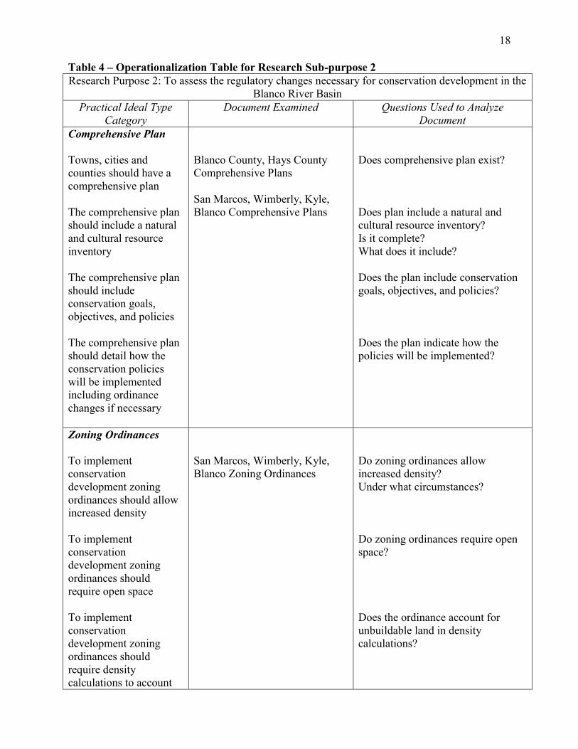
Table 4 – Operationalization Table for Research Sub-purpose 2
Research Purpose 2: To assess the regulatory changes necessary for conservation development in the
Blanco River Basin
Practical Ideal Type
Category
Document Examined Questions Used to Analyze
Document
Comprehensive Plan
Towns, cities and
counties should have a
comprehensive plan
The comprehensive plan
should include a natural
and cultural resource
inventory
The comprehensive plan
should include
conservation goals,
objectives, and policies
The comprehensive plan
should detail how the
conservation policies
will be implemented
including ordinance
changes if necessary
Blanco County, Hays County
Comprehensive Plans
San Marcos, Wimberly, Kyle,
Blanco Comprehensive Plans
Does comprehensive plan exist?
Does plan include a natural and
cultural resource inventory?
Is it complete?
What does it include?
Does the plan include conservation
goals, objectives, and policies?
Does the plan indicate how the
policies will be implemented?
Zoning Ordinances
To implement
conservation
development zoning
ordinances should allow
increased density
To implement
conservation
development zoning
ordinances should
require open space
To implement
conservation
development zoning
ordinances should
require density
calculations to account
San Marcos, Wimberly, Kyle,
Blanco Zoning Ordinances
Do zoning ordinances allow
increased density?
Under what circumstances?
Do zoning ordinances require open
space?
Does the ordinance account for
unbuildable land in density
calculations?

19
for unbuildable land
Conservation
development should be
allowed by right in
zoning ordinances
Is conservation development a by
right land use?
Is it allowed as a conditional use?
Subdivision Rules
To implement
conservation
development,
subdivision rules should
contain an open space
element designating
quantity and quality of
open space
To implement
conservation
development,
subdivision rules should
require a conceptual
preliminary plan
To implement
conservation
development,
subdivision rules should
require an Existing
Resources and Site
Analysis Map
Blanco County, Hays County
Subdivision Rules
San Marcos, Wimberly, Kyle,
Blanco Subdivision Rules
Do subdivision rules designate open
space requirement?
Do they designate quality of open
space required?
Do subdivision rules require a
conceptual preliminary plan?
What is the first plan stage required?
Do subdivision rules require an
Existing Resources and Site
Analysis Map?
Is there any type of community
resources map available to planners
or developers?
20
IV. Human Subjects Protection
Since this research will utilize focus groups, which require human subjects, potential
ethical concerns must be addressed. According to Babbie, some of the primary areas for ethical
concern in social research are voluntary participation, harm to the participants,
anonymity/confidentiality, and deception (2004, 64-68).
To ensure voluntary participation and prevent any occurrence of deception, any
communications used to recruit focus group participants will include full disclosure of the
research purpose and a full description of the research method. Additionally, at the time of the
focus group session, participants will be asked to sign a consent form that again discloses the
details of the research and the research method. A draft of the consent form is on the next page.
If all participants grant their consent, the audio from the focus group session will be tape-
recorded. If any participant does not consent to tape-recording, then the session will not be
recorded. Audio tape-recording will be discussed before the session and disclosed in writing on
the consent form.
To address the issue of confidentiality, the researcher will be the only person with access
to individual responses, and will not disclose those responses publicly. The identities of
participants will be known only to the researcher and will not be disclosed publicly. This
assurance of confidentiality will be included in writing on the consent form.
Harm to participants will be addressed through full disclosure and informed consent. This
research will ask participants for their impressions and opinions on environmental quality and
subdivision design in their communities. The participants will be informed of the aspects of the
research in recruitment and before participation. Any potential participant uncomfortable with
sharing their opinions on these matters will be excused from participation without prejudice.
The following is the draft Consent Form for participants:

21
Research Participation Consent Form
“Conservation Development in the Blanco River Basin”
You are invited to participate in a study of Conservation Development in the Blanco River basin.
I am a graduate student in Public Administration at Texas State University at San Marcos. This
study is part of my Applied Research Project, which is required for the Master of Public
Administration degree. The purpose of this phase of the research is to explore Blanco River
Basin community members‟ attitudes toward environmental quality and Conservation
Development. Conservation Development is a subdivision design method that preserves open
space on a development tract by clustering houses more densely on other parts of the tract. You
were selected as a possible participant in this study because you reside in the Blanco River basin.
You will be one of five to 12 participants in a focus group participating in this study.
If you decide to participate, the study is a focus group, or group interview. You will be asked to
discuss your impressions and opinions about environmental quality and Conservation
Development in your community. If you are uncomfortable discussing your opinions on these
matters in front of others, you may withdraw from participation without prejudice. The entire
process will take from 60 to 90 minutes.
Any information that is obtained in connection with this study and can be identified with you
will remain confidential and will be disclosed only with your permission. If you consent, the
audio from this session will be tape-recorded. If you consent to audio tape-recording of your
participation in this session, please initial here _______. If you do not consent, please inform me,
and the session will not be tape-recorded.
Your decision whether or not to participate will not prejudice your future relations with Texas
State University. If you decide to participate, you are free to discontinue participation at any time
without prejudice.
If you have any questions, please ask me. If you have any additional questions later, you may
contact me at 512-779-8190. Additionally, you may contact my research advisor, Dr. Patricia
Shields, at 512-245-
You will be offered a copy of this form to keep.
You are making a decision whether or not to participate. Your signature indicates that you have
read the information provided above and have decided to participate. You may withdraw at any
time without prejudice after signing this form, should you choose to discontinue participation in
this study.
__________________________________ ________________
Signature of Participant Date

22

23
References
Arendt, Randall. 1996. Conservation design for subdivisions: A practical guide to
creating open space networks. Washington D.C.: Island Press.
------. 1999. Growing greener: Putting conservation into local plans and
ordinances. Washington D.C.: Island Press.
Babbie, Earl. 2004. The practice of social research. Belmont, CA.: Wadsworth.
Beatley, Timothy and Kristy Manning. 1997. The ecology of place: Planning for
environment, economy, and community. Washington D.C.: Island Press.
Benfield, F. Kaid, J. Terris, and N. Vorsanger. 2001. Solving sprawl: Models of smart
growth in communities across America. Washington D.C.: Island Press.
Daniels, Thomas L. 1999. When city and country collide: Managing growth in the metropolitan
fringe. Washington D.C.: Island Press.
Daniels, Thomas L., John W. Keller, and Mark B. Lapping. 1995. The small town
planning handbook. Chicago: American Planning Association Planners Press
Kaplan, Rachel, Maureen Austin, and Stephen Kaplan. 2004. Open space communities:
Resident perceptions, nature benefits, and problems with terminology. Journal of
the American Planning Association. 70: 300-312.
24
Lady Bird Johnson Wildflower Center. 2005. Conservation development in Texas: A
primer for government officials, developers and land planners (draft). Austin:
Lady Bird Johnson Wildflower Center
Morgan, David L. 1997. Focus groups as qualitative research, second edition. Thousand Oaks,
CA: Sage Publications.
National Park Service. n.d. Protecting open space: Tools and techniques for Texans.
U.S.A.: National Parks Service
Odell, Eric A., David M. Theobald, and Richard L. Knight. 2003. Incorporating ecology
into land use planning: The Songbirds‟ case for clustered development. Journal of
the American Planning Association. 69: 72-82.
Shields, Patricia M. 1998. Pragmatism as a philosophy of science: A Tool for public
administration. Research in Public Administration. 4: 195-225.
Shields, Patricia M. and Hassan Tajalli. 2005. Intermediate theory the missing link in successful
student scholarship. Paper presented at the 2005 Annual Conference of the National
Association of Schools of Public Affairs and Administration, Washington D.C., October
13-15.
25
Urban Land Institute. 1991. The case for multi-family housing. Washington D.C.: Urban
Land Institute. Quoted in Daniels. 1999. When city and country collide:
Managing growth in the metropolitan fringe. Washington D.C.: Island Press.
Urban Land Institute. 2004. ULI land use policy forum report: Market mechanisms for
protecting open space. ULI Land Use Policy Forum Report Series.
http://www.policypapers.uli.org
Wisconsin Department of Natural Resources. n.d. Department of natural resources
position on “cluster development”. http://dnr.wi.gov/org/es/science/
landuse/tools/position_paper.pdf
Yin, Robert K. 2003. Case study research: Design and methods, third edition. Thousand Oaks,
CA: Sage Publications