application for engineering plan review & … for engineering plan review & inspections...
TRANSCRIPT

Application for Engineering Plan Review & Inspections
Application Date: _____ / _____ / _____ Property Information Project Name_________________________________________________________________________ Location/Address_____________________________________________________________________ Owner Information Name/Business Name_________________________________________________________________ _________________________________________________ ________________ ______ _______ Address City State Zip Contact Name______________________________________ Phone #_________________________ Engineer Information Firm Name_________________________________________________________________________ ________________________________________________ ________________ ______ _______ Address City State Zip Contact Name______________________________________ Phone #_________________________ PLAN REVIEW FEES The City of Pickerington uses third part consultants for all plan reviews and construction inspections. All charges incurred by the city will be passed on to the developer with a 5% administrative fee. To begin the review of plans, a deposit of $200 per sheet must be made at the time of initial plan submittal.
Number of Plan Sheets: ________________________
Review Deposit: $200/plan sheet
Traffic Study Deposit: $1,500 flat fee
(Continued on Page 2)

The City will collect the deposit(s) with the initial submittal of the plans and traffic study. Third party expenses will be tracked, and the developer will be invoiced in the event plan review costs exceed deposited fees.
SUBTOTAL ENGINEERING REVIEW FEES: $ ENGINEERING INSPECTION FEES: Third Party Testing/Inspections: Actual Costs to be invoiced by City SUBTOTAL INSPECTION FEES: $ TOTAL REVIEW AND INSPECTION FEES: $
Return Application & Fee Payment to the Engineering Department,
51 E. Columbus Street, Pickerington, Ohio 43147 (614) 833-2221
For City Use Date Received: _____ / _____ / _____ Date of Final Signature: _____ / _____ / _____

Engineering Department • City of Pickerington • 51 E. Columbus St. • Pickerington, Ohio 43147 (614) 833-2221 • Fax (614) 833-2273 • www.pickerington.net
PLAN REVIEW FEES FOR PRIVATE DEVELOPMENTS
Plan reviews are required for all developments constructed within Pickerington. The cost associated with this review is invoiced to the developer on a monthly basis. These review costs are in addition to the fees charged by the Engineering Department for the inspection of building components and appurtenant work. All actual costs such as inspection, materials testing and plant inspections are also invoiced monthly to the developer. The developer will be billed for plan reviews and associated services as follows:
1. Review of plan drawings for compliance with applicable standards. 2. Review of stormwater report for compliance with applicable standards. 3. Review of traffic impact study for mitigation of traffic impacts. 4. The review of the record drawings provided by the design engineer.
Please contact the Engineering Department at 614-833-2221 should you have any questions regarding these review requirements. INSPECTION BILLING INFORMATION Monthly invoicing for the engineering reviews will be mailed as follows: Project Name: ___________________________________________________________ Company: _______________________________________________________________ Contact Name: ___________________________________________________________ Address: ________________________________________________________________ City, State, Zip Code: ______________________________________________________ Telephone: __________________________ Fax: _____________________________ Prompt payment is expected; payments more than 30 days late may result in suspension of plan reviews by city. Late payments will be assessed a 1.5% fee (18% per annum) every month after 60 days past due.

Engineering Department Plan Review Process City of Pickerington
Updated: September, 2013
The applicant submits paper plan sets of their detailed Engineering Drawings, a CD of nativ e CAD and PDF
files, and all applicable reports. The applicant will also pay Engineering Plan Review Fees to Building
Department at this time. The submission must comply with sheet and CADD design standard to be
accepted; rejected submissions will be returned to the applicant for corrections prior to any review by city staff or consultants. Plans will be returned within 3 weeks.
If there are corrections to the plans, the City Engineer will provide a memo and/or red line plans detailing
those corrections. Applicants will make corrections and resubmit plans to the Building Department where
the reviewed again. The first resubmittal is no cost; additional resubmittals require fees per application.
Building Department will contact the applicant to let them know their plans are ready, give them the fees
owed, and let them know they can be picked up.
Applicant pays fees and picks up approved Plans.
Once all corrections have been addressed to the satisfaction of the City, the City Engineer will sign off.
Preconstruction Meeting held before commencement of construction.
Project Completion.
As Built Drawings completed and final inspection. 20% of Escrow held for two year warranty.
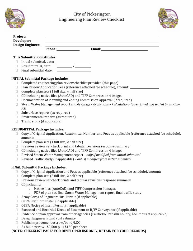
City of Pickerington Engineering Plan Review Checklist
Project: Developer: Design Engineer: Phone: Email: This Submittal Constitutes: � Initial submittal, date: � Resubmittal #, date: / � Final submittal, date:
INITIAL Submittal Package Includes:
� Completed engineering plan review checklist provided (this page) � Plan Review Application Fees (reference attached fee schedule), amount: � Complete plan sets (1 full size, 4 half size) � CD including native files (AutoCAD) and TIFF Compression 4 images � Documentation of Planning and Zoning Commission Approval (if required) � Storm Water Management report and drainage calculations – Calculations to be signed and sealed by an Ohio
P.E. � Subsurface reports (as required) � Environmental reports (as required) � Traffic study (if applicable)
RESUBMITTAL Package Includes:
� Copy of Original Application, Resubmittal Number, and Fees as applicable (reference attached fee schedule), amount:
� Complete plan sets (1 full size, 2 half size) � Previous review set check print and tabular revisions response summary � CD including native files (AutoCAD) and TIFF Compression 4 images � Revised Storm Water Management report – only if modified from initial submittal � Revised Traffic study (if applicable) – only if modified from initial submittal
FINAL Submittal Package Includes:
� Copy of Original Application and Fees as applicable (reference attached fee schedule), amount: � Complete plan sets (5 full size, 2 half size) � Previous review set check prints and tabular revisions response summary � CD including:
o Native files (AutoCAD) and TIFF Compression 4 images o PDF of plan set, final Storm Water Management report, final traffic study
� Army Corps of Engineers 404 Permit (if applicable) � OEPA Permit to Install (if applicable) � OEPA Notice of Intent Permit (if applicable) � Executed and Recorded Deeds of Easement or R/W Conveyance (if applicable) � Evidence of plan approval from other agencies (Fairfield/Franklin County, Columbus, if applicable) � Design Engineer’s final cost estimate � Public improvement escrow/bond/LOC � As built escrow - $2,500 plus $150 per sheet
[NOTE: CHECKLIST PAGES FOR DEVELOPER USE ONLY, RETAIN FOR YOUR RECORDS]

General Sheet Standards and Plan Development Guidance
Pickerington standard sheet frame o 22”x34” o ¾” border all sides
Title Block on each sheet o Project name and address o Sheet name o Sheet number (x of xx)
Revision Block North arrow (if applicable) Scale (includes text and symbol) Text orientation should be “right read” and sized at 3/32” minimum Legend All existing and proposed utilities shown should be labeled with type, size, depth, and slope Coded notes (as applicable) Maximum scale of 1:50 unless overall plan for large site; Large sites require overall plan and additional plan
sheets showing all portions of site not to exceed 1:50 scale. Order of sheets (as applicable). Each section may include more than one sheet if required to show all details.
o Title Sheet o General Notes/Details/Quantity Summary o Topography Survey o Demolition Plan o Site Dimensions o Site Grading and Drainage Plan and Profiles o Tributary Maps (drainage areas for each structure, grading plan) o Utility Plan/Profiles (includes Utility Relocation Plan) o Typical Pavement and Cross Sections o Intersection Grading and Details o Pavement Marking/Signage Plan o Erosion and Sediment Control Plan (SWPPP) o Landscape Plan
All AutoCAD files and layering system consistent with City of Columbus CAD Standards unless otherwise superseded by Pickerington requirements
Private road design is equivalent to public road standards Details to scale Appropriate items dimensioned Plan quantities shall be split between public and privately-owned infrastructure Development access is consistent with Pickerington Access Management Plan Development utility service is consistent with OEPA 208 Plan, City Wastewater and Water Master Plans 1988 N.A.V.D. elevation datum, State Plane South Coordinates Project is Geo-registered
Sheets may not be combined in any fashion without prior approval by the city.
Note: The City Engineer’s Office/Building Department will contact the plans submitter upon receipt of package if any of the above items do not conform to City requirements. Failure to submit the items may result in delay of the review process. Title Sheet
Name of Project A clearly legible location map showing the location of the project with respect to the nearest road
intersection with scale (maximum 1:2000 scale) Name, address, and contact information of the Design Engineer preparing the plan

Developer’s name, address, contact information Signature Lines for Pickerington City Engineer, Service Director, City Manager Index of Sheets Stamp and Signature of the Design Engineer licensed in the State of Ohio Site Total Area and Total Impervious Area Change Order (revisions) table Current Standard Drawings Traffic Data (as applicable)
No other information of any kind is permitted to be shown on the Title Sheet.
General Notes/Details/Quantity Summary
Pickerington General Notes (use applicable notes only) Fairfield County Notes (as applicable) Details (as applicable) Quantity Summery (as applicable)
Topography Survey
Existing contours-1' intervals and spot elevations for key features Benchmarks/horizontal controls including County certified benchmarks 1988 N.A.V.D elevation datum, State Plane South Coordinates Surveyor name and date of survey Property lines and owner information Monuments Easements, including deed book/page Bearing/distance information where applicable Existing buildings/structures and paved areas Existing utilities Existing elevations-finished floor, top of castings, invert Existing signs and utility/light poles Existing trees/plants (trees greater than 2” caliper) Do not show any proposed improvements or changes.
Demolition Plan
Existing buildings and paved areas Limits of removal Sequence of demolition and all applicable demolition notes Denote existing features as remove, remain, or relocate (and note by others as appropriate)
Site Dimensions
Show and Label Centerline, Edge of Pavement (or Back of Curb), and R/W of all adjacent streets. Label Size, Location, and Type of all Proposed Sidewalks and/or Multi-use paths including all handicap
ramps to be built on site or within the Public R/W Show and Label all Ingress/Egress points (both Proposed and Existing) and Cross Access Easements Label the Entrance Drives and Drive Widths. Drive widths comply with City standards. Parking Spaces/Islands Signs/pavement markings/traffic control Proposed Pad and Finished Floor Elevations provided
Site Grading and Drainage Plan and Profiles
Proposed right of way/easements All proposed utilities with stationing (stationing required for sewers and water lines only) Drainage flow arrows

Proposed Elevations (solid) including Contours and Spot Grades Storm Sewer Top of Casting & Invert Elevations 100-Year Flood Plane/Elevation Major Flood Routing (Designated with Unique Arrows defined on legend). Label Adjacent Property Names, Lot Numbers and Road Names Proposed and Existing Culverts or Storm Sewer and manholes
TC/EOP elevations at appropriate intervals Pond features, headwalls/outlets Channels/ditches and slopes Provide profiles of proposed storm sewers
Shown in background
Existing features/utilities Existing Contours (dashed) shown and labeled Existing right of way/easements Show and Label all existing structures with building footprint (external walls) Station and offset or GPS coordinates of all publicly maintained structures Work limits
Tributary Map Drainage area designations/size (acres)
Utility Plans Water
o Existing lines o Proposed lines with stationing o Fittings, valves, joints o Services and sizes o Hydrants o Blow off sizes/locations (or noted as TBD by city)
Sewers o Existing lines o Proposed lines with stationing o Sanitary laterals/sizes/slopes o Cleanouts o Tributary map for sanitary main o Inlets/manholes with inverts o Permanent BMPs o Storm water quality unit-access, maintenance, record keeping requirements o Grates/inlets stamped (drains to creek) o Applicable BMP Notes
Show in background Easements/lot lines/ROW Other utilities Building footprints Edge of pavement/back of curb Existing and proposed channels Streets/parking lots/islands
Don’t show Contours Spot elevations Drainage calculations Site plan dimensions

Pavement markings
Site Utility Profiles
Flow line elevations Existing and proposed surface elevations at centerline Pipe size, length, slope, material Stationing All crossed utilities Manhole TC, inverts, type Backfill limits for 911 and 912 backfill
Can be shown on utility plan if room on utility plan-city reserves right to require separate sheet for profiles Typical Pavement and Cross Sections
Limits of section 30 year pavement design (required for public roadways) Positive drainage Existing/proposed utilities shown Tie into existing grades Drive profile and drainage calculations
Intersection Grading and Details
ADA Compliance/ramps Benchmarks, if in area of detail TC/EOP elevations at 10' intervals (curb radius) TC/EOP elevations at 25' intersection detail TC/EOP elevations at appropriate intervals (other grading details) Drainage slopes and flow arrows Radius shown Existing/proposed storm sewers and structures Channels/ditches Show in background Streets/parking lot/islands, sidewalks Do not show Water lines/hydrants/valves, sanitary sewers, other utilities
Pavement Markings, Signs, Traffic Control Pavement markings Traffic control signs Stationing Pull boxes, signal conduit, and other traffic appurtenances Signal plan as per ODOT standards. Do not show Utilities Grading/contours
Erosion & Sediment Control Plan
Inlet Protection Locations Silt Fence Locations Check dams Sediment traps/basins Seeding plan Erosion Control Standards Details Construction Entrance Location and detail Construction sequencing (if necessary)

Landscape Plan
Stamped by landscape professional Plant materials/quantities/sizes (table) Proposed grading Property lines Planting plan
Table of code requirements Tree survey Tree removal/replacement
Show applicable code standards/sections and how plan meets or exceeds Tree replacement Buffer yard Foundation plantings
Show in background Right of way/easements Utilities and lighting Pavement, parking spots, curb/walk/bike path Building and outdoor equipment outlines Existing trees – note if removed or to remain Flood plain/wetlands/floodway
Storm Water Management Report Requirements and Calculations
Plan with tributary areas defined and tributary acreages labeled including offsite tributaries Pre-Development and Post- Development Maps Written Explanation/Summary/Narrative provided Water quantity and quantity addressed Calculations and frequencies provided where peak runoff from post-development 100-yr 24-hr storm less
than pre-development 2-yr 24-hr storm. Proper Method used for Storage
*************************************** For City Engineer use only ***********************************
Reviewed City Consultant Comments, revisions noted Reviewed water, wastewater, storm water requirements of site (including post-construction
maintenance issues) with Service Manager to ensure available capacity Back check Planning & Zoning approval letter outcomes are incorporated

Important Pickerington Documents
Pickerington Plan Review Submittal Form http://www.ci.pickerington.oh.us/upload/content/files/Engineering/Eng%20Plan%20Review%20Application%20April%2027%202016.pdf Pickerington General Notes http://www.ci.pickerington.oh.us/upload/content/files/Engineering/General%20Notes%20-%20June%202016.pdf Pickerington Access Management Plan http://www.ci.pickerington.oh.us/Pages/Departments/Engineering/Access_Management_Plan/ Pickerington Standard Sheets Look for “CADD Templates” under the quicklinks sidebar on the engineering department webpage.
Other Referenced Documents
City of Columbus Storm Water Manual https://www.columbus.gov/utilities/standards/Sanitary-and-Stormwater-Manuals-and-Submittal-Standards/ ODOT Roadway Design Manuals http://www.dot.state.oh.us/DIVISIONS/ENGINEERING/ROADWAY/DESIGNSTANDARDS/Pages/default.aspx City of Columbus Traffic Standards Code https://www.columbus.gov/WorkArea/linkit.aspx?LinkIdentifier=id&ItemID=31133