application to the tiger discretionary grants program · application to the tiger discretionary...
TRANSCRIPT
Application to the TIGER Discretionary Grants Program
Highway Project
Interstate 5 - Joint Base Lewis-McChord Area Congestion Management Project: SR 510 to SR 512
Submitted to:
TIGER Discretionary Grants Program Manager [email protected]
Submitted by:
Washington State Department of Transportation 310 Maple Park Avenue SE PO Box 47300 Olympia, WA 98504-7300
Interstate 5 - JBLM Area Congestion Management Project: SR 510 to SR 512 October 31, 2011 Tiger ID Number: WSDOT73943 i
Table of Contents
I. Project Description ……………………………………………...……………………… Page 1
II. Project Party ……………………………………………...…………………….…..….. Page 6
1. Washington Department of Transportation (WSDOT) ……………………...… Page 6
III. Grant Funds and Sources/Uses of Project Funds ………………………………..…… Page 6
IV. Primary Selection Criteria ………………………………………………….………… Page 8
a. Long-Term Outcomes ……………………………………………………… Page 8
i. State of Good Repair ………………………………………...…… Page 8 ii. Economic Competitiveness ………………………………..………Page 9
iii. Livability …………………………………………………………..Page 12 iv. Environmental Sustainability ……………………………………...Page 14 v. Safety ……………………………………………………..……… Page 14
V. Evaluation of Expected Project Costs and Benefits …………………………..….…….Page 16
VI. Evaluation of Project Performance …………………………………………..…..……Page 19
b. Job Creation and Near-Term Economic Activity ……………..………..….. Page 21
i. Project Schedule …………………………………………….……. Page 21 ii. Environmental Approvals ……………………………..….…..…... Page 21
iii. Legislative Approvals …………………………………….….…… Page 22 iv. State and Local Planning …………………………………...…….. Page 22 v. Technical Feasibility ……………………………………..……......Page 22
vi. Financial Feasibility …………………………………….…..……. Page 22
VII. Secondary Selection Criteria ………………………………………………….……...Page 23
a. Innovation ………………………………………………………….…...….. Page 23 b. Partnership ………………………………………………………….….…...Page 23
i. Jurisdictional & Stakeholder Collaboration ……………….….….. Page 23 ii. Disciplinary Integration …………………………………….….….Page 24
VIII. Federal Wage Rate Certification …………………………………………….……....Page 24
IX. Pre-application Changes ………………………………………………………...……. Page 24
List of Figures
Exhibit 1 – Project Map and Features ………………………………………..……Page 2
Exhibit 2 – Annual Accrual of Cost and Benefit using 3% Discount Rate …..…... Page 17
Exhibit 3 – Annual Accrual of Cost and Benefit using 7% Discount Rate ……..... Page 18
Interstate 5 - JBLM Area Congestion Management Project: SR 510 to SR 512 October 31, 2011 Tiger ID Number: WSDOT73943 Page 1 of 24
Project Narrative
I. Project Description
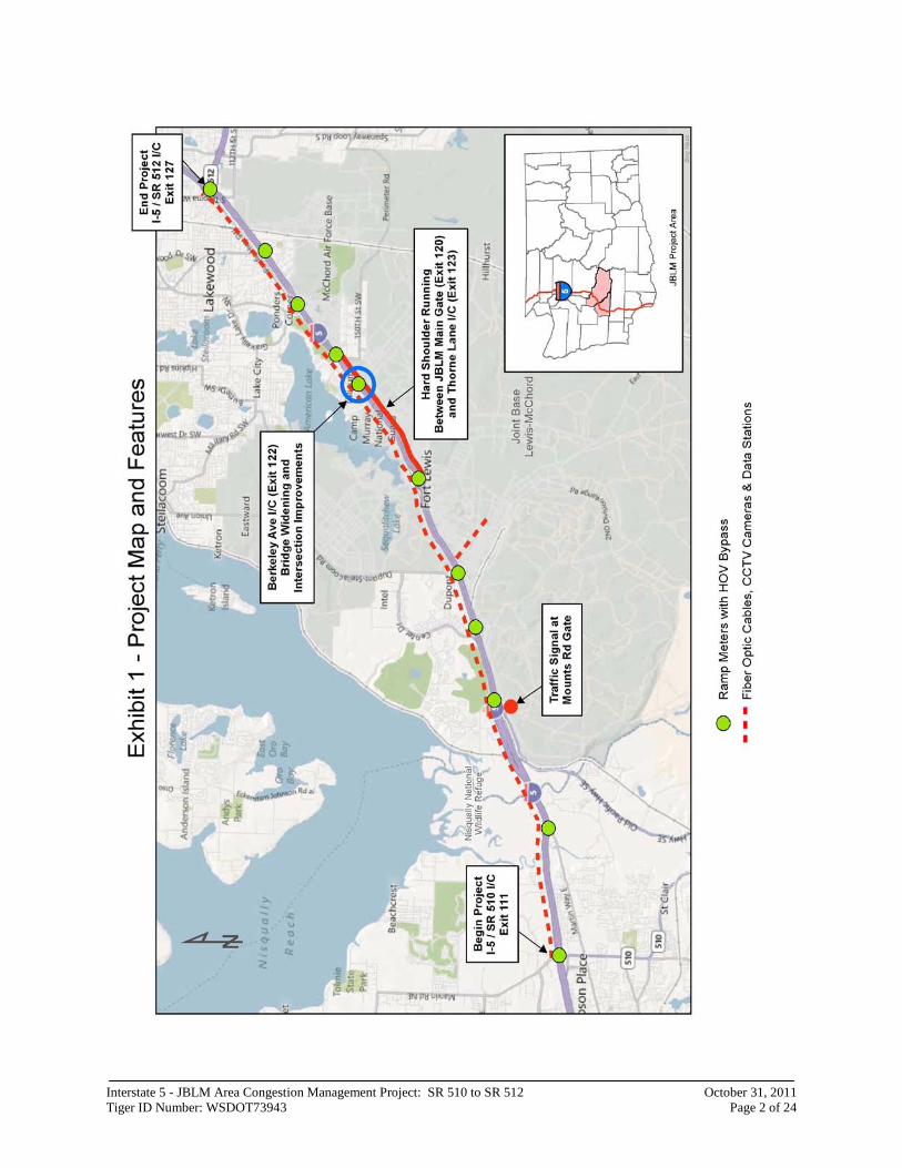
Location: The I-5 Joint Base Lewis-McChord Area Congestion Management Project extends approximately 15.5 miles on Interstate 5 (I-5) from SR 510 north to SR 512. (See Exhibit 1) This area of I-5 is just north of the state capitol, Olympia and just south of the city of Tacoma in Thurston and Pierce counties in the State of Washington. In Washington I-5 runs north from the Columbia River between Portland, Oregon and the international border near Vancouver, British Columbia, Canada.
Background
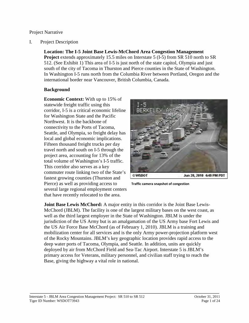
Economic Context: With up to 15% of statewide freight traffic using this corridor, I-5 is a critical economic lifeline for Washington State and the Pacific Northwest. It is the backbone of connectivity to the Ports of Tacoma, Seattle, and Olympia, so freight delay has local and global economic implications. Fifteen thousand freight trucks per day travel north and south on I-5 through the project area, accounting for 13% of the total volume of Washington’s I-5 traffic. This corridor also serves as a key commuter route linking two of the State’s fastest growing counties (Thurston and Pierce) as well as providing access to several large regional employment centers that have recently relocated to the area.
Joint Base Lewis McChord: A major entity in this corridor is the Joint Base Lewis-McChord (JBLM). The facility is one of the largest military bases on the west coast, as well as the third largest employer in the State of Washington. JBLM is under the jurisdiction of the US Army but is an amalgamation of the US Army base Fort Lewis and the US Air Force Base McChord (as of February 1, 2010). JBLM is a training and mobilization center for all services and is the only Army power-projection platform west of the Rocky Mountains. JBLM’s key geographic location provides rapid access to the deep water ports of Tacoma, Olympia, and Seattle. In addition, units are quickly deployed by air from McChord Field and Sea-Tac Airport. Interstate 5 is JBLM’s primary access for Veterans, military personnel, and civilian staff trying to reach the Base, giving the highway a vital role in national.
Traffic camera snapshot of congestion
Interstate 5 - JBLM Area Congestion Management Project: SR 510 to SR 512 October 31, 2011 Tiger ID Number: WSDOT73943 Page 2 of 24
Interstate 5 - JBLM Area Congestion Management Project: SR 510 to SR 512 October 31, 2011 Tiger ID Number: WSDOT73943 Page 3 of 24
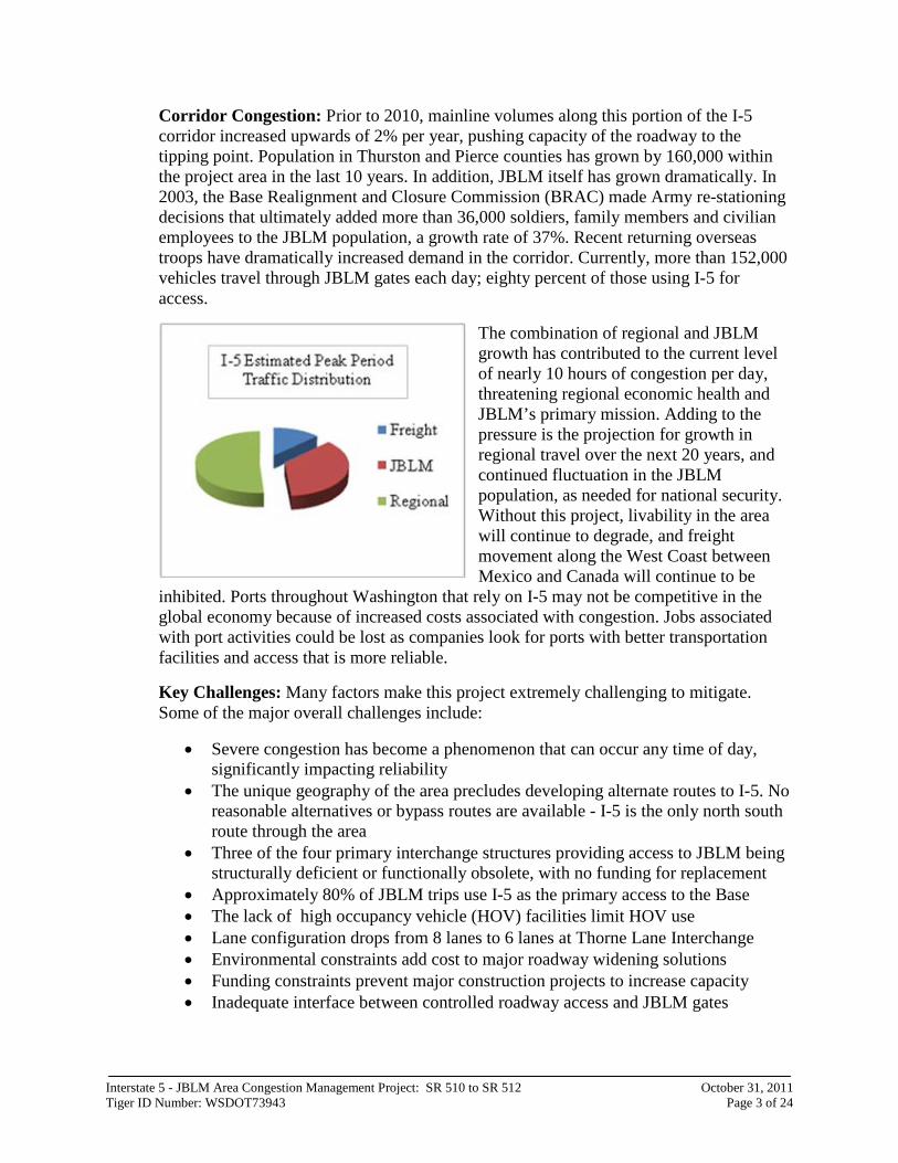
Corridor Congestion: Prior to 2010, mainline volumes along this portion of the I-5 corridor increased upwards of 2% per year, pushing capacity of the roadway to the tipping point. Population in Thurston and Pierce counties has grown by 160,000 within the project area in the last 10 years. In addition, JBLM itself has grown dramatically. In 2003, the Base Realignment and Closure Commission (BRAC) made Army re-stationing decisions that ultimately added more than 36,000 soldiers, family members and civilian employees to the JBLM population, a growth rate of 37%. Recent returning overseas troops have dramatically increased demand in the corridor. Currently, more than 152,000 vehicles travel through JBLM gates each day; eighty percent of those using I-5 for access.
The combination of regional and JBLM growth has contributed to the current level of nearly 10 hours of congestion per day, threatening regional economic health and JBLM’s primary mission. Adding to the pressure is the projection for growth in regional travel over the next 20 years, and continued fluctuation in the JBLM population, as needed for national security. Without this project, livability in the area will continue to degrade, and freight movement along the West Coast between Mexico and Canada will continue to be
inhibited. Ports throughout Washington that rely on I-5 may not be competitive in the global economy because of increased costs associated with congestion. Jobs associated with port activities could be lost as companies look for ports with better transportation facilities and access that is more reliable.
Key Challenges: Many factors make this project extremely challenging to mitigate. Some of the major overall challenges include:
• Severe congestion has become a phenomenon that can occur any time of day, significantly impacting reliability
• The unique geography of the area precludes developing alternate routes to I-5. No reasonable alternatives or bypass routes are available - I-5 is the only north south route through the area
• Three of the four primary interchange structures providing access to JBLM being structurally deficient or functionally obsolete, with no funding for replacement
• Approximately 80% of JBLM trips use I-5 as the primary access to the Base • The lack of high occupancy vehicle (HOV) facilities limit HOV use • Lane configuration drops from 8 lanes to 6 lanes at Thorne Lane Interchange • Environmental constraints add cost to major roadway widening solutions • Funding constraints prevent major construction projects to increase capacity • Inadequate interface between controlled roadway access and JBLM gates
Interstate 5 - JBLM Area Congestion Management Project: SR 510 to SR 512 October 31, 2011 Tiger ID Number: WSDOT73943 Page 4 of 24
Specific operational and safety issues include:
• Close intersection spacing and at-grade rail line crossings at the I-5 ramp interchanges at Bridgeport Way, Thorne Lane, Berkeley Avenue, 41st Division Drive (Main Gate), and DuPont-Steilacoom Road
• Significant mainline congestion during PM peak hour periods at the Thorne Lane interchange due to the choke point on I-5 from dropping from 8 to 6 lanes
• Poor circulation and frequent congestion in the Tillicum neighborhood due to the close proximity to the Berkeley Avenue interchange
• AM peak hour congestion at the southbound I-5 off-ramp at Berkeley Avenue resulting from the general capacity of the interchange and access control at JBLM. This problem is spreading beyond the peak hour
• PM peak hour I-5 mainline and ramp congestion at the SR 512 interchange, northbound Gravelly Lake Drive off-ramp, and between the Berkeley Avenue northbound on-ramp and Thorne Lane off-ramp. This problem is spreading beyond the peak hour
• Inadequate out-bound JBLM operations at Berkeley Avenue (to northbound I-5), DuPont gate/DuPont-Steilacoom Road (to southbound I-5), and Center Drive (to DuPont and southbound I-5)
• Limited internal circulation within JBLM
The I-5 JBLM Area Congestion Management Project: SR 510 to SR 512: The proposed project controls and redistributes demand, adds capacity, and provides real time information to drivers in this heavily congested corridor. Managing congestion will also improve access. This project has an estimated benefit cost ratio ranging from 10.0-14.2:1. The components of this project will allow it to be phased and implemented in stages when funding is available.
Major components of this project include the following:
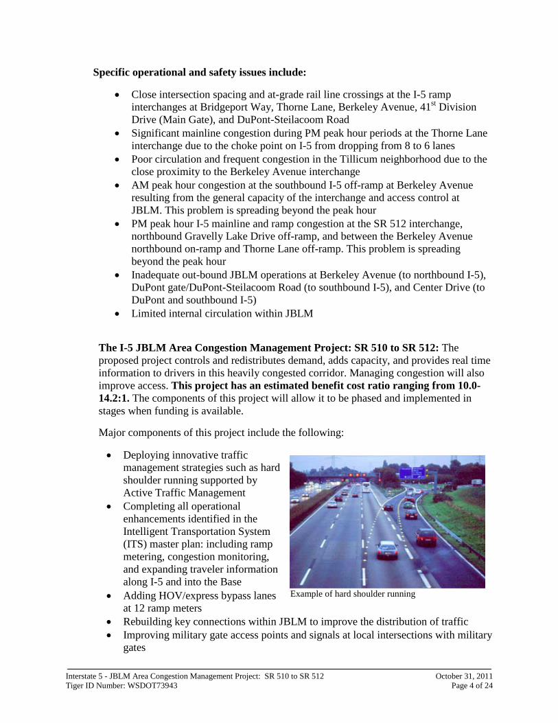
• Deploying innovative traffic management strategies such as hard shoulder running supported by Active Traffic Management
• Completing all operational enhancements identified in the Intelligent Transportation System (ITS) master plan: including ramp metering, congestion monitoring, and expanding traveler information along I-5 and into the Base
• Adding HOV/express bypass lanes at 12 ramp meters
• Rebuilding key connections within JBLM to improve the distribution of traffic • Improving military gate access points and signals at local intersections with military
gates
Example of hard shoulder running
Interstate 5 - JBLM Area Congestion Management Project: SR 510 to SR 512 October 31, 2011 Tiger ID Number: WSDOT73943 Page 5 of 24
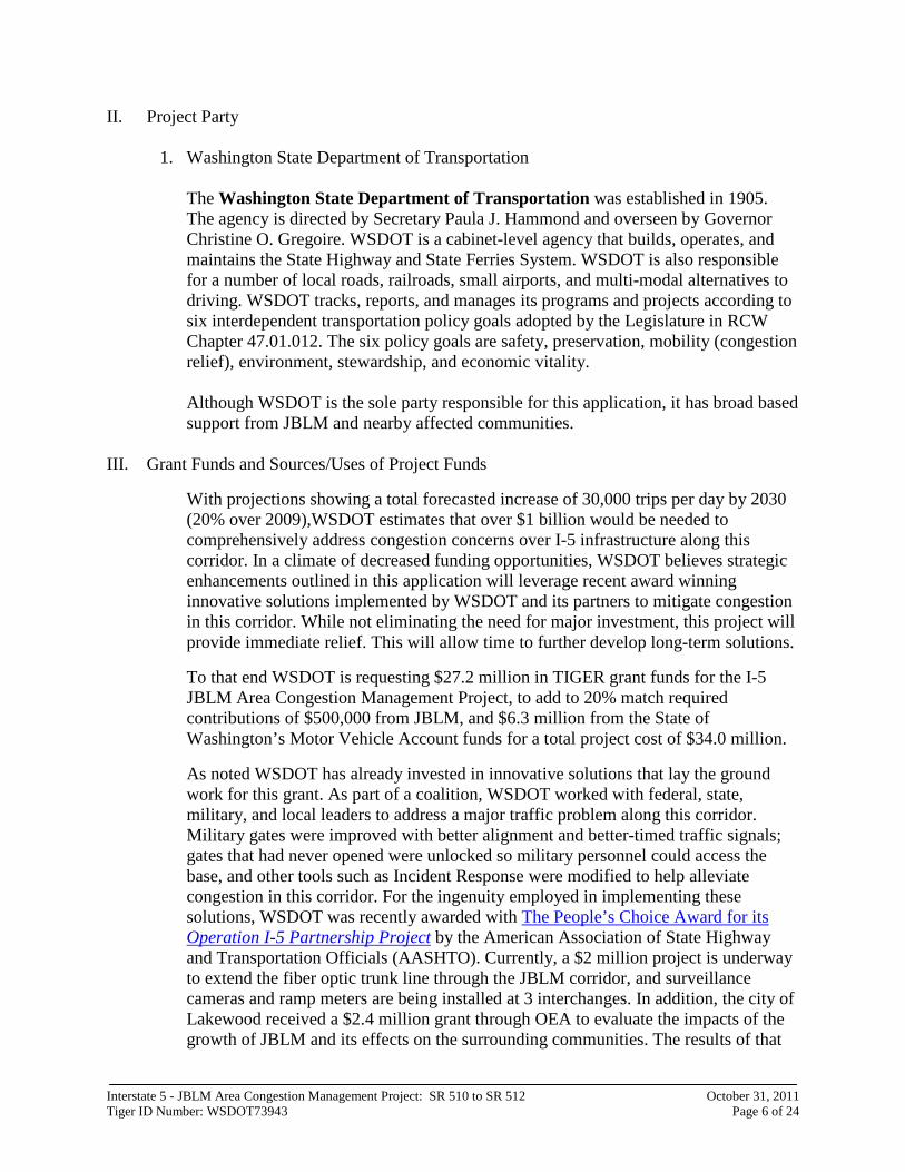
Example of signalized intersection
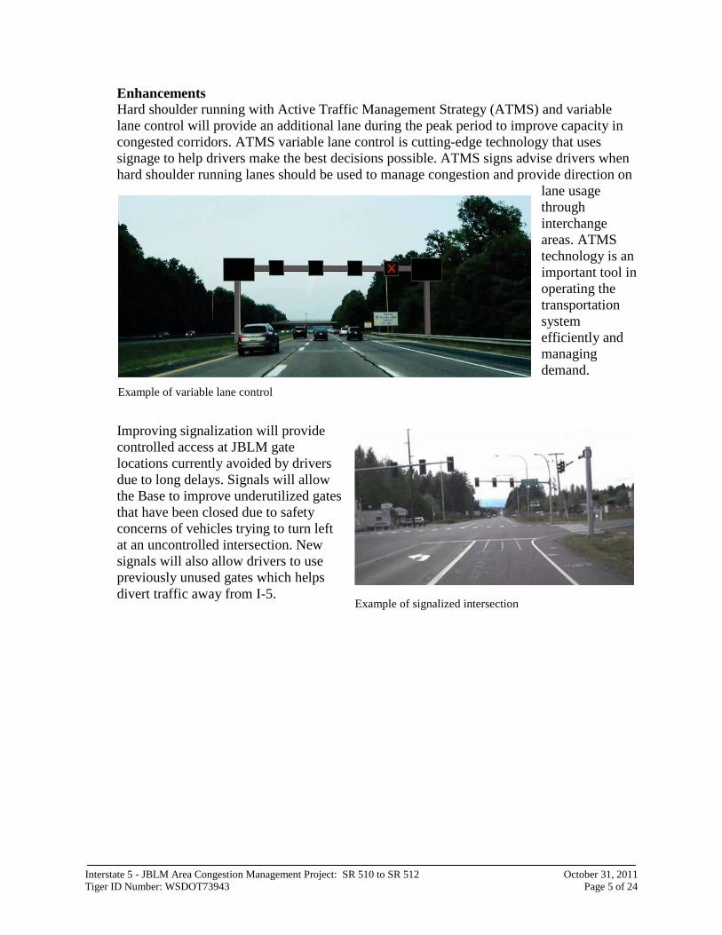
Enhancements Hard shoulder running with Active Traffic Management Strategy (ATMS) and variable lane control will provide an additional lane during the peak period to improve capacity in congested corridors. ATMS variable lane control is cutting-edge technology that uses signage to help drivers make the best decisions possible. ATMS signs advise drivers when hard shoulder running lanes should be used to manage congestion and provide direction on
lane usage through interchange areas. ATMS technology is an important tool in operating the transportation system efficiently and managing demand.
Improving signalization will provide controlled access at JBLM gate locations currently avoided by drivers due to long delays. Signals will allow the Base to improve underutilized gates that have been closed due to safety concerns of vehicles trying to turn left at an uncontrolled intersection. New signals will also allow drivers to use previously unused gates which helps divert traffic away from I-5.
Example of variable lane control
Interstate 5 - JBLM Area Congestion Management Project: SR 510 to SR 512 October 31, 2011 Tiger ID Number: WSDOT73943 Page 6 of 24
II. Project Party
1. Washington State Department of Transportation
The Washington State Department of Transportation was established in 1905. The agency is directed by Secretary Paula J. Hammond and overseen by Governor Christine O. Gregoire. WSDOT is a cabinet-level agency that builds, operates, and maintains the State Highway and State Ferries System. WSDOT is also responsible for a number of local roads, railroads, small airports, and multi-modal alternatives to driving. WSDOT tracks, reports, and manages its programs and projects according to six interdependent transportation policy goals adopted by the Legislature in RCW Chapter 47.01.012. The six policy goals are safety, preservation, mobility (congestion relief), environment, stewardship, and economic vitality. Although WSDOT is the sole party responsible for this application, it has broad based support from JBLM and nearby affected communities.
III. Grant Funds and Sources/Uses of Project Funds
With projections showing a total forecasted increase of 30,000 trips per day by 2030 (20% over 2009),WSDOT estimates that over $1 billion would be needed to comprehensively address congestion concerns over I-5 infrastructure along this corridor. In a climate of decreased funding opportunities, WSDOT believes strategic enhancements outlined in this application will leverage recent award winning innovative solutions implemented by WSDOT and its partners to mitigate congestion in this corridor. While not eliminating the need for major investment, this project will provide immediate relief. This will allow time to further develop long-term solutions.
To that end WSDOT is requesting $27.2 million in TIGER grant funds for the I-5 JBLM Area Congestion Management Project, to add to 20% match required contributions of $500,000 from JBLM, and $6.3 million from the State of Washington’s Motor Vehicle Account funds for a total project cost of $34.0 million.
As noted WSDOT has already invested in innovative solutions that lay the ground work for this grant. As part of a coalition, WSDOT worked with federal, state, military, and local leaders to address a major traffic problem along this corridor. Military gates were improved with better alignment and better-timed traffic signals; gates that had never opened were unlocked so military personnel could access the base, and other tools such as Incident Response were modified to help alleviate congestion in this corridor. For the ingenuity employed in implementing these solutions, WSDOT was recently awarded with The People’s Choice Award for its Operation I-5 Partnership Project by the American Association of State Highway and Transportation Officials (AASHTO). Currently, a $2 million project is underway to extend the fiber optic trunk line through the JBLM corridor, and surveillance cameras and ramp meters are being installed at 3 interchanges. In addition, the city of Lakewood received a $2.4 million grant through OEA to evaluate the impacts of the growth of JBLM and its effects on the surrounding communities. The results of that
Interstate 5 - JBLM Area Congestion Management Project: SR 510 to SR 512 October 31, 2011 Tiger ID Number: WSDOT73943 Page 7 of 24
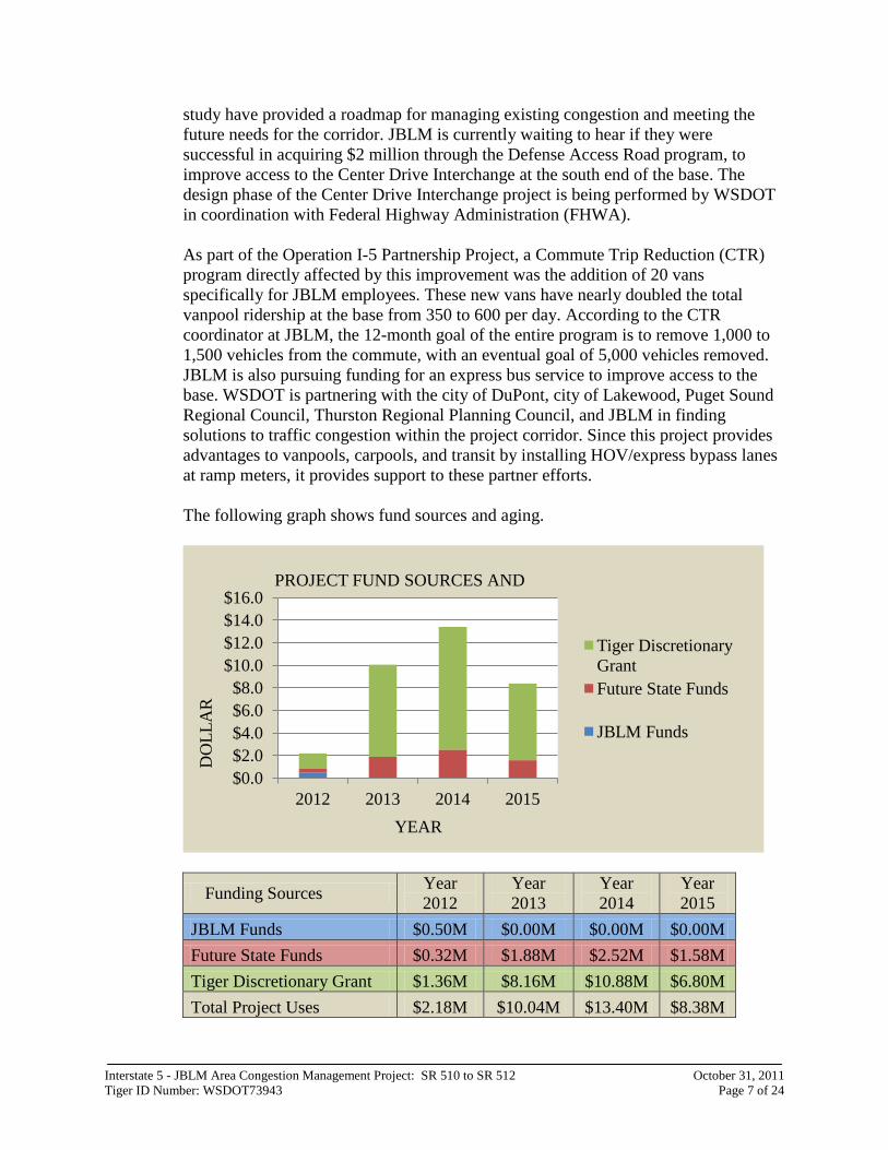
study have provided a roadmap for managing existing congestion and meeting the future needs for the corridor. JBLM is currently waiting to hear if they were successful in acquiring $2 million through the Defense Access Road program, to improve access to the Center Drive Interchange at the south end of the base. The design phase of the Center Drive Interchange project is being performed by WSDOT in coordination with Federal Highway Administration (FHWA). As part of the Operation I-5 Partnership Project, a Commute Trip Reduction (CTR) program directly affected by this improvement was the addition of 20 vans specifically for JBLM employees. These new vans have nearly doubled the total vanpool ridership at the base from 350 to 600 per day. According to the CTR coordinator at JBLM, the 12-month goal of the entire program is to remove 1,000 to 1,500 vehicles from the commute, with an eventual goal of 5,000 vehicles removed. JBLM is also pursuing funding for an express bus service to improve access to the base. WSDOT is partnering with the city of DuPont, city of Lakewood, Puget Sound Regional Council, Thurston Regional Planning Council, and JBLM in finding solutions to traffic congestion within the project corridor. Since this project provides advantages to vanpools, carpools, and transit by installing HOV/express bypass lanes at ramp meters, it provides support to these partner efforts. The following graph shows fund sources and aging.
Funding Sources Year 2012
Year 2013
Year 2014
Year 2015
JBLM Funds $0.50M $0.00M $0.00M $0.00M Future State Funds $0.32M $1.88M $2.52M $1.58M Tiger Discretionary Grant $1.36M $8.16M $10.88M $6.80M Total Project Uses $2.18M $10.04M $13.40M $8.38M
$0.0 $2.0 $4.0 $6.0 $8.0
$10.0 $12.0 $14.0 $16.0
2012 2013 2014 2015
Tiger Discretionary Grant Future State Funds
JBLM Funds
YEAR
DO
LLA
R
PROJECT FUND SOURCES AND
Interstate 5 - JBLM Area Congestion Management Project: SR 510 to SR 512 October 31, 2011 Tiger ID Number: WSDOT73943 Page 8 of 24
IV. Primary Selection Criteria a. Long-Term Outcomes
WSDOT and local partners have identified I-5 congestion between SR 510 and SR 512 as a high priority for improvement. This project will provide positive long-term outcomes for the Puget Sound, the West Coast and the nation. Long-term benefits have been calculated using a range of factors related to accessibility, travel conditions and modes, economic markets and industry. Through congestion management, the project fundamentally improves travel between key areas in south and central Puget Sound, and from JBLM. Managing congestion improves access, and analysis shows that increased accessibility will result in increased economic production by attracting businesses to the study area, increased labor productivity through input sharing and matching, and increased exports through improvements in port access. Access is based on an evaluation of the forty minute market, the three hour market, time to modal facilities and international gateways, and facility quality.
i. State of Good Repair
(i) WSDOT, JBLM, the city of Lakewood and the city of DuPont are in agreement that the I-5 corridor is a critical link for continuing economic viability. This project fulfills recommendations adopted by a broad stakeholder process in 2010 called the JBLM Growth Coordination Plan (GCP). The plan was led by the city of Lakewood and sponsored by the Department of Defense. The plan identified the I-5 corridor as being vital to the mission of JBLM. This effort of local, state, federal, and military leaders determined that a wide range of improvements were needed to provide for reliable transportation to JBLM and surrounding communities in preparation for further expansion of the base. Among the transportation recommendations documented in the final report, one strategy calls for provision of HOV lanes to support and incentivize carpooling. The project design also proposes facilitates that provide exiting HOV/express lanes to bypass ramp meters.
The GCP also identified deficiencies and recommended further study to rebuild various interchanges along the corridor. WSDOT has conducted other studies and has proposed studies that will study the corridor in more detail. WSDOT has a history of working partnership with JBLM in conjunction with the Defense Access Roads program to rebuild roads and interchanges accessing JBLM.
(ii) The project is designed to maximize the existing corridor capacity with the use of ITS. If improvements are not made, commuters and freight operators will continue to experiences long delays, averaging 1-3 hours per trip.
Interstate 5 - JBLM Area Congestion Management Project: SR 510 to SR 512 October 31, 2011 Tiger ID Number: WSDOT73943 Page 9 of 24
(iii) The project installs ramp meters, which maximizes the use of capital while providing strategies that return a true benefit for the commuters. Ramp meters have shown benefit in travel time and in the reduction of crashes. Repaving roads within the Base and building new signals at strategic gate locations will provide controlled access and encourage the use of underutilized gates, dispersing the demand away from congested areas.
Hard shoulder running with ATMS directed variable lane control provides additional capacity (when needed) that benefit more commuters by reducing travel times.
The project proposes to extend the life of the existing facility by providing operational improvements that allow for better utilization of present roadway capacity. These operational improvements include installing ramp meters and the infrastructure needed to support hard shoulder running operation during peak hours.
(iv) The project continues the installation of the WSDOT ITS master plan that includes future operational and maintenance costs. The initial installation of ITS will maximize use of the existing facility and later provide valuable tools to manage construction traffic when rebuilding the corridor. Currently, active ITS devices are maintained and tracked in SIMMS, a database that identifies devices needing replacement. SIMMS also tracks preventative maintenance on ITS devices and is used to measure performance of many maintenance activities. As a tool, SIMMS links strategic planning, the budget and maintenance service delivery.
Project benefits - State of good repair
The project maximizes existing corridor capacity by deploying ITS and peak hour traffic management strategies. By extending the life of the existing facility, the long-term improvement cost estimated at over $1 billion could be delayed. Assuming the project proposed in this application delays the high cost planned corridor investments for 5 years, and the investment would have taken place over 10 years starting in 2020, then the value of the 5 year delay at a 3% discount rate and 2% inflation rate would be about $55 million (in 2020 dollars). The value of this extension of service life is included here for illustrative purposes only. Since the approach used was subjective, involving speculation about an unfunded project, and a number of other assumptions, it was not included in the project benefit cost calculation.
ii. Economic Competitiveness
(i) The project contributes to long-term economic success of the Pacific Northwest and the West Coast by improving the efficiency of the corridor with ITS strategies. The project addresses a specific traffic issue that occurs during peak hour travel when heavy traffic exits the freeway to JBLM during the morning commute, and enters the freeway during the evening commute.
Interstate 5 - JBLM Area Congestion Management Project: SR 510 to SR 512 October 31, 2011 Tiger ID Number: WSDOT73943 Page 10 of 24
Ramp meters installed at freeway entrances will smooth the flow of traffic entering the freeway, thereby improving the characteristics of mainline operations. Ramp meters installed in similar locations elsewhere in the Puget Sound Region, have proven they delay the onset of congestion, reduce duration and improve overall throughput in the corridor.
This project proposes HOV/express bypass lanes extending from within JBLM to allow drivers to bypass ramp meters, and encourage bus ridership and vanpooling/carpooling. This will reduce the number of vehicles during the peak period.
The use of ATMS is cutting-edge technology that uses variable lane control signage to help guide drivers and allow them to make the best decisions possible. ATMS technology also helps keep traffic flowing as smoothly as possible on highways where the system capacity simply can’t keep up with our expanding population. ATMS is an important tool in operating our transportation system efficiently and managing demand. The use of ATMS will allow hard shoulder running between on and off- ramps along I-5 during the peak period with variable lane controls. Hard shoulder driving has proven effective in extending the life of the existing infrastructure reducing congestion where it has been used.
Fiber optic communications will be extended to JBLM to provide real time information to drivers exiting the Base. This will give drivers trip planning tools to identify which gates are backed up or which gates have available capacity. This will be accomplished through on-Base real time travel advisory signing. All these investments will improve the travel time reliability in the corridor. Improvements will enhance access for a wide range of travel purposes especially businesses that depend on predictable travel in the corridor. The project also contributes to economic competitiveness by giving HOV travelers an incentive to use HOV instead of single occupancy vehicles. By the construction of HOV/express bypass lanes at ramp meter throughout the project corridor. These types of HOV facilities make the trip faster for travelers, giving them an incentive to switch to the HOV mode. This reliability improvement can also be attributed to reduced buffer time for a wide range of travel purposes. This project can be expected to reduce costs for all users of the corridor, including freight movement. Interstate 5 is the primary roadway link between Mexico, US, and Canada on the West Coast and is the primary link to major employment centers in the Puget Sound Region. There are no reasonable alternative routes to I-5 through the JBLM area, which is a serious issue for long range regional, interstate, and international traffic. Costs incurred by congestion to the international truck traffic to and from the Seattle area from Mexico and Canada is estimated by the Freight Analysis Framework (FAF)

Interstate 5 - JBLM Area Congestion Management Project: SR 510 to SR 512 October 31, 2011 Tiger ID Number: WSDOT73943 Page 11 of 24
database for 2009, published by FHWA Office of Freight Management and Operations, at almost $6 billion and are itemized in the following table.
From To FAF Estimated Cost Seattle Mexico $278 million California Canada via WA $2.73 billion Oregon Canada via WA $789 million Canada California via WA $1.28 billion Canada Oregon via WA $589 million Mexico Seattle $230 million
The project contributes to economic competitiveness by providing travel cost savings to shippers, and logistical benefits to receivers, of $95 million (undiscounted dollars) across all sectors of the economy over the 20 year design life of the project.
(ii) I-5 within the project area is not in an economically distressed area, however adjacent counties to the project area that have been identified as being distressed areas could benefit from improved travel times through this section of I-5 as a results of this project. Improved travel times will make the region more attractive to businesses and further economic development.
Project benefits – Economic competitiveness
Because of improvements in traffic flow and HOV throughput, the project results in savings in vehicle hours traveled (VHT). TREDIS software was used to estimate economic impacts related to the project improvements, resulting in the following estimated benefits over the thirty year life of the project:
• Operating costs: The improvement in operating costs for passenger
vehicles, including fuel and oil consumption, tire wear, maintenance, and depreciation was calculated using TREDIS. Three different operating parameters were considered: average per mile cost for uncongested conditions; average per mile cost under congested conditions, and per hour cost of vehicles sitting at idle, in a queue, or traveling in highly congested conditions. The undiscounted estimated vehicle operating cost savings was calculated at $138.8 million.
• Travel time and reliability: Savings in travel time and buffer time due to the project were calculated using the improvement in VHT due to the project. Buffer time was 3.1% improvement for buffer time in metered corridors. The undiscounted estimated travel time and reliability cost savings was calculated at $232.8 million.
• Freight: The benefit of improved travel time for vehicle drivers, crew, passengers, cargo, and operating and accident costs were calculated using TREDIS. The undiscounted estimated savings in logistics operations to freight shippers was calculated at $95.0 million.
Interstate 5 - JBLM Area Congestion Management Project: SR 510 to SR 512 October 31, 2011 Tiger ID Number: WSDOT73943 Page 12 of 24
• Job creation: Increases in productivity result in a total projected increase in region employment of 2,351 jobs. This is an estimated economic impact only, and is not included in the project benefit-cost calculation.
iii. Livability
Due to antiquated facilities and increase demand, all modes of transportation suffer due to peak hour congestion on I-5 in the project corridor. This is due in large part to the lack of HOV specific facilities in the project area. Construction of HOV lanes on I-5 within the project area is included in the long term WSDOT Transportation Plan.
However, this project focuses on short-term, operational fixes that will contribute to the efficiency of all HOV modes (buses, carpools, and vanpools). To increase HOV use, State transportation plans include target strategies to improve the effectiveness of commute trip reduction initiatives at JBLM and elsewhere in the Puget Sound region. The Growth and Transportation Efficiency Center program, is particularly successful at implementing traffic demand management strategies at work sites throughout the area served by this section of I-5.
This project proposal includes an HOV solution. To complement ITS and ATMS, WSDOT will provide new HOV/express bypass operations at all ramp meter locations. New HOV/express bypass facilities will encourage the use of more sustainable transportation modes such as transit or car/vanpool during peak hours. The project will have a direct effect on travel along I-5 to the cities of Lacey, DuPont and Lakewood, and JBLM. Travel time throughout the region to cities farther north and south in the corridor will also improve, including travel time to Olympia, Tacoma, and Seattle.
This project will have a positive effect on the quality of life for the region by:
• Providing commute time savings, saving drivers an estimated 531,000 hours of travel time per year in the base year
• Increasing capacity of the existing infrastructure, deferring the need to reconstruct the corridor.
• Reducing 121,000 trips to JBLM in the base year • Reducing daily person-miles traveled in the base year to 1,360,000 • Reducing overall congestion and having fewer cars sit idling • Reducing carbon dioxide (CO2) emissions in the short term (no long
term reduction expected due to increased capacity and accompanying population growth in the region)
• Reducing regional commute times • Improving travel time reliability and predictability for all traffic
Interstate 5 - JBLM Area Congestion Management Project: SR 510 to SR 512 October 31, 2011 Tiger ID Number: WSDOT73943 Page 13 of 24
The project increases viable transportation choices. By reducing congestion and improving HOV access, the project also decreases household transportation costs. For example:
• This project will significantly reduce the average cost of user mobility
by creating more HOV access, making HOV options like vanpools, transit, and carpools more attractive and more beneficial to users
• Will improve existing transportation choices by enhancing points of modal connectivity, and reducing commute time and congestion on existing modal assets
• Improve the movement of people and goods in the corridor • Provide more job commuting options
Project benefits – Livability
Because of improvements in traffic flow and HOV throughput, the project results in savings in travel time and VHT, which were applied to subjective estimates of improvements to livability. Subjective estimates of livability benefits follow, and are based on tangible improvements in accessibility and transit performance. However, these estimates were not included in the project benefit cost calculation.
• Accessibility: The project improves access to jobs and amenities by
reducing average travel time in during peak hours by about four minutes northbound, and two and one half minutes southbound.
• Due to the unreliability of the corridor, travel buffer time, as defined by FHWA, which is currently estimated at about six minutes northbound and four minutes southbound is expected to be reduced, for a total reduction in trip time of four and one half minutes northbound, and three minutes southbound.
• Transit/CTR: Since there are no HOV facilities on the corridor at the present time, these travel time savings accrue to both private vehicle and transit vehicles in the same way. There is an average of almost 1,000 transit passengers traveling during peak hours on this corridor every day. In this way, disadvantaged communities who depend on transit in the corridor to make connections between Thurston County/south Pierce County to Tacoma and Seattle are further impacted by the congestion. The JBLM Installation Sustainability Program has identified goals to increase for HOV travel to and from the base. The project supports these goals by providing HOV bypass facilities at certain onramps serving JBLM.
• Land use changes linked to transportation: No benefits are anticipated or were estimated regarding potential land use changes based on the project, as none are anticipated.

Interstate 5 - JBLM Area Congestion Management Project: SR 510 to SR 512 October 31, 2011 Tiger ID Number: WSDOT73943 Page 14 of 24
iv. Environmental Sustainability
WSDOT is committed to increasing sustainable transportation. For example, hard shoulder running is a strategy to use the existing pavement for improving traffic with lower costs and fewer environmental impacts than large scale construction projects. Sustainable strategies like hard shoulder running increase the efficiency of the existing facility, while conserving resources for the future. Sustainable transportation is a system that preserves the environment, is durable and takes into account how we build and the materials we use. It's a system that manages and operates using policies and strategies that meet society's present needs without compromising the needs of future generations.
• The I-5 JBLM Area Congestion Management Project will improve
energy efficiency. Cost factors based on work published by the US Environmental Protection Agency (EPA) were applied to value for the base case and project case VHT, VMT, and fraction of VMT in congested conditions, for emission of nitrogen oxides (NOx), sulfur dioxide (SO2), particulate matter (PM), and volatile organic compounds (VOC) and greenhouse gases. The results show that by reducing commute time so that the interstate can operate closer to design speeds, a savings in societal cost associated with improvement in emissions due to the project is estimated to be $6.8 million over the project’s 20 year life.
• The project will be designed and constructed to avoid, minimize and mitigate impact to the environment. This project has no planned unavoidable environmental impacts to air or water quality, wetlands, or endangered species. Environmental benefits include the installation of new bioswales to allow for storm water infiltration.
Project benefits – Environmental Sustainability
TREDIS software was used to estimate emission reductions due to the project, and these estimates were used in calculating the project benefits. According to program documentation, because the assumption is that VMT in the corridor will not change after the project, the calculation is based on the anticipated reduction in total VHT, and in vehicle-miles in congested conditions. The undiscounted estimated emissions reduction benefit calculated for the project is estimated at $5.6 million.
v. Safety
New ITS applications within the project area will improve the safety of traffic in and around the corridor. The installation of ramp meters will improve the merging of traffic and will prevent or delay traffic flow breakdown. Ramp meters help break up vehicle platoons and improve the flow characteristics of
Interstate 5 - JBLM Area Congestion Management Project: SR 510 to SR 512 October 31, 2011 Tiger ID Number: WSDOT73943 Page 15 of 24
traffic entering the freeway. Ramp meters also reduce the risk of collisions due to heavy, uncontrolled merges. This improved merge can have a significant benefit to freeway travel. Ramp meters are a low cost solution to decreasing congestion and increasing capacity of existing facilities. In 23 urban areas across the US, studies where ramp metering was implemented, reported crash rate reductions of 24 to 50% (Piotrowicz and Robinson, 1995 pp 26). Without ramp meters, multiple cars try to merge simultaneously. Drivers on the freeway slow down to allow the cars enter and these slower speeds quickly cause backups. If cars enter the highway in controlled intervals, they are less likely to cause a disruption to the traffic on the freeway. A short wait on the ramp allows drivers to increase their average freeway speed and shorten overall freeway travel times. Ramp meters also reduce the number of accidents that often occur when multiple vehicles merge onto the highway at the same time. Ramp meters are part of a large computer-operated system that is managed in WSDOT's Traffic Management Center (TMC). Magnetic "loops" are embedded in the pavement that provides the TMC with information about traffic flow, such as the volume and speed of vehicles on freeways and ramps. This traffic data is continually fed to the ramp meters, which automatically alter their cycles to maximize traffic flow on both the ramps and the freeways. More information on ramp meters is located at the following link. (http://www.wsdot.wa.gov/Traffic/Congestion/rampmeters/ )
Hard shoulder running with variable lane control messaging is also intended to provide more favorable merge conditions. Hard shoulder running extends the effective merge area at three ramps in the corridor beyond the single point location, and ahead along the shoulder, thus providing the potential for further reduction in crashes.
Project benefits – Safety
Ramp meters are expected to improve safety and reduce incidents in the on ramp merge areas where they are applied as part of the project. WSDOT collects information about all reported crashes in cooperation with the Washington State Patrol. Based on the most recent three years of data, there was an average of 305 crashes recorded annually in the study corridor during peak period. Applying a reduction in crash between 24% and 50%, a reduction of between 73 and 153 crashes can be expected in the corridor. To be conservative, a reduction of 24% was applied uniformly across all crash and trip types using Abbreviated Injury Scale (AIS) categories. The undiscounted estimated value of this crash reduction benefit was calculated by TREDIS to be $8.6 million, including societal costs associated with injuries, property, and fatalities.
Interstate 5 - JBLM Area Congestion Management Project: SR 510 to SR 512 October 31, 2011 Tiger ID Number: WSDOT73943 Page 16 of 24
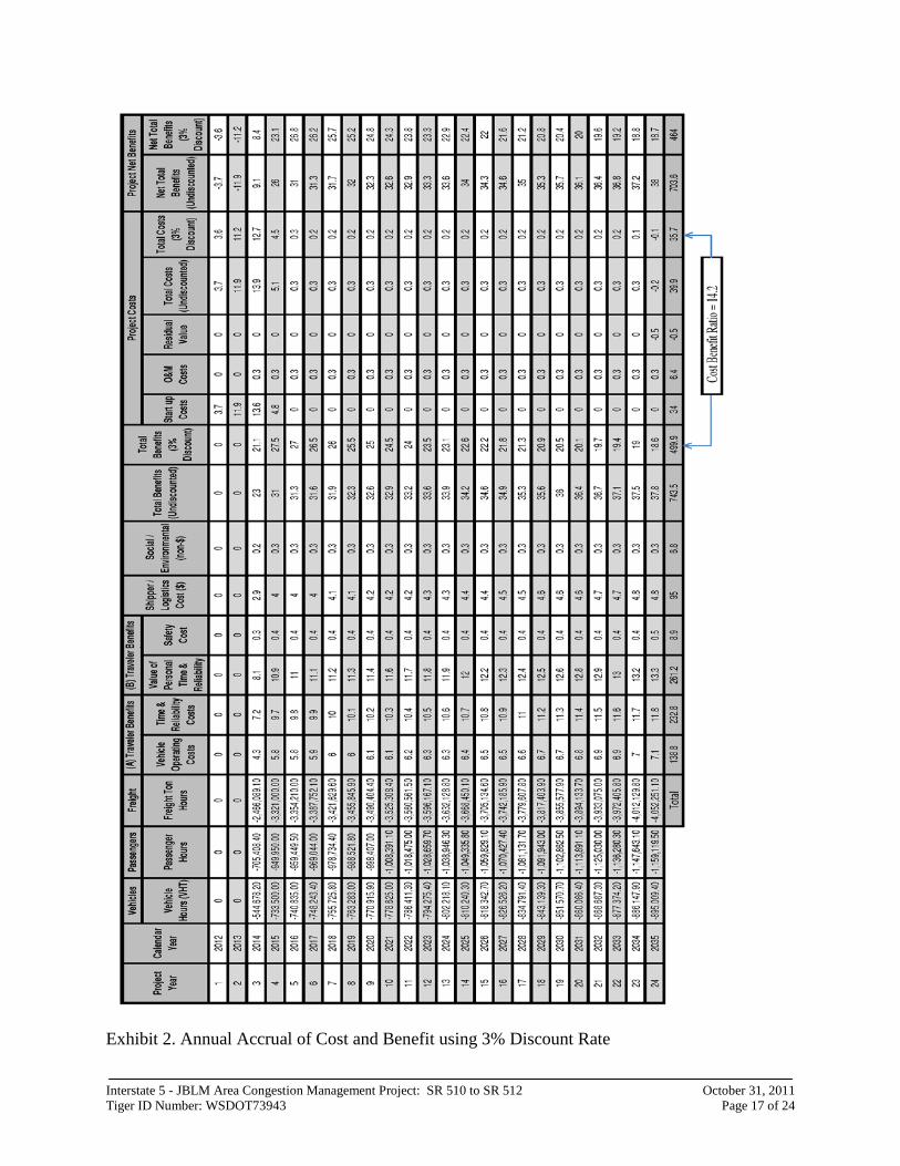
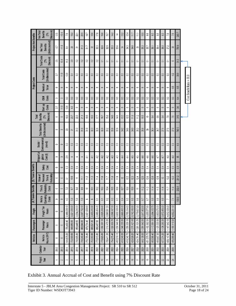
V. Evaluation of Expected Project Costs and Benefits Results of Benefit-Cost Analysis The total project benefit cost ratio, based on anticipated project design and construction costs, as well as all monetized benefits, including travel time, vehicle operating costs, reliability, safety, freight, and environmental, are estimated to be 14.2:1 and 10.0:1 using 3% and 7% discount rates respectively, values were discounted to present value. The following Exhibits 2 and 3 are results from TREDIS for the annual accrual of costs and benefits for each discount rate.
Monetized estimate of benefits and costs: The year-by-year stream of benefits accruing from the project was monetized over a thirty year project life. The value of time savings for both business and non-business travelers was developed based on DOT published sources. The value of savings in fuel costs and operator’s time to freight shippers were also estimated. The reliability of travel time was estimated using comparable corridors in Washington where ramp meters have been installed, and those results were translated into buffer time. Savings in buffer time were added to aggregate savings in average travel time due to the project.
Interstate 5 - JBLM Area Congestion Management Project: SR 510 to SR 512 October 31, 2011 Tiger ID Number: WSDOT73943 Page 17 of 24
Exhibit 2. Annual Accrual of Cost and Benefit using 3% Discount Rate
Interstate 5 - JBLM Area Congestion Management Project: SR 510 to SR 512 October 31, 2011 Tiger ID Number: WSDOT73943 Page 18 of 24
Exhibit 3. Annual Accrual of Cost and Benefit using 7% Discount Rate

Interstate 5 - JBLM Area Congestion Management Project: SR 510 to SR 512 October 31, 2011 Tiger ID Number: WSDOT73943 Page 19 of 24
VI. Evaluation of Project Performance
Base condition: The project was evaluated by examining its performance in comparison to the corridor base condition. The current infrastructure baseline is the 15.5 mile long I-5 corridor between SR 510 and SR 512. It is a limited access facility that consists of six through lanes for 11.7 miles in the southern portion, increasing to seven through lanes (and one auxiliary lane) for 1.0 miles, then eight full travel lanes for the remaining 2.8 miles. Assumptions and calculations describing the base case condition were derived and input for use in TREDIS as follows:
• VMT was estimated using a simulation model of the study corridor
developed on the PTV VISSIM platform, which was calibrated to detailed counts at three long term traffic recorders, and periodic counts at on and off ramps
• VHT was calculated using speed derived from simulation model segments identified at approximately one mile intervals
• Corridor congestion was calculated like VHT, using simulation model segment output for travel speed, where congestion was assumed to be where speed dropped below 42 mph (70% of the posted speed), which is the accepted agency metric for congestion
• Buffer time was calculated at a 95% confidence level using the variation in real travel time recorded in the corridor during the first two weeks of September, 2011
• Average vehicle occupancy (1.1 commute and work-related, 2.0 non-commute/work) was adapted from data published about the National Household Travel Survey (2009)
• Trip distribution in the affected region was adapted from a special run of the Puget Sound Regional Council travel demand model which monitored traffic into and out of Pierce County, which represents the major portion of the travel region affected by the project
• A horizon year of 2035 was used for the calculation, corresponding to a twenty year investment period
• A one percent per year annual traffic growth rate was assumed, based on the average corridor growth rate assumption documented by the most recent investigation in the corridor, an interchange justification report supporting modifications to the Center Drive interchange at I-5 near the middle of the project corridor
Project description: The proposed project would install ramp meters and HOV/express bypasses to freeway entrance ramps in the corridor, expand capacity by one lane eastbound on the Berkeley Avenue crossing by moving the sidewalks to a cantilever structure, expand the southbound Berkeley Avenue off-ramp to three lanes to accommodate a double left turn southbound to eastbound, and improve the shoulders both northbound and southbound between the 41st
Interstate 5 - JBLM Area Congestion Management Project: SR 510 to SR 512 October 31, 2011 Tiger ID Number: WSDOT73943 Page 20 of 24
Division Drive interchange and Thorne Lane interchange, and configure those shoulders to accommodate traffic during the peak travel hours. Assumptions and calculations describing the base case condition were derived and input for use in TREDIS as follows: • VMT, trip distribution, horizon year, and traffic growth rates were assumed
to be unchanged from the base condition • VHT and congested segments were calculated using the same approach as
the base case, except the simulation model of the corridor was coded with the project improvements
• Buffer time was taken to be the 3.1% improvement for buffer time in metered corridors
Justification and impact on long term outcomes: The project is justified because it affects the long-term state of good repair, economic competitiveness, sustainability, and safety of the corridor by leveraging current infrastructure investments through operational enhancements and encouraging multimodal travel. The project is designed so that it provides benefits to all peak hour users who use I-5 and want to travel between north and south Puget Sound, and the entire West Coast. These users include local commuters, commuters to JBLM, freight users, and business and leisure travelers. Special benefits also accrue to HOV users who utilize those ramps with HOV bypasses installed by the project.
Economic impacts: The project is expected to create economic impacts for a wide range of economic sectors that depend on transportation and access. These economic impacts include job creation and construction costs delayed as the service life of the existing freeway facility is extended. Economic impacts are included in this discussion for illustrative purposes only, and were not included in the cost-benefit calculation. The project will provide improved livability and societal benefits accruing from improved travel time and reliability during peak hours. The project is a standalone project: The benefit cost analysis for this application was performed independently, and did not depend on the installation of any other transportation or other kind of improvement, either by WSDOT or others. Affected population: For benefit cost calculation purposes, the population affected by the project has been identified as residents of Pierce and Thurston Counties, which was estimated to be over 1 million people in the 2010 census (1,047,489 persons). The travelers who are directly affected by the project are those who are traveling, or would like to travel, during morning and evening peak periods. Alternatives: Alternatives to this project were identified, evaluated, recommended, and the process documented in the JBLM GCP. The recommendations include short and long term solutions. In general, short term
Interstate 5 - JBLM Area Congestion Management Project: SR 510 to SR 512 October 31, 2011 Tiger ID Number: WSDOT73943 Page 21 of 24
solutions focused on changes to operations on the Base that JBLM can take to reduce travel demand in the corridor, while long term solutions focused on capital investments which are generally expensive.
b. Job Creation and Near-Term Economic Activity
TREDIS software was used to calculate job creation resulting from the project. According to the analysis, the project will create 548 short term jobs due to construction, and 1,803 long terms jobs due to increases in economic activity due to the project, for a total of 2,351 jobs. This information is included for illustrative purposes only, and was not included in the benefit cost calculation.
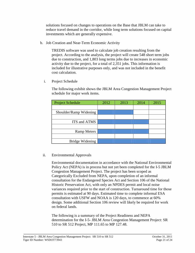
i. Project Schedule
The following exhibit shows the JBLM Area Congestion Management Project schedule for major work items.
Project Schedule 2012 2013 2014 2015
Shoulder/Ramp Widening
ITS and ATMS
Ramp Meters
Bridge Widening
ii. Environmental Approvals
Environmental documentation in accordance with the National Environmental Policy Act (NEPA) is in process but not yet been completed for the I-5 JBLM Congestion Management Project. The project has been scoped as Categorically Excluded from NEPA, upon completion of an informal consultation for the Endangered Species Act and Section 106 of the National Historic Preservation Act, with only an NPDES permit and local noise variances required prior to the start of construction. Turnaround time for those permits is estimated at 90 days. Estimated time to complete informal ESA consultation with USFW and NOAA is 120 days, to commence at 60% design. Some additional Section 106 review will likely be required for work on federal lands. The following is a summary of the Project Readiness and NEPA determination for the I-5- JBLM Area Congestion Management Project: SR 510 to SR 512 Project, MP 111.65 to MP 127.48.
Interstate 5 - JBLM Area Congestion Management Project: SR 510 to SR 512 October 31, 2011 Tiger ID Number: WSDOT73943 Page 22 of 24
Most of the proposed work is exempt from Section 106 requirements pursuant to 36 CFR 800.2(c)(4), Exhibit B, Undertakings Presumed to Have Minimal Potential to Cause Effects (First Amended Programmatic Agreement Implementing Section 106 of the National Historic Preservation Act for the Federal-aid Highway Program in Washington State Administered by the Federal Highway Administration), A-1, A-2, B-1, B-2, B-3, B-5, B-6, and B-10. Work within the limits of JBLM is not exempt and would be subject to Section 106 review.
iii. Legislative Approvals
WSDOT has secured legislative and gubernatorial approvals for this project. Letters from the chairs of the State House and Senate Transportation Committees also indicate their support for this effort.
iv. State and Local Planning Interstate 5 – JBLM Area Congestion Management Project will be added by amendment to both Thurston Regional Planning Council and Puget Sound Regional Council transportation Improvement Plan (TIP) and the WSDOT State TIP. Components of the project have already been added to the TIPs.
v. Technical Feasibility The project introduces emerging technology with ATMS directed variable lane control. WSDOT has installed ATMS with variable lane control in other areas and seen the benefit this technology provides. Hard shoulder running has been used in other areas and successfully added capacity in congested corridors.
vi. Financial Feasibility
The project financing will be complete assuming the availability of the requested TIGER grant funds. WSDOT has experience in managing grants and partnering with others in managing grants. WSDOT has a successful delivery record, with 90% of projects on time and 86% under or on budget.
Interstate 5 - JBLM Area Congestion Management Project: SR 510 to SR 512 October 31, 2011 Tiger ID Number: WSDOT73943 Page 23 of 24
VII. Secondary Selection Criteria
a) Innovation
The project is innovative because it uses cutting edge, low cost technology to address chronic congestion and extend the life of this critical corridor. This project will be among the first in Washington to combine ATMS hard shoulder running with variable lane controls. This approach holds promise for creating capacity without expanding the facility footprint. Using this approach will involve specialized standard and electronic signing to direct drivers when to use the hard shoulder lane. Integrating new operations, approaches at ramp merge and diverge points enables shoulders to be used to respond to rapidly changing congestion conditions.
b) Partnership
A specific long-standing partnership exists among the jurisdictions and stakeholders in this corridor. Most recently, when traffic volumes and congestion suddenly grew with the return of troops from overseas, this partnership was instrumental in identifying immediate operational improvements to traffic conditions. This effort received national recognition from the AASHTO. This coalition of partners continues work to shape the long-term improvement needs in the corridor, and seek funding to move this major investment process forward.
( i) Jurisdictional & Stakeholders Collaboration
The following partner agencies have provide letters of support for this project and have been co-leaders in actively developing solutions for the corridor.
1. JBLM Joint Base Lewis-McChord, is a United States military facility located midway between Olympia (state capitol), and Tacoma. They have provided $500,000 towards this project. They have worked closely with WSDOT, FHWA and local agencies in developing solutions for the corridor.
2. City of Lakewood City of Lakewood is located within the project limits. They have an interest and investment of this corridor as they were the lead on the JBLM GCP sponsored by OEA. Included in this grant is a request from the City of Lakewood to improve the Berkeley Avenue Interchange and adjacent roads to help alleviate congestion at this interchange and improve access to the Army’s medical installation Madigan Hospital.
3. Pierce County Pierce County has worked closely with WSDOT and JBLM in utilizing the county road network to improve access and the distribution of traffic to and from JBLM.
Interstate 5 - JBLM Area Congestion Management Project: SR 510 to SR 512 October 31, 2011 Tiger ID Number: WSDOT73943 Page 24 of 24
They will be contributing staff time and expertise to ensure the success of this project.
4. Other Partners The South Sound Military and Communities Partnership is a coalition that represents the broader interests of the stakeholders within this corridor. This coalition was formed with the focus on ensuring the overall needs of this corridor, including transportation, are met. There are currently over a hundred state agencies and local jurisdictions actively participating in this effort.
(ii) Disciplinary Integration
JBLM has provided $500,000 towards the project.
VIII. Federal Wage Rate is attached
IX. Noted differences between pre-application and application
To the extent relevant, the final page of the application should describe (in one page or less) any material changes that need to be made to the pre-application form.
1. Change in total cost of the project : • Pre-application amount was $31.8 million total with $25.44 million grant
request. Final application amount is $34 million with $27.2 million grant request. The $2.2 million increase was the result of refined design and construction cost estimate since the submittal of the pre-application
• It has been determined JBLM cannot be a co-applicant