applications of smartphone based sensors in agriculture a systematic review of research
TRANSCRIPT
Review ArticleApplications of Smartphone-Based Sensors in Agriculture:A Systematic Review of Research
Suporn Pongnumkul, Pimwadee Chaovalit, and Navaporn Surasvadi
National Electronics and Computer Technology Center (NECTEC), 112 Thailand Science Park, Phahonyothin Road,Khlong Nueng, Khlong Luang, PathumThani 12120, Thailand
Correspondence should be addressed to Suporn Pongnumkul; [email protected]
Received 7 April 2015; Revised 8 July 2015; Accepted 9 July 2015
Academic Editor: Pietro Siciliano
Copyright © 2015 Suporn Pongnumkul et al. This is an open access article distributed under the Creative Commons AttributionLicense, which permits unrestricted use, distribution, and reproduction in any medium, provided the original work is properlycited.
Smartphones have become a useful tool in agriculture because their mobility matches the nature of farming, the cost of the deviceis highly accessible, and their computing power allows a variety of practical applications to be created. Moreover, smartphones arenowadays equipped with various types of physical sensors which make them a promising tool to assist diverse farming tasks. Thispaper systematically reviews smartphone applications mentioned in research literature that utilize smartphone built-in sensorsto provide agricultural solutions. The initial 1,500 articles identified through database search were screened based on exclusioncriteria and then reviewed thoroughly in full text, resulting in 22 articles included in this review. The applications are categorizedaccording to their agricultural functions.Those articles reviewed describe 12 farming applications, 6 farmmanagement applications,3 information system applications, and 4 extension service applications. GPS and cameras are the most popular sensors used inthe reviewed papers. This shows an opportunity for future applications to utilize other sensors such as accelerometer to provideadvanced agricultural solutions.
1. Introduction
Among the technologies invented in the past few decades,smartphones have gained large market shares among var-ious user sectors due to their usefulness, ease-of-use, andaffordability.The number of new smartphone users continuesto grow. It is estimated that, by 2016, the number of userswill be more than 2 billion people worldwide [1]. Onefactor that enhances the smartphones’ ability to assist usersto perform various tasks is the numerous built-in sensors(e.g., positioning sensors, motion sensors, and camerasmicrophones).Many industries have adopted smartphones tofacilitate their work, such as health care [2, 3] and education[4, 5]. This paper reviews the usage of smartphone sensorsin an important sector, agriculture. Inexpensive smartphonesequippedwith various sensors are opening newopportunitiesfor rural farmers who previously had limited access to up-to-date agricultural information (e.g., market, weather, andcrop disease news) and assistance from agricultural expertsand government extension workers. Meanwhile, farmers in
large-scale farms, who already adopt assistance from otherinformation technologies, can now utilize smartphone-basedsensors to increase productivity and facilitate various tasksthroughout the farming cycle.
Ensuring food security has been a global concernthroughout human history, and the global food crisis of2007-2008 has emphasized the importance of increasing bothquantity and quality of food production [6]. Agriculture,which is the upstream food producing sector, is, therefore,in need of new and modern methods to ensure the world’sfood security. Traditional agriculture was usually donewithina family or a village and accumulative farming expertiseand knowledge were passed down to their future gener-ations. Human was the main observer of field conditionsand the solution provider as problems arise. However, thistraditional method is no longer suitable, because farmingoutputs depend largely on the natural surrounding conditions(e.g., weather and water) and global warming issues (causingfrequent droughts and floods) and crop disease outbreaks aredisruptive of farming productivity. Traditional within-group
Hindawi Publishing CorporationJournal of SensorsVolume 2015, Article ID 195308, 18 pageshttp://dx.doi.org/10.1155/2015/195308

2 Journal of Sensors
knowledge and human observations alone are not sufficientto battle the issues. Therefore, new methods for farming havebeen invented, for example, precision agriculture. One keyidea of new practices in agriculture is the use of technologyto measure or monitor field and crop conditions in orderfor farmers to make informed decisions in various parts oftheir farming process. Sensors for continuous and automaticmeasurements of different field values are one of the mainsuccess factors for precision agriculture [7].
Dedicated devices (e.g., a SPADmeter for leaf chlorophyllassessment [8], a Li-3100 for Leaf Area Index (LAI) measure-ment [9], and a spectroscopy for studying soil structure andcomponents [10]) have been useful in agriculture but mightbe difficult to access for rural farmers who do not have accessto the product providers or insufficient funds to purchasethe devices. However, some of the tasks that the dedicateddevices perform can be replicated on smartphones with built-in sensors. This provides an easy alternative for farmers whoalready own smartphones to easily download applications touse. This paper aims at reviewing how smartphone sensorshave been used in agriculture in research literature andillustrates the range of applications that farmers can usefor their work without having to purchase new hardware.Additionally, to the best of our knowledge, we are the firstto review smartphone usage in agriculture with the focuson how sensors are used. This paper also highlights theopen opportunities through which researchers and mobiledevelopers can further utilize smartphones to provide bettertools for agriculture.
In this survey, the authors categorize smartphone appli-cations by their agricultural functions into four categories:farming, farmmanagement, information systems, and exten-sion services. Farming applications are those that assist infarming activities, such as disease detection and pesticideapplication rate calculation. Farm management applicationsfacilitate users to manage overall farm resources and farmingactivities more efficiently and effectively in order to achievebetter profit and farming productivity. Information systemapplications include systems that provide essential infor-mation for farmers, including farming knowledge, environ-mental context, and market information. Extension serviceapplications provide assistance to the traditional agriculturalextension where field workers visit farms. Extension serviceapplications mostly provide channels for remote farmers toaccess expert consultation and provide tools for field workersto efficiently work while in the field.
A systematic review was conducted by a search forresearch papers on SCOPUS database, yielding 1,500 initialresults. The search results were then screened by reviewingtitle, abstract, and keywords for exclusion criteria: smart-phone applications only limited to voice, SMS, or accessinginformation via the Internet; primary domains of smartphoneapplications not in agriculture; smartphone applications onlyapplied to non-plant-based agriculture; no smartphone-based sensor used in smartphone applications; full textarticles not accessible; and articles written in languagesother than English. This process resulted in 339 potentiallyrelevant papers which were again reviewed more thoroughlyin full text using the same exclusion criteria. The remaining
22 papers are included in this review and are categorized intothe four categories discussed above. The papers (describing12 farming applications, 6 farm management applications,3 information system applications, and 4 extension servicesapplications) are summarized with the focus of the smart-phone sensor usages and their functions.
The remaining sections are as follows. Section 2 reviewsthe current technology of smartphone sensors. Then,Section 3 describes the method used to obtain the articles forthis review. After that, the results are presented in Section 4with subsections for each of the four categories. In Section 5,we discuss, in each subsection, respectively, the current usageof smartphone-based sensors in agriculture, their advantageswith respect to traditional tools/methods, challenges fortheir usages in agriculture, and future research opportunities.Finally, Section 6 concludes the review.
2. Smartphone Sensors and Their Use
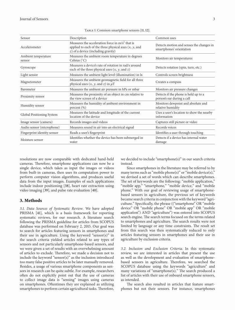
This section reviews common sensors of recent smartphones.Sensors are a device that measures a physical quantity andconverts to a signal which can be read and used by otherdevices. An example of the traditional sensors is the ther-mometer which converts how hot or cold the environmentis into a number, which is called the temperature. Thereare many kinds of sensors available nowadays, and manymainstream smartphones are equipped with various sensors,including accelerometers, GPS, light sensors, temperaturesensors, gyroscope, and barometer.
The sensors embedded in smartphones can be classifiedinto three categories: motion sensors, environmental sensors,and position sensors. The first category, motion sensors, pro-vides acceleration force and rotational force measurements.Examples of motion sensors are accelerometers, gyroscopes,gravity sensors, and rotational vector sensors. The secondcategory, environmental sensors, provides measurements ofthe surrounding environments. This ranges from ambientair temperature from a thermometer and pressure from abarometer to illumination from a photometer.The third cate-gory, position sensors, provides measurements of the device’sphysical position. Such sensors includemagnetometers, GPS,and orientation sensors [11]. Table 1 describes the commonsmartphone sensors. For the purpose of this review, weexclude communication channels (e.g., WIFI, Bluetooth, 3G,and NFC) and display channels from the sensor list.
Recent increases in popularity of smartphones have calledattention to researchers to explore the use of smartphonesensors in their work. Many sensors have been appliedsuccessfully in numerous areas. Global Positioning System(GPS) allows applications to obtain the current location ofthe device. Apart from direct uses of the location in appli-cations (e.g., maps), GPS data have also been used to infertransportation modes [35]. Accelerometers, which measurethe force of acceleration whether caused by the phone’smovement or gravity in 3 axes, have been used as sensorsin fall detection [3], activity recognition [36], driving eventdetection [37], and so forth. Built-in cameras (both front andrear cameras) of recent smartphones have improved greatlyin terms of specifications over recent years. The camera
Journal of Sensors 3
Table 1: Common smartphone sensors [11, 12].
Sensor Description Common uses
AccelerometerMeasures the acceleration force in m/s2 that isapplied to each of the three physical axes (𝑥, 𝑦, and𝑧) of a device (including gravity)
Detects motion and senses the changes insmartphones’ orientation
Ambient temperaturesensor
Measures the ambient room temperature in degreesCelsius (∘C) Monitors air temperatures
Gyroscope Measures a device’s rate of rotation in rad/s aroundeach of the three physical axes (𝑥, 𝑦, and 𝑧) Detects rotation (spin, turn, etc.)
Light sensor Measures the ambient light level (illumination) in lx Controls screen brightness
Magnetometer Measures the ambient geomagnetic field for all threephysical axes (𝑥, 𝑦, and 𝑧) in 𝜇T Creates a compass
Barometer Measures the ambient air pressure in hPa or mbar Monitors air pressure changes
Proximity sensor Measures the proximity of an object in cm relative tothe view screen of a device
Detects if the phone is held up to aperson’s ear during a call
Humidity sensor Measures the humidity of ambient environment inpercent (%)
Monitors dewpoint and absolute andrelative humidity
Global Positioning System Measures the latitude and longitude of the currentlocation of the device
Uses a user’s location to show the nearbyinformation
Image sensor (camera) Records images and videos Captures still picture or videoAudio sensor (microphone) Measures sound in air into an electrical signal Records voicesFingerprint identity sensor Reads a user’s fingerprint Identifies a user through touching
Moisture sensor Identifies whether the device has been submerged inwater
Detects if a device has internal waterdamage
resolutions are now comparable with dedicated hand-heldcameras. Therefore, smartphone applications can now be asingle device, which takes as input the images or videosfrom built-in cameras, then uses its computation power toperform computer vision algorithms, and produces usefuldata from the input images. Examples of such applicationsinclude indoor positioning [38], heart rate extraction usingvideo imaging [39], and pulse rate evaluation [40].
3. Methods
3.1. Data Sources of Systematic Review. We have adoptedPRISMA [41], which is a basis framework for reportingsystematic reviews, for our research. A literature searchfollowing the PRISMA guideline for articles from SCOPUSdatabase was performed on February 2, 2015. Our goal wasto search for articles featuring sensors in smartphones andtheir use in agriculture. Using the keyword “sensor(s)” inthe search criteria yielded articles related to any types ofsensors and not particularly smartphone-based sensors, andwe were given a set of results with an overwhelming amountof articles to exclude. Therefore, we made a decision not toinclude the keyword “sensor(s)” as the inclusion introducedtoo many false positive articles to be later manually removed.Besides, a usage of various smartphone components as sen-sors in research can be quite subtle. For example, researchersoften do not explicitly point out that the use of camerasto collect image data is “sensing” images using camerason smartphones. Oftentimes they are explained as utilizingsmartphones to perform certain agricultural tasks.Therefore,
we decided to include “smartphone(s)” in our search criteriainstead.
Since smartphones in the literature may be referred to bymany terms such as “mobile phone(s)” or “mobile device(s),”we devised a set of words which can describe smartphones.The set of keywords are the following: “mobile application,”“mobile app,” “smartphone,” “mobile device,” and “mobilephone.” With our goal of reviewing usage of smartphone-based sensors in agriculture, the previous set of keywordsbecame search criteria in conjunctionwith the keyword “agri-culture.” Specifically, the phrase ((“smartphone” OR “mobiledevice” OR “mobile phone” OR “mobile app” OR “mobileapplication”) AND “agriculture”) was entered into SCOPUSsearch engine. The search terms focused on the terms relatedto smartphones and agriculture. The search results were notlimited by language or any time constraints. The result setfrom this search was then systematically reduced to onlyarticles featuring sensors in smartphones and their use inagriculture by exclusion criteria.
3.2. Inclusion and Exclusion Criteria. In this systematicreview, we are interested in articles that present the useas well as the development and evaluation of smartphone-based sensors in agriculture. Therefore, we searched theSCOPUS database using the keywords “agriculture” andmany variations of “smartphone(s).” The search produced alist of articles with their use of onboard smartphone sensors,as intended.
The search also resulted in articles that feature smart-phones but not their sensors. For instance, smartphones

4 Journal of Sensors
are used only as a communication means in agriculturework, when farmers use voice call or Short Message Ser-vice (SMS) to communicate crop prices, or when network-enabled smartphones are solely used as devices for access-ing agricultural-related information. We decided to excludethose articles, as smartphones are not devised as sensors butonly as communication devices. Also, we excluded articlesthat describe general systems which were not specificallydesigned for agricultural use. In addition, the scope of ourreview is plant farming; we therefore removed articles relatedonly to animal farming. Furthermore, we review usage ofsmartphone-based sensors in agriculture in order to increasefarmers’ awareness of numerous applications that can beused in their farming cycle without having to purchase newdedicated devices. We, therefore, decided to exclude articlesin which smartphones are used only as a remote terminalto monitor and control other external sensors, for example,external temperature and humidity sensors as in [42, 43].In many cases, it is still not clear from a full text review ifany built-in sensors are used in the applications. However,we decided to include certain articles in which although theauthors did not clearly specify the sensors used, we can inferfrom the functionalities of the applications such as retrievinglocation data via GPS as in [27, 28, 31]. We also excludedarticles written in languages other than English and those ofwhich we could not access full text.
In summary, our exclusion criteria include (a) smart-phone applications only limited to voice, SMS, or accessinginformation via the Internet; (b) primary domains of smart-phone applications not in agriculture; (c) smartphone appli-cations only applied to non-plant-based agriculture; (d) nosmartphone-based sensor used in smartphone applications;(e) full text articles not accessible; and (f) articles writtenin languages other than English. The process of filteringout articles based on our exclusion criteria was performedmanually.
3.3. Data Extraction. After irrelevant articles had beenexcluded based on the criteria above, we read the remaining22 articles in full text to gather relevant information. Weextracted information of what the smartphone applicationsutilizing onboard sensors are, which smartphone-based sen-sors are used, and how the sensors are used. We also accessedthe smartphone application marketplaces to extract relateddata when applications are available on those markets.
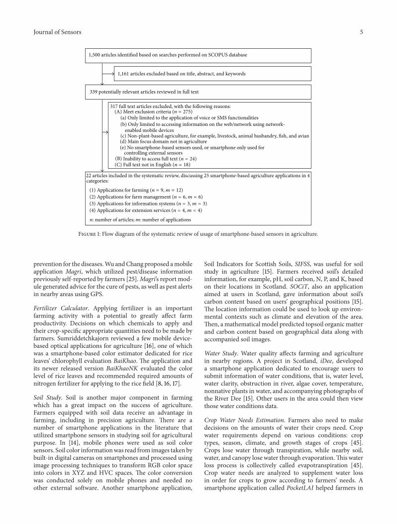
3.4. Flow Diagram. The flow diagram presented in Figure 1concludes the steps taken in our database search methodand search result filtration. First, entering the search termsinto SCOPUS search engine initially resulted in 1,500 arti-cles. Second, the search result set was screened by title,abstract, and keywords following the exclusion criteria inSection 3.2, resulting in the exclusion of 1,161 articles. Third,the remaining 339 potentially relevant articles were examinedthoroughly in full text using the same exclusion criteria.The final result list consisted of 22 eligible articles forcomprehensive review of their contents with the focus of thesmartphone sensor usages and their functions in agriculture.Those 22 articles, describing 25 smartphone-based sensor
applications, are categorized based on their agricultural func-tions as follows: 9 articles describing 12 farming applications,6 articles describing 6 farm management applications, 3articles describing 3 information systems applications, and 4articles describing 4 extension services applications.
4. Results
This section describes the smartphone applications fromour survey. The applications were categorized into fourcategories: farming, farm management, information system,and extension services.
4.1. Farming Applications. Farming refers to a series of agri-cultural processes which involve various day-to-day activitieson the field, for example, sowing, weeding, fertilizing, andmaking related agricultural decisions. Farming activities arefocused on how to grow plants, kill weeds/pests, identifyand correct plant diseases, apply fertilizers, and estimategrowth/yield of crops. Recent advances in smartphone appli-cation development and an increasing availability of smart-phones allow for some of these agricultural burdens to belifted and guided. For example, farmers may calculate properamounts of fertilizers for crop fields upon analyzing color ofcrop leaves with some help from smartphone applications.This section reviews smartphone applications under farmingcategory and how they may aid farmers to achieve farmingtasks.
Farmers have a number of responsibilities working incrop fields. A handful of tasks which are performed in thefield, that is, seeding, weeding, fertilizing, and watering,may seemingly be repetitive, mundane, and labor-intensive.However, those tasks usually require precursory decision-making steps prior to the actual activities in order for thefarming cycle to be effective. The previous statement isespecially truewhen farmers have to dealwith unfamiliar newkinds of crops [44]. Knowledge such as how to identify cropdiseases, the diseases’ exhibition locations on crops, and theirprevention and cure can save farmers’ time and costs in thepractice of farming. The following are the subcategories ofsmartphone applications for farming.
Disease Detection and Diagnosis. Smartphone applicationsunder this subcategory are dedicated to disease detec-tion/diagnosis in farms when utilizing sensors on smart-phones. Prasad et al. depicted a mobile vision system whichaids in plant disease identification process [13]. The systemworked by capturing images of plant leaves being investigatedfor diseases, then preprocessing those images, and transmit-ting the processed images to remote laboratories. The imagepreprocessing step was necessary for saving transmissioncost of sending diseased leaf images to plant pathologists inremote laboratories. Leaf images were segmented by a clus-tering algorithm into three areas: background, nondiseasedportion of the leaf, and diseased portion(s) of the leaf. Leafimages were then cropped only to the location of the largestdiseased patch on the leaf and transmitted over any availablenetwork to lab experts for further disease identification.Closely related to disease detection is suggesting cure and
Journal of Sensors 5
1,161 articles excluded based on title, abstract, and keywords
1,500 articles identified based on searches performed on SCOPUS database
339 potentially relevant articles reviewed in full text
22 articles included in the systematic review, discussing 25 smartphone-based agriculture applications in 4 categories:
317 full text articles excluded, with the following reasons:
(a) Only limited to the application of voice or SMS functionalities(b) Only limited to accessing information on the web/network using network-
enabled mobile devices(c) Non-plant-based agriculture, for example, livestock, animal husbandry, fish, and avian(d) Main focus domain not in agriculture(e) No smartphone-based sensors used, or smartphone only used for
controlling external sensors
(A) Meet exclusion criteria (n = 275)
(C) Full text not in English (n = 18)
(1) Applications for farming (n = 9, m = 12)(2) Applications for farm management (n = 6, m = 6)(3) Applications for information systems (n = 3, m = 3)(4) Applications for extension services (n = 4, m = 4)
(B) Inability to access full text (n = 24)
n: number of articles; m: number of applications
Figure 1: Flow diagram of the systematic review of usage of smartphone-based sensors in agriculture.
prevention for the diseases.Wu andChang proposed amobileapplication Magri, which utilized pest/disease informationpreviously self-reported by farmers [25].Magri’s report mod-ule generated advice for the cure of pests, as well as pest alertsin nearby areas using GPS.
Fertilizer Calculator. Applying fertilizer is an importantfarming activity with a potential to greatly affect farmproductivity. Decisions on which chemicals to apply andtheir crop-specific appropriate quantities need to be made byfarmers. Sumriddetchkajorn reviewed a few mobile device-based optical applications for agriculture [16], one of whichwas a smartphone-based color estimator dedicated for riceleaves’ chlorophyll evaluation BaiKhao. The application andits newer released version BaiKhaoNK evaluated the colorlevel of rice leaves and recommended required amounts ofnitrogen fertilizer for applying to the rice field [8, 16, 17].
Soil Study. Soil is another major component in farmingwhich has a great impact on the success of agriculture.Farmers equipped with soil data receive an advantage infarming, including in precision agriculture. There are anumber of smartphone applications in the literature thatutilized smartphone sensors in studying soil for agriculturalpurpose. In [14], mobile phones were used as soil colorsensors. Soil color informationwas read from images taken bybuilt-in digital cameras on smartphones and processed usingimage processing techniques to transform RGB color spaceinto colors in XYZ and HVC spaces. The color conversionwas conducted solely on mobile phones and needed noother external software. Another smartphone application,
Soil Indicators for Scottish Soils, SIFSS, was useful for soilstudy in agriculture [15]. Farmers received soil’s detailedinformation, for example, pH, soil carbon, N, P, and K, basedon their locations in Scotland. SOCiT, also an applicationaimed at users in Scotland, gave information about soil’scarbon content based on users’ geographical positions [15].The location information could be used to look up environ-mental contexts such as climate and elevation of the area.Then, amathematical model predicted topsoil organic matterand carbon content based on geographical data along withaccompanied soil images.
Water Study. Water quality affects farming and agriculturein nearby regions. A project in Scotland, iDee, developeda smartphone application dedicated to encourage users tosubmit information of water conditions, that is, water level,water clarity, obstruction in river, algae cover, temperature,nonnative plants in water, and accompanying photographs ofthe River Dee [15]. Other users in the area could then viewthose water conditions data.
Crop Water Needs Estimation. Farmers also need to makedecisions on the amounts of water their crops need. Cropwater requirements depend on various conditions: croptypes, season, climate, and growth stages of crops [45].Crops lose water through transpiration, while nearby soil,water, and canopy lose water through evaporation.This waterloss process is collectively called evapotranspiration [45].Crop water needs are analyzed to supplement water lossin order for crops to grow according to farmers’ needs. Asmartphone application called PocketLAI helped farmers in
6 Journal of Sensors
determining Leaf Area Index (LAI), which is a key factor tocalculate crop water requirements [9]. PocketLAI estimatedLAI using an indirect method based on sensors available onmodern smartphones. Two sensors were main componentsof this application. Image sensors (cameras) were used totake pictures of leaf canopy to estimate Leaf Area Index.Accelerometers were used to obtain the angle of smartphonesas the devices were rotating in order to estimate LAI whenthe gap fraction was precisely measured at 57.5∘. The angle57.5∘ was a directional view angle that had been shown inthe agricultural research to allow the estimation of LAI to befree from leaf angle distribution and leaf degree clumping [9].Once water requirements were determined from Leaf AreaIndex, farmers could adjust their watering/irrigation toolsaccordingly. Closely related to LAI calculation is brightnessanalysis which estimates light brightness intercepted byplants. In [8, 16], an application was developed to analyzebrightness using cameras on smartphones. The applicationof brightness analysis was for estimating light radiation onplants. Also, Molina-Martınez et al. presented amobile appli-cation, RaGPS, for devices with Windows Mobile operatingsystem to calculate the extraterrestrial solar radiation andother parameters related to solar position in real-time basedon the GPS data [26]. These radiation parameters wereuseful for estimating cropwater needs and validating weatherdata provided by the agricultural weather stations. Theirexperiments showed that RaGPS could estimate radiationparameters very similarly to the ones from theweather stationin clear-sky days.
Crop Produce Readiness Analysis. An innovative use ofsmartphone-based sensors is to determine ripeness of fruits.In [8, 16], an application was developed utilizing smartphonecameras. Pictures of fruits under white and UV-A lightsources were taken to determine ripeness levels for greenfruits. Farmers could integrate the system into their farmsby separate fruits of different ripeness levels into piles beforesending them to markets. With the help of computer visiontechniques, this process could be done in bulk rather thanfarmers manually inspecting each fruit.
Smartphone applications under farming category supportfarming processes of planting crop by sensing the environ-ment using various sensors. Observations can be in the formof snapped pictures, specific locations in the farm, colors ofsoil, water, and plant leaves, and light. Main target users ofthe applications are farmers who are involved with exhaustivefarming activities. This type of application aims at improvingfarm productivity, oftentimes by analyzing agricultural spec-imens, supporting agricultural decisions, and solving task-specific problems. Smartphone applications which are underfarming category often share a common trait of being highlycomputational as evident in [8, 9, 13, 14, 16, 17], comparedwithsmartphone applications in other categories.
4.2. FarmManagement Applications. This subsection reviewsthe literature on applications of smartphone-based sensorsfor farm management. Research papers in this categoryconsider farming issues from a system perspective. Specifi-cally, smartphone applications in the papers discussed here
focus on a whole farm system in contrast to the farmingapplications discussed in the previous subsection whereeach farming process, for example, disease identification andprevention, fertilizing, and applying pesticide, wasmore con-sidered. The main objective of the smartphone applicationsin this category is to facilitate users to manage overall farmresources and activities more efficiently and effectively inorder to achieve their goals, for example, to obtain maximumprofit and farming productivity.
Traditionally, farmers might rely solely on paper formsand desktop computers to record, track status, and managefarm resources and farming activities. While they are on thefield, they might keep field records, for example, amount ofpesticide and fertilizer used, locations and types of weedsand disease found, and yields at each field on paper forms,and then they enter the collected field data to a computerwhen they are back at the office. Those data are later used forreport generation and various analyses (e.g., cost analysis) toimprove overall farming productivity. However, this conven-tional data collecting approach often results in nonintegrateddata, making it difficult to extract valuable information fromsuch data.The recent development of smartphone technologyhas transformed those farm management tasks in manyaspects. The mobile nature of the smartphone allows usersto access it anywhere anytime. Farmers can easily carrya smartphone with them to the field to record field dataand manage farm resources right at the field. Moreover,smartphone-based sensors such as microphone, camera,GPS, accelerometer, and several others can tremendouslyease farm journaling and other farm management tasks.For example, farmers can take photos of crops planted andweeds found on the field with GPS coordinates. To label thephotos taken, besides typing, some applications use speechrecognition technology to aid users, for example,MapIT [19].GPS technology also enables farmers to track equipmentand vehicles at different parts of a farm in real-time. Inaddition, a common feature of smartphone applications inthe farm management category is that most applications areconnected to cloud servers where all farm data are integrated,analyzed, and visualized in different formats to support deci-sion making of farm managers/owners in order to improvefarming operations.The field data collected via a smartphoneare usually synchronized to the cloud servers and are easilyaccessible from any devices connected to the Internet.
Water Management. Farm management applications assistusers to manage various farm resources. Water is one ofthe crucial resources for crop growing. Better water resourcemanagement means better yields and lower farm operatingcosts. Researchers have proposed and developed smartphoneapplications for effective water resource management. Todesign effective water management strategies, water flowdata is necessary for daily operations of irrigation channels.In general, to obtain such data, it requires measurementstations, which are expensive, resulting in sparse and lowquality data used for water management decision making.Smartphones allow water flowmeasurement tasks to be donemuch easier at a lower cost, as it does not require permanentstation installation. Luthi et al. [18] designed and developed

Journal of Sensors 7
an Android application for measuring open-channel flow.The application estimates the water level, surface velocity,and discharge rate by analyzing a short video recorded bya smartphone of the water flow between two control pointswith a known distance. To estimate the water level, thealgorithm relied on a separation line of image segments withand without optical flow using a sequence of images. Thistechnique can be done because pixels in the dry parts of theimage generally remain unchanged over time, while pixelson the water are subject to constant change. The surfacevelocity estimation was implemented by a modified methodof the standard Particle Image Velocimetry (PIV) method.The preliminary results reveal that the accuracy of the waterlevel, surface velocity, and runoff data obtained via theirsmartphone application is about 5% of data obtained from acommercial radar sensor.
HR Management and Farm Activity Journaling. Humanresources play an important role in farming productivity,especially for farms in developing countries where agri-cultural systems rely more heavily on manual labor thanmachinery. The ability to keep records of farm workers’activities such as weeding, fertilizing, and harvesting in eacharea of the farm at specific time, schedule farm workers todifferent jobs, and communicate work plans to farmers isessential for effective farmmanagement. Murakami et al. andMurakami proposed iFarm, a system designed to assist inrecording field data and communicating work plans, usingsmartphones, a cloud server, and web browsers [27, 28].Farmers in the field use an application on smartphones torecord field data and send it to a cloud server. Farmers in thehead office can retrieve the information via a web browser.The information can then be used to form a work plan andcommunicate back to field farmers immediately as a task liston their smartphones. The task list can be location-aware.Although the authors did not state it explicitly, the location-aware task list can be implemented using GPS. Sharmaet al. developed a machine learning algorithm applicationto automatically detect farm workers’ activities (e.g., har-vesting, bed making, standstill, and walking) based on datacollected from various sensors on smartphones carried byfarm workers while working in the farm [29]. Based on GPScoordinates, the working pattern of farmers and frequencyof visiting certain plot of the farm can be inferred. Theusage of differentmachines, for example, tractor and chopper,can be determined by sound data collected via microphone.The data from 3-axis accelerometer are used to identifyvarious body movements. Such accelerometer data are alsotagged with timestamp and the GPS coordinates.The authorsinvestigated the accuracies of multiple classifier algorithmsincluding Naive Bayes, Linear Discriminant Analysis (LDA),and 𝑘-Nearest Neighbor (𝑘-NN) in detecting various farmingactivities. In addition, as different placements of the phoneresult in different sensing data, they also studied the detectionof placement of the phone, trouser pocket and upper arm,using the same three classifiers. Their experiment showedthat the LDA algorithm outperformed the other two interms of both activity detection andmobile phone placementidentification. These detected farm workers’ activity data are
useful for monitoring and improving the overall productivityof the farm.
Vehicle Monitoring. Vehicle monitoring and location track-ing are another promising feature of recent applications ofsmartphone-based sensors. Liu andKoc introduced SafeDriv-ing, an iOS application to detect a tractor rollover andreport emergency event [30]. Based on a tractor’s physi-cal parameters and data from smartphone built-in sensorsincluding accelerometer, gyroscope, andGPS, the applicationconducts a signal processing and uses a mathematical modelto calculate the stability index of the tractor. Once the stabilityindex drops below a certain threshold, a warning appears onthe phone screen.When the index is zero indicating a rolloveror accident condition, the application sends an email with thedate, time, and GPS coordinates of the accident location toemergency contacts.
The applications discussed in this subsection so farmainly target an individual farm manager/farm owner/farmer at a farm level. However, farm management not onlyoccurs at an individual farm level; there are also availableapplications that aim to manage collective farmland resour-ces.These are tools to support decisionmaking of top govern-ment officials or policymakers to achieve an optimal solutionat a macro level, for example, an application to manage farm-lands and irrigated areas covering a large region of a country.
Agricultural Land Management. The aggregated geo-data ofagricultural areas are useful for monitoring purpose and tosupport decision making of policy makers. Frommberger etal. developed MapIT, a crowdsourcing tool for collectinggeographic information of small objects and agriculturalareas [19]. To collect the geo-data, a user takes a photo of theinterested area/object and draws an outline of the object ona smartphone screen. Through speech recognition or typing,the user can label the object and then upload it to a server forfurther analyses. To obtain the original size and shape of theobject, their implementation relied on the Douglas-Peuckeralgorithm to firstly simplify the outline drawn by the user.Then, based on the data from built-in inertial sensors, thedistance of the object from the camera, and GPS location,the coordinates in the photo are projected to real-worldcoordinates, yielding a geo-object of exact original geometry.
4.3. Information System Applications. Information is a keyfactor in making effective decisions in all industrial sectorsincluding agricultural sector. It is widely recognized thatinformation can help farmers increase agricultural produc-tivity. Up-to-date information about prices as well as marketdemands helps farmers in choosing the type and amount ofcrops to grow and where to sell their products, to maximizeprofits. Prompt crop disease warnings and predictions allowfarmers to take actions to minimize damage. Updated farm-ing knowledge educates farmers of newways to improve theircrop yields. While such information may be available, someof the main issues faced by farmers, especially small-scalefarmers, are that they are not able to meet the expected yieldquality, supply, and demand at themarket level due to the lack

8 Journal of Sensors
of information visibility at the time of decision making. Thefact that farmers are not able to make optimal decisions atdifferent stages of the farming life cycle results in a hugeimpact on farmers’ revenue [46]. Innovative informationsystem for agriculture is an effective solution for this problem.This section discusses three papers on this topic.
Information Localization. In order to provide relevant infor-mation to farmers, Jain et al. proposed a hybrid architecturewhich combines mobile and web technology and uses thelocation of mobile device to improve the information sentto farmers [31]. The main purpose of this paper is to designa system that can provide the localized information whichis very crucial at one location but may be irrelevant toother locations. A database is designed to couple informationwith mapped location. When a farmer uses their location-enabled mobile device, the mobile application sends thelocation data to the server and receives localized agriculturalinformation. This helps farmers receive relevant informationwithout having to read through enormous amount of data.While the authors did not specify which sensors to be used,the location data can be retrieved using GPS.
Pest and Disease Information. In contrast to the previoussolution which provides a general framework for agriculturalinformation, two papers have discussed solutions for pest anddisease management. Rafoss et al. used GPS-enabled mobilephones as a way to fight fire blight in Norway in SMILEXsystem [32]. As mobile phones connected to the Internetprovide a way to quickly receive information and reportdisease outbreaks, stakeholders (e.g., farmers, policy makers,and field workers) can take appropriate actions to minimizethe damage. The application was implemented for mobiledevices to be able to display disease outbreak reports on amapand users can also report or edit disease outbreaks. GPS isused to access current location of themobile phone to retrievethe nearby map and the information. While the case studywas conducted on the fire blight survey inNorway, the systemis applicable for disseminating most crop disease outbreakinformation. Similarly, Suen et al. proposedVillageTreewhichis a mobile application that provides intelligent pest man-agement solutions [20]. VillageTree gathers pest incidencereports from farmers using crowdsourcing approach. Then,the incidence reports which include location data and imagestaken of crop disease are processed in their server usingspatial-temporal analytic and image recognition algorithms.Finally, their system produces warning data and sends alertsand relevant solutions to farmers for them to take preventivemeasures.
Farmer’s information needs can be separated into threestages: know-how, context of planting, and market informa-tion [47].Know-how includes information about crop choicesand seed varieties. The knowledge of new crops or seedvariety that improve yields is beneficial in improving rev-enues.Context of planting is information aboutweather, plantprotection, and cultivation practices. The nature of contextinformation is dynamic (e.g., weather changes everyday andpest outbreaks that happen irregularly) and has high impactson crop yields. Market information, which refers to market
prices, market demands, and logistics to sell products, isessential in turning products into revenues. The applicationsdiscussed above provide innovative solutions, but only for asubset of the information needs. Reference [31] is a generalsolution which is applicable to all stages, while [20, 32]provide solutions that take crowdsourcing approaches forcontext stage.
The nature of smartphone applications in this categoryis a channel for receiving and sending information, whichrequires less computation and information entry on thesmartphone than the applications in previous categories.While it is less obvious how sensors could be used forapplications in this category, GPS has been successfully usedto enhance the information exchange in the three papersdescribed.
4.4. Extension Service Applications. In many countriesaround the world, agriculture is the main economic driver,but farmers are still poor and undereducated. Governmentsprovide agricultural extensions as a service that reaches outto farmers to provide assistance, for example, educatingfarmers of new crops, helping farmers diagnose crop disease,and registering farms to provide subsidy for disaster-affectedareas. Conventionally, agricultural extension services wereprovided by extension workers and experts who visited farmsto give farming advice and solutions to specific problems,which required traveling and were resource intensive.Smartphones and information technology have recentlymade the process easier and more accessible. This sectionreviews four research papers that facilitate extension services.
Pest and Disease Inspections by Experts. Agricultural exten-sion services include the activities that provide personalizedinformation and solution to rural farmers, one of which isto assist farmers in diagnosis of pest or diseases found inthe farmer’s plants, so that proper solutions or actions canbe taken to alleviate the problems. A few researchers haveexplored the use of information technology and smartphonesto enhance this area of agricultural extensions. Jhunjhunwalaet al. implemented a voice-based service through call centerto provide personalized solution to 1,200 farmers in TamiNadu, India [21]. This project was inspired by the successof call center business model in modern industries, whichprovides personalized solution to customers who face techni-cal problems and seek help through their mobile phones. Incall center web technology, customer information is logged intheir database and some FAQpages allow relatively untrainedcall center operators to assist with the customer’s problems.Indian Agricultural Advisory System (AAS) was built byusing the call center technology. Farmers can call in to seekhelp. Farmers can also send pictures taken from their mobilephones to the central server to allow call center personneland experts to visually inspect their problems. Location datafrom the mobile device informs call center operators andexperts about where the problem occurs. Similarly, Saha et al.explored the design and implementation of an Android-based prototype, m-Sahayak, to allow experts to diagnoseand treat plant’s (and people’s) disease remotely [22]. Whenfarmers face diseased plants, they can take photos or videos of
Journal of Sensors 9
the plants and use audio to record their query using their localspoken language. The photos, videos, and audios are sent tothe server for agricultural scientist to use the data to provideproper solutions accordingly by call or SMS. In another paperproposed by Jagyasi et al., mKRISHI’s phone applicationallows a farmer to send their query using text, voice, pictures,and videos in a similar manner with m-Sahayak [24]. WhilemKRISHI’s full system uses external sensors embedded infarms (such as humidity and temperature sensors) to furtherinform experts of field’s context, this part goes beyond thescope of our survey.
As most research found in this area was done in develop-ing countries, the target users’ level of literacy was a concernand the use of a lot of textual data and advanced featuresof smartphones for extension services in research has beenlimited. Mobile applications that provide remote extensionservices (similar to [21, 22, 24]) are still popularly functioningusing voice and SMS (e.g., [21]). However, this group of paperis excluded from this survey because the papers do not utilizesmartphone features beyond voice and SMS communication.Yet the remaining results still show that smartphone sensorscan enhance extension services. The sensors that have beenused in this category are cameras, microphones, and GPS.Camera functionality is used to enhance the communicationbetween farmers and experts, because camera is easy to useand images help communicate problems better than worddescriptions and allow experts to quickly and accuratelydiagnose problems. Microphones allow farmers to recordtheir query as spoken words, which provide an alternative forthem when forming queries. GPS adds location as additionalinformation for experts.
Tools for ExtensionWorkers. A differentway that smartphonescan facilitate extension services is to provide a convenienttool for extension workers. In land plot identification, con-ventionally, technical staffs go to a farmer’s plot with multipledevices (e.g., a GPS, a camera, and an electronic recorder torecord data such as the plot code, photograph identification,or date) and management of the devices becomes a tedioustask. The staffs have to make sure that the battery of eachdevice is sufficient beforehand and have to switch betweendevices while working in the field. Mesas-Carrascosa et al.proposedGeoFoto, an Android-basedmobile application thatassists field workers in land plot identification, which reducesthe number of tools the extension worker has to carry intothe field [23]. GPS and image data captured from the phoneare sent to the central office as field workers visit farms.The data is then analyzed to verify that the correct field isvisited. While these tools are not directly used by farmers,they help extension workers in providing extension servicesmore efficiently.
5. Discussion
5.1. Summary of Current Usage of Smartphone Sensors. Thissection discusses how smartphone sensors are used in agri-cultural research. Table 2 summarizes the papers that usesmartphone sensors that were described in the previoussection.The most popular sensors in agriculture applications
are cameras (used by 16 applications) and GPS (used by14 applications). Other sensors that are applied includemicrophone, accelerometer, and gyroscope.
As a large number of smartphone applications in Table 2utilize cameras and GPS, we examine further into bothhardware sensors. GPS are mostly used for location-awareapplications, which send/receive essential environmentalinformation for agriculture (such as pests and diseases [20,25, 32], weather, soil [15], water [15], and radiation [26]),farmmanagement information [27–29], locations of accident[30], locations of fields [23], and locations of farmers [29],based on users’ locations. The aforementioned location-based information seems to be able to tolerate some levelsof location inaccuracy as environmental information orlocations of farmers/fields/accidents can be reported in thevicinity of meters.Therefore, GPS on smartphones, even low-priced ones, represent an ample choice of GPS hardwarespecifications.
As for image sensors on smartphones, requirements ofcameras’ technical specifications may be analyzed in twoways. Cameras can be used to take pictures or videos whichare then sent and stored as a whole on servers or on thecloud for future reference or further inspection [15, 21–24].Cameras can also be used to take pictures or videos to beimage-processed further [8, 9, 13–20]. The former requiresimages/videos to be in a sufficiently good enough qualityfor human inspection. The latter, however, calls for higherquality image sensors for the purpose of image processing.Furthermore, smartphones expected to perform onboardimage processing need to meet certain computing power.While some papers report image resolution in which theapplications were tested (e.g., 5-megapixel in [9], up to 8-megapixel in [13]), some researchers specify processing powerrequirement [9]. Whether these applications are able to assistfarmers, farm managers, and government workers effectivelydepends on smartphones’ specifications.
5.2. Advantages of Using Smartphone-Based Sensors withrespect to Traditional Methods in Agriculture. This sectioncompares the utilization of smartphone-based sensors inagriculture to that of traditional tools and methods. Table 3gives a synopsis of advantages of using smartphone-basedsensors over traditional methods for each smartphone appli-cation. The applications are ordered by categories previouslydescribed in Section 4.
5.3. Challenges of Using Smartphone-Based Sensors in Agricul-ture. This section explores challenges in the design, develop-ment, and implementation of using sensors on smartphoneto assist agricultural decisions and management. Challengesthat may arise when developing agricultural applicationsusing smartphone-based sensors are divided into challengesdue to the nature of the sensors and due to the natureof the applications. First, technical challenges of utilizingsmartphones’ onboard sensors instead of dedicated sensorsare discussed. Then, we examine challenges of buildingsmartphone applications to meet agricultural requirements.
10 Journal of Sensors
Table2:Summaryof
smartpho
ne-based
sensorsinagric
ulturalcon
text.
Sensors
Category
Article
Year
Applicationname
Features
Cameras
Farm
ing
[13]
2014
n/a
Pictures
ofleaves
aretaken,thenprocessed,andsent
tolabs
forfurther
diseased
iagn
osis
Cameras
Farm
ing
[14]
2013
n/a
Cameras
functio
nas
soilcolorsensors
Cameras
Farm
ing
[15]
2013
iDee
Photograph
softhe
RiverD
eearec
apturedforw
ater
cond
ition
assessment
Cameras
Farm
ing
[15]
2013
SOCiT
Photograph
ofthes
oilofinterestisc
apturedfortop
soilorganicm
attera
ndcarbon
content
predictio
nCa
meras
Farm
ing
[8,16]
2013
n/a
Brightnessisanalyzed
fore
stim
atinglight
radiationon
plants
Cameras
Farm
ing
[8,16]
2013
BaiKhaoN
KPictures
ofric
eleavesa
retakento
analyzec
hlorop
hyllcontents
Cameras
Farm
ing
[8,16]
2013
n/a
Pictures
offruitsun
derw
hiteandUV-Alight
sourcesa
retakento
determ
iner
ipenesslevels
forg
reen
fruits
Cameras
Farm
ing
[9]
2013
PocketLA
IIm
ages
ofleafcano
pyarea
cquiredto
estim
ateL
eafA
reaInd
ex(LAI),w
hich
inturn
gives
crop
water
requ
irements
Cameras
Farm
ing
[17]
2012
BaiKhao
Pictures
ofric
eleavesa
retakento
analyzec
hlorop
hyllcontents
Cameras
Farm
managem
ent
[18]
2014
n/a
Ashortvideo
ofwater
flowistakenandthen
analyzed
toestim
atethe
water
level,surfa
cevelocity,and
discharger
ate
Cameras
Farm
managem
ent
[19]
2013
MapIT
Images
ofob
ject/areao
finterestare
captured
forg
eographicinformationcollectingpu
rpose
Cameras
Inform
ationsyste
ms
[20]
2014
VillageTree
Farm
erstakep
ictureso
fpestand
send
tothec
entralserver,w
here
theimages
arep
rocessed
toanalyzetypes
ofpests
Cameras
Extensionservices
[21]
2013
AgriculturalA
dviso
rySyste
m(A
AS)
Images
ofanyinfesta
tionor
potentialproblem
arec
apturedandsent
totheo
perator’s
dashbo
ardin
real-timeu
singPestandDise
aseImageU
pload(PDIU
)feature,because
sometim
esitisdifficultto
findwords
todescrib
ethe
prob
lems
Cameras
Extensionservices
[22]
2012
m-Sahayak
Images
andvideos
ofthed
iseased
plantsarec
apturedandsent
tothec
entralserver
for
agric
ulturalscientiststo
inspectand
provides
olution
Cameras
Extensionservices
[23]
2012
GeoFo
toIm
ages
ofland
plotsa
retakenby
technicalstaffs
andsent
tothec
entraloffi
ceas
averifi
catio
nthatthelandhasb
eenvisited
Cameras
Extensionservices
[24]
2011
mKR
ISHI
Images
andvideos
canbe
sent
alon
gwith
afarmer’squ
eryto
anexpertto
seek
advice
GPS
Farm
ing
[25]
2013
Magri
GPS
locatio
nsareu
sedto
generatelocatio
n-aw
arep
est/d
iseasea
lertstofarm
ers
GPS
Farm
ing
[15]
2013
SIFS
SSoilcharacteris
ticsa
ndinform
ation,
such
aspH
,soilcarbo
n,N,P,and
K,ared
elivered
basedon
users’GPS
locatio
nsin
Scotland
GPS
Farm
ing
[15]
2013
iDee
Userscanview
locatio
n-basedriv
ercond
ition
sintheR
iver
Dee
catchm
entb
ased
ontheir
GPS
positions
GPS
Farm
ing
[15]
2013
SOCiT
User’s
locatio
nsareu
sedto
implyelevation,
climate,andgeolog
ybasedon
availabled
igita
lmapsa
ndthen
topredicttop
soilorganicm
attera
ndcarbon
content
GPS
Farm
ing
[26]
2011
RaGPS
Basedon
GPS
data,the
applicationcalculates
thee
xtraterrestrialsolar
radiationandother
parametersrela
tedto
solarp
osition
inreal-time
GPS
Farm
managem
ent
[27,28]
2013,2014
iFarm
Thea
pplicationsend
slocation-aw
aretaskliststo
farm
erso
nthefi
eld

Journal of Sensors 11
Table2:Con
tinued.
Sensors
Category
Article
Year
Applicationname
Features
GPS
Farm
managem
ent
[29]
2013
n/a
Working
patte
rnso
ffarmersa
ndfre
quency
ofvisitingcertainplot
ofthefarm
canbe
inferred
basedon
GPS
locatio
nsin
thefi
eld
GPS
Farm
managem
ent
[30]
2013
SafeDriv
ing
GPS
coordinateso
ftractor
rollo
vera
ccidentsarer
eported
GPS
Farm
managem
ent
[19]
2013
MapIT
Images
ofob
ject/areao
finterestare
mappedforg
eographicinformationcollectingpu
rpose
GPS
Inform
ationsyste
ms
[31]
2014
n/a
Locatio
nof
theu
serissenttothec
entralserver,w
hich
send
sonlyther
elevant
inform
ation
abou
tthatlocationback
totheu
ser
GPS
Inform
ationsyste
ms
[20]
2014
VillageTree
Applicationuser
canrepo
rtpestou
tbreak
with
thed
evicelocation.
Theinformationis
processedandap
redictionissent
tousersw
hose
locatio
nmight
beinvadedby
thep
est
GPS
Inform
ationsyste
ms
[32]
2010
SMILEX
Fieldworker’s
fireb
light
repo
rtfro
mthefi
eldiscoup
ledwith
thelocationdata,sothe
incident
repo
rtcanbe
show
non
them
apforb
etterfi
reblight
managem
ent
GPS
Extensionservices
[21]
2013
AgriculturalA
dviso
rySyste
m(A
AS)
FieldworkersuseG
PSdatato
record
farm
locatio
nswhenregiste
ringfarm
ers.Spatiald
ata
(farm
plotsw
ithwater
bodies,drainagea
ndirr
igationchannels)
areincludedin
thefarmer’s
record
GPS
Extensionservices
[23]
2012
GeoFo
toGPS
dataisused
toverifythatthec
orrectland
isvisited
Microph
one
Farm
managem
ent
[29]
2013
n/a
Thea
pplicationdeterm
ines
usageo
fdifferentagriculturalm
achines(e.g
.,tractora
ndchop
per)by
soun
ddata
Microph
one
Farm
managem
ent
[19]
2013
MapIT
Microph
oneisu
sedto
anno
tateim
ages
ofob
ject/areao
finterestviaspeech
recogn
ition
for
geograph
icinform
ationcollectingpu
rpose
Microph
one
Extensionservices
[22]
2012
m-Sahayak
Farm
ersc
anusethe
microph
onetorecord
theirv
oicedqu
estio
nsto
send
toagric
ultural
scientists
Microph
one
Extensionservices
[24]
2011
mKR
ISHI
Audioqu
eriesc
anbe
recorded
andsent
toexperts
Accelerometer
Farm
ing
[9]
2013
PocketLA
I
Thea
pplicationob
tainsthe
angles
ofsm
artpho
nesa
sthe
devicesa
rerotatin
gin
orderto
estim
ateL
AIw
hentheg
apfractio
nisprecise
lymeasuredat57.5∘
,adirectionalviewangle
thathasb
eenshow
nin
thea
griculturalresearchto
allowthee
stim
ationof
LAItobe
free
from
leafangled
istrib
utionandleafdegree
clumping
Acceler
ometer
Farm
managem
ent
[29]
2013
n/a
Accelerometer
isused
todetectvario
usbo
dymovem
entsin
ordertoidentifyfarm
workers’
activ
ities
Acceler
ometer
Farm
managem
ent
[30]
2013
SafeDriv
ing
Accelerometer
isused
toob
tain
arollang
leandpitchangleo
fthe
tractorinordertodetecta
rollo
vere
vent
Gyroscope
Farm
managem
ent
[30]
2013
SafeDriv
ing
Gyroscope
isused
toob
tain
arollang
leandpitchangleo
fthe
tractorinordertodetecta
rollo
vere
vent
Inertia
lsensors
aFarm
managem
ent
[19]
2013
MapIT
Basedon
thed
atafrom
inertia
lsensors,the
dista
nceo
fthe
objectfro
mthec
amera,andGPS
locatio
n,thec
oordinates
inthep
hoto
arep
rojected
toreal-w
orld
coordinates,yielding
ageo-ob
jectof
exacto
riginalgeom
etry
aTh
epaper
didno
tmentio
nthes
pecific
nameo
fthe
sensorsu
sed.Generally,
theterm
inertia
lsensorsisused
tocollectively
refertoaccelerometersa
ndgyroscop
es[33].

12 Journal of Sensors
Table3:Com
paris
onof
usingsm
artpho
ne-based
sensorsa
ndtradition
altools/metho
dsin
agric
ulture.
Applicationname
Functio
nTradition
altools/metho
dsAd
vantages
ofsm
artpho
ne-based
sensors
Farm
ing
Dise
ased
etectio
nanddiagno
sis
n/a[
13]
Users
snap
photos
ofdiseased
leaves.P
icturesarepro-
cessed
andsent
tolabs
forfurther
diagno
sis
(a)E
xpertd
iagn
osiswith
then
aked
eye.(b)L
abdiagno
sistechniqu
essuch
asmicroscop
y,cultu
ring,
biochemicaltests
,and
ELISA
(a)F
armersw
ithno
expertise
indisease
identifi
catio
ncanperfo
rmthed
iagn
osis.
(b)F
armersreceive
fastdiagno
siscomparedto
send
ingsamples
ofdiseases
tolabs
Magri[25]
Usersrepo
rtinform
ationabou
tpestd
iseasesandreceive
advice
from
Magriregardingthep
ests
Con
sultwith
pestexperts
Farm
ersc
anreceivelocalized
pest
inform
ation
Fertilizerc
alculator
Baikhao[8,16],
BaikhaoN
K[17]
Usin
gpictures
ofric
eleaves,the
applications
analyze
chloroph
yllcon
tentsa
ndtheam
ount
ofnitro
genfertil-
izer
needed
forthe
ricefi
eld
(a)V
isualinspectio
nusingLeafColor
Chart(LC
C)(b)
SPADanalyzer
(a)Th
eycanbe
morea
ccuratea
ndmore
reliablethanvisualinspectio
n.a(b)Th
eyarec
heaper
than
pricey
SPADanalyzers
Soilstu
dy
n/a[
14]
Mun
sellsoilcolorisd
etermined
usingim
ages
ensorsin
ordertosuggestthe
structure
andcompo
nentso
fsoil
(a)V
isualinspectio
nusingMun
sellsoilcolorc
hart.(b)
Tradition
alinstr
uments,
fore
xample,colorim
etersa
ndspectro
meters
(a)Itisn
otsubjecttoaccuracy
prob
lemsb
asin
visualinspectio
n.(b)U
sing
smartpho
nesa
sproximalsensorsis
simpler,cheaper,faster,lesslabo
rious,
andmorefl
exiblethan
complex
and
costlyinstr
uments
SIFS
S[15]
SIFS
Sgivesu
sersaccessto
thefullsoildatasetfrom
the
SoilSurvey
ofScotland
Requ
estin
ginform
ationmanually
from
theS
oilSurvey
ofScotland
Itisas
impler
andfaste
rway
toaccess
inform
ation
SOCiT[15]
SOCiTpredictstopsoilo
rganicmattera
ndcarbon
con-
tent
from
pictures
takenagainsta
colorc
orrectioncard
andotherenvironm
entalc
haracteristics,
forexam
ple,
elevation,
climate,andgeolog
y
Wetanddrycombu
stionmetho
ds(w
hich
are
analyticallyaccuratebu
texp
ensiv
e)SoilanalysisusingSO
CiTisqu
ickera
ndmorec
ost-e
ffective
Water
study
iDee
[15]
iDee
provides
avenu
efor
river
cond
ition
repo
rtingand
view
ingforcommun
ities
arou
ndRiverDee
catchm
ent
inScotland
Manually
exchanging
inform
ationwith
inthe
commun
ities
viatraditio
nalcom
mun
icationchannels,
fore
xample,surveysa
ndform
s
Itisas
impler
andfaste
rway
toaccess
inform
ation
Crop
water
needse
stim
ation
n/a[
8,16]
Thesm
artpho
neim
agesensor
isused
tomon
itorthe
brightnessof
thelight
radiatingon
plants
Luxmeter
Smartpho
nesn
owadaysa
rehigh
lyavailablea
ndub
iquitous
PocketLA
I[9]
PocketLA
IdeterminesLeafAreaInd
ex(LAI),w
hich
isa
keyfactor
tocalculatec
ropwater
requ
irements
(a)D
irectmetho
dsmeasurin
gLA
Idire
ctlyon
leaves
gathered
from
plantsc
orby
imagep
rocessingof
leaf
images.(b)
Indirectmetho
dsdestim
atingLA
Ifrom
gap
fractio
ne
(a)P
ocketLAIisn
otdestructivetothe
plantsbecauseitu
sesa
nindirectmetho
d.(b)P
ocketLAIisc
heaper
andmore
portablethan
usually
expensived
edicated
devices
RaGPS
[26]
RaGPS
calculates
solarr
adiatio
nandequivalent
evapo-
ratio
nfro
msolarp
osition
usingGPS
insm
artpho
nes
Obtaining
such
datafro
mnearby
agric
ulturalw
eather
station
Itcanestim
atec
ropwater
needsw
here
thereisn
oweather
statio
nnearby
Journal of Sensors 13Ta
ble3:Con
tinued.
Applicationname
Functio
nTradition
altools/metho
dsAd
vantages
ofsm
artpho
ne-based
sensors
Crop
prod
ucer
eadinessanalysis
n/a[
8,16]
Smartpho
neim
agesensorss
erve
asatwo-dimensio
nal
sensor
measurin
grip
enesslevelof
bananas
(a)M
anualestim
ationwith
then
aked
eye.(b)
Quantitativ
eestim
ationmetho
ds,including
analyses
form
echanical,chem
ical,and
arom
aticcompo
nents,
someo
fwhich
ared
estructiv
etothefruititself
[34]
Itisan
ondestructivem
etho
d,which
isidealfor
preserving
thea
ctualfruits
Farm
managem
ent
Water
managem
ent
n/a[
18]
Theapplicationestim
ates
thewater
level,surfa
ceveloc-
ity,and
dischargerateby
analyzingashortv
ideo
ofthe
water
flow
betweentwocontrolp
ointswith
akn
own
distance
Toob
tain
such
water
flowdata,ittraditio
nally
requ
ires
expensivem
easurementstatio
ns,resultin
gin
sparse
andlowqu
ality
dataused
forw
ater
managem
ent
decisio
nmaking
(a)S
martpho
nesfacilitatethe
measurementtasks
tobe
done
much
easie
ratlow
ercosts
(verylowinitialcosts
andno
maintenance
cost)
.(b)
Userscan
take
water
flowmeasurementany
where.
(c)L
esstim
eisrequiredto
take
measurementsanddatacollectioniseasy
viaS
MS
HRmanagem
entand
farm
activ
ityjournalin
g
iFarm
[27,28]
iFarm
allowsfarmersinthefi
eldto
record
fielddataand
commun
icatewith
farm
ersintheoffi
cethatcanform
aworkp
lanandcommun
icateb
acktofi
eldfarm
ersimme-
diately
asalocation-aw
aretasklistontheirsmartpho
nes
Writingfield
dataon
papera
ndlaterm
anually
enterin
gthosed
ataintoac
ompu
tera
tthe
office
(a)T
raditio
nalfi
elddatacollection
approaches
often
resultin
nonintegrated
data,m
akingitdifficultto
extract
valuableinform
ationfro
mdata.(b)
Farm
ersc
anrecord
field
dataandmanage
farm
resourcesright
atthefi
eld.(c)G
PSmakes
alocation-specificd
atac
ollection
andalocation-aw
aretasklistcreation
possible
n/a[
29]
Usin
gdata
from
accelerometer,G
PS,a
ndmicroph
one
sensors,
the
application
automatically
detects
farm
workers’activities,for
exam
ple,harvestin
g,bedmaking,
stand
still,andwalking
Vario
uskind
sofd
edicated
body
wearables
ensorshave
been
developedto
detecthu
man
activ
ities
f
Com
paredwith
conventio
nalbod
ywearables
ensors,smartpho
nesa
remore
integrated,hence
redu
cing
users’
rejectiondu
etothep
oora
estheticvalue
andintrusivenesso
fthe
tradition
aldevices
Vehicle
mon
itorin
g
SafeDriv
ing[30]
Basedon
datafro
maccelerometer,gyroscope,and
GPS
,SafeDriv
ingdetectsatractorrollo
verandrepo
rtsan
emergencyevent
RollOverP
rotectiveS
tructures(RO
PS)a
rerequ
iredby
theU
SOccup
ationalSafetyandHealth
Administratio
n(O
SHA)tobe
insta
lledon
allagriculturaltractorsto
protecto
peratorsfro
mrollo
vers[30]
Alth
ough
ROPS
canredu
cethes
everity
ofther
ollovera
ccidents,
they
dono
tprovidea
nem
ergencyrepo
rtingto
rescue
team
sasinthes
martpho
neapplication
Agriculturallandmanagem
ent
MapIT
[19]
MapIT
isacrow
dsou
rcingapplication
forcollecting
geograph
icinform
ationof
smallo
bjectsandsm
allagri-
cultu
ralareas.A
user
takesa
photoof
anarea
anddraw
san
outline
ofthea
reao
nas
martpho
nescreen
Tomap
largeo
bjects,
itusually
requ
iresa
user
toph
ysicallytraverse
theg
eographico
bjectw
ithaG
PSdevice.Som
etoo
lsuses
atelliteimages
asbaselin
edata
With
thetraditio
nalm
etho
ds,m
apping
smallobjectsisatim
e-consum
ingtask
since
GPS
isusually
unreliablea
tthis
levelofd
etail,which
requ
ires
considerableefforttorevise
theo
utlin
edata.M
apIT
isac
amera-based
applicationthatisaccurate,easy-to-use,
andsuitablefor
relativ
elysm
allobjects

14 Journal of Sensors
Table3:Con
tinued.
Applicationname
Functio
nTradition
altools/metho
dsAd
vantages
ofsm
artpho
ne-based
sensors
Inform
ationsyste
mInform
ationlocalization
n/a[
31]
Farm
erscan
access
agric
ulturalinform
ation
that
isrelevant
totheirlocationviam
obile
andweb
techno
logy
Farm
ersc
anaccessinform
ationviam
obile
andweb
techno
logy
buth
avetomanually
sortthroug
hinform
ationthataren
otrelevant
tothem
(e.g.,langu
age
notinthelocaldialect,diseaseo
utbreakin
distantarea)
Locatio
ninform
ationfro
mfarm
ers’
mob
ileph
onea
llowso
nlyrelevant
inform
ationto
beshow
nto
farm
ersa
ndredu
cesinformationoverload
Pestanddiseaseinformation
SMILEX
[32]
Fieldworker’s
fireb
lightrepo
rtsfromthefi
eldaresho
wn
onthem
apforb
etterfi
reblight
managem
ent
Alertsa
ndwarning
shaveb
eendistrib
uted
over
the
internetsin
ceearly
1990s,bu
tthe
useo
fmod
ern
techno
logy
(e.g.,GPS
)has
been
limited
Smartpho
neenables
real-timer
eports
from
thefi
eldwith
locatio
ninform
ation
usingbu
ilt-in
GPS
.Thisallowsb
etter
managem
ento
feventsa
ndbette
rinform
ationdissem
ination
VillageTree
[20]
Users
can
send
images
alon
gwith
locatio
nsof
pest
incidentstobe
processedandalerto
ther
relevant
users
Pestrepo
rt,inspection,
andwarning
have
tradition
ally
been
done
manually,w
hich
isslo
wandtediou
s
Pestim
ages
andlocatio
nsfro
msm
artpho
neallowthes
ystem
todetect
pestandwarnotheru
serswho
might
beaffected
Extensionservice
Pestanddiseaseinformationby
experts
AgriculturalA
dviso
rySyste
m(A
AS)
[21]
Farm
erscancallthis
callcenter
toseek
person
alized
solutio
nfortheirfarm
ingprob
lems.Im
ages
takenfro
mtheirc
ameraandlocatio
nfortheirph
ones
canprovide
inform
ationforthe
callcenter
abou
tthe
prob
lem
Thispapertargetsfarm
ersinruralareas
where
therea
reno
teno
ughexpertstoprovides
olutions.Th
erefore,
tradition
almetho
distheinsuffi
cientexp
ertfi
eldvisits
Smartpho
neallowsfarmerstobette
rcommun
icatetheirprob
lemstoexpert
remotely
andreceivep
rompt
and
person
alized
solutio
n
m-Sahayak
[22]
Farm
erscantake
photos
orvideos
oftheplants
and
usea
udio
torecord
theirq
uery
usingtheirlocalspoken
lang
uage
Teleph
ones
ervicesfor
agric
ulturalsolutionexist
forthe
targetuserso
fthisp
aper,but
commun
icationfailu
reoccursdu
etofarm
ers’inabilityto
describ
etheirdisease
Smartpho
nesensors(microph
ones
and
cameras)a
ssist
farm
ersin
commun
icatingtheirp
roblem
s
mKR
ISHI[24]
Farm
erscan
useaudio-visual
facilitieson
amob
ileph
onetoartic
ulatetheirqu
eriestoexpertsw
ithminim
aluseo
ftextg
Tradition
altoolsa
ndmetho
dsares
imilartothoseo
fm-Sahayak
[22]
Smartpho
nesensors(microph
ones
and
cameras)a
ssist
farm
ersin
commun
icatingtheirp
roblem
sTo
olsfor
extensionworker
GeoFo
to[23]
Field
workers
use
this
application
inland
plot
identifi
catio
nFieldworkersmanagem
ultip
lespecialized
devicesa
ndmanually
transfe
rdatab
etweendevices
Smartpho
neapplicationprovides
asingle
device
todo
thes
ametaskas
multip
ledevices,which
makes
managem
entand
datatransfe
reasiera
ndfaste
ra LCC
ischeap,bu
tthe
chartislikely
todeterio
rateover
time,causingther
eading
ofther
iceleafcolor
leveltobe
incorrect.
b Thisisdu
eto“illuminationcond
ition
s,samplec
haracteristics,andob
server’ssensitivitie
s”[14
].c A
nexam
pleo
fdedicated
instr
umentsisLi-3100C
.d Th
eseinclu
desyste
msu
singdirectsunlight
such
asTR
ACandDEM
ON,d
ifferentm
odels
ofceptom
eterssuchas
theSU
NSC
AN
ortheAc
cuPA
R,andsensorssuchas
theLA
I-2000
orLA
I-2200
PlantC
anop
yAnalyzers.
e Aview
ableprop
ortio
nof
skyfro
mbeneaththec
anop
y(orthato
fsoilfrom
topof
thec
anop
y).
f How
ever,tho
sededicatedsensorsstillh
aveb
eentargetingurbanapplications,for
exam
ple,usingbo
dywornsensorstomeasure
physicalactiv
ityform
otivatingmorew
orkout,orfor
falldetectionandpreventio
n.Th
eworkin
[29]
aimsa
tutilizingsm
artpho
ne-based
sensorstodetecthu
man
activ
ities
inthec
ontext
ofruralfarming.
g Whilethispaperd
iscussesthe
useo
fexternalsensorsto
createcontextualdatafore
xpertsto
providem
oreinformed
solutio
n,thisreview
focuseso
nthep
arto
fpaper
thatutilizesinternalsensors.

Journal of Sensors 15
5.3.1. Challenges due to the Nature of the Sensors. Cameras onrecent smartphones might be of high specifications, but forsome applications they might still be inadequate in quality.Applications that use cameras as sensors for image processingrun into trouble when lighting and angles of the objectsare not appropriate. Therefore, this poses a challenge forapplication developers or researchers. In order to use camerasensors as light analyzers, Sumriddetchkajorn describes usingan external diffuser on top of the smartphone camera tocontrol the lighting condition [8]. Similarly, Confalonieriet al. utilize accelerometer on smartphones to ensure that thegap fraction is captured when smartphones are at the correctangle (57.5∘ to be exact).
In this case, smartphone application developers maycompare performances between using smartphone sensorsand other methods [8, 9]. Usually the nonsmartphone meth-ods are a more direct way to perform the tasks but requiremore specific expensive equipment, such as a spectroscopyfor soil study [10].
GPS data could be erroneous. While the specific usagesthat have been reviewed in this paper do not require highaccuracy and can tolerate some errors, some of the possibleapplications could be challenging in the context of smart-phone GPS. For example, research suggests that moderndedicated GPS equipment used in precision agriculture canbe as accurate as in centimeters [48]. A precise detectionof locations allows farmers to be equipped with a decisionsupport system. Coupled with sensing agricultural variables,such as moisture levels, soil organic matter, and nutrition,precise location detection by GPS enables variability withinfarm management. Researchers and developers need todefine the scope of their applications in order to specifyrequired hardware specifications on the sensors.
5.3.2. Challenges in the Design and Development of Agri-cultural Applications. Another challenge for mobile devel-opers and researchers in creating practical smartphone-based applications for agriculture is user interface design.In general, the requirements and behaviors of smartphoneusers are different across farming communities. For example,rural farmers in developing countries might be constrainedby low level of literacy and lack of exposure to softwareinterfaces, which probably make the user interface designsfor large-scale farms in developed countries inappropriate forthem. It is necessary for smartphone application developersto realize this difference and customize the interface designto their target users. Applications which target rural farmersneed to have highly intuitive interfaces; using a lot of textas interface might be incomprehensible or difficult for them.Although this fact has been taken into account in thedevelopment process of some applications such as in [20],many applications still do not concern this aspect.
Some applications that were reviewed pose some chal-lenges due to the nature of the approaches taken by theapplication. Saha et al. [22] and Jain et al. [31] took thecrowdsourcing approach to assist with the management ofpest and disease outbreaks. While this approach allowsrapid and distributed data to be inputted to the system,which has advantages over traditional centralized approach,
the nature of crowdsourcing approach requires checking ofthe correctness of the data. The papers did not specify anycorrectness checking which could pose a problem for themodel for pest prediction [22] and the alerts that are sentcould be less credible when users make error in reporting.
5.4. Future Research Opportunities. This section synthesizesfuture research opportunities from the papers that werereviewed. Future research directions are grouped into cate-gories as follows.
Exploration of Unused Sensors. There are many built-insensors in smartphones which have yet to be explored inthe context of agriculture. Physical sensors, for example,barometer and humidity sensor, can be rather easily extendedto the agricultural field by performing their original intendedfunctions of environmental sensing. This leaves an openopportunity for researchers and developers to invent usefulapplications that are enabled or enhanced by these sensors.
Extension of Sensor Usage from Existing Research. Moreover,the sensors that have already been explored can be furtherexplored by replicating previous techniques to smartphones.Computer vision techniques have been studied in the contextof agriculture extensively, many of which were proposed asoffline computation, for example, weed identification [49]and cotton foreign matter inspection [50]. The current stateof server computational power can allow some of thesealgorithms to be deployed where images are taken usingsmartphone cameras, sent to server for processing, and theresults are returned to senders on their mobile phones.
Additionally, smartphone accelerometers have beenproven useful in other fields such as for daily physical activityrecognition [51] and for prevention of major health hazardssuch as fall detection [3]. However, the approaches have beenlimitedly applied to agricultural field. Similar approachescan be applicable to recognize various farming activities andto provide further assistance in farm journaling. The workin [29] utilized sensing data from accelerometer to detectfarming activities including standstill, walking, bed-making,and harvesting, but indeed there are open opportunities toapply similar techniques to detect other farming activitiessuch as sowing, watering, and spraying.
Improvement of Algorithms to Process Sensing Data. In addi-tion to using accelerometer data to detect various typesof farming activities, researchers can further improve thealgorithms to detect if a farmer performs a certain farmingactivity in an appropriate manner or not. For example,utilizing data from accelerometer, an algorithm might detectfrom a farmer’s hand movement if he/she is sprinklingfertilizer in a proper way. If not, the application could givea real-time recommendation to the farmer to correct his/herhand movement [29].
Smartphone Battery Usage Reduction. We noticed that mostof the papers reviewed here did not consider the batteryefficient aspect in the design and development process oftheir applications. Indeed, one nature of farm work is that
16 Journal of Sensors
farmers are usually away frompower source, preventing themfrom recharging their phones once they run out of battery.Therefore, design and development of a battery efficientapplication is crucial for the practicality of any smartphoneapplication and could be another future direction for researchin this area [29].
Appropriate User Interface Design for the Target Users. Asmentioned in Section 5.3.2, the wide range of target usersfor agricultural sector creates a challenge for developingappropriate mobile user interfaces. Intuitive interfaces forrespective user groups are important for the success ofsmartphone applications [20]. Level of literacy and familiaritywith gadgets are two of the key factors to consider insmartphone application design.
Scalable and Sustainable Business Model and LongitudinalStudy. The majority of research papers covered in this reviewproposed new ideas and invented new systems to solveproblems that arise in agriculture for a certain group of users.While they provide a great solution, most of the solutions aretested in small scale and for a short period of time. It would beuseful to extend the proposed solutions spatially and tempo-rally. However, extending a research prototype to a scalableand sustainable solution requires new business models [21].The success of such models would allow longitudinal studiesto be conducted where data is gathered for the same subjectsrepeatedly over a period of time, which allows us to betterunderstand how effective and sustainable a solution is over aperiod of time.
Solutions for External Factors Affecting the Effectivenessof Smartphone Applications. Multiple problems have beenreported in using smartphone applications, for example, poormobile network coverage [23, 32]. While it is expected thatnetwork coverage will be continually improved, providing asolution that adapts to network coverage would be beneficial.That is, an application wouldmake use of the Internet when itis available but also allows users to perform their task withoutthe Internet and synchronize with the appropriate databasewhen there is network connection again.
5.5. Limitations. The scope of this systematic survey includesonly smartphone applications published in the researchliterature. While, from our brief searches, there are manyinteresting applications on the markets both in the App Storeand the Play Store, we decided to exclude them from thesurvey because it is difficult to accurately and thoroughlyunderstand the functionality and how the sensors were usedin the applications simply from the descriptions provided byapplication developers. In contrast, research papers providedetailed description, methodology, and evaluation of thework that was done. While we did our best attempt toreview all potentially relevant articles, we could not access 24papers in full text. Therefore, this survey does not claim tocontain the most comprehensive list of invented smartphoneapplications for agriculture which utilize onboard sensors.However, our systematic survey method, despite yielding
a bounded set of results, was further analyzed extensively onapplication features and sensors.
6. Conclusions
This paper presented the state-of-the-art survey of theresearch literature in how smartphone sensors have beenused in agriculture, without the needs for external sensors.The total of 22 articles describing 25 smartphone-basedagricultural applications were found to be within our scope.Cameras and GPS were the most widely used sensors. Outof 25 applications, cameras and GPS were used in 16 and14 applications, respectively. Other sensors (microphones,accelerometer, and gyroscope) were used by a few applica-tions each.
We may draw a few conclusions from our systematicreview. First, there is an availability of a number of helpfulsmartphone applications for target farmers. Most of theseapplications are easily accessible provided that target usershave access to basic smartphones, because most of thereviewed applications devise two sensors, cameras and GPS,and because the two sensors are available in almost allbasic smartphones. Second, researchers and smartphoneapplication developers reading our review paper may havean impression of research gap regarding which agriculturalapplications to develop using smartphone-based sensors, asdiscussed in Section 5.4.Third, governments and agriculturalagencies can respond to how even the most basic sensors onsmartphones can be used in agriculture. Since agriculturalwork is context-based, which is primarily distinguishableby different geographical locations, smartphone applicationsalready available in one scope of context can be developed tofit other crops or countries or regions.
Conflict of Interests
The authors declare that there is no conflict of interestsregarding the publication of this paper.
References
[1] “2 billion consumers worldwide to get smart(phones) by2016,” 2014, http://www.emarketer.com/Article/2-Billion-Con-sumers-Worldwide-Smartphones-by-2016/1011694.
[2] A. S. M. Mosa, I. Yoo, and L. Sheets, “A systematic reviewof healthcare applications for smartphones,” BMC MedicalInformatics & Decision Making, vol. 12, no. 1, article 67, 2012.
[3] M. A. Habib, M. S. Mohktar, S. B. Kamaruzzaman, K. S. Lim,T. M. Pin, and F. Ibrahim, “Smartphone-based solutions for falldetection and prevention: challenges and open issues,” Sensors,vol. 14, no. 4, pp. 7181–7208, 2014.
[4] W. S. Cheung and K. F. Hew, “A review of research methodolo-gies used in studies on mobile handheld devices in K-12 andhigher education settings,” Australasian Journal of EducationalTechnology, vol. 25, no. 2, pp. 153–183, 2009.
[5] M. Milrad and D. Spikol, “Anytime, anywhere learning sup-ported by smart phones: experiences and results from themusisproject,” Educational Technology and Society, vol. 10, no. 4, pp.62–70, 2007.

Journal of Sensors 17
[6] A. Sasson, “Food security for africa: an urgent global challenge,”Agriculture & Food Security, vol. 1, no. 2, pp. 1–16, 2012.
[7] A. Siuli Roy and S. Bandyopadhyay, “Agro-sense: precisionagriculture using sensor-based wireless mesh networks,” inProceedings of the 1st ITU-T Kaleidoscope Academic ConferenceInnovations inNGN: FutureNetwork and Services (K-INGN ’08),pp. 383–388, 2008.
[8] S. Sumriddetchkajorn, “How optics and photonics is simplyapplied in agriculture?” in International Conference on Photon-ics Solutions, vol. 8883 of Proceedings of SPIE, June 2013.
[9] R. Confalonieri, M. Foi, R. Casa et al., “Development of an appfor estimating leaf area index using a smartphone. Trueness andprecision determination and comparison with other indirectmethods,” Computers and Electronics in Agriculture, vol. 96, pp.67–74, 2013.
[10] R. Viscarra Rossel1 and R. Webster, “Discrimination of Aus-tralian soil horizons and classes from their visible-near infraredspectra,” European Journal of Soil Science, vol. 62, no. 4, pp. 637–647, 2011.
[11] Sensors overview—android developers, 2015, http://developer.android.com/guide/topics/sensors/sensors overview.html.
[12] Apple—iPhone 6—Touch ID, 2015, https://www.apple.com/iphone-6/touch-id/.
[13] S. Prasad, S. K. Peddoju, andD. Ghosh, “Energy efficientmobilevision system for plant leaf disease identification,” inProceedingsof the IEEE Wireless Communications and Networking Confer-ence (WCNC ’14), pp. 3314–3319, April 2014.
[14] L. Gomez-Robledo, N. Lopez-Ruiz, M. Melgosa, A. J. Palma,L. F. Capitan-Vallvey, and M. Sanchez-Maranon, “Using themobile phone as munsell soil-colour sensor: an experimentunder controlled illumination conditions,”Computers and Elec-tronics in Agriculture, vol. 99, pp. 200–208, 2013.
[15] M. Aitkenhead, D. Donnelly, M. Coull, and H. Black, “E-smart: environmental sensing for monitoring and advising inreal-time,” IFIP Advances in Information and CommunicationTechnology, vol. 413, pp. 129–142, 2013.
[16] S. Sumriddetchkajorn, “Mobile device-based optical instru-ments for agriculture,” in Sensing Technologies for Biomaterial,Food, and Agriculture 2013, vol. 8881 of Proceedings of SPIE, TheInternational Society for Optical Engineering, May 2013.
[17] Y. Intaravanne and S. Sumriddetchkajorn, “Baikhao (rice leaf)app: a mobile device-based application in analyzing the colorlevel of the rice leaf for nitrogen estimation,” in OptoelectronicImaging and Multimedia Technology II, vol. 8558 of Proceedingsof SPIE, The International Society for Optical Engineering,November 2012.
[18] B. Luthi, T. Philippe, and S. Pena-Haro, “Mobile device appfor small open-channel flow measurement,” in Proceedings ofthe 7th International Congress on Environmental Modelling andSoftware (iEMSs ’14), vol. 1, pp. 283–287, June 2014.
[19] L. Frommberger, F. Schmid, and C. Cai, “Micro-mappingwith smartphones for monitoring agricultural development,”in Proceedings of the 3rd ACM Symposium on Computing forDevelopment (DEV ’13), January 2013.
[20] R. C. L. Suen, Y. C. Ng, K. T. T. Chang, B. C. Y. Tan, and M. P.-H.Wan, “Interactive experiences designed for agricultural com-munities,” in Proceedings of the 32nd Annual ACM Conferenceon Human Factors in Computing Systems (CHI EA ’14), pp. 551–554, May 2014.
[21] A. Jhunjhunwala, J. Umadikar, S. Prashant, and N. Canagara-jah, “A new personalized agriculture advisory system reality,
potential and technology challenges,” in Proceedings of the 19thEuropean Wireless Conference (EW ’13), April 2013.
[22] B. Saha, K. Ali, P. Basak, andA.Chaudhuri, “Development ofm-Sahayak-the innovativeAndroid based application for real-timeassistance in Indian agriculture and health sectors,” in Proceed-ings of the 6th International Conference on Mobile UbiquitousComputing, Systems, Services and Technologies (UBICOMM ’12),pp. 133–137, September 2012.
[23] F. J. Mesas-Carrascosa, I. L. Castillejo-Gonzalez, M. S. dela Orden, and A. Garcıa-Ferrer, “Real-time mobile phoneapplication to support land policy,” Computers and Electronicsin Agriculture, vol. 85, pp. 109–111, 2012.
[24] B. G. Jagyasi, A. K. Pande, and R. Jain, “Event based experientialcomputing in agro-advisory system for rural farmers,” in Pro-ceedings of the IEEE 7th International Conference onWireless andMobile Computing, Networking and Communications (WiMob’11), pp. 439–444, October 2011.
[25] Y.WuandK.Chang, “An empirical study of designing simplicityfor mobile application interaction,” in Proceedings of the 19thAmericas Conference on Information Systems (AMCIS ’13), vol.1, pp. 331–338, August 2013.
[26] J. M. Molina-Martınez, M. Jimenez, A. Ruiz-Canales, and D.G. Fernandez-Pacheco, “RaGPS: a software application fordetermining extraterrestrial radiation in mobile devices withGPS,” Computers and Electronics in Agriculture, vol. 78, no. 1,pp. 116–121, 2011.
[27] Y. Murakami, S. K. T. Utomo, K. Hosono, T. Umezawa, and N.Osawa, “IFarm: development of cloud-based system of cultiva-tion management for precision agriculture,” in Proceedings ofthe IEEE 2nd Global Conference on Consumer Electronics, pp.233–234, October 2013.
[28] Y.Murakami, “iFarm: development of web-based system of cul-tivation and cost management for agriculture,” in Proceedingsof the 8th International Conference on Complex, Intelligent andSoftware Intensive Systems (CISIS ’14), pp. 624–627, Birming-ham, UK, July 2014.
[29] S. Sharma, J. Raval, and B. Jagyasi, “Mobile sensing for agricul-ture activities detection,” in Proceedings of the 3rd IEEE GlobalHumanitarian Technology Conference (GHTC ’13), pp. 337–342,October 2013.
[30] B. Liu and A. B. Koc, “SafeDriving: a mobile application fortractor rollover detection and emergency reporting,”Computersand Electronics in Agriculture, vol. 98, pp. 117–120, 2013.
[31] L. Jain, H. Kumar, and R. K. Singla, “Hybrid architecture forlocalized agricultural information dissemination,” in Proceed-ings of the Recent Advances in Engineering and ComputationalSciences (RAECS ’14), pp. 1–3, IEEE, Chandigarh, India, March2014.
[32] T. Rafoss, K. Sælid, A. Sletten, L. F. Gyland, and L. Engravslia,“Open geospatial technology standards and their potential inplant pest risk management-GPS-enabled mobile phones util-ising open geospatial technology standards web feature servicetransactions support the fighting of fire blight in norway,”Computers and Electronics in Agriculture, vol. 74, no. 2, pp. 336–340, 2010.
[33] X.Niu,Q.Wang, Y. Li, Q. Li, and J. Liu, “Using inertial sensors insmartphones for curriculum experiments of inertial navigationtechnology,” Education Sciences, vol. 5, no. 1, pp. 26–46, 2015.
[34] Y. Intaravanne, S. Sumriddetchkajorn, and J. Nukeaw, “Cellphone-based two-dimensional spectral analysis for bananaripeness estimation,” Sensors and Actuators B: Chemical, vol.168, pp. 390–394, 2012.
18 Journal of Sensors
[35] H. Gong, C. Chen, E. Bialostozky, and C. T. Lawson, “AGPS/GIS method for travel mode detection in New York City,”Computers, Environment and Urban Systems, vol. 36, no. 2, pp.131–139, 2012.
[36] A. Anjum and M. U. Ilyas, “Activity recognition using smart-phone sensors,” in Proceedings of the IEEE 10th ConsumerCommunications and Networking Conference (CCNC ’13), pp.914–919, IEEE, January 2013.
[37] P. Chaovalit, C. Saiprasert, and T. Pholprasit, “A method fordriving event detection using sax with resource usage explo-ration on smartphone platform,” EURASIP Journal on WirelessCommunications and Networking, vol. 2014, no. 1, article 135,2014.
[38] M. Werner, M. Kessel, and C. Marouane, “Indoor positioningusing smartphone camera,” in Proceedings of the InternationalConference on Indoor Positioning and Indoor Navigation (IPIN’11), 6, p. 1, September 2011.
[39] S. Kwon, H. Kim, and K. S. Park, “Validation of heart rateextraction using video imaging on a built-in camera systemof a smartphone,” in Proceedings of the Annual InternationalConference of the IEEE Engineering in Medicine and BiologySociety (EMBC ’12), pp. 2174–2177, IEEE, San Diego, Calif, USA,August-September 2012.
[40] F. Lamonaca, Y. Kurylyak, D. Grimaldi, and V. Spagnuolo,“Reliable pulse rate evaluation by smartphone,” in Proceedingsof the IEEE International Symposium on Medical Measurementsand Applications (MeMeA ’12), pp. 234–237, May 2012.
[41] D. Moher, A. Liberati, J. Tetzla, and D. G. Altman, “Preferredreporting items for systematic reviews and meta-analyses: theprisma statement,” British Medical Journal, vol. 339, 2009.
[42] J. Lee, H.-J. Kim, G.-L. Park, H.-Y. Kwak, and C. Kim, “Intel-ligent ubiquitous sensor network for agricultural and livestockfarms,” in Algorithms and Architectures for Parallel Processing,vol. 7017 of Lecture Notes in Computer Science (IncludingSubseries Lecture Notes in Artificial Intelligence and LectureNotes in Bioinformatics), pp. 196–204, Springer, 2011.
[43] M. A. K. Jaradat, M. A. Al-Nimr, and M. N. Alhamad, “Smokemodified environment for crop frost protection: a fuzzy logicapproach,”Computers and Electronics in Agriculture, vol. 64, no.2, pp. 104–110, 2008.
[44] F. Yang and S. Li, “Development of information support systemfor the application of new maize variety based on smartphone,”IFIP International Federation for Information Processing, vol.259, pp. 817–824, 2008.
[45] R. Allen, L. Pereira, D. Raes, and M. Smith, “Cropevapotranspiration—guidelines for computing crop waterrequirements,” FAO Irrigation and Drainage Paper 56, 1998.
[46] L. de Silva, J. Goonetillake, G. Wikramanayake, and A. Ginige,“Farmer response towards the initial agriculture informationdisseminationmobile prototype,” in Computational Science andIts Applications—ICCSA 2013, vol. 7971 of Lecture Notes inComputer Science (Including Subseries Lecture Notes in ArtificialIntelligence and Lecture Notes in Bioinformatics), pp. 264–278,Springer, 2013.
[47] M. Singhal, K. Verma, and A. Shukla, “Krishi Ville—androidbased solution for Indian agriculture,” in Proceedings of the5th IEEE International Conference on Advanced Networks andTelecommunication Systems (ANTS ’11), December 2011.
[48] C. Koc, “Development of a mobile app for remote monitoringand control of a pull type field sprayer,” Journal of Food,Agriculture and Environment, vol. 11, no. 3-4, pp. 2532–2535,2013.
[49] J. Hemming andT. Rath, “PA—precision agriculture: computer-vision-based weed identification under field conditions usingcontrolled lighting,” Journal of Agricultural EngineeringResearch, vol. 78, no. 3, pp. 233–243, 2001.
[50] H. Zhang and D. Li, “Applications of computer vision tech-niques to cotton foreignmatter inspection: a review,”Computersand Electronics in Agriculture, vol. 109, pp. 59–70, 2014.
[51] A. M. Khan, Y.-K. Lee, S. Y. Lee, and T.-S. Kim, “Humanactivity recognition via an accelerometer-enabled-smartphoneusing Kernel Discriminant Analysis,” in Proceedings of the5th International Conference on Future Information Technology(FutureTech ’10), pp. 1–6, May 2010.

Submit your manuscripts athttp://www.hindawi.com
VLSI Design
Hindawi Publishing Corporationhttp://www.hindawi.com Volume 2014
International Journal of
RotatingMachinery
Hindawi Publishing Corporationhttp://www.hindawi.com Volume 2014
Hindawi Publishing Corporation http://www.hindawi.com
Journal ofEngineeringVolume 2014
Hindawi Publishing Corporationhttp://www.hindawi.com Volume 2014
Shock and Vibration
Hindawi Publishing Corporationhttp://www.hindawi.com Volume 2014
Mechanical Engineering
Advances in
Hindawi Publishing Corporationhttp://www.hindawi.com Volume 2014
Civil EngineeringAdvances in
Acoustics and VibrationAdvances in
Hindawi Publishing Corporationhttp://www.hindawi.com Volume 2014
Hindawi Publishing Corporationhttp://www.hindawi.com Volume 2014
Electrical and Computer Engineering
Journal of
Hindawi Publishing Corporationhttp://www.hindawi.com Volume 2014
Distributed Sensor Networks
International Journal of
The Scientific World JournalHindawi Publishing Corporation http://www.hindawi.com Volume 2014
SensorsJournal of
Hindawi Publishing Corporationhttp://www.hindawi.com Volume 2014
Modelling & Simulation in EngineeringHindawi Publishing Corporation http://www.hindawi.com Volume 2014
Hindawi Publishing Corporationhttp://www.hindawi.com Volume 2014
Active and Passive Electronic Components
Hindawi Publishing Corporationhttp://www.hindawi.com Volume 2014
Chemical EngineeringInternational Journal of
Control Scienceand Engineering
Journal of
Hindawi Publishing Corporationhttp://www.hindawi.com Volume 2014
Antennas andPropagation
International Journal of
Hindawi Publishing Corporationhttp://www.hindawi.com Volume 2014
Hindawi Publishing Corporationhttp://www.hindawi.com Volume 2014
Navigation and Observation
International Journal of
Advances inOptoElectronics
Hindawi Publishing Corporation http://www.hindawi.com
Volume 2014
RoboticsJournal of
Hindawi Publishing Corporationhttp://www.hindawi.com Volume 2014