applied engineering geology 10cv36 - e-learning · applied engineering geology 10cv36 sjb institute...
TRANSCRIPT

Applied Engineering Geology 10CV36
SJB Institute of Technology, Department of Civil Engineering. Page 1
UNIT – 1
1. Discuss the importance of Geology in the field of civil engineering.
(May/June – 2010) (Dec-2011) (Dec09-Jan10) (May/June2010) (Jan-2013)
Ans. Engineering Geology is a basic discipline of Applied Geology, which deals with the
application of geological studies in several branches of civil engineering or engineering
projects. The role of engineering geologists is to apply geological knowledge in planning,
designing, construction, operation and maintenance of engineering structures. Further, it
is an affiliated branch of geotechnical engineering, soil and rock mechanics and
supported by other multidisciplinary subjects such as hydrology, earthquake engineering,
engineering materials etc.
The importance of engineering Geology in civil engineering projects are as follows:
1. Systematic knowledge about the source of rocks, soil and sediment for its use as
construction material.
2. Geological conditions evaluation for construction of dams, tunnels, bridges,
railways, highways, pipeline and multistoried buildings.
3. Complete knowledge about the exploration of surface and underground water
resources, assessment of quality of groundwater and groundwater basin
management.
4. The evaluation of geological hazards such as landslides, earthquake and
volcanoes.
5. Interpretation of geological maps, topographic maps, hydrologic maps and their
sections which are needed for planning engineering projects.
6. The knowledge of surface water, erosion, transportation and deposition of
sediment/soil by the action of river and soil conservation.
7. Preliminary geological survey of the area before carrying out engineering
projects.
2) Describe the internal structure and composition of the earth.
(Dec09-Jan10)(May/June2010) (June/July2009) (Jan-2013)
.
Ans : LITHOSPHERE
It is the solid part of the earth and in a broader sense includes all the solid materials
composing the earth from surface downwards, although sometimes-specific terms are
used for deeper earth zones. Recent detailed seismic studies of the body of the earth have
shown that it is composed of three well-defined shells, Crust, Mantle, Core.

Applied Engineering Geology 10CV36
SJB Institute of Technology, Department of Civil Engineering. Page 2
INTERNAL STRUCTURE OF EARTH
The Crust: - Is the topmost shell of the earth, which has a thickness of 30-40 km in the
continents and 5-6 km in the oceans. There is a striking variation in the materials or
rocks, as they are called, composing the crust over the continents and ocean floors. The
oceanic crust is made up of heavier and darker rocks called basalts compared to light-
colored and light-density, granitic rocks of the continental crust. When considered as a
part of the total structure of the earth, crust makes only an insignificant part represented
by a thin layer, similar to the skin of an apple. As regards he chemical composition of
the crust, analyses made by Clarke and Gold Schmith, using rocks from different
geographic regions of the crust have all shown that when expressed in terms of oxides,
the crust has Silica as the most dominant component, its value lying above 50% by
volume in the oceanic crust and above 62% in the continental crust. Alumina is the next
important oxide, varying between 13-16% followed by Iron Oxides (8%), Lime (6%),
Sodium (4%), Magnesium (4%), Potassium (2.5%) & Titanium (2%). The crust itself
shows a complicated structure both in make-up and compositional variations.
The Mantle: - At the base of the crust materials of the earth become greatly different in
many properties from those overlying them in the crust. These materials appear to form a
nearly homogeneous zone till a depth of 2900 km is reached. This zone of materials lying
between crust and a depth of 2900 km is known a MANTLE. It is made up of extremely
basic materials, called ultra basic rocks, which are believed to be very rich in iron and
magnesium but quite poor in silica. Such rock names as Periodotites, Dunite. This One
is characterized with a high density, increasing steadily with depth further; the mantle
material is believed to be highly plastic in nature. Many of the most important geological
process such as earthquakes and formation of mountains are believed to have their origin
in this zone.
Applied Engineering Geology 10CV36
SJB Institute of Technology, Department of Civil Engineering. Page 3
The Core: - It is the third and the innermost structure shell of the earth, which is clearly
marked by the seismic evidence. It starts at a depth of 2900 km below the surface and
extends right up to the center of the earth at 6370 km. The material making g the core is
found to be from seismic studies only strikingly different from that making the other two
shells in one major aspect, in elastic properties. The material has no shear resistance,
which makes it nearer to liquid than to a solid body. It has a very high density, above
10gms/cubic centimeter, at the mantle –core boundary. Nothing can be said about the
composition of the core. According to one, widely favored view, the core is made up of
Iron and Nickel.
3) Define Minerals. Explain the following physical properties of
minerals.1)Cleavage 2)Fracture 3)Luster 4)Hardness. (Dec09-Jan10) (June/July2009) (Jan-2013)
Ans: Physical properties: The identification of minerals in the lab as well as in the field
is easily made by their physical properties. The physical properties of minerals are of
great practical significance and they depend on the chemical composition and type of
crystal structure.
1. Cleavage: It is the property of mineral to split / break under force along certain
definite planes yielding more or less smooth plane surfaces.
Perfect cleavage: It indicates surface that splits have smooth or planar surface. Ex.
Mica, Gypsum
Good/distinct: Applied to cleavage surface that are planar but not quite smooth.
Ex: Galena, Calcite, feldspar
Poor/indistinct: It refers to surface of mineral which are less smooth and may be
less planar. Ex. Apatite, Beryl
None-Cleavage: Cleavage is practically non-existent on breaking forming only
uneven fracture surface. Ex: Quartz.
2. Fracture: The surface of a broken mineral other than the cleavage plane is known as
fracture.
Type of
Fracture
Description Example
EVEN When the broken surfaces of a mineral are smooth Chert
UNEVEN When the mineral breaks with very rough and coarse
surface
Chromite
CONCHOIDAL When a mineral breaks with curved surfaces Quartz
HACKLY When a mineral breaks with irregular surfaces having
sharp edges
Copper
EARTHY When a broken surface is soft and almost smooth Chalk

Applied Engineering Geology 10CV36
SJB Institute of Technology, Department of Civil Engineering. Page 4
3 Luster: The shining surface of a mineral is called it luster. It is the intensity of
reflection of light from the fresh mineral surface.
Sl.
No..
Type of Luster Description Example
1 VITEREOUS
A mineral having a glassy shine Quartz and Calcite
2 PEARLY A mineral having a pearly shine Muscovite Mica
3 METALLIC A mineral having a metallic shine Magnetite
4 SILKY A mineral having a silky shine Asbestos
5 RESINOUS A mineral having a greasy, oil shine Talc
6 ADAMANTINE A mineral shines like diamond Diamond
7 DULL/EARTHY Shining is absent in mineral Bauxite, chalk
4 Hardness: The hardness of a mineral is an important diagnostic property for
its identification. The hardness of a mineral is an expression of how much
force is required to make a scratch into its surface. This property of a mineral is
generally determined by scratching a given mineral with a mineral of known
hardness, so as to obtain the comparative figure for the hardness of the given
mineral.
The common hardness tools / equivalent that are used to measure the relative
hardness are
Mohs established a hardness scale which consists of 10 standard minerals and they are as
follows.
MINERAL HARDNESS Tools
TALC 1 Can be scratched by finger nail
GYPSUM 2 Can be scratched by finger nail
CALCITE 3 Can be scratched by finger nail with difficulty
FLUORITE 4 Can be scratched by penknife
APATITE 5 Can be scratched by penknife
ORTHOCLASE 6 Can be scratched by penknife with difficulty
QUARTZ 7 Cannot be scratched by penknife
TOPAZ 8 Cannot be scratched by penknife
CORUNDUM 9 Cannot be scratched by penknife
DIAMOND 10 It can be scratch by another diamond

Applied Engineering Geology 10CV36
SJB Institute of Technology, Department of Civil Engineering. Page 5
4) Write the chemical composition and uses of any two of the following
minerals. GYPSUM, BAUXITE, OPAL, HEMATITE (Dec09-Jan10)
Ans:
N A M E
PHYSICAL
PROPERTIES
HEMATITE MAGNETIT
E
GYPSUM BAUXITE OPAL
FORM Massive/granu
lar
Massive/granu
lar
Crystal/fibrous Massive/crypt
o cry
Crystal
COLOUR Black Black White/yellowi
sh
White/yellowi
sh
White Grey/
/black
STREAK Cherry red Black White White Colorless
LUSTER Sub-metallic Sub-metallic Vitreous Dull Vitreous
CLEAVAGE None None Perfect None Indistinct
FRACTURE Uneven Uneven Uneven Uneven Uneven
HARDNESS 5.5-6 5.5-6 1.5 3.5 9
DIAPHENITY Opaque Opaque Opaque Opaque Opaque
SP GRAVITY 5 5 2.3 3 4
COMPOSITION Fe2O3 Fe3O4 CaSO4 –
2H2O
Al2O3 – H2O Al2O3
OCCURRENCE Weathering
hydrothermal
Magmatic,
hydrothermal
Oxidation of
sulphides
Hydrothermal/
weathering
Igneous
Rocks, Met.
rocks
USES Iron ore, dye Iron ore Cement,
Metallurgy
Aluminum
ore, refractory,
paper making,
dying,
ceramics
Gem/abrasive
Applied Engineering Geology 10CV36
SJB Institute of Technology, Department of Civil Engineering. Page 6
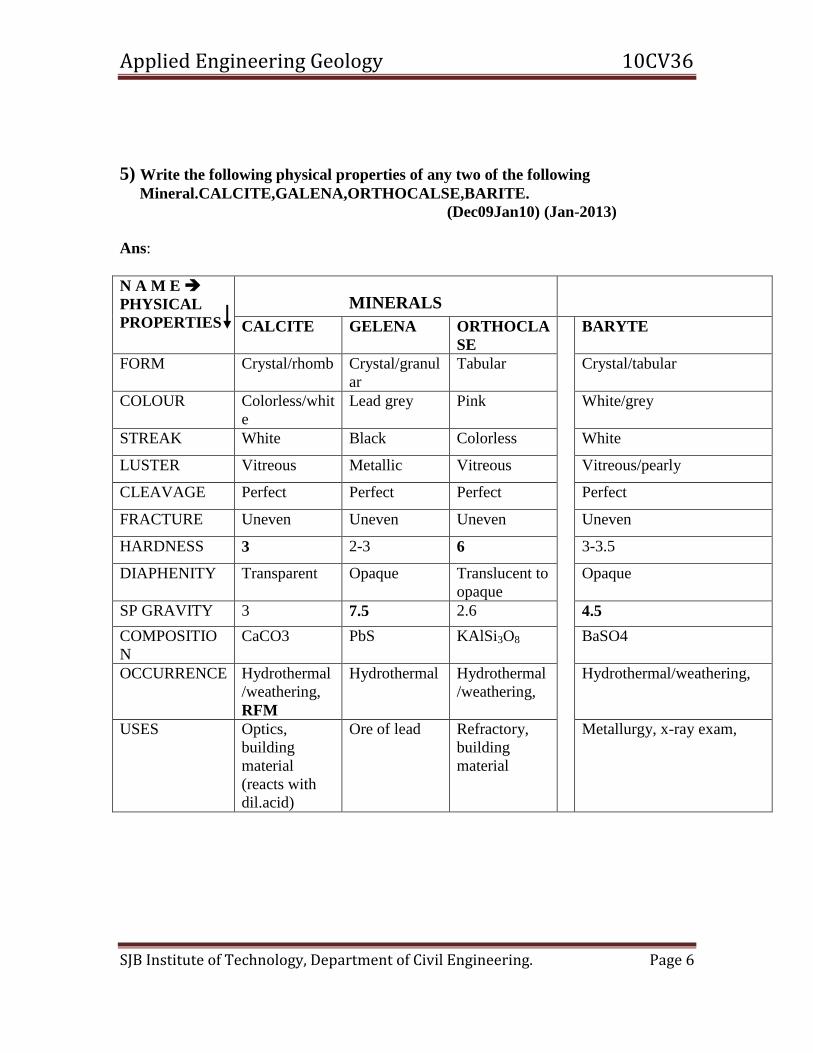
5) Write the following physical properties of any two of the following
Mineral.CALCITE,GALENA,ORTHOCALSE,BARITE.
(Dec09Jan10) (Jan-2013)
Ans:
N A M E
PHYSICAL
PROPERTIES
MINERALS
CALCITE GELENA ORTHOCLA
SE
BARYTE
FORM Crystal/rhomb Crystal/granul
ar
Tabular Crystal/tabular
COLOUR Colorless/whit
e
Lead grey Pink White/grey
STREAK White Black Colorless White
LUSTER Vitreous Metallic Vitreous Vitreous/pearly
CLEAVAGE Perfect Perfect Perfect Perfect
FRACTURE Uneven Uneven Uneven Uneven
HARDNESS 3 2-3 6 3-3.5
DIAPHENITY Transparent Opaque Translucent to
opaque
Opaque
SP GRAVITY 3 7.5 2.6 4.5
COMPOSITIO
N
CaCO3 PbS KAlSi3O8 BaSO4
OCCURRENCE Hydrothermal
/weathering,
RFM
Hydrothermal Hydrothermal
/weathering,
Hydrothermal/weathering,
USES Optics,
building
material
(reacts with
dil.acid)
Ore of lead Refractory,
building
material
Metallurgy, x-ray exam,
Applied Engineering Geology 10CV36
SJB Institute of Technology, Department of Civil Engineering. Page 7
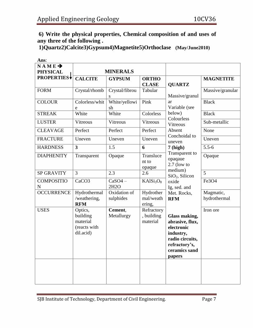
6) Write the physical properties, Chemical composition of and uses of
any three of the following .
1)Quartz2)Calcite3)Gypsum4)Magnetite5)Orthoclase (May/June2010)
Ans:
N A M E
PHYSICAL
PROPERTIES
MINERALS
CALCITE GYPSUM ORTHO
CLASE
QUARTZ
Massive/granul
ar
Variable (see
below)
Colourless
Vitreous
Absent
Conchoidal to
uneven
7 (high) Transparent to
opaqaue
2.7 (low to
medium)
SiO2, Silicon
oxide
Ig, sed. and
Met. Rocks,
RFM
Glass making,
abrasive, flux,
electronic
industry,
radio circuits,
refractory’s,
ceramics sand
papers
MAGNETITE
FORM Crystal/rhomb Crystal/fibrou
s
Tabular Massive/granular
COLOUR Colorless/whit
e
White/yellowi
sh
Pink Black
STREAK White White Colorless Black
LUSTER Vitreous Vitreous Vitreous Sub-metallic
CLEAVAGE Perfect Perfect Perfect None
FRACTURE Uneven Uneven Uneven Uneven
HARDNESS 3 1.5 6 5.5-6
DIAPHENITY Transparent Opaque Transluce
nt to
opaque
Opaque
SP GRAVITY 3 2.3 2.6 5
COMPOSITIO
N
CaCO3 CaSO4 –
2H2O
KAlSi3O8 Fe3O4
OCCURRENCE Hydrothermal
/weathering,
RFM
Oxidation of
sulphides
Hydrother
mal/weath
ering,
Magmatic,
hydrothermal
USES Optics,
building
material
(reacts with
dil.acid)
Cement,
Metallurgy
Refractory
, building
material
Iron ore

Applied Engineering Geology 10CV36
SJB Institute of Technology, Department of Civil Engineering. Page 8
UNIT – 2
1) What are Igneous Rocks, Describe the mode of occurrence of Igneous rocks. (May/June2010) (May/June2010) Ans: A rock is a naturally formed, consolidated material usually composed of
grains of one or more minerals. Rocks provide a historical record of geological events.
Most rocks at Earth's surface are silicates. Others, carbonates, are formed from minerals
extracted from water.
Petrology is a branch of Geology deals with the study of rocks. It mainly deals
with the mode of formation, mineral constituents, textures and structure.
Rocks are classified into
IGNEOUS: These are primary rocks formed by solidifying from a molten magma
METAMORPHIC: pre-existing rocks are altered due to pressure and/or temperature and
fluid activity.
SEDIMENTARY: result when fragments of pre-existing rocks accumulate and are
cemented together or by the precipitation of mineral crystals out of water solutions.
I IGNEOUS ROCKS Igneous rocks are those, which are formed by direct solidification of liquid rock
or magma. They are thus called primary rocks. Magma is a got viscous silicate melt with
gases occur in the deeper part of the Earth. This magma during its upward journey tries to
penetrate to thin crust. During this process magma sometimes successful in coming out
and some time they arrest themselves within the crust.
Lava: The magma which is successful in coming out on the Earth’s surface, it is erupted
out with a great force and spreads out on the surface of the Earth is called Lava.
Classification of Igneous rocks: They are classified on the basis of ‘silica’ content in the
magma and ‘mode’ of occurrence.
1. Based on silica content:
a) Acidic Igneous rocks: It is rich in silica content (>65% of SiO2)
Ex: Granite, Pegmatite
b) Intermediate Igneous rocks: Silica percentage is 55-65%
Ex: Syenite, Diorite
c) Basic Igneous rocks: Silica content is 45-55%
Ex: Dolerite, Gabbro
d) Ultra-basic Igneous rocks: Silica content is <45%
Ex: Dunite

Applied Engineering Geology 10CV36
SJB Institute of Technology, Department of Civil Engineering. Page 9
2) Define Metamorphism. Describe the kinds of Metamorphism. (May/June2010) (June/July2009) (Jan-2013)
Ans: The word "Metamorphism" comes from the Greek: Meta = change, Morph =
form, so metamorphism means to change form. Metamorphic rocks are those rocks that
are formed as a result of transformation that takes place in the pre-existing rocks
(Igneous/sedimentary rocks). When the pre-existing rocks are subjected to higher
temperature, pressure and chemically active liquids and gases, the minerals present in the
original rocks changes to new environmental condition. This adjustment processes
continues until the minerals attain stability or equilibrium. By this, original minerals get
recrystallized and the original structure and texture also changes. The process by which
the metamorphic rocks are formed is known as metamorphism.
Agents or factors of metamorphism: Temperature, Pressure and Fluid are main agents
responsible for metamorphism.
Kinds of metamorphism: Depending upon the factors responsible for metamorphism,
different kinds of metamorphism are noticed and they are
1. Thermal metamorphism
2. Dynamic metamorphism
3. Dynamo -thermal metamorphism
1. Thermal metamorphism: Here, temperature is the dominant factor and pressure and
fluid are the sub-ordinate factors. When the thermal metamorphismoccurs in the
immediate contact of igneous intrusions, it is called contact metamorphism and
when it occurs on a regional scale at depth it is called Plutonic metamorphism.
As a result of thermal metamorphism, recrystallization of original minerals
takes place.
Ex: Limestone Marble, Sandstone Quartzite
2. Dynamic metamorphism: This type of metamorphism takes place in the rock by
means of direct pressure / stress which is a dominant which leads to new
structures. It is also called Cataclastic / kinetic metamorphism and the rock
undergo mechanical breaking down and they may be crushed into smaller ones by
pressure.
Ex. Shale Slate
3. Dynamothermal metamorphism: It is a kind of metamorphism where temperature
and pressure are the dominant factors which operates upon pre-existing rocks. The
metamorphism may be regional / local scale and it is called Regional
metamorphism. Here, temperature promotes recrystallization as in the case of
thermal metamorphism and the original mineral grains re-arrange into new
minerals. Direct pressure / stress leads into the formation of new structures. Thus,
the minerals developed under direct pressure are usually flat, tabular, flaky in
nature.
Ex. Granite Gneiss

Applied Engineering Geology 10CV36
SJB Institute of Technology, Department of Civil Engineering. Page 10
3) Write the classification of igneous rocks based on the occurrence
with rock example (Dec09-Jan10) (Jan-2013)
Ans: Classification of Igneous rocks: They are classified on the basis of ‘silica’ content in
the magma and ‘mode’ of occurrence.
Based on silica content:
e) Acidic Igneous rocks: It is rich in silica content (>65% of SiO2)
Ex: Granite, Pegmatite
f) Intermediate Igneous rocks: Silica percentage is 55-65%
Ex: Syenite, Diorite
g) Basic Igneous rocks: Silica content is 45-55%
Ex: Dolerite, Gabbro
h) Ultra-basic Igneous rocks: Silica content is <45%
Ex: Dunite
Based on mode of origin:
i) Plutonic rocks: These are deep seated rocks formed under slow cooling
and great pressure conditions. They exhibit equigranular texture because
the magma has cooled slowly under uniform pressure.
Ex: Granite, Syenite, Diorite, Gabbroid
j) Hypabyssal rocks: They are formed by the solidification of magma nearer
to the surface of the Earth’s crust. They show porphyritic texture because
of rapid cooling of magma.
Ex: Pegmatite, Porphyry, Dolerite
k) Volcanic rocks: These are formed on the surface of the crust by the
consolidation of the lava. Here, the minerals cannot be distinguished with
naked eye because of very small grain size and is due to rapid cooling and
chilling.
Ex: Basalt
Table showing classification of igneous rocks based on silica content and mode of
origin.
BASED ON
MODE OF
ORIGIN
ON THE BASIS OF SILICA CONTENT
ACIDIC
>65% SiO2
INTERMEDIATE
55-65% SiO2
BASIC
45-65% SiO2
ULTRABASIC
<45% SiO2
PLUTONIC Granite Syenite, Diorite Gabbro Dunite
HYPABYSSAL Pegmatite Porphyry Porphyry
VOLCANIC Rhyolite Trachite Basalt Olivine basalt
Applied Engineering Geology 10CV36
SJB Institute of Technology, Department of Civil Engineering. Page 11
4) Write the classification of Sedimentary rocks based on the
sediments size with rock example. (Dec09-Jan10) (Jan-2013)
Ans: Classification of sedimentary rocks:
The classification of sedimentary rocks is based on the mineralogy, depositional
environment, origin or mode of formation and structural features. However, for practical
purpose, they are broadly classified into
1) Clastic and 2) Non-clastic rocks
1. Clastic rocks: They are mechanically formed rocks. These are formed due to the
process of weathering, erosion, transportation and deposition and diagenesis of pre-
existing rocks. Based on grain size, they are further classified into
a) Rudaceous b) Arenaceous c) Argillaceous
a) Rudaceous rocks: If the grain size of sediment / particle are more than 2 mm in
dia, they are called ‘Rudites’ and the rocks are called Rudaceous rocks. They are
further classified into
Gravel (2-10 mm in dia)
Pebbles (10-50 mm)
Cobble (50-200 mm)
Boulder (>200 mm)
The grains may be rounded or angular / sharp which depends on
the rate of transportation.
Rounded – Example: Conglomerate
Angular/sharp - Example: Breccia
b) Arenaceous rocks: If the size of the particle is in between 1 and 2 mm, then such
sedimentary rocks are called Arenaceous rocks. Here, the main constituent is sand
(quartz and feldspar) and the cementing material is may be argillaceous,
calcareous, ferruginous or siliceous material.
Example: Sandstone, Grit
c) Argillaceous rocks: If the size of the particle is < 1mm in dia, they are described
as ‘dust’ and rocks are called Argillaceous rocks. Argillaceous rocks are formed
by the accumulation and compaction of dust particles. If the particles are loose
and dry, the deposits are called ‘dust’, if it compact and semi wet it is mud and if
it is wet, it is described as clay.
Example: Shale, Mudstone
2. Non-clastic rocks: They are formed either by chemical processes or organic process.
Accordingly, they are grouped into
a) Chemically formed rocks
b) Organically formed rocks
a) Chemically formed rocks; They are formed by precipitation, evaporation or
crystallization from natural aqueous solution. They are further classified into
Applied Engineering Geology 10CV36
SJB Institute of Technology, Department of Civil Engineering. Page 12
i) Siliceous deposits – formed by precipitation of silica solution
Ex: Flint, Chart, Jasper
ii) Carbonate deposits - formed by precipitation of carbonate rich water
Ex: Limestone, Dolomite, Magnetite
iii) Ferruginous rocks- formed by precipitate of oxides and hydroxides of
iron
Ex: Bog iron ores
iv) Phosphate deposits- formed by sea water rich in phosphoric acid
Ex: Phosphate compound
v) Evaporates – formed by evaporation of sea water (bays and estuaries).
Ex: Rock salt, Anhydrites, Gypsum, Borates
b) Organically formed rocks: Sedimentary rocks which are formed exclusively from
remains of organisms (plant / animals).
Ex: Carbonaceous deposits – Coal and petroleum
Fossiliferous limestone
5) Write a short note on Dyke and Sill. (Dec- 2010)
a) Ans: Concordant intrusive bodies: If the intrusion is parallel to the structure
of the country rock, they are called ‘Concordant intrusive bodies’.
Ex: Sill, Phacolith, Laccoliths and Lopolith
Sill: It is a concordant intrusive sheet like body which runs parallel to the bedding
planes of the enclosing sedimentary rock. They are typical of basic magma and varies
in thickness from few centimeters to several kilometers
b) Discordant intrusive bodies: If the intrusion is cut across the structure
of pre-existing country rock, thy are called ‘Discordant intrusive
bodies’
Ex: Batholiths, Dyke, Volcanic Neck
Batholiths: Batholiths are known to be largest kind of discordant intrusive bodies
which are spread over very large area covering several kilometers. They increase in
size with depth and they are thought to be bottomless. A Stock is a small batholith of
irregular and cylinder form. A stock having a circular form is called a Boss.

Applied Engineering Geology 10CV36
SJB Institute of Technology, Department of Civil Engineering. Page 13
6) Write the properties and uses of any two of the following
a)Granite b) Basalt c)Sand Stone d)Marble (Jan-2013)
NAME.
PROPERTIES
Granite Sand Stone Basalt Marble
COLOUR Leucocratic Leucocratic Leucocratic Melanocratic
TEXTURE and GRAIN SIZE
Equigranular Coarse grained
Equigranular Coarse grained
Equigranular Coarse grained
Equigranular Coarse grained
STRUCTURE Batholith Batholith, dyke Batholith, dyke Batholith, dyke
MINERAL COMPOSITION
A. ESSENTIAL MINERALS
B. ACCESSOR
Y MINERALS
Quartz, Feldspar and Mica Magnetite
Feldspar and Mica ±Hornblende (Quartz absent) Magnetite
Plagioclase, hornblende Magnetite
Plagioclase and Augite Magnetite Pyrite
SP GRAVITY 2.6 2.6 2.6 3.0
GROUP Over saturated, acidic, plutonic Igneous rock
Saturated, plutonic Igneous rock
Saturated, Volcanic Igneous rock
Saturated, acidic, plutonic Igneous rock
USES Highly resistant to weathering Used as Building stone, ornamental, Aggregates, Railway ballast
Highly resistant to weathering Used as Building stone, ornamental, Aggregates, Railway ballast
Highly resistant to weathering Used as Building stone, road metal, Aggregates, Railway ballast
Highly resistant to weathering Used as Building stone, road metal, Aggregates, Railway ballast
Varieties Pink granite, grey granite, graphic granite

Applied Engineering Geology 10CV36
SJB Institute of Technology, Department of Civil Engineering. Page 14
UNIT – 3
1) Define Soil. Describe the types of soil. (May/June2010) (June/July 2009)
Ans:
Soils are an important natural resource. They represent the interface between the
lithosphere and the biosphere - as soils provide nutrients for plants. Soils consist of
weathered rock plus organic material that comes from decaying plants and animals.
Engineers define soil as any unconsolidated material (clay through gravel size) that may
be excavated without blasting. Soil contains mostly quartz and clay particles of varying
sizes. The quartz sand grains help keep the soil porous, and the clay particles hold water
and nutrients for plant growth.
1). Red Soils: - These are residual soils derived mainly from the disintegration and
decomposition of ancient granites and gneisses and contain coarse grains of quartz and
mica and fines mainly kaolinite. Red Soils are generally heavily stained red with iron
oxides grading into brown, yellow gray and even black. These are fairly rich in potash,
porous and contain no salts and free carbonate and moderately fertile. Red Soils occur
extensively in peninsular India covering the states of Bihar, West Bengal, Orissa, Parts of
Madhya Pradesh, Andhra Pradesh, Karnataka and Tamil Nadu.
2). Black Soils: - These are residual soils mainly from the alteration of basalts. Black
soils are typically highly clay. Black soils are fine grained, porous, and sticky and swell
when
Wet and contracts on drying with the development of a network of deep cracks. These
highly fertile and excellent for cotton cultivation, hence called black cotton soil locally.
In India black soils are derived from the alteration of Deccan Basalts and occur over a
very wide are of over 200,000 sq miles in western and central parts covering the states of
Gujarat, Maharashtra, parts of M.P, Orissa, A.P and Karnataka.
3. Laterite are highly leached, residual soils that form in tropical regions. The high
temperature and rainfall result in deep and intense weathering. The laterite is typically
bright red and composed of iron and aluminum oxides that are the most resistant to
leaching. Valuable metals such as aluminum, copper, silver, gold, nickel, and iron are
concentrated in laterites through secondary enrichment and can sometimes be mined
economically. Secondary enrichment works in two ways: It can remove many of the other
elements from the rock, which enriches the remaining valuable elements in place, or it
can leach valuable elements such as copper and gold and deposit them at a particular
level lower in the laterite.
2) What is soil and soil profile? Describe the methods of soil
conservation. (Dec08/Jan09) (Dec2010)

Applied Engineering Geology 10CV36
SJB Institute of Technology, Department of Civil Engineering. Page 15
Ans: Soils are an important natural resource. They represent the interface between the
lithosphere and the biosphere - as soils provide nutrients for plants. Soils consist of
weathered rock plus organic material that comes from decaying plants and animals.
Engineers define soil as any unconsolidated material (clay through gravel size) that may
be excavated without blasting. Soil contains mostly quartz and clay particles of varying
sizes. The quartz sand grains help keep the soil porous, and the clay particles hold water
and nutrients for plant growth.
Sand – composed of sand grains mostly without clay
Loam – Mixture of sand and clay
Clay – The finest material, mostly kaoline without sand
Importance of soils are:
1) natural resource (for agriculture, for
construction material)
2) soil erosion
3) as a sediment source (via erosion)
4) as a water filter (for water infiltrating the
ground)
5) as a contaminant sink
6) as a bearing material (for building on)
Soil Profile: When a soil develops on a rock, a soil profile develops as shown below.
These different layers are not the same as beds formed by sedimentation, instead each of
the horizons forms and grows in place by weathering and the addition of organic material
from decaying plants and plant roots. Vertical sequence of A,B,C and D horizon is the
soil profile which is as follows.
A-Horizon: Top soil, organic layer
B-Horizon: Rich in mineral matter, zone of accumulation of clays, colloids, iron and
aluminium oxides. The horizon A and B is combined is called Solum which is a true soil
zone.
C-Horizon: Weathered material
D-Horizon: Solid rock (fresh parent rock)
2) Write a brief account of Geological work of running water and its
engineeringimportance
(June/July 2010)(June/July 2009) (Jan-2013)

Applied Engineering Geology 10CV36
SJB Institute of Technology, Department of Civil Engineering. Page 16
Ans: The geological work of Running Water can be broadly divided into 6 processes and
they are:
Hydraulic action
Abrasion
Attrition
Solution
Transportation
Deposition
First four processes belongs to EROSION.
Hydraulic action: Here breaking down and removal of rock masses due to continuous
impact of water moving with some velocity in the Upper part of the course of river. In
general, the greater the velocity of the water and the steeper the grade, the greater the
hydraulic action capabilities of the stream.
Abrasion: The rock debris formed by hydraulic action naturally rub themselves against
the valley floor and bring about mechanical wear and tear of base rock. The mechanical
breaking down of bed rock due to impact of flowing rock debris is called abrasion.
Attrition: It is the mechanical wear and tear of rolling or transported materials
(boulders/pebbles) into the smaller fragments due to mutual impact and collision.
Solution: Rocks susceptible to the chemical weathering process of solution can be
dissolved by the slightly acidic water of a stream. Limestone and sedimentary rock
cemented with calcite are vulnerable to solution.
Hydraulic action, abrasion, attrition and solution pertain to Emotional process. Following
are some of the features of River Erosion.
Pot holes: These are bowl like cylindrical depression with the dimension of few inches to
several feet formed due to ABRASION of softer rocks. Initially small depression forms
and later the pebbles and gravels are caught in Eddies’ and thrown into a swirling /
churning motion and causing deepening and widening of the holes.
Gorges and Canyons: A valley is a low land surrounded on sides by inclined hill slopes
and mountains. Valley deepening occurs due to cutting down of river bed which depends
on the velocity of streams
GORGES are due to valley deepening and they are very deep and narrow valleys with
very steep and high walls on either side.
CANYONS are a specific type of gorge where the layers cut down by a river are
essentially stratified and horizontal in altitudes.
Waterfalls: -A steep descent of a river at a particular point in its course, especially in
mountainous regions is called a waterfall. Waterfalls range in size from a small descent
or jump called a rapid to a succession of rapids over a steep gradient called cascades to
shear deep majestic vertical falls of hundreds of meters.
Escarpments: This feature is found in regions of alternate beds of hard and soft rocks.
The softer rocks erodes quickly and hard rock’s resist and projects as ledges. Escarpment
Applied Engineering Geology 10CV36
SJB Institute of Technology, Department of Civil Engineering. Page 17
is the steep slope caused by falling of undercut ledge of hard rocks. CUESTA is the term
used for escarpment and Dip slope.
Hogback: It is a feature due to erosion process where carved surface develops on hard
rocks.
Mesa and Butte: These features are found in alternate layers of soft and hard rock’s
which are almost horizontal. MESA is an erosion feature of cap like structure (large size)
in the hard rocks. The small sized Mesa which are isolated are called BUTTE.
Transportation: A river is a most powerful agent of transportation and transport all the
product of erosion.
Load: The product of erosion ranging from boulders and pebbles to fine sand, silt, clay
and also solution. The total quantity of rock particle transported by a stream, in siltation,
suspension and soluble constitutes Load.
Running water transports its Load due to kinetic energy. As soon as the velocity
decreases, its transportation capacity reduces and hence parts of the load drops. The
larger fragments drops immediately and smaller/lighter transported far away and deposit.
This is SORTING of sediments
The suspended load is the fine-grained sediment that remains in the water during
transportation. The heavier, coarser-grained earth material that travels along the bottom
of the stream is the bed load. Earth material that has been dissolved into ions and carried
in solution is the dissolved load.
6. Deposition: A stream's sediment load is typically deposited, eroded, and redeposited
many times in a stream channel, especially during climatic variations such as flooding.
Sediments are deposited throughout the length of the stream as bars or floodplain
deposits..
Alluvial Fans - When a steep mountain stream enters a flat valley, there is a sudden
decrease in gradient and velocity. Sediment transported in the stream will suddenly
become deposited along the valley walls in an alluvial fan. As the velocity of the
mountain stream slows it becomes choked with sediment and breaks up into numerous
distributaries’ channels.
Deltas - When a stream enters a standing body of water such as a lake or ocean, there is a
sudden decrease in velocity and the stream deposits its sediment in a deposit called a
delta. As the velocity of a stream decreases on entering the delta, the stream becomes
choked with sediment and conditions become favorable to those of a braided stream
channel, but instead of braiding, the stream breaks into many smaller streams called
distributaries streams.
Meanders and oxbow lakes: When a river is sluggishly flowing in the plains, it has very
little energy to remove the obstructions. Its course gets deviated / deflected due to slight
irregularities. As a result, the river develops prominent beds which may further swell into
big loop. This process will transform a gentle curve into a hairpinlike feature called
meander and the phenomenon is called Meandering.

Applied Engineering Geology 10CV36
SJB Institute of Technology, Department of Civil Engineering. Page 18
Erosion will take place on the outer parts of the meander bends where the velocity of the
stream is highest. Sediment deposition will occur along the inner meander bends where
the velocity is low. Such deposition of sediment results in exposed bars, called point bars.
Oxbow lake: Meanders continuously change location as they swing back and forth across
a valley or migrate downstream over time. If erosion on the outside meander bends
continues to take place, eventually a meander bend can become cut off from the rest of
the stream. When this occurs, the cutoff meander bend, because it is still a depression,
will collect water and form a type of lake called an oxbow lake.
3) What are OX-bow lakes? How are they formed?
(Dec08/Jan09)
Ans:

Applied Engineering Geology 10CV36
SJB Institute of Technology, Department of Civil Engineering. Page 19
In the middle part of the course in rivers the gradient of valley floor are very less. In this
stage river are never follow or less zig zag path and the curvatures along the course are
known as Meanders
Due to the slope of the channel, erosion is more effective on the down streamside of a
meander. Therefore in addition to growing laterally, the bends also gradually migrate
down the valley. Sometimes the downstream migration of a meander is slowed when it
reaches a more resistant portion; gradually the neck of land between the meanders is
narrowed. When they get closer, the river may erode through the narrow neck of land to
the next loop. Because of shape left behind is called an oxbow lake
4) What is wind deflation? Write a note an importance of wind to
civil engineering. (Dec-
2011)
5) What is mechanical weathering? Write a note on mechanical
weathering by thermal effect.
(Dec09/Jan10) (Jan-2013) Ans:
It is a process that cause the breakdown of rocks, either to form new minerals that are
stable on the surface of the Earth, or to break the rocks down into smaller
particles. Weathering is the result of the interactions of air, water, and temperature on
exposed rock surfaces and prepares the rock for erosion.
Erosion is the movement of the particles by ice, wind, or water. The particles are then
transported by that agent until they are deposited to form sedimentary deposits, which can
be later eroded again or transformed into sedimentary rocks. Weathering is generally a
long, slow process that is continuously active at the earth's surface.
There are two kinds of weathering: mechanical and chemical.
Mechanical weathering: It is the process by which rocks are broken down into smaller
pieces by external conditions.
A single block is broken gradually into numerous small irregular fragments and then into
smaller fragments. Further it is classified into Block disintegration and Granular
disintegration.
Block disintegration: - This is because of regular arrangement of atoms in a rock, due to
this individual blocks are obtain.
Granular disintegration: - This is because of irregular arrangement of atoms in a rock, due
to this small grains are obtain.
Thermal or heat effect: The effect of change of temperature on rocks is of considerable
importance in arid and semiarid regions where difference between day- time and
nighttime temperature is very high. Expansion on heating followed by contraction on
cooling, repeated expansion and of the same rock body gradually breaks into smaller
pieces due to stress developing by this process.
Applied Engineering Geology 10CV36
SJB Institute of Technology, Department of Civil Engineering. Page 20
Frost action: It results due to freezing of water which are trapped in the cracks of the
rocks widens and deepens the cracks, breaking off pieces and slabs.
Plant and Animal Activities: Plant roots can extend into fractures and grow, causing
expansion of the fracture and eventually can break rock. Animals burrowing or moving
through cracks can break rock. Plants can penetrates into the ground just a few meters
whereas microorganisms can penetrate to a greater than of 10-25 mts.
6)Write brief note on Epigene and Hypogene geological agents(Jan-2012)
Ans: Epigene and Hypogene Geological agents are the study of Land forms with Regard
to their Structures and Origen by various geological agents such as wind, running water,
moving ice….etc.
Epigene geological agents are those from the sources exterior , Examples Atmosphere,
Rain Fall, River, Glaciers, Oceans,,, etc.
Hypogene Geological agent are those derive from dynamic agencies, examples earth
quake, volcanoes, landslides… etc
UNIT – 4
1) What is Earthquake? Discuss the causes of Earthquake
resistance structures .
(May/June2010)
(OR)
What are Earthquake? How they are caused? Discuss in detail
precautionary measures followed in the design of seismic tolerant
structures. (Dec07/Jan08)
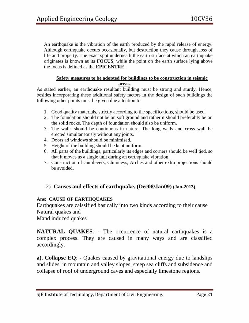
Ans: An earthquake is a sudden and rapid shaking of the ground due to passage of
vibrations beneath caused by transient disturbance of elastic or gravitational equilibrium
of rocks.
Applied Engineering Geology 10CV36
SJB Institute of Technology, Department of Civil Engineering. Page 21
An earthquake is the vibration of the earth produced by the rapid release of energy.
Although earthquake occurs occasionally, but destruction they cause through loss of
life and property. The exact spot underneath the earth surface at which an earthquake
originates is known as its FOCUS, while the point on the earth surface lying above
the focus is defined as the EPICENTRE.
Safety measures to be adopted for buildings to be construction in seismic
areas.
As stated earlier, an earthquake resultant building must be strong and sturdy. Hence,
besides incorporating these additional safety factors in the design of such buildings the
following other points must be given due attention to
1. Good quality materials, strictly according to the specifications, should be used.
2. The foundation should not be on soft ground and rather it should preferably be on
the solid rocks. The depth of foundation should also be uniform.
3. The walls should be continuous in nature. The long walls and cross wall be
erected simultaneously without any joints.
4. Doors ad windows should be minimised.
5. Height of the building should be kept uniform.
6. All parts of the buildings, particularly its edges and corners should be well tied, so
that it moves as a single unit during an earthquake vibration.
7. Construction of cantilevers, Chimneys, Arches and other extra projections should
be avoided.
2) Causes and effects of earthquake. (Dec08/Jan09) (Jan-2013)
Ans: CAUSE OF EARTHQUAKES
Earthquakes are calssified basically into two kinds according to their cause
Natural quakes and
Mand induced quakes
NATURAL QUAKES: - The occurrence of natural earthquakes is a
complex process. They are caused in many ways and are classified
accordingly.
a). Collapse EQ: - Quakes caused by gravitational energy due to landslips
and slides, in mountain and valley slopes, steep sea cliffs and subsidence and
collapse of roof of underground caves and especially limestone regions.
Applied Engineering Geology 10CV36
SJB Institute of Technology, Department of Civil Engineering. Page 22
b). Volcanic EQ: - When a volcano become active with gas explosions,
fissuring and up doming or collapse the volcanic tremors soon take the form
of rapid seismic waves. Volcanic quakes usually are of shallow origin and
restricted to small areas but dangerous to towns and cities in the vicinity of
volcanoes.
c). Tectonic EQ: - These are the most common, powerful, highly destructive
and responsible for loss of life and property in inhabited areas. The origin or
causes of tectonic quakes is explained by the following theories.
(i). Elastic rebound theory: -This theory propounded by A C Lawson 1906,
and modified by professor H F Reid 1908 is based on the detailed field study
of the great 1906 San Francisco, California, USA quake in the San Andreas
Fault region.
According to this theory when segments of rocks at depths of a few
kilometers below the ground surface, strained beyond the limits of their
elastic deformation yield suddenly by faulting and snap back to unstrained
positions much like a broken spring called elastic rebound with the release
of enormous strain energy. This produces powerful vibrations that spread out
form the local area in all directions inducing ground shaking until they reach
relatively unstrained area.
(ii). Plate Tectonic Theory: -According to this theory the earth’s crust is
broken into a dozen or more large rigid blocks down to a depth of about
100km called crustal plates. These carry Land, Sea or both and are in
constant motion on the viscous mantle overriding, one plunging beneath the
other colliding with each other or brushing one past another. Some segments
of a adjacent plate, however, remain immobile and locked together for years
only to break free in, great lurches(faulting) and produce seismic vibrations
long plate boundaries, with deafening noise and everything around, ground
hills, riverbed, building, roads and living being and their belonging are
destroyed.
(iii).Man induced quakes: - These are caused by
#Large scale blasting as in quarries and excavations in large rocky
construction iste
# Collapse of abandoned underground mines without supports and or
backfilling

Applied Engineering Geology 10CV36
SJB Institute of Technology, Department of Civil Engineering. Page 23
# Construction of large water reservoir behind huge and heavy dams especially in areas,
overlying fault intersections and extensional tectonics. This increases local crustal
loading and induce deformation and lubricate faults triggering the so called reservoir
induced quakes
#Withdrawal of large quantities of liquids, water, petroleum, natural gas
from below the surface.
# Test explosion of atomic and nuclear devices underground.
3) Write a note on causes of landslides. (Dec09/Jan10)
Ans: A landslide is a slow or sudden downhill movement of slope forming rock and soil
material under the force of gravity. Landslides or sloope failures are natural Erosional
process. They occur in hillsides valley slopes, seacoasts, riverbanks and bends, on the
slopes of volcanic cones and in earthquake prone areas. They also occur underneath as on
lake or sea floor. Man in his urban and regional development activities also trigger
landslides. Such as excavations, fills quarries, cuttings of roads, railway and canals etc.
Landslides as natural erosional process not only modify the existing topography and
landscape, they also cause immense damages to manmade structures and heavy loss of
life.
CAUSES OF LANDSLIDES

Applied Engineering Geology 10CV36
SJB Institute of Technology, Department of Civil Engineering. Page 24
Many factors are causing a mass of material to slide or flow. Some of them play a
direct role and are easily understand whereas others are indirectly responsible for the
instability of the landmass. All such factors that facilities land sliding in one way or
another is generally grouped in tow headings.
1) Internal Factors
2) External Factors
Internal Factors: - These include such causes, which tend to reduce the shearing of the
rock, further it is classified into, 1) the nature of slope, 2) water content, 3) composition
and compaction of the mass, 4) geological structures
1) the nature of slope: - Some slopes are very stable even when very steep whereas
other are unstable, even at very gentle slope. But a great majority of failure are
confined to slopes only, indicating that slopes are directly responsible for mass
failure.
2) Water content: - Much importance is attached to the role of water is causing mass
movements. It may act in a number of ways to reduce the shearing strength of the
rock or soil mass. Even presence of water in the pore spaces of rocks has been
found to affect all the strength properties adversely. When water within the mass is
also capable of flow around the grains. Similarly, when water happens to move
along a plane of weakness within the mass, that plane gets lubricated and may turn
into an effective plane of shear failure. In sliding type of failure this lubricating
action is of great importance.
3) Composition and compaction of the mass: - Some materials are stable in a given
set of conditions of slopes and water content whereas others may be practically
unstable under those very conditions. This clearly suggests that compaction plays
an important part in defining the stability of the masses. Sandstone exhibits a great
variation in chemical composition. Siliceous Sandstones would be highly stable
even during intensive rains and at steep slopes whereas clayey or calcareous may
suffer repeated failure under same conditions.
4) geological structures: - Of all the geological structure the inclination(dip), joints,
faults zones of the strata, presence or deposition of shear, fault zone, joints and
other
Planes of weakness are important in defining their stability.
External Factors: - Earthquakes and blasting around mines due to this vibration is
librated from this mass failure may take place.
PART - B
UNIT – 5
1) What are folds? How are they caused? Describe recumbent and
plunging folds. (Dec08/Jan09) (Jan-2013)
Ans:

Applied Engineering Geology 10CV36
SJB Institute of Technology, Department of Civil Engineering. Page 25
Folds are undulation is obtained in rock strata produced by compressive
forces in plastic strata similar to buckling of an overload column.
PARTS OF FOLD: -
Axial line or Axis: - The median line about which folding has taken place.
The axis may be horizontal, inclined or vertical
Axial plane: - An imaginary plane that divides a fold into two more or less
symmetrical halves. The axial plane may be vertical inclined or horizontal
Limbs: - The two sides of a folds the left limb and right limb
Crest: - Highest position of fold, it is always curving or angular
Crest line: - The two sides of crest point are referred as crest line
If the fold axis is inclined then it referred as Plunge of fold
2) Distinguish between a joints and faults in rocks. Explain Horst
and Gabren. (Dec08/Jan09)
Ans:
Joints are natural divisional planes or fractures dissecting rock masses in patterns along
which there has been no parallel movement of blocks of rocks.
A fault is a fracture or fracture zone in rocks along which t
here has been displacement of the two sides relative to one another parallel to the
fracture.
FAULTS JOINTS
1 Fracture or fracture zone with
Displacement of the sides Relative to
one another parallel to the fracture
Fracture that divides A rock and along
which There has been no Movement
parallel to The fracture
2 Occur generally single or in groups,
parallel vertical inclined radial or
intersecting
Occur in numbers parallel to each
other and intersecting perpendicularly
or obliquely
3 Comparatively widely spaced Relatively closely spaced
4 Fault fissure open clean cut irregular Joint planes open at surface may close

Applied Engineering Geology 10CV36
SJB Institute of Technology, Department of Civil Engineering. Page 26
filled with gouge down at depth filled with gouge,
mineral matter.
5 Fault plane surface rough silken sided
grooved scratched
Rough or smooth, never slicken sided
6 Fault blocks forced to override other No movement
7 Contact of beds of different
composition thickness and age
Same rock
8 Cut rock strata with displacement of
the contiguous parts
Divide the rock mass into regular
cuboidal, rectangular. Columnar or
prismatic blocks
9 May be subjected intermittent
movement (activated)
Nil
10 Forms potential hazard causes
earthquakes
Responsible for landslides and rock
falls
11 Result from tensional as well as
compressive forces
Result from tensional as well as
compressive forces
12 Continued application of stress
following rupture lead to dislocation
(fault movement)
Operation of stress stops with rupture
3) What are folds? How are they caused? Describe the various types
of folds noticed on rocks. (Dec – 2011) (Dec09/Jan10)
Ans: FOLD
An undulation is obtained in rock strata produced by compressive forces in
plastic strata similar to buckling of an overload column.
PARTS OF FOLD: -
Axial line or Axis: - The median line about which folding has taken place.
The axis may be horizontal, inclined or vertical
Axial plane: - An imaginary plane that divides a fold into two more or less
symmetrical halves. The axial plane may be vertical inclined or horizontal
Applied Engineering Geology 10CV36
SJB Institute of Technology, Department of Civil Engineering. Page 27
Limbs: - The two sides of a folds the left limb and right limb
Crest: - Highest position of fold, it is always curving or angular
Crest line: - The two sides of crest point are referred as crest line
If the fold axis is inclined then it referred as Plunge of fold
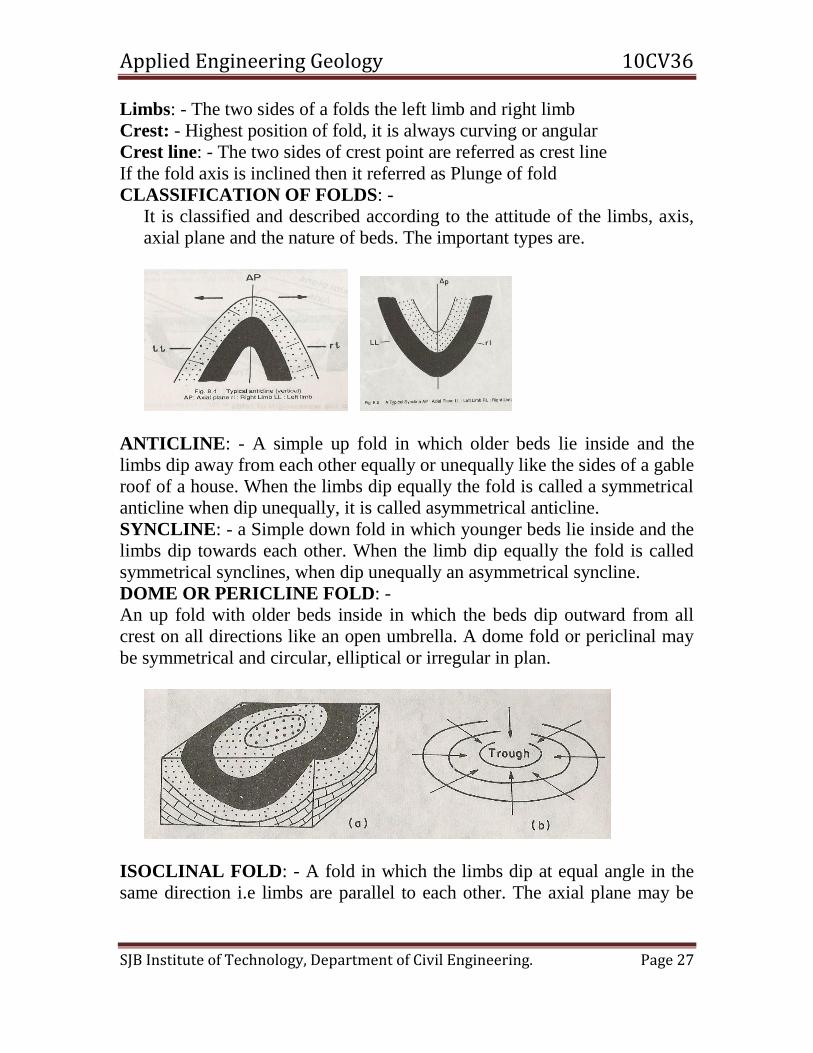
CLASSIFICATION OF FOLDS: -
It is classified and described according to the attitude of the limbs, axis,
axial plane and the nature of beds. The important types are.
ANTICLINE: - A simple up fold in which older beds lie inside and the
limbs dip away from each other equally or unequally like the sides of a gable
roof of a house. When the limbs dip equally the fold is called a symmetrical
anticline when dip unequally, it is called asymmetrical anticline.
SYNCLINE: - a Simple down fold in which younger beds lie inside and the
limbs dip towards each other. When the limb dip equally the fold is called
symmetrical synclines, when dip unequally an asymmetrical syncline.
DOME OR PERICLINE FOLD: -
An up fold with older beds inside in which the beds dip outward from all
crest on all directions like an open umbrella. A dome fold or periclinal may
be symmetrical and circular, elliptical or irregular in plan.
ISOCLINAL FOLD: - A fold in which the limbs dip at equal angle in the
same direction i.e limbs are parallel to each other. The axial plane may be

Applied Engineering Geology 10CV36
SJB Institute of Technology, Department of Civil Engineering. Page 28
vertical inclined or horizontal. When the axial plane is horizontal it is called
as recumbent fold.
OVERFOLD OR OVERTURN FOLD: -
A fold in which the axial plane is inclined form the vertical and the limb dip
in the same direction but unequally i.e the limbs are not parallel to each
other. The limb below the axial plane is the overturned limb.
CHEVRON FOLD: - If the crest point is acute then it is referred as Chevron fold. This is due to very much of
magnitude of force is acted on either side.
3) What is normal fault? Add a note on Horst and Gabren
(Dec- 2011) (Jan-2013)
Ans: A fault is a fracture or fracture zone in rocks along which there has been
displacement of the two sides relative to one another parallel to the fracture.
NORMAL FAULT: - A normal fault is a high angle dip-slip fault in which the fault plane
is inclined steeply with hade10o-20o or less. The vertical component of the movement ie

Applied Engineering Geology 10CV36
SJB Institute of Technology, Department of Civil Engineering. Page 29
the throw is generally large. The fault traces of normal faults commonly run straight or
slightly sinuous, but may be very irregular due to slumping of the sides later. Normal
faults may small, local or regional features and area also called gravity faults.
RIDGE FAULT: - A fault system consisting of a pair of normal faults whose fault planes
are inclined away from each other with a common up throw side in between. The up
throw side of a ridge fault system forms a conspicuous inverted wedge shaped ridge
parallel to the fault planes, generally long compared to its width called ridge or a horst.
TROUGH FAULT: - A fault system consisting of a pair of normal faults whose fault
planes are inclined towards each other with a common down throw side in between. The
down throw side of a troughs fault system forms a long trench or depression parallel to
the fault planes, general long compared to its width called fault basin or graben of a rift
valley.
4) Add a note on Angular Unconformity.(Dec – 2011) (Jan-2013)
Ans: When stratified rock formations are deposited regularly and continuously one
above the other without any disturbance or break in the succession presenting a series
of parallel beds, the sequence is called conformable beds or series and the structure is
called conformity
ANGULAR UNCONFORMITY
Applied Engineering Geology 10CV36
SJB Institute of Technology, Department of Civil Engineering. Page 30
5) What are joints? Write its importance in civil engineering field.
(Dec – 2011) (Jan-2013)
Ans: Joints are natural divisional planes or fractures dissecting rock masses in
patterns along which there has been no parallel movement of blocks of rocks. Joints in rocks form advantages as well as potential weak and dangerous features.
They are t be very carefully studied and assessed of their pattern, intensity, depth and
continuity. Joints break the continuity of the rocks and reduce their strength greatly.
Joint concentration is best studied on the basis of statistical data obtained from rose
diagram and point contour diagram.
# Joints influence quarrying and blasting pattern
# Joints spacing determine the size and shape of the blocks to be obtained in a quarry,
mural and master joints help quarrying intact cubical or rectangular dimension stones.
Sheet jointing helps obtaining crushed stone for concrete aggregate, road metal, rail
road ballasting.
# Joints provide passages for the percolation of water and help weathering and
formation f soil.
# Joints control the natural groundwater drainage system in rocks underground.
# Joints often provide passages for the groundwater to rise to the surface or issue out
to the surface or issue out to the surface and form springs.
# Joints planes provide potential depositional channels of mineralizing solutions.
# Joints are helpful in exploration of water and locating well sites.
# Joints render rocks weak and unstable.
# Joints planes form slop planes in inclined and folded beds and therefore induced
landslides and rock falls.
# Joints render rocky banks of rivers unfit for bridge and dam abutments.
5)Explain the following: a) Unconformity (Jan-2013)

Applied Engineering Geology 10CV36
SJB Institute of Technology, Department of Civil Engineering. Page 31
b) Dip and Strike
c) Normal and Reverse fault
d) Drag fold (May/June2010)
Ans: a) Unconformity- When stratified rock formations are deposited regularly and
continuously one above the other without any disturbance or break in the succession
presenting a series of parallel beds, the sequence is called conformable beds or series and
the structure is called conformity.
b) Dip and Strike
DIP: - It is defined as the maximum angle of slope of a bed or layer of rock with the
horizontal. It is expressed both in terms of degree of inclination and direction of
inclination.
The amount of dip is the angle between the bedding plane and a horizontal plane.
STRIKE: - It is a geographic direction of extension of the layers of rocks and may be
explained as the direction of intersection of the bedding plane with a horizontal plane.
\
c) Normal and Reverse fault

Applied Engineering Geology 10CV36
SJB Institute of Technology, Department of Civil Engineering. Page 32
NORMAL FAULT: - A normal fault is a high angle dip-slip fault in which the fault plane
is inclined steeply with hade10o-20o or less. The vertical component of the movement ie
the throw is generally large. The fault traces of normal faults commonly run straight or
slightly sinuous, but may be very irregular due to slumping of the sides later. Normal
faults may small, local or regional features and area also called gravity faults.
REVERSE FAULT: - A reverse fault is a low –angle dip-slip fault in which the fault
plane is inclined less steeply towards the up throw side i.e the hade is pointing towards
the up throw side and the hanging wall has moved up relative to the foot wall.
Reverse faults are produced by severe compressive forces and the fault planes commonly
area gently dipping with large hade over45o. The heave or the horizontal of the
movement is very large, often many kilometers in case of larger faults. The up throw side
is actually thrust over the down throw side due to great tangential forces. As such a
reverse fault is also called thrust fault.
d) Drag fold- A fold in which the axial plane is inclined form the vertical and the limb dip
in the same direction but unequally i.e the limbs are not parallel to each
other. The limb below the axial plane is the overturned limb.
UNIT – 6
1) Comment on tunneling through the folded strata. (Dec- 2010)
(Dec – 2011) (Dec09/Jan10) (Jun- July2009) (Jan-2013)
Ans: TUNNEL LOCATED IN ANTICLINE AND SYNSLINE
Folds signify beds and curvatures and a lot of strain energy stored in the
rocks. Their influence on design and construction of tunnels is important
from at least three angles.
Applied Engineering Geology 10CV36
SJB Institute of Technology, Department of Civil Engineering. Page 33
Folding of rocks introduces considerable variation and uncertainty in a
sequence of rocks, so that entirely unexpected rocks might be encountered
along any given direction. This situation becomes especially serious when
folding is not recognized properly in preliminary or detailed surveys due
either to its being localized or to misinterpretation.
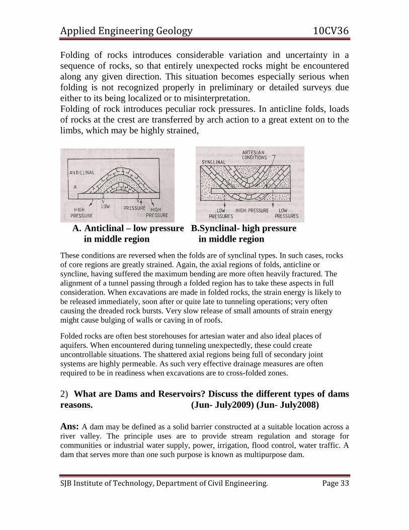
Folding of rock introduces peculiar rock pressures. In anticline folds, loads
of rocks at the crest are transferred by arch action to a great extent on to the
limbs, which may be highly strained,
A. Anticlinal – low pressure B.Synclinal- high pressure
in middle region in middle region
These conditions are reversed when the folds are of synclinal types. In such cases, rocks
of core regions are greatly strained. Again, the axial regions of folds, anticline or
syncline, having suffered the maximum bending are more often heavily fractured. The
alignment of a tunnel passing through a folded region has to take these aspects in full
consideration. When excavations are made in folded rocks, the strain energy is likely to
be released immediately, soon after or quite late to tunneling operations; very often
causing the dreaded rock bursts. Very slow release of small amounts of strain energy
might cause bulging of walls or caving in of roofs.
Folded rocks are often best storehouses for artesian water and also ideal places of
aquifers. When encountered during tunneling unexpectedly, these could create
uncontrollable situations. The shattered axial regions being full of secondary joint
systems are highly permeable. As such very effective drainage measures are often
required to be in readiness when excavations are to cross-folded zones.
2) What are Dams and Reservoirs? Discuss the different types of dams
reasons. (Jun- July2009) (Jun- July2008)
Ans: A dam may be defined as a solid barrier constructed at a suitable location across a
river valley. The principle uses are to provide stream regulation and storage for
communities or industrial water supply, power, irrigation, flood control, water traffic. A
dam that serves more than one such purpose is known as multipurpose dam.

Applied Engineering Geology 10CV36
SJB Institute of Technology, Department of Civil Engineering. Page 34
SCHEMATIC CROSS SECTION OF DAM
ABUTMENT: - These are the sloping side of the river valley, upon which
the dam is built
RIVER CHANNEL SECTION: - It is the central portion of the dam that
directly overlies river channel or that portion of the valley.
HELL OF THE DAM: - Heel is the upstream portion of dam where it
contacts the bearing surface of supporting the dam.
TOE OF THE DAM: - Toe is the downstream portion of dam where it
contacts the bearing surface.
CREST OF THE DAM: - It is the top most part of the dam
PARAPET WALL: - Wall that are placed along top of the dam to afford
safety to the road.
FREE BOARD: - It is the distance between highest level of water in the
reservoir and the top of the dam.
AXIS OF DAM: - It is an arbitrary line drawn along center of the plan of he
crest.
CROSS SECTION: - It is drawn on a vertical; cross section is perpendicular
to the axis of the dam.
GALLERY: - Formed openings within the dam. They may run either
transversely or longitudinally and may be level or have a sloping grade.
They provide for drainage water seeping through the face or the foundation.
It provides access equipment within the dam for observing performance.
TAIL WATER: - It is the water level at the downstream base of dam.
MAXIMUM WATER LEVEL: - It is the highest elevation at which water
can be stored in the reservoir without over tapping the dam.
Applied Engineering Geology 10CV36
SJB Institute of Technology, Department of Civil Engineering. Page 35
MINIMUM WATER LEVEL: - Lowest elevation, which the reservoir can
be lowered, and still water withdrawn though the outlet.
The principal classes of dams: -
A). Concrete dams: - a). Gravity dam
b). Buttress dam
c). Arch dam
B). Embarkement dam: - a). Earth fill dam
b). Rock fill dam C). Composite dam
Other type includes dam in plains, hydrostatic fill dam, semi-hydrostatic fill
dm, and barrages. These dams are the rare structure.
CONCRETE DAMS: - These assume one of the three main designs Gravity,
Buttress and Arch dam all require strong foundation that will deform little
when loaded by the dam.
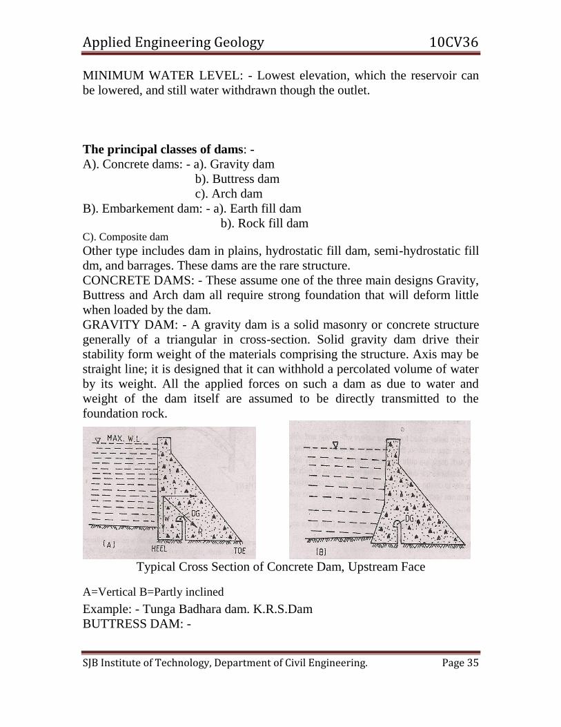
GRAVITY DAM: - A gravity dam is a solid masonry or concrete structure
generally of a triangular in cross-section. Solid gravity dam drive their
stability form weight of the materials comprising the structure. Axis may be
straight line; it is designed that it can withhold a percolated volume of water
by its weight. All the applied forces on such a dam as due to water and
weight of the dam itself are assumed to be directly transmitted to the
foundation rock.
Typical Cross Section of Concrete Dam, Upstream Face
A=Vertical B=Partly inclined
Example: - Tunga Badhara dam. K.R.S.Dam
BUTTRESS DAM: -
Applied Engineering Geology 10CV36
SJB Institute of Technology, Department of Civil Engineering. Page 36
This may be regard as, modified gravity dam with the volume of concreted
reduced by taking advantage of the structural strength of reinforced concrete.
Buttress dm is composed principally
--- A sloping upstream deck of RCC that takes upon water load.
--------Buttress vertical walls with their axis normal to the plane of the slab
that support the slab and transmit the water load to the foundation
ARCH DAM: -
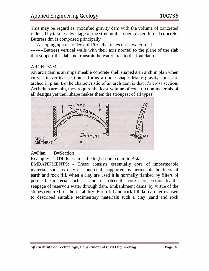
An arch dam is an impermeable concrete shell shaped s an arch in plan when
curved in vertical section it forms a dome shape. Many gravity dams are
arched in plan. But he characteristic of an arch dam is that it’s cross section.
Arch dam are thin, they require the least volume of construction materials of
all designs yet their shape makes them the strongest of all types.
A=Plan B=Section
Example: - IDDUKI dam is the highest arch dam in Asia.
EMBANKMENTS: - These consists essentially core of impermeable
material, such as clay or concreted, supported by permeable boulders of
earth and rock fill, when a clay are used it is normally flanked by filters of
permeable material such as sand to protect the core from erosion by the
seepage of reservoir water through dam. Embankment dams, by virtue of the
slopes required for their stability. Earth fill and rock fill dam are terms used
to described suitable sedimentary materials such a clay, sand and rock

Applied Engineering Geology 10CV36
SJB Institute of Technology, Department of Civil Engineering. Page 37
blocks that cam be placed to forming safe embankment.
(Some types of Embankment Dams)
COMPOSITE DAM: -
Dam site which geological unsuitable which broad valleys and strong rocks
on one side and weak ones on the other side. By combined gravity dam and
earth dam.
3) Give a brief account of geological considerations to be considered in
selecting site for the construction of a dam and reservoir.
(Dec- 2010)
Ans: SELECTION OF DAM SITES AND SELECTION CRITERIA:-
To construct a dam many important factors were borne in mind by the
geologist and engineers. Among them safety and stability of the dam is most
important. The stability and safety depends on three important factors
1). Choice of site for foundation
2). Material used in construction
3). Method of construction
Selection of site for dam is of maximum importance. Dams are constructed
to preserve water for longer use. Reservoir must hold water and should not
leak, therefore before the project is under taken the physiographic, geologic
sequence and structure of the rock formation in the river basin must be
studied in great detail. The major is the foundation upon which the structure
is built and the relation of foundation materials to the new and different
condition of geologic environment such a stress and strain must be
determined.
The following criteria’s are very important while selection of sites for dam.
The rock should be sound and resistant o the expected static
Applied Engineering Geology 10CV36
SJB Institute of Technology, Department of Civil Engineering. Page 38
and dynamic forces.
The river valley slopes should be stable when the reservoir in
full and also the abutment must be strong.
The dam foundation should be safe from sliding especially in
the place of gravity dam,
The foundation and the reservoir walls should be watertight.
The rocks of the dam site should be resistant to solution
activity, erosion, decomposition and other detrimental effects of
wetting and drying.
The location of construction materials mainly concrete
aggregate should be within and economically justified distance
forms the project.
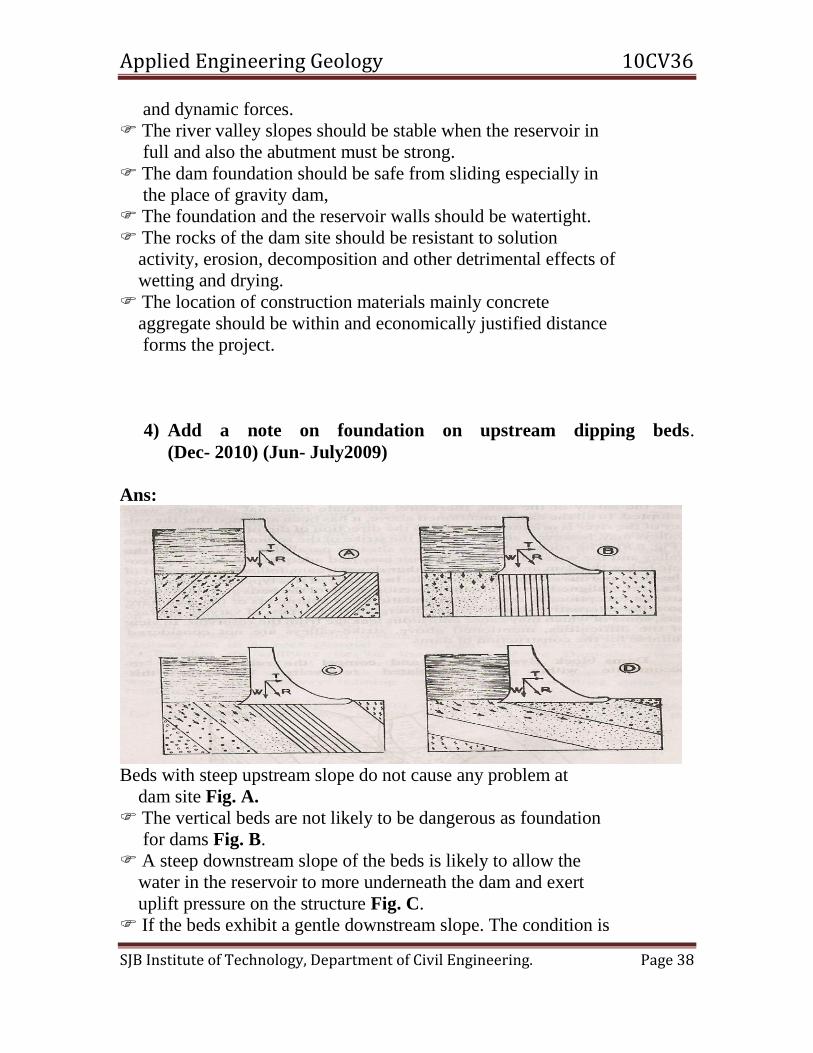
4) Add a note on foundation on upstream dipping beds.
(Dec- 2010) (Jun- July2009)
Ans:
Beds with steep upstream slope do not cause any problem at
dam site Fig. A.
The vertical beds are not likely to be dangerous as foundation
for dams Fig. B.
A steep downstream slope of the beds is likely to allow the
water in the reservoir to more underneath the dam and exert
uplift pressure on the structure Fig. C.
If the beds exhibit a gentle downstream slope. The condition is

Applied Engineering Geology 10CV36
SJB Institute of Technology, Department of Civil Engineering. Page 39
worse, there is a great chance of seepage of much of water form
to reservoir Fig. D .
5) Write a brief note on preventive measures of silting of the
reservoirs. (Dec- 2010)
Ans: Silt control: - Silting in reservoirs, however is reduced to some extent by control
of sediment production is soil erosion, landslides, and forest fires in the catchments area
by water shed treatment (soil conservation measure): Reforestation range seeding, strip
cropping and contour farming
Structural measures: - Construction of farm ponds, flood-retarding structures. Silt
ejectors, check dams, silt barriers grade stabilization and channel improvement.
A good reservoir site would be a valley section constructed be a narrow gorge at its
outfall with steep banks. The competence of the selected span of a river valley depends
upon the geology of the area, rock types, their conditions and permeability governed by
defects like joints, cracks and fissure system, faults their orientation and relation to
bedding, solubility dissolution and erosion.
UNIT – 7
1) Explain water bearing properties of Rock. (June/July-2008)
Ans: POTENTIALITY OF DIFFERENT ROCKS AS AQUIFERS The various kinds of rocks posses’ variable water-bearing properties, depending chiefly
on their permeability and porosity. Of the three important types of rocks, the Sedimentary
rocks, generally, constitute the best aquifers, the Metamorphic rocks and especially the
foliated ones, making moderate to good aquifers; and the Igneous rocks generally
behaving as the poor aquifers. The various kinds of rocks and their water-bearing
potentials are briefly discussed below.
SEDIMENTARY ROCKS AS AQUIFERS: - Among the Sedimentary rocks, Gravels
posses the highest water retaining as well as water yielding capacities. This is truer in
case of loose and weakly cemented coarse gravels. In general, next to Gravel, the other
Sedimentary rocks in their successive order of decreasing water bearing capacity are;
loose sand, sandstone, limestone etc. Shale (Clay) is the poorest in absorbing water, being
impermeable although porous, and hence classified as aquicludes.
Among sandstones, the water-bearing capacity depends much upon their texture and
nature of cementing material. Coarse-grained sandstone may be good aquifers. Whereas
fine grained sandstone may prove to be the poorest aquifers.
The water-bearing capacity of limestone depends much upon the presence of solution
channels, crevices, fissures and other such opening in the rock. Hence, fissured and
cracks limestones may prove to be excellent aquifers and other compacted limestones mat
prove to be totally unproductive.
IGNEOUS ROCKS AS AQUIFERS: - The intrusive igneous rocks like granites,
syenites etc., are generally very compact and dense and hence are non-porous. They are
barren groundwater under normal conditions. However when they are traversed by

Applied Engineering Geology 10CV36
SJB Institute of Technology, Department of Civil Engineering. Page 40
fissures or cracks, they may be capable of holding some groundwater quantities. Even
these cracks and fissures die out with depth, and as such, there is absolutely no possibility
of getting any groundwater in these rocks at depths greater than 80-100mts.
The extrusive igneous rocks also exhibit great variations in their water-bearing properties.
Basic igneous rocks like basalts are generally rich in cavities and contraction cracks; and
as such may become permeable and sources of groundwater. Acidic igneous rocks like
rhyolites may or may not contain groundwater, because such rocks although generally
posses interstices, but may be filled up with ash and other material, and hence the
uncertainty.
METAMORPHIC ROCKS AS AQUIFERS: - Non-foliated metamorphic rocks like
Marble and Quartzite are generally impermeable, except along the original bedding, if the
same is not completely destroyed during metamorphism. Foliated metamorphic rocks like
Slates, Schist, Phyllites and sometimes even Gneiss may contain some good amount of
groundwater due to their being highly fractured.
2) What is an aquifer? Describe the types of aquifers. (June/July-
2008)(Dec09-Jan10) (Dec- 2010) (Dec-2011) (Jan-2013)
Ans: AQUIFERS: - An aquifer is a saturated formation of earth material, which not
only stores water but yield it in sufficient quantity. Thus on aquifer transmits water
relatively easily due to its high permeability. Unconsolidated deposits of sand and gravel
form good aquifers. TYPES OF AQUIFERS
Aquifers vary in depth, lateral extent and thickness, but in general all aquifers fall into
two categories.
1). UNCONFINED AQUIFERS
2). CONFINED AQUIFERS
1). UNCONFINED AQUIFERS: - Unconfined aquifers also called non-artesian
aquifers, are the top most
Water bearing strata having no confined impermeable over burden lying
over them. The ordinary gravity wells of 2-5 mts diameters, which are excavated through
such top most aquifers, are known as unconfined wells.
The water level in these wells will stand equal to the level of the water

Applied Engineering Geology 10CV36
SJB Institute of Technology, Department of Civil Engineering. Page 41
table as shown in figure. Such wells are, therefore also known as water-
table wells or gravity wells.
CONFINED AQUIFERS (Artesian well
2). CONFINED AQUIFERS (Artesian well): - When an aquifer is encased on its upper
and under surface by impervious rock formation and is also broadly inclined so as to
exposed the aquifer somewhere to the catchment’s area at a higher level for the creation
of sufficient hydraulic head, it is called a confined aquifer or an Artesian aquifer. A well
excavated through such an aquifer yields water that often flows out automatically, under
the hydrostatic pressure, and even rises or gushes out of surface for a reasonable height.
However, the ground profile is high, the water may remain well below the ground level.
Where water is gushing out automatically is known as flowing wells.
3) Describe how ground water is prospected by electrical resistivity
method. (June/July-2008)(Dec-2011) (Jan-2013)
Ans: ELECTRICAL RESTIVITY METHODS
These methods are based on the principle that electrical resistivity of loose
unconsolidated or partially consolidated surficial materials like the products of rock
weathering and erosion such as soil loss, alluvium sand and clay is different from that of
bed rock over which they are deposited. The more porous or jointed and fissured the rock
lower is its electrical resistance. Thus intact igneous and metamorphic rocks in general
greater resistance than sedimentary rock.
Geologic Bodies Resistivity
Clays 200-500ohms/cm

Applied Engineering Geology 10CV36
SJB Institute of Technology, Department of Civil Engineering. Page 42
Equipment: - The receptivity equipment consists essentially
1). Power pack of a high voltage battery 200v as a source of current and a measuring
assembly consisting of a voltmeter or potentiometer for measuring small potential
difference accurately and a multi range millimeter for measuring current.
2). Four Stainless Steel metallic spikes (electrodes) about 800mm long 20m dia prod
vided with heads for easy driving into the ground and clamps for cable connection.
3). Abundant stranded insulated single conductor cable of 0.5m2 conducting area. The
cable is wound on portable reels.
FIELD PROCEDURE AND INTERPRETATION
In this method, four electrodes are driven into the ground in a straight line at equal
distances and electric current is intruded through, two outer spikes called current
electrodes, which are connected by insulated wire through a mill ammeter to a power
pack. The current flows through the ground.
Theoretically the current flow extends to indefinite depths but the intensity diminishes
with dept. For practical purposes the current is considered to be confined within a depth
approxcipamately equal to one-third the distance between the current electrodes
The current impressed into the ground is recorded by the millimeter.
In homogeneous ground the lines of current flow have a definite shape independent of the
medium of the distance between electrodes. As such the current penetration can be varied
by varying the electrode spacing.
Next, the voltage drop due to potential difference between two inner electrodes called
potential electrodes is measured from the potentiometer. Restivity is then obtained by the
expression
R=2P/I
R=Resistivity, P= Potential difference, I= Current applied between electrodes The value of R so measured is only apparent resistivity of the ground as the ground is
rarely homogeneous.
The underground configuration of rocks is deduced by variations in the apparent
resistivity obtained as a function of depth.
The depth of penetration is controlled either by expanding electrode spacing or moving
the electrode system as a whole. The depth determined would be over the central point of
electrode determined would be over the central point of electrode system. This forms the
station sounded.
Thus principally there are two distinct methods of resistivity determinations
a). Expanding electrodes separation techniques or Vertical Profiling
b). Lateral traversing techniques or Horizontal Profiling.
Sedimentary Rocks 5000-10,000 Ohms/cm
Igneous Rocks Above 10,000 Ohm/cm
Metamorphic Rocks ………do………

Applied Engineering Geology 10CV36
SJB Institute of Technology, Department of Civil Engineering. Page 43
a). Expanding electrodes separation techniques or Vertical Profiling: - In this method
electrode spacing is increased about a fixed central point thereby depth of current
penetration is increased. If the ground is homogeneous resistivity is constant for all
electrode spacing and equal to actual resistance of the geological formation. Therefore
the graph of resistivity against electrode spacing would be a constant.
The resistivity curve is then compared with a series of master curves, computed for
various values of depth and resistivity ratio like those of mastr curves and depth is
obtained
Test value curve for electrical resistivity analysis

Applied Engineering Geology 10CV36
SJB Institute of Technology, Department of Civil Engineering. Page 44
4) Write brief note on Hydrological cycle. (Dec09-Jan10)
(May/June2010) (Jan-2013) Ans: HYDROLOGICAL CYCLE
HYDROLOGICAL CYCLE
In one form or another, water occurs practically everywhere, varying in quantity from an
almost unlimited supply in the oceans to nearly none in desert regions. It occurs in the
atmosphere as water vapors, clouds and precipitation. On the earth’s surface it is found
principally in streams, in lakes and in the oceans. Beneath the ground surface it occurs
under various classifications.
The hydrosphere, atmosphere and upper part of the lithosphere constitute the three media
in which the water of the earth circulates. The circulation of water from the oceans to the
atmosphere to the lithosphere and the lithosphere to the oceans, through complex and
interdependent process including precipitation, runoff, groundwater flow, evaporation
and transpiration is called the Hydrological Cycle.
The oceans, comprising the largest single body of water, having 78% of the earth’s
surface area and store 98% of the earth’s water resources. The water evaporated from the
sea and land forms a part of the atmospheric moisture which when it moves into low
temperature regions, is condensed and precipitated as rain and snow. When humidity is
high, moisture condenses on the soil surface as dew. Before reaching ground, apart or all
of the precipitated water may get intercepted by plants in the atmosphere itself. In dense
forest a substantial part of the precipitated water may be returned to the atmosphere by
evaporation. The part of the water reaching the ground is dissipated in several ways.It
may be absorbed in the ground, evaporated, transpired by plants, or may flow over
ground as runoff into streams to reach the oceans or inlands basins. Runoff occurs when
the ground surface is situated with water. The water absorbed in the ground infiltrates
down through interstices of rocks till it reaches the ground water body and completes the
hydrologic cycle.
5) Describe the methods adopted for artificial recharge of
ground water. (Jun- July2009) (May/June2010) (Dec- 2010)
Ans: RECHARGE AND DISCHARGE AREAS
Water enters the groundwater system as precipitation falling on recharges areas, which
are areas where water is added to the saturated zone.

Applied Engineering Geology 10CV36
SJB Institute of Technology, Department of Civil Engineering. Page 45
It means through the system to discharge areas, which are areas where subsurface water
is discharged to streams or to a bodies of surface water. The aerial extent of recharge
areas is invariably larger than that of discharge area. In humid regions, recharge areas
encompass nearly all areas except stream and their adjacent floodplains. In more arid
regions, recharge occurs mainly in mountains and in the alluvial fans.
From the figure streams that flow from mountains having substantial rainfall into much
drier regions in which the water table lies deep beneath the surface. Water from these
rivers leaks downwards and recharges the groundwater below.
ARTIFICIAL RECHARGE :
Although most recharge is supplied directly by rain fill, this intense demand for water in
some areas has led to artificial recharge of the ground. One example is the practice of
water spreading in dry parts of the American West. A common way to spread water for
recharge is to build a low dam across a stream valley. This holds water bank that would
otherwise flow away and allows it to seep downward and recharge aquifers beneath the
stream be. The water thereby, stored underground is withdrawn through wells as needed.
In some regions an aquifers may be recharged with used water. This practice has
increased as air-conditioning, which requires a large volume of water, has become
commonplace in hot, dry regions. Some cities have laws requiring that water used for air
conditioning be returned to the ground, where it successfully builds up the water table.
This illustrates the basic principles of groundwater conservation. Where groundwater
with drawl exceeds the rate of recharge, the lowering of the water table can lead to
subsidence of the ground.
FLUCTUATIONS OF THE WATER TABLE:
The water table is a subdued imitation of the ground surface above it. It is high beneath
hills and low at valleys because water tends to move toward low points in the topography
where the pressure on it is least. If all rainfall were to cease, the water table would slowly
fallen and gradually approach the levels of the valleys. Percolation would diminish and
cease, and the stream in the valley would dry up. In times of drought, when rain may not
fall for several weeks or even months, we can sense the flattening of the water table in the
drying up o wells. When that occurs we knew that the water table has fallen to a level
below the bottoms of the wells.
UNIT – 8
1) What is remote sensing? Write its application in civil engineering.
(Dec.08/Jan.9) (Dec-2011) (Dec09-Jan10) (Jan-2013)
Ans: Generally, the identification and study of different objects on the earth’s
surface, without physically coming in contact with them is termed as Remote
Sensing. This is done mainly with the help of aerial photographs and satellite
Imagery. The basis for remote sensing is the electromagnetic energy emitting from
the sun and reaching the earth’s surface.
Applied Engineering Geology 10CV36
SJB Institute of Technology, Department of Civil Engineering. Page 46
Application of remote sensing)
Soil Moisture
Mapping of agricultural irrigated/un- irrigated areas
Determination of canal seepage
National waste land mapping (to identify type and extent of wasteland at village
level)
National drinking water mission (hydro geomorphologic maps, helps in scientific
source finding of drinking water)
Agricultural drought monitoring (to assess and monitor agricultural drought at
district level)
Forest cover mapping, forest fire
Urban studies (to study the urban land use / land cover and growth etc of all major
cities
Crop acreage and production estimation (to estimate the crop acreage and
forecast prediction)
Natural hazard study, flood mapping, landslides, earthquake
Snow mapping
Environmental impact of mining and thermal power complexes (to develop a
suitable methodology for monitoring environmental parameters
Oceanography – fishing, tsunamis, cyclones, movements of waves, currents, tides
Coral reef mapping
Natural resources
2) Impact of mining on environment.
(Dec-2011) (Dec07/Jan.08) (Dec09-Jan10) (Jan-2013)
Ans: IMPACT OF MINING ON ENVIRONMENT
For example the essential raw material for cement manufacture being Limestone, it has
to be exploited from where it occurs. In India, only opencast mines are winning
Limestone, a low cost material. To produce a tones of cement 1.5-1.6 tones of
Limestone is required over 21,400 sq.m will come under mining operation every year
depending upon the thickness of limestone to be exploited. Such huge operation will no
doubt, leave its impact on relief and topography, hydrology, air forestry/agriculture wild
life etc.
RELIEF AND LANDSCAPE ALTERATIONS: Mining operation and installation of
various allied units will change the existing topography and will cause creation of huge
pits or leveling of hills or creation of wastes heaps etc.
IMPACT ON HYDROLOGY: Mining activities in some cases may disturb the
aquifer, the ground water flow and recharge capacity of the surrounding areas are
affected due to change in topography.
CONTAMINATION OF WATER: Limestone mining by and large does not
adversely contaminate the rain waters and ground water flowing through the exposed
mine cuts but may carry fine particle of Limestone dust, which may cause silting

Applied Engineering Geology 10CV36
SJB Institute of Technology, Department of Civil Engineering. Page 47
problems, but they are non-toxic. Surface runoff from mine cuts may however be turbid
during monsoons due to seepage of overburden soil etc.
AIR POLLUTION OR DUST POLLUTION: In mining air pollution is mainly
caused by dust generation. Blasting is one of the pollutants as it creates fumes, dust,
vibrations, air blaster, noise and fly rock fragments. The other activities such as drilling
excavation, waste dumping will also cause dust nuisance. Crushing plant, conveyors
and transfer points will be the other sources of dust generation.
NOISE POLLUTION: Noise may be defined as” Unwanted sound”. This implies
sounds, which interfere with human communication, comfort health etc. The noise
pollution in the Limestone blasting and movement of heavy earth moving equipment
cause mine.
IMPACT ON FORESTRY /VEGETATION: The mining operation if carried out on
hills, which are usually associated with forests and vegetation causes. Impairment
(spoil) and affects climate, rainfall, soil erosion and causes in equilibrium between
biotic substance and macro/micro organisms. When carried out on plains affect
agriculture and grazing lands.
IMPACT ON WILDLIFE: Noise and habitation may probably cause migration of the
existing wild life.
IMPACT OF HUMAN ENVIRONMENT: The impact of mining on human
environment can be both beneficial and detrimental as it may provide job opportunities
and overall development of the region, can also deprive some of them of their
agricultural land. Sometimes it can help in water resources for water irrigation and
domestic use.
VIBRATION, AIR BLAST AND NOISE CONTROL: The noise in mines is caused
by blasting, movement of heavy earth moving equipment which in terms causes
vibration and air blast.
The following can control these: - a). Avoiding blasting during night and foggy weather which associated with
temperature inversion
b). Stemming of the blast hole properly
c). Avoid blasting when wind velocity is more than 25km/hr
d). Large scale plantation or shade giving trees also reduce the noise and Vibration
level,
e). Using rock breaking, the secondary blasting (which usually produces a huge noise)
can be avoided
DUST CONTROL: During mining the dust can be controlled by the following
a). DRILLING: the using suitable dust can control Dust Collector, which is also a
stationary requirement.
b). BLASTING: If the topsoil is completely removed before blasting, dust generation
during the same can be minimized.
c). TRANSPORTATION: Dust is generated when loaded dumpers move over
unconcerned roads. This can be overcome by concreting the roads or by sprinkling
water over the roads regularly.

Applied Engineering Geology 10CV36
SJB Institute of Technology, Department of Civil Engineering. Page 48
3) Explain Global positioning system (GPS).
(Dec09-Jan10) (Dec 07/Jan.08)
4) Application of GIS and GPS in civil engineering.
(June/July-2008) (Dec-2011) (Jan-2013)
Ans: Application of remote sensing
Soil Moisture
Mapping of agricultural irrigated/un- irrigated areas
Determination of canal seepage
National waste land mapping (to identify type and extent of wasteland at village
level)
National drinking water mission (hydro geomorphologic maps, helps in scientific
source finding of drinking water)
Agricultural drought monitoring (to assess and monitor agricultural drought at
district level)
Forest cover mapping, forest fire
Urban studies (to study the urban land use / land cover and growth etc of all major
cities
Crop acreage and production estimation (to estimate the crop acreage and
forecast prediction)
Natural hazard study, flood mapping, landslides, earthquake
Snow mapping
Environmental impact of mining and thermal power complexes (to develop a
suitable methodology for monitoring environmental parameters
Oceanography – fishing, tsunamis, cyclones, movements of waves, currents, tides
Coral reef mapping
Natural resources
Defense activity.
Litho logy, Landforms Structures & Recharge the rain water into the ground
--------------------------------

Applied Engineering Geology 10CV36
SJB Institute of Technology, Department of Civil Engineering. Page 49