arbeia journal - arbsoc.org.ukarbsoc.org.uk/download/i/mark_dl/u/4013045205/4632315945/the...
TRANSCRIPT
THE ARBEIA
JOURNAL
VOLUME I 1992
THE ARBEIA SOCIETY MCMXCII

THE ARBEIA SOCIETY
OFFICERS 1992
PRESIDENT P.T. Bidwell LLB MA FSA MIFA
EXECUTIVE OFFICERS Chairman
LP. Stephenson BA
Quinta Secretary Ms A.T. Croom BA
Treasurer M. Urquhart
General Secretary W.B. Griffiths BA
NON-EXECUTIVE OFFICERS Publications Officer: M.C. Bishop BA PhD
Publicity Officer: Mrs M.E. Snape BSc MLitt Authenticity Officer: J.C.N. Coulston BA MPhil PhD
Young Archaelogy Club Co-ordinator: Ms C. Lloyd BA PGCE Editors- Arbeia Magazine: R.C. Oram BA ATD & Ms A.T. Croom BA
The Arbeia Journal Editor : W.B. Griffiths BA
Editorial Board: P.T. Bidwell, M.C. Bishop, Ms A.T. Croom
All correspondence to the society should be addressed in the first instance to:
The Secretary, Arbeia Society, Arbeia Roman Fort, Baring Street, South Shields,Tyne and Wear, NE33 2BB
THE ARBEIA JOURNAL
SOCIETY VOLUME I
©The Individual Authors 1992
The Arbeia Society, Arbeia Roman Fort, Baring Street, South Shields, Tyne and Wear, NE33 2BB
Produced for the Arbeia Society by M. C. Bishop Printed in England by Tyneside Free Press
The Arbeia Society
MCMXCII
CONTENTS
Page
The Hand-Thrown Stone W.B. Griffiths 1 Ebchester Roman Fort: A Survey of the Evidence N. Hodgson 13 Ceremonial Landscapes in Prehistory: Catastrophic Creations? S.C. Speak 23
Notes 1. Documentary Research on Benwell and Wallsend M.E.Snape 37 2. Survey of the Remains of Chesters Roman Bridge W.B. Griffiths 40 3. A Note on the Medieval Bridge Across the NorthTyne at Chollerford G. Stobbs 46 4. Quinta's Wooden Practice Swords A.T. Croom 51
Excavation Summary. Compiled by M.E. Snape South Shields, Jarrow, Wallsend-Buddle Street, Wallsend Fort Ditches, Chesters Roman Bridge, Oakwellgate, Carley Hill 55
Reviews Woodward, Shrines and Sacrifice (G. Stobbs) 67 Connolly, The Roman Fort, Tiberius Claudius Maximus (2 Vols) (R.C. Dram) 68 Hyland, Equus: The Horse in the Roman World (W.B.Griffiths) 70 Southern and Dixon, The Roman Cavalry (l.P. Stephenson) 71
lll
The Arbeia Journal11992
EDITORIAL
The Roman fort at South Shields is owned by South Tyneside Council and managed for them by Tyne and Wear Museums. It also serves as the location of Tyne and Wear Museums' Department of Archaeology, which carries out the excavations at Arbeia, as well as at several other sites in the region.
For several years the fort has had its own re-enactment group, Cohors V Gallorum (more familiarly known as 'Quinta'). The group takes its name from that of the third century garrison of the site. In 1991 it became clear that many local visitors to Arbeia wanted to have some active connection with the fort, but not necessarily as re-enactors. In addition it was found that the Arbeia magazine, produced by staff at the fort in their own time, was proving very popular. As a result, it was decided to form a more general society at the fort which would not only continue to produce the Arbeia magazine but also an annual journal, as well as provide a more general service to people who wished to support and/ or take part in archaeological work both at the site and- in the region in general. The society was officially inaugurated on 1st January 1992.
The Arbeia Society naturally has very close links with Tyne and Wear Museums Archaeology Department; indeed our President, Paul Bidwell, is the Principal Keeper of Archaeology (Head of the Department). Also, much of the running of the society is handled by other members of staff, in their own time; but we are always looking for outside volunteers.
The close links with the department are emphasised by the inclusion of a summary of the principal excavations undertaken by the department over the past two years. It is intended to continue this with a summary of each years work in subsequent issues of the journal.
April 1993 is likely to see a reduction of the funding for excavations at Arbeia by South Tyneside Council. However work will continue at the fort, as a result of funding from various new sources; it hoped that the Arbeia Society will be able to play a part in raising some of this funding. Work at the site will be split between continuing the current programme of excavations and writing volume 2 of the excavation report. Volume 1, which covers the excavation of the south west gateway and ditches, and the headquarters building will shortly be going to the printers. This explains the lack of too much information specifically about Arbeia in this
The Arbeia ]ournal11992
volume, as most of the recent work on the site will be presented in Volume 1 of the excavation reports. As a result this issue of the Journal concentrates on some of the more wide ranging work being carried out, both by members of the society and the department.
NOTES FOR CONTRIBUTORS
1. All Papers should be submitted to: The Editor, Arbiea Journal, Arbeia Roman Fort, Baring Street, South Shields, Tyne and Wear, NE33 2BB, by the 1st of July each year, if they are to be included in that year's volume. ·
2. All papers should ideally be submitted on paper (clearly typed on A4 pages, with all references filled in ready for printing, subject only to correction of printer's errors. Wherever possible, a plain text copy (ie ASCIT file, not a wordprocessor file) should also be submitted on disc (IBM/MSDOS or Acorn, 5.25" or 3.5").
3. Line illustrations will usually be reproduced as figures and should be no larger than 290mm by 410mm. They must be able to reduce to a finished size of 180mm by 125mm including captions.
4. The Journal can take photographs, which should ideally be 90mm by 65mm, but can be 180mm by 125mm if necessary.
5. All references, whether in text or footnotes should be in the Harvard style with page numbers included, ie (Smith 1979, 223).
V

The Arbeia Journal11992
THE HAND-THROWN STONE
W.B. Griffiths As part of its commitment to archaeological reconstruction and
experimentation, Cohors V Gallorum (usually referred to as 'Quinta'), the re-enactment section of the Arbeia Society, has begun a programme of research into some of the hand-launched missile weapons of the Roman army, such as the javelin, sling and others. It is intended that one weapon will be studied in detail each year, the research culminating in accurate reconstructions of the weapon being made and used by members of the society in order to test factors such as range and accuracy. The results of each year's work will be published in the Arbeia Joumal.l The reason for restricting the project to one weapon a year is to allow for as full and
complete a study as possible of each, and to avoid certain weapons being less fully researched than others. Once all the research is complete it is intended that a final summary will be produced, which will also discuss more generally the question of the defensive capabilities of a Roman fort.
One of the factors which prompted Quinta to undertake this research was the presence of the reconstructed south west gate at South Shields fort, which provides a chance, not often readily available in such experiments, to study the effectiveness of the weapons in a defensive situation. Another reason for undertaking the experimental side of this research is to provide scholars with the data concerning performance abilities of weapons that is all too often lacking in the primary sources. Ancient authors, for instance, are prone to exaggerate the effectiveness of weapons, or, at least, record only their most remarkable applications (Bishop and Coulston 1989, 10); we need to know what they can achieve in normal use. Modem experiments, if conducted carefully, provide us ~ith the minimum capabilities of the weapons; it is logical to assume that with constant training and practice better results could be achieved. Such a regime is beyond the scope of this project, but with knowledge of the minimum capability of each weapon it will be possible to begin to assess its effectiveness to the Roman Army. The first such weapon to be so studied is the hand-thrown stone.
Roughly rounded worked stones, often with slightly flattened sides, are quite common finds from military sites throughout the Roman world;
1
The Arbeia Journal11992
sixteen have been recovered from South Shields alone. These stones are usually interpreted as shot for ballistae, although this identification is by no means certain. The care taken in working the stones into regular sizes is usually seen to indicate their specialised function as artillery projectiles. However, Jobey (1978, 91) drew attention to the possibility of another interpretation when discussing the stones from Bumswark: 'if it were not for the small flattened areas and the care taken in the making, (the stones) could have been intended simply for hand throwing'.2 Baatz went further, arguing cogently that stones intended for hand throwing would have been worked, as a 'high rate of accurate fire' would not 'be achieved with unworked stones of uncertain weight' (1983, 136). He instead postulated the preparation of stores of worked stones for use in defending town walls. The flat sides on many of these stones are seen as intended for ease of stacking, to prevent the stones rolling away prior to use, equally as essential whether the stones are for use by hand or machine.3
The evidence for the deliberate use of the hand-thrown stone by the Roman army, and in the ancient world in general, is sparse in the extreme. This is partly the result of various elements of bias in the sources, the hand-thrown stone being such a basic and obvious weapon that ancient writers may not have considered it worthwhile discussing in any detail: Such evidence as there is for its use is often ambiguous to say the least. We do, however, know that the hand-thrown stone was employed in troop training. Vegetius, discussing the training of Republican and Imperial troops, states that 'formerly all soldiers were trained in the practice of throwing stones of a pound weight with the hand'(Epitoma Rei Militaris II:23). Also, Arrian records that the cavalry used stones in place of javelins in training (Tactica XLIII:1).
There is no evidence for premeditated deployment of the handthrown stone in battle by trained troops; such references as there are indicate rather that stones were used, much as today, by untrained, unarmed civilians. For instance Tacitus records that during the Civil Wars of AD69 civilians used stones at the first battle of Cremona (Histories II:14); while Josephus, also writing in the first century AD, records that civilians attempting to leave Jerusalem when it was besieged by the Romans 'advanced as if to battle armed with stones, then fled to the Romans' (Jewish War V:548).
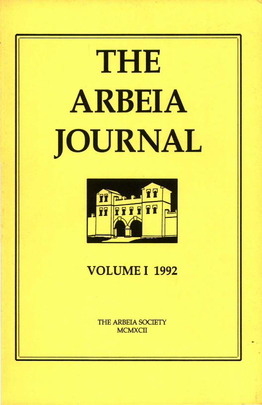
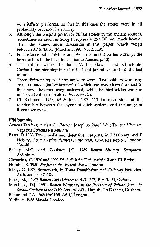
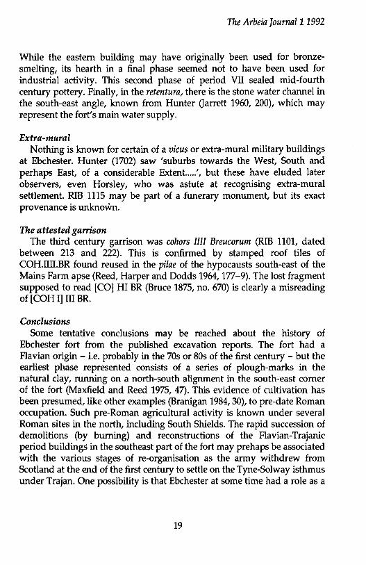
Trajan's Column appears to depict the employment of the hand thrown
2
The Arbeia Journal11992
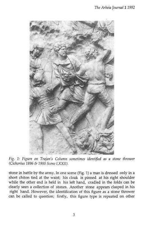
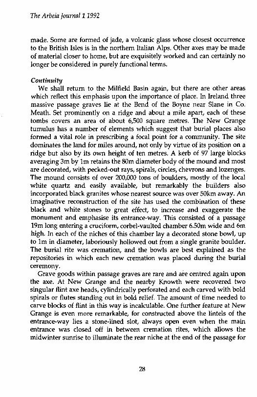
Fig. 1: Figure on Trajan's Column sometimes identified as a stone thrower (Cichorius 1896 & 1900 Scene LXX[[).
stone in battle by the army. In one scene (Fig. 1) a man is dressed only in a short chiton tied at the waist; his cloak is pinned at his right shoulder while the other end is held in his left hand, cradled in the folds can be clearly seen a collection of stones. Another stone appears clasped in his right hand. However, the identification of this figure as a stone thrower
can be called to question; firstly, this figure type is repeated on other
3
The Arbeia Journal11992
parts of the column, where it can be clearly seen as a slinger (cf Cichorius 1896 & 1900 Scene LXVI), and it may simply be that in this case the sling was provided by a metal inset which was subsequently lost from the Column. Secondly, the lack of a helmet or shield would suggest the figure was not a soldier at all, but rather a camp follower or servant embroiled in the conflict. However, such an interpretation would be to attempt to read too much significance of detail into the Column. It may be that this man is simply the figure type that the sculptors used when ordered to produce slingers at certain points and has little bearing on reality.
Thus, the weight of evidence, such as it is, would seem to indicate that the Roman soldier had no use for the hand-thrown stone in battle. Indeed this is only to be expected, weighed down as he would be with his other equipment, no soldier would be able, or willing, to carry worked stones around with him, and would instead have gathered stones from the ground when they were needed. In fact, given the short range of the hand-thrown stone, it would be no use in battle as by the time a soldier had thrown it at an advancing enemy they would be upon him before he had time to prepare himself for hand to hand combat.
It is in terms of defence, rather than attack, that the few references we have hint at the possibility of a deliberate preparation of stones for throwing by hand. For instance the Greek author Aeneas, writing in the mid fourth century BC, imparts several pieces of advice concerning the use of stones by a defending garrison. He suggests that on dark nights guards should randomly throw stones over the walls to. discourage attackers (Tacticus XXII:12). He also states that some authorities disagreed with this practice, claiming that it would warn would-be attackers away from the better defended areas. That this debate existed at all indicates that the employment of hand-thrown stones in a defensive role was perhaps standard practice in some areas of the Greek world. Aeneas also points out that provision should be made, when under siege, for the collection of stones under cover of the night so that they may be reused the following day (ibid XXXVIII:6-7). This further indicates that stones were not to be employed haphazardly in the heat of the moment, and hints at the possibility that special stones were used.
Archaeological evidence from Masada shows the prior preparation of stones for use in defence. The excavation of the casemate walls of the
Jewish stronghold in 1963-5 led to the discovery of several large round
4
The Arbeia fournal11992
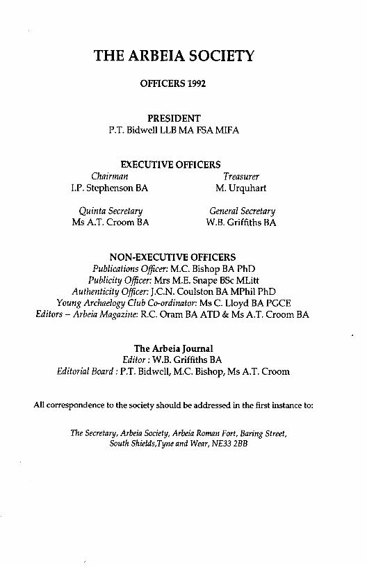
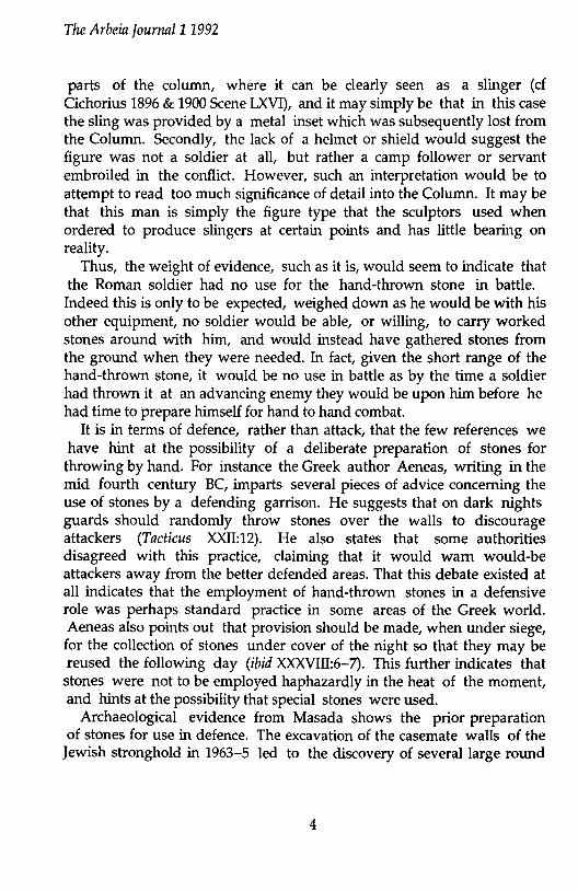
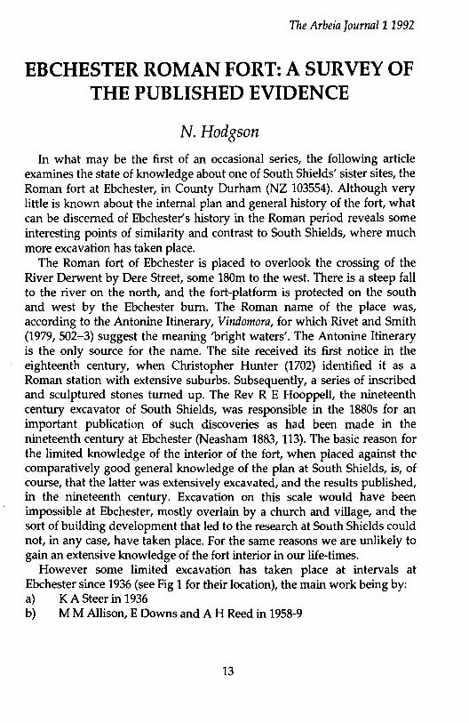
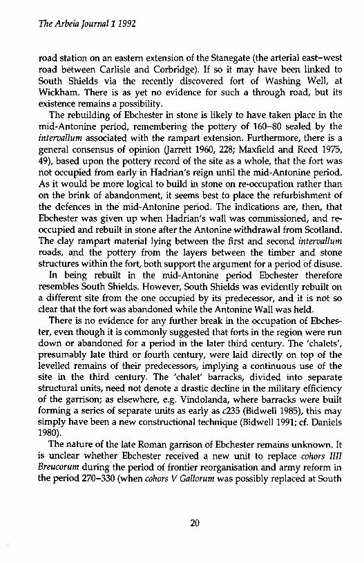
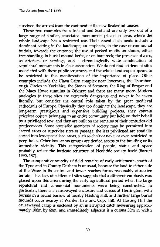
Fig. 2: The Arch of Constantine in Rome, showing soldiers defending their wall by throwing stones at the attackers (after Humble 1980, 248)
stones, each weighing around 100 pounds (Yadin 1966, 222), stored on the roofs of the rooms in the casemate wall ready to be rolled down onto any attackers. They were recovered, unused, from areas such as the South Wall, which we know ·was never attacked by the Roman besiegers. It was believed that these stones were originally prepared under Herod, almost a century before the Zealot occupation and Roman siege of the site, indicating that they were placed in a state of readiness during peace time, as opposed to being hurriedly assembled by the Zealots in time of war.
The Arch of Constantine in Rome (see Fig. 2) clearly depicts soldiers throwing small round stones by hand (although, as with Trajan's Column, it may be that some may have had metal weapon broken off). Unlike the figures on Trajan's Column they are helmeted and carry shields. Also, Vegetius states that city garrisons 'are provided with all sorts of arms, arrows, fustibali, slings, stones, onagri, and ballistae for their defence' (/bid ill:3). That the stones are listed separately must
5
The Arbeia Journal11992
surely be an indication of their existence as a weapon in their own right rather than simply as ammunition for the artillery
All the above is by no means proof that the Romans deliberately prepared stones for throwing by hand but the fact that the troops were trained in this, combined with both the evidence from the manual of Aeneas, which would have been available to Roman commanders,4 and the common finds of worked stones, go a long way towards indicating that this was the case.
Certainly, it would make sense for the Roman army to employ such a weapon in a defensive situation, as it has many significant advantages, and few, if any, real disadvantages. For one, it is, as Aeneas pointed out, an economical weapon, as the stone can always be collected by defenders and re-used. Unlike weapons such as javelins there is little value in an attacker removing the heavy stones for reuse on another occasion, as they are of limited use in battle, and too heavy to transport in any significant numbers to ones own defences. Again, unlike javelins, they are of limited effect if thrown back against the defenders as they will have a slower velocity when hurled upwards making them less effective tl:).an a pointed weapon should they hit a target. However, when used from defenses they are in many ways at least as effective as javelins, if not more so. The extra density of the stone, compared to that of the javelin, will allow it to cause damage when coming into contact with armour and helmets that lighter weapons will not. Against shields a stone can throw the attacker off balance and break up formations such as the testudo if a heavy enough volley is given when troops are attempting to cross the ditches.
The Practical Experiment Given that in theory the hand thrown stone would be a useful addition
to the defensive capabilities of the Roman fort, and that the evidence, such as there is, indicates its possible use in that role, the next step was to prepare some stones and see what kind of range could be achieved.
In all 37 stones were worked into the correct shape. All were made from sandstone recovered from the excavations at Arbeia and weighed between 625 and 950 gms. Their sizes varied between 83-59mm to 96-71mm diameter, in line with the actual finds of such stones from the site.
Although stone throwing from the gateway had been part of Quinta's
6
The Arbeia Jour1Ull11992
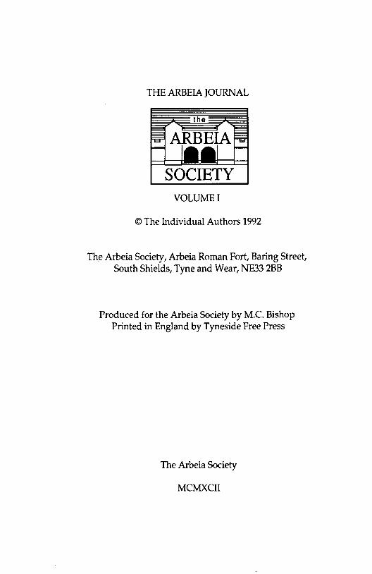
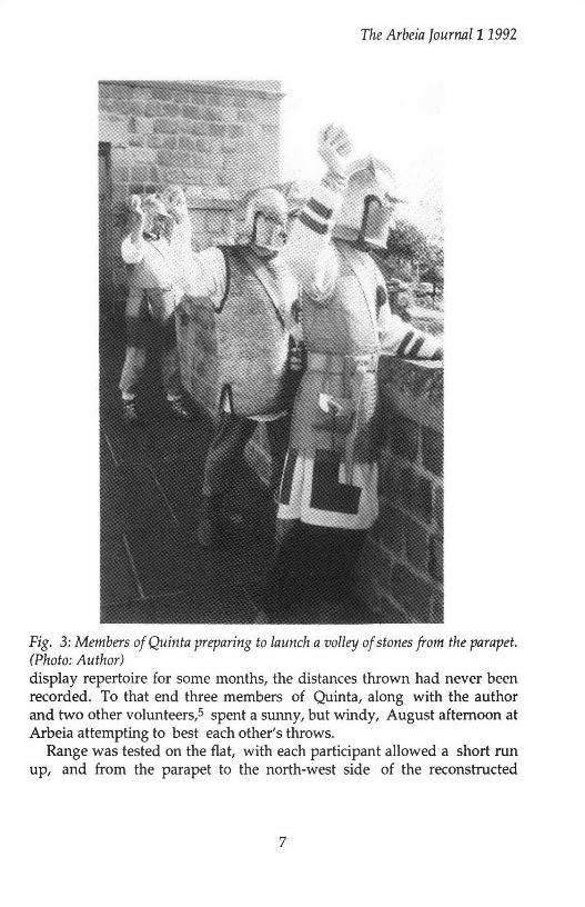
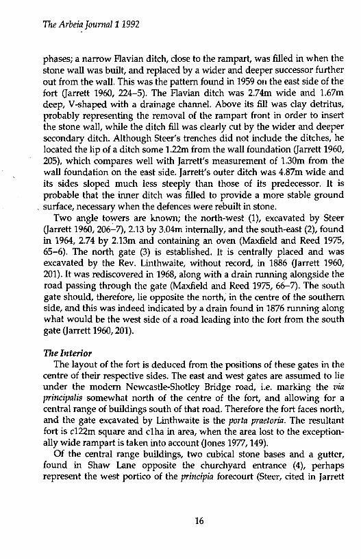
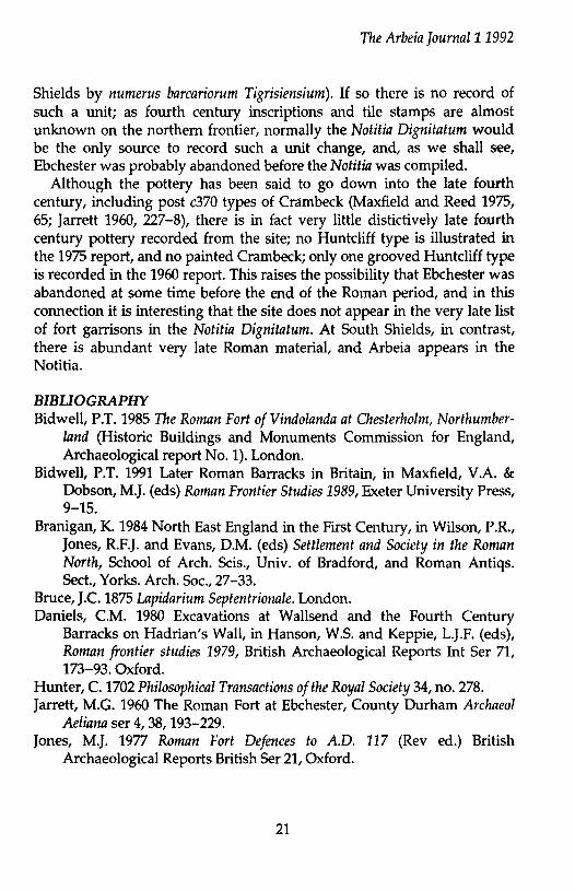
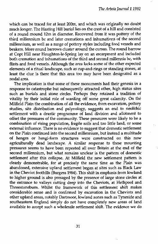
Fig. 3: Members of Quinta preparing to launch a volley of stones from the parapet. (Photo: Author) display repertoire for some months, the distances thrown had never been recorded. To that end three members of Quinta, along with the author and two other volunteers,5 spent a sunny, but windy, August afternoon at Arbeia attempting to best each other's throws.
Range was tested on the flat, with each participant allowed a short run up, and from the parapet to the north-west side of the reconstructed
7
The Arbeia Journal11992
gateway. All the participants took five throws from each, with the distance of each throw being recorded. The Quinta members threw twice, in full kit( although minus their shields) and in 'civvies', in order to see whether their armour caused any significant impairment of performance: it did not.6
Over the flat distances up to 31 metres were achieved; with the average range of the best three throwers being 25.7m. As suggested above, this distance is too short for the stones to be of any use in open battle, especially considering that the participants threw from a short run up, and without the encumbrance of their shields.
From parapet level the range achieved was, despite the height advantage, slightly less than that on the flat, with a maximum throw of 27.9m, and an average for the best three throwers of 24.31m. This was probably the result of both a strong headwind (in the throws taken on the flat the wind was blowing from the side), and the lack of a run up for the participants, who this time had to throw from a standing position. Nevertheless, the average distance coincides with the known position of the third and outermost ditch at the fort.
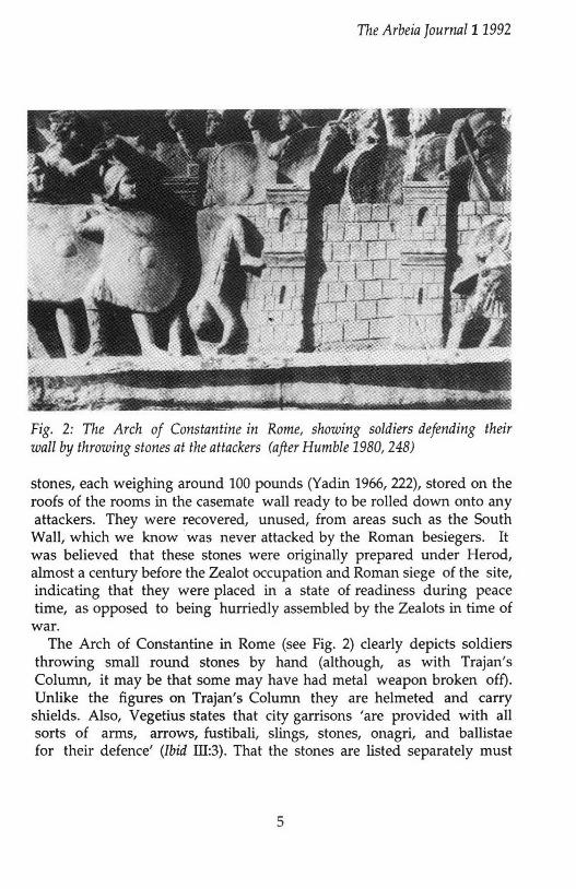
Following on from this, it was decided to attempt a rapid succession of volleys (see Fig. 3) into the central ditch, in order to see whether a rapid rate of accurately ranged fire could be maintained. Five of the throwers took part, the author standing aside to observe. In all, seven volleys were thrown, with no more than 2-3 seconds between each. The results were astonishing, with 26 of the 35 stones landing in the ditch, 2 overshooting, and 7 (all thrown by the weakest volunteer) falling short. Similar results had been observed at other Quinta displays (most notably at the Roman Military Equipment conference in April 1992), but the accuracy of the volleys had not before been quantified, or fully appreciated. Certainly such a volley of stones would greatly disrupt any body of men attempting to storm across the ditches.
After the main part of the experiment was completed, cut out targets, the size of a man, were put out within the second ditch in order to see how accurate a throw each of the participants could manage. All the shots grouped closely around the targets, with the best of the throwers hitting home on four out of five attempts.
Bearing in mind that all the participants were untrained novices it is clear that with the constant practice exhorted by Vegetius every soldier should have been capable of reaching the maximum distances of this test
8
The Arbeia Jounwl11992
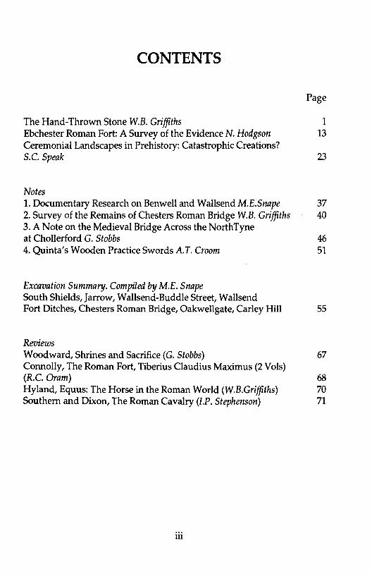
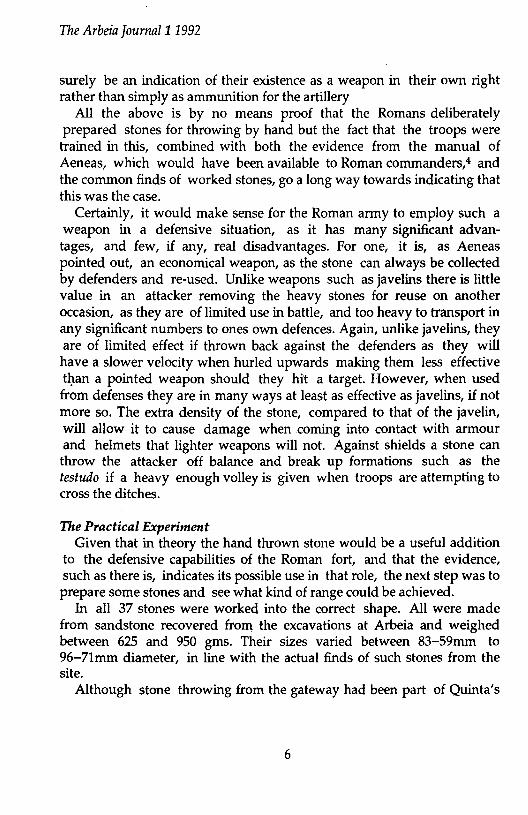
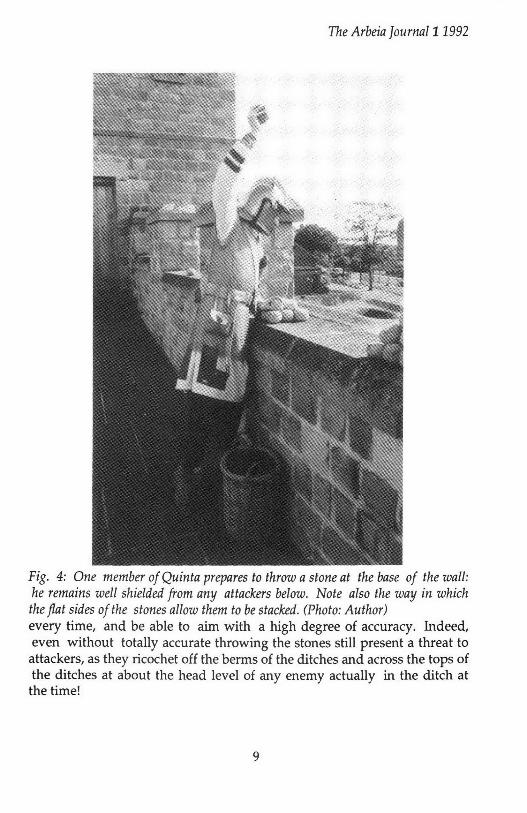
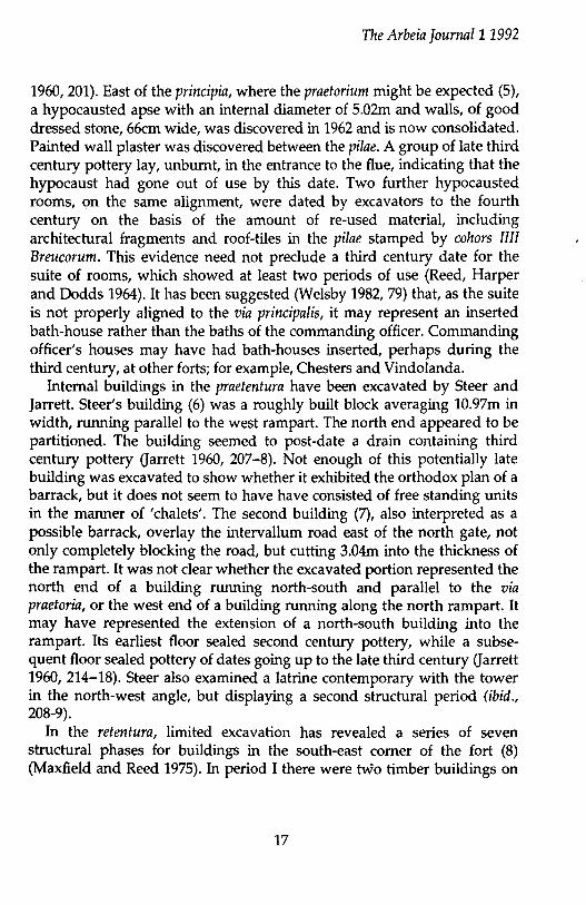
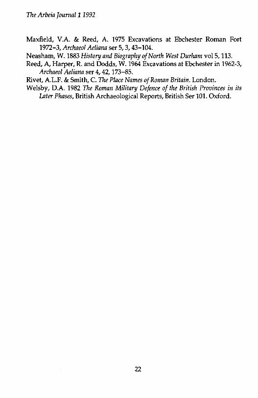
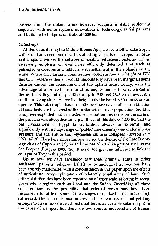
Fig. 4: One member of Quinta prepares to throw a stone at the base of the wall: he remains well shielded from any attackers below. Note also the way in which the flat sides of the stones allow them to be stacked. (Photo: Author) every time, and be able to aim with a high degree of accuracy. Indeed, even without totally accurate throwing the stones still present a threat to attackers, as they ricochet off the berms of the ditches and across the tops of the ditches at about the head level of any enemy actually in the ditch at the time!
9
The Arbeia Journal11992
Another point worth making, although not directly quantifiable, is the effectiveness of the hand thrown stone on attackers at the base of the wall. It can be hurled down by the defenders with enough force to cause injuries even through armour, yet the defenders barely have to expose themselves at all (see FigA). To use other weapons such as the javelins, and especially the bow, on targets at the base of the wall, the soldier would have to lean out further and remain exposed for longer.
Conclusions Although the above trials by no means represent a statistically
valid set of data, they do provide us with an idea of the minimum capabilities of the hand thrown stone, which could only be improved upon with constant training. Certainly it is clear that the stones, used in this way, can very effectively cover the defensive zone of the fort, as delimited by its ditches?
Of course, the effectiveness of the hand-thrown stone in the trials cannot be taken as proof of its deliberate use by the Roman army; but added to the circumstantial evidence for its possible employment it would be suprising if the Roman military had overlooked its potential; after all it cost nothing to manufacture beyond the soldiers' time, a cheap commoc'!ity in any army!
Acknowledgements Much of the initial research incorporated within this article was
carried out for my undergraduate dissertation at the University of Exeter in 1986 under Dr V.A. Maxfield for whose guidance at the time I remain extremely grateful. Thanks are due also to Martin Howell and Christophe Guffond as well as Quinta members Bob Carr, Paul Carrick, and Ian Stephenson for taking part in the experiment, and to Alex Croom and my wife, Karen, for technical support on the day. I should also like to thank Dr D. Marchant for permission to read his unpublished Ph.D thesis while this article was at an early draft stage; and Alex Croom and Jon Coulston for commenting on an earlier draft of this paper.
Footnotes 1. Anyone wishing to take part in this project should contact the author
at South Shields fort. 2. Bumswark was the site of a Roman military practice range, complete
10
The Arbeia ]ournal11992
with ballista platforms, so that in this case the stones were in all probability prepared for artillery.
3. Although the weights given for ballista stones in the ancient sources, sometimes as much as 26Kg (Josephus V 269-70), are much heavier than the stones under discussion in this paper which weigh between 0.7 to 1.0 kg (Marchant 1991, Vol2. 128).
4. For instance both Polybius and Aelian comment on his work (cf the introduction to the Loeb translation to Aeneas, p. 13).
5. The author wishes to thank Martin Howell and Christophe Guffond for stepping in to lend a hand (or rather arm) at the last minute.
6. Three different types of armour were worn. Two soldiers wore ring mail cuirasses (loricae Juunatae) of which one was sleeved almost to the elbow, the other being unsleeved, while the third soldier wore an unsleeved cuirass of scale (lorica squamata).
7. Cf. Richmond 1968, 69 & Jones 1975, 113 for discussions of the relationship between the layout of ditch systems and the range of Roman weapons.
Bibliography Aeneas Tacticus; Arrian Ars Tactica; Josephus Jewish War; Tacitus Histories;
Vegetius Epitoma Rei Militaris Baatz D 1983 Town walls and defensive weapons, in J Maloney and B
Hobley, Roman Urban defences in the West, CBA Res Rep 51, London, 136-40.
Bishop M.C. and Coulston J.C. 1989 Roman Military Equipment, Aylesbury.
Cichorius, C. 1896 and 1900 Die Reliefs der Traianssiiule, II and Ill, Berlil).. Humble, R. 1980 Warfare in the Ancient World, London. Jobey, G. 1978 Bumswark, in Trans Dumfrieshire and Galloway Nat. Hist.
Arch. Soc. 53,57-104. Jones, M.J. 1975 Roman Fort Defences to A.D. 117, B.A.R. 21, Oxford. Marchant, D.J. 1991 Roman Weaponry in the Province of Britain from the
Second Century to the Fifth Century AD., Unpub. Ph.D thesis, Durham. Richmond, LA. 1968 Hod Hill Vol.ll, London. Yadin, Y. 1966 Masada, London.
11

12
The Arbeia Journa/11992
EBCHESTER ROMAN FORT: A SURVEY OF THE PUBLISHED EVIDENCE
N. Hodgson In what may be the first of an occasional series, the following article
examines the state of knowledge about one of South Shields' sister sites, the Roman fort at Ebchester, in County Durham (NZ 103554). Although very little is known about the internal plan and general history of the fort, what can be discerned of Ebchester' s history in the Roman period reveals some interesting points of similarity and contrast to South Shields, where much more excavation has taken place.
The Roman fort of Ebchester is placed to overlook the crossing of the River Derwent by Dere Street, some 180m to the west. There is a steep fall to the river on the north, and the fort-platform is protected on the south and west by the Ebchester bum. The Roman name of the place was, according to the Antonine Itinerary, Vindomora, for which Rivet and Smith (1979, 502-3) suggest the meaning 'bright waters'. The Antonine Itinerary is the only source for the name. The site received its first notice in the eighteenth century, when Christopher Hunter (1702) identified it as a Roman station with extensive suburbs. Subsequently, a series of inscribed and sculptured stones turned up. The Rev R E Hooppell, the nineteenth century excavator of South Shields, was responsible in the 1880s for an important publication of such discoveries as had been made in the nineteenth century at Ebchester (Neasham 1883, 113). The basic reason for the limited knowledge of the interior of the fort, when placed against the comparatively good general knowledge of the plan at South Shields, is, of course, that the latter was extensively excavated, and the results published, in the nineteenth century. Excavation on this scale would have been impossible at Ebchester, mostly overlain by a church and village, and the sort of building development that led to the research at South Shields could not, in any case, have taken place. For the same reasons we are unlikely to gain an extensive knowledge of the fort interior in our life-times.
However some limited excavation has taken place at intervals at Ebchester since 1936 (see Fig 1 for their location), the main work being by: a) K A Steer in 1936 b) M M Allison, E Downs and A H Reed in 1958-9
13

The Arbeia ]ournal11992
3
r f 7
/ --------~-__)
--------- ------
I 4
" ~ :: ~~ 1 1 l l t 1 i 1 l l L 1 ~ 1 l ~ 1.-:;
~ .. t T T T 11 1 T 1 { T l T 1 T n \\::
-----
----------
Fig. 1: Ebchester Roman Fort, Showing the Main Areas of Excavation. (Drawn by M. Hoyle).
14

The Arbeia Journal11992
c) M G Jarrett in 1959: published in Jarrett 1960, which also summarised the results of the earlier excavations.
d) A H Reed, R Harper and W Dodds in 1962: published in Reed, Harper and Dodds 1964.
e) V A Maxfield and A H Reed in 1972-3: published in Maxfield and Reed 1975.
The results of some more recent small scale excavations and watching briefs await publication, and as a result are not discussed here.
Defences The defences have been examined at several points. Steer Garrett 1960,
202-14, using material from Steer's unpublished thesis) investigated the area of the north-west angle (1 on the plan), finding the fort wall (robbed out, but on a clay foundation bounded by lines of boulders 2.59m apart) to be secondary and, as at Binchester, inserted into a cut-back primary clay rampart. This latter produced samian of Flavian date (ibid., 210). At 12.16m, the rampart seemed exceptionally wide; however, the excavations of 1972 on the south rampart demonstrated two phases, the heel of the rampart having been extended by 1.75m into the fort's interior. This extension was associated by the excavators with the insertion of the stone fort-wall, and they suggested that the same could have happened in Steer's section, the crucial point of junction being obscured there by the insertion of an oven into the back of the rampart (Maxfield and Reed 1975, 47-9). There is evidence (ibid.) for the date of the stone wall construction and rampart extension, at least in the area of the southern defences examined, for the interoallum road II, associated with these changes, sealed a black-burnished ware category 2 bowl of c160-180. As a clay deposit, suggestive of rampartslip, intervened between interoallum roads I and 11, it seems that the defences either experienced a period of disuse or were deliberately slighted. The stone wall itself was examined on the east side in 1959. At the lower course, it was found to be 1.44m wide with an offset on the outer face of 0.12m. The cobbled foundation projected 0.68m. The rampart here, not completely sectioned, had been at least 7.92m wide; again, it had been cut back to the take the later stone wall. At the same time, a section across the north rampart showed it to be narrower than in Steer's section. The associated primary intervallum road sealed late first century pottery (Jarrett 1960, 214-16).
The ditch system is imperfectly known, but would seem to consist of two
15
The Arbeia Journal11992
phases; a narrow Flavian ditch, close to the rampart, was filled in when the stone wall was built, and replaced by a wider and deeper successor further out from the wall. This was the pattern found in 1959 011 the east side of the fort (Jarrett 1960, 224-5). The Flavian ditch was 2.74m wide and 1.67m deep, V-shaped with a drainage channel. Above its fill was clay detritus, probably representing the removal of the rampart front in order to insert the stone wall, while the ditch fill was clearly cut by the wider and deeper secondary ditch. Although Steer's trenches did not include the ditches, he located the lip of a ditch some 1.22m from the wall foundation (Jarrett 1960, 205), which compares well with Jarrett's measurement of 1.30m from the wall foundation on the east side. Jarrett's outer ditch was 4.87m wide and its sides sloped much less steeply than those of its predecessor. It is probable that the inner ditch was filled to provide a more stable ground
, surface, necessary when the defences were rebuilt in stone. Two angle towers are known; the north-west (1), excavated by Steer
(Jarrett 1960, 206-7), 2.13 by 3.04m internally, and the south-east (2), found in 1964, 2.74 by 2.13m and containing an oven (Maxfield and Reed 1975, 65-6). The north gate (3) is established. It is centrally placed and was excavated by the Rev. Linthwaite, without record, in 1886 (Jarrett 1960, 201). It was rediscovered in 1968, along with a drain running alongside the road passing through the gate (Maxfield and Reed 1975, 66-7). The south gate should, therefore, lie opposite the north, in the centre of the southern side, and this was indeed indicated by a drain found in 1876 running along what would be the west side of a road leading into the fort from the south gate (Jarrett 1960, 201).
The Interior The layout of the fort is deduced from the positions of these gates in the
centre of their respective sides. The east and west gates are assumed to lie under the modem Newcastle-Shotley Bridge road, i.e. marking the via principalis somewhat north of the centre of the fort, and allowing for a central range of buildings south of that road. Therefore the fort faces north, and the gate excavated by Linthwaite is the porta praetoria. The resultant fort is c122m square and clha in area, when the area lost to the exceptionally wide rampart is taken into account (Jones 1977, 149).
Of the central range buildings, two cubical stone bases and a gutter, found in Shaw Lane opposite the churchyard entrance (4), perhaps represent the west portico of the principia forecourt (Steer, cited in Jarrett
16
The Arbeia Journal11992
1960, 201). East of the principia, where the praetorium might be expected (5), a hypocausted apse with an internal diameter of 5.02m and walls, of good dressed stone, 66cm wide, was discovered in 1962 and is now consolidated. Painted wall plaster was discovered between the pilae. A group of late third century pottery lay, unburnt, in the entrance to the flue, indicating that the hypocaust had gone out of use by this date. Two further hypocausted rooms, on the same alignment, were dated by excavators to the fourth century on the basis of the amount of re-used material, including architectural fragments and roof-tiles in the pilae stamped by cohors IIII Breucorum. This evidence need not preclude a third century date for the suite of rooms, which showed at least two periods of use (Reed, Harper and Dodds 1964).1t has been suggested (Welsby 1982, 79) that, as the suite is not properly aligned to the via principalis, it may represent an inserted bath-house rather than the baths of the commanding officer. Commanding officer's houses may have had bath-houses inserted, perhaps during the third century, at other forts; for example, Chesters and Vindolanda.
Internal buildings in the praetentura have been excavated by Steer and Jarrett. Steer's building (6) was a roughly built block averaging 10.97m in width, running parallel to the west rampart. The north end appeared to be partitioned. The building seemed to post-date a drain containing third century pottery (Jarrett 1960, 207-8). Not enough of this potentially late building was excavated to show whether it exhibited the orthodox plan of a barrack, but it does not seem to have have consisted of free standing units in the manner of 'chalets'. The second building (7), also interpreted as a possible barrack, overlay the intervallum road east of the north gate, not only completely blocking the road, but cutting 3.04m into the thickness of the rampart. It was not clear whether the excavated portion represented the north end of a building running north-south and parallel to the via praetoria, or the west end of a building running along the north rampart. It may have represented the extension of a north-south building into the rampart. Its earliest floor sealed second century pottery, while a subsequent floor sealed pottery of dates going up to the late third century (Jarrett 1960, 214-18). Steer also examined a latrine contemporary with the tower in the north-west angle, but displaying a second structural period (ibid., 208-9).
In the retentura, limited excavation has revealed a series of seven structural phases for buildings in the south-east corner of the fort (8) (Maxfield and Reed 1975). In period I there were two timber buildings on
17

The Arbeia Journal11992
east-west alignment, although how far either of them extended is unknown. The more northerly was suggestive of a barrack; although the width of the assumed contubernium was indeterminable, there was a possible lateral division like that common in contubernia, as well as an apparent verandah. The space available between the via decumana and the east intervallum would have allowed a building some 45m in length. The southern building may also have been a barrack (although positive evidence was lacking), but as the trench showed it ending c10m short of the eastern defences, any centurion's quarters would have been detached. These buildings were destroyed by fire and built to the same plan in Period II. Periods IIl and IV, each after a destructive fire, followed on a different plan, similar, however, in IIl and IV. It was not clear whether the northern building still existed, or had been replaced by a paved area, but in any case it no longer displayed the characteristics of a barrack. It is possible that the southern building was divided into rooms 2.74m wide, each room divided by a lateral partition and the whole fronted by a verandah. Occupation material dates period I as Flavian-early Trajanic. 11, IIl and IV had no material later than the early second century, so they are considered to have followed period I in quick succesion. The next buildings on the site were in stone, and the pottery recovered suggested that they followed after an interval of abandonment. Samian dating to 160-195 came from the construction levels of the stone buildings. The occupation material from period V, following on directly from the probably Trajanic timber structures, was uniformly mid to late Antonine in date. In phases V and VI the function of the northern building is obscure, although in VI it had an opus signinum floor and may have been connected to the baths complex to the north. This would support a third century date for the bath-house, as suggested above. Period VI seems to be third century; the make up of its floor contained pottery dating from the late second to the third century. The southern building in periods V and VI was not a barrack, and was perhaps the site of industrial activity. Period VII sees County Durham's contribution to the growing list of 'chalet' type accommodation on military sites. Although the northern building appeared to be an ephemeral structure, the southern became two buildings, an eastern and a western, roughly built, 10-11m from north to south and separated by a 254-304mm eavesdrip. The date of this construction is uncertain. It could go as far back as the later third century - a metal working hearth contained a third century segmental bowl - but a fourth century origin is not to be ruled out.
18
The Arbeia ]ournal11992
While the eastern building may have originally been used for bronzesmelting, its hearth in a final phase seemed not to have been used for industrial activity. This second phase of period VII sealed mid-fourth century pottery. Finally, in the retentura, there is the stone water channel in the south-east angle, known from Hunter Oarrett 1960, 200), which may represent the fort's main water supply.
Extra-mural Nothing is known for certain of a vicus or extra-mural military buildings
at Ebchester. Hunter (1702) saw 'suburbs towards the West, South and perhaps East, of a considerable Extent.. ... ', but these have eluded later observers, even Horsley, who was astute at recognising extra-mural settlement. RIB 1115 may be part of a funerary monument, but its exact provenance is unknoWn.
The attested garrison The third century garrison was cohors !Ill Breucorum (Rffi 1101, dated
between 213 and 222). This is confirmed by stamped roof tiles of COH.IIII.BR found reused in the pilae of the hypocausts south-east of the Mains Farm apse (Reed, Harper and Dodds 1964, 177-9). The lost fragment supposed to read [CO] HI BR (Bruce 1875, no. 670) is clearly a misreading of [COH I] Ill BR.
Conclusions Some tentative conclusions may be reached about the history of
Ebchester fort from the published excavation reports. The fort had a Flavian origin - i.e. probably in the 70s or 80s of the first century - but the earliest phase represented consists of a series of plough-marks in the natural clay, running on a north-south alignment in the south-east corner of the fort (Maxfield and Reed 1975, 47). This evidence of cultivation has been presumed, like other examples (Brartigan 1984, 30), to pre-date Roman occupation. Such pre-Roman agricultural activity is known under several Roman sites in the north, including South Shields. The rapid succession of demolitions (by burning) and reconstructions of the Flavian-Trajartic period buildings in the southeast part of the fort may prehaps be associated with the various stages of re-organisation as the army withdrew from Scotland at the end of the first century to settle on the Tyne-Solway isthmus under Trajan. One possibility is that Ebchester at some time had a role as a
19
The Arbeia ]ournal11992
road station on an eastern extension of the Stanegate (the arterial east-west road between Carlisle and Corbridge). If so it may have been linked to South Shields via the recently discovered fort of Washing Well, at Wickham. There is as yet no evidence for such a through road, but its existence remains a possibility.
The rebuilding of Ebchester in stone is likely to have taken place in the mid-Antonine period, remembering the pottery of 160-80 sealed by the interoallum associated with the rampart extension. Furthermore, there is a general consensus of opinion Garrett 1960, 228; Maxfield and Reed 1975, 49}, based upon the pottery record of the site as a whole, that the fort was not occupied from early in Hadrian's reign until the mid-Antonine period. As it would be more logical to build in stone on re-occupation rather than on the brink of abandonment, it seems best to place the refurbishment of the defences in the mid-Antonine period. The indications are, then, that Ebchester was given up when Hadrian's wall was commissioned, and reoccupied and rebuilt in stone after the Antonine withdrawal from Scotland. The clay rampart material lying between the first and second intervallum roads, and the pottery from the layers between the timber and stone structures within the fort, both support the argument for a period of disuse.
In being rebuilt in the mid-Antonine period Ebchester therefore resembles South Shields. However, South Shields was evidently rebuilt on a different site from the one occupied by its predecessor, and it is not so clear that the fort was abandoned while the Antonine Wall was held.
There is no evidence for any further break in the occupation of Ebchester, even though it is commonly suggested that forts in the region were run down or abandoned for a period in the later third century. The 'chalets', presumably late third or fourth century, were laid directly on top of the levelled remains of their predecessors, implying a continuous use of the site in the third century. The 'chalet' barracks, divided into separate structural units, need not denote a drastic decline in the military efficiency of the garrison; as elsewhere, e.g. Vindolanda, where barracks were built forming a series of separate units as early as c235 (Bidwell 1985}, this may simply have been a new constructional technique (Bidwell1991; cf. Daniels 1980).
The nature of the late Roman garrison of Ebchester remains unknown. It is unclear whether Ebchester received a new unit to replace cohors !Ill Breucorum during the period of frontier reorganisation and army reform in the period 270-330 (when cohors V Gallorum was possibly replaced at South
20
The Arbeia Journal11992
Shields by numerus barcariorum Tigrisiensium). If so there is no record of such a unit; as fourth century inscriptions and tile stamps are almost unknown on the northern frontier, normally the Notitia Dignitatum would be the only source to record such a unit change, and, as we shall see, Ebchester was probably abandoned before the Notitia was compiled.
Although the pottery has been said to go down into the late fourth century, including post c370 types of Crambeck (Maxfield and Reed 1975, 65; Jarrett 1960, 227-8), there is in fact very little distictively late fourth century pottery recorded from the site; no Huntcliff type is illustrated in the 1975 report, and no painted Crambeck; only one grooved Huntcliff type is recorded in the 1960 report. This raises the possibility that Ebchester was abandoned at some time before the end of the Roman period, and in this connection it is interesting that the site does not appear in the very late list of fort garrisons in the Notitia Dignitatum. At South Shields, in contrast, there is abundant very late Roman material, and Arbeia appears in the Notitia.
BIBLIOGRAPHY Bidwell, P.T. 1985 The Roman Fort ofVindolanda at Chesterholm, Northumber
land (Historic Buildings and Monuments Commission for England, Archaeological report No. 1). London.
Bidwell, P.T. 1991 Later Roman Barracks in Britain, in Maxfield, V.A. & Dobson, M.J. (eds) Roman Frontier Studies 1989, Exeter University Press, 9-15.
Branigan, K. 1984 North East England in the First Century, in Wilson, P.R., Jones, R.F.J. and Evans, D.M. (eds) Settlement and Society in the Roman North, School of Arch. Scis., Univ. of Bradford, and Roman Antiqs. Sect., Yorks. Arch. Soc.,27-33.
Bruce, J.C. 1875 Lapidarium Septentrionale. London. Daniels, C.M. 1980 Excavations at Wallsend and the Fourth Century
Barracks on Hadrian's Wall, in Hanson, W.S. and Keppie, L.J.F. (eds}, Roman frontier studies 1979, British Archaeological Reports Int Ser 71, 173-93. Oxford.
Hunter, C. 1702 Philosophical Transactions of the Royal Society 34, no. 278. Jarrett, M.G. 1960 The Roman Fort at Ebchester, County Durham Archaeol
Aeliana ser 4, 38, 193-229. Jones, M.J. 1977 Roman Fort Defences to A.D. 117 (Rev ed.) British
Archaeological Reports British Ser 21, Oxford.
21
The Arbeia Journal11992
Maxfield, V.A. & Reed, A. 1975 Excavations at Ebchester Roman Fort 1972-3, Archaeol Aeliana ser 5, 3, 43-104.
Neasham, W. 1883 History and Biography of North West Durham vol5, 113. Reed, A, Harper, R. and Dodds, W. 1964 Excavations at Ebchester in 1962-3,
Archaeol Aeliana ser 4, 42, 173-85. Rivet, A.L.F. & Smith, C. The Place Names of Roman Britain. London. Welsby, D.A. 1982 The Roman Military Defence of the British Provinces in its
Later Phases, British Archaeological Reports, British Ser 101. Oxford.
22

The Arbeia Journal11992
CEREMONIAL LANDSCAPES IN PREHISTORY: CATASTROPHIC
CREATIONS?
S.C. Speak It has long been known that the earliest large-scale monuments to be
built in Britain were constructed within the 3rd millennium be, following at least 2000 years of intensive agricultural pressure upon relatively small areas of land. These large earthwork sites include causewayed camps, cursus monuments, and the earthen long barrow. Only the latter type of site is capable of an unequivocal explanation, and even here the sepulchral element is only one part of an extremely complex rite. In the past it has been fashionable to view these sites simply as single monuments, although it is becoming increasingly clear that their emphasis is related more to their topographical setting, and they should be regarded not as isolated sites but as groups of related monuments. This nodal arrangement of Neolithic ceremonial sites can be demonstrated throughout Britain and Ireland and can be seen to survive through several later periods of British prehistory, during which such sites act as a focal point for ever-diverging communities. This paper attempts to suggest why such ceremonial landscapes were formed, using the Milfield Basin of North Northumberland as a model, and to describe an area of South Tyneside near Houghton-le-Spring which may fall into this category.
Nodal Areas: the 'Importance of Place' The notion of a ceremonial landscape, rather than a loose collection of
individual sites, can be illustrated . by describing the early archaeology of the Milfield Basin near Wooler in North Northumberland. Topographically the basin is defined by the dominant Cheviot massif to its west and by the broad sweep of the Fell Sandstones to the east. These two geological regimes close off the basin to the south, whilst the north is more open. The basin, a lake in immediately post-glacial times which attracted huntergatherers from about 8000 be onwards, eventually became afforested and attracted early agriculturalists who were able to create and farm small man-made clearances. These early communities are characterised by simple
23
The Arbeia ]ournal11992
pottery forms and axes of polished stone; these latter, we shall see, assume a tremendous importance in later prehistoric communities, well beyond their functional use for tree clearance. The excavated settlement at Thirlings on the Milfield Plain has produced large quantities of pottery typical of the agriculturalists associated with a radiocarbon date of 3280 be± 150 (HAR-877), and there are round barrows on the basin margin at Ford and Chatton.
What happened to the existing hunter-gatherers who used this area is not known. It is clear that some aspects of each life style are mutually beneficial and the division between each group is no longer as clear-cut as it once seemed. Discoveries over the past decade have pointed out that all the characteristics once assumed diagnostic of the earliest agriculturalists -pottery, polished axes, territorial rights - were known to the huntergatherers. At Tevic in France for example, a community of hunter-gatherers buried their dead under a group of stone cairns, suggesting that the ultimate origins of the larger burial sites of later periods can be found in pre-agricultural societies. This permanent marking of a place with a burial cairn may have been a response to the impact on the hunter-gatherers of the new farming settlements. Indeed, taking northern and western Europe as a whole, the distribution of early Neolithic monuments coincides with those areas where the hunter-gatherer population formed the most predominant group of the first farming communities (Sherratt 1990, 147-8, 167). Perhaps the Milfield Plain hunter-gatherers were gradually absorbed into the new agricultural regime, retaining some aspects of their traditional ways.
Pollen diagrams from the Plain reveal that by 3000 be, after at least 1000 years of agricultural exploitation, the soils on which this way of life were based were becoming increasingly fragile and that crop failure was taking place (Burgess 1984, 141). The small-scale clearances were taken over by widespread forest regeneration as they became abandoned. In itself this would have appeared to be an inexplicable occurrence to the population, whose knowledge of farming procedures would have remained rudimentary; however, there was still plenty of land available, so catastrophe could be avoided, or, as we shall see, averted. The response to this first minicatastrophe was thus to open up new areas of the lowland but to impose upon it a stricter sense of territoriality and land division. Accompanied by improved social and political organisation a recovery from this initial agricultural set-back took place. It is vital to remember that similar events
24
~
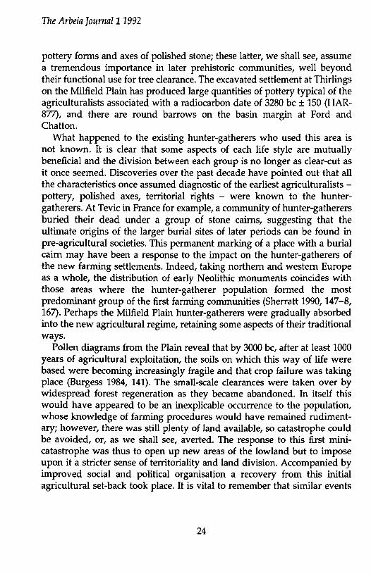
+ Henge monuments A Cup-marked stones
• Barrows • Early Bronze Age settlements
Fig.l: Sites and monuments at Milfield and Herrington. [ ! .. •F>:J:·''·1 0 60 120 180 metres
The Arbeia Journal11992
took place elsewhere in Britain, particularly in the more densely populated south of the country. Although we are still dealing with a total population to be measured in the tens of thousands, they had been concentrating their agriculture on relatively small clearances. At the same time that small-scale land divisions were being imposed upon the Milfield Plain, much larger territorial divisions were emerging in the south, based on large monuments like causewayed camps, long barrows and cursus monuments.
Of course an increasing population placed more and more pressure on available resources, and as new land was required the higher valleys were cleared and the regenerated forest reopened. On the Milfield Plain the response to this pressure on the land was to formalise the earlier ad hoc clearances and produce a regular pattern of either field banks or large timbers, marked today by pit alignments. These alignments are still visible on aerial photographs, particularly over Ewart Park, dividing up the Plain into rectangular allotments (Burgess 1984, 142). Such a series of land allotments suggests an increasing hierarchy in society at this time, with the development of community or territorial centres: the origins of nodality, or a feeling of the importance of a particular area of land, can perhaps be traced to this period, around 3200 be. Despite this more regular approach to agricultural subsistence, the Plain contained only a finite amount of land and the inevitable cumulative inability of the area to support farming took place around 2000 be. It was at this point that the land of the Milfield Plain, once so prized for agricultural purposes was given over to what might be termed 'public monuments'. These had no domestic nor sepulchral use, although they retained such strong traditions that they attracted burials in later periods, either within them or adjacent to them. Such sites include the henges and the cursus monuments.
Henges consisted of roughly circular enclosures defined by earthen banks quarried from a ditch which was normally, though not always, placed within the bank. Most henges had a single entrance, although a large number had two opposed entrances. They had a wide distribution throughout the British Isles but show great regional differences. In the south they retained the same distribution as the earlier causewayed camps and tended to be single monuments, but very large- such as Avebury. On the Milfield Plain they were quite small, perhaps 20m or so in diameter, but here they occur in groups, with a dozen or so currently known, and associated with a cursus. The C14 evidence for the Milfield henges include dates of 1851 ± 62 and 1824 ± 39 from the ditch of the Milfield North henge
26
The Arbeia ]ourna/11992
(GU-1048 and BM-1149 respectively) and 1950 ± 110 and 1590 ± 100 from a primary pit at Milfield South and 1740 ± 80 from a secondary context (HAR-3071, HAR-3040 and HAR-3068). Internally the henges may contain circular timber settings, but these were unroofed and presage the more durable stone circles. The cursus monuments were entirely different. These consisted of a pair of low parallel banks, perhaps 20m apart (although this is by no means standard) and could be of astonishing length. The Dorset cursus ran for approximately 20km. They were reasonably straight and frequently incorporated long barrows within their banks or positioned transversely between them. The causewayed camps, the earliest of these public monuments, consisted of a series of up to three concentric ditches which provided spoil for interrupted banks on their inner side. Fewer than fifty of these sites are known, mainly located in the south and east of the country. In the north of England it seems that their construction had by and large been overtaken by the analogous henges.
The functions of all these three types of monument is unknown, but what evidence there is suggests that they represent nodal points in the landscape of great importance to the communities that built them. They seem to be a response of a population in extremis, whether from population increase or pressure upon the land. In the cases of the henges and the cursus, they were certainly built on land which was once under cultivation. The importance of this response can be seen in the prodigious resources invested in them: over 30 million man-hours alone would be needed for the Avebury henge. That these monuments survive at all in areas that today are intensively cultivated is a testament to their builders. Recent excavations have shown that these structures were frequently accompanied by a plethora of large timber settings which survive only as subsoil features.
Although by regarding these monuments as part of a ceremonial landscape rather than as individual sites we can suspect some elements of nodality, supporting evidence comes from traditional techniques such as field-walking. Many of these sites lie in areas of modem prime agricultural land and field walking over the past decades has produced a large corpus of finds. A synthesis of these finds emphasises the importance of the sites. We do not find assemblages of domestic material. The most durable type of object, and one that can survive the passage of time virtually unscathed, is the polished stone axe, which fortunately can be geologically ascribed to its point of origin. The distribution of axes near the Dorset cursus is clear: the closer to the monument, the more exotic the material from which the axe is
27
The Arbeia ]ournal11992
made. Some are formed of jade, a volcanic glass whose closest occurrence to the British Isles is in the northern Italian Alps. Other axes may be made of material closer to home, but are exquisitely worked and can certainly no longer be considered in purely functional terms.
Continuity We shall return to the Milfield Basin again, but there are other areas
which reflect this emphasis upon the importance of place. In Ireland three massive passage graves lie at the Bend of the Boyne near Slane in Co. Meath. Set prominently on a ridge and about a mile apart, each of these tombs covers an area of about 6,500 square metres. The New Grange tumulus has a number of elements which suggest that burial places also formed avital role in prescribing a focal point for a community. The site dominates the land for miles around, not only by virtue of its position on a ridge but also by its own height of ten metres. A kerb of 97 large blocks averaging 3m by lm retains the 80m diameter body of the mound and most are decorated, with pecked-out rays, spirals, circles, chevrons and lozenges. The mound consists of over 200,000 tons of boulders, mostly of the local white quartz and easily available, but remarkably the builders also incorporated black granites whose nearest source was over 50 km away. An imaginative reconstruction of the site has used the combination of these black and white stones to great effect, to increase and exaggerate the monument and emphasise its entrance-way. This consisted of a passage 19m long entering a cruciform, corbel-vaulted chamber 6.50m wide and 6m high. In each of the niches of this chamber lay a decorated stone bowl, up to lm in diameter, laboriously hollowed out from a single granite boulder. The burial rite was cremation, and the bowls are best explained as the repositories in which each new cremation was placed during the burial ceremony.
Grave goods within passage graves are rare and are centred again upon the axe. At New Grange and the nearby Knowth were recovered two singular flint axe heads, cylindrically perforated and each carved with bold spirals or flutes standing out in bold relief. The amount of time needed to carve blocks of flint in this way is incalculable. One further feature at New Grange is even more remarkable, for constructed above the lintels of the entrance-way lies a stone-lined slot, always open even when the main entrance was dosed off in between cremation rites, which allows the midwinter sunrise to illuminate the rear niche at the end of the passage for
28

The Arbeia Journa/11992
about 15 minutes; this is the only site in Europe where this occurs. Finally the monument was surrounded by that most enigmatic of features, a stone circle of undressed boulders. Only 12 of an original 38 survive: an outlier is decorated. Opinion differs as to whether the stone circle is original to the monument or an addition, but in a discussion of the importance of the monument as a nodal point in the community, this is irrelevant. The continuity of the place is the important issue, and there are over 40 surviving burial sites, hengi-form earthworks, stone circles and standing stones within a few miles of New Grange and its companions.
In Scotland too there are similar nodal areas, of which one example will suffice. In the Kilmartin Valley, between Oban and Lochgilphead, lie a series of monuments of differing dates and styles, but all individually devoted to burial and collectively to the importance to the community of this one area. The valley is long and thin, dominated to east and west by rugged mountains. It is still the main communication line through the area for river, road and train. Four large cairns - Glebe cairn, and North-, Midand South Nether Largie - lie close together. One is a chambered long cairn, the others circular. Each has attracted later burials in the form of Beaker cist graves of about 1800 be. Two other cairn complexes at Ri Cruin and Temple Wood complement the group. At the latter site a stone circle of 13, originally 20, earthfast slabs form a circle 12m in diameter within a slight and irregular bank, containing cist graves within it. At Ri Cruin a cist central to a stone cairn contains carvings of an axe upon it, and there are other cup-and-ring carvings and axe carvings at North Nether Largie. Elsewhere in this valley lie several other burial cairns, as at Duncraigaig, and a henge with accompanying stone settings at Ballymeanoch. The greatest concentration of cup-and-ring carvings on outcrop rocks in Britain occurs in this valley, mainly at Achnabreck and Kilmichael Glassary.
Significantly, the second greatest concentration lies upon the outcrop at Roughting Linn, overlooking the Milfield Plain. To complete our picture of the Milfield Plain we must add to the Roughting Linn cup-and-rings a large corpus of motifs from Doddington, Weetwood and Fowberry Moor: and a number of standing stones. A circular setting of sockets is visible on aerial photographs of the henge at East Marley Knowe, which may have retained timbers rather than stones, and a stone circle was demolished in order to make way for Edwin's Saxon Palace at Yeavering. The occurrence of these features on the Milfield Plain, perhaps 500 or so years after the henges were constructed, implies that the importance of place tradition
29
The Arbeia Journal11992
survived the arrival from the continent of the new Beaker influences. These two examples from Ireland and Scotland are only two out of a
large range of similar, associated monuments placed in areas where the whole landscape has a restricted use. Their essential elements include a dominant setting in the landscape; an emphasis, in the case of communal burials, towards the entrance; the use of pecked motifs on stones, either free-standing, in burial mound kerbs, or on bare rock; the presence of axes, as artefacts or carvings; and a chronologically wide combination of sepulchral monuments in close association. We do not find settlement sites associated with these public structures and the whole landscape appears to be restricted to this manifestation of the importance of place. Other examples include the Clava Cairn complex near Inverness, the Thomborough Circles in Yorkshire, the Stones of Stenness, the Ring of Brogar and the Maes Howe tumulus in Orkney: and there are many more. Modem analogies to these sites are extremely dangerous and never to be taken literally, but consider the central role taken by the great medieval cathedrals of Europe. Physically they too dominate the landscape, they are long-term prestigious and expensive building projects, they contain priceless objects belonging to an entire community but held on their behalf by a privileged few, and they are built on the remains of their centuries-old predecessors. Some specialist members of society may be permitted into sacred areas or supervise rites of passage: the less privileged are spatially sorted into less specialised areas, such as choir or nave, or even restricted to peep-holes. Other low-status groups are denied access to the building or its immediate vicinity. This categorization of people, status and space probably reflect the intricate structure of Neolithic society itself (Barrett 1990, 187).
The comparative scarcity of field remains of early settlements south of the Tyne and in County Durham is unusual, because the land to either side of the Wear in its central and lower reaches forms reasonably attractive terrain. This lack of settlement sites suggests that a different emphasis was placed upon this area during the early agricultural period when the large sepulchral and ceremonial monuments were being constructed. In particular, there is a causewayed enclosure and cursus at Herrington, with burials in a round barrow at nearby Hasting Hill: and further large burial mounds occur nearby at Warden Law and Copt Hill. At Hasting Hill the causewayed camp is enclosed by an interrupted ditch measuring approximately lOOm by 60m, and immediately adjacent is a cursus 30m in width
30
The Arbeia ]ournal11992
which can be traced for at least 200m, and which was originally no doubt much longer. The Hasting Hill burial lies on the crest of a hill and consisted of a round mound 12m in diameter. Recovered from it was pottery of the third millennium be and later cremations and inhumations of the second millennium, as well as a range of pottery styles including food vessels and beakers. More round barrows cluster around the cursus. The round barrow at Copt Hill near Houghton-le-Spring lay on an escarpment and included both cremation and inhumations of the third and second millennia be, with flints and food vessels. Although the area lacks some of the other expected elements of a ritual landscape, such as cup-and-rings or standing stones, at least the clue is there that this area too may have been designated as a nodal area.
The implication is that some of these monuments had their genesis in a response to catastrophe but subsequently attracted other, high status sites such as burials and stone circles. Perhaps they retained a tradition of vitality by their initial role of warding off some great calamity. On the Milfield Plain the combination of all the evidence, from excavation, pottery studies, site distribution and palynology, suggests an end to neolithic settlement with a drastic programme of land division and allotment to offset the pressures of the community. These pressures were likely to be a combination of rising population, fragile soils and too little land, or some external influence. There is no evidence to suggest that domestic settlement on the Plain continued into the second millennium, but instead a multitude of henges or hengi-form structures were constructed on this now agriculturally dead landscape. A similar response to these mounting pressures seems to have been repeated all over Britain at the end of the second millennium, but what remains unclear is the pattern of domestic settlement after this collapse. At Milfield the new settlement pattern is clearly demonstrable, for at precisely the same time as the Plain was abandoned, extensive upland settlement began at sites such as Black Law in the Cheviot foothills (Burgess 1984). This shift in emphasis from lowland to higher ground is also presaged by the presence of large stone circles at the entrance to valleys cutting deep into the Cheviots, at Hethpool and Threestoneburn. Whilst the framework of this settlement shift makes considerable sense and is confirmed by excavation in the Cheviots and other upland areas, notably Dartmoor, lowland zones such as Tyneside and southeastern England simply do not have completely new areas of land available to accept such a wholesale settlement shift. The evidence we do
31
The Arbeia Journal11992
possess from the upland areas however suggests a stable settlement sequence, with minor regional innovations in technology, burial patterns and building techniques, until about 1200 be.
Catastrophe At this date, during the Middle Bronze Age, we see another catastrophe
with social and economic disasters affecting all parts of Europe. In northeast England we see the collapse of existing settlement patterns and an increasing emphasis on ever more efficiently defended sites such as palisaded enclosures and hillforts, with settlement in the uplands on the wane. Where once farming communities could survive at a height of 1700 feet O.D. (where settlement would undoubtedly have been marginal) some disaster caused the abandonment of the upland areas. Today, with the advantage of improved agricultural techniques and fertilizers, we can in the north of England only cultivate up to 900 feet O.D on a favourable southern-facing slope. Above that height only the Forestry Commission can operate. This catastrophe has normally been seen as another combination of those factors which created the earlier crisis- over population, too little land, over-exploited and exhausted soil - but on this occasion the scale of the problem was altogether far larger. It was at this date of 1200 BC that the old civilizations of Egypt (a civilization always in extremis, and significantly with a huge range of 'public' monuments) was under intense pressure and the Hittite and Mycenean cultures collapsed (Bryson et al 1974, 47-8). Elsewhere across Europe we see the demise of the Late Bronze Age cities of Cyprus and Syria and the rise of war-like groups such as the Sea Peoples (Burgess 1989, 326). It is not too great an inference to link the collapse of Tray to this period.
Up to now we have envisaged that these dramatic shifts in either settlement patterns, religious beliefs or technological innovations have been entirely man-made, with a concentration in this paper upon the effects of agricultural over-exploitation of relatively small areas of land. Such artificial difficulties have been repeated on a larger scale, affecting in recent years whole regions such as Chad and the Sudan. Overriding all these considerations is the possibility that external forces may have been responsible for at least some of the changes recognized in the archaeological record. The span of human interest in their own selves is not yet long enough to have recorded such external forces as variable solar output or the cause of ice ages. But there are two sources independent of human
32
The Arbeia Journal11992
activity that might record the presence of effects great enough to have caused prehistoric catastrophes of such magnitude that they destroyed whole civilizations; ice cores from Greenland and tree rings from Ireland. Cores from Greenland ice sheets reveal traces of sulphuric acid deposited by volcanic eruptions and as these sheets are laid down annually these events can be broadly dated (Hammer et al1980, 231). Prehistoric oaks from Ireland are almost exclusively bog oaks rooted on deep peat and their existence was always marginal: in short they are extremely sensitive to alterations in the climate and any such changes are recorded in differential tree ring growth (Baillie 1989, 310). If there were any correspondence in date between these two sources suggestive of a climatic deterioration and a similarly dated disruption of archaeological sequences in Europe then we can add the effects of external forces to those internal stresses affecting societies. In fact the evidence from both ice cores and tree rings suggest a major volcanic eruption sometime around 1100 ± 50 be. Evidence from excavation in the Outer Hebridean island of South Uist and in the Shetlands has recorded a fine layer of volcanic tephra from this period which can be shown to belong to an eruption of the Icelandic volcano Hekla. Such an eruption would produce what today would be termed a 'nuclear winter' with a veil of volcanic dust released into the atmosphere absorbing sunlight and reducing surface temperature, inducing a decade or more of crop failure (Baillie and Munro 1988, 346). A similar event has been suggested for the demise of the Minoan civilization (Hammer et al 1987, 518). In a more recent case, the eruptions of the Sunset Crater in Arizona beginning in AD 1064 were followed by a farming strategy which led to permanent ecological degradation after only 120 years (Sullivan and Downum 1990, 287). Such a deterioration in the climate would be most felt in upland areas such as the Cheviots, where we have already seen settlement in turmoil at the end of the earlier Bronze Age, to be followed by a very different later Bronze Age. Indications of this difference in scale of activity are revealed by studying entire landscapes rather than individual monuments. There are areas with little or no evidence for domestic settlement between the 12th and 8th centuries be, including almost the whole of northern England from the Tees to the Firth of Forth, which at least accounts for the comparative dearth of sites in the South Tyneside area following the floruit of the ceremonial centres at Herrington and Hasting Hill. It is at this time we see an increase in interest in 'wet' places, with the deposition of intrinsically valuable objects, including axes, in
33
The Arbeia Journal11992
rivers and bogs. The numbers of bronze swords recovered from the river Tyne is surely indicative of more than mere casual loss - it would be very difficult to 'lose' a sword! For evidence of population and settlement recovery after the 8th century be we must look again at distribution maps, which show a series of rectilinear enclosures in the lowlands, as at Burradon, Hartburn, Winlaton Mill, and Buck's Nook in Prudhoe.
Conclusion It has been normal practise to consider that a hiatus in the archaeological
record must be due to internal stresses within societies, such as population pressure or some agricultural mismanagement. In this paper I have suggested that this may not be so, certainly for Old World Europe around 1200 be. It may yet be erroneous to suggest that external forces were the cause of widespread disruption around 2500-2000 be, but any consideration of why field remains in the South Tyneside area were so scarce following the demise of the large ceremonial monuments of Herrington and Hasting Hill, Warden Law and Copt Hill must bear these ideas in mind. These monuments can thus be regarded in two ways. Firstly as part of a large-scale ritual landscape in which these very visible monuments played a vital role in defining focal points for a community in stress, however that stress may have occurred. And secondly, remote a possibility as it may once have seemed, there is an increasing supply of evidence (in years to come we may be able to say an overwhelming supply of evidence) to suggest that external forces beyond the power of man to predict or control shaped the destinies of these communities, in particular the correlation between the Hekla eruption and the lack of sites in our area after 1200 be. Indeed, although research in these matters is at an early stage, there are already hints that a similar environmental disaster took place somewhere around 2500 be, which would tie in very well with the demise of the causewayed camps and the rise of their immediate successor, the henge monuments.
BIBLIOGRAPHY Baillie M 1989 Do Irish Bog Oaks Date the Shang Dynasty? CA X, 10 (117) Baillie M G L and Munro M A R 1988 Irish Tree Rings, Santorini and
Volcanic Dust Veils, Letter to Nature, 332, 344-6 Barratt J C 1990 The monumentality of death: the character of Early Bronze
Age mortuary mounds in southern Britain World Arch, 22, 2, 179-89
34
The Arbeia Journal11992
Bryson RA, Lamb H H, and Donley D L, 1974 Drought and the decline of Mycenae Antiquity 98, 46;....50
Burgess C B 1984 The Prehistoric Settlement of Northumberland: A Speculative Survey in Miket R and Burgess C B (eds.) Between and Beyond the Walls
Burgess C B 1989 Volcanoes, Catastrophe and the Global Crisis of the Late Second Millennium BC CA X, 10 (117)
Hammer C U, Clausen H B, and Dansgaard W 1980 Greenland ice sheet evidence of post-glacial volcanism and its climatic impact Nature, 288 230-5
Hammer C U, Clausen H B, Friedrich W L, and Tauber H 1987 The Minoan eruption of Santorini in Greece dated to 1645 BC? Nature, 328, 517-19
Sherratt A G 1990 The genesis of megaliths: monumentality, ethnicity and social complexity in neolithic north-west Europe World Arch, 22, 2, 147-67
Sullivan A Pm and Downum C E 1990 Aridity, activity, and volcanic ash agriculture: a study of short-term prehistoric cultural-ecological dynamics World Arch, 22, 3, 271-87
35

36
The Arbeia ]ournal11992
NOTES
Documentary Research on Benwell and Wallsend Recently Tyne and Wear Museums Archaeology Department undertook
a documentary survey of archaeological deposits in the areas surrounding the Roman forts at Benwell and Wallsend. Although much is known of the forts themselves, it was less clear how. extensive the outlying civilian settlements might have been. As there is always a danger of development work causing damage in archaeologically sensitive areas, English Heritage commissioned the survey to chart the extent and state of preservation of the remains. Readers may like to know what is involved in documentary research of this kind.
The first task was to plot the position of all structures and objects found to date in the environs of the forts. This information came from the works of antiquarian authors and more recent excavation reports; also very useful were the catalogues which list all the inscriptions and sculptures of Roman Britain, with the date and place of their discovery. Many professional colleagues were consulted and supplied information on excavations and finds.
The results showed that at Benwell there had been a very extensive settlement to the south and southwest of the fort, with a zone of burials and temples to the east. The lack of known structures to the west indicated that the garrison's parade ground may have lain there. The possible presence of post-Roman remains should also be borne in mind, in view of a few Anglo-Saxon finds located close to the for[
At Wallsend there is a possibility that pre-Roman structures might be found. Modem excavations have revealed traces of early agriculture beneath the Roman levels, and the eighteenth century antiquarian Horsley (1732, 135-6; Northumberland County History, 13, 1930, 485-6) recorded that a pre-Roman earthwork lay to the north of the fort.
The area of the Roman civil settlement, to the south and west of the fort, was a restricted one, bounded on the east by a branch of Hadrian's Wall, to the south by the high water line of the river and to the west by a natural ravine which ran down to the river some 90m from the fort. A cemetery seems to have been located beside the edge of the ravine, with the fort's parade ground beyond it. Still further west was a temple area from which many altars and sculptures have been found.
37

The Arbeia Journal11992
It was very noticeable that settlement at Benwell and Wallsend was much more extensive than might initially have been thought, with shrines and burials lining the Military Way for a distance of at least 500m from both forts.
Some accounts by early authors provided information about events which would have affected the state of preservation of the remains. However, for this part of the survey much more use was made of old maps and plans, some published and some stored in the Tyne and Wear Archives.
Evidence about seventeenth and eighteenth century land use showed which areas had been ploughed, and collieries had been sunk at both sites. Wallsend had suffered most from coal-working, although the damage was not as bad as feared by the historian Brand, who noted with dismay that 'The fire engines and workings ... will soon, it is probable, deface every vestige of this station, so that future antiquaries will search for the foundations of it in vain' (1789, 604). Fortunately his gloomy prediction was not justified.
Architects' plans and building specification of the nineteenth and early twentieth century houses on both sites showed that none had had foundations deep enough to affect the archaeological layers: the same was true of modem industrial units. However, the railway cutting at Wallsend and the shipyards of Swan Hunter will have removed considerable deposits, as will the construction of the reservoir in the northern part of the fort at Benwell.
The final task was to assemble plans showing trenches for the provision of gas, electricity, telecommunications, water and sewerage.
In conclusion, one of the most striking results of the survey was that the fort at Benwell and archaeological remains surrounding it have been very little damaged in recent times, although the area lies under a modern housing estate. In fact the presence of the small semi-detached houses has probably protected the remains better than those surrounding forts in open country where the land has been ploughed.
For readers who would like to learn more about the topics in this survey, the bibliography lists the main books and journals consulted. M.E. Stulpe
38
BffiLIOGRAPHY Archaeologia Aeliana. Archaeological Journal.
The Arbeia ]ournal11992
Bidwell PT 1989 Hadrian's Wall, Wallsend, in C M Daniels, The eleventh pilgrimage of Hadrian's Wall, Newcastle upon Tyne, 77.
Bidwell PT and Watson M M 1989 A trial excavation on Hadrian's Wall at Buddle Street, Wallsend, Archaeol Aeliana 5 ser 17, 211-18.
Birley E 1961 Research on Hadrian's Wall, Kendal. Brand J 1789 The history and antiquities of the town and county of the town of
Newcastle upon Tyne, vol1, Newcastle upon Tyne. Britannia, 7-12, 1976-81,14-16, 1983-5. Bruce J Collingwood 1851 The Roman Wall (1 edn), London. -- 1853 The Roman Wall (2 edn), London. -- 1867 The Roman Wall (3 edn), Newcastle upon Tyne. Collingwood R G and Wright R P 1965 The Roman inscriptions of Britain, vol
1, Oxford. Daniels C M 1978 Handbook to the Roman Wall (13 edn), Newcastle upon
Tyne. -- 1980 Excavation at Wallsend and the fourth century barracks of
Hadrian's Wall, in W S Hanson and L J F Keppie (eds), Roman frontier studies 1979, Oxford, 173-93.
-- 1989 The eleventh pilgrimage of Hadrian's Wall, Newcastle upon Tyne.Ephemeris Epigrapha.
Frere SS, Roxan M and Tomlin R S 0 (eds) 1990 The Roman inscriptions of Britain, vol 11, fasc 1,lnstrumentum domesticum, Gloucester.
Graham F 1984 Maps of Newcastle, Newcastle upon Tyne. Hodgson J 1840 History of Northumberland, 11, iii, Newcastle upon Tyne. Horsley J 1732 Britannia Romana, London. Lewis M J T 1966 Temples in Roman Britain, Cambridge. MacLauchlan H 1858 Memoir of a survey of the Roman Wall, London. Mackenzie E 1825 An historical, topographical and descriptive view of the county
of Northumberland. Northumberland County History, 13,1930. Phillips E J 1977 Corpus Signorum Imperii Romani: vol1, fasc 1. Corbridge
and Hadrian's Wall east of the Tyne, Oxford. Proceedings of the Society of Antiquaries of Newcastle upon Tyne. Salway P 1967 The frontier people of Roman Britain, Cambridge.
39
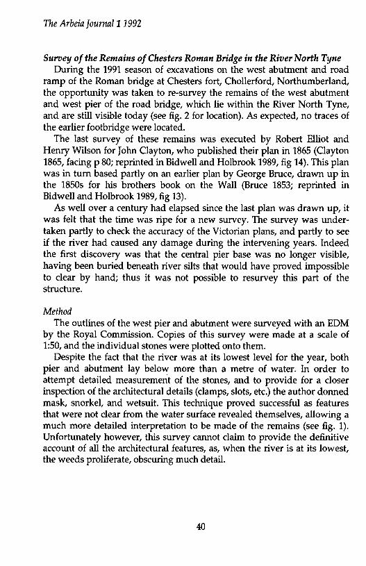
The Arbeia Journal11992
Survey of the Remains of Chesters Roman Bridge in the River North Tyne During the 1991 season of excavations on the west abutment and road
ramp of the Roman bridge at Chesters fort, Chollerford, Northumberland, the opportunity was taken to re-survey the remains of the west abutment and west pier of the road bridge, which lie within the River North Tyne, and are still visible today (see fig. 2 for location). As expected, no traces of the earlier footbridge were located.
The last survey of these remains was executed by Robert Elliot and Henry Wilson for John Clayton, who published their plan in 1865 (Clayton 1865, facing p 80; reprinted in Bidwell and Holbrook 1989, fig 14). This plan was in turn based partly on an earlier plan by George Bruce, drawn up in the 1850s for his brothers book on the Wall (Bruce 1853; reprinted in Bidwell and Holbrook 1989, fig 13).
As well over a century had elapsed since the last plan was drawn up, it was felt that the time was ripe for a new survey. The survey was undertaken partly to check the accuracy of the Victorian plans, and partly to see if the river had caused any damage during the intervening years. Indeed the first discovery was that the central pier base was no longer visible, having been buried beneath river silts that would have proved impossible to clear by hand; thus it was not possible to resurvey this part of the structure.
Method The outlines of the west pier and abutment were surveyed with an EDM
by the Royal Commission. Copies of this survey were made at a scale of 1:50, and the individual stones were plotted onto them.
Despite the fact that the river was at its lowest level for the year, both pier and abutment lay below more than a metre of water. In order to attempt detailed measurement of the stones, and to provide for a closer inspection of the architectural details (clamps, slots, etc.) the author donned mask, snorkel, and wetsuit. This technique proved successful as features that were not clear from the water surface revealed themselves, allowing a much more detailed interpretation to be made of the remains (see fig. 1). Unfortunately however, this survey cannot claim to provide the definitive account of all the architectural features, as, when the river is at its lowest, the weeds proliferate, obscuring much detail.
40

""" .....
I
I
I
-~
I
I
\..- ....... ,
I
--~ ~ "' ·-~o <?-ot-Q
11 a
TAENC~ ' ' L !DGE '"I ~I
I
I
I
MODERN RIVER BANK
WEST ABUTMENT
0
WEST PIER
10m
Fig. 1: The Remains of the West Pier and Abutment of Chesters Roman Bridge as Surveyed Summer 1991. (Drawn by I. Hagan)
~ "' )...
g. i::i• 'o' ;::
i """' 1---l \0 <.o N
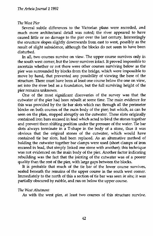
The Arbeia Journal11992
The West Pier Several subtle differences to the Victorian plans were recorded, and
much more architectural detail was noted; the river appeared to have caused little or no damage to the pier over the last century. Interestingly the structure slopes slightly downwards from east to west, possibly as the result of slight subsidence, although the blocks do not seem to have been disturbed.
In all, two courses survive on view. The upper course survives only in the south west corner, but the lower survives intact. It proved impossible to ascertain whether or not there were other courses surviving below as the pier was surrounded by blocks from the bridge, which were impossible to move by hand, that prevented any possibility of viewing the base of the structure. There must have been at least one course below the one on view, set into the river bed as a foundation, but the full surviving height of the pier remains unknown.
One of the most significant discoveries of the survey was that the cutwater of the pier had been rebuilt at some time. The main evidence for this was provided by the tie bar slots which ran through all the perimeter blocks on both courses of the main body of the pier; but which, as can be seen on the plan, stopped abruptly on the cutwater. These slots originally contained iron bars encased in lead which acted to bind the stones together and prevent them shifting position under the pressure of the water. Tie bar slots always terminate in a T-shape in the body of a stone, thus it was obvious that the original stones of the cutwater, which would have contained tie bar slots, had been replaced. As an alternative method of holding the cutwater together bar clamps were used (short clamps of iron encased in lead, that simply linked one stone with another); this technique was not evidenced on the main body of the pier. Another factor indicating rebuilding was the fact that the jointing of the cutwater was of a poorer quality than the rest of the pier, with large gaps between the blocks.
It is probable that much of the tie bar of the lower course survives, sealed beneath the remains of the upper course in the south west corner. Immediately to the north of this a section of tie bar was seen in situ; it was partially obscured by rubble, and ran on below the upper course.
The West Abutment As with the west pier, at least two courses of this structure survive.
42

The Arbeia Journal11992
However, any possible lower courses were again obscured by tumble from the bridge.
As indicated on the plans of the previous century, the north end of the abutment has suffered much damage; indeed only the lower course survives at this point. The upper course to the south, which survives essentially intact, is regularly laid out, and every block, with one exception, has a lewis hole.
On the upper course there is no tie bar slot, but on the southernmost stone of the lower course on view (see plan) a tie bar survives in situ, partly preserved by silting. It runs on southwards below the upper course. However, as with the west pier, the slot is not continued to the north. Also, with the exception of one stone with two (which in itself indicates reuse), none of the stones on the lower course has lewis holes, and their layout follows a more haphazard pattern. Thus it appears that, as with the pier, the north end of the abutment has been rebuilt at some point.
At least one stone on the upper course of the abutment has also been reused, as it contains a bar clamp slot that is not reciprocated on the opposite stone. Whether this stone has been reused from the original footbridge or represents a repair to the structure is unclear, although on balance the former is more likely.
The rear (west) edge of the abutment exists as planned, that is to say no further stones exist at the same level. Again there may be a lower course, but the accumulation of rubble and river silts made it impossible to check. Essentially though, this edge represents either the point at which the abutment reached the riverbank, or the edge of a phase of robbing of the abutment. It may well be that this area was originally filled with rubble from the road ramp.
The south end of the abutment is a little more confused, with remnants of two different courses surviving below the water-line. The lower of the two, still one course higher than the rest of the abutment, contains a tie bar slot on its edge. It may be that alternate courses of the abutment contained tie bars.
Further still to the south, the next set of stones are a course higher still, although the stones from the river frontage are missing.
So far as it was possible to see, both these courses appeared to be set onto river gravels. Thus it seems that the bottom course of the abutment stepped up as the river bed rose towards the bank. This may also explain
43

The Arbeia ]ournal11992
the line of the rear edge of the abutment; the next higher course perhaps continued further west.
Concluding Remarks Although it was not possible to study features such as dowel holes and
crowbar slots in detail1 this survey has revealed much new information about the foundations of the road bridge at Chesters. Not only is the relationship of the abutment to the riverbank more fully understood; it is also clear that1 for some reason/ probably to repair damage/ the north end of both the pier and the abutment were extensively/ if roughly/ rebuilt.
Inevitably there is still more that could be done to provide a fuller survey/ such as the clearance of the central pier1 or a search for traces of coffer dams that the Roman engineers presumably employed when constructing the bridge. However such work would not be possible without building a modem coffer dam around each structure1 which would make such a survey prohibitively expensive. Also it is unlikely/ even in quite severe drought conditions/ that the river would ever run dry enough for more detailed survey to take place as/ since the construction of Kielder dam/ water is pumped down the North Tyne in drought conditions from the reservoir in order to keep the level of the Tyne up.
Acknowledgements Thanks are due to Keith Blood and Mark Bowden of the Royal Commis
sion (Newcastle) who carried out the outline survey of the remains1 and to Darnian Robinson who assisted in the detailed survey. Thanks are also due to Chesters Estate for permission to carry out the work. The project was funded by English Heritage. W.B. Griffiths
Bibliography Bidwell P.T. and Holbrook N. 1989 Hadrian's Wall Bridges1 HBMC Arch.
report 91 London. Bruce J.C. 1853 The Roman Wall1 2nd edn1 Newastle upon Tyne. Clayton J. 1865 The Roman Bridge of Cilemum1 Archaeologia Aeliana ser 2/ 61
80-6.
44
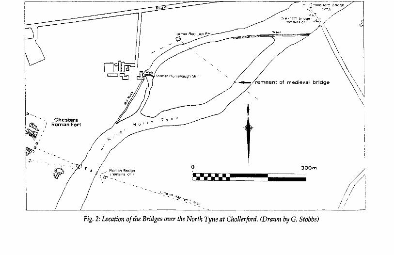
!:1~
tlJ;., ', Chesters ~ ''' Roman Fort
~~/
~tjf)
f - -. -
OotJUc!l c=:lt:t::J
-... -...
'· -...
--. c~ollerrora ::3naqe ..;.-z. :r-:-s -~-~'"1,
~~~;~:;~~~~?(e :1~'1>._//
\
\ cemnant of medle•al bcodge ~ \
\i 'I .\!
\ "
i
I I --'o•/ /~~ y~ ~'
- -(J23n f : - '.. '!•If I I ! - I .1 I
I f / .
]., ... _ ...
fir 0 300m
Roman Boage 1~ trema1ns of '; \r:r-\
••••• '--.I_I_m
Fig. 2: Location of the Bridges over the North Tyne at Chollerford. (Drawn by G. Stobbs)
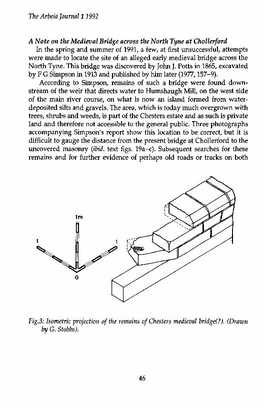
The Arbeia Journal11992
A Note on the Medieval Bridge across the North Tyne at Chollerford In the spring and summer of 1991, a few, at first unsuccessful, attempts
were made to locate the site of an alleged early medieval bridge across the North Tyne. This bridge was discovered by John J. Potts in 1865, excavated by F G Simpson in 1913 and published by him later (1977, 157-9).
According to Simpson, remains of such a bridge were found downstream of the weir that directs water to Humshaugh Mill, on the west side of the main river course, on what is now an island formed from waterdeposited silts and gravels. The area, which is today much overgrown with trees, shrubs and weeds, is part of the Chesters estate and as such is private land and therefore not accessible to the general public. Three photographs accompanying Simpson's report show this location to be correct, but it is difficult to gauge the distance from the present bridge at Chollerford to the uncovered masonry (ibid. text figs. 19a-c). Subsequent searches for these remains and for further evidence of perhaps old roads or tracks on both
1m
0
Fig.3: Isometric projection of the remains of Chesters medieval bridge(?). (Drawn by G. Stobbs).
46
The Arbeia Journal11992
sides of the river revealed nothingl and it was assumed that river erosion had destroyed all traces of any bridge remains that may have existed.2
A final search was more successful. This was aided by the information provided by a person walking along the western river bank who had noticed that some stonework was visibly protruding, due to the low river level. Hence, a portion of masonry was located, (see Fig. 2) jutting out at right angles to the bankside into the river itself. This matched that described by Simpson and consisted of three courses of dressed freestone (local sandstone) blocks, each c. 850mm long, 430mm wide and 200mm deep, (see Figs. 3 & 4). The blocks of the uppermost course were different in size, being only 500mm long, wider at 620mm, but still 200mm deep. They had a chamfer, 125mm wide, on one edge (the outer edge of the structure) identifying it c.:s the masonry Simpson described. Only the lowest course was seen to have iron cramps set in lead, measuring 200mm in length, as noted by Simpson, although the edges of only two blocks were visible. Simpson's photographs appear to show cramps in situ on the middle course just below the chamfered blocks. The only block with a cramp was dislodged, probably by the force of the river, by some 20 degrees angle in a downstream direction. A feature not noted during Simpson's investigations was a wood beam 300mm square, of which nearly 3m was surviving, underlying the three courses of stonework. It was preserved here, presumably, by it being under the water level, which on the day of our examination also covered the lower course of blocks.
Simpson's report, and photographs, record three sides of the structure surviving, which he termed the north side, east side and northeast turn. His interpretation was that these formed the eastern abutment of an early bridge. He also goes on to state that the east side had originally fronted the river, although it is not clear what evidence he had to suggest that the river had moved so substantially south eastwards. There can be no doubt that the remains located in this survey are the same as those described by Simpson and presumably it is a remnant of the east side, exposed due to river erosion of the bankside.
From the evidence of the physical remains it is not easy to identify this masonary as any part of a bridge. Indeed it is difficult to envisage what type of superstructure this abutment could have supported, although clearly, not a stone arched bridge similar to that of the present bridge. There is no evidence that any masonry ever existed above the known chamfered course which, as Simpson's photographs show, went around all
47
The Arbeia Journal11992
three sides. Even allowing for the fact that the structure was well constructed with a rubble interior, at less than 1m high this need only have acted as a base, either at water level or in the water, for a timber bridge. This may have been the case if this is in fact the earliest post-Roman bridge site. Rigold remarks (1975, 49) that, from documentary evidence, it appears that most major bridges were entirely of timber until the C14th.
Other remains about 10m downstream, consisting of a number of large roughly dressed stone blocks of approximately 600-700mm square, could be seen lying just under the water surface. One stone had an incised X marked upon it but further investigation of these blocks was not possible. These may not be associated with the so-called abutment and could instead be masonry from any of the later bridges at Chollerford that were damaged by floods, washed downstream. Simpson also had evidence of a pier; the eastern edge of which was seen by Mr Potts and marked on a sketchplan. Simpson had this sketchplan in his possession during his 1913 excavation, but was unable to locate the pier.
Documentary evidence shows an early bridge at Chollerford at some point prior to 1394, when Bishop Waiter Skirlaw of Durham granted an indulgence for assistance towards its restoration (Mackenzie, 1827, 242). Hence, a re-built or newly built stone bridge of four arches was completed. By c1569 this bridge appears to have been in ruins and a ford existed instead according to a C16th ballad entitled 'Jock o'the side' (Tomlinson, 1910, 183). By 1718, it was reported by the Grand Jury at the Northumberland Sessions that Chollerford Bridge, lying upon the King's High Street from Carlisle to Newcastle, had fallen down and was in need of repair and also that the early ford was dangerous to cross (Hodgson, 1897, 169). In 1733, damage to a bridge by flood was recorded and due to the Great Flood of 1771, a bridge was totally destroyed and replaced by the current Chollerford Bridge in 1775 (ibid 169). The remains immediately south-west of the existing bridge (NY9196, 7051), consisting of terminal buttresses and two piers3, could be the site of all these earlier bridges, or at least those from 1394 onwards.
Simpson observed that the late medieval road noted by Horsley (1732, 144 and map between 158-9) and erroneously termed by him the 'Military Way', follows a route across the site of the Roman Fort from Walwick through its North Gate, and on towards a building on the west bank of the river which was formerly known as The Red Lion Inn. This route is then seen to continue up the east bank, northeastwards, suggesting that this is
48
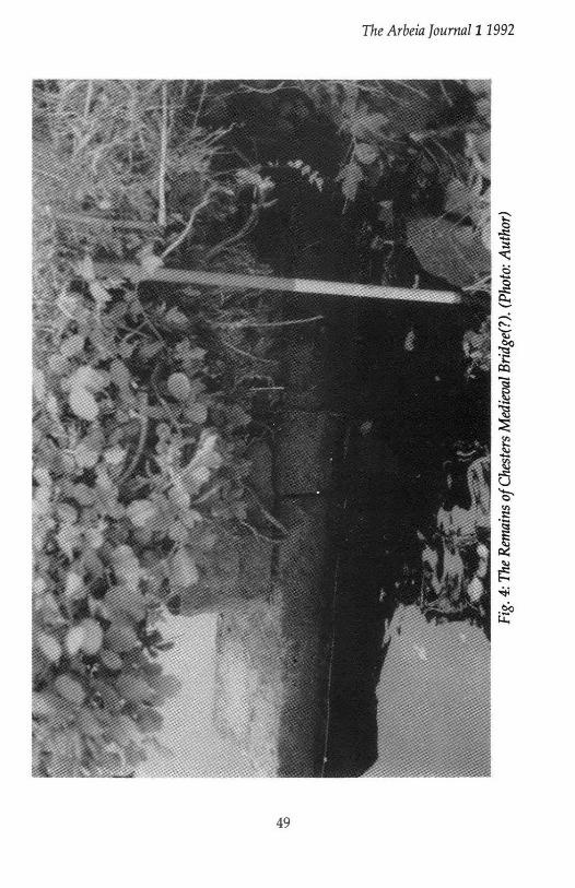
The Arbeia Jour1Ull11992
49

The Arbeia ]ournal11992
where the route must have crossed the river, lending support to Simpson's identification of these remains as being those of a bridge.
In conclusion, the physical evidence offers no substantive identification to the structure as being a bridge abutment, and no clear date can be fixed, except to say that the remains are post-Roman and pre-1775. Such was the use of rivers in the post-medieval period as a power source, that an abundance of masonry can be found in most rivers of Northumberland and Durham. This is evident by the existence of the weirs in the North Tyne at present and it may be that these remains can be associated with this form of activity instead.
The documentary evidence is also inconclusive, as shown by the presence of earlier bridge remains next to the present Chollerford Bridge. Thus, only by future investigation, especially excavation, can the mystery of these remains be solved. However, while this note was in preparation, part of an abutment of an early bridge on the Tyne at Corbridge, possibly dating to 1235, was unearthed. This was constructed of similar sandstone blocks, with a chamfered top course.4It is certainly tempting to see this as a possible parallel to the Chollerford remains, but much work remains to be done. G. Stobbs
Footnotes 1. Ordnance Survey Record Card NY97SW24. Information supplied by F
H Colquhoun, 4/4/56. 2. Ordnance Survey Record Card NY97SW24. Information supplied by J I
Davidson, 25/1/62. 3. Ordnance Survey Record Card NY97SW25. Information supplied by R
W Emsley, 14/11/66. 4. Tyne Valley Herald & Post (1/10/92, p1; 8/10/92, p3). Hexham
Courant (9/10/92, p5).
Bibliography Hodgson, J.C. 1897 Northumberland County History, Vol IV. Horsley, J. 1732 Britannia Romana. Mackenzie, A. 1827 A view of Northumberland, Vol II. Rigold, S.E. 1975 Structural aspects of medieval timber bridges, in Medieval
Archaeology, Vol XIX, 48-91. Simpson, F.G. 1977 Watermills and military works on Hadrian's Wall:
50
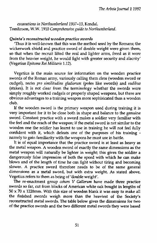
The Arbeia Journal11992
excavations in Northumberland 1907-13, Kendal. Tomlinson, W.W. 1910 Comprehensive guide to Northumberland.
Quinta's reconstructed wooden practice swords 'Thus it is well-known that this was the method used by the Romans; the
wickerwork shield and practice sword of double weight were given them, so that when the recruit lifted the real and lighter arms, freed as it were from the heavier weight, he would fight with greater security and alacrity' (Vegetius Epitoma Rei Militaris 1.12).
Vegetius is the main source for information on the wooden practice swords of the Roman army, variously calling them clava (wooden sword or cudgel), vectes pro similitudine gladiorum (poles like swords) and sudibus (stakes). It is not clear from the terminology whether the swords were simply roughly worked cudgels or properly shaped weapons, but there are obvious advantages to a training weapon more sophisicated than a wooden club.
If the wooden sword is the primary weapon used during training it is very important for it to be close both in shape and balance to the genuine sword. Constant practice with a sword makes a soldier very familiar with the feel and the reach of the weapon; if the metal sword is not similar to the wooden one the soldier has learnt to use in training he will not feel fully confident with it, which defeats one of the purposes of his training -namely to gain familiarity with the weapons he must use in battle.
It is of equal importance that the practice sword is at least as heavy as the metal weapon. A wooden sword of exactly the same dimensions as the metal weapon will naturally be lighter in weight; this gives the soldier a dangerously false impression of both the speed with which he can make blows and of the length of time he can fight without tiring and becoming slower. A practice sword therefore needs to be of the same general dimensions as a metal sword, but with extra weight. As stated above, Vegetius refers to them as being of 'double weight'.
The re-enactment group cohors V Gallorum have made three practice swords so far, cut from blocks of American white oak bought in lengths of 50 x 70 x 1220mm. With this size of wooden blank it was easy to make all the finished swords weigh more than the heaviest of the Society's reconstructed metal swords. The table below gives the dimensions for two of the practice swords and the two different metal swords they were based
51
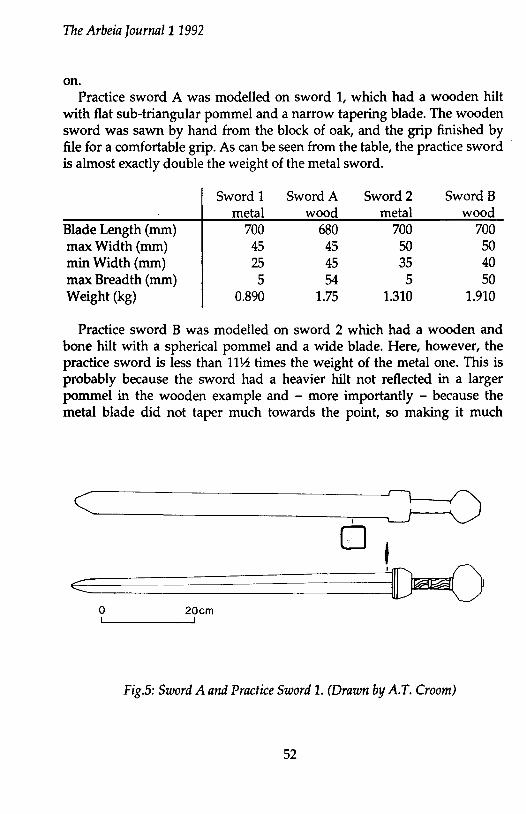
The Arbeia ]ournal11992
on. Practice sword A was modelled on sword 1, which had a wooden hilt
with flat sub-triangular pommel and a narrow tapering blade. The wooden sword was sawn by hand from the block of oak, and the grip finished by file for a comfortable grip. As can be seen from the table, the practice sword is almost exactly double the weight of the metal sword.
Sword 1 Sword A Sword2 Sword B metal wood metal wood
Blade Length (mm) 700 680 700 700 max Width (mm) 45 45 50 50 min Width (mm) 25 45 35 40 max Breadth (mm) 5 54 5 50 Weight (kg) 0.890 1.75 1.310 1.910
Practice sword B was modelled on sword 2 which had a wooden and bone hilt with a spherical pommel and a wide blade. Here, however, the practice sword is less than 11 ~ times the weight of the metal one. This is probably because the sword had a heavier hilt not reflected in a larger pommel in the wooden example and - more importantly - because the metal blade did not taper much towards the point, so making it much
c~--------~.~J 0 o,
?=c~~~-=-=======3'1J@~ 0 20cm
Fig.5: Sword A and Practice Sword 1. (Drawn by A.T. Croom)
52
The Arbeia ]ournal11992
heavier than that of Sword 1. This could theoretically be corrected by making a larger pommel and thicker blade on the wooden sword, but in practise the weight that could be added would be limited by the restriction imposed by the hilt. Since the grip of the hilt has to remain basically the same as ori a metal sword so that it can be held by the soldier, extra weight on the blade will put more strain on the junction between hilt and blade. So far coho'rs V gallorum has done no research into how much weight can be put in the blade before the junction is made too weak for efficent use of the wooden sword.
All the practice swords have been used against a post. All three can be used with proficiency - for a short time - after training to get used to the weight, but no-one has yet been keen enough to try using one 'for the greater part of the day, until the sweat runs off them' as Vegetius suggests (3.4)!
In conclusion, it is clear from our preliminary studies that double weight swords can be made very simply when based on the lighter metal examples, but would be more difficult for heavier swords. However, the priority was presumably simply for the practice sword to be heavier than the metal sword, and as long as this was achieved there would be no serious problem in using a less then double weight wooden sword as a training weapon. ATCroom
53

54

The Arbeia Journal11992
EXCAVATIONS UNDERTAKEN BY TYNE AND WEAR MUSEUMS ARCHAEOLOGY
DEPARTMENT IN 1991-2
Compiled by M E Snape South Shields (Figures 1 and 2)
Excavation continued in the eastern quadrant of the fort, as part of the programme funded by South Tyneside MBC and augmented by the Employment Training scheme.
The earliest activity so far located was a well-preserved round-house of the pre-Roman Iron Age. Destruction by fire had caused the collapse of a large quantity of burnt material onto the floor, and this has been sampled for environmental analysis.
The round-house was sealed by a large square of metalling. Comprising a well-engineered raft of heavy cobbles and a fine gravel surface, it has been interpreted as a parade ground. It was cut by the defensive ditches of the mid-Antonine stone fort, and is therefore assumed to belong to an earlier turf and timber fort, as yet unlocated.
The next phase of activity on the site consisted of barrack blocks of the third century supply base. These were of two structural periods. The work of previous seasons had shown each to consist of an officer's quarters and five contubernia, each divided by L-shaped partitions: excavation in 1991-2 revealed more of their plan.
The latest Roman activity revealed in the recent excavations was the western wing of the large fourth century courtyard house thought to be the residence of the commanding officer. Excavation of the house has been carried out since 1985 and is now complete. The western range contained an impressive entrance hall and a bath suite. The former had a central stone-lined tank for an ornamental pool, flanked by two rows of three pier bases for columns. The bath suite contained two heated rooms, a furnaceroom and two other rooms. Originally equipped with one hot plunge bath and one cold, a third apsidal bath was added later. (Summary by N Hodgson)
55
Ul 0\
1- 1 _, I 1 I
I ...J L
1-., I I
parade ground
~~-. :. ~ :-: :.~· ~:~·1·:.~ .. --:-:.~ ~:--:--::·::-=-:·-::' . . . . . . . . . . . . . . . . . . . . . I :- : : . : . . . : . . ·. . : : ... -: ... I~·. . . . . . ~ . ~ . . . . . ~ . I· .. ·. .
1.':: : . . · .. I·· ... I:. I· . .
I·:- . . r·-:-·:- -~ I .... ·. ·.
. ....... . .
I : : . .' .' . . · - ... ,,~·-:;,:•;: ) 11 I . • . .... ....... :. :-.:,·.·:•::'::!'· .;.:;-::. I . . . . . . . . :::...:-::::::·-~ -:::·::·.=.:;:~~~;;:_=!:~~==1.~ :~;~:,~:~;§.;-{.:~~ =!!~:::: 11 I : ·. ·. ·-: ·. : · . ·.··-it\¥~ ~~%i.~,i~i\T!~i't ·Z ~~;l!f~lii~f.'ic, ' 1
I . . . . y-01'· ··-·~···--~·-···-····--·· .,, ... , .... ,., .... "' # I I · · ·. · · . ·: · · . !,,~.=:;:P ·~=·=:;:~~f~?:r:::~~:.~::::.:p.-(.·::=. .'=·: ::::..:;· :~: :::.:.: v . . . . . ., ........ ~· ... ,::.:·.-:·)/'· . . . . . ~ .. ~., ~ I r. ·.::. :<: ·. : . ·:-: :r :'~'t4f::_.·.::: ·. :·.··:":.'-j ~ ; ; I . . . . . . . . . r . ·:~=:~·=:.,. . . . . . . . . . .. ·~ / ; . . . . . . . . . ::~:·:~:·.-::.· . . . . . . . . . . . . / I• • • • • • • • • • •• ~ •••. :,;.•·.-::-..· • • • • • • • • • • / ...... · ..... '!&..·~·-·------. ·~ --' - - - - - - ;-.;·,;~ / /
-- ~~%,i //
--r--
o 20m
Fig.l: South Shields: Iron Age round-house underlying parade ground of late Hadrianic or early Antonine date. Wall of third century supply base shown as dashed line. Scale 1:400. (Drawn by R Oram).
~ "" ;:t..
it s· '0' :;:::
i 1-4 ..... \0
~
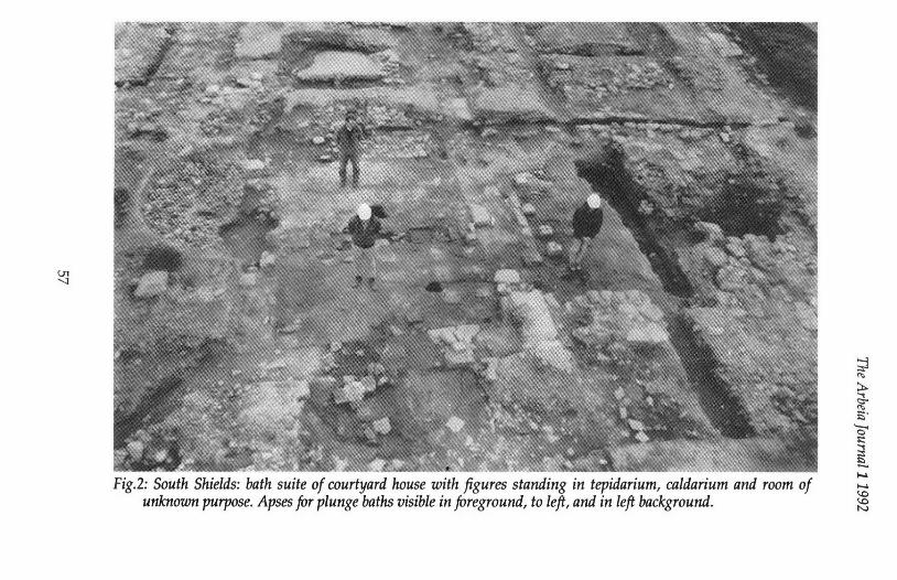
U"l '-1
Fig.2: South Shields: bath suite of courtyard house with figures standing in tepidarium, caldarium and room of unknown purpose. Apses for plunge baths visible in foreground, to left, and in left background.
~ "' ::t.. ~ j5•
'0' ;::
~ ..... ...... ~
~
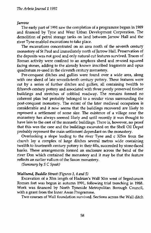
The Arbeia Journal11992
farrow The early part of 1991 saw the completion of a programme begun in 1989
and financed by Tyne and Wear Urban Development Corporation. The demolition of petrol storage tanks on land between Jarrow Hall and the river Tyne enabled excavations to take place.
The excavations concentrated on an area north of the seventh century monastery of St Paul and immediately north of Jarrow Hall. Preservation of the deposits was not good and only natural cut features survived. Traces of Roman activity were confined to an amphora sherd and re-used squared facing stones, adding to the already known inscribed fragments and opus quadratum re-used in the eleventh century monastery.
Pre-conquest ditches and gullies were found over a wide area, along with one sherd of late seventh-tenth century pottery. These features were cut by a series of further ditches and gullies, all containing twelfth to fifteenth century pottery and associated with three poorly preserved timber buildings and stretches of cobbled roadway. The remains formed no coherent plan but probably belonged to a secular vicus surrounding the post-conquest monastery. The extent of the later medieval occupation is considerable and it now seems that the buildings recovered are likely to represent a settlement of some size. The existence of a village near the monastery has always seemed likely and until recently it was thought to have lain to the east of the monastic buildings. There is, however, no proof that this was the case and the buildings excavated on the Shell Oil Depot probably represent the main settlement dependant on the monastery.
Overlooking a slope leading to the river Tyne and c 325m from the church lay a complex of large ditches several metres wide containing twelfth to fourteenth century pottery in their ffils, succeeded by stone-faced banks. These arrangements formed an enclosure across the bend of the river Don which contained the monastery and it may be that the feature reflects an earlier vallum of the Saxon monastery.
(Sumnuzry by S C Speak)
Wallsend, Buddle Street (Figures 3, 4 and 5) Excavation of a 30m length of Hadrian's Wall 50m west of Segedunum
Roman fort was begun in autumn 1991, following trial trenching in 1988. Work was financed by North Tyneside Metropolitan Borough Council, with a grant from the Inner Areas Programme.
Two courses of Wall foundation survived. Sections across the Wall ditch
58
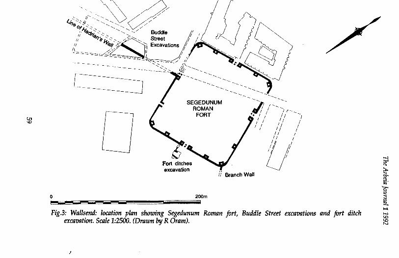
U1 \C)
0
··,"'0 'l/ f~~ ,, / . I "\ / / ', / // .·. , .. <.·-.. / , , !/'.. I ~''$, '•, -¥ Budd~ ' ' J/ r::J. •o,~t,''•· •, .... , 1 ' ~ 1
; \?0'11<?;;;,'-::-~,v/-:;;·0-:::::-, Excavations/~""""""' j " "'""" :: ' -~ " /" ' ' ,? • '"'-"------/~~~~ ~ ~ ~c---- ,/ ''• '<.
~~~----------~----- ----~~7'' .1t.:.--:::_··--... ____ ' ---~--- ---. ______ --... __ _
[ ____________ ] SEGEDUN ,/! ' I; I
UM I 1 1 r~ ~ _
fort ditches excavation
1 r--......__
ROMAN &• • / I I 1 I FORT I I I I I
!/ Branch Wall
200m
1 I I 1 I I I I I
Ull /
I I
I
Fig.3: Wallsend: location plan showing Segedunum Roman fort, Buddle Street excavations and fort ditch excavation. Scale 1:2500. (Drawn by R Dram).
)
;J "" ~ ~ 5" 0" ;::
~ ...... ~ (,0
:e
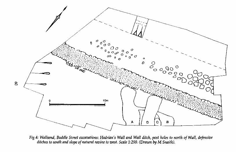
~ !-~~ ---......__
-----......_ __ ~_
/ // ~~~
0 10m
l - uu- _==-::t
----
----
0
0
---------------
--- --- --._
-- -.. --- --
--- -..._
0 -..._
----0 0
Fig.4: Wallsend, Buddle Street excavations: Hadrian's Wall and Wall ditch, post holes to north of Wall, defensive ditches to south and slope of natural ravine to west. Scale 1:200. (Drawn by M Snaith).
-..._
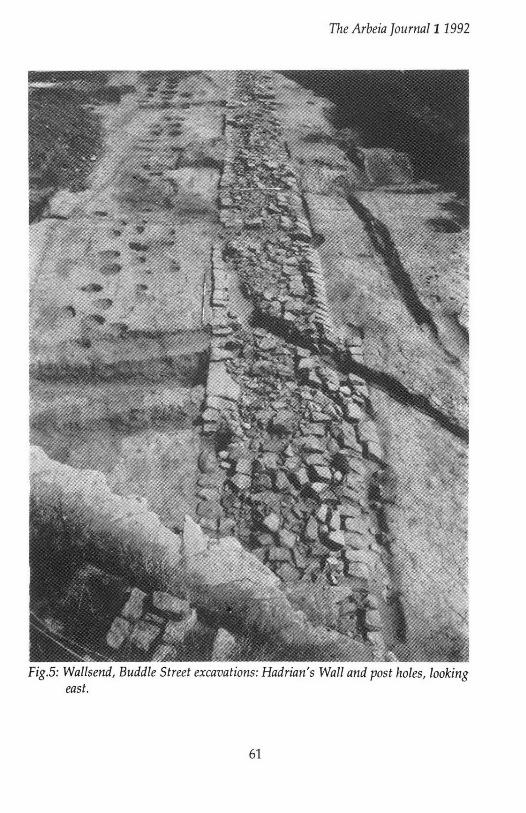
The Arbeia ]ourna/11992
Fig.S: Wallsend, Buddle Street excavations: Hadrian's Wall and post holes, looking east.
61

The Arbeia ]ournal11992
indicated it was shallower than that seen elsewhere along the frontier. A complex of ditches ran southwards at right angles from the Wall. A
pair of ditches (A and B), recut on at least one occasion (C), had been filled in and replaced by a single ditch (D; initially located in 1988), itself recut or extended. The system was clearly defensive rather than for drainage, and there may have been associated earth banks. Pottery from the ditch fills was all of the third century. It is suggested that this represents the construction of defences along the western side of the civil settlement to the southwest of the fort, already bounded to the east by a branch of Hadrian's Wall and to the south by the river Tyne. The new defences appear to parallel those constructed around towns in southern Britain at the same date.
Along the berm to the north of the Wall were three rows of post holes of two distinct types. Those to the east were large, deep and evenly spaced in a staggered arrangment: those in the centre and to the west of the site were smaller and irregularly spaced. It was noticeable that the former were eoterminal with the ditches to the south of the Wall and may represent additional frontier defences in the area of the vicus. (Summary by M E Snape)
Wallsend fort ditches (Figure 3) Excavation of the ditches outside the south gate of Segedunum fort took
place in the spring of 1991 following trial trenching in 1990. Work was carried out on behalf of North Tyneside MBC, prior to landscaping.
Two shallow primary ditches had been recut and extended across the causeway, narrowing the approach road to the gate. Beyond them a third ditch, dug across the full width of the road, cut off access to the gate completely. A latrine pit was also found on the berm.
All three ditches went out of use in the third century, their fills sealed beneath road metalling consisting of stones probably derived from the fort wall. The southern side of the fort may no longer have required defensive ditches if the vicus surrounding it had acquired defences at that date, as described above.
Chesters Roman bridge Excavations in spring 1991 ended a two season campaign of work on the
west abutment of the bridge, carried out with funding from English Heritage, in advance of consolidation work at the site to prevent further
62
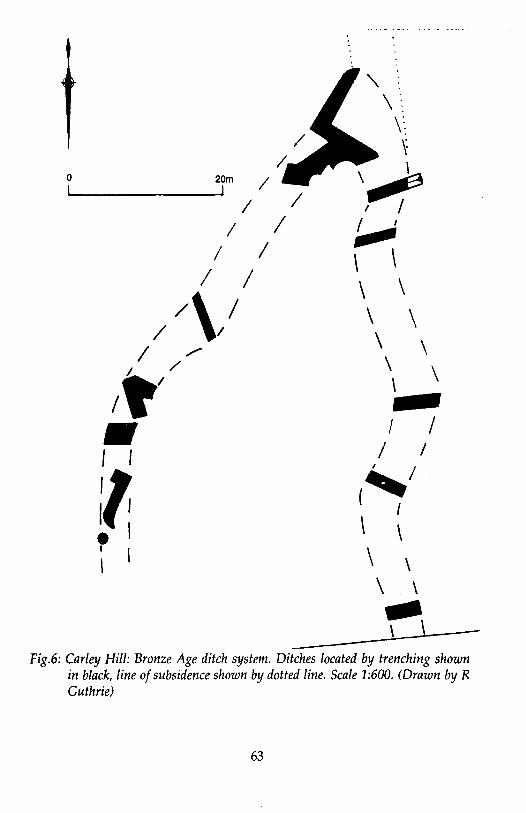
0 20m
I 1 I
I I I I
/\I / I
I ,... I /
/~/
• I l
~~ • I I I
\ \ \ \ \ \ 2 I
\
\
I I I I (' I
\ \ \ \ \ \
~\ Fig.6: Carley Hill: Bronze Age ditch system. Ditches located by trenching shown
in black, line of subsidence shown by dotted line. Scale 1:600. (Drawn by R Guthrie)
63
The Arbeia Journal11992
erosion of the remains by the river North Tyne. A section of Hadrian's Wall revealed on the site stood to a height of 2m
and was of broad gauge. The position of the road, now seen to be running behind the western tower onto the bridge, was elucidated, and the revetting wall for the road ramp was clearly revealed. Dating evidence showed that the road bridge had been constructed at the time of the Antonine withdrawal from Scotland, in the second half of the second century AD. Subsequently the road level was raised five times, and a structure was built between the road and Hadrian's Wall at the head of the bridge.
In addition a survey was carried out of the remains of the bridge visible in the river (see Notes section above), and geophysical prospection was carried out to the south and west of the excavation. (Summary by W B Griffiths)
Oakwellgate, Gateshead Excavation was carried out on behalf of Gateshead MBC in 1991,
following trial trenching in 1990. Land scheduled for redevelopment to the east of St Mary's church may lie within the precinct of a monastery mentioned by Bede. A wall of twelfth century date survived to a height of 10 courses and overlay earlier pits.
Carley Hill, Sunderland (Figure 6) Excavation was carried out in 1992 on behalf of Sunderland City Council
on land scheduled for redevelopment, following trial trenching in 1990-1. The area lies on a boulder clay plain surrounded by urban development,
the Fulwell quarries or land-fill operations. The site lies within 1.5 km of the river Wear, at a height of c170 feet and commands extensive views in all directions, but rests upon a plateau of no great defensive capability. There have been several finds of isolated burials of bronze age date in the area of the Fulwell quarry, almost all in the last century and their recording is virtually non-existent. A study of aerial photographs revealed no trace of archaeological features, and the earliest maps of the area merely confirmed our impressions that the area had been under the plough until fairly recent times. Excavation in the face of severe elemental distractions recovered a series of broad ditches 6m wide and 0.60m deep. In some unexcavated areas between trenches, the line of the ditches could be distinguished by slight subsidence into them: the extension of this subsidence to the north
64
The Arbeia Journal11992
suggested the system continued northwards. The occasional remains of a turf bank were represented by layers of clay up to 30cm in depth which contained blocks of black fibrous material representing individual turves. The excavation of this ditch revealed that its base was metalled by a very compacted layer of cobbles up to 60mm in size, particularly in the eastern or outer half of the ditch. Embedded in the cobbles were considerable quantities of charcoal, and this yielded a radio-carbon date of 3,790 ± BP, i.e. 1840 ± 80 years BC. This single date may not be relied upon, as pottery sealed below the cobbles and resting directly upon undisturbed natural subsoil is likely to belong closer to clOOO BC. A pollen diagram taken through the silts filling the ditch shows progressive deforestation of alder associated with the appearance and/ or increase in ruderal plants, suggesting cereal cultivation nearby. The strongest parallel for the Carley Hill system comes from the well-documented Dartmoor reave system. At Shaugh Moor a similarly sized ditch was interpreted as a hollow way with an adjacent bank, and containing the miraculous preservation of the hoofprints of cattle and sheep that used it. The section is virtually identical to that of the Carley Hill example.
The Carley Hill excavations have thus produced one of the earliest settlement-related sites in Northern Britain, representing a lowland equivalent of better documented sites in the uplands. This in itself is not unexpected and the site fills a lacuna in the known settlement chronology of the later prehistoric period; its discovery will undoubtedly assist in the interpretation of other sites currently with little or no supporting dating evidence. However, of the most fundamental concern was the accidental discovery of the site whilst exploring the pattern of post-medieval ridge and furrow ploughing. Albeit possessing a ditch, in places, 6m wide and 0.60m deep, no trace of the site is known from aerial photographs, despite the most exhaustive examination. Geophysical survey over the site was similarly inconclusive, even though the line of the ditch was known prior to the survey. (Sumrrulry by S C Speak)
In addition to the above sites, staff from the Archaeology Department, based at Arbeia, also carried out many smaller projects such as trial trenches, watching briefs and site evaluations, as well as carrying out much needed consolidation and repair work at several sites in the region. Much
65
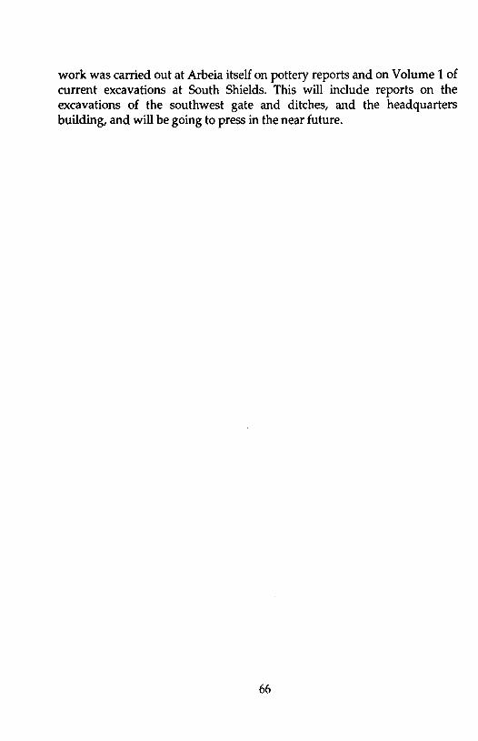
work was carried out at Arbeia itself on pottery reports and on Volume 1 of current excavations at South Shields. This will include reports on the excavations of the southwest gate and ditches, and the headquarters building, and will be going to press in the near future.
66

The Arbeia Journal11992
REVIEWS Shrines & Sacrifice. By Ann Woodward. Batsford/English Heritage, London, 1992. Pp.143, 10 col. plates & 95 illus. ISBN 0 7134 6080 6.
Yet another addition to what is now becoming a major series of popular books on archaeology from joint publishers English Heritage and Batsford. The evocatively titled Shrines and Sacrifice, however, differs from the other works in this series, which are either period or site specific, in that this book tackles the subject of religion and in particular, religious sites.
The author begins by giving her definitions of the title; 'shrine' refers to any place or building of whatever size, designed or used for ritual purpose, while 'sacrifice' is the practice of the religion itself. Early religious practice in Britain, particularly during the Iron Age and Roman periods, is a growth area of academic study and thus, perhaps, a large topic to cover. The author admits that this book is not intended to be a general study, but rather an analysis of particular religious sites of those periods. Her criteria for the inclusion or exclusion of sites appears to be those which have been excavated.since the 1930s, but more importantly those sites which provide evidence for her running theme, that of the continuity of use of sites throughout different periods. The evidence for this concept is drawn from a corpus of 32 excavations, mainly in the South of England, although sites in other areas are occasionally mentioned. This evidence is well presented and illustrated throughout, although it is perhaps chapters 2 through to 6 which best approach the continuity hypothesis. Chapter 2 looks at the placing of shrines and examines the re-use of Iron Age temple sites in the Roman period. Chapter 3 goes on to look at the structure of shrines and makes the comparison between Iron Age and Roman, as well as discussing the Romano-Celtic style. A description of religious practices, particularly beliefs and rituals, is found in chapter 4, with a strong emphasis on Celtic practice as well as the equation of Celtic deities with Roman. Chapter 5 examines the evidence of offerings and sacrifice - the physical remains that are preserved in the archaeological record. Comparisons are made between the Iron Age and Roman offerings to see if a pattern can be found. The symbolism of votive objects is discussed along with the practice of sacrifice itself. Burial practice as evident from cemeteries is examined in chapter 6, from Iron Age to Roman and on to late Roman and finally on into the Christian era. In the final chapters, 7 to 9, Christianity becomes the dominant topic of study with a look at the Roman church, the early
67
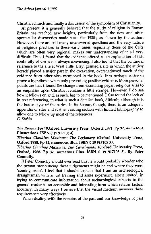
The Arbeia Journal11992
Christian church and finally a discussion of the symbolism of Christianity. At present, it is generally believed that the study of religion in Roman
Britain has reached new heights, particularly from the new and often spectacular discoveries made since the 1930s, as shown by the author. However, there are still many unanswered questions and the very nature of religious practices in these early times, especially those of the Celts which are often very regional, makes our understanding of it all very difficult. Thus I found that the evidence offered as an explanation of this continuity of use is not always convincing. I also found that the continual reference to the site at West Hills, Uley, granted a site in which the author herself played a major part in the excavation, overshadowed much of the evidence from other sites mentioned in the book. It is perhaps easier to prove a hypothesis when only presenting positive evidence. More personal points are that I found the change from examining pagan religious sites to an emphasis upon Christian remains a little strange. However, I do see how it follows on and, as such, has to be mentioned. I also found the lack of in-text referencing, in what is such a detailed book, difficult, although it is the house style of the series. In its favour, though, there is an adequate appendix of sites and further reading section with limited bibliography to allow one to follow up most of the references. G. Stobbs
The Roman Fort (Oxford University Press, Oxford, 1991. Pp 32, numerous illustrations. ISBN 0 19 917108 4). Tiberius Claudius Maximus: The Legionary (Oxford University Press, Oxford 1988. Pp 32, numerous illus. ISBN 0 19 917105 X). Tiberius Claudius Maximus: The Cavalryman (Oxford University Press, Oxford, 1988. Pp 32, numerous illus. ISBN 0 19 917106 8). By Peter Connolly.
If Peter Connolly should ever read this he would probably wonder who the person pronouncing these judgements might be and where they were 'coming from'. I feel that I should explain that I am an archaeological draughtsman with an art training and some experience, albeit limited, in trying to communicate information about archaeological subjects to the general reader in an accessible and interesting form which retains factual accuracy. In many ways I believe that the visual medium answers these requirements very effectively.
When dealing with the remains of the past and our knowledge of past
68
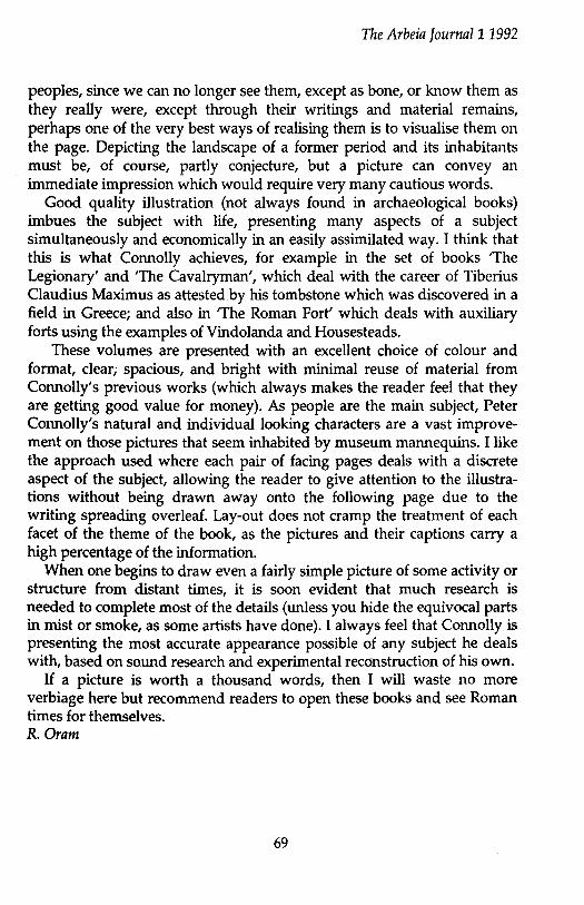
The Arbeia ]ournal11992
peoples, since we can no longer see them, except as bone, or know them as they really were, except through their writings and material remains, perhaps one of the very best ways of realising them is to visualise them on the page. Depicting the landscape of a former period and its inhabitants must be, of course, partly conjecture, but a picture can convey an immediate impression which would require very many cautious words.
Good quality illustration (not always found in archaeological books) imbues the subject with life, presenting many aspects of a subject simultaneously and economically in an easily assimilated way. I think that this is what Connolly achieves, for example in the set of books 'The Legionary' and 'The Cavalryman', which deal with the career of Tiberius Claudius Maximus as attested by his tombstone which was discovered in a field in Greece; and also in 'The Roman Fort' which deals with auxiliary forts using the examples of Vindolanda and Housesteads.
These volumes are presented with an excellent choice of colour and format, clear, spacious, and bright with minimal reuse of material from Connolly's previous works (which always makes the reader feel that they are getting good value for money). As people are the main subject, Peter Connolly's natural and individual looking characters are a vast improvement on those pictures that seem inhabited by museum mannequins. I like the approach used where each pair of facing pages deals with a discrete aspect of the subject, allowing the reader to give attention to the illustrations without being drawn away onto the following page due to the writing spreading overleaf. Lay-out does not cramp the treatment of each facet of the theme of the book, as the pictures and their captions carry a high percentage of the information.
When one begins to draw even a fairly simple picture of some activity or structure from distant times, it is soon evident that much research is needed to complete most of the details (unless you hide the equivocal parts in mist or smoke, as some artists have done). I always feel that Connolly is presenting the most accurate appearance possible of any subject he deals with, based on sound research and experimental reconstruction of his own.
If a picture is worth a thousand words, then I will waste no more verbiage here but recommend readers to open these books and see Roman times for themselves. R. Dram
69

The Arbeia ]ournal11992
Equus: The horse in the Roman World. By Ann Hyland. Batsford, London, 1990. Pp Xiii+285, 31 plates, 7 illus. ISBN 07134 6260 4.
Hyland approaches this theme, not as a historian, but rather as a rider, breeder, and trainer of horses. Thus her work tackles this wide ranging topic from a different perspective to that of others writing on the subject. This is not to imply that the work is in any way a light read; on the contrary Hyland is a most exacting scholar.
The book is divided, unequally, into three sections. The first covers basic horse practices, including breeding and veterinary care. The second, and largest, section is concerned with the role of the horse in the cavalry, as opposed to the role of the cavalry which is the more standard approach. Hyland emphasises concepts such as the abilities of the horses in battle, horse and rider training, supply and logistics, and animal health, using her own knowledge to supplement the often meagre sources. The third, and final, section of the book deals with the use of the horse in civilian life, the circus, and the public transport system.
When embarking on this venture Hyland turned to the primary sources for as much evidence as possible, supplementing and upgrading, rather than replacing, that evidence with her own equine knowledge. This included commissioning the first English translation of Pelagonius, the Roman veterinary surgeon; indeed it is to be hoped that the translation will be published in full at some point. Another aspect of her enthusiasm for the subject is demonstrated by her willingness to experiment with replica items of equipment (loaned by Peter Connolly), from shields and lances to saddles and bits, often while wearing ring mail! Indeed it is only from such complete experimentation that there is any chance of understanding the abilities required of both horse and rider in the Roman world. For instance, Hyland has shown that the cavalryman could have used pressure from the shield to cause his horse to turn instead of using the reins, allowing for a much faster response in battle, exactly where it is needed.
Another area covered by Hyland is that of horse health. These animals usually represented much investment in terms of time and money by their owners, whether they were individuals or the state, and many efforts were made to ensure the horses remained fit. For instance it would be in the cavalry's interests to keep the number of remounts required to a minimum in order to save on stabling, grooming, fodder, and the like. This could only be achieved if the horses in stock were well tended, kept free from disease and so on. As Hyland says 'the smooth running of a cavalry ala depended
70
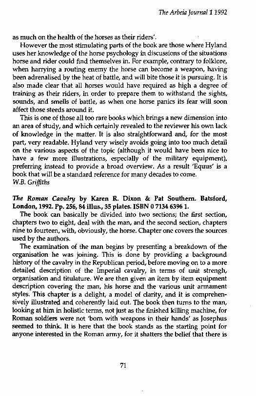
The Arbeia Journal11992
as much on the health of the horses as their riders'. However the most stimulating parts of the book are those where Hyland
uses her knowledge of the horse psychology in discussions of the situations horse and rider could find themselves in. For example, contrary to folklore, when harrying a routing enemy the horse can become a weapon, having been adrenalised by the heat of battle, and will bite those it is pursuing. It is also made clear that all horses would have required as high a degree of training as their riders, in order to prepare them to withstand the sights, sounds, and smells of battle, as when one horse panics its fear will soon affect those steeds around it.
This is one of those all too rare books which brings a new dimension into an area of study, and which certainly revealed to the reviewer his own lack of knowledge in the matter. It is also straightforward and, for the most part, very readable. Hyland very wisely avoids going into too much detail on the various aspects of the topic (although it would have been nice to have a few more illustrations, especially of the military equipment), preferring instead to provide a broad overview. As a result 'Equus' is a book that will be a standard reference for many decades to come. W.B. Griffiths
The Roman Cavalry by Karen R. Dixon & Pat Southern. Batsford, London, 1992. Pp. 256, 84 illus., 35 plates. ISBN 0 7134 6396 1.
The book can basically be divided into two sections; the first section, chapters two to eight, deal with the man, and the second section, chapters nine to fourteen, with, obviously, the horse. Chapter one covers the sources used by the authors.
The examination of the man begins by presenting a breakdown of the organisation he was joining. This is done by providing a background history of the cavalry in the Republican period, before moving on to a more detailed description of the Imperial cavalry, in terms of unit strengh, organisation and titulature. We are then given an item by item equipment description covering the man, his horse and the various unit armament styles. This chapter is a delight, a model of clarity, and it is comprehensively illustrated and coherently laid out. The book then turns to the man, looking at him in holistic terms, not just as the finished killing machine, for Roman soldiers were not 'born with weapons in their hands' as Josephus seemed to think. It is here that the book stands as the starting point for anyone interested in the Roman army, for it shatters the belief that there is
71
The Arbeia Journal11992
no more to the army than the infantry and no more to the soldier than just his arms and armour. Specifics may differ but all soldiers had to be recruited and trained, and the chapter on 'Conditions of service' as well as looking at the usual pay and punishments, considers those aspects of a soldier's life which were important to him as an individual (be he infantry or cavalry), namely death, diet, marriage, medical care, hygiene and sanitation. The chapters on the hippika gymnasia and the employment of cavalry in peace and war ably demonstrate the authors' grasp of warfare, as well as their ability to enliven the text with witty and apposite quotes.
The treatment of the horse is equally thorough, being in no way covered as an after-thought. The wealth of detail, especially the anecdotes, and the style of writing brings the whole subject to life, making it compulsive reading. We are presented with a sensible, realistic view of both the cavalry horse and the baggage animal, seen as pieces of equipment which must be looked after, but which at times were expendable. I.P. Stephenson
72


THE ARBEIA SOCIETY
Aims The Arbeia Society is based at Arbeia (South Shields) Roman Fort, and has five principle aims: 1. To promote interest in/the study of Arbeia Roman Fort and other Roman sites, especially those in north-east England. 2. To carry out archaeological fieldwork in the region. 3. Through its re-enactment group 'Quinta', to recreate as accurate a picture as possible of life in the third century at Arbeia. 4. To engage in reconstruction archaeology. 5. To raise funds to help with the cost of excavations at Arbeia.
Publications The Society produces two magazines a year in addition to the Journal. These are available at Arbeia fort at a cost of 60p each, plus 34p p&p per copy (except issue 5 which costs £1). They are available to members at a reduced cost of 30p (apart from issue 5 at 60p) each, plus 34p p&p per copy. Please note Issues 1-3 are out of print.
Membership The membership fees for the Society stand at the following levels for 1993:
Individual £8.50; Family £10.00; Associate (Publications Only) £7.50 For individual and family members please add £1 if you wish to be a member of the re-enactment group Cohors Quinta Gallorum also.
Concessions (OAPs, UB40s, Full Time Students) - the rates stand at: Individual £8 (£9 for Quinta); Family £9.50 (£10.50 for Quinta)
Membership runs from January 1st each year. Please forward membership applications to:
The Secretary, The Arbeia Society, Arbeia Roman Fort, Baring Street, South Shields, Tyne & Wear, NE33 2BB