archaeological desk-based assessment
TRANSCRIPT
ARCHAEOLOGICAL DESK-BASED ASSESSMENT
LAND AT MANOR FARMTEMPLECOMBE
June 2019updated November 2019

Planning Authority:
South Somerset District Council
Site centred at: TQ6772693385
Author:
Suzanne Gailey BA (Hons) MA
MCIFA
Report Status:
Final
Issue Date:
June/November 2019
CgMs Ref:
25620
© CgMs Limited
No part of this report is to be copied in any way
without prior written consent.
Every effort is made to provide detailed and accurate
information, however, CgMs Limited cannot be held
responsible for errors or inaccuracies within this report.
© Ordnance Survey maps reproduced with the
sanction of the controller of HM Stationery Office. Licence No: AL 100014723
Archaeological Desk Based Assessment Land at Manor Farm, Templecombe
CgMs Heritage 1 SG/25620
CONTENTS
Executive Summary
1.0 Introduction and Scope of Study
2.0 Planning Background and Development Plan Framework
3.0 Geology and Topography
4.0 Archaeological and Historical Background and Assessment of Significance
5.0 Site Conditions, the Proposed Development and Impact on Archaeological Assets
6.0 Summary and Conclusions
Sources Consulted
Appendix 1 HER Location Plan (Somerset HER 2019)
Appendix 2 Land Adjacent to Templars Barton, High Street, Templecombe, Somerset Results
of an Evaluation (AC Archaeology 2004)
LIST OF ILLUSTRATIONS
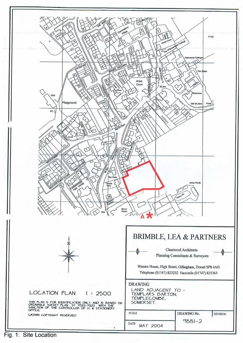
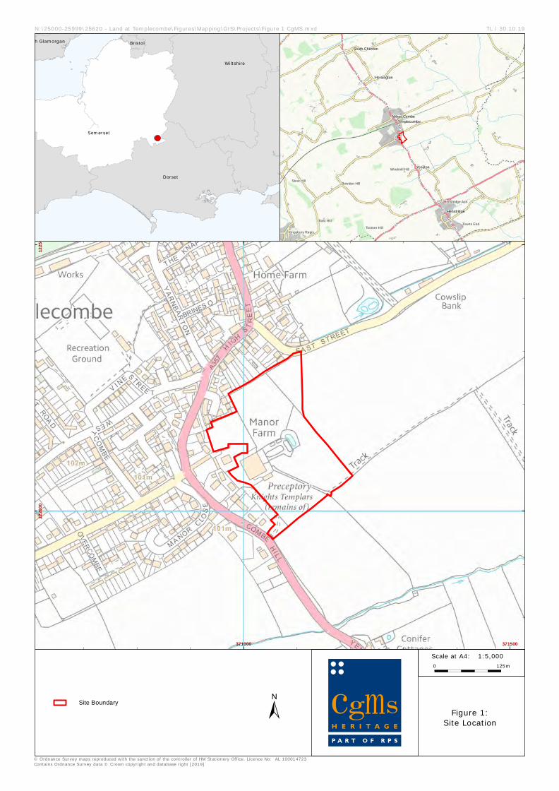
Fig. 1 Site location
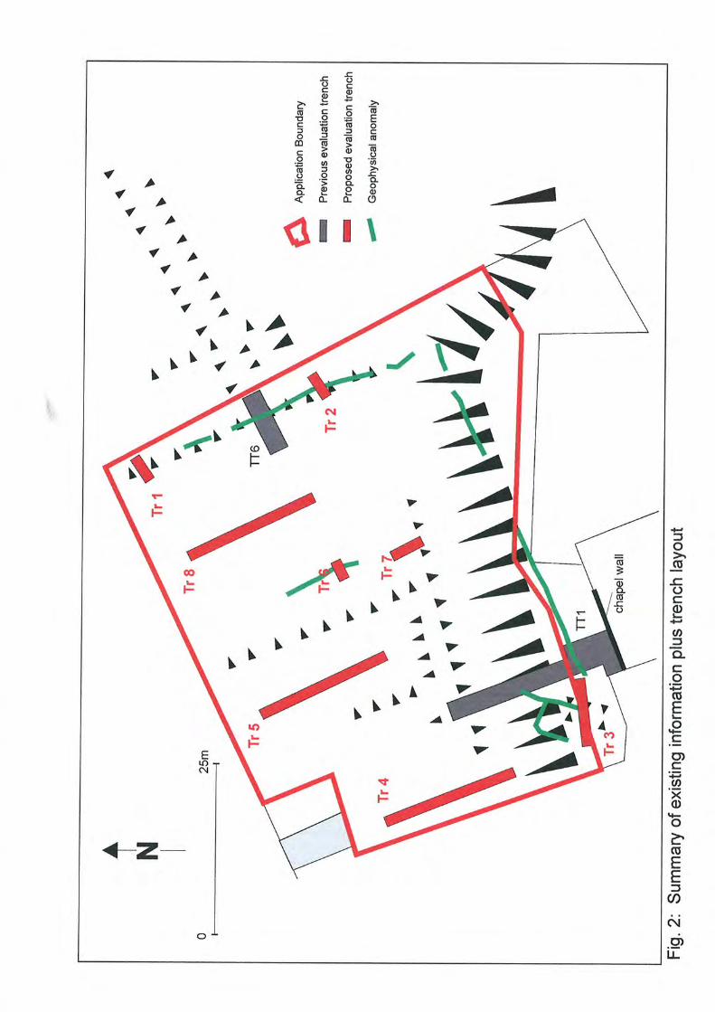
Fig. 2 Site Plan showing trench location and earthwork survey undertaken by Time Team
(Harding et al 1995)
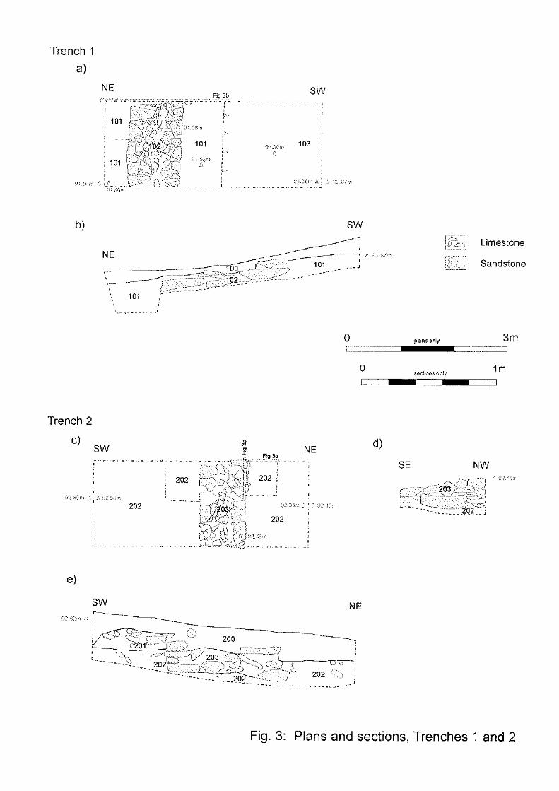
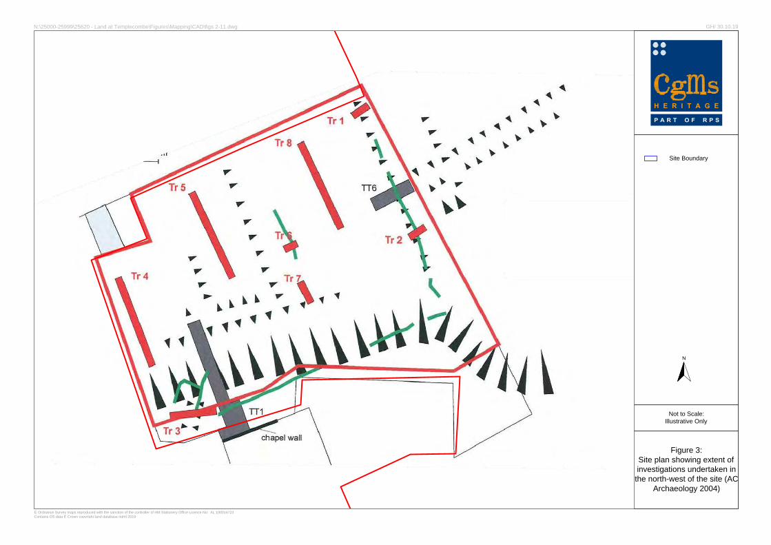
Fig. 3 Site plan showing extent of investigations undertaken in the north-west of the site
(AC Archaeology 2004)
Fig. 4 1808 Ordnance Survey
Fig. 5 1839 Templecombe (Abbas Combe) Tithe Map
Fig. 6 1887 Ordnance Survey
Fig. 7 1903 Ordnance Survey
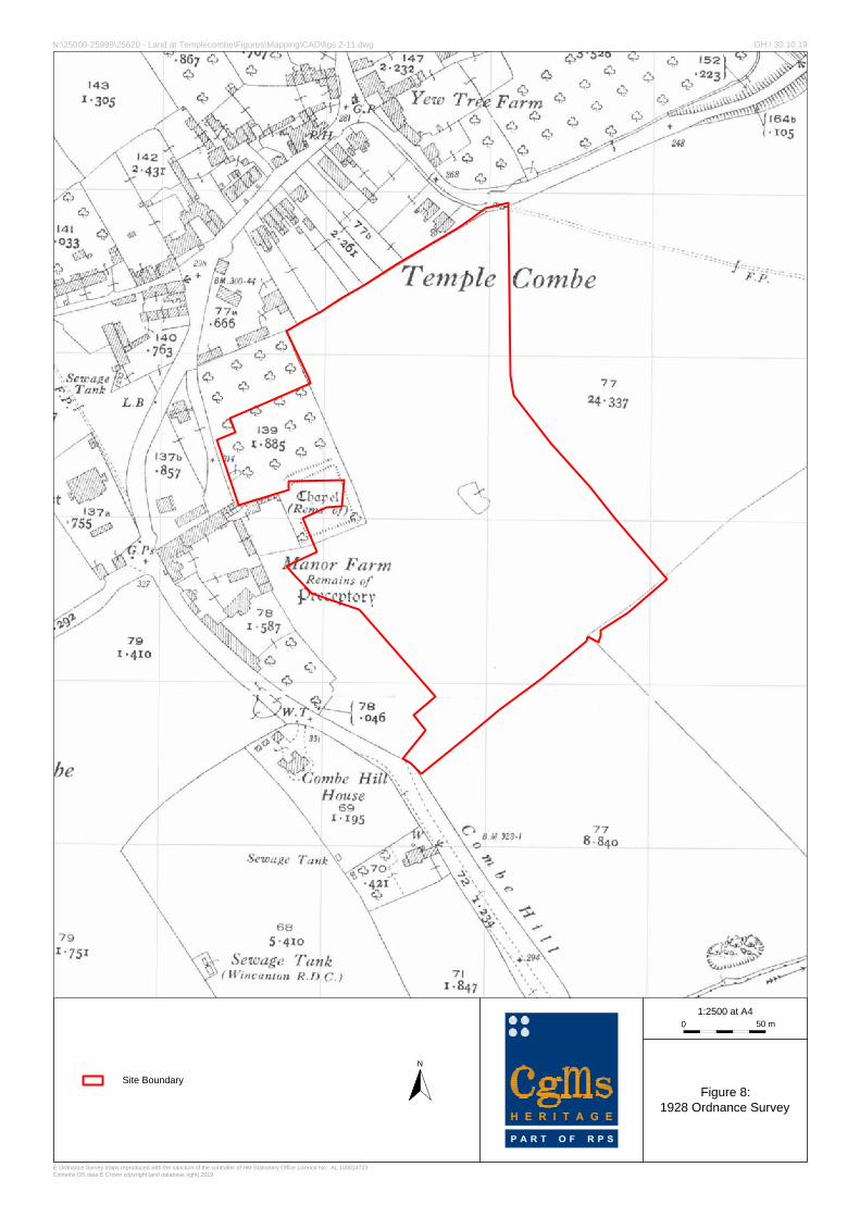
Fig. 8 1928 Ordnance Survey
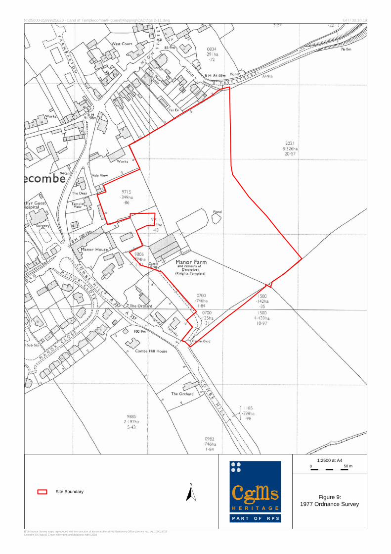
Fig. 9 1977 Ordnance Survey
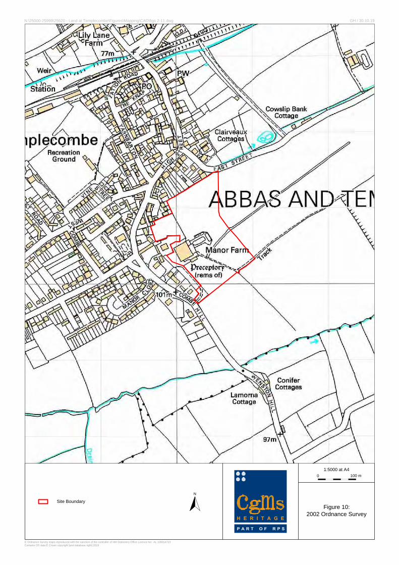
Fig. 10 2002 Ordnance Survey
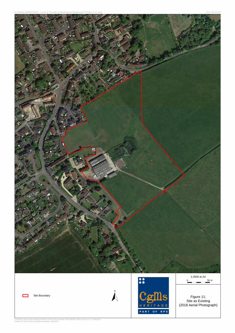
Fig. 11 Site as Existing
LIST OF PLATES
Plate 1 South facing photograph of northern perimeter wall of Manor Farm
Plate 2 North-east facing photograph looking across north-western field
Archaeological Desk Based Assessment Land at Manor Farm, Templecombe
CgMs Heritage 2 SG/25620
Plate 3 South-east facing photograph looking up to earthwork plateau and farm buildings
beyond
Plate 4 South facing photograph taken from northern field looking up to earthwork plateau
and farm buildings beyond
Plate 5 North-east facing photograph looking towards north-eastern corner of the site
Plate 6 East facing photograph looking towards south-eastern corner of the northern field
Plate 7 East facing photograph of slurry pit to the east of the farm
Plate 8 South-east facing photograph of farm access road in the south-east of the site
Plate 9 North facing photograph of southern field.
Archaeological Desk Based Assessment Land at Manor Farm, Templecombe
CgMs Heritage 3 SG/25620
EXECUTIVE SUMMARY
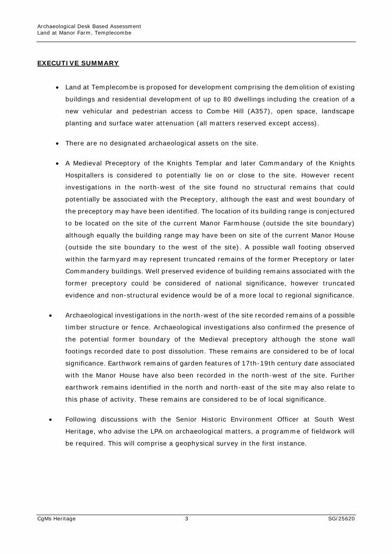
• Land at Templecombe is proposed for development comprising the demolition of existing
buildings and residential development of up to 80 dwellings including the creation of a
new vehicular and pedestrian access to Combe Hill (A357), open space, landscape
planting and surface water attenuation (all matters reserved except access).
• There are no designated archaeological assets on the site.
• A Medieval Preceptory of the Knights Templar and later Commandary of the Knights
Hospitallers is considered to potentially lie on or close to the site. However recent
investigations in the north-west of the site found no structural remains that could
potentially be associated with the Preceptory, although the east and west boundary of
the preceptory may have been identified. The location of its building range is conjectured
to be located on the site of the current Manor Farmhouse (outside the site boundary)
although equally the building range may have been on site of the current Manor House
(outside the site boundary to the west of the site). A possible wall footing observed
within the farmyard may represent truncated remains of the former Preceptory or later
Commandery buildings. Well preserved evidence of building remains associated with the
former preceptory could be considered of national significance, however truncated
evidence and non-structural evidence would be of a more local to regional significance.
• Archaeological investigations in the north-west of the site recorded remains of a possible
timber structure or fence. Archaeological investigations also confirmed the presence of
the potential former boundary of the Medieval preceptory although the stone wall
footings recorded date to post dissolution. These remains are considered to be of local
significance. Earthwork remains of garden features of 17th-19th century date associated
with the Manor House have also been recorded in the north-west of the site. Further
earthwork remains identified in the north and north-east of the site may also relate to
this phase of activity. These remains are considered to be of local significance.
• Following discussions with the Senior Historic Environment Officer at South West
Heritage, who advise the LPA on archaeological matters, a programme of fieldwork will
be required. This will comprise a geophysical survey in the first instance.
Archaeological Desk Based Assessment Land at Manor Farm, Templecombe
CgMs Heritage 4 SG/25620
1.0 INTRODUCTION AND SCOPE OF STUDY
1.1 This archaeological desk-based assessment has been written by Suzanne Gailey of CgMs
Ltd on behalf of Gleeson Strategic Land.
1.2 The subject of this assessment, also known as the study site, is Land at Manor Farm,
Templecombe, Somerset. The site is centred on National Grid Reference TQ6772693385.
1.3 In accordance with central, and local government policy and guidance on archaeology
and planning, and in accordance with the ‘Standard and Guidance for Historic
Environment Desk-Based Assessments’ (Chartered Institute for Archaeologists updated
January 2017), this assessment draws together the available archaeological, topographic
and land-use information in order to clarify the archaeological potential of the site.
1.4 This desk-based assessment comprises an examination of evidence on the Somerset
Historic Environment Record and other sources and includes the results of a
comprehensive map regression exercise.
1.5 This study therefore provides an assessment of the archaeological potential of the site
and enables relevant parties to consider the need for design, engineering or
archaeological mitigation measures.
Archaeological Desk Based Assessment Land at Manor Farm, Templecombe
CgMs Heritage 5 SG/25620
2.0 PLANNING BACKGROUND AND DEVELOPMENT PLAN FRAMEWORK
2.1 In March 2012, the government published the National Planning Policy Framework
(NPPF), which was revised in July 2018 and again in February 2019. The NPPF is
supported by the National Planning Practice Guidance (NPPG), which was published online
6th March 2014 and updated regularly since (http://planning
guidance.planningportal.gov.uk).
2.2 The NPPF and NPPG are additionally supported by three Good Practice Advice (GPA)
documents published by Historic England: GPA 1: The Historic Environment in Local
Plans; GPA 2: Managing Significance in Decision-Taking in the Historic Environment (both
published March 2015). The second edition of GPA3: The Setting of Heritage Assets was
published in December 2017.
National Planning Policy
2.3 Section 16 of the NPPF, entitled Conserving and enhancing the historic environment
provides guidance for planning authorities, property owners, developers and others on
the conservation and investigation of heritage assets. Overall, the objectives of Section
16 of the NPPF can be summarised as seeking the:
• Delivery of sustainable development
• Understanding the wider social, cultural, economic and environmental benefits
brought by the conservation of the historic environment
• Conservation of England's heritage assets in a manner appropriate to their
significance, and
• Recognition that heritage contributes to our knowledge and understanding of the
past.
2.4 Section 16 of the NPPF recognises that intelligently managed change may sometimes be
necessary if heritage assets are to be maintained for the long term. Paragraph 189
states that planning decisions should be based on the significance of the heritage asset
and that level of detail supplied by an applicant should be proportionate to the
importance of the asset and should be no more than sufficient to review the potential
impact of the proposal upon the significance of that asset.
2.5 Heritage Assets are defined in Annex 2 of the NPPF as: a building, monument, site,
place, area or landscape positively identified as having a degree of significance meriting
consideration in planning decisions. They include designated heritage assets (as defined
Archaeological Desk Based Assessment Land at Manor Farm, Templecombe
CgMs Heritage 6 SG/25620
in the NPPF) and assets identified by the local planning authority during the process of
decision-making or through the plan-making process.
2.6 Annex 2 also defines Archaeological Interest as a heritage asset which holds or
potentially could hold evidence of past human activity worthy of expert investigation at
some point. Heritage assets with archaeological interest are the primary source of
evidence about the substance and evolution of places, and of the people and cultures
that made them.
2.7 A Designated Heritage Asset comprises a: World Heritage Site, Scheduled Monument,
Listed Building, Protected Wreck Site, Registered Park and Garden, Registered
Battlefield or Conservation Area.
2.8 Significance is defined as: The value of a heritage asset to this and future generations
because of its heritage interest. This interest may be archaeological, architectural,
artistic or historic. Significance derives not only from a heritage asset’s physical
presence, but also from its setting.
2.9 In short, government policy provides a framework which:
• Protects nationally important designated Heritage Assets (which include World
Heritage Sites, Scheduled Ancient Monuments, Listed Buildings, Protected Wreck
Sites, Registered Parks and Gardens, Registered Battlefields or Conservation
Areas).
• Protects the settings of such designations.
• In appropriate circumstances seeks adequate information (from desk based
assessment and field evaluation where necessary) to enable informed decisions.
• Provides for the excavation and investigation of sites not significant enough to merit
in-situ preservation.
2.10 In considering any planning application for development, the planning authority will be
mindful of the framework set by government policy, in this instance the NPPF, in addition
to current Development Plan Policy and by other material considerations.
Local Planning Policy
2.11 The South Somerset District Council Local Plan was adopted in March 2015 and contains
the following relevant policy:
POLICY EQ3: HISTORIC ENVIRONMENT HERITAGE ASSETS WILL BE CONSERVED AND WHERE APPROPRIATE ENHANCED FOR THEIR HISTORIC SIGNIFICANCE AND IMPORTANT CONTRIBUTION TO LOCAL DISTINCTIVENESS,
Archaeological Desk Based Assessment Land at Manor Farm, Templecombe
CgMs Heritage 7 SG/25620
CHARACTER AND SENSE OF PLACE. THEIR POTENTIAL TO CONTRIBUTE TOWARDS THE ECONOMY, TOURISM, EDUCATION AND LOCAL IDENTITY WILL BE EXPLOITED. ALL NEW DEVELOPMENT PROPOSALS RELATING TO THE HISTORIC ENVIRONMENT WILL BE EXPECTED TO:
• SAFEGUARD OR WHERE APPROPRIATE ENHANCE THE SIGNIFICANCE, CHARACTER, SETTING AND LOCAL DISTINCTIVENESS OF HERITAGE ASSETS;
• MAKE A POSITIVE CONTRIBUTION TO ITS CHARACTER THROUGH HIGH STANDARDS OF DESIGN WHICH REFLECT AND COMPLEMENT IT AND THROUGH THE USE OF APPROPRIATE MATERIALS AND TECHNIQUES;
• ENSURE ALTERATIONS, INCLUDING THOSE FOR ENERGY EFFICIENCY AND RENEWABLE ENERGY, ARE BALANCED ALONGSIDE THE NEED TO RETAIN THE INTEGRITY OF THE HISTORIC ENVIRONMENT AND TO RESPECT THE CHARACTER AND PERFORMANCE OF BUILDINGS, ADOPTING PRINCIPLES OF MINIMUM INTERVENTION AND REVERSIBILITY.
2.12 No Scheduled Monuments or other designated assets lie on the site. The closest Listed
building is Grade II* Manor House which is located approximately 50m west of the study
site. Built Heritage assets will be discussed in a separate built heritage assessment.
2.13 This desk-based assessment therefore aims to meet the national and local policy
requirements and policy guidance, in clarifying the archaeological potential of the study
site and the need or otherwise for further mitigation measures.
Archaeological Desk Based Assessment Land at Manor Farm, Templecombe
CgMs Heritage 8 SG/25620
3.0 GEOLOGY AND TOPOGRAPHY
3.1 Geology
3.1.1 The British Geological Survey data (BGS Map Viewer) indicates that the site is located
on a mixed geological base comprising Cornbrash Formation – Limestone and Forest
Marble Formation – Mudstone. There are no superficial deposits recorded.
3.1.2 No geotechnical investigation data is currently available for the site.
3.2 Topography
3.2.1 The study site lies on east/north-east facing slope of a natural ridge. It slopes steeply
downwards from south-west to east/north-east from approximately 100m AOD in the
west of the site down to c90m AOD in the east.
3.2.2 The farm buildings in the centre of the site occupy a plateau that drops steeply to the
north and north-east.
3.2.3 No natural water courses cross the site. A water channel flows approximately 250m
south of the site and a further approximately 250m north of the site draining into the
Bow Brook which flows approximately 2km further to the east.
Archaeological Desk Based Assessment Land at Manor Farm, Templecombe
CgMs Heritage 9 SG/25620
4.0 ARCHAEOLOGICAL AND HISTORICAL BACKGROUND AND ASSESSMENT OF
SIGNIFICANCE
Timescales used in this report:
Prehistoric
Palaeolithic 450,000 - 12,000 BC
Mesolithic 12,000 - 4,000 BC
Neolithic 4,000 - 1,800 BC
Bronze Age 1,800 - 600 BC
Iron Age 600 - AD 43
Historic
Roman AD 43 - 410
Anglo-Saxon/Early Medieval AD 410 - 1066
Medieval AD 1066 - 1485
Post Medieval AD 1486 - 1799
Modern AD 1800 - Present
4.1 Introduction
4.1.1 What follows comprises a consideration of archaeological finds and features held within
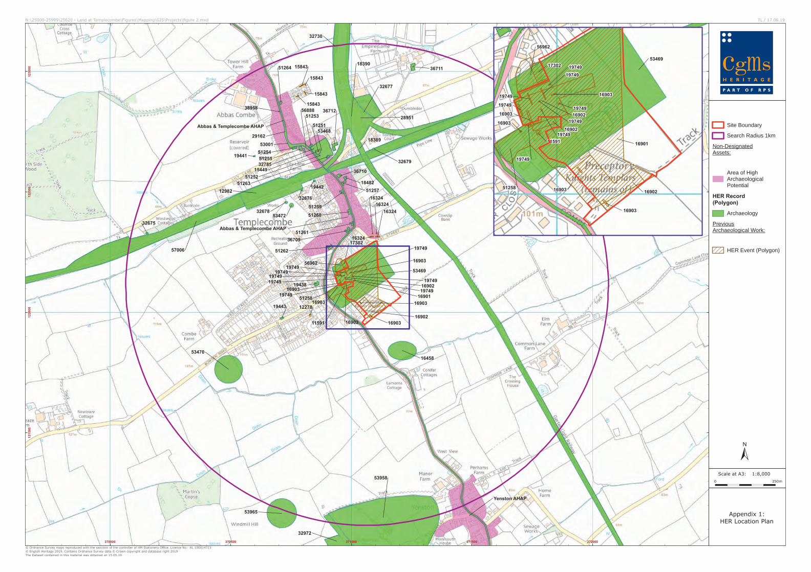
a 1km radius of the study site, also referred to as the study area, held on the Somerset
Historic Environment Record (SHER) (Appendix 1), together with a map regression
exercise charting the development of the site from the eighteenth century until the
present day. In addition the results of field investigations undertaken at the site provide
the archaeological baseline conditions on the site (Appendix 2).
4.1.2 This chapter reviews the available archaeological evidence for the study site and the
archaeological/historical background of the general area, and, in accordance with NPPF,
considers the potential for any as yet to be discovered archaeological evidence on the
study site.
4.1.3 Chapter 5 subsequently considers the site conditions and whether the proposed
development will impact the theoretical archaeological potential identified below.
Archaeological Desk Based Assessment Land at Manor Farm, Templecombe
CgMs Heritage 10 SG/25620
4.2 Prehistoric
4.2.1 The only evidence of prehistoric activity recorded within a 1km radius of the study site
comprises a prehistoric field boundary ditch of possibly Early to mid Iron Age date,
recorded during archaeological trial trenching approximately 100m north-east of the
study site (16324 ST71092232).
4.2.2 No evidence of prehistoric activity was recorded on the site during the recent
archaeological investigations (Harding et al 1995 and AC Archaeology 2004 (Appendix
2)).
4.2.3 Based on the paucity of evidence the site is considered to have a low/nil potential for
evidence of in situ prehistoric occupation.
4.3 Roman
4.3.1 No evidence of Roman occupation has been recorded within a 1km radius of the study
site.
4.3.2 No evidence of Roman occupation was identified during the recent archaeological
investigations undertaken on the site. A single residual sherd of Roman pottery was
recorded (Harding et al 1995 and AC Archaeology 2004 Appendix 2).
4.3.3 Consequently, the archaeological potential for Roman settlement evidence on the site
is considered to be low/nil.
4.4 Anglo Saxon/Medieval/Early Post Medieval
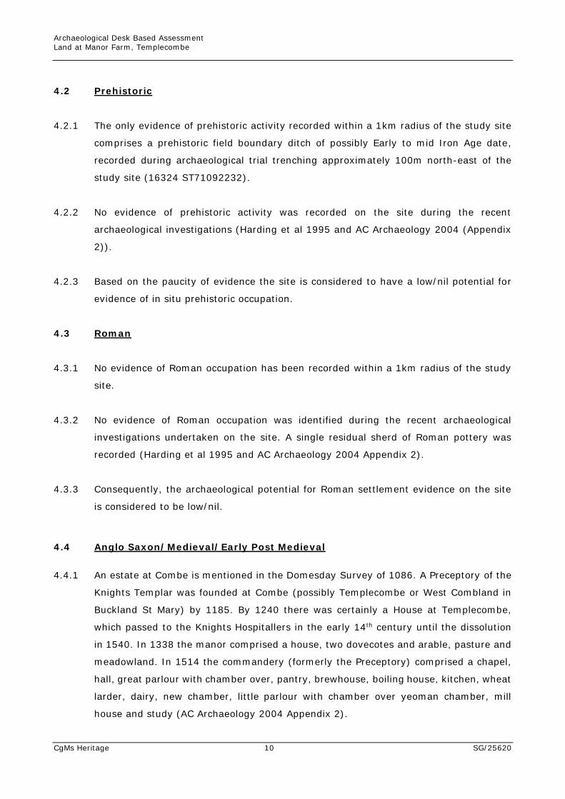
4.4.1 An estate at Combe is mentioned in the Domesday Survey of 1086. A Preceptory of the
Knights Templar was founded at Combe (possibly Templecombe or West Combland in
Buckland St Mary) by 1185. By 1240 there was certainly a House at Templecombe,
which passed to the Knights Hospitallers in the early 14th century until the dissolution
in 1540. In 1338 the manor comprised a house, two dovecotes and arable, pasture and
meadowland. In 1514 the commandery (formerly the Preceptory) comprised a chapel,
hall, great parlour with chamber over, pantry, brewhouse, boiling house, kitchen, wheat
larder, dairy, new chamber, little parlour with chamber over yeoman chamber, mill
house and study (AC Archaeology 2004 Appendix 2).
Archaeological Desk Based Assessment Land at Manor Farm, Templecombe
CgMs Heritage 11 SG/25620
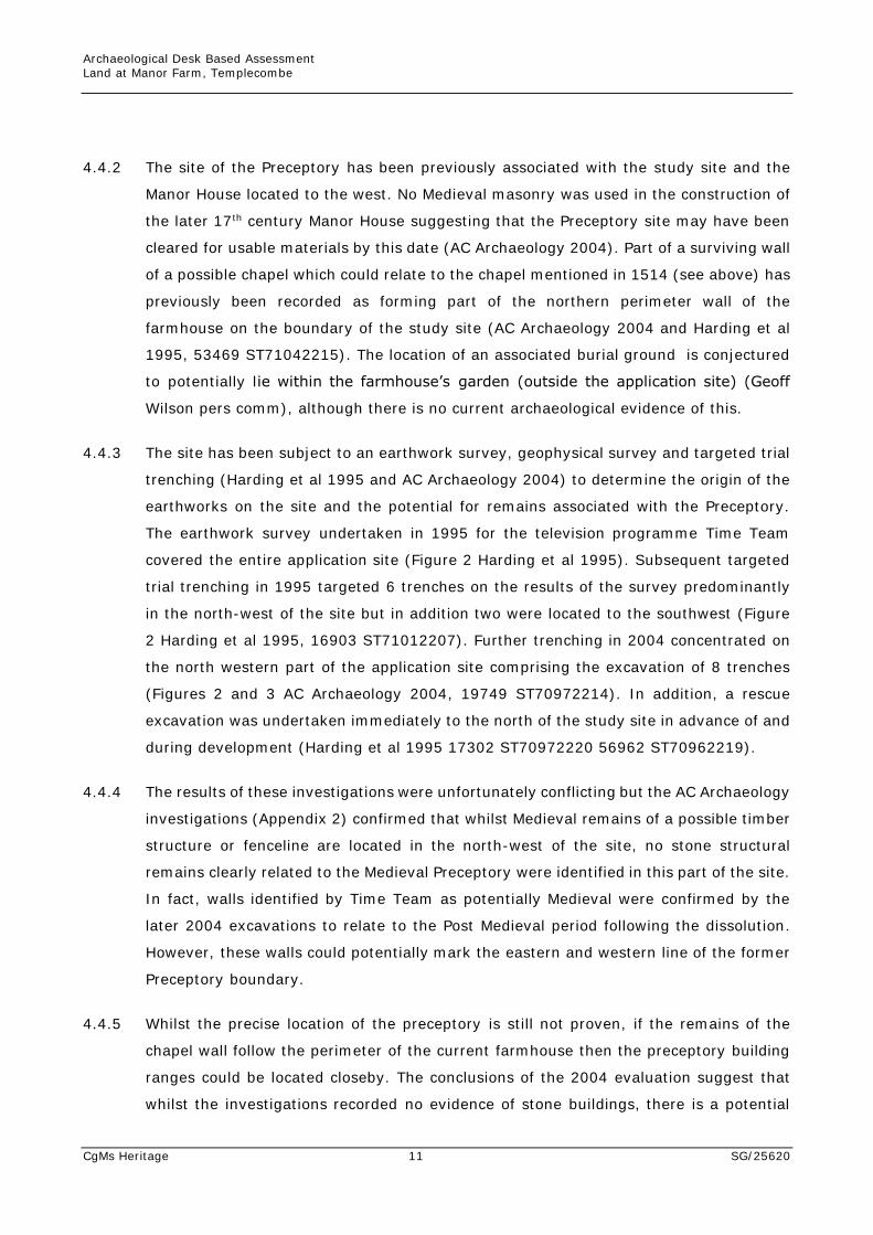
4.4.2 The site of the Preceptory has been previously associated with the study site and the
Manor House located to the west. No Medieval masonry was used in the construction of
the later 17th century Manor House suggesting that the Preceptory site may have been
cleared for usable materials by this date (AC Archaeology 2004). Part of a surviving wall
of a possible chapel which could relate to the chapel mentioned in 1514 (see above) has
previously been recorded as forming part of the northern perimeter wall of the
farmhouse on the boundary of the study site (AC Archaeology 2004 and Harding et al
1995, 53469 ST71042215). The location of an associated burial ground is conjectured
to potentially lie within the farmhouse’s garden (outside the application site) (Geoff
Wilson pers comm), although there is no current archaeological evidence of this.
4.4.3 The site has been subject to an earthwork survey, geophysical survey and targeted trial
trenching (Harding et al 1995 and AC Archaeology 2004) to determine the origin of the
earthworks on the site and the potential for remains associated with the Preceptory.
The earthwork survey undertaken in 1995 for the television programme Time Team
covered the entire application site (Figure 2 Harding et al 1995). Subsequent targeted
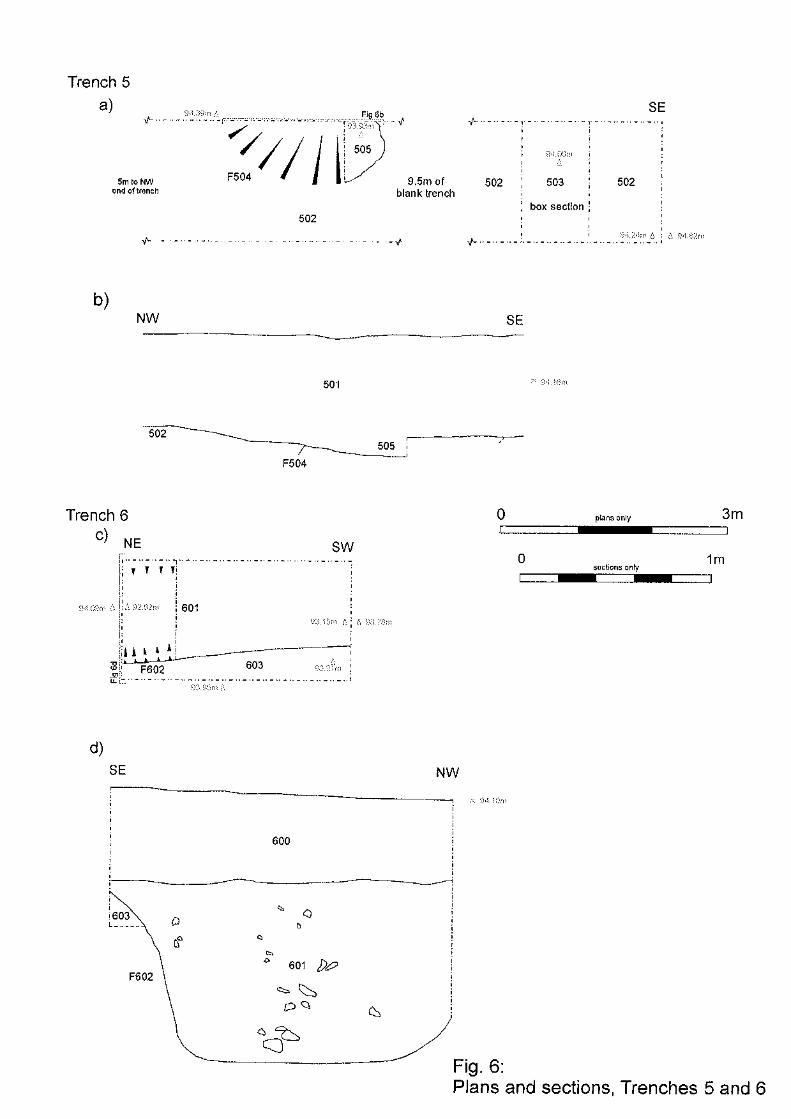
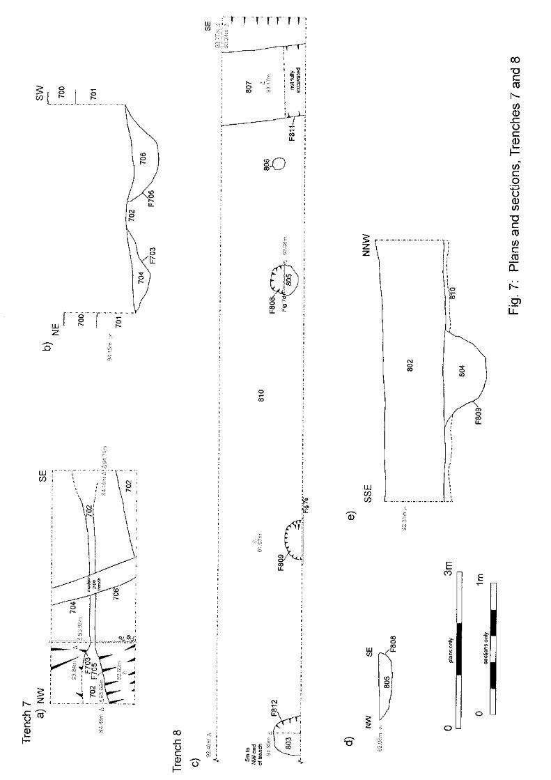
trial trenching in 1995 targeted 6 trenches on the results of the survey predominantly
in the north-west of the site but in addition two were located to the southwest (Figure
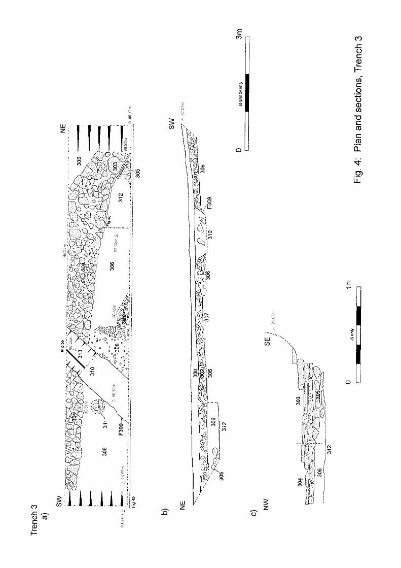
2 Harding et al 1995, 16903 ST71012207). Further trenching in 2004 concentrated on
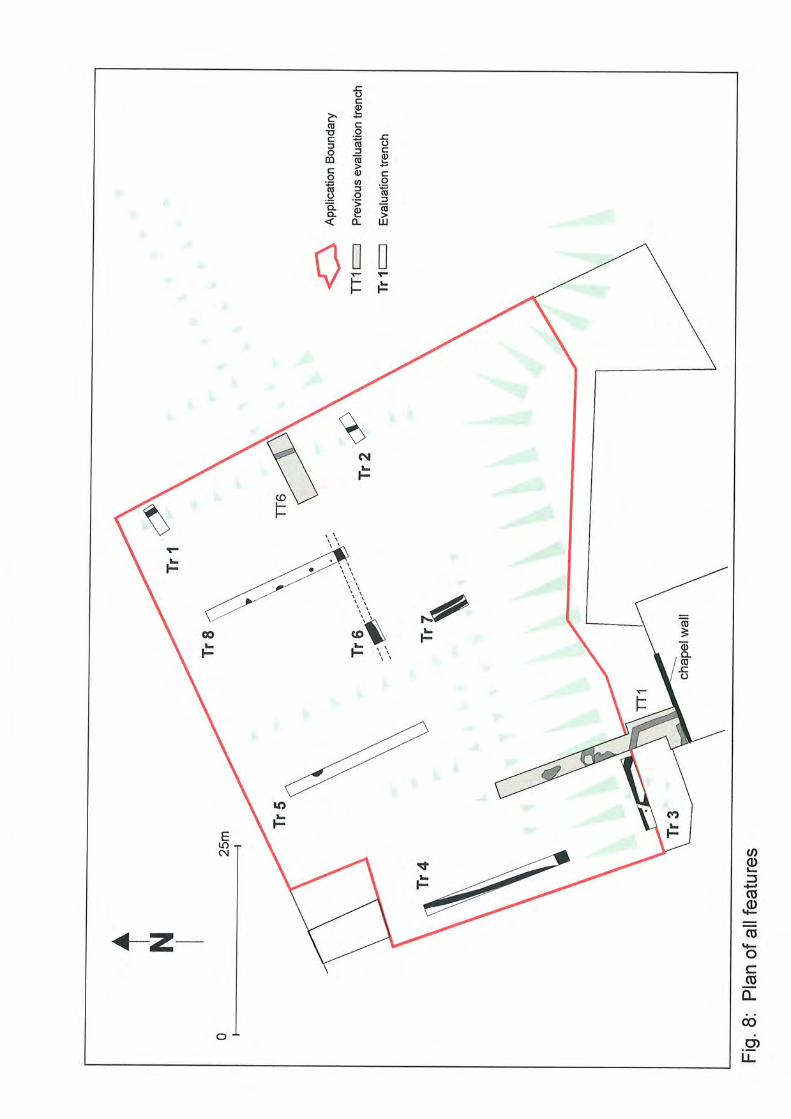
the north western part of the application site comprising the excavation of 8 trenches
(Figures 2 and 3 AC Archaeology 2004, 19749 ST70972214). In addition, a rescue
excavation was undertaken immediately to the north of the study site in advance of and
during development (Harding et al 1995 17302 ST70972220 56962 ST70962219).
4.4.4 The results of these investigations were unfortunately conflicting but the AC Archaeology
investigations (Appendix 2) confirmed that whilst Medieval remains of a possible timber
structure or fenceline are located in the north-west of the site, no stone structural
remains clearly related to the Medieval Preceptory were identified in this part of the site.
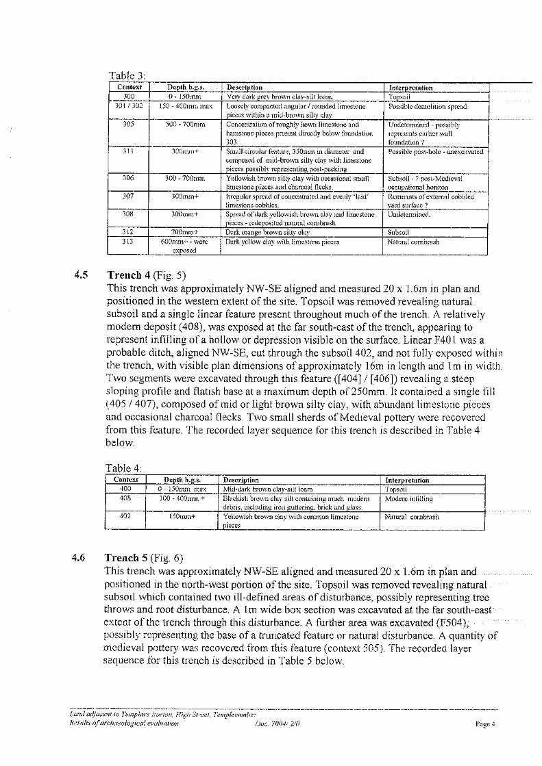
In fact, walls identified by Time Team as potentially Medieval were confirmed by the
later 2004 excavations to relate to the Post Medieval period following the dissolution.
However, these walls could potentially mark the eastern and western line of the former
Preceptory boundary.
4.4.5 Whilst the precise location of the preceptory is still not proven, if the remains of the
chapel wall follow the perimeter of the current farmhouse then the preceptory building
ranges could be located closeby. The conclusions of the 2004 evaluation suggest that
whilst the investigations recorded no evidence of stone buildings, there is a potential
Archaeological Desk Based Assessment Land at Manor Farm, Templecombe
CgMs Heritage 12 SG/25620
location to the south of the ‘chapel wall’ on an area of ‘level ground above the
escarpment … that was formerly a square earthwork enclosure once referred to as the
Cock Pit and now in the location of modern agricultural buildings’. This area has not
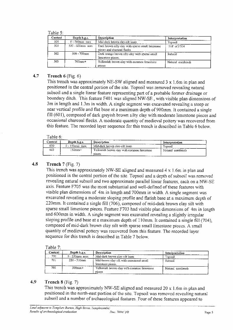
been investigated archaeologically and may have been a possible site for the range of
buildings of the Preceptory and later Commandery. This area lies predominantly under
the footprint of the current farmhouse and outside of the application site. However in
the farm yard which lies within the application site and to the south of the farmhouse,
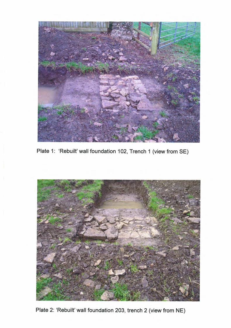
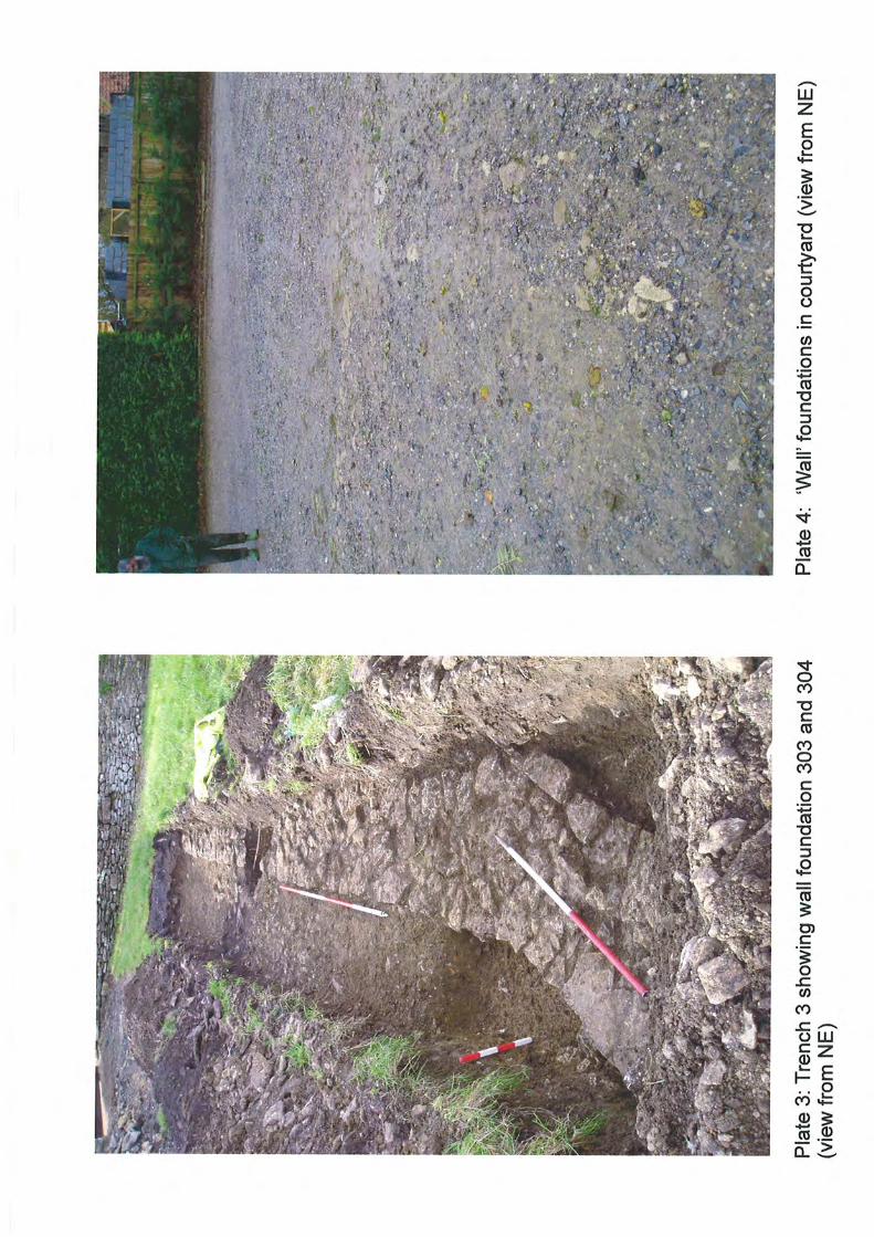
a possible wall footing was observed during the investigations in 2004 (AC Archaeology
2004 Appendix 2).
4.4.6 Medieval fishponds recorded on the HER as possibly related to the Templar preceptory
are located approximately 200m south of the study site (16458 ST71212184).
4.4.7 As a result whilst investigations in the north-west of the site have confirmed that known
evidence of Medieval activity comprising a series of post holes representing a possible
former timber structure or fenceline survive in this part of the site no evidence of
structural remains associated with the Preceptory have been recorded. However, a
possible wall footing observed within the farmyard may represent truncated remains of
the former Preceptory or later Commandery buildings. Across the remainder of the site,
evidence of agricultural activity associated with the estate may be present whilst the
remains of the former building ranges are considered less likely.
4.5 Late Post Medieval and Modern
4.5.1 As discussed above following the dissolution, the Preceptory/Commandary was
abandoned and cleared and a Manor House was constructed on land adjacent to the
west of the site in 17th century.
4.5.2 The possible earthwork remains of garden features relating to the manor house were
recorded in the north-west and north-east of the site during the Time Team
investigations in 1995 (Harding et al 1995). These garden features could be of 17th-19th
date. Evidence of demolition of buildings potentially associated with the Manor House
were recorded during the programme of later trial trenching (AC Archaeology 2004
51258 ST70912208).
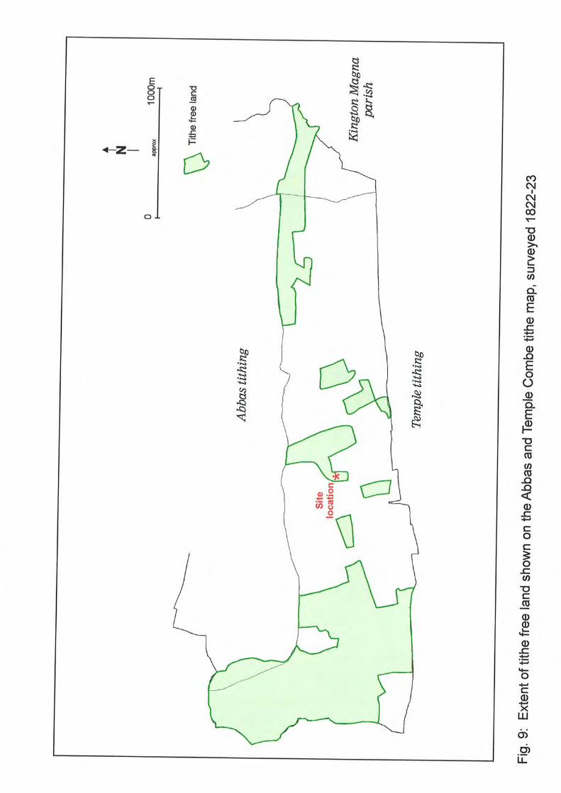
4.5.3 The western boundary of the application site once bound the former road through
Templecombe which was realigned potentially during the Post Medieval period following
Archaeological Desk Based Assessment Land at Manor Farm, Templecombe
CgMs Heritage 13 SG/25620
the construction of the Manor House, potentially to allow the manor house to incorporate
the chapel into its grounds.
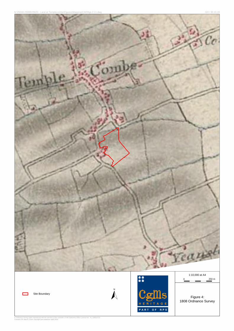
4.5.4 The 1808 Ordnance Survey shows that by this date the road had been realigned and
the site comprised agricultural land to the east of the manor house (Fig 4).
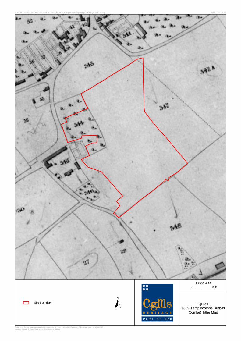
4.5.5 The tithe map of 1839 shows the site in more detail comprising an orchard in the north-
west and pasture land. Two enclosures can be seen on the map on the site of the current
farmhouse which lies outside the application site (Fig. 5).
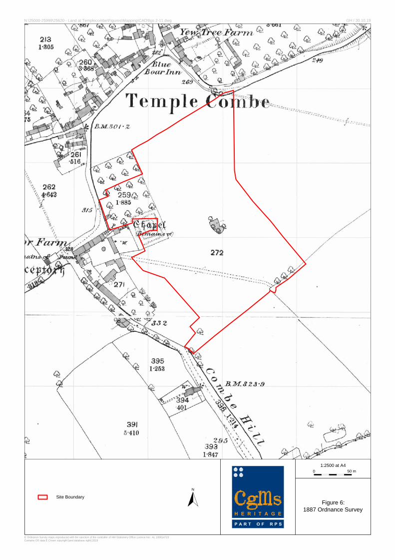
4.5.6 The 1887 Ordnance survey map records the ‘remains of a Chapel’ within the footprint
of the current farmhouse which lies outside the application site. In addition, a series of
square earthworks are shown which extend partly into the application site. A pond was
located to the east and a trackway traversed the south of the site by this date. A further
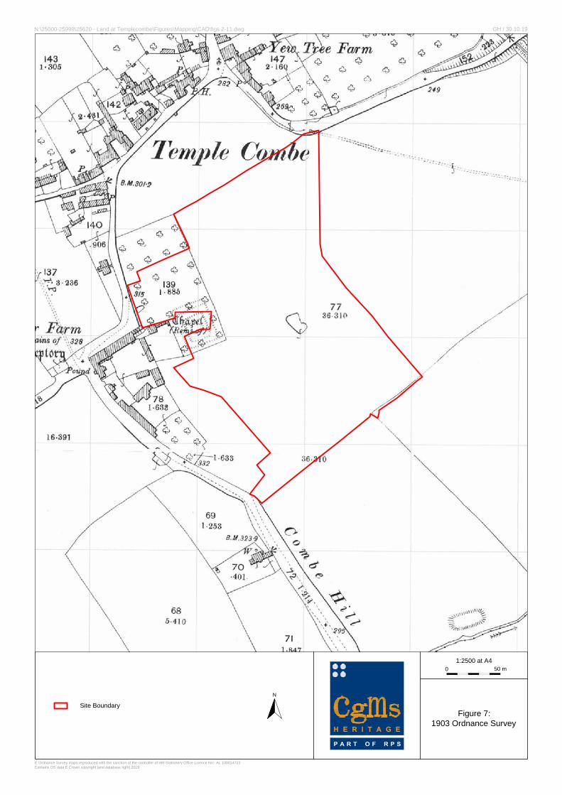
pond was located in the north -west of the site, within the orchard (Fig. 6). By the early
20th century the orchard had expanded into the earthwork remains and the former
trackway had been removed (Fig. 7) and by the mid 20th century the earthwork remains
had been partially levelled (Fig. 8).
4.5.7 A number of Second World war defences recorded at Templecombe and Abbas Combe
but none from the site itself (32678 ST70732245, 32679 ST71092267, 32730
ST70932310, 32676 ST70792250, 32677 ST71052283, 32675 ST70152232).
4.5.8 By the 1970s the orchard had been cleared and Manor Farm had been constructed
adjacent to the site (its perimeter wall bounds the site). The farm was accessed by a
road/track leading from Coombe Hill in the south-west of the site. A large farm
building/shed had been constructed to the south-east of the farmhouse, within the study
site. To the east a slurry pit had been excavated and the site had been divided into a
four fields/enclosures (Fig. 9).
4.5.9 By the late 20th century the large farm building/shed had expanded northwards (Fig.
10). There has been no subsequent change to the site (Fig. 11).
4.5.10 The archaeological evidence in the north-west of the site have confirmed the presence
of possible 17th-19th garden features potentially associated with the Manor House.
Earthwork remains recorded on the 19th century mapping which extend partly into the
study site might represent yet further evidence of former garden features or could
represent earlier activity. The archaeological potential for significant Late Post
Medieval/modern evidence across the remainder of the site is considered to be low.
Archaeological Desk Based Assessment Land at Manor Farm, Templecombe
CgMs Heritage 14 SG/25620
4.6 Negative Evidence
4.6.1 An archaeological watching brief during the digging of foundations for an extension to
the Manor Farmhouse on the site recorded no archaeological finds or features (11591
ST70962210).
4.7 Assessment of Significance
4.7.1 Paragraph 189 of the NPPF states that planning decisions should be based on the
significance of the heritage asset, and that the level of detail supplied by an applicant
should be proportionate to the importance of the asset and should be no more than
sufficient to review the potential impact of the proposal on the significance of that asset.
4.7.2 No designated archaeological assets lie on the site.
4.7.3 Archaeological investigations in the north-west of the site recorded remains of a possible
timber structure or fence. Archaeological investigations also confirmed the presence of
the potential former boundary of the Medieval preceptory although the stone wall
footings recorded date to post dissolution. These remains are considered to be of local
significance.
4.7.4 Earthwork remains of garden features of 17th-19th century date associated with the
Manor House have also been recorded in the north-west of the site. Further earthwork
remains identified in the north and north-east of the site may also relate to this phase
of activity. These remains are considered to be of local significance.
4.7.5 No structural evidence of the former Medieval Preceptory have been found on the site
and it is possible that the building ranges may have once been located in the footprint
of the current farmhouse which lies outside the study site boundary. Equally the focus
of activity may have been further to the west on the site of the current Post Medieval
Manor House. However, a possible wall footing observed within the farmyard may
represent truncated remains of the former Preceptory or later Commandery buildings.
Well preserved evidence of building remains associated with the former preceptory could
be considered of national significance, however truncated evidence and non-structural
evidence would be of a more local to regional significance.
Archaeological Desk Based Assessment Land at Manor Farm, Templecombe
CgMs Heritage 15 SG/25620
5.0 SITE CONDITIONS, THE PROPOSED DEVELOPMENT AND IMPACT ON
ARCHAEOLOGICAL ASSETS
5.1 Site Conditions
5.1.1 A site visit was undertaken in June 2019 (Plates 1-9). The west of the site comprises a
large 20th century farm building. The farm buildings are surrounded by gravel yard
surface and hardstanding and are accessed via an access road leading from Coombe
Hill. A further concrete trackway leads from the farm on a north-west/south-east
alignment. To the east of the farm building is a large slurry pit. The remainder of the
site comprises pasture land. A series of earthworks are visible in the landscape to the
north, north-east and south of the farm (as surveyed as part of the Time Team fieldwork
in 1995 discussed above).
5.1.2 Construction of the farm building and associated hard standing is likely to have a
widespread below ground impact through soil stripping and the cutting of services and
foundations. The excavations for the slurry pit will have removed any archaeology from
within its footprint.
5.1.3 Archaeological remains of a local significance are known to survive in the north-west of
the site.
5.2 Proposed Development Impact
5.2.1 The proposed development comprises the demolition of existing buildings and
residential development of up to 80 dwellings including the creation of a new vehicular
and pedestrian access to Combe Hill (A357), open space, landscape planting and surface
water attenuation (all matters reserved except access).
5.3 Impact on Archaeological Assets
5.3.1 The proposed development will not impact any known designated archaeological assets.
5.3.2 Due to the extent of past ground disturbance in the west of the study site any remains
of the former preceptory, if present, will have likely been significantly truncated.
Consequently, remains of a national significance are not anticipated and as a result any
development of the site is likely to have the potential to impact on known and as yet to
be discovered non-designated archaeological assets of a local to regional importance.
Archaeological Desk Based Assessment Land at Manor Farm, Templecombe
CgMs Heritage 16 SG/25620
6.0 SUMMARY AND CONCLUSIONS
6.1 In accordance with central and local government planning policy and guidance, a desk
based assessment has been undertaken to clarify the archaeological potential of the
study site.
6.2 No designated archaeological assets lie on the site.
6.3 Archaeological investigations in the north-west of the site recorded remains of a possible
timber structure or fence. Archaeological investigations also confirmed the presence of
the potential former boundary of the Medieval preceptory although the stone wall
footings recorded date to post dissolution. These remains are considered to be of local
significance. Earthwork remains of garden features of 17th-19th century date associated
with the Manor House have also been recorded in the north-west of the site. Further
earthwork remains identified in the north and north-east of the site may also relate to
this phase of activity. These remains are considered to be of local significance.
6.4 No structural evidence of the former Medieval Preceptory have been found on the site
and it is possible that the building ranges may have once been located in the footprint
of the current farmhouse which lies outside the study site boundary. Equally the focus
of activity may have been further to the west on the site of the current Post Medieval
Manor House. However, a possible wall footing observed within the farmyard may
represent truncated remains of the former Preceptory or later Commandery buildings.
Well preserved evidence of building remains associated with the former preceptory could
be considered of national significance, however truncated evidence and non-structural
evidence would be of a more local to regional significance.
6.5 Due to the extent of past ground disturbance in the west of the study site any remains
of the former preceptory, if present, will have been significantly truncated.
Consequently, remains of a national significance are not anticipated and as a result any
development of the site is likely to have the potential to impact on known and as yet to
be discovered non-designated archaeological assets of a local to regional importance.
6.6 Consequently, archaeology is considered unlikely to constrain any future development
of the site. Following discussions with the Senior Historic Environment Officer at South
Archaeological Desk Based Assessment Land at Manor Farm, Templecombe
CgMs Heritage 17 SG/25620
West Heritage, who advise the LPA on archaeological matters, a programme of fieldwork
will be required. This will comprise a geophysical survey in the first instance.

Archaeological Desk Based Assessment Land at Manor Farm, Templecombe
CgMs Heritage 18 SG/25620
SOURCES CONSULTED
1. General
Somerset Heritage Environment Record
British Library
2. Bibliographic
DCMS 2013 Scheduled Monuments and Nationally Important non Scheduled Monuments
Harding et al 1995 Archaeological Investigations at Templecombe
Historic England 2015 Historic Environment Good Practice Advice in Planning: 1 The
Historic Environment in Local Plans
Historic England 2015 Historic Environment Good Practice Advice in Planning: 2 Managing
Significance in Decision-Taking in the Historic Environment
Historic England 2017 Historic Environment Good Practice Advice in Planning: 3 The
Setting of Heritage Assets
3. Internet
British Geological Survey Geology of Britain Viewer http://www.bgs.ac.uk/ 2013
Open Domesday http://domesdaymap.co.uk/ 2014
4. Cartographic
1808 Ordnance Survey Drawing
1839 Templecombe Tithe Map
1887 Ordnance Survey
1903 Ordnance Survey
1928 Ordnance Survey
1977 Ordnance Survey
2002 Ordnance Survey
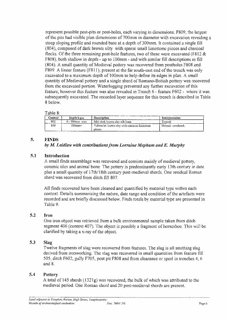
371000 371500
1220
0012
2500
Figure 1:
Site Location
1:5,000Scale at A4:
N:\25000-25999\25620 - Land at Templecombe\Figures\Mapping\GIS\Projects\Figure 1 CgMS.mxd
© Ordnance Survey maps reproduced with the sanction of the controller of HM Stationery Office. Licence No: AL 100014723Contains Ordnance Survey data © Crown copyright and database right [2019]
TL / 30.10.19
0 125m
±
Somerset
Wiltshire
Dorset
BristolSouth Glamorgan
Yenston
Horsington
Henstridge
Abbas Combe
Templecombe
South Cheriton
Towns End
Henstridge Ash
Kingsbury Regis
East Hill
Stout HillBowden Hill
Toomer Hill
Windmill Hill A30
A3
57
B31
45
A35
7
A35
7
A30
A35
7
A30
A35
7
A30
A30A
35
7
A357
A35
7
A357
A30
A30
A35
7
A30
A35
7
A30
A357
A357
A30
A30
A35
7
A35
7
A35
7
A35
7
A357
A35
7
A35
7
Site Boundary

N
Site Boundary
Figure 2:
Site Plan showing trench
location and earthwork
survey undertaken by Time
Team
(Harding et al 1995)
© Ordnance Survey maps reproduced with the sanction of the controller of HM Stationery Office Licence No: AL 100014723
Contains OS data © Crown copyright [and database right] 2019
N:\25000-25999\25620 - Land at Templecombe\Figures\Mapping\CAD\figs 2-11.dwg GH / 30.10.19
H E R I T A G E
P A R T O F R P S
Not to Scale:
Illustrative Only
N
Figure 3:
Site plan showing extent of
investigations undertaken in
the north-west of the site (AC
Archaeology 2004)
Not to Scale:
Illustrative Only
Site Boundary
N:\25000-25999\25620 - Land at Templecombe\Figures\Mapping\CAD\figs 2-11.dwg GH/ 30.10.19
© Ordnance Survey maps reproduced with the sanction of the controller of HM Stationery Office Licence No: AL 100014723
Contains OS data © Crown copyright [and database right] 2019
H E R I T A G E
P A R T O F R P S
N
Site Boundary
1:10,000 at A4
Figure 4:
1808 Ordnance Survey
© Ordnance Survey maps reproduced with the sanction of the controller of HM Stationery Office Licence No: AL 100014723
Contains OS data © Crown copyright [and database right] 2019
N:\25000-25999\25620 - Land at Templecombe\Figures\Mapping\CAD\figs 2-11.dwg GH / 30.10.19
H E R I T A G E
P A R T O F R P S
0250 m
N
Site Boundary
1:2500 at A4
Figure 5:
1839 Templecombe (Abbas
Combe) Tithe Map
© Ordnance Survey maps reproduced with the sanction of the controller of HM Stationery Office Licence No: AL 100014723
Contains OS data © Crown copyright [and database right] 2019
N:\25000-25999\25620 - Land at Templecombe\Figures\Mapping\CAD\figs 2-11.dwg GH / 30.10.19
H E R I T A G E
P A R T O F R P S
50 m0
N
Site Boundary
1:2500 at A4
Figure 6:
1887 Ordnance Survey
© Ordnance Survey maps reproduced with the sanction of the controller of HM Stationery Office Licence No: AL 100014723
Contains OS data © Crown copyright [and database right] 2019
N:\25000-25999\25620 - Land at Templecombe\Figures\Mapping\CAD\figs 2-11.dwg GH / 30.10.19
H E R I T A G E
P A R T O F R P S
50 m0
N
Site Boundary
1:2500 at A4
Figure 7:
1903 Ordnance Survey
© Ordnance Survey maps reproduced with the sanction of the controller of HM Stationery Office Licence No: AL 100014723
Contains OS data © Crown copyright [and database right] 2019
N:\25000-25999\25620 - Land at Templecombe\Figures\Mapping\CAD\figs 2-11.dwg GH / 30.10.19
H E R I T A G E
P A R T O F R P S
50 m0
N
Site Boundary
1:2500 at A4
Figure 8:
1928 Ordnance Survey
© Ordnance Survey maps reproduced with the sanction of the controller of HM Stationery Office Licence No: AL 100014723
Contains OS data © Crown copyright [and database right] 2019
N:\25000-25999\25620 - Land at Templecombe\Figures\Mapping\CAD\figs 2-11.dwg GH / 30.10.19
H E R I T A G E
P A R T O F R P S
50 m0
N
Site Boundary
1:2500 at A4
Figure 9:
1977 Ordnance Survey
© Ordnance Survey maps reproduced with the sanction of the controller of HM Stationery Office Licence No: AL 100014723
Contains OS data © Crown copyright [and database right] 2019
N:\25000-25999\25620 - Land at Templecombe\Figures\Mapping\CAD\figs 2-11.dwg GH / 30.10.19
H E R I T A G E
P A R T O F R P S
50 m0
N
Site Boundary
1:5000 at A4
Figure 10:
2002 Ordnance Survey
© Ordnance Survey maps reproduced with the sanction of the controller of HM Stationery Office Licence No: AL 100014723
Contains OS data © Crown copyright [and database right] 2019
N:\25000-25999\25620 - Land at Templecombe\Figures\Mapping\CAD\figs 2-11.dwg GH / 30.10.19
H E R I T A G E
P A R T O F R P S
0100 m
N
Site Boundary
1:2500 at A4
Figure 11:
Site as Existing
(2018 Aerial Photograph)
© Ordnance Survey maps reproduced with the sanction of the controller of HM Stationery Office Licence No: AL 100014723
Contains OS data © Crown copyright [and database right] 2019
N:\25000-25999\25620 - Land at Templecombe\Figures\Mapping\CAD\figs 2-11.dwg GH / 30.10.19
H E R I T A G E
P A R T O F R P S
50 m0
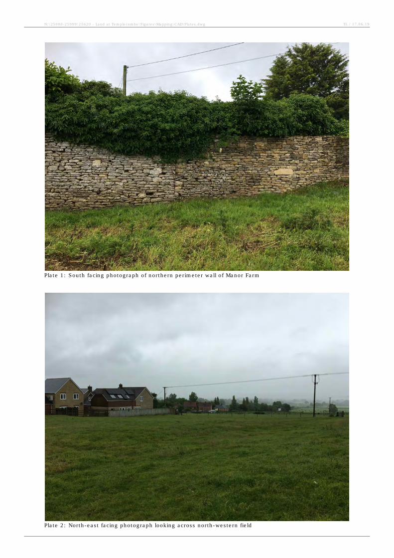
Plate 1: South facing photograph of northern perimeter wall of Manor Farm
Plate 2: North-east facing photograph looking across north-western field
N:\25000-25999\25620 - Land at Templecombe\Figures\Mapping\CAD\Plates.dwg TL / 17.06.19
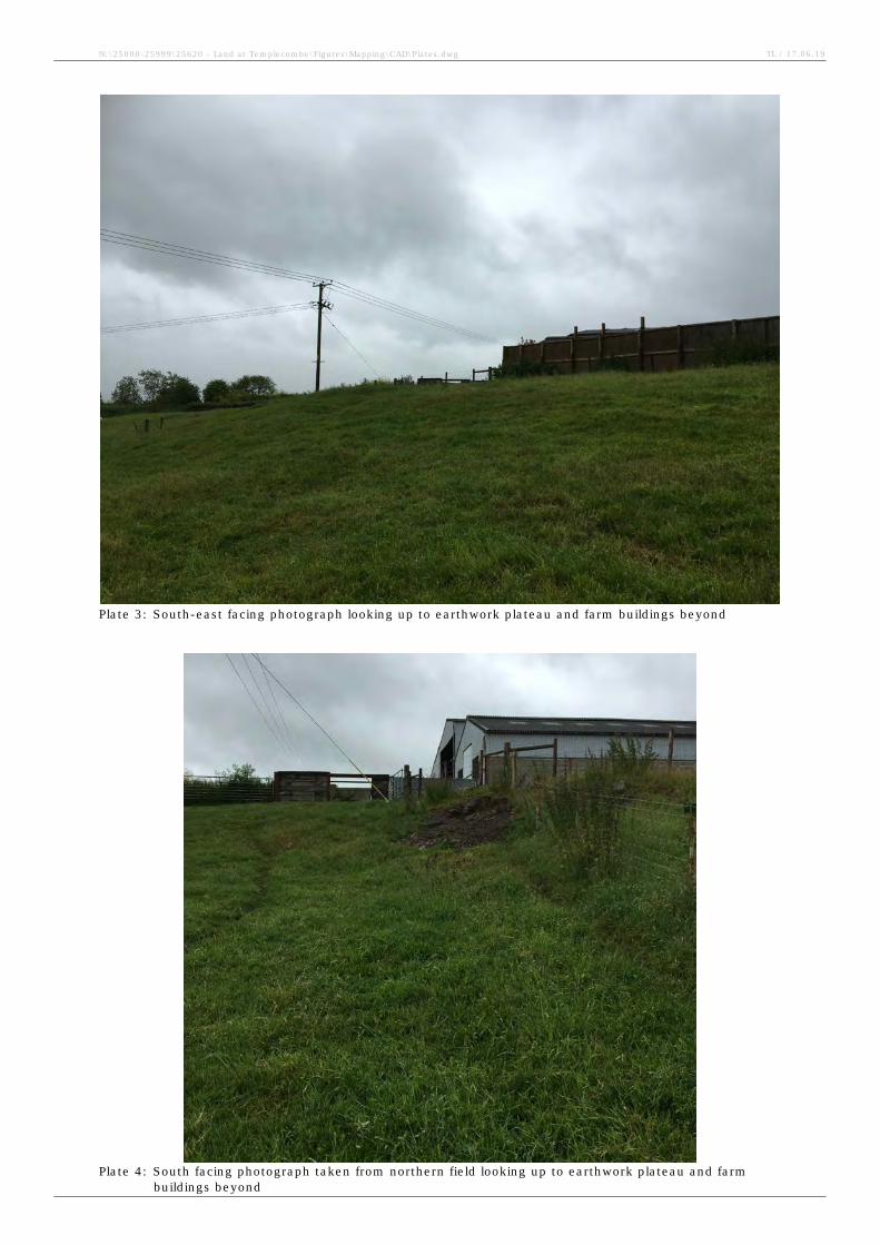
Plate 3: South-east facing photograph looking up to earthwork plateau and farm buildings beyond
Plate 4: South facing photograph taken from northern field looking up to earthwork plateau and farm
buildings beyond
N:\25000-25999\25620 - Land at Templecombe\Figures\Mapping\CAD\Plates.dwg TL / 17.06.19
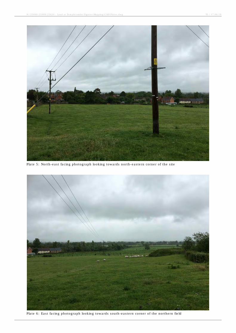
Plate 5: North-east facing photograph looking towards north-eastern corner of the site
Plate 6: East facing photograph looking towards south-eastern corner of the northern field
N:\25000-25999\25620 - Land at Templecombe\Figures\Mapping\CAD\Plates.dwg TL / 17.06.19
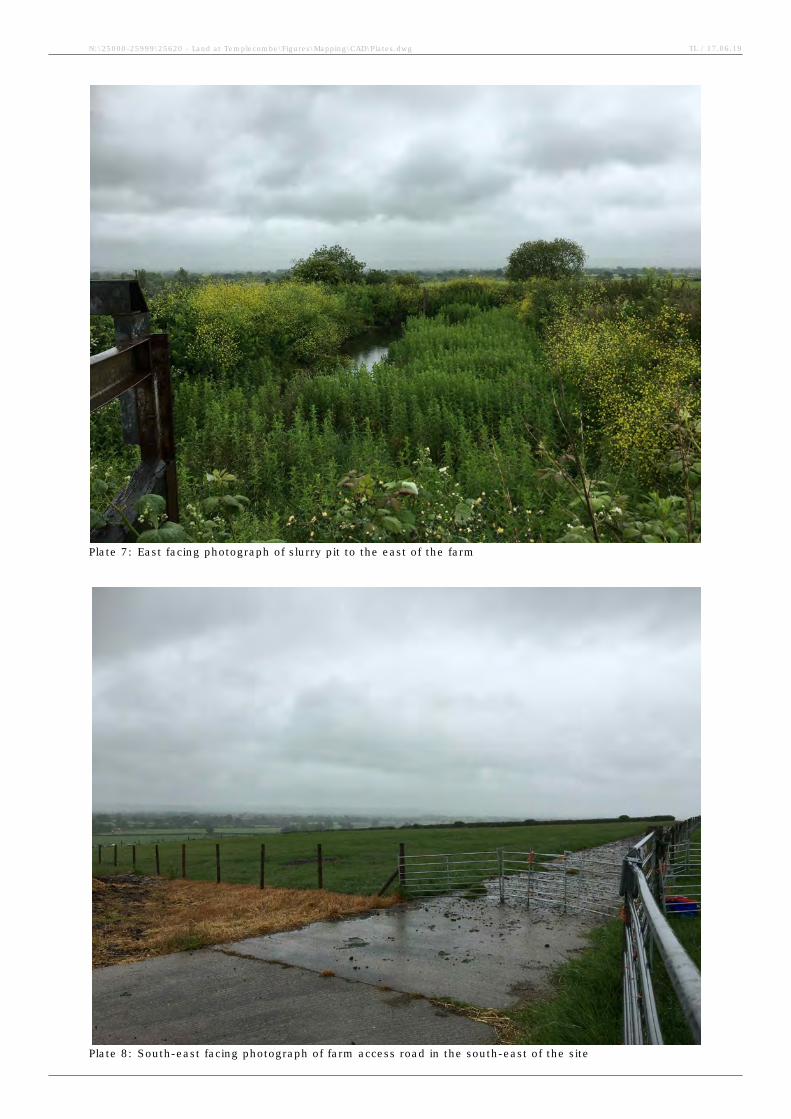
Plate 7: East facing photograph of slurry pit to the east of the farm
Plate 8: South-east facing photograph of farm access road in the south-east of the site
N:\25000-25999\25620 - Land at Templecombe\Figures\Mapping\CAD\Plates.dwg TL / 17.06.19
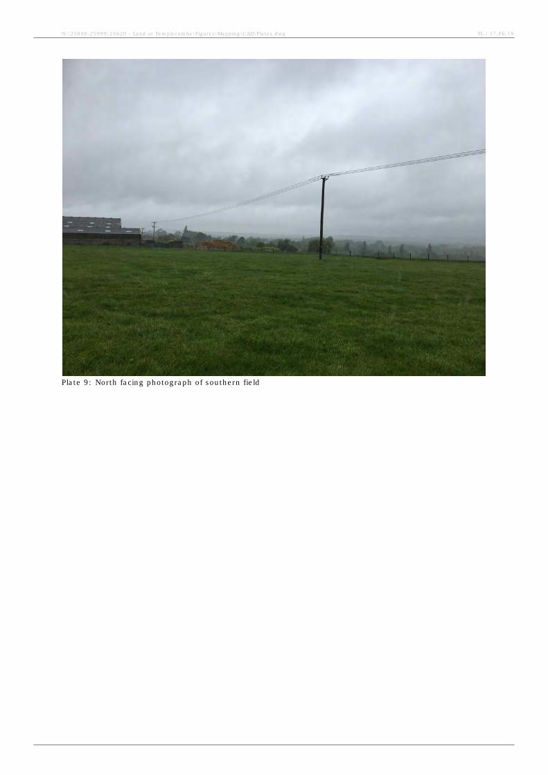
Plate 9: North facing photograph of southern field
N:\25000-25999\25620 - Land at Templecombe\Figures\Mapping\CAD\Plates.dwg TL / 17.06.19
Archaeological Desk Based Assessment Land at Templecombe
CgMs Heritage 20 SG/25620
Appendix One
HER Location Plan (Somerset HER 2019)
16901
16902
16902
56962
17302
16902
12278
16324
15843
16324
11591
19749
19749
16903
15843
16903
15843
16903
15449
16324
16903
19749
16903
19749
19749
15843
16324
19749
19749
19749
53958
53469
32972
12982
28951
53965
53470
16458
53468
57006
29162
18390
51258
36711
36712
51251
18389
51255
19438
51262
53472
36709
36710
51260
51257
51259
51254
51253
51261
18482
19443
51263
51264
32679
32678
32676
32677
32675
19442
32730
19441
38958
53001
56888
51252
32785
Yenston AHAP
Abbas & Templecombe AHAP
Abbas & Templecombe AHAP
370000 370500 371000 371500 372000
12
15
00
12
20
00
12
25
00
12
30
00
1:8,000Scale at A3:
N:\25000-25999\25620 - Land at Templecombe\Figures\Mapping\GIS\Projects\figure 2.mxd
© Ordnance Survey maps reproduced with the sanction of the controller of HM Stationery Office. Licence No: AL 100014723
© English Heritage 2019. Contains Ordnance Survey data © Crown copyright and database right 2019
The Dataset contained in this material was obtained on 15.05.19
0 250m
±
Appendix 1:
HER Location Plan
Site Boundary
Search Radius 1km
Non-DesignatedAssets:
Area of HighArchaeologicalPotential
HER Record
(Polygon)
Archaeology
PreviousArchaeological Work:
HER Event (Polygon)
TL / 17.06.19
53469
51258
16901
16902
16902
56962
17302
16902
16903
11591
19749
19749
19749
16903
16903
16903
19749
16903
19749
19749
19749
19749
Archaeological Desk Based Assessment Land at Templecombe
CgMs Heritage 21 SG/25620
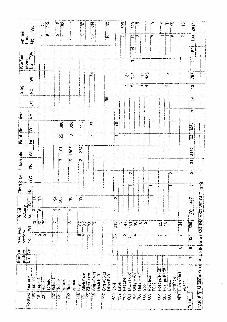
Appendix Two
Land Adjacent to Templars Barton, High Street, Templecombe, Somerset Results of
an Archaeological Evaluation (AC Archaeology 2004)