archaeological desk-based assessment: land to the
TRANSCRIPT

ARCHAEOLOGICAL DESK-BASED ASSESSMENT:
LAND TO THE NORTHWEST OF SUTTON’S LANE, GREAT ALTCAR, LANCASHIRE
Planning Reference: Pre-application NGR: SD 32654 07458
AAL Site Code: AMLA18
Report prepared for Zetland Group Limited On behalf of Aurora Energy Resources Limited
By Allen Archaeology Limited
Report Number AAL2018114
March 2019

Contents
Executive Summary ................................................................................................................................. 1
1.0 Introduction ................................................................................................................................ 2
2.0 Site Location and Description ..................................................................................................... 2
3.0 Planning Background .................................................................................................................. 2
National Planning Policy ..................................................................................................................... 2
Local Planning Policy ........................................................................................................................... 3
4.0 Methodology ............................................................................................................................... 5
Data Collection .................................................................................................................................... 5
Assessment Methodology ................................................................................................................... 6
5.0 Archaeological and Historical Background ................................................................................. 7
6.0 Site Visit..................................................................................................................................... 12
7.0 Constraints ................................................................................................................................ 14
8.0 Consultations ............................................................................................................................ 15
9.0 Impact Assessment ................................................................................................................... 16
Development Details and Types of Impact ....................................................................................... 16
Access Track Construction ................................................................................................................ 18
Containment Ditch and Cess Tank .................................................................................................... 18
Heritage Assets ................................................................................................................................. 19
Impact Assessment ........................................................................................................................... 20
Effects on the Visual Setting of Great Altcar Conservation Area ...................................................... 21
Effects on the Visual Setting of Listed Buildings ............................................................................... 21
10.0 Mitigation .................................................................................................................................. 22
11.0 Discussion and Conclusions ...................................................................................................... 23
12.0 Acknowledgements ................................................................................................................... 24
13.0 References ................................................................................................................................ 24
Cartographic Sources ........................................................................................................................ 25
List of Plates
Plate 1: South West Lancashire Wetlands survey area, with approximate site area circled in red ....... 8 Plate 2: South West Lancashire Wetlands survey area, with early prehistoric (left) and later prehistoric sites (right) shown ................................................................................................................................... 8

Plate 3: View of the site, looking northeast .......................................................................................... 13 Plate 4: View of the site, looking southwest ......................................................................................... 13 Plate 5: Sutton’s Lane from Lord Sefton Way, looking northeast towards the proposed route of the access road ............................................................................................................................................ 14 Plate 6: Sutton’s Lane in the direction of the site, looking northeast .................................................. 14
List of Appendices
Appendix 1: Assessment Criteria .......................................................................................................... 26 Appendix 2: List of LHER Entries within a 1km search area .................................................................. 30 Appendix 3: Figures ............................................................................................................................... 31
List of Figures
Figure 1: Site Location outlined in red .................................................................................................. 31 Figure 2: Location and direction of site visit photographs with site outlined in red ............................ 32 Figure 3: LCAS HER entries and heritage assets within a 1km radius of the site with the site outlined in red ......................................................................................................................................................... 33 Figure 4: LiDAR imagery with the site outlined in red .......................................................................... 34 Figure 5: Extract of 1845 map with site outlined in red ....................................................................... 35 Figure 6: Extract of 1848 Tithe Map of the Township of Altcar in the county of Lancaster with site outlined in red ....................................................................................................................................... 36 Figure 7: Extract of the 1st Edition Ordnance Survey map with site outlined in red ............................ 37 Figure 8: Extract of 1904 Ordnance Survey map with site outlined in red ........................................... 38 Figure 9: Extract of 1928 Ordnance Survey map with site outlined in red ........................................... 39
Document Control
Element: Name: Date: Report prepared by: Isobel Curwen MSc BSc (Hons), Harvey
Tesseyman BA (Hons) PCIfA 27/07/2018
Illustrations prepared by: Isobel Curwen MSc BSc (Hons), Harvey Tesseyman BA (Hons) PCIfA
27/07/2018
Report edited by: Matt Parker Wooding MPhil MCIfA 13/08/2018 Report reviewed by: Chris Clay BA MA (Hons) 14/08/2018 Revised Boundary: Matt Parker Wooding MPhil MCIfA 11/10/2018 Version no: v.5 15/03/2019
Cover image: Sutton’s Lane, access to the site, looking east

1
Executive Summary
• Allen Archaeology Limited was commissioned by Zetland Group Limited on behalf of Aurora Energy Resources Limited to undertake a desk-based assessment to assess land near to Great Altcar, Lancashire, in advance of a planning application for the construction of an exploratory wellsite including access track and compound.
• Data was gathered from a range of primary and secondary sources, including a search of the Lancashire Historic Environment Record, the Lancashire Archives, appropriate published sources, the geotechnical investigations for the site and a site visit. The known archaeological resource of the wider Lancashire coastal plain was considered when attempting to understand the potential and significance of archaeological remains which may be present within the proposed wellsite.
• Prehistoric activity is absent from the site or study area but is well represented from the wider coastal plain, including nationally significant Mesolithic remains. The slightly elevated position within the landscape and the presence of a palaeochannel within the site may indicate some potential for prehistoric archaeological or palaeoenvironmental activity here, as this type of locale was favoured during the earlier prehistoric period.
• There are no Roman or early medieval sites in the study area, with some limited later early medieval activity suggested by place name evidence. Activity of this date is not anticipated within the proposed development site.
• Medieval activity is focussed on the main settlements generally to the southwest of the site, with no recorded activity in the study area. Any activity of this date may be either agricultural activity, land drainage or the exploitation of natural resources, but there is overall a low potential.
• Post-medieval activity is recorded in the study area, predominantly farmsteads and the church in Great Altcar itself. Aside from field drains and field boundaries, there is no evidence for post-medieval activity on the site. There is only one site of modern date near to the site, a Q-type decoy, which is not likely to have left any tangible remnants on the ground.
• The assessment has recommended that a phased archaeological investigation of the wellsite is undertaken prior to the commencement of construction. This should include geophysical survey and augur survey followed by trial trenching, to enable the identification of any archaeological remains within the site and to formulate the most appropriate method of preservation.
• The assessment has indicated that there will be a minor impact on the setting of the Great Altcar Conservation Area and Listed Buildings, as they are approximately 900m or more from the site with limited intervisibility.

2
1.0 Introduction
1.1 Allen Archaeology Limited was commissioned by Zetland Group Limited on behalf of Aurora Energy Resources Limited to prepare a desk-based assessment to evaluate the archaeological potential of land to the northwest of Sutton’s Lane, Great Altcar in advance of the submission of a planning application for the construction of an exploratory wellsite including access track.
1.2 The document has been completed with reference to current national guidelines, as set out in the Chartered Institute for Archaeologists ‘Standard and guidance for historic environment desk-based assessment’ (CIfA 2014), and the Historic England documents ‘Management of Research Projects in the Historic Environment’ (Historic England 2015a) and ‘Historic Environment Good Practice Advice in Planning’ (Historic England 2015b).
2.0 Site Location and Description
2.1 The proposed development site is located in Great Altcar, in the administrative district of West Lancashire Borough Council. It is situated 3.4km east of Formby and 10km south of Southport (Figure 1). The site is approximately 1.72ha and presently undeveloped. The site is centred at National Grid Reference (NGR) SD 32564 07458 and is c.2.9m above Ordnance Datum (aOD).
2.2 The bedrock geology comprises Singleton Mudstone Member - Mudstone, with superficial deposits of peat recorded (http://mapapps.bgs.ac.uk/geologyofbritain/home.html).
3.0 Planning Background
3.1 This desk-based assessment has been prepared to inform a planning application for construction of a well pad, drilling and hydraulic fracturing of two exploratory boreholes, testing procedures and restoration of the site. This is the first stage of archaeological investigation, intended to provide detailed information that will allow the planning authority to make an informed decision as to whether further archaeological investigations will be required prior to or following the determination of a planning application for the proposed development.
National Planning Policy 3.2 The National Planning Policy Framework (NPPF) was published in February 2019 (Ministry
of Housing, Communities and Local Government 2019).
3.3 The relevant sections of the NPPF (Department for Communities and Local Government 2019) concerning archaeological and cultural heritage assets, are Paragraphs 187 and 189 of ‘Section 16. Conserving and enhancing the historic environment’. Paragraph 189 has special relevance concerning the responsibilities of planning applicant:
‘In determining applications, local planning authorities should require an applicant to describe the significance of any heritage assets affected, including contribution made by their setting. The level of detail should be proportionate to the assets’ importance and no more than is sufficient to understand the potential impact of the proposal on their significance. As a minimum the relevant historic environment record should have been consulted and the heritage assets assessed using appropriate expertise where

3
necessary. Where a site on which development is proposed includes or has the potential to include heritage assets with archaeological interest, local planning authorities should require developers to submit an appropriate desk-based assessment and, where necessary, a field evaluation’.
Local Planning Policy Lancashire Minerals and Waste Plan
Joint Lancashire Minerals and Waste Local Plan – Site Allocation and Development Management Policies Part 1
Policy DM2 Development Management sets out that minerals operations will be supported where it can be demonstrated that impacts can be eliminated or reduced to acceptable levels. The written justification associated with this policy sets out that sufficient information should be made available to establish the site’s archaeological importance.
Onshore Oil and Gas Exploration, Production and Distribution Draft Supplementary Planning Document for Consultation
This draft document was published in 2014, to date there has been no adoption of the document by the Lancashire County Council.
With regards to heritage assets the guidance sets put the developers will need to consider the proposed developments impact on heritage assets. Particular mention is made listed buildings and conservation areas and that considerable weight relative to other material considerations will be given to these when considering any planing application.
3.4 The West Lancashire Local Plan 2012-2027 guides future development within West Lancashire over the 15-year period to 2027. It was adopted by Council on 16 October 2013.
3.5 The relevant policies of the West Lancashire Local Plan 2012-2027 (West Lancashire Borough Council 2013) concerning archaeological and cultural heritage assets is EN4: Preserving and Enhancing West Lancashire's Built Environment. Details of the contents of this policy are found below:
1. Quality Design
High quality and inclusive design will be required for all new developments and will be expected to:
i. be high quality and inspiring design and in keeping with the West Lancashire Design Guide SPD;
ii. be adaptable to climate change through construction principles;
iii. create safe and secure environments that reduce the opportunities for crime. A crimeimpactstatementmayberequiredinaccordancewiththeCouncil’svalidation checklist;

4
iv. contribute to creating a ‘sense of place’ by responding positively to the setting and local distinctiveness of the area in relation to the scale of development, site layout, building style and design, materials and landscaping;
v. fully integrate with existing streets and paths to ensure safety for pedestrian, vehicles and cycle users; and
vi. create attractive public spaces to promote healthy and inclusive communities, making use of well designed open space, landscaping and public art, where appropriate.
2. Cultural and Heritage Assets
The historic environment has an aesthetic value and promotes local distinctiveness and helps define our sense of place. In order to protect and enhance historic assets whilst facilitating economic development through regeneration, leisure and tourism, the following principles will be applied:
a) There will be a presumption in favour of the conservation of designated heritage assets. Regard should be had for the following criteria:
i. development will not be permitted that will adversely affect a listed building, a scheduled monument, a conservation area, historic park or garden, or important archaeological remains;
ii. developmentaffectingthehistoricenvironmentshouldseektopreserveorenhance the heritage asset and any features of specific historic, archaeological, architectural or artistic interest;
iii. in all cases there will be an expectation that any new development will enhance the historic environment in the first instance, unless there are no identifiable opportunities available; and
iv. in instances where existing features have a negative impact on the historic environment, aside notified through character appraisals, the Local Planning Authority will request the removal of the features that undermine the historic environment as part of any proposed development.
b) Substantial harm or loss of a listed building, park or garden will only be permitted in exceptional circumstances where it can be demonstrated that:
i. the substantial harm to, or loss of significance of, the heritage asset is necessary in order to deliver substantial public benefits that outweigh that harm or loss; or the nature of the heritage asset prevents all reasonable uses of the site;
ii. no viable use of the heritage asset itself can be found in the medium term that will enable its conservation (evidence of appropriate marketing and reasonable endeavours should be provided in line with Policy GN4);
iii. conservation through grant-funding or some form of charitable or public ownership is not possible; and

5
iv. the harm to or loss of the heritage asset is outweighed by the benefits of bringing the site back into use.
c) There will be a presumption in favour of the protection and enhancement of existing buildings and built areas which do not have Listed Building or Conservation Area status but have a particular local importance or character which it is desirable to keep. Such buildings or groups of buildings will be identified through a Local List which will be adopted by the Council.
d) Heritage Statements and/or Archaeological Evaluations will be required for proposals related to, or impacting on, the setting of heritage assets and/or known or possible archaeological sites, in order that sufficient information is provided to assess the impacts of development on historic environment assets, together with any proposed mitigation measures.
e) Where possible, opportunities to mitigate and adapt to the effects of climate change will be encouraged. Re-use of heritage assets and, where suitable, modification so as to reduce carbon emissions and secure sustainable development will be permitted where appropriate. The public benefit of mitigating the effects of climate change should be weighed against any harm to the significance of the heritage asset.
4.0 Methodology
Data Collection 4.1 A full range of primary and secondary archaeological and historical sources were consulted
in the preparation of this document. The sources consulted were as follows:
• Lancashire County Archaeology Service Historic Environment Record – a database of archaeological sites and artefacts, listed buildings and Scheduled Monuments. A search of this resource was undertaken for a study area extending 1km from the centre of the site.
• West Lancashire Records Office – holds a range of historic maps, for example enclosure maps, Tithe maps, estate plans, and former editions of Ordnance Survey maps of the development area.
• Allen Archaeology’s own reference library – secondary sources pertaining
to the archaeology and history of the region.
• Geotechnical Borehole Results, undertaken as part of the background assessment and whose results have been incorporated into this assessment.
• A site visit was carried out on 15th March 2018 in order to assess the
present situation of the development area, to identify any areas where the potential archaeological resource may be particularly well preserved or damaged by recent development, and to observe the site in its landscape context.
4.2 Each archaeological and historic site and Listed Building identified in the study area has been allocated a one or two digit ‘Site’ number and assigned to a specific period according

6
to the definitions outlined on the English Heritage Periods List (formerly the Royal Commission on the Historical Monuments of England (RCHME) Archaeological Periods List). These sites are described in the Archaeological and Historical Background section (See Section 5.0 below). Further details are provided for each site in Appendix 2, and where applicable the sites are depicted on Figure 3.
Assessment Methodology 4.3 The scope of the assessment was to:
• Determine the presence of known archaeological and built heritage sites that may be affected by the proposed development;
• Assess the likely potential of finding previously unrecorded archaeological remains during the construction programme;
• Identify effects upon heritage assets; and
• Suggest mitigation measures based upon the results of the above research.
4.4 No standard method of evaluation and assessment is available for the assessment of effect on significance with regards to cultural heritage. Therefore, a set of evaluation and assessment criteria have been developed using a combination of NPPF and the Design Manual for Roads and Bridges (DMRB) guidance on cultural heritage.
4.5 NPPF defines significance of heritage assets as ‘The value of a heritage asset to this and future generations because of its heritage interest.’ (NPPF, Annex 2 Glossary). In addition to the NPPF, Historic England guidance sets out criteria which should be considered when assessing the significance of cultural heritage assets, which include archaeological, architectural, artistic and historic values. These criteria have therefore been used in the assessment of significance for each asset. The criteria for assessing the significance of heritage assets, magnitude of impact and significance of effect are found in Appendix 1.
4.6 The significance of effect, obtained from assessing the significance of the asset and the magnitude of impact, is shown below:
Significance of Effect
Magnitude of Change
Major Intermediate Minor Negligible No change
Cultu
ral H
erita
ge S
ensi
tivity
Very high Very Large Large/Very Large
Moderate/ Large Slight Neutral
High Large/Very Large
Moderate/ Large
Slight/ Moderate Slight Neutral
Medium Moderate/ Large Moderate Slight Neutral/
Slight Neutral
Low Slight/ Moderate Slight Neutral/ Slight Neutral/
Slight Neutral
Negligible Slight Neutral/ Slight Neutral/ Slight Neutral Neutral

7
Table 1 Significance of Effect
5.0 Archaeological and Historical Background
5.1 The geomorphology of the Alt Valley and west coastal plain of Lancashire was moulded by the retreating glaciers with the more recent deposits of sand, alluvium and peat reflecting the subsequent sea-level changes that followed the glacial retreat.
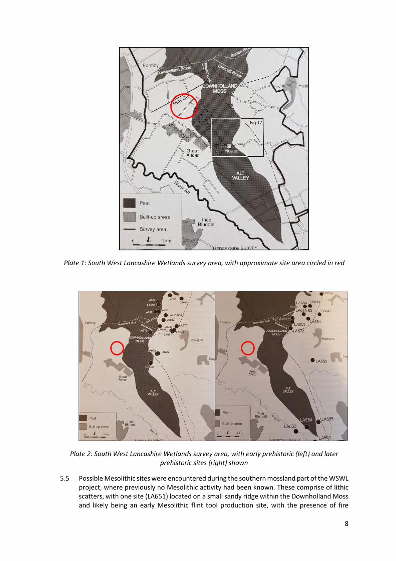
5.2 During the earlier prehistoric period the coastline was located further to the west (Johnson 2009). The formation of peat deposits in the area of Great Altcar reflect the subsequent sea-level rises following the glacial period. This rise in sea level flooded a large part of the low-lying land along the Lancashire coast, creating a new coastline that ran from Altcar northwards towards Shirdley Hill (West Lancashire County Council 2006). Isostatic readjustment, which is the land rising again following the glacial compression, caused the sea level then to return to its present-day position and the land became colonised with trees. As drainage became more difficult peat deposits formed in the area around Great Altcar. The area of peat deposit has been recognised as ‘Altcar Moss’ and the site is located within this area (ibid).
5.3 Surveys as part of the Wetlands of South West Lancashire (WSWL) project (Middleton et al 2013) have investigated and set out some of the archaeological and palaeoenvironmental remains found across this part of Lancashire. This was just one element of a larger survey of the North West Wetlands Survey which covered parts of Lancashire, Cumbria, Merseyside, Greater Manchester, Cheshire, Shropshire and Staffordshire.
5.4 The survey concentrates on the southern mossland of South West Lancashire although in reality, this mossland conjoins with the Merseyside mosslands to the south and the northern mosslands, covering a large part of the northwest coastal plain. The proposed development site is located close to the boundary of the Alt Valley and Downholland Moss areas.
8
Plate 1: South West Lancashire Wetlands survey area, with approximate site area circled in red
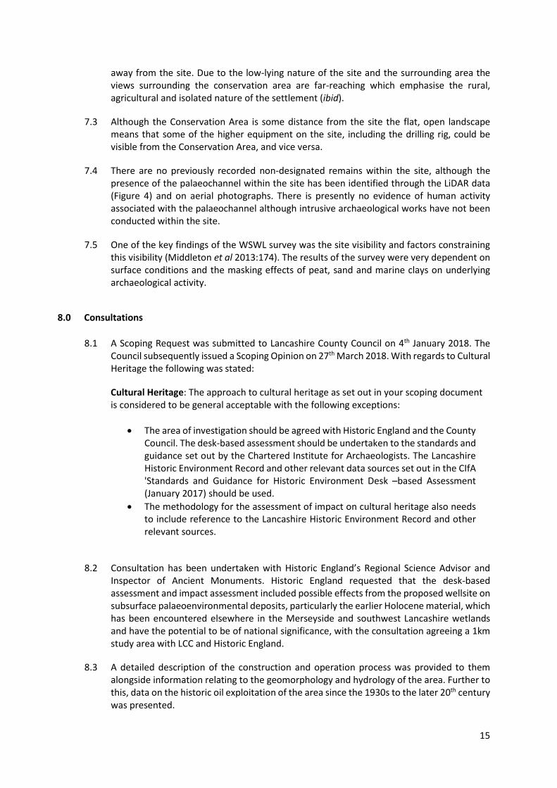
Plate 2: South West Lancashire Wetlands survey area, with early prehistoric (left) and later prehistoric sites (right) shown
5.5 Possible Mesolithic sites were encountered during the southern mossland part of the WSWL project, where previously no Mesolithic activity had been known. These comprise of lithic scatters, with one site (LA651) located on a small sandy ridge within the Downholland Moss and likely being an early Mesolithic flint tool production site, with the presence of fire

9
cracked stone and flint possibly indicating the use of fire in the tool production and/or a camp fire (Middleton et al 2013:63). A smaller scatter of Mesolithic flints was also noted at Hill House, over 2km to the west of the proposed development area, on another sandy ridge (Ibid 2013:63).
5.6 Further evidence of human activity from the Late Mesolithic period has been recorded along the coastline in the wider region, including the ‘Formby Footprints’, identified in the intertidal zone between Formby and Ainsdale (Gonzalez et al 1996; Hodgson and Brennand 2006). More footprints from later Neolithic and Bronze Age date have also survived in the mudflats outside Formby.
5.7 A total of 15 sites have been recorded during the WSWL surveys within the southern mosses of late Mesolithic or early Neolithic date, most of these with some form of blade technology, suggesting, if not an intensive, at least a wide spread of exploitation of the landscape and resources here. The evidence points to exploitation of natural resources rather than early farmers although the latter cannot be dismissed.
5.8 A number of late Neolithic and Bronze Age sites have been identified within the coastline between Liverpool and Fleetwood, including associated find spots such as two perforated axe-hammers, including one found within Great Altcar itself during ditch cutting, two canoes and a log boat.
5.9 Evidence of any Iron Age activity within this area is limited (ibid). The origin of the extensive system of sand dunes along the Sefton coast have also been dated to the prehistoric period (National Museums Liverpool and English Heritage 2011). One of the flint scatters, likely of Neolithic or Bronze Age date, at Barton, was found on a sandy ridge (LA646-53) although a number of the other finds were of single flints across a number of areas.
5.10 The area surrounding Great Altcar and Formby is known to have nationally important heritage assets, as determined by Historic England, that are not protected by national designations, mainly in the form of numerous occupation and activity areas with in-situ cultural material of prehistoric date, ranging from the Early Mesolithic to the Iron Age (Andrew Davison, pers. comm). A number of these sites are located within the Alt Valley, with activity and work sites seeming to favour the higher ground, or at least this is where more archaeological sites of earlier prehistoric date have been found.
5.11 Recent excavations at Lunt Meadows, c.5.5km south of the site and adjacent to the River Alt, have uncovered two substantial Mesolithic buildings, part of an area of well-organised settlement, rare for Mesolithic sites (Museum of Liverpool 2018). These buildings were discovered lying on a slightly elevated sand island. Such sand islands have since been buried beneath peat deposits, which have enabled the sealing of any prehistoric sites at a considerable depth, also protecting them from ploughing and drainage. A combination of these factors has meant that such deposits, and any associated archaeological activity, are extremely well preserved and this has certainly been the case at Lunt Meadows (Andrew Davison, pers. comm).
5.12 The site is located on the edge of the known peat deposits (Plate 1), with much of the peat deposits surveyed in the Alt Valley interspersed with other deposits, caused by mudflats, salt marshes and sand dunes (Cowell and Innes 1994). This geology is defined by the underlying boulder clay, on which sits the Shirdley Coversands. These sands were overlain by the Holocene deposits, including peats and alluvial material and was noted during the geotechnical investigations within the site, which is summarised below (Opus 2017).

10
Topsoil
Topsoil was encountered in all the exploratory hole locations to a maximum depth of 0.30m below ground level (bgl). The topsoil typically comprised a clayey sand or clayey gravelly sand.
Alluvium
A soft clay with varying proportions of silt and sand, as well as a clayey sand was encountered beneath the topsoil in all exploratory hole locations to a maximum encountered depth of 1.7m bgl.
Peat
Plastic pseudofibrous peat with varying proportions of clay and sand was encountered in all exploratory locations to a maximum depth of 2.60m bgl. The greatest thickness of peat recorded was 0.55m.
Downholland Silt
A soft to very soft clay comprising varying proportions of silt and sand was encountered beneath the peat to depths of 1.50m and 4.70m respectively.
Shirdley Sand
A very loose to very dense sand with varying proportions of clay and silt was encountered in all exploratory hole locations to a maximum encountered depth of 7.00m bgl. The greatest thickness of sand was shown to be 5.50m.
5.13 Although no evidence of any prehistoric activity has currently been found within the search area, the nature of the palaeoenvironment here has been demonstrated to be conducive to human activity and occupation, albeit more likely to be of a seasonal or episodic nature, as stated above. Palaeoenvironmental information on the former flora of the area has been recorded, with an account from 1895 describing bog oaks of considerable size and black poplar have regularly been dug up during ploughing across the Altcar Parish (Warburton 1895). Warburton further states that the bones and horns of wild animals were sometimes found alongside the trees during drain cutting (Ibid).
5.14 Evidence of Roman and early medieval activity within the area is limited and no evidence of Roman or early medieval activity has been identified within the search area. Little evidence of Roman and Romano-British activity has been recorded within the Sefton area in general, with the possible reason for this being a rise in sea level, which would have made habitation difficult (Cowell and Innes 1994). The early medieval period activity is also sparse, with little known settlement until the 10th century, when the Norse settlers from Ireland began to colonise the coastal areas and the Alt Valley (Ibid). The place name of Formby is potentially of Old Scandinavian derivation, meaning ‘old farmstead’ or ‘farmstead of a man named Forni’ (Mills 1991).
5.15 The place-name Altcar is derived from ‘Marsh by the River Alt’, with ‘Alt’ being the name of the river and the Old Norse ‘kjarr’ referring to brushwood; a marsh overgrown with brushwood (Watts 2007). The modern-day equivalent, ‘carr’ can be found in many place names in this area. Both ‘Great’ and ‘Little’ Altcar’ exist suggesting that at one stage Great

11
Altcar was the larger of the two settlements. However, Little Altcar has now been absorbed into the town of Formby and is much larger than its historic counterpart.
5.16 Although there is no physical evidence of Saxon or Norse date within the study area, Great and Little Altcar are mentioned in the Domesday Book of 1086, assessed together at half a plough land and described as waste land held by Roger of Poitou with Uhtred as Lord (Williams and Martin 1992). The villages were built on land reclaimed from the sea; the process of reclamation is assumed to have been started at the beginning of the medieval period but which predominantly dates to the 19th century (West Lancashire County Council 2006: 5). Despite this, no medieval activity is recorded within the search area, suggesting that the small medieval settlement was located beyond the search area, likely further to the south where the present village of Great Altcar is located.
5.17 The isolated and rural nature of the village meant that its residents had to be relatively self-sufficient. This local focus may be reflected in the names of the fields surrounding the village with many of the farms named after their former occupiers (West Lancashire County Council 2006). Sutton’s Lane, the access route to the site, is assumedly named because it provides access to Sutton’s Farm, a post-medieval farm located c.1km southwest of the site (Site 1). This personal etymological origin is reflected in the naming of other farms and lanes within the village, including Liversley’s Lane and Doctor’s Lane.
5.18 The HER entries are predominately post-medieval records of farmsteads and cottages along what is now called ‘Lord Sefton Way’ which formed the main arterial route through the village with habitation occurring along either side of this route, clearly marked on historic mapping from 1845 (Figure 5). As well as Sutton’s Farm, Tyrer’s Farm, Burgess Cottage and Mercer’s Cottage are all marked on the 1845 map of the area, lying c. 1km southwest of the site (Sites 1-4) (Figure 5). A pump, well and a pound are also marked c.1km southwest of the site (Sites 5 and 6). The site itself was undeveloped and bisected by a number of field drains, typical of reclaimed marshland.
5.19 Further settlement within the village is also recorded along Broad Lane with the development of a number of farmsteads, including Formby’s Farm and floodgate, c.1km west of the site (Sites 7 and 10), Prestcot’s Farm, c. 925m southwest of the site (Site 8), Cooper’s and Arnold’s Farm c.930m west of the site (Sites 9 and 11). Many of these farms are named after their former occupiers with both the individuals and their descendants commemorated in the graveyard of St Michael’s Church (West Lancashire County Council 2006). Both Cooper’s and Prestcot’s Farm are no longer extant.
5.20 The Tithe map of 1848 shows little change in the area of the site or its environs (Figure 6). The area of the site covers two plots of land, marked as apportionments 202 and 203. These are both listed as being pasture/meadow land. Both plots of land were owned by the Earl of Sefton, with the pasture at Plot 202 occupied by a Henry Golbourne or Golthorne and the plot named as Long Hey. The meadow at Plot 203 appears to have been occupied by a James Bond, with the plot called Mofs (potentially Moss) Hey.
5.21 At the site of what is now 93 and 95 Lord Sefton Way a school is marked on the 1845 map, c.970m south of the proposed wellsite (Site 12). The school was moved in 1865 to a new building to the east of Clayton’s Farm. At the original school site, the school rooms to the rear were demolished and now only the Master’s House is extant and has been converted into a dwelling.

12
5.22 The small village of Great Altcar remained largely isolated until the construction of the Cheshire Lines Extension in 1884, which was an extension of the Liverpool to Southport railway line (West Lancashire County Council 2006). The site of the original Barton and Halsall Station, renamed the Moss Bridge Station in 1894, is located c.820m northeast of the site (Site 13) and is clearly marked on the Ordnance Survey map of 1894 (Figure 7). However, this station was closed to passengers in 1917 and closed entirely in 1928. Today, the line of the former railway line is marked by the Cheshire Lines Path, a walking/cycling route.
5.23 Sand extraction has been occurring at Formby since at least the early 18th century, mainly around the area south of Formby Point (Johnson 2009), whilst extraction has been ongoing since the late 19th century, with the Altcar borehole, for brine exploration, operating since 1890-2, although Formby oil seeps had been recorded in Camden’s Britannia as far back as 1637. This described the finds as “As to the oily matter abovementioned, a Chymist in the neighbourhood extracted from it an Oyl extraordinary Soveraign in Paralytick Distempers”. Oil exploration and extraction began in 1939, and continued in the wider area, extending through the remaining 20th century.
5.24 During the early 20th century the site remained undeveloped agricultural land, bisected by field drains. Within Great Altcar itself, a number of dwellings have been built on the northern side of Lord Sefton Way (Figure 8 and Figure 9). Two records relating to the Second World War have been identified within the search area; several anti-tank tetrahedrons which have been re-used to stop vehicles entering the Cheshire Lines Path, are located c.785m northeast of the site (Site 14), and a ‘Q-type’ decoy which displayed a series of lights to simulate an active airfield, in use in 1942. This was thought to be located c.250m east of the site although research has indicated that it is closer to c.550m to the east (Site 15). It is unclear whether any evidence of this survives today.
5.25 A number of undated watercourses and cropmarks have been identified within the search area, including within the site itself (Site 16). These are also clearly identifiable in the LiDAR imagery of the site (Figure 4). The meandering nature of many of the watercourses, or roddons, indicate their natural origins, with the man-made channels of more regular appearance, as is clear from historic mapping and the current network of field drains.
5.26 A possible channel appears to pass through the proposed development site, running broadly north - south towards Great Altcar. The watercourse is not shown on the 1845 map of Great Altcar (Figure 5), suggesting that it may have been medieval or earlier and had silted up by the post-medieval period, if not earlier.
6.0 Site Visit
6.1 The site was visited by AAL on Tuesday 20th March 2018. Selected photographic images taken during the site visit are reproduced below and their locations indicated on Figure 2.
6.2 The proposed wellsite comprises a c.1 hectare area with an access track which measures 0.72 hectares. The wellsite is located within an arable field (Plates 3–4). The terrain is flat, with no obvious features present.

13
Plate 3: View of the site, looking northeast
Plate 4: View of the site, looking southwest
6.3 The proposed wellsite is currently accessed off Lord Sefton Way and Broad Lane and is on a minor road, Sutton’s Lane, leading northeast between Sutton’s Farm and Tyrer’s Farm, heading for Middle Moss Lane (Plate 5) (Plate 6). The proposed route of the access road runs from the junction of Broad Lane and Sutton’s Lane across the field to the wellsite entrance.

14
Plate 5: Sutton’s Lane from Lord Sefton Way, looking northeast towards the proposed route of the access road
Plate 6: Sutton’s Lane in the direction of the site, looking northeast
7.0 Constraints
7.1 There are no Battlefields, Registered Parks and Gardens, Scheduled Monuments, or World Heritage Sites within the search area.
7.2 The Great Altcar Conservation Area covers the main settlement area of the village along Lord Sefton Way and Broad Lane (Figure 3) (West Lancashire County Council 2006). The Conservation Area encroaches into the southern part of the search area but is around 1km
15
away from the site. Due to the low-lying nature of the site and the surrounding area the views surrounding the conservation area are far-reaching which emphasise the rural, agricultural and isolated nature of the settlement (ibid).
7.3 Although the Conservation Area is some distance from the site the flat, open landscape means that some of the higher equipment on the site, including the drilling rig, could be visible from the Conservation Area, and vice versa.
7.4 There are no previously recorded non-designated remains within the site, although the presence of the palaeochannel within the site has been identified through the LiDAR data (Figure 4) and on aerial photographs. There is presently no evidence of human activity associated with the palaeochannel although intrusive archaeological works have not been conducted within the site.
7.5 One of the key findings of the WSWL survey was the site visibility and factors constraining this visibility (Middleton et al 2013:174). The results of the survey were very dependent on surface conditions and the masking effects of peat, sand and marine clays on underlying archaeological activity.
8.0 Consultations
8.1 A Scoping Request was submitted to Lancashire County Council on 4th January 2018. The Council subsequently issued a Scoping Opinion on 27th March 2018. With regards to Cultural Heritage the following was stated:
Cultural Heritage: The approach to cultural heritage as set out in your scoping document is considered to be general acceptable with the following exceptions:
• The area of investigation should be agreed with Historic England and the County Council. The desk-based assessment should be undertaken to the standards and guidance set out by the Chartered Institute for Archaeologists. The Lancashire Historic Environment Record and other relevant data sources set out in the CIfA 'Standards and Guidance for Historic Environment Desk –based Assessment (January 2017) should be used.
• The methodology for the assessment of impact on cultural heritage also needs to include reference to the Lancashire Historic Environment Record and other relevant sources.
8.2 Consultation has been undertaken with Historic England’s Regional Science Advisor and Inspector of Ancient Monuments. Historic England requested that the desk-based assessment and impact assessment included possible effects from the proposed wellsite on subsurface palaeoenvironmental deposits, particularly the earlier Holocene material, which has been encountered elsewhere in the Merseyside and southwest Lancashire wetlands and have the potential to be of national significance, with the consultation agreeing a 1km study area with LCC and Historic England.
8.3 A detailed description of the construction and operation process was provided to them alongside information relating to the geomorphology and hydrology of the area. Further to this, data on the historic oil exploitation of the area since the 1930s to the later 20th century was presented.

16
8.4 The hydrogeology and hydrology assessments will accompany the full planning application. The lengthy history of oil extraction within the area was previously unknown to Historic England. The level of impact that this previous extraction has had on the historic environment is unknown. Changes to the water table and chemistry of previously anaerobic deposits may have caused the degradation of organic remains within the Alt Valley.
8.5 The detailed description of the construction techniques for the wells including the well casing design will be in accordance with environmental regulations issued by government and regulatory bodies.
8.6 Following the discussions, the remaining issues of interest to Historic England were the perimeter ditch surrounding the wellsite, the drilling cellar and the access track and the nature of the site, being slightly elevated compared with the surrounding land form, which may be conducive to earlier prehistoric activity.
9.0 Impact Assessment
Development Details and Types of Impact 9.1 The main impacts as a result of the proposed development are limited to the central well
cellar, the area around the wellsite boundary and access track. The larger sub-surface works will cover a much wider area than the wellsite boundary, the extent of these works will be at a depth of around 2-3km below ground level and therefore will not have any impact upon archaeological or palaeoenvironmental remains.
9.2 A description of the works proposed for the wellsite is as follows:
The area of surface works cover one (1) hectare encompassing a hydrocarbon exploration wellsite, from which two (2) exploratory boreholes will be drilled.
Once the site is constructed, the drilling rig will mobilise to the site to drill the two exploratory boreholes.
The topographic survey indicates a slightly higher area of ground within the proposed wellsite area, which will be reduced (cut) and distributed (fill) in the lower areas of the proposed wellsite area.
Once the regrading of the land is complete, a combi grid, a combination of non-woven geotextile and geogrid, will be placed over the proposed wellsite, which provides for soil stabilisation and separation. A granular sub base aggregate will then be imported to wellsite and overlaid on the combi grid.
Once the wellsite has been constructed to a suitable level platform, a piling machine will be mobilised to the wellsite to install precast concrete driven piles into the underlying soils. The concrete piles will be positioned and set to provide structural support to the drilling cellar, which will be constructed within the wellsite. The drilling cellar is a concrete chamber constructed below ground level, which provides a fully sealed containment area within which the wellheads are to be installed.
17
Once the concrete piles have been set to the required depth, subsoils will then be excavated to a depth of up to 5m to allow the drilling cellar to be constructed. The concrete piles will be cut to the required level to allow for a reinforced concrete base to be formed on top of the concrete piles, in the bottom of the excavation. The reinforced concrete base will form the floor of the drilling cellar, upon which reinforced concrete walls will be constructed. Once the drilling cellar has been constructed, excavated subsoil will be used to backfill the excavation.
Following construction of the drilling cellar, perimeter containment, water attenuation system, interceptor and cess tank, the granular sub base aggregate will be compacted to level prior to the installation of a 2mm thick fully welded high-density polyethylene (HDPE) impermeable membrane across the active area of the wellsite and perimeter containment ditches. The HDPE impermeable membrane will be protected above and below by a layer of non-needle punch geotextile. The HDPE impermeable membrane provides tertiary containment, in the unlikely event of an accidental spill during wellsite operations.
For clarity, the HDPE impermeable membrane will not extend to the non-active area of the wellsite. This area is designated for office accommodation and welfare facilities only and, as such, the risk of an environmental release is extremely low and will be contained within dedicated bunding.
A layer of non-needle punch geotextile will be laid across the non-active area of the wellsite to provide for soil stabilisation and separation. In addition, it provides filtration, allowing rain water to percolate into the underlying soils, maintaining the natural water system in this area.
Above the non-needle punch geotextile, aggregate material will be imported to the wellsite, laid and compacted across the whole wellsite at varying depths.
The active area of the wellsite will then be covered with a reinforced concrete slab, which, in addition to providing greater structural support, provides secondary environmental containment. The concrete slab will be edged with concrete kerbing, incorporating concrete ramps to provide vehicular access in to the containment area.
The first borehole will be drilled vertically to a depth of circa 3,200m below ground level. The purpose of the borehole is to appraise the subsurface geology, in particular, the Bowland Shale formation at a depth of circa 2,000m below ground level and Hodder Mudstone formation circa 2,300m below surface. Exploratory drilling operations undertaken between 1940 and 1947 encountered hydrocarbons (gas) in the Bowland Shale formation at a depth of 2,341m below ground level, however, that well (Formby-1) is one of a significant number of wells drilled in the immediate area from 1939 to 1965, when oil was discovered at shallow depth, producing from a depth of 40m below ground level. The oldest borehole to be drilled in the immediate vicinity of the proposed site is the Altcar Borehole, drilled to a depth of 330m below ground level and is positioned 50m to the north of the proposed site.
Once the first borehole has been constructed, drilling will commence on the second borehole. The second borehole will be drilled vertically for approximately 1,500m before directionally drilling the borehole, building angle to achieve a horizontal

18
section in one of the formations identified when drilling the first borehole. For clarity, the horizontal section will be in excess of 2,000m below ground level.
Following the drilling and construction of the boreholes, both boreholes will undergo hydraulic fracture stimulation. Again, this happens at a depth deeper than 2,000m. During the hydraulic stimulation operations, a detailed microseismic monitoring system will be deployed to monitor for induced seismicity. In the event that a 0.5ML induced event is recorded, the hydraulic fracturing operation must be depressured, followed by a period of monitoring before the operation can resume.
9.3 Details of the access track and other associated construction including site security and welfare are as follows:
Access Track Construction Access to the wellsite will be from Lord Sefton Way onto Suttons Lane. After approximately 220m vehicles will then turn northwest onto private land where a new access track will be constructed, for a distance of approximately 815m to the wellsite entrance.
The access track will be constructed in advance of wellsite construction, together with highway improvement works to Sutton’s Lane, which will be agreed in advance with the County Highways Authority.
The new access track will be constructed to a general width of 5m, using a geomembrane separation and granular sub base aggregate, overlaid with pre-made interlocking track panels. A number of wider sections will be provided along its route, incorporating passing places.
The new access track will cross two (2) existing field drains, one at the new access track entrance on to Sutton’s Land and one at the northern extent of the adjacent field. In order to provide for the construction of the new access track, the drains will be culverted, using precast concrete box culverts, set on a concrete bed.
Containment Ditch and Cess Tank A containment ditch will be excavated to a depth of 1m around the perimeter of the active area of the wellsite, the area within which the drilling rig, hydraulic fracturing equipment and well testing equipment will be located. The purpose of the containment ditch is to provide a mechanism for collecting surface run-off water (rain water) falling within the active area of the wellsite and directing it to a discharge point located in the southeast corner of the wellsite via fully lined surface water attenuation system and Class 1 full retention separator, installed below ground level.
A cess tank will be installed in the non-active area of the wellsite, the area within which the office accommodation and welfare facilities will be located, connected to the cess tank using standard foul drainage pipes. The cess tank will contain foul water and sewage for subsequent offsite treatment at an approved sewage water treatment works.
9.4 Once the wellsite is constructed, temporary Heras fencing will be replaced with a 3m high security fence, vehicle access and pedestrian access gates. Additional security may be

19
installed, consisting of a secondary security fence around the perimeter of the active area and pole mounted CCTV cameras and lighting.
9.5 Construction of the wellsite and access track is estimated to take approximately 16 weeks to complete. The Phase 1 works will be subject to a detailed construction quality assurance plan (CQA).
9.6 The assessment of impacts has been undertaken based on the above development parameters. Significant alternations to these parameters may necessitate a re-evaluation of the impacts.
9.7 The impact assessment will use the assessment methodology described in section 4 above and in Appendix 1.
9.8 The main impacts of the proposed development relate to the intrusive element of the proposed development, namely the construction of the perimeter ditch, the drilling cellars and the subsurface drainage system and the construction of the access route, although this last element will not involve any intrusive ground excavation.
9.9 In addition to these impacts, consideration has been made regarding compaction, the introduction of oxygen into previously anaerobic deposits and changes to the water table. These effects may impact on fragile palaeoenvironmental remains.
9.10 The development may have further indirect effects during the construction and operational phases of its existence. These are the levels of noise, vibration, light and visual intrusion which could conceivably impact on any heritage assets.
9.11 In terms of noise disturbance, it is assumed that the use of appropriate mitigation will mean that an increase in noise levels associated with the hydraulic fracturing will be within accepted limits. Therefore, the impact upon heritage assets within the search area is considered to be neutral.
9.12 The hydraulic fracturing has the potential to generate vibration at the surface due to induced seismicity. The potential impact of such vibration on any buried archaeological and paleoenvironmental remains within the site may cause damage and movement to buried archaeological deposits, although this is more likely to affect rigid structural remains rather than on ‘soft’ organic remains. However, modelling suggests that any vibration at the surface as a result of induced seismicity will be at a level below that which may cause cosmetic damage to even the most sensitive structures and consequently there is no anticipated impact.
9.13 The flat, open landscape surrounding the well site will mean that views of the wellsite will be far reaching in all directions, both towards Great Altcar and to Formby. In particular, the wellsite will be viewed from the heritage assets (Sites 1 -12) to the south and southwest within the Great Altcar Conservation Area (Figure 3). The low-lying nature of the land will likely limit the long-distance visibility however and the visual impact of the proposed development on the identified heritage assets and the conservation area is considered be both minor and temporary.
Heritage Assets 9.14 The assessment has not identified any archaeological remains within the application site
boundary including the access track alignment. The locality is slightly elevated compared
20
with the surrounding landscape, which may have implications in terms of its potential for archaeological remains, although the present height difference is less than 250mm. Higher ground was more likely to have been exploited, although how much this elevated landform is due to the presence of a palaeochannel running through the site and how much is natural late Pleistocene or early Holocene topography is unknown.
9.15 There are limited identified archaeological or built heritage assets within proximity of the proposed wellsite. A World War Q-type' night decoy, which displayed a series of lights to simulate an active airfield, was located to the east of the development site. These types of site may have included dummy plywood buildings, inflatable rubber aircraft or vehicles, and a ploughed imitation runway, all above ground structures unlikely to leave any archaeological trace.
9.16 The limited number of known archaeological remains appear to be primarily focussed to the southwest, at Great Altcar, and are post-medieval in date, representing dwellings and farmsteads on the periphery of the settlement.
9.17 Although no remains of prehistoric, Roman, early medieval or medieval date are recorded in the search area, activity of these dates have been recorded within the wider area. Although no prehistoric activity has been identified from within the search area itself, there is extensive previously recorded evidence in the surrounding area, of Mesolithic, Neolithic, Bronze Age, and Iron Age dates. Such evidence has been found west of the site on along the northwest coastline (Johnson 2009) and also within the Alt Valley, within the wider southwest Lancashire and Merseyside wetlands. Currently no evidence of prehistoric date is known but the known remains from the wider landscape, coupled with the presence of relict palaeochannels, would indicate that the area surrounding the site may have been suitable for resource exploitation during this period.
9.18 Roman and early medieval is activity is less common, with Norse settlers arriving in the 10th century, and probably giving impetus to the development of settlements such as Formby, Great Altcar and Little Altcar. Physical evidence however is lacking.
9.19 Medieval activity is likely to have been focussed around these main settlements. Formby was the largest of the settlements within the area, with the Altcars and Meols much smaller. Again, it is likely that most of the settlement activity was within the former historic cores of these settlements, with farming, fishing and exploitation of resources extending from the settlement hubs. Once again however, physical evidence of this period of activity is absent from the study area.
9.20 Previously unrecorded post-medieval activity within the area is likely to be of a similar nature to the medieval period, focussing on the agricultural use of the drained marshland. Exploitation of the natural resources is also possible, with peat extraction taking place within the area.
Impact Assessment 9.21 The assessment has covered a study area of 1km surrounding the wellsite and included all
previously recorded heritage assets within this range. Further consideration of heritage assets and sites outside of this 1km radius have been undertaken where it enhances the understanding of the heritage assets within the 1km study area or assessing the potential significance and assessment of impact.

21
9.22 The proposed development is not anticipated to impact on any of the previously identified archaeological or heritage assets. There is no recognisable trace of the World War night decoy, including on LIDAR and aerial photographs.
9.23 The proposed development will not remove any historic field boundary, being aligned with the current landscape system. The access route will cross two ditches, which will be culverted and retained to ensure that water management of the area is unaffected.
9.24 Impacts during the construction phase on previously unrecorded archaeological remains are possible although currently the assessment has indicated a low potential for the existence of any remains, besides palaeoenvironmental evidence, to survive within the site. This palaeoenvironmental material may have been degraded from previous work within the area, namely agriculture, the land reclamation and drainage, the existing water management and natural fluctuations in the water level. The presence of a palaeochannel may mean that any palaeoenvironmental material could survive at depth, with the drilling cellar having the potential to expose these deposits, if present.
9.25 The settlement of Great Altcar to the southwest of the development area contains seven Listed Buildings and is designated as a Conservation Area. The Listed Buildings are all slightly beyond the 1km study area. They comprise the local Church, War Memorial, Lychgate and four farms or farm buildings. The proposed wellsite is not anticipated to significantly impact on the setting of the Listed Buildings and Conservation Area. The landscape is very flat, meaning that there are few topographical highpoints or hills, from which the proposed development would be visible. The current skyline is of open fields, hedgerows and trees, above which overhead telegraph poles and electricity pylons are visible. The wellsite rig and coil tubing tower are likely to be visible temporarily from parts of the surrounding countryside. A Landscape Impact Assessment (LIA) has been undertaken by DRaW (UK) Ltd (2018). The LIA produced a Zone of Theoretical Visibility (ZTV) plan indicating where visibility of the proposed wellsite would be possible within a 5km radius from the wellsite.
9.26 This concludes that the proposals would have the following effect on Listed Buildings and the Great Altcar Conservation Area:
Effects on the Visual Setting of Great Altcar Conservation Area Great Altcar Conversation Area encompasses the majority of the village. At its closest point it is approximately 935m from the wellsite. The taller structures within the wellsite would be visible from properties on the eastern edge of Great Altcar and intermittently from Lord Sefton Way, between gaps in the buildings. The intermittent long-distance views across Altcar Moss are a defining characteristic of the Conservation Area. The proposals would have a temporary adverse effect on some views between the buildings, although the magnitude of effect would be lessened by distance, partial screening afforded by adjacent properties and by the short duration of the exploration works.
Effects on the Visual Setting of Listed Buildings The nearest Listed Building is the Grade II* St Michael and All Angel’s Church, Great Altcar. Views of the wellsite and the tall structures would be substantially screened by intervening vegetation and by Tryer’s Farm off Lord Sefton Way, consequently the setting of the church would not be affected by the proposals
The proposed drilling rig, coil tubing tower and work over rig would be theoretically visible from Grade II Listed buildings within Great Altcar although in reality substantial screening would be afforded by vegetation in the village and the properties to the east of Lord Sefton

22
Way. Any partial views of the development would be temporary, short-term and fully reversible. Overall, the proposals would not affect the setting of the Listed Buildings.
9.27 Increased traffic movement, particularly during the construction and hydraulic fracture phases, are likely to bring increased noise, traffic, dust and vibration, therefore reducing the level of appreciation and enjoyment visitors may get from the scattering of Listed Buildings within Great Altcar itself. The proposed HGV/AILV route to the site is:
• HGVs travelling towards the site: A565 – Altcar Road (B5159) – Lord Sefton Way (B5195) – Suttons Lane – Access Track.
9.28 The egress route from the site will be the same as above but in reverse.
9.29 All HGV vehicles will access the site using a specified route, turning west from Lord Sefton Way onto Suttons Lane and after approximately 220m turning north west onto private land where the new access track will be constructed. HGV’s will therefore not directly pass any Listed buildings or the Great Altcar Conservation Area.
10.0 Mitigation
10.1 Mitigation is proposed for those impacts with the potential to affect the setting of heritage assets and buried archaeological/palaeoenvironmental remains.
10.2 Although the potential for remains within the site is considered to be low, any remains, if present, could be fragile and significant. As there are no identified remains, it is not possible to advocate mitigation by avoidance at this stage. Consequently, it is recommended that archaeological investigations are conducted within the site where there is potential for harm to the underlying deposits. This may be in a phased approach, with non-intrusive geophysical survey being conducted, followed by intrusive archaeological investigations. Archaeological auguring could be another technique employed, to better ascertain and collect palaeoenvironmental data relating to deeply stratified early Holocene deposits. The aim of this is to provide a detailed understanding of the archaeological and palaeoenvironmental resource within the site, formulate the most appropriate and proportionate method for the preservation of any remains encountered and identify whether further work is required, including scientific dating and analysis. Bog mats and track panels will be laid down for the access track to avoid any excavation. Some compaction of underlying deposits may occur here as a result of the track panels.
10.3 The proposed wellsite is not anticipated to lead to an increase in widescale dewatering or desiccation of the peat. The excavation of the perimeter ditch will be on a similar scale to the existing drainage ditches and water management features across the Great Altcar area and Downholland Moss. The sunken drilling cellar will extend up to 5m below ground level and will be deeper than the surrounding drainage ditches. However, the lengthy history of extraction within the area, most without any environmental precautions or mitigation, may have caused prior degradation of the peat and organic remains. A scheme of groundwater monitoring will be agreed with the Environment Agency.
10.4 In order to mitigate against the impacts of vibrations, a miscroseismic monitoring system, the traffic light system, will be deployed to monitor for induced seismicity. If a 0.5 ML event is recorded (0.5 on the Richter scale), the hydraulic fracturing operation will be de-

23
pressured, followed by a period of monitoring before the operation can resume. This approach has been implemented at other hydraulic fracturing sites (Walker 2015).
10.5 With regard to the visual impacts, the landscape chapter of the Environmental Statement has determined that there would be minimal impact on the designated heritage receptors and that any impact is on a temporary basis. Therefore, there are no further recommended mitigation requirements for setting issues.
11.0 Discussion and Conclusions
11.1 The assessment has considered the LHER data, historic maps, aerial images and LiDAR to assess the known and potential archaeological resource within the study area surrounding the proposed wellsite at Great Altcar. This has been supplemented by geotechnical data from recent ground investigations, a site visit and consultation and agreement with Historic England and Lancashire County Council.
11.2 The assessment has found that there are no previously recorded archaeological remains within the site itself, and limited evidence recorded within a 1km radius of the site, predominantly of post-medieval date. However, in the wider landscape, there is extensive evidence of prehistoric exploitation of the area, particularly of Mesolithic date and the landscape was likely crossed by numerous small watercourses, which potentially led to seasonal flooding. There is no evidence of any prehistoric activity within the site or in proximity to it.
11.3 Roman and early medieval remains are absent from the site or study area although 10th century Norse habitation may have occurred, as suggested by place-name data.
11.4 Land reclamation may have started during the medieval period and Great Altcar, Little Altcar, Meols and Formby all appear in the Domesday Book, with Formby being the main settlement at the time. The settlements seem to have formed from small farmsteads or groups of farmsteads, likely on higher ground, with the surrounding land used for agriculture and resource exploitation. A palaeochannel of uncertain date appears to pass through the site, and may have been the focus of exploitation of resources.
11.5 The assessment has not established any significant post-medieval or modern activity, with a World War II Q-type night decoy being the only recorded archaeology within proximity to the site.
11.6 Based on the previously recorded evidence and the potential for unrecorded remains, it is recommended that, in order to determine if any prehistoric activity, or any other archaeological deposits, are present within the site, a phased approach is taken to investigating the site. In the first instance, a geophysical survey should be carried out to ascertain near surface archaeological activity and an augur survey to review deeply stratified palaeoenvironmental deposits, in particular the relict palaeochannel. This is non-intrusive and will give an indication as to whether any features of archaeological interest are present within the site. The results of the geophysical survey will determine the next stage of archaeological works, if any, needed on the site. It should be made clear that the area of the site includes the area of surface construction for the wellsite and access track.
11.7 The main impacts to any subsurface/buried archaeological and palaeoenvironmental remains within the site and any heritage assets within the search area are from the drilling

24
cellar construction. However, appropriate intrusive investigations have been recommended in order to identify assets and formulate an appropriate strategy to reduce the impacts of the temporary wellsite.
11.8 Vibration effects and hydrological changes will be monitored, with the baseline data set established by the Hydrological Risk Assessment, against which any changes can be measured. No impacts are anticipated, given the extent of historic water management and drainage ditches covering the area and the 20th century oil exploitation but prudence is advised here to ensure the present hydrological system is maintained.
11.9 The proposed wellsite will slightly alter the setting of the surrounding landscape, with limited views from the settlement of Great Altcar. The landscape is low-lying, with few topographical landmarks. Consequently, the wellsite is likely to be limited in its visual presence and is a temporary structure. Standard measures for limiting the visibility of the site are recommended, including the use of neutral coloured materials in the design and build.
11.10 A Construction Environmental Management Plan should limit the number of vehicle movements, thus limiting the noise and dust created by works traffic, both during the construction and operation periods. Facilities for reduction of dust which may lead to may also be warranted during summer months.
12.0 Acknowledgements
12.1 Allen Archaeology Limited would like to thank Zetland Group Limited for this commission.
13.0 References
CIfA, 2014, Standard and Guidance for Historic Environment Desk-Based Assessment, Reading: Chartered Institute for Archaeologists
Brennand, M., (eds) 2006, The Archaeology of North West England: An Archaeological Research Framework for the North West Region, Volume 1, Resource Assessment, Archaeology North West, Volume 8
Cowell R.W & Innes J.B 1994, North West Wetlands Survey 1: The Wetlands of Merseyside, Lancaster Archaeological Unit, Lancaster Imprints
Gonzalez, S. Huddart, D. & Roberts, G. 1996. Holocene development of the Sefton Coast: a multidisciplinary approach to understanding the archaeology. In A. Sinclair, E. Slater and J. Gowlett (eds) Proceedings of the Archaeological Sciences Conference 1995, 289-299. Oxford University Archaeological Monograph Series. Oxford: Oxbow Books.
Hodgson. J. & Brennand. M., 2006, Prehistoric Period Resource Assessment (Chapter 2), In: Brennand, M., (eds) 2006, The Archaeology of North West England: An Archaeological Research Framework for the North West Region, Volume 1, Resource Assessment, Archaeology North West, Volume 8

25
Historic England, 2015a, Historic Environment Good Practice Advice in Planning, London: Historic Buildings and Monuments Commission for England
Historic England, 2015b, Management of Research Projects in the Historic Environment: The MoRPHE Project Managers’ Guide, London: Historic Buildings and Monuments Commission for England
Johnson. B., 2009, North West Rapid Coastal Zone Assessment (NWRCZA), Archaeological Research Services Ltd
Middleton, R, Tooley, M. J & J.B Innes, 2013, The Wetlands of South West Lancashire, Oxford Archaeology North, Lancaster, North West Wetlands Survey No 7
Ministry for Housing, Communities and Local Government, 2018, National Planning Policy Framework. London: Department for Communities and Local Government
Museum of Liverpool, 2018: http://www.liverpoolmuseums.org.uk/ mol/archaeology/projects/lunt-meadows/settlement.aspx
National Museums Liverpool and English Heritage, 2011, Sefton Historic Settlement Study, Merseyside Historic Characterisation Project
The Highways Agency, 2007, Design Manual for Roads and Bridges – Cultural Heritage, HA 208/07, Volume 11, Section 3, Part 2
Walker. E., 2015, Kirby Miserperton A Wellsite, KM8 Production Well – Hydraulic Fracture Simulation, Heritage Impact Assessment, Third Energy, Revision 1
Williams, A., & Martin, G.H., 2002, Domesday Book: A Complete Translation, London: Penguin Books Ltd
West Lancashire County Council, 2006, Great Altcar Conservation Area – Conservation Area Appraisal
Cartographic Sources 1845 map of Great Altcar Area (Lancashire Archives)
1848 Tithe Map of the Township of Altcar in the county of Lancaster (Lancashire Archives)
1st Edition Ordnance Survey map (Lancashire Archives)
1904 Ordnance Survey map (Lancashire Archives)
1928 Ordnance Survey map (Lancashire Archives)

26
Appendix 1: Assessment Criteria No standard method of evaluation and assessment is available for the assessment of effect on significance with regards to cultural heritage. Therefore, a set of evaluation and assessment criteria have been developed using a combination of NPPF and the Design Manual for Roads and Bridges (DMRB) guidance on cultural heritage.
NPPF defines significance of heritage assets as ‘The value of a heritage asset to this and future generations because of its heritage interest.’ (NPPF, Annex 2 Glossary). In addition to the NPPF, Historic England guidance sets out criteria which should be considered when assessing the significance of cultural heritage assets, which include archaeological, architectural, artistic and historic values. These criteria have therefore been used in the assessment of significance for each asset.
The criteria for assessing the significance of heritage assets are presented in Table 9.1 below:
Table .1: Cultural Heritage Significance
Significance Examples
Very High
World Heritage Sites;
Assets of acknowledged international importance;
Other buildings of recognised international importance; and
Historic landscapes of international sensitivity, whether designated or not.
High
Scheduled Monuments;
Undesignated sites/features of schedulable quality and importance;
Listed Buildings;
Undesignated structures of clear national importance; and
Designated & undesignated historic landscapes of outstanding interest.
Medium
Sites/features that contribute to regional research objectives;
Unlisted buildings that can be shown to have exceptional qualities in their fabric or historical association;
Conservation Areas;
Historic townscape or built-up areas with historic integrity in their buildings, or built settings; and
Designated special historic landscapes and undesignated historic landscapes of regional sensitivity.
Low
Undesignated sites/features of local importance;
‘Locally Listed’ buildings and unlisted buildings of modest quality in their fabric or historical association; and
Historic landscapes whose sensitivity is limited by poor preservation and/or poor survival of contextual associations or with specific and substantial importance to local interest groups.
Negligible
Assets with very little or no surviving archaeological interest;
Buildings of no architectural or historical note; buildings of an intrusive character; and
Landscapes with little or no significant historical interest.

27
Significance Examples
Unknown
Archaeological sites/features where the importance of the resource cannot be ascertained; and
Buildings with some hidden (i.e. inaccessible) potential for historic significance.
When professional judgement is considered, some sites may not fit into the specified category in this table. For example, some Grade II listed buildings may only be of medium value or the rarity value of a certain asset regionally may raise its value. Each heritage asset is assessed on an individual basis and takes into account regional variations and individual qualities of sites.
Sites with an unknown significance cannot be assessed further.
The magnitude of change resulting from the development is assessed for each heritage asset independently of its archaeological or heritage value. The magnitude of change categories have been adapted from DMRB guidance and are presented in Table 9.2.
Change to assets can be either direct or indirect. Direct effects are those where there is a physical connection between the development and the asset, whereas indirect effects require some additional pathway for the effect to arise, for example changes to the setting of a heritage asset. The magnitude of change may be either positive or negative.
Table 2: Determining Magnitude of Change
Magnitude Example Criteria
Major Change to most or all key archaeological/historic building/historic landscape elements or their setting, such that the resource is totally altered.
Intermediate Changes to many key archaeological/historic building/historic landscape elements or their setting, such that the resource is clearly modified.
Minor Changes to key archaeological/historic building/historic landscape elements, such that the asset or its setting is slightly altered.
Negligible Very minor changes to elements.
No Change No change

28
Table 3: Criteria to Determine Significance of Impact
Impact Significance
Criteria
Very Large
Within cultural heritage it is highly unlikely this category will be assigned to a beneficial effect. Cultural heritage features assigned this level of impact significance will represent key factors in the decision making process.
Adverse – Assets of international or national importance which are partially damaged or assets of national or regional value which are almost wholly damaged or destroyed, leading to an almost complete loss of integrity or information. Mitigation measures will have had minimal effect in reducing the significance of impact.
Beneficial – These effects will virtually restore an asset or its setting and re-establish its significance. Previous negative impacts will be reversed. Effects will significantly contribute to international, national, regional and local policies for the enhancement and promotion of heritage.
Large
These effects are considered to be very important in the decision making process. These effects are important at a national level and to statutory bodies.
Adverse – these effects will damage cultural heritage assets, their setting or context, so that their integrity or understanding is destroyed or is severely compromised, such that the resource can no longer be appreciated or understood. Effects will seriously conflict with national, regional and local policies. Mitigation measures may not deal appropriately with all aspects of the impact.
Beneficial – these effects will halt rapid degradation or erosion of assets of national or regional importance, or result in significant restoration of setting and reestablishment of significance to heritage assets. Effects will significantly contribute to national, regional and local policies for the enhancement and promotion of heritage.
Moderate
These effects are likely to be important to considerations, but not key factors, in the decision making process, unless cumulative effects combine to raise the overall significance. These impacts are likely to be important at a regional level and to statutory bodies.
Adverse – these effects will damage cultural heritage assets, or their setting, so that their integrity or understanding is compromised but not destroyed. Effects will be at odds with local and regional policies for heritage. Adequate mitigation measures can be specified.
Beneficial – these effects are likely to result in the halting of degradation or erosion of heritage assets or result in the restoration of characteristic features or setting so that understanding and appreciation is improved. Effects will positively contribute to local and regional heritage policies.
Slight
These effects are unlikely to be critical factors in the decision making process, but are likely to be important factors in the design of a project. These effects are important at a local level. There may be some contribution to, or variance with local heritage policies.
Adverse – the proposals will damage cultural heritage assets, or their setting, so that their integrity or understanding is diminished but not compromised. Adequate mitigation measures can be specified.
Beneficial – the proposals will stabilise cultural heritage assets or enhance their setting, so that their integrity is maintained or understanding is improved.
Neutral No effects upon cultural heritage or the effects are negligible. There is no conflict with, or contribution to, policies for protection of heritage resources.

30
Appendix 2: List of LHER Entries within a 1km search area
Site No.
HER No. Easting Northing Description Date
1 Map Regression 331979 406719
Sutton's Farm. Farm buildings marked on the 1845 map (Lancashire Archives). Post-medieval
2 Map Regression 332149 406735
Tyrer's Farm. Farm buildings marked on the 1845 map (Lancashire Archives). Post-medieval
3 Map Regression 332241 406534
Burgess Cottage. Marked on the 1845 map (Lancashire Archives). Post-medieval
4 Map Regression 332361 406475
Mercer's Cottages. Marked on the 1845 map (Lancashire Archives). Post-medieval
5 Map Regression 332164 406666
Pump and well. Marked on the 1845 map (Lancashire Archives). Post-medieval
6 Map Regression 332286 406499
Pound. Marked on the 1845 map (Lancashire Archives). Post-medieval
7 MLA9526 331781 407102
Formby's Farm, Broad Lane, Great Altcar. Floodgate shown on OS 1849 1:10,560 mapping. Post-medieval
8
MLA33159 331991 406906
Prestcots Farm, Broad Lane, Great Altcar. Farmstead shown on OS 1849 1:10,560 mapping, no longer extant. Post-medieval
9
MLA33158 331871 407013
Coopers, Broad Lane, Great Altcar. Farmstead shown on OS 1849 1:10,560 mapping, no longer extant. Post-medieval
10
MLA33157 331787 407033
Formby's Farm, Broad Lane, Great Altcar. Farmstead shown on OS 1849 1:10,560 mapping. Apparently rebuilt since 1893. Post-medieval
11
MLA33160 331896 407071
Arnold's (Farm), Broad Lane, Great Altcar. Probable farmstead shown on OS 1849 1:10,560 mapping. No longer extant. Post-medieval
12
MLA28039 332685 406492
93 and 95 Lord Sefton Way, Great Altcar. School shown on OS 1:10,560 map, 1849. School moved c. 1865 and surviving former master's house now two dwellings. Post-medieval
13
MLA33633 332969 408308
Moss Bridge Station (formerly Barton and Halsall Station), Downholland. Site of a railway station on the Southport and Cheshire Lines Extension Railway; opened in 1884, closed to passengers in 1917 and entirely in 1928. Originally called Barton and Halsall Station, it was renamed in 1894. Post-medieval
14
MLA33551 332997 408292
Cheshire Lines Path, Downholland. Anti-tank tetrahedrons. Re-used for stopping vehicles on a cycle/footpath. Modern
15
MLA33632 332898 407612
Great Altcar. Site of a Q-type' night decoy, which displayed a series of lights to simulate an active airfield. It is referenced as being in use during 1942. Modern
16 LA500 331700 407500 Watercourse. Identified from cropmark evidence. Uncertain

Figure 1: Site loca on outlined in red
© Crown copyright 2000. All rights reserved. Licence Number 100047330
A
A
B
B
1:25,000
Site Loca on
1:10,000,000 1:1,000,000
Site Code
Scale
Drawn byDate
AMLA18
1:10,000,0001:1,000,0001:25,000 @ A4
I Curwen11/10/2018


Allen Archaeology Limited
Website: www.allenarchaeology.co.uk
Company Registered in England and Wales No: 6935529
Birmingham
Cambridge
Lincoln
Preston
Southampton
+44 (0) 800 610 2545
+44 (0) 800 610 2550
+44 (0) 1522 685356
+44 (0) 7710 099052
+44 (0) 800 610 2555