archaeological investigations of the alamo dam and upper
TRANSCRIPT

Preserving Cultural Resources
Volume 1
by Clinton M M McKenzie
Principal Investigator Raymond Mauldin
with contributions by C Stephen Smith
Prepared for Ford Powell amp Carson Architects and Planners 1138 East Commerce Street San Antonio Texas 78205
Prepared by Center for Archaeological Research The University of Texas at San Antonio
One UTSA Circle San Antonio Texas 78249-1644 Archaeological Report No 444
copy 2017
Archaeological Investigations of the Alamo Dam and Upper Labor Dam Brackenridge Park
San Antonio Bexar County Texas
Texas Antiquities Permit No 6449
Original Principal Investigator Steve Tomka
REDACTED
Cover image 1865-1868 Confederate Tannery Sketch Map (unpublished) Gustave Freisleben City Engineer City
Engineers Office ndash City of San Antonio Texas Municipal Archives of the City of San Antonio
Archaeological Investigations of the
Alamo Dam and Upper Labor Dam Brackenridge Park San Antonio Bexar County Texas
by Clinton M M McKenzie
with contributions by C Stephen Smith
Texas Antiquities Committee Permit No 6449 Volume 1
REDACTED
Principal Investigator Raymond Mauldin
Original Principal Investigator Steve A Tomka
Prepared for Ford Powell and Carson
Architects and Planners Inc 1138 East Commerce Street San Antonio Texas 78205
Prepared by Center for Archaeological Research
The University of Texas at San Antonio One UTSA Circle
San Antonio Texas 78249 Archaeological Report No 444
copy 2017
iii
Archaeological Investigations of the Alamo Dam and Upper Labor Dam Brackenridge Park San Antonio Bexar County Texas
Abstract
From February 2013 to November of 2014 the Center for Archaeological Research (CAR) at The University of Texas at San Antonio (UTSA) conducted archaeological monitoring and test excavations within the boundaries of Brackenridge Park 48 km north of downtown San Antonio Bexar County Texas The project was contracted by Ford Powell and Carson Architects and Planners Inc (FPC) under contract with the San Antonio River Authority (SARA) in advance of planned park improvements along the east and west banks of the San Antonio River These improvements consisted of pathways lighting and interpretive features Brackenridge Park is listed on the National Register of Historic Places (NRHP) with numerous contributing resources including historic buildings cultural properties and prehistoric and historic archaeological sites In addition Brackenridge Park is a State Antiquities Landmark (SAL) The park is owned by the City of San Antonio and additionally is a part of the City of San Antoniorsquos (COSA) San Antonio River Improvement Overlay (SA-RIO) Improvements within the boundaries of the SA-RIO are subject to review by the Cityrsquos Historic and Design Commission The COSA is subject to compliance with the Antiquities Code of Texas Both the Texas Antiquities Code and Chapter 35 of the Local Government Code of the City of San Antonio require coordination with the Cityrsquos Office of Historic Preservation and both the Texas Historical Commission Division of Archeology and Division of Architecture CAR conducted these investigations under Texas Antiquities Permit Number 6449 Dr Steve A Tomka served as the Principal Investigator for the majority of the fieldwork Following Dr Tomkarsquos departure from UTSA early in 2014 Dr Raymond P Mauldin became Principal Investigator Charles Stephen Smith served as Project Archaeologist for the field portion of the excavations initial analysis and production of several interim field reports Clinton M M McKenzie served as Project Archaeologist for the final analysis description of materials collected and assembly of the final report
Principal activities undertaken included the monitoring of trenches and the excavation of both hand-dug trenches and units within two defined Areas of Potential Effect (APEs) APE 1 was focused on the Alamo Dam and APE 2 was focused on the Upper Labor Dam (APE 2) Excavations documented the remains of both of the Spanish Colonial dams CAR staff identified several buried twentieth-century walls in APE 1 and APE 2 Within APE 1 CAR identified a remaining portion of the Spanish Colonial Alamo Dam Within APE 2 CAR identified architectural components related to improvements made to the Upper Labor Dam and related Headworks during the Civil War by the Confederate States of America (CSA) The work within APE 2 demonstrates that despite numerous late nineteenth- and twentieth-century impacts there are substantial remains of the Spanish Colonial and Civil War dam complex that warrant protection and further investigation CAR recommends that prior to any impacts within either APE additional work should be undertaken on these features In communications delivered in December 2016 the Texas Historical Commission (THC) and City of San Antonio Office of Historic Preservation concurred with these recommendations
Artifacts and records generated during this project were prepared for curation according to THC guidelines and are permanently curated at the CAR at UTSA
This page intentionally left blank
v
Archaeological Investigations of the Alamo Dam and Upper Labor Dam Brackenridge Park San Antonio Bexar CountyTexas
Table of Contents
Abstract iii List of Figures vii List of Tables ix Acknowledgements xi Chapter 1 Introduction and Project Overview 1
Introduction 1 Areas of Potential Effect 1 Project Overview 1 Project Results 2 Report Organization 3
Chapter 2 Project Setting and Previous Archaeology 5 Project Setting 5 Current Environment 5
Climate 5 Balcones Escarpment 6 Hydrology 7 Geology 8 Soils 8 Flora and Fauna 10
Previous Archaeology 10 Olmos Basin 10
41BX283 12 41BX284 12 41BX285 12 41BX287 12 41BX289 12 Areas Noted but Not Recorded as Sites in the 1975 Survey 12
Brackenridge Park 13 41BX170 13 41BX171 13 41BX1754 Miraflores Park Site 13 41BX1798 Miraflores Park Bridge Replacement Site 13 41BX1892 13 41BX2007 13
Sites in the APEs 14 Alamo Dam (41BX2056) 14 Alamo Acequia (41BX8) 14 Upper Labor Dam (41BX1273) 14 41BX1425 15
Summary 15 Historical and Archival Research 17Chapter 3
Historical and Archival Background 17 Overview of the Spanish Colonial Dams and Irrigation Canals of San Antonio 17 Alamo Dam and Acequia 19 Upper Labor Dam and Acequia 26
Brief History of Brackenridge Park 33 Before the Park to 1875 33 Brackenridge Water Works 1875-1899 34 The Creation of the Park to the Present 34
vi
Archaeological Investigations of the Alamo Dam and Upper Labor Dam Brackenridge Park San Antonio Bexar County Texas
Chapter 4 Field Laboratory and Curation Methods 35 Field Methods 35
APE 1 Alamo Dam Site 35 APE 2 Upper Labor Dam and Acequia Site 35
Laboratory Methods 36 Curation Methods 36
Excavations 37Chapter 5APE 1 Investigation of the West Side of the Alamo Dam 37
Trench Group 1 Feature 2 ndash Partially Buried Mid-Twentieth-Century Wall 38 Feature 1 ndash The Alamo Dam 38Trench Group 2 Feature 3 ndash Undetermined Stone Construction 38Trench Group 3
APE 2 Investigations at the Lily Pond and Upper Labor Headworks 38 Excavation by Type 40 Feature 1 Lily Pond Retaining Wall 41 Feature 2 Buried Wall 42 Feature 3 Parking Lot Low Wall 42 Feature 4 Upper Labor Acequia Headgate 42 Feature 5 Buried Eastern Revetment 46 Feature 6 Upper Labor Dam 47 Adverse Impacts to the Upper Labor Dam 47 Unique Attributes 53
Artifacts Recovered 57Chapter 6APE 1 Alamo Dam 57
Ceramics 57 Glass 58 Metal Objects 59 Lithics 59 Organics 59 Summary of APE 1 59
APE 2 Upper Labor Headworks 60 Ceramics 60 Glass 60 Construction Related Artifacts 63 Organics 64 Metal Objects 64 Lithics 65 Summary of APE 2 66
Chapter 7 Summary Conclusions and Recommendations 69 APE 1 The Alamo Dam 69 APE 2 Upper Labor Acequia Headworks and Dam 69
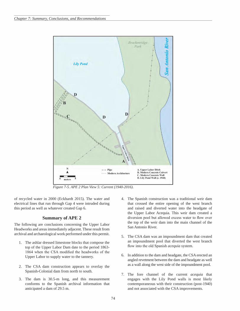
Period 1 Prehistoric to 1776 69 Period 2 Spanish Colonial to the Civil War (1776-1863) 69 Period 3 The Civil War and Post War Period (1863-1875) 70 Period 4 Late Nineteenth to Early Twentieth Century (1875-1940) 72 Period 5 Current (1940-2017) 73 Summary of APE 2 74
References Cited 77 Appendix 1 Common Terms Used in This Report 89 Appendix 2 Master Tables of Artifacts APE 1 and APE 2 95
vii
Archaeological Investigations of the Alamo Dam and Upper Labor Dam Brackenridge Park San Antonio Bexar County Texas
List of Figures
Figure 1-1 APE 1 and APE 2 as seen on the San Antonio East (2998-133) 75-minute quadrangle map 2 Figure 2-1 Physiographic map of Central Texas showing the project area Edwards Plateau Balcones Escarpment
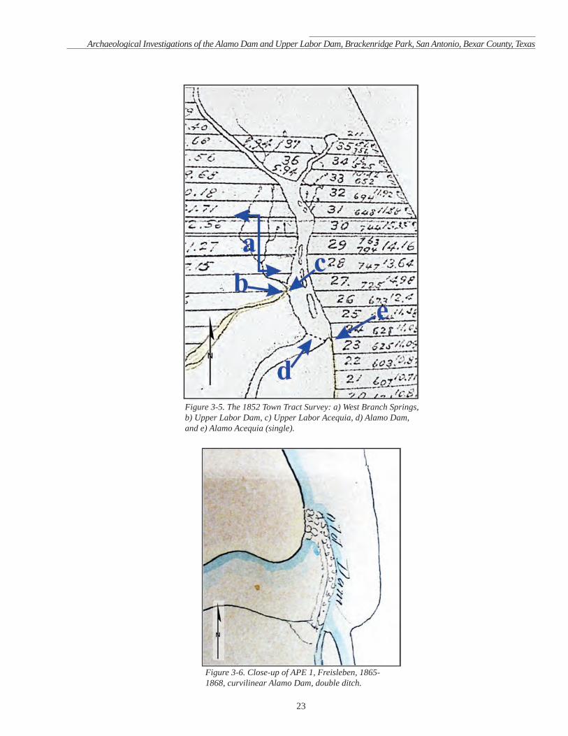
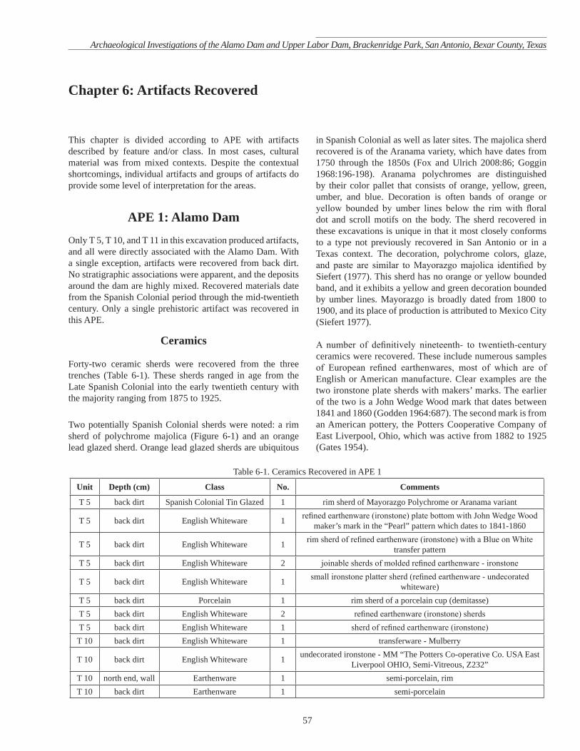
Blackland Prairie and major rivers 6 Figure 2-2 Geological map with the project area highlighted in yellow 8 Figure 2-3 Soil types in project area with general area of excavation circled in black 9 Figure 2-4 Historic archaeological sites within the Lower OlmosUpper San Antonio River Basins 11 Figure 3-1 Freisleben CSA Tannery Map ca 1865-1868 with both APEs identified 19 Figure 3-2 Freisleben Plat of Lots 1-10 January 1875 with both APEs identified 20 Figure 3-3 Close-up of Freislebenrsquos January 1875 Plat of Lots 1-10 APEs 1 and 2 (circled in red) 21 Figure 3-4 Freislebenrsquos May 1875 Plat of Lands of the Upper Part of the Labor de Arriba 22 Figure 3-5 The 1852 Town Tract Survey a) West Branch Springs b) Upper Labor Dam c) Upper Labor Acequia d) Alamo Dam and e) Alamo Acequia (single) 23 Figure 3-6 Close-up of APE 1 Freisleben 1865-1868 curvilinear Alamo Dam double ditch 23 Figure 3-7 Close-up of APE 1 Freisleben May 1875 straight-line Alamo Dam single ditch 24 Figure 3-9 Close-up of curvilinear Alamo Dam (circled in red) on Giraudrsquos 1879 map single ditch 24 Figure 3-8 Close-up of curvilinear Alamo Dam on Freislebenrsquos January 1875 map double ditch 24 Figure 3-10 Montage of Freisleben Maps showing alignments of dams and acequias 1865-1875 25 Figure 3-11 Giraud map showing property the City leased to the San Antonio Water Works Co 1879 APEs identified (red circles) 28
Figure 3-12 Close-up of 1879 Giraud Water Works map indicating alignment of Hermannrsquos trench 29 Figure 3-13 Close-up of Freisleben tannery sketch map ca 1865-1868 a) Upper Labor Dam b) Headworks and c) Acequia 30 Figure 3-14 Comparison of Freisleben 1865-68 map (left) with January 1875 map (right) 31 Figure 3-15 The 1926 Brackenridge and Koehler Park Map close-up of APE 2 showing the (a) acequia
(b c) two other channels and the notation of ldquoDAMSrdquo 33 Figure 3-16 The 1939 City Map of the Headwaters close-up of APE 2 33 Figure 5-1 Excavations within APE 1 37 Figure 5-2 Alamo Dam exposed in T 4 T 8 T 9 and T 10 looking northeast 39 Figure 5-3 Excavations within APE 2 40 Figure 5-4 Buried deadman buttress associated with F 1 in U 1 facing north 41 Figure 5-5 Upper Labor Headgate wall (left) and CSA Tannery Sluice walls (right) Comparison of Upper Labor
Headgate ashlars to CSA Tannery sluice from Lot 9 exhibiting similar construction CSA Tannery photograph courtesy of H Ray Smith and San Jacinto Materials 43
Figure 5-6 West side of headgate exhibiting carved headgate groove and lower eye-bolt 43 Figure 5-7 Hand-wrought eye-bolt on lower west wall of headgate (top) close-up of eye-bolt (bottom) 44 Figure 5-8 Headgate and fore channel of Upper Labor Acequia after removal of concrete slabs 45 Figure 5-9 a) Upper Acequia walls b) headgate c) lower walls and d e) wall width 45 Figure 5-10 Upper channel wall (east) showing mixed construction and visible damage 46 Figure 5-11 Lower channel wall (east) showing whole block construction 46 Figure 5-12 Top of F 5 wall between headgate and dam on east side of acequia 47 Figure 5-13 Top of Upper Labor Dam looking north-northeast from southern end 48 Figure 5-14 Plan view of Upper Labor Dam 49 Figure 5-15 Cross section of dam 50 Figure 5-16 Northern terminus west face Nineteenth-century ashlars superimposed on eighteenth-century
Spanish Colonial dam 50 Figure 5-17 Sequential plan view of north half of Upper Labor Dam showing Gaps 1 2 3 and 4 51 Figure 5-18 Sequential plan view south half of Upper Labor Dam showing Gaps 4 5 and 6 52 Figure 5-19 West face of F 6 with notches in yellow and set stones noted by red arrows 53 Figure 5-20 Spanish Colonial alignment with vertical wood posts and planking north end of dam 54
viii
Archaeological Investigations of the Alamo Dam and Upper Labor Dam Brackenridge Park San Antonio Bexar County Texas
Figure 5-21 Close-up of posts and plank intrudingabutting the Spanish Colonial dam 54 Figure 5-22 Plan view of northern end of dam with wood posts noted on western face 54 Figure 5-23 Profile of west face of southern end of dam showing wood post and Gap 6 55 Figure 5-24 Two limestone blocks south and east of dam 55 Figure 5-25 Ashlars in river (top) and on west bank of Lily Pond (bottom) 56 Figure 6-1 Sherd attributed as Mayorazgo Polychrome Images show sherd from side paste (left) reverse (center)
and obverse (right) 58 Figure 6-2 Early Triangular dart point Images show point from obverse (left) and reverse (right) 60 Figure 6-3 Seven sherds of orange lead glaze 62 Figure 6-4 Guadalupe ToolAdze Images show tool from obverse (left) side (center) and reverse (right) 66 Figure 7-1 APE 2 Plan View 1 Prehistoric through 1776 70 Figure 7-2 APE 2 Plan View 2 Spanish Colonial through the Civil War (1776-1863) 71 Figure 7-3 APE 2 Plan View 3 The Civil War through the Post War Period (1863-1875) 72 Figure 7-4 APE 2 Plan View 4 Late Nineteenth to Early Twentieth Century (1875-1940) Nb While the dam is
shown it was most likely partially to completely buried during this period 73 Figure 7-5 APE 2 Plan View 5 Current (1940-2016) 74
ix
Archaeological Investigations of the Alamo Dam and Upper Labor Dam Brackenridge Park San Antonio Bexar County Texas
List of Tables
Table 2-1 List of Recorded Trinomial Sites in the Lower Olmos Basin and Brackenridge Park Area 11 Table 5-1 Trench Groups and Their Respective Features and Trench Numbers 38 Table 5-2 APE 2 Excavations Respective Trenches and Units with Associated Features 39 Table 6-1 Ceramics Recovered in APE 1 57 Table 6-2 Glass Recovered in APE 1 59 Table 6-3 Ceramic Artifacts Recovered in APE 2 61 Table 6-4 Glass Recovered in APE 2 62 Table 6-5 Construction Related Artifacts from APE 2 64 Table 6-6 Metal Artifacts from APE 2 65 Table 6-7 Lithics from APE 2 66 Table A2-1 Artifacts Recovered from APE 1 97 Table A2-2 Artifacts Recovered from APE 2 99
x
Archaeological Investigations of the Alamo Dam and Upper Labor Dam Brackenridge Park San Antonio Bexar County Texas
This page intentionally left blank
xi
Archaeological Investigations of the Alamo Dam and Upper Labor Dam Brackenridge Park San Antonio Bexar County Texas
Acknowledgements
This projectrsquos success was dependent on a number of parties and participants The firm of Ford Powell and Carson Inc was instrumental in providing clear direction and support during the course of the fieldwork and assisting and sharing data in support of the final report production In particular the authors wish to thank John Mize for his many instances of help The authors also wish to thank the City of San Antonio and in particular Kay Hindes City Archaeologist with the Office of Historic Preservation Assistant Manager of Park Planning Bill Pennell Parks and Recreation Department Municipal Archivists Katie Riojas Tina Flores and Elivira Kisser Office of the City Clerk and City Arborist Mark Byrd with the Development Services Department The support direction and assistance of Mark Denton with the Division of Archeology of the Texas Historical Commission is also much appreciated Stonemason H Ray Smith of San Jacinto Materials provided invaluable insight and support for the interpretation of the masonry investigated during this project as well as critical photographs and documents Dr Shawn Marceaux assisted with editorial commentary and direction
The projectrsquos success is directly tied to the field crew and their invaluable work on the project Most especially to C Stephen Smith who served as Project Archaeologist and Kristi Nichols both of whom oversaw portions of the fieldwork Members of the field crew included Preston Beecher Justin Blomquist Matt Colvin Colt Dresser Antonia Figueroa Ashley Jones Mark Luzmoor Alex McBride Lindy Martinez Tyrone Tatum Alexandria Wadley and Sarah Wigley who performed the majority of primary fieldwork Melissa Eiring CAR Lab Director oversaw the processing of artifacts generation of supporting documentation and final curation A particular thanks goes to Lindy Martinez for her meticulous plan drawings of the Upper Labor Dam as they were instrumental in interpretation and report production Thanks also to GIS Specialist Katherine Smyth for her many hours of work in producing the various figures without which this report would be much less effective Kelly Harris Rick Young and Leonard Kemp created many of the figures for the report Kelly Harris also provided her editorial services and produced the final report Ms Harrisrsquos skill and many hours spent editing have resulted in a much more effective and useful report Dr Steve Tomka served as the initial Principal Investigator directing and supporting the fieldwork project archaeologists and crew Dr Raymond Mauldin served as the final Principal Investigator
xii
An Intensive Pedestrian Archaeological Survey of Hot Wells County Park San Antonio Bexar County Texas
This page intentionally left blank
1
Archaeological Investigations of the Alamo Dam and Upper Labor Dam Brackenridge Park San Antonio Bexar County Texas
Chapter 1 Introduction and Project Overview
Introduction
In 2012 the Center for Archaeological Research (CAR) of The University of Texas at San Antonio (UTSA) was contracted by Ford Powell and Carson Inc (FPC) to conduct archaeological services associated with planned improvements along the San Antonio River within the boundaries of Brackenridge Park in Bexar County San Antonio Texas The park is owned by the City of San Antonio Archaeological services were provided to ensure that significant archaeological deposits known to exist within the park would not be negatively impacted Further if possible it was anticipated that investigated archaeological resources be incorporated into the visitor experience at the park This current report details the archaeological investigations related to two historic resources the Alamo Dam originally known as the Presa de Valero or the Valero Dam and the Upper Labor Dam and Acequia originally known as the Presa de Labores de Arriba or the Upper Labor Dam and the Acequia de Labores de Arriba or the Upper Labor Acequia (Pfieffer et al 20119-10) These resources are only a part of the larger work associated with the City of San Antoniorsquos redevelopment plans located within Brackenridge Park A second report focused on the prehistoric resources is in preparation
Areas of Potential Effect The two Areas of Potential Effect (APEs) are within the confines of Brackenridge Park a 343-acre public park of the City of San Antonio (Figure 1-1) APE 1 was located on the west bank of the San Antonio River opposite the Witte Museum to search for the west side of the Alamo Dam APE 2 was at the Lily Pond and Upper Labor Dam just south of Hildebrand Avenue
Project Overview
The current investigations took place between February and May of 2013 Services were performed under Texas Antiquities Permit Number 6449 issued to Dr Steve A Tomka former CAR Director who acted as Principal Investigator and Stephen Smith who acted as Project Archaeologist Dr Raymond Mauldin assumed the role of Principal Investigator in early 2014 Permit 6449 covered all work performed within Brackenridge Park related to the City of San Antoniorsquos redevelopment plans At the request of the City this current volume focuses exclusively on the two captioned features A second volume summarized the
other archaeological work conducted The work reported here consisted of backhoe trenching and hand-excavated test units The work was required to address the Texas Antiquities Code (Texas Natural Resource Code Title 9 Chapter 191) and the City of San Antonio Unified Development Code Chapter 35
There were several goals for these investigations For APE 1 the goal was to identify structural remnants of the Alamo Dam on the west bank of the San Antonio River in order to verify the dam alignment noted in an earlier report (Ulrich 2011) The investigations in APE 2 were interested in documenting the length of the Upper Labor Dam and further defining the post-Spanish Colonial modifications that had been identified in 1996 (Cox et al 1999) Further CAR wanted to determine when features within APE 2 were built This timeline would assist in any future plans
Both APE 1 and APE 2 included the possibility of finding prehistoric materials and remnants of the corral and potential ancillary structures associated with the Confederate States of America (CSA) Tannery This facility drew its waterpower from the Upper Labor Dam and Acequia and operated adjacent to the Alamo Dam site on the west side of the San Antonio River (City Council Minute Books [CCMB] 583)
Archaeological work near the anticipated western end of the Alamo Dam was prompted by the proposed construction of a Wetland Area by the Witte Museum in conjunction with the installation of new trails on the west bank of the San Antonio River Work in this area was accomplished with backhoe trenching and subsequent shovel and trowel exposure of structural elements
Redevelopment plans in the vicinity of the Lily Pond included the installation of a walking path adjacent to the Upper Labor Dam and Acequia If a significant portion of the dam and the original acequia were found to be intact these Spanish Colonial and Civil War to late nineteenth-century features could be integrated into an interpretive experience associated with the history of the area To determine the presence or absence of the dam and its full extent CAR worked in two areas 1) the Lily Pond and retaining wall and 2) the articulation between the Upper Labor Dam and Acequia immediately adjacent CAR first exposed the west side of the existing Lily Pond retaining wall to determine its mode of construction and establish if it required any stabilization measures prior to the installation of the walking path CAR
Chapter 1 Introduction and Project Overview
2
Figure 1-1 APE 1 and APE 2 as seen on the San Antonio East (2998-133) 75-minute quadrangle map
personnel also exposed the Upper Labor Dam and the Acequia through the removal of several concrete picnic pads and soil overburden The excavations in APE 2 consisted of trench work and test units followed by hand-cleaning and exposure of the dam headgate and acequia
Project Results In APE 1 CAR recovered structural remnants of the Alamo Dam on the west bank of the river These remnants together with archival research and recent work by Pape-Dawson Engineering on the eastern bank have allowed CAR to
unravel two contradictory late nineteenth-century maps Further no definitive remnants of the tannery operations were identified during the investigations in APE 1 These results are further expanded on in Chapter 7
In APE 2 CAR was able to identify the length of most of the Spanish Colonial dam and the full extent of the nineteenth-century structural elements at the site of the Upper Labor Dam and Acequia The vertical extent of the colonial portion could not be determined across the length of the dam due to the water table inundating the trenches The vertical extent of the upper modifications was determined as these
3
Archaeological Investigations of the Alamo Dam and Upper Labor Dam Brackenridge Park San Antonio Bexar County Texas
improvements were above the water line CAR was able to expose the headgate and its articulation with both the dam and acequia The investigations also defined the post-Spanish Colonial modifications to the Upper Labor Dam identified in 1996 (Cox et al 1999) Based on archival and historical information collected during the project CAR has identified that the post-Spanish Colonial improvements to the Upper Labor Headworks which collectively consist of the dam headgate and acequia were made during the Civil War and were associated with the operation of the CSA Tannery
No intact prehistoric deposits were identified in either APE However evidence of mixed prehistoric deposits were noted in APE 2 between the Lily Pond retaining wall and adjoining parking lot
Report Organization
The report is divided into seven chapters Following this introduction Chapter 2 deals with previous archaeological investigations in the two APEs Chapter 3 outlines the archival and historical background of the APEs and discusses the history of the Brackenridge Park Chapter 4 identifies the field and laboratory methods used on this project Chapter 5 presents the results of the archaeological investigations Chapter 6 is a brief discussion of recovered artifacts and is followed by the project summary and recommendations in Chapter 7 Two appendices are included in the report Appendix 1 consists of a lexicon of common terms used in the report Appendix 2 enumerates all of the recovered artifacts from both APE 1 and APE 2
Chapter 1 Introduction and Project Overview
4
This page intentionally left blank
5
Archaeological Investigations of the Alamo Dam and Upper Labor Dam Brackenridge Park San Antonio Bexar County Texas
Chapter 2 Project Setting and Previous Archaeology
Project Setting
This chapter presents an overview of the environmental conditions prevailing in the project area including a brief discussion of the physiographic setting climate geology soils flora and fauna
The project areas are located within the San Antonio watershed in central San Antonio Bexar County Texas within Brackenridge Park only 48 km (3 mi) north of the downtown business district Despite the parkrsquos urban setting and its frequent modification over the years to accommodate public use Brackenridge Park remains home to numerous flora and fauna species native to the South and Central regions of Texas The park is bounded on all sides by major city thoroughfares and one US Highway Hildebrand Avenue marks the northern boundary with Broadway Avenue on the east and US Highway 281 to the south and west Over the years the park has been affected by building road and utility construction in addition to the development of park amenities Some of these numerous subsurface impacts are discussed in the Previous Archaeology section of this report as well as in the three preceding interim reports regarding this project (Smith 2013a 2013b Tomka and Smith 2014)
Current Environment
The project areas are situated approximately 213 m (700 ft) above mean sea level Brackenridge Park uniquely sits astride the conjunction of these two discrete biotic provinces The project areas are located at the boundary of the Tamaulipan and Balconian biotic provinces (Blair 1950) The park straddles the edge of the Balcones Escarpment which forms the northern edge of the Tamaulipan province The Tamaulipan biotic province extends from the east-west portion of the Balcones Escarpment to the eastern Sierra Madre in northeastern Mexico Plants and animals are a mixture of those typical of semitropical Mexico the semiarid southern Plains and the humid southeastern United States Thorny brush dominates vegetation type of the Tamaulipan province of Texas (Blair 1950103) The Balconian biotic province consists of the majority of the Edwards Plateau which is characterized as a semiarid area composed of upshylifted limestone and covered by vegetation dominated by various species of oak ash juniper (Texas Cedar) and mesquite with an undergrowth of several varieties of native grasses (Blair 1950 Hester et al 1989)
Climate
The San Antonio area is a subtropical humid climate characterized by cool winters and hot summers (Norwine 1995) Average annual rainfall measures 291 inches (National Oceanic and Atmospheric Administration [NOAA] 2013a) and monthly temperatures range from 379degF in January to 95degF in July (Bomar 1995) The growing season for Bexar County averages 265 days with the frost-free period extending from March 6 to November 26 (Natural Fibers Information Center [NIFC] 1987) The mean annual temperature for Bexar County is 69degF (NFIC 1987) The warmest months are July and August while the coolest are December and January Average annual temperature in San Antonio for the period 1981-2010 was 6942degF Calculated monthly norms for temperature and precipitation in San Antonio between 1981 and 2010 demonstrate a bimodal distribution of rainfall with peaks in April-May and September-October (Southern Regional Climate Center [SRCC] 2014) Generally one more inch of rain fell during the May to June peak than during the October to November peak Regardless annual rainfall totals were nearly equal May to June as July to December of any given year The hurricane season occurs during the second half of the year from June through November (NOAA 2013b) and may help to explain this pattern Average annual rainfall amounts to 3227 inches for these decades The driest periods occurred from winter to early spring in the months of December January February and March with each averaging less than two inches of rain Rainfall is not consistent across the area A transition line separates the moister eastern half of the region from the drier western half of the region cutting across the San Antonio area (Houk et al 1999)
Brackenridge Park lies within the area of Texas referred to as Central Texas The Central Texas environment is a vast area encompassing sections of the upper Gulf Coastal Plain the Texas Hill Country and the Edwards Plateau (Figure 2-1) Much like the biotic provinces these three major geographic regions meet in Bexar County These regions are the Edwards Plateau the Blackland Prairie and the South Texas Brush Country (Nickels et al 1997)
Bexar County lies at the southeastern edge of the Edwardrsquos Plateau and Balcones Escarpment The escarpment marks the break between two major physiographic divisions in North America the Great Plains Province on the west and the Coastal Plains to the east (Abbott and Woodruff 1986) The escarpment is a geological fault zone several miles wide extending from Del Rio to the Red River and dividing the
6
Chapter 2 Project Setting and Previous Archaeology
Figure 2-1 Physiographic map of Central Texas showing the project area Edwards Plateau Balcones Escarpment Blackland Prairie and major rivers
Edwards Plateau from the southern Coastal Plains (Collins and Laubach 19902) Viewed from the plains the escarpment is a low ridge of wooded hills (Abbott and Woodruff 1986) However underneath the surface the Balcones zone is the major rift line along a series of en echelon faults that occurred when older limestone displaced younger claystone chalk and marl The bulk of this tectonic displacement is thought to have occurred during the late Oligocene or early Miocene about 24 million years ago (mya Collins and Laubach 19903) The youngest sediments that geologists can definitely say were offset by the Balcones fault occurred during the Eocene (55-34 mya Brown et al 1974)
Descriptions of the Texas region often appear in terms of ldquobiotic provincesrdquo (Blair 1950) Classification of the environmental zones have also been based on ldquobroad and generalrdquo distribution patterns of ldquoplant communitiesrdquo distinguishable by their ldquophysiographic and biological differencesrdquo (Ellis et al 1995404) More recently descriptions of the area have been structured around soil types and plant communities with the state divided into eleven distinct ldquonatural regionsrdquo Overlap between ldquonatural regionsrdquo and ldquobiotic provincesrdquo has been
noted (Johnson School of Public Affairs 1978Table 1) and the literature often uses the terms ldquoregionsrdquo and ldquoprovincesrdquo interchangeably as a result Central Texas resides in six of these eleven natural regions These are the Llano Uplift Rolling Plains Oak Woods and Prairies Blackland Prairie Gulf Coast Prairies and Marshes and South Texas Brush Country All six of these ldquonatural regionsrdquo contain subregions with distinctive patterns of plant and animal life Central Texas lies within the Great Plains physiographic province and makes up the southern end of the Great Plains (Carr 1967) Throughout much of Central Texas several varieties of oakmdash principally Live Oak and Scrub Oak ash juniper mesquite cedar elm and other hardwoods are the dominate vegetation Mesquite thorny scrub and cacti dominate plant types in the South Texas Brush Country and the prairies support grass with very little tree cover (Kenmotsu and Boyd 2012)
Balcones Escarpment The project area is approximately 18 km (11 mi) southeast of the formal edge of the Balcones Escarpment The Balcones fault zone extends south from the escarpment edge and is clearly seen as the low limestone bluffs that frame the western
7
Archaeological Investigations of the Alamo Dam and Upper Labor Dam Brackenridge Park San Antonio Bexar County Texas
side of Brackenridge Park These limestone deposits were utilized as quarries in the eighteenth and nineteenth centuries These same quarries now house the San Antonio Zoo Sunken Gardens Theater and Japanese Tea Gardens (Pfeiffer 2011 Pfeiffer et al 2011)
The visible above-ground portion of the Balcones fault zone extends in a curved line across Texas running from the southwest part of the state near Del Rio to the north central region near Waco (Grimshaw and Woodruff 1986) Generally the exposed surface to the west of the fault zone consists of harder rocks than the nonresistant chalk and calcareous clay composition of the east side of the fault zone and consequently the east has sustained greater erosion This erosional difference produced the steep sloped face of the Balcones Escarpment which is as much as 305 m (1000 ft) high near its western terminus at Del Rio while only 91 m (300 ft) high between San Antonio and Austin (Abbott and Woodruff 1986) The soils east of the escarpment are deep and well developed and this area is used predominately for agricultural cropland Soils to the west of the escarpment are thin and rocky and ranching predominates in this area (Grimshaw and Woodruff 1986)
The Balcones Escarpment also plays a major role in weather production in Central Texas (Abbott and Woodruff 1986) Although the relief in Central Texas ranges from 100 to 500 feet the escarpment is the first topographic break inland from the Gulf of Mexico making its orographic influence on the unstable moisture saturated Gulf air more pronounced (Caran and Baker 1986Figure 1) Major flooding occurs along the Balcones Escarpment more often than any other place in the United States and precipitation intensity and discharge rates are close to the highest in the world (Caran and Baker 1986) Additionally the region lies in a ldquozone of convergencerdquo (Orton 196610-11) When southbound high-pressure air masses (cold fronts) and westward-moving low-pressure troughs (warm fronts) meet over Central Texas the resulting atmospheric instability can trigger massive rainfall with potentially devastating consequences (Caran and Baker 1986) The most severe rainstorm ever recorded in the continental United States occurred on September 9 and 10 1921 in Thrall Williamson County north of Austin (Jennings 1950 Larkin and Bomar 1983) A world record 364 inches of rain fell in an 18-hour period during this storm (Abbott and Woodruff 1986) The 24-hour rainfall total of 382 inches eclipsed the average precipitation expected for the entire year in the area (Larkin and Bomar 1983) The storm took the lives of 215 people and resulted in over $19 million in property damage (Bomar 19781) Regarded as possibly the greatest rainstorm in Texas history the storm began as a hurricane on the eastern Mexican coast before producing torrential rains resulting in the deadly flooding (Larkin and Bomar 1983) The 1921 storm covered more than 25900 km2 (10000 mi2)
along the Balcones Escarpment extending from Temple Texas southwestward beyond San Antonio Texas The area of maximum rainfall followed the Balcones Escarpment and affected seven counties Bell Bexar Comal Hays Milam Travis and Williamson (Ellsworth 19234 Plate 1)
The city of San Antonio was the most heavily populated and developed area affected by the 1921 storm where 51 deaths and over $3 million in property damage occurred (Ellsworth 1923) The 1921 flood was not the only such event in San Antonio The city is one of the most ldquoflash-flood pronerdquo areas in North America and flooding is so common in the Central Texas region that it has been called ldquoFlash Flood Alleyrdquo (SARA 2014) More recently severe flooding struck San Antonio and surrounding areas in October 1998 and again in June and July of 2002 (SARA2014) Flash flooding in Central Texas is all too prevalent and unfortunately the steep rocky terrain combined with urbanization in the region exacerbate this phenomenon and can turn an already dangerous situation into an even more violent and deadly one (Baker 1975 1976 Patton and Baker 1976)
Hydrology
The Edwards Aquifer is the source for numerous springs outcropping at the edge of the Balcones Escarpment One of the most productive carbonate aquifers in the United States the Edwards (Stein and Ozuna 1995) gives rise to the San Antonio river system Bexar County spring water is alkaline and very hard due to its high calcium carbonate content (Brune 198170) with the water becoming more saline to the southeast (Houk et al 1999) The San Antonio Springs is in reality a complex of three springs the largest one being the so-called Blue Hole Historically over 100 springs existed in this immediate area (Brune 1981) The northern edge of the project area sits about 305 m (1000 ft) south of the original headwaters area Nearby springs include the Olmos Springs Panther Springs Salado Springs San Pedro Springs and Walker Springs (Houk et al 1999) In addition a number of smaller streams flow into the San Antonio River such as the Calaveras Helotes Leon and Salado creeks (Long 2014)
The Edwards Aquifer is a cavernous zone of water-bearing permeable limestone 91-213 m (300-700 ft) thick (Menard 1995) Composed of Cretaceous-era limestone the Edwards Aquifer dips coastward and its southern and eastern edge mark the transition line from fresh to saline aquifer water Water-bearing formations beneath the Edwards Plateau are interrupted by the Balcones fault that acts to release water to the surface forced there under artesian pressure The San Antonio Springs Barton Springs San Marcos Springs and Comal Springs are examples of these artesian springs The Edwards Aquifer extends along the fault zone from Kinney
8
Chapter 2 Project Setting and Previous Archaeology
County through Uvalde Medina Bexar and Comal counties before ending in Hayes County (Eckhardt 2014) The aquifer outflows along its northern and western boundaries in the form of springs Water enters the aquifer within a geographically constrained recharge zone as rain and stream loss through solution cavities that occur along fractures in the limestone surface (Menard 1995) Water in the aquifer moves in a general east-west direction across the region from the semi-arid western half of the fault zone to the sub-humid eastern watersheds Water is also released from the aquifer though pumping (Stein and Ozuna 1995) These springs and seeps influenced both prehistoric and historic settlement patterns across the entire area (Gerstle et al 197826)
The San Antonio River Basin drains 10826 km2 (4180 mi2) of land (SARA 2014) Beginning in Kerr and Medina counties the basin extends southeast toward the Gulf of Mexico Bedrock forms the river basin and consists of shale siltstone limestone chalk and sandstone (Barnes 1974) Quaternary terrace deposits structured the original river channel (Barnes 1974) and this remains substantially true within the project area However river channeling bank stabilizing dredging filling and damming have obscured the ancient river channel throughout the remainder of its course through the city thereby making its original course virtually invisible today (Loucks 2011427) Sections of the river channel south of Bexar County remain unmodified by human hands and follow a pattern common to sandy bottom meandering streams complete with oxbow bends sand bars pools and riffles (Ritter 1978236)
Geology
The geology of the APEs resulted from the same uplifting that formed the Edwards Plateau and the Balcones Escarpment Figure 2-2 depicts the geology of Brackenridge Park and the surrounding area The APEs fall within a Quaternary alluvium floodplain of Holocene and Pleistocene gravel sand silts and clay deposits (United States Geological Survey [USGS] 2015) To the southwest and northeast rests the Navarro Group and Marlboro Marl formations which are composed of marl clay sandstone siltstone and limestone concretions The Austin Chalk deposits in the western edge of the park in the Sunken Garden area contain chalks marls and limestone To the east of the park lies the Uvalde Gravel formation that is characterized by gravel containing chert quartz and limestone cobbles Chert cobbles from this formation as well as the Edwards Limestone formation in the Balcones fault zone were used by prehistoric inhabitants as a source of lithic material (Ulrich et al 20124-5)
Soils
Soils in the project area include Lewisville Trinity and Frio soils (Taylor et al 1991) Soil locations and descriptions were taken from these sources (Figure 2-3) Lewisville soils are found on stream terraces located above the Trinity and Frio floodplain soils Along the western end of the APEs is Lewisville silty clay that is characterized by nearly flat 0-1 percent slopes (LvA) Lewisville silty clay soils skirt the
Figure 2-2 Geological map with project area highlighted in yellow
9
Archaeological Investigations of the Alamo Dam and Upper Labor Dam Brackenridge Park San Antonio Bexar County Texas
Brackenridge golf course Lewisville silty clay 1-3 percent slopes (LvB) are found in the extreme eastern section of the APE which approximates the northeast corner of the golf course Lewisville soils are described as deep well-drained soils common to stream terraces Their profile is characterized by brown subangular blocky silty clay over reddish-yellow silty clays with calcium carbonate nodules The areas upslope both east and west from APE 1 and APE 2 fall within Trinity and Frio soil types Trinity and Frio soils are deep slowly permeable calcareous clays and clay loams Trinity soils are clays derived from Holocene age clayey alluvium A typical profile is clay to 20 m (66 ft) with 25 percent CaCO3 Frio soils are also Holocene in age with a typical profile of silty clay loam to 127 m (42 ft) and clay
loam to 20 m (66 ft) and 40 percent CaCO3 (Taylor et al 1991) The soil survey for Bexar County reports that along the San Antonio River in the project area Venus clay loam 1-3 percent slopes (VcB) occupies the river terrace above the floodplain (Taylor et al 1991)
This soil series is the dominate soil found in the two APEs constituting over 90 percent of the project area Venus series soils consist of very deep and well-drained soils found in nearly level to moderately steep stream terraces or slopes of valleys and ridges (Taylor et al 1991) The surface to about 30 cm beneath consists of dark grayish brown (10YR 42) loam Underneath the upper layer is hard brown (10YR 53) loam
Figure 2-3 Soil types in project area with general area of excavation circled in black
10
Chapter 2 Project Setting and Previous Archaeology
containing films and threads of calcium carbonate 50 percent by weight down to a depth of approximately 53 cm below the surface The next approximate 100 cm of matrix consists of very pale brown (10YR 74) loam that is only slightly hard in nature but very friable and in common with the immediately preceding level contains calcium carbonates reaching 65 percent by weight The next 30 cm of depth consists of very pale brown (10YR 74) loam that is very friable with the same approximate calcium carbonate as the immediate level above Parent materials for these soils are loamy alluvial sediments that are high in calcium carbonate (Taylor et al 1991) In the study area Loire series soils (Fr) are found within the San Antonio River floodplains and low terraces
Flora and Fauna
The Balcones fault zone is a major physical factor in the distribution of animals in Central Texas (Neck 1986) Blair (1950) created the Balconian Biotic Province in recognition of the role the escarpment plays in biotic distribution for the region Analysis of ldquoherpetofaunardquo in Central Texas demonstrated that the range of 77 percent of reptile and amphibian species are limited (either eastward or westward) by the Balcones Escarpment (Smith and Buechner 1947) Buechner (1946) reported that 56 percent of the bird species in Central Texas are limited by the escarpment Of the 128 mammal species Davis (1974) lists for Texas 508 percent occur along the escarpment Of these species 529 percent occur only west of the escarpment and 353 percent are found only east of that barrier Some of the mammals common in this area include white-tailed deer (Odocoileus virginianus) opossum (Didelphis virginiana) raccoon (Procyon lotor) nine-banded armadillo (Dasypus novemcinctus) cottontail rabbit (Sylvagus virginiana) and the black-tailed jackrabbit (Lepus californicus) Large mammals once found in the area include mountain lion (Puma concolor) and black bear (Ursus americanus) Bison (Bison bison) were also once a common land mammal but are found today only in captivity (Davis and Schmidley 1997)
The San Antonio River Watershed hosts over 70 species of fish (Gonzales 1988 SARA 1996) However many of these species are not native but have been introduced Within the San Antonio River Basin SARA routinely monitors fish species diversity and fish community composition in the San Antonio River and tributaries (SARA 1992 1994 1996 2000) and uses fish as biotic indicators of aquatic ecosystem health (SARA 1988 1996 2000) Some common fish species recorded in the San Antonio River include Bluegill (Lepomis macrochirus) Channel Catfish (Ictalurus punctatus) Blue Catfish (Ictalurus natilis) Red Shiner (Cyprinella lutrensis) Yellow Bullhead (Ameiurus natalis) Largemouth Bass (Micropterus salmoides) Green Sunfish (Lepomis cyanellus)
Texas Shiner (Notropis amabilis) Gizzard Shad (Dorosoma cepedianum) Spotted Gar (Lepisosteus oculatus) and Central Stoneroller (Campostoma anomalum SARA 1996)
Common migratory birds in the park are the Belted Kingfisher (Megaceryle alcyon) Great Blue Heron (Ardea herodias) Night Heron (Nycticorax nycticorax) White-winged Dove (Zenaida asiatica) and Turkey Vultures (Cathartes aura) Birdwatchers frequent the project area and have recorded Red-shouldered Hawk (Buteo lineatus) Golden-fronted (Melanerpes aurifrons) and Ladder-backed Woodpecker (Picoides scalaris) Wood Duck (Aix sponsa) Green Heron (Butorides virescens) and many other riparian and open field birds (San Antonio Audubon Society 2005)
Along the river native trees consist of Black Willow (Salix nigra) Cedar Elm (Ulmus crassifolia) hackberry (Celtis laevigiata spp) Pecan (Carya illinoinensis) and Sycamore (Platanus occidentalis) Shrubs and vines include Baccharis (Baccharissp) Bluewood Condalia (Condaliasp) Buttonbush (Cephalanthus sp) Mustang Grape (Vitis mustangensis) and Roughleaf Dogwood (Cornus drummondii) Common forbs are Arrowhead bush (Sagittaria sp) Sunflower (Helianthus annuus) Frogfruit (Phyla sp) Pickerelweed (Pontederia cordata) and Water Primrose (Lugwigia sp) Grasses and sedges along the river are Bushy Bluestem (Andropogon glomeratus) Eastern Gamagrass (Tripsacum dactyloides) Inland Sea Oats (Chasmanthium latifolium) Switchgrass (Panicum virgatum) and wildrye (Elymus sp) The uplands to the west support ash and juniper woodlands as well as shrubs Common species include Texas persimmon (Diospyros texana) agarita (Mahonia trifoliolata) and prickly pear (Opuntia spp) Vegetation in the Blackland Prairie to the east includes hickory (Carya spp) red oak (Quercus spp) and hackberry (Celtis sp) trees (Gould 1969)
Previous Archaeology This section discusses historical archaeological work performed within Brackenridge Park and the surrounding area The review focused only on historic resources includes discussion of prior investigations of the Alamo Dam the Upper Labor Dam and the Upper Labor Acequia as well as Olmos Basin and Brackenridge Park resources Table 2-1 lists selected historical sites in the lower Olmos Basin and Brackenidge Park areas and the locations of the APEs are shown on Figure 2-4
Olmos Basin There are currently six recorded historical archaeological sites within the lower Olmos Basin Five of these (41BX283 41BX284 41BX285 41BX287 and 41BX289) are listed
11
Archaeological Investigations of the Alamo Dam and Upper Labor Dam Brackenridge Park San Antonio Bexar County Texas
Table 2-1 List of Recorded Trinomial Sites in the Lower Olmos Basin and Brackenridge Park Area Trinomial Date Area Site Name or Description Designation Eligibility Status Notes
41BX8 1966 Brackenridge Park Alamo Madre or Alamo Acequia (Madre de Valero) RTHL
41BX170 1971 Brackenridge Park Lime Kiln site Unknown
41BX171 1971 Within a half mile Historic late nineteenth- to early twentieth-century dump Unknown
41BX283 1975 Olmos Basin Historic quarry site NRHP (site no longer extant)
41BX284 1975 Olmos Basin Historic ldquoMillrdquo site NRHP
41BX285 1975 Olmos Basin Historic foundations and dump site NRHP (site no longer extant) 41BX287 1975 Olmos Basin Historic dump NRHP SAL 41BX289 1975 Olmos Basin Fernridge (G W Brackenridge Villa) NRHP 41BX1273 1999 Brackenridge Park Upper Labor Dam (Presa de Labor de Arriba) Potential SAL 41BX1425 2001 Brackenridge Park Multi-component prehistoric and historic site Unknown
41BX1754 2008 Brackenridge Park Miraflores multi-component prehistoric and historic site SAL
41BX1798 2009 Brackenridge Park Multi-component prehistoric and historic waterworks site Unknown
41BX1892 2013 Brackenridge Park Multi-component historic quarry site Potential SAL 41BX2007 2014 Brackenridge Park Multi-component prehistoric and historic site Unknown 41BX2043 2014 Brackenridge Park Linear historic canal Potential SAL 41BX2056 2014 Brackenridge Park Historic site Alamo Madre Dam Potential SAL
National Register of Historic Places (NRHP) Registered Texas Historic Landmark (RTHL) State Antiquities Landmark (SAL)
Redacted Content
Figure 2-4 Historic archaeological sites within the Lower OlmosUpper San Antonio River Basins
12
Chapter 2 Project Setting and Previous Archaeology
on the National Register of Historic Places (NRHP) These sites are contributing resources to the ldquoSource of the River Archaeological Districtrdquo and were enrolled on the NRHP in 1978 (National Register Nomination Form 1978) These five sites were recorded in 1975 by Fox who conducted the first survey of the Olmos Basin (Fox 1975Figure 1) The sixth site 41BX2008 was recorded by CAR in 2014 (Wigley et al 2014) The multi-component site lacks specific temporal details on the historic material and is located roughly 2 km to the north of the APEs The site is not shown on Figure 2-1 and is not discussed further
41BX283
This historic quarry site (Table 2-1 Figure 2-4) was recorded by Fox who noted
Judging from old maps and aerial photos this was probably the last quarry worked in the area There is no indication on early maps that the quarry existed in 1890 and on an aerial view taken in 1938 it appears to have but recently ceased operations [Fox 19754]
No further archaeological work occurred at the site The University of the Incarnate Word (UIW) has apartment-style housing on the site that has removed all traces of the quarry The site no longer exists
41BX284
This site was investigated by the 1978 Incarnate Word College Field School (Table 2-1 Figure 2-4) According to Stothert ldquoThis ruin consists of some broken walls the remains of a foundation situated across a now intermittent stream which is a tributary of the San Antonio Riverrdquo (Stothert 198964) The site has been interpreted as a mill as a guardhouse or possibly as part of the CSA Tannery complex (Fox 19754shy5 Kemp 20081 Stothert 198964) Archival research conducted on the current project suggests the site is Alsburyrsquos Mill constructed by Hanson Alsbury and Francois Marchant in 1853 (Bexar County Deed Records [BCDR] M1191) Additional supporting evidence for its identification as a mill is an advertisement from the San Antonio Herald of November 26 1858 for the ldquoE P Alsbury Millrdquo listed as a ldquoCorn amp Flour Mill at the head of San Antonio riverrdquo (San Antonio Herald 26 November 18584)
41BX285
This site (Table 2-1 Figure 2-4) consisted of limestone foundation walls that in 1975 were projecting from a trash dump behind the Incarnate Word Convent (Fox 19755)
In 2007 CAR performed a survey that focused on the site of a proposed dormitory that abutted the side of 41BX285 Investigations documented that 41BX285 is no longer extant (Kemp 20081)
41BX287
This site (Table 2-1 Figure 2-4) on a small knoll on the west side of the basin consisted of a collection of mid- to late nineteenth-century ceramics glass and brick (Fox 19757) No structural remains were noted and no further work has been performed at this location
41BX289
Site 41BX289 (Table 2-1 Figure 2-4) was originally owned by J R Sweet who constructed the first residence on the property in 1852 (Fox 19754) In 1869 George Brackenridge ldquohellippurchased property with an antebellum home at the head of the San Antonio River Because the word lsquobrackenrsquo was the Scottish word for lsquofernrsquo Brackenridge named his new home lsquoFernridgersquordquo (Pfeiffer 201113 Sibley 197391) Fernridge is essentially two homesmdashthe original single-story Sweet Home of 1852 and the subsequent three-story Brackenridge home built in 1886 (Dunn 197511 Stothert 198969) In 1897 the building and grounds were deeded by Brackenridge to the Sisters of Charity of the Incarnate who maintained the structure as a convent (Stothert 198970) The Sisters continue to hold title to the home and use the site as a museum No formal archaeological work has been performed at 41BX289
Areas Noted but Not Recorded as Sites in the 1975 Survey
In addition to the surveyed and recorded trinomials Fox identified five areas where there were reported finds or where a previously destroyed site was located (Fox 197510) These included the following
1 The site of Worthrsquos Spring on the north and immediate east side of Olmos Dam (Fox 1975Figure 1 Area D) The spring was named for US General William Jenkins Worth a prominent military commander during the US ndash Mexican War who constructed a camp and quartered his troops at this location
2 A location immediately south of Hildebrand Avenue within Brackenridge Park on the west bank of the river (Fox 1975Figure 1 Area E) An old dam located at this point by Orchard in a hand-drawn map (Fox 1975) may be the one also mentioned in a letter of agreement between F Giraud and G W Brackenridge
13
Archaeological Investigations of the Alamo Dam and Upper Labor Dam Brackenridge Park San Antonio Bexar County Texas
of September 30 1874 ldquoa dam erected during the Civil War - for the purpose of supplying the Confederate Tanneryrdquo (Fox 197510-11) This is the same site that constitutes APE 2 of the current report
3 Fox (1975) lists another site identified on Figure 1 as Area F but provides no information on this location Likewise this site is shown on Stothertrsquos (1989) Figure 8 but with no description or discussion Whatever is represented in these figures has been impacted by construction on the UIW campus and no published work has been performed at the location
Brackenridge Park There are nine recorded historical archaeological sites within Brackenridge Park and one additional site within 08 km Six of these sites are multi-component containing both historic and prehistoric materials and three sites are listed as solely historic
No formal archaeological work was performed within the park prior to the 1976 CAR survey (Katz and Fox 1979) This initial survey work was performed for the City of San Antonio prefatory to the development of a Brackenridge Park Master Plan and covered the entire park property The 1976 survey identified 27 historic buildings or features (Katz and Fox 197912-22) Information regarding these historic resources can be found in Pfieffer (2011) and Pfieffer et al (2011)
41BX170 The trinomial for 41BX170 (Table 2-1 Figure 2-4) was assigned in 1971-1972 (Fox 1972 Texas Sites Atlas [TSA] 2014) The site (Katz and Fox 1979Figure 1) consists of historic foundations evidence of a lime kiln and assorted nineteenth-century artifacts It is part of and abuts the Alamo Roman and Portland Cement Company site No other work has been performed since the site was identified in 1971-1972
41BX171 Recorded in a 1971 survey and subsequently excavated this site is a late nineteenth- to early twentieth-century municipal dump (Table 2-1 Figure 2-4) The dump used the abandoned historic limestone quarries as a landfill Testing was done using heavy equipment and no screening through hardware cloth was performed As a result only whole bottles diagnostic glass metal and ceramic sherds were collected as noted by the author (Clark 19841 4) While a late historic site (1893-1922) the site does offer insight into regional
and national trade networks diet and food as well as trash disposal patterns (Clark 1984117)
41BX1754 Miraflores Park Site
Trinomial 41BX1754 (Table 2-1 Figure 2-4) was assigned to Miraflores Park as a result of work performed by CAR in 2008 (Ulrich and Figueroa 2008) The site is multi-component CAR recommended that any subsurface work potentially impacting historic features be archaeologically monitored (Ulrich and Figueroa 2008 see also Tomka and Dowling 2009)
41BX1798 Miraflores Park Bridge Replacement Site
Trinomial 41BX1798 (Table 2-1 Figure 2-4) was assigned to Miraflores Park as a result of work performed by CAR in 2009 (Tomka and Dowling 2009) The site is multi-component with evidence of both prehistoric and historic use Historic remains included a 12-x-3 m limestone cobble dam construction that was attributed based on its components and placement as a diversionary or cofferdam associated with the San Antonio Water Works Raceway immediately south of the construction (Tomka and Dowling 200929) Excavation results indicate that much of the prehistoric deposits at the site are inversely deposited materials from an upstream source CAR recommended that any subsurface work impacting historic features be archaeologically monitored (Tomka and Dowling 2009)
41BX1892
This historic site (Table 2-1 Figure 2-4) was recorded by STARS LLC as part of a currently unpublished report associated with municipal redevelopment on the site of the old City Animal Control Facility commonly known as ldquoThe Poundrdquo just south of the main entrance to the San Antonio Zoo (Herbert G Uecker personal communication July 2014) The recordation is assigned to the quarry face and associated tool marks along this section below Alpine Drive and running south to the Alamo Roman and Portland Cement Company site The site dates from the Spanish Colonial through the late nineteenth century
41BX2007 This site was recorded by SWCA in 2014 and is located across Broadway Avenue from the park proper (Table 2-1 Figure 2-4) The multi-component site features historic materials in the upper deposits overlying a buried lithic scatter (Ward 2014)
14
Chapter 2 Project Setting and Previous Archaeology
Sites in the APEs
Alamo Dam (41BX2056) Investigations performed on the grounds of the Witte Museum (Table 2-1 Figure 2-4) on the east bank of the river by CAR in 2011 identified the presence of a layer of stone approximately 100 cm below the surface (cmbs) This layer of stone was documented by probing as the trench quickly filled with water Considering its linear extent (7 m) and its apparent alignment with historic maps it was suggested that this feature was the remains of the Madre Dam on the east bank (Ulrich 201156)
Alamo Acequia (41BX8) Site 41BX8 is the historic the Alamo Madre or Alamo Acequia (Table 2-1 Figure 2-4) This irrigation structure began at the Alamo Dam and then continued south to the east of the San Antonio River There have been numerous excavations along the route of the acequia several of which were within Brackenridge Park
Ulrich (2011) documented two instances of the acequia near the presumed site of the headgate These excavations showed the acequia was not lined with stone Cox (19853) also uncovered an unlined portion of the acequia in 1984 In 1997 the acequia was investigated in the downtown area as it passed through the Hampton Inn property between Bowie Street and the highway access road north of Star Street The acequia in this location was lined with stone sometime after 1840 (Renner et al 1997) Recent work by Pape-Dawson Engineers Inc Raba Kistner Inc and CAR in 2016 documented four other portions of the Alamo acequia system Pape-Dawson located a side branch just west and north of the intersection of Martinez Street with South Alamo Street (unpublished manuscript 2016) Raba Kistner uncovered an unlined portion of the Alamo Acequia Madre on the site of the former Playland Park just east and north of the intersection of Broadway and North Alamo streets and a second stone-lined portion of the acequia on the site of the current San Antonio Convention Center expansion just south and east of the intersection of Commerce and South Alamo streets (K Nichols Raba Kistner Engineering personal communication December 2 2016) The stone-lined portion identified by Raba Kistner matches the alignment of a portion of the same stone-lined acequia branch identified by CAR on the grounds of St Josephrsquos Roman Catholic Church earlier in 2016 (Zapata 2017)
Upper Labor Dam (41BX1273) The dam was inadvertently discovered in 1995 after torrential downpours in San Antonio resulted in a wash-out of the culvert between the Lily Pond and San Antonio River at the
northern end of the Brackenridge Park (Table 2-1 Figure 2-4) Local architect Steve Tillotson discovered that a dressed stone construction had been revealed and contacted both the City Parks Department and Historic Preservation Office The City contracted with CAR to investigate and document the structure in September of 1996
Excavations confirmed that the structure was the remains of the Upper Labor Dam The structure consisted of an earlier rough limestone block Spanish Colonial component topped by a later dressed stone portion set at a slightly different angle than the earlier colonial stonework (Cox et al 199912) The 1996 excavations only identified the northern terminus of the dam and the first 65 m of the northern portion of the dam No further work was performed at the site until the present undertakings
Cox traced the courses of the many Spanish acequias in San Antonio (Cox 2005) and the Upper Labor Acequia route is well documented The acequia starts at the Lily Pond runs south and cuts west under the Dionosio Rodriguez Bridge and Brackenridge Drive It then crosses into the San Antonio Zoo where some portions have been used as part of the zoorsquos water features
The Upper Labor Acequia has been sporadically documented along portions of its route around the western edge of Brackenridge Park and then south-southwestward to its confluence with San Pedro Creek just below the springs of the same name There have been numerous investigations of the acequia and related structures in the past twenty-five years (Cox et al 1999 Fox and Cox 1988 Shafer and Hester 2010 2012)
In 1988 a portion of the acequia was encountered during the monitoring of construction for drainage trenches along St Maryrsquos Street between Ashby and Park avenues The only trace of the acequia was observed near the intersection of West Myrtle and St Maryrsquos streets and Fox and Cox described it as ldquohellipa broad sloping ditch [seen in profile]hellip dropped to a depth of approximately five feet and a width of about 20 feetrdquo (Fox and Cox 19885)
Additional portions of the Upper Labor Acequia were documented in 2010 and 2012 by Abasolo Archaeological Consultants (Shafer and Hester 2010) The 2010 undertaking included the monitoring of sediment and fill removal from the 131-m section of the acequia running between Brackenridge Drive and the San Antonio Zoo immediately to the west of APE 2 Monitoring determined that the current stone lining dates to the WPA era and that the last period of clean-out dates
15
Archaeological Investigations of the Alamo Dam and Upper Labor Dam Brackenridge Park San Antonio Bexar County Texas
sometime in the late 1960s or early 1970s (Shafer and Hester 201011) No Spanish Colonial artifacts were recovered and no definable traces of the original channel were present due to the construction of the stone walls and the periodic clean-out of the channel The 2012 (Shafer and Hester 2012) work consisted of monitoring and documentation of a desaguumla (discharge channel see Cox 20055-6) off of the main channel of the acequia on the west side of Allison Park The project entailed the monitoring of the removal of fill within the desaguumla as well as the stone-lined walls and brick-lined floor of the channel so that they could be subsequently stabilized (Shafer and Hester 2012) No Spanish Colonial period artifacts were recovered
41BX1425
Nearly the entirety of APE 1 is within the site boundaries of 41BX1425 (Table 2-1 Figure 2-4) This is a multi-component site recorded by SWCA (Houk and Miller 2001) and includes a portion of Katz and Foxrsquos Collecting Locality 10 (Katz and Fox 1979) The site lies on the west bank of the San Antonio River opposite 41BX323 (Houk and Miller 2001) SWCA subsequently tested the site in 2002 and described it as ldquohellip generally low-density and dispersed prehistoric materials [that] have a Transitional Archaic componenthellipdraped by scattered historic and modern artifactsrdquo (Houk 200253)
They further stated that most of the deposits were disturbed and represented potentially inverted fill or spoil from the adjacent drainagescanals (Houk and Miller 200260)
Summary The earliest archival records show that the headwaters of both the San Antonio River and San Pedro Springs were the deciding factor for settlement of the San Antonio River Valley in 1718 The historical archaeological resources within Brackenridge Park span the entire historic period from 1718 to the present day The Alamo Dam was begun in January of 1719 and represents the beginning of mission acequia agriculture in San Antonio and the first documented historic modification to the area that is now the park In the past forty years archaeological investigations have documented much of the historical uses within the park Both the sites of the Alamo Dam and headworks and that of the Upper Labor Dam and headworks are now clearly known In addition to the numerous extant historical features within the park many buried components remain that have been archaeologically documented Coupled with the abundance of investigated prehistoric sites no other location in San Antonio contains so varied and rich archaeological resources as Brackenridge Park
16
Chapter 2 Project Setting and Previous Archaeology
This page intentionally left blank
17
Archaeological Investigations of the Alamo Dam and Upper Labor Dam Brackenridge Park San Antonio Bexar County Texas
Chapter 3 Historical and Archival Research
Historical and Archival Background
This section first details the common history of the Spanish Colonial acequia systems in San Antonio from the eighteenth century through to their general abandonment in the twentieth century Following that discussion the unique histories of the Alamo Dam and its Acequia and the Upper Labor Dam and its Acequia will be presented followed by a brief history of the park itself Appendix 1 of this report contains definitions of the various sociocultural engineering and architectural terms associated with the Spanish Colonial acequia systems in San Antonio
The headwaters area has been amply described during the historic period by both the Spanish and their successors as lush and verdant with abundant springs copious amounts of water and teeming with both flora and fauna endemic to the area In 1709 Father Isidro Felix Espinosa who was a diarist of the Espinosa-Olivares-Aguirre Entrada described ldquohellipa luxuriant growth of trees high walnuts poplars elms and mulberries watered by a copious springhelliprdquo (Tous 1930a5) Perhaps the most praiseworthy description comes from Frederic Law Olmstead who visited San Antonio in 1854
The San Antonio Spring may be classed as the first water among the gems of the natural world The whole river gushes up in one sparkling burst from the earth It has all the beautiful accompaniments of a smaller spring moss pebbles seclusion sparkling sunbeams and dense overhanging luxuriant foliage The effect is overpowering It is beyond your possible conceptions of a spring You cannot believe your eyes and almost shrink from sudden metamorphosis by invaded nymphdom [Olmstead 1860156]
Water from the river and springs was utilized for consumption irrigation manufacturing and hydraulic power Extensive use and depletion of the Edwards Aquifer since the twentieth century has reduced artesian flow to intermittent periods Today spring flow is directly associated with rises in the aquifer due to heavy and consistent rainfall As such the once numerous springs have been reduced to virtually zero The main spring eponymously titled the San Antonio Spring (also referred to as the ldquoBlue Holerdquo and by the Spanish as the Ojo de Agua) on the campus of the UIW flows only every few years and then only briefly (Fisher 2006)
Overview of the Spanish Colonial Dams and Irrigation Canals of San Antonio
San Antonio retains portions of four Spanish Colonial dams the Alamo Dam the San Juan Dam the Espada Dam and the Upper Labor Dam The dams considered no longer extant include the San Pedro Dam (also known as the Principal) the Concepcioacuten Dam the San Jose Dam and the Arocha Dam The San Pedro Dam was located in San Pedro Park and diverted a portion of the copious spring waters into the San Pedro Acequia The area of the dam has been investigated numerous times but no trace of it has yet been definitively identified (Houk 2001 Mauldin et al 2015) The Concepcioacuten Dam was demolished in 1869 in an attempt to alleviate flooding in the lower reaches of the city (Cox 200552) The Arocha Dam was located on San Pedro Creek just below the current boundaries of San Pedro Park This dam was made of wood and diverted water into the Arocha Acequia constructed by Francisco Arocha ca 1743-1745 (McKenzie 201510) An eighth dam the San Jose located below the confluence of the Concepcioacuten Creek with the San Antonio River was destroyed in the flood of 1865 and not rebuilt (Cox et al 19996)
The first of these dams was located in San Pedro Springs Park and diverted the spring headwaters of the San Pedro Creek into the San Pedro Acequia As noted above the Arocha Dam was also located on San Pedro Creek The remaining six dams were all placed on the San Antonio River Three of these the Alamo Concepcioacuten and Espada dams spanned the full channel of the river and are referred to as weir dams As described from archival sources Cox (200529 32 77) attributed the San Jose Dam San Juan Dam and Upper Labor Dam in their original configurations as projecting from a single bank rather than spanning the entire channel These types of dams are referred to as wing dams Both kinds of dams (weir and wing) served the same purpose the diversion of water into an excavated channel
Each of the Spanish Colonial dams had a corresponding acequia or irrigation canal system that it supplied with water In turn each of these systems served defined geographic areas by providing irrigation to abutting property Five of these acequia systems were associated with the five San Antonio missions and four of them were named after the mission that it served The fifth the Concepcioacuten Acequia was most often referred to as the Pajalache The Pajalache was the name of one of the three principal Native American
18
Chapter 3 Historical and Archival Research
tribes present at the founding of the mission in 1731 and they most likely excavated the canal (Habig 1968) The five other acequia systems the Principal (also known as the San Pedro) the Navarro the Arocha and the Upper Labor either served the citizens of the Villa de San Fernando de Bexar which was founded May 9 1731 with the arrival of the Canary Islanders (de la Teja 199510) andor in the case of the San Pedro Acequia the first villa and presidio This new settlement was located adjacent to the Presidio San Antonio de Bexar The original settlement of Villa de Bexar started by Alarcon in 1718 essentially merged with the new official civil settlement By the close of the eighteenth century the different namesmdash San Antonio de Bexar the former Villa de Bexar and the new Villa de San Fernandomdashmerged and the settlement was called San Antonio de Bexar (de la Teja 199532)
These improvements continued in use throughout the Spanish Colonial period from 1718-1719 when the San Pedro and Alamo acequias were begun until 1821 when Mexico became independent of Spain A major change was the secularization of the five missions between 1793 and 1824 and the assumption of ditch maintenance by the Ditch Companies composed of abutting property owners (Cox 20058) These companies maintained the mission ditches primarily for agricultural pursuits However from 1810 through 1850 the San Pedro and Upper Labor acequias progressively fell into a state of disrepair through lack of use and maintenance This was a direct result of political turmoil and demographic displacement Numerous insurrections Mexican Independence and the Texas Revolution all had a negative impact on San Antoniorsquos population (Chipman 1992240-241) For example following the Royalist victory of 1813 Governor Arredondo was forced to suspend administering the oath of allegiance as the settlements were nearly depopulated (Hatcher 1908236) Arredondo himself had dramatically purged San Antonio de Bexar where ldquo[H]is soldiers indiscriminately arrested about seven hundred male residentshelliprdquo (Almaraz 1971179) The lack of population directly affected the need for and the maintenance of the old Spanish irrigation systems
Between 1820 and 1830 San Antoniorsquos population fluctuated between 1750 and 2000 (de la Teja and Wheat 198510shy11) Following Texas independence in 1836 and subsequent accession to the United States in 1846 the population of San Antonio steadily grew By the time of the 1860 United States Census San Antonio had a total population of 8235 making it the largest city in the state The population was classified at that time as consisting of 7643 whites (Hispanics and Anglo-Americans) and 592 slaves (United States Census Record 1864487) The burgeoning population between 1836 and 1860 resulted in demands for both land and water Land was needed for homes farms and other industry and water was needed for drinking sanitation irrigation and power
The City addressed the need for land in 1845 by asserting its claim to the ejidos or common public lands within the 1731 eight-league royal grant from the King of Spain (Corner 189037-38) To accomplish that end the City initiated a survey in 1846 and sued parties that claimed lands within that boundary After the Cityrsquos claim was affirmed by the Texas Supreme Court in 1851 a final survey was completed by Francois Giraud at that time the City Surveyor and in 1852 the Plat of the City Tract of San Antonio de Bexar was drawn by the artist Jore Gentilz who utilized Giraudrsquos survey notes (Corner 189037-38)
Water needs began to be addressed in an ad hoc fashion shortly after the Texas Revolution The first recorded municipal action was in 1838 when the City Council appointed a committee to oversee the intermittent ldquohellipcleaning of the ditch that runs through townhelliprdquo (CCMB I31) While unnamed it is a certainty that the ditch in question was the San Pedro Acequia which ran through the heart of the city In 1840 ldquothe ditch of the Alamordquo was added along with provision for the appointment of a Ditch Commissioner (CCMB I37) As the city continued to grow the need for water and water control increased It is apparent from numerous City Council Minute Book entries during the period from the 1840s to 1860s that repairs to ditches were on a case-by-case basis and predicated on available funds and need rather than foresight The stone lining of portions of the urban ditches occurred during this period (Cox 19852)
In 1857 the City Council directed ldquothat the City Surveyor be required to examine the old irrigation ditch for the Upper Labor with the view of reopening the same andhellipthe practicability and probable cost of reopening the samehelliprdquo (CCMB C95) City Council minutes from December of 1860 and 1862 indicate that effort was expended to bring the Upper Labor back into active use but the nature and extent is not recorded in the minutes (CCMB C340 Cox et al 19996)
The single greatest event to impact the acequias and dams was the March 26 1865 flood that covered the downtown area under some 46 m (15 ft) of water and caused major civic and economic losses It damaged most of the dams and acequias in particular the Alamo Upper Labor and San Pedro acequias and nearly obliterated the San Jose Dam located below the confluence of the San Pedro Creek with the San Antonio River (CCMB C475 481 491 496) A City Council appointed committee consisting of Gustav Schleicher (Chair) Francois Giraud (Member) and Victor Considerant (Member) was tasked to investigate the causes of the flooding and report back to City Council with recommendations Their report was made to Council on April 31 1865 and published in the San Antonio Semi-Weekly News as well as appended
19
Archaeological Investigations of the Alamo Dam and Upper Labor Dam Brackenridge Park San Antonio Bexar County Texas
to the City Council Minutes (CCMB C475) Their report singled out three main causes for the flooding 1) the stone diversion dam for the Concepcioacuten Acequia raised the river level by over 1 meter 2) the numerous water walls erected along the San Pedro Creek impeded flow and caused flooding and 3) the bridges crossing both the river and creek needed to be replaced to allow more water to flow beneath them Their immediate recommendations were to remove the Concepcioacuten Dam the water walls on the San Pedro Creek and to replace obstructing bridges (CCMB C475) They also recommended that the City Surveyor and Engineer establish the flood profile of the San Antonio River and report back to the City Council ldquowith dispatchrdquo (CCMB C475) Another consideration was the possibility of adding a new ditch above the Upper Labor to handle excess floodwater and to open up additional land on the east side for farming Aside from directing the flood profile to be completed the City Council undertook none of the actions recommended at the time of the report The City Council however did make numerous authorizations for payment of expenditures to Ditch Commissioner G A Wurzbach for repairs to the ditches and dams in the months of May June and August of 1865 (CCMB C481 491 496)
During the remaining years of the nineteenth century many of the original recommendations of the Schleicher Commission were ultimately instituted the Concepcioacuten Dam was removed in 1869 the water walls along the San Pedro were ordered removed new bridges were erected that lessened impediment to stream flow and not only the recommended eastern ditch
but also a western ditch was constructedmdashthe Valley Ditch on the east side and the Alazan on the west Both ditches were essentially extensions of the Alamo and Upper Labor acequias respectively (Cox 200557-59)
With the advent of a public water system and the increasing urban nature of the city the need and use of the old Spanish acequias declined All those within the downtown area had ceased operation by 1913 and were simply left to function as storm drains or ready-made ditches for utility lines (Cox 2005) However the rural and agricultural acequias continued to see use The San Juan and Espada acequias remained in operation into the twentieth century and the Espada continues to irrigate farms to the present day The San Juan Acequia has recently been reopened and provides water for the National Park Services Demonstration Farm
Alamo Dam and Acequia
The Alamo Dam was the second of two Spanish Colonial dam and acequia systems constructed in San Antonio beginning in January of 1719 the second system being that of the San Pedro Acequia (Hoffman 193586) The Alamo Dam and its corresponding acequia system watered the fields that supported the Mission San Antonio de Valero The dam and headworks were located at the first right-angle bend of the San Antonio River below the headwaters The alignment of the river in this location has remained more or less static based on the known maps of the area (Figures 3-1 3-2 3-3 and 3-4)
Figure 3-1 Freisleben CSA Tannery Map ca 1865-1868 with both APEs identified
20
Chapter 3 Historical and Archival Research
Figure 3-2 Freisleben Plat of Lots 1-10 January 1875 with both APEs identified
The earliest recorded mention of the dam comes from the Inspection Report of 1761-1762 by Fray Mariano Francisco de los Dolores In that report he states that San Antonio de Valero has ldquoa beautiful main irrigation canal with a dam of stone for the watering of the farm fields which are themselves fencedrdquo (Dolores 1762) The record however is silent on the type of dam first constructed ie a wing or a weir dam Certainly by the mid-nineteenth century the Alamo Dam was a weir dam that crossed from the east to the west bank of the river The 1852 Survey Map shows a dotted line crossing the river in the location of the Alamo Dam the Alamo Acequia and a sizable
pool of water north of the structure (Figure 3-5) The map also clearly shows the west branch springs as separate from the east branch the route of the Upper Labor Acequia and the location of the Upper Labor Dam The Alamo Dam retention pool raised the level of the river and diverted waters into the Alamo Acequia on the east bank In addition to the 1852 Survey Map the Freisleben Tannery sketch map of 1865-68 and the two Freisleben Plat of the Lands of the Upper Part of the Labor de Arriba maps of January and May of 1875 show the Alamo Dam as a weir dam and the articulation of the dam with the headworks and acequia (Figures 3-6 3-7 and 3-8)
21
Archaeological Investigations of the Alamo Dam and Upper Labor Dam Brackenridge Park San Antonio Bexar County Texas
Figure 3-3 Close-up of Freislebenrsquos January 1875 Plat of Lots 1-10 APEs 1 and 2 (circled in red)
The three Freisleben Maps (Figures 3-1 through 3-3) show the location of the Alamo Dam at the first bend the Alamo Dam crossing the river from bank to bank and the articulation of the headworks with the Alamo Acequia There are differences however between the three maps regarding the dam The 1865-68 Tannery Sketch Map and the January 1875 Upper Part of the Labores de Arriba Map as well as the 1879 Giraud Water Works Map indicate a curvilinear structure (Figures 3-6 3-7 3-8 and 3-9) Only the May 1875 Freisleben Map shows the dam as a straight-line rock structure
Figure 3-10 is a chronological comparison of three Freisleben maps the Tannery Map of ca 1865-1868 the January of 1875 plat and the Plat of May of 1875 This montage has expanded views of the Alamo Dam and Upper Labor Dam sites respectively A visual inspection permits identification of a number of similarities and differences
1 All three maps are in general agreement about the alignment of the river and the siting of the Alamo Dam at the first primary bend below the headwaters
2 All three show the Alamo Dam as a weir dam that spans the entire river (three indicate a curvilinear structure while one indicates a straight alignment) and
3 All three place the headworks of the Alamo Acequia in the same general location (east bank) with one map showing a single ditch (Freisleben May 1875) and two maps showing a double ditch (Freisleben 1865-1868 and January 1875)
As such the maps are more in agreement than disagreement The Giraud Map of 1879 (Figure 3-9) postdates the last Freisleben map by four years and also shows a curvilinear Alamo Dam and a single ditch The most probable reasons for the variations between these maps as to dam alignment and the number of ditches may simply be a reflection of vagaries in the production of the maps or that only one of the two ditches were extant at a given period or that Freisleben or Giraud simply overlooked details that were not relevant to the purposes of the maps to begin with
The Alamo Acequia system converted from an agricultural system to an urban system over time with the increased growth of the city following Texas independence As previously noted the Alamo Acequia was added to those overseen by the City along with the appointment of a Ditch Commissioner in 1840 (CCMB I37) City Council Minutes from 1840 through the 1860s include regular reports from appointed Ditch Commissioners regarding expenses maintenance and water rents for the Alamo Ditch
The original dam may have only been a wing dam to divert water into the ditch which then flowed south some 55 km through the farmlands of Mission San Antonio de Valero before returning to the San Antonio River in the vicinity of the current Hyatt River Walk Hotel This original system was expanded and elaborated in the following century to a length in excess of 16 km of canals (Cox 200522) The extension of the system may have necessitated the expansion both in breadth and height of the dam in order to create a pool of
22
Chapter 3 Historical and Archival Research
Figure 3-4 Freislebenrsquos May 1875 Plat of Lands of the Upper Part of the Labor de Arriba
water sizable enough to feed the entire system and to account for the large dashed-line and large pool of water shown on the 1852 Town Tract Survey map (see Figure 3-5)
The damrsquos expansion to a weir dam that spanned the channel of the river is also documented by the 1867 report of a committee constituted to inspect the old Alamo Dam and Acequia with an eye to adding the proposed East Side or Valley Ditch
Your committee after crossing the River upon the Dam inspected the head Water gates which they found in good condition except a wash in the bottom which can be easily filled up Said Gate
is a double gate about 8 feet in width and six feet in depth and is of sufficient capacity having now about four feet head of water to add an abundance of water for the old and new ditches [CCMB C581 emphasis added]
The committee report indicates that the dam could be traversed simply by walking across the top of the structure from bank to bank This same committee reported on several dimensions of the dam and its composition
hellipthat the Dam rests upon a rock foundation of from fifteen to near forty feet broad and is sufficient to be easily repaired the fissures and
23
Archaeological Investigations of the Alamo Dam and Upper Labor Dam Brackenridge Park San Antonio Bexar County Texas
Figure 3-5 The 1852 Town Tract Survey a) West Branch Springs b) Upper Labor Dam c) Upper Labor Acequia d) Alamo Dam and e) Alamo Acequia (single)
Figure 3-6 Close-up of APE 1 Freisleben 1865shy1868 curvilinear Alamo Dam double ditch
24
Chapter 3 Historical and Archival Research
Figure 3-7 Close-up of APE 1 Freisleben May 1875 straight-line Alamo Dam single ditch
Figure 3-8 Close-up of curvilinear Alamo Dam on Freislebenrsquos January 1875 map double ditch
Figure 3-9 Close-up of curvilinear Alamo Dam (circled in red) on Giraudrsquos 1879 map single ditch
25
Archaeological Investigations of the Alamo Dam and Upper Labor Dam Brackenridge Park San Antonio Bexar County Texas
Figure 3-10 Montage of Freisleben Maps showing alignments of dams and acequias 1865-1875
26
Chapter 3 Historical and Archival Research
leaks stopped and by removing the upper course of small loose rock and replacing them with one layer of large rock it will be high enough to furnish an abundance of water for labors [farms] of the Alamo and the new branch Ditch [CCMB C580-581]
The Alamo Dam and Acequia system continued in operation until 1905 when it was closed by order of the City By that time the Spanish acequia was being used as a storm runshyoff channel and disposal site The acequia itself was filled and disappeared from view and the dam was subsequently removed but precisely when is currently not known There is a consolidated mass of rubble set in cement that is visible in the river at this location and may very well represent a portion of the alignment of the Alamo Dam as it crossed from east to west
APE 1 consists of the area where the western end of the dam intruded into the west bank of the San Antonio River Investigations by CAR in 2011 identified a portion of the damrsquos eastern embankment (Ulrich 2011) Subsequent investigations on the east bank performed by Pape-Dawson in 2015 have verified a small intact portion of the dam immediately adjacent to the area in which CAR had excavated in 2010 (Dr N Anderson Pape-Dawson Engineering personal communication October 2015)
Upper Labor Dam and Acequia
The lands that ultimately became the Labores de Arriba de Nuestra Senora de los Dolores or Upper Farms of Our Lady of Sorrows were part of the lands of the Villa of San Fernando set aside in 1731 In that year the lands west of the river and north of the Presidio were reserved for the residents of the villa to accommodate the influx of the Canary Islanders a group of some sixteen families (Austin 1908338-339)
Prior to the construction of the Upper Labor Dam and Acequia the lands that became the Upper Farms were used as a commons for grazing pursuant to Viceroy Juan de Acuntildea y Bejarantildeo Marqueacutes de Casa Fuertersquos Dispatch of 1731
[The Governor]hellipshall set apart a sufficient amount for commons [ejidos] so that if the population increases the people will have ample recreation grounds and room for the stock to graze without doing any damage In addition to these commons he shall lay off sufficient lands for pastures [dehesas] on which to keep the work oxen the horses the stock for the slaughtershy
houses that may be subsequently built and the other stock which by law the settlers are required to keep [Austin 1908340]
The Villa de Bexar subsequently renamed the Villa de San Fernando with the arrival of the islanders was irrigated by the San Pedro Acequia This irrigation system was completed and in operation by January of 1734 and served the needs of the settlers (Leal 1986)
As a result of the growth of the villa and the pressing need for new arable lands Governor Angel Martos y Navarette initiated a site selection process for the construction of a new dam and acequia in 1762 This project was not carried out until 1776 by Governor Juan Maria Vicencio Baron de Ripperda (Wright 1916117) Begun in July 1776 the Upper Labor Dam and its adjoining Acequia was the last acequia irrigation system in San Antonio constructed during the Spanish Colonial period The system was completed by March 10 1778 and irrigated some 600 acres of land between what are now the old quarries and the San Antonio River below Hildebrand Avenue and above Ashby Place (Arneson 1921124-125) The acequia once fully operational in 1778 irrigated 52 suertes (tracts) of land owned by residents of the Villa de San Fernando and also for several displaced residents from Los Adaes
The Upper Labor Dam was constructed just below the mouth of the western branch headwaters of the San Antonio River and on the west bank The dam diverted water from a group of springs that formed the west branch of the headwaters of the San Antonio River into the Upper Labor Acequia (see Figure 3-5 a) Dams that divert the flow of water rather than impound water are referred to as diversion dams and come in a variety of types such as weir or wing dams As originally designed by the Spanish a portion of the water flow was diverted by the Upper Labor Dam into the acequia while excess water flowed around the end of the dam and down the San Antonio River channel The acequia was a gravity-fed dirt-lined irrigation canal that carried water from the west branch headwaters irrigated adjoining land along its route and returned excess water into the San Pedro Creek Villa residents who owned tracts abutting the acequia had rights to draw water at specified times to irrigate their fields The Upper Labor Acequia after passing through what is now the west side of Brackenridge Park then traveled along the route of what is now North St Maryrsquos Street The somewhat meandering course of North St Maryrsquos Street as it curves from beneath US Highway 28137 to its junction with Ashby Street is because it follows the old acequia alignment At Ashby Street the acequia began to head west-southwest following the contour line around the east and south side of Tobin Hill It then travelled to a point just south of San Pedro Springs near the current intersection of North Flores Street
27
Archaeological Investigations of the Alamo Dam and Upper Labor Dam Brackenridge Park San Antonio Bexar County Texas
and Fredericksburg Road crossed the San Pedro Acequia via a wooden ldquocanoardquo and returned its surplus water to the San Pedro Creek (Cox et al 19995-6)
The Upper Labor Acequia was maintained during its period of use by the abutting property owners as ordered by Governor Domingo Cabello in 1784 ldquohellipeach individual partner is to take care to repair the water gates and whatever deterioration may occur in the part that belongs to himrdquo (Cabello 1784 Cox et al 19996) The annual maintenance of the acequia continued throughout the Spanish Colonial period from 1778 to ca 1810 Like the San Pedro and Alamo acequias the Upper Labor fell in to disrepair from lack of use and maintenance during the three decades that followed
The APE 2 property was not originally assigned as a suerte and had the status of ejidos (common lands) While these lands were held in common only the suerte of Mariano Rodriguez abutted the land The Rodriguez suerte later became the property of the Zambrano estate This tract was one of nine that Pedro Flores acquired during the period from 1838 to 1857 Five of these tracts were from the estate of Juan Flores one from the Zambrano estate and the others from various other families (BCDR F1151 BCDR I11 BCDR O2524) Flores also purchased one lot west of the Upper Labor from the City in 1852 (BCDR K2428-429) Floresrsquos acquisition of these lots gave him substantial use rights on the common lands that included APE 2 and it appears that Flores farmed both his titled lands and the 75 acres of commons (Pfeiffer 201110)
In December of 1860 the City attempted to sell Lots 20 through 27 on the west side of the Upper Labor Acequia (BCDR S385-88) These lots comprised some 180 acres and were part of the Upper Labor Farms commons Some 75 acres of adjoining lots including the Upper Labor Dam lot were actively being farmed by Flores at this time (Pfeiffer 201110) The City asserted its claim to the 75 acres of common lands above the Flores Tract that included APE 2 The City made the claim pursuant to the Texas Supreme Court decision of 1851 to the common lands (Corner 189036) It appears that Flores disputed the Cityrsquos claim to ownership as both Flores and the City mutually agreed upon sale of the property to the CSA in January of 1863 with the City and Flores each accepting $5000 for the 75 acres (BCDR S2497-498 BCDR S2498-499 City Council Ordinance Books 1166-167)
In addition to the lands below the Upper Labor Dam and west of the Upper Labor Acequia sold by the City in 1852 there were five lots above the dam sold that same year These lots were numbered 28 through 32 with Lot 28 sold to Gregoire Hermann Lot 29 to Hanson Alsbury Lots 30 and
31 to Francois Marchant and Lot 32 to Andrew Neill (BCDR K2367 BCDR T1157 BCDR K2362 BCDR K2446 BCDR K2412-413) These five lots controlled the springs and waters of the western branch of the San Antonio River immediately above the Upper Labor Dam on Lot 27 (Figure 3-11 see also Figure 3-5 a)
Several maps from the nineteenth and early twentieth century clearly show the separate springs and channels of the west branch or portions thereof eg The 1852 Town Tract Survey Map and the Head of the San Antonio River City Rock Quarries Academy of the Incarnate Word and St Anthony College Map of 1939 (Figures 3-11 and 3-12) The waters from these springs were the near exclusive source of water for the Upper Labor Acequia By 1854 Alsbury and his wife Harriet had obtained both the Marchant and Neill lots and controlled Lots 29 through 32 with Hermann maintaining control of Lot 28 (BCDR M1189-191)
In addition to the 1854 sale of the lots Marchant separately conveyed ldquohellipunto the said Alsbury all my right interest in and for a certain mill situated upon the San Antonio River above the City of San Antonio on Lot 29helliptogether with all its fixtures and appliancesrdquo (BCDR M1191) The remains of Alsburyrsquos Mill are undoubtedly 41BX284 and resolve the question of the function of the structural remains located on the UIW campus across Hildebrand Avenue just north of APE 2 The Alsburys and Hermann operated the mill and controlled the western branch headwaters Harriet Alsbury sold the mill and Lot 29 to Hermann in October of 1868 (BCDR U1563) Hermann in turn sold Lots 28 and 29 to Brackenridge in 1871 (BCDR W2171-172)
The CSA controlled the 75 acres of property immediately south of the Alsbury and Hermann tracts between 1863 and the end of the Civil War in 1865 The CSArsquos expressed purpose for acquiring the land was the development of a tannery to supply leather for shoes boots and other military uses (Pfeiffer 201110) The CSA made major improvements to the 75-acre tract in particular on Lots 23 to 27 on the west side of the Upper Labor and on what subsequently became Lots 9 and 10 lying between the Upper Labor and the San Antonio River (see Figure 3-1) The CSA also performed work on the Upper Labor Headworks and Acequia and in April of 1863 were authorized by City Council to ldquoquarry hard rock from [the] No 24 and 25 quarries at no charge for constructing their works at the head of the San Antonio Riverrdquo (CCMB C392)
A sketch map of the tannery property was made by City Engineer Freisleben ca 1865-1868 (see Figure 3-1) Although undated it is likely that the map was made as part of the plan submitted to the City Council in June of 1868
28
Chapter 3 Historical and Archival Research
Figure 3-11 Giraud map showing property the City leased to the San Antonio Water Works Co 1879 APEs identified (red circles)
for flood improvements or was prepared when the City was seeking to obtain the property from the US Government in 1867-68 (CCMB D579 583 588) In addition to the tannery buildings and sluices the map shows the headworks and upper channel of the acequia lined with stone The map also shows that the Upper Labor Dam extended across the full width of the west branch of the San Antonio River headwaters In so doing the CSA directed 100 percent of the west branch springs into the Upper Labor Acequia Further evidence that the CSA dam diverted all the waters of the west branch is found in the June 7 and 20 1864 City Council minutes In early June the Council appointed a committee to examine the dam and gave them authority to ldquocreate a gap in the dam 15rsquo by 2rsquordquo and the same committee reported back on June 20 as having done so (CCMB C436-437)
At the time of the 1996 excavations and subsequent report Cox et al (1999) utilized available archival and historical resources to arrive at several conclusions that have since been further refined or replaced as a result of the current excavations and new documentation
1 The 1996 excavations were unable to specifically determine the date and who had made the improvements to the Upper Labor Dam (Cox et al 1999i 12)
2 The 1999 report was clear in its determination that the Upper Labor Dam was originally designed as a wing dam and that the subsequent post-1860 additions did not change that condition (Cox et al 199912) and
3 The extant headworks and acequia channel of the Upper Labor were installed as part of the 1935 WPA improvements (Cox 200572 Cox et al 199912 San Antonio Express News [SAEN] 4 August 1935)
Archival searches performed in relation to the 1999 report did not discover evidence of specific work performed by the CSA or any other contractor on the dam or headworks The ashlar dressed stones that comprise the upper coursing of the dam were presumed to date after 1860 and were attributed to German stonemasons (Cox et al 199912)
Research performed under the current permit uncovered an agreement executed in 1875 between Brackenridge and the City of San Antonio that demonstrates the upper portion of the dam was constructed by the CSA
Agreement made this sixteenth day of January 1875 between the City of San Antoniohellip in the first part and G W Brackenridgehellipof the second part whitherforto
29
Archaeological Investigations of the Alamo Dam and Upper Labor Dam Brackenridge Park San Antonio Bexar County Texas
Figure 3-12 Close-up of 1879 Giraud Water Works map indicating alignment of Hermannrsquos trench
1st The City consents to the permanent closing and abolishing of the street or road 20 varas widehellipbetween the lots No 29 and 30hellip
2nd in consideration of the foregoing G W Brackenridge agrees to the opening of a streethellip running along the south boundary line of lot 28hellip lying on the west side of the river between said river and the branch below and adjoining a trench cut by G Hermann
3rd G W Brackenridge agrees that the City has the right to build a gate in said trench and to raise the water of said spring branch which feeds the Upper Labor Ditch to the height of the dam and no higher
4th G W Brackenridge renounces the right and authority given him by decree of the District Court Bexar County in case No 4511 January 10 1872 to abate or remove the aforesaid dam erected during the Civil War near the mouth of said spring branch for the purpose of supplying the Confederate Tannery with watershellip [BCDR V3217 emphasis added]
The 1875 agreement consisted of four parts Stipulations 1 and 2 concerned the route of what became Hildebrand Avenue and moved its course south by one full lot from the line between Lots 29 and 30 to the line between Lots 28 and 29 Stipulations 3 and 4 were associated with water access
and control related to the Upper Labor Dam and Acequia The language in stipulations 2 3 and 4 provide new information concerning water access from the west branch and identify that the CSA constructed the upper ashlar dressed course of the dam Stipulations 2 and 3 indicate that Hermann had cut an east-west aligned trench along the south property line of Lot 28 and stipulations 3 and 4 confirm that the west branch was at that time the sole source for the Upper Laborrsquos waters
A second reference to Hermannrsquos trench appeared in Freislebenrsquos report to City Council from June 2 1874 (CCMB D111) This report was on the practicability of the Hartnett Plan for the Alazan Acequia as recommended by the Schleicher Commission Report of 1865 Freisleben was critical of the plan created by Hartnett who had replaced him as City Engineer during the period from 1870 to 1872 (CCMB D51 Cox 19997) In his report Freisleben mentioned ldquoWithout consent [from the abutting property owners] the whole plan is impracticable the new channel just above the lower line of Brackenridge prevents raising the waterrdquo (CCMB CD111 emphasis added) This reference to a ldquonew channelrdquo along the south line of Lot 28 corresponds with Hermannrsquos trench alignment and this was the lower lot owned by Brackenridge at that time as he had obtained the property from Hermann in 1871 (CCMB CD111) It appears that in order to obtain water from the east branch or possibly in a bid to control access to water Hermann cut a trench to bring additional flow into the west branch from the east branch or vice versa As such Hermann could control the water flow to the Upper Labor Headworksmdashsupplying or denying access via his trench across Lot 28
30
Chapter 3 Historical and Archival Research
The Giraud Water Works Map of 1879 shows the ownership of the various parcels along both sides of the San Antonio River and its headwaters (Figure 3-11) This 1879 map shows Hermannrsquos trench connecting the two branches and in the correct position along the south line of Lot 28 (Figure 3-12) Additionally the Giraud map demonstrates that the west branch springs and channels are completely separate from those of the east branch which is formed by the Blue Hole and associated springs as well as the outflow of Olmos Creek Hermann most probably excavated the trench to obtain water from the east branch when west branch flows were diminished Hermann and the Alsburys before him controlled the property and springs that fed the Upper Labor between 1852 and 1871 The Cityrsquos right to build a gate in the trench indicates that Hermannrsquos trench controlled water flow into and down the west branch
Unfortunately District Court Bexar County case No 4511 only provides the judgment and none of the arguments or facts of the case (Stewart Title Collection 1872) Additionally the construction of Hildebrand Avenue and subsequent reconstruction of the street and elevated roadway have more than likely obliterated any archaeological evidence of Hermannrsquos trench and other modifications to Lot 28 What little is left of Alsburyrsquos Mill (41BX284) on the UIW campus should receive further investigation prior to potential impacts in light of the new evidence
Additional supporting evidence of the damrsquos modification from a weir dam to an impoundment dam is found on the Freisleben Tannery map of 1865-1865 (Figure 3-13) This map shows the dam as an impoundment that crosses and closes the mouth of the west branch Further the map shows the upper portion of the acequia lined with stone and the gate clearly marked Another factor advocating for a CSA attribution to the headworks and stonework of the upper portion of the acequia is the quality and construction The stonework is of dressed ashlar construction and does not match the rather crude irregular stone-faced wall construction typical of the WPA work found in Brackenridge Park and throughout the city The smooth ashlar dressed stones of the headworks along with the cut articulations for the headgate itself demonstrate that this was a working gate and not a replica
Work performed by the San Antonio Zoo in 2014 uncovered portions of one of the tannery sluices that lay on Lot 9 (V Kay Hindes City Archaeologist personal communication December 2015) While this work was not archaeologically documented photographs of the sluice stonework match that of the headgate It is the opinion of H Ray Smith a well-regarded local stonemason and avocational archaeologist who was present at both the sluice and Upper Labor Dam excavations that the work is contemporaneous and performed by the same masons (H Ray Smith personal communication January 2016)
Figure 3-13 Close-up of Freisleben tannery sketch map ca 1865-1868 a) Upper Labor Dam b) Headworks and c) Acequia
31
Archaeological Investigations of the Alamo Dam and Upper Labor Dam Brackenridge Park San Antonio Bexar County Texas
In 1867 the control of the property became clouded when the United States Bureau of Refugees Freedmen and Abandoned Lands (BRFAL) claimed title to the now valuable property along with all of its improvements (CCMB D579 583 588) The City entered into negotiations with the BRFAL to recover the property and the Freisleben tannery map may have been produced during this period City Council minutes of January 1867 demonstrate that Mayor Giraud wrote a letter to US Army General Joseph Barr Kiddoo at Galveston seeking to obtain the land (CCMB D579) General Kiddoo was the official in charge of the BRFAL This letter was followed by a visit by S G Newton in February and an offer of $25000 in May of the same year (CCMB D583 588)
Negotiations between the parties however were preempted by yet another devastating flood that hit the city in May of 1868 and destroyed most of the tannery improvements It was not until 1869 that the City re-acquired the property from the US Government via the BRFAL for the sum of $4500 the price having been reduced as a result of the loss of improvements in the flood of 1868 (BCDR U2593-594 CCMB C655) After gaining control of the property in 1869 the City leased it to the firm of Bennett and Thornton from 1871 to 1874 but the firmrsquos use of the property was not recorded (BCDR V3146-147 CCMB D14)
The City determined to plat and sell a 4448-acre portion of the former tannery property in December 1874 ordering the City Engineer Freisleben to make a plat containing 10 lots ranging in size from 3-7 acres each (see Figures 3-2 and 3-3 CCMB D134) The sale of these lands was to
satisfy a $6300 debt incurred by the City from F Groos and Company in September of 1873 and secured by the land in question City Marshal John Dobbins sold the lots via public auction in January of 1875 Lots 1 3 and 4 were sold to J H Kampmann (BCDR 2249-250) Lots 2 and 5 to F Groos and Co (BCDR 499-100) Lots 6 7 9 and 10 to G W Brackenridge (BCDR 2236-237) and Lot 8 to the firm of Lockwood and Manning (BCDR 2243-244) The City retained the property containing both APE 1 and APE 2 as these lands were not included in the sale From 1719 to the present APEs 1 and 2 have been publicly owned Both were part of the common lands during the Spanish Colonial period and continued to be farmed by Pedro Flores as late as 1862shy63 when they were part of the 75 acres conveyed to the CSA Following the Civil War the title passed from the CSA to the BRFAL in 1865 and from the BRFAL to the City in 1869 which continues ownership to the present day
A comparison of the Freisleben Tannery Map of 1865-1868 with the Freisleben Plat of January 1875 (Figure 3-14) indicates possible changes at the Upper Labor Dam The two principal changes are the presence in the 1875 map of a spillway or opening between the west branch and the east branch of the river and secondarily the orientation of the dam itself appears to have shifted It is important to note that the 1865-1868 map is more highly detailed as to improvements and features because it was drawn to specifically show the tannery operation and not simply the landform Both the January and May 1875 plats in comparison are primarily documents to delineate lots and not improvements Additionally Lot 27 and the land for APEs 1 and 2 were not part of the lots sold by the City in 1875 Freislebenrsquos
Figure 3-14 Comparison of Freisleben 1865-68 map (left) with January 1875 map (right)
32
Chapter 3 Historical and Archival Research
focus was on a plat of accurate lot lines and acreages for Lots 1-10 For this reason the 1875 maps as they relate to the Upper Labor and Alamo dams should be considered an approximation of conditions and not necessarily an accurate depiction of those features
The dam in the 1865-68 map is drawn as a rock structure oriented north-northeast the dam and gate are shown and labeled as such and the upper channel of the acequia is stone lined (see Figure 3-14 left) There does appear to be a faint channel or spillway on the northern end of the dam however this is not noted nor is it colored blue like the spillway in the 1875 maps
The 1875 map shows the dam as a simple spit of land with a north-northwest alignment and an opening on the north end The map does not show stones drawn on the dam footprint a headgate or a stone lining of the ditch The absence of these details in the 1875 map is most likely because an accurate depiction of these features was not important or related to the plat for the sale of the lots The change in alignment may represent the accumulation of sediment along the eastern face of the dam or it may simply reflect a lack of accuracy as it was an unnecessary element The spillway on the 1875 map is significant as it indicates that although this area was not being sold the feature was prominent enough for Freisleben to include it in the plat The spillway likely reflects the Cityrsquos determination to rejoin the west branch to the east while still maintaining a head of water for the Upper Labor Acequia
In 1874 and 1875 the City created an extension of the Upper Labor Acequia which had originally been recommended by the Schleicher Report of 1865 (Cox 200557-58) in an attempt to alleviate flooding This extension was named the Alazan Acequia as it carried excess flood waters from the Upper Labor Acequia around and above the San Pedro Springs and drained them into Alazan Creek on the west side of the city In order for the plan to be put into effect it required deepening the channel of the Upper Labor Acequia to support the increased flow (CCMB D147) It is important to note that the City Council Minutes only speak to the deepening of the Upper Labor Acequia giving specifications for the amount of stone in perches and the location where these were to be laid No mention is made or specifications given for any alterations to the headworks or dam This would be consistent with the plan of the Alazan Acequia it was not to add water for irrigation or increase the pressure for irrigation purposes which raising the dam height or surrounding walls would accomplish Rather it was to assist in flood control by allowing the Upper Labor Acequia channel to carry more water which deepening the channel by raising the wall heights would accomplish Despite the improvements the Alazan Acequia was by almost any definition a failure as it was plagued with design construction and functional
problems As a result the Alazan Acequia extension was abandoned in 1894 after less than 20 years of operation (Cox 200557-58 Cox et al 19998)
The Upper Labor Dam and Acequia continued in operation after the 1894 closure of the Alazan extension but a series of factors resulted in its complete closure shortly after the turn of the century The primary factors that closed the Upper Labor were common to all the urban Spanish Colonial acequias the cost of maintaining the systems exceeded their water rents the flow of water from the old springs decreased as a direct result of the drop in the water table caused by the intrusion of artesian wells into the Edwards Aquifer and the ditches had ceased to be sanitary and were effectively no more than storm water run-off and sewage canals (Cox 200560-70 Cox et al 19998-9)
APE 2 became part of Brackenridge Park following Brackenridgersquos donation of land to the City in 1897 With the closure of the acequia around 1904 the former diversion impoundment pool simply became another water feature within the park The configuration of the pool varied considerably prior to becoming the Lily Pond after 1940 A City map attributed to 1926 shows the dam pool with notation ldquoDAMSrdquo and what appear to be the acequia and two small spillways articulating the west branch with the east branch of the river (Figure 3-15) The City Map of the Headwaters (1939) demonstrates that these dams spillways the pool and island are gone by 1939 (Figure 3-16)
Excavations under the current projectrsquos permit documented the WPA-style stonework that enclosed the sides of the pond However it is clear that this work was not performed in 1935 as it is not listed in the San Antonio Express News article nor is it shown in its current configuration on the 1939 map (see Figure 3-16 SAEN 4 August 1935) The stone lining of the Lily Pond occurred after 1939 and may represent an as yet undocumented WPA project or Parks Department project By the 1950s the Lily Pond as it is known today was extant The Upper Labor Dam was present but it is not shown or not clearly shown on any of the twentieth-century maps of the park It is possible that the dam is not shown because it was either submerged in the river at that time or had been buried
The last half of the twentieth century was not particularly kind to the Upper Labor Dam Once the Lily Pond had been enclosed with walls a combination of intentional leveling by human design and additional deposition by fluvial and colluvial sediment completed the process of obscuring the dam from sight Additionally improvements to the park required the intrusion of various utilities and drains that directly impacted the dam in various places along its alignment The intruding utilities and drains are discussed further in Chapters 5 and 7
33
Archaeological Investigations of the Alamo Dam and Upper Labor Dam Brackenridge Park San Antonio Bexar County Texas
Figure 3-15 The 1926 Brackenridge and Koehler Park Map close-up of APE 2 showing the (a) acequia (b c) two other channels and the notation of ldquoDAMSrdquo
Figure 3-16 The 1939 City Map of the Headwaters close-up of APE 2
Brief History of Brackenridge Park Before the Park to 1875
The history of Brackenridge Park and the important Starting in the seventeenth century the headwaters of the individuals who were central to its history and formation San Antonio River and San Pedro Creek close to where are well documented Readers interested in a more detailed Brackenridge Park is located today began attracting the history than that provided here are directed to Pfeifferrsquos attention of passing Spanish entradas or expeditions Brackenridge Park A History (2011) as well as to the (Chipman 1992 Hoffman 1935 Tous 1930a 1930b) In National Register Nomination for the park completed by 1709 the Espinoza-Olivares-Aguirre entrada discovered and Pfeiffer Tomka and Leibowitz (2011) named both the San Antonio Springs and San Pedro Creek
34
Chapter 3 Historical and Archival Research
(Tous 1930a) In 1716 on the way to East Texas the Ramon entrada passed through the area stopping first in the San Antonio River Valley (Tous 1930b) What they saw there so impressed them that it contributed to the area being selected as a site for future settlement (Mauldin et al 2015) Two years later in May of 1718 a third entrada under the direction of Governor Don Martin de Alarcon reached the San Antonio River Alarcon established Mission San Antonio de Valero the Presidio San Antonio de Bexar and the Villa de Bexar and he began constructing infrastructure including Spanish acequias to supply water to these settlements (Schuetz 19663-4) The two acequias that are the focus of this report originate in the area Brackenridge Park now occupies (de la Teja 1995)
The headwaterrsquos area remained essentially rural until after the United States annexed Texas in 1845 By 1852 most of the land comprising Brackenridge Park had private owners as the result of City land sales (Pfeiffer 2011) However not all of the land owned by the City went up for sale The bluffs west of the river and the Upper Labor Acequia were composed of high-quality hard limestone and City-owned and leased rock quarries operated here supplying stone for local construction Undoubtedly the stones used in the construction of both the Alamo and Upper Labor dams were quarried from these bluffs by the Spanish in the preceding century
Brackenridge Water Works 1875-1899
Following the Civil War the City of San Antonio re-acquired the CSA tannery complex from the Federal government but by 1875 it had subdivided the majority of the tract and sold the lots to private investors As previously noted in this report several of these lots were sold to Brackenridge (Pfeiffer 2011) Brackenridge had moved to San Antonio late in 1865 and purchased a residence at the headwaters of the San Antonio River (Sibley 1973) Over the next 20 years Brackenridge acquired more than 1600 acres of land along the San Antonio River and Olmos Creek (Pfeiffer 201114)
On April 3 1877 City Council approved a contract to construct a municipal water system (Pfeiffer 2011) Construction began immediately with the building of a raceway and pump house near the old tannery and Upper Labor Acequia and by July 5 1878 the water works plant was operational A deal involving exchange of stock in the water works for cash loans resulted in Brackenridge obtaining controlling interest of the San Antonio Water Works as the business was then called by 1883 (Sibley 1973)
Brackenridgersquos earlier purchases of large blocks of riverfront land allowed for the rapid expansion of his water works and in 1885 he added a second pump house (Pfeiffer 201116) Besides the water works numerous other businesses opened in what is today Brackenridge Park from 1875-1899 for example the Alamo and Roman Cement Works the Ilka Nursery and the San Antonio Jockey Club (Pfeiffer 201117-19)
The Creation of the Park to the Present Brackenridge sold the headwater property to the Sisters of Charity of the Incarnate Word in May 31 1897 and two years later he donated 199 acres of riverfront land to the City for use as a public park with the City Council accepting the gift on December 4 1899 (Pfeiffer 201119) Brackenridgersquos bequest contained a reversion clause stating that should alcohol be sold or consumed on the premises the property would revert to the State of Texas for the benefit of the University of Texas (Pfeiffer 201120) Ludwig Mahnke the Chairman of the Parks and Plazas Committee began developing the park in 1900 In 1914 City Council approved the creation of a zoological garden and natural history museum on 12 acres of the old tannery property making use of the rock quarry for large animal exhibits (Pfeiffer 201124 27 San Antonio Express 19 May 1914) The outline of the present park took shape through the depression-era and post-World War II renovations of the 1960s and the park continues to be shaped through todayrsquos on-going renovations ever acting as an ldquoevolutionary landscaperdquo preserving the ldquopublic needs and political willrdquo of its time (Pfeiffer 20111)
35
Archaeological Investigations of the Alamo Dam and Upper Labor Dam Brackenridge Park San Antonio Bexar County Texas
Chapter 4 Field Laboratory and Curation Methods
Field Methods
Four primary methods were utilized to discover attribute and record the archaeological resources within APE 1 and APE 2 Initial methodology consisted of a pedestrian survey of both APEs to assess ground conditions and orient subsequent work with the prior excavations performed near APE 1 (Houk and Miller 2001 2002 Ulrich 2011) and APE 2 (Cox et al 1999) No artifacts were observable on the surface at either site
The Principal Investigator in consultation with the Project Archaeologist determined the course of action for each APE Four additional methods were determined for application at both APEs These consisted of backhoe trenches hand-excavated trenches 1-x-1 m excavation test units and hand-cleaning of architectural and archaeological features Each APE will be discussed separately to avoid confusion between the two areas
APE 1 Alamo Dam Site
Backhoe Trenches Ten backhoe trenches were excavated at APE 1 These trenches are labeled Trench 1 (T 1) through Trench 10 (T 10) The 10 trenches reported here were excavated with a standard backhoe bucket (762 cm 30 in) and opened to average width of 1 m The trenches ranged in both length and depth resulting in differing approximate volumes of excavated material
These trenches were monitored during excavation and photographed They were visually inspected and a typical section of the trench was profiled Any artifacts noted from the trench spoil or recovered from the trench walls were noted as to provenience and bagged for subsequent laboratory processing at the CAR facility The location of each trench was recorded with field notes and GPS by CAR staff and with TDS by engineers working with FPC Utilizing a combination of field notes GPS and TDS a plan map of APE 1 was produced
There were no hand-dug trenches or hand-excavated 1-x-1 m test units placed within APE 1
Hand Cleaning of Features Two main features were identified within APE 1 a twentieth-century park wall and a portion of the Alamo Dam These features were initially identified through backhoe trenching
and subsequently cleaned by hand to prevent damage and to expose the top and sides of each feature Both of these features are more fully described in Chapters 5 and 6
APE 2 Upper Labor Dam and Acequia Site
Backhoe Trenches Twelve trenches were excavated in APE 2 The trenches were numbered consecutively regardless of whether they were hand dug andor mechanically excavated Only Trench 11 was excavated utilizing a standard backhoe The 11 hand-excavated trenches reported here were excavated through a combination of small a backhoe with a standard 25 cm (10 in) backhoe bucket which opened to average width of 25-30 cm and hand excavation The use of the backhoe was limited to identifying buried stone remnants of the Upper Labor Dam at which time field crew then hand excavated utilizing shovels to expose the full trench and any encountered structural remains The trenches ranged in both length and depth resulting in differing approximate volumes of excavated material
As in APE 1 these trenches were monitored during excavation and photographed They were visually inspected and where and when appropriate a typical section of the trench was profiled Any artifacts noted from the trench spoil or recovered from the trench walls were noted as to provenience and bagged for subsequent laboratory processing at the CAR facility The location of each trench was recorded with field notes and GPS by CAR staff and with TDS by engineers working with FPC Utilizing a combination of field notes GPS and TDS a plan map of APE 2 was produced It should be noted that a combination of both equipment failures and operator error resulted in a loss of some control points in the mapping However a combination of the remaining reliable points field notes and photographs has ensured the accuracy of the maps in this report
Hand-Excavated Units CAR staff hand excavated 63 levels from 11 1-x-1 m units in APE 2 The arbitrary unit depth was 20 cm and sediment from each level was screened through frac14-in hardware cloth The features encountered were documented using standard archaeological procedures including feature forms measured plan and profile drawings and digital photography Soil mortar and wood samples were taken from the Upper Labor Dam All of the excavations were recorded utilizing hand-held GPS units and correlated with pre-existing project maps of the excavations conducted by Cox et al in 1997 (Cox et al 1999)
36
Chapter 4 Field Laboratory and Curation Methods
Laboratory Methods All artifacts soil samples mortar samples and organic samples recovered from backhoe trenches hand-excavated units or hand cleaning at both APE 1 and APE 2 were transported to the CAR laboratory on a daily basis for processing and safe-keeping Daily records of excavations and submission of artifacts were recorded in the field and upon their receipt in the CAR laboratory This double-blind method included verification of unit provenience bad contents and attribution to field forms All mortar soil and wood samples were removed from their plastic bags and allowed to desiccate prior to curation Artifactual materials were allowed to accumulate until such time as there were enough to warrant cleaning and washing by CAR laboratory staff Following hand washing artifacts were air dried prior to processing Processing included separation of artifacts into broad classes by material (bone ceramic glass lithics metal etc) before being further refined for analysis
Curation Methods All records obtained andor generated during the portion of the project that occurs on public property have been prepared in accordance with federal regulations 36 CFR Part 79 and
THC requirements for State Held-in-Trust collections Field forms were printed on acid-free paper and completed with pencil Artifacts brought to the CAR laboratory were (after cleaning and analysis) stored in 4-mil zip-locking archival-quality bags Any materials needing extra support were double-bagged and acid-free labels were placed in all artifact bags These labels were printed using a laser printer and contained provenience information and lot numbers Where appropriate artifacts were separated by class stored in acid-free boxes and labeled with standard archival paper tags Project documentation such as field notes forms photographs and drawings were placed in labeled archival folders Digital photographs were printed on acid-free paper and placed archival-quality page protectors
In consultation with the THC and subsequent to proper analyses andor quantification artifacts recovered from Brackenridge Park possessing little scientific value were discarded pursuant to Chapter 2627(g)(2) of the Antiquities Code of Texas Artifact classes discarded specific to this project included but were not limited to burned rock snail shell unidentifiable metal soil samples and recent (post-1950) materials In all instances however discarded materials were recorded and their counts were included in this final report and in the curation documentation
37
Archaeological Investigations of the Alamo Dam and Upper Labor Dam Brackenridge Park San Antonio Bexar County Texas
Chapter 5 Excavations
As noted discussion of the investigationrsquos results is organized by the respective APE 1 and APE 2 designations This chapter presents the record of excavations by methods employed and features encountered
APE 1 Investigation of the West Side of the Alamo Dam
CAR excavations on the east bank of the river in 2011 (Ulrich 2011) discovered what appeared to be in situ remains of the eastern side or terminus of the Alamo Dam As the
2011 excavations were directly across the river from APE 1 CAR undertook excavations to determine if any portion of the original dam remained on the west bank As noted in the previous chapter excavations within this APE consisted of a series of 10 backhoe trenches designated T 1 through T 10 (Figure 5-1) These were associated with Features (F) 1 2 and 3 (Table 5-1) Group 1 (T 1 T 2 and T 3) and Group 2 (T 4 T 5 T 8 T 9 and T 10) were both established to search for the Alamo Dam and document a partially buried wall These groups are associated with F 2 and F 1 respectively (Table 5-1) Trench Group 3 (T 6 and T 7) is associated with F 3 and these trenches were established to search for extensions to the colonial dam
Figure 5-1 Excavations within APE 1
38
Chapter 5 Excavations
Table 5-1 Trench Groups and Their Respective Features and Trench Numbers
Trench Group Feature Trench Number Trench Group 1 Feature 2 Trench 1
Trench 2 Trench 3
Trench Group 2 Feature 1 Trench 4 Trench 5 Trench 8 Trench 9 Trench 10
Trench Group 3 Feature 3 Trench 6 Trench 7
Trench Group 1 Feature 2 ndash Partially Buried Mid-Twentieth-Century Wall
Group 1 (T 1 T 2 and T 3) was a series of three trenches excavated in the northern section of the APE The three trenches were excavated to determine the boundaries of a partially buried wall Feature 2 (F 2) that ran parallel to the San Antonio riverbank Trench 1 was excavated to document the north end of F 2 T 2 to document the southern end of F 2 and T 3 to expose the top and sides of F 2 Trench 3 was excavated to follow the slightly curvilinear alignment of F 2 and to expose the route of the wall Further excavations performed within T 2 documented that the wall was pointed with Portland cement mortar and footed with loose rubble indicating a mid-twentieth-century construction associated with the WPA or later
Trench Group 2 Feature 1 ndash The Alamo Dam
Trench Group 2 (T 4 T 5 T 8 T 9 and T 10) were those trenches excavated in the central portions of the APE specifically looking for possible remnants of the Alamo Dam Trenches 4 and 5 were the first trenches excavated in this group and exposed a large limestone rubble mass that was similar to the limestone rubble discovered on the east bank in 2011 (Ulrich 2011) Trenches 8 and 9 were opened to investigate this rubble mass and both trenches located additional large irregular limestone blocks Considering their size and linear alignment these blocks were attributed as remnants of the Alamo Dam and labeled Feature 1 (F 1)
The next trench T 10 was placed to expose the western extent of the dam and was subsequently expanded to expose the top and all four sides of the construction forming the large excavation area shown on Figure 5-1 and as exhibited
in Figure 5-2 As these trenches were excavated a constant challenge was the shallowness of the water table that necessitated the use of pumps to keep trenches exposed long enough to document the dam and related profiles
Trench Group 3 Feature 3 ndash Undetermined Stone Construction
Group 3 (T 6 and T 7) was composed of two trenches in the southern sector of the APE Trenches 6 and 7 were opened running southwest from the T 10 excavation area These excavations encountered a limestone feature Feature 3 (F 3) at approximately 60-65 cm below the datum (cmbd) Concerns of the City Arborist limited the depth of these trenches as they were close to the drip line of a native pecan (Carya illinoiensis) No further excavations were performed Considering the feature is located adjacent and parallel to the river the greatest probability is that F 3 may be a buried wall like F 2 or possibly represents a portion of the Alamo Dam andor some remnant of the dam through various constructionrehabilitation sequences
APE 2 Investigations at the Lily Pond and Upper Labor Headworks
Excavations took place within APE 2 to investigate the Lily Pond walls and the structural components of the Upper Labor Headworks (dam headgate and acequia) Excavations consisted of 12 trenches excavated through a combination of mechanical backhoe and hand excavation and 11 hand-excavated 1-x-1 m units (Table 5-2) Archaeologists identified six distinct features (F 1 through F 6) during these excavations A plan map of the excavations and features is shown in Figure 5-3
39
Archaeological Investigations of the Alamo Dam and Upper Labor Dam Brackenridge Park San Antonio Bexar County Texas
Figure 5-2 Alamo Dam exposed in T 4 T 8 T 9 and T 10 looking northeast
Table 5-2 APE 2 Excavations Respective Trenches and Units with Associated Features
Excavation Associated Feature(s) Trench 1 Trench 2 Feature 2 Trench 3 Trench 4 Feature 6 Trench 5 Feature 6 Trench 6 Feature 6 Trench 7 Feature 5 Trench 8 Feature 5 Trench 9 Feature 6 Trench 10 Feature 6 Trench 11 Feature 6 Trench 12
Unit 1 Feature 1 Unit 2 Feature 1 Unit 3 Feature 3 Unit 4 Feature 2 Unit 5 Feature 2 Unit 6 Feature 4 Unit 7 Feature 4 Unit 8 Feature 4 Unit 9 Feature 2 Unit 10 Feature 6 Unit 11
40
Chapter 5 Excavations
Figure 5-3 Excavations within APE 2
Excavation by Type
Mechanical and Hand-Excavated Trenches Twelve trenches were excavated within APE 2 Eleven were excavated utilizing a small backhoe in combination with hand clearing using shovels One wide trench (T 10) was excavated with a standard backhoe to expose the east and west sides of the dam
Trench 1 was excavated approximately 12 m from the face of the Lily Pond wall in a northwest-southeast alignment and helped expose structural components of the Lily Pond wall The Lily Pond wall was designated Feature 1 (F 1)
Trench 2 was opened to investigate a perceived stone alignment partially visible on the surface Work in T 2 quickly verified the presence of a stone wall running in a northwest-southeast alignment and more-or-less parallel to the Lily Pond wall This buried stone wall was designated Feature 2 (F 2)
The remaining trenches T 3 to T 12 were excavated on the east side of the Lily Pond and principally focused on relocating the Upper Labor Dam Eight of these trenches (T 3 T 4 T 5 T 6 T 9 T 10 T 11 and T 12) specifically targeted the dam structure These eight trenches relocated the dam and it was labeled as Feature 6 (F 6)
41
Archaeological Investigations of the Alamo Dam and Upper Labor Dam Brackenridge Park San Antonio Bexar County Texas
Trenches 7 and 8 were excavated to determine the nature of a stone alignment encountered on the west side of the Upper Labor Headgate This angled stone wall alignment was labeled as Feature 5 (F 5)
The twelve trenches were generally shallow 10-20 cm in depth and dug east-west along the expected alignment of the dam Exceptions to depth include T 7 and T 10 both of which exceeded a meter in depth to expose the structural remains encountered in those trenches
Trench 11 was the only trench excavated utilizing a regular backhoe with a standard-size bucket This trench was excavated along portions of the top and along the east and west faces of the Upper Labor Dam Trench 11 was not a unified monolithic trench as it was excavated in portions at different times throughout the project Nevertheless the result was a large trenchpit exposing the top and portions of the sides of the dam structure
Hand-Excavated Test Units Eleven hand-excavated 1-x-1 m test units (U) were placed within APE 2 and labeled as U 1 through U 11 The placement of these units was determined through ongoing consultation between the Principal Investigator and Project Archaeologist The placement of the units was intentional to determine the age construction condition and depth of the Upper Labor Dam Upper Labor Headgate and the retaining walls of the Lily Pond Several features were identified in the hand-excavated units specifically Features 3 and 4 (F 3 and F 4) These were a mid-twentieth-century or later wall along the parking lot perimeter and the west side of the Upper Labor Headgate respectively
Six features were identified within APE 2 1) a twentieth-century (presumed WPA or later ie post-1940) retaining wall 2) a buried mid-nineteenth-century wall 3) the Lily Pond wall 4) the Upper Labor Dam 5) the Upper Labor Headgate and 6) a revetment extending between the east side of the headgate and dam These features were initially identified through visual inspection as surface features and through hand excavation or limited backhoe trenching Once exposed these features were cleaned by hand to prevent damage and to expose the sides of each feature
Feature 1 Lily Pond Retaining Wall The Lily Pond wall was designated Feature 1 (F 1) Units 1 and 2 comprised a 1-x-2 m excavation on the east side of the Lily Pond wall and reached a maximum depth of 24 m These units adjacent to F 1 were excavated in an effort to determine the original construction method(s) employed to build the wall to assign a temporal affiliation and to allow engineers to assess its structural integrity Units 1 and 2 were excavated immediately behind the Lily Pond wall at this location Further T 1 was excavated immediately west of U 1 and U 2
Trench 1 and U 1 exposed a rudimentary deadman buttress of concrete and stone (Figure 5-4) The purpose of a deadman buttress is to anchor a wall from the back side This method of construction obviates the need for buttresses on the face of the wall
Unit 2 was excavated 24 m to the base of the wall and exposed the east face of F 1 The wall was in good condition and composed of small irregular limestone fragments roughly
Figure 5-4 Buried deadman buttress associated with F 1 in U 1 facing north
42
Chapter 5 Excavations
dressed on the exposed west face and variously dressed (a mix of both rough rough dressed and dressed) on the back face The entire construction was joined with Portland cement mortar and exhibited multiple episodes of repair and repointing as evidenced by the presence of concrete and differing mixes of cement mortars No diagnostic artifacts earlier than the twentieth century were identified in association with F 1 and it appears to be entirely of WPA-era or later construction
Feature 2 Buried Wall
Approximately 275 m due west of the Lily Pond retaining wall (F 1) crew members noticed a partially exposed parallel stone wall alignment This wall alignment was investigated by the combination of a hand-excavated trench (T 2) and three hand-excavated 1-x-1 m units (U 4 U 5 and U 9) as shown in Figure 5-3 The trench T 2 revealed a buried stone wall designated Feature 2 (F 2)
Trench 2 exposed the top of the buried wall and followed it south toward the Upper Labor Acequia A small section of the F 2 wall was destroyed by a transecting 203-cm (8-in) water main Units 4 and 5 were opened in the midshysection of the exposed wallrsquos route to determine the original construction method(s) and assign a temporal affiliation The excavation extended to a depth of 19 m below the surface and revealed that the upper 40 cm of the wall consists of medium-to-large-sized irregular pieces of limestone laid and mortared with Portland cement Beneath this coursing is a distinctly different coursing consisting of a combination of dry-stacked rough and dressed ashlar limestone blocks 60shy70 cm in depth and 10 cm wider than the irregular pieced limestone upper wall This coursing in turn is footed on a course of progressively larger irregular limestone boulders comprising the bottom 10 m of F 2 In a small section of the excavation pieces of wood planking were noted sitting on edge and apparently placed against the wall The wood planking appears at approximately 95 cm below the top of the wall at roughly the same elevation as the deepest ashlar blocks No associated diagnostic artifacts were discovered during excavation of the buried wall
Feature 3 Parking Lot Low Wall
A single 1-x-1 m test unit U 3 was placed on the east side of the existing low stone and cement wall that separates the parking area from the slope above the Lily Pond This low wall was designated Feature 3 (F 3) The unit was excavated to verify the construction method(s) employed to build the wall to assign a temporal affiliation and to determine if there were any earlier wall components sub-surface Excavations
terminated at 40 cmbd and verified the wall is of twentieth-century construction has no formal footing and has no underlying earlier components
Feature 4 Upper Labor Acequia Headgate
Field crews encountered a finely dressed ashlar block at the southern terminus of the F 2 wall in T 2 Subsequent removal of overburden exposed a group of large ashlar dressed limestone blocks aligned roughly east-west and perpendicular to the Upper Labor Acequia These blocks compose the west side of the Upper Labor Headgate and were designated Feature 4 (F 4) To further expose F 4 field personnel excavated U 6 and U 7 perpendicular to the stone blocks on the north side to a depth of roughly 140 cmbs A single test unit U 8 was excavated on the south side of F 4 These excavations exposed four courses of finely dressed ashlar limestone blocks A single course of narrower limestone tops these four larger ashlar courses on the west side of the headgate while only the four larger courses remain on the eastern side It is not possible to determine the original height of the headgate but it is probable that the thinner top course represents the finish height
The north face of the headgate is finely dressed limestone ashlar blocks while the southern face is rough dressed At the time that the headgate was constructed the finely dressed blocks would have been visible while the rough face was buried The treatment of the headgate stones matches that of the CSA sluice gate uncovered by H Ray Smith of San Jacinto Materials on the west side of Lot 9 in November of 2012 The CSA Tannery sluice gate is clearly shown in G Freislebenrsquos Confederate Tannery Sketch Map (see Figure 3-13) Both constructions were executed in finely dressed limestone ashlars with the smooth face exposed and the rough unfinished face buried (see Figure 5-5 for comparison)
The mouth of the headgate has two finely carved vertical grooves one on each side cut into the stone (groove on west side shown in Figure 5-6) This pair of grooves allowed the headgate to be held in a fixed position and provided a means for lowering and raising the headgate to regulate water In addition a single iron eye-bolt remains in place on the western side of the headgate and it is 25 cm in advance (upstream) of the cut groove (Figure 5-7) While this is the only remaining eye-bolt a single hole for an additional bolt is still extant 25 cm behind the groove There are no holes drilled into the east side of the headgate nor are there any remaining bolts on the upper western side as that portion of the upper block is no longer present These eye-bolts may have acted as pivot hinges that could have supported additional gates or doors for closing the mouth of the channel to maintain service or replace the headgate
43
Archaeological Investigations of the Alamo Dam and Upper Labor Dam Brackenridge Park San Antonio Bexar County Texas
Figure 5-5 Upper Labor Headgate wall (left) and CSA Tannery Sluice walls (right) Comparison of Upper Labor Headgate ashlars to CSA Tannery sluice from Lot 9 exhibiting similar construction CSA Tannery photograph courtesy of H Ray Smith and San Jacinto Materials
Figure 5-6 West side of headgate exhibiting carved headgate groove and lower eye-bolt
44
Chapter 5 Excavations
Figure 5-7 Hand-wrought eye-bolt on lower west wall of headgate (top) close-up of eye-bolt (bottom)
Further investigation of the headgate structure was obstructed by two modern overlapping concrete slabs about 2-m wide by 25-m long and 20-cm thick These slabs were formed and poured in-place at some period in the mid-to-late twentieth century to permit transit over the acequia channel The concrete slabs were removed by veteran stonemason H Ray Smith and a crew from San Jacinto Materials The removal of the concrete slabs fully exposed the headgate and acequia channel as shown in Figure 5-8
The current acequia channel projects north of the headgate to where it ties in with the WPA-era Lily Pond walls (Figure 5-9) The construction methods used for these two forward walls differ from the headgate and walls of the lower acequia channel (Figure 5-9 a b) These forward walls were badly damaged The limestone ashlars in this upper portion of the channel are a combination of complete blocks and partial blocks and have a rough ashlar dressed face (Figure 5-10) Those in the lower channel are a combination of whole blocks of varying sizes and both rough and fine ashlar dressed (Figure 5-11) The walls formed by these blocks are narrower
in thickness (Figure 5-9 d) than those of the headgate (Figure 5-9 b) and the lower channel (Figure 5-9 c) The damage to this forward section might have occurred during installation of the concrete slabs or subsequently due to the movement of heavy equipment across the slabs to access the property on the east side of the acequia
Another interesting feature is the angled slide-block on the west side of the channel immediately in front of the headgate itself This construction is visible to the right in Figure 5-8 The slide-block is at an angle of 110 degrees The purpose of this construction was to allow for a slide down into which an obstruction wider than the mouth of the acequia channel could be fitted into place This temporary watertight obstruction permitted the installation of all of the tannery stonework under dry conditions Following completion of the work the obstruction was removed and water was then controlled by means of the slide-block mounted within the headgate structure This slide-block remained in place for future use should repairs be necessary to the headgate or along the channel
45
Archaeological Investigations of the Alamo Dam and Upper Labor Dam Brackenridge Park San Antonio Bexar County Texas
Figure 5-8 Headgate and fore channel of Upper Labor Acequia after removal of concrete slabs
Figure 5-9 a) Upper Acequia walls b) headgate c) lower walls and d e) wall width
46
Chapter 5 Excavations
Figure 5-10 Upper channel wall (east) showing mixed construction and visible damage
Figure 5-11 Lower channel wall (east) showing whole block construction
Feature 5 Buried Eastern Revetment
Hand clearing of the top of the ashlars blocks on the east side of the headgate of the Upper Labor Acequia exposed another buried wall that was designated Feature 5 (F 5) Trenches 7 and 8 were excavated to investigate this alignment The top of F 5 is shown in Figure 5-12 A large pecan tree had overgrown this feature making excavation and interpretation of the structure difficult Additional concerns from the City Arborist over root-damage precluded the use of mechanized equipment within the drip line of the tree therefore F 5 was excavated by hand
Feature 5 is constructed of dressed ashlar limestone with the blocks oriented along two alignments joined at an angle The angle peaks north between the dam on the east and the headgate on the west The southwest to northeast leg of F 5 is
415 m in length (see Figure 5-2) The northwest to southeast leg is approximately 225 m in length The masonry is of the same rough ashlar dressed limestone as the lower acequia channel walls of the headgate (F 4) the lower part of the buried wall (F 3) on the west bank and the upper coursing on the Upper Labor Dam (F 6) itself
Although many details of the wall are obscured by tree roots it is a minimum of three ashlar courses deep The western end of the wall terminates on the east side of the headgate which it directly abuts A foundation of intermediate limestone rubble is beneath the blocks of the eastern leg Limitations on excavation in the vicinity of the pecan tree prevented determination of the temporal affiliation of this lower limestone rubble mass It is possible that it may be colonial in age or it may simply be foundation material for the CSA walls The eastern leg of F 5 must have engaged the
47
Archaeological Investigations of the Alamo Dam and Upper Labor Dam Brackenridge Park San Antonio Bexar County Texas
Figure 5-12 Top of F 5 wall between headgate and dam on east side of acequia
western face of the dam but an approximately 125-m section is missing This missing section of the wall corresponds with the large gap in the dam caused by an unknown event This gap referred to as Gap 5 and five others are more fully discussed under Feature 6 At present it is not certain why this angled revetment was constructed rather than a straight wall running from the headgate to the dam It may have acted as a breakwater or strong point considering its placement in the angle of the dam and headgate The F 5 wall is slightly curved but this curvature is a result of deformation caused by the taproot and root system of the pecan tree and not an original design element
Feature 6 Upper Labor Dam
The discussion of the Upper Labor Dam excavations is organized into three sections The first section addresses attempts to find the dam and the exposure of the structure as well as its composition form and alignment The second section addresses adverse impacts to the dam construction and the third section addresses unique elements identified during the excavations
Relocation and Exposure Five picnic sites consisting of picnic tables barbecue pits trash stations and concrete pads occupied the landform between the current Lily Pond and San Antonio River Three of these pads traced the approximate course of the Upper Labor Dam and were situated directly above the buried structure Following removal of the park furniture and pads CAR exposed the entire length of the Upper Labor Dam along the top (Figure 5-13) before exposing major portions of the east and west faces as well as the northern and southern ends of the structure The dam was designated as Feature 6 (F 6) The excavation process for the dam began by placing a series of shallow hand-dug east-west trenches to verify the damrsquos depth and alignment The dam varied in depth from 10-30 cm and its alignment agreed with the position fixed
by Cox et al (1999) The top of the dam was fully exposed using shovels The damrsquos total length is 3012 m and the width across the top is 92 cm (approximately 100 ft by 3 ft or 355 varas by 110 varas) Figure 5-14 provides a final excavated plan view of the Upper Labor Dam (not including the headgate and acequia) Figure 5-15 provides a cross section of the dam at Gap 3
Excavation efforts concentrated on exposing the Spanish Colonial dam and its nineteenth-century additions A mini-excavator opened a trench parallel to the western dam face beginning at the northern end of the feature This trench was excavated to the base of the structure and subsequent hand cleaning exposed the west face of the dam The exposed face of the dam (Figure 5-16) revealed two courses of ashlar dressed stone forming the top of the dam as identified by Cox et al (1999) The top course of ashlars is approximately 20-cm thick and the second course is approximately 40-cm thick Below the two courses of ashlars was a zone of large irregular (not dressed) limestone blocks approximately 11-m deep This underlying course of irregular limestone blocks as noted by Cox et al (1999) is slightly set off from the overlying ashlars The ashlars angle northeastward toward the San Antonio River channel while the underlying blocks maintain a north-south alignment
Adverse Impacts to the Upper Labor Dam
As previously noted six distinct gaps or breaks in the dam were identified in the process of exposing the top and sides of the Upper Labor Dam These gaps are numbered 1 through 6 from north to south (Figures 5-17 and 5-18) Each gap is described based on its distance from the northern terminus its width and whether it is partial (leaving courses below) or complete (no intact structural remains)
Gap 1 is a partial gap in the dam some 3 m from the northern end This gap is 355-m wide and 20-cm deep No attribution for the gap can be made
48
Chapter 5 Excavations
Figure 5-13 Top of Upper Labor Dam looking north-northeast from southern end
Gap 2 is a complete break in the dam located 745 m south of the northern terminus This gap is the direct result of the intrusion of a concrete culvert through the dam to drain the Lily Pond It was likely intruded following abandonment of the acequia for use as a storm run-off and the enclosure of the Lily Pond itself sometime in the 1940s The culvert is 110-m wide The culvert and concrete encasing raise above the dam on either side by approximately 20 cm
Gap 3 is a partial gap in the dam that begins at the southern edge of Gap 2 It is 855 m from the terminus and like Gap 1 is 355-m wide and 20-cm deep
Gap 4 is 1545 m south of the northern end The gap is 235-m wide but whether this is a partial or complete gap is unknown as CAR did not fully excavate due to the active utility lines crossing through the gap These two lines a 2032-cm (8-in) water line and an electrical line encased in concrete aggregate are the most probable cause for the gap sometime in the midshyto-late twentieth century The water line originates beyond the north end of the dam and parallels the eastern face of the structure before penetrating the dam transiting subsurface
across the landform and returning to the surface where it crosses the acequia before returning underground to the fire hydrant adjacent to the parking lot above the Lily Pond
Gap 5 is 2145 m from the northern end of the dam This gap ranges in width from 3-35 m and is a complete gap This is the single largest adverse impact to the Upper Labor Dam having removed at least 75 m3 of limestone blocks and rubble The remains from the impact are strewn throughout the profile and spill over to the western side This wide gap may correspond with the first gap or spillway shown on the 1926 Koehler and Brackenridge Park map (see Figure 3-14) This gap appears to have affected the colonial portion of the dam since the stones in this gap match those of the colonial section of the dam to the north
Gap 6 is a narrow partial gap in the dam 286 m from the northern terminus and 165 m from the southern end The gap is 80 cm in width and 40 cm in maximum depth It appears to be related to a trench seen in the eastern profile of the excavation trench Most likely this gap was for another utility line that was since removed or relocated
49
Archaeological Investigations of the Alamo Dam and Upper Labor Dam Brackenridge Park San Antonio Bexar County Texas
Figure 5-14 Plan view of Upper Labor Dam
50
Chapter 5 Excavations
Figure 5-15 Cross section of dam
Figure 5-16 Northern terminus west face Nineteenth-century ashlars superimposed on eighteenth-century Spanish Colonial dam
51
Archaeological Investigations of the Alamo Dam and Upper Labor Dam Brackenridge Park San Antonio Bexar County Texas
Figure 5-17 Sequential plan view of north half of Upper Labor Dam showing Gaps 1 2 3 and 4
52
Chapter 5 Excavations
Figure 5-18 Sequential plan view south half of Upper Labor Dam showing Gaps 4 5 and 6
53
Archaeological Investigations of the Alamo Dam and Upper Labor Dam Brackenridge Park San Antonio Bexar County Texas
Unique Attributes
Notched Stone Just north of Gap 5 and on the west face of the dam are intentionally notched limestone blocks The notches persist through the top course and the second course of blocks (Figure 5-19) A possible interpretation of theses notches would be to accommodate some sort of wooden superstructure
Another deliberate notch or cut in an ashlar block is present on the north face of Gap 5 in F 6 This may be a quarry mark or it may have had a material function in the dam
Wooden Posts At five locations along the western face and in one location on the eastern the remains of wooden posts were encountered These wooden posts were circular in cross section and ranged from 75-12 cm in diameter These posts had been set into holes cut into the limestone boulders that formed the Spanish Colonial base of the dam At the northern end of the west face
of the dam are four posts spaced approximately 1 m apart The decayed remains of a plank of wood placed on its edge runs along these posts (Figures 5-20 and 5-21) The planking along the dam is similar in placement to the planking noted along the eastern face of F 3 An additional post was encountered on the western face at the southern end of the dam (Figures 5-22 and 5-23) No additional plank work was encountered in these other locations Samples of both the posts and planking were taken for future analysis A metal bolt associated with the wood planking was not hand wrought but appeared to date to the nineteenth century possibly suggesting that the planking was added at the time that the CSA raised the dam However the posts appear to have been intruded into the stone suggesting they were added at a later time
Miscellaneous In addition to Features 1 through 6 two other matters of interest were identified by CAR personnel The first of these is a stone wall or dam alignment south and east of the current dam footprint and along a different alignment from the dam (Figure 5-24) CAR personnel hand excavated along the side
Figure 5-19 West face of F 6 with notches in yellow and set stones noted by red arrows
54
Chapter 5 Excavations
Figure 5-20 Spanish Colonial alignment with vertical wood posts and planking north end of dam
Figure 5-21 Close-up of posts and plank intrudingabutting the Spanish Colonial dam
Figure 5-22 Plan view of northern end of dam with wood posts noted on western face
55
Archaeological Investigations of the Alamo Dam and Upper Labor Dam Brackenridge Park San Antonio Bexar County Texas
Figure 5-23 Profile of west face of southern end of dam showing wood post and Gap 6
Figure 5-24 Two limestone blocks south and east of dam
of the blocks and determined that they were only one course (Figure 5-25) These appear similar to the ashlar blocks of the thick The function of this stone alignment its temporal headworks and are likely associated with the late nineteenth-association or its relation to the dam are not known century work in this area The blocks at the northwest end of
the Lily Pond may reflect ashlars tumbled downslope from A second matter of interest is the presence of scattered the continuation of the F 2 wall that formed the western side rough and smooth ashlar blocks at various locations within of the diversion pool during the Civil War through the late the APE They are concentrated in two areas One area is nineteenth century Those blocks scattered in the river or on the northwest bank of the Lily Pond and the second is partially buried along the river embankment likely represent immediately east of the southern terminus of the dam both portions of the CSA dam that were blown-out by whatever on the bank and lying in the San Antonio River channel created Gaps 2 4 and 5
56
Chapter 5 Excavations
Figure 5-25 Ashlars in river (top) and on west bank of Lily Pond (bottom)
57
Archaeological Investigations of the Alamo Dam and Upper Labor Dam Brackenridge Park San Antonio Bexar County Texas
Chapter 6 Artifacts Recovered
This chapter is divided according to APE with artifacts described by feature andor class In most cases cultural material was from mixed contexts Despite the contextual shortcomings individual artifacts and groups of artifacts do provide some level of interpretation for the areas
APE 1 Alamo Dam Only T 5 T 10 and T 11 in this excavation produced artifacts and all were directly associated with the Alamo Dam With a single exception artifacts were recovered from back dirt No stratigraphic associations were apparent and the deposits around the dam are highly mixed Recovered materials date from the Spanish Colonial period through the mid-twentieth century Only a single prehistoric artifact was recovered in this APE
Ceramics
Forty-two ceramic sherds were recovered from the three trenches (Table 6-1) These sherds ranged in age from the Late Spanish Colonial into the early twentieth century with the majority ranging from 1875 to 1925
Two potentially Spanish Colonial sherds were noted a rim sherd of polychrome majolica (Figure 6-1) and an orange lead glazed sherd Orange lead glazed sherds are ubiquitous
in Spanish Colonial as well as later sites The majolica sherd recovered is of the Aranama variety which have dates from 1750 through the 1850s (Fox and Ulrich 200886 Goggin 1968196-198) Aranama polychromes are distinguished by their color pallet that consists of orange yellow green umber and blue Decoration is often bands of orange or yellow bounded by umber lines below the rim with floral dot and scroll motifs on the body The sherd recovered in these excavations is unique in that it most closely conforms to a type not previously recovered in San Antonio or in a Texas context The decoration polychrome colors glaze and paste are similar to Mayorazgo majolica identified by Siefert (1977) This sherd has no orange or yellow bounded band and it exhibits a yellow and green decoration bounded by umber lines Mayorazgo is broadly dated from 1800 to 1900 and its place of production is attributed to Mexico City (Siefert 1977)
A number of definitively nineteenth- to twentieth-century ceramics were recovered These include numerous samples of European refined earthenwares most of which are of English or American manufacture Clear examples are the two ironstone plate sherds with makersrsquo marks The earlier of the two is a John Wedge Wood mark that dates between 1841 and 1860 (Godden 1964687) The second mark is from an American pottery the Potters Cooperative Company of East Liverpool Ohio which was active from 1882 to 1925 (Gates 1954)
Table 6-1 Ceramics Recovered in APE 1
Unit Depth (cm) Class No Comments
T 5 back dirt Spanish Colonial Tin Glazed 1 rim sherd of Mayorazgo Polychrome or Aranama variant
T 5 back dirt English Whiteware 1 refined earthenware (ironstone) plate bottom with John Wedge Wood makerrsquos mark in the ldquoPearlrdquo pattern which dates to 1841-1860
T 5 back dirt English Whiteware 1 rim sherd of refined earthenware (ironstone) with a Blue on White transfer pattern
T 5 back dirt English Whiteware 2 joinable sherds of molded refined earthenware - ironstone
T 5 back dirt English Whiteware 1 small ironstone platter sherd (refined earthenware - undecorated whiteware)
T 5 back dirt Porcelain 1 rim sherd of a porcelain cup (demitasse) T 5 back dirt English Whiteware 2 refined earthenware (ironstone) sherds T 5 back dirt English Whiteware 1 sherd of refined earthenware (ironstone) T 10 back dirt English Whiteware 1 transferware - Mulberry
T 10 back dirt English Whiteware 1 undecorated ironstone - MM ldquoThe Potters Co-operative Co USA East Liverpool OHIO Semi-Vitreous Z232rdquo
T 10 north end wall Earthenware 1 semi-porcelain rim T 10 back dirt Earthenware 1 semi-porcelain
58
Chapter 6 Artifacts Recovered
Table 6-1 Ceramics Recovered from APE 1 continued Unit Depth (cm) Class No Comments
T 10 back dirt Stoneware 1 undecorated stoneware
T 10 back dirt English Whiteware 1 undecorated ironstone T 11 back dirt Spanish Colonial Lead Glaze 1 lead glaze rim fragment T 11 back dirt Porcelain 3 porcelain plate fragments T 11 back dirt Porcelain 1 porcelain cup fragment T 11 back dirt Porcelain 1 molded porcelain mug rim fragment T 11 back dirt English Whiteware 6 undecorated whiteware plate fragments T 11 back dirt English Whiteware 2 undecorated whiteware cup base and body fragment T 11 back dirt English Whiteware 2 undecorated whiteware platter rim fragments T 11 back dirt English Whiteware 1 undecorated whiteware - molded T 11 back dirt English Whiteware 1 undecorated whiteware plate fragment T 11 back dirt English Whiteware 1 undecorated whiteware body fragment T 11 back dirt English Whiteware 1 soft paste - modern T 11 back dirt English Whiteware 3 stoneware wblack-brown interior slip T 11 back dirt English Whiteware 2 stoneware wlight brown interior slip T11 back dirt English Whiteware 1 soft past earthenware - light matte green slip body fragment
Figure 6-1 Sherd attributed as Mayorazgo Polychrome Images show sherd from side paste (left) reverse (center) and obverse (right)
Other temporally diagnostic ceramics include a sherd of Mulberry transferware and a sherd of Blue on White transferware Both of these have date ranges from the early nineteenth into the twentieth century as do the numerous European or American stoneware sherds recovered
Glass
Thirty-five glass artifacts were recovered (Table 6-2) including three whole bottles Glass is broadly time diagnostic based on changes in production morphologies Though less specific than many ceramics glass in the form of whole bottles as well as bottles with embossing or other distinguishing attributes can greatly narrow the production period The glass recovered in APE 1 provides several clear temporally diagnostic examples broadly dating from the mid-nineteenth century into the mid-twentieth century
No definitively Spanish Colonial glass was identified in the project area but there are several glass artifacts that have dates in the Civil War to the close of the nineteenth century Among these are an intact aqua coffin flask and the base of a dark brown case gin bottle An unusual glass artifact is a substantial portion of a light amethyst colored cuspidor that dates to the same time period ca 1870 to 1900 as the aqua coffin flask (Lindsey 2015b) The rest of the datable glass suggest a time span ranging from 1875 to 1960 and consist of primarily container glass Diagnostic fragments dating from 1875 to 1925 include the base of a Kerr Mason jar (postshy1915 Lindsey 2015d) one pressed glass goblet fragment of the Late Paneled Grape variety dating between 1890 and 1930 (Lee 1958204-207) two whiskey glass tumbler fragments and a ldquoFebrilinerdquo medicine bottle Later twentieth-century diagnostic glass include several fragments of post-World War II soda bottles including the base of a 1952 7UPreg bottle
59
Archaeological Investigations of the Alamo Dam and Upper Labor Dam Brackenridge Park San Antonio Bexar County Texas
Table 6-2 Glass Recovered in APE 1 Unit Depth (cm) Class No Comments T 5 back dirt ContainerVessel 1 whole aqua coffin flask 3 part mold T 5 back dirt ContainerVessel 1 dark brown gin bottle base T 5 back dirt ContainerVessel 2 blue glass body panel fragments T 5 back dirt ContainerVessel 1 fragment of olive green body panel T 5 back dirt ContainerVessel 3 clear glass fragments - base (1) and body (2) T 5 back dirt ContainerVessel 1 fragment of aqua body glass
T 10 back dirt ContainerVessel 1 clear glass incised diamond pattern T 10 back dirt ContainerVessel 1 aqua container base embossed ldquoA B CO Srdquo T 10 back dirt ContainerVessel 1 aqua soda bottle base embossed ldquoSAN ANTO TEXArdquo T 10 back dirt ContainerVessel 1 aqua bottleneck T 11 back dirt ContainerVessel 1 light amethyst glass cuspidor T 11 back dirt ContainerVessel 1 amethyst Lee Pattern 73 ldquoLate Paneled Graperdquo fragment T 11 back dirt ContainerVessel 2 clear whiskey glass fragments (2) T 11 back dirt ContainerVessel 1 whole machine-made clear ldquoFebrilinerdquo medicine bottle T 11 back dirt ContainerVessel 1 unknown mfg olive green body fragment T 11 back dirt ContainerVessel 1 machine-made clear bottom - embossed ldquoKerr Glass Mfg Cordquo T 11 back dirt ContainerVessel 4 unknown mfg clear body fragments T 11 back dirt Other Glass Objects 3 unknown mfg moldedribbed clear fragments T 11 back dirt ContainerVessel 1 machine-made soda green 7UPreg base T 11 back dirt ContainerVessel 1 neck - machined lip - olive green T 11 back dirt ContainerVessel 1 light green body fragment T 11 back dirt ContainerVessel 1 emerald green base fragment ldquoMrdquo on bottom T 11 back dirt ContainerVessel 1 whole machine-made clear ldquoAsepticrdquo medicine bottle T 11 back dirt Chimney 1 molded milk glass light shade fragment T 11 back dirt Chimney 1 milk glass light shade fragment T 11 back dirt Other Glass Objects 1 molded milk glass slipped in pink glass
Nearly half (46 percent) of the identified containers held beverages and 25 percent held medicines Of the remaining glass artifacts 20 percent were fragments of drinking glasses or pitchers utilized in the service and consumption of beverages The remaining items (9 percent) were not specifically attributable Not included in these totals were several fragments of chimney glass that indicate the use breakage and discard of lighting sources such as kerosene or oil lamps and lanterns
Metal Objects Only two metal artifacts were recovered in APE 1 and consisted of the end of a ferrous scythe blade and a piece of twisted wire These objects date from 1875 to the early twentieth century
Lithics A single lithic artifact was recovered in APE 1 This was identified as an Early Triangular dart point based on its morphology and the presence of a series of parallel oblique flakes on the obverse of the specimen and basal thinning
flakes (Figure 6-2) This dart point conforms closely to the described type found in Stone Artifacts of Texas Indians and dates to the latter part of the Early Archaic Period ca 3900 BC or earlier (Turner et al 201188-89) Considering that APE 1 contains the recorded multi-component site of 41BX1425 it is not unusual to have recovered this dart point
Organics Only three organic items were recovered in APE 1 There were two fragments of faunal bone and a single fragment of freshwater mussel shell The larger of the two bone fragments is a long bone from a large mammal most likely cattle (Bos taurus) The smaller bone is a rib fragment from a small-toshymedium-sized mammal most likely a goat (Capra hircus)
Summary of APE 1 The artifacts recovered from APE 1 are indicative of the long-term use of the site from the prehistoric through historic period That the artifacts are in mixed context is not
60
Chapter 6 Artifacts Recovered
Figure 6-2 Early Triangular dart point Images show point from obverse (left) and reverse (right)
surprising considering the sitersquos use (not occupational) and location (adjacent to a river and within an active floodplain) The historic artifacts attest to the use of the APE and the dam site as a destination for outings to the dam and later park and the preponderance of alcoholbeverage bottles glass drinking vessels and serving plates support this contention
APE 2 Upper Labor Headworks This section offers brief descriptions of artifacts uncovered during the Upper Labor Dam and Headgate portion of the excavation The large number of artifacts recovered requires that the master table be presented as a separate appendix (Appendix 2) The discussion of the APE 2 artifacts reviews the cultural materials according to the following broad categories ceramics glass construction metal lithics and organics The artifacts will be discussed collectively within these categories followed by a brief summary
Ceramics
Table 6-3 depicts the 63 ceramic artifacts found in the Upper Labor Headworks excavations The ceramics span the time period beginning in the late eighteenth century through the mid-twentieth century
Eight sherds of orange lead glaze are the only examples of ceramics from APE 2 that could possibly date to the Spanish Colonial period (Figure 6-3) Seven of these eight sherds are all from a single shallow vessel and all seven sherds can be rejoined Lead-glazed ware has production dates from the sixteenth to twentieth century but those recovered likely date in the nineteenth century
Other highly probable nineteenth-century ceramics included numerous sherds of EuropeanAmerican stoneware There are two sherds of Dutch Gin Jug stoneware (Lindsey 2015a Switzer 1974) an unusual light green wheel-thrown sherd of stoneware of unknown provenience and examples of Albany Brown glazed with Bristol White glaze Also recovered was a sherd of matte brown stoneware with a partial stamp of ldquoLOrdquo that most likely is either from the Melcher or Doane potteries of Louisville Kentucky which may represent a Civil War period import from the time of the sitersquos use by the CSA as a tannery operation (Kleber 2015173) Additionally included in the mid-nineteenth-century component is a white earthenware rim sherd with cut sponge decoration dating from 1845 to ca 1870
The significant number of various white EuropeanAmerican earthenwares refined earthenwares porcelains and semi-porcelains all have date ranges from the early nineteenth century through to the present
Glass
One hundred and thirty glass artifacts were recovered (Table 6-4) including four whole bottles The APE 2 glass dates from the mid-nineteenth into the mid-twentieth century No glass recovered in APE 2 was definitively Spanish Colonial in age
The recovered glass broadly fell into two temporal categories with a great deal of overlap There are several examples of mid-nineteenth-century glass (1850-1875) to late nineteenth-century glass (1875-1900) and a diversity of specifically twentieth-century glass (post-1900)
61
Archaeological Investigations of the Alamo Dam and Upper Labor Dam Brackenridge Park San Antonio Bexar County Texas
Table 6-3 Ceramic Artifacts Recovered in APE 2 Unit Depth (cmbd) Class No Comments
GAP 5 back dirt Spanish Colonial Lead Glaze 1 lead glaze N End of Dam back dirt Spanish Colonial Lead Glaze 7 lead glaze
U 6 Level 2 (40-60) Other Ceramics 1 terracotta U 9 Level 2 (30-50) Other Ceramics 1 terracotta U 1 Level 2 (40-60) European Stoneware 1 stoneware U 1 Level 3 (60-80) European Stoneware 1 stoneware U 2 Level 2 (30-50) European Stoneware 1 stoneware U 2 Level 3 (50-70) European Stoneware 1 sewer pipe - stoneware U 2 Level 3 (50-70) European Stoneware 1 stoneware U 2 Level 4 (70-90) European Stoneware 1 stoneware
FEATURE 4 back dirt European Stoneware 1 stoneware GAP 5 back dirt European Stoneware 2 stoneware GAP 5 back dirt European Stoneware 1 Albany Brown with Bristol White glaze GAP 5 back dirt European Stoneware 1 stoneware - Schiedam Gin Jug GAP 5 back dirt European Stoneware 2 stoneware sherd GAP 5 back dirt European Stoneware 1 matte brown with ldquoLOrdquo GAP 5 back dirt European Stoneware 1 Schiedam Gin Jug sherd
U 2 Level 3 (50-70) European Semi-Porcelain 1 semi-porcelain GAP 5 back dirt European Semi-Porcelain 2 semi-porcelain GAP 5 back dirt European Semi-Porcelain 3 semi-porcelain
U 1 Level 2 (40-60) European Porcelain 4 porcelain U 1 Level 3 (60-80) European Porcelain 1 porcelain U 1 Level 3 (60-80) European Earthenware 1 creamware - undecorated
GAP 5 back dirt European Earthenware 2 low-fired soft paste earthenware GAP 5 back dirt European Earthenware 4 semi-porcelain decalcomania GAP 5 back dirt European Earthenware 15 undecorated whitewares GAP 5 back dirt European Earthenware 2 soft paste earthenware GAP 5 back dirt European Earthenware 1 yellow ware with alkaline slip GAP 5 back dirt European Earthenware 1 soft paste earthenware with green glaze GAP 5 back dirt European Earthenware 1 sponge decorated rim sherd
Mid-nineteenth-century glass and late nineteenth-century glass have a great deal of overlap as bottle production methods remained similar throughout much of the nineteenth century (Lindsey 2015e)
Several fragments of blown-in-mold (BIM) bottles were recovered These can range in date from as early as 1830 to ca 1900 BIM bottles often lack uniform thickness which distinguishes them from uniform machine-made bottles Several hand-blown green glass bottle fragments with various applied or machine-tool-finished lips were also recovered and have similar dates as BIM bottles ranging throughout most of the nineteenth century
Distinctively twentieth-century glass included three of the four whole bottles These three bottles include a 4-oz cork-top medicine bottle an Eagle Brand Shoe Polish Bottle and a crown cap brown beverage bottle All of these bottles are mass produced machine-made bottles the first two with cork fasteners and the third utilizing a crown cap (Lindsey 2015f) The medicine bottle and shoe polish bottle are from 1900shy1925 and the brown beverage bottle is from 1915 or later
In addition to these intact specimens numerous time diagnostic fragments of medicine and soda water bottles were recovered A nearly intact 4 oz medicine bottle and a similar Norwich medicine bottle both date to the first quarter of the
62
Chapter 6 Artifacts Recovered
Figure 6-3 Seven sherds of orange lead glaze
Table 6-4 Glass Recovered in APE 2 Unit Depth (cmbd) Class No Comments
GAP 5 back dirt Chimney 2 molded milk glass fragments - lamp or chimney GAP 5 back dirt ContainerVessel 2 top to shoulder and base of three-part mold aqua bottle wtooled lip
GAP 5 back dirt ContainerVessel 4 top to shoulder base and panel fragments (2) of a three-part mold clear patent medicine bottle with a machine-tooled lip
GAP 5 back dirt ContainerVessel 8 clear glass medicine bottle fragments machine-made bottles 1 large (5 fragments) and 1 small bottle (3 fragments)
GAP 5 back dirt ContainerVessel 1 whole complete Eagle Brand Shoe Polish bottle (clear)
GAP 5 back dirt ContainerVessel 5 misc amethyst glass fragment of pressed Late Paneled Grape Pattern (1) mug base (1) body panel fragments (3)
GAP 5 back dirt ContainerVessel 1 emerald green body fragment of BIM bottle GAP 5 back dirt ContainerVessel 2 olive green body fragment (1) light green body fragment (1)
GAP 5 back dirt ContainerVessel 2 machine-made crown cap top brown beverage bottle (1) and machine-made brown body fragment (1)
GAP 5 back dirt ContainerVessel 5 Duraglass fragments (5) base has a date code of 1953 and was proshyduced in the Fairmont WV plant most likely 7UPreg
GAP 5 back dirt ContainerVessel 1 fragment of clear chimney glass
GAP 5 back dirt ContainerVessel 6 lip and neck fragment (1) of a machine-made three-part mold bottle with a machine-tooled lip (aqua) and aqua body fragments (5)
GAP 5 back dirt ContainerVessel 1 early whole clear glass medicine bottle machine-made three-part mold with hand-tooled neck and lip
GAP 5 back dirt ContainerVessel 10
clear glass fragments drinking glass fragments - lip (1) and base (1) molded glass lid fragment (1) shoulder fragments (3) representing at least 2 different vessels body fragments (4) one embossed ldquo(o)NE
QUARTrdquo GAP 5 back dirt FlatWindow 3 clear flat glass fragments
U 2 Level 2 (30-50) ContainerVessel 1 fragment of brown bottle glass U 4 Level 10 (170-190) ContainerVessel 1 light aqua green soda bottle fragment - shoulder U 4 Level 3 (50-70) ContainerVessel 1 olive green body fragment
63
Archaeological Investigations of the Alamo Dam and Upper Labor Dam Brackenridge Park San Antonio Bexar County Texas
Table 6-4 Glass Recovered in APE 2 continued Unit Depth (cmbd) Class No Comments U 4 Level 5 (90-110) ContainerVessel 2 fragments of brown bottle glass - fragment (1) is melted U 4 Level 7 (110-130) ContainerVessel 1 emerald green 7UPreg bottle neck fragment with decal lettering U 4 Level 7 (110-130) ContainerVessel 1 clear medicine bottle (small) base and body U 4 Level 9 (150-170) ContainerVessel 1 light aqua green soda bottle fragment - shoulder with lettering U 4 Level 8 (130-150) ContainerVessel 1 fragment of brown bottle glass
U 4 Level 9 (150-170) ContainerVessel 3 clear body fragments (3) and one pint whiskey base embossed with ldquoFILL PINTrdquo and mold No ldquo2rdquo
U 4 Level 10 (170-190) ContainerVessel 1 aqua rimneck fragment - crown cap bottle U 4 Level 10 (170-190) ContainerVessel 1 emerald green 7UPreg bottle body fragment U 4 Level 9 (150-170) FlatWindow 1 clear flat glass fragment U 4 Level 7 (110-130) Other Glass Objects 1 light bulb fragment U 4 Level 8 (130-150) Other Glass Objects 1 light bulb fragment with metal socket screw base U 4 Level 8 (130-150) Other Glass Objects 36 light bulb fragment U 5 Level 3 (50-70) ContainerVessel 1 fragment of brown bottle glass U 5 Level 3 (50-70) ContainerVessel 1 clear body fragment U 5 Level 6 (110-130) ContainerVessel 1 fragment of brown bottle glass U 5 Level 6 (110-130) ContainerVessel 1 fragment of brown bottle glass U 5 Level 6 (110-130) ContainerVessel 1 olive green body fragment U 5 Level 6 (110-130) ContainerVessel 1 light aqua green soda bottle fragment - neck U 5 Level 3 (50-70) ContainerVessel 1 light aqua green soda bottle fragment - body U 5 Level 6 (110-130) FlatWindow 2 aqua flat glass U 6 Level 1 (10-30) ContainerVessel 1 emerald green 7UPreg bottle body fragment U 6 Level 2 (40-60) ContainerVessel 1 fragment of brown bottle glass U 6 Level 3 (60-80) ContainerVessel 1 whole brown glass bottle ndash machine-made with crown cap U 6 Level 4 (80-100) ContainerVessel 1 basal fragment of machine-molded brown bottle glass U 6 Level 5 (100-120) ContainerVessel 1 fragment of brown bottle glass U 6 Level 5 (100-120) FlatWindow 1 clear flat glass fragment U 7 Level 4 (70-90) ContainerVessel 3 fragments of brown bottle glass
U 7 NA ContainerVessel 4 clear medicine bottle fragments ldquoPatent No 105321rdquo embossed on base fragment indicates this was a Norwich Pharmaceutical Bottle
manufactured 1916+ Wall
Trench 2 NA ContainerVessel 1 heel and body wall fragment of brown BIM bottle glass - heavily patinated
twentieth century (Lindsey 2015g) Soda bottles include fragments of at least two 7UPreg bottles and one Barqrsquosreg Root Beer bottle which date to 1920-1960 (Lindsey 2015c) Other clearly twentieth-century glass items included a light bulb base and 36 fragments of light bulb glass
As was the case in APE 1 nearly half (47 percent) of the identified containers held alcohol or non-alcoholic beverages The number of identified medicine bottles was slightly lower at 20 percent Utility wares such as drinking glasses or pitchers constituted 16 percent of the glass assemblage Only 4 percent of the assemblage was attributable to lightingmdash
either chimney lamp or light bulb glass The remaining items (10 percent) were not specifically attributable The 36 fragments of light bulb glass were not included to avoid skewing the results The percentages of glass types between APE 1 and APE 2 are very similar
Construction Related Artifacts
Construction related artifacts recovered from APE 2 are listed in Table 6-5 These included two brick fragments both of which date to the late nineteenth century or later One is a fragment of lettered red DrsquoHanis Brick that dates after the
64
Chapter 6 Artifacts Recovered
Table 6-5 Construction Related Artifacts from APE 2 Unit Depth (cmbd) Class No Comments
FEATURE 2 NE-SW (NA) MortarPlaster 1 mortar sample GAP 5 back dirt Brick 1 half of a red DrsquoHanis brick GAP 5 back dirt MortarPlaster 1 mortar sample
U 2 NA MortarPlaster 1 concretecement sample U 2 NA MortarPlaster 1 concretecement sample U 2 NA MortarPlaster 1 concretecement sample U 2 NA MortarPlaster 1 concretecement sample U 2 NA MortarPlaster 1 concretecement sample U 4 Level 9 (150-170) Brick 1 possibly fire brick U 4 Level 8 (130-150) MortarPlaster 1 mortar sample U 4 Level 8 (130-150) MortarPlaster 1 concretecement sample U 4 Level 9 (150-170) MortarPlaster 1 concretecement sample U 6 Level 1 (10-30) Asphalt 1 asphalt
founding of the company in 1883 (Steinbomer 1983) and the other appears to be a light buff colored unadorned fragment of fire brick with no known attribution Aside from a single fragment of late twentieth-century asphalt the remaining construction artifacts consist of mortar and cement samples retained as comparative index materials for the respective features within APE 2
Organics
Three pieces of unidentified animal bone were recovered along with four snail shells and one mussel shell fragment The remainder of the organics found consisted of wood samples taken from the planks in Feature 2 (buried western wall) and Feature 6 (Upper Labor Dam)
The faunal bone consisted of one large mammal bone presumably cattle (Bos taurus) and two small mammal bones of unknown attribution
The four snail shells represent two species Rumina decollata and Melanoides tuberculatus Both of these are invasive species with relatively long histories in the United States and Texas R decollata was first introduced into Charleston South Carolina from its native range in the Mediterranean ca 1800 and had spread to Texas by 1900 where it was noted along both banks of the San Antonio River (Batts 195774) This is an aggressive predator of other snails and it has decimated local snail populations across much of the United States (Fisher et al 198018-20)
The second invasive species Melanoides tuberculatus is native to portions of Asia as well as northern and eastern Africa It was introduced to the United States in the 1930s as a decorative snail for aquaria and subsequently released into the wild (Karatyev 2008184) Initial colonies were
found in Florida in 1952 These snails were first found in the headwaters of the San Antonio River in 1964 (Murray 196415-16) M tuberculatus is an egg predator of native snails and also acts as the intermediate host for Centrocestus formosanus trematodes that infect the gills of native fish ultimately killing them or degrading their activity and thus making them an easier prey species (Fleming et al 2011117shy118 Ladd and Rogowski 2012287-288 Mitchell et al 200511-12) While the specimen recovered from APE 2 was found at a depth of 100-120 cmbs the habits of this species include burrowing to depths of as much as 2 m (Dr David Huffman Texas State University personal communication of April 5 2016)
The single mussel shell fragment is from a freshwater species but it is too small to make a definitive attribution
The wood samples taken from Features 2 and 6 were inspected The posts are made of Texas Cedar (Juniperus asheii) and the planks are composed of at least two different woods one of which is Texas Cypress (Taxodium distichum) Two of the three plank samples were too degraded to identify All of the samples are retained within the CAR collections and may be subjected to future analysis
Metal Objects
Fifty-three metal objects were recovered from APE 2 (Table 6-6) Most are ferrous nails or spikes (n=25) Of the twenty-five nails three are cut nails six are spikes and 16 are wire nails The next largest group consists of unidentified metal objects (n=12) In addition a mule shoe or horseshoe a corroded nickel-lead padlock with a ferrous hasp a cuprous or brass button and a cuprous ring findingsetting were recovered These objects date within the use range of APE
65
Archaeological Investigations of the Alamo Dam and Upper Labor Dam Brackenridge Park San Antonio Bexar County Texas
2 1776-1960 Also included here is a broken Champion stone recovered from the back dirt of Gap 5 A single time-Spark Plug that dates as early as 1908 though the specific diagnostic prehistoric lithic a Guadalupe tool was discovered date of this specimen could not be determined (Sparkplugs during excavation in APE 2 (Figure 6-4) The tool was found Limited 2014 ) in U 6 Level 2 (40-60 cmbd) Guadalupe tools date to the
Early Archaic Period ca 3500 BC or earlier (Turner et Lithics al 2011232-233) As was noted in the introduction to this Thirty-five lithic artifacts were recovered from APE 2 section the tool is from a mixed context and an aluminum (Table 6-7) The majority (n=34) are prehistoric in age pull-tab was recovered in the next level of the same unit A single historic lithic is a whetstone or knife sharpening Other lithic artifacts found included a biface recovered from
Table 6-6 Metal Artifacts from APE 2 Unit Depth (cmbd) Class No Comments U 4 Level 5 (90-110) ContainersCaps 1 oxidized ferrous can remnants U 4 Level 5 (90-110) ContainersCaps 1 cap - ferrous U 5 Level 6 (110-130) ContainersCaps 1 crown cap - ferrous U 6 Level 1 (10-30) ContainersCaps 1 pull tab - aluminum U 7 wall clean ContainersCaps 1 pull tab - aluminum
GAP 5 back dirt FarmRanchTack 1 mule shoe or horseshoe U 1 Level 4 (80-100) Fastener 1 bracket or hinge - ferrous U 4 Level 7 (110-130) Fastener 1 iron object with concrete attached U 5 Level 6 (110-130) Fastener 1 lead sealpipe solder U 4 Level 11 (190-210) Fastener 1 hinge fragment - ferrous
GAP 5 back dirt Fastener 1 cuprous or brass button GAP 5 back dirt Household Items 1 padlock ferrous bail and nickellead alloy lock GAP 5 back dirt Jewelry 1 cuprous ring findingsetting
U 4 Level 3 (50-70) Nails 2 cut nails - ferrous U 4 Level 3 (50-70) Nails 1 wire nail - ferrous U 5 Level 5 (90-110) Nails 1 wire nail - ferrous U 4 Level 7 (110-130) Nails 2 wire nail - ferrous U 7 Level 4 (70-90) Nails 1 wire nail - ferrous U 4 Level 8 (130-150) Nails 3 wire nail - ferrous U 4 Level 9 (150-170) Nails 4 wire nail - ferrous U 4 Level 10 (170-190) Nails 2 wire nail - ferrous U 4 Level 11 (190-210) Nails 1 large wire nail - ferrous T 10 back dirt Nails 6 ferrous spikes
GAP 5 back dirt Nails 1 large wire nail GAP 5 back dirt Nails 1 square cut nail
U 4 Level 10 (170-190) Other Metal ObjectsUnknown 1 unidentified ferrous
GAP 5 back dirt Other Metal ObjectsUnknown 8 ferrous concretions - one appears to be an ornamental fence spearspike
GAP 5 back dirt Other Metal ObjectsUnknown 1 unidentified ferrous object GAP 5 back dirt Other Metal ObjectsUnknown 1 section of metal pipe (1 of 2) GAP 5 back dirt Other Metal ObjectsUnknown 1 section of metal pipe (2 of 2)
U 5 Level 3 (50-70) Wire 1 wire - ferrous U 4 Level 8 (130-150) Wire 1 wire - ferrous U 4 Level 9 (150-170) Wire 1 wire - ferrous and insulated
U 4 Level 11 (190-210) Other Metal Objects 1 Champion Sparkplug (1908 or later) nickel electrode and ferrous base with semi-porcelain insulator
66
Chapter 6 Artifacts Recovered
Table 6-7 Lithics from APE 2 Unit Depth (cmbd) Class No Comments T 10 back dirt Edge-modified flakes 2 edge modified flakes T 10 back dirt Debitage 2 stream-rolled flakes
GAP 5 back dirt Biface 1 bifacial tool GAP 5 back dirt Debitage 6 flakes GAP 5 back dirt Other Groundstone 1 whetstone (historic)
S End of Dam back dirt Cores 1 core U 1 Level 1 (20-40) Uniface 1 uniface with retouched edge U 2 Level 4 (70-90) Burned Rock 1 burnt chert cobble U 2 Level 6 (110-130) Debitage 2 flakes U 4 Level 8 (130-150) Core 1 core U 4 Level 7 (110-130) Biface 1 medial biface fragment U 5 Level 6 (110-130) Debitage 1 flake U 5 Level 6 (110-130) Debitage 1 stream-rolled flake U 6 Level 1 (10-30) Debitage 1 primary cortex flake U 6 Level 5 (100-120) Debitage 1 flake U 6 Level 2 (40-60) Specialized Tools 1 Guadalupe Tool U 7 Level 2 (30-50) Debitage 4 tertiary flakes U 7 Level 5 (90-110) Debitage 1 secondary cortex flake U 7 Level 7 (130-150) Debitage 1 secondary cortex flake U 8 Level 1 (0-20) Debitage 4 secondary (3) and tertiary (1) U 9 Level 2 (30-50) Debitage 1 flake
Figure 6-4 Guadalupe ToolAdze Images show tool from obverse (left) side (center) and reverse (right)
Gap 5 of this excavation and a core recovered near the south similar to APE 1 the vast majority of the artifacts recovered end of the Upper Labor Dam Twenty-five chipped stone in APE 2 are in mixed or disturbed contexts The few flakes were also found Two of these flakes appeared to have exceptions are the in situ wood posts and plank samples taken been edge-modified and several appear stream-rolled from the east and west faces of the dam and the single plank
sample from the buried west wall of the current Lily Pond Summary of APE 2
All of the excavation areas represent investigations in Similar to the artifacts recovered from APE 1 the artifacts disturbed and redeposited sediment for the construction of recovered within APE 2 are indicative of the long-term use walls dams and the headgate by backfilling on the back of the site from the prehistoric through historic period Also side of these structures Further the excavations along the
67
Archaeological Investigations of the Alamo Dam and Upper Labor Dam Brackenridge Park San Antonio Bexar County Texas
faces of the dam exposed buried sediments Some of these had accumulated over time but others undoubtedly were deposited intentionally by the City to level the landform between the Lily Pond and river Artifacts within these contexts may have origins that predate the location of their
secondary or tertiary deposition within APE 2 For example the Early Archaic Guadalupe Tool found in U 6 at a depth of 40-60 cmbd is indeed an ancient stone tool but historic glass metal and ceramic artifacts were recovered above within and below this level indicating mixed and disturbed deposits
68
Chapter 6 Artifacts Recovered
This page intentionally left blank
69
Archaeological Investigations of the Alamo Dam and Upper Labor Dam Brackenridge Park San Antonio Bexar County Texas
Chapter 7 Summary Conclusions and Recommendations
This chapter provides summary remarks and conclusions about the resources in each APE and recommendations for further investigation The limited extent and nature of the Alamo Dam in APE 1 affects reporting accordingly and the majority of this chapter and report are dominated by discussion on APE 2 and its numerous resources
APE 1 The Alamo Dam The primary goal for APE 1 the location and identification of structural remnants of the Alamo Dam on the west bank of the San Antonio River was achieved There are definitive in situ remains of the Spanish Colonial structure and these have been archaeologically documented within this report The remnants of the west side of the Alamo Dam are of typical Spanish Colonial construction and consist of large limestone rubble placed in alignment to form a weir dam across the San Antonio River The remnants documented in this report are almost certainly part of that original construction begun in 1718-1719 or at least early in the Spanish Colonial period That more of the dam has been removed is consistent with the reinterpretation of CARrsquos work on the east bank in 2011 (Ulrich 2011) and Pape-Dawsonrsquos current undertakings The breaching of the weir dam and the use of the dam rubble as fill to raise the height of the east bank has removed nearly all traces of the once impressive structure This destructive episode took place sometime after 1935 The few remnants buried on the west bank should continue to be protected as some of the only evidence of this important Spanish Colonial structure
In addition to the remains of the dam the unidentified wall or structure labeled as APE 1 Feature 3 should be avoided or subsequently investigated to determine construction and temporal affiliation
As noted in Chapter 6 none of the artifacts recovered during the excavations of the Alamo Dam site are in primary context and none directly support interpretation of the dam or other features encountered in APE 1 The artifacts range in age from the prehistoric through the modern period as would be expected given the sites long-term use and context
APE 2 Upper Labor Acequia Headworks and Dam
The investigations in APE 2 documented what appears to be the entire length of the Upper Labor Dam some 305 m north-south The exposure of the dam allowed CAR to
address several of the research questions both the extent of the structure and the demarcation of differing construction periods (colonial versus post-colonial) and the identification of a number of adverse impacts to the structure over time All of the excavations within APE 2 allow for the attribution of the late nineteenth-century modifications of the Upper Labor Headworks to the Civil War period The modifications do not appear to have any relation to the Alazan Acequia improvements of 1876 Further it was hoped that temporal associations could be attributed to the numerous extant features to allow for the development of hypothetical plan maps of APE 2 over time On the basis of the archival documentation presented herein and the excavation results CAR has produced five maps of the APE representing five periods Period 1 Prehistoric to 1776 Period 2 Spanish Colonial to Civil War (1776-1863) Period 3 The Civil War and Post-War Period (1863-1875) Period 4 Late Nineteenth to Early Twentieth Century (1875-1940) and Period 5 Current (1940-2016) Each of these periods will be discussed individually along with their associated features
Period 1 Prehistoric to 1776
The west branch of the San Antonio headwaters where it joins the east branch (without any infrastructure improvements) constitutes the hypothetical plan view of what is now APE 2 (Figure 7-1) This would have been the general site plan from the prehistoric period through to initiation of construction on the Upper Labor in July of 1776
Cox et al (199912) identified a buried prehistoric component during their excavations in 1996 Work performed by CAR in advance of the Miraflores Bridge project recovered numerous time diagnostic prehistoric artifacts but these were deemed to be redeposited materials from an upstream context This work took place immediately adjacent and south of the current APE Like the work performed for Miraflores the current excavations encountered time diagnostic prehistoric artifacts (see Chapter 6) In all cases these artifacts were recovered from mixed contexts It is probable that these represent the same redeposited materials as those recovered in the Miraflores work
Period 2 Spanish Colonial to the Civil War (1776-1863)
This plan view is an approximation of what the site looked like following the construction of the Spanish Colonial Headworks and Acequia (Figure 7-2) Distinguishing
70
Chapter 7 Summary Conclusions and Recommendations
Figure 7-1 APE 2 Plan View 1 Prehistoric through 1776
features are the rubble dam and unlined acequia and headgate The dam is shown as a weir dam and not a wing dam as the rubble that distinguishes the Spanish Colonial construction is present at both ends of the 30-m alignment The placement of the headgate is approximate as its original location and construction were obliterated by the late nineteenth-century improvements
The determination that the dam is a weir dam that crossed the west branch confluence resolves the question of it being either a wing dam or a weir dam (Cox et al 199912) The archival and archaeological investigations demonstrate that the colonial dam was repurposed as a foundation to raise the height of the dam for the CSA Tannery The CSA work appears to lie atop the colonial presumably along the full length of the dam as it is present at both the northern and southern ends The archival record documents that the CSA improvements to the dam diverted the entire flow of water from the west branch springs Therefore the Spanish Colonial dam must have also spanned the entire opening of
the west branch at its confluence with the San Antonio River Further there is no distinction made in the Spanish archival accounts as to the type of dam that was constructed The main distinction between the two dams is that the colonial dam was a weir dam that created a diversion pool as a result of the placement of a rubble construction that raised the height of the water and directed flow into the acequia system Excess water still flowed over the top of this construction and down the river The subsequent CSA dam was an impoundment dam that captured all of the water and redirected it into the Upper Labor Acequia system leaving none to return to the San Antonio River (except the excess which flowed into San Pedro Creek and then back into the San Antonio River just west of Mission Concepcioacuten a bypass of some 15 km)
Period 3 The Civil War and Post War Period (1863-1875)
Features 2 4 5 and 6 all appear on the basis of construction materials style and articulation with one another to be
71
Archaeological Investigations of the Alamo Dam and Upper Labor Dam Brackenridge Park San Antonio Bexar County Texas
Figure 7-2 APE 2 Plan View 2 Spanish Colonial through the Civil War (1776-1863)
directly associated with the CSA improvements of 1863-1864 In all cases these features are composed of a combination of dressed ashlar limestone blocks in similar styles These features articulate with one another and allow for the formation of a site plan during the Civil War period (Figure 7-3)
The plan as drawn has notable similarities and differences from the Spanish Colonial Similarities include the continued use of the acequia system the presence of a headgate and the repurposing of the dam using the same alignment and raising it 05 m or more Differences include the use of ashlar dressed limestone for the construction of the headgate acequia walls upper portion of the dam the western wall and the revetment
The lower portions of the Feature 2 wall most likely represent a retaining wall along the west bank of the diversion pool The purpose of the wall was twofold The lower portions framed the west side of the diversion pool However as the wall is clearly elevated above the pool along most of its distance and considering the steepness of the slope the wall may have served
both as a retaining structure and shoulder for a path or road for access The presence of strewn ashlars along the northwestern area of the former Lily Pond may represent remnants of the retaining wall that have subsided and tumbled downslope
The revetment Feature 5 most likely represents the desire to strengthen and protect the angle of the dam and headgate from flood pressure flows The unfortunate circumstance of the mature pecan tree that is deforming and displacing the feature prevented a more accurate understanding of this construction
The CSA modifications to the dam required the stones to be laid and mortared in a dry environment To accomplish this the masons chiseled holes into the original Spanish construction inserted posts and then laid planking across and between the posts to create a coffer dam to divert the water while they laid the new stone courses to raise the height of the dam This accounts for the presence of the remaining wood posts encountered in 1996 by Cox et al (1999) and during the current excavations
72
Chapter 7 Summary Conclusions and Recommendations
Figure 7-3 APE 2 Plan View 3 The Civil War through the Post War Period (1863-1875)
As noted in the discussion of Period 2 the CSA dam spanned the opening of the west branch and diverted all of the flow into the Acequia system That the opening was blocked is evidenced by the City Council ordering 45-x-06 m gaps cut into the structure as mentioned in Chapter 3 Further the agreement between the City and Brackenridge from 1875 refers to the dam as ldquothat built by the Confederatesrdquo as well as to placing a gate in Hermannrsquos trench (BCDR V3217)
The majority of the CSA improvements are still extant albeit evidencing numerous adverse impacts in the past 150 years
Period 4 Late Nineteenth to Early Twentieth Century (1875-1940)
With the cessation of the tannery as a working proposition following the flood of 1868 the next major impact to the Upper Labor system was the creation of the Alazan Acequia
This ditch as discussed in Chapter 3 was designed for flood control and extended the Upper Labor Acequia westward from its former terminus on San Pedro Creek to a point on the Alazan Creek It is clear from the City Council minutes for the period that the channel of the Upper Labor was deepened and specific mention is made of where these improvements took place as well as their material and labor costs No improvements are listed for the Upper Labor Headworks
The Alazan Acequia ended as a failure and the last quarter of the nineteenth century saw a steady decline in use for the Upper Labor system By the end of the century Brackenridgersquos Water Works had made major changes within the current park boundaries related to the extraction and movement of water but no improvements were made on the City-owned Upper Labor Headworks property not controlled by Brackenridge The APE 2 site was most likely affected to some degree as the 1908 City Engineers Office Map showing Brackenridge and Mahncke Parks indicates that the west branch is completely open at that time
73
Archaeological Investigations of the Alamo Dam and Upper Labor Dam Brackenridge Park San Antonio Bexar County Texas
The first quarter of the twentieth century saw the complete Period 5 Current (1940-2017) abandonment and disregard for the Upper Labor as an irrigation or flood control system and it is a near certainty that one or more of the current gaps in the dam structure were made during this period Figure 7-4 is conjectural and shows sediment accumulation along the face of the headworks the contraction of the size of the pool and Gaps 1 3 and 5 open
The 1930s WPA improvements to Brackenridge Park also passed the Upper Labor by with no improvements listed as being made The 1926 Koehler and Brackenridge Park map (Figure 3-14) shows an enclosed pool with several open gaps along the dam alignment as well as the acequia channel open That map and the 1939 Headwaters map (Figure 3-15) also show that the headgate was still adjacent to the pool and not recessed
The exact date of the building of the extant Lily Pond walls is not known except that it was after 1940 Figure 7-5 demonstrates that the Lily Pond as currently configured required the installation of new walls in advance of the old CSA western wall the CSA headgate and in advance of the dam It is suggested that it was during this period that the fore channel of the acequia between the CSA headgate and the Lily Pond walls was installed This set the stage for a long static period where the landform and use largely remained the same While the use remained static a number of major impacts occurred in this period The culvert that created Gap 2 was punched through the dam to allow for the flow of well water from the pond to escape back into the San Antonio River The large well beneath the Hildebrand Avenue Bridge supplied water to augment the river level until the installation
Figure 7-4 APE 2 Plan View 4 Late Nineteenth to Early Twentieth Century (1875-1940) Nb While the dam is shown it was most likely partially to completely buried during this period
74
Chapter 7 Summary Conclusions and Recommendations
Figure 7-5 APE 2 Plan View 5 Current (1940-2016)
of recycled water in 2000 (Eckhardt 2015) The water and electrical lines that run through Gap 4 were intruded during this period as well as whatever created Gap 6
Summary of APE 2 The following are conclusions concerning the Upper Labor Headworks and areas immediately adjacent These result from archival and archaeological work performed under this permit
1 The ashlar dressed limestone blocks that compose the top of the Upper Labor Dam date to the period 1863shy1864 when the CSA modified the headworks of the Upper Labor to supply water to the tannery
2 The CSA dam construction appears to overlay the Spanish-Colonial dam from north to south
3 The dam is 305-m long and this measurement conforms to the Spanish archival information that anticipated a dam of 295 m
4 The Spanish construction was a traditional weir dam that crossed the entire opening of the west branch and raised and diverted water into the headgate of the Upper Labor Acequia This weir dam created a diversion pool but allowed excess water to flow over the top of the weir dam into the main channel of the San Antonio River
5 The CSA dam was an impoundment dam that created an impoundment pool that diverted the west branch flow into the old Spanish acequia system
6 In addition to the dam and headgate the CSA erected an angled revetment between the dam and headgate as well as a wall along the west side of the impoundment pool
7 The fore channel of the current acequia that engages with the Lily Pond walls is most likely contemporaneous with their construction (post-1940) and not associated with the CSA improvements
75
Archaeological Investigations of the Alamo Dam and Upper Labor Dam Brackenridge Park San Antonio Bexar County Texas
8 The Lily Pond walls are not a product of the 1930s WPA improvements to Brackenridge Park and are not shown on the 1939 Headwaters Map indicating a construction date of post-1940 Further the extant headgate was installed by the CSA and is not a WPA construction
9 There have been no less than six adverse impacts that have created partial to complete gaps in the dam
10 The western branch springs were completely separate from the eastern branch and Olmos Creek These springs were jointly controlled from 1851 to 1872 by Hanson and Harriet Alsbury and Gregoire Hermann
11 The Alsburys operated a mill on their property that corresponds with 41BX189 on the UIW campus north of Hildebrand Avenue
12 Hermann at some point opened a trench along his southern property line (Lot 28) that drew water from the San Antonio River This trench is shown on the L Giraud Water Works Map of 1879 and referenced in the 1875 Agreement between the City and G W Brackenridge By means of this trench Hermann could control the water flow in either direction diverting all west branch waters into the San Antonio River or diverting east branch waters into the Upper Labor
In addition CAR identified several areas for new research should future impacts within APE 2 necessitate exploration These include
1 Investigation of the strewn ashlar blocks within the APE to determine association
2 Exposure of the mid-section of the dam on both the east and west faces to obtain a complete profile and verify the presence of underlying Spanish Colonial construction
3 Investigate on either side of the acequia below the CSA headgate to attempt to find remnants of the original Spanish Colonial headgate
4 Determine the alignment of the remaining portion of the Feature 2 west wall
5 Any work along Hildebrand Avenue in the vicinity of Hermannrsquos trench should be monitored for possible evidence of the structure
6 Additional archival and historical research to more accurately determine the particulars of the contention between the City and the CSA regarding water access and the use of the tannery during the Civil War
The Upper Labor Headworks is a unique historical and cultural resource In a single area there is evidence of prehistoric occupation dating back to the Early Archaic ca 6000 BP Spanish Colonial structural remains from the original construction of the Upper Labor weir dam and acequia and one of the few purpose-built constructions remaining from the Civil War period in San Antonio The site holds the possibility of providing a visual interpretive experience for both citizens and visitors to see how an acequia system operates
The Upper Labor Headworks property has been in the public domain nearly since it was first set-aside as public land by the Spanish Crown While the construction has seen numerous adverse impacts the fact that it is still extant should not be taken for granted The eastern face of the dam is less than 25 m from the San Antonio River and the potential for damage from flooding cannot be discounted It was the flooding of 1995 that exposed the dam to view after it had been buried for more than half a century
76
Chapter 7 Summary Conclusions and Recommendations
This page intentionally left blank
77
Archaeological Investigations of the Alamo Dam and Upper Labor Dam Brackenridge Park San Antonio Bexar County Texas
References Cited
Abbott PL and CM Woodruff Jr (editors) 1986 The Balcones Escarpment Geology Hydrology Ecology and Social Development in Central Texas Geological
Society of America Comet Reproduction Service Santa Fe Springs California
Ahr SW KM Ulrich and CM Dickey 2012 Intensive Archaeological Pedestrian Survey and Construction Monitoring of the VFW Boulevard Drainage
Improvements Project Segment I San Antonio Bexar County Texas Archaeological Report No 422 Center for Archaeological Research The University of Texas at San Antonio
Almaraz FD 1971 Tragic Cavalier - Governor Manuel Salcedo of Texas 1808-1813 University of Texas Press Austin
Arneson EP 1921 Early Irrigation in Texas The Southwestern Historical Quarterly 25(2)121ndash130
Austin MA (translator) 1905 Translation of Viceroy Don Juan Acunarsquos Dispatch to the Governor of Texas Regarding the Settlement of the Canary
Islanders at Villa de San Fernando 1731 Archivo General de Mexico in Seccion de Historia LXXXIV Document 4 in Appendix II of The Municipal Government of San Fernando de Bexar 1730-1800 The Quarterly of the Texas State Historical Association 8(4)277-352
Baker VR 1975 Flood Hazards along the Balcones Escarpment in Central TexasmdashAlternative Approaches to Their Recognition
Mapping and Management Bureau of Economic Geology Geographical Circular The University of Texas at Austin
1976 Hydrogeomorphic Methods for the Regional Evaluation of Flood Hazards Environmental Geology 1(5)261-281
Barnes VE 1974 Geologic Atlas of Texas San Antonio Sheet Bureau of Economic Geology Electronic document httpwwwbeg
utexasedupubspubs-CrossSecAtlasphp accessed October 29 2014
Batts JH 1957 Anatomy and Life Cycle of the Snail Rumina decolatta (PulmonataAchatinidae) The Southwestern Naturalist 2(2shy
3)74-82
Bexar County Deed Records (BCDR) 1838 Book F1 Page 151 March 18 1838
1850 Book I1 Page 1 March 11 1850
1852 Book K2 Page 362 November 13 1852
1852 Book K2 Page 367 November 13 1852
1852 Book K2 Pages 412-413 November 18 1852
1852 Book K2 Pages 428-429 November 22 1852
1852 Book K2 Page 446 November 22 1852
1854 Book M1 Pages 189-191 July 15 1854
1854 Book M1 Page 191 July 15 1854
78
References Cited
1857 Book O2 Page 254 April 1 1857
1860 Book S3 Pages 85-88 December 12 1860
1863 Book S2 Pages 497-498 January 14 1863
1863 Book S2 Pages 498-499 January 14 1863
1864 Book T1 Page 157 February 11 1864
1868 Book U1 Page 563 October 5 1868
1869 Book U2 Pages 593-594 July 22 1869
1871 Book V3 Pages 146-147 October 21 1871
1871 Book W2 Pages 171-172 November 17 1871
1875 Book 3 Page 217 January 16 1875
1875 Book 4 Pages 99-100 January 19 1875
1875 Book 2 Pages 236-237 January 19 1875
1875 Book 2 Pages 243-244 February 4 1875
1875 Book 2 Pages 249-250 January 15 1875
Blair WF 1950 The Biotic Provinces of Texas The Texas Journal of Science 293-117
Bomar GW 1978 1978 Drought in the East Floods out West-A Chronological Review of Highlights of Texas Weather during the
Year Texas Department of Water Resources Electronic document httpwwwtwdbstatetxuspublicationsreports limited_printingdocLP-089pdf accessed October 29 2014
1995 Texas Weather University of Texas Press Austin
Brown TE NB Waechter PR Rose and VE Barnes 1974 San Antonio Sheet Geologic Atlas of Texas Bureau of Economic Geology Electronic document httpwwwbeg
utexasedupubspubs-CrossSecAtlasphp accessed October 29 2014
Brune G 1981 Springs of Texas Branch-Smith Inc Fort Worth
Buechner HK 1946 Birds of Kerr County Texas Electronic documents httpwwwjstororgstablepdfplus3626087pdf accessed
October 29 2014
Cabello D 1784 Petition and Auto March 1784 in Bexar Archives Center for American History University of Texas at Austin
Microfilm Reel 15 Frames 967-973
Caran CS and VR Baker 1986 Flooding Along the Balcones Escarpment Central Texas In The Balcones Escarpment Geology Hydrology Ecology
and Social Development in Central Texas edited by PL Abbott and CM Woodruff pp 1-14 Geological Society of America Electronic document httpwwwlibutexasedugeobalcones_escarpmentpages1-14html accessed October 31 2013
79
Archaeological Investigations of the Alamo Dam and Upper Labor Dam Brackenridge Park San Antonio Bexar County Texas
Carr JT 1967 The Climate and Physiography of Texas Texas Water Development Board Report Electronic document httpwww
twdbstatetxuspublicationsreportsnumbered_reportsdocr53r53pdf accessed October 31 2014
Chipman DE 1992 Spanish Texas 1519-1821 University of Texas Press Austin
City Council Minute Books (CCMB) City of San Antonio Texas Book C Page 95
1862 Book C Page 340 January 1862 1863 Book C Page 392 April 20 1863 1864 Book C Page 436 June 7 1864 1864 Book C Page 437 June 20 1864 1865 Book C Page 475 April 3 1865 1865 Book C Page 481 May 1 1865 1865 Book C Page 491 August 1 1865 1865 Book C Page 496 September 19 1865 1867 Book C Page 581 January 29 1867 1867 Book C Pages 580-581 January 29 1867 1867 Book D Page 579 January 26 1867 1867 Book D Page 583 February 4 1867 1867 Book D Page 588 February 26 1867 1869 Book C Page 655 June 1869 1871 Book D Page 14 February 1871 1872 Book D Page 51 November 12 1872 1874 Book D Page 111 June 2 1874 1874 Book D Page 134 March 1874 1874 Book D Page 147 April 1874
Book I Page 31 Book I Page 37
City Council Ordinance Books 1863 Book 1 Pages 166-167 January 14 1863 Archives of the City of San Antonio Texas
City Engineers Office City of San Antonio Texas Municipal Archives of the City of San Antonio Texas 1852 Plat of the City Tract of San Antonio de Bexar as Surveyed and Divided 1852 Franccedilois Giraud City Engineer
1865-1868 Confederate Tannery Sketch Map (unpublished) Gustave Freisleben City Engineer
1875 Plat of Lots 1-10Upper Labor Tracts January Gustave Freisleben City Engineer
1875 Plat of Lands of the Upper Part of the Labor de Arriba May Gustave Freisleben City Engineer
1879 Map Showing Property Belonging to the City of San Antonio Leased to the San Antonio Water Works Company 1879 Louis Giraud City Engineer
1939 Head of the San Antonio River City Rock Quarries Academy of the Incarnate Word and St Anthony College Map City Engineers Office
Clark JW 1984 Archaeological Test Excavations at an Early Twentieth Century Dump in North San Antonio Bexar County
Texas Texas State Department of Highways and Public Transportation Highway Design Division Publications in Archaeology Report No 26 Austin
80
References Cited
Collins EW and SE Laubach 1990 Faults and Fractures in the Balcones Fault Zone Austin Geological Society Austin
Collins MB 2004 Archeology in Central Texas In The Prehistory of Texas edited by TK Perttula pp 101-126 Texas AampM University
Press College Station
1995 Forty Years of Archaeology in Central Texas Bulletin of the Texas Archeological Society 66361-400
Corner W 1890 San Antonio de Bexar A Guide and History Bainbridge and Corner San Antonio Texas
Cox IW 1985 10th Street Substation Excavation of the Acequia Madre (41BX8) San Antonio Bexar County Texas Archaeological
Survey Report No 153 Center for Archaeological Research The University of Texas at San Antonio
2005 The Spanish Acequias of San Antonio Maverick Publishing Company San Antonio
Cox IW ED Johnson and CB Bousman 1999 Excavations for the Upper Labor Dam Site Brackenridge Park San Antonio Bexar County Texas Archaeological
Survey Report No 268 Center for Archaeological Research The University of Texas at San Antonio
Davis WB 1974 The Mammals of Texas Bulletin 41 Texas Parks and Wildlife Department
Davis W and D Schmidley 1997 The Mammals of Texas On-Line Texas Tech University Electronic document httpwwwnsrlttueduhtml accessed
September 1 2014
de la Teja JF 1995 San Antonio de Bexar University of New Mexico Press Albuquerque
de la Teja JF and J Wheat 1985 Bexar Profile of a Tejano Community 1820-1832 The Southwestern Historical Quarterly 89(1)7-34
Dolores Fray MF de los 1762 Documentos Para la Historia Eclesiastica y Civil de la Provincia de Texas o Nuevas Philipinas 1720-1779 As
translated by CM M McKenzie 2016 Coleccion Chimalistac de Libros y Documentos Acerca de la Nueva Espana Vol 12 Ediciones Jose Porrua Turanzas Madrid 1961
Dunn B 1975 Historical Significance of Incarnate Word Property Unpublished manuscript Development Office University of the
Incarnate Word San Antonio
Eckhardt G 2015 Using Recycled Edwards Water The Edwards Aquifer Website Electronic document httpwwwedwardsacquifer
netreusehtml accessed November 16 2015
2014 The Edwards Aquifer Website Electronic document httpwwwedwardsaquifernetindexhtml accessed March 3 2014
Ellis LW GL Ellis and CD Fredrick 1995 Implications of Environmental Diversity in the Central Texas Archeological Region Bulletin of the Texas Archeological
Society 66401-26
81
Archaeological Investigations of the Alamo Dam and Upper Labor Dam Brackenridge Park San Antonio Bexar County Texas
Ellsworth CE 1923 The Floods in Central Texas in September 1921 Department of the Interior United States Geological Survey
Electronic document httppubsusgsgovwsp0488reportpdf accessed October 31 2014
Fisher LF 2006 River Walk The Epic Story of San Antoniorsquos River Maverick Publishing Company San Antonio
Fisher TW RE Orth and SC Swanson 1980 Snail against Snail California Agriculture Nov-Dec18-20
Fleming BP DG Huffman TH Bonner and TM Brandt 2011 Metacercarial Distribution of Centrocestus formosanus (Digenea Heterophyidae) among Fish Hosts in the Guadalupe
River Drainage of Texas Journal of Aquatic Animal Health 23(3)117-124
Flood Safety Education Project 2014 Flood Safety Electronic document httpfloodsafetycomtexasdocumentariesj2002 accessed September 12 2014
Fox AA 1975 An Archaeological Assessment of the Southern Portion of the Olmos Basin Bexar County Texas Archaeological
Survey Report No 9 Center for Archaeological Research The University of Texas at San Antonio
1979 A Survey of Archaeological Architectural and Historical Sites on the San Antonio River from Olmos Dam to South Alamo Street and on San Pedro Creek from San Pedro Park to Guadalupe Street Archaeological Survey Report No 80 Center for Archaeological Research The University of Texas at San Antonio
Fox AA and IW Cox 1988 Archaeological Monitoring of the Ashby Street Drainage Project San Antonio Bexar County Texas Archaeological
Survey Report No 176 Center for Archaeological Research The University of Texas at San Antonio
Gates W Jr 1984 The City of Hills amp Kilns Life and Work in East Liverpool Ohio East Liverpool Historical Society
Gerstle A TC Kelly and C Assad 1978 The Fort Sam Houston Project An Archaeological and Historical Assessment Archaeological Survey Report No 40
Center for Archaeological Research The University of Texas at San Antonio
Godden GA 1964 Encyclopaedia of British Pottery and Porcelain Marks Bonanza Books New York
Gonzales MC 1988 An Examination of the Biotic Integrity of the Upper San Antonio River Unpublished Masterrsquos thesis Department of
Anthropology Southwest Texas State University San Marcos
Gould FW 1969 Texas Plants A Checklist and Ecological Summary Texas AampM University Texas Agricultural Experiment Station
College Station
Grimshaw TW and CM Woodruff Jr 1986 Structural Style in an En Echelon Fault System Balcones Fault Zone Central Texas Geomorphological and
Hydrologic Implications The Walter Geology Library The University of Texas Libraries Electronic document httpwwwlibutexasedugeobalcones_escarpmentpages71-76html accessed August 18 2014
Habig MA 1968 The Alamo Chain of Missions A History of San Antoniorsquos Five Old Missions Franciscan Herald Press Chicago
82
References Cited
Hall G 1998 Prehistoric Human Food Resources Patches on the Texas Coastal Plain Bulletin of the Texas Archeological Society
691-10
1995 Prehistoric Cemeteries on the Texas Central Coastal Plain Interpretations and Hypotheses In Archeological Investigations at the Loma Sandia Site Love Oak County Texas edited by AJ Taylor and CL Highley pp 633-647 2 Vols Studies in Archeology 20 Texas Archeological Research Laboratory The University of Texas at Austin
Hatcher MA 1908 Translation of ldquoJoaquin de Arredondorsquos Report of the Battle of Medina August 18 1813rdquo The Quarterly of the Texas
State Historical Association 11(3)220-236
Hester TR SL Black DG Steele BW Olive AA Fox KJ Reinhard and LC Bement 1989 Historic Native American Populations In From the Gulf to the Rio Grande Human Adaptation in Central South and
Lower Pecos Texas edited by TR Hester SL Black DG Steele BW Olive AA Fox KJ Reinhard and LC Bement pp 77-84 Research Series No 33 Arkansas Archeological Survey Fayetteville
Hoffman FL (translator) 1935 Diary of the Alarcoacuten Expedition into Texas 1718-1719 by Fray Francisco Celiz The Quivira Society Los Angeles
Houk B 2002 The Brackenridge Park Rehabilitation Project Data Recovery at 41BX323 and Testing at 41BX1425 San Antonio
Bexar County Texas SWCA Cultural Resource Report No 01-357 SWCA Inc Environmental Consultants Austin
Houk B and KAMiller 2001 The Brackenridge Park Rehabilitation Project Archaeological Survey San Antonio Bexar County Texas SWCA
Cultural Resource Report No 00-331 SWCA Inc Environmental Consultants Austin
Houk BA KA Miller RK Meadows and CW Ringstaff 1999 Archaeological Excavations at 41BX323 Brackenridge Park San Antonio Bexar County Texas SWCA Cultural
Resource Report No 99-67 SWCA Inc Environmental Consultants Austin
Jennings AH 1950 Worldrsquos Greatest Observed Point Rainfalls Monthly Weather Review 78(1)4-5
Jochim MA 1981 Strategies for Survival Cultural Behavior in an Ecological Context Academic Press New York
Karatayev AY LE Burlakova VA Karatayev and DK Padilla 2009 Introduction Distribution Spread and Impacts of Exotic Freshwater Gastropods in Texas Hydrobiologia 619181ndash194
Katz SR and AA Fox 1979 Archaeological and Historical Assessment of Brackenridge Park City of San Antonio Texas Archaeological Survey
Report No 33 Center for Archaeological Research The University of Texas at San Antonio
Kemp L 2008 Archaeological Survey Associated with the Proposed Stadium Field House and Bleachers at the University of the
Incarnate Word San Antonio Bexar County Texas Technical Report No 12 Center for Archaeological Research The University of Texas at San Antonio
Kenmotsu NA and DK Boyd 2012 The Toyah Phase in Texas An Introduction and Retrospective In The Toyah Phase of Central Texas Late Prehistoric
Economic and Social Processes edited by NA Kenmotsu and DK Boyd pp 1-18 Texas AampM University Press College Station
83
Archaeological Investigations of the Alamo Dam and Upper Labor Dam Brackenridge Park San Antonio Bexar County Texas
Khavrus KV and I Shelevytsky 2012 Geometry and the Physics of Seasons Physics Education 47 (6)680
Kibler KW 2012 The Role of Exotic Materials in Toyah Assemblages in a late Prehistoric Economic and Social System In The Toyah
Phase of Central Texas Late Prehistoric Economic and Social Processes edited by NA Kenmotsu and DK Boyd pp 76-89 Texas AampM University Press College Station
Kleber J (editor) 2015 The Encyclopedia of Louisville University of Kentucky Press Lexington
Ladd HLA and DL Rogowski 2012 Egg Predation and Parasite Prevalence in the Invasive Freshwater Snail Melanoides tuberculata (Muumlller 1774) in a
West Texas Spring System Aquatic Invasions 7(2)287ndash290
Larkin TJ and GW Bomar 1983 Climatic Atlas of Texas LP 192 Texas Department of Water Resources
Leal JO 1986 Translation of ldquoThe Division of the Lands of the Canary Islanders in San Antoniordquo in the Bexar County Archives
Manuscript on file Bexar County Courthouse San Antonio Texas
Lindsey B 2015a Beer and Ale Bottles BLMSHA Historic Glass Bottle Identification and Information Website Society for Historical
Archaeology Electronic document httpswwwshaorgbottlebeerhtm accessed September 12 2015
2015b Coffin Flasks BLMSHA Historic Glass Bottle Identification and Information Website Society for Historical Archaeology Electronic document httpsshaorgbottleliquorhtmShoo-fly amp Coffin flasks accessed September 12 2015
2015c Crown Top Soda Bottles BLMSHA Historic Glass Bottle Identification and Information Website Society for Historical Archaeology Electronic document httpsshaorgbottlesodahtmLater (20th century) Crown Top Sodas accessed September 12 2015
2015d Fruit Jars BLMSHAHistoric Glass Bottle Identification and Information Website Society for Historical Archaeology Electronic document httpsshaorgbottlefoodhtmCanningFruit Jars accessed September 12 2015
2015e General Dating of Bottles BLMSHA Historic Glass Bottle Identification and Information Website Society for Historical Archaeology Electronic document httpsshaorgbottledatinghtm accessed September 12 2015
2015f Lip and Neck Finishes BLMSHAHistoric Glass Bottle Identification and Information Website Society for Historical Archaeology Electronic document httpsshaorgbottlefinisheshtm accessed September 12 2015
2015g Medicinal Bottles BLMSHA Historic Glass Bottle Identification and Information Website Society for Historical Archaeology Electronic document httpsshaorgbottlemedicinalhtmRectangular Druggists accessed September 12 2015
Long C 2014 Bexar County Handbook of Texas Online Texas State Historical Association Electronic document httpwww
tshaonlineorghandbookonlinearticleshcbo7 accessed on September 19 2014
Loucks ED 2011 Final Preliminary Engineering Report Bexar County Flood Control Program Sixmile Creek Drainage Improvements
Camp Dresser amp McKee Inc San Antonio
84
References Cited
Lyndon B Johnson School of Public Affairs 1978 Preserving Texasrsquo Natural Heritage Natural Heritage Policy Research Electronic document httprepositorieslib
utexaseduhandle215221411 accessed November 4 2014
Mauldin R S Smith S Wigley A Figueroa and C McKenzie 2015 Archaeological Investigations within San Pedro Springs Park (41BX19) San Antonio Bexar County Texas
Archaeological Report No 443 Center for Archaeological Research The University of Texas at San Antonio
McKenzie CMM 2015 Investigations on the Site of Wohlfarthrsquos Mercantile and the Search for the Arocha Acequia San Antonio Bexar
County Texas Technical Report No 63 Center for Archaeological Research The University of Texas at San Antonio
Menard JA 1995 Bibliography of the Edwards Aquifer Texas through 1993 US Geological Survey Open-File Report Electronic
document httppubsusgsgovof19950336reportpdf accessed November 4 2014
Mitchell AJ RM Overstreet AE Goodwin and TM Brandt 2005 Spread of an Exotic Fish-gill Trematode A Far-reaching and Complex Problem Transactions of the American
Fisheries Society 3011ndash16
Murray HD 1964 Tarebia granifera and Melanoides tuberculata in Texas Bulletin of the American Malacological Union Annual
Reports Inc 196415ndash16
National Oceanic and Atmospheric Administration (NOAA) 2013a MonthlyAnnualAverage Precipitation San Antonio Texas (1971-2013) US Department of Commerce Electronic
document httpwwwsrhnoaagovimagesewxsatsatmonrainpsf accessed February 2014lrm
2013b Tropical Cyclones A Preparedness Guide US Department of Commerce Electronic document httpwwwsrh noaagovjetstreamdownloadstropicalcyclonespdf accessed November 6 2014
Natural Fibers Information Center (NFIC) 1987 The Climates of Texas Counties Bureau of Business Research Graduate School of Business University of Texas Austin
Neck RW 1986 The Balcones Escarpment the Balcones Fault Zone as a Major Zoographic Feature The Walter Geology Library The
University of Texas at Austin Electronic document httpwwwlibutexasedugeobalcones_escarpment accessed September 1 2014
Nickels DL DW Pease and CB Bousman 1997 Archaeological Survey of Lackland Air Force Base Bexar County Texas Archaeological Report No 416 Center for
Archaeological Research The University of Texas at San Antonio
Nordt LC 1999 Geoarchaeology of Site 41BX323 In Archaeological Excavations at 41BX323 Brackenridge Park San Antonio
Bexar County Texas by BA Houk KA Miller RK Meadows CW Ringstaff pp 47-64 SWCA Cultural Resource Report No 99-67 SWCA Inc Environmental Consultants Austin
Norwine J 1995 The Regional Climate of South Texas Patterns and Trends In The Changing Climate of Texas Predictability and
Implications for the Future edited by J Norwine J Giardino G North and J Valdes pp 138-155 Texas AampM University College Station
85
Archaeological Investigations of the Alamo Dam and Upper Labor Dam Brackenridge Park San Antonio Bexar County Texas
Olmstead FL 1860 A Journey through Texas or A Saddle-trip on the Southwestern Frontier with a Statistical Appendix Mason Brothers
New York
Orton R 1966 Characteristic Meteorology of Some Large Flood-Producing Storms in Texas--Easterly Waves In Symposium on
Consideration of Some Aspects of Storms and Floods in Water Planning Electronic document httptwdbstatetxus publicationsreportsnumbered_reportsdocr33r33pdf accessed November 6 2014
Patton PC and VR Baker 1976 Morphometry and Floods in Small Drainage Basins Subject to Diverse Hydrogeomorphic Controls Water Resources
Research 12(5) 941-952
Peter D D Kuehn S Allday A Tine S Hunt and M Freeman 2006 Archeological Assessment of the Potential Impact of the San Antonio River Improvement Project Mission Reach on
Historic Properties Miscellaneous Report of Investigations No 355 Geo-Marine Inc Plano Texas
Pfieffer MW 2011 Brackenridge Park A History Brackenridge Park Conservancy Electronic document httpwwwbrackenridgepark
org accessed July 11 2014
Pfieffer MW S Tomka and R Liebowitz 2011 Brackenridge Park National Register Nomination Brackenridge Park Conservancy Electronic document http
wwwbrackenridgeparkorgaboutresources accessed July 2014
Prewitt ER 1981 Cultural Chronology in Central Texas Bulletin of the Texas Archeological Society 5265-89
Renner M (editor) AA Fox IW Cox and HG Uecker 1997 Historical and Archaeological Research of the Hampton Inn Property in Downtown San Antonio Archaeological
Survey Report No 246 Center for Archaeological Research The University of Texas at San Antonio
Ritter DF 1978 Process Geomorphology WC Brown Company Dubuque Iowa
San Antonio Audubon Society 2005 Bexar County Bird List San Antonio Audubon Society Electronic document httpwwwsaaudubonorg_
birdlist_7_1_14_44apdf accessed September 1 2014
San Antonio Express News (SAEN) 1914 Texas Ideal Site Selected for Cityrsquos Zoological Garden and Museum 19 May7 San Antonio Texas
1935 NEAT ndash feature article on improvements to Brackenridge and San Pedro Park 4 August11 San Antonio Texas
San Antonio Herald 1858 Advertisement for E P Alsbury ldquoCorn and Flour Mill at the head of San Antonio riverrdquo 26 November4 San
Antonio Texas
1867 Advertisement for the sale of the tannery property 25 January1 San Antonio Texas
San Antonio River Authority (SARA) 1988 Ecological Assessment the Upper San Antonio River Hildebrand Avenue to Lone Star Blvd San Antonio River
Authority Environmental Services Division San Antonio
86
References Cited
1992 Regional Assessment of Water Quality San Antonio River Basin San Antonio River Authority Environmental Services Division San Antonio
1994 Regional Assessment of Water Quality San Antonio River Basin San Antonio River Authority Environmental Services Division San Antonio
1996 Evaluation of Aquatic Ecosystems Of Streams in The San Antonio River Watershed Based On Rapid Bioassessment Protocols San Antonio River Authority Environmental Services Division San Antonio
2000 Documentation Survey of the San Antonio River Aquatic Ecosystem Benthic Macroinvertebrate Diversity San Antonio River Authority Informal Technical Information Report San Antonio
Schuetz MK 1966 Historic Background of the Mission San Antonio de Valero State Building Commission Archaeological Program
Report No 1 Austin Texas
Shafer HJ and TR Hester 2010 Archaeological Monitoring of the Upper Labor Acequia Clean-up Project Brackenridge Park San Antonio Bexar
County Texas Report No 92 Abasolo Archaeological Consultants San Antonio
2012 Archaeological Monitoring at Allison Park Upper Labor Acequia Repair San Antonio Bexar County Texas Report No 113 Abasolo Archaeological Consultants San Antonio
Sibley MM 1973 George W Brackenridge Maverick Philanthropist University of Texas Press Austin
Seifert D 1977 Archaeological Majolicas of the Rural Teotihuacan Valley Mexico Ph D dissertation University of Iowa University
Microfilms Ann Arbor
Smith CS 2013a First Interim Report on Archaeological Investigations within Brackenridge Park San Antonio Bexar County
Texas San Antonio River Improvement ProjectmdashMuseum Reach On file Center for Archaeological Research The University of Texas at San Antonio
2013b Second Interim Report on Archaeological Investigations within Brackenridge Park San Antonio Bexar County Texas San Antonio River Improvement ProjectmdashMuseum Reach On file Center for Archaeological Research The University of Texas at San Antonio
Smith HM and HK Buechner 1947 The Influence of the Balcones Escarpment on the Distribution of Amphibians and Reptiles in Texas Bulletin of the
Chicago Academy of Sciences 8(1)1-16
Southern Regional Climate Center (SRCC) 2014 San Antonio International Airport 1981-2010 Southern Regional Climate Center Electronic document httpwww
srcclsuedustation_searchhtml accessed September 19 2014
Stein WG and GB Ozuna 1995 Geologic Framework and Hydrogeologic Characteristics of the Edwards Aquifer Recharge Zone Bexar County Texas US
Geological Survey Electronic document httppubsusgsgovwri19954030reportpdf accessed November 7 2014
Steinbomer RA 1983 Brickmaking in Texas (working draft) Texas Historical Commission Austin On file San Antonio Conservation
Society Library
87
Archaeological Investigations of the Alamo Dam and Upper Labor Dam Brackenridge Park San Antonio Bexar County Texas
Stewart Title Collection 1872 Transcripted copy of Bexar County District Court Decision Case No 4511 January 10 1872 Stewart Title Collection
Box 102 Folder 630 Institute of Texas Cultures The University of Texas at San Antonio
Stothert K 1989 The Archaeology and Early History of the Head of the San Antonio River Special Publication No 5 Southern Texas
Archaeological Association San Antonio Archaeology Series No 3 Incarnate Word College San Antonio
Suhm DA 1957 A Review of Central Texas Archeology Bulletin of the Texas Archeological Society 2963-107
Switzer RR 1974 The Bertrand Bottles ndash A Study of 19th Century Glass and Ceramic Containers National Park Service US Department
of the Interior Washington DC
Taylor FB RB Hailey and DL Richmond 1991 Soil Survey of Bexar County Texas United States Department of Agriculture Soil Conservation Service Washington DC
Tomka SA and CS Smith 2014 Third Interim Report on Archaeological Investigations within Brackenridge Park San Antonio Bexar County
Texas San Antonio River Improvement ProjectmdashMuseum Reach On file Center for Archaeological Research The University of Texas at San Antonio
Tous G (translator) 1930a The Espinosa-Olivares-Aguire Expedition of 1709 Preliminary Studies of the Texas Catholic Historical Society
1(3)3-14
1930b Ramonrsquos Expedition Espinosarsquos diary of 1716 Preliminary Studies of the Texas Catholic Historical Society 1(4)4-24
Turner SE TR Hester and R McReynolds 2011 Stone Artifacts of Texas Indians 3rd ed Taylor Trade Publishing Lanham Maryland
Ulrich KM 2011a Archaeological Investigations at the Lily Pond in Brackenridge Park San Antonio Bexar County Texas Technical
Report No 35 Center for Archaeological Research The University of Texas at San Antonio
2011b Intensive Survey and Testing Associated with the Rediscovery of the Acequia Madre and Alamo Dam San Antonio Bexar County Texas Archaeological Survey Report No 417 Center for Archaeological Research The University of Texas at San Antonio
Ulrich KM and A Figueroa 2008 Archaeological Services Associated with Improvements to Miraflores at Brackenridge Park San Antonio Bexar
County Texas Archaeological Report No 387 Center for Archaeological Research The University of Texas at San Antonio
Ulrich KM JL Thompson S Ahr and J Blomquist 2012 Intensive Pedestrian Survey and Construction Monitoring along a Portion of Trail 11 in Brackenridge Park San
Antonio Bexar County Texas Archaeological Report No 416 Center for Archaeological Research The University of Texas at San Antonio
United States Government Bureau of the Census and JCG Kennedy 1864 The Population of the United States in 1860 Compiled from the Original Returns of the 8th Census under the
Direction of the Secretary of the Interior Government Printing Office Washington DC
88
References Cited
United States Geological Survey (USGS) 2015 Explore Texas Geology USGS Electronic document httptxusgsgovtexasgeology accessed October 3 2016
2014 Images of the 1921 Flood in San Antonio Electronic document httputsalibariesstopshelfwordpresscom accessed September 24 2014
Wallace E 1950 General William Jenkins Worth and Texas Southwestern Historical Quarterly 54159-168
Ward R 2014 Site Recordation Form for 41BX2007 Texas Sites Atlas Texas Historic Commission Electronic document https
atlasthcstatetxus accessed July 2014
Wigley S CM Munoz and CS Smith 2014 A Linear Pedestrian Archaeological Survey in Olmos Basin Park San Antonio Bexar County Texas Archaeological
Survey Report No 439 Center for Archaeological Research The University of Texas at San Antonio
Wright JS 1916 San Antonio de Beacutexar Historical Traditional Legendary An Epitome of Early Texas History Morgan Printing
Company San Antonio Texas
Zapata J 2017 Archaeological Testing and Monitoring for the Mother of the Americas Formation Center San Antonio Bexar County
Texas Center for Archaeological Research The University of Texas at San Antonio in press
89
Archaeological Investigations of the Alamo Dam and Upper Labor Dam Brackenridge Park San Antonio Bexar County Texas
Appendix 1 Common Terms Used in This Report
90
Appendix 1 Common Terms Used in This Report
This page intentionally left blank
91
Archaeological Investigations of the Alamo Dam and Upper Labor Dam Brackenridge Park San Antonio Bexar County Texas
Appendix 1 Common Terms Used in This Report
The primary purpose of this appendix is to promote understanding of terms used in this report by providing definitions The terms are each noted as to source and are taken from relevant fields that include civil engineering architecture Spanish Colonial and Spanish language studies and selected historical documents andor reports After each entry is the particular citation(s) from which the definition is taken and where appropriate the relevant pages
acequia from the Arabic ndash Al as-sāqiya meaning the ldquowater canalrdquo a Hispanicized word to designate an irrigation canal or ditch These ditches or canals were hand-dug and part of a larger system of water control predominantly used for agricultural purposes (Baker et al 1974 Cox 2005 Merriam-Webster [MW] Spanish Dictionary [SD])
artesian Descriptive of springs wells and aquifers that are distinguished by the upward movement of water under hydrostatic pressure in rocks or unconsolidated material beneath the Earthrsquos surface San Antonio is perched above the Edwards Aquifer and the springs that formed the headwaters of the San Antonio River and San Pedro Creek were regular flowing artesian springs The San Antonio Riverrsquos water supply is dominated by artesian water drawn from the aquifer (Eckhardt 2016a MW)
ashlar Dressed stonework of any type where the blocks have squared sides and carefully squared corners and they are laid in regular courses usually with fine joints Ashlar faced stone can have a variety of finishes but the most common varieties are smooth and roughrock-faced Other types are commonly associated with decorative work or detailing around windows doors and margins (Grieve 2008 Harris 1993 MW)
canal An artificial waterway for irrigating land and sometimes referred to as an irrigation canal or ditch (MW)
canoa Spanish for ldquocanoerdquo the term canoa denotes the shape and material of the open-ended wooden channel used to transit water from one acequia channel to another or across one channel as a type of conduit or expedient aqueduct (MW SD)
coffer dam A watertight enclosure placed or constructed in waterlogged soil or under water and pumped dry so that construction or repairs can proceed under normal conditions (Lerner and Lerner 2004)
crest The top of a dam structure (Flynn 1892)
deadman In civil engineering a deadman is a type of anchor or tie for retaining walls A buried beam is engaged with the backside or face of the wall and extended into the slope The principle is that the same pressure pushing against the wall is pushing and holding the deadman and therefore the wall in place (Harris 1993)
desaguumle Spanish literally ldquooutflowrdquo desaguumles are the individual branch ditches off of the acequia channels to bring water to particular parcels (MW SD)
diversion dam Diversion dams divert a portion of water from one place to another Diversion dams only redirect a portion of flow not 100 percent of the flow like an impoundment dam There are many types of diversion dams but chiefly in discussing the Spanish Colonial dams of San Antonio they are referring to weir dams or wing dams (Eckhardt 2016a 2016b Flynn 1892 Lerner and Lerner 2004)
diversion pool The pool of water formed behind a diversion dam and utilized to divert water into a canal Excess water from the diversion pool flows over or around the diversion dam and returns to the original route of the river or stream (Cox 2005 Lerner and Lerner 2004)
headgate The headgate is the main regulating apparatus at the head of a canal or acequia Operation of the gate regulates the flow of water into the canal (Cox 2005 Flynn 1892)
headwaters The source of a river or creek in the case of the San Antonio River the San Antonio Springs and associated springs located on the UIW campus Likewise the San Pedro Springs are the headwaters of San Pedro Creek
92
Appendix 1 Common Terms Used in This Report
headworks The physically constructed infrastructure at the head of a canal for controlling the quantity of water required to be admitted to it It consists of a diversion dam across the river by which the water is checked and diverted into it and a gate or regulator across the head of the canal by which the proper quantity of water is admitted In Spanish Colonial systems the headworks consists of the diversion dam the headgate and acequia mouth (Cox 20051-9 Flynn 189279-80)
impoundment dam These types of dams capture 100 percent of the flow of water that they interrupt The captured water is collected in an impoundment pool and then redistributed through canals or irrigation pipes (Lerner and Lerner 2004)
impoundment pool The catchment pool formed behind an impoundment dam (Lerner and Lerner 2004)
laborlabores Spanish literally ldquoworkworksrdquo Idiomatically the term refers to the farms within an acequia system eg Labores de Arriba (the upper farms) or Labores de Valero (the Valero Farms) (MW SD)
Madre (Ditch) Spanish for ldquomotherrdquo a Madre Acequia describes the main ditch of any large acequia system There are madre ditches for all five of the San Antonio Spanish Missions (MW SD)
Ojo de Agua Spanish literally the ldquoEye of Waterrdquo describes a natural spring-fed pool In the case of San Antonio it is used in reference to both the ldquoBlue Holerdquo or San Antonio Springs and San Pedro Springs
Paso de Tejas Spanish literally ldquoThe Texas Passrdquo This was an historic ford on the San Antonio River in what is now Brackenridge Park Its precise location has been a matter of debate with arguments for a Hildebrand Avenue or Tuleta Avenue crossing A single late nineteenth-century map Freislebenrsquos Location of Rock Quarry Road Map of March 1879 has the notation ldquoOld Texas Fordrdquo at what later became the Tuleta Avenue River crossing (Freisleben 1879 MW SD)
revetment A revetment is a structure erected to prevent erosion by deflecting or absorbing the energy of water In the case of the revetment described in this report it is essentially a ldquobuttressrdquo designed to break up or dissipate the powerenergy of flowing water (Harris 1993)
Saca de Agua Spanish literally ldquoThe Sack of Waterrdquo this refers to the individual water rights for each parcel along the acequia system Each parcel had dedicated rights to fixed amounts of water draws from the acequia with which to water their fields (SD)
sluicesluice gate Generally synonymous term for the headgate regulating water into a canal system (Flynn 1892128-129)
spillway A passageway through which surplus water escapes from a reservoir lake or the like The wordrsquos origins are from the late nineteenth century and it is not a term commonly used to describe Spanish Colonial features (MW)
suertes Spanish literally ldquochancesrdquo the name given to the lottery system of land distribution used by the Spanish to assign land lots and accompanying water rights within acequia farm systems These lots took their name from this practice and are often referred to in Spanish documents and later English documents by this term (SD)
toe The lowest foundation or course of a wall that projects outward from the embankment In dam construction this refers to the juncture between the dam structure itself and the downstream ground surface (MW)
varavaras Spanish literally for ldquorodrodsrdquo the standard Spanish unit of measurement nearly equivalent to the English ldquoyardrdquo A vara is generally considered 3333 inches in length
water doors The actual physical door(s) of the headgate at the mouth of a canal Commonly referred to as the headgate
water rents The system of payments for water use from the municipal ditches during the Texas Republic through the late nineteenth century The maintenance of the urban ditches was dependent on water rents in this period
weir dam A type of diversion dam that spans a river or creek and interrupts flow for a specific purpose Some types of weir dams are used to reduce water velocity In relation to the Spanish Colonial dams of San Antonio the term describes dams that
93
Archaeological Investigations of the Alamo Dam and Upper Labor Dam Brackenridge Park San Antonio Bexar County Texas
cross or partially cross a stream or river raising the height of the water behind the structure and diverting it into an acequia system (Cox 2005 Flynn 1892)
wing dam A specific type of weir dam that consists of a structure projecting from a single bank for the purpose of diverting and directing flow into the mouth of an acequia system (Cox 2005 Flynn 1892 MW)
References Cited
Baker TL JD Carson and J Minor 1974 Historic American Engineering Record The Acequias of San Antonio HAER No TX-1 Prepared for the National
Park Service Department of the Interior Washington DC
Cox IW 2005 The Spanish Acequias of San Antonio Texas Maverick Publishing Company San Antonio
Eckhart G 2016a Geology The Edwards Aquifer Website Electronic document httpwwwedwardsaquifernetgeologyhtml
accessed August 2016
2016b San Antonio Spring The Edwards Aquifer Website Electronic document httpwwwedwardsaquifernetsaspring html accessed August 2016
Flynn PJ 1892 Irrigation canals and other irrigation works including the flow of water in irrigation canals and open and closed
channels generally with tables simplifying and facilitating the application of the formulaelig of Kutter DrsquoArcy and Bazin G Spaulding and Co Printers San Francisco
Freisleben G 1879 Location of Rock Quarry Road map dated March 1879 City of San Antonio Municipal Archives
Grieve N 2008 The Urban Conservation Glossary Produced in conjunction with Town amp Regional Planning University of Dundee
Scotland Electronic document httpwwwtrpdundeeacukresearchglossaryglossaryhtml accessed August 2016
Harris CM (editor) 1993 Dictionary of Architecture and Construction 2nd ed McGraw Hill New York
Lerner KL and BW Lerner (editors) 2004 The Gale Encyclopedia of Science 3rd ed Gale Cengage Farmington Hills Michigan
Merriam-Webster Inc (MW) 2015 Merriam-Webster Online Electronic document httpwwwmerriam-webstercom accessed August 2016
SpanishDict (SD) 2016 SpanishDict Curiosity Media Inc Electronic document httpwwwspanishdictcom accessed August 2016
94
Appendix 1 Common Terms Used in This Report
This page intentionally left blank
95
Archaeological Investigations of the Alamo Dam and Upper Labor Dam Brackenridge Park San Antonio Bexar County Texas
Appendix 2
Master Tables of Artifacts APE 1 and APE 2
96
Appendix 2 Master Tables of Artifacts APE 1 and APE 2
This page intentionally left blank
97
Archaeological Investigations of the Alamo Dam and Upper Labor Dam Brackenridge Park San Antonio Bexar County Texas
Table A2-1 Artifacts Recovered from APE 1 UnitTrench Superclass Class No Comments
T 5 Ceramic Spanish Colonial Tin Glazed 1 majolica rim sherd (MayorazgoAranama)
T 5 Ceramic European Earthenware 1 refined earthenware (ironstone) plate bottom with John
Wedge Wood makerrsquos mark in the ldquoPearlrdquo pattern which dates to 1841-1860
T 5 Ceramic European Earthenware 1 rim sherd of refined earthenware (ironstone) with a blue on white transfer pattern
T 5 Ceramic European Earthenware 2 joinable sherds of molded ironstone
T 5 Ceramic European Earthenware 1 small ironstone platter sherd (refined earthenware ndash undecorated whiteware)
T 5 Ceramic Porcelain 1 rim sherd of porcelain cup (demitasse) T 5 Ceramic European Earthenware 2 refined earthenware (ironstone) sherds T 5 Ceramic European Earthenware 1 sherd of refined earthenware (ironstone) T 5 Glass ContainerVessel 1 whole aqua coffin flask three-part mold T 5 Glass ContainerVessel 1 dark brown gin bottle base T 5 Glass ContainerVessel 2 blue glass body panel fragments T 5 Glass ContainerVessel 1 fragment of olive green body panel T 5 Glass ContainerVessel 3 clear - base (1) and body (2) T 5 Glass ContainerVessel 1 fragment aqua body glass T 5 Metal Wire 1 twisted ferrous wire T 10 Ceramic European Earthenware 1 transferware (Mulberry)
T 10 Ceramic European Earthenware 1 undecorated ironstone with makerrsquos mark ldquoThe Potshy
ters Co-operative Co USA East Liverpool OHIO Semi-Vitreous Z232rdquo
T 10 Ceramic Earthenware 1 semi-porcelain rim
T 10 Ceramic Earthenware 1 semi-porcelain T 10 Ceramic Stoneware 1 undecorated stoneware T 10 Ceramic European Earthenware 1 undecorated ironstone T 10 Glass ContainerVessel 1 clear glass diamond pattern T 10 Glass ContainerVessel 1 aqua container base embossed ldquoA B CO Srdquo T 10 Glass ContainerVessel 1 aqua soda bottle base embossed ldquoSAN ANTO TEXArdquo T 10 Glass ContainerVessel 1 aqua bottleneck T 10 Lithics Biface 1 biface T 10 Metal FarmRanchTack related 1 scythesickle blade tip T 10 Organics Faunal Bone 1 faunal long bone T 10 Organics Faunal Bone 1 faunal bone T 10 Organics Mussel Shell 1 umbo T 11 Ceramic Spanish Colonial Lead Glaze 1 lead glaze rim sherd T 11 Ceramic European Porcelain 3 porcelain plate sherd T 11 Ceramic European Porcelain 1 porcelain cup sherd T 11 Ceramic European Porcelain 1 molded porcelain sherd T 11 Ceramic European Earthenware 6 undecorated whiteware T 11 Ceramic European Earthenware 2 undecorated whiteware cup base and body sherds T 11 Ceramic European Earthenware 2 undecorated whiteware platter rim sherds
recovered from north end of wall
98
Appendix 2 Master Tables of Artifacts APE 1 and APE 2
Table A2-1 Artifacts Recovered from APE 1 continued UnitTrench Superclass Class No Comments
T 11 Ceramic European Earthenware 1 undecorated molded whiteware T 11 Ceramic European Earthenware 1 undecorated whiteware T 11 Ceramic European Earthenware 1 undecorated whiteware T 11 Ceramic European Earthenware 1 earthenware T 11 Ceramic European Earthenware 3 stoneware T 11 Ceramic European Earthenware 2 stoneware T 11 Ceramic European Earthenware 1 earthenware sherd T 11 Glass ContainerVessel 1 light amethyst glass cuspidor
T 11 Glass ContainerVessel 1 light amethyst goblet fragment Lee Late Paneled Grape Pattern 73
T 11 Glass ContainerVessel 2 clear whiskey glass fragments T 11 Glass ContainerVessel 1 whole machine-made clear ldquoFebrilinerdquo medicine bottle T 11 Glass ContainerVessel 1 unknown mfg olive green body fragment T 11 Glass ContainerVessel 1 machine-made clear bottom - embossed ldquoKerr Glass Mfg Cordquo T 11 Glass ContainerVessel 4 unknown mfg clear body fragments T 11 Glass Other Glass Objects 3 unknown mfg moldedribbed clear fragments T 11 Glass ContainerVessel 1 machine-made soda green 7UPreg base T 11 Glass ContainerVessel 1 neck - machined lip - olive green T 11 Glass ContainerVessel 1 light green body fragment T 11 Glass ContainerVessel 1 emerald green base fragment ldquoMrdquo on bottom T 11 Glass ContainerVessel 1 machine-made clear ldquoAsepticrdquo medicine bottle T 11 Glass Chimney 1 molded milk glass light shade fragment T 11 Glass Chimney 1 milk glass light shade fragment T 11 Glass Other Glass Objects 1 molded milk glass slipped in pink glass
recovered from north end of wall
99
Archaeological Investigations of the Alamo Dam and Upper Labor Dam Brackenridge Park San Antonio Bexar County Texas
Table A2-2 Artifacts Recovered from APE 2 UnitTrench Depth (cmbd) Superclass Class No Comments
U 1 Level 1 (20-40) Lithics Uniface 1 uniface with retouched edge
U 1 Level 2 (40-60) Ceramic European Porcelain 4 porcelain
U 1 Level 2 (40-60) Ceramic European Stoneware 1 stoneware
U 1 Level 3 (60-80) Ceramic European Earthenware 1 creamware - undecorated
U 1 Level 3 (60-80) Ceramic European Porcelain 1 porcelain
U 1 Level 3 (60-80) Ceramic European Stoneware 1 stoneware
U 1 Level 4 (80-100) Metal Fastener 1 bracket or hinge - ferrous
U 2 Level 2 (30-50) Ceramic European Stoneware 1 stoneware
U 2 Level 2 (30-50) Glass ContainerVessel 1 fragment of brown bottle glass
U 2 Level 3 (50-70) Ceramic European Semi-Porcelain 1 semi-porcelain
U 2 Level 3 (50-70) Ceramic European Stoneware 1 sewer pipe - stoneware
U 2 Level 3 (50-70) Ceramic European Stoneware 1 stoneware
U 2 Level 4 (70-90) Ceramic European Stoneware 1 stoneware
U 2 Level 4 (70-90) Lithics Burned Rock 1 burnt chert cobble U 2 Level 6 (110-130) Lithics Debitage 2 flakes U 2 Level 7 (130-150) Organics Mussel shell 1 shell fragment U 3 Level 2 (20-40) Organics Faunal Bone 1 large mammal bone U 4 Level 10 (170-190) Glass ContainerVessel 1 light aqua green coke bottle fragment - shoulder U 5 Level 3 (50-70) Glass ContainerVessel 1 fragment of brown bottle glass U 5 Level 3 (50-70) Glass ContainerVessel 1 clear body fragment U 5 Level 3 (50-70) Metal Wire 1 wire - ferrous U 4 Level 3 (50-70) Glass ContainerVessel 1 olive green body fragment U 4 Level 3 (50-70) Metal Nails 2 cut nails - ferrous U 4 Level 3 (50-70) Metal Nails 1 wire nail - ferrous
U 4 Level 5 (90-110) Glass ContainerVessel 2 fragments of brown bottle glass - 1 fragment is melted
U 4 Level 5 (90-110) Metal ContainersCaps 1 oxidized ferrous can remnants U 4 Level 5 (90-110) Metal ContainersCaps 1 crown cap - ferrous U 4 Level 6 (106-116) Samples Macrobotanical 1 wood sample
U 4 Level 6 (110-130) Other Unknown 1 not asphalt hard to determine appears organic also found in level 11
U 5 Level 5 (90-110) Metal Nails 1 wire nail - ferrous
U 4 Level 7 (110-130) Glass ContainerVessel 1 emerald green 7UPreg bottle neck fragment with decal lettering
U 4 Level 7 (110-130) Glass ContainerVessel 1 clear medicine bottle (small) base and body
U 4 Level 7 (110-130) Glass Other Glass Objects 1 light bulb fragment
100
Appendix 2 Master Tables of Artifacts APE 1 and APE 2
Table A2-2 Artifacts Recovered from APE2 continued UnitTrench Depth (cmbd) Superclass Class No Comments
U 4 Level 7 (110-130) Lithics Biface 1 medial biface fragment U 4 Level 7 (110-130) Metal Fastener 1 iron object with concrete attached U 4 Level 7 (110-130) Metal Nails 2 wire nail - ferrous
U 4 Level 9 (150-170) Glass ContainerVessel 1 light aqua green soda bottle fragment - shoulder with lettering
U 5 Level 6 (110-130) Glass ContainerVessel 1 fragment of brown bottle glass U 5 Level 6 (110-130) Glass ContainerVessel 1 fragment of brown bottle glass U 5 Level 6 (110-130) Glass ContainerVessel 1 olive green body fragment U 5 Level 6 (110-130) Glass FlatWindow 2 aqua flat glass U 5 Level 6 (110-130) Lithics Debitage 1 flake U 5 Level 6 (110-130) Lithics Debitage 1 stream-rolled flake U 5 Level 6 (110-130) Metal ContainersCaps 1 crown cap - ferrous U 5 Level 6 (110-130) Metal Fastener 1 lead sealpipe solder U 6 Level 1 (10-30) Construction Asphalt 1 asphalt U 6 Level 1 (10-30) Glass ContainerVessel 1 emerald green 7UPreg bottle body fragment U 6 Level 1 (10-30) Lithics Debitage 1 primary cortex flake U 6 Level 1 (10-30) Metal ContainersCaps 1 pull tab - aluminum U 6 Level 1 (10-30) Samples Macrobotanical 1 wood sample U 8 Level 1 (0-20) Lithics Debitage 4 secondary (3) and tertiary (1)
T 2 NA Glass ContainerVessel 1 heel and body wall fragment of brown BIM bottle glass - heavily patinated
U 6 Level 2 (40-60) Ceramic Other Ceramics 1 terracotta U 6 Level 2 (40-60) Glass ContainerVessel 1 fragment of brown bottle glass U 6 Level 2 (40-60) Lithics Specialized Tools 1 Guadalupe Tool U 6 Level 2 (40-60) Samples Macrobotanical 1 wood sample U 7 Level 2 (30-50) Lithics Debitage 4 tertiary flakes U 7 Level 4 (70-90) Glass ContainerVessel 3 fragments of brown bottle glass U 7 Level 4 (70-90) Metal Nails 1 wire nail - ferrous U 7 Level 4 (70-90) Organics Snail 1 Rumina decollata shell U 4 Level 8 (130-150) Construction MortarPlaster 1 mortar sample U 4 Level 8 (130-150) Construction Other 1 cement U 4 Level 8 (130-150) Glass ContainerVessel 1 fragment of brown bottle glass
U 4 Level 8 (130-150) Glass Other Glass Objects 1 light bulb fragment with metal socket screw base
U 4 Level 8 (130-150) Glass Other Glass Objects 36 light bulb fragment
U 4 Level 8 (130-150) Lithics Core 1 core U 4 Level 8 (130-150) Metal Nails 3 wire nail - ferrous U 4 Level 8 (130-150) Metal Wire 1 wire - ferrous U 4 Level 8 (130-150) Organics Snail 2 Rumina decollata shells U 7 Level 5 (90-110) Lithics Debitage 1 secondary cortex flake
U 6 Level 3 (60-80) Glass ContainerVessel 1 whole brown glass bottle ndash machine-made with crown cap
U 4 Level 9 (150-170) Construction Brick 1 possibly fire brick U 4 Level 9 (150-170) Construction Other 1 cement
101
Archaeological Investigations of the Alamo Dam and Upper Labor Dam Brackenridge Park San Antonio Bexar County Texas
Table A2-2 Artifacts Recovered from APE2 continued UnitTrench Depth (cmbd) Superclass Class No Comments
U 4 Level 9 (150-170) Glass ContainerVessel 3 clear body fragments and one pint whiskey base embossed with ldquoFILL PINTrdquo and mold No ldquo2rdquo
U 4 Level 9 (150-170) Glass FlatWindow 1 clear flat glass fragment U 4 Level 9 (150-170) Metal Nails 4 wire nail - ferrous U 4 Level 9 (150-170) Metal Wire 1 wire - ferrous and insulated U 5 Level 6 (110-130) Glass ContainerVessel 1 light aqua green soda bottle fragment - neck
U 6 Level 4 (80-100) Glass ContainerVessel 1 basal fragment of machine-molded brown bottle glass
U 7 Wall Fall Glass ContainerVessel 4
clear medicine bottle fragments ldquoPatent No 105321rdquo embossed on base fragment indicates this was a Norwich
Pharmaceutical Bottle manufactured 1916+ U 7 Wall Clean Metal ContainersCaps 1 pull tab - aluminum U 7 Level 7 (130-150) Lithics Debitage 1 secondary cortex flake U 7 Level 7 (130-150) Samples Macrobotanical 1 wood sample U 4 Level 10 (170-190) Glass ContainerVessel 1 aqua rimneck fragment - crown cap bottle U 4 Level 10 (170-190) Glass ContainerVessel 1 emerald green 7UPreg bottle body fragment U 4 Level 10 (170-190) Metal Nails 2 wire nail - ferrous
U 4 Level 10 (170-190) Metal Other Metal ObjectsUnshy
known 1 unidentified ferrous
U 5 Level 3 (50-70) Glass ContainerVessel 1 light aqua green soda bottle fragment - body U 6 Level 5 (100-120) Glass ContainerVessel 1 fragment of brown bottle glass U 6 Level 5 (100-120) Glass FlatWindow 1 clear flat glass fragment U 6 Level 5 (100-120) Lithics Debitage 1 flake U 6 Level 5 (100-120) Organics Snail 1 Mealnoides tuberculatus U 4 Level 11 (190-210) Metal Fastener 1 hinge fragment - ferrous U 4 Level 11 (190-210) Metal Nails 1 large wire nail - ferrous
U 4 Level 11 (190-210) MetalCeramic Other Metal
Objects Unknown
1 Champion Sparkplug 1908 or
later nickel electrode and ferrous base with semi-porcelain insulator
U 4 Level 11 (190-210) Other Unknown 1 This is not asphalt Hard to determine Appears organic Also found in level 6
U 9 Level 2 (30-50) Ceramic Other ceramics 1 terracotta U 9 Level 2 (30-50) Lithics Debitage 1 flake U 4 Level 12 (210-230) Samples 14C 1 bag of collected charcoal
FEATURE 4 NA back dirt Ceramic European Stoneware 1 stoneware
U 11 70-90 Samples Macrobotanical 1 wood sample
T 10 NA back dirt Lithics Edge-modified flakes 2 two edge-modified flakes
T 10 NA back dirt Lithics Debitages 2 stream-rolled flakes T 10 NA back dirt Metal Nails 6 ferrous spikes T 10 NA back dirt Organics Faunal Bone 1 small mammal rib fragment
GAP 5 NA back dirt Organics Metal
Wooden Objects and Nail 1 wood with metal fastener
FEATURE 2 NE-SW Construction MortarPlaster 1 mortar sample
102
Appendix 2 Master Tables of Artifacts APE 1 and APE 2
Table A2-2 Artifacts Recovered from APE2 continued UnitTrench Depth (cmbd) Superclass Class No Comments
GAP 5 NA West wall Personal Jewelry 1 cuprous ring setting S End of Dam NA back dirt Lithics Cores 1 core
GAP 5 NA back dirt Ceramic European Earthenware 2 low-fired soft paste earthenware
GAP 5 NA back dirt Ceramic European Earthenware 4 semi-porcelain decalcomania
GAP 5 NA back dirt Ceramic European Earthshyenware 15 undecorated whitewares
GAP 5 NA back dirt Ceramic European Earthenware 2 soft paste earthenware
GAP 5 NA back dirt Ceramic European Earthenware 1 yellow ware with alkaline slip
GAP 5 NA back dirt Ceramic European Earthenware 1 stoneware with green glaze
GAP 5 NA back dirt Ceramic European Earthenware 1 sponge decorated rim sherd
GAP 5 NA back dirt Ceramic European Semi-Porcelain 2 semi-porcelain
GAP 5 NA back dirt Ceramic European Semi-Porcelain 3 semi-porcelain
GAP 5 NA back dirt Ceramic European Stoneware 3 stoneware
GAP 5 NA back dirt Ceramic European Stoneware 1 stoneware - Schiedam Gin Jug
GAP 5 NA back dirt Ceramic European Stoneware 3 stoneware sherd (1 brown with ldquoLOrdquo stamped
GAP 5 NA back dirt Ceramic European Stoneware 1 Schiedam Gin Jug sherd
GAP 5 NA back dirt Ceramic Spanish Colonial Lead Glaze 1 lead glaze
GAP 5 NA back dirt Construction Brick 1 half of a red DrsquoHanis brick GAP 5 NA back dirt Construction MortarPlaster 1 sample bag of mortar GAP 5 NA back dirt Glass Chimney 2 molded milk glass fragments - lamp or chimney
GAP 5 NA back dirt Glass ContainerVessel 2 top to shoulder and base of three-part mold aqua bottle wtooled lip
GAP 5 NA back dirt Glass ContainerVessel 4 top to shoulder base and panel fragments (2)
of a three-part mold clear patent medicine bottle with a machine-tooled lip
GAP 5 NA back dirt Glass ContainerVessel 8 clear glass medicine bottle fragments (2)
machine-made bottles 1 large (5 fragments) and 1 small bottle (3 fragments)
GAP 5 NA back dirt Glass ContainerVessel 1 complete Eagle Brand Shoe Polish Bottle (clear)
GAP 5 NA back dirt Glass ContainerVessel 5 misc amethyst glass fragment (1) of pressed
Late Paneled Grape Pattern mug base (1) body panel fragments (3)
GAP 5 NA back dirt Glass ContainerVessel 1 emerald green body fragment of BIM Bottle
GAP 5 NA back dirt Glass ContainerVessel 2 olive green body fragment (1) light green body fragment (1)
103
Archaeological Investigations of the Alamo Dam and Upper Labor Dam Brackenridge Park San Antonio Bexar County Texas
Table A2-2 Artifacts Recovered from APE2 continued
UnitTrench Depth (cmbd) Superclass Class No Comments
GAP 5 NA back dirt Glass ContainerVessel 2 machine-made crown cap top brown beverage bottle (1) machine-made brown body fragment (1)
GAP 5 NA back dirt Glass ContainerVessel 5 Duraglass fragments (5) base has a date
code of 1953 and was produced in the Fairmont WV plant Most likely 7UPreg
GAP 5 NA back dirt Glass ContainerVessel 1 fragment of clear chimney glass
GAP 5 NA back dirt Glass ContainerVessel 6 lip and neck fragment (1) of a machine-made three part mold bottle with a machine-tooled
lip (aqua) and aqua body fragments (5)
GAP 5 NA back dirt Glass ContainerVessel 1 nearly whole clear glass medicine
bottle machine-made three-part mold with hand-tooled neck and lip
GAP 5 NA back dirt Glass ContainerVessel 10
clear glass fragments drinking glass fragments - lip (1) and base (1) molded
glass lid fragment (1) shoulder fragments (3) representing at least 2 different vessels body fragshy
ments (4) one embossed ldquo(o)NE QUARTrdquo GAP 5 NA back dirt Glass FlatWindow 3 clear flat glass fragments GAP 5 NA back dirt Lithics Biface 1 bifacial tool GAP 5 NA back dirt Lithics Debitage 6 flakes
GAP 5 NA back dirt Lithics Other Groundstone 1 whetstone (historic)
GAP 5 NA back dirt Metal Farm RanchTack 1 mule shoe or horseshoe
GAP 5 NA back dirt Metal Fastener 1 cuprous or brass button GAP 5 NA back dirt Metal Household Items 1 padlock ferrous bail and nickellead alloy lock GAP 5 NA back dirt Metal Nails 1 large wire nail GAP 5 NA back dirt Metal Nails 1 square cut nail
GAP 5 NA back dirt Metal Other Metal
Objects Unknown
8 ferrous concretions - one appears to be an ornamental fence spearspike
GAP 5 NA back dirt Metal Other Metal
Objects Unknown
1 unidentified ferrous object
GAP 5 NA back dirt Metal Other Metal
Objects Unknown
1 section of metal pipe (1 of 2)
GAP 5 NA back dirt Metal Other Metal
Objects Unknown
1 section of metal pipe (2 of 2)
GAP 5 NA back dirt Organics Faunal Bone 1 Bos taurus long bone - missing epiphyses GAP 5 NA back dirt Organics Faunal Bone 1 Bos taurus rib GAP 5 NA back dirt Organics Faunal Bone 26 fragmentary bone - 1 bag of 26 count GAP 5 NA back dirt Personal Other 1 unknown material - may be gutta percha N End of Dam NA back dirt Ceramic Spanish Colonial
Lead Glaze 7 lead glaze
Plank - Dam NA 110 cm from N End Samples Macrobotanical 1 wood sample from plank at N end of dam
104
Appendix 2 Master Tables of Artifacts APE 1 and APE 2
Table A2-2 Artifacts Recovered from APE2 continued
UnitTrench Depth (cmbd) Superclass Class No Comments
Post - Dam NA 4th post from end Samples Macrobotanical 1 wood sample from 4th post from N end of dam
Post - Dam NA S End Samples Macrobotanical 1 wood sample from post at S end of dam U 2 NA Construction MortarPlaster 1 concretecement sample U 2 NA Construction MortarPlaster 1 concretecement sample U 2 NA Construction MortarPlaster 1 concretecement sample U 2 NA Construction MortarPlaster 1 concretecement sample U 2 NA Construction MortarPlaster 1 concretecement sample
- Redacted cover
- Cover image credit
- REDACTED Alamo and Upper Labor Dams report
-

Cover image 1865-1868 Confederate Tannery Sketch Map (unpublished) Gustave Freisleben City Engineer City
Engineers Office ndash City of San Antonio Texas Municipal Archives of the City of San Antonio
Archaeological Investigations of the
Alamo Dam and Upper Labor Dam Brackenridge Park San Antonio Bexar County Texas
by Clinton M M McKenzie
with contributions by C Stephen Smith
Texas Antiquities Committee Permit No 6449 Volume 1
REDACTED
Principal Investigator Raymond Mauldin
Original Principal Investigator Steve A Tomka
Prepared for Ford Powell and Carson
Architects and Planners Inc 1138 East Commerce Street San Antonio Texas 78205
Prepared by Center for Archaeological Research
The University of Texas at San Antonio One UTSA Circle
San Antonio Texas 78249 Archaeological Report No 444
copy 2017
iii
Archaeological Investigations of the Alamo Dam and Upper Labor Dam Brackenridge Park San Antonio Bexar County Texas
Abstract
From February 2013 to November of 2014 the Center for Archaeological Research (CAR) at The University of Texas at San Antonio (UTSA) conducted archaeological monitoring and test excavations within the boundaries of Brackenridge Park 48 km north of downtown San Antonio Bexar County Texas The project was contracted by Ford Powell and Carson Architects and Planners Inc (FPC) under contract with the San Antonio River Authority (SARA) in advance of planned park improvements along the east and west banks of the San Antonio River These improvements consisted of pathways lighting and interpretive features Brackenridge Park is listed on the National Register of Historic Places (NRHP) with numerous contributing resources including historic buildings cultural properties and prehistoric and historic archaeological sites In addition Brackenridge Park is a State Antiquities Landmark (SAL) The park is owned by the City of San Antonio and additionally is a part of the City of San Antoniorsquos (COSA) San Antonio River Improvement Overlay (SA-RIO) Improvements within the boundaries of the SA-RIO are subject to review by the Cityrsquos Historic and Design Commission The COSA is subject to compliance with the Antiquities Code of Texas Both the Texas Antiquities Code and Chapter 35 of the Local Government Code of the City of San Antonio require coordination with the Cityrsquos Office of Historic Preservation and both the Texas Historical Commission Division of Archeology and Division of Architecture CAR conducted these investigations under Texas Antiquities Permit Number 6449 Dr Steve A Tomka served as the Principal Investigator for the majority of the fieldwork Following Dr Tomkarsquos departure from UTSA early in 2014 Dr Raymond P Mauldin became Principal Investigator Charles Stephen Smith served as Project Archaeologist for the field portion of the excavations initial analysis and production of several interim field reports Clinton M M McKenzie served as Project Archaeologist for the final analysis description of materials collected and assembly of the final report
Principal activities undertaken included the monitoring of trenches and the excavation of both hand-dug trenches and units within two defined Areas of Potential Effect (APEs) APE 1 was focused on the Alamo Dam and APE 2 was focused on the Upper Labor Dam (APE 2) Excavations documented the remains of both of the Spanish Colonial dams CAR staff identified several buried twentieth-century walls in APE 1 and APE 2 Within APE 1 CAR identified a remaining portion of the Spanish Colonial Alamo Dam Within APE 2 CAR identified architectural components related to improvements made to the Upper Labor Dam and related Headworks during the Civil War by the Confederate States of America (CSA) The work within APE 2 demonstrates that despite numerous late nineteenth- and twentieth-century impacts there are substantial remains of the Spanish Colonial and Civil War dam complex that warrant protection and further investigation CAR recommends that prior to any impacts within either APE additional work should be undertaken on these features In communications delivered in December 2016 the Texas Historical Commission (THC) and City of San Antonio Office of Historic Preservation concurred with these recommendations
Artifacts and records generated during this project were prepared for curation according to THC guidelines and are permanently curated at the CAR at UTSA
This page intentionally left blank
v
Archaeological Investigations of the Alamo Dam and Upper Labor Dam Brackenridge Park San Antonio Bexar CountyTexas
Table of Contents
Abstract iii List of Figures vii List of Tables ix Acknowledgements xi Chapter 1 Introduction and Project Overview 1
Introduction 1 Areas of Potential Effect 1 Project Overview 1 Project Results 2 Report Organization 3
Chapter 2 Project Setting and Previous Archaeology 5 Project Setting 5 Current Environment 5
Climate 5 Balcones Escarpment 6 Hydrology 7 Geology 8 Soils 8 Flora and Fauna 10
Previous Archaeology 10 Olmos Basin 10
41BX283 12 41BX284 12 41BX285 12 41BX287 12 41BX289 12 Areas Noted but Not Recorded as Sites in the 1975 Survey 12
Brackenridge Park 13 41BX170 13 41BX171 13 41BX1754 Miraflores Park Site 13 41BX1798 Miraflores Park Bridge Replacement Site 13 41BX1892 13 41BX2007 13
Sites in the APEs 14 Alamo Dam (41BX2056) 14 Alamo Acequia (41BX8) 14 Upper Labor Dam (41BX1273) 14 41BX1425 15
Summary 15 Historical and Archival Research 17Chapter 3
Historical and Archival Background 17 Overview of the Spanish Colonial Dams and Irrigation Canals of San Antonio 17 Alamo Dam and Acequia 19 Upper Labor Dam and Acequia 26
Brief History of Brackenridge Park 33 Before the Park to 1875 33 Brackenridge Water Works 1875-1899 34 The Creation of the Park to the Present 34
vi
Archaeological Investigations of the Alamo Dam and Upper Labor Dam Brackenridge Park San Antonio Bexar County Texas
Chapter 4 Field Laboratory and Curation Methods 35 Field Methods 35
APE 1 Alamo Dam Site 35 APE 2 Upper Labor Dam and Acequia Site 35
Laboratory Methods 36 Curation Methods 36
Excavations 37Chapter 5APE 1 Investigation of the West Side of the Alamo Dam 37
Trench Group 1 Feature 2 ndash Partially Buried Mid-Twentieth-Century Wall 38 Feature 1 ndash The Alamo Dam 38Trench Group 2 Feature 3 ndash Undetermined Stone Construction 38Trench Group 3
APE 2 Investigations at the Lily Pond and Upper Labor Headworks 38 Excavation by Type 40 Feature 1 Lily Pond Retaining Wall 41 Feature 2 Buried Wall 42 Feature 3 Parking Lot Low Wall 42 Feature 4 Upper Labor Acequia Headgate 42 Feature 5 Buried Eastern Revetment 46 Feature 6 Upper Labor Dam 47 Adverse Impacts to the Upper Labor Dam 47 Unique Attributes 53
Artifacts Recovered 57Chapter 6APE 1 Alamo Dam 57
Ceramics 57 Glass 58 Metal Objects 59 Lithics 59 Organics 59 Summary of APE 1 59
APE 2 Upper Labor Headworks 60 Ceramics 60 Glass 60 Construction Related Artifacts 63 Organics 64 Metal Objects 64 Lithics 65 Summary of APE 2 66
Chapter 7 Summary Conclusions and Recommendations 69 APE 1 The Alamo Dam 69 APE 2 Upper Labor Acequia Headworks and Dam 69
Period 1 Prehistoric to 1776 69 Period 2 Spanish Colonial to the Civil War (1776-1863) 69 Period 3 The Civil War and Post War Period (1863-1875) 70 Period 4 Late Nineteenth to Early Twentieth Century (1875-1940) 72 Period 5 Current (1940-2017) 73 Summary of APE 2 74
References Cited 77 Appendix 1 Common Terms Used in This Report 89 Appendix 2 Master Tables of Artifacts APE 1 and APE 2 95
vii
Archaeological Investigations of the Alamo Dam and Upper Labor Dam Brackenridge Park San Antonio Bexar County Texas
List of Figures
Figure 1-1 APE 1 and APE 2 as seen on the San Antonio East (2998-133) 75-minute quadrangle map 2 Figure 2-1 Physiographic map of Central Texas showing the project area Edwards Plateau Balcones Escarpment
Blackland Prairie and major rivers 6 Figure 2-2 Geological map with the project area highlighted in yellow 8 Figure 2-3 Soil types in project area with general area of excavation circled in black 9 Figure 2-4 Historic archaeological sites within the Lower OlmosUpper San Antonio River Basins 11 Figure 3-1 Freisleben CSA Tannery Map ca 1865-1868 with both APEs identified 19 Figure 3-2 Freisleben Plat of Lots 1-10 January 1875 with both APEs identified 20 Figure 3-3 Close-up of Freislebenrsquos January 1875 Plat of Lots 1-10 APEs 1 and 2 (circled in red) 21 Figure 3-4 Freislebenrsquos May 1875 Plat of Lands of the Upper Part of the Labor de Arriba 22 Figure 3-5 The 1852 Town Tract Survey a) West Branch Springs b) Upper Labor Dam c) Upper Labor Acequia d) Alamo Dam and e) Alamo Acequia (single) 23 Figure 3-6 Close-up of APE 1 Freisleben 1865-1868 curvilinear Alamo Dam double ditch 23 Figure 3-7 Close-up of APE 1 Freisleben May 1875 straight-line Alamo Dam single ditch 24 Figure 3-9 Close-up of curvilinear Alamo Dam (circled in red) on Giraudrsquos 1879 map single ditch 24 Figure 3-8 Close-up of curvilinear Alamo Dam on Freislebenrsquos January 1875 map double ditch 24 Figure 3-10 Montage of Freisleben Maps showing alignments of dams and acequias 1865-1875 25 Figure 3-11 Giraud map showing property the City leased to the San Antonio Water Works Co 1879 APEs identified (red circles) 28
Figure 3-12 Close-up of 1879 Giraud Water Works map indicating alignment of Hermannrsquos trench 29 Figure 3-13 Close-up of Freisleben tannery sketch map ca 1865-1868 a) Upper Labor Dam b) Headworks and c) Acequia 30 Figure 3-14 Comparison of Freisleben 1865-68 map (left) with January 1875 map (right) 31 Figure 3-15 The 1926 Brackenridge and Koehler Park Map close-up of APE 2 showing the (a) acequia
(b c) two other channels and the notation of ldquoDAMSrdquo 33 Figure 3-16 The 1939 City Map of the Headwaters close-up of APE 2 33 Figure 5-1 Excavations within APE 1 37 Figure 5-2 Alamo Dam exposed in T 4 T 8 T 9 and T 10 looking northeast 39 Figure 5-3 Excavations within APE 2 40 Figure 5-4 Buried deadman buttress associated with F 1 in U 1 facing north 41 Figure 5-5 Upper Labor Headgate wall (left) and CSA Tannery Sluice walls (right) Comparison of Upper Labor
Headgate ashlars to CSA Tannery sluice from Lot 9 exhibiting similar construction CSA Tannery photograph courtesy of H Ray Smith and San Jacinto Materials 43
Figure 5-6 West side of headgate exhibiting carved headgate groove and lower eye-bolt 43 Figure 5-7 Hand-wrought eye-bolt on lower west wall of headgate (top) close-up of eye-bolt (bottom) 44 Figure 5-8 Headgate and fore channel of Upper Labor Acequia after removal of concrete slabs 45 Figure 5-9 a) Upper Acequia walls b) headgate c) lower walls and d e) wall width 45 Figure 5-10 Upper channel wall (east) showing mixed construction and visible damage 46 Figure 5-11 Lower channel wall (east) showing whole block construction 46 Figure 5-12 Top of F 5 wall between headgate and dam on east side of acequia 47 Figure 5-13 Top of Upper Labor Dam looking north-northeast from southern end 48 Figure 5-14 Plan view of Upper Labor Dam 49 Figure 5-15 Cross section of dam 50 Figure 5-16 Northern terminus west face Nineteenth-century ashlars superimposed on eighteenth-century
Spanish Colonial dam 50 Figure 5-17 Sequential plan view of north half of Upper Labor Dam showing Gaps 1 2 3 and 4 51 Figure 5-18 Sequential plan view south half of Upper Labor Dam showing Gaps 4 5 and 6 52 Figure 5-19 West face of F 6 with notches in yellow and set stones noted by red arrows 53 Figure 5-20 Spanish Colonial alignment with vertical wood posts and planking north end of dam 54
viii
Archaeological Investigations of the Alamo Dam and Upper Labor Dam Brackenridge Park San Antonio Bexar County Texas
Figure 5-21 Close-up of posts and plank intrudingabutting the Spanish Colonial dam 54 Figure 5-22 Plan view of northern end of dam with wood posts noted on western face 54 Figure 5-23 Profile of west face of southern end of dam showing wood post and Gap 6 55 Figure 5-24 Two limestone blocks south and east of dam 55 Figure 5-25 Ashlars in river (top) and on west bank of Lily Pond (bottom) 56 Figure 6-1 Sherd attributed as Mayorazgo Polychrome Images show sherd from side paste (left) reverse (center)
and obverse (right) 58 Figure 6-2 Early Triangular dart point Images show point from obverse (left) and reverse (right) 60 Figure 6-3 Seven sherds of orange lead glaze 62 Figure 6-4 Guadalupe ToolAdze Images show tool from obverse (left) side (center) and reverse (right) 66 Figure 7-1 APE 2 Plan View 1 Prehistoric through 1776 70 Figure 7-2 APE 2 Plan View 2 Spanish Colonial through the Civil War (1776-1863) 71 Figure 7-3 APE 2 Plan View 3 The Civil War through the Post War Period (1863-1875) 72 Figure 7-4 APE 2 Plan View 4 Late Nineteenth to Early Twentieth Century (1875-1940) Nb While the dam is
shown it was most likely partially to completely buried during this period 73 Figure 7-5 APE 2 Plan View 5 Current (1940-2016) 74
ix
Archaeological Investigations of the Alamo Dam and Upper Labor Dam Brackenridge Park San Antonio Bexar County Texas
List of Tables
Table 2-1 List of Recorded Trinomial Sites in the Lower Olmos Basin and Brackenridge Park Area 11 Table 5-1 Trench Groups and Their Respective Features and Trench Numbers 38 Table 5-2 APE 2 Excavations Respective Trenches and Units with Associated Features 39 Table 6-1 Ceramics Recovered in APE 1 57 Table 6-2 Glass Recovered in APE 1 59 Table 6-3 Ceramic Artifacts Recovered in APE 2 61 Table 6-4 Glass Recovered in APE 2 62 Table 6-5 Construction Related Artifacts from APE 2 64 Table 6-6 Metal Artifacts from APE 2 65 Table 6-7 Lithics from APE 2 66 Table A2-1 Artifacts Recovered from APE 1 97 Table A2-2 Artifacts Recovered from APE 2 99
x
Archaeological Investigations of the Alamo Dam and Upper Labor Dam Brackenridge Park San Antonio Bexar County Texas
This page intentionally left blank
xi
Archaeological Investigations of the Alamo Dam and Upper Labor Dam Brackenridge Park San Antonio Bexar County Texas
Acknowledgements
This projectrsquos success was dependent on a number of parties and participants The firm of Ford Powell and Carson Inc was instrumental in providing clear direction and support during the course of the fieldwork and assisting and sharing data in support of the final report production In particular the authors wish to thank John Mize for his many instances of help The authors also wish to thank the City of San Antonio and in particular Kay Hindes City Archaeologist with the Office of Historic Preservation Assistant Manager of Park Planning Bill Pennell Parks and Recreation Department Municipal Archivists Katie Riojas Tina Flores and Elivira Kisser Office of the City Clerk and City Arborist Mark Byrd with the Development Services Department The support direction and assistance of Mark Denton with the Division of Archeology of the Texas Historical Commission is also much appreciated Stonemason H Ray Smith of San Jacinto Materials provided invaluable insight and support for the interpretation of the masonry investigated during this project as well as critical photographs and documents Dr Shawn Marceaux assisted with editorial commentary and direction
The projectrsquos success is directly tied to the field crew and their invaluable work on the project Most especially to C Stephen Smith who served as Project Archaeologist and Kristi Nichols both of whom oversaw portions of the fieldwork Members of the field crew included Preston Beecher Justin Blomquist Matt Colvin Colt Dresser Antonia Figueroa Ashley Jones Mark Luzmoor Alex McBride Lindy Martinez Tyrone Tatum Alexandria Wadley and Sarah Wigley who performed the majority of primary fieldwork Melissa Eiring CAR Lab Director oversaw the processing of artifacts generation of supporting documentation and final curation A particular thanks goes to Lindy Martinez for her meticulous plan drawings of the Upper Labor Dam as they were instrumental in interpretation and report production Thanks also to GIS Specialist Katherine Smyth for her many hours of work in producing the various figures without which this report would be much less effective Kelly Harris Rick Young and Leonard Kemp created many of the figures for the report Kelly Harris also provided her editorial services and produced the final report Ms Harrisrsquos skill and many hours spent editing have resulted in a much more effective and useful report Dr Steve Tomka served as the initial Principal Investigator directing and supporting the fieldwork project archaeologists and crew Dr Raymond Mauldin served as the final Principal Investigator
xii
An Intensive Pedestrian Archaeological Survey of Hot Wells County Park San Antonio Bexar County Texas
This page intentionally left blank
1
Archaeological Investigations of the Alamo Dam and Upper Labor Dam Brackenridge Park San Antonio Bexar County Texas
Chapter 1 Introduction and Project Overview
Introduction
In 2012 the Center for Archaeological Research (CAR) of The University of Texas at San Antonio (UTSA) was contracted by Ford Powell and Carson Inc (FPC) to conduct archaeological services associated with planned improvements along the San Antonio River within the boundaries of Brackenridge Park in Bexar County San Antonio Texas The park is owned by the City of San Antonio Archaeological services were provided to ensure that significant archaeological deposits known to exist within the park would not be negatively impacted Further if possible it was anticipated that investigated archaeological resources be incorporated into the visitor experience at the park This current report details the archaeological investigations related to two historic resources the Alamo Dam originally known as the Presa de Valero or the Valero Dam and the Upper Labor Dam and Acequia originally known as the Presa de Labores de Arriba or the Upper Labor Dam and the Acequia de Labores de Arriba or the Upper Labor Acequia (Pfieffer et al 20119-10) These resources are only a part of the larger work associated with the City of San Antoniorsquos redevelopment plans located within Brackenridge Park A second report focused on the prehistoric resources is in preparation
Areas of Potential Effect The two Areas of Potential Effect (APEs) are within the confines of Brackenridge Park a 343-acre public park of the City of San Antonio (Figure 1-1) APE 1 was located on the west bank of the San Antonio River opposite the Witte Museum to search for the west side of the Alamo Dam APE 2 was at the Lily Pond and Upper Labor Dam just south of Hildebrand Avenue
Project Overview
The current investigations took place between February and May of 2013 Services were performed under Texas Antiquities Permit Number 6449 issued to Dr Steve A Tomka former CAR Director who acted as Principal Investigator and Stephen Smith who acted as Project Archaeologist Dr Raymond Mauldin assumed the role of Principal Investigator in early 2014 Permit 6449 covered all work performed within Brackenridge Park related to the City of San Antoniorsquos redevelopment plans At the request of the City this current volume focuses exclusively on the two captioned features A second volume summarized the
other archaeological work conducted The work reported here consisted of backhoe trenching and hand-excavated test units The work was required to address the Texas Antiquities Code (Texas Natural Resource Code Title 9 Chapter 191) and the City of San Antonio Unified Development Code Chapter 35
There were several goals for these investigations For APE 1 the goal was to identify structural remnants of the Alamo Dam on the west bank of the San Antonio River in order to verify the dam alignment noted in an earlier report (Ulrich 2011) The investigations in APE 2 were interested in documenting the length of the Upper Labor Dam and further defining the post-Spanish Colonial modifications that had been identified in 1996 (Cox et al 1999) Further CAR wanted to determine when features within APE 2 were built This timeline would assist in any future plans
Both APE 1 and APE 2 included the possibility of finding prehistoric materials and remnants of the corral and potential ancillary structures associated with the Confederate States of America (CSA) Tannery This facility drew its waterpower from the Upper Labor Dam and Acequia and operated adjacent to the Alamo Dam site on the west side of the San Antonio River (City Council Minute Books [CCMB] 583)
Archaeological work near the anticipated western end of the Alamo Dam was prompted by the proposed construction of a Wetland Area by the Witte Museum in conjunction with the installation of new trails on the west bank of the San Antonio River Work in this area was accomplished with backhoe trenching and subsequent shovel and trowel exposure of structural elements
Redevelopment plans in the vicinity of the Lily Pond included the installation of a walking path adjacent to the Upper Labor Dam and Acequia If a significant portion of the dam and the original acequia were found to be intact these Spanish Colonial and Civil War to late nineteenth-century features could be integrated into an interpretive experience associated with the history of the area To determine the presence or absence of the dam and its full extent CAR worked in two areas 1) the Lily Pond and retaining wall and 2) the articulation between the Upper Labor Dam and Acequia immediately adjacent CAR first exposed the west side of the existing Lily Pond retaining wall to determine its mode of construction and establish if it required any stabilization measures prior to the installation of the walking path CAR
Chapter 1 Introduction and Project Overview
2
Figure 1-1 APE 1 and APE 2 as seen on the San Antonio East (2998-133) 75-minute quadrangle map
personnel also exposed the Upper Labor Dam and the Acequia through the removal of several concrete picnic pads and soil overburden The excavations in APE 2 consisted of trench work and test units followed by hand-cleaning and exposure of the dam headgate and acequia
Project Results In APE 1 CAR recovered structural remnants of the Alamo Dam on the west bank of the river These remnants together with archival research and recent work by Pape-Dawson Engineering on the eastern bank have allowed CAR to
unravel two contradictory late nineteenth-century maps Further no definitive remnants of the tannery operations were identified during the investigations in APE 1 These results are further expanded on in Chapter 7
In APE 2 CAR was able to identify the length of most of the Spanish Colonial dam and the full extent of the nineteenth-century structural elements at the site of the Upper Labor Dam and Acequia The vertical extent of the colonial portion could not be determined across the length of the dam due to the water table inundating the trenches The vertical extent of the upper modifications was determined as these
3
Archaeological Investigations of the Alamo Dam and Upper Labor Dam Brackenridge Park San Antonio Bexar County Texas
improvements were above the water line CAR was able to expose the headgate and its articulation with both the dam and acequia The investigations also defined the post-Spanish Colonial modifications to the Upper Labor Dam identified in 1996 (Cox et al 1999) Based on archival and historical information collected during the project CAR has identified that the post-Spanish Colonial improvements to the Upper Labor Headworks which collectively consist of the dam headgate and acequia were made during the Civil War and were associated with the operation of the CSA Tannery
No intact prehistoric deposits were identified in either APE However evidence of mixed prehistoric deposits were noted in APE 2 between the Lily Pond retaining wall and adjoining parking lot
Report Organization
The report is divided into seven chapters Following this introduction Chapter 2 deals with previous archaeological investigations in the two APEs Chapter 3 outlines the archival and historical background of the APEs and discusses the history of the Brackenridge Park Chapter 4 identifies the field and laboratory methods used on this project Chapter 5 presents the results of the archaeological investigations Chapter 6 is a brief discussion of recovered artifacts and is followed by the project summary and recommendations in Chapter 7 Two appendices are included in the report Appendix 1 consists of a lexicon of common terms used in the report Appendix 2 enumerates all of the recovered artifacts from both APE 1 and APE 2
Chapter 1 Introduction and Project Overview
4
This page intentionally left blank
5
Archaeological Investigations of the Alamo Dam and Upper Labor Dam Brackenridge Park San Antonio Bexar County Texas
Chapter 2 Project Setting and Previous Archaeology
Project Setting
This chapter presents an overview of the environmental conditions prevailing in the project area including a brief discussion of the physiographic setting climate geology soils flora and fauna
The project areas are located within the San Antonio watershed in central San Antonio Bexar County Texas within Brackenridge Park only 48 km (3 mi) north of the downtown business district Despite the parkrsquos urban setting and its frequent modification over the years to accommodate public use Brackenridge Park remains home to numerous flora and fauna species native to the South and Central regions of Texas The park is bounded on all sides by major city thoroughfares and one US Highway Hildebrand Avenue marks the northern boundary with Broadway Avenue on the east and US Highway 281 to the south and west Over the years the park has been affected by building road and utility construction in addition to the development of park amenities Some of these numerous subsurface impacts are discussed in the Previous Archaeology section of this report as well as in the three preceding interim reports regarding this project (Smith 2013a 2013b Tomka and Smith 2014)
Current Environment
The project areas are situated approximately 213 m (700 ft) above mean sea level Brackenridge Park uniquely sits astride the conjunction of these two discrete biotic provinces The project areas are located at the boundary of the Tamaulipan and Balconian biotic provinces (Blair 1950) The park straddles the edge of the Balcones Escarpment which forms the northern edge of the Tamaulipan province The Tamaulipan biotic province extends from the east-west portion of the Balcones Escarpment to the eastern Sierra Madre in northeastern Mexico Plants and animals are a mixture of those typical of semitropical Mexico the semiarid southern Plains and the humid southeastern United States Thorny brush dominates vegetation type of the Tamaulipan province of Texas (Blair 1950103) The Balconian biotic province consists of the majority of the Edwards Plateau which is characterized as a semiarid area composed of upshylifted limestone and covered by vegetation dominated by various species of oak ash juniper (Texas Cedar) and mesquite with an undergrowth of several varieties of native grasses (Blair 1950 Hester et al 1989)
Climate
The San Antonio area is a subtropical humid climate characterized by cool winters and hot summers (Norwine 1995) Average annual rainfall measures 291 inches (National Oceanic and Atmospheric Administration [NOAA] 2013a) and monthly temperatures range from 379degF in January to 95degF in July (Bomar 1995) The growing season for Bexar County averages 265 days with the frost-free period extending from March 6 to November 26 (Natural Fibers Information Center [NIFC] 1987) The mean annual temperature for Bexar County is 69degF (NFIC 1987) The warmest months are July and August while the coolest are December and January Average annual temperature in San Antonio for the period 1981-2010 was 6942degF Calculated monthly norms for temperature and precipitation in San Antonio between 1981 and 2010 demonstrate a bimodal distribution of rainfall with peaks in April-May and September-October (Southern Regional Climate Center [SRCC] 2014) Generally one more inch of rain fell during the May to June peak than during the October to November peak Regardless annual rainfall totals were nearly equal May to June as July to December of any given year The hurricane season occurs during the second half of the year from June through November (NOAA 2013b) and may help to explain this pattern Average annual rainfall amounts to 3227 inches for these decades The driest periods occurred from winter to early spring in the months of December January February and March with each averaging less than two inches of rain Rainfall is not consistent across the area A transition line separates the moister eastern half of the region from the drier western half of the region cutting across the San Antonio area (Houk et al 1999)
Brackenridge Park lies within the area of Texas referred to as Central Texas The Central Texas environment is a vast area encompassing sections of the upper Gulf Coastal Plain the Texas Hill Country and the Edwards Plateau (Figure 2-1) Much like the biotic provinces these three major geographic regions meet in Bexar County These regions are the Edwards Plateau the Blackland Prairie and the South Texas Brush Country (Nickels et al 1997)
Bexar County lies at the southeastern edge of the Edwardrsquos Plateau and Balcones Escarpment The escarpment marks the break between two major physiographic divisions in North America the Great Plains Province on the west and the Coastal Plains to the east (Abbott and Woodruff 1986) The escarpment is a geological fault zone several miles wide extending from Del Rio to the Red River and dividing the
6
Chapter 2 Project Setting and Previous Archaeology
Figure 2-1 Physiographic map of Central Texas showing the project area Edwards Plateau Balcones Escarpment Blackland Prairie and major rivers
Edwards Plateau from the southern Coastal Plains (Collins and Laubach 19902) Viewed from the plains the escarpment is a low ridge of wooded hills (Abbott and Woodruff 1986) However underneath the surface the Balcones zone is the major rift line along a series of en echelon faults that occurred when older limestone displaced younger claystone chalk and marl The bulk of this tectonic displacement is thought to have occurred during the late Oligocene or early Miocene about 24 million years ago (mya Collins and Laubach 19903) The youngest sediments that geologists can definitely say were offset by the Balcones fault occurred during the Eocene (55-34 mya Brown et al 1974)
Descriptions of the Texas region often appear in terms of ldquobiotic provincesrdquo (Blair 1950) Classification of the environmental zones have also been based on ldquobroad and generalrdquo distribution patterns of ldquoplant communitiesrdquo distinguishable by their ldquophysiographic and biological differencesrdquo (Ellis et al 1995404) More recently descriptions of the area have been structured around soil types and plant communities with the state divided into eleven distinct ldquonatural regionsrdquo Overlap between ldquonatural regionsrdquo and ldquobiotic provincesrdquo has been
noted (Johnson School of Public Affairs 1978Table 1) and the literature often uses the terms ldquoregionsrdquo and ldquoprovincesrdquo interchangeably as a result Central Texas resides in six of these eleven natural regions These are the Llano Uplift Rolling Plains Oak Woods and Prairies Blackland Prairie Gulf Coast Prairies and Marshes and South Texas Brush Country All six of these ldquonatural regionsrdquo contain subregions with distinctive patterns of plant and animal life Central Texas lies within the Great Plains physiographic province and makes up the southern end of the Great Plains (Carr 1967) Throughout much of Central Texas several varieties of oakmdash principally Live Oak and Scrub Oak ash juniper mesquite cedar elm and other hardwoods are the dominate vegetation Mesquite thorny scrub and cacti dominate plant types in the South Texas Brush Country and the prairies support grass with very little tree cover (Kenmotsu and Boyd 2012)
Balcones Escarpment The project area is approximately 18 km (11 mi) southeast of the formal edge of the Balcones Escarpment The Balcones fault zone extends south from the escarpment edge and is clearly seen as the low limestone bluffs that frame the western
7
Archaeological Investigations of the Alamo Dam and Upper Labor Dam Brackenridge Park San Antonio Bexar County Texas
side of Brackenridge Park These limestone deposits were utilized as quarries in the eighteenth and nineteenth centuries These same quarries now house the San Antonio Zoo Sunken Gardens Theater and Japanese Tea Gardens (Pfeiffer 2011 Pfeiffer et al 2011)
The visible above-ground portion of the Balcones fault zone extends in a curved line across Texas running from the southwest part of the state near Del Rio to the north central region near Waco (Grimshaw and Woodruff 1986) Generally the exposed surface to the west of the fault zone consists of harder rocks than the nonresistant chalk and calcareous clay composition of the east side of the fault zone and consequently the east has sustained greater erosion This erosional difference produced the steep sloped face of the Balcones Escarpment which is as much as 305 m (1000 ft) high near its western terminus at Del Rio while only 91 m (300 ft) high between San Antonio and Austin (Abbott and Woodruff 1986) The soils east of the escarpment are deep and well developed and this area is used predominately for agricultural cropland Soils to the west of the escarpment are thin and rocky and ranching predominates in this area (Grimshaw and Woodruff 1986)
The Balcones Escarpment also plays a major role in weather production in Central Texas (Abbott and Woodruff 1986) Although the relief in Central Texas ranges from 100 to 500 feet the escarpment is the first topographic break inland from the Gulf of Mexico making its orographic influence on the unstable moisture saturated Gulf air more pronounced (Caran and Baker 1986Figure 1) Major flooding occurs along the Balcones Escarpment more often than any other place in the United States and precipitation intensity and discharge rates are close to the highest in the world (Caran and Baker 1986) Additionally the region lies in a ldquozone of convergencerdquo (Orton 196610-11) When southbound high-pressure air masses (cold fronts) and westward-moving low-pressure troughs (warm fronts) meet over Central Texas the resulting atmospheric instability can trigger massive rainfall with potentially devastating consequences (Caran and Baker 1986) The most severe rainstorm ever recorded in the continental United States occurred on September 9 and 10 1921 in Thrall Williamson County north of Austin (Jennings 1950 Larkin and Bomar 1983) A world record 364 inches of rain fell in an 18-hour period during this storm (Abbott and Woodruff 1986) The 24-hour rainfall total of 382 inches eclipsed the average precipitation expected for the entire year in the area (Larkin and Bomar 1983) The storm took the lives of 215 people and resulted in over $19 million in property damage (Bomar 19781) Regarded as possibly the greatest rainstorm in Texas history the storm began as a hurricane on the eastern Mexican coast before producing torrential rains resulting in the deadly flooding (Larkin and Bomar 1983) The 1921 storm covered more than 25900 km2 (10000 mi2)
along the Balcones Escarpment extending from Temple Texas southwestward beyond San Antonio Texas The area of maximum rainfall followed the Balcones Escarpment and affected seven counties Bell Bexar Comal Hays Milam Travis and Williamson (Ellsworth 19234 Plate 1)
The city of San Antonio was the most heavily populated and developed area affected by the 1921 storm where 51 deaths and over $3 million in property damage occurred (Ellsworth 1923) The 1921 flood was not the only such event in San Antonio The city is one of the most ldquoflash-flood pronerdquo areas in North America and flooding is so common in the Central Texas region that it has been called ldquoFlash Flood Alleyrdquo (SARA 2014) More recently severe flooding struck San Antonio and surrounding areas in October 1998 and again in June and July of 2002 (SARA2014) Flash flooding in Central Texas is all too prevalent and unfortunately the steep rocky terrain combined with urbanization in the region exacerbate this phenomenon and can turn an already dangerous situation into an even more violent and deadly one (Baker 1975 1976 Patton and Baker 1976)
Hydrology
The Edwards Aquifer is the source for numerous springs outcropping at the edge of the Balcones Escarpment One of the most productive carbonate aquifers in the United States the Edwards (Stein and Ozuna 1995) gives rise to the San Antonio river system Bexar County spring water is alkaline and very hard due to its high calcium carbonate content (Brune 198170) with the water becoming more saline to the southeast (Houk et al 1999) The San Antonio Springs is in reality a complex of three springs the largest one being the so-called Blue Hole Historically over 100 springs existed in this immediate area (Brune 1981) The northern edge of the project area sits about 305 m (1000 ft) south of the original headwaters area Nearby springs include the Olmos Springs Panther Springs Salado Springs San Pedro Springs and Walker Springs (Houk et al 1999) In addition a number of smaller streams flow into the San Antonio River such as the Calaveras Helotes Leon and Salado creeks (Long 2014)
The Edwards Aquifer is a cavernous zone of water-bearing permeable limestone 91-213 m (300-700 ft) thick (Menard 1995) Composed of Cretaceous-era limestone the Edwards Aquifer dips coastward and its southern and eastern edge mark the transition line from fresh to saline aquifer water Water-bearing formations beneath the Edwards Plateau are interrupted by the Balcones fault that acts to release water to the surface forced there under artesian pressure The San Antonio Springs Barton Springs San Marcos Springs and Comal Springs are examples of these artesian springs The Edwards Aquifer extends along the fault zone from Kinney
8
Chapter 2 Project Setting and Previous Archaeology
County through Uvalde Medina Bexar and Comal counties before ending in Hayes County (Eckhardt 2014) The aquifer outflows along its northern and western boundaries in the form of springs Water enters the aquifer within a geographically constrained recharge zone as rain and stream loss through solution cavities that occur along fractures in the limestone surface (Menard 1995) Water in the aquifer moves in a general east-west direction across the region from the semi-arid western half of the fault zone to the sub-humid eastern watersheds Water is also released from the aquifer though pumping (Stein and Ozuna 1995) These springs and seeps influenced both prehistoric and historic settlement patterns across the entire area (Gerstle et al 197826)
The San Antonio River Basin drains 10826 km2 (4180 mi2) of land (SARA 2014) Beginning in Kerr and Medina counties the basin extends southeast toward the Gulf of Mexico Bedrock forms the river basin and consists of shale siltstone limestone chalk and sandstone (Barnes 1974) Quaternary terrace deposits structured the original river channel (Barnes 1974) and this remains substantially true within the project area However river channeling bank stabilizing dredging filling and damming have obscured the ancient river channel throughout the remainder of its course through the city thereby making its original course virtually invisible today (Loucks 2011427) Sections of the river channel south of Bexar County remain unmodified by human hands and follow a pattern common to sandy bottom meandering streams complete with oxbow bends sand bars pools and riffles (Ritter 1978236)
Geology
The geology of the APEs resulted from the same uplifting that formed the Edwards Plateau and the Balcones Escarpment Figure 2-2 depicts the geology of Brackenridge Park and the surrounding area The APEs fall within a Quaternary alluvium floodplain of Holocene and Pleistocene gravel sand silts and clay deposits (United States Geological Survey [USGS] 2015) To the southwest and northeast rests the Navarro Group and Marlboro Marl formations which are composed of marl clay sandstone siltstone and limestone concretions The Austin Chalk deposits in the western edge of the park in the Sunken Garden area contain chalks marls and limestone To the east of the park lies the Uvalde Gravel formation that is characterized by gravel containing chert quartz and limestone cobbles Chert cobbles from this formation as well as the Edwards Limestone formation in the Balcones fault zone were used by prehistoric inhabitants as a source of lithic material (Ulrich et al 20124-5)
Soils
Soils in the project area include Lewisville Trinity and Frio soils (Taylor et al 1991) Soil locations and descriptions were taken from these sources (Figure 2-3) Lewisville soils are found on stream terraces located above the Trinity and Frio floodplain soils Along the western end of the APEs is Lewisville silty clay that is characterized by nearly flat 0-1 percent slopes (LvA) Lewisville silty clay soils skirt the
Figure 2-2 Geological map with project area highlighted in yellow
9
Archaeological Investigations of the Alamo Dam and Upper Labor Dam Brackenridge Park San Antonio Bexar County Texas
Brackenridge golf course Lewisville silty clay 1-3 percent slopes (LvB) are found in the extreme eastern section of the APE which approximates the northeast corner of the golf course Lewisville soils are described as deep well-drained soils common to stream terraces Their profile is characterized by brown subangular blocky silty clay over reddish-yellow silty clays with calcium carbonate nodules The areas upslope both east and west from APE 1 and APE 2 fall within Trinity and Frio soil types Trinity and Frio soils are deep slowly permeable calcareous clays and clay loams Trinity soils are clays derived from Holocene age clayey alluvium A typical profile is clay to 20 m (66 ft) with 25 percent CaCO3 Frio soils are also Holocene in age with a typical profile of silty clay loam to 127 m (42 ft) and clay
loam to 20 m (66 ft) and 40 percent CaCO3 (Taylor et al 1991) The soil survey for Bexar County reports that along the San Antonio River in the project area Venus clay loam 1-3 percent slopes (VcB) occupies the river terrace above the floodplain (Taylor et al 1991)
This soil series is the dominate soil found in the two APEs constituting over 90 percent of the project area Venus series soils consist of very deep and well-drained soils found in nearly level to moderately steep stream terraces or slopes of valleys and ridges (Taylor et al 1991) The surface to about 30 cm beneath consists of dark grayish brown (10YR 42) loam Underneath the upper layer is hard brown (10YR 53) loam
Figure 2-3 Soil types in project area with general area of excavation circled in black
10
Chapter 2 Project Setting and Previous Archaeology
containing films and threads of calcium carbonate 50 percent by weight down to a depth of approximately 53 cm below the surface The next approximate 100 cm of matrix consists of very pale brown (10YR 74) loam that is only slightly hard in nature but very friable and in common with the immediately preceding level contains calcium carbonates reaching 65 percent by weight The next 30 cm of depth consists of very pale brown (10YR 74) loam that is very friable with the same approximate calcium carbonate as the immediate level above Parent materials for these soils are loamy alluvial sediments that are high in calcium carbonate (Taylor et al 1991) In the study area Loire series soils (Fr) are found within the San Antonio River floodplains and low terraces
Flora and Fauna
The Balcones fault zone is a major physical factor in the distribution of animals in Central Texas (Neck 1986) Blair (1950) created the Balconian Biotic Province in recognition of the role the escarpment plays in biotic distribution for the region Analysis of ldquoherpetofaunardquo in Central Texas demonstrated that the range of 77 percent of reptile and amphibian species are limited (either eastward or westward) by the Balcones Escarpment (Smith and Buechner 1947) Buechner (1946) reported that 56 percent of the bird species in Central Texas are limited by the escarpment Of the 128 mammal species Davis (1974) lists for Texas 508 percent occur along the escarpment Of these species 529 percent occur only west of the escarpment and 353 percent are found only east of that barrier Some of the mammals common in this area include white-tailed deer (Odocoileus virginianus) opossum (Didelphis virginiana) raccoon (Procyon lotor) nine-banded armadillo (Dasypus novemcinctus) cottontail rabbit (Sylvagus virginiana) and the black-tailed jackrabbit (Lepus californicus) Large mammals once found in the area include mountain lion (Puma concolor) and black bear (Ursus americanus) Bison (Bison bison) were also once a common land mammal but are found today only in captivity (Davis and Schmidley 1997)
The San Antonio River Watershed hosts over 70 species of fish (Gonzales 1988 SARA 1996) However many of these species are not native but have been introduced Within the San Antonio River Basin SARA routinely monitors fish species diversity and fish community composition in the San Antonio River and tributaries (SARA 1992 1994 1996 2000) and uses fish as biotic indicators of aquatic ecosystem health (SARA 1988 1996 2000) Some common fish species recorded in the San Antonio River include Bluegill (Lepomis macrochirus) Channel Catfish (Ictalurus punctatus) Blue Catfish (Ictalurus natilis) Red Shiner (Cyprinella lutrensis) Yellow Bullhead (Ameiurus natalis) Largemouth Bass (Micropterus salmoides) Green Sunfish (Lepomis cyanellus)
Texas Shiner (Notropis amabilis) Gizzard Shad (Dorosoma cepedianum) Spotted Gar (Lepisosteus oculatus) and Central Stoneroller (Campostoma anomalum SARA 1996)
Common migratory birds in the park are the Belted Kingfisher (Megaceryle alcyon) Great Blue Heron (Ardea herodias) Night Heron (Nycticorax nycticorax) White-winged Dove (Zenaida asiatica) and Turkey Vultures (Cathartes aura) Birdwatchers frequent the project area and have recorded Red-shouldered Hawk (Buteo lineatus) Golden-fronted (Melanerpes aurifrons) and Ladder-backed Woodpecker (Picoides scalaris) Wood Duck (Aix sponsa) Green Heron (Butorides virescens) and many other riparian and open field birds (San Antonio Audubon Society 2005)
Along the river native trees consist of Black Willow (Salix nigra) Cedar Elm (Ulmus crassifolia) hackberry (Celtis laevigiata spp) Pecan (Carya illinoinensis) and Sycamore (Platanus occidentalis) Shrubs and vines include Baccharis (Baccharissp) Bluewood Condalia (Condaliasp) Buttonbush (Cephalanthus sp) Mustang Grape (Vitis mustangensis) and Roughleaf Dogwood (Cornus drummondii) Common forbs are Arrowhead bush (Sagittaria sp) Sunflower (Helianthus annuus) Frogfruit (Phyla sp) Pickerelweed (Pontederia cordata) and Water Primrose (Lugwigia sp) Grasses and sedges along the river are Bushy Bluestem (Andropogon glomeratus) Eastern Gamagrass (Tripsacum dactyloides) Inland Sea Oats (Chasmanthium latifolium) Switchgrass (Panicum virgatum) and wildrye (Elymus sp) The uplands to the west support ash and juniper woodlands as well as shrubs Common species include Texas persimmon (Diospyros texana) agarita (Mahonia trifoliolata) and prickly pear (Opuntia spp) Vegetation in the Blackland Prairie to the east includes hickory (Carya spp) red oak (Quercus spp) and hackberry (Celtis sp) trees (Gould 1969)
Previous Archaeology This section discusses historical archaeological work performed within Brackenridge Park and the surrounding area The review focused only on historic resources includes discussion of prior investigations of the Alamo Dam the Upper Labor Dam and the Upper Labor Acequia as well as Olmos Basin and Brackenridge Park resources Table 2-1 lists selected historical sites in the lower Olmos Basin and Brackenidge Park areas and the locations of the APEs are shown on Figure 2-4
Olmos Basin There are currently six recorded historical archaeological sites within the lower Olmos Basin Five of these (41BX283 41BX284 41BX285 41BX287 and 41BX289) are listed
11
Archaeological Investigations of the Alamo Dam and Upper Labor Dam Brackenridge Park San Antonio Bexar County Texas
Table 2-1 List of Recorded Trinomial Sites in the Lower Olmos Basin and Brackenridge Park Area Trinomial Date Area Site Name or Description Designation Eligibility Status Notes
41BX8 1966 Brackenridge Park Alamo Madre or Alamo Acequia (Madre de Valero) RTHL
41BX170 1971 Brackenridge Park Lime Kiln site Unknown
41BX171 1971 Within a half mile Historic late nineteenth- to early twentieth-century dump Unknown
41BX283 1975 Olmos Basin Historic quarry site NRHP (site no longer extant)
41BX284 1975 Olmos Basin Historic ldquoMillrdquo site NRHP
41BX285 1975 Olmos Basin Historic foundations and dump site NRHP (site no longer extant) 41BX287 1975 Olmos Basin Historic dump NRHP SAL 41BX289 1975 Olmos Basin Fernridge (G W Brackenridge Villa) NRHP 41BX1273 1999 Brackenridge Park Upper Labor Dam (Presa de Labor de Arriba) Potential SAL 41BX1425 2001 Brackenridge Park Multi-component prehistoric and historic site Unknown
41BX1754 2008 Brackenridge Park Miraflores multi-component prehistoric and historic site SAL
41BX1798 2009 Brackenridge Park Multi-component prehistoric and historic waterworks site Unknown
41BX1892 2013 Brackenridge Park Multi-component historic quarry site Potential SAL 41BX2007 2014 Brackenridge Park Multi-component prehistoric and historic site Unknown 41BX2043 2014 Brackenridge Park Linear historic canal Potential SAL 41BX2056 2014 Brackenridge Park Historic site Alamo Madre Dam Potential SAL
National Register of Historic Places (NRHP) Registered Texas Historic Landmark (RTHL) State Antiquities Landmark (SAL)
Redacted Content
Figure 2-4 Historic archaeological sites within the Lower OlmosUpper San Antonio River Basins
12
Chapter 2 Project Setting and Previous Archaeology
on the National Register of Historic Places (NRHP) These sites are contributing resources to the ldquoSource of the River Archaeological Districtrdquo and were enrolled on the NRHP in 1978 (National Register Nomination Form 1978) These five sites were recorded in 1975 by Fox who conducted the first survey of the Olmos Basin (Fox 1975Figure 1) The sixth site 41BX2008 was recorded by CAR in 2014 (Wigley et al 2014) The multi-component site lacks specific temporal details on the historic material and is located roughly 2 km to the north of the APEs The site is not shown on Figure 2-1 and is not discussed further
41BX283
This historic quarry site (Table 2-1 Figure 2-4) was recorded by Fox who noted
Judging from old maps and aerial photos this was probably the last quarry worked in the area There is no indication on early maps that the quarry existed in 1890 and on an aerial view taken in 1938 it appears to have but recently ceased operations [Fox 19754]
No further archaeological work occurred at the site The University of the Incarnate Word (UIW) has apartment-style housing on the site that has removed all traces of the quarry The site no longer exists
41BX284
This site was investigated by the 1978 Incarnate Word College Field School (Table 2-1 Figure 2-4) According to Stothert ldquoThis ruin consists of some broken walls the remains of a foundation situated across a now intermittent stream which is a tributary of the San Antonio Riverrdquo (Stothert 198964) The site has been interpreted as a mill as a guardhouse or possibly as part of the CSA Tannery complex (Fox 19754shy5 Kemp 20081 Stothert 198964) Archival research conducted on the current project suggests the site is Alsburyrsquos Mill constructed by Hanson Alsbury and Francois Marchant in 1853 (Bexar County Deed Records [BCDR] M1191) Additional supporting evidence for its identification as a mill is an advertisement from the San Antonio Herald of November 26 1858 for the ldquoE P Alsbury Millrdquo listed as a ldquoCorn amp Flour Mill at the head of San Antonio riverrdquo (San Antonio Herald 26 November 18584)
41BX285
This site (Table 2-1 Figure 2-4) consisted of limestone foundation walls that in 1975 were projecting from a trash dump behind the Incarnate Word Convent (Fox 19755)
In 2007 CAR performed a survey that focused on the site of a proposed dormitory that abutted the side of 41BX285 Investigations documented that 41BX285 is no longer extant (Kemp 20081)
41BX287
This site (Table 2-1 Figure 2-4) on a small knoll on the west side of the basin consisted of a collection of mid- to late nineteenth-century ceramics glass and brick (Fox 19757) No structural remains were noted and no further work has been performed at this location
41BX289
Site 41BX289 (Table 2-1 Figure 2-4) was originally owned by J R Sweet who constructed the first residence on the property in 1852 (Fox 19754) In 1869 George Brackenridge ldquohellippurchased property with an antebellum home at the head of the San Antonio River Because the word lsquobrackenrsquo was the Scottish word for lsquofernrsquo Brackenridge named his new home lsquoFernridgersquordquo (Pfeiffer 201113 Sibley 197391) Fernridge is essentially two homesmdashthe original single-story Sweet Home of 1852 and the subsequent three-story Brackenridge home built in 1886 (Dunn 197511 Stothert 198969) In 1897 the building and grounds were deeded by Brackenridge to the Sisters of Charity of the Incarnate who maintained the structure as a convent (Stothert 198970) The Sisters continue to hold title to the home and use the site as a museum No formal archaeological work has been performed at 41BX289
Areas Noted but Not Recorded as Sites in the 1975 Survey
In addition to the surveyed and recorded trinomials Fox identified five areas where there were reported finds or where a previously destroyed site was located (Fox 197510) These included the following
1 The site of Worthrsquos Spring on the north and immediate east side of Olmos Dam (Fox 1975Figure 1 Area D) The spring was named for US General William Jenkins Worth a prominent military commander during the US ndash Mexican War who constructed a camp and quartered his troops at this location
2 A location immediately south of Hildebrand Avenue within Brackenridge Park on the west bank of the river (Fox 1975Figure 1 Area E) An old dam located at this point by Orchard in a hand-drawn map (Fox 1975) may be the one also mentioned in a letter of agreement between F Giraud and G W Brackenridge
13
Archaeological Investigations of the Alamo Dam and Upper Labor Dam Brackenridge Park San Antonio Bexar County Texas
of September 30 1874 ldquoa dam erected during the Civil War - for the purpose of supplying the Confederate Tanneryrdquo (Fox 197510-11) This is the same site that constitutes APE 2 of the current report
3 Fox (1975) lists another site identified on Figure 1 as Area F but provides no information on this location Likewise this site is shown on Stothertrsquos (1989) Figure 8 but with no description or discussion Whatever is represented in these figures has been impacted by construction on the UIW campus and no published work has been performed at the location
Brackenridge Park There are nine recorded historical archaeological sites within Brackenridge Park and one additional site within 08 km Six of these sites are multi-component containing both historic and prehistoric materials and three sites are listed as solely historic
No formal archaeological work was performed within the park prior to the 1976 CAR survey (Katz and Fox 1979) This initial survey work was performed for the City of San Antonio prefatory to the development of a Brackenridge Park Master Plan and covered the entire park property The 1976 survey identified 27 historic buildings or features (Katz and Fox 197912-22) Information regarding these historic resources can be found in Pfieffer (2011) and Pfieffer et al (2011)
41BX170 The trinomial for 41BX170 (Table 2-1 Figure 2-4) was assigned in 1971-1972 (Fox 1972 Texas Sites Atlas [TSA] 2014) The site (Katz and Fox 1979Figure 1) consists of historic foundations evidence of a lime kiln and assorted nineteenth-century artifacts It is part of and abuts the Alamo Roman and Portland Cement Company site No other work has been performed since the site was identified in 1971-1972
41BX171 Recorded in a 1971 survey and subsequently excavated this site is a late nineteenth- to early twentieth-century municipal dump (Table 2-1 Figure 2-4) The dump used the abandoned historic limestone quarries as a landfill Testing was done using heavy equipment and no screening through hardware cloth was performed As a result only whole bottles diagnostic glass metal and ceramic sherds were collected as noted by the author (Clark 19841 4) While a late historic site (1893-1922) the site does offer insight into regional
and national trade networks diet and food as well as trash disposal patterns (Clark 1984117)
41BX1754 Miraflores Park Site
Trinomial 41BX1754 (Table 2-1 Figure 2-4) was assigned to Miraflores Park as a result of work performed by CAR in 2008 (Ulrich and Figueroa 2008) The site is multi-component CAR recommended that any subsurface work potentially impacting historic features be archaeologically monitored (Ulrich and Figueroa 2008 see also Tomka and Dowling 2009)
41BX1798 Miraflores Park Bridge Replacement Site
Trinomial 41BX1798 (Table 2-1 Figure 2-4) was assigned to Miraflores Park as a result of work performed by CAR in 2009 (Tomka and Dowling 2009) The site is multi-component with evidence of both prehistoric and historic use Historic remains included a 12-x-3 m limestone cobble dam construction that was attributed based on its components and placement as a diversionary or cofferdam associated with the San Antonio Water Works Raceway immediately south of the construction (Tomka and Dowling 200929) Excavation results indicate that much of the prehistoric deposits at the site are inversely deposited materials from an upstream source CAR recommended that any subsurface work impacting historic features be archaeologically monitored (Tomka and Dowling 2009)
41BX1892
This historic site (Table 2-1 Figure 2-4) was recorded by STARS LLC as part of a currently unpublished report associated with municipal redevelopment on the site of the old City Animal Control Facility commonly known as ldquoThe Poundrdquo just south of the main entrance to the San Antonio Zoo (Herbert G Uecker personal communication July 2014) The recordation is assigned to the quarry face and associated tool marks along this section below Alpine Drive and running south to the Alamo Roman and Portland Cement Company site The site dates from the Spanish Colonial through the late nineteenth century
41BX2007 This site was recorded by SWCA in 2014 and is located across Broadway Avenue from the park proper (Table 2-1 Figure 2-4) The multi-component site features historic materials in the upper deposits overlying a buried lithic scatter (Ward 2014)
14
Chapter 2 Project Setting and Previous Archaeology
Sites in the APEs
Alamo Dam (41BX2056) Investigations performed on the grounds of the Witte Museum (Table 2-1 Figure 2-4) on the east bank of the river by CAR in 2011 identified the presence of a layer of stone approximately 100 cm below the surface (cmbs) This layer of stone was documented by probing as the trench quickly filled with water Considering its linear extent (7 m) and its apparent alignment with historic maps it was suggested that this feature was the remains of the Madre Dam on the east bank (Ulrich 201156)
Alamo Acequia (41BX8) Site 41BX8 is the historic the Alamo Madre or Alamo Acequia (Table 2-1 Figure 2-4) This irrigation structure began at the Alamo Dam and then continued south to the east of the San Antonio River There have been numerous excavations along the route of the acequia several of which were within Brackenridge Park
Ulrich (2011) documented two instances of the acequia near the presumed site of the headgate These excavations showed the acequia was not lined with stone Cox (19853) also uncovered an unlined portion of the acequia in 1984 In 1997 the acequia was investigated in the downtown area as it passed through the Hampton Inn property between Bowie Street and the highway access road north of Star Street The acequia in this location was lined with stone sometime after 1840 (Renner et al 1997) Recent work by Pape-Dawson Engineers Inc Raba Kistner Inc and CAR in 2016 documented four other portions of the Alamo acequia system Pape-Dawson located a side branch just west and north of the intersection of Martinez Street with South Alamo Street (unpublished manuscript 2016) Raba Kistner uncovered an unlined portion of the Alamo Acequia Madre on the site of the former Playland Park just east and north of the intersection of Broadway and North Alamo streets and a second stone-lined portion of the acequia on the site of the current San Antonio Convention Center expansion just south and east of the intersection of Commerce and South Alamo streets (K Nichols Raba Kistner Engineering personal communication December 2 2016) The stone-lined portion identified by Raba Kistner matches the alignment of a portion of the same stone-lined acequia branch identified by CAR on the grounds of St Josephrsquos Roman Catholic Church earlier in 2016 (Zapata 2017)
Upper Labor Dam (41BX1273) The dam was inadvertently discovered in 1995 after torrential downpours in San Antonio resulted in a wash-out of the culvert between the Lily Pond and San Antonio River at the
northern end of the Brackenridge Park (Table 2-1 Figure 2-4) Local architect Steve Tillotson discovered that a dressed stone construction had been revealed and contacted both the City Parks Department and Historic Preservation Office The City contracted with CAR to investigate and document the structure in September of 1996
Excavations confirmed that the structure was the remains of the Upper Labor Dam The structure consisted of an earlier rough limestone block Spanish Colonial component topped by a later dressed stone portion set at a slightly different angle than the earlier colonial stonework (Cox et al 199912) The 1996 excavations only identified the northern terminus of the dam and the first 65 m of the northern portion of the dam No further work was performed at the site until the present undertakings
Cox traced the courses of the many Spanish acequias in San Antonio (Cox 2005) and the Upper Labor Acequia route is well documented The acequia starts at the Lily Pond runs south and cuts west under the Dionosio Rodriguez Bridge and Brackenridge Drive It then crosses into the San Antonio Zoo where some portions have been used as part of the zoorsquos water features
The Upper Labor Acequia has been sporadically documented along portions of its route around the western edge of Brackenridge Park and then south-southwestward to its confluence with San Pedro Creek just below the springs of the same name There have been numerous investigations of the acequia and related structures in the past twenty-five years (Cox et al 1999 Fox and Cox 1988 Shafer and Hester 2010 2012)
In 1988 a portion of the acequia was encountered during the monitoring of construction for drainage trenches along St Maryrsquos Street between Ashby and Park avenues The only trace of the acequia was observed near the intersection of West Myrtle and St Maryrsquos streets and Fox and Cox described it as ldquohellipa broad sloping ditch [seen in profile]hellip dropped to a depth of approximately five feet and a width of about 20 feetrdquo (Fox and Cox 19885)
Additional portions of the Upper Labor Acequia were documented in 2010 and 2012 by Abasolo Archaeological Consultants (Shafer and Hester 2010) The 2010 undertaking included the monitoring of sediment and fill removal from the 131-m section of the acequia running between Brackenridge Drive and the San Antonio Zoo immediately to the west of APE 2 Monitoring determined that the current stone lining dates to the WPA era and that the last period of clean-out dates
15
Archaeological Investigations of the Alamo Dam and Upper Labor Dam Brackenridge Park San Antonio Bexar County Texas
sometime in the late 1960s or early 1970s (Shafer and Hester 201011) No Spanish Colonial artifacts were recovered and no definable traces of the original channel were present due to the construction of the stone walls and the periodic clean-out of the channel The 2012 (Shafer and Hester 2012) work consisted of monitoring and documentation of a desaguumla (discharge channel see Cox 20055-6) off of the main channel of the acequia on the west side of Allison Park The project entailed the monitoring of the removal of fill within the desaguumla as well as the stone-lined walls and brick-lined floor of the channel so that they could be subsequently stabilized (Shafer and Hester 2012) No Spanish Colonial period artifacts were recovered
41BX1425
Nearly the entirety of APE 1 is within the site boundaries of 41BX1425 (Table 2-1 Figure 2-4) This is a multi-component site recorded by SWCA (Houk and Miller 2001) and includes a portion of Katz and Foxrsquos Collecting Locality 10 (Katz and Fox 1979) The site lies on the west bank of the San Antonio River opposite 41BX323 (Houk and Miller 2001) SWCA subsequently tested the site in 2002 and described it as ldquohellip generally low-density and dispersed prehistoric materials [that] have a Transitional Archaic componenthellipdraped by scattered historic and modern artifactsrdquo (Houk 200253)
They further stated that most of the deposits were disturbed and represented potentially inverted fill or spoil from the adjacent drainagescanals (Houk and Miller 200260)
Summary The earliest archival records show that the headwaters of both the San Antonio River and San Pedro Springs were the deciding factor for settlement of the San Antonio River Valley in 1718 The historical archaeological resources within Brackenridge Park span the entire historic period from 1718 to the present day The Alamo Dam was begun in January of 1719 and represents the beginning of mission acequia agriculture in San Antonio and the first documented historic modification to the area that is now the park In the past forty years archaeological investigations have documented much of the historical uses within the park Both the sites of the Alamo Dam and headworks and that of the Upper Labor Dam and headworks are now clearly known In addition to the numerous extant historical features within the park many buried components remain that have been archaeologically documented Coupled with the abundance of investigated prehistoric sites no other location in San Antonio contains so varied and rich archaeological resources as Brackenridge Park
16
Chapter 2 Project Setting and Previous Archaeology
This page intentionally left blank
17
Archaeological Investigations of the Alamo Dam and Upper Labor Dam Brackenridge Park San Antonio Bexar County Texas
Chapter 3 Historical and Archival Research
Historical and Archival Background
This section first details the common history of the Spanish Colonial acequia systems in San Antonio from the eighteenth century through to their general abandonment in the twentieth century Following that discussion the unique histories of the Alamo Dam and its Acequia and the Upper Labor Dam and its Acequia will be presented followed by a brief history of the park itself Appendix 1 of this report contains definitions of the various sociocultural engineering and architectural terms associated with the Spanish Colonial acequia systems in San Antonio
The headwaters area has been amply described during the historic period by both the Spanish and their successors as lush and verdant with abundant springs copious amounts of water and teeming with both flora and fauna endemic to the area In 1709 Father Isidro Felix Espinosa who was a diarist of the Espinosa-Olivares-Aguirre Entrada described ldquohellipa luxuriant growth of trees high walnuts poplars elms and mulberries watered by a copious springhelliprdquo (Tous 1930a5) Perhaps the most praiseworthy description comes from Frederic Law Olmstead who visited San Antonio in 1854
The San Antonio Spring may be classed as the first water among the gems of the natural world The whole river gushes up in one sparkling burst from the earth It has all the beautiful accompaniments of a smaller spring moss pebbles seclusion sparkling sunbeams and dense overhanging luxuriant foliage The effect is overpowering It is beyond your possible conceptions of a spring You cannot believe your eyes and almost shrink from sudden metamorphosis by invaded nymphdom [Olmstead 1860156]
Water from the river and springs was utilized for consumption irrigation manufacturing and hydraulic power Extensive use and depletion of the Edwards Aquifer since the twentieth century has reduced artesian flow to intermittent periods Today spring flow is directly associated with rises in the aquifer due to heavy and consistent rainfall As such the once numerous springs have been reduced to virtually zero The main spring eponymously titled the San Antonio Spring (also referred to as the ldquoBlue Holerdquo and by the Spanish as the Ojo de Agua) on the campus of the UIW flows only every few years and then only briefly (Fisher 2006)
Overview of the Spanish Colonial Dams and Irrigation Canals of San Antonio
San Antonio retains portions of four Spanish Colonial dams the Alamo Dam the San Juan Dam the Espada Dam and the Upper Labor Dam The dams considered no longer extant include the San Pedro Dam (also known as the Principal) the Concepcioacuten Dam the San Jose Dam and the Arocha Dam The San Pedro Dam was located in San Pedro Park and diverted a portion of the copious spring waters into the San Pedro Acequia The area of the dam has been investigated numerous times but no trace of it has yet been definitively identified (Houk 2001 Mauldin et al 2015) The Concepcioacuten Dam was demolished in 1869 in an attempt to alleviate flooding in the lower reaches of the city (Cox 200552) The Arocha Dam was located on San Pedro Creek just below the current boundaries of San Pedro Park This dam was made of wood and diverted water into the Arocha Acequia constructed by Francisco Arocha ca 1743-1745 (McKenzie 201510) An eighth dam the San Jose located below the confluence of the Concepcioacuten Creek with the San Antonio River was destroyed in the flood of 1865 and not rebuilt (Cox et al 19996)
The first of these dams was located in San Pedro Springs Park and diverted the spring headwaters of the San Pedro Creek into the San Pedro Acequia As noted above the Arocha Dam was also located on San Pedro Creek The remaining six dams were all placed on the San Antonio River Three of these the Alamo Concepcioacuten and Espada dams spanned the full channel of the river and are referred to as weir dams As described from archival sources Cox (200529 32 77) attributed the San Jose Dam San Juan Dam and Upper Labor Dam in their original configurations as projecting from a single bank rather than spanning the entire channel These types of dams are referred to as wing dams Both kinds of dams (weir and wing) served the same purpose the diversion of water into an excavated channel
Each of the Spanish Colonial dams had a corresponding acequia or irrigation canal system that it supplied with water In turn each of these systems served defined geographic areas by providing irrigation to abutting property Five of these acequia systems were associated with the five San Antonio missions and four of them were named after the mission that it served The fifth the Concepcioacuten Acequia was most often referred to as the Pajalache The Pajalache was the name of one of the three principal Native American
18
Chapter 3 Historical and Archival Research
tribes present at the founding of the mission in 1731 and they most likely excavated the canal (Habig 1968) The five other acequia systems the Principal (also known as the San Pedro) the Navarro the Arocha and the Upper Labor either served the citizens of the Villa de San Fernando de Bexar which was founded May 9 1731 with the arrival of the Canary Islanders (de la Teja 199510) andor in the case of the San Pedro Acequia the first villa and presidio This new settlement was located adjacent to the Presidio San Antonio de Bexar The original settlement of Villa de Bexar started by Alarcon in 1718 essentially merged with the new official civil settlement By the close of the eighteenth century the different namesmdash San Antonio de Bexar the former Villa de Bexar and the new Villa de San Fernandomdashmerged and the settlement was called San Antonio de Bexar (de la Teja 199532)
These improvements continued in use throughout the Spanish Colonial period from 1718-1719 when the San Pedro and Alamo acequias were begun until 1821 when Mexico became independent of Spain A major change was the secularization of the five missions between 1793 and 1824 and the assumption of ditch maintenance by the Ditch Companies composed of abutting property owners (Cox 20058) These companies maintained the mission ditches primarily for agricultural pursuits However from 1810 through 1850 the San Pedro and Upper Labor acequias progressively fell into a state of disrepair through lack of use and maintenance This was a direct result of political turmoil and demographic displacement Numerous insurrections Mexican Independence and the Texas Revolution all had a negative impact on San Antoniorsquos population (Chipman 1992240-241) For example following the Royalist victory of 1813 Governor Arredondo was forced to suspend administering the oath of allegiance as the settlements were nearly depopulated (Hatcher 1908236) Arredondo himself had dramatically purged San Antonio de Bexar where ldquo[H]is soldiers indiscriminately arrested about seven hundred male residentshelliprdquo (Almaraz 1971179) The lack of population directly affected the need for and the maintenance of the old Spanish irrigation systems
Between 1820 and 1830 San Antoniorsquos population fluctuated between 1750 and 2000 (de la Teja and Wheat 198510shy11) Following Texas independence in 1836 and subsequent accession to the United States in 1846 the population of San Antonio steadily grew By the time of the 1860 United States Census San Antonio had a total population of 8235 making it the largest city in the state The population was classified at that time as consisting of 7643 whites (Hispanics and Anglo-Americans) and 592 slaves (United States Census Record 1864487) The burgeoning population between 1836 and 1860 resulted in demands for both land and water Land was needed for homes farms and other industry and water was needed for drinking sanitation irrigation and power
The City addressed the need for land in 1845 by asserting its claim to the ejidos or common public lands within the 1731 eight-league royal grant from the King of Spain (Corner 189037-38) To accomplish that end the City initiated a survey in 1846 and sued parties that claimed lands within that boundary After the Cityrsquos claim was affirmed by the Texas Supreme Court in 1851 a final survey was completed by Francois Giraud at that time the City Surveyor and in 1852 the Plat of the City Tract of San Antonio de Bexar was drawn by the artist Jore Gentilz who utilized Giraudrsquos survey notes (Corner 189037-38)
Water needs began to be addressed in an ad hoc fashion shortly after the Texas Revolution The first recorded municipal action was in 1838 when the City Council appointed a committee to oversee the intermittent ldquohellipcleaning of the ditch that runs through townhelliprdquo (CCMB I31) While unnamed it is a certainty that the ditch in question was the San Pedro Acequia which ran through the heart of the city In 1840 ldquothe ditch of the Alamordquo was added along with provision for the appointment of a Ditch Commissioner (CCMB I37) As the city continued to grow the need for water and water control increased It is apparent from numerous City Council Minute Book entries during the period from the 1840s to 1860s that repairs to ditches were on a case-by-case basis and predicated on available funds and need rather than foresight The stone lining of portions of the urban ditches occurred during this period (Cox 19852)
In 1857 the City Council directed ldquothat the City Surveyor be required to examine the old irrigation ditch for the Upper Labor with the view of reopening the same andhellipthe practicability and probable cost of reopening the samehelliprdquo (CCMB C95) City Council minutes from December of 1860 and 1862 indicate that effort was expended to bring the Upper Labor back into active use but the nature and extent is not recorded in the minutes (CCMB C340 Cox et al 19996)
The single greatest event to impact the acequias and dams was the March 26 1865 flood that covered the downtown area under some 46 m (15 ft) of water and caused major civic and economic losses It damaged most of the dams and acequias in particular the Alamo Upper Labor and San Pedro acequias and nearly obliterated the San Jose Dam located below the confluence of the San Pedro Creek with the San Antonio River (CCMB C475 481 491 496) A City Council appointed committee consisting of Gustav Schleicher (Chair) Francois Giraud (Member) and Victor Considerant (Member) was tasked to investigate the causes of the flooding and report back to City Council with recommendations Their report was made to Council on April 31 1865 and published in the San Antonio Semi-Weekly News as well as appended
19
Archaeological Investigations of the Alamo Dam and Upper Labor Dam Brackenridge Park San Antonio Bexar County Texas
to the City Council Minutes (CCMB C475) Their report singled out three main causes for the flooding 1) the stone diversion dam for the Concepcioacuten Acequia raised the river level by over 1 meter 2) the numerous water walls erected along the San Pedro Creek impeded flow and caused flooding and 3) the bridges crossing both the river and creek needed to be replaced to allow more water to flow beneath them Their immediate recommendations were to remove the Concepcioacuten Dam the water walls on the San Pedro Creek and to replace obstructing bridges (CCMB C475) They also recommended that the City Surveyor and Engineer establish the flood profile of the San Antonio River and report back to the City Council ldquowith dispatchrdquo (CCMB C475) Another consideration was the possibility of adding a new ditch above the Upper Labor to handle excess floodwater and to open up additional land on the east side for farming Aside from directing the flood profile to be completed the City Council undertook none of the actions recommended at the time of the report The City Council however did make numerous authorizations for payment of expenditures to Ditch Commissioner G A Wurzbach for repairs to the ditches and dams in the months of May June and August of 1865 (CCMB C481 491 496)
During the remaining years of the nineteenth century many of the original recommendations of the Schleicher Commission were ultimately instituted the Concepcioacuten Dam was removed in 1869 the water walls along the San Pedro were ordered removed new bridges were erected that lessened impediment to stream flow and not only the recommended eastern ditch
but also a western ditch was constructedmdashthe Valley Ditch on the east side and the Alazan on the west Both ditches were essentially extensions of the Alamo and Upper Labor acequias respectively (Cox 200557-59)
With the advent of a public water system and the increasing urban nature of the city the need and use of the old Spanish acequias declined All those within the downtown area had ceased operation by 1913 and were simply left to function as storm drains or ready-made ditches for utility lines (Cox 2005) However the rural and agricultural acequias continued to see use The San Juan and Espada acequias remained in operation into the twentieth century and the Espada continues to irrigate farms to the present day The San Juan Acequia has recently been reopened and provides water for the National Park Services Demonstration Farm
Alamo Dam and Acequia
The Alamo Dam was the second of two Spanish Colonial dam and acequia systems constructed in San Antonio beginning in January of 1719 the second system being that of the San Pedro Acequia (Hoffman 193586) The Alamo Dam and its corresponding acequia system watered the fields that supported the Mission San Antonio de Valero The dam and headworks were located at the first right-angle bend of the San Antonio River below the headwaters The alignment of the river in this location has remained more or less static based on the known maps of the area (Figures 3-1 3-2 3-3 and 3-4)
Figure 3-1 Freisleben CSA Tannery Map ca 1865-1868 with both APEs identified
20
Chapter 3 Historical and Archival Research
Figure 3-2 Freisleben Plat of Lots 1-10 January 1875 with both APEs identified
The earliest recorded mention of the dam comes from the Inspection Report of 1761-1762 by Fray Mariano Francisco de los Dolores In that report he states that San Antonio de Valero has ldquoa beautiful main irrigation canal with a dam of stone for the watering of the farm fields which are themselves fencedrdquo (Dolores 1762) The record however is silent on the type of dam first constructed ie a wing or a weir dam Certainly by the mid-nineteenth century the Alamo Dam was a weir dam that crossed from the east to the west bank of the river The 1852 Survey Map shows a dotted line crossing the river in the location of the Alamo Dam the Alamo Acequia and a sizable
pool of water north of the structure (Figure 3-5) The map also clearly shows the west branch springs as separate from the east branch the route of the Upper Labor Acequia and the location of the Upper Labor Dam The Alamo Dam retention pool raised the level of the river and diverted waters into the Alamo Acequia on the east bank In addition to the 1852 Survey Map the Freisleben Tannery sketch map of 1865-68 and the two Freisleben Plat of the Lands of the Upper Part of the Labor de Arriba maps of January and May of 1875 show the Alamo Dam as a weir dam and the articulation of the dam with the headworks and acequia (Figures 3-6 3-7 and 3-8)
21
Archaeological Investigations of the Alamo Dam and Upper Labor Dam Brackenridge Park San Antonio Bexar County Texas
Figure 3-3 Close-up of Freislebenrsquos January 1875 Plat of Lots 1-10 APEs 1 and 2 (circled in red)
The three Freisleben Maps (Figures 3-1 through 3-3) show the location of the Alamo Dam at the first bend the Alamo Dam crossing the river from bank to bank and the articulation of the headworks with the Alamo Acequia There are differences however between the three maps regarding the dam The 1865-68 Tannery Sketch Map and the January 1875 Upper Part of the Labores de Arriba Map as well as the 1879 Giraud Water Works Map indicate a curvilinear structure (Figures 3-6 3-7 3-8 and 3-9) Only the May 1875 Freisleben Map shows the dam as a straight-line rock structure
Figure 3-10 is a chronological comparison of three Freisleben maps the Tannery Map of ca 1865-1868 the January of 1875 plat and the Plat of May of 1875 This montage has expanded views of the Alamo Dam and Upper Labor Dam sites respectively A visual inspection permits identification of a number of similarities and differences
1 All three maps are in general agreement about the alignment of the river and the siting of the Alamo Dam at the first primary bend below the headwaters
2 All three show the Alamo Dam as a weir dam that spans the entire river (three indicate a curvilinear structure while one indicates a straight alignment) and
3 All three place the headworks of the Alamo Acequia in the same general location (east bank) with one map showing a single ditch (Freisleben May 1875) and two maps showing a double ditch (Freisleben 1865-1868 and January 1875)
As such the maps are more in agreement than disagreement The Giraud Map of 1879 (Figure 3-9) postdates the last Freisleben map by four years and also shows a curvilinear Alamo Dam and a single ditch The most probable reasons for the variations between these maps as to dam alignment and the number of ditches may simply be a reflection of vagaries in the production of the maps or that only one of the two ditches were extant at a given period or that Freisleben or Giraud simply overlooked details that were not relevant to the purposes of the maps to begin with
The Alamo Acequia system converted from an agricultural system to an urban system over time with the increased growth of the city following Texas independence As previously noted the Alamo Acequia was added to those overseen by the City along with the appointment of a Ditch Commissioner in 1840 (CCMB I37) City Council Minutes from 1840 through the 1860s include regular reports from appointed Ditch Commissioners regarding expenses maintenance and water rents for the Alamo Ditch
The original dam may have only been a wing dam to divert water into the ditch which then flowed south some 55 km through the farmlands of Mission San Antonio de Valero before returning to the San Antonio River in the vicinity of the current Hyatt River Walk Hotel This original system was expanded and elaborated in the following century to a length in excess of 16 km of canals (Cox 200522) The extension of the system may have necessitated the expansion both in breadth and height of the dam in order to create a pool of
22
Chapter 3 Historical and Archival Research
Figure 3-4 Freislebenrsquos May 1875 Plat of Lands of the Upper Part of the Labor de Arriba
water sizable enough to feed the entire system and to account for the large dashed-line and large pool of water shown on the 1852 Town Tract Survey map (see Figure 3-5)
The damrsquos expansion to a weir dam that spanned the channel of the river is also documented by the 1867 report of a committee constituted to inspect the old Alamo Dam and Acequia with an eye to adding the proposed East Side or Valley Ditch
Your committee after crossing the River upon the Dam inspected the head Water gates which they found in good condition except a wash in the bottom which can be easily filled up Said Gate
is a double gate about 8 feet in width and six feet in depth and is of sufficient capacity having now about four feet head of water to add an abundance of water for the old and new ditches [CCMB C581 emphasis added]
The committee report indicates that the dam could be traversed simply by walking across the top of the structure from bank to bank This same committee reported on several dimensions of the dam and its composition
hellipthat the Dam rests upon a rock foundation of from fifteen to near forty feet broad and is sufficient to be easily repaired the fissures and
23
Archaeological Investigations of the Alamo Dam and Upper Labor Dam Brackenridge Park San Antonio Bexar County Texas
Figure 3-5 The 1852 Town Tract Survey a) West Branch Springs b) Upper Labor Dam c) Upper Labor Acequia d) Alamo Dam and e) Alamo Acequia (single)
Figure 3-6 Close-up of APE 1 Freisleben 1865shy1868 curvilinear Alamo Dam double ditch
24
Chapter 3 Historical and Archival Research
Figure 3-7 Close-up of APE 1 Freisleben May 1875 straight-line Alamo Dam single ditch
Figure 3-8 Close-up of curvilinear Alamo Dam on Freislebenrsquos January 1875 map double ditch
Figure 3-9 Close-up of curvilinear Alamo Dam (circled in red) on Giraudrsquos 1879 map single ditch
25
Archaeological Investigations of the Alamo Dam and Upper Labor Dam Brackenridge Park San Antonio Bexar County Texas
Figure 3-10 Montage of Freisleben Maps showing alignments of dams and acequias 1865-1875
26
Chapter 3 Historical and Archival Research
leaks stopped and by removing the upper course of small loose rock and replacing them with one layer of large rock it will be high enough to furnish an abundance of water for labors [farms] of the Alamo and the new branch Ditch [CCMB C580-581]
The Alamo Dam and Acequia system continued in operation until 1905 when it was closed by order of the City By that time the Spanish acequia was being used as a storm runshyoff channel and disposal site The acequia itself was filled and disappeared from view and the dam was subsequently removed but precisely when is currently not known There is a consolidated mass of rubble set in cement that is visible in the river at this location and may very well represent a portion of the alignment of the Alamo Dam as it crossed from east to west
APE 1 consists of the area where the western end of the dam intruded into the west bank of the San Antonio River Investigations by CAR in 2011 identified a portion of the damrsquos eastern embankment (Ulrich 2011) Subsequent investigations on the east bank performed by Pape-Dawson in 2015 have verified a small intact portion of the dam immediately adjacent to the area in which CAR had excavated in 2010 (Dr N Anderson Pape-Dawson Engineering personal communication October 2015)
Upper Labor Dam and Acequia
The lands that ultimately became the Labores de Arriba de Nuestra Senora de los Dolores or Upper Farms of Our Lady of Sorrows were part of the lands of the Villa of San Fernando set aside in 1731 In that year the lands west of the river and north of the Presidio were reserved for the residents of the villa to accommodate the influx of the Canary Islanders a group of some sixteen families (Austin 1908338-339)
Prior to the construction of the Upper Labor Dam and Acequia the lands that became the Upper Farms were used as a commons for grazing pursuant to Viceroy Juan de Acuntildea y Bejarantildeo Marqueacutes de Casa Fuertersquos Dispatch of 1731
[The Governor]hellipshall set apart a sufficient amount for commons [ejidos] so that if the population increases the people will have ample recreation grounds and room for the stock to graze without doing any damage In addition to these commons he shall lay off sufficient lands for pastures [dehesas] on which to keep the work oxen the horses the stock for the slaughtershy
houses that may be subsequently built and the other stock which by law the settlers are required to keep [Austin 1908340]
The Villa de Bexar subsequently renamed the Villa de San Fernando with the arrival of the islanders was irrigated by the San Pedro Acequia This irrigation system was completed and in operation by January of 1734 and served the needs of the settlers (Leal 1986)
As a result of the growth of the villa and the pressing need for new arable lands Governor Angel Martos y Navarette initiated a site selection process for the construction of a new dam and acequia in 1762 This project was not carried out until 1776 by Governor Juan Maria Vicencio Baron de Ripperda (Wright 1916117) Begun in July 1776 the Upper Labor Dam and its adjoining Acequia was the last acequia irrigation system in San Antonio constructed during the Spanish Colonial period The system was completed by March 10 1778 and irrigated some 600 acres of land between what are now the old quarries and the San Antonio River below Hildebrand Avenue and above Ashby Place (Arneson 1921124-125) The acequia once fully operational in 1778 irrigated 52 suertes (tracts) of land owned by residents of the Villa de San Fernando and also for several displaced residents from Los Adaes
The Upper Labor Dam was constructed just below the mouth of the western branch headwaters of the San Antonio River and on the west bank The dam diverted water from a group of springs that formed the west branch of the headwaters of the San Antonio River into the Upper Labor Acequia (see Figure 3-5 a) Dams that divert the flow of water rather than impound water are referred to as diversion dams and come in a variety of types such as weir or wing dams As originally designed by the Spanish a portion of the water flow was diverted by the Upper Labor Dam into the acequia while excess water flowed around the end of the dam and down the San Antonio River channel The acequia was a gravity-fed dirt-lined irrigation canal that carried water from the west branch headwaters irrigated adjoining land along its route and returned excess water into the San Pedro Creek Villa residents who owned tracts abutting the acequia had rights to draw water at specified times to irrigate their fields The Upper Labor Acequia after passing through what is now the west side of Brackenridge Park then traveled along the route of what is now North St Maryrsquos Street The somewhat meandering course of North St Maryrsquos Street as it curves from beneath US Highway 28137 to its junction with Ashby Street is because it follows the old acequia alignment At Ashby Street the acequia began to head west-southwest following the contour line around the east and south side of Tobin Hill It then travelled to a point just south of San Pedro Springs near the current intersection of North Flores Street
27
Archaeological Investigations of the Alamo Dam and Upper Labor Dam Brackenridge Park San Antonio Bexar County Texas
and Fredericksburg Road crossed the San Pedro Acequia via a wooden ldquocanoardquo and returned its surplus water to the San Pedro Creek (Cox et al 19995-6)
The Upper Labor Acequia was maintained during its period of use by the abutting property owners as ordered by Governor Domingo Cabello in 1784 ldquohellipeach individual partner is to take care to repair the water gates and whatever deterioration may occur in the part that belongs to himrdquo (Cabello 1784 Cox et al 19996) The annual maintenance of the acequia continued throughout the Spanish Colonial period from 1778 to ca 1810 Like the San Pedro and Alamo acequias the Upper Labor fell in to disrepair from lack of use and maintenance during the three decades that followed
The APE 2 property was not originally assigned as a suerte and had the status of ejidos (common lands) While these lands were held in common only the suerte of Mariano Rodriguez abutted the land The Rodriguez suerte later became the property of the Zambrano estate This tract was one of nine that Pedro Flores acquired during the period from 1838 to 1857 Five of these tracts were from the estate of Juan Flores one from the Zambrano estate and the others from various other families (BCDR F1151 BCDR I11 BCDR O2524) Flores also purchased one lot west of the Upper Labor from the City in 1852 (BCDR K2428-429) Floresrsquos acquisition of these lots gave him substantial use rights on the common lands that included APE 2 and it appears that Flores farmed both his titled lands and the 75 acres of commons (Pfeiffer 201110)
In December of 1860 the City attempted to sell Lots 20 through 27 on the west side of the Upper Labor Acequia (BCDR S385-88) These lots comprised some 180 acres and were part of the Upper Labor Farms commons Some 75 acres of adjoining lots including the Upper Labor Dam lot were actively being farmed by Flores at this time (Pfeiffer 201110) The City asserted its claim to the 75 acres of common lands above the Flores Tract that included APE 2 The City made the claim pursuant to the Texas Supreme Court decision of 1851 to the common lands (Corner 189036) It appears that Flores disputed the Cityrsquos claim to ownership as both Flores and the City mutually agreed upon sale of the property to the CSA in January of 1863 with the City and Flores each accepting $5000 for the 75 acres (BCDR S2497-498 BCDR S2498-499 City Council Ordinance Books 1166-167)
In addition to the lands below the Upper Labor Dam and west of the Upper Labor Acequia sold by the City in 1852 there were five lots above the dam sold that same year These lots were numbered 28 through 32 with Lot 28 sold to Gregoire Hermann Lot 29 to Hanson Alsbury Lots 30 and
31 to Francois Marchant and Lot 32 to Andrew Neill (BCDR K2367 BCDR T1157 BCDR K2362 BCDR K2446 BCDR K2412-413) These five lots controlled the springs and waters of the western branch of the San Antonio River immediately above the Upper Labor Dam on Lot 27 (Figure 3-11 see also Figure 3-5 a)
Several maps from the nineteenth and early twentieth century clearly show the separate springs and channels of the west branch or portions thereof eg The 1852 Town Tract Survey Map and the Head of the San Antonio River City Rock Quarries Academy of the Incarnate Word and St Anthony College Map of 1939 (Figures 3-11 and 3-12) The waters from these springs were the near exclusive source of water for the Upper Labor Acequia By 1854 Alsbury and his wife Harriet had obtained both the Marchant and Neill lots and controlled Lots 29 through 32 with Hermann maintaining control of Lot 28 (BCDR M1189-191)
In addition to the 1854 sale of the lots Marchant separately conveyed ldquohellipunto the said Alsbury all my right interest in and for a certain mill situated upon the San Antonio River above the City of San Antonio on Lot 29helliptogether with all its fixtures and appliancesrdquo (BCDR M1191) The remains of Alsburyrsquos Mill are undoubtedly 41BX284 and resolve the question of the function of the structural remains located on the UIW campus across Hildebrand Avenue just north of APE 2 The Alsburys and Hermann operated the mill and controlled the western branch headwaters Harriet Alsbury sold the mill and Lot 29 to Hermann in October of 1868 (BCDR U1563) Hermann in turn sold Lots 28 and 29 to Brackenridge in 1871 (BCDR W2171-172)
The CSA controlled the 75 acres of property immediately south of the Alsbury and Hermann tracts between 1863 and the end of the Civil War in 1865 The CSArsquos expressed purpose for acquiring the land was the development of a tannery to supply leather for shoes boots and other military uses (Pfeiffer 201110) The CSA made major improvements to the 75-acre tract in particular on Lots 23 to 27 on the west side of the Upper Labor and on what subsequently became Lots 9 and 10 lying between the Upper Labor and the San Antonio River (see Figure 3-1) The CSA also performed work on the Upper Labor Headworks and Acequia and in April of 1863 were authorized by City Council to ldquoquarry hard rock from [the] No 24 and 25 quarries at no charge for constructing their works at the head of the San Antonio Riverrdquo (CCMB C392)
A sketch map of the tannery property was made by City Engineer Freisleben ca 1865-1868 (see Figure 3-1) Although undated it is likely that the map was made as part of the plan submitted to the City Council in June of 1868
28
Chapter 3 Historical and Archival Research
Figure 3-11 Giraud map showing property the City leased to the San Antonio Water Works Co 1879 APEs identified (red circles)
for flood improvements or was prepared when the City was seeking to obtain the property from the US Government in 1867-68 (CCMB D579 583 588) In addition to the tannery buildings and sluices the map shows the headworks and upper channel of the acequia lined with stone The map also shows that the Upper Labor Dam extended across the full width of the west branch of the San Antonio River headwaters In so doing the CSA directed 100 percent of the west branch springs into the Upper Labor Acequia Further evidence that the CSA dam diverted all the waters of the west branch is found in the June 7 and 20 1864 City Council minutes In early June the Council appointed a committee to examine the dam and gave them authority to ldquocreate a gap in the dam 15rsquo by 2rsquordquo and the same committee reported back on June 20 as having done so (CCMB C436-437)
At the time of the 1996 excavations and subsequent report Cox et al (1999) utilized available archival and historical resources to arrive at several conclusions that have since been further refined or replaced as a result of the current excavations and new documentation
1 The 1996 excavations were unable to specifically determine the date and who had made the improvements to the Upper Labor Dam (Cox et al 1999i 12)
2 The 1999 report was clear in its determination that the Upper Labor Dam was originally designed as a wing dam and that the subsequent post-1860 additions did not change that condition (Cox et al 199912) and
3 The extant headworks and acequia channel of the Upper Labor were installed as part of the 1935 WPA improvements (Cox 200572 Cox et al 199912 San Antonio Express News [SAEN] 4 August 1935)
Archival searches performed in relation to the 1999 report did not discover evidence of specific work performed by the CSA or any other contractor on the dam or headworks The ashlar dressed stones that comprise the upper coursing of the dam were presumed to date after 1860 and were attributed to German stonemasons (Cox et al 199912)
Research performed under the current permit uncovered an agreement executed in 1875 between Brackenridge and the City of San Antonio that demonstrates the upper portion of the dam was constructed by the CSA
Agreement made this sixteenth day of January 1875 between the City of San Antoniohellip in the first part and G W Brackenridgehellipof the second part whitherforto
29
Archaeological Investigations of the Alamo Dam and Upper Labor Dam Brackenridge Park San Antonio Bexar County Texas
Figure 3-12 Close-up of 1879 Giraud Water Works map indicating alignment of Hermannrsquos trench
1st The City consents to the permanent closing and abolishing of the street or road 20 varas widehellipbetween the lots No 29 and 30hellip
2nd in consideration of the foregoing G W Brackenridge agrees to the opening of a streethellip running along the south boundary line of lot 28hellip lying on the west side of the river between said river and the branch below and adjoining a trench cut by G Hermann
3rd G W Brackenridge agrees that the City has the right to build a gate in said trench and to raise the water of said spring branch which feeds the Upper Labor Ditch to the height of the dam and no higher
4th G W Brackenridge renounces the right and authority given him by decree of the District Court Bexar County in case No 4511 January 10 1872 to abate or remove the aforesaid dam erected during the Civil War near the mouth of said spring branch for the purpose of supplying the Confederate Tannery with watershellip [BCDR V3217 emphasis added]
The 1875 agreement consisted of four parts Stipulations 1 and 2 concerned the route of what became Hildebrand Avenue and moved its course south by one full lot from the line between Lots 29 and 30 to the line between Lots 28 and 29 Stipulations 3 and 4 were associated with water access
and control related to the Upper Labor Dam and Acequia The language in stipulations 2 3 and 4 provide new information concerning water access from the west branch and identify that the CSA constructed the upper ashlar dressed course of the dam Stipulations 2 and 3 indicate that Hermann had cut an east-west aligned trench along the south property line of Lot 28 and stipulations 3 and 4 confirm that the west branch was at that time the sole source for the Upper Laborrsquos waters
A second reference to Hermannrsquos trench appeared in Freislebenrsquos report to City Council from June 2 1874 (CCMB D111) This report was on the practicability of the Hartnett Plan for the Alazan Acequia as recommended by the Schleicher Commission Report of 1865 Freisleben was critical of the plan created by Hartnett who had replaced him as City Engineer during the period from 1870 to 1872 (CCMB D51 Cox 19997) In his report Freisleben mentioned ldquoWithout consent [from the abutting property owners] the whole plan is impracticable the new channel just above the lower line of Brackenridge prevents raising the waterrdquo (CCMB CD111 emphasis added) This reference to a ldquonew channelrdquo along the south line of Lot 28 corresponds with Hermannrsquos trench alignment and this was the lower lot owned by Brackenridge at that time as he had obtained the property from Hermann in 1871 (CCMB CD111) It appears that in order to obtain water from the east branch or possibly in a bid to control access to water Hermann cut a trench to bring additional flow into the west branch from the east branch or vice versa As such Hermann could control the water flow to the Upper Labor Headworksmdashsupplying or denying access via his trench across Lot 28
30
Chapter 3 Historical and Archival Research
The Giraud Water Works Map of 1879 shows the ownership of the various parcels along both sides of the San Antonio River and its headwaters (Figure 3-11) This 1879 map shows Hermannrsquos trench connecting the two branches and in the correct position along the south line of Lot 28 (Figure 3-12) Additionally the Giraud map demonstrates that the west branch springs and channels are completely separate from those of the east branch which is formed by the Blue Hole and associated springs as well as the outflow of Olmos Creek Hermann most probably excavated the trench to obtain water from the east branch when west branch flows were diminished Hermann and the Alsburys before him controlled the property and springs that fed the Upper Labor between 1852 and 1871 The Cityrsquos right to build a gate in the trench indicates that Hermannrsquos trench controlled water flow into and down the west branch
Unfortunately District Court Bexar County case No 4511 only provides the judgment and none of the arguments or facts of the case (Stewart Title Collection 1872) Additionally the construction of Hildebrand Avenue and subsequent reconstruction of the street and elevated roadway have more than likely obliterated any archaeological evidence of Hermannrsquos trench and other modifications to Lot 28 What little is left of Alsburyrsquos Mill (41BX284) on the UIW campus should receive further investigation prior to potential impacts in light of the new evidence
Additional supporting evidence of the damrsquos modification from a weir dam to an impoundment dam is found on the Freisleben Tannery map of 1865-1865 (Figure 3-13) This map shows the dam as an impoundment that crosses and closes the mouth of the west branch Further the map shows the upper portion of the acequia lined with stone and the gate clearly marked Another factor advocating for a CSA attribution to the headworks and stonework of the upper portion of the acequia is the quality and construction The stonework is of dressed ashlar construction and does not match the rather crude irregular stone-faced wall construction typical of the WPA work found in Brackenridge Park and throughout the city The smooth ashlar dressed stones of the headworks along with the cut articulations for the headgate itself demonstrate that this was a working gate and not a replica
Work performed by the San Antonio Zoo in 2014 uncovered portions of one of the tannery sluices that lay on Lot 9 (V Kay Hindes City Archaeologist personal communication December 2015) While this work was not archaeologically documented photographs of the sluice stonework match that of the headgate It is the opinion of H Ray Smith a well-regarded local stonemason and avocational archaeologist who was present at both the sluice and Upper Labor Dam excavations that the work is contemporaneous and performed by the same masons (H Ray Smith personal communication January 2016)
Figure 3-13 Close-up of Freisleben tannery sketch map ca 1865-1868 a) Upper Labor Dam b) Headworks and c) Acequia
31
Archaeological Investigations of the Alamo Dam and Upper Labor Dam Brackenridge Park San Antonio Bexar County Texas
In 1867 the control of the property became clouded when the United States Bureau of Refugees Freedmen and Abandoned Lands (BRFAL) claimed title to the now valuable property along with all of its improvements (CCMB D579 583 588) The City entered into negotiations with the BRFAL to recover the property and the Freisleben tannery map may have been produced during this period City Council minutes of January 1867 demonstrate that Mayor Giraud wrote a letter to US Army General Joseph Barr Kiddoo at Galveston seeking to obtain the land (CCMB D579) General Kiddoo was the official in charge of the BRFAL This letter was followed by a visit by S G Newton in February and an offer of $25000 in May of the same year (CCMB D583 588)
Negotiations between the parties however were preempted by yet another devastating flood that hit the city in May of 1868 and destroyed most of the tannery improvements It was not until 1869 that the City re-acquired the property from the US Government via the BRFAL for the sum of $4500 the price having been reduced as a result of the loss of improvements in the flood of 1868 (BCDR U2593-594 CCMB C655) After gaining control of the property in 1869 the City leased it to the firm of Bennett and Thornton from 1871 to 1874 but the firmrsquos use of the property was not recorded (BCDR V3146-147 CCMB D14)
The City determined to plat and sell a 4448-acre portion of the former tannery property in December 1874 ordering the City Engineer Freisleben to make a plat containing 10 lots ranging in size from 3-7 acres each (see Figures 3-2 and 3-3 CCMB D134) The sale of these lands was to
satisfy a $6300 debt incurred by the City from F Groos and Company in September of 1873 and secured by the land in question City Marshal John Dobbins sold the lots via public auction in January of 1875 Lots 1 3 and 4 were sold to J H Kampmann (BCDR 2249-250) Lots 2 and 5 to F Groos and Co (BCDR 499-100) Lots 6 7 9 and 10 to G W Brackenridge (BCDR 2236-237) and Lot 8 to the firm of Lockwood and Manning (BCDR 2243-244) The City retained the property containing both APE 1 and APE 2 as these lands were not included in the sale From 1719 to the present APEs 1 and 2 have been publicly owned Both were part of the common lands during the Spanish Colonial period and continued to be farmed by Pedro Flores as late as 1862shy63 when they were part of the 75 acres conveyed to the CSA Following the Civil War the title passed from the CSA to the BRFAL in 1865 and from the BRFAL to the City in 1869 which continues ownership to the present day
A comparison of the Freisleben Tannery Map of 1865-1868 with the Freisleben Plat of January 1875 (Figure 3-14) indicates possible changes at the Upper Labor Dam The two principal changes are the presence in the 1875 map of a spillway or opening between the west branch and the east branch of the river and secondarily the orientation of the dam itself appears to have shifted It is important to note that the 1865-1868 map is more highly detailed as to improvements and features because it was drawn to specifically show the tannery operation and not simply the landform Both the January and May 1875 plats in comparison are primarily documents to delineate lots and not improvements Additionally Lot 27 and the land for APEs 1 and 2 were not part of the lots sold by the City in 1875 Freislebenrsquos
Figure 3-14 Comparison of Freisleben 1865-68 map (left) with January 1875 map (right)
32
Chapter 3 Historical and Archival Research
focus was on a plat of accurate lot lines and acreages for Lots 1-10 For this reason the 1875 maps as they relate to the Upper Labor and Alamo dams should be considered an approximation of conditions and not necessarily an accurate depiction of those features
The dam in the 1865-68 map is drawn as a rock structure oriented north-northeast the dam and gate are shown and labeled as such and the upper channel of the acequia is stone lined (see Figure 3-14 left) There does appear to be a faint channel or spillway on the northern end of the dam however this is not noted nor is it colored blue like the spillway in the 1875 maps
The 1875 map shows the dam as a simple spit of land with a north-northwest alignment and an opening on the north end The map does not show stones drawn on the dam footprint a headgate or a stone lining of the ditch The absence of these details in the 1875 map is most likely because an accurate depiction of these features was not important or related to the plat for the sale of the lots The change in alignment may represent the accumulation of sediment along the eastern face of the dam or it may simply reflect a lack of accuracy as it was an unnecessary element The spillway on the 1875 map is significant as it indicates that although this area was not being sold the feature was prominent enough for Freisleben to include it in the plat The spillway likely reflects the Cityrsquos determination to rejoin the west branch to the east while still maintaining a head of water for the Upper Labor Acequia
In 1874 and 1875 the City created an extension of the Upper Labor Acequia which had originally been recommended by the Schleicher Report of 1865 (Cox 200557-58) in an attempt to alleviate flooding This extension was named the Alazan Acequia as it carried excess flood waters from the Upper Labor Acequia around and above the San Pedro Springs and drained them into Alazan Creek on the west side of the city In order for the plan to be put into effect it required deepening the channel of the Upper Labor Acequia to support the increased flow (CCMB D147) It is important to note that the City Council Minutes only speak to the deepening of the Upper Labor Acequia giving specifications for the amount of stone in perches and the location where these were to be laid No mention is made or specifications given for any alterations to the headworks or dam This would be consistent with the plan of the Alazan Acequia it was not to add water for irrigation or increase the pressure for irrigation purposes which raising the dam height or surrounding walls would accomplish Rather it was to assist in flood control by allowing the Upper Labor Acequia channel to carry more water which deepening the channel by raising the wall heights would accomplish Despite the improvements the Alazan Acequia was by almost any definition a failure as it was plagued with design construction and functional
problems As a result the Alazan Acequia extension was abandoned in 1894 after less than 20 years of operation (Cox 200557-58 Cox et al 19998)
The Upper Labor Dam and Acequia continued in operation after the 1894 closure of the Alazan extension but a series of factors resulted in its complete closure shortly after the turn of the century The primary factors that closed the Upper Labor were common to all the urban Spanish Colonial acequias the cost of maintaining the systems exceeded their water rents the flow of water from the old springs decreased as a direct result of the drop in the water table caused by the intrusion of artesian wells into the Edwards Aquifer and the ditches had ceased to be sanitary and were effectively no more than storm water run-off and sewage canals (Cox 200560-70 Cox et al 19998-9)
APE 2 became part of Brackenridge Park following Brackenridgersquos donation of land to the City in 1897 With the closure of the acequia around 1904 the former diversion impoundment pool simply became another water feature within the park The configuration of the pool varied considerably prior to becoming the Lily Pond after 1940 A City map attributed to 1926 shows the dam pool with notation ldquoDAMSrdquo and what appear to be the acequia and two small spillways articulating the west branch with the east branch of the river (Figure 3-15) The City Map of the Headwaters (1939) demonstrates that these dams spillways the pool and island are gone by 1939 (Figure 3-16)
Excavations under the current projectrsquos permit documented the WPA-style stonework that enclosed the sides of the pond However it is clear that this work was not performed in 1935 as it is not listed in the San Antonio Express News article nor is it shown in its current configuration on the 1939 map (see Figure 3-16 SAEN 4 August 1935) The stone lining of the Lily Pond occurred after 1939 and may represent an as yet undocumented WPA project or Parks Department project By the 1950s the Lily Pond as it is known today was extant The Upper Labor Dam was present but it is not shown or not clearly shown on any of the twentieth-century maps of the park It is possible that the dam is not shown because it was either submerged in the river at that time or had been buried
The last half of the twentieth century was not particularly kind to the Upper Labor Dam Once the Lily Pond had been enclosed with walls a combination of intentional leveling by human design and additional deposition by fluvial and colluvial sediment completed the process of obscuring the dam from sight Additionally improvements to the park required the intrusion of various utilities and drains that directly impacted the dam in various places along its alignment The intruding utilities and drains are discussed further in Chapters 5 and 7
33
Archaeological Investigations of the Alamo Dam and Upper Labor Dam Brackenridge Park San Antonio Bexar County Texas
Figure 3-15 The 1926 Brackenridge and Koehler Park Map close-up of APE 2 showing the (a) acequia (b c) two other channels and the notation of ldquoDAMSrdquo
Figure 3-16 The 1939 City Map of the Headwaters close-up of APE 2
Brief History of Brackenridge Park Before the Park to 1875
The history of Brackenridge Park and the important Starting in the seventeenth century the headwaters of the individuals who were central to its history and formation San Antonio River and San Pedro Creek close to where are well documented Readers interested in a more detailed Brackenridge Park is located today began attracting the history than that provided here are directed to Pfeifferrsquos attention of passing Spanish entradas or expeditions Brackenridge Park A History (2011) as well as to the (Chipman 1992 Hoffman 1935 Tous 1930a 1930b) In National Register Nomination for the park completed by 1709 the Espinoza-Olivares-Aguirre entrada discovered and Pfeiffer Tomka and Leibowitz (2011) named both the San Antonio Springs and San Pedro Creek
34
Chapter 3 Historical and Archival Research
(Tous 1930a) In 1716 on the way to East Texas the Ramon entrada passed through the area stopping first in the San Antonio River Valley (Tous 1930b) What they saw there so impressed them that it contributed to the area being selected as a site for future settlement (Mauldin et al 2015) Two years later in May of 1718 a third entrada under the direction of Governor Don Martin de Alarcon reached the San Antonio River Alarcon established Mission San Antonio de Valero the Presidio San Antonio de Bexar and the Villa de Bexar and he began constructing infrastructure including Spanish acequias to supply water to these settlements (Schuetz 19663-4) The two acequias that are the focus of this report originate in the area Brackenridge Park now occupies (de la Teja 1995)
The headwaterrsquos area remained essentially rural until after the United States annexed Texas in 1845 By 1852 most of the land comprising Brackenridge Park had private owners as the result of City land sales (Pfeiffer 2011) However not all of the land owned by the City went up for sale The bluffs west of the river and the Upper Labor Acequia were composed of high-quality hard limestone and City-owned and leased rock quarries operated here supplying stone for local construction Undoubtedly the stones used in the construction of both the Alamo and Upper Labor dams were quarried from these bluffs by the Spanish in the preceding century
Brackenridge Water Works 1875-1899
Following the Civil War the City of San Antonio re-acquired the CSA tannery complex from the Federal government but by 1875 it had subdivided the majority of the tract and sold the lots to private investors As previously noted in this report several of these lots were sold to Brackenridge (Pfeiffer 2011) Brackenridge had moved to San Antonio late in 1865 and purchased a residence at the headwaters of the San Antonio River (Sibley 1973) Over the next 20 years Brackenridge acquired more than 1600 acres of land along the San Antonio River and Olmos Creek (Pfeiffer 201114)
On April 3 1877 City Council approved a contract to construct a municipal water system (Pfeiffer 2011) Construction began immediately with the building of a raceway and pump house near the old tannery and Upper Labor Acequia and by July 5 1878 the water works plant was operational A deal involving exchange of stock in the water works for cash loans resulted in Brackenridge obtaining controlling interest of the San Antonio Water Works as the business was then called by 1883 (Sibley 1973)
Brackenridgersquos earlier purchases of large blocks of riverfront land allowed for the rapid expansion of his water works and in 1885 he added a second pump house (Pfeiffer 201116) Besides the water works numerous other businesses opened in what is today Brackenridge Park from 1875-1899 for example the Alamo and Roman Cement Works the Ilka Nursery and the San Antonio Jockey Club (Pfeiffer 201117-19)
The Creation of the Park to the Present Brackenridge sold the headwater property to the Sisters of Charity of the Incarnate Word in May 31 1897 and two years later he donated 199 acres of riverfront land to the City for use as a public park with the City Council accepting the gift on December 4 1899 (Pfeiffer 201119) Brackenridgersquos bequest contained a reversion clause stating that should alcohol be sold or consumed on the premises the property would revert to the State of Texas for the benefit of the University of Texas (Pfeiffer 201120) Ludwig Mahnke the Chairman of the Parks and Plazas Committee began developing the park in 1900 In 1914 City Council approved the creation of a zoological garden and natural history museum on 12 acres of the old tannery property making use of the rock quarry for large animal exhibits (Pfeiffer 201124 27 San Antonio Express 19 May 1914) The outline of the present park took shape through the depression-era and post-World War II renovations of the 1960s and the park continues to be shaped through todayrsquos on-going renovations ever acting as an ldquoevolutionary landscaperdquo preserving the ldquopublic needs and political willrdquo of its time (Pfeiffer 20111)
35
Archaeological Investigations of the Alamo Dam and Upper Labor Dam Brackenridge Park San Antonio Bexar County Texas
Chapter 4 Field Laboratory and Curation Methods
Field Methods
Four primary methods were utilized to discover attribute and record the archaeological resources within APE 1 and APE 2 Initial methodology consisted of a pedestrian survey of both APEs to assess ground conditions and orient subsequent work with the prior excavations performed near APE 1 (Houk and Miller 2001 2002 Ulrich 2011) and APE 2 (Cox et al 1999) No artifacts were observable on the surface at either site
The Principal Investigator in consultation with the Project Archaeologist determined the course of action for each APE Four additional methods were determined for application at both APEs These consisted of backhoe trenches hand-excavated trenches 1-x-1 m excavation test units and hand-cleaning of architectural and archaeological features Each APE will be discussed separately to avoid confusion between the two areas
APE 1 Alamo Dam Site
Backhoe Trenches Ten backhoe trenches were excavated at APE 1 These trenches are labeled Trench 1 (T 1) through Trench 10 (T 10) The 10 trenches reported here were excavated with a standard backhoe bucket (762 cm 30 in) and opened to average width of 1 m The trenches ranged in both length and depth resulting in differing approximate volumes of excavated material
These trenches were monitored during excavation and photographed They were visually inspected and a typical section of the trench was profiled Any artifacts noted from the trench spoil or recovered from the trench walls were noted as to provenience and bagged for subsequent laboratory processing at the CAR facility The location of each trench was recorded with field notes and GPS by CAR staff and with TDS by engineers working with FPC Utilizing a combination of field notes GPS and TDS a plan map of APE 1 was produced
There were no hand-dug trenches or hand-excavated 1-x-1 m test units placed within APE 1
Hand Cleaning of Features Two main features were identified within APE 1 a twentieth-century park wall and a portion of the Alamo Dam These features were initially identified through backhoe trenching
and subsequently cleaned by hand to prevent damage and to expose the top and sides of each feature Both of these features are more fully described in Chapters 5 and 6
APE 2 Upper Labor Dam and Acequia Site
Backhoe Trenches Twelve trenches were excavated in APE 2 The trenches were numbered consecutively regardless of whether they were hand dug andor mechanically excavated Only Trench 11 was excavated utilizing a standard backhoe The 11 hand-excavated trenches reported here were excavated through a combination of small a backhoe with a standard 25 cm (10 in) backhoe bucket which opened to average width of 25-30 cm and hand excavation The use of the backhoe was limited to identifying buried stone remnants of the Upper Labor Dam at which time field crew then hand excavated utilizing shovels to expose the full trench and any encountered structural remains The trenches ranged in both length and depth resulting in differing approximate volumes of excavated material
As in APE 1 these trenches were monitored during excavation and photographed They were visually inspected and where and when appropriate a typical section of the trench was profiled Any artifacts noted from the trench spoil or recovered from the trench walls were noted as to provenience and bagged for subsequent laboratory processing at the CAR facility The location of each trench was recorded with field notes and GPS by CAR staff and with TDS by engineers working with FPC Utilizing a combination of field notes GPS and TDS a plan map of APE 2 was produced It should be noted that a combination of both equipment failures and operator error resulted in a loss of some control points in the mapping However a combination of the remaining reliable points field notes and photographs has ensured the accuracy of the maps in this report
Hand-Excavated Units CAR staff hand excavated 63 levels from 11 1-x-1 m units in APE 2 The arbitrary unit depth was 20 cm and sediment from each level was screened through frac14-in hardware cloth The features encountered were documented using standard archaeological procedures including feature forms measured plan and profile drawings and digital photography Soil mortar and wood samples were taken from the Upper Labor Dam All of the excavations were recorded utilizing hand-held GPS units and correlated with pre-existing project maps of the excavations conducted by Cox et al in 1997 (Cox et al 1999)
36
Chapter 4 Field Laboratory and Curation Methods
Laboratory Methods All artifacts soil samples mortar samples and organic samples recovered from backhoe trenches hand-excavated units or hand cleaning at both APE 1 and APE 2 were transported to the CAR laboratory on a daily basis for processing and safe-keeping Daily records of excavations and submission of artifacts were recorded in the field and upon their receipt in the CAR laboratory This double-blind method included verification of unit provenience bad contents and attribution to field forms All mortar soil and wood samples were removed from their plastic bags and allowed to desiccate prior to curation Artifactual materials were allowed to accumulate until such time as there were enough to warrant cleaning and washing by CAR laboratory staff Following hand washing artifacts were air dried prior to processing Processing included separation of artifacts into broad classes by material (bone ceramic glass lithics metal etc) before being further refined for analysis
Curation Methods All records obtained andor generated during the portion of the project that occurs on public property have been prepared in accordance with federal regulations 36 CFR Part 79 and
THC requirements for State Held-in-Trust collections Field forms were printed on acid-free paper and completed with pencil Artifacts brought to the CAR laboratory were (after cleaning and analysis) stored in 4-mil zip-locking archival-quality bags Any materials needing extra support were double-bagged and acid-free labels were placed in all artifact bags These labels were printed using a laser printer and contained provenience information and lot numbers Where appropriate artifacts were separated by class stored in acid-free boxes and labeled with standard archival paper tags Project documentation such as field notes forms photographs and drawings were placed in labeled archival folders Digital photographs were printed on acid-free paper and placed archival-quality page protectors
In consultation with the THC and subsequent to proper analyses andor quantification artifacts recovered from Brackenridge Park possessing little scientific value were discarded pursuant to Chapter 2627(g)(2) of the Antiquities Code of Texas Artifact classes discarded specific to this project included but were not limited to burned rock snail shell unidentifiable metal soil samples and recent (post-1950) materials In all instances however discarded materials were recorded and their counts were included in this final report and in the curation documentation
37
Archaeological Investigations of the Alamo Dam and Upper Labor Dam Brackenridge Park San Antonio Bexar County Texas
Chapter 5 Excavations
As noted discussion of the investigationrsquos results is organized by the respective APE 1 and APE 2 designations This chapter presents the record of excavations by methods employed and features encountered
APE 1 Investigation of the West Side of the Alamo Dam
CAR excavations on the east bank of the river in 2011 (Ulrich 2011) discovered what appeared to be in situ remains of the eastern side or terminus of the Alamo Dam As the
2011 excavations were directly across the river from APE 1 CAR undertook excavations to determine if any portion of the original dam remained on the west bank As noted in the previous chapter excavations within this APE consisted of a series of 10 backhoe trenches designated T 1 through T 10 (Figure 5-1) These were associated with Features (F) 1 2 and 3 (Table 5-1) Group 1 (T 1 T 2 and T 3) and Group 2 (T 4 T 5 T 8 T 9 and T 10) were both established to search for the Alamo Dam and document a partially buried wall These groups are associated with F 2 and F 1 respectively (Table 5-1) Trench Group 3 (T 6 and T 7) is associated with F 3 and these trenches were established to search for extensions to the colonial dam
Figure 5-1 Excavations within APE 1
38
Chapter 5 Excavations
Table 5-1 Trench Groups and Their Respective Features and Trench Numbers
Trench Group Feature Trench Number Trench Group 1 Feature 2 Trench 1
Trench 2 Trench 3
Trench Group 2 Feature 1 Trench 4 Trench 5 Trench 8 Trench 9 Trench 10
Trench Group 3 Feature 3 Trench 6 Trench 7
Trench Group 1 Feature 2 ndash Partially Buried Mid-Twentieth-Century Wall
Group 1 (T 1 T 2 and T 3) was a series of three trenches excavated in the northern section of the APE The three trenches were excavated to determine the boundaries of a partially buried wall Feature 2 (F 2) that ran parallel to the San Antonio riverbank Trench 1 was excavated to document the north end of F 2 T 2 to document the southern end of F 2 and T 3 to expose the top and sides of F 2 Trench 3 was excavated to follow the slightly curvilinear alignment of F 2 and to expose the route of the wall Further excavations performed within T 2 documented that the wall was pointed with Portland cement mortar and footed with loose rubble indicating a mid-twentieth-century construction associated with the WPA or later
Trench Group 2 Feature 1 ndash The Alamo Dam
Trench Group 2 (T 4 T 5 T 8 T 9 and T 10) were those trenches excavated in the central portions of the APE specifically looking for possible remnants of the Alamo Dam Trenches 4 and 5 were the first trenches excavated in this group and exposed a large limestone rubble mass that was similar to the limestone rubble discovered on the east bank in 2011 (Ulrich 2011) Trenches 8 and 9 were opened to investigate this rubble mass and both trenches located additional large irregular limestone blocks Considering their size and linear alignment these blocks were attributed as remnants of the Alamo Dam and labeled Feature 1 (F 1)
The next trench T 10 was placed to expose the western extent of the dam and was subsequently expanded to expose the top and all four sides of the construction forming the large excavation area shown on Figure 5-1 and as exhibited
in Figure 5-2 As these trenches were excavated a constant challenge was the shallowness of the water table that necessitated the use of pumps to keep trenches exposed long enough to document the dam and related profiles
Trench Group 3 Feature 3 ndash Undetermined Stone Construction
Group 3 (T 6 and T 7) was composed of two trenches in the southern sector of the APE Trenches 6 and 7 were opened running southwest from the T 10 excavation area These excavations encountered a limestone feature Feature 3 (F 3) at approximately 60-65 cm below the datum (cmbd) Concerns of the City Arborist limited the depth of these trenches as they were close to the drip line of a native pecan (Carya illinoiensis) No further excavations were performed Considering the feature is located adjacent and parallel to the river the greatest probability is that F 3 may be a buried wall like F 2 or possibly represents a portion of the Alamo Dam andor some remnant of the dam through various constructionrehabilitation sequences
APE 2 Investigations at the Lily Pond and Upper Labor Headworks
Excavations took place within APE 2 to investigate the Lily Pond walls and the structural components of the Upper Labor Headworks (dam headgate and acequia) Excavations consisted of 12 trenches excavated through a combination of mechanical backhoe and hand excavation and 11 hand-excavated 1-x-1 m units (Table 5-2) Archaeologists identified six distinct features (F 1 through F 6) during these excavations A plan map of the excavations and features is shown in Figure 5-3
39
Archaeological Investigations of the Alamo Dam and Upper Labor Dam Brackenridge Park San Antonio Bexar County Texas
Figure 5-2 Alamo Dam exposed in T 4 T 8 T 9 and T 10 looking northeast
Table 5-2 APE 2 Excavations Respective Trenches and Units with Associated Features
Excavation Associated Feature(s) Trench 1 Trench 2 Feature 2 Trench 3 Trench 4 Feature 6 Trench 5 Feature 6 Trench 6 Feature 6 Trench 7 Feature 5 Trench 8 Feature 5 Trench 9 Feature 6 Trench 10 Feature 6 Trench 11 Feature 6 Trench 12
Unit 1 Feature 1 Unit 2 Feature 1 Unit 3 Feature 3 Unit 4 Feature 2 Unit 5 Feature 2 Unit 6 Feature 4 Unit 7 Feature 4 Unit 8 Feature 4 Unit 9 Feature 2 Unit 10 Feature 6 Unit 11
40
Chapter 5 Excavations
Figure 5-3 Excavations within APE 2
Excavation by Type
Mechanical and Hand-Excavated Trenches Twelve trenches were excavated within APE 2 Eleven were excavated utilizing a small backhoe in combination with hand clearing using shovels One wide trench (T 10) was excavated with a standard backhoe to expose the east and west sides of the dam
Trench 1 was excavated approximately 12 m from the face of the Lily Pond wall in a northwest-southeast alignment and helped expose structural components of the Lily Pond wall The Lily Pond wall was designated Feature 1 (F 1)
Trench 2 was opened to investigate a perceived stone alignment partially visible on the surface Work in T 2 quickly verified the presence of a stone wall running in a northwest-southeast alignment and more-or-less parallel to the Lily Pond wall This buried stone wall was designated Feature 2 (F 2)
The remaining trenches T 3 to T 12 were excavated on the east side of the Lily Pond and principally focused on relocating the Upper Labor Dam Eight of these trenches (T 3 T 4 T 5 T 6 T 9 T 10 T 11 and T 12) specifically targeted the dam structure These eight trenches relocated the dam and it was labeled as Feature 6 (F 6)
41
Archaeological Investigations of the Alamo Dam and Upper Labor Dam Brackenridge Park San Antonio Bexar County Texas
Trenches 7 and 8 were excavated to determine the nature of a stone alignment encountered on the west side of the Upper Labor Headgate This angled stone wall alignment was labeled as Feature 5 (F 5)
The twelve trenches were generally shallow 10-20 cm in depth and dug east-west along the expected alignment of the dam Exceptions to depth include T 7 and T 10 both of which exceeded a meter in depth to expose the structural remains encountered in those trenches
Trench 11 was the only trench excavated utilizing a regular backhoe with a standard-size bucket This trench was excavated along portions of the top and along the east and west faces of the Upper Labor Dam Trench 11 was not a unified monolithic trench as it was excavated in portions at different times throughout the project Nevertheless the result was a large trenchpit exposing the top and portions of the sides of the dam structure
Hand-Excavated Test Units Eleven hand-excavated 1-x-1 m test units (U) were placed within APE 2 and labeled as U 1 through U 11 The placement of these units was determined through ongoing consultation between the Principal Investigator and Project Archaeologist The placement of the units was intentional to determine the age construction condition and depth of the Upper Labor Dam Upper Labor Headgate and the retaining walls of the Lily Pond Several features were identified in the hand-excavated units specifically Features 3 and 4 (F 3 and F 4) These were a mid-twentieth-century or later wall along the parking lot perimeter and the west side of the Upper Labor Headgate respectively
Six features were identified within APE 2 1) a twentieth-century (presumed WPA or later ie post-1940) retaining wall 2) a buried mid-nineteenth-century wall 3) the Lily Pond wall 4) the Upper Labor Dam 5) the Upper Labor Headgate and 6) a revetment extending between the east side of the headgate and dam These features were initially identified through visual inspection as surface features and through hand excavation or limited backhoe trenching Once exposed these features were cleaned by hand to prevent damage and to expose the sides of each feature
Feature 1 Lily Pond Retaining Wall The Lily Pond wall was designated Feature 1 (F 1) Units 1 and 2 comprised a 1-x-2 m excavation on the east side of the Lily Pond wall and reached a maximum depth of 24 m These units adjacent to F 1 were excavated in an effort to determine the original construction method(s) employed to build the wall to assign a temporal affiliation and to allow engineers to assess its structural integrity Units 1 and 2 were excavated immediately behind the Lily Pond wall at this location Further T 1 was excavated immediately west of U 1 and U 2
Trench 1 and U 1 exposed a rudimentary deadman buttress of concrete and stone (Figure 5-4) The purpose of a deadman buttress is to anchor a wall from the back side This method of construction obviates the need for buttresses on the face of the wall
Unit 2 was excavated 24 m to the base of the wall and exposed the east face of F 1 The wall was in good condition and composed of small irregular limestone fragments roughly
Figure 5-4 Buried deadman buttress associated with F 1 in U 1 facing north
42
Chapter 5 Excavations
dressed on the exposed west face and variously dressed (a mix of both rough rough dressed and dressed) on the back face The entire construction was joined with Portland cement mortar and exhibited multiple episodes of repair and repointing as evidenced by the presence of concrete and differing mixes of cement mortars No diagnostic artifacts earlier than the twentieth century were identified in association with F 1 and it appears to be entirely of WPA-era or later construction
Feature 2 Buried Wall
Approximately 275 m due west of the Lily Pond retaining wall (F 1) crew members noticed a partially exposed parallel stone wall alignment This wall alignment was investigated by the combination of a hand-excavated trench (T 2) and three hand-excavated 1-x-1 m units (U 4 U 5 and U 9) as shown in Figure 5-3 The trench T 2 revealed a buried stone wall designated Feature 2 (F 2)
Trench 2 exposed the top of the buried wall and followed it south toward the Upper Labor Acequia A small section of the F 2 wall was destroyed by a transecting 203-cm (8-in) water main Units 4 and 5 were opened in the midshysection of the exposed wallrsquos route to determine the original construction method(s) and assign a temporal affiliation The excavation extended to a depth of 19 m below the surface and revealed that the upper 40 cm of the wall consists of medium-to-large-sized irregular pieces of limestone laid and mortared with Portland cement Beneath this coursing is a distinctly different coursing consisting of a combination of dry-stacked rough and dressed ashlar limestone blocks 60shy70 cm in depth and 10 cm wider than the irregular pieced limestone upper wall This coursing in turn is footed on a course of progressively larger irregular limestone boulders comprising the bottom 10 m of F 2 In a small section of the excavation pieces of wood planking were noted sitting on edge and apparently placed against the wall The wood planking appears at approximately 95 cm below the top of the wall at roughly the same elevation as the deepest ashlar blocks No associated diagnostic artifacts were discovered during excavation of the buried wall
Feature 3 Parking Lot Low Wall
A single 1-x-1 m test unit U 3 was placed on the east side of the existing low stone and cement wall that separates the parking area from the slope above the Lily Pond This low wall was designated Feature 3 (F 3) The unit was excavated to verify the construction method(s) employed to build the wall to assign a temporal affiliation and to determine if there were any earlier wall components sub-surface Excavations
terminated at 40 cmbd and verified the wall is of twentieth-century construction has no formal footing and has no underlying earlier components
Feature 4 Upper Labor Acequia Headgate
Field crews encountered a finely dressed ashlar block at the southern terminus of the F 2 wall in T 2 Subsequent removal of overburden exposed a group of large ashlar dressed limestone blocks aligned roughly east-west and perpendicular to the Upper Labor Acequia These blocks compose the west side of the Upper Labor Headgate and were designated Feature 4 (F 4) To further expose F 4 field personnel excavated U 6 and U 7 perpendicular to the stone blocks on the north side to a depth of roughly 140 cmbs A single test unit U 8 was excavated on the south side of F 4 These excavations exposed four courses of finely dressed ashlar limestone blocks A single course of narrower limestone tops these four larger ashlar courses on the west side of the headgate while only the four larger courses remain on the eastern side It is not possible to determine the original height of the headgate but it is probable that the thinner top course represents the finish height
The north face of the headgate is finely dressed limestone ashlar blocks while the southern face is rough dressed At the time that the headgate was constructed the finely dressed blocks would have been visible while the rough face was buried The treatment of the headgate stones matches that of the CSA sluice gate uncovered by H Ray Smith of San Jacinto Materials on the west side of Lot 9 in November of 2012 The CSA Tannery sluice gate is clearly shown in G Freislebenrsquos Confederate Tannery Sketch Map (see Figure 3-13) Both constructions were executed in finely dressed limestone ashlars with the smooth face exposed and the rough unfinished face buried (see Figure 5-5 for comparison)
The mouth of the headgate has two finely carved vertical grooves one on each side cut into the stone (groove on west side shown in Figure 5-6) This pair of grooves allowed the headgate to be held in a fixed position and provided a means for lowering and raising the headgate to regulate water In addition a single iron eye-bolt remains in place on the western side of the headgate and it is 25 cm in advance (upstream) of the cut groove (Figure 5-7) While this is the only remaining eye-bolt a single hole for an additional bolt is still extant 25 cm behind the groove There are no holes drilled into the east side of the headgate nor are there any remaining bolts on the upper western side as that portion of the upper block is no longer present These eye-bolts may have acted as pivot hinges that could have supported additional gates or doors for closing the mouth of the channel to maintain service or replace the headgate
43
Archaeological Investigations of the Alamo Dam and Upper Labor Dam Brackenridge Park San Antonio Bexar County Texas
Figure 5-5 Upper Labor Headgate wall (left) and CSA Tannery Sluice walls (right) Comparison of Upper Labor Headgate ashlars to CSA Tannery sluice from Lot 9 exhibiting similar construction CSA Tannery photograph courtesy of H Ray Smith and San Jacinto Materials
Figure 5-6 West side of headgate exhibiting carved headgate groove and lower eye-bolt
44
Chapter 5 Excavations
Figure 5-7 Hand-wrought eye-bolt on lower west wall of headgate (top) close-up of eye-bolt (bottom)
Further investigation of the headgate structure was obstructed by two modern overlapping concrete slabs about 2-m wide by 25-m long and 20-cm thick These slabs were formed and poured in-place at some period in the mid-to-late twentieth century to permit transit over the acequia channel The concrete slabs were removed by veteran stonemason H Ray Smith and a crew from San Jacinto Materials The removal of the concrete slabs fully exposed the headgate and acequia channel as shown in Figure 5-8
The current acequia channel projects north of the headgate to where it ties in with the WPA-era Lily Pond walls (Figure 5-9) The construction methods used for these two forward walls differ from the headgate and walls of the lower acequia channel (Figure 5-9 a b) These forward walls were badly damaged The limestone ashlars in this upper portion of the channel are a combination of complete blocks and partial blocks and have a rough ashlar dressed face (Figure 5-10) Those in the lower channel are a combination of whole blocks of varying sizes and both rough and fine ashlar dressed (Figure 5-11) The walls formed by these blocks are narrower
in thickness (Figure 5-9 d) than those of the headgate (Figure 5-9 b) and the lower channel (Figure 5-9 c) The damage to this forward section might have occurred during installation of the concrete slabs or subsequently due to the movement of heavy equipment across the slabs to access the property on the east side of the acequia
Another interesting feature is the angled slide-block on the west side of the channel immediately in front of the headgate itself This construction is visible to the right in Figure 5-8 The slide-block is at an angle of 110 degrees The purpose of this construction was to allow for a slide down into which an obstruction wider than the mouth of the acequia channel could be fitted into place This temporary watertight obstruction permitted the installation of all of the tannery stonework under dry conditions Following completion of the work the obstruction was removed and water was then controlled by means of the slide-block mounted within the headgate structure This slide-block remained in place for future use should repairs be necessary to the headgate or along the channel
45
Archaeological Investigations of the Alamo Dam and Upper Labor Dam Brackenridge Park San Antonio Bexar County Texas
Figure 5-8 Headgate and fore channel of Upper Labor Acequia after removal of concrete slabs
Figure 5-9 a) Upper Acequia walls b) headgate c) lower walls and d e) wall width
46
Chapter 5 Excavations
Figure 5-10 Upper channel wall (east) showing mixed construction and visible damage
Figure 5-11 Lower channel wall (east) showing whole block construction
Feature 5 Buried Eastern Revetment
Hand clearing of the top of the ashlars blocks on the east side of the headgate of the Upper Labor Acequia exposed another buried wall that was designated Feature 5 (F 5) Trenches 7 and 8 were excavated to investigate this alignment The top of F 5 is shown in Figure 5-12 A large pecan tree had overgrown this feature making excavation and interpretation of the structure difficult Additional concerns from the City Arborist over root-damage precluded the use of mechanized equipment within the drip line of the tree therefore F 5 was excavated by hand
Feature 5 is constructed of dressed ashlar limestone with the blocks oriented along two alignments joined at an angle The angle peaks north between the dam on the east and the headgate on the west The southwest to northeast leg of F 5 is
415 m in length (see Figure 5-2) The northwest to southeast leg is approximately 225 m in length The masonry is of the same rough ashlar dressed limestone as the lower acequia channel walls of the headgate (F 4) the lower part of the buried wall (F 3) on the west bank and the upper coursing on the Upper Labor Dam (F 6) itself
Although many details of the wall are obscured by tree roots it is a minimum of three ashlar courses deep The western end of the wall terminates on the east side of the headgate which it directly abuts A foundation of intermediate limestone rubble is beneath the blocks of the eastern leg Limitations on excavation in the vicinity of the pecan tree prevented determination of the temporal affiliation of this lower limestone rubble mass It is possible that it may be colonial in age or it may simply be foundation material for the CSA walls The eastern leg of F 5 must have engaged the
47
Archaeological Investigations of the Alamo Dam and Upper Labor Dam Brackenridge Park San Antonio Bexar County Texas
Figure 5-12 Top of F 5 wall between headgate and dam on east side of acequia
western face of the dam but an approximately 125-m section is missing This missing section of the wall corresponds with the large gap in the dam caused by an unknown event This gap referred to as Gap 5 and five others are more fully discussed under Feature 6 At present it is not certain why this angled revetment was constructed rather than a straight wall running from the headgate to the dam It may have acted as a breakwater or strong point considering its placement in the angle of the dam and headgate The F 5 wall is slightly curved but this curvature is a result of deformation caused by the taproot and root system of the pecan tree and not an original design element
Feature 6 Upper Labor Dam
The discussion of the Upper Labor Dam excavations is organized into three sections The first section addresses attempts to find the dam and the exposure of the structure as well as its composition form and alignment The second section addresses adverse impacts to the dam construction and the third section addresses unique elements identified during the excavations
Relocation and Exposure Five picnic sites consisting of picnic tables barbecue pits trash stations and concrete pads occupied the landform between the current Lily Pond and San Antonio River Three of these pads traced the approximate course of the Upper Labor Dam and were situated directly above the buried structure Following removal of the park furniture and pads CAR exposed the entire length of the Upper Labor Dam along the top (Figure 5-13) before exposing major portions of the east and west faces as well as the northern and southern ends of the structure The dam was designated as Feature 6 (F 6) The excavation process for the dam began by placing a series of shallow hand-dug east-west trenches to verify the damrsquos depth and alignment The dam varied in depth from 10-30 cm and its alignment agreed with the position fixed
by Cox et al (1999) The top of the dam was fully exposed using shovels The damrsquos total length is 3012 m and the width across the top is 92 cm (approximately 100 ft by 3 ft or 355 varas by 110 varas) Figure 5-14 provides a final excavated plan view of the Upper Labor Dam (not including the headgate and acequia) Figure 5-15 provides a cross section of the dam at Gap 3
Excavation efforts concentrated on exposing the Spanish Colonial dam and its nineteenth-century additions A mini-excavator opened a trench parallel to the western dam face beginning at the northern end of the feature This trench was excavated to the base of the structure and subsequent hand cleaning exposed the west face of the dam The exposed face of the dam (Figure 5-16) revealed two courses of ashlar dressed stone forming the top of the dam as identified by Cox et al (1999) The top course of ashlars is approximately 20-cm thick and the second course is approximately 40-cm thick Below the two courses of ashlars was a zone of large irregular (not dressed) limestone blocks approximately 11-m deep This underlying course of irregular limestone blocks as noted by Cox et al (1999) is slightly set off from the overlying ashlars The ashlars angle northeastward toward the San Antonio River channel while the underlying blocks maintain a north-south alignment
Adverse Impacts to the Upper Labor Dam
As previously noted six distinct gaps or breaks in the dam were identified in the process of exposing the top and sides of the Upper Labor Dam These gaps are numbered 1 through 6 from north to south (Figures 5-17 and 5-18) Each gap is described based on its distance from the northern terminus its width and whether it is partial (leaving courses below) or complete (no intact structural remains)
Gap 1 is a partial gap in the dam some 3 m from the northern end This gap is 355-m wide and 20-cm deep No attribution for the gap can be made
48
Chapter 5 Excavations
Figure 5-13 Top of Upper Labor Dam looking north-northeast from southern end
Gap 2 is a complete break in the dam located 745 m south of the northern terminus This gap is the direct result of the intrusion of a concrete culvert through the dam to drain the Lily Pond It was likely intruded following abandonment of the acequia for use as a storm run-off and the enclosure of the Lily Pond itself sometime in the 1940s The culvert is 110-m wide The culvert and concrete encasing raise above the dam on either side by approximately 20 cm
Gap 3 is a partial gap in the dam that begins at the southern edge of Gap 2 It is 855 m from the terminus and like Gap 1 is 355-m wide and 20-cm deep
Gap 4 is 1545 m south of the northern end The gap is 235-m wide but whether this is a partial or complete gap is unknown as CAR did not fully excavate due to the active utility lines crossing through the gap These two lines a 2032-cm (8-in) water line and an electrical line encased in concrete aggregate are the most probable cause for the gap sometime in the midshyto-late twentieth century The water line originates beyond the north end of the dam and parallels the eastern face of the structure before penetrating the dam transiting subsurface
across the landform and returning to the surface where it crosses the acequia before returning underground to the fire hydrant adjacent to the parking lot above the Lily Pond
Gap 5 is 2145 m from the northern end of the dam This gap ranges in width from 3-35 m and is a complete gap This is the single largest adverse impact to the Upper Labor Dam having removed at least 75 m3 of limestone blocks and rubble The remains from the impact are strewn throughout the profile and spill over to the western side This wide gap may correspond with the first gap or spillway shown on the 1926 Koehler and Brackenridge Park map (see Figure 3-14) This gap appears to have affected the colonial portion of the dam since the stones in this gap match those of the colonial section of the dam to the north
Gap 6 is a narrow partial gap in the dam 286 m from the northern terminus and 165 m from the southern end The gap is 80 cm in width and 40 cm in maximum depth It appears to be related to a trench seen in the eastern profile of the excavation trench Most likely this gap was for another utility line that was since removed or relocated
49
Archaeological Investigations of the Alamo Dam and Upper Labor Dam Brackenridge Park San Antonio Bexar County Texas
Figure 5-14 Plan view of Upper Labor Dam
50
Chapter 5 Excavations
Figure 5-15 Cross section of dam
Figure 5-16 Northern terminus west face Nineteenth-century ashlars superimposed on eighteenth-century Spanish Colonial dam
51
Archaeological Investigations of the Alamo Dam and Upper Labor Dam Brackenridge Park San Antonio Bexar County Texas
Figure 5-17 Sequential plan view of north half of Upper Labor Dam showing Gaps 1 2 3 and 4
52
Chapter 5 Excavations
Figure 5-18 Sequential plan view south half of Upper Labor Dam showing Gaps 4 5 and 6
53
Archaeological Investigations of the Alamo Dam and Upper Labor Dam Brackenridge Park San Antonio Bexar County Texas
Unique Attributes
Notched Stone Just north of Gap 5 and on the west face of the dam are intentionally notched limestone blocks The notches persist through the top course and the second course of blocks (Figure 5-19) A possible interpretation of theses notches would be to accommodate some sort of wooden superstructure
Another deliberate notch or cut in an ashlar block is present on the north face of Gap 5 in F 6 This may be a quarry mark or it may have had a material function in the dam
Wooden Posts At five locations along the western face and in one location on the eastern the remains of wooden posts were encountered These wooden posts were circular in cross section and ranged from 75-12 cm in diameter These posts had been set into holes cut into the limestone boulders that formed the Spanish Colonial base of the dam At the northern end of the west face
of the dam are four posts spaced approximately 1 m apart The decayed remains of a plank of wood placed on its edge runs along these posts (Figures 5-20 and 5-21) The planking along the dam is similar in placement to the planking noted along the eastern face of F 3 An additional post was encountered on the western face at the southern end of the dam (Figures 5-22 and 5-23) No additional plank work was encountered in these other locations Samples of both the posts and planking were taken for future analysis A metal bolt associated with the wood planking was not hand wrought but appeared to date to the nineteenth century possibly suggesting that the planking was added at the time that the CSA raised the dam However the posts appear to have been intruded into the stone suggesting they were added at a later time
Miscellaneous In addition to Features 1 through 6 two other matters of interest were identified by CAR personnel The first of these is a stone wall or dam alignment south and east of the current dam footprint and along a different alignment from the dam (Figure 5-24) CAR personnel hand excavated along the side
Figure 5-19 West face of F 6 with notches in yellow and set stones noted by red arrows
54
Chapter 5 Excavations
Figure 5-20 Spanish Colonial alignment with vertical wood posts and planking north end of dam
Figure 5-21 Close-up of posts and plank intrudingabutting the Spanish Colonial dam
Figure 5-22 Plan view of northern end of dam with wood posts noted on western face
55
Archaeological Investigations of the Alamo Dam and Upper Labor Dam Brackenridge Park San Antonio Bexar County Texas
Figure 5-23 Profile of west face of southern end of dam showing wood post and Gap 6
Figure 5-24 Two limestone blocks south and east of dam
of the blocks and determined that they were only one course (Figure 5-25) These appear similar to the ashlar blocks of the thick The function of this stone alignment its temporal headworks and are likely associated with the late nineteenth-association or its relation to the dam are not known century work in this area The blocks at the northwest end of
the Lily Pond may reflect ashlars tumbled downslope from A second matter of interest is the presence of scattered the continuation of the F 2 wall that formed the western side rough and smooth ashlar blocks at various locations within of the diversion pool during the Civil War through the late the APE They are concentrated in two areas One area is nineteenth century Those blocks scattered in the river or on the northwest bank of the Lily Pond and the second is partially buried along the river embankment likely represent immediately east of the southern terminus of the dam both portions of the CSA dam that were blown-out by whatever on the bank and lying in the San Antonio River channel created Gaps 2 4 and 5
56
Chapter 5 Excavations
Figure 5-25 Ashlars in river (top) and on west bank of Lily Pond (bottom)
57
Archaeological Investigations of the Alamo Dam and Upper Labor Dam Brackenridge Park San Antonio Bexar County Texas
Chapter 6 Artifacts Recovered
This chapter is divided according to APE with artifacts described by feature andor class In most cases cultural material was from mixed contexts Despite the contextual shortcomings individual artifacts and groups of artifacts do provide some level of interpretation for the areas
APE 1 Alamo Dam Only T 5 T 10 and T 11 in this excavation produced artifacts and all were directly associated with the Alamo Dam With a single exception artifacts were recovered from back dirt No stratigraphic associations were apparent and the deposits around the dam are highly mixed Recovered materials date from the Spanish Colonial period through the mid-twentieth century Only a single prehistoric artifact was recovered in this APE
Ceramics
Forty-two ceramic sherds were recovered from the three trenches (Table 6-1) These sherds ranged in age from the Late Spanish Colonial into the early twentieth century with the majority ranging from 1875 to 1925
Two potentially Spanish Colonial sherds were noted a rim sherd of polychrome majolica (Figure 6-1) and an orange lead glazed sherd Orange lead glazed sherds are ubiquitous
in Spanish Colonial as well as later sites The majolica sherd recovered is of the Aranama variety which have dates from 1750 through the 1850s (Fox and Ulrich 200886 Goggin 1968196-198) Aranama polychromes are distinguished by their color pallet that consists of orange yellow green umber and blue Decoration is often bands of orange or yellow bounded by umber lines below the rim with floral dot and scroll motifs on the body The sherd recovered in these excavations is unique in that it most closely conforms to a type not previously recovered in San Antonio or in a Texas context The decoration polychrome colors glaze and paste are similar to Mayorazgo majolica identified by Siefert (1977) This sherd has no orange or yellow bounded band and it exhibits a yellow and green decoration bounded by umber lines Mayorazgo is broadly dated from 1800 to 1900 and its place of production is attributed to Mexico City (Siefert 1977)
A number of definitively nineteenth- to twentieth-century ceramics were recovered These include numerous samples of European refined earthenwares most of which are of English or American manufacture Clear examples are the two ironstone plate sherds with makersrsquo marks The earlier of the two is a John Wedge Wood mark that dates between 1841 and 1860 (Godden 1964687) The second mark is from an American pottery the Potters Cooperative Company of East Liverpool Ohio which was active from 1882 to 1925 (Gates 1954)
Table 6-1 Ceramics Recovered in APE 1
Unit Depth (cm) Class No Comments
T 5 back dirt Spanish Colonial Tin Glazed 1 rim sherd of Mayorazgo Polychrome or Aranama variant
T 5 back dirt English Whiteware 1 refined earthenware (ironstone) plate bottom with John Wedge Wood makerrsquos mark in the ldquoPearlrdquo pattern which dates to 1841-1860
T 5 back dirt English Whiteware 1 rim sherd of refined earthenware (ironstone) with a Blue on White transfer pattern
T 5 back dirt English Whiteware 2 joinable sherds of molded refined earthenware - ironstone
T 5 back dirt English Whiteware 1 small ironstone platter sherd (refined earthenware - undecorated whiteware)
T 5 back dirt Porcelain 1 rim sherd of a porcelain cup (demitasse) T 5 back dirt English Whiteware 2 refined earthenware (ironstone) sherds T 5 back dirt English Whiteware 1 sherd of refined earthenware (ironstone) T 10 back dirt English Whiteware 1 transferware - Mulberry
T 10 back dirt English Whiteware 1 undecorated ironstone - MM ldquoThe Potters Co-operative Co USA East Liverpool OHIO Semi-Vitreous Z232rdquo
T 10 north end wall Earthenware 1 semi-porcelain rim T 10 back dirt Earthenware 1 semi-porcelain
58
Chapter 6 Artifacts Recovered
Table 6-1 Ceramics Recovered from APE 1 continued Unit Depth (cm) Class No Comments
T 10 back dirt Stoneware 1 undecorated stoneware
T 10 back dirt English Whiteware 1 undecorated ironstone T 11 back dirt Spanish Colonial Lead Glaze 1 lead glaze rim fragment T 11 back dirt Porcelain 3 porcelain plate fragments T 11 back dirt Porcelain 1 porcelain cup fragment T 11 back dirt Porcelain 1 molded porcelain mug rim fragment T 11 back dirt English Whiteware 6 undecorated whiteware plate fragments T 11 back dirt English Whiteware 2 undecorated whiteware cup base and body fragment T 11 back dirt English Whiteware 2 undecorated whiteware platter rim fragments T 11 back dirt English Whiteware 1 undecorated whiteware - molded T 11 back dirt English Whiteware 1 undecorated whiteware plate fragment T 11 back dirt English Whiteware 1 undecorated whiteware body fragment T 11 back dirt English Whiteware 1 soft paste - modern T 11 back dirt English Whiteware 3 stoneware wblack-brown interior slip T 11 back dirt English Whiteware 2 stoneware wlight brown interior slip T11 back dirt English Whiteware 1 soft past earthenware - light matte green slip body fragment
Figure 6-1 Sherd attributed as Mayorazgo Polychrome Images show sherd from side paste (left) reverse (center) and obverse (right)
Other temporally diagnostic ceramics include a sherd of Mulberry transferware and a sherd of Blue on White transferware Both of these have date ranges from the early nineteenth into the twentieth century as do the numerous European or American stoneware sherds recovered
Glass
Thirty-five glass artifacts were recovered (Table 6-2) including three whole bottles Glass is broadly time diagnostic based on changes in production morphologies Though less specific than many ceramics glass in the form of whole bottles as well as bottles with embossing or other distinguishing attributes can greatly narrow the production period The glass recovered in APE 1 provides several clear temporally diagnostic examples broadly dating from the mid-nineteenth century into the mid-twentieth century
No definitively Spanish Colonial glass was identified in the project area but there are several glass artifacts that have dates in the Civil War to the close of the nineteenth century Among these are an intact aqua coffin flask and the base of a dark brown case gin bottle An unusual glass artifact is a substantial portion of a light amethyst colored cuspidor that dates to the same time period ca 1870 to 1900 as the aqua coffin flask (Lindsey 2015b) The rest of the datable glass suggest a time span ranging from 1875 to 1960 and consist of primarily container glass Diagnostic fragments dating from 1875 to 1925 include the base of a Kerr Mason jar (postshy1915 Lindsey 2015d) one pressed glass goblet fragment of the Late Paneled Grape variety dating between 1890 and 1930 (Lee 1958204-207) two whiskey glass tumbler fragments and a ldquoFebrilinerdquo medicine bottle Later twentieth-century diagnostic glass include several fragments of post-World War II soda bottles including the base of a 1952 7UPreg bottle
59
Archaeological Investigations of the Alamo Dam and Upper Labor Dam Brackenridge Park San Antonio Bexar County Texas
Table 6-2 Glass Recovered in APE 1 Unit Depth (cm) Class No Comments T 5 back dirt ContainerVessel 1 whole aqua coffin flask 3 part mold T 5 back dirt ContainerVessel 1 dark brown gin bottle base T 5 back dirt ContainerVessel 2 blue glass body panel fragments T 5 back dirt ContainerVessel 1 fragment of olive green body panel T 5 back dirt ContainerVessel 3 clear glass fragments - base (1) and body (2) T 5 back dirt ContainerVessel 1 fragment of aqua body glass
T 10 back dirt ContainerVessel 1 clear glass incised diamond pattern T 10 back dirt ContainerVessel 1 aqua container base embossed ldquoA B CO Srdquo T 10 back dirt ContainerVessel 1 aqua soda bottle base embossed ldquoSAN ANTO TEXArdquo T 10 back dirt ContainerVessel 1 aqua bottleneck T 11 back dirt ContainerVessel 1 light amethyst glass cuspidor T 11 back dirt ContainerVessel 1 amethyst Lee Pattern 73 ldquoLate Paneled Graperdquo fragment T 11 back dirt ContainerVessel 2 clear whiskey glass fragments (2) T 11 back dirt ContainerVessel 1 whole machine-made clear ldquoFebrilinerdquo medicine bottle T 11 back dirt ContainerVessel 1 unknown mfg olive green body fragment T 11 back dirt ContainerVessel 1 machine-made clear bottom - embossed ldquoKerr Glass Mfg Cordquo T 11 back dirt ContainerVessel 4 unknown mfg clear body fragments T 11 back dirt Other Glass Objects 3 unknown mfg moldedribbed clear fragments T 11 back dirt ContainerVessel 1 machine-made soda green 7UPreg base T 11 back dirt ContainerVessel 1 neck - machined lip - olive green T 11 back dirt ContainerVessel 1 light green body fragment T 11 back dirt ContainerVessel 1 emerald green base fragment ldquoMrdquo on bottom T 11 back dirt ContainerVessel 1 whole machine-made clear ldquoAsepticrdquo medicine bottle T 11 back dirt Chimney 1 molded milk glass light shade fragment T 11 back dirt Chimney 1 milk glass light shade fragment T 11 back dirt Other Glass Objects 1 molded milk glass slipped in pink glass
Nearly half (46 percent) of the identified containers held beverages and 25 percent held medicines Of the remaining glass artifacts 20 percent were fragments of drinking glasses or pitchers utilized in the service and consumption of beverages The remaining items (9 percent) were not specifically attributable Not included in these totals were several fragments of chimney glass that indicate the use breakage and discard of lighting sources such as kerosene or oil lamps and lanterns
Metal Objects Only two metal artifacts were recovered in APE 1 and consisted of the end of a ferrous scythe blade and a piece of twisted wire These objects date from 1875 to the early twentieth century
Lithics A single lithic artifact was recovered in APE 1 This was identified as an Early Triangular dart point based on its morphology and the presence of a series of parallel oblique flakes on the obverse of the specimen and basal thinning
flakes (Figure 6-2) This dart point conforms closely to the described type found in Stone Artifacts of Texas Indians and dates to the latter part of the Early Archaic Period ca 3900 BC or earlier (Turner et al 201188-89) Considering that APE 1 contains the recorded multi-component site of 41BX1425 it is not unusual to have recovered this dart point
Organics Only three organic items were recovered in APE 1 There were two fragments of faunal bone and a single fragment of freshwater mussel shell The larger of the two bone fragments is a long bone from a large mammal most likely cattle (Bos taurus) The smaller bone is a rib fragment from a small-toshymedium-sized mammal most likely a goat (Capra hircus)
Summary of APE 1 The artifacts recovered from APE 1 are indicative of the long-term use of the site from the prehistoric through historic period That the artifacts are in mixed context is not
60
Chapter 6 Artifacts Recovered
Figure 6-2 Early Triangular dart point Images show point from obverse (left) and reverse (right)
surprising considering the sitersquos use (not occupational) and location (adjacent to a river and within an active floodplain) The historic artifacts attest to the use of the APE and the dam site as a destination for outings to the dam and later park and the preponderance of alcoholbeverage bottles glass drinking vessels and serving plates support this contention
APE 2 Upper Labor Headworks This section offers brief descriptions of artifacts uncovered during the Upper Labor Dam and Headgate portion of the excavation The large number of artifacts recovered requires that the master table be presented as a separate appendix (Appendix 2) The discussion of the APE 2 artifacts reviews the cultural materials according to the following broad categories ceramics glass construction metal lithics and organics The artifacts will be discussed collectively within these categories followed by a brief summary
Ceramics
Table 6-3 depicts the 63 ceramic artifacts found in the Upper Labor Headworks excavations The ceramics span the time period beginning in the late eighteenth century through the mid-twentieth century
Eight sherds of orange lead glaze are the only examples of ceramics from APE 2 that could possibly date to the Spanish Colonial period (Figure 6-3) Seven of these eight sherds are all from a single shallow vessel and all seven sherds can be rejoined Lead-glazed ware has production dates from the sixteenth to twentieth century but those recovered likely date in the nineteenth century
Other highly probable nineteenth-century ceramics included numerous sherds of EuropeanAmerican stoneware There are two sherds of Dutch Gin Jug stoneware (Lindsey 2015a Switzer 1974) an unusual light green wheel-thrown sherd of stoneware of unknown provenience and examples of Albany Brown glazed with Bristol White glaze Also recovered was a sherd of matte brown stoneware with a partial stamp of ldquoLOrdquo that most likely is either from the Melcher or Doane potteries of Louisville Kentucky which may represent a Civil War period import from the time of the sitersquos use by the CSA as a tannery operation (Kleber 2015173) Additionally included in the mid-nineteenth-century component is a white earthenware rim sherd with cut sponge decoration dating from 1845 to ca 1870
The significant number of various white EuropeanAmerican earthenwares refined earthenwares porcelains and semi-porcelains all have date ranges from the early nineteenth century through to the present
Glass
One hundred and thirty glass artifacts were recovered (Table 6-4) including four whole bottles The APE 2 glass dates from the mid-nineteenth into the mid-twentieth century No glass recovered in APE 2 was definitively Spanish Colonial in age
The recovered glass broadly fell into two temporal categories with a great deal of overlap There are several examples of mid-nineteenth-century glass (1850-1875) to late nineteenth-century glass (1875-1900) and a diversity of specifically twentieth-century glass (post-1900)
61
Archaeological Investigations of the Alamo Dam and Upper Labor Dam Brackenridge Park San Antonio Bexar County Texas
Table 6-3 Ceramic Artifacts Recovered in APE 2 Unit Depth (cmbd) Class No Comments
GAP 5 back dirt Spanish Colonial Lead Glaze 1 lead glaze N End of Dam back dirt Spanish Colonial Lead Glaze 7 lead glaze
U 6 Level 2 (40-60) Other Ceramics 1 terracotta U 9 Level 2 (30-50) Other Ceramics 1 terracotta U 1 Level 2 (40-60) European Stoneware 1 stoneware U 1 Level 3 (60-80) European Stoneware 1 stoneware U 2 Level 2 (30-50) European Stoneware 1 stoneware U 2 Level 3 (50-70) European Stoneware 1 sewer pipe - stoneware U 2 Level 3 (50-70) European Stoneware 1 stoneware U 2 Level 4 (70-90) European Stoneware 1 stoneware
FEATURE 4 back dirt European Stoneware 1 stoneware GAP 5 back dirt European Stoneware 2 stoneware GAP 5 back dirt European Stoneware 1 Albany Brown with Bristol White glaze GAP 5 back dirt European Stoneware 1 stoneware - Schiedam Gin Jug GAP 5 back dirt European Stoneware 2 stoneware sherd GAP 5 back dirt European Stoneware 1 matte brown with ldquoLOrdquo GAP 5 back dirt European Stoneware 1 Schiedam Gin Jug sherd
U 2 Level 3 (50-70) European Semi-Porcelain 1 semi-porcelain GAP 5 back dirt European Semi-Porcelain 2 semi-porcelain GAP 5 back dirt European Semi-Porcelain 3 semi-porcelain
U 1 Level 2 (40-60) European Porcelain 4 porcelain U 1 Level 3 (60-80) European Porcelain 1 porcelain U 1 Level 3 (60-80) European Earthenware 1 creamware - undecorated
GAP 5 back dirt European Earthenware 2 low-fired soft paste earthenware GAP 5 back dirt European Earthenware 4 semi-porcelain decalcomania GAP 5 back dirt European Earthenware 15 undecorated whitewares GAP 5 back dirt European Earthenware 2 soft paste earthenware GAP 5 back dirt European Earthenware 1 yellow ware with alkaline slip GAP 5 back dirt European Earthenware 1 soft paste earthenware with green glaze GAP 5 back dirt European Earthenware 1 sponge decorated rim sherd
Mid-nineteenth-century glass and late nineteenth-century glass have a great deal of overlap as bottle production methods remained similar throughout much of the nineteenth century (Lindsey 2015e)
Several fragments of blown-in-mold (BIM) bottles were recovered These can range in date from as early as 1830 to ca 1900 BIM bottles often lack uniform thickness which distinguishes them from uniform machine-made bottles Several hand-blown green glass bottle fragments with various applied or machine-tool-finished lips were also recovered and have similar dates as BIM bottles ranging throughout most of the nineteenth century
Distinctively twentieth-century glass included three of the four whole bottles These three bottles include a 4-oz cork-top medicine bottle an Eagle Brand Shoe Polish Bottle and a crown cap brown beverage bottle All of these bottles are mass produced machine-made bottles the first two with cork fasteners and the third utilizing a crown cap (Lindsey 2015f) The medicine bottle and shoe polish bottle are from 1900shy1925 and the brown beverage bottle is from 1915 or later
In addition to these intact specimens numerous time diagnostic fragments of medicine and soda water bottles were recovered A nearly intact 4 oz medicine bottle and a similar Norwich medicine bottle both date to the first quarter of the
62
Chapter 6 Artifacts Recovered
Figure 6-3 Seven sherds of orange lead glaze
Table 6-4 Glass Recovered in APE 2 Unit Depth (cmbd) Class No Comments
GAP 5 back dirt Chimney 2 molded milk glass fragments - lamp or chimney GAP 5 back dirt ContainerVessel 2 top to shoulder and base of three-part mold aqua bottle wtooled lip
GAP 5 back dirt ContainerVessel 4 top to shoulder base and panel fragments (2) of a three-part mold clear patent medicine bottle with a machine-tooled lip
GAP 5 back dirt ContainerVessel 8 clear glass medicine bottle fragments machine-made bottles 1 large (5 fragments) and 1 small bottle (3 fragments)
GAP 5 back dirt ContainerVessel 1 whole complete Eagle Brand Shoe Polish bottle (clear)
GAP 5 back dirt ContainerVessel 5 misc amethyst glass fragment of pressed Late Paneled Grape Pattern (1) mug base (1) body panel fragments (3)
GAP 5 back dirt ContainerVessel 1 emerald green body fragment of BIM bottle GAP 5 back dirt ContainerVessel 2 olive green body fragment (1) light green body fragment (1)
GAP 5 back dirt ContainerVessel 2 machine-made crown cap top brown beverage bottle (1) and machine-made brown body fragment (1)
GAP 5 back dirt ContainerVessel 5 Duraglass fragments (5) base has a date code of 1953 and was proshyduced in the Fairmont WV plant most likely 7UPreg
GAP 5 back dirt ContainerVessel 1 fragment of clear chimney glass
GAP 5 back dirt ContainerVessel 6 lip and neck fragment (1) of a machine-made three-part mold bottle with a machine-tooled lip (aqua) and aqua body fragments (5)
GAP 5 back dirt ContainerVessel 1 early whole clear glass medicine bottle machine-made three-part mold with hand-tooled neck and lip
GAP 5 back dirt ContainerVessel 10
clear glass fragments drinking glass fragments - lip (1) and base (1) molded glass lid fragment (1) shoulder fragments (3) representing at least 2 different vessels body fragments (4) one embossed ldquo(o)NE
QUARTrdquo GAP 5 back dirt FlatWindow 3 clear flat glass fragments
U 2 Level 2 (30-50) ContainerVessel 1 fragment of brown bottle glass U 4 Level 10 (170-190) ContainerVessel 1 light aqua green soda bottle fragment - shoulder U 4 Level 3 (50-70) ContainerVessel 1 olive green body fragment
63
Archaeological Investigations of the Alamo Dam and Upper Labor Dam Brackenridge Park San Antonio Bexar County Texas
Table 6-4 Glass Recovered in APE 2 continued Unit Depth (cmbd) Class No Comments U 4 Level 5 (90-110) ContainerVessel 2 fragments of brown bottle glass - fragment (1) is melted U 4 Level 7 (110-130) ContainerVessel 1 emerald green 7UPreg bottle neck fragment with decal lettering U 4 Level 7 (110-130) ContainerVessel 1 clear medicine bottle (small) base and body U 4 Level 9 (150-170) ContainerVessel 1 light aqua green soda bottle fragment - shoulder with lettering U 4 Level 8 (130-150) ContainerVessel 1 fragment of brown bottle glass
U 4 Level 9 (150-170) ContainerVessel 3 clear body fragments (3) and one pint whiskey base embossed with ldquoFILL PINTrdquo and mold No ldquo2rdquo
U 4 Level 10 (170-190) ContainerVessel 1 aqua rimneck fragment - crown cap bottle U 4 Level 10 (170-190) ContainerVessel 1 emerald green 7UPreg bottle body fragment U 4 Level 9 (150-170) FlatWindow 1 clear flat glass fragment U 4 Level 7 (110-130) Other Glass Objects 1 light bulb fragment U 4 Level 8 (130-150) Other Glass Objects 1 light bulb fragment with metal socket screw base U 4 Level 8 (130-150) Other Glass Objects 36 light bulb fragment U 5 Level 3 (50-70) ContainerVessel 1 fragment of brown bottle glass U 5 Level 3 (50-70) ContainerVessel 1 clear body fragment U 5 Level 6 (110-130) ContainerVessel 1 fragment of brown bottle glass U 5 Level 6 (110-130) ContainerVessel 1 fragment of brown bottle glass U 5 Level 6 (110-130) ContainerVessel 1 olive green body fragment U 5 Level 6 (110-130) ContainerVessel 1 light aqua green soda bottle fragment - neck U 5 Level 3 (50-70) ContainerVessel 1 light aqua green soda bottle fragment - body U 5 Level 6 (110-130) FlatWindow 2 aqua flat glass U 6 Level 1 (10-30) ContainerVessel 1 emerald green 7UPreg bottle body fragment U 6 Level 2 (40-60) ContainerVessel 1 fragment of brown bottle glass U 6 Level 3 (60-80) ContainerVessel 1 whole brown glass bottle ndash machine-made with crown cap U 6 Level 4 (80-100) ContainerVessel 1 basal fragment of machine-molded brown bottle glass U 6 Level 5 (100-120) ContainerVessel 1 fragment of brown bottle glass U 6 Level 5 (100-120) FlatWindow 1 clear flat glass fragment U 7 Level 4 (70-90) ContainerVessel 3 fragments of brown bottle glass
U 7 NA ContainerVessel 4 clear medicine bottle fragments ldquoPatent No 105321rdquo embossed on base fragment indicates this was a Norwich Pharmaceutical Bottle
manufactured 1916+ Wall
Trench 2 NA ContainerVessel 1 heel and body wall fragment of brown BIM bottle glass - heavily patinated
twentieth century (Lindsey 2015g) Soda bottles include fragments of at least two 7UPreg bottles and one Barqrsquosreg Root Beer bottle which date to 1920-1960 (Lindsey 2015c) Other clearly twentieth-century glass items included a light bulb base and 36 fragments of light bulb glass
As was the case in APE 1 nearly half (47 percent) of the identified containers held alcohol or non-alcoholic beverages The number of identified medicine bottles was slightly lower at 20 percent Utility wares such as drinking glasses or pitchers constituted 16 percent of the glass assemblage Only 4 percent of the assemblage was attributable to lightingmdash
either chimney lamp or light bulb glass The remaining items (10 percent) were not specifically attributable The 36 fragments of light bulb glass were not included to avoid skewing the results The percentages of glass types between APE 1 and APE 2 are very similar
Construction Related Artifacts
Construction related artifacts recovered from APE 2 are listed in Table 6-5 These included two brick fragments both of which date to the late nineteenth century or later One is a fragment of lettered red DrsquoHanis Brick that dates after the
64
Chapter 6 Artifacts Recovered
Table 6-5 Construction Related Artifacts from APE 2 Unit Depth (cmbd) Class No Comments
FEATURE 2 NE-SW (NA) MortarPlaster 1 mortar sample GAP 5 back dirt Brick 1 half of a red DrsquoHanis brick GAP 5 back dirt MortarPlaster 1 mortar sample
U 2 NA MortarPlaster 1 concretecement sample U 2 NA MortarPlaster 1 concretecement sample U 2 NA MortarPlaster 1 concretecement sample U 2 NA MortarPlaster 1 concretecement sample U 2 NA MortarPlaster 1 concretecement sample U 4 Level 9 (150-170) Brick 1 possibly fire brick U 4 Level 8 (130-150) MortarPlaster 1 mortar sample U 4 Level 8 (130-150) MortarPlaster 1 concretecement sample U 4 Level 9 (150-170) MortarPlaster 1 concretecement sample U 6 Level 1 (10-30) Asphalt 1 asphalt
founding of the company in 1883 (Steinbomer 1983) and the other appears to be a light buff colored unadorned fragment of fire brick with no known attribution Aside from a single fragment of late twentieth-century asphalt the remaining construction artifacts consist of mortar and cement samples retained as comparative index materials for the respective features within APE 2
Organics
Three pieces of unidentified animal bone were recovered along with four snail shells and one mussel shell fragment The remainder of the organics found consisted of wood samples taken from the planks in Feature 2 (buried western wall) and Feature 6 (Upper Labor Dam)
The faunal bone consisted of one large mammal bone presumably cattle (Bos taurus) and two small mammal bones of unknown attribution
The four snail shells represent two species Rumina decollata and Melanoides tuberculatus Both of these are invasive species with relatively long histories in the United States and Texas R decollata was first introduced into Charleston South Carolina from its native range in the Mediterranean ca 1800 and had spread to Texas by 1900 where it was noted along both banks of the San Antonio River (Batts 195774) This is an aggressive predator of other snails and it has decimated local snail populations across much of the United States (Fisher et al 198018-20)
The second invasive species Melanoides tuberculatus is native to portions of Asia as well as northern and eastern Africa It was introduced to the United States in the 1930s as a decorative snail for aquaria and subsequently released into the wild (Karatyev 2008184) Initial colonies were
found in Florida in 1952 These snails were first found in the headwaters of the San Antonio River in 1964 (Murray 196415-16) M tuberculatus is an egg predator of native snails and also acts as the intermediate host for Centrocestus formosanus trematodes that infect the gills of native fish ultimately killing them or degrading their activity and thus making them an easier prey species (Fleming et al 2011117shy118 Ladd and Rogowski 2012287-288 Mitchell et al 200511-12) While the specimen recovered from APE 2 was found at a depth of 100-120 cmbs the habits of this species include burrowing to depths of as much as 2 m (Dr David Huffman Texas State University personal communication of April 5 2016)
The single mussel shell fragment is from a freshwater species but it is too small to make a definitive attribution
The wood samples taken from Features 2 and 6 were inspected The posts are made of Texas Cedar (Juniperus asheii) and the planks are composed of at least two different woods one of which is Texas Cypress (Taxodium distichum) Two of the three plank samples were too degraded to identify All of the samples are retained within the CAR collections and may be subjected to future analysis
Metal Objects
Fifty-three metal objects were recovered from APE 2 (Table 6-6) Most are ferrous nails or spikes (n=25) Of the twenty-five nails three are cut nails six are spikes and 16 are wire nails The next largest group consists of unidentified metal objects (n=12) In addition a mule shoe or horseshoe a corroded nickel-lead padlock with a ferrous hasp a cuprous or brass button and a cuprous ring findingsetting were recovered These objects date within the use range of APE
65
Archaeological Investigations of the Alamo Dam and Upper Labor Dam Brackenridge Park San Antonio Bexar County Texas
2 1776-1960 Also included here is a broken Champion stone recovered from the back dirt of Gap 5 A single time-Spark Plug that dates as early as 1908 though the specific diagnostic prehistoric lithic a Guadalupe tool was discovered date of this specimen could not be determined (Sparkplugs during excavation in APE 2 (Figure 6-4) The tool was found Limited 2014 ) in U 6 Level 2 (40-60 cmbd) Guadalupe tools date to the
Early Archaic Period ca 3500 BC or earlier (Turner et Lithics al 2011232-233) As was noted in the introduction to this Thirty-five lithic artifacts were recovered from APE 2 section the tool is from a mixed context and an aluminum (Table 6-7) The majority (n=34) are prehistoric in age pull-tab was recovered in the next level of the same unit A single historic lithic is a whetstone or knife sharpening Other lithic artifacts found included a biface recovered from
Table 6-6 Metal Artifacts from APE 2 Unit Depth (cmbd) Class No Comments U 4 Level 5 (90-110) ContainersCaps 1 oxidized ferrous can remnants U 4 Level 5 (90-110) ContainersCaps 1 cap - ferrous U 5 Level 6 (110-130) ContainersCaps 1 crown cap - ferrous U 6 Level 1 (10-30) ContainersCaps 1 pull tab - aluminum U 7 wall clean ContainersCaps 1 pull tab - aluminum
GAP 5 back dirt FarmRanchTack 1 mule shoe or horseshoe U 1 Level 4 (80-100) Fastener 1 bracket or hinge - ferrous U 4 Level 7 (110-130) Fastener 1 iron object with concrete attached U 5 Level 6 (110-130) Fastener 1 lead sealpipe solder U 4 Level 11 (190-210) Fastener 1 hinge fragment - ferrous
GAP 5 back dirt Fastener 1 cuprous or brass button GAP 5 back dirt Household Items 1 padlock ferrous bail and nickellead alloy lock GAP 5 back dirt Jewelry 1 cuprous ring findingsetting
U 4 Level 3 (50-70) Nails 2 cut nails - ferrous U 4 Level 3 (50-70) Nails 1 wire nail - ferrous U 5 Level 5 (90-110) Nails 1 wire nail - ferrous U 4 Level 7 (110-130) Nails 2 wire nail - ferrous U 7 Level 4 (70-90) Nails 1 wire nail - ferrous U 4 Level 8 (130-150) Nails 3 wire nail - ferrous U 4 Level 9 (150-170) Nails 4 wire nail - ferrous U 4 Level 10 (170-190) Nails 2 wire nail - ferrous U 4 Level 11 (190-210) Nails 1 large wire nail - ferrous T 10 back dirt Nails 6 ferrous spikes
GAP 5 back dirt Nails 1 large wire nail GAP 5 back dirt Nails 1 square cut nail
U 4 Level 10 (170-190) Other Metal ObjectsUnknown 1 unidentified ferrous
GAP 5 back dirt Other Metal ObjectsUnknown 8 ferrous concretions - one appears to be an ornamental fence spearspike
GAP 5 back dirt Other Metal ObjectsUnknown 1 unidentified ferrous object GAP 5 back dirt Other Metal ObjectsUnknown 1 section of metal pipe (1 of 2) GAP 5 back dirt Other Metal ObjectsUnknown 1 section of metal pipe (2 of 2)
U 5 Level 3 (50-70) Wire 1 wire - ferrous U 4 Level 8 (130-150) Wire 1 wire - ferrous U 4 Level 9 (150-170) Wire 1 wire - ferrous and insulated
U 4 Level 11 (190-210) Other Metal Objects 1 Champion Sparkplug (1908 or later) nickel electrode and ferrous base with semi-porcelain insulator
66
Chapter 6 Artifacts Recovered
Table 6-7 Lithics from APE 2 Unit Depth (cmbd) Class No Comments T 10 back dirt Edge-modified flakes 2 edge modified flakes T 10 back dirt Debitage 2 stream-rolled flakes
GAP 5 back dirt Biface 1 bifacial tool GAP 5 back dirt Debitage 6 flakes GAP 5 back dirt Other Groundstone 1 whetstone (historic)
S End of Dam back dirt Cores 1 core U 1 Level 1 (20-40) Uniface 1 uniface with retouched edge U 2 Level 4 (70-90) Burned Rock 1 burnt chert cobble U 2 Level 6 (110-130) Debitage 2 flakes U 4 Level 8 (130-150) Core 1 core U 4 Level 7 (110-130) Biface 1 medial biface fragment U 5 Level 6 (110-130) Debitage 1 flake U 5 Level 6 (110-130) Debitage 1 stream-rolled flake U 6 Level 1 (10-30) Debitage 1 primary cortex flake U 6 Level 5 (100-120) Debitage 1 flake U 6 Level 2 (40-60) Specialized Tools 1 Guadalupe Tool U 7 Level 2 (30-50) Debitage 4 tertiary flakes U 7 Level 5 (90-110) Debitage 1 secondary cortex flake U 7 Level 7 (130-150) Debitage 1 secondary cortex flake U 8 Level 1 (0-20) Debitage 4 secondary (3) and tertiary (1) U 9 Level 2 (30-50) Debitage 1 flake
Figure 6-4 Guadalupe ToolAdze Images show tool from obverse (left) side (center) and reverse (right)
Gap 5 of this excavation and a core recovered near the south similar to APE 1 the vast majority of the artifacts recovered end of the Upper Labor Dam Twenty-five chipped stone in APE 2 are in mixed or disturbed contexts The few flakes were also found Two of these flakes appeared to have exceptions are the in situ wood posts and plank samples taken been edge-modified and several appear stream-rolled from the east and west faces of the dam and the single plank
sample from the buried west wall of the current Lily Pond Summary of APE 2
All of the excavation areas represent investigations in Similar to the artifacts recovered from APE 1 the artifacts disturbed and redeposited sediment for the construction of recovered within APE 2 are indicative of the long-term use walls dams and the headgate by backfilling on the back of the site from the prehistoric through historic period Also side of these structures Further the excavations along the
67
Archaeological Investigations of the Alamo Dam and Upper Labor Dam Brackenridge Park San Antonio Bexar County Texas
faces of the dam exposed buried sediments Some of these had accumulated over time but others undoubtedly were deposited intentionally by the City to level the landform between the Lily Pond and river Artifacts within these contexts may have origins that predate the location of their
secondary or tertiary deposition within APE 2 For example the Early Archaic Guadalupe Tool found in U 6 at a depth of 40-60 cmbd is indeed an ancient stone tool but historic glass metal and ceramic artifacts were recovered above within and below this level indicating mixed and disturbed deposits
68
Chapter 6 Artifacts Recovered
This page intentionally left blank
69
Archaeological Investigations of the Alamo Dam and Upper Labor Dam Brackenridge Park San Antonio Bexar County Texas
Chapter 7 Summary Conclusions and Recommendations
This chapter provides summary remarks and conclusions about the resources in each APE and recommendations for further investigation The limited extent and nature of the Alamo Dam in APE 1 affects reporting accordingly and the majority of this chapter and report are dominated by discussion on APE 2 and its numerous resources
APE 1 The Alamo Dam The primary goal for APE 1 the location and identification of structural remnants of the Alamo Dam on the west bank of the San Antonio River was achieved There are definitive in situ remains of the Spanish Colonial structure and these have been archaeologically documented within this report The remnants of the west side of the Alamo Dam are of typical Spanish Colonial construction and consist of large limestone rubble placed in alignment to form a weir dam across the San Antonio River The remnants documented in this report are almost certainly part of that original construction begun in 1718-1719 or at least early in the Spanish Colonial period That more of the dam has been removed is consistent with the reinterpretation of CARrsquos work on the east bank in 2011 (Ulrich 2011) and Pape-Dawsonrsquos current undertakings The breaching of the weir dam and the use of the dam rubble as fill to raise the height of the east bank has removed nearly all traces of the once impressive structure This destructive episode took place sometime after 1935 The few remnants buried on the west bank should continue to be protected as some of the only evidence of this important Spanish Colonial structure
In addition to the remains of the dam the unidentified wall or structure labeled as APE 1 Feature 3 should be avoided or subsequently investigated to determine construction and temporal affiliation
As noted in Chapter 6 none of the artifacts recovered during the excavations of the Alamo Dam site are in primary context and none directly support interpretation of the dam or other features encountered in APE 1 The artifacts range in age from the prehistoric through the modern period as would be expected given the sites long-term use and context
APE 2 Upper Labor Acequia Headworks and Dam
The investigations in APE 2 documented what appears to be the entire length of the Upper Labor Dam some 305 m north-south The exposure of the dam allowed CAR to
address several of the research questions both the extent of the structure and the demarcation of differing construction periods (colonial versus post-colonial) and the identification of a number of adverse impacts to the structure over time All of the excavations within APE 2 allow for the attribution of the late nineteenth-century modifications of the Upper Labor Headworks to the Civil War period The modifications do not appear to have any relation to the Alazan Acequia improvements of 1876 Further it was hoped that temporal associations could be attributed to the numerous extant features to allow for the development of hypothetical plan maps of APE 2 over time On the basis of the archival documentation presented herein and the excavation results CAR has produced five maps of the APE representing five periods Period 1 Prehistoric to 1776 Period 2 Spanish Colonial to Civil War (1776-1863) Period 3 The Civil War and Post-War Period (1863-1875) Period 4 Late Nineteenth to Early Twentieth Century (1875-1940) and Period 5 Current (1940-2016) Each of these periods will be discussed individually along with their associated features
Period 1 Prehistoric to 1776
The west branch of the San Antonio headwaters where it joins the east branch (without any infrastructure improvements) constitutes the hypothetical plan view of what is now APE 2 (Figure 7-1) This would have been the general site plan from the prehistoric period through to initiation of construction on the Upper Labor in July of 1776
Cox et al (199912) identified a buried prehistoric component during their excavations in 1996 Work performed by CAR in advance of the Miraflores Bridge project recovered numerous time diagnostic prehistoric artifacts but these were deemed to be redeposited materials from an upstream context This work took place immediately adjacent and south of the current APE Like the work performed for Miraflores the current excavations encountered time diagnostic prehistoric artifacts (see Chapter 6) In all cases these artifacts were recovered from mixed contexts It is probable that these represent the same redeposited materials as those recovered in the Miraflores work
Period 2 Spanish Colonial to the Civil War (1776-1863)
This plan view is an approximation of what the site looked like following the construction of the Spanish Colonial Headworks and Acequia (Figure 7-2) Distinguishing
70
Chapter 7 Summary Conclusions and Recommendations
Figure 7-1 APE 2 Plan View 1 Prehistoric through 1776
features are the rubble dam and unlined acequia and headgate The dam is shown as a weir dam and not a wing dam as the rubble that distinguishes the Spanish Colonial construction is present at both ends of the 30-m alignment The placement of the headgate is approximate as its original location and construction were obliterated by the late nineteenth-century improvements
The determination that the dam is a weir dam that crossed the west branch confluence resolves the question of it being either a wing dam or a weir dam (Cox et al 199912) The archival and archaeological investigations demonstrate that the colonial dam was repurposed as a foundation to raise the height of the dam for the CSA Tannery The CSA work appears to lie atop the colonial presumably along the full length of the dam as it is present at both the northern and southern ends The archival record documents that the CSA improvements to the dam diverted the entire flow of water from the west branch springs Therefore the Spanish Colonial dam must have also spanned the entire opening of
the west branch at its confluence with the San Antonio River Further there is no distinction made in the Spanish archival accounts as to the type of dam that was constructed The main distinction between the two dams is that the colonial dam was a weir dam that created a diversion pool as a result of the placement of a rubble construction that raised the height of the water and directed flow into the acequia system Excess water still flowed over the top of this construction and down the river The subsequent CSA dam was an impoundment dam that captured all of the water and redirected it into the Upper Labor Acequia system leaving none to return to the San Antonio River (except the excess which flowed into San Pedro Creek and then back into the San Antonio River just west of Mission Concepcioacuten a bypass of some 15 km)
Period 3 The Civil War and Post War Period (1863-1875)
Features 2 4 5 and 6 all appear on the basis of construction materials style and articulation with one another to be
71
Archaeological Investigations of the Alamo Dam and Upper Labor Dam Brackenridge Park San Antonio Bexar County Texas
Figure 7-2 APE 2 Plan View 2 Spanish Colonial through the Civil War (1776-1863)
directly associated with the CSA improvements of 1863-1864 In all cases these features are composed of a combination of dressed ashlar limestone blocks in similar styles These features articulate with one another and allow for the formation of a site plan during the Civil War period (Figure 7-3)
The plan as drawn has notable similarities and differences from the Spanish Colonial Similarities include the continued use of the acequia system the presence of a headgate and the repurposing of the dam using the same alignment and raising it 05 m or more Differences include the use of ashlar dressed limestone for the construction of the headgate acequia walls upper portion of the dam the western wall and the revetment
The lower portions of the Feature 2 wall most likely represent a retaining wall along the west bank of the diversion pool The purpose of the wall was twofold The lower portions framed the west side of the diversion pool However as the wall is clearly elevated above the pool along most of its distance and considering the steepness of the slope the wall may have served
both as a retaining structure and shoulder for a path or road for access The presence of strewn ashlars along the northwestern area of the former Lily Pond may represent remnants of the retaining wall that have subsided and tumbled downslope
The revetment Feature 5 most likely represents the desire to strengthen and protect the angle of the dam and headgate from flood pressure flows The unfortunate circumstance of the mature pecan tree that is deforming and displacing the feature prevented a more accurate understanding of this construction
The CSA modifications to the dam required the stones to be laid and mortared in a dry environment To accomplish this the masons chiseled holes into the original Spanish construction inserted posts and then laid planking across and between the posts to create a coffer dam to divert the water while they laid the new stone courses to raise the height of the dam This accounts for the presence of the remaining wood posts encountered in 1996 by Cox et al (1999) and during the current excavations
72
Chapter 7 Summary Conclusions and Recommendations
Figure 7-3 APE 2 Plan View 3 The Civil War through the Post War Period (1863-1875)
As noted in the discussion of Period 2 the CSA dam spanned the opening of the west branch and diverted all of the flow into the Acequia system That the opening was blocked is evidenced by the City Council ordering 45-x-06 m gaps cut into the structure as mentioned in Chapter 3 Further the agreement between the City and Brackenridge from 1875 refers to the dam as ldquothat built by the Confederatesrdquo as well as to placing a gate in Hermannrsquos trench (BCDR V3217)
The majority of the CSA improvements are still extant albeit evidencing numerous adverse impacts in the past 150 years
Period 4 Late Nineteenth to Early Twentieth Century (1875-1940)
With the cessation of the tannery as a working proposition following the flood of 1868 the next major impact to the Upper Labor system was the creation of the Alazan Acequia
This ditch as discussed in Chapter 3 was designed for flood control and extended the Upper Labor Acequia westward from its former terminus on San Pedro Creek to a point on the Alazan Creek It is clear from the City Council minutes for the period that the channel of the Upper Labor was deepened and specific mention is made of where these improvements took place as well as their material and labor costs No improvements are listed for the Upper Labor Headworks
The Alazan Acequia ended as a failure and the last quarter of the nineteenth century saw a steady decline in use for the Upper Labor system By the end of the century Brackenridgersquos Water Works had made major changes within the current park boundaries related to the extraction and movement of water but no improvements were made on the City-owned Upper Labor Headworks property not controlled by Brackenridge The APE 2 site was most likely affected to some degree as the 1908 City Engineers Office Map showing Brackenridge and Mahncke Parks indicates that the west branch is completely open at that time
73
Archaeological Investigations of the Alamo Dam and Upper Labor Dam Brackenridge Park San Antonio Bexar County Texas
The first quarter of the twentieth century saw the complete Period 5 Current (1940-2017) abandonment and disregard for the Upper Labor as an irrigation or flood control system and it is a near certainty that one or more of the current gaps in the dam structure were made during this period Figure 7-4 is conjectural and shows sediment accumulation along the face of the headworks the contraction of the size of the pool and Gaps 1 3 and 5 open
The 1930s WPA improvements to Brackenridge Park also passed the Upper Labor by with no improvements listed as being made The 1926 Koehler and Brackenridge Park map (Figure 3-14) shows an enclosed pool with several open gaps along the dam alignment as well as the acequia channel open That map and the 1939 Headwaters map (Figure 3-15) also show that the headgate was still adjacent to the pool and not recessed
The exact date of the building of the extant Lily Pond walls is not known except that it was after 1940 Figure 7-5 demonstrates that the Lily Pond as currently configured required the installation of new walls in advance of the old CSA western wall the CSA headgate and in advance of the dam It is suggested that it was during this period that the fore channel of the acequia between the CSA headgate and the Lily Pond walls was installed This set the stage for a long static period where the landform and use largely remained the same While the use remained static a number of major impacts occurred in this period The culvert that created Gap 2 was punched through the dam to allow for the flow of well water from the pond to escape back into the San Antonio River The large well beneath the Hildebrand Avenue Bridge supplied water to augment the river level until the installation
Figure 7-4 APE 2 Plan View 4 Late Nineteenth to Early Twentieth Century (1875-1940) Nb While the dam is shown it was most likely partially to completely buried during this period
74
Chapter 7 Summary Conclusions and Recommendations
Figure 7-5 APE 2 Plan View 5 Current (1940-2016)
of recycled water in 2000 (Eckhardt 2015) The water and electrical lines that run through Gap 4 were intruded during this period as well as whatever created Gap 6
Summary of APE 2 The following are conclusions concerning the Upper Labor Headworks and areas immediately adjacent These result from archival and archaeological work performed under this permit
1 The ashlar dressed limestone blocks that compose the top of the Upper Labor Dam date to the period 1863shy1864 when the CSA modified the headworks of the Upper Labor to supply water to the tannery
2 The CSA dam construction appears to overlay the Spanish-Colonial dam from north to south
3 The dam is 305-m long and this measurement conforms to the Spanish archival information that anticipated a dam of 295 m
4 The Spanish construction was a traditional weir dam that crossed the entire opening of the west branch and raised and diverted water into the headgate of the Upper Labor Acequia This weir dam created a diversion pool but allowed excess water to flow over the top of the weir dam into the main channel of the San Antonio River
5 The CSA dam was an impoundment dam that created an impoundment pool that diverted the west branch flow into the old Spanish acequia system
6 In addition to the dam and headgate the CSA erected an angled revetment between the dam and headgate as well as a wall along the west side of the impoundment pool
7 The fore channel of the current acequia that engages with the Lily Pond walls is most likely contemporaneous with their construction (post-1940) and not associated with the CSA improvements
75
Archaeological Investigations of the Alamo Dam and Upper Labor Dam Brackenridge Park San Antonio Bexar County Texas
8 The Lily Pond walls are not a product of the 1930s WPA improvements to Brackenridge Park and are not shown on the 1939 Headwaters Map indicating a construction date of post-1940 Further the extant headgate was installed by the CSA and is not a WPA construction
9 There have been no less than six adverse impacts that have created partial to complete gaps in the dam
10 The western branch springs were completely separate from the eastern branch and Olmos Creek These springs were jointly controlled from 1851 to 1872 by Hanson and Harriet Alsbury and Gregoire Hermann
11 The Alsburys operated a mill on their property that corresponds with 41BX189 on the UIW campus north of Hildebrand Avenue
12 Hermann at some point opened a trench along his southern property line (Lot 28) that drew water from the San Antonio River This trench is shown on the L Giraud Water Works Map of 1879 and referenced in the 1875 Agreement between the City and G W Brackenridge By means of this trench Hermann could control the water flow in either direction diverting all west branch waters into the San Antonio River or diverting east branch waters into the Upper Labor
In addition CAR identified several areas for new research should future impacts within APE 2 necessitate exploration These include
1 Investigation of the strewn ashlar blocks within the APE to determine association
2 Exposure of the mid-section of the dam on both the east and west faces to obtain a complete profile and verify the presence of underlying Spanish Colonial construction
3 Investigate on either side of the acequia below the CSA headgate to attempt to find remnants of the original Spanish Colonial headgate
4 Determine the alignment of the remaining portion of the Feature 2 west wall
5 Any work along Hildebrand Avenue in the vicinity of Hermannrsquos trench should be monitored for possible evidence of the structure
6 Additional archival and historical research to more accurately determine the particulars of the contention between the City and the CSA regarding water access and the use of the tannery during the Civil War
The Upper Labor Headworks is a unique historical and cultural resource In a single area there is evidence of prehistoric occupation dating back to the Early Archaic ca 6000 BP Spanish Colonial structural remains from the original construction of the Upper Labor weir dam and acequia and one of the few purpose-built constructions remaining from the Civil War period in San Antonio The site holds the possibility of providing a visual interpretive experience for both citizens and visitors to see how an acequia system operates
The Upper Labor Headworks property has been in the public domain nearly since it was first set-aside as public land by the Spanish Crown While the construction has seen numerous adverse impacts the fact that it is still extant should not be taken for granted The eastern face of the dam is less than 25 m from the San Antonio River and the potential for damage from flooding cannot be discounted It was the flooding of 1995 that exposed the dam to view after it had been buried for more than half a century
76
Chapter 7 Summary Conclusions and Recommendations
This page intentionally left blank
77
Archaeological Investigations of the Alamo Dam and Upper Labor Dam Brackenridge Park San Antonio Bexar County Texas
References Cited
Abbott PL and CM Woodruff Jr (editors) 1986 The Balcones Escarpment Geology Hydrology Ecology and Social Development in Central Texas Geological
Society of America Comet Reproduction Service Santa Fe Springs California
Ahr SW KM Ulrich and CM Dickey 2012 Intensive Archaeological Pedestrian Survey and Construction Monitoring of the VFW Boulevard Drainage
Improvements Project Segment I San Antonio Bexar County Texas Archaeological Report No 422 Center for Archaeological Research The University of Texas at San Antonio
Almaraz FD 1971 Tragic Cavalier - Governor Manuel Salcedo of Texas 1808-1813 University of Texas Press Austin
Arneson EP 1921 Early Irrigation in Texas The Southwestern Historical Quarterly 25(2)121ndash130
Austin MA (translator) 1905 Translation of Viceroy Don Juan Acunarsquos Dispatch to the Governor of Texas Regarding the Settlement of the Canary
Islanders at Villa de San Fernando 1731 Archivo General de Mexico in Seccion de Historia LXXXIV Document 4 in Appendix II of The Municipal Government of San Fernando de Bexar 1730-1800 The Quarterly of the Texas State Historical Association 8(4)277-352
Baker VR 1975 Flood Hazards along the Balcones Escarpment in Central TexasmdashAlternative Approaches to Their Recognition
Mapping and Management Bureau of Economic Geology Geographical Circular The University of Texas at Austin
1976 Hydrogeomorphic Methods for the Regional Evaluation of Flood Hazards Environmental Geology 1(5)261-281
Barnes VE 1974 Geologic Atlas of Texas San Antonio Sheet Bureau of Economic Geology Electronic document httpwwwbeg
utexasedupubspubs-CrossSecAtlasphp accessed October 29 2014
Batts JH 1957 Anatomy and Life Cycle of the Snail Rumina decolatta (PulmonataAchatinidae) The Southwestern Naturalist 2(2shy
3)74-82
Bexar County Deed Records (BCDR) 1838 Book F1 Page 151 March 18 1838
1850 Book I1 Page 1 March 11 1850
1852 Book K2 Page 362 November 13 1852
1852 Book K2 Page 367 November 13 1852
1852 Book K2 Pages 412-413 November 18 1852
1852 Book K2 Pages 428-429 November 22 1852
1852 Book K2 Page 446 November 22 1852
1854 Book M1 Pages 189-191 July 15 1854
1854 Book M1 Page 191 July 15 1854
78
References Cited
1857 Book O2 Page 254 April 1 1857
1860 Book S3 Pages 85-88 December 12 1860
1863 Book S2 Pages 497-498 January 14 1863
1863 Book S2 Pages 498-499 January 14 1863
1864 Book T1 Page 157 February 11 1864
1868 Book U1 Page 563 October 5 1868
1869 Book U2 Pages 593-594 July 22 1869
1871 Book V3 Pages 146-147 October 21 1871
1871 Book W2 Pages 171-172 November 17 1871
1875 Book 3 Page 217 January 16 1875
1875 Book 4 Pages 99-100 January 19 1875
1875 Book 2 Pages 236-237 January 19 1875
1875 Book 2 Pages 243-244 February 4 1875
1875 Book 2 Pages 249-250 January 15 1875
Blair WF 1950 The Biotic Provinces of Texas The Texas Journal of Science 293-117
Bomar GW 1978 1978 Drought in the East Floods out West-A Chronological Review of Highlights of Texas Weather during the
Year Texas Department of Water Resources Electronic document httpwwwtwdbstatetxuspublicationsreports limited_printingdocLP-089pdf accessed October 29 2014
1995 Texas Weather University of Texas Press Austin
Brown TE NB Waechter PR Rose and VE Barnes 1974 San Antonio Sheet Geologic Atlas of Texas Bureau of Economic Geology Electronic document httpwwwbeg
utexasedupubspubs-CrossSecAtlasphp accessed October 29 2014
Brune G 1981 Springs of Texas Branch-Smith Inc Fort Worth
Buechner HK 1946 Birds of Kerr County Texas Electronic documents httpwwwjstororgstablepdfplus3626087pdf accessed
October 29 2014
Cabello D 1784 Petition and Auto March 1784 in Bexar Archives Center for American History University of Texas at Austin
Microfilm Reel 15 Frames 967-973
Caran CS and VR Baker 1986 Flooding Along the Balcones Escarpment Central Texas In The Balcones Escarpment Geology Hydrology Ecology
and Social Development in Central Texas edited by PL Abbott and CM Woodruff pp 1-14 Geological Society of America Electronic document httpwwwlibutexasedugeobalcones_escarpmentpages1-14html accessed October 31 2013
79
Archaeological Investigations of the Alamo Dam and Upper Labor Dam Brackenridge Park San Antonio Bexar County Texas
Carr JT 1967 The Climate and Physiography of Texas Texas Water Development Board Report Electronic document httpwww
twdbstatetxuspublicationsreportsnumbered_reportsdocr53r53pdf accessed October 31 2014
Chipman DE 1992 Spanish Texas 1519-1821 University of Texas Press Austin
City Council Minute Books (CCMB) City of San Antonio Texas Book C Page 95
1862 Book C Page 340 January 1862 1863 Book C Page 392 April 20 1863 1864 Book C Page 436 June 7 1864 1864 Book C Page 437 June 20 1864 1865 Book C Page 475 April 3 1865 1865 Book C Page 481 May 1 1865 1865 Book C Page 491 August 1 1865 1865 Book C Page 496 September 19 1865 1867 Book C Page 581 January 29 1867 1867 Book C Pages 580-581 January 29 1867 1867 Book D Page 579 January 26 1867 1867 Book D Page 583 February 4 1867 1867 Book D Page 588 February 26 1867 1869 Book C Page 655 June 1869 1871 Book D Page 14 February 1871 1872 Book D Page 51 November 12 1872 1874 Book D Page 111 June 2 1874 1874 Book D Page 134 March 1874 1874 Book D Page 147 April 1874
Book I Page 31 Book I Page 37
City Council Ordinance Books 1863 Book 1 Pages 166-167 January 14 1863 Archives of the City of San Antonio Texas
City Engineers Office City of San Antonio Texas Municipal Archives of the City of San Antonio Texas 1852 Plat of the City Tract of San Antonio de Bexar as Surveyed and Divided 1852 Franccedilois Giraud City Engineer
1865-1868 Confederate Tannery Sketch Map (unpublished) Gustave Freisleben City Engineer
1875 Plat of Lots 1-10Upper Labor Tracts January Gustave Freisleben City Engineer
1875 Plat of Lands of the Upper Part of the Labor de Arriba May Gustave Freisleben City Engineer
1879 Map Showing Property Belonging to the City of San Antonio Leased to the San Antonio Water Works Company 1879 Louis Giraud City Engineer
1939 Head of the San Antonio River City Rock Quarries Academy of the Incarnate Word and St Anthony College Map City Engineers Office
Clark JW 1984 Archaeological Test Excavations at an Early Twentieth Century Dump in North San Antonio Bexar County
Texas Texas State Department of Highways and Public Transportation Highway Design Division Publications in Archaeology Report No 26 Austin
80
References Cited
Collins EW and SE Laubach 1990 Faults and Fractures in the Balcones Fault Zone Austin Geological Society Austin
Collins MB 2004 Archeology in Central Texas In The Prehistory of Texas edited by TK Perttula pp 101-126 Texas AampM University
Press College Station
1995 Forty Years of Archaeology in Central Texas Bulletin of the Texas Archeological Society 66361-400
Corner W 1890 San Antonio de Bexar A Guide and History Bainbridge and Corner San Antonio Texas
Cox IW 1985 10th Street Substation Excavation of the Acequia Madre (41BX8) San Antonio Bexar County Texas Archaeological
Survey Report No 153 Center for Archaeological Research The University of Texas at San Antonio
2005 The Spanish Acequias of San Antonio Maverick Publishing Company San Antonio
Cox IW ED Johnson and CB Bousman 1999 Excavations for the Upper Labor Dam Site Brackenridge Park San Antonio Bexar County Texas Archaeological
Survey Report No 268 Center for Archaeological Research The University of Texas at San Antonio
Davis WB 1974 The Mammals of Texas Bulletin 41 Texas Parks and Wildlife Department
Davis W and D Schmidley 1997 The Mammals of Texas On-Line Texas Tech University Electronic document httpwwwnsrlttueduhtml accessed
September 1 2014
de la Teja JF 1995 San Antonio de Bexar University of New Mexico Press Albuquerque
de la Teja JF and J Wheat 1985 Bexar Profile of a Tejano Community 1820-1832 The Southwestern Historical Quarterly 89(1)7-34
Dolores Fray MF de los 1762 Documentos Para la Historia Eclesiastica y Civil de la Provincia de Texas o Nuevas Philipinas 1720-1779 As
translated by CM M McKenzie 2016 Coleccion Chimalistac de Libros y Documentos Acerca de la Nueva Espana Vol 12 Ediciones Jose Porrua Turanzas Madrid 1961
Dunn B 1975 Historical Significance of Incarnate Word Property Unpublished manuscript Development Office University of the
Incarnate Word San Antonio
Eckhardt G 2015 Using Recycled Edwards Water The Edwards Aquifer Website Electronic document httpwwwedwardsacquifer
netreusehtml accessed November 16 2015
2014 The Edwards Aquifer Website Electronic document httpwwwedwardsaquifernetindexhtml accessed March 3 2014
Ellis LW GL Ellis and CD Fredrick 1995 Implications of Environmental Diversity in the Central Texas Archeological Region Bulletin of the Texas Archeological
Society 66401-26
81
Archaeological Investigations of the Alamo Dam and Upper Labor Dam Brackenridge Park San Antonio Bexar County Texas
Ellsworth CE 1923 The Floods in Central Texas in September 1921 Department of the Interior United States Geological Survey
Electronic document httppubsusgsgovwsp0488reportpdf accessed October 31 2014
Fisher LF 2006 River Walk The Epic Story of San Antoniorsquos River Maverick Publishing Company San Antonio
Fisher TW RE Orth and SC Swanson 1980 Snail against Snail California Agriculture Nov-Dec18-20
Fleming BP DG Huffman TH Bonner and TM Brandt 2011 Metacercarial Distribution of Centrocestus formosanus (Digenea Heterophyidae) among Fish Hosts in the Guadalupe
River Drainage of Texas Journal of Aquatic Animal Health 23(3)117-124
Flood Safety Education Project 2014 Flood Safety Electronic document httpfloodsafetycomtexasdocumentariesj2002 accessed September 12 2014
Fox AA 1975 An Archaeological Assessment of the Southern Portion of the Olmos Basin Bexar County Texas Archaeological
Survey Report No 9 Center for Archaeological Research The University of Texas at San Antonio
1979 A Survey of Archaeological Architectural and Historical Sites on the San Antonio River from Olmos Dam to South Alamo Street and on San Pedro Creek from San Pedro Park to Guadalupe Street Archaeological Survey Report No 80 Center for Archaeological Research The University of Texas at San Antonio
Fox AA and IW Cox 1988 Archaeological Monitoring of the Ashby Street Drainage Project San Antonio Bexar County Texas Archaeological
Survey Report No 176 Center for Archaeological Research The University of Texas at San Antonio
Gates W Jr 1984 The City of Hills amp Kilns Life and Work in East Liverpool Ohio East Liverpool Historical Society
Gerstle A TC Kelly and C Assad 1978 The Fort Sam Houston Project An Archaeological and Historical Assessment Archaeological Survey Report No 40
Center for Archaeological Research The University of Texas at San Antonio
Godden GA 1964 Encyclopaedia of British Pottery and Porcelain Marks Bonanza Books New York
Gonzales MC 1988 An Examination of the Biotic Integrity of the Upper San Antonio River Unpublished Masterrsquos thesis Department of
Anthropology Southwest Texas State University San Marcos
Gould FW 1969 Texas Plants A Checklist and Ecological Summary Texas AampM University Texas Agricultural Experiment Station
College Station
Grimshaw TW and CM Woodruff Jr 1986 Structural Style in an En Echelon Fault System Balcones Fault Zone Central Texas Geomorphological and
Hydrologic Implications The Walter Geology Library The University of Texas Libraries Electronic document httpwwwlibutexasedugeobalcones_escarpmentpages71-76html accessed August 18 2014
Habig MA 1968 The Alamo Chain of Missions A History of San Antoniorsquos Five Old Missions Franciscan Herald Press Chicago
82
References Cited
Hall G 1998 Prehistoric Human Food Resources Patches on the Texas Coastal Plain Bulletin of the Texas Archeological Society
691-10
1995 Prehistoric Cemeteries on the Texas Central Coastal Plain Interpretations and Hypotheses In Archeological Investigations at the Loma Sandia Site Love Oak County Texas edited by AJ Taylor and CL Highley pp 633-647 2 Vols Studies in Archeology 20 Texas Archeological Research Laboratory The University of Texas at Austin
Hatcher MA 1908 Translation of ldquoJoaquin de Arredondorsquos Report of the Battle of Medina August 18 1813rdquo The Quarterly of the Texas
State Historical Association 11(3)220-236
Hester TR SL Black DG Steele BW Olive AA Fox KJ Reinhard and LC Bement 1989 Historic Native American Populations In From the Gulf to the Rio Grande Human Adaptation in Central South and
Lower Pecos Texas edited by TR Hester SL Black DG Steele BW Olive AA Fox KJ Reinhard and LC Bement pp 77-84 Research Series No 33 Arkansas Archeological Survey Fayetteville
Hoffman FL (translator) 1935 Diary of the Alarcoacuten Expedition into Texas 1718-1719 by Fray Francisco Celiz The Quivira Society Los Angeles
Houk B 2002 The Brackenridge Park Rehabilitation Project Data Recovery at 41BX323 and Testing at 41BX1425 San Antonio
Bexar County Texas SWCA Cultural Resource Report No 01-357 SWCA Inc Environmental Consultants Austin
Houk B and KAMiller 2001 The Brackenridge Park Rehabilitation Project Archaeological Survey San Antonio Bexar County Texas SWCA
Cultural Resource Report No 00-331 SWCA Inc Environmental Consultants Austin
Houk BA KA Miller RK Meadows and CW Ringstaff 1999 Archaeological Excavations at 41BX323 Brackenridge Park San Antonio Bexar County Texas SWCA Cultural
Resource Report No 99-67 SWCA Inc Environmental Consultants Austin
Jennings AH 1950 Worldrsquos Greatest Observed Point Rainfalls Monthly Weather Review 78(1)4-5
Jochim MA 1981 Strategies for Survival Cultural Behavior in an Ecological Context Academic Press New York
Karatayev AY LE Burlakova VA Karatayev and DK Padilla 2009 Introduction Distribution Spread and Impacts of Exotic Freshwater Gastropods in Texas Hydrobiologia 619181ndash194
Katz SR and AA Fox 1979 Archaeological and Historical Assessment of Brackenridge Park City of San Antonio Texas Archaeological Survey
Report No 33 Center for Archaeological Research The University of Texas at San Antonio
Kemp L 2008 Archaeological Survey Associated with the Proposed Stadium Field House and Bleachers at the University of the
Incarnate Word San Antonio Bexar County Texas Technical Report No 12 Center for Archaeological Research The University of Texas at San Antonio
Kenmotsu NA and DK Boyd 2012 The Toyah Phase in Texas An Introduction and Retrospective In The Toyah Phase of Central Texas Late Prehistoric
Economic and Social Processes edited by NA Kenmotsu and DK Boyd pp 1-18 Texas AampM University Press College Station
83
Archaeological Investigations of the Alamo Dam and Upper Labor Dam Brackenridge Park San Antonio Bexar County Texas
Khavrus KV and I Shelevytsky 2012 Geometry and the Physics of Seasons Physics Education 47 (6)680
Kibler KW 2012 The Role of Exotic Materials in Toyah Assemblages in a late Prehistoric Economic and Social System In The Toyah
Phase of Central Texas Late Prehistoric Economic and Social Processes edited by NA Kenmotsu and DK Boyd pp 76-89 Texas AampM University Press College Station
Kleber J (editor) 2015 The Encyclopedia of Louisville University of Kentucky Press Lexington
Ladd HLA and DL Rogowski 2012 Egg Predation and Parasite Prevalence in the Invasive Freshwater Snail Melanoides tuberculata (Muumlller 1774) in a
West Texas Spring System Aquatic Invasions 7(2)287ndash290
Larkin TJ and GW Bomar 1983 Climatic Atlas of Texas LP 192 Texas Department of Water Resources
Leal JO 1986 Translation of ldquoThe Division of the Lands of the Canary Islanders in San Antoniordquo in the Bexar County Archives
Manuscript on file Bexar County Courthouse San Antonio Texas
Lindsey B 2015a Beer and Ale Bottles BLMSHA Historic Glass Bottle Identification and Information Website Society for Historical
Archaeology Electronic document httpswwwshaorgbottlebeerhtm accessed September 12 2015
2015b Coffin Flasks BLMSHA Historic Glass Bottle Identification and Information Website Society for Historical Archaeology Electronic document httpsshaorgbottleliquorhtmShoo-fly amp Coffin flasks accessed September 12 2015
2015c Crown Top Soda Bottles BLMSHA Historic Glass Bottle Identification and Information Website Society for Historical Archaeology Electronic document httpsshaorgbottlesodahtmLater (20th century) Crown Top Sodas accessed September 12 2015
2015d Fruit Jars BLMSHAHistoric Glass Bottle Identification and Information Website Society for Historical Archaeology Electronic document httpsshaorgbottlefoodhtmCanningFruit Jars accessed September 12 2015
2015e General Dating of Bottles BLMSHA Historic Glass Bottle Identification and Information Website Society for Historical Archaeology Electronic document httpsshaorgbottledatinghtm accessed September 12 2015
2015f Lip and Neck Finishes BLMSHAHistoric Glass Bottle Identification and Information Website Society for Historical Archaeology Electronic document httpsshaorgbottlefinisheshtm accessed September 12 2015
2015g Medicinal Bottles BLMSHA Historic Glass Bottle Identification and Information Website Society for Historical Archaeology Electronic document httpsshaorgbottlemedicinalhtmRectangular Druggists accessed September 12 2015
Long C 2014 Bexar County Handbook of Texas Online Texas State Historical Association Electronic document httpwww
tshaonlineorghandbookonlinearticleshcbo7 accessed on September 19 2014
Loucks ED 2011 Final Preliminary Engineering Report Bexar County Flood Control Program Sixmile Creek Drainage Improvements
Camp Dresser amp McKee Inc San Antonio
84
References Cited
Lyndon B Johnson School of Public Affairs 1978 Preserving Texasrsquo Natural Heritage Natural Heritage Policy Research Electronic document httprepositorieslib
utexaseduhandle215221411 accessed November 4 2014
Mauldin R S Smith S Wigley A Figueroa and C McKenzie 2015 Archaeological Investigations within San Pedro Springs Park (41BX19) San Antonio Bexar County Texas
Archaeological Report No 443 Center for Archaeological Research The University of Texas at San Antonio
McKenzie CMM 2015 Investigations on the Site of Wohlfarthrsquos Mercantile and the Search for the Arocha Acequia San Antonio Bexar
County Texas Technical Report No 63 Center for Archaeological Research The University of Texas at San Antonio
Menard JA 1995 Bibliography of the Edwards Aquifer Texas through 1993 US Geological Survey Open-File Report Electronic
document httppubsusgsgovof19950336reportpdf accessed November 4 2014
Mitchell AJ RM Overstreet AE Goodwin and TM Brandt 2005 Spread of an Exotic Fish-gill Trematode A Far-reaching and Complex Problem Transactions of the American
Fisheries Society 3011ndash16
Murray HD 1964 Tarebia granifera and Melanoides tuberculata in Texas Bulletin of the American Malacological Union Annual
Reports Inc 196415ndash16
National Oceanic and Atmospheric Administration (NOAA) 2013a MonthlyAnnualAverage Precipitation San Antonio Texas (1971-2013) US Department of Commerce Electronic
document httpwwwsrhnoaagovimagesewxsatsatmonrainpsf accessed February 2014lrm
2013b Tropical Cyclones A Preparedness Guide US Department of Commerce Electronic document httpwwwsrh noaagovjetstreamdownloadstropicalcyclonespdf accessed November 6 2014
Natural Fibers Information Center (NFIC) 1987 The Climates of Texas Counties Bureau of Business Research Graduate School of Business University of Texas Austin
Neck RW 1986 The Balcones Escarpment the Balcones Fault Zone as a Major Zoographic Feature The Walter Geology Library The
University of Texas at Austin Electronic document httpwwwlibutexasedugeobalcones_escarpment accessed September 1 2014
Nickels DL DW Pease and CB Bousman 1997 Archaeological Survey of Lackland Air Force Base Bexar County Texas Archaeological Report No 416 Center for
Archaeological Research The University of Texas at San Antonio
Nordt LC 1999 Geoarchaeology of Site 41BX323 In Archaeological Excavations at 41BX323 Brackenridge Park San Antonio
Bexar County Texas by BA Houk KA Miller RK Meadows CW Ringstaff pp 47-64 SWCA Cultural Resource Report No 99-67 SWCA Inc Environmental Consultants Austin
Norwine J 1995 The Regional Climate of South Texas Patterns and Trends In The Changing Climate of Texas Predictability and
Implications for the Future edited by J Norwine J Giardino G North and J Valdes pp 138-155 Texas AampM University College Station
85
Archaeological Investigations of the Alamo Dam and Upper Labor Dam Brackenridge Park San Antonio Bexar County Texas
Olmstead FL 1860 A Journey through Texas or A Saddle-trip on the Southwestern Frontier with a Statistical Appendix Mason Brothers
New York
Orton R 1966 Characteristic Meteorology of Some Large Flood-Producing Storms in Texas--Easterly Waves In Symposium on
Consideration of Some Aspects of Storms and Floods in Water Planning Electronic document httptwdbstatetxus publicationsreportsnumbered_reportsdocr33r33pdf accessed November 6 2014
Patton PC and VR Baker 1976 Morphometry and Floods in Small Drainage Basins Subject to Diverse Hydrogeomorphic Controls Water Resources
Research 12(5) 941-952
Peter D D Kuehn S Allday A Tine S Hunt and M Freeman 2006 Archeological Assessment of the Potential Impact of the San Antonio River Improvement Project Mission Reach on
Historic Properties Miscellaneous Report of Investigations No 355 Geo-Marine Inc Plano Texas
Pfieffer MW 2011 Brackenridge Park A History Brackenridge Park Conservancy Electronic document httpwwwbrackenridgepark
org accessed July 11 2014
Pfieffer MW S Tomka and R Liebowitz 2011 Brackenridge Park National Register Nomination Brackenridge Park Conservancy Electronic document http
wwwbrackenridgeparkorgaboutresources accessed July 2014
Prewitt ER 1981 Cultural Chronology in Central Texas Bulletin of the Texas Archeological Society 5265-89
Renner M (editor) AA Fox IW Cox and HG Uecker 1997 Historical and Archaeological Research of the Hampton Inn Property in Downtown San Antonio Archaeological
Survey Report No 246 Center for Archaeological Research The University of Texas at San Antonio
Ritter DF 1978 Process Geomorphology WC Brown Company Dubuque Iowa
San Antonio Audubon Society 2005 Bexar County Bird List San Antonio Audubon Society Electronic document httpwwwsaaudubonorg_
birdlist_7_1_14_44apdf accessed September 1 2014
San Antonio Express News (SAEN) 1914 Texas Ideal Site Selected for Cityrsquos Zoological Garden and Museum 19 May7 San Antonio Texas
1935 NEAT ndash feature article on improvements to Brackenridge and San Pedro Park 4 August11 San Antonio Texas
San Antonio Herald 1858 Advertisement for E P Alsbury ldquoCorn and Flour Mill at the head of San Antonio riverrdquo 26 November4 San
Antonio Texas
1867 Advertisement for the sale of the tannery property 25 January1 San Antonio Texas
San Antonio River Authority (SARA) 1988 Ecological Assessment the Upper San Antonio River Hildebrand Avenue to Lone Star Blvd San Antonio River
Authority Environmental Services Division San Antonio
86
References Cited
1992 Regional Assessment of Water Quality San Antonio River Basin San Antonio River Authority Environmental Services Division San Antonio
1994 Regional Assessment of Water Quality San Antonio River Basin San Antonio River Authority Environmental Services Division San Antonio
1996 Evaluation of Aquatic Ecosystems Of Streams in The San Antonio River Watershed Based On Rapid Bioassessment Protocols San Antonio River Authority Environmental Services Division San Antonio
2000 Documentation Survey of the San Antonio River Aquatic Ecosystem Benthic Macroinvertebrate Diversity San Antonio River Authority Informal Technical Information Report San Antonio
Schuetz MK 1966 Historic Background of the Mission San Antonio de Valero State Building Commission Archaeological Program
Report No 1 Austin Texas
Shafer HJ and TR Hester 2010 Archaeological Monitoring of the Upper Labor Acequia Clean-up Project Brackenridge Park San Antonio Bexar
County Texas Report No 92 Abasolo Archaeological Consultants San Antonio
2012 Archaeological Monitoring at Allison Park Upper Labor Acequia Repair San Antonio Bexar County Texas Report No 113 Abasolo Archaeological Consultants San Antonio
Sibley MM 1973 George W Brackenridge Maverick Philanthropist University of Texas Press Austin
Seifert D 1977 Archaeological Majolicas of the Rural Teotihuacan Valley Mexico Ph D dissertation University of Iowa University
Microfilms Ann Arbor
Smith CS 2013a First Interim Report on Archaeological Investigations within Brackenridge Park San Antonio Bexar County
Texas San Antonio River Improvement ProjectmdashMuseum Reach On file Center for Archaeological Research The University of Texas at San Antonio
2013b Second Interim Report on Archaeological Investigations within Brackenridge Park San Antonio Bexar County Texas San Antonio River Improvement ProjectmdashMuseum Reach On file Center for Archaeological Research The University of Texas at San Antonio
Smith HM and HK Buechner 1947 The Influence of the Balcones Escarpment on the Distribution of Amphibians and Reptiles in Texas Bulletin of the
Chicago Academy of Sciences 8(1)1-16
Southern Regional Climate Center (SRCC) 2014 San Antonio International Airport 1981-2010 Southern Regional Climate Center Electronic document httpwww
srcclsuedustation_searchhtml accessed September 19 2014
Stein WG and GB Ozuna 1995 Geologic Framework and Hydrogeologic Characteristics of the Edwards Aquifer Recharge Zone Bexar County Texas US
Geological Survey Electronic document httppubsusgsgovwri19954030reportpdf accessed November 7 2014
Steinbomer RA 1983 Brickmaking in Texas (working draft) Texas Historical Commission Austin On file San Antonio Conservation
Society Library
87
Archaeological Investigations of the Alamo Dam and Upper Labor Dam Brackenridge Park San Antonio Bexar County Texas
Stewart Title Collection 1872 Transcripted copy of Bexar County District Court Decision Case No 4511 January 10 1872 Stewart Title Collection
Box 102 Folder 630 Institute of Texas Cultures The University of Texas at San Antonio
Stothert K 1989 The Archaeology and Early History of the Head of the San Antonio River Special Publication No 5 Southern Texas
Archaeological Association San Antonio Archaeology Series No 3 Incarnate Word College San Antonio
Suhm DA 1957 A Review of Central Texas Archeology Bulletin of the Texas Archeological Society 2963-107
Switzer RR 1974 The Bertrand Bottles ndash A Study of 19th Century Glass and Ceramic Containers National Park Service US Department
of the Interior Washington DC
Taylor FB RB Hailey and DL Richmond 1991 Soil Survey of Bexar County Texas United States Department of Agriculture Soil Conservation Service Washington DC
Tomka SA and CS Smith 2014 Third Interim Report on Archaeological Investigations within Brackenridge Park San Antonio Bexar County
Texas San Antonio River Improvement ProjectmdashMuseum Reach On file Center for Archaeological Research The University of Texas at San Antonio
Tous G (translator) 1930a The Espinosa-Olivares-Aguire Expedition of 1709 Preliminary Studies of the Texas Catholic Historical Society
1(3)3-14
1930b Ramonrsquos Expedition Espinosarsquos diary of 1716 Preliminary Studies of the Texas Catholic Historical Society 1(4)4-24
Turner SE TR Hester and R McReynolds 2011 Stone Artifacts of Texas Indians 3rd ed Taylor Trade Publishing Lanham Maryland
Ulrich KM 2011a Archaeological Investigations at the Lily Pond in Brackenridge Park San Antonio Bexar County Texas Technical
Report No 35 Center for Archaeological Research The University of Texas at San Antonio
2011b Intensive Survey and Testing Associated with the Rediscovery of the Acequia Madre and Alamo Dam San Antonio Bexar County Texas Archaeological Survey Report No 417 Center for Archaeological Research The University of Texas at San Antonio
Ulrich KM and A Figueroa 2008 Archaeological Services Associated with Improvements to Miraflores at Brackenridge Park San Antonio Bexar
County Texas Archaeological Report No 387 Center for Archaeological Research The University of Texas at San Antonio
Ulrich KM JL Thompson S Ahr and J Blomquist 2012 Intensive Pedestrian Survey and Construction Monitoring along a Portion of Trail 11 in Brackenridge Park San
Antonio Bexar County Texas Archaeological Report No 416 Center for Archaeological Research The University of Texas at San Antonio
United States Government Bureau of the Census and JCG Kennedy 1864 The Population of the United States in 1860 Compiled from the Original Returns of the 8th Census under the
Direction of the Secretary of the Interior Government Printing Office Washington DC
88
References Cited
United States Geological Survey (USGS) 2015 Explore Texas Geology USGS Electronic document httptxusgsgovtexasgeology accessed October 3 2016
2014 Images of the 1921 Flood in San Antonio Electronic document httputsalibariesstopshelfwordpresscom accessed September 24 2014
Wallace E 1950 General William Jenkins Worth and Texas Southwestern Historical Quarterly 54159-168
Ward R 2014 Site Recordation Form for 41BX2007 Texas Sites Atlas Texas Historic Commission Electronic document https
atlasthcstatetxus accessed July 2014
Wigley S CM Munoz and CS Smith 2014 A Linear Pedestrian Archaeological Survey in Olmos Basin Park San Antonio Bexar County Texas Archaeological
Survey Report No 439 Center for Archaeological Research The University of Texas at San Antonio
Wright JS 1916 San Antonio de Beacutexar Historical Traditional Legendary An Epitome of Early Texas History Morgan Printing
Company San Antonio Texas
Zapata J 2017 Archaeological Testing and Monitoring for the Mother of the Americas Formation Center San Antonio Bexar County
Texas Center for Archaeological Research The University of Texas at San Antonio in press
89
Archaeological Investigations of the Alamo Dam and Upper Labor Dam Brackenridge Park San Antonio Bexar County Texas
Appendix 1 Common Terms Used in This Report
90
Appendix 1 Common Terms Used in This Report
This page intentionally left blank
91
Archaeological Investigations of the Alamo Dam and Upper Labor Dam Brackenridge Park San Antonio Bexar County Texas
Appendix 1 Common Terms Used in This Report
The primary purpose of this appendix is to promote understanding of terms used in this report by providing definitions The terms are each noted as to source and are taken from relevant fields that include civil engineering architecture Spanish Colonial and Spanish language studies and selected historical documents andor reports After each entry is the particular citation(s) from which the definition is taken and where appropriate the relevant pages
acequia from the Arabic ndash Al as-sāqiya meaning the ldquowater canalrdquo a Hispanicized word to designate an irrigation canal or ditch These ditches or canals were hand-dug and part of a larger system of water control predominantly used for agricultural purposes (Baker et al 1974 Cox 2005 Merriam-Webster [MW] Spanish Dictionary [SD])
artesian Descriptive of springs wells and aquifers that are distinguished by the upward movement of water under hydrostatic pressure in rocks or unconsolidated material beneath the Earthrsquos surface San Antonio is perched above the Edwards Aquifer and the springs that formed the headwaters of the San Antonio River and San Pedro Creek were regular flowing artesian springs The San Antonio Riverrsquos water supply is dominated by artesian water drawn from the aquifer (Eckhardt 2016a MW)
ashlar Dressed stonework of any type where the blocks have squared sides and carefully squared corners and they are laid in regular courses usually with fine joints Ashlar faced stone can have a variety of finishes but the most common varieties are smooth and roughrock-faced Other types are commonly associated with decorative work or detailing around windows doors and margins (Grieve 2008 Harris 1993 MW)
canal An artificial waterway for irrigating land and sometimes referred to as an irrigation canal or ditch (MW)
canoa Spanish for ldquocanoerdquo the term canoa denotes the shape and material of the open-ended wooden channel used to transit water from one acequia channel to another or across one channel as a type of conduit or expedient aqueduct (MW SD)
coffer dam A watertight enclosure placed or constructed in waterlogged soil or under water and pumped dry so that construction or repairs can proceed under normal conditions (Lerner and Lerner 2004)
crest The top of a dam structure (Flynn 1892)
deadman In civil engineering a deadman is a type of anchor or tie for retaining walls A buried beam is engaged with the backside or face of the wall and extended into the slope The principle is that the same pressure pushing against the wall is pushing and holding the deadman and therefore the wall in place (Harris 1993)
desaguumle Spanish literally ldquooutflowrdquo desaguumles are the individual branch ditches off of the acequia channels to bring water to particular parcels (MW SD)
diversion dam Diversion dams divert a portion of water from one place to another Diversion dams only redirect a portion of flow not 100 percent of the flow like an impoundment dam There are many types of diversion dams but chiefly in discussing the Spanish Colonial dams of San Antonio they are referring to weir dams or wing dams (Eckhardt 2016a 2016b Flynn 1892 Lerner and Lerner 2004)
diversion pool The pool of water formed behind a diversion dam and utilized to divert water into a canal Excess water from the diversion pool flows over or around the diversion dam and returns to the original route of the river or stream (Cox 2005 Lerner and Lerner 2004)
headgate The headgate is the main regulating apparatus at the head of a canal or acequia Operation of the gate regulates the flow of water into the canal (Cox 2005 Flynn 1892)
headwaters The source of a river or creek in the case of the San Antonio River the San Antonio Springs and associated springs located on the UIW campus Likewise the San Pedro Springs are the headwaters of San Pedro Creek
92
Appendix 1 Common Terms Used in This Report
headworks The physically constructed infrastructure at the head of a canal for controlling the quantity of water required to be admitted to it It consists of a diversion dam across the river by which the water is checked and diverted into it and a gate or regulator across the head of the canal by which the proper quantity of water is admitted In Spanish Colonial systems the headworks consists of the diversion dam the headgate and acequia mouth (Cox 20051-9 Flynn 189279-80)
impoundment dam These types of dams capture 100 percent of the flow of water that they interrupt The captured water is collected in an impoundment pool and then redistributed through canals or irrigation pipes (Lerner and Lerner 2004)
impoundment pool The catchment pool formed behind an impoundment dam (Lerner and Lerner 2004)
laborlabores Spanish literally ldquoworkworksrdquo Idiomatically the term refers to the farms within an acequia system eg Labores de Arriba (the upper farms) or Labores de Valero (the Valero Farms) (MW SD)
Madre (Ditch) Spanish for ldquomotherrdquo a Madre Acequia describes the main ditch of any large acequia system There are madre ditches for all five of the San Antonio Spanish Missions (MW SD)
Ojo de Agua Spanish literally the ldquoEye of Waterrdquo describes a natural spring-fed pool In the case of San Antonio it is used in reference to both the ldquoBlue Holerdquo or San Antonio Springs and San Pedro Springs
Paso de Tejas Spanish literally ldquoThe Texas Passrdquo This was an historic ford on the San Antonio River in what is now Brackenridge Park Its precise location has been a matter of debate with arguments for a Hildebrand Avenue or Tuleta Avenue crossing A single late nineteenth-century map Freislebenrsquos Location of Rock Quarry Road Map of March 1879 has the notation ldquoOld Texas Fordrdquo at what later became the Tuleta Avenue River crossing (Freisleben 1879 MW SD)
revetment A revetment is a structure erected to prevent erosion by deflecting or absorbing the energy of water In the case of the revetment described in this report it is essentially a ldquobuttressrdquo designed to break up or dissipate the powerenergy of flowing water (Harris 1993)
Saca de Agua Spanish literally ldquoThe Sack of Waterrdquo this refers to the individual water rights for each parcel along the acequia system Each parcel had dedicated rights to fixed amounts of water draws from the acequia with which to water their fields (SD)
sluicesluice gate Generally synonymous term for the headgate regulating water into a canal system (Flynn 1892128-129)
spillway A passageway through which surplus water escapes from a reservoir lake or the like The wordrsquos origins are from the late nineteenth century and it is not a term commonly used to describe Spanish Colonial features (MW)
suertes Spanish literally ldquochancesrdquo the name given to the lottery system of land distribution used by the Spanish to assign land lots and accompanying water rights within acequia farm systems These lots took their name from this practice and are often referred to in Spanish documents and later English documents by this term (SD)
toe The lowest foundation or course of a wall that projects outward from the embankment In dam construction this refers to the juncture between the dam structure itself and the downstream ground surface (MW)
varavaras Spanish literally for ldquorodrodsrdquo the standard Spanish unit of measurement nearly equivalent to the English ldquoyardrdquo A vara is generally considered 3333 inches in length
water doors The actual physical door(s) of the headgate at the mouth of a canal Commonly referred to as the headgate
water rents The system of payments for water use from the municipal ditches during the Texas Republic through the late nineteenth century The maintenance of the urban ditches was dependent on water rents in this period
weir dam A type of diversion dam that spans a river or creek and interrupts flow for a specific purpose Some types of weir dams are used to reduce water velocity In relation to the Spanish Colonial dams of San Antonio the term describes dams that
93
Archaeological Investigations of the Alamo Dam and Upper Labor Dam Brackenridge Park San Antonio Bexar County Texas
cross or partially cross a stream or river raising the height of the water behind the structure and diverting it into an acequia system (Cox 2005 Flynn 1892)
wing dam A specific type of weir dam that consists of a structure projecting from a single bank for the purpose of diverting and directing flow into the mouth of an acequia system (Cox 2005 Flynn 1892 MW)
References Cited
Baker TL JD Carson and J Minor 1974 Historic American Engineering Record The Acequias of San Antonio HAER No TX-1 Prepared for the National
Park Service Department of the Interior Washington DC
Cox IW 2005 The Spanish Acequias of San Antonio Texas Maverick Publishing Company San Antonio
Eckhart G 2016a Geology The Edwards Aquifer Website Electronic document httpwwwedwardsaquifernetgeologyhtml
accessed August 2016
2016b San Antonio Spring The Edwards Aquifer Website Electronic document httpwwwedwardsaquifernetsaspring html accessed August 2016
Flynn PJ 1892 Irrigation canals and other irrigation works including the flow of water in irrigation canals and open and closed
channels generally with tables simplifying and facilitating the application of the formulaelig of Kutter DrsquoArcy and Bazin G Spaulding and Co Printers San Francisco
Freisleben G 1879 Location of Rock Quarry Road map dated March 1879 City of San Antonio Municipal Archives
Grieve N 2008 The Urban Conservation Glossary Produced in conjunction with Town amp Regional Planning University of Dundee
Scotland Electronic document httpwwwtrpdundeeacukresearchglossaryglossaryhtml accessed August 2016
Harris CM (editor) 1993 Dictionary of Architecture and Construction 2nd ed McGraw Hill New York
Lerner KL and BW Lerner (editors) 2004 The Gale Encyclopedia of Science 3rd ed Gale Cengage Farmington Hills Michigan
Merriam-Webster Inc (MW) 2015 Merriam-Webster Online Electronic document httpwwwmerriam-webstercom accessed August 2016
SpanishDict (SD) 2016 SpanishDict Curiosity Media Inc Electronic document httpwwwspanishdictcom accessed August 2016
94
Appendix 1 Common Terms Used in This Report
This page intentionally left blank
95
Archaeological Investigations of the Alamo Dam and Upper Labor Dam Brackenridge Park San Antonio Bexar County Texas
Appendix 2
Master Tables of Artifacts APE 1 and APE 2
96
Appendix 2 Master Tables of Artifacts APE 1 and APE 2
This page intentionally left blank
97
Archaeological Investigations of the Alamo Dam and Upper Labor Dam Brackenridge Park San Antonio Bexar County Texas
Table A2-1 Artifacts Recovered from APE 1 UnitTrench Superclass Class No Comments
T 5 Ceramic Spanish Colonial Tin Glazed 1 majolica rim sherd (MayorazgoAranama)
T 5 Ceramic European Earthenware 1 refined earthenware (ironstone) plate bottom with John
Wedge Wood makerrsquos mark in the ldquoPearlrdquo pattern which dates to 1841-1860
T 5 Ceramic European Earthenware 1 rim sherd of refined earthenware (ironstone) with a blue on white transfer pattern
T 5 Ceramic European Earthenware 2 joinable sherds of molded ironstone
T 5 Ceramic European Earthenware 1 small ironstone platter sherd (refined earthenware ndash undecorated whiteware)
T 5 Ceramic Porcelain 1 rim sherd of porcelain cup (demitasse) T 5 Ceramic European Earthenware 2 refined earthenware (ironstone) sherds T 5 Ceramic European Earthenware 1 sherd of refined earthenware (ironstone) T 5 Glass ContainerVessel 1 whole aqua coffin flask three-part mold T 5 Glass ContainerVessel 1 dark brown gin bottle base T 5 Glass ContainerVessel 2 blue glass body panel fragments T 5 Glass ContainerVessel 1 fragment of olive green body panel T 5 Glass ContainerVessel 3 clear - base (1) and body (2) T 5 Glass ContainerVessel 1 fragment aqua body glass T 5 Metal Wire 1 twisted ferrous wire T 10 Ceramic European Earthenware 1 transferware (Mulberry)
T 10 Ceramic European Earthenware 1 undecorated ironstone with makerrsquos mark ldquoThe Potshy
ters Co-operative Co USA East Liverpool OHIO Semi-Vitreous Z232rdquo
T 10 Ceramic Earthenware 1 semi-porcelain rim
T 10 Ceramic Earthenware 1 semi-porcelain T 10 Ceramic Stoneware 1 undecorated stoneware T 10 Ceramic European Earthenware 1 undecorated ironstone T 10 Glass ContainerVessel 1 clear glass diamond pattern T 10 Glass ContainerVessel 1 aqua container base embossed ldquoA B CO Srdquo T 10 Glass ContainerVessel 1 aqua soda bottle base embossed ldquoSAN ANTO TEXArdquo T 10 Glass ContainerVessel 1 aqua bottleneck T 10 Lithics Biface 1 biface T 10 Metal FarmRanchTack related 1 scythesickle blade tip T 10 Organics Faunal Bone 1 faunal long bone T 10 Organics Faunal Bone 1 faunal bone T 10 Organics Mussel Shell 1 umbo T 11 Ceramic Spanish Colonial Lead Glaze 1 lead glaze rim sherd T 11 Ceramic European Porcelain 3 porcelain plate sherd T 11 Ceramic European Porcelain 1 porcelain cup sherd T 11 Ceramic European Porcelain 1 molded porcelain sherd T 11 Ceramic European Earthenware 6 undecorated whiteware T 11 Ceramic European Earthenware 2 undecorated whiteware cup base and body sherds T 11 Ceramic European Earthenware 2 undecorated whiteware platter rim sherds
recovered from north end of wall
98
Appendix 2 Master Tables of Artifacts APE 1 and APE 2
Table A2-1 Artifacts Recovered from APE 1 continued UnitTrench Superclass Class No Comments
T 11 Ceramic European Earthenware 1 undecorated molded whiteware T 11 Ceramic European Earthenware 1 undecorated whiteware T 11 Ceramic European Earthenware 1 undecorated whiteware T 11 Ceramic European Earthenware 1 earthenware T 11 Ceramic European Earthenware 3 stoneware T 11 Ceramic European Earthenware 2 stoneware T 11 Ceramic European Earthenware 1 earthenware sherd T 11 Glass ContainerVessel 1 light amethyst glass cuspidor
T 11 Glass ContainerVessel 1 light amethyst goblet fragment Lee Late Paneled Grape Pattern 73
T 11 Glass ContainerVessel 2 clear whiskey glass fragments T 11 Glass ContainerVessel 1 whole machine-made clear ldquoFebrilinerdquo medicine bottle T 11 Glass ContainerVessel 1 unknown mfg olive green body fragment T 11 Glass ContainerVessel 1 machine-made clear bottom - embossed ldquoKerr Glass Mfg Cordquo T 11 Glass ContainerVessel 4 unknown mfg clear body fragments T 11 Glass Other Glass Objects 3 unknown mfg moldedribbed clear fragments T 11 Glass ContainerVessel 1 machine-made soda green 7UPreg base T 11 Glass ContainerVessel 1 neck - machined lip - olive green T 11 Glass ContainerVessel 1 light green body fragment T 11 Glass ContainerVessel 1 emerald green base fragment ldquoMrdquo on bottom T 11 Glass ContainerVessel 1 machine-made clear ldquoAsepticrdquo medicine bottle T 11 Glass Chimney 1 molded milk glass light shade fragment T 11 Glass Chimney 1 milk glass light shade fragment T 11 Glass Other Glass Objects 1 molded milk glass slipped in pink glass
recovered from north end of wall
99
Archaeological Investigations of the Alamo Dam and Upper Labor Dam Brackenridge Park San Antonio Bexar County Texas
Table A2-2 Artifacts Recovered from APE 2 UnitTrench Depth (cmbd) Superclass Class No Comments
U 1 Level 1 (20-40) Lithics Uniface 1 uniface with retouched edge
U 1 Level 2 (40-60) Ceramic European Porcelain 4 porcelain
U 1 Level 2 (40-60) Ceramic European Stoneware 1 stoneware
U 1 Level 3 (60-80) Ceramic European Earthenware 1 creamware - undecorated
U 1 Level 3 (60-80) Ceramic European Porcelain 1 porcelain
U 1 Level 3 (60-80) Ceramic European Stoneware 1 stoneware
U 1 Level 4 (80-100) Metal Fastener 1 bracket or hinge - ferrous
U 2 Level 2 (30-50) Ceramic European Stoneware 1 stoneware
U 2 Level 2 (30-50) Glass ContainerVessel 1 fragment of brown bottle glass
U 2 Level 3 (50-70) Ceramic European Semi-Porcelain 1 semi-porcelain
U 2 Level 3 (50-70) Ceramic European Stoneware 1 sewer pipe - stoneware
U 2 Level 3 (50-70) Ceramic European Stoneware 1 stoneware
U 2 Level 4 (70-90) Ceramic European Stoneware 1 stoneware
U 2 Level 4 (70-90) Lithics Burned Rock 1 burnt chert cobble U 2 Level 6 (110-130) Lithics Debitage 2 flakes U 2 Level 7 (130-150) Organics Mussel shell 1 shell fragment U 3 Level 2 (20-40) Organics Faunal Bone 1 large mammal bone U 4 Level 10 (170-190) Glass ContainerVessel 1 light aqua green coke bottle fragment - shoulder U 5 Level 3 (50-70) Glass ContainerVessel 1 fragment of brown bottle glass U 5 Level 3 (50-70) Glass ContainerVessel 1 clear body fragment U 5 Level 3 (50-70) Metal Wire 1 wire - ferrous U 4 Level 3 (50-70) Glass ContainerVessel 1 olive green body fragment U 4 Level 3 (50-70) Metal Nails 2 cut nails - ferrous U 4 Level 3 (50-70) Metal Nails 1 wire nail - ferrous
U 4 Level 5 (90-110) Glass ContainerVessel 2 fragments of brown bottle glass - 1 fragment is melted
U 4 Level 5 (90-110) Metal ContainersCaps 1 oxidized ferrous can remnants U 4 Level 5 (90-110) Metal ContainersCaps 1 crown cap - ferrous U 4 Level 6 (106-116) Samples Macrobotanical 1 wood sample
U 4 Level 6 (110-130) Other Unknown 1 not asphalt hard to determine appears organic also found in level 11
U 5 Level 5 (90-110) Metal Nails 1 wire nail - ferrous
U 4 Level 7 (110-130) Glass ContainerVessel 1 emerald green 7UPreg bottle neck fragment with decal lettering
U 4 Level 7 (110-130) Glass ContainerVessel 1 clear medicine bottle (small) base and body
U 4 Level 7 (110-130) Glass Other Glass Objects 1 light bulb fragment
100
Appendix 2 Master Tables of Artifacts APE 1 and APE 2
Table A2-2 Artifacts Recovered from APE2 continued UnitTrench Depth (cmbd) Superclass Class No Comments
U 4 Level 7 (110-130) Lithics Biface 1 medial biface fragment U 4 Level 7 (110-130) Metal Fastener 1 iron object with concrete attached U 4 Level 7 (110-130) Metal Nails 2 wire nail - ferrous
U 4 Level 9 (150-170) Glass ContainerVessel 1 light aqua green soda bottle fragment - shoulder with lettering
U 5 Level 6 (110-130) Glass ContainerVessel 1 fragment of brown bottle glass U 5 Level 6 (110-130) Glass ContainerVessel 1 fragment of brown bottle glass U 5 Level 6 (110-130) Glass ContainerVessel 1 olive green body fragment U 5 Level 6 (110-130) Glass FlatWindow 2 aqua flat glass U 5 Level 6 (110-130) Lithics Debitage 1 flake U 5 Level 6 (110-130) Lithics Debitage 1 stream-rolled flake U 5 Level 6 (110-130) Metal ContainersCaps 1 crown cap - ferrous U 5 Level 6 (110-130) Metal Fastener 1 lead sealpipe solder U 6 Level 1 (10-30) Construction Asphalt 1 asphalt U 6 Level 1 (10-30) Glass ContainerVessel 1 emerald green 7UPreg bottle body fragment U 6 Level 1 (10-30) Lithics Debitage 1 primary cortex flake U 6 Level 1 (10-30) Metal ContainersCaps 1 pull tab - aluminum U 6 Level 1 (10-30) Samples Macrobotanical 1 wood sample U 8 Level 1 (0-20) Lithics Debitage 4 secondary (3) and tertiary (1)
T 2 NA Glass ContainerVessel 1 heel and body wall fragment of brown BIM bottle glass - heavily patinated
U 6 Level 2 (40-60) Ceramic Other Ceramics 1 terracotta U 6 Level 2 (40-60) Glass ContainerVessel 1 fragment of brown bottle glass U 6 Level 2 (40-60) Lithics Specialized Tools 1 Guadalupe Tool U 6 Level 2 (40-60) Samples Macrobotanical 1 wood sample U 7 Level 2 (30-50) Lithics Debitage 4 tertiary flakes U 7 Level 4 (70-90) Glass ContainerVessel 3 fragments of brown bottle glass U 7 Level 4 (70-90) Metal Nails 1 wire nail - ferrous U 7 Level 4 (70-90) Organics Snail 1 Rumina decollata shell U 4 Level 8 (130-150) Construction MortarPlaster 1 mortar sample U 4 Level 8 (130-150) Construction Other 1 cement U 4 Level 8 (130-150) Glass ContainerVessel 1 fragment of brown bottle glass
U 4 Level 8 (130-150) Glass Other Glass Objects 1 light bulb fragment with metal socket screw base
U 4 Level 8 (130-150) Glass Other Glass Objects 36 light bulb fragment
U 4 Level 8 (130-150) Lithics Core 1 core U 4 Level 8 (130-150) Metal Nails 3 wire nail - ferrous U 4 Level 8 (130-150) Metal Wire 1 wire - ferrous U 4 Level 8 (130-150) Organics Snail 2 Rumina decollata shells U 7 Level 5 (90-110) Lithics Debitage 1 secondary cortex flake
U 6 Level 3 (60-80) Glass ContainerVessel 1 whole brown glass bottle ndash machine-made with crown cap
U 4 Level 9 (150-170) Construction Brick 1 possibly fire brick U 4 Level 9 (150-170) Construction Other 1 cement
101
Archaeological Investigations of the Alamo Dam and Upper Labor Dam Brackenridge Park San Antonio Bexar County Texas
Table A2-2 Artifacts Recovered from APE2 continued UnitTrench Depth (cmbd) Superclass Class No Comments
U 4 Level 9 (150-170) Glass ContainerVessel 3 clear body fragments and one pint whiskey base embossed with ldquoFILL PINTrdquo and mold No ldquo2rdquo
U 4 Level 9 (150-170) Glass FlatWindow 1 clear flat glass fragment U 4 Level 9 (150-170) Metal Nails 4 wire nail - ferrous U 4 Level 9 (150-170) Metal Wire 1 wire - ferrous and insulated U 5 Level 6 (110-130) Glass ContainerVessel 1 light aqua green soda bottle fragment - neck
U 6 Level 4 (80-100) Glass ContainerVessel 1 basal fragment of machine-molded brown bottle glass
U 7 Wall Fall Glass ContainerVessel 4
clear medicine bottle fragments ldquoPatent No 105321rdquo embossed on base fragment indicates this was a Norwich
Pharmaceutical Bottle manufactured 1916+ U 7 Wall Clean Metal ContainersCaps 1 pull tab - aluminum U 7 Level 7 (130-150) Lithics Debitage 1 secondary cortex flake U 7 Level 7 (130-150) Samples Macrobotanical 1 wood sample U 4 Level 10 (170-190) Glass ContainerVessel 1 aqua rimneck fragment - crown cap bottle U 4 Level 10 (170-190) Glass ContainerVessel 1 emerald green 7UPreg bottle body fragment U 4 Level 10 (170-190) Metal Nails 2 wire nail - ferrous
U 4 Level 10 (170-190) Metal Other Metal ObjectsUnshy
known 1 unidentified ferrous
U 5 Level 3 (50-70) Glass ContainerVessel 1 light aqua green soda bottle fragment - body U 6 Level 5 (100-120) Glass ContainerVessel 1 fragment of brown bottle glass U 6 Level 5 (100-120) Glass FlatWindow 1 clear flat glass fragment U 6 Level 5 (100-120) Lithics Debitage 1 flake U 6 Level 5 (100-120) Organics Snail 1 Mealnoides tuberculatus U 4 Level 11 (190-210) Metal Fastener 1 hinge fragment - ferrous U 4 Level 11 (190-210) Metal Nails 1 large wire nail - ferrous
U 4 Level 11 (190-210) MetalCeramic Other Metal
Objects Unknown
1 Champion Sparkplug 1908 or
later nickel electrode and ferrous base with semi-porcelain insulator
U 4 Level 11 (190-210) Other Unknown 1 This is not asphalt Hard to determine Appears organic Also found in level 6
U 9 Level 2 (30-50) Ceramic Other ceramics 1 terracotta U 9 Level 2 (30-50) Lithics Debitage 1 flake U 4 Level 12 (210-230) Samples 14C 1 bag of collected charcoal
FEATURE 4 NA back dirt Ceramic European Stoneware 1 stoneware
U 11 70-90 Samples Macrobotanical 1 wood sample
T 10 NA back dirt Lithics Edge-modified flakes 2 two edge-modified flakes
T 10 NA back dirt Lithics Debitages 2 stream-rolled flakes T 10 NA back dirt Metal Nails 6 ferrous spikes T 10 NA back dirt Organics Faunal Bone 1 small mammal rib fragment
GAP 5 NA back dirt Organics Metal
Wooden Objects and Nail 1 wood with metal fastener
FEATURE 2 NE-SW Construction MortarPlaster 1 mortar sample
102
Appendix 2 Master Tables of Artifacts APE 1 and APE 2
Table A2-2 Artifacts Recovered from APE2 continued UnitTrench Depth (cmbd) Superclass Class No Comments
GAP 5 NA West wall Personal Jewelry 1 cuprous ring setting S End of Dam NA back dirt Lithics Cores 1 core
GAP 5 NA back dirt Ceramic European Earthenware 2 low-fired soft paste earthenware
GAP 5 NA back dirt Ceramic European Earthenware 4 semi-porcelain decalcomania
GAP 5 NA back dirt Ceramic European Earthshyenware 15 undecorated whitewares
GAP 5 NA back dirt Ceramic European Earthenware 2 soft paste earthenware
GAP 5 NA back dirt Ceramic European Earthenware 1 yellow ware with alkaline slip
GAP 5 NA back dirt Ceramic European Earthenware 1 stoneware with green glaze
GAP 5 NA back dirt Ceramic European Earthenware 1 sponge decorated rim sherd
GAP 5 NA back dirt Ceramic European Semi-Porcelain 2 semi-porcelain
GAP 5 NA back dirt Ceramic European Semi-Porcelain 3 semi-porcelain
GAP 5 NA back dirt Ceramic European Stoneware 3 stoneware
GAP 5 NA back dirt Ceramic European Stoneware 1 stoneware - Schiedam Gin Jug
GAP 5 NA back dirt Ceramic European Stoneware 3 stoneware sherd (1 brown with ldquoLOrdquo stamped
GAP 5 NA back dirt Ceramic European Stoneware 1 Schiedam Gin Jug sherd
GAP 5 NA back dirt Ceramic Spanish Colonial Lead Glaze 1 lead glaze
GAP 5 NA back dirt Construction Brick 1 half of a red DrsquoHanis brick GAP 5 NA back dirt Construction MortarPlaster 1 sample bag of mortar GAP 5 NA back dirt Glass Chimney 2 molded milk glass fragments - lamp or chimney
GAP 5 NA back dirt Glass ContainerVessel 2 top to shoulder and base of three-part mold aqua bottle wtooled lip
GAP 5 NA back dirt Glass ContainerVessel 4 top to shoulder base and panel fragments (2)
of a three-part mold clear patent medicine bottle with a machine-tooled lip
GAP 5 NA back dirt Glass ContainerVessel 8 clear glass medicine bottle fragments (2)
machine-made bottles 1 large (5 fragments) and 1 small bottle (3 fragments)
GAP 5 NA back dirt Glass ContainerVessel 1 complete Eagle Brand Shoe Polish Bottle (clear)
GAP 5 NA back dirt Glass ContainerVessel 5 misc amethyst glass fragment (1) of pressed
Late Paneled Grape Pattern mug base (1) body panel fragments (3)
GAP 5 NA back dirt Glass ContainerVessel 1 emerald green body fragment of BIM Bottle
GAP 5 NA back dirt Glass ContainerVessel 2 olive green body fragment (1) light green body fragment (1)
103
Archaeological Investigations of the Alamo Dam and Upper Labor Dam Brackenridge Park San Antonio Bexar County Texas
Table A2-2 Artifacts Recovered from APE2 continued
UnitTrench Depth (cmbd) Superclass Class No Comments
GAP 5 NA back dirt Glass ContainerVessel 2 machine-made crown cap top brown beverage bottle (1) machine-made brown body fragment (1)
GAP 5 NA back dirt Glass ContainerVessel 5 Duraglass fragments (5) base has a date
code of 1953 and was produced in the Fairmont WV plant Most likely 7UPreg
GAP 5 NA back dirt Glass ContainerVessel 1 fragment of clear chimney glass
GAP 5 NA back dirt Glass ContainerVessel 6 lip and neck fragment (1) of a machine-made three part mold bottle with a machine-tooled
lip (aqua) and aqua body fragments (5)
GAP 5 NA back dirt Glass ContainerVessel 1 nearly whole clear glass medicine
bottle machine-made three-part mold with hand-tooled neck and lip
GAP 5 NA back dirt Glass ContainerVessel 10
clear glass fragments drinking glass fragments - lip (1) and base (1) molded
glass lid fragment (1) shoulder fragments (3) representing at least 2 different vessels body fragshy
ments (4) one embossed ldquo(o)NE QUARTrdquo GAP 5 NA back dirt Glass FlatWindow 3 clear flat glass fragments GAP 5 NA back dirt Lithics Biface 1 bifacial tool GAP 5 NA back dirt Lithics Debitage 6 flakes
GAP 5 NA back dirt Lithics Other Groundstone 1 whetstone (historic)
GAP 5 NA back dirt Metal Farm RanchTack 1 mule shoe or horseshoe
GAP 5 NA back dirt Metal Fastener 1 cuprous or brass button GAP 5 NA back dirt Metal Household Items 1 padlock ferrous bail and nickellead alloy lock GAP 5 NA back dirt Metal Nails 1 large wire nail GAP 5 NA back dirt Metal Nails 1 square cut nail
GAP 5 NA back dirt Metal Other Metal
Objects Unknown
8 ferrous concretions - one appears to be an ornamental fence spearspike
GAP 5 NA back dirt Metal Other Metal
Objects Unknown
1 unidentified ferrous object
GAP 5 NA back dirt Metal Other Metal
Objects Unknown
1 section of metal pipe (1 of 2)
GAP 5 NA back dirt Metal Other Metal
Objects Unknown
1 section of metal pipe (2 of 2)
GAP 5 NA back dirt Organics Faunal Bone 1 Bos taurus long bone - missing epiphyses GAP 5 NA back dirt Organics Faunal Bone 1 Bos taurus rib GAP 5 NA back dirt Organics Faunal Bone 26 fragmentary bone - 1 bag of 26 count GAP 5 NA back dirt Personal Other 1 unknown material - may be gutta percha N End of Dam NA back dirt Ceramic Spanish Colonial
Lead Glaze 7 lead glaze
Plank - Dam NA 110 cm from N End Samples Macrobotanical 1 wood sample from plank at N end of dam
104
Appendix 2 Master Tables of Artifacts APE 1 and APE 2
Table A2-2 Artifacts Recovered from APE2 continued
UnitTrench Depth (cmbd) Superclass Class No Comments
Post - Dam NA 4th post from end Samples Macrobotanical 1 wood sample from 4th post from N end of dam
Post - Dam NA S End Samples Macrobotanical 1 wood sample from post at S end of dam U 2 NA Construction MortarPlaster 1 concretecement sample U 2 NA Construction MortarPlaster 1 concretecement sample U 2 NA Construction MortarPlaster 1 concretecement sample U 2 NA Construction MortarPlaster 1 concretecement sample U 2 NA Construction MortarPlaster 1 concretecement sample
- Redacted cover
- Cover image credit
- REDACTED Alamo and Upper Labor Dams report
-

This page intentionally left blank
v
Archaeological Investigations of the Alamo Dam and Upper Labor Dam Brackenridge Park San Antonio Bexar CountyTexas
Table of Contents
Abstract iii List of Figures vii List of Tables ix Acknowledgements xi Chapter 1 Introduction and Project Overview 1
Introduction 1 Areas of Potential Effect 1 Project Overview 1 Project Results 2 Report Organization 3
Chapter 2 Project Setting and Previous Archaeology 5 Project Setting 5 Current Environment 5
Climate 5 Balcones Escarpment 6 Hydrology 7 Geology 8 Soils 8 Flora and Fauna 10
Previous Archaeology 10 Olmos Basin 10
41BX283 12 41BX284 12 41BX285 12 41BX287 12 41BX289 12 Areas Noted but Not Recorded as Sites in the 1975 Survey 12
Brackenridge Park 13 41BX170 13 41BX171 13 41BX1754 Miraflores Park Site 13 41BX1798 Miraflores Park Bridge Replacement Site 13 41BX1892 13 41BX2007 13
Sites in the APEs 14 Alamo Dam (41BX2056) 14 Alamo Acequia (41BX8) 14 Upper Labor Dam (41BX1273) 14 41BX1425 15
Summary 15 Historical and Archival Research 17Chapter 3
Historical and Archival Background 17 Overview of the Spanish Colonial Dams and Irrigation Canals of San Antonio 17 Alamo Dam and Acequia 19 Upper Labor Dam and Acequia 26
Brief History of Brackenridge Park 33 Before the Park to 1875 33 Brackenridge Water Works 1875-1899 34 The Creation of the Park to the Present 34
vi
Archaeological Investigations of the Alamo Dam and Upper Labor Dam Brackenridge Park San Antonio Bexar County Texas
Chapter 4 Field Laboratory and Curation Methods 35 Field Methods 35
APE 1 Alamo Dam Site 35 APE 2 Upper Labor Dam and Acequia Site 35
Laboratory Methods 36 Curation Methods 36
Excavations 37Chapter 5APE 1 Investigation of the West Side of the Alamo Dam 37
Trench Group 1 Feature 2 ndash Partially Buried Mid-Twentieth-Century Wall 38 Feature 1 ndash The Alamo Dam 38Trench Group 2 Feature 3 ndash Undetermined Stone Construction 38Trench Group 3
APE 2 Investigations at the Lily Pond and Upper Labor Headworks 38 Excavation by Type 40 Feature 1 Lily Pond Retaining Wall 41 Feature 2 Buried Wall 42 Feature 3 Parking Lot Low Wall 42 Feature 4 Upper Labor Acequia Headgate 42 Feature 5 Buried Eastern Revetment 46 Feature 6 Upper Labor Dam 47 Adverse Impacts to the Upper Labor Dam 47 Unique Attributes 53
Artifacts Recovered 57Chapter 6APE 1 Alamo Dam 57
Ceramics 57 Glass 58 Metal Objects 59 Lithics 59 Organics 59 Summary of APE 1 59
APE 2 Upper Labor Headworks 60 Ceramics 60 Glass 60 Construction Related Artifacts 63 Organics 64 Metal Objects 64 Lithics 65 Summary of APE 2 66
Chapter 7 Summary Conclusions and Recommendations 69 APE 1 The Alamo Dam 69 APE 2 Upper Labor Acequia Headworks and Dam 69
Period 1 Prehistoric to 1776 69 Period 2 Spanish Colonial to the Civil War (1776-1863) 69 Period 3 The Civil War and Post War Period (1863-1875) 70 Period 4 Late Nineteenth to Early Twentieth Century (1875-1940) 72 Period 5 Current (1940-2017) 73 Summary of APE 2 74
References Cited 77 Appendix 1 Common Terms Used in This Report 89 Appendix 2 Master Tables of Artifacts APE 1 and APE 2 95
vii
Archaeological Investigations of the Alamo Dam and Upper Labor Dam Brackenridge Park San Antonio Bexar County Texas
List of Figures
Figure 1-1 APE 1 and APE 2 as seen on the San Antonio East (2998-133) 75-minute quadrangle map 2 Figure 2-1 Physiographic map of Central Texas showing the project area Edwards Plateau Balcones Escarpment
Blackland Prairie and major rivers 6 Figure 2-2 Geological map with the project area highlighted in yellow 8 Figure 2-3 Soil types in project area with general area of excavation circled in black 9 Figure 2-4 Historic archaeological sites within the Lower OlmosUpper San Antonio River Basins 11 Figure 3-1 Freisleben CSA Tannery Map ca 1865-1868 with both APEs identified 19 Figure 3-2 Freisleben Plat of Lots 1-10 January 1875 with both APEs identified 20 Figure 3-3 Close-up of Freislebenrsquos January 1875 Plat of Lots 1-10 APEs 1 and 2 (circled in red) 21 Figure 3-4 Freislebenrsquos May 1875 Plat of Lands of the Upper Part of the Labor de Arriba 22 Figure 3-5 The 1852 Town Tract Survey a) West Branch Springs b) Upper Labor Dam c) Upper Labor Acequia d) Alamo Dam and e) Alamo Acequia (single) 23 Figure 3-6 Close-up of APE 1 Freisleben 1865-1868 curvilinear Alamo Dam double ditch 23 Figure 3-7 Close-up of APE 1 Freisleben May 1875 straight-line Alamo Dam single ditch 24 Figure 3-9 Close-up of curvilinear Alamo Dam (circled in red) on Giraudrsquos 1879 map single ditch 24 Figure 3-8 Close-up of curvilinear Alamo Dam on Freislebenrsquos January 1875 map double ditch 24 Figure 3-10 Montage of Freisleben Maps showing alignments of dams and acequias 1865-1875 25 Figure 3-11 Giraud map showing property the City leased to the San Antonio Water Works Co 1879 APEs identified (red circles) 28
Figure 3-12 Close-up of 1879 Giraud Water Works map indicating alignment of Hermannrsquos trench 29 Figure 3-13 Close-up of Freisleben tannery sketch map ca 1865-1868 a) Upper Labor Dam b) Headworks and c) Acequia 30 Figure 3-14 Comparison of Freisleben 1865-68 map (left) with January 1875 map (right) 31 Figure 3-15 The 1926 Brackenridge and Koehler Park Map close-up of APE 2 showing the (a) acequia
(b c) two other channels and the notation of ldquoDAMSrdquo 33 Figure 3-16 The 1939 City Map of the Headwaters close-up of APE 2 33 Figure 5-1 Excavations within APE 1 37 Figure 5-2 Alamo Dam exposed in T 4 T 8 T 9 and T 10 looking northeast 39 Figure 5-3 Excavations within APE 2 40 Figure 5-4 Buried deadman buttress associated with F 1 in U 1 facing north 41 Figure 5-5 Upper Labor Headgate wall (left) and CSA Tannery Sluice walls (right) Comparison of Upper Labor
Headgate ashlars to CSA Tannery sluice from Lot 9 exhibiting similar construction CSA Tannery photograph courtesy of H Ray Smith and San Jacinto Materials 43
Figure 5-6 West side of headgate exhibiting carved headgate groove and lower eye-bolt 43 Figure 5-7 Hand-wrought eye-bolt on lower west wall of headgate (top) close-up of eye-bolt (bottom) 44 Figure 5-8 Headgate and fore channel of Upper Labor Acequia after removal of concrete slabs 45 Figure 5-9 a) Upper Acequia walls b) headgate c) lower walls and d e) wall width 45 Figure 5-10 Upper channel wall (east) showing mixed construction and visible damage 46 Figure 5-11 Lower channel wall (east) showing whole block construction 46 Figure 5-12 Top of F 5 wall between headgate and dam on east side of acequia 47 Figure 5-13 Top of Upper Labor Dam looking north-northeast from southern end 48 Figure 5-14 Plan view of Upper Labor Dam 49 Figure 5-15 Cross section of dam 50 Figure 5-16 Northern terminus west face Nineteenth-century ashlars superimposed on eighteenth-century
Spanish Colonial dam 50 Figure 5-17 Sequential plan view of north half of Upper Labor Dam showing Gaps 1 2 3 and 4 51 Figure 5-18 Sequential plan view south half of Upper Labor Dam showing Gaps 4 5 and 6 52 Figure 5-19 West face of F 6 with notches in yellow and set stones noted by red arrows 53 Figure 5-20 Spanish Colonial alignment with vertical wood posts and planking north end of dam 54
viii
Archaeological Investigations of the Alamo Dam and Upper Labor Dam Brackenridge Park San Antonio Bexar County Texas
Figure 5-21 Close-up of posts and plank intrudingabutting the Spanish Colonial dam 54 Figure 5-22 Plan view of northern end of dam with wood posts noted on western face 54 Figure 5-23 Profile of west face of southern end of dam showing wood post and Gap 6 55 Figure 5-24 Two limestone blocks south and east of dam 55 Figure 5-25 Ashlars in river (top) and on west bank of Lily Pond (bottom) 56 Figure 6-1 Sherd attributed as Mayorazgo Polychrome Images show sherd from side paste (left) reverse (center)
and obverse (right) 58 Figure 6-2 Early Triangular dart point Images show point from obverse (left) and reverse (right) 60 Figure 6-3 Seven sherds of orange lead glaze 62 Figure 6-4 Guadalupe ToolAdze Images show tool from obverse (left) side (center) and reverse (right) 66 Figure 7-1 APE 2 Plan View 1 Prehistoric through 1776 70 Figure 7-2 APE 2 Plan View 2 Spanish Colonial through the Civil War (1776-1863) 71 Figure 7-3 APE 2 Plan View 3 The Civil War through the Post War Period (1863-1875) 72 Figure 7-4 APE 2 Plan View 4 Late Nineteenth to Early Twentieth Century (1875-1940) Nb While the dam is
shown it was most likely partially to completely buried during this period 73 Figure 7-5 APE 2 Plan View 5 Current (1940-2016) 74
ix
Archaeological Investigations of the Alamo Dam and Upper Labor Dam Brackenridge Park San Antonio Bexar County Texas
List of Tables
Table 2-1 List of Recorded Trinomial Sites in the Lower Olmos Basin and Brackenridge Park Area 11 Table 5-1 Trench Groups and Their Respective Features and Trench Numbers 38 Table 5-2 APE 2 Excavations Respective Trenches and Units with Associated Features 39 Table 6-1 Ceramics Recovered in APE 1 57 Table 6-2 Glass Recovered in APE 1 59 Table 6-3 Ceramic Artifacts Recovered in APE 2 61 Table 6-4 Glass Recovered in APE 2 62 Table 6-5 Construction Related Artifacts from APE 2 64 Table 6-6 Metal Artifacts from APE 2 65 Table 6-7 Lithics from APE 2 66 Table A2-1 Artifacts Recovered from APE 1 97 Table A2-2 Artifacts Recovered from APE 2 99
x
Archaeological Investigations of the Alamo Dam and Upper Labor Dam Brackenridge Park San Antonio Bexar County Texas
This page intentionally left blank
xi
Archaeological Investigations of the Alamo Dam and Upper Labor Dam Brackenridge Park San Antonio Bexar County Texas
Acknowledgements
This projectrsquos success was dependent on a number of parties and participants The firm of Ford Powell and Carson Inc was instrumental in providing clear direction and support during the course of the fieldwork and assisting and sharing data in support of the final report production In particular the authors wish to thank John Mize for his many instances of help The authors also wish to thank the City of San Antonio and in particular Kay Hindes City Archaeologist with the Office of Historic Preservation Assistant Manager of Park Planning Bill Pennell Parks and Recreation Department Municipal Archivists Katie Riojas Tina Flores and Elivira Kisser Office of the City Clerk and City Arborist Mark Byrd with the Development Services Department The support direction and assistance of Mark Denton with the Division of Archeology of the Texas Historical Commission is also much appreciated Stonemason H Ray Smith of San Jacinto Materials provided invaluable insight and support for the interpretation of the masonry investigated during this project as well as critical photographs and documents Dr Shawn Marceaux assisted with editorial commentary and direction
The projectrsquos success is directly tied to the field crew and their invaluable work on the project Most especially to C Stephen Smith who served as Project Archaeologist and Kristi Nichols both of whom oversaw portions of the fieldwork Members of the field crew included Preston Beecher Justin Blomquist Matt Colvin Colt Dresser Antonia Figueroa Ashley Jones Mark Luzmoor Alex McBride Lindy Martinez Tyrone Tatum Alexandria Wadley and Sarah Wigley who performed the majority of primary fieldwork Melissa Eiring CAR Lab Director oversaw the processing of artifacts generation of supporting documentation and final curation A particular thanks goes to Lindy Martinez for her meticulous plan drawings of the Upper Labor Dam as they were instrumental in interpretation and report production Thanks also to GIS Specialist Katherine Smyth for her many hours of work in producing the various figures without which this report would be much less effective Kelly Harris Rick Young and Leonard Kemp created many of the figures for the report Kelly Harris also provided her editorial services and produced the final report Ms Harrisrsquos skill and many hours spent editing have resulted in a much more effective and useful report Dr Steve Tomka served as the initial Principal Investigator directing and supporting the fieldwork project archaeologists and crew Dr Raymond Mauldin served as the final Principal Investigator
xii
An Intensive Pedestrian Archaeological Survey of Hot Wells County Park San Antonio Bexar County Texas
This page intentionally left blank
1
Archaeological Investigations of the Alamo Dam and Upper Labor Dam Brackenridge Park San Antonio Bexar County Texas
Chapter 1 Introduction and Project Overview
Introduction
In 2012 the Center for Archaeological Research (CAR) of The University of Texas at San Antonio (UTSA) was contracted by Ford Powell and Carson Inc (FPC) to conduct archaeological services associated with planned improvements along the San Antonio River within the boundaries of Brackenridge Park in Bexar County San Antonio Texas The park is owned by the City of San Antonio Archaeological services were provided to ensure that significant archaeological deposits known to exist within the park would not be negatively impacted Further if possible it was anticipated that investigated archaeological resources be incorporated into the visitor experience at the park This current report details the archaeological investigations related to two historic resources the Alamo Dam originally known as the Presa de Valero or the Valero Dam and the Upper Labor Dam and Acequia originally known as the Presa de Labores de Arriba or the Upper Labor Dam and the Acequia de Labores de Arriba or the Upper Labor Acequia (Pfieffer et al 20119-10) These resources are only a part of the larger work associated with the City of San Antoniorsquos redevelopment plans located within Brackenridge Park A second report focused on the prehistoric resources is in preparation
Areas of Potential Effect The two Areas of Potential Effect (APEs) are within the confines of Brackenridge Park a 343-acre public park of the City of San Antonio (Figure 1-1) APE 1 was located on the west bank of the San Antonio River opposite the Witte Museum to search for the west side of the Alamo Dam APE 2 was at the Lily Pond and Upper Labor Dam just south of Hildebrand Avenue
Project Overview
The current investigations took place between February and May of 2013 Services were performed under Texas Antiquities Permit Number 6449 issued to Dr Steve A Tomka former CAR Director who acted as Principal Investigator and Stephen Smith who acted as Project Archaeologist Dr Raymond Mauldin assumed the role of Principal Investigator in early 2014 Permit 6449 covered all work performed within Brackenridge Park related to the City of San Antoniorsquos redevelopment plans At the request of the City this current volume focuses exclusively on the two captioned features A second volume summarized the
other archaeological work conducted The work reported here consisted of backhoe trenching and hand-excavated test units The work was required to address the Texas Antiquities Code (Texas Natural Resource Code Title 9 Chapter 191) and the City of San Antonio Unified Development Code Chapter 35
There were several goals for these investigations For APE 1 the goal was to identify structural remnants of the Alamo Dam on the west bank of the San Antonio River in order to verify the dam alignment noted in an earlier report (Ulrich 2011) The investigations in APE 2 were interested in documenting the length of the Upper Labor Dam and further defining the post-Spanish Colonial modifications that had been identified in 1996 (Cox et al 1999) Further CAR wanted to determine when features within APE 2 were built This timeline would assist in any future plans
Both APE 1 and APE 2 included the possibility of finding prehistoric materials and remnants of the corral and potential ancillary structures associated with the Confederate States of America (CSA) Tannery This facility drew its waterpower from the Upper Labor Dam and Acequia and operated adjacent to the Alamo Dam site on the west side of the San Antonio River (City Council Minute Books [CCMB] 583)
Archaeological work near the anticipated western end of the Alamo Dam was prompted by the proposed construction of a Wetland Area by the Witte Museum in conjunction with the installation of new trails on the west bank of the San Antonio River Work in this area was accomplished with backhoe trenching and subsequent shovel and trowel exposure of structural elements
Redevelopment plans in the vicinity of the Lily Pond included the installation of a walking path adjacent to the Upper Labor Dam and Acequia If a significant portion of the dam and the original acequia were found to be intact these Spanish Colonial and Civil War to late nineteenth-century features could be integrated into an interpretive experience associated with the history of the area To determine the presence or absence of the dam and its full extent CAR worked in two areas 1) the Lily Pond and retaining wall and 2) the articulation between the Upper Labor Dam and Acequia immediately adjacent CAR first exposed the west side of the existing Lily Pond retaining wall to determine its mode of construction and establish if it required any stabilization measures prior to the installation of the walking path CAR
Chapter 1 Introduction and Project Overview
2
Figure 1-1 APE 1 and APE 2 as seen on the San Antonio East (2998-133) 75-minute quadrangle map
personnel also exposed the Upper Labor Dam and the Acequia through the removal of several concrete picnic pads and soil overburden The excavations in APE 2 consisted of trench work and test units followed by hand-cleaning and exposure of the dam headgate and acequia
Project Results In APE 1 CAR recovered structural remnants of the Alamo Dam on the west bank of the river These remnants together with archival research and recent work by Pape-Dawson Engineering on the eastern bank have allowed CAR to
unravel two contradictory late nineteenth-century maps Further no definitive remnants of the tannery operations were identified during the investigations in APE 1 These results are further expanded on in Chapter 7
In APE 2 CAR was able to identify the length of most of the Spanish Colonial dam and the full extent of the nineteenth-century structural elements at the site of the Upper Labor Dam and Acequia The vertical extent of the colonial portion could not be determined across the length of the dam due to the water table inundating the trenches The vertical extent of the upper modifications was determined as these
3
Archaeological Investigations of the Alamo Dam and Upper Labor Dam Brackenridge Park San Antonio Bexar County Texas
improvements were above the water line CAR was able to expose the headgate and its articulation with both the dam and acequia The investigations also defined the post-Spanish Colonial modifications to the Upper Labor Dam identified in 1996 (Cox et al 1999) Based on archival and historical information collected during the project CAR has identified that the post-Spanish Colonial improvements to the Upper Labor Headworks which collectively consist of the dam headgate and acequia were made during the Civil War and were associated with the operation of the CSA Tannery
No intact prehistoric deposits were identified in either APE However evidence of mixed prehistoric deposits were noted in APE 2 between the Lily Pond retaining wall and adjoining parking lot
Report Organization
The report is divided into seven chapters Following this introduction Chapter 2 deals with previous archaeological investigations in the two APEs Chapter 3 outlines the archival and historical background of the APEs and discusses the history of the Brackenridge Park Chapter 4 identifies the field and laboratory methods used on this project Chapter 5 presents the results of the archaeological investigations Chapter 6 is a brief discussion of recovered artifacts and is followed by the project summary and recommendations in Chapter 7 Two appendices are included in the report Appendix 1 consists of a lexicon of common terms used in the report Appendix 2 enumerates all of the recovered artifacts from both APE 1 and APE 2
Chapter 1 Introduction and Project Overview
4
This page intentionally left blank
5
Archaeological Investigations of the Alamo Dam and Upper Labor Dam Brackenridge Park San Antonio Bexar County Texas
Chapter 2 Project Setting and Previous Archaeology
Project Setting
This chapter presents an overview of the environmental conditions prevailing in the project area including a brief discussion of the physiographic setting climate geology soils flora and fauna
The project areas are located within the San Antonio watershed in central San Antonio Bexar County Texas within Brackenridge Park only 48 km (3 mi) north of the downtown business district Despite the parkrsquos urban setting and its frequent modification over the years to accommodate public use Brackenridge Park remains home to numerous flora and fauna species native to the South and Central regions of Texas The park is bounded on all sides by major city thoroughfares and one US Highway Hildebrand Avenue marks the northern boundary with Broadway Avenue on the east and US Highway 281 to the south and west Over the years the park has been affected by building road and utility construction in addition to the development of park amenities Some of these numerous subsurface impacts are discussed in the Previous Archaeology section of this report as well as in the three preceding interim reports regarding this project (Smith 2013a 2013b Tomka and Smith 2014)
Current Environment
The project areas are situated approximately 213 m (700 ft) above mean sea level Brackenridge Park uniquely sits astride the conjunction of these two discrete biotic provinces The project areas are located at the boundary of the Tamaulipan and Balconian biotic provinces (Blair 1950) The park straddles the edge of the Balcones Escarpment which forms the northern edge of the Tamaulipan province The Tamaulipan biotic province extends from the east-west portion of the Balcones Escarpment to the eastern Sierra Madre in northeastern Mexico Plants and animals are a mixture of those typical of semitropical Mexico the semiarid southern Plains and the humid southeastern United States Thorny brush dominates vegetation type of the Tamaulipan province of Texas (Blair 1950103) The Balconian biotic province consists of the majority of the Edwards Plateau which is characterized as a semiarid area composed of upshylifted limestone and covered by vegetation dominated by various species of oak ash juniper (Texas Cedar) and mesquite with an undergrowth of several varieties of native grasses (Blair 1950 Hester et al 1989)
Climate
The San Antonio area is a subtropical humid climate characterized by cool winters and hot summers (Norwine 1995) Average annual rainfall measures 291 inches (National Oceanic and Atmospheric Administration [NOAA] 2013a) and monthly temperatures range from 379degF in January to 95degF in July (Bomar 1995) The growing season for Bexar County averages 265 days with the frost-free period extending from March 6 to November 26 (Natural Fibers Information Center [NIFC] 1987) The mean annual temperature for Bexar County is 69degF (NFIC 1987) The warmest months are July and August while the coolest are December and January Average annual temperature in San Antonio for the period 1981-2010 was 6942degF Calculated monthly norms for temperature and precipitation in San Antonio between 1981 and 2010 demonstrate a bimodal distribution of rainfall with peaks in April-May and September-October (Southern Regional Climate Center [SRCC] 2014) Generally one more inch of rain fell during the May to June peak than during the October to November peak Regardless annual rainfall totals were nearly equal May to June as July to December of any given year The hurricane season occurs during the second half of the year from June through November (NOAA 2013b) and may help to explain this pattern Average annual rainfall amounts to 3227 inches for these decades The driest periods occurred from winter to early spring in the months of December January February and March with each averaging less than two inches of rain Rainfall is not consistent across the area A transition line separates the moister eastern half of the region from the drier western half of the region cutting across the San Antonio area (Houk et al 1999)
Brackenridge Park lies within the area of Texas referred to as Central Texas The Central Texas environment is a vast area encompassing sections of the upper Gulf Coastal Plain the Texas Hill Country and the Edwards Plateau (Figure 2-1) Much like the biotic provinces these three major geographic regions meet in Bexar County These regions are the Edwards Plateau the Blackland Prairie and the South Texas Brush Country (Nickels et al 1997)
Bexar County lies at the southeastern edge of the Edwardrsquos Plateau and Balcones Escarpment The escarpment marks the break between two major physiographic divisions in North America the Great Plains Province on the west and the Coastal Plains to the east (Abbott and Woodruff 1986) The escarpment is a geological fault zone several miles wide extending from Del Rio to the Red River and dividing the
6
Chapter 2 Project Setting and Previous Archaeology
Figure 2-1 Physiographic map of Central Texas showing the project area Edwards Plateau Balcones Escarpment Blackland Prairie and major rivers
Edwards Plateau from the southern Coastal Plains (Collins and Laubach 19902) Viewed from the plains the escarpment is a low ridge of wooded hills (Abbott and Woodruff 1986) However underneath the surface the Balcones zone is the major rift line along a series of en echelon faults that occurred when older limestone displaced younger claystone chalk and marl The bulk of this tectonic displacement is thought to have occurred during the late Oligocene or early Miocene about 24 million years ago (mya Collins and Laubach 19903) The youngest sediments that geologists can definitely say were offset by the Balcones fault occurred during the Eocene (55-34 mya Brown et al 1974)
Descriptions of the Texas region often appear in terms of ldquobiotic provincesrdquo (Blair 1950) Classification of the environmental zones have also been based on ldquobroad and generalrdquo distribution patterns of ldquoplant communitiesrdquo distinguishable by their ldquophysiographic and biological differencesrdquo (Ellis et al 1995404) More recently descriptions of the area have been structured around soil types and plant communities with the state divided into eleven distinct ldquonatural regionsrdquo Overlap between ldquonatural regionsrdquo and ldquobiotic provincesrdquo has been
noted (Johnson School of Public Affairs 1978Table 1) and the literature often uses the terms ldquoregionsrdquo and ldquoprovincesrdquo interchangeably as a result Central Texas resides in six of these eleven natural regions These are the Llano Uplift Rolling Plains Oak Woods and Prairies Blackland Prairie Gulf Coast Prairies and Marshes and South Texas Brush Country All six of these ldquonatural regionsrdquo contain subregions with distinctive patterns of plant and animal life Central Texas lies within the Great Plains physiographic province and makes up the southern end of the Great Plains (Carr 1967) Throughout much of Central Texas several varieties of oakmdash principally Live Oak and Scrub Oak ash juniper mesquite cedar elm and other hardwoods are the dominate vegetation Mesquite thorny scrub and cacti dominate plant types in the South Texas Brush Country and the prairies support grass with very little tree cover (Kenmotsu and Boyd 2012)
Balcones Escarpment The project area is approximately 18 km (11 mi) southeast of the formal edge of the Balcones Escarpment The Balcones fault zone extends south from the escarpment edge and is clearly seen as the low limestone bluffs that frame the western
7
Archaeological Investigations of the Alamo Dam and Upper Labor Dam Brackenridge Park San Antonio Bexar County Texas
side of Brackenridge Park These limestone deposits were utilized as quarries in the eighteenth and nineteenth centuries These same quarries now house the San Antonio Zoo Sunken Gardens Theater and Japanese Tea Gardens (Pfeiffer 2011 Pfeiffer et al 2011)
The visible above-ground portion of the Balcones fault zone extends in a curved line across Texas running from the southwest part of the state near Del Rio to the north central region near Waco (Grimshaw and Woodruff 1986) Generally the exposed surface to the west of the fault zone consists of harder rocks than the nonresistant chalk and calcareous clay composition of the east side of the fault zone and consequently the east has sustained greater erosion This erosional difference produced the steep sloped face of the Balcones Escarpment which is as much as 305 m (1000 ft) high near its western terminus at Del Rio while only 91 m (300 ft) high between San Antonio and Austin (Abbott and Woodruff 1986) The soils east of the escarpment are deep and well developed and this area is used predominately for agricultural cropland Soils to the west of the escarpment are thin and rocky and ranching predominates in this area (Grimshaw and Woodruff 1986)
The Balcones Escarpment also plays a major role in weather production in Central Texas (Abbott and Woodruff 1986) Although the relief in Central Texas ranges from 100 to 500 feet the escarpment is the first topographic break inland from the Gulf of Mexico making its orographic influence on the unstable moisture saturated Gulf air more pronounced (Caran and Baker 1986Figure 1) Major flooding occurs along the Balcones Escarpment more often than any other place in the United States and precipitation intensity and discharge rates are close to the highest in the world (Caran and Baker 1986) Additionally the region lies in a ldquozone of convergencerdquo (Orton 196610-11) When southbound high-pressure air masses (cold fronts) and westward-moving low-pressure troughs (warm fronts) meet over Central Texas the resulting atmospheric instability can trigger massive rainfall with potentially devastating consequences (Caran and Baker 1986) The most severe rainstorm ever recorded in the continental United States occurred on September 9 and 10 1921 in Thrall Williamson County north of Austin (Jennings 1950 Larkin and Bomar 1983) A world record 364 inches of rain fell in an 18-hour period during this storm (Abbott and Woodruff 1986) The 24-hour rainfall total of 382 inches eclipsed the average precipitation expected for the entire year in the area (Larkin and Bomar 1983) The storm took the lives of 215 people and resulted in over $19 million in property damage (Bomar 19781) Regarded as possibly the greatest rainstorm in Texas history the storm began as a hurricane on the eastern Mexican coast before producing torrential rains resulting in the deadly flooding (Larkin and Bomar 1983) The 1921 storm covered more than 25900 km2 (10000 mi2)
along the Balcones Escarpment extending from Temple Texas southwestward beyond San Antonio Texas The area of maximum rainfall followed the Balcones Escarpment and affected seven counties Bell Bexar Comal Hays Milam Travis and Williamson (Ellsworth 19234 Plate 1)
The city of San Antonio was the most heavily populated and developed area affected by the 1921 storm where 51 deaths and over $3 million in property damage occurred (Ellsworth 1923) The 1921 flood was not the only such event in San Antonio The city is one of the most ldquoflash-flood pronerdquo areas in North America and flooding is so common in the Central Texas region that it has been called ldquoFlash Flood Alleyrdquo (SARA 2014) More recently severe flooding struck San Antonio and surrounding areas in October 1998 and again in June and July of 2002 (SARA2014) Flash flooding in Central Texas is all too prevalent and unfortunately the steep rocky terrain combined with urbanization in the region exacerbate this phenomenon and can turn an already dangerous situation into an even more violent and deadly one (Baker 1975 1976 Patton and Baker 1976)
Hydrology
The Edwards Aquifer is the source for numerous springs outcropping at the edge of the Balcones Escarpment One of the most productive carbonate aquifers in the United States the Edwards (Stein and Ozuna 1995) gives rise to the San Antonio river system Bexar County spring water is alkaline and very hard due to its high calcium carbonate content (Brune 198170) with the water becoming more saline to the southeast (Houk et al 1999) The San Antonio Springs is in reality a complex of three springs the largest one being the so-called Blue Hole Historically over 100 springs existed in this immediate area (Brune 1981) The northern edge of the project area sits about 305 m (1000 ft) south of the original headwaters area Nearby springs include the Olmos Springs Panther Springs Salado Springs San Pedro Springs and Walker Springs (Houk et al 1999) In addition a number of smaller streams flow into the San Antonio River such as the Calaveras Helotes Leon and Salado creeks (Long 2014)
The Edwards Aquifer is a cavernous zone of water-bearing permeable limestone 91-213 m (300-700 ft) thick (Menard 1995) Composed of Cretaceous-era limestone the Edwards Aquifer dips coastward and its southern and eastern edge mark the transition line from fresh to saline aquifer water Water-bearing formations beneath the Edwards Plateau are interrupted by the Balcones fault that acts to release water to the surface forced there under artesian pressure The San Antonio Springs Barton Springs San Marcos Springs and Comal Springs are examples of these artesian springs The Edwards Aquifer extends along the fault zone from Kinney
8
Chapter 2 Project Setting and Previous Archaeology
County through Uvalde Medina Bexar and Comal counties before ending in Hayes County (Eckhardt 2014) The aquifer outflows along its northern and western boundaries in the form of springs Water enters the aquifer within a geographically constrained recharge zone as rain and stream loss through solution cavities that occur along fractures in the limestone surface (Menard 1995) Water in the aquifer moves in a general east-west direction across the region from the semi-arid western half of the fault zone to the sub-humid eastern watersheds Water is also released from the aquifer though pumping (Stein and Ozuna 1995) These springs and seeps influenced both prehistoric and historic settlement patterns across the entire area (Gerstle et al 197826)
The San Antonio River Basin drains 10826 km2 (4180 mi2) of land (SARA 2014) Beginning in Kerr and Medina counties the basin extends southeast toward the Gulf of Mexico Bedrock forms the river basin and consists of shale siltstone limestone chalk and sandstone (Barnes 1974) Quaternary terrace deposits structured the original river channel (Barnes 1974) and this remains substantially true within the project area However river channeling bank stabilizing dredging filling and damming have obscured the ancient river channel throughout the remainder of its course through the city thereby making its original course virtually invisible today (Loucks 2011427) Sections of the river channel south of Bexar County remain unmodified by human hands and follow a pattern common to sandy bottom meandering streams complete with oxbow bends sand bars pools and riffles (Ritter 1978236)
Geology
The geology of the APEs resulted from the same uplifting that formed the Edwards Plateau and the Balcones Escarpment Figure 2-2 depicts the geology of Brackenridge Park and the surrounding area The APEs fall within a Quaternary alluvium floodplain of Holocene and Pleistocene gravel sand silts and clay deposits (United States Geological Survey [USGS] 2015) To the southwest and northeast rests the Navarro Group and Marlboro Marl formations which are composed of marl clay sandstone siltstone and limestone concretions The Austin Chalk deposits in the western edge of the park in the Sunken Garden area contain chalks marls and limestone To the east of the park lies the Uvalde Gravel formation that is characterized by gravel containing chert quartz and limestone cobbles Chert cobbles from this formation as well as the Edwards Limestone formation in the Balcones fault zone were used by prehistoric inhabitants as a source of lithic material (Ulrich et al 20124-5)
Soils
Soils in the project area include Lewisville Trinity and Frio soils (Taylor et al 1991) Soil locations and descriptions were taken from these sources (Figure 2-3) Lewisville soils are found on stream terraces located above the Trinity and Frio floodplain soils Along the western end of the APEs is Lewisville silty clay that is characterized by nearly flat 0-1 percent slopes (LvA) Lewisville silty clay soils skirt the
Figure 2-2 Geological map with project area highlighted in yellow
9
Archaeological Investigations of the Alamo Dam and Upper Labor Dam Brackenridge Park San Antonio Bexar County Texas
Brackenridge golf course Lewisville silty clay 1-3 percent slopes (LvB) are found in the extreme eastern section of the APE which approximates the northeast corner of the golf course Lewisville soils are described as deep well-drained soils common to stream terraces Their profile is characterized by brown subangular blocky silty clay over reddish-yellow silty clays with calcium carbonate nodules The areas upslope both east and west from APE 1 and APE 2 fall within Trinity and Frio soil types Trinity and Frio soils are deep slowly permeable calcareous clays and clay loams Trinity soils are clays derived from Holocene age clayey alluvium A typical profile is clay to 20 m (66 ft) with 25 percent CaCO3 Frio soils are also Holocene in age with a typical profile of silty clay loam to 127 m (42 ft) and clay
loam to 20 m (66 ft) and 40 percent CaCO3 (Taylor et al 1991) The soil survey for Bexar County reports that along the San Antonio River in the project area Venus clay loam 1-3 percent slopes (VcB) occupies the river terrace above the floodplain (Taylor et al 1991)
This soil series is the dominate soil found in the two APEs constituting over 90 percent of the project area Venus series soils consist of very deep and well-drained soils found in nearly level to moderately steep stream terraces or slopes of valleys and ridges (Taylor et al 1991) The surface to about 30 cm beneath consists of dark grayish brown (10YR 42) loam Underneath the upper layer is hard brown (10YR 53) loam
Figure 2-3 Soil types in project area with general area of excavation circled in black
10
Chapter 2 Project Setting and Previous Archaeology
containing films and threads of calcium carbonate 50 percent by weight down to a depth of approximately 53 cm below the surface The next approximate 100 cm of matrix consists of very pale brown (10YR 74) loam that is only slightly hard in nature but very friable and in common with the immediately preceding level contains calcium carbonates reaching 65 percent by weight The next 30 cm of depth consists of very pale brown (10YR 74) loam that is very friable with the same approximate calcium carbonate as the immediate level above Parent materials for these soils are loamy alluvial sediments that are high in calcium carbonate (Taylor et al 1991) In the study area Loire series soils (Fr) are found within the San Antonio River floodplains and low terraces
Flora and Fauna
The Balcones fault zone is a major physical factor in the distribution of animals in Central Texas (Neck 1986) Blair (1950) created the Balconian Biotic Province in recognition of the role the escarpment plays in biotic distribution for the region Analysis of ldquoherpetofaunardquo in Central Texas demonstrated that the range of 77 percent of reptile and amphibian species are limited (either eastward or westward) by the Balcones Escarpment (Smith and Buechner 1947) Buechner (1946) reported that 56 percent of the bird species in Central Texas are limited by the escarpment Of the 128 mammal species Davis (1974) lists for Texas 508 percent occur along the escarpment Of these species 529 percent occur only west of the escarpment and 353 percent are found only east of that barrier Some of the mammals common in this area include white-tailed deer (Odocoileus virginianus) opossum (Didelphis virginiana) raccoon (Procyon lotor) nine-banded armadillo (Dasypus novemcinctus) cottontail rabbit (Sylvagus virginiana) and the black-tailed jackrabbit (Lepus californicus) Large mammals once found in the area include mountain lion (Puma concolor) and black bear (Ursus americanus) Bison (Bison bison) were also once a common land mammal but are found today only in captivity (Davis and Schmidley 1997)
The San Antonio River Watershed hosts over 70 species of fish (Gonzales 1988 SARA 1996) However many of these species are not native but have been introduced Within the San Antonio River Basin SARA routinely monitors fish species diversity and fish community composition in the San Antonio River and tributaries (SARA 1992 1994 1996 2000) and uses fish as biotic indicators of aquatic ecosystem health (SARA 1988 1996 2000) Some common fish species recorded in the San Antonio River include Bluegill (Lepomis macrochirus) Channel Catfish (Ictalurus punctatus) Blue Catfish (Ictalurus natilis) Red Shiner (Cyprinella lutrensis) Yellow Bullhead (Ameiurus natalis) Largemouth Bass (Micropterus salmoides) Green Sunfish (Lepomis cyanellus)
Texas Shiner (Notropis amabilis) Gizzard Shad (Dorosoma cepedianum) Spotted Gar (Lepisosteus oculatus) and Central Stoneroller (Campostoma anomalum SARA 1996)
Common migratory birds in the park are the Belted Kingfisher (Megaceryle alcyon) Great Blue Heron (Ardea herodias) Night Heron (Nycticorax nycticorax) White-winged Dove (Zenaida asiatica) and Turkey Vultures (Cathartes aura) Birdwatchers frequent the project area and have recorded Red-shouldered Hawk (Buteo lineatus) Golden-fronted (Melanerpes aurifrons) and Ladder-backed Woodpecker (Picoides scalaris) Wood Duck (Aix sponsa) Green Heron (Butorides virescens) and many other riparian and open field birds (San Antonio Audubon Society 2005)
Along the river native trees consist of Black Willow (Salix nigra) Cedar Elm (Ulmus crassifolia) hackberry (Celtis laevigiata spp) Pecan (Carya illinoinensis) and Sycamore (Platanus occidentalis) Shrubs and vines include Baccharis (Baccharissp) Bluewood Condalia (Condaliasp) Buttonbush (Cephalanthus sp) Mustang Grape (Vitis mustangensis) and Roughleaf Dogwood (Cornus drummondii) Common forbs are Arrowhead bush (Sagittaria sp) Sunflower (Helianthus annuus) Frogfruit (Phyla sp) Pickerelweed (Pontederia cordata) and Water Primrose (Lugwigia sp) Grasses and sedges along the river are Bushy Bluestem (Andropogon glomeratus) Eastern Gamagrass (Tripsacum dactyloides) Inland Sea Oats (Chasmanthium latifolium) Switchgrass (Panicum virgatum) and wildrye (Elymus sp) The uplands to the west support ash and juniper woodlands as well as shrubs Common species include Texas persimmon (Diospyros texana) agarita (Mahonia trifoliolata) and prickly pear (Opuntia spp) Vegetation in the Blackland Prairie to the east includes hickory (Carya spp) red oak (Quercus spp) and hackberry (Celtis sp) trees (Gould 1969)
Previous Archaeology This section discusses historical archaeological work performed within Brackenridge Park and the surrounding area The review focused only on historic resources includes discussion of prior investigations of the Alamo Dam the Upper Labor Dam and the Upper Labor Acequia as well as Olmos Basin and Brackenridge Park resources Table 2-1 lists selected historical sites in the lower Olmos Basin and Brackenidge Park areas and the locations of the APEs are shown on Figure 2-4
Olmos Basin There are currently six recorded historical archaeological sites within the lower Olmos Basin Five of these (41BX283 41BX284 41BX285 41BX287 and 41BX289) are listed
11
Archaeological Investigations of the Alamo Dam and Upper Labor Dam Brackenridge Park San Antonio Bexar County Texas
Table 2-1 List of Recorded Trinomial Sites in the Lower Olmos Basin and Brackenridge Park Area Trinomial Date Area Site Name or Description Designation Eligibility Status Notes
41BX8 1966 Brackenridge Park Alamo Madre or Alamo Acequia (Madre de Valero) RTHL
41BX170 1971 Brackenridge Park Lime Kiln site Unknown
41BX171 1971 Within a half mile Historic late nineteenth- to early twentieth-century dump Unknown
41BX283 1975 Olmos Basin Historic quarry site NRHP (site no longer extant)
41BX284 1975 Olmos Basin Historic ldquoMillrdquo site NRHP
41BX285 1975 Olmos Basin Historic foundations and dump site NRHP (site no longer extant) 41BX287 1975 Olmos Basin Historic dump NRHP SAL 41BX289 1975 Olmos Basin Fernridge (G W Brackenridge Villa) NRHP 41BX1273 1999 Brackenridge Park Upper Labor Dam (Presa de Labor de Arriba) Potential SAL 41BX1425 2001 Brackenridge Park Multi-component prehistoric and historic site Unknown
41BX1754 2008 Brackenridge Park Miraflores multi-component prehistoric and historic site SAL
41BX1798 2009 Brackenridge Park Multi-component prehistoric and historic waterworks site Unknown
41BX1892 2013 Brackenridge Park Multi-component historic quarry site Potential SAL 41BX2007 2014 Brackenridge Park Multi-component prehistoric and historic site Unknown 41BX2043 2014 Brackenridge Park Linear historic canal Potential SAL 41BX2056 2014 Brackenridge Park Historic site Alamo Madre Dam Potential SAL
National Register of Historic Places (NRHP) Registered Texas Historic Landmark (RTHL) State Antiquities Landmark (SAL)
Redacted Content
Figure 2-4 Historic archaeological sites within the Lower OlmosUpper San Antonio River Basins
12
Chapter 2 Project Setting and Previous Archaeology
on the National Register of Historic Places (NRHP) These sites are contributing resources to the ldquoSource of the River Archaeological Districtrdquo and were enrolled on the NRHP in 1978 (National Register Nomination Form 1978) These five sites were recorded in 1975 by Fox who conducted the first survey of the Olmos Basin (Fox 1975Figure 1) The sixth site 41BX2008 was recorded by CAR in 2014 (Wigley et al 2014) The multi-component site lacks specific temporal details on the historic material and is located roughly 2 km to the north of the APEs The site is not shown on Figure 2-1 and is not discussed further
41BX283
This historic quarry site (Table 2-1 Figure 2-4) was recorded by Fox who noted
Judging from old maps and aerial photos this was probably the last quarry worked in the area There is no indication on early maps that the quarry existed in 1890 and on an aerial view taken in 1938 it appears to have but recently ceased operations [Fox 19754]
No further archaeological work occurred at the site The University of the Incarnate Word (UIW) has apartment-style housing on the site that has removed all traces of the quarry The site no longer exists
41BX284
This site was investigated by the 1978 Incarnate Word College Field School (Table 2-1 Figure 2-4) According to Stothert ldquoThis ruin consists of some broken walls the remains of a foundation situated across a now intermittent stream which is a tributary of the San Antonio Riverrdquo (Stothert 198964) The site has been interpreted as a mill as a guardhouse or possibly as part of the CSA Tannery complex (Fox 19754shy5 Kemp 20081 Stothert 198964) Archival research conducted on the current project suggests the site is Alsburyrsquos Mill constructed by Hanson Alsbury and Francois Marchant in 1853 (Bexar County Deed Records [BCDR] M1191) Additional supporting evidence for its identification as a mill is an advertisement from the San Antonio Herald of November 26 1858 for the ldquoE P Alsbury Millrdquo listed as a ldquoCorn amp Flour Mill at the head of San Antonio riverrdquo (San Antonio Herald 26 November 18584)
41BX285
This site (Table 2-1 Figure 2-4) consisted of limestone foundation walls that in 1975 were projecting from a trash dump behind the Incarnate Word Convent (Fox 19755)
In 2007 CAR performed a survey that focused on the site of a proposed dormitory that abutted the side of 41BX285 Investigations documented that 41BX285 is no longer extant (Kemp 20081)
41BX287
This site (Table 2-1 Figure 2-4) on a small knoll on the west side of the basin consisted of a collection of mid- to late nineteenth-century ceramics glass and brick (Fox 19757) No structural remains were noted and no further work has been performed at this location
41BX289
Site 41BX289 (Table 2-1 Figure 2-4) was originally owned by J R Sweet who constructed the first residence on the property in 1852 (Fox 19754) In 1869 George Brackenridge ldquohellippurchased property with an antebellum home at the head of the San Antonio River Because the word lsquobrackenrsquo was the Scottish word for lsquofernrsquo Brackenridge named his new home lsquoFernridgersquordquo (Pfeiffer 201113 Sibley 197391) Fernridge is essentially two homesmdashthe original single-story Sweet Home of 1852 and the subsequent three-story Brackenridge home built in 1886 (Dunn 197511 Stothert 198969) In 1897 the building and grounds were deeded by Brackenridge to the Sisters of Charity of the Incarnate who maintained the structure as a convent (Stothert 198970) The Sisters continue to hold title to the home and use the site as a museum No formal archaeological work has been performed at 41BX289
Areas Noted but Not Recorded as Sites in the 1975 Survey
In addition to the surveyed and recorded trinomials Fox identified five areas where there were reported finds or where a previously destroyed site was located (Fox 197510) These included the following
1 The site of Worthrsquos Spring on the north and immediate east side of Olmos Dam (Fox 1975Figure 1 Area D) The spring was named for US General William Jenkins Worth a prominent military commander during the US ndash Mexican War who constructed a camp and quartered his troops at this location
2 A location immediately south of Hildebrand Avenue within Brackenridge Park on the west bank of the river (Fox 1975Figure 1 Area E) An old dam located at this point by Orchard in a hand-drawn map (Fox 1975) may be the one also mentioned in a letter of agreement between F Giraud and G W Brackenridge
13
Archaeological Investigations of the Alamo Dam and Upper Labor Dam Brackenridge Park San Antonio Bexar County Texas
of September 30 1874 ldquoa dam erected during the Civil War - for the purpose of supplying the Confederate Tanneryrdquo (Fox 197510-11) This is the same site that constitutes APE 2 of the current report
3 Fox (1975) lists another site identified on Figure 1 as Area F but provides no information on this location Likewise this site is shown on Stothertrsquos (1989) Figure 8 but with no description or discussion Whatever is represented in these figures has been impacted by construction on the UIW campus and no published work has been performed at the location
Brackenridge Park There are nine recorded historical archaeological sites within Brackenridge Park and one additional site within 08 km Six of these sites are multi-component containing both historic and prehistoric materials and three sites are listed as solely historic
No formal archaeological work was performed within the park prior to the 1976 CAR survey (Katz and Fox 1979) This initial survey work was performed for the City of San Antonio prefatory to the development of a Brackenridge Park Master Plan and covered the entire park property The 1976 survey identified 27 historic buildings or features (Katz and Fox 197912-22) Information regarding these historic resources can be found in Pfieffer (2011) and Pfieffer et al (2011)
41BX170 The trinomial for 41BX170 (Table 2-1 Figure 2-4) was assigned in 1971-1972 (Fox 1972 Texas Sites Atlas [TSA] 2014) The site (Katz and Fox 1979Figure 1) consists of historic foundations evidence of a lime kiln and assorted nineteenth-century artifacts It is part of and abuts the Alamo Roman and Portland Cement Company site No other work has been performed since the site was identified in 1971-1972
41BX171 Recorded in a 1971 survey and subsequently excavated this site is a late nineteenth- to early twentieth-century municipal dump (Table 2-1 Figure 2-4) The dump used the abandoned historic limestone quarries as a landfill Testing was done using heavy equipment and no screening through hardware cloth was performed As a result only whole bottles diagnostic glass metal and ceramic sherds were collected as noted by the author (Clark 19841 4) While a late historic site (1893-1922) the site does offer insight into regional
and national trade networks diet and food as well as trash disposal patterns (Clark 1984117)
41BX1754 Miraflores Park Site
Trinomial 41BX1754 (Table 2-1 Figure 2-4) was assigned to Miraflores Park as a result of work performed by CAR in 2008 (Ulrich and Figueroa 2008) The site is multi-component CAR recommended that any subsurface work potentially impacting historic features be archaeologically monitored (Ulrich and Figueroa 2008 see also Tomka and Dowling 2009)
41BX1798 Miraflores Park Bridge Replacement Site
Trinomial 41BX1798 (Table 2-1 Figure 2-4) was assigned to Miraflores Park as a result of work performed by CAR in 2009 (Tomka and Dowling 2009) The site is multi-component with evidence of both prehistoric and historic use Historic remains included a 12-x-3 m limestone cobble dam construction that was attributed based on its components and placement as a diversionary or cofferdam associated with the San Antonio Water Works Raceway immediately south of the construction (Tomka and Dowling 200929) Excavation results indicate that much of the prehistoric deposits at the site are inversely deposited materials from an upstream source CAR recommended that any subsurface work impacting historic features be archaeologically monitored (Tomka and Dowling 2009)
41BX1892
This historic site (Table 2-1 Figure 2-4) was recorded by STARS LLC as part of a currently unpublished report associated with municipal redevelopment on the site of the old City Animal Control Facility commonly known as ldquoThe Poundrdquo just south of the main entrance to the San Antonio Zoo (Herbert G Uecker personal communication July 2014) The recordation is assigned to the quarry face and associated tool marks along this section below Alpine Drive and running south to the Alamo Roman and Portland Cement Company site The site dates from the Spanish Colonial through the late nineteenth century
41BX2007 This site was recorded by SWCA in 2014 and is located across Broadway Avenue from the park proper (Table 2-1 Figure 2-4) The multi-component site features historic materials in the upper deposits overlying a buried lithic scatter (Ward 2014)
14
Chapter 2 Project Setting and Previous Archaeology
Sites in the APEs
Alamo Dam (41BX2056) Investigations performed on the grounds of the Witte Museum (Table 2-1 Figure 2-4) on the east bank of the river by CAR in 2011 identified the presence of a layer of stone approximately 100 cm below the surface (cmbs) This layer of stone was documented by probing as the trench quickly filled with water Considering its linear extent (7 m) and its apparent alignment with historic maps it was suggested that this feature was the remains of the Madre Dam on the east bank (Ulrich 201156)
Alamo Acequia (41BX8) Site 41BX8 is the historic the Alamo Madre or Alamo Acequia (Table 2-1 Figure 2-4) This irrigation structure began at the Alamo Dam and then continued south to the east of the San Antonio River There have been numerous excavations along the route of the acequia several of which were within Brackenridge Park
Ulrich (2011) documented two instances of the acequia near the presumed site of the headgate These excavations showed the acequia was not lined with stone Cox (19853) also uncovered an unlined portion of the acequia in 1984 In 1997 the acequia was investigated in the downtown area as it passed through the Hampton Inn property between Bowie Street and the highway access road north of Star Street The acequia in this location was lined with stone sometime after 1840 (Renner et al 1997) Recent work by Pape-Dawson Engineers Inc Raba Kistner Inc and CAR in 2016 documented four other portions of the Alamo acequia system Pape-Dawson located a side branch just west and north of the intersection of Martinez Street with South Alamo Street (unpublished manuscript 2016) Raba Kistner uncovered an unlined portion of the Alamo Acequia Madre on the site of the former Playland Park just east and north of the intersection of Broadway and North Alamo streets and a second stone-lined portion of the acequia on the site of the current San Antonio Convention Center expansion just south and east of the intersection of Commerce and South Alamo streets (K Nichols Raba Kistner Engineering personal communication December 2 2016) The stone-lined portion identified by Raba Kistner matches the alignment of a portion of the same stone-lined acequia branch identified by CAR on the grounds of St Josephrsquos Roman Catholic Church earlier in 2016 (Zapata 2017)
Upper Labor Dam (41BX1273) The dam was inadvertently discovered in 1995 after torrential downpours in San Antonio resulted in a wash-out of the culvert between the Lily Pond and San Antonio River at the
northern end of the Brackenridge Park (Table 2-1 Figure 2-4) Local architect Steve Tillotson discovered that a dressed stone construction had been revealed and contacted both the City Parks Department and Historic Preservation Office The City contracted with CAR to investigate and document the structure in September of 1996
Excavations confirmed that the structure was the remains of the Upper Labor Dam The structure consisted of an earlier rough limestone block Spanish Colonial component topped by a later dressed stone portion set at a slightly different angle than the earlier colonial stonework (Cox et al 199912) The 1996 excavations only identified the northern terminus of the dam and the first 65 m of the northern portion of the dam No further work was performed at the site until the present undertakings
Cox traced the courses of the many Spanish acequias in San Antonio (Cox 2005) and the Upper Labor Acequia route is well documented The acequia starts at the Lily Pond runs south and cuts west under the Dionosio Rodriguez Bridge and Brackenridge Drive It then crosses into the San Antonio Zoo where some portions have been used as part of the zoorsquos water features
The Upper Labor Acequia has been sporadically documented along portions of its route around the western edge of Brackenridge Park and then south-southwestward to its confluence with San Pedro Creek just below the springs of the same name There have been numerous investigations of the acequia and related structures in the past twenty-five years (Cox et al 1999 Fox and Cox 1988 Shafer and Hester 2010 2012)
In 1988 a portion of the acequia was encountered during the monitoring of construction for drainage trenches along St Maryrsquos Street between Ashby and Park avenues The only trace of the acequia was observed near the intersection of West Myrtle and St Maryrsquos streets and Fox and Cox described it as ldquohellipa broad sloping ditch [seen in profile]hellip dropped to a depth of approximately five feet and a width of about 20 feetrdquo (Fox and Cox 19885)
Additional portions of the Upper Labor Acequia were documented in 2010 and 2012 by Abasolo Archaeological Consultants (Shafer and Hester 2010) The 2010 undertaking included the monitoring of sediment and fill removal from the 131-m section of the acequia running between Brackenridge Drive and the San Antonio Zoo immediately to the west of APE 2 Monitoring determined that the current stone lining dates to the WPA era and that the last period of clean-out dates
15
Archaeological Investigations of the Alamo Dam and Upper Labor Dam Brackenridge Park San Antonio Bexar County Texas
sometime in the late 1960s or early 1970s (Shafer and Hester 201011) No Spanish Colonial artifacts were recovered and no definable traces of the original channel were present due to the construction of the stone walls and the periodic clean-out of the channel The 2012 (Shafer and Hester 2012) work consisted of monitoring and documentation of a desaguumla (discharge channel see Cox 20055-6) off of the main channel of the acequia on the west side of Allison Park The project entailed the monitoring of the removal of fill within the desaguumla as well as the stone-lined walls and brick-lined floor of the channel so that they could be subsequently stabilized (Shafer and Hester 2012) No Spanish Colonial period artifacts were recovered
41BX1425
Nearly the entirety of APE 1 is within the site boundaries of 41BX1425 (Table 2-1 Figure 2-4) This is a multi-component site recorded by SWCA (Houk and Miller 2001) and includes a portion of Katz and Foxrsquos Collecting Locality 10 (Katz and Fox 1979) The site lies on the west bank of the San Antonio River opposite 41BX323 (Houk and Miller 2001) SWCA subsequently tested the site in 2002 and described it as ldquohellip generally low-density and dispersed prehistoric materials [that] have a Transitional Archaic componenthellipdraped by scattered historic and modern artifactsrdquo (Houk 200253)
They further stated that most of the deposits were disturbed and represented potentially inverted fill or spoil from the adjacent drainagescanals (Houk and Miller 200260)
Summary The earliest archival records show that the headwaters of both the San Antonio River and San Pedro Springs were the deciding factor for settlement of the San Antonio River Valley in 1718 The historical archaeological resources within Brackenridge Park span the entire historic period from 1718 to the present day The Alamo Dam was begun in January of 1719 and represents the beginning of mission acequia agriculture in San Antonio and the first documented historic modification to the area that is now the park In the past forty years archaeological investigations have documented much of the historical uses within the park Both the sites of the Alamo Dam and headworks and that of the Upper Labor Dam and headworks are now clearly known In addition to the numerous extant historical features within the park many buried components remain that have been archaeologically documented Coupled with the abundance of investigated prehistoric sites no other location in San Antonio contains so varied and rich archaeological resources as Brackenridge Park
16
Chapter 2 Project Setting and Previous Archaeology
This page intentionally left blank
17
Archaeological Investigations of the Alamo Dam and Upper Labor Dam Brackenridge Park San Antonio Bexar County Texas
Chapter 3 Historical and Archival Research
Historical and Archival Background
This section first details the common history of the Spanish Colonial acequia systems in San Antonio from the eighteenth century through to their general abandonment in the twentieth century Following that discussion the unique histories of the Alamo Dam and its Acequia and the Upper Labor Dam and its Acequia will be presented followed by a brief history of the park itself Appendix 1 of this report contains definitions of the various sociocultural engineering and architectural terms associated with the Spanish Colonial acequia systems in San Antonio
The headwaters area has been amply described during the historic period by both the Spanish and their successors as lush and verdant with abundant springs copious amounts of water and teeming with both flora and fauna endemic to the area In 1709 Father Isidro Felix Espinosa who was a diarist of the Espinosa-Olivares-Aguirre Entrada described ldquohellipa luxuriant growth of trees high walnuts poplars elms and mulberries watered by a copious springhelliprdquo (Tous 1930a5) Perhaps the most praiseworthy description comes from Frederic Law Olmstead who visited San Antonio in 1854
The San Antonio Spring may be classed as the first water among the gems of the natural world The whole river gushes up in one sparkling burst from the earth It has all the beautiful accompaniments of a smaller spring moss pebbles seclusion sparkling sunbeams and dense overhanging luxuriant foliage The effect is overpowering It is beyond your possible conceptions of a spring You cannot believe your eyes and almost shrink from sudden metamorphosis by invaded nymphdom [Olmstead 1860156]
Water from the river and springs was utilized for consumption irrigation manufacturing and hydraulic power Extensive use and depletion of the Edwards Aquifer since the twentieth century has reduced artesian flow to intermittent periods Today spring flow is directly associated with rises in the aquifer due to heavy and consistent rainfall As such the once numerous springs have been reduced to virtually zero The main spring eponymously titled the San Antonio Spring (also referred to as the ldquoBlue Holerdquo and by the Spanish as the Ojo de Agua) on the campus of the UIW flows only every few years and then only briefly (Fisher 2006)
Overview of the Spanish Colonial Dams and Irrigation Canals of San Antonio
San Antonio retains portions of four Spanish Colonial dams the Alamo Dam the San Juan Dam the Espada Dam and the Upper Labor Dam The dams considered no longer extant include the San Pedro Dam (also known as the Principal) the Concepcioacuten Dam the San Jose Dam and the Arocha Dam The San Pedro Dam was located in San Pedro Park and diverted a portion of the copious spring waters into the San Pedro Acequia The area of the dam has been investigated numerous times but no trace of it has yet been definitively identified (Houk 2001 Mauldin et al 2015) The Concepcioacuten Dam was demolished in 1869 in an attempt to alleviate flooding in the lower reaches of the city (Cox 200552) The Arocha Dam was located on San Pedro Creek just below the current boundaries of San Pedro Park This dam was made of wood and diverted water into the Arocha Acequia constructed by Francisco Arocha ca 1743-1745 (McKenzie 201510) An eighth dam the San Jose located below the confluence of the Concepcioacuten Creek with the San Antonio River was destroyed in the flood of 1865 and not rebuilt (Cox et al 19996)
The first of these dams was located in San Pedro Springs Park and diverted the spring headwaters of the San Pedro Creek into the San Pedro Acequia As noted above the Arocha Dam was also located on San Pedro Creek The remaining six dams were all placed on the San Antonio River Three of these the Alamo Concepcioacuten and Espada dams spanned the full channel of the river and are referred to as weir dams As described from archival sources Cox (200529 32 77) attributed the San Jose Dam San Juan Dam and Upper Labor Dam in their original configurations as projecting from a single bank rather than spanning the entire channel These types of dams are referred to as wing dams Both kinds of dams (weir and wing) served the same purpose the diversion of water into an excavated channel
Each of the Spanish Colonial dams had a corresponding acequia or irrigation canal system that it supplied with water In turn each of these systems served defined geographic areas by providing irrigation to abutting property Five of these acequia systems were associated with the five San Antonio missions and four of them were named after the mission that it served The fifth the Concepcioacuten Acequia was most often referred to as the Pajalache The Pajalache was the name of one of the three principal Native American
18
Chapter 3 Historical and Archival Research
tribes present at the founding of the mission in 1731 and they most likely excavated the canal (Habig 1968) The five other acequia systems the Principal (also known as the San Pedro) the Navarro the Arocha and the Upper Labor either served the citizens of the Villa de San Fernando de Bexar which was founded May 9 1731 with the arrival of the Canary Islanders (de la Teja 199510) andor in the case of the San Pedro Acequia the first villa and presidio This new settlement was located adjacent to the Presidio San Antonio de Bexar The original settlement of Villa de Bexar started by Alarcon in 1718 essentially merged with the new official civil settlement By the close of the eighteenth century the different namesmdash San Antonio de Bexar the former Villa de Bexar and the new Villa de San Fernandomdashmerged and the settlement was called San Antonio de Bexar (de la Teja 199532)
These improvements continued in use throughout the Spanish Colonial period from 1718-1719 when the San Pedro and Alamo acequias were begun until 1821 when Mexico became independent of Spain A major change was the secularization of the five missions between 1793 and 1824 and the assumption of ditch maintenance by the Ditch Companies composed of abutting property owners (Cox 20058) These companies maintained the mission ditches primarily for agricultural pursuits However from 1810 through 1850 the San Pedro and Upper Labor acequias progressively fell into a state of disrepair through lack of use and maintenance This was a direct result of political turmoil and demographic displacement Numerous insurrections Mexican Independence and the Texas Revolution all had a negative impact on San Antoniorsquos population (Chipman 1992240-241) For example following the Royalist victory of 1813 Governor Arredondo was forced to suspend administering the oath of allegiance as the settlements were nearly depopulated (Hatcher 1908236) Arredondo himself had dramatically purged San Antonio de Bexar where ldquo[H]is soldiers indiscriminately arrested about seven hundred male residentshelliprdquo (Almaraz 1971179) The lack of population directly affected the need for and the maintenance of the old Spanish irrigation systems
Between 1820 and 1830 San Antoniorsquos population fluctuated between 1750 and 2000 (de la Teja and Wheat 198510shy11) Following Texas independence in 1836 and subsequent accession to the United States in 1846 the population of San Antonio steadily grew By the time of the 1860 United States Census San Antonio had a total population of 8235 making it the largest city in the state The population was classified at that time as consisting of 7643 whites (Hispanics and Anglo-Americans) and 592 slaves (United States Census Record 1864487) The burgeoning population between 1836 and 1860 resulted in demands for both land and water Land was needed for homes farms and other industry and water was needed for drinking sanitation irrigation and power
The City addressed the need for land in 1845 by asserting its claim to the ejidos or common public lands within the 1731 eight-league royal grant from the King of Spain (Corner 189037-38) To accomplish that end the City initiated a survey in 1846 and sued parties that claimed lands within that boundary After the Cityrsquos claim was affirmed by the Texas Supreme Court in 1851 a final survey was completed by Francois Giraud at that time the City Surveyor and in 1852 the Plat of the City Tract of San Antonio de Bexar was drawn by the artist Jore Gentilz who utilized Giraudrsquos survey notes (Corner 189037-38)
Water needs began to be addressed in an ad hoc fashion shortly after the Texas Revolution The first recorded municipal action was in 1838 when the City Council appointed a committee to oversee the intermittent ldquohellipcleaning of the ditch that runs through townhelliprdquo (CCMB I31) While unnamed it is a certainty that the ditch in question was the San Pedro Acequia which ran through the heart of the city In 1840 ldquothe ditch of the Alamordquo was added along with provision for the appointment of a Ditch Commissioner (CCMB I37) As the city continued to grow the need for water and water control increased It is apparent from numerous City Council Minute Book entries during the period from the 1840s to 1860s that repairs to ditches were on a case-by-case basis and predicated on available funds and need rather than foresight The stone lining of portions of the urban ditches occurred during this period (Cox 19852)
In 1857 the City Council directed ldquothat the City Surveyor be required to examine the old irrigation ditch for the Upper Labor with the view of reopening the same andhellipthe practicability and probable cost of reopening the samehelliprdquo (CCMB C95) City Council minutes from December of 1860 and 1862 indicate that effort was expended to bring the Upper Labor back into active use but the nature and extent is not recorded in the minutes (CCMB C340 Cox et al 19996)
The single greatest event to impact the acequias and dams was the March 26 1865 flood that covered the downtown area under some 46 m (15 ft) of water and caused major civic and economic losses It damaged most of the dams and acequias in particular the Alamo Upper Labor and San Pedro acequias and nearly obliterated the San Jose Dam located below the confluence of the San Pedro Creek with the San Antonio River (CCMB C475 481 491 496) A City Council appointed committee consisting of Gustav Schleicher (Chair) Francois Giraud (Member) and Victor Considerant (Member) was tasked to investigate the causes of the flooding and report back to City Council with recommendations Their report was made to Council on April 31 1865 and published in the San Antonio Semi-Weekly News as well as appended
19
Archaeological Investigations of the Alamo Dam and Upper Labor Dam Brackenridge Park San Antonio Bexar County Texas
to the City Council Minutes (CCMB C475) Their report singled out three main causes for the flooding 1) the stone diversion dam for the Concepcioacuten Acequia raised the river level by over 1 meter 2) the numerous water walls erected along the San Pedro Creek impeded flow and caused flooding and 3) the bridges crossing both the river and creek needed to be replaced to allow more water to flow beneath them Their immediate recommendations were to remove the Concepcioacuten Dam the water walls on the San Pedro Creek and to replace obstructing bridges (CCMB C475) They also recommended that the City Surveyor and Engineer establish the flood profile of the San Antonio River and report back to the City Council ldquowith dispatchrdquo (CCMB C475) Another consideration was the possibility of adding a new ditch above the Upper Labor to handle excess floodwater and to open up additional land on the east side for farming Aside from directing the flood profile to be completed the City Council undertook none of the actions recommended at the time of the report The City Council however did make numerous authorizations for payment of expenditures to Ditch Commissioner G A Wurzbach for repairs to the ditches and dams in the months of May June and August of 1865 (CCMB C481 491 496)
During the remaining years of the nineteenth century many of the original recommendations of the Schleicher Commission were ultimately instituted the Concepcioacuten Dam was removed in 1869 the water walls along the San Pedro were ordered removed new bridges were erected that lessened impediment to stream flow and not only the recommended eastern ditch
but also a western ditch was constructedmdashthe Valley Ditch on the east side and the Alazan on the west Both ditches were essentially extensions of the Alamo and Upper Labor acequias respectively (Cox 200557-59)
With the advent of a public water system and the increasing urban nature of the city the need and use of the old Spanish acequias declined All those within the downtown area had ceased operation by 1913 and were simply left to function as storm drains or ready-made ditches for utility lines (Cox 2005) However the rural and agricultural acequias continued to see use The San Juan and Espada acequias remained in operation into the twentieth century and the Espada continues to irrigate farms to the present day The San Juan Acequia has recently been reopened and provides water for the National Park Services Demonstration Farm
Alamo Dam and Acequia
The Alamo Dam was the second of two Spanish Colonial dam and acequia systems constructed in San Antonio beginning in January of 1719 the second system being that of the San Pedro Acequia (Hoffman 193586) The Alamo Dam and its corresponding acequia system watered the fields that supported the Mission San Antonio de Valero The dam and headworks were located at the first right-angle bend of the San Antonio River below the headwaters The alignment of the river in this location has remained more or less static based on the known maps of the area (Figures 3-1 3-2 3-3 and 3-4)
Figure 3-1 Freisleben CSA Tannery Map ca 1865-1868 with both APEs identified
20
Chapter 3 Historical and Archival Research
Figure 3-2 Freisleben Plat of Lots 1-10 January 1875 with both APEs identified
The earliest recorded mention of the dam comes from the Inspection Report of 1761-1762 by Fray Mariano Francisco de los Dolores In that report he states that San Antonio de Valero has ldquoa beautiful main irrigation canal with a dam of stone for the watering of the farm fields which are themselves fencedrdquo (Dolores 1762) The record however is silent on the type of dam first constructed ie a wing or a weir dam Certainly by the mid-nineteenth century the Alamo Dam was a weir dam that crossed from the east to the west bank of the river The 1852 Survey Map shows a dotted line crossing the river in the location of the Alamo Dam the Alamo Acequia and a sizable
pool of water north of the structure (Figure 3-5) The map also clearly shows the west branch springs as separate from the east branch the route of the Upper Labor Acequia and the location of the Upper Labor Dam The Alamo Dam retention pool raised the level of the river and diverted waters into the Alamo Acequia on the east bank In addition to the 1852 Survey Map the Freisleben Tannery sketch map of 1865-68 and the two Freisleben Plat of the Lands of the Upper Part of the Labor de Arriba maps of January and May of 1875 show the Alamo Dam as a weir dam and the articulation of the dam with the headworks and acequia (Figures 3-6 3-7 and 3-8)
21
Archaeological Investigations of the Alamo Dam and Upper Labor Dam Brackenridge Park San Antonio Bexar County Texas
Figure 3-3 Close-up of Freislebenrsquos January 1875 Plat of Lots 1-10 APEs 1 and 2 (circled in red)
The three Freisleben Maps (Figures 3-1 through 3-3) show the location of the Alamo Dam at the first bend the Alamo Dam crossing the river from bank to bank and the articulation of the headworks with the Alamo Acequia There are differences however between the three maps regarding the dam The 1865-68 Tannery Sketch Map and the January 1875 Upper Part of the Labores de Arriba Map as well as the 1879 Giraud Water Works Map indicate a curvilinear structure (Figures 3-6 3-7 3-8 and 3-9) Only the May 1875 Freisleben Map shows the dam as a straight-line rock structure
Figure 3-10 is a chronological comparison of three Freisleben maps the Tannery Map of ca 1865-1868 the January of 1875 plat and the Plat of May of 1875 This montage has expanded views of the Alamo Dam and Upper Labor Dam sites respectively A visual inspection permits identification of a number of similarities and differences
1 All three maps are in general agreement about the alignment of the river and the siting of the Alamo Dam at the first primary bend below the headwaters
2 All three show the Alamo Dam as a weir dam that spans the entire river (three indicate a curvilinear structure while one indicates a straight alignment) and
3 All three place the headworks of the Alamo Acequia in the same general location (east bank) with one map showing a single ditch (Freisleben May 1875) and two maps showing a double ditch (Freisleben 1865-1868 and January 1875)
As such the maps are more in agreement than disagreement The Giraud Map of 1879 (Figure 3-9) postdates the last Freisleben map by four years and also shows a curvilinear Alamo Dam and a single ditch The most probable reasons for the variations between these maps as to dam alignment and the number of ditches may simply be a reflection of vagaries in the production of the maps or that only one of the two ditches were extant at a given period or that Freisleben or Giraud simply overlooked details that were not relevant to the purposes of the maps to begin with
The Alamo Acequia system converted from an agricultural system to an urban system over time with the increased growth of the city following Texas independence As previously noted the Alamo Acequia was added to those overseen by the City along with the appointment of a Ditch Commissioner in 1840 (CCMB I37) City Council Minutes from 1840 through the 1860s include regular reports from appointed Ditch Commissioners regarding expenses maintenance and water rents for the Alamo Ditch
The original dam may have only been a wing dam to divert water into the ditch which then flowed south some 55 km through the farmlands of Mission San Antonio de Valero before returning to the San Antonio River in the vicinity of the current Hyatt River Walk Hotel This original system was expanded and elaborated in the following century to a length in excess of 16 km of canals (Cox 200522) The extension of the system may have necessitated the expansion both in breadth and height of the dam in order to create a pool of
22
Chapter 3 Historical and Archival Research
Figure 3-4 Freislebenrsquos May 1875 Plat of Lands of the Upper Part of the Labor de Arriba
water sizable enough to feed the entire system and to account for the large dashed-line and large pool of water shown on the 1852 Town Tract Survey map (see Figure 3-5)
The damrsquos expansion to a weir dam that spanned the channel of the river is also documented by the 1867 report of a committee constituted to inspect the old Alamo Dam and Acequia with an eye to adding the proposed East Side or Valley Ditch
Your committee after crossing the River upon the Dam inspected the head Water gates which they found in good condition except a wash in the bottom which can be easily filled up Said Gate
is a double gate about 8 feet in width and six feet in depth and is of sufficient capacity having now about four feet head of water to add an abundance of water for the old and new ditches [CCMB C581 emphasis added]
The committee report indicates that the dam could be traversed simply by walking across the top of the structure from bank to bank This same committee reported on several dimensions of the dam and its composition
hellipthat the Dam rests upon a rock foundation of from fifteen to near forty feet broad and is sufficient to be easily repaired the fissures and
23
Archaeological Investigations of the Alamo Dam and Upper Labor Dam Brackenridge Park San Antonio Bexar County Texas
Figure 3-5 The 1852 Town Tract Survey a) West Branch Springs b) Upper Labor Dam c) Upper Labor Acequia d) Alamo Dam and e) Alamo Acequia (single)
Figure 3-6 Close-up of APE 1 Freisleben 1865shy1868 curvilinear Alamo Dam double ditch
24
Chapter 3 Historical and Archival Research
Figure 3-7 Close-up of APE 1 Freisleben May 1875 straight-line Alamo Dam single ditch
Figure 3-8 Close-up of curvilinear Alamo Dam on Freislebenrsquos January 1875 map double ditch
Figure 3-9 Close-up of curvilinear Alamo Dam (circled in red) on Giraudrsquos 1879 map single ditch
25
Archaeological Investigations of the Alamo Dam and Upper Labor Dam Brackenridge Park San Antonio Bexar County Texas
Figure 3-10 Montage of Freisleben Maps showing alignments of dams and acequias 1865-1875
26
Chapter 3 Historical and Archival Research
leaks stopped and by removing the upper course of small loose rock and replacing them with one layer of large rock it will be high enough to furnish an abundance of water for labors [farms] of the Alamo and the new branch Ditch [CCMB C580-581]
The Alamo Dam and Acequia system continued in operation until 1905 when it was closed by order of the City By that time the Spanish acequia was being used as a storm runshyoff channel and disposal site The acequia itself was filled and disappeared from view and the dam was subsequently removed but precisely when is currently not known There is a consolidated mass of rubble set in cement that is visible in the river at this location and may very well represent a portion of the alignment of the Alamo Dam as it crossed from east to west
APE 1 consists of the area where the western end of the dam intruded into the west bank of the San Antonio River Investigations by CAR in 2011 identified a portion of the damrsquos eastern embankment (Ulrich 2011) Subsequent investigations on the east bank performed by Pape-Dawson in 2015 have verified a small intact portion of the dam immediately adjacent to the area in which CAR had excavated in 2010 (Dr N Anderson Pape-Dawson Engineering personal communication October 2015)
Upper Labor Dam and Acequia
The lands that ultimately became the Labores de Arriba de Nuestra Senora de los Dolores or Upper Farms of Our Lady of Sorrows were part of the lands of the Villa of San Fernando set aside in 1731 In that year the lands west of the river and north of the Presidio were reserved for the residents of the villa to accommodate the influx of the Canary Islanders a group of some sixteen families (Austin 1908338-339)
Prior to the construction of the Upper Labor Dam and Acequia the lands that became the Upper Farms were used as a commons for grazing pursuant to Viceroy Juan de Acuntildea y Bejarantildeo Marqueacutes de Casa Fuertersquos Dispatch of 1731
[The Governor]hellipshall set apart a sufficient amount for commons [ejidos] so that if the population increases the people will have ample recreation grounds and room for the stock to graze without doing any damage In addition to these commons he shall lay off sufficient lands for pastures [dehesas] on which to keep the work oxen the horses the stock for the slaughtershy
houses that may be subsequently built and the other stock which by law the settlers are required to keep [Austin 1908340]
The Villa de Bexar subsequently renamed the Villa de San Fernando with the arrival of the islanders was irrigated by the San Pedro Acequia This irrigation system was completed and in operation by January of 1734 and served the needs of the settlers (Leal 1986)
As a result of the growth of the villa and the pressing need for new arable lands Governor Angel Martos y Navarette initiated a site selection process for the construction of a new dam and acequia in 1762 This project was not carried out until 1776 by Governor Juan Maria Vicencio Baron de Ripperda (Wright 1916117) Begun in July 1776 the Upper Labor Dam and its adjoining Acequia was the last acequia irrigation system in San Antonio constructed during the Spanish Colonial period The system was completed by March 10 1778 and irrigated some 600 acres of land between what are now the old quarries and the San Antonio River below Hildebrand Avenue and above Ashby Place (Arneson 1921124-125) The acequia once fully operational in 1778 irrigated 52 suertes (tracts) of land owned by residents of the Villa de San Fernando and also for several displaced residents from Los Adaes
The Upper Labor Dam was constructed just below the mouth of the western branch headwaters of the San Antonio River and on the west bank The dam diverted water from a group of springs that formed the west branch of the headwaters of the San Antonio River into the Upper Labor Acequia (see Figure 3-5 a) Dams that divert the flow of water rather than impound water are referred to as diversion dams and come in a variety of types such as weir or wing dams As originally designed by the Spanish a portion of the water flow was diverted by the Upper Labor Dam into the acequia while excess water flowed around the end of the dam and down the San Antonio River channel The acequia was a gravity-fed dirt-lined irrigation canal that carried water from the west branch headwaters irrigated adjoining land along its route and returned excess water into the San Pedro Creek Villa residents who owned tracts abutting the acequia had rights to draw water at specified times to irrigate their fields The Upper Labor Acequia after passing through what is now the west side of Brackenridge Park then traveled along the route of what is now North St Maryrsquos Street The somewhat meandering course of North St Maryrsquos Street as it curves from beneath US Highway 28137 to its junction with Ashby Street is because it follows the old acequia alignment At Ashby Street the acequia began to head west-southwest following the contour line around the east and south side of Tobin Hill It then travelled to a point just south of San Pedro Springs near the current intersection of North Flores Street
27
Archaeological Investigations of the Alamo Dam and Upper Labor Dam Brackenridge Park San Antonio Bexar County Texas
and Fredericksburg Road crossed the San Pedro Acequia via a wooden ldquocanoardquo and returned its surplus water to the San Pedro Creek (Cox et al 19995-6)
The Upper Labor Acequia was maintained during its period of use by the abutting property owners as ordered by Governor Domingo Cabello in 1784 ldquohellipeach individual partner is to take care to repair the water gates and whatever deterioration may occur in the part that belongs to himrdquo (Cabello 1784 Cox et al 19996) The annual maintenance of the acequia continued throughout the Spanish Colonial period from 1778 to ca 1810 Like the San Pedro and Alamo acequias the Upper Labor fell in to disrepair from lack of use and maintenance during the three decades that followed
The APE 2 property was not originally assigned as a suerte and had the status of ejidos (common lands) While these lands were held in common only the suerte of Mariano Rodriguez abutted the land The Rodriguez suerte later became the property of the Zambrano estate This tract was one of nine that Pedro Flores acquired during the period from 1838 to 1857 Five of these tracts were from the estate of Juan Flores one from the Zambrano estate and the others from various other families (BCDR F1151 BCDR I11 BCDR O2524) Flores also purchased one lot west of the Upper Labor from the City in 1852 (BCDR K2428-429) Floresrsquos acquisition of these lots gave him substantial use rights on the common lands that included APE 2 and it appears that Flores farmed both his titled lands and the 75 acres of commons (Pfeiffer 201110)
In December of 1860 the City attempted to sell Lots 20 through 27 on the west side of the Upper Labor Acequia (BCDR S385-88) These lots comprised some 180 acres and were part of the Upper Labor Farms commons Some 75 acres of adjoining lots including the Upper Labor Dam lot were actively being farmed by Flores at this time (Pfeiffer 201110) The City asserted its claim to the 75 acres of common lands above the Flores Tract that included APE 2 The City made the claim pursuant to the Texas Supreme Court decision of 1851 to the common lands (Corner 189036) It appears that Flores disputed the Cityrsquos claim to ownership as both Flores and the City mutually agreed upon sale of the property to the CSA in January of 1863 with the City and Flores each accepting $5000 for the 75 acres (BCDR S2497-498 BCDR S2498-499 City Council Ordinance Books 1166-167)
In addition to the lands below the Upper Labor Dam and west of the Upper Labor Acequia sold by the City in 1852 there were five lots above the dam sold that same year These lots were numbered 28 through 32 with Lot 28 sold to Gregoire Hermann Lot 29 to Hanson Alsbury Lots 30 and
31 to Francois Marchant and Lot 32 to Andrew Neill (BCDR K2367 BCDR T1157 BCDR K2362 BCDR K2446 BCDR K2412-413) These five lots controlled the springs and waters of the western branch of the San Antonio River immediately above the Upper Labor Dam on Lot 27 (Figure 3-11 see also Figure 3-5 a)
Several maps from the nineteenth and early twentieth century clearly show the separate springs and channels of the west branch or portions thereof eg The 1852 Town Tract Survey Map and the Head of the San Antonio River City Rock Quarries Academy of the Incarnate Word and St Anthony College Map of 1939 (Figures 3-11 and 3-12) The waters from these springs were the near exclusive source of water for the Upper Labor Acequia By 1854 Alsbury and his wife Harriet had obtained both the Marchant and Neill lots and controlled Lots 29 through 32 with Hermann maintaining control of Lot 28 (BCDR M1189-191)
In addition to the 1854 sale of the lots Marchant separately conveyed ldquohellipunto the said Alsbury all my right interest in and for a certain mill situated upon the San Antonio River above the City of San Antonio on Lot 29helliptogether with all its fixtures and appliancesrdquo (BCDR M1191) The remains of Alsburyrsquos Mill are undoubtedly 41BX284 and resolve the question of the function of the structural remains located on the UIW campus across Hildebrand Avenue just north of APE 2 The Alsburys and Hermann operated the mill and controlled the western branch headwaters Harriet Alsbury sold the mill and Lot 29 to Hermann in October of 1868 (BCDR U1563) Hermann in turn sold Lots 28 and 29 to Brackenridge in 1871 (BCDR W2171-172)
The CSA controlled the 75 acres of property immediately south of the Alsbury and Hermann tracts between 1863 and the end of the Civil War in 1865 The CSArsquos expressed purpose for acquiring the land was the development of a tannery to supply leather for shoes boots and other military uses (Pfeiffer 201110) The CSA made major improvements to the 75-acre tract in particular on Lots 23 to 27 on the west side of the Upper Labor and on what subsequently became Lots 9 and 10 lying between the Upper Labor and the San Antonio River (see Figure 3-1) The CSA also performed work on the Upper Labor Headworks and Acequia and in April of 1863 were authorized by City Council to ldquoquarry hard rock from [the] No 24 and 25 quarries at no charge for constructing their works at the head of the San Antonio Riverrdquo (CCMB C392)
A sketch map of the tannery property was made by City Engineer Freisleben ca 1865-1868 (see Figure 3-1) Although undated it is likely that the map was made as part of the plan submitted to the City Council in June of 1868
28
Chapter 3 Historical and Archival Research
Figure 3-11 Giraud map showing property the City leased to the San Antonio Water Works Co 1879 APEs identified (red circles)
for flood improvements or was prepared when the City was seeking to obtain the property from the US Government in 1867-68 (CCMB D579 583 588) In addition to the tannery buildings and sluices the map shows the headworks and upper channel of the acequia lined with stone The map also shows that the Upper Labor Dam extended across the full width of the west branch of the San Antonio River headwaters In so doing the CSA directed 100 percent of the west branch springs into the Upper Labor Acequia Further evidence that the CSA dam diverted all the waters of the west branch is found in the June 7 and 20 1864 City Council minutes In early June the Council appointed a committee to examine the dam and gave them authority to ldquocreate a gap in the dam 15rsquo by 2rsquordquo and the same committee reported back on June 20 as having done so (CCMB C436-437)
At the time of the 1996 excavations and subsequent report Cox et al (1999) utilized available archival and historical resources to arrive at several conclusions that have since been further refined or replaced as a result of the current excavations and new documentation
1 The 1996 excavations were unable to specifically determine the date and who had made the improvements to the Upper Labor Dam (Cox et al 1999i 12)
2 The 1999 report was clear in its determination that the Upper Labor Dam was originally designed as a wing dam and that the subsequent post-1860 additions did not change that condition (Cox et al 199912) and
3 The extant headworks and acequia channel of the Upper Labor were installed as part of the 1935 WPA improvements (Cox 200572 Cox et al 199912 San Antonio Express News [SAEN] 4 August 1935)
Archival searches performed in relation to the 1999 report did not discover evidence of specific work performed by the CSA or any other contractor on the dam or headworks The ashlar dressed stones that comprise the upper coursing of the dam were presumed to date after 1860 and were attributed to German stonemasons (Cox et al 199912)
Research performed under the current permit uncovered an agreement executed in 1875 between Brackenridge and the City of San Antonio that demonstrates the upper portion of the dam was constructed by the CSA
Agreement made this sixteenth day of January 1875 between the City of San Antoniohellip in the first part and G W Brackenridgehellipof the second part whitherforto
29
Archaeological Investigations of the Alamo Dam and Upper Labor Dam Brackenridge Park San Antonio Bexar County Texas
Figure 3-12 Close-up of 1879 Giraud Water Works map indicating alignment of Hermannrsquos trench
1st The City consents to the permanent closing and abolishing of the street or road 20 varas widehellipbetween the lots No 29 and 30hellip
2nd in consideration of the foregoing G W Brackenridge agrees to the opening of a streethellip running along the south boundary line of lot 28hellip lying on the west side of the river between said river and the branch below and adjoining a trench cut by G Hermann
3rd G W Brackenridge agrees that the City has the right to build a gate in said trench and to raise the water of said spring branch which feeds the Upper Labor Ditch to the height of the dam and no higher
4th G W Brackenridge renounces the right and authority given him by decree of the District Court Bexar County in case No 4511 January 10 1872 to abate or remove the aforesaid dam erected during the Civil War near the mouth of said spring branch for the purpose of supplying the Confederate Tannery with watershellip [BCDR V3217 emphasis added]
The 1875 agreement consisted of four parts Stipulations 1 and 2 concerned the route of what became Hildebrand Avenue and moved its course south by one full lot from the line between Lots 29 and 30 to the line between Lots 28 and 29 Stipulations 3 and 4 were associated with water access
and control related to the Upper Labor Dam and Acequia The language in stipulations 2 3 and 4 provide new information concerning water access from the west branch and identify that the CSA constructed the upper ashlar dressed course of the dam Stipulations 2 and 3 indicate that Hermann had cut an east-west aligned trench along the south property line of Lot 28 and stipulations 3 and 4 confirm that the west branch was at that time the sole source for the Upper Laborrsquos waters
A second reference to Hermannrsquos trench appeared in Freislebenrsquos report to City Council from June 2 1874 (CCMB D111) This report was on the practicability of the Hartnett Plan for the Alazan Acequia as recommended by the Schleicher Commission Report of 1865 Freisleben was critical of the plan created by Hartnett who had replaced him as City Engineer during the period from 1870 to 1872 (CCMB D51 Cox 19997) In his report Freisleben mentioned ldquoWithout consent [from the abutting property owners] the whole plan is impracticable the new channel just above the lower line of Brackenridge prevents raising the waterrdquo (CCMB CD111 emphasis added) This reference to a ldquonew channelrdquo along the south line of Lot 28 corresponds with Hermannrsquos trench alignment and this was the lower lot owned by Brackenridge at that time as he had obtained the property from Hermann in 1871 (CCMB CD111) It appears that in order to obtain water from the east branch or possibly in a bid to control access to water Hermann cut a trench to bring additional flow into the west branch from the east branch or vice versa As such Hermann could control the water flow to the Upper Labor Headworksmdashsupplying or denying access via his trench across Lot 28
30
Chapter 3 Historical and Archival Research
The Giraud Water Works Map of 1879 shows the ownership of the various parcels along both sides of the San Antonio River and its headwaters (Figure 3-11) This 1879 map shows Hermannrsquos trench connecting the two branches and in the correct position along the south line of Lot 28 (Figure 3-12) Additionally the Giraud map demonstrates that the west branch springs and channels are completely separate from those of the east branch which is formed by the Blue Hole and associated springs as well as the outflow of Olmos Creek Hermann most probably excavated the trench to obtain water from the east branch when west branch flows were diminished Hermann and the Alsburys before him controlled the property and springs that fed the Upper Labor between 1852 and 1871 The Cityrsquos right to build a gate in the trench indicates that Hermannrsquos trench controlled water flow into and down the west branch
Unfortunately District Court Bexar County case No 4511 only provides the judgment and none of the arguments or facts of the case (Stewart Title Collection 1872) Additionally the construction of Hildebrand Avenue and subsequent reconstruction of the street and elevated roadway have more than likely obliterated any archaeological evidence of Hermannrsquos trench and other modifications to Lot 28 What little is left of Alsburyrsquos Mill (41BX284) on the UIW campus should receive further investigation prior to potential impacts in light of the new evidence
Additional supporting evidence of the damrsquos modification from a weir dam to an impoundment dam is found on the Freisleben Tannery map of 1865-1865 (Figure 3-13) This map shows the dam as an impoundment that crosses and closes the mouth of the west branch Further the map shows the upper portion of the acequia lined with stone and the gate clearly marked Another factor advocating for a CSA attribution to the headworks and stonework of the upper portion of the acequia is the quality and construction The stonework is of dressed ashlar construction and does not match the rather crude irregular stone-faced wall construction typical of the WPA work found in Brackenridge Park and throughout the city The smooth ashlar dressed stones of the headworks along with the cut articulations for the headgate itself demonstrate that this was a working gate and not a replica
Work performed by the San Antonio Zoo in 2014 uncovered portions of one of the tannery sluices that lay on Lot 9 (V Kay Hindes City Archaeologist personal communication December 2015) While this work was not archaeologically documented photographs of the sluice stonework match that of the headgate It is the opinion of H Ray Smith a well-regarded local stonemason and avocational archaeologist who was present at both the sluice and Upper Labor Dam excavations that the work is contemporaneous and performed by the same masons (H Ray Smith personal communication January 2016)
Figure 3-13 Close-up of Freisleben tannery sketch map ca 1865-1868 a) Upper Labor Dam b) Headworks and c) Acequia
31
Archaeological Investigations of the Alamo Dam and Upper Labor Dam Brackenridge Park San Antonio Bexar County Texas
In 1867 the control of the property became clouded when the United States Bureau of Refugees Freedmen and Abandoned Lands (BRFAL) claimed title to the now valuable property along with all of its improvements (CCMB D579 583 588) The City entered into negotiations with the BRFAL to recover the property and the Freisleben tannery map may have been produced during this period City Council minutes of January 1867 demonstrate that Mayor Giraud wrote a letter to US Army General Joseph Barr Kiddoo at Galveston seeking to obtain the land (CCMB D579) General Kiddoo was the official in charge of the BRFAL This letter was followed by a visit by S G Newton in February and an offer of $25000 in May of the same year (CCMB D583 588)
Negotiations between the parties however were preempted by yet another devastating flood that hit the city in May of 1868 and destroyed most of the tannery improvements It was not until 1869 that the City re-acquired the property from the US Government via the BRFAL for the sum of $4500 the price having been reduced as a result of the loss of improvements in the flood of 1868 (BCDR U2593-594 CCMB C655) After gaining control of the property in 1869 the City leased it to the firm of Bennett and Thornton from 1871 to 1874 but the firmrsquos use of the property was not recorded (BCDR V3146-147 CCMB D14)
The City determined to plat and sell a 4448-acre portion of the former tannery property in December 1874 ordering the City Engineer Freisleben to make a plat containing 10 lots ranging in size from 3-7 acres each (see Figures 3-2 and 3-3 CCMB D134) The sale of these lands was to
satisfy a $6300 debt incurred by the City from F Groos and Company in September of 1873 and secured by the land in question City Marshal John Dobbins sold the lots via public auction in January of 1875 Lots 1 3 and 4 were sold to J H Kampmann (BCDR 2249-250) Lots 2 and 5 to F Groos and Co (BCDR 499-100) Lots 6 7 9 and 10 to G W Brackenridge (BCDR 2236-237) and Lot 8 to the firm of Lockwood and Manning (BCDR 2243-244) The City retained the property containing both APE 1 and APE 2 as these lands were not included in the sale From 1719 to the present APEs 1 and 2 have been publicly owned Both were part of the common lands during the Spanish Colonial period and continued to be farmed by Pedro Flores as late as 1862shy63 when they were part of the 75 acres conveyed to the CSA Following the Civil War the title passed from the CSA to the BRFAL in 1865 and from the BRFAL to the City in 1869 which continues ownership to the present day
A comparison of the Freisleben Tannery Map of 1865-1868 with the Freisleben Plat of January 1875 (Figure 3-14) indicates possible changes at the Upper Labor Dam The two principal changes are the presence in the 1875 map of a spillway or opening between the west branch and the east branch of the river and secondarily the orientation of the dam itself appears to have shifted It is important to note that the 1865-1868 map is more highly detailed as to improvements and features because it was drawn to specifically show the tannery operation and not simply the landform Both the January and May 1875 plats in comparison are primarily documents to delineate lots and not improvements Additionally Lot 27 and the land for APEs 1 and 2 were not part of the lots sold by the City in 1875 Freislebenrsquos
Figure 3-14 Comparison of Freisleben 1865-68 map (left) with January 1875 map (right)
32
Chapter 3 Historical and Archival Research
focus was on a plat of accurate lot lines and acreages for Lots 1-10 For this reason the 1875 maps as they relate to the Upper Labor and Alamo dams should be considered an approximation of conditions and not necessarily an accurate depiction of those features
The dam in the 1865-68 map is drawn as a rock structure oriented north-northeast the dam and gate are shown and labeled as such and the upper channel of the acequia is stone lined (see Figure 3-14 left) There does appear to be a faint channel or spillway on the northern end of the dam however this is not noted nor is it colored blue like the spillway in the 1875 maps
The 1875 map shows the dam as a simple spit of land with a north-northwest alignment and an opening on the north end The map does not show stones drawn on the dam footprint a headgate or a stone lining of the ditch The absence of these details in the 1875 map is most likely because an accurate depiction of these features was not important or related to the plat for the sale of the lots The change in alignment may represent the accumulation of sediment along the eastern face of the dam or it may simply reflect a lack of accuracy as it was an unnecessary element The spillway on the 1875 map is significant as it indicates that although this area was not being sold the feature was prominent enough for Freisleben to include it in the plat The spillway likely reflects the Cityrsquos determination to rejoin the west branch to the east while still maintaining a head of water for the Upper Labor Acequia
In 1874 and 1875 the City created an extension of the Upper Labor Acequia which had originally been recommended by the Schleicher Report of 1865 (Cox 200557-58) in an attempt to alleviate flooding This extension was named the Alazan Acequia as it carried excess flood waters from the Upper Labor Acequia around and above the San Pedro Springs and drained them into Alazan Creek on the west side of the city In order for the plan to be put into effect it required deepening the channel of the Upper Labor Acequia to support the increased flow (CCMB D147) It is important to note that the City Council Minutes only speak to the deepening of the Upper Labor Acequia giving specifications for the amount of stone in perches and the location where these were to be laid No mention is made or specifications given for any alterations to the headworks or dam This would be consistent with the plan of the Alazan Acequia it was not to add water for irrigation or increase the pressure for irrigation purposes which raising the dam height or surrounding walls would accomplish Rather it was to assist in flood control by allowing the Upper Labor Acequia channel to carry more water which deepening the channel by raising the wall heights would accomplish Despite the improvements the Alazan Acequia was by almost any definition a failure as it was plagued with design construction and functional
problems As a result the Alazan Acequia extension was abandoned in 1894 after less than 20 years of operation (Cox 200557-58 Cox et al 19998)
The Upper Labor Dam and Acequia continued in operation after the 1894 closure of the Alazan extension but a series of factors resulted in its complete closure shortly after the turn of the century The primary factors that closed the Upper Labor were common to all the urban Spanish Colonial acequias the cost of maintaining the systems exceeded their water rents the flow of water from the old springs decreased as a direct result of the drop in the water table caused by the intrusion of artesian wells into the Edwards Aquifer and the ditches had ceased to be sanitary and were effectively no more than storm water run-off and sewage canals (Cox 200560-70 Cox et al 19998-9)
APE 2 became part of Brackenridge Park following Brackenridgersquos donation of land to the City in 1897 With the closure of the acequia around 1904 the former diversion impoundment pool simply became another water feature within the park The configuration of the pool varied considerably prior to becoming the Lily Pond after 1940 A City map attributed to 1926 shows the dam pool with notation ldquoDAMSrdquo and what appear to be the acequia and two small spillways articulating the west branch with the east branch of the river (Figure 3-15) The City Map of the Headwaters (1939) demonstrates that these dams spillways the pool and island are gone by 1939 (Figure 3-16)
Excavations under the current projectrsquos permit documented the WPA-style stonework that enclosed the sides of the pond However it is clear that this work was not performed in 1935 as it is not listed in the San Antonio Express News article nor is it shown in its current configuration on the 1939 map (see Figure 3-16 SAEN 4 August 1935) The stone lining of the Lily Pond occurred after 1939 and may represent an as yet undocumented WPA project or Parks Department project By the 1950s the Lily Pond as it is known today was extant The Upper Labor Dam was present but it is not shown or not clearly shown on any of the twentieth-century maps of the park It is possible that the dam is not shown because it was either submerged in the river at that time or had been buried
The last half of the twentieth century was not particularly kind to the Upper Labor Dam Once the Lily Pond had been enclosed with walls a combination of intentional leveling by human design and additional deposition by fluvial and colluvial sediment completed the process of obscuring the dam from sight Additionally improvements to the park required the intrusion of various utilities and drains that directly impacted the dam in various places along its alignment The intruding utilities and drains are discussed further in Chapters 5 and 7
33
Archaeological Investigations of the Alamo Dam and Upper Labor Dam Brackenridge Park San Antonio Bexar County Texas
Figure 3-15 The 1926 Brackenridge and Koehler Park Map close-up of APE 2 showing the (a) acequia (b c) two other channels and the notation of ldquoDAMSrdquo
Figure 3-16 The 1939 City Map of the Headwaters close-up of APE 2
Brief History of Brackenridge Park Before the Park to 1875
The history of Brackenridge Park and the important Starting in the seventeenth century the headwaters of the individuals who were central to its history and formation San Antonio River and San Pedro Creek close to where are well documented Readers interested in a more detailed Brackenridge Park is located today began attracting the history than that provided here are directed to Pfeifferrsquos attention of passing Spanish entradas or expeditions Brackenridge Park A History (2011) as well as to the (Chipman 1992 Hoffman 1935 Tous 1930a 1930b) In National Register Nomination for the park completed by 1709 the Espinoza-Olivares-Aguirre entrada discovered and Pfeiffer Tomka and Leibowitz (2011) named both the San Antonio Springs and San Pedro Creek
34
Chapter 3 Historical and Archival Research
(Tous 1930a) In 1716 on the way to East Texas the Ramon entrada passed through the area stopping first in the San Antonio River Valley (Tous 1930b) What they saw there so impressed them that it contributed to the area being selected as a site for future settlement (Mauldin et al 2015) Two years later in May of 1718 a third entrada under the direction of Governor Don Martin de Alarcon reached the San Antonio River Alarcon established Mission San Antonio de Valero the Presidio San Antonio de Bexar and the Villa de Bexar and he began constructing infrastructure including Spanish acequias to supply water to these settlements (Schuetz 19663-4) The two acequias that are the focus of this report originate in the area Brackenridge Park now occupies (de la Teja 1995)
The headwaterrsquos area remained essentially rural until after the United States annexed Texas in 1845 By 1852 most of the land comprising Brackenridge Park had private owners as the result of City land sales (Pfeiffer 2011) However not all of the land owned by the City went up for sale The bluffs west of the river and the Upper Labor Acequia were composed of high-quality hard limestone and City-owned and leased rock quarries operated here supplying stone for local construction Undoubtedly the stones used in the construction of both the Alamo and Upper Labor dams were quarried from these bluffs by the Spanish in the preceding century
Brackenridge Water Works 1875-1899
Following the Civil War the City of San Antonio re-acquired the CSA tannery complex from the Federal government but by 1875 it had subdivided the majority of the tract and sold the lots to private investors As previously noted in this report several of these lots were sold to Brackenridge (Pfeiffer 2011) Brackenridge had moved to San Antonio late in 1865 and purchased a residence at the headwaters of the San Antonio River (Sibley 1973) Over the next 20 years Brackenridge acquired more than 1600 acres of land along the San Antonio River and Olmos Creek (Pfeiffer 201114)
On April 3 1877 City Council approved a contract to construct a municipal water system (Pfeiffer 2011) Construction began immediately with the building of a raceway and pump house near the old tannery and Upper Labor Acequia and by July 5 1878 the water works plant was operational A deal involving exchange of stock in the water works for cash loans resulted in Brackenridge obtaining controlling interest of the San Antonio Water Works as the business was then called by 1883 (Sibley 1973)
Brackenridgersquos earlier purchases of large blocks of riverfront land allowed for the rapid expansion of his water works and in 1885 he added a second pump house (Pfeiffer 201116) Besides the water works numerous other businesses opened in what is today Brackenridge Park from 1875-1899 for example the Alamo and Roman Cement Works the Ilka Nursery and the San Antonio Jockey Club (Pfeiffer 201117-19)
The Creation of the Park to the Present Brackenridge sold the headwater property to the Sisters of Charity of the Incarnate Word in May 31 1897 and two years later he donated 199 acres of riverfront land to the City for use as a public park with the City Council accepting the gift on December 4 1899 (Pfeiffer 201119) Brackenridgersquos bequest contained a reversion clause stating that should alcohol be sold or consumed on the premises the property would revert to the State of Texas for the benefit of the University of Texas (Pfeiffer 201120) Ludwig Mahnke the Chairman of the Parks and Plazas Committee began developing the park in 1900 In 1914 City Council approved the creation of a zoological garden and natural history museum on 12 acres of the old tannery property making use of the rock quarry for large animal exhibits (Pfeiffer 201124 27 San Antonio Express 19 May 1914) The outline of the present park took shape through the depression-era and post-World War II renovations of the 1960s and the park continues to be shaped through todayrsquos on-going renovations ever acting as an ldquoevolutionary landscaperdquo preserving the ldquopublic needs and political willrdquo of its time (Pfeiffer 20111)
35
Archaeological Investigations of the Alamo Dam and Upper Labor Dam Brackenridge Park San Antonio Bexar County Texas
Chapter 4 Field Laboratory and Curation Methods
Field Methods
Four primary methods were utilized to discover attribute and record the archaeological resources within APE 1 and APE 2 Initial methodology consisted of a pedestrian survey of both APEs to assess ground conditions and orient subsequent work with the prior excavations performed near APE 1 (Houk and Miller 2001 2002 Ulrich 2011) and APE 2 (Cox et al 1999) No artifacts were observable on the surface at either site
The Principal Investigator in consultation with the Project Archaeologist determined the course of action for each APE Four additional methods were determined for application at both APEs These consisted of backhoe trenches hand-excavated trenches 1-x-1 m excavation test units and hand-cleaning of architectural and archaeological features Each APE will be discussed separately to avoid confusion between the two areas
APE 1 Alamo Dam Site
Backhoe Trenches Ten backhoe trenches were excavated at APE 1 These trenches are labeled Trench 1 (T 1) through Trench 10 (T 10) The 10 trenches reported here were excavated with a standard backhoe bucket (762 cm 30 in) and opened to average width of 1 m The trenches ranged in both length and depth resulting in differing approximate volumes of excavated material
These trenches were monitored during excavation and photographed They were visually inspected and a typical section of the trench was profiled Any artifacts noted from the trench spoil or recovered from the trench walls were noted as to provenience and bagged for subsequent laboratory processing at the CAR facility The location of each trench was recorded with field notes and GPS by CAR staff and with TDS by engineers working with FPC Utilizing a combination of field notes GPS and TDS a plan map of APE 1 was produced
There were no hand-dug trenches or hand-excavated 1-x-1 m test units placed within APE 1
Hand Cleaning of Features Two main features were identified within APE 1 a twentieth-century park wall and a portion of the Alamo Dam These features were initially identified through backhoe trenching
and subsequently cleaned by hand to prevent damage and to expose the top and sides of each feature Both of these features are more fully described in Chapters 5 and 6
APE 2 Upper Labor Dam and Acequia Site
Backhoe Trenches Twelve trenches were excavated in APE 2 The trenches were numbered consecutively regardless of whether they were hand dug andor mechanically excavated Only Trench 11 was excavated utilizing a standard backhoe The 11 hand-excavated trenches reported here were excavated through a combination of small a backhoe with a standard 25 cm (10 in) backhoe bucket which opened to average width of 25-30 cm and hand excavation The use of the backhoe was limited to identifying buried stone remnants of the Upper Labor Dam at which time field crew then hand excavated utilizing shovels to expose the full trench and any encountered structural remains The trenches ranged in both length and depth resulting in differing approximate volumes of excavated material
As in APE 1 these trenches were monitored during excavation and photographed They were visually inspected and where and when appropriate a typical section of the trench was profiled Any artifacts noted from the trench spoil or recovered from the trench walls were noted as to provenience and bagged for subsequent laboratory processing at the CAR facility The location of each trench was recorded with field notes and GPS by CAR staff and with TDS by engineers working with FPC Utilizing a combination of field notes GPS and TDS a plan map of APE 2 was produced It should be noted that a combination of both equipment failures and operator error resulted in a loss of some control points in the mapping However a combination of the remaining reliable points field notes and photographs has ensured the accuracy of the maps in this report
Hand-Excavated Units CAR staff hand excavated 63 levels from 11 1-x-1 m units in APE 2 The arbitrary unit depth was 20 cm and sediment from each level was screened through frac14-in hardware cloth The features encountered were documented using standard archaeological procedures including feature forms measured plan and profile drawings and digital photography Soil mortar and wood samples were taken from the Upper Labor Dam All of the excavations were recorded utilizing hand-held GPS units and correlated with pre-existing project maps of the excavations conducted by Cox et al in 1997 (Cox et al 1999)
36
Chapter 4 Field Laboratory and Curation Methods
Laboratory Methods All artifacts soil samples mortar samples and organic samples recovered from backhoe trenches hand-excavated units or hand cleaning at both APE 1 and APE 2 were transported to the CAR laboratory on a daily basis for processing and safe-keeping Daily records of excavations and submission of artifacts were recorded in the field and upon their receipt in the CAR laboratory This double-blind method included verification of unit provenience bad contents and attribution to field forms All mortar soil and wood samples were removed from their plastic bags and allowed to desiccate prior to curation Artifactual materials were allowed to accumulate until such time as there were enough to warrant cleaning and washing by CAR laboratory staff Following hand washing artifacts were air dried prior to processing Processing included separation of artifacts into broad classes by material (bone ceramic glass lithics metal etc) before being further refined for analysis
Curation Methods All records obtained andor generated during the portion of the project that occurs on public property have been prepared in accordance with federal regulations 36 CFR Part 79 and
THC requirements for State Held-in-Trust collections Field forms were printed on acid-free paper and completed with pencil Artifacts brought to the CAR laboratory were (after cleaning and analysis) stored in 4-mil zip-locking archival-quality bags Any materials needing extra support were double-bagged and acid-free labels were placed in all artifact bags These labels were printed using a laser printer and contained provenience information and lot numbers Where appropriate artifacts were separated by class stored in acid-free boxes and labeled with standard archival paper tags Project documentation such as field notes forms photographs and drawings were placed in labeled archival folders Digital photographs were printed on acid-free paper and placed archival-quality page protectors
In consultation with the THC and subsequent to proper analyses andor quantification artifacts recovered from Brackenridge Park possessing little scientific value were discarded pursuant to Chapter 2627(g)(2) of the Antiquities Code of Texas Artifact classes discarded specific to this project included but were not limited to burned rock snail shell unidentifiable metal soil samples and recent (post-1950) materials In all instances however discarded materials were recorded and their counts were included in this final report and in the curation documentation
37
Archaeological Investigations of the Alamo Dam and Upper Labor Dam Brackenridge Park San Antonio Bexar County Texas
Chapter 5 Excavations
As noted discussion of the investigationrsquos results is organized by the respective APE 1 and APE 2 designations This chapter presents the record of excavations by methods employed and features encountered
APE 1 Investigation of the West Side of the Alamo Dam
CAR excavations on the east bank of the river in 2011 (Ulrich 2011) discovered what appeared to be in situ remains of the eastern side or terminus of the Alamo Dam As the
2011 excavations were directly across the river from APE 1 CAR undertook excavations to determine if any portion of the original dam remained on the west bank As noted in the previous chapter excavations within this APE consisted of a series of 10 backhoe trenches designated T 1 through T 10 (Figure 5-1) These were associated with Features (F) 1 2 and 3 (Table 5-1) Group 1 (T 1 T 2 and T 3) and Group 2 (T 4 T 5 T 8 T 9 and T 10) were both established to search for the Alamo Dam and document a partially buried wall These groups are associated with F 2 and F 1 respectively (Table 5-1) Trench Group 3 (T 6 and T 7) is associated with F 3 and these trenches were established to search for extensions to the colonial dam
Figure 5-1 Excavations within APE 1
38
Chapter 5 Excavations
Table 5-1 Trench Groups and Their Respective Features and Trench Numbers
Trench Group Feature Trench Number Trench Group 1 Feature 2 Trench 1
Trench 2 Trench 3
Trench Group 2 Feature 1 Trench 4 Trench 5 Trench 8 Trench 9 Trench 10
Trench Group 3 Feature 3 Trench 6 Trench 7
Trench Group 1 Feature 2 ndash Partially Buried Mid-Twentieth-Century Wall
Group 1 (T 1 T 2 and T 3) was a series of three trenches excavated in the northern section of the APE The three trenches were excavated to determine the boundaries of a partially buried wall Feature 2 (F 2) that ran parallel to the San Antonio riverbank Trench 1 was excavated to document the north end of F 2 T 2 to document the southern end of F 2 and T 3 to expose the top and sides of F 2 Trench 3 was excavated to follow the slightly curvilinear alignment of F 2 and to expose the route of the wall Further excavations performed within T 2 documented that the wall was pointed with Portland cement mortar and footed with loose rubble indicating a mid-twentieth-century construction associated with the WPA or later
Trench Group 2 Feature 1 ndash The Alamo Dam
Trench Group 2 (T 4 T 5 T 8 T 9 and T 10) were those trenches excavated in the central portions of the APE specifically looking for possible remnants of the Alamo Dam Trenches 4 and 5 were the first trenches excavated in this group and exposed a large limestone rubble mass that was similar to the limestone rubble discovered on the east bank in 2011 (Ulrich 2011) Trenches 8 and 9 were opened to investigate this rubble mass and both trenches located additional large irregular limestone blocks Considering their size and linear alignment these blocks were attributed as remnants of the Alamo Dam and labeled Feature 1 (F 1)
The next trench T 10 was placed to expose the western extent of the dam and was subsequently expanded to expose the top and all four sides of the construction forming the large excavation area shown on Figure 5-1 and as exhibited
in Figure 5-2 As these trenches were excavated a constant challenge was the shallowness of the water table that necessitated the use of pumps to keep trenches exposed long enough to document the dam and related profiles
Trench Group 3 Feature 3 ndash Undetermined Stone Construction
Group 3 (T 6 and T 7) was composed of two trenches in the southern sector of the APE Trenches 6 and 7 were opened running southwest from the T 10 excavation area These excavations encountered a limestone feature Feature 3 (F 3) at approximately 60-65 cm below the datum (cmbd) Concerns of the City Arborist limited the depth of these trenches as they were close to the drip line of a native pecan (Carya illinoiensis) No further excavations were performed Considering the feature is located adjacent and parallel to the river the greatest probability is that F 3 may be a buried wall like F 2 or possibly represents a portion of the Alamo Dam andor some remnant of the dam through various constructionrehabilitation sequences
APE 2 Investigations at the Lily Pond and Upper Labor Headworks
Excavations took place within APE 2 to investigate the Lily Pond walls and the structural components of the Upper Labor Headworks (dam headgate and acequia) Excavations consisted of 12 trenches excavated through a combination of mechanical backhoe and hand excavation and 11 hand-excavated 1-x-1 m units (Table 5-2) Archaeologists identified six distinct features (F 1 through F 6) during these excavations A plan map of the excavations and features is shown in Figure 5-3
39
Archaeological Investigations of the Alamo Dam and Upper Labor Dam Brackenridge Park San Antonio Bexar County Texas
Figure 5-2 Alamo Dam exposed in T 4 T 8 T 9 and T 10 looking northeast
Table 5-2 APE 2 Excavations Respective Trenches and Units with Associated Features
Excavation Associated Feature(s) Trench 1 Trench 2 Feature 2 Trench 3 Trench 4 Feature 6 Trench 5 Feature 6 Trench 6 Feature 6 Trench 7 Feature 5 Trench 8 Feature 5 Trench 9 Feature 6 Trench 10 Feature 6 Trench 11 Feature 6 Trench 12
Unit 1 Feature 1 Unit 2 Feature 1 Unit 3 Feature 3 Unit 4 Feature 2 Unit 5 Feature 2 Unit 6 Feature 4 Unit 7 Feature 4 Unit 8 Feature 4 Unit 9 Feature 2 Unit 10 Feature 6 Unit 11
40
Chapter 5 Excavations
Figure 5-3 Excavations within APE 2
Excavation by Type
Mechanical and Hand-Excavated Trenches Twelve trenches were excavated within APE 2 Eleven were excavated utilizing a small backhoe in combination with hand clearing using shovels One wide trench (T 10) was excavated with a standard backhoe to expose the east and west sides of the dam
Trench 1 was excavated approximately 12 m from the face of the Lily Pond wall in a northwest-southeast alignment and helped expose structural components of the Lily Pond wall The Lily Pond wall was designated Feature 1 (F 1)
Trench 2 was opened to investigate a perceived stone alignment partially visible on the surface Work in T 2 quickly verified the presence of a stone wall running in a northwest-southeast alignment and more-or-less parallel to the Lily Pond wall This buried stone wall was designated Feature 2 (F 2)
The remaining trenches T 3 to T 12 were excavated on the east side of the Lily Pond and principally focused on relocating the Upper Labor Dam Eight of these trenches (T 3 T 4 T 5 T 6 T 9 T 10 T 11 and T 12) specifically targeted the dam structure These eight trenches relocated the dam and it was labeled as Feature 6 (F 6)
41
Archaeological Investigations of the Alamo Dam and Upper Labor Dam Brackenridge Park San Antonio Bexar County Texas
Trenches 7 and 8 were excavated to determine the nature of a stone alignment encountered on the west side of the Upper Labor Headgate This angled stone wall alignment was labeled as Feature 5 (F 5)
The twelve trenches were generally shallow 10-20 cm in depth and dug east-west along the expected alignment of the dam Exceptions to depth include T 7 and T 10 both of which exceeded a meter in depth to expose the structural remains encountered in those trenches
Trench 11 was the only trench excavated utilizing a regular backhoe with a standard-size bucket This trench was excavated along portions of the top and along the east and west faces of the Upper Labor Dam Trench 11 was not a unified monolithic trench as it was excavated in portions at different times throughout the project Nevertheless the result was a large trenchpit exposing the top and portions of the sides of the dam structure
Hand-Excavated Test Units Eleven hand-excavated 1-x-1 m test units (U) were placed within APE 2 and labeled as U 1 through U 11 The placement of these units was determined through ongoing consultation between the Principal Investigator and Project Archaeologist The placement of the units was intentional to determine the age construction condition and depth of the Upper Labor Dam Upper Labor Headgate and the retaining walls of the Lily Pond Several features were identified in the hand-excavated units specifically Features 3 and 4 (F 3 and F 4) These were a mid-twentieth-century or later wall along the parking lot perimeter and the west side of the Upper Labor Headgate respectively
Six features were identified within APE 2 1) a twentieth-century (presumed WPA or later ie post-1940) retaining wall 2) a buried mid-nineteenth-century wall 3) the Lily Pond wall 4) the Upper Labor Dam 5) the Upper Labor Headgate and 6) a revetment extending between the east side of the headgate and dam These features were initially identified through visual inspection as surface features and through hand excavation or limited backhoe trenching Once exposed these features were cleaned by hand to prevent damage and to expose the sides of each feature
Feature 1 Lily Pond Retaining Wall The Lily Pond wall was designated Feature 1 (F 1) Units 1 and 2 comprised a 1-x-2 m excavation on the east side of the Lily Pond wall and reached a maximum depth of 24 m These units adjacent to F 1 were excavated in an effort to determine the original construction method(s) employed to build the wall to assign a temporal affiliation and to allow engineers to assess its structural integrity Units 1 and 2 were excavated immediately behind the Lily Pond wall at this location Further T 1 was excavated immediately west of U 1 and U 2
Trench 1 and U 1 exposed a rudimentary deadman buttress of concrete and stone (Figure 5-4) The purpose of a deadman buttress is to anchor a wall from the back side This method of construction obviates the need for buttresses on the face of the wall
Unit 2 was excavated 24 m to the base of the wall and exposed the east face of F 1 The wall was in good condition and composed of small irregular limestone fragments roughly
Figure 5-4 Buried deadman buttress associated with F 1 in U 1 facing north
42
Chapter 5 Excavations
dressed on the exposed west face and variously dressed (a mix of both rough rough dressed and dressed) on the back face The entire construction was joined with Portland cement mortar and exhibited multiple episodes of repair and repointing as evidenced by the presence of concrete and differing mixes of cement mortars No diagnostic artifacts earlier than the twentieth century were identified in association with F 1 and it appears to be entirely of WPA-era or later construction
Feature 2 Buried Wall
Approximately 275 m due west of the Lily Pond retaining wall (F 1) crew members noticed a partially exposed parallel stone wall alignment This wall alignment was investigated by the combination of a hand-excavated trench (T 2) and three hand-excavated 1-x-1 m units (U 4 U 5 and U 9) as shown in Figure 5-3 The trench T 2 revealed a buried stone wall designated Feature 2 (F 2)
Trench 2 exposed the top of the buried wall and followed it south toward the Upper Labor Acequia A small section of the F 2 wall was destroyed by a transecting 203-cm (8-in) water main Units 4 and 5 were opened in the midshysection of the exposed wallrsquos route to determine the original construction method(s) and assign a temporal affiliation The excavation extended to a depth of 19 m below the surface and revealed that the upper 40 cm of the wall consists of medium-to-large-sized irregular pieces of limestone laid and mortared with Portland cement Beneath this coursing is a distinctly different coursing consisting of a combination of dry-stacked rough and dressed ashlar limestone blocks 60shy70 cm in depth and 10 cm wider than the irregular pieced limestone upper wall This coursing in turn is footed on a course of progressively larger irregular limestone boulders comprising the bottom 10 m of F 2 In a small section of the excavation pieces of wood planking were noted sitting on edge and apparently placed against the wall The wood planking appears at approximately 95 cm below the top of the wall at roughly the same elevation as the deepest ashlar blocks No associated diagnostic artifacts were discovered during excavation of the buried wall
Feature 3 Parking Lot Low Wall
A single 1-x-1 m test unit U 3 was placed on the east side of the existing low stone and cement wall that separates the parking area from the slope above the Lily Pond This low wall was designated Feature 3 (F 3) The unit was excavated to verify the construction method(s) employed to build the wall to assign a temporal affiliation and to determine if there were any earlier wall components sub-surface Excavations
terminated at 40 cmbd and verified the wall is of twentieth-century construction has no formal footing and has no underlying earlier components
Feature 4 Upper Labor Acequia Headgate
Field crews encountered a finely dressed ashlar block at the southern terminus of the F 2 wall in T 2 Subsequent removal of overburden exposed a group of large ashlar dressed limestone blocks aligned roughly east-west and perpendicular to the Upper Labor Acequia These blocks compose the west side of the Upper Labor Headgate and were designated Feature 4 (F 4) To further expose F 4 field personnel excavated U 6 and U 7 perpendicular to the stone blocks on the north side to a depth of roughly 140 cmbs A single test unit U 8 was excavated on the south side of F 4 These excavations exposed four courses of finely dressed ashlar limestone blocks A single course of narrower limestone tops these four larger ashlar courses on the west side of the headgate while only the four larger courses remain on the eastern side It is not possible to determine the original height of the headgate but it is probable that the thinner top course represents the finish height
The north face of the headgate is finely dressed limestone ashlar blocks while the southern face is rough dressed At the time that the headgate was constructed the finely dressed blocks would have been visible while the rough face was buried The treatment of the headgate stones matches that of the CSA sluice gate uncovered by H Ray Smith of San Jacinto Materials on the west side of Lot 9 in November of 2012 The CSA Tannery sluice gate is clearly shown in G Freislebenrsquos Confederate Tannery Sketch Map (see Figure 3-13) Both constructions were executed in finely dressed limestone ashlars with the smooth face exposed and the rough unfinished face buried (see Figure 5-5 for comparison)
The mouth of the headgate has two finely carved vertical grooves one on each side cut into the stone (groove on west side shown in Figure 5-6) This pair of grooves allowed the headgate to be held in a fixed position and provided a means for lowering and raising the headgate to regulate water In addition a single iron eye-bolt remains in place on the western side of the headgate and it is 25 cm in advance (upstream) of the cut groove (Figure 5-7) While this is the only remaining eye-bolt a single hole for an additional bolt is still extant 25 cm behind the groove There are no holes drilled into the east side of the headgate nor are there any remaining bolts on the upper western side as that portion of the upper block is no longer present These eye-bolts may have acted as pivot hinges that could have supported additional gates or doors for closing the mouth of the channel to maintain service or replace the headgate
43
Archaeological Investigations of the Alamo Dam and Upper Labor Dam Brackenridge Park San Antonio Bexar County Texas
Figure 5-5 Upper Labor Headgate wall (left) and CSA Tannery Sluice walls (right) Comparison of Upper Labor Headgate ashlars to CSA Tannery sluice from Lot 9 exhibiting similar construction CSA Tannery photograph courtesy of H Ray Smith and San Jacinto Materials
Figure 5-6 West side of headgate exhibiting carved headgate groove and lower eye-bolt
44
Chapter 5 Excavations
Figure 5-7 Hand-wrought eye-bolt on lower west wall of headgate (top) close-up of eye-bolt (bottom)
Further investigation of the headgate structure was obstructed by two modern overlapping concrete slabs about 2-m wide by 25-m long and 20-cm thick These slabs were formed and poured in-place at some period in the mid-to-late twentieth century to permit transit over the acequia channel The concrete slabs were removed by veteran stonemason H Ray Smith and a crew from San Jacinto Materials The removal of the concrete slabs fully exposed the headgate and acequia channel as shown in Figure 5-8
The current acequia channel projects north of the headgate to where it ties in with the WPA-era Lily Pond walls (Figure 5-9) The construction methods used for these two forward walls differ from the headgate and walls of the lower acequia channel (Figure 5-9 a b) These forward walls were badly damaged The limestone ashlars in this upper portion of the channel are a combination of complete blocks and partial blocks and have a rough ashlar dressed face (Figure 5-10) Those in the lower channel are a combination of whole blocks of varying sizes and both rough and fine ashlar dressed (Figure 5-11) The walls formed by these blocks are narrower
in thickness (Figure 5-9 d) than those of the headgate (Figure 5-9 b) and the lower channel (Figure 5-9 c) The damage to this forward section might have occurred during installation of the concrete slabs or subsequently due to the movement of heavy equipment across the slabs to access the property on the east side of the acequia
Another interesting feature is the angled slide-block on the west side of the channel immediately in front of the headgate itself This construction is visible to the right in Figure 5-8 The slide-block is at an angle of 110 degrees The purpose of this construction was to allow for a slide down into which an obstruction wider than the mouth of the acequia channel could be fitted into place This temporary watertight obstruction permitted the installation of all of the tannery stonework under dry conditions Following completion of the work the obstruction was removed and water was then controlled by means of the slide-block mounted within the headgate structure This slide-block remained in place for future use should repairs be necessary to the headgate or along the channel
45
Archaeological Investigations of the Alamo Dam and Upper Labor Dam Brackenridge Park San Antonio Bexar County Texas
Figure 5-8 Headgate and fore channel of Upper Labor Acequia after removal of concrete slabs
Figure 5-9 a) Upper Acequia walls b) headgate c) lower walls and d e) wall width
46
Chapter 5 Excavations
Figure 5-10 Upper channel wall (east) showing mixed construction and visible damage
Figure 5-11 Lower channel wall (east) showing whole block construction
Feature 5 Buried Eastern Revetment
Hand clearing of the top of the ashlars blocks on the east side of the headgate of the Upper Labor Acequia exposed another buried wall that was designated Feature 5 (F 5) Trenches 7 and 8 were excavated to investigate this alignment The top of F 5 is shown in Figure 5-12 A large pecan tree had overgrown this feature making excavation and interpretation of the structure difficult Additional concerns from the City Arborist over root-damage precluded the use of mechanized equipment within the drip line of the tree therefore F 5 was excavated by hand
Feature 5 is constructed of dressed ashlar limestone with the blocks oriented along two alignments joined at an angle The angle peaks north between the dam on the east and the headgate on the west The southwest to northeast leg of F 5 is
415 m in length (see Figure 5-2) The northwest to southeast leg is approximately 225 m in length The masonry is of the same rough ashlar dressed limestone as the lower acequia channel walls of the headgate (F 4) the lower part of the buried wall (F 3) on the west bank and the upper coursing on the Upper Labor Dam (F 6) itself
Although many details of the wall are obscured by tree roots it is a minimum of three ashlar courses deep The western end of the wall terminates on the east side of the headgate which it directly abuts A foundation of intermediate limestone rubble is beneath the blocks of the eastern leg Limitations on excavation in the vicinity of the pecan tree prevented determination of the temporal affiliation of this lower limestone rubble mass It is possible that it may be colonial in age or it may simply be foundation material for the CSA walls The eastern leg of F 5 must have engaged the
47
Archaeological Investigations of the Alamo Dam and Upper Labor Dam Brackenridge Park San Antonio Bexar County Texas
Figure 5-12 Top of F 5 wall between headgate and dam on east side of acequia
western face of the dam but an approximately 125-m section is missing This missing section of the wall corresponds with the large gap in the dam caused by an unknown event This gap referred to as Gap 5 and five others are more fully discussed under Feature 6 At present it is not certain why this angled revetment was constructed rather than a straight wall running from the headgate to the dam It may have acted as a breakwater or strong point considering its placement in the angle of the dam and headgate The F 5 wall is slightly curved but this curvature is a result of deformation caused by the taproot and root system of the pecan tree and not an original design element
Feature 6 Upper Labor Dam
The discussion of the Upper Labor Dam excavations is organized into three sections The first section addresses attempts to find the dam and the exposure of the structure as well as its composition form and alignment The second section addresses adverse impacts to the dam construction and the third section addresses unique elements identified during the excavations
Relocation and Exposure Five picnic sites consisting of picnic tables barbecue pits trash stations and concrete pads occupied the landform between the current Lily Pond and San Antonio River Three of these pads traced the approximate course of the Upper Labor Dam and were situated directly above the buried structure Following removal of the park furniture and pads CAR exposed the entire length of the Upper Labor Dam along the top (Figure 5-13) before exposing major portions of the east and west faces as well as the northern and southern ends of the structure The dam was designated as Feature 6 (F 6) The excavation process for the dam began by placing a series of shallow hand-dug east-west trenches to verify the damrsquos depth and alignment The dam varied in depth from 10-30 cm and its alignment agreed with the position fixed
by Cox et al (1999) The top of the dam was fully exposed using shovels The damrsquos total length is 3012 m and the width across the top is 92 cm (approximately 100 ft by 3 ft or 355 varas by 110 varas) Figure 5-14 provides a final excavated plan view of the Upper Labor Dam (not including the headgate and acequia) Figure 5-15 provides a cross section of the dam at Gap 3
Excavation efforts concentrated on exposing the Spanish Colonial dam and its nineteenth-century additions A mini-excavator opened a trench parallel to the western dam face beginning at the northern end of the feature This trench was excavated to the base of the structure and subsequent hand cleaning exposed the west face of the dam The exposed face of the dam (Figure 5-16) revealed two courses of ashlar dressed stone forming the top of the dam as identified by Cox et al (1999) The top course of ashlars is approximately 20-cm thick and the second course is approximately 40-cm thick Below the two courses of ashlars was a zone of large irregular (not dressed) limestone blocks approximately 11-m deep This underlying course of irregular limestone blocks as noted by Cox et al (1999) is slightly set off from the overlying ashlars The ashlars angle northeastward toward the San Antonio River channel while the underlying blocks maintain a north-south alignment
Adverse Impacts to the Upper Labor Dam
As previously noted six distinct gaps or breaks in the dam were identified in the process of exposing the top and sides of the Upper Labor Dam These gaps are numbered 1 through 6 from north to south (Figures 5-17 and 5-18) Each gap is described based on its distance from the northern terminus its width and whether it is partial (leaving courses below) or complete (no intact structural remains)
Gap 1 is a partial gap in the dam some 3 m from the northern end This gap is 355-m wide and 20-cm deep No attribution for the gap can be made
48
Chapter 5 Excavations
Figure 5-13 Top of Upper Labor Dam looking north-northeast from southern end
Gap 2 is a complete break in the dam located 745 m south of the northern terminus This gap is the direct result of the intrusion of a concrete culvert through the dam to drain the Lily Pond It was likely intruded following abandonment of the acequia for use as a storm run-off and the enclosure of the Lily Pond itself sometime in the 1940s The culvert is 110-m wide The culvert and concrete encasing raise above the dam on either side by approximately 20 cm
Gap 3 is a partial gap in the dam that begins at the southern edge of Gap 2 It is 855 m from the terminus and like Gap 1 is 355-m wide and 20-cm deep
Gap 4 is 1545 m south of the northern end The gap is 235-m wide but whether this is a partial or complete gap is unknown as CAR did not fully excavate due to the active utility lines crossing through the gap These two lines a 2032-cm (8-in) water line and an electrical line encased in concrete aggregate are the most probable cause for the gap sometime in the midshyto-late twentieth century The water line originates beyond the north end of the dam and parallels the eastern face of the structure before penetrating the dam transiting subsurface
across the landform and returning to the surface where it crosses the acequia before returning underground to the fire hydrant adjacent to the parking lot above the Lily Pond
Gap 5 is 2145 m from the northern end of the dam This gap ranges in width from 3-35 m and is a complete gap This is the single largest adverse impact to the Upper Labor Dam having removed at least 75 m3 of limestone blocks and rubble The remains from the impact are strewn throughout the profile and spill over to the western side This wide gap may correspond with the first gap or spillway shown on the 1926 Koehler and Brackenridge Park map (see Figure 3-14) This gap appears to have affected the colonial portion of the dam since the stones in this gap match those of the colonial section of the dam to the north
Gap 6 is a narrow partial gap in the dam 286 m from the northern terminus and 165 m from the southern end The gap is 80 cm in width and 40 cm in maximum depth It appears to be related to a trench seen in the eastern profile of the excavation trench Most likely this gap was for another utility line that was since removed or relocated
49
Archaeological Investigations of the Alamo Dam and Upper Labor Dam Brackenridge Park San Antonio Bexar County Texas
Figure 5-14 Plan view of Upper Labor Dam
50
Chapter 5 Excavations
Figure 5-15 Cross section of dam
Figure 5-16 Northern terminus west face Nineteenth-century ashlars superimposed on eighteenth-century Spanish Colonial dam
51
Archaeological Investigations of the Alamo Dam and Upper Labor Dam Brackenridge Park San Antonio Bexar County Texas
Figure 5-17 Sequential plan view of north half of Upper Labor Dam showing Gaps 1 2 3 and 4
52
Chapter 5 Excavations
Figure 5-18 Sequential plan view south half of Upper Labor Dam showing Gaps 4 5 and 6
53
Archaeological Investigations of the Alamo Dam and Upper Labor Dam Brackenridge Park San Antonio Bexar County Texas
Unique Attributes
Notched Stone Just north of Gap 5 and on the west face of the dam are intentionally notched limestone blocks The notches persist through the top course and the second course of blocks (Figure 5-19) A possible interpretation of theses notches would be to accommodate some sort of wooden superstructure
Another deliberate notch or cut in an ashlar block is present on the north face of Gap 5 in F 6 This may be a quarry mark or it may have had a material function in the dam
Wooden Posts At five locations along the western face and in one location on the eastern the remains of wooden posts were encountered These wooden posts were circular in cross section and ranged from 75-12 cm in diameter These posts had been set into holes cut into the limestone boulders that formed the Spanish Colonial base of the dam At the northern end of the west face
of the dam are four posts spaced approximately 1 m apart The decayed remains of a plank of wood placed on its edge runs along these posts (Figures 5-20 and 5-21) The planking along the dam is similar in placement to the planking noted along the eastern face of F 3 An additional post was encountered on the western face at the southern end of the dam (Figures 5-22 and 5-23) No additional plank work was encountered in these other locations Samples of both the posts and planking were taken for future analysis A metal bolt associated with the wood planking was not hand wrought but appeared to date to the nineteenth century possibly suggesting that the planking was added at the time that the CSA raised the dam However the posts appear to have been intruded into the stone suggesting they were added at a later time
Miscellaneous In addition to Features 1 through 6 two other matters of interest were identified by CAR personnel The first of these is a stone wall or dam alignment south and east of the current dam footprint and along a different alignment from the dam (Figure 5-24) CAR personnel hand excavated along the side
Figure 5-19 West face of F 6 with notches in yellow and set stones noted by red arrows
54
Chapter 5 Excavations
Figure 5-20 Spanish Colonial alignment with vertical wood posts and planking north end of dam
Figure 5-21 Close-up of posts and plank intrudingabutting the Spanish Colonial dam
Figure 5-22 Plan view of northern end of dam with wood posts noted on western face
55
Archaeological Investigations of the Alamo Dam and Upper Labor Dam Brackenridge Park San Antonio Bexar County Texas
Figure 5-23 Profile of west face of southern end of dam showing wood post and Gap 6
Figure 5-24 Two limestone blocks south and east of dam
of the blocks and determined that they were only one course (Figure 5-25) These appear similar to the ashlar blocks of the thick The function of this stone alignment its temporal headworks and are likely associated with the late nineteenth-association or its relation to the dam are not known century work in this area The blocks at the northwest end of
the Lily Pond may reflect ashlars tumbled downslope from A second matter of interest is the presence of scattered the continuation of the F 2 wall that formed the western side rough and smooth ashlar blocks at various locations within of the diversion pool during the Civil War through the late the APE They are concentrated in two areas One area is nineteenth century Those blocks scattered in the river or on the northwest bank of the Lily Pond and the second is partially buried along the river embankment likely represent immediately east of the southern terminus of the dam both portions of the CSA dam that were blown-out by whatever on the bank and lying in the San Antonio River channel created Gaps 2 4 and 5
56
Chapter 5 Excavations
Figure 5-25 Ashlars in river (top) and on west bank of Lily Pond (bottom)
57
Archaeological Investigations of the Alamo Dam and Upper Labor Dam Brackenridge Park San Antonio Bexar County Texas
Chapter 6 Artifacts Recovered
This chapter is divided according to APE with artifacts described by feature andor class In most cases cultural material was from mixed contexts Despite the contextual shortcomings individual artifacts and groups of artifacts do provide some level of interpretation for the areas
APE 1 Alamo Dam Only T 5 T 10 and T 11 in this excavation produced artifacts and all were directly associated with the Alamo Dam With a single exception artifacts were recovered from back dirt No stratigraphic associations were apparent and the deposits around the dam are highly mixed Recovered materials date from the Spanish Colonial period through the mid-twentieth century Only a single prehistoric artifact was recovered in this APE
Ceramics
Forty-two ceramic sherds were recovered from the three trenches (Table 6-1) These sherds ranged in age from the Late Spanish Colonial into the early twentieth century with the majority ranging from 1875 to 1925
Two potentially Spanish Colonial sherds were noted a rim sherd of polychrome majolica (Figure 6-1) and an orange lead glazed sherd Orange lead glazed sherds are ubiquitous
in Spanish Colonial as well as later sites The majolica sherd recovered is of the Aranama variety which have dates from 1750 through the 1850s (Fox and Ulrich 200886 Goggin 1968196-198) Aranama polychromes are distinguished by their color pallet that consists of orange yellow green umber and blue Decoration is often bands of orange or yellow bounded by umber lines below the rim with floral dot and scroll motifs on the body The sherd recovered in these excavations is unique in that it most closely conforms to a type not previously recovered in San Antonio or in a Texas context The decoration polychrome colors glaze and paste are similar to Mayorazgo majolica identified by Siefert (1977) This sherd has no orange or yellow bounded band and it exhibits a yellow and green decoration bounded by umber lines Mayorazgo is broadly dated from 1800 to 1900 and its place of production is attributed to Mexico City (Siefert 1977)
A number of definitively nineteenth- to twentieth-century ceramics were recovered These include numerous samples of European refined earthenwares most of which are of English or American manufacture Clear examples are the two ironstone plate sherds with makersrsquo marks The earlier of the two is a John Wedge Wood mark that dates between 1841 and 1860 (Godden 1964687) The second mark is from an American pottery the Potters Cooperative Company of East Liverpool Ohio which was active from 1882 to 1925 (Gates 1954)
Table 6-1 Ceramics Recovered in APE 1
Unit Depth (cm) Class No Comments
T 5 back dirt Spanish Colonial Tin Glazed 1 rim sherd of Mayorazgo Polychrome or Aranama variant
T 5 back dirt English Whiteware 1 refined earthenware (ironstone) plate bottom with John Wedge Wood makerrsquos mark in the ldquoPearlrdquo pattern which dates to 1841-1860
T 5 back dirt English Whiteware 1 rim sherd of refined earthenware (ironstone) with a Blue on White transfer pattern
T 5 back dirt English Whiteware 2 joinable sherds of molded refined earthenware - ironstone
T 5 back dirt English Whiteware 1 small ironstone platter sherd (refined earthenware - undecorated whiteware)
T 5 back dirt Porcelain 1 rim sherd of a porcelain cup (demitasse) T 5 back dirt English Whiteware 2 refined earthenware (ironstone) sherds T 5 back dirt English Whiteware 1 sherd of refined earthenware (ironstone) T 10 back dirt English Whiteware 1 transferware - Mulberry
T 10 back dirt English Whiteware 1 undecorated ironstone - MM ldquoThe Potters Co-operative Co USA East Liverpool OHIO Semi-Vitreous Z232rdquo
T 10 north end wall Earthenware 1 semi-porcelain rim T 10 back dirt Earthenware 1 semi-porcelain
58
Chapter 6 Artifacts Recovered
Table 6-1 Ceramics Recovered from APE 1 continued Unit Depth (cm) Class No Comments
T 10 back dirt Stoneware 1 undecorated stoneware
T 10 back dirt English Whiteware 1 undecorated ironstone T 11 back dirt Spanish Colonial Lead Glaze 1 lead glaze rim fragment T 11 back dirt Porcelain 3 porcelain plate fragments T 11 back dirt Porcelain 1 porcelain cup fragment T 11 back dirt Porcelain 1 molded porcelain mug rim fragment T 11 back dirt English Whiteware 6 undecorated whiteware plate fragments T 11 back dirt English Whiteware 2 undecorated whiteware cup base and body fragment T 11 back dirt English Whiteware 2 undecorated whiteware platter rim fragments T 11 back dirt English Whiteware 1 undecorated whiteware - molded T 11 back dirt English Whiteware 1 undecorated whiteware plate fragment T 11 back dirt English Whiteware 1 undecorated whiteware body fragment T 11 back dirt English Whiteware 1 soft paste - modern T 11 back dirt English Whiteware 3 stoneware wblack-brown interior slip T 11 back dirt English Whiteware 2 stoneware wlight brown interior slip T11 back dirt English Whiteware 1 soft past earthenware - light matte green slip body fragment
Figure 6-1 Sherd attributed as Mayorazgo Polychrome Images show sherd from side paste (left) reverse (center) and obverse (right)
Other temporally diagnostic ceramics include a sherd of Mulberry transferware and a sherd of Blue on White transferware Both of these have date ranges from the early nineteenth into the twentieth century as do the numerous European or American stoneware sherds recovered
Glass
Thirty-five glass artifacts were recovered (Table 6-2) including three whole bottles Glass is broadly time diagnostic based on changes in production morphologies Though less specific than many ceramics glass in the form of whole bottles as well as bottles with embossing or other distinguishing attributes can greatly narrow the production period The glass recovered in APE 1 provides several clear temporally diagnostic examples broadly dating from the mid-nineteenth century into the mid-twentieth century
No definitively Spanish Colonial glass was identified in the project area but there are several glass artifacts that have dates in the Civil War to the close of the nineteenth century Among these are an intact aqua coffin flask and the base of a dark brown case gin bottle An unusual glass artifact is a substantial portion of a light amethyst colored cuspidor that dates to the same time period ca 1870 to 1900 as the aqua coffin flask (Lindsey 2015b) The rest of the datable glass suggest a time span ranging from 1875 to 1960 and consist of primarily container glass Diagnostic fragments dating from 1875 to 1925 include the base of a Kerr Mason jar (postshy1915 Lindsey 2015d) one pressed glass goblet fragment of the Late Paneled Grape variety dating between 1890 and 1930 (Lee 1958204-207) two whiskey glass tumbler fragments and a ldquoFebrilinerdquo medicine bottle Later twentieth-century diagnostic glass include several fragments of post-World War II soda bottles including the base of a 1952 7UPreg bottle
59
Archaeological Investigations of the Alamo Dam and Upper Labor Dam Brackenridge Park San Antonio Bexar County Texas
Table 6-2 Glass Recovered in APE 1 Unit Depth (cm) Class No Comments T 5 back dirt ContainerVessel 1 whole aqua coffin flask 3 part mold T 5 back dirt ContainerVessel 1 dark brown gin bottle base T 5 back dirt ContainerVessel 2 blue glass body panel fragments T 5 back dirt ContainerVessel 1 fragment of olive green body panel T 5 back dirt ContainerVessel 3 clear glass fragments - base (1) and body (2) T 5 back dirt ContainerVessel 1 fragment of aqua body glass
T 10 back dirt ContainerVessel 1 clear glass incised diamond pattern T 10 back dirt ContainerVessel 1 aqua container base embossed ldquoA B CO Srdquo T 10 back dirt ContainerVessel 1 aqua soda bottle base embossed ldquoSAN ANTO TEXArdquo T 10 back dirt ContainerVessel 1 aqua bottleneck T 11 back dirt ContainerVessel 1 light amethyst glass cuspidor T 11 back dirt ContainerVessel 1 amethyst Lee Pattern 73 ldquoLate Paneled Graperdquo fragment T 11 back dirt ContainerVessel 2 clear whiskey glass fragments (2) T 11 back dirt ContainerVessel 1 whole machine-made clear ldquoFebrilinerdquo medicine bottle T 11 back dirt ContainerVessel 1 unknown mfg olive green body fragment T 11 back dirt ContainerVessel 1 machine-made clear bottom - embossed ldquoKerr Glass Mfg Cordquo T 11 back dirt ContainerVessel 4 unknown mfg clear body fragments T 11 back dirt Other Glass Objects 3 unknown mfg moldedribbed clear fragments T 11 back dirt ContainerVessel 1 machine-made soda green 7UPreg base T 11 back dirt ContainerVessel 1 neck - machined lip - olive green T 11 back dirt ContainerVessel 1 light green body fragment T 11 back dirt ContainerVessel 1 emerald green base fragment ldquoMrdquo on bottom T 11 back dirt ContainerVessel 1 whole machine-made clear ldquoAsepticrdquo medicine bottle T 11 back dirt Chimney 1 molded milk glass light shade fragment T 11 back dirt Chimney 1 milk glass light shade fragment T 11 back dirt Other Glass Objects 1 molded milk glass slipped in pink glass
Nearly half (46 percent) of the identified containers held beverages and 25 percent held medicines Of the remaining glass artifacts 20 percent were fragments of drinking glasses or pitchers utilized in the service and consumption of beverages The remaining items (9 percent) were not specifically attributable Not included in these totals were several fragments of chimney glass that indicate the use breakage and discard of lighting sources such as kerosene or oil lamps and lanterns
Metal Objects Only two metal artifacts were recovered in APE 1 and consisted of the end of a ferrous scythe blade and a piece of twisted wire These objects date from 1875 to the early twentieth century
Lithics A single lithic artifact was recovered in APE 1 This was identified as an Early Triangular dart point based on its morphology and the presence of a series of parallel oblique flakes on the obverse of the specimen and basal thinning
flakes (Figure 6-2) This dart point conforms closely to the described type found in Stone Artifacts of Texas Indians and dates to the latter part of the Early Archaic Period ca 3900 BC or earlier (Turner et al 201188-89) Considering that APE 1 contains the recorded multi-component site of 41BX1425 it is not unusual to have recovered this dart point
Organics Only three organic items were recovered in APE 1 There were two fragments of faunal bone and a single fragment of freshwater mussel shell The larger of the two bone fragments is a long bone from a large mammal most likely cattle (Bos taurus) The smaller bone is a rib fragment from a small-toshymedium-sized mammal most likely a goat (Capra hircus)
Summary of APE 1 The artifacts recovered from APE 1 are indicative of the long-term use of the site from the prehistoric through historic period That the artifacts are in mixed context is not
60
Chapter 6 Artifacts Recovered
Figure 6-2 Early Triangular dart point Images show point from obverse (left) and reverse (right)
surprising considering the sitersquos use (not occupational) and location (adjacent to a river and within an active floodplain) The historic artifacts attest to the use of the APE and the dam site as a destination for outings to the dam and later park and the preponderance of alcoholbeverage bottles glass drinking vessels and serving plates support this contention
APE 2 Upper Labor Headworks This section offers brief descriptions of artifacts uncovered during the Upper Labor Dam and Headgate portion of the excavation The large number of artifacts recovered requires that the master table be presented as a separate appendix (Appendix 2) The discussion of the APE 2 artifacts reviews the cultural materials according to the following broad categories ceramics glass construction metal lithics and organics The artifacts will be discussed collectively within these categories followed by a brief summary
Ceramics
Table 6-3 depicts the 63 ceramic artifacts found in the Upper Labor Headworks excavations The ceramics span the time period beginning in the late eighteenth century through the mid-twentieth century
Eight sherds of orange lead glaze are the only examples of ceramics from APE 2 that could possibly date to the Spanish Colonial period (Figure 6-3) Seven of these eight sherds are all from a single shallow vessel and all seven sherds can be rejoined Lead-glazed ware has production dates from the sixteenth to twentieth century but those recovered likely date in the nineteenth century
Other highly probable nineteenth-century ceramics included numerous sherds of EuropeanAmerican stoneware There are two sherds of Dutch Gin Jug stoneware (Lindsey 2015a Switzer 1974) an unusual light green wheel-thrown sherd of stoneware of unknown provenience and examples of Albany Brown glazed with Bristol White glaze Also recovered was a sherd of matte brown stoneware with a partial stamp of ldquoLOrdquo that most likely is either from the Melcher or Doane potteries of Louisville Kentucky which may represent a Civil War period import from the time of the sitersquos use by the CSA as a tannery operation (Kleber 2015173) Additionally included in the mid-nineteenth-century component is a white earthenware rim sherd with cut sponge decoration dating from 1845 to ca 1870
The significant number of various white EuropeanAmerican earthenwares refined earthenwares porcelains and semi-porcelains all have date ranges from the early nineteenth century through to the present
Glass
One hundred and thirty glass artifacts were recovered (Table 6-4) including four whole bottles The APE 2 glass dates from the mid-nineteenth into the mid-twentieth century No glass recovered in APE 2 was definitively Spanish Colonial in age
The recovered glass broadly fell into two temporal categories with a great deal of overlap There are several examples of mid-nineteenth-century glass (1850-1875) to late nineteenth-century glass (1875-1900) and a diversity of specifically twentieth-century glass (post-1900)
61
Archaeological Investigations of the Alamo Dam and Upper Labor Dam Brackenridge Park San Antonio Bexar County Texas
Table 6-3 Ceramic Artifacts Recovered in APE 2 Unit Depth (cmbd) Class No Comments
GAP 5 back dirt Spanish Colonial Lead Glaze 1 lead glaze N End of Dam back dirt Spanish Colonial Lead Glaze 7 lead glaze
U 6 Level 2 (40-60) Other Ceramics 1 terracotta U 9 Level 2 (30-50) Other Ceramics 1 terracotta U 1 Level 2 (40-60) European Stoneware 1 stoneware U 1 Level 3 (60-80) European Stoneware 1 stoneware U 2 Level 2 (30-50) European Stoneware 1 stoneware U 2 Level 3 (50-70) European Stoneware 1 sewer pipe - stoneware U 2 Level 3 (50-70) European Stoneware 1 stoneware U 2 Level 4 (70-90) European Stoneware 1 stoneware
FEATURE 4 back dirt European Stoneware 1 stoneware GAP 5 back dirt European Stoneware 2 stoneware GAP 5 back dirt European Stoneware 1 Albany Brown with Bristol White glaze GAP 5 back dirt European Stoneware 1 stoneware - Schiedam Gin Jug GAP 5 back dirt European Stoneware 2 stoneware sherd GAP 5 back dirt European Stoneware 1 matte brown with ldquoLOrdquo GAP 5 back dirt European Stoneware 1 Schiedam Gin Jug sherd
U 2 Level 3 (50-70) European Semi-Porcelain 1 semi-porcelain GAP 5 back dirt European Semi-Porcelain 2 semi-porcelain GAP 5 back dirt European Semi-Porcelain 3 semi-porcelain
U 1 Level 2 (40-60) European Porcelain 4 porcelain U 1 Level 3 (60-80) European Porcelain 1 porcelain U 1 Level 3 (60-80) European Earthenware 1 creamware - undecorated
GAP 5 back dirt European Earthenware 2 low-fired soft paste earthenware GAP 5 back dirt European Earthenware 4 semi-porcelain decalcomania GAP 5 back dirt European Earthenware 15 undecorated whitewares GAP 5 back dirt European Earthenware 2 soft paste earthenware GAP 5 back dirt European Earthenware 1 yellow ware with alkaline slip GAP 5 back dirt European Earthenware 1 soft paste earthenware with green glaze GAP 5 back dirt European Earthenware 1 sponge decorated rim sherd
Mid-nineteenth-century glass and late nineteenth-century glass have a great deal of overlap as bottle production methods remained similar throughout much of the nineteenth century (Lindsey 2015e)
Several fragments of blown-in-mold (BIM) bottles were recovered These can range in date from as early as 1830 to ca 1900 BIM bottles often lack uniform thickness which distinguishes them from uniform machine-made bottles Several hand-blown green glass bottle fragments with various applied or machine-tool-finished lips were also recovered and have similar dates as BIM bottles ranging throughout most of the nineteenth century
Distinctively twentieth-century glass included three of the four whole bottles These three bottles include a 4-oz cork-top medicine bottle an Eagle Brand Shoe Polish Bottle and a crown cap brown beverage bottle All of these bottles are mass produced machine-made bottles the first two with cork fasteners and the third utilizing a crown cap (Lindsey 2015f) The medicine bottle and shoe polish bottle are from 1900shy1925 and the brown beverage bottle is from 1915 or later
In addition to these intact specimens numerous time diagnostic fragments of medicine and soda water bottles were recovered A nearly intact 4 oz medicine bottle and a similar Norwich medicine bottle both date to the first quarter of the
62
Chapter 6 Artifacts Recovered
Figure 6-3 Seven sherds of orange lead glaze
Table 6-4 Glass Recovered in APE 2 Unit Depth (cmbd) Class No Comments
GAP 5 back dirt Chimney 2 molded milk glass fragments - lamp or chimney GAP 5 back dirt ContainerVessel 2 top to shoulder and base of three-part mold aqua bottle wtooled lip
GAP 5 back dirt ContainerVessel 4 top to shoulder base and panel fragments (2) of a three-part mold clear patent medicine bottle with a machine-tooled lip
GAP 5 back dirt ContainerVessel 8 clear glass medicine bottle fragments machine-made bottles 1 large (5 fragments) and 1 small bottle (3 fragments)
GAP 5 back dirt ContainerVessel 1 whole complete Eagle Brand Shoe Polish bottle (clear)
GAP 5 back dirt ContainerVessel 5 misc amethyst glass fragment of pressed Late Paneled Grape Pattern (1) mug base (1) body panel fragments (3)
GAP 5 back dirt ContainerVessel 1 emerald green body fragment of BIM bottle GAP 5 back dirt ContainerVessel 2 olive green body fragment (1) light green body fragment (1)
GAP 5 back dirt ContainerVessel 2 machine-made crown cap top brown beverage bottle (1) and machine-made brown body fragment (1)
GAP 5 back dirt ContainerVessel 5 Duraglass fragments (5) base has a date code of 1953 and was proshyduced in the Fairmont WV plant most likely 7UPreg
GAP 5 back dirt ContainerVessel 1 fragment of clear chimney glass
GAP 5 back dirt ContainerVessel 6 lip and neck fragment (1) of a machine-made three-part mold bottle with a machine-tooled lip (aqua) and aqua body fragments (5)
GAP 5 back dirt ContainerVessel 1 early whole clear glass medicine bottle machine-made three-part mold with hand-tooled neck and lip
GAP 5 back dirt ContainerVessel 10
clear glass fragments drinking glass fragments - lip (1) and base (1) molded glass lid fragment (1) shoulder fragments (3) representing at least 2 different vessels body fragments (4) one embossed ldquo(o)NE
QUARTrdquo GAP 5 back dirt FlatWindow 3 clear flat glass fragments
U 2 Level 2 (30-50) ContainerVessel 1 fragment of brown bottle glass U 4 Level 10 (170-190) ContainerVessel 1 light aqua green soda bottle fragment - shoulder U 4 Level 3 (50-70) ContainerVessel 1 olive green body fragment
63
Archaeological Investigations of the Alamo Dam and Upper Labor Dam Brackenridge Park San Antonio Bexar County Texas
Table 6-4 Glass Recovered in APE 2 continued Unit Depth (cmbd) Class No Comments U 4 Level 5 (90-110) ContainerVessel 2 fragments of brown bottle glass - fragment (1) is melted U 4 Level 7 (110-130) ContainerVessel 1 emerald green 7UPreg bottle neck fragment with decal lettering U 4 Level 7 (110-130) ContainerVessel 1 clear medicine bottle (small) base and body U 4 Level 9 (150-170) ContainerVessel 1 light aqua green soda bottle fragment - shoulder with lettering U 4 Level 8 (130-150) ContainerVessel 1 fragment of brown bottle glass
U 4 Level 9 (150-170) ContainerVessel 3 clear body fragments (3) and one pint whiskey base embossed with ldquoFILL PINTrdquo and mold No ldquo2rdquo
U 4 Level 10 (170-190) ContainerVessel 1 aqua rimneck fragment - crown cap bottle U 4 Level 10 (170-190) ContainerVessel 1 emerald green 7UPreg bottle body fragment U 4 Level 9 (150-170) FlatWindow 1 clear flat glass fragment U 4 Level 7 (110-130) Other Glass Objects 1 light bulb fragment U 4 Level 8 (130-150) Other Glass Objects 1 light bulb fragment with metal socket screw base U 4 Level 8 (130-150) Other Glass Objects 36 light bulb fragment U 5 Level 3 (50-70) ContainerVessel 1 fragment of brown bottle glass U 5 Level 3 (50-70) ContainerVessel 1 clear body fragment U 5 Level 6 (110-130) ContainerVessel 1 fragment of brown bottle glass U 5 Level 6 (110-130) ContainerVessel 1 fragment of brown bottle glass U 5 Level 6 (110-130) ContainerVessel 1 olive green body fragment U 5 Level 6 (110-130) ContainerVessel 1 light aqua green soda bottle fragment - neck U 5 Level 3 (50-70) ContainerVessel 1 light aqua green soda bottle fragment - body U 5 Level 6 (110-130) FlatWindow 2 aqua flat glass U 6 Level 1 (10-30) ContainerVessel 1 emerald green 7UPreg bottle body fragment U 6 Level 2 (40-60) ContainerVessel 1 fragment of brown bottle glass U 6 Level 3 (60-80) ContainerVessel 1 whole brown glass bottle ndash machine-made with crown cap U 6 Level 4 (80-100) ContainerVessel 1 basal fragment of machine-molded brown bottle glass U 6 Level 5 (100-120) ContainerVessel 1 fragment of brown bottle glass U 6 Level 5 (100-120) FlatWindow 1 clear flat glass fragment U 7 Level 4 (70-90) ContainerVessel 3 fragments of brown bottle glass
U 7 NA ContainerVessel 4 clear medicine bottle fragments ldquoPatent No 105321rdquo embossed on base fragment indicates this was a Norwich Pharmaceutical Bottle
manufactured 1916+ Wall
Trench 2 NA ContainerVessel 1 heel and body wall fragment of brown BIM bottle glass - heavily patinated
twentieth century (Lindsey 2015g) Soda bottles include fragments of at least two 7UPreg bottles and one Barqrsquosreg Root Beer bottle which date to 1920-1960 (Lindsey 2015c) Other clearly twentieth-century glass items included a light bulb base and 36 fragments of light bulb glass
As was the case in APE 1 nearly half (47 percent) of the identified containers held alcohol or non-alcoholic beverages The number of identified medicine bottles was slightly lower at 20 percent Utility wares such as drinking glasses or pitchers constituted 16 percent of the glass assemblage Only 4 percent of the assemblage was attributable to lightingmdash
either chimney lamp or light bulb glass The remaining items (10 percent) were not specifically attributable The 36 fragments of light bulb glass were not included to avoid skewing the results The percentages of glass types between APE 1 and APE 2 are very similar
Construction Related Artifacts
Construction related artifacts recovered from APE 2 are listed in Table 6-5 These included two brick fragments both of which date to the late nineteenth century or later One is a fragment of lettered red DrsquoHanis Brick that dates after the
64
Chapter 6 Artifacts Recovered
Table 6-5 Construction Related Artifacts from APE 2 Unit Depth (cmbd) Class No Comments
FEATURE 2 NE-SW (NA) MortarPlaster 1 mortar sample GAP 5 back dirt Brick 1 half of a red DrsquoHanis brick GAP 5 back dirt MortarPlaster 1 mortar sample
U 2 NA MortarPlaster 1 concretecement sample U 2 NA MortarPlaster 1 concretecement sample U 2 NA MortarPlaster 1 concretecement sample U 2 NA MortarPlaster 1 concretecement sample U 2 NA MortarPlaster 1 concretecement sample U 4 Level 9 (150-170) Brick 1 possibly fire brick U 4 Level 8 (130-150) MortarPlaster 1 mortar sample U 4 Level 8 (130-150) MortarPlaster 1 concretecement sample U 4 Level 9 (150-170) MortarPlaster 1 concretecement sample U 6 Level 1 (10-30) Asphalt 1 asphalt
founding of the company in 1883 (Steinbomer 1983) and the other appears to be a light buff colored unadorned fragment of fire brick with no known attribution Aside from a single fragment of late twentieth-century asphalt the remaining construction artifacts consist of mortar and cement samples retained as comparative index materials for the respective features within APE 2
Organics
Three pieces of unidentified animal bone were recovered along with four snail shells and one mussel shell fragment The remainder of the organics found consisted of wood samples taken from the planks in Feature 2 (buried western wall) and Feature 6 (Upper Labor Dam)
The faunal bone consisted of one large mammal bone presumably cattle (Bos taurus) and two small mammal bones of unknown attribution
The four snail shells represent two species Rumina decollata and Melanoides tuberculatus Both of these are invasive species with relatively long histories in the United States and Texas R decollata was first introduced into Charleston South Carolina from its native range in the Mediterranean ca 1800 and had spread to Texas by 1900 where it was noted along both banks of the San Antonio River (Batts 195774) This is an aggressive predator of other snails and it has decimated local snail populations across much of the United States (Fisher et al 198018-20)
The second invasive species Melanoides tuberculatus is native to portions of Asia as well as northern and eastern Africa It was introduced to the United States in the 1930s as a decorative snail for aquaria and subsequently released into the wild (Karatyev 2008184) Initial colonies were
found in Florida in 1952 These snails were first found in the headwaters of the San Antonio River in 1964 (Murray 196415-16) M tuberculatus is an egg predator of native snails and also acts as the intermediate host for Centrocestus formosanus trematodes that infect the gills of native fish ultimately killing them or degrading their activity and thus making them an easier prey species (Fleming et al 2011117shy118 Ladd and Rogowski 2012287-288 Mitchell et al 200511-12) While the specimen recovered from APE 2 was found at a depth of 100-120 cmbs the habits of this species include burrowing to depths of as much as 2 m (Dr David Huffman Texas State University personal communication of April 5 2016)
The single mussel shell fragment is from a freshwater species but it is too small to make a definitive attribution
The wood samples taken from Features 2 and 6 were inspected The posts are made of Texas Cedar (Juniperus asheii) and the planks are composed of at least two different woods one of which is Texas Cypress (Taxodium distichum) Two of the three plank samples were too degraded to identify All of the samples are retained within the CAR collections and may be subjected to future analysis
Metal Objects
Fifty-three metal objects were recovered from APE 2 (Table 6-6) Most are ferrous nails or spikes (n=25) Of the twenty-five nails three are cut nails six are spikes and 16 are wire nails The next largest group consists of unidentified metal objects (n=12) In addition a mule shoe or horseshoe a corroded nickel-lead padlock with a ferrous hasp a cuprous or brass button and a cuprous ring findingsetting were recovered These objects date within the use range of APE
65
Archaeological Investigations of the Alamo Dam and Upper Labor Dam Brackenridge Park San Antonio Bexar County Texas
2 1776-1960 Also included here is a broken Champion stone recovered from the back dirt of Gap 5 A single time-Spark Plug that dates as early as 1908 though the specific diagnostic prehistoric lithic a Guadalupe tool was discovered date of this specimen could not be determined (Sparkplugs during excavation in APE 2 (Figure 6-4) The tool was found Limited 2014 ) in U 6 Level 2 (40-60 cmbd) Guadalupe tools date to the
Early Archaic Period ca 3500 BC or earlier (Turner et Lithics al 2011232-233) As was noted in the introduction to this Thirty-five lithic artifacts were recovered from APE 2 section the tool is from a mixed context and an aluminum (Table 6-7) The majority (n=34) are prehistoric in age pull-tab was recovered in the next level of the same unit A single historic lithic is a whetstone or knife sharpening Other lithic artifacts found included a biface recovered from
Table 6-6 Metal Artifacts from APE 2 Unit Depth (cmbd) Class No Comments U 4 Level 5 (90-110) ContainersCaps 1 oxidized ferrous can remnants U 4 Level 5 (90-110) ContainersCaps 1 cap - ferrous U 5 Level 6 (110-130) ContainersCaps 1 crown cap - ferrous U 6 Level 1 (10-30) ContainersCaps 1 pull tab - aluminum U 7 wall clean ContainersCaps 1 pull tab - aluminum
GAP 5 back dirt FarmRanchTack 1 mule shoe or horseshoe U 1 Level 4 (80-100) Fastener 1 bracket or hinge - ferrous U 4 Level 7 (110-130) Fastener 1 iron object with concrete attached U 5 Level 6 (110-130) Fastener 1 lead sealpipe solder U 4 Level 11 (190-210) Fastener 1 hinge fragment - ferrous
GAP 5 back dirt Fastener 1 cuprous or brass button GAP 5 back dirt Household Items 1 padlock ferrous bail and nickellead alloy lock GAP 5 back dirt Jewelry 1 cuprous ring findingsetting
U 4 Level 3 (50-70) Nails 2 cut nails - ferrous U 4 Level 3 (50-70) Nails 1 wire nail - ferrous U 5 Level 5 (90-110) Nails 1 wire nail - ferrous U 4 Level 7 (110-130) Nails 2 wire nail - ferrous U 7 Level 4 (70-90) Nails 1 wire nail - ferrous U 4 Level 8 (130-150) Nails 3 wire nail - ferrous U 4 Level 9 (150-170) Nails 4 wire nail - ferrous U 4 Level 10 (170-190) Nails 2 wire nail - ferrous U 4 Level 11 (190-210) Nails 1 large wire nail - ferrous T 10 back dirt Nails 6 ferrous spikes
GAP 5 back dirt Nails 1 large wire nail GAP 5 back dirt Nails 1 square cut nail
U 4 Level 10 (170-190) Other Metal ObjectsUnknown 1 unidentified ferrous
GAP 5 back dirt Other Metal ObjectsUnknown 8 ferrous concretions - one appears to be an ornamental fence spearspike
GAP 5 back dirt Other Metal ObjectsUnknown 1 unidentified ferrous object GAP 5 back dirt Other Metal ObjectsUnknown 1 section of metal pipe (1 of 2) GAP 5 back dirt Other Metal ObjectsUnknown 1 section of metal pipe (2 of 2)
U 5 Level 3 (50-70) Wire 1 wire - ferrous U 4 Level 8 (130-150) Wire 1 wire - ferrous U 4 Level 9 (150-170) Wire 1 wire - ferrous and insulated
U 4 Level 11 (190-210) Other Metal Objects 1 Champion Sparkplug (1908 or later) nickel electrode and ferrous base with semi-porcelain insulator
66
Chapter 6 Artifacts Recovered
Table 6-7 Lithics from APE 2 Unit Depth (cmbd) Class No Comments T 10 back dirt Edge-modified flakes 2 edge modified flakes T 10 back dirt Debitage 2 stream-rolled flakes
GAP 5 back dirt Biface 1 bifacial tool GAP 5 back dirt Debitage 6 flakes GAP 5 back dirt Other Groundstone 1 whetstone (historic)
S End of Dam back dirt Cores 1 core U 1 Level 1 (20-40) Uniface 1 uniface with retouched edge U 2 Level 4 (70-90) Burned Rock 1 burnt chert cobble U 2 Level 6 (110-130) Debitage 2 flakes U 4 Level 8 (130-150) Core 1 core U 4 Level 7 (110-130) Biface 1 medial biface fragment U 5 Level 6 (110-130) Debitage 1 flake U 5 Level 6 (110-130) Debitage 1 stream-rolled flake U 6 Level 1 (10-30) Debitage 1 primary cortex flake U 6 Level 5 (100-120) Debitage 1 flake U 6 Level 2 (40-60) Specialized Tools 1 Guadalupe Tool U 7 Level 2 (30-50) Debitage 4 tertiary flakes U 7 Level 5 (90-110) Debitage 1 secondary cortex flake U 7 Level 7 (130-150) Debitage 1 secondary cortex flake U 8 Level 1 (0-20) Debitage 4 secondary (3) and tertiary (1) U 9 Level 2 (30-50) Debitage 1 flake
Figure 6-4 Guadalupe ToolAdze Images show tool from obverse (left) side (center) and reverse (right)
Gap 5 of this excavation and a core recovered near the south similar to APE 1 the vast majority of the artifacts recovered end of the Upper Labor Dam Twenty-five chipped stone in APE 2 are in mixed or disturbed contexts The few flakes were also found Two of these flakes appeared to have exceptions are the in situ wood posts and plank samples taken been edge-modified and several appear stream-rolled from the east and west faces of the dam and the single plank
sample from the buried west wall of the current Lily Pond Summary of APE 2
All of the excavation areas represent investigations in Similar to the artifacts recovered from APE 1 the artifacts disturbed and redeposited sediment for the construction of recovered within APE 2 are indicative of the long-term use walls dams and the headgate by backfilling on the back of the site from the prehistoric through historic period Also side of these structures Further the excavations along the
67
Archaeological Investigations of the Alamo Dam and Upper Labor Dam Brackenridge Park San Antonio Bexar County Texas
faces of the dam exposed buried sediments Some of these had accumulated over time but others undoubtedly were deposited intentionally by the City to level the landform between the Lily Pond and river Artifacts within these contexts may have origins that predate the location of their
secondary or tertiary deposition within APE 2 For example the Early Archaic Guadalupe Tool found in U 6 at a depth of 40-60 cmbd is indeed an ancient stone tool but historic glass metal and ceramic artifacts were recovered above within and below this level indicating mixed and disturbed deposits
68
Chapter 6 Artifacts Recovered
This page intentionally left blank
69
Archaeological Investigations of the Alamo Dam and Upper Labor Dam Brackenridge Park San Antonio Bexar County Texas
Chapter 7 Summary Conclusions and Recommendations
This chapter provides summary remarks and conclusions about the resources in each APE and recommendations for further investigation The limited extent and nature of the Alamo Dam in APE 1 affects reporting accordingly and the majority of this chapter and report are dominated by discussion on APE 2 and its numerous resources
APE 1 The Alamo Dam The primary goal for APE 1 the location and identification of structural remnants of the Alamo Dam on the west bank of the San Antonio River was achieved There are definitive in situ remains of the Spanish Colonial structure and these have been archaeologically documented within this report The remnants of the west side of the Alamo Dam are of typical Spanish Colonial construction and consist of large limestone rubble placed in alignment to form a weir dam across the San Antonio River The remnants documented in this report are almost certainly part of that original construction begun in 1718-1719 or at least early in the Spanish Colonial period That more of the dam has been removed is consistent with the reinterpretation of CARrsquos work on the east bank in 2011 (Ulrich 2011) and Pape-Dawsonrsquos current undertakings The breaching of the weir dam and the use of the dam rubble as fill to raise the height of the east bank has removed nearly all traces of the once impressive structure This destructive episode took place sometime after 1935 The few remnants buried on the west bank should continue to be protected as some of the only evidence of this important Spanish Colonial structure
In addition to the remains of the dam the unidentified wall or structure labeled as APE 1 Feature 3 should be avoided or subsequently investigated to determine construction and temporal affiliation
As noted in Chapter 6 none of the artifacts recovered during the excavations of the Alamo Dam site are in primary context and none directly support interpretation of the dam or other features encountered in APE 1 The artifacts range in age from the prehistoric through the modern period as would be expected given the sites long-term use and context
APE 2 Upper Labor Acequia Headworks and Dam
The investigations in APE 2 documented what appears to be the entire length of the Upper Labor Dam some 305 m north-south The exposure of the dam allowed CAR to
address several of the research questions both the extent of the structure and the demarcation of differing construction periods (colonial versus post-colonial) and the identification of a number of adverse impacts to the structure over time All of the excavations within APE 2 allow for the attribution of the late nineteenth-century modifications of the Upper Labor Headworks to the Civil War period The modifications do not appear to have any relation to the Alazan Acequia improvements of 1876 Further it was hoped that temporal associations could be attributed to the numerous extant features to allow for the development of hypothetical plan maps of APE 2 over time On the basis of the archival documentation presented herein and the excavation results CAR has produced five maps of the APE representing five periods Period 1 Prehistoric to 1776 Period 2 Spanish Colonial to Civil War (1776-1863) Period 3 The Civil War and Post-War Period (1863-1875) Period 4 Late Nineteenth to Early Twentieth Century (1875-1940) and Period 5 Current (1940-2016) Each of these periods will be discussed individually along with their associated features
Period 1 Prehistoric to 1776
The west branch of the San Antonio headwaters where it joins the east branch (without any infrastructure improvements) constitutes the hypothetical plan view of what is now APE 2 (Figure 7-1) This would have been the general site plan from the prehistoric period through to initiation of construction on the Upper Labor in July of 1776
Cox et al (199912) identified a buried prehistoric component during their excavations in 1996 Work performed by CAR in advance of the Miraflores Bridge project recovered numerous time diagnostic prehistoric artifacts but these were deemed to be redeposited materials from an upstream context This work took place immediately adjacent and south of the current APE Like the work performed for Miraflores the current excavations encountered time diagnostic prehistoric artifacts (see Chapter 6) In all cases these artifacts were recovered from mixed contexts It is probable that these represent the same redeposited materials as those recovered in the Miraflores work
Period 2 Spanish Colonial to the Civil War (1776-1863)
This plan view is an approximation of what the site looked like following the construction of the Spanish Colonial Headworks and Acequia (Figure 7-2) Distinguishing
70
Chapter 7 Summary Conclusions and Recommendations
Figure 7-1 APE 2 Plan View 1 Prehistoric through 1776
features are the rubble dam and unlined acequia and headgate The dam is shown as a weir dam and not a wing dam as the rubble that distinguishes the Spanish Colonial construction is present at both ends of the 30-m alignment The placement of the headgate is approximate as its original location and construction were obliterated by the late nineteenth-century improvements
The determination that the dam is a weir dam that crossed the west branch confluence resolves the question of it being either a wing dam or a weir dam (Cox et al 199912) The archival and archaeological investigations demonstrate that the colonial dam was repurposed as a foundation to raise the height of the dam for the CSA Tannery The CSA work appears to lie atop the colonial presumably along the full length of the dam as it is present at both the northern and southern ends The archival record documents that the CSA improvements to the dam diverted the entire flow of water from the west branch springs Therefore the Spanish Colonial dam must have also spanned the entire opening of
the west branch at its confluence with the San Antonio River Further there is no distinction made in the Spanish archival accounts as to the type of dam that was constructed The main distinction between the two dams is that the colonial dam was a weir dam that created a diversion pool as a result of the placement of a rubble construction that raised the height of the water and directed flow into the acequia system Excess water still flowed over the top of this construction and down the river The subsequent CSA dam was an impoundment dam that captured all of the water and redirected it into the Upper Labor Acequia system leaving none to return to the San Antonio River (except the excess which flowed into San Pedro Creek and then back into the San Antonio River just west of Mission Concepcioacuten a bypass of some 15 km)
Period 3 The Civil War and Post War Period (1863-1875)
Features 2 4 5 and 6 all appear on the basis of construction materials style and articulation with one another to be
71
Archaeological Investigations of the Alamo Dam and Upper Labor Dam Brackenridge Park San Antonio Bexar County Texas
Figure 7-2 APE 2 Plan View 2 Spanish Colonial through the Civil War (1776-1863)
directly associated with the CSA improvements of 1863-1864 In all cases these features are composed of a combination of dressed ashlar limestone blocks in similar styles These features articulate with one another and allow for the formation of a site plan during the Civil War period (Figure 7-3)
The plan as drawn has notable similarities and differences from the Spanish Colonial Similarities include the continued use of the acequia system the presence of a headgate and the repurposing of the dam using the same alignment and raising it 05 m or more Differences include the use of ashlar dressed limestone for the construction of the headgate acequia walls upper portion of the dam the western wall and the revetment
The lower portions of the Feature 2 wall most likely represent a retaining wall along the west bank of the diversion pool The purpose of the wall was twofold The lower portions framed the west side of the diversion pool However as the wall is clearly elevated above the pool along most of its distance and considering the steepness of the slope the wall may have served
both as a retaining structure and shoulder for a path or road for access The presence of strewn ashlars along the northwestern area of the former Lily Pond may represent remnants of the retaining wall that have subsided and tumbled downslope
The revetment Feature 5 most likely represents the desire to strengthen and protect the angle of the dam and headgate from flood pressure flows The unfortunate circumstance of the mature pecan tree that is deforming and displacing the feature prevented a more accurate understanding of this construction
The CSA modifications to the dam required the stones to be laid and mortared in a dry environment To accomplish this the masons chiseled holes into the original Spanish construction inserted posts and then laid planking across and between the posts to create a coffer dam to divert the water while they laid the new stone courses to raise the height of the dam This accounts for the presence of the remaining wood posts encountered in 1996 by Cox et al (1999) and during the current excavations
72
Chapter 7 Summary Conclusions and Recommendations
Figure 7-3 APE 2 Plan View 3 The Civil War through the Post War Period (1863-1875)
As noted in the discussion of Period 2 the CSA dam spanned the opening of the west branch and diverted all of the flow into the Acequia system That the opening was blocked is evidenced by the City Council ordering 45-x-06 m gaps cut into the structure as mentioned in Chapter 3 Further the agreement between the City and Brackenridge from 1875 refers to the dam as ldquothat built by the Confederatesrdquo as well as to placing a gate in Hermannrsquos trench (BCDR V3217)
The majority of the CSA improvements are still extant albeit evidencing numerous adverse impacts in the past 150 years
Period 4 Late Nineteenth to Early Twentieth Century (1875-1940)
With the cessation of the tannery as a working proposition following the flood of 1868 the next major impact to the Upper Labor system was the creation of the Alazan Acequia
This ditch as discussed in Chapter 3 was designed for flood control and extended the Upper Labor Acequia westward from its former terminus on San Pedro Creek to a point on the Alazan Creek It is clear from the City Council minutes for the period that the channel of the Upper Labor was deepened and specific mention is made of where these improvements took place as well as their material and labor costs No improvements are listed for the Upper Labor Headworks
The Alazan Acequia ended as a failure and the last quarter of the nineteenth century saw a steady decline in use for the Upper Labor system By the end of the century Brackenridgersquos Water Works had made major changes within the current park boundaries related to the extraction and movement of water but no improvements were made on the City-owned Upper Labor Headworks property not controlled by Brackenridge The APE 2 site was most likely affected to some degree as the 1908 City Engineers Office Map showing Brackenridge and Mahncke Parks indicates that the west branch is completely open at that time
73
Archaeological Investigations of the Alamo Dam and Upper Labor Dam Brackenridge Park San Antonio Bexar County Texas
The first quarter of the twentieth century saw the complete Period 5 Current (1940-2017) abandonment and disregard for the Upper Labor as an irrigation or flood control system and it is a near certainty that one or more of the current gaps in the dam structure were made during this period Figure 7-4 is conjectural and shows sediment accumulation along the face of the headworks the contraction of the size of the pool and Gaps 1 3 and 5 open
The 1930s WPA improvements to Brackenridge Park also passed the Upper Labor by with no improvements listed as being made The 1926 Koehler and Brackenridge Park map (Figure 3-14) shows an enclosed pool with several open gaps along the dam alignment as well as the acequia channel open That map and the 1939 Headwaters map (Figure 3-15) also show that the headgate was still adjacent to the pool and not recessed
The exact date of the building of the extant Lily Pond walls is not known except that it was after 1940 Figure 7-5 demonstrates that the Lily Pond as currently configured required the installation of new walls in advance of the old CSA western wall the CSA headgate and in advance of the dam It is suggested that it was during this period that the fore channel of the acequia between the CSA headgate and the Lily Pond walls was installed This set the stage for a long static period where the landform and use largely remained the same While the use remained static a number of major impacts occurred in this period The culvert that created Gap 2 was punched through the dam to allow for the flow of well water from the pond to escape back into the San Antonio River The large well beneath the Hildebrand Avenue Bridge supplied water to augment the river level until the installation
Figure 7-4 APE 2 Plan View 4 Late Nineteenth to Early Twentieth Century (1875-1940) Nb While the dam is shown it was most likely partially to completely buried during this period
74
Chapter 7 Summary Conclusions and Recommendations
Figure 7-5 APE 2 Plan View 5 Current (1940-2016)
of recycled water in 2000 (Eckhardt 2015) The water and electrical lines that run through Gap 4 were intruded during this period as well as whatever created Gap 6
Summary of APE 2 The following are conclusions concerning the Upper Labor Headworks and areas immediately adjacent These result from archival and archaeological work performed under this permit
1 The ashlar dressed limestone blocks that compose the top of the Upper Labor Dam date to the period 1863shy1864 when the CSA modified the headworks of the Upper Labor to supply water to the tannery
2 The CSA dam construction appears to overlay the Spanish-Colonial dam from north to south
3 The dam is 305-m long and this measurement conforms to the Spanish archival information that anticipated a dam of 295 m
4 The Spanish construction was a traditional weir dam that crossed the entire opening of the west branch and raised and diverted water into the headgate of the Upper Labor Acequia This weir dam created a diversion pool but allowed excess water to flow over the top of the weir dam into the main channel of the San Antonio River
5 The CSA dam was an impoundment dam that created an impoundment pool that diverted the west branch flow into the old Spanish acequia system
6 In addition to the dam and headgate the CSA erected an angled revetment between the dam and headgate as well as a wall along the west side of the impoundment pool
7 The fore channel of the current acequia that engages with the Lily Pond walls is most likely contemporaneous with their construction (post-1940) and not associated with the CSA improvements
75
Archaeological Investigations of the Alamo Dam and Upper Labor Dam Brackenridge Park San Antonio Bexar County Texas
8 The Lily Pond walls are not a product of the 1930s WPA improvements to Brackenridge Park and are not shown on the 1939 Headwaters Map indicating a construction date of post-1940 Further the extant headgate was installed by the CSA and is not a WPA construction
9 There have been no less than six adverse impacts that have created partial to complete gaps in the dam
10 The western branch springs were completely separate from the eastern branch and Olmos Creek These springs were jointly controlled from 1851 to 1872 by Hanson and Harriet Alsbury and Gregoire Hermann
11 The Alsburys operated a mill on their property that corresponds with 41BX189 on the UIW campus north of Hildebrand Avenue
12 Hermann at some point opened a trench along his southern property line (Lot 28) that drew water from the San Antonio River This trench is shown on the L Giraud Water Works Map of 1879 and referenced in the 1875 Agreement between the City and G W Brackenridge By means of this trench Hermann could control the water flow in either direction diverting all west branch waters into the San Antonio River or diverting east branch waters into the Upper Labor
In addition CAR identified several areas for new research should future impacts within APE 2 necessitate exploration These include
1 Investigation of the strewn ashlar blocks within the APE to determine association
2 Exposure of the mid-section of the dam on both the east and west faces to obtain a complete profile and verify the presence of underlying Spanish Colonial construction
3 Investigate on either side of the acequia below the CSA headgate to attempt to find remnants of the original Spanish Colonial headgate
4 Determine the alignment of the remaining portion of the Feature 2 west wall
5 Any work along Hildebrand Avenue in the vicinity of Hermannrsquos trench should be monitored for possible evidence of the structure
6 Additional archival and historical research to more accurately determine the particulars of the contention between the City and the CSA regarding water access and the use of the tannery during the Civil War
The Upper Labor Headworks is a unique historical and cultural resource In a single area there is evidence of prehistoric occupation dating back to the Early Archaic ca 6000 BP Spanish Colonial structural remains from the original construction of the Upper Labor weir dam and acequia and one of the few purpose-built constructions remaining from the Civil War period in San Antonio The site holds the possibility of providing a visual interpretive experience for both citizens and visitors to see how an acequia system operates
The Upper Labor Headworks property has been in the public domain nearly since it was first set-aside as public land by the Spanish Crown While the construction has seen numerous adverse impacts the fact that it is still extant should not be taken for granted The eastern face of the dam is less than 25 m from the San Antonio River and the potential for damage from flooding cannot be discounted It was the flooding of 1995 that exposed the dam to view after it had been buried for more than half a century
76
Chapter 7 Summary Conclusions and Recommendations
This page intentionally left blank
77
Archaeological Investigations of the Alamo Dam and Upper Labor Dam Brackenridge Park San Antonio Bexar County Texas
References Cited
Abbott PL and CM Woodruff Jr (editors) 1986 The Balcones Escarpment Geology Hydrology Ecology and Social Development in Central Texas Geological
Society of America Comet Reproduction Service Santa Fe Springs California
Ahr SW KM Ulrich and CM Dickey 2012 Intensive Archaeological Pedestrian Survey and Construction Monitoring of the VFW Boulevard Drainage
Improvements Project Segment I San Antonio Bexar County Texas Archaeological Report No 422 Center for Archaeological Research The University of Texas at San Antonio
Almaraz FD 1971 Tragic Cavalier - Governor Manuel Salcedo of Texas 1808-1813 University of Texas Press Austin
Arneson EP 1921 Early Irrigation in Texas The Southwestern Historical Quarterly 25(2)121ndash130
Austin MA (translator) 1905 Translation of Viceroy Don Juan Acunarsquos Dispatch to the Governor of Texas Regarding the Settlement of the Canary
Islanders at Villa de San Fernando 1731 Archivo General de Mexico in Seccion de Historia LXXXIV Document 4 in Appendix II of The Municipal Government of San Fernando de Bexar 1730-1800 The Quarterly of the Texas State Historical Association 8(4)277-352
Baker VR 1975 Flood Hazards along the Balcones Escarpment in Central TexasmdashAlternative Approaches to Their Recognition
Mapping and Management Bureau of Economic Geology Geographical Circular The University of Texas at Austin
1976 Hydrogeomorphic Methods for the Regional Evaluation of Flood Hazards Environmental Geology 1(5)261-281
Barnes VE 1974 Geologic Atlas of Texas San Antonio Sheet Bureau of Economic Geology Electronic document httpwwwbeg
utexasedupubspubs-CrossSecAtlasphp accessed October 29 2014
Batts JH 1957 Anatomy and Life Cycle of the Snail Rumina decolatta (PulmonataAchatinidae) The Southwestern Naturalist 2(2shy
3)74-82
Bexar County Deed Records (BCDR) 1838 Book F1 Page 151 March 18 1838
1850 Book I1 Page 1 March 11 1850
1852 Book K2 Page 362 November 13 1852
1852 Book K2 Page 367 November 13 1852
1852 Book K2 Pages 412-413 November 18 1852
1852 Book K2 Pages 428-429 November 22 1852
1852 Book K2 Page 446 November 22 1852
1854 Book M1 Pages 189-191 July 15 1854
1854 Book M1 Page 191 July 15 1854
78
References Cited
1857 Book O2 Page 254 April 1 1857
1860 Book S3 Pages 85-88 December 12 1860
1863 Book S2 Pages 497-498 January 14 1863
1863 Book S2 Pages 498-499 January 14 1863
1864 Book T1 Page 157 February 11 1864
1868 Book U1 Page 563 October 5 1868
1869 Book U2 Pages 593-594 July 22 1869
1871 Book V3 Pages 146-147 October 21 1871
1871 Book W2 Pages 171-172 November 17 1871
1875 Book 3 Page 217 January 16 1875
1875 Book 4 Pages 99-100 January 19 1875
1875 Book 2 Pages 236-237 January 19 1875
1875 Book 2 Pages 243-244 February 4 1875
1875 Book 2 Pages 249-250 January 15 1875
Blair WF 1950 The Biotic Provinces of Texas The Texas Journal of Science 293-117
Bomar GW 1978 1978 Drought in the East Floods out West-A Chronological Review of Highlights of Texas Weather during the
Year Texas Department of Water Resources Electronic document httpwwwtwdbstatetxuspublicationsreports limited_printingdocLP-089pdf accessed October 29 2014
1995 Texas Weather University of Texas Press Austin
Brown TE NB Waechter PR Rose and VE Barnes 1974 San Antonio Sheet Geologic Atlas of Texas Bureau of Economic Geology Electronic document httpwwwbeg
utexasedupubspubs-CrossSecAtlasphp accessed October 29 2014
Brune G 1981 Springs of Texas Branch-Smith Inc Fort Worth
Buechner HK 1946 Birds of Kerr County Texas Electronic documents httpwwwjstororgstablepdfplus3626087pdf accessed
October 29 2014
Cabello D 1784 Petition and Auto March 1784 in Bexar Archives Center for American History University of Texas at Austin
Microfilm Reel 15 Frames 967-973
Caran CS and VR Baker 1986 Flooding Along the Balcones Escarpment Central Texas In The Balcones Escarpment Geology Hydrology Ecology
and Social Development in Central Texas edited by PL Abbott and CM Woodruff pp 1-14 Geological Society of America Electronic document httpwwwlibutexasedugeobalcones_escarpmentpages1-14html accessed October 31 2013
79
Archaeological Investigations of the Alamo Dam and Upper Labor Dam Brackenridge Park San Antonio Bexar County Texas
Carr JT 1967 The Climate and Physiography of Texas Texas Water Development Board Report Electronic document httpwww
twdbstatetxuspublicationsreportsnumbered_reportsdocr53r53pdf accessed October 31 2014
Chipman DE 1992 Spanish Texas 1519-1821 University of Texas Press Austin
City Council Minute Books (CCMB) City of San Antonio Texas Book C Page 95
1862 Book C Page 340 January 1862 1863 Book C Page 392 April 20 1863 1864 Book C Page 436 June 7 1864 1864 Book C Page 437 June 20 1864 1865 Book C Page 475 April 3 1865 1865 Book C Page 481 May 1 1865 1865 Book C Page 491 August 1 1865 1865 Book C Page 496 September 19 1865 1867 Book C Page 581 January 29 1867 1867 Book C Pages 580-581 January 29 1867 1867 Book D Page 579 January 26 1867 1867 Book D Page 583 February 4 1867 1867 Book D Page 588 February 26 1867 1869 Book C Page 655 June 1869 1871 Book D Page 14 February 1871 1872 Book D Page 51 November 12 1872 1874 Book D Page 111 June 2 1874 1874 Book D Page 134 March 1874 1874 Book D Page 147 April 1874
Book I Page 31 Book I Page 37
City Council Ordinance Books 1863 Book 1 Pages 166-167 January 14 1863 Archives of the City of San Antonio Texas
City Engineers Office City of San Antonio Texas Municipal Archives of the City of San Antonio Texas 1852 Plat of the City Tract of San Antonio de Bexar as Surveyed and Divided 1852 Franccedilois Giraud City Engineer
1865-1868 Confederate Tannery Sketch Map (unpublished) Gustave Freisleben City Engineer
1875 Plat of Lots 1-10Upper Labor Tracts January Gustave Freisleben City Engineer
1875 Plat of Lands of the Upper Part of the Labor de Arriba May Gustave Freisleben City Engineer
1879 Map Showing Property Belonging to the City of San Antonio Leased to the San Antonio Water Works Company 1879 Louis Giraud City Engineer
1939 Head of the San Antonio River City Rock Quarries Academy of the Incarnate Word and St Anthony College Map City Engineers Office
Clark JW 1984 Archaeological Test Excavations at an Early Twentieth Century Dump in North San Antonio Bexar County
Texas Texas State Department of Highways and Public Transportation Highway Design Division Publications in Archaeology Report No 26 Austin
80
References Cited
Collins EW and SE Laubach 1990 Faults and Fractures in the Balcones Fault Zone Austin Geological Society Austin
Collins MB 2004 Archeology in Central Texas In The Prehistory of Texas edited by TK Perttula pp 101-126 Texas AampM University
Press College Station
1995 Forty Years of Archaeology in Central Texas Bulletin of the Texas Archeological Society 66361-400
Corner W 1890 San Antonio de Bexar A Guide and History Bainbridge and Corner San Antonio Texas
Cox IW 1985 10th Street Substation Excavation of the Acequia Madre (41BX8) San Antonio Bexar County Texas Archaeological
Survey Report No 153 Center for Archaeological Research The University of Texas at San Antonio
2005 The Spanish Acequias of San Antonio Maverick Publishing Company San Antonio
Cox IW ED Johnson and CB Bousman 1999 Excavations for the Upper Labor Dam Site Brackenridge Park San Antonio Bexar County Texas Archaeological
Survey Report No 268 Center for Archaeological Research The University of Texas at San Antonio
Davis WB 1974 The Mammals of Texas Bulletin 41 Texas Parks and Wildlife Department
Davis W and D Schmidley 1997 The Mammals of Texas On-Line Texas Tech University Electronic document httpwwwnsrlttueduhtml accessed
September 1 2014
de la Teja JF 1995 San Antonio de Bexar University of New Mexico Press Albuquerque
de la Teja JF and J Wheat 1985 Bexar Profile of a Tejano Community 1820-1832 The Southwestern Historical Quarterly 89(1)7-34
Dolores Fray MF de los 1762 Documentos Para la Historia Eclesiastica y Civil de la Provincia de Texas o Nuevas Philipinas 1720-1779 As
translated by CM M McKenzie 2016 Coleccion Chimalistac de Libros y Documentos Acerca de la Nueva Espana Vol 12 Ediciones Jose Porrua Turanzas Madrid 1961
Dunn B 1975 Historical Significance of Incarnate Word Property Unpublished manuscript Development Office University of the
Incarnate Word San Antonio
Eckhardt G 2015 Using Recycled Edwards Water The Edwards Aquifer Website Electronic document httpwwwedwardsacquifer
netreusehtml accessed November 16 2015
2014 The Edwards Aquifer Website Electronic document httpwwwedwardsaquifernetindexhtml accessed March 3 2014
Ellis LW GL Ellis and CD Fredrick 1995 Implications of Environmental Diversity in the Central Texas Archeological Region Bulletin of the Texas Archeological
Society 66401-26
81
Archaeological Investigations of the Alamo Dam and Upper Labor Dam Brackenridge Park San Antonio Bexar County Texas
Ellsworth CE 1923 The Floods in Central Texas in September 1921 Department of the Interior United States Geological Survey
Electronic document httppubsusgsgovwsp0488reportpdf accessed October 31 2014
Fisher LF 2006 River Walk The Epic Story of San Antoniorsquos River Maverick Publishing Company San Antonio
Fisher TW RE Orth and SC Swanson 1980 Snail against Snail California Agriculture Nov-Dec18-20
Fleming BP DG Huffman TH Bonner and TM Brandt 2011 Metacercarial Distribution of Centrocestus formosanus (Digenea Heterophyidae) among Fish Hosts in the Guadalupe
River Drainage of Texas Journal of Aquatic Animal Health 23(3)117-124
Flood Safety Education Project 2014 Flood Safety Electronic document httpfloodsafetycomtexasdocumentariesj2002 accessed September 12 2014
Fox AA 1975 An Archaeological Assessment of the Southern Portion of the Olmos Basin Bexar County Texas Archaeological
Survey Report No 9 Center for Archaeological Research The University of Texas at San Antonio
1979 A Survey of Archaeological Architectural and Historical Sites on the San Antonio River from Olmos Dam to South Alamo Street and on San Pedro Creek from San Pedro Park to Guadalupe Street Archaeological Survey Report No 80 Center for Archaeological Research The University of Texas at San Antonio
Fox AA and IW Cox 1988 Archaeological Monitoring of the Ashby Street Drainage Project San Antonio Bexar County Texas Archaeological
Survey Report No 176 Center for Archaeological Research The University of Texas at San Antonio
Gates W Jr 1984 The City of Hills amp Kilns Life and Work in East Liverpool Ohio East Liverpool Historical Society
Gerstle A TC Kelly and C Assad 1978 The Fort Sam Houston Project An Archaeological and Historical Assessment Archaeological Survey Report No 40
Center for Archaeological Research The University of Texas at San Antonio
Godden GA 1964 Encyclopaedia of British Pottery and Porcelain Marks Bonanza Books New York
Gonzales MC 1988 An Examination of the Biotic Integrity of the Upper San Antonio River Unpublished Masterrsquos thesis Department of
Anthropology Southwest Texas State University San Marcos
Gould FW 1969 Texas Plants A Checklist and Ecological Summary Texas AampM University Texas Agricultural Experiment Station
College Station
Grimshaw TW and CM Woodruff Jr 1986 Structural Style in an En Echelon Fault System Balcones Fault Zone Central Texas Geomorphological and
Hydrologic Implications The Walter Geology Library The University of Texas Libraries Electronic document httpwwwlibutexasedugeobalcones_escarpmentpages71-76html accessed August 18 2014
Habig MA 1968 The Alamo Chain of Missions A History of San Antoniorsquos Five Old Missions Franciscan Herald Press Chicago
82
References Cited
Hall G 1998 Prehistoric Human Food Resources Patches on the Texas Coastal Plain Bulletin of the Texas Archeological Society
691-10
1995 Prehistoric Cemeteries on the Texas Central Coastal Plain Interpretations and Hypotheses In Archeological Investigations at the Loma Sandia Site Love Oak County Texas edited by AJ Taylor and CL Highley pp 633-647 2 Vols Studies in Archeology 20 Texas Archeological Research Laboratory The University of Texas at Austin
Hatcher MA 1908 Translation of ldquoJoaquin de Arredondorsquos Report of the Battle of Medina August 18 1813rdquo The Quarterly of the Texas
State Historical Association 11(3)220-236
Hester TR SL Black DG Steele BW Olive AA Fox KJ Reinhard and LC Bement 1989 Historic Native American Populations In From the Gulf to the Rio Grande Human Adaptation in Central South and
Lower Pecos Texas edited by TR Hester SL Black DG Steele BW Olive AA Fox KJ Reinhard and LC Bement pp 77-84 Research Series No 33 Arkansas Archeological Survey Fayetteville
Hoffman FL (translator) 1935 Diary of the Alarcoacuten Expedition into Texas 1718-1719 by Fray Francisco Celiz The Quivira Society Los Angeles
Houk B 2002 The Brackenridge Park Rehabilitation Project Data Recovery at 41BX323 and Testing at 41BX1425 San Antonio
Bexar County Texas SWCA Cultural Resource Report No 01-357 SWCA Inc Environmental Consultants Austin
Houk B and KAMiller 2001 The Brackenridge Park Rehabilitation Project Archaeological Survey San Antonio Bexar County Texas SWCA
Cultural Resource Report No 00-331 SWCA Inc Environmental Consultants Austin
Houk BA KA Miller RK Meadows and CW Ringstaff 1999 Archaeological Excavations at 41BX323 Brackenridge Park San Antonio Bexar County Texas SWCA Cultural
Resource Report No 99-67 SWCA Inc Environmental Consultants Austin
Jennings AH 1950 Worldrsquos Greatest Observed Point Rainfalls Monthly Weather Review 78(1)4-5
Jochim MA 1981 Strategies for Survival Cultural Behavior in an Ecological Context Academic Press New York
Karatayev AY LE Burlakova VA Karatayev and DK Padilla 2009 Introduction Distribution Spread and Impacts of Exotic Freshwater Gastropods in Texas Hydrobiologia 619181ndash194
Katz SR and AA Fox 1979 Archaeological and Historical Assessment of Brackenridge Park City of San Antonio Texas Archaeological Survey
Report No 33 Center for Archaeological Research The University of Texas at San Antonio
Kemp L 2008 Archaeological Survey Associated with the Proposed Stadium Field House and Bleachers at the University of the
Incarnate Word San Antonio Bexar County Texas Technical Report No 12 Center for Archaeological Research The University of Texas at San Antonio
Kenmotsu NA and DK Boyd 2012 The Toyah Phase in Texas An Introduction and Retrospective In The Toyah Phase of Central Texas Late Prehistoric
Economic and Social Processes edited by NA Kenmotsu and DK Boyd pp 1-18 Texas AampM University Press College Station
83
Archaeological Investigations of the Alamo Dam and Upper Labor Dam Brackenridge Park San Antonio Bexar County Texas
Khavrus KV and I Shelevytsky 2012 Geometry and the Physics of Seasons Physics Education 47 (6)680
Kibler KW 2012 The Role of Exotic Materials in Toyah Assemblages in a late Prehistoric Economic and Social System In The Toyah
Phase of Central Texas Late Prehistoric Economic and Social Processes edited by NA Kenmotsu and DK Boyd pp 76-89 Texas AampM University Press College Station
Kleber J (editor) 2015 The Encyclopedia of Louisville University of Kentucky Press Lexington
Ladd HLA and DL Rogowski 2012 Egg Predation and Parasite Prevalence in the Invasive Freshwater Snail Melanoides tuberculata (Muumlller 1774) in a
West Texas Spring System Aquatic Invasions 7(2)287ndash290
Larkin TJ and GW Bomar 1983 Climatic Atlas of Texas LP 192 Texas Department of Water Resources
Leal JO 1986 Translation of ldquoThe Division of the Lands of the Canary Islanders in San Antoniordquo in the Bexar County Archives
Manuscript on file Bexar County Courthouse San Antonio Texas
Lindsey B 2015a Beer and Ale Bottles BLMSHA Historic Glass Bottle Identification and Information Website Society for Historical
Archaeology Electronic document httpswwwshaorgbottlebeerhtm accessed September 12 2015
2015b Coffin Flasks BLMSHA Historic Glass Bottle Identification and Information Website Society for Historical Archaeology Electronic document httpsshaorgbottleliquorhtmShoo-fly amp Coffin flasks accessed September 12 2015
2015c Crown Top Soda Bottles BLMSHA Historic Glass Bottle Identification and Information Website Society for Historical Archaeology Electronic document httpsshaorgbottlesodahtmLater (20th century) Crown Top Sodas accessed September 12 2015
2015d Fruit Jars BLMSHAHistoric Glass Bottle Identification and Information Website Society for Historical Archaeology Electronic document httpsshaorgbottlefoodhtmCanningFruit Jars accessed September 12 2015
2015e General Dating of Bottles BLMSHA Historic Glass Bottle Identification and Information Website Society for Historical Archaeology Electronic document httpsshaorgbottledatinghtm accessed September 12 2015
2015f Lip and Neck Finishes BLMSHAHistoric Glass Bottle Identification and Information Website Society for Historical Archaeology Electronic document httpsshaorgbottlefinisheshtm accessed September 12 2015
2015g Medicinal Bottles BLMSHA Historic Glass Bottle Identification and Information Website Society for Historical Archaeology Electronic document httpsshaorgbottlemedicinalhtmRectangular Druggists accessed September 12 2015
Long C 2014 Bexar County Handbook of Texas Online Texas State Historical Association Electronic document httpwww
tshaonlineorghandbookonlinearticleshcbo7 accessed on September 19 2014
Loucks ED 2011 Final Preliminary Engineering Report Bexar County Flood Control Program Sixmile Creek Drainage Improvements
Camp Dresser amp McKee Inc San Antonio
84
References Cited
Lyndon B Johnson School of Public Affairs 1978 Preserving Texasrsquo Natural Heritage Natural Heritage Policy Research Electronic document httprepositorieslib
utexaseduhandle215221411 accessed November 4 2014
Mauldin R S Smith S Wigley A Figueroa and C McKenzie 2015 Archaeological Investigations within San Pedro Springs Park (41BX19) San Antonio Bexar County Texas
Archaeological Report No 443 Center for Archaeological Research The University of Texas at San Antonio
McKenzie CMM 2015 Investigations on the Site of Wohlfarthrsquos Mercantile and the Search for the Arocha Acequia San Antonio Bexar
County Texas Technical Report No 63 Center for Archaeological Research The University of Texas at San Antonio
Menard JA 1995 Bibliography of the Edwards Aquifer Texas through 1993 US Geological Survey Open-File Report Electronic
document httppubsusgsgovof19950336reportpdf accessed November 4 2014
Mitchell AJ RM Overstreet AE Goodwin and TM Brandt 2005 Spread of an Exotic Fish-gill Trematode A Far-reaching and Complex Problem Transactions of the American
Fisheries Society 3011ndash16
Murray HD 1964 Tarebia granifera and Melanoides tuberculata in Texas Bulletin of the American Malacological Union Annual
Reports Inc 196415ndash16
National Oceanic and Atmospheric Administration (NOAA) 2013a MonthlyAnnualAverage Precipitation San Antonio Texas (1971-2013) US Department of Commerce Electronic
document httpwwwsrhnoaagovimagesewxsatsatmonrainpsf accessed February 2014lrm
2013b Tropical Cyclones A Preparedness Guide US Department of Commerce Electronic document httpwwwsrh noaagovjetstreamdownloadstropicalcyclonespdf accessed November 6 2014
Natural Fibers Information Center (NFIC) 1987 The Climates of Texas Counties Bureau of Business Research Graduate School of Business University of Texas Austin
Neck RW 1986 The Balcones Escarpment the Balcones Fault Zone as a Major Zoographic Feature The Walter Geology Library The
University of Texas at Austin Electronic document httpwwwlibutexasedugeobalcones_escarpment accessed September 1 2014
Nickels DL DW Pease and CB Bousman 1997 Archaeological Survey of Lackland Air Force Base Bexar County Texas Archaeological Report No 416 Center for
Archaeological Research The University of Texas at San Antonio
Nordt LC 1999 Geoarchaeology of Site 41BX323 In Archaeological Excavations at 41BX323 Brackenridge Park San Antonio
Bexar County Texas by BA Houk KA Miller RK Meadows CW Ringstaff pp 47-64 SWCA Cultural Resource Report No 99-67 SWCA Inc Environmental Consultants Austin
Norwine J 1995 The Regional Climate of South Texas Patterns and Trends In The Changing Climate of Texas Predictability and
Implications for the Future edited by J Norwine J Giardino G North and J Valdes pp 138-155 Texas AampM University College Station
85
Archaeological Investigations of the Alamo Dam and Upper Labor Dam Brackenridge Park San Antonio Bexar County Texas
Olmstead FL 1860 A Journey through Texas or A Saddle-trip on the Southwestern Frontier with a Statistical Appendix Mason Brothers
New York
Orton R 1966 Characteristic Meteorology of Some Large Flood-Producing Storms in Texas--Easterly Waves In Symposium on
Consideration of Some Aspects of Storms and Floods in Water Planning Electronic document httptwdbstatetxus publicationsreportsnumbered_reportsdocr33r33pdf accessed November 6 2014
Patton PC and VR Baker 1976 Morphometry and Floods in Small Drainage Basins Subject to Diverse Hydrogeomorphic Controls Water Resources
Research 12(5) 941-952
Peter D D Kuehn S Allday A Tine S Hunt and M Freeman 2006 Archeological Assessment of the Potential Impact of the San Antonio River Improvement Project Mission Reach on
Historic Properties Miscellaneous Report of Investigations No 355 Geo-Marine Inc Plano Texas
Pfieffer MW 2011 Brackenridge Park A History Brackenridge Park Conservancy Electronic document httpwwwbrackenridgepark
org accessed July 11 2014
Pfieffer MW S Tomka and R Liebowitz 2011 Brackenridge Park National Register Nomination Brackenridge Park Conservancy Electronic document http
wwwbrackenridgeparkorgaboutresources accessed July 2014
Prewitt ER 1981 Cultural Chronology in Central Texas Bulletin of the Texas Archeological Society 5265-89
Renner M (editor) AA Fox IW Cox and HG Uecker 1997 Historical and Archaeological Research of the Hampton Inn Property in Downtown San Antonio Archaeological
Survey Report No 246 Center for Archaeological Research The University of Texas at San Antonio
Ritter DF 1978 Process Geomorphology WC Brown Company Dubuque Iowa
San Antonio Audubon Society 2005 Bexar County Bird List San Antonio Audubon Society Electronic document httpwwwsaaudubonorg_
birdlist_7_1_14_44apdf accessed September 1 2014
San Antonio Express News (SAEN) 1914 Texas Ideal Site Selected for Cityrsquos Zoological Garden and Museum 19 May7 San Antonio Texas
1935 NEAT ndash feature article on improvements to Brackenridge and San Pedro Park 4 August11 San Antonio Texas
San Antonio Herald 1858 Advertisement for E P Alsbury ldquoCorn and Flour Mill at the head of San Antonio riverrdquo 26 November4 San
Antonio Texas
1867 Advertisement for the sale of the tannery property 25 January1 San Antonio Texas
San Antonio River Authority (SARA) 1988 Ecological Assessment the Upper San Antonio River Hildebrand Avenue to Lone Star Blvd San Antonio River
Authority Environmental Services Division San Antonio
86
References Cited
1992 Regional Assessment of Water Quality San Antonio River Basin San Antonio River Authority Environmental Services Division San Antonio
1994 Regional Assessment of Water Quality San Antonio River Basin San Antonio River Authority Environmental Services Division San Antonio
1996 Evaluation of Aquatic Ecosystems Of Streams in The San Antonio River Watershed Based On Rapid Bioassessment Protocols San Antonio River Authority Environmental Services Division San Antonio
2000 Documentation Survey of the San Antonio River Aquatic Ecosystem Benthic Macroinvertebrate Diversity San Antonio River Authority Informal Technical Information Report San Antonio
Schuetz MK 1966 Historic Background of the Mission San Antonio de Valero State Building Commission Archaeological Program
Report No 1 Austin Texas
Shafer HJ and TR Hester 2010 Archaeological Monitoring of the Upper Labor Acequia Clean-up Project Brackenridge Park San Antonio Bexar
County Texas Report No 92 Abasolo Archaeological Consultants San Antonio
2012 Archaeological Monitoring at Allison Park Upper Labor Acequia Repair San Antonio Bexar County Texas Report No 113 Abasolo Archaeological Consultants San Antonio
Sibley MM 1973 George W Brackenridge Maverick Philanthropist University of Texas Press Austin
Seifert D 1977 Archaeological Majolicas of the Rural Teotihuacan Valley Mexico Ph D dissertation University of Iowa University
Microfilms Ann Arbor
Smith CS 2013a First Interim Report on Archaeological Investigations within Brackenridge Park San Antonio Bexar County
Texas San Antonio River Improvement ProjectmdashMuseum Reach On file Center for Archaeological Research The University of Texas at San Antonio
2013b Second Interim Report on Archaeological Investigations within Brackenridge Park San Antonio Bexar County Texas San Antonio River Improvement ProjectmdashMuseum Reach On file Center for Archaeological Research The University of Texas at San Antonio
Smith HM and HK Buechner 1947 The Influence of the Balcones Escarpment on the Distribution of Amphibians and Reptiles in Texas Bulletin of the
Chicago Academy of Sciences 8(1)1-16
Southern Regional Climate Center (SRCC) 2014 San Antonio International Airport 1981-2010 Southern Regional Climate Center Electronic document httpwww
srcclsuedustation_searchhtml accessed September 19 2014
Stein WG and GB Ozuna 1995 Geologic Framework and Hydrogeologic Characteristics of the Edwards Aquifer Recharge Zone Bexar County Texas US
Geological Survey Electronic document httppubsusgsgovwri19954030reportpdf accessed November 7 2014
Steinbomer RA 1983 Brickmaking in Texas (working draft) Texas Historical Commission Austin On file San Antonio Conservation
Society Library
87
Archaeological Investigations of the Alamo Dam and Upper Labor Dam Brackenridge Park San Antonio Bexar County Texas
Stewart Title Collection 1872 Transcripted copy of Bexar County District Court Decision Case No 4511 January 10 1872 Stewart Title Collection
Box 102 Folder 630 Institute of Texas Cultures The University of Texas at San Antonio
Stothert K 1989 The Archaeology and Early History of the Head of the San Antonio River Special Publication No 5 Southern Texas
Archaeological Association San Antonio Archaeology Series No 3 Incarnate Word College San Antonio
Suhm DA 1957 A Review of Central Texas Archeology Bulletin of the Texas Archeological Society 2963-107
Switzer RR 1974 The Bertrand Bottles ndash A Study of 19th Century Glass and Ceramic Containers National Park Service US Department
of the Interior Washington DC
Taylor FB RB Hailey and DL Richmond 1991 Soil Survey of Bexar County Texas United States Department of Agriculture Soil Conservation Service Washington DC
Tomka SA and CS Smith 2014 Third Interim Report on Archaeological Investigations within Brackenridge Park San Antonio Bexar County
Texas San Antonio River Improvement ProjectmdashMuseum Reach On file Center for Archaeological Research The University of Texas at San Antonio
Tous G (translator) 1930a The Espinosa-Olivares-Aguire Expedition of 1709 Preliminary Studies of the Texas Catholic Historical Society
1(3)3-14
1930b Ramonrsquos Expedition Espinosarsquos diary of 1716 Preliminary Studies of the Texas Catholic Historical Society 1(4)4-24
Turner SE TR Hester and R McReynolds 2011 Stone Artifacts of Texas Indians 3rd ed Taylor Trade Publishing Lanham Maryland
Ulrich KM 2011a Archaeological Investigations at the Lily Pond in Brackenridge Park San Antonio Bexar County Texas Technical
Report No 35 Center for Archaeological Research The University of Texas at San Antonio
2011b Intensive Survey and Testing Associated with the Rediscovery of the Acequia Madre and Alamo Dam San Antonio Bexar County Texas Archaeological Survey Report No 417 Center for Archaeological Research The University of Texas at San Antonio
Ulrich KM and A Figueroa 2008 Archaeological Services Associated with Improvements to Miraflores at Brackenridge Park San Antonio Bexar
County Texas Archaeological Report No 387 Center for Archaeological Research The University of Texas at San Antonio
Ulrich KM JL Thompson S Ahr and J Blomquist 2012 Intensive Pedestrian Survey and Construction Monitoring along a Portion of Trail 11 in Brackenridge Park San
Antonio Bexar County Texas Archaeological Report No 416 Center for Archaeological Research The University of Texas at San Antonio
United States Government Bureau of the Census and JCG Kennedy 1864 The Population of the United States in 1860 Compiled from the Original Returns of the 8th Census under the
Direction of the Secretary of the Interior Government Printing Office Washington DC
88
References Cited
United States Geological Survey (USGS) 2015 Explore Texas Geology USGS Electronic document httptxusgsgovtexasgeology accessed October 3 2016
2014 Images of the 1921 Flood in San Antonio Electronic document httputsalibariesstopshelfwordpresscom accessed September 24 2014
Wallace E 1950 General William Jenkins Worth and Texas Southwestern Historical Quarterly 54159-168
Ward R 2014 Site Recordation Form for 41BX2007 Texas Sites Atlas Texas Historic Commission Electronic document https
atlasthcstatetxus accessed July 2014
Wigley S CM Munoz and CS Smith 2014 A Linear Pedestrian Archaeological Survey in Olmos Basin Park San Antonio Bexar County Texas Archaeological
Survey Report No 439 Center for Archaeological Research The University of Texas at San Antonio
Wright JS 1916 San Antonio de Beacutexar Historical Traditional Legendary An Epitome of Early Texas History Morgan Printing
Company San Antonio Texas
Zapata J 2017 Archaeological Testing and Monitoring for the Mother of the Americas Formation Center San Antonio Bexar County
Texas Center for Archaeological Research The University of Texas at San Antonio in press
89
Archaeological Investigations of the Alamo Dam and Upper Labor Dam Brackenridge Park San Antonio Bexar County Texas
Appendix 1 Common Terms Used in This Report
90
Appendix 1 Common Terms Used in This Report
This page intentionally left blank
91
Archaeological Investigations of the Alamo Dam and Upper Labor Dam Brackenridge Park San Antonio Bexar County Texas
Appendix 1 Common Terms Used in This Report
The primary purpose of this appendix is to promote understanding of terms used in this report by providing definitions The terms are each noted as to source and are taken from relevant fields that include civil engineering architecture Spanish Colonial and Spanish language studies and selected historical documents andor reports After each entry is the particular citation(s) from which the definition is taken and where appropriate the relevant pages
acequia from the Arabic ndash Al as-sāqiya meaning the ldquowater canalrdquo a Hispanicized word to designate an irrigation canal or ditch These ditches or canals were hand-dug and part of a larger system of water control predominantly used for agricultural purposes (Baker et al 1974 Cox 2005 Merriam-Webster [MW] Spanish Dictionary [SD])
artesian Descriptive of springs wells and aquifers that are distinguished by the upward movement of water under hydrostatic pressure in rocks or unconsolidated material beneath the Earthrsquos surface San Antonio is perched above the Edwards Aquifer and the springs that formed the headwaters of the San Antonio River and San Pedro Creek were regular flowing artesian springs The San Antonio Riverrsquos water supply is dominated by artesian water drawn from the aquifer (Eckhardt 2016a MW)
ashlar Dressed stonework of any type where the blocks have squared sides and carefully squared corners and they are laid in regular courses usually with fine joints Ashlar faced stone can have a variety of finishes but the most common varieties are smooth and roughrock-faced Other types are commonly associated with decorative work or detailing around windows doors and margins (Grieve 2008 Harris 1993 MW)
canal An artificial waterway for irrigating land and sometimes referred to as an irrigation canal or ditch (MW)
canoa Spanish for ldquocanoerdquo the term canoa denotes the shape and material of the open-ended wooden channel used to transit water from one acequia channel to another or across one channel as a type of conduit or expedient aqueduct (MW SD)
coffer dam A watertight enclosure placed or constructed in waterlogged soil or under water and pumped dry so that construction or repairs can proceed under normal conditions (Lerner and Lerner 2004)
crest The top of a dam structure (Flynn 1892)
deadman In civil engineering a deadman is a type of anchor or tie for retaining walls A buried beam is engaged with the backside or face of the wall and extended into the slope The principle is that the same pressure pushing against the wall is pushing and holding the deadman and therefore the wall in place (Harris 1993)
desaguumle Spanish literally ldquooutflowrdquo desaguumles are the individual branch ditches off of the acequia channels to bring water to particular parcels (MW SD)
diversion dam Diversion dams divert a portion of water from one place to another Diversion dams only redirect a portion of flow not 100 percent of the flow like an impoundment dam There are many types of diversion dams but chiefly in discussing the Spanish Colonial dams of San Antonio they are referring to weir dams or wing dams (Eckhardt 2016a 2016b Flynn 1892 Lerner and Lerner 2004)
diversion pool The pool of water formed behind a diversion dam and utilized to divert water into a canal Excess water from the diversion pool flows over or around the diversion dam and returns to the original route of the river or stream (Cox 2005 Lerner and Lerner 2004)
headgate The headgate is the main regulating apparatus at the head of a canal or acequia Operation of the gate regulates the flow of water into the canal (Cox 2005 Flynn 1892)
headwaters The source of a river or creek in the case of the San Antonio River the San Antonio Springs and associated springs located on the UIW campus Likewise the San Pedro Springs are the headwaters of San Pedro Creek
92
Appendix 1 Common Terms Used in This Report
headworks The physically constructed infrastructure at the head of a canal for controlling the quantity of water required to be admitted to it It consists of a diversion dam across the river by which the water is checked and diverted into it and a gate or regulator across the head of the canal by which the proper quantity of water is admitted In Spanish Colonial systems the headworks consists of the diversion dam the headgate and acequia mouth (Cox 20051-9 Flynn 189279-80)
impoundment dam These types of dams capture 100 percent of the flow of water that they interrupt The captured water is collected in an impoundment pool and then redistributed through canals or irrigation pipes (Lerner and Lerner 2004)
impoundment pool The catchment pool formed behind an impoundment dam (Lerner and Lerner 2004)
laborlabores Spanish literally ldquoworkworksrdquo Idiomatically the term refers to the farms within an acequia system eg Labores de Arriba (the upper farms) or Labores de Valero (the Valero Farms) (MW SD)
Madre (Ditch) Spanish for ldquomotherrdquo a Madre Acequia describes the main ditch of any large acequia system There are madre ditches for all five of the San Antonio Spanish Missions (MW SD)
Ojo de Agua Spanish literally the ldquoEye of Waterrdquo describes a natural spring-fed pool In the case of San Antonio it is used in reference to both the ldquoBlue Holerdquo or San Antonio Springs and San Pedro Springs
Paso de Tejas Spanish literally ldquoThe Texas Passrdquo This was an historic ford on the San Antonio River in what is now Brackenridge Park Its precise location has been a matter of debate with arguments for a Hildebrand Avenue or Tuleta Avenue crossing A single late nineteenth-century map Freislebenrsquos Location of Rock Quarry Road Map of March 1879 has the notation ldquoOld Texas Fordrdquo at what later became the Tuleta Avenue River crossing (Freisleben 1879 MW SD)
revetment A revetment is a structure erected to prevent erosion by deflecting or absorbing the energy of water In the case of the revetment described in this report it is essentially a ldquobuttressrdquo designed to break up or dissipate the powerenergy of flowing water (Harris 1993)
Saca de Agua Spanish literally ldquoThe Sack of Waterrdquo this refers to the individual water rights for each parcel along the acequia system Each parcel had dedicated rights to fixed amounts of water draws from the acequia with which to water their fields (SD)
sluicesluice gate Generally synonymous term for the headgate regulating water into a canal system (Flynn 1892128-129)
spillway A passageway through which surplus water escapes from a reservoir lake or the like The wordrsquos origins are from the late nineteenth century and it is not a term commonly used to describe Spanish Colonial features (MW)
suertes Spanish literally ldquochancesrdquo the name given to the lottery system of land distribution used by the Spanish to assign land lots and accompanying water rights within acequia farm systems These lots took their name from this practice and are often referred to in Spanish documents and later English documents by this term (SD)
toe The lowest foundation or course of a wall that projects outward from the embankment In dam construction this refers to the juncture between the dam structure itself and the downstream ground surface (MW)
varavaras Spanish literally for ldquorodrodsrdquo the standard Spanish unit of measurement nearly equivalent to the English ldquoyardrdquo A vara is generally considered 3333 inches in length
water doors The actual physical door(s) of the headgate at the mouth of a canal Commonly referred to as the headgate
water rents The system of payments for water use from the municipal ditches during the Texas Republic through the late nineteenth century The maintenance of the urban ditches was dependent on water rents in this period
weir dam A type of diversion dam that spans a river or creek and interrupts flow for a specific purpose Some types of weir dams are used to reduce water velocity In relation to the Spanish Colonial dams of San Antonio the term describes dams that
93
Archaeological Investigations of the Alamo Dam and Upper Labor Dam Brackenridge Park San Antonio Bexar County Texas
cross or partially cross a stream or river raising the height of the water behind the structure and diverting it into an acequia system (Cox 2005 Flynn 1892)
wing dam A specific type of weir dam that consists of a structure projecting from a single bank for the purpose of diverting and directing flow into the mouth of an acequia system (Cox 2005 Flynn 1892 MW)
References Cited
Baker TL JD Carson and J Minor 1974 Historic American Engineering Record The Acequias of San Antonio HAER No TX-1 Prepared for the National
Park Service Department of the Interior Washington DC
Cox IW 2005 The Spanish Acequias of San Antonio Texas Maverick Publishing Company San Antonio
Eckhart G 2016a Geology The Edwards Aquifer Website Electronic document httpwwwedwardsaquifernetgeologyhtml
accessed August 2016
2016b San Antonio Spring The Edwards Aquifer Website Electronic document httpwwwedwardsaquifernetsaspring html accessed August 2016
Flynn PJ 1892 Irrigation canals and other irrigation works including the flow of water in irrigation canals and open and closed
channels generally with tables simplifying and facilitating the application of the formulaelig of Kutter DrsquoArcy and Bazin G Spaulding and Co Printers San Francisco
Freisleben G 1879 Location of Rock Quarry Road map dated March 1879 City of San Antonio Municipal Archives
Grieve N 2008 The Urban Conservation Glossary Produced in conjunction with Town amp Regional Planning University of Dundee
Scotland Electronic document httpwwwtrpdundeeacukresearchglossaryglossaryhtml accessed August 2016
Harris CM (editor) 1993 Dictionary of Architecture and Construction 2nd ed McGraw Hill New York
Lerner KL and BW Lerner (editors) 2004 The Gale Encyclopedia of Science 3rd ed Gale Cengage Farmington Hills Michigan
Merriam-Webster Inc (MW) 2015 Merriam-Webster Online Electronic document httpwwwmerriam-webstercom accessed August 2016
SpanishDict (SD) 2016 SpanishDict Curiosity Media Inc Electronic document httpwwwspanishdictcom accessed August 2016
94
Appendix 1 Common Terms Used in This Report
This page intentionally left blank
95
Archaeological Investigations of the Alamo Dam and Upper Labor Dam Brackenridge Park San Antonio Bexar County Texas
Appendix 2
Master Tables of Artifacts APE 1 and APE 2
96
Appendix 2 Master Tables of Artifacts APE 1 and APE 2
This page intentionally left blank
97
Archaeological Investigations of the Alamo Dam and Upper Labor Dam Brackenridge Park San Antonio Bexar County Texas
Table A2-1 Artifacts Recovered from APE 1 UnitTrench Superclass Class No Comments
T 5 Ceramic Spanish Colonial Tin Glazed 1 majolica rim sherd (MayorazgoAranama)
T 5 Ceramic European Earthenware 1 refined earthenware (ironstone) plate bottom with John
Wedge Wood makerrsquos mark in the ldquoPearlrdquo pattern which dates to 1841-1860
T 5 Ceramic European Earthenware 1 rim sherd of refined earthenware (ironstone) with a blue on white transfer pattern
T 5 Ceramic European Earthenware 2 joinable sherds of molded ironstone
T 5 Ceramic European Earthenware 1 small ironstone platter sherd (refined earthenware ndash undecorated whiteware)
T 5 Ceramic Porcelain 1 rim sherd of porcelain cup (demitasse) T 5 Ceramic European Earthenware 2 refined earthenware (ironstone) sherds T 5 Ceramic European Earthenware 1 sherd of refined earthenware (ironstone) T 5 Glass ContainerVessel 1 whole aqua coffin flask three-part mold T 5 Glass ContainerVessel 1 dark brown gin bottle base T 5 Glass ContainerVessel 2 blue glass body panel fragments T 5 Glass ContainerVessel 1 fragment of olive green body panel T 5 Glass ContainerVessel 3 clear - base (1) and body (2) T 5 Glass ContainerVessel 1 fragment aqua body glass T 5 Metal Wire 1 twisted ferrous wire T 10 Ceramic European Earthenware 1 transferware (Mulberry)
T 10 Ceramic European Earthenware 1 undecorated ironstone with makerrsquos mark ldquoThe Potshy
ters Co-operative Co USA East Liverpool OHIO Semi-Vitreous Z232rdquo
T 10 Ceramic Earthenware 1 semi-porcelain rim
T 10 Ceramic Earthenware 1 semi-porcelain T 10 Ceramic Stoneware 1 undecorated stoneware T 10 Ceramic European Earthenware 1 undecorated ironstone T 10 Glass ContainerVessel 1 clear glass diamond pattern T 10 Glass ContainerVessel 1 aqua container base embossed ldquoA B CO Srdquo T 10 Glass ContainerVessel 1 aqua soda bottle base embossed ldquoSAN ANTO TEXArdquo T 10 Glass ContainerVessel 1 aqua bottleneck T 10 Lithics Biface 1 biface T 10 Metal FarmRanchTack related 1 scythesickle blade tip T 10 Organics Faunal Bone 1 faunal long bone T 10 Organics Faunal Bone 1 faunal bone T 10 Organics Mussel Shell 1 umbo T 11 Ceramic Spanish Colonial Lead Glaze 1 lead glaze rim sherd T 11 Ceramic European Porcelain 3 porcelain plate sherd T 11 Ceramic European Porcelain 1 porcelain cup sherd T 11 Ceramic European Porcelain 1 molded porcelain sherd T 11 Ceramic European Earthenware 6 undecorated whiteware T 11 Ceramic European Earthenware 2 undecorated whiteware cup base and body sherds T 11 Ceramic European Earthenware 2 undecorated whiteware platter rim sherds
recovered from north end of wall
98
Appendix 2 Master Tables of Artifacts APE 1 and APE 2
Table A2-1 Artifacts Recovered from APE 1 continued UnitTrench Superclass Class No Comments
T 11 Ceramic European Earthenware 1 undecorated molded whiteware T 11 Ceramic European Earthenware 1 undecorated whiteware T 11 Ceramic European Earthenware 1 undecorated whiteware T 11 Ceramic European Earthenware 1 earthenware T 11 Ceramic European Earthenware 3 stoneware T 11 Ceramic European Earthenware 2 stoneware T 11 Ceramic European Earthenware 1 earthenware sherd T 11 Glass ContainerVessel 1 light amethyst glass cuspidor
T 11 Glass ContainerVessel 1 light amethyst goblet fragment Lee Late Paneled Grape Pattern 73
T 11 Glass ContainerVessel 2 clear whiskey glass fragments T 11 Glass ContainerVessel 1 whole machine-made clear ldquoFebrilinerdquo medicine bottle T 11 Glass ContainerVessel 1 unknown mfg olive green body fragment T 11 Glass ContainerVessel 1 machine-made clear bottom - embossed ldquoKerr Glass Mfg Cordquo T 11 Glass ContainerVessel 4 unknown mfg clear body fragments T 11 Glass Other Glass Objects 3 unknown mfg moldedribbed clear fragments T 11 Glass ContainerVessel 1 machine-made soda green 7UPreg base T 11 Glass ContainerVessel 1 neck - machined lip - olive green T 11 Glass ContainerVessel 1 light green body fragment T 11 Glass ContainerVessel 1 emerald green base fragment ldquoMrdquo on bottom T 11 Glass ContainerVessel 1 machine-made clear ldquoAsepticrdquo medicine bottle T 11 Glass Chimney 1 molded milk glass light shade fragment T 11 Glass Chimney 1 milk glass light shade fragment T 11 Glass Other Glass Objects 1 molded milk glass slipped in pink glass
recovered from north end of wall
99
Archaeological Investigations of the Alamo Dam and Upper Labor Dam Brackenridge Park San Antonio Bexar County Texas
Table A2-2 Artifacts Recovered from APE 2 UnitTrench Depth (cmbd) Superclass Class No Comments
U 1 Level 1 (20-40) Lithics Uniface 1 uniface with retouched edge
U 1 Level 2 (40-60) Ceramic European Porcelain 4 porcelain
U 1 Level 2 (40-60) Ceramic European Stoneware 1 stoneware
U 1 Level 3 (60-80) Ceramic European Earthenware 1 creamware - undecorated
U 1 Level 3 (60-80) Ceramic European Porcelain 1 porcelain
U 1 Level 3 (60-80) Ceramic European Stoneware 1 stoneware
U 1 Level 4 (80-100) Metal Fastener 1 bracket or hinge - ferrous
U 2 Level 2 (30-50) Ceramic European Stoneware 1 stoneware
U 2 Level 2 (30-50) Glass ContainerVessel 1 fragment of brown bottle glass
U 2 Level 3 (50-70) Ceramic European Semi-Porcelain 1 semi-porcelain
U 2 Level 3 (50-70) Ceramic European Stoneware 1 sewer pipe - stoneware
U 2 Level 3 (50-70) Ceramic European Stoneware 1 stoneware
U 2 Level 4 (70-90) Ceramic European Stoneware 1 stoneware
U 2 Level 4 (70-90) Lithics Burned Rock 1 burnt chert cobble U 2 Level 6 (110-130) Lithics Debitage 2 flakes U 2 Level 7 (130-150) Organics Mussel shell 1 shell fragment U 3 Level 2 (20-40) Organics Faunal Bone 1 large mammal bone U 4 Level 10 (170-190) Glass ContainerVessel 1 light aqua green coke bottle fragment - shoulder U 5 Level 3 (50-70) Glass ContainerVessel 1 fragment of brown bottle glass U 5 Level 3 (50-70) Glass ContainerVessel 1 clear body fragment U 5 Level 3 (50-70) Metal Wire 1 wire - ferrous U 4 Level 3 (50-70) Glass ContainerVessel 1 olive green body fragment U 4 Level 3 (50-70) Metal Nails 2 cut nails - ferrous U 4 Level 3 (50-70) Metal Nails 1 wire nail - ferrous
U 4 Level 5 (90-110) Glass ContainerVessel 2 fragments of brown bottle glass - 1 fragment is melted
U 4 Level 5 (90-110) Metal ContainersCaps 1 oxidized ferrous can remnants U 4 Level 5 (90-110) Metal ContainersCaps 1 crown cap - ferrous U 4 Level 6 (106-116) Samples Macrobotanical 1 wood sample
U 4 Level 6 (110-130) Other Unknown 1 not asphalt hard to determine appears organic also found in level 11
U 5 Level 5 (90-110) Metal Nails 1 wire nail - ferrous
U 4 Level 7 (110-130) Glass ContainerVessel 1 emerald green 7UPreg bottle neck fragment with decal lettering
U 4 Level 7 (110-130) Glass ContainerVessel 1 clear medicine bottle (small) base and body
U 4 Level 7 (110-130) Glass Other Glass Objects 1 light bulb fragment
100
Appendix 2 Master Tables of Artifacts APE 1 and APE 2
Table A2-2 Artifacts Recovered from APE2 continued UnitTrench Depth (cmbd) Superclass Class No Comments
U 4 Level 7 (110-130) Lithics Biface 1 medial biface fragment U 4 Level 7 (110-130) Metal Fastener 1 iron object with concrete attached U 4 Level 7 (110-130) Metal Nails 2 wire nail - ferrous
U 4 Level 9 (150-170) Glass ContainerVessel 1 light aqua green soda bottle fragment - shoulder with lettering
U 5 Level 6 (110-130) Glass ContainerVessel 1 fragment of brown bottle glass U 5 Level 6 (110-130) Glass ContainerVessel 1 fragment of brown bottle glass U 5 Level 6 (110-130) Glass ContainerVessel 1 olive green body fragment U 5 Level 6 (110-130) Glass FlatWindow 2 aqua flat glass U 5 Level 6 (110-130) Lithics Debitage 1 flake U 5 Level 6 (110-130) Lithics Debitage 1 stream-rolled flake U 5 Level 6 (110-130) Metal ContainersCaps 1 crown cap - ferrous U 5 Level 6 (110-130) Metal Fastener 1 lead sealpipe solder U 6 Level 1 (10-30) Construction Asphalt 1 asphalt U 6 Level 1 (10-30) Glass ContainerVessel 1 emerald green 7UPreg bottle body fragment U 6 Level 1 (10-30) Lithics Debitage 1 primary cortex flake U 6 Level 1 (10-30) Metal ContainersCaps 1 pull tab - aluminum U 6 Level 1 (10-30) Samples Macrobotanical 1 wood sample U 8 Level 1 (0-20) Lithics Debitage 4 secondary (3) and tertiary (1)
T 2 NA Glass ContainerVessel 1 heel and body wall fragment of brown BIM bottle glass - heavily patinated
U 6 Level 2 (40-60) Ceramic Other Ceramics 1 terracotta U 6 Level 2 (40-60) Glass ContainerVessel 1 fragment of brown bottle glass U 6 Level 2 (40-60) Lithics Specialized Tools 1 Guadalupe Tool U 6 Level 2 (40-60) Samples Macrobotanical 1 wood sample U 7 Level 2 (30-50) Lithics Debitage 4 tertiary flakes U 7 Level 4 (70-90) Glass ContainerVessel 3 fragments of brown bottle glass U 7 Level 4 (70-90) Metal Nails 1 wire nail - ferrous U 7 Level 4 (70-90) Organics Snail 1 Rumina decollata shell U 4 Level 8 (130-150) Construction MortarPlaster 1 mortar sample U 4 Level 8 (130-150) Construction Other 1 cement U 4 Level 8 (130-150) Glass ContainerVessel 1 fragment of brown bottle glass
U 4 Level 8 (130-150) Glass Other Glass Objects 1 light bulb fragment with metal socket screw base
U 4 Level 8 (130-150) Glass Other Glass Objects 36 light bulb fragment
U 4 Level 8 (130-150) Lithics Core 1 core U 4 Level 8 (130-150) Metal Nails 3 wire nail - ferrous U 4 Level 8 (130-150) Metal Wire 1 wire - ferrous U 4 Level 8 (130-150) Organics Snail 2 Rumina decollata shells U 7 Level 5 (90-110) Lithics Debitage 1 secondary cortex flake
U 6 Level 3 (60-80) Glass ContainerVessel 1 whole brown glass bottle ndash machine-made with crown cap
U 4 Level 9 (150-170) Construction Brick 1 possibly fire brick U 4 Level 9 (150-170) Construction Other 1 cement
101
Archaeological Investigations of the Alamo Dam and Upper Labor Dam Brackenridge Park San Antonio Bexar County Texas
Table A2-2 Artifacts Recovered from APE2 continued UnitTrench Depth (cmbd) Superclass Class No Comments
U 4 Level 9 (150-170) Glass ContainerVessel 3 clear body fragments and one pint whiskey base embossed with ldquoFILL PINTrdquo and mold No ldquo2rdquo
U 4 Level 9 (150-170) Glass FlatWindow 1 clear flat glass fragment U 4 Level 9 (150-170) Metal Nails 4 wire nail - ferrous U 4 Level 9 (150-170) Metal Wire 1 wire - ferrous and insulated U 5 Level 6 (110-130) Glass ContainerVessel 1 light aqua green soda bottle fragment - neck
U 6 Level 4 (80-100) Glass ContainerVessel 1 basal fragment of machine-molded brown bottle glass
U 7 Wall Fall Glass ContainerVessel 4
clear medicine bottle fragments ldquoPatent No 105321rdquo embossed on base fragment indicates this was a Norwich
Pharmaceutical Bottle manufactured 1916+ U 7 Wall Clean Metal ContainersCaps 1 pull tab - aluminum U 7 Level 7 (130-150) Lithics Debitage 1 secondary cortex flake U 7 Level 7 (130-150) Samples Macrobotanical 1 wood sample U 4 Level 10 (170-190) Glass ContainerVessel 1 aqua rimneck fragment - crown cap bottle U 4 Level 10 (170-190) Glass ContainerVessel 1 emerald green 7UPreg bottle body fragment U 4 Level 10 (170-190) Metal Nails 2 wire nail - ferrous
U 4 Level 10 (170-190) Metal Other Metal ObjectsUnshy
known 1 unidentified ferrous
U 5 Level 3 (50-70) Glass ContainerVessel 1 light aqua green soda bottle fragment - body U 6 Level 5 (100-120) Glass ContainerVessel 1 fragment of brown bottle glass U 6 Level 5 (100-120) Glass FlatWindow 1 clear flat glass fragment U 6 Level 5 (100-120) Lithics Debitage 1 flake U 6 Level 5 (100-120) Organics Snail 1 Mealnoides tuberculatus U 4 Level 11 (190-210) Metal Fastener 1 hinge fragment - ferrous U 4 Level 11 (190-210) Metal Nails 1 large wire nail - ferrous
U 4 Level 11 (190-210) MetalCeramic Other Metal
Objects Unknown
1 Champion Sparkplug 1908 or
later nickel electrode and ferrous base with semi-porcelain insulator
U 4 Level 11 (190-210) Other Unknown 1 This is not asphalt Hard to determine Appears organic Also found in level 6
U 9 Level 2 (30-50) Ceramic Other ceramics 1 terracotta U 9 Level 2 (30-50) Lithics Debitage 1 flake U 4 Level 12 (210-230) Samples 14C 1 bag of collected charcoal
FEATURE 4 NA back dirt Ceramic European Stoneware 1 stoneware
U 11 70-90 Samples Macrobotanical 1 wood sample
T 10 NA back dirt Lithics Edge-modified flakes 2 two edge-modified flakes
T 10 NA back dirt Lithics Debitages 2 stream-rolled flakes T 10 NA back dirt Metal Nails 6 ferrous spikes T 10 NA back dirt Organics Faunal Bone 1 small mammal rib fragment
GAP 5 NA back dirt Organics Metal
Wooden Objects and Nail 1 wood with metal fastener
FEATURE 2 NE-SW Construction MortarPlaster 1 mortar sample
102
Appendix 2 Master Tables of Artifacts APE 1 and APE 2
Table A2-2 Artifacts Recovered from APE2 continued UnitTrench Depth (cmbd) Superclass Class No Comments
GAP 5 NA West wall Personal Jewelry 1 cuprous ring setting S End of Dam NA back dirt Lithics Cores 1 core
GAP 5 NA back dirt Ceramic European Earthenware 2 low-fired soft paste earthenware
GAP 5 NA back dirt Ceramic European Earthenware 4 semi-porcelain decalcomania
GAP 5 NA back dirt Ceramic European Earthshyenware 15 undecorated whitewares
GAP 5 NA back dirt Ceramic European Earthenware 2 soft paste earthenware
GAP 5 NA back dirt Ceramic European Earthenware 1 yellow ware with alkaline slip
GAP 5 NA back dirt Ceramic European Earthenware 1 stoneware with green glaze
GAP 5 NA back dirt Ceramic European Earthenware 1 sponge decorated rim sherd
GAP 5 NA back dirt Ceramic European Semi-Porcelain 2 semi-porcelain
GAP 5 NA back dirt Ceramic European Semi-Porcelain 3 semi-porcelain
GAP 5 NA back dirt Ceramic European Stoneware 3 stoneware
GAP 5 NA back dirt Ceramic European Stoneware 1 stoneware - Schiedam Gin Jug
GAP 5 NA back dirt Ceramic European Stoneware 3 stoneware sherd (1 brown with ldquoLOrdquo stamped
GAP 5 NA back dirt Ceramic European Stoneware 1 Schiedam Gin Jug sherd
GAP 5 NA back dirt Ceramic Spanish Colonial Lead Glaze 1 lead glaze
GAP 5 NA back dirt Construction Brick 1 half of a red DrsquoHanis brick GAP 5 NA back dirt Construction MortarPlaster 1 sample bag of mortar GAP 5 NA back dirt Glass Chimney 2 molded milk glass fragments - lamp or chimney
GAP 5 NA back dirt Glass ContainerVessel 2 top to shoulder and base of three-part mold aqua bottle wtooled lip
GAP 5 NA back dirt Glass ContainerVessel 4 top to shoulder base and panel fragments (2)
of a three-part mold clear patent medicine bottle with a machine-tooled lip
GAP 5 NA back dirt Glass ContainerVessel 8 clear glass medicine bottle fragments (2)
machine-made bottles 1 large (5 fragments) and 1 small bottle (3 fragments)
GAP 5 NA back dirt Glass ContainerVessel 1 complete Eagle Brand Shoe Polish Bottle (clear)
GAP 5 NA back dirt Glass ContainerVessel 5 misc amethyst glass fragment (1) of pressed
Late Paneled Grape Pattern mug base (1) body panel fragments (3)
GAP 5 NA back dirt Glass ContainerVessel 1 emerald green body fragment of BIM Bottle
GAP 5 NA back dirt Glass ContainerVessel 2 olive green body fragment (1) light green body fragment (1)
103
Archaeological Investigations of the Alamo Dam and Upper Labor Dam Brackenridge Park San Antonio Bexar County Texas
Table A2-2 Artifacts Recovered from APE2 continued
UnitTrench Depth (cmbd) Superclass Class No Comments
GAP 5 NA back dirt Glass ContainerVessel 2 machine-made crown cap top brown beverage bottle (1) machine-made brown body fragment (1)
GAP 5 NA back dirt Glass ContainerVessel 5 Duraglass fragments (5) base has a date
code of 1953 and was produced in the Fairmont WV plant Most likely 7UPreg
GAP 5 NA back dirt Glass ContainerVessel 1 fragment of clear chimney glass
GAP 5 NA back dirt Glass ContainerVessel 6 lip and neck fragment (1) of a machine-made three part mold bottle with a machine-tooled
lip (aqua) and aqua body fragments (5)
GAP 5 NA back dirt Glass ContainerVessel 1 nearly whole clear glass medicine
bottle machine-made three-part mold with hand-tooled neck and lip
GAP 5 NA back dirt Glass ContainerVessel 10
clear glass fragments drinking glass fragments - lip (1) and base (1) molded
glass lid fragment (1) shoulder fragments (3) representing at least 2 different vessels body fragshy
ments (4) one embossed ldquo(o)NE QUARTrdquo GAP 5 NA back dirt Glass FlatWindow 3 clear flat glass fragments GAP 5 NA back dirt Lithics Biface 1 bifacial tool GAP 5 NA back dirt Lithics Debitage 6 flakes
GAP 5 NA back dirt Lithics Other Groundstone 1 whetstone (historic)
GAP 5 NA back dirt Metal Farm RanchTack 1 mule shoe or horseshoe
GAP 5 NA back dirt Metal Fastener 1 cuprous or brass button GAP 5 NA back dirt Metal Household Items 1 padlock ferrous bail and nickellead alloy lock GAP 5 NA back dirt Metal Nails 1 large wire nail GAP 5 NA back dirt Metal Nails 1 square cut nail
GAP 5 NA back dirt Metal Other Metal
Objects Unknown
8 ferrous concretions - one appears to be an ornamental fence spearspike
GAP 5 NA back dirt Metal Other Metal
Objects Unknown
1 unidentified ferrous object
GAP 5 NA back dirt Metal Other Metal
Objects Unknown
1 section of metal pipe (1 of 2)
GAP 5 NA back dirt Metal Other Metal
Objects Unknown
1 section of metal pipe (2 of 2)
GAP 5 NA back dirt Organics Faunal Bone 1 Bos taurus long bone - missing epiphyses GAP 5 NA back dirt Organics Faunal Bone 1 Bos taurus rib GAP 5 NA back dirt Organics Faunal Bone 26 fragmentary bone - 1 bag of 26 count GAP 5 NA back dirt Personal Other 1 unknown material - may be gutta percha N End of Dam NA back dirt Ceramic Spanish Colonial
Lead Glaze 7 lead glaze
Plank - Dam NA 110 cm from N End Samples Macrobotanical 1 wood sample from plank at N end of dam
104
Appendix 2 Master Tables of Artifacts APE 1 and APE 2
Table A2-2 Artifacts Recovered from APE2 continued
UnitTrench Depth (cmbd) Superclass Class No Comments
Post - Dam NA 4th post from end Samples Macrobotanical 1 wood sample from 4th post from N end of dam
Post - Dam NA S End Samples Macrobotanical 1 wood sample from post at S end of dam U 2 NA Construction MortarPlaster 1 concretecement sample U 2 NA Construction MortarPlaster 1 concretecement sample U 2 NA Construction MortarPlaster 1 concretecement sample U 2 NA Construction MortarPlaster 1 concretecement sample U 2 NA Construction MortarPlaster 1 concretecement sample
- Redacted cover
- Cover image credit
- REDACTED Alamo and Upper Labor Dams report
-