archaeological services inc. · 2020-01-04 · archaeological services inc. stage 1 archaeological...
TRANSCRIPT

Stage 1 Archaeological Assessment
Spadina Subway Extension From Downsview Station via
York University to Steeles Avenue City of Toronto, Ontario
Submitted to URS Canada Inc.
75 Commerce Valley Drive East Markham, ON L3T 7N9
Tel.: (905) 882-4100 Fax: (905) 882-4399
Prepared by Archaeological Services Inc.
528 Bathurst Street Toronto, Ontario M5S 2P9
Tel.: (416) 966-1069 Fax: (416) 966-9723
Email: [email protected] Website: www.archaeologicalservices.on.ca
ASI File 04CS-04 Archaeological Licence P057
MCL PIF P057-117
November 2004 (revised December 2005)
Archaeological Services Inc.
ARCHAEOLOGICAL SERVICES INC.
ENVIRONMENTAL ASSESSMENTS
PROJECT PERSONNEL
Project Director: Robert Pihl, M.A. Partner & Senior Archaeologist Manager, Environmental Assessments
Project Administrator: Caitlin Pearce, Hon. B.A
Research Archaeologist
Field Director: Dr. Michael Brand Staff Archaeologist
Field Photography: Robert Pihl
Report Writers and Graphics: Caitlin Pearce Robert Pihl

Archaeological Services Inc.
Stage 1 Archaeological Assessment
Spadina Subway Extension From Downsview Station via York University to Steeles Avenue
City of Toronto, Ontario
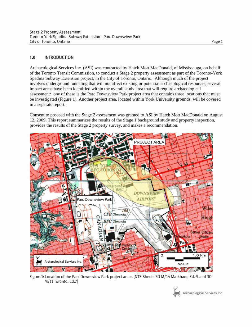
1.0 INTRODUCTION Archaeological Services Inc. (ASI) was contracted by URS Canada Inc., on behalf of the City of Toronto and the Toronto Transit Commission, to conduct a Stage 1 archaeological assessment for the Spadina Subway Extension Environmental Assessment from Downsview Station via York University to Steeles Avenue in the City of Toronto, Ontario (Figure 1). The assessment was conducted under the project direction of Mr. Robert Pihl, ASI, under an archaeological license (P057) issued to Mr. Pihl. The field review was conducted by Dr Michael Brand (P160) in accordance with the Ontario Heritage Act (2005). Permission to access the study area and to carry out the activities necessary for the completion of the Stage 1 assessment was granted to ASI by URS Canada Inc. on November 8, 2004. This report presents the results of the Stage 1 background research and field review and makes several recommendations.
Figure 1: Location of the study area [NTS Sheets 30 M/11 (Toronto), 30 M/12(Brampton), 30M/13 (Bolton), 30 M/14 (Markham)]
Stage 1 Archaeological Assessment Spadina Subway Extension from Downsview Station via York University to Steeles Avenue City of Toronto, Ontario Page 4
Archaeological Services Inc.
2.0 BACKGROUND RESEARCH 2.1 Previous Archaeological Research In order that an inventory of archaeological resources could be compiled for the study area, three sources of information were consulted: the site record forms for registered sites housed at the Ontario Ministry of Culture; published and unpublished documentary sources; and the files of ASI. In Ontario, information concerning archaeological sites is stored in the Ontario Archaeological Sites Database (OASD) maintained by the Ontario Ministry of Culture. This database contains archaeological sites registered within the Borden system. Under the Borden system, Canada has been divided into grid blocks based on latitude and longitude. A Borden Block is approximately 13 kilometres east to west, and approximately 18.5 kilometres north to south. Each Borden Block is referenced by a four-letter designator, and sites within a block are numbered sequentially as they are found. The study area under review is located in the Borden Blocks AkGu and AkGv. According to the OASD, there are 15 previously registered sites within the study area (Table 1). Table 1: Registered Archaeological Sites within the Study Area
Borden # Site name Site Affiliation Site Type Researcher(s) AkGu-10 Risebrough Late Woodland Iroquoian
Village A. Roberts, 1971; M, Kapches, 1972
AkGu-12 Dufferin Woodland Campsite Father Meighan, 1950
AkGu-68 Jerrett Historic Euro-Canadian Homestead ASI*, 2001
AkGv-8 E.A. Parson Late Woodland Village J.V. Wright, 1966; J. Morrison, 1979; U of T**; ASI, 1988
AkGv-70 Boynton Historic Euro-Canadian Homestead ASI, 1988
AkGv-71 Bramalae Undetermined Pre-contact Isolated Find ASI, 1988
AkGv-104 Burkholder House Historic Euro-Canadian Homestead Warrick 1990
AkGv-105 Unassigned Undetermined Pre-contact Isolated find Warrick 1991
AkGv-106 Goose Undetermined Pre-contact Isolated find Warrick 1991
AkGv-107 Bingo Undetermined Pre-contact Campsite Warrick 1991
AkGv-108 Unassigned Early Archaic Isolated find Warrick 1991
AkGv-109 Left Shoe Undetermined Pre-contact Isolated find Warrick 1991
AkGv-110 Right Shoe Undetermined Pre-contact Campsite Warrick 1991
AkGv-111 Boot Undetermined Pre-contact Isolated find Warrick 1991 AkGv-193 Kaiser Site Historic Euro-Canadian Homestead ASI, 2002
* ASI – Archaeological Services Inc. **U of T – University of Toronto 2.2 Physiography and Assessment of Pre-contact Archaeological Potential The study area is located in the bevelled till plains of the Peel Plain physiographic region (Chapman and Putnam 1984: 174–176) of southern Ontario. This region is a fairly level clay plain spread across the central portions of the Regional Municipalities of York, Peel, and Halton and the City of Toronto. The surface of the Peel Plain is characterized by level to gently rolling topography, with a consistent, gradual

Stage 1 Archaeological Assessment Spadina Subway Extension from Downsview Station via York University to Steeles Avenue City of Toronto, Ontario Page 5
Archaeological Services Inc.
slope toward Lake Ontario. The Peel Plain is made up of deep deposits of dense, limestone and shale imbued till, often covered by a shallow layer of clay sediment. Across this plain the Credit, Humber, Don and Rouge Rivers create a systematic drainage system as there is no large undrained depression, swamp, or bog in the study area. Potable water is arguably the single most important resource necessary for any extended human occupation or settlement. Since water sources have remained relatively stable in south central Ontario after the Pleistocene era, proximity to water can be regarded as a useful index for the evaluation of archaeological site potential. Indeed, distance from water has been one of the most commonly used variables for predictive modelling of site location. The Ministry of Citizenship, Culture and Recreation Primer on Archaeology Land Use Planning and Development in Ontario (1997: 12-13) stipulates that undisturbed lands within 300 metres of a primary water source or 200 metres of a secondary water source are considered to be of high archaeological site potential. Therefore, depending on the degree of previous land disturbance, it may be concluded that there is potential for the recovery of pre-contact archaeological remains within the study area. 2.3 Assessment of Historic Archaeological Potential: Summary Review of Historical Maps The 1878 Illustrated Historical Atlas of the County of York, Ontario was reviewed to determine the potential for the presence of historical archaeological remains within the study area during the nineteenth century (Figure 2). A number of historic communities fall within the study area including Dublin, Fisherville, Kaiserville, and Elia. The many little communities which sprang up in the nineteenth century had their beginnings as service areas for the farms which surrounded them (Hart, 1968: 136). Naturally, there was a tendency for the neighbourhood churches and schools to concentrate in the same area (ibid.) Dublin, a crossroads village, developed at the corner of Sheppard Avenue and Dufferin Street (where the northeastern most part of Downsview Park is currently situated) and was named after William Duncan’s Farm (Hart 1968: 197). Very few merchants settled in the area, but a shoemaker’s shanty and a general store were constructed in the late 1830’s. When the Duncan children reached school age, William built a one-storey frame schoolhouse and hired a school master for his growing family and the neighbourhood children (Hart 1968: 199). Members of the community would head into the neighbouring community of Downsview to attend to business that could not be done in Dublin or to attend church. Elia, a larger community than Dublin, was located in the district between Dufferin Street and Jane Street and from north of Sheppard Avenue to Steeles Avenue. The original lot owners in 1800 were mostly members of the Queen’s Rangers, who accompanied Governor Simcoe from Niagara to York in 1793. Later the property was sold to Pennsylvania German settlers who left Lancaster, Franklin, and Bedford Counties in Pennsylvania and came overland with their families to take up residence in Upper Canada (Hart 1968: 213). The community of Elia contained two blacksmith shops, a saw mill, a grist mill, a general store, a post office, an Episcopal Methodist Church, a log school house which was replaced by a brick school in 1873, and the Canadian Order of Foresters Hall. Today, the church stands alone surrounded by huge oil tanks. The old school, which closed in 1956, has been replaced with many new school buildings, and York
Stage 1 Archaeological Assessment Spadina Subway Extension from Downsview Station via York University to Steeles Avenue City of Toronto, Ontario Page 6
Archaeological Services Inc.
Stage 1 Archaeological Assessment Spadina Subway Extension from Downsview Station via York University to Steeles Avenue City of Toronto, Ontario Page 7
Archaeological Services Inc.
University opened its doors in September, 1964, on the Boyton, Hoover, Kaiser, and Stong farms (Hart 1968: 218). Two small villages sprang up west of Yonge Street along Steeles Avenue, North York’s northern boundary. Fisherville and Kaiserville (now Black Creek Village), were drawn toward the villages of Vaughan to the north. (Hart 1968: 224). Fisherville was named after Jacob Fisher, who brought twenty-two members of his Pennsylvania German family to Canada in 1797 and received land from the Crown in Vaughan Township and North York, bordering Steeles Avenue (Hart 1968: 224). He built a mill on the West Branch of the Don River, and, as usually happened, a community grew up around it. The community also consisted of several houses, a blacksmith shop, and an inn (Reaman 1971: 106). As in similar communities, Fisherville’s numbers decreased and finally ceased to exist except for the Presbyterian church and the hotel. In 1945, the property was taken over by the University of Toronto, and the Cannaught Medical Research Laboratories were expanded on to it (Reaman 1971: 107). The church has since been relocated to Black Creek Pioneer Village, located at Jane Street and Steeles Avenue. Kaiserville was the official name the Kaiser family gave to the settlement where they lived. Other families in the district may not have accepted the name, but for lack of a better one, it is used to distinguish this early community, part of which is now known as Black Creek Pioneer Village (Hart 1968: 225). Some of the early buildings associated with Kaiserville still stand at Black Creek Pioneer Village. In order to meet the need for a church and community hall, the Kaiser Chapel was erected in 1830 on Jane Street and served many purposes (Hart 1968: 226). Eventually the Kaiser Chapel was dismantled and the Townline Church was established in 1852, adjoining the school. Other buildings of interest in the community included a saw mill, which was the centre of industry in Kaiserville, two blacksmith shops, a carpenter shop, and a wagon shop. The community was gradually turning northward to Edgeley, where a school was opened about 1839, a post office in 1872, and finally a Methodist church in 1877 (ibid.). For the Euro-Canadian period, the majority of early nineteenth century farmsteads (i.e., those which are arguably the most potentially significant resources and whose locations are rarely recorded on nineteenth century maps) are likely to be captured by the basic proximity to water model outlined above, since these occupations were subject to similar environmental constraints. An added factor, however, is the development of the network of concession roads through the course of the nineteenth century. These transportation routes frequently influenced the siting of farmsteads. Accordingly, undisturbed lands within 100 metres of an early settlement road are also considered to have potential for the presence of Euro-Canadian archaeological sites. Therefore, depending on the degree of previous land disturbance, it may be concluded that there is potential for the recovery of historic cultural material within the study area. Furthermore, it should be noted that not every feature of potential interest today would have been illustrated on the nineteenth century mapping. 3.0 FIELD REVIEW A field review of three alternative alignments was conducted by Dr Michael Brand, ASI, on December 14, 2004. The weather at the time consisted of cold temperatures with grey, overcast skies, but viewing conditions were considered acceptable. The three alternatives investigated traversed a largely urban land-
Stage 1 Archaeological Assessment Spadina Subway Extension from Downsview Station via York University to Steeles Avenue City of Toronto, Ontario Page 8
Archaeological Services Inc.
scape (Figure 3), but the actual construction alignment will be underground, and therefore tunneled. Following detailed study of these three and other alternatives, a recommended subway alignment was defined which differed from the three investigated in the field. The Preferred Alignment is depicted in Figure 4, and a field review of that corridor was conducted by Mr. Rober Pihl, ASI, in early November, 2005. The weather again consisted of grey overcast skies, cool temperatures and a stiff wind, but viewing conditions were considered satisfactory. The field review proceeded from south to north, starting at Downsview Station (Plate 1). Although the route mostly traverses an urban landscape and will pass beneath buildings, roads, and parking lots (Plates 1-3, 8-11, 12-15), there are sections where development disturbances are absent to minimal (Plates 4-7). All stations are cut and cover construction (personal communication, Scott Thorburn, URS, December 6, 2005), but several will also feature major surface facilities: both Steeles West and Finch West Stations feature commuter parking and bus terminal facilities. All proposed construction activity within lands with known archaeological sites or archaeological site potential will require a Stage 2 archaeological assessment. 4.0 CONCLUSIONS AND RECOMMENDATIONS The Stage 1 archaeological assessment for the Spadina Subway Extension Environmental Assessment determined that 15 archaeological sites have been registered within the study area. Additionally, a review of the general physiography and local nineteenth century land uses of the study area suggested that it exhibits archaeological site potential. Field reviews were conducted in December 2004 and November 2005 by archaeologists from ASI, and these focused on the alternative and recommended alignments (Figures 3 and 4). Since construction activities will be mostly confined to underground tunneling, disturbance to archaeological resources will not occur unless these activities move to the surface (e.g. construction of station parking and bus terminal facilities) within areas of known or potential archaeological interest. In light of these results, the following recommendations are made: 1. A Stage 2 archaeological assessment of the preferred alignment (Figure 3) should be conducted in
accordance with the Ministry of Culture’s Stage 1-3 Archaeological Assessment Technical Guidelines (1993), in order to identify any archaeological remains that may be present within the preferred alignment. However, this assessment will only be required on those sections containing known sites or archaeological site potential where construction activities will disturb the surface.
Otherwise, and with this exception, no additional archaeological assessment will be required, and the study area (preferred alignment) can be considered clear of further archaeological concern.
The above recommendations are subject to Ministry of Culture approval, and it is an offence to alter any archaeological site without Ministry of Culture concurrence. No grading or other activities that may result in the destruction or disturbance of an archaeological site are permitted until notice of Ministry of Culture approval has been received. 2. Should deeply buried archaeological remains be found during construction activities, the Heritage
Operations Unit of the Ministry of Culture should be immediately notified.

Stage 1 Archaeological Assessment Spadina Subway Extension from Downsview Station via York University to Steeles Avenue City of Toronto, Ontario Page 9
Archaeological Services Inc.
Figure 3: Spadina Subway Extension Study Area with Alternative Alignments.
Stage 1 Archaeological Assessment Spadina Subway Extension from Downsview Station via York University to Steeles Avenue City of Toronto, Ontario Page 10
Archaeological Services Inc.
3. In the event that human remains are encountered during construction, the proponent should
immediately contact both the Ministry of Culture, and the Registrar or Deputy Registrar of the Cemeteries Regulation Unit of the Ministry of Consumer and Business Services.
The documentation related to the archaeological assessment of this project will be curated by Archaeological Services Inc. until such a time that arrangements for their ultimate transfer to Her Majesty
Figure 4: Spadina Subway Extension Study Area with Preferred Alignment.

Stage 1 Archaeological Assessment Spadina Subway Extension from Downsview Station via York University to Steeles Avenue City of Toronto, Ontario Page 11
Archaeological Services Inc.
the Queen in right of Ontario, or other public institution, can be made to the satisfaction of the project owner, the Ontario Ministry of Culture, and any other legitimate interest groups. 5.0 REFERENCES CITED Chapman, L.J. and F. Putnam
1984 The Physiography of Southern Ontario. Ontario Geological Survey, Special Volume 2.Ontario Ministry of Natural Resources, Toronto.
Hart, P. W. 1968 Pioneering in North York: A History of the Borough. General Publishing Company
Limited, Toronto.
Miles & Co. 1878 Illustrated historical atlas of the county of York and the township of West Gwillimbury & town of Bradford in the county of Simcoe, Ont. Miles & Co., Toronto.
Ministry of Culture
1993 Archaeological Assessment Technical Guidelines (Stages 1-3 & Report Format). Ministry of Culture, Toronto.
1997 Conserving a Future for a Past: Archaeology, Land Use Planning and Development in
Ontario. An Educational Primer and Comprehensive Guide for Non Specialists. (former Cultural Programs Branch, Archaeology & Heritage Planning Unit) Ministry of Culture, Toronto
Reaman, G. Elmore 1971 A History of Vaughan Township. University of Toronto Press, Toronto.
Stage 1 Archaeological Assessment Spadina Subway Extension from Downsview Station via York University to Steeles Avenue City of Toronto, Ontario Page 12
Archaeological Services Inc.
6.0 PHOTOGRAPHY
Plate 1: View of Downsview Station looking south
Plate 2: View of east side of Dufferin Steet looking north from Downsview Station.
Plate 3: Looking northwest from Dufferin Street along preferred alignment that will run beneath buildings
Plate 4: Looking east along Sheppard Avenue at proposed Downsview Park Station site beside railway tracks; cut and cover construction.
Plate 5: View of proposed corridor running along Sheppard Avenue (from proposed station site); area will be tunneled.
Plate 6: View of preferred alignment from Sheppard Avenue across field and connecting to Keele Street (in the distance); area will be tunneled..

Stage 1 Archaeological Assessment Spadina Subway Extension from Downsview Station via York University to Steeles Avenue City of Toronto, Ontario Page 13
Archaeological Services Inc.
Plate 7: Looking southeast along preferred alignment from Keele Street; area will be tunneled.
Plate 8: View of proposed Finch West Station site looking south along Keele Street; proposed main entrance to station.
Plate 9: Looking north along Keele Street section of preferred alignment from proposed Finch West Station site; view of proposed pedestrian entrance.
Plate 10: Looking north along Keele Streete corridor section from Murray Ross Parkway; area will tunneled.
Plate 11: View of preferred alignment looking south-east from Pond Road (within York University campus); area will be tunneled.
Plate 12: View of preferred alignment through York University parking lot next to the proposed York University Station site; cut and cover construction at station.
Stage 1 Archaeological Assessment Spadina Subway Extension from Downsview Station via York University to Steeles Avenue City of Toronto, Ontario Page 14
Archaeological Services Inc.
Plate 13: View of proposed York University Station site within campus; cut and cover construction
at station..
Plate 14: View of preferred alignment looking south-east through woodlot on south side of Ian MacDonald Boulevard; area will be tunneled.
Plate 15: View of preferred alignment looking south-east through York University parking lot from Steeles Avenue (and proposed Steeles West Station site); proposed bus terminal.

Stage 2 Property Assessment
Toronto-York Spadina Subway Extension—Parc Downsview Park City of Toronto, Ontario
Prepared for:
Hatch Mott MacDonald
2800 Speakman Drive Mississauga, Ontario L5K 2R7
Tel.: 905-855-2010 Fax: 905-855-2607
Website: www.hatchmott.com
Archaeological Licence P264 (Kathryn Bryant) MCL PIF P264-089-2009 ASI File 09EA-218a
October 2009

Stage 2 Property Assessment
Toronto-York Spadina Subway Extension—Parc Downsview Park, City of Toronto, Ontario
EXECUTIVE SUMMARY Archaeological Services Inc. (ASI) was contracted by Hatch Mott MacDonald, of Mississauga, on behalf of the Toronto Transit Commission, to conduct a Stage 2 property assessment as part of the Toronto-York Spadina Subway Extension project, in the City of Toronto, Ontario. Although much of the project involves underground tunneling that will not affect existing or potential archaeological resources, several impact areas have been identified within the overall study area that will require archaeological assessment: one of these is the Parc Downsview Park project area which contains three locations that must be investigated. A Stage 1 background study and property inspection of the Toronto-York Spadina Subway Extension study area was previously conducted by ASI in 2005, and the results were summarized in a report that was submitted to the Ontario Ministry of Culture (MCL). The Stage 1 background study and property inspection suggested that only certain parts of the study area exhibited archaeological potential due to proximity to known archaeological sites, numerous tributaries and early Euro-Canadian settlements and transportation roads. It was recommended that a Stage 2 property assessment be conducted on lands with known archaeological sites or archaeological site potential, if any proposed construction activity were to impact these areas. One of the areas to be impacted by the Toronto-York Spadina Subway Extension project is the Parc Downsview Park, which includes three separate project areas, only two of which were determined to have archaeological site potential. A Stage 2 property assessment was conducted on these two areas in accordance with the Ontario Heritage Act (2005) and the Draft Standards and Guidelines for Consultant Archaeologists (MCL 2009). Judgmental test pit survey confirmed that both project areas were in fact disturbed and, therefore, archaeological potential was negated. No archaeological remains were encountered. In light of these results, the following recommendation is made: no further archaeological assessment of the three project areas is required within the Parc Downsview Park.

Stage 2 Property Assessment Toronto-York Spadina Subway Extension—Parc Downsview Park, City of Toronto, Ontario Page ii
ARCHAEOLOGICAL SERVICES INC. ENVIRONMENTAL ASSESSMENT DIVISION
PROJECT PERSONNEL
Senior Project Manager: Robert Pihl, MA, CAHP [P057] Partner and Senior Archaeologist Manager, Environmental Assessment Division
Project Director (licensee): Katie Bryant, MA [P264] Staff Archaeologist
Project Manager/Archaeologist: Katie Bryant
Project Administrator: Sarah Jagelewski, Hon. BA Research Archaeologist
Field Director: Katie Bryant
Field Archaeologists: Caitlin Lacy, Hon. BA [R303} Staff Archaeologist Andrea Jackson, MLitt Adrienne Perrin, BSc Blake Williams, MLitt Research Archaeologist
Report Writer: Katie Bryant
Graphics Preparation: Katie Bryant Jonas Fernandez, MSc GIS Technician Sarina Finlay, Hon. BA, GIS-AS GIS/CAD Technician
Report Reviewer: Robert Pihl

Stage 2 Property Assessment Toronto-York Spadina Subway Extension—Parc Downsview Park, City of Toronto, Ontario Page iii
TABLE OF CONTENTS EXECUTIVE SUMMARY ..................................................................................................................................... ii PROJECT PERSONNEL ...................................................................................................................................... ii TABLE OF CONTENTS ...................................................................................................................................... iii
1.0 INTRODUCTION.............................................................................................................................. 1 2.0 SUMMARY OF STAGE 1 BACKGROUND STUDY AND PROPERTY INSPECTION ...................................... 2
2.1 ADDITIONAL BACKGROUND RESEARCH....................................................................................... 4 3.0 STAGE 2 PROPERTY ASSESSMENT .................................................................................................. 5
3.1 Methodology............................................................................................................................. 5 3.2 Stage 2 Property Survey ............................................................................................................ 5
4.0 RECOMMENDATIONS AND COMPLIANCE ADVICE............................................................................. 8 5.0 REFERENCES CITED ........................................................................................................................ 9 6.0 PHOTOGRAPHY............................................................................................................................ 10
LIST OF FIGURES Figure 1: Location of the Parc Downsview Park project areas [NTS Sheets 30 M/14 Markham, Ed. 9 and 30
M/11 Toronto, Ed.7]............................................................................................................................ 1 Figure 2: Wilson Yard Connection project area................................................................................................. 3 Figure 3: Approximate location of the project areas superimposed on the Township of York North map in
the 1878 Illustrated Historical Atlas of the County of York, Ontario...................................................... 4 Figure 4: Stage 2 property assessment of Sheppard West Station project area................................................. 6 Figure 5: Stage 2 property assessment of Track Laydown project area.............................................................. 7
LIST OF PLATES Plate 1: Looking northwest at northwest corner of disturbed Sheppard West Station project area................... 10 Plate 2: Looking west-southwest at heavily disturbed Sheppard West Station project area. ........................... 10 Plate 3: Looking south-southeast at heavily disturbed Sheppard West Station project area. .......................... 10 Plate 4: Looking northeast across access road for Sheppard West Station project area. ................................. 10 Plate 5: Looking west-southwest across disturbed access road for Sheppard West Station project area. ......... 11 Plate 6: Looking east-northeast across heavily disturbed Sheppard West Station project area. ....................... 11 Plate 7: Looking north during judgmental test pit survey of Track Laydown project area. ................................. 11 Plate 8: Looking at ground surface, stripped of topsoil, in the Track Laydown project area. ............................ 11 Plate 9: Looking northwest across top of Track Laydown project area. ........................................................... 12 Plate 10: Looking southwest across Track Laydown project area. ................................................................... 12 Plate 11: Looking north at judgmental test pit survey at top of Track Laydown project area. ............................ 12 Plate 12: Looking east at disturbed gravel surface of Track Laydown project area. ......................................... 12
Stage 2 Property Assessment Toronto-York Spadina Subway Extension—Parc Downsview Park, City of Toronto, Ontario Page 1
1.0 INTRODUCTION Archaeological Services Inc. (ASI) was contracted by Hatch Mott MacDonald, of Mississauga, on behalf of the Toronto Transit Commission, to conduct a Stage 2 property assessment as part of the Toronto-York Spadina Subway Extension project, in the City of Toronto, Ontario. Although much of the project involves underground tunneling that will not affect existing or potential archaeological resources, several impact areas have been identified within the overall study area that will require archaeological assessment: one of these is the Parc Downsview Park project area that contains three locations that must be investigated (Figure 1). Another project area, located within York University grounds, will be covered in a separate report. Consent to proceed with the Stage 2 assessment was granted to ASI by Hatch Mott MacDonald on August 12, 2009. This report summarizes the results of the Stage 1 background study and property inspection, provides the results of the Stage 2 property survey, and makes a recommendation.
Figure 1: Location of the Parc Downsview Park project areas [NTS Sheets 30 M/14 Markham, Ed. 9 and 30
M/11 Toronto, Ed.7]

Stage 2 Property Assessment Toronto-York Spadina Subway Extension—Parc Downsview Park, City of Toronto, Ontario Page 2
2.0 SUMMARY OF STAGE 1 BACKGROUND STUDY AND PROPERTY INSPECTION This section presents a summary of the Stage 1 report for the Toronto-York Spadina Subway Extension study area that was prepared by ASI (2005) and submitted to the Ontario Ministry of Culture (MCL). The Stage 1 study area ran from Downsview Station via York University to Steeles Avenue. The Stage 1 background study and property inspection were conducted in order to identify the potential for Aboriginal and Euro-Canadian archaeological resources in the study area. The Ontario Archaeological Sites Database (OASD) maintained by the MCL was consulted, and it indicated that 15 archaeological sites had been registered within the Stage 1 study area. The study area is situated within the bevelled till plains of the Peel Plain physiographic region of southern Ontario. This region is a fairly level clay plain spread across the central portions of the Regional Municipalities of York, Peel and Halton. The surface of the Peel Plain is characterized by level to gently rolling topography, with a consistent, gradual slope toward Lake Ontario. The Peel Plain is made up of deep deposits of dense, limestone and shale imbued till, often covered by a shallow layer of clay sediment. Across this plain the Credit, Humber, Don and Rouge Rivers create a systematic drainage system as there is no large undrained depression, swamp, or bog in the study area. Therefore, depending on the degree of previous land disturbance, it was concluded that there is potential for the recovery of Aboriginal archaeological remains within the study area. According to the 1878 Illustrated Historical Atlas of the County of York, Ontario, the study area encompassed a number of historic communities, including Dublin, Fisherville, Kaiserville and Elia. Based on the proximity of early settlement roads, and the historic features illustrated in the Atlas, the study area was characterized as having potential for the recovery of Euro-Canadian cultural material. A property inspection of the Spadina Subway Extension study area identified sections where development disturbances were absent to minimal. It was recommended that a Stage 2 property assessment be conducted on lands with known archaeological sites or archaeological site potential, if any proposed construction activity were to impact these areas (ASI 2005). In preparation for construction of the Toronto-York Spadina Subway Extension project, three impact areas within the Parc Downsview Park were identified for Stage 2 property assessment. Two of these, identified in connection with the proposed Sheppard West Station site and the Track Laydown Area, are located at the north end of Parc Downsview Park (Figure 1: shown in yellow and green, respectively), and both were determined to have archaeological potential (ASI 2005, 2009). The third impact area, identified as the Downsview Station Connection to Wilson Yard (Figure 1: shown in pink; Figure 2), was considered to be disturbed due to previous development impact and archaeological potential has therefore been negated (ASI 2009). This was established by looking at the Archaeological Potential Mapping for the City of Toronto and evaluating the landscape integrity through aerial photography review and systematic field review (ASI 2009). No further archaeological assessment is therefore required.
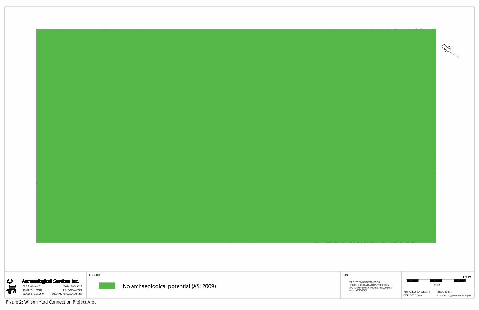
Figure 2: Wilson Yard Connection Project Area
No archaeological potential (ASI 2009)


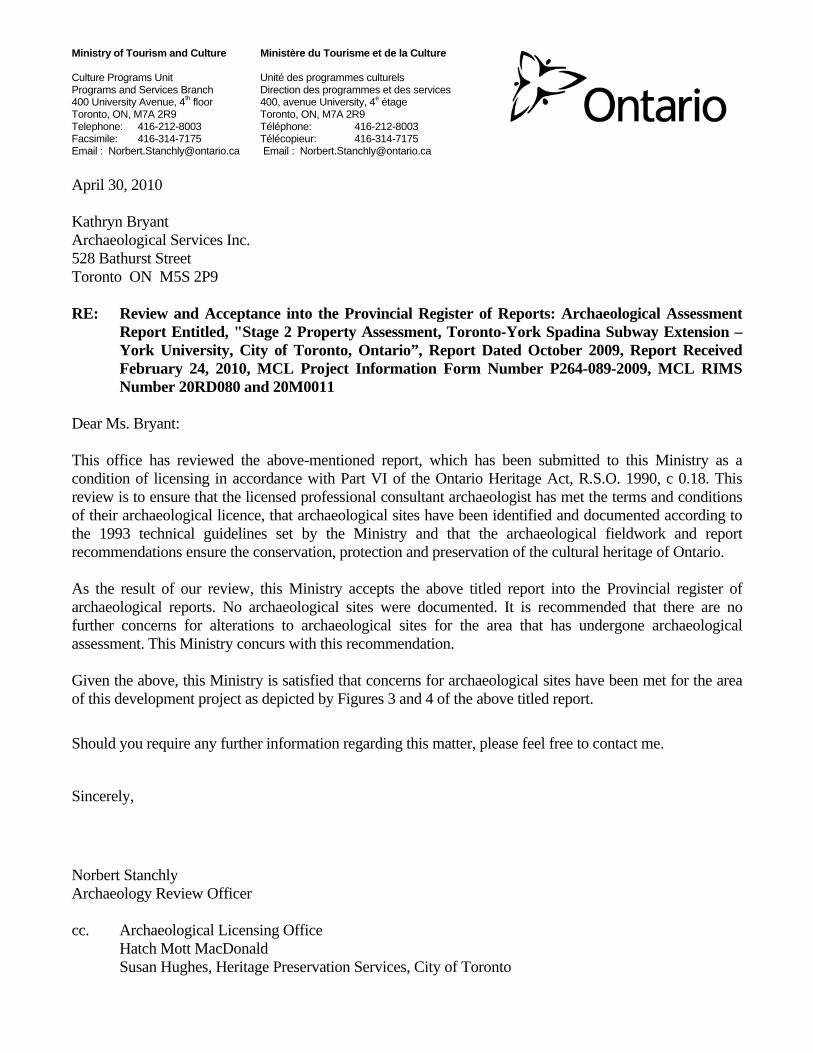
Ministry of Tourism and Culture Ministère du Tourisme et de la Culture Culture Programs Unit Unité des programmes culturels Programs and Services Branch Direction des programmes et des services 400 University Avenue, 4th floor 400, avenue University, 4e étage Toronto, ON, M7A 2R9 Toronto, ON, M7A 2R9 Telephone: 416-212-8003 Téléphone: 416-212-8003 Facsimile: 416-314-7175 Télécopieur: 416-314-7175 Email : [email protected] Email : [email protected] April 30, 2010 Kathryn Bryant Archaeological Services Inc. 528 Bathurst Street Toronto ON M5S 2P9 RE: Review and Acceptance into the Provincial Register of Reports: Archaeological Assessment
Report Entitled, "Stage 2 Property Assessment, Toronto-York Spadina Subway Extension – York University, City of Toronto, Ontario”, Report Dated October 2009, Report Received February 24, 2010, MCL Project Information Form Number P264-089-2009, MCL RIMS Number 20RD080 and 20M0011
Dear Ms. Bryant: This office has reviewed the above-mentioned report, which has been submitted to this Ministry as a condition of licensing in accordance with Part VI of the Ontario Heritage Act, R.S.O. 1990, c 0.18. This review is to ensure that the licensed professional consultant archaeologist has met the terms and conditions of their archaeological licence, that archaeological sites have been identified and documented according to the 1993 technical guidelines set by the Ministry and that the archaeological fieldwork and report recommendations ensure the conservation, protection and preservation of the cultural heritage of Ontario. As the result of our review, this Ministry accepts the above titled report into the Provincial register of archaeological reports. No archaeological sites were documented. It is recommended that there are no further concerns for alterations to archaeological sites for the area that has undergone archaeological assessment. This Ministry concurs with this recommendation. Given the above, this Ministry is satisfied that concerns for archaeological sites have been met for the area of this development project as depicted by Figures 3 and 4 of the above titled report.
Should you require any further information regarding this matter, please feel free to contact me.
Sincerely,
Norbert Stanchly Archaeology Review Officer cc. Archaeological Licensing Office
Hatch Mott MacDonald Susan Hughes, Heritage Preservation Services, City of Toronto
Stage 2 Property Assessment Toronto-York Spadina Subway Extension—Parc Downsview Park, City of Toronto, Ontario Page 4
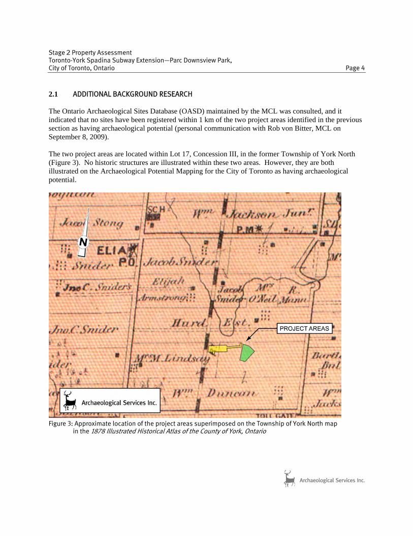
2.1 ADDITIONAL BACKGROUND RESEARCH The Ontario Archaeological Sites Database (OASD) maintained by the MCL was consulted, and it indicated that no sites have been registered within 1 km of the two project areas identified in the previous section as having archaeological potential (personal communication with Rob von Bitter, MCL on September 8, 2009). The two project areas are located within Lot 17, Concession III, in the former Township of York North (Figure 3). No historic structures are illustrated within these two areas. However, they are both illustrated on the Archaeological Potential Mapping for the City of Toronto as having archaeological potential.
Figure 3: Approximate location of the project areas superimposed on the Township of York North map in the 1878 Illustrated Historical Atlas of the County of York, Ontario

Stage 2 Property Assessment Toronto-York Spadina Subway Extension—Parc Downsview Park, City of Toronto, Ontario Page 5
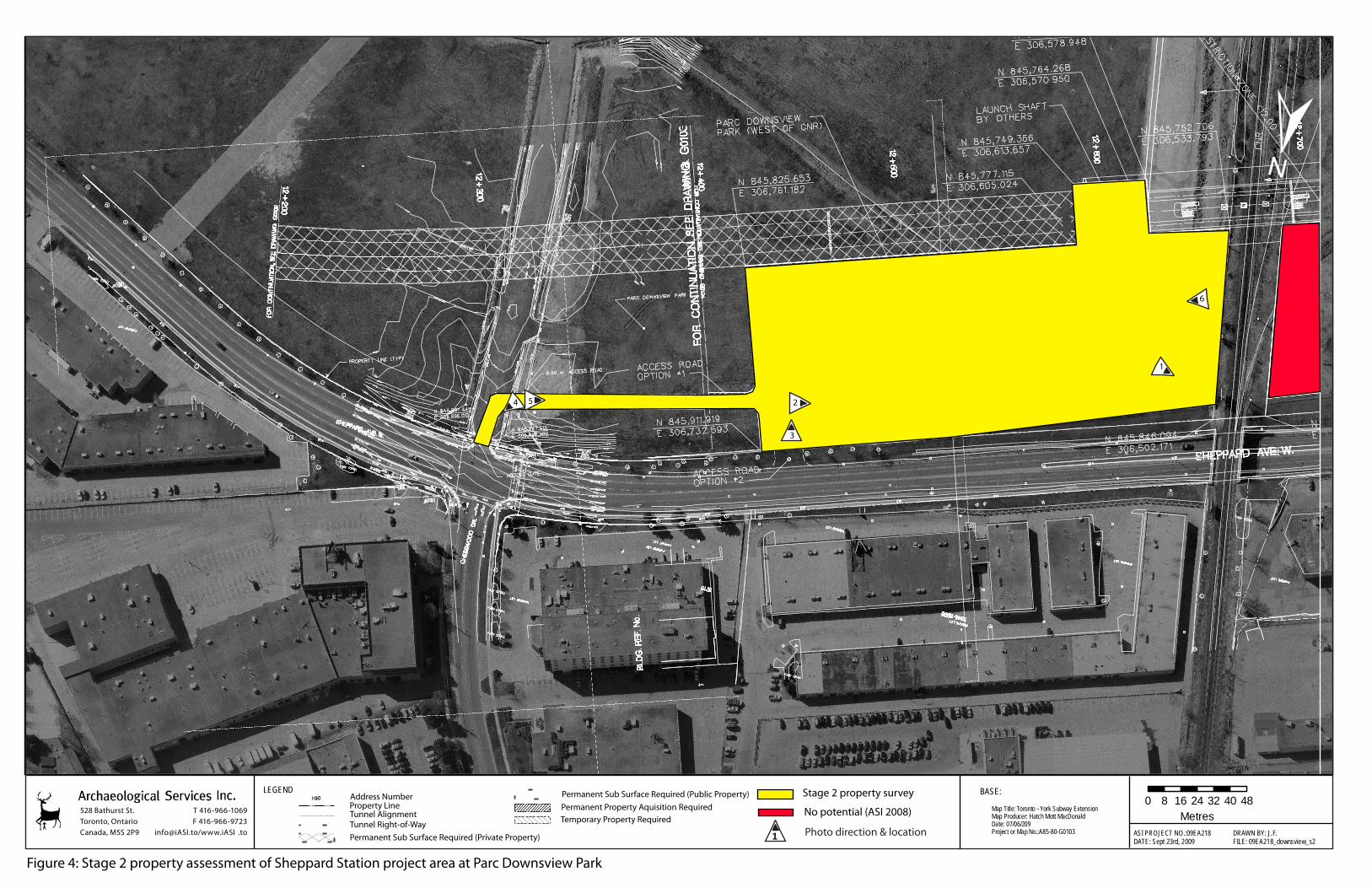
3.0 STAGE 2 PROPERTY ASSESSMENT 3.1 Methodology The Stage 2 property assessment was conducted in accordance with the Ontario Heritage Act (2005) and the Draft Standards and Guidelines for Consultant Archaeologists (MCL 2009; Section 2). Both project areas are within lands with closed surface visibility and were therefore assessed by test pit survey. According to the MCL’s draft standards and guidelines, any undisturbed areas within 300 m of any feature of archaeological potential must be subject to systematic test pit survey at 5 m intervals (MCL 2009; Section 2). Any undisturbed areas more than 300 m from any feature of archaeological potential must be systematically test pitted at 10 m intervals. For this Stage 2 survey, all lands requiring assessment with closed surface visibility were test pit surveyed following the above standards. Test pit survey involved the excavation of 30 cm diameter test pits into the first 5 cm of subsoil, and the screening of all test pit fills through 6 mm mesh to facilitate artifact recovery. All test pits were backfilled and their locations were recorded on field maps. If archaeological resources were uncovered, test pit intervals were intensified to 2.5 m around the positive test pits to define site boundaries. Any factors that preclude the excavation of test pits (e.g. excessive slope, drainage, exposed bedrock, previous disturbance) were noted, and the areas were mapped and photographed. Where necessary, areas of disturbance were confirmed by the excavation of test pits at judgmental intervals. The results of this assessment were mapped (Figures 4 and 5), and associated photographs are presented in Section 6.0. 3.2 Stage 2 Property Survey Stage 2 fieldwork was completed on August 21 and September 9, 2009, under the field direction of Katie Bryant (P264), ASI. The weather was overcast on the first visit and sunny on the second. All necessary Permissions to Enter (PTE) were provided by Hatch Mott MacDonald on August 17 and September 8, 2009. Viewing conditions were considered acceptable. The two areas within Parc Downsview Park that were examined during the Stage 2 property assessment included the proposed Sheppard West Station area and access road (shown in yellow in Figure 1) and the seven acre Track Laydown Area (shown in green in Figure 1). The Sheppard West Station area is located at the north end of Parc Downsview Park, directly east of the railway and south of Sheppard Avenue. It includes an access road leading to Chesswood Drive. The entire area has been completely disturbed by previous grading and dumping activities (Plates 1-6). No testing was conducted due to the clear absence of archaeological potential. The seven acre Track Laydown Area is located at the north end of Parc Downsview Park, immediately east of Chesswood Drive and south of Sheppard Avenue. This area was test pitted at judgmental intervals and was also determined to be disturbed (Plates 7-12). The topsoil had been stripped and was overgrown with weeds. Test pits contained a high amount of gravel and asphalt with some glass shards. Despite careful scrutiny, no archaeological remains were encountered.
528 Bathurst St.Toronto, OntarioCanada, M5S 2P9
T 416-966-1069F 416-966-9723
[email protected]/www.iASI .to ASI PROJECT NO.:09EA218DATE: Sept 23rd, 2009
DRAWN BY: J.F.FILE: 09EA218_downsview_s2
BASE:
Map Title: Toronto - York Subway ExtensionMap Producer: Hatch Mott MacDonaldDate: 07/06/209Project or Map No.:A85-80-G0103
LEGEND±
0 8 16 24 32 40 48Metres
Address NumberProperty LineTunnel AlignmentTunnel Right-of-WayPermanent Sub Surface Required (Private Property)
Permanent Sub Surface Required (Public Property)Permanent Property Aquisition RequiredTemporary Property Required
Stage 2 property survey
No potential (ASI 2008)
1 Photo direction & location
1
2
3
4 5
6
Figure 4: Stage 2 property assessment of Sheppard Station project area at Parc Downsview Park

Stage 2 judgmental test pit survey
1 Photo direction & location
7
10
8
9
10
1112
Figure 5: Stage 2 Property Assessment of Track Laydown Area at Parc Downsview Park

Stage 2 Property Assessment Toronto-York Spadina Subway Extension—Parc Downsview Park, City of Toronto, Ontario Page 8
4.0 RECOMMENDATIONS AND COMPLIANCE ADVICE ASI was contracted by Hatch Mott MacDonald, of Mississauga, to conduct a Stage 2 property assessment of three project areas within the Parc Downsview Park as part of the Toronto-York Spadina Subway Extension project, in the City of Toronto, Ontario. A Stage 1 background study and property inspection of the Toronto-York Spadina Subway Extension study area suggested that only certain parts of the study area exhibited archaeological potential due to proximity to known archaeological sites, numerous tributaries and early Euro-Canadian settlements and transportation roads. It was recommended that a Stage 2 property assessment be conducted on lands with known archaeological sites or archaeological site potential, if any proposed construction activity were to impact these areas (ASI 2005). One of the areas to be impacted is the Parc Downsview Park which includes three separate project areas, only two of which were determined to have archaeological site potential. A Stage 2 property assessment was conducted on these two areas, and judgmental test pit survey confirmed that both were in fact disturbed and, therefore, archaeological potential was negated. No archaeological remains were encountered. In light of these results, the following recommendation is made:
1. No further archaeological assessment of the three project areas is required within the Parc Downsview Park.
ASI advises compliance with the following legislation:
• This report is submitted to the Minister of Culture as a condition of licensing in accordance with Part VI of the Ontario Heritage Act, R.S.O. 1990, c 0.18. The report is reviewed to ensure that the licensed consultant archaeologist has met the terms and conditions of their archaeological licence, and that the archaeological fieldwork and report recommendations ensure the conservation, protection and preservation of the cultural heritage of Ontario.
• Should previously undocumented archaeological resources be discovered, they may be a new
archaeological site and therefore subject to Section 48 (1) of the Ontario Heritage Act. The proponent or person discovering the archaeological resources must cease alteration of the site immediately and engage a licensed consultant archaeologist to carry out archaeological fieldwork, in compliance with sec. 48 (1) of the Ontario Heritage Act.
• The Cemeteries Act requires that any person discovering human remains must notify the
police or coroner and the Registrar of cemeteries, Ministry of Consumer Services. The documentation related to the archaeological assessment of this project will be curated by Archaeological Services Inc. until such a time that arrangements for their ultimate transfer to Her Majesty

Stage 2 Property Assessment Toronto-York Spadina Subway Extension—Parc Downsview Park, City of Toronto, Ontario Page 9
the Queen in right of Ontario, or other public institution can be made to the satisfaction of the project owner, the Ontario Ministry of Culture, and any other legitimate interest groups. 5.0 REFERENCES CITED ASI (Archaeological Services Inc.)
2005 Stage 1 Archaeological Assessment, Spadina Subway Extension, From Downsview Station via York University to Steeles Avenue, City of Toronto, Ontario. Report on file, Ontario Ministry of Culture, Toronto (CIF P057-117).
2009 Downsview Area Secondary Plan Review Study, City of Toronto, Ontario, Stage 1
Archaeological Resource Assessment, Final Report. Report on file, Ontario Ministry of Culture, Toronto (CIF P049-333-2008).
Chapman, L.J. and F. Putnam
1984 The Physiography of Southern Ontario. Ontario Geological Survey, Special Volume 2. Ontario Ministry of Natural Resources, Toronto.
MCL (Ontario Ministry of Culture)
2009 Draft Standards and Guidelines for Consultant Archaeologists (June 2009). Culture Policy, Programs and Services Division, Programs and Services Branch, Culture Programs Unit, Toronto.
Miles & Co.
1878 Illustrated Historical Atlas of the County of York, Ontario. Toronto.

Stage 2 Property Assessment Toronto-York Spadina Subway Extension—Parc Downsview Park, City of Toronto, Ontario Page 10
6.0 PHOTOGRAPHY
Plate 1: Looking northwest at northwest corner of
disturbed Sheppard West Station project area.
Plate 2: Looking west-southwest at heavily disturbed
Sheppard West Station project area.
Plate 3: Looking south-southeast at heavily disturbed
Sheppard West Station project area.
Plate 4: Looking northeast across access road for
Sheppard West Station project area.

Stage 2 Property Assessment Toronto-York Spadina Subway Extension—Parc Downsview Park, City of Toronto, Ontario Page 11
Plate 5: Looking west-southwest across disturbed
access road for Sheppard West Station project area.
Plate 6: Looking east-northeast across heavily
disturbed Sheppard West Station project area.
Plate 7: Looking north during judgmental test pit
survey of Track Laydown project area.
Plate 8: Looking at ground surface, stripped of
topsoil, in the Track Laydown project area.

Stage 2 Property Assessment Toronto-York Spadina Subway Extension—Parc Downsview Park, City of Toronto, Ontario Page 12
Plate 9: Looking northwest across top of Track
Laydown project area.
Plate 10: Looking southwest across Track Laydown
project area.
Plate 11: Looking north at judgmental test pit survey
at top of Track Laydown project area.
Plate 12: Looking east at disturbed gravel surface of
Track Laydown project area.


Ministry of Tourism and Culture Ministère du Tourisme et de la Culture Culture Programs Unit Unité des programmes culturels Programs and Services Branch Direction des programmes et des services 400 University Avenue, 4th floor 400, avenue University, 4e étage Toronto, ON, M7A 2R9 Toronto, ON, M7A 2R9 Telephone: 416-212-8003 Téléphone: 416-212-8003 Facsimile: 416-314-7175 Télécopieur: 416-314-7175 Email : [email protected] Email : [email protected] March 17, 2010 Kim Slocki Archeoworks Inc. 16715-12 Yonge Street Suite #1029 Newmarket, Ontario L3X 1X4 RE: Review and Acceptance into the Provincial Register of Reports: Archaeological Assessment
Report Entitled, “Stage 2 Archaeological Assessment (AA) of: Proposed Sheppard West Station Within part of Lot 17, Concession 3, City of Toronto, Ontario”, Report Dated September, 2009, Report Received December 14, 2009, MCL Project Information Form Number P029-575-2009, MCL RIMS Number 20RD077
Dear Ms. Slocki: This office has reviewed the above-mentioned report, which has been submitted to this Ministry as a condition of licensing in accordance with Part VI of the Ontario Heritage Act, R.S.O. 1990, c 0.18. This review is to ensure that the licensed professional consultant archaeologist has met the terms and conditions of their archaeological licence, that archaeological sites have been identified and documented according to the 1993 technical guidelines set by the Ministry and that the archaeological fieldwork and report recommendations ensure the conservation, protection and preservation of the cultural heritage of Ontario. As the result of our review, this Ministry accepts the above titled report into the Provincial register of archaeological reports. No archaeological sites were documented. It is recommended that there are no further concerns for alterations to archaeological sites for the area that has undergone archaeological assessment. This Ministry concurs with this recommendation. Given the above, this Ministry is satisfied that concerns for archaeological sites have been met for the area of this development project as depicted by Figure 4 of the above titled report. Should you require any further information regarding this matter, please feel free to contact me.

Sincerely,
Norbert Stanchly Archaeology Review Officer cc. Archaeological Licensing Office
AECOM Susan Hughes, Heritage Preservation Services, City of Toronto