archeoguide: an augmented reality guide for archaeological sites
TRANSCRIPT
Recently, researchers have introducedcomputers to archaeology and cultural
heritage either as tools for promoting scientific work oras electronic aids providing users with information.
During the past decade, CD-ROMsand Web sites have provided publicaccess to virtual museums, archae-ological sites, and works of art.Audio CD guides installed in cul-tural heritage sites let visitors par-ticipate in prerecorded audio tours,and information kiosks provideinteractive historical, artistic, andother information. The latest devel-opments include portable devicescapable of providing guided tourswith audiovisual information andlimited interaction.1,2
Most of these tools, however, lackintelligence, user friendliness, andthe ability to provide accurate navi-gation. Each solves only part of theinteractive visualization problemand fails to integrate many featuresusers might expect such as guidanceand navigation information, infor-mation personalization, access toobjects stored at remote locations,
life animation, and so on.We developed Archeoguide, short for Augmented
Reality-Based Cultural Heritage On-Site Guide, tobridge the gap between recreation, education, and sci-entific research. This article shows how a well-designed mobile system can provide a personalizedelectronic guide to outdoor archaeological sites, helpusers navigate and make the most of their visit, andenable the collection, exploitation, and updating ofarchaeological data on any given site. The systemexploits recent advances in mobile computing, aug-
mented reality, 3D visualization, networking, andarchiving to present users with on-site and online toursof the physical site according to their profile and behav-ior during the tour.
Site preparationWe have installed the Archeoguide prototype at
Greece’s Olympia archaeological site for testing, demon-stration, and user evaluation. We chose this site becauseof its importance as the birthplace of the ancientOlympic games, its high popularity among visitors, andthe fact that it lies mainly in ruins.
Before implementing the system, we performed a sitesurvey to collect necessary data and plan the hardwareinstallation. We collected aerial photographs and sur-veying data and entered them in a geographical infor-mation system (GIS) used to construct a digital elevationmap. We used this 3D site representation to identifymajor monuments and corresponding viewpoints withunobstructed views. This data helped us define suitabletours and capture high-definition photographs of theruins from the predefined viewpoints along the tourpaths. For each viewpoint, we took a set of tiled pho-tographs to simulate user movement around it. Westored the full dataset in the server database, along with3D reconstruction models (in Virtual Reality ModelingLanguage format; http://www.vrml.org) of the ruinsdesigned from architectural drawings and archaeolog-ical sources.
We used the same elevation model to define suit-able positions for the communication infrastructureinstallation.
System architectureArcheoguide uses a client–server architecture with
three basic subsystems, shown in Figure 1: the site infor-mation server (SIS), mobile units, and the networkinfrastructure.
We built the server on a high-end PC with sufficient
0272-1716/02/$17.00 © 2002 IEEE
Computer Graphics in Art History and Archaeology
52 September/October 2002
Archeoguide offers
personalized augmented
reality tours of archaeo-
logical sites. It uses outdoor
tracking, mobile computing,
3D visualization, and
augmented reality
techniques to enhance
information presentation,
reconstruct ruined sites, and
simulate ancient life.
Vassilios Vlahakis, Nikolaos Ioannidis, JohnKarigiannis, Manolis Tsotros, and MichaelGounarisIntracom S.A., Greece
Didier StrickerFraunhofer Institute IGD, Germany
Tim Gleue and Patrick DaehneCenter for Computer Graphics (ZGDV), Germany
Luís AlmeidaCenter for Computer Graphics (CCG), Portugal
Archeoguide: An AugmentedReality Guide forArchaeologicalSites

storage space to implement a multimedia database. Itserves as the system’s central repository for archivingthe multimedia information used to construct aug-mented reality3 tours. The SIS communicates this infor-mation to the clients via a wireless local area network(WLAN). Touring users in the archaeological site carrythe mobile units, which are based on laptop, pen-tablet,and palmtop computers. The mobile units request mul-timedia information from the SIS based on user posi-tion and other parameters as calculated by the GlobalPositioning System (GPS) signals received from satel-lites at geostationary orbits. The system corrects the cal-culations’ accuracy using a reference signal transmittedby a Differential GPS (DGPS) beacon located at a pre-cisely known position.
Site information serverWe consider the SIS to be the heart of the Archeogu-
ide system. It administers a multimedia object databasestoring 2D images, 3D models, audio and video clips,and text objects on the archaeological site. These objectsare organized in a hierarchical treestructure, enabling groupingaccording to the information theyrepresent. The tree’s roots representthe whole site and its branches cor-respond to specific areas such astemples. Moving down the struc-ture, we can reach the level of build-ing parts (such as a temple’spronaos) or artifacts (such as a stat-ue) originally found in the monu-ment. The multimedia objects arestored along with attributes aimedat facilitating context-based search-es using natural language—forexample, “marble statues datingfrom the 5th century BC.” Theseattributes include name, type, dat-ing, geographic location, category,and detail level, and also help usselect suitable material to constructpersonalized tours based on theuser’s profile, preferences, position, and orientation.
The SIS also hosts a suite of authoring tools for cre-ating and editing multimedia content and defining vir-tual and augmented tours. We developed theapplication’s graphical interface (shown in Figure 2) inJava for maximum portability in a three-tier architec-ture. Virtual tour developers use six subwindows to cre-ate and organize new database content: toolbar, objecteditor (multimedia, composite, script), schedule editor,options editor, site node editor, and GIS editor.
The repository facilitates exchanging scientific find-ings and updating the stored information, which canthen be used to create many things, from virtual Inter-net tours to CD-ROMs and media articles.
Finally, the SIS provides Internet access to virtualtours and the database content for recreational, educa-tional, and scientific use. Users can draw their own tourson a digital map, navigate in 3D, and request relatedaudiovisual information.
Mobile unitsThe mobile units provide Archeoguide’s substance
and more advanced functionalities. These portabledevices provide all information stored in the centraldatabase to the touring users and incorporate a hybridsystem for identifying the user’s view. DGPS and com-pass readings provide initial estimates, refined by thetechnique presented in the sidebar, “Image Tracking”(next page). This information helps the system render3D reconstructed models of monuments, artifacts, andlife on top of ruins and natural surroundings.
All client components (tracking, rendering, con-troller, data manager, and user interfaces) operate con-currently, with the controller continuously instructingthe renderer based on the tracking system data read-ings and user interactions. We therefore implement themobile unit as a multithreaded process with the multi-media synchronization unit being the main controlthread. This approach forces us to write all client com-
IEEE Computer Graphics and Applications 53
GPS satellite
DGPSbeacon
Mobile units
Wireless LAN
Site information server
1 Archeoguidearchitecture.
2 SIS graphicalauthoring tools.
ponents in the same language (C++) but also optimizesresponse times, which is critical for a real-time systemsuch as Archeoguide.
Keeping these components on the mobile unit was afundamental design choice. It implies a fat-client archi-tecture where the mobile unit handles heavy processing(required by the renderer and the tracking system) butminimizes network traffic overhead and doesn’t over-load the server with many concurrent visitors’ servicerequests. The design therefore works if the mobile unitcan process information faster than the server can andtransmit it to the mobile units through the WLAN. Sim-ple calculations (considering that the WLAN can oper-
ate at a maximum of 11 Mbps in shared mode and thatthe mobile unit’s CPU clock speed is at least 800 MHz,while a high-end server may have dual Pentium 4 CPUsrunning at more than 1.5GHz) show that for even a fewconcurrent visitors, the fat-client approach wins.
Communication infrastructureThe communication infrastructure forms the back-
bone for the SIS and mobile units to exchange multi-media data and control information. The site’sdimensions (300 × 500 meters) and remoteness fromwired communication and power networks call for awireless solution. We chose an IEEE 802.11b WLAN to
Computer Graphics in Art History and Archaeology
54 September/October 2002
Image TrackingTo track users at the archaelogical site, Archeoguide uses
an image tracking algorithm based on frequency domainanalysis and matching of 2D images. This algorithm isoptimized for execution speed, allowing real-timeoperation.
TranslationLet f1 and f2 be two images differing only in a 2D
translation t(tx, ty). The images are related as follows:
(1)
The Fourier functions F1 and F2 of the two images aregiven by the Fourier shift-theorem:
(2)
F2 and F1 are two arrays of complex numbers.The power spectrum of the Fourier transform F1 does not
change if the function f1 is shifted by an amount of (tx, ty).The power spectrum is translation invariant.
The translation vector (tx, ty) can be easily isolated bycomputing the cross-power spectrum of F1and F2 :
(3)
where F *2(ξ,η) is the conjugate-complex value of F2(ξ,η).
Recalling that the inverse Fourier transform (IFT) of anexponential function is a Dirac function, we can estimatethe maximum of the IFT of Equation 3 which provides theimage shift (tx, ty).
RotationIf image f1(x, y) is transformed into image f2(x, y) by a
translation t(tx, ty) and a rotation with angle ϕ, then therelation between f1 and f2 is defined as
(4)
According to the shift theorem of the Fouriertransformation, we obtain
(5)
A rotation in the spatial domain generates a similarrotation in the frequency domain. The magnitude spectraM1 and M2 of F1 and F2 are related as follows:
(6)
ScalingLet f2(x, y) be the scaled image of the image f1(x, y) with
the factors (α,b), so that
(7)
Then, the Fourier spectra of both images are related asfollows:
(8)
If the horizontal and vertical axes of the frequencydomain are scaled in a logarithmic way, the scalingparameters can be found as a translation in the frequencydomain. This can be written as
(9)
By applying the phase-correlation technique, thetranslation (log a, log b) can be found and thus the scalingfactor (a, b).
In conclusion, the power spectra are invariant fortranslation but variant for scaling and rotation.
Rotation and scaleIn most cases, the horizontal and the vertical scale factors
are equal. A rotated and scaled copy of one image can befound by a log-polar transformation of the magnitudeimages (see Equation 7):
(10)M r M r a2 1 0(log , ) (log log , )φ φ φ= − −
F2(log ξ ,log η) =
1ab
F1
log ξ − log a ,
log η − log b
Fab
Fa b2 1
1( , ) ( , )ξ η ξ η=
f x y f ax by2 1( , ) ( , )=
M M2 1 0 0
0 0
( , ) ( cos sin ,
sin cos )
ξ η ξ φ η φξ φ η φ
= +− +
F e
F
j t tx y2
2
1 0 0
0 0
( , )
( cos sin ,
sin cos )
( )ξ ηξ φ η φ
ξ φ η φ
π ξ η=+
− +
− +
f x y f x y t
x y tx
y
2 1 0 0
0 0
( , ) ( cos sin ,
sin cos )
= + −− + −
φ φφ φ
F F
F Fe j t htx y1 2
1 2
2( , ) ( , )
( , ) ( , )
*
*
( )ξ η ξ ηξ η ξ η
π ξ= +
F e Fj t tx y2
21( , ) ( , )( )ξ η ξ ηπ ξ η= − +
f x y f x t y tx y2 1( , ) ( , )= − −

permit expansion and upgrades should the need ariseafter installation. The archaeological site’s delicacyrequired that we install the hardware outside its perime-ter so as to eliminate physical damage and minimizevisual disturbance. We used a total of three access pointsto cover the whole site, and measurements showed suf-ficient coverage for all areas accessible to visitors.
The access points use directional antennas to imple-ment the WLAN but can also link to their neighborsusing secondary point-to-point links. To power theremote access point, we installed solar panels thatcharge battery packs and converters that convert 12VDC to 220V AC.
Figure 3 depicts an access point, which we camou-flaged in vegetation behind the temple. It stands 4.3meters high.
The DGPS reference station uses an additional wire-less link to communicate correction signals to the mobileunit’s DGPS receivers. This station is a low-frequencyDGPS beacon transmitting data over the wireless link inthe 300 kHz band under the RTCM (Radio TechnicalCommission for Maritime Services) SC-104 specification.
The network runs at up to 11 Mbps and can supportup to 50 users at a time. It handles the multimedia traf-fic asynchronously in that it downloads information tothe mobile units in chunks corresponding to the prese-lected viewpoints. As a user approaches a new view-point, the corresponding information is downloaded (ifnot yet in the device’s hard disk). To minimize wait time(in seconds), the system downloads much informationat the tour’s start and updates it when required.
Position and orientation trackingThe DGPS position data give an accuracy of less than
1 meter and estimates the viewing angle with an accura-cy of 0.5 degrees. Archeoguide displays this informationon a digital map of the archaeological site together withthe most important monuments’ positions. Figure 4shows a sample map from the Olympia archaeologicalsite. The colored compasses indicate the user’s positionand viewing angle and the site’s most important monu-ments.
This information gives an accurate first estimation ofthe monument the user is looking at, along with theviewing distance and angle. This is further refined bythe optical tracking method we describe next.
Optical trackingMarkerless optical camera tracking is a complex task.
Several approaches using image-processing operators4-
8 produce good results for offline applications where allfeatures are available at once. In real-time applications,however, abrupt and unpredictable motion makessequential approaches uncertain and fragile. We there-fore propose using a set of calibrated reference imagescaptured from the user’s viewpoint. This method com-pares the user’s view—the current live video image—to all reference images and computes a correlation score.It retains the best score and evaluates the 2D transfor-mation between the current video image and the refer-ence image, then passes this to the rendering system tocreate the augmented world.
The algorithm’s reliability represents the most impor-tant aspect of our registration technique choice. Manychanges may appear between the live and referenceimages as new objects, or visitors may be present in thescene, or new lighting conditions (due, for example, tochanging sun direction or clouds) may create new shad-ows or highlights in the images. Therefore, we prefer touse algorithms that exploit global rather than localimage properties. Basically, this corresponds to algo-rithms working directly on the whole image’s pixelintensity or in the frequency space.
We opted for a Fourier-based approach because of itsrobustness and fast calculation. This approach allowsthe recovery of only rotation, scaling, and translation,effectively limiting its application to predefined view-points and restricted camera motion.
ImplementationFor any given reference image, we consider that
IEEE Computer Graphics and Applications 55
3 Access pointplacement onan archaeologi-cal site.
4 Map of ancient Olympia. Green–red compassesindicate major monuments’ viewpoints and orienta-tions. The solid red–yellow (upper left) compass indi-cates the current user’s position and orientation.
Cell antenna(120 degrees or 180 degrees)
Link antenna(21 dB)
Equipment box(batteries, charger, AC/DC converter, alternate powersource, and so on)
Ground mount
Solar panels
� the 2D image shifts are due to pure 3D rotation,� the 3D translation and perspective distortion are neg-
ligible,� a (moderate) scale change corresponds to a motion
along the camera’s optical axis, and� the image’s 2D rotation is due to the camera’s 3D rota-
tion around its optical axis.
These factors reduce complex 3D scene tracking anduser motion to a 2D problem. They introduce a smallerror in visualization of the resulting reconstructionmodels because the actual viewing angle may differslightly from that assumed for the augmentation of thenatural user’s view. However, this error is hardly per-ceptible and should be rectified as we transition to full3D tracking in the future.
For the algorithm we compute the Fourier transfor-mation using the fast Fourier transformation (FFT)6
method. Hence the image must be square and withdimension 2n. Our implementation9,10 cuts the left andright borders equally and scales the image down to thenext 2n dimension. This retains the image’s principalpoint and introduces no error in the 2D image shift com-putation (that is, 3D rotation around the optical axis).
Because the Fourier transform assumes a periodicfunction and truncated image, we must apply a windowfunction, such as the Hanning window,11 to the inputimages. The numerical instability for coordinates nearthe origin presents another implementation difficulty, sowe apply a high-pass filter to the logarithmic spectra.(We could, instead, directly set to zero the points nearthe origin and inside a circle of radius e.4)
The system doesn’t account for the digital compass’
tilt measurement, as the algorithmtreats it as a simple translation.
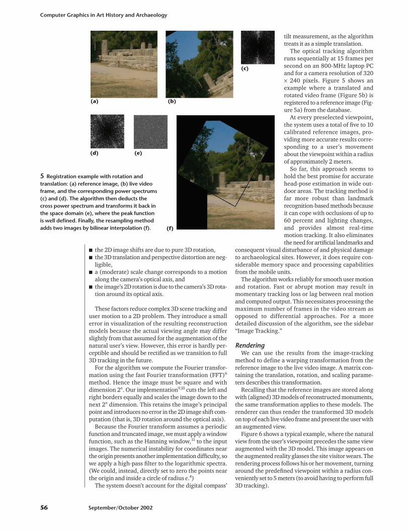
The optical tracking algorithmruns sequentially at 15 frames persecond on an 800-MHz laptop PCand for a camera resolution of 320× 240 pixels. Figure 5 shows anexample where a translated androtated video frame (Figure 5b) isregistered to a reference image (Fig-ure 5a) from the database.
At every preselected viewpoint,the system uses a total of five to 10calibrated reference images, pro-viding more accurate results corre-sponding to a user’s movementabout the viewpoint within a radiusof approximately 2 meters.
So far, this approach seems tohold the best promise for accuratehead-pose estimation in wide out-door areas. The tracking method isfar more robust than landmarkrecognition-based methods becauseit can cope with occlusions of up to60 percent and lighting changes,and provides almost real-timemotion tracking. It also eliminatesthe need for artificial landmarks and
consequent visual disturbance of and physical damageto archaeological sites. However, it does require con-siderable memory space and processing capabilitiesfrom the mobile units.
The algorithm works reliably for smooth user motionand rotation. Fast or abrupt motion may result inmomentary tracking loss or lag between real motionand computed output. This necessitates processing themaximum number of frames in the video stream asopposed to differential approaches. For a moredetailed discussion of the algorithm, see the sidebar“Image Tracking.”
RenderingWe can use the results from the image-tracking
method to define a warping transformation from thereference image to the live video image. A matrix con-taining the translation, rotation, and scaling parame-ters describes this transformation.
Recalling that the reference images are stored alongwith (aligned) 3D models of reconstructed monuments,the same transformation applies to these models. Therenderer can thus render the transformed 3D modelson top of each live video frame and present the user withan augmented view.
Figure 6 shows a typical example, where the naturalview from the user’s viewpoint precedes the same viewaugmented with the 3D model. This image appears onthe augmented reality glasses the site visitor wears. Therendering process follows his or her movement, turningaround the predefined viewpoint within a radius con-veniently set to 5 meters (to avoid having to perform full3D tracking).
Computer Graphics in Art History and Archaeology
56 September/October 2002
5 Registration example with rotation andtranslation: (a) reference image, (b) live videoframe, and the corresponding power spectrums(c) and (d). The algorithm then deducts thecross power spectrum and transforms it back inthe space domain (e), where the peak functionis well defined. Finally, the resampling methodadds two images by bilinear interpolation (f).
(c)
(a) (b)
(d) (e)
(f)

Mobile unit prototypesWe’ve built three mobile unit implementations, each
offering different features based on trade-offs betweenportability and functionality.
LaptopThis top-of-the-range version uses a high-end Toshi-
ba laptop PC and a Sony Glasstron head-mounted dis-play (HMD) with variable transparency upon which theAR worlds appear. As Figure 7 shows, the user wears abicycle helmet with a USB Web camera and a digitalcompass mounted on top, and a backpack containingthe laptop, DGPS receiver, battery, power distributionmodule, and WLAN hardware.
Users position themselves at a viewpoint and stare atthe monument of interest. In essence, the system treatsthem as active pointing devices, and mobile units identi-fy their desire to view this specific monument’s augmen-tation. It transmits a request to the SIS, which mines thecorresponding audiovisual data from its database andtransmits it back to the mobile unit. The system matchesthe reconstruction model to the live video stream fromthe Web camera, transforms it accordingly, and rendersit. At the same time, it synchronizes the audio narrationto the visual presentation and presents both to the user viathe HMD and earphones. Figure 6b shows the image that
users see. They can interrupt or alter the information flowby moving or turning away from the viewpoint.
Users can also employ an optional gamepad to dis-play a short menu on the HMD and request navigationinformation (a digital map of the site clearly indicatinglocation and orientation, as in Figure 4). This also letsthem view more detailed item descriptions or informa-tion on related topics.
The system automatically personalizes the touroffered according to its user’s profile, entered prior tothe tour’s start. Based on parameters like age, interests,education, and archaeological knowledge, the systemdraws up a basic tour and enriches it with correspond-ing information. The user’s behavior or gamepad inputcan alter this tour schedule automatically in real time.
The system downloads the necessary informationfrom the server but minimizes wait times throughprefetching and reuse of content left on the device’s harddisk from previous tours. As such, only missing andupdated items must be transferred. Because all the sys-tem’s mobile devices use this downloading method,each transfer takes just a few seconds. The device cur-rently offers one hour of use between recharging.
The GPS receiver requires 15 to 45 seconds to starttransmitting position information after a cold start. Thecompass can provide readings as soon as it’s poweredup based on absolute measurements from a magneticsensor. This avoids cumulative inaccuracies caused bydifferential measurements. Provision for calibration andoffset correction exists in case strong magnetic fieldsexist at the site.
Pen-tabletA lighter mobile unit implementation uses a Fujitsu
pen-tablet PC running at 500 MHz that suits outdooruse and can be carried like a book. It features a pressure-sensitive screen upon which users can write or performWindows-based operations with a special pen. Thedevice has a DGPS receiver, a digital compass, and wire-less communication equipment integrated in a small boxattached to its bottom. Designed to deliver the digitallyenhanced equivalent of the traditional paper guides car-ried by tourists, it needs no camera or image trackingsoftware. Instead, it employs measurements from its dig-ital compass and DGPS receiver to synchronize its audio-visual presentation to the user’s natural view.
IEEE Computer Graphics and Applications 57
6 Rendering example. (a) Ruins of the temple of Herain their present state and (b) augmented temple withrendered model on top of live video.
(a)
(b)
HMD
DGPS receiverBackpack
Compass
Camera
7 Touring userwith laptop andAR HMD at aviewpoint.

Figure 8 shows a user standing in front of the ruinsand consulting the device. The device’s screen showsnavigation information and 3D physical site navigationfeaturing reconstructed monuments and their sur-roundings. Audio narration in the user’s languageaccompanies visual material to provide historical andother information.
Users can also select augmented panoramic views cor-responding to 360-degree reconstructions from theirviewpoints. The panorama is automatically loaded andscrolled, as the user turns around, based on the DGPSand compass reading.
The device suits outdoor viewing, even under directsunlight, and offers one hour of use between batteryrecharges.
Palmtop The lightest mobile unit version uses a palmtop com-
puter running Windows CE and is a cheap and easy-to-carry electronic guide. Its current version supports userposition tracking but not orientation tracking. It providesinformation in a digital plan similar to those offered inpaper guide, map, and augmented map formats. It alsoincorporates augmented images and videos, panoramicviews, related information, audio narration, and textualinformation. The information is automatically present-ed when users approach a viewpoint, as long as they headtoward the monument presented on the device’s screen.Alternatively, they can read the site plan, marked withtheir position in the site, and request the relevant data.
Figure 9 shows an example of this device’s user inter-face. Based on a common Internet browser, it offers easyinteraction because it’s familiar. Users can operatedirectly on the device’s screen with a special pen or thebuttons at the bottom of the screen. We took special careto structure the multimedia content in single pages andto avoid scrolling except from the panoramic views.
Figure 10, an example of an augmented avatar videoframe, shows avatar athletes competing in the ancientOlympia stadium in a reconstruction of the race duringthe ancient Olympic Games.12,13 The avatars appear inthe stadium as it exists today, creating more realism.
The device can run for an hour before recharging andis visible under all lighting conditions. A PCMCIA cardattached to it with a special expansion jacket serves itsnetworking needs. Additional hardware can also be inte-grated to provide position and orientation tracking, toautomatically present the relevant audiovisual infor-mation to the user.
Analysis and future workWe tested Archeoguide at the ancient Olympia
archaeological site in Greece and received good reviewsfrom ordinary users, site staff, archaeologists, and tech-nology experts. Users liked the AR reconstructions andthe additional information the system offered, such asnavigation and audio narration.
Users praised the AR glasses for realism, but somesaid they felt uncomfortable wearing them while walk-ing. The helmet received a similar critique. We’re cur-rently reengineering these and should replace themwith a miniature device in the next system prototype.
Computer Graphics in Art History and Archaeology
58 September/October 2002
Bookmarks
3D navigationNavigation aid
Pen tablet
Hardware box
Battery
8 (a) Touring user with pen-tablet mobile unit at a viewpoint (b) Seeexamples of 3D navigation information and available options in bookmarkform at http://www.archeoguide.com.
(a) (b)
9 Samplescreen of thepalmtop mobileunit.
10 Avatar athletes competing in the stadium in ancient Olympia, Greece.

Users said the avatar animations helped them betterunderstand the site’s history and use, and they appreci-ated personalization features for better time manage-ment during their visit. The pen-tablet also receivedgood reviews because it simulated the use of familiarpaper guides and the augmented panoramic viewshelped bridge the gap between its flat-screen presenta-tions and the more realistic ones with the special glass-es. Finally, users found the palmtop a cheap substitutesuitable for quick visits but criticized its small screen.Based on these comments, we’re currently working ona second prototype that will offer users more flexibility.
The system also needs further work on 3D tracking anddevelopment of custom-made mobile devices that arecompact and lightweight enough to carry around out-doors. We expect these improvements to help Archeogu-ide become the prime candidate for installation in majorarchaeological sites. For more information on Archeo-guide, go to http://www.archeoguide.com. �
AcknowledgmentsThis work is supported by the European Union IST
framework (IST 1999-11306) and the European insti-tutions and commercial companies forming theArcheoguide consortium. These include Intracom S.A.Greece, Fraunhofer IGD Germany, ZGDV Germany, CCGPortugal, A&C2000 Italy, Post Reality Greece, and theHellenic Ministry of Culture. We thank Renzo Carluccifrom A&C2000, Panagiotis Kyriakoulakos from PostReality S.A., and Demosthenes Giraud from the HellenicMinistry of Culture for their contributions to the pro-ject. We also thank the visitors and staff at the Olympiaarchaeological site in Greece who helped us evaluatethe Archeoguide prototype.
References1. M. Pollefeys et al., “A Guided Tour to Virtual Sagalassos,”
Proc. Eurographics-Siggraph Virtual Reality, Archaeology,and Cultural Heritage Ann. Conf. (VAST01), 2001, in press;http://www.eg.org/events/VAST2001.
2. D. Scagliarini et al., “Exciting Understanding in Pompeiithrough On-Site Parallel Interaction with Dual Time Vir-tual Models,” Proc. Eurographics-Siggraph Virtual Reality,Archaeology, and Cultural Heritage Ann. Conf. (VAST01),in press; 2001, http://www.eg.org/events/VAST2001.
3. R. Azuma, “A Survey of Augmented Reality,” Proc. Siggraph95, course notes no. 9 (Developing Advanced Virtual Reali-ty Applications), ACM Press, New York, 1995.
4. L.G. Brown. “A Survey of Image Registration Techniques,”ACM Computing Surveys, vol. 24, no. 4, Dec. 1992, pp. 325-376.
5. R. Holloway, Registration Errors in Augmented Reality Sys-tems, PhD dissertation, Dept. of Computer Science, Univ.North Carolina, Chapel Hill, N.C., 1995.
6. B. Reddy and B. Chatterji, “An FFT-Based Technique forTranslation, Rotation, and Scale-Invariant Image Regis-tration,” IEEE Image Processing, vol. 5, no. 8, Aug. 1996, pp.1266-1271.
7. F. Seibert, “Augmented Reality by Using Uncalibrated Opti-cal Tracking,” Siggraph Computers & Graphics, vol. 23, no.6, 1999, pp. 801-804.
8. A. State et al., “Superior Augmented Reality Registrationby Integrating Landmark Tracking and Magnetic Track-ing,” Proc. Siggraph 96, ACM Press, New York, Aug. 1996,pp. 429-438.
9. D. Stricker et al., “Augmented Reality for Visitors of Cultur-al Heritage Sites,” Proc. Int’l Conf. Artistic, Cultural and Sci-entific Aspects of Experimental Media Spaces (CAST 01), GMDPublikationen, Bonn, Germany, Sept. 2001, pp. 89-93.
10. V. Vlahakis et al., “Archeoguide: First Results of an Aug-mented Reality, Mobile Computing System in Cultural Her-itage Sites,” Proc. Eurographics-Siggraph Virtual Reality,Archaeology, and Cultural Heritage Ann. Conf. (VAST01),2001, in press; http://www.eg.org/events/VAST2001.
11. A. Oppenheim and R. Schafer, Discrete-Time Signal Pro-cessing, Prentice-Hall, Upper Saddle River, N.J., 1999.
12. G. Christopoulos and J. Bastias, The Olympic Games inAncient Greece, Ekdotike Athenon, Athens, 1982.
13. P. Ratner, 3D Human Modeling and Animation, John Wiley& Sons, New York, 1998.
Vassilios Vlahakis is an elec-tronic engineer at the DevelopmentPrograms department at IntracomS.A. His research interests includeimage processing, communications,and augmented reality. He receivedhis BEng in electronic engineering
from the University of Manchester Institute of Science andTechnology and an MSc in biomedical engineering andPhD in medical image processing from Imperial College,London. He is a member of IEEE, IEE, and the TechnicalChamber of Greece.
Nikolaos Ioannidis is associatemanager of the Development Pro-grams department at Intracom S.A.in Greece and project manager ofArcheoguide. His research interestsinclude new media services, person-alized digital TV, location-based ser-
vices, and augmented reality. He holds a diploma inelectrical engineering from the National Technical Uni-versity of Athens and a D.E.A. (Diplôme des Etudes Appro-fondies) in electronics from the National PolytechnicInstitute of Grenoble. He is a member of IEEE, ACM, andthe Technical Chamber of Greece.
John Karigiannis is a computer engineer at the Devel-opment Programs department at Intracom S.A. Hisresearch interests include 3D modeling, simulation of mul-tirobot industrial processes, and haptic interfaces for VRinteraction techniques. He received his BEng in computerengineering and MASc in electrical engineering from Con-cordia University, Montreal. He is a member of the Techni-cal Chamber of Greece.
IEEE Computer Graphics and Applications 59

Manolis Tsotros is a computerengineer at the Development Pro-grammes department at IntracomS.A. His research interests include 3Dmodeling, Web-based services, mul-timedia applications, VR interfacingand programming, and augmented
reality. He received his BSc in computer science from TEIof Athens and MSc in interactive computing system designfrom Loughborough University, UK.
Michael Gounaris works as a sys-tem analyst and software engineer inthe Development Programs de-partment of Intracom S.A. He holds adegree in electrical engineering fromthe Aristotle University of Thessaloni-ki. His dissertation focused on 2D and
3D medical image registration. He has participated inActive, Estia, and Archeoguide EU research projects.
Didier Stricker heads the Aug-mented Reality group of the Depart-ment of Visualization and VirtualReality at the Fraunhofer Institutefor Computer Graphics in Darm-stadt, Germany. His research inter-ests include augmented reality,
real-time camera tracking, and camera calibration tech-niques. He received his diploma in electronic engineeringand telecommunication from the National University ofElectronics and Radio-Electricity of Grenoble, France.
Tim Gleue is a research assistant atthe Center for Computer Graphics(ZGDV) in Darmstadt, Germany. Hisresearch interests include 3D visual-ization and augmented reality. Heholds a computer science degree fromthe University of Kaiserslautern and
an MSc in computational visualistics from Otto-von-Guericke University, Magdeburg, Germany.
Patrick Daehne is a PhD student inthe Visual Computing department atthe Center for Computer Graphics(ZGDV) in Darmstadt, Germany. Hisresearch interests are in mixed reality(VR and augmented reality). He hasa diploma in computer science from
Darmstadt University of Technology, Germany.
Luís Almeida is a computer graph-ics researcher at the Center for Com-puter Graphics (CCG) in Coimbra,Portugal. His research interestsinclude geometric modeling, multi-media systems, and animation appli-cations in cultural heritage. He holds
a diploma in mathematics with specialization in comput-er graphics and applications.
Readers may contact Vassilios Vlahakis at IntracomS.A., Hellenic Telecommunications & Electronics Industry,Research and Development Division, Development Pro-grammes Dept., 19.5 km Markopoulo Ave., 190 02 Pea-nia, Athens, Greece, email [email protected].
Computer Graphics in Art History and Archaeology
ArchitecturesSupport Services
Algorithm/Protocol Design and AnalysisMobile Environment
Mobile Communication SystemsApplications
Emerging Technologies
IEEE Transactions onMobile Computing
revolutionary new quarterly journal that seeks out and delivers the very best peer-reviewed research results on mobility of users, systems, data, computing information
organization and access, services, management, and applications.IEEE Transactions on Mobile Computing gives you remarkablebreadth and depth of coverage...
A
The latest peer-reviewed researchkeeps you on the cutting edge...
To subscribe:
http://computer.org/tmc
or call
USA and CANADA:
+1 800 678 4333WORLDWIDE:
+1 732 981 0060