ard-r125 346 phase iv archaeological … · the donaldson stone house .. . ... lawrence, kansas....
TRANSCRIPT

ARD-R125 346 PHASE IV ARCHAEOLOGICAL INVESTIGATIONS AT EL DORADO L/3LAKE BUTLER COUNTY KANSAS SUMMER 1988(U) KANSAS UNIVLAWRENCE MUSEUM OF ANTHROPOLOGY A E JOHNSON ET AL.
UNCLASSIFIED 1980 DRCI56-77-C-8221 F/G 5/6 N

.L
A
iis
IIIIL.L.....2.8 -n
111.6
MICROCOPY RESOLUTION TEST CHARTNATIONAL BUREAU OF STANDARDS-1963-A
.4 r ''" * *. . . _ _". . . ":.. ." ." " . " ".". - .",. .- -. ,l

14,4
.0
(,~M 1,''
PROJET REORT ERIE
Th:nvesh = Mueu of
A

University of Kansas
Museum of Anthropology
Project Report Series
Number 52
PHASE IV ARCHAEOLOGICAL INVESTIGATInNS AT EL DORADO
LAKE, BUTLER COUNTY, KANSAS, SUMMER 1980
Funded by the U.S. Army Corps of Engineers
mm " (Tulsa District) Contract No. DACW56-77-C-0221
Edited by Alfred E. Johnson
. Contributors:
Alfred E. J•nsoD
John M. Parisi
Ricky L. Roberts4
Prepared by the:
Museum of Anthropology
University of Kansas
-' Principal Investigator: Paul E. Brockington, Jr.
1983
p -.t
:: " Vaud"A.....-" .
ABSTRACT
1As a continuation of a multi-year project, begun in 1977 and designed
to mitigate the effect of construction work and flooding on local prehis-
toric and historic cultural resources at El Dorado Lake, Butler County,
Kansas, a field party from the Museum of Anthropology at the University of
Kansas conducted archaeological investigations at the Lake during the sum-
" .mer of 1980. The work was funded by the U.S. Army Corps of Engineers
(Tulsa District) through Contract No. DACW56-77-C-0221 with the University.
?" . During this final season of field work prior to the completion of El
Dorado Lake, test excavations were conducted at three prehistoric sites of
the Woodland period. Site 14BU72 is interpreted as a temporarily-occupied
- base camp, and 14BU73 as a small camp for specialized activities. Site
* 14BU5 is large and includes three sub-areas: A, B, and C. The test exca-
vations in Areas A and C indicated limited cultural debris restricted to
the plow zone, while Area B included more substantial remains, perhaps rep-
resenting a seasonal occupation with structures.
• Studies devoted to the historic period at El Dorado Lake included
tests at the Doc Lewellen site, 14BU1005, and the Donaldson site, 14BU1008.
- In addition, further work was conducted at the site of New Chelsea, 14BU1007.
The tests at the Doc Lewellen and Donaldson sites, designed to locate the
original homesteads of 1857, were unsuccessful, apparently due to more
recent developmental activities which destroyed the remains. Work at New
Chelsea, consisting of a detailed surface collection designed to locate
intra-site activity loci, was successful and five different types of occu-
1pations were identified.
A final chapter in the report provides a sunary of work accomplished
at El Dorado Lake from 1977-1980, the period of Corps of Engineers support.
iii

CONTENTS
3ABSTRACT . . . . . . . . . . .* ii
LIST OF FIGURES. . . . . . . . . . . . . . . . . v
LIST OF TABLES . . . . . . . . . . . . . . . . . vii
CHAPTER 1. PHASE IV INVESTIGATIONS OF THE PREHISTORICPERIOD IN THE EL DORADO LAKE AREA (John M. Parisi) . . . .. 1
Introduction . . . . . . . . . . . . . 1Environmental Setting . . . . . . . . . . . . 2Cultural Chronology. . . . .......... 31980 Investigations . . . . . . . . . .. . . 6Field Methodology . . . . . . . 8Laboratory Procedures. . ..... 1114BU72 . . . . . . . . . . . . . . . . 14
Physical Description . . .......... 14Archaeological Investigations ......... 17Site Stratigraphy . . . . 19Discussion ............. . . . . . . . 25Artifact Analysis ............. ....... 27Shaped Tools. . . ............. 39Recoumendations . . . ........... 47
14BU73 . ................ 49Physical Description . . ........... 49
* Archaeological Investigations.. . . . . . . . 51Discussion ...... .............. 58
* Artifact Analysis . . . 58Shaped Tools . . . . . . . . . . . . . . 68Discussion . . . . .............. 73Recommendations.. ........... 74
14BU5 ........ ................. 76Physical Setting ...... ............. 76Prior Investigations . . ......... 76
14BU5A . . . . ............. 79Discussion . . . . . . . . . . . . ... .. 82
1 I4BU5B .......... ................ 82Artifact Analysis ............. 92Discussion ....... ............... 95
" 14BU5C ................ 96VerPhysical Setting 9........ 96
Discussion . .... .......... .i00Artifact Analysis .i........... 100 f
SSummary. ............... 106 [Acknowledgements . . . . . . . . . . . . .. 108 COn--References Cited .10. ..... ...
, iliStributloal/availability Coles
Avetl and/or
" I Speioal, ;Biit
. -o-,

CHAPTER 2. FURTHER INVESTIGATIONS OF THE HISTORIC PERIOD IN THEEL DORADO LAKE AREA (Ricky L. Roberts) . . . . . . . . . . 112
Introduction . . . . . . . . . . . . . . . . 112Previous Work . . . . . . . . . . . . . . . . 114
1980 Previous Work . . . . . . . . . . . . . 115The Doc Levellen Site . . . . . . . . . . . . . 116
itstory . . . . . . . . . . . . . . . . . 116Methodology . .. . . . .. . .. . 119Discussion . . . . . . . . . . . . . . . . 120
The Donaldson Site . . . . . . . . . . . . . . 121History . . .. . .......... 121Methodology and Excavations 124Artifacts . . . . . . . . . . . . . . . 130Discussion . . . . . . . . . . . . . . . . 134
The New Chelsea Site . . . . . . . . . . .. . 139- History . . . . . . . . . . .. . . 139
Methodology . .. . . . . . . . . . . 143Artifacts . . . . . . . . . . . . . . . 144Individually Plotted Artifacts . . . . . . .. . 145Discussion . . . . . . . . . . . . . . . . 145Concentration 1 . . . . . . . . . . . .. . 150Concentration 2 ............ 152Concentration3 . ............... 152Concentration4 ............. . 170Concentration 5 . . . . . . . . . ... 172Concentration 6 . . . . . . . . . . . . . 174Concentration 7 . . . . . . . . . . . .. . 175Concentration 8 . 177
Summary and Conclusions ..... ............ 180References Cited . . . . . . . . . . . . . . 182
CHAPTER 3. A SUMMARY OF ARCHAEOLOGICAL INVESTIGATIONS AT ELDORADO LAKE, 1977-1980 (Alfred E. Johnson) . . . . . . . . 185
Paleoenvironmental Modeling . . . . . . . . . . . 187Prehistoric Archaeology . . . . . . . . . . . 192The Archaic Period . . . . . . . . . . . . . . 197Plains Woodland ................. .... 206Specialized Studies. . . . ............. 213Historic Sites Archaeology ............... 213
14BU1002--Foster ..... ............. . 21614BU1005--Doc Lewellen Site .. ......... . 21614BU1006--Kobel Site . . . . . . . . . . . . 21814BU1004--The Osborn Log Cabin .. ......... 21914BU1008-The Donaldson House ......... . 22014BU1007-The New Chelsea Site ......... 221
References Cited. . . .................. 223
APPENDIX I . ......................... 229
IVt S
LIST OF FIGURES
1.1 Woodland archaeological sites investigatedat El Dorado Lake. . . . . . . ............. 5
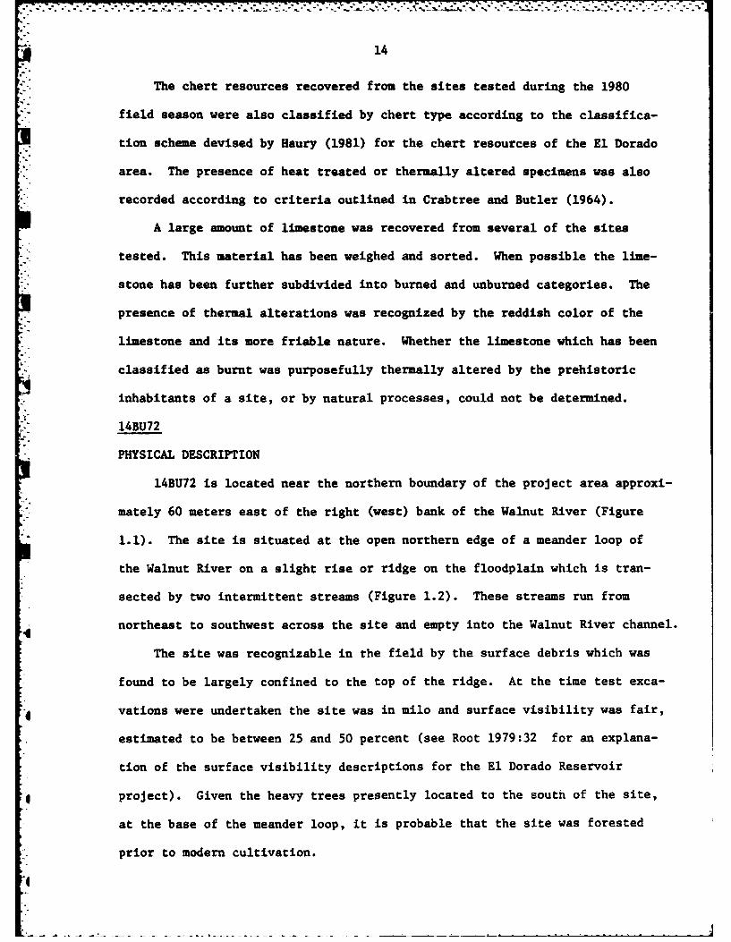
1.2 Topographic map of 14BU72 and vicinity . ....... 15
1.3 Stratigraphic Profile of Test Pit 1, 14BU72 ...... 20
1.4 Stratigraphic Profile of Backhoe Trench 4, 14BU72 26
1.5 Two opposite lateral views of a core from 14BU72 .... 36
1.6 Shaped tools recovered from 14BU72 . . . . . . . . 41
1.7 Hammerstones recovered . . . . . . . 45
1.8 Topographic Map of 14BU73 and Vicinity ........... 50
1.9 Stratigraphic Profile of, Test Pit 1,. 14BU73 ...... 54
1.10 Stratigraphic Profile of Backhoe Trench 1, 14BU73 .... 57
..' 1.11 Complete bifaces recovered from 14BU73 . ...... . 69
1.12 Biface fragments and notch from 14BU73 . . . . . . . . 71
1.13 Topographic Map of 14BUS and Vicinity . . . . . . . . 77
1.14 Stratigraphic Profile of Test Pit 3, 14BU5A . . . . . . 80
1.15 Feature 1 as it appeared at 25 cm below surface ..... 87U1.16 Plan View of Feature 1 as it appeared between
30 and 35 cm below surface .... ........... 88
1.17 Stratigraphic Profile of Test Pits 9 and 11, 14BU5B . ... 91
1.18 Stratigraphic Profile of Test Pits 4 and 5, 14BU5C . ... 99
1.19 Shaped tools recovered from 14BU5C . ...... ... 104
2.1 The Doc Lewellen site . . ... ............. 117
2.2 The Donaldson site, south field survey area . ...... 125
" 2.3 Excavation units in the south field of the Donaldson site. 127
2.4 Distribution of 1980 excavation units aroundthe Donaldson stone house . . . .............. 128
2.5 Foundation tested during Phase IV at the Donaldson site . . 129
VI-
"o'
2. 6 Contour map of the New Chelsea site . . . . . . 140
2.7 Plot of Chelsea, Kansas superimposed on contourmap of New Chelsea site . . . . . o o o 142
2.8 Distribution of surface concentrations and
individually plotted artifacts at the New Chelsea site. . 146
2.9 Glass artifacts . ........... 156
2.10 New Chelsea site ceramic artifacts o....... 158
2.11 Riveter, Concentration 3 .... ............ .163
2.12 Stove parts, Concentration 3 . . ...... 164
2.13 Metal artifacts . . . . ............ 167
2.14 Interior of "Old Man Bashaw's store"early 20thcentury. . . . o . . o . . . . . 169
3.1 Map showing location of El Dorado Lake . . . o . . . 186
3.2 Composite cross section of the present upper Walnut RiverValley,Kansas, El Dorado Lake project . . . o . . . 189
* 3.3 Geological history of the upper Walnut River" Valley, Kansas, El Dorado Lake project .. .. .. . 190
3.4 Map showing the location of prehistoric archaeologicalsites at El Dorado Lake .......... . . 193
3.5 Location of Archaic sites within the El Dorado
Lake area o . . . .. .............. 196
3.6 Map of the Snyder site, 14BU9 .............. . 201
3.7 Stemed bifaces from the Milbourn site, 14BU25 .... 203
3.8 Map showing location of historic sitesat El Dorado Lake ... ............. 215
V.

* LIST OF TABLES
1.1 Radiocarbon dates from Woodland sites in the El Dorado
Lake area (based on a half-life of 5568 years). . . . . . 7
1.2 14BU72 Vertical Distribution of Artifacts in Test Pit 1 . . 22
1.3 14BU72 Vertical Distribution of Artifacts in Test Pit 2 . . 22
1.4 14BU72 Vertical Distribution of Artifacts in Test Pit 3 . . 22
1.5 14BU72 Combined Vertical Distribution of Test Pits 1-3 . . . 22
1.6 Chert Types and Thermal Alteration of Chipped StoneTechnoclasses recovered from 14BU72 in 1980 . . . . . . 30
1.7 Chert Types and Thermal Alteration of Chipped StoneTechnoclasses Recovered from 14BU72 in 1975 . . . . . . 31
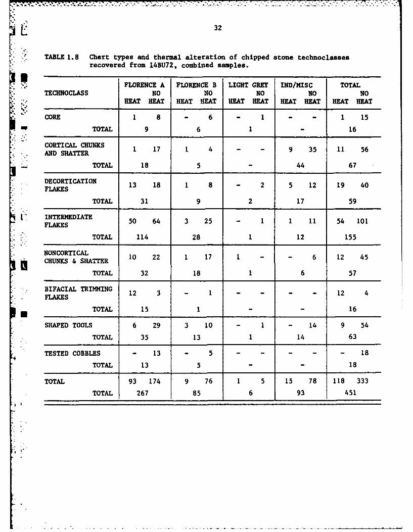
1.8 Chert Types and Thermal Alteration of Chipped StoneTechnoclasses Recovered from 14BU72, Combined Samples . . . 32
1.9 Raw Material Usage at 14BU72 . . . . ... .... 34
1.10 Morphological/Functional Categories and Chert typesof Shaped Tools, 14BU72 ...... . . . . . 40
1.11 Vertical Distribution of Artifacts in Test Pit 1-14BU73 . . 53
1.12 Vertical Distribution of Artifacts in Test Pit 2--14BU73 . . 55
U 1.13 Chert Types and Thermal Alteration of Chipped StoneTechnoclasses Recovered from 14BU73 in 1980 .. ....... 61
* 1.14 Chert Types and Thermal Alteration of Chipped StoneTechnoclasses Recovered from 14BU73 in 1977 . ...... 62
1.15 Chert Types and Thermal Alteration of Chipped Stone. Technoclasses Recovered from 14BU73,Combined Samples. . . . 63
1.16 Raw Material Usage at 14BU73 .... .......... 65
j.. 1.17 Morphological/Functional Categories and Chert Typesof Shaped Tools Recovered in 1980, 14BU73 .. ....... 68
1.18 Vertical Distribution of Artifacts inTest Pits 1-3,14BU5A .............. 81
1 1.19 Chert Types and Thermal Alteration ofChipped Stone Technoclasses, 14BU5A ... ......... 83
- 1.20 Vertical Distribution of Artifacts in Test Pit 8, 14BU5B . . 86
vii
. . . . . . . . .

L7.
1.21 Vertical Distribution of Artifacts in Test Pits9 and 11,14BU5B. . . . . . . ............. 86
1.22 Vertical Distribution of Artifacts in Test Pits10 andl2,14BU5B . . . . . .. .. . . . .... 86
1.23 Chert Types and Thermal Alteration of Chipped StoneTechnoclasses, 14BU5B .. . ... .. ....... .. .. . 93
1.24 Vertical Distribution of Artifacts in Test Pits1 and 2,14BU5C . . . . . . . ............. 97
1.25 Vertical Distribution of Artifacts in Test Pit 3,14BU5C . ... ......... ........ . 97
1.26 Vertical Distribution of Artifacts in Test Pits4 and 5, 14BU5C. . . . . . . ..... .. . 97
1.27 Chert Types and Thermal Alteration of ChippedStone Technoclasses, 14BU5C .. . ....... . . . 102
2.1 Distribution of Flat Glass at 14BU1008 .. ...... . 135
2.2 Distribution of Bottle Glass at 14BU1008 .... ..... 135
2.3 Distribution of Ceramic Artifacts at 14BU1008 . ... . 136
2.4 Distribution of Metal Artifacts at 14BU1008 . .. . . 137
2.5 Distribution of Wire Nails at 14BU1008 . .. ..... 138
2.6 Individually Plotted Artifacts ............. 147
2.7 Glass Assemblages from Concentration 1 . . ...... 151
2.8 Ceramic Assemblage from Concentration 1 .. . ...... 153
2.9 Glass Assemblages from Concentration 3 . .. ..... 154
2.10 Ceramic Assemblages from Concentration 3 .... ..... 159
2.11 Concentration 3 Nail Sizes .... . ...... .. 166
- 2.12 Ceramic Assemblage from Concentration 4 .. .. ..... 171
2.13 Ceramic Assemblage from Concentration 5 .. .. ..... 173
2.14 Ceramic Assemblage from Concentration 6 .. . ...... 176
* 2.15 Ceramic Assemblage from Concentration 7 .. . ...... 178
2.16 Ceramic Assemblage from Concentration 8 . . .. ... . 179
viii
.. .-iii

3.1 Prehistoric Archaeological Sites Tested at El DoradoLake from 1977 through 1980. . . ............. 194
3.2 Lare-Scale Excavations in Prehistoric Sitesat El Dorado Lake, 1977-1980 . .......... 195
3.3 Middle and Late Archaic Radiocarbon Dates,Archaeological Sites, and Culture-Historical Taxafrom eastern Kansas and western Missouri . . . . . . . 198
3.4 Radiocarbon dates from Woodland sites in the
El Dorado Lake area .... . .............. 207
' 3.5 Historic Sites Tested ..................... 217
! .
4--
,?i
I - : " . ' - " " - - -: _ - _ . i , . . .. . . . .. . , ..... . .
CHAPTER 1
PHASE IV INVESTIGATIONS OF THE PREHISTORIC PERIOD IN THE EL DORADO LAKE AREA
3 John M. Parisi
INTRODUCTION
S-"During the sunmer and fall of 1980, the excavation and subsequent lab-
.n oratory analysis of archaeological remains from the El Dorado Lake Project
area, in Butler County, Kansas, were undertaken by the University of Kansas
Museum of Anthropology, Lawrence, Kansas. These investigations constituted
Phase IV of a multi-phase, four year study of the cultural resources at El
Dorado Lake. The work has been done under contract with the United States
Army Corps of Engineers, Tulsa District (Contract No. DACW-56-77-C-0221).
The purpose of the Phase IV testing of prehistoric archaeological sites
conducted during the limited 4-week 1980 field season, was to retrieve
information consistent with the goals defined within the University of
Kansas Museum of Anthropology's research design for the El Dorado Lake
Area (See Leaf 1976).
.* Principal goals of the research design are:
0 "(1) to retrieve data and test hypotheses on prehistoric subsistenceand settlement systems; and, (2) to conduct an interdisciplinaryprogram to retrieve data and test models of paleoenvironments
- "useful for the study of prehistoric cultural-ecologicalrelationships" (Leaf 1976:1).
Due to the large number of prehistoric archaeological sites within
the project area (48 as of 1976) and the limited allotment of time in which
to perform the fieldwork prior to the dam's closure, the testing of settle-
ment pattern hypotheses, and the development of paleoenvironmental models
will have to depend on data recovered from limited test excavations of arch-
aeological sites, and a few more extensive excavations. At a minimum, test
excavations should provide data on site depth, stratigraphic relationships
of multiple components, the relative qtate of preservation of cultural debris
and features, as well as, the cultural affiliation and significance of the
1A

* 2
site. It is within this framework that Phase IV archaeological testing
of prehistoric archaeological sites within the El Dorado Lake area was
conducted.
ENVIRONMENA SETTING
Several detailed accounts of the natural environmental setting of the
El Dorado Lake area have been published in recent reports (Fulmer 1976;
Leaf 1976, 1979; Grosser 1977). In addition to these detailed accounts
a more generalized description of the environmental setting of the El
Dorado Lake area has been presented by Bastian (1979). Given the avail-
* ability of these descriptions of the environmental setting of the project
area only brief mention of a few of the more salient characteristics will
be mentioned here.
El Dorado Lake is located within the Flint Hills Upland division of
the Osage Plains section of the Central Lowland province. The Flint Hills,
* a north-south trending topographic feature located in eastern Kansas, are
characterized by gently rolling topography which slopes toward the Arkan-
sas River (Leaf 1976;1979).
The climate of the El Dorado Lake area is best summarized as cont-
inental, with cold, dry winters and hot, relatively wet summers. Leaf
(1979) following Fulmer (1976) listed 5 probable resource zones which
could have been exploited by prehistoric inhabitants of the area: (1)
upland prairie, (2) floodplain forest, (3) breaks, (4) riverine and
(5) oxbow swamp. The upland prairies would have been an important source
of bison, deer and antelope. Water, as well as aquatic plants and ani-
mals, would have been available in the riverine and oxbow swamp local-
ities. The floodplain forest would have provided nuts, berries, fruits,
deer, elk, turkey and squirrel as well as raw materials for constru-
cting shelters, cooking food or maintaining warmth. Leaf (1979:3)
C 3
noted that while the breaks, the steep and eroded slopes at the Junction
of the floodplain forest and prairie uplands had little to offer in terms
of food resources, they would have been an important locus of chert
suitable for prehistoric tool manufacture.
- CULTURAL CHRONOLOGY
Systematic archaeological investigations, undertaken by the Museum of
"* Anthropology, began in the El Dorado Lake area in 1967 with an archaeological
reconnaissance conducted by Eoff and Johnson (1968). Since that initial
survey considerable work has been performed within the project area including
both testing (Artz 1981; Bastian 1979; Leaf 1979; Fulmer 1976, 1977) and large
scale excavation (Adair and Brown 1981; Grosser 1970, 1973, 1977; Leaf 1981) of
the prehistoric archaeological resources. A su-mmary of excavations conducted
prior to 1976 has led to the development of a cultural chronology for the El
Dorado Lake area. Archaeological sites and materials representing the Archaic
. (2000 BC - AD 1), Plains Woodland (AD 1 - 1000) and Plains Village (AD 1000 -
1500) cultural traditions have been recognized in the resevoir area (Leaf 1979:10).
USeveral multi-component Archaic sites have been excavated. The presence
of different artifact inventories and differences in the intensity of occupation
* within the Archaic components excavated, indicate that both larger base camps
and smaller extractive or more specialized hunting camps were occupied. The
subsistance economy during the Archaic was based on hunting and gathering with
* apparent oscillations in intensity through time. Features and artifacts re-
covered from excavations at four Archaic sites within the reservoir indicate
" that a variety of activities were performed at the camps, including tool manu-
facture, animal and plant processing, woodworking, and cooking (Leaf 1979).
The Archaic cultural historical tradition within the El Dorado resevoir
area has been further subdivided into three phases; the Chelsea phase (ca 2650 -
4
4
2000 B.C.), the El Dorado phase (ca. 2000 - 1150 B.C.) and the Walnut Phase
(ca. 1150- A.D. 1). Based on data obtained from the Snyder site (14BU9) varia-
tion in subsistence economy during the Archaic has been recognized, as summar-
ized by Leaf (1979:11). His data suggest that the economy of the Chelsea phase
*i .component was based primarily on the exploitation of large mammals and a few
small mammals; the economy of the El Dorado phase component was more diversi-
fied with large mammals and a large number of small animals and plants being
exploited; while the Walnut phase component had an economy based only on the
exploitation of large mammals. This apparent oscillation during the Archaic in
subsistence strategy, while extremely interesting, is in need of further investi-
gation before it can be adequately evaluated. As noted by Leaf (1979:11) sam-
pling bias, changes in food preferences, functional differences among compon-
ents, changes in procurement technology and climatic fluctuation are all fac-
tors which could account for these variations.
Prior to 1980, archaeological investigations of Woodland occupation sites
within the lake area included testing or large-scale excavation of 12 sites
(Fig. 1.1). These investigations include block excavations at the Snyder site,
14BU9 (Grosser 1971; Leaf 1981), the Nuttal site, 14BU4 (Fulmer 1976), the
Holderman site, 14BU19, (Fulmer 1976) and the Two Deer site, 14BU55 (Adair and
Brown 1981; Fulmer 1977). Restricted test excavations at 14BU27, 14BU30, 14BU31
and 14BU57 were undertaken in 1977, and 14BU57 received more extensive excavation
in 1979. Test excavations carried out during 1978 investigated 14BU16 and 14BU87
while 14BU15 and 14BU32 were tested in 1979. Bastian (1979) tested 14BU5B in
1968. A brief summary of the more salient characteristics of the Woodland cul-
tural-historical period within the El Dorado Lake area follows (Adair, personal
communication). In general, the Woodland period at El Dorado is characterized
by sites which vary widely in overall size and artifact assemblages. Most
of the sites are located in low-lying areas, primarily on the first terrace
-

o..
"I
FIGURE 1.1
Woodland archaeological sites investigatedat El Dorado Lake.
p.-
I°

1 M i. * . .
I m
Flo Po
Efea o

6
of the Walnut River or one of its tributaries. A hunting and gathering mode
of subsistence apparently predominated, based on the exploitation of several
resource zones. Horticulture, exhibited by the presence of corn and squash,
has only been documented at 14BU55, the Two Deer site, which is chronologically
late in the known Woodland sequence of the El Dorado area (Table 1.1).
Ceramics recovered from Woodland sites, within the project area are pre-
dominately cordmarked conical vessels, which have been compared to Harlan Cord-
roughened (Fulmer 1977). A wide variety of nonplastic materials or tempers
were added to the clay during manufacture, including limestone or Indurated
clay at 14BU9, 14BU19, 14BU56, and 14BU31,sand at 14BU27 and 14130, and pri-
marily bone at 14BU55. The presence of zoned and dentate stamped ceramics from
14BU9 indicates an affiliation with Kansas City Hopewell ceramics to the north-
east (Leaf 1979).
Intra-site and inter-site variability in Woodland projectile point styles
is apparent. 14BU9 has Gibson and Snyder points, which are indicative of
Hopewellian influence, and smaller Scallon and Sequoyah points. 14BU19 exhibits
both larger dart and smaller Scallorn points, which presumably functioned as
arrow armaments. 14BU55, 14BU4, and 14BU56 are represented by small triangular
corner notched points very similar to the Scallorn type. Based on the relative
sizes of these points it can be inferred that both the atlatl and bow and
arrow were utilized during the Woodland period within the El Dorado Lake area
(Fenenga 1953; Thomas 1978).
1980 INVESTIGATIONS
Specifically this report describes the sub-surface testing of three pre-
viously-recorded archaeological sites within the El Dorado Lake area: 14BU72,
14BU73, and 14BU5 areas A, B & C (Figurel.1). 14BU72 and area B of 14BU5 were
previously assigned to the Woodland cultural-historical period, while areas
A and C of 14BU5 and 14BU73, were of unknown cultural affiliation
aA

L. 7
Table 1.1. Radiocarbon dates from Woodland sites in the El Dorado Lakearea (based on a half-life of 5568 years). From Artz, InPreparation.
CalendarLab Site Context Radiocarbon DateNumber Years B.P. (Uncorrected)
*UGa-2561c 14BU9 Composite sample fromflotation 520 * 55 A.D. 1430
*UGa-3044a 14BU32 XU103/XUI04(composite sample) 720 t 70 A.D. 1230
UGa-1347d 14BU71 Feature 2(limestone-filled pit) 740 t 75 A.D. 1210
UGa-3137 14BU57 Excavation Unit 5(composite sample) 755 t 235 A.D. 1195
UGa-1345d 14BU55 House 1 890 t 60 A.D. 1060
UGa-2504b 14BU55 1 m excavation unit(composite sample) 950 t 135 A.D. 1000
* UGa-1346d 14BU55 House 1 970 ± 80 A.D. 980
bUGa-2501 14BU55 Feature 18
- (charcoal concentration) 984 t 45 A.D. 965
UGa-2500b 14BU55 Feature 6U (charcoal concentration) 1065 t 65 A.D. 885
bUGa-2503 14BU55 Feature 19 (post mold) 1090 t 55 A.D. 860
; UGa-2560 f 14BU31 Feature 3024 (limestone-filled pit) 1215 ± 55 A.D. 735
UGa-2807 14BU31 Feature 304(limestone-filled pit) 1240 ± 75 A.D. 710
* *Dates rejected because of recency or stratigraphic inversion.
aLeaf and Root 1981; bAdair and Brown 1981; cunpublished; dFulmer 1977;
eBrown 1981; fRoot 1981.
6'

. ..o-.
8
at the time of the 1980 Investigations (Fulmer 1977; Bastian 1979; Root 1978).
These sites were selected for test excavation in an effort to expand the
current knowledge of the Woodland cultural historical tradition within the
project area. The excavations were designed to provide data capable of filling
some of the gaps in the cultural chronology of the project area. An examination
of Table 1.1 will illustrate that at present there are no known Early Woodland
sites within the El Dorado Lake area. The time period of A.D. 1-500 is
conspicuously absent, leaving a 500 year void in the cultural chronology. In
an effort to narrow this gap in our present knowledge of the developmental
stages of the Woodland cultural manifestations within the El Dorado Lake area,
the testing of prehistoric archaeological sites undertaken in 1980 concentrated
primarily on sites of known Woodland cultural affiliation.
FIELD METHODOLOGY
The Phase IV prehistoric archaeological test excavations at El Dorado
Lake were completed under the direction of the author by a small but dedicated
crew consisting of John Eads, Judy Muck, and Jerry Wagner. The field work
was performed between July 28 and August 20, 1980 under adverse climatic condi-
tions during which temperatures routinely topped 1000 F. While the procedures
outlined below were employed during the course of the 1980 field season, it
should be noted that each of the sites presented different problems which re-
quired modification to the basic field strategy employed.
The three basic goals of the 1980 prehistoric testing program were:
1) to delimit the horizontal and vertical extent of each site; 2) to record
the cultural and natural stratigraphic units within each site; and, 3) to
identify the cultural affiliation of the archaeological component or components
represented by the material recovered. The field methodology employed during
the 1980 field season was designed to facilitate the attainment of these goals
within the limited time available. All of the sites selected for testing hadI

9
previously been recorded and surface collected during prior research within
the El Dorado Reservoir by the Museum of Anthropology (Bastian 1979; Fulmer
1977; Leaf 1979; Root 1978). Rather than spend additional time surface
collecting each of the sites, attention was focused on ascertaining site
* boundaries and intra-site concentrations of artifacts. To facilitate this
"- basic aim a pedestrian reconnaissance of the surface of each site was under-
taken and surveying lathes or stakes were placed adjacent to each of the
artifacts encountered on the surface of the site. The outer edge or perimeter
of these stakes was then used as an Indication of the horizontal extent of bl '1j
* site. In addition all recognized tools found on the surface were mapped by
their east-vest, northr-south and elevation coordinates in an effort to delineate
areas within the site boundaries where concentrations of tools occurred. From
this information, the selection of specific areas of the sites in which to place
1.0 x 1.0 m. test pits was determined.
In order to map site boundaries and intra-site tool densities, a coordinate
• -system or grid was established for horizontal control. East-West and north-south
base lines were laid out using a transit and a stadia rod. This was accomplished
by calculating true North from Magnetic North, laying the north-south baseline
and turning a 900 angle to lay the east-west baseline. An origin point, desig-
nated E500, N500, established the Cartesian coordinate system and horizontal
provienience for each artifact and test pit. Monument hubs (2 by 2 inch wooden
stakes) were placed within tree or fence lines for protection in the event
that future researchers need to reestablish the grid. The origin point can
be located by simple triangulation from the monument hubs with reference to
the field notes. Vertical provenience of artifacts was determined by means of
an arbitrary datum point, designated 10 meters below datum. All test pits and
plotted artifacts were then recorded vertically in relation to the datum point.
A site map illustrating the estimated site boundaries, the locations of test
* excavations and monument hubs was made for each site. These maps illustrace

,. . .... .... -. . % %.. . ,, -. ,- -. .*, . . ., -- . - ., , - -- -. ---- * ,-. . . , .- o. . . :- ,
10
topographic relief in feet above sea level.
At least three 1.0 x 1.0 m. test units were placed within the boundaries
of each site. Given that we were attempting to gather data on the cultural
affiliation of the components excavated, the test pits were located primarily
within areas where artifacts were concentrated on the surface of the site.
Test units were numbered sequentially, as well as being identified by the
east-west and north-south coordinates of the southwest corner. The 1.0 x 1.0 m.
test units were hand excavated using shovels and trowels. In the absence of
discernable natural or cultural atrat;Lgraphic relationships, the test units were
excavated in arbitrary 10 cm. vertical levels measured from the surface eleva-
tion of the southwest corner of the unit. An Excavation Record-Level Summary
form was completed for each 10 ca level of each one by one meter test unit
excavated. These forms were used to record the description of sediments,
stratigraphy, artifacts recovered, features present, special samples taken,
and photographs taken, and served as the primary means of recording data. A
17.5 liter sample of matrix was taken from the center of each 10 cm level below
the plow zone for flotation or water screening. The rest of the matrix from
each level, including the plow zone, was mechanically screened through a k inch
(6.35 mm) hardware cloth. At the completion of each 1.0 m. x 1.0 m. test pit, a
* vertical profile of the unit was completed. In addition to the 1.0 x 1.0 m.
test units placed within each site's boundaries, additional excavation techniques
were employed at each site to assist in locating site boundaries and to deter-
*mine if deeply buried cultural components were present. These included the
use of a backhoe at 14BU72 and 14BU73, the use of manual and mechanical post
hole diggers at 14BU5 B, and the use of shovel cuts at 14BU5 A and C. At the
*completion of the test excavations all test units and backhoe trenches were
backfilled.

- --- . • -- • . -- .. o - - . - . --- -- - .. m u . . o - . - - . . ' 'B . - .. _..
% . . . .o .
LABORATORY PROCEDURES
3 After completion of the field work all of the materials recovered from
the 1980 prehistoric test excavation were transported to the Museum of
Anthropology at the University of Kansas for laboratory analysis and curation.
The laboratory analysis was performed by Judy Muck and the author during the
-, -. fall of 1980 and the spring 1981. All materials were first washed and then
sorted into categories based on material types, such as limestone, chert, sand-
stone, quartzite, etc. Analysis of each of these material types resulted in
further subdivision of the archaeological assemblage recovered from each of
the sites into more specific artifact types.
The absence of ceramic material and the lack of any recognizable floral
* or faunal remains within the sample of artifacts recovered during the 1980
testing program dictates that the artifact analysis be primarily concerned
with lithic materials. The analysis of the lithic material closely follows
analytical procedures employed by Artz (1981) in his report on the prehistoric
sites tested within the El Dorado Reservoir area in 1978. This analytical
* procedure should provide an insight into the lithic manufacturing technology
adopted by the prehistoric inhabitants of each site tested. The procedure
should also facilitate future comparative studies of the prehistoric sites
tested in 1980 with those tested by Artz (1981) in 1978.
A four stage model of the manufacture of lithic tools is employed to charac-
terize the lithic technology employed by the inhabitants of each of the sites.
The four stages of the model are:
"1) The initial reduction of unaltered chert or raw material;
2) the intermediate reduction of the products of the initial reduction;
3) the final shaping of selected pieces into utilizable forms; and
4) the subsequent maintenance or reshaping of those forms." (Artz 1981:57).
.e.... ..
12
The lithic material recovered from each of the sites is related to the four
stages of the model by classifying individual specimens into operationally-
defined categories or technoclasses. Following Artz (1978:57), technoclasses
are interpreted here as the by-products and end-products of the technological
processes enacted by prehistoric peoples in manufacturing usable tools from
unaltered chert, and in the subsequent use or maintenance activities of those
manufacturers. The technoclasses employed in the present analysis are
nearly identical to those described by Artz (1981:58-61) and are redefined
below. These technoclasses are related to the four stage model of lithic
manufacture outlined above in an attempt to characterize the range of behaviors,
or activities, carried out by the prehistoric inhabitants of each of the sites
tested.
Utilized or tested raw materials are pieces of chert which represent the
procurement and initial reduction of unaltered raw materials. In either case
modification is restricted to the removal of a few flakes, with those forming
a functional edge classified as utilized and those with no functional edge
classified as tested.
Cores can be manufactured from unaltered raw material, in which case
4 they exhibit cortical surfaces; or from an intermediate stage of reduction,
in which case they are more carefully prepared. In either case they are
recognized by the presence of well-defined negative flake scares identifying
*the presence of one or more prepared platforms from which the flakes were
struck.
Flakes are classified into one of three technoclasses; decortication
flakes, intermediate flakes, and bifacial triming flakes. They all share
the basic morphological attributes of conchoidal fracture on their ventral
L 13
surface, including bulbs of percussion, striking platform remnants,
g flake ripples, or waves, and hinge fracture termination. These are illus-
trated in Crabtree (1972).
. :Decortication flakes are defined by the presence of cortex, the naturally
weathered surface of the original raw material, on 50% of the dorsal surface
. of the flake. Decortication flakes indicate that the initial reduction of
i* • relatively unaltered raw material was actively performed at the site.
Bifacial tri-Ing flakes, in contrast, represent the maintenance or
manufacture of bifacial tools and are thus characteristic of the third and
fourth stages of the generalized lithic reduction sequence discussed above.
I' These flakes are easily recognized by a multifaceted striking platform, which
* forms an acute angle with the dorsal surface of the flake and "overhangs"
or "lips over" the flake's ventral surface. This juncture of the platform
5 and the dorsal surface represents the edge of the bifacial tool from which
the flake was struck (Artz 1981:58; Crabtree 1972:94).
*Intermediate flakes are flake specimens which are not classifiable as
i Ieither decortication flakes or bifacial triuming flakes. They are represen-
tative of the intermediate or second stage of the lithic reduction model.
These intermediate flakes are not further subdivided in this analysis.
Blocky fragments of chert not classifiable as either flakes or cores
- * comprise the category or technoclass of chunks. These are further subdivided
* into cortical chunks which represent the initial stage of reduction, and
non-cortical chunks which represent the intermediate stage of reduction.
The technoclass of shaped tools consists of artifacts which are the
product of the trimming of selected chert blanks into utilizable forms. T'-ese
* tools are further subdivided by their basic morphological attributes into
categories such as projectile points, scrapers, drills, etc.
14
The chert resources recovered from the sites tested during the 1980
field season were also classified by chert type according to the classifica-
tion scheme devised by Haury (1981) for the chert resources of the El Dorado
area. The presence of heat treated or thermally altered specimens was also
recorded according to criteria outlined in Crabtree and Butler (1964).
A large amount of limestone was recovered from several of the sites
tested. This material has been weighed and sorted. When possible the lime-
stone has been further subdivided into burned and unburned categories. The
presence of thermal alterations was recognized by the reddish color of the
limestone and its more friable nature. Whether the limestone which has been
classified as burnt was purposefully thermally altered by the prehistoric
inhabitants of a site, or by natural processes, could not be determined.
14BU72
PHYSICAL DESCRIPTION
14BU72 is located near the northern boundary of the project area approxi-
mately 60 meters east of the right (west) bank of the Walnut River (Figure
1.1). The site is situated at the open northern edge of a meander loop of
the Walnut River on a slight rise or ridge on the floodplain which is tran-
sected by two intermittent streams (Figure 1.2). These streams run from
4 northeast to southwest across the site and empty into the Walnut River channel.
The site was recognizable in the field by the surface debris which was
found to be largely confined to the top of the ridge. At the time test exca-
- vations were undertaken the site was in milo and surface visibility was fair,
estimated to be between 25 and 50 percent (see Root 1979:32 for an explana-
tion of the surface visibility descriptions for the El Dorado Reservoir
4| project). Given the heavy trees presently located to the south of the site,
at the base of the meander loop, it is probable that the site was forested
prior to modern cultivation.
i
"- - . . . . . .., . . . . .. _ . ,,, , , , , , , ,-| a - . *= el
FIGURE 1.2
Topographic map of 14BU72 and vicinity.
I
Ib"
d

15
'3
-44
4$llt

16
The west bank of the Walnut River is much steeper and grades into the
uplands. This land is currently in pasture for cattle grazing and is best
characterized as an upland prairie grassland.
As noted, 14BU72 lies at the northern edge of the project area. The
relationship of the site boundaries as here defined to the floodpool elevation
of the proposed El Dorado Reservoir is illustrated in Figure 1.2. This map
indicates that only during periods of flooding will the site be directly
adversely impacted by the dam construction since at all other times the
site will be situated well above the conservation pool of 1339 feet. Even
when the reservoir is raised to floodpwol stage at 1347.5 feet most of the
site will not be innundated. The major impact will be from shoreline
erosion caused by the filling of the intermittent streams during flood stage.
Other potential disturbances to the site exist in the form of illegal arti-
fact collecting and future recreational activities given the sites close
proximity to the section road.
The soil within which 14BU72 is located has been designated as Verdigris
Silt Loam by the Soil Survey of Butler County, Kansas (U.S.D.A. 1975). This
soil type consists of deep, nearly level and gently sloping, moderately well
drained soils on bottom lands which formed in loamy alluvial sediment.
4According to Drew (1981:28-33) the Verdigris soil series, along with the
Vanoss and Brewer soil series within the El Dorado Reservoir area, developed
as Holocene alluvium. He postulates that the upper 50 cm. of these soil
*series have developed as recently as 2000 years B.P. with the uppermost 25 cm.
developing as recently as 1000 years B.P. (Drew 1981:33). If this estimate
of the sedimentation rate within the El Dorado Lake Project area is proved
to be accurate it will greatly aid in the chronological ordering of the
archaeological components within the area. However, I want to emphasize that
I'.
17
it will be necessary to test Drew's hypothesis with additional radio-carbon
dates before it can be employed as a relative dating method within the
project area as has been done successfully within the Copan Reservoir
area of northeast Oklahoma (Farley and Keyser 1979).
ARCHAEOLOGICAL INVESTIGATIONS
Site 14BU72 was first recorded in 1975 by personnel from the Kansas
University Museum of Anthropology (Fulmer 1977; Root 1978; 1979). A large
* - collection of 373 artifacts was recovered from the surface of the site
during the 1975 field season. From this sample of artifacts 26 finished tools
have been illustrated and described by Fulmer (1977:76-82) including 2 pro-
jectile points, 1 drill, 2 bifacially flaked knives, 4 large bifaces, 6 chert
celts, 1 unifacial knife, 3 endscrapers, 1 sidescraper, 2 notches, 1 uni-
facially flaked chopper and 3 core/hammerstones.
14BU72 was revisited by personnel from the Museum of Anthropology during
the 1977 field season, and an additional grab sample of surface materials
was recovered (Root 1979). This sample has not been incorporated into the
present analysis.
!. Based on the presence of a large corner notched, convex sided projectile
point recovered from the surfac 14BU72 has been assigned a Woodland cultural
*. affiliation. The density and large area of surface scatter, approximately
four hectares, led Root (1978:21) to speculate that the site may represent
the presence of a former Woodland village. Based on these findings 14BU72
was recommended for test excavations to formulate proper protective measures
of this cultural resource (Root 1979:71).
The 1980 test investigations at 14BU72 were initiated by a pedestrian
surface reconnaissance of the milo field within which the site was located
according to site survey records (Root 1978). The density of artifacts
* 18
encountered on the surface of the site proved to be much less concentrated
than was originally expected given the large quantity of surficial material
recovered by Fulmer (1977) and the continuing agricultural practices at the
site. Even though the surface visibility was only estimated at 25 to 50
percent, a great deal of effort was expended to locate artifacts in an effort
to define the horizontal limits of the site.
The site boundary, illustated in Figure 1.2, is best viewed as an approx-
imation of the actual site boundaries as the site may extend further to the
north. However, shovel cuts placed within this area failed to produce any
artifacts indicative of a prehistoric occupation.
The test excavation at 14BU72 consisted of three 1.0 x 1.0 m test pits
and four 25.0 m. long backhoe trenches placed within or adjacent to the
boundaries of the site. The three test pits were placed along a north-south
axis in an attempt to assess the depth and areal extent of the cultural
deposit as well as to help determine the effects of the erosion along the
intermittent stream.
Test Pit 1 was located at the center of the ridge which is bounded by
the two intermittant streams. It was placed within an area of relatively
high surface debris (an area of 7 small chert flakes). The placement of the
test pit was made to assess the subsurface characteristics of the cultural
deposit in an area of the site which was not affected by any obvious erosion
from the intermittent streams.
Test Pit 2 was placed 80 meters north of Test Pit 1 within an area of
extremely low surface density. The presence of a single tool five meters
to the east was the only surficial evidence that the site extended this far
north.
Test Pit 3 was located 50 meters south of Test Pit 2 adjacent to the
intermittent stream which forms the western boundary of the ridge on which
a

19
the site is located. Although artifact density within the vicinity of the
Test Pit 3 was relatively low it was so placed in an attempt to assess the
effect of the intermittent stream channel erosion on the cultural deposit.
SITE STRATIGRAPHY
Test Pit 1, located at the center of the ridge on the Walnut River
floodplain, was excavated in arbitrary 10 ca vertical levels (below the
plowzone) to a depth of 50 cm. below the present ground surface. The plow-
zone was removed as a single 20 cm. level. The stratigraphic profile of
the unit is illustrated in Figure 1.3. It corresponds well with that of the
typical Verdigris Series soil profile as described and illustrated by the
U.S.D.A. Soil Survey (1975:21). The upper 20-24 ca. consists of the plow-
zone, a loose alluvial sediment which is brown (10YR5/3) in color. The plow-
zone is underlain by a dark brown (lOYR4/3) silty clay loam All horizon which
gis slightly mottled at the base of the unit with dark gray (10YR4/I) silty
clay loam.As demonstrated in Table 2 the majority of the cultural deposit
- is confined to the plowzone. In addition, the fact that the majority of
artifacts encountered within the 20-30 cm. level were recovered from the
upper 5 cm. indicates that little if any intact cultural deposit remained
undisturbed by agricultural activities on the site. The three artifacts
found below 30 cm. of the present ground surface are small chert chips which
measure less than 2 cm. in maximum dimension. Thus it is highly probable
that these small specimens worked their way down into the soil by natural
&rather than cultural processes.
Test Pit 2 was placed at the northernmost edge of surficial debris as
noted above. The unit was excavated in arbitrary 10 cm. levels below the
plowzone to a depth of 50 cm.; the plowzone was removed in a single 20 cm.
level. The stratigraphic profile of Test Pit 2 does not significantly differ
9

FIGURE 1.3
Stratigraphic profile of test pit 1, 14BU72.
0.
6°-
a

20
143U72 TEST PIT 1
STRATIGRAPHIC PROFILE
|-010 Plowzone Ap 10YRS/3
20.w
030_Al 11 lYR4/3
40-
so-cm.es
0 10 20 30 40 50cm
V
9._

- , . . . - -: , . -, . - . % .- . - - . . o. . A t . - a . . . o.- * . *. . . - °
21
from that of Test Pit 1 and consequently is not illustrated here. However,
a post hole auger, 18 ca. in diameter, was used to place a 50 cm. deep post
hole in the center of the base of the unit to test for the presence of a
buried culture deposit. No artifacts or significant changes in the soil
stratigraphy were noted within the excavated post hole.
The distribution of artifacts by level In Test Pit 2 reveals that as
in Test Pit 1, the cultural deposit is confined almost entirely to the plow-
zone (Table 1.3). The only artifact recovered below 20 ca. of the present
ground surface is a small fragment of unburned limestone weibing 3.5 grams.
This artifact probably aigrated dowmard from the rodent activity which was
noted throughout all levels of the unit in the form of stames indicating the
former presence of rodent burrows.
Test Pit 3 was placed adjacent to the bank of the weteramt iatermittent
stream in an area where slope runoff sad erosioe appeared to be greatest.
The unit was excavated in arbitrary 10 ca. levels below .. plowsone to a
depth of 40 cm. The plowzone was ramved as a single 20 ca. level.
The stratigraphy of Test Pit 3 is nearly idestical to that of test pits
- 1 and 2; with nearly all of the cultural material occuring within the ploweone
(Table 1.4). The only artifacts encountered below the plowsome are a small
* chert chip which measures less than 2 cm. in maim dimension and two small
unburned limestone fragments with a combined weight of less than 5 Sms. The
small size of these artifacts and the presence of rodent activity within the
*unit indicates that these artifacts migrated downward due to natural rather
than cultural processes. A post hole, 18 cu. in diameter, was excavated at
the base of the unit to a depth of 1 meter below surface. No artifacts or
stratigraphic evidence of a buried cultural deposit were encountered within
the auger test.

22
Tablel.2 14BU72 Vertical distribution of artifacts in test pit 1
Level Number
U Plovzone (0-20) cm. BS 33
20-30 cm BS 14
30-40 cm BS 2
- 40-50 cm BS 1
Table 1.3 14BU72 Vertical distribution of artifacts in test pit 2
Level Number
Plovzone (0-20) cm BS 14
20-30 cm BS 0
30-40 cm BS 1
40-50 ca BS 0U
Table 1.4 14BU72 Vertical distribution of artifacts in test pit 3
Level NumberUPlowzone 15
20-30 1
30-40 2
Table 1.5 14BU72 Combined vertical distribution of test pits 1-3
Level Number Relative Percentage
Plowzone 62 75Z
20-30 15 18%
30-40 5 6%
40-50 1 1%
23
Four 25 meter long backhoe trenches were placed within or adjacent to
the lithic scatter taken to represent the boundaries of the site (Figure 1.2).
These trenches represent an attempt to locate buried cultural deposits within
the floodplain sediments of the Walnut River. In addition particular atten-
tion was given to the area just below the plowzone of the trenches In an
attempt to discover any features which may have been transected by their
excavation. Unfortunately no buried cultural deposits or features were
encountered.
Trench 1 was placed on the eastern edge of the ridge in a north-south
direction within an area of very slight lithic scatter which formed the
posited northeastern boundary of the site. The trench ranged in depth from
1.5 to 3.5 meters below the present surface of the ridge. Although the
walls of the trench were carefully cut back with a profile shovel and
trowels, no cultural material was found below the plowzone. The east wall
of the trench was photographed and a profile of the soil stratigraphy was
made prior to backfilling the trench.
Trench 2 was placed in the southeastern portion of the lithic scatter
on the south bank of the intermittent stream which transects 14BU72. This
trench was oriented in a north-south direction and ranged in depth from 1 to
*f 4 meters below the present surface of the intermittent stream bank. While no
cultural material was noted within the trench, a lens of small freshwater
mussel shell was encountered on the surface of the stream bank which extended
from 3 to 5 cm. below the plowzone. The small but uniform size of these
bivalve shells, with maximum diameter of 1 cm. indicates a non-cultural
origin for their disposition. The absence of any cultural material within the
* shell lens corroborates this view. Given the close proximity of the Walnut
River as a source for these shells they most likely washed onto the site
II

. .j , .. ... . . *. , . . . , . -, . - . . , , . . . , . . .. , -. .. ,. • ., ... -. ,, '- -..-.
24
during periods of flooding which would account for their presence in the
lower portion of the southern bank of the intermittent stream.
The lack of cultural material within Trench 2 is particularly inter-
*/ esting in light of the fact that 5 of the 10 chipped stone tools found on the
surface of the site were located within 20 meters to the east of the trench
at the crest of the southern bank of the intermittent stream. The absence
of cultural material and the presence of the shell lens within the trench
S- indicates that any evidence of a prehistoric occupation which may have existed
within this portion of the site has been obliterated by the cutting action
of the intermittent stream. Thus data derived from Trench 2 document that
the intermittent stream has cut through the site subsequent to its' prehis-
toric occupation. The east wall of the trench was photographed and a profile
was drawn prior to backfilling.
Trench 3 was placed in the south central portion of the milo field south
of the edge of the surface scatter taken to indicate the southern boundary
of the site. The trench was oriented north to south and ranged in depth from
*1 to 4 meters below the present surface of the Walnut river flood plain. No
cultural material was found nor were any shell fragments discovered. The
- absence of any cultural material indicates that the southern boundary of the
site is reasonably established by the southern terminus of the surface scatter.
The absence of the shell lens, encountered in Trench 2, documents that the
shell is confined to the channel of the intermittent stream and does not
extend southward to the higher elevation of Trench 3. The east wall of the
trench was photographed and a stratigraphic profile was made prior to
backfilling.
Trench 4 was placed 60 meters north of Trench 3 in the central portion
of the ridge where surface artifact density appeared greatest. It should be

A/
S25
emphasized that the concept of density as used here is relative and unquanti-
fied. In actuality the area consisted of a light scatter of lithic debris.
The trench was oriented from north to south and ranged in depth from 60 cm.
to 4 meters. No artifacts were encountered below the plowzone, even though
the southernmost 5 meters of the trench were only taken dor-m to 60 cm. below
the surface and carefully trowled back. The east wall of this trench was
photographed and profiled prior to backfilling. The stratigraphic profile
of Trench 4 is illustrated in Figure 1.4. The stratigraphy is very similar
to that of the other three trenches and in general corresponds very well
with the Verdigris Soil series as defined and illustrated by the U.S.D.A.
Soil Survey (1975:21).
DISCUSSION
While the test excavations at 14BU72 did not yield a large number of
artifacts or discover any intact cultural components a few statements re-
garding the nature of the prehistoric occupation can be made. As expected
from the surface scatter the number of artifacts recovered from Test Pits
2 and 3 are fewer in number than the quantity recovered from Test Pit 1 (see
Tables 1.2 - 1.4). This difference in artifact density in Test Pit 1 doc-
uments that the major locus of prehistoric occupation was, as expected, on
* the center of the slightly elevated ridge on the Walnut River Floodplain.
It also indicates that the southern area of this ridge was more intensively
occupied than the northern area of the site. Currently the southern area
4of this ridge provides the closest proximity to the channel of the Walnut
River with its perennial source of water and other aquatic resources. The
three test pits also confirm that the cultural deposit at 14BU72 is confined
"* within, or just below the plowzone. Table l.5gives the relative percentages
and the total number of artifacts located within each level of the three test
pits combined.
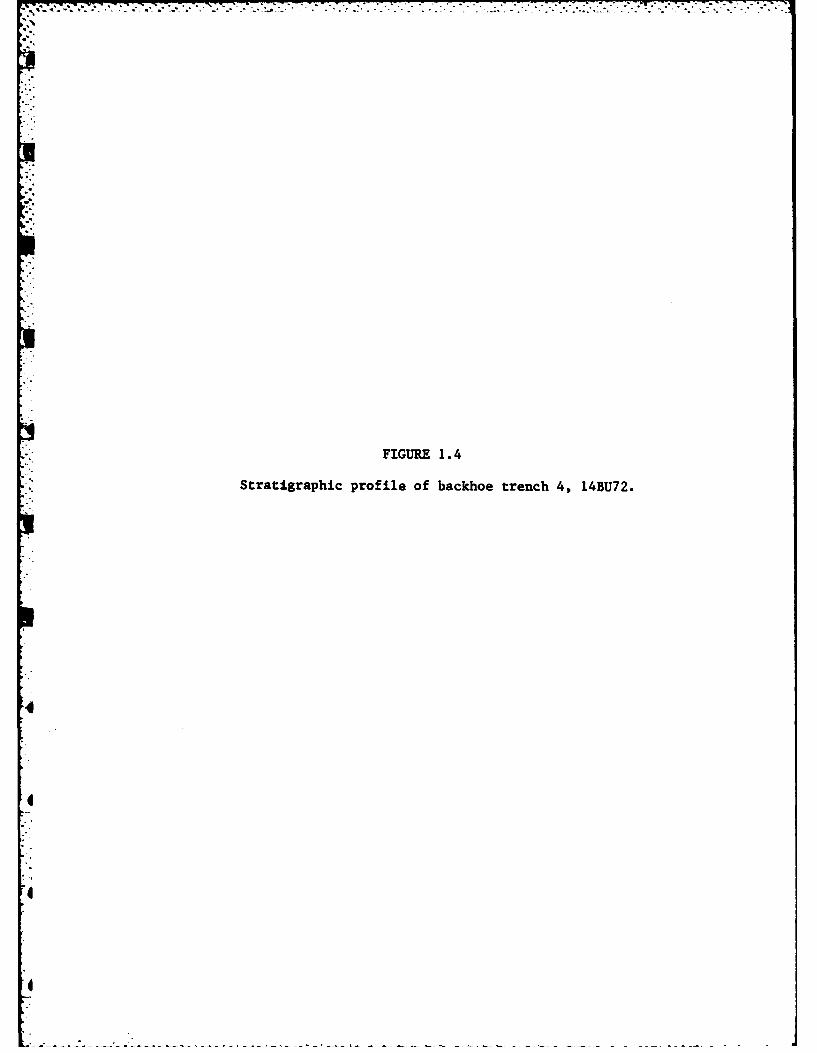
FIGURE 1.4
Stratigraphic profile of backhoe trench 4, 14BU72.

26
UL
0c 0
W IL
S E
~C,4

27
The information derived from the four backhoe trenches proved to be
somewhat of a disappointment since no intact sub-plowzone cultural components
were encountered. However the backhoe trenches did serve to delimit both
the horizontal and vertical extent of the site. The southern boundary of
-the site was well established with the placement of backhoe trenches 2 and 3.
The precise location of the northern boundary of the site is more difficult
to establish however since the presence of artifacts at the southern edge of
g trench 1 and within Test Pit 2 indicate that the site boundary is actually
somewhat further north than indicated by the limits of the surface scatter.
Shovel cuts, placed to the north and west of the surface scatter, failed to
encounter any artifacts within the plowzone. Thus, with the data at hand it
is impossible to precisely define the northern boundary of the site. The
area of the site is therefore best taken as an estimated minimum of 22,500
square meters, or 2.25 hectares. This area is only a little over 50% of the
total area of 4 hectares estimated by Root (1978) to have been occupied
prehistorically. The larger and denser scatter of artifacts encountered on
the surface of 14BU72 by earlier researchers (Fulmer 1977; Root 1978) best
accounts for the differences in the calculated surface area of the site.
This discrepancy would seem to indicate that a substantial portion of the
* site has been removed via the surface collections which are currently curated
at the Museum of Anthropology at the University of Kansas.
ARTIFACT ANALYSIS
* During the 1980 field season a total of 135 artifacts were recovered
from the surface and subsurface of 14BU72. Material types recovered include
chipped stone, unworked stone, bone, burned earth, and historic ceramics.
• Two small fragments of an historic ceramic vessel were recovered from
the plowzone of the site with one located in Test Pit 1 and the other found

28
* •in Test Pit 3. While these two fragments do not cross mend they are nearly
identical and probably came from the same vessel. Their interior surface
is covered by a crackled glaze of olive yellow (5Y6/6) while their interior
is coated with a black (5Y2.5/2) glossy glaze. While both sherds appear to
be from the shoulder of a vessel they are too small to determine either the
- vessel form or to calculate the vessel orifice diameter. The larger of these
two fragments measures 2.9 mm by 1.8 mm in maximum dimension. The smaller
measures 2.1 mm by 1.4 mm in maximum dimension. Both specimens have a max-
imum thickness of 7.0 mm while their combined weight is 7.5 grams.
As noted above, while these two sherds do not cross mend, they are nearly
identical and appear to have come from a single vessel. The possibility does
exist that they came from separate but identical vessels. However, the lack
* - of any other historic material, ceramic or otherwise, on the surface of the
site mitigates against this possibility since if there were more than one
vessel represented other fragments should have been encountered. If these
two fragments are in fact derived from the same vessel the horizontal displace-
ment of artifacts at 14BU72, due to farming practices, has been extensive
since they were found 30 meters apart in a north-south trending milo row.
Thus any attempts at locating intrasite densities of artifacts within the
4plowzone for the purpose of defining prehistoric activity loci would be
extremely suspect at this site.
Two small pieces of burned earth were recovered from the plowzone of
Test 1. Their combined weight is 1.0 grams. The fragments are both badly
weathered and neither of them exhibit evidence of grass or pole impressions
indicative of a prehistoric structure. A natural firing of these specimens
can not be discounted based on the evidence available. One small bone frag-
ment, weighing 0.5 grams, was encountered between 40-50 cm. below the sur-
face of Test Pit 1. Although taxonomically unidentifiable it is most likely
29
the remains of a rodent, given its small size, depth below surface and the
presence of rodent runs throughout the unit.
A relatively large amount of unworked stone was recovered from the test
excavations of the site including five pieces of gravel weighing 17.6 grams
and 46 pieces of limestone weighing 149.9 grams. Only two fragments (2.3
grams) of the limestone appeared to have been thermally altered. Whether
the fragments were purposefully fired or were subjected to natural firing
can not be determined.
The majority of the limestone (75% by weight) was located within the
plowzone. The remaining 25% was located in the 20-30 cm level. Since there
is not an equal percentage of limestone present throughout the floodplain
deposit, that which is present was transported to the site by the prehistoric
inhabitants. How this material was utilized by the prehistoric inhabitants
can not readily be determined but the near absence of thermal alteration
would seem to preclude its use in stone boiling or hearth construction.
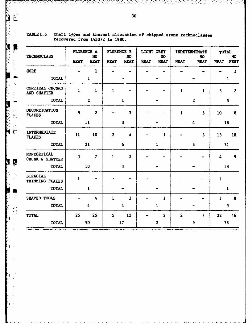
Table 1.6 lists the chert types as well as the presence or absence of
thermal alteration for the 78 chipped stone artifacts recovered from both
the surface and the three test pits at 14BU72 during 1980. Table 1.7 presents
the same data for the sample of 373 chipped stone artifacts recovered by
Fulmer (1977) in 1975. While these two collections are essentially combined
in the following analysis they are presented in separate tables to facilitate
comparisons between them. It should be noted that the finished tools collected
4 in 1975 have already been described by Fulmer (1977:76-82) and are not dealt
with here in any detail.
Florence A chert numerically predominated in both the 1975 and the 1980
4 artifact samples obtained from 14BU72, comprising 58% and 64% of the samples
respectively. When the two samples are combined Florence A chert comprises
I
30
, TABLE 1.6 Chert types and thermal alteration of chipped stone technoclasses
recovered from 14BU72 in 1980.
' FLORENCE A FLORENCE B LIGHT GREY INDETERMINATE TOTAL
TECHNOCLASS NO NO NO NO NOHEAT HEAT HEAT HEAT HEAT HEAT HEAT HEAT HEAT HEAT
CORE - 1 .......
1 TOTAL 1 - 1
CORTICAL CHUNKS 1 3 1 - 1 3 2AND SHATTER
TOTAL 2 1 2 5
DECORTICATION 9 2 - 3 1 3 10FLAKES 9 2313 1
TOTAL 11 3 4 18
INTERMEDIATE 11 10 2 4 - 1 - 3 13 18FLAKES
TOTAL 21 6 1 3 31
NONCORTICALHU &HTTR 3 7 1 2 ---- 4 9I, CHUNK & SHATTER
TOTAL 10 3 -- 13
BIFACIALTRIMMING FLAKES
TOTAL 1 - - I
- SHAPED TOOLS - 4 1 3 - 1 - - 1 8
TOTAL 4 4 1 9
TOTAL 25 25 5 12 2 2 7 32 46
TOTAL 50 17 2 9 78
4i.

31
TABLE 1. 7 Chert types and thermal alteration of chipped stone technoclassesrecovered from 14BU72 in 1975.
FLORENCE A FLORENCE B LIGHT GREY ID/MISC TOTALTECHNOCLASS NO NO NO NO NO
HEAT HEAT HEAT HEAT HEAT HEAT HEAT HEAT HEAT HEAT
CORE 1 7 - 6 - 1 - - 1 14
TOTAL 8 6 115
COTCLHNS - 16 - 4 - - 8 34 8 54AND SHATTER
TOTAL 16 4 -42 62
DECORTICATION 4 16 1 5 - 2 4 9 9 32FLAKES
TOTAL 20 6 2 13 41
INTERMEDIATE 39 54 1 21 - - 1 8 41 83* FLAKES
TOTAL 93 22 -9 124
* NONCORTICALCHUNKS &SHATTER 7 15 - 15 1 - - 6 8 36
TOTAL 22 15 1 6 44
*BIFACIAL TRI1MMING 11 3 - 1 - - - - 11 4
TOTAL 14 1 -15
SHAPED TOOLS 6 25 2 7 - - - 14 8 46
TOTAL 31 9 -14 54
*TESTED COBBLES - 13 - 5 - - - - - 18
TOTAL 13 5 -18
TOTAL 68 149 4 64 1 3 13 71 86 287
TOTAL 217 68 4 84 373
IL 32
TABLE 1.8 Chert types and thermal alteration of chipped stone technoclassesrecovered from 14BU72, combined samples.
.3 FLORENCE A FLORENCE B LIGHT GREY IND/MISC TOTAL
TECHNOCLASS NO NO NO NO NOHEAT HEAT HEAT HEAT HEAT HEAT HEAT HEAT HEAT HEAT
CORE 1 8 - 6 - 1 1 15TOTAL 9 6 16
.% CORTICAL CHUNKS IT 1 17 1 4 9 35 11 56. •. AND SHATTER
- TOTAL 18 5 - 44 67
DECORTICATION 13 18 1 8 - 2 5 12 19 40
* FLAKES
TOTAL 31 9 2 17 59
-.' [ INTERMEDIATE 50 64 3 25 - 1 1 11 54 101FLAKES
TOTAL 114 28 1 12 155
!. NONCORTICALC NR AT 10 22 1 17 1 - - 6 12 45i CHUNKS &SHATTER
TOTAL 32 18 1 6 57
" . BIFACIAL TRIMMING- FLAKES 12 3 - 1 12 4
TOTAL 15 1 - - 16
SHAPED TOOLS 6 29 3 10 - 14 9 54
TOTAL 35 13 1 14 63
TESTED COBBLES - 13 - 5 - - - 18
TOTAL 13 5 - - 18
TOTAL 93 174 9 76 1 5 15 78 118 333TOTAL 267 85 6 93 451
'I
33
59% of the total sample (Table 1.9) The only core recovered in 1980 is of
Florence A chert while 8 of the 15 cores recovered in 1975 are of this
material. In addition to these cores, cortical chunks and shatter, decor-
tication flakes, intermediate flakes, bifacial thinning flakes, noncortical
chunks and shatter, and shaped tools of Florence A chert are present in
both the 1980 and 1975 samples.
Florence B chert is the next most prevalent chert type represented at
14BU72, comprising 18% of the 1975 surface collection and 22% of the sample
obtained in 1980. When the sampleswexe combined 19% of the artifacts were
categorized as being manufactured from Florence B chert (Table 1.9 While
no cores of Florence B were found in 1980, 6 cores of this material type
were recovered in 1975. The technological categories represented by Florence
B chert are the same as those for Florence A in both samples, with the excep-
tion that the 1980 sample lacks both cores and bifacial thinning flakes.
Flint Hills Light Grey, while represented in both samples comprises only
slightly more than 1% of the total sample (Table 1.9). Artifacts of this
material type include a single coretwodecortication flakes, one intermediate
flake, one noncortical chunk and a single shaped tool.
The category of indeterminate/miscellaneous chert contains 93 artifacts
* or 21% of the combined total of both collections. All technoclasses are
represented with the exception of cores, tested cobbles and bifacial thinning
flakes.
*I The 18 tested cobbles obtained from 14BU72 in 1975 provide evidence
that the initial procurement of raw material was an activity performed by
the inhabitants of the site. Thirteen of these cobbles are of Florence A chert,
* while the remaining 5 cobbles are of Florence B chert. The ratio of Florence
A to Florence B chert for the technoclass of tested cobbles is nearly identical
to the overall ratio of Florence A to Florence B for the entire assemblageI

Table 1.9 Raw material usage at 14BU72 190obne
Chert type 1975190Cmie
UFlorence A 219 (58) 50 (64) 267 (59)
Florence B 68 (18) 17 (22) 85 (19)
Flint Hills Lt. Grey 4 (1) 2 (2) 6 (1)
-Indet.IMisc. 84 (23) 9 (12) 93 (21)
Totals 371 (100) 78 (100) 451 (100)
%.,.
35
recovered from the site, and as such it provides a good indication of the
relative abundance or cultural preference for chert types. That the pre-
historic inhabitants of the site obtained these cobbles from a quarry site,
rather than from a stream bed, is indicated by the blocky contours of these
cobbles and the lack of a patina indicative of water action. The location
or locations of the activity is not known, but the abundance of these two
material types suggests that it is in close proximity to the site.
A total of 16 cores recovered from 14BU72 provide ample and direct evi-
dence that the manufacture of flakes was an important technological activity
at the site. Nine of the cores recovered are of Florence A chert while 6
of the specimens are of Florence B. The remaining core is of Flint Hills
Light Grey chert, a material type not well represented at the site, and
apparently not readily available to the prehistoric inhabitants or considered
technologically inferior.
The single core recovered during the 1980 investigations at 14BU72 was
removed from the surface of the site and is illustrated in Figure 1.5. This
specimen is of Florence A chert and weighs 137.9 grams. The core exhibits
2 striking platforms and apparently went through at least two episodes of
flake manufacture during its' use-life. Initially flakes were removed from
4 the striking platform visible at the right margin of Figure l.5B. The presence
of cortex on this platform indicates that the initial flakes were removed
from a relatively unmodified piece of raw material. This platform measures
38 mm. by 28 mm. in maximum dimensions and is rectangular in shape. Flakes were
removed from three of the four edges of the perimeter of this platform.
Subsequent reduction of the core occurred as additional flakes were
*I removed from the platform visible at the top of Figure 1.5A. This platform is
roughly triangular in shape and measures 34 mm. in maximum length and ranges
from 10 mm. to 32 mm. in maximum width. The angle formed between the flake

FIGURE 1.5
Two opposite lateral views of a core from 14BU72.
0!
4/
I' -
I,
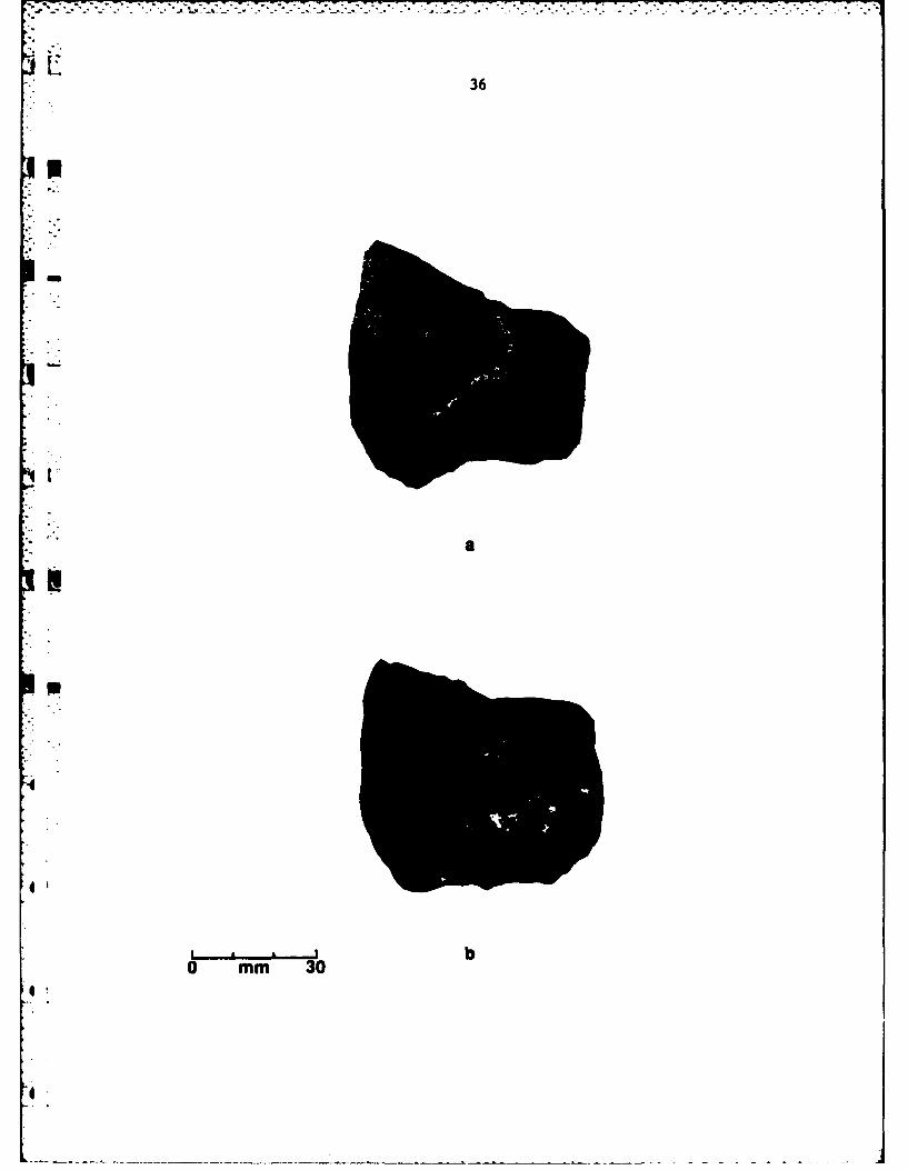
-. - -. - .'S.~..% - -* - FT
36
pm 3

37
scars and this second striking platform ranges from 78 to 85 degrees. Plat-
form preparation along the margin is visible in the illustration (Figure 1.5A).
It is possible that as this second platform narrowed it became too small to
effectively strike off anymore flakes and the core was discarded. Figure 1.5B
illustrates the opposite surface of the specimen.
The decortication elements at the site, comprised of decortication flakes
as well as the cortical chunks and shatter, represent 28% of the combined
chipped stone assemblage obtained from 14BU72 in 1975 and 1980. As the figure
indicates, the initial reduction of raw material was an important activity at
the site. The presence of the 16 cores in conjunction with this large number
of decortication elements demonstrates that the cores were prepared on the site
rather than being transported to the site after their initial preparation at
another locality.
The 155 intermediate flakes and 57 pieces of noncortical chunks and shatter
represent 49% of the combined 1980 and 1975 samples. This large quantity of
intermediate elements, again in conjunction with the 16 cores, demonstrates
that the manufacture of flakes was a primary technological activity at the site.
The 54 shaped tools recovered in 1975 and the 9 recovered in 1980 from
the surface of 14BU72 indicate that the object of this prehistoric flake pro-
duction was the manufacture of chipped stone tools. The small number of bi-
facial trimming flakes (N-18) recovered from the entire assemblage seems to
contradict the conclusion since more of these would have been present if bi-
face production was an important activity. However, it is probable that
sample bias accounts for this discrepancy given the small size of these
elements and the fact that both samples were almost entirely from the surface
* of the site.

. ? ./ , / • . :, .. .. . ..i . ... ... .. . ..... ,
1.' 38
As shown in Table 1.8, 118 elements which comprise 26 percent of the total
* assemblage exhibit evidence of thermal alteration. The overwhelming majority,p*" or 93 elements of heat treated material, are of Florence A chert. Only 9
elements of Florence B and a single non-cortical chunk of Flint Hills Light
Grey chert were heat treated. An additional 15 elements were heat treated but
the chert type could not be determined. The significant preference for heating
Florence A chert at 14BU72 indicates that while this material is the preferred
chert resource it often required the technological process of heat treatment
to render it suitable for utilization by the prehistoric inhabitants (Crabtree
and Butler 1964).
Within the Florence A chert type all technoclasses exhibit heat treatment
except for tested cobbles. The technoclasses exhibiting the highest ratio of
heat treated elements are the intermediate flakes and bifacial trimming flakes.
This data indicates that only after a piece of raw material was selected as
suitable for prehistoric tool manufacture was it subjected to heat treatment.
It can also be inferred that heat treatment was performed at the site rather
*than at another locality from the absence of heat treatment from only the
technoclass of tested cobbles.
Flakes, rather than finished tools, exhibit the highest ratio of heat
treated elements at the site. Only 1 of the 16 cores and 9 of the 63 shaped
tools appear to be heat treated (Table 1.8. However, the high incidence of heat
treatment within the technoclass of bifacial trimming flakes (80% of the
Florence A sample) indicates that the absence of heat treated bifaces within
the sample of artifacts recovered from 14BU72 is a serious bias in the data.
This absence of heat treated bifaces may be the result of prehistoric curation
or the effects of historic artifact collectors. In either case, it appears
that heat treatment played a more important role in the manufacture of bifaces

p.. 9 : .:............ .... ........-.. -.. - -..... ' # '
39
than Table 1.8 would indicate.
SHAPED TOOLS
Only the tools recovered during the 1980 field season are described in
this report. See Fulmer (1977:91) for a description of the shaped tools
recovered from 14BU72 in 1975.
The 9 shaped chert tools found on the surface of 14BU72 in 1980 con-
sist of 1 complete biface, 2 biface fragments, 5 scrapers and 1 hammerstone.
An additional hammerstone fashioned of quartzite completes the tool inventory.
The chert types of these tools are listed in Table 1.10.
The only complete biface recovered from the surface of 14BU72 in 1980 is
morphologically quite distinct from the other tools recovered (Figure 1.6A). It
measures 72 mm. in maximum length and 41 mm. in maximum width. The maximum
thickness of this tool is 15 -. and it weighs 37.3 grams. The biface was
fashioned from Florence A chert and is subtriangular in shape.
This specimen was retouched along both of the lateral margins. The edge
angle of the lateral margins averaged 340, placing it within the range of edge
angles acute enough to infer a f-inction as a cutting implement (Wilmsen 1970:70).
While this specimen does not exhibit color change indicative of thermal alter-
ation it does possess cortex on both surfaces. The presence of cortex on both
sides of this biface provides conclusive evidence that it was manufactured from
a single small cobble of raw material. The shape of the tool, as well as the
blunted proximal lateral edges, indicate that it may have been hafted or socketed.
The two biface fragments recovered from the surface of 14BU72 in 1980 are
quite dissimilar. The firsz of these (Figure 1.6B & 1.6C) is the distal end of a
relatively thick and narrow biface of Florence A chert. This specimen is com-4
pletely flaked on both surfaces. Its maximum dimensions are 60 mm length, 33 mm.
in width, and 18 mm. in thickness. It weighs 36.6 grams. The edge angle of the

40
TABLE 1.10 Morphological/functional categories and chert
types of shaped tools, 14BU72.
MORPHOLOGI CAL/FUNCTIONAL FLORENCE FLORENCE LIGHT
-CATEGORIES A B GREY TOTAL
BIFACE 1I
BIFACE FRAGMENT - 2 -2
SCRAPER 2 2 1 5
HAMNERSTONE 1 - - 1
TOTAL 4 4 1 9
--

FIGURE 1.6
Shaped tools recovered from 14BU72: (A-D) bifaces;(E,F) scrapers.
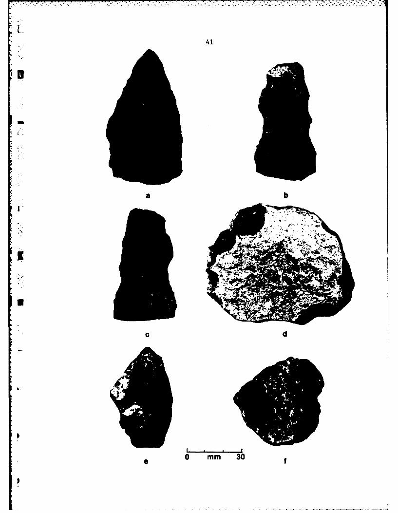
41
a b
-CN.
. ....
0 mm 30 f
42
lateral edges averages 630 while the angle of the transverse edge is 610.
Both the transverse and lateral edges exhibit evidences of utilization in
the form of pronounced crushing and step faceting. Wilmsen (1970:71) postu-
* lated that heavy cutting and scraping activities are tasks which are suited
for tools with edge angles within this range.
The second biface fragment is also a distal fragment although it is
*i considerably smaller than the one described above. Its maximum dimensions
are 25 mm. in length, 21mm in width and 18 mm. in thickness. It weighs 5.8
grams and was manufactured from heat treated Florence B chert. While the
fragmentary nature of this specimen made edge angle measurement difficult,
the retouch along the working edge varies from 40 to 76 degrees. These
edge angles and the crushing and rounding of the working edge suggest that
it functioned as a scraping implement.
Four of the five scrapers recovered from the surface of 14BU72 were
fashioned by the placement of steep retouch on the transverse edge of a flake
(see Figures 1.6E and 1.6F).
One of these four scrapers is the only tool recovered in 1980 which is
made of Flint Hills Light Grey chert. Its maximum dimensions are 31 mm. in
length, 27 mm. in width, and 7.2 mm. in thickness. It weighs 7.2 grams. The
* steeply retouched transverse edge of this tool averages 78 degrees placing it
well within the range of scraping tools discussed by Wilmsen (1970:71).
Figure 1.6E illustrates one of the two scrapers manufactured from Florence
* B chert. This view is of the ventral surface of the tool and the transverse
working edge is visible at the top of the illustration. The transverse edge
angle measures 70 degrees, which is suitable for scraping activities. The max-
* imum dimensions of this scraper are 32 mm. in length, 55 mm. in width, 10 mm.
in thickness and 18.2 grams in weight.
IL 43
The second of the two scrapers manufactured from Florence B chert is very
similar to the one described above although it is smaller in size. This speci-
ment measures 16 mm in length, 18 n. in width, 8 mm. in thickness and 1.5
grams in weight. The transverse edge of the dorsal surface of this small
tool has been retouched to an angle of 630 degrees.
One of the two scrapers manufactured from Florence A chert recovered
during 1980 is illustrated in Figure L6F. The view is of the dorsal surface
of the artifact and the working edge is visible at the upper left hand portion
of the illustration.
This specimen measures 41 mm. in length, 44 mm. in width and 13 mm. in
thickness. It weighs 23.1 grams. The placement of steep retouch along the
transverse margin of this tool yielded an edge angle of 71 degrees, which, as
already noted, is suitable for scraping activities. This tool also was found
to exhibit step faceting or edge crushing along the working edge.
The remaining scraper recovered from the surface of 14BU72 in 1980 is il-
lustrated in Figure 1.6D and is of Florence A chert. Unlike the four scrapers
described above, which were manufactured by the placement of steep retouch along
the transverse margin of an intermediate flake, this tool was manufactured from
a decortication flake and was steeply retouched along the lateral margins.
In Figure 16D the view is of the dorsal surface, and the cortex can be readily
distinguished from the retouched transverse margins. These margins possess
an average edge angle of 55 degrees. This is within the range of edge angles
Wilmsen (1970:70) inferred suitable for skinning and hide scraping;
sinew and plant fiber shredding; heavy cutting of wood, bone, or horn; and tool
back blunting. The tool measures 61 mm. in length, 82 mm. in width, 20 mm. in
thickness and 123.4 grams in weight.

44
Two hanmerstones were recovered in 1980 from the surface of 14BU72. One
is of Florence A chert and is illustrated in Figures 1. 7A and 1. 7B. Crushing,
rounding, and pockmarks, presumably resulting from hammering or pulverizing
activities, are visible on both surfaces of the tool. The presence of cortex
(visible in Figure 1. 7A) indicates that this tool was utilized initially from
a relatively unaltered piece of raw material. Some flakes were removed from
the hammerstone as can be determined by the negative flake scars visible on
both surfaces. No well prepared .striking platform is evident, however, and
it is probable that these flakes were detached as the result of its use as
a hammerstone rather than as a core. This tool measures 54 mm in maximum
length, 49 mm. in maximum width, 34 mm. in maximum thickness, and weighs
137.9 grams.
The second hammerstone recovered from the surface of the site in 1980
is illustrated in Figure 1. 7C. This specimen was fashioned from a small rounded
cobble of quartzite which is most likely a glacial erratic. The extremely
smooth surface of the cobble, where it has not been altered by battering,
indicates that it was subjected to alluvial action. This specimen was pro-
bably brought into the El Dorado area from further north. This specimen weighs
127.2 grams.
DISCUSSION
The analysis of the lithic assemblage recovered from 14BU72 has demonstrated
that all stages of lithic manufacture are represented at the site; from initial
procurement of raw materials to the final shaping of chipped stone tools. The
presence of hammerstones, the abundance of chert cores, the large quantity of
decortication elements and the predominance of intermediate flakes at the site
substantiate that flake manufacture was a primary activity. That this flake
I
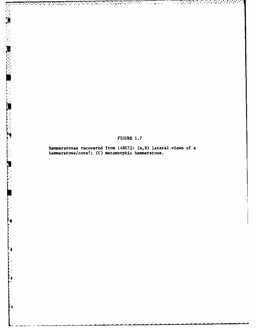
-. '
FIGURE 1.7
Hammerstones recovered from 14BU72: (A,B) lateral views of ahammerscone/core?; (C) metamorphic hammerstone.
.4
4
.4
4
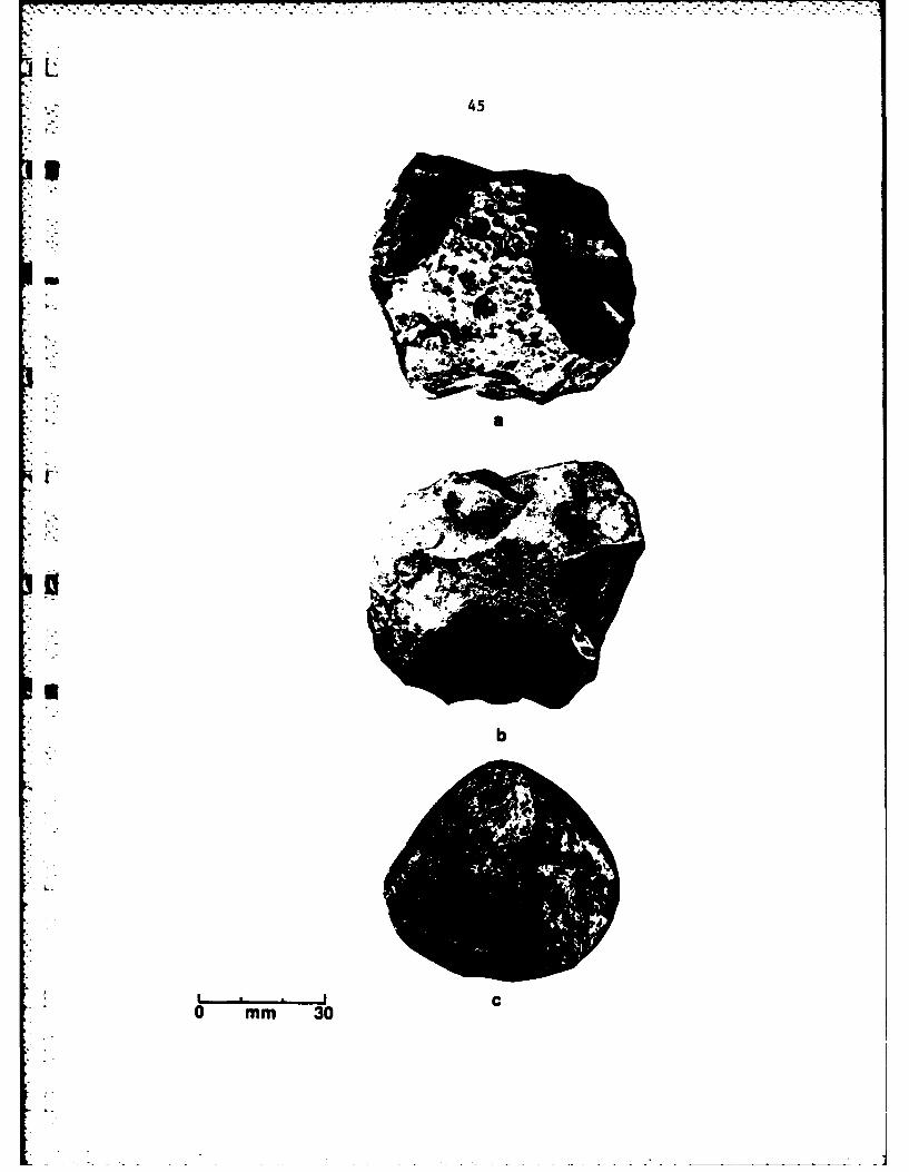
* - 45
b
0 mm 30

46
production resulted in the manufacture of shaped tools is evident in the
63 shaped tools recovered from the surface of the site.
The preferred chert type of the prehistoric inhabitants was Florence A.
This chert type is represented at the site over three times as often as
Florence B chert which is the next most abundant chert type. Flint Hills
Light Grey, while present at the site, comprises only 1% of the total
assemblage. Florence A chert was often heat treated presumably to improve its
flaking qualities.
The large number of finished tools recovered from the surface of
14BU72 in 1975 (Fulmer 1977), along with those recovered in 1980 indicate
that a variety of activities were performed at the site. The projectile point
recovered from the surface of the site in 1975 yields some evidence that
hunting activities were carried out from the site (Ahler and McMillian 1976:
171). The chert tools recovered from the site suitable for cutting and
* scraping activities also yield evidence that the butchering of game, prepara-
tion of hides, and the manufacture of bone and wooden artifacts were activities
which may have been performed at the site.
The large size of 14BU72, the evidence of all stages of lithic reduction,
and the presence of a large number of chipped stone tools indicate that the
site was occupied as a base camp rather than a specialized hunting camp or
gathering area. The site is located on a natural ridge of the Walnut River
floodplain which would have provided the prehistoric occupants protection from
spring and early suimmer flooding. The close proximity of the site to upland
resources, as well as to a perennial source of water, would have made it
attractive as a habitation site.
* However attractive the site may have been to the prehistoric inhabitants
of the El Dorado Lake Area, there is not sufficient evidence to conclude that
14BU72 represents the former presence of a Woodland village as has been

L 47
suggested by Root (1978). No evidence of fire hearths, post molds, or burned
daub concentrations indicative of the former presence of a habitation structure
were encountered during the limited sub-surface testing conducted during 1980.
There is also a near total absence of floral and faunal remains in the artifact
inventory as well as the complete lack of ceramic material which would be
expected at a permanent habitation site occupied by Woodland peoples. Thus
it is concluded here that 14BU72 functioned as a temporarily occupied base
*i camp in which a variety of subsistence activities were carried out. Foremost
* among these activities, and for which the best hard evidence is at hand, was
the procurement of raw materials and the manufacture of chipped stone tools.
f" Hunting, butchering, hide preparation, tool maintenance, woodworking and
boneworking are other activities which can be inferred from the presence of
these tools.
RECOMENDATIONS
The limited sub-surface testing of 14BU72 has demonstrated that the site
is largely, if not entirely, confined within the plowzone. The site has been
adversely impacted by current and historic farming practices and artifact
displacement has certainly occurred. The four backhoe trenches and post hole
auger tests have provided data which confirm that no buried cultural deposit
is present within the alluvial sediments of the Walnut River floodplain to a
depth of 4 meters below surface. The relative paucity of cultural material
recovered from the test excavations and surface survey of 14BU72 in 1980 indi-
cates that the majority of the artifacts once present at the site had already
been removed. This is evident in the large sample of material recovered in
1975 as compared to that recovered in 1980.
As noted, 14BU72 is situated in a ridge of the Walnut River floodplain.
It will, therefore, only be directly impacted by the construction of the El

* 48
Dorado Reservoir during periods of flooding when the level of the water reaches
1347.5 feet above mean sea level. However, even at floodstage the majority
of the site will not be innundated. Shore line erosion, especially along the
two intermittent streams, which will be innundated at flood stage, will present
the largest threat to this cultural resource.
Thus it is recommended that no further work be performed at 14BU72 other
- than a periodic monitoring of the site to assess the effects of the shore
line erosion.
,0
0i
S

K i 49
14BU73
PHYSICAL DESCRIPTION
Site 14BU73 is located at the northern boundary of the project area,
,- approximately one kilometer southwest of site 14BU72 (Fig. 1.1). 14BU73 is
situated 200 meters west of the right bank of the Walnut River on the firstdoterrace (T1) above the floodplain (Fig. 1.8). The T1 terrace is clearly visible.
in Figure 1.8. It rises approximately 2.5 meters (8 feet) above the surface of
the Walnut River floodplain.
The site was located by reference to the site survey records of the project
• 'area (Root 1978). At the time of the 1980 investigations the site consisted
of a very light scatter of lithic debris widely dispersed along the margin of
the T1 terrace. The field in which 14BU73 is located was planted in Milo
-.which reduced surface visibility to only 25 to 50%. Given the light scatter
* - of material and low surface visibility the boundaries of the site were some-
what difficult to precisely define. It is likely that recent farming practices
and the slope erosion along the margin of the T1 terrace have increased the
area of the surface scatter beyond the actual limits of the site as it existed
in prehistory. Thus the limits of the surface scatter illustrated in Figure 1.8
are only an approximation of the actual boundaries of the site when it was
.occupied prehistorically.
The area of heavy trees which is currently located several hundred meters
south of the site boundaries indicates that prior to modern farming practices
the site would have been closer to a source of timber. To the north and west
the site grades into the uplands which at the time of the 1980 test investiga-
tions consisted of both pasture for cattle and fallow fields. These were most
likely prairie grasslands prior to Euro-American settlement of the El Dorado
area.
FIGURE 1.8
Topographic map of 14BU73 and vicinity.
K.
L -
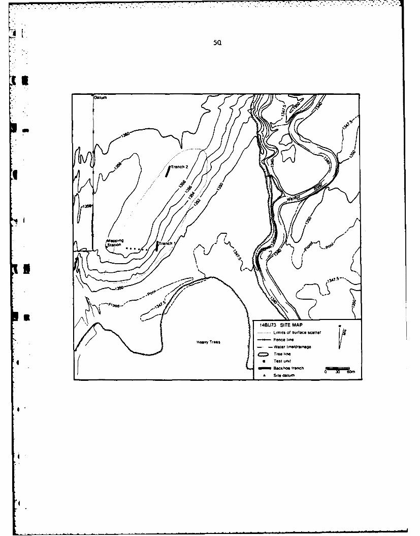
5Q
Oatum rn~4
.... ......
/Trench 2 . 4
I~ wpn ec
14BU73 SITE MAP
......Limits of sujrface scatter
Heav Tres - Fence line- -Water lineldrainage
iC= Tree line
a Test unitBackt'O trench 001P ORm
A Site datum"
--4------
- - - -M n

51
The soil within which !4BU73 is located has been designated as Norge gilt
Loam by the Soil Survey of Butler County, Kansas (U.S.D.A. 1975:15). This
soil type consists of deep, nearly level to sloping, well drained soils on
high terraces and uplands which formed in loamy sediment. Drew (1981:20) has
postulated that the Norge Soil Series within the project area represents the
remnants of a cut and fill terrace sequence which was deposited prior to 20,000
years B.P. Drew also notes that such a date has predictive value for the arch-
aeology of the area since no burred archaeological sites would be expected
in deposits of this antiquity. The test investigations conducted at 14BU73
serve in part as a weak test of this hypothesis. The placement of two backhoe
trenches within the T terrace and the terrace margin yielded no evidence of
a buried cultural deposit within the Norge Soil series. Obviously such a
test can not prove this hypothesis but only fails to disprove it.
ARCHAEOLOGICAL INVESTIGATIONS
14BU73 was first recorded as an archaeological site in 1975 by personnel
from the Kansas University, Museum of Anthropology (Fulmer 1977:,ii. At that
time a small sample of artifacts was recovered from the surface of the site.
This sample included 27 pieces of chipped stone ranging in size from 1.5 to
8.2 cm, 3 pieces of limestone, and a metamorphosed sedimentary rock which
Fulmer (1977:82) thought to be a possible hammerstone. This object is illus-
trated by Fulmer (1977, Appendix D). The cultural affiliation of the site
was not determined since no diagnostic artifacts were recovered. It was also6
noted that none of the 27 elements of chipped stone bore evidence of having
been utilized by the prehistoric inhabitants of the site.
14BU73 was revisited by personnel from the Museum of Anthropology in 1977
and an additional grab sample of artifacts was recovered from the surface of
the site (Root 1978, 1979).
A

t 52
The areal extent of the site was estimated to be 15,000 square meters or
1.5 hectares based on the surface scatter of artifacts. As in 1975 no culturally
u diagnostic artifacts were recovered. Root (1979:71) recommended that 14BU73
receive limited test excavations to help formulate protective measures for this
cultural resource.
Even though 14BU73 was not a known Woodland site its inclusion in the 1980
testing program is within the defined research goals of the project since the
research design for the El Dorado Lake project calls for the limited subsurface
testing of all archaeological components within the project area (Leaf 1976).
The limited amount of time available to perform fieldwork during 1980 made the
prudent scheduling of time imperative. The decision was made in the field to1L
include 14BU73 among the Woodland sites tested in 1980 because it lies within
close proximity to 14BU72. This proximity made it possible to schedule the
use of a backhoe at both 14BU72 and 14BU73 in the same day which saved both
time and money while providing information necessary to formulate decisions
regarding the preservation of these cultural resources.
Fieldwork performed at 14BU73 in 1980 was initiated by a pedestrian surfaceSreconnaissance of the milo field in which the site was located according to
the site survey records of the project area (Root 1978:212). As already noted
the artifact density on the surface of the site was very sparse. The majority
of material appeared to be eroding out of the edge of the terrace at the
southern portion of the site. The test investigation at the site began by
* .laying out six one by one meter tests within the area of the site. The test
pits were placed along the east-west baseline of the site grid at 10 meter
intervals. They are numbered sequentially from west to east from one to six.
As can be seen in Figure 1.8, they crosscut the margin of the T, terrace. The
test pits were placed within this area of relatively high surface artifact density
to discover the depth of the cultural deposit as well as to discern if any

53
Intact cultural features were located within the area. With the discovery
that the site was confindd to the plowzone only four of the six test pits
which were initially laid out were actually excavated.
Test pit 1 was placed in the southwestern portion of the site on the T1.
terrace. This test unit was excavated in arbitrary 10 cm units below the
plowzone to a depth of 40 cm below the present ground surface. The plovzone
was removed as a single 20 cm level. The stratigraphic profile of the completed
excavation of test pit 1 is illustrated in Figure 1.9. The stratigraphy of test
pit 1 correlates well with the stratigraphic profile of a typical Norge Series
soil, as illustrated and described by the U.S.D.A. Soil Survey (1975:15). The
upper 20 cm of the unit consists of the plowzone, a loose silt loam which is
brown (10 YR 5/3) in color. The plowzone is underlain by a reddish brown
*(5YR 4/3) silty clay loam BI horizon. An auger test placed at the base of
this unit to a depth of 1.5 meters below surface revealed no apparent change
in the color or texture of this lower horizon.
TABLE 1.11 Vertical distribution of artifacts in test pit l--14BU73.
Level No. of Artifacts
00-20 cm 115
4 20-30 cm 18
30-40 cm 11
TOTAL 144
The data in Table 1. 11 indicate that the majority of cultural material within
the unit is confined almost entirely to the plowzone. The seemingly high
artifact count is biased by the large amount of limestone and gravel which
together comprise 95 percent of the total sample of artifacts recovered from
the unit. Only three small chert chips were encountered below the plowzone
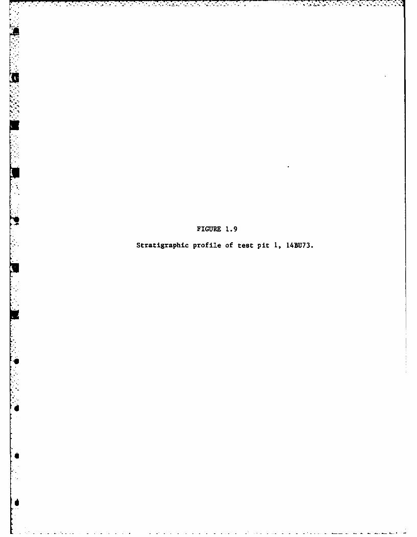
I°.
FIGURE 1.9
-. Stratigraphic profile of test pit 1, 14BU73.
6'
S
6
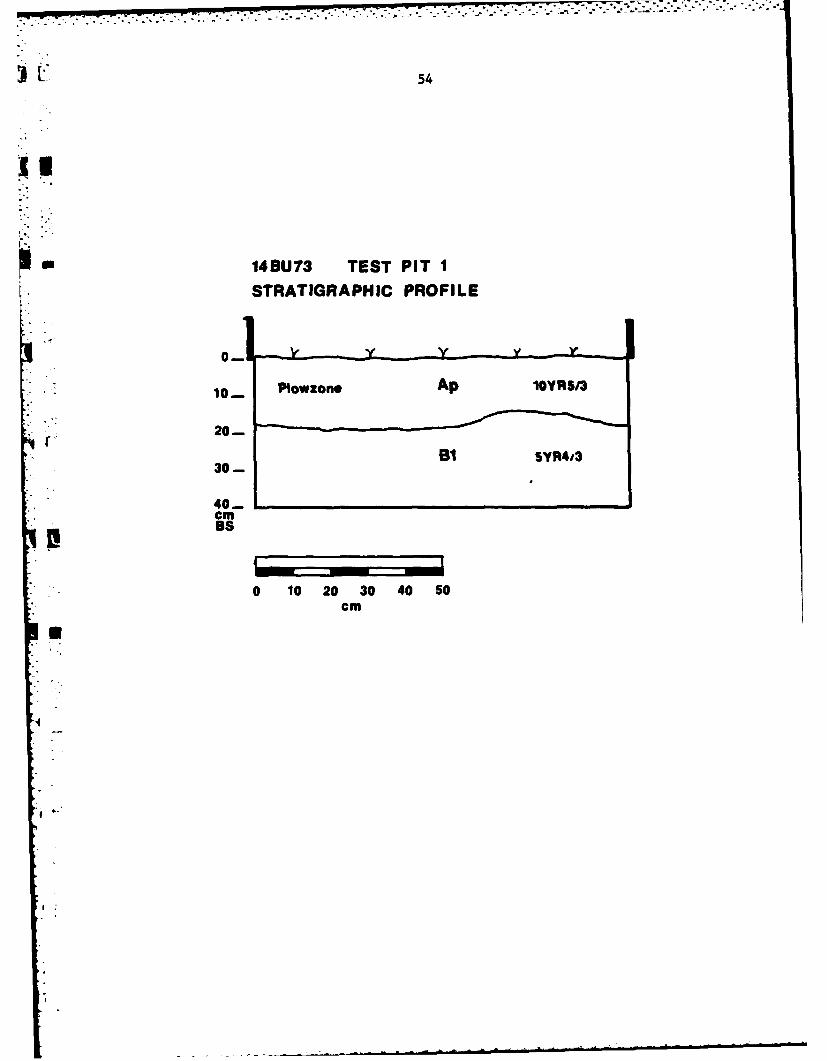
54
Sm149U73 TEST PIT ISTRATIGRAPHIC PROFILE
P.owlon Ap 10YRS/3
39-
40- 1 03 05ccm
SB
0.0 2 3 0 5
55
of the unit. The presence of rodent burrows within the lower levels of the unit
indicate that these elements migrated downward by natural processes after their
cultural deposition.
Test pit 2 was placed 10 meters to the east of test pit 1 along the margin
of the TI terrace. This unit was also excavated in arbitrary 10 cm levels
below the plowzone to a depth of 40 cm below the present ground surface. The
plowzone was removed as a single 20 cm unit. The stratigraphy of the unit is
identical to that of test pit 1 and is not reproduced here.
TABLE 1.12 Vertical distribution of artifacts in test pit 2-14BU73.
Level No. of Artifacts
00-20 cm 102
20-30 cm 3
30-40 cm 0
TOTAL 105
Table 1.12 indicates that as in test pit I the artifacts in test pit 2 are
almost exclusively confined to the plowzone. Only 3 small pieces of limestone,
with a combined weight of 4.2 grams, were recovered from the 20-30 cm level
of the test pit. As in test pit 1 the overwhelming majority of artifacts
4 recovered from the unit consist of limestone and gravel. In fact only one
chert chip which measures less than 2 cm in maximum length was recovered from
the entire unit.
4 Test pits 3 and 4 were also placed along the margin of the T1 terrace.
Test pit 3 was placed 10 meters east of test pit 2 and test pit 4 was placed
10 meters east of test pit 3. Both test pit 3 and test pit 4 were only exca-
vated to a depth of 20 cm below surface. It was determined by the placement
of the first two test pits and two backhoe trenches that the cultural component
at 14BU73 did not extend below the plowzone. The material recovered from the
L

56
plowzone of these two units includes 6 small chert flakes, 372 pieces of lime-
stone, and 35 pieces of gravel.
The two 25 meter backhoe trenches mentioned above were placed within the
boundaries of the artifact scatter in an attempt to locate buried cultural
deposits. As already noted none were discovered.
Backhoe trench 1 was placed on the slope of the T terrace at the south-
eastern portion of the site to determine if the artifacts were eroding out of
a buried cultural deposit. The trench was taken down to a depth of 1.5 meters
below the surface of the terrace slope. Even though the walls of the backhoe
trench were carefully trowled backsno cultural material was discovered
*below the plowzone. The east wall of the trench was photographed and profiled
prior to backfilling. The stratigraphic profile of backhoe trench 1 is illus-
trated in Figure 1.10. This profile compares favorably with Norge Soil series
profile described by the U.S.D.A. Soil Survey (1975:15). The uppermost 20 to
25 cm consists of the plowzone, a friable silty loam which is dark brown (10 Y-
R 4/3) in color. Beneath the plowzone lies a silty clay loam B22t horizon
which is yellowish red (5 YR 5/6) in color. This horizon extends to the base
of the trench.
Backhoe trench 2 was placed 100 meters north of trench I at the top of the
4 T terrace. The trench was placed at the northwestern portion of the site
because several chipped stone tools were located on the surface of the site
within this area. The trench was taken down to a depth of 1.5 to 3.5 meters
" below surface. No cultural material was discovered below the plowzone even
though, as in trench 1, the walls were carefully troweled back. The strati-
graphy of trench 2 is identical to that illustrated in Figure 10 for trench
I with the exception that the B22t horizon extends down to 3.5 meters below
surface. The east wall of the trench was photographed and profiled prior
to backfilling.
FIGURE 1. 10
Stratigraphic profile of backhoe trench 1, 14BU73.
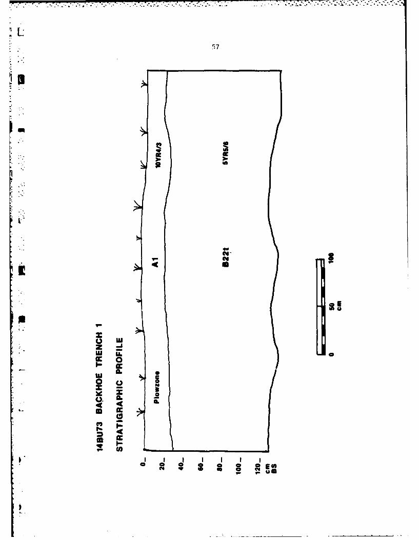
cc 0
L) L
0- It
XU 0
IC-CAz
58
DISCUSSION
VThe test excavations conducted during 1980 at 14BU73 document that
the unknown cultural component is confined to the plowzone. While it is
possible that more than one archaeological component is represented at the
site, no direct evidence of repeated occupations was encountered during
the 1980 testing of the site. The low artifact density, in terms of tools
and debitage, both on the surface of the site and within the test pits,
indicates that the site was never intensively occupied.
The perimeter of the surface scatter of lithic debris within the milo
field is illustrated in Figure 1.8. As already noted, this boundary probably
inflates the actual site boundary since material is eroding down the slope
of the terrace and is being plowed across the field. So the total area of
40,000 square meters, or 4 hectares, of the lithic scatter is best viewed
as an approximation of the actual boundaries of the site as it existed in
prehistory.
ARTIFACT ANALYSIS
Including the material recovered from the surface of the site and from
the excavation of the test pits, a sample of 771 items was taken from
14BU73 in 1980. These included 28 chipped stone artifacts, 579 pieces ofI
limestone, and 71 pieces of gravel. There were no faunal elements recovered
from the site and a single hackberry seed (Celtis occidentalis) completes
the floral inventory.
The large amount of unworked stone constitutes the majority of mater-
ial recovered from the test excavations at the site. A total of 71 pieces
of gravel with a combined wnight of 215.1 grams were recovered from the four
test pits actually excavated. This gravel, known locally as jasper, is
generally brown in color and rather blocky in appearance. It ranges from
L59
* less than I cm up to 5 cm in maximum dimension. With the exception of
only two elements, all of this material was recovered from the plowzone.
S-"Although this differential occurrence would seem to indicate a cultural
rather than natural origin for this material, it is possible that the
jasper was deposited on the surface as part of the cut and fill terrace
sequence which Drew (1981) has postulated as responsible for the presence
of the T terrace of the Walnut River Valley within the project area. If
this material is of cultural rather than natural origin, the manner in
which it was utilized by the prehistoric inhabitants of the site is not
readily apparent. None of this material appears to have been purposefully
r utilized in the manufacture of stone tools at the site. Nor was it
thermally altered, which would be expected if it was used in activities
such as stone boiling, roasting, or hearth construction.a A total of 579 pieces of limestone with a combined weight of 1090.2
grams were recovered from the 4 test pits excavated at 14BU73. The major-
ity of these elements are small fragments. They range in size from less
p than 1 cm up to 5 cm in maximum dimension. Ninety-two of the 519 limestone
* fragments exhibit evidence of thermal alteration in the form of color
change and compositional alteration. The 92 elements weigh 162.0 grams,
which is approximately 15 percent of the total sample of limestone recov-
ered in 1980. It was not determined in this analysis if these burned
fragments were purposely fired or were subjected to a natural firing.
Ninety-five percent of the limestone recovered from the test pits at
14BU73 was contained within the plowzone. The remaining five percent was
scattered between 20 and 40 cm below the surface of test pits one and two.
Even though these figures are skewed by the fact that a total of 80 cubic
cm of matrix were removed from the plowzone while only 40 cubic cm were
" . .. . "i " ... - - -- -.- ". ' . .-
" - . -
60
were removed from below the plowzone during the test excavations, they can
be used to provide a valid comparison of the presence or absence of the
material. Since there is not an equal distribution of limestone through-
out the TI terrace deposit, it is likely that the limestone present at the
-site represents manuports carried to the site by the prehistoric inhabitants.
As noted above, 15 percent of the limestone recovered exhibits evidence of
thermal alteration which suggests that the manuports may have been used
in activities such as stone boiling, roasting, or hearth construction.
However, during the test investigations of 14BU73, no direct evidence of
the remains of such features were encountered.
Table 1.13 lists the chert types and the presence or absence of thermal
alteration for the 28 chipped stone artifacts recovered from both the sur-
face and the test excavations at 14BU73 during 1980. Table L 14 lists the
same data for the 48 artifacts recovered from the surface of the site by
Root (1979) in 1977. These data are combined in Table 1.15which will be
used as a more representative sample in the following analysis of the chipped
stone from 14BU73.
0

.4 7i61
TABLE 1.13 Chert types and thermal alteration of chipped stone technoclassesrecovered from 14BU73 in 1980.
FLORENCE A FLORENCE B LIGHT GREY 1141/MISC TOTALTECHNOCLASS NO NO NO NO NO
HEAT HEAT HEAT HEAT HEAT HEAT HEAT HEAT HEAT HEAT
CORE -- -3 -- - - -3
TOTAL -3 -- 3
CORTICAL CHUNKS-1- -- - - -1
* AND SHATTER
TOTAL1--1
* DECORTICATION--- -- - 1 -1
* FLAKES
TOTAL--11
INTERMEDIATE 2 3 -2 -- - - 2 5FLAKES
TOTAL 5 2 -- 7
* NONCORTICALI CHUNKS &SHATTER -1 - . -- - - -2
TOTAL 11--2
* SHAPED TOOLS 2 3 -5 1 - - 3 3 11
TOTAL 5 5 1 3 14
1K TOTAL 4 8 -11 1 - - 4 5 23
TOTAL 12 11 1 4 28

0 62
TABLE 1.14 Chert types and thermal alteration of chipped stone technoclassesrecovered from 14BU73 in 1977.
FLORENCE A FLORENCE B LIGHT GREY IND/MISC TOTALTECHNOCLASS NO NO NO NO NO
HEAT HEAT HEAT HEAT HEAT HEAT HEAT HEAT HEAT HEAT
CORE - 1i . .. i
TOTAL I - 1
CORTICAL CHUNKS - 2 - 1 - 6 - 9
TOTAL 2 1 6 9
INTERMEDIATE 3 11 - 1i - 2 1 1 4 25FLAKES
TOTAL 14 11 2 2 29
NONCORTICAL - 2 - 2 - - - 1 - 5CHUNKSC TOTAL 2 2 - 1 5
SHAPED TOOLS 1 - 1 2 - - - 2 2
TOTAL 1 3 - 4
TOTAL 4 16 1 16 - 2 1 8 6 42
TOTAL 20 17 2 9 48
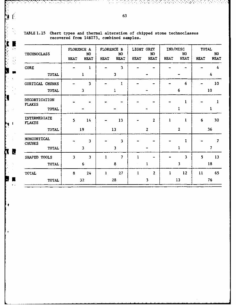
63
- TABLE 1.15 Chert types and thermal alteration of chipped stone technoclasses
recovered from 14BU73, combined samples.
FLORENCE A FLORENCE B LIGHT GREY IND/MISC TOTALTECHNOCLASS NO NO NO NO NO
HEAT HEAT HEAT HEAT HEAT HEAT HEAT HEAT HEAT HEAT
CORE - 1 - 3 . . .. 4
TOTAL 1 3 - 4
CORTICAL CHUNKS - 3 - 1 - 6 10
TOTAL 3 1 6 10
DECORTICATION 1 1FLAKES
TOTAL - - 1 1
INTERMEDIATE 5 14 - 13 - 2 1 1 6 30FLAKES
TOTAL 19 13 2 2 36
NONCORTICAL- 3 - 3 - - - 1 - 7CHUNKS
TOTAL 3 3 - 1 7
SHAPED TOOLS 3 3 1 7 1 - - 3 5 13
TOTAL 6 8 1 3 18
TOTAL 8 24 1 27 1 2 1 12 11 65
K TOTAL 32 28 3 13 76

G64
Florence A chert numerically predominated in both the 1977 and 1980
samples, comprising 42% and 43% of the samples respectively. When the two
samples are combined Florence A chert comprises 42% of the total sample of
artifacts recovered from 14BU73 (Table 1.16). The single core recovered
from 14BU73 of Florence A chert was found on the surface in 1977. In add-
ition to this core the technoclasses of cortical chunks, intermediate flakes,
non-cortical chunks,and shaped tools are in both the 1977 and 1980 artifact
samples.
Florence B chert is represented at 14BU73 only slightly less often than
Florence A chert. Florence B comprises 35% of the chert recovered in 1977
and 39% recovered in 1980. When the two samples are combined, 37% of the
chipped stone artifacts are classified as Florence B chert (Table 1.16).
Three cores of Florence B chert were recovered from the surface of
14ETT73 in 1980. The other technoclasses represented by this material type
are the same as those represented by Florence A chert in both samples, with
the exceptions that the 1977 sample lacks cores and the 1980 sample lacks
cortical chunks.
Flint Hills Light Grey, while present in both the 1977 and 1980 samples
represents only 4% of the total sample--3 artifacts. These include two
intermediate flakes and a single shaped tool.
The category of intermediate/miscellaneous chert contains 13 artifacts,
or 17% of the total sample recovered from 14BU73 (Table 1.16). Several
elements included within this category are of a chert type currently recog-
nized by El Dorado researchers as Cresswell chert (Haury 1981). In addition
to the technoclasses of Florence A and Florence B chert, the technoclass
4

65
of decortication flakes is represented by a single element within this
I |category.
TABLE 1.16 Raw material usage at 14BU73.
CHERT TYPE 1977 1980 COMBINED
- FLORENCE A 20(42) 12(43) 32(42)
FLORENCE B 17(35) 11(39) 28(37)
FLINT HILLS LT. GREY 2(4) 1(4) 3(4)
MISC/INDET. 9(19) 4(14) 13(17)
TOTALS 48(100) 28(100) 76(100)
The lack of tested cobbles on the site indicates that chert was not
procured at 14BU73 but at a separate locality. The four cores recovered
from the surface of the site do, however, indicate that limited flake manu-
facture was performed. The only core recovered in 1977 was fashioned from
Florence A chert while the three cores recovered in 1980 were manufactured
from Florence B chert. The first of these three cores weighs 133.0 grams.
It exhibits a single striking platform which measures 54 mm by 39 mm in
* .maximum dimension. Flakes were removed along three of the four margins of
the perimeter of this platform. Platform preparation is also present along
the margin in the form of step fractures and edge crushing. The average
edge angle of this platform measures 82 degrees.
The second core of Florence B chert weighs 221.0 grams and is the
4 . largest of the three cores of this material. The platform measures 78 mm
by 37 mm in maximum dimension. The presence of negative flake scars
indicates that flakes were removed from only two of the margins of this
* !platform. The edge angle of the platform averages 78 degrees and platform
preparation is present.
4
66
0
The third core of Florence B chert recovered in 1980 is much smaller
than the two described above. It weighs only 67.4 grams and exhibits only
one platform. Flakes have been removed from three of the four margins of
the platform as indicated by the presence of negative flake scars. Plat-
. form preparation is present along the margin of the platform in the form
of step fractures and edge crushing. The edge angle of the platform aver-
ages 80 degrees. This platform measures 36 mm by 24 mm in maximum dimension.
The decortication elements recovered from the site are sparse,
represented by only ten cortical chunks and a single decortication flake
(Table 1.15). Together these elements only represent 14 percent of the
total of the combined artifact assemblage recovered in 1977 and 1980. The
presence of only four cores, along with the lack of tested cobbles and the
" sparse number of decortication elements demonstrates that the initial reduc-
tion of raw material was not an important activity at the site.
The 36 intermediate flakes and 6 non-cortical chunks represent 56%
of the combined 1977 and 1980 samples (Table 1.15). This relatively large
quantity of intermediate elements, in contrast to the limited number of
elements representative of the initial reduction of raw materials, indi-
cates that flakes were manufactured at the site from cores initially
prepared at another locality. The rather limited manufacture of these
flakes appears to have been a primary technological activity at the site.
Including the four shaped tools obtained from the surface of 14BU73
in 1977, a total of 18 shaped tools have been recovered from the site
(Table 1.15). The absence of bifacial triaming flakes from both the 1977
and 1980 artifact samples, however, indicates that the manufacture or
maintenance of bifacially chipped stone tools was not a prevalent activity
at the site. Only eight of the 18 tools recovered from the site are
classifiable as bifaces or biface fragments. The other 10 tools are best
-4

67
categorized as modified or retouched flakes. The predominance of these
elements within this sample indicates that the object of the limited flake
I production at 14BU73 was the manufacture of what Artz (1981:71) has termed
'ad hoc' tools; i.e., opportunistically-manufactured flakes used in the
performance of various tasks.
The data in Table 1.15 reveal that only 11 of the 65 chipped stone
artifacts recovered from 14BU73 were heat treated by the prehistoric inhab-
itants. These 11 elements represent 14% of the total assemblage. Eight of
the 11 elements were manufactured from Florence A chert, while only a single
element of both Florence B and Flint Hills Light Grey chert exhibited evi-
dence of heat treatment. The remaining heat treated intermediate flakesI
could not be classified as to chert type. The predominance of heat treated
Florence A chert indicates that while this material was the preferred chert
type, it often required the technological process of heat treatment to
render it suitable for utilization by the prehistoric inhabitants of 14BU73.
The only technoclasses which were heat treated within the Florence A
chert type include both intermediate flakes and shaped tools. Of these two,
the technoclass of shaped tools exhibits the highest ratio of heat treated
elements (Table 1.15). Within the Florence B and Flint Hills Light Grey
E chert types, heat treatment is present only within the technoclass of shaped
tools. The fact that only shaped tools and intermediate flakes were heat
treated indicates that raw materials were heat treated only after they were
4 selected for tool manufacture, or that the tools were brought to the site
already heat treated. The presence of six intermediate heat treated flakes
would seem to indicate that heat treatment was performed at the site.
However, it is possible that these flakes were struck from cores which were
heat treated at another locality. Thus, it can only be concluded that the
I
i , -. -a '. .- ', ..' p ' > o .. , .. , ! . .. . . . .o . .. .i . --
468
prehistoric occupants of 14BU73 were capable of heat treating chert, not
whether this activity was actually performed at the site.
SHAPED TOOLS
Only the 14 tools recovered from 14BU73 during the 1980 field season
are described in this report. These consist of three complete bifaces,
four biface fragments, six modified flakes and one notch (Table 1.17).
The largest of the three complete bifaces is illustrated in Figure 1.11A.
This tool measures 72.0 m in maximum length, 70.0 m in maximm width and
is 35.0 mm thick. It weighs 71.8 grams. The negative flake scars visible
in the illustration form an acute edge angle which averages 62 degrees.
The opposite margin of the tool is blunted which facilitates holding the
tool. The reverse side of this biface exhibits the presence of cortex
which indicates that the tool was manufactured from a relatively unaltered
cobble of Cresswell chert. The acute edge angle and position of the working
edge indicates that this biface was utilized as a heavy cutting tool or
chopper. The step fractures along the working edge of the tool indicate
that it was intensively utilized before being discarded.
TABLE 1.17 Morphological/functional categories and chert types of shapedtools recovered in 1980, 14BU73.
MORPHOLOGICAL/ LIGHTFUNCTIONAL FLORENCE A FLORENCE B GREY CRESSWELL TOTALCATEGORIES
BIFACE 2 - - 1 3
BIFACE FRAGMENT 3 - 1 - 4
RETOUCHED FLAKE - 5 - 1 6
NOTCH - - 1 1
TOTAL 5 5 1 3 14
FIGURE 1.11
Complete bifaces recovered from 14BU73.

69
b
0 mm 30
70
The second complete biface recovered from the surface of 14BU73 in 1980
was manufactured from Florence A chert (Figure 1.11B). The tool measures
75.0 mm in maximum length, 49.0 mm in maximum width and 16.0 mm in thickness.
It weighs 54.4 grams. The presence of cortex on the dorsal surface of the
*tool can be seen in the illustration. The tool is retouched along the
lateral margins. The right margin of the tool exhibits a more acute edge
angle which averages 47 degrees. The left margin is somewhat more steeply
retouched and the edge angle is more obtuse, measuring 53 degrees. These
edge angles are within the range of edge angles Wilmsen (1970:70) has
suggested are suitable for a wide variety of cutting and scraping activities,
including plant processing, hideworking and woodworking.
The third complete biface recovered in 1980 was also manufactured from
Florence A chert. It measures 70.0 mm in maximum length, 31.0 mm in maxi-
mum width and is 16.0 mm thick. This tool weighs 33.3 grams (Figure 1.11C).
Unlike the other two complete bifaces described above, this specimen is
completely flaked on both sides. It has been marginally retouched or sharp-
ened along the distal lateral margins which have an average edge angle of
54 degrees. The proximal lateral margins of the tool are slightly narrowed
and blunted as if to facilitate hafting the tool. Only the distal lateral
* margins of the tool appear to have been utilized. The edge angles of the
tool are within the range of angles Wilmsen (1970:70) has described as
suitable for a wide variety of cutting and scraping activities.
* Of the four biface fragments recovered in 1980, two are distal fragments,
one is a medial fragment, and one is a proximal fragment. The first of
these biface fragments was manufactured from Flint Hills Light Grey chert
4 and is illustrated in Figures 1.12A and 1.12B. This fragment represents
the tip of a heat treated biface which was not completely flaked on both
sides. Rather, it was invasively retouched on the side visible in Figure 1.12 A,
I .. .. . . .. ,h,, .,n. m ,~ ,,-a-.-ka '-- mne ,- ,an,,m ,a mm mn -"--illJ
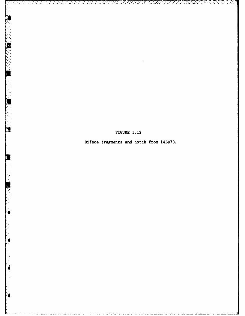
FIGURE 1.12
Biface fragments and notch from 14BU73.

71
U a b
44
4 _ f
0 mm 30

72
and marginally retouched on the side visible in Figure 1.12B. The tool does
not appear to have been heavily utilized. It was discarded after it broke,
presumably while being used since there is little evidence of biface manufac-
ture at the site. This fragment measures 42.0 mm in maximum length, 41.0 mm
in maximum width, and is 8.0 mm thick. It weighs 14.0 grams. The tip of the
specimen does not exhibit an impact fracture which would be expected if it had
been used as a projectile point. The lateral margins of the tool possess an
acute edge angle which measures 34 degrees. This angle is suitable for a cut-
ting tool (Wilmsen 1970:70).
The other distal fragment, recovered in 1980, was also manufactured from
Florence A chert and is illustrated in Figure 1.12C. This small fragment meas-
ures only 17.0 mm in maximum length, 24.0 m- in maximum width and is 4.0 mm
thick. It weighs only 2.0 grams. It has been retouched along the lateral mar-
gins to an edge angle of 40 degrees. The burin like tip may have been used
for engraving or boneworking.
The other two biface fragments were manufactured from heat treated Flo-
rence A chert. The first of these is illustrated in Figure 1.12D. It is the
proximal fragment of a small, thin biface which was completely flaked on both
sides. It measures 33.0 -m in maximum length, 32.0 mm in maximum width, and
* is 8.0 pm thick. It weighs 9.0 grams. The lateral margins of this biface
fragment exhibit step fractures indicating the tool was fairly intensively
utilized. The average edge angle of the lateral margins of the tool is 38
degrees. The remaining biface fragment is illustrated in Figure 1.12E. It
is a small medial fragment of what appears to be a projectile point, although
it is too small and incomplete to conclude that it is anything other than a
biface fragment. It measures only 14.0 mm in maximum length, 27.0 mm in max-
imum width and is 6.0 mm thick. It weighs 2.7 grams. The lateral edge angles

73
average 32 degrees. The edge angles of these latter two biface fragments
indicate that they also functioned as cutting tools.
The only notch recovered from the surface of the site is illustrated in
Figure 1.12F. This tool was fashioned from Cresswell chert. The presence
of cortex on the opposite side of this tool indicates that it was manufactured
from a relatively unaltered piece of raw material. The notch is visible in
the illustration. It is steeply retouched to an angle of 88 degrees which is
suitable for scraping activities. The tool measures 91.0 mm in maximum dimen-
sion and is 19.0 mm thick. It weighs 109.6 grams.
The five retouched flakes recovered from the surface of the site were
manufactured from Florence B chert. They range in size from 1.7 to 2.9 cm in
maximum dimension and exhibit retouch on transverse or lateral margins. The
remaining retouched flake is of Cresswell chert and was encountered within the
plowzone of test pit 1. It measures 2.5 cm in maximum dimension and was re-
touched on the transverse margin. These flakes can be separated into two
functional classes based on criterion of working edge angle, working edge
* shape, and working edge placement. Four of them are classified as cutting
tools and two are classified as scraping tools.
DISCUSSION
The analysis of the lithic assemblage recovered from 14BU73 has demonst-
rated that the procurement and initial reductieca of raw materials was not an
important activity at the site. The predominance of intermediate elements
within the assemblage indicates that most of the chert was brought to the site
in the form of previously trimmed cores. Three cores were recovered from the
surface of the site in 1980. As evidenced by the lack of bifacial trimming
flakes, little manufacture or maintenance of bifaces was carried out at the
site. The bifacial tools encountered on the surface of the site were probably

0
74
brought to the site after they were manufactured at another locality.
Given the light scatter of material at the site, 14BU73 probably repre-
sents a small camp from which a number of specialized activities were carried
out. The presence of finished tools, primarily suitable for cutting and scra-
ping, indicates that rather specific extractive activities were performed.
The butchering of game, plant processing, hide preparation or the manufacture
of bone or wooden artifacts are activities which could have occupied the pre-
historic inhabitants.
The site is located on the T terrace of the Walnut River Valley which
would have provided protection from spring and early summer floods as well as
F* providing a good view of the surrounding terrain. The site was scattered over
a large area of the terrace and probably represents a series of repeated occu-
pations rather than a single occupation. The lack of evidence of any habita-
tion structures or permanent features indicates that the occupations were of
a temporary nature.
RECOMMENDATIONS
The limited sub-surface testing of 14BU73 has demonstrated that the site
is confined within the plowzone. The site has been adversely impacted by cur-
rent and historic farming practices which have displaced artifacts and des-
troyed any features which may have been present. The farming activities have
also resulted in erosion along the terrace margin. The two backhoe trenches
and the post hole auger tests confirm that no buried cultural deposits exist
below the plowzone to a depth of 4 meters below the surface of the TI terra.-e.
14BU73 is located above the El Dorado Lake floodpool elevation ,I
* feet above mean sea level and will not be directly impacted v
tion of El Dorado Lake. The site will continue to er ,dt, b'

ORD-AL25 346 PHASE IY ARCHAE.OLOGICAL INVESTIGATIONS AT EL DORADO 2/3LAKE BUTLER COUNTY KANSAS SUMMER i986(U) KANSAS UNIVLAMRENCE MUSEUM OF ANTHROPOLOGY A E JOHNSON ET AL.
NLASIFIED ±98 DACM56-77-C-622i F/G 5/6 NUCAMENOMOEE -looiIEhhhohhhhhhhhEMEhhhhhhhEhEmhhhhhhhhhhhhEEhhhhhhhhhhhhESmhhhhhhohhhhhEEhhhMhhhEEEMhI

4,'.t ._ :a .. ~ " -.- . . .-',;. . . . . . .. . .. . . . .. . .. ... . . . .* "-~ w - - -. -* . . ..
9~14
ml5
mli
!
MICROCOPY RESOLUTION TEST CHARTNATIONAL BUREAU OF STANDARDS-1963A
U75
S".slope with the continuation of farming practices and it should be taken
*out of cultivation. No further work is recommended at 14BU73 other than
a periodic monitoring of the site to assess the effects of erosion along
the T1 terrace margin.
in
I'.
d
Ul
*9 4

76
14BU5
PHYSICAL SETTING
Site 14BU5 is located 300 meters from the confluence of Durechen Creekp.
and the Walnut River (Figure 1.1). The site has been subdivided into three
areas which are separated by the meander loop of Durechen Creek (Figure 1.13).
These three areas have been designated 14BU5A, 14BU5B, and 14BU5C by personnel
from the Museum of Anthropology at the University of Kansas (Eoff and Johnson
1968; Bastian 1979).
Areas A and C of 14BU5 are located on the floodplain of both Durechen
Creek and the Walnut River; while Area B of the site is located on a point
bar of the Durechen Creek floodplain which is enclosed by the meander loop.
The gallery forests that presently exist along both Durechen Creek and the
Walnut River indicate that much of t:ese three areas would have been forested.
prior to modern cultivation practices. The northern portion of Area A of the
site extends into the uplands which were prairie grasslands in prehistory. All
three areas of 14BU5 are located on the soil type defined by the Butler County
Soil Survey (USDA 1975) as Verdigus Silt Loam. This soil series has been
"., discussed in some detail in the analysis of 14BU72 earlier in this report.
The elevation of the site is well below that of the conservation pool of
El Dorado Lake and all three areas of the site will be completely
indundated.
PRIOR INVESTIGATIONS
Site 14BU5 was originally recorded in 1967 by personnel from the Museum
K of Anthropology of the University of Kansas (Eoff and Johnson 1968). The
site, as already noted, was divided into three sub-areas, designated Area A,
Area B, and Area C, by the meander loop of Durechen Creek. During the initial
surface survey, however, material was recorded without regard to the sub-area
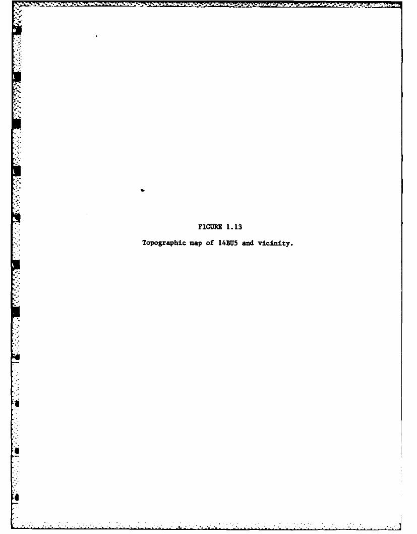
FIUE1. 13
Topographic map of 14BU5 and vicinity.
aI
o,
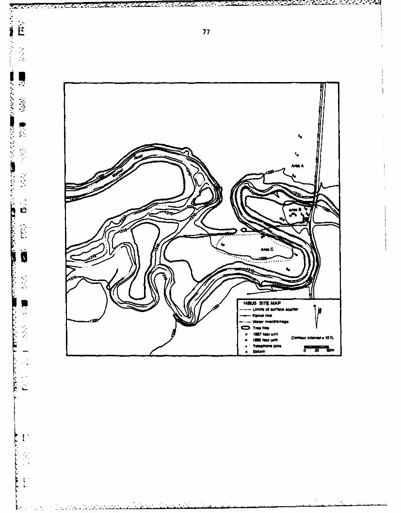
77
II0
-. ..- Wtw Ineldai in
A 1W tes AMA
* wotet n~ ~AM ~ f
41eehoe9t
35Otu
AM.
78
from which it was derived since all three areas of the site were thought to
represent the same cultural components. Based on the recovery of 14 artifacts,
including four ceramic sherds, the site was assigned both a Plains Woodland
and a Plains Village cultural component. The recommendation was made by Eoff
and Johnson (1968:42) that the site receive large scale excavation.
During the summer of 1968, Area B of 14BU5 was test excavated by personnel
from the Museum of Anthropology (Bastian 1979). Seven 2.0 by 2.0 meter test
pits were hand excavated within this area of the site. The test excavations
produced materials diagnostic of a Plains Woodland cultural affiliation. These
included a Scallorn projectile point and several ceramic sherds. The test
excavations carried ottin 1968 by Bastian (1979) also documented the presence
of an intact subplowzone deposit at the southwest portion of Area B. No infor-
mation regarding the cultural status of Areas A and C was recorded.
14BU5 was surface collected in 1975 by Fulmer (1977). A ceramid body
sherd was recovered but the area from which it was obtained was not recorded.
The sherd measures 2.1 cm in maximum dimension and is 1.0 cm thick. It is
tempered with angular quartzite particles with a maximum dimension of approxi-
mately 2.0 m. Fulmer (1977:71) recorded the interior surface as grey brown
and the exterior surface as red brown. Both surfaces of the sherd are smooth.
Also recovered by Fulmer (1977) in 1975 were 36 pieces of chipped stone ranging
in maximum dimension from 1.3 cm to 5.5 cm. One flake was noted to have been
utilized. Two fragments of unidentified bone, a piece of burned earth, and
a fragment of burned limestone complete the artifact inventory recovered
from 14BU5 in 1975.
The presence of an intact Woodland cultural component at 14BU5B and the
6 essentially unknown cultural affiliation and relationships of 14BUSA and
14BU5C, led to the decision to reinvestigate the site in 1980. The research
. "

* . 79
design submitted to the Tulsa District of the United States Army Corps of
* Engineers for Phase IV of the El Dorado Reservoir Project noted that Bastian's
5(1979) report had inadequately recorded the intact Woodland cultural deposit.The presence of the deposit was considered very significant because of the
current lack of knowledge of the Woodland cultural tradition within the project
area. The report submitted by Bastian (1979) also gave no data as to the
cultural status of Areas A and C.
14BU5A
The archaeological investigations at 14BU5A in 1980 began with a pedes-
trian surface reconnaissance of the wheat field in which the site was located
according to site survey records of the project area (Root 1978) and the
report of the 1968 test investigations (Bastian 1979). Due to the poor
surface visibility no artifacts were located on the surface of the site during
the initial survey. Shovel cuts were placed at 10 meter intervals along north-
south transects in an effort to locate the site boundaries but this strategy
proved to be largely unsuccessful because of extremely low artifact density.
The exact boundaries remain unknown. Three 1.0 by 1.0 meter test pits were
• 'placed 50 meters apart along a north-south baseline to determine the nature
. of the cultural deposit within the area of the site.
Test Pit 1 was placed in the center of the area of the field in which
Area A of the site was located according to the site survey records (Root 1978:4).
Test Pit 2 was placed 50 meters south of Test Pit 1 and Test Pit 3 was placed
50 meters north of Test Pit 1. All three units were excavated in arbitrary
10 cm. levels below the plowzone to a depth of 50 cm. below surface. The plow-
zone of all three units was removed as a single 20 cm. level. The stratigraphic
4 [profile of Test Pit 3 is illustrated in Figure 1.14. The profile of this unit
is very similar to that of a typical Verdigris Soil Series profile as described
°•
FIGUR .14
Stratigraphic profile of test pit 3, 14BU5A.
F
L.o_
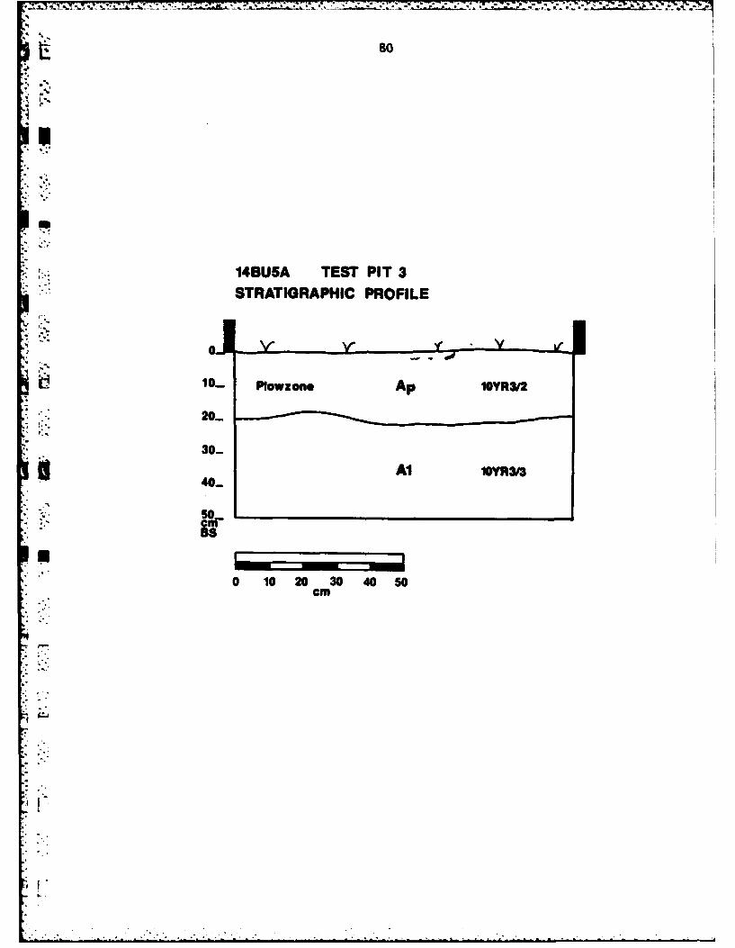
141314BU5A TEST PIT 3
08
.do
o-o-'"STRATIGRAPHIC PROFILE
Ii 10. Powzone Ap 10YR3/2
20-
30-
II40- l..Y~f
Bs
0 10 20 30 40 50cm
i o-
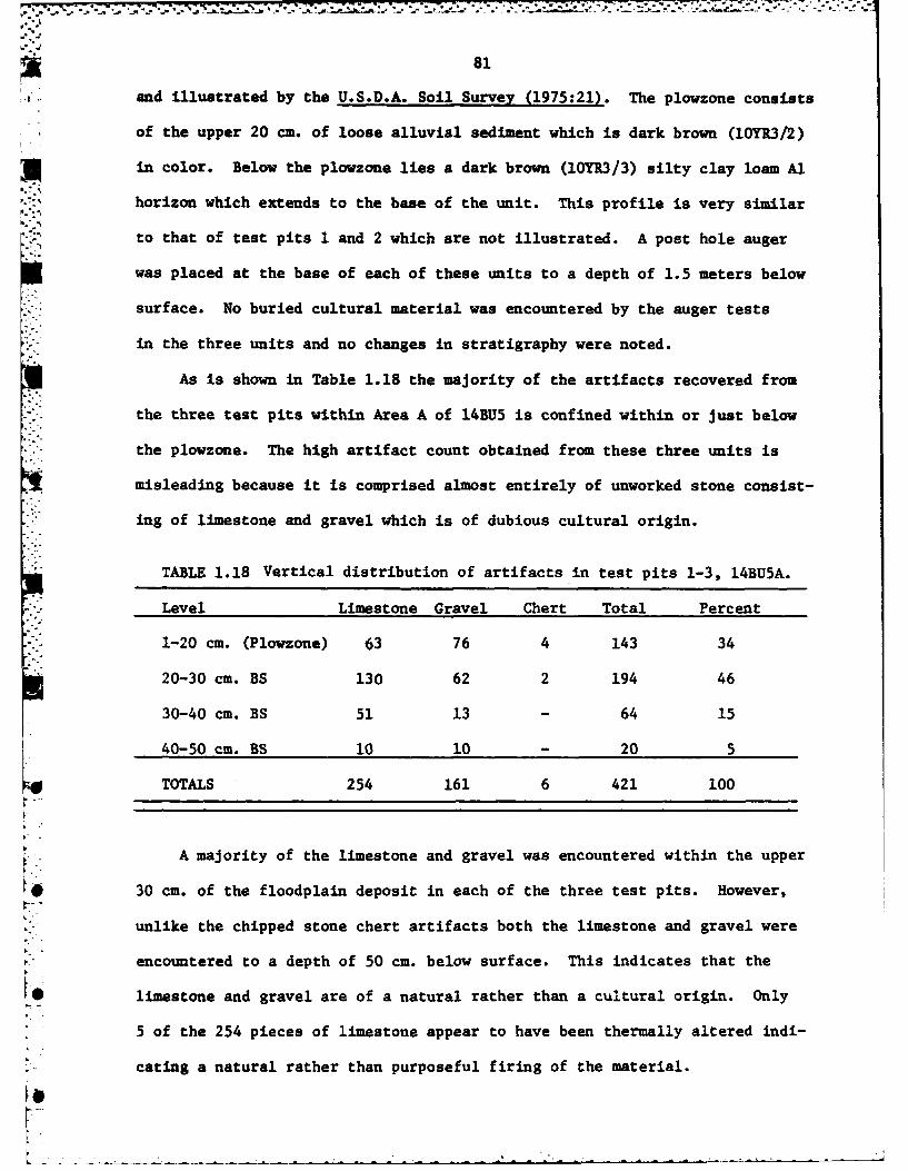
81
and illustrated by the U.S.D.A. Soil Survey (1975:21). The plowzone consists
, of the upper 20 ca. of loose alluvial sediment which is dark brown (10YR3/2)
U , in color. Below the plowzone lies a dark brown (10YR3/3) silty clay loam Al
horizon which extends to the base of the unit. This profile is very similar
to that of test pits 1 and 2 which are not illustrated. A post hole auger
was placed at the base of each of these units to a depth of 1.5 meters below
surface. No buried cultural material was encountered by the auger tests
in the three units and no changes in stratigraphy were noted.
As is shown in Table 1.18 the majority of the artifacts recovered from
the three test pits within Area A of 14BU5 is confined within or just below
the plowzone. The high artifact count obtained from these three units is
misleading because it is comprised almost entirely of unworked stone consist-
ing of limestone and gravel which is of dubious cultural origin.
TABLE 1.18 Vertical distribution of artifacts in test pits 1-3, 14BU5A.
Level Limestone Gravel Chert Total Percent
1-20 cm. (Plowzone) 63 76 4 143 34
20-30 cm. BS 130 62 2 194 46
30-40 cm. BS 51 13 - 64 15
40-50 cm. BS 10 10 - 20 5
TOTALS 254 161 6 421 100
A majority of the limestone and gravel was encountered within the upper
030 cm. of the floodplain deposit in each of the three test pits. However,
unlike the chipped stone chert artifacts both the limestone and gravel were
encountered to a depth of 50 cm. below surface. This indicates that the
10 limestone and gravel are of a natural rather than a cultural origin. Only
*5 of the 254 pieces of limestone appear to have been thermally altered indi-
cating a natural rather than purposeful firing of the material.
[ -_ . .. • -. .. - .__ _ _ _ ,*. ' - .. . . .°

82
Only 6 chipped stone artifacts manufactured from Florence A and Florence
B chert were recovered from the 3 test pits in Area A. These include one
decortication flake, 4 non-cortical chunks, and a single tested cobble (Table 1.19).
This sample size is too small to draw any meaningful conclusions about prehis-
toric activities at the site. However, it is possible to speculate that the
m initial processing of raw materials was an activity carried out at the site.
DISCUSSION
The 1980 test investigations at 14BUSA have demonstrated that the site is
confined within or just below the plowzone. Post hole auger tests have demon-
strated that no buried cultural deposit is present below the three test pits
to a depth of 1.5 meters below the surface. The only materialirecovered from
the site consisted of a large amount of unworked stone and 6 chipped stone
chert artifacts. The cultural affinity of area A of 14BU5 remains unknown
U .as does the relationship of Area A to Areas B and C of the site. The size of
the site can only be roughly estimated given the poor surface visibility and
sparse artifact density. The area of 14BU5A is approximately 1 hectare. No
further work is recommended at l4BU5A. The site will be innundated by the
conservation pool of the El Dorado Reservoir.
14BUSB
Area B of 14BU5 is located on a point bar which is enclosed by the meander
loop of Durechen Creek. Bastian (1979) placed seven test pits within this area
-j '- of the site which documented a subplowzone deposit at the southwestern portion
of Area B. The apr -wimatr 4cations of the seven test pits excavated in 1968
are illustrated in Figure 1.13.
Archaeological investigations at l4BU5B began with the cutting of the
dense vegetation which covered the site in 1980. This vegetation consisted
e.o

83
TABLE 1.19 Chert types and thermal alteration ofchipped stone teclrinoclasses, 14BU5A.
-, FLORENCE A FLORENCE B TOTAL
TECHNOCLASS NO NO NOHEAT HEAT HEAT HEAT HEAT HEAT
DECORTICATION - 1 - - - 1FLAKES
TOTAL 1 - 1
NONCORTICAL - 1 - 3 4CHUNKS
TOTAL 1 3 4
TESTEDCOBBLES
TOTAL - 1 1
TOTALS - 2 - 4 - 6
TOTAL 2 4 6
4""
0

[ 84
of 8 foot high weeds and saplings which completely obscured the surface of
the site. Even after this vegetation was removed surface visibility was near
*zero.
A mechanical post hole auger was used within this area of the site to
attempt to locate areas where artifact density was greatest and also to
- define the areas of the subplowzone cultural deposit recorded by Bastian
(1979). The auger holes were placed at 10 meter intervals along the east-
west and north-south baselines of the site grid. The diameter of the mechani-
cal post hole auger was 35 cm. and the post holes were taken to a depth of
50 cm. below surface. Results of the auger tests indicated that very little
of the cultural deposit remained undisturbed. This area was recorded by
Bastian (1979) as the southwest portion of Area B.
Five 1.0 by 1.0 meter test pits were placed within Area B of 14BUS
during the 1980 field season. The location of these test pits is illustra-
* ted in Figure 13. Test Pit 8 is located in the southwest portion of the site
" in the area where Bastian (1979) recorded discovering the intact subplowzone
* deposit. This test unit was dug in arbitrary 10 cm. vertical levels below
the plowzone to a depth of 50 cm. below surface. The plowzone was removed
as a single 20 cm. level. As can be seen in Table 1.20 the majority of
material recovered from this unit is confined within or just below the plow-
zone. The single chert flake located at 40-50 cm. below the surface was the
only definate cultural evidence that the site extended below 30 cm. from the
surface. The presence of 5 small pieces of limestone which have a combined
weight of 13.5 grams are the only other indications of a buried cultural
component below the plowzone. The gravel recovered from the unit is probably
of natural rather than cultural origin since it occurs throughout Area B.
The lower levels of this unit could not be screened due to the saturated
state of the soil at the time of the excavation. The backdirt from each of
-I

85
the lower three levels below the plowzone was inspected by hand for artifacts.
This procedure undoubtedly has biased the artifact count given in Table 1.20.
Test Pit 8 is located within Verdigris soil and the vertical profile of the
unit does not significantly differ from the typical Verdigris Soil Series
profile described and illustrated by the Butler County Soil Survey (U.S.D.A.:
1975:21).
Test Pit 9 was placed 45 meters to the northeast of Test Pit 8 on a diag-
onal across the field. It is located at the center of Area B of 14BU5 where
the auger tests indicated an increased density of cultural material. During
the excavation of Test Pit 9 a concentration of burned limestone was encountered
just below the plowzone at the eastern edge of the unit. In order to better
define this limestone concentration an additional test unit, designated Test
Pit 11, was opened adjacent to the east wall of Test Pit 9. It was found
* ithat the limestone concentration continued in Test Pit 11 and was even more
dense than in Test Pit 9. This concentration of limestone encountered in
Test Pit 11 was designated Feature 1. Figure 1.15 illustrates how this feature
appeared at 25 cm. below surface. The hard spot in the center of the illus-
tration was apparently baked out by thermal activities, apparently associated
with the function of the feature. Figure 1.16 is a schematic plan view of
the feature as it appeared between 30 and 35 cm. below the surface of the
Durechen Creek floodplain. The baked area visible in Figure 1.15 continued
down to this level. Only two small charcoal samples were recovered from the
feature. These were obtained from between 30 to 35 cm. below the surface
and were in direct association with the feature. These two samples were
sent to the University of Georgia for radio-carbon analysis. Unfortunately,
both of the samples were of insufficient mass to be run individually and
they had to be combined to obtain even a single date.
*6

-. . . . . . . - -
86
TABLE 1.20 Vertical distribution of artifacts in test pit 8. 14BU5B.
Level Limestone Chert Gravel Total
0-20 cm (Plowzone) 37 25 13 75
20-30 cm. 1 2 2 5
30-40 cm. 1 0 1 2
W 40-50 cm. 3 1 0 4
TOTAL 42 28 16 86
TABLE 1.21 Vertical distribution of artifacts in test pits 9 and 11-, 14BU5B.
Level Limestone Chert Gravel Total
0-20 cm. (Plowzone) 40 15 103 158
20-30 cm. 72 7 7 86
30-40 cm 68 5 1 74
40-50 cm. 115 0 0 115
TOTAL 295 27 il 433
TABLE 1.22 Vertical distribution of artifacts in test pits 10 and 12. 14BU5B.
Level Limestone Chert Gravel Total
. 0-20 cm. (Plowzone) 5 3 32 40
20-30 cm. 4 4 15 23
30-40 cm. 5 0 12 17
40-50 cm. 0 0 2 2
TOTAL 14 7 61 82
4I ;
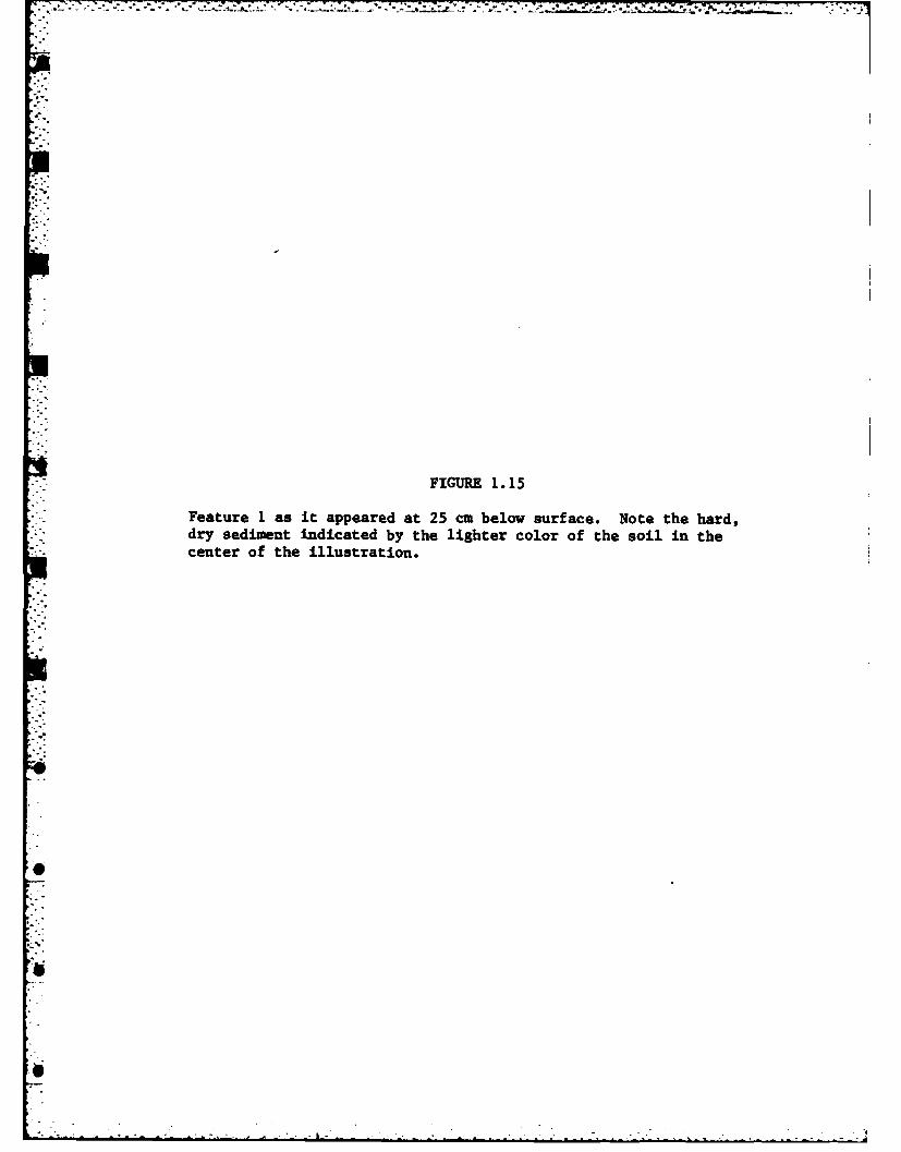
• - '. • - - , - . . . * - . - " * . , r-v- r 7 *-j , ' ?
FIGURE 1.15
Feature 1 as it appeared at 25 cm below surface. Note the hard,dry sediment indicated by the lighter color of the soil in thecenter of the illustration.
0*.°
0'
0F

S* ' I _ j , n . a .. .... I-t. I .. a [ | . .
-. --- - ~ ~ --- S to - ---- S
-. a. .. t
,,p .
-
t
-. J

FIGURE 1.16
Plan view of Feature I as it appeared between 30 and 35 cmbelow surface.

143U58BLA VIEW OF FEATURE.I
- TEST PIT 11 30-35cmS
00 0
0 0o0
V. 0
0 .0
N 576 0)E656
0 10 20 30 40 50Ncm
SHard, Dry Sediment
o Limestoneo Burned son@
*Chart Flake

89
The radio-carbon date obtained from the combined charcoal samples
recovered from within Feature 1 (UGa #3947) proved to be modern. Given the
context of the samples and the depth below surface from which they were ob-
tained it is probable that they were contaminated and the modern date is in
error. If this feature were modern in date historic artifacts would have
been expected. No historic artifacts were recovered from either Test Pit
9 or 11.
Feature 1 most likely represents the remains of a roasting pit rather
than a hearth. The presence of a large amount of burned limestone and the
relatively small amount of burned earth and charcoal indicates that direct,
in situ, combustion did not take place within the feature. Rather the lime-
stone was probably heated first and then placed in a shallow depression re-
presented by Feature 1. Presumably this was done to roast food. Of the 183
pieces. (743.6 grams) of limestone recovered from Feature 1, 47 percent by
weight (352.0 grams) were thermally altered. If these manuports were direct-
ly fired within the feature much more charcoal and burned earth would be
expected than was recovered.
The vertical distribution of artifacts within Test Pits 9 and 11 is
given in Table 1.21. This distribution clearly demonstrates the presence of
the intact subplowzone deposit recorded by Bastian (1979). The 183 pieces of
limestone recovered between 30 and 50 cm. below the ground surface are the
manuports recovered from Feature 1. Four small chert chips, all of which
are less than 2 cm. in maximum dimension, were directly associated with the
feature. A chert chunk was also located with chert chips between 30 and 40
.* cm. below the surface. The subplowzone deposit probably extends to approxi-
mately 40 cm. below the surface in most of the southwest portion of the site.
The gravel recovered from Test Pits 9 and 11 was confined almost exclusively
* to the plowzone. It was most likely washed into the site during periods of

90
flooding.
The vertical profile of Test Pits 9 and 11 is illustrated in Figure 1.17.
*The upper 15 to 20 ca. of these units consists of the plouzone, a loose allu-
vial sediment which is dark grayish brown (10YR4/2) in color. It is under-.%lain by a silty clay loam All horizon that extends to 40 ca. below surface
.. and is dark grey (lOYRA/1) in color. The All horizon is underlain by an
A12 horizon which consists of a dark brown (10YR4/3) silty clay loam.
*~ i Test pits 10 and 12 were placed at the eastern margin of 14BU53 in an
.* -attempt to define the horizontal boundaries of the cultural conpout. Both
of these units were excavated in arbitrary 10 ca. vertical levels below the7-J
* - plowzone to a depth of 50 ca. The plowzone was removed as a single 20 ca.
level in both units. The vertical distribution of artifacts for both of
these units is given in Table 1.22. From this table it can be seen that
*the majority of material at the eastern portion of Area B is confined within
or just below the plowzone. The vertical profile of these units is very sim-
ilar to that illustrated in Figure 1.17. Post hole augers placed at the base
of these units to a depth of 1.5 meters below surface indicate that no buried
cultural deposits exist to that level.
-DISCUSSION
The test investigations at 14BU5B during the 1980 field season consisted
-of the placement of 5 additional 1.0 by 1.0 meter test pits. These test pits
- have reaffirmed the presence of the intact subplowzone cultural deposit which
was first recorded in 1968 by Bastian (1979). The deposit is confined to the
Swestern portion of Area B and extends only to about 40 cm. below the present
ground surface. The majority of rhe site is confined within the plowzone or
upper 20 cm. The presence of a limestone feature, presumably a roasting pit,
9

FIGURE 1.17
Stratigraphic profile of test pits 9 and 11, 14BU5B.
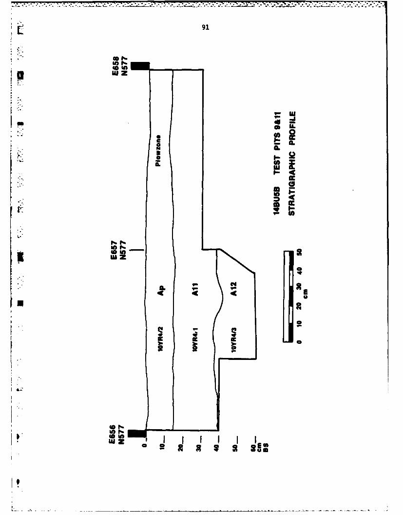
91
w z
C ~CCSA
w z
_ CQ
*u 0
a 0
*61 X I S I

'-7- 77 77 "V . t .i-----. -.-
92
offered the opportunity to radio-carbon date the aubplowzone Woodland deposit.
"f" Unfortunately, the date obtained from the two charcoal samples removed from
the feature proved too modern. The boundaries of the site are fairly well
established by the meander loop of Durechan Creek. The surface area of 14BU5B
is estimated to be approximately 1 hectare. The area of the subplowzone cul-
tural deposit is estimated to be only .25 hectares and is confined to the
. southwest portion of the site.
ARTIFACT ANALYSIS
No diagnostic artifacts were recovered from l4BU5B during the 1980 test
investigations. The total sample of artifacts included 351 pieces of limestone
weighing 1.5 KS, 67 pieces of chipped stone, 2 fragments of unidentifiable
*burned bone, 2 small samples of charcoal and 14 pieces of burned earth. No
ceramic material or floral remains were recovered from Area B in 1980.
Table 1.23 lists the chert types and the presence or absence of thermal
alteration for the 67 pieces of chipped stone recovered from Area B in 1980.
Florence A and Florence B chert types were the most often utilized at the site.
Of these Florence A was three times as likely to be heat treated as was
Florence B; indicating that this chert type required heat treatment to render
it suitable for tool manufacture. Only 6 elements of Flint Hills Light GreyI
Chert were recovered from Area B of 14BU5. A single element of an unknown
chert type completes the inventory recovered from 14BU5B in 1980.
The technoclasses represented by these chert types are given in Table 1.23.
I -These include cortical chunks, intermediate flakes, noncortical chunks, bifacial
trimming flakes and shaped tools. Combined, the technoclasses of intermediate
flakes and non-cortical chunks represent 80 percent of the total sample. These
elements, together with the 6 bifacial trimming flakes indicate that tool
manufacture and maintanence was an important activity at the site.
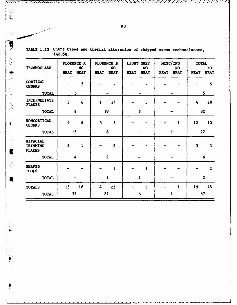
*' .. .- a - - '--'-. .. + +aS," T
." .'+ ,-o ++ .' , . ... .' . . , + ,, +. , +,. 0 . . , . . , . .. ,' ' r . . + ++ +
93
TABLE 1.23 Chert types and thermal alteration of chipped stone technoclasses,14BU5B.
FLORENCE A FLORENCE B LIGHT GREY MISC/IND TOTAL
TECHNOCLASS NO NO NO NO NO1 HEAT HEAT HEAT HEAT HEAT HEAT HEAT HEAT HEAT HEAT
CORTICAL 5 5
CHUNKS
TOTAL 5 - 5INTERMEDIATE 3 6 1 17 - 5 4 28
;- FLAKES
TOTAL 9 18 5 32
NONCORTICAL 9 6 3 3 1 12 10
TOTAL 15 6 1 22
BIFACIALTRIMMING 3 1 - 2 3 3
K FLAKESTOTAL 4 2 6
S SHAPED12SHPD- - - 1 - 1. - - - 2TOOLS
* TOTAL - 1 1 2
TOTALS 15 18 4 23 - 6 - 1 19 48
TOTAL 33 27 6 1 67
II-

94
The only two shaped tools recovered from Area B in 1980 consist of a
scraper fashioned from Flint Hills Light Grey chert and a retouched flake
of Florence B chert. Neither of these tools are illustrated. The scraper
measures 24 -. in maximum length, 26 m. in maximum width, is 7 mm. thick
and weighs 3.1 grams. The tool is steeply retouched at the distal end and
the working edge has an edge angle of 78 degrees. This edge angle is within
the range that Wilmsen (1979:71) postulated was suitable for bone working,
woodworking, and heavy shredding. The tool was recovered from the plowzone
of Test Pit 8.
The retouched flake of Florence B chert was recovered from the plowzone
of Test Pit 11. It measures 26 mm. in maximum length, 14 m. in maximum width
and is 4 -mm. thick. Only one lateral margin of the flake is steeply retouched.
It has an average edge angle of 68 degrees which is suitable for a wide
variety of cutting and scraping activities. The distal portion of the flake
converges to a sharp point which could have been used as a graver. The flake
weighs 1.2 grams.
A Scallorn projectile point which was recovered from Area B in 1968 and
is illustrated by Bastian (1979) indicates that hunting activities were
carried out from the site. The recovery of ceramics from Area B in 1968, com-
bined with the presence of the roasting pit excavated in 1980, indicate that
cooking and perhaps storage of food were activities carried out at the site
as well. Bastian (1979:48) recorded the presence of a post mold which may
have represented the presence of a structure at the site.
The results of the artifact analyses indicate that a number of activi-
ties took place at the site. Tool manufacture and maintenance are indicated
by the presence of a large number of intermediate elements in 1980 as well
as by the 6 bifacial trimming flakes. Heat treatment of chert probably took
0
95
place at the site as well since none of the 5 cortical chunks recovered in
* 1980 are heat treated and heat treated specimens of intermediate flakes,
non-cortical chunks and bifacial trimming flakes were recovered from the site.
This indicates that heat treatment was applied only after the chert was
selected and initially reduced for tool manufacture.
Bastian recovered 2 cores, 2 bifaces, 3 utilized flakes and one scraper
from Area B of 14BU5 in 1968. These tools would have been suitable for wood-
working, hidescraping, butchering and other food processing activities which
were most likely carried out at the site.
DISCUSSION
As already noted Bastian (1979) recovered ceramic material from the site.
He also excavated a post mold which provides limited evidence that a prehis-
toric structure existed at the site. Thus it is inferred that 14BU5B was
relatively permanently, but perhaps seasonally, occupied since it would have
been susceptible to spring and early summer flooding. The site was probably
*occupied in the late summer, fall, or winter when the mast resources of the
gallery forests would have made it an attractive habitation site.
Further archaeological work of a limited nature is recommended for Area
B of 14BU5. The intact Woodland cultural deposit recorded by Bastian (1979)
*[ and documented in 1980 should be further investigated with the use of heavy
machinery. The plowzone of the western half of Area B should be stripped
off to expose any features which may be present. This work was originally
planned for 1980, but the saturated state of the soil made it impossible to
get heavy machinery into the field before the field -eason ended. The site
will be completely innundated by the conservation pool of the proposed El
Dorado Lake and the opportunity to perform this work is limited.

S.. 96
14BU5C
PHYSICAL SETTING
Area C of 14BU5 is located nearest to the confluence of Durechen Creek
, and the Walnut River (Figure 1.13). It is situated on a slight rise or ridge
in the floodplain which is shared by Durechen Creek and the Walnut River.
At the time of the 1980 investigations the site was in wheat stubble and
surface visibility was poor, ranging between 25 and 50 percent. A pedestrian
reconnaissance of the surface of the area led to the mapping of the boundaries
of the surface scatter. The perimeter or boundaries of this scatter of lithic
debris, illustrated in Figure 1.13, is a good approximation of the site's
boundaries.
A total of 5 1.0 by 1.0 meter test pits were placed within or adjacent
to the boundaries of this scatter of artifacts in an attempt to detei-ine the
horizontal and vertical extent of the site.
Test Pits 1 and 2 were placed outside the western edge of surface scatter.
Both of the units were excavated in arbitrary 10 cm. vertical levels below the
plowzone to a depth of 40 cm. below the surface of the Durechen Creek flood-
plain. The plowzone was removed as a single 20 cm. unit. The vertical dis-
tribution of artifacts within Test Pits 1 and 2 is given in Table 1.24. The
only material recovered from these units consisted of limestone and gravel of
dubious cultural origin. No chipped stone artifacts were recovered from either
of these two Test Pits. Thus the units are outside of the site boundaries
and provide supportive evidence that the surface scatter represents the limits
of the site.
Test Pit 3 was placed at the eastern edge of Area C at the top of the
ridge on the floodplain. The unit was placed in an area where several tools
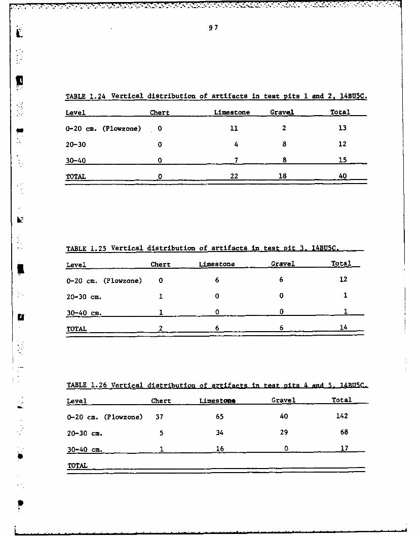
9 7
TABLE 1.24 Vertical distribution of artifacts in test pits 1 and 2. 14BU5C.
Level Chert Limestone Gravel Total
- 0-20 cm. (Plowzone) 0 11 2 13
20-30 0 4 8 12
30-40 0 7 8 15
TOTAL 0 22 18 40
TABLE 1.25 Vertical distribution of artifacts in test pit 3. 14BU5C.
Level Chert Limestone Gravel Total
0-20 cm. (Plowzone) 0 6 6 12
20-30 cm. 1 0 0 1
u 30-40 cm. 1 0 0 1
TOTAL 2 6 6 14
TABLE 1.26 Vertical distribution of artifacts in test Dits 4 gnd 5- 1LRITSTC
Level Chert Limestone Gravel Total
0-20 cm. (Plowzone) 37 65 40 142
20-30 cm. 5 34 29 68
30-40 cm. 1 16 0 17
TOTAL

r7?
98
were located on the surface of the site. The Test Pit was excavated in
arbitrary 10 cm. levels below the plowzone to a depth of 40 cm. below surface.
The plowzone was removed as a single 20 cm level. The vertical distribution
of artifacts within this unit is given in Table 1.25. The majority of the
material recovered from the unit consisted of limestone and gravel which
were confined to the plowzone. The only chipped stone elements recovered
" . from Test Pit 3 are two small chert chips which measure less than 2 cm. in
maximum dimension. These two chips were recovered from between 20 and 40 cm.
below the surface. Their small size and the absence of any other cultural
material within these two levels indicates that the chert chips migrated
downward by natural processes.
Test Pits 4 and 5 are contiguous units. They were placed at the north
central portion of Area C adjacent to the southern bank of Durechen Creek.
The units were excavated in arbitrary 10 cm. vertical levels below the plow-
zone to a depth of 40 cm. below surface. The plowzone was removed as a
single 20 cm. level. The vertical distribution of artifacts within Test Pits
4 and 5 is given in Table 1.26. The majority of the artifacts recovered from
these two units are confined within the plowzone which extends down as far as
30 cm. This downward extension of the plowzone is illustrated in the strati-I
graphic profile of Test Pits 4 and 5 presented in Figure 1.18. The upper 20
to 30 cm., or plowzone, consists of a loose alluvial sediment which is dark
greyish brown (10YR4/2) in color. The plowzone is underlain by a silty clayIloam All horizon which is dark brown (lOYR4/3) in color and extends to the
base of the unit. A post hole auger test was made at the base of test pit 4
to a depth of 1.5 meters below surface. No evidence of a buried cultural
component was encountered by the auger test.
S|
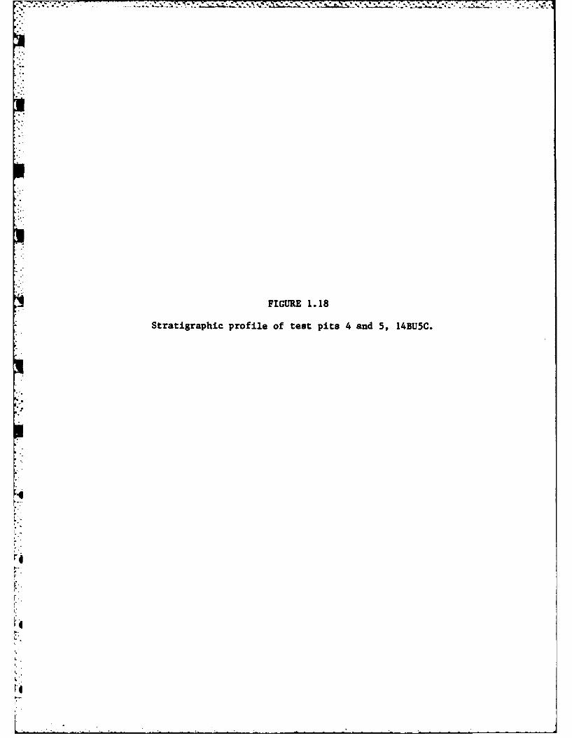
FIGURE 1. 18
Stratigraphic profile of test pits 4 and 5, L4BU5C.
I.

99
C04I Iz 4
0
CI 0

100
The stratigraphic profile of Test Pits 4 and 5 which is illustrated
in Figure 1.18 is representative of the stratigraphy recorded in the other
3 test pits placed in Area C in 1980. These profiles correspond closely to
the typical Verdigr1 Soil Series profile illustrated and described by the
U.S.D.A. (1975:21).
DISCUSSION
The test excavations within Area C of 14BU5 have demonstrated that the
site is primarily confined to the plowzone and has been disturbed by modern
- and historic farming practices. Even though the farming activities have
most likely extended the perimeter of the surface scatter beyond the actual
site boundaries as they existed in prehistory the perimeter of the surface
scatter, illustrated in Figure 1.13, provides a good estimate of the areal
extent of the site. The area contained within this perimeter is approximately
1 hectare.
ARTIFACT ANALYSIS
The large amount of unworked stone recovered from the 5 test pits con-
sists of limestone and gravel. The gravel is probably not of cultural origin
since it occured throughout Test Pits 1 and 2 which were devoid of cultural
material.
The limestone recovered from the site consists of 143 pieces weighing
337.2 grams. Only 35 pieces, weighing 123.5 grams, of the limestone appear
to have been heat treated. All of the heat treated limestone was encountered
in Test Pits 4 and 5. The fact that these units also produced the greatest
number of chipped stone artifacts indicates that the limestone was intention-
ally fired.

101
STable 1.27 lists the chert types as well as the presence or absence of
5 thermal alteration for the 49 chipped stone artifacts recovered from both
the surface and the 5 Test Pits within Area C of 14BU5. Florence A chert is
-. the numerically dominant chert type at 14BU5C. It is represented in the sample
twice as often as Florence B which is the next most prevalent chert type rep-
resented at 14BU5C.
Both the Florence A and Florence B chert types are represented by the
technoclasses of intermediate flakes, non-cortical chunks, bifacial trimming
". flakes and shaped tools. Only Florence A chert is represented by the techno-
class of cortical chunks and only Florence B chert is represented by the techno-
classes of decortication flakes and cores. The remaining chert type found at
14BU5C is Flint Hills Light Grey chert which is represented by a single non-
cortical chunk.
K The only evidence of the initial reduction of raw materials at 14BU5C
• iconsists of 5 cortical chunks and two decortication flakes. These seven
elements comprise 14 percent of the total sample recovered in 1980.
*The single core recovered in 1980 in conjunction with the 17 intermediate
flakes and 10 non-cortical chunks demonstrates that flake production was an
important activity at Area C. These elements combined represent 57 percent
of the total sample of chipped stone artifacts recovered from 14BU5C in 1980.
The nine shaped tools and five bifacial trimming flakes recovered from
Area C indicate that the manufacture and maintenance of chipped stone tools
was also an important activity undertaken in this area of the site. These
elements represent 29 percent of the total sample recovered from Area C.
Thus it appears that, with the exception of tested cobbles, all stages
of lithic procurement and manufacture took place at Area C of 14BU5. The
p

102
TABLE 1.27 Chart types and thermal alteration of chipped stonetechnoclasses,_14BU5C.___ ____ ______
FLORENCE A FLORENCE B LIGHT GREY TOTALTECHNOCLASS NO NO NO NO
HEAT BEAT HEAT HEAT HEAT HEAT HEAT HEAT
CORES- -- 1- -- 1
TOTAL1-
CORTICAL 3 2 - -- -3 2CHUNKS
* TOTAL 5 -- 5
DECORTICATION- -- 2- -- 2FLAKES22
TOTAL 2 -2
INTERMEDIATE6 32 6- -8 9FLAKES6 32 68 9
TOTAL 9 8 17
NONCORTICAL5 3- 1- 15 5CHUNKS5 35 5
TOTAL 8 11..0
BIFACIALTRIMMING 2 2 1 2 3FLAKES
TOTAL 4 1 -5
SSHAPEDTOOLS 3 3 1 2 4 5
TOTAL 6 3 -9
TOTALS 19 13 3 13 - 1 22 27
TOTAL 32 16 1 49
4 __ _ _ _ _ _ _ _ _ _ _ _ _ _ _ __ _ _ _ _ _ _ _ _ _ _ _ _ _
o:TBE126hr ye n hra lealno hpe tn
• eholsss 4UC
10 3
initial reduction of raw material is represented by the decortication flakes
and cortical chunks. The large number of intermediate elements and the single
core indicate that flake production also took place within this area of the
site. The presence of shaped tools and bifacial trimming flakes document that
the tools were manufactured and maintained as well.0
Of the 21 elements recovered from Area C of 14BUS which were heat treated
19 of them are of Florence A chert and the remaining 3 are of Florence B chert.
This difference in the heat treatment of the two chert types indicates that
while Florence A was the preferred chert type it often required heat treatment
to render it suitable for prehistoric tool manufacture. It appears that
Florence A chert was heated during the initial stages of tool production as
indicated by the presence of heat treated cortical chunks of this material.
Florence B, on the other hand, appears to have been heat treated only after
3 it was selected for tool use. The only technoclasses which are heat treated
within this chert type are intermediate flakes and shaped tools.
The shaped tools recovered from 14BU5C in 1980 consist of one projectile
*point, 2 biface fragments, and 6 retouched flakes.
The small projectile point was recovered from the plowzone of Test Pit 4.
This specimen, illustrated in Figures 1.19A and 1.19B, is essentially identical
-- in size and shape to the Scallorn projectile point recovered from Area B of
14BU5 in 1968 (Bastian 1979:51). The Scallorn point recovered from Area C
" in 1980 was manufactured from heat treated Florence A chert. It measures
23.0 mm. in maximum length. The width of the blade at the shoulders of the
- specimen is 10.0 mm. The stem of the point is 4.0 mm. long. The stem is
4.0 mm. wide at the notches and 7.0 mm. wide at the base. The maximum thick-
ness of the point is 3.0 mm. and it weighs 0.4 grams. Criteria developed by

FIGURE 1.19
Shaped tools recovered from 14BU5C: (A,B) opposite lateral viewsof a Scallorn point; (C, E) biface fragments.

104
a b
0 mm 30

* . .
10 5
Thomas (1978) and Fenenga (1953) classify both of the Scallorn points
recovered from Areas B and C as arrow points rather than atlatl dart
points. Thus it can be concluded that the prehistoric inhabitants of
Areas B and C of 14BU5 utilized the bow and arrow for hunting and defense.
The Scallorn point recovered from 14BU5C is the only diagnostic artifact
recovered from this area of the site. The presence of this specimen enables
the component at 14BU5C to be tentatively assigned to the Woodland cultural
tradition. It also promotes the speculation that Area C and Area B were
occupied at the same time or by the same group of people.
The two biface fragments recovered from Area C in 1980 were found on
the surface of the site near Test Pit 3. These two specimens were manufac-
tured from Florence A chert and are illustrated in Figures 1.19C and 1.19D.
The larger of the two biface fragments is a proximal fragment which exhibits
cortex on what apparently is the dorsal surface. The cortex is visible in
Figure 1.19C, indicating that the tool was manufactured from a relatively
unaltered piece of raw material and was not completely flaked during manu-
facture. It is possible that the tool broke during manufacture and was
discarded as an incomplete fragment. However, the retouch which is present
along the lateral margins of this tool indicates that it was resharpened
S0 and probably broken during use. This proximal biface fragment measures
73.0 mm in maximum length, 51.0 mm in maximum width, 24.0 M in maximum
thickness and weighs 124.5 grams. The edge angles of the lateral margins
* average 65 degrees.
The second biface fragment recovered from Area C is a medial fragment
which is illustrated in Figure 1.19D. This specimen is completely flaked
on both sides and measures 32.0 mm in maximum length, 21.0 mm in maximum

106
width, and 11.0 m in maximum thickness. It weighs 9.3 grams. The edge
angles of the lateral margins of this tool average 60 degrees, which places
it, along with the larger proximal biface fragment discussed above, within
the range of edge angles postulated by Wilmsen (1970:71) to have functioned
as heavy cutting implements suitable for a variety of tasks.
The six retouched flakes recovered from Area C of 14BU5 complete the
tool inventory. These tools range in maximum dimension from 2.7 to 4.2 cm
* and exhibit retouch on their lateral or transverse margins. They can be
separated into two functional classes based on the criteria of working edge
angle, working edge shape and working edge placement. Of the six retouched
flakes recovered from Area C, four are classified as scrapers while two are
classified as cutting tools.
SUMMARY
I The analysis of the chipped stone assemblage recovered from Area C
of 14BU5 in 1980 indicates that while all stages of lithic reduction were
performed at the site, flake production was the predominant activity. The
presence of a Scallorn projectile point indicates that the bow and arrow
were utilized by the prehistoric inhabitants and that hunting activities
were carried out from this area of the site. The presence of a small number
of bifacial trimming flakes and the two biface fragments demonstrate that
toolmanufacture and maintenance were also performed at the site. The edge
angles of the bifacial tools and retouched flakes indicate that hide scraping,
boneworking, woodworking, and other processing and maintenance activities
were probably carried out at this area of the site as well.
The test excavations conducted at Area C of 14BU5 have demonstrated
that the cultural component is confined to within or just below the plowzone.

o-o. 107
As such, the component has been disturbed by historic and modern agricul-
tural activities. The cultural component of Area C of 14BU5 has been
assigned to the Woodland cultural tradition on the basis of a single Scallarn
projectile point. The recovery of a Scallorn point from Area B in 1968
raises the possibility that these two areas of 14BU5 were occupied by the
same group of people.
Area C will be completely innundated by the conservation pool of
El Dorado Lake. Given the low artifact density encountered on the surface
". of the site and the shallow depth of the deposit, no further work is recom-
* mended at Area C of 14BU5.
0
0
S

108
" ACKNOWLEDGEMENTS
I would like to acknowledge the help and support I recieved in pre-
paring this report from the personnel of the Museum of Anthropology at the
University of Kansas. Dr. Alfred Johnson and Dr. Paul S. Brockington
supervised the writing of this report and to them I extend my gratitude.
Without the capable efforts of Judy Muck, John Eads and Jerry Wagner the
* field work could not have been completed. They proved to be a very compe-
tent and uncomplaining crew under the adverse conditions of an extremely
hot Kansas summer. The unselfish contribution of time and energy provided
by Mary J. Adair, both during the fieldwork and laboratory analysis, is
&- most gratefully acknowledged. She also photographed and printed the artifact
illustrations used in the report. I would also like to extend my gratitude
to the secretarial staff of the Museum of Anthropology, particularly Kathy
Pate and Judy Forbes for typing the draft of the report. It is emphasized
however, that I alone am responsible for any errors contained within the
corpus of this work.
U
9

109
REFERENCES CITED
Adair, Mary J. and Marie E. Brown1981 The Two Deer Site (14BU55: A Plains Woodland-Plains Village Tram-
sition. In, Prehistory and History of the El Dorado Lake Area,Kansas (Phase II), M. J. Adair (Editor). University of Kansas.Museum of Anthropology, Project Report Series, Number 47. Lawrence.
Ahler, S. A. and R. B. McMilliam1976 Material Culture at Rodgers Shelter: A Reflection of Past Human
Activities. In, Prehistoric Man and His Environments: A Case'" Study in the Ozark Highlands, pp. 163-201, W. R. Wood and R. B.
McMillian (Editors). New York, Academic Press.
Artz, Joe Alan1981 Test Excavations at El Dorado Lake, 1978. In, Prehistory and
History of the El Dorado Lake Area, Kansas (Phase 11), M. J.Adair (Editor), pp. 54-165. University of Kansas, Museum ofAnthropology, Project Report Series, Number 47. Lawrence.
Bastian, Tyler1979 Archaeological Investigations in the El Dorado Lake Area, Kansas
(1968). Report submitted to U.S. Department of Interior, HeritageConservation and Recreation Service, Interagency ArcheologicalServices. Denver, Colorado.
Crabtree, D. E.1972 An Introduction to Flint Working. In, Occasional Papers of the
Idaho State University Museum, No. 38. Pocatello, Idaho.
Crabtree, D. E. and B. R. Butler1964 Notes on Experiments in Flint Knapping I: Heat Treatments of
Silica Minerals. Tebiwa 7:1-7.
Drew, Darrell1981 Late Quaternary History and Paleogeography of the El Dorado Lake
Area, Kansas: Second Report. In, Prehistory and History of theEl Dorado Lake Area, Kansas (Phase II), M. J. Adair (Editor), pp.1-41. University of Kansas, Museum of Anthropology, Project ReportSeries, Number 47. Lawrence.
Eoff, J. D. and A. E. Johnson1968 An Archaeological Survey of the El Dorado Reservoir Area, South
Central Kansas. National Park Service, Midwest Region. Lincoln,Nebraska.
Farley, J. A. and J. D. Keyser1979 Little Caney River Prehistory: 1977 Field Season. University of
4Tulsa Press, Tulsa, Oklahoma.
Fenenga, Frank1953 The Weights of Chipped Stone Points: A Clue to Their Function.
Southwestern Journal of Anthropology, Vol. 9:309-323.
11.0
Fulmer, D. W.1976 Archaeological Excavations Within the El Dorado Reservoir Area,
Kansas, 1974. Department of the Interior, National Park Service,.3 Interagency Archeological Services, Office of Archeological and
Historic Preservation. Denver, Colorado.
1977 Archaeological Investigations Within the El Dorado Reservoir Area,
Kansas, 1975. Department of the Interior, National Park Service,Interagency Archeological Services, Office of Archeological and
PW Historic Preservation. Denver, Colorado.
Grosser, R. D.
1970 The Snyder Site: An Archaic-Woodland Occupation in South CentralKansas. M.A. Thesis, Department of Anthropology, University of
- Kansas. Lawrence, Kansas.
1973 A Tentative Cultural Sequence for the Snyder Site, Kansas. Plains*. Anthropologist, 18(61):228-38.
1977 Late Archaic Subsistence Patterns from the Central Great Plains:*. A Systemic Model. Ph.D. Dissertation, Department of Anthropology,
University of Kansas. Lawrence, Kansas.
Haury, C. E.1981 Chert Types and Terminology for the Upper Walnut River Drainage.
In, Prehistory and History of the El Dorado Lake Area, Kansas(Phase II), M. J. Adair (Editor), pp. 45-530. University ofKansas, Museum of Anthropology, Project Report Series, Number 47.Lawrence.
Leaf, G. R.1976 An Archaeological Research Design and Salvage Mitigation Plan for
the El Dorado Reservoir, Butler County, Kansas. Department of the3Interior, National Park Service, Interagency Archeological Ser-
vices, Office of Archeological and Historic Preservation. Denver,Colorado.
1979 Finding, Managing, and Studying Cultural Resources at El Dorado
Lake, Kansas (Phase I), Gary R. Leaf (Editor). University ofKansas, Museum of Anthropology, Research Series, No. 2. Lawrence.
1981 Woodland Occupation of the Snyder Site (14BU9). In, Prehistoryand History of the El Dorado Lake Area, Kansas (Phase II), M. J.Adair (Editor), pp. 165-239. University of Kansas, Museum ofAnthropology, Project Report Series, Number 47. Lawrence.
Root, M. J.1978 Background Data for Finding, Managing, and Studying Prehistoric
Cultural Resources at El Dorado Lake, Kansas. MS, submitted tothe U.S. Army Corps of Engineers, Tulsa District.
111
1979 Archaeological Site Survey in the El Dorado Lake Area, South Cen-tral Kansas. In, Finding, Managing, and Studying Prehistoric Cul-tural Resources at El Dorado Lake, Kansas (Phase I), G. R. Leaf(Editor), pp. 31-60. University of Kansas, Museum of Anthropology,Research Series, Number 2. Lawrence.
Thomas, D. H.1978 Arrowheads and Atlatl Darts: How the Stones Got the Shaft.
American Antiquity, Vol. 43(3):461-72.
U.S.D.A. Soil Conservation Service1975 Soil Survey of Butler County, Kansas. United States Department of
Agriculture, Soil Conservation Service. Washington, D.C.
Wilmsen, E. N.U 1970 Lithic Analysis and Cultural Inference: A Paleoindian Case. TheUniversity of Arizona Press. Tucson, Arizona.
6

CHAPTER 2
FURTHER INVESTIGATIONS OF THE HISTORIC PERIOD IN THE EL DORADO LAKE AREA
Ricky L. RobertsIINTRODUCTION
* The Phase IV, historical archaeological data recovery program at El
Dorado Lake undertaken by the University of Kansas Museum of Anthropology
was a continuation of an ongoing program begun in 1978. An historical arch-
aeologist and three excavators conducted an archaeological testing program
designed to locate the early historic components at two sites: the Doc
Lewellen site, 14BUI005, and the Donaldson site, 14BU1008. These actions were
.. followed by renewed efforts at the New Chelsea site, 14BU1007, to culminate
the field season. The results of these investigations are expatiated in the
following report.
Cultural resource management studies of the historic period at El Dorado
Lake, are mandated by the National Historic Preservation Act of 1966 and the
National Environmental Policy Act of 1969. Results of these undertakings
are to evidence compliance with Executive Order 11593, entitled, Protection
and Enhancement of the Cultural Environment. Funding is provided by the
Reservoir Salvage Act of 1960 as amended by the Archaeological and Historic
Data Preservation Act cf 1974.
The historic resources of the El Dorado Lake area constitute a major
cultural resource for the people of Butler County and the State of Kansas.
* Were it not for the historic sites project of the Museum of Anthropology,
a significant portion of this area's history would have been destroyed by
the lake and valuable anthropological data would have been lost forever.
Kansas was part of the final frontier of the continental United States.
At the time it was settled (1857), Butler County was among the westernmost
occupations in the state (then a territory). The lushness of the Walnut
112
L - . . ' " ' : " ' ' ' .. . " - "

.. . . . .. ,, . . ... . . .
113
Valley attracted settlers who established a town and county seat, Chelsea,
as well as numerous outlying nuclear family settlements. Butler County's
fortunes were generally similar to many Kansas counties and other Plains
* ..i settlements. El Dorado Lake is impacting the physical center of this impor-
tant part of Plain's history.
From an anthropological standpoint we know little about this final frontier
period. Almost without exception, historical archaeology on the Plains has
focused on military sites and historic Indian settlements (Baker 1978). In
Kansas, there has never been an archaeological project that explored the
complexities of Euro-American town and rural occupations. By studying the
extinct Butler County town of Chelsea and its surrounding nuclear family
settlements, this project has contributed to an understanding of the lifeways
and processes of the more than 2800 other towns that were established and
failed during the settlement of Kansas. The project provides the opportunity
to explore the concept of community, to examine the economic relationships
between town and country and town and world, to understand the organization
and development of an historic town, and most importantly, how such towns
died and the effect this had on an area. In addition, the data being accumu-
lated has bearing on historical problems such as the Turner Thesis (Turner
40 1894), McKitrick-Elken's Thesis, and the cultural geography of frontier towns.
Beyond the historic and scientific potentials (although this project has
demonstrated that these are not mutually exclusive goals) of the area, the
Museum has endeavored to be sensitive to the interests of Butler County's
residents. As stated earlier, the lake is impacting the very area where
Butler County's history began. Many of the persons displaced by the lake
* are direct descendants of the original settlers and still occupied the lands
acquired by their ancestors. The historical archaeology program has been
0@

[114
structured to achieve the professional goals of mitigation and management
but has been tempered with a concern to insure the preservation of certain
physical manifestations of Butler County's history.
PREVIOUS WORK
MThe historical archaeology project was a development of the Phase I
cultural resource survey. Although historic resources were addressed in the
research design (Leaf 1976), no personnel were specifically assigned to
inventory and evaluate historical properties during the 1977 survey. During
the course of the El Dorado Lake project area survey, it became obvious that
substantial numbers of historical resources were present. At the Museum's
suggestion, the Corps requested a proposal to address the historical resources.
The submitted proposal was accepted.
During the summer of 1978, the Museum of Anthropology initiated the
historical resources program. Using documentary sources, oral history, and
some of the findings from the prehistoric site survey, a total of 88 historic
sites were identified. The preliminary list was reduced to 66 sites that wereU
at least 50 years old and/or that were potentially eligible for the National
Register of Historic Places. Each of these sites was then subjected to a more
concerted research effort (Roberts and Wilk 1981). Fifteen of the historic
sites were determined to have potential archaeological significance. Six of
the fifteen, 14BUI001, 14BU1002, 14BU1003, 14BU1005, 14BU1006, and 14BU1007,
*. were tested (Roberts 1981b). Results of the testing indicated a complex
archaeological data base was present among the historic sites.
In 1979 the historical archaeology program continued. Four additional
* historic sites were tested: 14BU1004, 14BU1008, 14BU1009, and 14BU1012 (Brown
1981). Large scale excavations were undertaken at the New Chelsea site,
14BU1007, centering on one of the town's blacksmith shops (Robertq 1981).
L

115
More intensive documentary research focusing on the town of Chelsea and its
development was also undertaken (Thomas 1981).
1980 PREVIOUS WORK
The 1980 historical archaeology program at El Dorado Lake was a small
scale version of what had originally been projected for Phase IV. From the
outset, the ultimate goal of the historical archaeological investigation has
been to test excavate a representative sample of sites from the historic period
(Roberts 1981a:465). Collections had accrued during the previous excava-
tions from all the major type sites except habitations from the earliest settle-
ent period (ca. 1858-1867). Therefore, the 1980 investigation was oriented
towards locating deposits from the earliest period.
A review of the documentary data accumulated in the course of the project
indicated two sites that had the best potential for encountering deposits
related to the early settlement period: the Doc Lewellen site, 14BU1005, and
the Donaldson site, 14BU1008. Both sites were among those settled by the first
group of arrivals in 1857. Each had been occupied for less than 12 years and
then abandoned, which provided well bracketed deposits. Subsequent occupation
by the inhabitants of the two sites had already been excavated which meant
there was an ideal opportunity to compare continuity in material culture. A
final significant factor was the availability of written and informant reported
descriptions of the original occupations' locations.
The 1980 field season was also used to implement a controlled surface
collection strategy at the New Chelsea site, 14BU1007. Previous excavations
had indicated that although much of the site had been disturbed, surface collec-
tions could still be used to define the town's layout. By using a controlled
mapping and surface collecting procedure, the goal for the Phase IV investiga-
tion was to provide a quick and efficient inventory of archaeological deposits
in the southern half of the town.
L 116
THE DOC LEWELLEN SITE
The Doc Lewellen site, 14BU1005, occupies both banks of the Walnut River
U (Fig. 2.1). The site is comprised of three horizontally stratified deposits
associated with three separate residences occupied by the Doc Lewellen family
-- and descendants between 1857 and the present. During Phase II, the second of
the three Lewellen occupations was excavated (Roberts 1981a), and an unsuccessfulq..'
attempt was made to locate the original occupation. Phase IV's investigation
*• was an extensive on-the-ground survey and testing procedure designed to identify
the original Lewellen family homesite.
HISTORY
Zadoc Lewellen, more comuno'ly refered to as "Doc", was born in Fayette
County, Pennsylvania in 1826. He was raised in what is now West Virginia near
the Pennsylvania border. It was in 1855 that Lewellen and his wife began their
trek west.
Lewellen first settled in Iowa in 1855, but his stay there was brief. In
1857 the Lewellen's joined with the Charles Jefferson family and moved to
*Butler County, Kansas to take advantage of newly openel government lands. Once
there, Lewellen established a residence in a bend of the Walnut River on the
" .~west bank.
Butler County in the mid-19th Century presented an often hostile appearing
face to arriving settlers. The gently undulating hills with minimal soil cover,
the all pervasive grass cover and the limited tracts of timber combined to form
an alien looking landscape to settlers who were more familiar with woodland
environments. As a response to this foreign environment, pioneers such as Doc
Lewellen tended to select for lands which were similar to those from which they
* came; i.e., the lowlands along the Walnut River and its tributaries where limit-
ed riparian forests existed.

Figure 2.1. The Doc Levellen site.
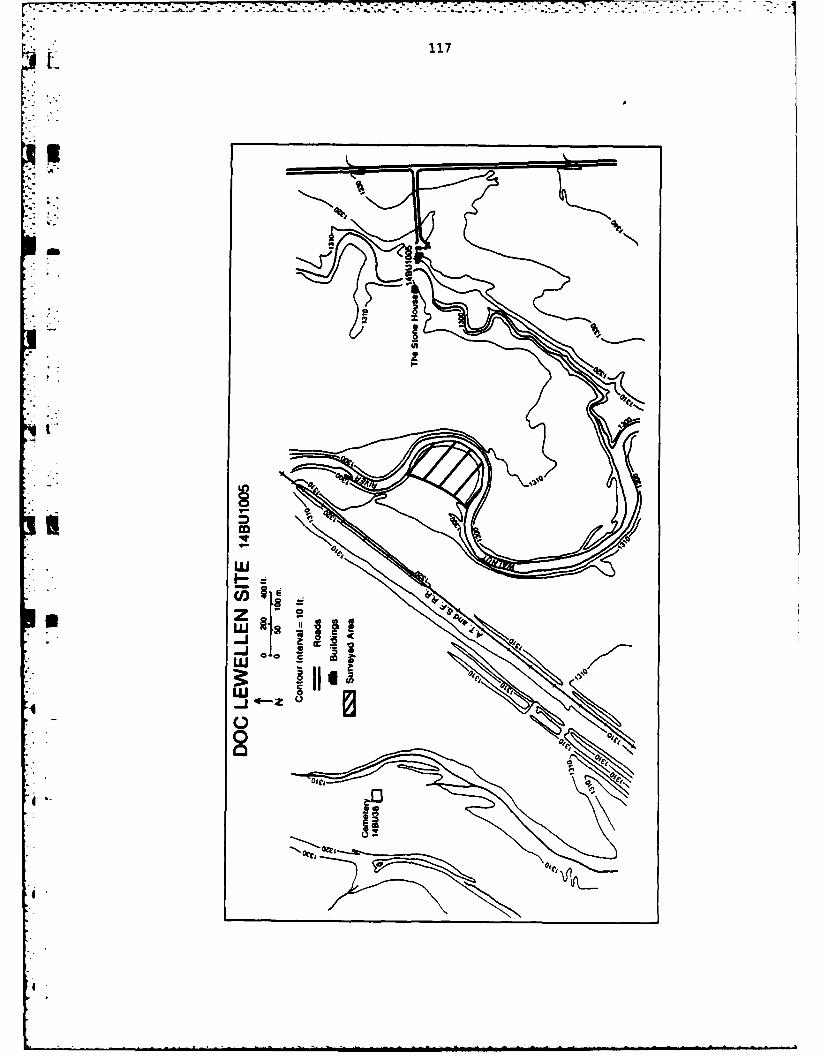
-7 -77* 7-7 7:77.
117
ell
Iu
ftJ

118
Lewellen's first home in Butler County was a log cabin built in 1857. A
description of the cabin has not survived, but it was probably a one or two room
structure with a stone fireplace. The Lewellen's occupied their original home-
site for eleven years, 1857-1868. A small family cemetary was established
northwest of the homesite for two Lewellen infants who died in 1858 and 1860.
(This family cemetary was designated 14BU38 and was translocated prior to the
1980 field season.)
During the occupation of the log cabin, Doc Lewellen became quite active in
local developmeat. He helped found and promote the original Butler County seat,
Chelsea. In 1859 he was appointed sheriff of Butler County. From 1864-1867 he
served as county commissioner and as a member of the school board. These duties
were in addition to his establishing a successful farming and stockraising
operation.
About the time that the town he helped found failed, Lewellen left the area.
In 1868 he purchased a trading post on the Little Arkansas River from Henry
Chisolm of cattle trail fame. Through this trading post Lewellen helped accomo-
date the new settlers arriving in Sedgewick County. During his stay in Sedge-
wick County Lewellen became one of Wichita's first merchants and actively
participated in the town's development.
*O In 1872, Lewellen's wife died. Shortly thereafter he returned to his
farm on the Walnut. Lewellen and his six children probably reoccupied the log
house when they returned. However, in 1874 a large cut-stone cabin was erected
* on the east bank of the Walnut River opposite the log house. There Lewellen
and his family lived until ca. 1885 when a 2 story frame house was built east
of the stone house. As was fairly typical of Butler County occupations, each
* succeeding house was located on higher ground.
0

119
Doc Lewellen died July 11, 1901. During his life, he had helped found
two towns and conquer a frontier. A measure of his success as a farmer and
stockman can be gleaned from the size of his farm: more than 1160 acres.
S.: METHODOLOGY
The original Lewellen family homesite occupied a position on the west
bank of theWalnut River (Fig. 2.1). Leo Hullihan, Lewellen family geneologist,
reported that the cabin's foundation was still visible ca. 1900 according to
his mother, Fencia Niola Lewellen Hullihan (daughter of Zadoc and his second
wife Delilah). Hullihan thought that the cabin stood where the Atchison, Topeka
and Santa Fe Railroad bridge formerly crossed the Walnut. The area south and
I east of the railroad in the bend of the river, had been carefully surveyed in
.. 1978 without locating the homesite. A second report by Joe Lewellen, last
owner of 14BU1005, put the cabin in the bend opposite the stone cabin. This
was the area surveyed in 1980.
The Walnut River flows in a deeply incised channel as it passes 14BUI005.
Erosion of the river bank continues and evidence of recent slumping is plainly
Sevident. Except in areas that have been cleared for agricultural purposes,
the banks are covered with a dense riparian forest and undergrowth. Without
some clearing technique, ground visibility is zero to poor.
Survey of the west bank site began with an examination of the cutbaink.-
Beginning at the railroad bridge surveyors followed the channel of the Walnut
River looking for historic material eroding out of the bank or present in the
river bed. It was realized that any material deposited in the river was un-
likely to remain in place very long. Therefore, primary attention was given to
the examination of the cutbank. The cutbank survey continued around the first
full bend of the river south of the railroad bridge. No historic material
was encountered.
9
120
The second phase of the survey consisted of an on-the-ground investigation
of the wooded terrace. Four surveyors were placed at 10m intervals beginning
at the treeline. They then traversed the area in a north-south direction.
Every 10 paces a surveyor would stop, remove a shovel full of soil, dice it
with the shovel blade, carefully examine the soil and the hole from which it
was removed for historic material, then backfill the hole. This procedure was
repeated until the entire wooded portion of the bend had been covered. Again,
no historic material was encountered.
Power-augers -nd post-hole diggers were next used to test the area. A
series of holes averaging 50cm in depth were placed in selected areas of the
bend. The selected areas were broad flat expanses that would have been good
for building a house, unusual depressions, and mounded areas. The results of
this endeavor were also negative.
The final phase of the survey was to walk the plowed fields that occupied
the space between the railroai and the treeline. This area had never seriously
been considered as a possible location for the homesite but because of the neg-
ative results acquired in themore likely areas, this survey was undertaken.
However, no historical material was encountered.
DISCUSSION
*0 The failure to locate the site of the original Doc Lewellen homesite was
frustrating. There a . two possible explanations, however. The first possi-
bility is that the house stood very close to the edge of the bank. Subsequent
undercutting of the bank eventually led to a slumping and the deposit was
washed away. A second possible explanation is that the cabin was located near
the treeline of the 1978 survey area and was destroyed when the railroad was
built. At the present time, the latter explanation seems more plausible.

121
THE DONALDSON SITE
The Donaldson site, 14BUI008, occupies an expanse of land north of Durechen
UCreek and east of the section road in Section 33. The site contains two hori-
zontally stratified components: an early occupation in a log cabin which
occurred from 1857 to 1869 and a later occupation centering around a stone
.- house which began in 1869 and lasted until 1976. During Phase II the site
was initially recorded and an architectural assessment of the stone house was
made (Roberts and Wilk 1981). Extensive excavation of 32 square meters of
deposits related to the stone house occupation was conducted during Phase III
(Brown 1981). Investigation of the Donaldson site during Phase IV was aimed at
locating the original home site occupation.
HISTORY
The Donaldscn site derives its name from George F. Donaldson, the original
U owner of the site. Donaldson was born in Ohio but grew up in Indiana. As a
young man he began his move west by relocating in Illinois. Then in the spring
of 1855 Donaldson and his wife settled near Hull's Grove, Jefferson County,
* Kansas. This was a time of great civil strife in Kansas over the slavery
question. Donaldson was an adherent of free-state principles and became an
associate of General James Lane, the ardent free-state advocate (Andreas 1883:
1450). Because of his free-state convictions, Donaldson became a target of
the border ruffians (a name given pro-slavery supporters who made forays into
Kansas from across the Missouri state line). He was made a captain of a Free
State Company and in turn a $500 reward was offered by the pro-slavery faction
for his capture, dead or alive. Eventually, Donaldson was forced to flee,
his home destroyed, and his family was driven from the land (Walnut Valley
Times August 31, 1883).

K122
In 1857, Donaldson and his family joined with his brother-in-law,
Martin Vaught, and a small group of settlers at Emporia, Kansas. There they
were told of a veritable garden of Eden on the Walnut River by a college
professor who had explored the area. The group quickly decided that that
was where they would settle. In this manner, Donaldson first came to Butler
County.
When Donaldson arrived he selected a farmsite on Durechen Creek. Like
Lewellen, Donaldson, apparently selected for a building site near or in the
tree line along the stream. His first house was a log cabin, a description
of which has not been discovered. It was probably a simple structure of one
or two rooms with a limestone fireplace.
Donaldson immediately became active in establishing Chelsea, the county
seat. Although his house stood outside the legal description of the town,
his cabin was a center of activity for county government. He was also a
financial investor in the town, having purchased 160 acres, or one-quarter
of the town Eite, in 1860.
Politically, Donaldson was also active. From 1859 to 1860 he served as one
of Butler County's first three county commissioners and the commission meetings
were held at his house. In 1863 and 1867, Donaldson was elected as a repre-
* sentative from Butler County to the state legislature.
Although Donaldson had come to Butler County to escape his political
problems he did not abandon his free-state principles. When the War-Between-
the-States began, Donaldson became involved with recruiting and organizing
Indians for the Northern cause. He was so successful that he received a
commission as a First Lieutenant and served in that capacity throughout the
war (Stratford and Klintworth 1970:21).

L123
After the war, Donaldson appears to have been as staunch a supporter of
Chelsea as he was of a free Kansas. The war years had not been good for
* Chelsea. At a time when the town needed to build and grow, the young men
required for that work had been siphoned off to the war. Donaldson was
4M faced with a town that had lost its position as county-seat and was steadily
declining.
* Chelsea was obviously something Donaldson did not feel inclined to let
die easily. In part, this is understandable in as much as he had been so
involved with the town. Not only had the county commission met on his pro-
perty but one of his buildings also served as the county's first school and
church.
In 1868, Donaldson replatted the town of Chelsea on his own property.
That same year the post office was transferred to his house thereby legally
relocating Chelsea (Mooney 1916:337). Although less than half the size of
original Chelsea, the new town offered much promise: it was located on a
main road, the Emporia Trail, which ran through Donaldson's property, and it
had the dynamic support of George Donaldson.
Shortly after relocating Chelsea, Donaldson decided to build a new home.
His new house was to be built of stone and was located very near the town of
Chelsea. On November 3, 1869 Donaldson was killed in a logging accident which,
according to one source, occurred while building his stone house (Mooney 1916:
338). In any respect, the house was finished and the Donaldson family
abandoned the log dwelling. The stone house remained in the Donaldson family's
possession until 1883 when Mrs. Donaldson died. After that, the property
passed through several owners until finally acquired by the Corps of Engineers.
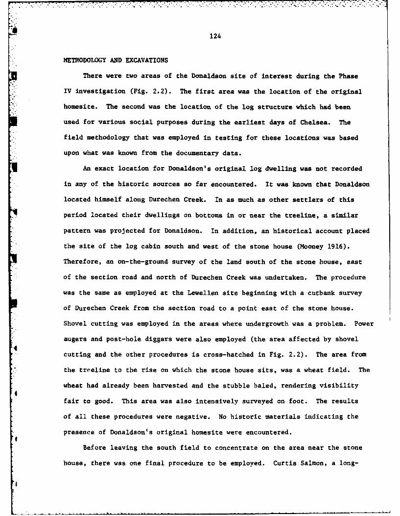
124
METHODOLOGY AND EXCAVATIONS
There were two areas of the Donaldson site of interest during the Phase
% IV investigation (Fig. 2.2). The first area was the location of the original
homesite. The second was the location of the log structure which had been
used for various social purposes during the earliest days of Chelsea. The
field methodology that was employed in testing for these locations was based
upon what was known from the documentary data.
An exact location for Donaldson's original log dwelling was not recorded
in any of the historic sources so far encountered. It was known that Donaldson
located himself along Durechen Creek. In as much as other settlers of this
period located their dwellings on bottoms in or near the treeline, a similar
pattern was projected for Donaldson. In addition, an historical account placed
the site of the log cabin south and west of the stone house (Mooney 1916).
Therefore, an on-the-ground survey of the land south of the stone house, east
of the section road and north of Durechen Creek was undertaken. The procedure
was the same as employed at the Lewellen site beginning with a cutbank survey
of Durechen Creek from the section road to a point east of the stone house.
Shovel cutting was employed in the areas where undergrowth was a problem. Power
augers and post-hole diggers were also employed (the area affected by shovel
cutting and the other procedures is cross-hatched in Fig. 2.2). The area from
the treeline to the rise on which the stone house sits, was a wheat field. The
wheat had already been harvested and the stubble baled, rendering visibility
fair to good. This area was also intensively surveyed on foot. The results
of all these procedures were negative. No historic materials indicating the
presence of Donaldson's original homesite were encountered.
Before leaving the south field to concentrate on the area near the stone
house, there was one final procedure to be employed. Curtis Salmon, a long-

Figure 2.2. The Donaldson site, south fieldsurvey area.
I

125
S DONALDSON SITE 14SU10080 290 40 it.
Contour Interval . 10 ft.
= Roads
some@ Buildings
SSurveyed Area
U U
4'9
...4..
460

126
time area resident, reported the remains of a notched log structure were
visible in the south field early in the 20th century (ca. 1915-1920). Although
there is not much topographic relief in the field, Mr. Salmon indicated that
*the structure was located on a very low rise (the approximate 1320 ft. contour
line) just below the point where the field achieves its greatest constriction.
Therefore, a series of four one by one meter excavation units were established
at 10 meter intervals across the low rise (Fig. 2.3). Each of the units,
designated XU 33 - XU 36 (continuing the sequence begun in Phase III) was taken
down to 40 cm below the surface. No historic material was encountered. A
power auger was used in XU33 to probe an additional 50 cm but the results con-
tinued to be negative.
Attention was next turned to the area around the stone house. Interest
in this area was twofold: 1) the original homesite may have been on a portion
of the rise southeast of the stone house; and, 2) the log structure which
was so significant to original Chelsea possibly stood here.
As can be seen in Figure 2.2 the area around the stone house had been
heavily developed. Test units were placed in areas which appeared to be the
least disturbed (Fig. 2.4).
A foundation 5.2 m x 5.2 m, was encountered northeast of the stone house.0
Most of the limestone had been removed, however, the foundation trench remained
fairly visible (Fig. 2.5). A series of test units were laid out crossing the
foundation at right angles. Excavation quickly revealed that the foundation
rested on a natural gravel lens approximately 15 cm. thick. The foundation
had never been more than one stone deep and the gravel precluded any buried
deposits.
Artifacts recovered during the excavations conducted at the Donaldson
site are discussed below.

.017
Figure 2.3. Excavation units in the southfield of the Donaldson site.
°4
,°,
4
I

127
j
14BU1008Donaldson Site
South Field
Datum*0
XU33 XU34 XU35 XU36
f

Figure 2.4. Distribution of 1980 excavationunits around the Donaldson stone house.
4'
0l
I

'12Q
Field Road
C08
.2
00
Figure 2.5. Foundation tested during Phase IVat the Donaldson~ site.

129
z
CD/
0
LL
-- --- -
.. . .i .L '
K. 130
ARTIFACTS
As has recently been pointed out (Sprague 1981), the question of how
to type historic artifacts presents the archaeologist with a question of
ponderable proportions. Classification by raw material tends to mask
shared functions or associations among artifacts (for example, clothes
buttons are used for basically similar tasks but a raw material emphasizing
typology would sort them into classes of bone, shell, brass, etc.). At
the same time, a functionally oriented typology must contend with multi-
functional artifacts (for example, a chain could be part of a harness, wrench,
wagon gate assembly, fence latch, etc.). Functional classification, however,
tends to the preferred system and some complex typologies have been proposed
(Buckles 1978; Sprague 1981).
The classification scheme used in the historic sites program at El Dorado
Lake is a hybrid of raw material and functional typologies. This scheme
developed from the nature of the material that was being recovered. Much of
the historical archaeological record at El Dorado Lake had been disturbed.
Most of the artifacts that were recovered were small fragments. In many
instances, the only characteristic that a large number of artifacts shared
was their raw material. Therefore, the basic attribute in the typological
hierarchy is raw material. If the function of an artifact can be determined,
it is categorized as a member of an assemblage or set. Assemblages are gen-
erally of two types: activity sets (tool assemblages used in specific work6
behaviors such as metal working, woodworking, etc.) and use sets (tool assem-
blages that serve similar functions in different activities, i.e. nails, nuts
and bolts). In the following artifact descriptions ceramics are always
treated as a distinct group; glass is differentiated as "flat" (i.e. window
glass) or "bottle" (any non-flat or colored glass); and metal is the most
I

131
explicitly typed. When an artifact is multifunctional, its assignment
to a particular class is based on context.
Flat Glass (n-7)
The flat glass assemblage from 14BU1008 in 1980 consisted of seven
fragments: four, clear, and three green tinted. The distribution is
shown in Table 2.1.
Bottle Glass (n=49)
A total of 49 bottle glass fragments were recovered during Phase IV.
The distribution of bottle glass is shown in Table 2.2. Only two bottle
neck fragments were recovered. Both came from the surface near the founda-
tion and had seams that went all the way to the lip. Two specimens, both
from Test Pit 43, bore embossing. An aqua fragment bore "SYP". An amber
fragment carried the number, "32". The only other possibly significant
bottle fragment was a portion of a milk glass jar lid liner from Test Pit 53.
Ceramics (n14)
Fourteen historic ceramic sherds were recovered at the Donaldson site.
Table 2.3 provides a break down of types and distribution. The three
electrical insulator types testify to the continued occupation of this site
into the 20th century. All were recovered near the foundation. The Copper
'4 Luster Tea Leaf Pattern sherd is a fragment of a coffee cup produced by
Alfred Meakin under that type name. Four other specimens recovered in 1979
indicated that an entire service of this type may have been present (Anderson
1981:138). This was an expensive ware in the 19th century and can be inter-
preted as a marker of the Donaldson's wealth.

.-
132
Agricultural Implements (n-2)
Two artifacts generally used in an agricultural context were recovered:
a rake fragment and a piece of fence wire (Table 2.4).
Architectural (n=2)
Two artifacts were classified as architectural: a staple from Test
Pit 39 and a door latch with an eye screw from Test Pit 52.
Household (n=3)
*i Three of the recovered artifacts were considered to be of a household
nature. This includes one clothes hook from the surface near the foundation,
one crown cap from Test Pit 56 and one container lid from Test Pit 58.
Nuts and Bolts (n=12)
All of the specimens in the nuts and bolts assemblage were recovered
from units around the foundation (Table 2.4). The assemblage consists of
two eye screws, two galvanized screws, three regular screws, a quarter inch
washer, a half inch bolt with nut, and a three-quarter inch bolt.
Wagon and Harness Parts (n=17)
This was largest of all the assemblages, numerically, but only two arti-
fact types are represented. In Test Pit 55 a fragment of a single-tree clip
from a wagon was recovered. The remainder of the assemblage is composed of
"clips" or "latches" that are interpreted as being harness parts. Each part
of the clip is cast iron and designed to be riveted in place. One piece
forms a box which the other hooks over. When the two pieces are articulated
a short tongue on the box fits through a slot on the hook and helps lock the
two together. None of the pieces were articulated when recovered. All came
from around the foundation (Table 2.4).
Wire Nails (n=16)
Sixteen wire nails were recovered. Table 2.5 provides penney weights

133
and distributions.
Square Nails (n-3)
Three fragments of common cut square nails were recovered. One each
, from Test Pit 46, 53, and 55.
Miscellaneous Tools (n-7)
This category is reserved for tools which cannot be assimilated into
other classes. Included under this classification are two metal collars,
one stainless steel clip, one cotter pin, one coil spring, one small length
of copper cable, one copper cap, and one stainless steel screw valve. Dis-
tribution of these artifacts is provided in Table 2.4.
Miscellaneous Metal (n=15.5 g)
Fragments of metal which are unrecognizable as any type of tool or stock
are classified as miscellaneous metal. Fifteen and a half grams of rusted
* iron were so classified at 14BU1008. Distribution of the material is shown
in Table 2.4.
Plastic (n=l plus numerous fragments)
* This assemblage consists of one plastic lid from Test Pit 39 and numerous
fragments of at least two small containers in Test Pit 40 and Test Pit 43.
Markings on some of the fragments indicate that the containers held some type
4( of automobile part produced by General Motors.
Rubber (n=l)
One small fragment of hard rubber weighing l.Og was recovered from Test
Pit 42.
Miscellaneous Personal (n=l)
This class is reserved for artifacts which are strongly associated with
the personal context regardless of raw material type. The single constituent
of this class is a glass marble with white and yellow swirls. It was recovered
in T.P. 43.

...'.'...'.' .. . . " .-.' " -" " ."" .. "' ." "
134DISCUSSION
*. Excavations at the Donaldson site during Phase IV did not contribute
substantially to the knowledge of historical archaeology in the El Dorado
S..- Lake area. Attempts to locate two structures associated with the area's
early period were unsuccessful. On the basis of the Phase IV investigation
it is hypothesized that the deposits associated with the early period
occupations were light and that subsequent development and agricultural
activity have destroyed them.
The remnants of a limestone foundation northeast of the stone house
were investigated. There is no evidence that the structure is of any great
age. Based on the material that was recovered in and about the foundation
it is postulated that the structure was a frame building built in the 20th
Century and functioned as a workshop, possibly a small garage. The latch
and general debris recovered from T.P. 52 suggests a door may have been
present in the east wall. However, this interpretation has not been con-
firmed with any informants.
!.
4.
a
a°

L135
Table 2.1. Distribution of flat glass at 14BU1008.
LOCATION
COLORT.P. 37) T.P. 381 T.P. 41] T.P. 43] T.P. 47
Clear 1 2 1
Green Tinted 1 1
Table 2.2. Distribution of bottle glass at 14BU1008.
TESTPTS 37 38 41 43 46 47 52 53 55 SurfacePITS
AMBER 1 1 2
I AMETHYST
AQUA 1 10
CLEAR 1 2 1 1 4 10
GREEN 2TINT
MILKGLASS
RED
TURQUOISE 3

136
000
N 60
000
E-4 -
w to 0 000
*04 0
to
cd w ( 1 c
uI 0 0u40 -W 4 1 H4
z 4.) U 0 0)C 0 0= 14c 04C v-4 .
.1-I 4. 0 0-
9z' r-4 V4 i4 N 4-00 00 a U
w. N W- m P- -4 cm 00 01.. m 0(0 4
F- .4 4-4 00 00 00-4a0 u m.. r..44 .4z d d O40 w . 4
E-4- 4.1 0. 414 E0 u to0n0 41 nc0 .0 "4- 4J "4h-?4 4- 0 m
0) '4.4 = ~ C.) r- 4 w wz W 4 P4*04 4. 94c *0 00 cc
o~~ - 0 E-4-4W t-4 04 r
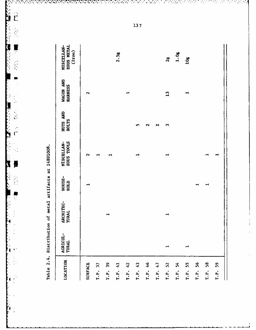
13 7
00 00%n' 0~zJ ~ a *00 * 00
W14C4 C14 4 0rn4
o
eq 4 -4 V4
00 r
44 0
E-
440
V4 -4'4 -
W- 00 1 n %0L) ID 0
CCO
E4 CA0

138
Table 2.5. Distribution of wire nails at 14BU1008.
*SIZE T.P. 37 T.P. 42 T.P. 43 T.P. 46 T.P. 47 T.P. 59
Fragment
3d
5d
6d 21
8d1
12d1
1 6d
18d 2
GalvanizedRoofing Tack2

139
THE NEW CHELSEA SITE
• The New Chelsea site, 14BU1007, occupies 80 acres along the Old Emporia
Trail (Fig.2.6). This site represents the remains of the translocated town
of Chelsea, Kansas. Previous investigations of the site included excavation
of eight one by one meter test units during Phase II (Roberts 1981a)and ex-
tensive block excavations during Phase III. Phase IV investigations employed
" a controlled surface collecting and mapping procedure derived from the findings
of the previous projects.
HISTORY
Chelsea was the name given the first county seat of Butler County by the
individuals who founded the town. The Chelsea Town Company was incorporated
February 11, 1858 by the Kansas Territorial Government (Kansas Private Laws
* 1858:323). Three hundred twenty acres of land between the Emporia Trail and
Durechen Creek were acquired by the company and laid off into blocks, lots
" and squares. Unfortunately, no town plat of Chulsea has yet been located.
Chelsea and its supporters suffered through hard times during the firstUfew years. Among the hardships which befell them were droughts, grasshopper
" infestations, and fires. These calamities were in addition to the necessary
hardships of frontier living: ground breaking, clearing, building and conten-
ding with the fear of hostile Indian attacks. Through all of these misfortunes
and difficulties, the Chelseaites endured. Chelsea may not have been expanding
but it was at least remaining stable.
* .The 1860's dealt Chelsea several crushing blows. In 1860, Butler County's
boundary lines were changed to include the town of El Dorado, a growing commun-
' 'ity that would soon challenge Chelsea's political position. This was followed
in 1861 by the outbreak of the War Betweea the States. Thus at a time when
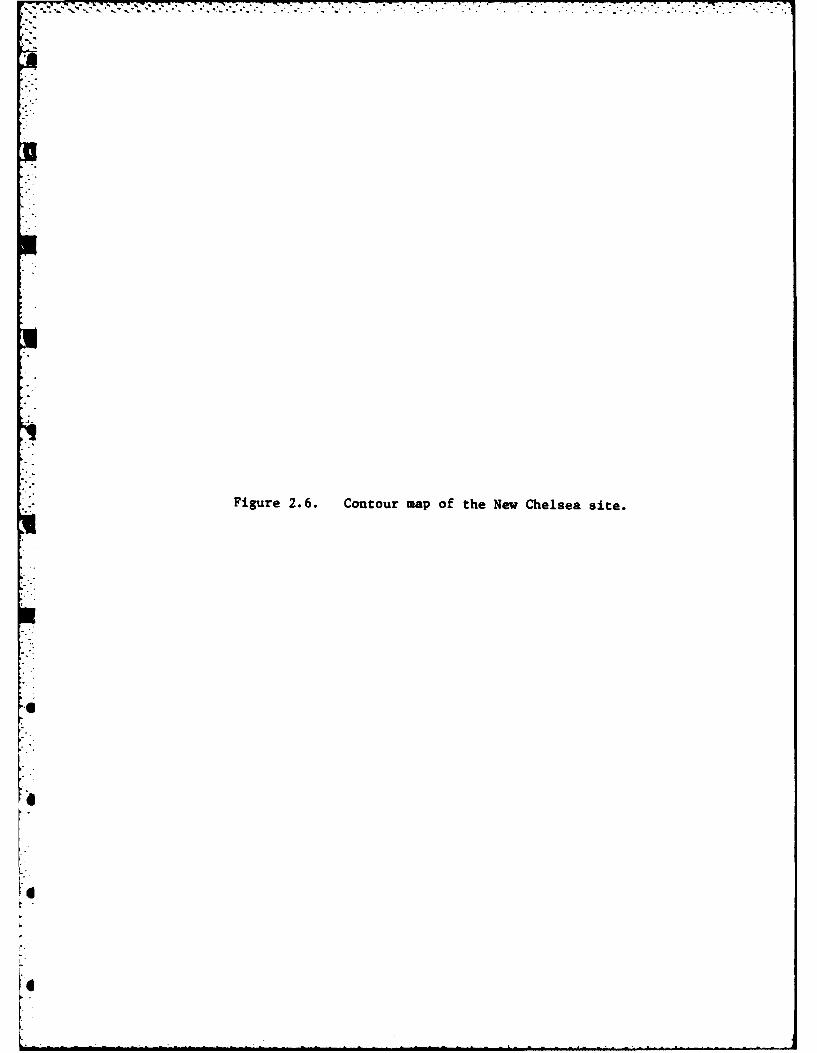
Figure 2.6. Contour map of the New Chelsea site.

140
NEW CHELSEA SITEV 14SU1007
CoWTOUR INTERVAL=u 2 FT.
ILDIEMS
133
Mas

141
the community needed to concentrate its efforts on growth, the very members
of the town necessary for expansion were siphoned off for the war effort.
By 1864 El Dorado was able to win the county seat from Chelsea. Loss
of political preeminence sounded the death knell for the town. Residents
*of the town began to sell-out. Some moved to El Dorado, others left the area
completely. Chelsea as a town was essentially gone by 1867. However, the
* notion of a Chelsea community appears to have survived.
In 1868, the Chelsea post office was transferred from the original town
site to George Donaldson's farm one mile south. That same year a plat for a
new town called Chelsea (now designated 14BU1007) was recorded (Deed Book D).
The new town was 145 rods and nine feet (2401.5 feet, 731.98m) north to south
and 60 rods and eight feet (998 feet, 304.19m) east to west. It consisted of
31 blocks set aside for commercial or residential lots and one block for the
public square (Fig.27). This design is termed a block square town pattern
(Price 1968:30).
George Donaldson receives the credit for striving to maintain Chelsea as
a viable town. He had the post office moved, platted the town on his own land,
sold the initial town lots and formed the town company. His personal capabil-
ities as a leader and organizer which had already led him to positions of
,4 authority and respect in the county, formed the foundation from which to build
a new town. Chelsea, like an urban Phoenix, was to rise anew from its ashes.
Fate, however, again interceded. Donaldson's untimely death in 1869 took
away the preeminent power in promoting Chelsea. Although the town prospered
for a few years, it never achieved the promise or potential that had been
portended for it.
By 1878 Chelsea was again a failed town. Many residents had left and
structures had been moved. In 1878, all but five blocks were vacated and the
4

LI
Figure 2.7. Plot of Chelsea, Kansas super-imposed on contour map of New Chelsea site.
I,
4
I

142
K-!
1 NEW CHELSEA14BU1007
Walnut Street IM
- Mulbery Street N
Pne Street
yMamle Street
r3 4
Sycamore Street
,3
| 4 Esj
Oak Street
Locust Street
G rove Street
Donaldson Place
143
land returned to the Donaldson family (Commissioners Journal 1878). A black-
smith shop operated by John Houser was the sole commercial enterprise at that
time. In the closing years of the 19th Century, several stores were established
on the town site. These establishments and the Chelsea school, which survived
until 1954, helped maintain a notion or sense of community for the residents of
the Chelsea area.
METHODOLOGY
q Phase IV investigations at the New Chelsea site were designed to accomplish
two goals: 1) recover physical data that could be used to reconstruct develop-
ments within the town; and 2) recover sufficient numbers of artifacts that
* could be identified as to time and place of manufacture so that economic patterns
could later be highlighted. The methodology employed was a controlled surface
collecting and mapping procedure.
During excavations at the New Chelsea site in 1979, particular attention
had been given to examining the effect of agricultural disturbance on arch-
aeological deposits (Roberts 1981a). Results of the investigation, indicated
that deposits in the upper 10 cm of the plow-zone had suffered greater lateral
displacement than those in the lower levels. Although surface deposits were
less likely to be adequate for identifying activity areas or other configura-
tions within a concentration of artifacts, the lateral displacement was not
sufficiently great to preclude the use of concentrations of artifacts on the
surface as indicators of where an occupation had occurred. Therefore, the
Phase IV investigation centered about locating and mapping surface concentra-
tions of historical artifacts.
The area of the site selected for investigation was that which was most
* :~i' accessible. Accessible in this instance refers tc land already under
it~on. It was necessary to limit the investigation in this manner
144
because implementing the procedure required disking the surface. To disk
outside the area already under cultivation would have required clearing ob-
stacles and would have risked disturbing possibly intact deposits in other
parts of the site.
The initial step of the field investigation was to have the project area
adisked. The field had been planted in wheat and required two diskings to
obtain good visibility. Each disking cut the first four inches (approximately
. 10 cm) of soil. A light rain, the evening after the disking was completed,
resulted in excellent collecting conditions.
Surveyors, placed at 10 m intervals, crossed the field in transects
paralleling the main road. When an artifact was encountered, it was flagged
with a wooden lath one meter tall. If an area contained an abundance of mater-
ial, the perimeter of the concentration would be flagged. When all of the
flags had been used, the concentrations and individual specimens were mapped
on a site map, carefully collected, and then the flags removed and the survey
continued. In this manner, the entire project area was surveyed, mapped and
collected.
After the survey was completed, the material was taken back to the labora-
tory, cleaned and identified. The site map with the individually plotted arti-
facts and concentrations depicted on it was then carefully blended with a plat
of Chelsea. By comparing artifact types and distributions with the town plat,
interpretation of the archaeological evidence was facilitated.
ARTIFACTS
In the following section, artifacts will be typed and identified according
to the criteria already put forth in the artifact section from the DonaldsonI
site above. Individually plotted artifacts and constituent assemblages in
concentrations will be treated separately.
p
:.7
145
INDIVIDUALLY PLOTTED ARTIFACTS
Two hundred and five individually plotted artifacts, representing all the
a major assemblages were recovered. Figure2.8 provides the distriuution of these
artifacts over the site. Due to the small scale of the map, it was necessary
to group many of the specimens. These latent groupings are shown as light
areas in Figure2B and are designated by a letter. Each of the individually
plotted artifacts is identified in Table2b according to its grouping.
iI DISCUSSION
Many of the individually plotted artifacts could be considered of a house-
*: hold nature: flat glass, bottle glass and ceramics. The major exceptions are
those specimens contained in Grouping F. These specimens include coal slag,
metal bar and rod fragments, and tools; much the same variety of material
recovered during the Phase III excavation of the blacksmith's shop (Roberts 1981b).
In fact, these artifacts come from the area where the blacksmith shop was
excavated and as can be seen in Figure2.8 are very close to lot 7 of block 18
where John Houser's blacksmith shop is believed to have stood.
GroupingsA, B, C, and D contain many relatively modern pieces and are
attributed to the long-time occupation of the house shown in Figure2.8. Grouping
E contains a high percentage of flat glass which suggests a structure not
4necessarily a residence; land records support this conclusion by revealing that
lots 13 and 14 of block 18, which are covered by E, were owned by Lakin and
L Watson who ran a dry goods store. GroupingSG and H are predominantly ceramic
and suggest a household. The lots covered by Groupinp G and H were occupied
by a half grocery/half house in the late 19th Century. GroupingiJ and I are
also predominantly ceramic but their interpretation is linked to that of
Concentration 3 below. The individual artifacts comprising Grouping K and the
I
7 7 7 7-- 7 7
Figure 2.8. Distribution of surface concentrationsand individually plotted artifacts at the New Chelseasite.
4
l . .4l" - "m -m m mlmmu~u mwn i mq~ t ll m l ' '
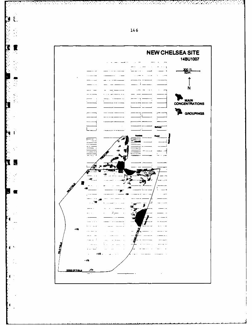
146
NEW CHELSEA SITE__ 14BU1007
- -__- __ , ~ MAIN___ -- - CONCENTRATIONS
-~ ~.GROUPINGS
IADM_

147ATable 2.6. Individually plotted artifacts.
Grouping A Grouping E continued1. Unidentified 42. Green tinted flat glass2. Green tinted bottle glass 43. White glazed ironstone cup3. Clear bottle glass fragment4. Milk glass lid liner 44. Green tinted bottle glass
45a Green tinted flat glassGroup B. 45b Green tinted flat glass
7. 20d wire nail 46a Support rod8a Clear bottle glass 46b Green tinted bottle glass8b Amber bottle glass 47. Amber bottle glass9. Brick 48. -/white ironstone10. Lime green bottle glass 49. Green tinted bottle glass11. Brick 50. Clear bottle glass
Grouping C Grouping F12. Amber bottle glass 66. Amber bottle glass13. Clear bottle glass 67. Coal slag14. Amber bottle glass 68. Hamer head15. Green tinted flat glass 69. Modified horseshoe16. Amber bottle glass 70. Clear flat glass17. Wire 71. Scale weight18. Cobalt blue transfer printed ironstone 72. Bar
plate fragment 73a Aqua bottle glass19. -/white ironstone 73b Coal slag20. Harness hook 74a Clear bottle glass21. White glazed ironstone 74b Coal slag22. Mottled brown stoneware marble 75. Amber bottle glass
76. Coal slagGrouping D 77. Bar
23. Common cut square nail fragment 78. Bar24. -/white ironstone 79a Light Amethyst bottle glass25. White glazed ironstone 79b Coal slag26. White glazed ironstone 79c Wood chisel27. -/white ironstone 80a Rod28. White/white semi-porcelain 80b Coal slag
* 29. Barbed wire 81a Albany/yellow-brown stoneware81b Coal slag
Grouping E 82. Chisel30. Blue transfer printed ironstone 83. Bar31. Green tinted flat glass 84a Miscellaneous Metal32. -/white ironstone 84b Wagon wheel hub35. Hex head bolt 85a Coal slag36. White glazed ironstone 85b Bar37. White glazed ironstone 86. Double beveled shaft steel38a Green tinted flat glass 87. Coal slag38b Green tinted flat glass 88. Coal slag38c Green tinted flat glass 89. Clear bottle glass
4 39. Green tinted flat glass 90. Wire nail fragment40. Clear bottle glass 91. Light amethyst bottle glass
* 41. Green tinted bottle glass 92. Chisel

148
Table 2.6. Individually plotted artifacts (continued)
Grouping F continued Grouping G continued
93. Aqua bottle glass 145. Light amethyst bottle glassp. 94. White glazed ironstone 146. Light olive green bottle glass
95. Green tinted flat glass 147. Center clip fragment96a. Chain link 148a. Amber bottle glass96b. Bar 148b. Light amethyst bottle glass97. Albany/albany redware 149. White glazed ironstone
98a. Green tinted bottle glass98b. Miscellaneous metal Grouping H99. Albany/buff stoneware 130. Clear bottle glass
100. Square nail fragment 131. White/white porcelain101. Light amethyst bottle glass 132. Amber bottle glass
* 102. White glazed ironstone 133a. Brick red/brick red stonewarebowl
Grouping G 133b. Albany/albany stoneware103. Medium brown/unglazed stoneware base 134a. White glazed ironstone104. White glazed ironstone bowl fragment 134b. White glazed ironstone
r 105. Ornate cast iron 135a. Light amethyst bottle glass106. Milk glass lid liner 135b. Green tinted bottle glass107. Brick red/Brick red stoneware 136. Aqua bottle glass108. White glazed ironstone 137. White glazed ironstone109a. Albany/buff stoneware 138a. Green tinted bottle glass109b. White glazed ironstone 138b. Green tinted bottle glass110. Whnite porcelain button 139. Green tinted bottle glass
* 111. Green tinted bottle glass 140. Green tinted bottle glass112a. Clear bottle glass 141. Albany/Albany stoneware112b. Amber bottle glass 142. Milkglass lid liner
' 113. White glazed ironstone 150. Milk glass lid liner114. Milk glass lid liner 151. Green tinted bottle glass115. Clear bottle glass 152a. White glazed ironstone sugar116a. Green Insulator bowl fragment116b. Amber bottle glass 152b. Brown transfer printed ironston117. Clear bottle glass118. White glazed ironstone Grouping I119. Green tinted bottle glass 153. Unglazed/gray green stoneware120. Albany/gray-green stoneware 154. White glazed ironstone bowl
r 121. -/white ironstone fragment122. White glazed ironstone 155. Medium brown/beige salt glaze
. 123a. White glazed ironstone stoneware123b. 3heet iron 156. White/white semi-porcelain
h 124a. Green tinted bottle glass
124b. Light amethyst bottle glass Grouping J125. White glazed ironstone 159. Green tinted flat glass126. White glazed ironstone 160. Light amethyst bottle glass127. Green tinted bottle glass 161. White glazed ironstone cup128. Amber bottle glass fragment129. Milk glass lid liner 162. White glazed ironstone
- 143. White glazed ironstone 163. Clear bottle glass144. Brick red/Brick red stoneware bowl 164a. White glazed ironstone coffee
or crock (3 or 4 gallon) cup handle

* 149
Table 2.6. Individually plotted artifacts (continued)
*m Grouping J continued164b. Green tinted flat glass165. -/white ironstone166. Green tinted flat glass167a. Albany/gray salt glaze stoneware167b. Albany/beige salt glaze stoneware168. Black /beige salt glaze stoneware
crock171. Wagon "Fifth wheel"172. White glazed ironstone plate
fragment
Grouping K53. Milk glass bottle54a. White glazed ironstone54b. Clear bottle glass55. Clear bottle glass56. White glazed ironstone
Others5. Barbed wire6. Aqua bottle glass
33. Pan fragment34. -/white ironstonel. Bristol/Bristol stoneware52. Green bottle glass57. Stove part58. Buckle59. White glazed ironstone60. White glazed ironstone61. Cobalt blue/white ironstone plate
fragment62. White glazed ironstone handle63. Harness ring64. Light amethyst bottle glass65. Albany/Albany red ware
* 157. -/white ironstone158. Green tinted flat glass169. Green tinted bottle glass170. Green tinted bottle glass173. Miscellanecus metal174. Green tinted bottle glass
4 175. White porcelain button176. White/white semi-porcelain
'I

'II 150t
others close by suggest another household assemblage. However, no land records
* affecting this area have yet been uncovered. The small assemblage may indicate
* . a brief occupation.
" .CONCENTRATION 1
m Concentration 1 was an extensive collection of glass and ceramics from
along the treeline in the northern end of the south field.
* . Flat Glass (n=13)
The flat glass assemblage is composed entirely of green tinted specimens.
Thicknesses in the ranges of 1.6-1.7 mm and 2.0-2.2 mm are the most common.
The distribution of thicknesses is provided in Table 2.7.
Bottle Glass (n=80)
A breakdown of the bottle glass assemblage by color is provided in Table 2.7.
This assemblage contains 11 bottle neck fragments, five of which have identi-
fiable finishes: one double beaded (aqua), one patent/extract (light amethyst),
one screw (yellow-green) and two beer (one amber, one green tint). Only the
amber beer bottle neck is complete enough to date. A seam which runs two-
* thirds the length of the neck indicates a ca. 1860-1880 manufacture date.
Other notable specimens include a wine bottle's round base with a kickup,
a lamp globe base, a piece of light amethyst pressed glass with a star-burst
pattern (possibly a sugar bowl), a fragment of milk glass with a star-burst
pattern, two green insulator fragments, a milk glass jar lid liner, and a
fragment of a unique cobalt blue panel bottle embossed with an "0", "C", or "G".
Ceramics (it-37)
Paste/'Glaze and functional types for ceramics recovered from Concentration
1 are preseated in Table 2.8.Most of the assemblage is plain white-glazed iron-
stone. One of the specimens bears the common 19th Century "Corn n'Oats"
embossing (Wetherbee 1974:74).

151
Table 2.7. Glass assemblages from concentration 1.
Bottle Glass
Amber 21
Aqua 5
Clear 14
Cobalt Blue 1
Green tinted 20* Light Amethyst 14
Milk 3
" .Sea Green 1
Yellow Green 1
Flat Glass - Green tinted
Thickness
1.6 3
1.7 1
2.0 3
2.2 2
2.4 1
3.1 1
3.2 1
3.4 1
"6
*0
a0m- m :a . . - "I "a"T mnmmi k mm'mlm''-- hwm mf Ww f n &,duW ,,, D .I .., Wh..J

152
Discussion
Concentration I can be characterized as a household assemblage. Probably
: only a single household is represented. This concentration is most likely
* .related to the occupation that produced Groupings G and H, above.
- CONCENTRATION 2
Concentration 2 was the smallest of all the concentrations collected. As
-•can be seen in Figure2.8, it occurs outside the platted boundaries of the town.
Bottle Glass (nil)
* .One green-tinted bottle fragment was recovered.
. Ceramics (n=4)
Three of the specimens (26.0g) are white-glazed ironstone. The remaining
specimen is a white glazed semi-porcelain plate fragment. One of the ironstone
specimens is also a plate fragment.
* N Nuts and Bolts (nffi)
* One bolt fragment with a I4 inch nut was recovered.
*Discussion
* This was the westernmost of the concentrations. Concentration 2 may
represent further evidence for a brief occupation in block 19.
4 CONCENTRATION 3
Concentration 3 was the largest of all the concentrations coilected. It
occurred as a very distinct, isolated assemblage on the eastern edge of the
* "field.
Flat Glass (n=168)
All the flat glass in Concentration 3 is green tinted. The distribution
of thicknesses is provided in TableZ9. Three ranges account for most of the
specimens: 1.5-1.7 mm, 2.0-2.3 mm, and 2.5-2.7 mm.

153
Table 2.8. Ceramic assemblage from concentration 1.
Paste/Glaze Type Count (Weight) Functional Types
St-EARTHENWARE/IRONSTONE
Brown Transfer Printedware 1 (2.Og)
Corn 'n Oats Pattern 1 (2.5g) 1 Plate
White glaze 22 (50.9g) 1 Butter dish
SEMI-PORCELAIN
Orange overglaze painted 1 (0.5g)
White glaze 5 (14.0g) 1 Coffee cup1 Coffee pot handle
STONEWARE
Albany glaze/Albany glaze 1 (2.5g)
Albany glaze/Bristol glaze 1 (5.5g)
Albany glaze/Gray/Greenglaze 1 (9.0g)
Albany glaze/Yellow/Brownglaze 1 (l.5g)
Brick Red glaze/Brick Redglaze 1 (45.0g)
Medium Brown glaze/Buff glaze I (9.4g)
Medium Brown glaze/Light Gray glaze I (27.5g)
BRICK
High Fire (57.0g)
S Low Fire (11. Og)

154
Table 2.9. Glass assemblages from concentration 3.
BOTTLE GLASS FLAT GLASS
Thickness
Amber 54 1.0 1
Aqua 65 1.3 4
Black 1 1.5 22
Clear 178 1.7 40
Dark Amethyst 3 2.0 20
Emerald Green 5 2.1 21
Green Tinted 166 2.2 15
Light Amethyst 126 2.3 14
Milk 18 2.5 17
Olive Green 1 2.7 9
Sea Green 3 3.1 5
* Yellow Green 3

155
Bottle Glass (n-623)
The color distribution of bottle glass sherds is provided in Table2.9.
C' Thirty-one of these specimens are neck fragments, 25 of which have identifi-
* able finishes: one beaded (light amethyst), one double beaded (green-tinted),
one collared (green-tinted), one flavied (clear), two crown cap (aqua), four
screw (3 aqua, I green-tinted), five beer (4 amber, 1 light amethyst), and ten
medicine/extract (1 amber, 1 aqua, 2 light amethyst, and 6 clear). Seven of
the necks provide chronological information based on seam height: three have
seams extending two-thirds of the way up the neck which indicates a ca. 1860-
1880 manufacture date; three have seams all the way to the rim, indicating ca.
1880-1900; and one has no seam at all, indicating pre-1860.
Other specimens also provide chronological data. One square (28 x 28 mm)
base with bevelled corners bears, "B B Co." (Fig.2.9a). This was the mark of
the Berney-Bond Glass Co. of Pennsylvania, ca. 1900 (Toulouse 1971:70). Otie
round base (Fig. 2.9b) bears a double-stamped double circle mark which was used
by the Buckeye Glass Co. of Ohio from 1880-1900 (Toulouse 1971:391-2). A
fragment of a milk glass lid liner carries the "Tudor Rose" design (Fig.2.9c)
used in Mason jar zinc caps from 1885-1900 (Toulouse 1971:344). One fragment
is embossed BEGG - in a style that denotes the C. W. Beggs and Sons Co. of
Chicago. Advertisements for Begg's nostrums have been recorded from 1886-1897
(Baldwin 1973) but Cramp (1921:582-3) reported the company was still being
prosecuted for makirgfalse and fraudulent claims about its products in 1916.
1 *A panel bottle fragment has the embossing, "McLea-" which matches a W. J.
McLean's Fincture of Life bottle illustrated in Baldwin (1373:335). No dates
were recorded but it is probably late 19th Century. A round base bears the
partial embossing, "T. A. SNI-". The T. A. Snider Preserve Co. operated in
Cincinnati, Ohio from 1884-? and in Chicago from an unknown date to 1923
(Toulouse 197L:449-50). This mark does not macch any illustrated in >ulcu .
6
L______n__| im luR| nnlaln mm m numnm ,
AD-125346 PHAE I ARHAELOGCA INETATOSTELDAD 33RD-R15 34 LAKE IVBUT LEIR N VETY KINS S SUM R EL KANSAS UN/Y
LANRENCE MUSEUM OF ANTHROPOLOGY R E JOHNSON ET AL.
UNCLASSIFIED ±986 DACM56-77-C-822 F/G 5/'6
smhhimEhholi""'I-I".'.olsmmhhhEohhhhhhsmhhhhhhmhhhhsmhhhhhhhhhhhsmhhhohhohmhh

4-
R1.0 U 3
IEEE.1111 .1 .0
iiii
1.8°
1.4___ 1 .6
MICROCOPY RESOLUTION TEST CHART
NATIONAL BUREAU OF STANDARDS-1963-A

Figure 2.9. Glass artifacts: (a-b) bottlebases; (c) lid liner; (d) glass bottle stopper;(e-g) panel bottle fragments. Concentration 3:a-f; Concentration 8:g.

15 6
:. ab
.. ENCE
!
I I,.- .- 5cm
W f f l f

157
however, his earliest only dates to 1900. This mark may be an earlier one.
A basal fragment of unknown shape carries a reversed "3" as a mark. The same
mark was observed on a French square bottle at Ft. Bowie (Herskovitz 1978:25).
Ft. Bowie dates 1862-1894.
Other notable bottle glass specimens include three fragments of a light
amethyst "log cabin" bottle(s); three fragments of light amethyst stemware
(diamond point pattern); three tumblers (one round with a sunburst pattern,
two faceted); a clear glass handle; a plain rim from a container (possibly a
sugar bowl); a pressed glass lid fragment; an olive green bottle stopper
(Fig.Z9d); a clear, pressed glass fragment with leaves, beads, and stars on a
textured background; base of a lampglobe; an insulator fragment; a green tinted
* specimen with the embossing -SAP- (sarsaparilla?); a round amber base esti-
*- mated at 3 inches in diameter with a Maltese cross embossed toward the perimeter
* of the pontil mark; a round, aqua base with -OV- on the periphery and 87 in the
center; a green tinted fragment with "93"; an amber medicine bottle sherd with
-UA- and graduated dosage lines embossed upon it; four milk glass lid liners;
" two green tinted panel bottle fragments that articulate to read TURKISH LIN-
(linament?) (Fig.2.9e); and two aqua panel bottle fragments which do not articu-
*" late but share identical lettering styles, colors, and thicknesses, and when
properly oriented read, "Dr -/LA-RENCE K--" (Lawrence, Kansas?) (Fig2.9f).
Ceramics (n-485)
The large ceramic assemblage from Concentration 3 is identified according
to paste/glaze and functional types in Table2. 10.
Several of the pieces provide chronological data. A Johnson Brothers'
maker's mark (Fig2.10e) on an ironstone plate identifies the specimen as having
4 been produced in England between 1891-1913 (Godden 1964:355). Two other pieces
*"

T9..
9..
I
Figure 2.10. New Chelsea site ceramic artifacts: (a) possibleStaffordshire ware, deep purplish-blue transfer printed; (b) iron-stone decalvare; (c) white-glazed porcelain doll-head; (d) AlfredHeakin's Copper Lustre Tea Leaf pattern sherd with complete designadded; (e) Johnson Brothers mark from an ironstone plate sherd.Concentration 3:d-e; concentration 5:a; concentration 7:b-c.

158
ab
d. .
? *-.*
JONSN Rb
*ENGLAN
4-e
*1c

159
Table 2.10. Ceramic assemblage from concentration 3.
Paste/Glaze count (weight) Functional Types
EARTHENWARE/IRONSTONE
Copper lustre tea leaf
pattern 1 (1.2g) 1 Coffee cup
Decaiware 3 (7.2g) 1 Cup
Dull pink glaze 1 (0.3g)
White glaze 230 (808.6g)
White glaze with cobalt
blue design 1 (4.8g)
PORCELAIN
White glaze 8 (8.7g) 2 Buttons2 Soap dishes1 Doll leg
SEMI-PORCELAIN
White glaze 40 (186.4g)
* - STONEWARE
Albany glaze/Albany glaze 85 (70719g) 1-1 gallon crock2-2 gallon crocks1- 3 or 4 gallon crock1- 5 or 6 gallon crock
Albany glaze/Black glaze 1 (20.0g)
Albany glaze/Beige Salt
glaze 3 (58.5g)
Albany glaze/Blue and White Salt glaze 1 (lO.Og)
Albany glaze/Brown Salt glaze 1 (21.0g)
Albany glaze/Buff glaze 4 (61.5g)
* Albany glaze/Buff Salt glaze 9 (154.2g) 1 indeterminant size
crock
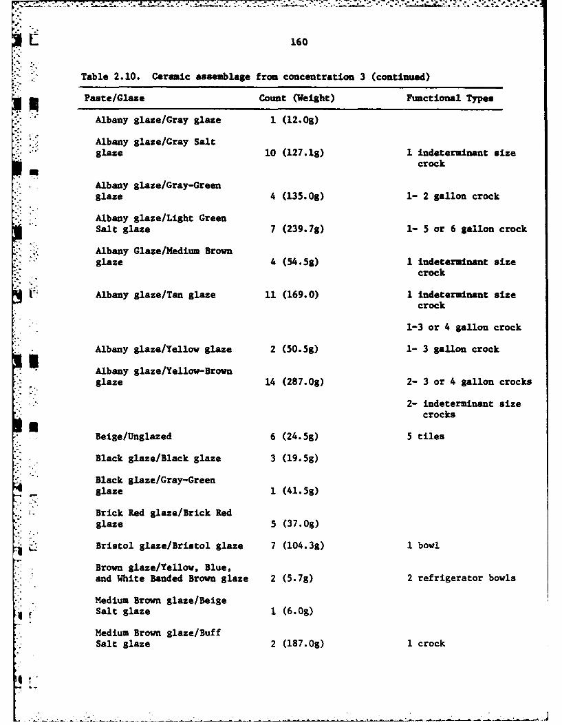
160
Table 2.10. Ceramic assemblage from concentration 3 (continued)
p Paste/Glaze Count (Weight) Functional Types
Albany glaze/Gray glaze 1 (12.0g)
.. : Albany glaze/Gray Saltglaze 10 (127.1g) 1 indeterminant size
crock
Albany glaze/Gray-Green
glaze 4 (135.0g) 1- 2 gallon crock
Albany glaze/Light Green
Salt glaze 7 (239.7g) 1- 5 or 6 gallon crock
Albany Glaze/Medium Brown
glaze 4 (54.5g) 1 indeterminant sizecrock
Albany glaze/Tan glaze 11 (169.0) 1 indeterminant sizecrock
1-3 or 4 gallon crock
Albany glaze/Yellow glaze 2 (50.5g) 1- 3 gallon crock
Albany glaze/Yellow-Brownglaze 14 (287.0g) 2- 3 or 4 gallon crocks
2- indeterminant sizecrocks
Beige/Unglazed 6 (24.5g) 5 tiles
Black glaze/Black glaze 3 (19.5s)
Black glaze/Gray-Greenglaze 1 (41.5g)
Brick Red glaze/Brick Redglaze 5 (37.0g)
Bristol glaze/Bristol glaze 7 (104.3g) 1 bowl
Brown glaze/Yellow, Blue,and White Banded Brown glaze 2 (5.7g) 2 refrigerator bowls
Medium Brown glaze/BeigeSalt glaze 1 (6.0g)
Medium Brown glaze/BuffSalt glaze 2 (187.0g) 1 crock
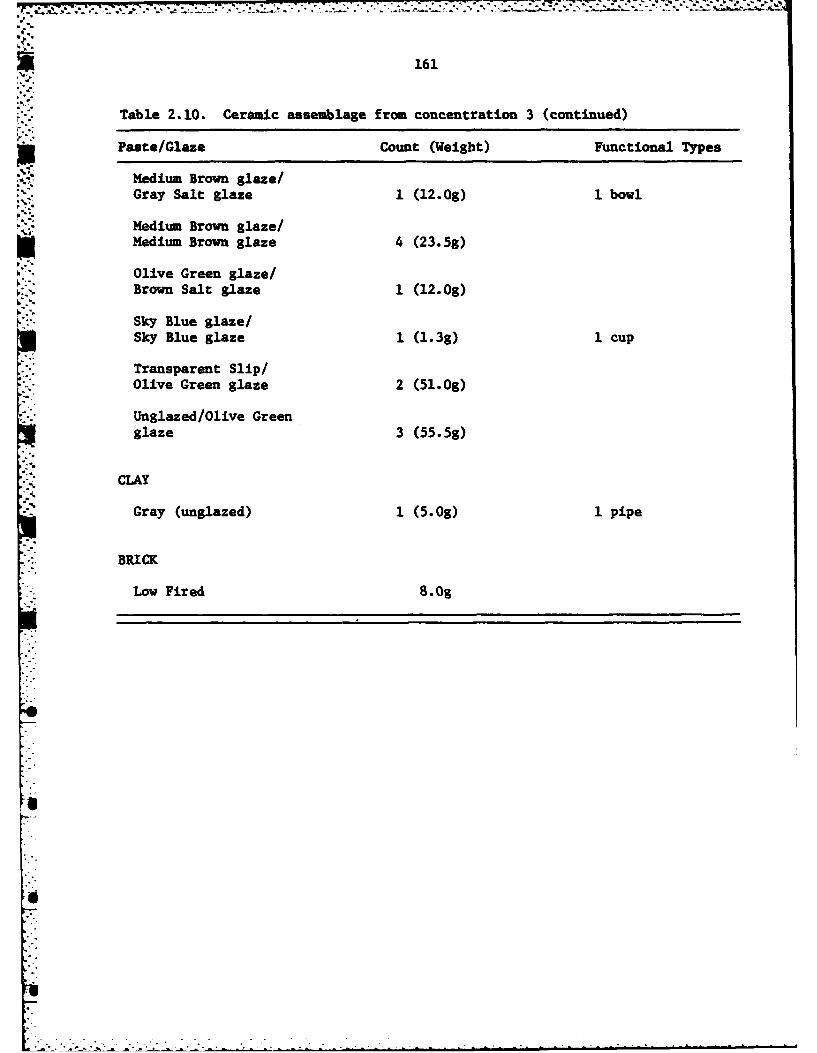
161
Table 2.10. Ceramic assemblage from concentration 3 (continued)
pPaste/Glaze Count (Weight) Functional Types
Medium Brown glaze/Gray Salt glaze 1 (12.0g) 1 bowl
Medium Brown glaze/Medium Brown glaze 4 (23.5g)
Olive Green glaze/K.Brown Salt glaze 1 (12.0g)
Sky Blue glaze/Sky Blue glaze 1 (1.3g) 1 cup
Transparent Slip/Olive Green glaze 2 (51.0g)
Unglazed/Olive Greenglaze 3 (55.5g)
CLAY
Gray (unglazed) 1 (5.0g) 1 pipe
BRICK
Low Fired 8. Og

L 162
bear fragments of makers marks consisting of the Royal Coat of Arms but they
are insufficient to date or identify. Another piece carries the words "Royal
Ironstone" which means it must date after 1850 when "Royal" was first added
to names. A stoneware crock sherd has an applied ceramic handle. Such handles
were replaced around 1915 by metal bales (Viel 1977:15).
Decorations include an embossed wheat design below the rim of a cup and
saucer of white glazed ironstone. Alfred Meakin's copper lustre tea leaf
pattern is present on one cup sherd (Fig. 2.10d). Decalware is represented by
a floral motif in beige and pink (Fig. 2.10b).
Agricultural (n-5)
This assemblage consists of a plowshare fragment, two mower blades, and
two pieces of round. None of the pieces in this assemblage, necessarily had
anything to do with the historic occupation of this spot. All could be intru-
fsive.Architectural (n-13)
Architectural or building related artifacts include two hinges, two strap
* hinges with rivets, two latches, one lock plate, on boat spike, four 1 in.
staples and one 1 in. staple.
Arms (n-1)
This category consists of a single copper cartridge case.
Blacksmith (n-24)
The blacksmith related assemblage consists of six pieces of iron bar,
LZI six pieces of banding, four pieces of rod, one horseshoe, three horseshoe
*. ifragments, one riveter (Fig.211), one rivet, one screwdriver fragment, one
sheet iron fragment, and a small amount of miscellaneous iron.
Household (n=12)
. "This assemblage consists of a drawer pull and 11 cast iron artifacts,
classified as stove parts including two stove legs (Fig. 2.12a & b).
i,

Figure 2.11. Riveter, Concentration 3.
1.
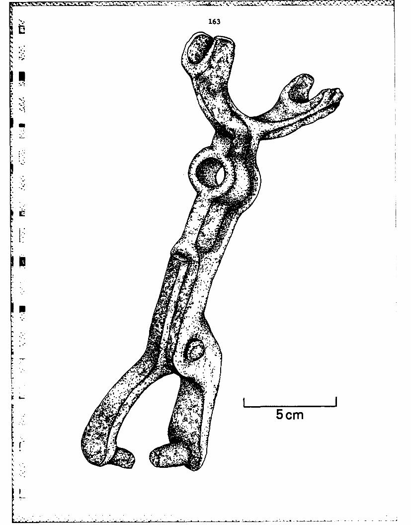
163
A * I
4

Figure 2.12. Stove parts, Concentration 3:(a-b) stove legs; (c) body fragment.
- ' t > . - S . .- -.--. --.-----..--.--------.-* -------. -..- -

L 164
at
Ul-
5cm

165
Miscellaneous Tools (n-6)
Miscellaneous tools include a 9 in. wrench, a vertical sprocket, a sprocket
.: seat, a socket head, a file, and a file fragment.
': Nails (n-47)
The pennyweight distribution of square and wire nails is provided in Table2 11.
Nuts and Bolts (n=6)
Members of the nuts and bolts assemblage include two bolt fragments, one
carriage bolt, one 6& in. bolt, and two 3/8 in. nuts.
Personal (n-3)
This assemblage includes a clothes buckle, a suspender buckle (Fig.2.13b),
and a pocket knife (Fig.2.13c).
Wagon and Harness Parts (n-12)
Wagon and harness parts recovered include one harness buckle, one wagon
hook, one brow iron, one whiffle tree bolt head (Fig.2.13d), one whiffle tree
spring, one wheel hub, one hub rim, one clip, one wagon rod, one wagon handle,
and two pieces of wagon strap bar.
Discussion
Concentration 3 is the largest and most complex of the surface assemblages.
Many of the artifacts are of a household nature, but a sizeable number are more
commercial or industrial affiliated. Attributtng Concentration 3 to a household
is not sufficient. Nor does an interpretation of the area as a dumpsite with-
stand scrutiny: during the days when the town existed, locating a dump along
its main thoroughfare would not have been a wise civic move. Once the town
was defunct, there was no reason for a farmer to despoil a portion of a good
field with an accumulation of historic debris. It is unlikely that this is
fill transported from elsewhere to fill in a low-spot as the town was located
on the floodplain and depressions have not been encountered there in other parts

166
* Table 2.11. Concentration 3 nail size.
SQUARE WIRE
Penny Weight Count Penny Weight Count
-Fragments 10 Fragments 6
2d 1 6d 1
3d 3 8d 3
4d 2 10d 1
6d 1 12d 4
7d 1 20d 2
8d 7
10d 2
16d 1
20d 1
No. 12 Tack 1
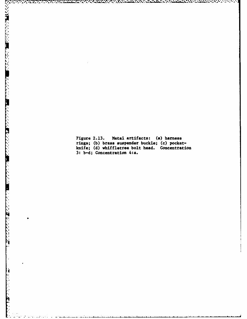
Figure 2.13. Metal artifacts: (a) harnessrings; (b) brass suspender buckle; (c) pocket-knife; (d) whiffletree bolt head. Concentration3: b-d; Concentration 4:a.

1 167
Iv
5cm
.. . . . . . .
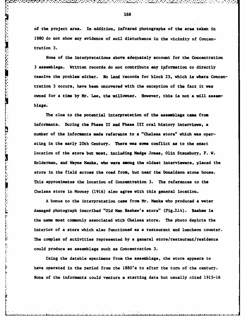
"i , " "- ".-;': - %- - -- S : - ' ---. "-"--"o. ---'-,-.-.---- -"- -- "..- .,-.-." -"-..---j,-.- , ;" "...- • -" --'' -
..- "'- ..- "- .- -
168
of the project area.. In addition, infrared photographs of the area taken in
1980 do not show any evidence of soil disturbance in the vicinity of Concen-
tration 3.
None of the interpretations above adequately account for the Concentration
3 assemblage. Written records do not contribute any information to directly
resolve the problem either. No land records for block 25, which is where Concen-
"" tration 3 occurs, have been uncovered with the exception of the fact it was
. owned for a time by Mr. Lee, the millowner. However, this is not a mill assem-
blage.
The clue to the potential interpretation of the assemblage came from
informants. During the Phase II and Phase III oral history interviews, a
number of the informants made reference to a "Chelsea store" which was oper-
, ating in the early 20th Century. There was some conflict as to the exact
* location of the store but most, including Madge Jones, Olin Stansbury, F. W.
Holderman, and Wayne Hanks, who were among the oldest interviewers, placed the
store in the field across the road from, but near the Donaldson stone house.
*This approximates the location of Concentration 3. The references to the
Chelsea store in Mooney (1916) also agree with this general location.
A bonus to the interpretation came from Hr. Manka who produced a water
damaged photograph inscribed "Old Man Bashaw's store" (Fig.2.14). Bashaw is
the name most commonly associated with Chelsea store. The photo depicts the
interior of a store which also functioned as a restaurant and luncheon counter.
The complex of activities represented by a general store/restaurant/residence
could produce an assemblage such as Concentration 3.
Using the datable specimens from the assemblage, the store appears to
have operated in the period from the 1880's to after the turn of the century.
None of the informants could venture a starting date but usually cited 1915-16

Z9'.."
Figure 2.14. Interior of "Old Han Bashav's*store", early 20th century. Photograph
courtesy of the Kansas Collection, KennethSpencer Research Library, University of Kansas.
Lg
I.o
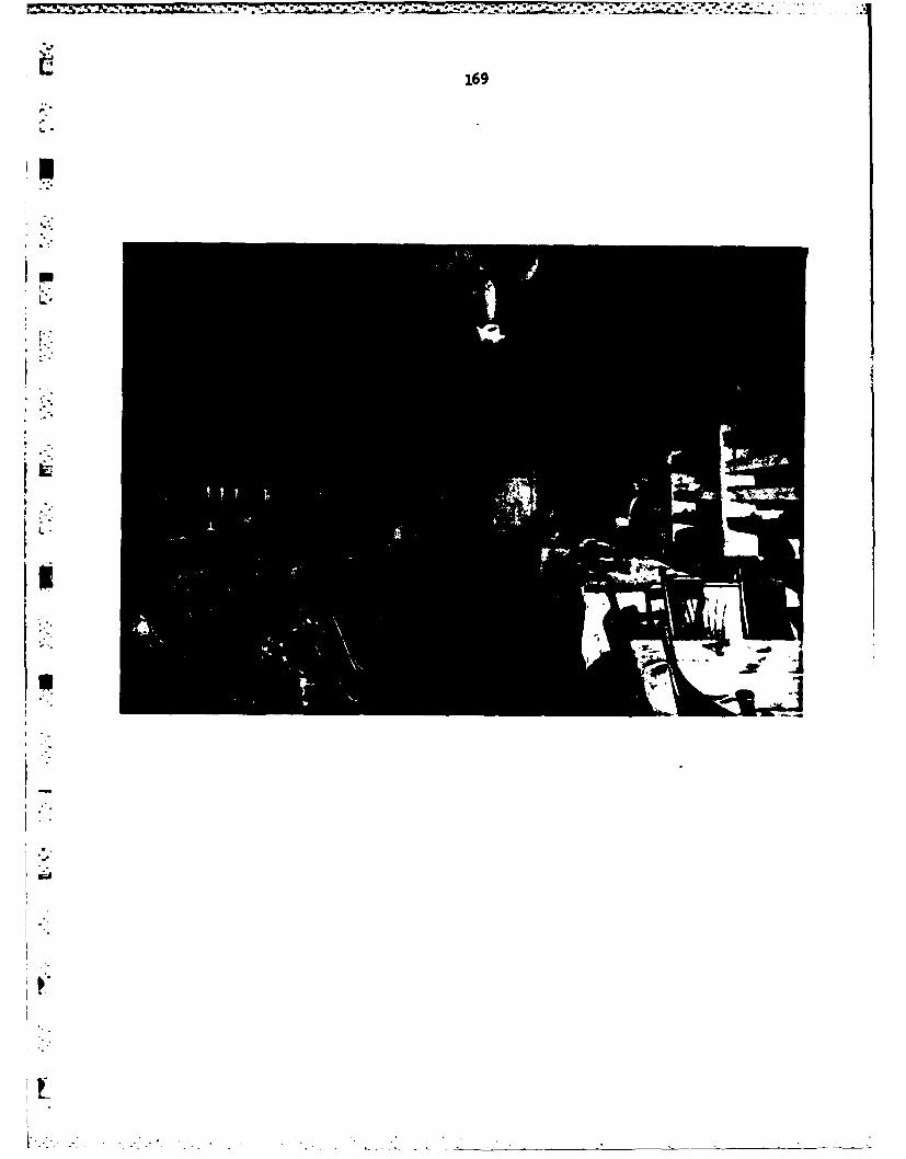
~169
:-.
I-
I-:
aa
'I.
Eo
"2- - - . --"- - -
170
as a terminus for the store. On the basis of these data the "Chelsea store"
does not appear to have actually been a part of the town of Chelsea. However,
it was definitely a central focus of the Chelsea coununity.
CONCENTRATION 4
Concentration 4 occurred north of the wire fence, near the datum stake
(Fig.2.8). It covered portions of lots 1-4 block 18.
Flat Glass (n-8)
The flat glass assemblage consists of green tinted glass in three thick-
nesses: 1.3 m (one specimen), 1.5 mm (2), and 2.0 am (5).
*Bottle Glass (n-38)
Comprising the bottle glass assemblage are three amber fragments, five
aqua, 13 clear, 11 green tinted, five light amethyst, and one milk. Only one
-* neck is included, a flair finish, clear specimen with an estimated one inch
* orifice diameter; possibly an ink bottle. Other notable specimens include
the rim of a drinking glass; a stemware base with a star-burst pattern; a clear
*glass, single-finger handle; melted green tinted glass, and a green tinted
basal fragment with an apparent hard suction cut-off scar. Such scars are
* left by a bottle making machine which was developed in 1904 (Toulouse 1969:582).
: Ceramics (n-35)
Table 2.12 privides the paste/glaze and functional types that comprise the
ceramic assemblage.
Harness Parts (n-1)
7The only element in this class is a set of heavy-duty, three inch harness
rings (Fig. 2. 13a).
Square Nails (n-3)
Three square nails, 6d, 7d, and 9d were recovered.
I t "- : . , . . . ... .
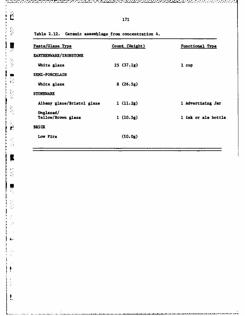
171
Table 2.12. Ceramic assemhlage from concentration 4.
n Paste/Glaze Type Count (Weight) Functional Type
EARTHENWARE/IRONSTONE
White glaze 25 (37.1g) 1 cup
m -SEMI-PORCELAIN
White glaze 8 (26.5g)
STONEWARE
Albany glaze/Bristol glaze 1 (11.2g) 1 Advertising Jar
Unglazed/Yellow/Brown glaze 1 (10.5g) 1 ink or ale bottle
Low Fire (i0.0g)
I
S
172Woodworking (n-3)
The woodworking assemblage consists of a nail punch, a two inch wood-
screw, and a fragment of a carpenters bit.
Discussion
This concentration occurs in the business or comercial section of the
town. It is not surprising, therefore, that the assemblage differs from those
characterized as domestic. The two containers identified as possible ink
bottles would be items comon in any business establishment (hopefully filled
with profit-black ink). However, the most significant artifacts may be the
small woodworking assemblage because lots I and 2 were owned by a carpenter'N'named Wilcox, ca. 1870. The archaeological assemblage thus provides a direct
link with the historical record. Of the remaining two lots, 3 may have been
the site of a doctor's office, but the records are unclear and none of the
recovered artifacts are classified as medical.
CONCENTRATION 5
Concentration 5 occurred at the very northern extremity of the Phase IV
project area. It is opposite the Holderman House (H-78-8, see Roberts and
" Wilk 1981), a residence that was occupied for approximately 100 years.
Flat Glass (n-4)
Four fragments of green tinted flat glass were recovered. Each was a
different thickness: 1.4, 1.7, 2.5, and 2.7 mm.
Bottle Glass (n-29)
The bottle glass assemblage is composed of one fragment of amber, eight
of clear, one of cobalt blue, nine of green tint, one of emerald green, seven
of light amethyst, one of lime green and one of milk. Two specimens (one
amber and one light amethyst) are the bases of flasks; three are insulator
fragments; two are Coca Cola bottle fragments, and one light amethyst specimen
.* has a partial label: -LIN- (Liniment?).
... ....

, ..
173
i "". Table 2.13. Ceramic assemblage from concentration 5.
Paste/Glaze Type Count (Weight) Functional Type
EARTHENWARE/IRONSTONE
White glaze 2 (3.Og)
EARTHENWARE/IRONSTONE
Blue Transfer Printed ware 1 (6.2g) 1 Plate
STONEWAREAlbany glaze/ Yellow Brownglaze 1 (17.5)
Medium Brown glaze/ BrownSalt glaze 1 (13.0g)
BRICK
High Fire (249.3g)
Low Fire (7. Og)
* L.

r174Ceramics (no5)
The small ceramic assemblage is presented in Table 2.13. Only one speci-
men is notable, a dark purple-blue transfer printed ironstone plate sherd
(Fig.ZlOa). The sherd is classified a Staffordshire ware and the design is
similar to that produced by Alfred Fenton and Sons (1887-1901) (Anderson 1981:
130).
Aaricultural (n-1)
The assemblage consists of a single piece of twisted round wire.
Architectural (n-2)
One hinge element and a one inch staple comprise the architectural assem-
blage.
Household (n-I)
The single specimen in this assemblage is a relatively recent tin can.
Nuts and Bolts (n-2)
An 11h in. T-Bolt with a one inch hexagonal nut and 6 in. oval-head bolt
with a 3/4 in. nut comprise this assemblage.
Discussion
The few pieces in this assemblage that suggest any age beyond the recent
past are probably associated with the long-term occupation of the Holderman
house.
CONCENTRATION 6
Concentration 6 was located south of Concentration 5. This concentration
extended into the tall grass and weeds on the east, that marked the boundary
of the field (Fig.2.8).
Bottle Glass (n-1l)
The bottle glass assemblage consists of four fragments of amber, four
of clear, two of green tinted, and one of light amethyst.
S
175
Ceramics (n-8)
Concentration 6's ceramic assemblage is presented in Table 2.14.
Blacksmithing (n-i)
One piece of banding was recovered.
Mechanical (n-i)
A pressure gauge from an unknown type of machine was collected.
Discussion
Concentration 6 was singularly uninspiring. Except for a small gap,
Concentrations 5 and 6 could have formed one long distribution probably
- related to the Holderman house occupation.
CONCENTRATION 7
Concentration 7 covered a small area in the northeast corner of the field.
.* The material extended into the treeline along the northern border (Fig. 28).
Flat Glass (n=12)
Twelve pieces of green tinted flat glass were recovered. Five different
thicknesses are represented: 1.8 (1), 2.1 (4), 2.5 (3), 2.8 (3), and 3.0 , (1).
* Bottle Glass (n17)
Two fragments of amber, two of aqua, two of clear, one of dark amethyst,
five of green tinted, four of light amber and two of milk comprise the bottle
glass assemblage. A green tinted bottle neck, broken at the rim, has a seam
* that goes up two-thirds the length of the neck indicating a ca. 1860-1880
*" manufacturing date. An amber crown cap bottle neck has a seam all the way to
the lip, indicating post-1904. The only other identifiable specimen in the
assemblage is an unmarked, milk glass jar lid liner.
Ceramics (n=12)
Ceramics recovered in Concentration 7 are presented in Table 2.15. The most
* notable specimens are the doll parts, a leg and a head (Fig.2.10c). These

i- -'6.-,-- -- -- -. -- . - - * . •,
176
Table 2.14. Ceramic assemblage from concentration 6.
Paste/Glaze Type Count (Weight) Functional Type
EARTHENWARE/IRONSTONE
White glaze 7 (16.6g) 1 Cup
SEMI-PORCELAIN
White glaze 1 (.3g)p.-.
. BRICK
High Fire (110. Og)
High " 4re with glazedsurface (33.0g)
6.-
U
°"
U:

177I.
pieces do not appear to be from the same doll. Unfortunately, these specimens
are not dateable.
, 3 Metal (n-i)
The only metal artifact from this concentration is unidentifiable.
Discussion
- .Concentration 7 represents a domestic assemblage. It is most likely
associated with the household responsible for Concentration 1 and the individ-
ual artifacts lumped into Groupings G and H.
-. CONCENTRATION 8
Concentration 8 was the northeastern most of the concentrations. Like
Concentration 7, Concentration 8's material extended into the treeline on the
* " field's northern border.
- Flat Glass (n-i)
* A single specimen of green tinted flat glass 1.9 mm thick comprises this
* class.
Bottle Glass (n-il)
n The bottle glass assemblage consists of two fragments of amber, two of
aqua, three of clear, three of green tinted, and one of light amethyst. The
only specimen of note is a clear glass piece embossed -DRUGG- (Druggist?) with
an elaborate emblem, possibly on ornate monogram (Fig. 2.9g).
Ceramics (n-18)
- The ceramic assemblage from Concentration 8 is presented in Table 2.16.
Agricultural (n-l)
The single element in this class consists of two pieces of round wire
twisted into interlocking loops.
Blacksmithing (n-2)
Two fragments of very large horseshoes were recovered.

178
Table 2.15. Ceramic assemblage from concentration 7.
Paste/Glaze Type Count (Weight) Functional Type
EARTHENWARE/IRONSTONE
White glaze 8 (32.8g) 1 Plate
- PORCELAIN
White glaze 2 (6.8) 1 Doll head
1 Doll leg
STONEWARE
Albany glaze/Albany glaze 1 (3.0g)
Medium Brown glaze/Buff glaze 1 (30.1g)
I%
4"
I
'-.
L [: 179
Table 2.16. Ceramic assemblage from concentration 8.
Paste/Glaze Type Count (Weight) Functional Type
EARTHEWARE/IRONSTONE
White glaze 9 (39.Og) 1 Plate
-. EARTMMNARE/CREMAREPale Yellow glaze/
Pale Yellow glaze 1 (4.4g) 1 Sugar bowl
STONE WARE
Albany glaze/Albany glaze 3 (56.0g) 1 Crock
Albany glaze/
Brown Salt glaze 1 (12.0g)
17 Albany glaze/
Buff glaze 1 (11.6g)
Brick Red glaze/
Brick Red glaze 1 (38.5g)
SINDUSTRIAPORCELAIN
White glaze 1 (11.Og) 1 Doorknob
I

180
Wire Nails (nm)
The only wire nail recovered in Concentration 8 is a 20d nail.
Miscellaneous Tools (n-2)
Two metal pipe fragments are included in this class.
* Metal (n-8)
Eight iron artifacts from Concentration 8 were unidentifiable.
Discussion
Concentration 8 is a domestic assemblage. It is possibly related to
Concentration I and 7 and Groupings G and H.
SUMMARY AND CONCLUSIONS
The Phase IV historical archaeological investigations at El Dorado have
*- substantially expanded our understanding of the historic period. On a more
practical level, these investigations highlighted the inherent difficulties
between documentary and archaeological research.
The testing programs at the Doc Lewellen and Donaldson sites were disap-
* pointing. Failure to locate the early historic deposits, leaves a critical
gap in the archaeological record of the area. Yet, something was learned from
those projects. The fact that documentary data is not enough is significant
In addition, the absence of any historic material in the survey areas, suggests
that deposits associated with the early historic period are very light, possibly
indicating minimal use of breakable items. Using what was learned in Phase IV,
it is recommended that surveys of poorly documented sites be undertaken as well
as those better recorded ones - the probabilities of success are likely to be
equal.
The mapping and surface collecting procedure at the New Chelsea site was
a great success. Artifact assemblages are now available for at least five
*different types of occupations in the town. The large number of specimens
p.
":L 181
identifiable as to point of origin will significantly increase future analyses
of economic networks in the area. Also significant is the degree of correspon-
dence between archaeological data and written records: four assemblages show
a particularly strong relationship but more than half of the total assemblage
comes from areas about which there are no written records. The Phase IV
: :investigation has demonstrated how historical and archaeological data can
. complement and supplement one another.
An expansion of the mapping and collecting procedure to the rest of the
site would contribute more data about the town's development. In addition,
excavation in areas where the materials are collected may reveal intact sub-
U.: surface features and deposits that can be used to reconstruct structures and
- behavioral patterns.
I
"I '_
182
REFERENCES CITED
Anderson, Elizabeth1981 Analysis of Historic Ceramics from the El Dorado Lake Area. In,
Archaeological Investigations at El Dorado Lake, Butler County,Kansas, Phase III, Sumer 1979, P. E. Brockington Jr. (Editor).MS, U.S. Army Corps of Engineers, Tulsa District. Tulsa, Oklahoma.
Andreas, A. T.
1883 History of the State of Kansas. A. T. Andreas, Chicago.
K Baker, Stephen G... 1978 Historical Archaeology for Colorado and the Victorian Mining Fron-
tier; Review, Discussion, and Suggestions. Southwestern Lore,44(3):11-31.
Baldwin, Joseph K.1973 A Collector's Guide to Patent and Proprietary Medicine Bottles of
the Nineteenth Century. Thomas Nelson, Inc., New York.
Brown, Kenneth L.1981 Archaeological Testing of Historic Sites in the El Dorado Lake
Area. In, Archaeological Investigations at El Dorado Lake, ButlerCounty, Kansas, Phase III, Sumer 1979, P. E. Brockington Jr.(Editor). MS, U.S. Army Corps of Engineers, Tulsa District.Tulsa, Oklahoma.
r Buckles, W. G.1978 Doing It, or, Strategies for Surveying Historic Sites and Analyz-
ing Historic Artifacts. In, Anthropological Investigations Nearthe Crest of the Continent 1975-1978, W. G. Buckles (Editor), pp.388-461. Report submitted to the Water and Power ResourcesService, Denver, Colorado.
Commissioner's Journal1878 Journal of the Butler County Commission, El Dorado, Kansas.
Cramp, A. J.1921 Nostrums and Quackery, Vol. 2. Press of American Medical Associa-
tion, Chicago.
F" Deed Bookn.d. Butler County Deed Books, Register of Deeds, El Dorado, Kansas.
Godden, G. A.1964 Encyclopaedia of British Pottery and Porcelain Marks. Crown
Publishers, Inc., New York.
Herskovitz, R. M.1978 Fort Bowie Material Culture. Anthropological Papers of the Univer-
sity of Arizona, Number 31.
6l
183
Kansas Private Laws1858 Kansas Private Laws. Kansas State Historical Society, Topeka.
5 Leaf, Gary R.1976 An Archaeological Research Design and Salvage Mitigation Plan for
the El Dorado Reservoir, Butler County, Kansas. Department of theS."Interior, National Park Service, Interagency Archeological Services,
-. Office of Archeological and Historical Preservation. Denver,Colorado.
Mooney, V. P.1916 History of Butler County, Kansas. Standard Publishing Co.,
Lawrence, Kansas.
Price, Edward T.1968 The Central Courthouse Square in the American County Seat.
"' Geographical Review 58(l):29-60. New York.
Roberts, Ricky L.1981a An Introduction to Historic Sites Archaeology in the El Dorado
r Lake Area. In, Prehistory and History of the El Dorado Lake Area,Kansas (Phase 11), M. J. Adair (Editor), pp. 462-571. Universityof Kansas Museum of Anthropology. Project Report Series, Number47. Lawrence.
1981b Preliminary Excavations at the New Chelsea Site, 14BU1007: TheBlacksmith Shop. In, Archaeological Excavations at El DoradoLake, Butler County, Kansas, Phase III, Summer 1979, P. E. Brock-ington Jr. (Editor). MS, U.S. Army Corps of Engineers, TulsaDistrict. Tulsa, Oklahoma.
Roberts, R. L., and Mary Wilk1981 Historic Sites in the El Dorado Lake Area: A Background Volume.
* "- MS, U.S. Army Corps of Engineers, Tulsa District. Tulsa, Oklahoma.
* Sprague, Roderick1981 A Functional Classification for Artifacts from 19th and 20th Cen-
*. tury Historical Sites. North American Archaeologist 2(3):251-61.
-- Stratford, J. P. and L. P. Klintworth1970 The Kingdom of Butler. 1857-1970. Butler County Historical
Society, El Dorado, Kansas.
* Thomas, Floyd R., Jr.1981 An Historical Perspective on Chelsea. In, Archaeological Inves-
tigations at El Dorado Lake, Butler County, Kansas, Phase III,Summer 1979, P. E. Brockington Jr. (Editor), pp. 356-398. MS,U.S. Army Corps of Engineers, Tulsa District. Tulsa, Oklahoma.
Toulouse, J. H.
1969 A Primer on Mold Seams. Western Collector 7(12):578-87.
1971 Bottle Makers and their Marks. Thomas Nelson, Inc., New York.

184
Turner, F. J.1894 The Significance of the Frontier in American History. American
Historical Association, Annual Report for the Year, 1893, pp. 199-227.
Viel, L. C.1977 The Clay Giants: The Stoneware of Red Wing, Goodhue County.
Minnesota. Wallace-Homestead Book Co., Des Moines, Iowa.
Walnut Valley Times1883 El Dorado, Kansas, Newspaper, August 31.
Wetherbee, Jean1974 A Handbook on White Ironstone. Privately published, Canajoharie,
New York.
, o
a
4,

CHAPTER 3
A SUMMARY OF ARCHAEOLOGICAL INVESTIGATIONS AT
EL DORADO LAKE, 1977-1980
by
Alfred E. Johnson
In 1967, the Museum of Anthropology at the University of Kansas
* : entered into a contract with the National Park Service to conduct a sur-
vey of the prehistoric archaeological resources of El Dorado Lake, being
planned for construction by the U.S. Army Corps of Engineers on the Walnut
River in Butler County, south-central Kansas (Fig. 3.1). The survey re-
[L sulted in the discovery of 28 sites, several of which were deemed to have
potential significance sufficient to warrant study prior to their destruc-
tion as a result of construction activities or inundation.
U !This survey was the initiation of a long-term project for the Museum,
now drawing to a close (1981) with the nearing completion of El Dorado
Lake. Major goals of the project, throughout its history, have been con-
* tributions to the theory, methodology, and substantive base of anthropolo-
gical archaeology, and mitigation of the effect of dam construction on the
€- local cultural resources through data recovery. Funding for the project,
- provided by the National Park Service, the Butler County Historical Soc-
iety, and the University of Kansas, was limited and sporadic from 1967
until 1977. At the latter date, and as a result of legal obligations re-
sulting from recently-passed federal legislation, the U.S. Army Corps of
Engineers (Tulsa District) assumed responsibility for completion of the
mitigative effort. The present report is a summary of the results of this
effort. A summary of accomplishments of the period from 1967 to 1977 is
readily available (Leaf 1979a:5-15), while the bibliography following
185

Figure 3.1. Map showing location of El Dorado Lake (from Drew 1981, Fig 1.1)
K.K.I

• .. 186
K "
•' .
• I--I
I.
St
Uw
°- .

• • , • . 4 • - • - ° -°
" °- .°
"• . . -.. "° °, ° . . -* * - - . " ° - • . - .°° -•
187
(Appendix 1) lists all of the publications ard manuscripts completed to
date as a result of work of the Museum at El Dorado Lake.
In 1976, prior to initiation of the U.S. Army Corps of Engineers
sponsored effort to complete the mitigation of the effect of the const-
ruction of El Dorado Lake on local cultural resources, the Museum dev-
eloped a comprehensive research design (Leaf 1976). Following review,
by both the Corps of Engineers and the National Park Service (Inter-
agency Archaeological Services), this design was judged acceptable as a
guide for future investigations. As set forth in the research design,
principle goals of the project were: "(1) to retrieve data and test hypo-
theses on prehistoric subsistence and settlement systems; and, (2) to
conduct an interdisciplinary program to retrieve data and test models of
paleoenvironments useful for the study of prehistoric cultural-ecological
relationships. Operationally these enquiries are organized in such a man-
ner so as to maximize the rescue of relevant data from the present to the
time of dam closure in 1980" (Leaf 1979a:l).
In so far as possible, within limits imposed by restricted funding,
time, and personnel availability, the Museum has adhered to the goals set
forth in the research design. One major addition came about as a result
of site survey work in 1977, which indicated the presence of numerous
sites of the historic period at the Lake. As summarized below, signifi-
cant attention has been devoted to developing an understanding of the
-- historic period occupation complementary to that of the prehistoric.
PALEOENVIRONMENTAL MODELING
As set forth in the research design for the El Dorado project, a
major goal has been to contribute to a better understanding of the envir-
II

. ." .. . . . . .
188
onments of the past to which the prehistoric and historic occupants of the
u *area had to adjust. Attempts to achieve this goal have taken two direc-
tions, one successful, the other not. The successful approach is a re-
sult of the study of the local geology, soils, and geomorphology, while
the unsuccessful is palynology. In an attempt to asses the potential ofm
palynology as a means to reconstruct local vegetation patterns (which are
in turn interpretable in terms of broadscale environmental factors), the
Museum sub-contracted with James King of the Illinois State Museum, to
collect and analyze pollen samples from several locations at El Dorado
Lake. Unfortunately, "none of the samples collected from the several
localities in the El Dorado project yielded any pollen" (King 1979:206).
Despite the negative results of this particular test, King (1979:206) iscareful to point out the capricious nature of pollen preservation. His
encouragement for additional studies in this locality is proving well-
founded, especially with the application of new techniques for the re-
covery and extraction of pollen (W. Johnson, Dept. of Geography,
n ,University of Kansas, personal communication).
More successful have been geomorphological studies, which suggest
(Figs. 3.2, 3.3), in outline, the nature of several Pleistocene and Holo-
cene events which have shaped the present configuration of the El Dorado
Lake area. Earlier events include an erosional stripping of the Walnut
Valley to bedrock (excepting a residual coarse stream gravel), deposition
of a reddish-colored regolith (possibly loess), and washing of portions
of this regolith into the valley to form a red alluvium. Modern remnants
of the red alluvium are equated with the T-1 and the Norge Soil Series. At
least two periods of extensive erosion can be identified following the de-
4
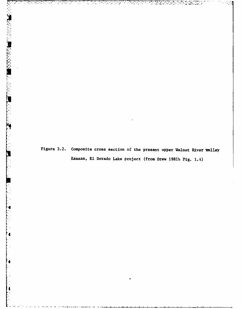
Figure 3.2. Composite cross section of the present upper Walnut River valley
Kansas, El Dorado Lake project (from Drew 1981b Fig. 1.4)
, .--I ---.--- , • , " -. " - . " -' " ." ' " " -2 " ' ' " .. ' " ., : .' : : .' -' -" -' ' " ' T ' I ., , .' .i" ..
4.
I.
1a
4..'
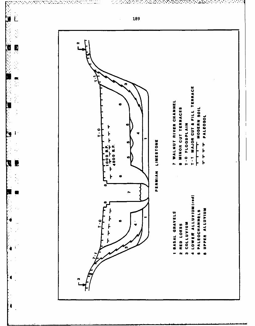
L 189
r6z
IM
IA2 -1-aZr 0 -%
Sm ~~z 0J -0 u -I
4- IC
_ LL
IIA
I..I4UI

Figure 3.3. Geological history of the upper Walnut River valley, Kansas, El
Dorado Lake project (from Drew 1981b, Fig. 1.5)
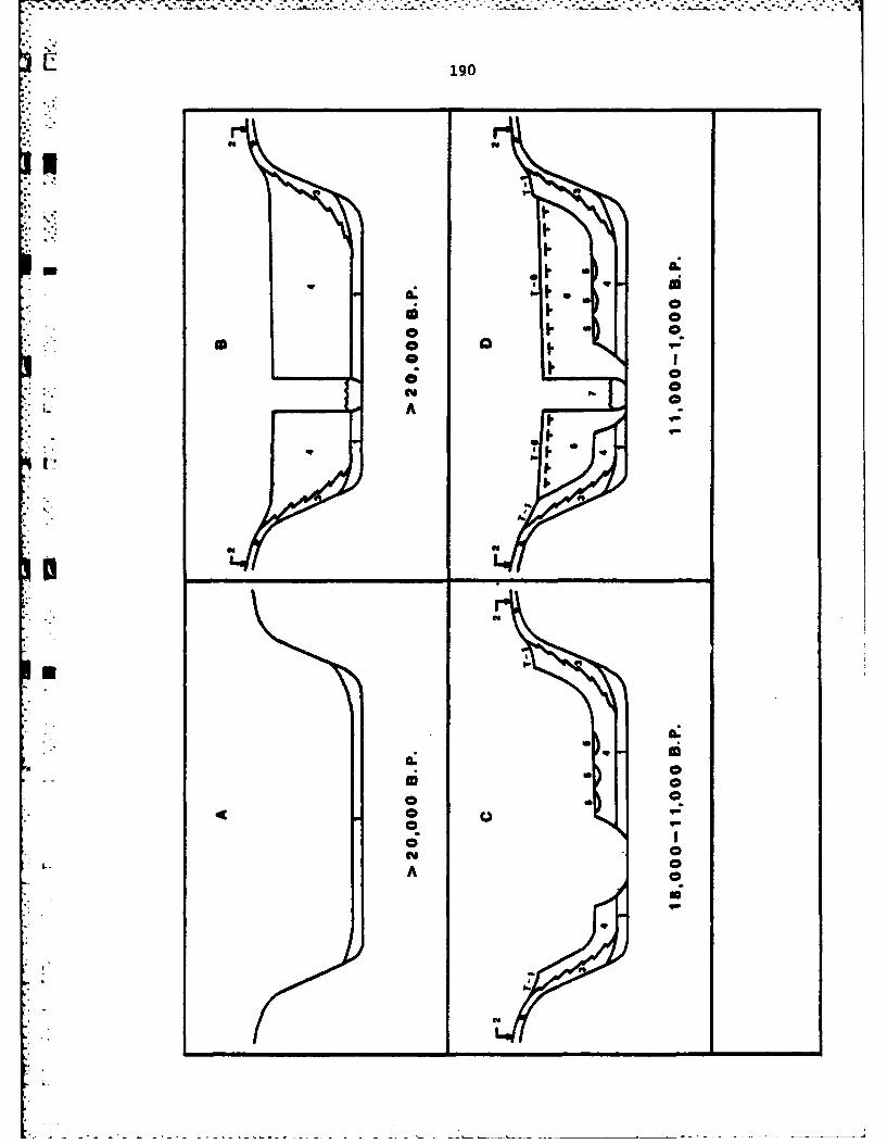
I-
@ II.
- -
a ,,
a 0
":iA 0
191
position of the red alluvium. Field examination of deposits leading to
this history of events have, unfortunately, not produced datable associa-
tions, and as a consequence, it is not possible to assign temporal estimates
more precise than those indicated on Figure 3.3. The estimates are based
on postulated rates of geological processes and radiocarbon dates from
archaeological sites buried in overlying alluvial deposits (Drew 1981: 2-7).
Holocene valley filling, initiated by perhaps 11,000 B.C., resulted
in the deposition of a gray upper alluvium. Periods of temporary stabil-
ity are indicated by the presence of paleosols. Detailed study of one of
these paleosols, which incorporates Late Archaic archaeological deposits,
indicate the paleosol was formed on a deposit which was aggrading slowly
between ca. 2000 B.C. and A.D. 1, the aggradation perhaps a function of low
intensity, basin-wide floods. From ca. A.D. 1-1000, the Woodland archaeo-
logical period in this area, alluvial deposits are indicative of a period
of disequilibrium, probably a result of increased rainfall in the form of
convectional storms. By ca. A.D. 1000, equilibrium had once again been
achieved, with establishment of an esssentially modern rainfall pattern
and stream regime. Correlations, based on soil, geomorphic, radiocarbon,
and archaeological data, suggest a similar pattern from western Missouri
4 into southwestern Oklahoma (Artz 1980).
In summary, geomorphological studies conducted as an integral part
of the El Dorado Lake project, have produced new data helpful in predic-
4: ting the location of buried archaeological sites and in reconstructing
the nature of past environmental settings to which the inhabitants of
the prehistoric Central Plains had to adjust. More detailed interpreta-
tions are anticipated with completion of two additional studies currently
underway.
192
* PREHISTORIC ARCHAEOLOGY
As it had not been set as a goal of the pre-1977 archaeological
investigations at El Dorado Lake, a complete inventory of surficial site
- :locations was not available for either the research endeavors of the arch-
aeologists or the management responsibilities of the Corps of Engineers.
As a consequence, a major focus of the 1977 season was a search for new
sites, as a supplement to the data on 51 which had accumulated previously
(Root 1979:31). Special attention was devoted to an attempt to "locate
*sites in the upland prairie and hillside areas between the flood pool of
El Dorado Lake and federal property boundaries, and in areas along the
Walnut River and its feeder creeks with unexpected low site density"
(Root 1979:31).
This search resulted in the discovery of 15 new sites, bringing the
U total to 66 for the federal property at El Dorado Lake (Fig. 3.4). This
, total includes a surprising number of buried sites (e.g., 14BU9--Snyder;
i " 14BU25--Milbourg; 14BU81), discovered accidentally as a result of exposure
*i !through recent erosion or an occasional deep trench in a site with surfi-
cial remains. It seems likely that the total for the Lake could be in-
creased significantly if resources were available for a systematic soil
probe and mechanized trenching program in those portions of the valley
fill which our soil-geomorphic studies indicate have the highest potential.
Several of the sites at El Dorado Lake were reoccupied and as a con-
sequence, 75 occupational components can be recognized. As diagnostic
artifacts were not recovered from 30 components, these cannot be assigned
to culture-historical taxa. The others can be assigned as follows: Late
Archaic (ca. 3500 B.C.-A.D. l)--16; Plains Woodland (ca. A.D. 1-1000)-- 24;
Plains Village (ca. A.D. 1000-1700)--5.

Figure 3.4. Map showing the location of prehistoric archaeological sites at
El Dorado Lake (from Root 1979, Fig. 2.2.)
I-
II
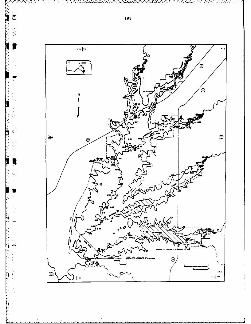
193
rC 0
49
N
40

., -.. - .. . -. - -j * . . . ,, s .- ,,- 4 .... , .- . -., . . . . - . . .. .-. --. . .,. .. .. ..
194
Table 3.1. Prehistoric archaeological sites tested at El Dorado Lakefrom 1977 through 1980.
- Site Year Tested Cultural Affiliation(s) Reference
14BU5 1978 Plains Woodland Parisi 1981:76-108
14BU16 1978 Plains Woodland Artz 1981a:60-77
14BU27 1977 Plains Woodland Leaf 1979:173-187
14BU30 1977 Plains Village Leaf 1979b:158-172
14BU31 1977 Plains Woodland Leaf 1979b:78-111
14BU32 1979 Plains Woodland Leaf and Root:l-46
14BU571 1977 Plains Woodland- Leaf 1979b:112-141Plains Village
14BU72 1980 Plains Woodland Parisi 1981:14-48
14BU73 1980 Unknown Parisi 1981:48-75
14BU81 1978 Walnut phaseEl Dorado phaseChelsea phase - ? Artz 1981a:77-119
14BU82 1977 Plains Village Leaf 1979b:141-158Plains WoodlandArchaic
14BU87 1978 Plains Woodland Art? 1981a:119-146Walnut phase - ?
iLarge-scale excavations were subsequently conducted at 14BU57 in 1979(M. Brown 1981).6
I!U
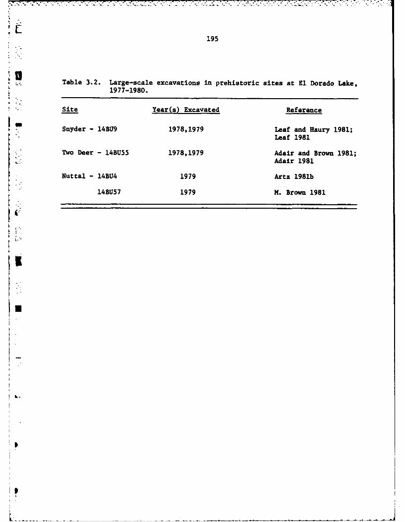
195
UTable 3.2. Large-scale excavations in prehistoric sites at El Dorado Lake,
1977-1980.
Site Year(s) Excavated Reference
Snyder - 14BU9 1978,1979 Leaf and Haury 1981;Leaf 1981
Two Deer - 14BU55 1978,1979 Adair and Brown 1981;Adair 1981
Nuttal - 14BU4 1979 Artz 1981b
14BU57 1979 M. Brown 1981
U

S.
Figure 3.5. Location of Archaic sites within the El Dorado Lake area
(from Root 1981b, Fig.3J-).
a~o
aI"
'a-
S- ------',- -

196
EL DORADOLAKE
rFki
* 41
U9
46-
kum

197
In addition to the survey, another goal set by the research design was
a systematic program of testing designed to collect data on "the number,
areal extent, internal structure, and cultural affiliation of archaeologi-
cal components recognizedat each site" (Artz 1981a:54). Prehistoric sites
tested from 1977-1980 are listed in Table 3.1. Large-scale excavations
were planned for a limited number of especially significant sites, and
those accomplished are listed in Table 3.2.
THE ARCHAIC PERIOD
One of the most recent overviews of the archaeology of the Great
Plains notes that, "Plains Archaic materials in the Central and Southern
Plains are not well known" (Wedel 1978:199). Although we have not encoun-
tered deposits of material culture remains that pertain to the earlier
portions of the Archaic, we are, as a result of the work at El Dorado
Lake, able to contribute to a fuller understanding of the nature of Late
Middle and Late Archaic developments (Fig. 3.5).
Much of our knowledge of the Late Archaic at El Dorado Lake comes
from excavations at 14BU9, the Snyder site. As well be apparent from an
examination of Table 3.3, not only is Snyder important to an understand-
0 iing of local developments at El Dorado Lake, but as well, it provides,
through its long stratigraphic sequence, the means to organize much of
the scattered data on the Late Archaic from the remainder of the State of0
Kansas.
Data from occupation zones at the Snyder site have permitted the
definition of four phases of occupation (Grosser 1973: 228-38). For themmost part, the Woodland Butler phase (about A.D. 200-800) deposits are
DI

198
100
m ~~~ cc 1 4 M 4
w4 0 r- "4i w n W 04 c 0%"4 D "s V * E- 14 E .0 0 m% Do 0%
000 ~ 4440W1. %0k "40 0 V-4. a'- 410~
"00 0 0 Ln 0 -41 00 to40 4I 0 In~ '0 4r- . c 0 It -I- .. 0%
t + 00 "4 4 %C I- DV4. 4 cc t 00 U 0 w 1 000-W w M M 00 t1" P- "4c r40%u00 N "411++ 0c wU" .J*
04- W Wf' 41 w1 0m + +1tw4 0) "4i0 4%.8 0 0 "4
(D% 4) 44%0M 0 0> >0 "4 0 0 ' en N 0 .4-
C r- 4 i .4 4.00011.40 30mr- "4"4
f 0 4 e 0.' 0 4.00d4 1 L r- 0 S - -4
0r $.j4. 15. 1 ii AS'-C1to 1 0 04t 't > I 00 "4 "q4.~ 0 cc 0. 0 0 cn N 0-""0 " 4 0 0% "4 "400 " E-4
*"0) 0 "4 I~ 0 tA 004JU
(a$ "4 (D.1r "4o-C.-
"0 m m II 4 -
"4 "4 -r4 IA 4 ~ ir0 41 4) ;00"a C 0 4) 0 r.
.0 a) 0% 0. :3. "m4.001 4 C'0 $4 . .. ^ . l%D
mk 0 "40 "-4CA03 0 0 a 00 c
00 0 4 r4
.'0"4 "4r4 0)- ~- 4"0~C 04 M0 " 4. . -r- 4 "4 W
"4 "4 "4 0 0 -'J w-*
M.0 00 . Ic I PCcd 00I V-4 kn 0
x 00 r. 0 - 0%004 0 0 0 w 0 "4
"00 $4 4 I ) ) 0 )I)m0 "4 V "4 PC4(
"i40 44 m 1 4 . 0 c c 9 4 c 0 P0o0 cc> t0 w w 0 0 A
4r c- CA C'PC04c 1 . 0 .
00 w 01 0 0 w 0 .~0 Ln . 0
0 ~ ~ ~ . 00n 0
F4 4 P,4 Ct tn t)" I t + t IV0 cc 0 0 %Q 0 )c
cc ) N 4-4 r- 4 v-4. N% C 14 N~'.0
C4.
C'n (41

199
restricted to the plow zone (A), but also extend into a lower, discontin-
uous Zone B. Three Archaic phase occupations occur below a deposit of
sterile yellow-brown clay (Zone C). Zone D, which contains the evidence
"- - for the three Archaic phases, is a mottled, dark, gray-brown soil, varying
from I to 1.5 m thick. The uppermost Archaic occupation, the Walnut phase,
is characterized by small, corner-notched projectile points and an associa-
ted tool kit suggesting that hunting was a major subsistence activity.
Radiocarbon dates are 20+110 B.C. (N-769) and 110+80 B.C. (N-1276), while
typological similarities of the artifacts suggest a range from about 1200
B.C. to A.D. 1.
Changes in artifact styles and earlier radiocarbon dates separate the
*-.*- earlier El Dorado phase deposits from those of the Walnut phase. El Dorado
phase projectile points are long, narrow, and stemmed, with straight or
convex bases, similar to Dustin and Lamoka points from the eastern United
States. Four associated radiocarbon dates range from 1290+ 85 B.C. (N-1277)
to 2030+100 B.C. (N-1278). A different style of projectile point, along
with a somewhat different lithic assemblage, and greater stratigraphic
depth in Zone D provide justification for identifying a third Archaic
phase, Chelsea. Chelsea phase projectile points have broad, oval blades,
concave bases, and shallow corner or side notches. Radiocarbon dates from
levels immediately below Chelsea deposits are 2650+125 B.C. (N-1280) and
2880+105 B.C. (N-1269) (Grosser 1973; 1977).
The El Dorado phase is of special interest in understanding adaptive
patterns during the Plains Archaic. Features associated with this phase
included extra-mural hearths, burned limestone concentrations, storage
pits, and a flexed burial. Excavations have not yet succeeded in defin-
ing the form, but habitation structures are indicated by post molds, con-
S

200
* centrations of burned daubing clay, and fired mud dauber's nests. Taken
as a whole, the El Dorado phase features suggest an occupation area of
some permanence (Grosser 1973, 1977; Klepinger 1972).
Resources exploited by the El Dorado phase inhabitants at Snyder in-
clude 17 species of mammals, two of fish, one amphibian, two species of
reptiles, two of birds, fresh water mussels, and the seeds of Celtis,
Amaranthus, and Chenopodium. No evidence for tropical cultigens has yet
been found. The variety of resources exploited indicates that the El
* .Dorado phase can be characterized as a diffuse adaptive pattern in the
Cleland (1976) model. This interpretation is supported by the varied
lithic assemblage, which includes six styles of projectile points (in add-
ition to the diagnostic Dustin points), seven varieties of knives, as well
as drills, choppers, chipped axes, scrapers, grinding stones, and hammer-
LI stones. The only artifacts of bone are tubular beads (Grosser 1977).
As a consequence of our knowledge of the importance of the Snyder
site to an understanding of the Late Archaic period in the Plains (as sum-
Smarized above), one of the major excavation projects undertaken, withCorps of Engineers support, was at the Snyder site. The goals of this
project were to gain types of data not collected during earlier tests, and
larger samples of types of data poorly represented (Grosser 1977). These
goals were accomplished through application of state-of-the-art techniques,
inLIluding large-scale water screening and floatation and three-dimensional
piece plotting of artifact locations. Back-hoe-trenching was used to de-
termine the spatial extent and depth of the deposits, and to open expos-
ures for the collection of soil and pollen samples.
A 10 x 10 m. block excavation was opened at the Snyder site (Fig. 3.6)
and carefully excavated using the procedures noted above to a depth of

Figure 3.6. Map of the Snyder site, 14BU9 (from Leaf 1981, Fig. 4.2).
6--
6 .
6 °

20,1
• 14BU9
-~N Sober*@ C4~
oi I
subo 0
4 *: /,/i b
moor
. 4, / Is, I' / ","""*
/ 1 , / I !I ,.,'
0 I 0 SO-O
,, * Subrea lr 1
I.
)
[" ,.

202
* 140 cm. below surface. At this depth, samples have been drawn from Wood-
land, Walnut phase, and El Dorado phase deposits. Unfortunately, resources
were not available to further sample the Chelsea phase deposits, nor to
learn more of the nature of an apparently extensive pre-Chelsea deposit
(Haury and Leaf 1981), which is known only from one hand-dug and several
back-hoe trench excavations. The lost opportunity to sample this pre-
Chelsea deposit is especially regrettable as it potentially might have
informed us of the nature of Middle or Early Archaic adaptive patterns,
which remain essentially unknown in this portion of the Plains.
Although work at the Snyder site was halted before the Chelsea phase
deposits were reached, some additional information is available on this
phase from limited excavations at other sites in the Lake area. The Milbourn
site, 14BU25, is hypothesized to have been a base camp, reoccupied during
several different warm seasons by groups of hunters pursuing bison, proghorn,
wapiti, and deer. Rather than an area of permanent occupation, the upper
Walnut River Valley may only have been a hunting territory for populations
to the south and east. A radiocarbon date of 2485+100 B.C. (UGa-2806) re-
lates the site to the Chelsea phase (Table 3.3) as do artifact similarit-
ies (Root 1981b). Interestingly, a much larger sample of hafted bifaces
from Milbourn (Fig. 3.7), than is available from Chelsea phase deposits at
Snyder (Grosser 1977), indicates striking similarities with the hafted bi-
faces from the Coffey site (Miller 1979), to the north at Tuttle Creek Lake.
Details of the interaction implied by these similarities remain problems
for the future.
While the quantity of debris, and the variety of activities suggested
by an analysis of this debris (Root 1981b), indicates the Milbourn site
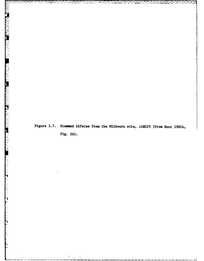
Figure 3.7. Stemud bifaces from the Hilbourn site, i4BU25 (from Root 1981b,
Fig. 26).
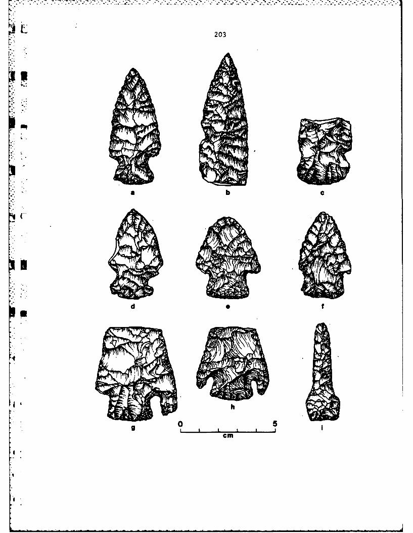
~AL 203
li
a b c
d 0 f
I h
0 51cm

204
was a base camp, studies of the buried Archaic component at the Nuttal
site, 14BU4, point to another aspect of the Chelsea phase settlement
system, a task-specific locus. The five spatially-distinct clusters of
artifacts uncovered are consistent assemblages of chipping debris, re-
sulting from the manufacture and maintenance of tools, especially pro-
jectile points. Locally-available Florence A chert (Haury, In Press),
was brought to the site in the form of heat-treated cores. Evidence for
small open fires was discovered, and burned bone suggests that meat was
cooked and eaten. All in all, the data from 14BU4 point to a hunting
camp (Artz 1981b:33-4).
Although limited in quantity, the variety of tools, as well as the
presence of a few features (2 hearths, 3 post stains, 2 pits) suggest
that the Chelsea phase occupation of the Snyder site may be interpretable
as that of a base camp (Grosser 1977). This is also the case for the
Milbourn site, while data from Nuttal suggest a temporary hunting camp.
. Perhaps then, the Chelsea phase occupation of the upper Walnut River
valley can best be interpreted as a result of the seasonal round of groups
of hunters and gatherers, normally resident further to the south and east,
who, during the warm season of the year, established bases for hunting
operations with hunts also conducted from temporary camps. Desirability
of the location would seemingly stem from the presence of abundant chert
resources for the manufacture of tools, a reliable supply of potable water
in spring-fed streams, cover and firewood in the gallery forests along
the Walnut and tributary streams, and perhaps most important, proximity
to the herd animals of the blue-stem prairie.
Data on the Late Archaic El Dorado phase are available from excava-
tions at the Snyder site, 14BU9 (Grosser 1977; Leaf and Haury 1981), and
4"

* .. . . . . . . . . . . . . . . . . . ° . . .. . . ,. ,, 7 b o
205
from test excavations at 14BU81 and 14BU89. As summarized above, an occu-
3 pation of some permanency is indicated for the El Dorado phase component
at the Snyder site. This "base camp", seemingly provided a focus for pre-
agricultural hunters-and-gathers who also operated from temporary hunting
4 a camps such as at 14BU89 (Artz 1981a:119-146). Insufficient data are avail-
able from 14BU81 to permit an assignment of function, although the site is
notable for its stratigraphic similarities to Snyder. At the surface is
a Walnut phase component, which is underlain by El Dorado phase materials.
" -* A third component, unfortunately lacking diagnostics, but perhaps equat-
able with the Cheslea phase, is present at depths greater than 90 cm. be-
low surface.
An El Dorado phase component has also been identified at John Redmond
Lake on the Neosho River, approximately 50 miles north and east of El
Dorado Lake (Schmits 1980). This spread suggests the phase is of reg-
ional import, and consequently of significance to the eventual develop-
ment of an understanding of the prehistory of the Central Plains.
U A third, less well known, but important, Late Archaic phase recog-
nized for the El Dorado Lake area is the Walnut. Radiocarbon dates for
* the phase, only available from the Snyder site are 110+80 B.C. (N-1276)
and 20+110 B.C. (N-769). Grosser (1973:228-38), on the basis of compar-
ative studies, suggests the phase may have a duration of approximately
1200 years (ca. 1200 B.C.-A.D. 1). Notable among the artifacts assoc-
iated with the Walnut phase are small "Walnut Valley Corner Notched" pro-
jectile points, which are of a size appropriate for use on an arrow, and
so are among the earliest indicators of the introduction of this new set
of technological equipment (bow-and-arrow) to this portion of the Plains.
Despite the implications of this latter statement for an understanding

206
* of Plains prehistory, precious little is known of the Walnut phase. In
addition to samples from the Snyder site (Grosser 1977; Leaf and Haury
1981), limited data on the phase are also available from the surface of
14BU81 (see above), and possibly from 14BU87. It is unfortunate that re-
sources were not available for a large-scale excavation at the latter
site, as test excavations disclosed a buried archaeological component in
deposits which could be correlated with deposits which contained the
gq Walnut phase component at the Snyder site. No diagnostics were forth-
coming from the tests in the buried archaeological level at 14BU87 (Artz
1981a:154).
Although ceramics have not yet been recovered from Walnut phase com-
ponents (and for this reason, in addition to the early radiocarbon dates,
the site is assigned to the Archaic), it is interesting to note the sim-
iliarities between Walnut phase lithic tools (Grosser 1977), and those
from the Traff site, located on the Little Blue River in Jackson County,
Missouri (Kansas City locality) (Wright 1980). Ceramics, resembling the
Early Woodland diagnostic type Black Sand Incised (Griffin 1952:98, P1.
28), are present at Traff. Radiocarbon dates from Traff are 395+70 B.C.
(UGa-2535) and 505+80 B.C. (UGa-2404), suggesting a rough temporal equiv-
*4 alency to the Walnut phase. Although Early Woodland sites have not yet
been identified to the west of the Missouri River in the Central Plains,
special attention should be devoted to data recovery in future excava-
4tions in Walnut phase components in search of ceramics.
PLAINS WOODLAND
Although many facets of the human adaptive patterns recognized in the
El Dorado Lake area for the Late Archaic period undoubtedly continued
after the time of Christ, important innovations, including pottery vessels

207
Table 3.4. Radiocarbon dates from Woodland sites in the El Dorado Lakearea (based on a half-life of 5568 years). From Artz, InPreparation.
CalendarLab RadiocarbonSite Context DateNumber Years B.P.i~i ':(Uncorrected)
*UGa-2561c 14BU9 Composite sample fromflotation 520 ± 55 A.D. 1430
*UGa-3044a 14BU32 XU103/XUl04(composite sample) 720 ± 70 A.D. 1230
UGa-1347d 14BU71 Feature 2(limestone-filled pit) 740 ± 75 A.D. 1210
UGa-3137e 14BU57 Excavation Unit 5(composite sample) 755 ± 235 A.D. 1195
UGa-1345d 14BU55 House 1 890 ± 60 A.D. 1060
UGa-2504b 14BU55 1 m2 excavation unit(composite sample) 950 t 135 A.D. 1000
N UGa-1346d 14BU55 House 1 970 ± 80 A.D. 980
UGa-2501b 14BU55 Feature 18(charcoal concentration) 984 t 45 A.D. 965
UGa-2500b 14BU55 Feature 6.3 (charcoal concentration) 1065 ±65 A.D. 885
UGa-2503b 14BU55 Feature 19 (post mold) 1090 ± 55 A.D. 860
UGa-2560f 14BU31 Feature 3G2(limestone-filled pit) 1215 ± 55 A.D. 735
UGa-2807 14BU31 Feature 304(limestone-filled pit) 1240 ± 75 A.D. 710
"4 *Dates rejected because of recency or stratigraphic inversion.
a Lefb c dLeaf and Root 1981; Adair and Brown 1981; unpublished; Fulmer 1977;
eBrown 1981; fRoot 1981.
a,
4

.°.-
208
and domesticated plants (Adair and Brown 1981:237-356) were added during
jthe Plains Woodland period (A.D. 1-1000). The earliest radiocarbon date
from an El Dorado Lake Plains Woodland component is A.D. 710+75 from
14BU31 (Table 3.4), a site tested in 1977 (Table 3.1). An even earlier
Plains Woodland component at the Snyder site (14BU9) is suggested by the
presence of sherds with Middle Woodland design elements (Grosser 1970:94-5).
Middle Woodland expressions in this region date between A.D. 1 and 500
(Johnson 1979). The presence of other styles of Woodland pottery (Grosser
Ki 1970, Table 32) at Snyder and the indications of spatial separation of
these differing styles (Grosser 1970:159-61) suggest several reoccupations
over a long period of time. Unfortunately, much of the Woodland data at
Snyder has been disturbed by plowing, although recent excavations demon-
strate the presence of intact lenses of Woodland material in the Vanoss
surface soil which overlies the paleosol that contains Archaic deposits.
The sample of more than 11,000 artifacts (many of which came from two
concentrations), in association with postmolds and wattle-and-daub frag-
ments, obtained from upper levels of the 10 x 10 m. block excavation be-
gun in 1978, leads to the inference that the site was not only used in a
transitory way, but as the locus of a hamlet or small village, possibly
occupied for more than a single generation (Leaf 1981:220-1).
As previously sunnarized (Root 1981a:357):
14BU31 was test excavated in 1977; investigations arethoroughly described by Leaf (1979). The site represents theremains of a small Woodland base camp, located along the Wal-nut's west bank. Cultural debris is scattered over a 1.0 ha.area, but river meandering may have destroyed as much as halfthe site. Limited investigations consisted of excavating two2 by 2 m. test units and digging three backhoe trenches. Stonetools made of local and exotic cherts; limestone tempered, cordmarked ceramics; food remains and cooking facilities werepresent. Possible subsistence items include fish, molluscs,

209
rabbit, seeds, and nuts. Activities carried out at or assoc-iated with the site include food preparation and consumption,
T u tool manufacture, wood working, hide scraping, hunting, andbutchering. Ceramic vessels may have been used for food pre-paration and/or storage. Inferred activities indicate ahunting and gathering subsistence mode. A date of 1215+55radiocarbon years: A.D. 735 (UGa 2560) was obtained from awood charcoal sample recovered from feature 302.
-Subsequently, a second date from a separate sample was forthcoming--1240+
75 B.P. or A.D. 710 (average of the two--A.D. 723).
The most substantial data set on the nature of Plains Woodland hamlet
or village occupation at El Dorado Lake is forthcoming from large-scale
excavations at the Two Deer site, 14BU55 (Adair and Brown 1981; Adair 1981).
Two deer, situated along Bemis Creek an eastern tributary of the Walnut
River, dates to approximately A.D. 1000+-25 (average of six radiocarbon
- dates--Table 3.4). A large sample of artifacts, and smaller but signifi-
cant, samples of faunal and floral remains were obtained from within and
around the remains of two structures., Although difficult to define, one
of the structures was apparently a surface, wattle-and-daub covered dom-
icile oval to rectangular in outline, and measuring about 12 m. in dia-
*: . meter. Concentrations of domestic debris, including pottery sherds, lithic
tools, faunal and floral remains, and bu&.ied limestone fragments, and two
metates, within the structure were useful in deliniating its outline and
extent (Adair 1981). The second structure, marked by 13 post mold stains,
outlining a portion of a rectangle with rounded corners oriented with its
long axis from northeast to southwest, lacked a similar concentration
of domestic debris and may, therefore, represent an extra-mural ramada
or drying rack. Portions of structure two had been destroyed by erosion
(Adair 1981).
Faunal remains, including deer, racoon, beaver, rabbit, bison, and

~~~~ ~~~~ -" -" - -' -'. . : ' - ' "- '-' - "- " " "" " . U . . -. ' i " '
210
turtle, were poorly preserved, in part, probably as a result of the prac-
tice of using crushed bone for pottery temper (Adair and Brown 1981,
Table 5.5). Floral remains are abundant and suggest the inhabitants of
14BU55 may have utilized as many as 40 different genera of native wild
plants, while relying heavily on three: Chenopodium spp.--goosefoot;
Juglans nigra--black walnut; and Quercus sp.--acorns. The presence of
two tropical cultigens, Cucurbita pepo and Zea mays, along with the seeds
of Helianthus annua (sunflower) of a size large enough to indicate domes-
tication, demonstrate at least a partial reliance on agriculture (Adair
1981, Table 8).
An important long-standing problem in the culture-history of the
Central Plains is the relationship between the Plains Village tradition,
dated from A.D. 1000-1700, and the Plains Woodland tradition, from A.D.
1-1000. Two Deer offers data towards the solution of this problem in
that it dates to the period of the assumed transition from Plains Wood-
land to Plains Village. The presence of artifacts, including corner-
notched and side-notched arrow points and elongate and globular cord-
marked pottery vessels, recognized as diagnostic of the two traditions,
points to a transitional position for the site (Adair and Brown 1981).
Additional support for an in-place transition from Plains Woodland
to Plains Village is forthcoming from excavations at 14BU57 (M. Brown
1981). Unfortunately, structural remains were not discovered at this
site, although the presence of burned daubing clay and a pit suggest some
permanency to the occupation. Recovered ceramics could be classified
to the Verdigris type, a diagnostic of the Plains Woodland tradition
Greenwood phase (Reynolds 1979). That, however, the site is extremely
late in the Woodland tradition is indicated by a radiocarbon date of

*[
211
A.D. 1195+235, as well as the presence of triangular side-notched and un-
*| 3 notched arrow points (Plains Village tradition diagnostics). A kernel of
Zea mays demonstrates that at least limited agriculture supplemented a
subsistence still heavily reliant on natural products including deer, fish,
M probably birds, acorns, walnuts, and hickory nuts (M. Brown 1981).
The Nuttal site, 14BU4, was mentioned above in connection with the
discussion of the Archaic period occupation of the El Dorado Lake area
as it has a buried component assignable to the Chelsea phase (Artz 1981b).
" - The site is also important for an understanding of Plains Woodland settle-
ment systems of this locality. The evidence for Plaifs Woodland occupation
of the Nuttal site is spatially-separated and to the south of the location
of the Chelsea phase component, as well as restricted to surficial depos-
*i - its, extending from the surface to a depth of 50 cm.
Evidence for permanancy for the Plains Woodland occupation was lacking.
Rather, transitory and perhaps seasonally-occupied camps, along the crest
of a natural levee were encountered. Abundant natural resources of a
back swamp may have been the attraction for the apparently repeated use
of this levee as a camp location. Analyses of the spatial distribution
of artifacts demonstrate differentials interpretable in functional terms,
including chipped stone manufacture, food preparation, and refuse disposal.
Although ceramic sherds were invariant in the presence of exterior
cordmarking, variety was recognizable in temper types. Most of the sherds
were tempered with indurated clay, although a few sherds with sand, lime-
stone, and bone were present. Spatial differentials in the distribution
of sherds of these varying temper types (Artz 1981b), as well as compara-
tive studies, suggest changes through time in Plains Woodland ceramic
technology may be responsible for the variety noted in temper. Earlier

212
Plains Woodland pottery is frequently stone tempered (Johnson and Johnson
31982:7). Bone is present in the pottery at the Two Deer site (14BU55)dated to A.D. 1000+25 (Adair and Brown 1981), while indurated clay is the
norm for Pomona pottery of the Plains village tradition (Witty 1967).
Studies of larger ceramic samples will be required to test these hypo-
* theses (only 67 sherds were recovered from the excavations at the Nuttal
site--Artz 1981b). Among the other tools recovered from the Plains Wood-
Iland component at Nuttal, projectile points (primarily of the Scallorntype--Bell 1960:84) and light-duty cutting tools predominate. Scraping
tools are lacking from the assemblage, and heavy-duty chopping and/or
butchering tools are rare.
Data forthcoming from the Nuttal site (14BU4) then, contribute signi-
.ficantly to an understanding of at least one settlement system of the Plains
Woodland period in the El Dorado Lake area. Not only were Plains Woodland
populations dwelling in small hamlets or villages of some permanency (Two
Deer, 14BU57, Snyder), they were exploiting the natural environment from
camps (perhaps seasonally) established at loci providing special attrac-
tions (e.g., a levee perhaps adjacent to a back swamp at the Nuttal site).
In many respects, this pattern seems remarkably similar to the one pre-
viously described for the Late Archaic.
Although use of the Upper Walnut drainage system during the Plains
Village tradition (A.D. 1000-1700) is documented (Fulmer 1977; Leaf 1979),
it is not detailed as insufficient resources were available to conduct
excavations in sites of this tradition during the post-1976 period of
intensive archaeological field work at El Dorado Lake. Five componentsadiscovered as a result of the survey of the Lake can be assigned to the
Plains Village tradition. That at least some date tc the pre-A.D. 1500
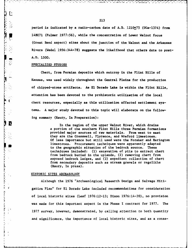
LT
213
period is indicated by a radio-carbon date of A.D. 1210+75 (UGa-1374) from
* 314BU71 (Fulmer 1977:56), while the concentration of Lower Walnut focus(Great Bend aspect) sites about the junction of the Walnut and the Arkansas
Rivers (Wedel 1956:344-78) suggests the likelihood that others date to post-
M A.D. 1500.
SPECIALIZED STUDIES
Chert, from Permian deposits which outcrop in the Flint Hills of
Kansas, was used widely throughout the Central Plains for the production
" of chipped-stone artifacts. As El Dorado Lake is within the Flint Hills,
attention has been devoted to the prehistoric utilization of the local
chert resources, especially as this utilization affected settlement sys-
* tems. A major study devoted to this topic will elaborate on the follow-
ing summary (Haury, In Preparation):
In the region of the upper Walnut River, which drainsa portion of the southern Flint Hills three Permian formations
* -provided major sources of raw materials. From west to eastthey are the Cresswell, Florence, and Wreford limestones.Of less importance but still used were the Foraker and Heringtonlimestones. Procurement techniques were apparently adaptedto the geographic situation of the bedrock source. Thesetechniques included: (1) excavation of pits to extract chertfrom bedrock buried in the uplands, (2) removing chert from
K exposed bedrock ledges, and (3) expedient collection of chertfrom secondary deposits such as stream gravels or regoliths(Haury, In press).
HISTORIC SITES ARCHAEOLOGY
Although the 1976 "Archaeological Research Design and Salvage Miti-
gation Plan" for El Dorado Lake included recommendations for consideration
of local historic sites (Leaf 1976:12-13; Dixon 1976:14-20), no provision
was made for this important aspect in the Phase I contract for 1977. The
r '1977 survey, however, demonstrated, by calling attention to both quantity
and significance, the importance of local historic sites, and as a conse-

70
7214
quence major attention was devoted to developing an understanding of this
period during all of the subsequent phases of work at the Lake (Roberts
1981a; 1981b; 1981c).
The Historic period at El Dorado Lake begins in 1857 with the arrival
of the first Anglo-Americans, many of whom have descendants in the area to-
day. Consequently, the most efficient means of developing an initial inven-
tory of historic sites was a combination of personal interviews, studies of
gdocumentary sources, and pedestrian reconnaissance. These activities, car-
ried out in 1978, resulted in the location of 66 Historic sites greater
than 50 years of age (Figure 3.8). The 1978 survey for historic sites
was conducted within the framework of research goals which guided all of
the work at El Dorado Lake (see above): "...the intention was to recover
data that would be useful in developing an understanding of the adaptions
the settlers made to their environment, the economic networks that were
operating, and the social system that existed" (Roberts 1981a:465).
Combining the results of studies of local oral and documentary history
with data forthcoming from archaeological test excavations (Table 3.5),
allows the recognition of a period of initial Anglo-American settlement,
beginning in 1857, in the forested, fertile, bottomlands along the Walnut
'4 River. Perhaps attracted to this environment because of its similarity to
"homelands" in forested eastern portions of North America, these early
settlers of the El Dorado Lake area built log cabins and farmed the flood-
4d plains close to the river. Flooding of homesites soon made it obvious that
adjustments would be necessary, and by the late 1860's shifts to higher
ground were taking place. Concomittant with these shifts were changes in
building materials, as later structures tend to be of wood-frame construc-
tion or of stone.
4'

Figure 3.8. Map showing location of historic sites at El Dorado Lake
(from Roberts 1981a, Fig. 10.1).
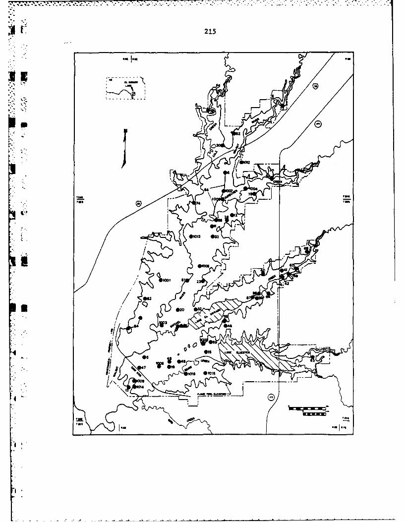
215
mit mu a
mTO
LIOn
Ova on
%10ft
.4 a

216
Following solution of these early problems of settlement, mastery of
agricultural pursuits, and population growth, establishment of a town, to
serve as an economic hub and as a legal and political center by virtue of
its designation as a county seat, became an important local goal. Although
seemingly with growth potential as the county seat, Chelsea eventually de-
clined with the growth of El Dorado, its rival to the south, to become one
of more than 2,800 towns established in Kansas during the latter half of
the 19th century which were soon to decline and disappear (Wilk 1981;
Roberts 1981b).
Brief summaries of the results of test excavations in sites providing
data for this overview follow. (Test excavations at sites listed in Table
3.5 but not summarized below were negative.)
14BU1002--FOSTER
The Foster site, 14BU1002, consisted of the remains of a homestead
farm established in 1874 by Charles Foster, later to become a successful
sheep raiser and breeder. Prior to the archaeological tests at the Foster
site, all structures had been moved or razed. The test excavations dis-
closed that one of the buildings had originally been constructed as a wa-
gon scale, and later converted into an ice house (Roberts 1981a).
'6 14BU1005--DOC LEWELLEN SITE
Site 14BU1005 includes the remains of the farm homes and outbuildings
of one of the earliest of the El Dorado area's Anglo-American pioneers,
Doc Lewellen. Lewellen arrived in Butler County, Kansas in 1857 and init-
ially constructed a log cabin on the floodplain west of the Walnut River.
Subsequently, he constructed a stone cabin and barn on higher ground east
of the Walnut, and finally, a wood frame house in the uplands. A success-
ful farmer and stockman, Lewellen eventually owned in excess of 1160 acres
.
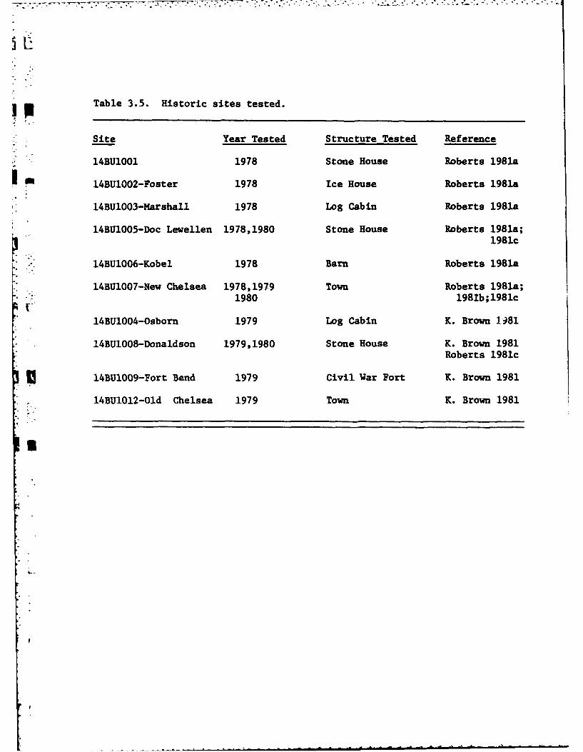
Table 3.5. Historic sites tested.
Site Year Tested Structure Tested Reference
14BU1001 1978 Stone House Roberts 1981a
rn14BU1002-Foster 1978 Ice House Roberts 1981a,
14BU1003-Harshall 1978 Log Cabin Roberts 1981a,
14BT31005-Doc Levellen 1978,1980 Stone House Roberts 1981a;
1981C
14BU1006-Kobel 1978 Barn Roberts 1981a
14BU1007-New Chelsea 1978,1979 Town Roberts 1981a;1980 1981b ;1981c
14BU1004-Osborn 1979 Log Cabin K. Brown 1)81
14BU1008-Donaldson 1979,1980 Stone House K. Brown 1981Roberts 1981c
14BU1009-Fort Bend 1979 Civil War Fort K. Brown 1981
14BU1012-Old Chelsea 1979 Town K. Brown 1981

218
(Roberts 1981a:505-9).
In 1978, test excavations wexe conducted in proximity to the stone
cabin and in a nearby bank-barn. The cabin, of coursed masonry utilizing
local limestone, was stylistically a vernacular I-house with gabeled ends.
It measured 32 ft. 2 in. by 19 ft. 2 in., and probably originally had two
rooms and a loft (Roberts 1981a:509-13). Tests, placed on the north and
east sides of the cabin, disclosed a water-deposited silt build up, per-
haps a result of periodic flooding, and a layer of cobbles apparently
placed to compensate for the flooding (Roberts 1981a:516).
The barn, of Pennsylvania-German style, was constructed by cutting
building stones from an outcrop, thereby producing a solid limestone floor
and sufficient stone for foundation courses. The wooden superstructure
was destroyed by fire around the turn of the century, and subsequently,
many of the building stones were reused. Test units placed within the
barn were non-productive, as after the fire the structure had been cleared
for use for some new purpose (Roberts 1981a:516-19).
Additional test excavations in 1980, made in an attempt to locate the
original floodplain dwelling, a log cabin, were unsuccessful. The cabin
site may have been destroyed by natural erosion, or perhaps by the construc-
4 tion of a railroad (Roberts 1981c:117-121).
14BU1006--KOBEL SITE
Named for a son-in-law who was the owner until acquisition by the
Corps of Engineers for El Dorado Lake, this site consisted of the farm homes
and out-buildings of 1871 homesteader William Bailey. As a later arrival,
Bailey was able to take advantage of the knowledge gained as a result of
the unfortunate experiences of the earliest Anglo-American settlers with
bottomland flooding. As a consequence, the Bailey homestead was placed
-
p.
L219
on the first permanent rise above the floodplain and away from the river
from the first. The original farm home was a log cabin, replaced by a
wood frame house constructed in 1915 (Roberts 1981a:532-43).
• . Another important building in the farm complex was a Pennsylvania-
* German bank barn, apparently constructed at or soon after the 1871 home-
stead date. The barn, measuring 36 ft. 1 in. east-to-west and 32 ft. 4 in.
north-to-south, had a foundation of coursed blocks of local limestone and
a wooden superstructure. Tests in the barn allowed recognition of original
builder's trenches and produced a restricted range of artifacts perhaps
characteristic of the specialized activities at a barn. Included are items
of glass, pottery, and metal. Wire nails are most common indicating later
additions and repairs to the original structure which was constructed with
wooden pegs.
I14BU1004--THE OSBORN LOG CABINFollowing local historical records (Roberts and Wilk 1981), the loc-
ation of the Phineas Osborn log cabin was predicted to be on the flood-
plain of Durechen Creek, a major eastern tributary of the Walnut River.
A surface collection, from within a gridded area established in the
plowed field thought to contain the location of the cabin, was success-
ful in more precisely defining its location by means of concentrations
of historic artifacts dating to the proper period (the cabin was built
around 1874--K. Brown 1981:8-35).
Next, a cross-shaped test trench was excavated in an attempt to
establish the precise location of the cabin. That this step was less
successful is probably a result of recent agricultural activities which
have destroyed all traces of the foundation of the cabin. A concentra-
tion of gravel, perhaps associated with the construction of the cabin,
220
was the only possible indication of its exact position (K. Brown 1981:
8-35).
Artifacts from the Osborn cabin site indicate construction before
the latter part of the 19th century when wire nails became abundant and
abandonment before 1903 (on the basis of seam marks on two bottle frag-
ments). Other artifacts suggest limited wealth for the occupants, Army
service, the presence of children, and the production of dairy products,
especially cheese (large quantities of earthenware and stoneware crockery
vessel sherds--K. Brown 1981:8-35).
14BU1008--THE DONALDSON HOUSE
In 1979, tests were made about the location of a cut limestone
house built in 1869 by George T. Donaldson, an individual of importance
in the establishment of the nearby town of Chelsea. The Donaldson house
was north facing, two stories in height, with rubble-fill walls of local
limestone (K. Brown 1981:35-7).
Guided by infra-red photographs, excavation units were laid out over
two rectangular areas north and east of the stone house. The goal was to
recover artifacts indicative of past economic activities and the social
status of previous residents. The excavations encountered two features,
.4 a hearth and a stone-supported post location, as well as quantities of
historic material culture debris. Datable artifacts substantiated the
historic record as to the building date for the Donaldson stone house,
and indicated both greater wealth and social status for the early occu-
pants than was the case at the Osborn log cabin site (K. Brown 1981:37-35).
In 1979, additional tests were conducted to the south of the
Donaldson stone house in an attempt to locate the original home site occu-
pation (a log cabin constructed in 1857). That the attempt was unsuccess-
221
i 'ful is probably a combination of light occupation, subsequent development,
and agricultural activity which obliterated all traces of the original
cabin site (Roberts 1981c:122-35).
* 14BU1007--THE NEW CHELSEA SITE
-In 1858, only a year after the initial Anglo-American settlement of
El Dorado Lake area, a Chelsea Town Company was incocporated and given
permission to purchase up to 320 acres of land in Butler County, Kansas
and to survey it into blocks, lots, and squares. "Old" Chelsea was the
first county seat of Butler County, and undoubtedly the loss of this
political significance to El Dorado was contributory to the demise of5 this original town by 1867. "Old" Chelsea (14BU1012) is beyond the bound-
aries of the federal reserve at El Dorado Lake, and as a consequence,
archaeological investigations were not made at this site, other than
* to verify its location (K. Brown 1981:6-8).
New Chelsea (14BU1007) was established in a different location in
1868 and lasted until 1878. As this location is within the boundaries
i of El Dorado Lake, in 1978, 1979, and 1980 excavations were conducted
to recover data before its destruction by flooding and construction
activities (Roberts 1981c:141-45).
In 1978, the tests were limited in extent and dug to assess the
potential of the site for information on early town settlement in Kansas.
Unfortunately, a portion of the site had already been destroyed by con-
struction activities related to the relocation of a railroad. The tests
produced historic artifacts in association with a cobble-lined walk and
possible building foundations (Roberts 1981a:543-58).
Investigations in 1979 were multi-faceted including historical
cartographic work to resolve inconsistencies in the town plat, aerial

222
photography to help define the location of features within the town, an
assessment of the effect of recent agricultural activities on artifact
displacement, and excavations in the town's blacksmith shop. Detailed
study of the spatial distribution of artifacts within the shop allowed
identification of the location of the forge, possibly an anvil, a gen-
eral work area, and two possible specialized work areas, one for wagons
and the other for farrier activities (Roberts 1981b).
Final investigations at New Chelsea, in 1980, consisted of an inten-
sive surface collection designed to facilitate the identification of var-
iations in activities within the town. Concentrations of artifacts re-
flective of domestic household activities, a store, and a carpenter's
shop were encountered. The locations of certain of these activities
within the town was probable as a result of study of historic documents.
The archaeological record provided verification. Other activity areas
were not documented historically, so the only indication came from the
archaeological work (Roberts 1981c:141-83).
0
0
0o
223
REFERENCES CITED
Adair, M.J.1981 Spatial Patterning at the Two Deer Site (14BU55): A Preliminary
*. Report. In, Archaeological Investigations at El Dorado Lake,* .Butler County, Kansas, Phase III, Summer 1979, ed. by P.E.
Brockington, Jr. MS, U.S. Army Corps of Engineers, Tulsa District.-- Tulsa, Oklahoma.
Adair, M.J. and M.E. Brown1981 The Two Deer Site (14BU55): A Plains Woodland-Plains Village
Transition. In, Prehistory and History of the El Dorado Lake Area,Kansas (Phase II), ed. by M.J. Adair, pp. 237-356. University ofKansas, Museum of Anthropology, Project Report Series, No. 47.Lawrence, Kansas.
Artz, J.A.1980 Soil-Geomorphic Evidence for Environmental Change on the South-
eastern Periphery of the Central Plains. Paper presented at the38th Plains Anthropological Conference, Iowa City, Iowa.
1981a Test Excavations at El Dorado Lake, 1978. In, Prehistory andHistory of the ElDorado Lake Area, Kansas (Phase II), ed. byM.J. Adair, pp. 54-168. University of Kansas, Museum of Anthro-pology, Project Report Series, No. 47. Lawrence, Kansas.
1981b Phase III investigations at 14BU4. In, Archaeological Investiga-tions at El Dorado Lake, Butler County, Kansas, Phase III, Summer1979, ed. by P.E. Brockington, Jr. MS, U.S. Army Corps of Engineers,Tulsa District. Tulsa, Oklahoma.
I• Bell, R.E.1960 Guide to the Identification of Certain American Indian Projectile
Points. Oklahoma Anthropological Society, Special Bulletin, No.* 2. Oklahoma City, Oklahoma.
Brown, K.L.1981 Archaeological Testing of Historic Sites in the El Dorado Lake
Area. In, Archaeological Investigations at El Dorado Lake,Butler County, Kansas, Phase III, Summer 1979, ed. by P.E.Brockington, Jr. MS, U.S. Army Corps of Engineers, Tulsa Dis-trict. Tulsa, Oklahoma.
Brown, M.E.1981 Site 14BU57. In, Archaeological Investigations at El Dorado Lake,
Butler County, Kansas Phase III, Summer 1979, ed. by P.E.Brockington, Jr. MS, U.S. Army Corps of Engineers, Tulsa District.Tulsa, Oklahoma.
224
Cleland, C.E.1976 The Focal-Diffuse Model: An Evolutionary Perspective on the Pre-
historic Cultural Adaptations of the Eastern United States. Mid-Continent Journal of Archaeology, Vol. 1, No. 1, pp. 59-75. Kent,Ohio.
Drew, Darrell1981 Late Quaternary History and Paleogeography of the El Dorado Lake
Area, Kansas: Third Report. In, Archaeological Investigationsat El Dorado Lake, Butler County, Kansas Phase III, Summer 1979,ed. by P.E. Brockington, Jr. MS, U.S. Army Corps of Engineers,Tulsa District. Tulsa, Oklahoma.
Fulmer, D.W.1977 Archaeological Investigations in the El Dorado Reservoir Area,
Kansas (1975). Department of the Interior, National Park Service,Interagency Archaeological Services, Office of Archaeology andHistoric Preservation. Denver, Colorado.
Griffin, J.B.* 1952 Some Early and Middle Woodland Types in Illinois. In, Hopewel-
lian Communities in Illinois, ed. by Thorne Deuel, pp. 95-130.Illinois State Museum, Scientific Papers, Vol 5. Springfield,Illinois.
Grosser, R.D.1970 The Snyder Site: An Archaic-Woodland Occupation in South-
Central Kansas. MS, Master's Thesis, Department of AnthropologyUniversity of Kansas, Lawrence, Kansas.
1973 A Tentative Cultural Sequence for the Snyder Site, Kansas.Plains Anthropologist, Vol. 18, No. 61, pp. 228-238. Lincoln,Nebraska.
1977 Late Archaic Subsistence Patterns from the Great Plains: ASystemic Model. MS, Ph.D. Dissertation, Department of Anthro-pology, University of Kansas, Lawrence, Kansas.
• Haury, C.E.In press Prehistoric Utilization of Chert Resources in the Southern
Flint Hills of Kansas. !n, Proceedings of the Conference on Pre-historic Chert Exploitation, ed. by B.M. Butler and E.E. May.University of Southern Illinois, Center for Archaeological In-
* vestigations, Research Papers. Carbondale, Illinois.
Johnson, A.E.1979 Kansas City Hopewell. In, Hopewell Archaeology, the Chillicothe
Conference, ed. by D.S. Brose and N'omi Greber, pp. 86-93. KentState University Press, Kent, Ohio.
0

[. 7
L 225
Johnson, A.E. and A.M. Johnson1982 Plains Woodland. MS, Museum of Anthropology, University of Kan-
isas, Lawrence, Kansas.
King, J.E.S-- 1979 Preliminary Survey for Palynological Sites in the El Dorado Lake
.Area, Kansas. In, Finding, Managing, and Studying PrehistoricCultural Resources at El Dorado Lake, Kansas (Phase I), ed. by
- G.R. Leaf, pp. 203-208. University of Kansas, Museum of Anthro-pology, Research Series, No. 2. Lawrence, Kansas.
Klepinger, Linda1972 An Early Human Skeleton from the Snyder Site, 14BU9, Butler County,
Kansas. Plains Anthmpologist, Vol. 17, No. 55, pp. 71-72.Lincoln, Nebraska.
Leaf, G.R.1976 An Archaeological Research Design and Salvage Mitigation Plan for
the El Dorado Reservoir, Butler County, Kansas. MS, Departmentof the Interior, National Park Service, Interagency Archaeolo-gical Services, Office of Archaeology and Historic Preservation.Denver, Colorado.
1979a A Research Design for Impacted Archaeological Sites at El DoradoLake, Butler County, Kansas. In, Finding, Managing, and StudyingPrehistoric Cultural Resources at El Dorado Lake, Kansas (Phase I),ed. by G.R. Leaf, pp. 1-30. University of Kansas, Museum of Anth-ropology, Research Series, No. 2. Lawrence, Kansas.
1979b Test Excavations Conducted at El Dorado Lake, 1977. In, Finding,Managing, and Studying Prehistoric Cultural Resources at El DoradoLake, Kansas (Phase I), ed. by G.R. Leaf, pp. 74-187. University
i of Kansas, Museum of Anthropology, Research Series, No. 2.Lawrence, Kansas.
1981 Woodland Occupation of the Snyder Site (14BU9). In, Prehistoryand History of the El Dorado Lake Area, Kansas (Phase II), ed. byM.J. Adair, pp. 169-236. University of Kansas, Museum of Anthro-pology, Project Series, No. 47. Lawrence, Kansas.
Leaf G.R. and C.E. Haury1981 The Snyder Site (14BU9): Phase III Excavations. In, Archaeolo-
gical Investigations at El Dorado Lake, Butler County, KansasPhase III, Summer 1979, ed. by P.E. Brockington. MS, U.S. ArmyCorps of Engineers, Tulsa District. Tulsa, Oklahoma.
Leaf, G.R. and M.J. Root1981 Test Excavations Conducted at 14BU32. In, Archaeological Invest-
igations at El Dorado Lake, Butler County, Kansas, Phase III,Summer 1979, ed. by P.E. Brockington, Jr. MS, U.S. Army Corpsof Engineers, Tulsa District, Tulsa, Oklahoma.

6 226
Miller, P.A.1979 An Archaic Tool Tradition in the Plains: A Case Study of the
Coffey Site. MS, Master's Thesis, Department of Anthropology,University of Kansas, Lawrence, Kansas.
Parisi, J.M.1981 Phase IV Investigations of the Prehistoric Period in the El )orado
Lake Area. In, Phase IV Archaeological Investigations at ElDorado Lake, Summer 1980, ed. by A.E. Johnson. MS, U.S. ArmyCorps of Engineers, Tulsa District. Tulsa, Oklahoma.
Reeder, R.L.1980 The Sohn Site: A Lowland Nebo Hill Complex Campsite. In, Archaic
Prehistory on the Prairie-Plains Border, ed. by A.E. Johnson,pp. 55-66. University of Kansas, Publications in Anthropology,No. 12. Lawrence, Kansas.
Reid, K.C.1980 Nebo Hill: Archaic Political Economy in the Riverine Midwest.
MS, Ph.D. Dissertation, Department of Anthropology, University ofKansas, Lawrence, Kansas.
Reynolds, J.D.1979 The Grasshopper Falls Phase Woodland. Kansas State Historical
Society, Anthropological Series, No. 7. Topeka, Kansas.
Roberts R.L.1981a An Introduction to Historic Sites Archaeology in the El Dorado
Lake Area. In, Prehistory and History of the El Dorado LakeArea, Kansas (Phase II), ed. by M.J. Adair, pp. 462-571. Univer-sity of Kansas Museum of Anthropology, Project Report Series, No.47. Lawrence, Kansas.
1981b Preliminary Excavations at the New Chelsea Site, 14BU1007: TheBlacksmith Shop. In, Archaeological Investigations at El DoradoLake, Butler County Kansas, Phase III, Summer 1979, ed. by P.E.Brockington, Jr. MS, U.S. Army Corps of Engineers, Tulsa Dist-rict. Tulsa, Oklahoma.
1981c Further Investigations of the Historic Period in the El DoradoLake Area. In, Phase IV Archaeological Investigations at El Dor-ado Lake, Summer 1980, ed. by A.E. Johnson. MS, U.S. Army Corpsof Engineers, Tulsa District. Tulsa, Oklahoma.
Roberts R.L. and Mary Wilk1981 Historic Sites in the El Dorado Lake Area: A Background Volume.
MS, U.S. Army Corps of Engineers, Tulsa District. Tulsa, Oklahoma.
Root, M.J.1979 Archaeological Site Survey in the El Dorado Lake Area, South-
Central, Kansas. In, Finding, Managing, and Studying PrehistoricCultural Resources at El Dorado Lake, Kansas (Phase I), ed. byG.R. Leaf, pp. 31-60. University of Kansas, Museum of Anthropo-

227
logy, Research Series, No.2. Lawrence, Kansas.
- 1981a Paleoethnobotanical Analysis of Woodland Components on 14BU9and 14BU31. In, Prehistory and History of the El Dorado LakeArea, Kansas (Phase II), ed. by M.J. Adair, pp. 357-373. Univer-sity of Kansas, Museum of Anthropology, Project Report Series,No. 47. Lawrence, Kansas.
m 1981b The Milbourn Site: Late Archaic Settlement in the Southern Flint
Hills of Kansas. MS, Master's Thesis, Department of Anthropology,University of Kansas, Lawrence, Kansas.
Schmits, L.J.
1980 The Williamson, Salb, and Dead Hickory Sites. In, Salvage Arch-eology of the John Redmond Lake, Kansas, ed. by T.A. Witty,pp. 13-66, 126-173. Kansas State Historical Society, Anthropo-logical Series, No. 8. Topeka, Kansas.
1981 Archaeological and Geological Investigations at the Coffey Site,
Tuttle Creek Lake, Kansas. MS, National Park Service, InteragencyArchaeological Services Branch, Rocky Mountain Region, Denver,Colorado.
Schmits, L.J. and C.A. Wright1981 The Turner-Casey Site (23JA35). In, Little Blue Prehistory:3 Archaeological Investigations at Blue Springs and Longview Lakes,
Jackson County, Missouri. MS, U.S. Army Corps of Engineers,*Kansas City District. Kansas City, Missouri.
Wedel, W.R.1959 An Introduction to Kansas Archaeology. Bureau of American Ethno-
* logy, Bulletin 174. Washington.
1978 The Prehistoric Plains. In, Ancient Native Americans, ed. byJ.D. Jennings, pp. 183-220. W.H. Freeman, San Francisco.
Wilk, Mary1981 The Historic Period. In, Prehistory and History of the El
Dorado Lake Area, Kansas (Phase II), ed. by M.J. Adair, pp. 435-461. University of Kansas, Museum of Anthropology, ProjectReport Series, No. 47. Lawrence, Kansas.
["4 "Witty, T.A.1962 Archaeological Field Work of the Kansas State Historical Society
During the 1962 Field Season. Kansas Anthropological Associa-tion, Newsletter, Vol. 8, No. 1, pp. 3-7. Topeka, Kansas.
1967 The Pomona Focus. Kansas Anthropological Association, Newsletter,Vol. 12, No. 9, pp. 1-5. Topeka, Kansas.
1969 Notes on Flint Hills Archaeology. Kansas Anthropological Assoc-iation, Newsletter, Vol. 14, No. 8, pp. 1-5. Topeka, Kansas.
..
228
Wright, C.A.1980 Archaeological.Investigations in the Proposed Blue Springs Lake
Area, Jackson County, Missouri: The Early !7oodland Period. MS,Burns and McDonnell Engineers, Kansas City, Missouri.
Ziegler, R.J.1981 Excavations at 23JA40. In, Prehistoric Cultural Resources within
the Right-of-way of the Proposed Little Blue River Channel, JacksonCounty, Missouri. MS, U.S. Army Corps of Engineers, Kansas CityDistrict, Kansas City, Missouri.
U
I
I.
229
APPENDIX I
Published and Manuscript Reports Produced by the Museum of Anthropologyat the University of Kansas as a Result of ArchaeologicalInvestigations at El Dorado Lake, Butler County, Kansas
Adair, M.J.- 1981 Spatial Patterning at the Two Deer Site (14BU55): A Preliminary* . Report. In, Archaeological Investigations at El Dorado Lake,
Butler County, Kansas, Phase III, Summer 1979, ed. by P.E.Brockington, Jr. MS, U.S. Army Corps of Engineers, Tulsa District.
- . Tulsa, Oklahoma.
Adair, M.J. (ed.)1981 Prehistory and History of the El Dorado Lake Area, Kansas (Phase II).
University of Kansas, Museum of Anthropology, Project Report Series,No. 47. Lawrence, Kansas.
Adair, M.J. and M.E. Brown1981 The Two Deer Site (14BU55): A Plains Woodland-Plains Village
Transition. In, Prehistory and History of the El Dorado Lake Area,Kansas (Phase II), ed. by M.J. Adair, pp. 237-356. University ofKansas, Museum of Anthropology, Project Report Series, No. 47.Lawrence, Kansas.
Anderson, E.W.1981a Analysis of Historic Ceramics from the El Dorado Lake Area. In,
Archaeological Investigations at El Dorado Lake, Butler County, Kansas,Phase III, Summer 1979, ed. by P.E. Brockington, Jr. MS, U.S. ArmyCorps of Engineers, Tulsa District. Tulsa, Oklahoma.
Anderson, E.W.1981b Analysis of Late Nineteenth and Early Twentieth Century Ceramics
from the El Dorado Lake Area, Kansas. MS, Master's Thesis, Depart-* - ment of Anthropology, University of Kansas, Lawrence, Kansas.
Artz, J.A.1980 Soil-Geomorphic Evidence for Environmental Change on the Southeastern
Periphery of the Central Plains. Paper presented at the 38th PlainsAnthropological Conference, Iowa City, Iowa.
Artz, J.A.1981a Test Excavations at El Dorado Lake, 1978. In, Prehistory and History
of the El Dorado Lake Area, Kansas (Phase I), ed. by M.J. Adair,pp. 54-168. University of Kansas, Museum of Anthropology, ProjectReport Series, No. 47. Lawrence, Kansas.
Artz, J.A.1981b Phase III Investigations at 14BU4. In, Archaeological Investigations
at El Dorado Lake, Butler County, Kansas, Phase III, Summer 1979,ed. by P.E. Brockington, Jr. MS, U.S. Army Corps of Engineers,Tulsa, Oklahoma.
230
Barnes, E. and D. Lubovich1974 Settlement Pattern Study of the El Dorado Reservoir Area. MS,
Museum of Anthropology, University of Kansas. Lawrence, Kansas.
Bastian, T.1980 Archaeological Investigations in the El Dorado Lake Area, Kansas
(1968). Department of the Interior, Heritage Conservation andRecreation Service, Interagency Archaeological Services. Denver,Colorado.
Bradley, L.E.1973 Subsistence Strategy at a Late Archaic Site in South-Central Kansas.
M.A. Thesis, Department of Anthropology, University of Kansas.Lawrence, Kansas.
Brockington, P.E., Jr. (Ed.)1981 Archaeological Investigations at El Dorado Lake, Butler County,
Kansas, Phase III, Summer 1979. MS, U.S. Army Corps of Engineers,Tulsa District. Tulsa, Oklahoma.
Brown, K.L.1981 Archaeological Testing of Historic Sites in the El Dorado Lake Area.
In, Archaeological Investigations at El Dorado Lake, Butler County,Kansas, Phase III, Summer 1979, ed. by P.E. Brockington, Jr. MS,U.S. Army Corps of Engineers, Tulsa District. Tulsa, Oklahoma.
Brown, M.E.1981 Site 14BU57. In, Archaeological Investigations at El Dorado Lake,
Butler County, Kansas, Phase III, Suner 1979, ed. by P.E. Brockington,Jr., MS, U.S. Army Corps of Engineers, Tulsa District. Tulsa,Oklahoma.
Dixon, B.1976 Supplement to Historic and Historic Architectural Cultural Resources.
In, An Archaeological Research Design and Salvage Mitigation Planfor the El Dorado Reservoir, Butler County, Kansas, by G.R. Leaf,pp. 14-20. MS, Department of the Interior, National Park Service,Interagency Archaeological Services, Office of Archaeological and
* Historic Preservation. Denver, Colorado.
Drew, D.1979 Late Quaternary History and Paleogeography of the El Dorado Lake
Area, Kansas. In, Finding, Managing and Studying PrehistoricCultural Resources at El Dorado Lake, Kansas (Phase I), ed. byGary R. Leaf, pp. 188-202. University of Kansas, Museum of Anthro-pology, Research Series, No. 2. Lawrence, Kansas.
Drew, D.1981 Lace Quaternary History and Paleogeography of the El Dorado Lake
Area, Kansas: Second Report. In, Prehistory and History of theEl Dorado Lake Area, Kansas (Phase II), ed by M.J. Adair, pp. 1-44.University of Kansas, Museum of Anthropology, Project Report Series,No. 47. Lawrence, Kansas.
Ii

*I L 231
1981b Late Quaternary History and Paleogeography of the El Dorado Lake.. Area, Kansas: Third Report. In, Archaeological Investigations
at El Dorado Lake, Butler County, Kansas, Phase III, Summer 1979,ed. by P.E. Brockington, Jr. MS, U.S. Army Corps of Engineers,Tulsa District. Tulsa, Oklahoma.
Eoff, J.D. and A.E. Johnson- 1968 An Archaeological Survey of the El Dorado Reservoir Area, South-
Central Kansas. U.S. Department of the Interior, National ParkService, Midwest Region. Lincoln, Nebraska.
" Fulmer, D.W.1976 Archaeological Excavations Within the El Dorado Reservoir Area,
Kansas, 1974. Department of the Interior, National Park Service,Interagency Archaeological Services. Office of Archaeology andHistoric Preservation. Denver, Colorado.
1977 Archaeological Investigations in the El Dorado Reservoir Area,Kansas (1975). Department of the Interior, National Park Service,Interagency Archaeological Services, Office of Archaeology andHistoric Preservation. Denver, Colorado.
* Grosser, R.D.1970 The Snyder Site: An Archaic-Woodland Occupation in South Central
Kansas. M.A. Thesis, Department of Anthropology, University ofKansas. Lawrence, Kansas.
1973 A Tentative Cultural Sequence for the Snyder Site, Kansas. PlainsAnthropologist Vol. 18, No. 61, pp. 228-238. Columbia, Missouri.
1977 Late Archaic Subsistence Patterns From the Central Great Plains:A Systemic Model. Ph.D. Dissertation, Department of Anthropology,University of Kansas. Lawrence, Kansas.
* .Grosser, R.D. and L. Klepinger1970 El Dorado Reservoir, Kansas: Three Analytic Reports. U.S. Depart-
ment of the Interior, National Park Service, Midwest Region.Lincoln, Nebraska.
* Haury, C.E.1979 Chert Characterization in the El Dorado Research Area. In,
Finding, Managing, and Studying Prehistoric Cultural Resources atEl Dorado Lake, Kansas (Phase I), ed. by G.R. Leaf, pp. 209-227.University of Kansas, Museum of Anthropology, Research Series, No.2
Haury, C.E.1981a Chart Types and Terminology for the Upper Walnut River Drainage.
In, Prehistory and History of the El Dorado Lake Area, Kansas(Phase II), ed. by M.J. Adair, pp. 45-53. University of Kansas,Museum of Anthropology, Project Report Series, No. 47. Lawrence,Kansas.

- 232
Haury, C.E.1981b Mammalian Fauna from 14BU9. In, Prehistory and History of the
El Dorado Lake Area, Kansas (Phase I), ed. by M.J. Adair,pp. 405-434. University of Kansas, Museum of Anthropology,Project Report Series, No. 47. Lawrence, Kansas.
Haury, C.E.In press Prehistoric Utilization of Chert Resources in the Southern Flint
Hills of Kansas. In, Proceedings of the Conference on PrehistoricChert Exploitation, ed. by B.M. Butler and E.E. May. Universityof Southern Illinois, Center for Archaeological Investigations,Research Papers. Carbondale, Illinois.
Haury, C.E. and G.R. Leaf1981 Backhoe Testing at 14BU9 and 14BU81, El Dorado Lake, Kansas, May
1981. MS, U.S. Army Corps of Engineers, Tulsa District. Tulsa,Oklahoma.
Johnson, A.E.1981 A Summary of Archaeological Investigations at El Dorado Lake,
1977-1980. In, Phase IV Archaeological Investigations at ElDorado Lake, Summer 1980, ed. by A.E. Johnson. HS, U.S. ArmyCorps of Engineers, Tulsa District. Tulsa, Oklahoma.
Johnson, A.E. (ed.)1981 Phase IV Archaeological Investigations at El Dorado Lake, Summer
1980. MS, U.S. Army Corps of Engineers, Tulsa, District. Tulsa,Oklahoma.
King, J.E.1979 Preliminary Survey for Palynological Sites in the El Dorado Lake
Area, Kansas. In Finding, Managing, and Studying PrehistoricCultural Resources at El Dorado Lake, Kansas (Phase I), ed. byG.R. Leaf, pp. 203-208. University of Kansas, Museum of Anthro-pology, Research Series, No. 2. Lawrence, &ansas.
Klepinger, Linda1972 An Early Human Skeleton from the Snyder Site, 14BU9, Butler County,
.•Kansas. Plains Anthropologist Vol. 17, No. 55, pp. 71-72.Columbia, Missouri.
Leaf, G.R. (ed.)1979 Finding, Managing, and Studying Prehistoric Cultural Resources
at El Dorado Lake, Kansas (Phase I). University of Kansas, Museumi of Anthropology, Research Series, No. 2. Lawrence, Kansas.
Leaf, G.R.1976 An Archaeological Research Design and Salvage Mitigation Plan for
the El Dorado Reservoir, Butler County, Kansas. Department ofthe Interior, National Park Service, Interagency Archaeological
* Services, Office of Archaeological and Historic Preservation.Denver, Colorado.

233
Leaf, G.R.1979 A Research Design for Impacted Archaeological Sites at El Dorado
Lake, Butler County, Kansas (Phase I). In, Finding, Managing, andStudying Prehistoric Cultural Resources at El Dorado Lake, Kansas,ed. by G.R. Leaf, pp. 1-30. University of Kansas, Museum ofAnthropology, Research Series, No. 2. Lawrence, Kansas.
1981 Woodland Occupation of the Snyder Site (14BU9). In, Prehistoryand History of the El Dorado Lake Area, Kansas (Phase II), ed. byM.J. Adair, pp. 169-236. University of Kansas, Museum of Anthropol-ogy, Project Report Series, No. 47. Lawrence, Kansas.
* Leaf, G.R. and C.E. Haury1981 The Snyder Site (14BU9): Phase III Excavations. In, Archaeological
* Investigations at El Dorado Lake, Butler County, Kansas, Phase III,* Suer 1979, ed. by P.E. Brockington. Ms, U.S. Army Corps of
Engineers, Tulsa District. Tulsa, Oklahoma.
Leaf, G.R. and M.J. Root1981 Test Excavations Conducted at 14BU32. In, Archaeological Investi-
gations at El Dorado Lake, Butler County, Kansas, Phase III, Summer1979, ed. by P.E. Brockington, Jr. MS, U.S. Army Corps of Engineers,Tulsa District. Tulsa, Oklahoma.
Parisi, J.M.1981 Phase IV Investigations of the Prehistoric Period in the El Dorado
Lake Area. In, Phase IV Archaeological Investigations at ElDorado Lake, Summer 1980, ed. by A.E. Johnson. MS, U.S. Army Corpsof Engineers, Tulsa District. Tulsa, Oklahoma.
Roberts, R.L.1981a An Introduction to Historic Sites Archaeology in the El Dorado LakeArea. In, Prehistory and History of the El Dorado Lake Area, Kansas
(Phase II), ed. by M.J. Adair, pp. 462-571. University of Kansas,Museum of Anthropology, Project Report Series, No. 47. Lawrence,Kansas.
1981b Preliminary Excavations at the New Chelsea Site, 14BU1007: TheBlacksmith Shop. In, Archaeological Investigations at El DoradoLake, Butler County, Kansas, Phase III, Summer 19:9, ed. by P.E.Brockington, Jr. MS, U.S. Army Corps of Engineers, Tulsa District.Tulsa, Oklahoma.
1981c Further Investigations of the Historic Period in the El DoradoLake Area. In, Phase IV Archaeological Investigations at El DoradoLake, Summer 1980, ed. by A.E. Johnson. MS, U.S. Army Corps ofEngineers, Tulsa District. Tulsa, Oklahoma.
Roberts, R.L. and M. Wilk1981 Historic Sites in the El Dorado Lake Area: A Background Volume.
MS, U.S. Army Corps of Engineers, Tulsa District. Tulsa, Oklahoma.
a234
-' Root, M.J.1978 Background Data for Finding, Managing, and Studying Prehistoric
Cultural Resources at El Dorado Lake, Kansas. MS, U.S. Corps of,/ Engineers, Tulsa District. Tulsa, Oklahoma.
" 1979 Archaeological Site Survey in the El Dorado Lake Area, South-Central Kansas. In, Finding, Managing, and Studying PrehistoricCultural Resources at El Dorado Lake, Kansas (Phase I), ed. byG.R. Leaf, pp. 31-60. University of Kansas, Museum of Anthro-pology, Research Series, No. 2. Lawrence, Kansas.
1979 A Management Plan for the Prehistoric Cultural Resources of ElDorado Lake. In, Finding, Managing, and Studying PrehistoricCultural Resources at El Dorado Lake, Kansas (Phase I), ed. byG.R. Leaf, pp. 61-73. University of Kansas, Museum of Anthro-pology, Research Series, No. 2. Lawrence, Kansas.
1981a Paleothnobotanical Analysis of Woodland Components on 14BU9 and14BU31. In, Prehistory and History of the El Dorado Lake Area,Kansas (Phase II), ed. by M.J. Adair, pp. 357-373. Universityof Kansas, Museum of Anthropology, Project Report Series, No. 47.Lawrence, Kansas.
1981b A Behavioral Chain Analysis of the Ceramic Assemblage from 14BU9.In, Prehistory and History of the El Dorado Lake Area, Kansas(Phase II), ed. by M.J. Adair, pp. 374-404. University of Kansas,Museum of Anthropology, Project Report Series, No. 47. Lawrence,Kansas.
1981c Excavations at the Milbourn Site (14BU25). In, ArchaeologicalInvestigations at El Dorado Lake, Butler County, Kansas, Phase III,Summer 1979, ed. by P.E. Brockington, Jr. MS, U.S. Army Corps ofEngineers, Tulsa District. Tulsa, Oklahoma.
1981d The Milbourn Site: Late Archaic Settlement in the Southern FlintHills of Kansas. MS, Master's Thesis, Department of Anthropology,University of Kansas, Lawrence, Kansas.
* Sorenson, C.J. and R.D. Mandel1976 Supplement to the Archaeological Research Design and Salvage
Mitigation Plan. In, An Archaeological Research Design and SalvageMitigation Plan for the El Dorado Reservoir, Butler County, Kansas,by G.R. Leaf, pp. 100-103. MS, Department of the Interior,National Park Service, Interagency Archaeological Services,
.. Office of Archaeoloical and Historic Preservation. Denver, Colorado
Thomas, F.R., Jr.1981 An Historical Perspective on Chelsea. In, Archaeological Investiga-
tions at El Dorado Lake, Butler County, Kansas, Phase III, Summer* 1979, ed. by P.E. Brockington, Jr. MS, U.S. Army Corps of Eng.neers,
Tulsa District. Tulsa, Oklahoma.
a
%%- .
235
Wilk, M.1981a The Historic Period. In, Prehistory and History of the El Dorado
* Lake Area, Kansas (Phase 11), ed. by N.J. Adair, pp. 435-461.University of Kansas, Museum of Anthropology, Project Report Series,No. 47. Lawrence, Kansas.
1981b An Analysis of Nails Recovered from the El Dorado Lake Area. In,Prehistory and History of the El Dorado Lake Area, Kansas (Phase II),
- ed. by N.J. Adair, pp. 572-591. University of Kansas, Museum ofAnthropology. Prolect Report Series, No. 47. Lawrence, Kansas.

FIMDS