arroyo conejo trail plan report
TRANSCRIPT

South Branch Arroyo Conejo
Multi-Use Pathway Plan
County of Ventura - General Services Agency 800 S. Victoria Ave. L#1030
Ventura, CA 93009
December 2014

South Branch Arroyo Conejo
Multi-Use Pathway Plan Submitted to:
County of Ventura - General Services Agency
Theresa Lubin Parks Manager
800 S. Victoria Ave. L#1030 Ventura, CA 93009
Southern California Association of Governments
Rye Baerg Associate Regional Planner
818 W. 7th Street, 12th Floor Los Angeles, CA 90017-3435
Submitted by:
Questa Engineering Corporation
1220 Brickyard Cove Road, Suite 206 Point Richmond, California 94801
Tel: 510.236.6114 Fax: 510.236.2423
in Association with: Rincon Consultants
Questa Project No. 1300195
The preparation of this report has been financed in part through grant(s) from the Federal Transit Administration (FTA) through the U.S. Department of Transportation (DOT) in accordance with the provisions
under the Metropolitan Planning Program as set forth in Section 104(f) of Title 23 of the U.S. Code.
December 29, 2014 SOUTH BRANCH ARROYO CONEJO MULTIUSE PATHWAY PLAN
i | P a g e Q U E S T A
TABLE OF CONTENTS
Table of Contents ............................................................................................................................... i
1. Introduction ...............................................................................................................................1
1.1 Study Area ......................................................................................................................................... 1
1.2 Project Goals and Objectives ............................................................................................................. 2
1.3 Public Outreach ................................................................................................................................. 2
2. Existing Conditions .....................................................................................................................5
2.1 Pathway Segments ............................................................................................................................ 5
2.2 Land Use.......................................................................................................................................... 20
2.3 Land Ownership .............................................................................................................................. 21
2.4 Study Area Demographics ............................................................................................................... 21
2.5 Consistency with Adopted Plans ..................................................................................................... 23 2.5.1 City of Thousand Oaks Bicycle Facilities Master Plan, 2010..................................................... 23 2.5.2 Ventura Countywide Bicycle Master Plan ................................................................................ 24 2.5.3 Ventura County General Plan—Thousand Oaks Area Plan ...................................................... 25 2.5.4 Ventura County Comprehensive Transportation Plan (CTP) .................................................... 25
2.6 Connections to Transit and Trails .................................................................................................... 26
2.7 Bikeways in the Study Area ............................................................................................................. 27 2.7.1 Existing Bikeways ..................................................................................................................... 27 2.7.2 Proposed Bikeways in the Study Area ...................................................................................... 28
2.8 Local Roadways ............................................................................................................................... 28
2.9 Transit ............................................................................................................................................. 30 2.9.1 Local Transit ............................................................................................................................. 30 2.9.2 Regional Transit ....................................................................................................................... 30
2.10 Bicycle and Pedestrian Collisions ..................................................................................................... 31
2.11 Safe Routes to School (SR2S) ........................................................................................................... 32
3. Initial Environmental Screening ................................................................................................ 33
3.1 Biological Resources ........................................................................................................................ 33
3.2 Cultural Resources........................................................................................................................... 40
3.3 Soils and Geology ............................................................................................................................ 42
3.4 Hydrology, Flooding and Water Quality .......................................................................................... 43
3.5 Land Ownership and Use ................................................................................................................ 46
3.6 Traffic Safety, Accessibility and Neighborhood Connections ........................................................... 47 3.6.1 Traffic Safety ............................................................................................................................ 47

December 29, 2014 SOUTH BRANCH ARROYO CONEJO MULTIUSE PATHWAY PLAN
ii | P a g e Q U E S T A
3.6.2 Accessibility .............................................................................................................................. 48 3.6.3 Neighborhood Connections ...................................................................................................... 50
4. Key Issues ................................................................................................................................ 51
4.1 Agency and Stakeholder Concerns .................................................................................................. 51 4.1.1 Ventura County Watershed Protection District ........................................................................ 51 4.1.2 Ventura County ........................................................................................................................ 52 4.1.3 Conejo Recreation and Park District ........................................................................................ 52
4.2 Community Concerns ...................................................................................................................... 53 4.2.1 Privacy, Security and Crime ...................................................................................................... 53 4.2.2 Noise ........................................................................................................................................ 55 4.2.3 Liability ..................................................................................................................................... 56
5. Draft Trail Plan ......................................................................................................................... 58
5.1 Preliminary Alignment .................................................................................................................... 58
5.2 Roadway and Bridge Crossings ........................................................................................................ 59
5.3 Complementary Facilities (Environmental and Bicycle Safety Education) ........................................ 61
5.4 Trail Design Standards ..................................................................................................................... 62
6. Implementation Plan ................................................................................................................ 64
6.1 Preliminary Project Costs ................................................................................................................ 64
6.2 Permits, Coordination and Phasing ................................................................................................. 66
6.3 Funding Opportunities .................................................................................................................... 69
7. References ............................................................................................................................... 75

December 29, 2014 SOUTH BRANCH ARROYO CONEJO MULTIUSE PATHWAY PLAN
iii | P a g e Q U E S T A
FIGURES 1 Project Location 2-1A – 2-1C Pathway Segments 2-2A – 2-1B Property Ownership/Land Use 2-3 Bicycle and Pedestrian Collisions 3-1 Biological Resources 3-2 Geology 3-3 Hydrology 3-4 Ventura WPD Ownership 3-5 WPD Lands with Easements 3-6 Bikeways in the Study Area 3-7 Trails in the Study Area 5.1 – 5.5 Short Term Alignment 5.6 – 5.10 Representative Cross Sections APPENDICES Appendix A: Public Outreach Appendix B: Biological Resources Appendix C: Cultural Resources Appendix D: Native American Heritage Commission (NAHC) Consultation Appendix E: Implementation Costs Appendix F: Project Letters of Support

December 29, 2014 SOUTH BRANCH ARROYO CONEJO MULTIUSE PATHWAY PLAN
1 | P a g e Q U E S T A
1. INTRODUCTION
Ventura County received a grant from the Southern California Association of Governments (SCAG) Sustainability Program for Active Transportation Projects to produce a Planning and Implementation Plan that will assess the feasibility of opening the maintenance roads along the South Branch Arroyo Conejo channel to the public for bicycle and pedestrian use. This Plan builds upon previous planning efforts completed to-date, and includes consideration of an educational and bicycle safety training component, as well as the potential for creek restoration and planting.
The South Branch Arroyo Conejo Multi-Use Pathway Plan assesses the feasibility of building a trail for bicyclists and pedestrians through an approximately 1.5-mile corridor between HWY 101 and Borchard Community Park. This Plan examines the feasibility of utilizing existing maintenance access roads along both sides of the channel to create a multiuse pathway network that will provide neighborhood residents and the community an opportunity to access nearby parks, schools, the Newbury Park branch library, and shopping areas.
This study evaluates the feasibility and cost of converting the roads to provide pedestrian, bicycle and accessible pathways along the channel that will provide continuous separation from vehicular traffic and provide connections to homes, schools, work, commercial centers, public transit, and community facilities. The Plan is consistent with the City of Thousand Oaks 2010 Bicycle Facilities Master Plan and other city and countywide goals to connect neighborhoods, reduce traffic congestion, and to improve air quality, provide alternative transportation options, and foster a walkable community to reduce traffic, increase pedestrian/bicycle safety, and provide opportunities for exercise.
The study also explores options for creek and habitat enhancement to improve water quality, wildlife habitat and community appeal.
1.1 STUDY AREA
The Plan focuses on the portion of Arroyo Conejo channel from the HWY 101 interchange at Borchard Road, west to Borchard Community Park (Figure 1). Borchard Road roughly parallels the alignment south of the channel. Nearby streets include Michael Drive, south of the channel, Gerald Drive and Alice Drive north of the Channel, and North Wendy Drive, which crosses the channel near the midpoint of the approximately 1.5 mile corridor.

December 29, 2014 SOUTH BRANCH ARROYO CONEJO MULTIUSE PATHWAY PLAN
2 | P a g e Q U E S T A
1.2 PROJECT GOALS AND OBJECTIVES
Arroyo Conejo within the project study area is a fenced flood control channel that separates the northern and southern portions of the community of Newbury Park. Wendy Drive bisects the study area, and with Borchard Road, provides vehicular access to the community. Bicycle and pedestrian facilities are discontinuous. The Arroyo Conejo Multi Use Pathway Plan will assist the City of Thousand Oaks, Casa Conejo community and Ventura County in developing and finalizing a conceptual design for a trail system that will connect eastern and western Newbury Park along the flood control channel right of way and a potential undercrossing at the Wendy Drive bridge.
The Plan provides an inventory of existing conditions, analyzes site opportunities and constraints, provides preliminary design recommendations and input on trail design, and identifies opportunities for phasing, funding, and implementation of the Plan, including cost estimation, funding identification and anticipated environmental review and permitting. It will also provide operational guidelines and recommendations. The Plan outlines next steps to determine the feasibility of using this alignment, achieve consensus on planning objectives, and to identify specific trail improvements that can be funded for implementation. When implemented, this pathway will help reduce local automobile congestion, help increase safety by eliminating conflict points between vehicles and non-motorized users, and increase mobility by enabling bicycle, pedestrian, and ADA access.
1.3 PUBLIC OUTREACH
Completion of the Plan included public outreach to receive input, identify key issues and address community concerns. Some of the key opportunities and constraints that were identified include:
1) Ownership and use of the maintenance road for public access;
2) Community support for use of the channel for public access;
3) Concerns of adjacent property owners (privacy, safety, maintenance); and
4) Flood issues associated with the channel
As part of the development of the Trail Feasibility Study, Ventura County Parks Department and the consultant team contacted and interviewed key stakeholders and held one public meeting. Based on comments from this meeting and associated engagement, the feasibility study was prepared with information to ensure that the process is thorough, inclusive, and responsive, and to facilitate a decision by the County Board of Supervisors regarding moving ahead with the project.
Stakeholder outreach included individual discussions, telephone conversations and email exchanges with representatives from the following key agencies and stakeholder groups:

December 29, 2014 SOUTH BRANCH ARROYO CONEJO MULTIUSE PATHWAY PLAN
3 | P a g e Q U E S T A
• City of Thousand Oaks Planning Department (discussed status of City Bike Plan for this area • City of Thousand Oaks Public Works Department; Kathy Lowry, Bicycle Coordinator
(discussed integration of the pathway with the City’s bikeway system including City policy, safety needs and concerns, and trail crossings.)
• City of Thousand Oaks Police Department; Officer Eric Hatlee-Crime Prevention Unit (discussed potential for increased crime following trail opening; Officer Hatlee considered it low potential).
• Ventura County Board of Supervisors; Supervisor Linda Park’s Office, Damon Wing (continuous coordination during preparation of plan)
• Ventura County Public Works/Transportation-Anitha Balan (discussed status of installation of pedestrian crossing signal at Michael Drive and Wendy Drive- this has been programmed)
• Ventura County Watershed Protection District; Sergio Vargas(discussed flooding issues along channel, including need to elevate any bridge crossing of drainage-ways so as not to block flood flows, also discussed 205j and other Multi-use Flood Control Project programs to include public access element)
• Ventura County Sherriff’s Department; Assistant Sherriff De Cesari (discussed potential for increased crime following trail opening , Sherriff De Cesari considered it low potential
• Representatives from local Schools; Conejo Valley Unified School District) • Conejo Recreation & Park District; Jim Friedl, General Manager. (discussed use of Recreation
District lands at Borchard Park for trail, which was acceptable, and if the District would consider an Operations & Maintenance role following trail construction, provided adequate funding were available to support this-“yes-in concept”.
• Rancho Simi Recreation & Park District. (discussed any increase in crime with opening of Arroyo Simi Trail –none noted to date, and approximate costs of project, about $1 million dollars a mile)
Public outreach efforts (Appendix A) included the following:
• Hosting a “Channel Walk” event on the afternoon of July 16, 2014 in which residents of the Casa Conejo neighborhood area and other parts of Newbury Park and Thousand Oaks were invited to walk along a portion of the route of one of the trail segments. There were an estimated 60-70 participants at the “Channel Walk event. This event was held jointly between Ventura County Parks Department and County Supervisor Linda Park’s office.
• PowerPoint presentation about the project to the public on the evening of July 16, 2014, at the Casa Conejo Municipal Advisory Committee (MAC) meeting. Following the presentation there was an extensive Question and Answer session. This public meeting was attended by an estimated 40-50 participants, with about an equal number of speakers voicing concern about the trail project because of trespass, crime, safety, and privacy concerns, and those that supported the concept of a trail along the Arroyo Conejo channel as a neighborhood amenity and alternative , safe bicycle and pedestrian route.

December 29, 2014 SOUTH BRANCH ARROYO CONEJO MULTIUSE PATHWAY PLAN
4 | P a g e Q U E S T A
• Representatives from the Ventura County Watershed Protection District and the Conejo Recreation and Park District attended both the Channel Walk and the MAC meeting and assisted in answering questions from their knowledge and perspective about the trail concept plan, including issues associated with flooding and flood protection efforts. Supervisor Parks and her Aide Damon Wing were also present at the Channel Walk and the MAC meeting and helped answer questions.
• Posting of the July 16, 2014 Preliminary Plans in a PowerPoint Presentation to the County Park District website
• Distributing, collecting and compiling survey information about the project. • In addition to public comments received at the July 16, 2014, Channel Walk and Community
Meeting, Supervisor Park’s office received several emails from local residents about the project, including some who attended the meeting, and some who could not attend. As was the case with the survey results and public comments at the Community Meeting, the emails were about equally mixed between those who supported the trail concept, and those that opposed it, mostly out of concern over privacy and safety and security, especially increased crime.
• Project letters of support are included in Appendix F.

December 29, 2014 SOUTH BRANCH ARROYO CONEJO MULTIUSE PATHWAY PLAN
5 | P a g e Q U E S T A
2. EXISTING CONDITIONS
The Arroyo Conejo channel is a 1.5 mile long creek corridor between HWY 101 just west of the Borchard Road exit and North Reino Road. The project site includes a 1.5-mile stretch of the South Branch Arroyo Conejo stormwater channel, which the Ventura County Watershed Protection District (WPD) controls and maintains. Unpaved maintenance roads on the north and south sides of the stormwater channel create a three-mile loop. Currently, WPD closes the channel and maintenance roads to public access by chain-link fencing and gates. WPD operates flood control facilities within the channel on a combination of both lands it owns as well as by easement to maintain flood control facilities on private lands. Property ownership and use for public access is discussed further in Chapter 4, Key Issues.
The open channel is a trapezoidal flood control channel, with gravel access roads on both sides in most of the study area, except the most westerly portion at Borchard Community Park, where it is contained within a 1,000-foot-long open concrete rectangular channel. With the exception of this channel, the 130-foot-wide corridor consists of a minimum 10-foot-wide gravel paved access road on each side of a 70-foot floodplain and low flow channel, consisting of shallow variable height (5 to 7 feet) graded banks and a 70-foot bottom trapezoidal channel; adjacent lots are typically higher than channel access roads tying either at 1-1/2 : 1 slope, or a 0- to 5-foot vertical retaining masonry wall. Most masonry walls are located at edge of the facility's right of way/easements. The access roads are generally separated from adjacent residences by a 5 foot graded bank, or low masonry walls. Residential backyards are further separated from the access roads by a variety of fences, walls, and landscaping. In some cases, the fencing is in disrepair, or the bank is retained by the chain link fencing.
The project involves adding a multi-use pathway to the existing flood control use within this channel and removing fencing and gates that currently close the stormwater channel to public use. Since the channel conveys fast-moving floodwaters at times, a flood warning (flood alert) and trail closure system will need to be developed and implemented as part of a Trail Implementation Plan. Part of this system will need to be an informational and educational program provided to local residents, businesses, and schools.
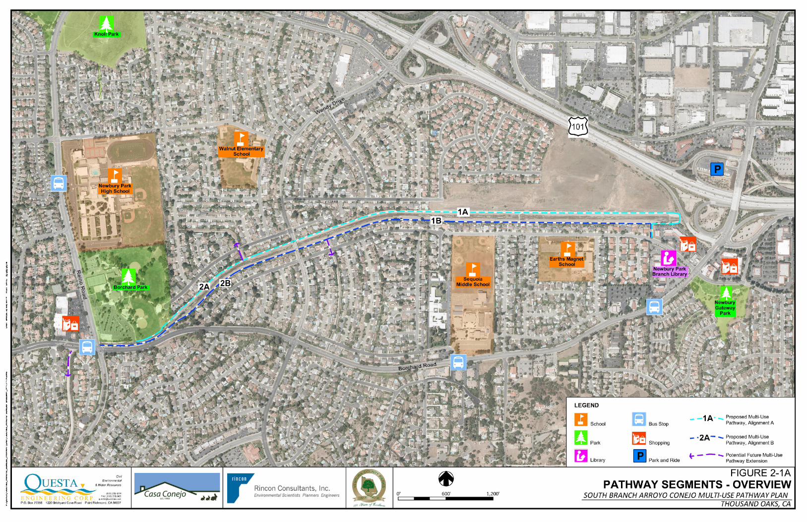
2.1 PATHWAY SEGMENTS
For the Study, the channel has been divided into six segments (Figures 2-1A to 2-1C).


December 29, 2014 SOUTH BRANCH ARROYO CONEJO MULTIUSE PATHWAY PLAN
6 | P a g e Q U E S T A
Segment 1A: 5,500-foot segment along the north side of the channel, between HWY 101 and North Wendy Drive. This segment would begin in the vicinity of the Times Square Shopping Center off Michael Drive, cross over the existing access road and box culvert structure headwall, and continue west to Wendy Drive. Approximately 3,100 ft. of this segment consists of a 25 foot wide access road that is adjacent to undeveloped land east of Alice Drive, as well as homes on Alice, Bob Court, and Gerald Drive. In general, homes that back up to the access road are approximately 3- 5 ft. higher and set back approximately 5-8 feet from the road.
SEGMENT 1A

December 29, 2014 SOUTH BRANCH ARROYO CONEJO MULTIUSE PATHWAY PLAN
7 | P a g e Q U E S T A
SEGMENT 1A

December 29, 2014 SOUTH BRANCH ARROYO CONEJO MULTIUSE PATHWAY PLAN
8 | P a g e Q U E S T A
SEGMENT 1A

December 29, 2014 SOUTH BRANCH ARROYO CONEJO MULTIUSE PATHWAY PLAN
9 | P a g e Q U E S T A
SEGMENT 1A

December 29, 2014 SOUTH BRANCH ARROYO CONEJO MULTIUSE PATHWAY PLAN
10 | P a g e Q U E S T A
Segment 1B: 4,700 foot segment along the south side of the channel, from the Times Square Shopping Center/Michael Drive, west to Wendy. This segment is bordered by homes located on Michael Drive. Homes in this area are generally about 2-3 feet above the existing access road, and many have pedestrian gates. A portion of this segment is owned by private property owners and will require acquisition of recreational access rights along the channel from the individual property owners.
SEGMENT 1B

December 29, 2014 SOUTH BRANCH ARROYO CONEJO MULTIUSE PATHWAY PLAN
11 | P a g e Q U E S T A
SEGMENT 1B

December 29, 2014 SOUTH BRANCH ARROYO CONEJO MULTIUSE PATHWAY PLAN
12 | P a g e Q U E S T A
SEGMENT 1B

December 29, 2014 SOUTH BRANCH ARROYO CONEJO MULTIUSE PATHWAY PLAN
13 | P a g e Q U E S T A
SEGMENT 1B

December 29, 2014 SOUTH BRANCH ARROYO CONEJO MULTIUSE PATHWAY PLAN
14 | P a g e Q U E S T A
Segment 2A: This segment consists of the 1,900 foot long north side maintenance road between N. Wendy Drive and Borchard Park. An additional 900 foot long segment would be located within the Park. This segment is bordered by homes on Gerald Drive. Homes in this area are generally 3- 5 ft. higher and set back approximately 5-8 feet from the road. Many homes have retaining walls, or have used the existing flood control fence to build up the back yard area.
SEGMENT 2A

December 29, 2014 SOUTH BRANCH ARROYO CONEJO MULTIUSE PATHWAY PLAN
15 | P a g e Q U E S T A
SEGMENT 2A

December 29, 2014 SOUTH BRANCH ARROYO CONEJO MULTIUSE PATHWAY PLAN
16 | P a g e Q U E S T A
Segment 2B: This segment consists of the 2,800 foot long south side maintenance road between N. Wendy and Borchard Park. Homes on Michael Drive are adjacent to this maintenance access road.
SEGMENT 2B

December 29, 2014 SOUTH BRANCH ARROYO CONEJO MULTIUSE PATHWAY PLAN
17 | P a g e Q U E S T A
SEGMENT 2B

December 29, 2014 SOUTH BRANCH ARROYO CONEJO MULTIUSE PATHWAY PLAN
18 | P a g e Q U E S T A
Spur S1: This spur provides a south side connection along the spur channel from Segment 1B to Michael Drive, along Newbury Park Drain No. 1. There is maintenance access on the west side of the channel only. This spur channel continues south 1,500 ft. to Borchard Road, and could be considered for a future pedestrian and bicycle connection to the south. Homes along Dorena Drive, Michael Drive, Cathy Drive and Theresa Drive border this channel spur.
SPUR SEGMENT S1

December 29, 2014 SOUTH BRANCH ARROYO CONEJO MULTIUSE PATHWAY PLAN
19 | P a g e Q U E S T A
Spur S2: S2 provides a possible north side connection on a spur channel between Segment2A and Gerald Drive, along Newbury Park Drain No. 2. This channel connects to Newbury Park High School and is bordered by homes on Henry Drive, Jeanne Court, Ben Court and Jenny Drive. There is limited maintenance access on the west side of the channel only, which could be considered for a future connection to the High School and neighborhoods north of the channel.
SPUR SEGMENT S2

December 29, 2014 SOUTH BRANCH ARROYO CONEJO MULTIUSE PATHWAY PLAN
20 | P a g e Q U E S T A
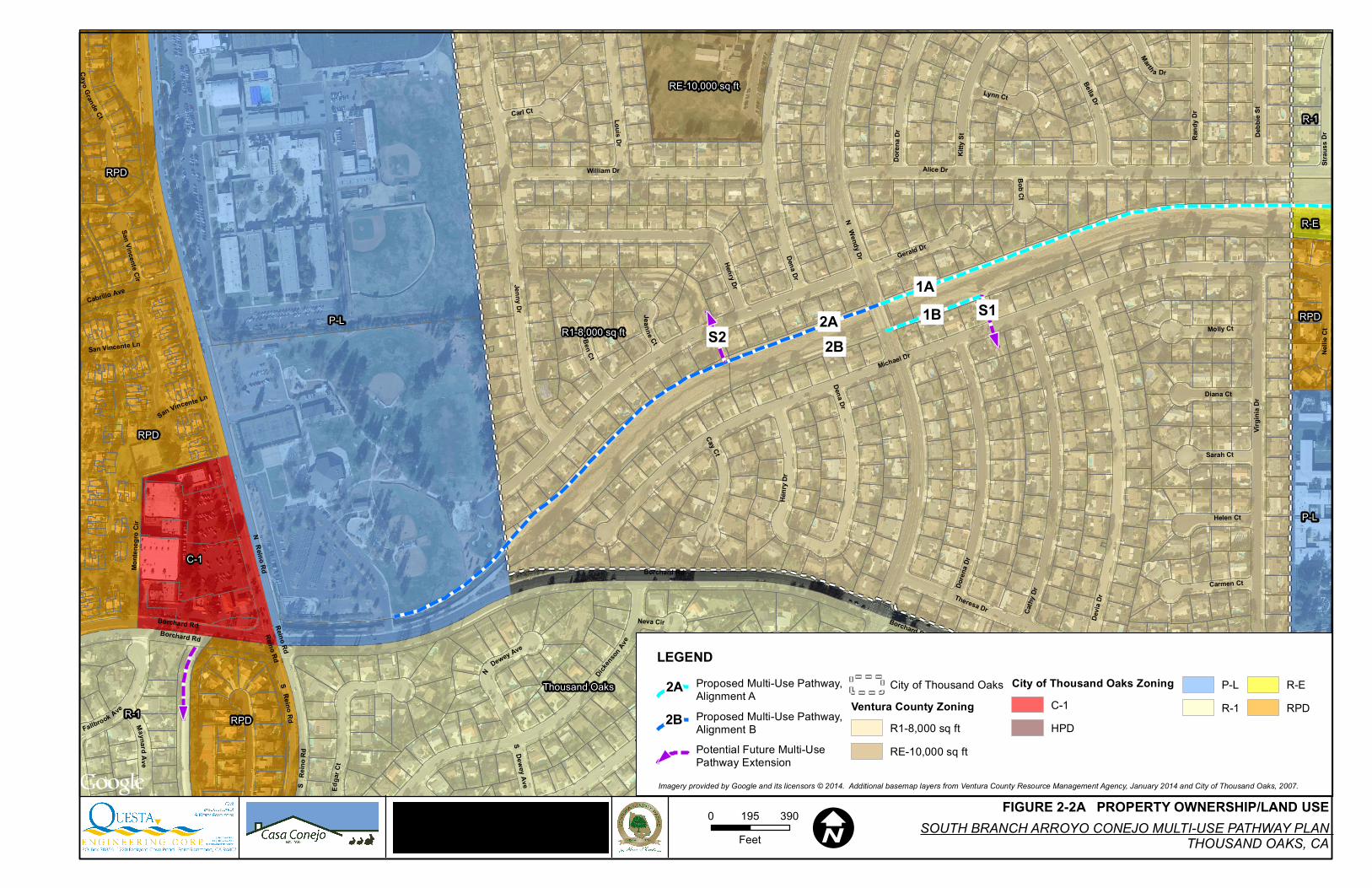
2.2 LAND USE
This section examines existing land uses within the study area for the proposed project, which is roughly bounded by the HWY 101 to the north, Borchard Road to the south and east, and Reino Road to the west. Existing land use designations throughout the trail corridor and adjacent properties are all urban. Within Casa Conejo, this area is designated UR 8, indicating that six to eight dwelling units per acre are permitted.
The proposed trail corridor runs through both unincorporated Ventura County and the City of Thousand Oaks. The corridor vicinity is developed at a suburban scale with primarily single-family residential structures. The western portion of the trail corridor, approximately from Reino Road to Nellie Court, is located within the unincorporated community of Casa Conejo. The eastern portion, from Sequoia Middle
School to the Newbury Square Shopping Center and the U.S. HWY 101 interchange with Borchard Road, is within the jurisdiction of Thousand Oaks, as shown in Figures 2-2A and 2-2B.These figures show existing zoning and land use in the vicinity of the trail corridor. The unincorporated portion of the trail corridor is zoned for residential use (R1-8,000 square feet), while the Thousand Oaks portion is zoned P-L at Borchard Park (Public, Quasi-Public, and Institutional Lands and Facilities), and R-1 (Single-Family Residential), R-E (Rural-Exclusive), and RPD (Residential Planned Development) to the east. The areas adjacent to the trail corridor are zoned R1-8,000 within Casa Conejo. In Thousand Oaks, adjacent parcels are variously zoned RPD, R-1, R-E, P-L, C-1 (Neighborhood Shopping Center), and C-2 (Highway and Arterial Business).
Consistent with the prevailing zoning of the area, the project site is situated in an established suburban community. Built-out primarily in the 1960s and 1970s (making the neighborhood one of the oldest in the area), land uses within the project study area include residential homes, four schools totaling approximately 4,500 students (two elementary schools, a middle school and a high school), several parks, a community library, numerous shopping centers, a retirement home, a park-and-ride facility, and religious institutions. Single-family residences along Gerald Drive, Bob Court, and Alice Drive to the north, and Michael Drive to the south, abut the trail corridor. With the exception of a row of two-story
Map Data ©2014
2A2B
S1S2
1B1A
P-L
R-1
RPD
C-1
R-1
RPD
RPD
P-L
R-1
RPD
C-O
R-E
R-E
R1-8,000 sq ft
Thousand Oaks
RE-10,000 sq ft
Borchard Rd
N Reino Rd
N Wendy Dr
S W
endy
Dr
SRe
i noRd
Reino Rd S
Reino Rd
Borchard Rd
Reino Rd
Michael Dr
Gerald Dr
Alice Dr
Jessica St
Jenny Dr
Devia
Dr Theresa Dr
Virgin
ia Dr
Cathy
Dr
Henry Dr
Sandra Ct
William Dr
Doren
a Dr
Dickens
onAv
e
Kitty
St
Bella Dr
Dena Dr
Borchard Rd
Louis Dr Cindy Ave
San Vincente Cir
Rand
y Dr
Debb
ie St
Edga
r Ct
Cay Ct
Strau
ss D
r
Silas
Ave
Ben Ct
Marty
Ct
Molly Ct
Nellie
Ct
Cayo Grande Ct
Helen Ct
Cabrillo Ave
Monte
negr
o Cir
Fallbrook Ave
Carmen Ct
Sarah Ct
Diana Ct
Carl Ct
Marth a Dr
MaynardAv e
Lynn Ct
N
Dewey Ave
Dona
ld Av
e
Bob Ct
Neva Cir
San Vincente Ln
Jeanne Ct
S Dewey Ave
San Vincente Ln
Dena Dr
Doren
a Dr
Borchard Rd
Henr
y Dr
0 390195Feet I
FIGURE 2-2A PROPERTY OWNERSHIP/LAND USE
LEGENDProposed Multi-Use Pathway,Alignment AProposed Multi-Use Pathway,Alignment BPotential Future Multi-UsePathway Extension
City of Thousand OaksVentura County Zoning
R1-8,000 sq ftRE-10,000 sq ft
City of Thousand Oaks ZoningC-1HPD
P-LR-1
R-ERPD
SOUTH BRANCH ARROYO CONEJO MULTI-USE PATHWAY PLANTHOUSAND OAKS, CA
Imagery provided by Google and its licensors © 2014. Additional basemap layers from Ventura County Resource Management Agency, January 2014 and City of Thousand Oaks, 2007.
2A
2B

Map Data ©2014
1B1A
R-1
R-1
R-E
HPD
C-1
RPD
C-3
C-2
RPD
R-1
P-L
P-L
R-EC-O
R-E
RPD
RPD
C-3
C-2
R-E
R-ER-E
RPD
O-SR-E R-1
P-L
HPD
O-SHPD
R-E
R-E
P-L
Thousand Oaks
R1-8,000 sq ft
£¤101
£¤101
Borchard Rd
Ranc
ho C
onejo
Blvd
Borchard Rd
Ran c
hoC o
nej o
B lv d
Michael Dr
Devia
Dr
Lupe
Ave
Ilex Dr
Virgin
ia Dr
Denise St
Hira
m Av
e
Theresa St
Alice Dr
Caro
b Dr
Theresa Dr
Adrian St
Cindy Ave
North
am A
ve
Redf
ield A
ve
Yew Dr
Elmira St
Rand
y Dr
Debb
ie St
Deer
path
Ln
Corin
ne D
r
Stra
uss D
r
W K
elly R
d
Silas
Ave
Bella D r
Jessica St
Molly Ct
Newb
ury R
d
Deer
walk
Pl
Nellie
Ct
Eagle
view
Pl
Herri
ngbo
ne C
t
Helen Ct Lander Ct
L uca s Ct
Carmen Ct
Sarah Ct
Diana Ct
Urbana Ave
Marth a Dr
Seabury Ct
Nico
le Dr
Gilbe
rt St
Dand
elion
Ct
Shirl
ey D
r
Ginger Cir
Deni
se C
t
Michael Dr
Adrian St
0 390195Feet I
FIGURE 2-2B PROPERTY OWNERSHIP/LAND USE
LEGENDProposed Multi-Use Pathway,Alignment AProposed Multi-Use Pathway,Alignment BPotential Future Multi-UsePathway Extension
City of Thousand OaksVentura County Zoning
R1-8,000 sq ftRE-10,000 sq ft
City of Thousand Oaks ZoningC-1C-2C-3
C-OHPDP-L
R-1R-ERPD
SOUTH BRANCH ARROYO CONEJO MULTI-USE PATHWAY PLANTHOUSAND OAKS, CA
Imagery provided by Google and its licensors © 2014. Additional basemap layers from Ventura County Resource Management Agency, January 2014 and City of Thousand Oaks, 2007.
IA
1B

December 29, 2014 SOUTH BRANCH ARROYO CONEJO MULTIUSE PATHWAY PLAN
21 | P a g e Q U E S T A
houses along Michael Drive to the east of Sequoia Middle School, these residences are one story in height.
North of the channel and east of Alice Drive, there is one vacant parcel. Table A-2 in the City of Thousand Oaks 2014-2021 Housing Element lists the site as a vacant, 36.7-acre property with the potential for development of 20 single-family residences. A “floodplain constraint” reduces the potential buildout on-site to 20 units. No projects are currently proposed, approved, or under construction at the site, according to the City’s Development Activity Report from April 2014.
Within the project study area, the fenced channel creates a barrier separating the neighborhoods to the north and south of the channel. The community is also bisected by Wendy Drive, an arterial roadway that runs north/south through the community. At their intersection, Wendy Drive utilizes a bridge to cross over the channel.
2.3 LAND OWNERSHIP
Portions of the South Branch Arroyo Conejo (SBAC) channel and maintenance roads are owned in fee simple by the Ventura County Watershed Protection District (WPD), and portions are owned by adjacent residential property owners whose property lines generally extend perpendicular to the access roads and channel. The District owns in fee the SBAC channel facility, except for a portion of the lower section of the channel between Nellie Street to the west and Eagle View Place and Library to the east, where the District has easement rights for flood control purposes. The District has a channel maintenance agreement with these property owners for routine maintenance, sediment removal, repairs and other flood protection activities. These easements may need to be modified on a case-by case basis in order to allow use as a bicycle/pedestrian facility with general public access.
2.4 STUDY AREA DEMOGRAPHICS
As discussed under Existing and Planned Land Uses, the study area is suburban and residential in character. For the purpose of assessing demographic information, the study area crosses two census tracts assigned by the U.S. Census Bureau: Casa Conejo Census Designation Place (census tract 11656) and the City of Thousand Oaks (census tract 78582). These tracts correspond, respectively, to the unincorporated Casa Conejo area, and to the entire City of Thousand Oaks. The following demographic analysis draws on data from both census tracts.
Table 2-1 lists basic characteristics of the populations of Casa Conejo and Thousand Oaks.

December 29, 2014 SOUTH BRANCH ARROYO CONEJO MULTIUSE PATHWAY PLAN
22 | P a g e Q U E S T A
Table 2-1: Population Characteristics
Demographic Category: Casa Conejo: Thousand Oaks:
Population 3,249 126,683
Households 990 45,836
Average Household Size 3.28 2.73
Source: U.S. Census Bureau, 2010 Census
As shown in Table 2-1, the population of Casa Conejo (3,249) is much smaller than that of the City of Thousand Oaks (126,683). When looking at demographic trends, these populations are expected to remain stable in the future because the Thousand Oaks area is mostly built out. The study area, with the exception of the vacant 36.7 acre parcel north of the site, is fully built out, and does not include any pending or approved projects as of May 2014 (County of Ventura, 2014).
The U.S. Census Bureau also estimates the share of local populations that commute by various modes, based on sampling data in the American Community Survey. Table 2-2, shows the estimated percentage of residents in Casa Conejo, Thousand Oaks, and throughout Ventura County who drive alone to work, carpool, take public transportation, walk, work at home, or commute by other means (including bicycling).
Table 2-2: Commuting to Work Casa Conejo, Thousand Oaks, and Countywide
Mode of Commuting Casa Conejo Thousand Oaks Ventura County
Driving alone 78.6% 77.2% 76.5%
Carpooling 14.4% 9.5% 12.9%
Public transportation 0% 0.8% 1.3%
Walking 1.7% 2.3% 2.1%
Other means 1.6% 2.4% 1.8%
Work at home 3.7% 7.7% 5.4%
Source: U.S. Census Bureau, 2008-2012 American Community Survey 5-Year Estimates, Table DP-03.
As shown in Table 2-2, more than three-quarters of residents locally and across Ventura County drive alone to work. These results suggest a potential to increase the share of the population that engages in active transportation to commute to work or other places such as parks, schools, restaurants and

December 29, 2014 SOUTH BRANCH ARROYO CONEJO MULTIUSE PATHWAY PLAN
23 | P a g e Q U E S T A
shopping centers. It is important to note that any differences in commuting data between Casa Conejo and the City of Thousand Oaks may be an artifact of a smaller sample size for survey data from Casa Conejo, which increases the margin for error.
The Thousand Oaks Bicycle Facilities Master Plan also presents demographic information on bicyclists. School children between the ages of about 7 and 12 make up a large percentage of bicycle riders, often riding to school, parks, or other local destinations on a daily basis, weather permitting. The single biggest adult group of bicyclists in Thousand Oaks is the intermittent recreational rider who generally prefers to ride on pathways or quiet side streets. The project would serve school children (by improving connectivity to Sequoia Middle School, Newbury Park High School, and recreational facilities at Borchard Park) and to adult recreational riders.
2.5 CONSISTENCY WITH ADOPTED PLANS
This section summarizes adopted plans that pertain to the proposed multi-use pathway and evaluates the project’s consistency with these plans.
2.5.1 CITY OF THOUSAND OAKS BICYCLE FACILITIES MASTER PLAN, 2010
The Thousand Oaks Bicycle Facilities Master Plan, adopted in November 2010, is intended to encourage the development of an integrated bicycle system throughout Thousand Oaks, with connections to other regional bike systems. This master plan provides goals and objectives for an integrated bicycle system, evaluates existing conditions, defines needs, recommends improvements, and includes strategies to prioritize, fund, and maintain improvements.
One of the main components of the master plan is a 20 Year Plan which establishes the City’s long-term vision for bicycle facilities. Projects shown on the 20- Year Bicycle Facilities map are given priority for various state and federal funding sources prioritized through the City and the Ventura County Transportation Commission (VCTC).
The proposed project would be consistent with several major recommendations of the 20 Year Plan in the 2010 Bicycle Facilities Master Plan. The overall concept in this plan is to create linkages between neighborhoods in Thousand Oaks and key destinations such as schools, parks, transit connections, and employment/shopping centers. The project would fulfill this vision by linking residential areas with Sequoia Middle School and improving connectivity to Newbury Park High School, and by creating a linkage to the Newbury Square Shopping Center. In addition, the project would further recommendations to improve safety by allowing bicyclists to travel without having to ride on busy city streets and to improve crossings (i.e., at Wendy Road) to minimize conflicts between cyclists and motorized vehicles.
December 29, 2014 SOUTH BRANCH ARROYO CONEJO MULTIUSE PATHWAY PLAN
24 | P a g e Q U E S T A
The following goals and objectives of the Master Plan pertain to the project:
Goal 1.0 Plan for the development of bicycle facilities and programs in Thousand Oaks as a viable alternative to the automobile.
Objective 1.1 Develop a viable bicycle commuter system.
Objective 1.2 Link residential areas, work and transit centers.
Goal 3.0 Maximize opportunities for bicycle use.
Objective 3.2 Develop a user-friendly bicycle system for all levels of experience and abilities.
Objective 3.5 Overcome major barriers and gaps in the existing bikeway system with a specific focus on freeway crossings
By improving the network of bikeways in Thousand Oaks, the project would be consistent with Goal 1.0 to make bicycling a viable alternative to the automobile. The project would create linkages with an existing Class II bike lane on Borchard Road to the west of Reino Road and an existing Class III bike route on Reino Road. This network of existing facilities would provide connectivity to the north side of the HWY 101 and to southwestern Thousand Oaks.
Although the project is not included as a planned improvement in the Bicycle Facilities Master Plan, it would enhance the utility of planned Class II and III facilities in the vicinity. In addition, the City of Thousand Oaks provided a letter of support for the grant application and endorses the effort to provide public access along the channel. Planned Class II bike lanes include Borchard Road from Reino Road to Rancho Conejo Boulevard at Highway 101, Wendy Drive from Kimber Drive to Old Conejo Road, and Newbury Road from Michael Drive to Ventu Park Road. A Class III bike route also is planned on Michael Drive, adjacent to the south of the stormwater channel, from Wendy Drive to Madrid Avenue. In addition, the Thousand Oaks Bicycle Facilities Master Plan could be amended to incorporate the project.
2.5.2 VENTURA COUNTYWIDE BICYCLE MASTER PLAN
The 2007 Ventura Countywide Bicycle Master Plan provides a blueprint for bicycle transportation and recreation in Ventura County. The plan made recommendations to enhance and expand the existing bikeway network, connect gaps, address constrained areas, provide for greater local and regional connectivity, and encourage more residents to bicycle.
The following goals from the Countywide Bicycle Master Plan apply to the project:
Goal 1 Expand and Optimize Ventura County’s Bicycle Facilities
Objective 1.1 Provide bicyclists safe and accessible routes to major destinations within the County served by public roads, trails, transit, and rail.

December 29, 2014 SOUTH BRANCH ARROYO CONEJO MULTIUSE PATHWAY PLAN
25 | P a g e Q U E S T A
Objective 1.2 Complete a comprehensive bikeway network by closing existing gaps and providing projects that improve inter-modal connections.
Goal 5 Facilitate Coordination and Cooperation in Developing the Countywide Bicycle Network
Objective 5.1 Integrate the countywide bikeway network between the cities and unincorporated areas and the adjacent counties of Santa Barbara and Los Angeles to ensure coherent regional connectivity.
Objective 5.2 Develop countywide north-south and east-west bicycle corridors within the roadway network supporting recreational and commute patterns.
In particular, the project would be consistent with Objective 1.2 by closing existing gaps between residential communities and destinations such as public schools and shopping centers. By linking the unincorporated Casa Conejo community with Thousand Oaks proper, the project also would be consistent with Objective 5.1 to integrate the countywide bikeway network across jurisdictions. Lastly, the project would serve as an east-west bicycle corridor in Thousand Oaks, consistent with Objective 5.2.
A bicycle facility not currently shown on the Ventura Countywide Bicycle Master Plan along the South Branch of Arroyo Conejo, but the Plan could potentially be amended to show this facility. Supervisor Parks made a recommendation in a letter to the County Board of Supervisors on May 31, 2014 to include a Class 1 facility along the South Branch of Arroyo Conejo. The recommendation was approved by the Board and the Class 1 trail will appear on the next revision of the Ventura County Bicycle Master Plan.
2.5.3 VENTURA COUNTY GENERAL PLAN—THOUSAND OAKS AREA PLAN
The Thousand Oaks Area Plan, as amended in April 2010, is a part of the Ventura County General Plan and functions as a land use plan for 3,767 acres of unincorporated land adjacent to the City of Thousand Oaks. This Area Plan governs the distribution, general location, types and intensity of land uses within Casa Conejo and other unincorporated areas, as well as providing specific policies concerning development.
Two goals in the Area Plan are relevant to the project. First, the Transportation and Circulation section states that safe pedestrian and bicycle pathways should be provided throughout the unincorporated Thousand Oaks area. By providing a multi-use pathway separated from motorized vehicles, including an underpass of Wendy Drive, the project would be consistent with this goal to protect the safety of pedestrians and bicyclists. Second, the Recreation section includes a goal to “ensure the completion of the unincorporated portion of the Thousand Oaks regional trail system and protect existing trails.” While the project is not included on Figures 8 and 9 of the Area Plan, which map existing and proposed bicycle pathways and hiking/equestrian trails, respectively, it would improve the existing trail system.
2.5.4 VENTURA COUNTY COMPREHENSIVE TRANSPORTATION PLAN (CTP)

December 29, 2014 SOUTH BRANCH ARROYO CONEJO MULTIUSE PATHWAY PLAN
26 | P a g e Q U E S T A
The Ventura County Transportation Commission (VCTC) approved the final CTP in August 2013 as a long-range policy document, built from community-expressed needs, to enhance regional mobility for all Ventura County residents. The CTP also fully examines various funding strategies and options from the federal, state, regional and local levels. It is intended to provide a framework for future community-based planning and collaboration and inform Ventura County’s long-range transportation decisions.
A community-based Local Advisory Group for the Conejo Valley, convened in the process of drafting the CTP, identified the following priorities:
• Addressing local traffic congestion • Expanding transit services for schools • Preserving local community character • Integrating community planning efforts • Increasing public awareness of the transportation system and options
Community input across Ventura County also identified opportunities to improve bicycling and pedestrian activity. According to this input, continued improvements to local bicycle and pedestrian infrastructure, and the growing “complete streets” movement focused on expanding the safety and usability of streets and roads for all users, offer significant promise for continued development of complete and safe local networks. However, significant gaps and safety issues in these networks still exist, both within and between cities. Regional connectivity was identified as a key indicator of the usefulness of active transportation networks and their ability to reduce traffic congestion.
The project would be consistent with this community input, by improving connectivity for bicyclists and pedestrians between unincorporated Casa Conejo and the City of Thousand Oaks.
2.6 CONNECTIONS TO TRANSIT AND TRAILS
This section describes existing conditions for bicyclists within the project study area.
Definition of Bikeway Types
The 2010 Thousand Oaks Bicycle Facilities Master Plan provides the following definitions for bicycle facility types located throughout the City of Thousand Oaks including the Newbury Park Planning Area, these definitions are generally consistent with the 2007 Ventura Countywide Bicycle Master Plan.

December 29, 2014 SOUTH BRANCH ARROYO CONEJO MULTIUSE PATHWAY PLAN
27 | P a g e Q U E S T A
Definition of Bikeway Types: 2010 Thousand Oaks Bicycle Facilities Master Plan
2.7 BIKEWAYS IN THE STUDY AREA
2.7.1 EXISTING BIKEWAYS
For the purpose of this analysis, existing bicycle facilities within approximately one-half mile of the proposed project were reviewed and inventoried. Currently there are no Class I bike paths within the project study area and there are only a limited number of Class II bike lanes and Class III bike routes. However, bicyclists and pedestrians regularly bicycle and walk along local streets, roadway shoulders, and sidewalks throughout the area. Relatively low volume streets such as Michael Drive see significant activity including student commuters headed to nearby schools, adult commuters, community members making utilitarian trips, and people out for recreational purposes.
Borchard Road – Class II bike lanes are provided on Borchard Road to the west of the project site between Via Las Brisas and Reino Road, a distance of approximately 2 miles. These bike lanes facilitate access for bicyclists to Borchard Community Park, Newbury Park High School, and lead directly to the western gateway of the proposed project.

December 29, 2014 SOUTH BRANCH ARROYO CONEJO MULTIUSE PATHWAY PLAN
28 | P a g e Q U E S T A
South Wendy Drive – Class II bike lanes are provided on South Wendy Drive between West Potrero Road and Jessica Street, a distance of approximately 1.8 miles.
North Wendy Drive – Class II bike lanes have recently been installed North Wendy Drive between Jessica Street and Ruth Drive, a distance of approximately 0.65 miles. The existing Class II bike lanes on North Wendy Drive intersect the proposed project between Michael Drive and Gerald Drive.
Old Conejo Road – a Class III bike route is signed on Old Conejo Road between North Reino Road and North Wendy Drive, a distance of approximately 0.75 miles.
2.7.2 PROPOSED BIKEWAYS IN THE STUDY AREA
Borchard Road – Class II bike lanes are proposed on Borchard Road from Reino Road east to Michael Drive.
Michael Drive – a Class III bike route is proposed on Michael Drive from Wendy Drive to Nellie Court.
Several notable projects and/or programmatic improvements are identified as Phase I Short-Term Projects in the 2010 Thousand Oaks Bicycle Facilities Master Plan that are relevant to the proposed project including:
• Borchard Road Bike Lanes Study – Reino Road to Michael Drive • Enhance Bicycle and Pedestrian Education Programs for Students and Adults • Citywide Bike Rack Installation Program
2.8 LOCAL ROADWAYS
Borchard Road is a five lane arterial (four travel lanes and a center turn lane) with a posted speed limit of 45 mph, that generally extends east-west, and has an Average Daily Traffic Volume (ADT) of approximately 18,0001 vehicles per day in the vicinity of the project. Borchard Road curves around the Arroyo Conejo Channel so that it is the closest arterial connection to both the east and west ends of the proposed project. Variable width sidewalks, approximately four – six feet wide, are provided on both sides of the street. Turn lanes, curb ramps, and overhead street lights are provided at intersections. Pedestrian signals are provided at signalized intersections.
Michael Drive is generally a two lane residential road with a posted speed limit of 25 mph that extends east-west and roughly follows the alignment of the Arroyo Conejo Channel on its’ south side for the length of the proposed project. Single family residences on the north side of Michael Drive separate the channel from the street. Michael Drive is discontinuous and changes characteristics along the length of the corridor. At its’ western end, Michael Drive terminates at a cul-de-sac between Borchard Road and Borchard Community Park. Approximately midway along the corridor, a cul-de-sac at Nellie Court
1 ADT’s were derived from the City of Thousand Oaks 2012 Average Daily Traffic Volumes Count

December 29, 2014 SOUTH BRANCH ARROYO CONEJO MULTIUSE PATHWAY PLAN
29 | P a g e Q U E S T A
adjacent to Sequoia Middle School limits vehicle access but allows bicyclists and pedestrians to pass. At the eastern end of the corridor between Eagleview Place and Borchard Road, a distance of approximately 0.15 miles, Michael Drive provides access to community destinations including shopping, commercial uses, and the Newbury Park Library. This short segment has a posted speed limit of 30 mph. Continuous sidewalks, street lights, curb ramps, crosswalks, and school zone signs and markings are provided along Michael Drive.
North Wendy Drive is a three lane residential collector with a center turn lane and a posted speed limit of 35 miles per hour that generally extends north-south, and has an ADT of approximately 12,600 vehicles in the vicinity of the project. Sidewalks and planter strips are provided on both sides of the street along with on-street parking. Class II bike lanes have recently been installed on North Wendy Drive, they extend from South Wendy Drive/Jessica Street to Ruth Drive. North Wendy Drive intersects the Arroyo Conejo Channel at grade between Michael Drive and Gerald Drive.
1 North Wendy at Arroyo Conejo 2 North Wendy at Gerald Drive
Gerald Drive is a two lane residential street with a 25 mph speed limit that extends east-west along the north side of the Arroyo Conejo Channel. Continuous sidewalks and planter strips are provided along with on-street parking, overhead street lights, and curb ramps at intersections. Gerald Drive intersects North Wendy Drive on the north side of the Arroyo Conejo channel and terminates in cul-de-sacs at its’ western and eastern ends. On-street parking and a small parking/staging area are provided for Borchard Community Park at Gerald Drive’s western cul-de-sac.
Alice Drive is a two lane residential street with a 25 mph speed limit that extends east-west along the north side of the Arroyo Conejo channel between North Wendy Drive and Strauss Drive. Continuous sidewalks and planter strips are provided along with on-street parking, overhead street lights, and curb ramps at intersections.
U.S. 101 (Ventura Freeway) is an eight lane interstate facility which is primarily oriented in an east-west direction in the project area. U.S. 101 is the major regional facility that provides intercommunity access in the San Fernando Valley and serves communities along the California Coast to the north and Los

December 29, 2014 SOUTH BRANCH ARROYO CONEJO MULTIUSE PATHWAY PLAN
30 | P a g e Q U E S T A
Angeles to the south. The east end of the Arroyo Conejo Channel terminates in a box culvert that goes under the southbound U.S. 101 off-ramp for Borchard Road/Rancho Conejo Boulevard (Exit 47A).
2.9 TRANSIT
2.9.1 LOCAL TRANSIT
Fixed route bus service is provided in the project area by Thousand Oaks Transit. Busses operate Monday through Saturday on approximately one hour headways. Route 1 (Gold Route) generally serves Newbury Park and the project area
including access to Newbury Park High School, Sequoia Middle School, and Newbury Park Library among other destinations. Bus stops, with varying amenities from benches to shelters and bus bays or turnouts are provided at intervals along arterial streets within the study area. Stop locations include Borchard Road/Community Park; Borchard Road/Wendy Drive; Borchard Road/Theresa Drive across from Sequoia Middle School; Borchard Road/Carob Drive adjacent to the Newbury Park Library; Reino Road/Borchard Road; Reino Road/Newbury Park High School.
http://www.totransit.org/government/depts/public_works/transit/default.asp
2.9.2 REGIONAL TRANSIT
Regional transit providers in the project study area include:
VISTA (Ventura Inter-City Service Transit Authority) - provides regional fixed route bus service between the cities of Ventura County and between neighboring Santa Barbara and Los Angeles Counties.
http://www.goventura.org/?q=travel-ventura
VISTA Highway 101 and Conejo Connection Route provides Monday through Saturday service from Thousand Oaks to the City of Ventura with varying headways from approximately 30 minutes during peak commute hours to 90 minutes during off-peak hours. VISTA busses stop at the Thousand Oaks Transit Center, the Conejo Industrial Park, Oaks Mall, and at U.S. 101/Wendy Drive/Hillcrest Drive. Transfers to other transit services can be made at the Thousand Oaks Transit Center and the Oaks Mall.
VISTA East County Route provides Monday through Saturday service between Thousand Oaks, Moorpark, and Simi Valley with varying headways from approximately 30 minutes during peak commute hours to 90 minutes during off-peak hours. The East County Route provides service along the U.S. 101, SR 23, and SR 118 corridors. In the project area, East County Route busses stop at the Thousand Oaks Transit Center and the Oaks Mall, transfers to other transit services can be made from both of these locations.

December 29, 2014 SOUTH BRANCH ARROYO CONEJO MULTIUSE PATHWAY PLAN
31 | P a g e Q U E S T A
METROLINK Commuter Shuttle Service - Thousand Oaks Transit offers weekday commuter shuttle service to the Moorpark Metrolink Station from three locations near the study area including: Thousand Oaks Transit Center, California Lutheran University, and the Oaks Shopping Center. Shuttle Service operates during morning and evening commute periods and corresponds to arriving and departing train times at the Moorpark Metrolink Station. Shuttle Service busses operate between approximately 5:00 AM – 9:00 AM and 4:00 PM – 8:30 PM.
http://www.totransit.org/civica/filebank/blobdload.asp?BlobID=26701
MetroLink is Southern California’s regional passenger rail system, providing commuter rail service that connects Ventura County to Los Angeles County and beyond. The MetroLink rail line does not travel through Thousand Oaks. The closest train stations are located to the north in Moorpark and to the
west in Camarillo. The Ventura Line Trains operate Monday through Friday during morning and evening commute periods with varying headways of approximately 30 – 60 minutes. Thousand Oaks Transit provides a MetroLink Commuter Shuttle Service that is coordinated with arriving and departing train times.
http://www.metrolinktrains.com/schedules/line/name/Ventura%20County/service_id/1141.html
2.10 BICYCLE AND PEDESTRIAN COLLISIONS
As a part of this analysis, bicycle and pedestrian collisions were documented and mapped in the study area using the University of California’s Safe Transportation Research and Education Center (SafeTREC) Transportation Injury Mapping System (TIMS) (see Figure 2-3). The Safe Routes to School (SRTS) Collision Map Viewer tool was used to identify collisions within one-quarter and one-half mile buffer zones around the schools in the project study area. Four schools are located within one-half mile of the proposed project including: Newbury Park High School, Walnut Elementary School, Sequoia Middle School, and Earths Magnet School. The map displays all pedestrian and bicyclist collisions with vehicles that have been reported by the Statewide Integrated Traffic Records System (SWITRS) between the years 2003 and 2011. The SWITRS database is maintained by the California Highway Patrol. SWITRS is the standard used to document and analyze crash statistics by law enforcement, cities, counties, transportation professionals, and other agencies throughout California. It should be noted that due to their nature, it is widely believed that many pedestrian and bicycle crashes go unreported, especially for incidents that do not result in visible injury or property damage.
There were 61 recorded bicycle and pedestrian collisions in the 9-year period analyzed2. Seventeen of the collisions occurred during the summer months, which does not exclude students, but indicates that the incidents may not have involved student commuters. Twenty-two of the 61 collisions listed Borchard Road as the primary street location, 9 additional incidents listed Borchard Road as the secondary street,
2 Note: While 61 Total collisions were reported, only 59 collisions were mapped.

December 29, 2014 SOUTH BRANCH ARROYO CONEJO MULTIUSE PATHWAY PLAN
32 | P a g e Q U E S T A
thus over half of the reported collisions occurred along the Borchard Road corridor. Five of the reported collisions occurred at the intersection of North Wendy Drive/Gerald Drive, and one occurred at North Wendy Drive/Michael Drive, adjacent to the Arroyo Conejo Channel.
2.11 SAFE ROUTES TO SCHOOL (SR2S)
The Safe Routes to School Movement is a broad based network of public agencies, community based organizations, pedestrian and bicycle advocates, parents, teachers, principals, public health leaders and more, all working to support and encourage walkable and bikeable communities and address traffic safety and the public health issue of childhood obesity. SR2S is a multifaceted effort to increase the number of students who walk, bike, rideshare, or take transit to and from school. The community benefits from the increased use of these travel modes are myriad. They help to improve air quality, reduce congestion around schools, improve traffic safety, empower students with safety skills and healthy habits, improve students’ focus in the classroom, and foster a closer sense of community among participants. The National Center for Safe Routes to School (http://www.saferoutesinfo.org/) and the California Safe Routes to School Technical Assistance Resource Center (http://www.casaferoutestoschool.org/) serve as information clearinghouses, provide resources and technical assistance, and work to advance the movement and train professionals.
The County of Ventura, Ventura County Transportation Commission, Ventura County Sheriff’s Department, City of Thousand Oaks, and the Casa Conejo Municipal Advisory Council, and the Conejo Valley Unified School District have all taken steps to address student safety in and around school zones. The Healthy Ventura County Program maintains a webpage (http://healthyventuracounty.org/healthy-schools/safe-routes-to-school/) and serves as a resource to local agencies, school districts, and others seeking to improve student safety and start or maintain a SR2S program within the County. The City of Thousand Oaks has worked to acquire SR2S grant funds and implemented capital improvements to improve student safety at local area schools.

December 29, 2014 SOUTH BRANCH ARROYO CONEJO MULTIUSE PATHWAY PLAN
33 | P a g e Q U E S T A
3. INITIAL ENVIRONMENTAL SCREENING
This Section describes potential environmental issues that may affect design and implementation of the Arroyo Conejo Multi Use Pathway, including:
• Biological Resources • Cultural Resources • Soils and Hydrology • Hydrology, Flooding and Water Quality • Land Ownership and Use • Traffic Safety • Accessibility • Neighborhood Connections
3.1 BIOLOGICAL RESOURCES
The purpose of this section is to identify potential “fatal flaws” or items associated with biological resources that may cause an exceptional cost or significant project delays, establish baseline conditions for purposes of future CEQA review and project permitting, and recommend further studies or mitigation measures, if any, that will be appropriate for the project. Regulated or sensitive resources studies analyzed herein include special-status plant and wildlife species, nesting birds and raptors, sensitive natural communities, jurisdictional waters and wetlands, wildlife movement corridors, and locally protected resources, such as protected trees.
METHODOLOGY
The analysis of biological constraints for the proposed project consisted of a review of relevant literature followed by a field reconnaissance survey. The literature review included information on sensitive resource occurrences within a five mile buffer around the project from the California Department of Fish and Wildlife (CDFW) California Natural Diversity Data Base (CNDDB), Biogeographic Information and Observation System (BIOS – www.bios.dfg.ca.gov), and U.S. Fish and Wildlife Service (USFWS) Critical Habitat Portal (http://criticalhabitat.fws.gov). Site plans provided by the study team, aerial photographs, and topographic maps were also examined.
Rincon Biologist, Lindsay Griffin, conducted a field reconnaissance survey on April 15, 2014. The biologist conducted the survey to document existing site conditions and the potential presence of sensitive biological resources, including sensitive plant and wildlife species, sensitive plant communities, jurisdictional waters and wetlands, and habitat for nesting birds.
Weather conditions during the survey included an average temperature of 67 degrees Fahrenheit, with winds between 2 and 3 miles per hour and minimal cloud cover. The survey was performed by walking

December 29, 2014 SOUTH BRANCH ARROYO CONEJO MULTIUSE PATHWAY PLAN
34 | P a g e Q U E S T A
the study area alignment alternatives to characterize the existing biological resources present. The survey area included the concrete-lined channel that transitions to an engineered earthen channel just east of Borchard Park, two spur channels (S1 and S2) along which future trail extensions may be built, and a 100-foot buffer surrounding the proposed trail alignment (Figure 3-1). Existing biological conditions (e.g., vegetative communities, potential presence of sensitive species and/or habitats, and presence of potentially jurisdictional waters) within the survey area were documented. The earthen channel was not designed to allow vegetation in the channel. O&M practices clear vegetation once a year.
The potential presence of sensitive species is based on a literature review and field surveys designed to assess habitat suitability only. Definitive surveys to confirm the presence or absence of special-status species were not performed. Definitive surveys for sensitive plant and wildlife species generally require specific survey protocols including extensive field survey time to be conducted only at certain times of the year. The findings and opinions conveyed in this report are based on this methodology.
EXISTING SITE CONDITIONS
Jurisdictional Drainages and Wetlands. A review of an aerial photo of the study area indicated the presence of multiple jurisdictional drainages within the proposed trail alignment, potential future extensions, and buffer zone. The main drainage of South Branch Arroyo Conejo traverses the survey area from east to west through a concrete lined channel that transitions to a naturalized channel downstream of Borchard Park. In addition, potential future trail extensions on side-channels would be located along jurisdictional drainages. One side-channel (S2) spurs off of the main channel and is located between Henry Drive and Jeanne Court on the north side of the main channel. A second side channel (S1) spurs off of the main channel and is located between Dorena Drive and Cathy Drive on the south side of the channel.
Vegetation. No sensitive plant communities were observed on-site. The area between Reino Road and Borchard Road along the proposed trail alignment consists primarily of gravel surfaces and bare ground. Residential properties border the length of the channel on both sides and the properties consist of landscaped lands. The two vegetation communities or land cover types that were observed include: Gravel Surfaces/Bare Ground and Landscaped Land. Descriptions of habitat types found within the project site are provided below.
Gravel Surfaces/Bare Ground. For this report, these areas include any area not covered by vegetation. These areas were commonly found associated with the access road that runs parallel with the flood control channel. Bare ground was observed along the banks of the flood control channel.
Landscaped Lands. This habitat type consists of any area vegetated with non-native, planted species and directly associated with the residential development surrounding the project area in all direction. It is not officially identified in A Manual of California Vegetation (Sawyer, et al. 2009) as a defined habitat type. The areas surrounding the project site include a Borchard Park and residential development with

!ÁÁ !ÁÁ
!ÁÁ
Map Data ©2014
2A2B
S1S2
1B1A
£¤101
£¤101
NWe
ndy D
r
N Reino Rd
W Hillcrest Dr
S W
endy
Dr
SRein
o Rd
Lynn Rd
Borchard Rd
Lynn Rd
Michael Dr
Lesser Dr
Jenny Dr
Gerald Dr
Alice Dr Dick
enson Ave
Theresa Dr
WKe
ll yR d
Si
las A
ve
KittySt
Dena
Dr
Cin
dy Ave
Devia Dr
Adrian St
Lu
pe A
ve
Bella Dr
Vi
rgini
a Dr
Bings RdKimber DrCathy Dr
Donald Ave
Denise St
Hi
ram A
ve
Theresa St
Shirley Dr
Sandra Ct
SDe we yAve
Debbie St
Henry Dr
William Dr
DorenaD r
Redfield Ave
Louis Dr
RandyDr Straus
s Dr
Ruth Dr
Edga
r Ct
Bernadine St
Yew Dr
Spanish Gate Dr
San Vincente Cir
Gilbe
rt St
Elmira St
De
erpa
th Ln
Ma
rty Ct
Co
rinne
Dr
Malat Dr
Cay C
t
La
wren
ce D
r
Rodney St
Ben C t
Molly Ct
Nellie
Ct
Ea
glevie
w Pl
Helen Ct
Carl Ct
Gail Ct Farrell Cir
Monica Cir
Da
ndeli
on C
t
Bob Ct
Dena Dr
Borchard Rd
Doren
a Dr
Michael Dr
0 660330Feet I
FIGURE 3-1 BIOLOGICAL RESOURCES MAPSOUTH BRANCH ARROYO CONEJO MULTI-USE PATHWAY PLAN
THOUSAND OAKS, CA
Imagery provided by Google and its licensors © 2014.
LEGENDProposed Trail AlignmentPotential Future Extension100-Foot Buffer
!ÁÁ Coast Live Oak!ÁÁ Valley Oak

December 29, 2014 SOUTH BRANCH ARROYO CONEJO MULTIUSE PATHWAY PLAN
35 | P a g e Q U E S T A
associated landscaping including Peruvian pepper (Schinus molle), pine trees (Pinus sp.), eucalyptus trees (eucalyptus sp.), and ornamental trees and shrubs.
Wildlife. Wildlife activity during the site visit was low. Approximately eight killdeer (Charadrius vociferus), three snowy egrets (Egretta thula), and ten mallards (Anas platyrhynchos) were observed within the naturalized portion of the channel. Four Anna’s hummingbirds (Calypte anna) were observed foraging in landscape vegetation and flying overhead. Several house finch (Haemorhous mexicanus) and American crows (Corvus brachyrhynchos) were observed perched on fences boarding adjacent residential properties. Four black phoebe (Sayornis nigricans) and several tree swallows (Tachycineta bicolor) were observed flying above the concrete lined portion of the channel adjacent to Borchard Park.
SENSITIVE BIOLOGICAL RESOURCES
Local, state, and federal agencies regulate special-status species and require an assessment of their presence or potential presence to be conducted on-site prior to the approval of any proposed development on a property. This section discusses sensitive biological resources observed within the project area, and evaluates the potential for the project area to support other sensitive biological resources. Assessments for the potential occurrence of special-status species are based upon known ranges, habitat preferences for the species, species occurrence records from the CNDDB, species occurrence records from other sites in the vicinity of the survey area, and previous reports for the project area. The potential for each special-status species to occur in the survey area was evaluated according to the following criteria:
• No Potential. Habitat on and adjacent to the site is clearly unsuitable for the species requirements (foraging, breeding, cover, substrate, elevation, hydrology, plant community, site history, disturbance regime).
• Low Potential. Few of the habitat components meeting the species requirements are present, and/or the majority of habitat on and adjacent to the site is unsuitable or of very poor quality. The species is not likely to be found on the site.
• Moderate Potential. Some of the habitat components meeting the species requirements are present, and/or only some of the habitat on or adjacent to the site is unsuitable. The species has a moderate probability of being found on the site.
• High Potential. All of the habitat components meeting the species requirements are present and/or most of the habitat on or adjacent to the site is highly suitable. The species has a high probability of being found on the site.
• Present. Species is observed on the site or has been recorded (e.g., CNDDB, other reports) on the site recently (within the last 5 years).
The CNDDB has records for 10 sensitive plant species, five sensitive plant communities, and eight sensitive wildlife species within a five-mile radius of the project area. Sensitive plant and wildlife species typically have very specific habitat requirements and the majority of these species are not expected to occur in the project area or within the surrounding area. The following discusses those species with potential to occur in the project area.

December 29, 2014 SOUTH BRANCH ARROYO CONEJO MULTIUSE PATHWAY PLAN
36 | P a g e Q U E S T A
Sensitive Plant Species. A search of the CNDDB yielded ten (10) special-status plant species recorded within five miles of the project area (Appendix B). These species have special-status based on state and/or federal listing. All special-status species previously recorded are not expected to occur on site as suitable habitat is lacking given the existing level of development and disturbance in the area and existing concrete-lined flood control channel.
Sensitive Plant Communities. A search of the CNDDB yielded five (5) special-status plant communities recorded within five miles of the project area (Appendix B). No sensitive plant communities were observed on site. The tracked communities, Southern Sycamore Alder Riparian Woodland, Southern Riparian Forest, Valley Needlegrass Grassland, and Southern Coast Live Oak Riparian Forest, are not present on site.
Sensitive Wildlife Species. A search of the CNDDB yielded eight (8) special-status wildlife species recorded within five miles of the project area (Appendix B). These species have special-status based on a state and/or federal listing, or because they are considered a California Species of Special Concern (SSC), Bird of Conservation Concern (BCC), or on the CDFW Watch List (WL). All special-status species previously recorded are not expected to occur on site as suitable habitat is lacking given the existing level of development and disturbance in the area and existing concrete-lined flood control channel.
Nesting Birds. The California Fish and Game Code (CFGC) Section 3503 and the Migratory Bird Treaty Act (MBTA) protect native birds and their nests. No nests or breeding/nesting behavior such as courtship displays, copulation, vegetation or food carries, presence of fledglings, or territorial displays (e.g., singing or aggression) was observed during the survey. However, suitable nesting habitat occurs within and directly adjacent to the project site. Therefore, the project has the potential to affect nesting birds if construction occurs during the nesting season.
Wildlife Movement. The project is not within a mapped wildlife corridor. The closest wildlife corridors, the Santa Susana Mountains and Simi Hills, are located about 10 miles northeast of the site (City of Thousand Oaks, 1996). Natural open space is present to the north of the project area that provides linkages to allow movement between large open space areas to the Santa Susana Mountains located to the north of the project. The 101 Freeway to the north of the project area and State Route 23 freeway located northeast of the project area are the major barriers to regional wildlife movements between the Santa Susana Mountains and the Simi Hills. Open space linkages in Thousand Oaks along 101 Freeway are of particular importance for continued wildlife movement, due to the lack of alternative routes and encroachment of development. Nonetheless, the project is not expected to significantly impede wildlife movement and no impacts to wildlife corridors are expected to occur as a result of the project.
Jurisdictional Drainages and Wetlands. Several probable jurisdictional drainages are present within the proposed project area that includes two spur channels off the main flood control channel. These drainages exhibited a defined bed, bank, and channel, characteristic of jurisdictional drainage features. The final alignment of the trail may temporarily impact jurisdictional drainages during construction of the trail system. If impacts are anticipated to these features, a jurisdictional delineation would be necessary to determine the types, total acreages, precise locations, and whether they are within the

December 29, 2014 SOUTH BRANCH ARROYO CONEJO MULTIUSE PATHWAY PLAN
37 | P a g e Q U E S T A
jurisdiction(s) of the USACE pursuant to the Clean Water Act (CWA), CDFW pursuant to FGC Section 1600 et seq. and/or the Los Angeles RWQCB pursuant to the CWA and Porter-Cologne Water Quality Control Act.
Local Policies and Ordinances. The City of Thousand Oaks, California Municipal Code, Title 5, Chapter 14 – Oak Tree Preservation and Protection Guidelines prescribes avoiding impacts to all oak trees unless compelling reasons justify the removal of such trees. Both individual coast live oak (Quercus agrifolia) and valley oak (Quercus lobata) were mapped within the survey area (Figure 3-1). The current trail alignment would affect one coast live oak located to the east of Borchard Park within the 2A proposed trail alignment, and could potentially affect a second coast live oak located within a 100-foot buffer of the 1A proposed alignment. Should the project impact protected trees, an oak tree permit may be needed pursuant to the provisions of sections 5-14.04 through 5-14.06 of the City’s Municipal Code.
Ventura County’s Tree Protection Ordinance, adopted in 1992, applies in the unincorporated portion of the stormwater channel. This ordinance classifies as protected trees all oaks and sycamores 9.5” in circumference or larger (measured 4.5’ above ground) and trees of any species 90” in circumference or larger, among others (County of Ventura RMA, 2013). The ordinance regulates pruning (beyond specified limits), removal, trenching, excavation, or other encroachment into the protected zone (5’ outside the canopy’s edge and a minimum of 15’ from the trunk) of protected trees. A permit may be required before any protected tree is trimmed, removed, or encroached upon.
Conservation and Specific Plans. The proposed project falls under the jurisdiction of the City of Thousand Oak’s Conservation Element and the Ventura County General Plan. The City of Thousand Oaks adopted a Conservation Element as part of its General Plan in 1972 and comprehensively updated this element in 2013. Ventura County Watershed Protection District has jurisdiction over the design and approval of structures impacting South Branch Arroyo Conejo drainage. The agency should be contacted prior to construction of the proposed project to minimize any potentially adverse environmental impacts wherever possible, should the proposed project impact the South Branch Arroyo Conejo drainage.
POTENTIAL CONSTRAINTS AND OPPORTUNITIES
Sensitive Plant Species. The project site and 100-foot buffer do not contain suitable habitat for sensitive plant species. No effects to sensitive plant species are expected to occur from this project.
Sensitive Plant Communities. This project area contains no sensitive plant communities therefore no impacts are expected to occur during construction activities.
Sensitive Wildlife Species. The CNDDB contains several records for sensitive wildlife species within the vicinity (five miles) of the project site, many of which are associated with the Calleguas Creek. The project site is channelized and not suitable for sensitive species of wildlife. Therefore, no effects to sensitive wildlife species are expected to occur from this project.

December 29, 2014 SOUTH BRANCH ARROYO CONEJO MULTIUSE PATHWAY PLAN
38 | P a g e Q U E S T A
Nesting Birds. The Arroyo Conejo stormwater channel contains habitat suitable for nesting birds. It should also be noted that the potential future S2 spur trail to the east of Jenny Drive could require the removal of dense vegetation which is suitable habitat for nesting birds, where the existing maintenance road dead ends at a chain-link fence. The chain-link fence and vegetation appears to be part of a private residential property. For the trail alignment to continue unobstructed west across Jenny Drive, the chain-link fence would need to be removed and the vegetation cleared on this private property. The vegetation currently provides suitable habitat for nesting birds. Therefore, there is a potential for significant impacts to these sensitive resources unless mitigation or avoidance measures are developed.
If project activities will occur during the avian nesting season (typically February to September), a survey of the project area and surrounding area for active nests should be conducted by a qualified biologist 1 to 2 weeks prior to trail construction. If active nest(s) are located, an appropriate buffer should be established surrounding the nest(s) and flagged for avoidance. The avoidance buffer should be determined by the monitoring biologist based upon the species nesting and the activity being conducted. Alternatively, construction within the buffer area may be conducted at the discretion of a qualified biological monitor. The biologist should monitor the active nest(s) during initial disturbance activities and/or development activities to determine if the recommended avoidance buffers are adequate and that the nests are not being stressed or jeopardized. Implementation of the above measures would effectively minimize impacts to nesting birds.
Wildlife Movement. The project is not within a mapped wildlife corridor. While the proposed multi-use trail will create an east-west trail system, no significant impediments on wildlife movement will occur as a result of the proposed trail project. A limited amount of temporary disturbance will occur from both construction of the trail and subsequent trail use, however, the proposed project is located adjacent to existing urban development and would not substantially affect wildlife movement.
Jurisdictional Drainages and Wetlands. Although channelized, South Branch Arroyo Conejo is subject to the jurisdiction of the USACE, RWQCB, and CDFW. If avoidance of the drainages is not feasible, compliance with standard avoidance, minimization, and mitigation measures and the requirements of the appropriate USACE, CDFW, and RWQCB permits and implementation of any mitigation therein, would reduce potential impacts to jurisdictional drainages to a less than significant level. The proposed trail also presents an opportunity to enhance existing wetland habitat in the stormwater channel. In addition, potential use of lands north of the channel associated with flood management or wetlands enhancement is an opportunity to incorporate trail segments and connections to the neighborhood.
Local Policies and Ordinances. If project activities impact any oak tree, regardless of the size of the tree, a permit from the applicable jurisdiction would be required. Encroachment, cutting, pruning, the physical removal or relocation of a tree or causing of the death of a tree through damaging, poisoning or other direct or indirect action shall constitute an impact. As shown in Figure 3-1, one coast live oak is located on the proposed alignment 2A, and a second is located within a 100-foot buffer of alignment 1A. The protected zone of these oak trees is defined in the City of Thousand Oaks, California Municipal Code, Title 5, Chapter 14 – Oak Tree Preservation and Protection Guidelines as the point five (5) feet outside of the dripline that extends inwards to the trunk of the tree and shall be less than fifteen (15) feet from the

December 29, 2014 SOUTH BRANCH ARROYO CONEJO MULTIUSE PATHWAY PLAN
39 | P a g e Q U E S T A
trunk of an oak tree. The term “dripline” refers to the area within the circumference a tree’s canopy, where water drips from the canopy onto the ground.
The coast live oaks within the proposed project area are protected under the City of Thousand Oaks Municipal Ordinance. Removal or damage to individual trees would require an oak tree permit prior to the start of construction activities and equivalent replacement for impacted oaks as determined by the City’s Community Development Director. In addition, if an S1 spur trail is constructed in the future, the potential removal or damage to a valley oak along this side channel could require a tree permit from the Ventura County Planning Division.
Conservation and Specific Plans. The proposed trail alignment falls under the jurisdiction of the City of Thousand Oaks, the City of Thousand Oaks General Plan Open Space and Conservation Element, and the Ventura County General Plan. As discussed above in the Consistency with Adopted Plans section, the proposed project presents an opportunity to enhance biological resources, as part of the creation of a multi-use pathway, consistent with the policies of applicable City and County plans. In addition, considering that Ventura County Watershed Protection District has jurisdiction over the design and approval of structures impacting South Branch Arroyo Conejo drainage, it is important that the project applicant work closely with this agency to minimize any potentially adverse environmental impacts and enhance existing habitat wherever possible.
CONCLUSION
The project area does not contain suitable habitat for sensitive plant or animal species; however, suitable habitat exists for nesting birds. Construction of the Arroyo Conejo Multi-Use Pathway also may adversely affect individual oak trees. One coast live oak (Quercus agrifolia) was observed to the east of Borchard Park within the 2A trail alignment, and another was observed within a 100-foot buffer of the 1A trail alignment. A valley oak (Quercus lobata) also was observed on an adjacent residential property on Dorena Drive, along the potential S1 spur trail to the north of Theresa Drive on the west side of the channel. The drip line of this tree extends into the proposed alignment. The potential S2 spur trail also could require the removal of suitable habitat for nesting birds. Finally, the project area contains probable jurisdictional drainages within the area of the currently proposed trail alignments.
Avoidance and minimization measures may include, but are not limited to: (1) preconstruction surveys for nesting birds, (2) compliance with standard avoidance, minimization, and mitigation measures and the requirements of the appropriate USACE, CDFW, and RWQCB permits and implementation of any mitigation therein, (3) avoidance of individual oak trees and/or procurement of an oak tree permit from the City of Thousand Oaks prior to the start of construction activities.

December 29, 2014 SOUTH BRANCH ARROYO CONEJO MULTIUSE PATHWAY PLAN
40 | P a g e Q U E S T A
3.2 CULTURAL RESOURCES
This section discusses existing cultural resources within the project area, including historic, archaeological, and Native American resources.
METHODOLOGY
On April 29, 2014, a search was conducted of cultural resource records housed at the California Historical Resources Information System (CHRIS) South Central Coastal Information Center (SCCIC) located at California State University, Fullerton. The search was conducted to identify all previous cultural resources work and previously recorded cultural resources within a 0.5-mile radius of the proposed trail alignments and the potential future spur trails. The CHRIS search included a review of the National Register of Historic Places (NRHP), the California Register of Historical Resources (CRHR), the California Points of Historical Interest list, the California Historical Landmarks list, the Archaeological Determinations of Eligibility list, and the California State Historic Resources Inventory list. The records search also included a review of all available historic USGS 7.5- and 15-minute quadrangle maps.
FINDINGS
The SCCIC records search identified a total of fifteen previous studies (Appendix C), of which two (VN-00728 and VN-02843) included a portion of the project site. Study VN-00728, Ventura County Archaeological Society, Thousand Oaks Area Plan- Archaeological Resources, authored by Robert Lopez in 1987, consisted of a cultural resources records search, which did not identify any cultural resources within the current project site. Study VN-02843, Conejo Fire Mitigation, Conejo Recreation and Park District, FEMA-1498-DR-CA, HMGP #1498-98-36, conducted by Alessandro Amaglio in 2005, consisted of a records search and survey, which included the western portion of the project site. This study did not identify any cultural resources within the current project site.
The records search identified one previously recorded cultural resource within 0.5 miles of the project site (CA-VEN-491; Appendix C). This resource is a prehistoric lithic scatter located west of the project site.
NATIVE AMERICAN SCOPING
A search of the Sacred Lands File (SLF) at the Native American Heritage Commission (NAHC) was requested on April 29, 2014. The NAHC faxed a response on May 6, 2014 which stated that “a record search of the NAHC Sacred Lands Inventory failed to indicate the presence of Native American traditional sites/places” within a 0.5-mile radius of the project site. The NAHC also provided a contact list of 21 Native American tribes and individuals who may be contacted in the future for information regarding the project area (Appendix D). As part of the consultation process, the NAHC recommends that tribal governments and individuals on this list be contacted to further determine if the proposed project might impact any cultural places or sacred sites.

December 29, 2014 SOUTH BRANCH ARROYO CONEJO MULTIUSE PATHWAY PLAN
41 | P a g e Q U E S T A
DISCUSSION AND RECOMMENDATIONS
The results of the research conducted for this constraints analysis indicate the proposed project site has not been surveyed for cultural resources in the last five years, nor has a cultural resources report meeting current professional standards been prepared for the entire project site. Few resources are known to have been located in the vicinity. However, due to the lack of prior investigations, it is possible that previously unrecorded cultural resources are present on-site. Moreover, historic USGS maps indicate that the historic alignment of Arroyo Conejo was slightly different than the current alignment, and archaeological sites tend to cluster along water sources; this would increase the likelihood of finding cultural resources along the stormwater channel (particularly in the eastern portion of the project site). Therefore, a Phase I cultural resources survey of the project site and the preparation of a cultural resources report are recommended as part of any subsequent project planning, design and CEQA review.
CULTURAL RESOURCES SURVEY
A cultural resources survey of the project site should be conducted under the direction of an archaeologist meeting the Secretary of Interior’s (1983) professional qualification standards. Any cultural resources that are encountered should be recorded on State of California Department of Parks and Recreation (DPR) Series 523 forms, and the potential for project-related impacts to such sites should be considered. Any historic-age (over 45 years old) buildings, structures, objects, or landscapes within the project area should be evaluated for CRHR eligibility to assess the potential of the project to impact these resources.
CULTURAL RESOURCES TECHNICAL REPORT
A technical report on cultural resources should be prepared that incorporates the results of this constraints analysis, the cultural resources survey, and any CRHR-eligibility evaluations. It should describe the methods and results of the literature review, Native American consultation, intensive pedestrian survey, and the evaluations of any identified resources for CRHR eligibility. The report should include maps depicting the area surveyed for cultural resources, the locations of cultural resources identified during the survey, and site records for cultural resources encountered during the survey. The report should be prepared in accordance with the Office of Historic Preservation’s Archaeological Resource Management Reports (ARMR) guidelines (OHP 1990). As such, it should include an environmental setting and detailed cultural setting that includes prehistoric, ethnographic, and historic period subsections.
DISCOVERY OF HUMAN REMAINS
If human remains are found, State of California Health and Safety Code Section 7050.5 states that no further disturbance shall occur until the county coroner has made a determination of origin and disposition pursuant to Public Resources Code Section 5097.98. In accordance with this code, in the event of an unanticipated discovery of human remains, the Ventura County coroner must be notified

December 29, 2014 SOUTH BRANCH ARROYO CONEJO MULTIUSE PATHWAY PLAN
42 | P a g e Q U E S T A
immediately. If the human remains are determined to be prehistoric, the coroner will notify the Native American Heritage Commission, which will determine and notify a most likely descendant (MLD). The MLD would complete the inspection of the site within 48 hours of notification and may recommend scientific removal and nondestructive analysis of human remains and items associated with Native American burials.
3.3 SOILS AND GEOLOGY
Soils and geologic information for the Trail Feasibility Study area are available in the City of Thousand Oaks General Plan Safety Element (adopted July 1996) as well as the Seismic Hazard Zone Reports and Maps prepared for the Newbury Park and Thousand Oaks quadrangles by the California Division of Mines and Geology in 2002.
The City of Thousand Oaks and the adjacent unincorporated Newbury Park area lie in the southern part of the west-central portion of the Transverse Range geologic province of southern California. Unlike the Coast Range province to the north and coastal mountain areas further to the south, this province is characterized by east-west trending mountains and associated east-west trending folds and faults. Mountainous areas are referred to as structural highs in these areas, and valleys, including the Conejo Valley, generally reflect structural lows. The Santa Monica Mountains form the structural high to the south, while the Simi Hills form the structural high to the north of the Conejo Valley.
The Conejo Valley is a seismically active area, although no active faults (fault movement in last 10,000 years) have been mapped either within the City of Thousand Oaks or in the Newbury Park area. Two Quaternary age faults, (fault movement more than 1.6 million years ago), the Boney Mtn. Fault, and the Sycamore Canyon Fault, occur within the city limits of Thousand Oaks. The Malibu Coast Fault to the south and the Simi-Santa Rosa Fault to the north are considered the closest and most likely active faults that could cause severe ground shaking and strong ground motion in this area.
As shown in Figure 3-2, Geology, the Feasibility Study area is underlain by recent alluvial fan and stream deposits. Older alluvial deposits lie outside of the immediate area of the historic Arroyo Conejo channel and Tertiary age Conejo Volcanic Rocks occur to the southeast.
The alluvial deposits within the Feasibility Study area are well graded and consist of silts and fine to medium grained sands and gravels with some clay. These materials, as exposed in the channel banks of the South Branch, are stable and not highly erosive. In general, the flood control channel banks are in good condition, with some minor bank toe erosion occurring immediately downstream of the concrete box channel at Borchard Park as well as downstream of Wendy Drive.
According to the Seismic Hazard Zone Maps, groundwater (at its maximum high point) occurs at depths of about 6 to about 10 feet below ground surface in this area, and much deeper in the summer months of dry years. The flood control channel bottom is a depth of about 7 to 8 feet below ground surface. This means that during most of the year groundwater is near or just below the channel bottom and that the

1 inch = 300 feet
0 300 600150FeetNORTH
SOUTH BRANCH ARROYO CONEJO MULTI-USE PATHWAY PLANTHOUSAND OAKS, CA
Martinique Pl
Bluefield Ave
S O U T H B R A N C H A R R O Y O C O N E J O
NE
W
B U R Y P A R K S T O R M D R A I N # 2
NE
WB
UR
Y P
AR
K S
TO
RM
DR
AI N
#1
Qal
Tco
Qao
Ttcu
Tco
Tco
TcoTco
Borchard Rd
US Hwy 101
Ventura Fwy
N W
endy
Dr
Michael Dr
el Camino Real
N R
eino Rd
Jenny Dr
Lesser Dr
Adrian St
Lynn Rd
Alice Dr
Gerald Dr
Jessica St
Kitty St
Theresa Dr
Sila
s A
ve
Dicken
son A
ve
Den
a D
r
S Walter Ave
Devia D
r
Ruth D
r
S Rein
o Rd
Lupe
Ave
Bella Dr
Cind
y Ave
Ilex
Dr
W K
elly
Rd
W Hillcrest Dr
Virg
inia
Dr
Cathy D
r
Cab
rillo
Ave
Denise St
Malat D
r
Hira
m A
ve
Theresa St
Shirley Dr
Cayo G
rande Ct
Gerst D
r
Deb
bie
St
Sandra Ct
May
nard
Ave
Car
ob D
r
Fallb
rook
Ave
Teller Rd
Henry Dr
S Dew
ey Ave
W K
imbe
r D
r
N Donald Ave
N M
adrid
Ave
William Dr
Dorena Dr
Mitc
hell
Rd
Law
renc
e D
r
N L
ois
Ave
Louis Dr
Baxter St
S Wendy Dr
Rudm
an Dr
Ran
dy D
r
Red
field
Ave
Stra
uss
Dr
Newbu
ry R
dN
Nor
tham
AveYew Dr
Ran
cho
Cone
jo B
lvd
Vern
a Av
e
Martha Dr
Tara
St
Mayfield St
Gilb
ert S
t
Pso Montecito
Gloria Dr
Elmira St
San Vicente C
ir
Spanish Gate Dr
N Bernadine St
Cay Ct
Lisa
Ct
Mar
ty C
t
S Edgar Ct
Silan Ln
Nico
le D
r
Teardrop Ct
Bring's Rd
Mapleleaf Ave
Lily Ct
Cor
inne
Dr
Ben C
t
Rodney St
Dee
rpat
h Ln
S Hen
rietta
Ave
Cordova Ct
Old Conejo Rd
Molly Ct
Nel
lie C
t
Silas Ln
Nad ine Ct
Dee
rwal
k Pl
Cou
rtney Ct
Cary Ct
Padu
a C
ir
Calle Clara Vis
Lander Ct
Eagl
evie
w P
l
Ethel Ct
Helen Ct
W Palos Ct
Diana Ct
Her
ringb
one
Ct
Chis
holm
Tr l
Carl Ct
Carmen Ct
Sarah Ct
S Madrid A
ve
Urbana Ave
Lynn Ct
Melvin Ct
N Dewey Ave
Gail Ct
Little Creek Cir
Lloyd C t
Cll Mazatlan
Cll Posadas
Farrell Cir
S Regal Ave
Seabury Ct
Mariposa Dr
Anacapa Cir
Bob
Ct
Damiana Dr
Seville Ct
Jane Ct
Edgar Ct
Calle Linda Vis
Dan
delio
n C
t
Toledo Ct
Neva Cir
Jeanne Ct
Trac
y C
t
Brenda Ct
Rosa Ln
Cloverw
ood Ave
Oak Glen Dr
Den
ise
Ct
Cabrillo Cir
S Re
ino
Rd
Dore
na D
r
US Hwy 101
Dena DrHenry D
r
Michael Dr
N R
eino Rd
Fallb
rook
Ave
Ventura Fwy
el Camino Real
S Wendy Dr
GEOLOGY MAPFigure 3-2
LegendAlignment B
Alignment A
VCWPD Jurisdictional Channel
Qal - Alluvium
Qao - Old Alluvial
Tco - Conejo Volcanics

December 29, 2014 SOUTH BRANCH ARROYO CONEJO MULTIUSE PATHWAY PLAN
43 | P a g e Q U E S T A
channel is likely to be losing flow to, or recharging the groundwater table in this area during the summer of dry years, and may be gaining a small amount of flow during the spring and early summer months of wet years. Lawn irrigation contributes to the low flow in the channel during the summer months.
At these groundwater depths, the immediate channel side slopes and near channel bottom area would support native riparian vegetation without supplemental irrigation. Native trees and shrubs planted along the upper bank and bank tops would require supplemental irrigation for several years to establish a riparian corridor. As discussed in the next section, however, planting any vegetation within the channel corridor may impact flood control capacity.
Depth to groundwater, in addition to soil and geologic conditions, is a determinant in liquefaction hazard potential. The 2002 Seismic Hazards Zone Report and evaluation did not determine that this part of Newbury Park in Conejo Valley has high risks of soil liquefaction during earthquake induced strong ground movement.
The maintenance roads along the channel are surfaced with crushed rock gravel aggregate. This surface is in good condition, but may not qualify as a firm and stable surface for ADA compliance. Asphalt concrete paving, or paving with a polymer stabilized fines aggregate base material may be needed for accessibility compliance.
There are no other unusual or highly constraining geotechnical conditions present (such as unstable or highly expansive soils) that need special consideration in trail planning and design.
3.4 HYDROLOGY, FLOODING AND WATER QUALITY
The Feasibility Study area is located within the Arroyo Conejo watershed, which is tributary to Calleguas Creek. Calleguas Creek and its major tributaries drain an area of about 350 square miles in southern Ventura County, and a small portion of western Los Angeles County. Calleguas Creek drains roughly southwest to the Pacific Ocean through Mugu Lagoon at Point Mugu, which is one of few remaining saltwater lagoons with associated salt marsh habitat in southern California.
The 45 square mile watershed of Arroyo Conejo is the major drainage course in the Conejo Valley and the City of Thousand Oaks. It also drains portions of Newbury Park and Westlake Village. There are two major tributaries to Arroyo Conejo, South Branch (the Feasibility Study area) and North Branch. The South Branch begins in the Santa Monica Mountains southwest of the City and joins the North Branch northwest of Hwy 101 and the Ventu Park Road interchange. The historic natural creek of the South Branch was channelized in the early 1960’s, associated with adjacent development of this part of Thousand Oaks and the unincorporated Casa Conejo community. It now exists as a largely earthen trapezoidal flood control channel. The mostly grass-lined channel has a bottom width of about 40-45 feet, and is about 7-8 feet below the adjacent gravel maintenance road. There is virtually no riparian vegetation associated with the existing channel.

December 29, 2014 SOUTH BRANCH ARROYO CONEJO MULTIUSE PATHWAY PLAN
44 | P a g e Q U E S T A
Within Borchard Park, the channel is an open concrete box structure about thirty feet wide and ten feet deep. The channel is currently in good condition, with no noticeable accumulation of silt, or down-cutting sections, although a concrete grade control structure exists in the lower channel section. Although the channel banks appear stable, in a few areas, especially in the section at and immediately up-stream from the grade control structure, in the section just below the concrete box structure, and downstream from Wendy Drive, there is minor channel bank toe erosion.
The existing channel is considered undersized for flood control purposes and all of the channel and the adjacent channel maintenance roads, as well as nearly all adjacent residences, including the Public Library, the Regional Park, and all four schools are within the FEMA designated 100-year floodplain (Figure 3-3). This means that there is a 1% chance of flooding each year. Although recent hydrology and flood control studies have indicated that the channel capacity may be only just over the 10-year flood event, there has not been any notable flooding of this area since at least 1992, when the channel ran at capacity. Nonetheless, all of the residences along the Arroyo Conejo channel that are in the floodplain must pay annual flood insurance. Part of the flooding problem is that the HWY 101 crossing of Arroyo Conejo does not have enough hydraulic capacity to pass major flood events. The backwater effect of this partial blockage creates the potential for flood flows to break out of the channel upstream, throughout the Study area.
The 100 year flood water surface is approximately + 4 feet above the surface of the existing maintenance road, which would be used for the pathway. Any new structures (such as bridges) would need to be elevated above the floodway, including an allowance for clearance under the new structure, and design of ramps and infrastructure that does not displace flood flows. This means that any needed new trail bridge or crossing (such as at Newbury Drain Number 2) would be about 8 feet above the existing maintenance road, and with an ADA accessible ramp on either side of up to 180 feet long. At this height, bridge users would be at or above neighboring yards. It should be noted that the existing Wendy Drive bridge is within the floodplain and has been identified (but not planned or programmed) for future replacement.
The Ventura County Watershed Protection District has a flowage easement across the vacant 35-acre parcel on the north side of the channel west of HWY 101. A Flowage Easement is defined in the Ventura County General Plan Goals Policies and Programs as follows:
“An easement that is utilized to define an area subject to flooding and which allows an agency to inundate the land with flood water and prevent obstruction of flow.”
The easement on this privately-owned parcel was secured in the 1970’s as a condition of development of an adjacent subdivision and is considered an integral part of the flood control facilities. The property also contains seasonal wetlands.
The City and Ventura County Watershed Protection District recently jointly petitioned the US Army Corps of Engineers, Los Angeles District to be considered for a Section 205-funded Small Flood Control Program flood study. Such a study, if approved and funded, would consider the costs and feasibility of potential structural solutions to address flood risk in this area by such methods as increasing the channel

1 inch = 300 feet
0 300 600150FeetNORTH
SOUTH BRANCH ARROYO CONEJO MULTI-USE PATHWAY PLANTHOUSAND OAKS, CA
Martinique Pl
Bluefield Ave
S O U T H B R A N C H A R R O Y O C O N E J O
NE
W
B U R Y P A R K S T O R M D R A I N # 2
NE
WB
UR
Y P
AR
K S
TO
RM
DR
AI N
#1
Borchard Rd
US Hwy 101
Ventura Fwy
N W
endy
Dr
Michael Dr
el Camino Real
N R
eino Rd
Jenny Dr
Lesser Dr
Adrian St
Lynn Rd
Alice Dr
Gerald Dr
Jessica St
Kitty St
Theresa Dr
Sila
s A
ve
Dicken
son A
ve
Den
a D
r
S Walter Ave
Devia D
r
Ruth D
r
S Rein
o Rd
Lupe
Ave
Bella Dr
Cind
y Av
e
Ilex
Dr
W K
elly
Rd
W Hillcrest Dr
Virg
inia
Dr
Cathy D
r
Cab
rillo
Ave
Denise St
Malat D
r
Hira
m A
ve
Theresa St
Shirley Dr
Cayo G
rande Ct
Gerst D
r
Deb
bie
St
Sandra Ct
May
nard
Ave
Car
ob D
r
Fallb
rook
Ave
Teller Rd
Henry Dr
S Dew
ey Ave
W K
imbe
r D
r
N Donald Ave
N M
adrid
Ave
William Dr
Dorena Dr
Mitc
hell
Rd
Law
renc
e D
r
N L
ois
Ave
Louis Dr
Baxter St
S Wendy Dr
Rudm
an Dr
Ran
dy D
r
Red
field
Ave
Stra
uss
Dr
Newbu
ry R
dN
Nor
tham
AveYew Dr
Ran
cho
Cone
jo B
lvd
Vern
a Av
e
Martha Dr
Tara
St
Mayfield St
Gilb
ert S
t
Pso Montecito
Gloria Dr
Elmira St
San Vicente C
ir
Spanish Gate Dr
N Bernadine St
Cay Ct
Lisa
Ct
Mar
ty C
t
S Edgar Ct
Silan Ln
Nico
le D
r
Teardrop Ct
Bring's Rd
Mapleleaf Ave
Lily Ct
Cor
inne
Dr
Ben C
t
Rodney St
Dee
rpat
h Ln
S Hen
rietta
Ave
Cordova Ct
Old Conejo Rd
Molly Ct
Nel
lie C
t
Silas Ln
Nad ine Ct
Dee
rwal
k Pl
Wau
neta St
Cou
rtney Ct
Cary Ct
Padu
a C
ir
Calle Clara Vis
Lander Ct
Eagl
evie
w P
l
Ethel Ct
Helen Ct
W Palos Ct
Diana Ct
Her
ringb
one
Ct
Chis
holm
Tr l
Carl Ct
Carmen Ct
Sarah Ct
S Madrid A
ve
Urbana Ave
Lynn Ct
Melvin Ct
N Dewey Ave
Gail Ct
Little Creek Cir
Lloyd C t
Cll Mazatlan
Cll Posadas
Farrell Cir
S Regal Ave
Seabury Ct
Mariposa Dr
Anacapa Cir
Bob
Ct
Damiana Dr
Seville Ct
Jane Ct
Edgar Ct
Calle Linda Vis
Dan
delio
n C
t
Toledo Ct
Neva Cir
Jeanne Ct
Trac
y C
t
Brenda Ct
Rosa Ln
Cloverw
ood Ave
Oak Glen Dr
Den
ise
Ct
Cabrillo Cir
S Re
ino
Rd
Dore
na D
r
US Hwy 101
Dena DrHenry D
r
Michael Dr
N R
eino Rd
Fallb
rook
Ave
Ventura Fwy
el Camino Real
S Wendy Dr
HYDROLOGY MAPFigure 3-3
LegendAlignment B
Alignment A
VCWPD Jurisdictional Channel
100-Year Floodplain (1% annual probability)
500-Year Floodplain (0.2% annual probability)
Area of Minimal Flood Hazard
PARCEL WITH VCWPDFLOWAGE EASEMENT
CONCRETE BOX CHANNEL
REINO RD. BRIDGE
WENDY DR. BRIDGE
GRADE CONTROL STRUCTURE

December 29, 2014 SOUTH BRANCH ARROYO CONEJO MULTIUSE PATHWAY PLAN
45 | P a g e Q U E S T A
capacity through widening and deepening, or possibly the construction of flood walls. The adjacent undeveloped parcel discussed above could potentially be a part of the flood reduction project, either by providing additional storage, or by providing an area for wetlands mitigation and enhancement of existing wetlands. Since the flood control maintenance roads are overly wide in most areas, widening the channel by reducing the road width may also be feasible.
The limited channel capacity of the South Branch of Arroyo Conejo has several implications in terms of the Trail Feasibility Study:
• Trails are acceptable uses within designated floodplains. However, any new “substantial” floodplain fill (such as elevating /raising trail sections; constructing ramps or bridges) would need to demonstrate that such a longitudinal encroachment would not impact floodwater surface elevations.
• Any new structures, such as bridges, would need to be elevated above the 100 year floodplain (to not block flood flows), which could be as much as 8 feet above the existing road elevation.
• Planting the existing channel with riparian vegetation would be difficult as the additional friction caused by the plantings could further reduce channel flood flow capacity.
• The trail design and alignment would need to accommodate (or be consistent with) any possible future widening of the channel, which may remove or narrow the existing maintenance roads on one or both sides of the channel,
• Implementation of a flood control project may require acquisition of additional right of way from adjacent private property over which the WPD now holds easements. Right of way acquisition could potentially include provision for public access by adjacent landowners.
• There is a potential benefit to adjacent landowners in the floodplain who would no longer have to purchase flood insurance, and
• The scope of the 205 Flood Control Study (if approved) could potentially be expanded to include public access and recreation, as well as channel restoration and revegetation, as part of a multi-purpose project.
WATER QUALITY
Arroyo Conejo was historically a seasonal creek, with high flows and flood flows during the winter rainy months, low flows during the late spring and early summer, and intermittent flow to dry or no flow in some areas during the late summer and fall months. The natural character of the creek changed with channelization; the widening of the channel spread the flow out over a larger area of channel bottom, so that flow depths and channel velocities decreased during the spring and early summer flow periods. In addition, the low flow period was extended to nearly year round with releases of water from summer lawn irrigation and associated runoff and seepage and attendant release of nutrients and toxins from lawn and garden pesticides and fertilizers. Coarser sediment loads may also have been reduced by upstream flood control basins. South Branch Arroyo Conejo is on the State Water Resources List of impaired water bodies due to the presence of a number of chemicals in the water, including legacy pesticides and some metals.

December 29, 2014 SOUTH BRANCH ARROYO CONEJO MULTIUSE PATHWAY PLAN
46 | P a g e Q U E S T A
3.5 LAND OWNERSHIP AND USE
As shown in Figure 3-4, most of the South Branch Arroyo Conejo channel is owned outright by Ventura County within the Casa Conejo community, and operated and managed by easement within the City of Thousand Oaks. The portions of the channel that are owned by others but operated under a flood control easement generally contain language that specifies “an easement and right of way for flood control purposes in, on, over, under and across” the subject property. These easements may be non-exclusive (other agencies and utilities may also have access). However, according to the WPD, County Counsel has been consulted regarding the recreational use of flood control easements, and in the past the District has been advised that unless the language is specified in the easement, there is no recreational right given by the grantor. Therefore, a new easement or license agreement would be needed for new public access facilities across these lands.
In order for a continuous trail to be completed within the Study Area, it is likely that a new easement or license agreement would be needed for the easement parcels that abut the channel along Michael Drive generally from Redfield east to the Michael Drive spur (Figure 3-5). It is also possible that an easement could be obtained through the undeveloped lands north of the channel to provide a continuous connection on the north side of the channel. If such an easement (or acquisition) occurred, it would be desirable to provide a connection to the east terminus of Alice Drive for neighborhood connectivity and additional maintenance access.
Casa Conejo
Thousand Oaks
Thousand Oaks

VENTURA WPD OWNERSHIPFigure 3-4

EASEMENT PARCELS

December 29, 2014 SOUTH BRANCH ARROYO CONEJO MULTIUSE PATHWAY PLAN
47 | P a g e Q U E S T A
3.6 TRAFFIC SAFETY, ACCESSIBILITY AND NEIGHBORHOOD CONNECTIONS
Providing a safe and convenient route that minimizes conflicts with vehicular traffic is a goal of the Arroyo Conejo Pathway project. This section explores issues with traffic safety and accessibility for users of all abilities, as well as potential neighborhood connections.
3.6.1 TRAFFIC SAFETY
Wendy Drive is the only street that crosses the channel within the study area, and bisects it with a bridge over Arroyo Conejo, located between Gerald and Michael Drive in unincorporated Casa Conejo. If a path is provided along the channel, trail users that want to cross Wendy at the bridge may be inclined to cross mid-block, which is the shortest route. However, to avoid a mid-block crossing, trail users would need to travel one-half block to either Gerald or Michael (the latter does not have marked crosswalks) to cross at an intersection. There is an existing crosswalk at the intersection of Wendy and Gerald Drive that is programmed for future intersection improvements, such as a pedestrian signal crossing. In addition, the existing bridge is within the 100-year floodplain, and if ever replaced, would likely be elevated above its current height.
To facilitate safe crossing of Wendy, the trail access could be designed to utilize excess street right of way north and south of the bridge for improved bicycle and pedestrian facilities. This could include narrowing or eliminating the center lane and widening or improving the existing sidewalks. However, in the event of long term bridge replacement, this area may be needed for ramp and transition to grade for vehicular traffic. In such a case, bicycle and pedestrian facilities should be incorporated into the bridge design to facilitate seamless non-motorized travel.
Wendy Drive Bridge. The sidewalk on the Wendy Drive bridge is 48” wide, which is an acceptable path of travel. However, the corners of the bridge have been modified with rolled curbs, with a portion of the sidewalk 32-36” wide adjacent to the bridge railing. This does not meet accessibility standards, and would need to be modified to provide an accessible sidewalk connection to the new trail.
Crossing under the existing Wendy Drive Bridge. Through-trail users could conceivably travel under the Wendy Bridge to avoid a mid-block or circuitous crossing of Wendy at-grade. However, there is only approximately 87” (7-1/4 feet) of clearance between the lower chord of the bridge and the concrete apron under the bridge on the north side, and 84” (7 feet) clearance on the south side. The invert (bottom of the channel) is approximately 100” with 4” of flow at the time of field review. It is conceivable that the outer edge of the apron under the bridge could be retrofitted with a flat walkway section (approximately 4-5 feet wide) that provides approximately 7 feet of clearance. This would need to be designed so that cyclists would dismount, and would be subject to seasonal closure during periods of high winter flows. Lighting may be appropriate to increase security. Pedestrian-only underpasses such as this are also prone to siltation, debris, etc. and would likely require annual maintenance.

December 29, 2014 SOUTH BRANCH ARROYO CONEJO MULTIUSE PATHWAY PLAN
48 | P a g e Q U E S T A
If and when the Wendy Drive bridge is replaced, it should be designed to incorporate widened sidewalks, a ramp and understructure with sufficient headroom and width to accommodate bicyclists and pedestrians.
3.6.2 ACCESSIBILITY
The existing sidewalk at the Wendy Drive bridge has been modified, and in some cases does not meet ADA width requirements. If the Wendy bridge is incorporated into the trail project, the design should consider utilizing some of the center turn lane area to provide widened sidewalks and bicycle facilities.
The Arroyo Conejo Multi Use Pathway is intended to be an all-weather shared-use trail, capable of accommodating pedestrians, bicycles, and universally accessible modes. The trail will be designed in accordance with ADA accessibility guidelines wherever feasible, which require a firm, stable surface for trails, and design accommodations for grade, cross-slope, width, etc. There are many design standards that provide guidance regarding trail design, and the trail segments will need to comply with one or more standards, depending upon funding, trail classification (hiking only, shared use, bikeway, etc.) and feasibility for compliance with applicable standards. The following trail and bikeway advisory and regulatory guidelines may be applicable, and some have been recently updated:
• Final Guidelines for Outdoor Developed Areas, November 25, 2013 Architectural Barriers Act Accessibility Guidelines; Outdoor Developed Areas (ABAAGODA, 2013)
• Americans with Disabilities Act (ADA) www.access-board.gov • American Association Of State Highway and Transportation Officials (AASHTO) • Manual of Uniform Traffic Control Devices (MUTCD) • Institute of Traffic Engineering (ITE) • Federal Highway Administration/National Highway Institute (FWHA, NHI)
ARCHITECTURAL BARRIERS ACT ACCESSIBILITY GUIDELINES FOR OUTDOOR DEVELOPED AREAS (ABAAGODA, 2013)
Design of shared use trails such as this falls under the guidelines of the Architectural Barriers Act Accessibility Guidelines for Outdoor Developed Areas (ABAAGODA). Approved in November 2013, these guidelines are applicable for trails and paths where one of the groups of intended users is pedestrians, as opposed to a facility designed exclusively for bicyclists. These guidelines set forth recommended trail width, gradient, cross slope and other factors that affect trail accessibility. Depending upon the type of use, federal guidelines call for a maximum trail gradient of 5%, or 1 ft. rise in 20 feet of distance, with a maximum 2% cross slope. Under some circumstances, depending on the type of anticipated use and connections to accessible facilities, short distances of trail at up to 10-12% grade may be allowed if a landing is provided:
• 1:20 (5%) any length • 1:12 (8.33%) for up to 200 feet • 1:10 (10%) for up to 30 feet

December 29, 2014 SOUTH BRANCH ARROYO CONEJO MULTIUSE PATHWAY PLAN
49 | P a g e Q U E S T A
• 1:8 (12.5%) for up to 10 feet • No more than 30% of the total trail length shall exceed 1:12
AMERICANS WITH DISABILITIES ACT
Design and implementation of portions of the trail that connect to parking areas, restrooms, trailheads or other physical facilities might also need to comply with federal regulations contained in the ADA Accessibility Guidelines for Buildings and Facilities (ADAAG) http://www.access-board.gov/adaag/html/adaag.htm#4.3. These guidelines require a 36 inches minimum clear trail width, with passing space at minimum 200-foot intervals if the trail is less than 60 inches wide, depending upon the anticipated trail use.
AMERICAN ASSOCIATION OF STATE HIGHWAY AND TRANSPORTATION OFFICIALS (AASHTO)
The primary design guide for bicycle and shared use facilities is the “Guide for the Development of Bicycle Facilities” from the American Association of State Highway and Transportation Officials (AASHTO), 1999. The AASHTO Guide defines a “shared use path” as a facility on exclusive right-of-way and minimal cross flow by motor vehicles. Users generally include bicyclists, skaters, and pedestrians. In most cases, the AASHTO Guide requires a greater level of accessibility when designing trails for pedestrians, including bicyclists and skaters than the ABAAGODA guidelines, but trails should ideally be designed to comply with both standards.
NATIONAL ASSOCIATION OF CITY TRANSPORTATION OFFICIALS (NACTO)
NACTO’s Urban Street Design Guide and Urban Bikeway Design Guide (http://nacto.org/usdg/) also incorporates AASHTO guidelines for the design of complete roadway facilities and shared use paths, which is applicable for Wendy and any connecting street routes. The National Association of City Transportation Officials (NACTO) Urban Bikeway Design Guide provides cities with state-of-the-practice solutions from some of the best cycling cities in the world to help create complete streets that are safe and enjoyable for bicyclists (http://nacto.org/cities-for-cycling/design-guide/). The Guide covers a variety of design topics including bike lanes, intersections, signs and markings, cycle tracks, signals, and bicycle boulevards. NACTO’s Urban Bikeway Design Guide provides guidance on facilities that go above and beyond the basic standards included in the AASHTO Guide to Bikeway Facilities and the Caltrans Highway Design Manual. However, virtually all of the designs (with two exceptions) are permitted under the Manual on Uniform Traffic Control Devices (MUTCD). Moreover, in response to the demand for greater flexibility in bikeway design and the NACTO Urban Bikeway Design Guide, the Federal Highway Administration has posted information regarding MUTCD approval status of all of the bicycle related treatments in the NACTO guide, and in August 2013 issued a memorandum officially supporting use of the document. Similarly, in April 2014, Caltrans issued a Memorandum “Design Flexibility in Multimodal Design” that addresses the need to “provide more flexibility in Caltrans’ highway design standards and procedures, especially in the context of urban environments and multimodal design”. And in September 2014, CA Assembly Bill 1193 was

December 29, 2014 SOUTH BRANCH ARROYO CONEJO MULTIUSE PATHWAY PLAN
50 | P a g e Q U E S T A
passed which directs Caltrans to develop standards for “Cycle Tracks” a new classification of separated bikeways in California. The NACTO guidelines provide engineers and planners with additional design options and safety measures based on tested “Best Practices”, engineering judgment, and flexibility to address unique situations.
ACCESSIBILITY EXCEPTIONS
The final trail design should be in compliance with all applicable guidelines and regulations for accessibility. The ABAAGODA Guidelines also contain conditions for exceptions to meeting trail accessibility goals, which might apply for some steeper areas where there are constrained areas, steep slopes and environmentally sensitive areas that must be avoided. The ABAAGODA exception process provides conditions for exceptions that should be documented as each trail segment is implemented.
Since the site is generally flat, compliance with ADA guidelines will generally apply to ramps and connections to existing streets. Segments with grades over 5% would need to be designed with ramps, structures or other existing streets. Segments that are within existing street right of way are generally exempted from meeting bikeway grade requirements. If an exception is needed, documentation of exception conditions would need to be included in the detailed design planning for each segment as it is implemented. Exception conditions include:
• Condition 1. Compliance Would Cause Substantial Harm to Cultural, Historic, Religious, or Significant Natural Features or Characteristics
• Condition 2. Compliance Would Substantially Alter the Nature of the Setting or the Purpose of the Facility, or Portion of the Facility
• Condition 3. Compliance Would Require Construction Methods or Materials That Are Prohibited by Federal, State, or Local Regulations or Statutes
• Condition 4. Compliance Would Not Be Feasible Due to Terrain or the Prevailing Construction Practices
3.6.3 NEIGHBORHOOD CONNECTIONS
Connections to existing and planned bicycle and pedestrian facilities (Class 1, 2 and 3) would be via Wendy Drive, Michael Drive and Borchard Road. Future path and trail connections via Newbury Park Drains 1 and 2 would be desirable to facilitate non-motorized connections and reduce vehicle, pedestrian and bicycle conflicts, since these areas provide a non motorized connection between Borchard Road and local schools and parks. These areas are currently fenced and gated, and not publicly accessible. Although these flood control facilities are operated and maintained by the WPD, they are operated by easement and not owned by the Flood Control District. Therefore, a public access easement would be needed from all affected property owners along these routes. In addition, portions of these easements do not have maintenance access facilities and would require substantial improvements to provide an accessible trail connection. If these facilities are improved, consideration should be given to improving the public access capabilities of these routes. Figures 3-6 and 3-7 show bicycle and pedestrian facilities and trails in the study area.

FIGURE 3-6
NEIGHBORHOOD BIKEWAY CONNECTIONS SOUTH BRANCH ARROYO CONEJO MULTI-USE PATHWAY PLAN
THOUSAND OAKS, CA
Source: Conejo Recreation and Park District Master Plan, June 2011

FIGURE 3-7
TRAIL CONNECTIONS SOUTH BRANCH ARROYO CONEJO MULTI-USE PATHWAY PLAN
THOUSAND OAKS, CA
Source: Conejo Recreation and Park District Master Plan, June 2011

December 29, 2014 SOUTH BRANCH ARROYO CONEJO MULTIUSE PATHWAY PLAN
51 | P a g e Q U E S T A
4. KEY ISSUES
Key issues have been identified through interviews with key stakeholders as well as public outreach through the Municipal Advisory Committee. Key stakeholders and agencies contacted include:
• Ventura County Watershed Protection District
• Ventura County
• Conejo Recreation and Park District
• City of Thousand Oaks
4.1 AGENCY AND STAKEHOLDER CONCERNS
The following project stakeholders were contacted for input regarding the Arroyo Conejo Multi Use Pathway Project.
4.1.1 VENTURA COUNTY WATERSHED PROTECTION DISTRICT Sergio Vargas, Deputy Director, Planning and Regulatory Division
Flood Control Facility. The channel is a District flood control facility, not a federal facility, and is subject to District policies.
Policies for trails. The District follows a Board of Supervisors policy for allowing trails on flood control facilities, and cooperates with local partners to allow joint use. This is usually accomplished by a use agreement with the local entity, such as a park and recreation district, with the understanding that the primary purpose of the facility is safety and flood protection. The local entity is responsible for building and maintaining improvements, including repair of damage or removal of facilities if needed for flood protection and safety.
Precedent for recreational use of flood control facilities. Some existing trails have been constructed in Camarillo and Simi Valley on District lands. An asphalt paved trail is allowable if designed and maintained to accommodate the extra loads needed for flood control maintenance.
Landscaping and Riparian Enhancement. According to the District, the current channel does not have sufficient capacity according to FEMA guidelines. Areas to the north and south of the site are in a Flood Hazard area. Additional hydraulic capacity improvements would be needed if the channel were planted to achieve a net zero flood water surface elevation change. Any planted vegetation would need to be accompanied by capacity improvements to avoid potential impacts to flood capacity. In addition, any vegetation would need to be placed in locations where it would not interfere with maintenance, such as the de-silting ramps.
December 29, 2014 SOUTH BRANCH ARROYO CONEJO MULTIUSE PATHWAY PLAN
52 | P a g e Q U E S T A
In the lower reaches (near HWY 101) it is flat, and is kept free of vegetation to avoid affecting hydraulic capacity. The maintenance access road on the north side in this area (Segment 1A) is a berm, and as such, no planting would be allowed either along the channel or on the outer (north) edge of the road (adjacent to vacant parcel).
Maintenance. Routine maintenance occurs on a yearly basis, which is primarily desilting and removal of material to retain hydraulic capacity. This usually occurs by directly entering the channel via the maintenance roads. The District’s policy is to notify owners when closure or maintenance will occur, so if the area were converted to allow public access, it may be subject to periodic closure.
Trespass and Vandalism. According to the District, there is little trespass or vandalism in the study area. It is closed to the public, and there have been a few cases of school children using the roads to or from local schools. There are several gates that have been installed to provide access from individual homes to the facilities, but this is unauthorized.
4.1.2 VENTURA COUNTY
Anitha Balan, Encroachment Permit Manager
A traffic signal has been programmed for Wendy Drive at Gerald and is expected to be completed by the end of 2015. The Transportation Department will likely not support a mid-block crossing of the street where the channel crosses Wendy, so this requires a half block detour off the trail and back. Additional traffic engineering analysis is recommended at this location.
Head room under the bridge is very limited (84 inches) for an undercrossing here. It could be designed and signed so that bicycle users would have to dismount to cross under it, but the trail likely would regularly silt in and have to be maintained regularly. It would also have to be closed during periods of high flow.
4.1.3 CONEJO RECREATION AND PARK DISTRICT
Jim Friedl, General Manager
The District supports the trail study in concept, and would consider operation and maintenance, but would need to consider maintenance costs.
The trail should be designed as a minimum 10 foot wide trail, preferably wider.
Within Borchard Park, the trail could be located across from the ball fields on the south side of the channel if a bridge were provided. Otherwise the trail would need to circle north of the fields.
The group picnic area at the end of Gerald Drive could be used for a bicycle training area, but there may be a need for a fence and gate. There are better locations within the Park near the High School and tennis courts for bicycle rodeos, and this has been done in the past.

December 29, 2014 SOUTH BRANCH ARROYO CONEJO MULTIUSE PATHWAY PLAN
53 | P a g e Q U E S T A
Existing chain-link fencing along the channel does not ensure privacy for some residences.
4.1.4 CITY OF THOUSAND OAKS
Kathy Lowry, Bicycle Coordinator.
The City has a “no midblock crosswalk” policy. They will not install or support any new midblock crossings and are working to remove all existing ones. They will only permit or endorse crosswalk marking and/or enhancements at legal signalized or stop controlled locations.
The City has completed and is currently working on ongoing Safe Routes to Schools (SR2S) programs and infrastructure improvements, but has not yet developed programs for the four schools in the study area. Actions addressed in the CA MUTCD contain the methodologies to establish preferred school routes, prepare school mapping, identify safety concerns, and develop a sustainable program.
4.2 COMMUNITY CONCERNS
Private property owners adjacent to and near the channel may have concerns about the project’s effects on privacy, noise, crime, trespass and liability. Existing conditions and potential impacts for these issues are discussed below.
This section identifies some of the community concerns that are generally associated with the placement of public access facilities in residential areas.
4.2.1 PRIVACY, SECURITY AND CRIME
The issue of privacy concerns views of the Arroyo Conejo channel from adjacent residences and vice versa. Currently, fencing and vegetation block most views between residences and the channel. Fencing encloses the channel right of way on both the north and south sides, although the type of fencing varies. In general, the channel is bounded by chain-link fencing and/or wooden fencing with vertical slats, both
approximately five to six feet in height. Dense vines cover much of the fencing, and trees and shrubs in many private backyards further obscure views.
Nevertheless, the backyards and rear windows of some residences are currently exposed to view from the maintenance access road. Based on field observation, approximately 13 residences adjacent to the north of the main channel and 25 residences adjacent to the south are at least partially visible from the perspective of its

December 29, 2014 SOUTH BRANCH ARROYO CONEJO MULTIUSE PATHWAY PLAN
54 | P a g e Q U E S T A
Existing wood fencing along the channel provides privacy for some residences.
maintenance roads. A greater number of residences on the south side are visible because existing fencing does not obstruct the line of sight to and from the upper floors of two-story residences, 13 of which are clustered on the north side of Michael Drive near Sequoia Middle School. In addition, seven residences on the south side of Denise Streets are visible at a distance from the channel. Finally, several residences on the north side of Edgar Court are elevated above the western end of the trail corridor and have clear views overlooking it from the south.
At present, this exposure does not constitute a privacy issue because the Watershed Protection District restricts public access to the channel; however, the introduction of a multi-use pathway could result in privacy concerns from local residents. Additional screening provided by landscaping or fencing could be
an effective means of improving the privacy of residents.
In addition to the issue of privacy, private property owners adjacent to and near the channel may have concerns about the project’s effects on crime and vandalism. Currently, restrictions on public access to the channel reduce exposure to these threats. As noted above, the Watershed Protection District forbids public access to the maintenance channel and has enclosed it with chain-link fencing and locked gates at entry points from local roads. However, the backyard fences of several
adjacent residences include gates which enable access to the maintenance access road. It is also possible for people to illegally access the channel by climbing over its enclosing chain-link fencing.
A review of crime statistics in the area provides a broader context for existing public safety issues. In greater Thousand Oaks, including the unincorporated Casa Conejo area, crime rates are low relative to both California and national rates, according to the most recent crime data available from the NeighborhoodScout database for the year 2012. Table 4-1 shows comparative crime rates for the greater Thousand Oaks area, California, and the entire country.
Table 4-1 Comparative Crime Statistics in Thousand Oaks
Crime Rate Location
Thousand Oaks California United States1
Property Crime Rate 14.23 per 1,000 residents 27.59 per 1,000 residents 28.6 per 1,000 residents Crimes per Area 36 per square mile 92 per square mile 39.3 per square mile Violent Crime Rate 1.22 per 1,000 residents 4.23 per 1,000 residents 3.9 per 1,000 residents Source: NeighborhoodScout, 2014. 1. For the entire United States, crime statistics are presented as median numbers.

December 29, 2014 SOUTH BRANCH ARROYO CONEJO MULTIUSE PATHWAY PLAN
55 | P a g e Q U E S T A
As shown in Table 4-1, the property crime rate in Thousand Oaks (14.23 per 1,000 residents) is approximately half that of the state and national rates. The violent crime rate, at 1.22 per 1,000 residents, also is less than one-third of the state and national rates. When quantifying the amount of crime by area, rather than per capita, Thousand Oaks currently experiences 36 incidents per square mile, which is slightly lower than the national rate of 39.3 per square and substantially lower than California’s rate of 92 per square mile. As a whole, NeighborhoodScout rates Thousand Oaks as safer than 58% of cities in the U.S.
By providing an unlocked pathway to a new multi-use trail in the Arroyo Conejo channel, the project would facilitate public access adjacent to residential backyards abutting the channel. While residents in the vicinity of trail projects occasionally voice concerns that greater public access would lead to a higher incidence of crime, multiple studies in the U.S. have concluded that trail development does not facilitate increased trespassing, theft, or vandalism. For instance, a study from June 2000 on the effects of recreational trails on property values and public safety in Omaha, Nebraska, found that residents adjacent to three representative trail segments reported very infrequent experiences with trail-related theft and property damage (and that most of these incidents were relatively minor in nature).
In an overview of potential trail impacts from October 2009, the City of San Jose’s Trail Program finds that trail development can actually improve public safety. With the addition of “eyes on the trail,” trail users can “help provide surveillance of otherwise unmonitored locations.” A survey of six police departments across the U.S. and review of trail impact studies, published in August 2004 corroborates the City of San Jose’s finding that trail development can improve public safety. According to the surveyed police departments in Houston, Texas, and Boulder, Colorado, among other jurisdictions, trail enhancements such as good lighting, easy access for emergency vehicles, and keeping the area free of obstructions contribute to public safety. Criminals also tend to avoid areas of increased visibility.
Based on the available data on trail impacts, it is anticipated that the project would not impact overall public safety.
4.2.2 NOISE
Multiple sources contribute to existing ambient noise along the Arroyo Conejo channel. Roadway noise is a primary source, especially on the eastern portion of the channel near HWY 101, near the Wendy Road channel crossing, and at the western end near Borchard Road and Reino Road. Barking dogs in backyards adjacent to the channel produce intermittent noise. This noise from neighboring residences is magnified by proximity, as their backyards adjoin the channel. Recreational activities at Borchard Park, such as softball and skateboarding, also contribute to the noise environment. Future trail users along the Arroyo Conejo channel would be exposed to these sources of ambient noise.
Currently, residences in the study area are exposed to minimal noise from the Arroyo Conejo channel because of the lack of human activity there (with the exception of WPD maintenance activity). However, the introduction of trail users may result in greater noise exposure. According to the Ventura County General Plan, residences are considered noise-sensitive land uses. To minimize noise impacts,

December 29, 2014 SOUTH BRANCH ARROYO CONEJO MULTIUSE PATHWAY PLAN
56 | P a g e Q U E S T A
construction activities would be restricted to daytime hours. During operation of the multi-use pathway, local residents may be subject to noise from human conversations and recreational activities. As a linear feature, noise generated from future trail users would be expected to be both transitory and temporary. Moreover, the mitigation recommended above to improve privacy by installing landscaping or fencing could also reduce potential noise impacts to residents. Allowing use of the trail during certain hours (dusk to dawn closure), or coordinating with other hours (park operations) should also be considered to control noise and address privacy concerns.
4.2.3 LIABILITY
Currently, the Watershed Protection District (WPD) protects itself from liability – and the expense of defending claims of injury – by forbidding public access to the Arroyo Conejo stormwater channel. The closure of the channel also protects adjoining private landowners from liability in the event of trespassing. Opening the stormwater channel to public recreational use would alter this existing condition. The entity seeking to build a trail within a flood control channel commonly assumes full liability for any risks, costs, or damages associated with trail use. Regardless of which entity assumes liability, existing laws in California would provide protection for the trail corridor and adjacent private property owners.
The California Tort Claims Act (Cal. Gov’t Code §810-996.6 et seq.) provides public entities and their employees broad immunity from lawsuits. The Tort Claims Act provides that public entities cannot be sued under common law or generally applicable principles of tort law or negligence (e.g., Cal. Civ. Code §1714). In order for a public entity to be held liable for an injury, the injury must have been caused by a dangerous condition of its property (Gov. Code §835).
The California Tort Claims Act protects public entities, public employees and persons granting an easement to a public entity from liability for an injury caused by the condition of a trail (paved or unpaved). The trail must be used for access to recreational or scenic areas, fishing, hunting, camping, hiking, riding (including animal and all types of vehicular riding) and water sports. In order for this statute to apply, the public entity must “reasonably attempt to provide adequate warnings” of the existence of any condition that constitutes a hazard to health or safety (Gov. Code §831.4).
The California Tort Claims Act includes specific protections for hazardous recreational activities (Gov. Code §831.7). The Act states that public entities and public employees are generally not liable to any person who participates in a hazardous recreational activity conducted on public property. As defined by the Act, hazardous recreational activities include animal riding, boating, biking on unpaved surfaces, windsurfing and water contact activities under certain conditions. In order for the statute to limit liability, public entities or their employees must guard or warn of known dangerous conditions and properly construct and maintain facilities. Liability is not limited if the public entity is paid a specific fee (that is, fees other than general park admission fees, vehicle entry or parking fees or group use permit fees) for granting permission to engage in a hazardous recreation activity on its land.

December 29, 2014 SOUTH BRANCH ARROYO CONEJO MULTIUSE PATHWAY PLAN
57 | P a g e Q U E S T A
The California Recreational Trails Act (Gov. Code 5070-5077.8) also protects landowners adjacent to trails. According to this law, no adjoining property owner is liable for any actions of any type resulting from, or caused by, trail users trespassing on adjoining property, and no adjoining property owner is liable for any actions of any type started on, or taking place within, the boundaries of the trail arising out of the activities of other parties.
With construction of the trial, there may be increased risks to the public from trail use, however, these risks can be managed by appropriate design and operating procedures. For instance, the open concrete box channel through Borchard Park may need to be retrofitted with a railing or fencing to preclude falling into the channel. In general, any trail segments adjacent to slopes steeper than 2H:1V should also be fenced with a low rail or fence designed so that it does not interfere with flood conveyance. Trail alignment during project design can help minimize the need for additional railings or fences within the channel.
Fencing or access gates may be needed to preclude access to flood control facilities such as the grade control structure or other infrastructure, or to control access from Borchard Park.
A process for trail closure during flood events should also be developed and implemented as well as signage informing users of periodic closure for flood control maintenance activities.

December 29, 2014 SOUTH BRANCH ARROYO CONEJO MULTIUSE PATHWAY PLAN
58 | P a g e Q U E S T A
5. DRAFT TRAIL PLAN
This section discusses potential trail alignments, design issues, bridge and road crossing options.
5.1 PRELIMINARY ALIGNMENT
Long-Term Alignment. As part of a comprehensive and connected trail and network, the trail could be located on one or both sides of the channel, which would allow future connections north to the high school, Borchard Park and neighborhoods, and to the south to connect to local schools, shopping areas and future connection to Borchard Drive. However, property ownership and availability of funding may limit complete construction of a trail system, unless implemented as part of a comprehensive flood control project.
Completion of a trail network on both sides of the channel as part of a comprehensive flood management strategy will likely need acquisition of right of way, use agreements, or other approval from private landowners who own portions of the channel and access roads along the eastern portion of the project area. However, a multi-purpose project may benefit adjacent landowners whose property is currently within FEMA flood zones with associated restrictions and insurance requirements.
This long-term solution should be implemented as part of a comprehensive flood management program, and would be integrated with necessary flood management improvements such as:
• Earthwork to modify channel configuration and improve flood storage capacity. • Floodwalls, fencing or buffers. • Habitat restoration and landscape elements. • Modifications to concrete box culvert and/or channel weir. • Modifications to Wendy Drive bridge or channel to incorporate bicycle/pedestrian access. • Modifications to Newbury Park Drains 1 and 2 to accommodate bicycle/pedestrian
improvements. • Fencing, landscaping, site furnishings, interpretive signs and other infrastructure improvements
for safety, privacy and security.
In the short term, a trail connection could be provided by either opening the maintenance access gates on a temporary basis (to provide access to areas that are publicly owned), and/or providing a short-term trail route that utilizes existing access facilities, in addition to lands where an agreement or easement from key property owners has been obtained. This alignment would include gates, fencing and other facilities to guide public use of the channel access roads, without affecting current flood conveyance capabilities. Either of these options should include a monitoring program to document trail use and access issues which can help guide long-term trail design.
Short Term Alignment. With a goal of constructing a trail that provides a complete connection between Borchard Park and the shopping and schools at the east end of Michael Drive, one potentially feasible short-term trail alignment would utilize Alignment A (north side of channel) from the east (Hwy 101 end

December 29, 2014 SOUTH BRANCH ARROYO CONEJO MULTIUSE PATHWAY PLAN
59 | P a g e Q U E S T A
of the Study Area) to Wendy Drive, and Alignment B (south side of channel) from Wendy Drive to Borchard Park. This alignment locates the trail away from private yards at the east end of the project, and would facilitate a future potential neighborhood connection at the east end of Alice Drive. The trail in this area would utilize a new public access easement on the south edge of the large property directly north of the channel, over which VWPD currently has a flowage easement for flood protection purposes. Preliminary discussions with the property owner, Naser Maradian, indicated a willingness to consider such a public access easement, subject to further review and evaluation3.
Trail users would need to exit the north channel maintenance road to Wendy Drive, travel about ¼ block on Wendy Drive sidewalks north to Gerald Drive (where pedestrian crossing improvements are planned), cross Wendy Drive at the existing crosswalk, and then travel a ½ block back to re-enter the south side channel maintenance road at Wendy Drive, continuing to the existing Borchard Park bridge. Ventura County staff (Ben Emami) indicated that use of Wendy Drive as an alignment would require construction of a raised median with pedestrian barriers and signs directing bicyclists and pedestrians to the crosswalks at Gerald Drive, to help insure that pedestrians do not take the shortest route in crossing the street, at mid-block. The alternative would be a designated and appropriately marked mid-block crossing of the street. Such crossings are typically not recommended by City or County traffic engineers. Although SCAG has indicated that a mid-block crossing with signals (such as a HAWK flashing beacon) should be considered as an exception to the “no mid-block crossing policy,” Ventura County would likely not recommend such a median crossing at mid-block. Sidewalk improvements would be required between the trail ingress/egress points on Wendy Drive and the crosswalk(s) at Gerald Drive intersection. The traffic flow and safety issues associated with the Wendy Drive :Gerald Drive crossing point will require further traffic and safety analysis as any Arroyo Conejo trail project moves forward in the planning and design process.
Wendy Drive at Gerald Drive is scheduled to be signalized in mid to late 2015. Currently the project is under design, and this project should also consider inclusion of sidewalk improvements and the appropriate median treatments to preclude or safely facilitate mid-block crossing at the channel.
Figures 5-1 through 5-10 illustrate the short term alignment, and contain representative trail cross sections.
5.2 ROADWAY AND BRIDGE CROSSINGS
5.2.1 WENDY DRIVE
The Short Term alignment directs trail users to the existing Wendy Drive sidewalk on both sides to access Gerald Drive (where intersection improvements, including a pedestrian signal, are programmed for implementation) as well as the existing creek maintenance roads. This short term alignment may
3 Personal discussion between J. Peters of Questa Engineering and N. Maradian, 9/10/2014


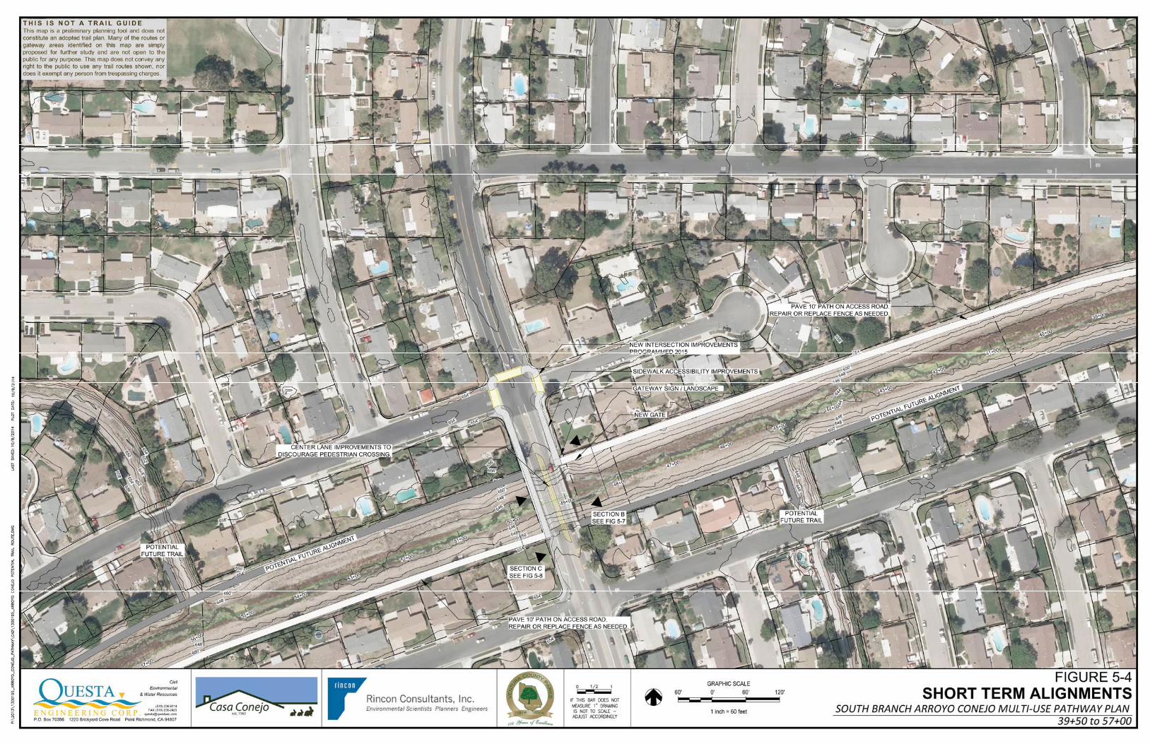


FIGURE 5-6
SECTION A SOUTH BRANCH ARROYO CONEJO MULTI-USE PATHWAY PLAN
THOUSAND OAKS, CA

FIGURE 5-7
SECTION B SOUTH BRANCH ARROYO CONEJO MULTI-USE PATHWAY PLAN
THOUSAND OAKS, CA
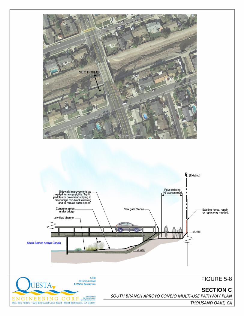
FIGURE 5-8
SECTION C SOUTH BRANCH ARROYO CONEJO MULTI-USE PATHWAY PLAN
THOUSAND OAKS, CA
el. 655’
el. 646’
SECTION C

FIGURE 5-9
SECTION D SOUTH BRANCH ARROYO CONEJO MULTI-USE PATHWAY PLAN
THOUSAND OAKS, CA
el. 656’
el. 648’
el. 652’

FIGURE 5-10
SECTION E SOUTH BRANCH ARROYO CONEJO MULTI-USE PATHWAY PLAN
THOUSAND OAKS, CA
el. 660’
el. 651’
December 29, 2014 SOUTH BRANCH ARROYO CONEJO MULTIUSE PATHWAY PLAN
60 | P a g e Q U E S T A
require modification of the existing sidewalks to insure accessibility, including widening, crosswalk installation, curb ramps and other amenities. It is also recommended that signage, lane painting or other traffic modifications be considered to discourage mid block crossing of Wendy at the access roads, as well as to calm traffic.
The Wendy Drive Bridge No. 69 (Caltrans No. 52C0166) was constructed in 1962. The Transportation Department Strategic Master Plan (SMP) lists the Wendy Drive Bridge Widening Project as Priority #108, which indicates a low priority compared to other planned projects in the SMP.
The Wendy Drive undercrossings represent potential opportunities to unify the north and south sides of the trail and to minimize traffic conflicts. However, the areas have a maximum 87” clearance, which is not sufficient for bicyclists without dismounting. Warning signs and reflective markings on the bridge under-structure would be needed. In addition, at this elevation, the user is within the active channel area, and the trail would be subject to seasonal inundation and would likely require maintenance each spring to reopen the seasonal pathway and remove debris and sediment. Options for utilization of the undercrossing at the south access road is further limited because lands east of the bridge contain flood control easements, and are not available for public access unless an agreement with the property owner is obtained. On the north side, use of the northwest access road (between Wendy and Borchard Park) is constrained by the concrete apron outlet at Newbury Park Drain Number 2. Options for use or retrofit of the Wendy Bridge undercrossings include: Seasonal Use:
• Retrofit of undercrossings for seasonal use, including ADA accessible ramp, with a maximum 8% grade, maximum 2% cross slope seasonally inundated crossing, gates signs and other crossing improvements (including signage to dismount when using a bicycle)
• Minimize curbs, fences or other obstructions within the undercrossing area to avoid interfering with channel’s flood flow capacity, and incorporate flow conveyance improvements if feasible
• Undercrossing should be minimum 5 feet wide, preferably 8 feet, with minimum 2 feet to vertical obstructions
• Undercrossing should be designed to maximize visibility, including lighting, level surface and open views
Restricted Use:
• Gate, fence and signage to preclude access to undercrossing areas Flood Management Comprehensive Project:
• Design of retrofit improvements or replacement of bridge at higher elevation to accommodate underpass as part of comprehensive flood management program.

December 29, 2014 SOUTH BRANCH ARROYO CONEJO MULTIUSE PATHWAY PLAN
61 | P a g e Q U E S T A
5.2.2 CROSSING SPUR TRAIL S1: ARROYO CONEJO AT NEWBURY PARK DRAIN NUMBER 2
Future connection to Newbury Park High School via the west-side maintenance access road along Newbury Park Drain number 2 is dependent on right of way acquisition or user agreements from each individual property owners along the channel. This access could also be pursued as part of a comprehensive flood management program. The access road is not continuous, and the channel would need to be re-graded to provide continuous access to the school and park trail system. Crosswalk improvements would be needed at Gerald Drive and Jenny Drive, where there is some potential private property encroachment.
5.2.3 SPUR TRAIL S2: ARROYO CONEJO AT NEWBURY PARK DRAIN NUMBER 1
Future connection to Borchard Road via the maintenance access road along west side of Newbury Park Drain number 1 is dependent on right of way acquisition or user agreement from individual property owners along the channel south of Arroyo Conejo. This access could be pursued as part of a comprehensive flood management program and would provide a continuous off-street path separated from traffic on Wendy Drive. Crosswalk improvements would be needed at Michael Drive and Theresa Drive.
5.2.4 BORCHARD PARK ENTRY
Like the Wendy Drive bridge, the existing Borchard Park bridge is within the FEMA floodway. Retrofit or replacement of this structure in the future should include consideration of a widened sidewalk and facilities for bicycle use that directly connect with the Arroyo Conejo Path.
5.3 COMPLEMENTARY FACILITIES (ENVIRONMENTAL AND BICYCLE SAFETY EDUCATION)
Environmental Education. Opportunities for educating the public on topics such as stormwater management, pollution and biological habitat protection should be incorporated into a comprehensive flood management program, and can be accomplished with signs, educational exhibits, demonstration gardens, bioswale/raingarden landscaping, decorative walls and other features. These should be included as part of the long term alignment designed in conjunction with stormwater and channel improvements.
For the short term alignments, kiosks and exhibits can be placed at the Borchard Park and Michael Drive trailhead entry areas.
Bicycle Safety. Bicycle safety and education programs are available to provide on-the-ground opportunities for learning how to safely ride a bike. Programs such as Gearing up for Better Biking (developed by Caltrans), Safe Routes to Schools, and programs offered through groups such as LA County and Ventura County Bicycle Coalitions and local cycling clubs offer safety education programs. Areas for bicycle safety education (also known as bicycle rodeos) are available within Borchard Park,

December 29, 2014 SOUTH BRANCH ARROYO CONEJO MULTIUSE PATHWAY PLAN
62 | P a g e Q U E S T A
including parking areas adjacent to the Park tennis courts, as well as the group picnic area at the end of Gerald Drive. Paved areas could be painted with bicycle symbols and striping to facilitate educational use.
5.4 TRAIL DESIGN STANDARDS
The pathway should incorporate standards from Ventura County, City of Thousand Oaks, American Association of Highway and Transportation Officials (AASHTO), California Department of Transportation (Caltrans), NACTO Urban Bikeway Design Guide, and the Uniform Building Code for bikeway trail design standards. The trail must meet accessibility standards. Other considerations:
• 2 feet minimum of clear space is required to avoid vertical obstructions, such as fences, signs, trees, etc. This 2 foot shoulder can be designed with gravel or compacted permeable pavement.
• The trail should be a minimum of 10 feet wide (12 feet preferred) to allow two-way traffic on the path. The outer 2 feet of the trail could be constructed using decomposed granite (dg), which is preferred by many pedestrians and trail runners. In restricted areas (such as a bridge underpass) this distance may need to be reduced. The minimum trail width in constrained areas should be 5 feet, with turnouts provided in such an area and associated signage.
• Trail entryways should be wide enough and designed to accommodate access for maintenance vehicles.
• Minimize potential obstructions such as utility covers, grates and other infrastructure within the path to comply with accessibility requirements.
• Use signs and striping where needed to direct path users and indicate location for emergency access.
• Minimize placement of new fencing or gates where possible to avoid flood obstruction. Rails at the grade control structure and HWY 101 culverts may need to be retrofitted to avoid safety hazards.
• Any new perimeter fencing should consider and incorporate flood protection concepts where appropriate.

December 29, 2014 SOUTH BRANCH ARROYO CONEJO MULTIUSE PATHWAY PLAN
63 | P a g e Q U E S T A
• A permanent path surface should be asphalt or concrete to accommodate maintenance and emergency vehicles, and be built to provide access for people with disabilities. The permanent path should be designed to accommodate Flood Control vehicles up to approximately 25 tons.
• Pavement should be designed to minimize maintenance associated with potential inundation, and with a design appropriate for channel conditions.
• Design trailhead entries and connections to local streets with landscaping and design elements to provide visibility, discourage midblock crossings, and provide an attractive amenity for the adjacent neighborhood. Permanent trailhead features could include signs, benches, landscape plantings, interpretive elements, decorative fencing, walls, trellises or arbors, and lighting.
• Typical design speed for the bicycle path should be 20 MPH, and where possible the path should have a paved section as well as an area that is not paved to allow separate pedestrian use.
• Incorporate drainage features such as raingardens and bioswales to minimize direct runoff from urban streets into the Arroyo, where appropriate.
• Landscape elements should include riparian plantings native to the Conejo Valley watershed, and designed in conjunction with an overall floodplain management strategy to avoid impacts to the channel’s flood conveyance capabilities.
• Landscape planting should include a palette of native drought tolerant species to increase habitat diversity, reduce erosion, filter pollutants, provide shaded canopy and enhance visual character of the channel.
• Landscape plantings should be placed and maintained to avoid screening or obstructing visibility of the trail.
• The primary function of Arroyo Conejo is flood water conveyance, and all improvements, including landscape planting, must be carefully considered to minimize operations and maintenance impacts to flood control facilities. All planting and other design elements would be subject to review and approval by the Flood Control District.
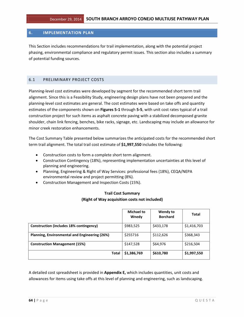
December 29, 2014 SOUTH BRANCH ARROYO CONEJO MULTIUSE PATHWAY PLAN
64 | P a g e Q U E S T A
6. IMPLEMENTATION PLAN
This Section includes recommendations for trail implementation, along with the potential project phasing, environmental compliance and regulatory permit issues. This section also includes a summary of potential funding sources.
6.1 PRELIMINARY PROJECT COSTS
Planning-level cost estimates were developed by segment for the recommended short term trail alignment. Since this is a Feasibility Study, engineering design plans have not been prepared and the planning-level cost estimates are general. The cost estimates were based on take offs and quantity estimates of the components shown on Figures 5-1 through 5-5, with unit cost rates typical of a trail construction project for such items as asphalt concrete paving with a stabilized decomposed granite shoulder, chain link fencing, benches, bike racks, signage, etc. Landscaping may include an allowance for minor creek restoration enhancements.
The Cost Summary Table presented below summarizes the anticipated costs for the recommended short term trail alignment. The total trail cost estimate of $1,997,550 includes the following:
• Construction costs to form a complete short term alignment. • Construction Contingency (18%), representing implementation uncertainties at this level of
planning and engineering. • Planning, Engineering & Right of Way Services: professional fees (18%), CEQA/NEPA
environmental review and project permitting (8%). • Construction Management and Inspection Costs (15%).
Trail Cost Summary
(Right of Way acquisition costs not included)
Michael to Wnedy
Wendy to Borchard Total
Construction (includes 18% contingency) $983,525 $433,178 $1,416,703
Planning, Environmental and Engineering (26%) $255716 $112,626 $368,343
Construction Management (15%) $147,528 $64,976 $216,504
Total $1,386,769 $610,780 $1,997,550
A detailed cost spreadsheet is provided in Appendix E, which includes quantities, unit costs and allowances for items using take offs at this level of planning and engineering, such as landscaping.

December 29, 2014 SOUTH BRANCH ARROYO CONEJO MULTIUSE PATHWAY PLAN
65 | P a g e Q U E S T A
A three (3) foot masonry block wall with a four (4) foot fence atop the wall and planted vines has been included in the cost estimate, where the trail backs up to residential neighborhood yards. This wall has not been designed or evaluated for flood impacts or benefits and represents a substantial portion ($396,000 or about 28%) of the overall construction costs.
Right of Way Acquisition Contingency Costs
Since much of the trail (but not all of it) will be on publicly owned land, Right of Way acquisition costs are considered moderate for this project.
A cost contingency for obtaining trail Right of Way on private land is recommended for acquisition of an easement for trail construction on the adjacent private land that VCWPD currently has a flowage easement on. This is located near where an easement exists for a sanitary sewer line.
ROW acquisition costs are difficult to estimate at a feasibility study level, without the benefit of a full land appraisal and a comparison with comparables, but some general cost information can be presented for budgeting and feasibility evaluation purposes.
No discussions have been held with the adjacent property owner regarding potential trail easement acquisition costs. For planning and feasibility study evaluation purposes only, a cost of raw land in this area of $250,000.00 per acre or $5.73 per square foot was used. This was based on the experience of the Feasibility Study authors and an on-line review of the prices of undeveloped land in the Thousand Oaks area with moderate income housing. Assuming a trail easement width of 20 feet is needed along 2,600 linear feet of private property, a total of 52,000 square feet or about 1.2 acres of land acquisition would be needed. Using a typical cost of $5.73 per square feet for planning and feasibility evaluation purposes, Right of Way acquisition costs would total approximately $300,000. If land costs closer to $500,000 per acre, then ROW acquisition costs would double and likewise, if raw land costs on constrained property was lower to say $125,000 per acre, Right of Way costs would be reduced proportionately. We expect Right of Way costs to be within this range. The $300,000 Right of Way Acquisition approximation represents about 18.5 % of the total estimated construction costs. The assumption is that no lands will be obtained by eminent domain and easement acquisition would be by a willing seller.
Operations and Maintenance Costs
Operations and maintenance of the trail will be important to ensure that the facility remains open, safe and productive as both a recreational and transportation facility. Since the trail would travel through a residential neighborhood (back yards) security and security patrols are an important consideration in O&M.
Operations will consist primarily of safety and security patrols, to ensure that trail users are not trespassing on adjoining properties, or that the trail does not become a conduit for property crimes. Because of concerns from occasional over bank flood waters , trail maintenance costs may be higher than those typical for a recreational trail not located in a floodplain and will consist primarily of

December 29, 2014 SOUTH BRANCH ARROYO CONEJO MULTIUSE PATHWAY PLAN
66 | P a g e Q U E S T A
maintaining drainage structures, and maintaining the paving through periodic pothole repair, crack sealing and slurry sealing, and re-paving. Other needed maintenance may include fence repair and replacement, weed control within the ROW, and repair of signage, trailhead facilities.
In addition to maintenance costs, operations include periodic inspections, system management, patrol, and other administrative functions that should be factored into the overall costs of the trail system.
According to a survey presented in the Northern San Luis Obispo County Coastal Trail Master Plan, representative annual costs for maintaining bicycle/pedestrian trails range from approximately $7,000 per mile of trail in Marin County to approximately $25,000 per mile for maintenance of Class I trails by East Bay Regional Park District.
Given that the trail is primarily located along an existing flood control facility maintenance road, , we anticipate annual operations and maintenance costs to average approximately $12,000.00 per mile, or about $18,000.00 annually for the roughly 1.5-mile trail system, not counting security patrols.
Cost Effectiveness and Financial Feasibility
As noted previously, the primary costs for the South Branch Arroyo Conejo Trail will be for construction (paving) of the road and installation of the 3 foot block wall and fencing, since much of the trail will be on public lands, moderating the need for land purchase. Costs are reduced due to favorable terrain, and the existing channel maintenance access road that can be cost effectively paved for the trail. Because of the difficulty of obtaining competitive grant funding for trail construction, total construction costs and cost effectiveness are important determinants in considering overall project feasibility.
One measure of the cost effectiveness of a project is a comparison of the costs of the proposed trail with nearby similar trail projects. Typically paved trails in the 10 foot to 12 foot range and with favorable topography range in costs from about $750,000 to as much as $1.5 million dollars per mile. Construction costs of the recommended short term trail alignment are estimated to average about opportunities and partnering $1.3 million per mile ($1,997,550/1.5 miles). According to information provided by the Rancho Simi Recreation and Park District, trail construction for the recently completed Arroyo Simi trail cost about $700,000 per mile. The proposed South Branch Arroyo Conejo per-mile trail cost includes block walls that increase the overall cost per mile. Considering the anticipated use of the trail as both a recreational trail and as an alternative mode of transportation and safe route to school usage, as well as multi functional project benefits, costs of this trail will make it competitive for grant funding, and project value can be maximized by tailoring grants to match grant funding with other partner agencies such as making it a part of a larger Flood Hazard reduction project.
6.2 PERMITS, COORDINATION AND PHASING
Implementation of the Arroyo Conejo Trail, as well as future connections to regional trail systems will likely occur in phases.

December 29, 2014 SOUTH BRANCH ARROYO CONEJO MULTIUSE PATHWAY PLAN
67 | P a g e Q U E S T A
Implementation as part of a coordinated flood control project:
Implementation Steps. The following steps would apply to implementation of a public trail project requiring detailed planning, design, environmental review and project permitting prior to construction.
• Review and/or approve this Plan by Ventura County, City of Thousand Oaks and project stakeholders.
• Integrate Plan concepts into applicable planning documents, including integrated flood management study, if applicable.
• Program funds for project implementation. • Secure funds for preliminary design and for trail construction (in Phases, if needed) as well as for
needed mitigation projects such as roadway soil erosion control and stream and wetlands restoration.
• Secure right of way needed for project implementation. • Obtaining regulatory permit approvals, including Section 7 or 10 consultation with the US Fish
and Wildlife Service if needed. • Complete environmental review document(s) (CEQA/NEPA). • Prepare Engineering Design Documents, coordinated with available budget for initial design and
construction (potential project phasing). • Advertise for bids to construct the project. • Construction, including construction oversight of the approved plans by a qualified Contractor to
ensure that the project plans, along with all of the CEQA mitigation measures and all permit conditions, are followed and implemented as approved.
• Design and build remaining segments of trail, if completed in phases. • Engineering and environmental work for extended trail connections.
The following Next Steps outline the near-term process in more detail for trail planning and design, leading to trail construction:
1. Project Review and Approval
This Document is a Planning and Feasibility Study. A final South Branch Arroyo Conejo Multi-Use Pathway Plan, including alignment recommendations and final trail sections, should be prepared and presented to the public and project stakeholders for review and approval at a Public Hearing. Additional public outreach is recommended, including a broader mail survey of area businesses and residents, informing them of any proposed project, and inviting their comments on issues associated with the concept of a trail along the South Branch of Arroyo Conejo.
2. Program and Secure Project Funding
This may include programming the project as part of an integrated flood management study.

December 29, 2014 SOUTH BRANCH ARROYO CONEJO MULTIUSE PATHWAY PLAN
68 | P a g e Q U E S T A
3. CEQA/NEPA Documentation
An environmental analysis needs to be conducted per California Environmental Quality Act (CEQA) requirements prior to any project approval. A CEQA Initial Study Checklist must be prepared to determine if there are potentially significant environmental impacts. If there are potential impacts, then an expanded environmental assessment or a full EIR may need to be prepared, most likely focusing on specific project issues and initial priority phases. Mitigation measures may be incorporated into the project design such as fencing, separation, trail realignment or other measures, and completion of compensatory mitigation (trail erosion control) to reduce or offset the potential environmental impacts. If federal funding is utilized to implement the project, then the project may need environmental review under the National Environmental Protection Act (NEPA), and supplemental environmental analysis in accordance with Caltrans procedures, if Caltrans administers applicable federal funding. As identified in Section 3, potentially significant environmental issues that may need to be evaluated in further detail include:
• Safety and Security
• Geology and Soils (erosion and sedimentation)
• Hydrology and Water Quality (flooding)
• Transportation/Traffic (local street connections and crossings)
The environmental document will need to identify Avoidance/Minimization Measures, mitigation requirements, and specific mitigation to address potential impacts. If the environmental review and special studies identify feasible mitigation measures that adequately address potential project impacts, then a Mitigated Negative Declaration can be adopted by the lead agency.
4. Right of Way Agreements
Since acquisition or permission for use of private property for the trail is needed in the form of a lease, easement or use agreement, this should be obtained, at least informally as an agreement in concept, before any significant further planning or design work begins. Typically, right of way is secured after environmental studies are completed, but well before engineering design is completed, when the most feasible/preferred alignment is more precisely defined.
Some trail segments will need agreements with adjacent private landowners to modify existing flood control access easements. Continued dialogue with respective property owners and stakeholders will be critical to incorporate trail elements into current and planned projects where appropriate.
5. Project Permitting
Preparation of permit applications and requests for permit approvals from applicable regulatory agencies is typically completed concurrent with or following completion of preliminary engineering

December 29, 2014 SOUTH BRANCH ARROYO CONEJO MULTIUSE PATHWAY PLAN
69 | P a g e Q U E S T A
design. Typically, permitting can often be completed on well thought-out conceptual (35% submittal) plans. The following project permits are anticipated:
• Ventura County Building/Grading/Encroachment Permit • City of Thousand Oaks Building/Grading/Encroachment Permit • U.S. Army Corps of Engineers Section 404 Nationwide wetlands fill permit (if wetlands are
affected) • CA Department of Fish and Wildlife 1600 Streambed Alteration Agreement (potential creek
crossing) • Watershed Protection Permit
Typically six to nine months should be allocated to project permitting, although this can be conducted concurrently with the CEQA review.
6. Final Design
The design process can often proceed at the same time the environmental review work and permitting is being completed. Next steps may include topographic, property or boundary and ROW/easement surveying, completion of soil borings for trail surface and/or boardwalk/bridge design, and trail design. Typically a design proceeds through several stages of preparation and review, from concept drawings to a final construction bid package (e.g., 35% completion, 70% completion, and 95% completion review and submittals). Depending on complexity, the completion of a final design and bid package, followed by public bidding. Preparation of Final Engineering Plans and Construction Documents typically takes from six to eight months. This can also be undertaken concurrently with the later phases of environmental review and project permitting.
7. Trail Construction
Trail implementation can also be completed in phases, depending upon prioritization, available funding, and environmental requirements, permitting, or combined with other construction projects. Construction may also be subject to seasonal implementation restrictions to avoid impacts to wildlife resources during nesting or breeding season, but given the small amount of riparian vegetation along the channel, this is not very likely. Trail construction can take from four months to six or more months.
6.3 FUNDING OPPORTUNITIES
This section provides a summary of current funding opportunities related to trails, and matches funding opportunities to the project implementation steps in the Action Plan. Bicycle, pedestrian, trail (recreational trails), and school safety improvement projects may be funded by a variety of federal, state, regional, and/or local funding programs. Federal and state programs have continued to acknowledge the importance of these improvements with increased flexibility in the major funding programs, along with the development of dedicated programs for “active” or “non-motorized”

December 29, 2014 SOUTH BRANCH ARROYO CONEJO MULTIUSE PATHWAY PLAN
70 | P a g e Q U E S T A
transportation projects. Project funding may also be obtained through bond measures, special tax districts, private entities, and/or directly by a local agency’s general fund.
Summary of Programs
The following section presents a general description of funding programs that can be used to implement the projects contained in this study.
6.3.1 FEDERAL AND STATE PROGRAMS CMAQ – Congestion Mitigation and Air Quality Improvement Program
Ventura County Transportation Commission (VCTC) programs federal Congestion Mitigation and Air Quality Improvement (CMAQ) Program (CMAQ) funds throughout Ventura County. CMAQ funds are derived from federal transportation legislation, Moving Ahead for Progress in the 21st Century Act (MAP-21). Approximately one-half of the total federal authorization that the VCTC programs is dedicated to active transportation projects (bikes / peds / transit). VCTC is currently administering a call for projects based on funding made available through the recent one-year reauthorization of MAP-21. Approximately $4 million dollars is available to jurisdictions throughout Ventura County for active transportation projects. Eligible CMAQ expenditures include construction and related project implementation activities.
Active Transportation Program
In September 2013, California legislation created the Active Transportation Program (ATP) to be administered by the California Department of Transportation (Caltrans). The ATP consolidates existing federal and state transportation programs, including the Transportation Alternatives Program (TAP), Bicycle Transportation Account (BTA), and State Safe Routes to School (SR2S), into a single program with a focus to make California a national leader in active transportation. The ATP is administered by the Caltrans Division of Local Assistance, Office of Active Transportation and Special Programs. The purpose of ATP is to encourage increased use of active modes of transportation by achieving the following goals:
• Increase the proportion of trips accomplished by biking and walking, • Increase safety and mobility for non-motorized users, • Advance the active transportation efforts of regional agencies to achieve greenhouse gas
reduction goals, • Enhance public health, • Ensure that disadvantaged communities fully share in the benefits of the program, and • Provide a broad spectrum of projects to benefit many types of active transportation users.
Caltrans is currently administering Cycle 1 projects, and VCTC indicated that a new call/round of ATP funding is expected this spring, potentially in March.
Web Link: http://www.dot.ca.gov/hq/LocalPrograms/atp/

December 29, 2014 SOUTH BRANCH ARROYO CONEJO MULTIUSE PATHWAY PLAN
71 | P a g e Q U E S T A
National Recreational Trails Program
The Recreational Trails Program (RTP) provides funds for recreational trails and trails-related projects. The RTP is administered at the federal level by the Federal Highway Administration (FHWA). It is administered at the state level by the California Department of Parks and Recreation (DPR). Non-motorized projects are administered by the Department’s Office of Grants and Local Services (OGLS), motorized projects are administered by the Department’s Off-Highway Motor Vehicle Recreation Division. Examples of trail uses include hiking, bicycling, in-line skating, equestrian use, and other non-motorized as well as motorized uses.
Recreational Trails Program funds may be used for:
• Maintenance and restoration of existing trails;
• Development and rehabilitation of trailside and trailhead facilities and trail linkages;
• Purchase and lease of trail construction and maintenance equipment;
• Construction of new trails (with restrictions for new trails on federal lands);
• Acquisition of easements or property for trails;
• State administrative costs related to this program (limited to seven percent of a State's funds); and
• Operation of educational programs to promote safety and environmental protection related to trails (limited to five percent of a State's funds).
Eligible applicants include cities and counties, parks districts, state agencies, Federal agencies, and non-profit organizations with management responsibilities of public lands. There is no maximum or minimum limit on grant request amounts. The maximum amount of RTP funds allowed for each project is 88% of the total project cost. The applicant is responsible for obtaining a match amount that is at least 12% of the total project cost. Eligible match sources include: State funds, including State Grant funds; Local funds, including general funds and bond funds; Private funds; Donated materials and services; Value of donated land (for Acquisition projects only); and other federal funds.
The RTP non-motorized funding program will provide approximately $1.47 million per year. The current federal RTP funding source, MAP-21, expired September 30, 2014. The next RTP Application call for projects is expected in 2016.
Web Link: http://www.parks.ca.gov/?page_id=24324
Land and Water Conservation Fund
The Land and Water Conservation Fund (LWCF) program provides grants for planning and acquiring outdoor recreation areas and facilities, including trails. LWCF is administered by the National Parks Service and the California Department of Parks and Recreation and has been reauthorized until 2015. Cities, counties, tribes, and districts authorized to acquire, develop, operate and maintain park and

December 29, 2014 SOUTH BRANCH ARROYO CONEJO MULTIUSE PATHWAY PLAN
72 | P a g e Q U E S T A
recreation facilities are eligible to apply. Applicants must fund the entire project and will be reimbursed for fifty percent of costs. $2,000,000.00 is the maximum request amount for any individual project.
Eligible projects must meet two specific criteria. The first is that projects acquired or developed under the program must be primarily for recreational use and not transportation purposes, and the second is that the lead agency must guarantee to maintain the facility in perpetuity for public recreation. Applications are considered using criteria such as priority status within the State Comprehensive Outdoor Recreation Plan (SCORP). The State Department of Park and Recreation will select which projects to submit to the National Park Service (NPS) for approval. Final approval is based on the amount of funds available that year, which is determined by a population-based formula, with a 40/60 split for northern and southern California respectively.
Web Link: http://www.parks.ca.gov/?page_id=21360
Rivers, Trails and Conservation Assistance Program
The National Park Service Rivers, Trails, and Conservation Assistance (RTCA) program supports community-led natural resource conservation and outdoor recreation projects across the nation. This program provides technical assistance via direct staff involvement to establish and restore greenways, rivers, trails, watersheds, and open space areas. The RTCA program provides planning assistance only. Projects are prioritized for assistance based upon criteria that include conserving significant community resources, fostering cooperation between agencies, serving a large number of users, encouraging public involvement in planning and implementation and focusing on lasting accomplishments. Federal agencies may be the lead partner only in collaboration with a non-federal partner.
Web Link: http://www.nps.gov/orgs/rtca/index.htm
Santa Monica Mountains Conservancy
The Santa Monica Mountains Conservancy manages several programs that provide grant funds for local trails, access, and habitat restoration projects, especially for projects on their lands. The funding cycle for these programs is open and on-going throughout the year. Funds are available to local government as well as non-profits. The Conservancy may be a funding source for trails that improve access to area rivers and creeks.
Web Link: http://smmc.ca.gov/
Habitat Conservation Fund
The Habitat Conservation Fund (HCF) provides $2 million dollars annually in grants for the conservation of habitat including wildlife corridors and urban trails statewide. Eligible activities include property acquisition, design, and construction. The HCF is 50% dollar for dollar matching program. California

December 29, 2014 SOUTH BRANCH ARROYO CONEJO MULTIUSE PATHWAY PLAN
73 | P a g e Q U E S T A
Environmental Quality Act (CEQA) compliance is required. Urban projects should demonstrate how the project would increase the public’s awareness and use of park, recreation, or wildlife areas.
Web Link: http://www.parks.ca.gov/?page_id=21361
Wildlife Conservation Board Public Access Program
This program funds land acquisitions that preserves wildlife habitat or provides recreational access for hunting, fishing or other wildlife-oriented activities. Up to $250,000 is available per project with applications accepted quarterly. Eligible projects include interpretive trails, river access and trailhead parking areas. The state must have a proprietary interest in the project. Local agencies are generally responsible for the planning and engineering phases.
Web Link: https://www.wcb.ca.gov/FundingSources.aspx
State Water Resources Control Board Grants Federal CWA 319(h) Program
This program is an annual federally funded nonpoint source pollution control program that is focused on controlling activities that impair beneficial uses and on limiting pollutant effects caused by those activities. States must establish priority rankings for waters on lists of impaired waters and develop action plans, known as Total Maximum Daily Loads (TMDLs), to improve water quality. Project proposals that address TMDL implementation and those that address problems in impaired waters are favored in the selection process. There is also a focus on implementing management activities that lead to reduction and/or prevention of pollutants that threaten or impair surface and ground waters. This funding could be explored in conjunction with erosion or water quality improvements to off-set any erosion caused by trail construction and operation.
Web Link: http://www.waterboards.ca.gov/water_issues/programs/grants_loans/319h/
6.3.2 LOCAL/REGIONAL FUNDING PROGRAMS TDA Article 3
Transportation Development Act (TDA) Article 3 funds are generated from State gasoline sales taxes and are returned to the source counties from which they originate to fund transportation projects. Article 3 funds provide a 2 percent set aside of the County TDA funds for bicycle and pedestrian projects. Eligible projects include right-of-way acquisition; planning, design and engineering; support programs; and construction of bicycle and pedestrian infrastructure, including retrofitting to meet ADA requirements, and related facilities. Each year the VCTC programs approximately $500,000 to non-motorized projects in Ventura County.
Direct Local Jurisdiction Funding

December 29, 2014 SOUTH BRANCH ARROYO CONEJO MULTIUSE PATHWAY PLAN
74 | P a g e Q U E S T A
Local jurisdictions can fund trails projects using a variety of sources. A county or city’s general funds are often earmarked for non-motorized projects.
Impact Fees
Another potential local source of funding is developer impact fees, typically tied to specific plan implementation, or reduction in vehicle trip generation. A clear connection between the impact fee and the mitigation project must be established. This may be appropriate for any development associated with the vacant lands southwest of HWY 101.
Community Partnerships
Corporate philanthropy is a component of many organizations. Partnering with corporations that supply products that contribute to healthy living may provide funding options for trail implementation. Potential partners include:
• REI Foundation http://www.rei.com/stewardship/report/community/rei-foundation.html • Amgen Foundation http://www.amgen.com/citizenship/foundation.html The Amgen
Foundation supports programs that align with their mission and priority giving areas in communities where Amgen has a presence. Their focus is to fund programs that enhance civic engagement by supporting science and education based initiatives, environmental programs, health and social services, as well as culture and arts in an effort to strengthen and enrich communities.
• Kaiser Permanente Southern California http://community.kp.org/be-involved/funding-
opportunities The Kaiser Permanente Southern California Region Grants Program provides support to nonprofit organizations, government entities, and academic institutions in Kaiser Permanente service areas throughout Southern California, to improve the health of communities and eliminate health disparities; parks and recreation is an area of focus.
Other
Local sales taxes, fees, and permits may be implemented, requiring a local election. Volunteer programs may substantially reduce the cost of implementing some of the trail segments. Use of groups such as the California Conservation Corp which offer low-cost assistance will be effective at reducing project costs. Local schools or community groups may use the trail as a project. Work parties may be formed to help clear the right of way where needed. A local construction company may donate or discount services. A challenge grant program with local businesses may be a good source of local funding, where corporations “adopt” a trail and help construct and maintain the facility.

December 29, 2014 SOUTH BRANCH ARROYO CONEJO MULTIUSE PATHWAY PLAN
75 | P a g e Q U E S T A
7. REFERENCES
Calflora. 2013. Information on wild California plants for conservation, education, and appreciation. Berkeley, CA. Updated online and accessed via: http://www.calflora.org/.
California Department of Fish and Game. 2011. Special Animals List. Biogeographic Data Branch, California Natural Diversity Database. December 2013.
California Department of Fish and Wildlife. 2013. California Natural Diversity Database, Rarefind V. 3.1.0. Updated November 2013.
California Department of Fish and Wildlife. 2013a. Biogeographic Information and Observation System (BIOS). Retrieved January 13, 2014 from http://bios.dfg.ca.gov.
California Department of Fish and Wildlife. 2013b. Special Vascular Plants, Bryophytes, and Lichens List. Biogeographic Data Branch, California Natural Diversity Database. December 2013.
California Native Plant Society. 2013. Inventory of Rare and Endangered Plants. V.8. Updated December 2010. Updated online and accessed via: http://cnps.web.aplus.net/cgi-bin/inv/inventory.cgi.
Calleguas Creek Watershed Master Plan – A Cooperative Strategy for Resource Management and Protection: Phase I Report. November 2004. Available at http://www.calleguas.com/ccbrochure/reportld.html
City of San Jose, Trail Program. Trail Impacts. October 2009. Available: https://www.sanjoseca.gov/DocumentCenter/View/6521
City of Thousand Oaks, Community Development Department. Development Activity Report. April 2014. Available at http://www.toaks.org/civica/filebank/blobdload.asp?BlobID=24120
City of Thousand Oaks. 1996. City of Thousand Oaks General Plan. Available at http://www.toaks.org/government/depts/community/planning/general/
City of Thousand Oaks. 1996. General Plan and Conservation Element. Updated online and accessed via: http://www.toaks.org/civica/filebank/blobdload.asp?BlobID=27841
City of Thousand Oaks. City of Thousand Oaks Bicycle Facilities Master Plan. November 2010.
City of Thousand Oaks. Thousand Oaks General Plan: Housing Element 2014-2021 Update. July 2013. Available at http://www.toaks.org/civica/filebank/blobdload.asp?BlobID=26686
Conejo Recreation and Park District. Conejo Recreation & Park District Master Plan. June 2011. Available at http://www.crpd.org/civica/filebank/blobdload.asp?BlobID=5883.
County of Ventura, Resource Management Agency (RMA). Tree Permits and the Tree Protection Ordinance. Accessed via: http://www.ventura.org/rma/planning/permits/tree/tree.html
County of Ventura. Recently Approved and Pending Projects. May 2014. Available at http://www.ventura.org/rma/planning/permits/pending-projects.html.
County of Ventura. Ventura County General Plan: Thousand Oaks Area Plan. April 2010. Available at http://www.ventura.org/rma/planning/pdf/plans/Thousand_Oaks_Area_Plan.pdf.
Greer, Donald. Omaha Recreational Trails: Their Effect on Property Values and Public Safety. June 2000. Available: http://atfiles.org/files/pdf/omahastudy.pdf.
December 29, 2014 SOUTH BRANCH ARROYO CONEJO MULTIUSE PATHWAY PLAN
76 | P a g e Q U E S T A
Hickman, J.C. (Ed.). 1993. The Jepson Manual: Higher Plants of California. University of California Press. Berkeley, California.
Holland, Robert F. 1986. Preliminary Descriptions of the Terrestrial Natural Communities of California. California Department of Fish and Wildlife, Nongame Heritage Program. 156 pgs.
Leehan, Officer Bruce. City of Edmond Police Department. Municipal Trails and Public Safety Concerns. August 2004. Available: http://arcadialaketrail.com/wp-content/uploads/2013/01/Trail-Survey-crime-statistics.pdf.
San Luis Obispo Council of Governments, 2013. Northern San Luis Obispo County Coastal Trail Plan.
Sawyer, J. O., T. Keeler-Wolf, and J.M. Evens. 2009. A Manual of California Vegetation, Second Edition. California Native Plant Society, Sacramento, California.
United States Corps of Engineers. 2008. Regional Supplement to the Corps of Engineer Wetland Delineation Manual: Arid West Region (Version 2.0). U.S. Army Corps of Engineers.
United States Department of Agriculture, Natural Resources Conservation Service. 2013b. Lists of Hydric Soils. National Cooperative Soil Survey, U.S. Department of Agriculture. Accessed via: http://soils.usda.gov/use/hydric/.
United States Fish and Wildlife Service. 1973. The Endangered Species Act of 1973, as amended (16 U.S.C 1531 et seq.).
United States Fish and Wildlife Service. 2000. Guidelines for Conducting and Reporting Botanical Inventories for Federally Listed, Proposed, and Candidate Plants. January 2000.
United States Fish and Wildlife Service. 2013a. Critical Habitat Portal. Available at: http://criticalhabitat.fws.gov.
Ventura County Transportation Commission (VCTC). Ventura County Comprehensive Transportation Plan. August 2013.
Ventura County Transportation Commission (VCTC). Ventura Countywide Bicycle Master Plan. October 2007.
Zeiner, D., W.F. Laudenslayer, Jr., and K.E. Mayer (May 1988). California’s Wildlife. California Statewide Wildlife Habitat Relationship System, Volumes I, II, & III. California Department of Fish and Wildlife.
Zeiner, D.C. et al. 1990. California’s Wildlife. Life History Accounts and Range Maps – California Wildlife Habitat Relationships System. California Department of Fish and Game.

December 29, 2014 SOUTH BRANCH ARROYO CONEJO MULTIUSE PATHWAY PLAN
77 | P a g e Q U E S T A
Personal Communication
Anitha Balan, Ventura County Public Works/Transportation
Ben Emami, Ventura County Watershed Protection District
Peter De Haan, Ventura County Transportation Commission Programming Director
Kathy Lowry, Bicycle Coordinator, City of Thousand Oaks Public Works Department
Officer Eric Hatlee-Crime Prevention Unit, City of Thousand Oaks Police Department
Damon Wing, Ventura County Board of Supervisors; Supervisor Linda Park’s Office
Sergio Vargas, Ventura County Watershed Protection District
Assistant Sherriff De Cesari, Ventura County Sherriff’s Department
Representatives from local Schools; Conejo Valley Unified School District)
Jim Friedl, General Manager, Conejo Recreation & Park District
Rancho Simi Recreation & Park District
Rye Baerg, Associate Regional Planner, Southern California Association of Governments

December 29, 2014 SOUTH BRANCH ARROYO CONEJO MULTIUSE PATHWAY PLAN
Q U E S T A
APPENDIX A: PUBLIC OUTREACH

CASA CONEJO MEETING NOTICE MUNICIPAL Wednesday, July 16, 2014 at 6:00 P.M.
ADVISORY NEW LOCATION: Borchard Community Center
COUNCIL 190 Reino Road, Newbury Park, CA
MAC Members:
Richard Twomey, Jr. (Chair), Edward J. Villa, Sr. (Vice Chair), Shannon Prachyl, Janell Smith,
Steven Wasco, Dustin Woomer and Richard Gaz
Please fill out a speaker card and bring it to the Chair if you plan to address the MAC at public comments.
1. Call to order
2. Flag salute
3. Approval of Minutes of May 14, 2014
4. Agenda Review
5. Public Safety Reports (CHP, Sheriff’s Department, etc.)
6. Public Comments on Items not on the Agenda
The MAC requests that speakers fill out speaker cards and limit comments to three minutes.
7. Council Comments on Items not on the Agenda
8. Workshop on South Branch Arroyo Conejo Trail
9. Comments of Ventura County Supervisor Linda Parks
10. Advisory Matters
a. Community Health Assessment Presentation by Rigoberto Vargas, Public Health Director
b. Goal Setting Using Casa Conejo Survey Results
c. Draft Wireless Communications Facilities Ordinance
d. Traffic Flow on Old Conejo Road
e. Graffiti Removal Intervention Team Update
11. Suggestions for Future Agenda Items
12. Adjournment until Wednesday, September 17, 2014 MAC Meeting
Ventura County Supervisor Linda Parks, District 2; (805) 214-2510; email: [email protected]
Access to MAC minutes and agendas: http://www.countyofventura.org/bos/dist2.asp
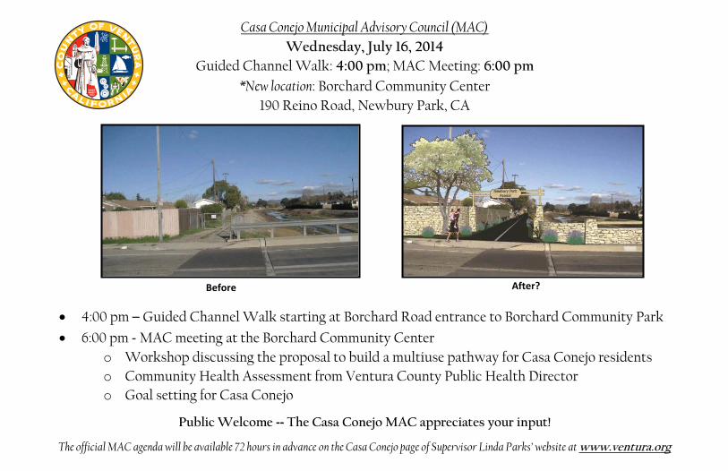
Before After?
4:00 pm – Guided Channel Walk starting at Borchard Road entrance to Borchard Community Park
6:00 pm - MAC meeting at the Borchard Community Center o Workshop discussing the proposal to build a multiuse pathway for Casa Conejo residents o Community Health Assessment from Ventura County Public Health Director o Goal setting for Casa Conejo
Public Welcome -- The Casa Conejo MAC appreciates your input!
The official MAC agenda will be available 72 hours in advance on the Casa Conejo page of Supervisor Linda Parks’ website at www.ventura.org
Casa Conejo Municipal Advisory Council (MAC) Wednesday, July 16, 2014
Guided Channel Walk: 4:00 pm; MAC Meeting: 6:00 pm *New location: Borchard Community Center
190 Reino Road, Newbury Park, CA

South Branch Arroyo Conejo Multi-Use Pathway Plan
Casa Conejo Municipal Advisory Committee July 16, 2014

Introduction • Consultant Team:
– Questa Engineering & Rincon Consultants
• Project Sponsors: – Ventura County – Southern California Association of
Governments (SCAG) • Stakeholders/Partners:
– Casa Conejo MAC – City of Thousand Oaks – Ventura County Watershed
Protection District – Conejo Recreation & Park District – Conejo Valley Unified School
District – Community


Background • The study area is between Highway 101 and
Borchard Community Park • 1-1/2 mile long flood control channel, with
maintenance access roads on both sides of the channel
• Wendy Drive and Borchard Rd. are nearest streets: Wendy bisects the channel
• A survey was conducted in 2010 to get community input

Community Input 2010 Resident Survey
• November 2010 Survey, 34 responses: – 78% supported trail along Arroyo Conejo – Destinations include shopping center, library,
schools and community center – 76% believe trail would improve safe school access – 64% believe trail would increase property values – 35% believe trail would increase crime – 41% believe trail would increase graffiti

Study Purpose The Plan will: • Evaluate the feasibility of constructing a trail on
the channel maintenance road • Assist in identifying needs, costs, environmental
issues and public concerns • When completed, the trail can help reduce local
automobile congestion and increase mobility by enabling bicycle, pedestrian, and ADA access to neighborhood schools, parks and shopping

Tasks
• Existing conditions inventory – Community setting – Environmental issues
• Preliminary design recommendations • Phasing, funding, and implementation options
– Environmental and engineering issues – Design and operating guidelines – Trail costs – Funding opportunities

Existing Conditions
• Traffic and Bicycle/Pedestrian Safety • Biological Resources • Hydrology and Flooding • Study Segments

Bicycle/Pedestrian Safety

Biological Resources

Hydrology and Flooding

Study Segments
• East Side: Michael Drive to Wendy Drive – South Side
• Newbury Park Drain Number 1
– North Side
• West Side: Wendy Drive to Borchard Park – South Side of channel – North Side of channel
• Newbury Park Drain Number 2
• Wendy Drive Crossing

East Side-Michael to Wendy
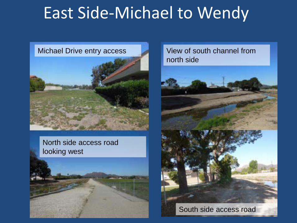
Michael Drive entry access View of south channel from north side
South side access road
North side access road looking west
East Side-Michael to Wendy

West Side-Wendy to Borchard Park
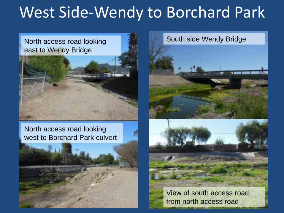
North access road looking east to Wendy Bridge
North access road looking west to Borchard Park culvert
South side Wendy Bridge
View of south access road from north access road
West Side-Wendy to Borchard Park

Potential Community Concerns
• Privacy • Crime • Cost

Privacy
• Project would likely include some new fencing, screening or buffering
• Short walls may be a part of project, to increase flood protection, which is a benefit to adjacent homeowners
• Trail might be subject to dawn-to-dusk operating hours
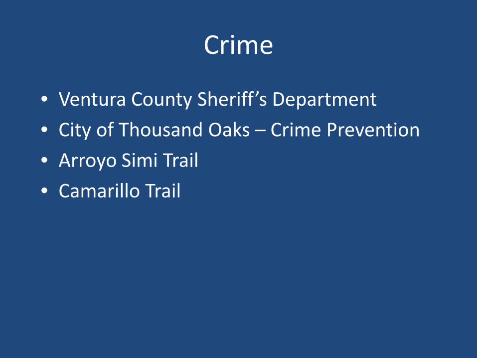
Crime
• Ventura County Sheriff’s Department • City of Thousand Oaks – Crime Prevention • Arroyo Simi Trail • Camarillo Trail

Cost • Why spend money on a trail when our sidewalks need repair?
– County policy is that residents pay for sidewalk repair • Study Cost
– Study is funded by Southern California Association of Governments (SCAG), not County revenues
– Grant funding from SCAG Sustainability Program for Active Transportation Projects
• Trail Cost – Many grants are available for trails and public access projects – Opportunities associated with access to schools – Opportunities when combined with flood control projects

Design Options • Trail on one or both sides of channel • Wendy Drive/Gerald crosswalk
– New signal to be installed in 2015
• Address flood issues – Floodwall challenges – Increase channel capacity – Year-round or seasonal crossings: Wendy Drive and Newbury Drain #2,
and relationship to flooding issues – Closure during flood events – Coordinate with WPD flood control studies
• Restoring Habitat/Revegetation Options – Landscape challenges: vegetation setback and flooding issues – In-channel habitat enhancement and channel flood capacity
• Park and Neighborhood Connections – Borchard Park, schools, Borchard Road future connections

Design Options
Michael Drive
Borchard Park
Newbury Park Drain #2
WendyDrive
Alice Drive
Newbury Park Drain #1

Michael Drive
100+’

Wendy Drive

Newbury Park Drain Number 2
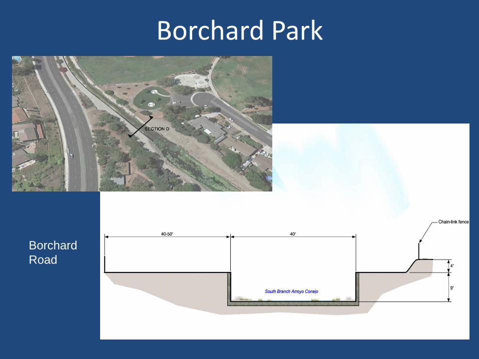
Borchard Park
Borchard Road
Baseball Field

Next Steps
• Obtain public input and consensus • Define feasible trail route, project
components, permits and approvals needed • Identify costs, and identify specific trail
improvements that can be funded and approved for implementation
• Complete environmental review, final design, right of way and permits
• Construct project

Questions and Comments
Thank you!


Channel Walk Photos
July 16, 2014


Ventura County Star:
July 18, 2014
CASA CONEJO RESIDENTS OFFER MIXED OPINIONS OF MULTI-USE PATH PROPOSAL Rachel McGrath
5:29 PM, Jul 18, 2014
conejo valley | outdoors | price of paradise


KAREN QUINCY LOBERG
SHOW CAPTION

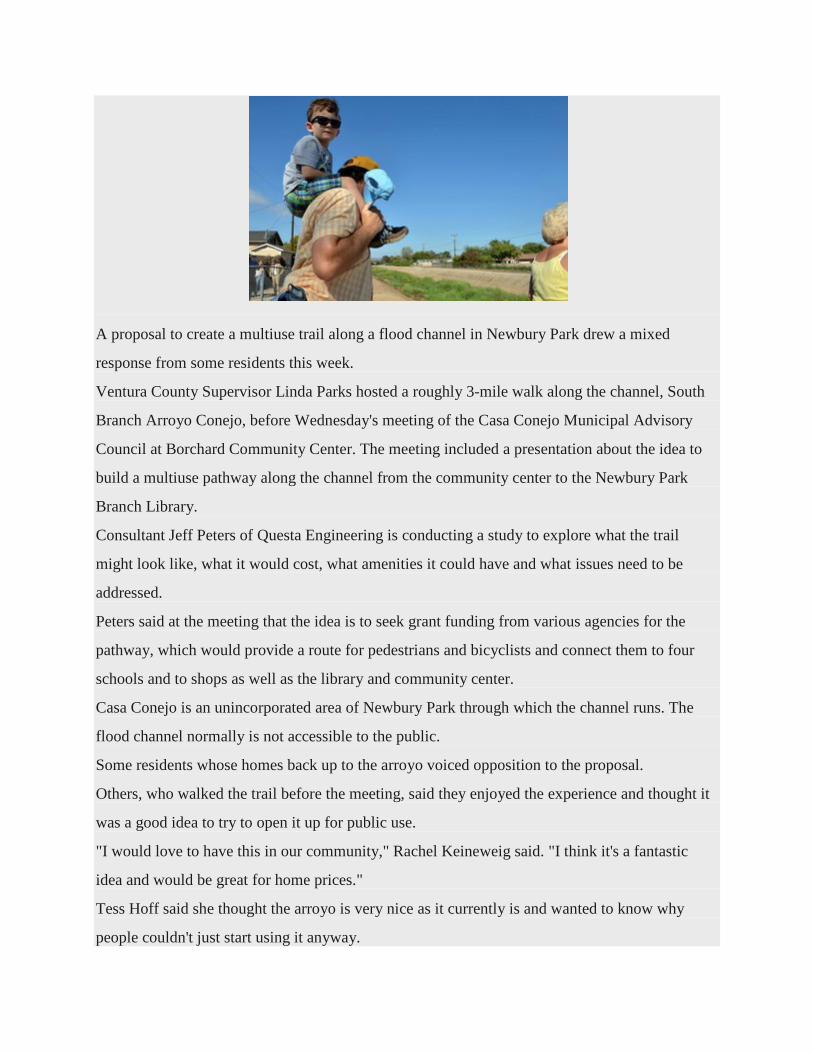
A proposal to create a multiuse trail along a flood channel in Newbury Park drew a mixed
response from some residents this week.
Ventura County Supervisor Linda Parks hosted a roughly 3-mile walk along the channel, South
Branch Arroyo Conejo, before Wednesday's meeting of the Casa Conejo Municipal Advisory
Council at Borchard Community Center. The meeting included a presentation about the idea to
build a multiuse pathway along the channel from the community center to the Newbury Park
Branch Library.
Consultant Jeff Peters of Questa Engineering is conducting a study to explore what the trail
might look like, what it would cost, what amenities it could have and what issues need to be
addressed.
Peters said at the meeting that the idea is to seek grant funding from various agencies for the
pathway, which would provide a route for pedestrians and bicyclists and connect them to four
schools and to shops as well as the library and community center.
Casa Conejo is an unincorporated area of Newbury Park through which the channel runs. The
flood channel normally is not accessible to the public.
Some residents whose homes back up to the arroyo voiced opposition to the proposal.
Others, who walked the trail before the meeting, said they enjoyed the experience and thought it
was a good idea to try to open it up for public use.
"I would love to have this in our community," Rachel Keineweig said. "I think it's a fantastic
idea and would be great for home prices."
Tess Hoff said she thought the arroyo is very nice as it currently is and wanted to know why
people couldn't just start using it anyway.

"It's fine that everybody wants to have a walkway behind somebody else's house because they
don't have to deal with it," longtime resident Bob Wayne said. "I think this is a horrible idea."
Some who spoke during the meeting said they were concerned about flooding, since the area sits
in a 100-year flood plain, and about the safety of those using the path during heavy rains.
Privacy and crime also were mentioned as important considerations.
Peters said he consulted with the Ventura County Sheriff's Office and Thousand Oaks Police
Crime Prevention Unit, and those agencies did not anticipate a trail would cause an increase in
criminal activity.
He said the experience of cities such as Simi Valley and Camarillo, which have multiuse paths
along flood channels, is that the paths become self-policing.
A complete environmental and final design review would have to take place before any approval
of the trail, Peters said.
"Ultimately, it's a community decision, and the decision is the responsibility of your elected
officials," he said.
Casa Conejo resident Roland Graham said a pathway would encourage young people to hang out
in the flood channel, would attract vagrants and could lead to property crimes and vandalism.
"I don't know anyone who's asked for this or anyone who really want this," said Susan Stout,
who lives on Gerald Drive with her husband, Brian. "There's a lot about this that concerns me
and frightens me."
Cycling advocate JC Simmons, who lives in Newbury Park but not in Casa Conejo, said
residents should embrace the idea.
"I think the path would be a huge, huge asset for the whole community," he said.
Copyright 2014 Scripps Media, Inc. All rights reserved. This material may not be published,
broadcast, rewritten, or redistributed.
Print this article Back to Top
A A A
1SHARE
SHARE ARTICLE

December 29, 2014 SOUTH BRANCH ARROYO CONEJO MULTIUSE PATHWAY PLAN
Q U E S T A
APPENDIX B: BIOLOGICAL RESOURCES
Special-Status Plant Species in the Regional Vicinity of the Project Site
Scientific Name
Common Name
Status Fed / State ESA
CRPR G-Rank / S-Rank
Habitat Preference / Requirements
Potential for Occurrence / Basis for Determination
Plants
Calochortus plummerae
Plummer's mariposa
lily
-- / -- 4.2
G4/S4
Perennial bulbiferous herb. Blooms May-Jul. Coastal scrub, chaparral, valley and foothill grassland, cismontane woodland, lower montane coniferous forest. Occurs on rocky and sandy sites, usually of granitic or alluvial material. Can be very common after fire. 100-1700m (330-5575ft).
Not expected. Preferred rocky, sandy substrate is not present on site.
Centromadia parryi ssp. australis
Southern tarplant
-- /-- 1B.1
G3T2/S2
Perennial deciduous shrub. Blooms Jul-Nov. Chaparral, coastal scrub. On sandstone outcrops and crevices, in shrubland. 280-760m (1920-2495ft).
Not expected. Preferred habitat not present on-site.
Dudleya blochmaniae ssp. Blochmaniae
Blochman's dudleya
-- /-- 1B.1
G2T2/S2.1
Perennial herb. Blooms Apr-June. Coastal scrub, coastal bluff scrub, valley and foothill grassland. Open, rocky slopes; often in shallow clays over serpentine or in rocky areas with little soil. 5-450m (15-1475ft).
Not expected. Preferred habitat not present on-site.
Dudleya cymosa ssp. marcescens
Marcescent dudleya
FT / SR 1B.2
G5T2/S2
Perennial herb. Blooms Apr-Jul. Chaparral. On sheer rock surfaces and rocky volcanic cliffs. 150-520m (490-1705ft).
Not expected. Preferred habitat not present on-site, no sheer, rocky volcanic cliffs present.
Dudleya verityi Verity's dudleya
FT / -- 1B.2
G1/S1
Perennial herb. Blooms May-Jun. Chaparral, cismontane woodland, coastal scrub. On volcanic rock outcrops in the Santa Monica Mountains. 60-120m (195-395ft).
Not expected. Preferred habitat and preferred volcanic soils not present on-site.
Eriogonum crocatum
Conejo buckwheat
-- / SR 1B.2
G2/S2.1
Perennial herb. Blooms Apr-Jul. Chaparral, coastal scrub, valley and foothill grassland. Conejo volcanic outcrops; rocky sites. 50-580m (165-1900ft).
Not expected. Preferred habitat and preferred volcanic soils not present on-site.
Monardella hypoleuca ssp. hypoleuca
White-veined monardella
-- / -- 1B.3
G4T2T3/S2S3
Herb. Blooms Apr-Dec. Chaparral, cismontane woodland. Dry slopes. 50-1525m (165-5005ft).
Not expected. Preferred habitat not present on-site. Occurrences within 5-mile radius are historical (<50 years).
Pentachaeta lyonii
Lyon's pentachaeta
FE/ SE 1B.1
G2/S2
Annual herb. Blooms Mar-Aug. Chaparral, valley and foothill grassland, coastal scrub. Edges of clearing in chaparral, usually at the ecotone between grassland and chaparral or edges of firebreaks. 30-630m (100-2065ft).
Not expected. Preferred habitat and preferred volcanic soils not present on-site.

December 29, 2014 SOUTH BRANCH ARROYO CONEJO MULTIUSE PATHWAY PLAN
Q U E S T A
Special-Status Plant Species in the Regional Vicinity of the Project Site
Scientific Name
Common Name
Status Fed / State ESA
CRPR G-Rank / S-Rank
Habitat Preference / Requirements
Potential for Occurrence / Basis for Determination
Senecio aphanactis
Chaparral ragwort
--/ -- 2B.2
G3/S2
Annual herb. Blooms Jan-Apr. Chaparral, cismontane woodland, coastal scrub. Drying alkaline flats. 15-800m (50-2625ft).
Not expected. Preferred habitat not present on-site.
Plant Communities
Southern Coast Live Oak Riparian Forest
-- / -- --
G4 / S4 Not expected. No riparian
areas observed on site.
Southern Riparian Forest
-- / -- --
G4 / S4 Not expected. No riparian
areas observed on site.
Southern Sycamore Alder Riparian
Woodland
-- / -- --
G4 / S4
Not expected. No alders observed on site. Sycamores observed were previously planted.
Valley Needlegrass Grassland
-- / -- --
G3 / S3.1 Not expected. No grassland
habitat observed on site.
Valley Oak Woodland -- / --
-- G3 / S2.1
Not expected. No valley oaks observed on site.
Regional Vicinity refers to within a 5 mile radius of site. FE = Federally Endangered FT = Federally Threatened SE = State Endangered ST = State Threatened SR = State Rare CRPR (CNPS California Rare Plant Rank): 1A = Presumed Extinct in California 1B = Rare, Threatened, or Endangered in California and elsewhere 2 = Rare, Threatened, or Endangered in California, but more common elsewhere 3 = Need more information (a Review List) 4 = Plants of Limited Distribution (a Watch List) CRPR Threat Code Extension: .1 = Seriously endangered in California (over 80% of occurrences threatened/high degree and immediacy of threat) .2 = Fairly endangered in California (20-80% occurrences threatened) .3 = Not very endangered in California (<20% of occurrences threatened) G-Rank/S-Rank = Global Rank and State Rank as per NatureServe and CDFW’s CNDDB RareFind 5. G1 or S1 - Critically Imperiled Globally or Subnationally (state) G2 or S2 - Imperiled Globally or Subnationally (state) G3 or S3 - Vulnerable to extirpation or extinction Globally or Subnationally (state) G4 or S4 - Apparently secure Globally or Subnationally (state) G5 or S5 - Secure Globally or Subnationally (state) ? - Inexact Numeric Rank T - Infraspecific Taxon (subspecies, varieties, and other designations below the level of species) Q – Questionable taxonomy that may reduce conservation priority

December 29, 2014 SOUTH BRANCH ARROYO CONEJO MULTIUSE PATHWAY PLAN
Q U E S T A
Special-Status Animal Species in the Regional Vicinity of the Project Site
Scientific Name Common Name
Status Fed / State ESA CDFW G-Rank / S-Rank
Habitat Preference / Requirements
Potential for Occurrence / Basis for Determination
Birds
Aquila chrysaetos
Golden eagle
-- / --
--
G5 / S3
Rolling foothills, mountain areas, sage-juniper flats, & desert. Cliff-walled canyons provide nesting habitat in most parts of range; also, large trees in open areas.
Not expected. Preferred nesting sites not present on-site.
Vireo bellii pusillus
least Bell's vireo
FE / SE
--
G5T2/ S2
Summer resident of Southern California in low riparian in vicinity of water or in dry river bottoms; below 2000 ft. Nests placed along margins of bushes or on twigs projecting into pathways, usually willow, Baccharis, mesquite.
Not expected. Preferred habitat and species not observed during survey.
Reptiles
Emys marmorata Western pond turtle
-- / -- SSC G3G4 / S3
A thoroughly aquatic turtle of ponds, marshes, rivers, streams & irrigation ditches, usually with aquatic vegetation, below 6000 ft elevation. Need basking sites and suitable (sandy banks or grassy open fields) upland habitat up to 0.5 km from water for egg-laying.
Not expected. Ideal habitat and species not observed during survey.
Thamnophis hammondii Two-striped garter snake
-- / -- SSC G4 / S2
Coastal California from vicinity of Salinas to northwest Baja California. From sea to about 7,000 ft elevation. Highly aquatic, found in or near permanent fresh water. Often along streams with rocky beds and riparian growth.
Not expected. Preferred habitat and species not observed during surveys.
Fish
Gila orcutti Arroyo chub
-- / -- SSC G2 / S2
Native to streams from Malibu Cr to San Luis Rey River basin. Introduced into streams in Santa Clara, Ventura, Santa Ynez, Mohave & San Diego river basins. Slow water stream sections with mud or sand bottoms. Feeds heavily on aquatic vegetation & associated invertebrates.
Not expected. Preferred habitat and species not observed during surveys.

December 29, 2014 SOUTH BRANCH ARROYO CONEJO MULTIUSE PATHWAY PLAN
Q U E S T A
Oncorhynchus mykiss irideus
southern steelhead - southern California DPS
FE / --
--
G5T2Q/ S2
Fed listing refers to pops from Santa Maria River south to southern extent of range (San Mateo Creek in San Diego Co.) Southern steelhead likely have greater physiological tolerances to warmer water & more variable conditions.
Not expected. Preferred habitat and species not observed during surveys.
Invertebrates
Danaus plexippus
Monarch butterfly
-- / --
--
G5 / S3
Winter roost sites extend along the coast from northern Mendocino to Baja California, Mexico. Roosts located in wind-protected tree groves (eucalyptus, Monterey pine, cypress), with nectar and water sources nearby.
Not expected. Suitable habitat and species not observed during surveys.
Trimerotropis occidentiloides
Santa Monica grasshopper
-- / --
--
G1G2 / S1S2
Known only form the Santa Monica Mountains. Found on bare hillsides and along dirt trails in chaparral.
Not expected. Suitable habitat and species not observed during surveys
Regional Vicinity refers to within a 5 mile radius of site. FT = Federally Threatened SE = State Endangered FC = Federal Candidate Species ST = State Threatened FE = Federally Endangered SSC = CDFW Species of Special Concern FP = Fully Protected G-Rank/S-Rank = Global Rank and State Rank as per NatureServe and CDFW’s CNDDB RareFind5. G1 or S1 - Critically Imperiled Globally or Subnationally (state) G2 or S2 - Imperiled Globally or Subnationally (state) G3 or S3 - Vulnerable to extirpation or extinction Globally or Subnationally (state) G4 or S4 - Apparently secure Globally or Subnationally (state) G5 or S5 - Secure Globally or Subnationally (state) ? - Inexact Numeric Rank T - Infraspecific Taxon (subspecies, varieties, and other designations below the level of species) Q – Questionable taxonomy that may reduce conservation priority

December 29, 2014 SOUTH BRANCH ARROYO CONEJO MULTIUSE PATHWAY PLAN
Q U E S T A
APPENDIX C: CULTURAL RESOURCES
Previous Studies Within 0.5-Mile of the Project Site
SCCIC Report No. Author Year Study Relationship to
Project Site
VN-00028 Rosen, Martin D.
1975
Evaluation of the Archaeological Resources and Potential Impact of Proposed Widening and
Realignment of the Ventura Freeway (federal 101 Freeway), Ventura County
Outside
VN-00041 Kaufman,
Susan Hector 1976 Evaluation of the Archaeological Resources and
Potential Impact of Proposed Industrial Tract 2488, Rpd-75-141, Ventura County
Outside
VN-00080 Ivie, Pamela and Vickie
Bennett 1976
Assessment of the Impact on Archaeological Resources of the Proposed Development of
Tentative Tract #2549 and Recorded Tract #2299-5, Thousand Oaks, Ventura County
Outside
VN-00394 Singer, Clay A. 1977 Cultural Resource Survey and Impact
Assessment for Tentative Tract #2790, City of Thousand Oaks, Ventura County, California
Outside
VN-00637 Clewlow, William C. Jr.
1981 An Archaeological Reconnaissance of the
Proposed Lynn Road Extension, Thousand Oaks, California
Outside
VN-00728 Lopez, Robert 1987 Ventura County Archaeological Society,
Thousand Oaks Area Plan- Archaeological Resources
Within
VN-00934 W & S Consultants
1990
Intensive Phase I Archaeological Survey and Cultural Resources Assessment of the Proposed Academy Business Park, Newbury Park Ventura
County, California
Outside
VN-00942 Lopez, Robert 1990
An Archaeological Reconnaissance of the Thirty-Six Acres Involved in the Borchard Villas (Tract 4707), Newbury Park, City of Thousand Oaks,
Ventura County, California
Outside
VN-01015 Callison, Sheila 1979 Survey Data Shee: PM-3447 Outside
VN-01040 Stell, Kenneth
and Albert Gallardo
1982
For Improvement of the Operational Characteristics of Route 101, the Ventura
Freeway in Los Angeles and Ventura Counties, Between Route 405 in Los Angeles, and the
Santa Clara River in Oxnard
Outside
VN-01520 Romani, John F.
1982 Archaeological Survey Report for the 07-LA/VEN
101 project P.M. 17.1-38.2/0.0-22.7 07351-076620
Outside

December 29, 2014 SOUTH BRANCH ARROYO CONEJO MULTIUSE PATHWAY PLAN
Q U E S T A
Previous Studies Within 0.5-Mile of the Project Site
SCCIC Report No. Author Year Study Relationship to
Project Site
VN-01553 Anonymous 1997
Phase I Archaeological Survey and Cultural Resources Assessment/Class III Inventory of the
Simi Valley Police Station project Area, Simi Valley, Ventura County, California
Outside
VN-02640 Maki, Mary K. 2004
Negative Archaeological Survey of 13.96 Acres for the Wendy Drive Executive Offices project,
City of Thousand Oaks, Ventura County, California
Outside
VN-02843 Amaglio, Alessandro
2005 Conejo Fire Mitigation, Conejo Recreation and
Park District, FEMA-1498-DR-CA, HMGP #1498-98-36
Within
VN-03018 Billat, Scott 2011
New Tower Submission Packt, FCC Form 620. Rancho Conejo Park & Ride. LA5658A. Ventura
Freeway & Borchard Road, Thousand Oaks, Ventura County
Outside
South Central Coastal Information Center, April 2014
Previously Recorded Cultural Resources Within 0.5-mile of the Project Site
Primary Number Description NRHP/CRHR Eligibility
Status Recorded/Updated
By and Year Relationship
to Project Site
CA-VEN-491 Lithic scatter Insufficient information IVIE 1976 Outside
South Central Coastal Information Center, April 2014

December 29, 2014 SOUTH BRANCH ARROYO CONEJO MULTIUSE PATHWAY PLAN
Q U E S T A
APPENDIX D: NATIVE AMERICAN HERITAGE COMMISSION (NAHC) CONSULTATION


December 29, 2014 SOUTH BRANCH ARROYO CONEJO MULTIUSE PATHWAY PLAN
Q U E S T A
APPENDIX E: IMPLEMENTATION COSTS

No. Item Qty. Unit Unit Price Total1 Michael Drive Trailhead Improvements
1.1 10' x 170' -3"AC Trail, w/ 2' DG shoulder 2,040 SF 4.50$ 9,180.00$ 1.2 Entry sign and arbor 1 EA 8,500.00$ 8,500.00$ 1.3 Information Kiosk 1 EA 4,000.00$ 4,000.00$ 1.4 Driveway and pedestrian improvements at street 1 LS 4,500.00$ 4,500.00$ 1.5 Landscaping Allowance 1 LS 9,000.00$ 9,000.00$ 1.6 Benches, bike rack , bollards-Allowance 1 LS 9,500.00$ 9,500.00$
Subtotal #1 44,680.00$ 2 Double Swing 16' Pipe Gate 1 LS 4,500.00$ 4,500.00$
3A Trail on VCWPD Access Road3A.1 10' x 740' -3" AC Trail, w/ 2' DG shoulder 8,880 SF 4.50$ 39,960.00$ 3A.2 4' Chain Link Fence Along Canal Structure 120 LF 15.00$ 1,800.00$
Subtotal #3A 41,760.00$ 3B Trail on N. Side of Channel, on Adjacent Private Property
-$ 3B.1 Grading and Imported Fill Placement 3,000 CY 45.00$ 135,000.00$ 3B.2 10' x 2,600' -3" AC Trail, w/ 2' DG shoulder 31,200 SF 4.25$ 132,600.00$ 3B.3 6' Chain Link Fence w/ slats 2,600 LF 25.00$ 65,000.00$ 3B.4 Landscaping Allowance 1 LS 5,000.00$ 5,000.00$
Subtotal #3B 337,600.00$ 3C Trail on N. Side of Channel, on VCWPD Access Road
3C.1 10' x 2,100' -3" AC Trail, w/ 2' DG shoulder 25,200 SF 4.50$ 113,400.00$ 3C.2 3' masonry block wall, 4' chain link fence w/ slats 2,100 LF 75.00$ 157,500.00$ 3C.3 Landscaping Allowance 1 LS 5,000.00$ 5,000.00$ 3C.4 Signage, Benches Allowance 1 LS 3,500.00$ 3,500.00$
Subtotal #3C 279,400.00$ 4 Alice Street Spur Trail Connection
-$ 4.1 Grading and Imported Fill Placement 100 CY 45.00$ 4,500.00$ 4.2 10' x 130' -3" AC Trail, w/ 2' DG shoulder 1,560 SF 4.25$ 6,630.00$ 4.3 6'-Chain Link Fencing Along Trail w/ slats, vines 125 LF 25.00$ 3,125.00$ 4.4 Landscaping Allowance 1 LS 5,000.00$ 5,000.00$ 4.5 Driveway, Bollards, Signage Allowance 1 LS 4,500.00$ 4,500.00$
Subtotal #4 23,755.00$ 5 Wendy Drive Trailhead Improvements
5.1 Entry Arbor, Wall, Signage and Bridge Façade Allowance 1 LS 75,000.00$ 75,000.00$ 5.2 Sidewalk Widening Allowance 1 LS 10,000.00$ 10,000.00$ 5.3 Center Median Allowance 1 LS 5,500.00$ 5,500.00$ 5.4 Seasonal Undercrossing Allowance 1 LS 7,500.00$ 7,500.00$ 5.5 Double Swing 16' Pipe Gate 1 LS 3,800.00$ 3,800.00$
-$ Subtotal #5 101,800.00$
6 Trail Located on S. Side Channel, VWPD Access Road6.1 10' x 2300' -3" AC Trail, w/ 2' DG shoulder 27,600 SF 4.50$ 124,200.00$ 6.2 3' masonry block wall w/ 4' chain link fence, slats 2,300 LF 75.00$ 172,500.00$ 6.3 Landscaping Allowance 1 LS 10,000.00$ 10,000.00$ 6.4 Signage, Benches Allowance 1 LS 6,500.00$ 6,500.00$ 6.5 Connection to Borchard Road Near Borchard Park- Allowance 1 LS 9,000.00$ 9,000.00$
South Branch Arroyo Conejo Cost Estimate

No. Item Qty. Unit Unit Price TotalSubtotal #6 322,200.00$
7 Trail Connection - N. Side of Channel (not included in Plan or Cost) -$ -$
8 Trail Along VWPD Box Culvert in Borchard Park8.1 Improvements within Borchard Park near Gerald Dr. cul de sac
including bike rodeo facilities -Allowance 1 LS 10,000.00$ 10,000.00$ 8.2 Fencing Along Top of Box Culvert 300 LF 25.00$ 7,500.00$ 8.3 Double Swing 16' Pipe Gate 1 LS 3,800.00$ 3,800.00$
-$ Subtotal #8 21,300.00$
9 Borchard Road Gateway Improvements9.1 Emergency Access Driveway 1 LS 4,500.00$ 4,500.00$ 9.2 Removable Bollards (2) 2 EA 1,500.00$ 3,000.00$ 9.3 Benches 1 EA 1,800.00$ 1,800.00$ 9.4 Landscaping Allowance 1 LS 8,000.00$ 8,000.00$ 9.5 Signage Allowance 1 LS 2,500.00$ 2,500.00$ 9.6 Double Swing 16' Pipe Gate to E. on S. Side of Channel 1 LS 3,800.00$ 3,800.00$ 9.7 12' x 80' Pre-engr. Bridge ( $200,000-Costs not Programmed) 80 lf -$ -$
Subtotal #9 23,600.00$ 10 Future Trail Connection ($25,000 Costs not Programmed) -$
SUBTOTAL CONSTRUCTION 1,200,595.00$ 18% Contingency 216,107.10$
TOTAL CONSTRUCTION 1,416,702.10$ 18% ROW & Engineering Design 255,006.38$
8% Environmental Review & Permitting 113,336.17$ 15% Construction Management 212,505.32$
TOTAL 1,997,549.96$

December 29, 2014 SOUTH BRANCH ARROYO CONEJO MULTIUSE PATHWAY PLAN
APPENDIX F PROJECT LETTERS OF SUPPORT


