assessing the economic value of 3d geo-information · austria: michael franzen, norbert pfeifer...
TRANSCRIPT

Official Publication No 68
European Spatial Data Research
November 2017
Assessing the Economic Value of 3D Geo-Information
Assessing the Economic Value of 3D Geo-Information
Andrew Coote, Phil Knight, Tina Svan ColdingRollo Home, Johanna Fröjdenlund, Gunnar Lysell
André Streilein, Paul Kane, Kevin BradyPiotr Wozniak, Maria Plá, Eric Bayers, Risto IlvesJurkka Tuokko, Martijn Rijsdijk, Richard WitmerFrédéric Cantat, Joep Crompvoets, Jantien Stoter
Andrew Coote, Phil Knight, Tina Svan ColdingRollo Home, Johanna Fröjdenlund, Gunnar Lysell
André Streilein, Paul Kane, Kevin BradyPiotr Wozniak, Maria Plá, Eric Bayers, Risto IlvesJurkka Tuokko, Martijn Rijsdijk, Richard WitmerFrédéric Cantat, Joep Crompvoets, Jantien Stoter

The present publication is the exclusive property of
European Spatial Data Research
All rights of translation and reproduction are reserved on behalf of EuroSDR.
Published by EuroSDR

EUROPEAN SPATIAL DATA RESEARCH
PRESIDENT 2016 – 2018:
Eric Bayers, Belgium
VICE-PRESIDENT 2017 – 2021:
Fabio Remondino, Italy
SECRETARY – GENERAL:
Joep Crompvoets, Belgium
DELEGATES BY MEMBER COUNTRY:
Austria: Michael Franzen, Norbert Pfeifer
Belgium: Eric Bayers
Croatia: Ivan Landek, Željko Bačič
Cyprus: Andreas Sokratous, Georgia Papathoma, Dimitrios Skarlatos
Denmark: Thorben Brigsted Hansen, Tessa Anderson
Finland: Juha Hyyppä, Jurkka Tuokko
France: Bénédicte Bucher, Yannick Boucher
Germany: Hansjörg Kutterer, Lars Bernard
Greece: Vassilios Vescoukis
Ireland: Paul Kane, Audrey Martin
Norway: Jon Arne Trollvik, Ivar Maalen-Johansen
Poland: Piotr Woźniak, Krzysztof Bakuła
Slovenia: Dalibor Radovan, Tomaž Petek, Mojca Kosmatin Fras
Spain: Antonio Arozarena, Javier Barrado Gozalo, Julián Delgado Hernández
Sweden: Tobias Lindholm, Heather Reese, Thomas Lithén
Switzerland: André Streilein-Hurni, Francois Golay
The Netherlands: Jantien Stoter, Martijn Rijsdijk
United Kingdom: Sally Cooper, Jon Mills
ASSOCIATE MEMBER:
ESRI: Nick Land
AIV: Jo Van Valckenborgh
COMMISSION CHAIRPERSONS:
Data Acquisition: Jon Mills, United Kingdom
Modelling and Processing: Jantien Stoter, The Netherlands
Updating and Integration: Jon Arne Trollvik, Norway
Information Usage: Bénédicte Bucher, France
Business Models and Operation: Joep Crompvoets, Belgium
Knowledge transfer: Markéta Potůčková, Czech Republic
OFFICE OF PUBLICATIONS:
Bundesamt für Eich- und Vermessungswesen
Publications Officer: Michael Franzen
Schiffamtsgasse 1-3
1020 Wien
Austria
Tel.: + 43 1 21110 5200
Fax: + 43 1 21110 995202
CONTACT DETAILS:
Web: www.eurosdr.net
President: [email protected]
Secretary-General: [email protected]
Secretariat: [email protected]
EuroSDR Secretariat
Public Governance Institute
KU Leuven
Faculty of Social Sciences
Parkstraat 45 bus 3609
3000 Leuven
Belgium
Tel.: +32 16 37 98 10
The official publications of EuroSDR are peer-reviewed.

4
Table of Contents
ABSTRACT ............................................................................................................................. 7
1 INTRODUCTION ............................................................................................................ 8
2 ECONOMIC CONCEPTS.............................................................................................. 10
2.1 The Value of Information ....................................................................................... 10
2.2 Methodologies used to assess the value of 3D geo-information in this project ...... 10
3 APPROACH ................................................................................................................... 14
3.1 Stages ...................................................................................................................... 14
3.2 Peer Review ............................................................................................................ 14
3.3 Skill Transfers ......................................................................................................... 14
4 VALUE CHAIN ANALYSIS RESULTS ...................................................................... 14
4.1 Forest Management ................................................................................................ 15
4.2 Flood Management ................................................................................................. 15
4.3 3D Cadastre and Valuation ..................................................................................... 17
4.4 Resilience (civil contingency) ................................................................................ 18
4.5 Asset Management.................................................................................................. 18
4.6 Urban Planning ....................................................................................................... 20
5 COST-BENEFIT ANALYSIS RESULTS ..................................................................... 21
5.1 Selected Use Cases for Cost-Benefit Analysis ....................................................... 21
5.2 Urban Planning ....................................................................................................... 21
5.3 Flood Management ................................................................................................. 22
6 CONCLUSION .............................................................................................................. 26
7 ACKNOWLEDGEMENTS ............................................................................................ 27
8 BIBLIOGRAPY ............................................................................................................. 27
ANNEX A: ECONOMIST PEER REVIEW .......................................................................... 32
ANNEX B: VALUE CHAIN COMBINED DELIVERABLES ............................................ 37
FORESTRY MANAGEMENT .............................................................................................. 38
ASSET MANAGEMENT ...................................................................................................... 51
FLOOD MANAGEMENT ..................................................................................................... 68
3D CADASTER AND VALUATION ................................................................................... 81
RESILIENCE ......................................................................................................................... 94
URBAN PLANNING ........................................................................................................... 110
ANNEX C: BARCELONA WORKSHOP PRESENTATIONS .......................................... 126
5
Assessing the Economic Value of 3D Geo-Information
With 1 figure and 3 appendices
Andrew Coote, ConsultingWhere
Philip Knight, ConsultingWhere
Tina Svan Colding, Agency for Data Supply and Efficiency
Rollo Home, Ordnace Survey, Great Britain
Johanna Fröjdenlund and Gunnar Lysell, Lantmäteriet
André Streilein, swisstopo
Paul Kane and Kevin Brady, Ireland
Piotr Wozniak, Glowny Urzad Geodezji I Kartografii
Maria Plá, Institut Cartogràfic i Geològic de Catalunya
Eric Bayers, Institut Géographique National, Belgium
Risto Ilves and Jurkka Tuokko, National Land Survey of Finland
Martijn Rijsdijk and Richard Witmer, Netherlands’ Kadaster
Frédéric Cantat, Institut Géographique National, France
Joep Crompvoets, KU Leuven, Belgium
Jantien Stoter, Delft University of Technology & Netherlands’ Kadaster

6
Index of Figures
Figure 1: Swiss Flood Loss and Damage Database ………………………………………... 23
Index of Annexes
Annex A: Economist Peer Review ………………………………………………………… 32
Annex B: Value Chain Combined Deliverables …………………………………………… 37
Annex C: Barcelona Workshop Presentations ……………………………………………. 126
7
ABSTRACT
The use of 3D geo-information has rapidly developed in recent years. Technological advances have driven this evolution and reduced the costs involved in the procurement and processing of 3D geo-information. Consequently, National Mapping Agencies (NMA’s) are actively seeking to transform their data operations and processes to produce such enhanced products. However, budgetary constraints in the public sector necessitate a rigorous assessment of costs and benefits before opportunities can be developed. This report is the culmination of a EuroSDR project that undertook a business case analysis over 12 months in collaboration with 11 European national and regional mapping agencies.
The analysis undertaken was structured around use cases (in order to examine the value derived within specific business contexts) and employed two methodologies: (i) value chain analysis and (ii) cost-benefit analysis to identify the quantification of value add identified by value chain analysis and the assessment of costs.
Value chain analysis identifies the connections between the supply and demand sides of a product or service and qualitatively identifies the value that is added throughout the chain of processes from source to end-user. Cost-benefit analysis facilitates an estimation of Return on Investment (RoI) by quantifying the costs and quantifiable benefits that arise from an investment over a defined period of time.
The project’s stakeholders initially selected six use cases for study: forestry management, flood management, 3D cadastre and valuation, resilience (civil contingency), asset management and urban planning. Over the course of six different workshops value chain analysis was applied to each of these use cases. Out of this process, two use cases were then selected for quantification using cost-benefit analysis: flood management due to the ubiquity of the challenge and its high political profile, and urban planning as 3D geo-information has a significant potential to contribute to the problems of managing urban growth. The process ended with the findings and outcomes being shared and consolidated at a workshop attended by delegates from each stakeholder.
Urban planning cost-benefit analysis -the costs are based on real-world cost estimates from Denmark, scaled up for the Republic of Ireland using the comparative land areas. The benefits are based on the following examples of financial impacts (for urban areas only):
• Local Area Plan (LAP) revision and the impact on the planning authority
• Visual impact assessment and the reduced costs for developers
• Reduced time for citizens to make LAP submissions and major scheme objections
• General improvements to public sector efficiency
Based on a 10 year project life cycle and discount rate of 4%, the results indicate a benefit to cost ratio of 2.1:1 and Net Present Value of € 22 million.
Flood management cost-benefit analysis - the same financial model as was applied to the urban planning case was also used for flood management. However, three approaches were taken to “triangulate” the assessment and to illustrate the use of different methodologies:
Cost Avoidance (Option 1) - this estimates the damages and losses that could have been avoided had 3D geo-information been used rather than the information used currently. The avoided damages are then interpreted as the benefits of using 3D geo-information. It has the advantage of requiring only limited inputs and is based on data available from Switzerland: (i) historical information on the loss and damage from previous events and (ii) interviews

8
with experts to indicate the positive effects of a high accuracy DTM. This resulted in a benefit to cost ratio of 3.3:1 and Net Present Value (after 10 years) of € 8.9 million.
Case Study (Option 2) - this uses case study evidence from the Netherlands on public sector benefits from data sharing and the reduced costs of: (i) land survey work, (ii) failures resulting from earlier detection of design errors and (iii) environmental impact assessments. This assessment gives a benefit to cost ratio of 3.2:1 and Net Present Value (after 10 years) of € 8.6 million.
Benefits Transfer (Option 3) - this uses information from a comparable study undertaken for USGS study entitled, ‘National Enhanced Elevation Assessment’ [Dewberry 2012]. Belgium has been used to illustrate this approach, although results for other countries involved in the study can also be automatically calculated within the financial model. This assessment method gives a benefit to cost ratio of 5.3:1 and Net Present Value (after 10 years) of € 27 million. The higher return calculated by this approach can be explained as Belgium would be unlikely to achieve the economies of scale of data capture costs in the US. A benefit to cost ratio “write down” of 50% would bring it into line with the returns predicted by the other two approaches.
The cost-benefit analysis demonstrated in both of the selected use cases that benefits outstrip costs by a multiple of between two and three times even when considering each use cases in isolation. As further applications of 3D geo–information are added, additional costs should rise more slowly, whilst benefits should accrue at a similar rate, thereby enhancing the overall rate of return. Investment proposals with the type of return profile found in this study would be expected to be positively received, provided the funds were available from public sources.
Further work using this methodology could usefully be considered in relation to the following use cases:
3D Cadastre and Valuation – in the consultant’s view this represents the best opportunity to complete cost-benefit analysis for one of the remaining use cases for which value chain mapping was undertaken. The timing of ground-breaking work in Denmark may mean that access to their internal economic assessment might now be publicly released making this a relatively quick and easy extension of the study into a potentially very financially attractive application.
Asset management – this should be approached by the creation of value chains for significant subsets of this large and complex use case, particularly transport asset management and streetworks. The recent study in Queensland may provide an opportunity for a cost-effective benefits transfer process to be applied..
1 INTRODUCTION
The third dimension (height) has always been an integral part of geo-information data capture processes. Within the national mapping community digital 3D geo-information was first used to create contours on topographic maps and in the private sector to produce small extent Digital Terrain Models (DTMs) to support engineering projects. Acquiring raw 3D data and using it to construct 3D geo-information has been expensive in the past. Consequently 3D geo-information has usually only been produced for limited areas on a project by project basis (DTMs and point clouds have however been produced as national coverages).

9
In recent years the introduction of much more sensitive LiDAR and imaging cameras has significantly reduced the cost of acquisition and processing of 3D geo-information
1.
Platforms including earth observation satellites, UAV (drones) and vehicle-mounted camera arrays are now competing for the market in high-resolution acquisition. Pattern recognition software to process images for the creation of point clouds, vector polygons and land use classifications has similarly become more capable.
Consequently, the modelling of our world in 3D is finding an ever increasing array of applications. National Mapping Agencies (NMAs) are looking to respond to this opportunity by re-orienting their data operations and processes to be 3D geo-information by default and as a result to re-position their products and services to take advantage during a period of rapid and radical change in the expectations of the public and private sector user base.
Concurrently, there are increasing budgetary pressures on the public sector. Therefore any investment, to exploit such an opportunity, requires a robust evaluation of the costs and benefits, even if the justification for doing so appears obvious. The commissioning of this study recognised the importance of establishing what we refer to here as the business case for 3D Geo-information. In financial appraisal a business case is defined as “a structured proposal for business improvement that provides a package of economic and related information sufficient for decision making.”
2.
1 3D geographic information science is an emerging field within academia and the commercial world. It offers additional
functionality not possible in 2D including 3D topology as well as techniques in analysing and querying volume, visibility, surface & sub-surface and shadowing. 2 UK HM Treasury, (2013) The Green Book: appraisal and evaluation in central government. Available at:
https://www.gov.uk/government/publications/the-green-book-appraisal-and-evaluation-in-central-governent
Economic value is a measure of the benefit provided by a good or service, defined as the
ability to produce income or benefit to the consumer. It is not the same as market price or
market value. Whilst the market price reflects an agreed transaction price between two
parties, the economic value is the maximum price that the purchaser would be prepared
to pay. If a consumer is willing to buy a good, it implies that they might place a higher
value on the good than the market price.
The difference between the value to the consumer and the market price is called
"consumer surplus". Economic value is generally measured in standard currency units.
There are many everyday situations in which economic value in excess of market price
arises frequently, such as in the distribution of drinking water.
10
This report describes the outcome of such a business case analysis that was carried out between March 2016 and March 2017 as a EuroSDR project in which 11 national and regional mapping agencies collaborated:
Belgian National Geographic Institute (NGI) http://www.ngi.be
Institute of Cartography and Geology, Catalonia (ICGC) http://www.icgc.cat
Danish Agency for Data Supply and Efficiency (SDFE) http://sdfe.dk
National Land Survey of Finland (NLS) http://www.maanmittauslaitos.fi
French National Geographic Institute (IGN) http://www.ign.fr
Ordnance Survey of Great Britain (OSGB) https://www.ordnancesurvey.co.uk
Ordnance Survey Ireland (OSI) https://www.osi.ie
The Netherlands Cadastre, Land Registry and Mapping Agency (Kadaster) https://www.kadaster.com
Polish Head Office of Geodesy and Cartography (GUGiK) http://www.gugik.gov.pl
Swedish National Land Survey (Lantmäteriet) http://www.lantmateriet.se
Swiss Federal Office of Topography (swisstopo) https://www.swisstopo.admin.ch
An international consultancy organisation specialising in geo-economics, ConsultingWhere, worked with the participants to deliver the project’s objectives.
2 ECONOMIC CONCEPTS
2.1 The Value of Information
Information of itself has limited intrinsic value. The value is derived from its use within a business context, which we refer to in this report as a use case. Depending on the scope of the application being evaluated, a use case may be as wide as the life cycle of the built environment, or more narrowly focused as in the case of forestry management. However, the 3D geo-information necessary to support such different use cases is comparable. Furthermore, the potential for information re-use is a significant factor in calculating economic value. Consequently, the question posed at the start of the project – “what is the value of 3D geo-information?” – is difficult to address holistically.
There are other dimensions to this complexity. The project was funded by a number of mapping agencies from different parts of Europe, each of which has its own economic drivers and political priorities. For instance, whilst forestry is hugely important in Scandinavia, it is less significant economically in the Mediterranean. Furthermore, there is a temporal dimension to value. At the time of the study, flooding had a very high political profile in France as a result of the Seine floods in June 2016, whilst the terror attacks in Belgium focused the nation on the theme of resilience.
2.2 Methodologies used to assess the value of 3D geo-information in this project
In the fields of economics and finance many different methodologies have been developed for assessing the economic value of information. Based on experience in previous work, particularly in the field of geo-information but also drawing on environmental and transport economics literature, two methodologies were selected for the task.

11
Value chain analysis was used for the initial scoping of use cases, information gathering and qualitative identification of the benefits of 3D geo-information. Value chain analysis was selected because of the need to clearly establish where in the supply chain, from data acquisition to end user consumption, 3D Geo-information would add greatest value. It is a very graphical and interactive technique and so generated particularly good input from an audience not used to modelling business processes.
In the second stage of the study, cost-benefit analysis was used in the quantification of the benefits and assessment of costs derived from the value chain analysis. Cost-benefit Analysis (CBA) is a technique used widely in the business and finance to compare the costs and benefits of alternative investments. In this case, comparing investment on 3D Geo-information with a “do nothing” scenario. It has many merits including the ease of understanding for non-economists, ease of computation and wide range of existing studies that have used this technique for economic assessment.
2.2.1 Value Chain Analysis
Value Chain Analysis is a technique used to create a visual representation of the connections between organisations (actors) on the supply side (creating the product or service) and the demand side (those that consume the product or service). It is essentially a flow diagram used to identify and describe what each component of the chain does to “add value” and where the most significant socio-economic benefits can be found. It is applied to each specific use case (application) for which the investment will be used.
Understanding the value chain is important for business case development because it is a graphical tool for dialogue with experts in the use case, e.g. flood management or urban planning. The key deliverable is a “break down” of the use case to a level of detail that allows the “value adding” processes to be identified, and by doing so, is more easily understood and quantified.
It facilitates understanding of the value by:
Helping to clarify the scope of the value chain and the interfaces to other related value chains, for instance in this project, by clearly establishing the interface processes between, for instance, asset management and urban planning;
Identifying stakeholder organisations (actors) that had not previously been recognised as beneficiaries;
Clarifying the processes that would change as a result of the use of 3D-geo-information.
Qualitative benefits identified in the value chain analysis, that may be politically or socially significant, but cannot be easily quantified, are also reported.
2.2.2 Cost-Benefit Analysis
In essence, cost-benefit analysis facilitates an estimation of Return on Investment (RoI) which can be expressed as “for each €1 Invested the return is €x”. It does so by attempting to quantify, using various techniques, the costs and the quantifiable benefits that flow directly from an investment over a defined time period, in this case 10 years. The financial flows are adjusted for the time value of money by using a discount rate. Typically this is currently in the region of 4% per annum for long-term public sector investments. Using discounting, returns achieved at some future date are factored downward using the agreed rate to take into account the opportunity cost of having made an alternative investment.
12
The cost components need to be comprehensively accounted for and often include consequential negative as well as positive effects. In assessing the “upside” of the equation, focus is generally on the largest and most irrefutable benefits identified from the value chain analysis. Since enhanced information is only a contributing component to any observed benefits, a logical approach is also required to the attribution of enhanced value to the information, system and other components of the improved process.
The following outlines the steps in implementation of cost-benefit analysis used in this project. It is based on that used in a comparable European Union study in the field of urban transport
3.
1. Evaluation criteria. It is important to define the evaluation criteria based on the customers’ expectations and local standards, such as the period over which the costs and benefits are to be evaluated, often referred to as the project life-cycle, the discount rate
4 to be
adopted and the form of presentation of the results. Using a longer project-life cycle (>10 years) is often a good mechanism for ensuring that the positive impacts of the investment are sustainable, since it forces consideration of maintenance costs after implementation has been completed.
2. Identify project impacts. All costs and benefits resulting from the project’s implementation are identified. In doing so it is important to understand the causal relationship between the measure and its various impacts (positive and negative). Usually, impacts for public investments will include the impacts on the organisation itself, other public sector organisations, citizens and businesses. For a comprehensive approach, indirect impacts, where economic effects in one context lead to impacts in a seemingly unrelated context, will also be relevant. Local guidance may be required as to whether citizen benefits will be considered valid. In some instances, we have found that only benefits to the organisation making the investment are to be considered.
3. Prioritising measurement effort. Each impact is considered and the most significant, either in terms of monetary or socio-economic consequences are identified. Criteria for prioritisation of the potential impacts need to be agreed with stakeholders
5. Clearly, the
more impacts you attempt to measure the more effort is required. Furthermore, if the investment can clearly be demonstrated with a small number of positive impacts then it is often easier to explain to decision makers and establish credibility.
4. Quantify monetary valuation of impacts. Instruments for measurement of market impacts, such as increases in productivity are often evaluated by directly measuring performance gains from the reduction in work required for processes which are particularly manually intensive. Another relatively easy benefit to evaluate is the removal of duplication in data acquisition through improvements in interoperability and data sharing. In other cases, measurement may be only be possible by an indirect method, such as measuring something that has been shown to have strong correlation with the impact in question. For instance, in the insurance market there is a well-established correlation between the time required by the customer to get an online quote and likelihood of acceptance – the shorter the period the greater the sales conversion rate. An additional consideration is what is referred to as “apportionment”. The geospatial system and its information are usually only a component of
3 TIDE Methodologies for cost-benefit and impact analyses in urban transport innovations. http://www.tide-
innovation.eu/en/Results/Methodologies-for-cost-benefit-and-impact-analyses/ 4 In cost-benefit analysis cash flows are discounted back to a reference year (usually the date of evaluation or the
commencement of a project) to calculate the present value of the net cash flows. Discounting recognises the opportunity cost of
investing in the project as opposed to an alternative use of the finance. 5 Hubbard, D.W. (2014) How to measure anything (third edition): finding the Value of Intangibles in Business. Wiley
13
an impact. A defensible method of assigning a percentage of the impact resulting from use of the system is to use expert opinion. The Delphi approach of “normalising” expert opinions is a useful technique in such cases
6.
5. Implement financial model. There are many standard models available. A number of software packages are available and widely used, for instance, in the transport sector
7.
However, simple spreadsheet packages, such as Microsoft Excel are sufficient in most cases. Excel supports the necessary calculation of indicators such as Net Present Value, Benefit-Cost Ratio (BCR) and Internal Rate of Return (IRR). Often the NPV (Net Present Value) is used to justify adopting or rejecting a project – all other things being equal, a positive NPV indicates an investment has a positive impact. The BCR is often used to rank different projects in order of benefits per unit of invested capital as it allows comparisons across different project types, sizes and durations.
We should be clear that we are not creating a new methodology here but implementing standard techniques (cost-benefit analysis) to derive a financial model for investment in 3D Geo-information.
6. Sensitivity analysis. As impact values are associated with predictions of future behaviour, they are innately uncertain. The risks of being smaller or larger than predicted must be taken into account. This is achieved by sensitivity analysis, whereby usually the largest contributing impacts are varied by making pessimistic and optimistic assumptions, so providing upper and lower bound measures of the performance of the investment.
This is also the stage at which risk should be factored into the business case. Some components of the costs or benefits may have a higher risk of variation than others, a key example is often where productivity of large groups of operators is forecast to improve. It is a well-known effect
8 that merely observing someone undertaking a routine task will increase
their productivity. Taking a conservative approach to the benefits predicted in such cases by “writing-down” the impacts claimed is recommended.
6 Hsu, C-C., & Sandford, B.A. (2007) The Delphi technique: making sense of consensus, Practical Assessment, Research &
Evaluation. Volume 12, Number 10. 7 University of California at Berkeley. Transportation Benefit-Cost Analysis primer. Available at:
http://bca.transportationeconomics.org/ 8 Hawthorne Effect. Available at: http://www.economist.com/node/12510632

14
3 APPROACH
3.1 Stages
The project was undertaken in a series of sequential stages:
Stage 1: Select Use Cases
The scope of the assignment (everything more than 2D) is potentially very wide. It was therefore agreed that we should select six use cases for initial assessment. A long list of use cases was discussed at a workshop of stakeholders in Brussels in March 2016 and the following selected:
Forestry Management Flood Management 3D Cadastre and Valuation Resilience (civil contingency) Asset Management Urban Planning
Stage 2: Value chain Analysis
Value-chain workshops hosted by various individual mapping agencies, and involving public and commercial sector representatives, were held in six different locations across Europe during June and July 2016. The use of 3D geo-information is now so widespread and disseminated through so many intermediaries, that the adding of value is no longer restricted to a relatively few suppliers and business partners.
Stage 3: Cost-benefit Analysis
From analysis of the results of the Stage 2 workshops, two use cases, flood management and urban planning, were selected for further study using cost-benefit analysis. Cost-benefit analysis is a technique for expressing quantitatively the benefits of a particular investment, in this case, high resolution Digital Terrain Models (DTMs) and, where appropriate, 3D City Models.
3.2 Peer Review
The study was subject to peer review by an external economist with considerable expertise in this field, Alan Smart of ACIL Allen in Sydney. His report is attached as Annex A.
3.3 Skill Transfers
On the basis of the feedback and discussion with the stakeholder group throughout the project, the results and outcomes were shared incrementally.
The final part of the skills transfer was undertaken through a workshop held over two days in Barcelona from the 30-31st March 2017. This event was organised by the Institute of Cartography and Geology, Catalonia, and attended by over 40 delegates.
4 VALUE CHAIN ANALYSIS RESULTS
It is not the intention of this report to provide a detailed account of the results of the analysis of each value chain. These are contained in Annex B and are also accessible on the EuroSDR website under the title “combined deliverables” for the use case of interest. What follows is

15
a summary of the use case for each the topics examined and the highest value impacts of 3D geo-information.
4.1 Forest Management
Forestry management in this context is the process of managing information concerning forests. It begins with planning where to plant trees and ends with their processing into products. The value chain includes activities undertaken by government, research organisations, forest owners and managers, harvesting (logging) companies, transport organisations and manufacturers.
The use case focused on Swedish and Finnish forestry sectors. Both countries are arranged on broadly similar lines with state funded National Mapping and Cadastral Agencies (NMCAs) alongside forest centres/agencies responsible for a wide range of data collection, analysis and distribution services. The sector is characterised by a very large number of forest owners with a much smaller number of forest companies providing silviculture services and marketing forest products.
The benefits spread sheet, included within Annex B, details the workshop participants’ view of the most significant benefits of 3D data to the forestry management use case. In total 13 separate benefits were identified for many different stakeholders.
Those valued most highly, in order of ranking were:
1. Survey costs are dramatically reduced. LiDAR produces more accurate and cheaper data, freeing surveyors from time consuming ground surveys. Consequently, they are able to provide more productive analysis and advice to forest owners.
2. Co-operation within the forestry sector reduces costs of acquisition and re-use of the data across other sectors multiplies the value added.
3. By providing forest owners with information about the value of their forests they can be encouraged to invest in and sell their assets, increasing forest productivity.
4. Advanced planning and appropriate application of silvicultural techniques using forest data products increases forest productivity.
5. Accurate data on the depth of water table reduces logistics costs by allowing better planning of routes for timber transport.
In summary, high quality remote sensing provides the basis of accurate and cost-effective 3D data products that enable improved forestry management. Due to these improved data products, the costs of maintaining the national forest inventory have decreased by 60 -70%.
Making this information openly available via forest information portals positively impacts the value chain from planning investment, to management activities and the scheduling of in-forest logistics. Public sector value add includes improvements in tax and land administration. There are also numerous indirect benefits within a range of sectors including defence, cultural and heritage, environmental, utilities and finance.
4.2 Flood Management
In recent years there has been an increase in the frequency and intensity of floods across Europe. The links between flooding and climate change are becoming more apparent bringing a greater need for preparedness. The significant economic and social impact of floods requires effective management. Central to effective planning and risk reduction is 3D - and arguably 4D – geographical information. As it is too expensive to comprehensively

16
protect all vulnerable areas, a value chain of flood management provides information on the relative costs and benefits so that informed and targeted choices can be made. The value chain can bring accurate and reliable risk analysis to agencies involved in flood preparedness, response, recovery and mitigation.
As many of the delegates for our workshop were from France, much of the workshop input has an emphasis on the situation in that country. The French system has multiple authorities with responsibility for flood management, local regional and national. We have not tried to separate them out rigorously as this level of detail was not covered in the workshop and would over complicate the deliverable. Improved coordination between them by common access to more accurate 3D data would clearly add value and has been identified in the deliverables. We have enhanced the workshop results, where our experience suggests there were gaps at the end of the workshop, from other studies concerning added value. These come from literature research and previous studies ConsultingWhere have undertaken. A glossary of terms that may not translate directly is included to assist participants in the study from other countries in using the outputs.
As identified by the workshop participants, the processes where the most value is added, generating the most significant potential socio-economic benefits, are as follows:
1. Early warning for emergency services saves lives.
2. More accurate and reliable risk analysis tools result in better development planning decisions and more appropriate construction.
3. Risk analysis tools that are, easier to use and understand, result in a reduction in time spent justifying the evidence and so reducing the administrative costs of consenting.
4. More accurate and reliable risk analysis tools result in better emergency response planning (including simulations) and a more effective response.
5. More accurate risk analysis increases the confidence of insurance providers when setting premiums and allows for more competitive premiums for some customers.
The above list provided a focus for quantification of economic benefits and elaboration of social benefits that would be required as part of a full business case.
The United Nations report (2013) titled ‘The value of geo-information for disaster and risk management (VALID): benefit analysis and stakeholder assessment’
9 provides an excellent
assessment of the various methodological approaches.
Another key resource is the very valuable quantitative output concerning the costs of flooding by the Swiss Federal Research Institute (WSL) on behalf of the Federal Office for the Environment (FOEN). The WSL has been systematically creating a database of information on flood and mass movement since 1972 and currently has more than 20,000 entries
10 (the information is partially available in English from the EuroSDR website). A
9 United Nations, (2013) ‘The Value of geo-information for disaster and risk management (Valid): benefit analysis and
stakeholder assessment’. Available on the EuroSDR website and at: http://www.un-spider.org/sites/default/files/VALIDPublication.pdf 10
Swiss Federal Institute for Forest, Snow and Landscape Research WSL, Swiss flood and landslide damage database.
Available at: http://www.wsl.ch/fe/gebirgshydrologie/HEX/projekte/schadendatenbank/index_EN

17
study published in 200911
assesses damage originating from naturally triggered floods, debris flows, landslides and rock-falls (since 2002).
4.3 3D Cadastre and Valuation
A cadastre is a comprehensive register of a country’s real estate commonly including details of the ownership, tenure, location and value of individual parcels of land. Valuation (of real estate) is used in most countries as the basis of local taxation, consequently any process that adds objectivity is helpful both to transparency and fairness of the system. This use case includes state agencies involved in property valuation, local government, as well as commercial entities in insurance and real estate and citizens.
The analysis covered the uses of geo-information related to land and property for land registration and administration and land and property valuation. The valuation element focuses largely on valuation for taxation purposes, but is also applicable to valuation for other purposes (insurance, resale, financial derivatives etc.). As the workshop attendees were exclusively from Denmark and The Netherlands the analysis focuses on the situation in these two countries.
Denmark is the more advanced of the nations in terms of using 3D topographic data for valuation purposes. A business case has been prepared and approved and implementation is underway. The primary rationale for the project is to make valuation more objective, this is politically popular and has many identified benefits (see benefits spreadsheet). The 3D status in Netherlands is also well advanced in terms of both 3D cadastral registration and 3D topography. Netherlands is well placed because of the well-developed state of linked key registers, particularly the cadastre, buildings and addresses.
The benefits spreadsheet details the workshop participants’ view of the most significant benefits of 3D to the Cadastre and Valuation use case. In total 17 separate benefits were identified for many different stakeholders. Those valued most highly, in order of ranking were:
1. Allowing citizens to review and contribute to the data held by the tax authorities about their property creates, through crowd-sourcing, production efficiencies for tax authorities as well as improving the citizens’ trust in the authority’s data holdings. Specific savings are: reduced time spent dealing with complaints by the tax authorities; reduced costs of lawyers and surveyors for both sides involved in disputes and time savings for citizens.
2. Complex property ownership scenarios are difficult to represent accurately in 2D. By using 3D cadastral mapping, lenders can improve the quality of the information that they hold on an asset that they are lending against. Improvements in information can reduce the amount of liquidity a lender has to hold to secure a loan and potentially reduce interest rates for the borrower.
3. Notaries administer the legal transfer of property from one party to another. Complex property ownership scenarios that are difficult to represent accurately in 2D are particularly difficult and time consuming for notaries to administer and can result in costly legal errors. 3D cadastral mapping improves the information available to the notary, speeding up the transaction time and associated cost, it also makes the nature of the transaction clear and traceable to other notaries carrying out property searches.
11 Hilker, N., Badoux, A., Hegg, C. (2009) ‘The Swiss flood and landslide damage database 1972-2007’, Natural Hazards and
Earth System Sciences, Vol 9, pp. 913.925. Available at:
http://www.wsl.ch/fe/gebirgshydrologie/HEX/projekte/schadendatenbank/download/nhess-9-913-2009_lq.pdf
18
4. Increasing the number of geo-variables in the land and property valuation models leads to a more uniform assessment of tax payable. This improves trust in the systems that assess land and property value making citizens more willing to pay the tax that is levied and saving the tax authorities effort recovering unpaid tax.
5. Property valuations, including valuations for the purposes of property tax are largely based the values achieved on the open market by similar properties known as “comparables”. Improving the geo-information held about properties using 3D data, for example the amount of solar radiation hitting the roof, or the views from the windows, allows valuers to identify useful “comparables” more reliably.
4.4 Resilience (civil contingency)
The term “resilience” has come to prominence in recent times to describe the ability of a nation, region or city to respond to civil emergencies. Major incidents can be caused by natural disasters, industrial accidents, health pandemics or terror attacks. Civil contingency planning requires high levels of preparedness and an improved ability of emergency services and government agencies to operate effectively together. The key users in the value chain include the emergency services, the interior ministry and defence and intelligence services.
The resilience value chain workshop was undertaken in Brussels. The Belgian system has multiple authorities with responsibility for resilience as well as national and regional mapping agencies. We have not tried to separate them out rigorously as this level of detail was not covered in the workshop and would over complicate the deliverable. Improved coordination between the authorities by common access to more accurate 3D data clearly adds value and has been identified in the deliverables. The defence and intelligence aspects of resilience are referred to but are not elaborated for obvious reasons of security and confidentiality.
The most important benefits identified by the workshop participants were:
1. Better building information (layout, number of floors etc.) which reduces emergency service response times by improving access decisions: the right resource in the right place at the right time.
2. Better 3D contextual data e.g. slope, aspect etc. which improves localisation of callers and incidents by Emergency Control Room operators (particularly in rural areas where there are few landmarks and cell phone location accuracy is poor).
3. 3D city models improve the analysis of planned developments and allow factors such as crowd evacuation to be taken into account and the design evaluated to minimise the impact of bomb blasts.
4. Better and more accessible 3D information can be used by defence forces to respond to terrorist incidents more effectively, for example, by identifying and blocking escape routes or identifying sniper positions.
5. Improved data sharing and rationalisation reduces the cost of acquisition and improves interoperability.
4.5 Asset Management
At its widest definition, asset management refers to processes that monitors and maintains tangible assets (such as public infrastructure) and intangible assets (such as information). In view of the potentially very wide scope for this use case we sought to focus on how 3D geo-information could be used to add value to the management and integration of physical

19
infrastructure in urban environments. To do so, we engaged a wide range of information producers and end users including transport companies, central and local government, citizens, the design and construction industry, utilities and telecoms and financial services.
Even this more limited description of asset management proved problematic during the workshop because of its wide scope and different interpretations of priorities by external delegates who came from quite specialised backgrounds – a standards facilitation company, property data aggregation start-up and Transport for London. As a result the value chain has components of at least four different narrower use cases: Land and Property Asset Management, Transport Asset Management, Street works and Precision Agriculture. There was also overlap with other of our target use cases, particularly for urban planning and resilience.
The benefits spread sheet details the workshop participants’ view of the most significant benefits of 3D geo-information to the use case. In total 21 separate benefits were identified. Although participants were asked to rank the entries in terms of value to their organisations, in view of the small number of participants, in the list that follows some additional entries are included:
1. Reduced utilities strikes – improved 3D underground and surface data would facilitate reduction in injuries and lives lost as a result of excavators hitting cables and other sub-surface assets. A study by the University of Birmingham
12 on the causes, impacts and costs
of strikes on buried utility assets quotes figures of 12 deaths and 600 serious injuries every year from contact with electricity cables alone.
2. Reduced earthwork volumes on infrastructure projects – more accurate 3D information about existing surfaces, has the potential to make large savings in the cost of moving materials during preparation for construction.
3. Reduced costs of construction – in certain areas the superficial geology (recent deposits) are not well mapped and their 3D profile not being well known. A pilot study in Glasgow
13
has shown more accurate 3D geological data to have the potential to reduce costs of construction by allowing engineers to be better informed about ground conditions.
4. Internet of Things (IoT) planning – accurate 3D models of buildings can be used to locate sensors in the optimal locations for coverage of the required area and to take into account site access and installation conditions.
5. Water network planning – more accurate surface and geological models allow better planning of pipe networks to minimise excavation costs and materials.
6. Telecoms planning – 4G/5G networks require a much greater density of transmitter masts than with previous generation wireless systems. Accurate 3D geo-information for buildings, in urban situations particularly, will reduce costs of planning and implementing such networks. Masts locations are susceptible to changes in the environment (vegetation/building extensions). Monitoring such change using 3D models reduces the need for site visits.
12 Metje, N., Ahmad, B. & Crossland, S. M. (2015), ‘Causes, impacts and costs of strikes on buried utility assets’, Institution of
Civil Engineers. Proceedings. Municiple Engineer, vol 168, no. 3, pp. 165-174. Available at: http://pure-oai.bham.ac.uk/ws/files/24091427/Metje_Ahmad_Crossland_2015_Causes_impacts_costs_ICE_Proceedings.pdf 13
Bonsor, H.C., et al. (2013) Maximising past investment in subsurface data in urban areas for sustainable resource
management: a pilot in Glasgow, UK. Available at: http://nora.nerc.ac.uk/502014/

20
7. Airport Management – rationalisation and joining up of systems currently used to manage different asset types in large complex sites such as Heathrow Airport
14 require
interoperability of data, much of it geospatial and 3D. Such rationalisation has the potential to yield substantial reductions in cost.
8. Interoperability – sharing and reuse of 3D geo-information will reduce data acquisition and handling costs and make it easier to maintain asset inventories. Other key benefits identified related to emergency services (see resilience use case), flood protection (flood management) and the urban planning use case.
Other key benefits identified related to emergency services (see resilience use case), flood protection (flood management) and the urban planning use case.
4.6 Urban Planning
An increasing proportion of the European population is choosing to live in urban areas and by 2050 it is predicted this will rise to 60%. Consequently, housing demand is outstripping supply leading to a lack of affordable accommodation in many cities. Housing is just one aspect of the challenges facing planners, who need to balance living space with maintaining quality of life whilst supporting long-term sustainability. Urban planning is becoming increasingly information-hungry and decisions are three dimensional. As well as an increasingly diverse range of public and private sector data providers, Citizens and a range of professionals are better able to understand and engage in planning their environments through visualisations in 3D.
The value chain analysis was focused on the use case of submitting and approval of planning applications for new urban developments. The participants were only from the Irish Republic, although most components of the process can be recognised in many other developed countries. A glossary of terms that may not translate directly is included, to assist participants in the study from other countries in using the outputs.
The benefits spreadsheet details the workshop participants’ view of the most significant benefits of 3D to the urban planning use case. In total 25 separate benefits were identified for many different stakeholders. Those valued most highly, in order of ranking were:
1. Complete city 3D coverage of Dublin – as the country’s biggest and most historic city, the availability of such data would allow more flexibility in the application of current planning regulations. For instance in relaxing current “blanket” restrictions on building heights and aspect in the Georgian core, higher rise development could be approved in certain areas without damaging the visual aesthetics of the city thus generating more efficient use of available space, easing the current housing crisis and generating additional property tax.
2. Citizen engagement – the ability afforded by accurate 3D models for citizens to visualise the impact of new developments using smartphones will lead to wider participation in consultations and less disputes by presenting a more coherent and easily understood evidence base.
3. Data interoperability – a standard information base of 3D information would reduce duplication in data acquisition and remove the need for Extraction, Translation and Loading (ETL) between the software systems used by the many actors in the consultation process.
14 Green, A. (2014) ‘Transforming asset mangement at London Heathrow’, Faithful+Gould. Available at:
https://www.fgould.com/uk-europe/articles/transforming-asset-management-london-heathrow/
21
4. The cost of analysis by local authorities considering new developments would be reduced by being able to answer complex questions relating to issues of environmental, traffic and visual impact semi-automatically using 3D-enabled software packages.
5. Faster decisions – for developers a quicker turnaround on planning consents will lead to better design (by virtue of considering more options), reduced borrowing costs and easier marketing (more virtual viewings) resulting in quicker sales.
6. Integrating utilities infrastructure – utilities can more easily and rapidly plan and modify provision to new developments through accurate and integrated 3D building and underground data (soils and geological data).
5 COST-BENEFIT ANALYSIS RESULTS
Value-chain modelling allows the identification of processes in the chosen use cases where value is added by the use of 3D Geo-information. In cost-benefit analysis, a number of these processes are examined in more detail and for a subset the benefits are quantified. These are set against the costs to derive a series of financial ratios that are used by decision makers to approve or reject investments.
As with the value chain analysis, it is not the intention of this report to provide a detailed account of the analysis. This is contained in supporting documents, listed in the Bibliography and workshop results presentations listed in Annex C.
In this section a short overview of the headline results is provided.
5.1 Selected Use Cases for Cost-Benefit Analysis
Two use cases were selected for cost-benefit analysis in a workshop held in Delft in December 2016.
The urban planning use case was chosen as it was felt that the process of obtaining permission to build or change buildings in urban areas was significant to economic growth and 3D geo-information clearly has potential to make the process more efficient.
The flood management use case was selected because of the ubiquity of the challenge and its consequent high political profile.
5.2 Urban Planning
The purpose of this work was to demonstrate and illustrate how a cost-benefit analysis for the use of 3D geo-information in the context of urban planning in the Republic of Ireland can be built up from an estimate of the costs of acquiring and maintaining the geo-information and a quantitative evaluation of benefits based on a number of case studies.
The financial model has been designed to be configurable for use in other urban planning contexts and in other countries. The version produced as part of this study assumes open (free at the point of delivery) data policy, so there no revenues included in the model. However, if the policy of the National Mapping Agency (NMA) using the model is to charge for some or all 3D geo-information, these can be added.
22
5.2.1 Derivation of Costs and Benefits
The costs are based on real-world cost estimates from Denmark. They have been scaled up for the Republic of Ireland using the comparative land area of the Republic of Ireland in relation to Denmark.
The benefits are based on the following case study examples of financial impacts (for urban areas only):
Local Area Plan (LAP) revision and the impact on the planning authority Visual impact assessment and the reduced costs for developers Improved public sector efficiency Reduced time for citizens to make LAP submissions and major scheme objections
5.2.2 Results
The results, based upon using a Discounted Cash Flow (DCF) financial model, an assumed project life cycle of 10 years and a discount rate of 4%, are as follows:
Benefit to cost ratio 2.1 : 1
Net Present Value (after 10 years) € 22 million
An assessment of an investment proposal with this type of return profile would be expected to be positive, provided the funds were available from public sources. It is important to note that in most countries the investment decision would be backed up other use cases with positive benefits.
5.3 Flood Management
The purpose of this work was to demonstrate and illustrate how a cost-benefit analysis for the use of 3D geo-information in the context of flood management can be built up from an estimate of the costs of acquiring and maintaining the geo-information and an evaluation of benefits using three different approaches (options).
The same financial model, with the same assumptions as had been applied to the urban planning case, was used for flood management. The three options are as follows:
Cost Avoidance (Option 1) - this estimates the damages and losses that could have been avoided had 3D geo-information been used rather than the information used currently. The avoided damages are then interpreted as the benefits of using 3D geo-information. It has the advantage of requiring only limited inputs and is based on data available from Switzerland: (i) historical information on the loss and damage from previous events and (ii) interviews with experts to indicate the positive effects of a high accuracy DTM.
Case Study (Option 2) - this uses case study evidence from the Netherlands on public sector benefits from data sharing and the reduced costs of: (i) land survey work, (ii) failures resulting from earlier detection of design errors and (iii) environmental impact assessments.
Benefits Transfer (Option 3) - this uses information from a comparable study undertaken for USGS study entitled, ‘National Enhanced Elevation Assessment’ conducted by Dewberry in 2012 and accessible via the EuroSDR website. Belgium has been used to illustrate this option. The calculation for the other countries in the study is calculated automatically if the country code is set in the calculation CBA spreadsheet for this option.
23
5.3.1 Cost Avoidance (Option 1) Results
Costs were scaled from Danish budgetary costs of national LiDAR programme to Switzerland
15. Their land areas are similar.
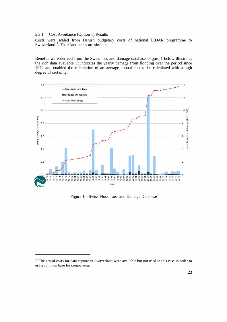
Benefits were derived from the Swiss loss and damage database, Figure 1 below illustrates the rich data available. It indicates the yearly damage from flooding over the period since 1972 and enabled the calculation of an average annual cost to be calculated with a high degree of certainty.
Figure 1 – Swiss Flood Loss and Damage Database
15 The actual costs for data capture in Switzerland were available but not used in this case in order to
use a common base for comparison.
24
Although Switzerland is used as an illustration, the financial model supports adding other national (or regional) information.
This approach uses expert judgement to determine the percentage reduction in loss and damage that could be achieved by having more accurate 3D Information. However, the Swiss experts’ approach declined to provide an estimate. In order to run the model therefore a conservative assessment of 1% total positive impact was assumed, which is also configurable in the model.
The results estimated the following:
Benefit to cost ratio 3.3 : 1
Net Present Value (after 10 years) € 8.9 million
Although within the study, we were unable to gain the necessary expert judgement, this technique has been proven in other geographies. The United Nations VALID study
16
recommends its use for evaluating economic benefit of geospatial information in disaster risk reduction. The return on investment indicates a healthy NPV of €8.9m over a 10 year life cycle and the key assumption of a 1% reduction in total loss and damage is conservative even for an advanced country such as Switzerland.
It is likely that suitable expert opinion can be obtained in most countries with the assistance of public bodies. The process is the simplest and least demanding in terms of participation.
5.3.2 Water Industry case Study (Option 2)
The costs are based on the same scaling from the Denmark–based figures as for option 1.
The benefits are based upon discussions within the water industry in the Netherlands, brokered by a contact of Dutch Kadaster in the Waterschapshuis organisation
17 concerning
the benefits of the newly available high resolution digital terrain model (AHN218
), particular resulting from data sharing, which include:
Reduced cost of external preparation of DEM specifications, contract supervision, legal costs: by access to AHN, the annual savings from a single procurement (an example of many) was estimated at € 6.7k per annum for 6 years;
Economies of scale: technical development per hectare price has fallen by approximately 25%;
Reduced cost of land survey work - a single Water Board will spend an average of € 100,000 per annum on land surveying work, through efficient use of the AHN this can save 30%. This provides an indirect saving of € 30,000 per annum.
Design errors for constructions can be detected more quickly and failure costs consequently decrease
Environmental impact assessments are easier to perform using higher quality data from the new AHN
In summary, the expert group concluded that each province, water or regional RWS expected savings are at least around € 80,000 per year.
16 UN SPIDER knowledge portal - http://www.un-spider.org/about/publication/value-geoinformation-
disaster-and-risk-management-valid 17
The Waterschapshuis is the management and execution organization for the 21 water boards in the
field of information and communication technology 18
AHN2 – new version of the Digital Elevation Model of the Netherlands
25
Using these figures, the financial model predicts the following:
Benefit to cost ratio 3.2 : 1
Net present value (after 10 years) € 8.6 million
Although the derivation of benefits are independent, the level of return on investment is remarkably similar to that derived from the cost avoidance study at a little more the 3:1 over a 10 year period. This “triangulation”, by which different evidence sources are used to assess the economic value of the investment, helps to increase confidence in the methodology.
5.3.3 Benefits Transfer (Option 3)
The concept of benefits transfer is based upon using data derived from a comparable study in another geography, in this case the United States, and scaling the costs and benefits on the basis of credible criteria. With the high accuracy DEM being evaluated for use in flood management, a comprehensive study by the consulting company Dewberry for the US Geological Survey (USGS)
19 is a very strong comparator. It assesses a number of use cases
(referred to as Business Uses) including specifically flood risk management.
The costs are derived from the full report of the Dewberry study (page 77). The financial model input can be changed to calculate the costs for each of the countries involved in the project on the basis of scaling by land area.
Using Belgium is used as an example:
A United States (coterminous states) 8,082,000 Sq. Km
B Belgium 30,528 Sq. Km
Multiplying Factor (B/A) 0.00377 (0.378%)
It should be noted that for smaller countries, the economies of scale achievable in US may not be possible. Costs can be factored upward in the financial model to account for this if required.
From the Dewberry report, the following have been extracted as some of the key examples of benefits:
Federal Emergency Management Flood risk Analysis - US$13.5 million per annum More accurate Flood Insurance Rate Maps thereby reducing losses of life, property
and business; increasing confidence in their credibility; providing more consistent insurance ratings and better communication of flood risks; ensuring that structures are insured at appropriate levels
Weather Service - static inundation mapping – US$24million per annum Riverine areas for which the National Weather Service (NWS) provides Advanced
Hydrologic Prediction Service (AHPS) inundation mapping as well as river and flood forecasts
Corp of Engineers (USACE) – US$ 31 million per annum Manage dam and dyke safety programs, to estimate depths of flooding from
predicted river flood stages, to perform breach analyses, and to make informed decisions regarding flood control systems and release of impounded waters
19 National Enhanced Elevation Assessment, Dewberry Associates for USGS, 2012
26
Overall the Potential Benefits were assessed as US$ 501 million per annum
For Belgium (implementation over 8 years) this provides the following estimate of the return on investment:
Benefit-Cost Ratio 5.3 : 1
Net present value (after 10 years) € 27 million
The incremental capture approach advocated (and adopted) for the US enhanced elevation programme, has a positive effect on the cash flow compared to the “big bang” initial capture approach used in the costing profile for previous options. However, the higher return calculated by this approach can be explained as Belgium would be unlikely to achieve the economies of scale of data capture costs in the US. A benefit to cost ratio “write down” of 50% would bring it into line with the returns predicted by the other two approaches.
6 CONCLUSION
The value chain analysis covered six areas in which 3D geo-information could provide benefits. These advantages were discussed and detailed in the workshops, and were various in nature. Improved planning processes were a clear theme running through many of the use cases. The benefits of 3D geo-information are easy to conceptualise when considering how to build flood defences, allow access to utility infrastructure or assessing the merits of a planning application. Furthermore, the enhanced depiction of the built environment should allow agencies to operate more effectively in time critical situations such as responding to a medical emergency or to a security incident. Conceivably of equal long-term value is the benefit to citizens from being able to understand how a project could change their community through more sophisticated modelling techniques that, in turn, could allow their concerns to be better reflected in the design process.
The cost benefit analysis of the two use cases that were studied in depth – urban planning and flood defence – both produced strong cost benefit ratios. Urban planning cost benefit ratio was over 2x whilst the flood management use case showed a higher return triangulated for the three approaches evaluated at circa 3x, possibly reflecting the significant economic damage caused by flooding.
The results of the project indicate that there is a significant positive return on investment from 3D geo-information when considering the two use cases in isolation. 3D geo-information will add value to a number of use cases and whilst the costs of satisfying other use cases will increase incrementally, the benefits of such re-use are additive, meaning that the case for investment becomes stronger as each additional application is implemented.
Further work using this methodology could usefully be considered in relation to the following use cases:
3D Cadastre and Valuation – in the consultant’s view this represents the best opportunity to complete cost-benefit analysis for one of the remaining use cases for which value chain mapping was undertaken. The timing of ground-breaking work in Denmark may mean that access to their internal economic assessment might now be publicly released making this a relatively quick and easy extension of the study into a potentially very financially attractive application.
Asset management – this should be approached by the creation by the creation of value chains for significant subsets of this large and complex use case, particularly transport asset

27
management and street works. The recent study in Queensland may provide an opportunity for a cost-effective benefits transfer process to be applied.
7 ACKNOWLEDGEMENTS
This project could not have been completed without the help of many people:
The mapping agencies who not only financed the project, but also provided a great deal of their time in organising workshops and helping to define and prioritise the chosen use cases;
The many user organisations that attended the workshops and contributed their expertise to helping the project team to understand their work and how 3D-Geo-information might bring benefits to it;
Lastly but not least, the steering group who commissioned and guided the project, Jantien Stoter, and Joep Crompvoets.
8 BIBLIOGRAPY
This is a list of published papers reviewed as part of the study.
Author Date Title Publisher /
Journal
ACIL Allen
Consulting
(2017) 3D QLD road map preliminary Findings:
interim report addressing Part A
ACIL Allen
Consulting,
3D QLD
Available at: http://3dqld.org/wp-content/uploads/2013/06/3D-QLD-Road-Map-Preliminary-Report-6-
February-2017_V1.pdf
BAFU (2016) Schutz vor Massenbewegungsgefahren:
Vollzugshilfe für das
Gefahrenmanagement von Rutschungen,
Steinschlag und Hangmuren
Bundesamt f r
Umwelt (BAFU)
Available at: https://www.bafu.admin.ch/bafu/de/home/themen/naturgefahren/publikationen-
studien/publikationen/schutz-vor-massenbewegungsgefahren.html
Biljecki, F., Stoter, .,
Ledoux, H., latanova,
S. ltekin, A.
(2015) Applications of 3D city models: state of
the art review ISPRS International
Journal of Geo-
graphical Infor-
mation, pp. 1-48
Available at: http://www.mdpi.com/2220-9964/4/4/2842
Bonsor, H.C.,
Entwisle, D.C.,
Watson, S., Lawrie,
K., Bricker, S.,
Campbell, S.,
Lawrence, D., Barron,
H., Hall, I., O
Dochartaigh, B.E.
(2013) Maximising past investment in subsurface
data in urban areas for sustainable
resource management: a pilot in Glasgow,
UK.
Ground
Engineering
28
Available at: http://nora.nerc.ac.uk/502014/
Bregt, A.K., Grus, L.,
van Beuningen, T. &
van Meijeren, H.
(2016) Wat zijn de effecten van een open Actueel
Hoogtebestand Nederland (AHN)?
Wageningen
University and
Research
Available at: http://edepot.wur.nl/393158
CCR (2016) Inondations -
Service D
mod lisation
D partement des
Etudes Techniques
Direction des
r assurances
publiques - CCR
Available at:
https://www.ccr.fr/documents/23509/29230/Inondations+de+Seine+et+Loire+mai+2016_version+130
72016.pdf/294fed48-546d-4b5d-a68c-7f7a7569b78c
CCR (2016) Les catastrophes naturelles en France:
Bilan 1982 - 2015
Caissse Centrale de
assurance (CC )
Available at: https://www.ccr.fr/documents/23509/29230/Bilan_CatNat_1982-2015.pdf/326b8219-
e0cb-419c-a83f-4ec2837c3ddb
Cerema (2016)
inondations
Co-pilot par le
CEP I et la DGP
Travaux r alis s par
le Cerema
Available at: https://www.ecologique-
solidaire.gouv.fr/sites/default/files/20160923_Guide_GT_Referentiel_vulnerabilite.pdf
Dewberry (2012) National Enhanced Elevation Assessment
(NEEA)
USGS
Available at: http://www.dewberry.com/services/geospatial/national-enhanced-elevation-assessment
Green, A. (2014) Transforming asset management at
London Heathrow
Faithful & Gould
Available at: https://www.fgould.com/uk-europe/articles/transforming-asset-management-london-
heathrow/
GUGiK (2015)
Polska3D+
Główny Urząd
Geodezji i
Kartografii
(GUGiK)
Available at: http://www.gugik.gov.pl/__data/assets/pdf_file/0009/23679/Raport-podsumowujacy-
konsultacje-i-ankietyzacje-interesariuszy-projektu-Polska3D.pdf
29
GUGiK (2015)
zorganizowanych przez GUGiK w latach
2014 - 2015
Główny Urząd
Geodezji i
Kartografii
(GUGiK)
Available at: http://www.gugik.gov.pl/__data/assets/pdf_file/0019/34147/20160608-raport-
podsumowujacy-Szkolenia-z-wykorzystania-Produktow-LiDAR_ostateczny.pdf
Heikkilä, J. (2016) Forest data services of the Finnish forest
centre
Metsäkeskus
Ho, S., Rajabifard, A.
& Kalantari, M.
(2015) ‘I 3
land administration: a case study on the
city of Melbourne
Land Use Policy,
Elsevier, Volume
42, pp. 412-425
Available at: http://www.sciencedirect.com/science/article/pii/S0264837714001938
Ho, S. & Rajabifard,
A.
(2016) Towards 3D-enabled urban land
administration: strategic lessons from the
BIM initiative in Singapore
Land Use Policy,
Elsevier, Volume
57, pp.1-10
Available at: http://www.sciencedirect.com/science/article/pii/S0264837715300247
Home, R. (2017) Cost-Benefit Analysis: Urban Planning
Results
EuroSDR
Available at: http://www.eurosdr.net/sites/default/files/images/inline/urban_planning_cost-
benefit_analysis_20170316.pdf
Hsu, C-C. & Sandford,
B.A.
(2007) The Delphi Technique: Making Sense of
Consensus
Practical
Assessment,
Research and
Evaluation, Volume
12, Number 10
Available at: http://pareonline.net/pdf/v12n10.pdf
Hubbard, D.W. (2014)
How to Measure Anything, third edition:
h V ‘I
business
Wiley
ICGC (2016)
DTES
Institut Cartogràfic
I Geològic de
Catalunya (ICGC)
Available at:
http://territori.gencat.cat/web/.content/home/01_departament/actuacions_i_obres/actuacions_dr_d_i/ei
xos_rdi/actuacions/noticies/pdf/butlleti_18/Butlleti_RDI-mapes-de-variables-biofisiques-forestals-de-
Catalunya.pdf
IGN (2016) EuroSDR 3D data economic value
workshop – national overview from
France: use case – flood management
Institut National de
L’information
Geographique et
Forestiére (IGN)
30
Larsson, S. (2016) Forestry Maps from laserdata Swedish Forest
Agency
Metje, N., Ahmad, B.
& Crossland, S. M.
(2015) Causes, impacts and costs of strikes on
buried utility assets
Proceedings.
Municipal
Engineer, vol 168,
no. 3, pp. 165-174.
Available at: http://pure-
oai.bham.ac.uk/ws/files/24091427/Metje_Ahmad_Crossland_2015_Causes_impacts_costs_ICE_Proce
edings.pdf
Nilsson, M.,
Nordkvist, ., onz n,
J., Axensten, P.,
Olsson, H., Wallerma,
J., Egbert, M.,
Lindgren, N., Larsson,
S., Nilsson, L., &
Eriksson, J.
(2015) A nationwide forest attribute map of
Sweden derived using airborne laser
scanning data and field data from the
national forest inventory
Swedish University
of Agricultural
Science (SLU) &
the Swedish Forest
Agency
(Skogsstyreslsen)
Ordnance Survey
International
(2015) Running a safe and secure major national
event with geospatial information
Ordnance Survey
Available at: https://www.ordnancesurvey.co.uk/international/case-studies/safely-running-major-
events.html
Orhan, A., Backhaus,
R., Boccardo, P.,
Tonolo, F.G., Trinder,
j., van Manen, N.,
Zlatanova, S. (Eds.).
(2013) The value of geoinformation for disaster
and risk management (VALID): benefit
analysis and stakeholder assessment
International
Council for Science
– GeoUnions, Joint
Board of Geospatial
Information
Societies & United
Nations Office for
Outer Space Affairs
Available at: http://www.un-spider.org/sites/default/files/VALIDPublication.pdf
Rajabifard, A. (2014) 3D Cadastres and Beyond 4th
International
Workshop on 3D
Cadastres, 9-11
November 2014,
Dubai, United Arab
Emirates
Available at: http://www.gdmc.nl/3dcadastres/literature/3Dcad_2014_11.pdf
Royal Academy of
Engineering.
(2016) h :
experience of coping with loss of power
Royal Academy of
Engineering

31
Available at: www.raeng.org.uk/livingwithoutelectricity
Snitkin, S., Mick, B. &
Novak, R.
(2010) Asset Information Management (AIM):
Part I – The Case for Developing an AIM
Strategy
ARC Strategies
Stoter, J.
(2016) 3D developments in cadastre registration
(Presentation)
Kadaster
The Economist. (2008) The Hawthorne effect The Economist
Available at: http://www.economist.com/node/12510632
Ven l inen, P.,
s nen, T.
H m l inen, .
(2015) Potential business models for forest big
data:
IGI E I ( I)
program
Mets teho ( eport
235)
Available at:
http://www.metsateho.fi/wp-
content/uploads/2015/03/Raportti_235_Potential_Business_Models_for_Forest_Big_Data_pv_ym.pdf
Verachtert, K. (2014) Astrid: Gebruik van geografische data in
GIS & dispatching applicaties voor
hulpdiensten
Agiv (pdf
presentation)
Available at: https://www.agiv.be/~/media/agiv/opleidingen/trefdag/documenten/agiv-
trefdag%202014/sessie%2014%20-%20astrid_verachtert.pdf
Wong, K. & Ellul, C. (2015) Economic Value of 3D Geographic
Information
EuroSDR and
University College
London
World Economic
Forum.
(2016) Inspiring future cities & urban services:
shaping the future of urban development &
services initiative
World Economic
Forum in
collaboration with
PwC
Available at: http://www3.weforum.org/docs/WEF_Urban-Services.pdf
32
Annex A: Economist Peer Review
1 INTRODUCTION
ACIL Allen Consulting (ACIL Allen) was engaged by ConsultingWhere to provide peer review comments on the economic analysis for a Value of 3D geo-information report. The comments address two aspects of the analysis: the socio economic impacts of the use and application of 3D geospatial information in flood management; and the use and application of 3D geospatial information in urban planning.
2 General Comments
The general approach taken is based on a cost-benefit analysis conducted over a 10 year period from 2017. Cash flow analysis is applied to selected case studies using a discount rate of 4 per cent. Some countries may suggest a different rate for cost benefit studies. This could be varied in the assumptions sheet should a different rate be mandated in the particular country using the financial model.
The cash flow model and discounting techniques are in line with accepted practice for cost-benefit analysis and the cell logic in the models is correct.
The general approach to estimating net benefits is based on assessing the potential impact of various 3D scenarios under various reference cases against a counterfactual that does not include the envisaged 3D scenarios. This is an appropriate framework for the analysis. The results produced are direct impacts the sectors in each case.
The case studies estimated costs avoided under the reference case. The three flood management case studies drew on findings from existing studies to estimate benefits and costs. Benefits for a fourth study (urban planning) were based on a workshop and scaled up to country wide level.
The findings of various reports that were drawn on were, where possible, checked for applicability through selected consultations and in one case a survey. Given the nature of the task, the cost of country surveys and the time available the methodologies applied are considered a valid approach to estimating net benefits in each case.
3 Flood management
Three evaluation approaches were examined drawing on studies of applications in comparable situations. Comments on these approaches are discussed in turn below.
3.1 Costs avoided from investment in a Digital Terrain Model in Switzerland
There are three ways in which the impact of flooding can be mitigated:
measures taken in advance of a flooding event to reduce future impacts when they occur
measures to improve responses when flooding occurs minimise human and economic costs
recovery actions that reduce the longer term impacts of floods after they occur.
The report cites a UN report released in 2013 that analysed the value of geo-informaton for disaster and risk management. This report is a comprehensive review of the economic
33
impact of natural disasters. It outlines four approaches that to estimating their impacts but focusses on the first point above - measures taken in advance to reduce the impact of flooding.
Four techniques were identified:
estimating the value of improved predictions such as weather forecasting on the impact of flooding and other natural disaster events.
analysis of whether flooding risk affects the price of land using hedonic pricing the use of contingent valuation surveys to assess what people value in services to
mitigate the impact of natural disasters the use of cost avoided approaches to assessing the value of measures to mitigate
natural hazards.
The study identified flooding as one of the highest areas of concern amongst stakeholders which confirms the appropriateness of focussing on flooding as an indicator of the value of 3D geospatial information in the EU. It also discusses the use of LIDAR for the development of a high accuracy digital terrain model (DTM) in mitigating the impact of flooding.
Given the impracticality of undertaking extensive willingness to pay or hedonic pricing studies the report adopted a cost avoided approach to assess such an application.
The report drew on published studies in Switzerland for benefits and Denmark for costs to feed into the cost benefit model. The benefit estimates from the Swiss study were scaled down to account for the fact that they covered both floods and landslides. The Danish cost figures were scaled by area to adjust for the different geographic size of Switzerland to Denmark. These approaches are considered reasonable.
A survey of stakeholders was conducted to estimate the impact on future average annual damage costs of the availability of a DTM. A conservative figure of 1 per cent was adopted based on qualitative assumptions in the absence of hard figures from the survey. This is considered a reasonable approach and the percentage gain can be varied in the final model based on the results of application of the survey to other geographies.
Overall the approach to estimating costs avoided is considered reasonable and the estimates valid indicators of net benefits and / or benefit cost ratio.
3.2 Costs avoided from investment in a Digital Terrain Model in the Netherlands
This case study estimated the cost savings to water authorities that could be expected from the implementation of a high accuracy 3D Digital Terrain Model (AHN2) in the Netherlands. A number of sources of cost savings were considered, including:
savings to 24 Water Authorities from economies of scale in developing a single DTM for use by all of the water authorities compared with each authority doing their own model
savings to the Water Authorities from costs avoided in land survey work. savings in lower design errors and environmental impact assessments.
There is a problem in this case with definition of the reference case and the counterfactual. The reference case is the one being evaluated – that is the single DTM for the Netherlands. The counterfactual can be either the savings from economies of scale or savings from costs avoided in land survey work, designed and environmental impacts statements. ACIL Allen prefers the latter as this reflects the full difference between the 3D case and the alternative conventional survey methods. The economies of scale are taken into account in the reference scenario costs and so cannot be considered savings. However, the figures used are based on
34
expert assessment of the overall savings, so do not appear to directly use this source of savings.
Apart from the reservation on economies of scale outline above, the general approach to benefits and costs is sound and the economic model is correctly applied to these results.
3.3 Cost savings calculated by benefits transfer
This case study estimated the net benefits of a DTM in Belgium using benefits transfer of estimates of costs avoided from a proposed Digital Elevation Model of the United States (Dewberry, 2012). The costs avoided in the Dewberry report include:
reduced average annual damage costs from better flood risk management reduced flood damage costs from improved hydrological modelling and inundation
and flood forecasting lower costs of design and management of flood mitigation measures for the US
Army Corps of Engineers.
While the hydrology, topography and economies of countries in Belgium differ from that of the United States the differences are not considered to be so significant that they would invalidate a benefits transfer approach to the Belgium providing the appropriate adjustments are made.
The benefits were scaled according to relative size of GDP between Belgium and the USA. GDP reflects levels of economic activity that is likely to be correlated to the cost of flooding events.
ACIL Allen has seen no studies that estimate this correlation, so it is considered that this parameter is a reasonable approach in the circumstances.
Costs were adjusted by relative area. ACIL Allen agrees that the costs of collecting the LIDAR data would be closely correlated to areas to be covered.
The transfer of this data to the benefit cost model has been checked and found to be correct.
ACIL Allen considers that this approach is acceptable for the purposes of estimating order of magnitude costs avoided from a development of a 3D elevation model for Belgium.
3.4 General comments for improved flood management
Each of the case studies examines the costs avoided of investment in 3D digital terrain models in three countries Switzerland, the Netherlands and Belgium. They provide an indication of the costs avoided from flooding from measures to mitigate damage from future flooding events. As such there is no double counting of benefits.
We have noted that the reference case for the study of the Netherlands should be based on the 3D DTM compared to the manual surveying by the water authorities and should not include the economies of scale of a single DTM compared to multiple DTMs. We understand that the figures provided were net of any such double counting.
3.5 Cost savings in urban planning and development
This study was based on savings in urban development in the Republic of Ireland. Data was initially collected from a workshop held in November 2016. Stakeholders at the workshop included municipalities, developers, real estate agents, architects, planners and academics.
35
The findings of the workshops were used to estimate the costs avoided for urban development and scaled to all of Ireland. The costs avoided included:
reduced costs to developers o scaled up to all of Ireland by the number of approvals
improved public sector efficiency o based on an Indecon report
1 on the value of geospatial information for Ireland
assuming that 3D represented about 1 per cent of the value savings to citizens in making submissions and managing objections
o scaled by the total number of submissions for all of the Republic of Ireland.
This approach is considered reasonable for the purposes of the report.
Costs were based on published data from Denmark scaled up by area. This is considered a reasonable approach to assessing costs for all of Ireland.
The transfer of this data to the economic model was checked and found to be correct.
4 Other relevant recent studies
ACIL Allen has recently completed work in the States of Queensland and NSW in Australia. The former was concerned with the value of a 3D Queensland model and is not yet published
2. However some aspects of that work were relevant to findings in NSW. These
latter findings are provisional at the present time but are expected to be published in the coming weeks and provide broad indications of value.
4.1 Value of a 3D model to the insurance industry
One of the case studies involved the value to the insurance sector of a 3D model of buildings and trees similar to that being developed by the Public Sector Mapping Authority (see www.PSMA.gov.au).
The value to the insurance industry of such models is in terms of:
improved ability to model peril and hazards to manage premium risk lower costs for both the insurance industry and consumers through the use of web
based interaction between insurance companies and customers improved ability to manage risk through greater engagement with customers
including the ability to warn insured customers when peril threatens by text or email.
A broad estimate of the value of 3D models as estimated by ACIL Allen indicated productivity savings of around AU$20 million per annum for one company whose claims and underwriting expenses totalled around $10 billion. After allowing for annual costs to around AU$0.8 million this gives a saving of AU$19.2 million for Australian wide operations.
4.2 Value of federated 3D BIM models
The use and application of federated 3D models such as BIM has the potential to deliver significant savings in costs associated with engineering construction in the longer term. ACIL Allen estimated that the present value of benefits could range from AU$226 million to
1 Assessment of the economic value of the geospatial information industry in Ireland, Indecon
International Economic Consultants (2014) 2 This study is now published and available on the EuroSDR website

36
AU$1,330 million in NSW over 15 years for productivity benefits ranging from 1 per cent to 5 per cent. ACIL Allen believes a productivity benefit of 3 per cent is a reasonable estimate resulting in savings of AU$798 million in present value terms.
Realisation of these benefits is based on the assumption that adoption commences at 10 per cent of building projects in NSW in 2026 rising gradually to 70 per cent by 2034. Completion of a proposed Digital Cadastre is important to realising these benefits.
4.3 Value of 3D cadastre and BIM models for asset management
Longer term benefits from the use of BIM and 3D modelling in asset management for non-residential buildings in NSW has been estimated to deliver additional benefits of around 2 per cent in the costs of asset management. These were estimated to be between AU$60 million and AU$120 million in present value terms assessed over a 15 year period. Benefits are assumed to commence in 2026 and increase gradually from 10 per cent adoption levels in 2026 to 70 per cent of adoption levels by 2034.
Alan Smart Senior Associate ACIL Allen Consulting

37
ANNEX B: VALUE CHAIN COMBINED DELIVERABLES
This Annex contains the complete value chain combined deliverables for each of the six use cases investigated as part of this project:
Forestry management
Asset Management
Flood Management
3D Cadastre and Valuation
Resilience
Urban Planning

38
FORESTRY MANAGEMENT
Table of Contents
1 EXECUTIVE SUMMARY ............................................................................................ 39
1.1 Introduction ............................................................................................................ 39
1.2 Purpose ................................................................................................................... 39
1.3 Deliverables ............................................................................................................ 39
1.4 Analysis .................................................................................................................. 40
2 VALUE CHAIN DIAGRAM ......................................................................................... 43
3 BENEFITS SCHEDULE ................................................................................................ 44
4 REFERENCES ............................................................................................................... 46
5 GLOSSARY ................................................................................................................... 47

39
1 EXECUTIVE SUMMARY
1.1 Introduction
The workshop was undertaken in the offices of National Land Survey of Finland in Helsinki on 15th June 2016. The event was attended by experts from the forestry sector in Finland, both public and private, and a representative from the Swedish Forest Agency.
The overall aim was to graphically document the forestry management process, using value chain mapping to represent the results. The value chain was then used to identify where the most significant socio-economic benefits would be added by access to 3D geo-information.
1.2 Purpose
The workshop was undertaken to:
Assist those involved in forestry management to better understand the data, stakeholders (referred to here as actors) and processes involved in creating value in the forestry management process.
Provide a starting point for quantifying the costs and benefits of 3D products and services for forestry management.
By involving representatives of the commercial sector, it helps to identify where the commercial sector are likely create products and services and by inference the “gaps” where Government may need to intervene to optimise socio-economic impacts.
EuroSDR is a European research organisation, so the results will inform discussions in the other countries involved in research in this domain.
1.3 Deliverables
The main deliverables are:
i. Value Chain - understanding this chain is a pre-requisite to evaluating the socio- economic benefits of 3D georeferenced data to this use case;
ii. Glossary – covering “actors” and processes to enable the value chain to be more easily interpreted;
iii. Benefits spreadsheet – this output is the result of a “brainstorm” by workshop attendees
iv. to identify the most significant value adding processes in the value chain; v. Overview Narrative – this document, which aims to draw out the main conclusions
from the exercise; vi. Presentations from the workshop and other background material.
All these deliverables are available on BaseCamp, labelled as Forest Management.

40
1.4 Analysis
1.4.1 Scope
This report focuses on both the Swedish and Finnish forestry sectors. Both countries are arranged on broadly similar lines with state funded National Mapping and Cadastral Agencies (NMCAs) alongside Forest Centres/Agencies responsible for a wide range of data collection, analysis and distribution services.
The sector is characterised by a very large number of forest owners with a much smaller number of forest companies providing silviculture services and marketing forest products.
1.4.2 Most Significant Benefits
The benefits spreadsheet details the workshop participants’ view of the most significant benefits of
3D data to the forestry management use case. In total 13 separate benefits were identified for many different stakeholders. Those valued most highly, in order of ranking were:
1. Survey costs are dramatically reduced. LiDAR produce more accurate and cheaper data, freeing surveyors from time consuming ground surveys. Consequently, they are able to provide more productive analysis and advice to forest owners.
2. Co-operation within the forestry sector reduces costs of acquisition and re-use of the data across multiple sectors multiplies the value add.
3. By providing forest owners with information about the value of their forests they can be encouraged to invest in and sell their assets, increasing forest productivity.
4. Advanced planning and appropriate application of silviculture techniques using forest data products increases forest productivity.
5. Accurate data on the depth of water table reduces logistics costs by allowing better planning of routes for timber transport.
In summary high quality remote sensing provides the basis of accurate and cost-effective 3D data products that enable improved forestry management. Due to these improved data products, the costs of maintaining the national forest inventory have decreased 60 -70%. Making this information openly available via forest information portals positively impacts the value chain from planning investment, to management activities and the scheduling of in-forest logistics. Public sector value add includes improvements in tax and land administration. There are also numerous indirect benefits within a range of sectors including defence, cultural and heritage, environmental, utilities and finance.
1.4.3 Supply-side Value Chain
The supply-side of the value chain shows the main actors currently involved or required to produce the forest data products. The connecting arrows illustrate the main flows of information between the actors.
The number of actors on the supply side is relatively small. Research institutes, remote sensing consultants and standards bodies develop data collection, methods and techniques to source Lidar and aerial imagery applicable to forestry. This remotely sensed data is processed by Forest Centres using forest estimation variables into specific forest data products which Forest Centres make available via information portals. Additional information is provided by Forest Owners, who update forest inventories with cutting information and Forest Companies/Centres who collect ground truth data. Examples of 3D data products that are developed using this value chain are: Lidar Canopy Height Models

41
(CHM) which can be used for automatic stand delineation and Depth to Water Table Maps that can be used to identify wet areas that are impassable in summer.
The value add on the supply side is the increased efficiency with which forest data products can be produced using remote sensing techniques and the distribution of the forest data products using the forest information portal which promotes wide re-use and reduces duplication of effort.
1.4.4 Demand-side Value Chain
On the demand side there are a small number of software developers and aggregators, mostly specialists in forestry applications. Other developers include developers of in cab digital navigation and logistics planning systems and outdoor activity application developers for use in the leisure industry.
The End Users are divided into four main groups:
i. those directly involved with forestry (by far the biggest group); ii. defence and civil contingency users;
iii. government agencies (mainly involved in heritage and the environment); iv. citizens who use forests for leisure pursuits.
The value chain for forestry begins with the Forest Owners using the forest data to make investment decisions. Encouraging forest owners to make use of their assets was identified as one of the top benefits. These investment activities include banks, insurance companies and realtors.
Here also Forest Centres are involved in providing financial support. Where decisions result in forests being sold cadastral agencies use the available data to administer land and tax agencies use the data to ensure the correct amount of tax is paid.
If the first stage of the forestry value chain is characterised by investment the second stage is characterised by forest management. Here the data is used by Forest Owners, Forest Companies, Forest Centres and Specialist Forestry Consultants to apply appropriate silviculture techniques to improve productivity by for example thinning and treating pests.
The final stage of the forestry value chain is characterised by harvesting and the remainder of the activities that convert trees into products for consumption, predominantly wood and paper. The main benefit of 3D data is in identifying wet areas which are impassable in summer. With improved data access, roads can be designed to be more effective, transport speeds increased and consequently transport costs decreased. In addition it is expected that the increased availability of accurate data will lead to increased levels of automation for example machine guidance for thinning. Further down the value chain the information provided about the distribution and quality of wood can be used to guide buying decisions and to plan the location of factories and facilities.
Outside of the forestry value chain there are a large number of indirect beneficiaries. Defence forces use the data to plan manoeuvres. Civil contingency agencies use the data to better respond to forest fires. Environment agencies use the data to identify and preserve important habitats and to slow climate change through action based on better biomass statistics. Cultural agencies use the data to identify cultural heritage sites. Aviation authorities use the data to locate obstacles as well as for airport planning. In the commercial sector the data is used by telecom companies for line of site estimates and electricity transmission companies to estimate risk to power lines. The data can also be used by financial services companies to analyse the forestry market and trade in Forest Company stocks.

42
Finally citizens can use the data by downloading and using outdoor activity apps made more realistic by access to 3D data.

Regulators & Government Agencies
Commercial Sector
Defence & Civil ContingencyCitizens
Forest Products
Machinery Manufacturers
Provide digital navigation and logistics planning systems for forestry
machinery.
Logging Companies
Use data for optimal planning and scheduling of in forest logistics.
Tax Agencies
Prevent tax avoidance on forest income.
Forest Owners
Use data for income calculations
Forest Owners
Use data for investment decisions and to obtain funding for silviculture
activities.
Forest Owners
Use Data for Forest Management Planning.
Specialist Forest Consultants
Use Data to Provide Forest Management Planning Services
Forest Companies
Use data to select and buy the right kind of timber.
Forest Companies
Use data for optimal sighting of new facilities.
Banks
Use Data to value forests for lending finance for
forestry projects.
Realators
Use data to value forests for the buying and selling
of forests.
Insurance
Use data to calculate insurance premiums and
for loss adjusting insurance claims.
Forest Owners
Use Data for Silviculture activities e.g. thinning and treating pests or diseases.
Forest Centres
Develop forest information products e.g.
disease mapping
Forest Companies
Use Data Products to provide optimal
silviculture services.
IT Services Companies
Build forest information systems.
Laser Data Consultants
Develop forest estimation variables
Electricity Generators
Use data to estimate availability of energy
wood.
Manufacturers
Use data to estimate availability of wood for
manufacture of furniture, homes and paper.
Electricity Transmission Co.
Use data for optimal sighting of new facilities.
Manufacturers
Use data for optimal sighting of new facilities.
Military
Use data to plan manoeuvres while avoiding obstacles
(excessive wetness) and exploiting cover (trees).
Military
Use data for optimal sighting of radar towers.
Environmental Agencies
Use data to locate and protect natural features with high conservation
value.
Hydrological Agencies
Use data to plan water conservation activities.
Cultural Agencies
Use data to locate and protect cultural heritage
sites.
Transport Companies
Use data for scheduling and routing.
Data Products
Electricity Transmission Co.
Use data to estimate storm risk to power lines.
App Developers
Develop Forest Management Apps
Leisure Users
Use forests for camping, hunting, walking, berry picking, orienteering etc.
App Developers
Use data to develop outdoor activity apps.
Telecommunication Companies
Use data for calculating base station line of sight.
Government Agencies with Responsibility for
Forestry
Fund data collection.
Universities and Research Institutes
Develop data collection techniques and train data collection specialists.
Standards Bodies
Develop standards and methods.
Forest Companies (including state owned)
Collect ground truth data.
Forest Owners
Update forest inventory with cutting information.
Remote Sensing Companies/Consultants
Provide Lidar data and aerial imagery.
Data Processors
Interpret forest data and develop data products. Forest Centres
Aggregate forest data and make available via forest information platform
Forest Centres
Provide regulatory oversight of forestry activities and enforce
forest legislation (Forest Act).
Civil Contingency
Use data for volume estimation of forest
damage caused by fire/storm.
Aviation Regulators
Use data to locate aviation obstacles
Aviation Regulators
Use data for airport planning
Civil Contingency
Use data during fire emergencies to estimate speed/spread of fire and
direct fire fighting activities.
Financial Services Companies
Use of data in commodities market
making.
Financial Services Companies
Use data in analysis of market value of forest
companies.
Forest Companies (including state owned)
Provide Funds for Data Collection
1
2 3.b 5.a 5.b 6 73.a
Environmental Agencies
Use biomass statistics to estimate the level of carbon capture.
Cadastral Agencies
Use data to demark and value forest stands for land administration.
10 11 12
4
8.a 9.a8.b 9.b
Supply Side“Raw” Data
Supply SideInformation Products and
Services
Demand SideSoftware Developers Aggregators
Demand SideEnd Users
Funder AggregatorPublisher
Reseller Developer User
Information Flow
Key
# Benefits Schedule Rank
Forest Centres
Collect and maintain forest inventory data.
Forest Centres
Provide financial support under the Sustainable Forest Financing Act
Forest Centres
Provide advice and training.
2 VALUE CHAIN DIAGRAM
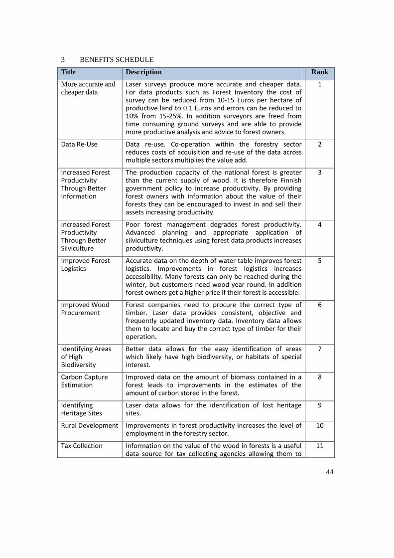
44
3 BENEFITS SCHEDULE
Title Description Rank
More accurate and cheaper data
Laser surveys produce more accurate and cheaper data. For data products such as Forest Inventory the cost of survey can be reduced from 10-15 Euros per hectare of productive land to 0.1 Euros and errors can be reduced to 10% from 15-25%. In addition surveyors are freed from time consuming ground surveys and are able to provide more productive analysis and advice to forest owners.
1
Data Re-Use Data re-use. Co-operation within the forestry sector reduces costs of acquisition and re-use of the data across multiple sectors multiplies the value add.
2
Increased Forest Productivity Through Better Information
The production capacity of the national forest is greater than the current supply of wood. It is therefore Finnish government policy to increase productivity. By providing forest owners with information about the value of their forests they can be encouraged to invest in and sell their assets increasing productivity.
3
Increased Forest Productivity Through Better Silviculture
Poor forest management degrades forest productivity. Advanced planning and appropriate application of silviculture techniques using forest data products increases productivity.
4
Improved Forest Logistics
Accurate data on the depth of water table improves forest logistics. Improvements in forest logistics increases accessibility. Many forests can only be reached during the winter, but customers need wood year round. In addition forest owners get a higher price if their forest is accessible.
5
Improved Wood Procurement
Forest companies need to procure the correct type of timber. Laser data provides consistent, objective and frequently updated inventory data. Inventory data allows them to locate and buy the correct type of timber for their operation.
6
Identifying Areas of High Biodiversity
Better data allows for the easy identification of areas which likely have high biodiversity, or habitats of special interest.
7
Carbon Capture Estimation
Improved data on the amount of biomass contained in a forest leads to improvements in the estimates of the amount of carbon stored in the forest.
8
Identifying Heritage Sites
Laser data allows for the identification of lost heritage sites.
9
Rural Development Improvements in forest productivity increases the level of employment in the forestry sector.
10
Tax Collection Information on the value of the wood in forests is a useful data source for tax collecting agencies allowing them to
11

45
check that the correct amount of tax is being paid.
Civil Contingency Improved forestry data can help emergency responders estimate the size and spread of a forest fire and plan fire fighting activities accordingly, it can also be used to estimate the scale of the damage caused by a fire.
12
Defence Planning military manoeuvres requires up to date information on terrain and land cover. In addition trees affect the signals that radar towers can receive .
13

46
4 REFERENCES
Presentation: ‘Forestry Maps from Laser Data, Svante Larsson, Skogsstyrelsen SLU,3rd June 2016. Available on Project BaseCamp.
‘Documentació dels mapes de variables biofísiques de Catalunya pel Butlletí del DTES’ Institut Cartografic I Geologic de Catalunya. Versio 1.0. Available at: http://territori.gencat.cat/web/.content/home/01_departament/actuacions_i_obres/actuacions_dr_d_i/eixos_rdi/actuacions/noticies/pdf/butlleti_18/Butlleti_RDI-mapes-de-variables-biofisiques- forestals-de-Catalunya.pdf
Presentation: ‘Forest data services of the Finnish Forest Centre’ Juho Heikkilä, Senior Forest Data Specialist, Lic.Sc. (For.) Helsinki, May 15, 2016. Available on Project BaseCamp.
Potential Business Models for Forest Big Data. DIGILE’s Data to Intelligence (D2I) program. Pirjo Venäläinen, Tapio Räsänen, Jarmo Hämäläinen. Metsäteho Report 235. 12th February 2015. Available at: http://metsate1.asiakkaat.sigmatic.fi/wp- content/uploads/2015/03/Raportti_235_Potential_Business_Models_for_Forest_Big_Data_pv_ym.p df

47
5 GLOSSARY
App Developers
Companies that develop forest management applications. For example:
Avenza PDF Maps Esri App Builder/Collector
Aviation Regulators
Government agency responsible for regulating the aviation industry.
Banks
Companies that lend money to finance forestry projects.
Cadastral Agencies
Government agencies that register private interests in land.
Civil Contingency
State actor responsible for coordinating emergency response.
Cultural Agencies
Government agency responsible for preserving a nation’s cultural heritage.
Data Processors
Companies that interpret raw remotely sensed forestry data and process it into data products containing actionable intelligence. For example:
Arbonaut Trestima Blom Dianthus Foran
Electricity Generators
Companies that generate electricity, including electricity from burning forest biomass.
Electricity Transmission Companies
Companies that own and maintain the electrical transmission network that transports electricity from power stations to users.
Environmental Agencies
Government agency responsible for funding policy and regulation relating to the environment.
Financial Services Companies
Companies that analyse and invest in companies that form part of the forestry supply chain.
Forest Centres
Public sector bodies that procure, aggregate and develop specialist forest related data products and make these available to the public, or to other forest actors, either as a public good or at cost in order to fund further data collection.
48
Forest Companies (including state owned)
Forest companies are involved across the entire forestry value chain. Forest companies are often also forest owners. But they also buy raw timber and use it to develop timber products for example: tissue and cooking papers, paperboard, pulp and wood products. Examples of forest companies are:
Metsä Group (Finland) UPM (Finland) Stora Enso (Finland & Sweden) Sveaskog (Sweden) Holmen Skog (Sweden) Bergvik Skog (Sweden) SCA Skog (Sweden) Metsähallitus Forest & Park Service (Finnish Public Sector)
Forest Owners
Owner of land on which forestry activities occur. Can be small private individual all the way up to large public sector body. There are 630,000 forest owners in Finland who have gross stumpage earnings of €1.7 billion per annum.
Government Agencies with Responsibility for Forestry
Central government departments that provide funding, policy and regulations for the operations of the forestry sector. For example:
Ministry of Agriculture and Forestry (Finland) Ministry of Industry (Sweden)
Hydrological Agencies
Government agency responsible for funding, policy and regulations for the operations water sector.
Insurance Companies
Companies that insure forests against loss due to, for example, fire and storm.
IT Services Companies
Companies that develop forest information system software. For example:
Tieto
Laser Data Consultants
Specialists in LIDAR data interpretation.
Leisure Users
Citizens that use forests for recreational activities such as camping, hunting, walking and berry picking.
Machinery Manufacturers
Specialist companies that design, manufacture and market technology and machinery for the automation of forestry activities. For example:
Kesla Ponsse

49
John Deere Forestry
Manufacturers
Any company using forest products to manufacture products such as furniture, homes and paper.
Military
The defence forces of a country including army, air force etc. Forests are of particular interest to ground based forces where they are a consideration for manoeuvres as well as providing cover.
National Mapping and Cadastral Agencies (NMCAs) and Other Public Sector Data Publishers
Public sector bodies that procure and aggregate data products (forestry and others) and make them available to the public either as a public good or at cost in order to fund further data collection. For example:
National Land Survey of Finland Lantmäteriet Sweden Agency of Rural Affairs National Heritage Board (Riksantikvarie ambelet, RAA) Swedish Forest Agency (Skogsstyrelsen) Finnish Forest Centre NR Institution Finland
Realators
Companies involved in the buying and selling of forests.
Remote Sensing Companies/Consultants
Private sector companies that collect remotely sensed data as a service. For example:
Terratec Blom Arbonaut Cowi Metria Foran Finnmap
Specialist Forest Consultants
Companies that provide specialist forest management services to forest owners to increase the value and profitability of their forest assets.
Standards Bodies
Government institutions and industry membership bodies that develop standards for the collection and exchange of forestry data. For example:
Natural Resources Institute Finland Finnish Forestry Centre Ministry of Agriculture and Forestry (Finland) Ministry of Industry (Sweden)
Tax Agencies
50
Government agencies with responsibility for collecting taxes on forestry revenue.
Telecommunication Companies
Companies transferring data via telecommunication networks. Particularly wireless, microwave, point-to-point radio links that rely on line of sight connections that can be subject to interference from obstacles including trees.
Transport Companies
Companies that provide transport services to the forestry sector.
Universities and Research Institutes
Institutions that refine and develop methods and techniques for the forestry sector as well as training forestry specialists and scientists. For example:
University of Eastern Finland (Joensuu) Swedish University of Agricultural Sciences (SLU) Natural Resources Institute Finland

51
ASSET MANAGEMENT
Table of Contents
1 EXECUTIVE SUMMARY ............................................................................................ 52
1.1 Introduction ............................................................................................................ 52
1.2 Purpose ................................................................................................................... 52
1.3 Deliverables ............................................................................................................ 52
1.4 Analysis .................................................................................................................. 53
1.5 Conclusion .............................................................................................................. 55
2 VALUE CHAIN DIAGRAMM ..................................................................................... 56
3 BENEFITS SCHEDULE ................................................................................................ 57
4 REFERENCES ............................................................................................................... 64
5 GLOSSARY ................................................................................................................... 65

52
1 EXECUTIVE SUMMARY
1.1 Introduction
The workshop was undertaken in the Future Cities Catapult (a Government-sponsored Innovation Centre) in Central London on 24th June. This was the day after the Brexit referendum and, perhaps in consequence of the unexpected result, the attendance numbers were well down on those who had indicated they would come. Three representatives from Ordnance Survey attended but only three others, the local authority sector and utilities were not represented. This has inevitably impacted on the quality of the deliverables for this use case.
In order to define the scope of this use case, we had constrained the scope to focus on the following:
Large urban areas (Cities) Infrastructure assets: buildings, water, energy, telecoms, highways and transport Geo-referenced information related to these assets
The overall aim was to graphically document the value chain throughout the life cycle of infrastructure assets from planning through design to construction and replacement. The value chain was then used to identify where the most significant socio-economic benefits would be added by access to 3D geo-information.
1.2 Purpose
The workshop was undertaken to:
Assist those involved in urban planning to better understand the data, stakeholders (referred to here as actors) and processes involved in creating value in the infrastructure asset life cycle.
Provide a starting point for quantifying the costs and benefits of 3D products and services for this use case.
EuroSDR is a European research organisation, so the results will inform discussions in the other countries involved in research in this domain.
1.3 Deliverables
The main deliverables from the workshop are:
i. Value Chain - understanding this chain is a pre-requisite to evaluating the socio- economic benefits of 3D georeferenced data to this use case;
ii. Glossary – covering “actors” and processes to enable the value chain to be more easily interpreted;
iii. Benefits spreadsheet – this output is the result of a “brainstorm” by workshop attendees to identify the most significant value adding processes in the value chain;
iv. Overview Narrative – this document, which aims to draw out the main conclusions from the exercise;
v. Presentations from the workshop and other background material.
All these deliverables are available on BaseCamp, labelled as Asset Management.
53
1.4 Analysis
1.4.1 Scope
The description of asset management proved problematic because of its wide scope and different interpretations of priorities by external delegates who came from quite specialised backgrounds – a standards facilitation company, property data aggregation start-up and Transport for London. As a result the value chain has components of at least four different narrower use cases:
Land and property asset management Transport asset management Streetworks Precision agriculture
There was also overlap with other of our target use cases, particularly urban planning and resilience.
1.4.2 Most Significant Benefits
The benefits spreadsheet details the workshop participants’ view of the most significant benefits of 3D geo-information to the use case. In total 21 separate benefits were identified. Although participants were asked to rank the entries in terms of value to their organisations, in view of the small number of participants, in the list that follows some additional entries are included:
1. Reduced utilities strikes – improved 3D underground and surface data would facilitate reduction in injuries / lives lost as a result of excavators hitting cables and other sub-surface assets. A study by the University of Birmingham
1 on the causes,
impacts and costs of strikes on buried utility assets quotes figures of 12 deaths and 600 serious injuries every year from contact with electricity cables alone.
2. Reduced earthwork volumes on infrastructure projects – more accurate 3D information about existing surfaces, has the potential to make large savings in the cost of moving materials during preparation for construction.
3. Reduced costs of construction – in certain areas the superficial geology (recent deposits) are not well mapped, their 3D profile not being well known. A pilot study in Glasgow
2 has shown more accurate 3D geological data to have the potential to
reduce costs of construction by allowing engineers to be better informed about ground conditions.
4. Internet of Things (IoT) planning – accurate 3D models of buildings can be used to locate sensors in the optimal locations for coverage of the required area and to take into account site access and installation conditions.
5. Water network planning – more accurate surface and geological models allow better planning of pipe networks to minimise excavation costs and materials.
6. Telecoms planning – 4G/5G networks require a much greater density of transmitter masts than with previous generation wireless systems. Accurate 3D geo-information
1 Metje, N., Ahmad, B. & Crossland, S. M. (2015), ‘Causes, impacts and costs of strikes on buried
utility assets’, Institution of Civil Engineers.Proceedings. Municiple Engineer, vol 168, no. 3, pp. 165-
174 2 Bonsor, H.C., et al. (2013) Maximising past investment in subsurface data in urban areas for
sustainable resource management: a pilot in Glasgow, UK. Available at: http://nora.nerc.ac.uk/502014/
54
for buildings, in urban situations particularly, will reduce costs of planning and implementing such networks. Masts locations are susceptible to changes in the environment (vegetation/building extensions). Monitoring such change using 3D models reduces the need for site visits.
7. Airport Management – rationalisation and joining up of systems currently used to manage different asset types in large complex sites such as Heathrow airport
3 require
interoperability of data, much of it geospatial and 3D. Such rationalisation has the potential to yield substantial reductions in cost.
8. Interoperability – sharing and reuse of 3D geo-information will reduced data acquisition and handling costs and make it easier to maintain asset inventories.
Other key benefits identified related to emergency services (see resilience use case), flood protection (flood management) and the urban planning use case.
1.4.3 Supply-side Value Chain
The value chain models the relationships between actors and the data they produce (supply-side) or processes they perform on the demand side. The connecting arrows illustrate the main flows of Information between the actors. The benefits spreadsheet is linked to the value chain by yellow diamonds indicating where in the chain significant added value (benefit) occurs.
1.4.3.1 Supply-Side
The supply-side of the value chain shows the main actors currently involved or required to produce the data necessary to support optimum asset management.
The actors are grouped according to the type of data produced. Even with the small number of participants in the workshop, the number of actors is substantial, making it difficult to represent all the significant information flows. This reinforces the view that asset management as a use case is insufficiently constrained and needs to be broken down into a series of more narrowly defined but interconnected use cases. This may be a useful stream of further work.
Even in its incomplete state, the supply value chain can be used facilitate identifying and quantification of the main components of the cost of creating 3D products or services by looking individually at the actors and connections.
1.4.3.2 Demand-Side
Examination of the yellow diamond shapes on the demand-side of the value chain shows that there are many value adding activities for a diverse group of actors.
Software developers, resellers, system integrators and data aggregators are all well represented, including app developers. This indicates that the market is well developed with competition in most of the sectors – principally professional services, construction, utilities and transport. The main Government intervention related to this use case has been the Building Information Modelling (BIM) regulation
4 for public infrastructure projects in UK.
3 Green, A. (2014) ‘Transforming asset mangement at London Heathrow’, Faithful+Gould. Available
at: https://www.fgould.com/uk-europe/articles/transforming-asset-management-london-heathrow 4 HM Government, Industrial Strategy: government and industry in partnership: Building Information
Modelling (BIM). Available at:
https://www.gov.uk/government/uploads/system/uploads/attachment_data/file/34710/12-1327-
building-information-modelling.pdf
55
The initial estimated savings to UK construction and its clients is £2bn per annum through the widespread adoption of BIM – details of the predicted savings can be found in the BSi-sponsored Investor’s Report
5 describing the business benefits to the market. The evidence of
the value chain is that BIM regulation appears to have stimulated the market sufficiently that realisation of these benefits is happening.
The end-user segment of the value chain confirms multiple benefits from availability of 3D geo- information to design and construction, transport, utilities and telecoms, as would be expected, but also identifies benefits to financial services and central and local Government.
1.5 Conclusion
The asset management use case is too broad to be taken forward to the cost-benefit stage in its current form. There may be a series of more focused use cases that could be taken forward to cost- benefit analysis but this would require further value chain modelling with a more representative set of stakeholders.
5 Investors Report: http://bimtaskgroup.org/wpcontent/iploads/2012/InvestorsReport-BIM.pdf
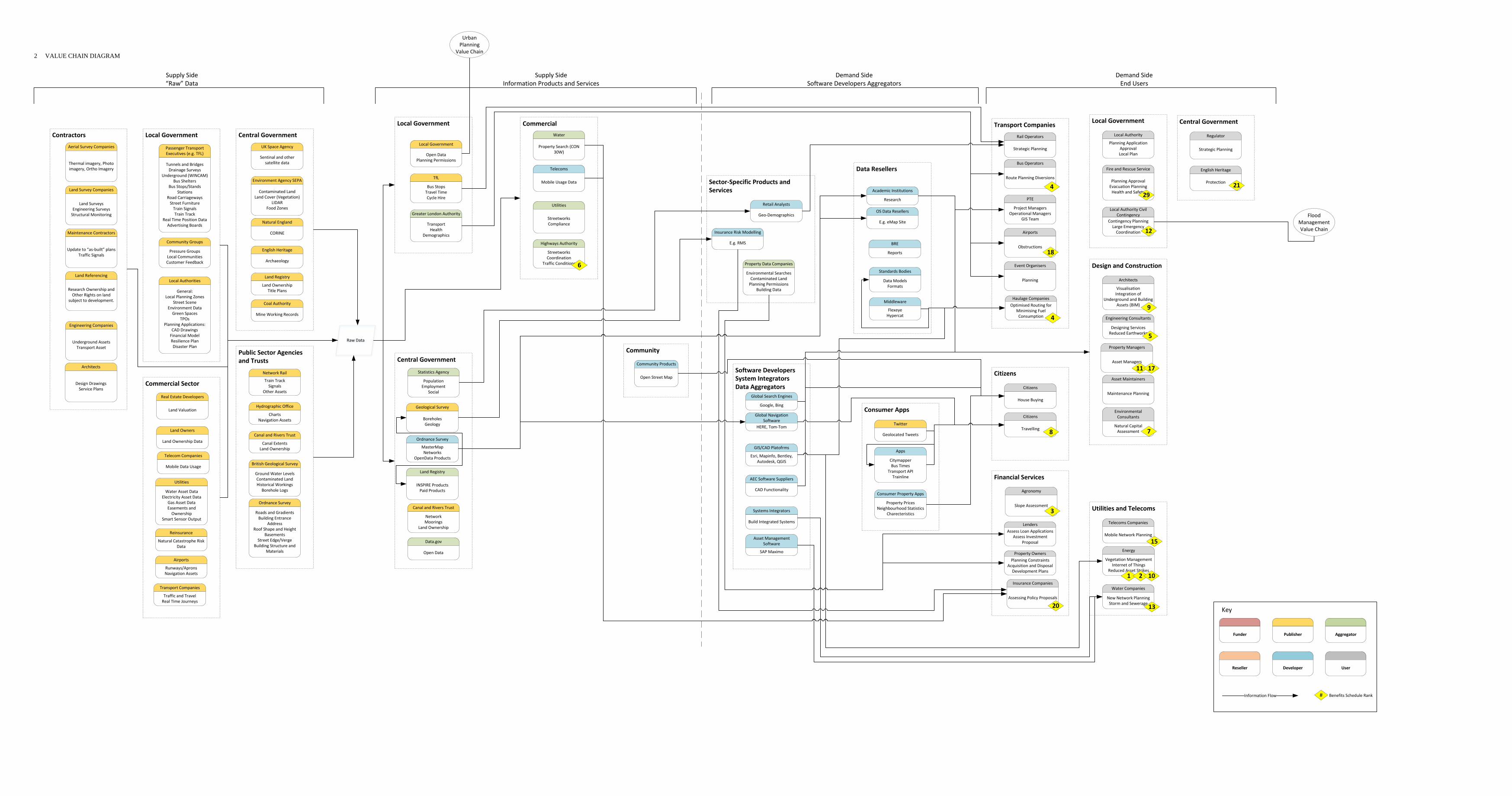
Funder AggregatorPublisher
Reseller Developer User
Information Flow
Key
# Benefits Schedule Rank
Contractors
Aerial Survey Companies
Thermal imagery, Photo imagery, Ortho Imagery
Land Survey Companies
Land SurveysEngineering SurveysStructural Monitoring
Maintenance Contractors
Update to “as‐built” plansTraffic Signals
Land Referencing
Research Ownership and Other Rights on land
subject to development.
Engineering Companies
Underground AssetsTransport Asset
Architects
Design DrawingsService Plans
Local Government
Local Authorities
General:Local Planning Zones
Street SceneEnvironment DataGreen Spaces
TPOsPlanning Applications:
CAD DrawingsFinancial ModelResilience PlanDisaster Plan
Community Groups
Pressure GroupsLocal CommunitiesCustomer Feedback
Passenger Transport Executives (e.g. TFL)
Tunnels and BridgesDrainage Surveys
Underground (WINCAM)Bus Shelters
Bus Stops/StandsStations
Road CarriagewaysStreet FurnitureTrain SignalsTrain Track
Real Time Position DataAdvertising Boards
Commercial Sector
Real Estate Developers
Land Valuation
Land Owners
Land Ownership Data
Telecom Companies
Mobile Data Usage
Utilities
Water Asset DataElectricity Asset Data
Gas Asset DataEasements and Ownership
Smart Sensor Output
Reinsurance
Natural Catastrophe Risk Data
Airports
Runways/ApronsNavigation Assets
Transport Companies
Traffic and TravelReal Time Journeys
Public Sector Agencies and Trusts
Network Rail
Train TrackSignals
Other Assets
Hydrographic Office
ChartsNavigation Assets
Canal and Rivers Trust
Canal ExtentsLand Ownership
Ordnance Survey
Roads and GradientsBuilding Entrance
AddressRoof Shape and Height
BasementsStreet Edge/Verge
Building Structure and Materials
British Geological Survey
Ground Water LevelsContaminated LandHistorical Workings
Borehole Logs
Central Government
UK Space Agency
Sentinal and other satellite data
Environment Agency SEPA
Contaminated LandLand Cover (Vegetation)
LIDARFood Zones
Natural England
CORINE
English Heritage
Archaeology
Land Registry
Land OwnershipTitle Plans
Coal Authority
Mine Working Records
Supply Side“Raw” Data
Raw Data
Local Government
Local Government
Open DataPlanning Permissions
TfL
Bus StopsTravel TimeCycle Hire
Greater London Authority
Transport Health
Demographics
Central Government
Ordnance Survey
MasterMapNetworks
OpenData Products
Geological Survey
BoreholesGeology
Land Registry
INSPIRE ProductsPaid Products
Statistics Agency
PopulationEmployment
Social
Canal and Rivers Trust
NetworkMoorings
Land Ownership
Data.gov
Open Data
Commercial
Telecoms
Mobile Usage Data
Water
Property Search (CON 30W)
Utilities
StreetworksCompliance
Highways Authority
StreetworksCoordination
Traffic Conditions
Community
Community Products
Open Street Map
Supply SideInformation Products and Services
Data Resellers
OS Data Resellers
E.g. eMap Site
BRE
Reports
Academic Institutions
Research
Standards Bodies
Data ModelsFormats
Middleware
FlexeyeHypercat
Software DevelopersSystem IntegratorsData Aggregators
Asset Management Software
SAP Maximo
Global Navigation Software
HERE, Tom‐Tom
Global Search Engines
Google, Bing
AEC Software Suppliers
CAD Functionality
Systems Integrators
Build Integrated Systems
GIS/CAD Platofrms
Esri, Mapinfo, Bentley, Autodesk, QGIS
Sector‐Specific Products and Services
Insurance Risk Modelling
E.g. RMS
Property Data Companies
Environmental SearchesContaminated LandPlanning Permissions
Building Data
Retail Analysts
Geo‐Demographics
Consumer Apps
Geolocated Tweets
Apps
CitymapperBus Times
Transport APITrainline
Consumer Property Apps
Property PricesNeighbourhood Statistics
Charecteristics
Demand SideSoftware Developers Aggregators
Local Government
Local Authority
Planning Application ApprovalLocal Plan
Fire and Rescue Service
Planning ApprovalEvacuation PlanningHealth and Safety
Local Authority Civil Contingency
Contingency PlanningLarge Emergency Coordination
6
29
12
Central Government
Regulator
Strategic Planning
English Heritage
Protection 21
Design and Construction
Architects
VisualisationIntegration of
Underground and Building Assets (BIM)
Engineering Consultants
Designing ServicesReduced Earthworks
Property Managers
Asset Managers
Asset Maintainers
Maintenance Planning
Environmental Consultants
Natural Capital Assessment
9
5
11 17
7
Utilities and Telecoms
Telecoms Companies
Mobile Network Planning
Water Companies
New Network PlanningStorm and Sewerage
Energy
Vegetation ManagementInternet of Things
Reduced Asset Strikes
15
13
1 2 10
Transport Companies
Haulage CompaniesOptimised Routing for
Minimising Fuel Consumption
Rail Operators
Strategic Planning
Bus Operators
Route Planning Diversions
PTE
Project ManagersOperational Managers
GIS Team
Airports
Obstructions
Event Organisers
Planning
4
4
18
Financial Services
LendersAssess Loan Applications
Assess Investment Proposal
Property OwnersPlanning Constraints
Acquisition and DisposalDevelopment Plans
Insurance Companies
Assessing Policy Proposals
Agronomy
Slope Assessment3
20
Citizens
Citizens
House Buying
Citizens
Travelling 8
Demand SideEnd Users
Urban Planning
Value Chain
Flood Management Value Chain
2 VALUE CHAIN DIAGRAM
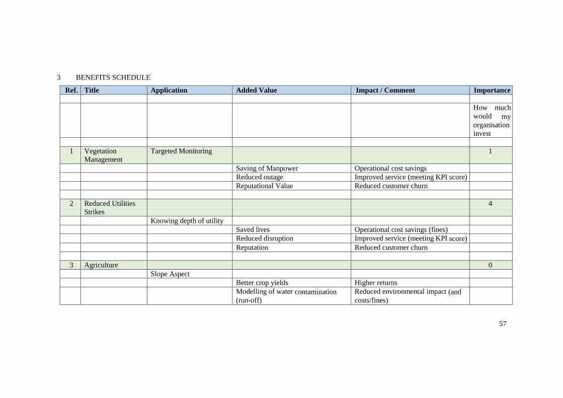
57
3 BENEFITS SCHEDULE
Ref. Title Application Added Value Impact / Comment Importance
How much
would my
organisation
invest
1 Vegetation
Management
Targeted Monitoring 1
Saving of Manpower Operational cost savings
Reduced outage Improved service (meeting KPI score)
Reputational Value Reduced customer churn
2 Reduced Utilities
Strikes
4
Knowing depth of utility
Saved lives Operational cost savings (fines)
Reduced disruption Improved service (meeting KPI score)
Reputation Reduced customer churn
3 Agriculture 0
Slope Aspect
Better crop yields Higher returns
Modelling of water contamination
(run-off)
Reduced environmental impact (and
costs/fines)
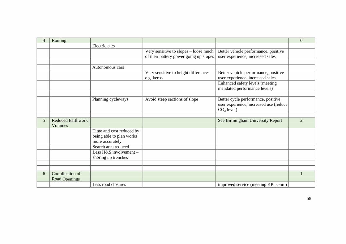
58
4 Routing 0
Electric cars
Very sensitive to slopes – loose much
of their battery power going up slopes
Better vehicle performance, positive
user experience, increased sales
Autonomous cars
Very sensitive to height differences
e.g. kerbs
Better vehicle performance, positive
user experience, increased sales
Enhanced safety levels (meeting
mandated performance levels)
Planning cycleways Avoid steep sections of slope Better cycle performance, positive
user experience, increased use (reduce
CO2 level)
5 Reduced Earthwork
Volumes
See Birmingham University Report 2
Time and cost reduced by
being able to plan works
more accurately
Search area reduced
Less H&S involvement –
shoring up trenches
6 Coordination of
Road Openings
1
Less road closures improved service (meeting KPI score)

59
7 Natural Capital Placing a financial value on the
landscape
Natural Capital Calculations 0
Steeper slopes require
greater management of
runoff
Reduced environmental impact (and
costs/fines)
Deciding where concreting
over of private gardens
should be discouraged
SUDS Improved water quality, reduced peak
flows, better flood management
8 Leisure market 0
Cycling / Walking Improved health indices, reduced CO2
(less use of vehicles)
Gaming Virtual Reality / Augmented reality ???
9 Better Geological
Information
1
Better decisions Reduced 'overspend' of construction
budgets, reduced implementation
delays
Reduced building costs Better planning of construction
appropriate for sub-surface features
10 Internet of Things 3
To optimally place sensors
inside buildings
Better placed so more useful data Better performance monitoring or
assets (pre-emptive maintenance, less
down time, improved services)
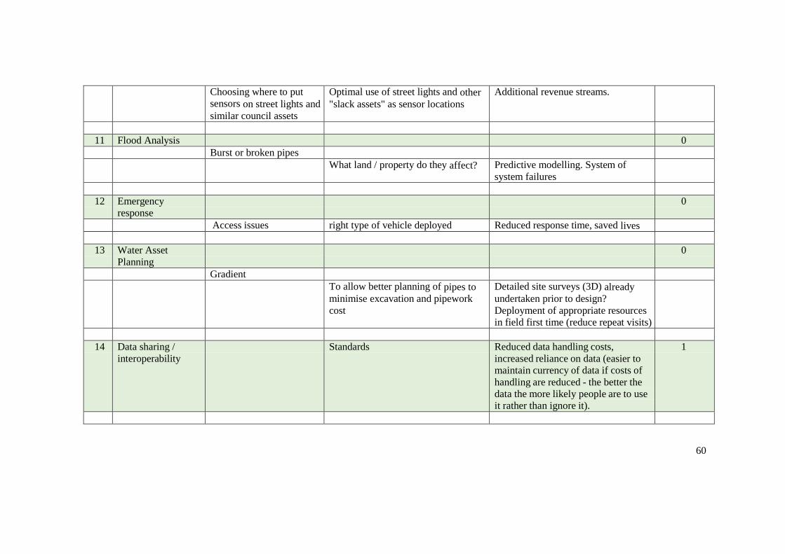
60
Choosing where to put
sensors on street lights and
similar council assets
Optimal use of street lights and other
"slack assets" as sensor locations
Additional revenue streams.
11 Flood Analysis 0
Burst or broken pipes
What land / property do they affect? Predictive modelling. System of
system failures
12 Emergency
response
0
Access issues right type of vehicle deployed Reduced response time, saved lives
13 Water Asset
Planning
0
Gradient
To allow better planning of pipes to
minimise excavation and pipework
cost
Detailed site surveys (3D) already
undertaken prior to design?
Deployment of appropriate resources
in field first time (reduce repeat visits)
14 Data sharing /
interoperability
Standards Reduced data handling costs,
increased reliance on data (easier to
maintain currency of data if costs of
handling are reduced - the better the
data the more likely people are to use
it rather than ignore it).
1
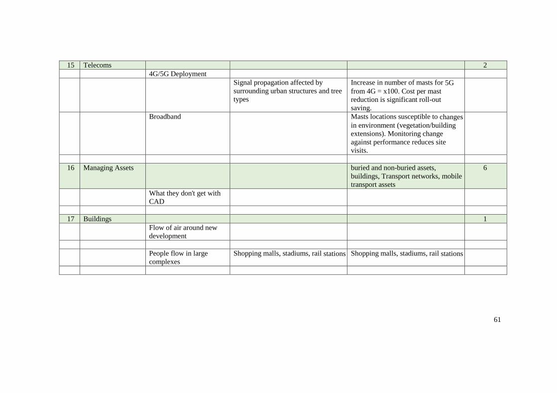
61
15 Telecoms 2
4G/5G Deployment
Signal propagation affected by
surrounding urban structures and tree
types
Increase in number of masts for 5G
from 4G = x100. Cost per mast
reduction is significant roll-out
saving.
Broadband Masts locations susceptible to changes
in environment (vegetation/building
extensions). Monitoring change
against performance reduces site
visits.
16 Managing Assets buried and non-buried assets,
buildings, Transport networks, mobile
transport assets
6
What they don't get with
CAD
17 Buildings 1
Flow of air around new
development
People flow in large
complexes
Shopping malls, stadiums, rail stations Shopping malls, stadiums, rail stations

62
18 Airports 0
More accurate mapping of
hazards on flight paths
Facilities management Underground plant Water pipe burst could close LHR for
3 months
19 Urban Planning
Regulation
3
Better data-driven
decisions
Basement control Groundwater infiltration issues (water
quality, forced to surface flows,
basement flooding, asset leakage
[drinking water, sewage pipes suffer
from ingress], reduced ground water
retention of rain fall water)
See Glasgow example
20 Insurance Policy validation 3
Check validity of information
supplied by customer on building
insurance policy application - is height of building consistent with it
being 3 floors?
Increased confidence in calculated risk
- leads to better premium pricing (to
meet competition or return better
margin)
Reduce exposure to risk by
disbursement of portfolio
63
21 Heritage Protection 3
View shed Analysis Examples include the shard blinding
train drivers and walky-talky
damaging cars
Sub-surface heritage sites. EH
maintain records of archeologically
significant sites in London. Need
consultation before work can
commence in this locations. Depth not
known
64
4 REFERENCES
World Economic Forum. (2016) Inspiring future cities & urban services: shaping the future of urban development & services initiative. World Economic Forum in collaboration with PwC
Available at:
http://www3.weforum.org/docs/WEF_Urban-Services.pdf
Metje, N., Ahmad, B. & Crossland, S. M. (2015) Causes, impacts and costs of strikes on buried utility assets. Proceedings. Municipal Engineer, vol 168, no. 3, pp. 165-174.,
10.1680/muen.14.00035.
Available at: http://pure-oai.bham.ac.uk/ws/files/24091427/Metje_Ahmad_Crossland_2015_Causes_impacts_costs_ICE_Proceedings.pdf
Snitkin, S., Mick, B., Novak, R., (2010) Asset Information Management (AIM) Part 1 – The Case for Developing an AIM Strategy. ARC Strategies.

65
5 GLOSSARY
Asset Maintainers
Also known as facilities managers asset maintainers are responsible for the maintenance and smooth running of assets including commercial property and infrastructure. Examples include:
AECOM Conway Kier CH2M
BRE
BRE (building research establishment) is a world leading multi-disciplinary building science centre with a mission to improve the built environment through research and knowledge generation. It developed the BREEAM standard, a method of assessing, rating, and certifying the sustainability of buildings.
Canal and Rivers Trust
The Canal & River Trust is a charitable trust set up to manage the navigable waterways of England and Wales, it is currently only responsible for a portion of the total navigable waterways in England and Wales with the remainder being managed by the Environment Agency.
Coal Authority
The Coal Authority is a non-departmental public body of the United Kingdom government. It is responsible for licensing coal mining operations and for providing information on coal reserves and past and future coal mining. It settles subsidence claims not falling on coal mining operators. It deals with the management and disposal of property, and with surface hazards such as abandoned coal mine shafts.
Community Groups
Products and services created by group of individuals. Suppliers of what is often referred to as Volunteer Geographic Information. Examples include:
Open Street Map Mapillary
English Heritage
English Heritage is a registered charity that manages the National Heritage Collection. This comprises over 400 of England's historic buildings, monuments and sites. Within its portfolio are Stonehenge, Dover Castle, Tintagel Castle and the best preserved parts of Hadrian's Wall.
Events Organisers
Commercial and public organisations organising events that utilise public roads and spaces.
Greater London Authority
The Greater London Authority is a top-tier administrative body for Greater London, England. It consists of a directly elected executive Mayor of London and an elected 25-member London Assembly. It is a strategic regional authority, with powers over transport, policing, economic development, and fire and emergency planning.
66
Hydrographic Office
The United Kingdom Hydrographic Office is an agency providing hydrographic and geospatial data to mariners and maritime organisations across the world. Publisher of admiralty charts of international shipping routes and ports, in varying detail.
Land Referencing Companies
Land referencing complements the work of law firms in the research of ownership, occupation and rights over of land subject to development. Examples include:
LRS, Persona, Terraquest
Land Survey Companies
Land Surveyors produce precise topographic surveys of land for valuation, or development activities. In the UK their activities are regulated by the Royal Institute of Chartered Surveyors and they adhere to RICS Specification Surveys of Land, Buildings and Utility Services. Examples include:
Warner Land Surveys Limited Land & Mineral Survey Services Limited Greenhatch Group Limited Catsurveys Group Limited
Lenders
Banks and venture Venture Capitalists that invest in and fund property acquisitions and development. Examples include:
The Grosvenor Estate Threadneedle Asset Management The British Land Company plc
Mobile Operators
Anonymous and aggregated mobile data supporting business decisions based on actual behaviour. Examples include:
Telefonica’s Smart steps
Natural England
Natural England is the non-departmental public body of the UK government responsible for ensuring that England's natural environment, including its land, flora and fauna, freshwater and marine environments, geology and soils, are protected and improved. It also has a responsibility to help people enjoy, understand and access the natural environment.
Network Rail
Network Rail is the owner and infrastructure manager of most of the rail network in England, Scotland and Wales. Network Rail owns the infrastructure, including the railway tracks, signals, overhead wires, tunnels, bridges, level crossings and most stations, but not the passenger or
commercial freight rolling stock. Network Rail is an arm’s length public body of the Department for

67
Transport
Passenger Transport Executives
In the United Kingdom, passenger transport executives (PTEs) are local government bodies which are responsible for public transport within large urban areas. They are accountable to bodies called integrated transport authorities (ITAs), or where they have been formed, to combined authorities. For example:
Transport for London (TfL)
Property Managers
Responsible for the maintenance and smooth running of buildings and infrastructure. In the commercial sector this role is often known as facilities management. In the residential sector this role is often undertaken by housing associations or cooperatives. Examples include:
Argent FM
Regulators
Regulate markets to ensure activities are in line with the law, but also to ensure markets are behaving in the public interest. Can recommend to the government the need for additional legislation or policy changes if deemed necessary. Examples include:
OFGEM – electricity and gas regulator in UK OFWAT – water regulator for England and Wales for piped water supply, storm
water and sewerage Ofcom is the communications regulator in the UK. It regulates the TV and radio
sectors, fixed line telecoms, mobiles, postal services, plus the airwaves. HSE – health and safety executive. Great Britain's independent regulator for work-
related health, safety and illness.
Reinsurance Companies
Sell data about previous natural catastrophe events to inform business customers and brokers about risks associated with asset investments. Examples include:
Willis Re and Swiss Re
Standards Bodies
Develop and publish technical standards for standardisation of industry practices for among other things improved interoperability. Relevant Examples:
British Standards Institute (BSi) International Standards Organisation (ISO) Open Geospatial Consortium (OGC)
System Integrators
Build large integrated software systems for large public and private sector customers. Examples include:
IBM, Cap Gemini, Accenture
Transport Operators
Supply traffic information and real time journey information, Examples include:
Uber, Arriva
68
FLOOD MANAGEMENT
Table of Contents
1 EXECUTIVE SUMMARY ............................................................................................ 69
1.1 Introduction ............................................................................................................ 69
1.2 Purpose ................................................................................................................... 69
1.3 Deliverables ............................................................................................................ 69
1.4 Analysis ................................................................................................................... 70
1.5 Notes ....................................................................................................................... 72
2 VALUE CHAIN DIAGRAM ......................................................................................... 73
3 BENEFITS SCHEDULE ................................................................................................ 74
4 REFERENCES ............................................................................................................... 77
5 GLOSSARY ................................................................................................................... 78

69
1 EXECUTIVE SUMMARY
1.1 Introduction
The workshop was undertaken in the offices of IGN France in Paris on 30th June, 2016. The event was attended by experts from Ireland, Denmark, Switzerland and France. The overall aim was to document the flood management process, using value chain mapping to represent the results. The value chain was then used to identify where the most significant socio-economic benefits would be added by access to 3D geo-information. This document is a narrative summary of the results of the workshop and subsequent analysis.
1.2 Purpose
The workshop was undertaken to:
Assist those involved in flood management to better understand the data, stakeholders (referred to here as actors) and processes involved in creating value in the flood management process.
Provide a starting point for quantifying the costs and benefits of 3D products and services for flood management.
By involving representatives of the commercial sector, it helps to identify where the commercial sector are likely create products and services and by inference the “gaps” where Government may need to intervene to optimise socio-economic impacts.
EuroSDR is a European research organisation, so the results will inform discussions in the other countries involved in research in this domain.
1.3 Deliverables
The main deliverables are:
Value Chain - understanding this chain is a pre-requisite to evaluating the socio- economic benefits of 3D georeferenced data to this use case;
Glossary – covering “actors” and processes to enable the value chain to be more easily interpreted;
Benefits spreadsheet – this output is the result of a “brainstorm” by workshop attendees
to identify the most significant value adding processes in the value chain; Overview Narrative – this document, which aims to draw out the main conclusions
from the exercise; Presentations from the workshop and other background material.
All these deliverables are available on BaseCamp, labelled as Urban Planning.
70
1.4 Analysis
1.4.1 Scope
As many of the delegates were from France, much of the workshop input has an emphasis on the situation in that country. The French system has multiple authorities with responsibility for flood management, local regional and national. We have not tried to rigorously separate them out as this level of detail was not covered in the workshop and would over complicate the deliverable. Improved coordination between them by common access to more accurate 3D data would clearly add value and has been identified in the deliverables.
We have enhanced the workshop results, where our experience suggests there were gaps at the end of the workshop, from other studies concerning added value. These come from literature research and previous studies ConsultingWhere have undertaken. A glossary of terms that may not translate directly is included, to assist participants in the study from other countries in using the outputs.
1.4.2 Most Significant Benefits
As identified by the workshop participants, the processes where the most value is added, generating the most significant potential socio-economic benefits, are as follows:
1. Early warning for emergency services saves lives. 2. More accurate and reliable risk analysis tools result in better development planning
decisions and more appropriate construction. 3. Risk analysis tools that are, easier to use and understand, result in a reduction in time
spent justifying the evidence and so reducing the administrative costs of consenting. 4. More accurate and reliable risk analysis tools result in better emergency response
planning (including simulations) and a more effective response. 5. More accurate risk analysis increases the confidence of insurance providers when
setting premiums and allows for more competitive premiums for some customers.
This list provides a focus for quantification of economic benefits and elaboration of social benefits that would be required as part of a full business case.
The report by the United Nations (in 2013) on the Value of Geoinformation for Disaster and Risk Management (VALID): Benefit Analysis and Stakeholder Assessment provide an excellent assessment of the various methodological approaches. This document is available on the basecamp site.
Some very valuable quantitative output concerning the costs of flooding by the Swiss Federal Research Institute WSL on behalf of the Federal Office for the Environment FOEN. Damage originating from naturally triggered floods, debris flows, landslides and rock-falls (since 2002) have been included. However, it does not consider damage from avalanches, snow pressure, earthquake, lightning, hail, windstorm and drought. The corresponding weather conditions are also noted in the database. The database, going back to 1972, currently has more than 20,000 entries. The information is (partially) available in English
1.
1 Costs of flooding research by the Swiss Federal Research Institute, available at:
http://www.wsl.ch/fe/gebirgshydrologie/HEX/projekte/schadendatenbank/index_EN
71
1.4.3 Supply-side Value Chain
The supply-side of the value chain shows the main actors currently involved or required to produce the flood management information products. The connecting arrows illustrate the main flows of information between the actors.
Raw 3D data in the form of Lidar or ortho imagery is collected by the National Mapping Agency (NMA) where it is compiled into DSM/DTM and break line maps while river bathymetry data is provided by the National Hydrographic Agency and Port Authority. These 3D data products are used by Hydrological Consultants to develop (i) flow maps, blue spot maps and hydrological adjustment layers, and then (ii) flood models and simulations.
To do this the data is combined with a range of other data sets, these are:
maps of flood obstacles derived from existing topographic data; the location of flood protection infrastructure provided by the Civil Protection
Agency; data on soils and bedrocks provided by the Geological Office; and historic flood data
A range of data relating to the locations of people and property is combined with flood models by the Municipalities to develop Flood Risk Maps (see demand side). These are:
topographic data on the location of properties provided by the NMA; transport data provided by the Road and Traffic Agency; demographic data provided by the Statistics Agency and the Municipalities; utility installation locations provided by the Utility Companies.
A range of real time, or near real time hydrographic and meteorological data is provided by the Meteorological Agency and the River Managers for use in real time decision support systems (see demand side).
The NMA also collects post-event 3D data (based on either ortho imagery or Lidar) and develop dynamic mapping of mass movements for input into the risk planning process as well as change data maps for damage assessment.
The main value add resulting from more accurate 3D data supply is the ability to improve the accuracy of flood models. Flood models are used to create risk maps supporting real-time decision making. The better the 3D data, the more value the information adds to the flood management value chain.
The use of these more accurate flood models for risk maps and decision support systems produces added value for a range of public bodies, businesses and ultimately for citizens through better protection.
For example in France, a programme of improvements to the national DTM was initiated following the 2007 EU Directive on Flood Management. This included an enhanced DTM for the Rhône river basin covering 3000km2 with a horizontal grid resolution of 2m and vertical accuracy of 20cm. This enhanced DTM was used to augment flood modelling by, for example, improving the detection of slope breaks. When combined with river bathymetry data and relevant conventional geographic information, such as the location of bridges and flood defence structures, the enhanced DTM contributed to more accurate and reliable flood modelling and simulations.
72
1.4.4 Demand-side Value Chain
The added value components identified in the benefits spreadsheet are shown by numbered yellow triangles attached to the relevant actors and processes. As on the supply-side, for clarity, the connectors only show the most significant inter-relationships between processes. Our analysis of the draft map, shows the following:
The demand side can be decomposed using the emergency management cycle of preparation, response, recovery and mitigation.
In the Preparedness stage flood models and simulations are used by the Municipalities to develop flood risk maps by combining flood models with a range of raw data on the location of people and property described above. The Municipalities uses these risk maps to plan urban development and evaluate planning applications for flood risk. The Emergency Services and Structural Engineering Companies use flood risk maps to plan the distribution of disaster relief assets and to design and build appropriate flood protection structures. Utility Companies and the Road and Traffic Agency use flood risk maps to plan asset protection and Insurance Companies use flood risk maps to estimate portfolio exposure.
Flood risk maps are also be used in combination with 3D models of cities to create visualisations to inform and engage Citizens and Elected Representatives either directly or via the media.
In the Response stage flood prediction services use flood models and risk maps in combination with a range of real time, or near real time, hydrographic and meteorological data (see supply side) to create real time flooding information and decision support systems. These systems are used by The Crisis Management Group (including the Emergency Services) to make decisions, for example about who to evacuate and when. They are also used to send warning messages to the Citizens, either in person, or via flood alert applications. A range of actors use real time flood information to make appropriate decisions during a flood, for example the Utility Companies may need to decide whether or not to shut down a power station.
In the recovery phase the Environment Agency develops damage assessment maps using post event analysis carried out by the NMA (see supply side). These maps are used by the Insurance Companies to estimate claims and the Waste Water Authorities to analyse how surface water percolation will affect ground water supplies.
In the mitigation phase risk maps are updated and improved by the Municipalities incorporating post event analysis carried out by the NMA (see supply side).
1.5 Notes
We believe there are still gaps in the value chain related to flood management in coastal areas. This requires further input from some of the delegates (or other experts).
Links between this use case and the others are indicated by oval boxes. The completeness of these linkages will be revisited once all value chains are completed.
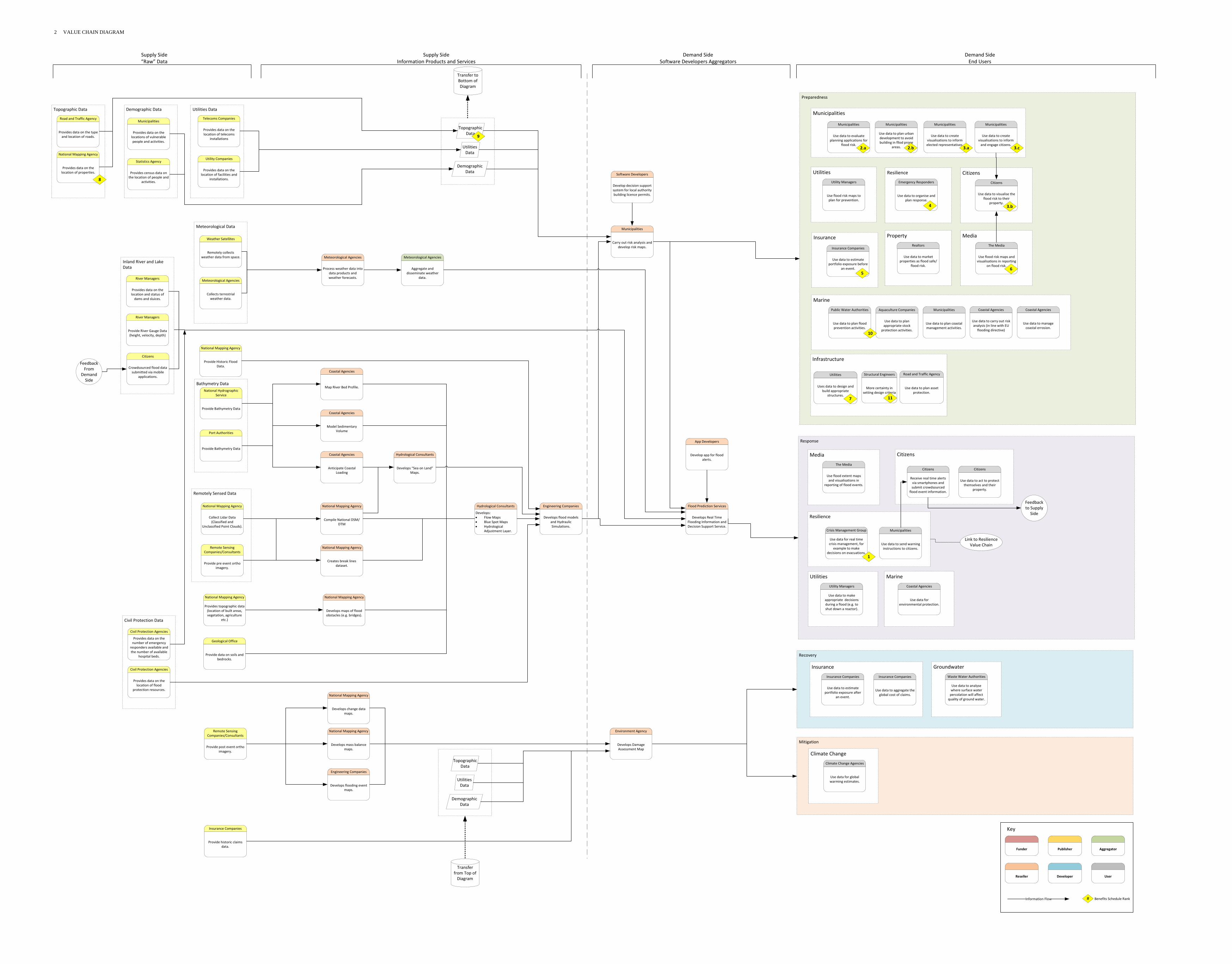
Mitigation
Recovery
Response
Marine
Preparedness
Marine
Property
Resilience
Realtors
Use data to market properties as flood safe/
flood risk.
Climate Change
Climate Change Agencies
Use data for global warming estimates.
Crisis Management Group
Use data for real time crisis management, for
example to make decisions on evacuations.
Municipalities
Use data to send warning instructions to citizens.
Utilities
Utility Managers
Use data to make appropriate decisions during a flood (e.g. to shut down a reactor).
Groundwater
Waste Water Authorities
Use data to analyse where surface water percolation will affect quality of ground water.
Coastal Agencies
Use data for environmental protection.
Coastal Agencies
Use data to manage coastal errosion.
Coastal Agencies
Use data to carry out risk analysis (in line with EU
flooding directive)
1
Link to Resilience Value Chain
Supply Side“Raw” Data
Supply SideInformation Products and Services
Demand SideSoftware Developers Aggregators
Demand SideEnd Users
Insurance Companies
Provide historic claims data.
Municipalities
Carry out risk analysis and develop risk maps.
Software Developers
Develop decision support system for local authority building licence permits.
Environment Agency
Develops Damage Assessment Map
Engineering Companies
Develops flooding event maps.
National Mapping Agency
Develops change data maps.
National Mapping Agency
Develops mass balance maps.
Remote Sensing Companies/Consultants
Provide post event ortho imagery.
Utilities DataDemographic Data
Telecoms Companies
Provides data on the location of telecoms
installations
Utility Companies
Provides data on the location of facilities and
installations.
Municipalities
Provides data on the locations of vulnerable people and activities.
Statistics Agency
Provides census data on the location of people and
activities.
Topographic Data
National Mapping Agency
Provides data on the location of properties.
Road and Traffic Agency
Provides data on the type and location of roads.
Coastal Agencies
Model Sedimentary Volume
Engineering Companies
Develops flood models and Hydraulic Simulations.
Flood Prediction Services
Develops Real Time Flooding Information and Decision Support Service.
App Developers
Develop app for flood alerts.
Bathymetry Data
Port Authorities
Provide Bathymetry Data
National Hydrographic Service
Provide Bathymetry Data
Remotely Sensed Data
Civil Protection Data
Meteorological Data
Inland River and Lake Data
National Mapping Agency
Provide Historic Flood Data.
Geological Office
Provide data on soils and bedrocks.
Civil Protection Agencies
Provides data on the location of flood
protection resources.
Civil Protection Agencies
Provides data on the number of emergency
responders available and the number of available
hospital beds.
National Mapping Agency
Provides topographic data (location of built areas, vegetation, agriculture
etc.)
National Mapping Agency
Develops maps of flood obstacles (e.g. bridges).
National Mapping Agency
Collect Lidar Data (Classified and
Unclassified Point Clouds).
Remote Sensing Companies/Consultants
Provide pre event ortho imagery.
National Mapping Agency
Compile National DSM/DTM
National Mapping Agency
Creates break lines dataset.
Coastal Agencies
Anticipate Coastal Loading
Coastal Agencies
Map River Bed Profile.
Hydrological Consultants
Develops “Sea on Land” Maps.
Hydrological Consultants
Develops: Flow Maps Blue Spot Maps Hydrological
Adjustment Layer.
Weather Satellites
Remotely collects weather data from space.
Meteorological Agencies
Collects terrestrial weather data.
Meteorological Agencies
Aggregate and disseminate weather
data.
Meteorological Agencies
Process weather data into data products and weather forecasts.
Citizens
Crowdsourced flood data submitted via mobile
applications.
River Managers
Provide River Gauge Data (height, velocity, depth)
River Managers
Provides data on the location and status of dams and sluices.
Feedback From
Demand Side
Utilities Data
Demographic Data
Topographic Data
Utilities Data
Demographic Data
Topographic Data
Insurance
Insurance Companies
Use data to aggregate the global cost of claims.
Insurance Companies
Use data to estimate portfolio exposure after
an event.
Citizens
Citizens
Receive real time alerts via smartphones and submit crowdsourced
flood event information.
Citizens
Use data to act to protect themselves and their
property.
Feedback to Supply
Side
Municipalities
Municipalities
Use data to evaluate planning applications for
flood risk.
Municipalities
Use data to plan urban development to avoid building in fllod prone
areas.
Municipalities
Use data to create visualisations to inform elected representatives.
Municipalities
Use data to create visualisations to inform and engage citizens.
2.a 3.a 3.c2.b
Public Water Authorities
Use data to plan flood prevention activities.
Aquaculture Companies
Use data to plan appropriate stock
protection activities.
Municipalities
Use data to plan coastal management activities.
Resilience
Emergency Responders
Use data to organise and plan response.
4
Utilities
Utility Managers
Use flood risk maps to plan for prevention.
Media
The Media
Use flood extent maps and visualisations in
reporting of flood events.
Insurance
Insurance Companies
Use data to estimate portfolio exposure before
an event.
Citizens
Citizens
Use data to visualise the flood risk to their
property.3.b
Media
The Media
Use flood risk maps and visualisations in reporting
on flood risk.
Infrastructure
Utilities
Uses data to design and build appropriate
structures.
Road and Traffic Agency
Use data to plan asset protection.
Funder AggregatorPublisher
Reseller Developer User
Information Flow
Key
# Benefits Schedule Rank
Transfer to Bottom of Diagram
Transfer from Top of Diagram
56
7
8
9
10
Structural Engineers
More certainty in setting design criteria
11
2 VALUE CHAIN DIAGRAM

74
3 BENEFITS SCHEDULE
Ref. Actor Process Benefit Source Score
1 Crisis Management Group
Flood early warning systems allows for emergency
services and local authorities to take short term flood mitigation actions to save lives and property.
Increased public safety &
avoid loss of life and damage to property.
Workshop 17
2 Municipalities (agencies involved in development planning)
Improved flood risk map accuracy improves confidence in the legitimacy of flood risk assessments. Improved confidence increases risk awareness for politicians, citizens and local authorities which leads to more effective local strategic planning (10-20 years ahead) to mitigate future flood risk. Wise development in flood prone regions avoids loss of life and damage to property. In addition as fewer businesses and services are sited in
high risk zones, fewer interruptions to services due to
flooding occur. Also reduced building on flood plains
allows for natural storm water management leading to
improved water quality and increased biodiversity.
Increased public safety &
avoid loss of life and damage to property. Reduced loss of business and interruption to services. Preservation of the natural function of floodplains.
Workshop/ other sources
8
3 Municipalities (agencies involved in development planning)
Improved tools for risk analysis in the strategic planning of construction are quicker to use and easier to justify this leads to savings in administrative costs (e.g. in dealing with appeals) and resources.
Administrative costs
savings.
Workshop 8
4 Emergency Services Putting the assets for disaster relief in the right place.
More efficient allocation in planning leads to more effective response.
Improved resource
deployment
Quicker response times
Workshop/
other sources
4
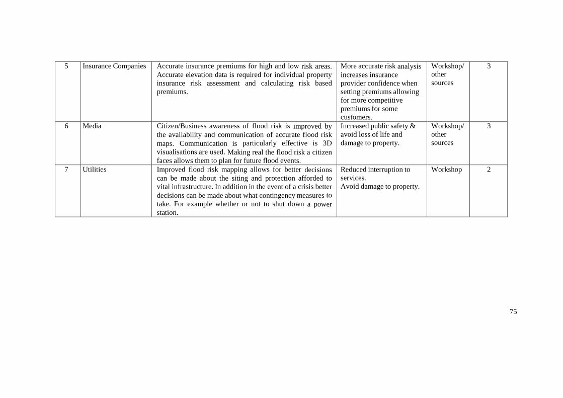
75
5 Insurance Companies Accurate insurance premiums for high and low risk areas.
Accurate elevation data is required for individual property
insurance risk assessment and calculating risk based
premiums.
More accurate risk analysis
increases insurance
provider confidence when
setting premiums allowing
for more competitive
premiums for some
customers.
Workshop/other sources
3
6 Media Citizen/Business awareness of flood risk is improved by
the availability and communication of accurate flood risk
maps. Communication is particularly effective is 3D
visualisations are used. Making real the flood risk a citizen faces allows them to plan for future flood events.
Increased public safety & avoid loss of life and
damage to property.
Workshop/ other sources
3
7 Utilities Improved flood risk mapping allows for better decisions
can be made about the siting and protection afforded to
vital infrastructure. In addition in the event of a crisis better
decisions can be made about what contingency measures to
take. For example whether or not to shut down a power station.
Reduced interruption to services.
Avoid damage to property.
Workshop 2
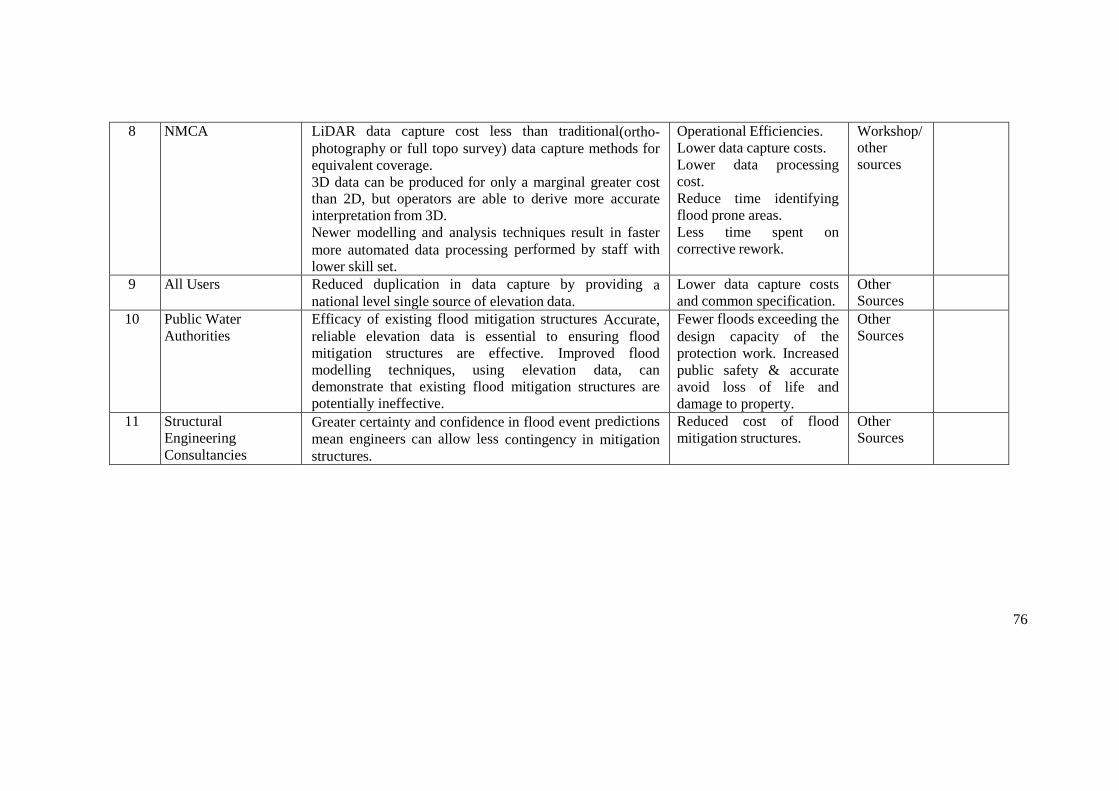
76
8 NMCA LiDAR data capture cost less than traditional(ortho-
photography or full topo survey) data capture methods for
equivalent coverage.
3D data can be produced for only a marginal greater cost than 2D, but operators are able to derive more accurate
interpretation from 3D.
Newer modelling and analysis techniques result in faster
more automated data processing performed by staff with
lower skill set.
Operational Efficiencies.
Lower data capture costs.
Lower data processing
cost.
Reduce time identifying
flood prone areas.
Less time spent on
corrective rework.
Workshop/other sources
9 All Users Reduced duplication in data capture by providing a national level single source of elevation data.
Lower data capture costs and common specification.
Other Sources
10 Public Water
Authorities
Efficacy of existing flood mitigation structures Accurate,
reliable elevation data is essential to ensuring flood
mitigation structures are effective. Improved flood
modelling techniques, using elevation data, can
demonstrate that existing flood mitigation structures are
potentially ineffective.
Fewer floods exceeding the
design capacity of the
protection work. Increased
public safety & accurate
avoid loss of life and
damage to property.
Other
Sources
11 Structural
Engineering
Consultancies
Greater certainty and confidence in flood event predictions
mean engineers can allow less contingency in mitigation structures.
Reduced cost of flood
mitigation structures.
Other Sources

77
4 REFERENCES
Presentation: Eurosdr “3d Data” Economic Value Workshop – National Overview From France, 30
th June 2016. IGN France. Powerpoint Presentation Available on Project
Basecamp.
Presentation: Relevance of 3D geodata – mass movements. Swiss Topo. Powerpoint Presentation Available on Project Basecamp.

78
5 GLOSSARY
App Developers
Companies that develop smartphone applications to inform the public and assist flood damage prevention activities.
Aquaculture Companies
Companies involved in the rearing of aquatic animals or the cultivation of aquatic plants for food that require flood information products to protect livestock and crops from damage.
Bathymetric Surveyor
Surveyors that measure the depth of water.
Civil Protection Agency
Generic term for the body that oversees the single or multi-agency response and recovery to an emergency.
Climate Change Agency
Government body with responsible for climate change policy.
Coastal Agency
Government agency responsible for coastal activities. Responsible for beaches, dunes, dikes, marinas and fishing ports. For example:
Réseau d'observation du littoral Normand et Picard Afdeling Kust (Department of Coast)
Crisis Management Group
Strategically-directed activities to prevent, respond to, mitigate the effects of and recover from a crisis.
Construction Industry
Where flooding is an issue the construction industry must design and built appropriately to cope with floodwaters and minimize the time for reoccupation after a flooding event.
Emergency Responders
The agencies that are responsible for the initial response in a crisis. For example:
Police Fire Ambulance
Environmental Agencies
Government agency responsible for funding policy and regulation relating to the environment usually including flood prevention and response. For example:
Belgian Interregional Environment Agency (IRCEL - CELINE)
Flood Prediction Services
Specialised hydrometeorology services that forecast natural forms of flooding - river, surface water, tidal/coastal and groundwater.
Geological Office

79
Publicly funded body which aims to advance geoscientific knowledge by means of systematic surveying, monitoring and research. Core outputs include geological, geophysical, geochemical and hydrogeological maps.
Hydrological Consultants
Companies and individuals that specialise in providing hydrological advice and assistance and develop specialist hydrographic related data services and products in the hydrology sector.
Insurance Companies
Companies that insure lives and property against loss due to, for example, flooding and storm damage.
Meteorological Agencies
Government agency responsible for collecting meteorological data and making meteorological predictions across all timescales from weather forecasts to climate change.
Royal Meteorological Institute of Belgium (RMI)
Municipalities
Generic term referring to local level, as opposed to national level, government. For example the French republic is divided into 18 regions, which are further subdivided into 96 departments in metropolitan France and 5 overseas departments, which are also classified as regions.
National Mapping Agency
Public sector body that procures, aggregates and develops topographic maps and geographic information of a country. For example:
Institut national de l’information géographique et forestière (IGN)
Realtors
Companies involved in the buying and selling of property.
Remote Sensing Companies/Consultants
Private sector companies that collect remotely sensed data as a service. For example:
Terratec Blom Arbonaut Cowi Metria Foran Finnmap
Road and Traffic Agency
Organisation responsible for operation of road network. For example:
Agentschap Wegen en Verkeer (Agency of Roads and Traffic)
Software Developers
Developers of customised applications for flooding data integration and analysis. For example:
80
Statistics Agency
Public sector body with responsibility for official statistics, for example demographic data and census.
Telecommunication Companies
Companies transferring data via telecommunication networks.
Utility Companies
Public utilities provide water, electricity, natural gas, telephone service, and other essentials. Utilities may be publicly or privately owned, but most are operated as private businesses.
Waste Agencies
Department of municipal authority responsible for solid waste disposal and recycling.
Weather Satellite
Satellites that are primarily used to monitor the weather
81
3D CADASTER AND VALUATION
Table of Contents
1 EXECUTIVE SUMMARY ............................................................................................ 82
1.1 Introduction ............................................................................................................ 82
1.2 Purpose ................................................................................................................... 82
1.3 Deliverables ............................................................................................................ 82
1.4 Analysis .................................................................................................................. 82
2 VALUE CHAIN DIAGRAM ......................................................................................... 86
3 BENEFITS SCHEDULE ................................................................................................ 87
4 GLOSSARY ................................................................................................................... 90
82
1 EXECUTIVE SUMMARY
1.1 Introduction
The workshop was undertaken in the offices of Dutch Kadastre in Amsterdam on 6th July.
The overall aim was to graphically document the land administration process, using value chain mapping to represent the results. The value chain was then used to identify where the most significant socio-economic benefits would be added by access to 3D geo-information.
The events was attended by experts from Netherlands and Denmark. Where components of the value chain are specific to one or other country these are indicated on the value chain map.
1.2 Purpose
The workshop was undertaken to:
Assist those involved in land administration – specifically cadastral mapping and land registration in 3D and land and property valuation for taxation purposes (referred to here as 3D Cadastre and Valuation) - to better understand the data, stakeholders (referred to here as actors) and processes involved in creating value in the 3D Cadastre and Valuation process.
Provide a starting point for quantifying the costs and benefits of 3D products and services for 3D Cadastre and Valuation.
By involving representatives of the commercial sector, it helps to identify where the commercial sector are likely create products and services and by inference the “gaps” where Government may need to intervene to optimise socio-economic impacts.
EuroSDR is a European research organisation, so the results will inform discussions in the other countries involved in research in this domain.
1.3 Deliverables
The main deliverables are:
i. Value Chain - understanding this chain is a pre-requisite to evaluating the socio- economic benefits of 3D georeferenced data to this use case;
ii. Glossary – covering “actors” and processes to enable the value chain to be more easily interpreted;
iii. Benefits spreadsheet – this output is the result of a “brainstorm” by workshop attendees
iv. to identify the most significant value adding processes in the value chain; v. Overview Narrative – this document, which aims to draw out the main conclusions
from the exercise; vi. Presentations from the workshop and other background material.
All these deliverables are available on BaseCamp, labelled as 3D Cadastre and Valuation.
1.4 Analysis
1.4.1 Scope
The analysis covered the uses of geo-information related to land and property for land registration and administration and land and property valuation. The valuation element focuses largely on valuation for taxation purposes, but is also applicable to valuation for
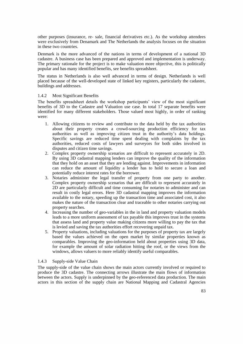
83
other purposes (insurance, re- sale, financial derivatives etc.). As the workshop attendees were exclusively from Denamark and The Netherlands the analysis focuses on the situation in these two countries.
Denmark is the more advanced of the nations in terms of development of a national 3D cadastre. A business case has been prepared and approved and implementation is underway. The primary rationale for the project is to make valuation more objective, this is politically popular and has many identified benefits, see benefits spreadsheet.
The status in Netherlands is also well advanced in terms of design. Netherlands is well placed because of the well-developed state of linked key registers, particularly the cadastre, buildings and addresses.
1.4.2 Most Significant Benefits
The benefits spreadsheet details the workshop participants’ view of the most significant benefits of 3D to the Cadastre and Valuation use case. In total 17 separate benefits were identified for many different stakeholders. Those valued most highly, in order of ranking were:
1. Allowing citizens to review and contribute to the data held by the tax authorities about their property creates a crowd-sourcing production efficiency for tax authorities as well as improving citizen trust in the authority’s data holdings. Specific savings are reduced time spent dealing with complaints by the tax authorities, reduced costs of lawyers and surveyors for both sides involved in disputes and citizen time savings.
2. Complex property ownership scenarios are difficult to represent accurately in 2D. By using 3D cadastral mapping lenders can improve the quality of the information that they hold on an asset that they are lending against. Improvements in information can reduce the amount of liquidity a lender has to hold to secure a loan and potentially reduce interest rates for the borrower.
3. Notaries administer the legal transfer of property from one party to another. Complex property ownership scenarios that are difficult to represent accurately in 2D are particularly difficult and time consuming for notaries to administer and can result in costly legal errors. Here 3D cadastral mapping improves the information available to the notary, speeding up the transaction time and associated cost, it also makes the nature of the transaction clear and traceable to other notaries carrying out property searches.
4. Increasing the number of geo-variables in the in land and property valuation models leads to a more uniform assessment of tax payable this improves trust in the systems that assess land and property value making citizens more willing to pay the tax that is levied and saving the tax authorities effort recovering unpaid tax.
5. Property valuations, including valuations for the purposes of property tax are largely based the values achieved on the open market by similar properties known as comparables. Improving the geo-information held about properties using 3D data, for example the amount of solar radiation hitting the roof, or the views from the windows, allows valuers to more reliably identify useful comparables.
1.4.3 Supply-side Value Chain
The supply-side of the value chain shows the main actors currently involved or required to produce the 3D cadastre. The connecting arrows illustrate the main flows of information between the actors. Supply is underpinned by the geo-referenced data production. The main actors in this section of the supply chain are National Mapping and Cadastral Agencies

84
(NMCAs). Private sector companies are involved in the collection of raw data or provide specialist processing services, but the NMCAs are responsible for providing national products and services.
The key supply-side products are 2D topographic mapping (at various scales), key registers and currently Digital Elevation and Digital Surface Model products. The initiative to create 3D cadastre will use high resolution vertical and oblique aerial (and / or LiDAR) data.
The administration of land is managed by Cadastral Agencies and Land Registration Authorities. They take address data, cadastral surveys and large scale topographic data to produce registers of land ownership (by parcel), easements and condominium rights. Here the addition of cadastral parcels recorded in 3D will allow for the more accurate recording of complex ownership situations.
The building register contains a wide range of attributes e.g gross usable floor area, wall and window area. Here 3D can add value by allowing for the automated calculation of size and position of
windows. The link between the building register and the other key registers through a persistent shared identifier is key to synchronisation. In Denmark much of this data will be provided by citizens. This process will be supported by a statutory obligation on the citizen. These data are also used within the valuation process, achieved through linkage to the valuation register.
Analysis of the supply-side value can expose inefficiencies resulting from multiple sources creating the same or similar data. In addition, the main components of the cost of creating the product or service can be more easily evaluated by looking individually at the actors and connections. In this case, the established position of public sector bodies as the only authoritative (aggregated) source of national cadastral and valuation data means there is apparently little inefficiency in this part of the value chain. This does not imply that these organisations do not have their own inefficiencies but as there are not competing agencies or commercial sector organisations in these domains in Denmark and the Netherlands, data collection duplication would appear to be limited. There is an open question as to whether this public sector monopoly is justified or sustainable, the purely economic “public good” argument is complicated by open (free) data policies in both countries and is beyond the scope of this study.
1.4.4 Demand-side Value Chain
Identified added value components in the benefits spreadsheet are shown by numbered yellow triangles attached to the relevant actors and processes. As on the supply-side, for clarity, the connectors only show the most significant inter-relationships between processes.
Our analysis of the draft map, shows the following:
The most significant consumer of property information will be the taxation authorities who will use all types of property information as input into their models for automated property valuation. Here the value add of 3D is greatest in residential apartment buildings where aspect and view are amongst the key determinants of both land and property valuation which has a direct relationship to taxation. This benefit is the main political driver (in Denmark) for 3D cadastre. The main benefits are thought to be improved citizen trust and transparency in the valuation process stemming from uniformity of assessment, this is expected to result in a reduction in complaints with associated time savings. In addition the automation of the valuation process should save resources in the valuation office.

85
Similar benefits will also be available to private sector bodies that wish to value properties for investment purposes.
In the legal profession 3D cadastral data also provides value to notaries by providing better insight into complex ownership situations and leading to the creation of more accurate and nuanced deeds.
Utility companies also maintain databases of rights associated with utility installations. 3D data can be re-used here to make registering large infrastructure projects cheaper. Data can also be used to improve network upgrade, new connection pricing and maintenance planning.
We do question whether we have captured the full set of intermediaries (resellers, software developers and aggregators) and would welcome more input in this area.
The value chain does not, at this stage, identify all the “spin-off” effects resulting from the potential reuse of the data for other use cases included in the study. These will be added once all use cases have been documented.

Water Companies
Maintains database of land rights associated with
piped water, storm water and sewage networks.
Electricity Transmission Companies
Maintains database of land rights associated with high
voltage transmission networks.
Electricity Distribution Companies
Maintains database of land rights associated with low
voltage electricity distribution networks.
Telecommunication Companies
Maintains database of land rights associated with telecommunication
assests.
Gas Distribution Companies
Maintains database of land rights associated with low gas distribution networks.
Utilities Products and Services
Property Information
App Developer
Use data to develop real estate smart phone
applications for citizens.
Municipalities
Uses data for knowing where people live/
addressing in apartments.
Municipalities
Uses data for noise analysis.
Municipalities
Uses data for air quality analysis.
Municipalities
Uses data for evaluating other environmental
variables.
Property Appraiser/Valuer
Uses data for more efficient accounting of
complex variables.
Property Appraiser/Valuer
Uses data for improving quality of neighbourhood
information.
Property Appraiser/Valuer
Uses data for presentation of property.
Property Appraiser/Valuer
Uses data for clearer demarcation of property.
Property Appraiser/Valuer
Uses data to find comparable transactions
other than those based on location and time.
Real Estate Agents/Brokers
Use data for marketing properties.
Real Estate Agents/Brokers
Uses data to comprehend complex ownership
situations.
Notaries
Use data for better insight into complex ownership
situations.
Notaries
Use data to create more accurate and nuanced
deeds.
Public Health Institutes
Uses data for epidemiological research.
Municipalities
Use data to simulate the visual impact of proposed
developments on the environment.
Insurance Companies
Use data for to make more granular risk assessments
– micro tariffing.
Insurance Companies
Use data for to make more accurate assessments of
damage claims.
Construction Industry
Use data for building design.
Construction Industry
Use data to create visualisations of planned
buildings in context.
Property Developer
Uses data to develop business models for new
developments.
Citizens
Check accuracy of the data held about their own
property thereby gaining trust and control and
ownership.
Property Buyers
Assemble data on potential properties.
Government
Integrate data to stimulate public interest and
increase public confidence in the valuation process.
Police Depatment
Uses data for anti terrorism activities.
Fire Department
Uses data to save lives and property.
Fire Department
Uses building materials information to plan fire
fighting strategy and assess fire risk.
Utility Companies
Use data for planning network maintenance.
Utility Companies
Use data for cheaper registration of large
infrastructure.
Utility Companies
Use data for location planning.
Funder AggregatorPublisher
Reseller Developer User
Information Flow
Key
Building Data
Property Developer
Collects floor plan data.
Cadastral Agency
Aggregates property floor plans.
Cadastral Agency
Aggregates parcel boundary data.
Cadastral Surveyors
Collect parcel boundary data.
Cadastral Surveyors
Collect the extents of permits/easements.
Land Registration Authority
Maintains register of easements that apply to
properties.
Cadastral Agency
Aggregates permit boundary data.
Earthquake Archive
Publish past earthquake records.
Ministry of Agriculture
Publish data on land suitability for crop
production and levels of agricultural subsidy.
Land Registration Authority
Maintains register of land ownership.
Land Registration Authority
Maintains register of condominium rights.
Union of Municipalities
Joint analysis of market prices
Cadastral Data
Valuation Data
NMCA
Develops DTM and DSM.
NMCA
Develops heights of objects dataset.
NMCA
Develops large scale topography.
NMCA
Distributes Large Scale Topography.
NMCA
Distributes address register.
NMCA
Collects aerial oblique imagery.
NMCA
Conducts aerial lidar survey.
Remote Sensing Companies/Consultants
Collects oblique imagery.
Survey Companies
Collect panoramic street level imagery.
NMCA
Collects panoramic imagery at street level.
Remote Sensing Companies/Consultants
Collects orthophotos.
Satellite Companies
Collect imagery.
Survey Companies
Large Scale Topographic Mapping.
Government Ministry
Sponsors topographic mapping.
Topographic Data
UD
Topography
Addressing
NMCA
Develops Address Register.
NMCA
Distributes 3D data products.
Municipalities
Maintains database of planning zones and protected sites (e.g.
protected trees)
Building Surveyor
Creates asbestos presence reports for properties.
Geological Office
Publish geology maps.
Geotechnical Engineer
Create soil and geology reports for properties.
3D
Cadastral Agency
Aggregates data on property roof shapes.
Real Estate Agents/Brokers
In building locations of units/appartments.
Construction Companies
BIM Data.
Municipalities
Maintains buildings register including details of
property quality plus: gross useable floor area,
volume, wall and window area.
Addressing
Addressing
#
3
1.b6
7
8
Benefits Schedule Rank
Link to Urban Planning Value
Chain
Citizen
Updates to building and dwelling register.
1.a
Addressing
Real Estate Agents/Brokers
Provides information on past sales for use as
comparables.
Addressing
Cadastral Products and Services
Topographic Products and Services
Building Products and Services
Valuation Products and Services
Building Developers
Supply Side“Raw” Data
Supply SideInformation Products and Services
Demand SideSoftware Developers Aggregators
Demand SideEnd Users
Property Appraiser/Valuer
Provide professional judgement on the value of
a propety.
Property Appraiser/Valuer
Report on the building quality and occupation. Tax Authorities
Maintains database of the taxation valuation of real
estate. Specialist Software
Company
Aggregate geodata for real estate analysis.
Tax Authority (Denmark)
Develop model for automated property
valuation.4.a 5.a
Valuation Developers and Aggregators
Tax Authorities
Use data for valuation for tax purposes.
Ministry of Finance
Use data to provide transparency for the
taxation process.
Government
Use data for desktop valuations which reduce
the requirement for property inspections. 1.c4.b 5.b
Valuation End Users
Banks and Credit Unions
Uses data for validating loan applications.
2
Link to Resilience
Value Chain
Link to Asset Management Value Chain
NMCA
Maintains Key Registers Database
2 VALUE CHAIN DIAGRAM
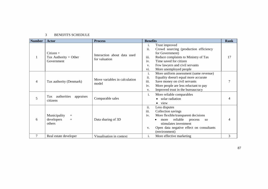
87
3 BENEFITS SCHEDULE
Number Actor Process Benefits Rank
1
Citizen +
Tax Authority + Other
Government
Interaction about data used
for valuation
i. Trust improved
ii. Crowd sourcing (production efficiency
for Government)
iii. Reduce complaints to Ministry of Tax
iv. Time saved for citizen
v. Few lawyers and civil servants
vi. More unemployed people
17
4 Tax authority (Denmark) Move variables in calculation
model
i. More uniform assessment (same revenue)
ii. Equality doesn't equal more accurate
iii. Save money on civil servants
iv. More people are less reluctant to pay
v. Improved trust in the bureaucracy
7
5 Tax authorities appraises
citizens Comparable sales
i. More reliable comparables
solar radiation
view
4
6
Municipality +
developers +
others
Data sharing of 3D
ii. Less disputes
iii. Collection savings
iv. More flexible/transparent decisions
more reliable process so
stimulates investment
v. Open data negative effect on consultants
(environment)
4
7 Real estate developer Visualisation in context i. More effective marketing 3
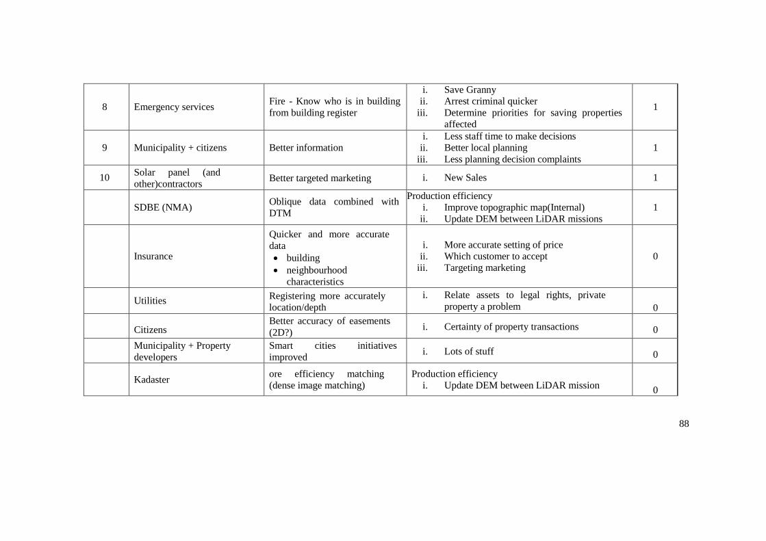
88
8 Emergency services Fire - Know who is in building
from building register
i. Save Granny
ii. Arrest criminal quicker
iii. Determine priorities for saving properties
affected
1
9 Municipality + citizens Better information
i. Less staff time to make decisions
ii. Better local planning
iii. Less planning decision complaints
1
10 Solar panel (and
other)contractors Better targeted marketing i. New Sales 1
SDBE (NMA) Oblique data combined with
DTM
Production efficiency
i. Improve topographic map(Internal)
ii. Update DEM between LiDAR missions
1
Insurance
Quicker and more accurate
data
building
neighbourhood
characteristics
i. More accurate setting of price
ii. Which customer to accept
iii. Targeting marketing
0
Utilities Registering more accurately
location/depth
i. Relate assets to legal rights, private
property a problem
0
Citizens
Better accuracy of easements
(2D?) i. Certainty of property transactions
0
Municipality + Property
developers
Smart cities initiatives
improved i. Lots of stuff
0
Kadaster ore efficiency matching
(dense image matching)
Production efficiency
i. Update DEM between LiDAR mission
0
89
Real estate appraisers
More efficient accounting
for variables
view
shade
radiation (sun) (solar panel
potential)
Leading to desktop valuation
i. Saving time for appraiser
ii. Higher quality interpretation
iii. Visualise for client
iv. Developments
0

90
4 GLOSSARY
Remote Sensing Companies/Consultants
Private sector companies that collect raw geospatial remotely sensed data such as true and oblique aerial ortho imagery as a service. For example:
Eurosense URBIS Terratec Blom Arbonaut Cowi Metria Foran Finnmap
App Developers
Companies that develop real estate applications for citizens searching for property to buy or rent. These applications include value added services that provide the citizen with a range of contextual data sets about the area that the property is located in or the health of the property market in that area. For example:
Boligsiden.dk Bolighed.dk Sunday.dk Dingeo.dk Boligeyes.dk
Banks
Companies that lend money to finance property developments.
Building Surveyor
Surveyor involved in all aspects of property and construction. Building surveying is one of the widest areas of surveying practice.
Cadastral Agency
Agency, usually publically owned, responsible for maintaining a Cadastre, a national register of property showing the extent, value, and ownership of land, usually for taxation purposes. The Danish cadastre is maintained by the The Danish Geodata Agency which is an agency within the Ministry of the Environment. The Dutch cadastre is maintained by Kadastre, a non-departmental public body, operating under the political responsibility of the Minister of Infrastructure and the Environment.
Cadastral Surveyors
Surveyor involved in collecting cadastral data i.e. property extent, value and ownership.
Construction Industry
The industry that builds the structures of the built environment. In this context it includes architects and developers who use 3D data to design and visualise new buildings.

91
Credit Unions
A credit union is a member-owned financial cooperative operated for the purpose of providing its members with credit and other financial services.
Earthquake Archive
Provides data on past earthquake events. For example:
The United States Geological Survey
Electricity Transmission/Distribution Companies
Companies that own and maintain the electrical transmission network that transports electricity from power stations to users.
Fire Department
Emergency responder with specialist skills and equipment for responding to fire emergencies and road traffic accidents.
Gas Distribution Companies
Transport gas across via pipes to millions of gas customers.
Geological Office
Publicly funded body which aims to advance geoscientific knowledge by means of systematic surveying, monitoring and research. Core outputs include geological, geophysical, geochemical and hydrogeological maps.
Geotechnical Engineer
Geotechnical engineering is the branch of civil engineering concerned with the behaviour of earth. Geotechnical engineers investigate subsurface rock and soil conditions to assess risks and design earthworks and foundations.
Insurance Companies
Companies that insure lives and property against loss due to, for example, flooding and storm damage.
Land Registration Authority
Here the land registration authority is the agency that registers legal titles, separate from the agency that registers cadastral parcels (see cadastral agency). The situation differs by country. Often these two agencies are combined together or are part of the National Mapping Agency.
Mortgage Institute
Membership bodies representing mortgage lenders that promote good practice, collect and publish data on mortgage lending, comment on market issues, and lobby government. For example:
The Council of Mortgage Lenders (UK)
Municipalities
Generic term referring to local level government as opposed to national level government. For example there are 415 Municipalities (gemeente, pl. gemeenten) in The Netherlands.

92
They form the lowest tier of government in the after the central government and the provinces.
National Mapping and Cadastral Agency
Public sector body that procures, aggregates and develops topographic maps and geographic information of a country. In many countries the mapping and Cadastral Agency (see above) are the same body, for example Kadaster in The Netherlands.
Notaries
Persons authorized to perform certain legal formalities, especially to draw up or certify contracts, deeds, and other documents.
Property Appraiser/Valuer
Appraiser and Valuer are different terms for the same role. A property professional who estimates the value of a property. This can be for a variety of reasons, often it is to inform a sale on the open market, but it may also be for insurance, or other accounting purposes. Professional Valuers are usually certified after obtaining the necessary professional qualification (for example by the Royal Institute of Chartered Surveyors in the UK). There are several methods that Valuers use, the most common is the comparative method which requires the Valuer to identify a sufficient number of similar properties that have been sold recently in the local market where the value attained is verifiable. Because no two properties are identical the method requires the Valuer to use professional judgement to estimate the quantitative and qualitative differences and the effect these will have on the value of the property.
Real Estate Agents/Brokers
Also known as Relators. Property professionals involved in the sale and marketing of property.
Satellite Companies
Private sector companies that provide satellite earth observation data. For example:
ESA Digital Globe Airbus
Specialist Software Companies
Developers of customised applications for a range of functions within the land administration domain including: geo-statistical analysis, retail analysis, real estate market analysis and catastrophe modelling for the insurance market. For example:
Geomatique Locatus Funda
Survey Company
Generic term for private company/contractor collecting raw geospatial data through on the ground data capture.
Tax Authority
Government agency with responsibility for collecting taxes on property, both transaction and general taxation based on the value of property.
93
Telecommunication Companies
Companies transferring data via telecommunication networks.
Union of Municipalities
Body representing the joint interests of multiple municipalities. For example:
The Local Government Association (UK)
Utility Companies
Public utilities provide water, electricity, natural gas, telephone service, and other essentials. Utilities may be publicly or privately owned, but most are operated as private businesses.
Water Companies
Utility company specialising in piped water and sewage.
Waterways Authority
Government body with responsibility for inland waterways. For example:
Waterwegen en Zeekanaal NV (W&Z)

94
RESILIENCE
Table of Contents
1 EXECUTIVE SUMMARY ............................................................................................ 95
1.1 Introduction ............................................................................................................ 95
1.2 Purpose ................................................................................................................... 95
1.3 Deliverables ............................................................................................................ 95
1.4 Analysis .................................................................................................................. 96
1.5 Limitations .............................................................................................................. 97
2 VALUE CHAIN DIAGRAM ......................................................................................... 99
3 BENEFITS SCHEDULE .............................................................................................. 100
4 REFERENCES ............................................................................................................. 103
5 GLOSSARY ................................................................................................................. 104

95
1 EXECUTIVE SUMMARY
1.1 Introduction
The workshop was undertaken in the offices of IGN Belgium in Brussels on 13th July 2016. The event was attended by experts in resilience from the private and public sectors in Belgium.
The overall aim was to graphically document the resilience process across the emergency management cycle: mitigation, preparedness, response, and recovery, using value chain mapping to represent the results. The value chain was then used to identify where the most significant socio- economic benefits would be added by access to 3D geo-information.
1.2 Purpose
The workshop was undertaken to:
Assist those involved in resilience to better understand the data, stakeholders (referred to here as actors) and processes involved in creating value in the resilience process.
Provide a starting point for quantifying the costs and benefits of 3D products and services for resilience.
By involving representatives of the commercial sector, it helps to identify where the commercial sector are likely create products and services and by inference the “gaps” where Government may need to intervene to optimise socio-economic impacts.
EuroSDR is a European research organisation, so the results will inform discussions in the other countries involved in research in this domain.
1.3 Deliverables
The main deliverables from the workshop and subsequent analysis are:
i. Value Chain Diagram - is a pre-requisite to evaluating the socio-economic benefits of 3D
ii. georeferenced data to this use case; iii. Benefits spreadsheet – this output is the result of a “brainstorm” by workshop
attendees of the largest value adding processes in the value chain; iv. Narrative – this document, which aims to draw out the main conclusions of the
work; v. Glossary – covering “actors” and processes to enable the value chain map to be
more easily interpreted, particularly outside the country that hosted the workshop; vi. Background papers and presentations from the workshop.
All these deliverables are available on BaseCamp, labelled as Resilience.

96
1.4 Analysis
1.4.1 Scope
The Belgium system has multiple authorities with responsibility for resilience as well as a national and regional mapping agencies. We have not tried to separate them out rigorously as this level of detail was not covered in the workshop and would over complicate the deliverable. Improved coordination between the authorities by common access to more accurate 3D data is clearly added value and has been identified in the deliverables.
The defence and intelligence aspects of resilience are referred to but are not elaborated for obvious reasons of security and confidentiality.
1.4.2 Most Significant Benefits
Identified by the workshop participants, as:
1. Better building information (layout, number of floors etc.) which reduces emergency service response times by improving access decisions: the right resource in the right place at the right time.
2. Better 3D contextual data e.g. slope, aspect etc. which improves localisation of callers and incidents by Emergency Control Room operators (particularly in rural areas where there are few landmarks and cell phone location accuracy is poor).
3. 3D city models improve the analysis of planned developments and allow factors such as crowd evacuation to be taken into account and the design evaluated to minimise the impact of bomb blasts.
4. Better and more accessible 3D information can be used by defence forces to respond to terrorist incidents more effectively, for example, by identifying and blocking escape routes or identifying sniper positions.
5. Improved data sharing and rationalisation reduces the cost of acquisition and improves interoperability
1.4.3 Supply-side Value Chain
The supply-side of the value chain shows the main actors currently involved or required to produce the resilience information products. The connecting arrows illustrate the main flows of information between the actors.
For resilience, the key product containing 3D data is the 3D building model. These models are developed by Commercial Geo-Data Companies, such as GIM in Belgium, either for the NMCA or for direct commercial resale, and are based on topographic mapping supplied by National Mapping and Cadastral Agencies (NMCAs). Building Models are enriched by including a range of attribute data supplied by NMCAs such as addressing, Points of Interest (POIs) and geographic names. In addition, in the field of resilience, it is essential that detailed mapping is available for all areas, not just city centres, and that this mapping includes as many relevant themes of information as possible. This is why additional topographic features, such as City Terrain Inventory (supplied by Municipalities) street light positions (supplied by electricity transmission companies) are collected by Emergency Control Rooms for use in dispatching geo-portals.
3D building models are a key input into crowd modelling simulations developed by Safety Consultants for Large Building Developers and Owners.
3D data in the form of DTM/DSM developed by NMCAs and 3D building models also input variables for Chemical, Biological, Radiological and Nuclear (CBRN) dispersion models

97
where they are combined with pollutant sensor data to improve the accuracy of plume forecasts.
Other 3D data products are flood models and forecasts developed by Environmental Agencies using hydrographic and meteorological data as input. These are covered in detail within the Flood Management value chain.
Although not 3D data Transport Network data for all modes of transport is very important within the resilience domain. Network data sets are collated by Private Mapping Companies and developed
into Integrated Transport Networks for use in Emergency Control Room dispatching systems. In addition to network data live, or near live, traffic date is also required alongside information regarding road closures and roadworks.
1.4.4 Demand-side Value Chain
Added value components identified in the benefits spread sheet are shown by numbered yellow triangles attached to the relevant actors and processes. For clarity and as on the supply-side, the connectors only show the most significant inter-relationships between processes. Our analysis of the draft map is described below.
In the Preparedness stage 3D data is used to develop CBRN dispersion models. These are used by Industrial Chemical Companies to develop SEVESO Emergency plans. 3D building models can also be used by Municipalities to improve the analysis of planned developments and allow factors such as crowd evacuation to be accounted for and design evaluated to minimise the impact of bomb blasts. Emergency Services can also use 3D building data for planning, for example fire services can use 3D data to determine the length of ladder needed.
In the Response stage the two main consumers of 3D geo-information are Emergency Control rooms who are responsible for dispatching emergency responders, and the Ministry of the Interior who are responsible for Crisis Management during significant emergencies. Dispatching systems require data for localisation of callers and incidents. This can range from the relatively simple: asking a caller to describe the direction of slope they are on and comparing this to a 3D terrain model within a dispatching geo-portal, to the more complex: using a 3D building model to ascertain the exact position of an apartment within an apartment complex and passing that information onto
emergency responders to ensure that the response goes directly to the incident. Crisis Management
systems consume a greater number of datasets than dispatching systems. They are used to coordinate potentially massive responses. They make use of 3D data derived products such as crowd forecasts, plume models, flood models and 3D building models, which they can use, for example, to position defence forces.
In the recovery phase 3D data can be used by the emergency services to assess damages and by insurers to update statistics and set premiums.
1.5 Limitations
We believe there are some gaps in the value chain. A review of the United States Federal Emergency Management Agency (FEMA) Emergency Support Functions
1 indicates that
1 http://www.fema.gov/media-library-data/20130726-1825-25045-
0604/emergency_support_function_annexes_introduction_2008_.pdf

98
there is little regarding Search and Rescue Operations, Public Health, or Energy infrastructure assessment, repair, and restoration.
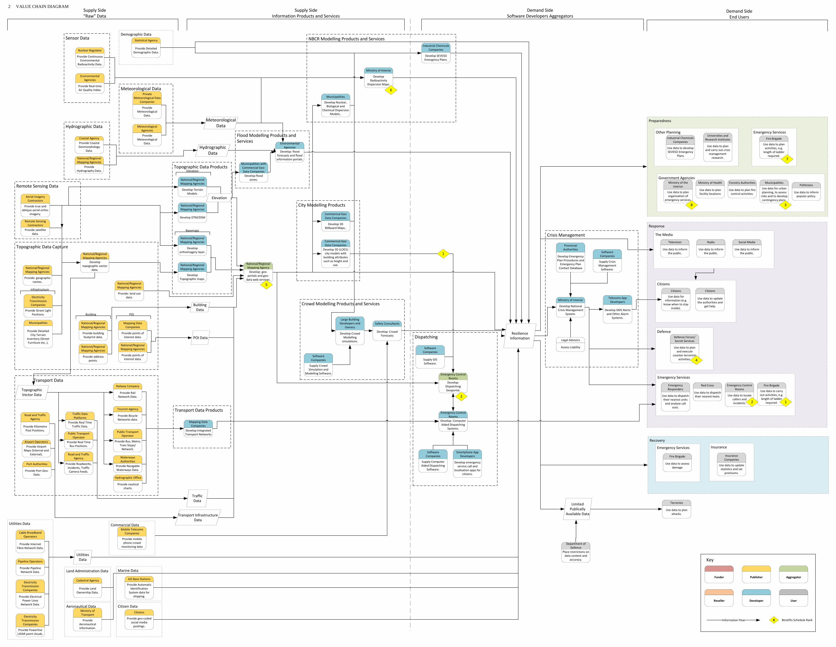
Transport Data
Hydrographic Office
Provide nautical charts.
Port Authorities
Provide Port Geo‐Data.
Traffic Data Platforms
Provide Real Time Traffic Data.
Railway Company
Provide Rail Network Data.
Public Transport Operator
Provide Bus, Metro, Tram Stops/Network.
Public Transport Operator
Provide Real Time Bus Positions.
Tourism Agency
Provide Bicycle Networks data.
Road and Traffic Agency
Provide Kilometre Post Positions.
Road and Traffic Agency
Provide Roadworks, Incidents, Traffic Camera Feeds.
Airport OperatorsProvide Airport
Maps (Internal and External).
Waterways Authorities
Provide Navigable Waterways Data.
Topographic Vector Data
Recovery
Insurance
Crisis Management
Dispatching
Crowd Modelling Products and Services
City Modelling Products
NBCR Modelling Products and Services
Flood Modelling Products and Services
Transport Data Products
Topographic Data Products
Utilities Data
Response
Preparedness
Defence
Other Planning
Emergency Services
Remote Sensing Data
Remote Sensing Contractors
Provide satellite data.
Aerial Imagery Contractors
Provide true and oblique aerial ortho‐
imagery.
Topographic Data Capture
Citizens
Mapping Data Companies
Develop Integrated Transport Networks
Electricity Transmission Companies
Provide Street Light Positions.
Municipalities
Provide Detailed City Terrain
Inventory (Street Furniture etc..).
Cable Broadband Operators
Provide Internet Fibre Network Data.
Pipeline Operators
Provide Pipeline Network Data.
Electricity Transmission Companies
Provide Electrical Power Lines
Network Data.
Electricity Transmission Companies
Provide Powerline LIDAR point clouds.
National/Regional Mapping Agencies
Provide: land use data.
Demographic DataStatistical Agency
Provide Detailed Demographic Data.
Emergency Control Rooms
Develop: Computer Aided Dispatching
Systems.
Environmental Agencies
Develop: flood forecasts and flood information portals.
National/Regional Mapping AgencyDevelop: geo‐portals and geo‐data web services.
Municipalities with Commercial Geo‐Data CompaniesDevelop flood
zones.
Municipalities
Develop Nuclear, Biological and
Chemical Dispersion Models..
Industrial Chemicals Companies
Develop SEVESO Emergency Plans.
Ministry of Interior
Develop National Crisis Management
System.
Ministry of Interior
Develop Radioactivity
Dispersion Maps.
Provincial Authorities
Develop Emergency Plan Procedures and Emergency Plan Contact Database
Safety Consultants
Develop: Crowd Forecasts
Large Building Developers and
Owners
Develop Crowd Modelling simulations.
Commerical Geo Data Companies
Develop 3D Billboard Maps..
Commerical Geo Data Companies
Develop 3D (LOD1) city models with building attributes such as height and
use.
Legal Advisors
Assess Liability
Department of Defence
Place restrictions on data content and
accuracy.
Smartphone App Developers
Develop emergency service call and
localisation apps for citizens.
Telecoms App Developers
Develop SMS Alerts and Other Alarm
Systems.
Fire Brigade
Use data to assess damage
Citizens
Use data for information (e.g. know when to stay
inside).
Citizens
Use data to update the authorities and
get help.
Government AgenciesMinistry of the
Interior
Use data to plan organisation of
emergency services.
Ministry of Health
Use data to plan facility locations
Forestry Authorities
Use data to plan fire control activities.
Defence Forces/Secret Services
Use data to plan and execute
counter terrorism activities.
Terrorists
Use data to plan attacks.
Politicians
Use data to inform popular policy.
Municipalities
Use data for urban planning, to assess risks and to develop contingency plans.
Universities and Research Institutes
Use data to plan and carry out crisis
management research.
Industrial Chemicals Companies
Use data to develop SEVESO Emergency
Plans
Insurance Companies
Use data to update statistics and set
premiums.
Supply Side“Raw” Data
Supply SideInformation Products and Services
Demand SideSoftware Developers Aggregators
Demand SideEnd Users
National/Regional Mapping Agencies
Develop Terrain Models.
National/Regional Mapping Agencies
Develop DTM/DSM
National/Regional Mapping Agencies
Develop topographic vector
data. National/Regional Mapping Agencies
Develop Topographic maps.
National/Regional Mapping Agencies
Develop orthoimagery layer.
Mobile Telecoms Companies
Provide mobile phone crowd
monitoring data
Elevation
Basemaps
Infrastructure
POI Data
Traffic Data
National/Regional Mapping Agencies
Provide: geographic names.
Building Data
Emergency Control RoomsDevelop:
Dispatching Geoportal.
Meteorological Data
Elevation
Meteorological DataPrivate
Meteorological Data Companies
Provide Meteorological
Data.
Meteorological Agencies
Provide Meteorological
Data.
Sensor Data
Nuclear Regulator
Provide Continuous Environmental
Radioactivity Data.
Environmental Agencies
Provide Real‐time Air Quality Index.
Hydrographic Data
Hydrographic Data
Coastal AgencyProvide Coastal Geomorphology
Data.
National/Regional Mapping Agencies
Provide Hydrography Data.
Transport InfrastructureData
Resilience Information
Software Companies
Supply Crowd Simulation and
Modelling Software.
Software Companies
Supply Crisis Management Software.
Software Companies
Supply Computer Aided Dispatching
Software.
Software Companies
Supply GIS Software.
Funder AggregatorPublisher
Reseller Developer User
Information Flow
Key
# Benefits Schedule Rank
1
2
3
4
5
6
Limited Publically
Available Data
Emergency ServicesFire Brigade
Use data to plan activities, e.g. length of ladder
required.7
8
Mapping Data Companies
Provide points of interest data.
National/Regional Mapping Agencies
Provide points of interest data.
POI
National/Regional Mapping Agencies
Provide building footprint data.
National/Regional Mapping Agencies
Provide address points.
Building
Commercial DataMobile Telecoms
Companies
Provide mobile phone crowd
monitoring data
Aeronautical Data Citizen Data
Marine Data
Ministry of Transport
Provide Aeronautical Information.
Citizens
Provide geo‐coded social media postings.
Land Administration Data
AIS Base Stations
Provide Automatic Identification System data for
shipping.
Cadastral Agency
Provide Land Ownership Data.
Utilities Data
The Media
Television
Use data to inform the public.
Radio
Use data to inform the public.
Social Media
Use data to inform the public.
Emergency Services
Emergency Responders
Use data to dispatch their nearest units and analyse call
outs.
Red Cross
Use data to dispatch their nearest team.
Fire Brigade
Use data to carry out activities, e.g. length of ladder
required.
Emergency Control Rooms
Use data to locate callers and incidents. 12
2 VALUE CHAIN DIAGRAM
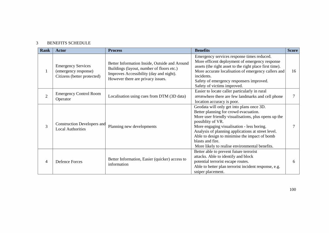
100
3 BENEFITS SCHEDULE
Rank Actor Process Benefits Score
1
Emergency Services
(emergency response)
Citizens (better protected)
Better Information Inside, Outside and Around
Buildings (layout, number of floors etc.)
Improves Accessibility (day and night).
However there are privacy issues.
Emergency services response times reduced. More efficent deployment of emergency response assets (the right asset to the right place first time). More accurate localisation of emergency callers and incidents. Safety of emergency responsers improved. Safety of victims improved.
16
2 Emergency Control Room
Operator Localisation using cues from DTM (3D data)
Easier to locate caller particularly in rural
areaswhere there are few landmarks and cell phone
location accuracy is poor.
7
3 Construction Developers and
Local Authorities Planning new developments
Geodata will only get into plans once 3D. Better planning for crowd evacuation. More user friendly visualisations, plus opens up the possiblity of VR. More engaging visualisation - less boring. Analysis of planning applications at street level. Able to design to minimise the impact of bomb blasts and fire. More likely to realise environmental benefits.
7
4 Defence Forces Better Information, Easier (quicker) access to
information
Better able to prevent future terrorist
attacks. Able to identify and block
potential terrorist escape routes.
Able to better plan terrorist incident response, e.g.
sniper placement.
6

101
5 All Data Suppliers Data Sharing and Rationalisation
Reduced cost of acquisition. Emergency services
speak the same language meaning reduced errors
and quicker response times of all required services.
5
6 Nuclear Regulator Plume modelling Urban areas more accurately modelled with 3D
data. 4
7
Fire Service
(preperation/planning)
Better Information Inside, outside and around
Buildings (layout, number of floors etc.)
Shorter site visits. Better prioritisation of inspections. Better quality assessment. Better inventory.
4
8 Emergency Services Develop 3D Crisis Scenarios Better training as more realistic.
Less expensive as desk exercise. Public disturbance reduced.
2
9 Data Acquisition Companies Selling products and services
Dis-benefit: reduced sales if emergency services 'buy-once'. However increased use of the data opens up other markets within public sector plus increases demand for updated versions. In addition increased usage increases data quality due to feedback.
10 Insurance Companies 3D Fire Plans More Accurate Calculation of Risks
11 Telecom Companies Data Sharing in times of crisis. Better contingency planning to keep emergency
services connected
12 Public Transport Network
Update information about access (road closures
etc.) and public transport availability during
crisis and recovery. 3D allows this to be
assessed more accurately.
Better contingency planning.

102
13 Citizens Knowledge that the emergency services have
3D data and are therefore better equipped to
respond. Feel safer
14 Media + Emergency Services Better 3D Visualisation Improved communication with the public. Better
publicity for the emergency services.
15 Government Visualisation of Emergency Response Easier to explain response during public enquiries.

103
4 REFERENCES
‘Living without electricity One city’s experience of coping with loss of power’. May 2016 Royal Academy of Engineering. Available at:
http://www.raeng.org.uk/publications/reports/living-without- electricity
OS International. ‘Running a safe and secure major national event with geospatial information’. Available at: https://www.ordnancesurvey.co.uk/international/case-studies/safely-running-major- events.html
Presentation: ‘Gebruik van geografische data in GIS & dispatching applicaties voor hulpdiensten’. Frédérique Lagae, Astrid NV. Avilable on project BaseCamp.
104
5 GLOSSARY
Airport Operators
Companies responsible for operating airports. Providers of key data sets including maps of the internal layout of the airport. For example:
BIAC Brussels airport company
AIS Base Stations
The Automatic Identification System (AIS) is an automatic tracking system used on ships for identifying and locating vessels by electronically exchanging data with other nearby ships, AIS base stations, and satellites AIS allows maritime authorities to track and monitor vessel movements.
App Developers
Companies that develop smartphone applications and SMS applications for public safety
Cable Broadband Operators
Companies responsible for the supply and maintenance of the telecoms infrastructure that underpins the internet. Providers of key data sets including maps of the fibre network. For example:
Telenet
Cadastral Agencies
Agency, usually publically owned, responsible for maintaining a Cadastre, a national register of property showing the extent, value, and ownership of land, usually for taxation purposes.
Coastal Agency
Government agency responsible for coastal activities. Responsible for beaches, dunes, dikes, marinas and fishing ports. For example:
Afdeling Kust (Department of Coast)
Commercial Geo Data Companies
Companies that interpret, combine and aggregate data to produce data products containing actionable intelligence. For example:
Eurosense Bel Map
Data Collection Contractors
Companies that collect raw geospatial data such as true and oblique aerial ortho imagery. For example:
Eurosense URBIS
Defence Department/Defence Forces/Secret Services
Government agencies responsible for national security.
Electricity Transmission Companies

105
Companies that own and maintain the electrical transmission network that transports electricity from power stations to users. For example:
Silage Infrax Eandis
Emergency Control Rooms
Emergency control rooms deal with emergency calls to the emergency services including ambulance, fire and police. They are the first point of contact for the public and are responsible for localising the caller and dispatching the appropriate emergency responders as soon as possible. To do this the control room continuously monitors the position of emergency responders. Belgium has 11 regional control rooms equipped with computer aided dispatching systems and adjunct geoportals. The government-owned corporation responsible for emergency control rooms in Belgium is:
ASTRID
Emergency Responders
The agencies that are responsible for the initial response in a crisis. For example:
Police Fire Ambulance
Environmental Agencies
Government agency responsible for funding policy and regulation relating to the environment. For example:
Belgian Interregional Environment Agency (IRCEL - CELINE)
Fire Brigade
Emergency responder with specialist skills and equipment for responding to fire emergencies and road traffic accidents.
Flooding Information Portal
A website that makes flood information, held by multiple different sources, accessible from a single online location. For example:
https://www.waterinfo.be/
Forestry Authorities
Central government departments that provide funding, policy and regulations for the operations of the forestry sector.
Hydrographic Office
Public sector bodies that procure, aggregate and develop specialist hydrographic related data products and make these available to the public. For example:
MUMM/BMM/UGMM (Management Unit of the North Sea Mathematical Models)
Industrial Chemicals Companies

106
In the context of this report Industrial Chemical Companies refers to operators of facilities that require SEVESO Emergency Plans under the Seveso directive. The Directive covers establishments where dangerous substances may be present (e.g. during processing or storage) in quantities above a certain threshold.
Insurance Companies
Companies that insure lives and property against loss due to, for example, fire and storm damage.
Large Building Developers and Owners
Developers and owners of large buildings are responsible for developing and managing the public spaces within buildings. Here they are responsible for ensuring that emergency escape procedures and routes are in place.
Legal Advisors
Legal specialist responsible for giving opinions on duty of care and liability in various emergency response scenarios.
Mapping Data Companies
Companies that supply commercial map data, or map data products/platforms primarily to the navigation (in-car and personal) market. For example:
TomTom Google Be-Mobile Verkeerscentr Tafiroutes Wallonie Open Street Map
Meteorological Agencies
Government agency responsible for collecting meteorological data and making meteorological predictions across all timescales from weather forecasts to climate change.
Royal Meteorological Institute of Belgium (RMI)
Ministry of Health
Government ministry with responsibility for health.
Ministry of the Interior
Government ministry responsible for policing, emergency management, national security, supervision of local governments, conduct of elections, public administration and immigration matters.
Ministry of Transport
Government ministry with responsibility for transport.
Mobile Telecoms Companies
Companies transferring data via mobile radio telecommunication networks. In the context of resilience Mobile Telecoms Companies are able to provide anonymous and aggregated mobile data supporting business decisions based on actual behaviour. Examples include:
Proximus
107
BASE Orange Belgium
Municipalities
Belgium comprises 589 grouped into five provinces in each of two regions and into a third region, the Brussels-Capital Region, comprising 19 municipalities that do not belong to a province. In most cases, the municipalities are the smallest administrative subdivisions of Belgium.
National/Regional Mapping Agencies
Public sector bodies that procure, aggregate and develop topographic maps and geographic information of a country. In Belgium there is one National Mapping Agency that aggregates topographic and geographic data for the whole of Belgium and three Regional Mapping Agencies that supply topographic and geographic data for their region to the national mapping agency. These are:
Regional:
AGIV (Agentschap voor Geografische Informatie Vlaanderen) - Flemish Region CIRB-CIBG-BRIC (Centre d'Informatique pour la Région Bruxelloise) - Brussels
Region Public Service of Wallonia SPW - Walloon Region
National:
NGI (Nationaal Geografisch Instituute)
Nuclear Regulator
Safety regulator for the nuclear industry. For example:
TELERAD: Federal Agency for Nuclear Control
Pipeline Operators
Commercial companies that transport chemicals, oil and gas via pipelines. For example:
FETRAPI
Politicians
A person who is professionally involved in politics, especially as a holder of or a candidate for an elected office.
Port Authorities
The official organisation that controls and manages the activities in a port.
Private Meteorological Data Companies
Companies involved in the collection, interpretation and dissemination of meteorological data and meteorological predictions.
Public Transport Operator
Here referring to operators of all forms of public transport including bus, trams, metro. For trains see
Railway Company. For example:
Brussels Intercommunal Transport Company (STIB/MIVB)
108
TEC - Transport En Commune
Railway Company
Operator of rail infrastructure. For example:
Infrabel
Red Cross
International organisation that treats the sick and wounded in the aftermath of wars and disasters.
Remote Sensing Contractors
Private sector companies that collect remotely sensed data as a service. For example:
Eurosense ESA Digital Globe Airbus
Universities and Research Institutes
Institutions that refine and develop methods and techniques for using data to improve reliance planning and practice. For example:
University Leuven
Road and Traffic Agency
Organisation responsible for operation of road network. For example:
Agentschap Wegen en Verkeer (Agency of Roads and Traffic) Tafiroutes Wallonie
Safety Consultants
Companies and individuals that specialise in providing advice and other knowledge based services in the field of public safety. For example:
Poppy
Smartphone Application Developers
Develop smartphone applications for emergency service call and localisation.
Software Application Developers
Developers of customised applications for public safety data integration and analysis. For example:
Orbit SIGGIS Poppy Geosolutions Cronos
Software Companies
Developers of off-the-shelf software for a range of domains including in the resilience domain: crowd modelling, event management, crisis management, fire modelling, GIS and computer aided dispatching. For example:

109
Pedestrian Dynamics
SIG GIS Nokeos ESRI Belux 1 Spatial Hexagon (Integraph) Integraph
Telecoms Application Developers
Develop systems to provide SMS alerts to citizens. For example:
Be Alert Risicokanta.ne
Statistical Agency
Public sector body with responsibility for official statistics, for example demographic data and census.
System Integrators
Large commercial companies that provide project management services for significant public sector
IT contracts. For example:
Proximus Thales IBM Cap Gemini
Terrorists
Organised criminal groups intent on high profile acts of wanton death and destruction for political gain. Modern terrorists are organised to a level at which they are capable of using publically available data for planning attacks making them an unwanted potential data customer.
The Media
Print, digital and broadcast media all use geographic data to tell stories and visualise scenarios.
Tourism Agency
Government body with responsibility for tourism. For example:
Toerisme Vlaanderen (Tourism Flanders)
Waterways Authorities
Government body with responsibility for inland waterways. For example:
Waterwegen en Zeekana
110
Urban Planning
Table of Contents
1 EXECUTIVE SUMMARY .......................................................................................... 111
1.1 Introduction .......................................................................................................... 111
1.2 Purpose ................................................................................................................. 111
1.3 Deliverables .......................................................................................................... 111
1.4 Analysis ................................................................................................................ 112
2 VALUE CHAIN DIAGRAM ....................................................................................... 115
3 BENEFITS SCHEDULE .............................................................................................. 116
4 REFERENCES ............................................................................................................. 120
5 GLOSSARY ................................................................................................................. 121

111
1 EXECUTIVE SUMMARY
1.1 Introduction
The workshop was undertaken in the offices of Ordnance Survey Ireland in Dublin on 13th July. It was attended by experts in urban planning from local government, central government, commercial sector and academic organisations.
The overall aim was to graphically document the planning approvals process, using value chain mapping to represent the results. The value chain was then used to identify where the most significant socio-economic benefits would be added by access to 3D geo-information.
1.2 Purpose
The workshop was undertaken to:
Assist those involved in urban planning to better understand the data, stakeholders (referred to here as actors) and processes involved in creating value in the urban planning process.
Provide a starting point for quantifying the costs and benefits of 3D products and services for urban planning.
By involving representatives of the commercial sector, it helps to identify where the commercial sector are likely create products and services and by inference the “gaps” where Government may need to intervene to optimise socio-economic impacts.
EuroSDR is a European research organisation, so the results will inform discussions in the other countries involved in research in this domain.
1.3 Deliverables
The main deliverables are:
i. Value Chain - understanding this chain is a pre-requisite to evaluating the socio- economic benefits of 3D georeferenced data to this use case;
ii. Glossary – covering “actors” and processes to enable the value chain to be more easily interpreted;
iii. Benefits spreadsheet – this output is the result of a “brainstorm” by workshop attendees
iv. to identify the most significant value adding processes in the value chain; v. Overview Narrative – this document, which aims to draw out the main conclusions
from the exercise; vi. Presentations from the workshop and other background material.
All these deliverables are available on BaseCamp, labelled as Urban Planning.
112
1.4 Analysis
1.4.1 Scope
The value chain analysis was focused on the use case of submitting and approval of planning applications for new urban developments. The participants were only from the Irish Republic, although most components of the process can be recognised in many other developed countries. A glossary of terms that may not translate directly is included, to assist participants in the study from other countries in using the outputs.
1.4.2 Most Significant Benefits
The benefits spreadsheet details the workshop participants’ view of the most significant benefits of 3D to the urban planning use case. In total 25 separate benefits were identified for many different stakeholders. Those valued most highly, in order of ranking were:
1. Complete city 3D coverage of Dublin – as the country’s biggest and most historic city, the availability of such data would allow more flexibility in the application of current planning regulations. For instance in relaxing current “blanket” restrictions on building heights and aspect in the Georgian core higher rise development could be approved in certain areas without damaging the visual ascetics of the city and generating more efficient use of available space, easing the current housing crisis and generating additional property tax.
2. Citizen engagement – the ability afforded by accurate 3D models for citizens to visualise the impact of new developments using smartphones will lead to wider participation in consultations and less disputes by presenting a more coherent and easily understood evidence base.
3. Data interoperability - a standard information base of 3D information would reduce duplication in data acquisition, remove the need for Extraction, Translation and Loading (ETL) between the software systems used by the many actors in the consultation process.
4. The cost of analysis by local authorities considering new developments would be reduced by being able to answer complex questions relating to issues of environmental, traffic and visual impact semi-automatically using 3D-enabled software packages.
5. Faster decisions – for developers an quicker turnaround on planning consents will lead to better design (by virtue of considering more options), reduced borrowing costs and easier marketing (more virtual viewings) leading to quicker sales.
6. Integrating utilities infrastructure – utilities can more easily and rapidly plan and modify provision to new developments through accurate and integrated 3D building and underground data (soils and geological data
1).
The sound track to the presentation by Ronan Lyons from Trinity College provides a very powerfully articulated description of the benefits of 3D geo-information to the housing sector. This is available on Basecamp under urban planning
2.
1 The presentation by Geological Survey of Ireland (GSI) delivered at the workshop is available on
Basecamp. 2 Soundtrack of Presentation by Ronan Lyons recorded during workshop, available at:
https://basecamp.com/1920286/projects/12214091/uploads/33116428?enlarge=240947753#attachmen
t_240947753 Warning file auto-plays

113
1.4.3 Supply-side Value Chain
The supply-side of the value chain shows the main actors currently involved or required to produce the data necessary to support the planning process. The connecting arrows illustrate the main flows of information between the actors. The benefits spreadsheet is linked to the value chain by yellow diamonds indicating where in the chain significant added value (benefits) occur.
The actors are grouped according to the type of data produced. It is striking the range of data types required for the assessment of a planning application and the range of bodies that must be consulted3
3.
Analysis of the supply-side value can also expose inefficiencies resulting from multiple sources creating the same or similar data. In this case the value chain shows a lack of coherence in the creation and management of 3D data. Much is produced for individual schemes but tends to be individual “wire frame” drawings produced by architects using CAD packages. A “joined up” dataset of developments and their environs in 3D are currently not required in Ireland for planning consents and consequently have only been produced for a limited number of projects, notably Galway City and Port of Cork
4.
The value chain enables the main components of the cost of creating 3D products or services to be evaluated by looking individually at the actors and connections. The value chain suggests there are many opportunities for cost sharing. For instance, in greater coordination of 3D capture between local authorities, Ordnance Survey Ireland and commercial services companies.
1.4.4 Demand-side Value Chain
Examination of the yellow diamond shapes on the demand-side of the value chain, shows that there are many value adding activities for a large number of actors.
A number of opportunities for specialist service providers (developers, resellers and aggregators) were identified. Some are established businesses and others are innovative new entrants, however, the market is small and it is unlikely that many will be able to grow significantly without supplementing local work with overseas contracts.
Some of the innovative 3D specialists are also undertaking work in other fields, such as medical imaging and the marine sector. This is an example of what economists refer to as productivity spillovers; by which innovation in one sector, in this case 3D geospatial, generates productivity in other segments of the economy by applying the same technological advances. Often such advances are enhanced by its use in other applications, and these then produce further value add in the original sector.
A more localised spillover effect is seen from the value chain in the relationship of hydrological modelling for flood prediction and urban planning. More accurate flood models created from 3D geo-information are important inputs to the planning process, helping to reduce the likelihood of
3 Not all are included in the value chain. Although we believe most are represented. A full list is given
in The planning and development guidelines (at page 52) -
http://www.housing.gov.ie/sites/default/files/migrated-
files/en/Legislation/DevelopmentandHousing/Planning/planning_and_development_regulations_2001
_-_2015_unofficial_consolidation_annotated_17_12_2015.pdf 4 See the narrated presentation by Gavin Duffy of RealSim on BaseCamp for further details.

114
building in areas of susceptibility, but are also clearly value add components to other use cases such
increased resilience to natural disasters. Consequently, spillovers between use cases are an important part of building the economic justification for each use case.
Examining the end-user segment of the value chain shows the beneficiaries of an improved planning consent process are many and the benefits they derive are varied. A good exposition of these many benefits can be found in the Singapore Smart Nation initiative
5.
Some of the benefits are long-term and strategic, so difficult to quantify.
However, the most significant beneficiaries are clearly property developers, the various professional advisors (planning, environmental, engineering and geospatial) and local authorities themselves.
The most effective policy change may therefore be for local authorities to impose the requirement on applicants to create integrated 3D models to support consent applications for major developments.
5 http://www.smartnation.sg/
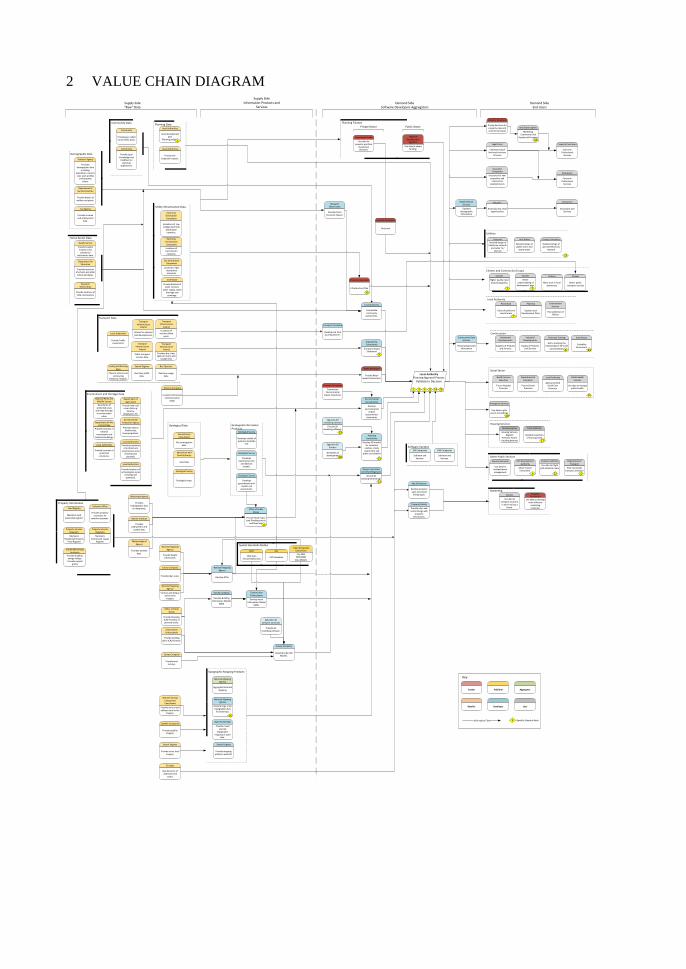
Citizens and Community Groups
Housing Services
Utilities
Spatial Standards Bodies
Social Sector
Software Vendors
Utility Infrastructure Data
Property Information
Other Public Services
Construction
Marketing
Planning Finance
Environmental Consultancies
Develop environmental
impact assessments/
statements
Planning Data
Topographic Mapping Products
Transport Data
Geological Information Products
Geological Data
Open Street Map
Provide crowd sourced
topographic mapping as open
data.
Search Engines
Real time traffic data.
Bus Operator
Real time usage data.
Transport to Ireland
Develop real time journey planner.
GIS Companies
Software and Services.
Investment Funds
Use data for property portfolio
investment decisions.
Citizens
More trust in local democracy
Citizens
Better understanding of
development plan
Property Developer
Pricing decisions for property sales and commercial leases
Department of Transport
Plan new public transport provision
Security Serrvices
Use data for incident/event management.
Aviation Authority
Use data for flight path obstacle maps.
Public Health Services
Use data to manage public health.
Housing Agency
Housing Vacancy Register
Forecase Future Houding demand
Emergency Services
Use data to plan access to buildings.
Industrial Developments
Supply of Products and Services
Regional Development
Agencies
Use data to obtain funding.
Supply Side“Raw” Data
Supply SideInformation Products and
ServicesDemand Side
Software Developers AggregatorsDemand Side
End Users
Funder AggregatorPublisher
Reseller Developer User
Information Flow
Key
# Benefits Schedule Rank
Survey Company
Develop Urban 3D Models.
Open Geospatial Consortium
City GMLWFS/WMS
Data Models
Construction Professionals
Provide building plans (CAD format).
Planning Consultancy
Develop 3D models for viewshed
analysis, shade assessment and
public consultation
Specialist 3D Software Comanies
Provide 3D modelling software.
Survey Company
Develop Building Information Models
(BIM)
Office of Public Works
Provide drawings (CAD formats) of planned works.
Specialist 3D modelling software
Provide 3D modelling software.
Engineering Consultancy
Transport Impact Statement
Telcoms Company
Location-referenced Communication
usage.
Retail Developer
Provide Retail Impact Assessment.
Local Authority
Sustainable community
assessments.
Environment and Heritage Data
Department of Agriculture
Provide land use/cover data e.g:
forestry, tillage,grass etc.
Department of Arts and Heritage
Provide locations of national
monuments and historical buildings.
National Parks and Wildlife Service
Boundaries of protected areas
with high heritage or conservation
value.
Environmental Protection Agency
Provides data on biodiversity,
licenced polluter.
Local Authorities
Provide locations of protected structures.
Local Authorities
Provide boundaries of architectural
conservation areas (existing and
planned).
Local Authorities
Provide locations of archeological zones
(existing and potential).
Geological Survey
Develops models of potential landslide
risk.
Geological Survey
Develops quaternary (soils
and bedrock models.
Geological Survey
Develops groundwater and
aquifer risk assessments.
Geotechnical Consultants
Site investigation data.
Agriculture and Food Authority
Soils Data
Geological Survey
Geological maps.
Irish Water
Provide detailed of water services,
water supply, storm drainage and
sewerage.
Property Developer
Commission Environmental
Impact Statement.
Demographic Data
Department of Social Protection
Provide details of welfare recipiants.
Statistics Agency
Provides demographic data
including population, vacancy rate, work profiles
and property values.
Tax Agency
Provides income and employment
data.
Transport Infrastructure
Ireland
Public transport services data.
Transport Infrastructure
Ireland
Locations of accident black
spots.
Transport Infrastructure
Ireland
Routes for planned road developments.
Transport Infrastructure
Ireland
Provides bus, train, light rail routes and
usuage data.
Local Authorities
Provide Traffic movements.
Social Sector Data
Health Service
Provide hospital locations and ambulance
catchments data.
Department for Education
Provides locations of schools and other
school attributes.
Research Observatory
Provide locations of child care facilties.
Cycling and Running Apps
Physical activity and commuting
behaviour insights.
Research Observatory
Develop Socio Economic Report.
Remote Sensing Companies/Consultants
Provide vertical and oblique aerial ortho
imagery.
Survey Company
Provide Lidar scans.
Satellite Companies
Provide satellite imagery.
Waterways Agency
Provides hydrographic data
on waterways.
Marine Institute
Provides bathymetric and
coastal data.
Meteorological Agency
Provides weather data.
Office of Public Works
Provide flood maps: past flooding events
and flood risk.
National Mapping Agency
Develop large scale topographic data
for basemaps.
National Mapping Agency
Develop DTM.
National Mapping Agency
Aggregate historical mapping.
National Mapping Agency
Provide Height information.
National Mapping Agency
Vertical and oblique aerial ortho
imagery.
Search Engines
Provide mapping platform with API.
Search Engines
Provide street level imagery.
Construction Professionals
Develop Asset Information Model
(AIM).
Eircodes
Geo-directory of addresses and
codes.
Local Authorities
Local development plan
Planning policies.
Survey Company
Provide land surveys.
Electricity Transmission Companies
Locations of transmission
networks.
Electricity Distribution Companies
Llocations of low voltage electricity
distribution networks.
Gas Distribution Companies
Locations of gas distribution networks.
Local Authorities
Provide site inspection reports.
Property Portals
Provide sales and rental listings with
property descriptions.
App Developers
Develop property sales and rental
listings apps. Citizens
Use data to compare locations in which to buy a
house.
Property Developers
Use data to develop more effective
marketing materials.
Sustainable Energy Authority
Provide building energy ratings.Provides capital
grants
Valuation Office
Provides property valuations for
taxation purposes.
Land Registry
Maintains land ownership register.
Property Services Regulator
Maintains Residential Property
Price Register
Property Services Regulator
Maintains Commercial Leases
Register
Community Data
Community
Provide Local Knowledge and
Feedback on planning
applications.
Community
Provide geo-coded social media posts.
Property developer
Infrastructure Plan
Local AuthorityPlanning Approval Process
Validate to Decision
Property developer
Buy Land
CAD Companies
Software and Services.
Construction Data Services
Planning Approvals Information
ResidentialDevelopments
Supplies of Products and Services
Irish Development Authority
Attact Inward Investment
Health Service Executive
Future Hospital Provision
Department of Education
Future School Provision
Local Authority
Adult and Child Social Care Provision
Local Authority
Environment Services
Plan collection of Refuse
Planning
Update Local Development Plans
Real Estate Agents
Marketing Commercial and
Residential Property
Legal Firms
Conveyancing of land and structure
of leases
Telecoms
Detailed design of telephone network
and cable TV / Internet
Energy Companies
Detailed design of gas and electricity
network
Irish Water
Detailed design of piped, storm and
waste water
Insurance Companies
Insurance for new properties and
commercial establishments
Retailers
Assessing new retail opportunities
Retail Analysis Services
Updated demographic information
ISO
CAD standards
W3C
Web data Virtual Reality data
3
6
Recreation
Value of parks and coastal areas
Technical Training
Aid to teaching the relationship of 2D to 3D
representation
Design Consultant (Architect/Engineer)
2D and 3D Development Design
Local Authority
Desktop inspection of housing stock
Specialist 3D Printers
3D Models of development
Solar Power
Suitability Assessment
Citizens
Higher quality input to planning policy
Property Purchasers
Consume Professional
Services
Businesses
Consume Professional
Services
Consumers
Buy Goods and Services
Citizens
Better public transport services
Public SectorPrivate Sector
1 2
4
5
7
8
9
10
11
12
13
14
15
16
17
18
19
20
21
22
23
241
1
4
25
2 VALUE CHAIN DIAGRAM
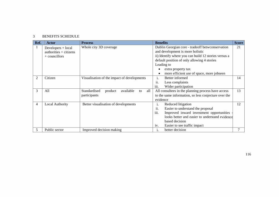
116
3 BENEFITS SCHEDULE
Ref. Actor Process Benefits Score
1 Developers + local
authorities + citizens
+ councillors
Whole city 3D coverage i) Dublin Georgian core - tradeoff betwconservation
and development is more holistic
ii) ii) Identify where you can build 12 stories versus a
default position of only allowing 4 stories
Leading to
extra property tax
more efficient use of space, more jobseen
21
2 Citizen Visualisation of the impact of developments i. Better informed
ii. Less complaints
iii. Wider participation
14
3 All Standardised product available to all
participants
All consultees in the planning process have access
to the same information, so less conjecture over the
evidence
13
4 Local Authority Better visualisation of developments i. Reduced litigation
ii. Easier to understand the proposal
iii. Improved inward investment opportunities -
looks better and easier to understand evidence
based decision
iv. Easier to see traffic impact
12
5 Public sector Improved decision making i. better decision 7
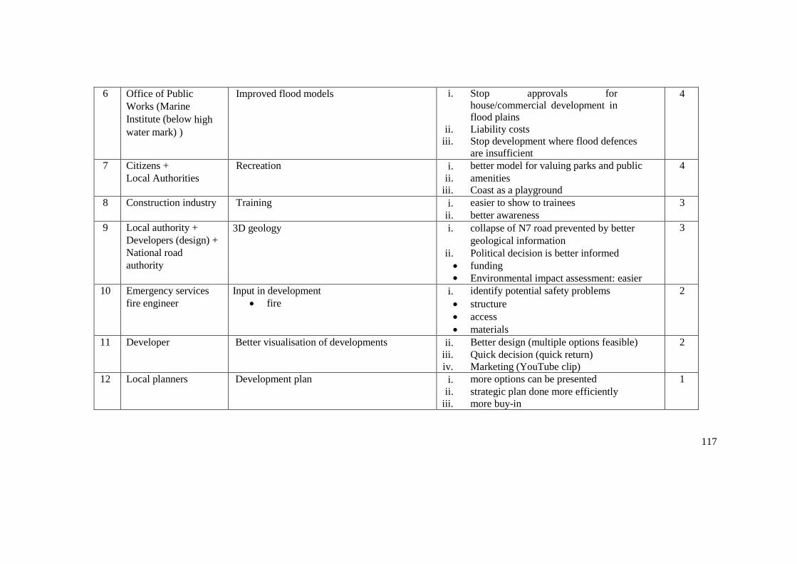
117
6 Office of Public
Works (Marine
Institute (below high
water mark) )
Improved flood models i. Stop approvals for
house/commercial development in flood plains
ii. Liability costs
iii. Stop development where flood defences
are insufficient
4
7 Citizens +
Local Authorities
Recreation i. better model for valuing parks and public
ii. amenities
iii. Coast as a playground
4
8 Construction industry Training i. easier to show to trainees
ii. better awareness
3
9 Local authority +
Developers (design) +
National road
authority
3D geology i. collapse of N7 road prevented by better
geological information
ii. Political decision is better informed
funding
Environmental impact assessment: easier
3
10 Emergency services
fire engineer
Input in development
fire
i. identify potential safety problems
structure
access
materials
2
11 Developer Better visualisation of developments ii. Better design (multiple options feasible)
iii. Quick decision (quick return)
iv. Marketing (YouTube clip)
2
12 Local planners Development plan i. more options can be presented
ii. strategic plan done more efficiently
iii. more buy-in
1

118
13 Utility asset
management
where to place windfarms
maintenance of existing assets
i. greater quality of information, then better
ii. planned development
iii. vegetation management better
1
14 Local authority Density of Development i. appropriate density of development
minimise cost of new infrastructure
assess carbon footprint
assess retail viability
1
15 Local authority
(Dublin)
Rule that no house facing north/east i. dis-benefit is, can only make apartments
South or West facing, taking into account
shading more objectively through viewshed
analysis, allows better interpretation of this
"rule".
ii. don't make best use of space
1
16 Local Authorities +
Ordnance Survey Ireland
Planning applications + construction i. OSI change intelligence improved
ii. Better data back
1
17 Local Authority (own
housing stock)
Property management
Visualisation + 3D data i. Desktop (virtual) inspections
ii. Better renovation
1
18 New commercial
ventures
3D printing i. flood plain models easter to interpret
done in colour
ii. contextual powerful
iii. archiving
iv. visually impaired people
v. museums/heritage
0
19 Software companies Procedural modelling i. sell clever software
more scenarios
0

119
20 Local authorities
Solar panel vendors
Solar panels
- all new builds
i. environmental costs reduces
ii. new sales
0
21 Local Authorities +
Geospatial industry
Sharing betweeen LA and GSI of bore hole
informaton (even within LA)
i. GSI build more granular 3D models
ii. Supply to LA
iii. Reduced duplicated capture in local authority
0
22 Aviation Obstacle identification i. sharing custs costs of acquisition 0
23 Local Authorities Use OSI maps as base i. Reduced cost
ii. Less Local Authority capture
0
24 Property Agent Better visualisation of developments i. Easier sale - less physical viewings 0
25 Public sector Enhanced forward planning i. more easily understood information for
decision makers
0

120
4 REFERENCES
Presentation: ‘Why 3D GIS’. Geological Survey of Ireland.Powerpoint Presentation Available on project BaseCamp.
‘Dublin Bedrock Model’, Version 1 (2016).Geological Survey of Ireland. Available at:
http://www.gsi.ie/Programmes/Bedrock/Projects/Dublin+Bedrock+Model.htm
Presentation: ‘Using 3D data and Simulation Technology to better Plan and Communicate our Vision for the Future Planning System Analysis and a review of Jersey 3D’. Gaving Duffy, Realsim. Powerpoint Presentation and Audio Available on project BaseCamp.
Value Chain Workshop Presentation. Ronan Lyons, Trinity College. Audio Available on project
BaseCamp.

121
5 GLOSSARY
Note : For the glossary we have focused on Irish government agencies where responsibility tends to differ between countries and terms that are capable of mis-interpretation.
Actors shown in bold feature are not defined in the glossary, as they are widely understood generic terms that are not specific to the country where the workshop was undertaken.
Agriculture and Food Authority
The Teagasc, also known as the Agriculture and Food Authority, is the national body providing integrated research, advisory and training services to agriculture and the food industry.
App Developers
Apps are both a user of data and a supplier. Taxi and ride sharing apps such as Uber and Halid are able to supply usage data. Cycling and Running Apps such as Map My Run provide insights into physical activity and commuting behaviour. Apps that use planning data include property sales and rental listing apps.
Architects (Engineering/Property)
Aviation Authority
The Aviation Authority is known as The Irish Aviation Authority. It regulates the safety standards of Irish civil aviation and provides air traffic management and aeronautical communications services in Irish controlled airspace.
Bus Operator
Construction Professionals
Department for Education
In Ireland the Department of Education and Skills is the government department with responsibility for education.
Department of Agriculture
In Ireland the Department for Agriculture is responsible for the promotion and development of agriculture, food and rural development
Department of Arts and Heritage
In Ireland the Department of Arts, Heritage, Regional, Rural and Gaeltacht Affairs oversees the conservation, preservation, protection and presentation of Ireland’s heritage and cultural assets.
Department of Social Protection
In Ireland the Department for Social Protection is responsible for the delivery of a range of social insurance and social assistance schemes including provision for unemployment, illness, maternity, caring, widowhood, retirement and old age.
Electricity Distribution Companies
Electricity Transmission Companies
Emergency Services

122
Environmental Consultancies
Environmental Protection Agency
The EPA is an Irish independent public body with responsibility for: environmental licensing, environmental law enforcement, environmental planning, environmental monitoring, regulating Ireland's greenhouse gas emissions, environmental research development, strategic environmental assessment, waste management, and radiological protection.
Gas Distribution Companies
Geo-Directory Company
In Ireland the postcode system is run by a private company called Eircode. A unique Eircode is assigned to each residential and business address.
Geological Survey
The Geological Survey of Ireland provides geological advice and information, and acquires data for this purpose. It produces a range of products including maps, reports and databases and acts as a knowledge centre and project partner in all aspects of Irish geology. It is a division of the Department of Communications, Climate Action & Environment (DCCAE)
Geotechnical Consultants
Health Service
All persons resident in Ireland are entitled to receive health care through the public health care system, which is managed by the Health Service Executive and funded by general taxation.
Heritage Charity
An Taisce, The National Trust for Ireland, is a charity working to preserve and protect Ireland's natural and built heritage. They own a range of heritage properties in trust, including historic buildings and nature reserves.
Industrial Development
Investment Funds
Land Registry
Local Authorities
Marine Institute
The Irish Marine Institute is are actively engaged in coordinating, supporting and undertaking the
mapping of Ireland’s seabed, and developing data services and mapping products to support government needs, research activities, and commercial development.
Meteorological Agency
Met Eireann, The Irish Meteorological Service is a line division of the Department of the Environment, Community and Local Government. It is the leading provider of weather information and related services for Ireland.
National Inventory of Architectural Heritage (NIAH)
123
The National Inventory of Architectural Heritage is a state initiative to identify, record, and evaluate the post-1700 built heritage of Ireland, uniformly and consistently as an aid to its protection and conservation.
National Mapping Agency
The National Mapping Agency of Ireland since 1824 is Ordnance Survey Ireland (OSi). The general function of OSi is to provide a national mapping service for the State. In this regard operates in the public interest by creating and maintaining the definitive national mapping and related geographic records. OSi’s remit does not extend to cadastral mapping/
National Parks and Wildlife Service
The National Parks and Wildlife Service in Ireland is part of the Heritage Division of the Department of Arts, Heritage, Regional, Rural and Gaeltacht Affairs. Its role includes to designate and advise on the protection of habitats and species identified for nature conservation; to manage, maintain and develop State-owned National Parks and Nature Reserves; and to promote awareness of natural heritage and biodiversity issues.
Office of Public Works
The Office of Public Works (OPW) (or “Board of Works” as it has also been called) was established in
1831, by an Act of Parliament: An Act for the Extension and Promotion of Public Works in Ireland. It has two main areas of activity: Estate Portfolio Management, including maintenance and management of government buildings and heritage sites and Flood Risk Management where it is the lead State body for the coordination and implementation of Government policy on the management of flood risk in Ireland.
Open Geospatial Consortium
Open Street Map
Planning Board
The Irish Planning Board or An Bord Pleanala was established in 1977 under the Local Government (Planning and Development) Act, 1976 and is responsible for the determination of appeals and certain other matters under the Planning and Development Acts, 2000 to 2014 and determination of applications for strategic infrastructure development including major road and railway cases. It is
also responsible for dealing with proposals for the compulsory acquisition of land by local authorities and others under various enactments.
Construction Data Services
Provide information to construction industry on approved planning applications to allow marketing of products and services to companies that will undertake construction. One of the largest of these information providers is Barbour.
Property Developer
Property Portals
Property Services Regulator
In Ireland the Property Services Regulatory Authority licences and regulates Auctioneers, Estate
124
Agents, Letting Agents and Property Management Agents.
Regional Development Agencies
Ireland has a number of statutory bodies to promote economic and social development regionally in Ireland. For example The Western Development Commission (WDC) is responsible for counties Donegal, Sligo, Leitrim, Roscommon, Mayo, Galway and Clare. The WDC provides risk capital by way of equity and loans, on a commercial basis, to projects and businesses.
Remote Sensing Companies/Consultants
Regional Assemblies
The three new Irish Regional Assemblies were established in January 2015. The aim of the new assemblies is to co-ordinate, promote or support strategic planning and sustainable development and promote effectiveness in local government and public services. Their main function will be to draw up regional spatial and economic strategies. These will replace the current regional planning guidelines and will be drawn up in conjunction with the various enterprise and economic development agencies.
Research Observatory
The All Ireland Research Observatory (AIRO) Haynooth at the National University of Ireland (NUI) Manooth develops the The Atlas of the Island of Ireland. This is made of up hundreds of socio- economic variables at the Small Area (SA) level made up with data from Census 2011 for the Republic and Northern Ireland.
Retailers
Satellite Companies
Digital Globe
Security Services
Statistics Agency
The Central Statistics Office is Ireland's national statistical office. The mandate of the CSO is the
collection, compilation, extraction and dissemination for statistical purposes of information relating to economic, social and general activities and conditions in Ireland.
Survey Company
JL Surveys
Digitech 3D
Murphy Surveys
Sustainable Energy Authority
The Sustainable Energy Authority of Ireland was established as Ireland's national energy authority under the Sustainable Energy Act 2002. SEAI's mission is to play a leading role in transforming Ireland into a society based on sustainable energy structures, technologies and practices.
Tax Agency

125
The Irish Tax Agency is known as The Office of the Revenue Commissioners. The core business is the assessment and collection of taxes and duties. In addition it is responsible for administering the Customs regime for the control of imports and exports.
Telcoms Company
Transport for Ireland
Transport for Ireland is a publically funded service that provides a journey planner and app with real time train, bus and light rail information. It also provides cycling information and information about licenced taxis.
Transport Infrastructure Ireland
Transport Infrastructure Ireland was established through a merger of the National Roads Authority and the Railway Procurement Agency in August 2015. It was a wide remit including road tolls and public transport development. It includes a strategic planning unit. It is a statutory consultee and prescribed body under the Planning and Development Acts and Regulations.
Valuation Office
The Valuation Office is responsible for providing accurate, up-to-date valuations of commercial and industrial properties in Ireland for taxation purposes.
Waterways Agency
Waterways Ireland is responsible for the management, maintenance, development, and restoration of inland navigable waterways in Ireland and Northern Ireland.

126
ANNEX C: BARCELONA WORKSHOP PRESENTATIONS
The presentations listed below are available on the EuroSDR website under the section dedicated to the Barcelona workshop in March 2017.
Bayers, E. (2017) Value chain mapping: resilience use case – the added value of 3D geo-information
EuroSDR
Available at: http://www.eurosdr.net/workshops/identifying-economic-value-3d-geoinformation
Cantat, F. (2017) Value chain mapping: flood management use case – the added value of 3D geo-information
EuroSDR
Available at: http://www.eurosdr.net/sites/default/files/images/inline/value_chain_analysis_-_flood_management_20170329.pdf
Coote, A. (2017) Assessing the economic value of 3D geo-information
EuroSDR
Available at: http://www.eurosdr.net/sites/default/files/images/inline/eurosdr_3d_geospatial_benefits_introduction_and_value_chain_20170330.pdf
Coote, A. (2017) Assessing the economic value of 3D geo-information: cost-benefit analysis – engaging decision makers
EuroSDR
Available at: http://www.eurosdr.net/sites/default/files/images/inline/eurosdr_3d_geospatial_benefits_cost-benefit_introduction_20170331.pdf
Home, R. (2017) Value chain mapping: asset management use case – the added value of 3D geo-information
EuroSDR
Available at: http://www.eurosdr.net/sites/default/files/images/inline/value_chain_analysis_-_asset_management_20170315.pdf
Kane, P. (2017) Value chain mapping: urban planning use case – the added value of 3D geo-information
EuroSDR
Available at: http://www.eurosdr.net/sites/default/files/images/inline/value_chain_analysis_-_urban_planning_20170314.pdf
Streilein, A. & Coote, A.
(2017) Cost-benefit analysis: flood management use case – the added value of 3D geo-information
EuroSDR
127
Available at: http://www.eurosdr.net/sites/default/files/images/inline/cost-benefit_analysis_-_flood_management_20170329.pdf
Tuokko, J. (2017) Value chain mapping: forestry management use case – the added value of 3D geo-information
EuroSDR
Available at: http://www.eurosdr.net/sites/default/files/images/inline/value_chain_analysis_-_forest_management_20170330.pdf
Witmer, R. & Stoter, J.
(2017) Value chain mapping: 3D cadastre and valuation – the added value of 3D geo-information
EuroSDR
Available at: http://www.eurosdr.net/sites/default/files/images/inline/value_chain_analysis_-_3d_cadastre_and_valuation_20170324.pdf