assessment of application against relevant development codes
TRANSCRIPT

Assessment of application against relevant Development Codes
APPLICATION DETAILSAPPLICATION PREMISES
FILE NO: OPW/19/0001 ADDRESS: 293 Mulligan Highway, Mareeba
APPLICANT: Golden Drop RPD: Lot 287 on NR7418
LODGED BY: U& I Town Plan AREA: 9,999m2
DATE LODGED: 4 March 2019 OWNER : S Musumeci
TYPE OF APPROVAL: Development PermitPROPOSED DEVELOPMENT: Operational Works - Advertising DevicePLANNING SCHEME: Mareeba Shire Council Planning Scheme 2016ZONE: RuralLEVEL OF ASSESSMENT:
Code Assessment
SUBMISSIONS: N/A - Code Assessment Only
Relevant Development Codes
The following Development Codes are considered to be applicable to the assessment of the application:
6.2.9 Rural zone code8.2.6 Flood hazard overlay code8.2.9 Regional infrastructure corridors and substations overlay code8.2.12 Transport infrastructure overlay code9.4.1 Advertising devices code
Version: 1, Version Date: 27/03/2019Document Set ID: 3511690

6.2.9 Rural zone code
6.2.9.1 Application
(1) This code applies to assessing development where:(a) located in the Rural zone; and(b) it is identified in the assessment benchmarks for assessable development and requirements
for accepted development column of an assessment table in Part 5 of the planning scheme.
6.2.9.2 Purpose
(1) The purpose of the Rural zone code is to: (a) provide for rural uses including cropping, intensive horticulture, intensive animal
industries, animal husbandry, animal keeping and other primary production activities;
(b) provide opportunities for non-rural uses that are compatible with agriculture, the environmental features, and landscape character of the rural area where the uses do not compromise the long-term use of the land for rural purposes;
(c) protect or manage significant natural resources and processes to maintain the capacity for primary production.
(2) Mareeba Shire Council's purpose of the Rural zone code is to recognise the importance of primary production to the economy of the region and to maintain and strengthen the range of primary industries which contribute to the rural economy.
The purpose of the Rural zone code is to:(a) recognise the diversity of rural uses that exists throughout the region;(b) protect the rural character of the region; (c) provide facilities for visitors and tourists that are accessible and offer a unique experience; (d) protect the infrastructure of the Mareeba-Dimbulah Irrigation Scheme Area from
development which may compromise long term use for primary production; (e) maintain distinct boundaries between the rural areas and the villages, towns and
urban areas of the region; (f) provide for a range of uses, compatible and associated with rural or ecological
values including recreational pursuits and tourist activities; (g) prevent adverse impacts of development on ecological values; (h) preserve land in large holdings; and(i) facilitate the protection of strategic corridors across the landscape which link
remnant areas of intact habitat and transport corridors.
(3) The purpose of the Rural zone code will be achieved through the following overall outcomes:(a) Areas for use for primary production are conserved and fragmentation below
economically viable lot sizes is avoided; (b) The establishment of a wide range of rural pursuits is facilitated, including cropping,
intensive horticulture, forestry, intensive animal industries, animal husbandry and animal keeping and other compatible primary production uses;
(c) The establishment of extractive industries, mining and associated activities and alternative forms of energy generation is appropriate where environmental impacts and land use conflicts are minimised;
(d) Uses that require isolation from urban areas as a consequence of their impacts such as noise or odour may be appropriate where land use conflicts are minimised;
Version: 1, Version Date: 27/03/2019Document Set ID: 3511690

(e) Development is reflective of and responsive to the environmental constraints of the land;
(f) Residential and other development is appropriate only where directly associated with the rural nature of the zone;
(g) Low-impact tourism and recreation activities do not compromise the long-term use of the land for rural purposes;
(h) The viability of both existing and future rural uses and activities is protected from the intrusion of incompatible uses;
(i) Visual impacts of clearing, building, materials, access ways and other aspects of development are minimised or appropriately managed;
(j) Adverse impacts of development both on-site and from adjoining areas are avoided and any impacts are minimised through location, design, operation and management; and
(k) Natural features such as creeks, gullies, waterways, wetlands and bushland are retained, managed, enhanced and separated from adjacent development.
6.2.9.3 Criteria for assessment
Table 6.2.9.3—Rural zone code - For accepted development subject to requirements and assessable development
Performance outcomes Acceptable outcomes Complies Comments
For accepted development subject to requirements and assessable development
HeightAO1.1Development, other than buildings used for rural activities, has a maximum building height of:(a) 8.5 metres; and(b) 2 storeys above
ground level.
Complies.PO1Building height takes into consideration and respects the following:(a) the height of existing
buildings on adjoining premises;
(b) the development potential, with respect to height, on adjoining premises;
(c) the height of buildings in the vicinity of the site;
(d) access to sunlight and daylight for the site and adjoining sites;
(e) privacy and overlooking; and
(f) site area and street frontage length.
AO1.2Buildings and structures associated with a rural activity including machinery, equipment, packing or storage buildings do not exceed 10 metres in height.
n/a Not applicable.
Siting, where not involving a Dwelling houseNote—Where for Dwelling house, the setbacks of the Queensland Development Code apply.
Version: 1, Version Date: 27/03/2019Document Set ID: 3511690

Performance outcomes Acceptable outcomes Complies Comments
AO2.1Buildings and structures include a minimum setback of:(a) 40 metres from a
frontage to a State-controlled road; and
(b) 10 metres from a boundary to an adjoining lot.
Complies with PO2
The proposed billboard will be sited just 1 metre off the sites frontage to the State controlled Mulligan Highway. Despite the lesser setback achieved, given the nature and scale of the development and separation distances achieved to adjoining sensitive land uses, the development will comply with PO2 in that it will have no impact on sunlight, privacy, breezes, air circulation or Mulligan Highway users (relocated from current location situated 750 metres to the north).
AO2.2Buildings and structures, where for a Roadside stall, include a minimum setback of 0 metres from a frontage to a road that is not a State-controlled road.
n/a Not applicable.
PO2Development is sited in a manner that considers and respects:(a) the siting and use of
adjoining premises;(b) access to sunlight
and daylight for the site and adjoining sites;
(c) privacy and overlooking;
(d) air circulation and access to natural breezes;
(e) appearance of building bulk; and
(f) relationship with road corridors.
AO2.3Buildings and structures, expect where a Roadside stall, include a minimum setback of:(a) 10 metres from a
frontage to a sealed road that is not a State-controlled road; and
(b) 100 metres from a frontage to any other road that is not a State-controlled road;
n/a Not applicable.
Accommodation densityPO3The density of Accommodation activities: (a) respects the nature
AO3.1Residential density does not exceed one dwelling house per lot.
n/a Not applicable.
Version: 1, Version Date: 27/03/2019Document Set ID: 3511690
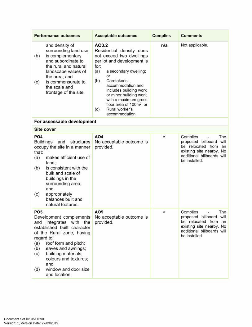
Performance outcomes Acceptable outcomes Complies Comments
and density of surrounding land use;
(b) is complementary and subordinate to the rural and natural landscape values of the area; and
(c) is commensurate to the scale and frontage of the site.
AO3.2Residential density does not exceed two dwellings per lot and development is for:(a) a secondary dwelling;
or(b) Caretaker’s
accommodation and includes building work or minor building work with a maximum gross floor area of 100m2; or
(c) Rural worker’s accommodation.
n/a Not applicable.
For assessable developmentSite coverPO4Buildings and structures occupy the site in a manner that:(a) makes efficient use of
land;(b) is consistent with the
bulk and scale of buildings in the surrounding area; and
(c) appropriately balances built and natural features.
AO4No acceptable outcome is provided.
Complies - The proposed billboard will be relocated from an existing site nearby. No additional billboards will be installed.
PO5Development complements and integrates with the established built character of the Rural zone, having regard to:(a) roof form and pitch;(b) eaves and awnings; (c) building materials,
colours and textures; and
(d) window and door size and location.
AO5No acceptable outcome is provided.
Complies - The proposed billboard will be relocated from an existing site nearby. No additional billboards will be installed.
Version: 1, Version Date: 27/03/2019Document Set ID: 3511690

Performance outcomes Acceptable outcomes Complies Comments
AmenityPO6Development must not detract from the amenity of the local area, having regard to:(a) noise;(b) hours of operation;(c) traffic;(d) advertising devices;(e) visual amenity; (f) privacy;(g) lighting;(h) odour; and(i) emissions.
AO6No acceptable outcome is provided.
Complies - The proposed billboard will be relocated from an existing site nearby. No additional billboards will be installed.
PO7Development must take into account and seek to ameliorate any existing negative environmental impacts, having regard to: (a) noise;(b) hours of operation;(c) traffic;(d) advertising devices;(e) visual amenity; (f) privacy;(g) lighting;(h) odour; and(i) emissions.
AO7No acceptable outcome is provided.
n/a Not applicable.
Version: 1, Version Date: 27/03/2019Document Set ID: 3511690
8.2.6 Flood hazard overlay code
8.2.6.1 Application
(1) This code applies to assessing development where:(a) land the subject of development is located within a Flood hazard area identified on the Flood
hazard overlay maps (OM-006a-o); and(b) it is identified in the assessment benchmarks for assessable development and requirements
for accepted development column of an assessment table in Part 5 of the planning scheme.
Note—Natural hazards are appropriately reflected in Overlay Maps 3, 6 and 8 and are required to be mapped by State Government in response to Hazard and Safety State Interests.
Note—where new information, including flood studies or flood modelling supersedes the Flood hazard overlay maps (OM-006a-o) Council may have regard to this new information in the application of the Flood hazard overlay code in the interests of the precautionary principle and the safety of persons and property.
8.2.6.2 Purpose
(1) The purpose of the Flood hazard overlay code is to manage development outcomes in flood hazard areas identified on the Flood hazard overlay maps (OM-006a-o) so that risk to life, property, community and the environment during flood events is minimised, and to ensure that development does not increase the potential for flood damage on site or to other property.
(2) The purpose of the code will be achieved through the following overall outcomes:
(a) Development in the ‘Extreme flood hazard area’:i. maintains and enhances the hydrological function of the land; ii. does not involve filling (earthworks) or changes to existing landform or
drainage lines that results in a loss of the flood conveyance and flood storage capacity of the land;
iii. is limited to: A. flood proofed Sport and recreation activities;B. Rural activities where for Animal husbandry, Cropping or Permanent
plantation;C. flood proofed Utility installations, Substations or Major electricity
infrastructure;D. conservation and natural area management; andE. replacement of existing lawful development, including Accommodation
activities where habitable rooms are elevated above the defined flood level and include freeboard;
Where there is no increase to the number of persons at risk of flood and where development reduces existing or potential risks to life and property.
(b) Development in the ‘High flood hazard area’:i. maintains the hydrological function of the land; ii. does not involve filling (earthworks) or changes to the existing landform or
drainage lines that results in a loss of the flood conveyance and flood storage capacity of the land;
iii. is limited to: A. flood proofed Sport and recreation activities and Club uses;B. Non-resident workforce accommodation, Relocatable home park, Resort
complex, Rooming accommodation, Short term accommodation and
Version: 1, Version Date: 27/03/2019Document Set ID: 3511690

Tourist park uses where these uses comprise permanent on-site management and a flood evacuation management plan ensures the health and safety of persons during a flood event;
C. a Dwelling house only where the lot existed or had a lawful reconfiguring a lot approval at the commencement of the planning scheme and the land is included in a Residential zone or the Centre zone or where for minor intensification of existing Dwelling houses;
D. Rural activities where for Animal husbandry, Cropping or Permanent plantation;
E. Industrial activities and Commercial activities where it is accepted development that flood damage is incurred as an operational cost and where flood sensitive elements of the development or use are elevated above the defined flood level, including freeboard;
F. flood proofed Utility installations, Substations or Major electricity infrastructure;
G. conservation and natural area management; andH. replacement of existing lawful development;
where there is no increase to the number of persons at risk of flood and where development reduces existing or potential risks to life and property.
iv. protects surrounding land and land uses from increased flood hazard impacts;v. elevates habitable rooms for all accommodation activities (including where for
minor building work) above the defined flood level, including freeboard.
(c) Development in the ‘Significant flood hazard area’:i. minimises risk to life and property from flood events;ii. involves changes to the existing landform and drainage lines in this area only
where detrimental impacts to the flood hazard risk of surrounding areas is avoided;
iii. is limited to: A. Sport and recreation activities;B. Industrial activities and Commercial activities where it is accepted
development that flood damage is incurred as an operational cost and where flood sensitive elements of the development or use are elevated above the defined flood level, including freeboard;
C. Rural activities;D. Accommodation activities, excluding Residential care facility and
Retirement facility;E. flood proofed Community activities, excluding Child care centre, Hospital
and Community use where a flood emergency evacuation plan ensures the safety of people during a flood event;
F. flood proofed Utility installations, Substations or Major electricity infrastructure;
G. conservation and natural area management;iv. locates habitable rooms for all accommodation activities above the defined
flood level, including freeboard; andv. locates the minimum floor level for all buildings other than accommodation
activities, industrial activities and business activities above the defined flood level.
Version: 1, Version Date: 27/03/2019Document Set ID: 3511690

(d) Development in the ‘Low flood hazard area’:i. minimises risk to life and property from flood events;ii. locates habitable rooms for all Accommodation activities above the defined
flood level, including freeboard; andiii. locates the minimum floor level for all buildings other than Accommodation
activities above the defined flood level, including freeboard.
(e) Development in the ‘Potential flood hazard area’:i. maintains the safety of people on the development site from flood events and
minimises the potential damage from flooding to property; ii. does not result in adverse impacts on people’s safety, the environment or the
capacity to use land within the floodplain;iii. locates habitable rooms for all Accommodation activities above a 1% Annual
Exceedance Probability (AEP), including freeboard; andiv. locates the minimum floor level for all building work other than Accommodation
activities above the 1% AEP flood level, including freeboard.
8.2.6.3 Criteria for assessment
Table 8.2.6.3A - Flood hazard overlay code - For accepted development subject to requirements and assessable development
Performance outcomes Acceptable outcomes Complies CommentsFor accepted development subject to requirements and assessable development All flood hazard areasPO1Development prevents the carriage or dispersal of contaminants or pollutants into the receiving environment.
AO1The processing or storage of dangerous goods or hazardous materials is:(a) not undertaken in a
flood hazard area identified on the Flood hazard overlay maps (OM-006a-o); or
(b) is located above the defined flood level plus 0.3 metre freeboard.
Complies.
PO2Essential community infrastructure is able to function effectively during and immediately after flood events.
AO2Design levels for buildings must comply with the flood immunity standards specified in Table 8.2.6.3.B and Table 8.2.6.3.C where within a flood hazard area identified on the Flood hazard overlay maps (OM-006a-o).
n/a Not applicable - The proposed development is for an advertising billboard only which is able to be temporarily submerged in a flood event without any loss of life or significant damage.
Extreme flood hazard area
Version: 1, Version Date: 27/03/2019Document Set ID: 3511690

Performance outcomes Acceptable outcomes Complies CommentsAO3.1Uses within the following activity groups are not located within an ‘Extreme flood hazard area identified’ on the Flood hazard overlay maps (OM006a-o):(a) Accommodation
activities;(b) Commercial activities;(c) Community activities
except where for a Club with a maximum gross floor area of 100m2;
(d) Industrial activities;(e) Rural activities, except
where for Animal husbandry, Cropping, or Permanent plantation.
n/a Not applicable.PO3Development, where involving a Material change of use within an ‘Extreme flood hazard area’ on the Flood hazard overlay maps (OM006a-o), is appropriate to the flood hazard risk having regard to the:(a) likelihood and
frequency of flooding;
(b) flood risk acceptability of development;
(c) vulnerability of and safety risk to persons associated with the use;
(d) associated consequences of flooding in regard to impacts on proposed buildings, structures, and supporting infrastructure; and
(e) associated consequences of flooding in respect to undue burden on disaster response recovery capacity and capabilities.
AO3.2Sport and recreation activities are not located within an ‘Extreme flood hazard area’ identified on the Flood hazard overlay maps (OM006a-o) except where for:(a) Environment facility; (b) Park; or(c) Outdoor sport and
recreation (excluding the provision of ancillary facilities or amenities conducted within a building).
n/a Not applicable.
Version: 1, Version Date: 27/03/2019Document Set ID: 3511690

Performance outcomes Acceptable outcomes Complies CommentsAO4.1Buildings, including extensions to existing buildings, are:(a) not located within an
‘Extreme flood hazard area’ identified on the Flood hazard overlay maps (OM006a-o); or
(b) elevated above the defined flood level, with 0.3 metres freeboard from the defined flood level provided for habitable rooms within a dwelling.
n/a Not applicable. The site is mapped as being situated within the extreme flood hazard area, however the proposed development is for an advertising billboard only which is able to be temporarily submerged in a flood event without any loss of life or significant damage. Achieving flood immunity is not considered necessary for an advertising billboard. It is likely the sign face, which would be the only part of the sign susceptible to damage from inundation would achieve immunity given it is raised 4m off natural ground level.
AO4.2All building work must be high set and retains the flood storage and conveyance capacity of the premises.
Note—Building work must be certified by a qualified structural engineer to be flood proof including the ability to withstand damage from floodwater and debris.
n/a Not applicable - see comment for AO4.1.
PO4Development is located and designed to: (a) maintain and
enhance the flood conveyance capacity of the premises;
(b) not increase the number of people calculated to be at risk from flooding;
(c) not increase the flood impact on adjoining premises;
(d) ensure the safety of all persons by ensuring that development levels are set above the defined flood level;
(e) reduce property damage; and
(f) provide flood immune access to buildings.
Note—Buildings may be constructed from flood resistant, waterproof materials below the defined flood level where certified by a qualified structural engineer to be flood proof (including the ability to withstand damage from floodwater and debris) and where an alternative outcome to AO4.1-AO4.4 is also demonstrated.
Note—In the event that a lawful building or structure is destroyed by flood or other event the building may be replaced in situ where there is no increase in:
i. gross floor area; orii. the number of dwellings or
bedrooms on the premises.
AO4.3New buildings are provided with flood free pedestrian and vehicle evacuation access between the building and a flood safe accessible road.
Note—A flood safe accessible road includes a road where identified as outside a flood hazard area or within a ‘Low flood hazard area’, ‘Potential flood hazard area’ or ‘Significant flood hazard area’ on the Flood hazard overlay maps (OM006a-o).
n/a Not applicable - see comment for AO4.1. Flood free evacuation routes for vehicles and pedestrians is not considered necessary.
Version: 1, Version Date: 27/03/2019Document Set ID: 3511690
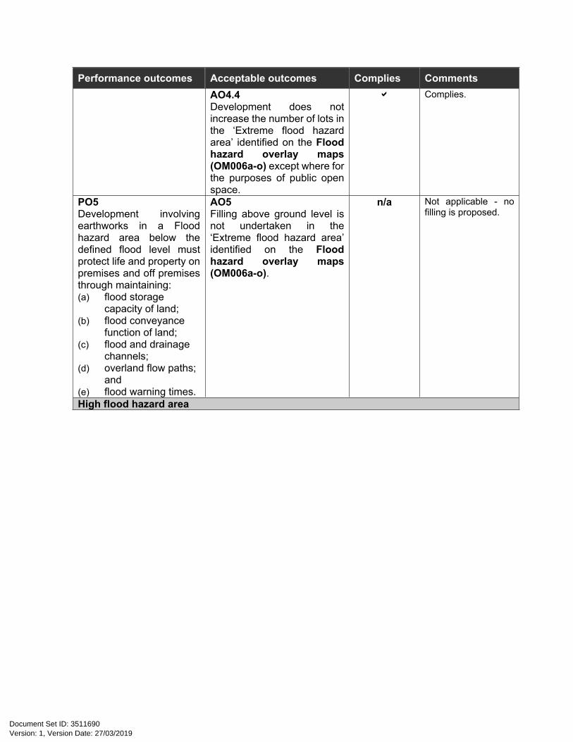
Performance outcomes Acceptable outcomes Complies CommentsAO4.4Development does not increase the number of lots in the ‘Extreme flood hazard area’ identified on the Flood hazard overlay maps (OM006a-o) except where for the purposes of public open space.
Complies.
PO5Development involving earthworks in a Flood hazard area below the defined flood level must protect life and property on premises and off premises through maintaining: (a) flood storage
capacity of land; (b) flood conveyance
function of land; (c) flood and drainage
channels; (d) overland flow paths;
and(e) flood warning times.
AO5Filling above ground level is not undertaken in the ‘Extreme flood hazard area’ identified on the Flood hazard overlay maps (OM006a-o).
n/a Not applicable - no filling is proposed.
High flood hazard area
Version: 1, Version Date: 27/03/2019Document Set ID: 3511690
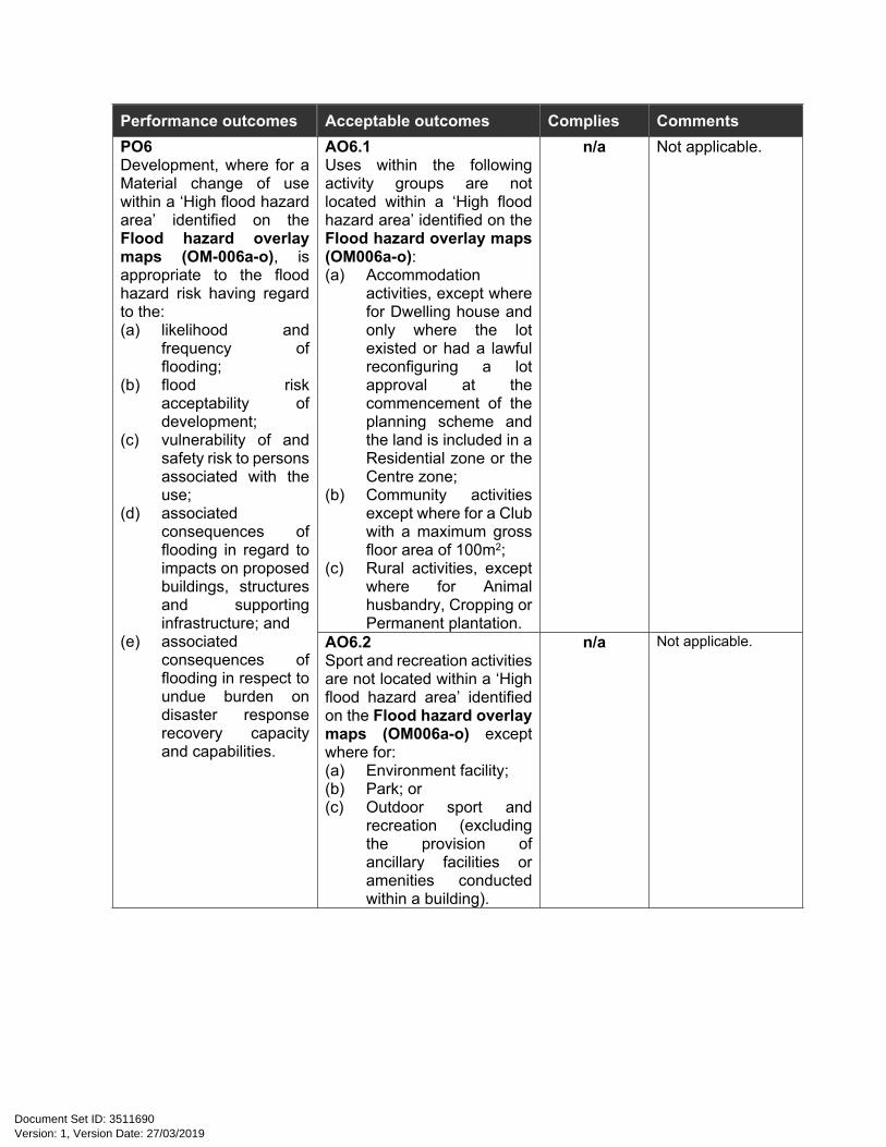
Performance outcomes Acceptable outcomes Complies CommentsAO6.1Uses within the following activity groups are not located within a ‘High flood hazard area’ identified on the Flood hazard overlay maps (OM006a-o):(a) Accommodation
activities, except where for Dwelling house and only where the lot existed or had a lawful reconfiguring a lot approval at the commencement of the planning scheme and the land is included in a Residential zone or the Centre zone;
(b) Community activities except where for a Club with a maximum gross floor area of 100m2;
(c) Rural activities, except where for Animal husbandry, Cropping or Permanent plantation.
n/a Not applicable.PO6Development, where for a Material change of use within a ‘High flood hazard area’ identified on the Flood hazard overlay maps (OM-006a-o), is appropriate to the flood hazard risk having regard to the:(a) likelihood and
frequency of flooding;
(b) flood risk acceptability of development;
(c) vulnerability of and safety risk to persons associated with the use;
(d) associated consequences of flooding in regard to impacts on proposed buildings, structures and supporting infrastructure; and
(e) associated consequences of flooding in respect to undue burden on disaster response recovery capacity and capabilities.
AO6.2Sport and recreation activities are not located within a ‘High flood hazard area’ identified on the Flood hazard overlay maps (OM006a-o) except where for:(a) Environment facility; (b) Park; or(c) Outdoor sport and
recreation (excluding the provision of ancillary facilities or amenities conducted within a building).
n/a Not applicable.
Version: 1, Version Date: 27/03/2019Document Set ID: 3511690

Performance outcomes Acceptable outcomes Complies CommentsAO7.1Buildings, including extensions to existing buildings are:(a) not located within the
‘High flood hazard area’ identified on the Flood hazard overlay maps (OM006a-o); or
(b) elevated above the defined flood level, with 0.3 metres freeboard from the defined flood level provided for habitable rooms within a dwelling.
OR
n/a Not applicable.
AO7.2Buildings used for Commercial activities or Industrial activities include a minimum floor level of 0.3 metres above the defined flood where for the following components of the use:(a) administrative areas; or(b) services, plant and
equipment associated with the building.
Note—AO8.2 accepts that the cost of flood impact is an operational cost of the Commercial activity or Industrial activity.
Note—Building work must be certified by a qualified structural engineer to be flood proof including the ability to withstand damage from floodwater and debris.
n/a Not applicable.
PO7Development is located and designed to: (a) maintain
hydrological function of the premises;
(b) not increase the number of people calculated to be at risk from flooding;
(c) minimises the flood impact on adjoining premises;
(d) ensure the safety of all persons by ensuring that an appropriate proportion of buildings are set above the defined flood level;
(e) reduce the carriage of debris in flood waters;
(f) reduce property damage; and
(g) provide flood immune access to buildings.
Note—Buildings may be constructed from flood resistant, waterproof materials below the defined flood level where certified by a qualified structural engineer to be flood proof (including the ability to withstand damage from floodwater and debris) and where an alternative outcome to AO8.1-AO8.9 is also demonstrated. AO7.3
All building work below the defined flood level must be high set (comprising pier and beam construction) and retains the flood storage and conveyance capacity of the premises.
Complies - proposed advertising billboard will be supported by two poles.
Version: 1, Version Date: 27/03/2019Document Set ID: 3511690

Performance outcomes Acceptable outcomes Complies CommentsAO7.4New buildings are provided with flood free pedestrian and vehicle evacuation access between the building and a flood safe accessible road.
Note—A flood safe accessible road includes a road where identified as outside a flood hazard area or within a ‘Low flood hazard area’, ‘Potential flood hazard area’ or ‘Significant flood hazard area’ on the Flood hazard overlay maps (OM006a-o).
n/a Not applicable.
AO7.5New temporary, relocatable or impermanent buildings and structures are to be anchored with the ability to withstand transportation by floodwater.
Note—Building work must be certified by a qualified structural engineer.
n/a Not applicable.
AO7.6Dwellings do not exceed four bedrooms.
n/a Not applicable.
AO7.7Building work on an existing dwelling does not comprise additional bedrooms.
n/a Not applicable.
AO7.8Building work on an existing dwelling is limited to a maximum increase of 20 percent of the lawfully approved gross floor area of the existing dwelling.
n/a Not applicable.
AO7.9Development does not increase the number of lots in the ‘High flood hazard area; as identified on the Flood hazard overlay maps (OM006a-o) except where for the purposes of public open space.
n/a Not applicable.
Version: 1, Version Date: 27/03/2019Document Set ID: 3511690

Performance outcomes Acceptable outcomes Complies CommentsPO8Development involving earthworks in a Flood hazard area below the defined flood level must protect life and property on premises and off premises through maintaining: (a) flood storage
capacity of land; (b) flood conveyance
function of land; (c) flood and drainage
channels; (d) overland flow paths;
and(e) flood warning times.
AO8Filling above ground level is not undertaken in the ‘High flood hazard area’ identified on the Flood hazard overlay maps (OM006a-o).
n/a Not applicable.
Significant flood hazard area
Version: 1, Version Date: 27/03/2019Document Set ID: 3511690

Performance outcomes Acceptable outcomes Complies CommentsPO9Development, involving a Material change of use, within a ‘Significant flood hazard area’ on the Flood hazard overlay maps (OM006a-o) is appropriate to the flood hazard risk having regard to the:(a) likelihood and
frequency of flooding;
(b) flood risk acceptability of development;
(c) vulnerability of and safety risk to persons associated with the use;
(d) associated consequences of flooding in regard to impacts on proposed buildings, structures and supporting infrastructure; and
(e) associated consequences of flooding in respect to undue burden on disaster response recovery capacity and capabilities.
AO9The following uses are not located within a ‘Significant flood hazard area’ identified on the Flood hazard overlay maps (OM006a-o):(a) Residential care facility;(b) Retirement facility; (c) Child care centre; (d) Hospital; or (e) Community use.
n/a Not applicable.
Significant flood hazard area, Low flood hazard area or Potential flood hazard area
Version: 1, Version Date: 27/03/2019Document Set ID: 3511690
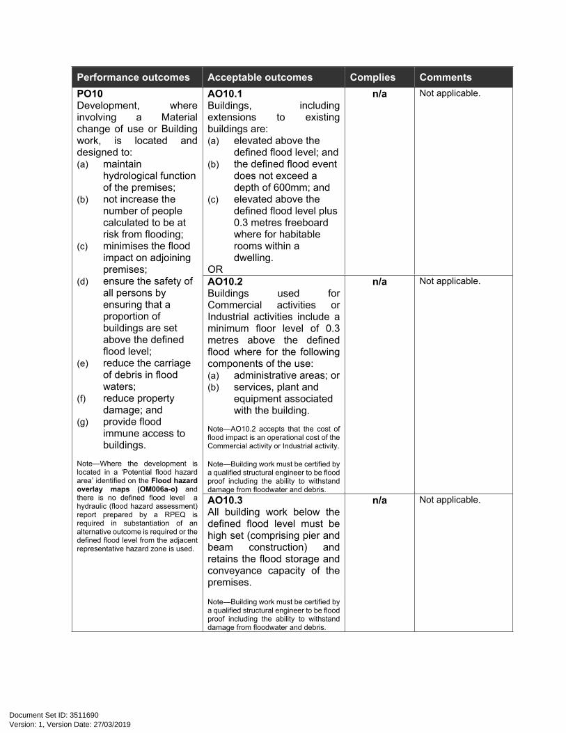
Performance outcomes Acceptable outcomes Complies CommentsAO10.1Buildings, including extensions to existing buildings are:(a) elevated above the
defined flood level; and(b) the defined flood event
does not exceed a depth of 600mm; and
(c) elevated above the defined flood level plus 0.3 metres freeboard where for habitable rooms within a dwelling.
OR
n/a Not applicable.
AO10.2Buildings used for Commercial activities or Industrial activities include a minimum floor level of 0.3 metres above the defined flood where for the following components of the use:(a) administrative areas; or(b) services, plant and
equipment associated with the building.
Note—AO10.2 accepts that the cost of flood impact is an operational cost of the Commercial activity or Industrial activity.
Note—Building work must be certified by a qualified structural engineer to be flood proof including the ability to withstand damage from floodwater and debris.
n/a Not applicable.
PO10Development, where involving a Material change of use or Building work, is located and designed to: (a) maintain
hydrological function of the premises;
(b) not increase the number of people calculated to be at risk from flooding;
(c) minimises the flood impact on adjoining premises;
(d) ensure the safety of all persons by ensuring that a proportion of buildings are set above the defined flood level;
(e) reduce the carriage of debris in flood waters;
(f) reduce property damage; and
(g) provide flood immune access to buildings.
Note—Where the development is located in a ‘Potential flood hazard area’ identified on the Flood hazard overlay maps (OM006a-o) and there is no defined flood level a hydraulic (flood hazard assessment) report prepared by a RPEQ is required in substantiation of an alternative outcome is required or the defined flood level from the adjacent representative hazard zone is used.
AO10.3All building work below the defined flood level must be high set (comprising pier and beam construction) and retains the flood storage and conveyance capacity of the premises.
Note—Building work must be certified by a qualified structural engineer to be flood proof including the ability to withstand damage from floodwater and debris.
n/a Not applicable.
Version: 1, Version Date: 27/03/2019Document Set ID: 3511690

Performance outcomes Acceptable outcomes Complies CommentsPO11Development involving earthworks in a Flood hazard area below the defined flood level must protect life and property on premises and off premises through maintaining: (a) flood storage
capacity of land; (b) flood conveyance
function of land; (c) flood and drainage
channels; (d) overland flow paths;
and(e) flood warning times.
AO11Development does not involve in excess of 50m3 of fill above ground level per 1,000m2 of site area.
n/a Not applicable.
For assessable development Where for Material change of use or Reconfiguring a lot that involves new gross floor area or increases the number of persons living, working or residing in the Extreme flood hazard area, High flood hazard area or Significant flood hazard area other than a Dwelling house.
Version: 1, Version Date: 27/03/2019Document Set ID: 3511690

Performance outcomes Acceptable outcomes Complies CommentsPO12Flood risk management minimises the impact on property and appropriately protects the health and safety of persons at risk of Extreme, high or significant flood hazard, and: (a) indicates the
position and path of all safe evacuation routes off the site; and
(b) if the site contains or is within 100 metres of a flood hazard area, hazard warning signage and depth indicators are provided at key hazard points, such as at floodway crossings.
Note—A Material change of use or Reconfiguring a lot that involves new gross floor area or increases the number of persons living, working or residing in the ‘Extreme flood hazard area’ identified on the Flood hazard overlay map (OM006a-o) is supported by a Flood Emergency Evacuation Plan prepared by suitably qualified persons having regard to Floodplain Management in Australia: Best Practice Principles and Guidelines (2000), prepared by Standing Committee on Agriculture and Resource Management (SCARM), CSIRO.
AO12No acceptable outcome is provided.
n/a Not applicable.
Version: 1, Version Date: 27/03/2019Document Set ID: 3511690

Performance outcomes Acceptable outcomes Complies Comments
Significant flood hazard area, Low flood hazard area or Potential flood hazard areaPO13Development, where involving Reconfiguring a lot, is located and designed to: (a) maintain
hydrological function of the premises;
(b) not increase the number of people calculated to be at risk from flooding;
(c) minimises the flood impact on adjoining premises;
(d) ensure the safety of all persons by ensuring that a proportion of buildings are set above the defined flood level;
(e) reduce the carriage of debris in flood waters;
(f) reduce property damage; and
(g) provide flood immune access to buildings.
Note—Where the development is located in a ‘Potential flood hazard area’ identified on the Flood hazard overlay maps (OM006a-o) and there is no defined flood level a hydraulic (flood hazard assessment) report prepared by a RPEQ is required in substantiation of an alternative outcome is required or the defined flood level from the adjacent representative hazard zone is used.
AO13No acceptable outcome is provided.
n/a Not applicable.
Table 8.2.6.3B Flood immunity levelsDevelopment Category Minimum design floor or pavement levels (mAHD)Category A 1% AEP + 0.5 metresCategory B 1% AEP + 0.3 metresCategory C 1% AEP
Version: 1, Version Date: 27/03/2019Document Set ID: 3511690

Category D 1% AEP Category E 2% AEP
Note—Refer Table 8.2.6.3D for building classification by Category.
Table 8.2.6.3C Community infrastructure flood immunity levelsDevelopment Type Minimum design floor or pavement
levels (mAHD)Emergency services, where for:
Emergency Shelters 0.1% AEP Police facilities 0.5% AEP Other Emergency services 0.1% AEP + 0.5 metres
Hospital 0.1% AEP+ 0.5 metresCommunity use (where for the storage of valuable records or items of historic or cultural significance including libraries and museums)
0.5% AEP
Special industry (where for power station)
0.5% AEP
Substations 0.5% AEPUtility installation (where for a sewage treatment plant)
Defined flood level
Utility installation (where for a water treatment plant)
0.5% AEP
Utility installation (other) Alternative outcome required.Air services Alternative outcome required.
Table 8.2.6.3D Development category Building Code of Australia Building classification(1)
Development types and design levels, assigned design floor or pavement levels
Category – refer to Table 8.2.6.3B for flood planning levels
Habitable room Category ANon-habitable room including patio and courtyard
Category B
Non-habitable part of a Class 2 or Class 3 building excluding the essential services(2) control room
Category B
Parking located in the building undercroft of a multiple dwelling
Category C
Carport, unroofed car park; vehicular manoeuvring area
Category D
Essential electrical services(2) of a Class 2 or Class 3 building only
Category A
Class 1–4
Basement parking entry Category C + 0.3 metresBuilding floor level Category CClass 5,
Class 6, orClass 8
Garage or car park located in the building undercroft
Category C
Version: 1, Version Date: 27/03/2019Document Set ID: 3511690

Building Code of Australia Building classification(1)
Development types and design levels, assigned design floor or pavement levels
Category – refer to Table 8.2.6.3B for flood planning levels
Carport or unroofed car park Category DVehicular access and manoeuvring areas
Category D
Basement parking entry Category CEssential electrical services(2) Class 8 – Category
Class 5 & 6 – Category A
Class 7a Refer to the relevant building class specified in this tableBuilding floor level Category CVehicular access and manoeuvring area Category D
Class 7b
Essential electrical services(2) Category CBuilding floor level Category ABuilding floor level for habitable rooms in Class 9a or 9c where for a Residential care facility
0.2% AEP flood
Building floor level for habitable rooms in Class 9b where involving children, such as a child care centre
0.2% AEP flood
Garage or car park located in the building undercroft
Category C
Carport or unroofed car park Category DVehicular access and manoeuvring areas
Category D
Class 9
Essential electrical services(2) Category ACar parking facility Refer to the relevant
building class specified in this table
Class 10a
Shed or the like Category DSwimming pool Category EAssociated mechanical and electrical pool equipment
Category CClass 10b
Other structures Flood planning levels do not apply
(1) Refer to the Building Code of Australia for definitions of building classifications.
(2) Essential electrical services include any area or room used for fire control panel, telephone PABX, sensitive substation equipment including transformers, low voltage switch gear, high voltage switch gear, battery chargers, protection control and communication equipment, low voltage cables, high voltage cables, and lift or pump controls.
Version: 1, Version Date: 27/03/2019Document Set ID: 3511690

8.2.9 Regional infrastructure corridors and substations overlay code
8.2.9.1 Application
(1) This code applies to assessing development where:(a) land the subject of development is affected by a constraint category identified on the
Regional infrastructure corridors and substations overlay maps (OM-009a-d); and(b) it is identified in the assessment benchmarks for assessable development and requirements
for accepted development column of an assessment table in Part 5 of the planning scheme.
Note—Energy is appropriately reflected in Overlay Map 9 and is required to be mapped by State Government in response to Infrastructure State Interests.
8.2.9.2 Purpose
(1) The purpose of the Regional infrastructure corridors and substations overlay code is to ensure that:(a) ‘Stock routes’ facilitate the proper and safe movement of stock and maintain public
health and safety; and(b) ‘Major electricity infrastructure’ and ‘Substations’ are protected from development
that may prejudice its ongoing operation.
(2) The purpose of the code will be achieved through the following overall outcomes:(a) ‘Stock routes’ are maintained free of impediments, obstructions or diversions;(b) development, other than for rural activities, is not located where it will increase the health
and safety risk of people by exposure to vector borne disease; and(c) ‘Major electricity infrastructure’ and ‘Substations’ are appropriately separated from other land
uses.
8.2.9.3 Criteria for assessment
Table 8.2.9.3 – Regional infrastructure corridors and substations overlay code - For accepted development subject to requirements and assessable development
Performance outcomes Acceptable outcomes Complies Comments
For accepted development subject to requirements and assessable developmentWhere on land comprising or adjoining a stock route
Version: 1, Version Date: 27/03/2019Document Set ID: 3511690
Performance outcomes Acceptable outcomes Complies Comments
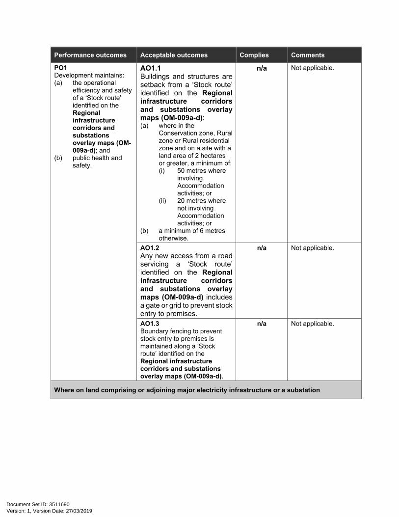
AO1.1Buildings and structures are setback from a ‘Stock route’ identified on the Regional infrastructure corridors and substations overlay maps (OM-009a-d):(a) where in the
Conservation zone, Rural zone or Rural residential zone and on a site with a land area of 2 hectares or greater, a minimum of:(i) 50 metres where
involving Accommodation activities; or
(ii) 20 metres where not involving Accommodation activities; or
(b) a minimum of 6 metres otherwise.
n/a Not applicable.
AO1.2Any new access from a road servicing a ‘Stock route’ identified on the Regional infrastructure corridors and substations overlay maps (OM-009a-d) includes a gate or grid to prevent stock entry to premises.
n/a Not applicable.
PO1Development maintains:(a) the operational
efficiency and safety of a ‘Stock route’ identified on the Regional infrastructure corridors and substations overlay maps (OM-009a-d); and
(b) public health and safety.
AO1.3Boundary fencing to prevent stock entry to premises is maintained along a ‘Stock route’ identified on the Regional infrastructure corridors and substations overlay maps (OM-009a-d).
n/a Not applicable.
Where on land comprising or adjoining major electricity infrastructure or a substation
Version: 1, Version Date: 27/03/2019Document Set ID: 3511690
Performance outcomes Acceptable outcomes Complies Comments
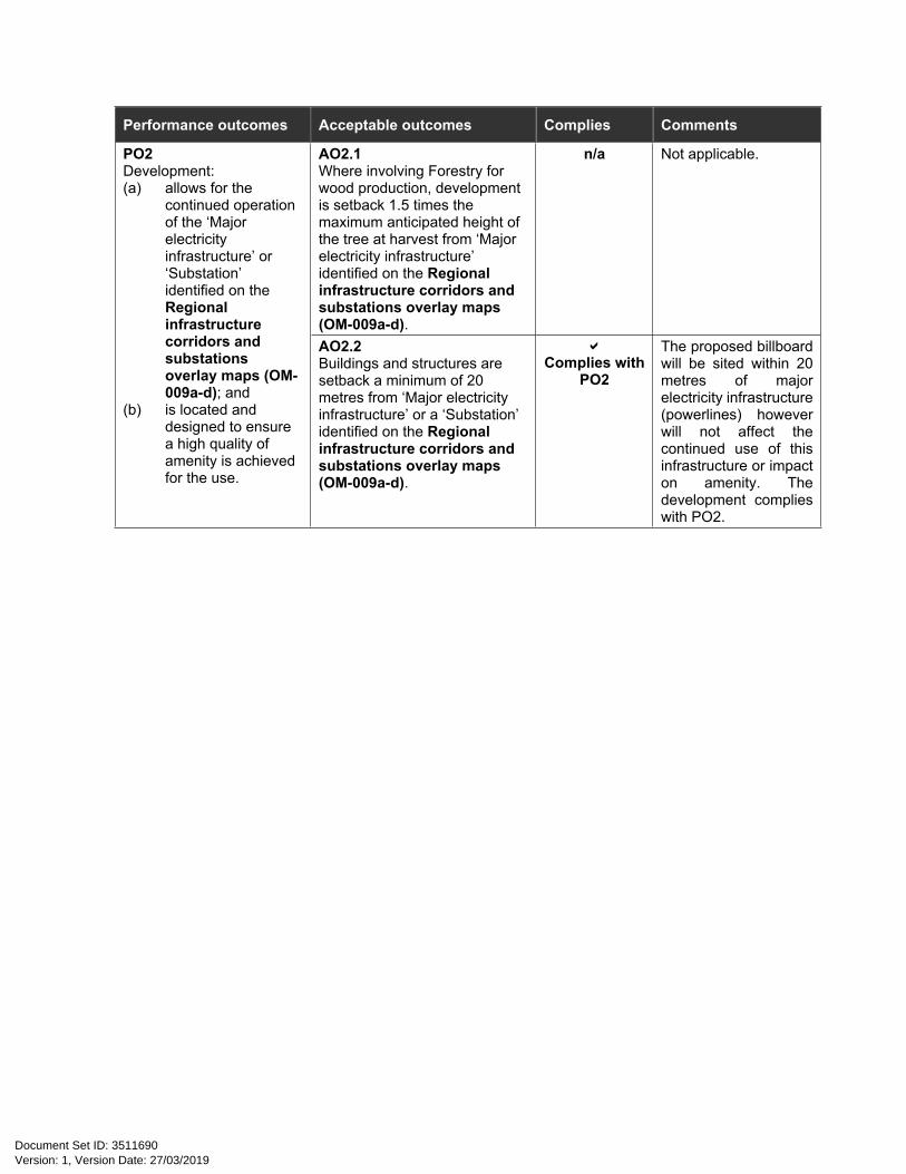
AO2.1Where involving Forestry for wood production, development is setback 1.5 times the maximum anticipated height of the tree at harvest from ‘Major electricity infrastructure’ identified on the Regional infrastructure corridors and substations overlay maps (OM-009a-d).
n/a Not applicable.PO2Development:(a) allows for the
continued operation of the ‘Major electricity infrastructure’ or ‘Substation’ identified on the Regional infrastructure corridors and substations overlay maps (OM-009a-d); and
(b) is located and designed to ensure a high quality of amenity is achieved for the use.
AO2.2Buildings and structures are setback a minimum of 20 metres from ‘Major electricity infrastructure’ or a ‘Substation’ identified on the Regional infrastructure corridors and substations overlay maps (OM-009a-d).
Complies with
PO2
The proposed billboard will be sited within 20 metres of major electricity infrastructure (powerlines) however will not affect the continued use of this infrastructure or impact on amenity. The development complies with PO2.
Version: 1, Version Date: 27/03/2019Document Set ID: 3511690

8.2.12 Transport infrastructure overlay code
8.2.12.1 Application
(1) This code applies to assessing development where:(a) land the subject of development adjoins a rail corridor identified on the Transport
infrastructure overlay maps (OM-012a-j); and(b) it is identified in the assessment benchmarks for assessable development and requirements
for accepted development column of an assessment table in Part 5 of the planning scheme.
Note—State transport infrastructure is appropriately reflected in Overlay Map 12 and is required to be mapped by State Government in response to Infrastructure State Interests.
Note—The Transport infrastructure overlay includes mapped Transport Noise Corridors in accordance with section 246ZA of the Building Act. These corridors are mapped on Transport infrastructure overlay maps (OM-012i-s) for information purposes only. Development on land within a mapped corridor is not subject to any specific provisions under this planning scheme. The Queensland Development Code should be consulted in this respect.
8.2.12.2 Purpose
(1) The purpose of the Transport infrastructure overlay code is to promote the ongoing and expanded use of rail corridors within the shire for the transportation of passengers and freight.
(2) The purpose of the code will be achieved through the following overall outcomes:(a) Active ‘Rail corridors’ are protected from adjoining land uses which may prejudice their
ongoing and expanded use;(b) Inactive ‘Rail corridors’ are preserved and protected for potential reuse for passenger or
freight movements; (c) Non-residential development adjoining a ‘Rail corridor’ does not prevent the future use of the
rail corridor by the site; and(d) Development compliments the use of ‘Rail corridors’ for tourist activities.
8.2.12.3 Criteria for assessment
Table 8.2.12.3 – Transport infrastructure overlay code - For accepted development subject to requirements and assessable development
Performance outcomes Acceptable outcomes Complies Comments
For accepted development subject to requirements and assessable development
Version: 1, Version Date: 27/03/2019Document Set ID: 3511690
Performance outcomes Acceptable outcomes Complies Comments
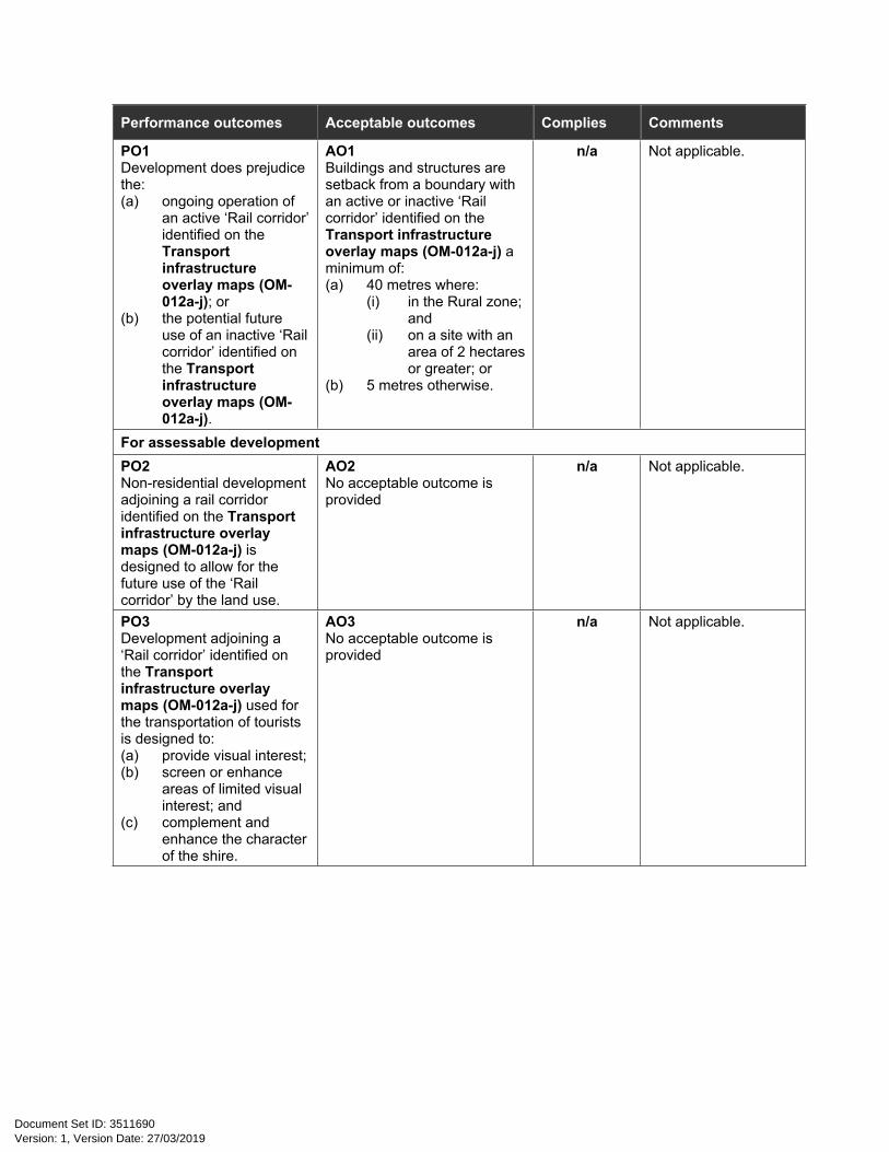
PO1Development does prejudice the:(a) ongoing operation of
an active ‘Rail corridor’ identified on the Transport infrastructure overlay maps (OM-012a-j); or
(b) the potential future use of an inactive ‘Rail corridor’ identified on the Transport infrastructure overlay maps (OM-012a-j).
AO1Buildings and structures are setback from a boundary with an active or inactive ‘Rail corridor’ identified on the Transport infrastructure overlay maps (OM-012a-j) a minimum of:(a) 40 metres where:
(i) in the Rural zone; and
(ii) on a site with an area of 2 hectares or greater; or
(b) 5 metres otherwise.
n/a Not applicable.
For assessable developmentPO2Non-residential development adjoining a rail corridor identified on the Transport infrastructure overlay maps (OM-012a-j) is designed to allow for the future use of the ‘Rail corridor’ by the land use.
AO2No acceptable outcome is provided
n/a Not applicable.
PO3Development adjoining a ‘Rail corridor’ identified on the Transport infrastructure overlay maps (OM-012a-j) used for the transportation of tourists is designed to:(a) provide visual interest;(b) screen or enhance
areas of limited visual interest; and
(c) complement and enhance the character of the shire.
AO3No acceptable outcome is provided
n/a Not applicable.
Version: 1, Version Date: 27/03/2019Document Set ID: 3511690

9.4.1 Advertising devices code
9.4.1.1 Application
(1) This code applies to assessing development where:(a) for Advertising devices; and(b) it is identified in the assessment benchmarks for assessable development and requirements
for accepted development column of an assessment table in Part 5 of the planning scheme.
9.4.1.2 Purpose
(1) The purpose of the Advertising devices code is to regulate the location, siting, number, content and design requirements for advertising devices to protect the visual character and amenity of the urban and rural areas of the region, whilst supporting the promotion of business and enterprise.
(2) The purpose of the code will be achieved through the following overall outcomes:(a) Advertising devices are designed, sited and integrated so that they do not detract from the
existing character and amenity of an area and contribute to a coherent and harmonious streetscape;
(b) Advertising devices are of a scale, dimension and quality to minimise adverse visual impacts; (c) Advertising devices do not result in visual clutter; (d) Advertising devices do not impact on pedestrian or road safety and do not obscure the view
of any official traffic, safety or information sign;(e) Advertising devices are constructed and maintained to ensure a high standard of public
safety through structural integrity, design and construction; (f) Advertising devices primarily provide, clear and effective identification of business and
commercial premises, community uses and events with limited product advertising; (g) In the Rural zone advertising devices are limited to maintain the landscape character of the
area; and(h) Billboards are limited to identified localities.
Version: 1, Version Date: 27/03/2019Document Set ID: 3511690
9.4.1.3 Criteria for assessment
Table 9.4.1.3A—Advertising devices code - For accepted development subject to requirements and assessable development
Performance outcomes Acceptable outcomes Complies Comments
For accepted development subject to requirements and assessable developmentPublic safetyPO1Advertising devices are designed, sited and constructed to maintain the efficient function of road infrastructure and not impede safe vehicular and pedestrian movements.
AO1.1Advertising devices do not:(a) resemble traffic
control devices; or(b) give instructions to
traffic; or(c) resemble a hazard or
warning light through colour or method of operation, if visible from a road; or
(d) cause interference with the visibility and effectiveness of hazard or warning lights; or
(e) encroach onto any part of a road, road reserve, pedestrian or cycle path; or
(f) incorporate highly reflective materials and finishes; or
(g) cause significant visual or physical obstruction of, or distraction to, vehicular or pedestrian traffic.
Complies - The proposed billboard is currently established 750 metres north of the proposed location facing the Mulligan highway. The application is for a relocation only. The billboard design and location will comply with AO1.1.
Character and amenity
Version: 1, Version Date: 27/03/2019Document Set ID: 3511690
Performance outcomes Acceptable outcomes Complies Comments
AO2.1Advertising devices:(a) do not move, revolve,
strobe or flash; (b) are not painted or
erected on a roof (excluding awnings) or structure (such as a silo or tank);
(c) do not incorporate overt or explicit language or visual content that is likely to be offensive to the general public;
(d) primarily advertise a business and/or commercial premises rather than products;
(e) are located on the property to which the advertising relates;
(f) do not protrude above the roofline or parapet; and
(g) are limited to those devices identified in Table 9.4.1.3B.
Complies with PO2
Complies - The proposed billboard is currently established 750 metres north of the proposed location facing the Mulligan highway. The application is for a relocation only. The billboard design and content will comply with AO2.1. The billboard will not advertise a business established on the subject site however being a relocation only (from nearby location) is not likely to cause any impacts that would compromise PO2.
PO2Advertising devices are designed and located to:(a) avoid visual clutter;(b) avoid overshadowing
of adjoining premises or public places;
(c) prevent loss of daylight or sunlight access for nearby uses;
(d) be consistent with the built and natural character of the immediate surrounds; and
(e) allow for the identification of premises, uses and business.
AO2.2The number, type and design of advertising devices complies with Table 9.4.1.3D.
n/a Not applicable - see comment for AO4.
Version: 1, Version Date: 27/03/2019Document Set ID: 3511690

Performance outcomes Acceptable outcomes Complies Comments
For assessable development
Character and amenityPO3Advertising devices are:(a) designed and
engineered to a standard that satisfies the wind classification for the particular area;
(b) appropriately secured and supported so as to cause no injury or damage to persons or property;
(c) not displayed on or attached to a tree, roadside pole or official traffic or safety sign; and
(d) appropriately separated from any electricity infrastructure.
AO3No acceptable outcome is provided.
Will comply - Development permit for building works will be required.
PO4Freestanding advertising devices, where located on land fronting a state-controlled road, are appropriately located and designed to:(a) not impact on the
safety and efficiency of the state controlled road network; and
(b) preserve rural character and landscape values.
AO4Freestanding advertising devices:(a) have a maximum sign
face area of 18m2 and a maximum sign face width of 6 metres;
(b) are sited a minimum of 1 kilometre from all existing freestanding advertising devices whether or not they are on the same side of the road;
(c) are of a design and colour that is compatible with existing adjacent development; and
(d) are only located on properties with frontage to either side of the sections of State-controlled road identified in Table 9.4.1.3C.
Complies - The proposed billboard will be relocated from an existing site in the vicinity of the subject site and will not result in the installation of an additional billboard along this stretch of the Mulligan Highway. The proposed billboard will have a sign face area of 18m2.
Version: 1, Version Date: 27/03/2019Document Set ID: 3511690

Table 9.4.1.3B—Acceptable advertising devicesType and definition Example
Above awning advertising device - an advertising sign located on top of and attached to an awning or veranda.
Fascia advertising device - a flush advertising sign painted on, or attached to the front and/or side faces of an awning.
Under awning advertising device - a flat signage panel or light-box that is suspended directly underneath an awning or verandah.
Blind advertising device - a sign that is painted or otherwise affixed to a solid or flexible material suspended from an awning face or verandah.
Version: 1, Version Date: 27/03/2019Document Set ID: 3511690

Type and definition Example
Parapet advertising device – a sign painted on, or affixed to the architectural parapet of a building.
Projecting advertising device - a sign mounted at right angles to a wall or building face.
Freestanding advertising device - a sign that comprises either a hoarding/billboard or a pylon sign which is elevated from the ground and supported by one or more columns, pylons or poles.
Fence advertising device - a sign painted on, or otherwise affixed to a fence or gate that acts as a permanent partition screen or barrier.
Version: 1, Version Date: 27/03/2019Document Set ID: 3511690
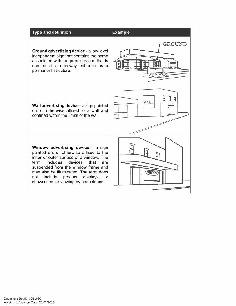
Type and definition Example
Ground advertising device - a low-level independent sign that contains the name associated with the premises and that is erected at a driveway entrance as a permanent structure.
Wall advertising device - a sign painted on, or otherwise affixed to a wall and confined within the limits of the wall.
Window advertising device - a sign painted on, or otherwise affixed to the inner or outer surface of a window. The term includes devices that are suspended from the window frame and may also be illuminated. The term does not include product displays or showcases for viewing by pedestrians.
Version: 1, Version Date: 27/03/2019Document Set ID: 3511690

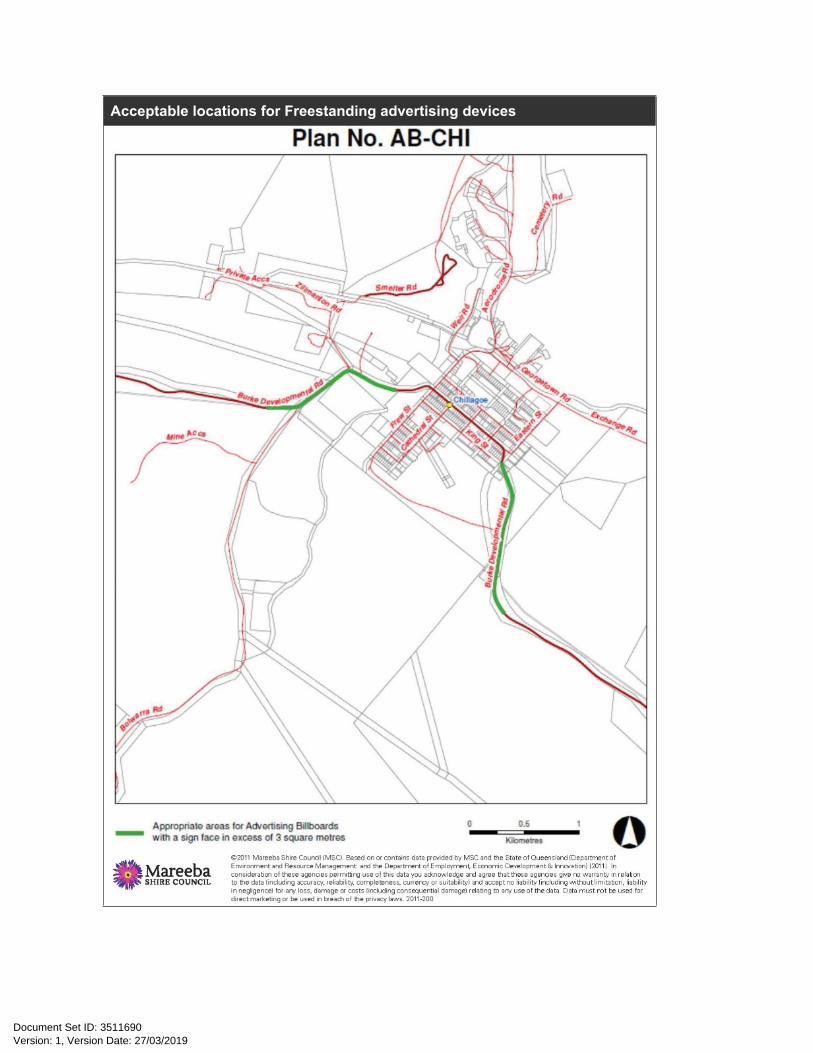
Table 9.4.1.3C—Acceptable locations for Freestanding advertising devicesAcceptable locations for Freestanding advertising devices
Version: 1, Version Date: 27/03/2019Document Set ID: 3511690
Acceptable locations for Freestanding advertising devices
Version: 1, Version Date: 27/03/2019Document Set ID: 3511690
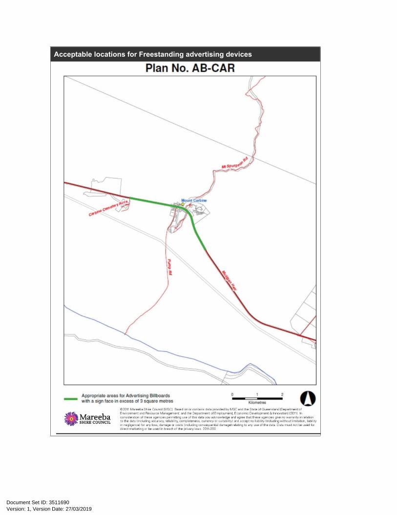
Acceptable locations for Freestanding advertising devices
Version: 1, Version Date: 27/03/2019Document Set ID: 3511690

Acceptable locations for Freestanding advertising devices
Version: 1, Version Date: 27/03/2019Document Set ID: 3511690

Acceptable locations for Freestanding advertising devices
Version: 1, Version Date: 27/03/2019Document Set ID: 3511690

Acceptable locations for Freestanding advertising devices
Version: 1, Version Date: 27/03/2019Document Set ID: 3511690

Acceptable locations for Freestanding advertising devices
Version: 1, Version Date: 27/03/2019Document Set ID: 3511690

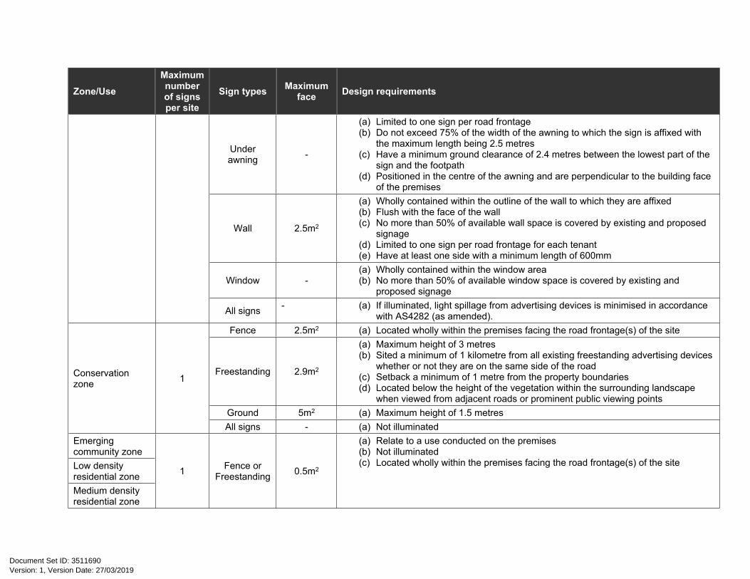
Table 9.4.1.3D—Number, Type and Design of Advertising Devices
Zone/UseMaximum number of signs per site
Sign types Maximum face Design requirements
ZonesAbove awning - (a) Do not exceed the height of the parapet or building roofline
(b) Do not exceed the width or depth of the of the awning to which they are affixed
Fascia - (a) Wholly contained within the outline of the awning to which they are affixed(b) Flush with the awning face
Blind -
(a) Do not exceed the width of the of the awning to which they are affixed(b) Have a ground clearance of 2.4 metres between the lowest part of the sign and
the footpath(c) Sited adjacent to the main building entrance(d) Flush with the awning face(e) Wholly located under the awning
Freestanding 6m2 (a) Located on lots greater than 1,000m2
(b) No higher than buildings on the same lot or 7.5 metres (whichever is the lesser)
Parapet -(a) Flush with the building parapet wall face (b) Wholly contained within the area of the parapet(c) Have a sign face of no more than maximum of 40% of the available parapet area
Projecting 2.5m2
(a) Limited to one sign per road frontage(b) Do not project greater than 1.5 metres from the building or structure to which
they are affixed;(c) Do not exceed the height of the building or structure to which they are affixed
Centre zone 3
Under awning -
(a) Limited to one sign per road frontage(b) Do not exceed 75% of the width of the awning to which the sign is affixed(c) Have a maximum length of 2.5 metres(d) Have a minimum ground clearance of 2.4 metres between the lowest part of the
sign and the footpath(e) Positioned in the centre of the awning and are perpendicular to the building face
of the premises
Version: 1, Version Date: 27/03/2019Document Set ID: 3511690

Zone/UseMaximum number of signs per site
Sign types Maximum face Design requirements
Wall 2.5m2
(a) Wholly contained within the outline of the wall to which they are affixed(b) Flush with the face of the wall(c) limited to one sign per road frontage for each tenant(d) No more than 50% of available wall space is covered by existing and proposed
signage(e) At least one side has a minimum length of 600mm
Window -(a) Wholly contained within the window area(b) No more than 50% of available window space is covered by existing and
proposed signage
All signs - (a) If illuminated, light spillage from advertising devices is minimised in accordance with AS4282 (as amended).
Above awning - (a) Do not exceed the height of the parapet or building roofline
(b) Do not exceed the width or depth of the of the awning to which they are affixed
Blind 1.5m2
(a) Do not exceed the width of the of the awning to which they are affixed(b) Have a ground clearance of 2.4 metres between the lowest part of the sign and
the footpath(c) Sited adjacent to the main building entrance(d) Flush with the awning face(e) Wholly located under the awning
Fascia - (a) Wholly contained within the outline of the awning to which they are affixed(b) Flush with the awning face
Fence 2.5m2 (a) Located wholly within the premises facing the road frontage(s) of the site
Freestanding 6m2 (a) Located on lots greater than 1,000m2
(b) No higher than buildings on the same lot or 7.5 metres (whichever is the lesser) Ground 5m2 (a) Maximum height of 1.5 metres
Parapet -(a) Flush with the building parapet wall face (b) Wholly contained within the area of the parapet (c) Sign face of no more than a maximum of 40% of the available parapet area
Community facilities zone 3
Projecting 2.5m2
(a) Limited to one sign per road frontage(b) Do not project greater than 1.5 metres from the building or structure to which
they are affixed(c) Do not exceed the height of the building or structure to which they are affixed
Version: 1, Version Date: 27/03/2019Document Set ID: 3511690
Zone/UseMaximum number of signs per site
Sign types Maximum face Design requirements
Under awning -
(a) Limited to one sign per road frontage(b) Do not exceed 75% of the width of the awning to which the sign is affixed with
the maximum length being 2.5 metres(c) Have a minimum ground clearance of 2.4 metres between the lowest part of the
sign and the footpath(d) Positioned in the centre of the awning and are perpendicular to the building face
of the premises
Wall 2.5m2
(a) Wholly contained within the outline of the wall to which they are affixed(b) Flush with the face of the wall(c) No more than 50% of available wall space is covered by existing and proposed
signage(d) Limited to one sign per road frontage for each tenant(e) Have at least one side with a minimum length of 600mm
Window -(a) Wholly contained within the window area(b) No more than 50% of available window space is covered by existing and
proposed signage
All signs - (a) If illuminated, light spillage from advertising devices is minimised in accordance with AS4282 (as amended).
Fence 2.5m2 (a) Located wholly within the premises facing the road frontage(s) of the site
Freestanding 2.9m2
(a) Maximum height of 3 metres(b) Sited a minimum of 1 kilometre from all existing freestanding advertising devices
whether or not they are on the same side of the road(c) Setback a minimum of 1 metre from the property boundaries(d) Located below the height of the vegetation within the surrounding landscape
when viewed from adjacent roads or prominent public viewing pointsGround 5m2 (a) Maximum height of 1.5 metres
Conservation zone 1
All signs - (a) Not illuminatedEmerging community zoneLow density residential zoneMedium density residential zone
1 Fence or Freestanding 0.5m2
(a) Relate to a use conducted on the premises(b) Not illuminated(c) Located wholly within the premises facing the road frontage(s) of the site
Version: 1, Version Date: 27/03/2019Document Set ID: 3511690
Zone/UseMaximum number of signs per site
Sign types Maximum face Design requirements
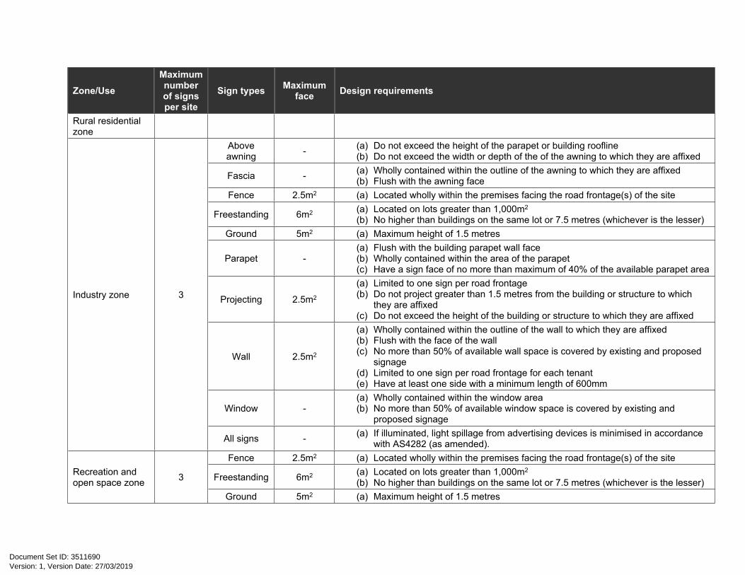
Rural residential zone
Above awning - (a) Do not exceed the height of the parapet or building roofline
(b) Do not exceed the width or depth of the of the awning to which they are affixed
Fascia - (a) Wholly contained within the outline of the awning to which they are affixed(b) Flush with the awning face
Fence 2.5m2 (a) Located wholly within the premises facing the road frontage(s) of the site
Freestanding 6m2 (a) Located on lots greater than 1,000m2
(b) No higher than buildings on the same lot or 7.5 metres (whichever is the lesser) Ground 5m2 (a) Maximum height of 1.5 metres
Parapet -(a) Flush with the building parapet wall face(b) Wholly contained within the area of the parapet (c) Have a sign face of no more than maximum of 40% of the available parapet area
Projecting 2.5m2
(a) Limited to one sign per road frontage(b) Do not project greater than 1.5 metres from the building or structure to which
they are affixed(c) Do not exceed the height of the building or structure to which they are affixed
Wall 2.5m2
(a) Wholly contained within the outline of the wall to which they are affixed(b) Flush with the face of the wall(c) No more than 50% of available wall space is covered by existing and proposed
signage(d) Limited to one sign per road frontage for each tenant(e) Have at least one side with a minimum length of 600mm
Window -(a) Wholly contained within the window area(b) No more than 50% of available window space is covered by existing and
proposed signage
Industry zone 3
All signs - (a) If illuminated, light spillage from advertising devices is minimised in accordance with AS4282 (as amended).
Fence 2.5m2 (a) Located wholly within the premises facing the road frontage(s) of the site
Freestanding 6m2 (a) Located on lots greater than 1,000m2
(b) No higher than buildings on the same lot or 7.5 metres (whichever is the lesser)Recreation and open space zone 3
Ground 5m2 (a) Maximum height of 1.5 metres
Version: 1, Version Date: 27/03/2019Document Set ID: 3511690

Zone/UseMaximum number of signs per site
Sign types Maximum face Design requirements
Wall 2.5m2
(a) Wholly contained within the outline of the wall to which they are affixed(b) Flush with the face of the wall(c) No more than 50% of available wall space is covered by existing and proposed
signage(d) Limited to one sign per road frontage for each tenant(e) Have at least one side with a minimum length of 600mm
All signs - (a) If illuminated, light spillage from advertising devices is minimised in accordance with AS4282 (as amended).
All signs - (a) Not illuminatedFence 2.5m2 (a) Located wholly within the premises facing the road frontage(s) of the site
Rural zone 1Freestanding 2.9m2
(a) Sited a minimum of 1 kilometre from all existing freestanding advertising devices whether or not they are on the same side of the road
(b) Setback a minimum of 1 metre from the property boundaries(c) Located below the height of the vegetation within the surrounding landscape
when viewed from adjacent roads or prominent public viewing points(d) Maximum height of 3 metres
UsesFenceHome based
business 1Freestanding
0.5m2 (a) Not illuminated(b) Located wholly within the premises facing the road frontage(s) of the site
Renewable energy facility - - -
(a) Limited in scale (b) Confined to site (c) Limited to development interpretation.
Roadside stall 2 - 1m2 (a) Located on the same site as the roadside stall.
Rural industry - - 2.1m2(a) Located at the entrance to the premises; (b) Limited to the name and hours of operation of the facility(c) Does not include any product advertising
Note—Where there is a conflict between a requirement in a zone and a requirement for a use in the Table 9.4.1.3D, compliance is to be achieved with the more restrictive requirement.
Note—Where there is no requirement specified for a use, reference should be made to the relevant zone requirement.
Version: 1, Version Date: 27/03/2019Document Set ID: 3511690

Version: 1, Version Date: 27/03/2019Document Set ID: 3511690