assessment of mineral resources in the upper north east ... · of mineral deposits which may be of...
TRANSCRIPT

Assessment of Mineral Resources in theUpper North East CRA Study Area
A project undertaken as part of the NSW Comprehensive RegionalAssessments
November 1999


ASSESSMENT OFMINERAL RESOURCESIN THE UPPER NORTH
EAST CRA STUDYAREA
GEOLOGICAL SURVEY OF NSWDEPARTMENT OF MINERAL RESOURCES
AUSTRALIAN GEOLOGICAL SURVEYORGANISATION
A project undertaken forthe Joint Commonwealth NSW Regional Forest Agreement Steering Committee
as part of theNSW Comprehensive Regional Assessments
Project number NU 04/ES

For more information and for information on access to data contact the:Resource and Conservation Division, Department of Urban Affairs and Planning
GPO Box 3927SYDNEY NSW 2001
Phone: (02) 9228 3166Fax: (02) 9228 4967
Forests Taskforce, Department of the Prime Minister and Cabinet
3-5 National CircuitBARTON ACT 2600
Phone: 1800 650 983Fax: (02) 6271 5511
© Crown copyright November 1999New South Wales GovernmentCommonwealth Government
ISBN 1 74029 018 6
This project has been jointly funded by the New South Wales and Commonwealth Governments andmanaged through the Resource and Conservation Division, Department of Urban Affairs and Planning,and the Forests Taskforce, Department of the Prime Minister and Cabinet
The project has been overseen and the methodology has been developed through the Economic andSocial Technical Committee which includes representatives from the New South Wales andCommonwealth Governments and stakeholder groups.
The collection of information and drafting of this report were undertaken cooperatively between officers ofthe Geological Survey of New South Wales and the Australian Geological Survey Organisation:
Geological Survey of New South WalesRob Barnes, David Suppel, Ken McDonald, Greg MacRae, Alex Ramsland, Adelmo Agostini.
Australian Geological Survey OrganisationYanis Miezitis, Subhash Jaireth, Aden McKay, Keith Porritt, Lloyd David, Don Perkin, Andrew Lucas, NealEvans.
DisclaimerWhile every reasonable effort has been made to ensure that this document is correct at the time ofprinting, the State of New South Wales, its agents and employees, and the Commonwealth of Australia, itsagents and employees, do not assume any responsibility and shall have no liability, consequential orotherwise, of any kind, arising from the use of or reliance on any of the information contained in thisdocument.

CONTENTS
PROJECT SUMMARY
1. INTRODUCTION 1
2. ADMINISTRATION OF MINING AND EXPLORATION TITLES 22.1 Mineral Exploration and Mining 22.2 Construction Material Extraction 3
3. GEOLOGICAL SETTING 43.1 Introduction 43.2 Pre Late Permian Sedimentary & Volcanic Sequences 73.3 Emu Creek Block 73.4 Serpentinite 73.5 Late Carboniferous Intrusives 83.6 Nambucca Block 83.7 Late Permian Volcanics 83.8 Late Permian to Early Triassic Intrusives 93.9 Mesozoic Basin Sedimentary Sequences 103.10 Tertiary Sediments & Volcanics 113.11 Quaternary Sediments 11
4. HISTORY OF MINING AND EXPLORATION 124.1 Mining History 124.2 Exploration History 18
5. KNOWN MINERAL RESOURCES AND MINERAL PRODUCTION 23
6. MINERAL EXPLORATION AND LAND ACCESS 306.1 Mineral Exploration 306.2 Land access 30
7. MINERAL POTENTIAL ASSESSMENT METHODOLOGY 33
8. POTENTIAL MINERAL RESOURCES 358.1 Hydrocarbons (Oil and Gas) (Figure 3) 358.2 Coal Seam Methane (Figure 4) 358.3 Porphyry Copper-Gold Deposits (Figure 5) 388.4 Epithermal Gold (Figure 6) 388.5 Granitoid Related Disseminated Gold Deposits (Timbarra Style) (Figure 7) 41

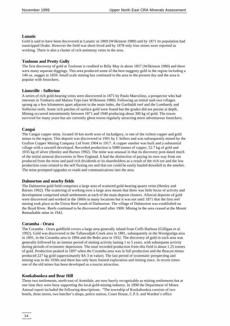
8.6 Heavy Mineral Sands (Figure 8) 418.7 Open Cut Coal (Figure 9) 448.8 Volcanogenic Massive Sulphide Base Metals (Figure 10) 448.9 Metahydrothermal Vein Gold-Antimony Vein Deposits (Figure 11) 478.10 Underground Coal (Figure 12) 478.11 Silver-Bearing Polymetallic Vein Deposits (Figure 13) 508.12 Tin Vein Deposits (Figure 14) 528.13 Tin Greisen Deposits (Figure 15) 548.15 Alluvial Diamonds (Figure 16) 568.16 Alluvial Sapphires (Figure 17) 568.17 Tungsten-Molybdenum Pipes, Veins, Disseminations (Figure 18) 598.18 Tungsten Skarn Deposits (Figure 19) 618.19 Silexite (Figure 20) 618.20 Copper-Gold-Magnetite Skarn Deposits (Figure 21) 618.21 Alluvial Gold (Figure 22) 658.22 Gold Deposits Associated with Volcanogenic Massive Sulphide Mineralisation
(including Gold in Chert and Jaspers) (Figure 23) 658.23 Alluvial Tin Deposits (Figure 24) 658.24 Volcanic Hosted Magnetite (Figure 25) 698.25 Podiform Chromite (Figure 26) 698.26 Limestone Deposits (Figure 27) 698.27 Volcanogenic Manganese Deposits (Figure 28) 698.28 Construction Materials (Aggregate and Pavement) (Figures 29 & 31) 748.29 Chrysotile, Asbestos Deposits (Figure 30) 758.30 Summary of Potential Mineral and Hydrocarbon Resources 75
9. REFERENCES 85
APPENDICES
A. Methodology for assessment of potential (undiscovered) mineral potential. 89B. Mineral resource assessment and mineral deposit models 91C. Areas covered by mineral potential tracts 159D. Metadata sheets 160
Figures:
1 Exploration titles covering the UNER August 1998 212 Relationship between Levels of Resource Potential and Levels of Certainty 34
Mineral potential tracts for:3 Hydrocarbons (Oil and Gas) 364 Coal Seam Methane 375 Porphyry Copper-Gold Deposits 396 Epithermal Gold 407 Granitoid Related Disseminated Gold Deposits (Timbarra Style) 428 Heavy Mineral Sands 439 Open Cut Coal 4510 Volcanogenic Massive Sulphide Base Metals 4611 Metahydrothermal Vein Gold-Antimony Vein Deposits 4812 Underground Coal 4913 Silver-Bearing Polymetallic Vein Deposits 51

14 Tin Vein Deposits 5315 Tin Greisen Deposits 5516 Alluvial Diamonds 5717 Alluvial Sapphires 5818 Tungsten-Molybdenum Pipes, Veins, Disseminations 6019 Tungsten Skarn Deposits 6220 Silexite 6321 Copper-Gold-Magnetite Skarn Deposits 6422 Alluvial Gold 6623 Gold Deposits Associated with VMS Mineralisation (including Gold in Chert &
Jaspers) 6724 Alluvial Tin Deposits 6825 Volcanic Hosted Magnetite 7026 Podiform Chromite 7127 Limestone Deposits 7228 Volcanogenic Manganese Deposits 7329 Construction Materials (Aggregate) 7630 Chrysotile, Asbestos Deposits 7731 Construction Materials (Pavement) 7832 Weighted Scores for tracts of all mineral deposit types 83
Text Diagrams
1 Time-Space Plot for the UNE CRA 6
Tables
1 Major geological systems present in the Upper North East region 52 Features of major plutonic suites in New England 93 Range of techniques applied in mineral exploration 194 List of Exploration licences in the UNE region (June 1998) 205 Identified metallic mineral resources 256 Identified industrial mineral & construction material resources 26-297 Aggregate Tract Data 748 Pavement Tract Data 759 Summary of potential mineral resources as at June 1998 8110 Size of areas covered by weighted mineral potential scores in Map 5 82
Maps
1 Geology of the UNE CRA back pocket2 Mineral occurrence distribution back pocket3 Composite mineral potential back pocket4 Cumulative mineral potential back pocket5 Weighted composite mineral potential back pocket6 Weighted cumulative mineral potential back pocket


PROJECT SUMMARY
This report describes a project undertaken as part of the comprehensive regional assessments offorests in New South Wales. The comprehensive regional assessments (CRAs) provide thescientific basis on which the State and Commonwealth Governments will sign regional forestagreements (RFAs) for major forest areas of New South Wales. These agreements will determinethe future of these forests, providing a balance between conservation and ecologically sustainableuse of forest resources.
This report was undertaken to provide a regional assessment of the mineral resources of the UpperNorth East region, which occupies the northeastern part of New South Wales. The assessment isbased on the known mineral occurrences and resources of the region and on the potential forundiscovered mineral resources, based on mineral exploration, geology and other geoscientificinformation of the area.
The assessment of the mineral resource potential was conducted for the whole of the Upper NorthEast region and is based on data and recent geological reports provided by the NSW Departmentof Mineral Resources (DMR). Professional staff of the Australian Geological Survey Organisation(AGSO), the Geological Survey of NSW (a division of DMR) collaborated in the preparation ofthe assessment.
The methodology adopted by AGSO and DMR to assess the mineral potential of the regionfollowed that developed by the United States Geological Survey, which has been used for mineralresource assessments of forest areas in North America and elsewhere. This methodology identifiesgeological units (referred to as tracts) which could contain particular types of mineral deposits. Anassessment of the potential resources of an area is then an estimate of the likelihood of occurrenceof mineral deposits which may be of a sufficient size and grade to constitute a mineral resource.
In this study mineral potential tracts were identified for 29 deposit types including seventeen typesof metallic mineral deposits (which included different styles of gold, silver, base metal, tungsten,and tin deposition), for coal, coal seam methane, hydrocarbons (petroleum and gas), limestone,mineral sands, alluvial gemstones, and construction materials. The tracts were then combined topresent a weighted composite mineral potential of the region. This result provides someperspective to the relative economic significance between different types of mineral deposits (anarea with high potential for gold mineralisation would rate higher than an area with high potentialfor tungsten, given the relative market prices of the two commodities).


November 1999 Upper North East CRA Minerals Assessment
1
1. INTRODUCTION
Known mineral resources and potential (undiscovered) mineral resources have been assessed as part ofthe Comprehensive Regional Assessment (CRA) of the forest areas in the Upper North East region inNew South Wales. This region is referred to in this report as the Upper North East region, UNER, or ‘theregion’.
The assessment of the mineral resources was conducted on a regional scale for the whole of the UNERand is based on data and recent geological reports provided by NSW Department of Mineral Resources(DMR). Professional staff of the Bureau of Resource Sciences (BRS) collaborated in the preparation ofthis assessment.
The DMR has prepared numerous reports and publications which describe the geology and mineralresources of the UNER. The major Departmental reports and publications include Scheibner and Basden(1996), Barnes and Willis (1989), Flood, Kovarch and Moore (1994), Stroud et al. (1996), Brown andStroud (1997), Brown, Brownlow and Krynen (1992), Gilligan et al. (1992), Barnes, Henley and Henley(1995), Henley and Barnes (1992), Brown (1995), and, Henley and Brown (1998).
Geological and tectonic interpretations of the New England Orogen abound with major collections ofpapers available in conference and synthesis volumes such as Flood and Runnegar (1982), Kleeman(1988), Flood and Aitchison (1993) and Ashley and Flood (1997).
Several hundred published papers and volumes relate to the mineral resources of the UNER. Reference tothese can be found in the review reports listed above and through other bibliographic avenues. Reviewpapers on mineralisation include Barnes et al. (1988), Gilligan and Barnes (1990) and Suppel, Barnes andScheibner (1998).
In addition, there are in excess of one thousand company reports on the results of mineral exploration inthe region. These reports are indexed and stored by the DMR and can be accessed through theDepartment’s computerised information systems.
Prior to the assessment of mineral resources, the DMR assembled a comprehensive digital data setcontaining the best available geoscientific and support data for the region. Assembled data on which themineral resource assessment is based include:
n a mineral occurrence database for the region with best available information to December1997
n a seamless coverage of geology of the region at 1:250 000 scale equivalent,
n magnetics and landsat images
n digital elevation images shaded to emphasise geological structure
n stream sediment geochemical data over much of the region
It is important to note that most of the UNER has not been subjected to a regional coverage of detailedhigh resolution airborne geophysical surveys; such surveys would generate new data and allow majorimprovements in understanding of the geology and mineral deposition in the region. Appendix G containsdata documentation information for mineral occurrence locations, geological and airborne geophysicaldata, and for mining tenements.

November 1999 Upper North East CRA Minerals Assessment
2
2.ADMINISTRATION OFMINING ANDEXPLORATION TITLES
2.1 MINERAL EXPLORATION AND MINING
Mineral exploration and mining in New South Wales is principally governed by the Mining Act 1992.Exploration and mining for petroleum is governed by the Petroleum (Onshore) Act 1991. Both Acts areadministered by the Department of Mineral Resources and provide for a range of conditions to beincluded in the tenures granted for exploration and mining. The conditions cover requirements forexploration and mining methods, professionalism in carrying out operations, reporting and care ofenvironment, and to address land owner and occupier interests. The provisions of the Petroleum(Onshore) Act 1991 are rather similar to those of the Mining Act 1992 and will not be elaborated uponfurther.
Under the Mining Act 1992 there are three principal forms of title, Exploration Licence, AssessmentLease and Mining Lease. To cater for the smaller operations, a Mineral Claim is a title which can begranted for prospecting and mining in areas up to two hectares in size. In the opal fields an OpalProspecting Licence can also be granted to assist in the search for opal within larger paddock size areasbut these are short term titles, usually of 28 days duration.
Under the Mining Act, tenures for exploration and mining can be granted over both Crown and privateland, and over both Crown and privately owned minerals. Although most minerals are owned by theCrown, there are cases, particularly where original land grants occurred in the 1800s, where the mineralswere not reserved to the Crown in the land grants, and in those cases the minerals are owned privately.
2.1.1 Exploration LicencesExploration Licences enable mineral exploration and prospecting to be undertaken. The size of areaswhich can be granted ranges from about 3 square kilometres (one unit) to about 300 square kilometres(100 units). A unit is an area bounded by a minute of longitude by a minute of latitude. Areas of morethan 100 units can be granted in special cases. Exploration licences are normally granted for a period oftwo years and may be renewed for further periods. These licences allow for geological and geophysicalsurveying, sampling, drilling, trenching and other exploration techniques as applied for by the applicant.Before any private lands are entered under an exploration licence the owner and any occupier must benotified and an access agreement entered into by the exploration licence holder and the land owner andoccupier. All exploration licences contain conditions, including ones specifying the amount required tobe expended on exploration during the period of the licence. A security deposit must also be lodged tocover the exploration licence holder's obligations to comply with the licence conditions.
2.1.2 Assessment LeasesThe Assessment Lease is a relatively new tenure for New South Wales having been introduced by theMining Act 1992. The purpose of this tenure is to enable detailed evaluation of mineral deposits to becarried out after the normal period of exploration but where, for some special reasons, the project is notready to be applied for under Mining Lease. Such reasons can be of an economic nature e.g. the depositfound is not presently economic to develop, or could be practical reasons such as a need to develop

November 1999 Upper North East CRA Minerals Assessment
3
specific processing methods to extract a particular mineral from the host rock. There is no maximum sizefor an assessment lease; size and dimensions of areas being such as are necessary and appropriate. Thesetitles can be granted for a period of five years and renewed for a further period of five years. Similarconditions on expenditure, reporting of progress and security are required as in exploration licences.Where access to lands is required appropriate access arrangements and consents must be obtained.
2.1.3 Mining LeasesMining Leases are granted to enable mining operations to be carried out. There is no maximum size for amining lease and dimensions and area can be such as are needed and appropriate for the particular miningoperation. Mining leases are generally granted for a period of twenty one years but can be granted forlonger or lesser periods, depending upon circumstances. Leases can be renewed. Mining leases enableoperations, subject to appropriate conditions, to be undertaken by open cut (surface) or undergroundmethods. Royalty is payable on all minerals recovered at the rate prescribed by the Mining Act 1992 or atsuch additional rates as may be specified. The holders of mining leases are required to lodge a securitydeposit with the Minister commensurate with the size of the mining operation to ensure compliance withconditions of the lease.
2.1.4 Compliance with Other LegislationApplicants for and holders of titles under the Mining Act 1992 are required to comply with the provisionsof other appropriate legislation such as the Environment Planning and Assessment Act 1979 and theendangered flora and fauna legislation. In particular, mining lease applicants are required under theEnvironment Planning and Assessment Act to obtain development consent before a mining lease can begranted under the Mining Act 1992. The lodgement of the development consent application normallyincludes the submission of an environment impact statement which is put on display for public commentas part of the application processing. Depending upon circumstances, a commission of inquiry to hearviews about the particular project can be required and the recommendations of the inquiry are taken intoconsideration as to whether or not development consent should be granted and, if so, upon whatconditions.
In granting mining leases, the views of all appropriate Government departments and authorities areobtained and appropriate conditions to meet respective requirements are formulated for inclusion in thelease documents. Records of all titles and applications for titles under the Mining Act are kept by theDepartment of Mineral Resources as required by the Act.
2.2 CONSTRUCTION MATERIAL EXTRACTION
A number of State and Local Government agencies control the extraction of construction materials.Some materials, like clay and shale, are classed as minerals under the Mining Act 1992 and can beextracted under mining titles issued by the Department of Mineral Resources. Other materials such assand, gravel, and crushed rock, can be extracted from Crown Land under titles issued by agencies such asState Forests and the Department of Land and Water Conservation. In each case, development consentmust be obtained from the local Council before extraction can proceed.
Where construction materials are present on private land, they may be extracted by the land owner, or byanyone having an agreement with the land owner, after obtaining development consent from the localCouncil or other relevant consent authority.
The Department of Mineral Resources has a recognised and accepted role in assessing the State’sresources of construction materials and providing advice on their management and extraction. It is alsoresponsible under the Mines Inspection Act 1901 (as amended) for ensuring the safe operation of theState’s mines and quarries.

November 1999 Upper North East CRA Minerals Assessment
4
3.GEOLOGICALSETTING
3.1 INTRODUCTION
The Upper North East Region (UNER) has a complex geological history extending from about 600million years ago to the present. Rocks in the region have been brought together from sites of depositionas far away as sub-Antarctic areas. The region has undergone massive upheavals and some rocksequences which now abut were formed in different parts of the globe in settings ranging from volcanicisland arcs to swampy basins. The area has been relatively stable as part of the Australian continent sinceabout 200 million years ago but there have been periods of considerable volcanic activity most recentlyabout 40-15 million years ago. Large parts of the region are now in an active erosional cycle butdeposition of new sediments is occurring in many coastal lake and river systems.
The UNER covers rocks of the New England Orogen (or New England fold belt), the Clarence-MoretonBasin and associated sub-basins, and younger rocks of Tertiary and Quaternary age which overlie thesemajor provinces. The New England Orogen is a major geological zone which extends from the Newcastlearea north to Far North Queensland. The Orogen comprises many rocks which formed in highly activegeological regions where sediments from the deep ocean were being subducted and thrust into theAustralian land mass at that time. They were mixing with sediments formed from the eroding mountainsand volcanoes which existed on the margins of the continent. The Orogen has a complex structural historyand the sedimentary rocks are generally folded and regionally metamorphosed. The Orogen includes amajor plutonic province and there are numerous intrusive units, generally felsic in character, as well asextrusive volcanic rocks of similar age and composition.
In the northeastern part of the UNER the Orogen rocks are overlain by relatively flat-lying sediments ofthe Clarence-Moreton Basin (C-MB) and underlying sub-basins. This major basin formed after the crusthad stabilised. This basin covers the New England Orogen rocks completely just north of the Region andsedimentary units can be traced across to the west to join with units comprising the vast sedimentarybasins of central Australia.
During the Tertiary Epoch basaltic volcanism occurred along eastern Australia and was related to theformation of the Tasman Sea. Remnants of very large continental basaltic shield volcanoes are present inthe Region, the major one being the Tweed volcano centred at Mount Warning. There has beensubstantial erosion throughout the region since these volcanoes formed.
Erosion has produced a major escarpment which extends through the UNER. Huge gorge systems havedeveloped and the material removed has been deposited in coastal regions in rivers and lakes and out tosea.
In order to describe the geological setting, a series of geological systems will be briefly described. Thesegenerally correspond with particular geological time intervals. The major geological systems and theirimportant geological units are shown in Table 1 and a time space plot is shown in Text Diagram 1.

November 1999 Upper North East CRA Minerals Assessment
5
TABLE 1. MAJOR GEOLOGICAL SYSTEMS PRESENT IN THE UPPER NORTH EASTREGION
Geological system Brief descriptionRecent Deposits along present day streams, coast and inletsQuaternary sediments Coastal sediments, estuarine sediments, deposits along major and
minor riversTertiary volcanism Major basaltic shield volcanoes now largely erodedTertiary sediments Remnants of Tertiary land surface, commonly preserved beneath
basaltsClarence-Moreton basin(Late Triassic - Cretaceous)
Large complex intracontinental sedimentary basin
Surat basin Largely to the west of the UNER, stratigraphically equivalent to theClarence-Moreton basin
Warialda trough To the west of the UNERGunnedah basin West of the UNERLate Permian volcanism Extensive sub-aerial explosive volcanism, Wandsworth Volcanic
Group and equivalentsNew England batholith(Late Carboniferous - EarlyTriassic)Coastal belt (Triassic) Triassic granitoids along the coastGundle belt (Triassic) Triassic granitoids in the fall countryLeucogranitoids(Late Permian-Triassic)
Highly fractionated granitoids of undetermined I-type suites - highlymineralised
Moonbi Plutonic Suite(Late Permian-Triassic)
High K granitoids, highly fractionated members classed asleucogranitoids
Clarence River Plutonic Suite(Late Permian-Triassic)
Primitive high-Ca granitoids
Uralla Plutonic Suite(Late Permian)
Mixed I -S - type granitoids
High K granitoids (Permian?)Bundarra Plutonic Suite(Early Permian)
S-type largely undeformed leucocratic granitoids
Hillgrove Plutonic Suite(Late Carboniferous)
S-type, foliated
Hillgrove associated(Late Carboniferous)
S-type, foliated
Undetermined plutonic Various undifferentiated, generally Permian to Triassic intrusivesPermian basins Early - middle Permian conglomeratic wedges in older accretionary
prism rocksPermian sediments Relatively undeformed sediments pre-dating Late Permian volcanism
and plutonismNambucca block(Early Permian)
Early Permian. Structural block with sediments showing a distinctmetamorphic and structural history, possibly an allochthonous terrain.Includes some metabasalts
Accretionary complex(Late Carboniferous and older)
Includes many complexly deformed and structurally dismemberedoceanic rock sequences comprising fine mudstones, siltstones andcherts but also sedimentary wedges of continental derivation.
Emu Creek block(Late Carboniferous)
Relatively undeformed sediments with substantial volcanic component
Hastings block(pre Late Permian)
Tamworth belt equivalent rocks in the Hastings area
Tamworth belt(pre Late Permian - Devonian)
Forearc(?) sediments and volcanics, only gently folded, block faulted
Serpentinite (Latest activation,?Permian)
Represented by the Gordonbrook Serpentinite belt in the UNER andthe Great Serpentinite belt adjacent to the Peel Fault in the west

November 1999 Upper North East CRA Minerals Assessment
6
Text Diagram 1: Time-Space Plot for UNE CRA.
Con
cent
ratio
n of
hea
vy m
iner
alsa
nds t
o fo
rm p
lace
rs
Form
atio
n of
allu
vial
Au,
Sn,
W, s
apph
ire,
bery
l and
topa
zoc
curr
ence
s
Inte
nse
wea
ther
ing
prod
uced
man
ycl
ay, l
ater
ite, c
alcre
tean
d m
agne
site
occu
rrenc
es.
Supe
rgen
een
richm
ent o
f Au
and
Cu
occu
rrenc
es
Volca
nics
brin
g sa
pphi
res
to th
e su
rface
Gen
erat
ion
ofA
u, H
g an
dS
b ric
h m
eta-
hydr
othe
rmal
fluid
s.D
epos
ition
as v
eins
Dep
ositi
on o
f pea
t sw
amps
and
even
tual
form
atio
nof
coa
l in
Clar
ence
-M
oret
on B
asin
Maj
or p
erio
d of
gra
nite
rela
ted
Sn, M
o, W
, Pb,
Ag,
Zn,
Cu,
Au,
sile
xite,
mag
netit
e oc
curr
ence
form
atio
n
Form
atio
n of
epi
ther
mal
gold
-silv
er-b
asem
etal
min
eral
isatio
n in
Dra
ke V
olca
nics
Dev
elop
men
t of
asbe
stos
fibr
e ve
ins
in a
ltere
d op
hiolite
s
Form
atio
n of
stra
tifor
mm
anga
nese
occu
rrenc
es,
copp
er in
volc
anic
mas
sive
sul
phide
depo
sits
Form
atio
n of
dis
sem
inat
edC
u-N
i and
pod
iform
chro
mite
in o
phio
lites
Intru
sion
of p
lugs,
dyk
es a
nd d
iatre
mes
Fluv
ial s
edim
enta
tion
mai
nly d
uring
Late
Eoc
ene
to E
arly
Mio
cene
Eru
ptio
n of
vol
cani
clasti
cs a
ndba
salts
. At l
east
two
epis
odes
of 1
9-23
Ma
and
32-3
8 M
a
Intra
crat
onic
fluvia
l sed
imen
tatio
n
Intru
sion
of I
-type
plu
tons
and
fract
iona
ted
I-typ
e pl
uton
s25
0-23
3 M
a
Ocea
nic
crus
tal r
ocks
- ch
ert,
mud
ston
e,ba
salt,
gre
ywac
ke, a
lloch
thon
ous
limes
tone
- de
posit
ed in
acti
vesu
bduc
tion-
accr
etio
nary
com
plex
Oce
anic
lithos
pher
e fo
rmed
at a
mid
oce
an ri
dge
or p
art o
f an
intra
-oce
anic
arc
rift;
resu
lting
insu
pra-
subd
uctio
n zo
ne o
phio
lites
Lam
ingt
on V
olcan
ics
- bas
alt
Cen
tral P
rovin
ce -
alka
line
and
subo
rdin
ate
thol
eiitic
lava
s
Gra
fton
Form
ation
Kang
aroo
Cre
ek S
ands
tone
Wal
loon
Coa
l Mea
sure
sKo
ukan
dow
ie F
orm
atio
nG
atto
n Sa
ndst
one Ri
pley
Roa
d Sa
ndst
one
Race
view
For
mat
ion
Layto
ns R
ange
Con
glom
erat
eEv
ans
Head
Coa
l Mea
sure
sRe
d Cl
iff C
oal M
easu
res
Chilli
ngha
m V
olca
nics
Nym
boid
a C
oal M
easu
res
“Leu
cogr
anito
ids”
Moo
nbi P
luto
nic S
uite
, Ura
lla P
luto
nic
Suite
,Cl
aren
ce R
iver
Plut
onic
Suite
and
othe
r gra
nito
ids
Wan
dsw
orth
Volca
nicG
roup
Kalo
eG
rano
dior
ite
Bondonga beds
Unna
med
Sed
imen
tsBu
ndar
ra P
luto
nic
Suite
,Hi
llgro
vePl
uton
ic Su
ite
Dem
on F
ault
29 K
mD
extra
l dis
plac
emen
t
Mou
nt W
arni
ng C
entra
l Com
plex
Mou
nt B
arne
y vo
lcani
c fie
ld
Woo
denb
ong
beds
Coas
tal g
rani
toids
, Gun
dle g
rani
toid
s

November 1999 Upper North East CRA Minerals Assessment
7
3.2 PRE LATE PERMIAN SEDIMENTARY & VOLCANIC SEQUENCES
The oldest rocks in the UNER are probably those of the Silverwood association, a group of rocksrepresented by a small area of sediments and volcanics in southern Queensland by the Silverwood Groupand by the Willowie Creek beds north west of Jackadgery in the Region.
The Willowie Creek beds are Silurian or Devonian in age while the Silverwood Group rocks areconsidered to be Devonian in age. They are diverse in character, comprising andesitic and basaltic rocksalong with fine to medium - grained lithic sediments. They appear to represent the remains of an islandarc sequence. These rocks may be related to the island arc-related rocks of the Tamworth belt in thewestern part of the New England fold belt
Fine - grained sediments of Late Carboniferous age which have been deformed and subject to low graderegional metamorphism form an extensive terrane in the western parts of the UNER. The rocks appear tohave formed on a continental slope or trench along a convergent plate boundary. Lithologies include finegrained oceanic mudstones, cherts, and siltstone, with some metabasalt (greenstone). The main units arethe Texas beds, Neranleigh-Fernvale beds, Coffs Harbour association beds, Sandon beds and theirequivalents and the Gundahl Complex. In most areas, the rocks have been subject to low grade regionalmetamorphism. However, in places, rocks which have been subject to high pressure regionalmetamorphism have been brought to the surface in small fault-bounded blocks, for example, rocks of theWongwibinda Metamorphic Complex.
All of these rocks have been subject to considerable deformation. They show extensive internal foldingand are commonly boudinaged such that it is often impossible to trace individual marker units for morethan a few tens of metres.
Within the Carboniferous sequences are several small, fault-bounded basins of Early Permian sediments.These are less deformed and commonly contain continental debris. In places, metabasalt is present.Examples of these rocks include the Bondonga beds north of Torrington. Several lenses of limestone arealso present.
3.3 EMU CREEK BLOCK
The Emu Creek Block is a restricted area of relatively undeformed sediments and volcanics lying to thenorth east of the Late Permian Drake Volcanics. These rocks are Early to Late Carboniferous in age andcomprise a western unit with sandstone, siltstone and prominent conglomerate beds deposited in ashallow marine environment and an eastern unit of thick bedded sandstone, laminated to massive siltstoneand conglomerate deposited in shallow marine, estuarine and deltaic environments. Both units includematerial derived from volcanic sources.
The Emu Creek Block does not show the intense deformation characteristic of the accretionary complexrocks of similar age and appears to have undergone a distinctly different depositional and tectonic historyin the pre Late Permian.
3.4 SERPENTINITE
The Gordonbrook Serpentinite belt, on the western margin of the Clarence Moreton basin, is adismembered ophiolite suite which has been serpentinised and intruded along a major terrane boundary.The unit is composed of serpentinised peridotites (mainly dunite and harzburgite) and pyroxenites This isa piece of highly altered oceanic crust that has been squeezed from great depths as the rocks expandedduring hydration. Other serpentinite units in the New England region are all situated along major andprobably deep crustal fractures and this unit is probably similarly situated although almost all structuralboundaries are obscured by later intrusions and overlying sediments.
The age of the serpentinite is uncertain. The rocks are possibly as old as Devonian or Silurian or olderwhen originally formed although their intrusion as serpentinites probably occurred during the Permian.

November 1999 Upper North East CRA Minerals Assessment
8
The Gordonbrook Serpentinite belt is overlain by the Late Permian Drake Volcanics and Mesozoicsediments of the Clarence Moreton basin. It is also intruded by Clarence River Suite plutonic rocks (seebelow).
3.5 LATE CARBONIFEROUS INTRUSIVES
The accretionary complex rocks of the Tablelands Complex were intruded by siliceous S-type granitesduring the Late Carboniferous. S-type granites have geochemical characteristics which suggest that theyformed from the partial melting of relatively mature sediments. As a result they are distinctive aluminiumrich compared to I-type granites (see below).
The Tablelands Complex rocks have been intruded by two S-type granite suites, the Bundarra Plutonicsuite occurring at the western extremity of the UNER and the Hillgrove Plutonic suite and related rocks.
The Hillgrove Plutonic suite rocks comprise mainly foliated biotite monzogranites containing accessorygarnet. They were intruded before regional deformation had ceased and as a result they show prominentinternal foliations and some bodies are very elongate and fault bounded. The Hillgrove Plutonic suiterocks do not appear to have produced significant mineralisation. However, the rocks have been thepassive hosts for substantial amounts of later vein-style mineralisation, especially in the Kookabookra -Bear Hill gold field and in the Rockvale area just south of the UNER.
The slightly younger (Early Permian) Bundarra Plutonic suite rocks typically comprise coarse - grainedbiotite -(cordierite) -(garnet) muscovite granite with abundant K-feldspar megacrysts. There are only afew mineral deposits associated with the Bundarra Plutonic suite to the south east of the UNER. The suitedoes not appear to show significant fractionation.
3.6 NAMBUCCA BLOCK
Immediately south of the UNER and present in restricted areas near the southern margin of the region areregionally metamorphosed and highly deformed metasedimentary rocks of the Nambucca Block. Theserocks appear to have undergone a different tectonic and metamorphic history to the other sedimentary andvolcanic rocks described above. They have reached a higher metamorphic grade and have been multiplydeformed and now show distinctive low angle fabric in areas near the coast. The block is considered tocomprise a section of crust which formed elsewhere and has been tectonically thrust against rocks of theCoffs Harbour association and the Central block (Sandon and Girrakool and other beds).
3.7 LATE PERMIAN VOLCANICS
The active tectonism and structural deformation which had occurred during and before the Early Permianwas largely finished by the Late Permian. During the Late Permian to Early Triassic, the New EnglandOrogen was probably in a mildly tensional tectonic setting and a several related thermal events produceda series of intrusive and extrusive felsic igneous rocks formed with differing chemical characteristicsrelated mainly to source rock type and granitic fractionation.
During the Late Permian extensive explosive calc-alkaline volcanism from scattered volcanic ventsproduced vast sheets of ignimbritic tuffs and lavas originally covering much of the western parts of theUpper North East region. The eroded remnants of these volcanics can be found across the New Englandtableland from near Uralla, to north west of Inverell and to the Drake area in the north east and arecollectively called the “Wandsworth Volcanic Group”. These volcanic rocks were deposited overthousands of square kilometres and were up to several kilometres thick. They were deposited mainly onland except in the Drake area where volcanics were deposited in a shallow marine setting. The mostcommon rock types are rhyolitic to rhyodacitic in composition with few, in any, basic variants.
Few mineral deposits were related to the volcanism in terrestrial settings. However, in the Drake area,slightly more chemically primitive volcanic rocks were deposited into shallow seas and produced largehydrothermal systems in the hot volcanic pile. These hydrothermal systems caused extensive alteration ofthe rocks and widespread epithermal mineralisation.

November 1999 Upper North East CRA Minerals Assessment
9
3.8 LATE PERMIAN TO EARLY TRIASSIC INTRUSIVES
The Late Permian volcanics were the extrusive equivalents of large magmatic bodies which in manyplaces cooled sub-surface to form what are now extensive areas of granitic rock. Several geochemicallydistinct suites of granites appear to have formed from the melting of differing types of rocks (variouslyvolcanic rich detritus to sedimentary rocks) deep in the crust. These granite bodies formed in mostinstances several kilometres below surface but in places they have intruded the Late Permian volcanicssuggesting that they extended close to the surface, perhaps as close as one to two kilometres in places.
The main geochemical suites recognised are called I-type granites and are derived from volcanic richsource rocks. In addition, there are several less well defined groupings of intrusives based on geochemicalcharacteristics or spatial association. The suites and their main characteristics are listed in table 2.
TABLE 2: FEATURES OF MAJOR PLUTONIC SUITES IN NEW ENGLAND
Suite BundarraPlutonicSuite
HillgrovePlutonicSuite
UrallaPlutonicSuite
ClarenceRiver(Nundle)PlutonicSuite
MoonbiPlutonicSuite
Leucogranites('Leucoadamellites')
Coastal beltgranitoids
Gundle beltgranitoids
Rock Types Granite,monzo-granite,granodiorite
Granite,monzo-granite
Monzo-granite,minormonzonite
Granodiorite,diorite,leucogranite
Granite,monzo-granite,tonalite
Leucogranitegranite,granodiorite
Granite,monzo-granite
Granite,monzo-granite,granodiorite,monzodiorite
Age Late Carbon-iferous -EarlyPermian
Late Carbon-iferous -EarlyPermian
Middle-LatePermian
Middle-LatePermian
Middle-LatePermian
LatePermian-Early Triassic
MiddleTriassic
MiddleTriassic
Structure Massive Foliated Massive Massive Massive Massive Massive Massive
S- or I- type S-type S-type I-S type I-type I-type ?I-type I-type I-type
Hornblende Rare orabsent
Rare orabsent
Present Present Present Absent -minor
Present Present
Magnetite Rare orabsent
Rare orabsent
Present Present Present Rare orabsent
Present Present
Ilmenite Present Present Present Rare orabsent
Rare orabsent
Rare orabsent
Delta 18O 11.02-12.49 10.35-11.82 7.90-9.92 No data 7.70-9.12 6.39-9.60
Initial87Sr/86Sr
0.706-0.707 0.706-0.707 0.705-0.707 0.703-0.704 0.704-0.705 No data
Otherfeatures
Cordierite-bearing,strongly S-type
LowFe2O3/FeO,garnet-bearing
Low K2O,High CaOgranitoids
Pink K-feldsparmegacrysts,euhedralsphene
Graniteminimummeltcompositionshigh SiO2,high Rb/Sr
There are numerous granitic bodies which are very silica rich and which have possibly formed byfractionation of magmas from the known, or other, suites. They have been generally called“leucogranites”. The leucogranites are not been assigned to particular suites on the basis of theirgeochemistry because the elements used to distinguish the suites have very low concentrations anddistinction becomes difficult, if not impossible.
The plutonic suites are variably mineralised. The Clarence River plutonic suite bodies have copper, goldand magnetite skarns associated with them and minor other base metal mineralisation. This suite may berelated to the mineralised Drake Volcanics.
The Uralla Plutonic suite rocks are, on the whole, poorly mineralised, although, like all granites, mineraldeposits may occur near granite margins.
The Moonbi Plutonic suite rocks are variably mineralised. Mineralisation mainly comprises molybdenumand gold deposits associated with fractionated bodies or granite margins. Some of the richly mineralisedleucogranites may be end members of this suite.

November 1999 Upper North East CRA Minerals Assessment
10
The leucogranites are widespread in the western parts of the Upper North East region. These rocksgenerally form boldly outcropping and ruggedly dissected terrains with thin, easily eroded andnutritionally poor soils. As a result they are commonly heavily forested, as opposed to many of the othersuites which produce good soil and less extreme topography. This is because they weather more easilybecause of the higher ferromagnesian mineral content (biotite and hornblende) and feldspar content.
The leucogranites have been major mineralisers in the UNER. They have formed from either high degreesof granitic fractionation or from limited partial melting in source rock area. As a result some magmascontained extreme concentrations of elements such as tin and molybdenum. Upon crystallisation, theseelements could not be accommodated in available geochemical sites in the limited number offerromagnesian minerals in the rocks and were further concentrated into hydrothermal fluids which wereprogressively expelled from crystallising granites and concentrated around the granite margins where theyformed mineral deposits. In a limited number of bodies, specifically the Mole Granite, Gilgai Granite, andRuby Creek Granite/Stanthorpe Adamellite these processes led to the formation of thousands of mineraloccurrences. These bodies have tungsten and tin deposits occurring in and close to the margins of thegranite bodies. Base metal deposits are found surrounding the bodies at distances of up to manykilometres.
The Gundle and Coastal granitoids are relatively small in areal extent. They are amongst the youngest ofthe Permo-Triassic granitoids. Rock types range from granodiorites through monzonites to leucogranites.Numerous small mineral deposits are associated these bodies. The Gundle belt granitoids occur just southof the region while the Coastal belt granitoids are represented only two small bodies west of CoffsHarbour. These plutons appear to be barely unroofed which leaves open the possibility that there may befurther unexposed bodies in the south eastern parts of the UNER.
3.9 MESOZOIC BASIN SEDIMENTARY SEQUENCES
By the end of the Triassic most of the major deformation and intrusive events which had culminated inthe Carboniferous - Late Permian in the region were finished. In the west, a substantial mountain rangewas present comprising the deformed accretionary prism rocks, island arc sediments and volcanics,granites which intruded them and associated ignimbritic volcanics.
In north eastern NSW and southern Queensland an extensive intracratonic sedimentary basin developed.Called the Clarence-Moreton basin (C-MB) it is a composite of several structural basins. In NSW thebasin developed in a region surrounded by mountain ranges with basin boundaries controlled by majorstructures. The basin appears to have formed after a period of oblique extension which ceased in the LateTriassic. Crustal cooling resulted in subsidence which in turn induced continental sedimentation. River,lake and swampy sediments developed across the basin. The carbon-rich sediments formed coal seams atseveral levels.
The oldest rocks exposed along the margins of the basin are the Early-Middle Triassic Nymboida CoalMeasures in the south and the Chillingham Volcanics in the north east. These are unconformably overlainby the Late Triassic Ipswich Coal Measures and their equivalents in the north. These rocks are interpretedto be much more extensive in the basin sub-surface than is indicated by their limited areas of surfaceexposure.
The basin subsequently filled between the Early Jurassic to Early Cretaceous with a series of basin widesedimentary sequences comprising coarse to fine grained lithic sediments with minor coals and rarebasalt. The major stratigraphic units are the Bundamba Group, Walloon Coal Measures, Kangaroo CreekSandstone and Grafton Formation. The sediments are interpreted to reach a maximum thickness of overfour kilometres towards the central axis of the basin.
Coal occurs across the basin at several stratigraphic levels but has only been mined on a small local scalein NSW. Large deposits have been exploited in southern Queensland. There is substantial petroleum andcoal seam methane potential in the basin.

November 1999 Upper North East CRA Minerals Assessment
11
3.10 TERTIARY SEDIMENTS & VOLCANICS
Few if any rock of Late Cretaceous age are preserved through the UNER suggesting widespread erosion.During the Tertiary period, terrestrial sediments were widely developed throughout the UNER over all ofthe existing basement rocks including those of the Clarence-Moreton basin. These sediments aregenerally poorly preserved and are most commonly found below later Tertiary volcanic rocks. It iscommon to find several metres of gravels, sands and muds at the base of Tertiary volcanic sequences.These gravels commonly contain heavy mineral concentrations and in several areas important gold or tindeposits are present, for example the large and very rich tin deposits in the Vegetable Creek deep lead atEmmaville. Lateritic horizons are developed in several areas including over the Grafton Formation and inthe Inverell and Emmaville areas.
Rifting of the east coast of Australia began in the Middle Cretaceous and continued for much of theTertiary. It eventually led to the formation of new oceanic crust underlying the Tasman Sea and theremoval of some of the rocks originally bounding the region in the east. Some of these rocks are nowrepresented by the Lord Howe rise. Tertiary volcanoes and fissure eruptions marked the culmination ofthis rifting. Most eruptives comprised basaltic flows and ashes although some centres include rhyolite,trachyte and related rocks types.
Several huge shield volcanoes were present in the New England region, and within the UNER manyvolcanic centres can be identified. Major volcanoes were centred in the Tweed area with Mount Warningsituated at the centre of the eroded remnants of an extensive shield volcano. A similar but more deeplyeroded volcano is present at Ebor, and several volcanic centres have been identified in the extensivebasaltic sheets present in the Glen Innes to Inverell areas. Other volcanic centres appear to have beenpresent at Mount Barney on the NSW - Queensland border, in the Baryulgil area where numeroustrachytic plugs now form prominent peaks. There are small basaltic and gabbroic plugs related to thisperiod of volcanism throughout the region. These are often recognisable as small, intense magneticanomalies.
The Tertiary volcanics have age dates in the range 43 to 17 Ma in age. The rocks of the Tweed volcanoare about 23 Ma old.
3.11 QUATERNARY SEDIMENTS
Quaternary sediments occur throughout the UNER in a variety of settings. Along the east coast extensivedeposits of coastal sands and muds formed in a range of marine and estuarine environments includingcoastal lakes. Large areas of low lying coastal regions comprise Quaternary sediments which have infilledbays and estuaries. The sea level has been up to several metres above its present level in the Quaternaryand coastal embayments filled with coastal sands and muds. Examples include the large valley fillingplains between Casino and the coast and between Grafton and Yamba. Along the coast, prevailingnortherly longshore drift has produced zeta-form beaches. Longshore drift combined with storm activityproduced concentrations of heavy mineral sands in these coastal sediments.
Away from the coast, most rivers have some Quaternary sedimentation associated with them. In placeslarge flood plains occur adjacent to rivers and comprise gravels, sand and mud deposited during floods.Throughout the New England tablelands and adjacent slopes erosion during the Quaternary hasdistributed heavy minerals such as gold, cassiterite and sapphires (corundum) into many streams. Inplaces these minerals are concentrated into mineable deposits.

November 1999 Upper North East CRA Minerals Assessment
12
4.HISTORY OF MININGAND EXPLORATION
4.1 MINING HISTORY
4.1.1 IntroductionThe Upper North East region is rich in mining heritage. Some of the first discoveries of gold in Australiawere made in the area and what was probably the first silver deposit in New South Wales worked at aprofit was discovered at Boorook. Prospecting and mining formed the foundation of many towns andsettlements in the region although many have been all but abandoned. Emmaville and Torrington haveextensive mining histories dating back to the first discovery of tin in the area. Lionsville and Solferinowere once substantial goldfields towns but have now almost returned back to forest. The village of Drakewas surrounded by many small satellite settlements before gold was discovered in the town.
Historically, mining tends to follow a pattern of discovery followed by periods of intensive activity forseveral years followed by a decline as the most easily recovered resources are exhausted. Interest thentends to focus on the larger deposits which have commonly been worked, or explored, intermittently tothe present day. Several other features are apparent in the mining record. In some instances thecommodity of interest has changed over time (e.g. at Kingsgate bismuth and tin followed by molybdenumand quartz crystals), and in some cases it was many years after initial discovery before developmentoccurred (e.g. the Magword deposit, discovered in 1880 was not systematically developed until 1941). Itis also apparent that mining and exploration are affected by prevailing commodity prices with a tendencyto be able to mine lower grades in more recent times (e.g. deposits mined at Drake). This also means thatsome resources may not be developed on discovery but may be developed at a later date as commodityprices change (e.g. the Taronga tin deposit south of Emmaville).
The greatest mining activity occurred in the eighteen hundreds when many thousands of miners werespread throughout the region. Settlements which have developed or supported by mining in the UpperNorth East include Torrington, Emmaville, Stannum, Drake, Lionsville and many coastal settlements. Thehistory of some of the more important mining centres is described briefly below.
4.1.2 Gold and silver fields
RivertreeThe Rivertree silver field lies to the east of Stanthorpe in the headwaters of the Clarence River. The fieldcomprises numerous rich polymetallic silver lodes which were explored in the 1890s. The lodes containedfrom a few to about 6000 g/t silver and many percent lead. The field underwent only a short-lived periodof activity severely restricted by problems in treating the mineralogically complex ore. Eventually onlythe richest ore was hand-picked and transported to Brisbane for treatment.
BoorookSilver was discovered at Boorook in 1878 by Mr Thomas Horton, in the Golden Age mine which was,according to Andrews (1908) possibly the first deposit of silver ore worked at a profit in New South

November 1999 Upper North East CRA Minerals Assessment
13
Wales. Mining of the rich silver deposits continued until 1886. About 3.6 t of silver were produced(Bottomer 1986).
DrakeDrake has had many names including Fairfield and Timbarra. The area was first settled in 1843 and thetown area was established as a resting place for teamsters bringing wool down the steep track fromTenterfield to the Clarence River (Snowden 1987) and serviced the numerous mining areas around it suchas Lunatic, Boorook, Tooloom and Timbarra. Gold was discovered in the town itself in Plumbago Creekin 1886 by a travelling hawker, Samuel Costa. Subsequently many deposits were discovered throughoutthe land surrounding Drake. Many of the mines were initially very successful as there were richsecondary deposits near the surface. Mining was later hampered by the complex mineralogy of the orewhich made treatment difficult and expensive. The area has remained an important centre for explorationand mining in the region with substantial mining operations having been undertaken as late as the 1980s.
The Drake Mining Division has produced about 2.5 tonnes of gold, and more than 4.4 tonnes of silver.The main producer deposits (or mines) were: Lady Jersey (530 kilograms gold); Mount Carrington area(300 kilograms gold); Adeline (200 kilograms gold); Lady Hampden (2.6 tonnes silver) and White Rock(1.5 tonnes silver) (Bottomer 1986). Many deposits have 0.5% to 5% total base metals in primarymineralisation. Around 10 000 tonnes of mixed sulphide ore were mined at Emu Creek and Red Rock byMount Carrington Mines Ltd from 1969 to 1972 (Offenberg and Cohrane 1975). From 1979 to 1984 ajoint venture between Aberfoyle Exploration and Mount Carrington Mines Ltd conducted explorationthroughout the Drake area and outlined aggregate resources totalling 3.3 million t at 98 g/t Ag and 0.5 g/tAu (Mt Carrington Mines Ltd Annual Report 1984). Between 1988 and 1990 approximately 233 000tonnes of ore with an average grade of 2.38 g/t gold and 7.44 g/t silver were mined from several depositsin the Mount Carrington area (Houston 1993) from several zones of mineralisation with an aggregateresource of 1.2 Mt averaging 2.16 g/t gold (Department of Mineral Resources 1988).
Timbarra - Poverty Point‘Timbarra’ is both the name of a river and the name of an area. Gold was discovered in the Timbarra orRocky River in 1853. The name Timbarra also refers to the what is now commonly called the TimbarraTableland, a peninsula of relatively flat country almost completely surrounded by deep river gorges.Extensive gold diggings can be found on the Timbarra tableland with the earliest and richest gold havingbeen discovered in McLeod’s Creek in the latter part of 1858 (Wilkinson 1980).
The Timbarra - Poverty Point goldfield was worked continuously from 1853 to 1886 and thensporadically until 1938. Most of the gold had been removed from this area before 1900 (Barnes et al.1996). Carne (1889) recorded that the gold escort transported 71,059 oz (2200 kg) of gold between 1859and 1866. Markham (1975a) garnished another 129 kg from various sources between 1867 and 1938giving a total recorded production of 2329 kg. It is certain that much of the gold left the field privately sothat a rough estimate of production could easily be double this figure. An indication of the richness of thefield is the reference found in a letter by T. Horton Jnr of Drake, 1889 (Wilkinson 1980), whichmentioned that each man made·£2,500 (over 19.6 kg) per year with only sufficient water for 13 weeks ofsluicing per year.
Successive exploration has been carried out by Utah Development Co (1969), Newmont Pty Ltd (1974)and AOG Minerals Australia Pty Ltd (1981) targeting large tonnage, low grade gold resources in thevicinity of the Poverty Point mine. This earlier exploration considered the grade of 1.2 g/t subeconomic atthe time. The area has been actively explored during the past decade by many joint venture companies(Barnes et al. 1996).
In 1997 Ross Mining Ltd the current owners began mine development of open cuts at the main PovertyPoint workings and at Big Hill. “The Timbarra project has ore reserves totalling 327,700 ounces of goldbased on three relatively shallow open-cuts known as Poverty, Big Hill and RMT. Gold mineralisationoccurs as disseminations in specialised granites. The average grade is approximately 1 g/t gold and wasteto ore ratios average approximately 1 for life of the mine. The gold production will be 50,000 to 60,000ounces of gold per annum. Mining will be by conventional open cut methods. Processing will be carriedout using heap leach techniques on ore crushed to minus 12mm. The gold extraction rate has beenestimated at 90% over 90 days. The cash cost to produce an ounce of gold is estimated at A$265 perounce”. Ross Mining Ltd (1997a, b).
November 1999 Upper North East CRA Minerals Assessment
14
LunaticGold is said to have been discovered at Lunatic in 1869 (Wilkinson 1980) and by 1871 its population hadoutstripped Drake. However the field was short-lived and by 1878 only four mines were reported asworking. There is also a cluster of rich antimony veins in the area.
Tooloom and Pretty GullyThe first discovery of gold at Tooloom is credited to Billy May in about 1857 (Wilkinson 1980) and therewere many separate diggings. This area produced some of the best nuggetty gold in the region including a140 oz. nugget in 1859. Small scale mining has continued in the area to the present day and the area ispopular with fossickers.
Lionsville - SolferinoA series of rich gold-bearing veins were discovered in 1871 by Paulo Marcolino, a prospector who hadinterests in Timbarra and Malara Tops (see Wilkinson 1980). Following an initial rush two villagessprang up a few kilometres apart adjacent to the main lodes, the Garibaldi reef and the Lombardy andSolferino reefs. Some rich patches of surface gold were found but the grades did not persist at depth.Mining occurred intermittently between 1871 and 1940 producing about 300 kg of gold. The townssurvived for many years but are currently ghost towns regularly attracting more adventurous fossickers.
CangaiThe Cangai copper mine, located 10 km north west of Jackadgery, is one of the richest copper and goldmines in the region. This deposit was discovered in 1901 by J. Sellers and was subsequently mined by theGrafton Copper Mining Company Ltd from 1904 to 1917. A copper smelter was built and a substantialvillage with a sawmill developed. Recorded production is 5080 tonnes of copper, 52.7 kg of gold and1035 kg of silver (Henley and Barnes 1992). The mine was unusual in that its discovery post-dated muchof the initial mineral discoveries in New England. It had the distinction of paying its own way from oreproduced from the mine and paid rich dividends to its shareholders as a result of the rich ore and the lowproduction costs related to the self fluxing ore and that ore could be easily hauled downhill to the smelter.The mine prompted upgrades to roads and communications into the area.
Dalmorton and nearby fieldsThe Dalmorton gold field comprises a large area of scattered gold-bearing quartz veins (Henley andBarnes 1992). The scattering of working over a large area meant that there was little focus of activity anddevelopment comprised small settlements at each of the main deposit clusters. Alluvial deposits of goldwere discovered and worked in the 1860s in many locations but it was not until 1871 that the first reefmining took place at the Union Reef south of Dalmorton. The village of Dalmorton was established onthe Boyd River. Reefs continued to be discovered until after 1900. Mining in the area ceased at the MountRemarkable mine in 1942.
Coramba - OraraThe Coramba - Orara goldfield covers a large area generally inland from Coffs Harbour (Gilligan et al.1992). Gold was discovered in the Tallawudjah Creek area in 1881, subsequently in the Woolgoolga areain 1891, in the Coramba area in 1894 and the Bobo area in 1932. The discovery of gold in each area wasgenerally followed by an intense period of mining activity lasting 1 to 5 years, with subsequent activityduring periods of economic depression. The total recorded production from this field is about 1.25 tonnesof gold. Production peaked in 1897 when the Coramba area was in full production and the Beacon minesproduced 227 kg gold (approximately $A 3 m value). The last period of systematic prospecting andmining was in the 1930s and there has only been limited exploration and mining since. In recent timesone of the old mines has been developed as a tourist attraction.
Kookabookra and Bear HillThese two settlements, north east of Armidale, are now barely recognisable as mining settlements but atone time they were busy supporting the local gold-mining industry. In 1890 the Department of MinesAnnual report included the following descriptions: “The township of Kookabookra consists of twohotels, three stores, two butcher’s shops, police station, Court House, C.P.S. and Warden’s office

November 1999 Upper North East CRA Minerals Assessment
15
combined, Public school, with an attendance of forty scholars. Population, about 120.... Bare Hill issituated about 5 miles from Kookabookra. ... About 120 men are continually employed. The townshipconsists of one hotel, two stores, one butcher’s shop, a public hall, a Public School, with an attendance ofthirty-five children. Population about 300.” The history of the mines and townships are described in detailin Newbury (1991).
4.1.3 Tin fields
Stanthorpe - Amosfield tin fieldsThe Stanthorpe - Amosfield tin fields straddle the NSW - Queensland border. Most mining occurred onthe Queensland side of the border. Tin was reported in the area in 1854 by Joe Greer and leases taken outin 1872 although Reverend W.B. Clarke in a report describing the geology of the Darling Downs districtin 1853 remarked on the occurrence of gemstones and tin ore in the area later called Stanthorpe (Denaroand Burrows 1992). Mining of the alluvial cassiterite deposits began in 1872 and 41800 t of concentrateswere produced to 1882. Total recorded production for the Stanthorpe Mining District (Queensland) is 56537 t of concentrate (Denaro and Burrows 1992). In the Stanthorpe, Wilsons Downfall and Amosfieldareas in NSW, some 40 000 t of Sn concentrate have been won (Weber 1975).
Torrington - EmmavilleThe Emmaville - Torrington area in the western parts of the Upper North East region has been majormining centre for more than a century. Tin was first discovered in Vegetable Creek in 1872 by ThomasCarlean. The alluvial and deep lead tin field proved to be extensive and the population grew rapidly. In1880 Vegetable Creek was renamed Emmaville and the population was estimated at 900 Europeans and1200 Chinese. In 1881 hard rock major tin lodes were discovered around Torrington including theTorrington, Butlers and Curnows lodes. In 1883 the post office at “The Mole” was renamed Torrington(Alt 1981).
The area around Emmaville and Torrington is one of the most richly mineralised areas in Australia andhas been the highest tin producing area in NSW. Many thousand individual mine workings weredeveloped on alluvial leads and lodes. Numerous small villages and settlements were establishedincluding Tent Hill, Stannum, Bismuth, Tungsten and The Gulf. By 1890 Emmaville was a prosperoustown with a population of about 300 (Lobsey 1972).
Mining continued to be a major component of the local economy. In 1972 Emmaville had a population ofabout 500 and numerous small mines operated in the area. The dramatic collapse of tin prices in the early1980s led to the demise of most small scale mining enterprises in the area. In its place the extensivemining heritage, as exemplified by the Ottery arsenic mine, and the abundance of a very broad range ofminerals, consistently draws fossickers and tourists from across the country.
TinghaThe first discovery of economically workable tin deposits is credited to Joseph Wills who in 1870 soldsome cassiterite he had found at Elsmore about 16 km north of Tingha. He had, according to Brown(1982) obtained tin specimens up to 5 years earlier. In 1871 the Sydney Morning Herald reported that “ Alarge deposit of tin ore, of extreme richness, has been found in the Northern district near Inverell.” Workon the Elsmore area (just outside of the Upper North East region) began almost immediately.
At about the same time, William Millis and Mr Fearby had found tin on the banks of Copes Creek on theTiengah Run. Land was purchased and a town site surveyed in anticipation of a “rush”. As Brown (1982)states: “Millis and Fearby called their town Tingha which appears to be the name of the Tiengah Runadapted to incorporate the word tin, the valuable mineral which was the reason for the town’s existence”.
At first the Tingha area was officially referred to as the Cope’s Creek tin field but by 1872 with a miningrush in train the Tingha mining area was universally recognised. Between 1870 and 1872 workable tindeposits were found and mining commenced at Elsmore, Tingha, Vegetable Creek (Emmaville) and QuartPot Creek (Stanthorpe) and in several other areas in NSW. These made Australia the largest tin producerin the world in the 1870s and 1880s and during these years the Tingha area was Australia’s major tinproducing district. Production peaked in 1883 when 3695 tonnes of tin ore were mined.

November 1999 Upper North East CRA Minerals Assessment
16
Unlike the Emmaville -Torrington area there were fewer hard rock lodes exploited at Tingha as, althoughpresent in large numbers, the lodes were rarely large enough to mine separately. In both areas howeverlarge additional deposits were found in “deep leads” where older Tertiary gravels had been preservedbeneath basalt flows. A large polymetallic vein was discovered in 1890 west of Tingha at Howell and thislode sustained a small town. This deposit was worked intermittently until 1957.
Between 1893 and 1901 mining was in the doldrums in Tingha until the first tin dredge ever to be used inAustralia started operations in Copes Creek. This led to a period of considerable activity with theconstruction of many dredges and the reworking of many of the areas which had previously only beenhand mined. Dredging continued throughout the district at various levels well into the 1970s. Oneambitious scheme in the 1920s involved building dams at Moredun between Guyra and Tingha andconstructing water races 26 km to Tingha to provide a regulated water supply.
KingsgateKingsgate has been a famous mineral locality since the probable discovery of tin in 1872 (England 1985).This field contains rich quartz pipes with molybdenum, bismuth, wolfram and tin minerals sometimes inhuge crystalline masses (Brown 1995). The value of the mineral masses other than tin were notrecognised until about 1877 and by 1880 the area was covered with leases with the intention of separatingthe valuable bismuth. Between 1883 and 1889, 219.8 metric tonnes of 45% bismuth concentrate wereproduced by Marks and Vickery who had bought out all the leases in 1883. Almost no molybdenite wassaved. Intermittent mining followed but it was not until 1912 that molybdenite ore was purposely minedat Kingsgate. Despite record high prices during World War I apparently no mining for molybdenum tookplace. Intermittent mining continued until a price slump in 1920-1923. In World War II the Kingsgatemines were investigated as a possible source of piezoelectric quartz for radios and a small amount wasproduced. Small scale mining has occurred for short periods until recent times. Incomplete recordsindicate a total production of at least 348 metric tonnes of molybdenite and 200 tonnes of bismuthconcentrate. Most interest in the area at present is as a mineral collecting locality. The spectacularcrystals produced from the pipes attract mineral collectors from around the world.
Pheasant CreekThe Pheasant Creek tin field is situated in the Gibraltar Range National Park, mid way between GlenInnes and Grafton. Tin was found as Pheasant Creek in about 1872 (Wynn 1965) and considerableactivity continued through the 1880s. Attempts at dredging in 1918 were not successful.
4.1.4 Other major mineral fields
Wild Cattle CreekA large antimony deposit at Wild Cattle Creek east of Dorrigo (one of many in the area) was firstprospected in 1890 and limited production occurred subsequently (Gilligan et al. 1992). Some work wascarried out between 1927 and 1930, and in 1942. Between 1972 and 1974, $235 000 worth of antimonywas produced. The Wild Cattle Creek deposits (Lower Bielsdown antimony project) have been activelyinvestigated in recent times and reserves of 478 000 tonnes grading 2.62% antimony have been defined(data from exploration reports, Allegiance Mining NL (1994); see also Department of Mineral Resources,1994). This may develop into a mining project in the future.
MagwordThe Magword mine at Fishington, east of Guyra, is one of the larger antimony vein deposits in the region.It is unusual as it appears to be a single deposit without numerous smaller satellite deposits. The lodeswere discovered in 1880, and apart from a small parcel of ore produced in 1907, there was no productionuntil 1941. The mine was then worked successfully until 1954. Further production occurred in the period1955-1969. During production a small mining settlement was established near the mine but this has sincebeen abandoned.
Glen Innes - Inverell sapphiresThe Glen Innes - Inverell area includes some of the richest sapphire-bearing creeks in the New Englandregion and the area is famous for its abundant dark blue sapphires. Sapphire was first recorded in theInverell area by Clarke in 1854 (Brown and Stroud 1993) where it was found in association with alluvial

November 1999 Upper North East CRA Minerals Assessment
17
cassiterite. The first commercial mining of sapphires was in Frazers Creek in 1919. Mining slumpedbetween 1930 and 1958. Large scale production commenced in the early 1960s due to the effects ofimproved marketing, better prices and increased demand (Brown and Stroud 1993, Brown 1995).Sapphire production peaked in the 1970s and early 1980s . Strong overseas competition and a fall inprices forced the closure of many mines during in the 1980s. Mining still occurs at many sites throughoutthe area, and sapphires are a major fossickers and tourist drawcard.
Baryugil asbestosThe Baryugil asbestos deposit was first developed during the 1914-1918 war and was again developedduring the Second World War (MacNevin 1975, Brownlow 1989). Open-cut mining operations continuedthrough until the late 1970s. Production of 19,400 t of fibre came from a large open cut developed at themine. The mine site has recently been rehabilitated. A small village grew up near the mine and is stilloccupied.
Coastal heavy mineral sandsWorld class heavy mineral sand deposits occur along the eastern Australian coast and have been ofparticular importance between Broken Bay and Fraser Island (Winward, 1975; Morley, 1982). Thesesands occur along present beaches and beneath older dunes. The sands contain zircon, rutile, ilmenite,monazite and local concentrations of gold, tin and platinum.
Heavy mineral sands or black sands were obvious along the coast from the time of first settlement. Thesewere initially only of interest were there were gold or platinum concentrations with the heavy mineralssand. Gold and platinum were discovered and worked in the Ballina and Evans Head area, particularly atJerusalem Creek with McAuley’s lead being discovered in 1895 and worked intensively but on a smallscale until about 1900. The Department of Mines Annual Report for 1890 reporting on the Lismore,Casino and Ballina Mining Divisions noted that: “The principal gold-mining operations were upon theseveral beaches between Ballina and Byron Bay, over 100 miners being at work there for weeks. It is onlyafter heavy gales “beach mining” is taken up, and then only worked in a very small way - only fossicking.The sand is rich in places to give the good returns obtained by some claimholders, averaging, in oneinstance, 4 1/2 oz. per man of a party of four, for several weeks”. Later, leads of heavy minerals werefound inland as fossil beach deposits.
The main heavy mineral sands industry developed much later and extended along much of coastal NSWnorth of Port Stephens. Production from 1933 to 1980 along the east coast totalled about 5.8 m t of rutileand 5.6 m t of zircon, with economic resources in 1980 estimated as 6.1 m t of rutile, 5.7 m t of zircon,12.6 m t of ilmenite and 57,100 t of monazite (Morley 1982). Many coastal towns and villages weresustained by this industry in the era before large scale tourism. A large amount of infrastructure includingroads, bridges and power supplies was developed with financial contributions from the industry. Theheavy mineral sands industry essentially ended on a large scale when the NSW Labor governmentgazetted large areas of National Parks along the coast in the 1970s. Existing mining operations wereallowed to continue in the National Parks under strict environmental controls for a further ten years. Thelast mineral sand mine under this regime closed in the Myall Lakes National Park in 1983. A limitednumber of heavy mineral sands operations continue outside of National Parks and reserves, and largereserves reman unmined in several national parks.
Nymboida coalA small scale coal mining operation at Nymboida began in about 1909 and finished in 1958 with a totalproduction of about 927 000 tonnes of coal (Wells 1995). The mine supported a small local community.
4.1.5 Other settlements and heritage itemsApart from the more significant mining fields, each mine site in the region, and there are more than athousand of these, generally had some sort of small settlement established near the mine area. In manyinstances the only remains are stone or galvanised iron chimneys and scattered relics. Mining has alsoproduced some interesting items such as water races which in some instances can extend for manykilometres. Examples of these include races from the Moredun dams to Tingha, the races to supply waterto Poverty Point on the Timbarra tableland east of Tenterfield, races along the Sara River near BallardsFlat, Mann River in the Cherry Tree Creek area and in the southern parts of the Kingsgate mines. Old

November 1999 Upper North East CRA Minerals Assessment
18
mining equipment and buildings are common in the Torrington area, especially near the Gulf, and providesignificant tourism interest.
4.2 EXPLORATION HISTORY
The UNER contains numerous important mining fields where mining and exploration has been active forover a century. However the region has not in the past two decades had the intensity of modernexploration effort which has occurred in central western NSW and Broken Hill for example. As a resultthere are many areas which could be considered to be underexplored especially using modern geophysicaltechniques.
Exploration for mineral deposits is commonly cyclical and very much depends upon prevailing metalprices, perceived reward for effort, global trends, corporate strategies and to some extent fashion inrelation to mineral deposit models considered as viable targets for exploration. For example, the globalcollapse of tin prices in the early 1980s led to a massive reduction of the region’s tin exploration andmining industries.
Although the UNER contains many thousands of deposits and occurrences, there have been relatively fewnew mineral deposit discoveries over the past twenty years. This, and perceived notions of the difficultyof exploration in a region dominated by rugged heavily forested or closely settled terrain especially withlarge areas of National Parks has, to some extent, reduced exploration interest. This is despite thegeological factors which suggest that many important mineral deposits remain to be discovered. It couldbe reasonably argued that the known distribution of mineral deposits throughout the region could beregarded as a sample of mineral deposits in the crust in the area which is fortuitously explored at thepresent day land surface. It may well be that there is a similar distribution of undiscovered deposits atdepths ranging for tens to several hundred metres below the present land surface.
The major mineral fields have all been subject to some exploration and some areas, notably the Drakearea, and the Emmaville - Torrington area have been subject to sustained exploration. Many of themineral fields have only been explored with a view to find extensions of known mineralisation with effortfocussed on old mine workings. There has been only limited conceptual or model-driven exploration.This generally depends upon an understanding of the geological parameters which have caused mineraldeposits to form and then searching for these geological factors irrespective of whether there are knownexamples of this deposit type in the area being explored.
Exploration has been undertaken using the full range of techniques available. There have been numerousstream sediment surveys but in most instances there has been little sophisticated interpretation of theresults.
Geophysical techniques have been limited in their use. There are only low quality regional geophysicalsurveys available at present over most of the UNER. Detailed airborne surveys have been conducted bycompanies over the Drake Volcanics and in limited areas elsewhere, particularly surrounding the MoleGranite. The Department of Mineral Resources AEROFIND spatial database indexes areas covered bygeophysical surveys.
The lack of high quality regional geophysical coverages and geological mapping has meant that manyareas have not been subject to any significant exploration. These areas generally do not have any majorknown mineral deposits. However, this does not mean that they have no mineral potential.
The range of techniques applied are listed in the following table (Table 3):

November 1999 Upper North East CRA Minerals Assessment
19
TABLE 3: RANGE OF TECHNIQUES APPLIED IN MINERAL EXPLORATION
Technique Applied mainly in search forAlteration studies Basemetals, tin, goldCosteaning Sapphires, tinDrilling Augering Hand Heavy mineral sands, sapphires, tinDrilling Augering Machine Heavy mineral sands, sapphires, tinDrilling Diamond Basemetal, gold, tinDrilling RAB Rotary air blast Basemetal, goldDrilling RC Reverse circulation Gold, sapphireGeochemistry BCL Bulk cyanide leach GoldGeochemistry BLEG Bulk leach
extractable goldGold
Geochemistry Ridge and spur Tin, basemetals, goldGeochemistry Rock chip Tin, basemetals, goldGeochemistry Soil Tin, basemetals, goldGeochemistry Stream sediment Tin, basemetals, goldGeochemistry Whole rock Tin, basemetals, goldGeological mapping Detailed All commoditiesGeological mapping Regional All commoditiesGeophysics Airborne magnetics Renison-type tin, basemetals, diamondsGeophysics Airborne radiometrics Tin, goldGeophysics DIGEM BasemetalsGeophysics EM Renison-type tin, basemetalsGeophysics Ground magnetics Renison-type tin, basemetalsGeophysics Ground radiometrics Renison-type tin, basemetalsGeophysics IP Renison-type tin, basemetalsGeophysics SIROTEM Renison-type tin, basemetalsGridding All commoditiesHeavy mineral studies Diamond, sapphiresLiterature survey All commoditiesPetrology Gold, tin, diamonds, basemetalsStructural studies Gold, tinTrack building All commodities
As indicated by figure 1, showing exploration titles, most activity has been focussed on known mineraldeposit fields. Some areas of known mineralisation are not currently held under exploration title, but overtime all mining fields can be expected to be revisited as part of the on-going exploration process.
Exploration licences in NSW are held as a series of geographically-defined blocks. Explorationcompanies are committed to spend a defined amount on exploration related to the number of blocks heldin a given exploration title. As a result, mineral exploration represents a significant regional industryirrespective of mineral deposit discovery.

November 1999 Upper North East CRA Minerals Assessment
20
TABLE 4: LIST OF EXPLORATION LICENCES IN THE UNE REGION (JUNE 1998)
Title Mineral Group HolderEL2619 1 ROSS MINING NLEL3127 6 CLUFF MINERALS (AUSTRALIA) PTY LTDEL3788 1 ROSS MINING NLEL3848 6 PRESALA PTY LTDEL3936 6 P.J.McSHARRY & ASSOCIATES PTY LTDEL4160 1 ROSS MINING NLEL4175 1 ROSS MINING NLEL4459 1 CENTRAL WEST GOLD NLEL4614 1 AURALIA RESOURCES PTY LIMITEDEL4634 1 GOLDRAP PTY LTDEL4672 1 TARA CITY MINING PTY LTDEL4673 1 TARA CITY MINING PTY LTDEL4708 1 AURALIA RESOURCES PTY LIMITEDEL4712 1 AURALIA RESOURCES PTY LIMITEDEL4761 6 GREAT NORTHERN MINING CORPORATION NLEL5013 1 NEW ENGLAND TIN NLEL5032 1 NEW ENGLAND TIN NLEL5057 6 DESERTSTONE NLEL5058 6 DESERTSTONE NLEL5059 6 DESERTSTONE NLEL5122 1 NEW ENGLAND TIN NLEL5157 1 NEW ENGLAND TIN NLEL5190 1 ROSS MINING NLEL5223 6 DESERTSTONE NLEL5251 1 NEW ENGLAND TIN NLEL5252 1 ROSS MINING NLEL5305 1 6 MCINTOSH, RODERICK SKINNEREL5307 1 KITSON, LEONARDEL5385 1 ROSS MINING NLEL5389 1 MALACHITE RESOURCES NLEL5395 6 GREAT NORTHERN MINING CORPORATION NLEL5401 1 ROSS MINING NLEL5403 1 PROBE RESOURCES NLEL5407 1 KINGS MINERALS NLEL5427 1 TOOLOOM GOLD PTY LIMITEDEL5438 6 GREAT NORTHERN MINING CORPORATION NLEL5442 1 MALACHITE RESOURCES NLEL5445 1, 2, 6 TOPALITE RESOURCES PTY LTDEL5455 6 DIAMOND VENTURES EXPLORATION PTY LTDEL5456 6 DIAMOND VENTURES EXPLORATION PTY LTDEL5457 6 DIAMOND VENTURES EXPLORATION PTY LTDEPL1050 1 KEMLO, KENNETH GARRYEPL1082 1 CAPRICORNIA PROSPECTING PTY LTDEPL1084 1 CAPRICORNIA PROSPECTING PTY LTDEPL1085 1 CAPRICORNIA PROSPECTING PTY LTDEPL1086 1 CAPRICORNIA PROSPECTING PTY LTDEPL1099 1 ROSS MINING NLEPL1100 1 ROSS MINING NLEPL1101 1 ROSS MINING NLEPL1135 1 McKISSOCK, JOHN ANDREWPEL9 PETROLEUM OIL COMPANY OF AUSTRALIA LIMITEDPEL13 PETROLEUM OIL COMPANY OF AUSTRALIA LIMITEDPEL16 PETROLEUM CARLITA HOLDINGS PTY LTDPEL426 PETROLEUM OIL COMPANY OF AUSTRALIA LIMITED
Note: As titles are constantly changing, reference should be made to the Department of MineralResources for lists of current titles.

November 1999 Upper North East CRA Minerals Assessment
21

November 1999 Upper North East CRA Minerals Assessment
22
4.2.1 The value of exploration
Exploration for mineral deposits can be considered as a significant input into the regional economyindependent of the results of the search for minerals. The NSW Department of Mineral Resources keepsdetailed records of exploration expenditure undertaken by exploration licence holders. These recordsindicate that expenditure for metallic and industrial minerals within the UNER has varied between about$1.5m to $2.5m per year during the past decade. In addition, exploration for petroleum related products inthe Clarence Moreton basin is in the order of $0.5m per year. Actual figures vary dramatically from yearto year. The variation relates to prevailing economic conditions, commodity prices, the development ofnew geological and mineral deposit models and the availability of new data such as detailed geophysicalor geological and metallogenic data.

November 1999 Upper North East CRA Minerals Assessment
23
5.KNOWN MINERALRESOURCES ANDMINERALPRODUCTION
Extractive industries represent a major activity in the Upper North East region. Department of MineralResources information indicates that there are at least 150 extractive operations in the UNE including 17hard rock quarries, 15 construction sand pits, one pit producing ironstone road base and numerous pitswinning unprocessed road materials in the region. Advice from Local Government indicate a much higherlevel of activity, with possibly as many as 350 sites probably active. Part of the discrepancy arisesbecause official production statistics aggregate public sector activity by producer, and data on thenumerous individual sites operated by local government are not available individually. Discrepanciesfurther arise from incompleteness in official production statistics and because data from LocalGovernment includes some sites registered under SEPP 37 that may no longer be active.
Current mining activity included winning of clay/shale at Bexhill (near Lismore), Tatham (near Casino),Coombell (south of Casino), South Grafton, Nymboida and Glen Innes for brickmaking; sandstone nearWoodburn for dimension stone, granite near Tenterfield and Dundee for dimension stone, industrial silicaat Bolivia near Torrington and sapphire at sites south of Emmaville. In addition, a limestone mine atTabulam near Drake, is on care and maintenance and is expected to reopen in the near future.
In the recent past, there has been mining of mineral sands near Tweed Heads and Ballina, emerald nearTorrington, and gold in the Tabulam area. Important industrial mineral deposits with potential forexploitation include the limestone near Tabulam and Tenterfield, silexite near Torrington, probablysapphires in the Glen Innes district and widespread granites and sandstone deposits (potential dimensionstone sources). Widespread clay/shale resources of the Clarence-Moreton Basin are especially promisingif gas were to be developed commercially, because together they could underpin development of a majorbrick-making industry to serve Brisbane (existing supplies depleting and suffering land-use pressures),the Gold Coast and the North Coast.
Construction material production in the UNE region is substantial. Records of the Royalty Branch,Department of Mineral Resources indicate that in 1996-97, production comprised 580,000 t ($4.16M) ofsand and gravel (possibly 100,000t is mislabelled unprocessed materials), 1.34 Mt ($14M) of hard rock,and 1.1 Mt ($6.7M) of unprocessed materials. Major deposits currently supplying the region include hardrock aggregate deposits near Tweed Heads, Lismore, Ballina, Coraki, Casino, Coffs Harbour and GlenInnes, and construction sand or sand and gravel deposits at Cobaki, Chinderah, Tyagarah, Suffolk Park,Bungawalbin, Mount Doubleduke, Maclean, Grafton and possibly Tenterfield. An assessment ofconstruction material availability and supply for the North Coast including the UNE the region(Brownlow, 1994) indicates long term shortages of supply, especially for construction sand. Many of theexisting sources of supply will need to be replaced within a few decades (some will last longer), andtherefore future access to resources will be a critically important issue. In that regard, resources in forestsvirtually represent a strategic reserve that is likely to become increasingly important owing to land-use

November 1999 Upper North East CRA Minerals Assessment
24
pressures outside forests. For example, hard rock resources in forests near Bucca Creek are critical forlong term security of supply in the Coffs Harbour area, and quartz sandstone deposits of the Clarence-Moreton Basin (especially Kangaroo Creek Sandstone) are especially important as sources of ironstone(for road base), crushed sandstone, outwash sand and friable sandstone.
Annual value of mineral production from some 150 operations in the Upper North East region area isestimated at $29.2 million from records for 1996-97 (DMR Royalty Branch). Of this amount some 73% isfrom hard rock aggregate production, 14% is from unprocessed road materials, 10% from constructionsand. Actual value of production is considered to be greater than the amount recorded because someoperations have not provided production records to the Department. Recorded value of mineralproduction from State Forests in 1996-97 is $215 000 from 8 quarries however estimated at value ofmineral production is likely to be about $0.5 million production from numerous quarries in State Forestshas not been provided.
Metallic mining at Timbarra is due to commence shortly. In 1997 Ross Mining Ltd the current ownersbegan mine development of open cuts at the main Poverty Point workings and at Big Hill. “The Timbarraproject has ore reserves totalling 327,700 ounces of gold based on three relatively shallow open-cutsknown as Poverty, Big Hill and RMT. Gold mineralisation occurs as disseminations in specialisedgranites. The average grade is approximately 1 g/t gold and waste to ore ratios average approximately 1for life of the mine. The gold production will be 50,000 to 60,000 ounces of gold per annum. Mining willbe by conventional open cut methods. Processing will be carried out using heap leach techniques on orecrushed to minus 12mm. The gold extraction rate has been estimated at 90% over 90 days. The cash costto produce an ounce of gold is estimated at A$265 per ounce” (Ross Mining Ltd, 1997a, b).
Reported resources amounts from company reports and environemtnal impact statements are given inTables 5 and 6. The reported amounts do not necessarily constitute reserves as defined by theAustralasian Code for Reporting of Identified Mineral Resources and Ore Reserves.

November 1999 Upper North East CRA Minerals Assessment
25
TABLE 5: IDENTIFIED METALLIC MINERAL RESOURCES
PROSPECT NAME COMMODITY RESOURCE UNIT CATEGORY AVERAGE GRADE
Boorolong Mo Mine Bi, Mo 44,500 tonne exploration result 0.07% Bi, 0.145% Mo
Muirs Mine Au 20,000 tonne indicated 3.8 g/t Au
Poverty Point Combined Au 1,285,000 tonne unknown 0.92 g/t Au
Big Hill Mine Au 7,160,000 tonne unknown 0.96 g/t Au
Hortons Mine Au 270,500 tonne unknown 2.64 g/t Au
RMT Au 1,346,200 tonne unknown 1.06 g/t Au
Blacks Mine Au 800,000 tonne inferred 15 g/t Au
Just-In-Time Mine Zn 70,000 tonne inferred 0.7% Zn
Nogrigar Ck Chromite Cr 200 tonne inferred 35% Cr
Chromite B Cr 20,000 tonne inferred 39.7% Cr
Pound Flat Sn 300,000 m3 inferred 0.016% Sn
Pound Flat Prospect Sn 2,250,000 tonne inferred 0.12% Sn
Glen Eden Mines Mo, W 30,000,000 tonne inferred 0.1% Mo, 0.17% W
Diggers Creek Au 363,000 m3 inferred 1.5 g/m3 Au
John Bull Reef Au 228,000 tonne inferred 1.5 g/t Au
Mount Remarkable Au 130,800 tonne inferred 18.5 g/t Au
Pine Creek Lode Au 63,650 tonne inferred 2.8 g/t Au
Sara River Alluvials Au 1,780,000 m3 inferred 0.4 g/m3 Au
Webbs Consols Ag, Pb, Zn 2,000 inferred 225g/t Ag, 8% Pb, 10%Zn
Tangoa Prospect Ag, Pb, An 30,000 tonne proved 10g/t Ag, 7% Pb, 7% Zn
Conrad Mine Ag, Cu, Pb, Sn,Zn
1,000,000 tonne inferred 673g/t Ag,2% Cu, 10%Pb, 2% Sn, 6% Zn
**Drake Field Au 3.3 Mt unknown 98g/t Ag, 0.5 g/t Au
Hilltop prospect Au 20,000 m3 unknown 0.87g/t Au
East Britain prospect Sn 392,680 m3 measured 1.09kg/m3 Sn
Ottery mine Sn 15,000 tonne inferred 3% Sn
Taronga prospect Sn 46,818,000 tonne measured 0.14% Sn
Great Britain deposit Sn 2,453.6 tonne measured 450ppm Sn
Mt Everard W 95,800 tonne proved 0.1% W
Butlers lode Sn 56,895 tonne inferred 1% Sn
Dutchmans & Harts Sn 28,346 tonne inferred 1% Sn
Wallaroo lode Sn 15,200 tonne inferred 1% Sn
Curnows Sn lode Sn 4,670 tonne inferred 1% Sn
Specimen Hill Sn 18,000 tonne probable 0.5% Sn
Farmers deposit Sn 250,000 m3 exploration result 1.2kg/m3 Sn
Upper Brushy Creek alluvials Sn 13,200 tonne inferred 2.2kg/m3 Sn
Torny mine Ag, Cu, Pb, Sn,Zn
51,000 tonne inferred 466g/t Ag, 0.1% Cu,11.9% Pb, 0.2% Sn, 2.3% Zn
Burra silver mine Ag, Zn 60,000 tonne inferred 933g/t Ag, 20% Zn
**Drake Field: Between 1988 and 1990 some 233,000 tonnes of ore at an average grade 2.38g/t Au & 7.44g/t Ag weremined from this resource (Houston 1993).

November 1999 Upper North East CRA Minerals Assessment
26
TABLE 6A: IDENTIFIED INDUSTRIAL MINERAL AND CONSTRUCTION MATERIALRESOURCES IN OPERATING SITES
Operation Name Commodity Amount Unit Category
Tuckombil Quarry coarse aggregate - hard rock 1,300,000 t IndicatedBoral Teven Quarry coarse aggregate - hard rock 8,000,000 t IndicatedFoxs Quarry coarse aggregate - hard rock 6,125,000 m3 IndicatedLucas Quarry coarse aggregate - hard rock 3,146,000 t IndicatedWoolgoolga Quarry coarse aggregate - hard rock 2,800,000 m3 IndicatedChadburns Quarry coarse aggregate - hard rock 380,000 m3 IndicatedBlakebrook Quarry coarse aggregate - hard rock 3,600,000 m3 IndicatedTerranora Quarry coarse aggregate - hard rock 1,860,000 t Indicated
Wilcocks Quarry coarse aggregate - sandstone 2,400,000 m3 UnknownNorth Boambee Quarry coarse aggregate - shale 15,500,000 t IndicatedLandrigans Quarry coarse aggregate - shale 3,400,000 m3 IndicatedJames Creek Road clay, clay/shale – structural 80,000 t InferredEungella gravel - fluvial 300,000 m3 UnknownNewrybar Sand Pit sand - construction 450,000 m3 IndicatedPicks Sand Pit sand - construction 285,000 m3 Indicated
Armstrongs Sand Pit sand - construction 100,000 m3 IndicatedGillies Sand Pit sand - construction 120,000 m3 IndicatedBatsons Suffolk Park Quarry sand - construction 4,000,000 m3 MeasuredBundagen sand Pit sand - construction 70,000 m3 IndicatedMartins Pit sand - construction 25,000 m3 IndicatedDowes Pit sand - construction 80,000 m3 UnknownWandering Star Resort sand - construction 100,000 m3 UnknownWandering Star Resort sand - construction 100,000 m3 Unknown
Stotts Island (Site A) sand - construction 1,000,000 m3 IndicatedDodds Island Sand Deposit sand - construction 1,500,000 m3 IndicatedChinderah sand - construction 1,500,000 m3 IndicatedBakers sand Quarry sand - construction 900,000 m3 IndicatedChinderah Road sand - construction 400,000 m3 IndicatedTerranora Inlet sand - construction 15,000 m3 IndicatedBolivia Quartz Mine silica - industrial 750,000 t Unknown
Stokers Quarry unprocessed construction materials 333,000 m3 IndicatedGibson Bros Pit unprocessed construction materials 100,000 m3 IndicatedEatons Pit unprocessed construction materials 390,000 m3 IndicatedMontis Quarry unprocessed construction materials 1,500,000 t IndicatedLeela Quarry unprocessed construction materials 2,500,000 m3 IndicatedGundar Quarry unprocessed construction materials 40,000 m3 IndicatedTuckers ironstone unprocessed construction materials 500,000 m3 IndicatedPelican Creek Road Quarry unprocessed construction materials 250,000 m3 Indicated
Chamberlains Quarry unprocessed construction materials 60,000 m3 IndicatedMcDonalds Quarry unprocessed construction materials 730,000 m3 IndicatedTurcatos Quarry unprocessed construction materials 1,000,000 m3 IndicatedMackney unprocessed construction materials 354,000 m3 IndicatedGittoes Quarry unprocessed construction materials 1,170,000 t IndicatedEbzerys Pit unprocessed construction materials 75,000 m3 UnknownRangers Valley unprocessed construction materials 50,000 m3 Unknown
Two Mile Road Pit unprocessed construction materials 50,000 m3 UnknownDairy Pit unprocessed construction materials 30,000 m3 Indicated

November 1999 Upper North East CRA Minerals Assessment
27
TABLE 6A (CONTINUED): IDENTIFIED INDUSTRIAL MINERAL AND CONSTRUCTIONMATERIAL RESOURCES IN OPERATING SITES
Operation Name Commodity Amount Unit Category
McCliftys Pit unprocessed construction materials 20,000 m3 Indicated76 Km Pit unprocessed construction materials 30,000 m3 IndicatedBluff Pit unprocessed construction materials 30,000 m3 IndicatedBartletts Quarry unprocessed construction materials 1,790,000 t IndicatedMarks Quarry unprocessed construction materials 450,000 t UnknownMudges Quarry unprocessed construction materials 200,000 m3 UnknownO'Keefes No 1 unprocessed construction materials 200,000 t IndicatedBrims Quarry unprocessed construction materials 940,000 t Indicated
Reeves Quarry unprocessed construction materials 200,000 m3 UnknownKanes chert Quarry unprocessed construction materials 500,000 m3 IndicatedTaggets Quarry unprocessed construction materials 83,000 m3 IndicatedSinghs Quarry unprocessed construction materials 300,000 t IndicatedBuglers Quarry unprocessed construction materials 300,000 t Indicated

November 1999 Upper North East CRA Minerals Assessment
28
TABLE 6B: IDENTIFIED INDUSTRIAL MINERAL AND CONSTRUCTION MATERIALRESOURCES, SITES NOT OPERATING
Operation Name Commodity Amount Unit Category
PWD Ilarwill Quarry coarse aggregate - armour stone 400,000 m UnknownPWD Rileys Hill Quarry coarse aggregate - armour stone 50,000 m UnknownNerasko Quarry site coarse aggregate - hard rock 2,700,000 m IndicatedCedar Point Quarry site coarse aggregate - hard rock 2,500,000 m IndicatedRound Mountain site coarse aggregate - hard rock 7,400,000 t IndicatedQuarry A coarse aggregate - sandstone 873,000 m IndicatedSlys Old Pit coarse aggregate - sandstone 3,250,000 t IndicatedWilliams Pit decorative aggregate - crushed 300,000 t Indicated
Fine Flower Mine iron oxides – magnetite 700,000 t InferredFine Flower No 2 iron oxides – magnetite 20,000 t InferredTabulam Limestone Deposit limestone 10,000,000 t InferredUnnamed friable sandstone 2,550,000 t IndicatedNorth Creek sand - construction 120,000 m IndicatedWiltons Pit sand - construction 40,000 m IndicatedGoldens Bundadgen Sand sand - construction 70,000 Unknown
6 Mile Swamp sand - construction 800,000 m IndicatedRomiaka Channel North sand - construction 25,000 m UnknownRomiaka Channel South sand - construction 25,000 m UnknownUnnamed sand - construction 300,000 m IndicatedHickey Island sand - construction 165,000 m IndicatedUnnamed sand - construction 350,000 t IndicatedChinderah Road sand - construction 400,000 UnknownTweed Heads South sand - construction 89,460 m Unknown
Kingscliff West sand - construction 260,000 m IndicatedBakers Road Quarry sand - construction 834,500 m IndicatedNobles site sand - construction 300,000 m IndicatedArea 5 (S) sand - construction 460,000 m IndicatedArea 5 (N) sand - construction 460,000 m IndicatedBismuth Mine topaz 90,000 InferredBurnt Hut topaz 300,000 Indicated
Mont Everard topaz 195,000 IndicatedWild Kates & Urens Workings topaz 70,000 IndicatedFielders Hill topaz 67,000 IndicatedWestern Margin Silexite Body topaz 555,000 InferredWolfram Hill topaz 102,000 IndicatedMyocum Quarry unprocessed construction materials 75,000 m IndicatedLeft Bank Quarry unprocessed construction materials 780,000 m IndicatedArchibalds unprocessed construction materials 180,000 m Indicated
Riches Quarry unprocessed construction materials 525,000 m IndicatedPerkins Pit unprocessed construction materials 600,000 m IndicatedCollins Corndale Quarry unprocessed construction materials 568,000 m IndicatedBalesfords Quarry unprocessed construction materials 225,000 m IndicatedHellyars Quarry unprocessed construction materials 100,000 m IndicatedSlys Pit unprocessed construction materials 725,000 t IndicatedCampbells Quarry unprocessed construction materials 430,000 t Indicated
Emu Park Quarry unprocessed construction materials 40,000 m UnknownPollards Quarry unprocessed construction materials 150,000 m Indicated

November 1999 Upper North East CRA Minerals Assessment
29
TABLE 6B (CONTINUED): IDENTIFIED INDUSTRIAL MINERAL AND CONSTRUCTIONMATERIAL RESOURCES, SITES NOT OPERATING
Sandersons Quarry unprocessed construction materials 840,000 m IndicatedChilcotts Quarry unprocessed construction materials 400,000 t IndicatedTSC Kinnears Pit unprocessed construction materials 550,000 m UnknownBurringbar Quarry unprocessed construction materials 1,250,000 t IndicatedHarrys Road Quarry unprocessed construction materials 70,000 m UnknownO'Keefes No 2 Quarry unprocessed construction materials 340,000 t Indicated
Reeves Pit (N) unprocessed construction materials 25,000 m IndicatedDuroby Quarry unprocessed construction materials 200,000 t Indicated

November 1999 Upper North East CRA Minerals Assessment
30
6.MINERALEXPLORATION ANDLAND ACCESS
6.1 MINERAL EXPLORATION
Mineral exploration is a long term and ongoing process. Exploration is extremely costly, it is acommercially high risk activity, and areas often have to be explored many times over before the initialclue that leads to a discovery is found. Various types of fine grained low grade gold deposits can beparticularly difficult to locate. In places disseminated gold and gold-copper deposits are associated withsmaller high grade gold deposits which have been mined out as at Cadia and Peak Hill in NSW, atKidston in Queensland, and Morning Star in Victoria.
The advent of Carbon-In-Pulp and Carbon-In-Leach gold extraction technologies in the 1970s provideexamples of the way in which technological (and economic) change can affect exploration. Thesetechnologies dramatically changed the costs of gold recovery and also reduced the risks associated withexploration for gold-oxide ores by allowing gold to be mined profitably at much lower grades. Thistriggered intensive, Australia-wide exploration for bulk gold oxide deposits at considerably lower cut offgrades than were previously considered economic (Blain 1992). Carbon-In-Pulp and Carbon-In-Leachprocessing are also used for treatment of low grade primary gold ores.
Persistent exploration and re-evaluation of the geology of a district can also lead to discoveries. The verypromising Ridgeway gold-copper deposit near Cadia Hill is concealed by a blanket of Tertiary basalt andwas recently discovered by a drilling program, 140 years after the first discoveries.
6.2 LAND ACCESS
New information, new concepts and better understanding of geological processes continually change theperceived prospectivity of areas and regions. New models are continually being developed and refined.Continued access to land is therefore a significant issue for the mineral exploration and mining industriesand for future mineral development.
In order to examine the implications of alternative land access arrangements for exploration and mining inthe region it is important to understand both the nature of exploration and its likely costs and benefits.Generally, exploration can be defined as the process of searching for and assessing mineral deposits.Although discovery and delineation are the primary reasons for exploration, lack of discovery from anexploration program does not imply that the effort yielded no benefit. Information gained fromexploration will usually increase the understanding of a region’s geology.
From the perspective of a private firm, the potential benefits from an exploration program derive from theeconomic returns that will accrue from the discovery of an economic deposit. Because exploration is ahigh risk activity (that is, there is a small probability of any one venture being successful), companies willapproach exploration in a sequential and systematic fashion. This enables the decision to abandon or keep

November 1999 Upper North East CRA Minerals Assessment
31
exploring in the area to be made in a efficient manner. The typical sequence of events that underpin amodern exploration program is shown below.
Modern mineral exploration: the typical sequence of events
1. Global considerations
Assessment of political stability
Assessment of security of title
Assessment of access and restrictions
Assessment of financial climate, restrictions or inducements
Determination of geoscientific framework and availability of information
2. Preliminary investigations
Review regional geoscientific data (geology, geophysics, satellite imagery)
Formulation of geological concepts and selection of prospective areas
Examination of known mineralisation
3. Reconnaissance exploration
Acquisition of exploration tenements
Collection and assessment of geoscientific data over the tenement
Examination of available regional geoscientific data
Conducting of geoscientific surveys required to augment available data
Selection of target areas, for more detailed exploration
4. Detailed exploration
Detailed geoscientific surveys to detect and delineate anomalies
Drilling of anomalies in search of significant mineralisation
Delineation of mineral deposits by further drilling and other methods to determine configuration,approximate tonnage, grade, metallurgical characteristics of the deposits
Pre-feasibility studies
Acquisition of mining tenements, if justified, at appropriate stage of program.
Source: ABARE, AGSO and BRS (1993).
The cost and duration of exploration programs will vary from company to company and acrosscommodities. Clark (1996) suggests that the development of a typical major deposit (worldwide)involves a 5-20 year lead time. This estimate results from a typical 3-10 years exploration program priorto the mine development phase.
It is important to note that the exploration process starts with assessments of very large regions and isthen systematically narrowed down as the exploration target becomes better defined. The direct costsfacing explorers increase as the target area becomes smaller and exploration methods more intense. Theenvironmental impact associated with exploration also increases as the area being explored becomessmaller and the exploration methods used become more invasive (for example, drilling).

November 1999 Upper North East CRA Minerals Assessment
32
Modern exploration, which is increasingly using remote sensing from satellites or aircraft, is able toproceed to surface phases with no land disturbance. The early stages of a surface exploration programinvolve activities such as mapping, geophysical measurements and geochemical sampling of streamsediments which are likely to have relatively little effect upon the environment. Follow-up investigationsthat would require other techniques and that may have some localised and temporary effects may include(see ABARE, AGSO and BRS 1993).
n rock chip sampling;
n collecting soil samples; and
n electrical, gravity, magnetic, seismic or radiometric ground surveys
If the results of this work were positive, additional follow-up work probably would include some drilling.However, it should be noted that not all exploration results in drilling.
In contrast to exploration, mining itself generally involves greater disturbance to the land surface in theimmediate area of the mine and could leave significantly changed landforms when mining is finished.Mining is generally therefore seen as posing greater difficulties in terms of compatibility with other uses.Many potential environmental effects of mining activities can be eliminated or mitigated, though at anadditional cost. For example, water pollution is another potential threat to the environment from mining.However, this can be controlled by using well established techniques like impoundment and evaporationof tailings, sedimentation, filtration and pH neutralisation. Dust and noise control are also important inareas close to residences. Rehabilitation of mine sites at the completion of operations can restore many ofthe features of the landscape that existed before mining began, substantially assist the re-establishment ofvegetation, and reduce the potential for pollution from the abandoned mine site.

November 1999 Upper North East CRA Minerals Assessment
33
7.MINERAL POTENTIALASSESSMENTMETHODOLOGY
The mineral potential of the study area has been assessed by determining the types of mineral depositslikely to be found within the geological framework known or believed to exist there. The generalmethodology used was developed by the United States Geological Survey (USGS), and has been usedsuccessfully for mineral resource assessments of forest areas in North America and elsewhere. Thisapproach identifies geological units (tracts) which could contain particular types of mineral deposits. Asummary of the qualitative assessment methodology is described in publications by Marsh, Kropschotand Dickinson (1984), Taylor and Steven (1983), and by Dewitt, Redden, Wilson and Buscher (1986).
A qualitative assessment of the potential resources of an area is an estimate of the likelihood ofoccurrence of mineral deposits which may be of sufficient size and grade to constitute a mineral resource.The term ‘mineral resource’ is restricted to material, the extraction of which is judged to be potentiallyviable in the next 25 years. Only the deposit types judged to be most likely to constitute significantresources in the region have been assessed in detail.
An assessment of potential mineral resources of a region combines knowledge of its geology, geophysics,geochemistry, mineral deposits and occurrences with current theories of mineral deposit genesis andresults of mineral exploration. The assessment process requires a study of available geoscientific data todetermine the history of geologic processes and environments. Geologic environments judged to havecharacteristics known to be associated with specific types of mineral deposits are then identified. Inparticular, the assessment draws on regional and local characteristics of mineral deposit models toestablish whether or not specific types of mineral deposits are likely to occur.
The mineral potential of an area, that is the likelihood of it having a particular type of mineral deposit, isranked as high, moderate, low or unknown, based on professional judgments of geoscientists involved inthe assessment. If there are insufficient data to classify the areas as having high, moderate or lowpotential then the mineral resource potential is categorised as unknown. To reflect the differing amountsof information available, the assessments of mineral potential are also categorised according to levels ofcertainty, denoted by letters A to D in order of increasing certainty (Figure 2). That is, A denotes thelowest level of certainty and D the highest. The method is described in more detail in Appendix A.
Assessments similar to the procedure used here in this report for the Eden region are commonly used bycompanies to select areas for exploration. It is important to note, however, that the assessment ofpotential resources is subject to the amount and the quality of data available to the assessors. Asgeological knowledge of an area is never complete, it is not possible to have a ‘final’ assessment ofpotential mineral resources at any given time. The mineral resource potential of areas needs to bemonitored and reassessed periodically to take account of new data, advances in geological understandingincluding new mineral discoveries. Advances in mineral exploration and mining technologies, andchanges in mineral markets are other factors which may change the mineral resource potential of an area.
Because of incomplete geological knowledge, the discovery rate in Australia is roughly of the order ofone mine for one thousand exploration programs. Thus areas are explored, often repeatedly, before a

November 1999 Upper North East CRA Minerals Assessment
34
mineral deposit is found. Increased geological knowledge and other factors can result in discoveries ofworld class deposits both in highly prospective areas (e.g. Kanowna Belle near Kalgoorlie, WA; Centuryin the Mount Isa Inlier, Qld.) or in areas not previously known to be of very high potential (e.g. OlympicDam on the Stuart Shelf, SA). Thus continued access to land for regulated exploration, which is atransient process rather than a long-term land use, is an important issue for the minerals industry and forfuture mineral development.
Geological areas (or ‘tracts’) in the Upper North East region, judged to contain geological environmentspermissive of the formation of specific types of mineral deposits are delineated and the mineral potentialis ranked (see Figures 3 to 31).
FIGURE 2:RELATIONSHIP BETWEEN LEVELS OF RESOURCE POTENTIAL AND LEVELS OF
CERTAINTY
H/D
HIGHPOTENTIAL
H/C
HIGHPOTENTIAL
H/B
HIGHPOTENTIAL
U/A
M/D
MODERATEPOTENTIAL
M/C
MODERATEPOTENTIAL
M/B
MODERATEPOTENTIAL
UNKNOWNL/D
LOWPOTENTIAL
L/C
LOW
L/B
LOW
POTENTIAL
N/D
NOPOTENTIAL
POTENTIAL POTENTIAL
D C B A
Decreasing level of certainty
Dec
reasi
ng lev
el o
f pote
ntial

November 1999 Upper North East CRA Minerals Assessment
35
8.POTENTIAL MINERALRESOURCES
Descriptive mineral deposit models used for qualitative broad scale assessment of the Upper North Eastregion are described in Appendix B. The favourable geological tracts for these types of mineralisation areindicated on Figures 3 to 31. The potential mineral resources are summarised in Table 7 and aredescribed below.
8.1 HYDROCARBONS (OIL AND GAS) (FIGURE 3)
The criteria used to delineate mineral potential tracts include the presence of Triassic and Jurassicsedimentary rocks with accumulated minimum thickness of 300 metres of sedimentary rocks; thepresence of underlying organic-rich source rocks and the determined source rock maturity >0.7% vitrinitereflectance.
Tract Hcarb1a/M-H/DThe tract includes identified reservoir rocks with defined traps based on seismic data of variable quality.The presence of source rocks is highly likely. On available evidence the tract is considered to have amoderate to high potential for hydrocarbons. The certainty of D is based on the identification of structurefrom seismic data and moderate level of confidence in the presence of reservoir and source rocks.
Tract Hcarb1b/M/BThe tract includes source rocks and potential reservoir rocks with sufficient cumulative thickness andadequate maturity to have generated oil or gas capable of accumulating in structural or stratigraphic traps.The certainty of B is based on limited petroleum well data and seismic line kilometres indicating thepossible presence of source and reservoir units throughout the tract. The presence of hydrocarbons inmost petroleum wells indicates a good level of confidence and moderate potential for hydrocarbons.
Tract Hcarb1c/L-M/BThe tract has lower potential for presence of sufficient coal/coaly shale content in source rocks as well aslower source rock maturity. There is low to moderate potential for a resource as reservoir rocks are lesslikely to be present close to the basin margin, the likelihood of source rocks being present and reservoirtraps formed. The certainty of B is based on a low level of penetrative drillhole data and very limited datato indicate the presence of source rocks such as the Nymboida Coal Measures beneath the tract.
8.2 COAL SEAM METHANE (FIGURE 4)
Tract CSMeth1a/H/CThe tract is defined by the presence of coal seams within both the Walloon Coal Measures and thepossible presence of the Nymboida/Ipswich Coal Measures. Depth of cover should be sufficient to retaingas within the coal seam (a minimum of 100 metres). The coal seams within the tract are expected to haveadequate maturity to have generated gas and therefore are defined in zones where the organic matterwithin the coal seams has a vitrinite reflectance of greater than 0.6%. A certainty of C is based on themoderate level of knowledge of the presence of reservoir rocks and limited data available on gas quantityand quality within the Walloon Coal Measures.

November 1999 Upper North East CRA Minerals Assessment
36

November 1999 Upper North East CRA Minerals Assessment
37

November 1999 Upper North East CRA Minerals Assessment
38
Tract CSMeth1b/M/BThe tract may contain sufficient cumulative coal thickness within the Ipswich or Nymboida CoalMeasures and within the tract such coal is more likely to occur at depths shallower than 1000 metres.Coal seams within the Walloon Coal Measures are likely to be at shallow depth or absent in this tract. Thecertainty of B is based on the poor level of knowledge regarding the depth and gas content of the WalloonCoal Measures and a complete lack of data regarding the presence of the Nymboida Coal Measures. Thetract has a moderate potential for coal seam methane.
Tract CSMeth1c/L/BThe tract may contain sufficient cumulative coal thickness within the Ipswich or Nymboida CoalMeasures. Within the tract such coal is more likely to occur at depths greater than 1000 metres due to themoderate to steep dips anticipated throughout this tract. Outcropping Ipswich Coal Measures are knownfrom Evans Head and Red Cliff. Coal seams within the Walloon Coal Measures are unlikely to be a targetas they are at shallow depth or absent in this tract. The tract has a low potential for coal seam methane. Acertainty of B is based on a very low level of data relating to the presence of the Nymboida/Ipswich CoalMeasures and moderate data for the Walloon Coal Measures.
8.3 PORPHYRY COPPER-GOLD DEPOSITS (FIGURE 5)
Tract CuAu1a/M/B-CThe tract embraces intrusives of the Clarence River plutonic Suite. Additional areas around the BruxnerAdamellite and the Jenny Lind Granite represent subsurface extensions of these bodies interpreted fromhigh-magnetic responses on aeromagnetics. The tract also includes areas around Tooloom, whereaeromagnetics shows the presence of a subsurface granitoid body, associated with alluvial goldoccurrences and significant geochemical anomalies (Au+Cu+Sb+As). At Snapes, mafic intrusives occur,and possibly also in the subsurface, together with moderately significant geochemical anomalies. Thetract also includes granitoids of the Sheep Station Creek Complex and the Billys Creek Tonalite. Theseare I-type, magnetic granites and are associated with moderate to high levels of geochemical anomalism.The tract exhibits evidence of gold and copper anomalism within these intrusives where exposed. Thistract is assessed as having moderate potential with a certainty level of B-C.
Tract CuAu1b/L-M/BIntrusives of the Permo-Triassic Moonbi Plutonic Suite (fractionated I-type oxidised granites) define thistract and include the Undercliffe Falls Adamellite, the Herries and Bungalla Adamellites, Mount MitchellMonzogranite, Newton Boyd Granodiorite and an unnamed granitoid north of Dalmorton which belongsto this Suite. The tract hosts most known occurrences of disseminated gold and is assessed as having low-moderate potential with a certainty level of B.
8.4 EPITHERMAL GOLD (FIGURE 6)
Tract Au1a/H/CThe tract includes volcanic, volcaniclastic rocks of the Drake Volcanics and the overlying sedimentaryrocks of the Gilgurry Mudstone. Both these units host significant epithermal deposits of the region (69 outof 70 known occurrences). The rocks show typical epithermal-style alterations. They also host severaloccurrences of alluvial gold. The tract is also characterised by high levels of combined stream sedimentgeochemical anomalies of gold, arsenic, copper and antimony. Hence mineral potential of the tract isassessed to be high with a certainty level of C.
Tract Au1b/M/BThe tract is defined by a 5 kilometre buffer on the eastern side of the Drake Volcanics included in thetract Au1a/H/C. The buffer approximates the extent of the epithermal system generated by volcanic-plutonic event associated with the Drake Volcanics. It includes rocks of the Emu Creek Formation whichhosts a number of gold occurrences. However the available information is not sufficient to suggest thatthey are of epithermal affiliation. The tract also includes Tertiary and Quaternary rocks at the margin ofthe Clarence-Moreton Basin, that have a potential to host favourable rocks (either the Drake Volcanics orthe Emu Creek Formation) for hosting epithermal mineralisation. The tract is characterised by moderateto high levels of combined stream sediment geochemical anomalies of gold, arsenic, copper andantimony. The potential of the tract is thus assessed to be moderate with a certainty level of B.

November 1999 Upper North East CRA Minerals Assessment
39

November 1999 Upper North East CRA Minerals Assessment
40

November 1999 Upper North East CRA Minerals Assessment
41
Tract Au1c/L-M/BThe tract is defined by the presence of the rocks of the Wandsworth Volcanic Group excluding the DrakeVolcanics and the Gilgurry Mudstone. Unlike the Drake Volcanics which are more mafic, the rocks of theWandsworth Group do not contain as many, high level, co-magmatic, felsic intrusions (stocks and dykes)which might be an important factor in generating and maintaining epithermal systems. The volcanics inthe tract do not contain any notable epithermal mineralisation but locally are characterised by low tomoderated levels of combined stream sediment geochemical anomalies of gold, arsenic, copper andantimony. Mineral potential of the tract is assessed to be low to moderate with a certainty level of B.
Tract Au1d/L/BThe tract is defined by a one kilometre buffer around the Wandsworth Volcanic Group rocks of the tractAu1c/L-M/B to delineate the extent of a possible epithermal system generated by the volcanic system. Asthe mineral potential of the tract defined by the volcanics has been assessed to be low to moderate (seetract Au1c/L-M/B), the potential of the buffer is assessed to be low with a certainty level of B.
8.5 GRANITOID RELATED DISSEMINATED GOLD DEPOSITS(TIMBARRA STYLE) (FIGURE 7)
Tract Au2a/H/BThe tract includes I-type, fractionated granitoids (The Stanthorpe Adamellite). They are classified as theStanthorpe subtype of the larger Stanthorpe Granite Group (Blevin and Chappell 1996). TheFe2O3/Fe3O4 ratio of a few samples indicates a low oxidation state and on the aeromagnetics they appearas magnetic lows. They contain all the known occurrences of this type including Poverty Point, RMT, BigHill and Hortons. In the areas of known occurrences they show sericitic and chloritic alteration. The tractis locally characterised by moderate levels of combined stream sediment geochemical anomalies of gold,arsenic, copper and antimony. The potential of the tract is assessed to be high with a certainty level of B.
Tract Au2b/M-H/BThe tract includes I-type, fractionated granitoids (Billyrimba Leucoadamellite, Bolivia RangeLeucoadamellite, Bungulla Adamellite, Clive Adamellite, Mackenzie Adamellite, NonigtonLeucoadamellite, Pyes Creek Leucoadamellite, Undercliff Falls Adamellite and an Unnamed complex atSugarloaf). These granitoids belong to the Bugualla and Stanthorpe types of the larger Stanthorpe GraniteGroup (Blevin and Chappell 1996). The Fe2O3/Fe3O4 ratio of a few samples indicates a low oxidationstate and on the aeromagnetics they appear as magnetic lows. The tract also contains areas of moderate tohigh levels of combined stream sediment geochemical anomalies of gold, arsenic, copper and antimony.They don’t host any known occurrences of disseminated gold but contain occurrences of alluvial gold.However the granitoids are geochemically and petrologically similar to those outlined the tract Au2a/H/Band could have crystallised from similar felsic melt. Hence the mineral potential of the tract is assessed tobe moderate to high with a certainty level of B.
Tract Au2c/L/BThe tract incudes all other I-type granites and leucoadamellites except the highly magnetic Clarence RiverPlutonic Suite which have been assessed to have a moderate potential to host porphyry copper-golddeposits. These granites have variable magnetic response on the aeromagnetics and could be responsiblefor low to moderate levels of combined stream sediment geochemical anomalies of gold, arsenic, copperand antimony. They could also be the source of several occurrences of alluvial gold. The tract howeverdoes not host any known occurrences of disseminated gold hence the potential is assessed to be low witha certainty level of B.
8.6 HEAVY MINERAL SANDS (FIGURE 8)
Tract HMS1a/H/C-DThis tract includes present day beach and dune sands and also includes older dune and swamp deposits onthe coastal plain where the presence of heavy mineral sands has been defined by drilling and/or is anextension of these known areas. On available information there is a high potential, with a certainty of C,for heavy mineral concentrations of sufficient size to be of economic interest. Such deposits may containsmall amounts of gold. The heavy mineral concentrations may occur largely within the older dunesystems and in fossil shoreline sediments and in strandlines resting on basement rocks.

November 1999 Upper North East CRA Minerals Assessment
42

November 1999 Upper North East CRA Minerals Assessment
43

November 1999 Upper North East CRA Minerals Assessment
44
Tract HMS1b/M-H/CThe tract covers Quaternary (Pleistocene and Recent) sandy sediments in areas where heavy mineralsands are known to have been mined out, but where extensions or lower grade halos could be possible orbecome mineable by improved technology. This tract is assessed on available information as havingmoderate to high potential, with a certainty of C, for heavy mineral concentrations of sufficient size to beof economic interest.
Tract HMS1c/M/BThe tract covers Quaternary sediments close to the present or palaeoshore lines. There is a moderatepotential, with a certainty of B, for heavy mineral concentrations of sufficient size to be of economicinterest. If heavy mineral concentrations are present in above tracts, they may also contain trace amountsof gold.
8.7 OPEN CUT COAL (FIGURE 9)
Tract Coal1a/M-H/B-CThe tract has moderate to high potential and is defined by the presence of Walloon Coal Measures atoutcrop and at depths with opencut potential where geological structure indicates shallow dip and theanticipated thickness of the main coal sequence may be of mineable thickness. The tract covers an area onthe western side of the basin, north of Urbenville and extending northerly into Queensland. Areas coveredby Tertiary volcanic flows and sills are not downgraded with only the outcrop extent of intrusions such asplugs, dykes and volcanic complexes excluded. A certainty of B for this tract is due to poor quality datawith no subsurface data.
A further tract with moderate to high potential is located in the central northern part of the basinextending from Nimbin north to Tyalgum. This tract is defined by the presence of Walloon CoalMeasures at outcrop and at depths with opencut potential where geological structure indicates shallow dipand the anticipated thickness of the main coal sequence may be of mineable thickness. Areas covered byTertiary volcanic flows and sills are not downgraded with only the outcrop extent of intrusions such asplugs, dykes and volcanic complexes excluded. A certainty of C is based on moderate quality dataincluding previous mining.
Tract Coal1b/M/CThe tract of moderate potential for open cut coal is defined by the presence of Walloon Coal Measures atoutcrop with opencut potential and the thickness of the main coal sequence is likely to be less than 15metres. The tract extends around the majority of the basin edge from Urbenville in the north west, toGlenreagh in the south and along the eastern side of the basin as far north as the Coraki-Lismore area.Areas covered by Tertiary volcanic flows and sills are not downgraded with only the outcrop extent ofintrusions such as plugs, dykes and volcanic complexes excluded. Areas overlain by Quaternarysediments are not excluded. A certainty of C is based on moderate quality data.
Another tract with moderate potential for locating opencut coal is defined by the presence of NymboidaCoal Measures at outcrop and at possible depths no greater than 100 metres. The tract is located at thesouth western margin of the basin. It is bounded by the Martin Fault in the north and extends south eastinto the Towallum area. A certainty of C is based on a moderate level of borehole data and previousmining at Nymboida Colliery.
8.8 VOLCANOGENIC MASSIVE SULPHIDE BASE METALS(FIGURE 10)
Tract BM1a/M/CThe tract includes the accretionary-prism rocks of the ophiolitic assemblage consisting of mafic and felsicvolcanics and volcaniclastics and their metamorphic equivalents. It also includes sedimentary andmetasedimentary rocks formed in proximity to submarine volcanic environment. The best markers ofthese environments are cherts, jaspers, manganese-rich sedimentary facies and magnetite rich rocks. Thetract also includes all the known occurrences of volcanic associated massive sulphide mineralisation.Mineral potential of the tract is assessed to be moderate with a certainty level of C.

November 1999 Upper North East CRA Minerals Assessment
45

November 1999 Upper North East CRA Minerals Assessment
46

November 1999 Upper North East CRA Minerals Assessment
47
Tract BM1b/L-M/CThe tract includes the rest of the accretionary-prism rocks which are not reported to have chert or jasperhorizons but are indicative of a general ophiolitic-related geological environment. The tract does not hostany known mineral occurrences of volcanic associated massive sulphides. However these rocks havefeatures which are indicative broad ophiolitic assemblage. It is also possible that these rocks host somedistal volcanic-massive sulphide mineralisation. Hence the potential of the tract is assessed as low tomoderate with a certainty level of C.
8.9 METAHYDROTHERMAL VEIN GOLD-ANTIMONY VEIN DEPOSITS(FIGURE 11)
Tract Au3a/H/BThis tract consists of metasediments of early Triassic or older age and Permo-Carboniferous S-typegranitoids within two kilometres of known faults. Over 95% of known gold-antimony-quartz veinoccurrences lie within the tract. Potential for the discovery of economic gold-antimony-quartz veindeposits in this tract is high with a certainty level of B.
Tract Au3b/M-H/BThis tract includes metasediments of early Triassic or older age and S-type granitoids not within twokilometres of a known fault, where unmapped faults with undiscovered surface or concealed gold-antimony-quartz vein deposits may occur. Potential for such deposits is considered moderate to high witha certainty level of B.
Tract Au3c/L-M/BThis tract delineates areas where Tract Au3a extends beneath Tertiary basaltic lavas and the Mesozoic agecover rocks to depths of 1000 metres along the western, southern and north-eastern margins of theClarence-Moreton Basin. A similar zone is defined around a “window” of the older metasediments of theMt Barney Beds on the central northern edge of the UNER. Detection of gold-antimony-quartz veindeposits by geophysics and drilling is possible.
Potential for such concealed economic gold-antimony-quartz vein deposits under Mesozoic and Tertiaryrocks is considered low to moderate with a certainty level of B.
Where metasediments of early Triassic or older age and S-type granitoids occur outside Tract Au3a andappear to extend under Mesozoic and Tertiary rocks potential for economic gold-antimony-quartz veindeposits is unknown, with a certainty level of A.
Disseminated gold deposits often occur as lower grade halos around higher grade metahydrothermal gold-low sulphide or antimony-gold vein-quartz deposits. Significant mineralisation of this type occurs inBendigo-Ballarat and Melbourne Zones in Victoria. Conditions suitable for formation of such halodeposits may have existed in the UNER but a lack of relevant detailed data prevents a reliable assessmentof their mineral potential.
8.10 UNDERGROUND COAL (FIGURE 12)
Tract Coal2a/M/BThe tract is defined by the presence of Walloon Coal Measures at depths no greater than 300 metres to thetop of the formation. The tract has moderate potential for underground coal only. This tract is generalisedto the outcrop extent of the Kangaroo Creek Sandstone which overlies the coal measures and has athickness of between 200 and 500 metres. Areas covered by Tertiary volcanic flows and sills are notdowngraded with only the outcrop extent of intrusions such as plugs, dykes and volcanic complexesexcluded. Areas overlain by Quaternary sediments are not excluded. Certainty of B is based on poorquality data with borehole spacing between 20 and 30 kilometres.

November 1999 Upper North East CRA Minerals Assessment
48

November 1999 Upper North East CRA Minerals Assessment
49

November 1999 Upper North East CRA Minerals Assessment
50
A second tract with moderate potential is defined by the probable presence of Walloon Coal Measureswith similar quality to shallower coal seams within the same region. Within this tract the Walloon CoalMeasures are overlain by extensive Tertiary volcanic flows with a depth of cover no greater than 300metres to the top of the formation. This tract occurs mainly in the north western part of the basin fromMummulgum north to the Woodenbong area where extensive Tertiary volcanic flows overlie the WalloonCoal Measures. A certainty of B is based on the probable presence of Walloon Coal Measures but with alack of knowledge due to lack of subsurface data.
A third tract delineates areas with moderate potential for underground coal and is defined by the possiblepresence of Nymboida Coal Measures at mineable depth beneath the lower Bundamba Group, downdipfrom the mapped outcrop extent to an approximated depth of 300 metres. The tract is terminated to thenorth east by the Martin Fault. A certainty of B is based on the lack of any subsurface data.
Tract Coal2b/L/BThe tract is defined by the probable presence of Walloon Coal Measures at depths greater than 300 metresto the top of the formation. This tract is generalised to the outcrop extent of the Grafton Formation. Areasof thick Tertiary volcanic flows where depth of cover to the Walloon Coal Measures is expected toexceed 300 metres are included. The outcrop extent of intrusions such as plugs, dykes and volcaniccomplexes are excluded. Areas overlain by Quaternary sediments are not excluded. The tract delineatesareas of low potential for underground coal based on the expected depth to coal being greater than 300metres. A certainty of B is based on the expected presence of Walloon Coal Measures throughout the areawith no coal quality information and only limited data from petroleum well chip logs. The possibilityremains that unknown structures such as faults or anticlines may position the Walloon Coal Measures atshallower depths than expected.
8.11 SILVER-BEARING POLYMETALLIC VEIN DEPOSITS(FIGURE 13)
Tract BM2a/H/B-CThis tract includes the (I-type) Mole, Gilgai and Ruby Creek Leucogranites plus a five kilometre bufferaround these bodies. These are extremely fractionated and reduced granite bodies, although there appearsto be some degree of variability in their relative oxidation (particularly within the Ruby Creek Granite). Alarge number of silver-bearing veins are associated with each of these bodies and each intrusive hosts, oris closely related to important silver-bearing polymetallic veins deposits (Mole -Taronga, Ruby Creek -Sundown, Gilgai - Conrad). This tract also includes the Tingha granite, which although part of the Urallasuite, has been intruded by the upper parts of the Gilgai granite and has provided a highly suitable host formany silver-bearing vein deposits whose source is very probably fluids from the Gilgai Granite.
The tract also includes a sub-surface south west extension of the Mole Granite, interpreted from amagnetic low and from the presence of numerous polymetallic vein and tin occurrences.
Mineral potential of the tract is assessed to be high with a certainty level of B in areas of subsurfaceextension of granites interpreted from magnetic lows. For the rest of the tract the certainty level is C.
Tract BM2b/M-H/B-CThis tract has been defined by drawing a corridor running between the high potential areas mentioned inthe above Tract BM2a/H/B-C. Numerous silver-rich base metal veins (distal varieties of the Sn vein-typedeposits) occur within this tract hosted by country rocks other than granite. The tract generally has a lowmagnetic response, similar to that of the high potential granites. The tract also contains the fractionated, I-type and reduced (ilmenite is the only opaque mineral) Round Mountain Leucoadamellite of the GundleSuite plus a 5 kilometre buffer around it.
The potential is assessed to be Moderate to High with a certainty level of B for the area defined by thecorridor and with a certainty level of C for the area occupied by the Round Mountain adamellite.

November 1999 Upper North East CRA Minerals Assessment
51

November 1999 Upper North East CRA Minerals Assessment
52
Tract BM2c/L-M/BThis tract includes the leucogranites and a 5 kilometre buffer, excluding those granites which are includedin the Tract BM2a/H/B-C. These granites not as fractionated as those in the Tract BM2a/H/B-C and arelocally more oxidised, and show variable levels of oxidation state. Numerous small occurrences arehosted by these leucogranites, especially the Dandahra Leucogranite and parts of the Red RangeMicroleucogranite. The potential of the tract is assessed to be low – moderate with a certainty level of B.
Tract BM2d/L/BThis tract is defined by the presence of relatively reduced, not very fractionated granitoids of the Uralla,Bundarra and Hillgrove suites. It also contains granites of the Moonbi Suite which are slightly moreoxidised. The Uralla (I-type) and Bundarra (S-type) suites both contain silver-bearing basemetaloccurrences. Granites of the (I-type) Moonbi suite are characterised as relatively oxidised and vary inrelative oxidation states. Moonbi Suite Granites are not as fractionated as the leucogranites but contain afew occurrences of silver-bearing basemetal veins. Thus low degree of fractionation as well as relativelyoxidised nature of these granitoids means that the potential of the tract is low with a certainty level of B.
8.12 TIN VEIN DEPOSI TS (FIGURE 14)
Tract Sn1a/H/B-CThis tract includes the (I-type) Mole, Gilgai and Ruby Creek leucogranites plus a five kilometre bufferaround these bodies. These are extremely fractionated and reduced granite bodies, although there appearsto be some degree of variability in their relative oxidation (particularly within the Ruby Creek Granite). Alarge number of Sn deposits are associated with each of these bodies and each host or are closely relatedto large Sn deposits (Mole - Taronga, Ruby Creek - Sundown, Gilgai - Conrad). This tract also includesthe Tingha granite, which although part of the Uralla suite, has been intruded by the upper parts of theGilgai granite and has provided a highly suitable host for many Sn deposits whose source is very probablyfluids from the Gilgai granite.
The tract also includes a sub-surface south west extension of the Mole Granite, interpreted from amagnetic low and from the presence of numerous tin and polymetallic vein occurrences.
Mineral potential of the tract is assessed to be high with a certainty level of B in areas of subsurfaceextension of granites interpreted from magnetic lows. For the rest of the tract the certainty level is C.
Tract Sn1b/M-H/B-CThis tract has been defined by drawing a corridor running between the high potential areas mentioned inTract Sn1a/H/B-C. Numerous Sn and base metal veins (distal varieties of the Sn vein-type deposits) occurwithin this tract hosted by country rocks other than granite. The tract also generally has a low magneticresponse, similar to that of the high potential granites.
The tract also contains, fractionated, I-type and reduced (ilmenite is the only opaque mineral) RoundMountain leucoadamellite of the Gundle Suite plus a 5 kilometre buffer around it. The tract contains afew significant tin deposits.
The potential is assessed to be moderate to high with a certainty level of B for the area defined by thecorridor and with a certainty level of C for the area occupied by the Round Mountain adamellite.
Tract Sn1c/L-M/BThis tract includes leucogranites and a 5 kilometre buffer, excluding those granites which are included inthe Tract Sn1a/H/B-C. These granites are not as fractionated as those in the Tract Sn1a/H/B-C and arelocally more oxidised, and show variable levels of oxidation state. Numerous small occurrences arehosted by these leucogranites, especially the Dandahra Leucogranite and parts of the Red RangeMicroleucogranite.
The potential of the tract is assessed to be low – moderate with a certainty level of B.

November 1999 Upper North East CRA Minerals Assessment
53

November 1999 Upper North East CRA Minerals Assessment
54
Tract Sn1d/L/BThis tract is defined by the presence of relatively reduced, not very fractionated granitoids of the Uralla,Bundarra and Hillgrove suites. It also contains granites of the Moonbi Suite which are slightly moreoxidised. The Uralla (I-type) and Bundarra (S-type) suites both contain rare, small Sn occurrences.Granites of the (I-type) Moonbi suite are characterised as relatively oxidised vary in relative oxidationstates. Moonbi Suite Granites are not as fractionated as the leucogranites but contain a few occurrences oftin veins. Thus low degree of fractionation as well as relatively oxidised nature of these granitoids meansthat the potential of the tract is low with a certainty level of B.
8.13 TIN GREISEN DEPOSITS (FIGURE 15)
Tract Sn2a/H/B-CThe tract is the same as the tract Sn1a/H/B-C for tin veins except that the 5 kilometre buffer is not usedfor tin greisens. This tract includes the (I-type) Mole, Gilgai and Ruby Creek Leucogranites. These areextremely fractionated and reduced granite bodies, although there appears to be some degree of variabilityin their relative oxidation (particularly within the Ruby Creek Granite). A large number of Sn deposits areassociated with each of these bodies and each host or are closely related to large Sn deposits (Mole -Taronga, Ruby Creek - Sundown, Gilgai - Conrad). This tract also includes the Tingha granite, whichalthough part of the Uralla suite, has been intruded by the upper parts of the Gilgai granite and hasprovided a highly suitable host for many Sn deposits whose source is very probably fluids form the Gilgaigranite.
The tract also includes a sub-surface south west extension of the Mole Granite, interpreted from amagnetic low and from the presence of numerous tin and polymetallic vein occurrences.
Mineral potential of the tract for tin greisen deposits is assessed to be high with a certainty level of B inareas of subsurface extension of granites interpreted from magnetic lows. For the rest of the tract thecertainty level is C.
Tract Sn2b/M-H/BThe tract is the same as the tract Sn1b/M-H/B for tin veins except that a 5 kilometre buffer around theGundle Suite, is not used for tin greisen deposits. This tract has been defined by drawing a corridorrunning between the high potential areas mentioned in Sn1b. Numerous Sn and base metal veins (distalvarieties of the Sn vein-type deposits) occur within this tract hosted by country rocks other than granite.The tract also generally has a low magnetic response, similar to that of the high potential granites.
The tract also contains fractionated, I-type and reduced (ilmenite is the only opaque mineral) RoundMountain Leucoadamellite of the Gundle Suite. The tract contains a few significant tin deposits.
The potential is assessed to be moderate to high with a certainty level of B for the area defined by thecorridor and with a certainty level of C for the area occupied by the Round Mountain adamellite.
Tract Sn2c/L-M/BThe tract is the same as the tract Sn1c/L-M/B for tin veins except that a 5 kilometre buffer around graniteis not applied. The tract includes leucogranites, excluding those granites which are included in the tractSn2a/H/B-C. These granites not as fractionated as those in the Tract Sn2a/H/B-C and are locally moreoxidised, and show variable levels of oxidation state. Numerous small occurrences are hosted by theseleucogranites, especially the Dandahra Leucogranite and parts of the Red Range Microleucogranite. Thepotential of the tract is assessed to be low – moderate with a certainty level of B.
Tract Sn2d/L/BThe tract is the same as the tract Sn1d/L/B for tin veins except for the 5 kilometre buffer around granite.The tract is defined by the presence of relatively reduced, not very fractionated granitoids of the Uralla,Bundarra and Hillgrove suites. It also contains granites of the Moonbi Suite which are slightly moreoxidised. The Uralla (I-type) and Bundarra (S-type) suites both contain rare, small Sn occurrences.Granites of the (I-type) Moonbi suite are characterised as relatively oxidised vary in relative oxidationstates. Moonbi Suite Granites are not as fractionated as the leucogranites but contain a few occurrences oftin veins. Thus low degree of fractionation as well as relatively oxidised nature of these granitoids meansthat the potential of the tract is low with a certainty level of B.
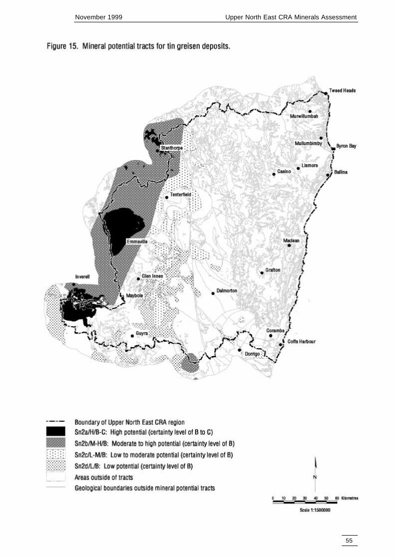
November 1999 Upper North East CRA Minerals Assessment
55

November 1999 Upper North East CRA Minerals Assessment
56
8.15 ALLUVIAL DIAMONDS (FIGURE 16)
Tract Dimnd/H/CThis tract consists of Tertiary basalt lavas or sediments within a five kilometre radius of known mineraloccurrences that have diamond recorded as a major commodity or have recorded diamond production.These five kilometre buffers are designed to coalesce into a north west to south east trending zone thatincludes the Copeton alluvial diamond occurrences and associated known Tertiary basalts and sediments,possibly controlled by Tertiary palaeo-drainage.
The potential for economic alluvial diamond deposits associated with old workings of these diamondoccurrences is considered high with a certainty level of C.
This tract does not include placer diamond deposits associated with concealed Tertiary sediments withinthe above five kilometre buffers, as existing data is insufficient to assess their potential.
Diamonds have been reported from Quaternary tin placers but no significant alluvial diamond depositshave been recorded. Dilution by the sediment load in the Quaternary streams may have hindered theformation of such deposits (MacNevin 1977 p.39, 40).
Concealed Quaternary alluvial sediment horizons could host placer diamond deposits but existinginformation does not allow assessment of their potential. Hence the potential for diamond deposits formedby the erosion of diamonds from the Tertiary sediments into Quaternary streams is unknown.
8.16 ALLUVIAL SAPPHIRES (FIGURE 17)
Tract Sapp1a/M-H/CSignificant sapphire concentrations and occurrences are restricted to Quaternary and Tertiary sedimentswithin a 60 kilometre radius of the Mount Maybole shield volcano centre. These Quaternary and Tertiarysediments may contain economic sapphire deposits and the Quaternary sediments may conceal Tertiarysediments with economic sapphire deposits.
This tract includes the above Quaternary and Tertiary sediments within:(a) a 20 kilometre buffer around Tertiary basalt lavas and basalt lava outcrop and(b) basalt lava outcrop.
Outside the 20 kilometre buffer, sapphire is thought to have been largely destroyed or diluted bysediments during erosion and transport.
Also included in the tract are 100 metre buffers along creeks in area (a) to take account of unmappedQuaternary and Tertiary sediments.
Some known alluvial sapphire deposits that are marginally economic may become viable in theforeseeable future. Brown (1997) suggests that there are considerable resources remaining in knowndeposits and others await discovery, while paler blue sapphire in the eastern part of the tract is underexploited. Thus the potential for economic sapphire deposits in this tract is considered moderate to highwith a certainty level of C.
Concealed deep lead deposits derived from previously removed Tertiary basalt lavas/pyroclastics mayalso exist beneath Quaternary sediments outside the above 20 kilometre buffer but there are insufficientdata to assess their potential.
The minor occurrences of alluvial sapphire along the western margin of the Ebor Volcanics have not beenincluded in the tract, as the potential for economic sapphire deposits is considered very low. The largeTweed shield volcano, in the north east of the UNER, has also been excluded, as there are no recordedsapphire occurrences despite considerable partial erosion of its basal volcanic rock units.

November 1999 Upper North East CRA Minerals Assessment
57

November 1999 Upper North East CRA Minerals Assessment
58

November 1999 Upper North East CRA Minerals Assessment
59
Tract Sapp1b/L-M/BThis tract consists of the interfluves between stream buffers of in a 20 kilometre buffer around Tertiarybasalt lavas that are within 60 kilometres of Mount Maybole. Economic sapphire deposits may occur inthese interfluves within unmapped Quaternary and Tertiary sediments, and in Tertiary sedimentsconcealed beneath unmapped Quaternary sediments.
Basalt lava outcrop within 60 kilometres of Mount Maybole is also included in the tract because it mayhide economic Tertiary deep lead sapphire deposits.
Potential for economic sapphire deposits in the tract is considered to be low to moderate with a certaintyof B.
8.17 TUNGSTEN-MOLYBDENUM PIPES, VEINS, DISSEMINATIONS(FIGURE 18)
Tract W-Mo1a/H/B-CThis tract has been delineated based on the distribution of granitoids of the Moonbi Suite and the group ofleucoadamellites which have not been assigned to any plutonic suite and are collectively referred to asleucoadamellites (undetermined). A buffer zone of two kilometres around the Moonbi Suite andLeucoadamellites is also included.
The Moonbi Suite granitoids are I-type, moderately oxidised and fractionated (Blevin & Chappell, 1993:Ashley, Barnes, Golding & Stephens, 1996). A number of tungsten - molybdenum veins and pipes occuralong the margins of these granitoids, the largest being the Moonbi Mo-W deposit 20 km north east ofTamworth. Based on the above information, it is concluded that the Moonbi Suite has a high potential fortungsten - molybdenum veins with a certainty level of C.
The leucoadamellites (undetermined) are I-type, moderately oxidised, and fractionated. A number of W-Mo veins occur along the margins of these granitoids. Molybdenum-bismuth-tungsten occur as pipes,veins and dissemination at the outer contact of the Kingsgate granite and other leucogranites (Gilligan &Barnes, 1990). The main deposits are those at Kingsgate where approximately 350 t of molybdenite and200 t of bismuth have been won from over 50 pipes. The leucoadamellites have a high potential fortungsten - molybdenum veins with a certainty level of B.
Overall, the tract has a high potential for tungsten - molybdenum veins with a certainty level of B-C.
Tract W-Mo1b/M-H/BThis tract outlines a granite shelf or possible cupola at shallow depths below the Glen Eden deposits. TheGlen Eden deposits comprise tungsten - molybdenum stockwork mineralisation and hydrothermal brecciapipes within Permian felsic volcanics (Barnes et al., 1988). Based on the presence of this style ofmineralisation and from interpretations of the magnetics, it is postulated that a shallow granite shelf orcupola underlies the area of this tract. The mineralising granite has been identified during explorationdrilling at a depth of 200 m (Amoco Minerals & Electrolytic Zinc Co. in 1983).
Based on the above information, it is concluded that this tract has a moderate - high potential for tungsten- molybdenum veins with a certainty level of B.
Tract W-Mo1c/M/BThis tract is based on the distribution of the leucoadamellites, (including the Mole, Gilgai and RubyCreek granitoids) and the Bolivia sub-type (Blevin & Chappell 1996). Over 150 lodes (including tin,tungsten and molybdenum) occur in the Mole Granite and 60 occur in and around the GilgaiGranite/Tingha Adamellite. The tract also includes a 2 kilometre buffer around these leucoadamellites.The leucoadamellites are I-type, reduced and highly fractionated (Blevin & Chappell 1993: Ashley et al.1996). A large number of W - Mo veins occur along the margins of these granitoids, particularly theBolivia sub-type. The roof pendant of the Mole Granite is excluded from the tract.
Based on the above information, it is concluded that this tract has a moderate potential for tungsten -molybdenum veins with a certainty level of B.

November 1999 Upper North East CRA Minerals Assessment
60

November 1999 Upper North East CRA Minerals Assessment
61
Tract W-Mo1d/L-M/B-CThis tract is based on the:
• Granitoids of the Clarence River Plutonic Suite, which are I-type, highly oxidised, and fractionated.These bodies have a number of molybdenum deposits. At Nundle, quartz - calcite - gold - tungsten -antimony veins are adjacent to granitoid contacts.
• Granitoids of the Uralla Plutonic Suite, which are I-type, reduced and fractionated. A number oftungsten - molybdenum veins occur along the margins of these bodies.
• The Gundle Granite, which is I-type (?), reduced and fractionated. There are a few tungsten -molybdenum veins associated this granite, the largest being the Guy Fawkes molybdenum deposit,60 km east of Armidale.
A buffer zone two kilometres wide is drawn around all the granitoids listed above.
The tracts enclosing the granitic suites listed above are considered to have low - moderate potential fortungsten - molybdenum mineralisation with certainty level C.
Evidence from geological data and magnetics suggest that the Gilgai, Mole and Ruby Creek graniticplutons are connected at shallow depth. The area of this shallow connection is considered to have low -moderate potential for tungsten - molybdenum mineralisation with certainty level B.
Overall, the tract has low - moderate potential with certainty level B-C.
8.18 TUNGSTEN SKARN DEPOSITS (FIGURE 19)
Tract W/M/BThe tract is based on the following geological parameters:• a 5 km wide zone adjacent to the margins of Triassic granitoids which are potential source rocks for
tungsten mineralisation, i.e. I-type granitoids which are fractionated and moderately oxidised. Adetailed analysis of the granitoids which are potential source rocks for tungsten mineralisation is givenin the model for tungsten-molybdenum veins and pipes,
• Palaeozoic calcareous sediments and ultramafic rocks which were intruded by these granitoids.
The intersection of the above two geological parameters defines the tract for tungsten skarn deposits,which is assessed as moderate potential with certainty level B.
8.19 SILEXITE (FIGURE 20)
Tract Silexite/M-H/BThe tract includes the area corresponding to the roof pendant of Mole Granite plus a 200 m wide bufferzone surrounding it. It contains all the known occurrences of silexite in the region.
8.20 COPPER-GOLD-MAGNETITE SKARN DEPOSITS (FIGURE 21)
Tract CuAu2/L-M/BThe tract includes zones where reactive calc-magnesian rocks lie within 5 kilometres of granitoids thathave a potential for hosting Cu-Au deposits. The tract is assessed as low to moderate because there are noeconomic skarn deposits known in the area, and because the occurrence of calc-magnesian rocks isgenerally irregular and intermittent within the potential host sequence.

November 1999 Upper North East CRA Minerals Assessment
62

November 1999 Upper North East CRA Minerals Assessment
63

November 1999 Upper North East CRA Minerals Assessment
64

November 1999 Upper North East CRA Minerals Assessment
65
8.21 ALLUVIAL GOLD (FIGURE 22)
Tract Au4a/M-H/CThis tract includes 100 metre buffers along streams, rivers, swamps, lakes, Quaternary sediments,Tertiary sediments and Tertiary lavas within 10 kilometres of known gold deposit clusters. Potential foreconomic Quaternary/Tertiary alluvial gold and deep lead deposits concealed beneath Tertiary basalt isconsidered to be moderate to high. Even though most alluvial gold areas have been worked in the past,modern technology may make some of these areas viable in future and allow access to deep lead depositsnot previously mined. The certainty level is assessed at C.
Tract Au4b/M/BThis tract includes 100 metre buffers along streams, rivers, swamps, lakes, Quaternary sediments,Tertiary sediments and Tertiary lavas that occur in areas of potential for other types of gold deposits.
Potential is considered moderate with a certainty of B.
8.22 GOLD DEPOSITS ASSOCIATED WITH VOLCANOGENICMASSIVE SULPHIDE MINERALISATION (INCLUDING GOLD INCHERT AND JASPERS) (FIGURE 23)
Tract Au5a/M/CThe tract is similar to the tract BM1a/M/C for volcanic associated massive sulphide deposits because goldmineralisation is spatially and temporally associated with massive sulphide mineralisation. Both stylesresult from submarine volcanic hydrothermal systems. The tract is marked by the presence of chert andjaspers which are known to host gold mineralisation in the area. The tract also hosts all the knownoccurrences of gold of this type in the UNE region. Mineral potential of the tract is thus assessed tomoderate with a certainty level of C.
Tract Au5b/L-M/BThe tract is similar to the tract BM1b/L-M/B for volcanic associated massive sulphide deposits. Althoughthe tract does not contain known occurrences of gold or volcanic associated massive sulphidemineralisation, it is marked by an environment which is favourable for distal type volcanic massivesulphide mineralisation. Hence mineral potential of the tract is assessed to be low to moderate with acertainty level of B.
8.23 ALLUVIAL TIN DEPOSITS (FIGURE 24)
Tract Sn3a/M-H/CThis tract includes 100 metre buffers along streams, rivers, swamps, lakes, Quaternary sediments,Tertiary sediments and Tertiary lavas within 10 kilometres of known tin deposit clusters (fields). Potentialfor economic Quaternary/Tertiary alluvial tin and deep lead deposits concealed beneath Tertiary basalt isconsidered moderate to high. Even though most alluvial tin areas have been worked in the past, moderntechnology may make some of these areas viable in future and allow access to deep lead deposits notpreviously mined. The certainty level is assessed at C.
Tract Sn3b/M/BThis tract includes 100 metre buffers along streams, rivers, swamps, lakes, Quaternary sediments,Tertiary sediments and Tertiary lavas that occur in areas of potential alluvial tin source rocks asdelineated by the tracts for tin veins and tin greisens.Potential is considered moderate with a certainty of B.

November 1999 Upper North East CRA Minerals Assessment
66

November 1999 Upper North East CRA Minerals Assessment
67

November 1999 Upper North East CRA Minerals Assessment
68

November 1999 Upper North East CRA Minerals Assessment
69
8.24 VOLCANIC HOSTED MAGNETITE (FIGURE 25)
Tract Fe1a/M-H/CThe tract includes rocks of the accretionary complex that are known to contain magnetite-rich units(Texas Beds), ironstones (Coffs Harbour Beds), magnetite-bearing chert or quartz-magnetiteaccumulations (Brookland Beds). These rocks also host all the known occurrences of volcanogenicmagnetite in the UNER. Mineral potential of the tract is assessed to be moderate to high with a certaintylevel of C
Tract Fe1b/L-M/BThe tract includes the rest of the rocks of the accretionary complex. Locally some units are magnetite richand are interpreted to be related to skarns. Most rocks in this tract have a potential for volcanic associatedmassive sulphide and volcanogenic manganese deposits. As the formation of volcanogenic magnetite isclosely related to the formation of volcanic associated massive sulphide and volcanogenic manganese,mineral potential of this tract is assessed to be low to moderate with a certainty level of B.
8.25 PODIFORM CHROMITE (FIGURE 26)
Tract Cr/H/CThis tract is characterised by the presence of an ultramafic body consisting of serpentinite known as theGordonbrook Serpentinite belt. It contains at least 6 known chromite deposits and 25 other prospects.There are significant Ni-Cr-PGE geochemical anomalies. The potential for further deposits of chromite isconsidered to be high with a certainty level of C.
8.26 LIMESTONE DEPOSITS (FIGURE 27)
Tract Lst1a/H/BThe tract is defined by the presence of known limestone quarries (The Four Mile, Tabulam and PlumbagoCreek). The tract is considered to have a high potential for additional limestone/dolomitic limestonedeposits with a certainty level of B.
Tract Lst1b/M/BThe tract is defined by rocks of the Willowie Creek Beds. The beds host two known limestone quarriesbut, because the distribution of calcareous units in these beds could be erratic and irregular, mineralpotential of the tract is assessed to be moderate with a certainty level of B.
8.27 VOLCANOGENIC MANGANESE DEPOSITS (FIGURE 28)
Tract Mn1a/M/CThe tract is similar to the tract BM1a/M/C for volcanic associated massive sulphide deposits becausevolcanogenic manganese mineralisation is spatially and temporally associated with massive sulphidemineralisation. Both styles result from submarine volcanic hydrothermal systems. The tract includesrocks of the accretionary complex such as jaspers, cherts and other mafic rocks (altered and/ormetamorphic equivalents), indicative of submarine volcanic-hydrothermal systems. It also hosts all theknown occurrences of manganese mineralisation. Mineral potential of the tract is assessed to be moderatewith a certainty level of C.
Tract Mn1b/L-M/BThe tract is similar to the tract BM1b/L-M/C for volcanic associated massive sulphide deposits. Althoughthe tract does not contain known occurrences of manganese or volcanic associated massive sulphidemineralisation, it is marked by an environment which is favourable for distal type volcanic massivesulphide mineralisation. Hence mineral potential of the tract is assessed to be low to moderate with acertainty level of B.

November 1999 Upper North East CRA Minerals Assessment
70
November 1999 Upper North East CRA Minerals Assessment
71

November 1999 Upper North East CRA Minerals Assessment
72

November 1999 Upper North East CRA Minerals Assessment
73

November 1999 Upper North East CRA Minerals Assessment
74
8.28 CONSTRUCTION MATERIALS (AGGREGATE AND PAVEMENT)(FIGURES 29 & 31)
Construction materials are naturally occurring, low unit value commodities which are generally exploitedin bulk and with limited processing for use in civil construction. In the Upper North East region,construction materials are in high demand due to the rapidly expanding population in the area. There aremore than 2000 active, historic or identified potential construction material sites in the Upper North Eastregion. The great majority of these would probably only qualify as fill materials by contemporarystandards. The assessment of potential construction materials is restricted to aggregates (higher valuematerials) and road pavement materials (moderate value materials).
Transport costs contribute significantly to the delivered cost of construction materials, and therefore it isimportant to obtain such materials as close as possible to markets. Increased transport costs associatedwith the need to use more distant resources result in increased raw material costs which are inevitablypassed on to the consumer. Therefore, the delineation of tracts for the potential of construction materialsis based upon the type of material likely to be present (that is the geology), and the distance of potentialdeposits from roads and markets.
The widths of buffers for different types of roads are based on the distribution of known deposits ofconstruction materials, the Pacific Highway is buffered 4800 metres on each side of the road; principalroads 2400 metres; secondary roads 1200 metres; minor roads 600 metres and tracks 300 metres. Thepotential for the two main types of construction materials was assessed for suitable rock types withinthese buffers. Some known locations of construction materials were still present outside the buffersbecause of the lack of sufficient detail on roads and geology in some parts of the region. These knownlocations of construction materials were buffered to indicate that additional resources of constructionmaterials may be present at 400 metres around these locations for aggregates and 200 metres for roadpavement materials.
The various tracts for aggregates and pavement materials are summarised in the following tables.
TABLE 7: AGGREGATE TRACT DATA (FIGURE 29)
Name of Tract Lithologies and rock units within buffersConmatag/H/C Unconsolidated sand and gravel; coarse quartz sandstone (a large operating
quarry in Ripley Road sandstone at Suffolk Park); contact metamorphosedsedimentary rocks; older sedimentary rocks within 500m of a granite body;specific coastal granites, granitoid body at Valla
Conmatag/M-H/C Tertiary volcanics, especially basalts; many aggregate quarries are present inTertiary basalts especially in the Tweed and Lismore regions; WandsworthVolcanic Group except Drake Volcanics; accretionary complex rocks east of theDemon Fault including the Beenleigh block and Coffs Harbour block butexcluding the Emu Creek block and Nambucca block.
Conmatag/M/B Sand and gravel - specific unitsConmatag/L-M/B Drake Volcanics; Chillingham VolcanicsConmatag/L/B Kangaroo Creek Sandstone - rippable to fine sand in many places; Tertiary
sediments excluding fine sands; Ripley Road Sandstone except for at SuffolkPark (see above); Bundamba Group except for Ripley Road sandstone - containsunits rich in sands and gravelsLeucogranites In places these units are deeply weathered and covered with thicksandy materialAll granites except leucogranites and excluding Hillgrove suite and relatedgranitesAll other rock inside road buffer except near existing depositRocks outside of roads buffer except where near existing deposit

November 1999 Upper North East CRA Minerals Assessment
75
TABLE 8. PAVEMENT TRACT DATA (FIGURE 31)
Name of Tract Lithologies and rock units within buffersConmatpv/H/B Sand and gravel (unconsolidated)
Coarse Sandstone baked by overlying Tertiary basalt and contain large operatingquarry in Ripley Road sandstone at Suffolk ParkContact metamorphosed sedimentary rocks. Older sedimentary rocks within500m of a granite bodyTertiary volcanics, especially basalts. Many aggregate quarries are present inTertiary basalt especially in the Tweed and Lismore regionsWandsworth Volcanic Group except Drake VolcanicsAccretionary complex rocks east of the Demon Fault including the Beenleighblock and Coffs Harbour block but excluding the Emu Creek block andNambucca blockSand and gravel - specific unitsDrake VolcanicsChillingham Volcanics. These dense felsic volcanics have been used forconstruction materials just to the north of the region in QueenslandKangaroo Creek Sandstone - rippable to fine sand in many places
Conmatpv/M-H/B Tertiary sediments excluding fine sandsConmatpv/M/B Ripley Road Sandstone except for at Suffolk Park (see above)
Leucogranites In places these units are deeply weathered and covered with thicksandy material
Conmatpv/L-M/B Specific coastal granites. Granitoid body at Valla.Conmatpv/L/B All other rock inside road buffer except near existing deposit
Rocks outside of roads buffer except where near existing deposit
8.29 CHRYSOTILE, ASBESTOS DEPOSITS (FIGURE 30)
Tract Asb/H/C
This tract is characterised by the presence of an ultramafic body consisting of serpentinite known as theGordonbrook Serpentinite belt.
8.30 SUMMARY OF POTENTIAL MINERAL AND HYDROCARBONRESOURCES
Mineral potential tracts were defined for 29 types of deposits (Figures 3-31, Tables 9, 10). These include:• 17 metalliferous deposit types• industrial mineral deposit types• 4 energy commodities (open cut and underground coal, coal seam methane and hydrocarbons), and• 2 precious minerals type deposits (diamonds and sapphires).
Only the mineral deposit types judged to be most likely to constitute significant resources in the regionhave been assessed in detail. The assessments of all deposit types are described in detail in Appendix B.
To facilitate land use decisions, all the mineral potential tracts were combined (overlain) to produce fourtypes of summary maps of mineral potential (Maps 3, 4, 5 & 6).
Map 3 is a composite of mineral potential for the Upper North East Forest region and shows the highestlevel of mineral potential assessed (in June 1998) for any particular area in the region. Where tracts fordifferent deposit types overlap, this area is assigned the highest potential level of all the overlappingtracts. In this approach, the tract having the highest mineral potential in any particular area obscurestracts of lower mineral potential.
The types of deposits with the most widespread tracts of high potential in the Upper North East Forestregion are for coal seam methane gas in the Clarence Moreton Basin and smaller areas of high potential

November 1999 Upper North East CRA Minerals Assessment
76

November 1999 Upper North East CRA Minerals Assessment
77

November 1999 Upper North East CRA Minerals Assessment
78

November 1999 Upper North East CRA Minerals Assessment
79
for construction materials along the eastern margin of the basin. Areas of high potential to the west of thebasin are for epithermal gold and disseminated gold in leucocratic granites. South west of the basin, areasof high and moderate to high potential are dominated by metahydrothermal gold.
Areas of high potential in the western half of the region are for tungsten-molybdenum deposits, and alongthe western perimeter there are high potential tracts for tin veins, tin greisen deposits, silver bearingpolymetallic vein deposits and metahydrothermal gold deposits. The potential for these deposit types alsooccupies most of the moderate to high potential tracts along the western boundary of the region.
It is important to note that Map 3 is a composite of mineral potential tracts for different types of mineraldeposits that do not have equal economic values. For example a tract with moderate to high potential forcoal seam methane gas may be considered to have a higher economic value than a tract with highpotential for limestone.
Map 4 shows the cumulative mineral potential for the Upper North East Forest region. In constructingthis map, standard scores were allocated according to a subjective ranking of levels of mineral potential asfollows: high potential (18), moderate – high (12), moderate (6), low – moderate (2), low (1), unknown(no score). In those areas where tracts overlap, the scores are added and this cumulative score is assignedto the overlapping areas. For example, where there is overlap of tracts with high potential formetahydrothermal gold (score 18), low – moderate potential for tungsten-molybdenum deposits (score 2)and moderate potential for tungsten skarns (score 6), then this area of overlap will have a cumulativescore of 26. The cumulative mineral potential takes account of both the diversity of deposit types thatmay occur in each area as well as the level of mineral potential of each of these deposit types.
A zone of high scores of cumulative potential occur along the western border of the region north andsouth of Emmaville. In this part of the region there are varying degrees of overlap of potential for 11different types of deposits. The deposit types include silver bearing polymetallic vein deposits (highpotential score of 18 and moderate to high of 12), tungsten-molybdenum deposits (18), two types of tinveins (18 and 12), alluvial sapphires (12), two types of construction materials (18 and 12), disseminatedgold (18 and 12), metahydrothermal gold (18 and 12), and volcanogenic massive sulphide deposits (6)with gold and with base metals. The cumulated potential scores exceed 60 for much of this part of theregion and in small areas exceed 100.
The areas with overlapping tracts of mineral potential (high cumulative scores) emphasise the diversity ofmineral potential. These areas are not necessarily more prospective than an area with fewer overlappingtracts of high potential, eg the Clarence-Moreton Basin for coal seam methane. The relative economicsignificance of the tracts for different types of mineral deposits, as perceived by mining companies, wouldbe influenced by their perceptions of prospectivity, future market conditions, land access and otherfactors.
Map 5 shows the weighted composite mineral potential for the region. The weighted compositepotential makes some allowance for the relative economic significance between different types of mineraldeposits. In this approach, mineral deposits are indexed for their relative economic significance. Forexample, porphyry copper gold was allocated an index of 7 out of 10, whereas pavement constructionmaterial was allocated an index of only 1 out of 10. The indexes for the various deposit types are listed inTable 7. The weighted composite score is calculated by multiplying the deposit index by the standardmineral potential score. For example, a tract for metahydrothermal vein gold deposits (index of 6) withhigh potential (18) will have a weighted composite score of 108 (6x18). Similarly a tract for pavementconstruction materials (index of 1) with high potential (18) will have a weighted composite score of 18(1x18). Where there are overlapping tracts, with different weighted scores, the highest of these scores isassigned to the area of overlap. The distribution of the weighted mineral potential scores resulting fromthe overlap of tracts in the region is shown on Map 5. The mineral deposit indexes and weighted scoresare tabulated in Table 7 and the size of areas for each weighted score, after overlap of tracts, is shown inTable 8. The weighted scores for tracts of all the mineral deposit types have been sorted in Figure 32. Thefull areas covered by the individual tracts of mineral potential for the various types of deposits (Figures 3to 31) is tabulated in Table C1 in Appendix C.
On Map 5, areas with weighted scores of 90 to 126 cover about 49.56% of the Upper North East region(Table 8). This part of the region includes all of the areas (tracts) of high potential for the most

November 1999 Upper North East CRA Minerals Assessment
80
significant types of mineral deposits (ie those with an index of 5 to 8 (Table 7)). The most extensive tractin this range of weighted scores is for coal seam methane over the Clarence-Moreton Basin (weightedscore of 126, covers 26.37% of the region (Table C1)) and for metahydrothermal gold veins west andsouth west of the basin (108, 11.4%). The mineral potential for other mineral deposit types in this rangeare mostly in the western part of the region and include silver bearing polymetallic veins (90, 7.26%), tinvein deposits (90, 7.26%) and tin greisen deposits (90, 4.12%). Less extensive tracts in this range ofweighted mineral potential scores are for disseminated gold deposits in leucogranites (126, 3.38%), andfor epithermal gold (126, 1.91%). Note that some of the mineral potential tracts, for specific types ofmineral deposits, are partly obscured by tracts with a higher weighted potential score. For example thefull extent of the tract for tin veins, with a weighted score of 90, covers 7.26% of the region (Table C1).However, tracts with a score of 90 are partly obscured by tracts with a higher weighted potential score sothat the remaining area with a score of 90 in the region is only 6.24% as shown in Table 8.

November 1999 Upper North East CRA Minerals Assessment
81
TABLE 9: SUMMARY OF POTENTIAL MINERAL RESOURCES AS AT JUNE 1998
Levels of mineral potential andstandard potential scores (b)
High M-H Moderate L-M Low18 12 6 2 1
Mineral DepositModel
DepositIndex(a)
Weighted Potential Score(a x b)
Hydrocarbons (oil and gas) 8 96 48 16Coal seam methane 7 126 42 7Porphyry Copper-gold 7 42 14Epithermal gold silver 7 126 42 14 7Au disseminated in leucogranite 7 126 42 7Heavy mineral sand 7 126 84 42Coal (opencut) 6 72 36Volcanic associated massivesulphide
6 36 12
Metahydrothermal veins 6 108 72 12Coal (underground) 5 30 10Silver-bearing polymetallic veins 5 90 60 10 5Tin veins 5 90 60 10 5Tin greisen 5 90 60 10 5Alluvial diamond 5 90Alluvial sapphire 5 60 10Tungsten-molybdenum pipes,veins and disseminations
4 72 48 24 8
Tungsten skarn 4 24Silexite (quart, topaz W-Mo-Bi) 4 48Copper ± magnetite skarn ± gold 4 8Alluvial gold (including deep lead) 4 48 24Gold associated with volcanicmassive sulphide mineralisationincluding gold in chert and jaspers
4 24 8
Alluvial tin 4 48 24Volcanic hosted magnetite 3 36 6Podiform chromite 3 54Limestone 3 54 18Volcanogenic manganese 2 12 4Construction material - aggregate 2 36 24 12 4 2Chrysotile, asbestos 2 36Construction material - pavement 1 18 12 6 2 1

November 1999 Upper North East CRA Minerals Assessment
82
The areas with weighted scores of 36 to 84 cover about 37.88% of the region. The most extensive mineralpotential tracts in this range of mineral potential scores are those for oil and gas in the Clarence-MoretonBasin (weighted score of 48, covers 16.39% of the region (Table C1)), volcanic associated massivesulphide deposits mainly south east of the basin (36,19.33%), metahydrothermal gold veins (72, 12.14%),tungsten molybdenum deposits (72, 12.92%), and alluvial gold (48, 12.02%). There are smaller areas withpotential for open cut coal (72, 1.96% and 36, 5.3%), silver bearing polymetallic veins (60, 5.16%), tinveins (60, 5.16%), tin greisens (60, 6.94%), alluvial tin (48, 5.38%), and aggregated constructionmaterials (36, 7.82%). Small areas of potential in this weighted score range include porphyry copper gold(42, 3.58%), alluvial sapphire (60, 3.51%), heavy mineral sands (42, 2.19%) and porphyry copper gold(42, 1.68%).
The area with weighted mineral potential classes below a score 36 cover about 12.56% of the region. Themore significant tracts in this range of weighted mineral potential scores are for pavement constructionmaterials (18, 25.03%) and aggregate construction materials (24, 13.82%). Considerable proportions ofthese tracts are overlain by tracts with higher weighted mineral potential scores.
TABLE 10: SIZE OF AREAS COVERED BY WEIGHTED MINERAL POTENTIAL SCORES INMAP 5
Weightedmineralpotential
score
Area of weightedmineral potential
tract (m2)
%Area of Region(Area of region =
39082km2)
0 34500000.000 0.08827593
2 88125000.000 0.22548744
5 187500.000 0.00047976
7 1250000.000 0.0031984
8 1812500.000 0.00463768
10 641062500.000 1.64030116
12 20812500.000 0.05325342
14 544625000.000 1.39354434
16 827000000.000 2.11606366
18 36375000.000 0.09307354
24 2462437500.000 6.30069469
30 252562500.000 0.6462374
36 780250000.000 1.99644338
42 1487312500.000 3.80562023
48 2579875000.000 6.60118469
54 94875000.000 0.24275881
60 1771250000.000 4.53213756
72 6986250000.000 17.8758764
84 1103375000.000 2.82323064
90 2440625000.000 6.24488255
96 45875000.000 0.1173814
108 4451437500.000 11.3899941
126 12430125000.000 31.8052428

November 1999 Upper North East CRA Minerals Assessment
83
126
126
126
126
108
96
90
90
90
90
84
72
72
72
60
60
60
60
54
54
48
48
48
48
48
42
42
42
42
42
36
36
36
36
36
30
24
24
24
24
24
24
18
18
16
14
14
12
12
12
12
12
10
10
10
10
10
8
8
8
7
7
7
6
6
5
5
5
4
4
2
2
1
0 20 40 60 80 100 120 140
Epithermal gold silver H
Heavy mineral sand H
Coal seam methane H
Au disseminated in leucogranite H
Metahydrothermal veins H
Hydrocarbons (oil and gas) M-H
Alluvial diamond H
Tin veins H
Silver-bearing polymetallic veins H
Tin greisen H
Heavy mineral sand M-H
Metahydrothermal veins M-H
Coal (opencut) M-H
Tungsten-molybdenum pipes, veins and disseminations H
Tin veins M-H
Alluvial sapphire M-H
Silver-bearing polymetallic veins M-H
Tin greisen M-H
Podiform chromite H
Limestone H
Hydrocarbons (oil and gas) M
Alluvial gold (including deep lead) M-H
Silexite (quatrz, topaz, W-Mo-Bi) M-H
Tungsten-molybdenum pipes, veins and disseminations M-H
Alluvial tin M-H
Epithermal gold silver M
Heavy mineral sand M
Coal seam methane M
Au disseminated in leucogranite M
Porphyry Copper-gold M
Coal (opencut) M
Volcanic associated massive sulphide M
Volcanic hosted magnetite M-H
Construction material - aggregate H
Chrysotile, asbestos H
Coal (underground) M
Gold associated with VMS mineralisation M
Alluvial gold (including deep lead) M
Tungsten-molybdenum pipes, veins and disseminations M
Tungsten skarn M
Alluvial tin M
Construction material - aggregate M-H
Limestone M
Construction material - pavement H
Hydrocarbons (oil and gas) L-M
Epithermal gold silver L-M
Porphyry Copper-gold L-M
Metahydrothermal veins L-M
Volcanic associated massive sulphide L-M
Construction material - aggregate M
Volcanogenic manganese M
Construction material - pavement M-H
Tin veins L-M
Alluvial sapphire L-M
Coal (underground) L-M
Silver-bearing polymetallic veins L-M
Tin greisen L-M
Gold associated with VMS mineralisation L-M
Tungsten-molybdenum pipes, veins and disseminations L-M
Copper-magnetite skarn-gold L-M
Epithermal gold silver L
Coal seam methane L
Au disseminated in leucogranite L
Volcanic hosted magnetite L-M
Construction material - pavement M
Tin veins L
Silver-bearing polymetallic veins L
Tin greisen L
Construction material - aggregate L-M
Volcanogenic manganese L-M
Construction material - aggregate L
Construction material - pavement L-M
Construction material - pavement L
Figure 32 - Weighted Scores for tracts of all mineral deposit types

November 1999 Upper North East CRA Minerals Assessment
84
The weighted cumulative mineral potential (Map 6) is similar to the weighted composite mineralpotential in that the score for each tract is calculated by multiplying the deposit index by the mineralpotential score. Where there is overlap of tracts, the scores of the overlapping tracts are summed and thistotal score is assigned to the overlap area. In Map 6, the relative importance of deposit types is taken intoaccount before adding individual potential scores. Thus on a simple cumulative map, an area where ahigh potential tract of metahydrothermal vein gold overlaps a tract with moderate potential for limestonedeposits will have the same score (18+6=24) as an area where high potential tract for metahydrothermalvein gold overlaps with a tract of moderate potential for volcanic massive sulphide gold deposits(18+6=24). However, on a weighted cumulative map, the two areas would acquire different scoresbecause of the different weights given to each of the deposit types. That is, for overlappingmetahydrothermal vein gold tract (high potential) and limestone (moderate potential) the score is (18x6) +(6x3) = 126; for the overlapping metahydrothermal vein gold tract (high potential) and clay tract(moderate potential) the score is (18x6) + (6x4) = 132.
The weighted cumulative map is similar to the cumulative map in that it highlights the diversity ofmineral potential in a north east trending zone along the western boundary of the region.

November 1999 Upper North East CRA Minerals Assessment
85
9.REFERENCES
References for Appendix B are given separately, below.
ABARE, AGSO & BRS 1993. Shoalwater Bay Military Training Area - Resource Assessment. AustralianBureau of Agricultural and Resource Economics, Australian Geological Survey Organisationand Bureau of Resource Sciences. Commonwealth of Australia, Canberra. 288 pp.
Allegiance Mining NL 1994. Exploration reports, EL 4221 and 4222, Dorrigo area. Geological Survey ofNew South Wales, File GS1994/177 (unpublished).
Alt C. 1981. Old Torrington - A History of Torrington and District. Back to Torrington CentenaryCommittee, Glen Innes. 96pp.
Amoco Minerals & Electrolytic Zinc Co. 1983. Exploration reports, EL 1993, Dundee - Glen Eden area.Geological Survey of New South Wales, File GS1983/300 (unpublished).
Andrews E.C. 1908. Report on the Drake gold and copper field. Geological Survey of New South Wales,Mineral Resources 12, 41pp.
AOG Minerals Australia Pty Ltd, 1981. Exploration reports, EL 1393, Surface Hill -Timbarra River.Geological Survey of New South Wales, File GS1981/223 (unpublished).
Ashley P.M. & Flood P.G. eds. 1997. Tectonics and Metallogenesis of the New England Orogen. Alan H.Voisey Memorial volume. Geological Society of Australia, Special Publication 19, 303pp.
Ashley P.M., Barnes R.G., Golding S.D. & Stephens C.J. 1996. Metallogenesis related to Triassicmagmatism in the New England orogen. Mesozoic Geology of the Eastern Australia PlateConference. Geological Society of Australia, Extended Abstracts 43.
Barnes R.G & Willis I.L. 1989. The geology of the Grafton and Maclean 1:250 000 sheet areas.Geological Survey of New South Wales, Report GS1989/117. (unpublished)
Barnes R.G., Brown R.E., Brownlow J.W., Gilligan L.B., Krynen J. & Willis I.L. 1988. A review of themineral deposits of the New England Orogen, in New South Wales. New England Orogen —Tectonics and Metallogenesis. Proceedings of a symposium held at the University of NewEngland. ed. J.D. Kleeman. Department of Geology and Geophysics, University of NewEngland, Armidale.
Barnes R.G., Brownlow J.W., Alder D., Facer R., Oakes G., Suppel D., Stroud J., O’Dea T. & HollandsK. 1996. Chapter 4, Mineral Resources. In Regional report of upper north east New SouthWales, Volume 5 Socio-economic values. Resource and Conservation Assessment Council,Sydney, 73-154.
Barnes R.G, Henley H.F. & Henley J.E. 1995. Exploration data package for the Tenterfield and Coaldale1:100,000 sheet areas (in two volumes). Geological Survey of New South Wales, ReportGS1995/004 (unpublished).
Blain C.B. 1992. Is exploration becoming more cost effective? Paper presented at the NationalAgricultural and Resources Outlook Conference, Canberra, 4-6 February.
Blevin P.L. & Chappell B.W. 1993: The influence of fractionation and magma redox on the distributionof mineralisation associated with the New England Batholith. In Flood P.G. & Aitchison J.C.eds. New England Orogen, eastern Australia. Department of Geology & Geophysics, Univ. ofNew England, Armidale.

November 1999 Upper North East CRA Minerals Assessment
86
Blevin P.L. & Chappell B.W. 1996. Internal evolution and metallogeny of Permo-Triassic high-Kgranites in the Tenterfield-Stanthorpe region, southern New England orogen, Australia.Mesozoic geology of the Eastern Australia Plate Conference. Geological Society of Australia,Extended Abstracts 43, 94-100.
Bottomer L.R. 1986. Epithermal silver-gold mineralization in the Drake area, northeastern New SouthWales. Australian Journal of Earth Sciences 33, 457-473.
Brown H. 1982. Tin at Tingha – The History of Tingha, The Greatest Tin Producing Area of New SouthWales, and the History of its People. Helen Brown, Armidale. 160pp.
Brown R.E. 1995. Exploration data package for the Glen Innes 1:100,000 sheet area. Geological Surveyof New South Wales, Report GS1995/231 (unpublished)
Brown R.E. 1997. Mineral deposits of the Glen Innes 1:100,000 map sheet area. Geological Survey ofNew South Wales, Quarterly Notes 103.
Brown R.E. & Stroud W.J. 1993. Exploration data package for the Inverell 1:100,000 sheet area.(2volumes) Geological Survey of New South Wales, Report GS1993/049 (unpublished).
Brown R.E. & Stroud W.J. 1997. Inverell metallogenic map 1:250 000 SH/56-5 - Metallogenic Study andMineral Deposit Data sheets. Geological Survey of New South Wales, Sydney, 576pp.
Brown R.E., Brownlow J.W. & Krynen J. 1992. Manilla–Narrabri 1:250,000 Metallogenic Map SH/56-9,SH/55-12: Metallogenic study and mineral deposit data sheets, Geological Survey of New SouthWales, Sydney.
Brownlow J.W. 1989. Industrial mineral and construction material deposits of the Grafton-Maclean1:250,000 sheet. Geological Survey of New South Wales, Report GS1989/308 (unpublished).
Brownlow J.W. 1994. Construction materials in the North Coast region: Demand assessment andpreliminary resource management strategy. Geological Survey of New South Wales, ReportGS1994/199 (unpublished).
Carne J.E. 1889. Notes on the mineral resources of New South Wales as represented at the MelbourneCentennial International Exhibition of 1888. Geological Survey of New South Wales, Records 1,33-114.
Clark A.L. 1996. Structural changes in a global mineral supply - Australia’s changing role. Paperpresented at the National Agricultural and Resources Outlook Conference, Canberra, 6-8February.
Cox D.P. & Singer D.A. 1986. Mineral Deposit Models. US Geological Survey, Bulletin 1693.
Denaro T.J. & Burrows P.E. 1992. Mineral occurrences - Stanthorpe and Drake 1:100,000 sheet areas,Queensland. Queensland Department of Resource Industries, Report 1992/8 (unpublished).
Department of Mineral Resources, 1988. Drake gold-silver project. NSW Department of MineralResources, Minfo 19, 1-5.
Department of Mineral Resources, 1994. Lower Bielsdown Project. NSW. Department of MineralResources, Minfo 45, p 31.
Dewitt E., Redden J.A., Wilson A.B. & Buscher D. 1986. Mineral resource potential and geology of theBlack Hills National Forest, South Dakota and Wyoming. United States Geological Survey,Bulletin 1580 .
England B.M. 1985. Famous mineral localities: the Kingsgate mines, New South Wales, Australia. TheMineralogical Record 16, 265-289.
Environment Planning and Assessment Act 1979. New South Wales.
Flood P.G. & Aitchison J.C. eds. 1993. New England Orogen, eastern Australia, Department of Geologyand Geophysics, University of New England, Armidale.
Flood R.H. & Runnegar B. eds. 1982. New England Geology. Department of Geology, University of NewEngland and AHV Club, Armidale.

November 1999 Upper North East CRA Minerals Assessment
87
Flood P.G., Kovarch A.L. & Moore D.M. 1994. A revision of the Warwick and Tweed Heads 1:250,000geological maps. Report by Geo Mapping Technologies Pty Ltd for Geological Survey of NewSouth Wales. Geological Survey of New South Wales, File GS1994/203. (unpublished)
Gilligan L.B & Barnes R.G. 1990. New England Fold Belt, New South Wales —regional geology andmineralisation. In Hughes F.E. ed. Geology of the Mineral Deposits of Australia and Papua NewGuinea. Australasian Institute of Mining and Metallurgy, Monograph 14, 1417-1423.
Gilligan L.B., Brownlow J.W., Cameron R.G. & Henley H.F. 1992. Dorrigo-Coffs Harbour 1:250,000Metallogenic Map SH/56-10, SH/56-11. Metallogenic Study and Mineral Deposit Data Sheets.509 pp. Geological Survey of New South Wales, Sydney.
Henley H.F. & Barnes R.G. 1992. Exploration data package for the Newton Boyd and Grafton 1:100,000sheet areas. Geological Survey of New South Wales, Report GS1992/088. (unpublished)
Henley H.F. & Brown R.E. 1998. Exploration data package for the Clive 1:100,000 sheet area.Geological Survey of New South Wales, Report GS1998/125. (unpublished).
Houston M.J. 1993. The geology and mineralisation of the Drake mine area, northern NSW, Australia. inNew England Orogen, eastern Australia (eds Flood, P.G & Aitchison, J.C.). Published by theDept. Geology & Geophysics, Univ. of New England, Armidale.
Kleeman J.D. (ed.) 1988. New England Orogen tectonics and Metallogenesis Proceedings of aSymposium 14-18 Nov 1988. Dept of Geology and Geophysics, University of New England,222pp.
Lobsey I. 1972. The Creek. A History of Emmaville and District. Emmaville Centenary CelebrationsCommittee, Glen Innes. 68pp.
MacNevin A.A. 1975. Demon, Emu Creek and Beenleigh Blocks. Gordonbrook Serpentinite Belt. InMarkham N.L. & Basden H. eds. The Mineral Deposits of New South Wales. pp.420-427.Geological Survey of New South Wales, Sydney.
MacNevin A. A. 1977. Diamonds in New South Wales . Geological Survey of New South Wales, MineralResources Report 42, 1-125.
Markham N.L. 1975. Gold deposits of the New England Fold Belt. Geological Survey of New SouthWales, Report GS 1975/378 (unpublished).
Marsh S.P., Kropschopt S.J. & Dickinson R.G. 1984. Wilderness mineral potential. United StatesGeological Survey, Professional Paper 1300.
Mines Inspection 1901 (as amended). New South Wales.
Minmet Database. Perth, Western Australia.
Mining Act 1992. New South Wales.
Morley I.W. 1982. A History of the Sand Mining Industry in Eastern Australia. University of QueenslandPress, St. Lucia. 278pp.
Mt Carrington Mines Ltd, 1984. Exploration reports, EL 1821, EL 3744, Drake area. Geological Surveyof New South Wales, File GS1984/418 (unpublished).
Newbury N.R. 1991. Mines of eastern New England, 1850 -1910. Guyra & District Historical Society,Journal 4, 1-48.
Newmont Pty Ltd, 1974. First and final report, EL 633, Timbarra Gold Field. Geological Survey of NewSouth Wales, File GS1974/072 (unpublished).
Offenberg A.C. & Cohrane G.W. 1975. Drake Mineral Field. In Knight C.L. ed. Economic Geology ofAustralia and New Guinea. AIMM, Melbourne, pp721-724.
Petroleum (Onshore) Act 1991. New South Wales.
Ross Mining Ltd., 1997a. Annual Report for 1997
Ross Mining Ltd. 1997b .Internet site, http://www.rossmining.com.au/Timbarra.html
Scheibner E. & Basden, H. ed. 1996. Geology of New South Wales - Synthesis. Volume 1 StructuralFramework. Geological Survey of New South Wales, Memoirs Geology 13(1), 295 pp.

November 1999 Upper North East CRA Minerals Assessment
88
Snowden H. 1987. Drake. Stories of Life and Times in an Old Mining Town. Drake CentenaryCommittee, Drake. 88pp.
Stroud W.J., Facer R.A., Agostini A., Chesnut W.S., Suppel D.W., Barnes R.G. & Roy, P.S. 1996.Chapter 3, Geology. In Regional report of upper north east New South Wales, Volume 2Physical attributes. Resource and Conservation Assessment Council, Sydney, 41 - 106
Suppel D.W., Barnes R.G. & Scheibner E. 1998. The Palaeozoic in New South Wales - geology andmineral resources. AGSO Journal of Australian Geology and Geophysics, 17(3), 87-105.
Taylor, R.B. & Steven, T.A., 1983. Definition of mineral resource potential. Economic Geology 78, 1268-1270.
Utah Development Co, 1969. (Joint authors V.R. Forbes and C.O. Haslam). Report on Poverty Point GoldProspect, Tenterfield. Geological Survey of New South Wales, File GS1969/367 (unpublished).
Weber C.R. 1975. Woolomin-Texas Block. Plutonic Rocks and Intruded Sediments. In Markham N.L. &Basden H. Eds. The Mineral Deposits of New South Wales. pp.350-391. Geological Survey ofNew South Wales, Sydney.
Wells A.T. 1995. Nymboida, Red Cliff and Evans Head Coal Measures, New South Wales. In Ward C.R.Harrington H.J., Mallett C.W. & Beetson J.W. 1995. Geology of Australian Coal Basins.Geological Society of Australia Coal Geology Group, Special Publication 1.
Wilkinson I. 1980. Forgotten Country, The Story of the Upper Clarence Gold Fields. Northern RiversCollege of Advanced Education, Lismore. 292pp.
Winward K. 1975. Quaternary coastal sediments. In Markham N.L. & Basden H. eds. The MineralDeposits of New South Wales. pp.595-621. Geological Survey of New South Wales, Sydney.
Wynn D.W. 1965. Pheasant Creek tin deposits. Geological Survey of New South Wales, Report 31, 25-26.
November 1999 Upper North East CRA Minerals Assessment
89
APPENDIX AMETHODOLOGY FOR ASSESSMENT OF POTENTIAL (UNDISCOVERED)
MINERAL RESOURCES
The mineral potential of the study areas has been assessed by determining the types of mineral depositslikely to be found under the geological conditions known or believed to exist there. The generalmethodology used, described below, was developed by the United States Geological Survey (USGS), andhas been used successfully for mineral resource assessments of forest areas in North America andelsewhere. The qualitative methodology for the assessment of potential mineral resources is described byMarsh, Kropschot and Dickinson (1984), Taylor and Steven (1983) and by Dewitt, Redden, Wilson andBuscher (1986).
An assessment of the potential mineral resources of a region combines knowledge of the region’sgeology, geophysics, geochemistry, mineral deposits and occurrences with current theories of mineraldeposit genesis and results of mineral exploration. The assessment process requires a study of availablegeoscientific data — for a region to small area, as required — to determine the history of geologicalprocesses and environments. Geological environments judged to have characteristics known to beassociated with specific types of mineral deposits are then identified. In particular the assessment drawson regional and local characteristics of mineral deposit models to establish whether or not specific typesof mineral deposits are likely to occur.
The mineral deposit models used in this assessment are generally those published by Cox and Singer(1986). These mineral deposit models are the systematic arrangements of information describing theessential attributes (properties) of groups or classes of mineral deposits. The models used are empirical(descriptive), the various attributes being recognised as essential even though their relationships areunknown. Each model encapsulates the common features of a group of deposits, as these are known fromdeposits around the world, and is constructed (as far as possible) to be independent of site-specificattributes not common to the group. The value of these models lies in the ability to apply what is knownabout a group of significant mineral deposits to the known geological environment of the area beingassessed.
The assessment takes into account all of the features of the deposit models and whether these features canbe recognised in the geoscientific data available for the area being assessed. Local and regional-scalefeatures provide evidence as to whether the geological environment is conducive to, or permissive of, theformation of a given deposit type.
There are probably at least 70 styles of mineral deposits of economic or potential economic significancein Australia. These have distinct features and have formed in different ways. It is not feasible to applymodels for all of these deposit classes systematically in each study area. Only the deposit types judged tobe most likely to constitute economically significant resources in each area have been assessed in anydetail. Where necessary, variations on USGS deposit models (Cox and Singer 1986) can be made tobetter fit regional circumstances.
Qualitatively assessed potential resourcesA qualitative assessment of the potential resources of an area is an estimate of the likelihood ofoccurrence of mineral deposits which may be of sufficient size and grade to constitute a mineral resource.
The mineral potential of an area is assessed for specific types of mineral deposits. For each type ofdeposit considered in a given area, the mineral potential is ranked in qualitative terms as ‘high’,‘moderate’, ‘low’, ‘no’ or ‘unknown’, based upon professional judgements of geoscientists involved inthe assessment. A qualitative mineral potential assessment is not a measure of the resources themselves.It cannot be classified according to the two dimensional (‘McKelvey’) diagram used for identifiedresources. For this reason the qualitatively assessed potential resources are shown in a separate box(Figure 2). The rankings are defined as follows:
H: An area is considered to have a high mineral resource potential if the geological, geophysical orgeochemical evidence indicate a high likelihood that mineral concentration has taken place and that thereis a strong possibility of specific type(s) of mineral deposit(s) being present. The area has characteristicswhich give strong evidence for the presence of specific types of mineral deposits. The assignment of high

November 1999 Upper North East CRA Minerals Assessment
90
resource potential does not require that the specific mineral deposits types have already been identified inthe area being assessed.
M: An area is considered to have a moderate mineral resource potential if the available evidence indicatesthat there is a reasonable possibility of specific type(s) of mineral deposit(s) being present. There may ormay not be evidence of mineral occurrences or deposits. The characteristics for the presence of specifictypes of mineral deposits are less clear.
L: An area is considered to have a low mineral resource potential if there is a low possibility of specifictypes of mineral deposit(s) being present. Geological, geophysical and geochemical characteristics insuch areas indicate that mineral concentrations are unlikely, and evidence for specific mineral depositmodels is lacking. The assignment of low potential requires positive knowledge and cannot be used as avalid description for areas where adequate data are lacking.
N: The term ‘no’ mineral resource potential can be used for specified types of mineral deposits in areaswhere there is a detailed understanding of the geological environment and geoscientific evidenceindicates that such deposits are not present.
U: If there are insufficient data to classify the areas as having high, moderate, low or no potential, thenthe mineral resource potential is unknown.
To reflect the differing amount of information available, the assessment of mineral potential is alsocategorised according to levels of certainty, denoted by letters A to D (Figure 2).
A: The available data are not adequate to determine the level of mineral resource potential. This level isused with an assignment of unknown mineral resource potential.
B: The available data are adequate to suggest the geological environment and the level of mineralresource potential, but either the evidence is insufficient to establish precisely the likelihood of resourceoccurrence or the occurrence and/or genetic models are not well enough known for predictive resourceassessment.
C: The available data give a good indication of the geological environment and the level of mineralresource potential.
D: The available data clearly define the geological environment and the level of mineral resourcepotential.

November 1999 Upper North East CRA Minerals Assessment
91
APPENDIX BMINERAL RESOURCE ASSESSMENT AND MINERAL DEPOSIT MODELS
HCarb: Hydrocarbons (oil and gas)(Conventional petroleum deposits in the Clarence-Moreton Basin)
Model Description
Approximate SynonymsPetroleum Reservoirs, Petroleum Leads, Petroleum Fairways
DescriptionCoaly and carbonaceous beds within the Ipswich and Nymboida Coal Measures, the Raceview Formation,Koukandowie Formation and the Walloon Coal Measures are considered to be source rocks forhydrocarbon generation. Reservoir targets occur in permeable sandstone bodies within the KoukandowieFormation, Ripley Road Sandstone, Walloon Coal Measures, Gatton Sandstone, Raceview Formation andNymboida Coal Measures. Reservoir rocks must occur with suitable structural or stratigraphic traps.
General ReferencesIngram & Robinson (1996), Stewart & Alder (1995), Wells & O’Brien (1994).
Geological Environment
Rock Types: Sedimentary reservoir; source rocks and seal rocks; medium to coarse grained quartz-lithic toquartzose sandstones interbedded with siltstone and claystone; coal and carbonaceous claystoneinterbedded with sandstone, siltstone and claystone; seal rocks range from impermeable shale andsiltstone to low permeability sandstones and conglomerates.
Age Range: Middle Triassic to Middle Jurassic
Depositional Environment: Fluvial, lacustrine and paludal sediments. Reservoir rocks are generally wellsorted, permeable sheet sands and laterally discontinuous channel and point bar sands. Organic sourcerocks accumulated in swamps, peat bogs, lacustrine or flood plain environments.
Tectonic Setting : Intracontinental, extensional sedimentary basin. Later folding and faulting in the LateTriassic and Late Cretaceous - Early Tertiary has produced structural traps associated with strike-slip,reverse thrust and normal faulting and anticlinal folds.
Associated deposit types: Coal and Oil shale.
Deposit Description
Mineralogy/Composition: Oil and gas composition comprises various hydrocarbons, carbon dioxide,nitrogen and helium. Reservoir rocks are porous and permeable, lithic to quartzose sandstones andconglomerates. Seal rocks are laterally extensive, impermeable shales, claystones, siltstones andsandstones. Source rocks are coal, carbonaceous claystone and carbonaceous siltstone.
Primary reservoir targets: Extent of sedimentary basin not including outliers of target sedimentary units
Known deposits and prospects in the Clarence-Moreton Basin
Eight prospective areas have been identified within the basin. The Pickabooba Prospect is located near thewestern margin of the basin on the upthrown (west) side of the East Richmond Fault. Potential reservoirtraps occur in closures within the Gatton Sandstone, Ripley Road Sandstone and the Ipswich CoalMeasures.
The Grevillia and the Toonumbar Leads are both surface anticlines with the primary reservoir target beingthe Ripley Road Sandstone. The Dyraaba and the Leeville Leads are both located within the CasinoTrough and occur as dip reversals against faults. The primary target would be the Heifer Creek SandstoneMember within the Koukandowie Formation. The Coraki and the Pine Brush Leads are located on the

November 1999 Upper North East CRA Minerals Assessment
92
eastern margin of the basin and comprise anticlinal structures with closure on reverse faults with primarytargets being the Heifer Creek Sandstone Member and the Ripley Road Sandstone. The Kungala Lead islocated in the south east of the basin and comprises a possible fault closure on the Kungala Anticline withthe Heifer Creek Sandstone Member and the Ripley Road Sandstone being the primary targets.
Assessment Criteria
1. Presence of Triassic and Jurassic sedimentary rocks.2. Accumulated minimum thickness of 300 metres of sedimentary rocks.3. Presence of underlying organic-rich source rocks.4. Determined source rock maturity >0.7% vitrinite reflectance.
Assessment
Tract HCarb1a/M-H/DThe tract includes identified reservoir rocks with defined traps based on seismic data of variable quality.The presence of source rocks is highly likely. On available evidence, the tract is considered to have amoderate to high potential for hydrocarbons. The certainty of D is based on the identification of structurefrom seismic data and moderate level of confidence in the presence of reservoir and source rocks.
Tract HCarb1b/M/BThe tract includes source rocks and potential reservoir rocks with sufficient cumulative thickness andadequate maturity to have generated oil or gas capable of accumulating in structural or stratigraphic traps.The certainty of B is based on limited petroleum well data and seismic line kilometres indicating thepossible presence of source and reservoir units throughout the tract. The presence of hydrocarbons inmost petroleum wells indicates a good level of confidence and a moderate potential for hydrocarbons.
Tract HCarb1c/L-M/BThe tract has lower potential for presence of sufficient coal/coaly shale content in source rocks as well aslower source rock maturity. There is low to moderate potential for a resource as reservoir rocks are lesslikely to be present close to the basin margin, the likelihood of source rocks being present and reservoirtraps formed. The certainty of B is based on a low level of penetrative drillhole data and very limited datato indicate the presence of source rocks such as the Nymboida Coal Measures beneath the tract.
Economic Significance
New South Wales is the only mainland state that imports all of its petroleum requirements. Gas or oil inthis area would greatly benefit the State as well as providing a cheap energy source for both local powergeneration, local industry and secondary processing of the minerals in the New England Block. Naturalgas would provide an energy source with minimal environmental impact.
CSMeth: Coal Seam Methane
Model Description
Approximate SynonymsSeam Gas, Coal Bed Methane
DescriptionCoaly and carbonaceous rocks within the Ipswich and Nymboida Coal Measures, KoukandowieFormation and the Walloon Coal Measures are source rocks for gas generation. Reservoir potential occursin permeable coal seams within the Walloon Coal Measures, Koukandowie Formation and Ipswich andNymboida Coal Measures.
General ReferencesIngram & Robinson (1996), Stewart & Alder (1995), Wells & O’Brien (1994).
Geological Environment

November 1999 Upper North East CRA Minerals Assessment
93
Rock Types: Coal measures interbedded with various terrestrial sequences.
Age Range: Middle Triassic to Middle Jurassic
Depositional Environment: Paludal, lacustrine and fluvial sediments. Peat swamps within structuraldepressions; peat swamps associated with fluvial flood plains and marginal to alluvial fans; lacustrineenvironment.
Tectonic Setting : Intracontinental, extensional sedimentary basin. Later folding and faulting in the LateTriassic and Late Cretaceous - Early Tertiary has produced strike-slip, reverse thrust and normal faultingand anticlinal folds.
Associated deposit types: Coal and Oil shale.
Deposit Description
Mineralogy/Composition: Gas composition comprises methane, ethane and minor other hydrocarbons,carbon dioxide, and nitrogen. Reservoir and source rocks are coal seams.
Primary reservoir targets: Limits of the main sedimentary basin with sufficient cover to providelithostatic pressure to confine gas (a minimum of 100 metres).
Known deposits and prospects in the CRA region
Within the south western portion of the basin the Nymboida Coal Measures have been mined. Gasexplosions at Nymboida Colliery have been attributed to coal seam methane within the Farquhar’s Creekseam. A nearby borehole intersected a fault plane resulting in a blow-out and subsequently flowed gas formany years. Petroleum wells towards the centre of the basin have recorded gas from coal seams of theIpswich Coal Measures. Gas shows have been recorded from the Walloon Coal Measures in many of thepetroleum wells drilled, particularly in the Hogarth, Tullymorgan and Kyogle areas.
Assessment Criteria
1. Presence of the coal-bearing formations2. Proximity to known coal deposits3. Depth of cover less than 1000 metres4. Presence of sufficient cumulative coal thickness5. Determined coal seam maturity >0.6% vitrinite reflectance
Assessment
Tract CSMeth1a/H/CThe tract is defined by the presence of coal seams within both the Walloon Coal Measures and thepossible presence of the Nymboida/Ipswich Coal Measures. Depth of cover should be sufficient to retaingas within the coal seam (a minimum of 100 metres). The coal seams within the tract are expected to haveadequate maturity to have generated gas and therefore are defined in zones where the organic matterwithin the coal seams has a vitrinite reflectance of greater than 0.6%. Areas of volcanic extrusion are notdowngraded and only the mapped extent of intrusions such as plugs, dykes and breccia pipes should beexcluded. The tract defines a high potential for coal seam methane. A certainty of C is based on themoderate level of knowledge of the presence of reservoir rocks and limited data available on gas quantityand quality within the Walloon Coal Measures.
Tract CSMeth1b/M/BThe tract may contain sufficient cumulative coal thickness within the Ipswich or Nymboida CoalMeasures but such coal is more likely to occur at depths shallower than 1000 metres. Coal seams withinthe Walloon Coal Measures are likely to be at shallow depth or absent in this tract. The certainty of B isbased on the poor level of knowledge regarding the depth and gas content of the Walloon Coal Measuresand a complete lack of data regarding the presence of the Nymboida Coal Measures. The tract has amoderate potential for coal seam methane.
November 1999 Upper North East CRA Minerals Assessment
94
Tract CSMeth1c/L/BThe tract may contain sufficient cumulative coal thickness within the Ipswich or Nymboida CoalMeasures but such coal is more likely to occur at depths greater than 1000 metres due to the moderate tosteep dips anticipated throughout this tract. Outcropping Ipswich Coal Measures are known from EvansHead and Red Cliff. Coal seams within the Walloon Coal Measures are unlikely to be a target as they areat shallow depth or absent in this tract. The tract has a low potential for coal seam methane. A certainty ofB is based on a very low level of data relating to the presence of the Nymboida/Ipswich Coal Measuresand moderate data for the Walloon Coal Measures.
Economic Significance
The strategic importance of a viable coal seam methane producing field within the Clarence-MoretonBasin should not be underestimated. A cheap energy source for both local power generation, localindustry and secondary processing of minerals from the New England Block would be of considerableeconomic significance.
Coal seam gas has the potential, as a fuel resource, to have a lower environmental impact in terms ofresource recovery, transport and utilisation compared to thermal coal.
CuAu1:Porphyry copper-gold deposits (Model 20c of Cox and Singer 1986)
Model DescriptionDescription of the model after Dennis P. Cox.
DescriptionStockwork veinlets of chalcopyrite, bornite, and magnetite in porphyritic intrusions and coeval volcanicrocks. Ratio of Au (ppm) to Mo (percent) is greater than 30
General References:Sillitoe (1979, 1989)
Geological Environment
Rock Types: Tonalite to monzogranite; dacite, andesite flows and tuffs coeval with intrusive rocks. Alsosyenite, monzonite, and coeval high-K, low-Ti volcanic rocks (shoshonites).
Textures: Intrusive rocks are porphyritic with fine- to medium-grained apliticgroundmass.
Age Range: Palaeozoic to Quaternary.
Depositional Environment: In porphyry intruding coeval volcanic rocks. Both involved and in large-scale breccia. Porphyry bodies may be dykes. Evidence for volcanic centre; 1-2 km depth ofemplacement.
Tectonic Setting(s) : Island-arc volcanic setting, especially waning stage of volcanic cycle. Alsocontinental margin rift-related volcanism.
Associated Deposit Types: Porphyry Cu-Mo; Gold-porphyry; epithermal Ag-Au, gold placers.
Deposit Description
Mineralogy: Chalcopyrite ± bornite; traces of native gold, electrum, sylvanite, and hessite. Quartz + K-feldspar + biotite + magnetite + chlorite + actinolite + anhydrite. Pyrite + sericite + clay minerals +calcite may occur in late-stage veinlets.
Texture/Structure: Veinlets and disseminations.

November 1999 Upper North East CRA Minerals Assessment
95
Alteration: Quartz ± magnetite ± biotite (chlorite) ± K-feldspar ± actinolite, ± anhydrite in interior ofsystem. Outer propylitic zone. Late quartz + pyrite + white mica ± clay may overprint early feldspar-stable alteration.
Ore controls: Veinlets and fractures of quartz, sulphides, K-feldspar magnetite, biotite, or chlorite areclosely spaced. Ore zone has a bell shape centred on the volcanic-intrusive centre. Highest grade ore iscommonly at the level at which the stock divides into branches.
Weathering: Surface iron staining may be weak or absent if pyrite content is low in protore. Coppersilicates and carbonates. Residual soils contain anomalous amounts of rutile.
Geochemical signature: Central Cu, Au, Ag; peripheral Mo. Peripheral Pb, Zn, Mn anomalies may bepresent if late sericite pyrite alteration is strong. Au (ppm):Mo (percent) >30 in ore zone. Au enriched inresidual soil over ore body. System may have magnetic high over intrusion surrounded by magnetic lowover pyrite halo.
Geophysical signature: Significant magnetic expression in most cases.
ExamplesGoonumbla, AUNW Heithersay et al. 1990Panguna, PPNG Clark 1990Ok Tedi, PPNG Rush and Seegers 1990Dizon, PLPNDos Pobres, USAZ Langton and Williams 1982Copper Mountain, CNBC Fahrni and others 1976
Known deposits and mineral prospects in UNER
Although traditional economic porphyry copper/gold type deposits are not known to occur within theUNER, some mineral occurrences show a number of similar characteristics and affinities with porphyrydeposits. In particular, disseminated copper showings at Solferino and at the Lionsville Cu-Au prospect,and at Tyringham Au (near Dundurrabin, west of Coffs Harbour). Disseminated low-grade mineralisationin other intrusives, similar to the Dumbudgery Creek Granodiorite or equivalents, may have affinitieswith porphyry gold-copper deposits. Other areas characterised by gabbroic or doleritic small intrusivebosses, and associated with alluvial gold and trace copper are known near Tooloom and near Snapescopper prospect and these occurrences could have affinities with porphyry copper-gold deposits.
Assessment Criteria
1. Distribution of late Carboniferous, Permian and (?)early Triassic I-type magnetic granitoids,particularly late Permian Clarence River Plutonic Suite, including the Dumbudgery CreekGranodiorite, Towgon Grange Granodiorite, Kaloe Granodiorite, Jenny Lind Granite (a quartzdiorite), and the Bruxner Adamellite, and associated unnamed gabbroic and mafic intrusive bodiesnear Tooloom and near Snapes prospect. Also, the presence of granitoid intrusives of the MoonbiPlutonic Suite.
2. Presence of several stages of porphyry-style sericitic, argillic or propylitic alteration, which may alsoinclude late stage tourmaline-rich siliceous alteration.
3. Presence of copper and gold anomalism in streams, soils or rock chip samples.4. Presence of indicative aeromagnetic anomalies.5. Presence of primary or alluvial gold occurrences
Assessment
Tract CuAu1a/M/B-CThe tract embraces intrusives of the Clarence River plutonic Suite. Additional areas around the BruxnerAdamellite and the Jenny Lind Granite represent subsurface extensions of these bodies interpreted fromhigh-magnetic responses on aeromagnetics. The tract also includes areas around Tooloom, whereaeromagnetics shows the presence of a subsurface granitoid body, associated with alluvial goldoccurrences and significant geochemical anomalies (Au+Cu+Sb+As). At Snapes, mafic intrusives occur,and possibly also in the subsurface, together with moderately significant geochemical anomalies. The

November 1999 Upper North East CRA Minerals Assessment
96
tract also includes granitoids of the Sheep Station Creek Complex and the Billys Creek Tonalite. Theseare I-type, magnetic granites and are associated with moderate to high levels of geochemical anomalism.The tract exhibits evidence of gold and copper anomalism within these intrusives where exposed. Thistract is assessed as having moderate potential with a certainty level of B-C.
Tract CuAu1b/L-M/BIntrusives of the Permo-Triassic Moonbi Plutonic Suite (fractionated I-type oxidised granites) define thistract and include the Undercliffe Falls Adamellite, the Herries and Bungalla Adamellites, Mount MitchellMonzogranite, Newton Boyd Granodiorite and an unnamed granitoid north of Dalmorton which belongsto this Suite. The tract hosts most known occurrences of disseminated gold and is assessed as having low-moderate potential with a certainty level of B.
Economic Significance
Generally these deposits are important sources of copper and gold. The grade/tonnage model (Cox andSinger, 1986) for porphyry copper gold deposits indicate that 90% of these deposit contain at least 25 Mtof ores, 50% contain at least 100 Mt and 10% contain at least 400 Mt. In 90% of these deposits orescontain at least 0.35 wt% copper and 0.2 ppm gold, in 50 % of the deposits ores have at least 0.5 wt%copper and 0.38 ppm gold and in 10% of the deposits the ores contain at least 0.72 wt% copper and 0.72ppm gold. One of the largest deposits of this type in NSW is the Goonumbla group of deposits whichcontain 30 Mt of ore with 0.91 wt% copper and 0.63 ppm gold (Heithersay et al. 1990)
Au1: Epithermal gold-silver deposits
Model DescriptionDescription of the model after Dan L. Mosier, Takeo Sato, Norman J Page, Donald A. Singer, and ByronR. Berger.
Approximate SynonymEpithermal gold (quartz-adularia) alkali-chloride-type, polymetallic veins.
DescriptionGalena, sphalerite, chalcopyrite, sulphosalts, + tellurides + gold in quartz-carbonate veins hosted by felsicto intermediate volcanics. Older miogeosynclinal evaporites or rocks with trapped seawater are associatedwith these deposits.
General ReferencesBuchanan (1980), White and Hedenquist (1990), Henley et al. (1984), Berger and Bethke (1985)
Geological Environment
Rock types: Host rocks are andesite, dacite, quartz latite, rhyodacite, rhyolite, and associated sedimentaryrocks. Mineralisation related to calc-alkaline or bimodal volcanism.
Textures: Porphyritic.
Age range: In Australia mostly Palaeozoic. Outside Australia most mineralised epithermal systems are ofTertiary age although Precambrian epithermal systems have also been reported.
Depositional environment: Bimodal and calc-alkaline volcanism. Deposits related to sources of salinefluids in prevolcanic basement such as evaporites or rocks with entrapped seawater.
Tectonic setting(s) : Through-going fractures systems; major normal faults, fractures related to doming,ring fracture zones, joints associated with calderas. Underlying or nearby older rocks of continental shelfwith evaporite basins, or island arcs that are rapidly uplifted.
Associated deposit types: Placer gold, epithermal quartz alunite Au, polymetallic replacement, porphyryCu-Au
November 1999 Upper North East CRA Minerals Assessment
97
Deposit Description
Mineralogy: Galena + sphalerite + chalcopyrite + copper sulphosalts + silver sulphosalts ± gold ±tellurides ± bornite ± arsenopyrite. Gangue minerals are quartz + chlorite ± calcite + pyrite +rhodochrosite + barite ± fluorite ± siderite ± ankerite ± sericite ± adularia ± kaolinite. Specular haematiteand alunite may be present.
Texture/structure: Banded veins, open space filling, lamellar quartz, stockworks, colloform textures.
Alteration: Top to bottom: quartz ± kaolinite + montmorillonite ± zeolites ± barite ± calcite; quartz +illite; quartz + adularia ± illite; quartz + chlorite; presence of adularia is variable.
Ore controls: Through-going or anastomosing fracture systems. High-grade shoots where vein changesstrike or dip and at intersections of veins. Hanging-wall fractures are particularly favourable.
Weathering: Bleached country rock, goethite, jarosite, alunite--supergene processes often importantfactor in increasing grade of deposit.
Geochemical signature: Higher in system Au + As + Sb + Hg; Au + Ag + Pb + Zn + Cu; Ag + Pb + Zn,Cu + Pb + Zn. Base metals generally higher grade in deposits with silver. W + Bi may be present.
Geophysical signature:
ExamplesPajingo, AUQL Bobis et al. 1996Creede, USCO Steven and Eaton 1975; Barton et al. 1977Pachuca, MXCO Geyne et al. 1963Toyoha, JAPN Yajima and Ohta 1979
Known deposits and mineral occurrences in the CRA region
All known occurrences and deposits of epithermal gold-silver are hosted by the Drake Volcanics of theMiddle to Late Permian Wandsworth Volcanic Group. The volcanics of the group are represented byterrestrial rhyolitic to andesitic ash flow tuffs and ignimbrites. The volcanics and the associatedsubvolcanic intrusions form large volcanic cauldrons. The Drake Volcanics are marine to marginalmarine and slightly more mafic than other rocks of the Wandsworth Group and contain abundant, highlevel, co-magmatic, felsic intrusions (stocks and dykes) which might be an important factor in generatingand maintaining epithermal system (Barnes et al, 1996)
The Drake Volcanics are extensively hydrothermally altered.
Mineralisation is in the form of fissure lodes, breccia infillings, stockworks and disseminations and isaccompanied by typical epithermal style wall rock alterations (phyllic, argillic, silicification). Fissurelodes are emplaced along north east trending faults.
A permeable stratigraphic unit close to fracture zones and to co-magmatic with volcanism, felsicintrusives such as the Dundee Rhyodacite are thought to be important ore controlling features (Bottomer,1986, cited in Barnes et al, 1996).
Spatial analysis of the distribution of known occurrences in the area suggests that;• 69 out of 70 occur within the Drake Volcanics;• 21 out of 70 occur within the PwkvA unit of the Drake Volcanics;• 41 out of 70 are within 1 km of mapped faults;• 60 out of 70 are within 5 km of mapped faults;• 25 out of 70 are within 2 km of known granitoids• 52 out of 70 are within 5 km of known granitoids.
Assessment Criteria

November 1999 Upper North East CRA Minerals Assessment
98
1. Distribution of intrusive/extrusive complexes represents a predominantly subaerial complex ofvolcanic and volcaniclastics of silicic to mafic composition (the Wandsworth Volcanic Group,particularly the Drake Volcanics)
2. Presence of favourable structures such as caldera with ring fractures and zones of brecciation.(importance of north east trending fractures)
3. Presence of subvolcanic intrusions.4. Presence of alterations such as: silicification, propylitic, chloritic, sericitic and argillic.5. Presence of mineral prospects having features similar to epithermal precious-metal deposits.
Assessment
Tract Au1a/H/CThe tract includes volcanic, volcaniclastic rocks of the Drake Volcanics and the overlying sedimentaryrocks of the Gilgurry Mudstone. Both these units host significant epithermal deposits of the region (69 outof 70 known occurrences are hosted by them). The rocks show typical epithermal-style alterations. Theyalso host several occurrences of alluvial gold. The tract is also characterised by high levels of combinedstream sediment geochemical anomalies of gold, arsenic, copper and antimony. Hence mineral potentialof the tract is assessed to be high with a certainty level of B.
Tract Au1b/M/BThe tract is defined by a 5 kilometre buffer on the eastern side of the Drake Volcanics included in thetract Au1a/H/C. The buffer approximates the extent of the epithermal system generated by volcanic-plutonic event associated with the Drake Volcanics. It includes rocks of the Emu Creek Formation whichhost a number of gold occurrences. However the available information is not sufficient to suggest thatthey are of epithermal affiliation. The tract also includes Tertiary and Quaternary rocks of at the marginof the Clarence-Moreton Basin, that have a potential to host favourable rocks (either the Drake Volcanicsor the Emu Creek Formation) for hosting epithermal mineralisation. The tract is characterised bymoderate to high levels of combined stream sediment geochemical anomalies of gold, arsenic, copper andantimony. The potential of the tract is thus assessed to be moderate with a certainty level of B.
Tract Au1c/L-M/BThe tract is defined by the presence of the rocks of the Wandsworth Volcanic Group excluding the DrakeVolcanics and the Gilgurry Mudstone. Unlike the Drake Volcanics which are more mafic, the rocks of theWandsworth Group do not contain as many, high level, co-magmatic, felsic intrusions (stocks and dykes)which might be an important factor in generating and maintaining epithermal systems. The volcanics inthe tract do not contain any notable epithermal mineralisation but locally are characterised by low tomoderate levels of combined stream sediment geochemical anomalies of gold, arsenic, copper andantimony. Mineral potential of the tract is assessed to be low to moderate with a certainty level of B.
Tract Au1d/L/BThe tract is defined by a one kilometre buffer around the Wandsworth Volcanic Group rocks of the tractAu1c/L-M/B to delineate the extent of a possible epithermal system generated by the volcanic system. Asmineral potential of the tract defined by the volcanics has been assessed to be low to moderate (see tractAu1c/L-M/B), the potential of the buffer is assessed to be low with a certainty level of B.
Economic Significance
Epithermal gold-silver deposits are important sources for gold and silver. Grade/tonnage model fordeposits of this type (Cox and Singer, 1986) indicates that 90% of deposits contain more than 0.065 Mt ofore, 50% more than 0.77 Mt and 10% contain more that 9.1 Mt. In 90% of these deposits ores have atleast 2.0 grams per tonnes gold and 10 grams per tonne silver. The ores in 50% of these deposits have atleast 7.5 grams per tonne gold and 110 grams per tonne silver. In 10% of these deposits the ores have atleast 27 grams per tonne gold and 1300 grams per tonne silver.
Au2: Granitoid related disseminated gold deposits (Timbarra Style)
Model Description
Description

November 1999 Upper North East CRA Minerals Assessment
99
Stockwork veinlets of sulphides and gold in granitoids.
General References : Mustard et al. (1998)
Geological Environment
Rock Types: High-K, I-type fractionated granites.
Textures: Intrusive rocks are porphyritic with medium to fine-grained groundmass, medium to coarsegrained equigranular, and aplitic.
Age Range: Palaeozoic.
Depositional Environment: Post orogenic granitoids. Presence of miarolitic cavities indicatesemplacement and crystallisation at shallow crustal levels (around 2 kb lithostatic pressure)
Tectonic Setting(s) : Cratonal as in Zaaiplaats in South Africa or Post-orogenic intrusions in the waningstages of the evolution of volcanic arcs
Associated Deposit Types: Gold-porphyry; epithermal Ag-Au, tin veins, gold placers.
Deposit Description
Mineralogy: pyrite, chalcopyrite, arsenopyrite, pyrrhotite, galena, molybdenite, bismuth sulphides andtellurides. Gangue minerals: quartz and feldspar.
Texture/Structure: Veinlets and disseminations. Gold disseminations along grain boundaries, withinfractures in large altered and unaltered feldspars, in fractured feldspar phases of perthite and as elongategrains with native bismuth in molybdenite.
Alteration: Weak to moderate pervasive sericite-chlorite (albite), sericite-chlorite (hematite), carbonateand clay alteration.
Ore controls: Disseminated gold mineralisation is dominantly beneath a carapace of microgranites.Localised high-grade mineralisation is also associated with aplite dykes. Locally structural (faults andfractures) control of mineralisation is significant.
Geochemical signature: Stream sediment geochemical anomalies of gold, copper, arsenic and antimony.
ExamplesThere are no other examples of this type of mineralisation, although tin mine at Zaaiplaats (Pollard et al.1991) and gold mineralisation at Mount Rawdon (Brooker and Jaireth 1995) have features similar to theTimbarra style mineralisation.
Known Deposits and Prospects in the CRA Region
There are several known occurrences of this type of deposits in the area. The most well known of theseare concentrated to form the Timbarra Goldfield, located 30 kilometres south east of Tenterfield.Disseminated gold mineralisation is associated with the high potassium I-type Stanthorpe Adamellite(locally called Surface Hill Granite).
Gold mineralisation is in the form of veins (only 1%) and disseminations in smoky quartz, and alongcracks in feldspars that have been locally altered to albite and/or illite. Available geological informationdoes not reveal any single factor controlling mineralisation. Any of the following geological factors couldhave played some role in ore localisation: fractionated I-type granitoids; microgranite and aplite dykes(east north east, east, north west trending), local structures. It is thought that the distribution ofmineralisation is controlled beneath or within chilled carapaces close to the granite roof.
Assessment Criteria

November 1999 Upper North East CRA Minerals Assessment
100
1. Distribution of fractionated, I-type leucoadamellites (Stanthorpe or equivalent granitoids).2. Presence of aplite dykes.3. Presence of albititic and/or illitic alterations.4. Geochemical anomalies of gold and arsenic.5. Presence of known mineral prospects and alluvial gold occurrences.
Assessment
Tract Au2a/H/BThe tract includes I-type, fractionated granitoids (Stanthorpe Adamellite). They are classified as theStanthorpe subtype of the larger Stanthorpe Granite Group (Blevin and Chappell 1996). TheFe2O3/Fe3O4 ratio of a few samples indicates a low oxidation state and on the aeromagnetics they appearas magnetic lows. They contain all the known occurrences of this type including Poverty Point, RMT, BigHill and Hortons. In the areas of known occurrences they show sericitic and chloritic alteration. The tractis locally characterised by moderate levels of combined stream sediment geochemical anomalies of gold,arsenic, copper and antimony. The potential of the tract is assessed to be high with a certainty level of B
Tract Au2b/M-H/BThe tract includes I-type, fractionated granitoids (Billyrimba Leucoadamellite, Bolivia RangeLeucoadamellite, Bungulla Adamellite, Clive Adamellite, Mackenzie Adamellite, NonigtonLeucoadamellite, Pyes Creek Leucoadamellite, Undercliff Falls Adamellite and an Unnamed complex atSugarloaf). These granitoids belong to the Bugualla and Stanthorpe types of the larger Stanthorpe GraniteGroup (Blevin and Chappell 1996). The Fe2O3/Fe3O4 ratio of a few samples indicates a low oxidationstate and on the aeromagnetics they appear as magnetic lows. The tract also contains areas of moderate tohigh levels of combined stream sediment geochemical anomalies of gold, arsenic, copper and antimony.They don’t host any known occurrences of disseminated gold but contain occurrences of alluvial gold.However the granitoids are geochemically and petrologically similar to those outlined the tract Au2a/H/Band could have crystallised from similar felsic melt. Hence mineral potential of the tract is assessed to bemoderate to high with a certainty level of B.
Tract Au2c/L/BThe tract incudes all other I-type granites and leucoadamellites except the highly magnetic Clarence RiverPlutonic Suite which has been assessed to have a moderate potential to host porphyry copper-golddeposits. These granites have variable magnetic response on the aeromagnetics and could be responsiblefor low to moderate levels of combined stream sediment geochemical anomalies of gold, arsenic, copperand antimony. They could also be the source of several occurrences of alluvial gold. The tract howeverdoes not host any known occurrences of disseminated gold; hence the potential is assessed to be low witha certainty level of B.
Economic Significance
The Timbarra deposit has ore reserves totalling 327,700 ounces of gold based on three relatively shallowopen-cuts. The gold mineralisation is disseminated in the leucogranite but the host rock is not the sourcerock for the mineralisation. The deposit shows some similarities to the Mount Rawdon gold deposit inQueensland and has some evidence for a porphyry type mineralising system.
MS1: Heavy mineral sands (Shoreline Placer Ti (Model 39c of Cox and Singer1986)
Model DescriptionDescription of the model after Eric R. Force.
DescriptionIlmenite, rutile, zircon, leucoxene, magnetite, monazite and other heavy minerals (garnet, xenotime,cassiterite and gold) concentrated by beach processes.
Geological environment
Rock types: Well-sorted medium to fine grained sand in dune, beach and inlet deposits commonlyoverlying shallow marine deposits.

November 1999 Upper North East CRA Minerals Assessment
101
Age range: Commonly Late Tertiary (Miocene) to Quaternary (Holocene) but could be any age range.
Depositional environment: Stable coastal region with efficient sorting and winnowing, receiving sedimentfrom deeply weathered metamorphic terranes of sillimanite or higher grade.
Tectonic setting: Margin of craton. Crustal stability during deposition and preservation of deposits.
Deposit description
Structure: Elongate ‘shoestring’ deposits parallel to coastal dunes and beaches.
Ore Controls: Ultimately a high-grade metamorphic source but may include sediments andmetasediments as source rocks in which heavy minerals were trapped during an earlier depositional cycleand subsequently eroded; stable coastline with efficient sorting and winnowing. Heavy mineralconcentrations are formed by wave and wind action and include beach placer, beach ridge, and sand dunedeposits.
Weathering: Leaching of iron from ilmenite and destruction of labile heavy minerals results in residualenrichment of deposits.
Geochemical and geophysical signatures: High Ti, Zr, Th, U, rare earth elements; anomalously highconcentrations of heavy minerals; gamma radiometric anomalies due to monazite content; inducedpolarisation anomalies due to ilmenite.
Examples
Numerous heavy mineral concentrations of rutile and ilmenite occurring along the current and ancientinland shorelines in northern New South Wales and southern Queensland (Wallis and Oakes 1990).
Heavy mineral concentrations of ilmenite and rutile along ancient shorelines inland from the presentcoastline in south west of Western Australia at Yoganup (Masters 1990) and Eneabba (Shepherd 1990).
Known Deposits and Mineral Prospects in the UNER
Concentrations of heavy mineral sands occur at Evans Head, Bullock Creek Beach, while gold-rich rutile,ilmenite and zircon sands are known at Gallaghers claim, Station Creek, McAuleys and the Coolgardielead on the Maclean sheet. These heavy mineral concentrations are dominated by rutile and zircon, withminor ilmenite. The sources for these heavy minerals debouching into the sea from major rivers areprobably the igneous rocks in the UNER but they could also have been derived from heavy mineralspreviously held in sediments and metasediments but subsequently released by erosion and transported bylong shore currents.
Assessment Criteria
1. Appropriate coastal deposits of sand along recent or late Pleistocene inland beach and dune sands.2. Known occurrences of heavy mineral sands including ilmenite, rutile and zircon, and possibly
including gold, platinum group metals or magnetite.3. The presence of alluvial heavy mineral sands cropping out through the sediments on the coastal plain.
Assessment
Tract HMS1a/H/C-DThis tract includes present day beach and dune sands and also includes older dune and swamp deposits onthe coastal plain where the presence of heavy mineral sands has been defined by drilling and/or is anextension of these known areas. On available information there is a high potential, with a certainty of C,for heavy mineral concentrations of sufficient size to be of economic interest. Such deposits may containsmall amounts of gold. The heavy mineral concentrations may occur largely within the older dunesystems and in fossil shoreline sediments and in strandlines resting on basement rocks.

November 1999 Upper North East CRA Minerals Assessment
102
Tract HMS1b/M-H/CThe tract covers Quaternary (Pleistocene and Recent) sandy sediments in areas where heavy mineralsands are known to have been mined out, but where extensions or lower grade halos could be possible orbecome mineable by improved technology
This tract is assessed on available information as having moderate to high potential, with a certainty of C,for heavy mineral concentrations of sufficient size to be of economic interest.
Tract HMS1c/M/BThe tract covers Quaternary sediments close to the present or palaeoshore lines. There is a moderatepotential, with a certainty of B, for heavy mineral concentrations of sufficient size to be of economicinterest.
If heavy mineral concentrations are present in the above tracts, they may also contain trace amounts ofgold.
Economic Significance
Based on data on 61 deposits worldwide, shoreline placer deposits have a median ore tonnage of 11 Mt(Cox and Singer 1986). Both beach and dune sand deposits are included in this sample. About 90% ofthese deposits contain at least 11 Mt of ore and 10% contain at least 690 Mt. The median grades for thesedeposits are 1.3% TiO2 for ilmenite and 0.15 percent TiO2 for rutile.
The economic viability of shoreline deposits is determined by the constituent mineralogy, grades and sizeof the deposit. The successful working of these east coast deposits over the last 50 years suggests that thebeach and dune sand deposits in the UNER are of significant economic importance, where there are nopre-existing State or National Parks covering the tract. It should be noted that environmental factors couldaffect the economic viability of the mineral sands tract.
Coal1: Open Cut Coal deposits in the Clarence-Moreton basin
Model Description
Approximate Synonyms : Coal Measures
DescriptionCoal-bearing and carbonaceous sequences within the Jurassic Walloon Coal Measures and KoukandowieFormation, and the Triassic Ipswich and Nymboida Coal Measures that are likely to occur at shallowdepths.
General ReferencesMcElroy (1962), McDonald (1978), Wells & O’Brien (1994).
Geological Environment
Rock Types: Sandstone, siltstone, claystone, carbonaceous claystone and coal. Igneous rocks comprisingTertiary basalts and syenitic rocks are variably intruded within the formation.
Age Range: Middle Triassic to Middle Jurassic
Depositional Environment: Paludal, lacustrine and fluvial sediments. Peat swamps within structuraldepressions; peat swamps associated with fluvial flood plains and marginal to alluvial fans; lacustrineenvironment.
Tectonic Setting : Intracontinental, extensional sedimentary basin. Later folding and faulting in the LateTriassic and Late Cretaceous - Early Tertiary tectonism has produced strike-slip, reverse thrust andnormal faulting and broad, open folds.
Associated deposit types: Coal Seam Methane and Oil shale.

November 1999 Upper North East CRA Minerals Assessment
103
Deposit Description
Mineralogy/Composition: Coal within the Walloon Coal Measures is high volatile bituminous, and highin vitrinite with minor exinite. Inherent ash is noted to be higher than Sydney Basin coals.
Coal within the Nymboida Coal Measures is low to medium volatile bituminous, tending to anthracite inplaces.
Sulphur content in both coals is low, ranging from 0.5% - 0.8%.
Known deposits and prospects in the CRA region
In the south western portion of the basin the Nymboida Coal Measures have been mined at NymboidaColliery. The Walloon Coal Measures have been mined at Bonalbo, Ramornie, Nimbin and Tyalgum.Numerous shallow prospects within the Walloon Coal Measures are located throughout the outcropextent.
Assessment Criteria
1. Presence of the Walloon Coal Measures.2. Presence of the Nymboida Coal Measures.3. Proximity to known coal deposits.4. Maximum depth of cover to top of coal measures less than 100 metres.5. Low to moderate seam dip.6. Absence of vertical to sub-vertical intrusive igneous bodies.
Assessment
Tract Coal1a/M-H/B-CThe tract has moderate to high potential and is defined by the presence of Walloon Coal Measures atoutcrop and at depths with opencut potential where geological structure indicates shallow dip and theanticipated thickness of the main coal sequence may be of mineable thickness. The tract covers an area onthe western side of the basin, north of Urbenville and extending northerly into Queensland. Areas coveredby Tertiary volcanic flows and sills are not downgraded with only the outcrop extent of intrusions such asplugs, dykes and volcanic complexes excluded. A certainty of B for this tract is due to poor quality datawith no subsurface data.
A further tract with moderate to high potential is located in the central northern part of the basinextending from Nimbin north to Tyalgum. This tract is defined by the presence of Walloon CoalMeasures at outcrop and at depths with opencut potential where geological structure indicates shallow dipand the anticipated thickness of the main coal sequence may be of mineable thickness. Areas covered byTertiary volcanic flows and sills are not downgraded with only the outcrop extent of intrusions such asplugs, dykes and volcanic complexes excluded. A certainty of C is based on moderate quality dataincluding previous mining.
Tract Coal1b/M/CThe tract is defined by the presence of Walloon Coal Measures at outcrop with opencut potential and thethickness of the main coal sequence is likely to be less than 15 metres. The tract extends around themajority of the basin edge from Urbenville in the north west, to Glenreagh in the south and along theeastern side of the basin as far north as the Coraki-Lismore area. Areas covered by Tertiary volcanicflows and sills are not downgraded with only the outcrop extent of intrusions such as plugs, dykes andvolcanic complexes excluded. Areas overlain by Quaternary sediments are not excluded. A certainty of Cis based on moderate quality data.
Another tract with moderate potential for locating open cut coal is defined by the presence of NymboidaCoal Measures at outcrop and at possible depths no greater than 100 metres. The tract is located at thesouth western margin of the basin. It is bounded by the Martin Fault in the north and extends south eastinto the Towallum area. A certainty of C is based on a moderate level of borehole data and previousmining at Nymboida Colliery.

November 1999 Upper North East CRA Minerals Assessment
104
Economic Significance
Currently no coal is produced from the Clarence-Moreton Basin within New South Wales. The strategicimportance of viable coal deposits within this region would be considerable. A cheap energy source forboth local power generation through either conventional coal-fired or fluidised-bed combustiontechnology. Combined with local industry and secondary processing of minerals from the New EnglandBlock this would be of considerable economic significance.
The division of coal deposits into opencut and underground potential reflects not only the expectedmineable depth of coal seams, it is a recognition that the viability of underground coal resources of thequality known to occur in the Clarence-Moreton Basin would be significantly less than shallow resourcesamenable to opencut. The interbedded nature of typical Walloon Coal Measure seams renders themsuitable only for selective mining which is currently only achieved in open cut extraction. However, thepossibility remains that seams with better quality, in geologically more favourable environments, occur inthe untested majority of these tracts.
BM1: Volcanic associated massive sulphide deposits
Model DescriptionDescription of the model after Donald A. Singer.
Approximate Synonyms : Cupreous pyrite.
Description: Massive pyrite, chalcopyrite, and sphalerite in pillow basalts.
General Reference: Franklin et al. (1981).
Geological Environment
Rock types: Ophiolite assemblage: tectonised dunite and harzburgite, gabbro, sheeted diabase dykes,pillow basalts, and fine-grained metasedimentary rocks such as chert and phyllite.
Textures: Diabase dykes, pillow basalts, and in some cases brecciated basalt.
Age range: Archaean(?) to Tertiary--majority are Ordovician or Cretaceous.
Depositional environment: Submarine hot spring along axial grabens in oceanic or back-arc spreadingridges. Hot springs related to submarine volcanoes producing seamounts.
Tectonic setting(s) : Ophiolites. May be adjacent to steep normal faults.
Associated deposit types: Mn and Fe-rich cherts regionally.
Deposit Description
Mineralogy: Massive: pyrite + chalcopyrite + sphalerite + marcasite + pyrrhotite. Stringer (stockwork):pyrite + pyrrhotite, minor chalcopyrite and sphalerite (cobalt, gold, and silver present in minor amounts).
Texture/Structure: Massive sulphides (>60 percent sulphides) with underlying sulphide stockwork orstringer zone. Sulphides brecciated and recemented. Rarely preserved fossil worm tubes.
Alteration: Stringer zone: feldspar destruction, abundant quartz and chalcedony, abundant chlorite, someillite and calcite. Some deposits overlain by ochre (Mn-poor, Fe-rich bedded sediment containinggoethite, maghemite, and quartz).
Ore controls: Pillow basalt or mafic volcanic breccia, diabase dykes below; ores rarely localised insediments above pillows. May be local faulting.
Weathering: Massive limonite gossans. Gold in stream sediments.

November 1999 Upper North East CRA Minerals Assessment
105
Geochemical signature: General loss of Ca and Na and introduction and redistribution of Mn and Fe inthe stringer zone.
ExamplesCyprus deposits, CYPS Constantinou and Govett 1973Oxec, GUAT Peterson and Zantop 1980York Harbour, CNNF Duke and Hutchinson 1974Turner-Albright, USOR Koski and Derkey 1981
Known Deposits and Mineral Prospects in the CRA Region
Stratiform and stratabound massive sulphide deposits occur as copper-rich sulphide lenses interlayeredwith deep water marine sediments. They are known to occur in the Late Devonian-Early CarboniferousWoolomin Group (and equivalents), Sandon Beds and in Silurian and Late Carboniferous sediments ofthe Coffs Harbour Block (Barnes et al. 1988). Most deposits in the Woolomin Group and Sandon Bedsoccur as stratiform lenses resting on altered metabasalts and as disseminations within altered metabasalts.Manganiferous cherts and jaspers overlie sulphide lenses (Herbert 1981 cited in Barnes et al. 1988).Mineralisation in the Coffs Harbour Block is generally associated with fine grained, siliceousmetasediments (slates, phyllites) or quartz magnetite or jasper (Barnes et al. 1988). In the Cangai Coppermine, mineralisation is associated with ?Silurian-Devonian andesitic, fine grained cherty tuff, mudstone,siltstones, lithic wackes and conglomerates of the Willowie Creek beds (Henley 1993).
Mineralisation in all deposits except in the Cangai mine is interpreted to be associated with tholeiiticvolcanism in submarine environment and belongs to the Oceanic Crustal Metallogenic Unit (Markham1975b). For the Cangai mine a similar environment is also suggested although lead isotope studiesindicate that the mineralising fluid might be related to the Towgon Grange Granodiorite (Brauhart 1991,cited in Henley 1993).
Assessment Criteria
1. Presence of rocks belonging to the ophiolitic assemblage consisting of mafic volcanic, volcaniclasticand volcanogenic sedimentary rocks formed in submarine environment. (Coffs Harbour Association,Sandon Association, Silverwood Association or Brooklana Beds, Coffs Harbour Beds, Coramba Beds,Cungleburg Creek Beds, Girakool Beds and Agnes Greywacke, Sandon Beds, Willowie Creek Beds).
2. Presence of known mineral occurrences.
Assessment
Tract BM1a/M/CThe tract includes the accretionary-prism rocks of the ophiolitic assemblage consisting of mafic and felsicvolcanics and volcaniclastics and their metamorphic equivalents. It also includes sedimentary andmetasedimentary rocks formed in proximity to submarine volcanic environment. The best markers ofthese environments are cherts, jaspers, manganese-rich sedimentary facies and magnetite rich rocks. Thetract also includes all the known occurrences of volcanic associated massive sulphide mineralisation.Mineral potential of the tract is assessed to be moderate with a certainty level of C.
Tract BM1b/L-M/CThe tract includes the rest of the accretionary-prism rocks which are not reported to have chert or jasperhorizons but are indicative of a general ophiolitic-related geological environment. The tract does not hostany known mineral occurrences of volcanic associated massive sulphides. However these rocks havefeatures which are indicative of broad ophiolitic assemblages. It is also possible that these rocks hostsome distal volcanic-massive sulphide mineralisation. Hence the potential of the tract is assessed to lowto moderate with a certainty level of C.
Economic significance
The tract can host Cyprus and/or Besshi style volcanic massive sulphide deposits. Grade and tonnage data(Cox and Singer 1986) of these deposits indicates that 10% of these deposits can contain at least 17 Mt(Cyprus style) or 3.8 Mt of ore (Besshi style); 50% of the deposits contain at least 1.6 (Cyprus style) or

November 1999 Upper North East CRA Minerals Assessment
106
0.22 (Besshi style) Mt of ore; 90% of these deposits contain at least 0.1 (Cyprus style) and 0.12 (Besshistyle) Mt of ore. The largest 10% of these deposits have at least 3.9 % (Cyprus style) and 3.8% (Besshistyle) copper in the ore. The two types of deposits also contain commercially important concentrations ofgold, silver and zinc.
Au3: Metahydrothermal Gold - antimony veins (Models 27d, 36a of Cox andSinger 1986)
Model DescriptionDescription of the model after James D. Bliss and Greta J. Orris; Byron R. Berger.
Approximate SynonymsMesothermal quartz veins, Mother Lode veins, turbidite-hosted gold veins, slate belt gold veins, lowsulphide gold-quartz veins, deposits of quartz-stibnite ore (Smirnov and others, 1983).
DescriptionGold in quartz veins and silicified lode structures, mainly in regionally metamorphosed rocks; stibnite-gold veins, pods, and disseminations in or adjacent to brecciated or sheared fault zones.
General ReferencesForde and Bell (1994); Hodgson, Love and Hamilton (1993), White (1962), Miller (1973), Gilligan &Barnes (1990), Knight (1978).
Geological Environment
Rock types: Regionally metamorphosed volcanic rocks, greywacke, chert, shale, and quartzite, especiallyturbidite-deposited sequences, greenstone belts and oceanic metasediments. Alpine gabbro andserpentine. Late granitic batholiths.
One or more of the following lithologies is found associated with over half of the antimony-gold veindeposits: limestone, shale (commonly calcareous), sandstone, and quartzite. Deposits are also found witha wide variety of other lithologies including slate, rhyolitic flows and tuffs, argillite, granodiorite, granite,phyllite, siltstone, quartz mica and chloritic schists, gneiss, quartz porphyry, chert, diabase, conglomerate,andesite, gabbro, diorite, and basalt.
Age range: Precambrian to Tertiary.
Depositional environment: Continental margin mobile belts, accreted margins. Veins age pre to post-metamorphic and locally cut granitic rocks.
Tectonic setting(s) : Fault and joint systems produced by regional compression.
Associated deposit types: Stibnite-bearing veins, pods, and disseminations containing base metalsulphides + cinnabar + silver + gold + scheelite that are mined primarily for lead, gold, silver, zinc, ortungsten; low-sulphide Au-quartz veins; epithermal gold and gold-silver deposits; hot-springs gold;carbonate-hosted gold; tin-tungsten veins; hot-springs and disseminated mercury, gold-silver placers;infrequently with polymetallic veins and tungsten skarns. Placer Au-PGE.
Deposit Description
Mineralogy: Gold-low sulphide quartz vein deposits contain quartz ± carbonates ± native gold ±arsenopyrite ± pyrite ± galena ± sphalerite ± chalcopyrite ± pyrrhotite ± sericite ± rutile. Locally tellurides± scheelite ± bismuth ± tetrahedrite ± stibnite ± molybdenite ± fluorite. Gold-bearing quartz is greyish orbluish in many instances because of fine-grained sulphides. Carbonates of Ca, Mg, and Fe abundant.Antimony-gold vein deposits contain stibnite + quartz ± pyrite ± calcite; minor other sulphides frequentlyless than 1 percent of deposit and included ± arsenopyrite ± sphalerite ± tetrahedrite ± chalcopyrite ±scheelite ± free gold; minor minerals only occasionally found include native antimony, marcasite,calaverite, berthierite, argentite, pyrargyrite, chalcocite, wolframite, richardite, galena, jamesonite; at least

November 1999 Upper North East CRA Minerals Assessment
107
a third (and possibly more) of the deposits contain gold or silver. Uncommon gangue minerals includechalcedony, opal (usually identified to be cristobalite by X-ray), siderite, fluorite, barite, and graphite.
Texture/structure: Gold-low sulphide quartz vein deposits - saddle reefs, ribbon quartz, breccias, open-space filling textures commonly destroyed by vein deformation. Antimony-gold vein deposits containstibnite in pods, lenses, kidney forms, pockets (locally); may be massive or occur as streaks, grains, andbladed aggregates in sheared or brecciated zones with quartz and calcite. Disseminated deposits containstreaks or grains of stibnite in host rock with or without stibnite vein deposits.
Alteration: Quartz + siderite and (or) ankerite ± albite in veins with possible halo of carbonate alteration.Chromian mica ± dolomite ± talc ± siderite in areas of ultramafic rocks. Sericite ± disseminatedarsenopyrite ± rutile in granitic rocks. Antimony-gold vein deposits exhibit silicification, sericitisation,and argillisation; minor chloritisation; serpentinisation when deposit is in mafic, ultramafic rocks.
Ore controls: Veins occur along regional high-angle faults, joint sets. Best deposits overall in areas withgreenstone. High-grade ore shoots locally at metasediment-serpentine contacts. Disseminated ore bodieswhere veins cut granitic rocks. Carbonaceous shales may be important. Competency contrasts, egshale/sandstone contacts and intrusive contacts may be important. Fissures and shear zones with brecciausually associated with faults; some replacement in surrounding lithologies; infrequent open-space fillingin porous sediments and replacement in limestone. Deposition occurs at shallow to intermediate depth.
Weathering: Abundant quartz chips in soil. Red limonitic soil zones. Gold may be recovered from soil bypanning. Yellow to reddish kermesite and white cerrantite or stibiconite (Sb oxides) may be useful inexploration for antimony-gold vein deposits; residual soils directly above deposits are enriched inantimony.
Geochemical signature: Gold best pathfinder in general; As, Ag, Pb, Zn, Cu may be useful.
Geophysical signature: Poorly defined generally, but magnetics may define important structures.
ExamplesGold-low sulphide quartz vein:Bendigo Goldfield, AUVT Sharpe and MacGeehan 1990Ballarat East Gold Deposits, AUVT d’Auvergne 1990Mother Lode, USCA Knopf 1929Goldfields of Nova Scotia, CNNS Malcolm 1929Antimony-gold:Amphoe Phra Saeng, Thailand Gardner 1967Coimadai, Victoria, Australia Fisher 1952Costerfield, Victoria, Australia Stillwell 1953Hillgrove, NSW, Australia Boyle 1990Last Chance, USA Lawrence 1963
Known deposits and mineral prospects in the CRA Region
The gold-antimony-quartz vein mineralisation in the UNER can be divided into two sub-types, antimony-gold-quartz veins and gold-low sulphide-quartz veins. Both types are structurally controlled, are hostedmainly by metasediments or S-type granitoids and appear to have some spatial association with I-typegranitoids.
Clusters of antimony-gold-quartz vein deposits and occurrences are located in the Lunatic and Lionsvillegoldfields in the central north of the CRA region. Other clusters occur in the Magword area straddling thesouthern boundary of the CRA a region and the Wild Cattle Creek area (also known as Lower Bielsdown)on the south eastern boundary of the CRA region. To the south of the region, major clusters occur in theHillgrove field (hosted by the S-type Hillgrove Adamellite and Girrakool Beds metasediments) and theTaylors Arm field (hosted by Permo-Carboniferous metasediments). All these fields have been historicproducers of antimony and gold but only Hillgrove continues to be a significant producer of antimony-gold concentrates.

November 1999 Upper North East CRA Minerals Assessment
108
Gold-low sulphide-quartz vein deposits and occurrences are mainly confined to the Coffs Harbour Blockin the CRA region. The major goldfields from south to north to are Coramba-Orara, Dalmorton,Lionsville and Lunatic. The Coramba-Orara field, in the south east corner of the CRA region, is the mostimportant in terms of number of occurrences, followed by the Dalmorton field. The Lunatic, Lionsvilleand Dalmorton fields lie along a north-south zone about midway between the Demon Fault and thewestern margin of the Clarence Moreton Basin and may be structurally related to either of these features(Markham 1975b). However, the Coramba-Orara field is located well east of the Demon Fault andextends around the southern tip of the Clarence Moreton Basin, so that when considered together the fourfields seem to parallel the margin of the Basin
Gold-pyrite-arsenopyrite-quartz veins in the Coramba-Orara field occupy tension gashes and fissures insiliceous claystone of the Coramba Beds and have no obvious association with intrusive igneous rocks.Over 45 reef deposits have been recorded (Markham 1975b). To the north west in the Dalmorton field,there is also no spatial relationship between intrusives and numerous gold-quartz vein reefs in slates,greywacke and sandstones of the Brooklana and Coramba Beds.
Further north in the Lionsville goldfield, north-north-east and east-west trending gold-arsenopyrite-stibnite-low sulphide-quartz veins are hosted by metasediments and andesitic metavolcanics of theWillowie Creek Beds and the intruding Dumbudgery Creek Granodiorite (I-type). Near Tyringham gold-arsenopyrite-low sulphide quartz veins occur in the Dundurrabin Granodiorite (S-type) and adjacentMoombil Beds metasediments (Markham 1975b).
Significant gold production came from the Glen Elgin reef mine, central part of the CRA region, wheregold occurs in pyrite-quartz veins in the Kingsgate Granite (I-type). The veins occur just west of theDemon Fault, which may have played a role in their genesis. A little west of the Demon Fault in the northwest of the CRA region, near Boonoo Boonoo, gold-silver quartz veins occur in the I-type StanthorpeAdamellite (Weber 1975).
Antimony deposits in, and near, the Dalmorton (central UNER) and Lionsville goldfields are hosted bygranitic rocks. The Lunatic field comprises a western belt of antimony and eastern belt of gold depositswith mineralised veins hosted by Emu Creek Formation sediments and at Ottos lode (Pretty Gully) byJenny Lind Granite. At Tooloom, gold-quartz veins occur in Emu Creek Formation sediments and acidvolcanics.
Antimony-gold-quartz vein deposits are distributed adjacent to major geological structures, such asregional faults and geological block margins. Such structures may have provided pathways for risingmetahydrothermal mineralising fluids generated by heat sources associated with the mantle or deep seatedmagmas. As the fluids cooled, gold/antimony/minor sulphide mineralisation was precipitated in veins,shears, stockworks and breccias higher in the earth’s crust (Minfo 1997). This depositional environmentappears best developed around the Nambucca-Central Block margin, but also occurs adjacent to thewestern margin of the Coffs Harbour Block.
The fluids for both antimony-gold and gold-low sulphide-quartz veins may have been derived fromcirculation of large volumes of heated water generated by dewatering of wet ocean derived sediments,metamorphic dehydration of sediments and/or infiltration of meteoric (rain) water through the NewEngland Orogen sedimentary rocks. The heat sources required to drive this circulation may have beenprovided, at least in part, by the I-type granitoid intrusives of the New England Batholith (Resource andConservation Assessment Council 1996).
Both gold-low sulphide-quartz vein and antimony-gold-quartz mineralisation appear to overlap withemplacement of the I-type granitoids of the Permo-Triassic age New England Batholith and the granitoidswere likely major sources of the mineralising fluids. This mesothermal mineralisation cross-cuts the olderPermo-Carboniferous S-type granitoids, metasediments and (rarely) metavolcanics. Geochronology alsoindicates that the mineralisation may have formed in Late Permian to early Triassic times (Ashley et al.1996). In addition, lamprophyre dykes of similar age to the New England Batholith commonly follow thestrongly developed north and north west trending mineralised shears and veins of the Hillgrove antimony-gold field (Boyle 1990) and have geochemical affinities with the I-type granitoids (Ashley et al. 1996).
November 1999 Upper North East CRA Minerals Assessment
109
Markham (1975b) states that antimony-gold deposits, except the Wild Cattle Creek deposit, appear to begenetically linked to the Dundurrabin Granodiorite (S-type), Mount Mitchell Adamellite (I-type), TowgonGrange Granodiorite (I-type), Jenny Lind Granite (I-type) and Bruxner Adamellite (I-type).
Spatial analysis of known occurrences in the UNER and its buffer shows that 91% of metahydrothermalantimony-gold and gold-low sulphide-quartz vein occurrences are hosted by Permian and pre-PermianAccretionary Complex metasediments. Less than 1% of occurrences are in Lower Permian Volcanics.
Thirty seven percent (37%) of occurrences are in, or within five kilometres, of an I-type granitoid, while8% lie in, or within five kilometres. of an S-type granitoid. Eight percent actually occur in I-typegranitoids and 3% in S-type granitoids.
Seventy four percent (74%) of metahydrothermal antimony-gold and gold-low sulphide-quartz veinoccurrences lie within five kilometres of a fault, 46% within two kilometres and 28% within onekilometre of a fault. Faults appear to have a north west to north-north-east preferred orientation (42% offaults) , including a stronger northerly orientation (14% of faults) . Fifty nine percent (59%) ofmetahydrothermal antimony-gold and gold-low sulphide-quartz vein occurrences lie within fivekilometres of a north west to north-north-east trending fault, while 34% lie within 2 kilometres of themand 19% within one kilometre.
Ninety percent of metahydrothermal antimony-gold and gold-low sulphide-quartz vein occurrences havevery small (<10kg gold) or unknown past production. Ten percent of occurrences in the CRA region andits buffer are considered small (<100kg gold production). Wild Cattle Creek (or Lower Bielsdown), witha resource of 327,000 tonnes at 4.95% antimony, is the only relatively large unmined deposit in the CRAregion and its buffer.
Arsenic stream sediment geochemistry shows a group (of about 9 kilometres diameter) of assays greaterthan 30 ppm As just inside the CRA boundary about 30 kilometres north-north-west of Tenterfield. Thisgroup lies adjacent to the western contact of the Stanthorpe Adamellite in Accretionary Complexmetasediments. No gold or other mineral occurrences are shown here. Similar arsenic geochemistrycoincides with the Lunatic goldfield and to a lesser extent with the Lionsville goldfield. However no suchgeochemistry has been recorded for the Dalmorton or Coramba-Orara fields. Scattered arsenic assaysgreater than 30 ppm As are spread over a 30 by 15 kilometre zone extending to the south east of GlenInnes in the south west of the CRA region.
Assessment Criteria:
1. Presence of host rock metasediments and S-type granitoids of Late Permian to early Triassic age orolder.
2. Presence of I-type granitoids as part of mineralisation genesis.3. Presence of faults spatially controlling mineralisation within deposit clusters.4. Presence of geological block margins, especially for antimony-gold vein-quartz deposits.5. Presence of the above rock types and structures beneath relatively thin Mesozoic age Clarence-
Moreton Basin or Tertiary basalt lava cover rocks.6. Enhanced potential where New England Batholith intrusions are concealed beneath older rocks, as
indicated by geophysical data, contact metamorphism (hornfelsing), alteration zones and/or relativelyintense rock fracturing (Resource and Conservation Assessment Council 1996).
7. Presence of gold-low sulphide-quartz vein or antimony-gold vein-quartz deposits.8. Presence of alluvial gold deposits and prospects.
Assessment:
Tract Au3a/H/BThis tract consists of metasediments of early Triassic or older age and Permo-Carboniferous S-typegranitoids within two kilometres of a known fault. Over 95% of known gold-antimony-quartz veinoccurrences lie within the tract. Potential for the discovery of economic gold-antimony-quartz veindeposits in this tract is thought to be high with a certainty level of B.
Tract Au3b/M-H/B

November 1999 Upper North East CRA Minerals Assessment
110
This tract includes metasediments of early Triassic or older age and S-type granitoids not within twokilometres of a known fault, where unmapped faults with undiscovered surface or concealed gold-antimony-quartz vein deposits may occur. Potential for such deposits is considered moderate to high witha certainty level of B.
Tract Au3c/L-M/BThis tract delineates areas where the above Tract Au3a extends beneath Tertiary basaltic lavas and therelatively shallow Mesozoic age cover rocks along the western, southern and north eastern margins of theClarence-Moreton Basin.
Limited geological cross section data indicate that a 20 kilometre zone along the inside of the aboveClarence-Moreton Basin margins includes areas of less than 1000 metres thickness of cover rocks,beneath which detection of gold-antimony-quartz vein deposits by geophysics and drilling is possible. Asimilar zone is defined around a “window” of the older metasediments of the Mt Barney Beds on thecentral northern edge of the CRA region. Tertiary basaltic lavas across the Region are thought to berelatively thin, possibly 200-300 metres thick (pers. comm. R.G. Barnes, NSWGS 1998), and may alsoconceal accessible gold-antimony-quartz vein deposits.
Potential for such concealed economic gold-antimony-quartz vein deposits under Mesozoic and Tertiaryrocks is considered low to moderate with a certainty level of B.
Where metasediments of early Triassic or older age and S-type granitoids occur outside Tract Au3a andappear to extend under Mesozoic and Tertiary rocks potential for economic gold-antimony-quartz veindeposits is unknown, with a certainty level of A.
Economic Significance:
Gold-low sulphide quartz vein deposits are one of the largest types of gold deposits and are importantsource of gold and silver. According to the grade /tonnage models for the low sulphide-gold quartz veins(Cox and Singer 1986) 90% of these deposits contain at least 0.001 Mt of ore; 50% contain at least 0.03Mt and 10% contain at least 0.91 Mt. In 90% of these deposits, ores contain at least 6 g/t gold; 50%contain at least 15 g/t gold and 10% contain 43 g/t gold.
The grade/tonnage model for simple antimony-gold vein deposits (Cox and Singer, 1986) indicates that50% of deposits contain more than 180 tonnes of ore and 10% contain more that 4,900 tonnes. Ninetypercent of these deposits contain at least 18% antimony, 50% of them contain at least 35% antimony,while 10% of them contain at least 66% antimony, 1.3 grams/tonne gold and 16 grams/tonne silver.
Assessment of associated deposit types
Disseminated gold deposits often occur as lower grade halos around higher grade metahydrothermal gold-low sulphide or antimony-gold vein-quartz deposits. Significant mineralisation of this type occurs inBendigo-Ballarat and Melbourne Zones in Victoria. Conditions suitable for formation of such halodeposits may have existed in the CRA region but a lack of relevant detailed data prevents a reliableassessment of their mineral potential.
Coal2: Underground Coal deposits in the Clarence-Moreton Basin
Model Description
Approximate Synonyms : Coal Measures
DescriptionCoal-bearing and carbonaceous sequences within the Jurassic Walloon Coal Measures and KoukandowieFormation, and the Triassic Ipswich and Nymboida Coal Measures that are likely to occur at depthsgreater than open cut limits.
General References: McElroy (1962), McDonald (1978), Wells & O’Brien (1994).

November 1999 Upper North East CRA Minerals Assessment
111
Geological Environment
Rock Types: Sandstone, siltstone, claystone, carbonaceous claystone and coal. Igneous rocks comprisingTertiary basalts and syenitic rocks are variably intruded within the formation.
Age Range: Middle Triassic to Middle Jurassic
Depositional Environment: Paludal, lacustrine and fluvial sediments. Peat swamps within structuraldepressions; peat swamps associated with fluvial flood plains and marginal to alluvial fans; lacustrineenvironment.
Tectonic Setting : Intracontinental, extensional sedimentary basin. Later folding and faulting in the LateTriassic and Late Cretaceous - Early Tertiary tectonism has produced strike-slip, reverse thrust andnormal faulting and broad, open folds.
Associated deposit types: Coal Seam Methane and Oil shale.
Deposit Description
Mineralogy/Composition: Coal within the Walloon Coal Measures is high volatile bituminous, and highin vitrinite with minor exinite. Inherent ash is noted to be higher than Sydney Basin coals.
Coal within the Nymboida Coal Measures is low to medium volatile bituminous, tending to anthracite inplaces.
Sulphur content in both coals is low, ranging from 0.5% - 0.8%.
Known deposits and prospects in the Clarence-Moreton Basin
Within the south western portion of the basin the Nymboida Coal Measures have been mined atNymboida Colliery. The Walloon Coal Measures have been mined at Bonalbo, Ramornie, Nimbin andTyalgum. Numerous shallow prospects within the Walloon Coal Measures are located throughout theoutcrop extent.
Assessment Criteria
1. Presence of the Walloon Coal Measures.2. Presence of the Nymboida Coal Measures.3. Proximity to known coal deposits.4. Depth of cover to the top of the Walloon Coal Measures is greater than 100 metres and less than 300
metres.5. Low to moderate seam dip.6. Absence of vertical to sub-vertical intrusive igneous bodies.
Assessment
Tract Coal2a/M/BThe tract is defined by the presence of Walloon Coal Measures at depths no greater than 300 metres to thetop of the formation. The tract has moderate potential for underground coal only. This tract is generalisedto the outcrop extent of the Kangaroo Creek Sandstone which overlies the coal measures and has athickness of between 200 and 500 metres. Areas covered by Tertiary volcanic flows and sills are notdowngraded with only the outcrop extent of intrusions such as plugs, dykes and volcanic complexesexcluded. Areas overlain by Quaternary sediments are not excluded. Certainty of B is based on poorquality data with borehole spacing between 20 and 30 kilometres.
A second tract with moderate potential is defined by the probable presence of Walloon Coal Measureswith similar quality to shallower coal seams within the same region. Within this tract the Walloon CoalMeasures are overlain by extensive Tertiary volcanic flows with a depth of cover no greater than 300metres to the top of the formation. This tract occurs mainly in the north western part of the basin fromMummulgum north to the Woodenbong area where extensive Tertiary volcanic flows overlie the Walloon

November 1999 Upper North East CRA Minerals Assessment
112
Coal Measures. A certainty of B is based on the probable presence of Walloon Coal Measures but with alack of knowledge due to lack of subsurface data.
A third tract delineates areas with moderate potential for underground coal and is defined by the possiblepresence of Nymboida Coal Measures at mineable depth beneath the lower Bundamba Group, downdipfrom the mapped outcrop extent to an approximated depth of 300 metres. The tract is terminated to thenorth east by the Martin Fault. A certainty of B is based on the lack of any subsurface data.
Tract Coal2b/L/BThe tract is defined by the probable presence of Walloon Coal Measures at depths greater than 300 metresto the top of the formation. This tract is generalised to the outcrop extent of the Grafton Formation. Areasof thick Tertiary volcanic flows where depth of cover to the Walloon Coal Measures is expected toexceed 300 metres are included. The outcrop extent of intrusions such as plugs, dykes and volcaniccomplexes are excluded. Areas overlain by Quaternary sediments are not excluded. The tract delineatesareas of low potential for underground coal based on the expected depth to coal being greater than 300metres. A certainty of B is based on the expected presence of Walloon Coal Measures throughout the areawith no coal quality information and only limited data from petroleum well chip logs. The possibilityremains that unknown structures such as faults or anticlines may position the Walloon Coal Measures atshallower depths than expected.
Economic Significance
Currently no coal is produced from the Clarence-Moreton Basin within New South Wales. The strategicimportance of viable coal deposits within this region would be considerable. A cheap energy source forboth local power generation through either conventional coal-fired or fluidised-bed combustiontechnology. Power generation through in situ gasification is also a possibility. Combined with localindustry and secondary processing of minerals from the New England Block this would be ofconsiderable economic significance.
The division of coal deposits into opencut and underground potential reflects not only the expectedmineable depth of coal seams, it is a recognition that the viability of underground coal resources of thepoor quality known to occur in the Clarence-Moreton Basin would be significantly less than shallowresources amenable to opencut extraction. The interbedded nature of typical Walloon Coal Measureseams renders them suitable only for selective mining which is currently, only achieved in open cutextraction. The possibility remains that seams with better quality, in geologically more favourableenvironments, occur in the untested majority of these tracts.
BM2: Silver-Bearing Polymetallic Vein deposits (Model 22c of Cox and Singer1986)
Model Description
Approximate Synonyms : Felsic intrusion-associated Ag-Pb-Zn veins.
Description: Quartz-carbonate veins with base metal sulphides and Ag, ± Au ± tin related to hypabyssalgranitic intrusions in sedimentary, igneous and metamorphic terranes.
General References: Sangster (1984).
Geological Environment
Rock Types: Veins related to calc-alkaline to alkaline, diorite to granodiorite, monzonite to monzogranitein small intrusions and dyke swarms in sedimentary, igneous and metamorphic rocks. Subvolcanicintrusions, necks, dykes, plugs of andesite to rhyolite composition.
Textures: Granitic texture, fine- to medium-grained equigranular and porphyroaphanitic.
Age Range: Any age.

November 1999 Upper North East CRA Minerals Assessment
113
Depositional Environment: Near-surface fractures and breccias within thermal aureoles of intrusions. Insome cases peripheral to porphyry systems.
Tectonic Setting(s) : Continental margin and island arc volcanic-plutonic belts. Especially zones of localdomal uplift.
Associated Deposit Types: Tin/tungsten veins, mesothermal gold veins, Sn-Au-polymetallic veins,Porphyry Cu-Mo, Porphyry Mo low-F, disseminated tin, polymetallic replacement, skarns, epithermaldeposits, greisens, etc.
Deposit Description
Mineralogy: galena + sphalerite + pyrite ± tetrahedrite-tennantite ± chalcopyrite ± arsenopyrite ± Ag ±Au sulphosalts ± argentite ± Cu -Pb sulphosalts ± in veins of quartz + siderite + calcite ±ankerite/dolomite ± chlorite ± rhodochrosite.
Texture/Structure: Complex, multiphase veins with breccia, comb structure, crustification, and lesscommonly colloform textures. Textures may vary from vuggy to compact within mineralised systems.
Alteration: Generally wide propylitic zones and narrow sericitic and argillic zones, but may be small ornonexistent. Some silicification of carbonate rocks to form jasperoid. Some quartz-carbonate-sericitealteration of ultrabasics.
Ore Controls: Areas of high permeability, intrusive contacts, fault intersections, and breccia veins andpipes. Replacement ore bodies may form where structures intersect carbonate rocks.
Weathering: Gossans and Fe- Mn-oxide stains. Zn and Pb carbonates and Pb sulphates, arsenates andphosphates. Abundant quartz chips in soil. Supergene enrichment produces high-grade native and hornsilver ores in veins where calcite is not abundant.
Geochemical Signature: Zn, Cu, Pb, As, Ag, Au, Mn, Ba. Anomalies zoned from Cu-Au outward to Zn-Pb-Ag to Mn at periphery.
ExamplesMisima I. PPNG Williamson and Rogerson 1983St Anthony (Mammoth) USAZ Creasey 1950Wallapai District, USAZ Thomas 1949Magnet, AUTS Cox 1975
Known deposits and mineral prospects in the CRA region
There are numerous occurrences of this deposit type within the area, the most significant being theConrad Ag lodes near Howell, the Webbs silver mine (Collisons) north west of Emmaville, and theTulloch silver mine, near Rockvale. They are spatially and genetically associated with Middle Permian to?Late Triassic, post-orogenic, I-type fractionated, and reduced granites the most important of which arethe Mole Granite and the Gilgai and Tingha Granites. Mineralisation is in the form of silver-rich and basemetal bearing veins, pipes and disseminations. Some silver-rich vein mineralisation is also associatedwith the Late Carboniferous-Early Permian S-type fractionated granites such as the Bundarra PlutonicSuite.
Assessment Criteria
1. Distribution of S-type or I-type fractionated and reduced granites.2. Distribution of granitic intrusions at shallow depth inferred from geophysical information, and silver-
rich and base metal bearing vein occurrences and tin veins closer to the intrusive.3. Presence of silver-rich vein occurrences.
Assessment
Tract BM2a/H/B-C

November 1999 Upper North East CRA Minerals Assessment
114
This tract includes the (I-type) Mole, Gilgai and Ruby Creek Leucogranites plus a five kilometre bufferaround these bodies. These are extremely fractionated and reduced granite bodies, although there appearsto be some degree of variability in their relative oxidation (particularly within the Ruby Creek Granite). Alarge number of silver-bearing veins are associated with each of these bodies and each intrusive hosts, oris closely related to important silver-bearing polymetallic veins deposits (Mole -Taronga, Ruby Creek -Sundown, Gilgai - Conrad). This tract also includes the Tingha granite, which although part of the Urallasuite, has been intruded by the upper parts of the Gilgai granite and has provided a highly suitable host formany silver-bearing vein deposits whose source is very probably fluids from the Gilgai Granite.
The tract also includes a sub-surface south west extension of the Mole Granite, interpreted from amagnetic low and from the presence of numerous polymetallic vein and tin occurrences.
Mineral potential of the tract is assessed to be high with a certainty level of B in areas of subsurfaceextension of granites interpreted from magnetic lows. For the rest of the tract the certainty level is C.
Tract BM2b/M-H/B-CThis tract has been defined by drawing a corridor running between the high potential areas mentioned inthe above BM2a/H/B-C. Numerous silver-rich base metal veins (distal varieties of the Sn vein-typedeposits) occur within this tract hosted by country rocks other than granite. The tract also generally has alow magnetic response, similar to that of the high potential granites.
The tract also contains, fractionated, I-type and reduced (ilmenite is the only opaque mineral) RoundMountain Leucoadamellite of the Gundle Suite plus a 5 kilometre buffer around it. The potential isassessed to be Moderate to High with a certainty level of B for the area defined by the corridor and with acertainty level of C for the area occupied by the Round Mountain adamellite.
Tract BM2c/L-M/BThis tract includes the leucogranites and a 5 kilometre buffer, excluding those granites which are includedin the Tract BM2a/H/B-C. These granites not as fractionated as those in the Tract BM2a/H/B-C and arelocally more oxidised, and show variable levels of oxidation state. Numerous small occurrences arehosted by these leucogranites, especially the Dandahra Leucogranite and parts of the Red RangeMicroleucogranite. The potential of the tract is assessed to be low – moderate with a certainty level of B.
Tract BM2d/L/BThis tract is defined by the presence of relatively reduced, not very fractionated granitoids of the Uralla,Bundarra and Hillgrove suites. It also contains granites of the Moonbi Suite which are slightly moreoxidised. The Uralla (I-type) and Bundarra (S-type) suites both contain silver-bearing basemetaloccurrences. Granites of the (I-type) Moonbi suite are characterised as relatively oxidised and vary inrelative oxidation states. Moonbi Suite Granites are not as fractionated as the leucogranites but contain afew occurrences of silver-bearing basemetal veins. Thus low degree of fractionation as well as relativelyoxidised nature of these granitoids means that the potential of the tract is low with a certainty level of B.
Economic Significance
The silver-bearing lead-zinc veins have been mined for lead, zinc, copper and silver. Some deposits havealso served as important source for gold. Global grade and tonnage data shows that 90% of depositscontain more than 290 tonnes, 50% contain more than 7600 tonnes and 10% contain more than 200,000tonnes of ore. In 90% of deposits the ores contain more than 140 g/t silver, and more than 2.4% lead. In50% of deposits the ores contain more than 820 g/t silver, more than 0.13 g/t gold, more than 9% lead,and more than 2.1% zinc and more than 0.89% copper. The richest 10% of deposits contain more than4700 g/t silver, more than 11 g/t gold, more than 33% lead, more than 7.6% zinc and more than 0.89%copper.
Sn1: Tin Vein deposits (Model 15b of Cox and Singer 1986)
Model DescriptionDescription of the model after B.L. Reed
Approximate Synonym: Cornish type lodes.

November 1999 Upper North East CRA Minerals Assessment
115
Description: Simple to complex quartz-cassiterite ± wolframite and base-metal sulphide fissure fillingsor replacement lodes in ore near felsic plutonic rocks.
General References: Solomon and Groves (1994), Hosking (1974), Taylor (1979).
Geological Environment
Rock Types: Close spatial relation to multiphase granitoids; specialised biotite and(or) muscoviteleucogranite common; pelitic sediments generally present.
Textures: Common plutonic textures.
Age Range: Palaeozoic and Mesozoic most common; may be any age.
Depositional Environment: Mesozonal to hypabyssal plutons; extrusive rocks generally absent; dykesand dyke swarms common.
Tectonic Setting(s) : Fold belts and accreted margins with late orogenic to postorogenic granitoids whichmay, in part, be anatectic; regional fractures common.
Associated Deposit Types: Sn greisen, Sn skarn, and replacement Sn deposits.
Deposit Description
Mineralogy: Extremely varied; cassiterite ± wolframite, arsenopyrite, molybdenite, hematite, scheelite,beryl, galena, chalcopyrite, sphalerite, stannite, bismuthinite; although variations and overlaps areubiquitous, many deposits show an inner zone of cassiterite ± wolframite fringed with Pb, Zn, Cu, and Agsulphide minerals.
Texture/Structure: Variable; brecciated bands, filled fissures, replacement, open cavities.
Alteration: Sericitisation (greisen development) ± tourmalisation common adjacent to veins and granitecontacts; silicification, chloritisation, hematisation. An idealised zonal relation might consist of quartz-tourmaline-topaz, quartz-tourmaline-sericite, quartz-sericite-chlorite, quartz-chlorite, chlorite.
Ore Controls: Economic concentrations of tin tend to occur within or above the apices of granitic cuspsand ridges; localised controls include variations in vein structure, lithologic and structural changes, veinintersections, dykes, and cross-faults.
Weathering: Cassiterite in stream gravels, placer tin deposits.
Geochemical Signature: Sn, As, W, B are good pathfinder elements; elements characteristic ofspecialised granites (F, Rb, Be, Nb, Cs, U, Mo, REE).
ExamplesCornwall, GRBR Hosking 1969Herberton, AUQL Blake 1972
Known Deposits and mineral occurrences in the CRA region
The region has numerous tin vein deposits and occurrences. They are spatially and genetically associatedwith Middle Permian to ?Late Triassic, post-orogenic, I-type fractionated, and reduced granites the mostimportant of which are the Mole Granite and the Gilgai and Tingha Granites. Mineralisation is in the formof cassiterite bearing veins, pipes and disseminations. Some tin vein mineralisation is also associated withthe Late Carboniferous-Early Permian S-type fractionated granites such as the Bundarra Plutonic Suite.
Assessment Criteria
1. Distribution of S-type or I-type fractionated and reduced granites.

November 1999 Upper North East CRA Minerals Assessment
116
2. Distribution of granitic intrusions at shallow depth inferred from geophysical information, Sn- andbase metal vein occurrences.
3. Presence of Sn-vein occurrences.
Assessment
Tract Sn1a/H/B-CThis tract includes the (I-type) Mole, Gilgai and Ruby Creek Leucogranites plus a five kilometre bufferaround these bodies. These are extremely fractionated and reduced granite bodies, although there appearsto be some degree of variability in their relative oxidation (particularly within the Ruby Creek Granite). Alarge number of Sn deposits are associated with each of these bodies and each host or are closely relatedto large Sn deposits (Mole - Taronga, Ruby Creek - Sundown, Gilgai - Conrad). This tract also includesthe Tingha granite, which although part of the Uralla suite, has been intruded by the upper parts of theGilgai granite and has provided a highly suitable host for many Sn deposits whose source is very probablyfluids from the Gilgai granite.
The tract also includes a sub-surface south west extension of the Mole Granite, interpreted from amagnetic low and from the presence of numerous tin and polymetallic vein occurrences.
Mineral potential of the tract is assessed to be high with a certainty level of B in areas of subsurfaceextension of granites interpreted from magnetic lows. For the rest of the tract the certainty level is C.
Tract Sn1b/M-H/B-CThis tract has been defined by drawing a corridor running between the high potential areas mentioned inTract Sn1a. Numerous Sn and base metal veins (distal varieties of the Sn vein-type deposits) occur withinthis tract hosted by country rocks other than granite. The tract also generally has a low magnetic response,similar to that of the high potential granites.
The tract also contains, fractionated, I-type and reduced (ilmenite is the only opaque mineral) RoundMountain leucoadamellite of the Gundle Suite plus a 5 kilometre buffer around it. The tract contains afew significant tin deposits.
The potential is assessed to be moderate to high with a certainty level of B for the area defined by thecorridor and with a certainty level of C for the area occupied by the Round Mountain adamellite.
Tract Sn1c/L-M/BThis tract includes leucogranites and a 5 kilometre buffer, excluding those granites which are included inthe Tract Sn1a/H/B-C. These granites not as fractionated as those in the Tract Sn1a/H/B-C and are locallymore oxidised, and show variable levels of oxidation state. Numerous small occurrences are hosted bythese leucogranites, especially the Dandahra Leucogranite and parts of the Red Range Microleucogranite.
The potential of the tract is assessed to be low – moderate with a certainty level of B.
Tract Sn1d/L/BThis tract is defined by the presence of relatively reduced, not very fractionated granitoids of the Uralla,Bundarra and Hillgrove suites. It also contains granites of the Moonbi Suite which are slightly moreoxidised. The Uralla (I-type) and Bundarra (S-type) suites both contain rare, small Sn occurrences.Granites of the (I-type) Moonbi suite are characterised as relatively oxidised and vary in relativeoxidation states. Moonbi Suite Granites are not as fractionated as the leucogranites but contain a fewoccurrences of tin veins. Thus low degree of fractionation as well as relatively oxidised nature of thesegranitoids means that the potential of the tract is low with a certainty level of B.
Economic Significance
According to grade/tonnage models for tin vein deposits, 90% of deposits contain at least 0.012 Mt of ore,50% at least 0.24 Mt and 10% at least 4.5 Mt. In these types of deposits, 90% contain at least 0.7% Sn,50% at least 1.3% Sn and 10% at least 2.3% Sn (Cox and Singer 1986).
Sn2: Tin greisen deposits (Model 15c of Cox and Singer 1986)

November 1999 Upper North East CRA Minerals Assessment
117
Model DescriptionDescription of the model after B.L. Reed
Description: Disseminated cassiterite, and cassiterite-bearing veinlets, stockworks, lenses, pipes, andbreccia in greisenised granite.
General References: Reed (1982), Solomon & Groves (1994)
Geological Environment
Rock Types: Specialised biotite and(or) muscovite leucogranite (S-type); distinctive accessory mineralsinclude topaz, fluorite, tourmaline, and beryl. Tin greisens are generally post-magmatic and associatedwith late fractionated melt.
Textures: Common plutonic rock textures, miarolitic cavities may be common; generally nonfoliated;equigranular textures may be more evolved (Hudson and Arth 1983); aplitic and porphyritic texturescommon.
Age Range: May be any age; tin mineralisation temporally related to later stages of granitoidemplacement.
Depositional Environment: Mesozonal plutonic to deep volcanic environment.
Tectonic Setting(s) : Fold belts of thick sediments ± volcanic rocks deposited on stable cratonic shield;accreted margins; granitoids generally postdate major folding.
Associated Deposit Types: Quartz-cassiterite sulphide lodes, quartz-cassiterite ± molybdenite stockworks,late complex tin-silver-sulphide veins.
Deposit Description
Mineralogy: Cassiterite, molybdenite, arsenopyrite, beryl, wolframite, bismuthinite, Cu-Pb-Zn sulphideminerals and sulphostannates. Gangue mineralogy includes quartz, ± fluorite, calcite, tourmaline,muscovite and topaz.
Texture/Structure: Exceedingly varied, the most common being disseminated cassiterite in greisens, andquartz veinlets and stockworks (in cupolas or in overlying wallrocks); less common are pipes, lenses, andtectonic breccia.
Alteration: Incipient greisen (granite): muscovite ± chlorite, tourmaline, and fluorite. Greisenisedgranite: quartz-muscovite-topaz-fluorite, ± tourmaline (original texture of granites retained). Greisen:quartz-muscovite-topaz ± fluorite ± tourmaline ± sulphides (typically no original texture preserved).Tourmaline can be ubiquitous as disseminations, concentrated or diffuse clots, or late fracture fillings.Greisen may form in any wallrock environment, typical assemblages developed in aluminosilicates.
Ore Controls: Greisen lodes located in or near cupolas and ridges developed on the roof or along marginsof granitoids; faults and fractures may be important ore controls.
Weathering: Granite may be "reddened" close to greisen veins. Although massive greisen may not beeconomic as lodes, rich placer deposits form by weathering and erosion.
Geochemical Signature: Cassiterite, topaz, and tourmaline in streams that drain exposed tin-rich greisens.Specialised granites may have high contents of SiO2 (>73 percent) and K2O (>4 percent), and aredepleted in CaO, TiO2, MgO, and total FeO. They are enriched in Sn, F, Rb, Li, Be, W, Mo, Pb, B, Nb,Cs, U, Th, Hf, Ta, and most REE, and impoverished in Ni, Cu, Cr, Co, V, Sc, Sr, La, and Ba.
ExamplesLost River, USAK Dobson 1982; Sainsbury 1964Anchor Mine, AUTS Solomon and Groves 1984

November 1999 Upper North East CRA Minerals Assessment
118
Erzgebirge, CZCL Janecka and Stemprok 1967
Known Deposits and prospects in the CRA region
The region contains numerous occurrences and deposits of tin-bearing greisens. The most important ofthese are associated with S or I-type, fractionated and reduced granites (the Mole Granite, the GilgaiGranite, the Ruby Creek Granite, the Daisy Plains Leucoadamellite, and the Gundle Granite). TheElsmore (granite) also hosts a number of greisen style deposits. All tin-greisen deposits are located withingranite hosts.
Assessment Criteria
1. Distribution of S-type or I-type, fractionated, felsic and reduced granites.2. Magnetic lows on the aeromagnetics.3. Presence of mineral occurrences of tin greisens.4. Presence of mineral occurrences and/ or deposits of tin veins5. Proximity of known occurrences of alluvial tin.
Assessment
Tract Sn2a/H/B-CThe tract is the same as the tract Sn1a/H/B-C for tin veins except that the 5 kilometre buffer is not usedfor tin greisens. This tract includes the (I-type) Mole, Gilgai and Ruby Creek Leucogranites. These areextremely fractionated and reduced granite bodies, although there appears to be some degree of variabilityin their relative oxidation (particularly within the Ruby Creek Granite). A large number of Sn deposits areassociated with each of these bodies and each host or are closely related to large Sn deposits (Mole -Taronga, Ruby Creek - Sundown, Gilgai - Conrad). This tract also includes the Tingha granite, whichalthough part of the Uralla suite, has been intruded by the upper parts of the Gilgai granite and hasprovided a highly suitable host for many Sn deposits whose source is very probably fluids form the Gilgaigranite.
The tract also includes a sub-surface south west extension of the Mole Granite, interpreted from amagnetic low and from the presence of numerous tin and polymetallic vein occurrences.
Mineral potential of the tract for tin greisen deposits is assessed to be high with a certainty level of B inareas of subsurface extension of granites interpreted from magnetic lows. For the rest of the tract thecertainty level is C.
Tract Sn2b/M-H/BThe tract is the same as the tract Sn1b/M-H/B for tin veins except that a 5 kilometre buffer around theGundle Suite, is not used for tin greisen deposits. This tract has been defined by drawing a corridorrunning between the high potential areas mentioned in Sn1b/M-H/B. Numerous Sn and base metal veins(distal varieties of the Sn vein-type deposits) occur within this tract hosted by country rocks other thangranite. The tract also generally has a low magnetic response, similar to that of the high potential granites.
The tract also contains, fractionated, I-type and reduced (ilmenite is the only opaque mineral) RoundMountain Leucoadamellite of the Gundle Suite. The tract contains a few significant tin deposits.
The potential is assessed to be moderate to high with a certainty level of B for the area defined by thecorridor and with a certainty level of C for the area occupied by the Round Mountain adamellite.
Tract Sn2c/L-M/BThe tract is the same as the tract Sn1c/L-M/B for tin veins except that a 5 kilometre buffer around graniteis not applied. The tract includes leucogranites, excluding those granites which are included in the tractSn2a/H/B-C. These granites not as fractionated as those in the Tract Sn2a/H/B-C and are locally moreoxidised, and show variable levels of oxidation state. Numerous small occurrences are hosted by theseleucogranites, especially the Dandahra Leucogranite and parts of the Red Range Microleucogranite. Thepotential of the tract is assessed to be low – moderate with a certainty level of B.
Tract Sn2d/L/B

November 1999 Upper North East CRA Minerals Assessment
119
The tract is the same as the tract Sn1d/L/B for tin veins except for the 5 kilometre buffer around granite.The tract is defined by the presence of relatively reduced, not very fractionated granitoids of the Uralla,Bundarra and Hillgrove suites. It also contains granites of the Moonbi Suite which are slightly moreoxidised. The Uralla (I-type) and Bundarra (S-type) suites both contain rare, small Sn occurrences.Granites of the (I-type) Moonbi suite are characterised as relatively oxidised and vary in relativeoxidation states. Moonbi Suite Granites are not as fractionated as the leucogranites and but contain a fewoccurrences of tin veins. Thus low degree of fractionation as well as relatively oxidised nature of thesegranitoids means that the potential of the tract is low with a certainty level of B.
Economic Significance
According to grade/tonnage models for tin greisen deposits, 90% of deposits contain at least 0.8 Mt ofore, 50% at least 7.2 Mt and 10% at least 65 Mt. In these types of deposits, 90% contain at least 0.17%Sn, 50% at least 0.28% Sn and 10% at least 0.47% Sn (Cox and Singer 1986).
Dimnd: Alluvial Diamond deposits (Model 39d of Cox and Singer 1986)
Model DescriptionAfter Dennis P. Cox.
Description: Diamonds in alluvial, beach sediments, sandstone and conglomerate.
General References: Barron et al. (1994), Pecover (1988), Sutherland (1982), Orlov (1973), Lampiettiand Sutherland (1978).
Geological Environment
Rock types: Sand and gravel in alluvial and beach deposits. Conglomerate beds may containpalaeoplacers.
Textures: Coarse clastic.
Age Range: Tertiary and Quaternary.
Depositional Environment: Streams draining areas of kimberlite pipes or other mantle derived igneousintrusives or diamond concentrations in sedimentary or metamorphic rocks. Alluvial diamond depositsmay be 1,000 km from source. It is possible that some diamonds may have been derived from Archaeangreenstone belts and Palaeozoic fold belts associated with subduction.
Tectonic Setting(s) : Stable craton, accreted fold belts.
Associated Deposit Types: Primary diamond pipe deposits.
Deposit Description
Mineralogy: Diamond, bort or carbonado (polycrystalline, generally dark coloured), ballas (spherulitic,polycrystalline and amorphous carbonado).
Texture/Structure: Diamonds derived from ancient placers in sedimentary rock commonly retain sandgrains cemented to grooves or indentations in the crystal.
Ore Controls: Diamonds are concentrated in low-energy parts of stream systems with other heavyminerals. Diamonds decrease in size and increase in quality (fewer polycrystalline types) with distancefrom their source.
Geochemical Signature: Diamond: Cr, Ti, Mn, Ni, Co, PGE, Ba. Anomalous Ni and Nb together with theheavy minerals pyrope, Mg-ilmenite, and phlogopite indicate nearby kimberlite pipes.
Examples

November 1999 Upper North East CRA Minerals Assessment
120
African deposits Sutherland 1982Venezuelan deposits Fairbairn 1971, Reid and Bisque 1975Argyle Alluvials, Australia Boxer and Deakin 1990Bow River Alluvials, Australia Fazakerley 1990
Known deposits and mineral prospects in the UNER
The Copeton diamond field lies in the far west of the UNER where rich (3.3 to 12 carats/cubic metre ofgravel, Brown and Stroud 1997) diamond deposits were discovered in 1872 and mined in association withtin from between 1884 and 1922. Recorded diamond production was over 200,000 carats but mining wasnot very profitable (MacNevin 1975b). A high proportion (90% approx) of the diamonds is of gem quality(Cluff Resources Pacific NL 1991 p.3, 1996a) but they are relatively small. They are found in Tertiaryboulder beds, gravels and sands, and Quaternary river/creek gravels within and bordering the CopetonDam (Brown and Stroud 1997).
Small scale open cut mining of remaining resources at old mine sites such as Streak of Luck, DoctorsWorkings and Round Mount and Mount Ross on the east side of the Copeton Dam commenced in 1996(Cluff Resources Pacific NL 1997). Diamond grades are estimated at 0.5 carats/tonne underground atMount Ross and 0.05 to 0.07 carats/ tonne in open cut resources at Streak of Luck and Round Mount(Cluff Resources Pacific NL 1996b). Numerous old workings on the northern side of the Copeton Damoffer significant potential for mineable resources, such as at Wonderland, Staggy Creek, Oaky Creek andothers.
Cluff Resources Pacific NL (1996b) infer a gaseous volcanic vent/crater (diatreme) concealed beneathbasalt lava at Mount Ross as the primary source of diamond in the Mt Ross area. The 1km x 2km craterencompasses Streak of Luck, Doctors Workings and possibly Round Mount. Diamondiferous sands andboulder beds fill the crater and are thought to be a mixture of initial explosive volcanic material andsediment washed back into the crater. Local erosion of this material may give rise to alluvial diamonddeposits outside the crater. More than ten similar volcanic centres have been interpreted in the Copetondiamond field where past diamond production has occurred, such as at Staggy Creek and Collas Hill.Airborne electromagnetic geophysical anomalies in the Oaky Creek area suggest the presence of volcaniccentres hidden beneath basalt lavas.
Brown and Stroud (1997) concur with historical opinion that the Mount Ross diamond/tin deposits are ofalluvial deep lead origin and observed no evidence of volcanoclastic rocks in the granite basement rockderived diamondiferous gravels. Ryders, Kenzie and Collas Hill deposits to the south of Mount Ross arealso described as deep lead deposits. The deep lead deposits are often protected from erosion by basaltlava capping but the basalt may be wholly or partially eroded to expose residual diamondiferous Tertiarysediments (MacNevin 1977). MacNevin (1975b) suggests these deep leads form part of a once continuousTertiary stream system with primary diamond sourced from concealed or eroded “kimberlitic” or basicvolcanic breccia pipes originating from deep seated magma sources. Brown and Stroud (1997) andMacNevin (1977) refer to dolerite dykes and “plugs” in the deep leads of the Copeton field as possibleprimary diamond sources.
The Ruby Hill volcanic pipe at Bingara, to the west of the UNER, contains eclogite rock fragments(MacNevin 1977) indicating deep crustal to mantle derivation where diamonds are thought to form.Bingara also has significant historical diamond production.
The very high gem quality component (90%) and relatively small average size (0.25 carats approx) of theCopeton diamonds indicates they may have travelled a significant distance prior to deposition unless anearby primary source has an unusually high proportion of gem diamond. Copeton diamonds show littleor no abrasion (Brown and Stroud 1997) in contrast to abraded and rounded stones from other localities(Kleeman 1988)
Quaternary alluvial flats along Copes Creek were mined for diamond and tin between Copeton townshipand the Gwydir River and along Bobs Creek, which drains Mount Ross and flows into Copes Creek.Alluvial diamond and tin is also known from Quart Pot gully to the south of Copeton township (Brownand Stroud 1997).
Assessment Criteria
November 1999 Upper North East CRA Minerals Assessment
121
1. Presence of Tertiary sediments.2. Presence of Tertiary lavas that may conceal deep lead deposits.3. Presence of known diamond deposits.
Assessment
Tract Dimnd/H/CThis tract consists of Tertiary basalt lavas or sediments within a five kilometre radius of known mineraloccurrences that have diamond recorded as a major commodity or have recorded diamond production.These five kilometre buffers are designed to coalesce into a north west to south east trending zone thatincludes the above Copeton alluvial diamond occurrences and associated known Tertiary basalts andsediments, possibly controlled by Tertiary palaeo-drainage.
The potential for economic alluvial diamond deposits associated with old workings of these diamondoccurrences is considered high with a certainty level of C.
This tract does not include placer diamond deposits associated with concealed Tertiary sediments withinthe above five kilometre buffers, as existing data is insufficient to assess their potential.
Diamonds have been reported from Quaternary tin placers but no significant alluvial diamond depositshave been recorded. Dilution by the sediment load in the Quaternary streams may have hindered theformation of such deposits (MacNevin 1977 pp.39-40).
Concealed Quaternary alluvial sediment horizons could host placer diamond deposits but existinginformation does not allow assessment of their potential. Hence the potential for diamond deposits formedby the erosion of diamonds from the Tertiary sediments into Quaternary streams is unknown.
Sapp: Alluvial Sapphire deposits (Model 39 of Cox and Singer 1986)
Model DescriptionAfter Dennis P. Cox
Description: Sapphires in alluvial sediments.
General References:Pecover (1992), Coenraads et al. (1990), Coenraads (1988), Pecover (1988).
Geological Environment
Rock types: Sand and gravel alluvial deposits. Conglomerate beds may contain palaeoplacers.
Textures: Coarse clastic.
Age Range: Tertiary and Quaternary.
Depositional Environment: Streams draining areas of mantle derived igneous intrusives with associatedsapphire bearing pyroclastic rocks.
Tectonic Setting(s) : Accreted fold belts.
Associated Deposit Types: Alluvial diamond, minor cassiterite (tin).
Deposit Description
Mineralogy: Sapphire of inky blue to green and yellow parti-coloured associated with zircon and otherheavy minerals.

November 1999 Upper North East CRA Minerals Assessment
122
Texture/Structure: Sapphire and zircon as subhedral to euhedral crystals with glossy crystal faces inTertiary alluvial sediments but more abraded in Quaternary sediments.
Ore Controls: Sapphire is concentrated in low-energy parts of stream systems with other heavy minerals.Sapphires decrease in size and increase in quality with distance from their source.
ExamplesKings Plains, AUNSW Brown and Pecover 1986bBraemar, AUNSW Brown & Pecover 1986a, Pecover & Coenraads 1989
Known deposits and mineral prospects in the CRA region
The Tertiary age Mount Maybole basalt shield volcano, 25 kilometres south west of Glen Innes on thesouth western edge of the CRA, has played an important role in the genesis of sapphire in the sapphirebearing eastern portion of the Central Volcanic Province of the New England region. Pyroclastic rockserupted early in the volcanic sequence were subsequently overlain by significant thicknesses of basaltlava flows. The pyroclastic rocks, and to a lesser extent basal basalt lava flows, carry sufficient low gradesapphire (Brown and Stroud 1997) to act as source rocks for richer alluvial sapphire concentrations innearby or overlying Tertiary deep lead river sediments covered by later basalt lava flows. As the basaltlavas were eroded around their margins, sapphire was shed into adjacent Quaternary river sediments byfurther erosion of exposed pyroclastics and Tertiary deep lead deposits. Streams also cut down throughthe basalt lavas for some distance within their margins and concentrated sapphire from the pyroclasticsinto associated river sediments.
The sapphire bearing pyroclastic source rocks are also associated with a number of smaller volcaniccentres or vents related to the Mount Maybole volcano. The very rich Kings Plains sapphire deposit, oneof the world’s largest and richest, was located close to the Swan – Kings Plains Vent Complex, about 35kilometres north east of Inverell and was mined out in 1997. This deposit was in Tertiary river sedimentsprobably derived from nearby sapphire bearing pyroclastic rocks, overlain by a thin basalt flow andconcealed beneath up to five metres of Quaternary alluvium (Brown and Pecover 1986b, Pecover 1992).Sapphires are now being mined at lower grade from the base of the overlying Quaternary alluvium.
Sapphire has also been mined from Tertiary river sediments interbedded with basal basalt lava flows atBraemar, just outside the CRA region, near Elsmore.
Most of the historical sapphire production has come from Quaternary sediments. Quaternary depositsrecently mined for sapphire include Wellingrove Creek and Reddestone Creek, just inside the south westboundary of the CRA region. The rich and extensive workings along Frazers Creek, Swan Brook(Pecover 1987) and Horse Gully (Brown and Stroud 1997) are other examples, just to the south west ofthe CRA region.
Virtually all the streams draining the Maybole Volcano are sapphire bearing (Pecover 1992) withsapphire occurring up to 60 kilometres away. As distance from the basalt lava/pyroclastic rock marginsincreases, sapphires are progressively broken down by abrasion and percussion during water transport andtheir frequency of occurrence is diluted by sediment influx. These factors appear to limit occurrence ofsapphire bearing streams to within 20 kilometres from the edges of the basalt lava associated with MtMaybole and related smaller volcanic vents (map in Dept of Mineral Resources 1983). Sapphire bearingcreeks just outside the CRA region, between Armidale and Guyra, may be related to the Balbair Sugarloafand Chandlers Peak volcanic vents while the Sara River alluvial sapphire may be associated with theMount Mitchell vent.
Several minor occurrences of alluvial sapphire with tin are located along the eastern margin of theTertiary age basaltic Ebor Volcanics on the south west boundary of the CRA region. The large Tweedshield volcano, in the north east of the CRA region, has no recorded sapphire despite considerable partialerosion of the basal volcanic rock units around its margins and the central volcanic plug that forms MountWarning.
Assessment Criteria
1. Presence and proximity to sapphire related Tertiary volcanic centres.

November 1999 Upper North East CRA Minerals Assessment
123
2. Presence of sapphire bearing pyroclastic source rock units related to early stages of Tertiaryvolcanism.
3. Presence of Tertiary and Quaternary river sediments.4. Presence of Tertiary lavas or Quaternary sediments that may conceal deep lead deposits.5. Streams, rivers, lakes and swamps with unmapped Quaternary sediments.
Assessment
Tract Sapp1a/M-H/CSignificant sapphire concentrations and occurrences are restricted to Quaternary and Tertiary sedimentswithin a 60 kilometre radius of the Mount Maybole shield volcano centre. These Quaternary and Tertiarysediments may contain economic sapphire deposits and the Quaternary sediments may conceal Tertiarysediments with economic sapphire deposits.
This tract includes the above Quaternary and Tertiary sediments within:(c) a 20 kilometre buffer around Tertiary basalt lavas and basalt lava outcrop and(d) basalt lava outcrop.
Outside the 20 kilometre buffer, sapphire is thought to have been largely destroyed or diluted bysediments during erosion and transport.
Also included in the tract are 100 metre buffers along creeks in area (a) to take account of unmappedQuaternary and Tertiary sediments.
Some known alluvial sapphire deposits that are marginally economic may become viable in theforeseeable future. Brown 1997 suggests that there are considerable resources remaining in knowndeposits and others await discovery, while paler blue sapphire in the eastern part of the tract is underexploited. Thus the potential for economic sapphire deposits in this tract is considered moderate to highwith a certainty level of C.
Concealed deep lead deposits derived from previously removed Tertiary basalt lavas/pyroclastics mayalso exist beneath Quaternary sediments outside the above 20 kilometre buffer but there are insufficientdata to assess their potential.
The minor occurrences of alluvial sapphire along the western margin of the Ebor Volcanics have not beenincluded in the tract, as the potential for economic sapphire deposits is considered very low. The largeTweed shield volcano, in the north east of the CRA region, has also been excluded, as there are norecorded sapphire occurrences despite considerable partial erosion of its basal volcanic rock units.
Tract Sapp1b/L-M/BThis tract consists of the interfluves between stream buffers of in a 20 kilometre buffer around Tertiarybasalt lavas that are within 60 kilometres of Mount Maybole. Economic sapphire deposits may occur inthese interfluves within unmapped Quaternary and Tertiary sediments, and in Tertiary sedimentsconcealed beneath unmapped Quaternary sediments.
Basalt lava outcrop within 60 kilometres of Mount Maybole is also included in the tract because it mayhide economic Tertiary deep lead sapphire deposits.
Potential for economic sapphire deposits in the tract is considered to be low to moderate with a certaintyof B.
W-Mo: Tungsten-Molybdenum pipes, veins and disseminated deposits (Model 15aof Cox and Singer 1986)
Model DescriptionDescription of the model after D.P. Cox and W.C. Bagby.
Approximate Synonym: Quartz-wolframite veins (Kelly and Rye 1979).
November 1999 Upper North East CRA Minerals Assessment
124
Description: Wolframite, molybdenite, and minor base-metal sulphides in quartz veins.
Geological Environment
Rock types: Monzogranite to granite stocks intruding sandstone, shale, and metamorphic equivalents.
Textures: Phanerocrystalline igneous rocks, minor pegmatitic bodies, and porphyroaphanitic dykes.
Age range: Palaeozoic to late Tertiary.
Depositional environment: Tensional fractures in epizonal granitic plutons and their wallrocks.
Tectonic setting(s) : Belts of granitic plutons derived from remelting of continental crust. Country rocksare metamorphosed to greenschist facies.
Associated deposit types: Sn-W veins, pegmatites.
Deposit Description
Mineralogy: Wolframite, molybdenite, bismuthinite, pyrite, pyrrhotite, arsenopyrite, bornite,chalcopyrite, scheelite, cassiterite, beryl, fluorite; also at Pasto Bueno, tetrahedrite-tennantite, sphalerite,galena, and minor enargite.
Texture/structure: Massive quartz veins with minor vughs, parallel walls, local breccia.
Alteration: Deepest zones, pervasive albitisation; higher pervasive to vein-selvage pink K-feldsparreplacement with minor disseminated REE minerals; upper zones, vein selvages of dark-gray muscoviteor zinnwaldite (greisen). Chloritisation. Widespread tourmaline alteration at Isla de Pinos.
Ore controls: Swarms of parallel veins cutting granitic rocks or sedimentary rocks near igneous contacts.
Weathering: Wolframite persists in soils and stream sediments. Stolzite and tungstite may be weatheringproducts.
Geochemical signature: W, Mo, Sn, Bi, As, Cu, Pb, Zn, Be, F.
ExamplesPasto Bueno, Peru Landis and Rye 1974Xihuashan, China Hsu 1943; Giuliani 1985Isla de Pinos, Cuba Page and McAllister 1944Hamme District, USA Foose et al. 1980Round Mountain, USA Shawe and others 1984Chicote Grande, Bolivia
Assessment Criteria
1. Presence of I-type granitoids (leucocratic granitoids) which have undergone fractional crystallisationand are moderately oxidised.
2. Presence of granites with moderate or high levels of magnetic response on the aeromagnetics.3. Presence of known occurrences of tungsten and molybdenum veins.
Assessment
Tract W-Mo1a/H/B-CThis tract has been delineated based on the distribution of granitoids of the Moonbi Suite and the group ofLeucoadamellites which have not been assigned to any plutonic suite and are collectively referred to asLeucoadamellites (undetermined). A buffer zone of two kilometres around the Moonbi Suite andLeucoadamellites is also included.
November 1999 Upper North East CRA Minerals Assessment
125
The Moonbi Suite granitoids are I-type, moderately oxidised and fractionated (Blevin & Chappell 1993,Ashley et al. 1996). A number of tungsten - molybdenum veins and pipes occur along the margins ofthese granitoids, the largest being the Moonbi Mo-W deposit 20 km north east of Tamworth. Based on theabove information, it is concluded that the Moonbi Suite has a high potential for tungsten - molybdenumveins with a certainty level of C.
The leucoadamellites (undetermined) are I-type, moderately oxidised, and fractionated. A number of W-Mo veins occur along the margins of these granitoids. Molybdenum-bismuth-tungsten occur as pipes,veins and dissemination at the outer contact of the Kingsgate granite and other leucogranites (Gilligan &Barnes 1990). The main deposits are those at Kingsgate where approximately 350 t of molybdenite and200 t of bismuth have been won from over 50 pipes. The leucoadamellites have a high potential fortungsten - molybdenum veins with a certainty level of B.
Overall, this tract has a high potential for tungsten - molybdenum veins with a certainty level of B-C.
Tract W-Mo1b/M-H/BThis tract outlines a granite shelf or possible cupola at shallow depths below the Glen Eden deposits. TheGlen Eden deposits comprise tungsten - molybdenum stockwork mineralisation and hydrothermal brecciapipes within Permian felsic volcanics (Barnes et al. 1988). Based on the presence of this style ofmineralisation and from interpretations of the magnetics, it is postulated that a shallow granite shelf orcupola underlies the area of this tract. The mineralising granite has been identified during explorationdrilling at a depth of 200 m (Amoco Minerals & Electrolytic Zinc Co. 1983).
Based on the above information, it is concluded that this tract has a moderate - high potential for tungsten- molybdenum veins with a certainty level of B.
Tract W-Mo1c/M/BThis tract is based on the distribution of the leucoadamellites, (including the Mole, Gilgai and RubyCreek granitoids) and the Bolivia sub-type (Blevin and Chappell 1996). Over 150 lodes (including tintungsten and molybdenum) occur in the Mole Granite and 60 occur in and around the GilgaiGranite/Tingha Adamellite. The tract also includes a 2 km buffer around these leucoadamellites. Theleucoadamellites are I-type, reduced and highly fractionated (Blevin & Chappell 1993, Ashley et al.1996). A large number of W - Mo veins occur along the margins of these granitoids, particularly theBolivia sub-type. The roof pendant of the Mole Granite is excluded from the tract.
Based on the above information, it is concluded that this tract has a moderate potential for tungsten -molybdenum veins with a certainty level of B.
Tract W-Mo1d/L-M/B-CThis tract is based on the following:• granitoids of the Clarence River Plutonic Suite,• granitoids of the Uralla Plutonic Suite,• Gundle Granite,• a corridor connecting the Mole Creek, Gilgai and Ruby Creek granitoids.• a buffer zone two kilometres wide is drawn around all the granitoids listed above.
Granitoids of the Clarence River Plutonic Suite are I-type, highly oxidised, and fractionated. These bodieshave a number of molybdenum deposits. At Nundle, quartz - calcite - gold - tungsten - antimony veins areadjacent to granitoid contacts.
Granitoids of the Uralla Plutonic Suite are I-type, reduced and fractionated. A number of tungsten -molybdenum veins occur along the margins of these bodies.
The Gundle Granite is I-type (?), reduced and fractionated. There are a few tungsten - molybdenum veinsassociated this granite, the largest being the Guy Fawkes molybdenum deposit, 60 km east of Armidale.
The tracts enclosing the granitic suites listed above are considered to have low - moderate potential fortungsten - molybdenum mineralisation with certainty level C.
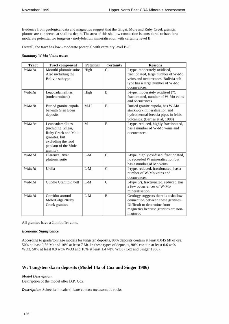
November 1999 Upper North East CRA Minerals Assessment
126
Evidence from geological data and magnetics suggest that the Gilgai, Mole and Ruby Creek graniticplutons are connected at shallow depth. The area of this shallow connection is considered to have low -moderate potential for tungsten - molybdenum mineralisation with certainty level B.
Overall, the tract has low - moderate potential with certainty level B-C.
Summary W-Mo Veins tracts
Tract Tract component Potential Certainty ReasonsWMo1a Moonbi plutonic suite
Also including theBolivia subtype
High C I-type, moderately oxidised,fractionated, large number of W-Moveins and occurrences. Bolivia sub-type has a large number of W-Mooccurrences.
WMo1a Leucoadamellites(undetermined)
High B I-type, moderately oxidised (?),fractionated, number of W-Mo veinsand occurrences
WMo1b Buried granite cupolabeneath Glen Edendeposits
M-H B Buried granite cupola, has W-Mostockwork mineralisation andhydrothermal breccia pipes in felsicvolcanics. (Barnes et al, 1988)
WMo1c Leucoadamellites(including Gilgai,Ruby Creek and Molegranites, butexcluding the roofpendant of the Molegranite).
M B I-type, reduced, highly fractionated,has a number of W-Mo veins andoccurrences.
WMo1d Clarence Riverplutonic suite
L-M C I-type, highly oxidised, fractionated,no recorded W mineralisation buthas a number of Mo veins.
WMo1d Uralla L-M C I-type, reduced, fractionated, has anumber of W-Mo veins andoccurrences.
WMo1d Gundle Granitoid belt L-M C I-type (?), fractionated, reduced, hasa few occurrences of W-Momineralisation.
WMo1d Corridor aroundMole/Gilgai/RubyCreek granites
L-M B Geology suggests there is a shallowconnection between these granites.Difficult to determine frommagnetics because granites are non-magnetic
All granites have a 2km buffer zone.
Economic Significance
According to grade/tonnage models for tungsten deposits, 90% deposits contain at least 0.045 Mt of ore,50% at least 0.56 Mt and 10% at least 7 Mt. In these types of deposits, 90% contain at least 0.6 wt%WO3, 50% at least 0.9 wt% WO3 and 10% at least 1.4 wt% WO3 (Cox and Singer 1986).
W: Tungsten skarn deposits (Model 14a of Cox and Singer 1986)
Model DescriptionDescription of the model after D.P. Cox.
Description: Scheelite in calc-silicate contact metasomatic rocks.

November 1999 Upper North East CRA Minerals Assessment
127
Approximate Synonyms : Scheelite skarns of the tin-tungsten type (Solomon & Groves 1994).
General References: Kwak (1987), Einaudi and Burt (1982).
Geological Environment
Rock Types: Tonalite, granodiorite, quartz monzonite; limestone.
Textures: Granitic, granoblastic.
Age Range: Mainly Mesozoic, but may be any age.
Depositional Environment: Contacts and roof pendants of batholith and thermal aureoles of apical zonesof stocks that intrude carbonate rocks. Adjacent to fault zones which intersect the intrusion and thecarbonate host rocks.
Tectonic Setting(s) : Orogenic belts. Syn-late orogenic.
Associated Deposit Types: Sn-W skarns, Zn skarns.
Deposit Description
Mineralogy: Scheelite ± molybdenite ± pyrrhotite ± sphalerite ± chalcopyrite ± bornite ± arsenopyrite ±pyrite ± magnetite ± traces of wolframite, fluorite, cassiterite, and native bismuth.
Alteration: Diopside-hedenbergite + grossular-andradite. Late stage spessartine + almandine. Outerbarren wollastonite zone. Inner zone of massive quartz may be present.
Ore Controls: Carbonate rocks in thermal aureoles of intrusions. Faults which intersect the intrusion andthe carbonate beds have acted as conduits to the mineralising fluids, particularly faults which pre-date theintrusion.
Geochemical Signature: W, Mo, Zn, Cu, Sn, Bi, Be, As.
ExamplesKing Island, Australia, Tasmania Solomon and Groves 1994Pine Creek, US, California Newberry 1982MacTung, Canada, British Columbia. Dick and Hodgson 1982Strawberry, US, California Nokleberg 1981
Known Deposits and Mineral Prospects in UNER
W skarn deposits are not abundant in the New England region because of the paucity of suitably reactivehost rocks (Ashley et al. 1996).
The Gilgurry Mudstone near the Drake Volcanics contains calcareous mudstone and fossiliferous units.The area where this unit is intruded by the Stanthorpe Adamellite has high potential for skarn deposits(pers. comm. R.G. Feb. 1998).
The scheelite-molybdenite bearing andradite skarns at Attunga are exoskarn replacement of marble andcalc-silicate hornfels and minor endoskarn replacement of the quartz monzonite intrusive (MoonbiSupersuite).
Assessment Criteria
1. Presence of granitoids (I-type granites which are moderately oxidised) associated with tungsten-molybdenum mineral deposits or with a potential to host tungsten-molybdenum deposits.
2. Presence of suitable calc-magnesian rocks in proximity to granitoids with a potential to host tungsten-molybdenum deposits.
3. Presence of known occurrences of skarns, hornfels and skarn-related mineral occurrences.
November 1999 Upper North East CRA Minerals Assessment
128
Assessment:
Tract W/M/BThe tract is based on the following geological parameters:• a 5 km wide zone adjacent to the margins of Triassic granitoids which are potential source rocks for
tungsten mineralisation, i.e. I-type granitoids which are fractionated and moderately oxidised. Adetailed analysis of the granitoids which are potential source rocks for tungsten mineralisation is givenin the model for tungsten-molybdenum veins and pipes,
• Palaeozoic calcareous sediments and ultramafic rocks which were intruded by these granitoids.
The intersection of the above two geological parameters defines the tract for tungsten skarn deposits,which is assessed as moderate potential with certainty level B.
Economic significance
Grade and tonnage data (Cox and Singer 1986) suggests that 10% of this type of deposits contain at least22 Mt of ore, 50% at least 1.1 Mt and 90% at least 0.05 Mt. In 10% of these deposits ores have at least1.4% WO3, 50% at least 0.67% and 90% at least 0.05% WO3.
Silexite: Quartz topaz W-Mo-Bi deposits (Silexite)
Model DescriptionDescription of the model by A.D. McKay
Description: Quartz - topaz rock with veins and disseminations of wolframite, molybdenite andbismuthinite and native bismuth. Occurs within altered microgranite, pegmatite and granite. Similar togreisenised granite.
General References: Kleeman et al. (1997), Plimer et al. (1995), Ashley et al. (1996).
Geological Environment
Rock Types: Silexite was developed as altered dykes, bosses and sills of microgranite in apical areas ofgranite roof, and in the sedimentary rocks of the roof pendant (Permian) overlying the Mole Granite.Silexite was developed after emplacement of the Mole Granite and is associated with later stages offractionation of the melt. Associated rock types include muscovite-bearing greisens. Distinctive accessoryminerals include lithium siderophyllite, fluorine-rich schorl, fluorine-rich muscovite, fluorite, beryl,dickite.
Textures: Textures and structures within the microgranite and seriate or porphyry granites, arepseudomorphed by silexite. Aplitic and porphyritic textures common, miarolitic cavities.
Age Range: In the case of the Mole Granite, the silexite is Triassic.
Depositional Environment: Plutonic, granitic bodies emplaced at high levels in the crust. Preservation ofroof pendant due to partial unroofing by erosion. Silexite was developed as altered dykes, bosses and sillsof microgranite in apical areas of granite roof, and in the sedimentary rocks of the roof pendant (Permian)overlying the Mole Granite
Tectonic Setting(s) : Fold belts of thick sediments ± volcanic rocks deposited on stable cratonic shield;accreted margins; granitoids generally postdate major folding.
Associated Deposit Types: Muscovite-quartz-chlorite-W-Sn-Bi rich greisens, sheeted vein quartz-cassiterite deposits, stockwork Mo-W-Bi mineralisation.
Deposit Description

November 1999 Upper North East CRA Minerals Assessment
129
Mineralogy: Topaz, wolframite, molybdenite, bismuth, bismuthinite, Cu-Pb-Zn sulphide. Ganguemineralogy includes quartz, Li-siderophyllite, F-schorl, F-muscovite, fluorite, beryl.
Texture/Structure: Various textures and structures, greisen textures are common. Textures and structureswithin silexite are pseudomorphs of the original microgranite and seriate granite. Quartz-wolframite-molybdenite-bismuthinite in silexite, greisens, veinlets and stockworks (in cupolas or in overlying roofpendant). Less common are pipes, lenses, and tectonic breccia.
Alteration: Hydrothermal alteration of microgranite and other host granite by hot, highly saline Si-richand F-rich aqueous fluids. Fluid inclusion studies indicate fluid temperatures of 570-620° C. Incipientsilexite (granite): quartz, topaz, muscovite ± chlorite, tourmaline, and fluorite(original texture of granitesretained). Greisenised granite: quartz-muscovite-topaz-fluorite, ± tourmaline
Ore Controls: Silexite lodes located in or near cupolas and ridges developed on the roof or along marginsof granitoids; faults and fractures may be important ore controls.
Weathering: Wolframite and cassiterite placer deposits form by weathering and erosion.
Geochemical Signature: Wolframite, cassiterite, topaz, and tourmaline in streams that drain exposedsilexite deposits. Associated granites may have high contents of SiO2 (>73 percent), and are depleted inCaO, TiO2, MgO, and total FeO. They are enriched in W, Sn, F, Rb, Li, Be, Mo, Cs, U, and Th andimpoverished in Ni, Cr, Co, V, Sc, Sr, La, and Ba (Cox & Singer 1986).
ExamplesTorrington roof pendant, Mole Granite.
Known deposits and mineral prospects in the CRA region
Silexite is a quartz-topaz rock formed by alteration of granite by F-rich fluids (Kleeman 1985). It alsocontains various amounts of wolframite, Li-siderophyllite, F-schorl, F-muscovite, beryl, molybdenite,bismuth, bismuthinite and dickite (Plimer et al 1995). Silexite contains more than 5% topaz. Silexite is theproduct of hydrothermal alteration of solidified granite, most frequently microgranite but also of seriateand other varieties of the Mole Granite (Kleeman et al 1997). Most silexite is developed as altered dykes,bosses and sills of microgranite in the sedimentary rocks of the roof pendant (Permian) within the MoleGranite. Textures and structures within the microgranite and seriate or porphyry granites, arepseudomorphed by silexite. Fluid-inclusion studies topaz grains in silexite have homogenisationtemperatures of 570-620° C.
The Mole Granite is interpreted as a sill-like mass only a few kilometres thick, emplaced at a high level inthe crust (Kleeman et al. 1997). It was emplaced at 246±2 Ma. Crystallisation inwards produced apressure quenched coarsely grained granite carapace. Microgranite was extensively emplaced as dykes inthe fractured carapace and overlying country rock. An aqueous magmatic fluid utilising the samestructures as the microgranite, at 246 Ma, reacted in places with the granite to form silexite.
At the Fielder’s Hill mine, which was one of the largest mines in the roof pendant, the first 20 000 t ofsilexite ore contained 1.6% WO3, but the bulk grade of all the quartzose rock mined was 0.5% WO3. Atthe The Bismuth mine, wolframite and native bismuth occurred in pegmatite and silexite. Overallproduction from the roof pendant deposits was 2000 tons wolframite (Kleeman 1990).
Assessment Criteria
1. Roof pendants in highly fractionated, felsic granites such as the Mole Granite.2. Presence of known occurrences of topaz bearing greisen rocks.
Assessment
Tract Silexite/M-H/BThe tract includes the area corresponding to the roof pendant of Mole Granite plus a 200 m wide bufferzone surrounding it. It contains all the known occurrences of silexite in the region.

November 1999 Upper North East CRA Minerals Assessment
130
Economic Significance
During the late 1980s, a pilot scale topaz calcination plant operated at Parramatta. Topaz is converted topure mullite (3Al2O3.2SiO2) when calcined at 1350° C. Mullite is an important industrial mineral for therefractory industries.
CuAu2: Copper-gold skarn deposits (Model 18b of Cox and Singer 1986)
Model DescriptionDescription of the model after D.P. Cox and T.G. Theodore
Description: Chalcopyrite in calc-silicate contact metasomatic rocks.
General References: Einaudi and Burt (1982), Einaudi et al. (1981).
Geological Environment
Rock Types: Tonalite to monzogranite intruding carbonate rocks or calcareous clastic rocks.
Textures: Granitic texture, porphyry, granoblastic to hornfelsic in sedimentary rocks.
Age Range: Mainly Mesozoic, but may be any age.
Depositional Environment: Miogeosynclinal sequences intruded by felsic plutons.
Tectonic Setting(s) : Continental margin late orogenic magmatism.
Associated Deposit Types: Porphyry Cu, zinc-lead-silver skarn, gold skarn, polymetallic replacement, Feskarn.
Deposit Description
Mineralogy: Chalcopyrite + pyrite ± hematite ± magnetite ± bornite ± pyrrhotite. Also molybdenite,bismuthinite, sphalerite, galena, cosalite, arsenopyrite, enargite, tennantite, loellingite, cobaltite, andtetrahedrite may be present. Au and Ag may be important products.
Texture/Structure: Coarse granoblastic with interstitial sulphides. Bladed pyroxenes are common.
Alteration: Diopside + andradite centre; wollastonite + tremolite outer zone; marble peripheral zone.Igneous rocks may be altered to epidote + pyroxene + garnet (endoskarn). Retrograde alteration toactinolite, chlorite, and clays may be present.
Ore Controls: Irregular or tabular ore bodies in carbonate rocks and calcareous rocks near igneouscontacts or in enclaves in igneous stocks. Associated igneous rocks are commonly barren.
Weathering: Cu carbonates, silicates, Fe-rich gossan. Calc-silicate minerals in stream pebbles are a goodguide to covered deposits.
Geochemical Signature: Rock analyses may show Cu-Au-Ag-rich inner zones grading outward to Au-Agzones with high Au:Ag ratio and outer Pb-Zn-Ag zone. Co-As-Sb-Bi may form anomalies in some skarndeposits. Magnetic anomalies.
ExamplesMason Valley Harris and Einaudi 1982Victoria Atkinson et al. 1982Copper Canyon Blake et al. 1979Carr Fork, Atkinson and Einaudi 1978Red Dome, AUQL Ewers et al. 1990

November 1999 Upper North East CRA Minerals Assessment
131
Known deposits and mineral prospects in the CRA region
There are quite a few known occurrences of this type in the area. Typical examples of these are themagnetite skarn-associated copper deposits at Fine Flower, Fine Flour, Busy Bee, Wiley’s, Potato Culode, West Potato Cu; also the Gem Cu, and Pluck Cu deposits. Other skarn-related prospects in theUNER include Pulganbar-Flintoff-Glamorgan; (associated with siliceous tourmaline veins) and LantanaDowns, May Queen Cu, & Paddy Dougherty Cu, and the Tabulam magnetite skarn (east of Drake) . Also,there are hornfelsed Cu and Au occurrences at Solferino.
Assessment Criteria
1. Presence of granitoids associated with Cu-Au mineralisation or with a potential to host Cu-Audeposits.
2. Presence of suitable calc-magnesian rocks in proximity to granitoids with a potential to host Cu-Audeposits.
3. Presence of known occurrences of skarns, hornfels and skarn-related mineral occurrences.
Assessment
Tract CuAu2a/L-M/BThe tract includes zones where reactive calc-magnesian rocks lie within 5 km of granitoids that have apotential for hosting Cu-Au deposits. The tract is assessed as low to moderate because there are noeconomic skarn deposits known in the area, and because the occurrence of calc-magnesian rocks isgenerally irregular and intermittent with the potential host sequence.
Economic Significance
According to grade/tonnage models for copper skarn deposits, 90% of deposits contain at least 0.034 Mtof ore, 50% at least 0.56 Mt and 10% at least 9.2 Mt. In these types of deposits, 90% contain at least 0.7%Cu, 50% at least 1.7% Cu and 10% at least 4.0% Cu (Cox and Singer 1986).
Au4: Alluvial (Placer) Gold deposits(Model 39a of Cox and Singer 1986)
Model DescriptionDescription after Warren E. Yeend.
Approximate Synonym:
Description: Elemental gold as grains and (rarely) nuggets in gravel, sand, silt, and clay, and theirconsolidated equivalents, in alluvial, beach, aeolian, and (rarely) glacial deposits.
General References: Boyle (1979), Wells (1973), Lindgren (1911).
Geological Environment
Rock types: Alluvial gravel and conglomerate, usually with white quartz clasts. Sand and sandstone ofsecondary importance.
Textures: Coarse clastic.
Age range: Cainozoic. Older deposits are known but their preservation is uncommon.
Depositional environment: High-energy alluvial where gradients flatten and river velocities lessen, as atthe inside of meanders, below rapids and falls, beneath boulders, and in vegetation mats. Winnowingaction of surf caused Au concentrations in raised, present, and submerged beaches.
Tectonic setting(s) : Tertiary conglomerates along major fault zones, shield areas where erosion hasproceeded for a long time producing multi-cycle sediments; high-level terrace gravels.

November 1999 Upper North East CRA Minerals Assessment
132
Associated deposit types: Black sands (magnetite, ilmenite, chromite); Platinum group elements, yellowsands (zircon, monazite). Au placers commonly derive from various Au vein-type deposits but also othergold deposits, eg. porphyry copper-gold, gold skarn, massive sulphide deposits and replacement deposits.
Deposit Description
Mineralogy: Au, commonly with attached quartz or limonite, rarely attached to sulphides and othergangue minerals. Associated with quartz and heavy minerals, which may include: rutile, ilmenite,chromite, magnetite, limonite, pyrite, zircon, monazite, tourmaline, cassiterite, platinum-iron alloys andosmium-iridium alloys.
Texture/Structure: Usually flattened with rounded edges, also flaky or flour gold (extremely fine grained);rarely angular and irregular (“crystalline”), very rarely equidimensional nuggets.
Ore controls: Highest Au values at base of gravel deposits in various gold "traps" such as natural riffles infloor of river or stream, fractured bedrock, slate, schist, phyllite, dykes, bedding planes, all structurestrending transverse to direction of water flow. Au concentrations also occur within gravel deposits aboveclay layers that constrain the downward migration of Au particles.
Geochemical signature: Anomalous high amounts of Ag, As, Hg, Sb, Cu, Fe, S, and heavy mineralsmagnetite, chromite, ilmenite, hematite, pyrite, zircon, garnet, rutile. Au nuggets have decreasing Agcontent with distance from source.
Geophysical signature: Seismic methods define buried channels or deep leads.
ExamplesSierra Nevada, California, USA Lindgren 1911, Yeend 1974Bendigo-Ballarat region, Vic, Australia Knight 1975
Known deposits and prospects in the CRA region
Placer deposits account for a significant portion of the gold produced in the New England region. Abouttwo thirds of this alluvial gold came from the Rocky River, Uralla and Nundle-Hanging Rock area to thesouth east of the UNER. The gold was recovered from Quaternary sediments along the Rocky River andits tributaries draining the Uralla Granodiorite (I-type), and Tertiary deep lead deposits preserved byoverlying basalt lava flows, such as at Sydney Flat, Mount Beef and Bourkes Knob. The Sydney Flatworkings were up to 60 metres deep. Together these deposits constitute the Rocky River Gold Field and anumber of them were relatively rich in gold (Weber 1975).
In the UNER, gold has been won from basal conglomerates along the western edge of the MesozoicClarence Moreton basin, Tertiary deep leads, Quaternary river gravels along river channels and beachplacer deposits. Significant alluvial gold production by hand sluicing and dredging came from Oban inthe central south of the CRA region, Mann River/Glen Elgin and Timbarra River in the central part of theCRA region, and Clarence River/Tooloom in the central north of the CRA region (Barnes & others 1988).
Alluvial gold is associated with gold-quartz vein reefs in the Dalmorton field in the central east of theCRA region and further north in the Lionsville goldfield and at Tyringham, where recent and deep leadalluvial deposits also occur (Markham 1975b). The Lunatic goldfield in the north of the CRA andCoramba-Orara goldfield in the south of the CRA region are also source areas for alluvial gold.
At Tooloom alluvial gold deposits appear to be derived from local gold-quartz veins in Emu CreekFormation sediments/ acid volcanics and nearby outcrops of gold bearing Jurassic conglomerate(Markham 1975b). Near Boonoo Boonoo, in the north west of the CRA region, gold-silver quartz veins inStanthorpe Adamellite (I-type) may be the source for nearby alluvial gold (Weber 1975). Disseminatedgold in the Stanthorpe and Bungulla Adamellites may have contributed gold to alluvial deposits in theTimbarra area (Resource and Conservation Assessment Council 1996). Further south, gold-quartz veinsand Jurassic conglomerate (Laytons Range Conglomerate Member) were also gold sources for the nearbyalluvial gold at Pretty Gully Gold Field and Paddy’s Gully (Weber 1975).

November 1999 Upper North East CRA Minerals Assessment
133
Minor gold in the Kingsgate Granite (I-type) molybdenum-bismuth pipes (Weber 1975) may havecontributed to alluvial gold deposits in the central part of the CRA region. The Wards Mistake Adamellite(I-type), and Kookabookra Adamellite (S-type) and especially the Oban River Leucoadamellite (I-type)appear to be the source of alluvial gold probably from gold bearing bismuth minerals in molybdenum-bismuth pipes. The only significant alluvial production has come from streams draining the Oban RiverLeucoadamellite (Weber 1975).
Assessment Criteria
1. Distribution of rocks containing, or with potential for other types of gold deposits.2. Distribution of gold-bearing vein and other deposits.3. Distribution of alluvial gold prospects and deposits.4. Distribution of possibly gold bearing Clarence-Moreton Basin basal Jurassic conglomerate.5. Distribution of Tertiary sediments deposited by ancient streams, rivers, lakes and swamps.6. Distribution of Tertiary basalts concealing deep leads.7. Distribution of Quaternary sediments deposited by ancient streams, rivers, lakes and swamps.8. Streams, rivers, lakes and swamps with unmapped Quaternary sediments.
Assessment
Tract Au4a/M-H/CThis tract includes 100 metre buffers along streams, rivers, swamps, lakes, Quaternary sediments,Tertiary sediments and Tertiary lavas within 10 kilometres of known gold deposit clusters. Potential foreconomic Quaternary/Tertiary alluvial gold and deep lead deposits concealed beneath Tertiary basalt isconsidered to be moderate to high. Even though most alluvial gold areas have been worked in the past,modern technology may make some of these areas viable in future and allow access to deep lead depositsnot previously mined. The certainty level is assessed at C.
Tract Au4b/M/BThis tract includes 100 metre buffers along streams, rivers, swamps, lakes, Quaternary sediments,Tertiary sediments and Tertiary lavas that occur in areas of potential alluvial gold source rocks asdelineated by the tracts in the following models of this report:• gold-antimony quartz veins• disseminated gold in leucogranite• epithermal gold• molybdenum-bismuth-minor gold veins/pipes• skarn/ironstone gold• volcanic massive sulphide gold• porphyry copper-gold
Potential is considered moderate with a certainty of B.
Economic significance
According to global grade and tonnage data these deposits are usually small. 90% of them have at least0.022 Mt or ore, 50% at least 1.1 Mt and 10% have more than 50 Mt of ore (Cox and Singer 1986). Theores in 90% deposits contain at least 0.084 g/t gold, in 50% deposits the ores have at least 0.2 g/t gold and10% deposits contain more than 0.48 g/t gold.
Au5: Gold associated with massive sulphide mineralisation including gold in chertand jaspers
Model DescriptionDescription of the model by S. Jaireth.
Approximate Synonym: Gold-rich Noranda type, volcanogenic massive sulphide, felsic to intermediatevolcanic type. Gold in chert and jaspers.

November 1999 Upper North East CRA Minerals Assessment
134
Description: Gold, copper, lead and zinc-bearing massive sulphide deposits in marine volcanic rocks ofintermediate to felsic composition.
General References: Ishihara (1974), Franklin et al. (1981), Hutchinson et al. (1982), Ohmoto andSkinner (1983), Lydon (1988), Hannington and Scott (1989), Large (1992).
Geological Environment
Rock types: Marine rhyolite, dacite, andesite and subordinate basalt and associated sediments, principallyorganic-rich mudstone or shale. Pyritic, siliceous shale. Chert and jaspers. Some basalt.
Textures: Flows, tuffs, pyroclastics, breccias, bedded sediment, and in some cases felsic domes.
Age range: Archaean through Cainozoic.
Depositional environment: Hot springs related to marine volcanism, probably with anoxic marineconditions. Lead-rich deposits associated with abundant fine-grained volcanogenic sediments.
Tectonic setting(s) : Island arc, local extensional tectonic activity, rifts and grabens following arc-continent collision, faults, or fractures. Archaean greenstone belt.
Associated deposit types: Epithermal quartz-adularia veins in Japan are regionally associated but youngerthan Kuroko deposits. Volcanogenic Mn, Algoma Fe.
Deposit Description
Mineralogy: Upper stratiform massive zone (black ore): pyrite + sphalerite + chalcopyrite ± pyrrhotite ±galena ± barite ± tetrahedrite - tennantite ± bornite; lower stratiform massive zone (yellow ore): pyrite +chalcopyrite ± sphalerite ± pyrrhotite ± magnetite; stringer (stockwork) zone: pyrite + chalcopyrite (goldand silver). Gold in two mineral associations: gold-zinc (-lead-silver-barite), typical of lead-zinc-richdeposits; and gold-copper. Gahnite in metamorphosed deposits. Gypsum/anhydrite present in somedeposits. Often gold mineralisation is hosted by chert and jaspers layers.
Texture/structure: Massive (>60 percent sulphides); in some cases, an underlying zone of ore stockwork,stringers or disseminated sulphides or sulphide-matrix breccia. Also slumped and redeposited ore withgraded bedding.
Alteration: Adjacent to and blanketing massive sulphide in some deposits: zeolites, montmorillonite (andchlorite?); stringer (stockwork) zone: silica, chlorite, and sericite; below stringer: chlorite and albite.Cordierite and anthophyllite in footwall of metamorphosed deposits, graphitic schist in hanging wall.
Ore controls: Toward the more felsic top of volcanic or volcanic-sedimentary sequence. Near centre offelsic volcanism. May be locally brecciated or have felsic dome nearby. Pyritic siliceous rock (exhalite)may mark horizon at which deposits occur. Proximity to deposits may be indicated by sulphide clasts involcanic breccias. Some deposits may be gravity-transported and deposited in palaeo depressions in theseafloor. In Japan, best deposits have mudstone in hanging wall.
Weathering: Yellow, red, and brown gossans. Gahnite in stream sediments near some deposits.
Geochemical signature: Gossan may be high in Pb and typically Au is present. Adjacent to deposit-enriched in Mg and Zn, depleted in Na. Within deposits: Cu, Zn, Pb, Ba, As, Ag, Au, Fe.
Geophysical signature:
ExamplesRosebery, AUTS Huston and Large 1988Mt. Lyell, AUTS Hills 1990Hellyer, AUTS McArthur and Dronseika 1990Mt Morgan, AUQL Taube 1990Brittania, CNBC Payne et al. 1980

November 1999 Upper North East CRA Minerals Assessment
135
Buchans, CNNF Swanson et al. 1981Kidd Creek, CNON Walker et al. 1975
Known deposits and Prospects in the CRA Region
There are several occurrences of this type. They are confined to the Coffs Harbour Block. In most ofthem gold mineralisation is in the form of stratabound concentrations hosted by chert, pyritic chert andjaspers. In several prospects stratabound mineralisation co-exists with epigenetic gold veins. In the CodHole prospect mineralisation is confined to a fractured chert horizon and is associated with introducedsilica, pyrite and arsenopyrite (Keevers and Jones 1984 cited in Gilligan et al. 1992). In the Illabo goldmine, several stacked horizons of chert and jaspers extending for several hundred metres occur withinmafic tuffs (Keevers and Jones 1984 cited in Gilligan et al. 1992). Here chert and jaspers are extensivelyfractured and flooded with ankerite, pyrite and sericite.
Gold bearing chert and epigenetic veins are in close spatial association with stratabound copper deposits.Hence tracts delineated for Cyprus style massive sulphide deposits also define the mineral potential tractsfor gold associated with massive sulphide deposits.
However, because not all volcanic associated massive sulphide deposits host economic grade goldmineralisation the level of potential needs to be lower than that for massive sulphide deposits (the notionof conditional probability).
Assessment Criteria
1. Presence of rocks belonging to the ophiolitic assemblage consisting of mafic volcanic, volcaniclasticand volcanogenic sedimentary rocks formed in submarine environment. (Coffs Harbour Association,Sandon Association, Silverwood Association or Brooklana Beds, Coffs Harbour Beds, Coramba Beds,Cungleburg Creek Beds, Girakool Beds and Agnes Greywacke, Sandon Beds, Willowie Creek Beds).
2. Presence of subvolcanic intrusives.3. Presence of known deposits and occurrences of volcanic associated massive sulphide mineralisation.4. Areas with a potential for volcanic associated massive sulphide deposits.5. Distribution of known deposit type and occurrences gold in chert and jaspers.
Assessment
Tract Au5a/M/CThe tract is similar to the tract BM1a/M/C for volcanic associated massive sulphide deposits because goldmineralisation is spatially and temporally associated with massive sulphide mineralisation. Both stylesresult from submarine volcanic hydrothermal systems. The tract is marked by the presence of chert andjaspers which are known to host gold mineralisation in the area. The tract also hosts all the knownoccurrences of gold of this type in the CRA region. Mineral potential of the tract is thus assessed tomoderate with a certainty level of C.
Tract Au5b/L-M/BThe tract is similar to the tract BM1b/L-M/B for volcanic associated massive sulphide deposits. Althoughthe tract does not contain known occurrences of gold or volcanic associated massive sulphidemineralisation, it is marked by an environment which is favourable for distal type volcanic massivesulphide mineralisation. Hence mineral potential of the tract is assessed to be low to moderate with acertainty level of B.
Economic Significance
There is limited grade and tonnage data about gold deposits associated with chert and jasper but volcanicassociated massive sulphide deposits are known to be important sources for gold and silver. Globalgrade/tonnage models for this type of deposits indicate that 90% of these deposits have more than 0.12 Mtof ore, 50% have more that 1.5 Mt and 10% have more than 18 Mt. Similarly 50% of these deposits theores have more than 0.16 g/t gold and 13 g/t silver and 10 % have more than 2.3 g/t gold and 100 g/tsilver.

November 1999 Upper North East CRA Minerals Assessment
136
Sn3: Alluvial Tin deposits (Model 39e of Cox and Singer 1986)
Model DescriptionDescription of the model after Bruce L. Reed.
Description: Cassiterite and associated heavy minerals in silt- to cobble-size nuggets concentrated by thehydraulics of running water in modern and fossil streambeds.
General References: Hosking (1974), Taylor (1979), Sainsbury and Reed (1973).
Geological Environment
Rock Types: Alluvial sand, gravel, and conglomerate indicative of rock types that host lode tin deposits.
Textures: Fine to very coarse clastic.
Age Range: Commonly late Tertiary to Holocene, but may be any age.
Depositional Environment: Generally moderate to high-level alluvial, where stream gradients lie withinthe critical range for deposition of cassiterite (for instance, where stream velocity is sufficient to result ingood gravity separation but not enough so the channel is swept clean). Stream placers may occur asoffshore placers where they occupy submerged valleys or strandlines.
Tectonic Setting(s) : Alluvial deposits derived from Palaeozoic to Cainozoic accreted terranes or stablecratonic fold belts that contain highly evolved granitoid plutons or their extrusive equivalents. Tectonicstability during deposition and preservation of alluvial deposits.
Associated Deposit Types: Alluvial gravels may contain by-product ilmenite, zircon, monazite, and,where derived from cassiterite-bearing pegmatites, columbite-tantalite. Economic placers are generallywithin a few (<8) kilometres of the primary sources. Any type of cassiterite-bearing tin deposit may be asource. The size and grade of the exposed source frequently has little relation to that of the adjacentalluvial deposit.
Deposit Description
Mineralogy: Cassiterite; varying amounts of magnetite, ilmenite, zircon, monazite, allanite, xenotime,tourmaline, columbite-tantalite, garnet, rutile, gold, sapphire, and topaz may be common heavy resistates.
Texture/Structure: Cassiterite becomes progressively coarser as the source is approached; euhedralcrystals indicate close proximity to primary source. Where a marine shoreline intersects or transgresses astream valley containing alluvial cassiterite the shoreline placers normally have a large length-to-widthratio.
Ore Controls: Cassiterite tends to concentrate at the base of stream gravels and in traps such as naturalriffles, potholes, and bedrock structures transverse to the direction of water flow. The richest placers lievirtually over the primary source. Streams that flow parallel to the margin of a tin-bearing granite areparticularly favourable for placer tin accumulation.
Geochemical Signature: Anomalously high amounts of Sn, As, B, F, W, Be, W, Cu, Pb, Zn. Pannedconcentrate samples are the most reliable method for detection of alluvial cassiterite.
ExamplesSouth East Asian tin fields Hosking 1974, Newell 1971, Simatupang et al. 1974
Westerveld 1937.
Known deposits and prospects in the CRA region
The region hosts several important prospects and deposits of alluvial and deep lead tin, the most notableof which are at Emmaville which produced more than 6500 tonnes of cassiterite and Tingha (70000tonnes of tin concentrate, Gilligan and Barnes 1990). Most placer concentrations are associated with

November 1999 Upper North East CRA Minerals Assessment
137
active watercourses. Cassiterite recovered from active watercourses is largely black, waterworn and fineto coarse. The cassiterite-bearing alluvials range in thickness from several centimetres to approximatelyten metres. Their lateral extent ranges from several metres wide and tens of metres long, to depositshundreds of metres wide and kilometres long (Brown and Stroud 1997). Frequently redistributed Tertiarywash or eluvium and broad areas of shallow wash beyond watercourses also contain significantaccumulation of cassiterite. The distribution of cassiterite in alluvium varies between localities. In someplaces cassiterite is richest or restricted to particular layers, especially towards or at the base of thesequence. In other places it is developed throughout the alluvium from ‘grass roots’ to the base (Brownand Stroud 1997). Scant historical data indicate that some watercourses returned from several kg/m3 to100 kg/m3.
The deep lead cassiterite deposits are overlain by basalt. In the Copeton Group of deep leads, two mainlevels of intrabasaltic alluvials containing cassiterite and diamonds were worked. The economic layerswere overlain by subeconomic, fine-grained sandy layer. In the Tingha-Gilgai area deep leads range indepth from several metres to fifty metres. Most deep leads are capped by thick strongly weathered tofresh basalt, shallow to deep basaltic soil and in many places by surficial concretionary laterite/bauxite(Brown and Stroud 1997).
Assessment Criteria
1. Presence of rocks containing, or with a potential for, tin2. Distribution of tin vein and greisen deposits.3. Distribution of alluvial tin prospects and deposits.4. Distribution of possibly tin bearing Clarence-Moreton Basin basal Jurassic conglomerate.5. Distribution of Tertiary sediments deposited by ancient streams, rivers, lakes and swamps.6. Distribution of Tertiary basalts concealing deep leads.7. Distribution of Quaternary sediments deposited by ancient streams, rivers, lakes and swamps.8. Streams, rivers, lakes and swamps with unmapped Quaternary sediments.
Assessment
Tract Sn3a/M-H/CThis tract includes 100 metre buffers along streams, rivers, swamps, lakes, Quaternary sediments,Tertiary sediments and Tertiary lavas within 10 kilometres of known tin deposit clusters (fields). Potentialfor economic Quaternary/Tertiary alluvial tin and deep lead deposits concealed beneath Tertiary basalt isconsidered moderate to high. Even though most alluvial areas have been worked in the past, moderntechnology may make some of these areas viable in future and allow access to deep lead deposits notpreviously mined. The certainty level is assessed at C.
Tract Sn3b/M/BThis tract includes 100 metre buffers around streams, rivers, swamps, lakes, Quaternary sediments,Tertiary sediments and Tertiary lavas that occur in areas of potential alluvial tin source rocks asdelineated by the tracts for tin veins and tin greisens. Potential is considered moderate with a certainty ofB.
Fe1: Volcanic-hosted Magnetite (Model 25i of Cox and Singer, 1986)
Model DescriptionDescription of the model by Dennis P. Cox.
Approximate Synonym: Porphyrite iron, Kiruna iron.
Description: Massive concordant and discordant magnetite ore bodies in intermediate to alkalic volcanicrocks with actinolite or diopside alteration.
Geological Environment
Rock types: Andesitic to trachytic flows and subvolcanic intrusions, also at Kiruna, quartz porphyry,syenite porphyry, monzonite, and diorite.
November 1999 Upper North East CRA Minerals Assessment
138
Textures: Porphyroaphanitic to fine- to medium-grained equigranular. Flows may be amygdaloidal.
Age range: Mesozoic to Holocene in circum-Pacific area. In Sweden and Missouri, 1,300-1,500 m.y.
Depositional environment: Continental volcanic rocks and clastic sediments intruded by subvolcanicintermediate plutons.
Tectonic setting(s) : Continental margin, subduction-related volcanic terrane. Especially with high-Kvolcanic rocks, possibly related to waning stages of volcanism.
Associated deposit types: Sedimentary Fe in associated clastic rocks, apatite-magnetite deposits, hematitein quartz-sericite alteration, possible disseminated Au.
Deposit Description
Mineralogy: Magnetite + apatite. Rarely pyrite, chalcopyrite, chalcocite, and covellite. Ti is in sphene.
Texture/structure: Fine, granoblastic, skarn type textures.
Alteration: Actinolite or diopside, andradite, biotite, quartz, albite, andesine, K-feldspar, sodic scapolite,epidote; carbonates, and locally, tourmaline, sphene, chlorite, barite, fluorite, kaolin, or sericite.
Ore Controls: Magnetite in massive replacement, breccia filling and stockwork veins. Orebodies may bestratabound, concordant to intrusive contacts or in cross-cutting veins. Possibly related to cupolas ofdeeper plutons.
Geochemical and geophysical signature: Fe, P, V, and minor Ba, F, Bi, Cu, Co; strong magneticanomalies.
Examples:Kirunavaara, Sweden Frietsch 1982, 1978El Romeral, Chile Bookstrom 1977Middle-Lower Yangtze Valley Research Group of Porphyrite Iron Ore 1977
Known Deposits and Prospects in the CRA Region
There are no known occurrences of this type in the CRA region. In the Tamworth Belt strataboundmagnetite mineralisation is reported to be present within andesitic volcanic rocks. In the Croydonmagnetite deposit, massive coarse grained magnetite with chlorite joint fills, interstitial and vein epidoteand minor quartz veins is associated with Late Devonian Mostyn Vale Formation (Dpmx). The MostynVale Formation consists of deep water marine sedimentary and volcanic rocks such as lithic wackes, andrhyodacitic to basaltic lavas and tuffs.
Assessment
Tract Fe1a/M-H/CThe tract includes rocks of the accretionary complex that are known to contain magnetite-rich units(Texas Beds), ironstones (Coffs Harbour Beds), magnetite-bearing chert or quartz-magnetiteaccumulations (Brookland Beds). These rocks also host all the known occurrences of volcanogenicmagnetite in the CRA region. Mineral potential of the tract is assessed to be moderate to high with acertainty level of C
Tract Fe1b/L-M/BThe tract includes the rest of the rocks of the accretionary complex. Locally some units are magnetite richand are interpreted to be related to skarns. Most rocks in this tract have a potential for volcanic associatedmassive sulphide and volcanogenic manganese deposits. As the formation of volcanogenic magnetite isclosely related to the formation of volcanic associated massive sulphide and volcanogenic manganese,mineral potential of this tract is assessed to be low to moderate with a certainty level of B.

November 1999 Upper North East CRA Minerals Assessment
139
Economic significance
Although volcanic-hosted magnetite deposits are smaller in size that the banded iron formation, they oftencontain significant quantities of iron ores. Grade and tonnage data (Cox and Singer 1986) suggest that10% of the deposits contain at least 450 Mt of ore, 50% at least 40 Mt and 90% at least 3.5 Mt. In 10% ofthe deposits ores have at least 64% iron and 0.92% phosphorus, 50% have at least 58% iron and 0.38%phosphorus and 90% have at least 38% iron and 0.13% phosphorus.
Cr: Podiform Chromite (MODEL 8a/8b of Cox and Singer 1986)
Model DescriptionBy John P. Albers
Approximate Synonym: Alpine type chromite (Thayer 1964).
Description: Podlike masses of chromitite in ultramafic parts of ophiolitecomplexes.
General References: Dickey (1975), Duke (1996), MacNevin (1975a), Barnes and Willis (1989).
Geological Environment
Rock Types: Highly deformed dunite and harzburgite of ophiolite complexes; commonly serpentinised.
Textures: Nodular, orbicular, gneissic, cumulate, pull-apart; most relict textures are modified ordestroyed by flowage at magmatic temperatures.
Age Range: Pre-Late Carboniferous – Permian (?).
Tectonic Setting(s) : Magmatic cumulates in elongate magma pockets along spreading plate boundaries.Subsequently exposed in accreted terranes as part of ophiolite assemblage.
Depositional Environment: Deep oceanic crustal rocks. Obducted ophiolite terrane?
Associated Deposit Types: Ultramafic hosted talc, chrysotile asbestos, lateritic /saprolitic nickel.
Deposit Description
Mineralogy: Chromite ± ferrichromite ± magnetite ± Ru-Os-Ir alloys ± laurite.
Texture/Structure: Massive coarse-grained, granular to finely disseminated.
Alteration: None related to ore.
Ore Controls: Restricted to dunite bodies in tectonised harzburgite or lower portions of ultramaficcumulate. Restricted to serpentinised ultrabasics.
Weathering: Highly resistant to weathering and oxidation.
Geochemical Signature: None recognised.
ExamplesOakey Creek (Gordonbrook) Deposits MacNevin 1975aThetford Mines Ophiolite Complex, Canada Kacira 1982
Known Deposits and Mineral prospects in the CRA region
The Gordonbrook Serpentinite Belt in the central parts of the Upper North East Region of NSW hostsabout 30 small to moderate sized chromite deposits. It is interpreted as an obducted ophiolite terrane.

November 1999 Upper North East CRA Minerals Assessment
140
During tectonic thrusting, faulting and hydration the original chromite layers were disaggregated andboudinaged resulting in discontinuous chromite pods scattered throughout the serpentinite. As a result theserpentinite contains numerous small but high grade chromite deposits.
Assessment Criteria
1. Existence and extent of highly deformed ultramafic bodies.2. The occurrence of a major fault in proximity to the ultramafic mass appears to be an important feature.
Tectonically re-emplaced to form deposits of the podiform type.3. Known chromite mineral occurrences.4. Known Ni-Cr-PGE geochemical anomalies.
Assessment
Tract Cr/H/CThis tract is characterised by the presence of an ultramafic body consisting of serpentinite known as theGordonbrook Serpentinite belt. It contains at least 6 known chromite deposits and a further 25 otherprospects. There are significant Ni-Cr-PGE geochemical anomalies. The potential for further deposits ofchromite is considered to be high with a certainty level of C.
Lst: Limestone
Model DescriptionDescription of the model after D. Hora (1992).
Approximate Synonyms : Limerock, cement rock, calcium carbonate.
Description: Limestone deposits of economic importance were partly or wholly biologically derived fromseawater and accumulated in a relatively shallow marine environment. Environment of depositiondetermines the size, shape and purity of the carbonate rock. Limestone deposits are frequently of largeareal extent and may be of considerable thickness (several hundred metres).
General References: Carr & Rooney (1983); Harben & Bates (1990)
Geological Environment
Rock types: Limestone
Age range: Late Proterozoic to Holocene.
Depositional environment: Belts of shallow sea water sediments.
Tectonic setting(s): Continental shelf and subsiding marginal marine basins.
Associated deposit types: Deposits of dolomitic limestones and dolomites.
Deposit Description:
Mineralogy: Limestone is a sedimentary rock consisting of 50% or more of calcite (CaCO3) and dolomite(CaMg(CO3)2). There is a complete gradation from impure limestone to high calcium limestone (>95%CaCO3). In dolomites, the mineral dolomite is the major carbonate, which usually forms by replacementof calcite. Common impurities in carbonate rocks include clay, quartz sand, chert, and organic matter.
Texture/structure: Massive, bedded.
Alteration: Groundwater dissolution results in karst cavities, frequently filled with clay.

November 1999 Upper North East CRA Minerals Assessment
141
Ore controls : Highly sought white limestones for mineral fillers are usually a product of the contact orregional metamorphic process. Maximum limitations of overburden extremely varied depending on theend use. Limestones are known to be mined underground even for uses like cement production.
Weathering: Weathering results in a variety of karst landforms in most climatic areas, but intensifies withwarmer climate.
Geochemical signature:
Geophysical signature: Resistivity has been used to identify karst features in covered terrain.
Examples
Silurian Marulan and Wombeyan Limestones of NSW;Tertiary Eucla Basin limestones, e.g. Nullarbor Limestone of WA and SA;Tertiary Batesford Limestone and Gambier Limestone of Victoria and SA.
Known Deposits and Mineral Prospects in the CRA Region
The CRA region hosts only a few minor deposits of limestone. These are: Four Mile, Tabulam andPlumbago Creek (hosted in calcareous beds the ?Emu Creek Formations), Tenterfield (Texas Beds) andInglebar Creek and Purgatory Creek (hosted in calcareous rocks of the Willowie Creek Beds).
Assessment Criteria:
1. Presence of marine sedimentary rocks.2. Presence of known occurrences of limestone and/or marble.
Assessment
Tract Lst1a/H/BThe tract is defined by the presence of known limestone quarries (The Four Mile, Tabulam and PlumbagoCreek). The tract is considered to have a high potential for additional limestone/dolomitic limestonedeposits with a certainty level of B.
Tract Lst1b/M/BThe tract is defined by rocks of the Willowie Creek Beds. The beds host two known limestone quarriesbut because the distribution of calcareous units in these beds could be erratic and irregular, mineralpotential of the tract is assessed to be moderate with a low certainty level of B.
Economic Significance
Limestone/dolomitic limestone, like many other industrial minerals, have a low value per unit of volumebut it is essential that they are accessible in large quantities close to urban areas for use in construction.Thus competing land uses are a constant pressure on the availability of these resources. Other uses are inagriculture, roads and fillers for paper and plastic.
Limestone/dolomitic limestone deposits usually need to be either outcropping or near surface to beeconomic to extract. Distance from markets is also an important factor in the viability of alimestone/dolomitic limestone deposit as transport makes up a substantial proportion of product costs.
Mn1: Volcanogenic Manganese (Model 24c of Cox and Singer 1986)
Model DescriptionDescription of the model after Randolph A. Koski.
Approximate Synonym: Volcanogenic-sedimentary.

November 1999 Upper North East CRA Minerals Assessment
142
Description: Lenses and stratiform bodies of manganese oxide, carbonate, and silicate in chert associatedwith sedimentary and mafic volcanic rocks. Genesis related to volcanic (volcanogenic) processes.
General Reference: Roy (1981).
Geologic Environment
Rock types: Chert, shale, sandstone, greywacke, jasper, tuff, basalt; chert, jasper, basalt (ophiolite);basalt, andesite, rhyolite (island arc); basalt, limestone; conglomerate, sandstone, tuff, gypsum.
Textures: White, red, brown, and green chert in thin-bedded or massive lenses, commonly with shalepartings. Some of chert contains radiolarians.
Age range: Cambrian to Pliocene.
Depositional environment: Sea-floor hot spring, generally deep water: some in shallow water marine;some may be enclosed basin.
Tectonic setting(s) : Oceanic ridge, marginal basin, island arc, young rifted marginal basins; all can beconsidered eugeosynclinal.
Associated deposit types: Kuroko massive sulphide deposits, Cyprus-style massive sulphide deposits,Besshi-style massive sulphide deposits.
Deposit description
Mineralogy: Rhodochrosite, Mn-calcite, hausmannite, braunite, neotocite, alleghenyite, spessartite,rhodonite, Mn-opal, manganite, pyrolusite, coronadite, cryptomelane, hollandite, todorokite, amorphousMnO2.
Texture/structure: Fine-grained massive crystalline aggregates, botryoidal, colloform in bedded andlensoid masses.
Alteration: Spilitic or greenschist-facies alteration of associated mafic lavas, silicification, hematisation.
Ore controls: Sufficient structure and porosity to permit sub-sea-floor hydrothermal circulation and sea-floor venting; redox boundary at sea floor/seawater interface around hot springs; supergene enrichment toupgrade Mn content.
Weathering: Strong development of secondary manganese oxides (todorokite, birnessite, pyrolusite,amorphous MnO2) at the surface and along fractures.
Geochemical signatures: Although Mn is only moderately mobile and relatively abundant in most rocks,Mn minerals may incorporate many other trace elements such as Zn, Pb, Cu, and Ba.
ExamplesOlympic Peninsula, USWA Park 1942, 1946; Sorem and Gunn 1967Franciscan type USCA, USOR Taliaferro and Hudson 1943, Snyder 1978,
Kuypers and Denyer 1979
Known Deposits and Prospects in the CRA Region
Known manganese deposits and prospects are developed as stratiform and locally discordant manganeseoxide ( rhodonite lenses interlayered with deep water marine sediments and mafic lavas (Brown andStroud, 1997). Most common host rocks are: Woolomin Group (SDwx), Whitlow Formation (Cws);Texas beds (Ctx), Sandon beds (Csx), Neranleigh-Fernvale beds (Cnx), Willowie Creek beds, andPermian sediments (Px).
The deposits are generally hosted by jasper beds in which they form lenses, beds, laminae and nodules.Many manganese oxide deposits pass into rhodonite at depth (Brown and Stroud, 1997)

November 1999 Upper North East CRA Minerals Assessment
143
Assessment Criteria
1. Presence of deep marine sedimentary and volcanogenic sedimentary rocks in particular cherts andjaspers, indicative of submarine volcanic hydrothermal systems. For delineating tracts the followingunits have been selected: DOR-Csx; DOR-Cwm; GOO-Ctl; GRA-Px; GRA-SDwx; INV-Csx; INV-Csx+Pwev; INV-Ctx; INV-Csx; INV-Cws; MAC-Cnx. Also included are the Willowie Creek bedsand Permian sediments.
2. Proximity to granitoids.3. Presence of known occurrences.
Assessment
Tract Mn1a/M/CThe tract is similar to the tract BM1a/M/C for volcanic associated massive sulphide deposits becausevolcanogenic manganese mineralisation is spatially and temporally associated with massive sulphidemineralisation. Both styles result from submarine volcanic hydrothermal systems. The tracts includerocks of the accretionary complex such as jaspers, cherts and other mafic rocks (altered and/ormetamorphic equivalents), indicative of submarine volcanic-hydrothermal systems. It also hosts all theknown occurrences of manganese mineralisation. Mineral potential of the tract is assessed to be moderatewith a certainty level of C.
Tract Mn1b/L-M/BThe tract is similar to the tract BM1b/L-M/B for volcanic associated massive sulphide deposits. Althoughthe tract does not contain known occurrences of manganese or volcanic associated massive sulphidemineralisation, it is marked by an environment which is favourable for distal type volcanic massivesulphide mineralisation. Hence mineral potential of the tract is assessed to be low to moderate with acertainty level of B.
Economic significance
Volcanogenic manganese deposits are generally smaller than sedimentary deposits of manganese such asthe Groote Eyland deposit in the Northern Territory but still represent important accumulation ofmanganese. Grade and tonnage data (Cox and Singer 1986) indicates that 10% of these deposits contain atleast 0.91 Mt of ore, 50% at least 0.047 Mt and 90% at least 0.0028 Mt. In 10% of the deposits the oreshave at least 49% manganese, 50% at least 42% and 90% at least 24% manganese.
CONMATAG and CONMATPV Construction Materials - aggregate and pavement materials
Model DescriptionsJ.W. Brownlow, R.G. Barnes and G.P. MacRae, Geological Survey of New South Wales.
Definitions
Construction materials are naturally occurring, low unit value commodities which are generally exploitedin bulk and with limited processing for use in civil construction. Transport costs contribute significantlyto the delivered cost of construction materials and, therefore, it is important to obtain such materials asclose as possible to markets. Increased transport costs associated with the need to use more distantresources result in increased raw material costs which are inevitably passed on to the consumer.
Approximate Synonyms
The term extractive resources is used as a synonym for construction materials. However, that termcommonly includes structural clay/shale, which is specifically excluded from the present discussionbecause of striking differences in the nature of required material properties, mode of occurrence,evaluation and usage.
Various terms are used to describe construction materials depending on particle sizes, mode ofoccurrence, and end use specifications. Such terms include hard rock aggregate, coarse aggregate, crushed

November 1999 Upper North East CRA Minerals Assessment
144
and broken stone, rip rap, decorative aggregate, prepared road base, fine aggregate, construction sand,sand and gravel, river stone, and shingle. Note that some of these terms describe products (e.g., coarseaggregate, fine aggregate, construction sand) whereas others describe geology (e.g. gravel and sand) or acombination of geology and materials (e.g. hard rock aggregate).
Two of several broad classes of construction materials are discussed herein, namely aggregates and roadpavement materials. These terms are used generically to emphasise broad product similarities and theproperties of most common product of the class (e.g. concrete aggregate among coarse aggregates). Thisusage does not differentiate the varied product range currently produced in the region (e.g. sealingaggregate and railway ballast is not differentiated from coarse aggregate for use in concrete production).Product classes excluded from the discussion are armour stone (specialised product produced on a limitedscale for specialised usage) and fill (too widely produced and too easily substituted to model easily).
For the Upper North East region, two separate but overlapping tracts have been determined, reflectingtwo separate but overlapping construction material models for these two broad classes of materials:• CONMATAG for higher value aggregates.• CONMATPV for moderate value road pavement materials.
These two models are described together as they have many features in common.
General References
Brownlow (1994), Carr (1994), Holmes, Lishmund & Oakes (1982).
Deposit Description
Coarse aggregate: The main types of hard rock crushed to produce coarse aggregate in the study area arebasalt, greywacke, argillite, rhyolite, granitoids, and hornfels. Unconsolidated fluvial gravels are alsoprocessed to produce coarse aggregate.
Fine aggregate: Currently, most fine aggregate in the region is produced from friable quartz sandstonedeposits. Quaternary fluvial deposits are also important sources, and locally, some sand is derived fromQuaternary estuarine and marine barrier sand deposits.
Crushed rock pavement materials. Coarse aggregate producers generally also produce graded productsthat satisfy specifications for road pavement materials (e.g DGB20, DGS20 as specified by the Roads andTraffic Authority). Specifications for pavement materials are slightly less stringent than for coarseaggregate in some properties (e.g. wet/dry strength variation among coarse particles), exclude certain tests(e.g. alkali reactivity), and generally require the presence of fines (sand and silt size particles). Thisallows incorporation of some weathered or weak rock that would be excluded from coarse aggregateproduction. Lesser strength requirements also permit the crushing of some rocks that are not strongenough to serve as coarse aggregate (e.g. quartz sandstone of the Kangaroo Creek Sandstone) or would beotherwise unacceptable (e.g some weathered cherty rocks of the Neranleigh-Fernvale beds). Some ofthese materials require stabilisation through addition of lime or blending with other materials to passspecifications.
Natural pavement materials. Certain materials have been used in road pavement following ripping, butwithout processing other than (in some instances) stabilisation through addition of lime or blending withother materials. These include: laterite (ironstone) developed on the Kangaroo Creek Sandstone of theClarence-Moreton Basin, coarse granite sand developed in the eluviated (A1) zone of certain granites(especially along the New England and Mount Lindsay Highways), rippable, weathered cherty rocks,(especially in the Neranleigh-Fernvale beds), and Tertiary gravels.
Known Deposits and Mineral Prospects in the CRA region
There are more than 2000 active, historic or identified potential construction material sites in the UpperNorth East region. Assessment of these is ongoing, and information is only available for some (generallythe more important). The great majority of these were probably used to supply road making materials forolder unsealed or poorer quality sealed roads. These materials would probably only qualify as fillmaterials by contemporary standards and not discussed further. Discussion herein is restricted to

November 1999 Upper North East CRA Minerals Assessment
145
aggregates (higher value materials) and road pavement materials (moderate value materials). The NorthCoast of NSW is an area of very high population growth and there is a strong and continuing demand forconstruction materials. Reconstruction of the Pacific Highway is currently placing considerable demandson the productive capacity of North Coast operators.
A list of the more important construction material deposits is given in Appendix E.
Assessment Criteria:
Geology is an important assessment criterion, because it strongly influences material properties, and thesize and nature of deposits. However, geological maps commonly depict rock units identified by a varietyof criteria including age and genetic association, and not just lithological character. Moreover equivalentproducts can sometimes be produced from diverse rock units. Further, available geological maps arebroad-scale, and site selection may ultimately be dominated by local geological variations or other sitefactors such as landforms (e.g. controlling site workability) or weathering (e.g. controlling the cost ofstripping). Therefore, regional geology is important in predicting resource potential, but needs to be usedjudiciously, and in conjunction with other factors such as markets, transport distance, access and sitefactors.
Distance from existing roads is an important criterion in assessing the development potential of anyparticular site. Transport to markets is generally by truck and therefore requires road linkage from thequarry to markets. Building new access roads is expensive, and may not be economically justified.Generally, larger quarries producing higher value products are more likely to warrant the construction oflonger, better quality new roads. These considerations have been incorporated into a land access ratingbased on distance from existing roads. Gaining legal transport access to a site and appropriatedevelopment consent for any needed road development/ upgrading are preconditions to developingsuitable access roads to quarries. Thus upgrading of an existing road might be far easier than developing anew one, and this reinforces the importance of proximity to existing roads.
Distance constraints - roads
Roads are important for construction materials in several main ways:
• They provide transport routes to population centres where most construction materials are consumed• Road density in a given area reflects the population density• They are themselves major consumers of materials.
The AUSLIG Geodata road data set has been used for modelling. This road data set is classified asfollows:
Class Description1 Dual carriageway Freeway, tollway or other major
road with lanes in differentdirections separated
2 Principal road Highway, regional and throughroad
3 Secondary road Connector and distributor road4 Minor road Access, residential, local road5 Track Public or private roadway of
minimum or no construction, notnecessarily maintained
The AUSLIG data set is a 1:250,000 scale data set and is not particularly comprehensive especially inrecording minor roads and tracks. Nevertheless, in the absence of a more detailed data set it has been usedas follows:
For the purposes of tract creation, the Pacific Highway has been reclassified from a Class 2 road to aClass 1 road. This reflects the importance of this road within the UNER and the fact that major upgradesof this road to Class 1 are currently being undertaken.

November 1999 Upper North East CRA Minerals Assessment
146
From experience with known deposits and their locations, each of the road classes has been buffered asfollows:
Class Description Buffered distance eachside of road (metres)
1 Pacific Highway 48002 Principal road 24003 Secondary road 12004 Minor road 6005 Track 300
The cost of road construction, and the difficulties in gaining road access to deposits further away fromexisting roads that these distances, would greatly reduce the likelihood of their development. Thereforesuitable rock types further afield have all been rated as of low potential regardless of rock type. Withinthese buffered roads, potential has been determined by the underlying geology. An exception has beenapplied in both cases where an existing operation is outside these buffers, to allow for inadequacies of theexisting road network data coverage.
Distance constraints - existing deposits
Material potential is highest for rock sequences with given physical characteristics adjacent to knowndeposits. There is also a major overall increase in material usage as high value aggregate deposits areoften also highly prospective for lower value pavement materials. The reverse does not apply, i.e. thepresence of an existing pavement material deposit or deposit of unknown or other type does not enhancethe potential for aggregate near that deposit.
Buffer distances indicating increased potential around existing deposits have been determined as in thefollowing table. It must be noted that the assignment on this basis to some extent is a recognition thatlimitations in the existing geological and roads data sets have not allowed for adequate modelling forsome deposits due to spatial errors in geological boundaries, road location or deposit grid references. Thepresence of a deposit also implies that the correct geological requirements exist even though this may notbe reflected in the known mapped geology.
Deposit type Buffereddistance(metres)
CONMATAGpotential
CONMATPVpotential
Aggregate - Hard Rock 400 H HAggregate - Unconsolidated 400 H HArmour Stone 400 H HRoad Pavement - Hard Rock 200 As determined by
geological featuresH
Road Pavement - Residual 200 As determined bygeological features
H
Other or Unknown 200 As determined bygeological features
H
Geological features
Given the locational constraints above, the geological factors which have been applied within the roadsbuffered areas are summarised in the following table:
Description ofgeological unit
RatingAggregate
Tract name/Potential/Certainty
RatingRoadpavement
Tract name/Potential/Certainty
Selection criteria

November 1999 Upper North East CRA Minerals Assessment
147
Sand and gravel(unconsolidated)
H Conmatag/H/C
H Conmatpv/H/B Quaternary unitsrich in sands andgravels, notincluding unitsrich in fine muds i.e. Qa, Qa1,Qa2, Qac, QbNot Qal, Qam,Qap, Qaw
Coarse quartzsandstone, thickand friable andcontaining a largeoperating quarryin Ripley Roadsandstone atSuffolk Park
H Conmatag/H/C
H Conmatpv/H/B Graphic selectionof subset fromRipley RoadSandstone
Contactmetamorphosedsedimentaryrocks. Oldersedimentary rockswithin 500m of agranite body
H Conmatag/H/C
H Conmatpv/H/B Separate coverageprepared,(hornfels)comprising all preLate Permiansedimentary rocksequences within500m ofgranitoids
Specific coastalgranites.Granitoid body atValla.
H Conmatag/H/C
L-M Conmatpv/L-M/B
Selected by name
Tertiaryvolcanics,especially basalts.Many aggregatequarries arepresent in Tertiarybasalts especiallyin the Tweed andLismore regions
M-H Conmatag/M-H/C
H Conmatpv/H/B All Tertiaryexcept Tertiarysediments
WandsworthVolcanic Groupexcept DrakeVolcanics
M-H Conmatag/M-H/B
H Conmatpv/H/B GeologicalSystem = “LatePermianvolcanics”excluding DrakeVolcanics units
Accretionarycomplex rockseast of the DemonFault includingthe Beenleighblock and CoffsHarbour block butexcluding theEmu Creek blockand Nambuccablock
M-H Conmatag/M-H/B
H Conmatpv/H/B Select Geologicalsystem =“Accretionarycomplex” with thegraphic selectionof a subset ofunits east ofDemon Fault
Sand and gravel -specificQuaternary units
M Conmatag/M/B
H Conmatpv/H/B Qu, Qx, Qe

November 1999 Upper North East CRA Minerals Assessment
148
Drake Volcanics L-M Conmatag/L-M/B
H Conmatpv/H/B Select bystratigraphicname, DrakeVolcanics
ChillinghamVolcanics. Thesedense felsicvolcanics havebeen used forconstructionmaterials just tothe north of theregion inQueensland
L-M L-M/B H Select bystratigraphic name
Kangaroo CreekSandstone -rippable to finesand in manyplaces
L Conmatag/L/B
H Conmatpv/H/B Select bystratigraphic name
Tertiarysedimentsexcluding finesands
L Conmatag/L/B
M-H Conmatpv/M-H/B
Geological system= “Tertiarysediments”excluding Tf units
Ripley RoadSandstone exceptfor at SuffolkPark (see above)
L Conmatag/L/B
M Conmatpv/M/B Select bystratigraphic name
Bundamba Groupexcept for RipleyRoad sandstone -contains units richin sands andgravels
L Conmatag/L/B
L-M Conmatpv/L-M/B
Select bystratigraphic name
Leucogranites. Inplaces these unitsare deeplyweathered andcovered withthick sandymaterial
L Conmatag/L/B
M Conmatpv/M/B Geological system= New EnglandBatholithLeucogranites
All granitesexceptleucogranites andexcludingHillgrove suiteand relatedgranites
L Conmatag/L/B
L-M Conmatpv/L-M/B
New EnglandBatholithexcludingHillgrove suiteand associatedrocks andleucogranites
All other rockinside road bufferexcept nearexisting deposit
L Conmatag/L/B
L Conmatpv/L/B
Rocks outside ofroads bufferexcept where nearexisting deposit
L Conmatag/L/B
L Conmatpv/L/B
Tract descriptions

November 1999 Upper North East CRA Minerals Assessment
149
CONMATAGTract name/Potential/CertaintyConmatag/H/C Sand and gravel (unconsolidated)
Coarse quartz sandstone, thick and friable and containing a large operatingquarry in Ripley Road sandstone at Suffolk ParkContact metamorphosed sedimentary rocks. Older sedimentary rocks within500m of a granite bodySpecific coastal granites. Granitoid body at Valla
Conmatag/M-H/C Tertiary volcanics, especially basalts. Many aggregate quarries are presentin Tertiary basalts especially in the Tweed and Lismore regionsWandsworth Volcanic Group except Drake VolcanicsAccretionary complex rocks east of the Demon Fault including theBeenleigh block and Coffs Harbour block but excluding the Emu Creekblock and Nambucca block
Conmatag/M/B Sand and gravel - specific unitsConmatag/L-M/B Drake VolcanicsConmatag/L/B Kangaroo Creek Sandstone - rippable to fine sand in many places
Tertiary sediments excluding fine sandsRipley Road Sandstone except for at Suffolk Park (see above)Bundamba Group except for Ripley Road sandstone - contains units rich insands and gravelsLeucogranites. In places these units are deeply weathered and covered withthick sandy materialAll granites except leucogranites and excluding Hillgrove suite and relatedgranites
All other rock inside road buffer except near existing depositRocks outside of roads buffer except where near existing deposit
CONMATPVConmatpv/H/B Sand and gravel (unconsolidated)
Coarse sandstone baked by overlying Tertiary basalt and contain largeoperating quarry in Ripley Road sandstone at Suffolk ParkContact metamorphosed sedimentary rocks. Older sedimentary rocks within500m of a granite bodyTertiary volcanics, especially basalts. Many aggregate quarries are presentin Tertiary basalts especially in the Tweed and Lismore regionsWandsworth Volcanic Group except Drake VolcanicsAccretionary complex rocks east of the Demon Fault including theBeenleigh block and Coffs Harbour block but excluding the Emu Creekblock and Nambucca blockSand and gravel - specific unitsDrake VolcanicsChillingham Volcanics. These dense felsic volcanics have been used forconstruction materials just to the north of the region in QueenslandKangaroo Creek Sandstone - rippable to fine sand in many places
Conmatpv/M-H/B Tertiary sediments excluding fine sandsConmatpv/M/B Ripley Road Sandstone except for at Suffolk Park (see above)
Leucogranites In places these units are deeply weathered and covered withthick sandy material
Conmatpv/L-M/B Specific coastal granites. Granitoid body at Valla.Conmatpv/L/B All other rock inside road buffer except near existing deposit
Rocks outside of roads buffer except where near existing deposit

November 1999 Upper North East CRA Minerals Assessment
150
REFERENCES for Appendix B
Amoco Minerals & Electrolytic Zinc Co. 1983. Exploration reports, EL 1993, Dundee - Glen Eden area.Geological Survey of New South Wales, File GS1983/300 (unpublished).
Ashley P.M., Barnes R.G., Golding S.D. & Stephens C.J. 1996. Metallogenesis related to Triassicmagmatism in the New England Orogen. Mesozoic geology of the Eastern Australia PlateConference. Geological Society of Australia, Extended Abstracts 43.
Atkinson W.W. Jr. & Einaudi M.T., 1978. Skarn formation and mineralization in the contact aureole atCarr Fork, Bingham, Utah. Economic Geology 73, 1326-1365.
Atkinson W.W. Jr., Kaczmarowski J.H. & Erickson A.J. Jr. 1982. Geology of the skarn breccia orebodyVictoria Mine, Elko County Nevada. Economic Geology 77, 899-918.
Barnes R.G., Brown R.E., Brownlow J.W., Gilligan L.B., Krynen J. & Willis I.L. 1988. A review of themineral deposits of the New England Orogen, in New South Wales. New England Orogen —Tectonics and Metallogenesis. Proceedings of a symposium held at the University of NewEngland. ed. J.D. Kleeman. Department of Geology and Geophysics, University of NewEngland, Armidale.
Barnes R.G., Brownlow J.W., Alder D., Facer R.A., Oakes G.M., Suppel D.W., Stroud W.J., O’Dea T. &Hollands K. 1996. Chapter 4, Mineral resources. In: Regional report of upper north east NewSouth Wales, Volume 5 Socio-economic values. Resource and Conservation AssessmentCouncil, Sydney, 73 - 154.
Barnes R.G. & Willis I.L. 1989. The Geology of the Grafton and Maclean 1:250,000 Sheet Areas,Geological Survey of New South Wales, Report GS1989/117 (unpublished)..
Barron L.M, Lishmund S.R, Oakes G.M. & Barron B.J. 1994. Subduction diamonds in New South Wales:implications for exploration in eastern Australia. Geological Survey of New South Wales,Quarterly Notes 94, 1-23.
Barton P.B.Jr, Bethke P.M. & Roedder E. 1977. Environment of ore deposition in the Creede miningdistrict, San Juan Mountains, Colorado, Part III. Progress toward the interpretation of thechemistry of the ore-forming fluid for the OH vein. Economic Geology 71, 1-24.
Berger B.R. & Bethke P.M. eds. 1985. Geochemistry of epithermal systems . Reviews in EconomicGeology, 2.
Blake D.H. 1972. Regional and economic geology of the Herberton - Mount Garnet area, HerbertonTinfield, North Queensland. Australia Bureau of Mineral Resources, Bulletin 124, 265 pp.
Blake D.W., Theodore T.G., Batchelder J.N. & Kretschmer E.L. 1979. Structural relations of igneousrocks and mineralization in the Battle Mountain mining district, Lander County, Nevada. inRidge, D.J., ed, Papers on mineral deposits of western North America. Nevada Bureau of Mines,Geological Report 33, 87-89.
Blevin P.L. & Chappell B.W. 1993. The influence of fractionation and magma redox on the distributionof mineralisation associated with the New England Batholith. In Flood P.G & Aitchison J.C.eds. New England Orogen, eastern Australia. Department of Geology & Geophysics, Universityof New England, Armidale.
Blevin P.L. & Chappell B.W. 1996. Internal evolution and metallogeny of Permo-Triassic high-Kgranites in the Tenterfield-Stanthorpe region, southern New England orogen, Australia.Mesozoic geology of the Eastern Australia Plate Conference. Geological Society of Australia,Extended Abstracts 43, 94-100.
Bobis R.E., Jaireth S. & Morrison G.W. 1996. The anatomy of Carboniferous epithermal ore shoot atPajingo, Queensland: Setting, zoning, alterations, and fluid inclusions. Economic Geology, 90,1776-1798.
Bookstrom A.A. 1977. The magnetite deposits of El Romeral, Chile. Economic Geology 72, 1101-1130.
Bottomer L.R. 1986. Epithermal silver-gold mineralization in the Drake area, northeastern New SouthWales. Australian Journal of Earth Sciences 33, 457-473.

November 1999 Upper North East CRA Minerals Assessment
151
Boxer G.L. & Deakin A.S. 1990. Argyle alluvial diamond deposits. In Hughes F.E. ed. Geology of theMineral Deposits of Australia and Papua New Guinea. Australasian Institute of Mining andMetallurgy, Monograph 14, 1655-1658.
Boyle G O, 1990, Hillgrove antimony-gold deposits. In Hughes F.E. ed. Geology of the Mineral Depositsof Australia and Papua New Guinea. Australasian Institute of Mining and Metallurgy,Monograph 14, 1425-1427.
Boyle R W, 1979. The geochemistry of gold and its deposits. Geological Survey Canada, Bulletin 280.
Brauhart C. 1991. The geology and mineralisation of the Cangai Copper mines, Coffs Harbour Block,northern New South Wales. B.Sc.(Hons) thesis, University of New South Wales, Sydney(unpublished)
Brooker M. & Jaireth S. 1995. Mount Rawdon, southeast Queensland, Australia - a diatreme-hosted gold-silver deposit. Economic Geology, 90, 1799-1817.
Brown R.E. 1997. Mineral deposits of the Glen Innes 1:100,000 map sheet area. Geological Survey ofNew South Wales, Quarterly Notes 103.
Brown R.E. & Pecover S.R. 1986a. The geology of the Braemar sapphire field . Geological Survey ofNew South Wales, Report GS 1986/270 (unpublished).
Brown R.E. & Pecover S.R. 1986b. The geology of the Kings Plains sapphire deposit. Geological Surveyof New South Wales, Report GS 1986/271 (unpublished).
Brown R.E. & Stroud W.J. 1997. Inverell 1:250,000 metallogenic map. Geological Survey of New SouthWales, Sydney.
Brownlow J.W. 1994. Construction materials in the North Coast region: Demand assessment andpreliminary resource management strategy. Geological Survey of New South Wales, ReportGS1994/199 (unpublished).
Buchanan L.J. 1980. Ore controls of vertically stacked deposits, Guanajuato, Mexico. American Instituteof Mining Engineers, Preprint 80-82, 26 p.
Carr D.D. ed. 1994. Industrial Minerals and Rocks (6th edition). Society for Mining, Metallurgy andExploration, Littleton.
Carr D.D. & Rooney L.F. 1983. Limestone and dolomite. In S.J. Lefond (ed). Industrial Minerals andRocks (5th Edition). American Institute of Mining, Metallurgical and Petroleum Engineers Inc,pp. 833-868.
Clark G.H. 1990. Panguna copper-gold deposit. In Hughes F.E. ed. Geology of the Mineral Deposits ofAustralia and Papua New Guinea. Australasian Institute of Mining and Metallurgy, Monograph14, 1807-1816.
Cluff Resources Pacific NL.1991. Annual Report for 1991.
Cluff Resources Pacific NL.1996a. Annual Report for 1996.
Cluff Resources Pacific NL.1996b. Prospectus, October 1996.
Cluff Resources Pacific NL.1997. Company reports and personal communication.
Coenraads R.R. 1988. Structural control and timing of volcanism in the Central Province. Implications forregional targetting of prospective areas for sapphire and diamond exploration. In Kleeman J.D.ed. New England Orogen Tectonics and Metallogenesis, Department of Geology andGeophysics, University of New England, Armidale, Australia, p302-307.
Coenraads R.R., Sutherland F.L. & Kinny P.D. 1990. The origin of sapphires: U-Pb dating of zirconinclusions sheds new light. Mineralogical Magazine, 54, 113-122.
Constantinou, George & Govett G.J.S. 1973. Geology, geochemistry and genesis of Cyprus sulfidedeposits. Economic Geology 68, 843-858.
Cox R. 1975. Magnet silver-lead-zinc orebody, in Knight, C.L., ed, Economic geology of Australia andPapua New Guinea, 1. Metals. Australasian Institute of Mining and Metallurgy, Monograph 5,628-631.
Cox D.P. & Singer D.A. 1986. Mineral Deposit Models. US Geological Survey Bulletin 1693 .

November 1999 Upper North East CRA Minerals Assessment
152
Creasey S.C. 1950. Geology of the St. Anthony (Mammoth) area, Pinal County, Arizona. Chapter VI inArizona zinc and lead deposits. Arizona Bureau of Mines, Bulletin 156, 63-84.
d’Auvergne P.B. 1990. Ballarat East gold deposit. In Hughes F.E. ed. Geology of the Mineral Deposits ofAustralia and Papua New Guinea. Australasian Institute of Mining and Metallurgy, Monograph14, 1599-1608.
Department of Mineral Resources, 1983. Sapphires in New South Wales pamphlet. Department ofMineral Resources, Sydney.
Dick L.A. & Hodgson C.T. 1982. The MacTung W-Cu (Zn) contact metasomatic and related deposits ofthe northeastern Canadian Cordillera. Economic Geology 77, 845-867.
Dickey J.S. Jr. 1975. A hypothesis of origin for podiform chromite deposits. Geochimica etCosmochimica Acta 39, 1061-1074.
Dobson D.C. 1982. Geology and alteration of the Lost River tin-tungsten-fluorine deposit, Alaska.Economic Geology 77, 1033-1052.
Duke J.M. 1996. Geology of Canadian Mineral Deposit Types. In Eckstrand O.R., Sinclair W.D. &Thorpe R.I. eds. Geological Survey of Canada, Geology of Canada 8, p615-616
Duke M.A., & Hutchinson R.W. 1974. Geological relationships between massive sulfide bodies andophiolitic volcanic rocks near York Harbour, Newfoundland. Canadian Journal of EarthScience 11, 53-69.
Einaudi M.T. & Burt D.M. 1982. Introduction - terminology, classification, and composition of skarndeposits. Economic Geology 77, 745-754.
Einaudi M.T., Meinert L.D. & Newberry R.S. 1981. Skarn deposits. In Skinner B.J. ed. EconomicGeology, Seventy-fifth Anniversary Volume. Economic Geology Publishing Company, p.317-391.
Ewers G.R., Torrey C.E. & Erceg M.M.1990. Red Dome gold deposit. In Hughes F.E. ed. Geology of theMineral Deposits of Australia and Papua New Guinea. Australasian Institute of Mining andMetallurgy, Monograph 14, 1455-1460.
Fahrni K.C., McCauley T.N. & Preto V.A. 1976. Copper Mountain and Ingerbelle, in Sutherland Brown,A. (ed) Porphyry deposits of the Canadian Cordillera . Canadian Institute Mining andMetallurgy, Special Paper 15, 368-375.
Fairbairn W.C. 1971. Diamonds in Venezuela: Mining Magazine 125, 349-353.
Fazakerley V.W. 1990. Bow River alluvial diamond deposit. In Hughes F.E. ed. Geology of the MineralDeposits of Australia and Papua New Guinea. Australasian Institute of Mining and Metallurgy,Monograph 14, 1659-1664.
Fisher N H, 1952. The Coimadai antimony mine. In Edwards, A.B. ed. Geology of Australian oredeposits: Melbourne, Australian Institute of Mining and Metallurgy, p. 1101-1103.
Foose M.P., Slack J.F. & Casadevall, Tom. 1980. Textural and structural evidence for predeformation ofhydrothermal origin of the Tungsten Queen deposit, Hamme district, North Carolina. EconomicGeology 75, 515-522.
Forde A. & Bell T.H. 1994. Structural control of mesothermal vein hosted deposits in Central VictoriaAustralia. Ore geology reviews 9, 33-59.
Franklin J.M., Sangster D.M. & Lydon J.W. 1981. Volcanic-associated massive sulfide deposits. InSkinner B.J. ed. Economic geology Seventy-fifth Anniversary Volume. Economic GeologyPublishing Company, p. 485-627.
Frietsch, Rudyard. 1978. On the magmatic origin of iron ores of the Kiruna type. Economic Geology 73,478-485.
Frietsch, Rudyard. 1982. On the chemical composition of the ore breccia at Luossavaara, NorthernSweden. Mineralium Deposita 17, 239-243.
Gardner L S, 1967. Antimony deposits of Thailand. Thailand Department of Mineral Resources, Reportof Investigation 14, 46 p.

November 1999 Upper North East CRA Minerals Assessment
153
Geyne A.R, Fries C. Jr, Segerstrom K., Black R.F. & Wilson, I.F. 1963. Geology and mineral deposits ofthe Pachuca-Real del Monte district, state of Hidalgo, Mexico. Consejo de Recursos Naturales,No Renovables Publicacion 5E, 203p.
Gilligan L.B. & Barnes R.G. 1990. New England Fold Belt, New South Wales - Regional Geology andMineralisation. In Hughes F.E. ed. Geology of the Mineral Deposits of Australia and Papua NewGuinea. Australasian Institute of Mining and Metallurgy, Monograph 14, 1417-1423.
Gilligan L.B., Brownlow, J.W., Cameron, R.G. & Henley, H.F., 1992. Dorrigo-Coffs Harbour 1:250,000Metallogenic Map SH/56-10, SH/56-11. Metallogenic Study and Mineral Deposit Data Sheets.509 pp. Geological Survey of New South Wales, Sydney.
Giuliani G. 1985. Le gisement de tungstene de Xihuashan (Sud Jiangxi, Chine). Relations granites,alterations deuteriques-hydrothermales, mineralisations. Mineralium Deposita. 20, 107-115.
Hannington M.D. & Scott S.D. 1989. Gold mineralisation in volcanogenic massive sulphides:Implications of data from active hydrothermal vents on the modern sea floor. In Keays, R.R.,Ramsay, W.R.H. & Groves D.I. eds. The Geology of Gold Deposits: The Perspectives in 1988,Economic Geology, Monograph 6, 491-507.
Harben P.W. & Bates R.L. 1990. Carbonate rocks. Industrial Minerals. Geology and world deposits.Industrial Minerals Division. Metal Bulletin plc. London, p. 41-48.
Harris N.B. & Einaudi M.T. 1982. Skarn deposits in the Yerington district, Nevada. Metasomatic skarnevolution near Ludwig. Economic Geology 77, 877-898.
Heithersay P.S., O’Neill M., Van der Helder P., Moore C.R. & Harbon, P.G. 1990. Goonumbla porphyrycopper district - Endeavour 26 North, Endeavour 22 and Endeavour 27 copper-gold deposits, InHughes F.E. ed. Geology of the Mineral Deposits of Australia and Papua New Guinea.Australasian Institute of Mining and Metallurgy, Monograph 14, 1385-1398.
Henley H.F. 1993. Mineral deposits of the Newton Boyd and Grafton 1:100 000 sheet areas. GeologicalSurvey of New South Wales, Quarterly Notes 90, 5-17.
Henley R.W., Truesdell A.H., Barton Paul B. Jr & Whitney J.A. 1984. Fluid mineral equilibria inhydrothermal systems. Reviews in Economic Geology 1, 267pp.
Herbert H.K. 1981. Origin and evolution of Cyprus-type ores and associated metabasites in western andsouthern new England, New South Wales. University of New England (Armidale) Ph.D. Thesis(unpublished).
Hills P.B. 1990. Mount Lyell copper-gold-silver deposits. In Hughes F.E. ed. Geology of the MineralDeposits of Australia and Papua New Guinea. Australasian Institute of Mining and Metallurgy,Monograph 14,1257-1266.
Hodgson C.J., Love D.A. & Hamilton J.V. 1993. Giant mesothermal gold deposits, In Whiting B.H.,Hodgson C. J. & Mason R. eds. Giant Ore Deposits. SEG SP-2.
Holmes G.G., Lishmund, S.R. & Oakes, G.M., 1982. A review of industrial minerals and rocks in NewSouth Wales. Geological Survey of New South Wales, Bulletin 30.
Hora D. 1992. Primary Kaolin In Lefebure, D.V. & Ray G.E. Deposit Profiles and Resource Data forSelected British Columbia Mineral Deposits. British Columbia Geological Survey Branchunpublished report.
Hosking K.F.G. 1969. The nature of primary tin ores of the south-west of England, in A SecondTechnical Conference on Tin, Bangkok. International Tin Council v. 3, p. 1157-1243.
Hosking K.F.G. 1974. The search for deposits from which tin can be profitably recovered now and in theforeseeable future. Fourth World Tin Conference, Kuala Lumpur. London, International TinCouncil v. 1, p. 21-83.
Hsu K.C. 1943. Tungsten deposits of southern Kiangsi, China. Economic Geology 38, 431-474.
Hudson T. & Arth J.G. 1983. Tin granites of Seward Peninsula, Alaska . Geological Society of AmericaBulletin 94, 768-790.
Huston D.L. & Large R.R. 1988. Distribution, mineralogy, and geochemistry of gold and silver in thenorth end orebody, Rosebery, Tasmania. Economic Geology 83, 1181-1192.

November 1999 Upper North East CRA Minerals Assessment
154
Hutchinson R.W., Spence C.D. & Franklin J.M., eds, 1982. Precambrian sulfide deposits, H.S. RobinsonMemorial Volume. Geological Association of Canada, Special Paper 25, 791 pp.
Ingram F.T. & Robinson V.A. (Facer, R.A., Ed.) 1996. Petroleum Prospectivity of the Clarence-MoretonBasin in New South Wales. Geological Survey of New South Wales, Petroleum Bulletin 3.
Ishihara S. ed. 1974. Geology of the Kuroko deposits . Society of Mining Geologists of Japan, SpecialIssue 6, 473 pp.
Janecka J. & Stemprok M. 1967. Endogenous tin mineralization in the Bohemian massif. in A technicalconference on tin. London, International Tin Council, v.1, p. 245-266.
Kacira 1982. Chromite occurrences of the Canadian Appalachians; The Canadian Institute of Mining andMetallurgy 75, 73-82
Keevers R.E. & Jones D.A. 1984. Palaeozoic stratabound gold mineralisation in cherts associated withsubmarine mafic volcanics from north-east Queensland and north-east New South Wales.Geological Survey of New South Wales, Report GS 1988/273 (unpublished).
Kelly W.C. & Rye R.O. 1979. Geologic, fluid inclusion and stable isotope studies of the tin-tungstendeposits of Panasqueira, Portugal. Economic Geology 74, 1721-1822.
Kleeman J.D. 1985. Origin of disseminated wolframite-bearing quartz-topaz rock at Torrington, NewSouth Wales, Australia, in High heat production (HHP) granites, hydrothermal circulation andore genesis. Institute of Mining and Metallurgy, London, p.197-201.
Kleeman J.D. ed. 1988. New England Orogen tectonics and Metallogenesis Proceedings of a Symposium14-18 Nov 1988. Dept of Geology and Geophysics, University of New England, p.222.
Kleeman J.D. 1990. Tin-tungsten in new England. in Geological Aspects of the discovery of SomeImportant Mineral Deposits in Australia (Ed. K.R Glasson & J.H. Rattigan) Monograph 17.Australasian Institute of Mining & Metallurgy, Melbourne.
Kleeman J.D, Plimer I.R., Lu J., Foster D. & Davidson R. 1997: Timing of thermal and mineralisingevents associated with the Mole Granite, New South Wales. In Ashley P.M. & Flood P.G. Eds.Tectonics and Metallogenesis of the New England Orogen. Geological Society of Australia,Special Publication 19, 254-265.
Knight C.L. ed. 1975. Economic geology of Australia and Papua New Guinea. Australasian Institute ofMining and Metallurgy: Melbourne, Monograph 5.
Knight N.D. 1978. Australian antimony deposits. Australian Government Publishing Service, Canberra.
Knopf, Adolf. 1929. The Mother Lode system of California. U.S. Geological Survey Professional Paper73, 226 pp.
Koski R.A. & Derkey R.E. 1981. Massive sulfide deposits in ocean-crust and island-arc terranes insouthwest Oregon. Oregon Geology, 43, 119-125.
Kuypers E.P. & Denyer P. 1979. Volcanic exhalative manganese deposits of the Nicoya ophiolitecomplex, Costa Rica. Economic Geology 74, 672-678.
Kwak T.A.P. 1987. W-Sn skarn deposits and related metamorphic skarns and granitoids. Developments inEconomic Geology 24.
Lampietti F.M. & Sutherland D.G. 1978. Prospecting for diamonds, some current aspects : MiningMagazine 132, 117-123.
Landis, Gary P. & Rye R.O. 1974. Geologic fluid inclusion and stable isotope studies of the Pasto Buenotungsten-base metal ore deposit, northern Peru. Economic Geology 69, 1025-1059.
Langton J.M. & Williams S.A. 1982. Structural, petrological, and mineralogical controls for the DosPobres ore body, in Titley, S.R. ed. Advances in geology of the porphyry copper deposits,southwestern North America. Tucson, University of Arizona Press, p. 335-352.
Large R.R. 1992. Australian volcanic-hosted massive sulfide deposits: Features, styles, and geneticmodels. Economic Geology 87, 471-510.
Lawrence E.F. 1963. Antimony deposits of Nevada: Nevada Bureau of Mines and Geology, Bulletin 61,248 p.

November 1999 Upper North East CRA Minerals Assessment
155
Lindgren W. 1911. The Tertiary deposits of the Sierra Nevada of California. US Geological SurveyProfessional Paper 73.
Lydon J.W. 1988. Volcanogenic massive sulphide deposits Part 1: Descriptive model, In Roberts R.G. &Sheahan P.A. eds. Ore deposit Models. Ottawa, Geological Association of Canada, p.145-154.
MacNevin A.A. 1975a. Demon, Emu Creek, and Beenleigh Blocks – Gordonbrook Serpentinite Belt. InMarkham N.L.& Basden H. eds. The Mineral Deposits of New South Wales, pp. 420-427.Geological Survey of New South Wales, Sydney.
MacNevin A.A. 1975b. Mesozoic – Cainozoic igneous activity, northern New South Wales. In MarkhamN.L.& Basden H. eds. The Mineral Deposits of New South Wales, pp. 571-582. GeologicalSurvey of New South Wales, Sydney.
MacNevin A.A. 1977. Diamonds in New South Wales . Geological Survey of New South Wales, MineralResources 42,1-125.
Malcolm W. 1929. Goldfields of Nova Scotia. Canadian Geological Survey, Memoir 156, 253 pp.
Markham N.L. 1975b. Demon, Emu Creek and Beenleigh Blocks. In Markham & Basden (eds) Themineral deposits of New South Wales. Geological Survey of New South Wales, p 405-418.
Masters B.K. 1990. Heavy mineral deposits in the Yogenup Formation. In Hughes F.E. ed. Geology ofthe Mineral Deposits of Australia and Papua New Guinea. Australasian Institute of Mining andMetallurgy, Monograph 14, 1595-1597.
McArthur G.J. & Dronseika E.V. 1990. Que River and Hellyer zinc-lead-silver deposits. In Hughes F.E.ed. Geology of the Mineral Deposits of Australia and Papua New Guinea. Australasian Instituteof Mining and Metallurgy, Monograph 14, 1229-1239.
McElroy C.T. 1962. The Geology of the Clarence-Moreton Basin. Geological Survey of New SouthWales, Memoirs Geology 9.
McDonald I. 1978. Grafton-Lismore Coal Drilling Programme: Basic data report. Geological Survey ofNew South Wales, Report GS 1978/278 (unpublished).
Miller M.H. 1973. Antimony, In Brobst D.A. & Pratt W.P. eds. United States mineral resources. U.S.Geological Survey, Professional Paper 820, 45-50.
Minfo Quarterly Journal No 56, 1997, New South Wales Department of Mineral Resources, July 1997,p.42-45.
Mustard R., Nielsen R. & Ruxton P.A. 1998. Timbarra gold deposits. In Berkman D.A. & MackenzieD.H. eds. Geology of Australian and Papua New Guinean mineral deposits. AustralasianInstitute of Mining and Metallurgy, Carlton, Victoria, Australia, p.551-559.
Newell R.A. 1971. Characteristics of the stanniferous alluvium in the Southern Kinta Valley, WestMalaysia. Geological Survey of Malaysia, Bulletin 4, 15-37.
Newberry R.J. 1982. Tungsten-bearing skarns in the Sierra Nevada. I. The Pine Creek mine, California.Economic Geology 77, 823-844.
Nokleberg W.J. 1981. Geologic setting, petrology, and geochemistry of zoned tungsten-bearing skarns atthe Strawberry mine, central Sierra Nevada, California. Economic Geology 76, 111-133.
Ohmoto H. & Skinner B.J. eds. 1983. The Kuroko and related volcanogenic massive sulfide deposits.Economic Geology, Monograph 5, 604 pp.
Orlov Y.L. 1973. The mineralogy of the diamond: New York, John Wiley & Sons, [translation fromIzdatel'stva Nauka], 235.
Page L.R. & McAllister J.F. 1944. Tungsten deposits, Isla de Pinos, Cuba. US Geological Survey,Bulletin 935-D, 246 pp.
Park C.F. 1942. Manganese resources of the Olympic Peninsula, Washington. US Geological Survey,Bulletin 931-R, p. 435-457.
Park C.F. 1946. The spilite and manganese problems of the Olympic Peninsula, Washington. AmericanJournal of Science 244, 305-323.

November 1999 Upper North East CRA Minerals Assessment
156
Payne J.G., Bratt J.A. & Stone B.G. 1980. Deformed Mesozoic Cu-Zn sulfide deposits in the Britanniadistrict, British Columbia. Economic Geology 75, 700-721.
Pecover S R, 1987. Tertiary maar volcanism and the origin of sapphires north eastern New South Wales.In Extended Abstracts from Seminar on Tertiary volcanics and sapphires in the New EnglandDistrict. Geological Survey of New South Wales, Report GS 1987/058 (unpublished).
Pecover S R, 1988. Cainozoic maar volcanism and the origin of sapphire and possibly diamond in EasternAustralia – achievements in Australian geoscience. 9th Australian Geological Convention,Brisbane – Abstracts 21, p.314-315.
Pecover S R, 1992. A guide to the geology of economic sapphire deposits in the Central VolcanicProvince, north eastern New South Wales. In 1992 New England District Field Conference,Geological Society of Australia: Queensland Division, p.55-73.
Pecover S.R. & Coenraads R.R. 1989. Tertiary volcanism, alluvial processes and the origin of sapphiredeposits at Braemar, near Elsmore, north eastern New South Wales. Geological Survey of NewSouth Wales, Quarterly Notes, 77, 1-23.
Peterson E.U. & Zantop, Half. 1980. The Oxec deposit, Guatemala: An ophiolite copper occurrence.Economic Geology, 75, 1053-1065.
Plimer I.R., Lu J., Foster D. & Kleeman J.D. 1995. Ar40-Ar39 dating of multi-phase minerals associatedwith the Mole Granite, Australia. In Pasava, J., Kribek, B., & Zak, K. eds. Mineral Deposits, pp.497-500. Balkema, Rotterdam.
Pollard P.J., Andrew Anita S. & Taylor R.G. 1991. Fluid inclusion and stable isotope evidence forinteraction between granites and magmatic hydrothermal fluids during formation ofdisseminated and pipe-style mineralization at the Zaaiplaats mine. Economic Geology 86, 121-141.
Reed B.L. 1982. Tin greisen model. In Erickson, R.L. ed. Characteristics of mineral deposit occurrences.U.S. Geological Survey Open, File Report 82-795, p. 55-61.
Reid A.R. & Bisque R.E. 1975. Stratigraphy of the diamond-bearing Roraima Group, Estado Bolivar,Venezuela: Quarterly of the Colorado School of Mines, 70, 61-82.
Research Group of Porphyrite Iron Ore of the Middle-Lower Yangtze Valley, 1977. Porphyrite iron ore -A genetic model of a group of iron ore deposits in andesitic volcanic area. Acta GeologicaSinica 51, 1-18.
Resource & Conservation Assessment Council, 1996. Regional report of Upper North East New SouthWales, vol 5.
Roy, Supriya. 1981. Manganese deposits. New York, Academic Press, 438 pp.
Rush P.M. & Seegers H.J. 1990. Ok Tedi copper-gold deposits. In Hughes F.E. ed. Geology of theMineral Deposits of Australia and Papua New Guinea. Australasian Institute of Mining andMetallurgy, Monograph 14, 1747-1754.
Sainsbury C.L. 1964. Geology of the Lost River Mine area, Alaska. US Geological Survey, Bulletin 1287,101 pp.
Sainsbury C.L. & Reed B.L. 1973. Tin, In Brobst D.B. & Pratt W.P. eds. United States mineral resources.US Geological Survey Professional Paper 820, 637-651.
Sangster D.F. 1984. Felsic intrusion-associated silver-lead-zinc veins. in Eckstrand, R.O. (ed) Canadianmineral deposit types, a geological synopsis. Geological Survey of Canada, Report 36 p.66.
Sharpe E.N. & MacGeehan P.J. 1990. Bendigo goldfield. In Hughes F.E. ed. Geology of the MineralDeposits of Australia and Papua New Guinea. Australasian Institute of Mining and Metallurgy,Monograph 14, 1599-1608.
Shawe D.R., Foord E.E. & Conklin N.M. 1984. Huebnerite veins near Round Mountain, Nye County,Nevada. U.S. Geological Survey, Professional Paper 1287, 42 pp.
Shepherd M.S. 1990. Eneabba heavy mineral sand placers. In Hughes F.E. ed. Geology of the MineralDeposits of Australia and Papua New Guinea. Australasian Institute of Mining and Metallurgy,Monograph 14, 1591-1594.

November 1999 Upper North East CRA Minerals Assessment
157
Sillitoe R.H. 1979. Some thoughts on gold-rich porphyry copper deposits. Mineralium Deposita 14, 161-174.
Sillitoe R.H. 1989. Gold deposits in Western Pacific island arcs: The magmatic connection, In Keays,R.R., Ramsay W.R.H. & Groves D.I. eds. The Geology of Gold Deposits: The Perspectives in1988. Economic Geology, Monograph 6, 274-290.
Simatupang M., Rubini S., Sutedjo M. & Noerdin A. 1974. Indonesian tin resources and potential. FourthWorld Tin Conference, Kuala Lumpur. London, International Tin Council, v.1, p.101-120.
Smirnov V.I., Ginzburg A.I., Grigoriev V.M. & Yakoviev G.F. 1983. Studies of mineral deposits:Moscow, Miv, 288 p.
Snyder W.S. 1978. Manganese deposited by submarine hot springs in chert-greenstone complexes,western United States. Geology 6, 741-744.
Solomon M. & Groves D.I. 1994. The geology and origins of Australia’s mineral deposits. OxfordMonographs on Geology and Geophysics. Oxford University Press, Oxford.
Sorem R.K. & Gunn D.W. 1967. Mineralogy of manganese deposits, Olympic Peninsula, Washington.Economic Geology, 62, 22-56.
Steven T.A. & Eaton G.P. 1975. Environment of ore deposition in the Creede mining district, San JuanMountains, Colorado, Part I. Geologic, hydrologic and geophysical setting. Economic Geology70, 1023-1037.
Stewart J.R. & Alder J.D. eds. 1995. New South Wales Petroleum Potential. New South WalesDepartment of Mineral Resources, Sydney.
Stillwell F.L. 1953. Costerfield gold-antimony mine, in Edwards, A.B., ed., Geology of Australian oredeposits: Melbourne, Australian Institute of Mining and Metallurgy, p. 1096-1100.
Sutherland, D.G., 1982. The transport and sorting of diamonds by fluvial and marine processes: EconomicGeology 77, 1613-1620.
Swanson S.A., Strong D.F. & Thurlow J.G. eds. 1981. The Buchans orebodies: Fifty years of geology andmining. Geological Association of Canada, Special Paper 22, 350 pp.
Taliaferro N.J. & Hudson F.S. 1943. Genesis of the manganese deposits of the Coast Ranges ofCalifornia, in Manganese in California. California Division of Mines Bulletin 125, p. 217-275.
Taube A. 1990. Mount Morgan gold-copper deposit, In Hughes F.E. ed. Geology of the Mineral Depositsof Australia and Papua New Guinea. Australasian Institute of Mining and Metallurgy,Monograph Series 14(2), 1499-1504.
Taylor R.G. 1979. Geology of tin deposits. Elsevier, Amsterdam. 543 pp.
Thayer T.P. 1964. Principal features and origin of podiform chromite deposits and some observations onthe Guliman-Soridag district, Turkey. Economic Geology 59, 1497-1524.
Thomas B.E. 1949. Ore deposits of the Wallapai District, Arizona. Economic Geology 44, 663-705.
Walker R.R., Matulich A., Amos A.C., Watkins J.J. & Mannard G.W., 1975. The geology of the KiddCreek mine. Economic Geology 70, p.80-89.
Wallis D.S. & Oakes G.M. 1990. Heavy mineral sands in eastern Australia, In Hughes F.E. ed. Geologyof the Mineral Deposits of Australia and Papua New Guinea. Australasian Institute of Miningand Metallurgy, Monograph Series 14(2), 1599-1608.
Weber C.R. 1975. Woolomin-Texas block - plutonic rocks and intruded sediments. In Markham N.L.&Basden H. eds. The Mineral Deposits of New South Wales, pp. 351-391. Geological Survey ofNew South Wales, Sydney.
Wells A.T. & O’Brien P.E. 1994. Geology of the Clarence-Moreton Basin (1:500,000 scale map),Australian Geological Survey Organisation, Canberra.
Wells J.H. 1973. Placer examination - principles and practice. US Department of Interior. Bureau of LandManagement, Bulletin 4.
Westerveld J. 1937. The tin ores of Banca, Billeton, and Singkep, Malay Archipelago - A discussion.Economic Geology 32, 1019-1041.

November 1999 Upper North East CRA Minerals Assessment
158
White D.E. 1962. Antimony in the United States: US Geological Survey Mineral Investigation ResourcesMap MR-20, scale 1:3,168,000.
White N.O. & Hedenquist J.W. 1990. Epithermal environments and styles of mineralization; variationsand their causes, and guidelines for exploration, in Hedenquist, J.W., White, N.O., & Siddeley,G., eds, Epithermal gold mineralization in the Circum-Pacific; geology, geochemistry, originand exploration; II. Journal of Geochemical Exploration 36, 445-474.
Williamson, Anthony & Rogerson R.J. 1983. Geology and mineralization of Misima Island. GeologicalSurvey of Papua New Guinea, Report 83/12, 137 pp.
Winward K. 1975. Quaternary coastal sediments. In Markham N.L. & Basden H. eds. The mineraldeposits of New South Wales. Geological Survey of New South Wales, Sydney. 595-621.
Yajima, Junkichi & Ohta E. 1979. Two stage mineralization and formation process of the Toyohadeposits, Hokkaido, Japan. Mining Geology 29, 291-306.
Yeend W.E. 1974. Gold bearing gravels of the ancestral Yuba River, Sierra Nevada, California. USGeological Survey Professional Paper 772.

November 1999 Upper North East CRA Minerals Assessment
159
APPENDIX C - AREAS COVERED BY MINERAL POTENTIAL TRACTS
TABLE C1: AREAS COVERED BY INDIVIDUAL MINERAL POTENTIAL TRACTS IN THEREGION
Deposit type Mineral potential Ranking ofmineral
deposit type
area of tract(m2)
area of tract(km2)
% of regioncovered by tract(area of region
39082 km2)
% of tract inexisting reserves
Hydrocarbons (oil and gas) Moderate to High 8 198625000 198.625 0.508226293Moderate 6406062500 6406.0625 16.39133744
Low to Moderate 8400937500 8400.9375 21.49566936Coal seam methane High 7 10304125000 10304.125 26.36539839
Moderate 1401062500 1401.0625 3.584930403Low 2642937500 2642.9375 6.762544138
Porphyry Copper-gold Moderate 7 657062500 657.0625 1.681240725Low to Moderate 1139812500 1139.8125 2.916464101
Epithermal gold silver High 7 748125000 748.125 1.914244409Moderate 581750000 581.75 1.488536922
Low to Moderate 3144750000 3144.75 8.046543166Low 1043500000 1043.5 2.670027122
Au disseminated in leucogranite High 7 1321250000 1321.25 3.380712348Moderate 1118687500 1118.6875 2.862411084
Low 1940812500 1940.8125 4.966000972Heavy mineral sand High 7 59937500 59.9375 0.153363441
Moderate to High 48625000 48.625 0.124417891Moderate 855562500 855.5625 2.189147178
Coal (opencut) Moderate to High 6 767062500 767.0625 1.96270022Moderate 2073000000 2073 5.304232127
Volcanic associated massivesulphide
Moderate 6 7555187500 7555.1875 19.33162965
Low to Moderate 483000000 483 1.235863057Metahydrothermal veins High 6 4453625000 4453.625 11.39559132
Moderate to High 4744812500 4744.8125 12.14065938Low to Moderate 7002937500 7002.9375 17.91857505
Coal (underground) Moderate 5 3384562500 3384.5625 8.66015685Low 5376125000 5376.125 13.756013
Silver-bearing polymetallic veins High 5 2836812500 2836.8125 7.258616499Moderate to High 2016687500 2016.6875 5.160144056Low to Moderate 6509437500 6509.4375 16.6558454
Low 3081500000 3081.5 7.884703956Tin veins High 5 2836812500 2836.8125 7.258616499
Moderate to High 2016687500 2016.6875 5.160144056Low to Moderate 6509437500 6509.4375 16.6558454
Low 3081500000 3081.5 7.884703956Tin greisen High 5 1609250000 1609.25 4.117624482
Moderate to High 2712000000 2712 6.939255923Low to Moderate 2173437500 2173.4375 5.561223837
Low 1668750000 1668.75 4.269868482Alluvial diamond High 5 2687500 2.6875 0.006876567Alluvial sapphire Moderate to High 5 1371562500 1371.5625 3.509448084
Low to Moderate 6050250000 6050.25 15.48091193Tungsten-molybdenum pipes, veinsand disseminations
High 4 5048375000 5048.375 12.91739164
Moderate to High 120687500 120.6875 0.308805844Moderate 4398125000 4398.125 11.25358221
Low to Moderate 3812125000 3812.125 9.754170718Tungsten skarn Moderate 4 1625125000 1625.125 4.158244204Silexite (quart, topaz W-Mo-Bi) Moderate to High 4 29125000 29.125 0.074522798Copper ± magnetite skarn ± gold Low to Moderate 4 1160937500 1160.9375 2.970517118Alluvial gold (including deep lead) Moderate to High 4 4698062500 4698.0625 12.0210391
Moderate 3247125000 3247.125 8.308492401Gold associated with volcanicmassive sulphide mineralisationincluding gold in chert and jaspers
Moderate 4 6632875000 6632.875 16.97168773
Low to Moderate 1405312500 1405.3125 3.595804974Alluvial tin Moderate to High 4 2100875000 2100.875 5.375556522
Moderate 3040562500 3040.5625 7.779956246Volcanic hosted magnetite Moderate to High 3 1728687500 1728.6875 4.423231923
Low to Moderate 6309500000 6309.5 16.14426079Podiform chromite High 3 94312500 94.3125 0.241319533Limestone High 3 10875000 10.875 0.027826109
Moderate 2450062500 2450.0625 6.2690305Volcanogenic manganese Moderate 2 7555187500 7555.1875 19.33162965
Low to Moderate 483000000 483 1.235863057Construction material - aggregate High 2 3054437500 3054.4375 7.815458523
Moderate to High 5400937500 5400.9375 13.8195013Moderate 570437500 570.4375 1.459591372
Low to Moderate 173187500 173.1875 0.443138785Low 29730437500 29730.4375 76.07194489
Chrysotile, asbestos High 2 94312500 94.3125 0.241319533Construction material - pavement High 1 9781250000 9781.25 25.02750627
Moderate to High 11687500 11.6875 0.029905071Moderate 1158750000 1158.75 2.964919912
Low to Moderate 1884500000 1884.5 4.821912901Low 26093812500 26093.8125 66.76683

November 1999 Upper North East CRA Minerals Assessment
160
APPENDIX D: METADATA SHEETS
METADATACATEGORY
CORE METADATAELEMENT
DESCRIPTION
DATASET Title Upper North East Region geology as polygons, lines andfaults (ingeolp, ungeoll, ungeolf).
Custodian NSW Department of Mineral ResourcesJurisdiction New South Wales, AustraliaCRA Project Name Upper North EastCRA Project Number NU 04/ES
CONTACTADDRESS
Contact organisation NSW Department of Mineral ResourcesNew South Wales Geological SurveyMinerals Assessment Program
Contact position Robert G Barnes, Senior Geologist orKen McDonald, Land Information Officer
Mail Address 1 PO Box 65Mail Address 2Suburb/Place/Locality ArmidaleState/Locality 2 NSWCountry AustraliaPostcode 2350Telephone 02 6770 2118Facsimile 02 6770 2121Electronic mailaddress
[email protected] [email protected]
DESCRIPTION Abstract A continuous topologically structured geological coveragehas been created in Arc/Info for the Upper North East regioncomprising the NSW portions of the Warwick, Tweed Heads,Grafton, Maclean, Dorrigo and Coffs Harbour 1:250,000sheet areas. A series of coverages of the geology arepresented as polygons, coded arcs and a separate coverageof faults at 1:250000 scale equivalent. The coverages portraymapped geological units with associated lithological andstratigraphic descriptions.
Search Word Geoscience, geology, faults.
Geographic ExtentName(s)
Upper North East region comprising the NSW portions of theWarwick, Tweed Heads, Grafton, Maclean, Dorrigo and CoffsHarbour 1:250,000 sheet areas.
Geographic ExtentPolygon(s)Type of feature Polygon, arcs of mapped geology unit boundaries and
vectors of faults derived from the data set.Attribute/Field List AREA, PERIMETER, GEOLOGY_, GEOLOGY_ID, SYM_ARC,
SHTSYM, GEOLPROV, GEOLSYSTEM, SYSNO, ALL_STRAT2,SUPERGRP, GRPSUITE, SUBGRP, FRMPLUTON, MEMBER,DOMLITH, OLDAGEMR, YNGAGEMR, OLDAGEAB, YNGAGEAB,BATHNO, GRANSUIT, LITHDESC, UNER, LGD, SYMBOL

November 1999 Upper North East CRA Minerals Assessment
161
METADATACATEGORY
CORE METADATAELEMENT
DESCRIPTION
Attribute/FieldDescription
SYM_ARC: The unique letter symbol field which is used todescribe each polygon. It links the SYM_GEOL.LUT table tothe geological coverage. This field must be used in relates tolink to the table.
SHTSYM: Letter symbol used for geological units on thesource manuscript maps.
GEOL_PROV: Lists the major geological province ifor eachunit, being:
NEWENGLAND: All the rocks which are the basementsedimentary and granitic units of the New EnglandOrogen.CLARENCE: All the rocks of the Clarence – Moretonbasin which dominates the northeastern part of thecoverage.TERTIARY: All Tertiary volcanics, intrusives andsediments.COVER: All Quaternary rocks mainly alluvium andcoastal sands deposits.
GEOLSYSTEM: Generalised description of the broadgeological system in which the unit is interpreted to fall.SYSNO: Ordered number for geological systems by age.ALL_STRAT2 : This field provides stratigraphic information foreach of the many components to a stratigraphic name.Included in this field is descriptive information for each of thestratigraphic name components separated by a forwardslash. The components are Supergroup/Group or PlutonicSuite/Subgroup/Formation or pluton/Member or body. If dataare incomplete or absent then positions are left blank.
e.g.: /Bundamba Group/Marburg Subgroup/GattonSandstone/Koreelah Conglomerate Member/Wandsworth Volcanic Group//DundeeRhyodacite/Brassington mass.
SUPERGRP: Supergroup name.GRPSUITE: Group or plutonic suite.SUBGRP: Sub group.FRMPLUTON : Formation or pluton name.MEMBER: Member or unit name.DOMLITH : This field is coded to provide information on thedominant lithology within the unit. The codes are verygeneralised and do not follow strict geological definitions ofthe codes used – e.g. GRANITE includes a whole range offelsic plutonic rock types in addition to granite sensu stricto.The codes are very generalised and are listed below. Inmany units, especially sedimentary units, many individuallithologies may be present within the unit.Dominant lithology Description CodeAMPHIBOL Amphibolite

November 1999 Upper North East CRA Minerals Assessment
162
ANDESITE AndesiteBASALT BasaltCARBONSED Carbonaceous sedimentCHERT ChertCLAY ClayCOLLUVIUM Colluvial/eluvial depositsCONGLOM Conglomerate, sedimentary brecciaDIORITE DioriteDUNE Dune and sandplain-unconsolidated sand
and siltECLOGITE EclogiteEVAPORITE Evaporitic depositsFERRICRETE FerricreteGABBRO Gabbroic rocksGNEISS GneissGRANITE GranitoidsGRANULITE GranuliteGRAVEL GravelHORNFELS HornfelsIRONSTONE Oolitic and other ironstonesLATERITE LateriteLATITE LatiteLIMESTONE LimestoneLUTITE MudstoneMONZONITE MonzoniteMUD MudOTHERMET Metamorphic rockOTHERPLUT Plutonic rockOTHERSED Sedimentary rockOTHERVOLC Volcanic rockPEGMATITE PegmatitePHYLLITE PhylliteQTZMAG Quartz magnetite/BIF-type rocksQUARTZITE QuartziteRHYOLITE Rhyolite-daciteSAND SandSANDSTONE SandstoneSCHIST SchistSEDMIX Interbedded clastic rocks, no single
dominant lithologySILCRETE SilcreteSLATE SlateSYENITE SyeniteTRACHYTE TrachyteULTRAMAFIC UltramaficsUMAFICVOLC Ultramafic volcanicUNCONSED Unconsolidated sedimentsUSATPLUT Undersaturated plutonic rocks (>10%
undersaturated minerals)USATVOLC Undersaturated volcanic rocksVOLCSED Volcaniclastics
OLDAGE_MR and YNGAGE_MR:These fields contain codes for the age of a geological unit.Because many geological units span a range of ages, thereis an old age and a young age code given. These codescorrespond to ages given in the table below. The numbersare codes only and have no absolute meaning.Age code Description100 Cainozoic, undifferentiated

November 1999 Upper North East CRA Minerals Assessment
163
109 Cainozoic, undifferentiated?110 Quaternary, undifferentiated111 Holocene (Recent)112 Holocene? (Recent?)115 Pleistocene116 Pleistocene?119 Quaternary, undifferentiated?120 Tertiary, undifferentiated121 Pliocene122 Pliocene?123 Miocene124 Miocene?125 Oligocene126 Oligocene?127 Eocene128 Eocene?129 Palaeocene130 Palaeocene?131 Tertiary, undifferentiated?200 Mesozoic, undifferentiated209 Mesozoic, undifferentiated?210 Cretaceous, undifferentiated211 Late Cretaceous212 Late Cretaceous?217 Early Cretaceous218 Early Cretaceous?219 Cretaceous, undifferentiated?220 Jurassic, undifferentiated221 Late Jurassic222 Late Jurassic?224 Middle Jurassic225 Middle Jurassic?227 Early Jurassic228 Early Jurassic?229 Jurassic, undifferentiated?230 Triassic, undifferentiated231 Late Triassic232 Late Triassic?234 Middle Triassic235 Middle Triassic?237 Early Triassic238 Early Triassic?239 Triassic, undifferentiated?300 Palaeozoic, undifferentiated309 Palaeozoic, undifferentiated?310 Permian, undifferentiated311 Late Permian312 Late Permian?314 Middle Permian315 Middle Permian?317 Early Permian318 Early Permian?320 Carboniferous, undifferentiated321 Late Carboniferous322 Late Carboniferous?327 Early Carboniferous328 Early Carboniferous?329 Carboniferous, undifferentiated?330 Devonian, undifferentiated331 Late Devonian

November 1999 Upper North East CRA Minerals Assessment
164
332 Late Devonian?334 Middle Devonian335 Middle Devonian?337 Early Devonian338 Early Devonian?339 Devonian undi fferentiated?340 Silurian, undifferentiated341 Late Silurian342 Late Silurian?344 Middle Silurian345 Middle Silurian?347 Early Silurian348 Early Silurian?349 Silurian, undifferentiated?350 Ordovician, undifferentiated351 Late Ordovician352 Late Ordovician?357 Early Ordovician358 Early Ordovician?359 Ordovician, undifferentiated?360 Cambrian, undifferentiated361 Late Cambrian362 Late Cambrian?364 Middle Cambrian365 Middle Cambrian?367 Early Cambrian368 Early Cambrian?369 Cambrian, undifferentiated?400 Precambrian, undifferentiated409 Precambrian, undifferentiated?500 Proterozoic, undifferentiated510 Late Proterozoic511 Late Proterozoic?540 Middle Proterozoic541 Middle Proterozoic?570 Early Proterozoic571 Early Proterozoic?579 Proterozoic, undifferentiated?600 Archaean610 Late ArchaeanOLDAGEAB and YNGAGEAB :These fields contain information on the absolute age of unitsin millions of years (Ma). This information is complete for onlya small number of granite units. The old and young agesrepresent the quoted age ranges for units and representrange of ages over which a unit formed or the range of errorpresent in the data. Most information comes from Shaw andFlood (1992).BATHNO:This field contains the pluton number assigned to granites inthe New England region as listed in Chappell and Bryant(1994).GRANSUIT:The suites assigned from Chappell and Bryant (1994) andfrom other sources are:GRANSUIT Definition0 Non - plutonic unit1 Bundarra Plutonic Suite (Supersuite)2 Moonbi Plutonic Suite (Supersuite)

November 1999 Upper North East CRA Minerals Assessment
165
3 Uralla Plutonic Suite (Supersuite)4 Hillgrove Plutonic Suite (Supersuite)5 Clarence River Plutonic Suite (Supersuite)6 High - K granites7 Hillgrove association8 Undifferentiated leucogranites9 Gundle granite belt10 Coastal granite belt11 Laurieton granites12 Un-assigned intrusives13 Tertiary plutonic intrusives
LITHDESC:This field provides a full lithological description of thestratigraphic or igneous unit. This field provides informationon the range of individual lithologies which can be expectedto be found in the mapped unit.e.g. Slaty siltstone, sandstone & diamictite, minor metabasaltSYMBOL :This is a number which can be used for colouring thecoverage using AGSOSHD shadeset which contains 999colours. This shadeset was obtained from the AustralianGeological Survey Organisation, Canberra.LGD:This is a sequential number covering the units within thecoverage. The LGD field was designed to provide asimplified method of creating a geological legend as the fieldnumber lists units in the approximate order in which theymight appear on a geological legend.
Scale/Resolution The data is presented as 1:250,000 scale equivalent. Someparts are 1:100,000 scale equivalent.
DATASETCURRENCY
Beginning date 1995
Ending date 1999DATASETSTATUS
Progress The geological data will be upgraded as time and resourcesallow.
Maintenance andupdate frequency
Infrequent updates will occur as new data become available
DATASETENVIRONMENT
Software ArcInfo, ArcView
Computer OperatingSystem
UNIX, Windows NT
Dataset Size 20 MbACCESS Stored Data Format Data are presented as ArcView shape files but are available
separately as ArcInfo coverages.Available format types ArcView, ArcInfo.Access constraints Publicly available provided that reference to data source is
made. Any distribution of the data in any form must belicensed by the NSW Department of Mineral Resources.
DATA QUALITY Lineage The data contained in the Upper North East region geologicalcoverage has been sourced from data compiled by, or for,the Geological Survey of NSW, NSW Department of MineralResources.The data were derived from existing published and

November 1999 Upper North East CRA Minerals Assessment
166
unpublished geological maps, new data produced byGeomapping Technologies Pty Ltd and from additionalgeological input from geologists from the Geological Surveyof NSW.The geology of the Dorrigo-Coffs Harbour 1:250,000 sheet isderived from the Dorrigo-Coffs Harbour metallogenic map(Gilligan et al. 1992). This map is a compilation of existingand previously published mapping (such as the originalDorrigo-Coffs Harbour geological sheet, Leitch et al. 1971)and new information from university thesis maps and mineralexploration reports. The mapping from various sources wascompiled by J. Brownlow with only reconnaissance fieldverification. There has been only very minor correction oramendment of the Dorrigo-Coffs Harbour geology in theUpper North East region geology coverage.The geology within Grafton-Maclean 1:250,000 sheet areaswas derived from compilations of geology at 1:100,000 and1:250,000 scale completed in 1989 (Barnes and Willis 1989).The 1989 compilations were prepared by compiling existinggeological mapping (from a range of published andunpublished sources) onto 1:25,000 topographic maps.These were re-compiled at 1:100,000 scale and furthersimplified and recompiled at 1:250,000 scale. Thiscompilation was then digitised as a 1:250,000 scale plan(see Barnes and Willis 1989). Minor modification andcorrection of the Grafton Maclean geology was undertakenduring compilation of the Upper North East region coverage.The geology within Warwick – Tweed Heads 1:250,000 sheetareas represents a new compilation of new and existing data.As part of NRAC sponsored Project S1(C)–Geologicalstudies, the pre-cover (i.e. pre Clarence – Moreton basin)rocks were remapped (Flood et al. 1994). The remappingoccurred in the western part of the Warwick 1:250,000 sheet(mainly on the Drake 1:100,000 sheet area) and along thecoastal parts of the Tweed Heads 1:250,000 sheet. Inaddition to basement remapping, coastal Quaternary unitswere also included in the mapping. This mapping wasderived from the work of P. Roy of the Geological Survey ofNSW and the contractors.Rocks of the Clarence-Moreton basin and the Tertiaryvolcanic units comprise much of the central and northeasternparts of the Warwick - Tweed Heads parts of the coverage.Data for these areas was derived mainly from the originalWarwick and Tweed Heads 1:250,000 published geologicalmaps (Brunker et al. 1972, Olgers et al. 1972). In addition, inorder to unify the coverage and to correct some edge mis-matches, a Tertiary volcanic unit from the Murwullimbah1:100,000 sheet was digitised and added to the coverage.Also, the sub-division of the Marburg Group which wasadded to the Grafton - Maclean sheets was added to theWarwick sheet. The boundary line was re-interpreted fromthe boundary marked on the AGSO 1:500,000 sheet map ofthe Clarence-Moreton basin (Wells and O’Brien 1994).

November 1999 Upper North East CRA Minerals Assessment
167
3.2.1 Digitising and data processingThe original data for Dorrigo, Coffs Harbour, Grafton,Maclean, Warwick and Tweed Heads sheets were digitisedusing INFORMAP software by the Cartography Section ofthe Geological Survey of NSW into the MRLIS graphicdatabase. Adrya Kovarch and David Moore processedseparately vector data from each of the Dorrigo-CoffsHarbour, Grafton - Maclean and Warwick - Tweed Headsareas to produce in PC Arc/Info three topologically structurescoverages with the key identifier for each polygon being theexisting letter symbol. These coverages were used as thebasis for additions, corrections and integration of data for thecomposite Upper North East region geology coverage.The new data acquired for the Warwick and Tweed Headssheets were digitised by Geomapping Technologies Pty Ltdfrom 1:25,000 scale field sheets and was simplified forinterpretation at 1:250,000 scale (Flood et al. 1994). Thisdigitising was manually combined with the existing geologicaldata by edge matching and by other geological correction.This work was undertaken by R.Barnes and K.McDonald atthe Department of Mineral Resources office, Armidale.A considerable amount of manual correction of arcs andpolygons was necessary to produce the combined Warwick –Tweed Heads coverage which was then combined with theGrafton-Maclean and Dorrigo-Coffs Harbour data sets.
Positional accuracy 3.2.2 Appropriate scale, spatial accuracy, level ofinterpretation
The geological coverage was created from existing1:250,000 geological maps, some new 1:250,000 geologicalmapping of basement rocks in the Warwick and TweedHeads 1:250,000 sheets, and some additional geologicalboundaries from NSWGS 1:100,000 mapping and AGSO1:500,000 mapping. Also, some minor additions andcorrections derived from NSWGS field investigations andinterpretations were made to the coverage.The data are appropriate for use at scales of approximately1:500,000 to 1:200,000. The data should not be used forinterpretations at scales greater than 1:150,000. Separateinterpretations of geology are available at 1:100,000 or1:25,000 scale for many areas from the NSWGS. Some ofthese will be available in digital form in the future.Geological boundaries and features shown in the coverageare appropriate to 1:250,000 scale interpretation. Mostboundaries can be considered to have a spatial accuracy ofbetween 10 and 500m with the majority of boundaries beinglocated with an accuracy in the 50m to 200m range. Formany geological contacts, it is impossible to effectively mapcontacts with more accuracy. This is because manygeological boundaries are themselves gradational, and manyare poorly exposed or not exposed. Most geological mapsare created by interpolations between a limited number ofactual ground observations. Interpolation may assisted byreference to airphotos, topographic maps, geophysical data,

November 1999 Upper North East CRA Minerals Assessment
168
satellite imagery, soil types etc.The spatial accuracy of boundaries is a different parameterto geological reliability. Geological reliability is a term whichgenerally reflects the confidence which could be assigned tothe mapped versus actual geology at a given point. Manyparts of the map coverage include extremely rugged andremote areas, where there has been little detailed geologicalmapping. As a result, most of the coverage could beconsidered to have a moderate to good geological reliability.It would be a reasonable estimate that for 90% or more of thearea of the coverage, the actual unit present will correspondto that shown on the geological map.The representation of spatial accuracy on geological maps isgenerally indicated by the line style used to show ageological boundary, e.g. accurate geological boundaries areshown as a solid line, and approximate geologicalboundaries as dashed lines. This information is presented inthe geology line coverage. Most geological boundaries areonly approximate.
Attribute accuracy 3.2.3 Descriptive geological dataOne of the major tasks in producing the Upper North Eastregion coverage was to integrate the data for each of theseparate data sets and to provide a textual database of eachof the mapped geological units. This task was undertaken asa series of steps as described below.On a standard geological map, information about geologicalunits is portrayed on the geological legend. In addition toexplicit descriptive information about each unit, informationabout the grouping and age relationships between units isgenerally portrayed graphically. Each unit on a geologicalmap is given a letter symbol which provides someinformation about the age, name and lithology of the unitsusing a convention described in Stroud (1994). This systemwas applied to the Dorrigo - Coffs Harbour metallogenic map(Gilligan et al. 1992), Grafton - Maclean geological map(Barnes and Willis 1989), Manilla - Narrabri metallogenicmap (Brown, Brownlow and Krynen 1992) and the Inverell –Goondiwindi geological map (Stroud 1990).For the composite Upper North East region geologicalcoverage, the methodology was extended to include the newmapping on the Warwick and Tweed Heads sheets. Inaddition, the existing mapping of the Clarence – Moretonbasin and Tertiary volcanic units were given letter symbolsmatching existing symbols where units were identical, orwere given new unique letter symbols where none previouslyexisted.The descriptive data for geological units were derived fromthe mapping as described above. The data were compiled ina PC database and transferred to an INFO table linked byletter symbol to the geological coverage. These have nowbeen transferred into ArcView shape files and associatedattribute tables.

November 1999 Upper North East CRA Minerals Assessment
169
Logical consistency The geological data set has been subject to checking duringthe initial map compilations and there should be few logicalconsistency errors. The map has been used by severalgeologists and many minor errors have been corrected.Some minor errors such as mis-labelled units may exist inthe data.Reconnaissance style field verification was undertaken of thegeology of the Grafton-Maclean sheet areas at a rate ofapproximately two field days per 1:25,000 sheet. Less fieldchecking was undertaken for the Dorrigo-Coffs Harboursheet area and the original parts of the Warwick and TweedHeads sheets. Extensive field checking was undertaken aspart of the re-mapping of the Warwick and Tweed Headssheets.
Completeness The geological coverage is a litho-stratigraphic interpretationof the area, not a lithological interpretation. Rock sequencescommonly comprise complex mixtures of rocks. Instratigraphic mapping, combinations of rock types (orlithologies) are mapped together as a single mapped unit. Asedimentary sequence could, for example, be dominantlysiltstone, but also contain beds of sandstone, conglomerate,mudstone and even basalt, each of which is too small to mapseparately at the interpretative scale of the map. The resultis that a stratigraphic map will not necessarily show theactual lithology present at a particular location, but rathershow a stratigraphic unit which may contain severallithologies any one of which may be present at a particularlocation. In addition, many areas have not been mapped indetail, and stratigraphic interpretations can be very broad.For example, the basement sedimentary sequences of theCoffs Harbour association (a broad grouping of similar rocktypes) are sub-divided into three units of the Dorrigo-CoffsHarbour sheets but boundaries between units are highlyinterpretative. In reality these units comprise complexintercalations of several main lithologies such as sandstoneand chert which would need to be mapped at about 1:5,000scale to be separately identified and mapped.The level of interpretation of mapping varies across theseparate data sets used to compile the combined data set.For example, some of the basal units of the ClarenceMoreton basin are distinguished in the upper parts of thedata set, but are combined into composite units for thoseparts falling onto the Dorrigo- Coffs Harbour sheet. This is afunction of the method and approach used during mapcompilation.Quaternary units are sub-divided into many classes on theTweed 1:250,000 sheet area; two classes on the Grafton-Maclean 1:250,000 sheet area; and are shown as a singleunit on the Dorrigo-Coffs Harbour sheet.There are similar but less obvious variations of interpretationand detail within map sheet areas. There are described inreports accompanying source data sets.

November 1999 Upper North East CRA Minerals Assessment
170
NOTES Notes ReferencesBarnes R.G. 1987. Notes on new geological compilations, northern
Grafton 1:250,000 sheet area, New England Region,NSW. Geological Survey of New South Wales, ReportGS 1987/137 (unpubl.).
Barnes R.G. & Willis I.L. 1989. The geology of the Grafton andMaclean 1:250,000 sheet areas. Geological Survey ofNew South Wales, Report GS 1989/117 (unpubl.).
Brown R.E., Brownlow J.W. & Krynen J.P. 1992. Manilla – Narrabri1:250,000 metallogenic map.
Brunker R.L., Casey D.J., Dickson T., McElroy C.T., McTaggartN.R., Murray C.H., Rasmus P.L, Reiser R., Relph R.E.,Solomon P. & Tweedale, G. 1972. Tweed Heads1:250,000 geological map. New South WalesDepartment of Mines, Sydney.
Chappell B.W. & Bryant C.J. 1994. New England Batholith granites.Report – Department of Geology, The AustralianNational University, Canberra (unpubl.).
Flood P.G., Kovarch A.L. & Moore D.M. 1994. A revision of theWarwick and Tweed Heads 1:250,000 geological maps.Geomapping Technologies Pty Ltd for NSW Departmentof Mineral Resources, Report GS 1994/203 (unpubl.).
Gilligan L.B., Brownlow J.W., Cameron R.G. & Henley H.F. 1992.Dorrigo-Coffs Harbour 1:250,000 metallogenic map.Geological Survey of New South Wales, Sydney.
Leitch E.C., Neilson M.J., & Hobson E., 1971. Dorrigo-CoffsHarbour 1:250,000 Geological Sheet SH/56-10 & 11.Geological Survey of New South Wales, Department ofMines, Sydney.
Olgers F. et al. 1972. Warwick 1:250,000 geological sheet. 1stedition. Bureau of Mineral resources, Geology andGeophysics Australia, Canberra.
Shaw S.E. & Flood R.H. 1981. The New England batholith, easternAustralia: geochemical variations in time and space.Journal of Geophysical Research, vol. 86, pp. 10,530-10,544.
Shaw S.E. & Flood R.H. 1993. A compilation of Late Permian andTriassic biotite Rb-Sr data from the New Englandbatholith and areas to the southeast. pp. 151-155. InCarr P.F. ed. Centre for Isotope Studies, ResearchReport, CSIRO Mineral Research Laboratories, NorthRyde.
Stroud W.J. 1990 The geology of the Inverell and Goondiwindi1:250,000 sheet areas (NSW portions). GeologicalSurvey of New South Wales, Report GS1990/083(unpubl).
Stroud W.J. 1994. An Explanation of the Letter Symbols used onthe North Eastern Section's 1:25,000; 1:50,000;1:100,000 & 1:250,000 Geological & Metallogenic maps.Geological Survey of New South Wales, ReportGS1994/038.
Wells A.T. & O’Brien P.E. 1994. Geology of the Clarence –Moreton Basin (1:500,000 scale map). AustralianGeological Survey Organisation, Canberra.
Willis I.L. 1985. Petroleum Data Package Clarence-Moreton Basin,New South Wales. Geological Survey of New SouthWales, Report GS 1985/010 (unpubl.).
Willis I.L. 1987. Notes on revised geological compilations, Macleanand part-Grafton 1:250,000 sheet areas, New England

November 1999 Upper North East CRA Minerals Assessment
171
Region, New South Wales. Geological Survey of NewSouth Wales, Report GS1987/013 (unpubl.).
Willis I.L. 1988a. Glen Innes (9238) 1:100,000 PreliminaryGeological Sheet. Geological Survey of New SouthWales, Report GS 1988/030 (unpubl.).
Willis I.L. 1988b. Newton Boyd (9338) 1:100,000 PreliminaryGeological Sheet. Geological Survey of New SouthWales, Report GS 1988/031 (unpubl.).
Willis I.L. 1988c. Grafton (9438) 1:100,000 Preliminary GeologicalSheet. Geological Survey of New South Wales, ReportGS 1988/032 (unpubl.).
Willis I.L. 1988d. Bare Point (9538) 1:100,000 PreliminaryGeological Sheet. Geological Survey of New SouthWales, Report GS 1988/033 (unpubl.).
Willis I.L. 1988e. Woodburn (9539) 1:100,000 PreliminaryGeological Sheet. Geological Survey of New SouthWales, Report GS 1988/034 (unpubl.).
METADATADATE
Metadata date 1995, Sept 1999.
METADATACOMPLETED BY
Metadata sheetcompiled by
Robert G Barnes
FURTHERINFORMATION
Further information Reference source data is stored on servers in the Armidaleregional office, Department of Mineral Resources.

November 1999 Upper North East CRA Minerals Assessment
172
METADATACATEGORY
CORE METADATAELEMENT
DESCRIPTION
DATASET Title Upper North East Region metallic and industrial mineralscoverage (uner5dm)
Custodian NSW Department of Mineral ResourcesJurisdiction New South Wales, AustraliaCRA Project Name Upper North EastCRA Project Number NU 04/ES
CONTACTADDRESS
Contact organisation NSW Department of Mineral ResourcesGeological Survey of New South WalesMinerals Assessment Program
Contact position Robert G Barnes, Senior Geologist orJim Stroud, Senior Geologist
Mail Address 1 PO Box 65Suburb/Place/Locality ArmidaleState/Locality 2 NSWCountry AustraliaPostcode 2350Telephone 02 6770 2118Facsimile 02 6770 2121Electronic mailaddress
[email protected] [email protected]
DESCRIPTION Abstract A point coverage of the location of metallic and industrialmineral occurrences in the Upper North East. This is one ofseveral mineral occurrences coverages for the region whichincludes a very broad range of metallic and industrial mineralcommodities. Production and resource information isincluded as well as summarised descriptions andclassifications.
Search Word Geoscience, economic mineral deposits, resources.Geographic ExtentName(s)
Upper North East region including a 15 km buffer of depositsin NSW.
Geographic ExtentPolygon(s)Type of feature Point.Attribute/Field List AREA, PERIMETER, NEWE5DM_, NEWE5DM_ID, NEWE5DM_,
NEWE5DM_ID, PUBNO, FIELDNO, CODE, ORDER, REFNO, CL,ABBREVNAME, NAMES, MAP100K, MAP250K, AMGE, AMGN,MAJCOM, MINCOM, SIZE, SIZE2, N16, FORM, FORM2,MINERALS, GANGUE, HOST1, HOST2, ST, REFS, GENESIS,X_COORD, Y_COORD
Attribute/FieldDescription
PUBNO, Published number on metallogenic maps ifpublishedFIELDNO, Field number of depositCODE, Classification code number as follows: CODE/LABEL/ DESC/ ADD_COMMOD/ EXAMPLES11/ Mo granitic/ Mo dominated granitic/ Bi Au Cu Zn Pb W AgAs/ Kingsgate12/ Sn granitic/ Sn dominated granitic/ Cu Zn Pb Ag Au MoBi As/ Elsmore, Giants Den, Tingha, Willi Willi13/ W granitic/ W dominated granitic/ Bi Sn F/ Burnt Hut,Attunga skarn

November 1999 Upper North East CRA Minerals Assessment
173
14/ As granitic/ As dominated granitic/ W Mo Sn Ag Au/Ottery, Mole River As15/ Pb Zn Cu granitic/ Pb, Zn, Cu dominated granitic/ Ag AsMo Bi/ Collisons, Webbs Consols, Conrad, Fine Flower Cu16/ Fe skarn/ Fe (magnetite) skarn/ Cu/ Fine Flowermagnetite17/ Ag granitic/ Ag dominated granitic/ As Zn Pb Cu Au Sb/Rockvale, Sees Ag18/ Au dissem. granitic/ Au disseminated in granite/ Ag MoBi/ Poverty Point19/ Au vein granitic/ Au vein granitic/ Ag/ Boorook,Rockvale?20/ Silexite granitic/ Silexite - topaz/ W Bi/ Torrington21/ Gem granitic/ Semi-precious gem deposits associatedwith granite/ Sn F/ Beryl Emmaville22/ Kaolin granitic/ Hydrothermal kaolin deposits/ /23/ Silica granitic/ Silica pipes and veins in granite/ Si/Bungulla, McCarthys24/ Fluorite/ Fluorite deposits in granite/ F/ Torrington25/ Uranium in granite/ Uranium in granite/ U/ Torrington31/ Au quartz vein/ Au quartz veins/ Au only/ Coramba-Orara, Dalmorton32/ Au Sb W quartz vein/ Au, Sb, W veins/ Pb Ag As Hg/Hillgrove33/ Sb quartz vein/ Sb veins/ Sb only/ Taylors Arm34/ W quartz vein/ W veins/ W only/ Hillgrove, Nundle35/ Au Ag quartz vein/ Au Ag veins/ Cu Sb Pb Zn As/Rockvale36/ Pb Zn Cu quartz vein/ Pb, Zn, Cu veins/ Au Ag/ Cangai37/ Hg quartz vein/ Hg veins/ Hg/ Yulgilbar41/ Mn in sediment/ Mn lenses and horizons Also residualMn/ Rhodonite/42/ Cu BM in basalt/ Cu Pb Zn py in basalt chert schist/ CuPb Zn Au/ Gulf Creek43/ Au in chert/ Au in cherts/ Au/44/ Pyrite in sediments/ Pyrite lenses in sediment orvolcanics/ Py/45/ Cu BM in felsic volcanics/ Cu Pb Zn Ag Au in felsicvolcanics/ Cu Pb Zn Au Ag/ Halls Peak46/ Magnetite beds/ Magnetite in Caroda Frm/ / Tamworthbelt47/ BM Au Ag epithermal/ Basemetal, Au Ag epithermaldeposits in felsic volcanics/ Au Ag Cu Zn Pb Sb As/ Depositsin the Drake volcanics48/ Cu in andesite/ Copper in andesitic volcanics/ / Tamworthbelt49/ Epithermal gold in P-C volcs/ Epithermal gold in Permo-Carboniferous volcanic complexes/ Ag Te/ Mount TerribleBoggabri - Murrurundi51/ Cr in serpentinite/ Cr in serpentinite/ / Great Serpentinitebelt, Gordonbrook S.B.52/ Cu in serpentinite/ Cu in serpentinite/ Au Ag Ni Co/53/ Au in ultramafic/ Au disseminated in ultramafic/ / GreatSerpentinite belt, Gordonbrook S.B.54/ Co Fe residual in serpent/ Co Fe residual on ultramafic/ /

November 1999 Upper North East CRA Minerals Assessment
174
Port Macquarie55/ Asbestos in serpentinite/ Asbestos deposits in ultramafic// Woodsreef, Baryulgil56/ Magnesite in ultramafic/ Magnesite deposits associatedwith ultramafic/ / Great Serpentinite belt, Gordonbrook S.B.57/ Gems in ultramafic/ Semi-precious gems / decorativestone assocd with ultramafics/ /58/ Serpentine rock/ Serpentine rock/ /61/ Au placer/ Au dominant placer/ Sn, SP/ Uralla62/ Au deep lead/ Au dominant deep lead/ Sn, SP/ Uralla63/ Au palaeoplacer/ Au dominated palaeoplacer/ / Tooloom,Pretty Gully, Tamworth belt64/ Sn placer/ Sn dominant placer/ Au, SP/ Emmaville,Tingha, Amosfield65/ Sn deep lead/ Sn dominant deep lead/ Au, SP/Emmaville66/ Sapphire placer/ Sapphire dominant placer/ / Inverell67/ Sapphire deep lead/ Sapphire dominant deep lead/ /Inverell68/ Diamond placer/ Diamond dominant placer/ / Bingara69/ Diamond deep lead/ Diamond dominant deep lead/ /70/ Heavy mineral sands/ Heavy mineral sands deposit/ /Coastal sands71/ HMS with Au or Pt/ Heavy mineral sands deposit withgold or platinum/ / Richmond / Clarence River areas72/ Topaz placer/ Topaz placer - TZ/ Sn, Au, SP/90/ Metallic unknown type/ Metallic deposits of unknowntype/ /91/ Au unknown type/ Au/ /92/ BM unknown type/ Cu/ /101/ Brick clays/ Brick clays - CB/ /102/ Decorative aggregate/ Decorative aggregate - DA/ /103/ Dolomite limestone/ Dolomite / limestone - DO,LS/ /104/ Diatomite/ Diatomite - DT/ /105/ Graphite/ Graphite – GT/ /106/ Industrial sand/ Industrial sand - IS/ /107/ Kaolin/ Kaolin - KA/ /108/ Mineral pigments/ Mineral pigments - MP/ /109/ Mineral water/ Mineral water - MW/ /110/ Phosphate/ Phosphate / guano - P/ /111/ Peat/ Peat - PE/ /112/ Perlite/ Perlite - PL/ /113/ Quartz crystals/ Quartz crystals - QZ/ /114/ Silica chert/ Silica-chert - SI/ /115/ Bauxite/ Bauxite - BX/ / Emmaville area116/ Emery/ Emery - EM/ /117/ Mica/ Mica - MC/ /118/ Barite - BA/ Barite – BA/ /119/ Zeolite - ZE/ Zeolite - ZE/ /120/ Talc - TK/ Talc - TK/ /121/ Sea shells - SS/ Sea shells - SS/ /122/ Decorative aggregate - DA/ Decorative aggregate - DA//123/ Alunite - AN/ Alunite - AN/ /124/ Garnet - GN/ Garnet - GN/ /

November 1999 Upper North East CRA Minerals Assessment
175
201/ Coal mine/ Coal mine localities - C/ /202/ Oil shale/ Oil shale/ /300/ Construction materials/ Construction materials/ / Majordeposits onlyORDER, No usedREFNO, a combination of published and field numbers tocreate a unique reference number,CL, Mineral deposit class. These are M=metallic deposit,I=industrial mineral deposit, F=fuel deposit, G=gemstonedeposit, C=construction material deposit (note there is aseparate comprehensive construction materials coverage).Deposits may be combinations of these eg MI.ABBREVNAME, Abbreviated nameNAMES, Long and alternate namesMAP100K, MAP250K, AMGE, AMGN, Locational informationMAJCOM, MINCOM, Major and minor commoditiesSIZE, SIZE2, A size classification based on the $A1967value of production and resources in the depositN16, A composite field of production and resourcesFORM, FORM2, The overall form of the depositMINERALS, GANGUE, Ore and gangue mineralsHOST1, HOST2, Host rocks in broad classesST, Strike of the depositREFS, References (see Departmental records for details)GENESIS, Interpreted genesisX_COORD, Y_COORD co-ordinates
Scale/Resolution 1:250,000 scale data.DATASETCURRENCY
Beginning date 1970
Ending date 1999.DATASETSTATUS
Progress On-going updates are being carried out
Maintenance andupdate frequency
The data are being continuously upgraded especially for thenorthern parts of the data set.
DATASETENVIRONMENT
Software Microsoft ACCESS, ArcView
Computer OperatingSystem
Windows NT, UNIX
Dataset Size 5 MbACCESS Stored Data Format A description of the format in which the data is stored.
Available formattypes
A description of any format types both digital and non-digitalin which the dataset is available.
Access constraints Any restrictions or legal prerequisites for using the dataset.These may include access restraints aimed at protection ofprivacy or intellectual property, and any special restrictions orlimitations on obtaining the dataset.

November 1999 Upper North East CRA Minerals Assessment
176
METADATACATEGORY
CORE METADATAELEMENT
DESCRIPTION
DATA QUALITY Lineage A data set of mineral occurrence locations and descriptionshas been created in Arc/Info for the New England and uppernorth east regions of NSW. This coverage has a data qualityand limitations as discussed below:The mineral occurrences coverage covers the NSW portionof the Warwick, Tweed Heads Inverell, Grafton, Maclean,Manilla, Dorrigo, Coffs Harbour, Tamworth-Hastings,Singleton and Newcastle 1:250,000 sheets.The data contained in the newe5dm mineral occurrencescoverage have been compiled by the Geological Survey ofNSW. Important references such as Markham and Basden(1975), Gilligan et al. (1992), Henley and Barnes (1992) andBrown et al. (1992) provide details of many of theoccurrences as well as comprehensive reference lists toadditional information.The information has been collected as part of the GeologicalSurvey of NSW metallogenic mapping program. Informationfor this program has been compiled from a range ofDepartmental publications and unpublished reports.Exploration company reports held by the Department ofMineral Resources provide a major information source. Inaddition to Departmental material, information has beenobtained from academic journals, geological conferenceproceedings and unpublished university theses. Otherinformation sources include historic papers such as theClarence and Richmond Examiner, and Australian MiningStandard; mining and exploration company annual reportsand prospectuses; and reports held by other governmentagencies.Many of the occurrences recorded from the availableliterature have been visited by Departmental geologists andtheir observations have been incorporated into the mineraloccurrence data record. In some instances, there are nohistorical records and only field observations have beenreported.Each mineral occurrence record has references to the sourceof the data presented for that record. The mineraloccurrences data for the Dorrigo-Coffs Harbour 1:250,000sheet is derived from the Dorrigo-Coffs Harbour metallogenicmap and study (Gilligan et al. 1992). There has been onlyvery minor correction or amendment of the Dorrigo-CoffsHarbour metallic and industrial mineral occurrenceinformation in the coverage. Other data sources are listed inthe table of completeness below.The industrial mineral occurrences data for the compilationwas mainly derived from Brownlow (1989a,b,c) with additionsand corrections from authors listed above.
Positional accuracy The positional accuracy of mineral occurrences in the dataset varies from better than 100m to greater than 1000m.Most occurrences are located to an accuracy of about 100 to

November 1999 Upper North East CRA Minerals Assessment
177
200m. It must be recognised that most mineral occurrencesextend through a volume of rock and are represented at thesurface by diggings such as shafts, pits and open cuts. Inmost instances an occurrence is represented in the data setas a point locality but workings commonly extend for tens ofmetres away from the designated location. In other words, amine shown as a point might comprise several shafts andmany other diggings extending over an area of severalhundred square metres.Some occurrences, especially placer occurrences, includingheavy mineral sands occurrences along the coast, mayextend for several kilometres but are represented in the dataset as a point locality. This information is generally given inthe accompanying attribute information.In some instances, the locality of an occurrence has beendetermined from poorly referenced old maps such as parishmaps, or from descriptive information such as “three milesnorth west of Lionsville”. In these circumstances, a best-guess locality has been given.Not all of the data points have been checked for spatialaccuracy. The data were plotted on the basis of a given 13figure AMG grid co-ordinate. Some grossly misplaced pointswere corrected during compilation, but some may beinaccurately located due to errors in grid co-ordinates. It isexpected that perhaps 1-2% of points may be in error due toincorrect grid co-ordinates.
Attribute accuracy There are many attributes associated with mineraloccurrecnes. These have been described with a range ofaccuracies. Most of the attributes of an occurrecne can beconsidered as reasonably accurate. That is, if a feature isdescribed then that description can be considered to becorrect or it can be considered that information from aspecific source has been transferred accurately to the recorddescribing the occurrence. This does not mean that data isalways correct, as, in many circumstances, a degree ofinterpretation is needed when describing an occurrence.These interpretations may vary depending on the geologistinvolved. In some cases, a range of terms may have beenused to describe what are essentially the same rocks. Mis-identifications of rocks and minerals can occur. In somecases the full extent of an occurrence may not have beendescribed in the literature or uncovered in field work.For a significant number of occurrences, especially on theWarwick and Tweed Heads 1:250,000 sheet and the Clive1:100,000 sheet, data have been compiled from only fromhistorical sources with no systematic field verification. As aresult, the data for these occurrences can be expected to beless complete and less accurate than for those examined inthe field.Some attributes are interpretative rather than descriptive andsome variation in the interpretation can be expected. Forexample, the ore genesis attribute is not always consistentfor occurrences of some types (generally those which are

November 1999 Upper North East CRA Minerals Assessment
178
inherently less well understood or more complex).
Logical consistency There should a high degree of logical consistency in the dataas information on a particular occurrence does not dependupon other information in most cases. There may be somemismatch between the mineral occurrences data andgeological mapping data, especially in the description of hostrocks. This may be due to slight spatial mismatchesbetween the data sets, or due to the level of detail used todescribe an occurrence at any specific locality. For example,an occurrence may occur in the Stanthorpe Adamellite, butbe described as being in leucocratic aplite, this being acomponent lithology of the Stanthorpe Adamellite.
Completeness The completeness of the data set varies in two importantways:(a) the completeness of the identification of the occurrencesin an area, and ,(b) the completeness of descriptive information associatedwith each occurrence.Some attribute fields are more consistently complete thanothers are. The general situation is that the larger or moreimportant the occurrence, the better is the descriptiveinformation. Further, information is invariably more completewhere an occurrence has been inspected by a geologist.The NSW Geological Survey metallogenic mapping programis continuing and data completeness will improve over time.The Department of Mineral Resources can supply updatedinformation as it is generated.

November 1999 Upper North East CRA Minerals Assessment
179
METADATACATEGORY
CORE METADATAELEMENT
DESCRIPTION
NOTES Notes ReferencesBarnes R.G., Henley H.F. & Henley J.E. 1995. Exploration data
package for the Tenterfield and Coaldale 1:100,000sheet areas, Geological Survey of New South Wales,Report (2 vols) GS1995/004 (unpubl.).
Brown R.E. 1995. Exploration data package for the Glen Innes1:100,000 sheet area, Geological Survey of New SouthWales, Report GS1995/231 (unpubl.).
Brown R.E. 1994. Compilation of data on the mineral deposits onthe Drake 1:100,000 sheet area. Computer data file(unpublished).
Brown R.E., Brownlow J.W. & Krynen J. 1992. Metallogenic Studyand Mineral Deposit Data Sheets, Manilla – Narrabri1:250,000 Metallogenic Map SH/56-9, SH/55-12. NewSouth Wales Geological Survey 319pp.
Brown R.E. & Stroud W.J. 1997. Metallogenic Study and MineDeposit Data Sheets, Inverell Metallogenic Map SH/56-5.New South Wales Geological Survey.
Brownlow J.W. 1989a. Industrial mineral and construction materialdeposits of the Warwick and Tweed Heads 1:250,000sheet. Geological Survey of New South Wales, ReportGS1989/309 (unpubl).
Brownlow J.W. 1989b. Industrial mineral and construction materialdeposits of the Grafton – Maclean 1:250,000 sheetGeological Survey of New South Wales, ReportGS1989/308 (unpubl).
Brownlow J.W. 1989c. Industrial mineral and construction materialdeposits of the Dorrigo - Coffs Harbour 1:250,000 sheetGeological Survey of New South Wales, ReportGS1989/350 (unpubl).
Brownlow J.W. 1994. Compilation of data on the mineral depositson the Woodburn and Bare Point 1:100,000 sheet areas.Computer data file (unpublished).
Gilligan L.B., Brownlow J.W., Cameron R.G. & Henley H.F. 1992.Dorrigo-Coffs Harbour 1:250,000 metallogenic mapSH/56-10, SH/56-11: metallogenic study and mineraldeposit data sheets, 509pp. Geological Survey of NSW,Sydney.
Gilligan L.B. & Brownlow J.W. 1987. eds. Tamworth-Hastings1:250,000 metallogenic map SH/56-13, SH/56-14 plusparts of SI/56-1 and SI/56-2: Mineral deposit data sheetsand metallogenic study 438pp. Geological Survey ofNSW, Sydney.
Henley H. F. & Barnes R. G. 1992. Exploration Data Package forthe Newton Boyd and Grafton 1:100,000 Sheet areas.Geological Survey of New South Wales, ReportGS1992/088 (unpubl).
Markham N.L. & Basden H. 1975. The Mineral Deposits of NewSouth Wales. New South Wales Geological Survey,Sydney. 682pp.
McIlveen G.R. 1980. Sydney 1:500,000 metallogenic map Minedata sheets. 168pp. Geological Survey of NSW, Sydney.
Stroud W.J. 1994. Compilation of data on the mineral deposits onthe Glen Innes 1:100,000 sheet area. Computer data file(unpublished).
METADATADATE
Metadata date The date that the metadata were created or last updated.

November 1999 Upper North East CRA Minerals Assessment
180
METADATACOMPLETED BY
Metadata sheetcompiled by
Robert G Barnes
FURTHERINFORMATION
Further information Reference data set is stored in the Armidale regional officeand it the MTEMIN database.

November 1999 Upper North East CRA Minerals Assessment
181
METADATACATEGORY
CORE METADATAELEMENT
DESCRIPTION
DATASET Title Upper North East Region construction materials deposits(uner4dc)
Custodian NSW Department of Mineral Resources,Geological Survey of NSW, Armidale Office
Jurisdiction New South Wales, AustraliaCRA Project Name Upper North EastCRA Project Number NU 04/ES
CONTACTADDRESS
Contact organisation NSW Department of Mineral ResourcesGeological Survey of New South WalesMinerals Assessment Program
Contact position Robert G Barnes, Senior GeologistMail Address 1 PO Box 65Suburb/Place/Locality ArmidaleState/Locality 2 NSWCountry AustraliaPostcode 2350Telephone 02 6770 2118Facsimile 02 67 70 2121Electronic mailaddress
DESCRIPTION Abstract A point data set showing the location of most constructionmaterial sites in the Upper North East region. The sites rangefrom small roadside scapes to regional quarries. The data setcontains only a limited amount of attribute information.
Search Word geoscience, mineral deposits, construction materials.Geographic ExtentName(s)
Upper North East CRA region.
Geographic ExtentPolygon(s)Type of feature Point locality records.Attribute/Field List A list of the attribute codes or names of the data set.Attribute/FieldDescription
There are incomplete attributes for a size class, name andbrief information of materials won.
Scale/Resolution The points have been captured from 1:25,000 and 1:100,000scale topographic maps
DATASETCURRENCY
Beginning date 1998
Ending date 1998
DATASETSTATUS
Progress The data set may be upgraded over time as resourcesbecome available.
Maintenance andupdate frequency
Occasional.
DATASETENVIRONMENT
Software Data sourced from a MS Access table has been converted toan ArcView shape file.
Computer OperatingSystem
Windows NT, UNIX
Dataset Size 0.6 Mb

November 1999 Upper North East CRA Minerals Assessment
182
METADATACATEGORY
CORE METADATAELEMENT
DESCRIPTION
ACCESS Stored Data Format ArcView shape file.Available formattypes
ArcView shape file.
Access constraints Not to be distributed without licence. The data set isincomplete and upgrades may be available
DATA QUALITY Lineage A data set of construction material sites has been generatedfor the Upper North East region.The data set covers portions of the Warwick, Tweed Heads,Inverell, Grafton, Maclean, Dorrigo and Coffs Harbour1:250,000 sheets in north-eastern NSW.The data contained in the Upper North East regionconstruction material inventory have been compiled underthe supervision of J.W. Brownlow, Geological Survey ofNSW. The data were obtained from relevant local and stategovernment authorities, quarry operators and through areview of available technical reports. These lists werecompiled onto a PC database. Where necessary, locationswere plotted onto 1:25,000 scale topographic sheets and a13 figure AMG co-ordinate obtained. In addition, an attemptwas made to standardise descriptive information on eachsite.The data set comprises locations of some 1659 constructionmaterials sites in the Upper North East region. Fieldinspection has been undertaken on over 10% of all identifiedsites, primarily operating quarries with a valid consent and/orthose registered under State Environmental Planning Policy37. These data are presented in tables and as location plotsand are available in digital form.
Positional accuracy All known occurrences have been plotted onto 1:25,000scale topographic maps (1:50,000 for the Emmaville, MoleRiver, and Wallangarra sheets), and recorded in a PCdatabase. The topographic base maps already showednumerous working and abandoned pits, all of which havealso been incorporated into the database. All sites havesome surface extent, and many have a surface extent ofseveral hectares. However, all occurrences are representedby a single point location with an AMG grid reference.Grid references for known occurrences were recordedaccurately in the range 10 - 100 m, depending on the size ofthe occurrence (only sufficiently accurate that the pointplotted within the occurrence). All such occurrences can beconsidered to be plotted to the accuracy of the topographicbase (E&OE). Uncorrected GPS measurements were usedto locate some sites. Some poorly located occurrences donot meet the specifications given above.There has been extensive checking of grid references, butchecking is incomplete and has been insufficiently rigorous toeliminate all errors.

November 1999 Upper North East CRA Minerals Assessment
183
Attribute accuracy The level of attribute accuracy for the construction materialsdata set decreases from high for operational sites subject offield inspection and/or of detailed technical reports whereinformation obtained meets standardised requirements, tolow for disused sites known only by location and surfaceextent.
Logical consistency Logical consistency for the data set is variable sincenumerous sources, reflecting a range of technical detail,have been used in compilation of the data set. Sites subjectof field inspection tend to have a high degree of logicalconsistency.
Completeness Completeness of the construction materials inventory dataset refers to both coverage of all sites within the Upper NorthEast region and the data coverage for each site.The completeness of coverage of sites in the Upper NorthEast region is considered good, particularly in and aroundmajor urban centres. The density of sites is much lower forrural areas and, therefore, the number of sites not accountedfor is likely to be low.The completeness of data for each site is best for operationalsites which have been inspected and/or have been subject oftechnical reports. The remainder of the data set mainlycovering disused sites is incomplete to varying degrees.The extent and structure of data gathered for each set issubject to ongoing development.
NOTES Notes © Copyright in this information (data) is vested in the Crown.The State of New South Wales retains ownership of theintellectual property rightsNo reproduction of this information, or any part of theinformation is permitted in any form except as the user maybe licensed to produce by the Minister for Mineral Resourcesfor the State of New South Wales.This data set is not guaranteed to be free from error oromission. Therefore the State of New South Wales and itsemployees disclaim liability for any act done or omissionmade on the information in data and any consequences ofsuch act.
METADATADATE
Metadata date November 1997, October 1999.
METADATACOMPLETED BY
Metadata sheetcompiled by
RG Barnes, JW Brownlow
FURTHERINFORMATION
Further information For more information about this data set contact J WBrownlow, Armidale regional [email protected]

November 1999 Upper North East CRA Minerals Assessment
184
METADATACATEGORY
CORE METADATAELEMENT
DESCRIPTION
DATASET Title Upper North East Region – Heavy mineral sands coverage(uner5hms)
Custodian NSW Department of Mineral ResourcesJurisdiction New South Wales, AustraliaCRA Project Name Upper North EastCRA Project Number NU 04/ES
CONTACTADDRESS
Contact organisation NSW Department of Mineral ResourcesGeological Survey of New South WalesMinerals Assessment Program
Contact position Robert G Barnes, Senior GeologistMail Address 1 PO Box 65Suburb/Place/Locality ArmidaleState/Locality 2 NSWCountry AustraliaPostcode 2350Telephone 02 6770 2118Facsimile 02 67 70 2121Electronic mailaddress
DESCRIPTION Abstract A polygon coverage of heavy mineral sands deposits for theUpper North East region showing indicative areas of pastmining, known resources and inferred resources. Thecoverage has been created from several data sources notindependently validated and is appropriate to indicate thepresence of heavy mineral sands areas only. It is notguaranteed to be complete or accurate in detail.
Search Word Geoscience, mineral resources, heavy mineral sandsGeographic ExtentName(s)
Coast strip within the Upper North East region being parts ofTweed Heads, Maclean, and Coffs Harbour 1:250,000 sheetareas.
Geographic ExtentPolygon(s)Type of feature Polygon data.Attribute/Field List Description.Attribute/FieldDescription
A description field covers three types of areas – Mined areas,areas of mineralisation defined by drilling and areas inferredto be mineralised from geological and morphologicalconsideration. There is no other information.
Scale/Resolution The data were captured from various sources and areappropriately used for indicative purposes at 1:100,000scale.
DATASETCURRENCY
Beginning date 1960?
Ending date 1999.DATASETSTATUS
Progress Complete
Maintenance andupdate frequency
No maintenance expected. Other more detailed mappingmay become available to supersede this data set.

November 1999 Upper North East CRA Minerals Assessment
185
METADATACATEGORY
CORE METADATAELEMENT
DESCRIPTION
DATASETENVIRONMENT
Software ArcView, ArcInfo
Computer OperatingSystem
Windows NT, UNIX
Dataset Size 0.3 MbACCESS Stored Data Format ArcView shape files.
Available formattypes
ArcView shape files, ArcInfo coverage.
Access constraints This data set should not be distributed without licence fromthe Department of Mineral Resources.
DATA QUALITY Lineage A data set of heavy mineral sands deposits has been createdin Arc/Info for the north coast of NSW. This coverage has adata quality and limitations as discussed below:The heavy mineral sands deposits coverage covers coastalareas of the Tweed Heads, Maclean, Dorrigo, Coffs Harbour.1:250,000 sheets.The data contained in the New England - North Coast heavymineral sands mineral deposits coverage have beencompiled by the Geological Survey of NSW from severalsources. The main source was a series of 1:100,000 scalemaps compiled by Tony Mason from a range of sourcesavailable to the Department of Mineral Resources. Theseinclude lease plan compilations of mined areas, andinformation in unpublished company reports and importantDepartmental references such as Winward and Nicholson inMarkham and Basden (1975).Brownlow and Henley (1995) provide details of the depositson the Maclean 1:250,000 sheet (Woodburn and Bare Point1:100,000 sheets).The information has been collected as part of the GeologicalSurvey of NSW metallogenic mapping program and formineral resource assessment projects.
Positional accuracy The positional accuracy of mineral deposits in the data setvaries from better than 100m to greater than 1000m. Mostdeposits are located to an accuracy of about 100 to 200m. Itmust be recognised that heavy mineral sands depositsextend through a volume of sand and are represented at thesurface by open cuts. In almost all cases mining sites havebeen rehabilitated and re-vegetated and there may be fewobvious signs that an area has been worked.Not all of the mineral deposit polygons have been checkedfor spatial accuracy. The data were compiled from 1:100,000scale maps and the accuracy of boundaries may vary widely.Digitising accuracy is in the order of 50m. The data arerecorded in 13 figure AMG grid co-ordinates.

November 1999 Upper North East CRA Minerals Assessment
186
Attribute accuracy There are many attributes associated with mineral deposits.This data set can be regarded as an indicative data set only.Details such as deposit name and production were notavailable for inclusion.
Three types of polygons are included:• Mined areas• Mineralisation defined by drilling• Inferred mineralisation extensionsMined areas are those areas where at least one layer ofheavy minerals has been extracted usually by dredging.Mineralisation defined by drilling are those areas whereexploration drilling shows the presence of heavy mineralsands in sufficient quantity to be worth assessing for mining.Inferred mineralisation extensions are areas where thereare good geological reasons to interpret the possiblepresence of heavy mineral sands at minable grades althoughtheir possible presence has not been tested by drilling.These attributes have a range of accuracies. Most of theattributes associated with a deposit can be considered asreasonably accurate.There is a high degree of confidence that data has beentransferred from source maps with a high degree ofaccuracy. However, there has been no systematic validationof the data set through methods such as field investigation orair photo interpretation. That is, if a feature is described thenthat description can be considered to be correct or it can beconsidered that information from a specific source has beentransferred accurately to the record describing the deposit.This does not mean that data is always correct, as, in manycircumstances, a degree of interpretation is needed whendescribing a deposit. These interpretations may varydepending on the geologist involved. It is likely that heavymineral sands deposits may be more extensive thanindicated. The data derived from sources external to theDepartment have not been systematically validated.
Logical consistency There should a high degree of logical consistency in the datain most cases. There may be some mismatch between themineral deposits data and geological mapping data. Forexample, heavy mineral deposits do not occur in areas ofhard rock outcrop. If they are shown as such then either thegeological or heavy mineral sands data are in error. Thismay be due to slight spatial mismatches between the datasets, or due to the level of detail used to describe deposit orgeology at any specific locality.

November 1999 Upper North East CRA Minerals Assessment
187
Completeness The completeness of the data set varies in two importantways:(a) the completeness of the identification of the deposits inan area, and ,(b) the completeness of descriptive information associatedwith each deposit.As indicated above, this data sets contains only very limitedattribute information.In addition, the data set is complete in its coverage of thearea but there may be information missing in specific areas.Caution in using the data is advised.The NSW Geological Survey metallogenic mapping programis continuing and data completeness will improve over time.The Department of Mineral Resources can supply updatedinformation as it is generated and information aboutomissions, selection criteria, generalisations, definitionsused, and other rules used to derive the dataset.
NOTES Notes ReferencesBrownlow J.W. & Henley J.E. 1995. Exploration data package for
the Woodburn and Bare Point 1:100,000 sheet areas.Compilation of data on the mineral deposits on theWoodburn and Bare Point 1:100,000 sheet areas.Geological Survey of New South Wales, ReportGS1995/005 (unpubl).
Windward K. & Nicholson. D. 1975. Quaternary coastal deposits inMarkham N.L. & Basden H. eds. 1975. The MineralDeposits of New South Wales. New South WalesGeological Survey, Sydney. 595- 621.
METADATADATE
Metadata date September 1999.
METADATACOMPLETED BY
Metadata sheetcompiled by
Robert G Barnes
FURTHERINFORMATION
Further information Armidale regional office, /armalph server.

November 1999 Upper North East CRA Minerals Assessment
188
METADATACATEGORY
CORE METADATAELEMENT
DESCRIPTION
DATASET Title Upper North East Region Section 117(2) Direction No.G28 -Coal, Other Minerals, Petroleum and Extractive Resources(lgas117b, lgas117h)
Custodian NSW Department of Mineral ResourcesJurisdiction New South Wales, AustraliaCRA Project Name Upper North EastCRA Project Number NU 04/ES
CONTACTADDRESS
Contact organisation NSW Department of Mineral ResourcesGeological Survey of New South WalesMinerals Assessment Program
Contact position Robert G Barnes, Senior GeologistMail Address 1 PO Box 65Suburb/Place/Locality ArmidaleState/Locality 2 NSWCountry AustraliaPostcode 2350Telephone 02 6770 2118Facsimile 02 67 70 2121Electronic mailaddress
DESCRIPTION Abstract A data set of mineral and extractive resources sites has beengenerated for Local Government Areas (LGAs) where thereis pressure from land uses which may restrict and/or prohibitmining or extraction. Areas have been identified andnotifications give to local government authorities who mustnot implement land use changes which affect the potential formining or exploration at these sites without reference to theDepartment of Mineral Resources. The main resource areasand buffer areas are presented in separate coverages.
Search Word mineral resources, landuse, local governmentGeographic ExtentName(s)
Upper North East CRA region. Does not include theTenterfield Shire
Geographic ExtentPolygon(s)Type of feature polygon data.Attribute/Field List LGA, Local Government area
IDENTIFIER, IDSTATUS, High potential zone, or buffer zonePRODUCT_S, Materials produced or resourcesOPERATION, Name of operationOPERATOR, Name of operating company or organisation
Attribute/FieldDescription
See above
Scale/Resolution 1:25,000 1:100,000DATASETCURRENCY
Beginning date 1996.
Ending date 1998

November 1999 Upper North East CRA Minerals Assessment
189
METADATACATEGORY
CORE METADATAELEMENT
DESCRIPTION
DATASETSTATUS
Progress In progress
Maintenance andupdate frequency
The data set is being upgraded and expanded. SeeDepartment for latest information.
DATASETENVIRONMENT
Software ArcView
Computer OperatingSystem
Windows NT
Dataset Size 1 MbACCESS Stored Data Format ArcView shape files.
Available formattypes
ArcView shape files.
Access constraints Not for redistribution. For any future use of this informationreference should be made to the Department of MineralResources for the most recent data set.
DATA QUALITY Lineage A data set of mineral and extractive resources sites has beengenerated for Local Government Areas (LGAs) where thereis pressure from land uses which may restrict and/or prohibitmining or extraction. The data set currently covers thecoastal strip and some selected inland areas. Eventually thedata set will cover the entire State.The data contained in Section 117(2) advice have beencompiled under the supervision of Geological Survey of NSWgeologists responsible for specific geographical regions orcommodity groups. Data is compiled from a number ofsources. Industrial mineral and extractive resources data isgenerated from the Geological Survey’s Industrial mineralsdatabase INDMIN. Metallic minerals data is generated fromthe Geological Survey’s metallic minerals database METMIN.Preliminary quality statements for these data bases havebeen prepared by Ray (1997) and Downes (1996),respectively. Information about active mining titles isobtained from the Department of Mineral Resources TitlesBranch. Other sources of data are relevant local and Stategovernment authorities, quarry and mine operators andavailable technical reports. Only localities which areconsidered to be of regional significance were selected forSection 117(2) advice. The selected localities were plottedonto 1:25,000 or 1:50,000 scale topographic sheets and a 13figure AMG co-ordinate obtained. In addition, an attempt wasmade to standardise descriptive information on each site.For each site an area containing existing quarries/mines andidentified resources is drawn on the map as accurately aspossible using the gathered information. In addition, mostareas are assigned a ‘buffer zone’ using a general rule of750-1000 m for quarries involving blasting, 500 m for hardrock quarries using heavy earthmoving equipment and 250-300 m for sand mining operations involving dredges, front-end loader and/or shovel operations. These distances areindicative only and wherever possible natural buffers such asroads, railways and topographical features are used. An

November 1999 Upper North East CRA Minerals Assessment
190
attempt to match the border of the buffer zone with cadastralboundaries and/or topographical features is always made tomake interpretation easier.The data set to date (May 1997) comprises locations of some900 identified mineral or extractive resource sites in 60LGAs. Field inspection has been undertaken whennecessary to more accurately define the locality and extent ofresources. These data are presented as diagrams showingthe extent of the resource and accompanying listings. Atpresent these data are available in digital form as point dataonly, but are currently being digitised and will eventually beavailable as digital polygons.This digital data represents the digitised version of thehardcopy described above.
Positional accuracy The positional accuracy of the data set is better than 100m.All sites are located to an accuracy of within 50mrepresenting the accuracy of positioning a locality on1:25,000 scale topographic maps. All sites have surfaceextent up to several hundred square metres. All arerepresented by a single point location in the INDMIN database. Maps are used to show the extent of the site and thebuffer zone where applicable. Digital versions of each mapare being produced. Digitising accuracy is within 20m.
Attribute accuracy The level of attribute accuracy for the materials data setdecreases from high for operational sites which have beenvisited and/or where detailed technical reports are availableto low for disused sites and inferred resources known only bylocation and surface extent.
Logical consistency Logical consistency for the data set is variable sincenumerous sources, reflecting a range of technical detail,have been used in its compilation. Sites which have beenvisited have a high degree of logical consistency.
Completeness Completeness of the Section 117(2) advice data set refers toboth the data coverage for each site and the coverage of allsites identified.The completeness of data for each identified site is best foroperational sites which have been inspected and/or havebeen the subject of technical reports. The remainder of thedata set mainly covering disused sites is incomplete tovarying degrees.In the LGAs which have been completed the advice isconsidered good, and the completeness of coverage of sitesparticularly in and around major urban centres is alsoconsidered to be good. The knowledge of extractiveoperations in rural areas is less complete and, therefore,there may be some sites not accounted for. However, asSection 117(2) advice is intended to identify regionallyimportant sites only, it is likely that the coverage is nearcomplete even in rural areas.
NOTES Notes Note: This data set is presented for archival purposes. It wasprepared for RFA negotiations in 1998. Updated data isavailable from the Department of Mineral Resources.

November 1999 Upper North East CRA Minerals Assessment
191
ReferencesDownes P. 1996. The Metallic Minerals Occurrence Data Base
METMIN. Geological Survey of New South Wales,Report GS1996/206 (unpublished).
Ray H. 1997. The Industrial Minerals Data Base, Geological Surveyof New South Wales, Report GS1997/083(unpublished).
METADATADATE
Metadata date May 1997, October 1999.
METADATACOMPLETED BY
Metadata sheetcompiled by
R.G. Barnes & J. Pienmunne, May 1997
FURTHERINFORMATION
Further information Copies stored on servers in Armidale and St Leonardsoffices

November 1999 Upper North East CRA Minerals Assessment
192
METADATACATEGORY
CORE METADATAELEMENT
DESCRIPTION
DATASET Title Upper North East Region – Snapshot of Administrative Titles,Department of Mineral Resources July – August 1998,including mining leases and exploration licences. Multiplesfiles (exminapl.dbf, expntitl.dbf, minetitl.dbf, une-capp.dbf)
Custodian NSW Department of Mineral ResourcesJurisdiction New South Wales, AustraliaCRA Project Name Upper North EastCRA Project Number NU 04/ES
CONTACTADDRESS
Contact organisation NSW Department of Mineral ResourcesTitles Branch
Contact position John Dunnell Manager Titles Administration SystemMail Address 1 PO Box 536Suburb/Place/Locality St LeonardsState/Locality 2 NSWCountry AustraliaPostcode 1590Telephone 02 9901 8888Facsimile 02 9901 8777Electronic mailaddress
DESCRIPTION Abstract The administrative titles for the Upper North East region areresponsible are presented as a series of files. TheDepartment is responsible for the administration of mineralexploration and mining. The titles are presented for archivalpurposes only. The titles situation changes frequently andthe coverages are a snapshot of titles in July – August 1998.They do not necessarily represent accurately the formal titlesituation as there can be overlapping titles types in any givenarea. The files are presented as indicators of areas of 1998interest to mineral exploration and mining companies.Reference should be made to the Titles Administrationbranch of the Department of Mineral Resources for currentinformation. The mining and exploration titles do not covermining (especially quarries) for construction materials whichare not minerals under the Mining Act.
Search Word mineral resources, exploration, titlesGeographic ExtentName(s)
Upper North East CRA region.
Geographic ExtentPolygon(s)Type of feature Polygon data.Attribute/Field List The files contain fields which include codes for the many
differing types of leases and licences administered by theDMR. Because of the relational database for source attributedata multiple overlapping polygons may occur attributes foreach polygon describing slightly different features of thetitles.
Attribute/FieldDescription
ML Mining LeaseGL Gold LeaseMC Mining ClaimMPL Mining Purposes Lease

November 1999 Upper North East CRA Minerals Assessment
193
PLL Private Lands LeaseSL Special Lease
explntitlThis is a coverage of titles which allow for mineral relatedexploration. Lease types are:
EL Exploration Licence (note that there may be severalcoincident ELs in a given area for different mineral types)
EPL Exploration Prospecting Licence - Generally relatedto detailed exploration adjacent to mining activity.
PEL Petroleum Exploration Licence.
The appl_code field identifies the application type. For thiscoverage they areALA Assessment lease applicationELA Exploration licence applicationMCA Mining claim applicationMLA Mining Lease applicationPELA Petroleum Exploration Licence application
Please note that these application types may overlap. Theseoverlaps are not represented in the data.
Scale/Resolution The data were captured from various sources and areappropriately used for indicative purposes at 1:100,000scale.
DATASETCURRENCY
Beginning date 1960?
Ending date 1999.DATASETSTATUS
Progress Complete
Maintenance andupdate frequency
The titles situation frequently changes and the datapresented here is out of date. Reference should be made tothe DMR for current data.
DATASETENVIRONMENT
Software ArcView, ArcInfo
Computer OperatingSystem
Windows NT, UNIX
Dataset Size 0.5 MbACCESS Stored Data Format ArcView shape files.
Available format types ArcView shape files, ArcInfo coverage.Access constraints This data set should not be distributed. For archival purposes
only. See Department of Mineral Resources for currentinformation.
DATA QUALITY Lineage A topologically structured coverage was produced inARC/INFO from arcs delineating exploration licences createdin INFORMAP. A topologically structured coverage wasproduced in ARC/INFO from arcs delineating mining titlescreated in INFORMAP.

November 1999 Upper North East CRA Minerals Assessment
194
METADATACATEGORY
CORE METADATAELEMENT
DESCRIPTION
Positional accuracy Exploration licence boundaries have been computergenerated using a graticule based on latitude and longitudeand are accurate to within 1 metre. Irregular boundaries havebeen digitised from 1:25,000 scale maps and are accurate toabout 20 metres. Mining title boundaries have been digitisedfrom 1:25,000 scale maps and are accurate to about 20metre
Attribute accuracy Attribute accuracy is good, although minor clerical errors mayoccur within the datasets.
Logical consistency Logical consistency is good as all data is derived from thesame source. The dataset has been subject to thoroughchecking.
Completeness The exploration licence coverage is complete as at the dateof production. The mining title coverage is complete as at thedate of production
NOTES NotesMETADATADATE
Metadata date September 1999.
METADATACOMPLETED BY
Metadata sheetcompiled by
Robert G Barnes
FURTHERINFORMATION
Further information Armidale regional office, /armalph server.

November 1999 Upper North East CRA Minerals Assessment
195
METADATACATEGORY
CORE METADATAELEMENT
DESCRIPTION
DATASET Title Nracchem Upper North East Region stream sedimentgeochemistry
Custodian NSW Department of Mineral ResourcesJurisdiction New South Wales, AustraliaCRA Project Name N/A (Data from NRAC project S1A geochemical atlas)CRA Project Number N/A
CONTACTADDRESS
Contact organisation NSW Department of Mineral ResourcesNew South Wales Geological SurveyMinerals Assessment Program
Contact position Robert G Barnes, Senior GeologistMail Address 1 PO Box 65Suburb/Place/Locality ArmidaleState/Locality 2 NSWCountry AustraliaPostcode 2350Telephone 02 6770 2118Facsimile 02 67 70 2121Electronic mailaddress
[email protected] [email protected]
DESCRIPTION Abstract A survey of the regional stream sediment geochemistry wasundertaken for the Natural Resources Audit Council (NRAC)area of northeastern NSW which comprised the Tweed,Richmond, Brunswick and Clarence River catchments.Samples were obtained from stream sediments and analysedfor 39 elements. Drainage polygons represented by eachsample were determined and values assigned to thatpolygon. The data set establishes regional base level valuesof a broad range of elements. It shows natural variationscaused by background rock types as well as some areas ofgeochemical anomalism caused by mining or mineralisedrock sequences. The data set can assist in establishingareas of possibly elevated mineral potential amongst otheruses.
Search Word Geochemistry, soils, streams, regionalGeographic ExtentName(s)
Catchments of the Tweed, Richmond, Brunswick andClarence Rivers in northeastern NSW. The stream sedimentgeochemistry coverage covers much of the Upper North Eastregion covering portions of the Warwick, Tweed Heads,Grafton Maclean, Dorrigo and Coffs Harbour 1:250,000sheets in northeastern NSW.
Geographic ExtentPolygon(s)
.
Type of feature Polygon representation of point sample data.Attribute/Field List AREA, PERIMETER, NRAC4GB_, NRAC4GB_ID, X_COORD,
Y_COORD, MAJOR1, MINOR1, ANAL_NO, EAST, NORTH,AG1_LOG, AG_1, AS1_LOG, AS_1, AU1_LOG, AU_1, BA1_LOG,BA, BR1_LOG, BR_1, CD_LOG, CD, CE_LOG, CE, CO1_LOG,CO_1, CR_LOG, CR, CU_LOG, CU, EU_LOG, EU, FE_LOG, FE,GA_LOG, GA, HF_LOG, HF, K1_LOG, K_1, LA_LOG, LA,LU_LOG, LU, MO1_LOG, MO_1, NA_LOG, NA, NB1_LOG, NB_1,NI_LOG, NI, PB1_LOG, PB_1, RB_LOG, RB, SB_LOG, SB,SC_LOG, SC, SM_LOG, SM, SN1_LOG, SN_1, SR_LOG, SR,

November 1999 Upper North East CRA Minerals Assessment
196
TA1_LOG, TA_1, TH_LOG, TH, U1_LOG, U_1, W1_LOG, W_1,Y_LOG, Y, YB_LOG, YB, ZN_LOG, ZN, ZR_LOG, ZR, SITE__NO,GEOL, MAJBLD, MINBLD, SIZE, GEOGRP, BLDGP, SLOPE,LANDU, CKWID, CKDPTH, TREECOV, TREESAMP, CKFLOW,WATERQ, WEATHER, PH, COND.
Attribute/FieldDescription
Attributes are largely self describing and refer to elementsanalysed. Values are represented as raw values and logvalues. Most represent ppm values but not all. The referencereport should be referred to for details.
Scale/Resolution The samples were located from 1:00000 and 1:25000 scaletopographic sheets. Data is appropriate for use at regionalscales only.
DATASETCURRENCY
Beginning date 1995.
Ending date 1995.DATASETSTATUS
Progress Final
Maintenance andupdate frequency
None.
DATASETENVIRONMENT
Software Source data were presented as an MS Excel spreadsheetand as hardcopy maps of drainage polygons. Subsequentlyprocessing has been in ArcInfo, ArcView and Excel
Computer OperatingSystem
Windows NT, Unix
Dataset Size About 8 MbACCESS Stored Data Format ArcView shape files.
Available format types Original data table is available as an EXCEL spreadsheetand as a .txt file. Drainage polygons as an ArcInfo coverageor ArcView shape files.
Access constraints The copyright and intellectual property rights remain with theauthors and Dept Mineral Resources (see below). Otherwisethe data are freely available.
DATA QUALITY Lineage A data set of stream sediment geochemistry was generatedfor the NRAC study of the Upper North East region. The dataset is as generated by the contractors, Unisearch Ltd.The data contained in the Upper North East region streamsediment geochemistry coverage have been compiled by thecontractors Unisearch Ltd for the Geological Survey of NSW,NSW Department of Mineral Resources. The majorcontributors were Dr David Cohen, Department of AppliedGeology, UNSW, Dr Neil Rutherford, Rutherford MineralResource Consultants, and Dr David Garnett, BecquerelLaboratories Pty Ltd.The data set comprises analyses of 1662 stream sedimentgeochemical samples. Each sample comprised 3 to 5 kg ofmaterial collected from the active stream channel. Samplesfrom each site were analysed for thirty-nine (39) elements.These data are presented in tables and as dot plots. Thedata are available in digital form.Each of the sample localities was selected to representapproximately 8 to 12 square kilometres of drainage for allrock sequences except for the Clarence – Moreton basinwhere each sample represents an area of drainage of

November 1999 Upper North East CRA Minerals Assessment
197
approximately 30 to 50 square kilometres.
Positional accuracy The positional accuracy of the data set is better than 100m.Most sample sites are located to an accuracy of about 50mrepresenting the accuracy of positioning a sample locality on1:25,000 scale topographic maps. GPS measurements wereused to locate some sites.
Attribute accuracy Samples from each site were analysed for multiple elements.These analyses represent the attribute information for eachsite and can be considered to be accurate to the levelobtained by the analytical laboratories used. The analyticalaccuracy varies from element to element but laboratoryaccuracy can be expected to significantly exceed any naturalvariations which might arise during sample collection.Checking for errors was undertaken by:(a) duplicating samples at approximately one in fiftysites and analysing each separately,(b) duplicating analyses of approximately one in fiftysamples by re-analysing a separate split of the sample, and,(c) completing check analyses on up to four sizefractions from some samples to ensure that no bias wasbeing introduced.Where analyses appeared anomalous for gold, duplicateanalyses were undertaken of sample splits.The laboratory accuracy for each of the thirty-nine elementsanalysed for is specified within the data set.Logical consistency reportThere should be a high degree of logical consistency in thedata as information for a particular site does not dependupon other information in most cases. The location data hasbeen subject to visual checking of the distribution of samplesites as shown on plots. Analytical results have beenchecked for expected inter-element correlations andexpected dilution of values downstream from a source area.As all of the samples were collected during a limited period oftime and were analysed using the same techniques andlaboratories, there is a high degree of internal consistency ofvalues. In other words, absolute values across the extent ofthe data set can be directly compared.
Logical consistency There is a high degree of integrity in the data set with highlogical consistency.
Completeness The completeness of the data set can be considered as:(a) the extent of areal coverage, and,(b) the completeness of analysis for each site.The coverage shows a high degree of completeness for arealcoverage although there is some variation in the catchmentsize represented by individual samples. Approximately twopercent of intended sample sites were not sampled for tworeasons:(a) access to private land was denied for about 12 sites,and,

November 1999 Upper North East CRA Minerals Assessment
198
(b) physical access was not possible for about 29 sites,especially in the Washpool and Guy Fawkes National Parkareas.All samples were analysed for the full range of elements andsample sites were systematically described. Site dataincluding local geology, sediment types, stream conditions,vegetation type, land use and GPS location was loggedusing electronic notebooks with pre-programmed question-and-answer prompts.Geochemical survey and data representation using drainagebasin polygonsBackgroundThe geochemical survey was conducted by collectingsamples in positions which effectively sampled a drainagebasin upstream from that point. In general, samples over theNew England fold belt rocks were smaller than those overthe Clarence-Moreton basin rocks. Details are given inCohen et al. (1995).Sample pointsThe stream sediment samples were located using GPSsystem coordinates. Because of the logistics of fieldsampling and the nature of drainage basins, sample pointsfrequently clustered especially along major drainages. Thiseffect is illustrated in figure 2.Drainage polygons and creation of coverages in ArcInfo:Drainage polygons were sketched onto 1:100,000 scaletopographic maps by the consultants before sampling wasundertaken in order to ensure appropriate sample density. Inmost cases these indicated basins were sampled in the fieldas expected but in some instances, where access preventedsampling, sampling points were altered. For the interpretationin this report, the anticipated drainage polygons as indicatedby the consultants were modified using the actual samplepoint localities to produce a coverage of drainage basins.Geologists Greg MacRae and Rob Barnes and cartographersKen McDonald and John Forsythe undertook this drainagebasin definition process.At a small number of localities, small isolated drainages werenot effectively sampled. Examples were small streamsfeeding directly into a large river. In these instances, polygonboundaries were extended and merged with adjacentpolygons in order to produce a continuous coverage without"holes".Drainage polygons were marked onto topographic sheetsand then digitised using Autocad. The Autocad vectors wereconverted into an ArcInfo polygon coverage using the samplepoints as polygon labels points and the sample ID number toidentify each polygon.Assignment of values to drainage polygonsHaving created a coverage of drainage polygons with IDnumbers matching sample analysis numbers it was possibleto link the tables of geochemical values from sample

November 1999 Upper North East CRA Minerals Assessment
199
analyses to drainage polygons representing the areaeffectively represented by the sample. With this linkestablished it is possible to display a mosaic of values,"tiles", representing geochemical vales.This techniques is one of several techniques which can beused to display geochemical values. The techniques used inCohen et al. (1995) was to display dots at sample pointsscaled to represent geochemical values. It is also possible touse a range of techniques such as inverse distance andkriging to produce raster images of geochemical surfaces.These techniques produce appealing graphic displays butlack the spatial analysis abilities of the drainage polygonapproach.Much literature on regional stream sediment geochemicalsurveys confirm that samples can effectively provide ageochemical signature of the basin represented in thesample.Methods of display of geochemical dataSome pre-processing of the geochemical data wasnecessary in order to use the data in polygons effectively.There are many examples in the data were individualelements did not reach the detection limit for that value. Anumber of approaches are used in the literature to deal withthese cases. In the original tables given in Cohen et al.(1995) such values are identified by a negative number. Forexample, the detection limit for tin is 4 ppm and samples withvalues below this detection limit were recorded as -4.00. Thismethod creates statistical distortions if the entire table isused for classification, and apparent "gaps" in the display. Asa result, all of the cases with detection limits below a givenvalue for that element were arbitrarily given a value of half ofthe detection limit value. For example, instead of -4.00 forSn, a value of +2.00 has been used. This allows for acontinuous coverage to be prepared and has been used inregional geochemical surveys elsewhere (e.g. Cruikshank1994).
NOTES Notes ReferencesCohen D., Rutherford N. & Garnett D. 1995. A geochemical survey
of the Upper North East region, New South Wales, forthe New South Wales Department of Mineral Resources.Report Unisearch Limited (University of New SouthWales) (Two volumes).
Cruikshank B.I., 1994. Stream sediment geochemistry of theEbagoola 1:250,000 sheet area, Cape York Peninsula,north Queensland. Australian Geological SurveyOrganisation, Record 1994/8
METADATADATE
Metadata date Created 1995 The date that the metadata were created orlast updated. Modified RG Barnes 2/10/1997, 27/9/1999
METADATACOMPLETED BY
Metadata sheetcompiled by
Robert G Barnes
FURTHERINFORMATION
Further information Reference should be made to the report referred to above.

November 1999 Upper North East CRA Minerals Assessment
200
METADATACATEGORY
CORE METADATAELEMENT
DESCRIPTION
DATASET Title Upper North East and Lower North East Regions(newe_magnetics.bil, hdr, alg)
Custodian NSW Department of Mineral Resources,Geophysics section
Jurisdiction New South Wales, AustraliaCRA Project Name Upper North East Mineral AssessmentCRA Project Number NU 04/ES
CONTACTADDRESS
Contact organisation NSW Department of Mineral ResourcesGeological Survey of New South WalesGeophysics Section or Minerals Assessment Program
Contact position Ross Spencer, Senior GeophysicistRobert G Barnes, Senior Geologist
Mail Address 1 PO 536Suburb/Place/Locality St LeonardsState/Locality 2 NSWCountry AustraliaPostcode 1590Telephone 02 9901 8888Facsimile 02 9901 8256Electronic mailaddress
[email protected] [email protected] [email protected]
DESCRIPTION Abstract This image is a subset of a total magnetic intensity image ofthe State. The State magnetic image is a composite of allregional surveys flown over New South Wales between 1960and 1997. Regional data were acquired by the AustralianGeological Survey Organisation (AGSO) and NSWDepartment of Mineral Resources. The data have beenprocessed to create a registered image for use in ArcViewand ArcInfo.
Search Word Geosciences,gophysics,magnetics airborneGeographic ExtentName(s)
Sheet_no Sheet_name ZoneSH/56-2 WARWICK amg56SH/56-3 TWEED HEADS amg56SH/55-4 ST. GEORGE amg55nSH/56-1 GOONDIWINDI amg56SH/55-8 MOREE amg55nSH/56-5 INVERELL amg56SH/56-6 GRAFTON amg56SH/56-7 MACLEAN amg56SH/55-12 NARRABRI amg55nSH/56-9 MANILLA amg56SH/56-10 DORRIGO amg56SH/56-11 COFFS HARBOUR amg56SH/55-16 GILGANDRA amg55nSH/56-13 TAMWORTH amg56SH/56-14 HASTINGS amg56SI/55-4 DUBBO amg55nSI/56-1 SINGLETON amg56SI/56-2 NEWCASTLE amg56SI/55-8 BATHURST amg55sSI/56-5 SYDNEY amg56

November 1999 Upper North East CRA Minerals Assessment
201
METADATACATEGORY
CORE METADATAELEMENT
DESCRIPTION
Geographic ExtentPolygon(s)Type of feature Processed grid cell data producing a multicolour shaded
image.Attribute/Field List No attributes. The image is a representation of total magnetic
intensity shaded with artificial illumination and coloured witha palette to highlight variations in magnetic response in theupper crust.
Attribute/FieldDescriptionScale/Resolution The scale or resolution at which the dataset has been
captured or derivedDATASETCURRENCY
Beginning date 1960s.
Ending date 1999.DATASETSTATUS
Progress On-going
Maintenance andupdate frequency
Image is upgraded at irregular intervals as new data becomeavailable.
DATASETENVIRONMENT
Software Image prepared in ERMAPPER for use in ArcView andArcInfo
Computer OperatingSystem
UNIX, Windows NT
Dataset Size 20 MbACCESS Stored Data Format .bil format image file with ArcView, ArcInfo and ERMAPPER
headers.Available format types Numerous standard formats available through the
Geophysics section Geological Survey of New South WalesAccess constraints This image is not to be redistributed without licence from the
DMR.DATA QUALITY Lineage Most of the data were acquired at a line spacing of 1500
metres and a terrain clearance of 150 metres although someof the data over the sedimentary basins was acquired at aline spacing of 3000 metres . The separate surveys weremerged by extracting surfaces from the disparate sets ofdata so that the join between surveys was as “invisible” aspossible . These data were processed by the Geophysicssection of the Geological Survey of New South Wales usingERMAPPER software. Images are presented where the totalfield amplitude is related to colour and the shading is from alight source shining on the total field surface from the east .
Positional accuracy Within the image the pixel size or grid square size is 250metres but data are interpolated over several hundreds ofmetres between flight lines. The image is accuratelyregistered to within 500m.
Attribute accuracy There are no attributes assigned to this dataset.

November 1999 Upper North East CRA Minerals Assessment
202
METADATACATEGORY
CORE METADATAELEMENT
DESCRIPTION
Logical consistency The data represented in this image has been systematicallyprocessed to tight technical specifications and is internallyhighly consistent.
Completeness The data are complete to specifications for the area covered.NOTES Notes Reference should be made to the Geophysics section
Geological Survey of New South Wales for upgrades ordiffering views of the magnetic data
METADATADATE
Metadata date September 1999.
METADATACOMPLETED BY
Metadata sheetcompiled by
Ross Spencer, Rob Barnes, David Hayward
FURTHERINFORMATION
Further information Primary source data is held by the Geophysics SectionGeological Survey of New South Wales

November 1999 Upper North East CRA Minerals Assessment
203
CATEGORY CORE METADATAELEMENT
DESCRIPTION
DATASET Title Upper North East Region CRA Mineral Potential TractsCustodian Minerals Division, Australian Geological Survey
OrganisationJurisdiction New South Wales, AustraliaCRA Project Name Upper North EastCRA Project Number NU 04/ES
CONTACTADDRESS
Contact organisation Australian Geological Survey OrganisationGPO Box 378, ACT 2601
Contact position Subhash Jaireth, Senior Research ScientistMail address GPO Box 378, ACT 2601Suburb SymonstonState ACTPostcode 2609Telephone 02 62499419Facsimile 02 62499971Email address [email protected]
DESCRIPTION Abstract Mineral potential tracts are based on 1:250,000 geologicalmaps created in ARC/INFO by the Geological Survey ofNSW. Delineation of tracts and the assessment of mineralpotential is based on a methodology adapted from that usedby the United States Geological Survey. The methodology isdescribed in the report. Metallic and industrial mineraloccurrences, information on the granite chemistry, andaeromagnetic and gravity images of the area are used todelineate tracts. Description of deposit models, assessmentcriteria and a brief description of tracts are in the mainreport. These maps are fundamental in assessing mineralpotential of the UNE region and are used in the creation ofthe cumulative and composite mineral potential coverages.
Keywords Mineral potentialGeographic extent Upper North East CRA study area (as defined by RACAC)
plus a 15 kilometre buffer zone bordering the inlandboundary of the study area in NSW.
BoundingcoordinatesType of feature Polygon coverage
DATASETCURRENCY
Beginning date 1999
Ending date 1999DATASETSTATUS
Progress Complete
Maintenance &update frequency
Not known
DATASETENVIRONMENT
Software ARC/INFO; ArcView3
Computer operatingsystem
UNIX, DOSDataset size About 2 Mb
ACCESS Available formats ARC/INFO; ArcView

November 1999 Upper North East CRA Minerals Assessment
204
CATEGORY CORE METADATAELEMENT
DESCRIPTION
Access constraints None
DATA QUALITY Lineage For information about the geology coverage, see themetadata sheet for the geology coverage.
Positional accuracy See metadata sheet for the geology coverage.Attribute accuracy See metadata sheet for the geology coverage.Logical consistency See metadata sheet for the geology coverage.Completeness See metadata sheet for the geology coverage.
NOTES NotesMETADATADATE
Metadata date 6 October, 1999
METADATACOMPLETED BY
Metadata sheetcompiled by
Subhash Jaireth

November 1999 Upper North East CRA Minerals Assessment
205
CATEGORY CORE METADATAELEMENT
DESCRIPTION
FURTHERINFORMATION
Further information All data is supplied in ArcView shapefile format.The following data is included for Calculated MineralPotential Datauner_compw.shp: Weighted Composite Mineral
Potential (Weighted Max)uner_cumuw.shp: Weighted Cumulative Mineral
Potential (Weighted Sum)Mineral potential tracts for individual mineral depositstylesagpoly_vein Silver-polymetallic veinsasb Asbestosau_alluv Alluvial goldau_chert Gold in chertau_diss Gold disseminated in leucograniteau_epi Epithermal goldau_meta Metahydrothermal (or low sulphide vein
quartz goldcoal_ocut Coal open cut potentialcoal_uground Coal Underground mining potentialcoalseam Coal seam methane potentialconmatag Construction materials aggregateconmatpv Construction materials pavementcr Chrome depositscuau_prop Copper-gold porphyrycuau_skarn Copper-gold skarndiamond Diamond – alluvialhms Heavy mineral sandslstone Limestonemgt_vol Magnetite in volcanicsmn_vol Volcanogenic manganesepetrol Petroleumsaphire Sapphiresilex Silexite (quartz-topaz rock)sn_alluv Tin -alluvialsn_grei2 Tin greisensn_vein Tin veinvms Volcanogenic massive sulphidewmo_skarn Tungsten-molybdenum skarnwmo_vein Tungsten-molybdenum vein

November 1999 Upper North East CRA Minerals Assessment
206
CATEGORY CORE METADATAELEMENT
DESCRIPTION
DATASET Title Upper North East Region CRA Weighted CumulativeMineral Potential (uner_wcushape)
Custodian Minerals Division, Australian Geological SurveyOrganisation
Jurisdiction New South Wales, AustraliaCRA Project Name Upper North EastCRA Project Number NU 04/ES
CONTACTADDRESS
Contact organisation Australian Geological Survey OrganisationGPO Box 378, ACT 2601
Contact position Subhash Jaireth, Senior Research ScientistMail address GPO Box 378Suburb SymonstonState ACTPostcode 2609Telephone 02- 62499419Facsimile 02- 62499971Email address [email protected]
DESCRIPTION Abstract Weighted Cumulative Mineral Potential Map is a collationof mineral potential tracts of the referenced mineraldeposit types. The map has been created using SpatialAnalyst of ArcView 3. It takes account of the diversity ofmineral resource potential. Weighted scores (potential *index) according to a subjective ranking of levels ofmineral potential for overlapping tracts are added toderive a weighted cumulative score. Areas with highweighted cumulative scores indicate potential for morethan one deposit type.
Keywords Weighted Cumulative Mineral potentialGeographic extent Upper North East CRA study area (as defined by
RACAC) plus a 15 kilometre buffer zone bordering theinland boundary of the South study area in NSW.
Bounding coordinatesType of feature Polygon data
DATASETCURRENCY
Beginning date 1999
Ending date 1999DATASETSTATUS
Progress Complete
Maintenance & updatefrequency
Not known
DATASETENVIRONMENT
Software ARC/INFO; ArcView3 (Spatial analyst)
Computer operatingsystem
UNIX, DOS
Dataset size About 500 Kb

November 1999 Upper North East CRA Minerals Assessment
207
CATEGORY CORE METADATAELEMENT
DESCRIPTION
ACCESS Available formats ARC/INFO; ArcViewAccess constraints None
DATA QUALITY Lineage The maps are delineated using the 1:250 000 geologicalcoverage for the Upper North East CRA regionFor information about the geology coverage, see themetadata sheet for the geology coverage.
Positional accuracy See metadata sheet for the geology coverage.Attribute accuracy See metadata sheet for the geology coverage.Logical consistency See metadata sheet for the geology coverage.Completeness See metadata sheet for the geology coverage.
NOTES NotesMETADATADATE
Metadata date 6 October, 1999
METADATACOMPLETED BY
Metadata sheet compiledby
Subhash Jaireth
FURTHERINFORMATION
Further information The tract maps and weighted composite and cumulativemineral potential maps are products are joint products ofthe BRS since moved to AGSO and the GeologicalSurvey of New South Wales

November 1999 Upper North East CRA Minerals Assessment
208
CATEGORY CORE METADATAELEMENT
DESCRIPTION
DATASET Title Upper North East Region CRA Weighted Composite MineralPotential (uner_wcoshape)
Custodian Minerals Division, Australian Geological SurveyOrganisation
Jurisdiction New South Wales, AustraliaCRA Project Name Upper North EastCRA Project Number NU 04/ES
CONTACTADDRESS
Contact organisation Australian Geological Survey OrganisationGPO Box 378, ACT 2601
Contact position Subhash Jaireth, Senior Research ScientistMail address GPO Box 378Suburb SymonstonState ACTPostcode 2609Telephone 02- 62499419Facsimile 02- 62499971Email address [email protected]
DESCRIPTION Abstract Weighted Composite Mineral Potential Map is a collation ofmineral potential tracts of the referenced mineral deposittypes. The map has been created using Spatial Analyst ofArcView 3. It takes account of the diversity of mineralresource potential. Weighted scores (potential * index)according to a subjective ranking of levels of mineralpotential for overlapping tracts are added to derive aweighted composite score. Areas with high weightedcomposite scores indicate potential for more than onedeposit type.
Keywords Weighted Composite Mineral potentialGeographic extent Upper North East CRA study area (as defined by RACAC)
plus a 15 kilometre buffer zone bordering the inlandboundary of the South study area in NSW.
BoundingcoordinatesType of feature
DATASETCURRENCY
Beginning date 1999
Ending date 1999DATASETSTATUS
Progress Complete
Maintenance &update frequency
Not known
DATASETENVIRONMENT
Software ARC/INFO; ArcView3 (Spatial analyst)
Computer operatingsystem
UNIX, DOS
Dataset size About 500 Kb
ACCESS Available formats ARC/INFO; ArcView
Access constraints None

November 1999 Upper North East CRA Minerals Assessment
209
CATEGORY CORE METADATAELEMENT
DESCRIPTION
DATA QUALITY Lineage The maps are delineated using the 1:250 000 geologicalcoverage for the Upper North East CRA regionFor information about the geology coverage, see themetadata sheet for the geology coverage.
Positional accuracy See metadata sheet for the geology coverage.Attribute accuracy See metadata sheet for the geology coverage.Logical consistency See metadata sheet for the geology coverage.Completeness See metadata sheet for the geology coverage.
NOTES NotesMETADATADATE
Metadata date 6 October, 1999
METADATACOMPLETED BY
Metadata sheetcompiled by
Subhash Jaireth
FURTHERINFORMATION
Further information The tract maps and weighted composite and compositemineral potential maps are products are joint products of theBRS since moved to AGSO and the Geological Survey ofNew South Wales