assessment report on ground geophysics tres-or resources
TRANSCRIPT

Assessment Report on Ground Geophysics
Tres-Or Resources Ltd and Arctic Star Diamond Corp.
MARQUIS and SA V ARD TOWNSHIP Larder Lake Mining District
UTM Zone 17 - NTS 41P16 NAD 83 Projection
564000E to 568500E 5307500N to 5310500N
Work Conducted on Claims 4200112, 4205115 and 3017647
Field Work Conducted From August to September, 2008
Prepared by:
R 'r:'IVED
GEOSCIENCE ASSESSMENT OFFICE
Elaine Basa, BSc, P.Geo., Martin Ethier, M.Sc. Geophysical Survey Report (Appendix I)
Grupo oJe Iml e Hinterland Geoscience and Geomatics
Meegwich Consultants Inc .
For: Tres-Or Resources Ltd. and Arctic Star Diamond Corp.
29 December 2008
T ABLE OF CONTENTS
SUMMARY ............................................................. 11 ••••••••••••••••••••••••••••••••••••••••••••••••••••••••••••••••••••••• 3 REGIONAL GEOLOGY ............................................................................................................. 5 SURFICIAL GEOLOGY ............................................................................................................. 8
GLACIAL HISTORY ....................................................................................................................... 8 ICE-FLOW HISTORY ..................................................................................................................... 8
DEPOSIT TYPE (DIAMOND) .................................................................................................. 10 PROPERTY ACCESS AND DESCRIPTION ........................................................................ 11 PREVIOUS WORK .............................................................. " ..................................................... 11 WORK PROGRAM ......................... " ........................................................ ' ................................. 11 DISCUSSION AND RECOMMENDATIONS: ....................................................................... 13 REFERENCES ................................................................................................................................. 14 STATEMENT OF QUALIFICATION ..................................................................................... 15 STATEMENTS OF QUALIFICATION ................................................................................... 16 APPENDICES ..................................................................................................................................... 17
LIST OF FIGURES
Figure 1. Claim Location map ....................................................................................................... 4 Figure 2. Regional Geology ............................................................................................................ 6 Figure 3. Legend for Regional Geology ......................................................................................... 7 Figure 4. The three dominant regional ice-flow directions in NE Ontario and NW Quebec ......... 9
2
Summary
In May 2005, Tres-Or Resources Ltd, with Arctic Star Diamonds, drilled into the largest, diamond-bearing kimberlite pipe yet discovered in Ontario, named the Lapointe kimberlite. With subsequent drilling, the pipe has been measured at over 21 hectares surface expression (below approximately 70m overburden). Since that time, the two companies have staked numerous claims in the region. Within the immediate Lapointe area of the surrounding 8 townships. Tres~Or Resources and Arctic Star Diamonds currently hold approximately 110 claims totaling approximately 890 units.
A total of22 kimberlite bodies, most of which have detectable magnetic responses, have been discovered in the Temiskaming area as well as 10 pipes and at least 11 dykes in the Kirkland Lake area. Given the existing mining infrastructure in this region and the comparatively low cost of mining, the required grade to meet an economic resource here is low.
The Lapointe kimberlite intrudes a granitic batholith know as the Round Lake Granite. This batholith intrudes Archean metavolcanics and metasediments of the Abitibi Greenstone Belt. Diabase dykes traverse the granite at several locations with both a northwest and east-northeast trend. Fault structures also traverse the granite. Numerous small deposits or showings of gold, copper, lead and silver are known to occur along the periphery of the intrusive.
In the initial phase of drilling, a new and distinct kimberlite body was encountered in hole TMN05-04, outside of the Lapointe kimberlite pipe margins. Tres-Or Resources and Arctic Star Diamonds are currently following~up on that dyke with several large ground magnetometer grids and over 200 till samples, prospecting and mapping. This work report covers two ground magnetometer surveys - one an extension of a previous ground mag survey over a linear magnetic signature passing through the drilled kimberlite body location and a second grid to the north over a parallel structure.
Three extra man days prior to this next phase of grid establishment was spent creating trail access to the northern grid location. The access trail was used as a baseline for the main geophysical grid and subsequent till sampling. The cost of the access trail to the grid location and the cost of the ground geophysics plus the direct costs of evaluation, writing and producing this report are filed herein as assessment work.
3
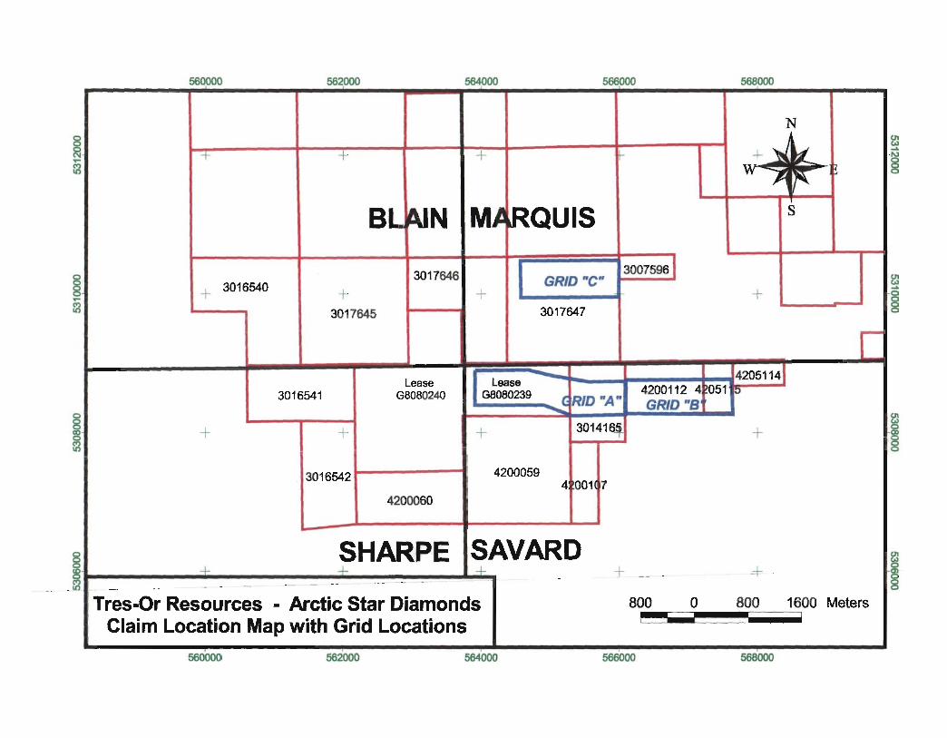
560000
+
+ 3016540
562000 564000 566000
+ +
BL~JN M~~QUIS
+ 3017645
3017646
+ 3007596 1
GRID "c" 3017647
568000
+
Lease GBOB0240
Lease G8080239
4205114J
3016541
+ + +
3016542
4200060
(RID "A" --3014164
4200059 4 001 7
4200112 4 )051 :0
GRID "S
8 SHARPE SAVARD ~~--------- ---~+----------------~~---------------~+-. + --
+
-+
s
c
Tres-Or Resources - Arctic Star Diamonds Claim Location Map with Grid Locations
800 0 800 1600 Meters ~I ~_~~~_-!
560000 562000 564000 566000 568000
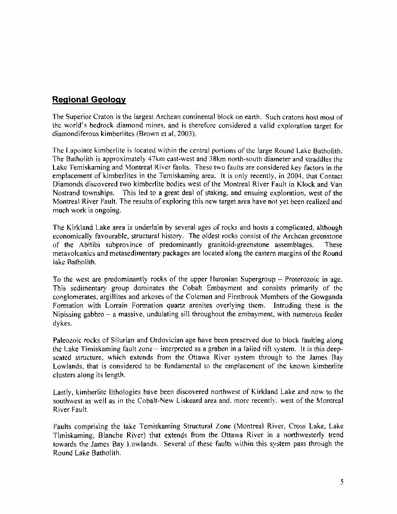
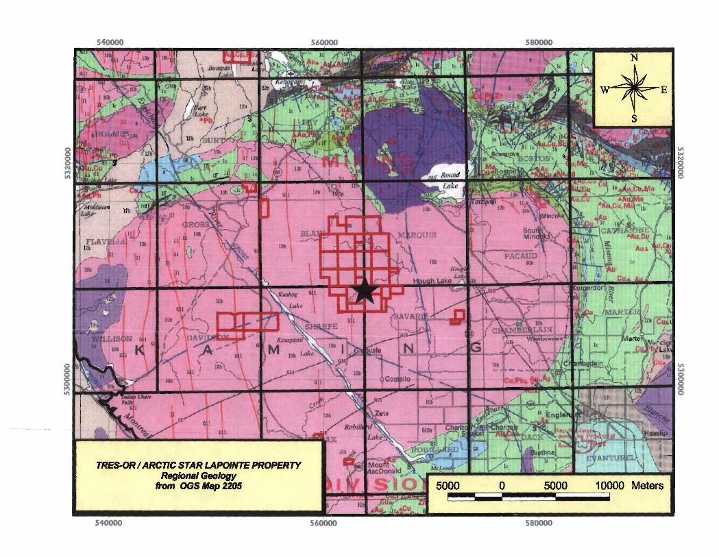
Regional Geology
The Superior Craton is the largest Archean continental block on earth. Such cratons host most of the world's bedrock diamond mines, and is therefore considered a valid exploration target for diamondiferous kimberlites (Brown et ai, 2003).
The Lapointe kimberlite is located within the central portions of the large Round Lake Batholith. The Batholith is approximately 47km east-west and 38km north-south diameter and straddles the Lake Temiskaming and Montreal River faults. These two faults are considered key factors in the emplacement of kimberlites in the Temiskaming area. It is only recently, in 2004. that Contact Diamonds discovered two kimberlite bodies west of the Montreal River Fault in Klock and Van Nostrand townships. This led to a great deal of staking, and ensuing exploration. west of the Montreal River Fault. The results of exploring this new target area have not yet been realized and much work is ongoing.
The Kirkland Lake area is underlain by several ages of rocks and hosts a complicated, although economically favourable, structural history. The oldest rocks consist of the Archean greenstone of the Abitibi subprovince of predominantly granitoid-greenstone assemblages. These metavolcanics and metasedimentary packages are located along the eastern margins of the Round lake Batholith.
To the west are predominantly rocks of the upper Huronian Supergroup - Proterozoic in age. This sedimentary group dominates the Cobalt Embayment and consists primarily of the conglomerates, argillites and arkoses of the Coleman and Firstbrook Members of the Gowganda Formation with Lorrain Formation quartz arenites overlying them. Intruding these is the Nipissing gabbro a massive, undulating sill throughout the embayment, with numerous feeder dykes.
Paleozoic rocks of Silurian and Ordovician age have been preserved due to block faulting along the Lake Timiskaming fault zone - interpreted as a graben in a failed rift system. It is this deepseated structure, which extends from the Ottawa River system through to the James Bay Lowlands, that is considered to be fundamental to the emplacement of the known kimberlite clusters along its length.
Lastly, kimberlite lithologies have been discovered northwest of Kirkland Lake and now to the southwest as well as in the Cobalt-New Liskeard area and. more recently. west of the Montreal River Fault.
Faults comprising the lake Temiskaming Structural Zone (Montreal River, Cross Lake, Lake Timiskaming, Blanche River) that extends from the Ottawa River in a northwesterly trend towards the James Bay Lowlands. Several of these faults 'within this system pass through the Round Lake Batholith.
5
TREs.CJR / ARCnC STAR LAPOINTE PROPERTY Regional Geology
from OGS Map 2205
540000 560000 580000
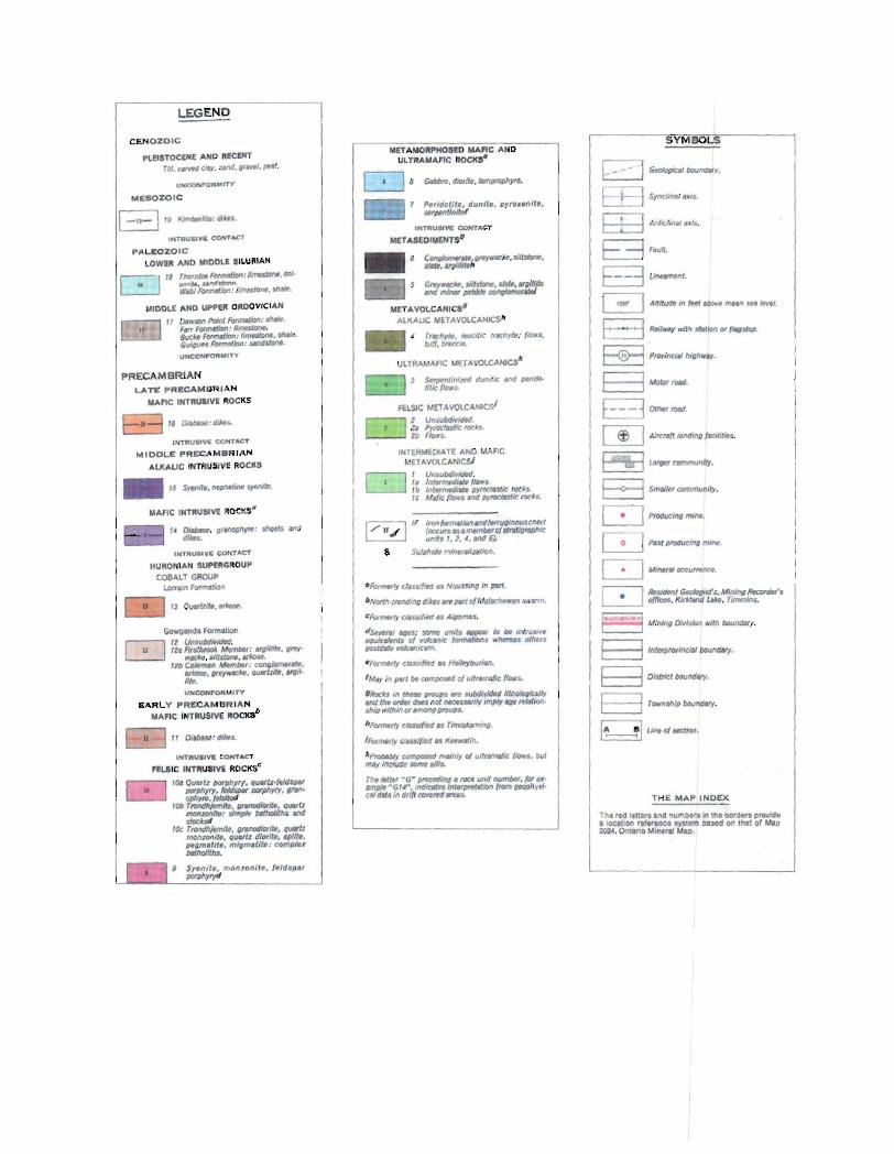
LEGEND
CENOZOIC
PLEISTOCENE AND /lECEHT TIIl .• _ eMf. WId. ~r_l. 1*1.
UNCONP'ORM'TY
MESOZOIC
I -It- \ ,~ t(Jmbrflu.: dikn.
INTRU.'yC eoHT~T
PAl-lEO Z OIC LOWER AND MIDDLE SILURIAN
~ " ThoInll>tF"f/""tlotl:6~.tIOI·
" Glf"ff., .1INfc:frvV'. Wdi FtxmMJon: /I"",stont . $hAle.
MIDDLE AND UPPER OROOVICIAN
11 Dows>n Poi"1 ""-:-. FOI' Ftx_IoII: limosJ.one. /IuC" Fo"'.'IotI: 1, __ ._. GulP' FormtJ1iDfJ: _110M. UNeON"O~MITV
lPfT"USIVE CONTACT
MIOOI-E PRECAM8R I A N
ALKALIC INTRUSIVE ROCKS
_ 15 ~1 •• IIfIIiI"jM $TM'Ie.
MA FIC INTRUSIIll! ftOCllS'
14 ~. ~flflOP/>yrr: _~ ift>d di/la.
INTftUSI VI; CONTACT
UHCOHf'OR M'TY
EARLY PRECAMBRIAN M/\FIC IMTRUSIVE IIOCKab
101J QUaIl. [JOf[J/Il'Y, quvl.·(t/d,W /1tIIph,,,, . fcId_ I»fphyfY, IIrM>' ~,.. (tISit<d
lOb TfOIIdhltm/l •• QWttJdlatfl , QUOII. _lDIIilc, oImp#e /RlhoIIIhs ond slacUtl
lOt: TfOfW//!;.,nIl#. granodiorite, qU¥ll """'lOIIl1 • • Quvl. dhNiI., apll/ •• /HQm. tit •• mlgm.lil~: compl.x _Ith •.
g S,.nil., mOf)7onll~. !eld'pal ptJIphytyd
MET .r.MORPHOS[i) MAfIC AND UL TRAMAFrc ROCKS'
~, GI/IbI'O. dlOtite,lfmPtOphy",.
Pelldotlte, dunlle, lIyro •• ttrtf . _PtnlJnllof
~:;'QI#YVf" . . s/I/sione.
;:w,,:,::·=.o::n:::r
IfIlfIformoIJofl_/ff'ulll"""ScMn (occu,. .. ".~btlO(1I1 'frapnlc "I"IJ" " 2, 4, and 6).
8 Su/p/ll<lf> mi""flliulion.
'For"./y ~1"SlfM" N""WftIJ '" ".".
6No</MlMdlt>g flIX" V'IM'/ 01 MJlarhe'NIHI .,..01"'.
&For __ I, cl4 ... fo4d'$ ...,.,..,...,.
ds.1I11J ...,: somt Unit' IIJI)IiItIIf 10 btl i('flrusi(~ !IQII!nIeflt. 01 ..... 1111( (ormoIIM. w",,", tJlhf,. I1OrtfJaI, ¥OkWlICSIt'I,
' FOI"""" C/a5J(t<JJ .. Hai~6u,iJn.
' Irkt in porlbt comfJOWJ 01 uNfOIM/lt Ilow~
III10cU I~ ,he .. 11 _ _ ~ illi>%rIiQIJr _ /he Otder <lot. noI M«SI.IIIy lmPIY _ ,tllliQn· shl# .. ,'thin fI' IJmOIJg RrouPl.
hFottn«'Y c/"nifitd .. Timislwning.
I""",.,ty ~1atIIif<1" KMWoIin.
kpro6tDIy ~ molnly 0( u{f,tmalk (lOYrs. ~ut ~lflCIlIW_JJII8.
TIl. /01,., "G" pItCOdlll/1. rock unil numbtl, for..,· Mnplt .. GI .. ·.lndkal .. lnt.,prl.'iolJOl> f'om ~.opllYSi· eM dill. In d,lft c<mre<l .",.s.
SYMBOLS
G<Oiogrc.,60u"q.ry.
E3FtVIt. a u_ nl.
~ All _m,.., ..... mH" ... ~/.
8 R,lI"ay "flh $lotion 01 (lftIIs/Op.
~ Provinef. high ..".
E3-rotd. E:.:::3 0/"" rotd. IT] Aitcra(t IlftdlfIQ rldh1lt! •.
~ tMptr community.
B Smaller aJmmunily.
Dp-ftlJ mI"".
~ Pili }JIOI1udng ml"".
C:.=1 Ml"'(11 «CUIf.nc#.
r-;-I ~1kJtJn! G«lIaQiol'$. Mit>ll>flilK'otdel·. L.:..-J offlcel;. Kirkliftld ~. Timmins.
~ Mining o.WtJon wIlh _rl.
B Inl.,_'nclol60und.ry.
E:l OIS1tJt:ltou"qt/Y.
B Tew.",,,, touMII'(.
E ~ Uneo(lICtlotl.
T H E M AP I ND EX
Th. , .. d 't1181, end "umbtra in the bot"dHI prcMcfe • IOCallOn ,e(tfence ""'1 III DesOd on ' ''''1 af Meo ~4. Onw.o Mlnel&! MIP.
SURFICIAL GEOLOGY
Glacial Histon
The Canadian Shield has an extensive glacial history and most surficial deposits and landforms are the result of the most recent glacial episode (Wisconsinan). The Temagami North extension property is located in an area previously covered by a continental style glacier referred to as the Laurentide lee-sheet.
The Keewatin lobe of the Laurentide Ice-sheet advanced across the property between 80 000 and 100 000 years ago at the beginning of the Wisconsinan (Roed. 1979). Ice accumulating in a number of ice domes to the north and northeast was the driving force for the ice movement. By approximately 11 000 years ago deglaciation was well under way and the ice front had receded to a position about 30 km north of North Bay, Ontario (Veillette, 1989). During this time the ice domes existed in Hudson's Bay to the north and in Quebec to the northeast. By 10 500 years before present (BP), the ice sheet began to recede. The ice continued to recede and the property was ice~free by 10000 years BP.
Following the retreat of the ice-front, proglacial lake Barlow and Ojib\¥ay formed. These large glacial lakes, fed by the melting ice and restricted by limited outflow. covered extensive areas of western Quebec and northeastern Ontario. The New Liskeard area and parts of the Ottawa River Valley were flooded and thick glaciolacustrine deposits formed (Veillette, J 994).
The glacial activity in the area is responsible for most of the surficial deposits and many of the landforms that occur. Many of the structurally controlled valleys have been scoured by glacial ice and fill with giaciogenic sediments.
Ice-Flow History
Much work has been done to determine the regional ice-flow history of the area and the reader is referred to Veillette (1989) for an extensive summary (Figure 2). Veillette (1986, 1989) recognizes three dominant ice-flow directions that likely reflect the shifting of ice divides with time. Early ice-flow was from east to west (230°-270°). Flow direction during this time is likely part of the initial advance of the ice as the Laurentide lee-sheet grew. consolidated and advanced in to the northern United States of America. This was followed by a deflection of ice-flow to the south at an azimuth of 180°-220°. It is likely that this phase was the most important in controlling sediment transport. Almost without exception. outcrop with preserved striae show this direction. indicating that much of the surficial material deposited during the 230°-270° (older) phase was removed and ice was in direct contact with bedrock.
8

· .' .. .. : ~
Figure 4. The three dominant regional Ice-flow directions in NE Ontario and NW Quebec
Ice-flow number J is the oldest and number three is the youngest (modified from Veillette, 1986).
9

DEPOSIT TYPE (Diamond)
Bedrock sources of diamond are limited to kimberlite or closely related rock types, which are rare, deep-seated magmas. All of these deep-seated kimberlitic rocks are Mg-. Ca- and volatilerich. as weI! as silica-poor. They are classified based on numerous and commonly overlapping mineralogical and trace element characteristics into three major types: group I (archetypal) kimberlite; group 2 (micaeous) kimberlite (sometimes named "orangeite"), or olivine lamproite (Mitchell. 1986). Although debates rage as to the derivation and most important characteristics of these different rock types, each can carry economic diamonds, and for the purposes of this report "kimberlite" or "kimberlitic" should be understood to encompass aU three.
Most economic diamond deposits occur in Archean (> 2.5 Ga) cratons. These deposits may be in the fonn of carrot-shaped pipes, or thin dykes (usually less than 2 m across). The pipes or dykes may penetrate thick supracrustal sequences, but Archean rocks that have not been significantly heated and deformed (Archons of Janse, 1997) are required as a basement Only relatively cool, thick lithosphere can fracture to sufficiently great depths to provide pathways for kimberlitic magmas to reach the surface.
Exceptions do occur and perhaps the most important is the Argyle Mine in Australia, which is the largest diamond mine in the world based on carats produced. The Argyle Mine occurs in olivine lamproite within a Paleoproteroloic basement. Another exception where diamondiferous kimberlite occurs within deformed or metamorphosed Archean basement is Alberta's discoveries in the Buffalo Head terrane, where U-Pb ages of basement are Paleoproterozoic. However. SmNd ages, which see through later metamorphic events, give Archean ages (Villeneuve et aI., 1993). Although none of these discoveries has been proven economic, exploration continues and preliminary results from some of the pipes are encouraging (Ashton Mining Canada Ltd. press release, May 200 I).
10
PROPERTY ACCESS AND DESCRIPTION
The property, for this report, refers to the claims centered on the junction of Sharpe-Savard-Blain and Marquis Townships specifically SW Marquis and NW Savard Townships (Figure 1), The Lapointe claims are located approximately 26 km southwest of Kirkland Lake. 23 km northwest of Englehart and 57 km north-northwest of New Liskeard. The property is located just less than 10km due west of secondary Highway 563 running between Charlton and Hwy 11 (south-Y intersection). Hough Lake Road runs due west from H wy 562 for 6.5km on a wellmaintained township road. From there, access is an old logging road, which is drivable by truck for approximately 2km for most of the year. Past this point off road vehicles are most reliable.
PREVIOUS WORK
Very little published information exists on the inner portions of the Round Lake Batholith. A number of gold and base metal occurrences are documented around the eastern and northern margins of the intrusion, while the western and southern margins are more typically marked by silver, copper and cobalt occurrences (OOS Map 2205). Its perceived low mineral potential has discouraged mapping and exploration budgets. Glen John's 1986 Geology of Hill Lake Area OGS report 250 covers a portion of the batholith in parts of Robillard, Bryce and Dack townships. [t is described therein as consisting of tonalite, trondhjemite, granodiorite, aplite and diorite. Modal compositions plotted on a QAP diagram plot the batholith lithologies as tonalite and granodiorite.
Previous work by Tres-Or Resources and Arctic Star Diamonds includes til! sampling, airborne geophysics, diamond drilling, and caustic fusion. and reverse circulation drilling for a 50 tonne kimberlite sample.
WORK PROGRAM
A large portion of this year's work program is focussed on and motivated by the kimberlite body (in 2005 in hole TMN05-04) discovered east of the Lapointe kimberlite pipe. This discovery and environs necessitate continual access to the area of our base camp for the completion of detailed ground geophysical surveys, till sampling, geochemical and other baseline studies, prospecting and mapping. Access to the region is difficult due to the high clay content and saturated ground conditions which create considerable barriers to the ongoing ground work. Trail access work reported here consisted of creating a trail north of the main access using bush swamper and log loader with hoe attachment, to allow for drainage and continued use for these ongoing programs.
The second two of three large ground magnetometer surveys (Figure 5) were contracted to Meegwich Consultants Inc of Temagami Ontario in June 2008. The grids were completed in August and September due to other contracts and equipment maintenance. The northern of the two grids, Grid "C" was planned to cover a large section of an east-west magnetic structure parallel to a similar response to the south which represented a kimberlitic body drilled in 2005. Due to very wet ground and a large creek, the western half of the planned Grid "C' could not be completed at that time of year. Grid "B" is a continuation to the east of Grid "A" (previously submitted for assessment) and covers the east-west structure drilled in 2005.
I I
I---~~-t Tres-Or Resources - Arctic Star Diamonds ~~~~~ .... __ 800 1I.1IdtiC.f'C! Magnetometer Grids over topography
564000 565000 566000 567000 568000
DISCUSSION AND RECOMMENDATIONS:
Both grids show well defined, although very subtle, linear features with a magnetic reading range of less the 600 nT. There is a break in the data on Grid "B" due to wet ground along a creek. There are three isolated, subtle mag highs at the far eastern end of the grid roughly on trend with the main linear feature so may be related. The linear feature to the north, covered by Grid "C". is a narrower feature roughly 30m to I OOm in width with one isolated circular mag high north of the linear feature on line 5250E but only traversed by one line so <50m maximum diameter.
Recommended work includes the completion of Grid "c" to the west as well as a grid covering a northeast trending structure (red dotted line on Figure 5) which intersects the east-west structure covered by Grids "A" and "B" at the west end of Grid "A" where drill hole TMN05-04 intersected the kimberlitic body. When this second kimberlite body is further explored. both the east-west and the northeast trending structures should be evaluated to determine its relationship to the kimberlitic body.
Till sampling is ongoing and diamond drilling has been recommended to extend and define the extent of this second kimberlite body.
13
REFERENCES Contact Diamonds website: http://www.contactdiamond.com
Geological Survey of Canada Website: http://gsc.nrcan.gc.caJdiamondsikirkland/diamond e.php
Johns. D.W., 1986. Geology of the Hill Lake Area, District of Timiskaming, OGS Report 250.
Kirkland Lake Resident Geologist's Office link to Geology of the Kirkland Lake District: http://www.mndm.gov.on.ca/mndm!mines/resgeo l/northeast!kirkland lake/geo e.asp
Mitchell, R.H. 1986. Kimberlites: Mineralogy, Geochemistry, and Petrology. Plenum Press. New York
Pyke, D.R, Ayres. LD and Innes, D.G, 1970-71. Map 2205: Timmins - Kirkland Lake Sheet, Ontario Geological Survey Geological Compilation Series; Scale 1:253.000
Roed, M.A., 1979; New Liskeard Area (NTS 3IM/NW), District of Timiskaming; Ontario Geological Survey, Northern Ontario Engineering Geology Terrain Study 84, 28p.
Sage, R. P., 1996. Kimberlites of the Lake Timiskaming Structural Zone. Ontario Geological Survey, Open File Report 5937.435 p.
Tres-Or Resources website: http://www.tres-:or.corTIL
Veillete. l, 1986. Former southwesterly ice flows in the Abitibi - Timiskaming region: implications for the configuration of the late Wisconsinan ice sheet. Canadian Journal of Earth Sciences, v. 23, p. 1724-1741.
Veillette, J.1., 1989; Ice movement. till sheets and glacial transport in Abitibi-Timiskaming. Quebec and Ontario. In: DiLabio, R.N.W. and Coker, W.B. (eds), Drift prospecting, Geological Survey of Canada, Paper 89-20, J 39-154.
Villeneuve M.E, Ross, G.E., Theriault, R.J., Miles, W., Parrish. R.R., and Broome, J., 1993. Tectonic subdivision and U-Pb geochronology of the crystalline basement of the Alberta Basin, Western Canada. Geological Survey of Canada Bulletin 447. 86 p.
Veillette, J.J .. 1994; Evolution and paleohydrology of glacial lakes Barlow and Ojibway. Quaternary Science Review. 13, 945-971
14
STATEMENT OF QUALIFICATION
To accompany the report entitled: Ground Geophysics, Marquis and Savard Township, Larder Lake Mining District for Tres-Or Resources Ltd and Arctic Star Diamonds Corp .. December 2008.
I, Elaine Basa, of the city of Temiskaming Shores, in the Province of Ontario, Canada, hereby certify as follows concerning my report on the Tres-Or Resources Ltd.'s and Arctic Star Diamonds Corp. 's Marquis and Savard Township property, Ontario, 2008:
I. I graduated from Carleton University in 1985 with a degree of Bachelor of Science, Honours Geology.
2. I am a Professional Geologist and a member of Professional Geoscientists of Ontario (member number 0895).
3. I have worked continuously in the mining industry for the past 22 years. 4. I am acting as a consulting geologist for Tres-Or Resources Ltd. 5. The attached report is a product of:
a) data provided to me by the property owner b) reports identified in the reference section of this report c) knowledge gained from working in the area over much of the past 22 years
Dated this 28th day of December 2008 in Temiskaming Shores, Ontario
Elaine Sasa, P.Geo.
]5
Statements of Qualification
I. To accompany the Geophysical report in Marquis and Savard Twp, Larder Lake Mining District for Tres-Or Resources Ltd, December 28th
, 2008
2. I. Martin Ethier, of the city ofTemiskaming Shores, in the Province of Ontario. Canada, hereby certify as follows concerning my report on the Tres-Or Resources Ltd.'s and Arctic Star Diamond Corp.'s Lapointe Area property. Ontario, 2008:
3. J graduated a Bachelor of Arts, from Mount Allison University in Sackville New Brunswick (1997), majoring in Geography, and minors in Geology as well as Environmental Studies. In addition, I completed an intensive Post Graduate Advanced Diploma in Remote Sensing and Geographic Information Systems from the Centre of Geographic Sciences (COGS) in Lawrencetown (J 998), Nova Scotia. Furthermore have obtained a Master s of Science in Geology from Acadia University in Wolfville (2001), Nova Scotia.
4. 1 am currently employed as a consulting geologist providing my services through:
Hinterland Geoscience & Geomatics 620 Brewster Street, P.o. Box 304 Haileybury, Ontario POJ 1 KO (705) 671-5814
5. The attached report is a product of: • data provided to me by the property owner • field supervision • reports identified in the reference section of this report • local knowledge and experience
Dated this 28th day of December 2008 in Temiskaming Shores, Ontario
Martin Ethier M .Sc.
16
APPENDICES
Appendix I ............................. Meegwich Consultants Inc Ground Geophysical Survey Report
17
I I I I I I I I I I I I I I I I I I I
GROUND GEOPHYSICAL SURVEYS Magnetometer Surveys Assessment Report
Lapointe Diamond Project Savard, Marquis and Blain Twps.
TRES-OR RESOURCES LTD.
October 2008.
NTS 41 P/16
9, ,ii," 7 \'
Meegwich Consultants Inc. P.O. Box 482, Temagami, Ontario POH 2HO TeL (705) 569- 2904 Fax. (705) 569-2817

I I I I I I I I I I I I I I I I I I I
Lapointe Diamond Project Tres-Or Resources Ltd.
TABLE OF CONTENTS
1.0 Summary
2.0 Property Description
3.0 Location and Access
4.0 Magnetometer Survey
4.1 Instrumentation
4.2 Survey Results and Interpretation
5.0 Conclusions and Recommendations
LIST OF FIGURES
Claim and Grid Sketch 1:75,000 Figure 1
Figure 2 Blain-Marquis-Savard Twp Grids 1 :30,000
LIST OF MAPS
Magnetometer Survey
Total Field Contours Grid B 1:2500
Magnetometer Survey
Total Field Contours Grid C 1:2500
Meegwich Consultants Inc. P.o. Box 482, Temagarni, Ontario POH 2HO Tel. (705) 569- 2904 Fax. (705) 569-2817
Page 2
I I I I I I I I I I I I I I I I I I I
Lapointe Diamond Project Tres-Or Resources Ltd.
1.0 SUMMARY:
From August 14 to September 16, 2008 a program of grid establishment and
detail magnetometer surveying was carried out over magnetic targets in Savard
Tp. The purpose of the work was to further resolve prospective airbome
magnetic features on the ground in detail. Trlis exploration work is part of the
extensive Lapointe Diamond Project. Tres-Or Resources Ltd., of 1934-131
Street, White Rock, B.C. V4A 7R7, holds the property.
The grid establishment and magnetometer surveying was done by David
Laronde, Wesley Verreault and Stephane Coulombe on behalf of Meegwich
Consultants Inc. P.O. Box 482, Temagami, Ontario POH 2HO. David
Laronde was the field supervisor and the author of this work report. There was a
grand total of 61.40 km of grid lines established and surveyed with
magnetometer on two grids. Grid B contained 30.40 km of line km while Grid C
was 31.00 km.
The lines of the grids were located with WAAS enabled GPS units (Garmin
60Cx) using the UTM NAD 83 co-ordinate system to ensure precise location.
2.0 PROPERTY:
The work was done on mining claims that are part of an extensive land holding
in several townships in the area. Only the mining claims that were worked on
are listed below.
Mcegwich Consultants Inc. P.O. 80'1482, Temagami, Ontario POH 2HO Tel (705) 569-- 2904 Fax. (705) 569--2817
Page 3
I I I I I I I I I I I I I I I I I I I
Lapointe Diamond Project Tres-Or Resources Ltd.
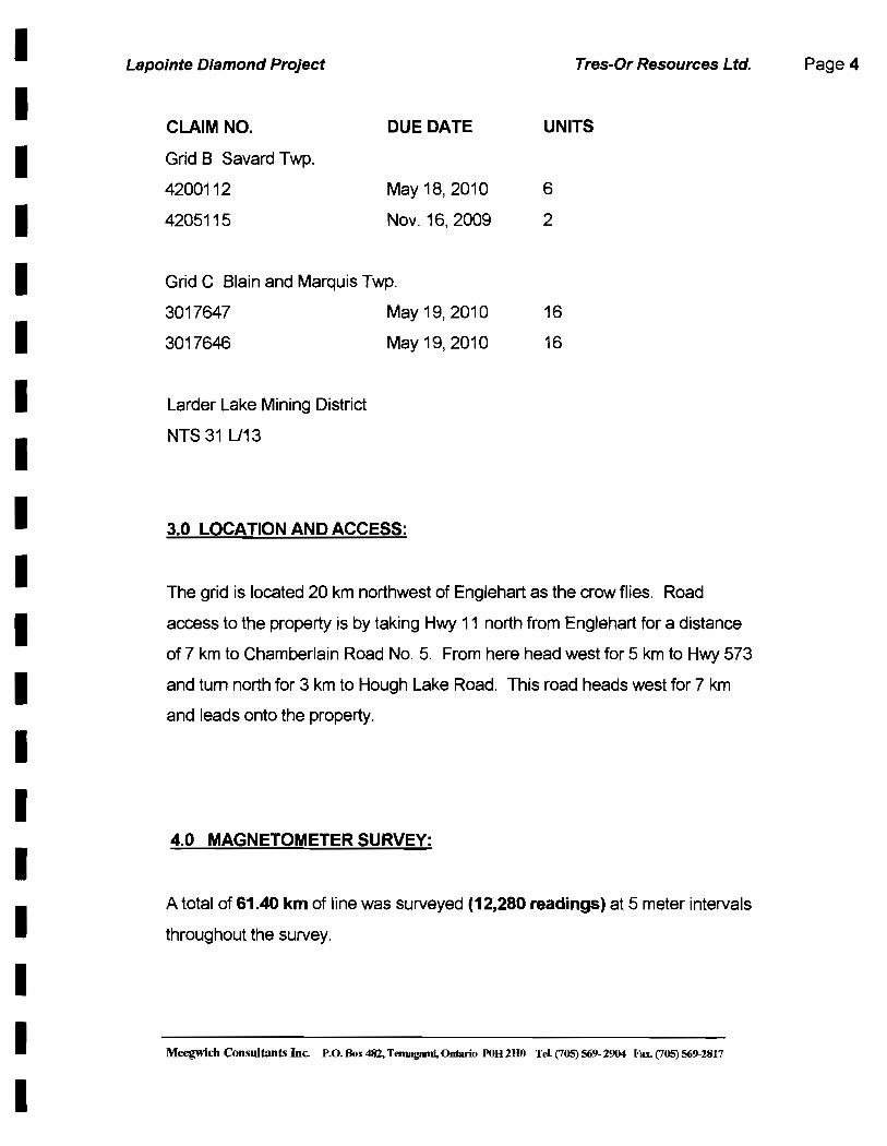
CLAIM NO. DUE DATE UNITS
Grid B Savard Twp.
4200112
4205115
May 18,2010
Nov. 16,2009
Grid C Blain and Marquis Twp.
6
2
3017647 May 19, 2010 16
3017646 May 19, 2010 16
Larder Lake Mining District
NTS 31 U13
3.0 LOCATION AND ACCESS:
The grid is located 20 km northwest of Englehart as the crow flies. Road
access to the property is by taking Hwy 11 north from Englehart for a distance
of 7 km to Chamberlain Road NO.5. From here head west for 5 km to Hwy 573
and tum north for 3 km to Hough Lake Road. This road heads west for 7 km
and leads onto the property.
4.0 MAGNETOMETER SURVEY:
A total of 61.40 km of line was surveyed (12,280 readings) at 5 meter intervals
throughout the survey.
Meegwicb Consultants Inc. P.o. Dox 48Z, Ternagami, Ontario POH 2HO Tel (705) 569· 2904 Fax. (705) 569·2817
Page 4
I I I I I I I I I I I I I I I I I I I
Lapointe Diamond Project Tres-Or Resources Ltd.
4.1 Instrumentation: Gem Systems GSM-19 overhauser magnetometers
serial no. 58479 and 712776 were used for field units measuring in nanoteslas
(nT) with an accuracy of +1-1I100th nT. These instruments have an excellent
gradient tolerance at 10,000 nT/m.
A Scintrex EDA Omni IV proton precession magnetometer ser. No. 255228 was
used for a base station to monitor the diurnal variation. The base station cycled
at 20 second intervals. This instrument has an accuracy of 1/10th nT.
4.2 Survey Results and Interpretation: The results are presented in
contour format on plans at 1 :2500 scale. Quality control was monitored by
comparing the reading at a common base station at different times. This
referencing technique confirms good data and checked out on these surveys.
The surveyed area covers an area 2200 meters long and 500 meters wide.
Please note that references to ground grid coordinates are simply
truncated UTM NAD 83 coordinates indicated along the map borders.
Grid B (30.4 km)
In general the surveyed area exhibits an east west trending linear high (dike)
that is relatively weak in magnetic intensity (25-50 n T) but nevertheless
contrasts well against a very quiet background range of 290-350 nT. This 100
meter wide feature spans the length of the 1600-meter long grid petering in and
out toward the eastern end. A low of 25-50 nT flanks the high to the north.
Throughout the grid are numerous isolated highs that compose irregular
patterns for the most part. Exceptions to this are three interpreted circular
patterns with diameters ranging 200-250 meters. The centres of these features
occur at 6625E at 5308350N, 6925E at 5308350N and finally 7150 E at
5308125N. The geometry is conducive to a kimberlite pipe.
Meegwich Consultants Inc. P.o. 801: 482, Temagami, Ontario roH 2HO Tel. (705) 569- 2904 Fax. (705) 569-2817
Page 5

I I I I I I I I I I I I I I I I I I I
Lapointe Diamond Project Tres-Or Resources Ltd.
Grid C (31.00 km)
This grid is quiet magnetically with a background range of 325-350 n T similar to
Grid B. Another similarity to Grid B is an east west trending linear high
spanning the total length of 1500 meters. The width of this feature varies from
20-90 meters. The feature is a dike of mafic content and likely intrusive by
nature.
Two isolated highs located on L5250E at 5310050N and L5600E at 5309700N
carry high readings of 923 and 1332 n T respectively. These anomalous
features are spotty but concentrated in mafic mineral content.
A north south trending feature is noted along the eastern grid boundary. Values
are similar to the east west feature. Perhaps there is folding or faulting at this
location.
A narrow southwest trending dike is noted in the extreme southwest corner of
the grid.
5.0 CONCLUSIONS AND RECOMMENDATIONS:
The detailed magnetic surveys were successful in identifying interesting drill
targets and areas to follow-up. The responses could be related to a diamond
bearing intrusive or other mafic intrusive.
Meegwich ConsuJtants Inc. P.O. Box 482, Temagami, 0r/tariQ POB 2BO Tt>l (705) 569- 2904 Fax. (705) 569-2817
Page 6

I I I I I I I I II
I I I I I I I I I I
Lapointe Diamond Project Tres-Or Resources Ltd.
Both Grid Band C contain a low intensity, narrow, linear dike feature that span
about 1.5 km. These should be drill tested for diamond bearing intrusives. Grid
B has three circular features that are interesting as well and should be drill
tested.
The surveyed features are recommended for drill follow-up work since the area
is highly prospective for kimberlite and magnetic features with compatible
geometry may be considered as possible diamond bearing rock.
Meegwich Consultants Inc. P.o. Box 482, Temagami, Ontario POH 2I10 TeL (705) 569- 2904 Fax. (705) 569-2817
Page 7
I I I I I I I I I I I I I I I I I I I
Lapointe Diamond Project Tres-Or Resources Ltd.
References
Geological Map 1974 -Ontario Geologic Survey Map 2205 Geological
Compilation Series 1 :250,000
Meegwicb Consultants Inc. P.O. Box 482, Temagami, Ontario POB 2BO Tel. (705) 569- 2904 Fax. (705) 569-2817
Page 8
I I I I I I I I I I I I I I I I I I I
Lapointe Diamond Project Tres-Or Resources Ltd.
CERTIFICATE OF AUTHOR
I, David Laronde of the town of Temagami, Ontario hereby certify:
1.
2.
3.
David Laronde
That I am a geology engineering technologist and have been
engaged in mineral exploration for the past 28 years.
That I am a graduate of Cambrian College in Sudbury
with a diploma in Geology Engineering Technology
1979.
That my knowledge of the property described herein
was acquired by field work and documentation.
Meegwich Consultants Inc. P.o. Box 482, Temagami, Ontario POH 280 Tel (705) 569- 2904 Fax. (705) 569-2817
Page 9
-------------------563000 564000 565000 567000 568000 566.000
g ~--------~----------~----------~_t--~--------11--~--------r_--t:::=l::~==~==~==~ ~
~ TRES-OR ARCTIC STAR - ~ M a LI1 Blain _ Marquis-Savard Twp Grids a
a g ~ - -~~~~~==~~~~I=-~-~~~~==~~~~~~~=-=1~--~~~~~~-r~--~~~==-4~
M LI1
a a a ct:; a M LI1
563000
/ -564000
""\ I ,,--./
I \
\ I
. , 565000 566000 567000 568000
en UJ a
-co a o a
en UJ a 00 a a a
- - - - - - - - - - - - - - - - - - -66400l 566500E. 566600E 566700Ec 566800E 566900E 567000E 567100E 567200E
r r r r r r r r r r r r r r r r r r r r r r 'r r r r r r r r r r r r r OJ m OJ m OJ m m OJ m m m m m OJ m OJ m OJ OJ m OJ m m OJ --J --J --J --J --J --J --J --J --J --J --J
"'" "'" "'" "'" (Jl (Jl (Jl (Jl m m m m --J --J --J --J co co co co (D (D (D (D 0 0 0 0 '" '" N 0 '" (Jl --J 0 '" C)l --J 0 '" (Jl --J 0 '" (Jl --J 0 '" (Jl --J 0 '" (Jl --J 0 '" (Jl --J 0 N (Jl --J 0 '" (Jl
0 (Jl 0 (Jl 0 C)l 0 (Jl 0 (Jl 0 (Jl 0 (Jl 0 C)l 0 (Jl 0 (Jl 0 (Jl 0 (Jl 0 (Jl 0 (Jl 0 (Jl 0 (Jl 0 C)l 0
m m m m m m m m m m m m m m m m m m m m m m m m m m m m m m m m m m m
I I I I I I I I I I I I I I I I I I I
I i
~- E ~~
I
§ .. §
§ .;
§
""""'" ......... .... , ... - 1:i -
iIi Ii ! ~ II! rrnlms;s.-. =, =========:;:=::===:=::::::=:=--;:;:;;;,ms;;l. i!! .. If ~ J "''''' / "",,. iL~ i ~
II ~[ : : : : f ~= :~~ ,d II ! Ii If lnm, U) ( l_' j I
! I :~~ : ~: : Sr :~~ II z ~::: : v / : "".. I
~ f ~:: ( L737tiE '\
~:~ __ n _______ - - :--------- - :--- _M : - \ : lT320'
I fcm;,--- ~ ~--- j\,><~ l""" j I lms. : i : ~ In'''' Ln!OE . ~ Lnsoe I
I f ~:: : ! . :::, j I "".. ( : : L1175E i L1150E . J . , L1150E
""SE : ' ''" .. If",·" \ . "",,. . ~ L)V7SE . - - : Lm.. I l"", --' \.lIlSOE
l 14lS1E
I ""'"
I~ l7Q25E !
~I z ... , .. ,.", .. .-0, ., - -- .-, l ..... l""'"
If ~. '-""", I L61117'5E l"'"
N .-. l .... ' I ...,.. """ If ~. .-, il
..,.,., I e o N
If""'"
If ~,
If ~,
If LS«>O,
, i ..".. '-""", ..-"" .. "ns. ~- - -:-, ...,.. / ".," ) .-, .... ,
-- 7-- - -~
l_' - - ----: - -~ --T ---~
lMJOE 11 LO'''''
. - - --- - ~- --7 _
l""" : - ----:-~\. u_ .. ~. I
LAm,
I / -
'-""'. :---- - ---~r:
"." .. .... , .. -- - 1_ :
"'75' T - - - -..... , lO'O" -- - - - -- ---:- --r ------~
...,.. ----- - T~ .-, 11 L.«J15E
- \-- --
..""
If....,.,
If..,...
I _ u."'" '-""'E
lA32S' LBJ25E 1- - -
""". I '-'1 ~I
Ul1'5E
""'" '-"=E
-.J -- ........ ........ -- -- """""'"
H ' nii
I --z-
I \. ...".,. $31!11Qa\t -. ........ Ii i
~ . . ~ ....
! II ~ U !il t:elIJ'Se: _ME Li!llJTSE ~u If 0
i~ -g
l.".E ~~ . :II! "",5< 9 II :5 I' .....,· ·1 ~ 0
...... '-""OE UOOO.
( 0.=5' """ L!OOOE """" .. I
( l5315E ... ," """" ~.
""'E l5alII'
1- l.58WE ...... E · I l5>7>' tsmE
LmO' LS>S>E
l5nSE L5n5' L
- I lS>OO' l5roJ" I § ""'" L547SE
• '-""'E C5050E
§ l5G!IE '-""0'
1- """'" LSaXI. · I t l L$r.>' ! LS!l5OE """. l5S2S' l5S2S'
t ""'" "".,,,. . I L5<'"
L5<0DE ~ """" """. "'>SE
I· L5«lOE ~ """. -I l5J75' LSm'
(;f) """" c=,
I 10;;;; ..,.,.,. j ""75'
.."..
I· 0 """, ·i l1i175E
('t) L5125E • LSI",E ' ; i ' l",,'"
UIlOOE
...,.. I' L.SOCII. ' I
'''' lAm'
~ J: § I· L<025E
-I, "'"'' . I ~. ....," l-/" ~.
...... ".", ! . ....... ......, ·1 l"''' "n" '"'''' L""1'6OE
,m .. lAnSE
~ . ''''''. L"1OO£ -I ! . """. ~, t:1tIOO£lAIJrJeE ........
\ """ ....,.,
I· ~~ . I -,to "",.. """",ts ...".,..., --
_--.--J