atlantic studies 9
TRANSCRIPT

Page 604/98
Correspondence Study Program
INTRODUCTION
Together the four Atlantic provinces formone of Canada’s unique regions. Theyshare a similar rugged landscape, withnumerous bays and inlets along the coast.The people who live here come from allover the world and have helped to makethe region an exciting and vibrant placeto live.
WEB SITES
There is more informationavailable on the internet onphysical settings. Use yoursearch engine (Yahoo, altavista, hot bot). Try thesewords to find more infor-mation: topographical maps, globalpositioning system, Environment Canada,Titanic.
ASSIGNMENT 1:FINDING YOUR WAY USING MAPS
If you want to learn more about AtlanticCanada, looking at maps is an excellentplace to begin. A world map will show youwhere Atlantic Canada is located in rela-tion to other countries, a provincial mapwill help you find the highways and backroads, and a street map will show youaround unfamiliar towns and cities.
PERSONAL ACCOUNT:DO PEOPLE LIVING IN ATLANTIC CANADA
NEED TO USE MAPS?
Recently, I met a woman who got lostin the Nova Scotia bush with her fam-ily. It was about 5 o’clock one springafternoon when she and her husbanddecided to pack their two small chil-dren in the van and go exploring.They used to live in Toronto andeverything in Nova Scotia seemed soopen by comparison. They turned offthe main highway and onto a dirtroad. There was a fork in the road:they guessed and took the one goingleft. Another fork, they turned right.There was no pattern to their choices.They assumed they were on provincialroads and eventually they would cometo one that was marked. However, theywere actually on logging roads, andthere were no markings.
Within an hour they were lost. Shesaid it was like being in a maze:everytime they turned they’d beenthere before or they came to a deadend. Just as it was starting to get dark,they found themselves on a road theydidn’t recognize. Before they’d gonevery far, the van became bogged in themud.
UNIT 1PHYSICAL SETTING
UNIT 1 PHYSICAL SETTING
Page 704/98
Correspondence Study Program
1. a) How are lines of latitude and linesof longitude different?
b) Copy the following degrees. Besideeach degree state whether it representslatitude or longitude: 85ºW, 85ºS,20ºN, 20ºE.
2. a) What is absolute location?
b) What is relative location?
c) Which example below shows rela-tive location and which shows absolutelocation?
Example 1: 42ºN 50ºW
Example 2: 3 km south of the bridge
3. What does GPS stand for? How does itwork?
4. a) What are the differences betweenphysical features and cultural features?
b) Copy the following locations andstate whether they represent a physicalor a cultural feature:
Lake Melville, Labrador; St. Anthony,Newfoundland; Folly Mountain, NovaScotia; Moncton, New Brunswick;Stanhope Beach, Prince Edward Is-land.
5. a) I am going on a hike in GrosMorne National Park in Newfound-land. What kind of map should I use?Why?
b) I am going to take the ferry fromNova Scotia to Prince Edward Island.What kind of map should I use? Why?
c) I need to go to the Micmac Mall inDartmouth. What kind of map should Iuse? Why?
The husband could see the lights ofa farmhouse in the distance and de-cided the only thing to do was to leavehis wife and children, ages two andfour, in the van while he went for help.He was gone for three hours. She sat inthe van, occasionally starting theengine and turning the heater on. Butshe was worried about using all the gas,so she never left the engine runningfor very long.
Finally the husband returned witha farmer on a tractor. They decidednot to even try to get the van out, but toleave it until the morning. The wholefamily climbed on the tractor and got aride to the farm. Then, they weredriven home. It turned out they wereonly three kilometres from the mainhighway and then a 15-minute drive totheir house.
The family was lucky it wasn’t reallycold or snowing. The next day theywere able to get a tow truck to get thevan out. After that, the woman boughta number of maps showing provincialhighways and byways so this kind ofadventure would not happen to themagain.
30EXERCISE 1:CHAPTER REVIEW
Read Chapter 1,pages 2-16 in your
text and answer the follow-ing questions. If you needto check out the meaning
of any words, look in the glossary on pages291-294 of your text.
Page 804/98
Correspondence Study Program
ATLANTIC STUDIES 9
EXERCISE 2:LATITUDE AND
LONGITUDE
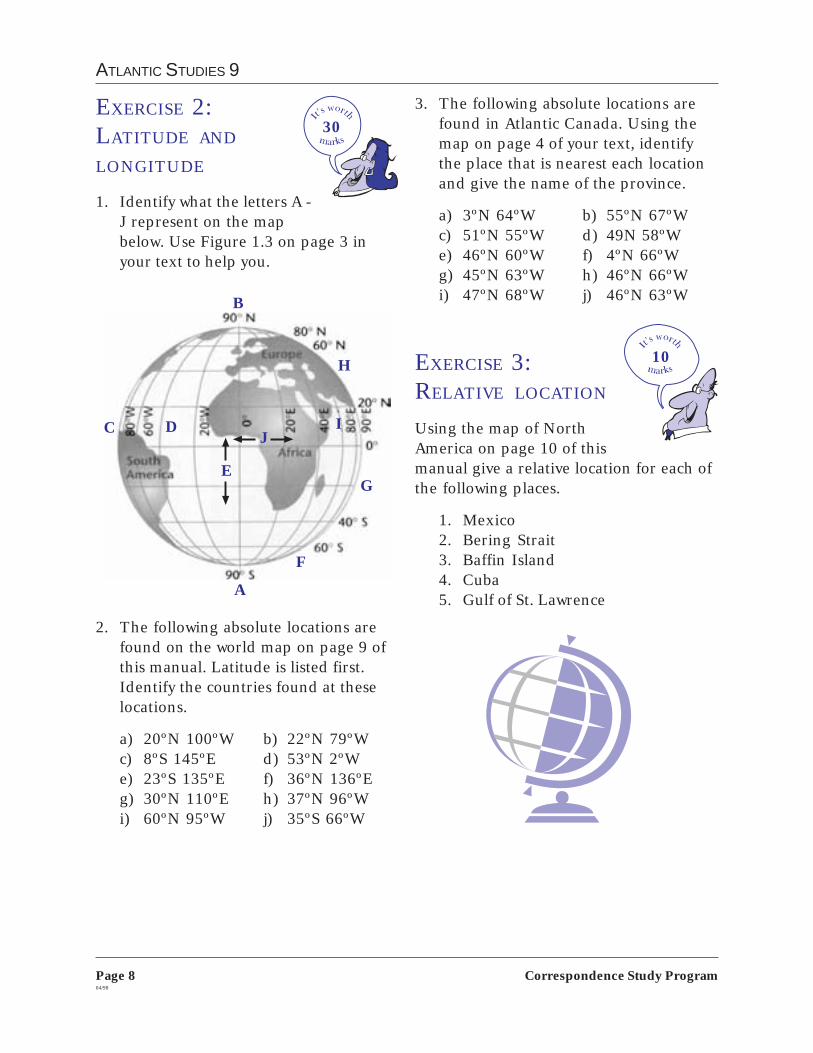
1. Identify what the letters A -J represent on the mapbelow. Use Figure 1.3 on page 3 inyour text to help you.
2. The following absolute locations arefound on the world map on page 9 ofthis manual. Latitude is listed first.Identify the countries found at theselocations.
a) 20ºN 100ºW b) 22ºN 79ºWc) 8ºS 145ºE d) 53ºN 2ºWe) 23ºS 135ºE f) 36ºN 136ºEg) 30ºN 110ºE h) 37ºN 96ºWi) 60ºN 95ºW j) 35ºS 66ºW
303. The following absolute locations are
found in Atlantic Canada. Using themap on page 4 of your text, identifythe place that is nearest each locationand give the name of the province.
a) 3ºN 64ºW b) 55ºN 67ºWc) 51ºN 55ºW d) 49N 58ºWe) 46ºN 60ºW f) 4ºN 66ºWg) 45ºN 63ºW h) 46ºN 66ºWi) 47ºN 68ºW j) 46ºN 63ºW
EXERCISE 3:RELATIVE LOCATION
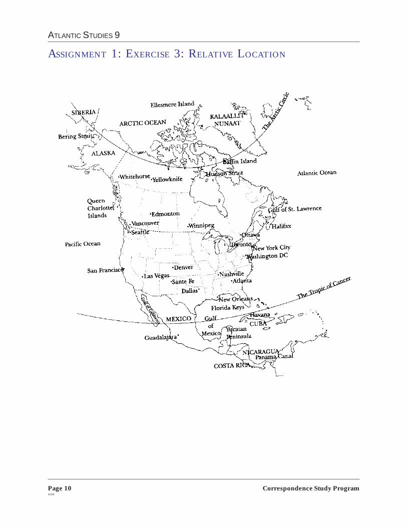
Using the map of NorthAmerica on page 10 of thismanual give a relative location for each ofthe following places.
1. Mexico2. Bering Strait3. Baffin Island4. Cuba5. Gulf of St. Lawrence
A
B
C D
E
F
G
IJ
H 10

UNIT 1 PHYSICAL SETTING
Page 904/98
Correspondence Study Program
• M
exic
o•
Cub
a
• Ja
pan
• C
hina
• U
SA• C
anad
a
• A
ustr
alia
• E
ngla
nd
• A
rgen
tina
ASSIGNMENT 1: EXERCISE 2.2—LATITUDE AND LONGITUDE
• Pa
pua
N
ew G
uine
a
Page 1004/98
Correspondence Study Program
ATLANTIC STUDIES 9
ASSIGNMENT 1: EXERCISE 3: RELATIVE LOCATION

UNIT 1 PHYSICAL SETTING
Page 1104/98
Correspondence Study Program
EXERCISE 4:FINDING YOUR WAY
WITH A
TOPOGRAPHICAL MAP
Read pages 10-11 in yourtext. Using the topo-graphical map on page10 of the text, answer thefollowing questions.
1. Name or describe the physical featureat each of the following locations.
a) 900400b) 920377c) 873405d) 884413
2. Name or describe the cultural featureat each of the following locations.
a) 944399b) 912393c) 904364d) 867388
3. a) You are travelling by road from thecrossroads at 903363 to StanhopeBeach at 923406. In which generaldirection would you travel?
b) If you travel the shortest possibleroute from the crossroads to StanhopeBeach, list two cultural features andtwo physical features you would see.
c) What is the name of the body ofwater beyond Stanhope Beach?
d) Give the 6-digit location numberfor the nearest campsite on theStanhope Beach.
EXERCISE 5:FINDING YOUR WAY
USING STREET MAPS
Read pages12-13 in yourtext. Using the street mapof downtown Frederictonon page 12, answer thefollowing questions.
1. a) You are staying at the University ofNew Brunswick Tourist Hotel. Accord-ing to the street map what is the gridlocation (grid reference) for this hotel?
b) Write a statement to describe therelative location of this hotel.
2. a) You are meeting a friend who isstaying at the Carriage House Inn.Which street would you take to get tothis hotel?
b) You wish to relax on “The Green”for an hour or so at the street mapreference 7D. Where is this location on“The Green” relative to the CarriageHouse Inn and the St. John River?
c) If you were to look east across theriver from this point, which parkwould you see?
3. a) You then walk to the buildingdesignated on the street map by “C.”What is the name of this flat-roofedbuilding?
b) Find this building on the photo-graph (page 13, Figure 1.17). What isthe grid location on the photograph?
4. From here you get a cab and go toBrunswick Street and then go along
1515

Page 1204/98
Correspondence Study Program
ATLANTIC STUDIES 9
35
1. What part did technology play inlocating and exploring the sunkenTitanic?
2. Give the last known absolute positionof the Titanic before it sank.
3. Describe the relative location of theTitanic after it sank.
4. The new technology can locate allkinds of things under the water.
a) What things do you think peopleare interested in finding?
b) What do people want to do withthings that they find?
5. Write a 100-word letter to the editor ofyour daily newspaper. In the firstparagraph, explain the problems yousee with this new technology. In asecond paragraph, discuss what con-trols, if any, should be placed on thetechnology and explain why.
Brunswick to the church at grid refer-ence 14F in the photograph on page13.
a) What is the name of this church?
b) What is its grid location on thestreet map?
c) You then proceed towards WaterlooRow. What is the grid reference on thestreet map of the railway bridge in thephotograph?
d) The cab then takes a right onUniversity to take you to your hotel. Inwhich direction are you travellingnow?
EXERCISE 6:FOCUS ON AN
ISSUE: THE TITANIC
Read the casestudy, “Findinga Sunken Ship,” on pages13-15 of your text and thearticle, “Undersea Scaven-
gers,” on page 13 of this manual whichdiscusses the ethics of underwater scaveng-ing. Answer the following questions basedon your reading.
UNIT 1 PHYSICAL SETTING
Page 1304/98
Correspondence Study Program
UNDERSEA SCAVENGERS
A THREAT TO HISTORIC WRECKS
by Stephen Thorne
RCMP in Nova Scotia are launching acampaign to deter divers from plunderingshipwrecks after museum officials com-plained the province’s underwater herit-age is fast disappearing.
Police say the coastal-watch andpublic-information program could expandinto a countrywide effort aimed at enforc-ing laws that have until now beenlargely ignored by officersand treasure-hunters alike.“There’s an escalationhere and it’s somethingthat needs to be ad-dressed,” said RCMPSgt. WendelAckerson. “That’swhat we’re trying todo.”
Museum officialsestimate there arebetween 5,000 and10,000 shipwrecksoff Nova Scotia’scoast, some predat-ing the 1492 arrivalof ChristopherColumbus inAmerica. Only about200 have been plotted,many more are knownto divers and dive groupswho make a businessplundering them.
More reliable gear, bettersearch tools and the sheernumber of divers have overrundwindling government resources,turning coastal waters into scavengers’playgrounds, suggests Pierre Laframboise,a coast guard policy superintendent.
“The problem is getting bigger andbigger because technology is makingeverything accessible,” said Laframboise,whose office determined the Titanic is notwithin Canada’s jurisdiction. “Depth is nota limit any more.”
Dive groups out of the United States inparticular have even advertised scavengingopportunities off Nova Scotia, said RCMPCpl. Phil Barrett.
Nova Scotia Museum officials went tothe RCMP after a group called the JerseyWreck Divers scavenged one of the lastknown marine casualties of the SecondWorld War—a merchant vessel off Halifaxcalled British Freedom.
They are believed to have taken thestern gun along with portholes and other
artifacts from the torpedoed ship,which still stands upright in
about 70 metres of water.
“I would have to saythis was the straw that
broke the camel’sback,” said BobOgilvie, the muse-um’s special-placescurator.
The law sayssuch sites are not tobe touched. If theyare, anything—coins, cannonballs,crockpots—must beturned over to thecoast guard’s re-ceiver of wrecks who
determines ownershipor whether they’re of
historical interest. Thereare about a dozen receiv-
ers in Canada.
In cases where therightful owners are found,
finders are eligible for compen-sation as salvors, usually for ex-
penses. If no owners are found after ayear, non-antiquities like rowboats, maybe destroyed or returned to the finder.
Items of historical or archeologicalinterest may be turned over to HeritageCanada, which determines their monetaryor other value. Countries of origin canhave claims to such items and mustcompensate finders for expenses only.
Source: Courtesy of the Chronicle Herald and TheMail Star.
Page 1404/98
Correspondence Study Program
ATLANTIC STUDIES 9
You can send Assignment 1 to your marker as soon as you arefinished. For Assignment 1, send the following to your marker:
Student Background Sheet
Introductory exercise
Exercise 1 - Chapter review
Exercise 2 - Latitude and longitude
Exercise 3 - Relative location
Exercise 4 - Finding your way with a topographical map
Exercise 5 - Finding your way using street maps
Exercise 6 - Focus on an issue: The Titanic
You can start Assignment 2 right away.

UNIT 1 PHYSICAL SETTING
Page 1504/98
Correspondence Study Program
ASSIGNMENT 2:OUR NATURAL ENVIRONMENT
The land and the water have made theAtlantic provinces what they are today.When people first settled in the region,they couldn’t change the land or thewater. They had to work with them.
PERSONAL ACCOUNT:THE THREE-HOUR CRUISE
People have to respect the land andthe water. Weather can change quicklyand disasters don’t take long to hap-pen. A teacher tells the following story.He and his wife and another couple setout for a ‘three hour sail’ in a bor-rowed sailboat. They had done thismany times before. On this particularoccasion, the couples had arrangedbabysitters, driven to where the sailboat was anchored, and set sail. At thehalf-way point, they wanted to turnback, but the wind had picked up andchanged direction. They found them-selves going further and further fromland.
After five hours, the babysittersbecame worried. Luckily, one of themhappened to be the daughter of anRCMP officer. Once he found outwhere the sailboat had gone, he con-tacted the Canadian Coast Guard. TheCoast Guard was able to find thesailboat and tow it back to where it hadstarted, 12 hours late.
30EXERCISE 1:CHAPTER REVIEW
Read Chapter2, pages 18-31in your text andanswer the followingquestions. If you need to
check out the meaning of any words, lookin the glossary on pages 291-294 of yourtext.
1. Define these words:
a) region b) physical distancec) time distance d) mountaine) folding f) fiord
2. a) How large is Canada exactly?
b) How large are each of the Atlanticprovinces exactly?
3. Give three reasons why New Brunswick,Nova Scotia, Prince Edward Island,and Newfoundland and Labrador aregrouped together as Atlantic prov-inces.
4. Who was Sir Sandford Fleming? Whatdid he do that made him famous?
5. What part of the Atlantic provinces ispart of the Canadian Shield?
6. Copy the chart on page 16 of thismanual and define each of the terms.

Page 1604/98
Correspondence Study Program
ATLANTIC STUDIES 9
EXERCISE 2:PHYSICAL FEATURES
On the blank map of theAtlantic provinces on page 17of this manual, locate and name the fol-lowing physical features. Use the map onpage 19 of your text to help you. Thereare more detailed maps of each of theprovinces on pages 287-290 of your text, ifyou need them. You may need to draw
Waterforms in Atlantic Canada
Water form Definition
river
lake
pond
wetlands
bogs
fens
swamps
ocean
gulf
bay
20 arrows to the locations if you don’t haveenough space to write the name.
Cape Breton Highlands, Nova Scotia
Lewis Hill, Newfoundland
Mount Caubvick, Labrador
Minas Basin, Nova Scotia
Bay of Fundy, Nova Scotia
Strait of Belle Isle

UNIT 1 PHYSICAL SETTING
Page 1704/98
Correspondence Study Program
ASSIGNMENT 2: EXERCISE 2—PHYSICAL FEATURES
Tea
r ou
t and
sen
d to
you
r m
arke
r w
ith A
ssig
nmen
t 2

UNIT 1 PHYSICAL SETTING
Page 1904/98
Correspondence Study Program
4. Fredericton, New Brunswick to NewGlasgow, Nova Scotia
5. Liverpool, Nova Scotia to CornerBrook, Newfoundland
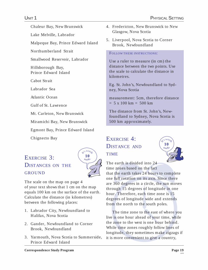
FOLLOW THESE INSTRUCTIONS:
Use a ruler to measure (in cm) thedistance between the two points. Usethe scale to calculate the distance inkilometres.
Eg. St. John’s, Newfoundland to Syd-ney, Nova Scotia
measurement: 5cm, therefore distance= 5 x 100 km = 500 km
The distance from St. John’s, New-foundland to Sydney, Nova Scotia is500 km approximately.
EXERCISE 4:DISTANCE AND
TIME
The earth is divided into 24time zones based on the factthat the earth takes 24 hours to completeone full rotation on its axis. Since thereare 360 degrees in a circle, the sun movesthrough 15 degrees of longitude in onehour. Therefore, each time zone is 15degrees of longitude wide and extendsfrom the north to the south poles.
The time zone to the east of where youlive is one hour ahead of your time, whilethe zone to the west is one hour behind.While time zones roughly follow lines oflongitude, they sometimes make zigzags ifit is more convenient to give a country,
10
10
Chaleur Bay, New Brunswick
Lake Melville, Labrador
Malpeque Bay, Prince Edward Island
Northumberland Strait
Smallwood Reservoir, Labrador
Hillsborough Bay,Prince Edward Island
Cabot Strait
Labrador Sea
Atlantic Ocean
Gulf of St. Lawrence
Mt. Carleton, New Brunswick
Miramichi Bay, New Brunswick
Egmont Bay, Prince Edward Island
Chignecto Bay
EXERCISE 3:DISTANCES ON THE
GROUND
The scale on the map on page 4of your text shows that 1 cm on the mapequals 100 km on the surface of the earth.Calculate the distance (in kilometres)between the following places:
1. Labrador City, Newfoundland toHalifax, Nova Scotia
2. Gander, Newfoundland to CornerBrook, Newfoundland
3. Yarmouth, Nova Scotia to Summerside,Prince Edward Island

Page 2004/98
Correspondence Study Program
ATLANTIC STUDIES 9
province or city a common time. In asense, a time zone map uses a grid patternbut only in one direction, namely East-West.
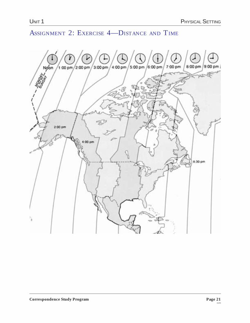
Look at the Time Zone Map of NorthAmerica on page 21 of this manual andanswer the following questions. You mayhave to look back to the map of NorthAmerica on page 10 of this manual if youare not sure where some of the places are.
1. If it is 9:00 a.m. in Halifax, what time isit in:
a) Edmontonb) Whitehorsec) New York Cityd) San Francisco
2. How many time zones are there inCanada?
3. Why is there a half hour time differ-ence between Newfoundland and theAtlantic Time Zone when there is a fullhour difference with other adjacenttime zones?
4. Why were time zones invented?
5. When you travel 3500 kilometres fromHalifax to Winnipeg, you pass throughthree time zones. When you travel asimilar 3500 kilometres from Halifaxto Havana, Cuba you change one timezone. Why is this so?
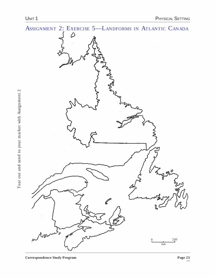
20EXERCISE 5:LANDFORMS IN
ATLANTIC CANADA
Read pages 24-25 in your textand the information on“The Appalachian Moun-tains” and “The Canadian
Shield” on page 22 of this manual. Answerthe following questions.
1. Why are the Appalachian Mountainsgenerally rounded in appearance?
2. a) According to Table 2.1 on page 24,which province has the highest pointof land?
b) Using the absolute location givenin Table 2.1, locate this point on themap on page 19 in your text. Describethe relative location of the highestpoint of land given in Table 2.1.
3. Use the map on page 19 of your text toanswer the following questions.
a) Lowlands are large low-lying areasof flat or gently rolling land. Describethe relative location of such an area inNew Brunswick and Nova Scotia.
b) Which province in Atlantic Canadahas the largest share of its area in theform of lowlands?
c) What is the elevation of the highestpoint of land in this province? (Referto Table 2.1.)
4. a) On the blank map of AtlanticCanada on page 23 of this manual,shade in the area of Atlantic Canadathat is part of the Canadian Shield
UNIT 1 PHYSICAL SETTING
Page 2104/98
Correspondence Study Program
ASSIGNMENT 2: EXERCISE 4—DISTANCE AND TIME

Page 2204/98
Correspondence Study Program
ATLANTIC STUDIES 9
with one colour and the area that ispart of the Appalachian Mountainswith another colour.
b) Using words, picturesand symbols on themap, show whateach landform islike. Put thepictures orsymbolson thecorrectlocationof themap. Putthe words in the correct box on thereverse side.
The Canadian Shield
The Canadian Shield is the largestlandform in Canada. It occupies most ofthe eastern parts of the northern half ofNorth America. Labrador is the only partof Atlantic Canada that belongs to theCanadian Shield. The shield rocks wereonce mountains that existed many mil-lions of years ago. These mountains wereeroded by streams and rivers to formlowlands. Then the climate became colderand giant glaciers spread across theCanadian Shield. They covered much ofNorth America.
As the glaciers moved, they melted.They shaped the landscape. The glacierswore down part of the land much likesandpaper on rough wood. Large areas ofthe landscape were covered with a thinlayer of mud and rocks that the glaciersleft behind. As the glaciers melted, waterunder them and in front of them carvedvalleys.
The action of the ice can be easily seenin some parts of the Canadian Shield.From the air you can see long, narrowlakes and ridges that show the directionthat the ice once took. The soil is verythin, but some plants grow well here, suchas fir and spruce.
The Canadian Shield has thousands oflakes of different sizes and shapes. Theselakes fill hollows carved in the rock by iceand melt water. The hollow now filled byLake Ontario is about 230 metres deep. Inthe shallow lakes, plants have grown onthe bottom, turning them into swamps.Streams and rivers twist and turn alongvalleys that were shaped by ice and melt-water. There are also many rapids andwaterfalls.
The Appalachian Mountains
The Appalachian Mountains stretch alongthe eastern side of North America. Theyrun from the southern United States toNewfoundland. Millions of years ago, thiswas a mountain region. The mountainswere formed by giant folds in the crust ofthe earth. Running water, winds, andglaciers scraped and wore down thesemountains. The landscape gradually sankin places. Today, a series of flat uplandsand low mountains are left.
Between these uplands are plainswhich were covered with glacial lakes atone time. These lakes left behind the richsoil found in areas such as Prince EdwardIsland and the Annapolis Valley in NovaScotia.
In low areas, ocean water filled thedeep grooves made by the glaciers. Oceanwater also filled some lowlands betweenold mountain ranges. The Bay of Fundyand hundreds of inlets in Newfoundlandwere formed this way.
UNIT 1 PHYSICAL SETTING
Page 2304/98
Correspondence Study Program
ASSIGNMENT 2: EXERCISE 5—LANDFORMS IN ATLANTIC CANADA
Tea
r ou
t and
sen
d to
you
r m
arke
r w
ith A
ssig
nmen
t 2

Page 2404/98
Correspondence Study Program
ATLANTIC STUDIES 9
Canadian Shield
Appalachian Mountains

UNIT 1 PHYSICAL SETTING
Page 2504/98
Correspondence Study Program
EXERCISE 6:PEOPLE IN THEIR
ENVIRONMENT
The natural environment hasalways influenced where peoplelive, how they live, and what they do in anarea. The natural environment includesmineral resources, landforms, waterforms, soil, vegetation and climate.
Traditional cultures, in particular, areinfluenced by their natural environment.Look at the chart on page 30 of your textwhich shows the yearly activities of thepeople from Makkovik, Labrador. Fromthe chart you can see that the Makkovikpeople spend their year in activities thatrelate to the seasonal weather and to theresources that are available from the landand sea.
Modern cultures too are influenced bytheir environments, but they have moretechnology to utilize the resources that areavailable. Halifax harbour is an example.Halifax is located on one of the world’sbest natural deep-sea harbours. Theharbour is ice-free year round. It is 21kilometres to the ocean, and closer toEurope than any other port on mainlandNorth America.
Halifax has developed its port facilitiesto take advantage of the natural assets ofits harbour. The port has storage areas forcargo that is being loaded onto trucks andtrains for markets in North America. Itcan also handle large container shipsfrom all over the world. Container shipsput all their cargo in large metal boxescalled containers. Some of the containersare refrigerated so that frozen food can betransported. Over 2,000 ships call annu-ally in the port of Halifax and it providesa significant economic boost to the area.
Read pages 30-31 in yourtext and answer the follow-ing questions.
1.Draw a pie (circular)chart that shows your family’s annualcycle of activities. You may find it easierto divide the circle into four parts, onepart for each season, rather thanmonthly.
2. How do your family’s activities todaydiffer from the traditional activities ofa Makkovik family?
3. What does your chart reveal about yourfamily’s relationship with the naturalenvironment?
4. Describe a natural resource in yourarea that has been developed so that ithas a modern use. Draw a pictureshowing what the natural resource isand how it is being used now. If possi-ble, send in a brochure or photographwhich shows the resource.
25

Page 2604/98
Correspondence Study Program
ATLANTIC STUDIES 9
EXERCISE 7:FOCUS ON AN
ISSUE—THE WETLANDS
Many environmentalists believethat wetlands should be protected bygovernment legislation. Others believethat wetlands provide many economicopportunities and, if used properly,should regenerate themselves.
Read page 27 in your textand the article, “Wetlands”on pages 26-28 of thismanual.
Assume that traces of gold have beenfound in a wetland area near your commu-nity. Mining engineers want to explorethe area to see if there is enough gold tomine.
1. You want to support the plan, butenvironmentalists from all over theprovince oppose it. What argumentswould you use to try to convince theenvironmentalists that the engineersshould go ahead?
2. As an opponent to the plan, what stepscould you take to encourage protectionof the wetland?
WETLANDS
Canada is famous for its many lakes andrivers, but travel folders seldom mentionits marshes, swamps, and bogs or themany small ponds or sloughs that dotlarge areas of the country. These are calledwetlands—a precious but threatened partof our heritage.
A wetland is simply any area of landthat is covered with water for a part of theday or year. There are two classes ofwetlands: freshwater and saltwater. Thelimits of freshwater wetlands are usuallyestablished in the spring, when waterlevels are highest because of melting snowand flooding. Summer droughts, evapora-tion, and nearby land absorbing the water,will gradually cause the areas to dry up,sometimes completely. But even if the areais wet for only a short time each year, it isstill considered a wetland.
Saltwater wetlands, on the other hand,are usually caused by ocean tides. Someare flooded and dry up twice each day.Others are flooded only by particularlyhigh tides that occur at less regular inter-vals.
WHAT GOOD ARE WETLANDS?
It’s easy to regard wetlands as merewastelands, of little or no value. We don’tbuild houses or factories in swamps, bogs,or marshes, and we don’t plant wheat ormany other crops on land submerged inwater. Wetlands are generally unsuitablefor boating, swimming—in fact, for mosthuman activities.
So it’s not surprising that many people“reclaim” our wetlands, by draining themor filling them in. To do so is a seriousmistake.
Wetlands act like giant sponges,soaking up rain and snowmelt and slowlyreleasing water in drier seasons. Thus,
20

UNIT 1 PHYSICAL SETTING
Page 2704/98
Correspondence Study Program
they help to reduce floods and to ease theworst effects of drought. Draining ponds,sloughs, and marshes often lowers thewater table and dries up wells. Wetlandsalso reduce soil erosion by checking orslowing the runoff from storms and thaws.
Without wetlands we would no longerhave a ready supply of fresh drinkingwater. Much like our kidneys, wetlandsfilter the waters of our lakes, rivers, andstreams, reducing pollution. The vegeta-tion in wetlands removes phosphates andother plant nutrients washed in from thesurrounding soil, thereby slowing downthe growth of algaeand aquatic weeds.This growth is aserious problem insome of Canada’smajor waterwayswhere dead anddecaying algae robthe deeper watersof their oxygen.
Wetlands arealso the homes forat least some partof the year formany fish, birds, and other animals,meeting essential breeding, nesting,nursery, and feeding needs. Withoutwetlands, some wildlife species woulddisappear.
Wetlands contribute to the growth andeconomy of the country. Some of thesmaller mammals, such as the beaver andmuskrat, that dwell in wetlands are impor-tant to the fur trade, and the millions ofgame birds and fish reared in and aroundour wetlands support a growing recreationand tourist industry.
CREATURES LARGE AND SMALL
A wetland Who’s Who would list manycreatures, ranging in size from the micro-
scopic one-celled protozoa to the massivemoose. Some are born and live out theirentire lives in wetlands; others spend onlypart of each day or a part of their lifethere.
Wetlands are the whole world for manysalamanders, snakes, turtles, and aquaticinsects. On the other hand, many of ourfrogs, toads, and tree frogs breed intemporary ponds and marshes, but spendmuch of their adult life on the surround-ing dry land. Fish, such as stickleback andpike, come to marshes to spawn and feedin the shallow waters.
Among thesmaller mammalsliving around themarsh are shrews,lemmings, voles,muskrats, andbeavers. Predatorsinclude mink,otters, bobcats, andthe elusive cougarand grey fox.
But wetlands areespecially a boon for
birds. More than 100 species inhabit ormake use of Canada’s marshes, swamps,and sloughs. Some, like the Swamp Spar-row and Marsh Wren, nest there almostexclusively. Many millions of ducks, geese,gulls, and other waterfowl also nest, breed,and feed there along with numerouswaders and shorebirds—herons, bitterns,rails, and sandpipers.
Kingfishers, owls, ospreys, and otherpredators feed in wetlands. Birds such asmallards and teals use wetlands whilemoulting because marshy areas provideexcellent escape cover. Sandhill cranes,geese, and tundra swans stop over inmarshes during migration, to rest andfeed and to regain their strength.

Page 2804/98
Correspondence Study Program
ATLANTIC STUDIES 9
You can send Assignment 2 to your marker as soon as you arefinished. For Assignment 2, send the following to your marker:
Exercise 1 - Chapter review
Exercise 2 - Physical features
Exercise 3 - Distances on the ground
Exercise 4 - Distance and time
Exercise 5 - Landforms in Atlantic Canada
Exercise 6 - People in their environment
Exercise 7 - Focus on an issue: The Wetlands
You can start Assignment 3 right away.
A THREATENED RESOURCE
The natural, reversible changes inwetlands may be almost insignificantcompared with the disruption caused byhuman interference. Dredging a pond canmake it unsuitable for birds that requireshallow water. Draining or filling inwetlands permanently destroys entirecommunities of plants and wildlife. Burn-ing off or cutting down surroundingweeds, brush, or other vegetation elimi-nates, at least temporarily, vital nestingplaces and escape cover. Building a high-way through a coastal marsh or erecting asmall dock at the marshy edge of a lakewhere you moor your rowboat is alsodamaging.
Air and water pollution are seriousproblems. Insecticides, weed killers, andindustrial wastes take a heavy toll onplants, fish, and other wildlife.
This destruction is happening allacross the country, as industry, commerce,
agriculture, and our appetite for “thegood life” continue to swallow up ourwetlands. When prospectors were inter-ested in a northern Cape Breton wetland,Jim Campbells Barren, the struggle wasbetween the mining companies and theenvironmentalists. In southwestern On-tario, the marshes bordering Lake St. Clairhave shrunk to only a fraction of what theywere. On the prairies, millions of hectareshave been drained and put to theplough—not only destroying wildlifehabitat, but frequently also lowering thewater table. Everywhere bogs and otherwetlands are being used as dumping sitesfor garbage and other refuse.
Naturalists, ecologists, and many otherpeople are concerned about this trend.And millions more are realizing that thiskind of “progress” threatens our worldwith impoverishment. Could we enjoy thetruly good life in a land without wildplaces and without wildlife?
Source: http://www.ec.gc.ca/cws-scf/hww-fap/wetlands/wetlands.html
UNIT 1 PHYSICAL SETTING
Page 2904/98
Correspondence Study Program
ASSIGNMENT 3:THE CHANGING WEATHER
Canadians often thinkand talk about the Atlan-tic provinces as if they allhave the same weather.
There are, however, somedifferences.
Everyone in Prince EdwardIsland lives within 20 kilometres of theocean. The island is low and winds andstorms move easily across the land. Theprovince has some of the most changeabledaily weather in the country.
In Newfoundland everyone lives within100 kilometres of the ocean. The oceanwaters keep temperatures mild. Thismeans spring and summers are cool, andwinters can be warm. The climate, how-ever, is arctic-like in Labrador. Labradoris in the northern part of the province.
Nova Scotia is a peninsula that isalmost surrounded by water. Tempera-tures in southern Nova Scotia can be thewarmest in the region. The ocean affectsthe weather the same way in Nova Scotia asin Newfoundland.
Everyone in New Brunswick liveswithin 200 kilometres of the ocean. Theclimate, however, is different dependingon where you live in the province. Airfrom central Canada blows over the north-west and central part of New Brunswick.Summers here are warm, and winters arecold. Yet the coasts of New Brunswick havemild temperatures like Nova Scotia.
The Atlantic provinces have heavyprecipitation near their coasts. Precipita-
30
tion is lighter farther inland. Some of thefoggiest parts of Canada are found in theAppalachian region. Fog is cloud atground level. It is made up of tiny waterdrops.
EXERCISE 1:CHAPTER REVIEW
Read Chapter3, pages 33-47in your text and answer thefollowing questions. If youneed to check out the
meaning of any words, look in the glossaryon pages 291-294 of your text.
1. a) What is condensation?
b) Describe three conditions that leadto condensation.
2. What is the difference between highpressure and low pressure?
3. What is the difference between climateand weather?
4. Name five factors that influence theclimate of Atlantic Canada and brieflyexplain how each factor affects climate.
5. What weather instruments are used ineach of the following locations: onland and sea? from the air? fromspace?
6. Explain what a radisonde is. How doesit help weather experts?
Page 3004/98
Correspondence Study Program
ATLANTIC STUDIES 9
Sable Island
LOCATION
Not many people visit Sable Island, but itis known worldwide because of its uniquegeography and climate. Sable Island is anarrow, crescent-shaped, sandy island inthe Atlantic Ocean. It lies 285 km offshorefrom Halifax. Its main features are twosand dune ridges that run parallel to eachother more or less the length of the island(38 km). Lake Wallace occupies part of thelow ground between the ridges. The islandis only 1.5 km across at its widest point.
OCEAN CURRENTS AND SHIPPING
In the past and even today, many shipspass close to Sable Island, either on theirway to the fishing banks in the area, or enroute to Europe or North America. Ele-ments of geography and climate havecombined to make Sable Island a death-trap for ships for close to three centuries.More than 500 ships have gone agroundon the island over the years, and it becameknown as the ‘graveyard of the Atlantic.’
At Sable Island, the icy northernwaters meet the warm Gulf Stream toproduce swirling currents. Sable is in thecentre of a whirlpool of currents as theGulf Stream passes the island on itseasterly course; when the great Arcticcurrent reaches the Grand Banks it isdeflected to the west. These conflictingcurrents are always present and are strongenough to carry a ship forward so swiftlythat, before anyone is aware, it is upon theisland. In the past, navigational miscalcu-lations also contributed to the number ofshipwrecks on Sable; for centuries thelocation of the island was inaccuratelycharted on the maps used by mariners.
20EXERCISE 2:FACTORS
AFFECTING THE
CLIMATE OF ATLANTIC
CANADA
Different places in Atlantic Canada canhave completely different weather on thesame day. In January in Nova Scotia it canbe sunny and above zero, while in Labra-dor it can be cloudy and -40 C. There arefive main factors that affect climate inAtlantic Canada. Using the informationon pages 38-40 in your text and the article“Sable Island” on pages 30-31 of thismanual, compare the effects that the fiveclimate factors have on the LabradorCoast and on Sable Island. Create a chartlike the one below to organize your infor-mation.
Climate Labrador SableFactor Coast Island
Latitude
Air Masses
OceanCurrents
Proximityto Water
Elevation

UNIT 1 PHYSICAL SETTING
Page 3104/98
Correspondence Study Program
At Sable Island, the movement ofocean currents not only distributes theheat received in any one place, it alsobrings together different types of water.Water may be fresh or salty; it may be coldor warm; it may be rich in nutrients; itmay be polluted.
Off the Maritime coasts all these typesof water are being mixed together. The St.Lawrence River dumps relatively cold,fresh, somewhat polluted water into theshallow Gulf of St. Lawrence. The Labra-dor current brings cold, clean, not verysalty water from the northern latitudes.The Gulf Stream brings warm, salty andnutrient-rich water from its source in theCaribbean. In addition, nutrients arecarried from the land by Maritime riversand are added to the sea. These waterscome together creating a unique environ-ment which supports a varied and prolificfish stock.
20EXERCISE 3:WORLD CLIMATE
CHANGE
Most of us know somethingabout the increasing threat ofglobal warming, that our planet is gettingwarmer because more greenhouse gasesare being released into our atmosphere.Greenhouse gases come mainly from ourmodern industrial practices: carbondioxide is given off when we burn fossilfuels like coal, oil and natural gas, andwhen we cut and burn the rainforests;chlorofluocarbons (CFCs) are given off inthe manufacture of refrigerants, cleaningsolvents and plastic foam; and nitrousoxide is given off when fertilizers areoverused in agriculture.
Canada is the world’s second-highestgreenhouse gas emitter on a per capitabasis, partly because it is a large, sparselypopulated cold-weather country. Not onlydo we burn fuel to stay warm, Canadiansuse a lot of fuel to transport people andgoods.
In our own homes we all contribute toglobal warming in different ways throughour waste of energy and our consumptionof non-disposable products. Divide a pieceof paper in half. On one half of the paper,make a poster or a collage showing howall of us contribute to global warming. Onthe other half of the paper, show what wecan do to prevent globalwarming. Read page 41 inyour text and take the“How Green are You?” teston pages 32 and 33 of thismanual. It may give you some ideas for theexercise.
Canada-United States fishing agreement boundary
Page 3204/98
Correspondence Study Program
ATLANTIC STUDIES 9
There’s more tobeing green thanrecycling yournewspapers andusing unleadedfuel. Here’s yourchance to test yourecological intelli-gence. The answers
are at the end of the test. Do not send thequiz to your marker.
1. Which uses the most energy?
a) fridgeb) stovec) washing machine
2. Which uses the most water in yourhome?
a) toiletb) bathc) washing machined) dishwasher
3. Which of these statements about‘ozone-friendly’ (non-CFC) aerosolcans is true?
a) they contain no ozone-damagingpropellants
b) they are biodegradablec) they are an energy-intensive form
of packagingd) they are recyclable
4. Only one of the following is not associ-ated with the destruction of the Ama-zon rainforest. Which is it?
a) greedy Brazilian land baronsb) paper consumption in the Westc) soft drink cansd) the greenhouse effect
5. Which is the best way of improving thequality of drinking water?
a) buying bottled waterb) collecting water in a barrelc) lobbying for a dual water supply
systemd) boiling tap water
6. Which of the following statementsabout disposable diapers is true?
a) they damage the ozone layerduring production
b) they are biodegradablec) they are the US’s second biggest
refuse problem
7. Which is the best way to dispose ofwaste?
a) burning waste in incinerators togenerate energy
b) recyclingc) composting
8. Which is the most environmentally-friendly form of energy?
a) nuclear powerb) coalc) gasd) oil
9. Which of the following does not pose arisk to wildlife?
a) discarded condomsb) railwaysc) tourist souvenirsd) acid rain
10.Which one of these statements aboutplastic food wrap is not true?
a) it may cause cancerb) it soaks into fatty foods like cheese
and meatc) it is less harmful at lower
temperaturesd) it contains bacteria which can
cause salmonella
UNIT 1 PHYSICAL SETTING
Page 3304/98
Correspondence Study Program
ANSWERS
1. b) The stove is one of the most energy-hungry machines in the house but gas ismore efficient than electricity. Ask aboutthe energy consumption of gadgets whenyou buy them.
2. a) The toilet uses 32% of the totalwater used in an average house. Baths andshowers use 17% and dishwashers andwashing machines use 12%.
3. c) Some non-CFC aerosol propellantsstill damage the ozone layer. The manu-facture of aerosols consumes considerableresources. Refillable pump-action contain-ers are preferable.
4. b) Only a negligible amount of paperused in the West comes from Amazontrees. But vast areas of tropical forest aredestroyed to create grazing for cattle.Tropical forests are also destroyed to makeway for hydro-electric plants to smeltbauxite—used in aluminum cans. Theburning of wood contributes to the green-house effect.
5. c) Relying on bottled water encouragesa wasteful trade. Besides the cost of fuelfor transport there is the expense ofpackaging. There is no way of checkingthat bottled water is any cleaner than tapwater. Rain is often too polluted to drink.Boiling tap water does nothing to removeharmful pesticide traces. But a dual watersupply would mean that poorer qualitywater would be used for wasteful practiceslike using garden sprinklers and washingthe car.
6. c) Even disposable diapers which claimto be biodegradable are virtually inde-structible. It is increasingly difficult to findsufficient land to bury them. Unbleacheddiapers should not be called ozone-friendly as bleached diapers do not dam-age the ozone layer either. A growingtrend in North America is a laundry
service that washes and dries cloth diapersdaily.
7. b) Incinerators sound like a goodoption but they release highly toxic gases.If the temperature is below 900 degreescentigrade—as it often is—plastics, pesti-cides and wood preservatives can give offdioxins which are among the most poison-ous substances known. Composting isgood, though it’s a lot of work because therubbish has to be sorted manually intobiodegradable and non-biodegradablematerial. But recycling at least saves onraw material.
8. c) Gas appliances are usually moreenergy efficient and cheaper to run thanelectric ones. Gas also produces lesspollutants than oil or coal—which gener-ate large amounts of sulphur and nitrogendioxide: these end up as acid rain. Nu-clear power carries the risk of accidentsand produces radioactive waste which willpollute the environment for centuries.There is no totally green energy source. Ifwe want to help the environment we mustbe sparing with what we use and campaignfor renewable energy sources—like wave,wind and solar power—to be invested inand taken more seriously.
9. b) The increased use of condoms dueto the spread of AIDS is causing farmersto worry that discarded condoms couldchoke their grazing bulls. Tourist souve-nirs like furs, ivory, animal skins, coralnecklaces and shells can devastate wildlife.Acid rain is killing the fish in lakes acrossthe world. While trains kill some creaturesthat cross the line, they preserve a wildhabitat for many more creatures in thearea surrounding the tracks and helpminimize the much greater destructioncaused by cars and roads.
10. d) Plastic food wrap does not causesalmonella.
Source: The New Internationalist, January 1990.

Page 3404/98
Correspondence Study Program
ATLANTIC STUDIES 9
Plans for Sable Island
Today the island is closed to the public.Animal life includes fish, seals, whales,seabirds, and other marine life. SableIsland is the only place in the world wherethe Ipswich Sparrow builds its nest. Theisland is most famous for its herd of wildhorses, which has roamed the sandyshores for 250 years.
Oil and natural gas have been discov-ered off Sable Island and an offshoredrilling project and underwater pipelineare underway. There has been a lot ofpublic concern expressed over whatenvironmental effects the drilling andpipeline project will have on the fishingindustry and the marine life in the area.
The only people who presently live onthe island year round are those who workat a weather station. The Canadian gov-ernment is planning to close the weatherstation in the near future, and replace itwith an automated station. Many peoplewant to keep the weather station open.They are concerned that there may betechnical problems with the automatedsystem and that the many mariners whofrequent the area will not be able to rely onthe weather data. As a result, people aretrying to keep the manned weather stationopen.
There has also been talk that SableIsland should be open for tourists who willhave to pay to visit. They will only beallowed in certain areas, under supervi-sion, and for short periods of time. Thetourists would have to come and go byboat.
EXERCISE 4:FOCUS ON AN
ISSUE: THE FUTURE
OF SABLE ISLAND
Different groups have different ideasabout how Sable Island should develop.Read the articles, “Plans for Sable Island”and “Wild Horses of Sable Island” onpages 34 through 36 of this manual.Consider everything you have read in thisunit about Sable Island when you answerthe followingquestions.
1. In approxi-mately 100-150words discusshow you see thefuture of SableIsland. Would it be agood tourist destina-tion? (Remember toconsider the climatic features youidentified in Exercise 2 and the factthat Sable Island gets approximately115 days of fog per year and thathurricanes periodically pass throughthe area.) Do you think the islandshould be left alone? What effects willtourism and resource developmenthave on the wildlife? Can tourism becontrolled?
2. Draw a picture or create a collage,showing your vision of Sable Island 50years from now.
30
UNIT 1 PHYSICAL SETTING
Page 3504/98
Correspondence Study Program
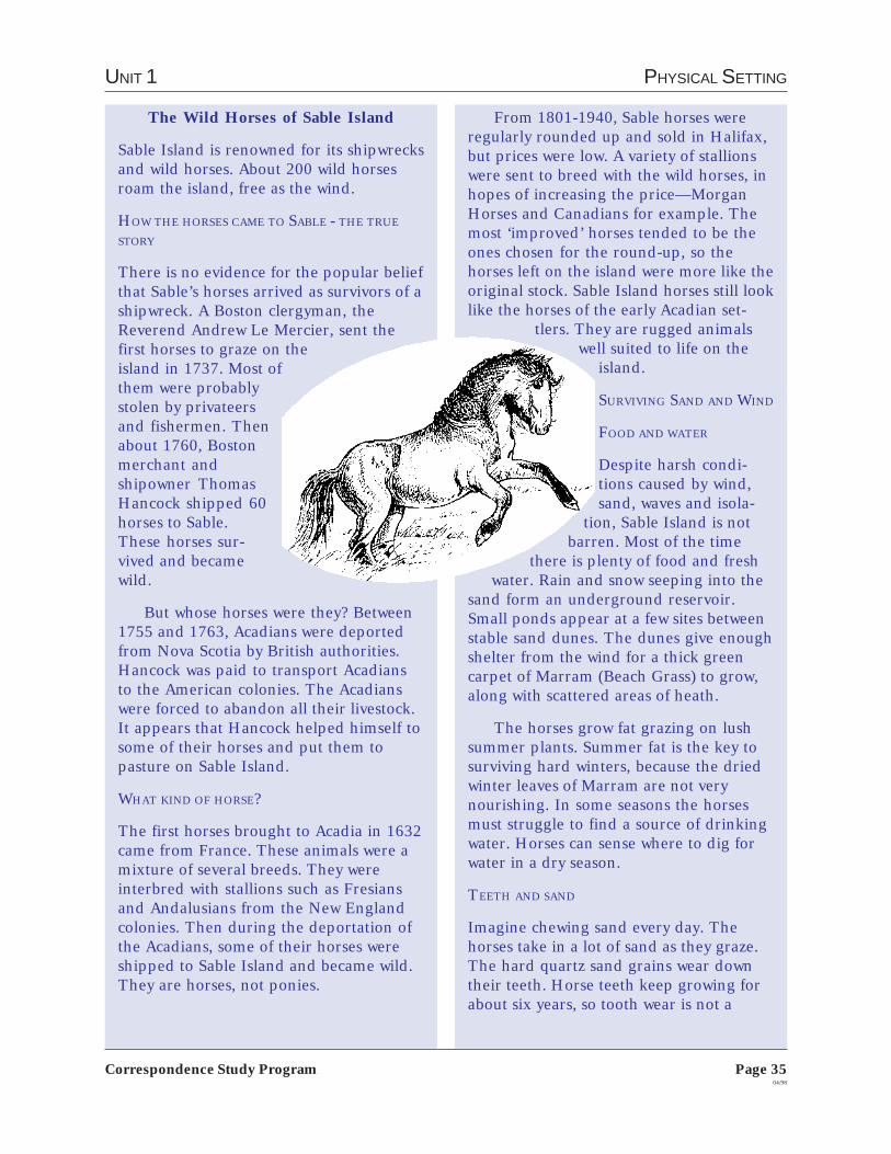
The Wild Horses of Sable Island
Sable Island is renowned for its shipwrecksand wild horses. About 200 wild horsesroam the island, free as the wind.
HOW THE HORSES CAME TO SABLE - THE TRUE
STORY
There is no evidence for the popular beliefthat Sable’s horses arrived as survivors of ashipwreck. A Boston clergyman, theReverend Andrew Le Mercier, sent thefirst horses to graze on theisland in 1737. Most ofthem were probablystolen by privateersand fishermen. Thenabout 1760, Bostonmerchant andshipowner ThomasHancock shipped 60horses to Sable.These horses sur-vived and becamewild.
But whose horses were they? Between1755 and 1763, Acadians were deportedfrom Nova Scotia by British authorities.Hancock was paid to transport Acadiansto the American colonies. The Acadianswere forced to abandon all their livestock.It appears that Hancock helped himself tosome of their horses and put them topasture on Sable Island.
WHAT KIND OF HORSE?
The first horses brought to Acadia in 1632came from France. These animals were amixture of several breeds. They wereinterbred with stallions such as Fresiansand Andalusians from the New Englandcolonies. Then during the deportation ofthe Acadians, some of their horses wereshipped to Sable Island and became wild.They are horses, not ponies.
From 1801-1940, Sable horses wereregularly rounded up and sold in Halifax,but prices were low. A variety of stallionswere sent to breed with the wild horses, inhopes of increasing the price—MorganHorses and Canadians for example. Themost ‘improved’ horses tended to be theones chosen for the round-up, so thehorses left on the island were more like theoriginal stock. Sable Island horses still looklike the horses of the early Acadian set-
tlers. They are rugged animalswell suited to life on the
island.
SURVIVING SAND AND WIND
FOOD AND WATER
Despite harsh condi-tions caused by wind,sand, waves and isola-
tion, Sable Island is notbarren. Most of the time
there is plenty of food and freshwater. Rain and snow seeping into the
sand form an underground reservoir.Small ponds appear at a few sites betweenstable sand dunes. The dunes give enoughshelter from the wind for a thick greencarpet of Marram (Beach Grass) to grow,along with scattered areas of heath.
The horses grow fat grazing on lushsummer plants. Summer fat is the key tosurviving hard winters, because the driedwinter leaves of Marram are not verynourishing. In some seasons the horsesmust struggle to find a source of drinkingwater. Horses can sense where to dig forwater in a dry season.
TEETH AND SAND
Imagine chewing sand every day. Thehorses take in a lot of sand as they graze.The hard quartz sand grains wear downtheir teeth. Horse teeth keep growing forabout six years, so tooth wear is not a
Page 3604/98
Correspondence Study Program
ATLANTIC STUDIES 9
problem at first. But older horses maystarve when their worn teeth cannot grindthe tough Marram.
SOCIAL BEHAVIOR
Sable’s horses were once domestic. As theybecame wild, they went back to theirnatural social system of small herds, eachdefended by a stallion.
A herd consists of about six animals—one stallion, several mares and theiryoung. Bachelor males sometimes tagalong, or may form their own herds. Eachherd has a home range of about threesquare km. Family herds avoid each other,even at shared water holes. There are 40 to50 herds on the island.
One of the mares, older and moreexperienced, usually leads the herd togood food or shelter. Stallions mustconstantly defend their mares and theirbreeding rights by threatening othermares. This may lead to fierce fights. Mostyoung are born in May or June, afternearly a year in the womb, and will nursefor 10 months.
When bad winters bring snow andfreezing rain, the senior mare huddles theherd close together for warmth. Thehorses grow thick woolly coats and findsome protection in the hollows betweenthe sand dunes.
DEATH
Death from natural causes prevents theisland from becoming over-populated.The pattern of population change tends tobe rapid growth interrupted by periodiccrashes. After several mild winters, thepopulation increases, but many of the old,weak or very young animals will die duringthe next hard winter. Nutrients from thedead horses enrich the soil, encouraging alush grow of Marram.
THE HORSES WERE SAVED BY CHILDREN
Daily News May 1960
Sable Island Ponies Destinedfor Dog Food
In May 1960 headlines like this startledCanadians. The government’s CrownAssets Disposal Corporation had offeredall the Sable Island horses for sale. At thetime, people misunderstood the naturalpopulation cycles and appearance of therugged little horses. They were believed tobe “stunted” from inbreeding and lack ofgood grass—this was wrong. For a while,hay was air-dropped on the island but thehorses did not eat much of it. So it wasthought the best thing to do was to sell thehorses to someone who would take themoff the island before they all starved todeath, and use them for something func-tional like dog food or glue.
Many children wrote letters to thePrime Minister. Because of these letters,the horses were saved. On June 2, 1960,Prime Minister Diefenbaker intervenedand protected the horses from all humaninterference. Children all over NorthAmerica thanked him for allowing thehorses to be “free as the wind.”
The horses are still protected. By theSable Island Regulations, part of theCanada Shipping Act, written permissionis required for anyone “feeding, interfer-ing with, or otherwise having anything todo with the horses on the island.” Thewild horses of Sable Island survive withouthuman help, as they have for the last 230years.
Source: Nova Scotia Museum, Department ofEducation and Culture.
UNIT 1 PHYSICAL SETTING
Page 3704/98
Correspondence Study Program
You can send Assignment 3 to your marker as soon as you arefinished. For Assignment 3, send the following to your marker:
Exercise 1 - Chapter review
Exercise 2 - Factors affecting the climate of Atlantic Canada
Exercise 3 - World climate change
Exercise 4 - Focus on an issue: The future of Sable Island
You can start Assignment 4 right away.

Page 3804/98
Correspondence Study Program
ATLANTIC STUDIES 9
ASSIGNMENT 4:A PLACE TO LIVE
On page 49 of your text there is a pictureshowing what Atlantic Canada would looklike if you were an astronaut looking downfrom space on a clear night. As you cansee, most of the people of Atlantic Canadalive around the coast, with smaller num-bers living inland.
People choose to live in AtlanticCanada for a variety of reasons. For some,their roots are here as their parents,grandparents and great-grandparentshave always been here. Others come forthe scenery and the slower pace of living.Still others come for specific jobs, thengrow to love the area and they stay onmaking it their home. Many AtlanticCanadians find they have to leave to lookfor work. But every holiday and familyoccasion, they are back, enjoying theirfamilies, the lifestyle and the scenery.
30EXERCISE 1:CHAPTER REVIEW
Read Chapter4, pages 49-63in your text andanswer the followingquestions. If you need to
check out the meaning of any words, lookin the glossary on pages 291-294 of yourtext.
1. Explain population density.
2. How has rural push and urban pullaffected the rural areas?
3. Define outmigration.
4. a) There are two theories about theorigin of Aboriginal people in AtlanticCanada. Briefly explain both theories.
b) Often early explorers and settlersrefused to learn survival skills from thenative people. Why?
5. When did England gain control of theAtlantic region? Who did she take itfrom?
6. Why did the British tell the Acadiansto take an oath of allegiance to Britainin 1749?
7. Give three reasons why immigrantsfrom England, Scotland, Wales andIreland came to Canada.
8. Wave 3 of the migration of people ofAfrican descent happened in the early1800s. Describe why people of Africandescent came to Canada at this time.
UNIT 1 PHYSICAL SETTING
Page 3904/98
Correspondence Study Program
b) Use Table 4.1 on page 50 to rankthe four Atlantic provinces accordingto population density from highestpopulation density to lowest.
c) How can you explain the popula-tion pattern for Newfoundland andLabrador?
d) How can you explain the popula-tion pattern for Prince Edward Island?
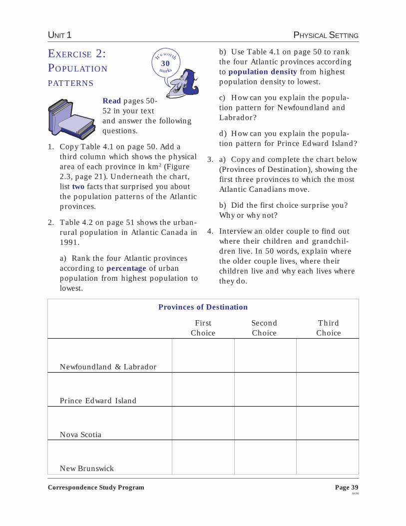
3. a) Copy and complete the chart below(Provinces of Destination), showing thefirst three provinces to which the mostAtlantic Canadians move.
b) Did the first choice surprise you?Why or why not?
4. Interview an older couple to find outwhere their children and grandchil-dren live. In 50 words, explain wherethe older couple lives, where theirchildren live and why each lives wherethey do.
30
Provinces of Destination
First Second ThirdChoice Choice Choice
Newfoundland & Labrador
Prince Edward Island
Nova Scotia
New Brunswick
EXERCISE 2:POPULATION
PATTERNS
Read pages 50-52 in your textand answer the followingquestions.
1. Copy Table 4.1 on page 50. Add athird column which shows the physicalarea of each province in km2 (Figure2.3, page 21). Underneath the chart,list two facts that surprised you aboutthe population patterns of the Atlanticprovinces.
2. Table 4.2 on page 51 shows the urban-rural population in Atlantic Canada in1991.
a) Rank the four Atlantic provincesaccording to percentage of urbanpopulation from highest population tolowest.

Page 4004/98
Correspondence Study Program
ATLANTIC STUDIES 9
20There are also problems with garbage
and waste disposal, and other servicessuch as roads and public transportation.City planners design services for thenumber of people they think will livethere. When those numbers increaserapidly, then the systems cannot handlethe increase.
Unfortunately, not all the people whogo to the cities find work. There might notbe jobs, or they might not have the skillsneeded for the available jobs. When thishappens, people find themselves with fewoptions. Some return to their rural homesif they can; others stay in the cities, accept-ing social services and handouts fromfood banks and hoping that things will getbetter; still others resort to crime.
1. What are the advantages and disadvan-tages of living in an urban community?
2. If you live in a rural community: Wouldyou like to live in a large city? Whatchanges in your life would be neces-sary? If you live in an urban commu-nity: Would you like to live in a ruralcommunity? What changes in your lifewould be necessary?
EXERCISE 3:URBANIZATION
Throughout Canada andother parts of the world, largenumbers of people have beenleaving rural areas and going to urbancentres. Urbanization and rural depopu-lation has been happening for differentreasons. There are usually more workopportunities in urban centres, and peo-ple move from rural areas looking forwork. Many people want to live closer toschools, hospitals, stores, and cultural andrecreational facilities.
There are serious consequences whenlarge numbers of people move from onearea to another. In rural areas, whenpeople start to leave, schools, stores andhospitals are forced to close. If businessesare no longer there, local governmentscan’t collect as much tax. They then can’tafford to keep libraries and recreationalprograms going, or maintain roads,sewage and other services. As servicesdeteriorate, more people and businessesdecide to leave, house prices go down, andeven more services are cut: the rural areasuffers more and more.
On the other side, as cities grow larger,so do the problems. If there is not enoughhousing for people, or if the housing istoo expensive, then more people sharewhat is available causing overcrowding.Some people find themselves living on thestreets because they are unable to affordwhat is available.
UNIT 1 PHYSICAL SETTING
Page 4104/98
Correspondence Study Program
10
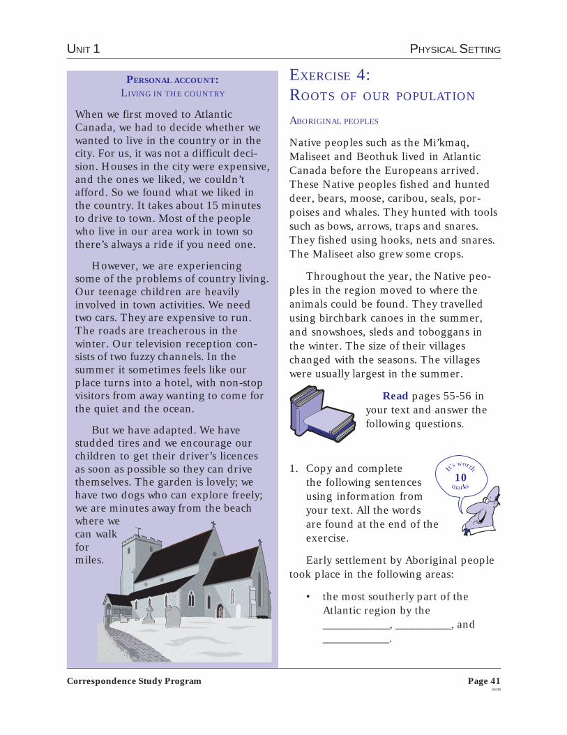
PERSONAL ACCOUNT:LIVING IN THE COUNTRY
When we first moved to AtlanticCanada, we had to decide whether wewanted to live in the country or in thecity. For us, it was not a difficult deci-sion. Houses in the city were expensive,and the ones we liked, we couldn’tafford. So we found what we liked inthe country. It takes about 15 minutesto drive to town. Most of the peoplewho live in our area work in town sothere’s always a ride if you need one.
However, we are experiencingsome of the problems of country living.Our teenage children are heavilyinvolved in town activities. We needtwo cars. They are expensive to run.The roads are treacherous in thewinter. Our television reception con-sists of two fuzzy channels. In thesummer it sometimes feels like ourplace turns into a hotel, with non-stopvisitors from away wanting to come forthe quiet and the ocean.
But we have adapted. We havestudded tires and we encourage ourchildren to get their driver’s licencesas soon as possible so they can drivethemselves. The garden is lovely; wehave two dogs who can explore freely;we are minutes away from the beachwhere wecan walkformiles.
EXERCISE 4:ROOTS OF OUR POPULATION
ABORIGINAL PEOPLES
Native peoples such as the Mi’kmaq,Maliseet and Beothuk lived in AtlanticCanada before the Europeans arrived.These Native peoples fished and hunteddeer, bears, moose, caribou, seals, por-poises and whales. They hunted with toolssuch as bows, arrows, traps and snares.They fished using hooks, nets and snares.The Maliseet also grew some crops.
Throughout the year, the Native peo-ples in the region moved to where theanimals could be found. They travelledusing birchbark canoes in the summer,and snowshoes, sleds and toboggans inthe winter. The size of their villageschanged with the seasons. The villageswere usually largest in the summer.
Read pages 55-56 inyour text and answer thefollowing questions.
1. Copy and completethe following sentencesusing information fromyour text. All the wordsare found at the end of theexercise.
Early settlement by Aboriginal peopletook place in the following areas:
• the most southerly part of theAtlantic region by the____________, __________, and____________.

Page 4204/98
Correspondence Study Program
ATLANTIC STUDIES 9
• North of the St. Lawrence River inthe barren lands of the Quebec/Labrador penninsula by the____________.
• the island of Newfoundland by the____________.
These areas were settled first after thegreat ice sheets ___________ and____________ re-established itself. Theseareas had a more favourable ____________and vegetation as well as abundant____________ resources, supporting morepeople than areas farther ____________.
Settlement of the ____________ coastand movement to the south occurredamong people of the ____________ culturewho are the ____________ of today’s Lab-rador ____________ .
Settlement occurred along____________ and ____________. When____________ was made with the Europe-ans, many First Nations people wereexposed to European ____________ anddied. The Beothuk people became____________.
Today, many First Nations’ people liveon ____________ which are usually foundon their traditional areas of settlement.
Words to be used:
THE ACADIANS
Read page 58 in your textas well as the informationon “The Deportation”below. Answer the follow-ing question.
THE DEPORTATION
When the British and the French beganfighting again in 1755, the British decidedthat the Acadians had to take an oath ofallegiance. If they didn’t take it, the Britishfelt that the Acadians could not be trustedand that they would have to move. TheAcadians did not want to support theBritish or the French. They wanted toremain neutral.
So the deportation of the Acadiansbegan. It caused misery to many families.In the summer and fall of 1755, Britishtroops rounded up over 7000 Acadians. Inevery Acadian community around the Bayof Fundy, the soldiers burned Acadianhomes. The Acadians were made prisonersof the British and pushed onto ships.They were taken to the American colonies.Many families were separated and someAcadians died on the voyage.
Some Acadians managed to escape toFrench territory. Some hid in the woodsbut many were caught and sent off to theAmerican colonies. By 1763, when theSeven Years’ War between Britain andFrance ended, a few Acadians were stillhiding in the woods of Atlantic Canada.Gradually, many returned to start newlives in new communities. Their originalland had been taken by the English set-tlers.
ThuleriversLabradorMi’kmaqfishancestorsMaliseetgamediseasesinland
InnuclimatecoastscontactreservesBeothukmeltedInuitextinctPassamaquoddy

UNIT 1 PHYSICAL SETTING
Page 4304/98
Correspondence Study Program
10
10
10
2. Look at the picture onpage 58 which showsthe expulsion of theAcadians at FortAmherst. Imagine you areone of the Acadians in thepicture. There are six chil-dren in the family, three boys andthree girls. You are the 15-year oldson. You find yourself separated fromyour family. Either write an account ofwhat happens to you in a diary form ordraw a picture showing what you de-cide to do.
SETTLERS OF BRITISH ORIGIN
The journey across the Atlantic was a verydifficult one. The conditions on the shipswere sometimes dreadful, especially asmany of the passengers were already sickand malnourished when they set out ontheir journey. Read pages59-60 in your text andanswer the followingquestion.
3. Imagine what it waslike for many of theseimmigrants who travelledfrom Britain to AtlanticCanada in sailing boats.
Write a conversation between a hus-band and a wife who see land for thefirst time in weeks and wonder ifthey’ve made the right decision incoming.
AFRICAN-CANADIAN COMMUNITIES
Read page 61 in your textas well as “Black History inAtlantic Canada” on page44 of this manual. Answerthe following question.
4. Imagine you are DavidGeorge. Write a letter toa friend in South Caro-lina, in which you describeyour experiences in NovaScotia.
Documents like this one were issued by the British toloyal Blacks at war’s end, and served as a passport toCanada.
Black Cultural Centre
Page 4404/98
Correspondence Study Program
ATLANTIC STUDIES 9
Britain: free land and three years of foodrations. Few got land and their food only lastedfor three months. They were not allowed to voteor have access to the law courts. Often, they wereforced to take low-paying jobs. Some gotdiscouraged and left, but those who remainedformed the basis of the Black community in theAtlantic provinces. About 30,000 Blacks in totalwent to other parts of Canada in the 1800s toescape slavery in the United States.
The fourth wave of Black immigrationhappened in the late 19th and early 20thcentury as sailors and other workers arrived inAtlantic Canada. Canadian immigration lawsmade it difficult for Blacks to enter Canada.Restrictions based on race were not lifted untilthe 1960s. Since then thousands of Blacks havecome to Canada.
WAVE 1 LOYALIST: DAVID GEORGE
David George was one of the founders of thefirst Black church in America in 1773, the SilverBluff Baptist Church in South Carolina. Georgearrived in Halifax in 1782, but he found therewere very few Blacks to whom he could minister.In 1783 he moved to Shelburne where he founda large following of Blacks. But he also faced thedistrust and hostility of many whites who werestill slave owners and who were not accustomedto being preached to by a Black person. Unem-ployment, food shortages and pioneeringproblems also inflamed racial sentimentsamongst the new settlers.
David George first organized camp meetingsin the woods in Shelburne bordering betweenthe white and black settlements. Initially hedrew a congregation from both camps. Then, in1784, there were racial riots: his chapel wasentered and he was beaten and driven into anearby swamp. He took shelter in Birchtown forabout six months, where he baptized andpreached in private homes. He returned toShelburne later that year, only to find that hisformer meeting-house had been turned into atavern.
From Shelburne, David George went on apreaching tour which took him to Liverpool,Saint John and Fredericton. He is credited withfounding six churches (Shelburne, Birchtown,Ragged Islands, Saint John, Preston andHalifax).
BLACK HISTORY IN ATLANTIC CANADA
Black people have lived in Canada for 400years. Some Black people came as slaves, butmost have been free men and women who camein search of dreams.
There were never a great many slaves in NewFrance—or later when the colony passed intoBritish hands—certainly nowhere near thenumber there were in the United States or theCaribbean. However, it is known that Blackslaves were among the skilled workers who builtHalifax.
In the 1750s and 1760s, free and slaveBlacks arrived in Nova Scotia from the NewEngland colonies. They came as pioneer settlerstaking advantage of the lands that had beentaken from the Acadians after they had beenexpelled.
The first large-scale influx of Black peopleinto Canada occurred after the American War ofIndependence. In the 1780s, over 3000 BlackLoyalists and 1200 Black slaves left the UnitedStates to live in the Atlantic provinces. Theywere part of a mass migration of Loyalists whohad sided with the British during the war. Fortheir loyalty, they were promised farmland andprovisions to start a new life. They received farless than they were promised; some receivednothing at all. In 1792, about 1200 BlackLoyalists sailed out of Halifax, bound for SierraLeone in West Africa and in search of a betterlife.
A second wave of Black immigrationoccurred in 1796 when hundreds of Blacks weredeported by the British from Jamaica. Known asthe Maroons, they were the descendants ofrunaway slaves who had lived for generations inthe hills of Jamaica and fought fiercely to avoidbeing captured. The Maroons helped build theHalifax Citadel and formed their own militiaunit. By 1800, most of the Maroons had left forSierra Leone.
After the War of 1812, about 2000 Blackscame to Nova Scotia and New Brunswick asrefugees, seeking protection from Americanslavery. This was the third wave of Black migra-tion to Atlantic Canada. Many found lifedifficult. They had been promised the samerewards as the whites who had remained loyal to

UNIT 1 PHYSICAL SETTING
Page 4504/98
Correspondence Study Program
EXERCISE 5:FOCUS ON AN
ISSUE: IMMIGRATION
IN THE TWENTIETH
CENTURY
Read page 63 in your text,as well as “Personal Ac-count of a War Bride” and“A Glimpse into the Past”on page 46 of this manual.
Look at Figure 4.20 on page 63 and keepin mind:
The average number of immigrantsper year to the Atlantic provincesdeclined between 1976-1985,compared with the average between1946-1955.
Immigrants from Europe declinedfrom about 80 percent of the totalin 1946-1955 to about 35 percentof the total between 1976-1985.
Immigrants came to the Atlanticprovinces from more regions of theworld between 1976-1985. Largenumbers came from South Asia,Southeast Asia and parts of LatinAmerica.
Many countries of the world con-tinue to battle civil wars, religiouswars and other forms of hostility.Refugees and immigrants willcontinue to look for safety, securityand a new life in countries otherthan their own.
15Talk to (interview) a person who is
either a recent immigrant to AtlanticCanada, or one who has been here for along time. Write a one-page report de-scribing this person’s experiences as a newimmigrant to Canada. Use the followingquestions as a guide when interviewing theperson and writing the report.
• Where were you born? Where didyou get your education?
• When did you come to Canada?How old were you when you came?
• Why did you come to Canada?
• In what community did you firstsettle? Did you like it? In how manycommunities have you lived?
• Why did you pick Atlantic Canadato finally settle?
• Did you have trouble finding work?If so, why?
• What do you like about Canada?What don’t you like about Canada?
Page 4604/98
Correspondence Study Program
ATLANTIC STUDIES 9
A GLIMPSE INTO THE PAST
PIER 21: WELCOME TO CANADA
Thousands of Canadians know Pier 21 inHalifax. This is the pier (dock) whereimmigrants from around the world landed.From 1928 to 1971, nearly 1.5 millionpeople used this pier. Many were greeted byrelatives. Others were met by groups whocould help them. These groups included theRed Cross, Salvation Army, Knights ofColumbus, Jewish Immigrant Society andchurch people.
During World War II, Pier 21 becamepart of Canadian history:
• 368,000 soldiers left from the pier tofight in Europe. Many never returned.
• 3,000 children from England landedhere. They were sent to Canada becauseof fear that England would be invadedby Germany.
After World War II, 50,000 war brideswho were from overseas and married toCanadian servicemen and their 22,000children landed at Pier 21 to join theirhusbands. The pier was also used by 100,000people who came to Canada after losingtheir homes or families because of the war.
What the numbers mean:
• 1.5 million people would fill the SkyDome in Toronto 30 times.
• 368,000 soldiers would fill Montreal’sOlympic Stadium more than eight times.
• 3,000 children would fill more than 100classrooms.
kept things moving and us relatively calmand happy. I could endure almost any-thing now that I was finally on solidground.
It’s been years since that voyage. Iraised my family of six children whilelearning to speak English, attendedUniversity, competed in table tennischampionships, worked in the fashionindustry and joined the multiculturalmovement.
PERSONAL ACCOUNT:BARBARA CAMPBELL: WAR BRIDE
(Personal stories about immi-grants arriving on Pier 21 inHalifax, Nova Scotia can befound on the internet: http://pier21.ns.ca/stories/)
The Queen Frederika, a Greek oceanliner departed Rotterdam December 2,1957 with Canadian personnel and theirfamilies. Recently married to Terrence H.Campbell and with a one-year old daugh-ter Elizabeth M. Campbell, I placed all mytrust in the hands of my husband, thepeople of Canada and God when Iboarded the ship.
My heart was full of excitement andhope for a great future in Canada and aromantic crossing. However, barely pastthe English Channel, I discovered that Iwas a terrible sailor in the mounting wavesdue to an ocean storm. I managed to eatthe first meal on board as well as the lastmeal (both were spaghetti); in between Ilay on my bunk deep in the belly of thishuge ship and agonized over my frequentill feelings and the daily drill of closing offsections of the ship in the event of anemergency. I was sure I would go downwith the ship. My husband was busytaking care of our daughter who alsobecame ill which resulted in an infectionthat later became very infected and left ascar on her upper leg to this day.
Land insight, I instantaneously feltbetter. I dressed, ate the last meal servedon board ship and prepared myself for thereception of my in-laws at the dock. It wasa grey day and the shoreline of Halifax wasunattractive; we docked at Pier 21, a huge,dark building busting at the seams, itappeared, with people. My in-laws waited;they were happy to have their son back inCanada and also happy to welcome theirgrandchild, and yes, I too was welcomed.It was some time before they could driveus to their home because of Immigrationand Customs procedures. The sheernumber of passengers appeared like anightmare, but officials and volunteers

UNIT 1 PHYSICAL SETTING
Page 4704/98
Correspondence Study Program
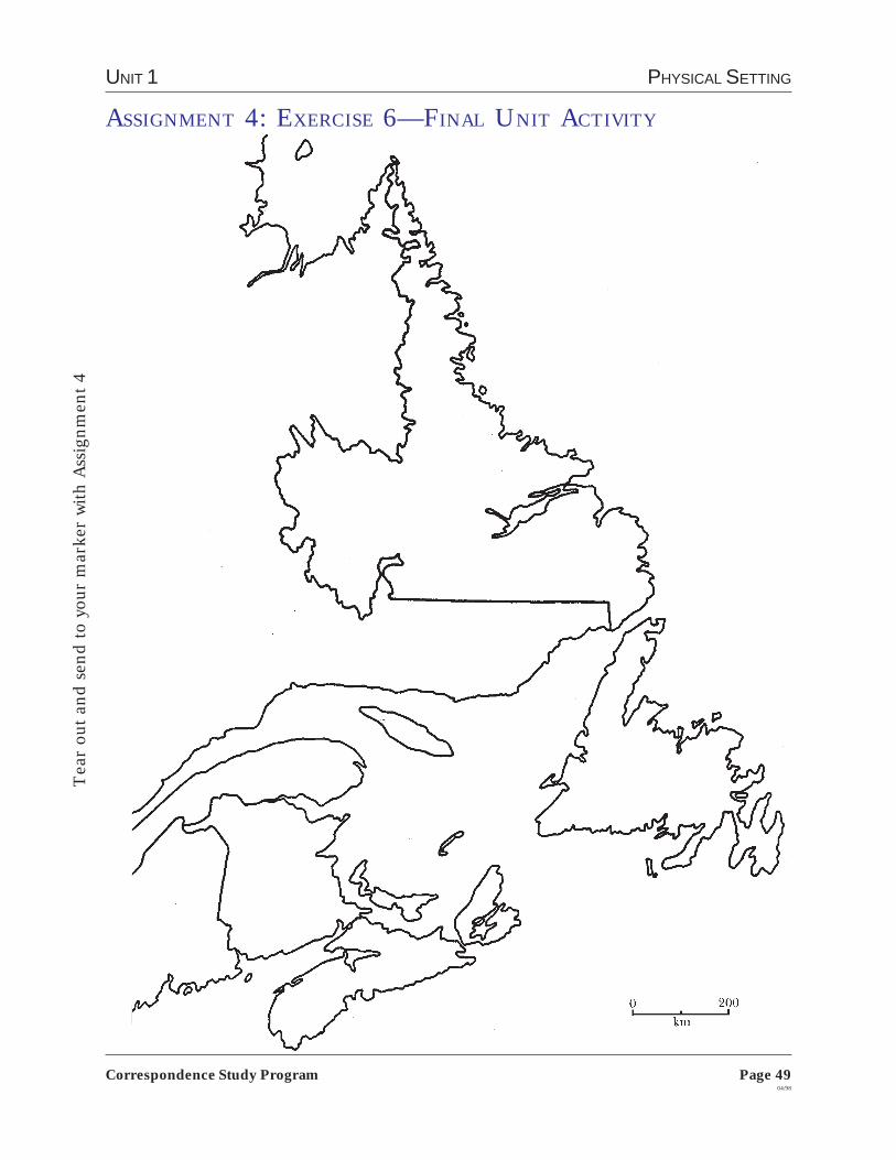
EXERCISE 6:FINAL UNIT
ACTIVITY
On the map of the Atlanticprovinces found on page 49 ofthis manual, plot the following informa-tion from each of the assignments.
Assignment 1
• the four Atlantic provinces andtheir capital cities
• the communities found at theseabsolute locations: 54ºN 67ºW,49ºN 58ºW, 44ºN 66ºW
Assignment 2
• shade in all areas above 700m witha light brown colour
• shade in all areas below 200m witha light green colour
• locate and name these physicalfeatures: Voisey’s Bay, Cabot Strait,Lewis Hill, Hillsborough Bay, Brasd’or Lakes, Mt. Carleton, ChignectoBay, Strait of Belle Isle
Assignment 3
• draw in the three main oceancurrents that affect the Atlanticprovinces
• draw in Sable Island in its correctlocation
Assignment 4
• draw four boxes on the back of yourmap. Use each box to give informa-tion about a specific culture that hasbeen important to the developmentof the Atlantic provinces. Give eachbox a title.
You can send Assignment 4 to your marker as soon as you arefinished. For Assignment 4, send the following to your marker:
Exercise 1 - Chapter review
Exercise 2 - Population patterns
Exercise 3 - Urbanization
Exercise 4 - Roots of our population
Exercise 5 - Focus on an issue: Immigration in the twentiethcentury
Exercise 6 - Final unit activity
You can start Unit 2 right away.
25

UNIT 1 PHYSICAL SETTING
Page 4904/98
Correspondence Study Program
ASSIGNMENT 4: EXERCISE 6—FINAL UNIT ACTIVITY
Tea
r ou
t and
sen
d to
you
r m
arke
r w
ith A
ssig
nmen
t 4