atlas of classical history - library01.comlibrary01.com/v/atlas of classical history.pdf · early...
TRANSCRIPT


ATLASof
CLASSICALHISTORY
EDITED BY RICHARDJ.A.TALBERT
London and New York

First published 1985by Croom Helm Ltd Routledge is an imprint of the Taylor & Francis Group This edition published in the Taylor & Francis e-Library, 2003. © 1985 Richard J.A.Talbert and contributors
All rights reserved. No part of this book may bereprinted or reproduced or utilized in any form orby any electronic, mechanical, or other means, nowknown or hereafter invented, including photocopyingand recording, or in any information storage orretrieval system, without permission in writingfrom the publishers. British Library Cataloguing in Publication DataAtlas of classical history.
1. History, Ancient—MapsI. Talbert, Richard J.A.911.3 G3201.S2
ISBN 0-203-40535-8 Master e-book ISBN
ISBN 0-203-71359-1 (Adobe eReader Format)ISBN 0-415-03463-9 (pbk)
Library of Congress Cataloguing in Publication DataAlso available

iii
Preface vContributors viEquivalent Measurements vi
Maps: map and text page reference placed first,further reading reference second
The Mediterranean World: Physical 1The Aegean in the Bronze Age 2–5, 179Troy 3, 179Knossos 3, 179Minoan Crete 4–5, 179Mycenae 5, 179Mycenaean Greece 4–6, 179Mainland Greece in the Homeric Poems 7–8,
179The Homeric World 8–9, 179Dark Age Greece 10–11, 179–80Late Geometric Greece 12, 179–80Greek Colonisation (Eighth to Sixth
Centuries BC) 13–15, 180Archaic Greece 16–17, 180The Persian Empire c. 550–330 BC 18–20, 180Persepolis 21, 180Marathon, 490 BC 21–2, 180Persian Wars 22–3Thermopylae: Ephialtes’ Route 24, 180Artemisium, 480 BC 24, 180Salamis, 480 BC 25, 180Plataea, 479 BC 25, 181Delphi 26, 181Sparta 27, 181The Hellespont 27Greece: Physical 28The Peloponnese and Central Greece 29The Aegean World 30–1
CONTENTS
Northern Greece, Macedonia and Thrace 32The Eastern Aegean and the Asia Minor
Hinterland 33Attica 34–5, 181Classical Athens 35–6, 181Roman Athens 35–6, 181Halicarnassus 36, 181Miletus 37, 181Priene 37, 181Greek Sicily 38–9, 181Syracuse 39, 181Akragas 40, 181Cyrene 40, 182Olympia 41, 182Greek Dialects c. 450 BC 42–3, 182The Athenian Empire 44–5, 182Peloponnesian War, 431–404 BC 46–8Pylos/Sphacteria 49, 182The Bosporan Realm and its
Neighbours 49–50, 182Trade in the Classical Greek World 51–3, 182The Ancient Explorers 54–5, 182Archaeological Sites of Greece 56–7, 182The Anabasis 58–9, 182Leuctra, 371 BC 59, 183The Second Athenian League 60–1, 183Chaeronea, 338 BC 61, 183The Growth of Macedonian
Power, 359–36 BC 62–3, 183Alexander’s Campaigns, 334–23 BC 64–6River Granicus, 334 BC 67, 183Issus, 333 BC 67, 183Tyre, 332 BC 68Gaugamela, 331 BC 68, 183River Hydaspes, 326 BC 69, 183Ai Khanum 69, 183–4

iv
The Hellenistic Kingdoms 70–6General 75, 184I Survey 70–1II Greece and Western Asia Minor 72–3III Eastern Asia Minor and Syria 74IV Ptolemaic Egypt 76
Pergamum 77, 184Delos 78, 184Major Cult Centres of the Classical
World 79–81, 184Major Cult Centres of the Aegean 80Major Cult Centres of Italy and Sicily 81
Alexandria 81, 184Etruria and Etruscan Expansion in
Northern Italy 82–3, 184Early Italy 84–5, 184Early Latium 86, 184The Languages of Italy Prior to the
Spread of Latin 87–8, 184Veii 88, 184Cosa 89, 184Luna 89, 184Republican Rome 90–1, 185Roman Expansion in Italy to 268 BC 92–3, 185Roman Colonisation 94–5, 185The Punic Wars 96–8, 185Cannae, 216 BC 99, 185Zama, 202 BC 99, 185Carthage 100, 185Cynoscephalae, 197 BC 100–1, 185Thermopylae, 191 BC 101, 185The Roman Empire in 60 BC 101–3, 185Roman Campaigns of 49–30 BC 103–5, 185Pharsalus, 48 BC 105–6, 185Augusta Praetoria 106, 185Italy: Physical 107Italy in the Age of Augustus 108–9Archaeological Sites of Italy 110–12, 186Ostia 112–14, 186Second Battle of Cremona, AD 69 114, 186Campania 115, 186Pompeii 116–117, 186Herculaneum 117–18, 186Italian Towns with Alimentary
Schemes 119–20, 186The Centre of Rome in the Age of
Caracalla 120–1, 185Rome in the Age of the Severi 120–3, 185The Environs of Imperial Rome 122, 184Trade in the Roman World 124–7, 186The Roman Empire in AD 60 127–9, 187Roman Britain 130–2, 187Hadrian’s Wall 132–4, 187Antonine Wall 132–4, 187Silchester 135, 187Lutetia Parisiorum 135, 187Roman Gaul and the Alpine Region 136–7, 187Germanies-Raetia-Noricum 138–9, 187The Rhine-Danube Limes from
c. AD 40 to AD 259–60 140–1, 187The Danubian Provinces/Balkan
Area c. AD 200 141–3, 187–8Iberian Peninsula 144–5, 188Corsica and Sardinia 146–7, 188Roman Sicily 148–9, 188North African Provinces 150–2, 188Africa Proconsularis 150, 188Imperial Estates in the R.Bagradas
Valley 151, 188Timgad 153, 188Lepcis Magna 153, 188African Limes 154–5, 188Greek and Roman Crete 155–6, 188Roman Cyprus 156–7, 189Bithynia and Asia c. AD 100 157–8, 189Roman Asia Minor 159–61, 189Roman Syria, Western Parthia and
Armenia 162–3, 189Masada 164–5, 189Jerusalem 164–5, 189Palestine 165–6, 189Roman Egypt 167–8, 189The Roman Empire in AD 211 169–71, 187Christianity by the Early Fourth
Century 172–4, 189The Dioceses and Provinces of the
Roman Empire in AD 314 175–7, 189
Reigns of Roman Emperors in Brief 178Abbreviations 178Suggestions for Further Reading 179Gazetteer 190

v
In all likelihood this book has its origin in a chanceencounter between Richard Stoneman, thehumanities editor of Croom Helm Ltd, and myselfat the classical societies’ Oxford Triennial Conferencein summer 1981. The subject of our conversationon that occasion eludes me. At any rate it was anunexpected pleasure to be approached by Richard inthe autumn with a tentative proposal for thecompilation of an atlas of classical history. We soonfound that we were in close agreement on what wasneeded: a volume in which lucid maps offered thehigh school student and the undergraduate areasonably comprehensive, up-to-date and scholarlycoverage of classical history down to the time ofConstantine, accompanied by modest elucidation ofthe material and by some suggestions for furtherreading. Explanation and discussion were felt to beespecially important, so long as they did not outweighthe maps.
A concern to keep production costs undercontrol has restrained us from including everythingthat we might have wished. The same concern hasaffected the size and number of pages in the atlas,while colour printing has proved out of thequestion. Use of some standard bases has helped tolimit expenditure on cartography. Equally, withoutthe help of expert colleagues the desired coverage ofclassical history would have been impossible toachieve. The warmest gratitude is therefore due tothose throughout the British Isles who agreed withalacrity to contribute to the atlas and have donesuch excellent work. It has been deliberate editorialpolicy to be ready with guidance when required,but otherwise—in view of the contributors’ specialistknowledge—to leave them a fairly free hand in thepresentation of their material. Inevitably, however,
restraint did have to be exercised when textssubmitted overran their allotted space.
In particular no standard convention for thespelling of names has been imposed. Since aconvention which meets with general satisfactionhas yet to be devised, in a work of this character aneditor who sought to impose one of his own makingwould only face exceptions, pleas, arguments,delay, as well as increasing the possibility ofmistakes and diverting attention from moreimportant issues. Whatever an editor does, he hasno hope of pleasing everybody where this perennialcontroversy is concerned. As it is, notablyoutlandish or unusual spelling of names has beendiscouraged, Latin forms have been recommendedwhere serious doubt has arisen, and an effort hasbeen made to keep each individual contributor’susage consistent (since sometimes it was not!).Nonetheless, throughout the atlas as a wholeinconsistency does still remain. While any distresscaused to purists who read through from cover tocover is regretted, arguably the degree ofinconsistency present should hardly cause unduedifficulties of comprehension anywhere, and shouldprove of little account to those who refer just to twoor three maps at a time.
No matter how carefully plans are laid inadvance, in a complex project of this type the needfor certain changes and improvements will onlyemerge as work proceeds. Such developments arethe principal cause of failure to publish the atlasduring 1984, as had originally been intended.However the remarkable fact that this target will bemissed by so very few months is due above all tothe efforts of Jayne Lewin and Richard Stoneman.Taking over from A.Bereznay at an early stage,
PREFACE

vi
Jayne has executed the cartographic work fornearly the entire volume with artistry, speed,efficiency and good humour: her responsiveness tocontributors’ diverse requirements has beenespecially appreciated. Richard, as well as initiatingthe project and contributing to it, has offered allpossible encouragement and support throughout.Not least my own debt to him is enormous: noeditor could have been served better.
In Belfast, too, my colleagues (especiallyRaymond Davis) have given unfailing support andhave patiently sought to answer my astonishingrange of queries. Janis Boyd’s secretarial work hasbeen superb. I continue to appreciate the highquality of the University Library’s holdings, and
the assistance of University funds towards traveland research. In addition thanks are due to N.G.L.Hammond, W.V.Harris, R.Hope Simpson, A.Powell and M.L.Pringle. But above all this atlas hasbeen a collaborative effort. If it succeeds in itsprincipal aim of stimulating the readers for whom itis designed, then there will be cause for jointsatisfaction on the part of all those who haveworked hard to achieve it.
Richard TalbertQueen’s UniversityBelfast1984
CONTRIBUTORS M.Alden, Queen’s University, Belfast.A.E.Astin, Queen’s University, Belfast.M.Ballance, Eton College.R.P.Davis, Queen’s University, Belfast.J.F.Drinkwater, University of Sheffield.J.D.Falconer, Winchester College.M.G.Fulford, University of Reading.J.F.Gardner, University of Reading.R.H.Jordan, Methodist College, Belfast.M.J.McGann, Queen’s University, Belfast.E.J.Owens, University College of Swansea.T.W.Potter, The British Museum.A.G.Poulter, The University, Nottingham.N.Purcell, St. John’s College, Oxford.P.J.Rhodes, University of Durham.J.B.Salmon, University of Lancaster.C.E.Schultze, Queen’s University, Belfast.A.R.R.Sheppard, London.E.M.Smallwood, Queen’s University, Belfast.R.Stoneman, Beckenham.R.J.A.Talbert, Queen’s University, Belfast.C.J.Tuplin, University of Liverpool.B.H.Warmington, University of Bristol.J.P.Wild, University of Manchester.R.J.A.Wilson, University of Dublin.
EQUIVALENTMEASUREMENTS 1 hectare=10,000 sq metres=2.47 acres
1 Roman foot=0.295 metres1 Roman mile=5,000 Roman feet=1475 metres
1 metre=1.09 yards1000 metres=1 kilometre=0.62 miles10 km=6.21 miles50 km=31.07 miles100 km=62.14 miles


3
Troy (Hissarlik)
Before excavation the city of Troy (later Ilion) was atell more than 31 metres high. Excavations bySchliemann (1870–90), Dörpfeld (1893–4), and theUniversity of Cincinnati (1932–8) revealed 46 sepa-rate strata, making up nine major layers (I– IX),each with a number of subdivisions. Occupationdates at least from the beginning of the Early BronzeAge, and the wealthy city of Troy II (Treasure ofPriam) has fortifications comparable in grandeurwith those of the approximately contemporary sitesof Thermi on Lesbos and Poliochni on Lemnos.Troy VI, in which the horse first appears here, is thesettlement which spans the Middle Bronze Age andearlier part of the Late Bronze Age: it seems to havebeen destroyed by an earthquake around 1300 BC.Mycenaean IIIB pottery in Troy VIIa, destroyed byfire c. 1260, has led to its identification with Homer’sTroy, the destruction of which was traditionallyplaced in 1184 by Eratosthenes on genealogicalgrounds. The city continued through various vicis-situdes to be inhabited until c. AD 500.
Knossos
The Cretan city of Knossos and its king, Minos,appear several times in the Homeric poems;Knossians led by Idomeneus take part in the expe-dition against Troy. In 1878 the site was investigatedby Minos Kalokairinos, who found a tall earthen-ware storage jar (pithos), now in the British Museum.Full-scale excavations were begun by Arthur Evansin 1900. The earliest levels were found to bepreceramic Neolithic. Despite destructions occupa-tion continued through all phases of the Bronze Age.Evans named the phases of the Cretan Bronze Age‘Minoan’ after King Minos. The Middle Minoanpalace at Knossos, destroyed c. 1700, was replacedby the magnificent one shown here. It was builtaround a central court, with state rooms, storagemagazines, and several storeys of luxurious residen-tial apartments. It suffered destruction c. 1450. Af-terwards it alone among the Cretan palaces was re-occupied, albeit on a reduced scale; the new inhab-itants were probably Mycenaeans. The final destruc-tion was by fire, c. 1375–50.

4
The Aegean in the Bronze Age, MinoanCrete, Mycenaean Greece
Pages 2, 4 and 6 show the most important sites atwhich excavations have revealed settlements ortombs in the period from 6500 to 1200 BC. TheAegean in the Bronze Age gives Neolithic and EarlyBronze Age sites for the whole area, as well as laterBronze Age sites for the islands, Asia Minor andCyprus. Later sites in Crete and mainland Greeceare shown on the other two maps.
The most heavily settled areas in the Neolithicperiod (c. 6500–2900) seem to have been the fer-tile plains in north east Greece, but in the EarlyBronze Age there was a change in the settlementpattern corresponding with a move from aneconomy based on cereals to a mixed economy ofolives, vines and cereals. Settlements were made inthe more rocky terrain of the islands, Crete andthe Peloponnese, and a particularly prosperousand artistic culture flourished in the Cyclades.While in Crete the Early Bronze Age settlementsseem to have led without a break to the founding
of the first great palaces in the twentieth centuryBC, on the mainland the end of the Early BronzeAge was marked by the violent destruction of sitesand the arrival of a new people from Anatolia.These were probably the ancestors of the Greeks.In the next period (the Middle Bronze Age, c.2000–1550) Crete replaced the Cyclades as themost prosperous civilisation in the westernAegean, while Asia Minor and the eastern Aegeanwere dominated by the city of Troy VI, also settledabout 2000 BC by newcomers from Anatolia.
After the first Cretan palaces had been destroyedc. 1700, probably by earthquakes, they were rebuilton an even grander scale. By the beginning of theLate Bronze Age (c. 1550) Crete was extending herinfluence widely across the Aegean, so that severalof the island sites became culturally and perhapsalso politically dependent on Crete. One of these,the town of Akrotiri on the volcanic island ofThera, was destroyed c. 1500 by an eruption which

5
was followed shortly afterwards by the great explo-sion of the whole island. The precise sequence ofevents on Thera and their relation to the burningand abandonment of all the major Cretan sites ex-cept Knossos c. 1450 has been much debated, buthowever these sites were destroyed, their destruc-tion marked the end of the Cretan dominance inthe Aegean.
For the next 200 years (c. 1400–1200) theMycenaean Greeks replaced the Minoans as mas-ters of the Aegean. That their prosperity had beengrowing since c. 1600 is shown by the rich burials inthe two Shaft Grave circles at Mycenae, and later bythe construction of the monumental tholos tombs.After the Thera eruption the Mycenaeans movedinto Knossos, and by 1400 seem to have had con-trol of the whole of Crete, until the palace was fi-nally destroyed a few years later.
Mycenae
The citadel occupies a low hill, with MountsProfitis Elias and Szara to the north and east.Sherds suggest that habitation dates from theNeolithic period, but the site seems to have risen toimportance during the Middle Bronze Age, whenthe wealthy Grave Circles A (found by Schliemannin 1876) and B were established; they form part ofan extensive Middle and Late Bronze Age cemeteryon the north west slopes. The Late Bronze Age cityconsisted of a palace on the hill, with houses, work-shops and storerooms below. At first only the sum-mit was fortified, though by the late thirteenth cen-tury a large area was enclosed, including the CultCentre and Grave Circle A.Even with its massivewalls and underground spring the city declinedduring the twelfth century, and was eventuallyburnt. However the area continued to be inhabitedand in the Archaic period had a temple of Athene.Mycenae was sacked by the Argives in 468, but re-occupied in the Hellenistic period.
In the fourteenth and thirteenth centuries therewas relative peace in the eastern Mediterranean,and the Mycenaeans traded widely in the Aegeanand beyond, replacing the Minoans in the islandsites and establishing a major settlement at Miletus.On the Greek mainland palaces were built andsome sites were heavily fortified. In the second halfof the thirteenth century, probably as a result of in-ternal wars, many of the Mycenaean sites were de-stroyed, the palace civilisation came to an end, andmuch of the population fled to Achaia and the Io-nian islands in the west, and to Euboia, the Cycla-des and Cyprus in the east. However, Mycenaeansociety continued in Greece for a further hundredyears until early in the eleventh century, by whichtime all the major sites except Athens had beenabandoned.


8
Mainland Greece in the Homeric Poemsand The Homeric World
Mainland Greece in the Homeric Poems and The HomericWorld are intended as a guide to readers of the Iliadand Odyssey, and show the known or probable loca-tion of the main places referred to by Homer. Likeother aspects of the poems, Homer’s geography is amixture of memories from the Mycenaean world,contemporary knowledge of the eighth or earlyseventh century BC, and fairy tale. The most de-tailed geographical information is given by theCatalogue of Ships in Iliad, Book 2, which names152 towns or districts in Greece and the islands,and 19 in Thrace, the Troad and Asia Minor. Theposition of many of these was unknown even to theGreeks of historical times, and it is likely that atleast the Greek section of the Catalogue was a sur-vival from the Mycenaean Age reflecting the settle-ment pattern of that period rather than of Homer’sown time. Further evidence for this is provided byplaces in the Catalogue which archaeology hasshown to have been unoccupied after theMycenaean period (e.g. Eutresis, Krisa, Dorion andPylos), and by the grouping of the towns into king-doms which are quite unlike anything known inhistorical Greece. Although the Catalogue cannotoriginally have been composed to form part of theIliad as we know it, the rest of the Iliad is broadlyconsistent with it in its picture of a Greece domi-nated by the important Mycenaean centres ofMycenae and Pylos.
The Trojan section of the Catalogue is far lessinformative than the Greek. Although the Troad it-self is described in some detail, the territories of theTrojan allies cannot be located with any certainty.The Trojan Catalogue appears to describe Asia Mi-nor before the Ionian migrations of around 1000BC, with no reference to any of the later Greek cit-ies on the coast, apart from Miletus which is specifi-cally said to be occupied by ‘barbarian-speakingCarians’. But whether this means that the Cata-logue was composed in the Mycenaean period, or
merely represents later ideas of what Asia Minorwas like at the time of the Trojan War, is still dis-puted. On the geography of the Troad, the rest ofthe Iliad adds details that are sometimes surpris-ingly accurate—for example, the fact that Poseidoncould see Troy from the peak of Samothrace—andthis feature has led to the suggestion that Homermay have had personal knowledge of the area.
It has also been claimed that the Odyssey’s de-scription of Ithaca and the islands round it wasbased on first-hand knowledge, but this has beenquestioned on the grounds that the account of therelative position of the islands is inaccurate. Whilethe identification of Ithaca with modern Ithaki isnow generally accepted, there is probably as muchfiction as fact in the topographical details of caves,springs and bays on the island.
The main action of the Iliad and Odyssey takesplace in a world enclosed by Ithaca in the west,Troy in the east and Crete in the south. However,the boundaries of the Homeric world are extendedby references to more distant peoples and places,Egypt and Libya in the south, Sidon and thePhoenicians in the east, as well as to a number ofmore or less mythical tribes, the Ethiopians andPygmies in the south, the Taphians in the west andthe Cimmerians in the north. Finally there are thewanderings of Odysseus, from the time when hewas blown off course round Cape Malea. The ori-gins of these stories lie in folk tales without anyspecific geographical location, but attempts weremade quite early on by the Greeks themselves to fitthem into the geography of the Mediterranean, sothat the Phaeacians were placed on Corfu, Circe atCape Circeo near Naples, Scylla and Charybdis inthe Straits of Messina and the Cyclopes on MountEtna. This location of Odysseus’ wanderings in thewest probably reflects the opening up of Sicily andsouth Italy to Greek trade and colonisation in theseventh century.


11
Dark Age Greece
After the collapse of Mycenaean civilisation duringthe course of the twelfth century BC Greek historyenters an era of darkness, which was not totallydispelled until the middle of the eighth century.This period is ‘dark’ both because information islacking, and because such information as exists in-dicates an extreme cultural recession, characterisedby depopulation, isolation and poverty. The sub-stantial reduction in the number and size of occu-pied sites is proof of widespread depopulation: in-deed some areas of the Aegean have so far pro-duced no evidence of habitation during this period.Depopulation was accompanied by regional frag-mentation and isolation, as communications ceasednot only within the Aegean but also with areas be-yond. A significant feature of the Dark Age is thescarcity of architectural remains at most sites. Thisreflects the uncertainty of the times and, togetherwith the poor quality of the other material remains,indicates the low quality of life. Except on Crete,where Bronze Age building traditions continued,graves alone supply the bulk of the evidencethroughout these centuries. Technical and artisticskills, such as bronze working, writing and figuredart, were also lost for a time.
The Dark Age, however, is not a period of totaldemoralisation. Life continued in certain areas, al-beit at a much reduced level. In particular, Attica,the Argolid, parts of Thessaly and Crete managedto survive the worst difficulties of the age, and itwas in these areas that the foundations of the even-tual recovery of Greece were laid. New metal work-ing technology was developed, and old skills redis-covered. Iron appears in several areas, and thecupellation of silver was undertaken at Argos andThorikos by 900. Bronze working reappears atLefkandi. Athens leads the rest of Greece with thedevelopment of the proto-Geometric style of pot-tery, from which evolved the full Geometric stylefrom c. 900 onwards. Lefkandi has arguably be-come one of the most important sites for the eluci-dation of the Dark Age: here the excavation of sev-eral rich burials must modify our view of total pov-erty, at least from the later tenth century onwards.
With the appearance of open air sanctuaries thereis also the first indication of a change in places ofworship. Before 1000 BC, too, the first tentativesteps were taken to colonise the Aegean with theimplantation of settlements along the west coast ofAsia Minor.
This evidence must not be over-emphasised.Most parts of Greece remained depressed through-out the ninth century, and full recovery did not be-gin until the eighth century. But then remarkablechanges and advances can be noted. A substantialincrease in population is evident, both from the in-creased number of sites and the increased size ofmany settlements. As communications wereopened up, areas of Greece for which evidence ofsettlement had been lacking, were again occupied.The west coast of Asia Minor and the Aegean is-lands were fully colonised. Contact with the NearEast, which brought fresh impetus to many aspectsof life and artistic development, was intensively re-newed. The colonisation of the western Mediterra-nean was also begun.
Graves and cemeteries continue to supply thebulk of the evidence for the eighth century, butthere is important information regarding archi-tecture from such sites as Emborio, Old Smyrnaand Zagora on Andros. Their substantial remainsalso confirm a more settled and prosperous exist-ence. However the defensive nature of manysites, often in inaccessible or hidden locations,and the construction of fortification walls at OldSmyrna and Zagora suggest that life was still byno means secure.
Many new sanctuaries appear during this pe-riod, and it is clear that some were gaining a repu-tation beyond their immediate area. About halfcontain remains of temples. The dedication of vo-tive offerings at Bronze Age sites is indicative of aninterest in the heroic past. With the introduction ofwriting from the Near East, Greece can be said tohave finally put aside the Dark Age and to beemerging into the full light of history.


13
Greek Colonisation (Eighth to SixthCenturies BC)
By c. 800 Greek traders had begun to venture be-yond the Aegean with such confidence and regular-ity that Euboeans from Chalcis and Eretria had setup a ‘trading station’ (emporion) at Al Mina (theplace called Posideion by Herodotus?) on theR.Orontes delta, excavated in the 1930s. Arguablythese traders sought iron and copper above all. Acomparable ‘trading station’ which Euboeansfounded before 750 at Pithecusae in the gulf of Na-ples was succeeded during the latter part of theeighth century by their establishment of ‘ports ofcall’ at Zancle and Rhegium, and of settlements infertile areas at Cumae, Leontini and Catane.Though Greeks were not blind to trading opportu-nities and other attractions, it was principally theprospect of good land free for occupation whichprompted others to follow the Euboean example, inan effort to gain relief from the generally acuteproblems of increased population and unequal divi-sion of land holdings throughout Greece. Furthersites on the eastern seaboard of Sicily were quicklysettled, and in the seventh century these acted asthe springboard for foundations on the north andsouth coasts of the island. In south Italy develop-ment of the same type occurred simultaneously,with settlers from Achaea taking the lead.
In a northerly direction it was again Euboeanswho led the way with the establishment of settle-ments in Chalcidice during the late eighth cen-tury. In the seventh century other Greeks settledfurther along the northern shore of the Aegean,either side of the Hellespont, and around thePropontis. Despite its harsher climate the BlackSea was even penetrated by a few settlers at thisdate, but the main wave of foundations here didnot come until the sixth century, mainly at theinstigation of Miletus.
Elsewhere Greeks principally from Asia Minorwere permitted to establish a ‘trading station’ andsettlement at Naucratis, 50 miles up the Canopicbranch of the Nile Delta, in the late seventh century.Cyrene near the North African coast was foundedfrom Thera c. 630; later, early in the sixth century,Phocaea in Asia Minor planted settlements as far
distant as southern France, Spain and Corsica.These areas, together with western Sicily, were alsobeing settled by Phoenicians and Carthaginians.Though their motives seem to have been broadlysimilar to those of Greeks, hostile relations were theexception, usually the result of provocation.
The modern translation ‘colony’ for the Greekapoikia misleads if it is taken to imply any degree oflong-term dependence upon, or control by, thefounders from mainland Greece. Rather, from theoutset the settlements were intended to be inde-pendent, self-supporting communities, whose linkswith their founders would in normal circumstancesbe no more than those of culture, religion and sen-timent. Each foundation would indeed enjoy theformal sponsorship of a community, which wasthus recognised as the metropolis or ‘mother city’.This community would appoint a leader (oikistes),furnish ships or other help, and gather colonists,who did not necessarily have to be its own citizens.However, its positive role would often lapse at thispoint, even though links of the type just mentionedwould always remain strong. In special circum-stances, where the social or agrarian problems of acommunity were particularly bad, the colonistsmight not even be volunteers—as, for example, inthe cases of the Spartan foundation of Tarentum orthe Theran foundation of Cyrene.
This last instance stands out as one of the bestdocumented colonial ventures, thanks to the sur-vival of an inscription embodying at least the gist ofan archaic record to supplement Herodotus’ narra-tive. Among ancient authors he and Thucydidesfurnish the most useful information about colonisa-tion; later writers, like Strabo, have much less ofsolid value to offer. Excavation and the analysis ofmaterial remains (especially pottery) have thereforeplayed a key role in illuminating further the charac-ter and development of colonisation, even if there isa limit to what may be securely deduced from suchevidence. It is frustrating that so little written mate-rial survives to deepen our insight into the majortopic of the relations between colonies and the local,normally less civilised, peoples of the areas settled.


17
Archaic Greece
The seventh and sixth centuries constitute an ex-citing formative period of the utmost importancein Greece. For the first time Greek history is nowilluminated significantly by written records aswell as by archaeology. Though its origins lie ob-scurely in the preceding Dark Age, unquestion-ably the emergence of the polis as the predominantpolitical and social unit in Greece was a crucialstep forward. Autonomous communities of thistype—centred on a defensible town in control ofits surrounding territory—became a distinctivefeature of Greek civilisation throughout the Medi-terranean and beyond.
However this is not to overlook wide variationsin the speed and character of change. In many areasof Greece, especially the north and west, there wasat best only a slow shift away from tribal organisa-tion. Elsewhere Crete (see further pp. 155–6) andSparta are distinguished by their idiosyncratic de-velopment. The latter, having at last achieved suc-cess in a struggle to conquer fertile Messeniashortly before 700, was then faced with bitter hostil-ity not only from Messenians permanently sub-jected as helots, but also from jealous neighbouringstates, Argos especially. A great battle at Hysiai in669 resulted in a narrow Argive victory. During thelate seventh century the strain which Sparta facedin containing a prolonged Messenian rebellion ledto a permanent transformation in the character ofthe state: most strikingly the Spartiates, or citizenmales, became an exclusive military caste. Onlyduring the sixth century was Sparta able to extendher influence further in the Peloponnese. Checkedby an initial failure to annex Tegea, she proceededinstead to forge alliances, a policy which led to theformation of the Peloponnesian League under herleadership. By the late sixth century Sparta was thestrongest of the mainland states.
As seen above (pp. 13–15), the Archaic periodwas one of widespread expansion and of increasingprosperity through trade and settlement. Commu-nities either side of the Aegean—like Chalkis,
Eretria, Miletus and Samos—were especially wellplaced to benefit, as was Crete to the south. On theGreek mainland this growth caused constant ri-valry between ambitious neighbours such as Ath-ens, Megara and Corinth. The latter built up a for-midable fleet and consolidated her influence innorth west Greece. She was also one of the firststates where the impact of new wealth weakenedthe exclusive hold of a traditional landed aristoc-racy upon government. As a consequence of suchstrife (stasis), Corinth was seized around 655 by asingle ruler or ‘tyrant’—not necessarily a pejorativeterm. Elsewhere too (as at Argos, Sikyon andSamos in particular) powerful tyrants establishedthemselves for one or two generations before giv-ing way to oligarchy or democracy. At Athens—notyet among the leading states—a political and eco-nomic crisis was alleviated in 594 by a mediator,Solon. But faction fighting persisted, so that eventu-ally from 545, at his third attempt, Peisistratus sethimself up as tyrant: he proved a wise ruler who,followed by his sons, did much to unify and stabi-lise Attica over 35 years, as well as to strengthen theeconomy. Athenian interest in Sigeion and theThracian Chersonese, on the trade route to theBlack Sea, dates from the sixth century.
On the eastern seaboard of the Aegean, theGreek cities first withstood Cimmerian incursions,and then from the 670s more persistent onslaughtsby the Mermnad rulers of Lydia, a power whichcame to stimulate its Greek neighbours as well as toantagonise and dominate them. Coinage, for exam-ple, was a Lydian invention imitated by Greeksfrom about 600. The most successful military re-sistance was that of Miletus, arguably the greatestGreek city of the day, celebrated for its encourage-ment of culture and scientific enquiry as well as ofcolonial ventures northwards. Yet Lydia, and withit the Greek cities beyond, fell to Persia in the mid-sixth century. Thereafter Persian encroachmentwestwards was to make a lasting impact uponGreek history.


20
Persian Empire c. 550–330
The empire was largely created by the absorption inturn of four previous Near Eastern great powers.First, c. 550, the Median empire, stretching from theR.Halys to an uncertain eastern frontier. By 522/21Persian rule ran as far as Sogdiana and eastwardsacross the Hindukush, but some of this area mayhave been acquired separately by Cyrus, who diedtrying to advance beyond the R. Jaxartes. Second, c.540, the Lydian empire, extending west of theR.Halys to the sea. Third, from 539, the Neo-Babylonian empire, consisting of Mesopotamia,Susiane and Abarnahara (‘Beyond the River’, i.e.Syria/Palestine). Fourth, from 525, Egypt, extend-ing south along the R.Nile to Elephantine/Syene. Inaddition, Cyprus came as either a precursor or aconsequence of the conquest of Egypt; Cambyseshad Arab help in 525 and Darius claimed ‘Arabia’as subject in 522/21; Cilicia voluntarily submittedto Cyrus, retaining a native dynasty almost con-tinuously until the fourth century. Herodotus andPersian ‘Lists of Peoples’ show significant additionsby Darius: c. 518, India (West Indus valley); someeast Aegean islands—Samos, Lesbos, Chios amongthem—and c. 513 Greek cities on the north Aegeancoast; c. 513/12, Thracians south, and possiblynorth, of Mount Rhodope; c. 512 or 492, Macedo-nia; c. 513, Libya. The Persian lists alone add Ethio-pia, Caria (not a new conquest) and, untruthfully,‘Scythians beyond the Sea’. Two new names appearin Xerxes’ reign, Akaufaka (unlocated) and Daha.However his Greek failure ended expansion andbrought permanent loss of European subjects,though, exceptionally, Persian occupation ofDoriscus persisted for decades.
At best the empire now stretched from westAnatolia, the Levant and Egypt to Bactria/Sogdiana and India. Chorasmia was certainly lostby the 330s, though some Indians did fight atGaugamela in 331, coming perhaps from areaswhere Alexander later encountered native rulersstill calling themselves hyparchs or even satraps.Even so, the empire never truly included all areaslying within the geographical limits outlined.Mysia, Pisidia and the Cardouchi, for example,appear autonomous c. 400, and this may be the
norm at all periods. Throughout the empire’s his-tory rebellion was a chronic problem—both nation-alist secession, and satrapal attempts to seize thethrone or to establish independent principalities.In 522 Darius’ usurpation occasioned rapidly sup-pressed disturbances in Elam, Babylonia, Assyria,Armenia, Egypt, Media, Parthia-Hyrcania,Sagartia, Sattagydia, Scythia, as well as in Persiaitself. Lydia had revolted immediately after Cyrus’conquest, the Asiatic Greeks and Caria in 499–4,parts of Cyprus in 498–7 and possibly 478, Egyptin 486–5, Babylon in the late 480s. Certain unsat-isfactory satraps had to be forcibly removed—likeOroetes at Sardis (c. 520), and Aryandes in Egypt(after 513).
After 480/79 the Asiatic Greeks rebelled againand were only regained securely by the King’sPeace of 387/86. Egypt was persistently trouble-some with two major rebellions: the first in the late460s was not suppressed until c. 455, with instabil-ity in the Nile Delta lasting even longer; the second,c. 404, brought independence until 343. There soonfollowed a third Egyptian rebellion between 338and 336. Various parts of Phoenicia, Cilicia andCyprus saw disturbances in the 380s, late 360s andearly 340s. There were rebellions by satraps inAbarnahara (440s, Megabyxos; c. 416, Artyphius),Lydia (c. 416, Pissouthnes; 401, Cyrus; late 360s,Autophradates), Hellespontine Phrygia (360s,Ariobarzanes; 350s, Artabazus), Caria (360s,Mausolus), Cappadocia (late 370s and 360s,Datames), and Armenia (late 360s, Orontes). Fur-ther east the evidence is less good, but shows a Me-dian rebellion c. 408, a period of Cadusian seces-sion from 405 to the 350s, and rebel satraps inBactria (late 460s), Hyrcania (425/24, Ochus, aliasDarius II), and possibly eastern Iran (under DariusII, Teritouchmes).
The political geography of the empire is acontentious topic. The present map seeks at leastto take account of four types of enumeration ofits constituent parts, though location is oftenconjectural and in some cases has not been at-tempted:

21
(a) the subject peoples in various, mostly Darian,royal texts (not satrapy lists);
(b) the 20 nomoi or satrapies in Herodotus3.89 ff.;
(c) the nations found in Persian armies, espe-cially those of Xerxes and of Darius in 331; in the
former instance, the account of Herodotus 7.61 ff. isnearly identical with (b) above;
(d) the nations represented, either singly or inconjunction with others, in attested satrapal titles;this is a fluid list, especially in better documentedareas, compiled almost entirely from Greek sources.
Persepolis
The ceremonial capital of the Persian Empire lies insouth west Iran, on the north side of the plain ofMarvdasht. Though the site may have been used byCambyses II, it was Darius the Great (522–485)who was responsible for the foundation of thepresent complex. Most of the building was accom-plished in the reign of Xerxes, in the thirteen yearsfollowing 485. Buildings of this period include theGateway of All Lands, the Hall of a Hundred Col-umns, and the Northern Staircase. Persepolis wasthe gathering place for the annual presentation oftribute to the Great King. This scene is representedin the magnificent reliefs of the Northern Staircase.The palace was destroyed by fire by Alexander theGreat—by accident or design—in 330. Many of thestone slabs exhibit the marks of cracking by fire.Further columns have collapsed with the passingcenturies. A few miles to the west are the tombs ofthe Achaemenid kings at Naqsh-e-Rustam, and fur-ther north Pasargadae and the tomb of Cyrus.
Marathon, 490 BC
The presumable position of the Athenian camp bythe western foothills (at a Herakleion, not securelyidentified), and the certain position of the Soros(Athenian mass-grave), guarantee the main battle’slocation west of the R.Charadra; and if the re-

22
mains of the later trophy were not significantlymoved when reused in the Middle Ages, they mayconfirm the slaughter of fleeing Persians by theGreat Marsh, shown in the Stoa Poecile painting.(The supposed ‘Plataean Grave’ near Vrana, andall dependent suppositions about the battle,should be rejected.) Much about the campaign isdisputed. Did the Athenians move their camp dur
and fleet acting in conjunction. The overriding con-cern of the Spartan leaders of the League—protec-tion of the Peloponnese—was not shared by Athens,whose fleet was vital to the Greek cause. Therewere therefore persistent and deep-rooted differ-ences over strategy among the Greeks. But they didagree upon successive attempts to halt Xerxes atTempe (abandoned as unsuitable before his arrivalthere), Thermopylae/ Artemisium (p. 24), andSalamis/Corinthian Isthmus. Both the latter wereco-ordinated land/ sea positions designed to keepthe enemy army and fleet out of mutual contact; inthe event the Persian army never actually reachedthe Isthmus. After the defeat at Salamis in Septem-ber 480, Xerxes, together with his fleet and part ofthe army, retired to Asia Minor. The remainder,under Mardonius, wintered in Thessaly and Mac-edonia.
Neither side hurried into action the followingyear. In particular the Hellenic League, dominatedby Sparta, showed little enthusiasm for searchingout the Persians in northern Greece. Mardonius, af-ter failing to detach Athens by diplomacy, re-in-vaded Attica. But when the Peloponnesian stateseventually mobilised, he chose southern Boeotia asmore favourable ground for a decisive confronta-tion. After their defeat at Plataea (p. 25), the Per-sians evacuated European Greece, except for garri-sons in Thrace and the Black Sea approaches.Meanwhile after some hesitation a League fleetcrossed the Aegean and defeated the Persians atMycale, provoking a second Ionian revolt. The sub-sequent capture of Sestos (479) and of Byzantium(478) brought operations by the Hellenic League toan end, and marks the lowest limit of what wouldnormally be called the Persian Wars.
Persian Wars
The ‘Persian Wars’—ta Medika, ‘Median things’—conventionally describes the two occasions onwhich Persian armies had to be driven out of theheart of mainland Greece.
(1) In 490 Datis led across the Aegean a seaborneexpedition against Eretria and Athens, the twomainland states which briefly participated in the ‘Io-nian revolt’ of Persia’s Greek subjects in westernAsia Minor (499/4). Persian aspirations on themainland extended beyond Eretria and Athens. Anearlier, unsuccessful punitive expedition againstthem had been instructed to conquer whatever itcould, and Darius sought formal submission fromother Greek cities in 491/90. But there was no gen-eral movement by the Greeks to resist Datis. OnlyAthens helped Eretria, and only Plataea helped Ath-ens. The Spartans did march north, but arrived toolate. When Eretria fell through treachery after abrief siege, the population was deported to Cissia.However a different fate was presumably intendedfor Athens, since the exiled tyrant Hippias, who ac-companied Datis, was hardly going to be restored toa deserted, smoking ruin. In the event the Athenianschose not to await a siege, but confronted the Per-sians where they landed in Attica, at Marathon (seep. 21). Despite their defeat here the Persians didthen sail on to Athens, but proved unwilling to riskan opposed landing, and so returned to Asia Minor.
(2) Xerxes’ expedition (480/79) was much largerin scale, and was confronted by a more concertedresistance from the Hellenic League. The SerpentColumn erected at Delphi as a thank-offering afterPlataea listed 31 participants in the war, though itomits states which medized after initial resistanceand some others. Xerxes planned a steady advanceinto the Greek peninsula from the north by army
ing the days before the battle? What eventuallyprecipitated the engagement? Likewise with re-gard to the battle itself, were the lines parallelwith, or at right angles to, the shore? In this con-nection Herodotus’ reference to the Persian centrepushing towards the mesogaia is unhelpful. Whydid the Persian cavalry make no significant contri-bution?


24
Thermopylae: Ephialtes’ Route
The fighting in the Middle Gate near the HotSprings [1] is straightforward: for two days theGreeks repelled assaults in front of the Phocian wall[5]; on the third day they pushed further west [4],but then retreated to a hillock west of the wall [3],and were annihilated by attacks from front and rear.The location of the Middle Gate is quite clear,thanks to identification of the wall [2]. The majortopographical problem is identification of Ephialtes’route. Disagreement centres around four questions.Did the route reach high ground south west ofThermopylae directly, or via the Asopos Gorge, orby a long western detour? Did it pass north ofMount Lithiza, or south? Where did it descend tothe coast? Where was the Phocian detachment?The map shows the route and Phocian position ac-cording to Grundy (....., P1), Munro (ooo, P2),Burn 1951 (xxxx, P3), Burn 1977 (***, P3), andPritchett (—, P4).
Artemisium, 480 BC
The Greek position at Pevki Bay is guaranteed bydiscovery of the Artemis shrine. Aphetae, the Per-sians’ headquarters, was probably at Platania,though their fleet doubtless occupied severalbeaches (suitable areas are shaded on the insetmap). The fighting involved two afternoon raidson Persian positions (not shown), and a full-scalePersian attack on Artemisium. Herodotus’ ac-count of the first engagement—the ships fighting inconcentric circles, with the Greeks inside—is incred-ible, while of the last he says only that the Persiansattacked in a crescent. It is crucially unclear howfar north this encounter occurred. The map as-sumes a position near Pevki and, consequently,two Greek lines. Other related problems includethe location of earlier Persian moorings ‘betweenCasthanaie and Cape Sepias’, and the timing andcredibility of the attempted Persian circumnaviga-tion of Euboea.

25
Salamis, 480 BC
All discussions revolve around crucial obscurities.(1) Was the Greek fleet largely in Ambelaki orPaloukia Bay? (2) Was the Persian fleet’s dawn po-sition (a) along the Attic shore facing Ambelakiand/or Paloukia [I], (b) across the strait fromKynosoura to the Attic shore [II], or (c) fromKynosoura towards Piraeus facing north [III]? (3) If(c), was the battle precipitated by the Persians sail-ing into the channel (and if so, was the eventualengagement of type I or II?), or by the Greeks com-ing out to a position across the channel entranceopposite the Persians [II I]? The ancient battlemonument on Kynosoura favours a southerly posi-tion, but does not decide other issues; and Xerxes’reported expectation that Psyttaleia (surelyLipsokoutali) would be near the battle could havebeen falsified in the event.
Plataea, 479 BC
Cavalry attacks and lack of water caused theGreeks to move from their initial position (inset) tothe Ag. Demetrios-Pyrgos line (this location de-pends on the usual equation of Gargaphia with themodern Rhetsi springs). The Persians followedsuit north of the Asopos. After 12 days duringwhich the Persian cavalry harassed Greek water-carriers by the Asopos, cut supply lines overDryoskephalai (day 8), and fouled Gargaphia (day12), the Greeks moved south in some confusion.The positions of P indicated here, in front ofPlataea, and of S, by a Demetrion (site fixed by thefind-spot of inscriptions relating to Demeter) arefairly certain; that of A much less so. In their ensu-ing attack the two Persian wings were defeated andfled to the fort (M) or to Thebes (G), while thecentre withdrew without engaging. The left wingof P, moving to support A, was severely mauled byTheban cavalry.
S: Spartans. P: Peloponnesians, Euboeans, NWGreeks, Aeginetans, Megarians. A: Athenians,Plataeans. M: Persians (under Mardonius). O:Medes, Bactrians, Indians, Sacae (underArtabazus). G: medizing Greeks.

26
Delphi
The origins of the oracular cult of Apollo at Del-phi are obscure. But its close association with thefoundation of colonies in the west in the secondhalf of the eighth century established a reputationwhich was maintained until a defeatist attitudewas adopted to the invasion of Xerxes in 480. Thepresent temple of Apollo (27) was built in the mid-fourth century; the expenses were met by contri-butions from the whole Greek world. Earlier tem-ples on approximately the same site had been de-stroyed in 373 and 548. The earliest temple hasnot yet been traced, but already before the end ofthe seventh century Cypselus, tyrant of Corinth,built the first known treasury on the site (19).Numerous similar buildings followed, to housemoveable dedications; there were already somehalf-dozen by the end of the sixth century. Othermonuments in this panhellenic centre commemo-rated particular events. Like the treasuries, theywere placed beside the Sacred Way, along which
worshippers climbed the steep path to the temple.The Serpent Column (22), dedicated by the com-bined Greek states after Plataea, was erected nearthe temple. Lower down, the intercity rivalrieswhich led to many of the dedications are reflectedin their locations: just beyond the entrance to theprecinct are to be found the Spartan monumentfor Aegospotami (1), an Arcadian dedication ofthe fourth century (2), the Athenian monumentfor Marathon (4) and two Argive structures (5–6),while the Syracusan Treasury (12), built after thedefeat of the Sicilian Expedition, faces the Athe-nian Treasury (11), erected nearly a century be-fore. The changed political conditions of the latefourth century are reflected in the dedication ofCraterus (29), which depicted his rescue of Alex-ander the Great during a lion hunt in Persia. TheHalos (17) was the venue for a ritual associatedwith the cult. Nearly a kilometre away to the southeast was the sanctuary of Athena.

27
Sparta
Sparta’s abnormal development had profound ef-fects on the city itself. First, Spartans claimed thattheir soldiers were their walls, and although the citywas partly walled in the fourth century, not untilthe second was it completely fortified. Thus Spartafor long remained a group of loosely-knit villagesalong the banks of the R.Eurotas. Second, therewas no embellishment of the city, and the remainssupport Thucydides’ remark that it possessed fewpublic buildings.
Archaeologists have concentrated on the acropo-lis, where the site of the archaic temple of AthenaChalkioikos has been identified. The theatre is Hel-lenistic, as is the small temple to the south, wronglyidentified as the ‘tomb of Leonidas’. The stoa abovethe agora is Roman. East of the acropolis, close tothe river, other monuments have been found: mostimportant is the sanctuary of Artemis Orthia,where an early altar and temple have been identi-fied. A theatre for spectators was added in the sec-ond century AD.


35
Attica
By the seventh century BC the whole of Attica (about2,500 sq. km) belonged to the city state of Athens. Eleusiswas the last area to be fully incorporated in the state.Salamis, acquired from Megara in the sixth century,Eleutherae (in the far north west, beyond Oenoe),acquired from Boeotia in the same century, and Oropia,disputed between Athens and Boeotia, were ruled assubject territory. By Cleisthenes’ reforms of 508/7 Atticawas organised in 139 demes. These were grouped to
form ten tribes in such a way that each tribe comprisedone trittys (‘third’) based on, but probably not whollylocated in, each of the three regions, City, Coast andInland. The demes forming a trittys were sometimes,but not always, a group of adjacent demes. These tribesand their subdivisions formed the basis of the armyand of every aspect of Athenian public life. The LongWalls linking Athens to the harbour town of Piraeuswere built in the mid-fifth century.

36
Athens
There is space here to show the centre of the cityonly. Athens, eight km from the sea, was occupiedfrom the Neolithic period; a wall was built roundthe Acropolis in the Late Mycenaean period (thir-teenth century BC). In classical Athens the Acropo-lis was the religious centre, where the principal tem-ple of Athena stood (from the 440s/30s onwards,the Parthenon). The Areopagus was the meeting-place of the oldest council of state. In the sixth cen-tury the area to the north of it was cleared of privatehouses and graves, and became the Agora, themain square of the city; major civic buildings wereerected on its west side in the fifth century. Thismay have been the original meeting-place of the as-sembly: the Pnyx was set out for the assembly inthe fifth century.
In the Roman period a new market and the Li-brary of Hadrian were built to the east of theAgora, and there was expansion further east in the‘City of Hadrian’, an area occupied in classicaltimes, but outside the classical city wall. Athens wassacked by the Persians in 480/79, by Sulla in 86 BC,by the Herulians in AD 267, and on various occa-sions thereafter. Although in prosperous times agreater area was occupied, a new wall after AD 267enclosed simply the Acropolis and the area duenorth as far as the Roman market. The Parthenon,Erechtheum and Hephaesteum were all convertedinto Christian churches, and later the Parthenonbecame a mosque: that so much of them survives isdue to this re-use.
Halicarnassus
Halicarnassus, occupying a naturally fortified posi-tion and with a good, sheltered harbour, was origi-nally colonised by Dorians at the eastern promon-tory of the harbour (Zephyrion), where the ruinedcastle of St Peter now stands. Although by the clas-sical period the town had expanded to include thewestern promontory (Salmacis), and the populationhad been increased by Ionian and native elements,Halicarnassus remained small until the accession ofMausolus to the satrapy of Caria in 377/6. Realisingthe advantages of the site, he chose it as his newcapital, and transformed Halicarnassus into one ofthe most splendid cities in the ancient world. Ac-cording to Vitruvius the buildings, rising on ter-races, resembled the tiers of a theatre with the agoraclose to the shore, the Mausoleum on a broad av-enue which ran across the middle of the city, and,dominating all, a temple to Ares on Göktepe. Dueto continuous occupation throughout antiquity,only the walls and the sites of a few buildings re-main. Thus many topographical details are prob-lematic.

37
Miletus
Situated on a peninsula opposite the mouth of theR.Maeander, during the seventh and sixth centuriesMiletus became an outstanding cultural and com-mercial centre. Traces of the extensive archaic cityhave emerged round Lion Bay and the Delphinium,on the theatre hill, around the temple to Athena,and as far south as the acropolis of Kalabak Tepe.Some parts evidently had a regular layout and basicamenities.
After its destruction by the Persians in 494Miletus was rebuilt on a grid (only partiallyknown). A large central area was reserved for fu-ture public use. In typical fashion the defences werenot integrated with the street system, and mainroads do not lead directly to the gates. Although theexisting monuments are Hellenistic and Roman(the theatre dates to c. AD 100), several buildings,especially the northern agora, the Delphinium andthe temple to Athena can be traced to the classicalperiod, and the Prytaneum to even earlier. Silting ofthe R.Maeander eventually led to Miletus’ decline.
Priene
Priene was always overshadowed by nearbyMiletus and suffered even more than her from thesilting of the R.Maeander. By the mid-fourth cen-tury the coast had so receded that the city was re-founded on a spur of Mount Mycale further down-stream from its original site. It is remarkable for theapplication of a grid plan to a difficult, steeply slop-ing location, where the major arterial roads runeast-west, while narrower streets, in places reducedto flights of steps, cross these at regular intervals toform rectangular blocks. Most public buildings areconcentrated round the centrally sited agora andconform to the grid plan. Exceptionally the sta-dium, located at the lowest point in the city, is mis-aligned to take advantage of the level ground of thecoast. The theatre—probably the best surviving Hel-lenistic example—is situated above the civic centre.Alexander, who made a visit here in 334, dedicatedthe temple to Athena. The terrain allowed water,conveyed by an aqueduct, to be piped throughoutthe city.


39
Greek Sicily
Sicily was one of the first areas colonised byGreeks from the latter part of the eighth centuryBC, in particular along its eastern and southernseaboards. The settlers’ search for fertile agricul-tural land was amply rewarded, and a flourishingexport trade to the Italian peninsula, north Africaand mainland Greece brought the leading commu-nities an impressive level of prosperity. The charac-ter of their relations with native peoples varied, butthe archaeological record shows how everywherenative territory was infiltrated by degrees, so thatafter c. 400 the tribes fade from the historicalrecord.
Quite independently, Phoenicians were attractedto the far west of the island around the same time asGreeks reached the east. The first Phoenician base,on the tiny island of Motya, was perhaps intendedas no more than a port of call on long-distance trad-ing voyages. Thereafter, however (though the time-scale is obscure), cultivation of good land was theprincipal purpose of settlements at Panormus(Phoenician Ziz) and Soluntum, both perhaps dat-ing from the seventh century; Motya was linked tothe mainland by a causeway. These communitieswere independent of Carthage, and their relationswith Greeks in the island remained generally excel-lent until around the end of the fifth century. Evenlater, when a Punic epikrateia comes to be recognisedin treaties, it is best taken as a loose ‘zone of influ-ence’, in no way presupposing a rigid barrier be-tween the two races; while any notion thatCarthage desired to further imperialistic ambitionsin Sicily is misplaced.
Syracuse
The eighth century Corinthian settlement atSyracuse was originally confined to the island ofOrtygia, which has a fresh water supply in thefountain of Arethusa, and sanctuaries of Apollo andAthena dating back at least to the sixth century. Itmust have been similarly early that the island be-came linked to the mainland by a causeway, and theadjacent area of Achradina (A on map) was settled,with agora, fortification wall, and the earliest cem-
eteries beyond. Later the city expanded into the dis-tricts of Temenites (TE), Neapolis (N), and Tyche(TY).
The siege by Athenian forces in 415/13 is nar-rated in detail by Thucydides: their bases were onthe coast in the marshy area of Lysimeleia, on thebleak, waterless headland of Plemmyrium, and onthe steep, uninhabited plateau of Epipolae, whichdominates the city. But the Athenian plan to con-fine Syracuse within a wall running fromLysimeleia northwards (proceeding either north ornorth eastwards across Epipolae) was never com-pleted; the Syracusans built three counter-walls tofrustrate their attackers. The city together withEpipolae was ringed with fortifications byDionysius I in the early fourth century, and a for-tress built at Euryalus. Remains of the fine publicbuildings erected in Neapolis from the third centurysurvive. Elsewhere modern occupation has limitedinvestigation of the ancient city.

40
Akragas
Akragas, founded from Gela about 580 accordingto the tradition, was protected to the north by along acropolis hill (the centre of the moderntown), and to the south by a ridge below whichran the rivers Hypsas and Akragas. Polybius’ de-scription (9.27) rightly praises this splendid site.Strong fortification walls linking both natural fea-tures were built early to complete the city’s de-fences. The extensive ‘Hippodamian’ street layoutrevealed by aerial photography may also date backto the sixth century. As a result of destruction suf-fered at successive stages in the city’s history, thehouses in the excavated area are only Hellenisticand Roman, yet are laid out on the original grid.Along the southern ridge was erected a series oftemples and other sacred buildings, which testifyto the citizens’ ostentation and to the remarkableprosperity of their agriculture during the sixth andfifth centuries. The so-called Temple of Concord isnotably well preserved thanks to former use as aChristian church.
Cyrene
Cyrene was founded from Thera in the late seventhcentury. It lies about eight km inland from the northAfrican coast; a road led to its port, Apollonia, 19km distant. The acropolis, where the original colo-nists may have settled, remains largely unexplored.A predominantly Roman city is visible today, thoughit retains the layout developed by Ptolemaic rulers,as well as some remodelled structures of the Hellen-istic period. It was then that long fortification wallswere built, encircling two hills which rise to 620 min height, separated by a valley dropping away to thenorth west. The town of Shahat on the north easthill occupies much of the centre of ancient Cyrene.So excavation has been concentrated upon areas withno modern settlement, the sanctuary of Apollo andthe south west hill. Both public buildings and pri-vate residences along the Road of Battus betweenthe agora and the forum show the city to have beena flourishing Roman provincial capital. Widespread,fanatical damage in the course of the Jewish revolt ofAD 115–17 was made good.

41
Olympia
The sanctuary of Zeus at Olympia, situated in apleasant, wooded valley close to where the riversKladeos and Alphaeus meet, was one of the mostfamous shrines in Greece. In connection with thefour-yearly games celebrated here the sanctuarywas embellished by dedications of buildings, sculp-tures and other monuments.
The precinct itself, the Altis, stood at the foot ofKronos Hill and contained the major religiousbuildings. On its northern side were situated a tem-ple of Hera with Zeus and a small metroon. Theformer was originally constructed of mud brickwith wooden entablature and columns, althoughparts were later replaced in stone. The latter, builtin the fourth century, honoured Rhea, mother ofZeus. The immense temple to Zeus stood on thesouthern side. Built c. 460 it housed Pheidias’ greatchryselephantine statue of the god. Other religiousmonuments within the precinct were thePhilippeum, the circular building west of theHeraeum begun by Philip II of Macedon; the
mound covering the supposed tomb of Pelops; andan open-air altar in honour of Zeus.
Since the Altis was the gods’ preserve, monu-ments associated with the administration of the siteand the celebration of the games were located out-side. To the west were the gymnasium andpalaestra, the workshop of Pheidias (identified bytools and a cup bearing his name), priests’ accom-modation, baths, and the Leonidaeum, providingaccommodation for distinguished visitors. To theeast, the precinct was flanked by the stadium, whichoriginally encroached upon it, the late fourth-cen-tury Echo Stoa (replacing a classical stoa), and thehouse constructed for Nero’s visit. On the northernboundary a series of treasuries was situated, themajority dedicated by Greek cities in southern Italyand Sicily. Next to these Herodes Atticus provideda fountain house, the first at Olympia. The appealof the sanctuary remained widespread until its en-forced closure by Theodosius I at the end of thefourth century AD.


43
Greek Dialects c. 450 BC
In his History (7.57–8), Thucydides surveys the con-tingents from the various states and islands in-volved in the Athenian expedition against Syracuse,dividing them into three main groups—Dorian, Io-nian and Aeolic. These three groups were living inclearly divided bands along the coast of Asia Minorin the classical period. So it was assumed that thistriple division applied to the mainland as well, sincethe cities of the Asia Minor coast and islands wereby tradition founded by cities or communities onthe mainland.
In fact the linguistic relationships between thedialects on the mainland are much more complex.The dialect of Arcadia, for example, is closely re-lated to that of Cyprus, suggesting that the islandwas colonised by speakers of an earlier form ofArcadian. Furthermore, the Greek discovered onthe Linear B tablets from Pylos and elsewhere onthe mainland is more closely akin to Arcadian thanany other classical dialect. This leads to the suppo-sition that a dialect of Greek from which Arcadianand Cyprian developed was at one time spokenover a much wider area in the Peloponnese.
Yet it was two different dialects, North WestGreek and Doric, which predominated in the Pelo-ponnese during the classical period, completely sur-rounding Arcadian. These two are closely related toeach other, and North West Greek was spoken inclassical times over a very wide area to the north ofthe Corinthian Gulf. The traditions concerning theDorians and the speakers of North West Greek inthe Peloponnese relate how they travelled to theirlater homes from the north in various groups, andthe evidence of the dialects would seem to supportthis tradition in broad out-line. A few traces of apre-Doric dialect can be found in the inscriptions ofsome Doric areas. Thus we may suppose that theremote ancestors of the classical Doric and NorthWest Greek speakers had once lived north of theCorinthian Gulf, perhaps not even along its north-
ern shore, but across the high and wild land domi-nated by the Pindus mountain range.
The second of Thucydides’ groups, the Ionianspeakers, could be found in his lifetime in many ofthe coastal cities and islands round the Aegean.Thucydides states clearly an accepted historical factof the time, that the Athenians were Ionians: for itwas believed that the initial Ionian colonists of AsiaMinor had set out from Athens. The evidence ofinscriptions bears out the very close linguistic bondbetween the Attic speakers of Athens and theIonians. Just how widespread the speakers of Ionicwere on the mainland in the period before the ar-rival of the Dorians is a subject of much debate.Equally the precise relationship between Ionic andArcado-Cyprian in this early period will almost cer-tainly never be known.
Aeolic, the third of Thucydides’ groups, is inmany ways the most mysterious. In Asia Minor itformed the most northerly of the three dialectbands, and it is there that the inscriptions show it inits least contaminated form. Linguistic evidencefrom the two Aeolic areas on the mainland, Boeotiaand Thessaly, strongly suggests that there the dia-lects had been infiltrated by a North West Greekdialect. This is particularly marked in Boeotian; inThessalian the purer Aeolic is found naturally inthe eastern part of the country.
All Greek dialects can be divided on linguisticgrounds into two broad divisions usually calledEast and West Greek. This represents the most fun-damental division and seems to have an historicalsignificance, with the East Greek dialects—Attic-Ionic, Arcado-Cyprian and Aeolic—representing theGreek spoken in those areas of Greece prominentduring the Mycenaean period. In contrast, the dia-lects of West Greek—Doric and North West Greek—represent those Greek speakers who came to theirhomes of the classical period after the collapse ofthe Mycenaean kingdoms.


45
The Athenian Empire
In 478 certain east Aegean members of the HellenicLeague invited Athens to assume effective leader-ship of military action against Persia. The resultwas the alliance system commonly known as theDelian League. The name is modern, derived fromthe location of the treasury and of consultativemeetings on Delos; contemporary parlance spokesimply of ‘the Athenians and their allies’. Member-ship involved support of the League’s military en-terprises by provision of ships, or of money (trib-ute), in quantities determined by the Athenians.After 454 there were regular reassessments of trib-ute, theoretically every fourth year, but occasionallyout of sequence (443 instead of 442, 428 and 425instead of 426). The original membership and rela-tive frequency of one or other type of contributionare obscure (Thucydides’ valuation of the ‘first trib-ute’ at 460 talents being of uncertain import). How-ever it is certain that choice or compulsion gradu-ally made tribute payment the norm, so that by 431only Chios and the cities of Lesbos were still fur-nishing ships (although Samos, which lost its fleetin 440/39, was paying war indemnity rather thantribute). By this time, too, Athenian official parlancewas referring to ‘the cities over whom the Atheni-ans rule’, and it had long been appropriate to speakof an Athenian Empire. Tribute is thus a centralcharacteristic of the empire until its replacement in413–10 by a 5 per cent import/export levy in theempire’s harbours.
In 454 the treasury was moved to Athens, and a1 2/3 per cent quota taken from tribute receipts fordedication to Athena began to be recorded onstone. The remains of these annual ‘tribute lists’and of assessment lists from 425, 422 and (?)410are the fundamental source for knowledge of theextent of the empire. Some 278 places are recordedas paying tribute at one time or another after 454/3(32 for the first time in 429 or later); and a further69 places can be named which were first assessed in
425 or later, but are not known to have paid. (Thetotal number of such new assessments was certainlymuch larger.) For the location of all tribute payersand new assessments of 425 see the maps inR.Meiggs, The Athenian Empire.
The present map confines itself to states whoseactual payments show an assessment of 1 talent ormore at some date in the period 454/3 to 429/8, i.e.before pressures of war caused assessments to riseto much higher levels. A few places with lower as-sessments are also included for other reasons. Thefive tribute areas in which quotas are arranged in442/38 (after which I and IV were amalgamated),together with the total number of actual payingstates in each area (in brackets), are also shown.The wartime assessments introduced two new ar-eas, Actaean Cities (the region between I and II), andEuxine (cities in the Crimea and on the west andsouth coasts of the Black Sea).
Two other features of the empire are illustrated.(1) Overseas settlement: here we may distinguishThurii (see p. 84) and Amphipolis, which were in-disputably colonies with minority Athenian partici-pation, from the rest, which present problems ofcategorisation as between ‘colony’ and ‘cleruchy’.(2) Revolt: the map shows places where revolt onone or more occasions is attested in literary sources,or by a conjunction of documents relating to or-ganisation after revolt with evidence of non-pay-ment in the quota lists. However it excludes caseswhere the hypothesis of revolt depends solely onthe quota lists, e.g. Miletus (447, 445–3); Aegina(447); Cos (446–3); various islands which neverappear in 453–50; 21 apparently regular payers in I,II and III which are absent on various occasions in442–1, 439, 434, 432; some 20 places in III whoseabsence in 431 and later may be connected with therevolts of Potidaea, Spartolus and Olynthus; andover 25 Carian places absent in 441–39 and notrecorded as paying after 443 at the latest.


48
Peloponnesian War, 431–404 BC
The term Peloponnesian War (not actually used insurviving texts until the first century BC) desig-nates the whole period from Sparta’s declaration ofwar in 431—as supposed champion of the au-tonomy of the Greeks—until Athens’ surrender andreduction to the status of a subject Spartan ally in404. A single map can only ‘illustrate’ the fightingof this 27-year period by indicating the whereaboutsof as many as possible of the places mentioned inthe sources. Three phases can be discerned:
(1) 431–21, the ‘Ten Years War’ or‘Archidamian War’ (an early, though inappropriate,term). During this period there was fighting in vari-ous theatres: Attica (regular Spartan invasions until425); Peloponnese (Athenian maritime raids in 431,430, 426; the introduction of garrisons in Pylos,Methone, Cythera in 425–4); central Greece (Spar-tan siege of Plataea, 429–7; Athenian attempts tocapture Megara and various parts of Boeotia, 424);north west Greece (429–6) and Corcyra (427–5);‘Thraceward’ region (431–29; 424–1); Lesbos(428–7); Sicily (427–4).
A major turning point was the Pylos campaign(425). After it, Sparta was not only under greaterpressure at home; she had also to abandon inva-sions of Attica to protect the lives of 120 Spartiatestaken prisoner. She was ready to negotiate a year’struce in 423–2, and a 50-years peace in 421, whenBrasidas’ successful encouragement of rebellionamong Athens’ Thraceward allies provided some-thing of a position of strength from which to do so.The resultant ‘Peace of Nicias’, accompanied as itwas by a defensive alliance, required each side tosurrender certain territorial gains (chiefly in thePeloponnese and Thrace) and all prisoners taken.But the territorial requirements were never properlyimplemented, and the peace was a very tense onefrom the outset.
(2) 421–13, an interlude—lasting until Sparta’soccupation of Decelea in northern Attica—whichThucydides insisted was mostly no better than a‘suspicious truce’ and therefore really part of thewar. There was sporadic fighting in Thrace. Activehostility between Athens and Sparta appears in twomain areas: Sicily, where resistance to Athens’ ma-jor onslaught against Syracuse came to be directedby the Spartan Gylippus (415–13); Peloponnese,where Athens’ defensive alliance with three anti-Spartan states, Argos, Mantinea, and Elis (420), ledto military operations, including some direct actionagainst Sparta or her unequivocal allies—incursionsfrom Pylos (419 onwards); capture of Orchomenus(418) and Orneae (416/15); siege of Epidaurus(418–17); battle of Mantinea (418); maritime at-tacks on eastern Laconia (414).
(3) 413–04, the ‘Decelean War’ (cf. above), or‘Ionian War’, because it was mostly fought outalong the coasts from Byzantium to Rhodes. Bothnames underline crucial differences from the firstperiod, when Sparta had not attempted either to oc-cupy Attica, or, normally, to encourage or exploitdisorder in the eastern Aegean or Black Sea ap-proaches. The latter development was nowprompted by over-optimistic expectations after Ath-ens’ Sicilian disaster. Another vital new element isPersian co-operation with Sparta. For five years thisdid not prevent Athenian recovery—in 410–08 espe-cially. Only after the arrival of the Great King’s son,Cyrus, in 407 was Persian wealth used effectively,at least whenever Lysander was in office as navarch(407 and 405–4). The change is well illustrated bythe contrast between Sparta’s hesitant reaction toloss of a fleet at Cyzicus (410), and the immediatereplacement of the losses at Arginusae (406) withthe ships which destroyed Athenian naval power atAegospotami (405).

49
Pylos/Sphacteria
Five stages can be discerned in the events of 425described by Thucydides (4.2–6, 8–23, 26–41). (1)The fortification of Pylos (?two stone walls and apalisade), and its occupation by a small Athenianforce. (2) The encampment of Spartan land and na-val forces around R.Gialova, and the installation of420 hoplites on Sphacteria. Allegedly the Spartansintended to block the harbour entrances, i.e. eitherA and B, or B and C. In context Thucydides’ wordsmust refer to A/B, but unless the text is emendedthe reported dimensions of the entrances will onlyfit B/C. The tactical value of the plan, which wasnot carried out, is in any case dubious. (3) Two daysof unsuccessful seaborne attacks on Pylos [1]. (4) ASpartan naval defeat in the harbour [2]. (5) TheAthenian landings on Sphacteria [3]: a first wavedisposed of southern outposts [4]; a second forcedthe main body [5] to retreat to the fort on MountElias [6], where it surrendered after someMessenians scaled the western cliffs.
The Bosporan Realm and its Neighbours
By the fifth century Panticapaeum had emerged asthe leading Greek settlement on the CimmerianBosporus. Power was seized here c. 480 byArchaeanax. His descendants (of whom nothingis known) were displaced c. 438 by Spartocus,whose family was to maintain its rule in Bosporustill the late second century. To the west theSpartocids eventually secured control of the majorport of Theodosia, even though Heraclea Ponticacame to the latter’s defence. Eastwards theysought control first of the Taman peninsula, andthen gradually of the Maeotian tribes up the east-ern shore of the Sea of Azov—objectives broughtto completion during the reign of Paerisades II(344–11), when the Bosporan realm reached itszenith.
Various circumstances enabled the Spartocids tomaintain their rule for an exceptionally long spanby Greek standards. Not only did the family con-tinue to produce suitably strong, long-lived succes-sors over generations. In addition, even though thestate was run entirely at their personal whim, theyexercised moderation, causing little friction athome, and abroad shunning any reckless expan-sion such as came to harm many Greek tyrannies.Above all, however, the state was unusuallywealthy. Since both rulers and ruled benefited, thepoverty and consequent tensions common else-where were absent, and there was unanimous rec-ognition that continued prosperity rested upon themaintenance of peace and stability.
Bosporan wealth derived principally from fish(herring, sturgeon, tunny), vines, and above all,corn. The latter was both grown locally, andbrought from the plains of south Russia for exportall over the Greek world. Well into the third cen-tury at least, Bosporus was the largest single sup-plier of corn to mainland Greece, especially to Ath-ens, whose merchants enjoyed preferential treat-ment during the late fifth and fourth centuries.Wine was also made, and fish salted, on a signifi-cant scale, as shown by excavation of wine-makingestablishments and pickling vats, notably atTyritace and Myrmecium.


51
Trade in the Classical Greek World
The pattern of Greek trading in and around theMediterranean was largely determined by the needto secure certain basic supplies—foodstuffs, timber,and metals above all. Some overseas settlementswere primarily commercial in aim—Pithecussae andSinope for iron, for example, Al Mina for north Syr-ian metal ores, Massilia at the end of an overlandriver-route for tin from the north. The Pontic settle-ments, major sources of fish and grain, are termedemporia by Herodotus. Settlements with a more gen-erally commercial purpose were Gravisca in Etruriaand Naucratis in the Nile Delta.
Except for certain basic metals, however, tradewas a marginal activity for the Greek world. Theclimatic homogeneity of much of the Mediterra-nean meant that most agricultural products couldbe obtained locally everywhere. So only regionalwines of high quality, for instance, were worth ex-porting. Those of Thasos, Chios, and Lesbos hadthe highest reputation; Massilia sold its local prod-uct to enthusiastic Gauls who did not cultivate thevine. Athens and Egypt, too, seem to have beenmajor customers for fine wine. Specialities ex-ported by them in return were olive oil and finepottery from Athens, grain, linen and papyrusfrom Egypt.
Corn was the principal exception to localavailability. Most mainland and Aegean statesimported some grain. South Italy, Sicily andEgypt supplied the Peloponnese. By the mid-fifthcentury Athens was heavily dependent on im-ported corn, obtained mainly from Thrace andsouth Russia.
Manufacture was on a small scale, and alsomainly for local consumption. Individual traderstravelled from port to port, buying and sellingpiecemeal. Pottery provides most of the evidence.Graffiti on Athenian pottery give some indicationsof traders to the west placing ‘bulk’ orders, but withthe exception of the workshop of Nikosthenes thereis not yet evidence of work being produced to speci-fication to meet the taste of a particular market.Current research indicates that in the late fifth andfourth centuries Attic black glaze pottery was car-
ried by Phoenician traders to much of the southand east Mediterranean.
In general, long voyages across the open seawere avoided. Some towns, like the Adriatic settle-ments, therefore became important as steppingstones, others because they commanded straits likethe Bosporus, or lay on an isthmus. Corinth is theprime example of the latter type, though Athensalso brought in goods by way of Euboea as well asPiraeus. Towns at or near river mouths—Massilia,Spina, Istrus, Olbia—traded up the rivers with theirhinterland.
So far as any one Greek city was concerned,much of its trade might be in the hands of non-citizens, either resident (metics), or in passage. In-stances of state intervention to control productionor trade are few, and confined to staple products.The Attic silver mines were state owned, but leasedto private concessionaires. In the early fourth cen-tury the towns of Ceos legislated to confine theexport of miltos (red ochre) to vessels designated byAthens. The Thasians regulated the wholesale pur-chase and retail sale of their wines, but were evi-dently able to ban only Thasian vessels from im-porting foreign wines to the neighbouring main-land. In the fifth century Athens was sufficientlypowerful to compel corn ships from the Black Seato unload at Piraeus, and to limit the quantity re-exported; other states could import corn from By-zantium only on licence from Athens. In the fourthcentury by contrast, while restrictions were im-posed on corn dealing in Attica, imports couldonly be encouraged indirectly, either by regula-tions on loans for mercantile ventures, or by offer-ing incentives both to shippers and to foreign rul-ers able to control exports from their own territo-ries.
Apart from the Greeks, Phoenicians were themain traders, covering the southern Mediterraneanespecially. From early in the fifth century thePhoenician settlement at Carthage virtually mo-nopolised trade with Sardinia, western Sicily, south-ern Spain, and much of north Africa; it also control-led the Atlantic tin route.


55
The Ancient Explorers
From early times Greeks were acquainted with,or at the least aware of, their neighbours to theeast and north east. Voyages to these regions—presumably for trading—are reflected in the leg-end of the Argonauts, in the exploits attributed toAristeas of Proconnesus, and in the mythicalwanderings of Io recounted in Aeschylus,Prometheus Bound. Her route takes in Scythians,Chalybes and Amazons to the north; next theCaucasus, Cimmerii and the Bosporus; thenAsia, haunt of the fabulous Graeae, the mutehounds of Zeus, and the one-eyed Arimaspians.Thereafter she turns south to the Aethiopes andthe R.Nile.
In the fifth century Herodotus made extensiveresearches on Egypt, Scythia, the Persian empire,and India, some of them by personal observation.His only Greek predecessor was Scylax ofCaryanda, who in a voyage of coastal explorationundertaken c. 510 for the Great King Darius set offfrom near Attock on the R.Indus and sailed as faras Arsinoe. Before Scylax, two Carthaginians,Himilco (c. 525) and Hanno (c. 500), had sailed re-spectively to right and left out of the Pillars ofHercules (Straits of Gibraltar). Himilco reachedBrittany, but probably did not go as far as Britain.From the account in Polybius it would seem thatHanno reached Sierra Leone, or possibly evenCameroon. This is further than any other travellerbefore the Middle Ages, unless the report inHerodotus be accepted of a circumnavigation ofAfrica by a Persian named Sataspes during the reignof Xerxes (486–65).
It is appropriate to mention here the March ofthe Ten Thousand led by Cyrus the Younger,which forms the subject of Xenophon’s Anabasis(see p. 58). His march seems to have been emu-lated in part by Alexander the Great, who crossedthe Hellespont in 334 to begin his remarkablecampaign of conquest of the Persian empire (seepp. 64–5). Alexander’s expedition included a ge-ographer and other scientific staff, and aimed torecord scientific information as well as to makeconquests. In 329 he passed the ‘Caspian Gates’
and entered hitherto unexplored territory. He wasin central Asia and northern India until 326. Hisadmiral Nearchus was despatched down the R.Indus to seek a sea route back to Persia, while Al-exander led his army through the burningGedrosian desert of south Iran, finally reachingSusa in 324.
The British Isles were visited c. 310 by Pytheas,a captain from Massilia, who sailed north out ofthe Pillars of Hercules. Though he is mentionedby Dicaearchus and Strabo, most of our informa-tion comes from Diodorus and Pliny. Besides ap-parently circumnavigating Britain he sailed intothe North Sea, reporting a condition where seaand air merge in a kind of jelly (a thick fog plusfloating ice?). His tantalising island, UltimaThule, has been variously identified as Iceland orpart of the Norwegian coast.
In the late first century BC Eudoxus of Cyzicusmade two voyages to India, on the second ofwhich he was blown down the African coastline.According to Strabo, this experience promptedhim to try the circumnavigation the other way.Here he was driven aground by the north easttrade wind and turned back; but after reaching theCanary Islands the expedition was lost, fromcauses unknown.
Several ancient explorers penetrated the Saharadesert. Herodotus records one journey through itby five men of the Berber tribe of the Nasamones.But this lead was hardly followed until Romantimes. Then, in 19 BC, Cornelius Balbus, procon-sul of Africa, explored south into the desert. In thelate first century AD another proconsul, SeptimiusFlaccus, made a three-month march inland, whileJulius Maternus at some unknown date extendedthe route to the Sudan. In AD 42 SuetoniusPaulinus crossed the Atlas. But in general Romanswere not prompted by such scientific curiosity asGreeks. Much ancient geo-graphical knowledge isdiluted and distorted in mediaeval travellers’ tales,until the fashion for pilgrimage again opened dis-tant lands as objects of interest, this time to northwest Europeans.


57
Archaeological Sites of Greece
In the latter part of the nineteenth century HeinrichSchliemann’s interest in Homer, and his desire touncover Priam’s Troy, laid the foundation for mod-ern archaeology in the Aegean. His excavations atHissarlik generated interest which led to the discov-ery of other great prehistoric sites. Archaeology hassince come to illuminate all aspects of ancient Greekhistory and culture. Thus, even when writtenrecords are available, archaeology can supplementand complement their evidence, or indeed provideprimary information, if the documents are defi-cient.
Because of the abundance of archaeological evi-dence, and the fact that almost every place inGreece can be regarded as an archaeological site,the choices for this map are difficult to make. Itsaim is twofold: first, to indicate the most importantand impressive sites and monuments of the Aegean;second, to show where the most significant contri-butions to our understanding of ancient Greecehave been made.
Four broad categories of site may be identified.First, those places which have immensely furtheredour knowledge, most notably perhaps of architec-ture—among them, Athens (inhabited fromNeolithic times); the great sanctuaries of Olympia,Delphi and Dodona; and the cities of Delos andMiletus. Although the most impressive remainsfrom the latter two date to Hellenistic and Romantimes, their archaeological importance extends be-yond their standing monuments.
Second, sites which illustrate the major histori-cal periods of Greece from the Bronze Age to theRoman era. Among Bronze Age sites are not onlygreat palaces, but also the important towns ofDimini, Poliochni and Akrotiri, the impressivevilla of Aghia Triada, the cemetery of Perati, andthe fort at Teichos Dymaion. Iron Age sites in-clude the incipient polis of Emborio on Chios; Old
Smyrna, where fortifications have been found;and Lefkandi, the excavation of which is substan-tially changing the present picture of the DarkAge. The sites of the classical to Roman periodsmostly illustrate cities or aspects of their architec-ture. Thus Thorikos is a fine example of an indus-trial town of the classical period. Olynthus revealsthe nature of a residential district of a regularlyplanned town, while Priene (see further p. 37) il-lustrates not only a medium-sized Hellenistic city,but also the application of a grid plan to a steeplysloping location. Substantial fifth-century houseshave come to light at Dystus. Roman towns andmonuments are represented by the sites of Philippiand Ephesus.
Third, specific monuments. For example, thepleasantly situated temple at Nemea; the fortifica-tions of Aegosthena; the remains of the diolkos at theisthmus of Corinth, along which ships weredragged to avoid the long and hazardous journeyaround the Peloponnese; the water installations atPerachora; the oracular shrine at Claros; the templeto Artemis at Brauron, where wooden artefactshave come to light; the recently discovered tomb ofPhilip II of Macedon at Aegae; and the ancientmarble quarries on Paros.
Fourth, sites where important or unusual findshave been made. A substantial number of fourth-century terracotta figurines were found in graves atTanagra. A complete set of Bronze Age armourcame to light at Dendra in the Argolid. The re-stored pediment of the archaic temple of Artemis ishoused in the Corfu museum. On Naxos a colossal,unfinished statue of the seventh century, still at-tached to the living rock by its back, shows themethod by which large sculpture was produced.Two gold cups, fashioned by Cretan smiths anddecorated with complementary narrative scenes,were discovered at Vaphio.


59
The Anabasis
The map shows the routes taken by Cyrus’ rebelarmy from Sardis to Cunaxa, where it was defeatedby Artaxerxes; by the Greek and non-Greek rem-nants, marching separately, from Cunaxa to the R.Zab, where the Greek generals were treacherouslymurdered by Tissaphernes; and by the Greeks fromthe R.Zab to Byzantium, eastern Thrace andAeolis. There are two problematic sections.
(1) Cunaxa to Opis. The Greeks marched north/north east for three days, stopped for over threeweeks negotiating with the Persians and vainlywaiting for Tissaphernes to escort them back tothe Aegean, then marched to the Median Wall inthree days, to the R.Tigris at Sittake in anothertwo days, and up its east bank to the R.Physkosand Opis in a further four days. The location of allthe named points is controversial: some have evensuggested that Xenophon carelessly interchangedOpis and Sittake! The inset illustrates Barnett’ssolution: Cunaxa=Nuseffiat, Median Wall=Nebuchadnezzar’s Opis-Sippar fortifications(partly preserved between Sippar and Nuseffiat),Sittake=Humaniye (near Azizye), R.Physkos andOpis=R.Diyala and a site at its junction with theTigris. Other suggestions are shown for compari-son as C?, M?, S?, P?, O?. A represents‘Artaxerxes’ Ditch’, part of a northern fortificationline between the rivers, crossed two days before thebattle.
(2) Mespila (Nineveh)-Trapezus, a march of three-and-a-half months, the course of which depends ondeciding where the Greeks crossed or marchedalong the rivers Kentrites, Teleboas, Euphrates,‘Phasis’ (i.e. Araks) and Harpasos. There is nothingin the sources to help except the record of distances(in days and parasangs, rather inexact measure-ments), general descriptions of terrain, and a scatterof tribal names, valueless in themselves. The solu-tion shown is that of Lehmann-Haupt. Most othersare generally similar: they tend to reduce or elimi-nate the detour to Malazgirt and Kaghyzman, butthe final section from the upper Harpasos is com-mon to all. The only radical alternative would be aroute following a wide westerly arc from Mus toGymnias.
Leuctra, 371 BC
The approximate location is established by theTheban battle monument. Combination of the indi-vidually incomplete ancient accounts of the battlereveals three key points:
(a) The Spartan cavalry [3] was placed oppositethe enemy’s initial position and therefore (contraryto normal practice) in front of the infantry, part ofwhich it fouled and put out of action when easilydefeated by the Boeotian cavalry [4] (Phase I).
(b) The Spartan King Cleombrotus attempted tocounter a diagonal Boeotian advance by swinginghis right wing forward, but could not complete themove before the arrival of the Thebans, spear-headed by the Sacred Band (front left).
(c) The 50-deep Theban hoplite contingent [5]crushed the isolated Lacedaemonians [1] (especiallythe Spartiate entourage of Cleombrotus), while theother Boeotians [6] and the Peloponnesians [2] re-mained unengaged (Phase II, actually almost simul-taneous with Phase I).


61
The Second Athenian League
In 378/7, exactly 100 years after the founding of theDelian League, the Second Athenian League wasfounded. We possess its prospectus, a decree of theAthenian assembly which states defence of the free-dom of Greek and barbarian states against Spartanimperialism as the League’s purpose; all states out-side Persia’s domains are invited to join on statedterms, designed to protect members against the en-croachments on their freedom which Athens hadpractised in the Delian League. Appended to thedecree is a list of members, to which additions weremade on various occasions between 377 and c. 375,but not thereafter.
The League was never as large or as prosperousas the Delian League, but fear of Sparta, and Ath-ens’ promises of good behaviour, won it widespreadsupport in the 370s, mostly among former mem-bers of the Delian League. However, at the battle ofLeuctra in 371 Sparta was decisively beaten byThebes, and the threat of Spartan imperialism wasdestroyed. In the 360s Athens turned to supportingSparta against Thebes; the cities of Euboea left theLeague with Thebes. In the Aegean Athens beganmaking conquests and planting settlements, andbroke some of the promises made at the League’sfoundation. Some members, especially in the southeast Aegean, left the League as a result of the SocialWar of 356–5, but certain former members re-joined when they felt threatened by the growingpower of Philip of Macedon. After his victory overAthens and Thebes at Chaeronea in 338, Philiporganised the mainland Greeks in the League ofCorinth, and the Second Athenian League ceasedto exist.
Chaeronea, 338 BC
The relative positions of Athenian and Boeotianhoplites, Philip and Alexander are clear, and aneastern limit for the battlefield is provided by theMacedonian polyandrion and the Greeks’ withdrawalto Lebadeia. The identity of the 254 skeletons un-der the Lion monument is too uncertain for them tohelp topographically; but the R. Haimon, nearwhich some of the Greeks camped, must be west ofHill 177, which favours location of the Greek leftnear that hill rather than at the end of the Lebadeiaroad. Both Macedonian wings routed the enemy,with Alexander achieving the first breakthrough.However a more precise picture depends onwhether he was leading the Companion Cavalry,and whether Polyaenus is reliable in his report of adeliberate retreat by the Macedonian right, whichtempted the Athenians into disastrous pursuit.These problems are linked, for if Alexander led acavalry charge (the normal view), Polyaenus mustbe used to explain why there was a gap in the Greekline for him to attack.


63
The Growth of Macedonian Power, 359–336 BC
The growth of Macedonian power involves two dis-tinct phenomena.
(1) The extension of the Macedonian Kingdom proper.This was achieved partly by the imposition ofunprecedentedly firm control on the Upper Mac-edonian cantons, and partly by actual annexation ofadjacent non-Macedonian territory. The scale ofsuch annexations is debatable. The map registersthe acquisition of the region up to Lake Ochrid(358), Pydna (357), the Strymon-Nestos area (356),Methone (354), Perrhaebia (352), and Parauaea(?351). Some would add Paeonia (356), and all ofChalcidice (348). The alternative view is thatPaeonia simply became a vassal principality andthat, although the land of Potidaea and Olynthus(cities destroyed in 356 and 348) was occupied byMacedonians, the surviving cities of Chalcidice be-came Philip’s allies. At least one Macedonian cav-alry squadron was named after a Chalcidian town—Apollonia.
(2) The acquisition of effective control in areas outside theKingdom. Here three phenomena may be distin-guished.
(i) The imposition of vassal status on tribal ar-eas: Paeonians (356: see above); Dardanians (345);Odrysian Thracians under Cetriporis (towardsR.Nestos: 356), Amadocus (between R. Nestosand R.Hebros: 352), and Cersobleptes (beyondR.Hebros: 352); the Molossian kingdom (c. 351–43/2: it is not clear what implications Molossianvassaldom had for the kingdom’s allies among theChaonians and Thesprotians); (?)Getae underCothelas (c. 341); Scythians under Atheas (340). Itis unlikely that the Agrianes were vassals, and theevidence that some or all of the Grabaei,Autariatae and Ardiaei were in that category isweaker than sometimes suggested. The Talauntiicertainly were not vassals. The situation in Thraceafter 342/1 is uncertain: some believe that a trib-ute-paying province stretching north to the BalkanMountains (Haemus) was established under aMacedonian strategos (an office first attested underAlexander).
(ii) Thessaly: Philip’s suppression of Pherae in352 was followed by his acclamation as archon of theThessalian League, an extraordinary position for aMacedonian king, in virtue of which he could re-ceive taxes, command military support, and gener-ally control the cities as he saw fit; after 344 theancient office of tetrarch was revived to assist theprocess. The status of the perioecis (areas theoreti-cally dependent on individual cities) is debatable:Perrhaebia and Magnesia were annexed in 352, butit is not clear whether the non-annexed areas (in-cluding Magnesia after 346) were subject to Philipas archon directly, or via the cities.
(iii) Other Greek states: Philip’s alliances withseveral states between 359 and 338 may in vary-ing degrees be construed as expressions of hisgrowing power, and the same goes for his more orless open interferences in the politics of Euboea,Megara and the Peloponnese after 346, and hisaddition of certain small Greek towns to theMolossian kingdom in 343/2. But the chief expres-sion and instrument of hegemony is theCorinthian League of 338, an organisation whichinvolved assertions of Greek autonomy (but alsothe outlawing of socio-economic revolution); free-dom from tribute and garrisons (except inAmbracia, Corinth and Thebes); the right of de-liberation in League synods (albeit occasional andcarefully orchestrated); and the obligation to pro-vide military support for the projected Persian ex-pedition. In default of appreciable precise evi-dence, the League must be presumed to have in-cluded all mainland and Aegean Greek stateswhich were neither part of Macedonia nor in Per-sian hands; the only known exception is Sparta.
It should be stressed that, notwithstanding theerection of a farflung Macedonian Reich, the fun-damental fact of Macedonian power remainedthe military potential of Macedonia itself, and thechief development here was the creation of awell-disciplined infantry force. In this context theuse of population transfers to alter settlement pat-terns and create the appropriate human raw ma-terial was vital, but the general references in thesources do not permit any precise description ofthe process.


66
Alexander’s Campaigns, 334–23 BC
The map illustrates Alexander’s movements be-tween the departure from Pella in 334 and hisdeath at Babylon in 323. The general picture ofhis progress is not in doubt—334–1: Asia Minor,Levant; 331–30: Mesopotamia, Iran, Afghani-stan; 329–7: Afghanistan, Soviet Central Asia;327–5: Pakistan, India; 325–3: Iran, Mesopota-mia. However lack of precise ancient evidence,conflict between different sources, and differencesof opinion about logistical probabilities canrender exact identification of the routes followedcontroversial. Sections where even a small scalemap must reflect a disputed interpretation includeAncyra-Tarsus; Tyre-Thapsacus (the site of thelatter is a notorious crux); Ecbatana-Rhagae;Zadracarta-Alexandria in Areia (=Herat); Herat-Alexandria in Arachosia (=Kandahar); move-ments either side of the R.Oxus in 328 (in par-ticular, did Alexander actually visit Alexandria inMargiane (=Merv)?; Pattala-Alexandria inCarmania.
The campaigns fall into four periods.
(1) The war against Darius, ending in 330 withthe latter’s murder as he fled east from Rhagae.Though Alexander had claimed the Persian thronein 332, and had been hailed as ‘King of Asia’ by hisarmy after Gaugamela, with Darius’ opportunedeath such claims became a reality; further fightingwould be against usurpers—like Darius’ killerBessus, who adopted the upright tiara of anAchaemenid king—and against recalcitrant ‘sub-jects’. The reduction of Darius to the level of anexpendable fugitive was principally achieved bythree set-piece battles: at the R.Granicus (334: theattempt by Asia Minor forces to contain the in-vader); Issus (333: Darius’ first personal appear-ance, and a defeat even though he first out-manoeu-vred Alexander strategically); and Gaugamela(331: the defeat which exposed the empire’s Meso-potamian and Iranian heartland). The delay be-tween Issus and Gaugamela, which gave Darius
another chance, was due to the time expended onthe sieges of Tyre (p. 68) and Gaza, and the occupa-tion of Egypt—diversions necessitated by Alexan-der’s strategy of neutralising the Persian navy bycontrol of its bases.
(2) In 330–27 Alexander slowly asserted controlin the eastern satrapies against resistance fromSatibarzanes, his own appointee as satrap of Areia;Bessus, satrap of Bactria and would-be Great King;and Spitamenes, leader of a rebellion in initiallysubmissive Sogdiana. This occupied Alexander’s at-tention for 18 months of hard and ill-documentedcampaigning in alternately mountainous and desertterrain. His successes in this period disposed of allconcerted Iranian nationalist opposition to the for-eign King of Kings. The next time there was troublein Bactria, in 325, it came from discontented Greekmercenaries who disliked being settled in such anun-Greek environment.
(3) In 327 Alexander crossed into India (mostlystaying within Pakistan in modern terms), captur-ing the apparently impregnable Aornus rock (Pir-Sar) early on, and then eliminating the resistance ofKing Poros at the R.Hydaspes (p. 69). Further ad-vance eastwards stopped at the R. Hyphasis, whenthe army refused to endorse a decision to make forthe R.Ganges. Instead Alexander set off down theR.Indus to subdue the tribes of its middle and lowerreaches, which he did with considerablebloodletting. Return to the empire’s centre alongthe coasts of Baluchistan and Iran became impossi-ble when monsoons delayed the fleet, so Alexanderhad to cross the Gedrosian desert, losing up tothree-quarters of his army to hunger and thirst inthe process.
(4) 324–3 saw him back in Babylonia, andlargely inactive militarily, except for a winter cam-paign against the Cossaei, and the preparations foran expedition to Arabia which his death fore-stalled.

67
River Granicus, 334 BC
There is fundamental conflict between the main ac-counts. In Arrian Alexander fights his way acrossthe river against Persian cavalry ranged on the eastbank, while in Diodorus he makes an unopposeddawn crossing and fights a ‘normal’ engagement inthe plain east of the river. Arrian’s somewhat morecircumstantial account is perhaps the lesser of twoevils, though Diodorus supplies the Persian disposi-tions. There are two phases: first, the crossing, withtwo cavalry attacks on the Macedonian right, thesecond co-ordinated with infantry advance; second,the annihilation of the Persians’ Greek mercenariesin the plain (not shown). The limited extent of theareas where crossing was unimpeded by either highbanks or trees, or both, may explain Alexander’s‘oblique’ line of attack and his ultimate success (thevery localised fighting neutralising Persian numeri-cal advantage). But the process can only be repre-sented schematically, since precise topographical in-formation is lacking; possibly it is no longer evenobtainable, as the river may have shifted course.
Issus, 333 BC
(a) represents schematically one interpretation ofthe final pre-battle dispositions recorded in Arrian.[1: Thracian javelineers; Cretan archers; 2: archers;3: prodromoi, Paeonians; 4: archers, Agrianians; 5:Greek mercenaries; 6: small cavalry unit.] TheMacedonian centre/right routed the enemy—thefirst breakthrough being led by Alexander againstthe Cardaces—while the left checked the Persiancavalry. Detailed reconstruction is difficult, not leastas regards the initial Macedonian attack. A crucialproblem here is the identification of the R.Pinarus.It seems most likely to have been either the DeliCay (30 km north of Iskenderun), or the Payas (20km north), where coastline and riverbed may havechanged: see broken lines in (c). The Payas fits vari-ous reported distances less badly, but steep banksabove A preclude the initial Macedonian cavalrycharge implied by the sources—and indeed any or-derly cavalry advance. So either the battle occurredon the Deli (between B and the sea), or infantrybrigades opened the attack.

68
Tyre, 332 BC
The sources are only in broad agreement, and noneprovides enough incident for a siege of sevenmonths. Initial Macedonian attempts to provide aplatform for siege engines by constructing a moleencountered the insuperable difficulty of protectingthe workmen against Tyrian attacks from the wallsand from ships. Alexander’s acquisition of 224ships from Cyprus, Phoenicia, Rhodes, Cilicia andLycia was crucial. The Tyrian fleet was then con-fined to harbour; a small sortie from the north,Sidonian, harbour failed. The mole was com-pleted—though in the event its role was largely di-versionary—and a successful assault was mounted.Two ship-borne engines inflicted sufficient damagefor an assault party under Alexander to seize astretch of wall (?adjacent to the south harbour),while the fleet broke into the harbours. Howeverthe puzzle of why this attack succeeded when oth-ers had failed is never properly solved by anysource.
Gaugamela, 331 BC
To quote Brunt, ‘The diversity of modernaccounts…shows that agreement…has not been at-tained and suggests that it is unattainable’. This en-tirely schematic plan shows the position just before
first contact. The dispositions are from Arrian. Theoblique Macedonian line, position of the wings, andextent of the Persian overlap, are arguable. Thereaf-ter three stages may be identified:
(1) The Macedonian right [1–6] stalls attack byDarius’ left wing [A, B, parts of D], whilelightarmed troops [8–10] neutralise a chariot attack[C].
(2) The Companions and infantry phalanx [7,11] rout the now exposed Persian left/centre [rest ofD, E]; Darius flees; the extreme left panics.
(3) The Macedonian left and left-centre phalanxcomes under severe pressure: some Persian cavalrymay have got through it, or around it, to the bag-gage camp. But apparently the phalanx holds itsown unaided, since the Companions and other cav-alry [7, 1] moving behind the lines encounter re-treating Parthian cavalry. Controversy attaches par-ticularly to this entire last stage of the battle.

69
River Hydaspes, 326 BC
The map illustrates (a) Alexander’s surprise rivercrossing, for which Stein’s location is generally pre-ferred; and (b) the subsequent decisive battle.Poros’ dispositions derive from Arrian; Alexander’sare nowhere properly described. The extent of In-dian overlap is debatable.
Alexander’s initial cavalry victory drove the In-dian horse onto the infantry line, and caused theelephants/infantry to attempt a leftward counter-movement. The Indian left’s co-ordination was thusbroken, and it was exposed to the Macedonian in-fantry, which pelted the elephants with missiles andthen mounted a crushing mass charge. The chiefproblem is unit 3, which made for the Indian rightbut still participated in the cavalry battle. Probablyit doubled back as shown, but some believe thatPoros transferred his rightwing cavalry to the left—as is likely in any case—and that unit 3 followedthem behind the Indian lines and attacked as theyreached their goal.
Ai Khanum
The site of Ai Khanum (‘Lady moon’) takes itsname from the nearby village in a remote frontierregion where Afghanistan borders the USSR. Dis-covered by accident, it has been excavated by aFrench archaeological mission since 1965 to un-cover the first evidence (beyond coins) of Greco-Bactrian civilisation. The city was most probablyfounded either by Alexander or Seleucus, andflourished for nearly 200 years until its violent de-struction at the hands of nomadic invaders in thelate first century BC. Its situation at the conflu-ence of the Oxus and Kokcha was well chosen,with an acropolis rising to 60 metres reinforced byramparts, especially to the exposed north east.The best residential area (to the south west) andthe city’s extensive public buildings were concen-trated in the flat area between the left bank of theR.Oxus and a straight main street running belowthe acropolis. Throughout there appears a reveal-ing blend of Oriental influence and traditionalGreek elements.


75
The Hellenistic Kingdoms
While Alexander greatly increased the scale of theGreek world, the successor kingdoms never quiteachieved stability in their inheritance. ThePtolemaic dynasty in Egypt was both the first to besecurely established and the last to fall, whenAugustus defeated Antony and Cleopatra in 30BC. Antigonus Monophthalmus gained control ofSyria and Asia Minor, but lost it at Ipsus in 301; hisdescendants did not establish a secure hold in theHellenistic world until a quarter of a century later,when Antigonus Gonatas gained Macedon. Thedynasty finally fell after defeat by the Romans atPydna in 168. The foundation of the Seleucid dy-nasty was laid by Seleucus in the eastern part ofAlexander’s realm while Syria was controlled byAntigonus Monophthalmus. Seleucus andLysimachus, then in command of Thrace, defeatedAntigonus at Ipsus; Lysimachus won Asia Minorand Seleucus north Syria. Twenty years laterSeleucus defeated Lysimachus at Corupedium andgained Asia Minor. The Attalid dynasty ofPergamum remained a minor power until theSeleucids were excluded from Asia Minor, follow-ing the Roman victory over Antiochus III at Mag-nesia-by-Sipylus in 190.
A major feature of the period was the founda-tion of new cities, often with dynastic names. Thetrend, begun by Alexander, was continued espe-cially by the Seleucids. Cities reinforced royal con-trol, and offered familiar institutions to the Greekand Macedonian settlers who fulfilled a key mili-tary and administrative role. Many native settle-ments were eventually granted city status. Citiesenjoyed a theoretical independence, though inpractice they generally recognised that their inter-ests coincided with those of the kings. Even in theGreek homeland new cities such as Demetrias,and Lysimacheia in the Thracian Chersonese,were founded by the kings, or old cities werestrengthened, to secure control of strategically vi-tal regions. By contrast, the Ptolemies’ control ofEgypt was secure enough to make new cities su-perfluous; their only foundation was the early oneof Ptolemais.
The Seleucids’ realm cannot be accurately de-fined at any stage. Once established in north Syria,they secured it with numerous city foundations inwhat came to be known as the Seleucis. This con-trolled communications either side of the desert be-tween Coele Syria and Mesopotamia, both withEgypt and further east along the rivers Tigris andEuphrates. It also gave Seleucus his only westwardsea communications; when he gained Asia Minor itbecame less exposed on the periphery of the realm,but Seleucid control in Asia Minor was only everpartial. The Ptolemies maintained possessions inthe south, while independent states were strungalong the north coast. The Galatians were gradu-ally restricted to what came to be known as Galatia;and the Attalids were independent long before theyprofited from the Roman desire to exclude theSeleucids. Rebels exploited the difficulty of main-taining control over the enormous realm, and kingsfaced attempts at secession both in Asia Minor andin the ‘Upper Satrapies’ beyond Seleuceia on theTigris. Seleucus I had already yielded the eastern-most portions of Alexander’s conquests toChandragupta, while royal subordinates later se-ceded in Bactria and Parthia. Antiochus III restoredcontrol briefly. But pressure from the Parthianscombined with that of Rome to squeeze theSeleucids into north Syria, where they were finallysuppressed by Pompey.
The power of the Ptolemies was based on thewealth of Egypt; but in the late fourth and thirdcenturies they enjoyed widespread possessions insouthern Asia Minor, the Aegean and even main-land Greece. Despite his failure to participate atIpsus—indeed perhaps because of it—Ptolemy Iprofited by seizing Coele Syria; the area was dis-puted with the Seleucids in various ‘Syrian Wars’until Antiochus III gained it, along with a prob-lematic relationship with the Jews, in 200. Majorinternal difficulties, created both by rebelliousEgyptians and by dynastic disputes, preventedthe Ptolemies from playing a significant positiverole in the Mediterranean world in the secondcentury.


77
Pergamum
Lysimachus, when he controlled Asia Minor, leftPhiletaerus in charge of his treasury at Pergamumand enabled him to lay the foundations for theAttalid dynasty. It increased its status with the de-feat of the Galatians of central Asia Minor byAttalus I in the 230s. Pergamum, built on a steeprocky hill, reflects both its standing as a royal capi-tal, and what was expected of a well-appointedHellenistic city. The gymnasium, with its three
sections (14a–c), was the largest in the Greekworld. The arsenal (1), barracks (2), and palace(4) were situated appropriately at the top of thehill. The library (5) shows the Attalids as patronsof learning, while the sculptural decoration of theGreat Altar of Zeus (10), depicting the battle be-tween Gods and Giants, symbolises the victoryover the Galatians.

78
Delos
The earliest known temple (11) on the tiny Aegeanisland of Delos is as late as the sixth century; butother buildings (7, 8) on the site reflect a much ear-lier origin for the cult of Apollo here. A huge mar-ble statue of kouros type, made in the early sixthcentury, stood in the open air against the north wallof the Oikos (House) of the Naxians (7); and a ter-race which looked over the approach from thenorth was embellished by a series of marble lions(23). When the Delian League was founded, a newtemple (9) was begun; but it was not completeduntil Hellenistic times, perhaps because of the re-moval of the treasury of the League to Athens in454. A third temple (10) was constructed by theAthenians during the Peloponnesian War, and theisland was ritually purified. But there was never alarge temple on the site. Since the whole island wasthought to be sacred, the sanctuary was not clearlydefined. Other deities besides Apollo had temples,
among them his sister Artemis (15), and theirmother Leto (21). A sacred dance was performed infront of the Keraton (14).
The fourth century saw little development; butduring the Hellenistic period the first major struc-tures were erected. Kings of the Antigonid dynastyof Macedon constructed two stoas (3, 17), and anAntigonus (probably Gonatas) built what is knownfrom part of its decoration as the Monument of theBulls (16) to house a ship dedicated in memory of anaval victory. The numerous agoras (1, 5, 18, 22)reflect the Hellenistic development of Delos as acommercial centre, and the ‘Hypostyle Hall’ (19)may have been connected with similar activity.Structures for other deities, often showing the cos-mopolitan origins of the traders who frequented theisland, were to be found elsewhere; and especiallyto the south of the main sacred area there were resi-dential quarters.

79
Major Cult Centres of the Classical World
No maps can show the complexities of religion inthe classical world. Personal beliefs defy geo-graphy, and polytheism itself took many forms.There were cults of most of the Olympian gods inevery great city and in many lesser ones. The mapshere present a selection of major shrines, oracles,and centres of worship, all notable for political orliterary reasons. Cults of heroes, and places merelymentioned in the legends associated with deities,are generally excluded except for the cult of the‘demi-god’ Heracles, and the special case of the ora-cle of the seer Amphiaraus. No attempt has beenmade to mark all shrines known in major centres ofpopulation, such as Rome, Ostia of Athens. Itshould be recognised that cult was also paid every-where to numerous local heroes—such as Oedipusat Colonus, or Neoptolemus at Delphi, to name buttwo prominent in the literary tradition.
The picture which emerges cannot reveal the nu-merically dominant cult in particular areas. Thecults of Iuppiter and Mars, for example, were in factpredominant throughout Italy. Equally it has notproved possible to trace on the maps the rise anddecline of different sites. For instance, the OlympicGames are important from the earliest historicaltimes, while the mysteries of the Cabiri onSamothrace only assume significance first in thefourth century, and reach their heyday much later;the latter point applies also to the sites of the AsiaMinor coast. The emphasis in these maps is oncults vigorous in the classical period.
The map of the Aegean World attempts to show,within the constraints of present knowledge, fourprincipal features as follows: cults, festivals andsites of panhellenic importance (oracles, games,mysteries); cults of unusual interest owing to thenature of their ritual (Brauron, Eleusis, ArtemisOrthia at Sparta, Lebadea); cults where the ar-chaeological evidence is especially illuminating orinteresting (Bassae, Aegina); the legendary dwellingplaces of the gods, important in literary sources. Inmost of the cults, the ritual included an annual fes-tival, often with races or other games. Where thenames of the festivals do not echo that of the godhonoured, they may be traced through the works
cited in the ‘Suggestions for Further Reading’. Itshould be noted that because of the strong Minoan-Mycenaean heritage, Cretan gods and cults differfrom those of the mainland. Most Cretan gods,however, came to be identified with counterpartsfrom the latter group in the classical period. Thecults shown in Sicily and south Italy reflect some ofthe vigorous temple building of the tyrants of thesixth and fifth centuries BC. It is hard to tell howfar the sites of temples there continue the traditionalcult sites of pre-Greek times.
In some parts of the ancient world major cultcentres were so few that no attempt has been madeto map these areas. For the western provinces of theRoman Empire, the table in R.MacMullen, Paganismin the Roman Empire, p. 6, shows that—apart fromIuppiter, whose cult was preeminent here—the mostpopular gods in dedicatory inscriptions were as fol-lows, in descending order of frequency:
Gaul and Germany: Mercury, Mars, Apollo,Hercules, Mithras/ Sol, Fortuna, Cybele,Silvanus;
North Africa: Mercury, Liber, Fortuna, Mars, Ve-nus, Hercules, Aesculapius, Silvanus;
Italy (apart from Rome and Ostia): Hercules, Mer-cury, Fortuna, Silvanus, Diana, Isis/ Serapis,Mithras/Sol, Venus, Mars;
North-central provinces: Silvanus, Mithras/Sol,Diana, Hercules, Liber.
Further complication was caused by the tendencyto identify gods of one people with those of another(syncretism). Greeks gave the names of their Greekgods to the deities whose cults they encountered inEgypt; Romanised Celts identified their own godswith those of the Romans, or combined two namesof originally separate divinities (like Mars Segomo).The most important series of identifications—theinterpretatio romana of the main Greek deities—ap-pears on p. 81.
Many gods appear in the same form in Greek andLatin: for example, Apollo (Phoebus), Cybele,Hecate, Isis, Uranus. For some Roman gods—such asIanus and Iuturna—no Greek equivalent was found.


81
The Great Olympians (numbered as on both maps oppo-site): 1. Aphrodite=Venus; 2. Apollo= Apollo; 3.Ares=Mars; 4. Artemis=Diana; 5. Athene=Minerva;6. Demeter=Ceres; 7. Dionysus (Iacchus,Bacchus)=Liber Pater (Bacchus); 8. Hades(Pluton)=Dis (Pluto); 9. Hephaestus=Volcanus; 10.Hera=Iuno; 11. Hermes=Mercurius; 12.Hestia=Vesta; 13. Poseidon=Neptunus; 14.Zeus=Iuppiter.Other deities: Amphitrite=Salacia; Asklepios= Aescu-lapius; Charites=Gratiae (the Graces);Cronos=Saturnus; Eileithyia=Lucina; Enyo=Bellona; Eos=Aurora (Dawn); Erinyes=Furiae (theFuries); Eros=Cupidus; Gaia=Tellus (Earth);Hebe=Iuventas; Helios=Sol (Sun); Hygieia=Salus(Health); Leto=Latona; Moirae =Fata or Parcae(the Fates); Nike=Victoria; Pan =Faunus;Persephone (Kore)=Proserpina (Libera);Satyres=Satyres, Fauni or Sileni; Selene =Luna(Moon); Silenus=Silvanus; Tyche= Fortuna.Heroes: Aias=Aiax; Hekabe=Hecuba; Heracles=Hercules; Odysseus=Ulixes.
Alexandria
Alexandria was Alexander’s first foundation; itsoon became the capital of the Ptolemies. TheHeptastadium joined the island of Pharos to themainland and created two main harbours. Theroyal palaces, the tomb of Alexander and the mu-seum and library were all to be found in the sameregion of the city: from the latter two institutionsthose attracted by Ptolemaic patronage led the intel-lectual life of the Hellenistic world. Alexandria’scommercial significance is shown by the emporium,with its customs and warehouses. Very little, how-ever, has been uncovered, although cemeteries toeast and west presumably define the area inhabitedby the mixed Greek, Jewish and Egyptian popula-tion. The Serapeum is known from excavation; thesite of the Caesareum, later the Sebasteum(Augusteum), was marked by two obelisks removedin the nineteenth century to London (Cleopatra’sNeedle) and New York. But in general our knowl-edge of the Ptolemaic city still depends mainly onStrabo’s description.


83
Etruria and Etruscan Expansion inNorthern Italy
Etruria proper is bounded by the rivers Arnus andTiber and stretches from the Tyrrhenian Sea to theApennines. Much of the terrain—like the CollineMetallifere and Mons Amiata—is mountainous, orat least hilly. The volcanic activity which createdLake Volsiniensis and other crater lakes alsoformed soft tufa rock which breaks down easily toform a fertile soil. There are alluvial river valleysand small coastal plains. In classical times, at Veiiand elsewhere irrigation improved natural fertility.There were easy communications by sea and alongthe navigable Arnus and Tiber; many smaller riv-ers, too, linked inland towns to the coast. An impor-tant route was provided by the Clanis and Tiber: itjoined the northern and southern cities, andthrough Rome or Praeneste gave access to the Liris-Volturnus route into Campania. Northwards, aroute led from the mid-Arnus over the Apenninewatershed to the Rhenus, and thence to Felsina andthe Po. Mineral deposits exploited from the BronzeAge explain early Etruscan prosperity. Ilva (Elba)produced iron, Volaterrae copper, Tolfa iron andcopper, while the Colline Metallifere yielded cop-per, silver, and lead.
Etruscan civilisation flourished from the eighthcentury and reached its height in the sixth century.Its heartland roughly corresponds with the south-ern area of Villanovan influence—an Iron Age cul-ture (900–700) named after Villanova, near Felsina,where the first finds were made. While Villanovansplayed an important formative role, other influ-ences, too, moulded Etruscan civilisation, especiallyfrom the east. In the seventh century Etruscan city-states developed, typically consisting of a plannedurban centre, with an agricultural hinterland and acluster of satellite towns. In addition to alliances, aloose confederation of 12 cities—the ‘Etruscandodecapolis’—is recorded, probably religious ratherthan political in character. Within communities awealthy elite controlled a large class of dependants.South Etruria developed first, with the growth oftowns such as Tarquinia, Caere, Vulci and Veii: ly-ing on accessible trading routes, these centresachieved a high degree of skill in metal-working,
pottery, and other crafts. More northerly inlandtowns like Clusium soon followed. Later theirflourishing agriculture enabled them to remainprosperous after the coastal towns had started todecline in the fifth century.
Etruscans crossed the Apennines to settle in thePo valley, where their most important towns wereFelsina, Marzabotto and Mantua. Down to thefourth century there was also considerable inter-change with other communities both north andsouth of the Po, and along the Adriatic coast. In thefifth century Adria and especially Spina becamemajor centres for trade with Greece. Southwards,Etruscans settled at Capua and elsewhere inCampania as far as the Salernum area (see p. 115).Sources mention a dodecapolis in both the Po areaand Campania. Despite the difficulties which thestory raises, it reflects a strong tradition about thescope of Etruscan power. Notable influence inLatium is best documented for Rome: an Etruscandynasty ruled here from the late seventh century,and constitutional, religious, and artistic influencesare clear. Remains from Praeneste and other Latintowns similarly reflect close links.
Etruscan sea-power brought contact with Cor-sica, Sardinia and the Phoenicians. Commercialand military alliances were made betweenEtruscans and Carthaginians, who shared a com-mon interest in resisting Greek penetration of theWestern Mediterranean. Nonetheless Etruscanstraded extensively with Greeks, as well as develop-ing and transmitting an alphabet derived from thatused by the Greeks of Cumae in the eighth century.
From the late sixth century Etruscan power be-gan to decline, with the fall of the Etruscan dynastyat Rome, and defeats by Latins and Cumaeans atAricia c. 504, and by the Syracusans off Cumae in474. In the north, Celts pressed on the Po area inthe later fifth century, and reached north Etruria inthe fourth century. Finally Rome took the offensive.Veii fell first, in 396; with the conquest of Falerii in241, the whole of Etruria was under Roman domi-nation.


85
Early Italy
Italy in the early historical period presented a diver-sity of peoples, with different languages, cultures,and levels of civilisation. From the fifth century,population movements, invasions and resettlementcreated considerable flux. Moreover, on the south-ern and western coasts, good communications bysea and land, together with the presence of foreignsettlers and traders, contributed to the spread andexchange of cultural influences. The eastern side,with less favourable terrain and poorer communica-tions—no navigable rivers or good harbours—wasless affected by such development, while the Apen-nines limited westward contact. Impact from over-seas is clear: from Carthaginians based in Corsica,Sardinia and Sicily; from Greeks (Italiotes), whosince the eighth century had colonised the coastfrom Cumae to Tarentum (Magna Graecia) as well asSicily; from Illyrians, known as Iapyges, who set-tled first in the heel of Italy and then spread north;and from Gauls, Celtic-speaking invaders from be-yond the Alps.
In the north, from the fifth century Gallic tribesoccupied the area which Romans called GalliaCisalpina. The Insubres and Cenomani settled northof the R.Padus (Po): these Transpadane Gaulsgreatly influenced their neighbours the Veneti andRaeti, and also mingled with Ligurian tribes to thewest. South of the river, the powerful Boii aroundBononia, together with their kin the Lingones,ended Etruscan control of the Po valley area. Themost southerly group, the Senones, occupied theAdriatic coastal region later known as Ager Gallicus.Celtic incursions reached Etruria, Latium and, in390, Rome itself. Even when settled, the Gauls werewidely regarded as a threat until the early secondcentury—a factor which contributed to the establish-ment of Roman hegemony in Italy. In the northwestern Apennines lived the Ligures, a tough, semi-civilised people; only the coastal tribes enjoyed sig-nificant prosperity.
In peninsular Italy, the Etruscans, powerful un-til the fifth century, spread their civilisation to thePo area and Campania (see p. 82). East of Etruria,the Umbrian tribes formed a cultural, but not a
political, unity. Picenum on the Adriatic was an-other region with a distinctive culture, but ethni-cally mixed, including a strong Sabellic (Oscan-speaking) element. The Praetuttii, too, wereSabellic. On the west coast, Rome’s immediateneighbours were her kin the Latins; they and theHernici were her earliest allies against fifth cen-tury incursions upon Latium by the Umbrian-speaking Aequi and Volsci. There were also earlycontacts with the Sabini, along the saltroute fromthe sea to their inland villages. The Aurunci werethe last remaining element of the originally wide-spread Osci, overrun by more powerful neigh-bours. Italic peoples of the mid-Apennine areaencountered by Rome in the fourth century werethe Vestini, Marrucini, Paeligni and Frentani: allwere Oscan-speakers living under various formsof tribal organisation, as did the Umbrian-speak-ing Marsi.
From the late fifth century the Sabellic tribes ofthe southern Apennines expanded notably. Afterthe collapse of Etruscan power in Campania, citiessuch as Capua and Cumae were taken over andadopted Oscan speech. However the Sabellic invad-ers—thereafter known as Campanians—becamecompletely urbanised under a city-state organisa-tion, as had the Sidicini. In the fourth century theyin turn were threatened by their Samnite kin, thewarlike Oscan tribal confederation of the Apennineuplands—Caudini, Carricini, Pentri and Hirpini,the two last being the most powerful. East of theApennines, the Dauni and Peucetii had developed adistinctive culture. When Sabellic penetration oc-curred there too, it was the northern peoples, theApuli, who became the most Oscanised; theMessapii retained an Illyrian-type language. Furthersouth west, the Oscan-speaking Lucani similarlyoverran and mingled with the Oenotri in the fifthcentury, as well as attacking several Greek cities.The toe of Italy was occupied by the tribal federa-tion of the Bruttii, who were an offshoot of theLucani: yet they never entirely dominated theGreek settlers there.

86
Early Latium
Between the steep scarp of the Appennine ridges andthe outlying Ausonian mountains, the Valle Latinaprovides an excellent low level inland route northfrom Campania. It debouches into a wide plain fromwhich rise two large volcanic uplands, the MontiSabatini and the Alban hills. Between these flow theperennial and navigable Tiber, and its tributary theAnio, whose headwaters form a rare east-west routeacross the mountain spine of the peninsula. A rela-tively heavy rainfall has furrowed the sides of thevolcanoes with a radial pattern of deeply incised gul-lies, between which are many defensive sites. In theeighth to sixth centuries these were occupied by thenumerous small agricultural settlements of an Italicpeople whose copious archaeological remains are nowusually called Latial. Over the last twenty years ithas become clear from sites like Castel di Decimaand Osteria dell’ Osa that their society was prosper-ous and complex, as well as distinct from theHellenised Etruscans to the north and in Campania,and from the other Italic peoples.
Near the Tiber—which served both as a routeto the interior and as port of entry for overseascultural influences—the terrain is flatter, thoughnot very fertile. This is the distinctive landscapeof the Roman Campagna, an area virtually unin-habited in large tracts almost within livingmemory, but in the imperial period the teeminghinterland of Rome: it was crisscrossed by a net-work of local and long-distance roads, whichgave access to suburban communities, dormitorytowns, villas and horticultural areas (see p. 122).This unique human landscape was the product ofRome’s astonishing success as an imperial capi-tal. Her cultural and political achievement wasfounded upon her nodal position on the naviga-ble Tiber: in the Latial period this had given herthe hegemony of the towns of the region, as wellas a prosperity which even in the sixth centurymade her one of the larger cities of the westernMediterranean.

87
The Languages of Italy Prior to the Spreadof Latin
It is impossible to represent accurately with clearcut boundaries the languages spoken in Italy at aprecise date. With the exception of Latin, ourknowledge of the languages of ancient Italy derivesmainly from inscriptions (most of which cannot bedated precisely), and in a much lesser degree fromproper names and a few individual words (glosses)preserved by classical writers. Not only is this latterevidence, too, chronologically ill-defined; it alsodoes not necessarily provide accurate informationabout speech communities. The map therefore mustconfine itself to illustrating the linguistic diversity ofItaly and Sicily before the rise of Rome and the ac-companying spread of Latin.
Several of the languages of ancient Italy—includ-ing Latin—belong to the linguistic group called Indo-European. In ancient times such Indo-European lan-guages were spoken in areas as far apart as Irelandand India. They share certain features usually heldto point to a common origin in a language not di-rectly attested (termed proto-Indo-European). Fromit, through a process of differentiation, the histori-cally attested Indo-European languages derive.
Latin was originally the language of the city ofRome and, with some dialectal differences, of theregion of Latium. Very similar to Latin is the lan-guage of some inscriptions from Falerii, north ofRome. Known as Faliscan, it shows in addition someinfluence from Etruscan, the language of Etruria,which is attested also in the north east of the penin-sula and in Campania. Etruscan is almost certainlya non-Indo-European language. It is represented bya large number of texts, most of which are short,and consist of proper names and recurring formu-lae; these can be understood. However, the muchsmaller number of longer texts cannot yet be trans-lated with confidence.
A language scantily attested through propernames and glosses in the region of Liguria, north ofEtruria, has been called Ligurian. Celtic (an Indo-Eu-ropean language) was introduced to Italy by settlerswho established themselves in the north Italianplain and were called Galli by the Romans. From anarea further north come inscriptions in an appar-ently Indo-European language called Lepontic. Innorth east Italy are attested Raetic, of uncertain clas-
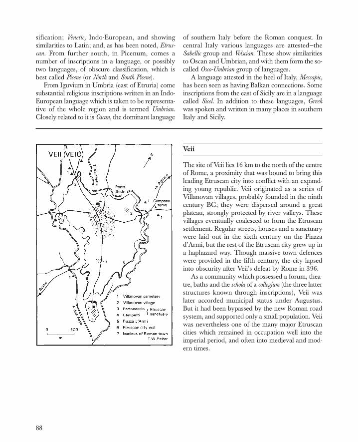
88
sification; Venetic, Indo-European, and showingsimilarities to Latin; and, as has been noted, Etrus-can. From further south, in Picenum, comes anumber of inscriptions in a language, or possiblytwo languages, of obscure classification, which isbest called Picene (or North and South Picene).
From Iguvium in Umbria (east of Etruria) comesubstantial religious inscriptions written in an Indo-European language which is taken to be representa-tive of the whole region and is termed Umbrian.Closely related to it is Oscan, the dominant language
of southern Italy before the Roman conquest. Incentral Italy various languages are attested—theSabellic group and Volscian. These show similaritiesto Oscan and Umbrian, and with them form the so-called Osco-Umbrian group of languages.
A language attested in the heel of Italy, Messapic,has been seen as having Balkan connections. Someinscriptions from the east of Sicily are in a languagecalled Sicel. In addition to these languages, Greekwas spoken and written in many places in southernItaly and Sicily.
Veii
The site of Veii lies 16 km to the north of the centreof Rome, a proximity that was bound to bring thisleading Etruscan city into conflict with an expand-ing young republic. Veii originated as a series ofVillanovan villages, probably founded in the ninthcentury BC; they were dispersed around a greatplateau, strongly protected by river valleys. Thesevillages eventually coalesced to form the Etruscansettlement. Regular streets, houses and a sanctuarywere laid out in the sixth century on the Piazzad’Armi, but the rest of the Etruscan city grew up ina haphazard way. Though massive town defenceswere provided in the fifth century, the city lapsedinto obscurity after Veii’s defeat by Rome in 396.
As a community which possessed a forum, thea-tre, baths and the schola of a collegium (the three latterstructures known through inscriptions), Veii waslater accorded municipal status under Augustus.But it had been bypassed by the new Roman roadsystem, and supported only a small population. Veiiwas nevertheless one of the many major Etruscancities which remained in occupation well into theimperial period, and often into medieval and mod-ern times.

89
Cosa
The Latin colony of Cosa was founded in 273 BCin the territory of the Etruscan city of Vulci.Strongly positioned on a limestone hill overlook-ing the Tyrrhenian Sea, it has been extensively ex-cavated. The walls enclosed some 13.35 hectaresof undulating terrain, which dictate the irregularshape of the defences. There were numerous tow-ers along the more vulnerable west and southsides, which face the sea; and, as was customary inItalic towns, there were three gates. Inside thewalls, the streets divided the town into a series ofrectangular blocks. The irregularity of the con-tours ensured that the forum and associated build-ings (which represent at least five main phases ofconstruction) lay somewhat off centre; while theCapitolium was situated within its own defenceson an eminence to the south west. Houses are at-tested in nearly every block: excavation showsthem to have consisted of rooms laid out around acentral court. Water storage tanks are also a con-spicuous feature of the site.
Luna
The Roman colony of Luna (Luni) is situated onlow-lying flat ground, close to the ancient coastlineof the Tyrrhenian Sea and overshadowed by hillscontaining the imperial marble quarries ofCarrara. Founded early in the second century BCand made a colonia under Augustus, the site wasnot finally abandoned until the thirteenth centuryAD. The town plan as demarcated by its wall is arectangle, within which was a regular grid ofstreets. Public buildings identified include a fo-rum—centrally placed, as was customary—theCapitolium, and a covered theatre. Richly deco-rated private houses have also been excavated.Outside the town was an amphitheatre; there aretraces of wharfs too. These port facilities were ofparticular importance for the export of marble,cheese and other goods, as well as for the importof items such as oil and wine from Spain, northAfrica and elsewhere. Although the forum was outof use by c. AD 400, the long-distance trading con-tacts remained active till much later.


91
Republican Rome
Streams draining into the R.Tiber have cut deep,steep-sided valleys into gently sloping beds of vol-canic tufa and calcareous freshwater deposits toform long projecting spurs and isolated hills. Thegullies between these were much deeper before thecenturies of continuous urban occupation partly ob-literated them. The valley floors were veryilldrained, so that in the eighth and seventh centu-ries BC it was the tops which formed the sites for anumber of nucleated village settlements. The Ro-mans believed that the one on the Palatine Hill—which they called Roma Quadrata, or ‘SquareRome’—was the most ancient. In affirming its pri-macy they could show huts and other genuine re-mains of the prehistoric period. They also believedin an ethnic difference between the inhabitants ofthe hills.
Archaeology and the Roman tradition alike con-firm the unification of these settlements into onelarge and urbanised unit around the end of the sev-enth century. In the sixth century Rome was a cityof importance, with fortifications and public monu-ments comparable to those of any contemporaryMediterranean city—above all the great temple ofJupiter on the Capitol. The Tiber had been bridgedby this time: indeed it was the presence of thebridge which brought about the accumulation ofthe island in the river, not the island which madepossible the bridge. In affording a highway to theinterior as well as an extended, safe harbour alongits banks, the Tiber was essential to the develop-ment of Rome: it made the city a great port and theplace of contact between the Mediterranean mari-time world and the peoples of peninsular Italy.Close to the river grew up the markets of the cityand an emporium which attained its greatest elabo-ration in the second century BC with the buildingof the enormous Porticus Aemilia.
The valleys between the hills became denselypacked with Rome’s rapidly swelling population,but the hilltops—cooler in summer—remained thepreserve of the wealthy, particularly the Palatineand the Carinae spur of the Esquiline. By the end ofthe Republic the built-up area had virtually filledthe walls of the Middle Republican period (last re-newed in the 80s), and was spreading out onto theCampus Martius and beyond the Capena Gate. Butthe meadows of the two Tiber meanders were stilltoo wet for development, and Transtiberim only be-came populous in the Augustan period. Howeverfrom the third century onwards the open spaces ofthe Campus Martius—scene of popular assembliesat muster-time or elections—were rapidly mademonumental along Hellenistic lines. A successionof triumphing commanders right down to Augustusbuilt here great porticoes, temples, and finally thea-tres.
Although from the earliest times the samespirit of display had sprinkled the city with finetemples, it was only in the last years of the Re-public that Rome’s architecture, even in the Cam-pus Martius or Forum Romanum, once againcame to compare with that of the Greek East.From the third century onwards much moneyhad regularly been channelled into utilitarianprojects such as aqueducts and roads, but the cityremained under-provided with amenities, and itsappearance was generally shabby until theAugustan age. Such open spaces as the CircusFlaminius and Circus Maximus, for example, didnot acquire their monumental definition untilquite late. The survival of so large a populationin so cramped and unhealthy a position must al-ways have been precarious; without the river,and later the assistance of the aqueducts, it wouldhave been impossible.


93
Roman Expansion in Italy to 268 BC
Roman expansion began in the regal period withthe annexation of smaller neighbouring settlements.Their inhabitants became Roman citizens, enrolledin the four urban and seventeen rural tribes (localareas of domicile) which were in existence by 495.Down to the early fourth century Rome was occu-pied in holding her own in Latium, and in co-oper-ating with her Latin and Hernican neighbours toresist incursions from Aequi and Volsci. Expansiontook the form of colonisation jointly with the Latins(see pp. 94–5). The conquest of Etruscan Veii in396 (see p. 82) greatly increased Roman territory:the land was allotted in viritane grants to individualRoman citizens, who were enrolled in four newtribes in 387. The capture of Rome by the Gauls in390 slowed progress; but two new tribes were cre-ated in 358, and Rome had recovered by the mid-fourth century.
After victory over Latins, Campanians,Volscians and others in the ‘Latin war’ (340–38),the increasing size of the territory under Rome’sinfluence led to new forms of association and con-trol, not necessarily entailing Roman annexation,settlement or even administration—for which, inany case, she was not equipped. Certain existingcommunities were incorporated as municipia: theirinhabitants became Roman citizens, liable to mili-tary service and taxation. In recompense municipiaenjoyed local autonomy and retained their laws,customs and identity. There were two grades: in themore privileged, the inhabitants were cives Romanioptimo iure (Roman citizens with full rights), whollyequal to existing Roman citizens and enrolled inRoman tribes; in the less privileged, they were civessine suffragio (citizens without vote), partial citizens,possessing the same rights in private law, but un-able to vote or hold office at Rome. Full citizenshipwas granted initially just to selected Latin-speakingcommunities; more distant or less cultured peoplesfirst received partial citizenship, and were upgradedlater. Some Sabine towns were the first non-Latinsto benefit thus in 268.
Other states became allies (socii or foederati) onsigning a bilateral treaty (foedus) with Rome. Thisdefined their duties and privileges, which variedgreatly. Though in theory independent and self-governing, most allies were really more or lesssubordinate to Rome. Their chief duty was toprovide troops; they did not pay Roman taxes.However, since treaties were often imposed byRome after conquest—which usually also entailedconfiscation of territory—the provision of troopsfrom a reduced economic base could prove oner-ous. Allied communities were very diverse in ori-gin and social organisation: Greek city states,Italian towns, tribal peoples. Those whose statusis firmly attested or fairly certain are shown here;doubtless there were many more by the mid-thirdcentury.
After 338, the last power to resist Roman controlof the peninsula was the Samnite tribal confedera-tion of the southern Apennines. Rome recognised aSamnite sphere in a treaty of 354, and despite hos-tilities in 343–1, the Samnites were Rome’s alliesagain by the time of the ‘Latin war’ of 340–38.However Rome’s continuing expansion, and espe-cially the foundation of Fregellae (328), provokedlengthy second and third Samnite wars (327–04,298–90). The Samnites had Etruscan, Umbrianand Gallic allies, so that Rome was often fightingon two fronts. Victory at Sentinum (295) gainedher northern central Italy, and by 290 the defeatedSamnites were forced into a Roman alliance, losingmuch territory. Colonisation and viritane grantscontinued meanwhile, with new tribes being cre-ated in pairs in 332, 318, 299 and 241, bringing thetribal total to 35. Finally, in the Pyrrhic war (280–72) the Tarentines, other south Italians, andSamnites, with help from Pyrrhus of Epirus, madea last unsuccessful stand against Rome. Thus underone form or another the peninsula south ofAriminum was now subject to her; the process ofassimilation and romanisation continued.


95
Roman Colonisation
In Roman terms, to found a colony was to establisha self-governing civic community with its own laws,magistrates and administration. The necessary landwas acquired by conquest and expropriation of theformer inhabitants. An urban centre was built to amore or less standard pattern, as at Cosa (p. 89). Inaddition to residential areas this included temples,market, assembly area and public buildings, likesenate house, court, treasury. Some inhabitantslived within the walls, others settled in the territoriumbeyond. All were allotted plots of ground, as well assharing rights over common land.
Down to 338 Rome established colonies jointlywith her fellow members of the Latin League(Priscae Latinae Coloniae). The colonists held the citi-zenship of their new community, which was aLatin city like any existing League member. Afterthe League’s dissolution, Rome continued to
found similar colonies (as first at Cales in 334),which likewise possessed Latin status, althoughthe settlers were no longer necessarily Latin byorigin, nor were such colonies sited within thegeo-graphical area of Latium. These communities(Coloniae Latinae) often consisted of some 4,000families. Rome also founded ‘citizen’ colonies(Coloniae civium Romanorum), whose inhabitants re-tained Roman citizenship: these were muchsmaller, with only 300 families, who were allottedtiny plots of land. They are often referred to as‘maritime’ or ‘coastguard’ colonies, since theirfunction was to protect coasts. After the secondPunic war, with more confiscated land available,and a higher value set on Roman citizenship, citi-zen colonies of a new type came to be established:they were sited inland, and larger, with severalthousand settlers who received bigger plots.Saturnia (183) conformed to this pattern; the fewLatin colonies of the second century are similar.
Foundations then ceased for over 50 years. Inthe Gracchan period, however, colonisation andviritane allotment—the grant of plots to individualsettlers without establishing any centre—were re-sumed. Next, after the Social war (91–89), the na-ture of colonisation changed. First century pro-grammes involved the dispatch of new settlers (of-ten veterans) to existing communities. Where insuf-ficient public land was available, what was requiredhad to be bought, or was confiscated as a conse-quence of civil war. By this period colonisation andland settlement generally had become importantforms of political patronage.
Colonies fulfilled several major functions. Theywere often sited at strategic points or on main linesof communication: thus Fregellae (328) controlled acrossing of the R.Liris and threatened Samnium,while Cremona and Placentia (218) thrust into Gal-lic territory. Colonies could be used to dominate ahostile area: Venusia (291) split up the Hirpini andLucani after the third Samnite war. Colonial institu-tions and language helped the process ofromanisation. Above all, colonies formed an impor-tant reserve of manpower, since land grants to thepoor who were not liable for military service(proletarii) transformed them into assidui who wereso liable.


98
The Punic Wars
Rome’s struggle with Carthage for supremacy inthe western Mediterranean was fought out in thethree Punic wars of 264–41, 218–01, and 149–6. Atthe outbreak of the first Rome was the chief city ofItaly, while Carthage, as a wealthy maritime power,dominated western Mediterranean trade in metalsand other commodities, and had dependencies andtrading posts in Africa, Spain, Corsica, Sardinia andwestern Sicily. The initial encounter occurred inSicily, when Rome agreed to help the Mamertini ofMessana against the Carthaginians. However heraims soon expanded to include the expulsion of theCarthaginians from the entire island. This requiredher to become a naval power, building ships anddrawing heavily upon her own and her allies’ man-power. Despite the failure of Regulus’ expedition toAfrica (256–5), and serious losses at sea, Rome didpersist with this policy. From the Carthaginianviewpoint there was no value in continuing thestruggle for Sicily indefinitely; after a defeat off theAegates Islands in 241 Carthage therefore madepeace, agreeing to evacuate Sicily and pay an in-demnity. In 238 Rome next took advantage of in-ternal difficulties at Carthage to force the cession ofSardinia too; subjugation of native populationsthere and in Corsica occupied much of the follow-ing decade.
The Carthaginians meanwhile concentrated onextending their empire in Spain, until they domi-nated the south and east coastal area from the R.Baetis to the R.Iberus (Ebro), and had some controlover the tribes of the hinterland. An excuse forRome to intervene came in 218 when Saguntum, acity friendly to her, was captured by Hannibal. Hethen marched swiftly upon Italy, hoping that arapid series of successes would win over Rome’sallies. He inflicted several severe defeats upon theRomans, culminating in that at Cannae in 216. Al-though much of southern Italy then joinedHannibal, he was nonetheless unable to undermineRome’s power base in central Italy, or to make ef-fective use of his Gallic allies in the north.
Rome meanwhile avoided major confronta-tions—the so called ‘Fabian’ strategy, named afterthe general Fabius Cunctator. Moreover Roman de-termination to remain engaged in Spain constantlyrequired Carthage to divert resources there, so thatHannibal never received the reinforcements whichmight have enabled him to force a decisive battleand break the deadlock. An alliance betweenCarthage and Macedon in 215 had no more than aslight diversionary effect. The turning point of thewar only came in 211 with the Romans’ recaptureof Capua and Syracuse. It gradually became clearthat despite the setbacks which Rome had suffered,Hannibal could not hold his gains in Italy in thelong term. Hasdrubal’s attempt to reinforce himfrom Spain resulted in a defeat at the R.Metaurus in207. In 203 Hannibal finally left Italy. In the sameyear Scipio Africanus, who had overcome theCarthaginians in Spain between 210 and 206, be-gan operations in Africa itself. In 202 he defeatedHannibal at Zama. Peace terms includedCarthaginian evacuation of Spain, payment of alarge indemnity, and rewards for Rome’s Africanally, Massinissa of Numidia.
Over the next 50 years Carthage continued toprosper, though her scope for territorial expansionwas severely restricted. In Africa she had securepossession only of the land within the ‘PhoenicianTrenches’, whose exact position is uncertain. Notonly was the territory beyond disputed withMassinissa; Rome also tacitly encouraged him toencroach on important Carthaginian possessionssuch as the Emporia district. In 149, seizing thechance offered by Carthaginian hostilities againstMassinissa and the voluntary surrender of Utica,Rome declared war. All the fighting took place atCarthage and in its hinterland. Punic resistance wasstiff: only in 146, when the siege had been madeeffective by the building of walls and ditches, andby a mole blocking the harbour mouth, did the cityfall to Scipio Aemilianus. It was then totally de-stroyed.

99
Cannae, 216 BC
The battle of Cannae was fought on 2 August 216.The terrain, on the right bank of the R.Aufidus, isfairly smooth and slopes down towards the sea. Ro-man and allied forces were 6,000 cavalry, 55,000infantry, and 15,000 light armed troops; the corre-sponding numbers on Hannibal’s side were ap-proximately 10,000, 30,000 and 10,000. After pre-liminary skirmishing by light armed troops, the cav-alry forces met (stage 1). Hasdrubal on the Punicleft wing routed the Roman cavalry facing him (2),and then crossed behind the Roman infantry tohelp against the allied cavalry (3). The Roman in-fantry was advancing (2) to attack Hannibal’s cen-tre, deployed in a thin line thrust forward in cres-cent formation (3). Meanwhile Hannibal’s Africans,stationed to the left and right, executed a turnwhich brought them up facing the Roman flanks:they then attacked from either side as the Spaniardsand Celts fell back (3). The Romans could not rede-ploy, and their defeat was completed whenHasdrubal’s cavalry returned and fell upon themfrom the rear (4).
Zama, 202 BC
The battle of Zama was fought in autumn 202; theexact site is unknown. The Romans under ScipioAfricanus had 23,000 infantry and 6,000 cavalry,while Hannibal had some 36,000 infantry and4,000 cavalry. In the first stage Scipio placed hislight armed troops to face the charge ofCarthaginian elephants (1). Retreat routes were leftfor the troops by arranging the maniples of thethree lines of Roman infantry in rows rather than inthe usual chessboard formation. Meanwhile, whenthe cavalry on each wing engaged (1), theCarthaginians were pursued off the field. Then thefront line of Roman infantry successfully attackedHannibal’s first two lines (2), who retreated to theflanks with heavy losses. While the Roman frontline closed up, Scipio brought in his second andthird lines, who engaged Hannibal’s third-line vet-erans, hitherto kept in reserve (3). Finally the Ro-man cavalry returned from pursuit, and from therear massacred the Carthaginians. Roman losseswere slight.

100
Carthage
Carthage, just north of modern Tunis, was foundedby Phoenicians—in 814 BC according to tradition.It emerged as the largest Phoenician settlement inthe west during struggles with the Greeks of Sicily.From the fifth century it controlled an empire domi-nating the coasts of north Africa, Spain, Sardiniaand western Sicily. Its wealth came from metals andagricultural trade.
As the plan indicates, little is known of the layoutof Phoenician Carthage, which was destroyed byRome in 146 BC and then built over a century later.The original settlement has usually been located inthe area of the tophet, or sacrificial burial ground,and the nearby hill identified with the ancient cita-del known as Byrsa. Recent excavations, however,reveal that the visible Phoenician ports date fromthe fourth century BC at the earliest, and that thewhole area including the Byrsa hill may represent arelatively late extension of an early area of settle-ment which has yet to be exactly located.
Cynoscephalae, 197 BC
Cynoscephalae was in southern Thessaly, nearScotussa; the exact site is unknown. The Macedo-nian and Roman armies, commanded respectivelyby Philip V and T.Flamininus, were marching westfrom Pherae but were concealed from each other byhills. In wet and misty conditions Philip encampedhis army and sent a covering screen to occupy arugged ridge between him and the Romans.Flamininus, encamped south of it but uncertain ofPhilip’s whereabouts, sent out cavalry and lightarmed troops to reconnoitre. A clash ensued; eachside summoned reinforcements. Encouraged bynews of successes, Philip now decided to deploy hismain army on the ridge; meanwhile a covering ac-tion by Aetolian cavalry gave Flamininus time todraw up his army below. He at first attacked withhis left flank, but it had little success against theMacedonian right. Observing that the Macedonianleft had been delayed and was only beginning tomove into position, Flamininus next attacked with

101
his right, which gained the heights and routed theopposing left before it could be deployed. Part ofthe Roman army then wheeled round against theflank and rear of the Macedonian right, whose
close-order phalanx formation was too inflexible toenable it to meet the double attack. Philip wascrushingly defeated.
Thermopylae, 191 BC
To minimise the disparity between his force of littlemore than 10,000 and the Roman army of about22,000, Antiochus I I I occupied the pass ofThermopylae. He held the so-called East Gate,where he built a substantial wall. The Romans un-der M’. Acilius Glabrio encamped near the hotsprings. When they assaulted Antiochus’ position,they were forced to narrow their front and to attackup a slope; they also suffered from missiles directedfrom higher ground to their right. Meanwhile, how-ever, two Roman detachments had been sentagainst three forts which guarded mountain pathsaround the pass itself. One detachment made littleprogress, while the other, under M.Porcius Cato,for a time lost its way. Yet eventually Cato’s 2,000men routed the Aetolian garrison of FortCallidromos, and then moved down behindAntiochus’ line. The alarm caused by their suddenappearance soon led to a rout.
promagistrates to fill these posts, and indeed fromthe late second century this became the normalpractice for all provincial governorships. Provincianow comes to have the specific connotation of anadministered territory overseas. A governor wassent regularly to Gallia Cisalpina from aroundSulla’s time. Cyrene and Crete, annexed respec-tively in 74 and 67, were governed as a single prov-ince. In the 60s Pompey’s eastern conquests addedvast areas—Bithynia/Pontus, Cilicia and Syria.
To the end of the Republic, Rome’s hold over mostprovinces was patchy, and their frontiers generally ill-defined. In the case of Illyricum Rome even laid claimto the coastal strip, yet seldom sent a governor. In manyregions definition of frontiers had little significance when
The Roman Empire in 60 BC
Rome’s acquisition of an empire was a slow, hap-hazard process, and her involvement in its adminis-tration always remained limited. Communities con-tinued to manage their local affairs. Not until the220s were Rome’s first gains—Sicily and Sardinia/Corsica—organised, and arrangements made foreach to become the regular, annual provincia (or‘sphere of action’) of a praetor. Two more suchpraetorships were created for ‘Further’ and ‘Nearer’Spain in 198/7. But none was added for Macedonia(whose governor also had the oversight of Achaeaor southern Greece), or Africa, both annexed in146, or for Asia, organised in the 120s, or GalliaTransalpina, to which a governor was being sentregularly by 100. It was therefore necessary for


103
these adjoined the territories of ‘client kings’, local rul-ers recognised by Rome and willing to serve her inreturn for the benefits of freedom and protection. The
Roman Campaigns of 49–30 BC
After he had crossed the R.Rubicon into Italy inJanuary 49 it took Julius Caesar five years of inter-mittent campaigning to achieve control of the Ro-man world. He gained Italy itself in two months,since a Pompeian stand at Corfinium proved shortlived. However Pompey, with further forces, es-caped to Greece via Brundisium. Because Caesarlacked a fleet, he delayed pursuit, and insteadturned west to Spain where he brilliantly dislodgedsuperior Pompeian forces from an entrenched posi-tion at Ilerda, and then marched south to accept thesurrender of Corduba. Massilia, too, yielded after afive months’ blockade, and a threatened mutiny offour legions at Placentia was swiftly averted.
In 48 Caesar crossed to Epirus. After a blockadeof Pompey’s army at Dyrrhachium had failed, hemade for Thessaly, where he routed the superiorenemy forces at Pharsalus (see p. 105). Pompey fledto Egypt, only to be assassinated on arrival there.Caesar followed, but roused such hostility by hisplan to gain control of Egypt, that he found himselfbesieged in the palace quarters of Alexandria dur-ing winter 48/7, and was only able to recover thesituation in spring 47, when Ptolemy XIII was de-feated and Cleopatra (now Caesar’s mistress) wasmade effective ruler. Soon afterwards he dashed tocrush the imminent threat to Asia Minor posed byPharnaces of Bosporus, which he accomplished in alightning five days’ campaign at Zela.
After some months in Italy Caesar returned to cam-paigning in late 47, since Pompeian forces in Africa,supported by King Juba of Numidia, had grown alarm-ingly in strength. Caesar risked a winter campaign tocrush them, and after early difficulties at Ruspina didso successfully within four months. The final battle,at Thapsus, turned into a massacre. Pompey’s sons,however, regrouped their forces in southern Spain,where Caesar faced them in March 45. The battle atMunda was his hardest won victory, but its outcomeproved decisive. Pompeian casualties were heavy, andof the leaders only Sextus Pompeius survived. The
campaigns against Dacia and Parthia planned by Cae-sar for 44 were forestalled by his assassination.
After the dictator’s death civil war resumed, thistime between his supporters and his assassins. In 43heavy fighting occurred in Cisalpine Gaul, where thegovernor, Decimus Brutus, was first besieged inMutina by Antony; the latter was then defeated bythe forces of the consuls and Octavian at both Fo-rum Gallorum and Bononia. However, Antony,Octavian and Lepidus came together to form theSecond Triumvirate. Meanwhile the assassinsM.Brutus and Cassius consolidated their hold on theeast, but were faced and beaten by Antony andOctavian in two successive battles at Philippi in Oc-tober 42. Thereafter Octavian in the west had tobesiege Perusia in the course of unrest during thewinter of 41/40. Elimination of S. Pompeius—a for-midable opponent—was his next pressing difficulty.Only when his fleet had been strengthened byAgrippa, did he eventually defeat Pompeius atNaulochus in 36. His campaigns in Illyricum between35 and 33 were intended to safeguard north east Italy.
In the east Antony, who joined himself to Cleo-patra, was faced by two crises. An Illyrian tribe, theParthini, was invading Macedonia, while furthereast the Parthians were overrunning Syria andthreatening Asia Minor. By the end of 39 Antony’slieutenants had beaten back all these incursions.But his own retaliatory campaign through Armeniainto Parthia in 36 was a disaster. He failed to cap-ture Phraaspa, capital of Media Atropatene, andcould not shake off Parthian harassment. An inva-sion confined to Armenia in 34 was more success-ful; Roman control there lasted two years.
Deteriorating relations between Octavian andAntony led to war in 31. Antony advanced toGreece, where he was defeated in land and sea op-erations at Actium. Having fled back to Egypt, hewas pursued there by Octavian the following year.He and Cleopatra committed suicide, leavingOctavian master of the Roman world.
most important such friendly states during the late Re-public (in Africa and Asia Minor) are marked.


106
Pharsalus, 48 BC
The site of the battle is disputed. For all its detailour main account, that of Caesar (Civil War 3.82–99), remains topographically vague enough for it tobe unclear how close to the town the armies met, oron which side of the R.Enipeus. This plan assumesa site north of the river, 12 km or so north west ofthe town. Its main aim, however, is to show the gen-eral development of the battle, which is not greatlyin doubt. Over several days Pompey’s army, secureon high ground, was repeatedly challenged to battleby Caesar, who each time moved closer. As it hap-pened, only at the point when Caesar had decidedto abandon his attempt and move off, did Pompeyunexpectedly respond. With his right flank pro-tected by the river, he intended that on the left his
superior cavalry, followed by slingers and archers,should attack Caesar’s lines in the flank and rear,while his infantry (which also out-numbered thoseof Caesar) would resolutely stand their groundwhen the enemy advanced. Caesar’s reactions wereto ensure that when his front two lines (only)charged, they did not over-tax themselves; and toplace eight cohorts obliquely behind his cavalryand right flank. These not only surprised and brokethe charge of Pompey’s cavalry, slingers and arch-ers, but also then outflanked the enemy, who wereput under intolerable pressure as Caesar now threwhis third line into the battle. Pompey’s army wasscattered.
Augusta Praetoria
Augusta Praetoria was founded in 25 BC as a mili-tary colonia designed to guard the Alpine passes ofGreat and Little St Bernard to the north and westrespectively. The town was thus strongly protected.Its walls stood over 10 metres high and were heavilybuttressed along the inner face, a highly unusual fea-ture. In addition there were 20 square towers andfour gates. These defences—still preserved in largepart—enclosed a military-style rectangle, 724×572metres, which was divided into 16 main buildingblocks and many other subdivisions. Much of thisstreet plan is fossilised in the present-day layout. Whatis likely to have been the Capitolium has been iden-
tified in the northern part of the town, as have acovered theatre, or odeon, and an amphitheatre nota-ble for its location inside the walls. Despite the tradi-tional identification, the forum is most likely to havelain at the centre of the town. There are traces ofpublic baths; however, few details of private housinghave yet been uncovered. Some distance to the eastof the town a bridge over the R.Buthier and the archof Augustus are both still well preserved. Originallysettled by 3,000 Praetorians, Augusta was never verylarge; but its continued strategic role is clearly high-lighted by an unbroken sequence of occupation fromantiquity to the present day.


112
Archaeological Sites of Italy
Italy is conspicuously rich in archaeological sites ofalmost every period. Moreover, many are quite as-tonishingly well preserved, in particular the im-mensely durable concrete structures of the later Re-publican and imperial periods. Even so, a great manymore sites (notably villas and farms) remain to bediscovered. This at least is clear from current pro-grammes of systematic field survey, which aim tomap all surface traces of sites, so as to record entirelandscapes of antiquity. The technique has been par-ticularly successful to the north of Rome, where over1,000 sq km have been studied in this way.
Of course thousands of sites have also been ex-amined through excavation, even if there is no sitethat can be said to have been completely uncov-ered. The map lists a selection of the more impor-tant, particularly (although not exclusively) thosewhere there are still visible remains. Most are townsites with long histories, in many cases extendingback well into the first millennium BC. Equally, asignificant number remains in occupation down tothe present day, underlining the care with whichtheir locations were originally chosen. However, itis useful to draw attention to the most importantperiod in a site’s history, and for this reason fourmain groups have been distinguished.
The first includes the Etruscan cities and theircemeteries, most of which came into being early inthe first millennium BC. Until very recently archaeo-logical work has tended to concentrate upon the reli-gious sanctuaries (e.g. Pyrgi, Gravisca) and the cem-eteries—vivid indices of the wealth and widespreadcontacts of the Etruscans. Yet the unplanned growthof all but a few cities is nonetheless manifest fromwork at Veii, Rusellae and elsewhere. The secondgroup comprises the Greek colonies of southernItaly, the oldest of which was at Pithecusa on theisland of Ischia, founded c. 775 BC. Experiments intown planning are evident at many early sites such asMetapontum and Paestum: these were to provideRome with a model to adapt when founding newsettlements. Many of the sites conserve outstandingremains, although often, as at Sybaris or Paestum,there is a heavy overlay of Roman buildings.Thirdly, there are town sites of the Italic tribes, such
as the Daunian city of Arpino (Arpi), or theMessapian centre of Manduria. Many of the moreimportant of these settlements were to take on a sig-nificant role in the Roman urban network.
Finally, there are the Roman sites themselves.These fall into three main subdivisions. First, townswhich developed out of older settlements, such asPompeii and Herculaneum. Second, new founda-tions, many of which were colonies, like Cosa,Luni, or Aosta; Augustus records founding 28 colo-nies in Italy. Third, sites of the countryside, amongthem farms, sanctuaries and villas. The latter varywidely. They range from great mansions such asTiberius’ Villa Iovis on the island of Capri to elabo-rate, but nevertheless functional, complexes such asthe Sette Finestre villa near Cosa. Most were in factthe centres of farming estates, and varied in size andmagnificence according to the wealth of the owner.Increasingly, like the towns, they are being scientifi-cally excavated, so that our knowledge of the lay-out, function and history of many sites should betransformed in the years ahead.
Ostia
The harbour town of Ostia occupied low-lyingground 25 km south west of Rome, close to themouth of the R.Tiber. Its irregular plan displays along history of growth and rebuilding. Ostia wasoriginally a military castrum, just over two hectaresin extent, located in the central part of the latertown. The decumanus maximus ran through thecastrum, the east gate of which can still be seen.Probably because of a greatly increased level oftrade, the town was much expanded early in thefirst century BC to a size of some 63 hectares, andthe existing walls were constructed. Certainly Os-tia grew to be most prosperous, as its wealth ofpublic monuments shows. There was a very longforum with temples at either end, while the mag-nificent Piazzale delle Corporazioni housed 61 of-fices—mostly with appropriate advertising in themosaic floors—of various local and overseas trad-ers. As the map shows, huge warehouses for the


114
storage of grain, wine, oil and other goods becamecommonplace, and no less than 18 sets of bathshave been identified—compared with three atPompeii. The building work entailed considerablereplanning of some quarters of the town, epito-mised, for example, by the orderly layout of thestreets to the north east. Ostia is perhaps bestknown for its insulae, or great apartment blocks,which probably rose to a total height of 60 Romanfeet. The development of such housing—whichmust have been typical of Rome and no doubt ofmany other Italian towns—is only represented on asmall scale at Pompeii and Herculaneum, sinceboth were fossilised by the volcanic eruption ofAD 79; this trend in domestic housing only be-
came well established later. Some more elaboratehouses are known at Ostia, but they are verymuch the exception.
In AD 42 work was begun on the constructionof a huge new harbour, four km to the north west.Silting created grave problems, however, and underTrajan a second, hexagonal harbour was built. Thisnew commercial centre soon became the focus ofwarehouses, domestic buildings and even a so-called imperial palace. Eventually to be known asPortus, the port area gradually increased in impor-tance, eclipsing the old city’s commercial role. Thiswas recognised in an edict of 314, when Ostia wasstripped of its municipal rights and began slowly tobe abandoned.
Second Battle of Cremona, AD 69
This crucial battle between the partisans of Vitelliusand Vespasian in the Year of the Four Emperors wasfought on the flat, rich plain about eight km east ofCremona during the night of 24/5 October 69. Theaccount of Tacitus (Histories 3.15–25), together withthe preservation of Roman centuriation, makes itpossible to identify the site with some accuracy.The battle was a heroic feat of endurance for bothsides. Though the Flavian troops had already beenstretched—the cavalry by clashes with squadronsfrom the Vitellian garrison in Cremona, the infan-try by a long march—there was a demand by lateafternoon for an immediate assault, which the com-mander, Antonius Primus, only prevented withgreat difficulty. He did prepare for battle, however,on receiving news that the garrison had just beensubstantially swelled to 35,000 legionaries (againsthis own 25,000) by a force which had dashed 100miles in five days, yet was equally eager to do battleat once. Antonius chose his ground astride the ViaPostumia, and the Vitellians, led by F.Fabullus,rashly risked a night encounter. Throughout, thefighting was bitter, confused, indecisive. But oncethe moon rose (by 10 p.m.), the Flavians gainedsome advantage from its light, and by dawn a ru-mour, albeit groundless, that they were being rein-forced gave the final impetus for a successful thrusttowards Cremona.

115
Campania
The distinctive physical geography of Campaniais immediately apparent from the map. The highlimestone ridges of the Appennines and theiroutliers surround a series of low-lying plains.While easily accessible from one another, these arebroken up by Mount Vesuvius and the volcanichills of the Campi Phlegraei (‘Burning Fields’), aswell as by extensive areas of intractable marshlandalong the rivers. For the rest, the land is extremelyfertile: thus it was not only the most highly prized,but also some of the most intensively exploited ar-able terrain of ancient Italy. Capua (near modernCaserta) was one of the most important settle-ments of the region throughout antiquity; its cen-tral position is plain. Other towns which control-led access to the region also grew dramatically:Teanum and Nuceria at mountain passes;Sinuessa, Cumae, Puteoli and Pompeii as harbourtowns. Although the relations between coast andinterior were always close, the separation of theharbours from the plains by hill or marsh assisted
a certain cultural divergence. Despite the predomi-nance of Etruscan and local cultures inland, theGreek colonies of the coast kept their distinctivecharacter; even widespread penetration by Oscanspeakers at the end of the fifth century did not endthis situation. Most notably Puteoli and Neapolis,assisted by the tenacious links of the Campanianports with the eastern Mediterranean, retainedmany Hellenic characteristics to the end of the Ro-man empire. This Hellenism, added to the advan-tages of wealth, populousness and great naturalbeauty, attracted the wealthy of Rome to such anextent that the Bay of Naples, and Baiae in par-ticular, became a notorious playground of theelite. Eventually, as tectonic activity drowned thepleasure palaces and the harbour works, and asthe draining of the Sebethus and Clanius marshesimproved communications with the interior,Neapolis succeeded Puteoli as the chief city of thearea. Modern Naples enjoys the same primacy to-day.


117
Pompeii
Pompeii was the leading city and port of the south-ern part of the bay of Naples, measuring some1,200×720 metres within its walls. Roughly two-thirds of the site has been liberated from the thickmantle of volcanic deposits which enveloped it inAugust AD 79. Like any city, Pompeii containsbuildings of many different centuries. The oldest isa Greek Doric temple of the sixth century BC, partof an early nucleus underlying the forum area; butmost structures belong to the second century BCand later.
There are three main areas of public buildings.First, the unusually long forum—with a Corinthiantemple, the Capitolium, at one end. Around weremore temples, a cloth hall, the judicial basilica, amarket, and three other halls (municipal offices?).Then to the east lay the triangular forum with itsDoric temple; nearby were the Greek theatre and asmall covered theatre, as well as a temple of Isis.Finally, at the town’s eastern edge, were the amphi-theatre of c. 80 BC and the Great Palaestra, a largeenclosure surrounding a swimming pool. Therewere three sets of public baths, of which the centralone was unfinished in 79. All were supplied by anaqueduct, from which water passed through leadpipes. The aqueduct also fed private baths and theinnumerable fountains, whose overflow was used towash down the streets and sewers. Houses variedconsiderably in scale, from one-room shops with aroom above, to palatial, elaborately decorated resi-dences. The layout of most of the latter is that de-scribed by the architect Vitruvius, with a roofedatrium containing a central opening to collect rain-water in a cistern below; and a peristyle, a gardencourt, surrounded by a colonnade.
Pompeii was a busy city which became prosper-ous through trade and agriculture, though it alsodeveloped industries like the production of lavamillstones, cloth and fish sauce. By 79, with a popu-lation of some 20,000, it was expanding consider-ably, particularly westwards, where sections of theold town walls became obliterated.
Herculaneum
Partly because Herculaneum is buried beneath noless than 15 metres of volcanic mud, only a rela-tively small part of the city has been excavated.Nonetheless it would seem to have been quite mod-est in size, perhaps measuring 320×370 metres. Thepopulation may have numbered about 5,000. Thepreservation of organic materials like wood is excel-lent, and many of the buildings have yielded an ex-traordinary quantity of detailed information. Thedecumani (east-west streets) and the cardines (north-south streets) divide the city into blocks or insulae.To the north was a particularly wide decumanus,closed off to vehicular traffic, which may haveserved as the forum. The basilica is thought to lieon the north side of the decumanus maximus, while tothe east was a palaestra with a large pool at thecentre of the peristyle court. A theatre is also knownfrom the old excavations in the north west area, andthere were public baths nearby.
Herculaneum is at least as old as the sixth cen-tury, but the visible remains of the houses belongmainly to the latter centuries of the Republic. Manyare laid out around an atrium, in the Italic style, butthere is considerable variation in plan. Some haveporticoes in front, while a great many possessed asecond or even a third storey. Attached to thehouses were shops selling wine, grain, metal-work,glassware and other commodities; one even con-serves its painted sign. To the south, at the extrem-ity of the early city, were some much granderhouses, with peristyles, gardens and other rooms,giving a panoramic view over the sea. They belongmainly to the Augustan period and later. Beyondwas an extensive complex of baths and various reli-gious buildings. These splendid structures, withtheir fine statues and paintings, underline the afflu-ence and high rank of many families who ownedproperty in Herculaneum.


120
Italian Towns with Alimentary Schemes
Alimentary schemes (alimenta) for the support ofchildren are known from the mid-first century ADonwards. Private benefactors took the initiative inthe first instance, but Nerva and Trajan came tosponsor a major state programme throughout Italy,best documented in substantial records from Veleiaand Ligures Baebiani. The state offered capital,though in all other respects its schemes were locallybased in each participating community, and de-signed to operate with the minimum of future ad-justment. The larger local landowners acceptedfrom the state perpetual loans amounting to ap-proximately 8 per cent of the value of their prop-erty; the interest paid at the low rate of 5 per centfurnished the modest monthly support grants. Themethod by which the children to benefit from theschemes were chosen is unknown. They are cer-tainly unlikely to have been orphans, yet the as-sumption that they would always be from the poor-est families is unwarranted. While the state pro-gramme was definitely not initiated in order to pro-vide smaller landowners with working capital (ashas been claimed), its real aims remain obscure: ar-guably these were a mixture of philanthropy andconcern for a supposed population decline whichmight affect legionary recruitment. State alimentawere perhaps extended a little by later second-cen-tury emperors and continued in existence into thethird century. At best their usefulness was only everlimited.
Evidence for alimenta is almost exclusively epi-graphic. While the spread of the 50 or so communi-ties from which relevant indications have emerged(references to a local quaestor alimentorum and thelike) may reflect little beyond the random survivalof this material, there must still be a suspicion thatthe state scheme was hardly extended to the re-moter or poorer areas of the peninsula. Evidencefor private schemes is slight, although the arrange-ments for one set up by Pliny at Comum are de-scribed in his Letters (7.18).
Key to P. 121: Temples 1. Divus Traianus. 2. MarsUltor. 3. Venus Genitrix. 4. Minerva. 5. Vediovis. 6.Concordia. 7. Divus Vespasianus. 8. Saturnus. 9.Ianus? 10. Castores. 11. Divus Iulius. 12. DivusAntoninus. 13. Vesta. 14. Iuturna. 15. Penates (theform indicated is post-Caracallan). 16. Iuturna orIuno Curritis. 17. Fortuna Huiusce Diei. 18.Feronia. 19. Lares Permarini. 20. HerculesMusarum. 21. Iuppiter Stator. 22. Iuno Regina. 23.Apollo Sosianus. 24. Bellona. 25. Iuppiter Tonans.26. Fortuna Primigenia. 27. Iuppiter Victor. 28.Apollo Palatinus. 29. Ianus. 30. Spes. 31. IunoSospita. 32. Fortuna. 33. Mater Matuta. Other tem-ples are indicated by the name of the deity wor-shipped there. Other monuments 34. Porticus Vipsaniaor Minucia? 35. Markets of Trajan. 36. Unidentifiedporticus. 37. Libraries and column of Trajan. 38.Tabularium. 39. Curia. 40. Regia. 41. PorticusMinucia? Templum Nympharum? 42. Ara GentisIuliae? 43. Unidentified porticus. 44. Market-build-ing of Forum Holitorium. 45. Houses of Augustusand his family. 46. Palatine libraries. 47. Site of thelater basilica of Maxentius.
Rome in the Age of the Severi
The orientation of the map is based on that of theMarble Plan of the city which was set up in theearly third century AD and survives in fragments.The Aurelianic Walls of 271-5 are indicated faintlyas a guide to the later topography. The map is in-tended to show not so much architectural detail,but rather the overall layout of the imperial city andits main topographical centres and regions, as wellas the principal morphological zones, in so far asthey can be reconstructed.
The shape of the city was still defined by theRepublican wall-circuit, although this will havebeen ruinous and built over in places. Its gates weregreat topographical landmarks. The monumentalcentre is left unshaded. Its enormous extent is at onceapparent. The monuments here may be seen in de-tail in ‘The Centre of Rome in the Age of Caracalla’(area within dotted rectangle). In heavy shading is thearea of the densest housing. Here


122
lived the great mass of Rome’s population—severalhundred thousand people—for the most part in talltenement buildings (insulae). The hatched area is theurban periphery. It, too, was quite densely populated,and was considered by Romans to be part of the built-up area or continentia aedificia. Here the suburban man-sions (horti) of the emperor and the very wealthy jos-tled with aqueducts, tombs, market gardens and someinsulae. Stippled are the commercial zones beside theriver. Certain prominent sacred buildings are indicatedby a small circle. In addition a star indicates someimportant aspect of the city’s layout:
A The Lateran. Luxury villas here were confiscatedunder Nero and destroyed to make room for thebarracks of the imperial equites singulares or mountedbodyguard; subsequently the site of the cathedralof Rome under Constantine.
B Campus Esquilinus, with grove of Libitina, god-dess of funerals. Place for public executions andpaupers’ cemetery, partly improved (by Maecenasin particular) to form lavish suburban estates.
C Camp (marked) and parade ground of thePraetorian Guard.
D Area later occupied by the Baths of Diocletian.
E Horti Sallustiani, enormous suburban palace whichsoon became one of the most important imperialproperties.
F Horti Luculliani, most lavish of all the suburbanvillas, and also an imperial estate.
G Tombs and villas on the Via Flaminia, includingthe tomb of Nero.
H Mausoleum of Augustus (circle marked), Ara PacisAugustae, giant sundial of Augustus and the parkwhich linked them.
I Funerary monuments of the Antonine emperors.J Ad Ciconias Nixas, the upstream river-harbour of
the city, and the principal wine wharves.K Mausoleum of Hadrian (marked) and the wealthy
suburb of the Ager Vaticanus. Race-track ofCaligula and Nero, naval arena of Augustus, andpaupers’ cemetery with strong religious associationsfor Christians and followers of Phrygian cults.
L Trigarium, practice horse-race track, with the sta-bles of the circus factions nearby. This area wasstill suburban in the late Republic but was built upby the Severan period; it later became the centre ofmedieval Rome.
M Main river harbour of Rome, which spread down-stream from the Forum Boarium from the secondcentury BC onwards.


126
Trade in the Roman World
In the Roman world trade was a complex affair.Trade for profit, carried out by entrepreneurs, waslimited. Institutions such as the imperial govern-ment (and later the church) were responsible forthe larger share of trade, and this was promotedfor non-commercial reasons. So, too, was themovement of goods between estates of the sameland-owners. Trade was lubricated by a uniformcoinage, but it remained incidental to the latter’smain function, which was to discharge govern-ment debts to the army and civil service. Not eve-ryone had access to coinage, so that barter andexchange continued among some groups, as it didalso between the Roman world and barbarian so-cieties beyond.
Roman trade resembled that of the classicalGreek world in so far as it was primarily concernedwith the movement of raw materials and food-stuffs, rather than of manufactured goods. A com-pletely self-sufficient community would have beenrare indeed. Yet an important distinction lies in theextent of state involvement, as seen early in the sup-ply of corn to Rome. During the Republic, importsfrom Sardinia and Sicily proved sufficient, butthereafter the city’s growing population led to de-pendence on regular shipments from Africa andEgypt.
The extraction of minerals—gold, silver, copper,tin, lead—was an imperial monopoly. Imperial in-volvement in the quarrying and supply of marblefor building is also clear. During the late Republicand early Empire, quarries in Africa, Asia Minor,Egypt and Greece, as well as in Italy itself, wereimportant sources of fine marble for the city ofRome. By the second century the use of these exoticmaterials had spread to other Mediterranean cities.Thus at Lepcis Magna marble and granite fromAttica, Carystos, Proconnesus and Egypt were em-ployed in both public and private building. As withcorn, the supply of these commodities was evi-dently left to private merchants (negotiatores) andshippers (navicularii), who were then able to use sur-plus carrying capacity to further their own interests.The direction of these activities lay in the hands ofthe state.
Negotiatores were also involved in supplying ar-mies stationed on the frontiers of the empire fromAugustus’ time. Although frontier provinces them-selves were probably forced to provide more thantheir fair share, much revenue from elsewhere,too, was clearly spent on soldiers, arms and de-fences. The distribution of artefacts and inscrip-tions along the river systems of Gaul indicates thevolume of trade drawn out of the Mediterraneanworld to serve the frontiers. However, not alllongdistance trade in this direction was deter-mined by the army. Well before barbarian societieswere incorporated within the empire, merchantshad found in them a profitable market for wineand manufactured goods, exchanged for slavesand raw materials.
Long-distance trade thrived where transportcosts were low. Diocletian’s price edict of AD 301shows how much cheaper it was to send goods bysea than by land. River transport, too, was rela-tively cheap, although costs rose the more that car-goes had to be handled. Predictably it was cities onthe Mediterranean, or on major river routes, whichprospered at the expense of land-locked towns.
More locally, Strabo and Pliny the Elder outlinethe character of provincial economies and their par-ticular strengths—whether in minerals, or in food-stuffs such as wine, cereals, or olive oil. Literarysources also illustrate the social context in whichcommercial trade took place. Notably the aristoc-racy, while profiting by the sale of goods from itsestates, distanced itself from direct involvement incommerce and manufacturing. Archaeology aidsdefinition of the direction, scale and complexity ofRoman trade both locally and empire-wide. Para-doxically the most abundant evidence is that frommanufactured goods such as cheap pottery and trin-kets: this can be used as a ‘proxy’ for the trade inperishables. Only in the case of pottery jars (ampho-rae) which carried wine, olive oil, fish sauce, driedfruit and the like, do we gain direct insight into thetrade of foodstuffs. Italy emerges as the main sup-plier of wine in the later Republic, Baetica of oliveoil in the early Empire (later overtaken by Africa).Evidence from shipwrecks is instructive: these re-

127
veal that cargoes were mainly devoted to the car-riage of basic commodities, leaving little space forthe less valuable manufactured goods. At times theextent of trade networks was great. Fragments ofItalian amphorae and fine tableware, for example,
show how in Augustus’ day communities as farapart as Britain and India—both beyond the fron-tiers of the empire—were enjoying the same wines aswere drunk in Rome.
The Roman Empire in AD 60
During the 120 years between 60 BC (see p. 102)and AD 60 Rome’s empire was impressively ex-tended and consolidated. Though it was Julius Cae-sar who conquered Gaul in the 50s BC and laterenlarged Africa, the expansion was above all theachievement of Augustus. During his PrincipateEgypt was annexed (30 BC), while Spain, Gaul andthe Alps were all pacified and organised (by 13BC). Persistent efforts to subdue Germany andpush Roman control as far as the R.Elbe (Albis)failed, however; the R.Rhine was therefore madethe frontier in this area, and heavily garrisoned.Arguably Augustus’ greatest contribution to theconsolidation of the empire was to link its westernand eastern sections by subduing all the territory upto the R.Danube along its whole course; this fron-tier, too, was strongly garrisoned. At Augustus’death in AD 14 much of the empire was indeed, asTacitus says (Ann. 1.9), ‘bordered by the ocean orby long rivers’. In the east the R. Euphrates formedpart of the frontier, yet this was less secure and lesssharply defined than in the west, with significantareas still left in the hands of friendly ‘client kings’(though Galatia had been annexed in 25 BC), andwith no substantial garrison. For a variety of rea-sons—political and financial, as well as military—Augustus had no wish to station many legions inthe east, and feared no pressing danger from there.For all its size the neighbouring Parthian empirewas normally weak and divided, while most of itsmonarchs respected Roman concern that kings ofArmenia (the mountainous area with which both
empires shared a frontier) should swear allegianceto the emperor.
Although Tiberius did incorporate the former‘client kingdom’ of Cappadocia within the empirein AD 17, in general he followed Augustus’ adviceagainst expansion. Claudius, by contrast, provedmore ambitious. During the 40s he incorporatedfurther ‘client kingdoms’—in Mauretania, Thrace,Lycia and Judaea—while embarking upon the con-quest of Britain. By 60 Roman forces there werefacing a native rebellion. At the same time the east-ern legions needed reinforcement to combat anunusually strong and aggressive Parthian monarch,Vologeses I, who was refusing to recognise evenRome’s nominal claim to Armenia.
From 27 BC governors were appointed by twodifferent methods. For certain provinces senatorialproconsuls chosen by lot continued to be sent outfor one-year terms, as in the Republic. Such sena-tors were all ex-praetors, except those sent to Africaand Asia, who were senior ex-consuls. By AD 14only one legion remained under proconsular com-mand (in Africa), and that, too, was removed in 39.In all other provinces the governor was the emper-or’s legate, appointed by him and holding office athis pleasure, though a term of around three yearsmight be expected. Such imperial governors weredrawn not only from among ex-consuls (for heavilygarrisoned provinces especially) and ex-praetors,but also from among equites in the emperor’s service(for Egypt and minor provinces).


132
Roman Britain
Intensive research and excavation have made Brit-ain the best studied of all the provinces of the Ro-man empire. It was annexed in AD 43 on comple-tion of the initial phase of invasion by A. Plautius;formally it ceased to be a province 367 years later,when the emperor Honorius withdrew the remain-ing garrisons. The map inevitably presents only apartial picture, and one that must amalgamate thedevelopments of more than one century. There isno hint here, for example, that the majority of bothmajor and minor civilian settlements in lowlandBritain began as forts or fortresses during the con-quest phase. The only military sites shown southeast of the line joining the R.Severn (Sabrina) andthe R.Trent (Trisantona), are either ones of the firstcentury which were not overlain by later towns;or—in the case of the coastal forts from the Wash tothe Isle of Wight—they are those which belong tothe less secure period from the late third centuryonwards, when pirate raids in the North Sea andthe Straits of Dover were becoming an increasingmenace to the peace and security of the civilianheartlands.
As a spur to romanisation three coloniae of retiredRoman legionaries were settled at Camulodunum,Glevum and Lindum in the first century; later, hon-orary colonial status was given to the civilian settle-ment at Eburacum, and almost certainly toLondinium too. But most of the rest of the ‘majorsettlements’ were organised as civitates, newlyplanted, self-governing capitals controlling tribal ar-eas, each roughly representing (with some Romanmanipulation) the same region occupied by each
tribe before the Roman invasion. It is vivid testi-mony to the genius of Roman planning that manyof these settlements are still thriving communitiestoday, and that long stretches of the Roman roadsystem which linked them are still in use. The flour-ishing state of Romano-British agriculture is wit-nessed by the thousand or so villas and farms lo-cated to date. The mosaics, painted plaster and lav-ish bath suites of the richer establishments (in coun-try and town) testify to the high standard of mate-rial comfort achieved by the wealthier propertiedclasses, as well as to their thorough romanisation.
To protect the civilian zone, however, a perma-nent buffer of garrison forts was required in Walesand the north of England, controlled from threepermanent legionary fortresses at Isca, Deva andEburacum. All but one of the other fortressesshown, whether legionary (16–20 hectares) orvexillation (8–12 hectares) size, belong to the firstcentury when the military situation was still fluid;Carpow alone is third century. Not all the fortsshown were occupied simultaneously. It is impossi-ble to show essential back-up features in the frame-work of military occupation, such as fortlets andsignal stations. Omitted, too, are the marchingcamps representing the army on manoeuvres orcampaign: it is from these, for example, that Romanarmies are known to have reached the mouth of theR.Spey (Tuesis) under Agricola in 84, and againlater, probably in the third century. For most ofRoman Britain’s history, however, it was Hadrian’sWall which formed the northern frontier.

133
Hadrian’s Wall and the Antonine Wall
Agricola was the first to appreciate the strategic im-portance of the Tyne-Solway line: during his gover-norship (78–84/5) he built a road (‘The Stanegate’)from Luguvalium to Red House and several of theforts along it. After the withdrawal from southernScotland c. 105 the Stanegate served as the frontier;it was probably now that its line was extended west-wards and eastwards, and fresh forts built along it.Hadrian, however, effected a bolder solution to thefrontier problem with the erection of a continuous118 km barrier from coast to coast a few milesnorth of the Stanegate—in stone three metres thickfrom Pons Aelius to the R. Irthing, and in turf fromthe Irthing to the Solway. At intervals of one Ro-man mile fortlets (‘mile-castles’) were built along it,with two signalling towers (turrets) spaced out be-tween each—milecastles of stone in the eastern sec-tor, of turf and timber in the western sector, butturrets of stone throughout. An impressive V-ditchwas dug outside the entire frontier line, exceptwhere the crags rendered it superfluous. The mainfighting garrisons were to remain in the Stanegateforts.
Drastic modifications were made c. 124. Fortswere now placed on the Wall itself, originally 12 innumber, later 16, demolishing turrets or mile-cas-tles already built, if they were in the way. To speedup the work, the stone Wall was narrowed to 2.5
metres, and extended eastwards to Segedunum toprovide better cover for the Tyne. Most idiosyn-cratic of all, a continuous flat-bottomed ditch, withaccompanying earth mounds both north and southof it (‘The Vallum’), ran behind the Wall to providea clear delineation of the military zone: now theonly crossing points were at control gates oppositeeach fort. This oddity of Roman planning came tobe ignored soon after it was built, and was partlyfilled in. But its construction, and the decision tomove the main garrisons onto the Wall itself, bothpresumably reflect the hostility with which thewhole idea of a frontier barrier was greeted locally.
Another integral part of Hadrian’s frontier wasthe system of stone watch towers and timberfortlets which continued down the Solway coast,probably as far as St Bees Head, south ofGabrosentum (see above, ‘Roman Britain’); recentwork between Bibra and Maia suggests that theoriginal scheme here may have been a continuoustimber palisade of uncertain length and height,similar to that known on the contemporary frontierin Germany. Also essential to defence of the frontierwere the outpost forts to the north—Blatobulgium,Castra Exploratorum and Fanum Cocidi, later tobe joined by Habitancum and others.
The Hadrianic frontier was essentially completec. 128. Yet a bare ten years later Antoninus Pius

134
ordered a fresh advance and the building of anotherWall—entirely of turf, a mere 59 km long—betweenForth and Clyde. The planners of the Antoninefrontier also had their afterthoughts. A tentativeearly scheme to build in stone (as seen at Balmuildyfort) was scrapped in favour of a turf Wall andditch. At first the plan seems to have envisagedwidely placed turf-and-timber forts, with fortletslike the milecastles of Hadrian’s turf Wall in be-tween: nine such fortlets are now known, though itis too early to say if a complete series was built.Clearly some at least were dismantled and super-seded by adjacent forts, even before the Wall hadbeen finished. Thus the Antonine frontier as finallycompleted c. 142 had 19 forts in all—more than
Hadrian’s Wall, which was twice as long. Therewas no Vallum, and apart from six platforms, per-haps used as beacon stances in signalling, no struc-ture resembling a turret. The western flanks wereprotected by a fort at Bishopton and a couple offortlets further west; to the east of the Wall weregarrisons at Cramond and Inveresk, while Alauna,Victoria (Strageath) and Bertha served as outpostforts to the north.
The Antonine Wall had an active service life ofless than 20 years. Temporarily abandoned c. 155/8and re-occupied after an interval of only a year ortwo, it was finally given up c. 163/4. Hadrian’sWall—its western sector now rebuilt in stone—henceforth served as the definitive frontier.

135
Silchester (Calleva Atrebatum)
Situated in Hampshire 13 km south of the R.Thames, Silchester has been almost deserted sinceRoman times, so that excavations in 1890–1909revealed the most detailed example of a Romano-British town. As the capital of the Atrebates,Silchester predates the invasion in AD 43, but theRoman town developed slowly. The baths (c. 55/65) were its earliest amenity, oriented differentlyto the over-ambitious street grid of the late firstcentury. The forum/basilica complex and amphi-theatre were both started at the same time as thestreet grid; the former took some 30 years to com-plete. In the late second century a defensive bankof gravel with stone gateways enclosed 40 hec-tares—average area for a Romano-British town ofmedium size—and this was fronted by a stone wallafter 250. Though full evidence is lacking, declineclearly followed, with the basilica being put to in-dustrial use for metal-working. A tiny church waserected about 350.
Lutetia Parisiorum
Lutetia Parisiorum (Paris) was a typical northernGallic civitas-capital, with a population of about7,500. It succeeded a Celtic oppidum located on theIle de la Cité—an easily defended site which control-led an important route across the R.Seine. Howevercontinuity of settlement was only assured when theRomans built a road which crossed the river at thesame point. The main part of the Romano-Galliccity lay on the left bank. Its layout reflects theGauls’ ready acceptance of Greco-Roman ideas ofurbanisation. There was regular street planning,and lavish provision of public buildings for admin-istration, entertainment and relaxation. To be notedare the central forum complex—which included anopen area with surrounding portico, a great halland temple—and the bath buildings. The city wasunwalled, a tribute to secure conditions during thePrincipate. In true Roman fashion its cemeterieswere placed beyond its sacred boundary. The laterRoman and medieval cities retreated again to theisland in the Seine.


137
Roman Gaul and the Alpine Region
Rome effectively acquired southern Gaul late in thesecond century BC, by her intervention to helpMassilia against the Salluvii. Subsequent war withthe Allobroges extended Roman territory to LakeGeneva. Aquae Sextiae was established as a garri-son town, and a colony was founded at NarboMartius. The area became known as ‘Provincia’—‘The Province’. Incessant feuding among the re-maining Gallic nations (civitates) blinded them to thethreat posed by Romans in the south and Germanicpeoples from the north. Rome herself, however,was increasingly aware of the German menace.Thus between 58 and 51 BC Julius Caesar coulduse it to justify his interference in the affairs of theHelvetii, Aedui, Arverni and Sequani, and indeedhis conquest of the whole of Gaul.
The Republic had prized ‘The Province’ only asa safe route to Spain. Caesar, once dictator, went fur-ther, and established full veteran colonies at Narbo,Arelate, Forum Iulii and Baeterrae. Augustus followedthe same pattern. He founded more full colonies inNarbonensis, as ‘The Province’ was now renamed—for example at Arausio; he also promoted Nemaususand many other indigenous settlements to colonialstatus. Thus began the intensive romanisation ofNarbonensis, and the displacement of civitates byGreco-Roman style city-states—as among the VolcaeArecomici, to cite one instance.
In the new territories, however, Caesar was re-sponsible for only three colonies—Noviodunum,Raurica, Lugdunum—to prevent German invasionfrom the Rhine. Augustus created no new coloniesin the north. He slightly remodelled the civitates, giv-ing them single centres of administration (the ‘civitas-capitals’, e.g. Augustodunum), but otherwise left themalone. His major innovation was to establish threenew provinces: Lugdunensis (capital: Lugdunum),Aquitania (capital: first Mediolanum, then Limonum,and finally Burdigala), and Belgica (capital: firstDurocortorum, then probably Augusta Treverorum).The ‘Three Gauls’ developed a Gallo-Roman ratherthan a Roman culture. Augustus also set in train thesubjugation of the western Alps, which considerablyeased overland communications between Gaul andItaly, and resulted ultimately in the provinces of Alpes
Graiae et Poeninae (capital: Axima), Alpes Cottiae(capital: Segusio), and Alpes Maritimae (capital:Cemenelum).
Following the failure of Augustus’ province ofGermania Magna, and the return of the imperialfrontier to the Rhine, martial law zones ofGermania Inferior and Germania Superior werecarved out of Belgica and Lugdunensis. In the latefirst century, under Domitian, these were consti-tuted as formal provinces, with capitals at ColoniaAgrippina and Moguntiacum respectively.Germania Superior included the only permanentRoman acquisition across the Rhine, the ‘AgriDecumates’, annexed by Vespasian and his sonDomitian to shorten the northern frontier. Duringthe second century its impressive overland bound-ary, the Limes, was progressively strengthened (seep. 140). Legions came to be stationed at Vetera,Bonna, Moguntiacum and Argentorate. Taken to-gether with associated auxiliaries, and the navalpersonnel at Gesoriacum and Colonia Agrippina,they amounted to a considerable garrison.
The army’s presence was of great importance forGaul. Military needs prompted the improvement ofroad and river communications, while the troops’spending power greatly stimulated the Galliceconomy. Increased wealth was reflected in urbani-sation, not only in colonies and civitas-capitals, butalso in agglomerations which grew up around themilitary bases and along the main routes. The great-est city was Lugdunum, whose suburb of Condatehoused the great Altar of Roma and Augustus, themain focus of Gallic emperorworship. Prosperity, andperhaps a growing population, are also seen in thewidespread appearance of substantial romanisedfarmhouses and villas, as revealed by aerial photog-raphy around Samarobriva, for example.
Gaul suffered particularly badly in the mid-thirdcentury, when external attack and internal discordbrought anarchy to the empire. The frontier col-lapsed, the Agri Decumates were lost, and manytowns and villas were destroyed. Order was re-stored by the fourth-century emperors, but the greatage of imperial peace had passed.


139
Germanies-Raetia-Noricum
For much of the Roman period the rivers Rhineand Danube marked the limit of Roman expansionnorthwards in western and central Europe. At theend of the first century BC the Celtic speaking peo-ples of the region (who lived both north and southof the rivers) were at differing levels of political, so-cial and economic development; but they did pro-vide a common bond between Rome’s frontierprovinces.
In the west Julius Caesar reached the Rhine in55 BC. In 15 BC, however, Augustus initiated aseries of campaigns to annex the lands between theRhine and the Elbe (Albis). He built fortresses onthe west bank of the Rhine (including Noviomagus,Vetera, Novaesium and Mogontiacum), and basesin the Lippe valley further east. This forward policywas reversed after a major disaster in AD 9, follow-ing which the Rhine was adopted as the frontier.The rump of Augustan Germania—two narrowmilitary zones on the west bank—became by AD 90the provinces of Germania Inferior and Superior.
After Augustus’ subjugation of the Alpine tribesin 15 BC, the Vindelici and the kingdom ofNoricum were overrun up to the Danube, thoughthe two provinces of Raetia and Noricum were notformally created until Claudius’ reign. Lying be-tween the fortresses of Upper Germany andPannonia, neither was garrisoned by legionarytroops until the later second century.
Claudius reinforced both river frontiers withnew forts. However the political upheavals of 69–70 caused widespread destruction, so that shortlyafterwards Vespasian thoroughly overhauled thedefensive systems. On the Danube he rebuilt theClaudian forts; east of the Upper Rhine he linkedMogontiacum and Augusta Vindelicum by newroads, and fortified the Upper Neckar (Nicer). Afterthe Chattan War of 83–5 his son Domitian con-structed the first limes in the Wetterau north east ofMogontiacum—a patrol road with towers and
fortlets at intervals. At the same time he built a lineof new forts north of the Danube. Around 90, fol-lowing further Chattan incursions, he joined theWetterau forts with Vespasian’s strongpoints on theUpper Neckar by a limes through the Odenwald.Further improvements were made under Trajanand Hadrian; later, around 150, the garrisons of theOdenwald-Neckar limes were moved 20–25 kmeastwards.
Under threat of attack by the Marcomanni, in179 Raetia was given the protection of a new legion-ary base at Regensburg (Castra Regina); soon after-wards Lauriacum took on the same role inNoricum. Germanic raids across the whole lengthof the Rhine and Danube frontier progressivelythreatened the security of provincial life, especiallyafter 233. The Agri Decumates behind the UpperGerman-Raetian limes were gradually evacuated,and by 259–60 the Upper Rhine and Danube oncemore became the front line. Then from the latethird century new strongpoints were built alongboth the rivers and some main routes in the hinter-land. Thus Rome had moved effectively from theoffensive to the defensive.
It is clear that the army was the agent of rapidromanisation in the frontier provinces: there is am-ple archaeological evidence for urbanisation andthe intensive exploitation of natural resources.Colonies such as Colonia Claudia AraAgrippinensium and Augusta Rauricorum werefounded, and many lesser towns sprang up. Mostforts, too, had dependent civil settlements, some-times of considerable importance. Villa estates inthe country-side supported a prosperous upperclass, and marginal land was farmed by a numerouspeasantry. The barbarian invasions of the third cen-tury did not put an end to progress; but they coin-cided with notable changes in the Roman social andeconomic system, so that their effect was far reach-ing.


141
The Rhine-Danube Limes from c.AD 40 to AD 259–60
The triangle of land between the upper courses ofthe Rhine and Danube formed a re-entrant into Ro-man territory and a potential weak spot in thenorthern defences. It was directly controlled byRome only between the late first and the mid-thirdcenturies AD. After Augustus’ failure to create aGreater German province up to the Elbe, the Rhineand Danube were accepted as the frontier. For-tresses at Mogontiacum, Argentorate andVindonissa were supported by auxiliary forts in theRhine Valley and south of the Danube. Claudiusmoved troops up to the two river lines and strength-ened both. After the disturbances of 69–70Vespasian reorganised the region’s defences. Hedrove a road east of the Rhine from Mogontiacumto Augusta Vindelicum and established forts on theUpper Neckar (Nicer). In 85, after his first ChattanWar, Domitian protected the Wetterau north east ofMogontiacum by a limes—that is, a patrol road withwooden look-out towers and fortlets at intervals; healso built a series efforts north of the Danube. Tolink the Wetterau system with the Upper Neckar,around 90 he constructed a limes through theOdenwald, secured by fortlets. Hadrian added awooden palisade in front of the road.
Around 150 the garrisons of the Odenwald-Neckar limes were moved to a new line 20–25 kmfurther east, and the work of replacing woodenforts and towers in stone was completed. In theearly third century the Upper German limes was re-inforced by a rampart and ditch set behind thewooden palisade; but in the Raetian sector the pali-sade was replaced by a stone wall and interval tow-ers.
Alamannic invasions in the second quarter of thethird century led to Roman retrenchment. By 259–60 the limes had been abandoned, the towns andvillas of the Agri Decumates had been evacuated,and the Rhine and Danube resumed their defensiverole.
The Danubian Provinces/ Balkan Area c.AD 200
Until the end of the first century BC Rome’s inter-ests in the Balkans were confined to the Istrian pe-ninsula and the occupation of Macedonia. HoweverRoman control came to be extended to theR.Danube as a result of Augustus’ campaigns downthe R.Save (Savus) valley, together with the con-quest of the interior of Dalmatia and the route tothe Danube down the valley of the R.Morava(Margus). By Tiberius’ time three provinces of Dal-matia, Pannonia and Moesia had been created. Ofthese Moesia was to be divided later by Domitian,Pannonia by Trajan. When Dacia was annexed atthe beginning of the second century, it was some-times governed as a single province, at other timesas two, or even three.
Towns—both Macedonian foundations andGreek colonies—only existed on the periphery ofthe new conquests, on the Aegean coast of Thraceand on the Black Sea. New towns were foundedunder Augustus and Tiberius, notably in Liburniaand northern Macedonia: these were both coloniae,settlements of Roman veterans, and municipia, na-tive settlements granted urban autonomy. All pro-vided civilian administration for newly conqueredterritory. In addition the colonies—such as Emonaon the road from Italy to Pannonia—guaranteed amilitary reserve at strategic centres vacated by thelegions after the initial phase of conquest. By themid-first century AD the Dalmatian coast fromLiburnia to Macedonia possessed numerous newtowns.
In the interior the pace of urbanism was muchslower. Native tribal administration was maintainedin central Pannonia and Moesia, regularly super-vised by centurions detached from the legions. Thefirst urban foundation on the middle Danube—theClaudian colony at Savaria—commanded the Am-ber road, the route north from Italy to the legionaryfortress at Carnuntum; its citizens included both le-gionary veterans and Italian traders, anxious to

142
seek out the important military markets on theDanube. Later in the first century Sirmium andSiscia (the latter founded with discharged sailorsfrom the fleet) were established to strengthen theeconomic development of the Save valley: it formedthe second most important route in Pannonia, lead-ing south east to the Danube at Singidunum (Bel-grade). Sufficiently romanised native communitieswere also granted urban status under the Flavians,among them Neviodunum, Andautonia andScarbantia. In Moesia tribal administration wasmaintained; romanisation proved more difficult.The only colony here was the Domitianic founda-tion of Scupi. It was a mixed community of Syrian,Gallic and Macedonian veterans drawn from allfour Moesian legions.
The greatest impetus to urban development camefrom the conquest and eventual annexation of Daciain 106. Three new colonies were founded—at Oescusin Moesia Inferior, at Ratiaria in Moesia Superior,and at Poetovio in Pannonia. Hadrian granted civicstatus to native settlements in the interior of Pannonia,such as Cibalae and Bassiana. On the Danubian limessubstantial civilian settlements (canabae) had beenformed close to the legionary fortresses by a mixtureof legionary and auxiliary veterans, native tradersand foreign immigrants. Hadrian raised several suchsettlements to municipal status, notably Viminacium,Carnuntum and Aquincum.
In the eastern Balkans the task was less easy.Thrace, annexed by Claudius, had few urban cen-tres away from the coast. Though Vespasian didfound a colony at Deultum, the real task of creatingtowns in Thrace was left to Trajan. While Serdica,Pautalia and Augusta Traiana could claim nativeorigins, his foundations at Nicopolis ad Nestum,Nicopolis ad Istrum and Marcianopolis (the lattertwo north of the Haemus range) were all new crea-tions. This attempt to spread urbanisation was notfully successful, however. Hadrian founded onlyone more town in Thrace—Hadrianopolis. So theprovince remained largely administered by villages:remote from the towns, these controlled extensiveterritories exploited through emporia, subsidiarymarket centres.
The conquest of Dacia, too, was not followed bythe creation of towns on the scale of the Augustanprogramme in Dalmatia or the Flavian one inPannonia. The establishment of Sarmizegethusa asa colony only three years after the conquest was apolitical decision: it demonstrated Rome’s power,not her intention to romanise the Dacian popula-tion. Hadrian added only two new towns, Drobetaand Romula, both south of the Dacian heartlandsof Transcarpathia.
The second century witnessed the most prosper-ous period in the development of the Danubianprovinces. Towns of the interior were provided withtemples, fora and lavishly decorated public build-ings. By contrast country farms were generallysmall, lacking the luxury of Gallic or African villas.Mining, though an imperial monopoly, encouragedthe growth of settlements in Moesia Superior andwestern Dacia: these gained municipal rights by thethird century. Ampelum, the centre of gold miningin Dacia, attracted skilled miners from Dalmatia.Moesia Superior was exploited for its lead and sil-ver, western Thrace for gold, northern Dalmatia foriron.
Military centres which had attracted substantialcivilian settlements in Dacia (like Potaissa,Napoca, Porolissum) and in Moesia Inferior(Troesmis, Durostorum) received civic rights, asdid the native settlements of Naissus, Margumand Horreum Margi in the Morava valley ofMoesia Superior. The development of towns alsoreflects the general economic development of theprovinces, the romanisation of their nativepopulations, and their general attractiveness toimmigrants from both east and west. From theearly third century, the award of the title colonia toexisting settlements becomes increasingly com-mon: Potaissa in Dacia and Aquincum inPannonia were so honoured. However, by thesecond decade of the third century the barbarianinvasions had commenced, bringing devastationto the Balkan provinces, and ending nearly twocenturies of economic and urban developmentwhich had reached its peak by c. 200.


145
Iberian Peninsula
The large Iberian peninsula, separated from the restof Europe by the Pyrenees, has always displayedextremes of landscape and climate. Serious Romaninterest dates from the Second Punic War. By itsend Rome had dislodged the Carthaginians there tooccupy the most productive areas in the peninsula,the valley of the lower R.Ebro, the east coast, andthe valley of the R.Baetis. Two provinces, Citeriorand Ulterior, were marked out in 197. In the follow-ing decades the need to protect and stabilise con-quered territory combined with greed for Spain’srich variety of resources to encourage continuingRoman expansion. Long and bitter conflict withnative tribes culminated in a major struggle with analliance led by the Lusitanian Viriathus, and thecapture of Numantia in 133. With Rome now inpossession of perhaps two-thirds of the peninsula,there was little further conquest for the next cen-tury, although the provinces were unsettled by Ro-man civil wars there against Sertorius in the 70sand Pompeians in the 40s. Final conquest of theentire peninsula (especially the rugged north west)was achieved by Augustus in the 20s BC. As a re-sult three provinces were created from his reign,Tarraconensis and Lusitania each governed by animperial legate, Baetica by a proconsul. Thereafterthe peninsula for long enjoyed a fair measure of in-ternal stability, with only one recorded mention offighting against the Astures in Nero’s reign (ILS2648). The three legions placed there by Augustuswere reduced by Vespasian to one—Legio VIIGemina, stationed at the place named after itself.
The fullest surviving descriptions of the penin-sula under Roman rule are those of Strabo dating toAugustus’ reign, and of Pliny the Elder in theFlavian period. They indicate the impressivenumber of new colonies founded by Julius Caesarand Augustus and of existing towns granted eithercolonial or some lesser Roman status. EmeritaAugusta, established in 25 BC for legionary veter-ans, is one outstanding example of the former
group, while among the latter the ancientPhoenician foundation of Gades, given Roman mu-nicipal status by Caesar, prospered sufficiently toboast as many as 500 men of equestrian census.Much survives on bronze of the municipal chartersof Salpensa and Malaca, drawn up in Domitian’sreign. Although his father Vespasian had bestowed‘Latin’ rights upon every community in the Spanishprovinces, it should not be overlooked that therestill remained a stark contrast between the south—rich, urban, romanised—and the rest of the penin-sula, where cities were relatively few, and tribal or-ganisation persisted along with native customs andlanguages. All the same, while many Spaniards mayindeed have been ‘obscure people with barbaricnames’, as Pliny put it, the number of educatedmen from the peninsula who rose to make theirmark at Rome (especially as senators and writers)was remarkable.
The sources of Spain’s wealth were diverse. Thepeninsula was rich in herds and crops, especiallycorn, vines, olives, flax. Fish were caught on a largescale, both for pickling and for the manufacture ofgarum, the salty fish sauce which added zest to everyRoman meal. Most valuable of all, however, wereSpain’s minerals—gold, silver, lead, tin, iron andcopper: the last was mined over extensive areas,principally at Rio Tinto and Vipasca, from whichregulations of the early second century AD survive.Most mines came to be owned by the state. Exportof all Spanish products was facilitated by navigablerivers and a well-developed system of main roads.
Rome’s Spanish provinces arguably reached thepeak of their prosperity in the second century AD.Beyond that date, for some reason, the number ofSpaniards to achieve prominence at Rome declines.The peninsula itself was harmed successively byMoorish invasions, widespread banditry, and theeffects of the empire-wide civil wars of the 190s. Itsuffered again from Frankish invasions during thethird century.


147
Corsica and Sardinia
These two wild and rugged islands had rather dif-ferent cultural backgrounds until their absorptionby Rome in the third century BC. In Sardinia thebest anchorages along the western and southerncoasts had been colonised by Phoenicians in theeighth and seventh centuries. These settlements,bolstered by trade and each controlling a fertile ag-ricultural hinterland, flourished underCarthaginian control, despite somewhat hostile re-lations with the Nuraghic peoples of the interior:the Carthaginian sphere of influence never ex-tended far inland. In Corsica Phocaeans made anill-fated attempt to found a Greek colony at Alalia(Aleria) around 565, but the island passed underEtruscan influence less than 30 years later, and theEtruscans are said to have founded Nicaea, perhapson the site of Mariana, about the same time. Laterat least part of Corsica, too, came underCarthaginian control, and it was from this thatRome wrested both islands in 238. But further cam-paigns were necessary before Roman power wasconsolidated: not until 227 was the new province ofSardinia-Corsica formally organised. The moun-tainous interiors, however, remained untamed.Continued forays by Roman armies in both islandswere necessary to quell native revolts until the endof the second century BC; even after that, brigand-age in Sardinia at least was not finally stamped outuntil the early empire.
With both islands so unsettled, it is hardly sur-prising that the progress of romanisation was slow.In Corsica a colonia was founded by Marius atMariana and another at Aleria by Sulla, but noother cities merit a reference in the Corsicansection of Pliny’s detailed and wide rangingsurvey of Roman provinces, and only a singleroad—the east coast one—is listed in the AntonineItinerary. The rest of the Corsican settlementsshown on the map derive from Ptolemy ’sGeography: doubts remain about the preciselocation of some, and in the absence of archaeo-
logical investigation it is impossible to determinethe degree of romanisation of the others. From thegarrison at Praesidium Rome kept a watchful eyeon the interior, while there was an importantdetachment of the Misenum fleet stationed in thesheltered lagoon of Portus Dianae.
Sardinia in time became more developed. Early inAugustus’ reign only Turris Libisonis was a colonia,and Carales the sole city with municipal rights. How-ever, Uselis soon joined Turris as a colonia, and Noraand Sulcis at least became municipia; Cornus, too,gained municipal or colonial rank. But the interiorremained unsettled. This may be seen first from thepresence of auxiliary garrisons there—most probablyat Sorabile, Luguido, Augustis and Valentia (thoughcertainty is impossible). The constant switching ofthe island’s status is another sign of instability. Hav-ing been split from Corsica and organised as a sepa-rate province some time early in the empire, Sardiniashifted between being a senatorial province and com-ing under direct imperial control half-a-dozen timesfrom Augustus’ day to the late second century.
Corsica’s main contribution to the Romaneconomy was its timber. Sardinian grain was notinsignificant, and the lead and silver mines of theMetalla district, as well as iron and copper sourceselsewhere in the island, also produced usefulyields. In addition granite was extracted fromquarries on both sides of the Fretum Pallicum—mostly for local needs. Certainly by the time of themiddle Empire places such as Turris Libisonis(probably the capital), Carales, Nora and Olbiahad equipped themselves with at least some publicbuildings in brick-faced concrete of the type to beexpected in any medium-sized town in the Italianpeninsula. But Punic influence in the coastal citiesdied hard: even in the late second century ADBitia erected an inscription in neo-Punic whichindicates that the town’s constitution continued tobe modelled along Carthaginian lines, with suffetesas chief magistrates.


149
Roman Sicily
Sicily became the first of Rome’s provinces at theend of the First Punic War (241 BC), and remainedone until the island passed under Byzantine controlin AD 535. The map inevitably represents a confla-tion of more than one period in that long span ofnearly 800 years. It is drawn from two mainsources.
The first is Pliny’s list of Sicilian communitiesbased on an Augustan document which, with oneor two supplements from Cicero’s Verrines, providesa list of the most important Sicilian cities in the lateRepublic. A comparison with the map of Greek Sic-ily (p. 38) will show that some of the famous oldGreek cities, such as Gela, Himera and Selinus,were already dead (these three, in fact, by 241), andthat some of the hill towns of the interior had alsodisappeared. In some cases the latter had beenpeacefully abandoned in the course of the late thirdcentury, when the arrival of the pax Romana madedefensive capability no longer the most importantfactor in the choice of urban site. Right into theEmpire the other hill towns were gradually desertedin favour of a pattern of more dispersed settlementon farms, and in villages and new market centres.The latter sprang up in the valleys and along thenew trunk roads which the Romans built. Archaeol-ogy has demonstrated clearly that some of theplaces mentioned by Cicero and Pliny, such asMegara Hyblaea, Camarina, Morgantina, HeracleaMinoa and Ietas, either vanished altogether in theperiod between 50 BC and AD 50, or else dwin-dled to the size of hamlets; others, notably Helorusand Soluntum, and possibly Segesta and Entella,did not much outlast the second century AD.
The second main source for Sicilian place namesin the Roman period is the Antonine Itinerary, inorigin a third century AD document, which along
with other similar late-Roman and post-Romanhandbooks, lists places along the major trunkroutes. In particular it provides the names of severalof the new market centres referred to above, al-though many of these remain to be securely identi-fied on the ground.
During both Republic and Empire, Sicily’s eco-nomic importance lay almost exclusively in herrole as a major corn producing province. Inaddition Sicilian wines were known on the tablesof Rome, whilst horses, timber and sulphur wereamong other local assets with an export market.During the Republic the Sicilian communitieswere left largely to their own devices, providedthey paid their tithes and other taxes. Theyretained a good measure of local autonomy, aswell as their Greek-style constitutions andmagistrates: culturally, Sicily under the Republicremained part of the Greek Hellenistic world.Romans showed an increasing interest in propertyspeculation and other business affairs, but thenumbers resident in Sicily stayed small until thefirst century BC. The Roman influx became moresignificant when six coloniae were created byAugustus, some of which erected buildings in thestyle of the concrete architecture of mainland Italy.However in other parts of Sicily buildingtraditions remained conservative down to the lateEmpire. Latin was the official language ofgovernment, at least in the coloniae and municipia,though even they occasionally erected official in-scriptions in Greek. This undoubtedly remainedthe language of normal everyday communication.Despite its geographical proximity to Italy andmore than seven centuries as a Roman province,Sicily retained a distinctly Greek flavour downinto Byzantine times.


151
Imperial Estates in the R.Bagradas Valley
Emperors acquired extensive landholdings through-out the provinces by such means as inheritance, giftand confiscation. Four key inscriptions found in theR.Bagradas valley between 1879 and 1906 illumi-nate the character of imperial estates (saltus) there,though how far generalisation from them is validremains doubtful. Of special interest is administra-tion by procurators directly responsible to the em-peror, acting in liaison with a conductor for each es-tate. Though technically himself a tenant, with offi-cial connivance the latter could oppress his fellows,as inscription D of Commodus’ time shows. Theothers all preserve regulations encouraging tenants’cultivation of marginal land (subseciva). The mapshows their approximate findspots and the presumedlocation of the estates named. The fundus villae MagneVariane id est mappalia Siga, to which inscription A (ofTrajanic date) relates, is thought to have formed partof the saltus Neronianus. The saltus Tuzritanus and saltusThusdritanus, to which the otherwise similar texts ofinscriptions B (Hadrianic date) and C (Severan date)respectively relate, are likely to be identical.

152
North African Provinces
Rome’s first province in Africa was acquired afterthe destruction of Carthage in 146 BC. It consistedof a relatively small area of northern Tunisia, andwas governed from Utica. In 46 BC Julius Caesaradded a new province created from the kingdom ofNumidia; the two were combined by Augustus about27 BC. Africa in this form remained a senatorial prov-ince governed from Carthage, which had beenrefounded as a colonia by Augustus. In AD 39 com-mand of the province’s single legion was transferredby Gaius from the proconsul to a legatus Augusti ofpraetorian rank. For all practical purposes he tookcharge of Numidia—which was not officially desig-nated as a separate province till 196—as well as themilitary zone on the desert fringes as far east as theborder with Cyrenaica. In 42/3 the client kingdomof Mauretania was annexed and split into two prov-inces, Mauretania Caesariensis and MauretaniaTingitana, separated by mountains; both were gov-erned by equestrian procurators. Later, underDiocletian, the proconsular province was divided intothree provinces, and Mauretania Caesariensis intotwo. No serious external or internal threats were feltto exist: the African garrison amounted to just onelegion with numerous auxiliaries, in all about 28,000men.
In the Punic period urban life had developed ona number of coastal sites, which came to survive thedestruction of Carthage. Further impetus to devel-opment was given by considerable immigrationfrom Italy under Caesar and Augustus. Severalcoloniae were founded, and there was much privatesettlement. The restriction of nomadic and pastoralmovements opened wide areas to intensive agricul-ture, particularly cereals in northern Tunisia andlater, after 100, olives in the southern areas. Thiswas the basis of a population increase which in turnled to further urbanisation in favoured areas,among them parts of Numidia in the region ofCirta. The army also played a role in urbanisationfrom its successive bases at Ammaedara, Thevesteand Lambaesis.
Tribal structures broke down rapidly in some ar-eas (though not in the mountains), so that some 400or 500 indigenous communities, mostly no more
than villages, came to be recognised by the govern-ment as having local administrative responsibilities.With increased wealth, a substantial number devel-oped into proper towns, acquiring Roman citizen-ship during the second century. Some, like LepcisMagna and Hadrumetum, were old Phoenician set-tlements; others like Thugga, ThubursicuNumidarum, Thuburbo Maius and Maktar were ofLibyan origin. By the end of the second century thedensity of urban life in northern Tunisia rivalledthat of Italy. The population of the majority of thesecommunities probably did not exceed 10,000; butCirta and Hadrumetum had perhaps 30,000, andCarthage, which became the largest city in the west-ern Mediterranean after Rome, perhaps 250,000.
Throughout north Africa there were extensiveimperial estates; much land, too, was held by absen-tee owners. But many provincials also prospered,and they are found in increasing numbers in thehighest ranks of the imperial administration.Septimius Severus, an African from Lepcis Magna,even rose to be emperor at the end of the secondcentury. A further notable feature of the north Afri-can provinces is the speed with which Christianityspread there—faster than in any other Latin speak-ing region. Many of the most important earlyChristian writers in Latin—among them Tertullian,Cyprian, Lactantius, Augustine—were Africans.
In contrast to the advancement of Latin culturefurther west, Cyrenaica retained the Hellenic charac-ter which stemmed from the original settlement byGreeks in the seventh century BC. During the Romanperiod immigration from Italy was slight. Followingits annexation in 74 BC Cyrenaica formed aproconsular province jointly with Crete—a connectionnot broken until some time in the third century AD.Diocletian next divided Cyrenaica into Libya Superiorand Libya Inferior. The traditional Greek way of lifecontinued in the coastal cities, the term Pentapolis beingapplied to Apollonia, Cyrene (see p. 40), Ptolemais,Arsinoe and Berenice. Serious damage was caused ina revolt by Jewish inhabitants in 115, but the provincesuffered no major military problem till the fourthcentury when pressure exerted on the cultivated areasby desert tribes became intense.

153
Timgad
Thamugadi (modern Timgad) has impressive re-mains which, unencumbered by post-Roman build-ing, reveal the most complete aspect of a Romancolonial city to have survived. Founded in AD 100as Colonia Marciana Traiana Thamugadi 38 km eastof Lambaesis (the base of Legio III Augusta whichprovided the first settlers) on the road to Theveste,the city was planned like a military camp, being al-most square. The perimeter wall was 355 metres perside and contained 111 roughly equal blocks, someoccupied by public buildings. As a result of a rapidincrease in population, the wall was dismantled withina generation and relatively unplanned expansionoccurred, particularly to the west and north. TheCapitolium itself was built c. 160 outside the originalperimeter. The city’s public buildings (among them15 sets of baths) and impressive works of art testifyto its wealth, derived from the agricultural resourcesof the region. Thamugadi became a stronghold ofthe Donatists, a Christian schismatic movement ofthe fourth century.
Lepcis Magna
Lepcis, or less correctly Leptis, Magna (modernLebda) lies on the coast road 120 km east of Tripoli.A small harbour there on the Oued Lebda had beensettled by Phoenicians around 600 BC. In Augustus’time its mixed Phoenician and Libyan inhabitantslavishly transformed it into a city on the Romanmodel. Some Phoenician institutions were still re-tained until Trajan gave the community the status ofa colonia. The initial rebuilding was in the area of the‘old forum’. Further notable expansion took placeunder Hadrian, but the climax was reached around200 when the emperor Septimius Severus and hispraetorian prefect Fulvius Plautianus—both nativesof Lepcis—added yet more magnificent buildings,including a new forum and harbour. Much remainssuperbly preserved. While the city may have prof-ited from trans-Saharan trade in exotic goods, itswealth must have derived mainly from cultivation ofthe land between desert and sea. Stagnation set inafter Severus’ time, and the city’s hinterland sufferedincreasingly from pressure by nomads.


155
African Limes
Rome’s African frontier system did not rest uponnatural boundaries or defend the empire from apowerful rival. Rather, it delimited flexibly the areanorth of the Sahara in which an economic and po-litical system of Mediterranean type could flourish.No serious military threat existed, and hence Africaneeded fewer troops (about 28,000) than equivalentareas, and the frontier was capable of further exten-sion to the west. The key areas were southern Alge-ria and Tunisia. The only legion, III Augusta,moved from Ammaedara to Theveste underVespasian, and then to Lambaesis, its final base,under Trajan. During this period the Aurès moun-tains were penetrated and encircled; the land to thesouth, from Gemellae eastwards to Tamalleni, wasdominated by a series of forts and roads. Probablyunder Hadrian the fossatum Africae—discontinuousstretches of ditch and wall—was built in variousplaces to channel and control natives’ movement.The furthest extension of the limes as far asCastellum Dimmidi came under Severus, but thisaddition was evacuated by Gordian III around 240.Irrigation and settlement went hand in hand withthe advance of military control, the effective limitbeing climatic and economic.
In Mauretania Caesariensis auxiliary forts wereat first concentrated on the line Auzia-Rapidum andthe Chelif valley, until Severus developed a moresoutherly system. There was no permanent landconnection between the Mauretanian provinces. InTingitana the auxiliary units were relatively numer-ous and stationed inside the province. Inscriptionsimply diplomatic arrangements with a neighbour-ing tribe outside the empire, the Baquates, between140 and 280.
Immediately east of Tunisia, Tripolitania had notroops till the late second century when outpostswere stationed as far south as Ghadames. From thethird century fortified farmhouses here and inCyrenaica testify to the need for self-protectionagainst increasing nomadic threats, due perhaps tomore widespread use of the camel. In the fourthcentury the entire limes (excluding Tingitana) wasdivided into sectors under praepositi limitis.
Greek and Roman Crete
Some time after the collapse of the Minoan civilisa-tion (see pp. 4–5), Dorian Greeks settled in Cretebeside the survivors of the earlier population, toform that mixture of Cretan peoples—‘Achaeans,Eteocretans, Kydonians, Dorians and Pelasgians’—described in Odyssey 19. 175–7. In the tenth andninth centuries conditions seem to have beenharsh, and there was continued occupation ofsome of the inaccessible hilltop sites like Vrokastroand Kavousi that had first been occupied byMinoan refugees. By the eighth century, however,several new Dorian cities had been founded, sothat in the seventh century Crete was a prosperousisland of independent cities, in which the artsflourished sufficiently to influence developmentsthroughout the Greek world. These communitiesof archaic Crete were also the first in Greece tointroduce written codes of law.
Such prosperity seems to have come to an abruptend in the sixth century. From that time on Cretenever again occupied a comparably dominant posi-tion in either the historical or the archaeologicalrecord. From the fifth century until the Roman con-quest in 67 BC the island suffered from frequentinter-city wars, in which the larger communities ofKydonia, Knossos, Gortyn and Hierapytna foughtto increase their power over the weaker ones. Dur-ing this period settlement was concentrated inwalled cities occupying strong positions on hill tops.
The Roman conquest was carried out by Q.Caecilius Metellus in 69–7 BC, following accusa-tions that the Cretans were guilty of piracy andwere helping Mithradates in his fight against Rome.After the annexation Gortyn became the provincialcapital, and Crete was combined with Cyrene toform a single province—an arrangement which con-tinued into the third century AD. In the peacefulconditions under the Principate, settlements in lowlying and coastal areas became more common. Acertain prosperity is indicated by the building of anumber of country villas in the second and thirdcenturies.


157
Roman Cyprus
Roman annexation of the Greek island of Cyprusin 58 BC followed two-and-a-half centuries ofPtolemaic rule. The island was first administeredwith Cilicia; Julius Caesar and Antony returned itto Egyptian rule. But Octavian claimed it perma-nently for Rome after his victory at Actium, andfrom 22 BC onwards it constituted a separate sena-torial province divided into four districts centredaround Paphus, Salamis, Amathus and Lapethus.Paphus, famous for its temple of Aphrodite, wasdeveloped as the administrative capital of the islandand seat of the provincial koinon or council. Salamis,however, with its harbour and fertile hinterland wasthe largest and most cosmopolitan city, and themain commercial centre. It exported the island’sprincipal products—copper, timber, corn—and waswell situated to exploit trading opportunities withSyria, Judaea and Egypt. Copper mining, understate control, was concentrated on the coastal stripbetween Marium and Soli and in the rugged inte-rior at Tamassus. The island did suffer occasionalearthquake damage, and it was also greatly dis-turbed by its sizeable Jewish population at the timeof the Jewish risings throughout the east late inTrajan’s reign. Yet archaeological findings taken to-gether with meagre literary and epigraphic evi-dence do confirm the general impression that underRoman rule Cyprus was a quiet, comparativelyprosperous backwater.
Bithynia and Asia c. AD 100
Competition for status and its rewards was a promi-nent feature of Greek society, in public as in privatelife. The map illustrates the local government struc-ture of two provinces and shows the major statuscategories competed for by cities.
In the case of Asia the cities are relatively wellknown from copious inscriptions of the late Hellen-istic and early imperial periods. For Bithynia in thetime of Trajan unique literary evidence is available:Pliny’s official correspondence with the emperorwhile governor c. 109–11 is complemented by thepolitical speeches of Dio Chrysostom concerning
both the troubled internal affairs of his native Prusain the years preceding Pliny’s appointment, and therivalries between Bithynian cities over points ofhonour.
In material terms the most valuable positions acity could hold were those of ‘temple warden’(neokoros) and assize centre (dioikesis/conventus). Theformer title was officially held by cities which pos-sessed a provincial temple of the imperial cult. Inthis capacity they hosted games which accompa-nied the cult and attracted crowds of visitors. Meet-ings of the koinon, the provincial congress responsi-ble for the cult, were also held there. Assize centreswere regularly visited by provincial governors toconduct judicial business. Litigants who required ahearing before a Roman tribunal had to travel tosuch a centre, and were naturally a source of pros-perity to the community concerned. Paradoxically,however, some of the bitterest disputes involved notthese positions, but the prestigious, though largelyempty titles of metropolis and prote (‘first city’). Diodeals with just such a wrangle between Nicomedeaand Nicaea in his Oration 38. In the imperial periodmetropolis, which had originally signified the mothercity of a Greek colony, came to be a title for thechief city of a province or region.
A few cities of the Greek east were absorbed bysettlements of Roman veterans in the greatdemobilisations of Augustus’ time, and thereby ac-quired the status of a Roman colonia, free from trib-ute and generally from interference by proconsuls.A number enjoyed the status of ‘free city’, whichcovered a range of different relationships withRome, from nominal independence guaranteed bytreaty or decree to more limited local autonomydependent upon the emperor’s goodwill. Finallythere were areas where Greek institutions had notyet penetrated, and the people were still organisedin tribal communities. However, there are severalplaces marked which owed to imperial policy theirdevelopment from tribal market centre to hellenisedcity. Such transformation was usually commemo-rated—at least temporarily—by the adoption of adynastic name (like Flaviopolis, Trajanopolis).


159
Roman Asia Minor
The geographical centre of Asia Minor—in ancientterms Phrygia, Galatia, Lycaonia and westernCappadocia—consists of a rolling plateau at an aver-age altitude of 1,100 metres, drained by theSangarius and Halys rivers and by lakes of varyingsalinity; rainfall is low, and winters severe. This pla-teau is bounded to the north by the Paphlagonianmountains; their wooded northern slopes drop to anarrow coastal plain. Southwards the Taurus rangebegins in Lycia, runs roughly parallel to the coastand finally, east of the Cilician Gates, merges intothe mountain mass 300 km wide which separatesthe Pontic coast from the Cilician and north Syrianplains. Westwards the plateau and the Pisidianmountains are broken by large river valleys, nota-bly those of the Maeander, Hermus and Sangarius:these made Lydia, Mysia and Bithynia the richestparts of Asia Minor.
Serious Roman interest began here with the waragainst Antiochus III. Victory in 190 BC left Romeas arbiter of the peninsula. The Seleucids were gen-erally confined to Cilicia, while native kings wereretained in control of Cappadocia and the northernseaboard. Of Rome’s allies, Rhodes was given terri-tory in Caria and Lycia, and the small but well or-ganised kingdom of Pergamum was encouraged toexpand inland to fill the vacuum left by Antiochus’withdrawal.
In 133 Attalus III of Pergamum bequeathed hiskingdom to Rome, and its richer and more accessi-ble parts became the province of Asia. In 74 a simi-lar bequest by Nicomedes III led to the formationof the province of Bithynia. On the south coast theprovince of ‘Cilicia’, which originally consistedmainly of Pamphylia, had been set up to curb pi-rates. But until Pompey’s campaign against them in67 and his subsequent rearrangement of the east,there was no continuous and effective Roman pres-ence here, so that Cilicia in the strict sense re-mained nominally Seleucid property. After the de-feat of Mithradates of Pontus by Pompey, most ofhis kingdom was added to Bithynia.
Next, in 25, Amyntas of Galatia bequeathed hiskingdom—including much newly captured territory
that was ethnically Pisidian, Phrygian, Lycaonianand Isaurian—to form the basis of a new imperialprovince of Galatia. Cappadocia was taken overearly in Tiberius’ reign. Initially it was controlledby a procurator, though later it was attached toGalatia, and finally became a separate imperialprovince under Trajan. Lycia and Pamphylia, after250 years of experiments with different forms ofgovernment, were definitively annexed only underVespasian. He also reinstated the province ofCilicia, which for more than a century had formedpart of Syria. Thereafter, except for minor adjust-ments, this pattern of provinces remained intactuntil Diocletian’s reorganisation.
Within the province of Asia certain cities weredesignated as district (conventus) centres where thegovernor on circuit would hold assizes. No doubtthis system applied further east too, but there islittle evidence for its organisation. In moredeveloped areas cities on the Greek pattern wereusually the main unit of local government, andnew cities continued to be created into theByzantine period. Elsewhere the tribe was the unitof government rather than the city; there were alsolarge imperial estates that never acquired citystatus. Roman colonies were rare, apart from agroup founded by Augustus to hem in theturbulent Pisidians.
The Roman road system began as a regularisa-tion of existing routes, though at any rate the ViaSebaste, linking Augustus’ Pisidian colonies, as wellas stretches near the Euphrates frontier, were builtspecifically for military purposes. The Peutinger Ta-ble and the Antonine and Jerusalem Itinerariesshow the network as it existed in the fourth centuryAD. Milestones are common, even if their valuemay be reduced by the tendency of engravers toomit distances, and by the old Turkish habit oftransporting such stones for reuse as grave markers.Though recent work has brought significant ad-vances in understanding, the road pattern shownremains far from definitive, especially inCappadocia.


163
Roman Syria, Western Parthia andArmenia
In ancient times Syria was the name given to thefertile strip along the entire eastern shore of theMediterranean, from the Taurus Mountains toEgypt. It was held by Seleucids prior to annexationfor Rome by Pompey in 63 BC. Thereafter its southwest region was always separately administered—from AD 70 as the regular province of Judaea. Thesouth east region, beyond the R. Jordan, was notdirectly controlled by Rome until AD 106 when therule of its Nabataean kings came to an end, and itwas then made the province of Arabia, governedfrom Bostra. In Roman parlance, therefore, thename ‘Syria’, came to be associated with the morefragmented northern region, to which Commagenewas added from AD 72. Behind the narrow coastalplain here lie two parallel chains of mountains, bro-ken at several points, and separated by valleysalong which the R.Orontes flows northwards, theR.Jordan southwards. Beyond the mountains therecome vast tracts of desert, which give Syria no de-fined frontier to the east; to the north theR.Euphrates marked the border. The prosperity ofthe cultivable regions derived from vines, olives,fruit and vegetables; the weaving of linen and woolwere important, too, together with dyeing. Theprovince also gained wealth from importing silkand other eastern luxury goods by caravan acrossthe desert. Despite the unusually high duty of 25per cent imposed on eastern imports by Rome, thetrade continued to flourish. It encouraged thegrowth of communities on the edge of the desert(especially Damascus), and at oases (especiallyPalmyra), as well as seaports on the Mediterraneancoast. Apart from these exceptions, however, Syriawas hardly urbanised; its territory remained rural,with the village as the centre of local life. The greatmajority of the population continued to speakSyriac, and were little influenced by Greco-Romanculture.
As one of Rome’s most splendid possessionsSyria was governed by a senior consular in com-mand of a substantial garrison, much of it recruited
locally. The capital, Antioch, ranked among thegreatest cities of the empire. At the end of the sec-ond century Septimius Severus divided the prov-ince into two—Coele to the north, governed fromAntioch; Phoenice to the south, governed fromTyrus. Further division followed in the late thirdcentury.
East of Syria lay another part of the Seleucid in-heritance, the Parthian empire. The attractive areaclosest to the Roman province, the north west of theMesopotamian plain, was ruled by Parthian vassals,the princes of Osrhoene, from their capital atEdessa. The Parthian capital itself, Ctesiphon onthe R.Tigris, lay far to the south, and its realmstretched on into the infinite distance, beyond theCaspian Sea. Although Parthian power was poten-tially a grave threat to the Roman empire, the statewas for long in practice so weak and divided thatRome—her resources already strained elsewhere—seldom sought any permanent commitment beyondthe R.Euphrates. Only from the late second centurywas northern Mesopotamia kept under regular oc-cupation. Thereby Rome was at last enabled to sta-tion troops within striking distance of Ctesiphon,while at the same time acquiring a base for domina-tion of Armenia.
The strategic situation of this mountainous, un-developed land had always made the allegiance ofits rulers a matter of concern to both Parthia (whichenjoyed close ties of race and culture with its peo-ple) and Rome. But despite certain more or less suc-cessful forays, Rome failed to hold any of the coun-try until Diocletian’s time (when an area on theupper Tigris was gained), and would usually exertinfluence there only by diplomacy. In any event,before the mid-third century, with the displacementof her Arsacid kings by Sassanids, Parthia’s conflictwith Rome had entered a new phase. She becameunprecedentedly aggressive. Armenia, Mesopota-mia and Syria were all overrun, and the emperorValerian captured by Sapor I in 260. Rome’s posi-tion was restored only with great difficulty.

164
Jerusalem
Jerusalem had the protection of the deep, steepsidedvalleys of Kidron and Gehenna to the east, southand west: these acted as vast natural fosses in frontof the city walls and of the east wall of the Templeenclosure, which was itself part of the fortifications.On the north there was only manmade protection.The first north wall was Hasmonaean. The secondwas possibly built in the latter part of the first cen-tury BC by Herod the Great, who strengthened thenorth west angle with three massive towers. Theline of this wall is conjectural, but it is known tohave run from near Herod’s towers to Antonia, hisnew fortress built for the protection of the Templeon more or less the same site as two earlier ones.These two walls were not demolished whenAgrippa I planned a new north wall (not actuallycompleted until early in the war of AD 66–70) toenclose the growing suburb of Bezetha. Some schol-ars hold that this new wall followed roughly the lineof the present sixteenth-century wall, but evidence

165
is accumulating for the more northerly line of thewall, named ‘Mayer-Sukenik’ after the archaeolo-gists who found the first traces of it.
Robinson’s Arch at the southern end of thewestern wall of the Temple enclosure supported abroad stairway leading down to the Tyropoeonor Cheesemakers’ Valley. Wilson’s Arch is thefirst arch of a viaduct leading across the valley tothe Upper City. Josephus describes the city, itsfortifications, and the Temple in his Jewish War5.136–247.
Masada
Masada is a rock plateau rising 366 metres from thenarrow plain between the Dead Sea and theJudaean mountains, with access only by the danger-ous ‘Snake Path’. Herod the Great strengthened theearlier Hasmonaean fortress by building a casematewall round the cliff edge except at the northern tip,where the precipices are almost vertical. There, onthree descending rock terraces, he had a small pri-vate palace. Large, well-stocked storerooms andnumerous reservoirs, mostly in the cliffs, fed by anaqueduct from a wadi on the west and by occa-sional rain, enabled the fortress to stand a longsiege. During the war of AD 66–70 the Sicarii tookpossession of Masada, converting the casematesinto dwellings. In 73 the Romans invested the for-tress with a circumvallation (except where the ter-rain made penetration impossible) and eight camps.They then used a projecting rock bastion on thewest as an assault ramp, raising it with stone andtimber to the level of the wall, which they breachedwith battering rams. From 73 the Romans main-tained a permanent garrison in the besiegers’ head-quarters camp. A description of Masada and an ac-count of the siege are given by Josephus, Jewish War7.275–406.
Palestine
When the Jews under the Hasmonaean dynastyachieved political independence from Seleucid Syriain the mid-second century BC, their territory con-
sisted of Judaea only, cut off from the sea by the lineof Greco-Syrian (formerly Phoenician) cities alongthe coast. A period of rapid territorial expansionfollowed. By the death of Jannaeus in 76 BC Jewishdominions comprised Galilee (which had a consid-erable Jewish population before annexation),Samaritis (where a schismatic form of Judaism waspractised), Idumaea (which was forced to acceptJudaism), Peraea, the coastal cities, and some otherGreco-Syrian cities in northern Transjordan. Theboundaries between these and the other variousdistricts comprising Palestine are not known for cer-tain, and consequently are left unmarked on themap.
In 63 when Pompey turned Palestine under itslast Hasmonaean king into a client kingdom, theJews’ cities in northern Transjordan were removedfrom their control and linked with others as thesemi-autonomous Decapolis. The IdumaeanHerod the Great, who was put on the throne byRome in 40 BC, had Ulatha, Paneas and extensiveterritory to the north east added to his kingdom inthe course of his reign. When he died in 4 BC, hiskingdom was divided between three of his sons:Philip ruled the north eastern territories till hisdeath in AD 34; Antipas ruled Galilee, Samaritisand Peraea until 40; Judaea and Idumaea wereruled by Archelaus until 6, when his oppressionprovoked his subjects to ask for annexation byRome. In consequence the province of Judaea wasestablished.
Next, in 37 Herod Agrippa, a grandson ofHerod the Great, was appointed king of Philip’sformer territory, while in 40 Antipas was deposedand his realm, too, was put under Agrippa. Then in41 the Roman province of Judaea was added toAgrippa’s kingdom. Finally on his death in 44 Ro-man Judaea was reconstituted and enlarged to in-clude all the former territories of both Agrippa andAntipas. This arrangement remained permanent.Neither the first Jewish revolt in 66–70, nor the sec-ond in 132–5, resulted in territorial alterations tothe province. However in 135 it was renamed SyriaPalaestina, and Jerusalem was refounded as theGreek city of Aelia Capitolina, from which Jewswere excluded. Praetorian legates supersededequestrian procurators as governors from 70.


168
Roman Egypt
Egypt was annexed by Octavian in 30 BC and as aRoman province was closely controlled by the em-peror through equestrian officials; senators werenever appointed to posts there. The frame-work ofthe existing Ptolemaic organisation was retained,thus making for a tighter degree of supervision thanRome exercised over any other province. Uniquelydetailed insight into the life of Roman Egypt is af-forded by papyrus records preserved in the dry cli-mate. Two legions (reduced to one from the earlysecond century) and a fleet were based at Alexan-dria, though soldiers from the former were de-ployed throughout the country, and ships from thelatter policed the R.Nile. For administrative and fis-cal purposes the province was divided into threelarge districts—Delta, Heptanomia, and Thebaid; tothe last of these was also joined the frontier zone ofthe Dodecaschoenus beyond the natural barrier ofthe First Cataract. Each district was headed by anepistrategus, and subdivided into a dozen or morenomes, the responsibility of a strategus and his assist-ant the Royal Scribe. The principal community ofeach nome ranked as a metropolis, enjoying someprivileges and limited civic services provided byannually elected magistrates from the superior‘gymnasium’ class, but otherwise controlled by thestrategus; town councils were not instituted until theearly third century. The other communities of eachnome, the villages, were wholly under the supervi-sion of the strategus. The limited number of Greekcities lay outside the nome structure and in everyrespect formed the most privileged communities ofthe province—the capital Alexandria, with its mixedGreek and Jewish population and the only goodharbour on the coast of the Delta, ranking as themost privileged of all; Naucratis; Ptolemais; and theHadrianic foundation of Antinoe/Antinoopolis.
Like the lands adjoining it, Egypt was almost alldesert. The only fertile areas were the marshy landsof the Delta (where papyrus was principallygrown), the country around Lake Moeris (the mod-ern Fayum), and a narrow strip either side of theNile. In consequence the river was the focus of thewhole province and its annual inundation vital togeneral prosperity: the level was predicted at El-ephantine Island from a ‘Nilometer’, or gauge,which survives. The flooding—at its greatest extentduring October—both refertilised the land and wa-tered crops. Regular maintenance of dykes, em-bankments and canals was so vital to the country’seconomy that five days’ labour at this work wasrequired annually from every native male.
Rome valued and exploited Egypt above all forits agricultural produce—chiefly cereals in sufficientquantities to fill whole convoys of vessels, but inaddition vegetables, olives, vines and flax. Animalswere raised, and there was also some quarrying andmining (notably for gold in the south east of theprovince). Highly lucrative, too, was the province’strade with Arabia and India through its Red Seaports. Luxury goods landed there (and attracting aspecial duty of 25 per cent of their value) weretransported by caravan to the Nile, and thenshipped to Alexandria for re-export elsewhere in theempire. The manufacture of perfumes, ointmentsand medicines was well developed in consequence.In the long term, however, Roman rule of Egyptduring the Principate was damaging both to thecondition of the country and to the welfare of itspeople. The land was drained of resources. Thevast majority of its inhabitants, the native Egyp-tians, was kept firmly at the bottom of a rigid classsystem, exploited, over-taxed and in complete sub-jection.

169
The Roman Empire in AD 211
The attempts made towards further extension ofthe empire during the century-and-a-half between60 and 211 were just as impressive as those of theJulio-Claudian period. But by no means all the ter-ritory gained could be held. Following the deaths ofthe client kings of Pontus (64) and Commagene(72), the Flavian emperors took the opportunity toextend and consolidate the eastern provinces; thelegions on this frontier were also increased innumber and redeployed. In Germany the formertwo military areas were formally established asUpper and Lower provinces, and the ‘AgriDecumates’, territory forming a dangerous re-en-trant angle between the Rhine and Danube, wasannexed. The frontier line was thus shortened con-siderably, and the garrison reduced. In Britain theconquest of England and Wales was completed,and during the 80s forces under Agricola even pen-etrated deep into Scotland; but this initiative wasnot followed up. At the same time the Danube fron-tier came under intense pressure from tribes northof the river. For security the single provinces ofPannonia and Moesia were each divided, and anearth wall raised across the Dobrudja plain. Thesituation was stabilised only after two campaigns byTrajan (101–2 and 105–6), which resulted in theannexation of Dacia as a protection for the lowerDanube area. In the east the improved Flavian fron-tier was rounded off with the annexation ofNabatea as the new province of Arabia in 105–6.About five years later Trajan made Parthian inter-ference in Armenia his pretext for attempting togain full control of the country, which Nero’s leg-ate, Corbulo, had over-run previously about 60(with the purpose of handing it over to a clientking). In 113/14 Trajan enjoyed similar success, butwas then rashly encouraged to proceed further,sweeping as far south as the Persian Gulf, which hereached by the end of 115. Yet these new territorieswere too vast to hold: rebellion here, and unrestelsewhere in the empire, prompted their immediateabandonment by Hadrian on his accession in 117.In deliberate contrast to Trajan he pursued a strictpolicy of everywhere consolidating the empire andits frontiers, even to the extent of building a massive
118 km wall from Tyne to Solway to mark thenorthern limit of Britannia. His successor,Antoninus Pius, permitted a modest advance to theshorter Forth-Clyde line, where a turf wall was builtand held for a brief period. Elsewhere general peaceand stability continued into the 160s. They werethen shattered first in the east, where Parthia onceagain seized Armenia. It was recovered only after along struggle, and for its protection part of UpperMesopotamia was now kept under Roman control.Next, M.Aurelius’ struggle to repulse Germantribes which swept across the upper and lower Dan-ube deep into the empire, led him from 170 to at-tempt the subjugation of central and south easternEurope north of the river, the territory of theMarcomanni, Quadi and Iazyges. His efforts mighthave been successful if a bid for the Principate byAvidius Cassius in 175 had not forced him to rushto the east. He returned to the Danube frontier in177 to spend the last three years of his reign fightingthe tribes north of the river, and again came close tosubjugating them. But his son and successor,Commodus, preferred to abandon the campaignand make peace.
Septimius Severus, who emerged as victor in thecivil wars of the 190s, attacked Parthia in retaliationfor its support of his first rival, Pescennius Niger,and extended Roman control of Mesopotamia,which he made into a new province. In north Africathe security of the desert frontier was improved.Efforts to add Scotland to the Roman province ofBritain were unsuccessful, however, and were notcontinued after his death at Eburacum (York) in211. Since the substantial concentrations of legionsin Syria and Britain had formed the support of histwo main rivals, Severus split each of these prov-inces into separate commands, so that in future nogovernor should have control of more than a pair oflegions. By raising three new ones he brought thetotal number of legions above thirty for the firsttime since the beginning of the Principate. He alsobroke with precedent by stationing one in Italy, atAlbanum just south east of Rome, for deploymentas a reserve or ‘field army’, with no responsibilityfor any particular area.


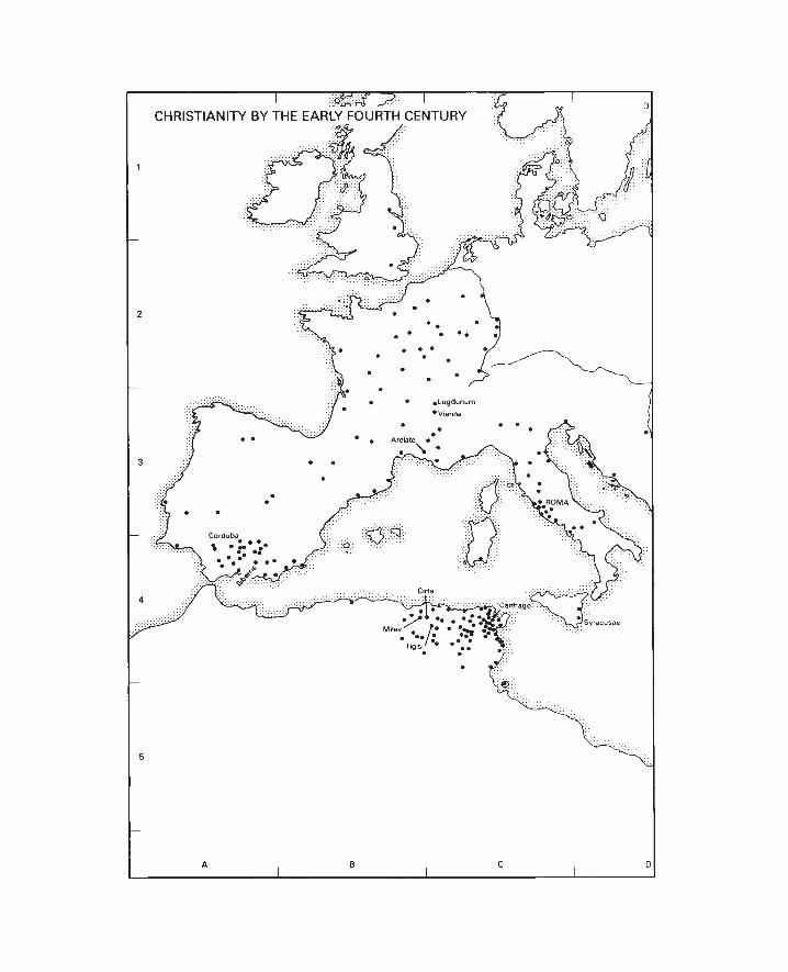


174
Christianity by the Early Fourth Century
As with other forms of religion, it is impossible tomap the Christian beliefs of individuals: the bestwhich may be done is to chart the spread of organ-ised churches, that is to say, of groups of Christianssufficiently numerous and stable to have regularmeeting places for worship. In practice this meansplotting on a map those places which are known, ormay on reasonable evidence be assumed, to havehad a bishop by the period in question. In this in-stance the latter may be defined as the time of theemergence of Christianity to full toleration and ac-tive imperial support during the reign ofConstantine: he controlled Gaul and Britain from306, Italy and Africa from 312, and the whole em-pire from 324 until his death in 337. At this stageChristians were possibly somewhere around 10 percent of the population.
This procedure has its drawbacks. First, there islittle doubt that individual Christians could befound in almost every town in the empire at a fairlyearly date: indeed, writing in about 200, Tertullianwas able to claim that Christians were to be foundeven in parts of Britain inaccessible to the Romans.But any attempt to map the presence of individualsfrom scanty literary or archaeological evidencewould be so random as to prove meaningless. Noteven the record of a martyrdom at a given city isnecessarily proof of an organised Christian commu-nity there.
Second, the evidence for the existence ofbishoprics is itself far from complete. Most usefulhere are the lists of bishops who attended, or ac-cepted the decisions of, church councils—held atCarthage in 256, Elvira (Iliberris) about 306, Romein 313, Arles (Arelate) in 314, Nicaea in 325 andSardica in 343—though with all these lists it shouldbe noted that difficulties of topographical identifica-tion often arise. The Council of Nicaea seems tohave been attended by the majority of eastern bish-ops, so that our picture of bishoprics for the eastern
provinces may be taken as relatively complete. Butsome of the other councils were more localised:thus it is from the signatures of the councils ofCarthage and Elvira that the clusters of bishopricsin Africa and southern Spain emerge. Recent stud-ies of Sardica mean that information on Gaul isrelatively good; yet evidence for the Danubianprovinces remains thin. It is certain, too, that therewere many more bishoprics in Italy than can be lo-cated: 60 Italian bishops apparently attended acouncil held at Rome in 251, though no list sur-vives. Records of councils may be supplemented tosome degree from literary sources, in particularEusebius’ History of the Church. As far as possible allthe place names given by Eusebius have beenmarked on the map, along with other cities wherecouncils were held, or which assume significance inearly Christian history for different reasons.
Important facts emerge from the picture whichresults. Little progress had been made in evangelis-ing the non-Roman world. In the early fourth cen-tury Christianity was still more widespread in theeastern provinces than in those of the west (apartfrom Africa). And it was predominantly an urbanreligion: hence the new meaning which the wordpaganus, a villager, was to acquire. Bishoprics wereurban; their territory generally corresponded to thecivil territory of the city. A hundred years later vir-tually all the cities of the empire had gainedbishoprics, but the process was far from complete atthe date of this map.
Some forms of higher jurisdiction had alreadybegun to develop by the fourth century: the bishopof a provincial capital was coming to outrank hisfellow provincial bishops, and to be known as themetropolitan (or ‘archbishop’) of his province.Equally, the Council of Nicaea recognised that thebishops of Rome and Alexandria had statuses notconfined to the current civil provinces where theircities lay.

175
The Dioceses and Provinces of the RomanEmpire in AD 314
By the death of Septimius Severus in 211 there wereabout 46 provinces (reckoning Italy as one). Subdi-vision continued through the third century. ThusCrete seems to have been hived off from Cyrenebefore the middle of the century, while a provinceof Phrygia et Caria was carved out of Asia in the250s; in Gaul the province of Novem Populi maydate from the same period. With the loss of thetrans-Danubian territories, Aurelian (270–5) gavetheir name of Dacia to a new province created outof parts of Moesia Inferior and Superior andThrace. He also began the reorganisation of Italy,while in his reign or shortly afterwards Bithyniawas divided from Pontus. Other divisions, too, mayhave been made before 284.
This process was significantly encouraged byDiocletian (284–305) as part of his wide-ranging re-forms: civil administration could thus be tightenedup. Following some further divisions a peak wasreached around 314 with approximately 101 prov-inces—including the divisions of Italy, whose specialstatus had been ended by Diocletian. A record ofthe provinces at that date survives in a somewhatcorrupt form in a manuscript preserved at Verona.The map is based on this ‘Verona List’, with theminimum necessary corrections. It should be appre-ciated that precise provincial boundaries are oftenuncertain (particularly so in Britain), and that theidentification of provincial capitals is not equallysecure in every case.
To provide greater supervision over the in-creased number of governors, Diocletian had fur-ther grouped the provinces into 12 ‘dioceses’. In the320s Constantine divided the diocese of Moesiainto two, styled Thracia and Macedonia, the latterconsisting of the provinces from Epirus Nova andMacedonia southward. But there is evidence thatConstantine considered the process of provincialdivision to have gone too far. Before the end of 314the two Numidian provinces (created in 305) hadbeen reunited, and it seems that subsequently someof the separate provinces in Dacia, Macedonia andThracia (perhaps also in Pannonia, Hispaniae,Britanniae and other dioceses) were suppressed.
However, most of the suppressed provinces werereinstated later in the century, not always with thesame names.
Under Diocletian’s arrangements, each provincewas governed by an equestrian praeses, although theproconsulships of Africa and Asia were still senato-rial posts, and the governors of the Italian districts,Sicilia, and Achaia, called correctores, could also besenators.
Each diocese was ruled by an equestrian vicarius(deputy of the equestrian praetorian prefects), ex-cept that the Italian diocese from the Apenninessouthward, along with the islands, was effectivelynot controlled by the vicarius of Italia, but by avicarius at Rome. In addition to its vicar, each dio-cese had one or more rationales and magistri respon-sible for those aspects of financial affairs outsidethe control of the praetorian prefects and theirvicars.
Senators now played little part in administration.From the time of Gallienus (254–68) they were fi-nally excluded from the command of legions, andwere probably no longer appointed as governors ofgarrisoned provinces, where the armies were placedunder duces. Perhaps because he found that prov-inces were now inconveniently small for governorsto deploy their forces adequately, Diocletian ar-ranged for the duces to control rather larger areas. Ineffect he thus began the total divorce of civil andmilitary commands; however, the process remainedincomplete at his abdication, with some provincialgovernors (though never senators) still retainingmilitary command. Yet Constantine did completethe change. Under him, not merely provincialpraesides and diocesan vicarii, but even the praetorianprefects, lost all direct military responsibilities. Healso laid much stress on the development of the hith-erto small ‘field armies’—the comitatenses, as opposedto the limitanei or frontier forces—placing these underthe control of magistri equitum and peditum.Consequently a map of the civil provinces can giveno idea of the complications of contemporarymilitary arrangements.


178
REIGNS OF ROMANEMPERORS IN BRIEF
ABBREVIATIONS
AJA American Journal of ArchaeologyBAR British Archaeological Reports
(International Series)BCH Bulletin de Correspondance HelléniqueBSA British School at AthensCAH Cambridge Ancient History, edns. 1 and 2CIL Corpus Inscriptionum LatinarumCQ Classical QuarterlyCRAI Comptes Rendus de l’Académie des
Inscriptions et Belles-LettresILS Inscriptions Latinae SelectaeJHS Journal of Hellenic StudiesJRS Journal of Roman StudiesLCM Liverpool Classical MonthlyMEFR Mélanges de l’Ecole Française de RomeOCD2 Oxford Classical Dictionary, ed. 2PBSR Papers of the British School at RomePW A.Pauly, G.Wissowa, W.Kroll, Real-
Encyclopädie der classischenAltertumswissenschaft
Augustus died AD 14Tiberius 14–37Gaius (Caligula) 37–41Claudius 41–54Nero 54–68Galba 68–9Otho 69Vitellius 69Vespasian 69–79Titus 79–81Domitian 81–96Nerva 96–8Trajan 98–117Hadrian 117–38Antoninus 138–61Marcus Aurelius 161–80Lucius Verus 161–9Commodus 177–92Pertinax 193Didius Julianus 193Septimius Severus 193–211Caracalla 198–217Macrinus 217–18Elagabalus 218–22Severus Alexander 222–35Maximinus 235–8Gordian I and II 238Balbinus and Pupienus 238Gordian III 238–44Philip 244–9Decius 249–51Gallus 251–3Valerian 253–60Gallienus 254–68Claudius Gothicus 268–70
Aurelian 270–5Tacitus 275–6Probus 276–82Carus, Carinus, Numerian 282–5Diocletian 284–305Maximian 286–305Constantius 305–6Galerius 305–11Constantine 307–37

179
SUGGESTIONS FORFURTHER READING
These modest suggestions are intended for the highschool or student reader who wishes to know whereto turn first for more information on a particulararea or topic. Quite deliberately, therefore, mostreferences are to modern publications in English;they are arranged in order of appearance.
In addition to material cited under the specificheadings, the following general works are ofnotable value:
CAH T.Frank (ed.), An Economic Survey of Ancient Rome,
Baltimore, 1933–40.M.Cary, The Geographic Background of Greek and
Roman History, Oxford, 1949. OCD2 R.Stillwell and others (eds), The Princeton
Encyclopedia of Classical Sites, Princeton, 1976.
For very full detail, PW and E. de Ruggiero andothers (eds), Dizionario Epigrafico di Antichità Romane,Rome, 1895-(in progress), may be consulted.
The Aegean in the Bronze Age Minoan Crete Mycenaean Greece J.D.S.Pendlebury, The Archaeology of Crete, London,
1939.C.Renfrew, The Emergence of Civilization: The Cyclades
and the Aegean in the Third Millenium B.C., London,1972.
P.M.Warren, The Aegean Civilizations, London,1975.
R.Hope Simpson, Mycenaean Greece, New Jersey,1981.
V.Karageorghis, Cyprus from the Stone Age to theRomans, London, 1982.
Troy
H.H.Schliemann, Ilios: The City and Country of theTrojans, London, 1880.
W.Döpfeld, Troja und Ilion: Ergebnisse derAusgrabungen in den vorhistorischen und historischenSchichten von Ilion, 1870–1894, Athens, 1902.
C.W.Blegen et al., Troy: Excavations Conducted by theUniversity of Cincinnati, 1932–1938, Princeton,1950–8, together with Supplementary Monographs I–III
C.W.Blegen, Troy and the Trojans, London, 1963.
Knossos
A.J.Evans, The Palace of Minos, London, 1921–35.S.Hood, The Minoans: Crete in the Bronze Age,
London, 1971.S.Hood and W.Taylor, The Bronze Age Palace at
Knossos: Plan and Sections, BSA Suppl. vol. 13,London, 1981.
S.Hood and D.Smyth, Archaeological Survey of theKnossos Area, BSA Suppl. vol. 14, London, 1981.
Mycenae
A.J.B.Wace, Mycenae, An Archaeological History andGuide, Princeton, 1949.
W.D.Taylour, The Mycenaeans, London, 1964.G.E.Mylonas, Mycenae and the Mycenaean Age,
Princeton, 1966.S.E.Iakovidis, Mycenae-Epidaurus, Athens, 1981. Mainland Greece in the Homeric Poems The Homeric World
W.Leaf, Troy: A Study in Homeric Geography, London,1912.
A.J.B.Wace and F.H.Stubbings, A Companion toHomer, London, 1962, chapters 8, 9, 13.
R.Hope Simpson and J.F.Lazenby, The Catalogue ofthe Ships in Homer’s Iliad, Oxford, 1970.
Dark Age Greece Late Geometric Greece A.M.Snodgrass, The Dark Age of Greece, Edinburgh,
1971.
180
V.R. d’A.Desborough, The Greek Dark Ages,London, 1972.
J.N.Coldstream, Geometric Greece, London, 1977. Greek Colonisation (Eighth to Sixth Centuries
BC) J.Boardman, The Greeks Overseas: Their Early Colonies
and Trade, edn. 2, London, 1980.CAH2 III.3. chapters 37–39a. Archaic Greece L.H.Jeffery, Archaic Greece: The City-States c. 700– 500
B.C., London and Tonbridge, 1976.CAH2 III.3. The Persian Empire c. 550–330 BC A.T.Olmstead, History of the Persian Empire, Chicago,
1948.J.M.Cook, The Persian Empire, London, 1983. Persepolis R.N.Frye, The Heritage of Persia, London, 1962.S.A.Matheson, Persia: An Archaeological Guide,
London, 1972, esp. pp. 223–33. Marathon, 490 BC W.K.Pritchett, ‘Marathon’, University of California
Publications in Classical Archaeology, 4, 1960, pp.137–90.
——, Studies in Ancient Greek Topography I, Berkeley,1965, chapter 6; II, 1969, chapter 1.
C.Hignett, Xerxes’ Invasion of Greece, Oxford, 1963,pp. 55–74.
E.Vanderpool, ‘The deme of Marathon and theHerakleion’, AJA, 70, 1966, pp. 319–23.
——, ‘A monument of the battle of Marathon’,Hesperia, 35, 1966, pp. 93–106.
A.R.Burn, Persia and the Greeks, edn. 2, London,1970, chapter 12.
N.G.L.Hammond, Studies in Greek History, Oxford,1973, chapter 7.
V.Massaro, ‘Herodotus’ account of the battle of
Marathon and the picture in the Stoa Poecile’,Ant. Class., 47, 1978, pp. 458–75.
G.S.Shrimpton, ‘The Persian cavalry at Marathon’,Phoenix, 34, 1980, pp. 20–37.
J.A.G. van der Veer, ‘The battle of Marathon: atopographical survey’, Mnemosyne, 35, 1982, pp.290–321.
Thermopylae: Ephialtes’ Route G.B.Grundy, The Great Persian War and its
Preliminaries, London, 1901, chapter 7.J.A.R.Munro, ‘Some observations on the Persian
wars, 2’, JHS, 22, 1902, pp. 294–332.A.R.Burn, ‘Thermopylai and Callidromus’, in
Studies Presented to David Moore Robinson I, StLouis, 1951, pp. 480–9.
——, ‘Thermopylai revisited and sometopographical notes on Marathon and Plataiai’,in Greece and the Eastern Mediterranean in AncientHistory and Prehistory (Festschrift Schachermeyr) ,Berlin, 1977, pp. 89–105.
W.K.Pritchett, ‘New light on Thermopylai’, AJA,62, 1958, pp. 203–13.
C.Hignett, Xerxes’ Invasion of Greece, chapter 2 andAppendices 2–4.
Artemisium, 480 BC C.Hignett, Xerxes’ Invasion of Greece, chapter 3.W.K.Pritchett, ‘Xerxes’ fleet at the “Ovens”’, AJA,
67, 1963, pp. 1–6.——, Studies in Ancient Greek Topography II, chapter 2. Salamis, 480 BC W.K.Pritchett, ‘Towards a restudy of the battle of
Salamis’, AJA, 63, 1959, pp. 251–62.——, Studies in Ancient Greek Topography I, chapter 7.A.R.Burn, Persia and the Greeks, pp. 436 ff.N.G.L.Hammond, Studies in Greek His tory,
chapter 8.G.Roux, ‘Eschyle, Hérodote, Diodore, Plutarque
racontent la bataille de Salamine’, BCH, 98,1974, pp. 51–94.
J.Delorme, ‘Deux notes sur la bataille de Salamine’,BCH, 102, 1978, pp. 87–96.

181
Plataea, 479 BC W.K.Pritchett, ‘New Light on Plataia’, AJA, 61,
1957, pp. 9–28.——, Studies in Ancient Greek Topography I, chapter 8.C.Hignett, Xerxes’ Invasion of Greece, chapter 7 and
Appendices 10–12.A.R.Burn, Persia and the Greeks, pp. 503 ff. Delphi F.Poulsen, Delphi, London, 1920.H.W.Parke and D.E.W.Wormell, The Delphic Oracle,
edn. 2, Oxford, 1956.CAH2 III.3, chapter 41, section V. Sparta Annual of the British School at Athens, 12–16 and 26–
30, 1906–10 and 1924–30.W.G.Forrest, A History of Sparta 950–192 B.C.,, edn.
2, London, 1980.P.Cartledge, Sparta and Lakonia: A Regional History,
1300–362 B.C., London, 1979. Attica C.W.J.Eliot, Coastal Demes of Attica, Phoenix Suppl.
vol. V, 1962.J.S.Traill, The Political Organization of Attica, Hesperia
Suppl. XIV, 1975. Classical Athens Roman Athens R.J.Hopper, The Acropolis, London, 1971.J.Travlos, Pictorial Dictionary of Ancient Athens,
London, 1971.H.A.Thompson and R.E.Wycherley, The Athenian
Agora, XIV. The Agora of Athens, Princeton, 1972.The Athenian Agora: A Guide to the Excavation and
Museum, edn. 3, Athens, 1976.R.E.Wycherley, The Stones of Athens, Princeton,
1978.
Halicarnassus G.E.Bean and J.M.Cook, ‘The Halicarnassus
peninsula’, BSA, 50, 1955, pp. 85–171.G.E.Bean, Turkey Beyond the Maeander: An
Archaeological Guide, London, 1971, chapter 9.S.Hornblower, Mausolus, Oxford, 1982. Miletus G.E.Bean, Aegean Turkey: An Archaeological Guide,
London, 1966, chapter 10.G.Kleiner, Alt-Milet, Wiesbaden, 1966.——, Die Ruinen von Milet, Berlin, 1968. Priene T.Wiegand and H.Schrader, Priene, Berlin, 1904.M.Schede, Die Ruinen von Priene, edn. 2, by G.
Kleiner and W.Kleiss, Berlin, 1964. Greek Sicily M.I.Finley, Ancient Sicily to the Arab Conquest, edn. 2,
London, 1979.E.Gabba and G.Vallet (eds), La Sicilia Antica I–II, 1,
Naples, 1980.E.Manni, Geografia Fisica e Politica della Sicilia Antica,
Kokalos Suppl. 4, 1981. Syracuse A.W.Gomme, A.Andrewes and K.J.Dover, A
Historical Commentary on Thucydides vol. 4 (BooksV.25–VII), Oxford, 1970.
P.Green, Armada from Athens, London, 1970.H.-P.Drögemüller, PW Suppl. 13, s.v.Syrakusai,
cols. 815–36. Akragas P.Griffo, Nuovissima Guida per il Visitatore dei
Monumenti di Agrigento, Agrigento, 1961.J.A. de Waele, Acragas Graeca I, ’s-Gravenhage,
1971.

182
Cyrene R.G.Goodchild, Kyrene und Apollonia, Zurich, 1971.S.Applebaum, Jews and Greeks in Ancient Cyrene,
Leiden, 1979. Olympia E.Curtius and F.Adler, Olympia: die Ergebnisse der
Ausgrabung, Berlin, 1896–7.Berichte über die Ausgrabungen in Olympia, Berlin,
1937– (in progress).A.Mallwitz, Olympia und seine Bauten, Munich, 1972. Greek Dialects c. 450 BC C.D.Buck, The Greek Dialects, edn. 2, Chicago,
1973.J.Chadwick, The Decipherment of Linear B, edn. 2,
Cambridge, 1967.R.J.Buck, ‘The Aeolic dialect in Boeotia’, Class.
Phil., 63, 1968, pp. 268–30.CAH2 II.2, chapter XXXIX (a). The Athenian Empire R.Meiggs, The Athenian Empire, Oxford, 1972. Pylos/Sphacteria W.K.Pritchett, Studies in Ancient Greek Topography I,
chapter 1.R.A.Bauslaugh, ‘The text of Thucydides IV 8.6
and the south channel at Pylos’, JHS, 99, 1979,pp. 1–6.
J.B.Wilson, Pylos 425 B.C., Warminster, 1979, withreview by C.J.Tuplin, LCM, 6, 1981, pp. 29–34.
The Bosporan Realm and its Neighbours CAH VIII, chapter 18.D.E.W.Wormell, ‘Studies in Greek tyranny II.
Leucon of Bosporus’, Hermathena, 68, 1946, pp.49–71.
C.M.Danoff, PW Suppl. 9, cols. 866–1175, s.v.Pontos Euxeinos.
H.Berve, Die Tyrannis bei den Griechen, Munich, 1967,part 3 chapter 3.3.
Trade in the Classical Greek World M.M.Austin and P.Vidal-Naquet, Economic and Social
History of Ancient Greece: An Introduction, London,1977.
J.F.Healy, Mining and Metallurgy in the Greek andRoman World, London, 1978.
R.J.Hopper, Trade and Industry in Classical Greece,London, 1979.
A.W.Johnston, Trademarks on Greek Vases,Warminster, 1979, chapter 11.
P.Garnsey et al., (eds), Trade in the Ancient Economy,London, 1983.
The Ancient Explorers J Needham, Science and Civilization in China, vol. 1,
Cambridge, 1954, chapter 7 sections (e)-(g).R.E.M.Wheeler, Rome Beyond the Imperial Frontiers,
Harmondsworth, 1955.M.Cary and E.H.Warmington, The Ancient
Explorers, edn. 2, Harmondsworth, 1963.C.F.C.Hawkes, Pytheas: Europe and the Greek
Explorers, Oxford, 1975. Archaeological Sites of Greece Archaeological Reports (for work in progress) M.I.Finley, Atlas of Classical Archaeology, London,
1977.P.MacKendrick, The Greek Stones Speak, edn. 2,
London, 1981.S.Rossiter, Benn’s Blue Guide to Greece, edn. 4,
London, 1981. The Anabasis C.F.Lehmann-Haupt, ‘Zum Ruckzug der
Zehntausend’, in J.Kromayer (ed.), AntikeSchlachtfelder IV, Berlin, 1931, pp. 243–60.
R.D.Barnett, ‘Xenophon and the wall of Media’,JHS, 83, 1963, pp. 1–26.

183
Leuctra, 371 BC W.K.Pritchett, Studies in Ancient Greek Topography I,
chapter 3.J.K.Anderson, Military Theory and Practice in the Age of
Xenophon, Berkeley, 1970, chapter 10.G.L.Cawkwell, ‘Epaminondas and Thebes’, CQ,
22, 1972, pp. 254–78.J.Buckler, ‘Plutarch on Leuctra’, Symb. Osl., 55,
1980, pp. 75–94. The Second Athenian League F.H.Marshall, The Second Athenian Confederacy,
Cambridge, 1905.J.L.Cargill, The Second Athenian League: Empire or Free
Alliance?, Berkeley, 1981. Chaeronea, 338 BC W.K.Pritchett, ‘Observations on Chaironeia’, AJA,
62, 1958, pp. 307–11.N.G.L.Hammond, Studies in Greek History, chapter
16.——, and G.T.Griffith, A History of Macedonia II,
Oxford, 1979, pp. 596–603.P.A.Rahe, ‘The annihilation of the Sacred Band at
Chaeronea’, AJA, 85, 1981, pp. 84–7. The Growth of Macedonian Power, 359–36 BC J.R.Ellis, Philip II and Macedonian Imperialism,
London, 1976.N.G.L.Hammond and G.T.Griffith, A History of
Macedonia II, part 2. River Granicus, 334 BC E.Badian, ‘The battle of the Granicus: a new look’,
in Archaia Makedonia II, Thessaloniki, 1977, pp.271–93.
C.Foss, ibid., pp. 495–502.N.G.L.Hammond, ‘The battle of the Granicus
river’, JHS, 100, 1980, pp. 73–88.A.B.Bosworth, A Historical Commentary on Arrian’s
History of Alexander I, Oxford, 1980, pp. 114 ff.
Issus, 333 BC A.B.Bosworth, A Historical Commentary on Arrian’s
History of Alexander I, pp. 198 ff.A.Devine, ‘The location of the battlefield of Issus’,
LCM, 5, 1980, pp. 3–10.N.G.L.Hammond, Alexander the Great: King,
Commander and Statesman, London, 1981, chapterV (B).
Gaugamela, 331 BC G.T.Griffith, ‘Alexander’s generalship at
Gaugamela’, JHS, 67, 1947, pp. 77–89.A.R.Burn, ‘Notes on Alexander’s campaigns, 332–
330’, JHS, 72, 1952, pp. 81–91.E.W.Marsden, The Campaign of Gaugamela,
Liverpool, 1964.P.A.Brunt, Arrian I, Loeb series, 1976, Appendix 9.A.B.Bosworth, A Historical Commentary on Arrian’s
History of Alexander I, pp. 297 ff.N.G.L.Hammond, Alexander the Great: King,
Commander and Statesman, chapter VI (C). River Hydaspes, 326 BC B.Breloer, Alexanders Kampf gegen Poros, Stuttgart,
1933.A.Stein, Archaeological Reconnaissances in North-Western
India and South-Eastern Iran, London, 1937,chapter 1.
J.R.Hamilton, ‘The cavalry battle at the Hydaspes’,JHS, 76, 1956, pp. 26–31.
J.F.C.Fuller, The Generalship of Alexander the Great,London, 1958, pp. 180–99.
R.L.Fox, Alexander the Great, London, 1973, chapter25.
N.G.L.Hammond, Alexander the Great: King,Commander and Statesman, pp. 204–12.
Ai Khanum Reports in CRAI 1965 onwards.P.Bernard, ‘Ai Khanum on the Oxus: a Hellenistic
city in central Asia’, Proc. Brit. Acad., 53, 1967,pp. 71–95.

184
——, ‘An ancient Greek city in central Asia’, ScientificAmerican, 246, 1982, pp. 126–35.
The Hellenistic Kingdoms W.W.Tarn and G.T.Griffith, Hellenistic Civilization,
edn. 3, London, 1952.M.M.Austin, The Hellenistic World from Alexander to the
Roman Conquest, Cambridge, 1981.F.W.Walbank, The Hellenistic World, London, 1981. Pergamum E.V.Hansen, The Attalids of Pergamon, edn. 2,
Cornell, 1971. Delos P.Bruneau and J.Ducat, Guide de Delos, Paris, 1965. Major Cult Centres of the Classical World W.K.C.Guthrie, The Greeks and their Gods, London,
1950.R.F.Willetts, Cretan Cults and Festivals, London,
1962.H.W.Parke, Greek Oracles, London, 1967.——, Festivals of the Athenians, London, 1977.
R.M.Ogilvie, The Romans and their Gods in the Age ofAugustus, London, 1969.
G.Dumezil, Archaic Roman Religion, Chicago, 1970.J.Ferguson, The Religions of the Roman Empire,
London, 1970.M.Grant, Roman Myths, London, 1971.R.MacMullen, Paganism in the Roman Empire, Yale,
1981. Alexandria P.M.Fraser, Ptolemaic Alexandria, Oxford, 1972. Etruria and Etruscan Expansion in Northern Italy M.Pallottino, The Etruscans, London, 1974.
M.Cristofani, The Etruscans: A New Investigation,London, 1979.
Early Italy J.Reich, Italy Before Rome, Oxford, 1979.A.C.Brown, Ancient Italy Before the Romans, Oxford,
1980. Early Latium The Environs of Imperial Rome T.Ashby, The Roman Campagna in Classical Times,
London, 1927.L.Quilici, Roma Primitiva e le Origini della Civiltà
Laziale, Rome, 1977. The Languages of Italy Prior to the Spread of Latin L.R.Palmer, The Latin Language, London, 1954.E.Pulgram, Italic, Latin, Italian 600 B.C. to A.D.
1260: Texts and Commentaries , Heidelberg, 1978. Veii J.B.Ward-Perkins, Veii: The History and Topography of
the Ancient City, PBSR, 29, 1961.A.Kahane, L.Murray Threipland and J.B. Ward-
Perkins, The Ager Veientanus, North and East ofRome, PBSR, 36, 1968.
Cosa E.T.Salmon, Roman Colonization Under the Republic,
London, 1969, esp. Appendix to chapter 1.F.E.Brown, Cosa: The Making of a Roman Town, Ann
Arbor, 1980. Luna A.Frova, Scavi di Luni I and II, Rome, 1973 and 1977.B.Ward-Perkins, ‘Luni: the decline and
abandonment of the Roman town’, in H.McK.Blake et al. (eds), Papers in Italian Archaeology I,BAR, 41, 1978, pp. 313–21.

185
Republican Rome The Centre of Rome in the Age of Caracalla Rome in the Age of the Severi S.B.Platner and T.Ashby, A Topographical Dictionary of
Ancient Rome, Oxford, 1929.D.R.Dudley, Urbs Roma, London, 1967.E.Nash, Pictorial Dictionary of Ancient Rome, edn. 2,
London, 1968.F.Coarelli, Roma, Bari, 1980. Roman Expansion in Italy to 268 BC E.T.Salmon, Samnium and the Samnites, Cambridge,
1967.——, The Making of Roman Italy, London, 1982. Roman Colonisation E.T.Salmon, Roman Colonization Under the Republic.A.N.Sherwin-White, The Roman Citizenship, edn. 2,
Oxford, 1973. The Punic Wars J.F.Lazenby, Hannibal’s War, Warminster, 1978.B.Caven, The Punic Wars, London, 1980. Cannae, 216 BC J.F.Lazenby, Hannibal’s War, pp. 77–85. Zama, 202 BC H.H.Scullard, Scipio Africanus: Soldier and Politician,
London, 1970, chapter 6. Carthage B.H.Warmington, Carthage, edn. 2, London, 1969.H.Hurst and L.E.Stager, ‘A metropolitan
landscape: the late Punic port of Carthage’,World Archaeology, 9, 1977/8, pp. 334–46.
Cynoscephalae, 197 BC F.W.Walbank, A Historical Commentary on Polybius II,
Oxford, 1967, pp. 576–84.W.K.Pritchett, Studies in Ancient Greek Topography II,
chapter 11. Thermopylae, 191 BC W.K.Pritchett, Studies in Ancient Greek Topography I,
chapter 5. The Roman Empire in 60 BC D.Braund, Rome and the Friendly King: The Character of
the Client Kingship, London, 1984. Roman Campaigns of 49–30 BC J.F.C.Fuller, Julius Caesar, Man, Soldier and Tyrant,
London, 1965.J.M.Carter, The Battle of Actium: The Rise and Triumph
of Augustus Caesar, London, 1970. Pharsalus, 48 BC Y.Béquignon, PW Suppl. 12, cols. 1071–84, s.v.
Pharsalos.C.B.R.Pelling, ‘Pharsalus’, Historia, 22, 1973, pp.
249–59.Y.Béquignon, ‘Etudes Thessaliennes XII’, BCH,
98, 1974, pp. 119–23.P.Greenhalgh, Pompey: The Republican Prince,
London, 1981, pp. 243–55. Augusta Praetoria I.A.Richmond, ‘Aosta’, in P.Salway (ed.), Roman
Archaeology and Art, London, 1969, pp. 249–59.F.Castagnoli, Orthogonal Town Planning in Antiquity,
Cambridge, Mass., 1971, pp. 112–13.J.B.Ward-Perkins, Cities of Ancient Greece and Italy:
Planning in Classical Antiquity, New York, 1974,esp. figs. 52–3.

186
Archaeological Sites of Italy J.B.Ward-Perkins, Cities of Ancient Greece and Italy:
Planning in Classical Antiquity.F.Coarelli et al. (eds), Etruscan Cities, London, 1975.H.McK.Blake et al. (eds), Papers in Italian Archaeology
I, BAR, 41, 1978.D. and F.Ridgway (eds), Italy Before the Romans: the
Iron Age, Orientalizing and Etruscan Periods, London,1979.
T.W.Potter, The Changing Landscape of South Etruria,London, 1979.
M.Aylwin Cotton, The Late Republican Villa at Posto,Francolise, London, 1979.
K.Painter (ed.), Roman Villas in Italy: RecentExcavations and Research, British Museum,London, 1980.
G.Barker and R.Hodges (eds), Archaeology and ItalianSociety: Prehistoric, Roman and Medieval Studies,BAR, 102, 1981.
Ostia A.Boëthius and J.B.Ward-Perkins, Etruscan and
Roman Architecture, Harmondsworth, 1970, pp.279–89.
R.Meiggs, Roman Ostia, edn. 2, Oxford, 1973.F.B.Sear, Roman Architecture, London, 1982, pp.
118–33. Second Battle of Cremona, AD 69 K.Wellesley, Cornelius Tacitus, The Histories, Book III,
Sydney, 1972, pp. 85–126.——, The Long Year A.D. 69, London, 1975, pp. 141–
50. Campania K.J.Beloch, Campanien. Geschichte und Topographie des
antiken Neapel und seiner Umgebung, Breslau, 1890.J.Heurgon, Recherches sur l’Histoire, la Religion et la
Civilization de Capoue Preromaine, des Origines à laDeuxième Guerre Punique, Paris, 1942.
J.H. d’Arms, Romans on the Bay of Naples, Harvard,1970.
M.W.Frederiksen, Campania, British School atRome, London, 1984.
Pompeii Herculaneum A.Maiuri, Ercolano: I Nuovi Scavi 1927–1958, Rome,
1958.H.Eschebach, Die städtebauliche Entwicklung des
antiken Pompeji, Römische Mitteilungen Suppl. 17,1970.
M.Grant, Cities of Vesuvius: Pompeii and Herculaneum,London, 1971.
J.B.Ward-Perkins and A.Claridge, Pompeii A.D. 79,London, 1976.
A. and M. De Vos, Pompei, Ercolano, Stabia, Bari,1982.
Italian Towns with Alimentary Schemes R.Duncan-Jones, The Economy of the Roman Empire:
Quantitative Studies, edn. 2, Cambridge, 1982,chapter 7 and Appendix 5.
Trade in the Roman World J.B.Ward-Perkins, ‘Quarrying in antiquity:
technology, tradition and social change’, Proc.Brit. Acad., 57, 1971, pp. 137–58.
J.F.Healy, Mining and Metallurgy in the Greek andRoman World.
J.du Plat Taylor and H.Cleere (eds), Roman Shippingand Trade: Britain and the Rhine Provinces, London,1978.
G.Rickman, The Corn Supply of Ancient Rome, Oxford,1980.
K.Muckelroy (ed.), Archaeology Under Water: An Atlasof the World’s Submerged Sites, New York, 1980,chapter 2.
J.H. d’Arms, Commerce and Social Standing in AncientRome, Harvard, 1981.
P.Garnsey and C.R.Whittaker (eds), Trade andFamine in Classical Antiquity, Cambridge, 1983.
P.Garnsey et al. (eds), Trade in the Ancient Economy,chapters 7–13.

187
The Roman Empire in AD 60 and 211 F.Millar et al., The Roman Empire and Its Neighbours,
edn. 2, London, 1981.Note the summary account of legions and their
bases in OCD2 pp. 591–3 s.v.Legion. Roman Britain Ordnance Survey, Map of Roman Britain, edn. 4,
Chessington, 1978.S.S.Frere, Britannia: A History of Roman Britain, edn.
2, London, 1978.A.L.F.Rivet and C.Smith, The Place-Names of Roman
Britain, London, 1979.R.J.A.Wilson, A Guide to the Roman Remains in Britain,
edn. 2, London, 1980.P.Salway, Roman Britain, Oxford, 1981.M.Todd, Roman Britain 55 B.C.—A.D. 400, London,
1981. Hadrian’s Wall Antonine Wall Ordnance Survey, Map of Hadrian’s Wall, edn. 2,
Chessington, 1972.Ordnance Survey, Map of the Antonine Wall, edn. 2,
Chessington, 1975.D.J.Breeze and B.Dobson, Hadrian’s Wall, edn. 2,
Harmondsworth, 1978.W.S.Hanson and G.S.Maxwell, Rome’s North West
Frontier: The Antonine Wall, Edinburgh, 1983. Silchester G.C.Boon, Silchester: The Roman Town of Calleva,
Newton Abbot, 1974.M.Fulford, Guide to the Silchester Excavations 1979–
81, Reading, 1982. Lutetia Parisiorum P.-M.Duval, Paris Antique, des Origines au Troisième
Siècle, Paris, 1961.P.-A. Février et al., Histoire de la France Urbaine, I: La
Ville Antique, Paris, 1980.
Roman Gaul and the Alpine Region O.Brogan, Roman Gaul, London, 1953.E.M.Wightman, Roman Trier and the Treveri,
London, 1970.C.E.Stevens, ‘Roman Gaul’, in J.M.WallaceHadrill
and J.McManners (eds), France: Government andSociety: A Historical Survey, edn. 2, London, 1970,pp. 19–35.
P.MacKendrick, Roman France, London, 1971.D.van Berchem, Les Routes et l’Histoire: Etudes sur les
Helvètes et leurs Voisins dans l’Empire Romain,Geneva, 1982, chapter 14.
J.F.Drinkwater, Roman Gaul: The Three Provinces 58B.C.–A.D. 260, London, 1983.
L.Pauli, The Alps: Archaeology and Early History,London, 1984.
Germanies-Raetia-Noricum C.B.Rüger, Germania Inferior, Cologne and Graz,
1968.J.J.Hatt, Celts and Gallo-Romans, London, 1970.H.-J.Kellner, Die Römer in Bayern, Munich, 1971.G.Alföldy, Noricum, London 1974. A.Mócsy, Pannonia and Upper Moesia, London,
1974. The Rhine-Danube Limes from c. AD 40 to AD
259–60 W.Schleiermacher, Der römische Limes in Deutschland,
Berlin, 1961 and later editions.H.Schönberger, ‘The Roman frontier in Germany:
an archaeological survey’, JRS, 59, 1969, pp.144–97.
The Danubian Provinces/Balkan Area c. AD 200 J.J.Wilkes, Dalmatia, London, 1969.A.H.M.Jones, The Cities of the Eastern Roman Provinces,
edn. 2, Oxford, 1971, chapter 1.E.Condurachi and C.Daicoviciu, The Ancient
Civilization of Romania, London, 1971.A.Mócsy, Pannonia and Upper Moesia.P.MacKendrick, The Dacian Stones Speak, Chapel
Hill, 1975.

188
R.F.Hoddinott, Bulgaria in Antiquity: An ArchaeologicalIntroduction, London, 1975.
A.G.Poulter (ed.), Ancient Bulgaria: Papers Presented tothe International Symposium on the Ancient History andArchaeology of Bulgaria, Nottingham, 1983.
Iberian Peninsula C.H.V.Sutherland, The Romans in Spain 217 B.C.-
A.D. 117, London, 1939.F.J.Wiseman, Roman Spain, London, 1956.A.Tovar and J.M.Blázquez, Historia de la Hispania
Romana, Madrid, 1975.J.M.Blázquez, Economia de la Hispania Romana,
Bilbao, 1978.J.Arce, El Último Siglo de la España Romana: 284–
409, Madrid, 1982. Corsica and Sardinia E.Pais, Storia della Sardegna e della Corsica Durante il
Dominio Romano, Rome, 1923.M.C.Ascari, La Corsica nell’ Antichità, Rome, 1942.J. and L.Jehasse, ‘La Corse romaine’, in P.Arrighi
(ed.), Histoire de la Corse, Toulouse, 1971, pp. 97–128.
P.Meloni, La Sardegna Romana, Sassari, 1975.R.J.Rowland, Jr., I Ritrovamenti Romani in Sardegna,
Rome, 1981. Roman Sicily M.I.Finley, Ancient Sicily, chapters 10–13.E.Gabba and G.Vallet (eds), La Sicilia Antica, II.2.E.Manni, Geografia Fisica e Politica della Sicilia Antica. North African Provinces Africa Proconsularis T.R.S.Broughton, The Romanization of Africa
Proconsularis, Baltimore, 1929.B.H.Warmington, The North African Provinces from
Diocletian to the Vandal Conquest, Cambridge, 1954.P.D.A.Garnsey, ‘Rome’s African empire under the
Principate’, in P.D.A.Garnsey and C.R.
Whittaker (eds), Imperialism in the Ancient World,Cambridge, 1978, pp. 223–54.
P.MacKendrick, The North African Stones Speak,London, 1980.
C.M.Wells (ed.), L’Afrique Romaine: Les ConférencesVanier 1980, Ottawa, 1982.
Imperial Estates in the R.Bagradas Valley J.Carcopino, ‘L’inscription d’Aïn-el-Djemala:
contribution à l’histoire des saltus Africains et ducolonat partiaire, IV. La région des “saltus”’,MEFR, 26, 1906, pp. 365–481 at pp. 423–40.
J.Kolendo, Le Colonat en Afrique sous le Haut-Empire,Besançon, 1976.
D.J.Crawford, ‘Imperial estates’, in M.I.Finley(ed.), Studies in Roman Property, Cambridge, 1976,pp. 35–70.
Timgad C.Courtois, Timgad; Antique Thamvgadi, Algiers,
1951.J.Lassus, Visite à Timgad, Paris, 1969. Lepcis Magna M.F.Squarciapino, Lepcis Magna, Basel, 1964.R.Bianchi Bandinelli et al., The Buried City:
Excavations at Leptis Magna, London, 1966. African Limes M.Bénabou, La Résistance Africaine à la Romanisation,
Paris, 1976.E.W.B.Fentress, Numidia and the Roman Army: Social,
Military and Economic Aspects of the Frontier Zone,BAR, 53, 1979.
Greek and Roman Crete CAH2 III.3, chapter 39b and c.I.F.Sanders, Roman Crete: An Archaeological Survey and
Gazetteer of Late Hellenistic, Roman and EarlyByzantine Crete, Warminster, 1982.

189
Roman Cyprus G.F.Hill, A History of Cyprus I, Cambridge, 1940,
chapter 11.V.Karageorghis, Cyprus from the Stone Age to the
Romans, chapter 10. Bithynia and Asia c. AD 100 Roman Asia Minor A.H.M.Jones, The Greek City from Alexander to
Justinian, Oxford, 1940.D.Magie, Roman Rule in Asia Minor, Princeton, 1951.J.Deininger, Die Provinziallandtage der römischen
Kaiserzeit, Vestigia, 6, Munich, 1965.D.Nörr, Imperium und Polis in der hohen Prinzipatszeit,
edn. 2, Munich, 1969.A.H.M.Jones, The Cities of the Eastern Roman Provinces,
chapters 2–8.C.Habicht, ‘New evidence on the province of Asia’,
JRS, 65, 1975, pp. 64–91.G.P.Burton, ‘Proconsuls, assizes and the
administration of justice under the empire’, JRS,65, 1975, pp.92–106.
M.Stahl, Imperiale Herrschaft und provinziale Stadt,Hypomnemata, 52, Göttingen, 1978.
R.J.A.Talbert, ‘Pliny the Younger as governor ofBithynia-Pontus’, in C.Deroux (ed.), Studies inLatin Literature and Roman History II, CollectionLatomus, 168, Brussels, 1980, pp. 412–35.
J.Reynolds, Aphrodisias and Rome, London, 1982. Roman Syria, Western Parthia and Armenia A.H.M.Jones, The Cities of the Eastern Roman Provinces,
chapters 9 and 10.D.Oates, Studies in the Ancient History of Northern Iraq,
Oxford, 1968, chapters 1 and 4.J.I.Miller, The Spice Trade of the Roman Empire 29 B.C.
to A.D. 641, Oxford, 1969.G.W.Bowersock, Roman Arabia, Harvard, 1983. Masada Y.Yadin, Bar-Kokhba: The Rediscovery of the Legendary
Hero of the Last Jewish Revolt Against Imperial Rome,London, 1971.
G.Vermes, The Dead Sea Scrolls in English, edn. 2,London, 1975.
Y.Yadin, Bar-Kokhba: The Rediscovery of the LegendaryHero of the Last Jewish Revolt Against Imperial Rome,London, 1971.
Jerusalem K.M.Kenyon, Jerusalem: Excavating 3000 Years of
History, London, 1967.Y.Yadin (ed.), Jerusalem Revealed: Archaeology in the
Holy City, 1968–1974, Jerusalem, 1975. Palestine M.Grant, The Jews in the Roman World, London,
1973.E.M.Smallwood, The Jews Under Roman Rule from
Pompey to Diocletian: A Study in Political Relations,edn. 2, Leiden, 1981.
Roman Egypt A.H.M.Jones, The Cities of the Eastern Roman Provinces,
chapter 11.N.Lewis, Life in Egypt Under Roman Rule, Oxford,
1983. Christianity by the Early Fourth Century A.H.M.Jones, Constantine and the Conversion of Europe,
edn. 2, London, 1962.K.Baus, From the Apostolic Community to Constantine,
London, 1965.H.Chadwick, The Early Church, London, 1968.R.A.Markus, Christianity in the Roman World, London,
1974.C.Thomas, Christianity in Roman Britain to A.D. 500,
London, 1981. The Dioceses and Provinces of the Roman Empire
in AD 314 A.H.M.Jones, The Decline of the Ancient World,
London, 1966.T.D.Barnes, The New Empire of Diocletian and
Constantine, Harvard, 1982, chapters 11–13.

190
Aalen 140 C3Abacaenum 38 E2; 148 E2Abae 72 C3Aballava 133 A2Abantes 7 D2, 3Abarnahara 18 C3Abassium 73 H3Abdera [Baetica] 96 B4; 144 C4Abdera [Thracia] 15 G1; 23 C1; 32 F1;
44 B1; 143 D4Abella 84 C4; 92 E3; 94 D3; 119 C4Abellinum 94 D3; 109 E4; 119 C4Aberffraw 131 B5Abila 166 C4Abila/Seleuceia 74 B5; 166 D2Abona 131 C7Abona, R. 131 C7Abonuteichus 161 E1Abrettene 158 B2Abus, R. 131 D5Abusina 140 E3Abydos [Hellespont] 9 D1; 27 B2; 31
F2; 33 A1; 44 C1; 160 A2Abydus [Aegyptus] 167 C4Acadama 162 B4Acamas, M. 156 A5Acamas, Pr. 156 A5Acampsis, R. 162 C1Acanthus 15 F1; 23 C1; 30 D1; 32 E2;
44 A1Acarnania 30 B3Acci 144 C4Ace/Ptolemais 74 B4; 166 B1; 173 F5Acelum 108 C1; 119 B1Acerrae 92 D3; 115 B2Acesines, R. [India] 65 H3Acesines, R. [Sicilia] 38 E2Achaea [Peloponnesus] 16 B2; 30 B4Achaea, Achaia (Roman Province) 105
E3; 129 D4; 171 D4, E4; 177 D4Achaea Phthiotis 30 C3; 62 B3Achaeon Acte 156 D4Acharnae 34 B3; 46 C3Achates, R. 148 D4Acheloos, R. 6 B2; 7 B2; 30 B3; 32 B3;
62 B3Acheron, R. 7 A2; 32 B3
Achilleum 27 A2Acholla 97 F5Aciris, R. 109 F4Acium 148 E3Acmonia 160 C3Acoris 76 B3Acquarossa 82 C5Acra Leuce 96 C3Acrabeta 166 B3Acrae 14 B2; 38 D4; 148 D4Acraea, Cautes 38 E3Acritas, Pr. 29 C3Acrothooi 44 B1Acruvium 143 B4Acte [Attica] 34 B4Acte [Chalcidice] 30 D1Action, Actium 32 B4; 105 D3Acuricum 143 A3Ad Ansam 131 E7Ad Duas Lauros 122 C2Ad Fl. Tigrim 162 D3Ad Fluvium Lanaricum 148 B3Ad Gallinas Albas 122 B1Ad Herculem 146 B3Ad Lunam 140 C4Ad Maiores 154 B1Ad Medias 146 B4Ad Olivam 148 B2Ad Pontem [Britannia] 131 D6Ad Pontem [Mesopotamia] 162 D3Ad Spem Vetus 122 B1Ad Turres 154 C1Adana/Antioch 74 B3; 161 F4Adara 162 C4Addua, R. 108 B2Adiabene 162 D2Adora 166 B5Adraha 162 B4Adramytteion, Adramyttium 23 D2; 31
F2; 33 B1; 73 E2; 158 A2; 160 A3Adramyttenus Sinus 33 A1Adranum, Hadranum 38 D3; 148 D3Adria, Atria 82 C1; 108 C2Adrianopolis see HadrianopolisAdriaticum Mare 107; 109 E3, F3Adys 97 F4Ae- see also Ai-
Aeane 32 C2Aecae 97 G2Aeclanum 92 E2; 109 E4Aedui 136 C3Aegae [Macedonia] 32 C2; 56 B1; 62
B2Aegae [Peloponnesus] 29 C1Aegaeum Mare 31 E4Aegaleos, M. 34 B3Aegates Is. 38 A2; 97 F4; 148 A2Aegilia 34 C5Aegina 16 C2; 29 D2; 30 D4Aeginion 32 B3Aegion, Aigion 6 B3; 29 C1; 72 C3Aegira, Aigeira 6 C3; 29 C1Aegithallus 38 A2Aegitium 46 C3Aegospotami 47 E1Aegospotami, R. 27 B1Aegosthena 29 D1; 56 B2Aegusa, Aethusa [Aegates Is.] 38 A2;
148 A2Aegyptus (Egypt) 76; 167Aegyptus (Roman Province) 129 E6;
171 E6Aegyptus Herculia 177 E5, F5Aegyptus Iovia 177 E5Aelana 76 D2; 167 D2Aelanites, Sinus 167 D2Aelia Capitolina see JerusalemAemilia 108 C2; 176 C3Aemilia,Via 108 C2Aemilia Scauri, Via 108 B3Aeminium 144 A2Aenaria 109 E4; 115 B3Aene(i)a 32 D2; 44 A1Aenis 23 B2; 62 B3Aenona 143 A4Aenos, M. [Cephallenia] 29 A1; 30 A4Aenus, Ainos 9 C1; 15 G1; 31 E1; 44
B1; 143 E4Aeoliae Is. 148 D1Aeolis 16 E2; 18 B2; 31 F3Aequi 84 B3, C3Aequum 143 B4Aequum Tuticum 84 C3Aerae 47 E3
Entries refer first to the page where the name appears;the letter and number which follow refer to figures on themap at the top/bottom and sides respectively. ThusAballava, for example, is to be found on p. 133 withinthe rectangle formed by letter A (at top left) and number2 (at bottom right).
Normally every appearance of a name is listed. Thisis not necessarily the case, however, with very wellknown names (Athens or Italy, for instance), especially in
the Aegean area. In addition most monuments andfeatures on battle or site plans are not listed; the mainexceptions are pp. 90, 121 and 123, where all the namesappearing on these maps of Rome are listed under‘Roma’.
Variant endings in os/us and on/um have generallybeen ignored in the gazetteer. Names which cannot befound under ‘Ae’, ‘J’ and ‘K’ should be checked under‘Ai’, ‘I’ and ‘C’ respectively.
GAZETTEER

191
Aesernia 94 D2; 109 E4Aesica 133 B1Aesis 108 D3Aesis, R. 108 D3Aesium 95 C2Aeso 144 D1Aethiopia, Ethiopia 18 B5; 167 C6Aethusa, Aegusa [Aegates Is.] 38 A2;
148 A2Aethusa Is. [inter Siciliam et Africam]
148 A4Aetna 38 D3; 148 E3Aetna, M. 38 E2; 97 G4; 148 E2Aetolia 16 B2; 30 B3Aexone 34 B4Aezani 160 C3Africa (Continent) 54Africa (Diocese) 176 B5Africa (Roman Province) 102 B3, C3;
128 C5; 150–1; 154; 170 C5Africa Proconsularis 150; 176 C4Agatha 14 B3Agathyrnum 38 D2; 148 D2Agedincum 138 A3Agia Eirene 2 C3; 10 C3; 12 C3; 56 C3Agia Marina 6 C2Agia Pelagia 4 C2Agia Triadha 4 C3; 56 C4Agidus 86 C2Agios Andreas 2 C3Agios Ilias 6 B2Agios Kosmas 2 C3; 6 D3Agios Stephanos 6 C4Agnone 92 D2Agora 27 C1Agri Decumates 128 C3; 136 D2, 3;
138 B4, C3Agrianians 62 B1Agrigentum see AkragasAgrinion 29 B1; 32 B4Agryle 34 B3Agylla see CaereAgyrium 38 D3; 148 D3Ahdem, R. 58 A3Ai- see also Ae-Ai Khanum 69 (Plan); 71 H2Aiacium 146 B2Aigythallus, Pr. 148 A2Ain-el-Jemala 151 B2Ain Wassel 151 A2Aisepos, R. 9 D1Aislingen 140 D4Akragas/Agrigentum 14 A2; 38 C3; 40
(Plan); 97 G4, 5; 148 C3Akroterion 6 A3Akrotiri 2 C4; 56 C3Aigeira see AegiraA1 Mina 15 G4; 53 G4Ala Miliaria 154 A1Alabanda/Antioch 33 C4; 73 F4; 158
B4; 160 B4Alabon, R. 38 E3Alabum 131 B7
Alaina 162 C3Alalia 14 C3Alarodioi 18 D2Alauna [1, Britannia] 130 C3Alauna [2, Britannia] 130 C4Alauna [3, Britannia] 130 D4Alauna [4, Britannia] 131 C5Alauna [5, Britannia] 130 C6Alauna, R. 130 C4Alauni 138 D4Alba Fucens 94 C2; 97 G2; 109 D3; 111
E3; 119 C3Alba Longa 86 C2; 122 C2Alba Pompeia 108 A3Alban Hills 86 C2Albanum (Domitiani) 122 C2; 170 C3Albanus, L. 108 D4Albanus, M. 81Albingaunum 108 B3Albintimilium, Albium Intemelium
(Ventimiglia) 108 A3; 110 A3Albis, R. 128 C2; 138 D2; 170 D2Alcantara Bridge 144 B2Alcester 131 C6Alchester 131 D7Alcmona, R. 140 F3Aleria 84 A3; 97 F2; 146 C2; 176 C3Alesia 136 C3Aletrium 92 C3Alexandria [Aegyptus] 76 B1; 81 (Plan);
129 E5; 167 B1; 171 E5; 173 E5; 177E5
Alexandria (Bactra, Zariaspa) 65 G2Alexandria [Bactria] 71 H3Alexandria (Buchephala) 65 H3Alexandria (Carmania) 65 F4Alexandria (Iomoussa) 65 H3Alexandria (Nicaea) 65 H3Alexandria (Oreitae) 65 G4Alexandria (Paropamisadae), 65 G2Alexandria (Prophthasia) 65 F3; 71 G4Alexandria on the Caucasus 71 H3Alexandria [Ad Indum] 65 H3Alexandria (By Issus) 64 B3; 74 B3; 161
F5; 162 B3Alexandria ad Latmum 64 A2Alexandria ad Oxum 65 G2Alexandria/Antioch 64 D4; 71 E4Alexandria/Herat (Areia) 65 F3; 71 G3Alexandria/Kandahar (Arachosia) 65
G3; 71 G3Alexandria/Merv (Margiane) 65 F2; 71
G2Alexandria Eschate 65 G2; 71 H2Alexandr(e)ia Troas 64 A2; 73 E2; 158
A2; 160 A2Alexandrion 166 C3Alfaterna see NuceriaAlfoldean 131 D8Alista 146 C2Alkofen 140 E3Allava 148 B3Allia 84 B3
Allifae 84 C3; 92 D3; 94 D3; 97 G2;109 E4; 119 C3
Allobroges 97 E1; 136 C4Allumiere 82 C5Alope 46 C3Alopece 34 B3Alopeconnesus 27 B1; 143 E4Aloros 32 C2Alpes 128 C3; 136 D4; 170 C3; 176 C3Alpheios, R. 16 B3; 29 C2; 30 B4Alsium 94 B2; 108 D4; 122 B1Altava, 150 B1; 154 A1Altenstadt 140 B1Altilia see SaepinumAltinum 108 C1Aluca 146 B1Alutus, R. 143 D3Alveria 143 A4Alvona 143 A3Alyzia 32 B4Amantia 143 C4Amanum Portus 144 C1Amanus, M. 161 F4, 5; 162 B3Amarus, L. 167 C2Amaseia 74 B1; 161 F2; 177 F3Amastris 74 A1; 129 F4; 158 D1; 160
D1; 171 F4; 173 E3Amathus [Cyprus] 156 B6Amathus [Palaestina] 166 C3Amber Is. 54 B1Ambiani 138 A2Ambisontes 138 D4Amblada 160 D4Ambra, R. 140 E4Ambracia 16 A2; 23 A2; 30 B3; 32 B3;
62 B3Ambracicus Sinus 32 B4Ambre 140 E4Amenanus, R. 38 E3Ameria 92 B3; 108 D3; 119 B3Ameselum 38 D3Amestratus 148 D2Amiata, M. 82 C4Amida 162 C2; 177 F4Amisus 15 G3; 50 C4; 161 F1Amiternum 92 C2; 109 D3Ammaedara 150 B4; 154 C1Ammonium 64 A4Amnias, R. 161 E1Amnisos 4 C2; 9 C4; 80 C4Amorgos 16 D3; 31 E5; 33 A5; 44 B3Amorium 160 D3Ampelum 143 D2Amphiaraus, Sanctuary of (Attica) 34
C1Amphilochia 30 B2, 3Amphipolis 30 D1; 32 E1; 44 A1; 143
D4Amphipolis/Thapsacus 58 D2; 64 C3;
74 C3Amphissa 12 B2; 29 C1; 30 C3; 32 C4;
62 B3Amsanctus 92 E2

192
Amyclae, Amyklai 7 C5; 10 B3; 12 B3;29 C3
Amyzon 73 F4Anactorion, Anactorium 16 A2; 23 A2;
30 B3; 32 B4Anaea 47 F4Anagnia 84 B3; 86 D2; 92 C3; 119 B3;
122 D2Anagyrus 34 C4Analipsis 6 C4Anaphe 31 E5; 33 A5; 60 D4Anaphlystus 34 D5Anapus, R. 38 E4; 148 E4Anas, R. 96 A3; 144 A3Anasartha 162 B3Anaunium 108 B1Anava, R. 130 C4Anazarbus 161 F4Ancaster 131 D6Anchialus 143 E3; 173 E3Ancona 84 C2; 92 B1; 108 D2; 110 D2Ancyra [Galatia] 74 A2; 129 F4; 158
D2; 160 D2; 171 F4; 173 F4; 177 F4Ancyra (Julia) [Asia] 158 B3; 160 B3Ancyro(no)polis 76 B2; 167 B2Andania 72 B4Andautonia 143 B2Andemantunnum 136 C3Anderitum 131 E8Androna 162 B3Andros 16 C2; 31 E4; 44 B3Anemurium 160 D5Angli 138 C1Angrivarii 138 C2Anio, R. 86 C1Anisa 161 F3Annia,Via 109 F4, G5Ansium 143 A4Antaeopolis 167 B3Antandros 9 D2; 23 D2; 31 F2; 44 C2Antaradus 74 B4Antemnae 86 B1Anthedon [Boeotia] 6 D2; 7 D3; 29 D1Anthedon [Palaestina] 166 A5Anthela 16 B2Anthemus 62 C2Anticaria 144 B4Anticythera 29 D4Antigoneia 72 A1Antilibanus, M. 162 B4Antinoe/Antinoopolis 167 B3Antioch [Asia] 73 G3Antioch [Cilicia] 74 A3; 160 D5Antioch(ia) (Caesareia) [Pisidia] 74 A2;
158 C3; 160 D3; 177 E4Antioch(ia) [Syria] 74 B3; 129 F4; 161
F5; 162 B3; 171 F4; 173 F4; 177 F4Antioch/Adana 74 B3; 161 F4Antioch/Alexandria 71 E4Antioch/Charax 71 E4Antioch/Hippus 74 B4Antioch/Mallus 74 B3; 161 F5Antioch/Nisibis 74 D3; 162 C3
Antiochia/Perrhe 162 B2Antioch in Persis 71 E4Antioch see AlabandaAntioch see EdessaAntioch see TarsusAntipatre(i)a 72 A1; 143 C4Antipatris 166 B3Antiphrae 167 A1Antipolis 14 B3Antipyrgus 151 H2Antirrhion Pr. 29 B1Antissa 33 A2; 44 B2Antitaurus, M [Armenia] 162 C2Antitaurus, M. [Cappadocia] 161 F3, 4Antium 81; 84 B3; 92 C3; 94 B2; 108
D4; 122 C3Antivestaeum, Pr. 131 A8Antonini Murus 130 B3, C3; 134 (Plan)Antoninopolis 162 C3Antron 7 C2Antunnacum 140 A1Aoi Stena 30 A1; 32 A2Aoos, R. 30 A1; 32 A2Aornus 65 H2Aosta see Augusta PraetoriaAous, M. 156 A5Apaisos 9 D1Apamea [Ad Euphratem] 162 B3Apamea [Ad Orontem] 70 C3; 74 C3;
162 B3Apame (i)a Celaenae, Kelainai 58 B2;
70 B3; 73 H3; 158 C3; 160 C4; 173E4
Apamea/Myrle(i)a 73 F1; 158 B2; 160B2
Ap(p)enninus, M. 108 C2–109 E4Aperopia 29 D2Aphaia 56 B3Aphetae 23 B2Aphidna 34 C2Aphrodisias 80 E2; 125 E4; 158 B4;
160 B4; 177 E4Aphrodisium 156 C4Aphroditopolis [1, Aegyptus] 76 B2; 167
B2Aphroditopolis [2, Aegyptus] 76 B3; 167
B3Aphytis 32 D2; 44 A1Apodhoulou 4 C2Apollonia [Chalcidice] 32 D2Apollonia [Cyrene] 151 G2Apollonia [Illyricum] 14 D3; 72 A1; 97
H3; 105 D3; 143 C4Apollonia [Ad Maeandrum] 73 G3Apollonia [Mesopotamia] 70 D3Apollonia [Mysia] 73 F2Apollonia [Palaestina] 74 B5; 166 A3Apollonia [Phrygia] 73 H3; 158 C3;
160 C4Apollonia [Pontus Euxinus] 15 F3; 143
E3Apollonia [Sicilia] 38 D2Apollonia [Thracia] 32 E1
Apollonia Mygdonia 72 C1Apollinopolis (Magna) 76 C4; 167 C4Apollonopolis Heptacomias 167 B3Apollonopolis Parva 167 C4Appia, Via 90 C4; 109 D4, F4; 115 A2,
C1; 122 C2; 123 D1Aprus 143 E4Apsorus 143 A3Aptera 156 A1Apthungi 150 C4Apuani 84 A2Apuli 84 C3Apulia 109 F4; 176 D3Apulum 143 D2; 171 E3Apurytai 19 H3Aquae 140 B3Aquae Arnemetiae 131 C6Aquae Flaviae 144 A2Aquae Hypsitanae/Forum Traiani 146
B4Aquae Larodes/Thermae Selinuntinae
148 B3Aquae Lesitanae 146 C4Aquae Mattiacorum 140 B2Aquae Neapolitanae 146 B5Aquae S. 143 B3Aquae Segestanae 148 B2Aquae Sextiae 136 C5; 176 C3Aquae Statiellae 108 B2Aquae Sulis 131 C7Aquae Vescinae 115 A2Aquileia [Italia] 95 C1; 108 D1; 110 D1;
124 C3; 176 C3Aquileia [Raetia] 140 C4Aquilonia 92 D2Aquincum 138 F4; 143 B2; 170 D3Aquinum (Aquino) 92 D3; 94 C2; 109
E4; 111 E4Aquitani 104 B2Aquitania 128 B3; 136 B4; 138 A4; 170
B3Aquitanica 176 B2, 3Arabia 18 C4; 162 B5; 171 F5; 177 F5Arabia Nova 177 F5Arabia Petraea 167 D2Arabiates 138 E4Arabicus, Sinus 167 D3Arabissus 161 G3Aracha 162 B4Arachosia 19 G3; 65 G3; 71 H4Aradus 74 B4; 162 B4Arae Flaviae 138 C4; 140 B4Arae Philaenorum 151 G2Araithyrea 7 C4Araks, R. see Araxes, R.Aral Sea 19 F1; 71 F1Arausio 136 C4Aravorum Civitas 144 A2Araxes, Araks, R. 58 D3; 162 D2Araxos 6 B3Arba 143 A3Arbeia 133 D1Arbela [Assyria] 64 D3; 162 D3

193
Arbeia [Palaestina] 166 C2Arcesine 73 E4Archelais [Cappadocia] 161 E3Archelais [Palaestina] 166 C4Arconnesos 33 B5Arcadia 16 B2; 30 C4Ardea 82 D6; 86 B2; 94 B2; 122 B2Ardiaei 62 A1Ardotalia 131 C5Areia 19 F3; 65 F3; 71 G3Arelate 136 C4; 172 B3Arene 7 B4Arethusa 74 C4Arevaci 144 B2Arezzo see ArretiumArgennum, Pr. [Ionia] 33 A3Argennum, Pr. [Sicilia] 148 E2Argentarius, M. 82 B5Argentorate 128 C3; 136 D3; 138 B3;
140 A4; 170 C3Argentovaria 140 A4Argilus 23 C1; 32 E1; 44 A1; 46 C1Arginusae Is. 33 A2; 47 E2Argissa 2 B1; 6 C1; 7 C1Argolis 30 C4Argos [Ad Acherona] 32 B3Argos [Amphilochicum] 30 B3; 32 B4Argos [Macedonia] 32 A3Argos [Peloponnesus] 29 C2; 30 C4Argyropouli 6 C1Argyruntum 143 A4Ariaratheia 74 B2Ariaspai 65 F4, G3Aricia 81; 82 D6; 92 C3; 122 C2Ariconium 131 C7Arienzo 94 D3Arikamedu (Pondicherry) 54 E3Ariminum (Rimini) 92 A1; 95 B2; 97
F2; 108 D2; 110 D2; 119 B2Arisbe 9 D1; 27 B2; 44 C1Aritium 144 A3Arkades 56 C2Arkalokhori 4 C2Arkhanes 4 C2Armenia 18 C2, D2; 105 G2; 129 G4;
162; 177 G4Armenia (Roman Province) 177 F4Armenia Maior 162 D2Armenia Minor 129 F4, G4; 161 H2, 3;
162 C2Armenoi 4 B2Arna 119 B3Arnon, R. 166 C5Arnsburg 140 B1Arnus, R. 82 B3; 108 C3Arpi (Arpino) 84 C3; 92 E2; 97 G2; 109
F3; 111 F3Arpinum 84 C3; 92 D3; 109 E4Arretium (Arezzo) 82 C3; 84 B2; 92
A2; 95 B2; 97 F2; 108 C3; 110 C3Arsamosata 162 C2Arsanias, R. 162 C2Arsinoe [Cilicia] 74 B3
Arsinoe [Cyprus] 156 C5Arsinoe [Cyrene] 151 G2Arsinoe [Ad Erythraeum Mare] 76 C3Arsinoe [Syria] 74 B4Arsinoe/Cleopatris 76 C2Arsinoe/Crocodilopolis 76 B2; 167 B2Arsinoe/Marium 74 A4; 156 A5Arsinoe see EphesosArsinoe see PataraArtaxata 70 D2; 162 D1Artemision, Artemisium (Pr.) 23 B2; 24
(Battle); 30 C3; 32 D4Arucci 144 A3Arunda 144 B4Arupium 143 A3Arverni 96 D1; 136 C4Arycanda 160 C5Arzbach 40 A1Ascalon 74 B5; 166 A4Asciano 82 C4Asculum 84 C3; 92 C2; 95 C2; 109 D3Asea 12 B3; 29 C2Asia (Roman Province) 102 D3; 129
E4; 158 B3; 160 B3, 4; 171 E4; 177E4
Asia Minor 73, 74; 160–1Asiana (Diocese) 177 E4Asido 144 B4Asine [Argos] 2 B3; 6 C4; 7 C4; 12 B3;
29 D2Asine [Messenia] 29 C3; 30 B5Asines, R. 38 E2; 148 E2Asisium 108 D3; 119 B3Askanie, L. 9 E1Askitario 2 C3Askra 16 B2Asopos 29 D3Asopos, R., [Peloponnesus] 7 C3Asopos, R., [Boeotia] 29 D1; 30 D3Aspendus 74 A3; 160 D4Asphynis 167 C4Asseria 143 A4Assinarus, R. 38 E4; 148 E4Assorum, Assorus 38 D3; 148 D3Assos 9 D2; 31 F2; 33 A1; 44 C2; 73 E2Assur 162 D3Assyria 18 D3; 162 D3Asta 144 B4Astacos [Acarnania] 29 B1; 32 B4; 46
B3Astacus [Propontis] 15 H1; 44 D1Asthall 131 D7Astigi 144 B3Astola Is. 54 D3Astraeus 60 A4Astura 86 C3; 122 C3Astures 144 A1Asturica Augusta 144 B1Astypalaea (Is.) 31 F5; 33 A5; 44 C4;
158 A4Astypalaea [Cos] 33 B5Atabyris, M. 31 G5; 33 C5Atalante 46 C1
Atalante Is. 46 C3Atarneus 9 D2; 23 D2; 33 B2; 73 E2Ategua 144 B3Atella 92 D3; 94 D3; 115 B2Aternum 109 E3Aternus, R. 109 E3Atesis, R. 108 C1Ateste 82 C1; 84 B2; 95 B1; 108 C2Athamania 62 B2, 3Athenae, Athens 29 D1; 30 D4; 35
(Plans)Athenae Diades 60 B2Athmonum 34 C3Athos, M. 23 C1; 31 D2; 32 E2Athribis 76 B1; 167 B1Atina [Latium] 92 D3; 109 E4; 119 C3Atina [Lucania] 109 F4; 119 C4Atintanes 62 A2, B2Atlas, M. 150 B2Atrebates [Britannia] 131 C7, D7Atrebates [Gallia] 138 A2Atrectianae et Poeninae, Alpes 170 C3Atria see AdriaAtropatene 70 D2; 162 D2, 3Attaleia [Asia] 73 F2Attale(i)a [Lycia] 73 H4; 158 C4; 160
C5Attica 30 D4; 34 (Plan); 125 E4Atuatuca 138 B2Auchendavy 134 B1Aufidena 84 C3; 92 D2; 109 E4; 119
C3Aufidus, R. 109 F4Aufinum 119 C3Aufkirchen 140 D3Augusta 161 F4Augusta Bagiennorum 108 A3Augusta Euphratensis 177 F4, G4Augusta Libanensis 177 F4Augusta Praetoria (Aosta) 95 A1; 106
(Plan); 108 A2; 110 A2; 136 D4Augusta Raurica, Rauricorum 136 D3;
138 B4Augusta Taurinorum (Turin) 95 A1;
108 A2; 110 A2; 136 D4Augusta Traiana, 143 D3Augusta Treverorum (Treveri) 136 C2;
138 B3; 176 C2Augusta Vindelic(or)um 128 C3; 138
C3; 140 D4; 176 C2Augustis 146 C4Augustobriga 144 B2Augustodunum 136 C3; 138 A4Augustonemetum 136 C4Aulis 7 D3; 29 D1; 30 D3Aulon 72 A1Aurelia, Via 90 A1; 108 C3; 122 B1;
123 E4Aurès Mts. 150 D1; 154 B1Aurunci 84 C3Ausa 44 E1Ausculum 92 E2; 94 E3Auser, R. 108 C3

194
Ausetani 96 D2Ausonian Mts. 86 D2Austuriani 151 F2, G3Autariatae 62 A1, B1Autricum 136 B3Auximum 95 C2; 108 D3; 119 C2Auzia 150 C1; 154 B1Avaricum 136 B3; 138 A4Aveia 92 C2Aventicum 136 D3; 138 B4Avernus, L. 111 G1Avon, R. 134 D2Axia 82 C5Axima 136 D4Axios, R. 2 B1; 9 B1; 30 C1; 32 C1,
D1; 62 C2; 143 D4Axos, Vaxus 16 C4; 72 D5; 156 B2Azali 138 E4Azotus 74 B5; 166 A4Azov, Sea of 50 C1
Babba 150 A1Babylon [Aegyptus] 167 B2Babylon [Mesopotamia] 18 D3; 58 A4,
E4; 64 D3; 162 D4Babylonia 18 D3; 64 D4Bacchias 167 B2Bacoli (Bauli) 111 G1; 115 B2Bactra 19 G2; 65 G2; 71 G2Bactria 19 G2; 65 G2; 71 H3Bad Cannstatt 140 C3Bad Nauheim 140 B1Badias 154 B1Baecula 96 B3Baelo 144 B4Baeterrae 136 C5Baetica 124 A4; 128 A4; 144 B3; 170
A4; 176 A4Baetis, R. 96 B3; 144 B3Baetocaece 74 B4; 162 B4Baetulo 144 E2Baeturia 144 B3Bagacum 138 A3Baginton 131 D6Bagradas, R. 97 E4; 104 C3; 150 C3;
151 B1Bahr Yusuf, R. 167 B3Baiae (Baia) 111 G1; 115 B2Balad 162 D3Balaneae 162 B3Balari 146 B4, C3Balatoni 146 B2Balbura 73 G4Baldock 131 D7Baleares (Gymnesiae) Is. 96 D3; 144 E2Balearicum Mare 144 D2Balmuildy 134 B2Balsa 144 A4Bambyce see HierapolisBanasa 150 A1Banna 133 B1Bannatia 130 C3Bannaventa 131 D6
Bannovalium 131 D6Bantia 92 E2; 109 F4Baquates 150 A2, B2Bar Hill 134 B1Barbarium, Pr. 144 A3Barca 14 D5; 151 G2Barcino 144 E2Bargylia 73 F4; 158 A4; 160 B4Bargylus, M. 162 B3Baria 144 C4Barium 84 D4; 109 F3Barochan 134 A2Barra 94 E4Barygaza 54 E3Basileus, R. 156 B5Basilica Therma 161 F3Bassae 56 B3; 80 B3Bassiana 143 C3Bastuli 144 B4Batavi 138 B2Batiae 62 B3Batitas 162 C3Batnae 162 B3Bauli (Bacoli) 111 G1; 115 B2Bautica, R. 108 A2Bauzanum (Pons Drusi) 108 C1Bearsden 134 A2Beberaci. L. 162 C3Bedriacum 108 B2Beersheba 166 A5Begastrum 144 C3Begorritis, L. 30 B1; 32 C1Belbina 29 E2Belerium 54 A1Belerium, Pr. 131 A8Belgae 131 C7Belgica 128 C2; 136 C2; 138 A3, B3;
140 A2; 170 C2; 176 B2, C2Belginum 140 A2Bellunum 108 C1Benacus, L. 108 B1Bendorf 140 A1Beneventum/Malventum (Benevento)
84 C4; 92 E2; 94 D3; 97 G3; 109E4; 111 F4; 115 C1
Benningen 140 C3Berbati 6 C3Berenice [Aegyptus] 70 B5; 167 D5Berenice [Cyrene] 151 G2; 173 D5Berenice/Pella [Palaestina] 74 B5; 166
C2Berezan Is. 15 F2; 50 A1Bergen 140 B2Bergidum 144 B1Bergomum 108 B2Beroe 62 D1Beroea [Macedonia] 32 C2; 72 C1Beroea [Syria] 74 C3; 161 G5; 162 B3Berones 144 C1Bertha 130 C3Berytus/Laodicea 74 B4; 162 A4Bessi 105 E2Beth Gabra/Eleutheropolis 166 B4
Beth Horon 166 B4Bethar 166 B4Betharamatha/Livias-Julias 166 C4Bethlehem 166 B4Bethletephe 166 B4Bethsaida/Julias 166 C1Bettolle 82 D4Beulah 131 C6Bezabde 162 D3Bezereos 154 C2Bibra 133 A2Bilbilis 144 C2Bilechas, R. 162 C3Billaeus, R. 160 D1Bingium 140 A2Biora 146 C5Biricianis 140 D3Bisanthe 73 F1Bishopton 134 A2Bistonis, L. 31 E1Bistue Nova 143 B3Bistue Vetus 143 B3Bithia, Bitia 97 E3; 146 C5Bithynia 18 B2; 129 E4; 158 C1; 160
C2, D1; 171 F4; 177 E4Bithynium/Claudiopolis 74 A1; 158 D2;
160 D2Bituriges 136 B3, B4; 176 B2Bizye 143 E4Black Sea 50 B2Blakehope 130 C4Blanda Iulia 109 F4Blandianus Saltus 151 A2Blatobulgium 133 A1Blaudus 73 F2Blera 82 C5Blestium 131 C7Bocarus, R. 156 A5Bochastle 130 B3Bodotria Aestuarium 134 D1Bodotria, R. 130 B3, C3Boeae 29 D4Boebe, Boibe, L. 7 C1; 30 C2; 32 D3Böhming 140 E3Boeotia 30 C3Boii [Italia] 84 B2; 97 F1Boii [Pannonia] 138 E4Bola 94 B2Bolbe, L. 30 C1; 32 D1Bolbitine Mouth (Nile) 167 B1Boliscus 47 E3Bolsena see VolsiniiBonna 128 C2; 136 C2; 138 B2; 170 C2Bononia/Felsina 82 B2; 84 B2; 95 B1;
97 F1; 108 C2Borbetomagus 138 C3; 140 B2Bormiscus 46 C1Borysthenes, R. 15 F2; 50 B1Bosa 146 B4Bospori Regnum 50; 105 F2; 129 F3;
171 F3Bosporus [Thracian] 15 H1Bosporus, Cimmerian 50 C2, D2

195
Bostra 74 C5; 162 B5; 171 F5; 173 F5;177 F5
Bothwellhaugh 134 C2Botrys 162 B4Bouprasion 7 B3Bourton-on-the-Water 131 C7Bovianum 92 D2; 94 D2; 109 E4Bovianum Vetus 92 D2; 94 D2Bovillae 122 C2Bovium 131 C7Bracara Augusta 144 A2; 176 A3Bracciano, L. 86 B1Bradanus, R. 109 F4Braintree 131 E7Brampton 131 E6Branodunum 131 E6Branogenium 131 C6Bratananium 140 E4Braughing 131 D7Brauron 6 D3; 12 C3; 29 E2; 34 D4Bravoniacum 130 C4Brea 44 A1Brecon Gaer 131 C7Bremenium 130 C4Bremetenacum, 131 C5Bremia 131 B6Brescia see BrixiaBricindarioi 44 C4Bricinniae 38 D3Briga 131 D7Brigantes 131 C5, D5Brigantium [Hispania] 144 A1Brigantium [Raetia] 138 C4Brigetio 138 E4; 170 D3Brindisi see BrundisiumBritannia 128 B2; 130–131; 176 B1Britannia Inferior 171 B2Britannia Superior 171 B2Britanniae (Diocese) 176 B1Britannicus Oceanus 131 D8Brithdir 131 B6Brixellum 95 B1; 108 B2Brixia (Brescia) 95 B1; 108 B2; 110 B1;
119 A1Brocavum 130 C4Brocolitia 133 C1Brocomagus 140 A3Brompton 131 C6Broomholm 133 A1Broxtowe 131 D6Bructeri 138 B2Brundisium (Brindisi) 84 D4; 94 B3; 97
H3; 109 G4; 111 G3Bruttii 84 D5Bruttium 109 G5Bryn-y-Gefailiau 131 B6Bu Njem 154 D2Bubastis 76 C1; 167 C1Bubon 73 G4; 158 B4Buch 140 D3Buchephala 65 H3Buchetium 62 B3Bucra, Pr. 148 D4
Burdigala 128 B3; 136 B4; 170 B3; 176B3
Bulla Regia 97 E4; 150 C3Burgh-by-Sands 133 A2Burghwallis 131 D5Burgundiones 138 E2Burnum 128 D3; 143 A4Burrium 131 C7Burunitanus, Saltus 151 A1Busiris 76 B1; 167 B1Butadae 34 B3Buthroton 32 A3Buto 76 B1; 167 B1Butua 143 B4Butzbach 140 B1Buxentum, 94 E4; 109 F4Byblus 74 B4; 162 A4Byllis 143 C4Byzacena 176 C4Byzantium 15 H1; 44 D1; 143 F2; 158
B1; 160 B1
Cabeira 74 C1Caburrum 108 A3Cabyle 62 D1; 143 E3Cacyparis, R. 38 E4Cacyrum 38 C3Cadder 134 B2Cadi 73 G2; 160 C3Cadousioi 19 E3Caecina, R. 108 C3Caedrus, R. 146 C4Caelia 109 F4Caelic Monte 140 C4Caelis, R. 130 C2Caenepolis 29 C4Caenys, Pr. 109 G6Caer Gai 131 C6Caere (Agylla) (Cerveteri) 82 C5; 84
B3; 86 B1; 92 B3; 110 D4; 122 B1Caermote 133 A2Caerphilly 131 C7Caersws 131 C6Caesaraugusta 144 D2Caesarea Germanica 158 B2Caesarea Paneas or Philippi (Panion)
162 A4; 166 C1Caesarea/Strato’s Tower 129 F5; 166
B2; 171 F5; 173 F5; 177 F5Caesarea (Iol) see IolCaesarea (Mazaca) see MazacaCaesareia [Pisidia] see Antioch(ia)Caesariensis, Mauretania 128 A5, B5;
150 C1; 170 B5; 176 B4Caesarobriga 144 B2Caesaromagus 131 E7Caesena 82 C2Caiatia 92 D3; 115 B1; 119 C4Caicos, R. 16 E1; 31 F3; 33 B2Caister-by-Yarmouth 131 E6Caistor 131 D5Calabria 109 F4, G4; 176 D3Calacte, Caleacte 38 D2; 148 D2
Calacum 131 C5Calagurris 144 C1Calama 150 B4Caiatia 92 D3; 94 D3; 115 B1Calauria 12 B3; 16 C3; 29 D2Calcaria 131 D5Calchedon see ChalcedonCaleacte, Calacte 38 D2; 148 D2Caledonii 130 B2Cales (Calvi Vecchia) [Campania] 109
E4; 111 E4; 115 B1; 119 C4Cales [Umbria] 84 C4; 94 D3; 108 D3Callatis 15 F3; 143 E3Calleva Atrebatum (Silchester) 131 D7;
135 (Plan)Callinusa, Pr. 156 A5Callipolis 27 C1; 143 E4Calloniana 148 C3Calor, R. 115 B1Calpe, M. 144 B4Calvi Vecchia see CalesCalvisiana 148 D4Calycadnus, R. 74 B3; 161 E5Calydnioi 44 C3Calydon 6 B3; 7 B3; 10 B2; 29 B1Calymnos 31 F5; 33 B4Calynda 44 D3; 73 G4; 160 B5Camacha 161 H2Camarina 14 A2; 38 D4; 97 G4; 148 D4Cambodunum [Britannia] 131 D5Cambodunum [Raetia] 138 C4Camboglanna 133 B1Camboritum 131 E6Camelon 134 C1Camerinum 92 B2; 108 D3Camerton 131 C7Camicus 38 C3Camirus, Kameiros 9 D4; 12 E3; 16 E3;
33 C5; 44 C4; 73 F5Campana, Via 90 A2; 115 B2Campani [Italia] 84 C4Campani [Sardinia] 146 C4, C5Campania 109 E4; 115; 176 C3Campanus, Ager 115 B2Campi Magni 97 E4, F4Campovalano 84 C3Camulodunum [1, Britannia] 131 C5Camulodunum [2, Britannia] 131 E7Cana 166 B2Canastraion, Pr. 32 E3Canatha 162 B4Candidum, Pr. 97 F4Canelata 146 C1Cannae (Canne della Battaglia), 97 G3;
99 (Battle); 109 F3; 111 F3Canonium 131 E7Canopic Mouth (Nile) 167 B1Canopus 76 B1; 167 B1Canovium 131 B5Cantabri 144 B1Cantiaci 131 E7Cantium 54 B2Cantium, Pr. 131 E7

196
Canusium 84 C3; 92 E2; 97 G3; 109F4; 119 D4
Caparcotna 166 B2; 171 F5Capena 86 B1; 92 B3; 119 B3; 122 B1Capera 144 B2Capernaum 166 C1Capestrano 84 C3Caphareus, Pr. 29 E1Caphyae 29 C2; 72 C3Capitoniana 148 D3Capitulum 92 C3Cappadocia 18 C2; 129 F4; 161 F3; 162
B2; 171 F4; 177 F4Cappadox, R. 161 F3Cappuck 130 C4Capraria [Baleares] 144 E3Capraria [Italia] 108 C3Capreae (Capri) 109 E4; 111 H2; 115 C3Capsa 150 B5Capua 84 C4; 92 D3; 94 D3; 97 G3;
109 E4; 115 B2; 119 C4Caput Ferentinae 86 C2Caput Tyrsi 146 C4Carales, Caralis 52 C4; 97 F3; 128 C4;
146 C5; 170 C4; 176 C4Carana 105 G2; 162 C2Caranis 76 B2; 167 B2Carbantoritum 130 C3Carbia 146 B4Carcine 50 B1Cardamyle [Chios] 33 A3Cardamyle [Messenia] 7 C5; 29 C3Cardean 130 C2Cardia 27 C1; 31 F1Cardiff 131 C7Cardouchoi 18 D2; 58 D2Cargill 130 C3Caria 16 E3; 18 B2; 31 G4Caria (Roman Province) 177 E4Carians 9 D3Carkin Moor 130 D4Carmana 71 F4Carmania 19 F4; 65 F4; 71 F4Carmo 144 B3Carni 84 C1Carno 131 B6Carauntum 128 D3; 138 E4; 143 B1;
170 D3Carnutes 136 B3Carpasia 156 D4Carpathium Mare 31 F6, G6; 33 B6Carpathos 31 F6Carpetana, Iuga 144 B2, C2Carpetani 96 B2, 3; 144 B2Carpow 130 C3Carrara 124 C3Carreum Potentia 108 A2Carrhae 74 C3; 161 H4; 162 C3Carriceni 84 C3Carriden (Veluniate) 134 D1Carron, R. 134 C1Carseoli, Carsioli (Carsoli) 94 C2; 109
D4; 110 D3
Carsulae 92 B3; 110 D3Carteia 96 A4; 144 B4Cartenna(e) 96 C4; 150 C1Carthaea 60 C3Carthage, Carthago 97 F4; 100 (Plan);
128 C4; 150 C3; 151 E1; 154 C1;170 C4; 172 C4; 176 C4
Carthaginiensis 176 A3, B4Carthago Nova 96 C3; 144 D3; 176 B4Carvetii 130 C4Caryae 46 C4Caryanda 33 B4Carystos 29 E1; 31 D4; 44 B3; 124 E4Carzield 130 C4Cascantum 144 C1Casilinum 92 D3; 94 D3; 97 G3; 109
E4; 115 B2Casinum 92 D3; 94 C2; 109 E4Casium 167 C1Casius, M. 162 B3Casmenae 14 B2; 38 D4Caspia 19 F2Caspian Gates 65 E3Caspians 18 D2Caspium Mare (Caspian Sea) 19 E2; 54
D2; 64 D1Cassandreia 70 A2; 72 C2Cassia, Via 108 D3; 122 B1Cassiope 32 A3Cassope 32 B3; 62 B3; 72 B2Castabala/Hierapolis 74 B3; 161 F4Castel Collen 131 C6Castel di Decima 82 D6; 86 B2Castellammare di Stabia (Stabiae) 111
H1; 115 C2Castellina Chianti 82 B3Castelluccio di Pienza 82 C4Castellum Dimmidi 154 B1Castellum Mattiacorum 140 B2Castellum Tibubuci 154 C2Castlecary 134 C1Castledykes 130 C3Castlehill 134 A2Castleshaw 131 C5Castra Exploratorum 133 A1Castra Hannibalis 94 A4Castra Regina 138 D3; 140 E3; 170 C3Castrum Inui 86 B2Castrum Novum [Etruria] 94 A2; 108 D4Castrum Novum [Picenum] 94 C1Castrum Truentinum 92 C2; 109 D3Castulo 96 B3; 144 C3Castulonesis, Saltus 144 B3, C3Casuentus, R. 109 F4Catada, R. 97 F4Catana, Catane, Catina 14 B2; 38 E3;
148 E3Cataonia 18 C2Cataractonium 130 D4Cataracts (R.Nile) 76 C5; 167 C5Catina see CatanaCatuvellauni 131 D7Cauca 144 B2
Caucana 148 D4Caucasus, M. 162 D1Caudine Forks 92 E3; 115 C1Caudini 84 C4Caudium 84 C4; 92 E3Caulonia 14 B2; 97 H3Caunus 44 D3; 47 G4; 73 G4; 160 B5Caurium 144 B2Causennae 131 D6Cautes Acraea 38 E3Cavares 97 E1Cayster, R. 9 D2; 16 E2; 31 G3; 33 B3,
C3; 158 A3Cebren 44 C2Cecryphalea 29 D2Celaenae see Apame(i)aCeleia 138 E4Celenderis 161 E5Celenza val Fortore 94 D2Celetron 32 B2Celeusum 140 E3Celsa 144 D2Celtiberi 96 C2; 144 C1Celtici 144 A3Cemenelum 136 D4Cena 148 B3Cenabum 138 A3Cenchreae 29 D2Cenestum 146 C2Cenis, Mont 97 E1Cenomani 84 A1; 97 F1Centrites, R. 58 D2; 162 D2Centumcellae 122 A1Centurinum 146 C1Centuripae 38 D3; 148 D3Ceos 29 E2; 31 D4; 44 B3; 60 C3Cephale 34 D5Cephallenia 29 A1; 30 A3Cephaloedium 38 C2; 148 C2Cephisia 34 C3Cephisos, R. 29 E1; 30 D4Cepi 50 D2Cerameis 34 B3Ceramicus Sinus 33 C4, 5Ceramos 33 C4; 44 C3Ceras(o)us/Pharnaceia 15 G3; 50 D4;
58 D1; 74 C1; 161 G1; 162 B1Cercina 97 F5; 150 C5Cercinitis 15 G2; 50 B2Cercinitis, L. 30 D1; 32 E1Ceresius, L. 108 B2Ceretani 144 D1Ceretapa/Diocaesareia 160 C4Cerinthos 7 D2; 9 B2; 32 D4Cerveteri see CaereCervini 146 B1Cerynia 156 B4Chaboras, R. 162 C3Chaeronea 29 C1; 30 C3; 32 D4; 61
(Battle)Chala 148 D4Chalandriani 2 C3Chalastra 32 D2

197
Chalce 33 B5; 47 F5Chalcedon, Calchedon 15 H1; 44 D1;
158 B1; 160 B1Chalcidice 30 C1Chalcis, Chalkis [Aetolia] 7 B3; 29 B1;
30 B3Chalcis [Euboea] 16 C2; 29 D1; 30 D3Chalcis [1, Syria] 74 C3; 162 B3Chalcis [2, Syria] 74 B4Chalos, R. 58 C2Chalybes, 58 D1Chamavi 138 B2Chaonia [Epirus] 30 A2Chaonia [Syria] 74 C3Chaonians 62 A2Characmoba 162 A5Charax [Pontus Euxinus] 50 C2Charax/Antioch 71 E4Charterhouse 131 C7Chatti 138 C2Chauci 138 C1Cheimerion, Pr. 32 A3Chelif, R. 150 C1; 154 A1Chelonatas, Pr. 29 B1Chemtou 124 C4Cherronesitae 44 C1Cherronesus 44 C3Chersonesos [Creta] 156 C2Chersonesus [Hellespontus] 27 B1; 31
F1Chersonesus [Pontus Euxinus] 15 G3;
50 B2Chersonesos, Pr. [Euboea] 29 E1; 32 E4Chersonesus, Pr. [Sardinia] 146 B6Cherusci 138 C2Chesterfield 131 D6Chesterton [1, Britannia] 131 C6Chesterton [2, Britannia] 131 D6Chianciano 82 C4Chieti 111 E3Chios 16 D2; 31 E3; 33 A3; 44 B2; 158
A3; 160 A3Chiusi see ClusiumChorasmia 19 F1Chorienes, Rock of 65 G2Chrysas, R. 38 D3; 148 D3Chrysopolis 47 G1; 58 A1Chullu 97 E4; 150 D1Chytri 156 C5Cibalae |143 B3Cibyra 73 G4; 158 B4; 160 C4Ciciliano 119 B3Cicones 9 C1Cicucium 131 C7Cierion 32 C3Cierus/Prusias-on-Hypius 73 H1; 158
C2; 160 D2Cilbiani 158 B3Cilices 9 D2Cilicia 18 B2; 102 E3; 158 D4; 161 E4,
F4; 162 A3; 171 F4; 177 F4Cilician Gates (Pylae Ciliciae) 161 F4Cilicius, Aulon 156 B4
Cillium 150 C4Cilurnum 133 C1Cimmerian Bosporus 50 C2, D2Cimmericum 50 C2Ciminius, L. 82 C5Cimolos 31 D4; 62 D4Cindye 44 C3Cingulum 108 D3Cinna 161 E3Circeii 94 B3; 109 D4Circesium 162 C3Circidius, R. 146 B2Cirrha 16 B2; 29 C1; 30 C3Cirta/Constantina 97 E4; 150 D1; 172
C4; 176 B4Cirtensis, Numidia 176 B4Cisalpina, Gallia 102 C2Cissa 143 A4Cissia 19 E4Cissos, M. 30 C1; 32 D2Cithaeron, M. 29 D1; 30 C4Citium, Kition 2 E4; 53 G5; 74 B4; 156
C5Cius/Prusias 73 G1; 158 B2Civitas Camunnorum 108 B1Clampetia 109 F5Clanis, R. 82 C4Clanius, R. 115 B2Clapier, Col du 97 E1Clarenna 140 C4Claros 56 D2; 80 D2Clastidium 97 F1; 108 B2Claudianus, M. 125 F6; 167 C3Claudiopolis 161 E5Claudiopolis/Bithynium 74 A1; 158
D2; 160 D2Clausentum 131 D8Clazomenae 16 D2; 31 F3; 33 B3; 44
C2; 73 E3Cleddans 134 A2Cleides Is. 156 D4Cleitor 29 C2Cleonae [Chalcidice] 44 B1Cleonae [Peloponnesus] 7 C3; 29 C2Cleopatris/Arsinoe 76 C2Clodia, Via 108 C3, D3; 122 B1Clota, R. 130 B3; 134 B2Clunia 144 C2Clunium 146 C1Clupea 97 F4; 150 D3Clusium (Chiusi) 82 C4; 84 B3; 92 B3;
95 B2; 108 D3; 110 D3Cluviae 92 D2Clyro 131 C7Clysma 167 C2Cnidos (Nova) 31 G5; 33 B5; 44 C3;
158 A4; 160 A5Cnidos (Vetus) 16 E3; 31 G5; 33 B5Cnossus see KnossosCoccium 131 C5Cocinthus, Pr. 109 G5Coclearia 146 C3Cocusus 161 F4
Coela 143 E4Coelbren 131 B7Coele (Syria) 70 C3; 162 B3; 171 F5;
177 F4Cömlekci, 10 E3Colania 134 C1Colchians 18 D1Collatia 86 C1Colline Metallifere 82 B4Colline Pass 97 F2Collippo 144 A2Colonae 27 C1Colonia Agrippina, Colonia Claudia
Ara Agrippinensium 136 C2; 138B2; 176 C2
Colonia Ulpia Traiana 138 B2Colonus 34 B3Colophon 16 E2; 31 F4; 33 B3; 44 C3;
160 A4Colossae, Kolossai 58 A2; 158 B4; 160
C4; 173 E4Columbarium, Pr. 146 C3Columnata 154 A1Comama 158 C4; 160 C4Comana [Cappadocia] 74 B2; 161 F3Comana [Pontus] 74 C1; 161 F2Combretovium 131 E7Comiciana 148 C3Commagene 129 F4; 161 E4, G4; 162
B2Complutum 144 C2Compsa 92 E2; 97 G3; 119 C4Comum 108 B2; 119 A1Concangis 133 D2Concavata 133 A2Concordia 95 C1; 108 C1Condate 131 C5Condercum 133 D1Confluentes 140 A1Conimbriga 144 A2Consabura 144 C3Consentia, Cosentia 84 D5; 94 A4; 97
G3; 109 F5Constantina see CirtaContestani 144 D3Contrebia 144 C2Copais 6 C2; 29 D1; 30 C3Cophen, R. 65 G3Copia 94 A3Coptus 76 C4; 167 C4Cora 94 B2; 122 C2Coracesium 160 D5Corconiana 148 C3Corcyra 30 A2; 32 A3Corda 130 C3Corduba 96 B3; 128 A4; 144 B3; 170
A4; 172 A4; 176 A4Coresia, Coressus 44 B3; 60 C3Corfinium 84 C3; 92 C3; 109 E3Corinium 143 A4Corinium (Dobunnorum) 131 C7; 176
B2Corinthiacus Sinus 29 C1

198
Corinthos 29 D2; 30 C4; 129 D4; 171D4; 173 D4; 177 E4
Coriosopitum 133 C1Coritani 131 D6Cornovii 131 C6Cornus 146 B4Corone(i)a 7 C3; 29 D1; 30 C3Corsi 146 B3, C3Corsica 146; 170 C4; 176 C3Cortona 82 C4; 92 A2; 97 F2; 108 C3Corupedium 73 F3Corycus 74 B3Corycus, M. 33 A3Corydallus, M. 34 A3, B3Coryphasion, Pr. 29 B3Cos 16 E3; 31 F5; 33 B5; 44 C3; 158
A4; 160 A4Cosa 89 (Plan); 94 A1; 97 F2; 108 C4;
110 C3Cosentia see ConsentiaCossaei 19 E3; 64 D3Cossura, Cossyra 97 F4; 148 A4Cotenna 160 D4Cotiaeum 160 C3Cottiae Alpes 128 C3; 136 D4; 170 C3;
176 C3Cotyora 15 G3; 58 C1Cramond 130 C3Cran(a)e 6 A3; 29 A1; 30 A4; 60 A3Cranius, M. 148 B3Crannon 6 C1; 16 B1; 32 C3; 72 C2Crassum, Pr. 146 B5Crate(i)a/Flaviopolis 158 D2; 160 D2Crathis, R. 109 F5Crawford 130 C3Cremna 158 C4; 160 C4Cremona 95 B1; 97 F1; 108 B2; 114
(Battle)Crestonia 46 C1Creta, Crete 4; 16 C4, D4; 129 E5; 171
E5; 177 E4Creusis 29 D1Crexi 143 A3Crimea 50 B2, C2Crimisa, Pr. 109 G5Crimisus, R. 38 B2; 148 B2Crithote 27 C1; 60 D1Crithote, Pr. 29 B1; 32 B4Crococalana 131 D6Crocodilopolis/Arsinoe 76 B2; 167 B2Crocodilopolis/Pathyris 167 C4Crocotus Campus (Crocus Field) 32
D3; 62 C3Crommyon 29 D1; 46 C3Crommyum, Pr. 156 B4Cronium, M. 38 B3Croton (Crotone) 14 B1; 84 D5; 94 A4;
97 H3; 109 G5; 111 G5Croy Hill 134 C1Crustumerium 86 B1Ctesiphon 162 D4Cubulteria 92 D3Cuicul 150 D1
Cumae, 14 A1; 81; 84 C4; 92 D3; 94C3; 109 E4; 111 G1
Cumaseni 146 C2Cunaxa 58 A4, E3Cunetio 131 C7Cuneus 144 A3Cupra Maritima 95 C2Cupra Montana 119 B2Cures (Sabini) 84 B3; 86 C1; 92 C3;
119 B3; 122 C1Curias Peninsula 156 B6Curium 156 B6Curubis 150 D3Cusae 167 B3Custodia Rubriensis 146 C4Cyamosorus, R. 38 D3Cyaneae 160 C5Cybistra 161 E4Cyclades 31 D4, E4Cyclopum Scopuli 148 E3Cydnus, R. 161 E4, F4Cydonia see KydoniaCyllandioi 44 D3Cyllene 29 B2; 30 B4Cyllene, M. 7 C3; 30 C4Cyme [Aeolis] 16 D2; 31 F3; 33 B2; 44
C2Cyme [Euboea] 32 E4Cynaetha 72 C3Cynopolis 167 B2Cynos 32 D4Cynoscephalae 30 C2; 100 (Battle)Cynossema [Aegyptus] 167 A1Cynossema [Hellespontus] 47 E2Cynossema, Pr. 33 C5Cynuria 30 C4Cyparissiae 29 B2Cyparissius Sinus 29 B2Cypros [Palaestina] 166 C4Cyprus 2 E4; 156; 171 F5; 177 F4Cyrenae, Cyrene 14 D5; 40 (Plan); 129
D5; 151 G2; 171 D5; 177 D5Cyreschate 19 G2Cyrrhos [Macedonia] 30 C1; 32 C1Cyrrhus [Syria] 74 C3; 129 F4; 161 G5;
162 B3Cythera 29 D4; 30 C5Cythnos 29 E2; 31 D4; 44 B3Cytinium 32 C4; 46 C3Cytorus 160 D1Cyzicos 15 H1; 31 G1; 44 C1; 158 B2;
160 B2; 177 E4
Dacia 125 D3, E3; 143 C2; 171 D3Dacia Mediterranea 177 E3Dacia Ripensis 177 E3Dadastana 160 C2Dades, Pr. 156 B6Daedalium 148 C4Daha 19 F2Daldis/Flaviocaesarea 158 B3; 160 B3Dalginross 130 C3Dalmatia 128 D3; 143 C3; 170 D3; 176 D3
Dalswinton 130 C4Damascus 74 B4; 162 B4Dambach 140 D3Damnonii 130 B3, C3Dandarii 50 D2Danubius, Danuvius, R. 138 D3; 140
C4; 143; 177 D3Danum 131 D5Daphnae 167 C1Daphnus 32 D4Dardania 177 D3Dardanii 62 B1Dardanus 27 B2; 44 C1Dareitai 19 F2Darnis 151 G2; 177 E5Dascusa 161 H3Dascylion 31 G2; 33 C1Daulis 29 C1; 32 D4Dauni 84 C3Dead Sea 166 C5Decapolis 166 A1Deceangli 131 C6Decelea 34 C2; 46 C3Delion, Delium 29 D1; 46 C3Delminium 143 B4Delos 16 D3; 31 E4; 44 B3; 78 (Plan)Delphi 23 B2; 26 (Plan); 29 C1; 30 C3;
32 C4Delphinion 47 E3Delta (Nile) 167 B1Demetae 131 B7Demetrias 72 C2Dendra 6 C3; 56 B3Derbe 161 E4Derrhis, Pr. 32 E2Dertona 95 A1; 108 B2Dertosa 96 C2; 144 D2Derveni 6 C3Derventio [1, Britannia] 130 C4Derventio [2, Britannia] 131 D5Derventio [3, Britannia] 131 D6Derventio, R. [1, Britannia] 131 D5Derventio, R. [2, Britannia] 131 D6Deultum 143 E3Deva 131 C5; 170 B2Deva, R. [1, Britannia] 130 C2Deva, R. [2, Britannia] 131 C6Develtum 173 E3Devona, R. 130 C2Dhimini 2 B2; 56 B2Diacria 34 C2Diacrioi [Euboea] 44 A2Diacrioi [Rhodes] 44 C4Diana Veteranorum 150 D1Dianae Portus 146 C2Dianium [Hispania] 144 D3Dianium [Italia] 108 C4Dicaea 60 C1Dicaeopolis 44 A1Dictaean Cave 10 D4Dicte, M. 4 D2; 80 C4; 156 C2Dictum 133 D2Didyma 12 D3; 33 B4; 80 D3

199
Didyme 38 D1; 148 D1Dierna 143 C3Dikili Tash 2 C1Diluntum 143 B4Dimaina 6 C3Diocaesareia/Ceretapa 160 C4Diocaesarea/Sepphoris 166 B2Diolkos 56 B3Diomedeae Is. 109 E3Dion, Dium [Chalcidice] 44 A1; 46 D1;
60 C1Dion, Dium [Euboea] 32 D4; 60 B2Dion, Dium [Palaestina] 74 B5; 166 D2Dionysias 167 B2Dionysopolis 143 E3Dioscurias 15 H3Dioscurias, Pr. 109 G5Diospolis/Lydda 166 B4Diospolis Magna/Thebae, Thebes 76
C4; 167 C4Diospolis Parva 167 C4Diospontus 177 F3Dium [Macedonia] 30 C2; 32 C2; 72
C1; 143 D4Dium see also DionDivodurum 138 B3Dobrudja 171 E3Dobunni 131 C7Docimium 125 E4; 160 C3Doclea 143 C4; 177 D3Dodecaschoenus 167 C5Dodona 7 A1; 30 B2; 32 B3Dolaucothi 131 B7Doliche [Syria] 161 G4; 162 B3Doliche [Thessalia] 32 C2Dolopes 7 B2, C2Dolopia 23 B2; 30 B3; 62 B3Domavia 143 C3Domitiana, Via 115 B2Domitianopolis/Sala 158 B3Domitianus, Saltus 151 A2Dora 74 B5; 166 B2Dorchester-on-Thames 131 D7Dorion 6 B4; 7 B4Doris 30 C3; 62 B3Doriscos 23 D1; 31 E1Dorn 131 D7Dorylaeum 73 H2; 160 C2Doschi 50 D1Doulichion 7 A2; 9 A2Doune 130 C3Dramesi 6 D3Drangiana, Drangiane 65 F3, G3; 71
G3Dravus, R. 143 B2Drepana, Drepanum 38 A2; 97 F4; 148
A2Drepanum, Pr. [Aegyptus] 167 C3Drepanum, Pr. [Cyprus] 156 A5Dreros 12 D4; 16 D4; 73 E5; 156 C2Drobeta 143 D3Druentia, R. 97 E1Drumquhassle 134 A1
Drymusa 33 A3Dubris 131 E7Dumnonii, 131 B8Dumnonium, Pr. 131 A8Dunblane 130 C3Duntocher 134 A1Dunum 131 C8Dura Europus 70 C3; 74 D4; 162 C4Duria, R. 108 A2Durius, R. 96 A2; 144 B2Durnovaria 131 C8Durobrivae [1, Britannia] 131 D6Durobrivae [2, Britannia] 131 E7Durocobrivis 131 D7Durocornovium 131 C7Durocortorum 128 C2; 136 C2; 138
A3; 170 C2Duroliponte 131 E6Durolitum 131 E7Durostorum 143 E3; 171 E3Durotriges 131 C8Durovernum Cantiacorum 131 E7Durovigutum 131 D6Dyme 29 B1; 72 B3Dyrrachium, Dyrrhachium 72 A1; 97
H2; 105 D2; 143 C4; 177 D3; see alsoEpidamnus
Dystos 29 E1; 56 C2 Easter Happrew 130 C3Ebora 144 A3Eburacum 131 D5; 170 B2; 176 B1Eburodunum 136 D4; 176 C3Ebusus 52 B4; 96 C3; 144 D3Ecbatana/Epiphaneia 19 E3; 64 D3; 71
E3Echetla 38 D3; 148 D3Echinades Is. 29 B1Echinai 7 A3Echinos 32 D4Echzell 140 B1Ecnomus, M. 38 C3; 97 G4Edessa [Macedonia] 30 C1; 32 C1; 72
C1Edessa/Antioch [Osrhoene] 74 C3; 161
H3; 162 C3; 173 F4; 177 F4Edetani 96 C2Eetionea 34 B3Egnatia, Via 105 E2; 143 D4Egnazia (Gnathia) 84 D4; 111 G3Egypt (Aegyptus) 76; 167Eileithyia 4 C2Eileithyiapolis 167 C4Eion 23 C1; 32 E1; 44 A1Elaea 33 B2; 73 F3Elaea, Pr. 156 C4Elaeus 15 G1; 27 A2; 143 E4Elaeussa/Sebaste 161 E5Elaiticus Sinus 33 A2, B2Elam 19 E3Elaphonisi 6 C5Elate(i)a 2 B2; 30 C3; 32 D4; 62 C3Elatos, M. 29 A2; 30 B4
Elatria 62 B3Elea see VeliaElefantaria 146 C3Eleon 6 D3Elegeia 162 C1Elephantine 76 C5; 167 C5Eleusis 29 D1; 30 D4; 34 A3Eleutherna 72 D5; 156 B2Eleutheropolis/Beth Gabra 166 B4Eleutherus, R. [Sicilia] 148 B2Eleutherus, R. [Syria] 162 B4Elginhaugh 130 C3Elimiotis 62 B2Elis 16 B2; 29 B2; 30 B4Ellingen 140 D3Elslack 131 C5Elusa 176 B3Elymais 71 E4Elymi 38 A2Elyros 156 A2Emathia 9 B1Emborio 2 D2; 12 D2; 56 C2Emerita Augusta 128 A4; 144 B3; 170
A4; 176 A3Emerkingen 140 C4Emesa 74 C4; 162 B4; 173 F4; 177 F4Emmaus/Nicopolis 166 B4Emona 143 A2Emporia [Africa] 97 F5Emporiae, Emporium 14 B3; 96 D2;
144 E1Ems 140 A1Engedi 166 C5Engyum 38 D2; 148 D2Enienes 7 A1, B1Enkomi 2 E4Enna, Henna 38 D3; 81; 97 G4, H5;
148 D3Ennetach 140 C4Enope 7 C5Entella 38 B2; 148 B2Eordaea 62 B2Epeians 7 A3, B3Ephesos/Arsinoe 16 E2; 31 F4; 33 B3;
44 C3; 73 F3; 129 E4; 158 A3; 160A4; 171 E4; 173 E4; 177 E4
Ephyra 7 A2; 80 A2Epiacum 133 B2Epidamnus 14 D3; 46 A1; 72 A1; see
also DyrrachiumEpidauros 16 B3; 29 D2; 30 C4Epidauros Limera 6 C5; 29 D3; 30 C5Epidaurum 143 B4Epidium, Pr. 130 B4Epiphan(e)ia [Syria] 74 C4; 162 B3Epiphaneia/Ecbatana, see EcbatanaEpirus 16 A1; 30 A2; 105 D3Epirus (Roman Province) 171 D4Epirus Nova 177 D4Epirus Vetus 177 D4Eporedia 95 A1; 108 A2Eravisci 138 F4Ercavica 144 C2

200
Erchia 34 C3Ercolano see HerculaneumEresos, Eressus 33 A2; 44 B2Eretria 16 C2; 29 E1; 30 D3Eretum 86 C1; 92 C3Ericus(s)a 38 D1; 148 D1Erineos 46 B3Eriza 73 G4Ermoucha, R. 151 B2Erucium 146 B3Erymanthos, M. 7 B3; 30 B4Erythrae [Boeotia] 29 D1; 30 C3Erythrae [Ionia] 16 D2; 31 F3; 33 A3;
44 C2Erythraeum, Mare 54 D3, E3; 167 D3Eryx 38 A2; 97 F4; 81; 148 A2Erzerum 58 D1Esdraelon, Plain of 166 B2Eteocretans 9 D4Ethiopia, Aethiopia 18 B5; 167 C6Ethiopians (Asiatic) 19 G4Etruria 82; 108 C3; 122 B1Etrusci 84 B3Euboea [Graecia] 29 E1; 30 D3; 32 E4Euboea [Sicilia] 38 D3Euboean Hollows 23 C2, 3Eucarpia 160 C3Euchaita 161 F2Euhemeria 167 B2Euhesperides 14 D5Eulbach 140 C2Eumeneia 73 G3; 160 C3; 173 E4Euonymum 34 B4Euonymus 38 E1; 148 E1Eupalium 46 B3Eupatoria 74 C1Euphrates, R. 18 D3; 65 C3; 70 D3;
161 H2, 5; 162 D4; 177 G5Eurydiceia see SmyrnaEuripos 30 C3; 32 D4Euromos 33 B4Europa (Roman Province) 177 E3Europos, R. 30 C2; 32 C3Europus [Syria] 74 C3; 162 B3Europus/Rhagae 65 E3; 71 E3Eurotas, R. 29 C3; 30 C5Eurymedon, R. 160 D4Eurymenae 32 B3Eusebeia see MazacaEusebeia see TyanaEutaea 29 C2Eutresis 2 B2; 6 C3; 7 D3Euxinus, Pontus 50 C3; 162 B1Ewell 131 D7Ezion-Geber 53 G5 Fabrateria Nova 94 C2Fabrateria Vetus 92 C3Faesulae (Fiesole) 82 B3; 92 A2; 95 B2;
97 F2; 108 C3; 110 C2Fagifulae 92 D2Faimingen 140 D4Falacrium, Pr. 148 E1
Falerii Novi (S.Maria di Falleri) 81; 82C5; 84 B3; 92 B3; 108 D3; 110 D3;119 B3
Falerio 95 C2; 109 D3Falernus, Ager 115 A2, B2Falisci 84 B3Falkirk 134 D1Fanum Carisi 146 C4Fanum Cocidi 133 B1Fanum Fortunae (Fano) 84 B2; 95 C2;
97 G2; 108 D2; 110 D2Faustinopolis 161 E4Faventia 82 C2; 108 C2Fayum 76 B2; 167 B2Febiana 140 C4Felsina see BononiaFeltria 108 C1Fendoch 130 C3Ferentinum (Ferentino) 86 D2; 92 C3;
111 E4; 119 B3Ferentum 108 D3Ferraria 146 C5Ficana 86 B2Ficaria 146 B3Ficulea 119 B3Fidenae 82 D5; 86 B1; 94 B2; 108 D4;
122 B1Fiesole see FaesulaeFinglandrigg 133 A2Firmum Picenum 95 C2; 109 D3Flanona 143 A3Flaminia 176 C3Flaminia, Via 90 D1; 108 D3; 122 B1;
123 B4Flavia Caesariensis 176 B1Flavia Solva 138 E4Flaviobriga 144 C1Flaviocaesarea/Daldis 158 B3; 160 B3Flaviopolis [Cilicia] 161 F4Flaviopolis [Thracia] 143 E4Flaviopolis/Crate(i)a 158 D2; 160 D2Flaviopolis/Lora 158 B3Flaviopolis/Temenothyrae 158 B3; 160
C3Fleet Marston 131 D7Florentia 95 B2; 108 C3; 119 B2Flosis, R. 108 D3Forden Gaer 131 C6Forentum 92 E2Formia, Formiae 92 D3; 109 E4; 111
E4; 119 C4Forum Appii 109 D4Forum Claudii 115 A2Forum Clodii [N.Etruria] 108 C3Forum Clodii [S.Etruria] 108 D4; 119
B3; 122 B1Forum Cornelii 108 C2Forum Fulvii Valentinum 108 B2Forum Gallorum 104 C2Forum Germanorum 108 A3Forum Hadriani 138 B2Forum Iulii [Narbonensis] 136 D5Forum Iulii [Venetia] 108 D1
Forum Iulium 108 B2Forum Novum 108 B2Forum Popilii [Aemilia] 108 C2Forum Popilii [Campania] 115 A2Forum Sempronii 108 D2Forum Traiani/Aquae Hypsitanae 146
B4Forum Vibii 108 A3Fossae Phoeniciae 97 E5, F5Franchthi Cave 2 B3Francolise Villas 111 E4Frankfurt a. M. 140 B2Frauenberg 140 E3Fregellae 92 D3; 94 C2; 109 E4Fregenae 94 B2Frentani 84 C3Friedberg 140 B1Friniates 84 A2Frisii 138 B1Frusino 92 C3Fucinus, L. 109 D4Fulfinium 143 A3Fulginiae 92 B2Fundi 92 D3; 109 E4; 119 C3 Gaba 166 B2Gabae 71 E4Gabala 162 B3Gabii (Osteria dell’ Osa) 86 C2; 110
D4; 119 C1Gabrosentum 130 C4Gabula 162 B3Gadara [Gaulanitis] 74 B5; 166 C2Gadara, Gadora [Peraea] 166 C4Gades, 52 A4; 54 A2; 96 A4; 144 B4Galatia 70 B3; 129 F4; 158 D3; 160
C4–161 F2; 171 F4; 177 F4Galava 130 C4Galepsos 32 E1; 44 A1; 46 D1Galeria 38 D3Galilee 166 B1, C1Galilee, Sea of 166 C2Gallaeci 144 A1Gallaecia 176 A3Gallia 136; 138Gallia Cisalpina 102 C2Gallia Transalpina 102 B2Galliae (Diocese) 176 B2Gallicum Fretum 131 E8Gamala 166 C2Gandara 19 H2Ganganorum, Pr. 131 B6Ganges, R. 54 E3Gangra/Germanicopolis, 74 B1; 161 E2;
173 F3; 177 F3Ganos 62 E2Garamantes 151 E2, F2Garganus, Pr. 109 F3Gariannum 131 E6Gariannus, R. 131 E6Gaudos 97 G4Gaugamela 64 C3; 68 (Battle)Gaul 136, 138

201
Gaulanitis 166 D1, 2Gaulus 148 A4Gauraina 161 G3Gaurion 31 D4Gavdhos 4 B3; 156 A2Gaza 64 B3; 74 B5; 166 A5; 173 F5Gazara 166 B4Gedrosia 19 G4; 54 D3; 65 G4; 71 G4Geislingen am Rhein 140 B4Gela 14 A2; 38 D3Gela, Gelas , R. 38 D3, 4; 148 D3Gelligaer 131 C7Gemellae[Africa] 154 B1Gemellae [Sardinia] 146 C3Gemelli Colles 148 C3Genava 136 C4Genèvre, Mont 97 E1Genoni 97 F3Genua 97 F1; 108 B3Georgikon 6 B1Geraestos 29 E1Geraistos, C. 9 C3Gerania 30 C4Gerasa 74 B5; 166 D3; 167 D2Gerizim, M. 133Germa 158 D2; 160 D2Germania 176 C2Germania Inferior 128 B2; 136 C2; 138
B2; 170 C2Germania Magna 136 D1; 138 C2Germania Superior 128 C3; 136 D3;
138 B4; 140 B4; 170 C3Germanic(e)ia 161 G4; 162 B2Germanicopolis 160 D5Germanicopolis see also GangraGermanicum 140 E3Germanicum Mare 138 A1Germanicus Oceanus 130 D3, 4Gernsheim 140 B2Geronthrai 29 C3Gerunda 144 E1Gerunium 97 G2Gesoriacum 136 B2; 138 A2Getae 62 E1Ghadames 154 C2Gheria-el-Garbia 154 C2Gigia 144 B1Gigthis 150 C6Gindarus 74 C3; 162 B3Girba 150 C5Gischala 166 C1Gitane 32 A3Gla 6 C2; 56 B2Glannoventa 130 C4Glanum 136 C4Glasgow Bridge 134 B2Glaucus, R. 162 C1Glemona 108 C1Glenlochar 130 B4Glevum 131 C7Glycys Limen 32 A3Gnathia (Egnazia) 84 D4; 111 G3Gnotzheim 140 D3
Gobannium 131 C7Golgi 156 C5Gomadingen 140 C4Gomphoi 30 B2; 32 C3; 72 B2Gonnos 12 B1; 30 C2; 32 C3Gophna 166 B4Gorbeus 160 D2Gorditanum, Pr. 146 B3Gordium 64 B2; 74 A2; 160 D2Gordyene 162 D2Gorgippia 50 D2Gorneae 162 D1Gortyn(a) 9 C4; 16 C4; 56 C4; 73 D6;
129 E5; 156 B2; 171 E5; 173 E4; 177E4
Gournia 4 D2Grabaei 62 A1Graccurris 96 C2; 144 C1Graiae et Poeninae, Alpes 136 D3, 4;
176 C3Granianum, Pr. 146 C2Granicos, R. 27 C2; 31 F1; 64 A2; 67
(Battle); 160 A2Gravisca(e) 52 D3; 82 C5; 84 B3; 94
A1; 110 D3Great Casterton 131 D6Great Chesterford 131 E7Great Dunmow 131 E7Great St. Bernard 97 E1Greta Bridge 130 D4Grimenothyrae/Traianopolis 158 B3Grinario 140 C4Gr.-Gerau 140 B2Gr.-Krotzenburg 140 B2Grotta 2 C3; 10 C3Grumentum 94 E4; 97 G3; 109 F4Gryneion 33 B2Gubbio see IguviumGulf Is. 19 F5Guntia 140 D4Gunugu 150 C1Gunzenhausen 140 D3Gurulis Nova 146 B4Gurulis Vetus 146 B4Gyaros 31 D4Gygaian, L. 9 D2Gymnesiae (Baleares) Is. 96 D3; 144 E2Gymnias 58 D1Gyrton(e) 7 C1; 46 C2Gytheion 29 C3; 30 C5; 72 B4 Habitancum 133 C1Hadranum see AdranumHadria 94 D1; 109 E3Hadriana, Via 167 C3Hadrianeia 160 B3Hadriani Murus 130 C4, D4; 133
(Plan)Hadrianopolis [Lycaonia] 160 D2Hadrianopolis [Thracia] 143 E4; 177 E3Hadrianutherae 160 B2Hadrumetum 97 F4; 150 C4; 151 E1;
176 C4
Haemimontus 177 E3Haemus, M. 62 D1; 143 E3Haerae 44 C3Hafa 146 B4Hagnus 34 C4Hainstadt 140 B2Halae 32 D4Halae Aexonides 34 C4Halae Araphenides 34 D3Halaesa 38 D2; 148 D2Halheim 140 D3Haliacmon, R. 2 B1; 30 B2, C1; 32 C2;
62 B2Haliartos 6 C3; 7 C3; 29 D1Halicarnassos 16 E3; 31 G5; 33 B4; 36
(Plan); 44 C3; 73 F4; 158 A4; 160B4
Halicyae 148 B2Halieis 29 D2; 46 C4Halimus 34 B4Halonnesos 31 E2; 62 D2Halos 32 D4Haltwhistle Burn 133 B1Haluntium 148 D2Halus 23 B2; 62 C3Halycus, R. 38 B3; 148 C3Halys, R. 18 C2; 58 C1; 74 B2; 161 E2,
F2Hamaxitus 47 E2Hamworthy 131 C8Hanau-Kesselstadt 140 B2Hardham 131 D8Harpagium 47 F1Harpasos, R. 58 D1Hassocks 131 D8Hasta 108 A2Hatra 162 D3Hayton 131 D5Heba 82 B5; 94 A1; 108 C3Hebron 166 B5Hebros, R. 31 F1; 62 D1; 143 E4Hecale 34 C2Hecatompylus 65 E3; 71 F3Hecatonnesi 33 A2Heddesdorf 140 A1Heftrich 140 B1Heidekringen 140 B2Heidelberg 140 B3Heilbronn-Böckingen 140 C3Heircte, M. 38 B2; 97 G5Heldenbergen 140 B1Helice 29 C1Heliopolis [Aegyptus] 76 B1; 167 B2Heliopolis [Syria] 162 B4Hellas 7 C2Hellespont(os) 27; 31 F2; 33 A1Hellespontus (Roman Province) 177 E4Helorus 14 B2; 38 E4; 97 H6; 148 E4Helorus, R. 38 E4; 148 E4Helos 7 C5; 29 C3Helvetii 136 D3; 138 B4Hemeroscopeum 96 C3Henchir Mettich 151 B2

202
Heniochi 162 C1, D1Henna see EnnaHephaestia 31 E2; 44 B1Heptanomia 167 B2Heracleia [Caria] 56 D3; 160 B4Heraclea, Heracleia (Policoro) [Lucania]
97 H3; 109 F4; 111 G4Heracle(i)a [Lyncestis] 30 B1; 32 B1; 62
B2; 143 C4Heracleia [Thracia] 143 D4Heraclea Minoa 38 B3; 97 G4, 5; 148
B3Heraclea (Pontica) 15 F3; 50 A4; 74 A1;
158 D1; 160 D1Heraclea (Trachinia) 32 C4; 46 C3; 72
C3Heraclea/Pleistarcheia 73 F4Heracleia see PerinthusHeracleion 30 C2Heracleopolis (Magna) 76 B2; 167 B2Heraea 72 B4Heraei, M. 38 D4; 148 D4Heraeum (Argos) 12 B3Heraeum, Heraion [Samos] 2 D3; 10 D3Heraeum (Cymbe) 148 D4Heraion Teichos 62 E1Herat/Alexandria (Areia) 65 F3; 71 G3Herbessus [1, Sicilia] 38 B3; 97 G5Herbessus [2, Sicilia] 38 D4Herbita 38 D2Herculaneum (Ercolano) 111 H1; 115
C2; 118 (Plan)Hercules Musinus (Shrine) 86 B1Herculeum, Pr. 109 G6Herculis, Pr. 131 B7Herdonia(e) (Ordona) 92 E2; 97 G2;
109 F4; 111 F3Hermaeum, Pr. [Africa] 97 F4Hermaeum, Pr. [Sardinia] 146 B4Herminius, M. 144 A2Hermione 7 D4; 23 B3; 29 D2Hermonassa 50 D2Hermonthis 76 C4; 167 C4Hermopolis 76 C1Hermopolis (Magna) 76 B3; 167 B3;
173 F5Hermopolis (Parva) 76 B1; 167 B1Hermos, R. 9 D2; 16 E2; 31 G3; 33 C2;
158 A3; 160 A3Hernici 84 B3Herodion 166 B4Heroopolis 76 C1; 167 C1Heroopoliticus, Sinus 167 C2Heshbon 166 D4Hesselbach 140 C2Hestiaea see HistiaeaHexalophos 6 B1Hibernia 130 A4Hibernicus Oceanus 131 A5Hibis 167 B4Hiera 38 A2Hiera Hephaesti Insula/Vulcani(a) 38
D1; 148 E1
Hieracopolis 167 C4Hierapolis [Asia] 160 B4; 173 E4Hierapolis/Bambyce 74 C3; 161 G5;
162 B3; 177 F4Hierapolis/Castabala 74 B3; 161 F4Hierapytna 73 E6; 156 C2Hierasus, R. 143 E2Hierasycaminus 167 C5Hieron Oros 62 E2Hieropolis 73 G3Hierosolyma see JerusalemHimera 14 A2; 38 C2Himera, R. [N.Sicily] 38 C2; 148 C2Himera, R. [S.Sicily] 38 C3; 97 G5; 148
C3Hippana 38 B2; 148 B2Hipparis, R. 38 D4; 148 D4Hippo Diarrhytus (Acra) 97 F4; 150 C3Hippo Regius 97 E4; 150 B3, D1Hipponium/Vibo Valentia 14 B1; 84
D5; 94 A4; 109 G5; 111 G5; 119 D5Hippus/Antioch 74 B4Hirminus, R. 148 D4Hirpini 84 C4Hispalis 104 A3; 144 B3Hispania Citerior 96 B3, C3; 102 A2,
B2Hispania Ulterior 96 B3; 102 A3Hispaniae (Diocese) 176 A3Hispellum (Spello) 95 C2; 108 D3; 110
D3Histiaea, Hestiaea/Oreus 9 B2; 30 C3;
32 D4; 44 A2; 72 C3Histonium 109 E3Histri 84 C1Histria 108 D1; 138 D4; 176 C3Histria/Istrus 15 F3; 143 E2Hod Hill 131 C8Hofheim a. Ts. 140 B2Holzhausen 140 B1Horncastle 131 D6Horreum Margi 143 C3Hostilia 108 C2Hunzel 140 A1Hyampolis 7 C2Hybla 148 D4Hybla Geleatis 38 D3Hyccara 38 B2; 148 B2Hydaspes, R. 65 H3; 69 (Battle)Hyde 9 D2Hydissus 44 C3Hydraotes, R. 65 H3Hydrea 29 D2Hyllos, R. 9 D2Hymettus, M. 34 C3Hypanis, R. 15 F2; 50 B1Hypata 32 C4Hyperesia 7 C3Hyphasis, R. 65 H3Hypsa(s), R. 38 B2; 148 B3Hypselis 167 B3Hyrcania [ad Caspium Mare] 19 E3,
F3; 65 E2; 71 E3
Hyrcania [Palaestina] 166 C4Hyrcanis 73 F3Hyrgales 158 B3, C3Hyrie 7 D3Hyrtakina 156 A2Hysiai 16 B3Hyssus, R. 162 C1Hytenneis 18 B2 Iaca 144 D1Iader 97 G2; 143 A4Iaitas, Ietas 38 B2; 148 B2Ialysos 2 E3; 9 E3; 10 E3; 12 E3; 16
E3; 33 C5; 44 C4Iamo 144 E2Iapudes 104 D2Iapyges 84 D4Iapygium, Pr. 109 G4Iasos 2 E2; 33 B4; 44 C3; 47 F4; 73 F4Iazyges 138 E4, F4; 171 D3Iberi 162 D1Ibericum Mare 144 C4, D4Iberus, R. 96 C2; 144 D2Icaria, Icaros 31 F4; 33 A4; 60 D3Icarium 34 C2Icarus [Persian Gulf] 71 E4Iceni 131 E6Ichnae 74 C3; 162 C3Ichthyophagi 167 D4Ichthys, Pr. 29 B2Iconium, Ikonion 58 B2; 74 A2; 158
D4; 160 D4; 173 F4Icos 32 E3; 60 C2Icosium 96 D4; 150 C1Ida, M. [Creta] 4 C2; 80 C4; 156 B2Ida, M. [Troas] 9 D2; 31 F2; 33 A1Idaean Cave 4 C2; 12 C4; 156 B2Idalium 156 B5Idomene 46 B2Idubeda, M. 144 C2Idumaea 166 B5Idyma 44 D3; 160 B4Iesso 144 D2Ietas see IaitasIgaeditani 144 A2Igilium 82 B5; 108 C4Iguvium (Gubbio) 84 B2; 92 B2; 108
D3; 110 D3Ikonion see IconiumIlerda 104 B2; 144 D2Ilergavones 144 D2Ilergetes 96 C2; 144 D1Iliberis 96 D2Iliberris 144 C4; 172 A4Ilici 96 C3; 144 D3Ilienses 146 C4Ilion, Ilium 27 A2; 31 F2; 33 A1; 158
A2; 160 A2; see also TroyIlipa 96 A3; 144 B3Iliturgi [Hispania Citerior] 96 C3Iliturgi [Hispania Ulterior] 96 B3Illyricum 102 C2; 105 D2Ilorci 96 C3

203
Iluro 144 E2Ilva 82 A4; 108 C4Ilyratum 50 C2Imachara 148 D3Imbros 27 A2; 31 E2; 33 A1; 44 B1Inatos 4 D3; 156 C2India 19 H4; 54 E3; 65 H3Indus, R. [India] 19 H3, 4; 54 E2; 65
H4Indus, R. [Lycia] 158 B4; 160 B4Industria 108 A2; 119 A2Ineravon 134 D1Inessa 38 D3Infer(n)um/Tyrrhenum Mare 107; 108
B4, C4Ingauni 84 A2Inheiden 140 B1Insubres 84 A2; 97 F1Insulae (Roman Province) 177 E4Interamna (Nahars) 84 B3; 92 B3; 108
D3Interamna Lirenas 94 C2Interamnia (Praetuttianorum) 92 C2; 94
C1; 109 D3Intercatia 144 B1Intercisa 138 F4Intibili 96 C3Inveresk 130 C3Inycum 38 B3Iol (Caesarea) 96 D4; 128 B4; 150 C1;
170 B4; 176 B4Iolchus, Iolkos 6 C1; 7 C1; 10 B2; 12
B2; 30 C2; 32 D3Iomoussa 65 H3Ionia 16 D2; 31 F3Ionian Is. 2 A2Ionium Mare 29 A2; 30 A5, B5; 148 E3Ios 31 E5; 44 B3Iouktas 4 C2Iovisura 140 E4Iping 131 D8Ipni, Pr. 32 D3Ipsus/Julia 73 H3; 158 C3; 160 C3Irchester 131 D6Irenopolis 160 D5Iria Flavia 144 A1Iris, R. 58 C1; 161 F1, 2Irthing, R. 133 B1Isara, R. [Narbonensis] 97 E1Isara, R. [Raetia] 140 E4Isaura 160 D4Isauria 160 D4Isauria (Roman Province) 177 F4Isburus, R. 148 B3Isca, R. 131 B8Isca (Silurum) 131 C7; 170 B2Isca Dumnoniorum 131 B8Ischia 111 G1Ismaros 9 C1Issus 64 B3; 67 (Battle); 74 B3; 162 B3Isthmia 10 B3Istone, M. 32 A3; 46 A2Istrus/Histria 15 F3; 143 E2
Isurium Brigantum 131 D5Italia (Diocese) 176 C3Italica 96 A3; 144 B3Italiotes 84 D4, 5Italy 108, 109Itanos 73 E5; 156 D2Ithaca 29 A1; 30 A3Ithome, M. 16 B3; 29 B3; 30 B5Iulia (Ancyra) [Asia] 158 B3; 160 B3Iulia/Ipsus, 73 H3; 158 C3; 160 C3Iulia Augusta, Via 108 A3Iulia Gordus 158 B3; 160 B3Iulias/Bethsaida 166 C1Iuliobona 136 B2Iuliobriga 144 B1Iuliopolis 158 C2; 160 D2Iulis 29 E2; 31 D4; 60 C3Iulium Caraicum 108 C1Iuvavum 138 D4Ixworth 131 E6 Jabbok, R. 166 C3Jagsthausen 140 C3Jamnia 166 A4Jaxartes, R. 19 G1; 54 D2; 65 F1Jericho 74 B5; 166 C4Jerusalem/Aelia Capitolina
(Hierosolyma) 74 B5; 105 F4; 164(Plan); 166 B4; 171 F5; 173 F5
Joppa 166 A3Jordan, R. 74 B4; 162 A5; 166 C3Jotapata 166 B2Judaea 129 F5; 162 A5; 166 B4Juli- see Iuli-Jupiter Latiaris, Shrine of (Monte Cavo)
86 C2 Kabalioi 18 B2Kaghyzman 58 E1Kainai 58 E3Kaine Polis 162 D1Kakovatos 6 B4Kalami 4 B2Kalavarda 2 E3Kalled, R. 151 B2Kalogeros 6 A3Kalos Limen 50 B2Kalpes Limen 58 B1Kalydnai 9 D3Kamares 4 C2Kambos 6 B4Kameiros see CamirusKandahar/Alexandria (Arachosia) 65
G3; 71 G3Kanli Kastelli 2 C4Kantanos 156 A2Kapersburg 140 B1Karphi 4 D2; 10 D4; 56 C4Kasos 9 D4Kastri 2 B4; 6 C5Kastro 12 C3Kastrokephala 4 C2
Katarraktis 6 B3Kato Syme 4 D3Kavousi 12 D4; 156 D2Kaystroupedion 58 B2Kelainai see Apame(i)aKelvin, R. 134 B1Kernel 140 B2Kephala 2 C3Kephissos, R. 7 C2, 3Keramon Agora 58 B2Kerkouane 97 F4Keros 2 D3Khamaizi 4 E2Khania 4 B2Khirokitia 2 E4Khlemoutsi 6 A3Kinneil 134 D1Kirkbride 133 A2Kirkham 131 C5Kirkintilloch 134 B2Kirriemuir 130 C2Kissamos 156 A1Kition see CitiumKl. Feldberg 140 B1Knossos, Cnossus 2 C4; 3 (Plan); 4 C2;
9 C4; 16 D4; 156 C2; 173 E4Kolonna 2 B3; 6 D3Kolossai see ColossaeKommos 4 C3Kopai 7 C3Korakou 2 B3; 6 C3Korifasion 6 B4Korsote 58 D3Kotroni 6 C4Koukounara 6 B4Kranae 7 C5Krapathos 9 D4Krebeni 6 B4Krisa 6 C2; 7 C3Ktouri 6 C1Kuban, R. 50 E2Kum Tepe 2 D1Kydonia 16 C4; 72 D5; 80 C4; 156 A1Kydonians 9 C4Kynos 7 C2 La Rustica 86 B2La(a)s 7 C5; 29 C3; 46 C4Labici 94 B2Labranda 33 B4Labyrinthus 167 B2Lacco Ameno 111 G1Lacetani 144 D2, E2Laciadae 34 B3Lacimurga 144 B3Lacinium, Pr. 109 G5Lacobriga 144 A4Laconia 30 C5Laconicus Sinus 29 C3Lactodurum 131 D7Lade 33 B4Lageina 160 D3Lagentium 131 D5
204
Lagina 73 F4Lambaesis 150 D1; 154 B1; 170 B5; 176
B4Lamia 23 B2; 30 C3; 32 C4Lamianus, Saltus 151 A2Laminium 144 C3Lampsacos 27 C1; 31 F1; 44 C1Lamptrae 34 C4Lancaster 131 C5Lancia 144 B1Langenhain 140 B1Langobardi 138 C2Lanuvium 81; 86 C2; 92 C3; 108 D4;
122 C2Laodicea [Syria] 74 B3; 162 B3; 173 F4Laodicea ad Libanum 74 C4Laodicea (on Lycus) 73 G3; 158 B4;
160 B4; 173 E4; 177 E4Laodice(i)a Catacecaumene
(Combusta) 74 A2; 160 D4Laodicea see also BerytusLapethus 156 B4Lappa 156 B2Laranda 161 E4; 173 F4Larinum 84 C3; 92 D2; 109 E3Larisa [Troas] 9 C2Larissa [Ionia] 56 D2Larissa [Mesopotamia] 58 E2Larissa [Syria] 74 C4; 162 B3Larissa [Thessalia] 23 B2; 30 C2; 32
C3; 62 B2; 177 D4Larissa Cremaste 32 D4Larius, L. 108 B1Las see La(a)sLata, Via 90 C2; 121 B1; 123 C3Latina, Via 90 C4; 115 A1; 122 C2Latini 84 B3Latium 86; 109 D4; 122 B2, C2Latmos, M. 31 G4; 33 B4Latmus 44 C3Lato 56 C4; 156 C2Latopolis 76 C4; 167 C4Laurentium, Vicus Augustanus 122 B2Lauriacum 138 D4; 170 D3Laurium 34 D5Lauro 144 D2Laus 14 B1Laus Pompeia 108 B2Lautlingen 140 B4Lautulae 92 D3Lavatris 130 C4Lavinium 86 B2; 92 C3; 110 D4; 122
B2Lease Rigg 131 D5Lebade(i)a 29 C1; 62 C3; 80 B2Lebedos/Ptolemais 33 B3; 44 C3; 73 F3Lebena 2 C4; 4 C3; 80 C4Lecce see LupiaeLechaeon 29 D2Lecton, Pr. 33 A1Lefkandi 2 C2; 6 D3; 10 C2; 56 B2Legio VII Gemina 144 B1; 170 A3Lelantine Plain 16 C2
Lemesus (Nemesus, Neapolis) 156 B6Lemnos 31 E2; 44 B1Leon 38 E4Leontini 14 B2; 38 E3; 97 H5; 148 E3Leontion 29 C1Leontopolis [1, Aegyptus] 76 B1; 167
B1Leontopolis [2, Aegyptus] 76 B1; 167
B2; 177 F5Lepcis Magna 97 G6; 124 C5; 151 F2;
153 (Plan); 154 D2; 176 C5Lepcis Minor 97 F4Lepreon, Lepreum 23 B3; 29 B2; 46 B3Leptis 104 C3Lerna 2 B3; 29 C2; 30 C4; 56 B3Leros 33 B4; 60 D3Lesbos 16 D1; 31 F2; 33 A2; 160 A3Letocetum 131 C6Letopolis 76 B1; 167 B2Leucarum 131 B7Leucas, Leukas 2 A2; 23 A2; 30 A3; 32
A4, B4Leucate, Pr. 29 A1; 32 A4Leuce 27 C1Leuce Is. 50 A2Leuci 138 B3Leucimme 46 A2Leucimme, Pr. 32 A3Leucolla 156 C5Leucomagus 131 D7Leuconium 47 E3Leuconoe 34 B3Leucos Limen 167 D4Leucosia 156 B5Leucovia 130 B4Leuctra 29 D1; 30 C4; 59 (Battle)Libanus, M. 162 B4Libarna 108 B2Libisosa 144 C3Liburnia 143 A3, B3Libya 18 A3Libya Inferior 177 E5Libya Superior 177 D5Libycum Mare 38 B3; 148 B4Licca, R. 140 D4Ligures 84 A2Ligures Baebiani 119 C3Liguria 108 A3; 176 C3Ligusticum Mare 107Ligusticus Sinus 108 B3Lilaea 32 C4; 72 C3Lilybaeum 38 A2; 97 F4, G5; 148 A2Limenia 156 A5Limes (Africa) 154Limes (Rhine/Danube) 140Limnae 15 G1; 27 A1Limonum 136 B3Lindinis 131 C7Lindos 9 D4; 10 E4; 12 E4; 16 E4; 33
C6; 44 C4Lindum 128 B2; 131 D6; 176 B1Lingones [Gallia] 136 C3; 138 B4Lingones [Italia] 84 B2
Lipadusa 148 A4Lipara 14 B2; 38 D1; 97 G3; 148 D1Liparaeae Is. 38 D1; 97 G3Lipsydrium 34 B2Liris, R. 109 D4, E4; 115 A1Lissos [Creta] 156 A2Lissus [Dalmatia] 97 H2; 105 D2; 143
C4Liternum (Literno) 94 C3; 111 G1; 115
B2Little St. Bernard 97 E1Livias-Julias/Betharamatha 166 C4Lixus 52 A4; 96 A4; 150 A1Llandovery 131 B7Llanfor 131 C6Locra, R. 146 B2Locri (Epizephyrii) 14 B2; 84 D5; 97
G4; 109 G5; 111 G5; 119 D5Locris 23 B2; 30 C3Locris, East 16 B2; 62 C3Locris, West 16 B2; 62 B3Londinium (Augusta) 124 B2; 128 B2;
137 D7; 170 B2; 176 B2Long Melford 131 E7Long Preston 131 C5Long Walls (Athens) 34 B3Longanus, R. 38 E2Longaricum 148 B2Longovicium 133 D2Longthorpe 131 D6Lopodunum 138 C3; 140 B2Lopsica 143 A3Lora/Flaviopolis 158 B3Lorch 140 C3Lorium 122 B1Loryma 47 F4Losodica 140 D3Loudoun Hill 130 B3Lousoi 12 B3Lousonna 138 B4Low Borrow Bridge 130 C4Loxa, R. 130 C2Luca 95 B2; 108 C3Lucani 84 C4Lucania 109 F4; 176 D4Lucentum 144 D3Luceria 84 C3; 94 E2; 97 G2; 109 E4Lucus Augusti 144 A1Lucus Deae Diae 122 B2Lucus Feroniae 82 D5; 86 C1; 94 B2;
108 D4; 119 B3; 122 C1Luentinum 131 B7Lützelbach, 140 C2Lugdunensis 128 B3; 136 B3; 138 A3,
4; 170 B3; 176 B2, C2Lugdunum 128 C3; 136 C4; 138 A4;
170 C3; 172 C3; 176 C3Lugudunum 131 D7Luguido 146 C3Luguvalium 133 A2Luna (Luni) 89 (Plan); 95 B2; 108 B3;
110 B3Lupia, R. 138 C2

205
Lupiae (Lecce) 84 D4; 109 G4; 111 H4Lurinum 146 C1Lusitani 104 A2Lusitania 128 A4; 144 A2, B2; 170 A4;
176 A3Lutetia Parisiorum (Paris) 135 (Plan);
136 B3; 138 A3Lycaeum, M. 80 B3Lycaonia 18 B2; 161 E4Lychnidos 72 B1; 143 C4Lychnitis, L. [Armenia] 162 D1Lychnitis, L. [Macedonia] 30 A1; 32
A1, B1; 62 B2Lycia 18 B2; 129 E4; 158 B4; 160 C5;
171 E4; 177 E4, F4Lycians, Lycioi 9 E3; 44 D4Lycopolis 76 B3; 167 B3Lycos, R. [Aeolis] 31 G3; 33 B2Lycosura 29 C2; 56 B3Lycus, R. [Cyprus] 156 B6Lydda/Diospolis 166 B4Lydia 16 E2; 18 B2; 31 G3; 160 B3Lydia (Roman Province) 177 E4Lykastos 9 C4Lyktos 9 C4Lyncestis 62 B2Lyne 130 C3Lyrnessos 9 D2Lysias 74 B3; 162 B3Lysimacheia [Aeolis] 73 E3Lysimacheia [Aetolia] 72 B3Lysimacheia [Chersonesus] 27 C1; 70
B2; 73 E1Lystra 158 D4; 160 D4Lyttos 16 D4; 73 E5; 156 C2
Maa 2 E4Macaria 30 B5Macedonia 30 B1; 62Macedonia (Roman Province) 129 D4,
E4; 171 D4, E4; 177 D4Macella 38 B2; 97 G4Macestos, R. 31 G2; 33 B1, C1; 158
B2, 3; 160 B3Machaeros 166 C5Macopsisa 146 B4Macrini 146 C1Macrones 18 C2, D2; 58 D1Mactorium 38 D3Madaba 166 C4Madaurus 150 B4Madnases 44 C3Madytus 27 B2; 47 E2; 73 E2; 143 E4Maeander, R. 16 E2; 31 G4; 33 C3; 158
B3; 160 B4, C4Maedi 62 B1, C1Maeonians 9 D2Maeotians, Maïtae 50 D1, 2Maeotis Palus 50 C1, D1Magiovinium 131 D7Magis 130 C4Maglona 133 A2Magnesia [Thessalia] 23 B2; 30 C2; 62 C2
Magnesia (by Sipylus) 31 F3; 33 B2; 73F3; 160 B3
Magnesia (on the Maeander) 16 E2; 31G4; 33 B3; 73 F3; 160 B4; 173 E4
Magnesians 18 B2Magnetes 7 C1Magni Campi 97 E4, F4Magnis [ad Hadriani Murum] 133 B1Magnis [Britannia] 131 C7Magnopolis 161 F2Magnum 143 B4Magnum, Pr. 144 A3Magnus Portus 131 D8Mago 52 C3; 96 D3; 144 E2Maia 133 A2Mainhardt 140 C3Maïtae, Maeotians 50 D1, 2Maka 19 F5Maktar 150 C4Malabar Coast 54 E3, 4Malaca 52 A4; 96 B4; 144 B4Malazgirt 58 E2Malea, Pr. [Lesbos] 33 A2Malea, Pr. [Peloponnesus] 29 D4; 30 C5Maleme 4 A2Malis 23 B2; 62 B3Mallia 4 D2; 56 C4Malloi 65 H3Mallus/Antioch 74 B3; 161 F5Malta see MelitaMalthi 6 B4Malventum see BeneventumMalvesa 143 C3Mamucium 131 C5Manavia 131 B5Manduessedum 131 D6Manduria 84 D4; 111 G4Manika 2 C2Mantinea 16 B3; 29 C2; 30 C4Mantinum 146 C1Mantua 108 C2Marathon 21 (Battle); 23 C3; 29 E1; 30
D4; 34 D2Marathus 74 B4Marcanda 65 G2; 71 G2Marcianopolis 143 E3; 177 E3Marcina 115 D2Marcomanni 138 D3; 170 C3Mardioi 19 E4Mardoi 19 E3; 65 E3Marea 76 B1; 167 B1Mareotis, L. 167 B1Margiana, Margiane 19 F2; 65 F2; 71
G3Margidunum 131 D6Margum 143 C3Margus, R. 143 C3Mariame 162 B4Mariana 146 C1Mariandyni 18 B2Mariani, M. 144 B3Marienfels 140 A1Marisa 74 B5; 166 B5
Maritima 148 A2Maritimae Alpes 128 C3; 136 D4; 170
C3; 176 C3Marium/Arsinoe 74 A4; 156 A5Marköbel, 140 B1Marmariani 6 C1Maronea [Attica] 34 D5Marone(i)a [Thracia] 9 C1; 15 G1; 31
E1; 44 B1; 143 E4Maroneus, M. 148 C2Marrucini 84 C3Marsi 84 B3, C3Marsiliana 82 B5Marzabotto 82 B2; 84 B2Masada 164 (Plan); 166 C5Mascula 150 D1Masius, M. 162 C2Massa Marittima 82 B4Massagetai 19 G1Massicus, M. 115 A2Massilia 14 B3; 52 C3; 97 E2; 136 C5Matianus/Urmia, L. 58 E2; 162 D2Matiene 18 D3Matisa 146 B2Mattiaci 138 C3Mauretania 128 A5, B5; 150 B1, C1;
170 A4, B5; 176 A4, B4Maxima Caesariensis 176 B2Maxula 150 D3Mazaca (Caesarea, Eusebeia) 74 B2;
129 F4; 161 F3; 162 A2; 171 F4; 173F4; 177 F4
Mazara 148 A3Mazarus, R. 38 A2; 148 A3Mecyberna 44 A1; 46 C1Medeon [Acarnania] 46 B3Medeon [Phocis] 6 C3; 10 B2; 12 B2Media 19 E3; 64 D3; 71 E3; 162 D4Media Atropatene 105 G3Medianis 140 D3Mediobogdum 130 C4Mediolanum [Britannia] 131 C6Mediolanum [Italia] 108 B2; 176 C3Mediolanum Santonum 136 B4Mediomatrici 138 B3Medma 14 B2Medullius, M. 144 A1, B1Mefineis, M. 115 A1Megalopolis 29 C2; 30 B4; 72 B4Megara 29 D1; 30 C4Megara (Hyblaea) 14 B2; 38 E3; 97 H5;
148 E3Melaina Acra 33 A2Melas, R. [Pamphylia] 160 D4Melas, R. [Sicilia] 148 E2Melas Sinus 31 F1Melfi 84 C4Melia 12 D3Meliboea, Meliboia 7 C1; 32 D3Meligunis 38 D1Melita (Malta) 52 D5; 97 G4; 148 A4Melitaea 32 C4Melitene 161 H3; 162 B2; 171 F4

206
Mellaria 144 B4Melos 16 C3; 29 E3; 31 D4; 44 B3Memphis 76 B2; 167 B2Menae 38 D3; 148 D3Menapii 138 A2Mende 15 F1; 32 D2; 44 A1Mendes 76 C1; 167 C1Mendesian Mouth (Nile) 167 C1Menelaion 6 C4Menidi 6 D3; 12 C3Meninx 97 F5Menteith, L. 130 B3Merobriga 144 A3Meropis 12 D3Merv/Alexandria (Margiane) 65 F2; 71
G2Mesambria, Mesembria 15 F3; 143 E3Mesara Plain 4 C3Mesopotamia 18 C3, D3; 70 C3, D3;
162 C3Mesopotamia (Roman Province) 177 G4Mesopotamium 148 D4Mespila 58 E2Messana/Zancle 14 B2; 38 E2; 97 G4;
148 E2Messapii 84 D4Messene 29 B3; 30 B5; 62 B4Messenia 16 B3; 30 B5Messeniacus Sinus 29 C3Metagonium, Pr. 96 B4Metalla 146 B5Metallifere, Colline 82 B4Metapontum 14 B1; 84 D4; 97 H3; 109
F4; 111 G4Metaris Aestuarium 131 E6Metaurus 14 B2Metaurus, R. 97 F2; 108 D2Metchley 131 C6Metellinum 144 B3Methana 29 D2; 46 C4; 72 C4Methone [Macedonia] 15 F1; 30 C1; 32
C2; 44 A1Methone [Messenia] 29 B3; 30 B5Methone [Thessalia] 32 D3Methydrium 46 C4Methymna 16 D1; 31 F2; 33 A2; 44 C2Metulum 104 D2; 143 A3Mevania 92 B2Midea 6 C3Milatos, Miletos [Creta] 156 C2Miletos [Ionia] 16 E3; 31 F4; 33 B4; 37
(Plan); 44 C3; 158 A4; 160 A4Milev 150 D1; 172 B4Militana, Numidia 176 B4, C4Miltenberg-Altstadt 140 C2Miltenberg-Ost 140 C2Milton 130 C4Milyai 18 B2Mimas, M. 9 D2; 33 A3Mincius, R. 108 C2Minervium 94 A4Minturnae 92 D3; 94 C3; 109 E4; 111
E4; 115 A2
Mirobriga [Baetica] 144 B3Mirobriga [Lusitania] 144 B2Misenum 109 E4; 115 B3Mistea 160 D4Moab 166 C5Mochlos 2 D4; 4 E2Modiana 167 D3Modiin 166 B4Modrene 160 D2Moenus, R. 138 C3Moeris, L. 167 B2Moesia (Diocese) 177 D4Moesia (Roman Province) 129 D4Moesia Inferior 143 E3; 171 E3, 4; 177
E3Moesia Superior 143 C3; 171 D3Moesia Superior Margensis 177 D3Mogentiana 143 B2Mogontiacum, Moguntiacum 128 C2;
136 D2; 138 C3; 140 B2; 170 C2;176 C2
Molaria 146 B4Mollins 134 B2Molossian Kingdom 62 B2Molossis 30 A2; 60 A2Mona 131 B5Monastiraki 4 C2Monoeci Portus 108 A3Monte Cavo 86 C2Monte Giove 95 C2Monteriggioni 82 B3Monti Sirai 97 E3Mopsuestia 74 B3; 161 F4Morae, R. 146 B2Morbium 130 D4Morgantina 38 D3; 97 H5; 148 D3Moricambe Aestuarium 131 C5Moridunum 131 B7Morini 138 A2Mosa, R. 138 B2Moschi 18 D2; 162 C1Mosella, R. 138 B3; 140 A2Mossynoeci 18 C2; 58 D1Motya 38 A2Motyum 38 C3Moxeani 158 C3Müskebi 2 D3Mulucha, R. 150 B2Mumrills 134 D1Munda 104 A3; 144 B3Munichia 34 B4Municipium Augustum Veiens see VeiiMunicipium Iasorum 143 B2Munigua 144 B3Murgi 144 C4Murlo 82 C4; 84 B3Murrhardt 140 C3Mursa 143 B2Mursella 143 B2Mus 58 D2Muthul, R. 150 B4Mutina 95 B1; 108 C2Mutyca 148 D4
Mycale, Mykale, M. 9 D3; 23 D3; 31F4; 33 B4
Mycalessus 46 C3Mycenae 5 (Plan); 6 C3; 29 C2Myconos 31 E4; 44 B3Mygdonia 23 B1; 46 C1Mygdonis, R. 162 C2, 3Mylae 14 B2; 38 E2; 97 G4; 148 E2Mylasa 33 B4; 44 C3; 73 F4; 158 A4;
160 B4 Myndos 33 B4Myonnesos 33 B3; 73 E3Myra 129 E5; 160 C5; 171 E5; 177 E4Myrcinus 46 D1Myriandros 58 C2Myrina [Aeolis] 44 C2; 73 F3Myrina [Lemnos] 31 E2; 44 B1Myrle(i)a/Apamea 73 F1; 158 B2; 160
B2Myrmecium 50 C2Myrrhinus 34 D4Myrsinochori 6 B4Myrtilis 144 A3Myrtos 2 D4; 4 D3Myrtoum Mare 29 D3; 30 C5, D5Mysia 16 E1; 18 B2; 31 G2; 160 A2, B2Mysians 9 D1Mytilene 16 D2; 31 F3; 33 A2; 44 C2;
158 A2; 160 A3Myus 33 B4; 44 C3Myus Hormus 76 D2; 167 C3Myxorrouma 4 B2 Nabataea 129 F5Nabataei 162 B4, 5; 167 D2Nacoleia 160 C3Nacrasa 73 F2Naissus 143 C3Nanstallon 131 B8Naples see NeapolisNapoca 143 D2Naraggara 97 E4Narbo (Martius) 128 B3; 136 C5; 170
B3Narbonensis 128 B3, C3; 136 C4; 170
B3, C3; 176 B3, C3Narce 82 D5Narnia 94 B1; 108 D3Narona 143 B3Narthacion 32 C4Nasamones 151 G2Natiso, R. 108 D1Naucratis 15 F5; 53 G5; 76 B1; 167 B1Naulochus 104 D3Naupactos 16 B2; 29 B1; 30 B3Nauplion 29 D2Naustathmus, Pr. 148 E4Nautaca 65 G2Navio 131 D5Naxos [Cyclades] 16 D3; 31 E5; 44 B3Naxos [Sicilia] 14 B2; 38 E2; 148 E2Nazareth 166 B2Nazianzus 161 E3Nea Makri 2 C2

207
Nea Nikomedia 2 B1Neapolis (Naples) 14 A1; 92 D3; 97 G3;
109 E4; 111 H1; 115 B2; 119 C4Neapolis (Nemesus, Lemesus) 156 B6Neapolis [Africa] 97 F4; 150 D3Neapolis [Mesopotamia] 70 D3Neapolis [Palaestina] 166 B3Neapolis [Propontis] 44 C1Neapolis [Sardinia] 146 B5Neapolis [Thracia] 15 F1; 31 D1; 32 E1Neatham 131 D7Nebrodes, M. 38 D2Nechesia 167 D4Neckarburken 140 C3Nedinum 143 A4Nemausus 136 C4; 176 B3Nemea 12 B3; 29 C2; 30 C4Nemesus (Lemesus, Neapolis) 156 B6Nemetostatio 131 B8Nemus Dianae 86 C2; 122 C2Neocaesarea 162 B1; 173 F3; 177 F3Nepet(e) 82 C5; 94 B1; 119 B3Nepheris 97 F4Nepta 154 B2Neptunia 94 A3Neptunius, M. 148 E2Neronianus, Saltus 151 B1Nertobriga 144 C2Nervii 138 A2Nesactium 108 D1Nestos, R. 31 D1; 32 F1; 62 C1; 143
D4Ne(e)tum 38 E4; 148 E4Nether Denton 133 B2Neuburg 140 D4Neuenheim 140 B3Neviodunum 143 A2Newbrough 133 C1Newton-on-Trent 131 D6Nicaea [Bithynia] 73 G1; 158 C2; 160
C2; 173 E4Nicaea [Gallia] 14 B3Nicaea [India] 65 H3Nicaea [Locris] 32 C4; 62 C3Nicephorium 74 C3; 162 C3Nicer, R. 138 C3; 140 C3Nichoria 6 B4; 10 B3Nicomed(e)ia 73 G1; 129 E4; 158 C1;
160 C2; 171 E4; 173 E3; 177 E3Niconium 50 A1Nicopolis [Aegyptus] 129 E5; 171 E5Nicopolis [Armenia Minor] 105 F2; 161
G2; 162 B1Nicopolis [Epirus] 56 A2; 171 D4; 177
D4Nicopolis [Syria] 161 G4; 162 B3Nicopolis ad Istrum 143 D3Nicopolis ad Nestum 143 D4Nicopolis/Emmaus 166 B4Nida 140 B2Nidri 2 A2Nidum 131 B7Niederberg 140 A1
Niederbieber 140 A1Niedernberg 140 C2Niger, R. 54 B3Nilopolis 173 F5Nilus, R. 76 C5; 167 C5Niniveh (Ninus) 162 D3Niphates, M. 162 C2, D2Nirou Khani 4 D2Nisaea 29 D1Nisibis/Antioch 74 D3; 162 C3Nisyros 9 D3; 33 B5; 44 C4Nola 92 E3; 94 D3; 97 G3; 109 E4; 115
C2Nomentana, Via 122 C1; 123 A3Nomentum 92 C3; 119 B3; 122 C1Nora 97 F3; 146 C5Norba [Latium] 94 B2Norba [Lusitania] 144 B3Norchia 82 C5Norici 138 D4Noricum 128 C3, D3; 138 D4; 170 C3,
D3Noricum Mediterraneum 176 C3Noricum Ripense 176 D2Norium, Pr. 144 A1Notion 33 B3; 47 F3Nova Traiana, Via 162 A5Novae 129 E3; 143 B4; 171 E3Novaesium 128 C2; 138 B2Novantae 130 B4Novantarum, Pr. 130 B4Novaria 108 A2Novem Populi 176 B3Novilara 84 B2Noviodunum Equestrium 136 C3Noviomagus [Batavorum] 138 B2Noviomagus [Cantiacorum] 131 E7Noviomagus [ad Mosellam] 140 A2Noviomagus [ad Rhenum] 138 C3; 140
B3Noviomagus Reginorum 131 D8Novius, R. 130 B4Nuceria (Alfaterna) 92 E3; 94 D3; 97
G3; 109 E4; 115 C2Numana 84 C2Numantia 96 C2; 144 C2Numerus Syrorum 154 A1Numidia 97 E4; 128 B5; 150 D1; 170
B5, C5Numidia Cirtensis 176 B4Numidia Militana 176 B4, C4Nuntia 146 C1Nure 146 B3Nursia 92 B2Nymphaei Portus 146 B4Nymphaeum 50 C2Nymphaeum, Pr. 32 E2Nysa 73 F3Nyssa 161 E3 Oa 34 C3Oanis, R. 38 D4Oasis Magna 167 A4, B4
Oasis Minor 167 A1Oberflorstad 140 B1Obernburg 140 C2Oberscheidental 140 C2Oberstimm 140 E4Obulco 144 B3Occaraba 162 B4Ocelum, Pr. 131 E5Ocelumduri 144 B2Ochrid, L. 62 B2Ocriculum 92 B3; 108 D3Ocrinum, Pr. 131 A8Octapitarum, Pr. 131 B7Octodurum 176 C3Odenwald 140 C2, 3Odessus 15 F3; 143 E3Odysseum, Pr. 148 E4Oe 34 B3Oea [Africa] 97 F5; 151 E2Oea [Thera] 31 E5Oeasso 144 C1Ohringen 140 C3Oeneon 46 B3Oeniadae 29 B1; 46 B3; 56 A2Oenoanda 73 G4; 160 C5Oenoe [N.E.Attica] 34 D2Oenoe [N.W.Attica] 34 A2Oenoe [Corinthia] 29 D1Oenoe, Oine [Icaros] 33 A4; 44 B3; 60
D3Oenophyta 29 D1Oenotri 84 C4Oenussae Is. 29 B3Oescus 129 E3; 143 D3Oesyme 32 E1; 46 D1Oetylos 7 C5; 29 C3Offenburg 140 A4Oglasa 108 C4Oine see OenoeOisyme 15 F1Oitylos see OetylosOkarben 140 B1Okehampton 131 B8Olba 74 B3; 161 C5Olbasa 158 C4; 160 C4Olbia [Gallia] 14 B3Olbia [Pontus Euxinus] 15 F2; 50 B1Olbia [Sardinia] 97 F3; 146 C3Olcades 144 C2, 3Olcinium 143 C4Old Carlisle 133 A2Old Church 133 B2Old Kilpatrick 134 A1Olenacum 131 C5Olenos 29 B1Olgassys, M. 161 E1Oliaros 31 E5Olizon 7 D2; 32 D3Ollius, R. 108 B2Oloosson 7 B1; 23 B1; 32 C3Olophyxus 44 A1Olous 12 D4; 156 C2Olpae 32 B4; 46 B3

208
Olympene 158 B2Olympia 16 B3; 29 B2; 30 B4; 41 (Plan)Olympus [Lycia] 160 C5Olympus, M. [Bithynia] 160 C2Olympus, M. [1. Cyprus] 156 B5Olympus, M. [2. Cyprus] 156 D4Olympos, M. [Ionia] 31 F3; 33 B3Olympos, M. [Macedonia] 30 C2; 32
C3Olynthos 23 B1; 30 C1; 32 D2; 44 A1Ombi 167 C4Ombi, Ombos 76 C4; 167 C5Omphace 38 C3Onchestos 7 C3Onnum 133 C1Onoba 144 A4Onugnathos, Pr. 29 D4Ophis, R. 162 C1Ophiussa 144 D3Opie 140 D3Opini 146 C2Opinum 146 C2Opis 58 B4, E3; 64 D3Opitergium 108 C1Oplontis (Torre Annunziata) 111 H1Opoeis 7 C2Opous, Opus 16 B2; 23 B2; 29 D1; 32
D4Oppidum Novum 154 A1Opus, Pr. 29 C1Orbetello 82 B5Orca 54 B2Orchoi/Uruk 70 D4Orchomenos [Boeotia] 2 B2; 29 D1; 30
C3; 32 D4Orchomenos [Peloponnesus] 7 C4; 16
B2; 29 C2; 30 C4Orcistus 160 D3Ordessus 50 A1Ordona see Herdonia(e)Ordovices 131 B6Oreitae 65 G4Orestis 62 B2Oretana, Iuga 144 B3Oretani 96 B3; 144 B3Oretum 144 C3Oreus see HistiaeaOrgus, R. 108 A2Oricum, Oricus 72 A1; 97 H3; 105 D3Oriens (Diocese) 177 F5Orisa 162 B4Orneae, Orneai 7 C4; 46 C4Orolaunum 138 B3Orongis 96 B3Orontes, R. 74 B4; 161 F5; 162 B3Oropia 34 B1Oropos 29 E1; 30 D3; 34 C1Orospeda, M. 144 C3Orthosia 162 B4Ortoplina 143 A3Orvieto 82 C4; 110 D3Osca 96 C2; 144 D1Oscela 108 A2
Osci 84 C4Ospringe 131 E7Osrhoene 162 B3, C3; 177 G4Ossa, M. 7 C1; 30 C2; 32 D3Ossonoba 144 A4Osteodes 38 B1Osterburken 140 C3Osteria dell’ Osa see GabiiOstia 86 B2; 94 B2; 108 D4; 110 D4;
113 (Plan); 119 B3; 122 B2Ostiensis, Via 90 A4; 123 E1Ostracine 167 C1Othoca 146 B4Othona 131 E7Othrys, M. 30 C3Otrus 173 E4Otzaki 2 B1Ourania 156 D4Outioi 19 F4Ouxioi 19 E4Ovetum 144 B1Ovilava 138 D4; 176 C2Owmby 131 D5Oxus, R. 19 G2; 54 E2; 65 F5; 71 G2Oxyrhynchus 76 B2; 167 B2 Pachynum, Pachynus, Pr. 38 E4; 97 G4;
148 E4Pactolos, R. 31 G3; 33 C3Pactye 27 C1Padus, R. 97 E1, F1; 108 C2Paeania 34 C3Paeligni 84 B3, C3Paeonians 9 B1; 62 B1Paeonidae 34 B2Paestum (Poseidonia) 14 B1; 81; 84 C4;
92 E3; 94 D4; 109 F4; 111 F4Paesus 27 C1Pagae 29 D1Pagasae 30 C2; 32 D3Pagasaeus Sinus 32 D3Palaea 156 C5Palaepercote 27 C2Palaestina (Roman Province) 177 F5Palaestina, Syria 171 F5Palaikastro [Creta] 4 E2Palaiokastro [Peloponnesus] 6 B4Palaipaphos 2 E4; 156 A6Palantia 146 B1Pale 23 A3; 60 A3Palestine 166Palestrina see PraenestePalice 38 D3Palinurus, Pr. 109 F5Pallae 146 C3Pallantia 144 B1Pallantion 29 C2Pallene [Attica] 34 C3Pallene [Chalcidice] 23 B1, C1; 30 C2Pallia, R. 108 D3Pallicum Fretum 146 B3Palma 144 E2Palmae (Tamaricii) 148 E2
Palmyra 162 B4Paltus 162 B3Pamisos, R. 29 C2, 3; 30 B4, 5Pamphylia 18 B2; 129 E4; 158 C4; 160
D4, 5; 171 E4; 177 E4, F4Pandateria 109 E4Pandosia 32 A3; 62 B3Paneas 166 C1Pangaeus, M. 30 D1Panhormus see PanormusPanion see Caesarea PhilippiPanionion 16 E2Pannonia 128 D3Pannonia Inferior 138 E4, F4; 143 B3,
C3; 170 D3; 176 D3Pannonia Superior 138 E4; 143 B2; 170
D3; 176 D2Pannoniae (Diocese) 176 D3Panopeos 6 C2; 7 C3Panopolis 76 C3; 167 C3Panormus [Achaea] 46 B3Panormus, Panhormus [Sicilia] 38 B2;
97 G4; 148 B2Pantagias, Pantagyas, R. 38 E3; 148 E3Panticapaeum 15 G2; 50 C2Pantimathoi 19 F2Panzano 82 B3Paphlagonia 18 B2; 58 B1Paphlagonia (Roman Province) 177 F3Paphus 129 F5; 156 A6; 171 F5; 177 F4Pappa/Tiberiopolis 160 D4Paraetacene 65 E3Paraetonium 76 A1; 167 A1Parapamisos 19 H3; 65 G2Parauaea 62 B2Parentium 95 C1; 108 D1Parga 6 A1Parikanioi 19 E3Parikaroi 19 G4, H4Parion, Parium 27 C1; 31 F1; 44 C1;
158 A2; 160 A2Paris see Lutetia ParisiorumParisata 6 A3Parisi 131 D5Parisii 138 A3Parium see ParionParlais 158 C3; 160 C4Parma 95 B1; 108 B2Parnassus 161 E3Parnassos, M. 7 C3; 29 C1; 30 C3; 32 C4Parnes, M. 30 D4; 34 B2Parnon, M. 30 C5Paroikia 2 C3Paropamisadae 65 G2Paropus 38 C2; 148 C2Paros 16 C3; 31 E5; 44 B3Parrhasia 7 B4Parrodunum 140 D4Parthenicum 148 B2Parthenios, R. 58 B1Parthia 19 F3; 65 E3, F3; 71 F3; 105
G3; 129 G5; 162 D4; 171 G4Parthini 105 D2

209
Pasargadai 19 E4; 65 E4Passaron 32 B3Pat(t)ala 65 H4; 71 H4Patara/Arsinoe 73 G5; 158 B5; 160 C5Patavium 108 C1Patelles 2 D3Pathyris/Crocodilopolis 167 C4Patmos 31 F4; 33 A4Patrae, Patras 6 B3; 29 B1; 30 B4Patraea 50 D2Patulcenses 146 C4, 5Pauca 146 B2Paucae, R. 146 B2Pausikani 19 F2Pautalia 143 D3Pax Julia 144 A3Paxos 32 A3Pedalium, Pr. 156 C5Pedasa 44 C3Pedasos 9 D2Pediaeus, R. 156 B5, C5Pedum 92 C3Pegae 46 C3Pelagonia 62 B1Pelinna 32 C3Pelion 30 B1; 32 B2Pelion, M. 7 C1Pella 30 C1; 32 C1; 62 B2; 143 D4Pella/Berenice 74 B5; 166 C2Pellanes 6 B4Pellene 7 C3; 46 C3; 72 C3Peloponnesus 29Pelorus, Pr. 38 F1; 97 H5; 148 E2Pelos 2 C3Peltai 58 B2Peltuinum 92 C2; 119 C3Pelusiac Mouth (Nile) 167 C1Pelusium 76 C1; 167 C1; 177 F5Pelva 143 B4Pen Llwyn 131 B6Pen Llystyn 131 B6Pen-y-Darren 131 C7Peneios, R. [Elis] 29 B2; 30 B4Peneios, R. [Thessalia] 2 A1; 30 C2; 32
C3; 62 B2Penna Sant’ Andrea 84 C3Pennal 131 B6Pennocrucium 131 C6Pentelicon, M. 34 C3Pentri 84 C3Peparethos 32 E4; 44 A2Perachora 2 B2; 12 B2; 56 B2Peraea 166 C3, 4Peraiboi 7 A1, B1Perakastro 2 D3Perati 6 D3; 10 C3; 56 C3Percote 27 B1Perdikaria 6 C3Pergamon, Pergamum 31 F2; 33 B2; 73
F2; 77 (Plan); 129 E4; 158 A2; 160A3; 171 E4; 173 E4
Perga, Perge 74 A3; 160 C4Pergus, L. 38 D3; 148 D3
Perinthus (Heracleia) 15 H1; 44 C1; 73F1; 129 E4; 143 E4; 160 B1; 171 E4;177 E3
Peristeria 6 B4Perrhaebia 23 B1, 2; 30 B2; 62 B2Perrhe/Antiochia 162 B2Persepolis 19 E4; 21 (Plan); 65 E4Persian Gates 65 E4Persian Gulf 71 E5Persis 19 E4; 65 E4; 71 E4Perusia 82 C4; 92 B2; 95 B2; 97 F2;
108 D3Pessinus 70 B3; 74 A2; 158 D3; 160 D3Petelia 97 H3Petiliana 148 C3Petra [Arabia] 70 C4; 74 B5; 162 A5;
167 D1Petra [Hellespontus] 27 B3Petra [Thessalia] 6 C1Petrina 148 B3Petsofa 4 E2Petuaria 131 D5Peucelaotis 65 H2Peucetii 84 D4Phaestus, Phaistos 2 C4; 4 C3; 9 C4; 72
D6; 156 B2Phalarium 38 C4Phalasarna 156 A1Phaleron 29 D2; 30 D4; 34 B4Phanagoria 15 G2; 50 D2Pharae, Pharai [Achaea] 29 B1; 72 B3;
80 A2Pharae [Leucas] 32 A4Pharae [Messenia] 29 C3Pharbaethus 167 C1Pharcadon 32 C3Pharmacussa 33 B4Pharnaceia see Ceras(o)usPharos 97 G2Pharsalos 16 B1; 30 C2; 32 C3; 62 B3;
72 C2; 105 E3,G1 (Battle)Phasaelis 166 C3Phaselis 44 E4; 160 C5Phasis 15 H3; 53 H3; 74 D1Phasis, R. 58 E1, 2; 162 C1, D1Phatnitic Mouth (Nile) 167 C1Pheia 6 B3; 46 B3Pheneos 6 C3; 7 C3; 29 C2Pherai [Messenia] 7 B5Pherae, Pherai [Thessalia] 6 C1; 7 C1;
12 B2; 30 C2; 32 D3Phigaleia 29 B2; 72 B4Philadelphia [Aegyptus] 76 B2; 167 B2Philadelphia [Asia] 73 G3; 158 B3; 160
B3; 173 E4Philadelphia [Cilicia] 74 B3Philadelphia [Palaestina] 74 B5; 166 D4Philae Is. 76 C5; 167 C5Philaidae 34 D4Philetaereia 73 E2Philia 12 B2Philippi 30 D1; 32 E1; 62 C2; 105 E2;
143 D4; 173 E4
Philippopolis [Syria] 162 B4Philippopolis [Thracia] 62 D1; 143 D4;
177 E3Philippoupolis 62 C2Philomelium 74 A2; 158 C3; 160 D3;
173 E4Philosophiana 148 D3Philotera 76 C2; 167 D3Philoteria 74 B5Phintias 38 C4; 148 C4Phlegraei, Campi 115 B2Phlius 23 B3; 29 C2; 30 C4Phlya 34 C3Phocaea 16 D2; 31 F3; 33 A2; 44 C2Phocis 16 B2; 23 B2; 30 C3Phoenice 32 A2; 72 A2; 97 H3Phoenice (Syria) 162 A4, B4; 171 F5;
177 F4Phoenicia 18 C3Phoenicum 167 C4Phoenicum Mare 162 A4Phoenicus 167 A1Phoenicus(s)a 38 D1; 148 D1Phoinix 156 A2Phokaia see PhocaeaPholegandros 31 E5Phorbantia 38 A2; 148 A2Phraaspa 105 G3Phrearrhii 34 C5Phrygia 16 F1; 18 B2; 160 C4, D3Phrygia (Roman Provinces) 177 E4Phrygians 9 E1Phthia 7 C2Phthiotis (Achaea) 23 B2; 30 C3; 62
B3Phylakopi 2 C3; 56 C3Phyle 34 B2Physkos, R. 58 B3Picentes 84 C3Picentia 115 D2Picenum 109 D3; 176 C3Pictones 136 B3Piercebridge 130 D4Pieria [Macedonia] 9 B1Pieria [Syria] 74 B3; 162 B3Pietrabbondante 84 C3Pighadia 2 D4Pindos, M. 2 A1, 2; 30 B2Pinna 92 C2Pinnata Castra 130 C3Piquentum 108 D1Piraeon 29 D1Piraeus 29 D2; 30 D4; 34 B3Pirama 148 B2Pisa 29 B2Pisae 95 B2; 97 F2; 108 C3Pisatis 16 A2, B2Pisaurum 95 C2; 108 D2; 119 B2Pisaurus, R. 108 D2Pisidia 18 B2; 160 C4, D4Pisidia (Roman Province) 177 F4Pistoria 97 F2; 108 C3Pitane 16 D2

210
Pithecusa(e) 14 A1; 84 C4; 111 G1; 115B3
Pitiniana 148 C3Pitinum (Mergens) 108 D2; 119 B2Pitya 27 D1Pityeia 9 D1Pityussa 29 D2Pityussae Is. 96 D3; 144 D3Placentia 95 A1; 97 F1; 108 B2Planasia 108 C4Plataea 23 B3; 25 (Battle); 29 D1; 30
C4Platamodes, Pr. 29 B3Platanos 4 C3Platyvola 4 B2Plavis, R. 108 C1Pleistarcheia/Heraclea 73 F4Plemmyrium, Pr. 38 E4; 148 E4Plestia 92 B2Pleuron 7 B3; 29 B1; 46 B3Plotinopolis 143 E4Pnigeus 167 A1Podandus 161 E4Poeessa 60 C3Poeninae, Alpes Atrectianae et 170 C3Poeninae, Alpes Graiae et 136 D3, 4;
176 C3Poetovio 128 D3; 138 E4; 143 A2Poggio Buco 82 C5Pola 95 C1; 108 D2Policoro see HeracleaPoliochni 2 C1; 56 C1Polis [Ithaca] 6 A2Polla 94 E4Pollentia [Baleares] 144 E2Pollentia [Italia] 108 A3Polyrrhenia 72 D5; 156 A1Pompaelo 144 C1Pompeii 94 D3; 109 E4; 111 H1; 115
C2; 116 (Plan)Pompeiopolis 161 E1Pompeiopolis/Soli 64 B3; 74 B3; 161 E5Pomptine Marshes 86 C3Pondicherry (Arikamedu) 54 E3Pons Aelius 133 D1Pons Aeni 138 D4Pons Drusi (Bauzanum) 108 C1Pons Saravi 140 A3Pontecagnano 84 C4Pontes 131 D7Pontia, Pontiae Is. 94 B3; 109 D4Pontica (Diocese) 177 F4Pontus Euxinus 50 C3; 162 B1Pontus 129 E4, 5; 158 D1; 161 E1; 171
F4Pontus Galaticus 161 G2, H2Pontus Polemonaicus 177 F3Popilia,Via 115 D2Popillia, Via 108 C2Populonia 82 B4; 84 B3; 92 A3; 108
C3; 110 C3Porolissum 143 D1Porphyrites, M. 167 C3
Portchester 131 D8Porthmium 50 C2Porticenses 146 C4Portuensis, Via 123 E3Portus Ardaoni 131 D8Portus Argous 108 C3Portus Cale 144 A2Portus Favoni 146 C2Portus Lemanis 131 E8Portus Luguidonis 146 C3Portus Namnetum 136 A3Portus Romae 122 B2Portus Syracusanus 146 C3Pos(e)ideion, Pr. [Achaea Phthiotis] 30
C3; 32 D4Poseideion, Pr. [Caria] 33 B4Pose(i)donia see PaestumPosideion, Pr. [Chalcidice] 32 D2Posideium [Syria] 74 B3Posidium [Aegyptus] 167 C2Posidium, Pr. [Campania] 109 F4Postumia, Via 108 C1Potaissa 143 D2; 171 E3Potentia [Lucania] 109 F4Potentia [Picenum] 95 C2; 108 D3Potidaea 15 F1; 30 C2; 32 D2; 44 A1Pozzuoli see PuteoliPraeneste (Palestrina) 81; 82 D6; 84 B3;
86 C2; 92 C3; 94 B2; 109 D4; 110D4; 122 C2
Praenestina, Via 90 D4; 122 C2; 123B1
Praesidium 146 C2Praetavi 162 D3Praetuttii 84 C3Praevalitana 177 D3Praisos 4 E2; 16 D4; 156 D2Prasiae 29 D3; 46 C4Prestatyn 131 C5Priansos 156 C2Priapus 27 D1; 47 F1Priene 16 E3; 31 F4; 33 B4; 37 (Plan);
44 C3; 160 A4Prilius, L. 108 C3Prinias 12 C4; 156 B2Priveraum 92 C3; 94 C2Probalinthus 34 D3Prochyta 115 B3Proconnesos 31 G1; 44 C1; 125 E4;
160 B2Prodromes 2 B2Promona 104 D2Pronni 60 A3Prophthasia 65 F3Prostovitsa 6 B3Prosymna 6 C3; 12 B3Prote 29 B3Prusa 73 G2; 158 B2; 160 B2Prusias/Cius 73 G1; 158 B2Prusias-on-Hypius/Cierus 73 H1; 158
C2; 160 D2Prymnessus 160 C3Psaros, R. 58 C2
Pseira 4 E2Pselchis 167 C5Psessi 50 E1Psophis 29 B2Psychro 4 D2Psyr(i)a 9 C2; 31 E3Pteleon [Achaea Phthiotis] 6 C2; 7 C2;
32 D4Pteleum [Hellespontus] 27 C1Ptoeum 80 B2Ptolemais [Aegyptus] 76 C3; 167 C4Ptolemais [Cyrene] 151 G2Ptolemais [Lycia] 74 A3Ptolemais/Ace 74 B4; 166 B1; 173 F5Ptolemais, see LebedosPtolemais Hormou 167 B2Pulchrum, Pr. 97 F4Pura 19 G4; 71 G4Puteoli (Pozzuoli) 94 C3; 97 G3; 109
E4; 111 H1; 115 B2Pydna 30 C1; 32 C2; 62 C3; 72 C1Pygela 44 C3; 47 F3Pylae Amanicae 161 F4Pylae Ciliciae (Cilician Gates) 161 F4Pylae Syriae (Syrian Gates) 161 F5Pylai 58 E3Pylos 6 B4; 7 B5; 29 B3; 30 B5; 49
(Plan)Pyramos, R. 58 C2; 161 F5Pyrasos 7 C2Pyrenaei, M. 96 C2; 144 D1Pyrgi (Santa Severa) 82 C5; 86 A1; 94
A2; 108 D4; 110 D4Pyrgos 2 C4Pyrgos Kieriou 6 B1Pyrrha 33 A2; 44 C2; 47 E2; 60 D2Pytho 7 C3
Quadi 138 E3; 170 D3Quintana 138 D3Quinto 82 B3Qumran 166 C4 Rabbathmoba 162 B5Raeburnfoot 130 C4Raeti 84 B1Raetia 128 C3; 136 D3; 138 C4; 140
D4; 170 C3; 176 C3Raphaneae 129 F5; 162 B3; 171 F5Raphia 70 B4; 74 B5; 166 A5Raphina 2 C2Rapidum 150 C1; 154 B1Ratae Coritanorum 131 D6Ratiaria 143 D3; 177 D3Ravenna 108 C2; 110 C2Reate 84 B3; 92 C3; 97 G2; 108 D3Red House 133 C1Red Sea 70 C5Refugium Apollinis 148 E4Regina 144 B3Regini 131 D8Regium Lepidum 108 C2Regulbium 131 E7

211
Remi 136 C2; 138 A3; 176 C2Renus, R. 82 B2; 108 C2Resafa 162 B3Resaina 162 C3; 171 G4Rhagae/Europus 65 E3; 71 E3Rhaikelos 16 B1Rhamn(o)us 29 E1; 34 D1Rhegium 14 B2; 84 D5; 97 G4; 109 G6Rheingönheim 140 B3Rhenea 31 E4Rhenus, R. 138 C3; 140 A4; 176 C2Rhenus, R. [Aemilia] see RenusRhinocolura 76 D1; 167 C1Rhion, Pr. 29 B1Rhizenia 156 B2Rhizon 97 H2Rhizus 162 C1Rhode 96 D2; 144 E1Rhodes, Rhodes 16 E3; 31 G5; 33 C5;
73 F5; 158 B4; 160 B5; 177 E4Rhodope 177 E3Rhoeteum, Rhoetium 27 B2; 47 E2Rhoetium, Pr. 146 B2Rhosus 74 B3; 162 B3Rhotanus, R. 146 C2Rhyn 131 C6Rhyndacos, R. 31 G2; 33 C1; 158 B2;
160 B2Rhytion 9 C4Rider 143 A4Rigodunum 131 C5Rimini see AriminumRio Tinto 144 A3, B3Risinium 143 B4Risstissen 140 C4Rium, Pr. 146 B2Robogdium, Pr. 130 A4Rocca San Felice 94 E3Rocester 131 D6Rogatica 143 C3
Roma, Rome 86 B2; 90 (Plan); 108D4; 121–3 (Plans)
Ad Ciconias Nixas 123 C4Agger 90 E3Alta Semita 121 B1, C1; 123 B3Altar, Great 90 C3Altar of Mars 90 C2Amphitheatrum Flavium 121 E2;
123 C2Aqua Alsietina 123 E4
Claudia 121 E2, 3; 123 C1Marcia 123 A2Virgo 121 A1; 123 B4
Ara Gentis luliae 121 C3Maxima Herculis 121 D3
Area Capitolina 121 D3Victoriae 90 C3
Argiletum 90 C3; 121 C1, D1; 123 C2Arx 121 C2Atrium Vestae 121 D2Aurelianic Walls 123Basilica Aemilia 121 C2
lulia 121 C2of Maxentius 121 D2Ulpia 121 C1, 2
Baths see ThermaeBridges see PonsCampus Agrippae 121 A2
Esquilinus 123 B1Martius 121 A3, B2; 123 C3
Carinae 90 C3; 121 D1, E1; 123 C2Castra Praetoria 123 A2Circus Flaminius 90 B2, 3; 121 B3;
123 D3Maximus 90 B3; 121 C3, D3; 123D2
Clivus Argentarius 121 B2, C2Orbius 121 D1Palatinus 121 D2Pullius 121 D1Salutis 121 B1Suburanus 121 D1; 123 B2
Cloaca Maxima 121 C3Colossus 121 D2Column of Trajan 121 B1, 2Comitium 90 C3; 121 C2Crypta Balbi 121 B3Curia 121 C2Roma, Rome (continued)Curiae 121 D2, E2Delta 121 A2Diribitorium 121 A2Domus Augustana 121 D3
Flavia 121 D3Tiberiana 121 D2, 3
Emporium 90 B3; 123 E2Euripus 121 A3Forum Augustum 121 C2
Boarium 90 C3; 121 C4; 123 D2Caesaris 121 C2Holitorium 90 C2; 121 C3; 123 D3Romanum 90 C3; 121 C2; 123 C2Traiani 121 C2Transitorium 121 C2
Furrina, Grove of 90 A2Gardens see HortiGates see PortaGreat Altar 90 C3Hecatostylum 121 A3Hill, Aventine 90 B3; 121 E4; 123 D2
Caelian 90 C3, 4; 123 C1, 2Capitoline (Capitolinus) 121 B2,3; 123 C2, 3
Esquiline 90 D3, 4; 123 B1, 2Hortulorum (Pincius) 123 B4Janiculum 90 A1, 2; 123 E3, 4Lateran 123 C1Palatine 90 C3; 121 D2, E2; 123C2, D2
Quirinal 90 D2; 121 C1; 123 B3, C3Viminal 90 D3; 123 A2, B2
Horrea Agrippiana 121 C3Galbana 123 E2
Horti Luculliani 90 E1; 123 B4Sallustiani 123 A3
Houses of Augustus and his Family121 D3
Hut of Romulus 90 C3Insula 121 B4; 123 D3Inter Duos Lucos 121 C2 Libraries of Trajan 121 B1, 2Libraries, Palatine 121 D3Ludus Magnus 121 E1
Matutinus 121 E2Lupercal 90 C3; 121 C3Macellum 90 C3Markets of Trajan 121 C1Mausoleum of Augustus 123 C4
Hadrian 123 C4Meta Sudans 121 E2Navilia 90 B2; 121 B4Odeum Domitiani 121 A3Ovilia 90 C2Piscina Publica 90 B4Pons Aelius 123 C4
Aemilius 90 B2; 121 C4; 123 D2Agrippae 123 D3Cestius 123 D3Fabricius 121 B3, C3; 123 D3Neronianus 123 D4Probi 123 D2Sublicius 90 B2; 121 C4; 123 D2Roma, Rome (continued)
Porta Caelimontana 123 C1Capena (Capua) 90 C4; 123 D1Carmentalis 123 D3Collina 90 E2; 123 A3Esquilina 123 B2Radusculana 123 D2Salutaris 123 C3Sanqualis 123 C3Trigemina 123 D2Viminalis 123 B2
Porticus Aemilia 90 A3; 123 E2Boni Eventus 121 A3Divorum Titi et Vespasiani 121 B2Minucia 121 A1, B3Octavia 90 C2Octaviae 121 B3Philippi 90 C2; 121 B3Pompeianae 121 A3Vipsania 121 A1
Regia 121 D2Roma Quadrata 90 C3Saepta lulia 121 A2Scala Caci 121 D3Septizonium 121 E3‘Servian’ Walls 90Stagnum 121 A3Subura 90 C3, D3; 121 D1Tabularium 121 C2Tarentum 90 C1; 123 D4Temple of Aesculapius 90 B2; 121
C4Apollo Palatinus 121 D3Apollo Sosianus 121 B3Bellona 121 B3Castores 121 C2

212
Ceres 121 D4Concordia 121 C2Diana 90 B3; 123 D2Divus Antoninus 121 C2Divus Claudius 121 E2Divus Hadrianus 121 A1Divus lulius 121 C2Divus Traianus 121 B1Divus Vespasianus 121 C2Feronia 121 A3Fides 121 C3Floral 23 B3Fortuna 121 C3Fortuna ad Portam Collinam 123
A3Fortuna Huiusce Diei 121 A3Fortuna Primigenia 121 C3Hercules Invictus 121 C4Hercules Musarum 121 B3Hercules Pompeianus 121 D3Honos et Virtus 123 D1Ianus 121 C2, 3Iseum 121 A2Iuno Curritis 121 A3Iuno Lucina 90 D3; 123 B2Iuno Moneta 90 C2; 121 C2Iuno Regina 121 B3Iuno Sospita 121 C3
Roma, Rome (continued)Temple of Jupiter Capitolinus 90 C2
Iuppiter Optimus Maximus 121 C3Iuppiter Stator 121 B3Iuppiter Tonans 121 C3Iuppiter Victor 121 D3Iuturna 121 A3, D2Lares Permarini 121 A3Liber 121 D4Libera 121 D4Magna Mater 121 D3Mars Ultor 121 C1Mater Matuta 121 C3Matidia 121 A2Mercurius 121 E4Minerva (Aventine) 123 D2Minerva (Forum Transitorium)
121 C2Minerva Chalcidica 121 B2Nymphae 121 B3Ops 121 D3Pantheon 121 A2Pax 121 C2, D2Penates 90 C3; 121 D2Portunus 121 C4Quirinus 90 D2; 123 B3Saturnus 121 C2Semo Sancus 121 B1, C1Serapeum 121 A2Serapis 121 B1Spes 121 C3Tellus 121 D1Vediovis 121 C2Venus Erycina 123 A3Venus et Roma 121 D2
Venus Genitrix 121 C2Vesta 90 C3; 121 D2
Theatre of Pompey 90 C2; 121 A3Theatrum Balbi 121 B3
Marcelli 121 B3, C3Thermae Agrippae 121 A2
Antoninianae 123 D1Diocletiani 123 B2Neronianae 121 A2Titi 121 E1Traiani 121 E1; 123 C2
Tiber, R. 90 C1; 123 C4, D4Transtiberim 123 D3, E3Trigarium 123 D4Velabrum 90 C3; 121 C3; 123 C2, D2Velia 90 C3Viae see under individual names inGazetteerVicus Cyprius, 121 D1
Iugarius 121 C3Longus 121 C1; 123 B2, 3Pallacinae 121 B2Patricus 123 B2Sandaliarius 121 D1Tuscus 121 D2, 3Villa Publica 90 C2
Romula 143 D3Ropicum 146 B1Rossano di Vaglio 84 C4Rossington Bridge 131 D5Rotomagus 138 A3; 176 B2Rough Castle 134 C1Roxolani 171 E3Rubi 84 D4Rubico, R. 104 C2; 108 D2Rubra 146 C2Rudiae 84 D4; 109 G4Rückingen 140 B2Ruffenhofen 140 D3Rufrae 92 D3Rusaddir 96 B4Rusellae (Ruselle) 82 B4; 92 A3; 95 B2;
108 C3; 110 C3Rusguniae 150 C1Rusicade 97 E4; 150 D1Ruspina 104 C3Rusucuru 96 D4Rutunium 131 C6Rutupiae 131 E7
Saalburg 140 B1Sabatini Montes 86 B1Sabatinus, L. 82 C5; 108 D4Sabini 84 B3Sabinum 122 C1Sabora 144 B4Sabratha 97 F5; 151 E2Sabrina, R. 131 B6, C6Saccaea 162 B4Sacrum, Pr. [Corsica] 146 C1Sacrum, Pr. [Lusitania] 144 A4Saepinum (Altilia) 92 D2; 94 D3; 109
E4; 111 E4; 119 C3
Saeprus, R. 146 C5Saetabi 144 D3Saevates 138 D4Sagalassus 160 C4Sagrus, R. 109 E3Saguntum 96 C3; 144 D2Sais 76 B1; 167 B1Saka 19 F1Sakasene 18 D2Saktouria 4 C2Sala [Africa] 150 A2Sala [Pannonia] 143 B2Sala Consilina 84 C4; 94 E4Sala/Domitianopolis 158 B3Salacia 144 A3Salamis [Cyprus] 74 B4; 156 C5Salamis [Graecia] 23 C3; 25 (Battle); 29
D2; 30 D4; 34 A3Salapia 84 C3; 97 G2; 109 F3Salaria 144 C3Salaria, Via 90 D2; 122 C1; 123 A3Salassi 97 E1Saldae 96 D4; 150 D1Salernum 94 D4; 115 D2Saletio 140 B3Saliagos 2 C3Salinae [1, Britannia] 131 C6Salinae [2, Britannia] 131 C6Sallentinum, Pr. 109 G4Salluvii 136 C5Salmantica 144 B2Salmydessos 58 A1Salona(e) 104 D2; 128 D3; 143 B4; 170
D3; 176 D3Salpensa 144 B4Salvium 143 B4Samarabriva, Samarobriva 136 B2; 138
A3Samaria/Sebaste 74 B5; 166 B3Samaritis 166 B3Same 29 A1; 30 A4; 60 A3Samnites 84 C3Samnium 109 E3Samos [Cephallenia] 7 A3; 9 A3Samos (Is.) 16 D2; 31 F4; 33 B4; 44 C3;
160 A4Samosata 74 C3; 161 H3; 162 B2; 171
F4; 173 F4Samothrace, Samothracia 31 E1; 44 B1Sanctuary of the Sirens 115 C3Sandy 131 D7Sane 32 E2; 44 A1; 46 D1Sangarios, R. 9 E1; 158 C2, D3; 160
C2, 3San Giovenale 82 C5; 110 D4S.Maria di Capua Vetere see VolturnumS.Maria di Falleri see Falerii NoviSant’ Angelo 94 D3Santa Severa see PyrgiSantones 136 B4Saocoras, R. 162 C3Sarangia 19 G3Sarcapos 146 C5

213
Sardica, Serdica 143 D3; 173 D3Sardinia 97 E3, F3; 146; 170 C4; 176 C4Sardis, Sardes 16 E2; 23 D2; 31 G3; 33
B3; 158 B3; 160 B3; 173 E4; 177 E4Sardopatris Fanum 146 B5Sardoum Mare 107Sarepta 162 A4Sarmatae 50 E2; 138 E3Sarmizeget(h)usa see Ulpia TraianaSarnus, R. 115 C2Sarpedon, Pr. 31 E1Sarsina 92 A2; 108 C2Sarteano 82 C4Saspeires 19 E2Satala 161 H2; 162 C1; 171 F4Saticula 94 D3Satnioeis, R. 9 C2Satrachus, R. 156 B5Satricum 86 C2; 94 B2; 122 C2Sattagydia 19 H3Saturnia 82 C4; 94 A1; 108 C3; 119 B3Sava, R. 150 D1Savaria 138 E4; 143 B2; 176 D3Savatra 161 E4Savensis 176 D3Savo 97 E1; 108 B3Savus, R. 104 D2; 143 B2Saxa Rubra 122 B1Saxones 138 C1Scaldis, R. 138 A2Scallabis 144 A3Scamander, R. 9 D2; 31 F2; 33 A1, B1Scarbantia 138 E4; 143 B1Scardonia 143 A4Scenitae 162 C4, D4Scepsis 27 C3; 33 A1; 44 C1; 73 E2Schedia 167 B1Schierenhof 140 C3Schlossau 140 C2Sciathos 30 C3; 32 D3Scillus 29 B2Scione 15 F1; 30 D2; 32 D2; 44 A1Sciritis 30 B4, C4Scodra 97 H2; 105 D2; 143 C4Scolacium, Scylacium 94 A4; 109 G5Scole 131 E6Scotussa 32 C3Scupi 143 C4; 177 D3Scyllaion, Pr. 29 D2Scyros 31 D3; 32 E4; 44 B2Scythi 50 C1Scythia 54 C2Scythia (Roman Province) 177 E3Scythopolis 74 B5; 166 C2Seabegs 134 C1Sebaste [Asia] 158 C3; 160 C3Sebaste/Elaeussa 161 E5Sebaste/Samaria 74 B5; 166 B3Sebaste, Via 160 C4, D4Sebasteia 161 G2; 177 F4Sebastopolis 161 F2Sebennytic Mouth (Nile) 167 B1Sebennytus 76 B1; 167 B1
Sebethus, R. 115 C2Sebinus, L. 108 B1Sebou, R. 150 B1Seckmauern 140 C2Segedunum 133 D1Segelocum 131 D5Segesta 38 B2; 97 G4; 148 B2Segisama 144 C1Segobriga 144 C2Segontia 96 C2; 144 C2Segontium 131 B6Segovia 144 B2Segusio 136 D4; 176 C3Seleuceia [Cilicia] 74 B3; 161 E5; 177 F4Seleucia [Osrhoene] 162 B3Seleuceia [Pamphylia] 74 A3Seleuceia [Persis] 71 E4Seleuceia ad Belum 74 B3Seleuceia (in) Pieria 74 B3; 161 F5; 162
B3Seleuceia (on the Tigris) 70 D3; 162 D4Seleuceia Sidera 73 H3; 160 C4Seleuceia/Abila 74 B5; 166 D2Seleuceia see SusaSeleuceia see TrallesSeleuceia see ZeugmaSeleucis 70 C3Selge 74 A3; 160 D4Selgovae 130 C4Seligenstadt 140 B2Selinus [Cilicia] 160 D5Selinus [Sicilia] 14 A2; 38 B3; 97 G4Sellasia 29 C3; 72 C4Selymbria 15 H1; 44 C1Semnones 138 D2Sena Gallica 95 C2; 97 G2; 108 D2Sena Iulia 95 B2; 108 C3Senia 104 D2; 143 A4Senones [Gallia] 138 A3Senones [Italia] 84 B2Sentinum 92 B2Sepias, Pr. 30 C3; 32 D3Sepphoris/Diocaesarea 166 B2Septimanca 144 B2Sequana, R. 138 A3Sequani 136 C3; 138 B4Sequania 176 C2Seraglio 2 D3; 10 D3Serapeum 76 B2Serdica, Sardica 143 D3; 173 D3Seriane 162 B3Seriphos 29 E3; 31 D4; 44 B3; 60 C3Sermigium 146 B2Sermyle, Sermylia 32 D2; 44 A1; 46 C2Servia 2 B1Sesites, R. 108 A2Sesklo 2 B2Sessa Aurunca see Suessa AuruncaSestinum 119 B2Sestos 15 G1; 27 B2; 31 F1; 33 A1; 143
E4Seteia, R. 131 C5Setia 94 B2
Sette Finestre Villa 110 C3Severiana, Via 122 B2, C2Sexi 96 B4; 144 C4Shapwick 131 C8Sibari see SybarisSicani 38 C3Sicca 97 E4Sicignano 94 E4Sicilia (Sicily) 38; 148Sicinos 31 E5; 60 C4Sicoris, R. 104 B2Siculi 38 D2, 3Siculum Fretum 38 F1, 2; 148 E2, F1Siculum Mare 38 E3Sicyon 16 B2; 29 C1; 30 C4Side 74 A3; 158 C4; 160 D5Sidicini 84 C4Sidon 74 B4; 162 A4Sidrona 143 A4Siga 96 C4Sigeion, Sigeum 15 G1; 16 D1; 27 A2Signia 94 B2Sigrium, Pr. 33 A2Silarus, R. 109 F4Silchester (Calleva Atrebatum) 131 D7;
135 (Plan)Siliana, R. 151 B2Silures 131 B7, C7Simbri 146 B2Simoeis, R. 9 D1Simyra 162 B4Sinda 2 E4Sindi 50 D2Sindimana 65 G4Singara 74 D3; 162 C3; 171 G4Singidunum 143 C3; 170 D3Singiticus Sinus 32 E2Singos 32 E2; 44 A1; 46 D2Sinope 15 G3; 50 C4; 161 F1Sinuessa 94 C3; 115 A2Sinzig 140 A1Siphae 46 C3Siphnos 12 C3; 16 C3; 31 D4; 44 B3Sipontum 84 C3; 94 E2; 109 F3; 119
C3Sippar 58 A4Sipylos, M. 9 D2; 31 F3; 33 B2Siris 14 B1Siris, R. 109 F4Sirmio 108 B2Sirmium 143 C3; 176 D3Sisapo 144 B3Siscia 104 D2; 143 B3; 176 D3Sitagroi 2 C1Siteia 156 D2Sithonia 30 D2Sitifensis, Mauretania 176 B4Sitifis 150 D1; 176 B4Sittacene 18 D3Sittake 58 B4, E3Siwa(h) 64 A4; 151 H2Sklavokambos 4 C2Skoteino 4 D2

214
Skudra 18 A1Smaragdus, M. 167 D4Smyrna/Eurydiceia 16 E2; 31 F3; 33
B3; 73 F3; 158 A3; 160 A3; 177 E4Smyrna, Old 10 D2; 12 D2Smyrnaeus Sinus 33 B3Soandus 161 E3Socnopaei Nesus 76 B2; 167 B2Sogdian Rock 65 G2Sogdiana 19 G2; 65 F2, G2; 71 G2, H2Soli [Cyprus] 74 A4; 156 B5Soli/Pompeiopolis [Cilicia] 64 B3; 74
B3; 161 E5Sollion 30 B3; 32 B4Solorius, M. 144 C4Soluntum, Solus 38 C2; 97 G4; 148 C2Solygeia 46 C3Solyma, M. 9 F3Sophanene 162 C2Sophene 162 C2Sopianae 138 E4; 176 D3Sora 94 C2; 109 E4Sorabile 146 C4Soracte, M. 86 B1Sorviodunum 131 C7Sorviodurum 140 F4Sossios, R. 148 B3Sotira 2 E4Souphli 2 B1Sovana 82 C4Sparta 23 B3; 27 (Plan); 29 C3; 30 C5;
80 A3Spartolos 32 D2; 44 A1Spata 6 D3Spello see HispellumSpercheios, R. 6 C2; 7 B2, C2Sperlonga 111 E4Sphacteria 29 B3; 30 B5; 49 (Plan)Sphettos 29 E2; 34 C4Spina 14 C3; 52 D3; 82 C2; 84 B2; 110
C2Spinis 131 D7Spoletium (Spoleto) 94 B1; 97 G2; 108
D3; 110 D3Stabiae (Castellammare di Stabia) 111
H1; 115 C2Stagirus 15 F1; 23 C1; 32 E2; 44 A1Stagna Palicorum 148 D3Staniwells 131 D5Stobi 143 D4Stockstadt 140 C2Stolos 44 A1; 46 C1Stracathro, R. 130 C2Strageath 130 C3Stratonicea [Athos] 32 E2Stratonicaea, Stratonice(i)a [Caria] 73
F4; 158 B4; 160 B4Stratonicaea [Mysia] 73 F2Strato’s Tower see CaesareaStratos 32 B4; 46 B3; 72 B3Stratton Grandison 131 C7Strepsa 44 A1Strongyle 38 E1; 148 E1
Strymon, R. 30 C1; 32 D1; 62 C1; 143D4
Stuttgart 140 C3Styberra 143 C4Stylos 4 B2Stymphalus, L. 29 C2Stymphalus, Stymphelos 7 C3; 29 C2Styra 9 C3; 23 C3; 29 E1; 44 A3Styx, R. 7 B3Subasani 146 C2Sublaqueum 122 D1Sucro, R. 96 C3Suebicum Mare 138 D1Suel 144 B4Suessa Aurunca (Sessa Aurunca) 84 C4;
92 D3; 94 C3; 111 E4; 115 A2Suessula 84 C4; 92 D3; 94 D3; 109 E4;
115 C2; 119 C4Sufes 150 C4Sufetula 150 C4Suia 156 A2Sûk-el-Khmis, 151 A1Sulcis [E.Sardinia] 146 C4Sulci(s) [W.Sardinia] 97 E3; 146 B5Sulcis, R. 146 B5Sulloniacis 131 D7Sulmo 84 C3; 109 E3Sulz 140 B4Sumelocenna 140 B4Summerston 134 B2Summontorium 140 D4Sunion, Pr. 29 E2; 30 D4; 34 D5Super(n)um (Adriaticum) Mare 107;
109 E3, F3Sura 162 B3Surrentum 109 E4; 115 C2Susa/Seleuceia 19 E3; 64 D3; 71 E4Susiana, Susiane 64 D4; 71 E4Sutrium 82 C5; 94 B1Syangela 44 C3Sybaris (Sibari) 14 B1; 111 G4Sybota 32 A3; 46 A2Sybrita 156 B2Syene 76 C5; 167 C5Symaethius 148 E3Symaethus, R. 38 D2, 3; 148 D3Syme, 9 D3; 31 G5; 33 C5Synnada 73 H3; 125 E4; 158 C3; 160
C3; 173 E4; 177 E4Syracus(a)e 14 B2; 38 E4; 39 (Plan); 97
G4, H5; 128 D4; 148 E4; 170 D4;172 D4; 176 D4
Syria 74Syria (Roman Province) 129 F5; 162
B4; 171 F4, 5; 177 F4Syros 31 E4Syrtis Minor 97 F5 Tabae 160 B4Tabernae 138 C3; 140 B3Tabor, M. 166 C2Tacapae 150 C5Tader, R. 96 C3
Tadinum 92 B2Taenaron, Pr. 29 C4Taenarum 29 C4Taexali 130 C2Taexalorum, Pr. 130 D2Tagus, R. 96 A2; 144 B2Talcinum 146 B2Talmis 76 C5Tamalleni 154 C2Taman Peninsula 50 D2Tamaricii (Palmae) 148 E2Tamarus, R. 131 B8Tamassus 156 B5Tameia 130 C2Tamesis, R. 131 D7Tamium 131 C7Tamynae 29 E1; 32 E4Tamyrace 50 B1Tanagra 29 D1; 30 D3; 34 B1Tanais 50 E1Tanais, R. 50 E1Tanarus, R. 108 A3Tanatus 131 E7Tanis 76 C1; 167 C1Tanitic Mouth (Nile) 167 C1Tannetum 97 H3; 108 B2Taochi 58 D1Taposiris 167 A1Tapurioi 19 E3Taras, Tarentum (Taranto) 14 B1; 84
D4; 94 A3; 109 G4; 111 G4Tarentinus Sinus 109 G4Tarichaeae 166 C2Tarne 9 D2Tarquinia, Tarquinii 82 C5; 84 B3; 92
B3; 108 D4; 110 D4Tarrabeni 146 B2Tarracina (Terracina) 84 C4; 92 D3; 94
C3; 97 G3; 111 E4; 119 B4Tarraco 96 D2; 128 B4; 144 D2; 170
B4; 176 B3Tarraconensis 128 B3; 144 C2; 170 B4;
176 B3Tarsatica 143 A3Tarsus/Antioch 58 C2; 70 C3; 74 B3;
161 F4; 162 A3; 171 F4; 173 F4; 177F4
Tartarus, R. 108 C2Tarvisium 108 C1Tatta, L. 161 E3Tauchira 14 D5Taulantii 62 A1Taurasia 97 E1Tauri 50 C2Taurianum, Pr. 109 F5Taurini 97 E1Tauroentum 14 B3Tauromenium 38 E2; 97 G4; 148 E2Taurus, M. 161 E4–G4; 162 B3Taurus, Pr. 148 E3Tava, R. 130 C2Tavium 74 B2; 161 E2Taxila 65 H3; 71 H3

215
Taygetos, M. 7 C5; 30 C5Teanum (Apulum) 84 C3; 92 D2; 109
E3Teanum Sidicinum (Teano) 84 C4; 92
D3; 94 C3; 97 G3; 109 E4; 111 E4;115 A1
Teate 92 C2Tebtunis 76 B2; 167 B2Tectosages 136 B5Tegea 16 B3; 29 C2; 30 C4Tegula 146 B5Tegyra 29 D1; 32 D4Teichiussa 47 F4Teichos Dymaion 6 B3; 56 A2Tekoa 166 B4Telamon 82 B5; 92 A3Telandria 44 D3Telesia 92 D3; 94 D3Tell Sukas 15 G4Telmessus 44 D3; 73 G4; 160 B5Telos 33 B5; 60 E4Tembris, R. 158 C2, 3; 160 C2, 3Temenothyrae/Flaviopolis 158 B3; 160
C3Tempe 23 B2; 30 C2Templeborough 131 D5Tempsa 94 A4; 109 G5Temus, R. 146 B4Tenedos 27 A3; 31 E2; 33 A1; 44 B2Tenos 31 E4; 44 B3Tentyra 76 C4; 167 C4Teos, Teus 16 D2; 33 B3; 44 C3; 160
A3Terenuthis 167 B1Tergeste 95 C1; 108 D1Terias, R. 38 E3; 148 E3Terina 14 B1; 109 G5Termantia 144 C2Termera 44 C3Termessus 73 H4; 158 C4; 160 C4Terracina see TarracinaTetius, R. 156 B5Tetrapolis 34 D2Teurnia 138 D4Teutlussa 47 F5Thabraca 97 E4; 150 C3Thabudeos 154 B1Thaenae 150 C5Thagaste 150 B4Thalamae 80 B3Thamalluma 154 B1Thamgnaioi 19 F4Thamna 166 B4Thamugadi (Timgad) 150 D1; 153
(Plan); 154 B1Thapsacus/Amphipolis 58 D2; 64 C3;
74 C3Thapsus [Africa] 97 F5; 104 C3; 150 C4Thapsus [Sicilia] 38 E3Tharros 97 E3; 146 B4Thasos 15 F1; 16 C1; 31 D1; 32 F1; 44
B1Thateis 50 E1
Thaumacoi 32 C4Theadelphia 76 B2; 167 B2Theangela 73 F4Thebae [Achaea Phthiotis] 32 D3Thebae [Boeotia] 29 D1; 30 C4Thebae, Thebes/Diospolis Magna, 76
C4; 167 C4Thebais 167 B4, C4Thebais (Roman Province) 177 E5, F5Thebe 9 D2Thebeta 162 C3Theilenhofen 140 D3Thelepte 150 B4Thelpusa 29 B2Themisonium 73 G4Theodosia 15 G2; 50 C2Thera 16 D3; 31 E5Therapnae 80 B3Thermae [Icaros] 60 D3Thermae (Himeraeae), [Sicilia] 38 C2;
97 G4; 148 C2Thermae Selinuntinae/Aquae Larodes
148 B3Thermaicus Sinus 30 C2; 32 D2Therme [Macedonia] 23 B1; 30 C1; 32
D2Thermessa 38 D1Thermi [Lesbos] 2 D2Thermodon, R. 58 C1Thermon, Thermos 6 B2; 10 B2; 12
B2; 29 B1; 32 C4Thermopylae 23 B2; 24 (Battle, 480
BC; 30 C3; 32 C4; 101 (Battle,191 BC)
Thermos, R. 148 C2Thespeia, Thespiae 7 D3; 23 B3; 29
D1; 46 C3; 72 C3Thesprotia(ns) 7 A1, 2; 9 A2; 30 A2, 3;
62 A2, B3Thessalia, Thessaly 30 C2; 62 B3; 105
E3Thessalia (Roman Province) 177 D4,
E4Thessalonica 56 B1; 70 A2; 72 C1; 129
D4; 143 D4; 171 D4; 177 E4Theveste 97 E5; 128 C4; 150 B4, D1;
154 C1Thibar, R. 151 A2Thibilis 150 D1Thinis 167 C4Thisbe 6 C3; 7 C3; 29 D1Thmuis 167 C1; 173 F5Thoricos, Thorikos 6 D3; 10 C3; 12
C3; 29 E2; 34 D5Thospitis (Van), L. 58 E2; 162 D2Thouria 6 B4Thracia 31 E1Thracia (Diocese) 177 E3Thracia (Roman Province) 129 E4;
143 E4; 171 E4; 177 E3Thracium Mare 31 D1, E1Thria 34 A3Throni 156 C5
Thronion, Thronium 7 C2; 32 D4; 46 C3Thryoessa 7 B4Thryon 7 B4Thubunae 154 B1Thuburbo Maius 150 C4Thuburbo Minus 150 C3Thubursicu Numidarum 150 B4, D1Thugga 150 C3; 151 A2Thule 54 B1Thuria 29 C3Thurii 84 D4; 94 A3; 97 G3Thyateira 73 F3; 158 B3; 160 B3Thymbrion 58 B2Thyrea 16 B3; 29 C2; 46 C4Thyrides, Pr. 29 C3Thyrreum 72 B3Thyrsus, R. 146 C4Thysdrus 150 C4Thyssus 44 A1; 46 D1Tibareni 18 C2Tiber(is), R. 86 B2; 108 D3; 122Tiberias 166 C2Tiberina,Via 122 B1Tiberiopolis 158 B3Tiberiopolis/Pappa 160 D4Tibiscum 143 C2Tibula 146 C3Tibur (Tivoli) 84 B3; 86 C1; 92 C3;
108 D4; 110 D4; 122 C1Tibureni 58 D1Tiburtina, Via 90 E4; 122 C1; 123 A1Ticinum 108 B2Ticinus, R. 97 F1; 108 B2Tie(i)um see TiosTifata, M. 81; 97 G3; 115 B1Tifernum (Tiberinum) 108 D3Tifernum Mataurense 119 B2Tigisi(s) 150 D1; 172 C4Tigranocerta 70 D3; 74 D2; 162 C2Tigris, R. 18 D3; 64 C2; 70 D3; 162 D4Tigullia 108 B3Tiliaventum, R. 108 C1Tillibari 154 C2Tilox, Pr. 146 B1Timbuktu 54 B3Timetos, R. 148 E2Timgad (Thamugadi) 150 D1; 153
(Plan); 154 B1Tinea, R. 130 D4; 133 C2Tingi(s) 96 A4; 128 A4; 150 A1; 170
A4; 176 A4Tingitana, Mauretania 128 A5; 150 B1;
170 A4; 176 A4Tinna, R. 108 D3Tios, Tie(i)um 15 F3; 74 A1; 158 D1;
160 D1Tipasa 96 D4; 150 C1Tiryns 2 B3; 7 C4; 29 D2Tissa 148 E2Tivoli see TiburTmolitae 158 B3Tmolos, M. 9 D2; 31 G3; 33 C3; 160 B3Toletum 144 B2

216
Tolfa 82 C5Tolosa 136 B5Tomen-y-Mur 131 B6Tomi(s) 15 F3; 143 E3; 177 E3Tomisa 161 H3; 162 B2Topirus 143 D4Topsham 131 C8Toretae 50 D2Toronaicus Sinus 30 D2; 32 D2, E2Torone 15 F1; 32 E2; 44 A1Torre Annunziata (Oplontis) 111 H1Trachis 30 C3Traducta 144 B4Tragana 6 B4Tragia 33 B4Traianopolis 143 E4; 177 E3Traianopolis/Grymenothyrae 158 B3Traiectum 138 B2Traiectus 148 E2Tralles/Seleuceia 33 B3; 73 F3; 158 B3;
160 B4; 173 E4Transalpina, Gallia 102 B2Transpadana 108 B1; 138 C4Trapez(o)us 15 H3; 50 E4; 58 D1; 161
H1; 162 C1Trasimenus, L. 82 C4; 97 F2; 108 D3Traversette, Col de la 97 E1Trawscoed 131 B6Treba 92 C3Trebia, R. 97 F1; 108 B2Trebula Mutuesca 92 C3Trebula Suffenas 92 C3Trechis 7 C2Trennfurt 140 C2Trent Vale 131 C6Trerus, R. 109 E4Tres Tabernae 140 A3Treveri 136 C2, D2; 138 B3Treveri see Augusta TreverorumTrianda 2 E3Tricca 32 C3Trichonis, L. 29 B1; 32 B4Tricorii 97 E1Tricorynthus 34 D2Tridentum 108 C1Trifanum 92 D3Trikke 7 B1Trimethus 156 C5Trimontium 130 C3Trinovantes 131 E7Triocala 148 B3Triopion 33 B5; 47 F4Triphylia 30 B4Tripolis [Asia] 160 B4Tripolis [Syria] 74 B4; 162 B4Tripolitana 176 C5Tripontium 131 D6Trisantona, R. [1, Britannia] 131 D6Trisantona, R. [2, Britannia] 131 D8Tritaea 29 B1Trivicum 119 C4Troad, Troas 16 D1; 31 F2; see also
Alexandria Troas
Trocnades 158 C2Troesmis 143 E2Troezen, Troizen 7 D4; 23 B3; 29 D2;
30 C4Trogilium, Pr. 33 B4Trogodos, M. 156 B5Trogodytae 167 D5Troia [Latium] 86 B2Tropaeum Traiani 143 E3Trotilum 38 E3Troutbeck 130 C4Troy 2 D1; 3 (Plan); 9 D1; see also IlionTruenius, R. 109 D3Tsangli 2 B2Tsikalario 12 C3Tubusuctu 150 D1Tucci 144 C3Tude 144 A1Tuder 84 B3; 92 B3; 94 B1; 108 D3Tuesis, R. 130 C2Tullum 138 B3Tungri 138 B2Tunis 97 F4Tuola, R. 146 B1, C1Turdetani 96 A3; 144 B4Turiaso 144 C1Turin see Augusta TaurinorumTunis Libisonis 146 B3Turublum Minus 146 C3Tuscania 82 C5Tuscia 176 C3Tusculum 86 C2; 92 C3; 108 D4; 110
D4; 122 C2Tuvius, R. 131 B6Tuzritanus, Saltus 151 B2Tyana/Eusebeia 58 C2; 74 B2; 161 E4Tylissos 4 C2Tymphaea 62 B2Tyndaris 38 E2; 97 G4; 148 E2Tyras 15 F2; 50 A1; 143 F2Tyras, R. 15 F2; 50 A1; 143 E1, F2Tyre, Tyrus 64 B3; 68 (Plan); 74 B4; 162
A4; 166 A1; 171 F5; 173 F5; 177 F4Tyriaion 58 B2Tyritace 50 C2Tyrrhenum/Infer(n)um Mare 107; 108
B4, C4 Ubii 136 C2Ucubi 144 B3Udensis, Saltus 151 A2Ulatha 166 C1Ulia 144 B3Ulixis Portus 148 E4Ulpia Traiana Sarmizeget(h)usa 143
D2; 171 D3Ulpianum 143 C4Ulubrae 94 B2Umbri 84 B2Umbria 108 C3; 176 C3Umbro, R. 82 B4; 108 C3Unterböbingen, 140 C3Urbana 94 C3
Urbinum 108 D2Urbs Salvia 92 B2Urci 144 C4Urcinium 146 B2Uria 109 G4Urmia/Matianus, L. 58 E2; 162 D2Ursi, Pr. 146 C3Urso 96 B3; 144 B4Uruk/Orchoi 70 D4Urvinum Mataurense 119 B2Uselis 146 B4Usha 166 B2Ustica 38 B1; 148 B1Utica 97 F4; 150 C3Uxacona 131 C6Uxama Barca 144 C2Uxelodunum 133 A2Uxii 64 D4Uzentum 84 D4; 109 G4 Vaccaei 96 B2; 144 B1, 2Vacomagi 130 B2, C2Vada-Cecina 82 B4Vada Sabatia 108 B3Vada Volaterrana 108 C3Vadimon, L. 92 B3Vaga 150 C3; 151 A1Vagniacis 131 E7Vagum, Pr. 146 C1Valentia [Italia] 108 B2Valentia [Sardinia] 146 C4Valentia [Tarraconensis] 144 D3Valeria (Roman Province) 176 D3Valeria [Tarraconensis] 144 C2Valeria, Via 122 C1Valle Latina 86 C2, D2Van/Thospitis, L. 58 E2; 162 D2Vandali 138 E2Vaphio 6 C4; 56 B3Varduli 144 C1Vareia 144 C1Varis 131 C5Varvaria 143 A4Vasada 160 D4Vascones 144 C1, D1Vasiliki 2 D4; 4 D2Vasio 136 C4Vathypatro 4 C2Vaxus see AxosVectis 131 D8Vegium 143 A4Veii/Municipium Augustum Veiens
(Veio) 82 C5; 84 B3; 86 B1; 88(Plan); 108 D4; 110 D4; 122 B1
Veldidena 138 D4Veleia (Velleia) 95 A1; 108 B2; 110 B2;
119 A2Velia (Elea) 14 B1; 84 C4; 92 E3; 97
G3; 109 F4; 111 F4Veliocasses 138 A3Velitrae 81; 82 D6; 92 C3; 94 B2; 122
C2Veluniate (Carriden) 134 D1

217
Venafrum 92 D3; 94 C2; 109 E4Venasa 161 E3Veneria Sicca 150 B4Veneti 84 B1Venetia 108 C1; 138 C4; 176 C3Venicium 146 B2Venicones 130 C3Venonis 131 D6Venta Belgarum 131 D7Venta Icenorum 131 E6Venta Silurum 131 C7Ventimiglia see AlbintimiliumVenusia 92 E2; 94 E3; 97 G3; 109 F4Verbanus, L. 108 A2Verbeia 131 D5Vercellae 108 A2Vercovicium 133 C1Vergina 10 B1; 12 B1Verlucio 131 C7Vernemetum 131 D6Verona 108 C2; 110 C1Verteris 130 C4Vertis 131 C6Verulae 92 C3Verulamium 131 D7Vescera 154 B1Vesontio 136 C3; 138 B4; 176 C2Vestini 84 C3Vesuvius, M. 111 H1; 115 C2Vetera 128 C2; 136 C2; 138 B2; 170 C2Vetonianis 140 E3Vetralla 82 C5Vettones 144 B2Vetulonia 82 B4; 84 B3; 92 A3; 108 C3Vibo Valentia see HipponiumVicat 162 D3Vicetia 108 C1Victoria 130 C3Vicus Alexandri 122 B2Vicus Altiaiensium 140 B2Vicus Augustanus Laurentium 122 B2Vicus Scuttarensium 140 D3Vicus V.V. 140 B2Vielbrunn 140 C2Vienna 136 C4; 172 C3Viennensis (Diocese) 176 B3, C3Villa Faustini 131 E6Villa Hadriani (Tibur) 122 C1Villa lovis (Capri) 111 H2Villa Magna [Latium] 122 D2Villanova 82 B2Viminacium 129 D3; 143 C3; 171 D3;
177 D3Vindelici 138 C4Vindius, M. 144 B1Vindobala 133 D1Vindobona 138 E4; 170 D3Vindocladia 131 C8Vindolanda 133 C1Vindomora 133 C2Vindonissa 128 C2; 138 C4Vindonium 131 D7Viniola [1, Sardinia] 146 B3
Viniola [2, Sardinia] 146 C4Vinovia 130 D4Vipasca 144 A3Viriballum, Pr. 146 B1Virconium (Cornoviorum) 128 B2; 131
C6Viromandui 138 A3Virosidum 131 C5Virunum 128 D3; 138 D4; 176 D3Visentium 82 C5Vitellia 94 B2Vivara 115 B3Vivisci 136 B4Vix 52 C2Vocontii 136 C4Voghiera 82 C2Volaterrae (Volterra) 82 B3; 92 A3; 108
C3; 110 C3Volcae 96 D2; 136 B5Volcae Arecomici 136 C4, 5Volci 108 D4Volga, R. 54 D1Volsci 84 B3Volsiniensis, L. 82 C5; 108 D3Volsinii (Bolsena) 82 C4; 84 B3; 92 B3;
97 F2; 108 D3; 110 D3Volterra see VolaterraeVolturnum (S.Maria di Capua Vetere)
94 C3; 109 E4; 111 H1; 115 B2Volturnus, R. 109 E4; 115 B1, 2Volubilis 150 A2Voreda 133 B2Votadini 130 C3Vounous 2 E4Vrokastro 4 D2; 10 D4; 12 D4; 156 C2Vrysinas 4 B2Vulcani(a)/Hiera Hephaesti Insula 38
D1; 148 E1Vulci 82 C5; 84 B3; 92 B3; 110 D3 Waddon Hill 131 C8Walheim 140 C3Waldmossingen 140 B4Wall Town 131 C6Walldurn 140 C2Walton 131 C6Walton Castle 131 E7Ward Law 130 C5Watling Lodge 134 C1Wearmouth 133 D2Weltenburg 140 E3Welwyn 131 D7Welzheim 140 C3Welzheim-Ost 140 C3Wensley 131 C5Westerwood 134 C1Whickham 133 D2White Mountains 4 A2, B2; 156 A2White Walls 131 C7Whitley Castle 133 B2Wiesental 140 B3Wigan 131 C5Wilderness Plantation 134 B2
Wilderspool 131 C5Wimborne 131 C8Wimpfen 40 C3Wimpole Lodge 131 D7Wiveliscombe 131 C7Worth 140 C2Worcester 131 C6Wreay 133 B2Würzburg 140 C2 Xanthos, R. 9 E3Xanthus 73 G4; 80 E3; 158 B4; 160 C5Xiphonia 38 E3Xiphoniae, Pr. 148 E3Xois 167 B1Xuthia 38 E3Xynias, L. 30 B3, C3; 32 C4Xypete 34 B3 Zab (Greater), R. 58 E2Zab (Lesser), R. 58 E3Zabi 154 B1Zacynthos 29 A2; 30 A4; 60 A3Zadracarta 54 D2; 65 E3; 71 F3Zaghouan 150 C4Zagora 12 C3Zagurae 162 D3Zaitha 162 C3Zakro 4 E2; 56 C4Zama (Battle) 99Zama Regia 97 F4; 150 C4Zancle see MessanaZapatas, R. 58 E2Zarai 150 D1Zarax 29 D3Zariaspa 65 G2Zegrenses 150 A2Zela 74 B1; 105 F2; 161 F2Zele(i)a 9 D1; 73 F2Zenobia 162 C3Zephyrium 167 A1Zephyrium, Pr. 156 A6Zeugma/Seleuceia 70 C3; 74 C3; 162
B3Zilis 150 A1Zliten 151 F2Zoelae Civitas 144 B2Zoster, Pr. 29 E2Zou 4 E2Zugmantel 140 B1Zygouries 2 B3; 6 C3