atoll research bulletin no. 256 cays of the belize barrier
TRANSCRIPT
ATOLL RESEARCH BULLETIN No. 256
CAYS OF THE BELIZE BARRIER REEF AND LAGOON
by
D . R. Stoddart, F. R. Fosberg and D. L. Spellman
Issued by THE SMlTHSONlAN INSTITUTION
Washington, D. C., U.S.A. April 1982
CONTENTS
L i s t of F igures
L i s t o f P l a t e s i i
Abst rac t 1
1. In t roduc t ion 2
2. S t r u c t u r e and environment 5
3. Sand cays of t h e northern b a r r i e r r e e f 9
S t George's Eas t Cay Paunch Cay Sergeant ' s Cay Curlew Cay Go£ f ' s Cay Sea l Cay Engl i sh Cay Sandbore south of Engl i sh Cay Samphire Spot Rendezvous Cay J a c k ' s Cays S k i f f Sand Cay Glory Tobacco Cay South Water Cay Carrie Bow Cay Curlew Cay
5 . Sand cays of t h e southern b a r r i e r reef 23
S i l k o r Queen Cays North S i l k Cay Middle S i l k Cay Sauth S i l k Cay Samphire Cay Round Cay Pompion Cay Ranguana Cay North Spot Tom Owen's Cay Tom Owen's E a s t Cay Tom Owen's West Cay Cays between Tom Owen's Cays and
Northeast Sapod i l l a Cay The Sapod i l l a Cays Northeast Sapod i l l a Cay
Frank ' s Cays Nicolas Cay Hunting Cay Lime Cay Ragged Cay S e a l Cays
5. Cays o f t h e b a r r i e r r e e f lagoon
A. The nor thern lagoon
Ambergris Cay Cay Caulker Cay Chapel S t George ' s Cay Cays between Cay Chapel and
Be l i ze ~ o h o cay S take Bank Spanish Lookout Cay Water Cay
B. The Southern T r i ang le s
Robinson Po in t Cay Robinson I s l a n d Spanish Cay
C. Cays of t h e c e n t r a l lagoon
Tobacco Range Coco Plum Cay Man-o '-War Cay Water Range Weewee Cay Cat Cay Lagoon cays between S t ewar t Cay
and Baker 's Rendezvous J a c k ' s Cay Buttonwood Cay Trapp 's Cay Cary Cay Bugle Cay Owen Cay S c i p i o Cay Colson Cay Hatchet Cay L i t t l e Water Cay Laughing Bi rd Cay P l a c e n t i a Cay Harvest Cay
iii
D. The Punta Gorda cays
Eas t Snake Cay Middle Snake Cay West Snake Cay South Snake Cay Wild Cane Cay Frenchman's Cay Moho Cay
6 . Summary and conclusions
A. Types o f i s l a n d s
B. Topographic change
C. F lora and vegeta t ion
7. References
Index o f i s l a n d s
LIST OF FIGURES
Locat ion o f t h e B e l i z e r e e f s and cays f o l - l o w i n g page 4
Reefs and cays o f t h e c e n t r a l b a r r i e r r e e f lagoon
S e r g e a n t ' s Cay 1972
Gof f ' s Cay 1972
Eng l i sh Cay 1972
Rendezvous Cay 1972
f o l l o w i n g page 22
Reef topography between Columbus Cay and Channel Cay
Tobacco Cay 1972
North-south p r o f i l e o f Tobacco Cay 1960
South Water Cay 1972
C a r r i e Bow Cay 1972
North S i l k Cay 1961 and 1972
Middle S i l k Cay 1961 and 1972
South S i l k Cay 1961 and 1972
Round Cay 1960 and 1972
Pompion Cay 1960 and 1972
P r o f i l e s of Round and Pompion Cays 1960
Ranguana Cay 1960 and 1972
North Spot 1960 and 1972
Reefs and cays o f t h e sou thern b a r r i e r r e e f
f o l l o w i n g page 39
Topographic change on t h e southernmost b a r r i e r r e e f , between t h e surveys o f Owen (1830) and t h o s e of 1960-1972)
Tom Owen's E a s t Cay 1960 and 1972
Tom Owen's West Cay 1960 and 1972
Nor thea s t S a p o d i l l a Cay 1960 and 1972
25. F r a n k ' s Cays 1972
Nicolas Cay 1960 and 1972
Hunting Cay 1960 and 1972
Lime Cay 1960 and 1972
Ragged Cay 1960 and 1972
S e a l Cay 1972
Buttonwood Cay 1972
Hatchet Cay 1972
L i t t l e Water Cay 1972
E a s t Snake Cay 1961
Middle Snake Cay 1961
West Snake Cay 1961
West I s l a n d West Snake Cay 1961
South Snake Cay 1961
Wild Cane Cay 1961
Moho Cay 1961
v
f o l l o w i n g page 39
f o l l o w i n g page 6 2
LIST OF PLATES
Paunch Cay: a e r i a l view from the southeas t 1961 following page 22
S t George's Eas t Cay: a e r i a l view from t h e northwest 1961
Sergeant 's Cay: a e r i a l view from the e a s t 1961
Sergeant 's Cay: a e r i a l view from the e a s t 1962
Goff 's Cay: a e r i a l view from the e a s t 1961
Goff 's Cay: a e r i a l view from the e a s t 1962
English Cay: a e r i a l view from the southeast 1961
English Cay: a e r i a l view from the southeas t 1962
English Cay from the south 1961
English Cay from the south 1962
Rendezvous Cay from the south 1960
Rendezvous Cay: a e r i a l view from the southeast 1962
Rendezvous Cay from the e a s t 1962
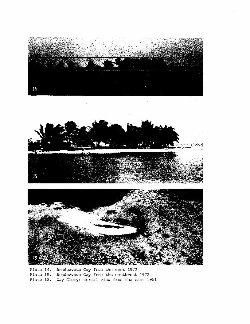
Rendezvous Cay from the west 1972
Rendezvous Cay from the southwest 1972
Cay Glory: a e r i a l view from the e a s t 1961
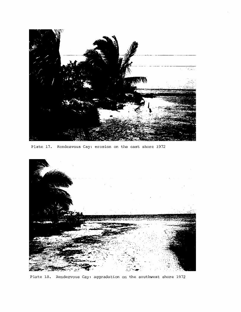
Rendezvous Cay: erosion on t h e e a s t shore 1972
Rendezvous Cay: aggradation on the southwest shore 1972
Tobacco Cay: a e r i a l view from the northwest 1960
Tobacco Cay: a e r i a l view from the e a s t 1962
Tobacco Cay from the south, seen from the ree f -c res t rubble r idge 1960
South Water Cay: a e r i a l view from the south 1961
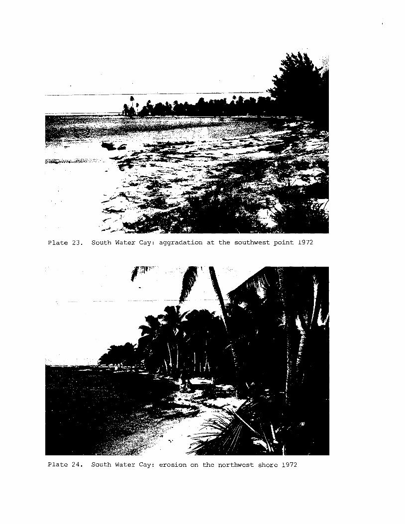
South Water Cay: aggradation a t the southwest po in t 1972
South Water Cay: erosion on the northwest shore 1972
v i i
Carr ie Bow Cay: a e r i a l view from the northwest 1960 f o l l o w i n g paqe 22
Carr ie Bow Cay: a e r i a l view from the e a s t 1962
Carr ie Bow Cay from the southwest 1965
Carr ie Bow Cay from the southwest 1972
North S i l k Cay: a e r i a l view from the e a s t 1962 f o l l o w i n g p a g e 39
South S i l k Cay: a e r i a l view from the south 1962
Round Cay: a e r i a l view from t h e southeas t 1962
Pompion Cay: a e r i a l view from the southeas t 1962
Pool on North S i l k Cay 1961
Middle S i l k Cay 1961
South S i l k Cay 1961
Ranguana Cay: a e r i a l view from the nor theas t 1962
North Spot: a e r i a l view from the southeas t 1962
North Spot from the south 1972
Tom Owen's Cays: a e r i a l view from the nor theas t 1961
H y m e n o c a l l i s l i t t o r a l i s under coconuts a t Pompion Cay 1972
Ranguana Cay: erosion on t h e nor th shore 1972
Ranguana Cay seen from the shingle i s l e t a t the west end 1972
Tom Owen's Eas t Cay from the southwest 1972
North Spot 1972
Tom Owen's West Cay: nor th shore 1972
Tom Owen's Cays from the west 1972
Tom Owen I s Eas t Cay: a e r i a l view from the south 1972
Tom Owen's West Cay: a e r i a l view from t h e southwest 1962
The Sapodi l la Cays 1972
Northeast Sapodil la Cay: a e r i a l view from the e a s t 1962 f o l l o w i n g paqe 39
v i i i
Nicolas Cay: a e r i a l view from the no r theas t 1962
Northeast Sapod i l l a Cay: n o r t h e a s t sh ing le r i d g e 1972
Northeast Sapod i l l a Cay: eroding northwest shore 1972
Frank's Cays: a e r i a l view from t h e south 1961
Hunting Cay: a e r i a l view from t h e no r th 1961
Hunting Cay: a e r i a l view from t h e southeas t 1962
Nicolas Cay: ' root rock ' exposed on t h e eroding west shore 1972
Hunting Cay e a s t bay from t h e no r th 1972
Lime Cay: a e r i a l view from t h e south 1962
Lime Cay: a e r i a l view of t h e west end from t h e no r th 1962
Lime Cay: a e r i a l view of the e a s t end from t h e no r th 1962
Ragged Cay: a e r i a l view from the south 1962
Ragged Cay from the west 1972
Seal Cay: a e r i a l view of t h e cay and f a r 0 from t h e e a s t 1962
Sea l Cay: e a s t rampart and moat 1972
S t George's Cay: a e r i a l view from the no r th 1962 (channel A) f o l l o w i n g page 6 2
S t George's Cay: a e r i a l view from t h e no r th 1962 (channel C )
S t George's Cay: a e r i a l view from t h e e a s t 1962 (channels D and E )
Tobacco Range: view in l and from t h e no r theas t sand r idge 1972
Tobacco Range: R h i w p h o r a k i l l e d by Hurricane H a t t i e i n 1961, invaded by B a t i s , a t t he no r theas t p o i n t 1972
Cary Cay: hurr icane-deposi ted sh ing le on t h e e a s t s i d e 1962
Sc ip io Cay: hurricane-deposited sh ing le r idge 1962
Colson Cay: hurricane-deposited sh ing le on t h e southeas t shore 1962
Water Range (Twin Cays): T h r i n a x t h i c k e t , south shore 1972
75. L i t t l e Water Cay: s h i n g l e rampart on t h e s o u t h e a s t sho re 1972 f o l l o w i n g page 62
76. E a s t Snake Cay: aerial view from t h e s o u t h e a s t 1961
77. West Snake Cay: a e r i a l view from t h e s o u t h e a s t 1961
78. South Snake Cay: a e r i a l view from t h e s o u t h e a s t 1961
79. E a s t Snake Cay rampart and moat from t h e no r th 1961
80. W e s t Snake Cay rampart and moat from t h e s o u t h 1961
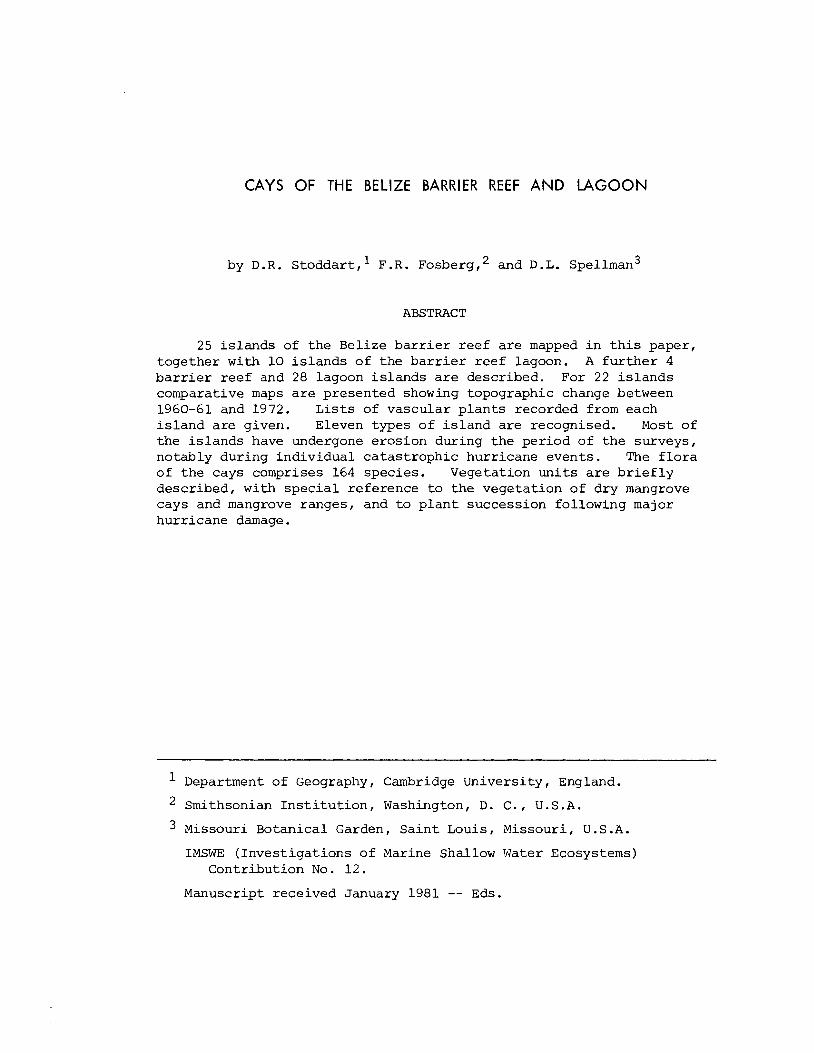
CAYS OF THE BELIZE BARRIER REEF AND LAGOON
by D.R. s toddar t , ' F.R. ~ o s b e r ~ , ~ and D.L. spellman3
ABSTRACT
25 i s l ands of the Belize b a r r i e r reef a r e mapped i n t h i s paper, together w i t h 10 i s l a n d s of the b a r r i e r reef lagoon. A f u r t h e r 4 b a r r i e r reef and 28 lagoon i s l ands a r e described. For 22 i s l a n d s comparative maps a r e presented showing topographic change between 1960-61 and 1972. L i s t s of vascular p lan t s recorded from each i s l a n d are given. Eleven types of i s l a n d are recognised. Most of the i s l ands have undergone erosion during the period of the surveys, notably during individual ca tas t rophic hurricane events. The f l o r a of the cays comprises 164 species. Vegetation u n i t s a r e b r i e f l y described, with spec ia l reference t o the vegetation of dry mangrove cays and mangrove ranges, and t o p l a n t succession following major hurricane damage.
Department of Geography, Cambridge University, England.
Smithsonian I n s t i t u t i o n , Washington, D. C. , U . S .A.
Missouri Botanical Garden, Sa in t Louis, Missouri, U . S .A.
IMSWE (Inves t igat ions of Marine Shallow Water Ecosystems) Contribution No. 12.
Manuscript received January 1981 -- Eds.
1. INTRODUCTION
"The whole extent of the main reef is ... studded with numerous i s l e t s of every var ie ty of s i ze and so l id i t y : f i r s t the spot of sand, j u s t ra ised above the water; then the more extended beach, which nurtures i n t o t r ee s the cocoa-nut ca s t upon i t s shores; next those places composed of sand and mud, where the mangrove springs out of the water, and which a re i n t h i s neighbourhood ca l led by the appropriate name of 'drowned cays ' ; and l a s t l y , the is land, a mile o r more across, whose s o i l produces the grapewood t r ee , button-wood t r e e (very hard and valuable for cogs of wheels), and other species of t r ee s , with a g i r t h of more than 3 f ee t " (Allen 1841, p.85).
" . . . so decei t ful a re the d i f f e r en t keys found from the general resemblance they bear t o each other, t h a t the most experienced seaman, when placed amongst them, often becomes f a t a l l y perplexed. ... A more par t icu la r description of these spots, so numerously scat tered over the whole of t h i s coast , would extend f a r beyond any moderate l i m i t s ; nor could any material value be affixed t o it, from the l i t t l e charac te r i s t i c difference tha t would be found connected with them" (Henderson 1811, pp. 20, 2 4 ) .
This paper presents an account of the cays of the bar r ie r reef and coasta l shelf of Belize (Bri t ish Honduras), Central America. I t is based on data collected during f i ve expeditions between 1959 and 1972. The f i r s t of these studied most of the bar r ie r reef islands between S t George's East Cay and Ragged Cay during the Cambridge Expedition t o Br i t i sh Honduras 1959-60, when the f i e l d party consisted of Stoddart and J . D . Poxon. In 1961 Stoddart and S.P. Murray re-surveyed several of these is lands , and a l so v i s i t ed the Punta Gorda cays i n the southern- most Gulf of Honduras, during a season supported by the Office of Naval Research and the Coastal Studies In s t i t u t e , Louisiana S ta te University. Following the catastrophic Hurricane Hatt ie of 30-31 October 1961, Stoddart remapped the bar r ie r reef islands as f a r south a s Carrie Bow Cay and a l so studied the numerous is lands of the cen t ra l coas ta l . she l f between Placentia and Gladden Sp i t , during March-April 1962; t h i s v i s i t was supported by the Royal Society. The bar r ie r and cen t ra l shelf islands were again mapped, with Royal Society support, i n March-April 1965, primarily t o es tabl ish the nature of recovery following catas t ro- phic hurricane damage. Finally, i n June-July 1972 a comprehensive study was undertaken of the bar r ie r and shelf cays (including the southernmostbarrier reef cays only b r i e f ly v i s i t ed previously i n 1960) a s p a r t of the Smithsonian In s t i t u t i on ' s IMSWE (Investigations of Marine Shallow Water Ecosystems) Programme centred on Carrie Bow Cay. The
f i e l d p a r t y cons i s t ed of S toddar t ( respons ib le f o r mapping and geomor- phology), Fosberg and Spellman (vegetat ion and f l o r a ) , and Henry P e l z l (orni thology) .
Some of t h e information presented here has appeared i n pre l iminary form i n e a r l i e r papers. The r eg iona l s e t t i n g and environment were described, t oge the r with gene ra l f e a t u r e s of t h e r e e f s , i n an account of p a r a l l e l s t u d i e s of t h e Bel ize o f f shore a t o l l s (Stoddart 1962a) . Hurricane e f f e c t s on t h e nor thern and c e n t r a l b a r r i e r reef cays were considered i n a paper on Hurricane H a t t i e (Stoddart 1963). I s l and recovery i n t h e nor thern and c e n t r a l a r e a s was considered i n an account of t h e 1965 re-survey (Stoddar t 1969). A pre l iminary account has appeared (Stoddar t 1974) of changes on f i v e of t h e cays monitored i n 1972. The southern b a r r i e r reef cays (south of t h e S i l k Cays) and those of t h e Punta Gorda a r e a i n t h e Gulf of Honduras have received only i n c i d e n t a l mention i n t h e published l i t e r a t u r e (Stoddart 1962b, 1965), and s t u d i e s on them appear here f o r t h e f i r s t t i m e . With t h e pub l i ca t ion of a f u l l account of t h e vascular p l a n t s of t h e cays (Fosberg e t a l . 1981), t h e nomenclature used i n previous papers i s here r ev i sed , and l is ts a r e given of spec ie s recorded from each of t h e i s l a n d s during success ive surveys. An a n a l y s i s of p l a n t spec ie s d i v e r s i t y on t h e cays has been published by Stoddar t and Fosberg (1981).
With a few exceptions, a l l o f t h e i s l a n d s he re mapped were surveyed by pace-and-compass methods a s descr ibed by Stoddar t (1962a, p.129). Maps from successive surveys were r e l a t e d t o each o t h e r by reference t o prominent o b j e c t s . I s l ands such a s Rendezvous Cay and C a r r i e Bow Cay were a l s o mapped by tape-and-compass methods, and t h e r e s u l t s used t o c a l i b r a t e t h e s c a l e s of t h e o t h e r maps. Oblique low- l e v e l a i r photographs were taken of many of t h e i s l a n d s i n 1960, 1961, 1962 and 1965. A l l t he maps of cays i n t h i s r e p o r t a r e o r i e n t a t e d conventional ly ( i . e . with magnetic no r th a t t h e t o p ) .
When t h i s study began i n 1959 v i r t u a l l y nothing was known of any of t h e i s l a n d s of t h e Bel ize c o a s t , o r indeed of t h e r e e f s themselves. The f i r s t d e t a i l e d hydrographic c h a r t s were made during t h e 1830s by Richard Owen, Edward Barnet t and Bird Al len , b u t t h e i r s h i p s c a r r i e d no s c i e n t i f i c men and only b r i e f accounts w e r e published (Owen 1838, Allen 1841). Darwin u t i l i z e d t h e i r information and c a l l e d t h e Bel ize b a r r i e r " the most remarkable reef i n t h e West Indies" (1842, p .201) , b u t t h i s l e d t o no f u r t h e r f i e l d i n v e s t i g a t i o n . Both Agassiz (1894, p.162) and Vaughan (1919, p.300) c a l l e d on evidence from Belize i n suppor t of t h e i r own t h e o r i e s of reef development, b u t n e i t h e r v i s i t e d t h e a rea . Not u n t i l 1957 were t h e cays inves t iga t ed , i n a p ioneer reconnaissance study by Vermeer (1959). Three major s e r i e s of i n v e s t i g a t i o n s have, however, subsequently made t h e Bel ize she l f and b a r r i e r r ee f one of t h e b e s t known reef provinces i n t h e world. The Rice Univers i ty s t u d i e s of she l f sediments d i r e c t e d by Edward G. Purdy during 1960-67, r e c e n t l y summarised by Wantland and Pusey (19751, l e d t o Purdy's c l a s s i c papers (1974a, 1974b) on reef s t r u c t u r e and morphology. Deep-diving submersible and geophysical s t u d i e s by James and Ginsburg (1960) have l e d t o new i n s i g h t s i n t o t h e form and evolu t ion
of t h e c e n t r a l b a r r i e r r e e f . F i n a l l y t h e IMSWE i n v e s t i g a t i o n s d i r e c t e d by Klaus Ruetz le r a t C a r r i e Bow Cay.have g r e a t l y extended knowledge of r e e f b i o t a , ecology and growth. The p r e s e n t paper i s t h u s concerned only wi th t h e most r e c e n t and ephemeral accumulations of c l a s t i c carbonate sediments on t h e t o p o f t h e s e massive r ee f s t r u c t u r e s ; wi th t h e i r vege t a t i on cover; and wi th t h e i r short- term v a r i a b i l i t y i n form and l o c a t i o n i n response t o environmental events .
We thank t h e B r i t i s h Department of S c i e n t i f i c and I n d u s t r i a l Research, t h e Royal Soc ie ty of London, t he Of f i ce of Naval Research, and t h e Coas t a l S tud i e s I n s t i t u t e o f Louis iana S t a t e Univers i ty f o r suppor t of t h e i n v e s t i g a t i o n s i n 1959-1965, and t h e Smithsonian IMSWE Programme f o r t h a t i n 1972. The suppor t of t h e Government of B e l i z e has g r e a t l y a s s i s t e d t h i s work from t h e time o f i t s i n i t i a t i o n , and noth ing would have been achieved wi thout t h e p r a c t i c a l a s s i s t a n c e of many Bel izeans . We a r e e s p e c i a l l y g r a t e f u l t o M r M. Young and M r R . Coe, of t h e Department of Geography, Cambridge Univers i ty , f o r t h e i r ca r tographic and photographic s k i l l s over many yea r s .
Seve ra l of t h e diagrams wi th in t h i s paper have been prepared from copies of c h a r t s and surveys provided by t h e Hydrographer of t h e Navy and wi th t h e s anc t ion o f Her Majes ty ' s S t a t i o n e r y Of f i ce . I t i s a p l ea su re t o thank success ive Hydrographers, no tab ly Rear Admiral S i r Edmund I r v i n g and Rear Admiral D.W. Haslam, bo th surveyors of t h e Be l i ze c o a s t and r e e f s , f o r t h e i r i n t e r e s t i n t h i s work.
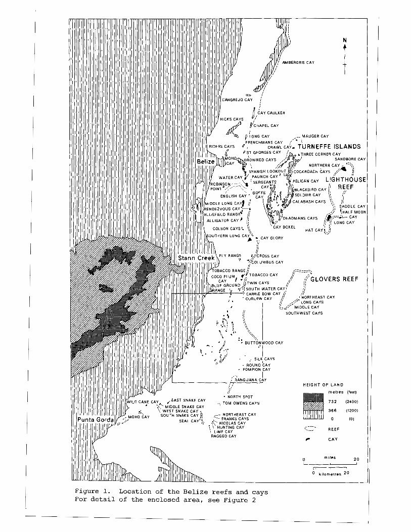
Figure 1. Location of the Belize ree fs and cays For d e t a i l of the enclosed area , see Figure 2
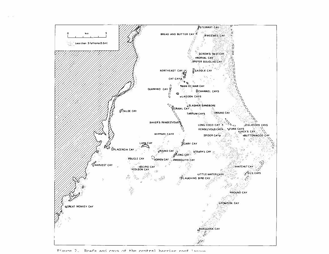
Fi m ~ r e 7 . R e e f s and C ~ T I ~ nf t h e r e n t ~ ; 1 1 h ~ v r i m r r o o + 1 annrrn
2. STRUCTURE AND ENVIRONMENT
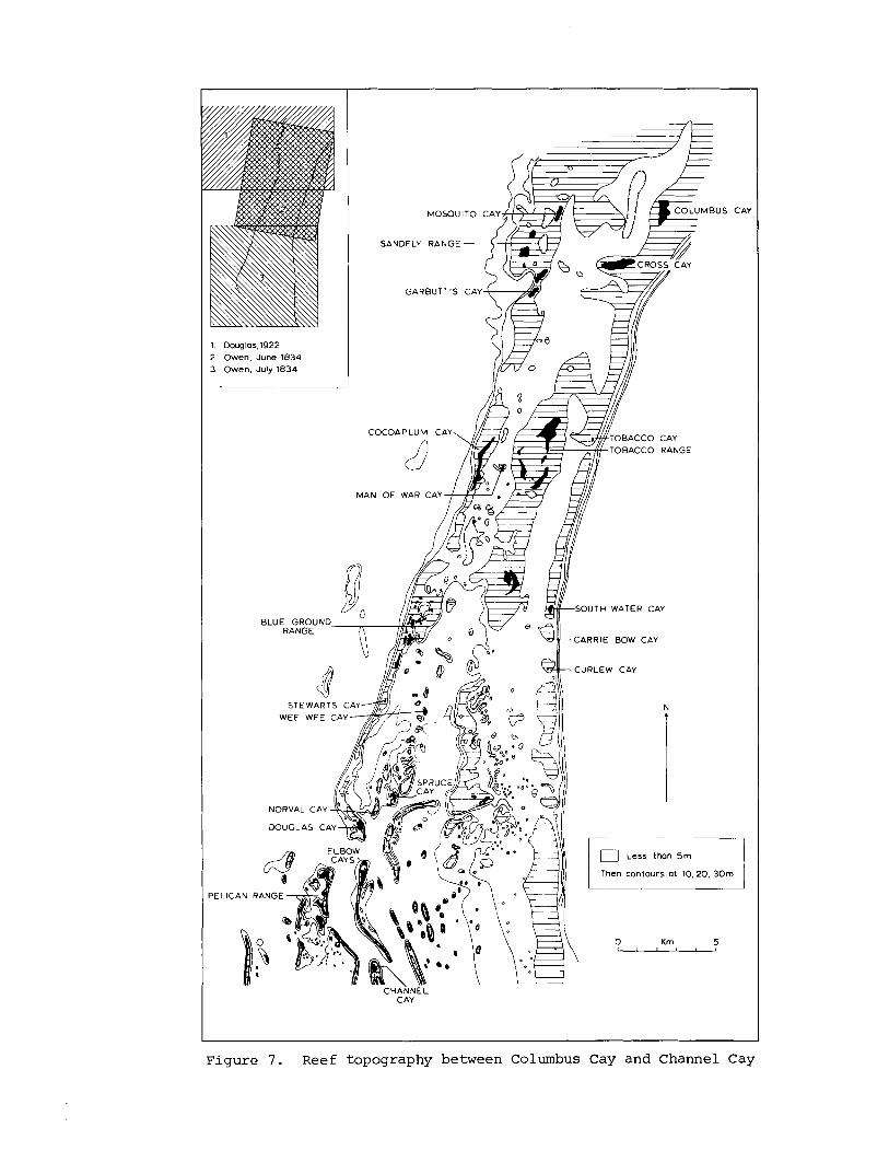
Belize i s loca t ed i n t h e southeas te rn p a r t of t h e Yucatan Peninsula , c e n t r a l America. The southern p a r t of t h e country c o n s i s t s of an u p l i f t e d block of Palaeozoic metamorphosed sediments and i n s t r u s i v e s , r i s i n g i n t h e Maya Mountains t o 1110 m above sea- leve l . The block i s p a r t l y surrounded by h i l l s of Cretaceous l imestones, which a r e themselves o v e r l a i n by low, f l a t - l y i n g Cenozoic l imestones which make up t h e g r e a t e r p a r t of t h e Yucatan Peninsula . The nor thern p a r t of t h e e a s t coas t of t h e Peninsula , between Cabo Catoche and Ambergris Cay, i s remarkably s t r a i g h t , formed by low c l i f f s w i th a f r i n g i n g r e e f . South of Ambergris Cay, however, t h e Be l i ze c o a s t a l she l f forms a major i nden ta t ion up t o 37 km wide. I t i s edged by a broadly a r c u a t e b a r r i e r r ee f more than 200 km long. North of t h e c i t y of Be l i ze t h e she l f i s gene ra l ly less than 5 m deep; immediately sou th of Be l i ze it inc reases t o 10-12 m, and deepens southwards t o depths of 45-55 m i n t h e Gulf of Honduras. Seaward of t h e b a r r i e r r ee f t h e sea f l o o r f a l l s very s t e e p l y t o more than 300 m, and depths of 1500 m a r e found wi th in 6 km of t h e r ee f edge, except i n t h e l e e of t h e o f f sho re a t o l l s (Figure 1) (Di l lon and Vedder 1973; James and Ginsburg 1980) . Pronounced topographic l i n e a t i o n s (notably connecting t h e southern b a r r i e r r e e f , t h e e a s t e r n s i d e of Glover ' s Reef and t h e e a s t s i d e of Lighthouse Reef; t h e c e n t r a l b a r r i e r r ee f and t h e e a s t e r n s i d e of Turneffe; and t h e c o a s t l i n e of Ambergris Cay) a r e c l e a r l y f a u l t b locks a l igned e n echelon along t h e nor thern margin of t h e Cayman Trough, a major t e c t o n i c s t r u c t u r e up t o 7 km deep.
P u d y et dl. (1975) have drawn a t t e n t i o n t o t h e very d i f f e r e n t c h a r a c t e r i s t i c s of t h e shelf-edge r e e f s no r th and south of Be l i ze C i ty . To t h e no r th , where t h e she l f i s shallow, t h e r e is a prominent chain of l i n e a r i s l a n d s (Cay Caulker, Cay Chapel) l oca t ed 2.5-4 km landward of t h e she l f edge; t h e edge i t s e l f i s f r inged by a discont inuous r ee f which l acks any well-developed reef f l a t . Purdy e t al. (1975, 3) comment on t h e resemblance between t h i s s i t u a t i o n and t h a t of t h e Bahama Banks. There a r e no t r u e sand cays on t h e s e r e e f s nor th of l a t i t u d e 17'33'N ( t h e s i t e of S t George's Eas t Cay which disappeared i n 1961) .
South of Bel ize C i ty t he deeper c o a s t a l she l f i s edged by a b a r r i e r p la t form, i n t h e terminology of Purdy et dl. (1975). This has q u i t e d i f f e r e n t c h a r a c t e r i s t i c s no r th and south of Gladden S p i t i n l a t i t u d e 1 6 ° 3 0 ' ~ . I n t h e nor thern s e c t o r , 80 km long, t h e s h e l f f l o o r reaches depths of 20-24 m a t d i s t a n c e s of 8-15 km from t h e mainland c o a s t ; t h e she l f edge p la t form i s 3-5 k m wide and i t s upper su r f ace 4-5 m deep. A t i t s ou te r edge t h e r e i s a well-developed r ee f f l a t 450-550 m wide, and t h e r e a r e numerous smal l pa t ch r e e f s i n i ts l e e . South of Gladden S p i t t h e same u n i t s a r e recognisable b u t wi th d i f f e r i n g degrees of development. The s h e l f here has a cons t an t width of 30 km,
and i t s maximum depth i nc reases southwards from 35 t o 77 m. The b a r r i e r p la t form main ta ins i t s depth on i t s upper s u r f a c e of 4-5 m , b u t it is l e s s than 2 km wide, is d i s s e c t e d by deep channels , and c a r r i e s l i t t l e s u r f a c e r e e f . I n s p i t e of t he se d i f f e r e n c e s i n dimension, however, t h e volume of t h e b a r r i e r p la t form remains cons t an t a long t h e e n t i r e s h e l f edge (S toddar t 1977, p . 4 7 ) .
Within t h e c o a s t a l s h e l f t h e r e a r e t h r e e main groups of i s l a n d s , i n add i t i on t o t hose of t h e s h e l f edge r e e f s , which a r e considered here . The r e e f s of t h e Southern T r i ang le s a r e developed a t t h e i nne r end of t h e Bel ize Deepwater Channel. They a r e s c a t t e r e d i s o l a t e d pa tch r e e f s , many of which have smal l mangrove cays on t h e i r upper s u r f a c e s . I n t h e l a t i t u d e of Gladden S p i t t h e r e is a complex a r r a y of l e n t i c u l a r r e e f s , mostly s l i g h t l y submerged (S toddar t 1963, f i g s . 35-36) , f u l l y descr ibed by Purdy (1974b) , termed ' s h e l f a t o l l s ' by Purdy et a l . (1975, p.15) and 'rhomboid p la t form a t o l l s o r f a r o e s ' by James and Ginsburg (1979) . Sur face r e e f s a r e i r r e g u l a r l y developed on these s t r u c t u r e s , b u t where they do occur i s l a n d s a r e common. F i n a l l y , small pa tch r e e f s r i s e from shallow water near t h e mainland c o a s t i n t h e Gulf of Honduras, n o r t h of Punta Gorda, and c a r r y sand and mangrove cays.
Purdy (1974b) has shown t h a t t h e p r e s e n t s u r f a c e r e e f s a t t h e Bel ize b a r r i e r a r e r e l a t i v e l y t h i n Holocene s t r u c t u r e s capping an o l d e r an tecedent and poss ib ly kars t -eroded r ee f topography. The Holocene r e e f s a r e 8-20 m t h i c k , and average 1 2 m. The p o s i t i v e f e a t u r e s on which they grow a r e presumed t o be r e e f s o f l a s t i n t e r - g l a c i a l age. I n c o n t r a s t t o many o t h e r p a r t s of t he Caribbean t h e r e a r e no l a s t i n t e r g l a c i a l r e e f s s t and ing above p r e s e n t sea- leve l anywhere on t h e c o a s t of Be l i ze , though they a r e descr ibed a t t h e usua l h e i g h t s of 2-4 m , wi th ages of 120-125,000 yea r s , i n no r theas t e rn Yucatan and Cozumel by Szabo et a l . (1978) . Their g r e a t e r dep th beneath t h e Be l i ze r e e f s must i n d i c a t e long-continued subsidence connected wi th t h e h o r s t s t r u c t u r e s no r th of t h e Cayman Trough.
Modern r ee f growth on t h e Be l i ze s h e l f must have post-dated t h e f looding of t h e an tecedent topography on which t h e p r e s e n t r e e f s s t a n d dur ing t h e Holocene t r a n s g r e s s i o n , about 6000-8000 y r B.P. The deeper s u r f a c e of t h e southern s h e l f would have f looded e a r l i e r , and Purdy (1974b, 854) has ob ta ined d a t e s of 6000-10,000 y r B.P. f o r s h e l f f l o o r p e a t s . Hal ley et a l . (1977) have documented t h e sequence of Holocene r ee f growth on a p re -ex i s t i ng P l e i s tocene l imestone prominence f o r a smal l patch r ee f of t h e c e n t r a l b a r r i e r r e e f . Th i s and o t h e r Be l i ze r e e f s have grown i n t h e Holocene a t r a t e s of 1-2 m pe r 1000 y r (Purdy 1974a, p .67 ) . The d a t e a t which r ee f f l a t development c l o s e t o low- t i d e l e v e l could provide a p la t form on which c l a s t i c sediments could accumulate t o form cays w i l l thus b e a func t ion of t h e depth and dimensions of t h e r e e f foundat ions , governing bo th t h e t ime a t which they were f looded by t h e Holocene t r ansg re s s ion and t h e volume of c o n s t r u c t i o n a l r ee f growth r equ i r ed f o r t h e r ee f t o r each t h e p r e s e n t sea- leve l . The a c t u a l age of r ee f f l a t formation has y e t t o be determined f o r Be l i ze r e e f s .
The B e l i z e r e e f s l i e i n t h e zone of Nor theas t Trades , which blow w i t h g r e a t cons tancy , e s p e c i a l l y du r ing t h e summer months o f Apr i l - September. A t B e l i z e , f o r t h e p e r i o d 1917-1949, 56% o f winds a t 0600 hours came from t h e e a s t and s o u t h e a s t and 23% from t h e nor thwes t (means f o r t h e y e a r s ) , wh i l e a t 1800 hours 75% came from t h e e a s t and no r thea s t . The Trades a r e i n t e r r u p t e d du r ing t h e months o f November t o February by ' n o r t h e r s ' , 4-5 day p e r i o d s o f n o r t h e r l y winds and low t empe ra tu r e s a s s o c i a t e d w i t h t h e s o u t h e r l y ex t ens ion o f t h e North American h i g h p r e s s u r e system.
R a i n f a l l over t h e e a s t c o a s t o f t h e Yucatan Pen in su l a i s about 1500 mm. June-September a r e t h e w e t t e s t months, and t h e r e i s a pronounced d ry season i n February-Apri l . Annual t o t a l s i n c r e a s e markedly southwards, t o n e a r l y 1900 mm a t Be l i z e , 2400 mm a t Mango Creek, and 4200 mm a t Punta Gorda (Table 1); t h e d r y season is a l s o very much less pronounced i n t h e s e w e t t e r areas. There a r e no r a i n f a l l r e c o r d s f o r any o f t h e i s l a n d s o f t h e c o a s t a l s h e l f , b u t it i s r ea sonab l e t o presume t h a t annua l t o t a l s on t h e cays mi r ro r t h o s e o f c o a s t a l l o c a l i t i e s . C e r t a i n l y t h e r e i s ev idence i n t h e southernmost c ays of much more humid c o n d i t i o n s t h a n i n t h e n o r t h .
Minimum tempera tures a t B e l i z e vary from 2 0 ' ~ i n January and December (monthly means) , wi th a mean maximum of 3 1 . 1 ' ~ i n August. Mean tempera tures range from 24' i n w i n t e r t o 27' i n summer. Extreme tempera tures recorded a t B e l i z e du r ing 1951-60 were 9.4' and 36' ( P o r t i g 1976, p. 470) .
Hur r icanes occur dur ing t h e months o f Ju ly t o October . E s p e c i a l l y d e s t r u c t i v e s to rms have been recorded i n 1787, 1813, 1827, 1831, 1931, 1942, 1945, 1955 and 1961; f o r an anno t a t ed l is t of recorded s to rms s e e S t o d d a r t (1963, pp. 127-130). The most r e c e n t s i g n i f i c a n t s to rm t o a f f e c t t h e r e e f s was Hurr icane G r e t a i n September 1978; t h i s pos t - d a t e d a l l t h e su rveys r e p o r t e d h e r e . The e f f e c t s of t h e l e s s e r Hur r icane F i f i of October 1974 have been documented f o r C a r r i e Bow Cay by M i l l e r and Macintyre (1977, p . 2 7 ) .
Mean t i d a l range a t s p r i n g s i s on ly 0 .2 m , and wate r l e v e l may be more a f f e c t e d by wave set -up and wind than by t h e a s t ronomica l t i d e s . The main Caribbean c u r r e n t which f lows from e a s t t o w e s t from t h e Les se r A n t i l l e s i s d i v e r t e d nor thwards th rough t h e Yucatan Channel by t h e Yucatan Pen in su l a . Water movement on t h e c o a s t a l s h e l f i s mainly t o t h e sou th , i n t o t h e Gulf of Honduras (Purdy et a l . 1975, p . 13 ) .
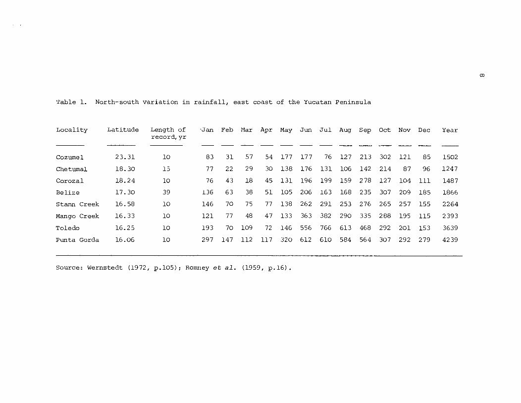
Table 1. North-south v a r i a t i o n i n r a i n f a l l , e a s t coast of t h e Yucatan Peninsula
Locali ty Lat i tude Length of record, y r
.Jan Feb Mar Apr May Jun J u l
Cozumel
Chetumal
Corozal
Belize
Stann Creek
Mango Creek
Toledo
Punta Gorda
Aug Sep
--
127 213
106 142
159 278
168 235
253 276
290 335
613 468
584 564
Oct Nov Dec
-- 121 85
87 96
104 111
209 185
257 155
195 115
201 153
292 279
Year
1502
1247
1487
1866
2264
2 393
3639
42 39
Source: Wernstedt (1972, p. 105) ; Romney et dl. (1959, p. 16) .
3. SAND CAYS OF THE NORTHERN BARRIER REEF
This chapter desc r ibes t h e sand cays of t h e shelf-edge r e e f s between S t George's E a s t Cay i n t h e no r th and Curlew Cay, south of C a r r i e Bow Cay, i n t h e sou th , a d i s t a n c e of some 90 km. I n each case , c i t a t i o n s a r e given o f prev ious ly publ ished accounts , t oge the r wi th a l i s t of p l a n t s recorded from t h e i s l a n d . S ince some of t h e s e cays have been t r e a t e d i n previous papers , t h e d e s c r i p t i o n s i n t h i s chapter a r e abbreviated.
S t George's Eas t Cay (17O33'NI 8 8 O 0 3 ' ~ ) P l a t e 2
When mapped i n 1960, t h i s was an a r c u a t e sh ing le r i d g e 110 m long wi th a maximum a l t i t u d e of about 1 m . I t had an a rea of 0 . 3 ha. The vege ta t ion cover cons i s t ed of herbs and v ines , with t a l l e r shrubs of T o u r n e f o r t i a , Conocarpus and B o r r i c h i a a t t h e no r theas t e rn end. The i s l a n d disappeared completely dur ing Hurricane H a t t i e i n 1961, and had n o t re-formed when t h e s i t e was v i s i t e d i n Apr i l 1962. For a f u l l e r account s ee S todda r t (1963, pp. 40-41). P l a n t s recorded a r e :
S e s u v i um p o r t u l a c a s t r u m ~ O S + Conocarpus e r e c t u s 60s Canava l ia sp. 60s Ipomoea sp. 60s Euphorbia m e s e m b r i a n t h e m i f o l i a 60s T o u r n e f o r t i a gnaphalodes 60s Rhizophora mangle 60s ( seed l ing ) B o r r i c h i a a r b o r e s c e n s 60s
Paunch Cay ( 1 7 " 2 4 ' ~ , 8 8 O 0 2 ' ~ ) P l a t e 1
Charted a s Punchgut Kay by Speer (1771) and a s Paunchgut by J e f f e r y s (1775). I t was vegeta ted i n 1830 and i n 1896-7 had coconut palms 10 m t a l l . The i s l a n d was destroyed i n t h e 1931 hurr icane . When mapped i n 1960 it was an unvegetated sandbore 45 m long, wi th t h r e e p a r a l l e l l i n e s o f beachrock up t o 45 m long on i t s south s i d e . The sandbore disappeared b u t t h e r e l i c t beachrock surv ived t h e 1961 hu r r i cane . No l and was p r e s e n t i n 1962 and the s i t e has not been v i s i t e d s ince . See S todda r t (1963, p .41 and f i g . 2 1 ) . The only
+ In t h e p l a n t l i s t s t h e numeral r e f e r s t o t he year o f record , and S o r C r e f e r t o s i g h t records o r c o l l e c t i o n s r e spec t ive ly . Species preceded by an a s t e r i s k a r e n o t n a t i v e t o t h e Be l i ze cay f l o r a , though t h i s does n o t n e c e s s a r i l y imply t h a t they have been de l ibe r - a t e l y introduced on t h e cays where they occur .
p l a n t recorded i s :
*Cocos n u c i f e r a 18968
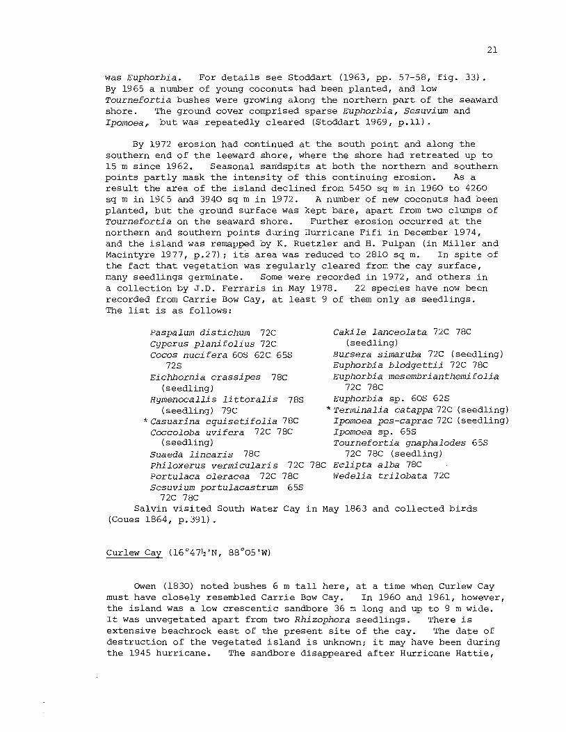
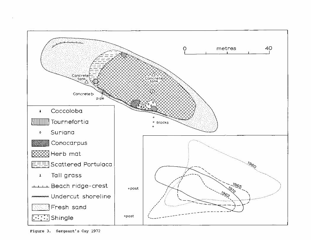
Se rgean t ' s Cay (17O23$'~, 8 8 O 0 2 ' ~ ) Figure 3, P l a t e s 3-4
This i s l a n d was cha r t ed by Speer (1771) and J e f f e r y s (1775) ; a t t h e time of t h e survey by H.M.S. Rambler i n 1896-7 it had palm t r e e s 15 m t a l l . I t was f i r s t mapped i n 1960, when it was a t r i a n g u l a r sand cay with g r e a t e s t length of 100 m and width of 45 m. I t s a r e a was 3680 s q m. The i s l a n d was occupied by a l a r g e clubhouse, and t h e ground s u r f a c e beneath t h e coconut palms was c leared . The cay was almost completely destroyed during Hurricane H a t t i e and was repor ted awash a few days l a t e r . I n March 1962 a t r i a n g u l a r sand cay had r e - formed, wi th longes t dimension of 70 m and a rea of 2000 s q m. The su r face was colonised by patches of P o r t u l a c a o l e r a c e a , t oge the r with Sesuv ium p o r t u l a c a s t r u m and Euphorbia m e s e m b r i a n t h e m i f o l i a . By 1965 t h e i s l a n d was more e longate , b u t only 68 m long and wi th an a r e a of 1640 s q m. The pioneer P o r t u l a c a had disappeared. A c e n t r a l a r e a , occupying about 25 pe r c e n t of t h e su r face and p e r s i s t i n g from be fo re t h e hurr icane , had a continuous cover of Ipomoea, Wede l ia and Euphorbia; Sesuv ium was a l s o absent . Shrubs were represented by t h r e e Conocarpus up t o 3 m t a l l , s i x S u r i a n a up t o 1 .5 m t a l l , and t h r e e T o u r n e f o r t i a l e s s than 1 m t a l l ; t h e r e was a s i n g l e Coccoloba seedl ing . Euphorbia and Ipomoea were colonis ing f r e s h sand a reas . The number of p l a n t spec ie s had r i s e n from 4 i n 1962 t o 1 3 i n 1965. For f u r t h e r d e t a i l s , see S todda r t (1963, pp. 41-42, f i g . 2 2 ; 1969, p.8, f i g . 4) and Vermeer (1959, pp. 71-74).
The i s l a n d was re-mapped on 11 J u l y 1972, when it was 90 m long and 25 m wide, wi th an a r e a of 1750 sq m. The vegetated a rea was s t i l l l a r g e l y l imi t ed t o t h a t p a r t of t h e su r face i n h e r i t e d from before t h e hurr icane: it was covered wi th a mat of Euphorb ia , Ipomoea, V i g n a , and Sesuv ium. A l l t h e 1965 shrub spec ies were p resen t , bu t t h e Coccoloba was i n danger of being undermined a s t h e south shore continued t o be eroded. Fresh sand t o t h e west of t h e main vegetated a r e a was being colonised by P o r t u l a c a . A new co lon i se r was S p a r t i n a s p a r t i n a e , t h e only g ras s , forming a conspicuous clump near t h e c e n t r e of t h e i s l and . Three spec ie s had become e x t i n c t s ince 1965: B a t i s m a r i t i m a , Euphorbia b l o d g e t t i i and Eustoma e x a l t a t u m . 14 spec ie s were p resen t i n 1972, br inging t h e t o t a l recorded f o r t h e i s l a n d t o 20:
S p a r t i n a s p a r t i n a e 72C Canava l ia r o s e a 72C Cocos n u c i f e r a 18968 60s S u r i a n a m a r i t i m a 65s 72C Coccoloba u v i f e r a 65s 72C Euphorbia b l o d g e t t i i 65s B a t i s m a r i t i m a 65C Euphorbia m e s e m b r i a n t h e m i f o l i a P h i l o x e r u s v e r m i c u l a r i s 65s 72C 62C 65s 72C P o r t u l a c a o l e r a c e a 62C 72C Sesuv ium p o r t u l a c a s t r u m 62C 72C ~ h i z o p h o r a mangle 62s C a k i l e l a n c e o l a t a 65C 72C (seedl ing)
Conocarpus e r e c t u s 65s 72C T o u r n e f o r t i a gnaphalodes 65s 72C Eustoma e x a l t a t u m 65C Avicennia germinans 60s Ipomoea macrantha 65s 72C Wedel ia t r i l o b a t a 65s 72C Ipomoea pes-caprae 65s 72C
Curlew Cay is descr ibed by Speer (1765, 19) a s "very low", wi th "only a few bushes", and comparable t o Paunch Cay. The Honduras Almanack f o r 1830 s t a t e d t h a t " t h e r e a r e no t r e e s on Curlew, b u t bush, such a s bay cedar [ ~ u r i a n a mar i t ima] and l i l l y - r o o t grass" . I t was cha r t ed by Owen i n 1830 and by H.M.S. Rambler i n 1896-7, b u t disappeared some time a f t e r t h a t d a t e , poss ib ly i n t h e 1931 hurr icane . When v i s i t e d i n 1960 it was a smal l sandbore 20 m long and 0.6 m h igh; it was n o t seen i n 1962. P l a n t s recorded:
Gramineae i n d e t . 18 30s Suriana mari t ima 1830s
Gof f ' s Cay ( 1 7 ' 2 1 ' ~ ~ 8 8 O 0 2 ' ~ ) Figure 4, P l a t e s 5-6
I n February 1960 Gof f ' s Cay was t r i a n g u l a r , wi th s i d e s 65-75 m long, b u i l t of grey sand, w i th a f r e s h sandsp i t a t t h e n o r t h end. It was cha r t ed by Speer (1765, p.19 - a "small round Kay ... no t s o b i g a s Engl i sh Kay") J e f f e r y s (17751, and H.M.S. Rambler i n 1896-7, when it had coconuts 14 m t a l l . Coconuts dominated t h e vege ta t ion i n 1960. There were a few Coccoloba and Avicennia t r e e s . The ground beneath t h e coconuts was spa re se ly covered with Euphorbia, Ipomoea and Canaval ia; t h e f r e s h sand was being co lonised by Sesuvium, Ipomoea and Canaval ia . The a r e a of t h e i s l a n d was 2920 s q m, and 7 p l a n t spec i e s were recorded. The i s l a n d su f f e red severe e ros ion during Hurricane H a t t i e . The o l d i s l a n d su r f ace was reduced t o about 800 sq m. By March 1962, however, marginal f r e s h sand accumulation had increased t h e s u r f a c e a r e a t o 2280 sq m. Sur face sand was s t r i p p e d from t h e o l d i s l a n d area ; two o r t h r e e coconuts and some broken Coccoloba survived. The only new c o l o n i s e r was Portulaca o l e r a c e a . R e l i c t beachrock, n o t prev ious ly v i s i b l e , was exposed on t h e south and e a s t s i d e s of t h e cay. For f u r t h e r d e t a i l s of t h e i s l a n d i n 1960 and 1962, s e e S todda r t (1963, pp. 43-44, f i g . 23 ) . By 1965 s l i g h t r eces s ion of t h e south c o a s t had been balanced by cons iderable aggradat ion on t h e no r th s i d e , i nc reas ing t h e t o t a l a r e a t o 2870 s q m, approximately t h a t of t h e pre-1961 i s l a n d . Dense vege ta t ion - a mat of Euphorbia, Sesuvium, Ipomoea and Ernodea - was l imi t ed t o t h e s u r f a c e a rea surv iv ing from be fo re t h e storm, though v ines i f Ipomoea were co lonis ing f r e s h sand. Eighteen coconuts p l an ted s ince 1961 were up t o 1 rn t a l l . I n both 1962 and 1965 t h e r e was a small unvegetated sandbore about 400 m no r th of t h e main cay. For d e t a i l s of t h e i s l a n d i n 1965 s e e S todda r t (1969, p .8, f i g . 4 ) .
Goff 's Cay was re-mapped on 11 Ju ly 1972. The core i s l a n d remained, with some marginal e ros ion on t h e e a s t s i d e , but t h e marginal sand accumulations had considerably increased t o g ive a t o t a l i s l a n d a r e a of 3190 s q m. The herb mat cons i s t ed of Por tu laca , Sesuvium, Ipomoea, Ernodea and Cakile , and 17 coconuts survived. The e a s t e r n sand s p i t was being colonised by Cakile . A s u b s t a n t i a l concre te j e t t y had been b u i l t on t h e leeward s i d e ( t h e i s l a n d is much used f o r r e c r e a t i o n a l purposes) , and a deep depression near t h e c e n t r e was presumably the sand source f o r t h e concrete . 10 p l a n t spec ie s were recorded i n 1972, compared with 2 i n 1962 and 4 i n 1965. No spec ie s became e x t i n c t e i t h e r between 1962 and 1965 o r between 1965 and 1972 except f o r t h e broken Coccoloba which d i d n o t survive. New co lon i se r s i n t h e f i r s t t h r e e yea r s were Cocos ( p l a n t e d ) , Sesuvium, Ipomoea and Euphorbia; a f t e r 1965 they included two g ras ses (~ndropogon, E r a g r o s t i s ) , a sedge (Cyperus p l a n i f o l i u s ) , and Cakile. A t o t a l of 13 spec ie s i s now recorded from t h e i s l a n d :
Andropogon glomera t u s 7 2C Caki le l anceo la t a 72C Eragros t i s p r o l i f e r a 72C Canavalia sp. 60s Cyperus p l a n i f o l i u s 72C Euphorbi a mesembri an t heini - Cocos nuci fera 1896S, 60s 65s 72s f o l i a 72C
*Coccoloba uvifera 60s 62s Euphorbia sp. 60s 65s Por tu laca o l e racea 72C Ipomoea pes-caprae 72C Por tu laca sp. 62s Ipomoea sp . 60s 65s Sesuvium portulacastrum bOS 65.5 72C Avicennia germinans 60s
E r i t h a l i s f r u t i c o s a 65s 72C
Seal Cay ( 1 7 ° 2 1 1 ~ , 8 8 O 0 2 ' ~ )
Sea l Cay was noted by Speer (1766, p.19) a s "a very low, small , sandy Kay". I t was no t char ted by Owen i n 1830, b u t t h e Rambler survey noted a sandbore awash a t high water immediately on t h e no r th s i d e of t h e entrance t o t h e Belize Deepwater Channel. I t was no t seen during our own surveys. The s e a l i n ques t ion was presumably t h e West Indian Monk Seal Monactlus t r o p i c a l i s , though t h e animal i t s e l f does no t appear ever t o have been recorded from t h e Belize coas t , which i s n o t included i n JCingls (1956, p.217) map of t h e range of t h i s spec ie s . That it was reasonably common i n t h e e igh teen th century i s shown by t h e presence of o t h e r 'Sea l Cays' on t h e ~ a r r i e r r e e f .
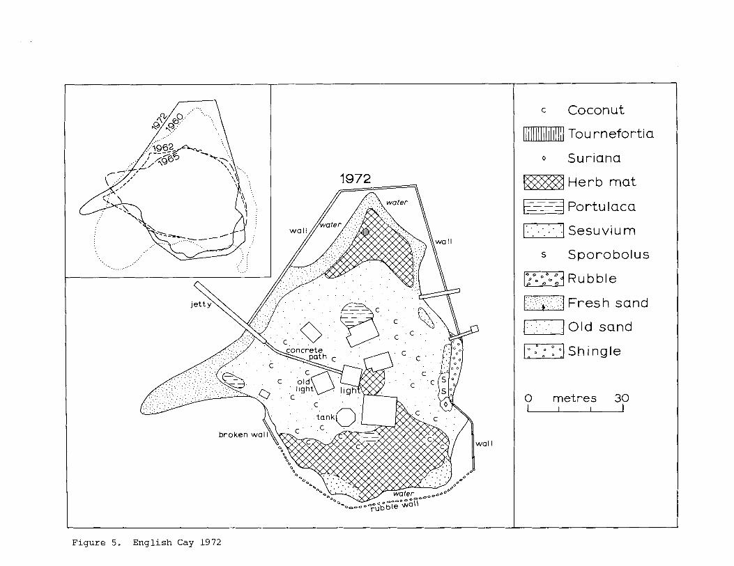
English Cay ( 1 7 ° 2 0 ' ~ , 88O03'W) Figure 5, P l a t e s 7-10
English Cay was char ted by Speer (1765, p.19: "a s h o r t , round, b l u f f Kay"; 1771) and J e f f e r y s (1775) . I t has been a l ighthouse and p i l o t s t a t i o n f o r many years ; t h e p resen t l igh thouse was b u i l t i n 1935. I n 1960 t h e i s l a n d was t r i a n g u l a r , with s i d e s 75-90 m long, and with an a r e a of 6510 s q m. The eas t e rn shore was l a r g e l y a r t i f i c i a l , being p a r t l y a masonry wal l and p a r t l y a r idge of conch s h e l l s . A leeward
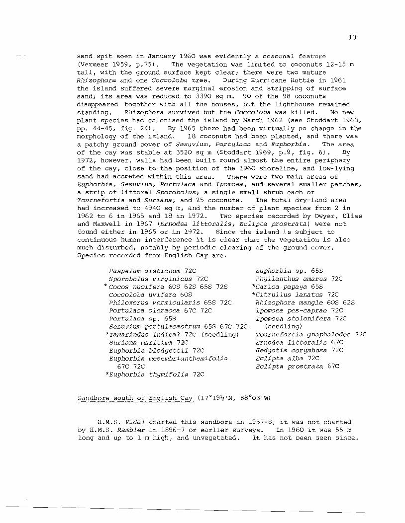
sand s p i t seen i n January 1960 was ev iden t ly a seasonal f e a t u r e (Vermeer 1959, p .75 ) . The vege ta t ion was l imi t ed t o coconuts 12-15 m t a l l , wi th t h e ground su r f ace kept c l e a r ; t h e r e were two mature Rhizophora and one Coccoloba t r e e . During Hurricane H a t t i e i n 1961 t h e i s l a n d su f f e red severe marginal e ros ion and s t r i p p i n g of su r f ace sand; i t s a r e a was reduced t o 3390 s q m. 90 of t he 98 coconuts disappeared toge ther wi th a l l t n e houses, b u t t he l igh thouse remained s tanding . Rhizophora survived b u t t h e Coccoloba was k i l l e d . No new p l a n t spec i e s had co lonised t h e i s l a n d by March 1962 ( see S todda r t 1963, pp. 44-45, f i g . 24 ) . By 1965 t h e r e had been v i r t u a l l y no change i n t h e morphology of t he i s l a n d . 1 8 coconuts had been p lan ted , and t h e r e was a patchy ground cover of S e s u v i u m , P o r t u l a c a and Eupilorbia. The a r e a of t h e cay was s t a b l e a t 3520 s q m (S toddar t 1969, p . 9 , f i g . 6 ) . By 1972, however, wa l l s had been b u i l t round almost t h e e n t i r e per iphery of t h e cay, c l o s e t o t h e p o s i t i o n of t he 1960 s h o r e l i n e , and low-lying sand had acc re t ed wi th in t h i s area. There were two main a r e a s of Euphorbia , Sesuv ium, P o r t u l a c a and Ipomoea, and s e v e r a l smal le r pa tches ; a s t r i p of l i t t o r a l S p o r o b o l u s ; a s i n g l e smal l shrub each of T o u r n e f o r t i a and S u r i a n a ; and 25 coconuts. The t o t a l dry-land a rea had increased t o 4940 s q m , and t h e number o f p l a n t spec i e s from 2 i n 1962 t o 6 i n 1965 and 18 i n 1972. Two spec i e s recorded by Dwyer, E l i a s and Maxwell i n 1967 (Ernodea l i t t o r a l i s , E c l i p t a p r o s t r a t a ) were n o t found e i t h e r i n 1965 o r i n 1972. Since t h e i s l a n d i s s u b j e c t t o continuous human i n t e r f e r e n c e it i s c l e a r t h a t t h e vege ta t ion i s a l s o much d i s tu rbed , no tab ly by p e r i o d i c c l e a r i n g of t h e ground cover . Species recorded from English Cay a r e :
Paspalum d i s t i c h u m 72C S p o r o b o l u s v i r g i n i c u s 72C
* ~ o c o s n u c i f e r a 60s 62s 65s 72s Coccol oba u v i f e r a 60s P h i l o x e r u s v e r m i c u l a r i s 65s 72C P o r t u l a c a o l e r a c e a 67C 72C P o r t u l a c a sp. 65s Sesuv ium p o r t u l a c a s t r u m 655 67C 72C
*Tamarindus i n d i c a ? 72C (seedl ing) S u r i a n a mar i t ima 72C Euphorbia b l o d q e t t i i 72C Euphorbia m e s e m b r i a n t h e n ~ i f o l i a
67C 72C "Euphorbia t h y m i f o l i a 72C
Eupnorbia s p . 65s P h y l l a n t h u s amarus 72C
*Carica papaya 65s * C i t r u l l u s l a n a t u s 72C Rhizophora mangle 60s 625 Ipon~oea pes -caprae 72C Ipomoea s t o l o n i f e r a 72C
(seedl ing) T o u r n e f o r t i a qnapha lodes 72C Ernodea l i t t o r a l i s 67C H e d y o t i s corymbosa 72C E c l i p t a a l b a 72C E c l i p t a p r o s t r a t a 67C
Sandbore south of English Cay ( 1 7 ° 1 9 % ' ~ , 88*03'w)
H.M.S. V i d a l cha r t ed t h i s sandbore i n 1957-8; it was n o t cha r t ed by H.M.S. Rambler i n 1896-7 o r e a r l i e r surveys. I n 1960 it was 55 m long and up t o 1 m h igh , and unvegetated. I t has n o t been seen s i n c e .
Samphire Spot ( 1 7 ° 1 7 ' ~ , 8 8 O 0 2 + ' ~ )
This was cha r t ed a s Saphi re Kay by J e f f e r y s i n 1775 b u t omi t ted by him i n 1792 and 1800; it was n o t noted by Speer o r Owen i n 1765 and 1830, b u t appears a s Samphire Spot fol lowing t h e 1896-7 Rambler survey. I n 1959-61 it was a smal l unvegetated sandbore; it presumably disappeared dur ing Hurricane H a t t i e , b u t i n 1962 was again a smal l sandbore 23 m i n diameter .
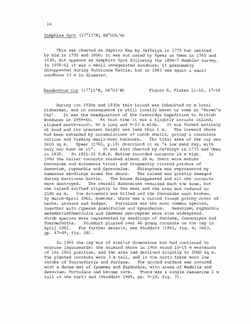
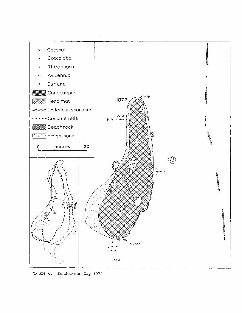
Rendezvous Cay (17O15'NI 8 8 O 0 3 ' ~ ) F igure 6 , P l a t e s 11-15, 17-18
During t h e 1920s and 1930s t h i s i s l a n d was i nhab i t ed by a l o c a l fisherman, and i n consequence i s s t i l l l o c a l l y known by some a s 'Brown's Cay ' . I t was t h e headquar te rs of t h e Cambridge Expedi t ion t o B r i t i s h Honduras i n 1959-60. A t t h a t t ime it was a s l i g h t l y a r c u a t e i s l a n d , a l i gned north-south, 90 m long and 9-23 m wide. I t was formed e n t i r e l y of sand and i t s g r e a t e s t h e i g h t was l e s s t han 1 m. The leeward shore had been extended by accumulations of conch s h e l l s , g iv ing a c r e n u l a t e o u t l i n e and forming small-boat harbours . The t o t a l a r e a of t h e cay was 2610 sq m. Speer (1765, p .19) descr ibed it a s "a low sand Kay, wi th on ly one bush on i t " . I t was a l s o cha r t ed by J e f f e r y s i n 1775 and Owen i n 1830. I n 1921-22 H . M . S . Mutine recorded coconuts 14 m h igh . I n 1960 t h e t a l l e r coconuts reached almost 20 m; t h e r e were mature Coccoloba and Avicennia t r e e s ; and f r equen t ly c l e a r e d pa tches of Sesuvium, Euphorbia and Sporobolus. Rhizophora was r ep re sen t ed by numerous s eed l ings round t h e shore . The i s l a n d was g r e a t l y damaged during Hurr icane H a t t i e . The house disappeared and a l l t h e coconuts were destroyed. The o v e r a l l dimensions remained much t h e same, b u t t he i s l a n d s h i f t e d s l i g h t l y t o t h e west and t h e a r e a was reduced t o 2180 s q m. The Avicennia was k i l l e d and t h e Coccoloba much broken. By March-April 1962, however, t h e r e was a v a r i e d though patchy cover of herbs , g r a s s e s and sedges. Po r tu l aca was t h e most common s p e c i e s , t oge the r wi th Cyperus p l a n i f o l i u s and Sporobolus. Sesuvium, Euphorbia mesembrianthemifolia and Ipomoea pes-caprae were a l s o widespread. Shrub spec i e s were represen ted by seed l ings of Su r i ana , Conocarpus and Tournefor t ia . S todda r t p l an t ed over 40 young coconuts on t h e cay i n A p r i l 1962. For f u r t h e r d e t a i l s , see S todda r t (1963, f i g . 4; 1663, pp. 47-49, f i g . 2 8 ) .
I n 1965 t h e cay was of s i m i l a r dimensions b u t had cont inued t o migrate lagoonwards: t h e seaward shore i n 1965 s tood 10-15 m westwards of i t s 1962 p o s i t i o n , and the a r e a had dec l ined s l i g h t l y t o 2000 s q m. The p l an t ed coconuts were 3 m t a l l , and i n t h e n o r t h t h e r e were low shrubs of Tournefor t ia and Sur iana . The ground s u r f a c e was covered with a dense mat of Ipomoea and Euphorbia, wi th a r e a s of Wedelia and Sesuvium; Por tu laca had become r a r e . There was a s i n g l e Casuarina 2 m t a l l a t t h e n o r t h end (S toddar t 1969, pp. 9-10, f i g . 7 ) .
In 1972 these t r ends had continued. The cay had maximum dimensions of 92 x 32 m , and an a rea of 1840 s q m. Both i t s seaward and lagoonward shores were loca ted up t o 10 m westward of t h e i r 1965 p o s i t i o n s (and hence up t o 16 m westward of t h e i r 1960 l o c a t i o n s ) . Some of t h e coconuts were a l ready bearing. The ground cover was dominated by Euphorb ia , Ipomoea, P h i l o x e r u s , S e s u v i u m , P o r t u l a c a , C y p e r u s , S p o r o b o l u s and o the r grasses . One clump of Coccoloba s t i l l survived from be fo re t h e hurr icane , b u t t h e Casuar ina had disappeared and t h e S u r i a n a appeared dead. There were s e v e r a l clumps of Conocarpus , Rh i zophora and A v i c e n n i a . A small hut had been b u i l t and appeared t o be i n t e r m i t t e n t l y occupied. There was evidence t h a t t he conch f i s h e r y had been resumed.
The t o t a l number of spec ie s recorded from Rendezvous Cay i s now 24. 7 were recorded i n 1960, 16 i n 1962, 16 i n 1965 and 16 i n 1972. The uniformity of these f i g u r e s d i sgu i ses considerable turnover , however, a s t h e d e t a i l e d records show. recorded:
Paspalum d i s t i c h u r n 62C 72C S p o r o b o l u s sp. 60s 62s 65s C y p e r u s l i q u l a r i s 62C Cyperus p l a n i f o l i u s 72C Cyperus s p . 65s F i m b r i s t y l i s cymosa 62C 72C
*Cocos n u c i f e r a 2 0 s 60s 65s 72s *Casuar ina e q u i s e t i f o l i a 65s
Coccoloba u v i f e r a 60s 62s 655 72C
P h i l o x e r u s v e r m i c u l a r i s 62C 72C P o r t u l a c a o l e r a c e a 62C 65s 72C P o r t u l a c a sp. 62s S e s u v i u m p o r t u l a c a s t r u m 60s 62C
65s 72C
The fol lowing spec ie s a r e
C a k i l e l a n c e o l a t a 62C 65s S u r i a n a m a r i t i m a 65s 72C Euphorbia m e s e m b r i a n t h e m i f o l i a
62C 72C Euphorbia s p . 60s 65s Rhi zophora mangle 60s 62s 65s 72C Conocarpus e r e c t u s 65s 72C Laguncu lar ia racemosa 72C Ipomoea pes-caprae 62s 72C Ipomoea s p . 65s T o u r n e f o r t i a qnapha lodes 65s 72s A v i c e n n i a germinans 60s 72s Solanum campech iense 62C
*solanurn 1 ycopers i cum 62C Ageratum sp. 65s
These a r e i n t e r m i t t e n t sandbores 20-40 m long. One was o f t en v i s i b l e i n 1959-60, t h e o the r was seen i n 1962. They a r e unvegetated.
S k i f f Sand ( 1 7 ' 1 3 ' ~ , 8 8 ° 0 3 1 ~ )
An ephemeral sandbore on t h e ou te r b a r r i e r , char ted by H.M.S. Mut ine i n 1921-22, and occas ional ly v i s i b l e ; it i s unvegetated.
Cay Glory ( 1 7 ' 0 6 ' ~ ~ 8 8 ' 0 1 ' ~ ) P l a t e 16
Cay Glory was mapped i n 1960: it was 105 m long, up t o 21 m wide, and had an a r e a of 1430 sq m. There was a s i n g l e young coconut 1.2 m t a l l , and a smal l vege ta ted a r e a covered wi th S e s u v i u m , Euphorb ia , P h i l o x e r u s , C a k i l e , Paspalum and Ipomoea. The i s l a n d was b u i l t of wel l - sor ted beach sand (S toddar t 1964, f i g s . 4 , 6) and i t s o u t l i n e was c l e a r l y very v a r i a b l e . The i s l a n d was prev ious ly l a r g e r . H.M.S. M u t i n e noted coconuts 21 m t a l l i n 1922, b u t t h e s e must have been des t royed by e i t h e r t h e 1931 o r 1945 hur r icanes . Beachrock r e l i c s of t h i s o l d e r i s l a n d a r e widespread no r th and west of t h e 1960 cay. The i s l a n d disappeared e n t i r e l y dur ing Hurricane H a t t i e i n 1961, and no land was seen on i t s s i t e i n 1962, 1965 o r 1972. For f u r t h e r d e t a i l s , s e e S todda r t (1963, pp. 52-53, f i g . 30) . The fol lowing 7 p l a n t spec i e s have been recorded:
Paspalurn d i s t i c h u m 60C C a k i l e l a n c e o l a t a 60C *Cocos n u c i f e r a 22s 60s Euphorbia m e s e m b r i a n t h e m i f o l i a 60C
P h i l o x e r u s v e r m i c u l a r i s 60C Ipomoea a s a r i f o l i a 60C S e s u v i u m p o r t u l a c a s t r u m 60C
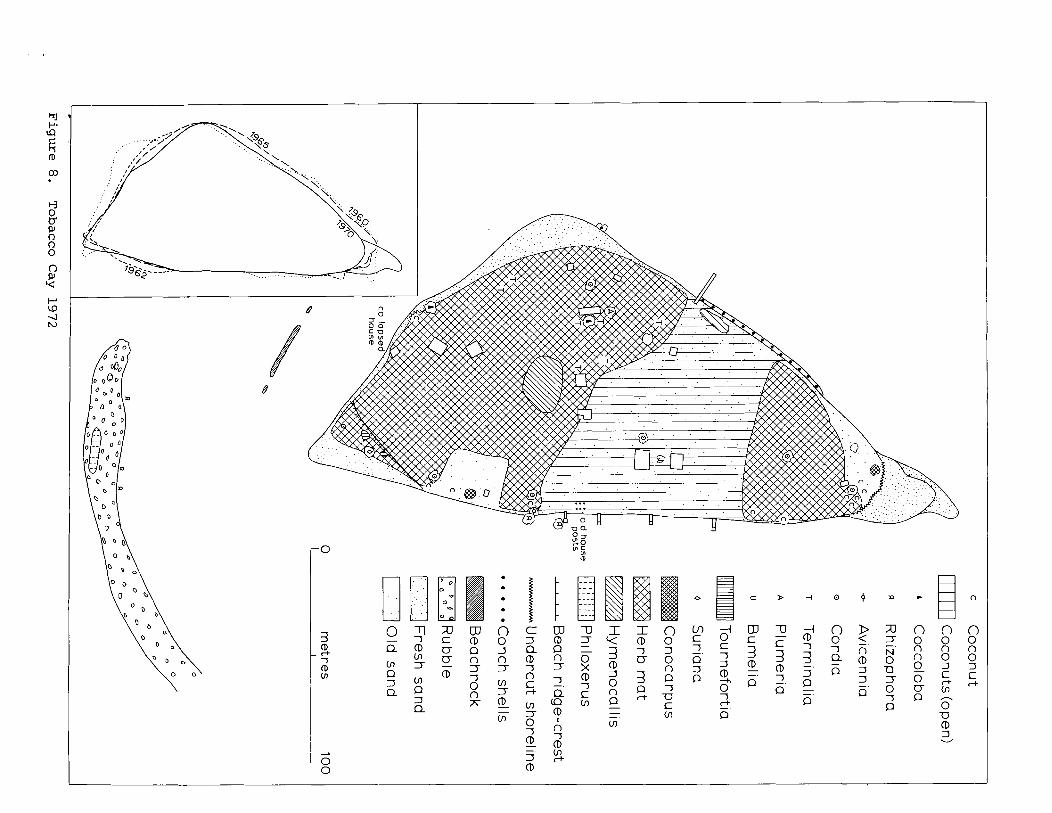
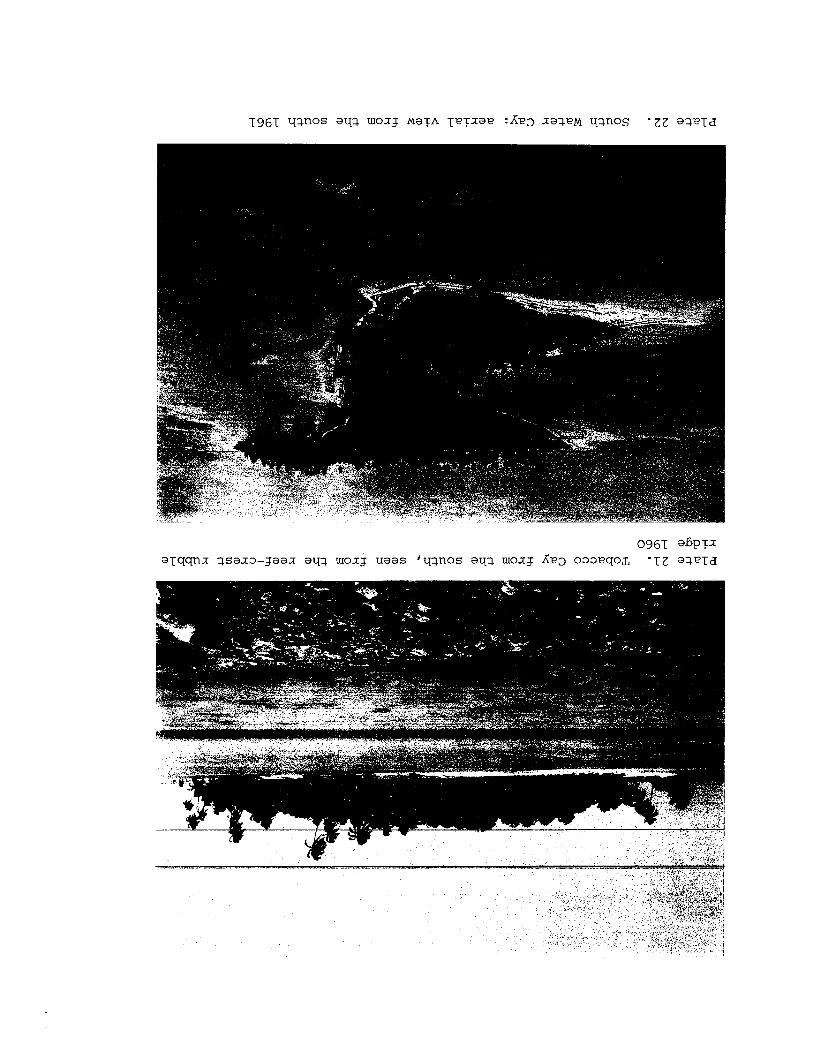
Tobacco Cay ( 1 6 ' 5 4 % ' ~ ~ 88 '03%' W ) F igures 8-9, P l a t e s 19-21
Tobacco Cay l i e s on t h e n o r t h s i d e of one of t h e most important en t rances i n t h e c e n t r a l b a r r i e r r e e f . I t was cha r t ed by Speer i n 1771 and J e f f e r y s i n 1775, and t h e r e is an unve r i f i ed sugges t ion t h a t t h e i s l a n d is named a f t e r tobacco c u l t i v a t i o n dur ing t h e e a r l y y e a r s o f t h e Engl ish s e t t l emen t i n 1630-40 (Winzerling 1946; Caiger 1951, 28-29). The most r e c e n t hydrographic c h a r t of t h e a r e a was made by Owen i n 1834. The cay was mapped i n 1960, 1961 ( i n July a f t e r Hurricane Abby), 1962 (Apr i l , a f t e r Hurricane H a t t i e ) , 1965, and 1972.
I n 1960 t h e i s l a n d was roughly t r i a n g u l a r , wi th a g r e a t e s t nor th- south dimension of 275 m and a g r e a t e s t width of 140 m; i t s a r e a was 2.74 ha. The whole i s l a n d was b u i l t of sand, wi th a f l a t f e a t u r e l e s s s u r f a c e a t about 1.2 m above sea- leve l . There were r i d g e s of f r e s h sand along t h e south shore , and r e l i c t s t r i p s o f beachrock 35 m o f f sho re . The cay was i nhab i t ed and dense ly vege ta ted . I n 1834 Owen had noted coconut t r e e s 20 m t a l l , and Smith (1842, p.732) descr ibed a f i g t r e e 20 m t a l l nea r t h e n o r t h e a s t p o i n t . I n 1960 many of t h e coconuts were o l d , reaching up t o 25 m , and t h e r e were a l s o mature t r e e s of T e r m i n a l i a , Coccoloba and C o r d i a . There was a dense ground cover of S t a c h y t a r p h e t a , W e d e l i a , Ipomoea pes -caprae , Ipomoea s t o l o n i f e r a , S e s u v i u m , H y m e n o c a l l i s , Euphorb ia , Canava l ia and V i g n a . Hurricane Abby on 15 J u l y 1960 removed t h e f r e s h sand r i d g e s and blew down a number of coconuts ; t h e i n h a b i t a n t s a l s o c l e a r e d a good d e a l of t h e ground vege t a t i on .
During Hurr icane H a t t i e t h e r e was severe marginal e ros ion , s t r i p p i n g of s u r f a c e sand, and depos i t i on of f r e s h sand along t h e south and west shores . A t t h e sou theas t p o i n t t h e s e new d e p o s i t s reached a
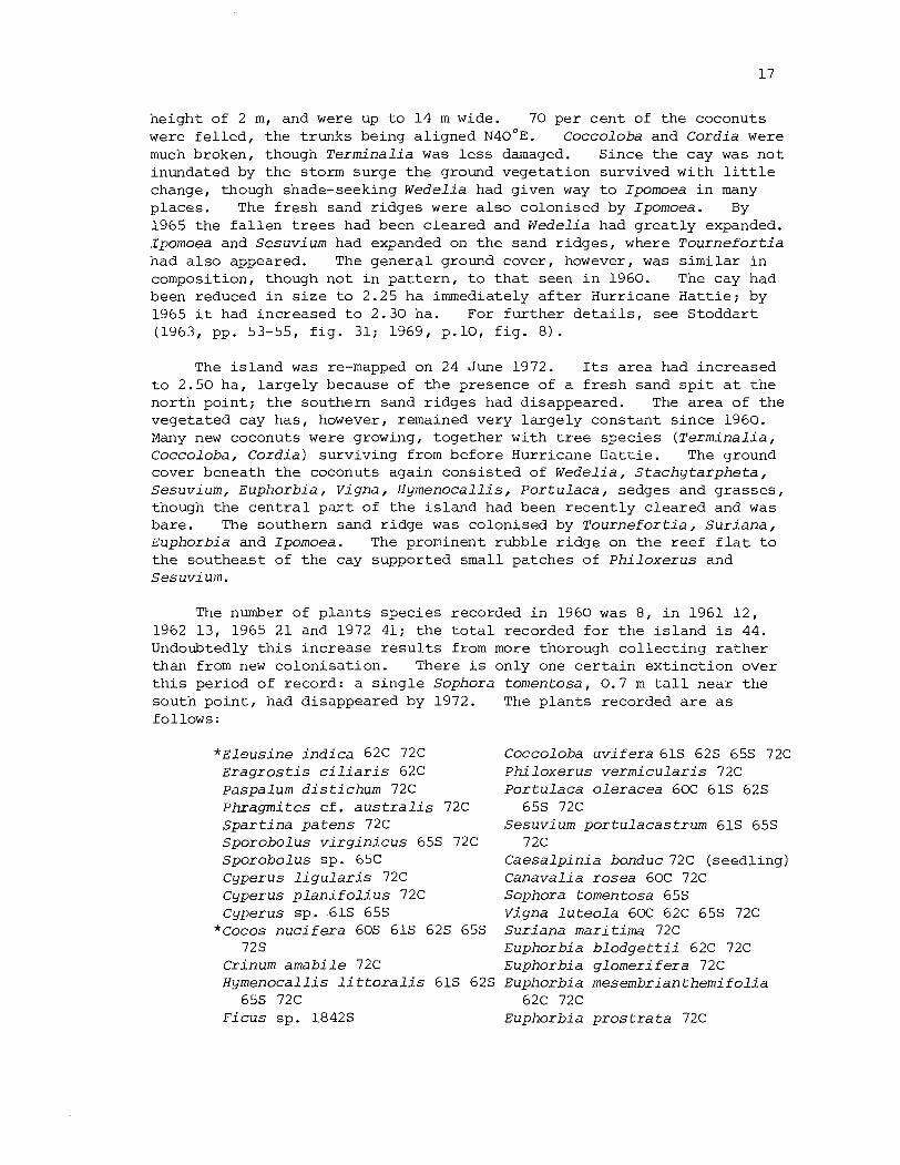
height of 2 m, and were up t o 14 m wide. 70 per c e n t of the coconuts were f e l l e d , the trunks being al igned ~ 4 0 ~ ~ . Coccoloba and Cordia were much broken, though T e r m i n a l i a was l e s s damaged. Since t h e cay was n o t inundated by the storm surge the ground vegetat ion survived with l i t t l e change, though shade-seeking W e d e l i a had given way t o Ipomoea i n many places. The f resh sand r idges were a l s o colonised by Ipomoea. By 1965 the f a l l e n t r e e s had been c leared and W e d e l i a had g rea t ly expanded. Ipomoea and Sesuv ium had expanded on t h e sand r idges , where T o u r n e f o r t i a had a l s o appeared. The genera l ground cover, however, was s imi la r i n composition, though not i n p a t t e r n , t o t h a t seen i n 1960. The cay had been reduced i n s i z e t o 2.25 ha immediately a f t e r Hurricane Ha t t i e ; by 1965 it had increased t o 2.30 ha. For f u r t h e r d e t a i l s , see Stoddart (1963, pp. 53-55, f i g . 31; 1969, p.10, f i g . 8 ) .
The i s l and was re-mapped on 24 June 1972. Its area had increased t o 2.50 ha, l a rge ly because of t h e presence of a f r e s h sand s p i t a t t h e nor th point ; t h e southern sand r idges had disappeared. The a rea of the vegetated cay has, however, remained very l a rge ly constant s ince 1960. Many new coconuts were growing, together with t r e e species ( T e r m i n a l i a , Coccoloba, C o r d i a ) surviving from before Hurricane Hat t ie . The ground cover beneath t h e coconuts again consisted of W e d e l i a , S t a c h y t a r p h e t a , Sesuv ium, Euphorb ia , V i g n a , H y m e n o c a l l i s , P o r t u l a c a , sedges and g rasses , though the c e n t r a l p a r t of t h e i s l a n d had been recen t ly c leared and was bare. The southern sand r idge was colonised by T o u r n e f o r t i a , S u r i a n a , Euphorbia and Ipomoea. The prominent rubble r idge on t h e reef f l a t t o t h e southeast of the cay supported small patches of P h i l o x e r u s and S e s u v i um.
The number of p lan t s species recorded i n 1960 was 8, i n 1961 12, 1962 13, 1965 21 and 1972 41 ; t h e t o t a l recorded f o r t h e i s l and is 44. Undoubtedly t h i s increase r e s u l t s from more thorough co l l ec t ing r a t h e r than from new colonisa t ion . There is only one c e r t a i n ex t inc t ion over t h i s period of record: a s i n g l e Sophora t o m e n t o s a , 0.7 m t a l l near the south po in t , had disappeared by 1972. The p lan t s recorded a r e a s follows:
* E l e u s i n e i n d i c a 62c 72C Coccoloba u v i f e r a 61s 625 65s 72C ~ r a g r o s t i s c i l i a r i s 62C Phi l o x e r u s v e r m i c u l a r i s 72C paspalurn d i s t i c h u m 72C P o r t u l a c a o l e r a c e a 60C 61s 62s Phragmi te s c f . a u s t r a l i s 72C 65s 72C S p a r t i n a p a t e n s 72C Sesuv ium p o r t u l a c a s t r u m 61s 65s S p o r o b o l u s v i r g i n i c u s 65s 72C 72C S p o r o b o l u s sp. 65C C a e s a l p i n i a bonduc 72C (seedl ing) Cyperus l i g u l a r i s 72C Canava l ia r o s e a 60C 72C Cyperus p l a n i f o l i u s 72C Sophora tomentosa 65s Cyperus sp. 61s 65s V i g n a l u t e o l a 60C 62C 65s 72C
*Cocos n u c i f e r a 60s 61s 62s 65s S u r i a n a mar i t ima 72C 72s Euphorbia b l o d g e t t i i 62C 72C
Crinum a m a b i l e 72C Euphorbia g l o m e r i f e r a 72C Hymenoca l l i s l i t t o r a l i s 61s 62s Euphorbia m e s e m b r i a n t h e m i f o l i a
65s 72C 62C 72C F i c u s sp. 1842s Euphorbia p r o s t r a t a 72C
Euphorbia sp. 60s 65s P h y l l a n t h u s amarus 72C
" ~ a r i c a papaya 65s 72s Rhizophora mangle 62s 65s 72C Conocarpus e r e c t u s 61s 65s 72C
* ~ e r m i n a l i a catappa 61s 62s 65s 7 2C
Bumelia r e t u s a 65C 72s * c a t h a r a n t h u s r o s e u s 72C
Ipomoea pes-caprae 62C 65s 72C Ipomoea s t o l o n i f e r a 60C 72C Ipomoea s p . 6 5s
Cord ia s e b e s t e n a 60C 61s 65s 72C T o u r n e f o r t i a qnaphalodes 65s 72C A v i c e n n i a germinans 61s 65s 72C S t a c h y t a r p h e t a j a m a i c e n s i s 60C
61s 65s 72C Spermacoce a s s u r q e n s 72C Ageratum l i t t o r a l e 72C B i d e n s c y n a p i i f o l i a 72C Melanthera n i v e a 72C Pluchea s y m p h y t i f o l i a 72C Wede l ia t r i l o b a t a 60C 61s 62s
65s 72C
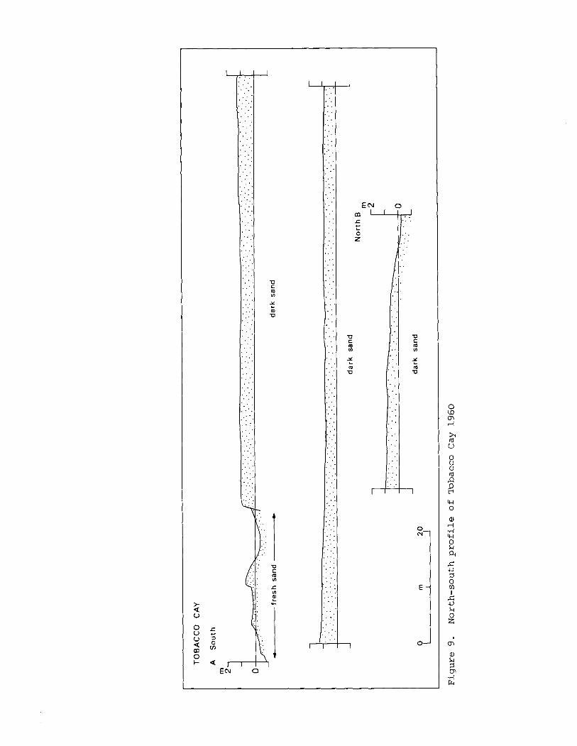
Purdy (197413, pp. 841, 853) d r i l l e d a core ho le 16.4 m deep on Tobacco Cay, t h e upper 14 m of t h e sec t ion being Holocene i n age.
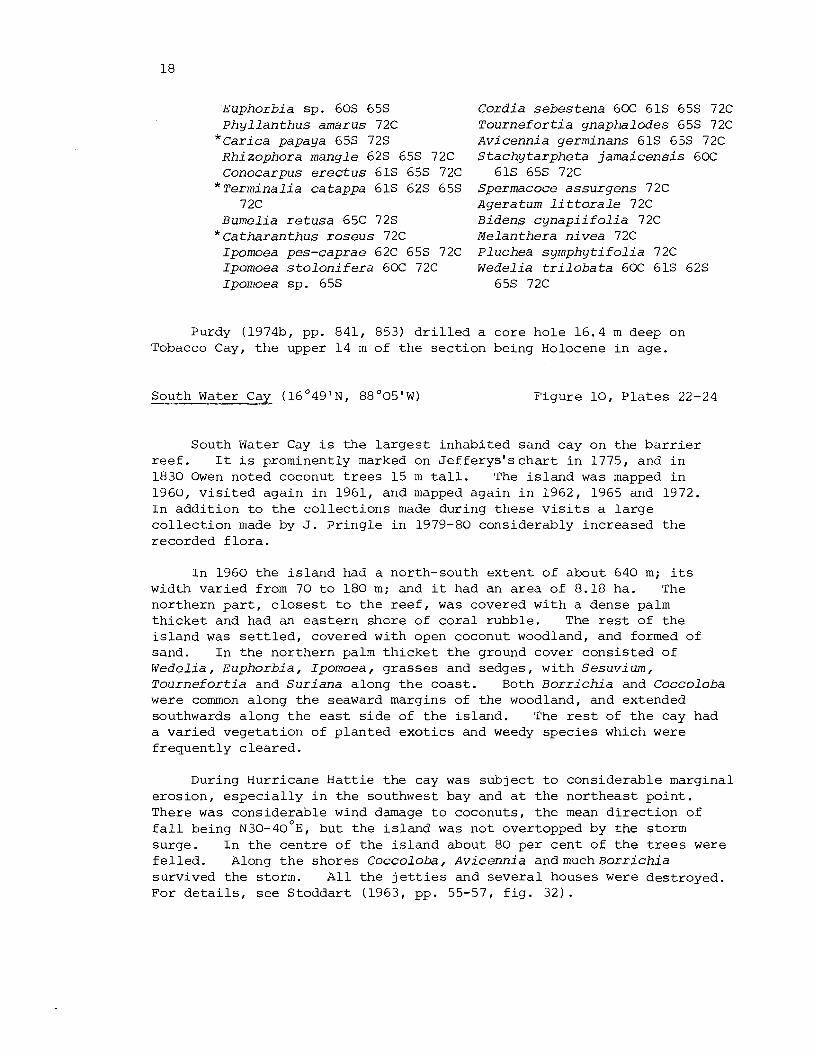
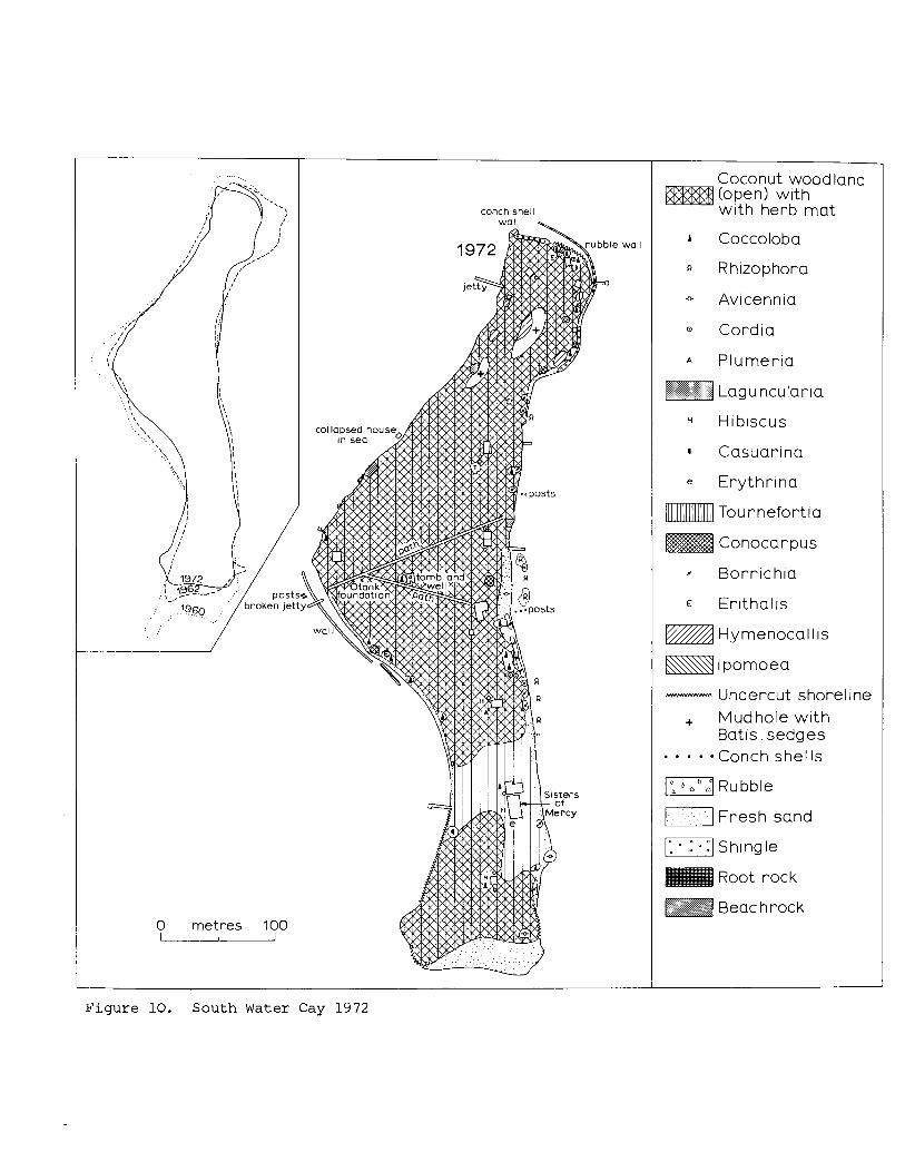
South Water Cay ( 1 6 ' 4 9 ' ~ ~ 8 8 ' 0 5 ' ~ ) Figure 10 , P l a t e s 22-24
South Water Cay i s t h e l a r g e s t inhabi ted sand cay on the b a r r i e r r e e f . I t i s prominently marked on J e f f e r y s ' s c h a r t i n 1775, and i n 1830 Owen noted coconut t r e e s 15 m t a l l . The i s l a n d was mapped i n 1960, v i s i t e d again i n 1961, and mapped again i n 1962, 1965 and 1972. I n add i t ion t o t h e c o l l e c t i o n s made during these v i s i t s a l a r g e c o l l e c t i o n made by J. P r ing le i n 1979-80 considerably increased t h e recorded f l o r a .
I n 1960 t h e i s l a n d had a north-south e x t e n t of about 640 m; i t s width va r i ed from 70 t o 180 m; and it had an a rea of 8.18 ha. The northern p a r t , c l o s e s t t o t h e r e e f , was covered wi th a dense palm t h i c k e t and had an e a s t e r n shore of c o r a l rubble. The r e s t of t he i s l a n d was s e t t l e d , covered with open coconut woodland, and formed of sand. I n t h e nor thern palm t h i c k e t t h e ground cover cons i s t ed of W e d e l i a , Euphorbia , Ipomoea, grasses and sedges, wi th S e s u v i u m , T o u r n e f o r t i a and S u r i a n a along t h e coas t . Both B o r r i c h i a and Coccoloba were common along t h e seaward margins of t h e woodland, and extended southwards along t h e e a s t s i d e of t h e i s l and . The r e s t of t h e cay had a var ied vegeta t ion of p lanted e x o t i c s and weedy spec ie s which were f r equen t ly c l ea red .
During Hurricane Ha t t i e t h e cay was sub jec t t o cons iderable marginal e ros ion , e s p e c i a l l y i n t h e southwest bay and a t t h e no r theas t po in t . There was considerable wind damage t o coconuts, t h e mean d i r e c t i o n of f a l l being ~ 3 0 - 4 0 ' ~ ~ but t he i s l a n d was not overtopped by t h e storm surge. I n t h e c e n t r e of t h e i s l a n d about 80 per c e n t of t h e t r e e s were f e l l e d . Along t h e shores Coccoloba, A v i c e n n i a a n d m u c h B o r r i c h i a survived t h e storm. A l l t h e j e t t i e s and s e v e r a l houses were destroyed. For d e t a i l s , see S toddar t (1963, pp. 55-57, f i g . 32) .
By 1965 physiographic change had been s l i g h t . The seaward beaches had r e t r e a t e d s l i g h t l y , but the leeward beaches had accreted; t h e r e had been continuing erosion a t t h e south point . The vegetat ion of t h e northern p a r t of the i s l a n d was l i t t l e changed, with W e d e l i a , Ipomoea, B a t i s , Euphorbia and Sesuvium, and t h r i v i n g Thr inax and Coccoloba under the coconnts. In the cent re of t h e i s l and t h e r e was a dense growth of Euphorbia, Ipomoea, S t a c h y t a r p h e t a , Ambrosia and Cassy tha , with some Hymenocal l i s and Coccoloba. Along the eas te rn shore the re was bushy B o r r i c h i a with much C a s s y t h a , a few T o u r n e f o r t i a seedlings, and a ground cover of Sesuvium, Ipomoea, Euphorbia and Sporobo lus . Many young coconuts planted i n the southern p a r t of t h e cay a f t e r t h e hurricane were 3-4.5 m t a l l . Two juvenile Casuarina were growing by the lagoon shore, bu t the re were many fewer Rhizophora seedlings round the shores and espec ia l ly along the e a s t coas t than i n 1960. A j e t t y and severa l new buildings had been erec ted and the e f f e c t s of t h e hurricane were no longer obvious. For f u r t h e r d e t a i l s , see Stoddart (1969, p.11) .
In 1972 the t rends of erosion and accre t ion had continued. There was r e t r e a t a t t h e south po in t , along the southwest bay and a t the nor th point . The i s l a n d had a maximum length of 660 m , a width varying from 55 t o 175 m, and an a rea of 6.49 ha. Masonry and rubble walls had been inadequate t o prevent continuing erosion both i n the southwest bay and a t the nor theas t point . Apart from a s e c t o r i n the soath, r ecen t ly c leared , there was a dense ground cover of herbs, v ines and grasses under the open coconut woodland. Hymenocal l i s , Ipomoea s t o l o n i f e r a , Ambrosia and Wedel ia were a l l common and conspicuous. B o r r i c h i a was the most common shrub colonising the e a s t shore, with Sesuvium a s ground cover; a s i n g l e seedling of Morinda was noted on the beach c r e s t .
No at tempt was made during t h e e a r l i e r v i s i t s t o make a complete co l l ec t ion of p l a n t s from South Water Cay, and by 1965 only 26 species had been recorded. 68 were recorded i n 1972, bringing the t o t a l t o 69, and P r i n g l e ' s co l l ec t ions i n 1979-80 r a i s e the t o t a l t o 80. This i s t h e h ighes t number f o r any of the Belize cays, b u t c l e a r l y r e f l e c t s the continuous and prolonged human disturbance of t h e vegetat ion. The following species have been recorded:
Andropogon glomeratus 61C 72C 79C
Anthephora hermaphrodi ta 79C Cenchrus i n c e r t u s 72C 79C Distichlis s p i c a t a 79C E r a g r o s t i s c i l i a r i s 72C 79C Eus tachys pe t raea 72C 79C Panicum v i r g a t u m 79C Paspalum b l o d g e t t i i 72C Paspalum d i s t i c h u m 72C Phragmites c f . a u s t r a l i s 72C S p a r t i n a p a t e n s 72C 79C S p a r t i n a s p a r t i n a e 72C
Sporobolus v i r g i n i c u s 72C 79C Sporobo lus sp. 60s 65s Cyperus l i g u l a r i s 72C Cyperus peruvianus 72C 79C Cyperus p l a n i f o l i u s 72C 79C Cyperus sp. 60s F i m b r i s t y l i s cymosa 72C 79C
*Cocos n u c i f e r a 60s 61s 62s 65s 72s
Thr inax r a d i a t a 65s 72C Agave sp . 72C Crinum amabi le 72C
Dracaena sp. 72C 79C H y m e n o c a l l i s l i t t o r a l i s 65.5
72C 79C * ~ a s u a r i n a e q u i s e t i f o l i a 6 5 s
72C 79C
Coccoloba u v i f e r a 6 0 s 6 5 s 72C B a t i s m a r i t i m a 6 5 s 72C 7% P h i l o x e r u s v e r m i c u l a r i s 72C Boerhav ia c o c c i n e a 79C P o r t u l a c a o l e r a c e a 72C 79C ~ e s u v i u m p o r t u l a c a s t r u m 6 0 s
72C 79C C a s s y t h a f i l i f o r m i s 6 0 s 6 5 s
72C 79C C a k i l e l a n c e o l a t a f 6 O S 72C 79C Chrysoba lanus i c a c o 72C Canava l ia r o s e a 72C 79C C r o t a l a r i a r e t u s a 72C 79C Desmodium incanum 72C 79C Desmodi um tor t u o s urn 79C E r y t h r i n a sp. 72C Sophora t o m e n t o s a 6 5 s 72C 79C V i g n a l u t e o l a 72C 79C S u r i a n a m a r i t i m a 6 0 s 79C Euphorbia b l o d g e t t i i 6 0 s 72C
79C Euphorbia m e s e m b r i a n t h e m i f o l i a
72C 79C Euphorbia t r i c h o t o m a 72C 79C Euphorbia sp. 6 0 s 6 5 s P h y l l a n t h u s amarus 72C 79C
* H i b i s c u s r o s a - s i n e n s i s 72C W a l t h e r i a i n d i c a 72C 79C P a s s i f lord s u b e r o s a 72C 79C Rhi zophora mang le 6 0 s 6 5 s
72C 79C
Conocarpus e r e c t u s 72C 79C L a g u n c u l a r i a racemosa 72C 79C
* ~ e r m i n a l i a c a t a p p a 72C * ~ s i d i um qua java 72C Polypremum procumbens 72C 79C
79C * ~ e r i um o l e a n d e r 79C *p lumer ia r u b r a 72C
79C Ipomoea macrantha 655 79C Ipomoea pes-caprae 72C 79C Ipomoea s t o l o n i f e r a 65C 72C 79C
6 5 s Ipomoea sp. 6 0 s 6 5 s
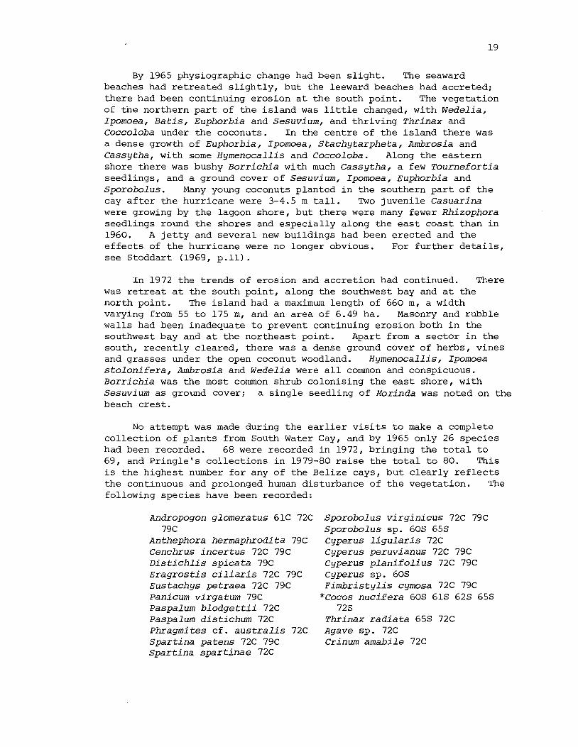
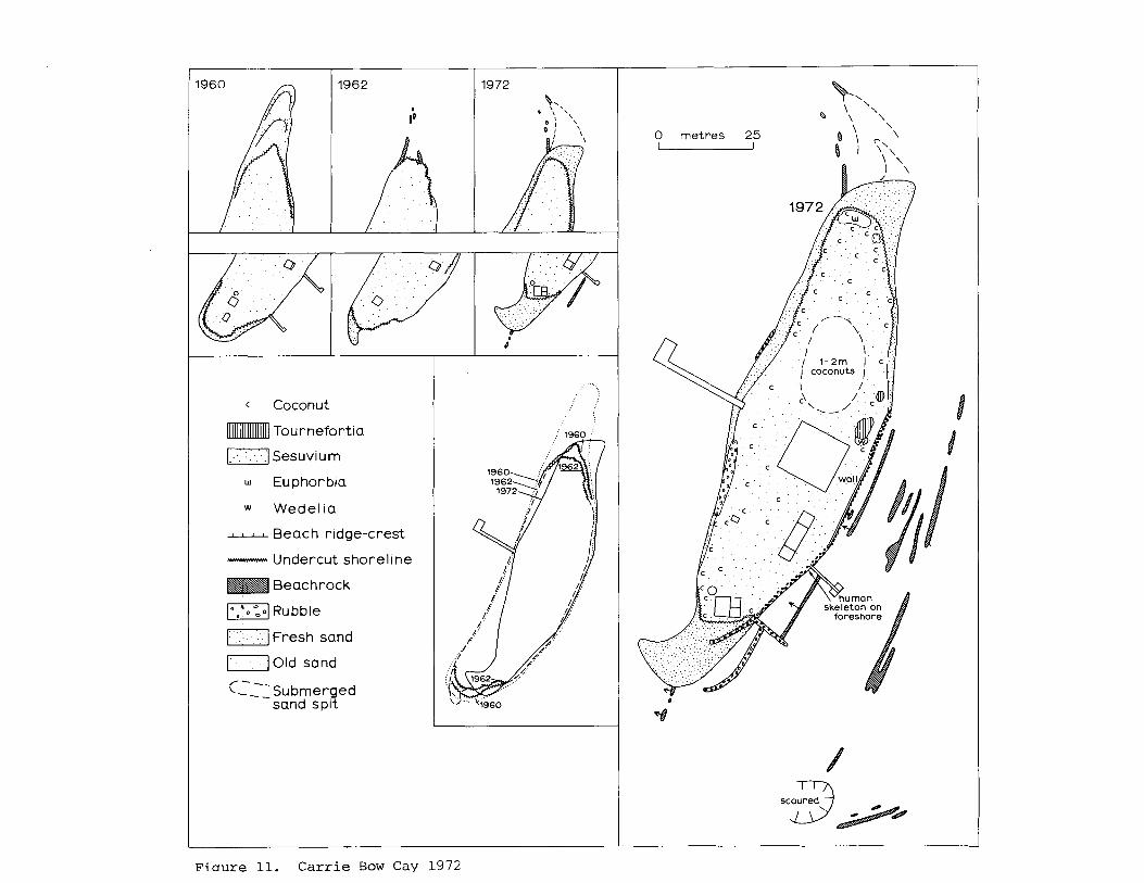
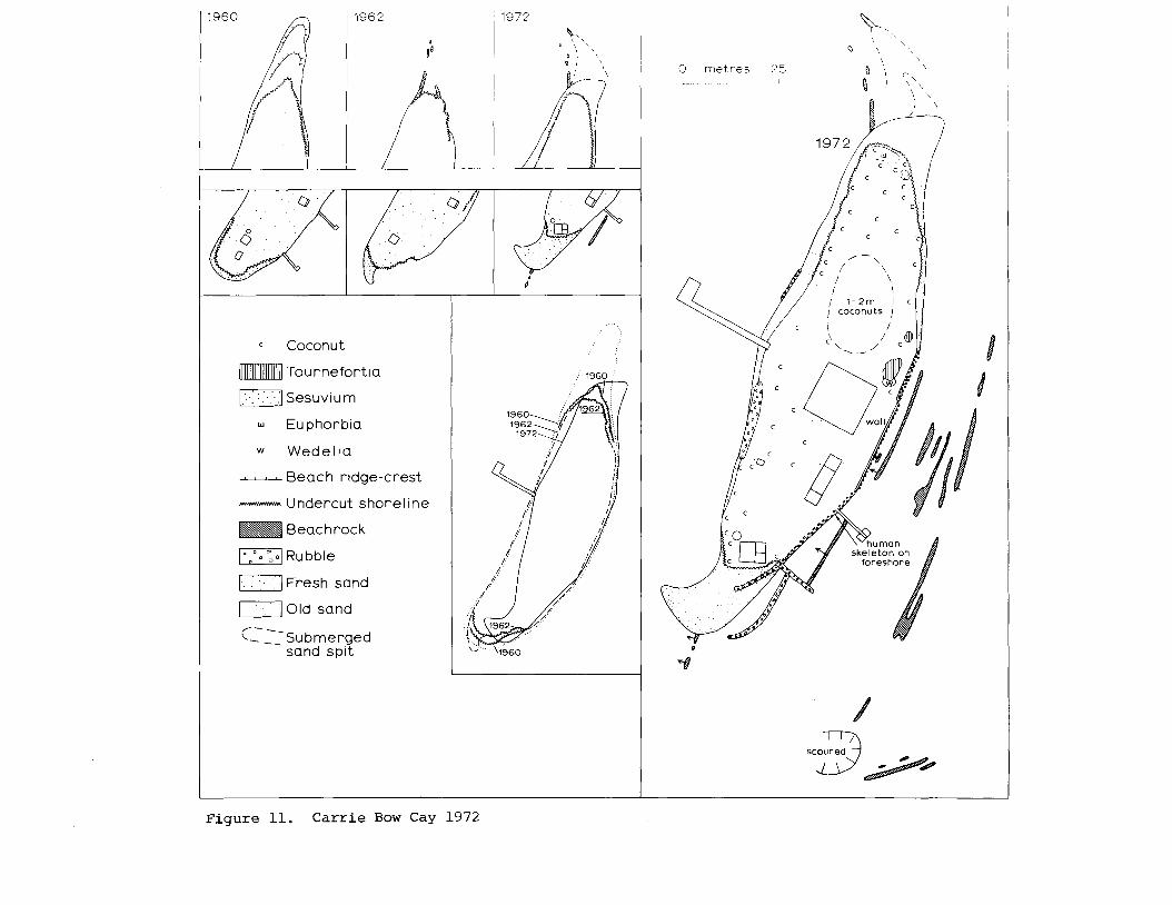
Carr ie Bow Cay (16048'N1 88O05'W)
Jacquemont ia h a v a n e n s i s 72C 79C Cord ia s e b e s t e n a 72C 79C T o u r n e f o r t i a gnapha lodes 60C
6 1 s 6 5 s 72C 79C A v i c e n n i a germinans 6 0 s 72C 79C L i p p i a n o d i f l o r a 72C 79C S t a c h y t a r p h e t a j a m a i c e n s i s 65s
72C 79C *Solanurn l y c o p e r s i c u m 79C E r i t h a l i s f r u t i c o s a 72C 79C Ernodea l i t t o r a l i s 72C 79C H e d y o t i s corymbosa 72C
* H e d y o t i s l a n c i f o l i a 79C Morinda c i t r i f o l i a 72C Spermacoce a s s u r g e n s 72C 79C Ageratum l i t t o r a l e 72C 79C Ambrosia h i s p i d a 6 5 s 72C 79C B o r r i c h i a a r b o r e s c e n s 6 0 s 6 5 s
72C 79C Conyza c a n a d e n s i s 72C E c l i p t a a l b a 79C E m i l i a s o n c h i f o l i a 79C Melan thera ni vea 72C W e d e l i a t r i l o b a t a 6 0 s 6 5 s 72C
79C
Figure 11, P la tes 25-28
Carrie Bow Cay, named a f t e r t h e Bowman family of Stann Creek, was charted by Owen as "Jack E l l i n ' s Cay" and appears on char t s a s "Ellen Cay". Owen noted "tops of bushes 2 0 f e e t " , b u t by 1960 the cay was covered with an open coconut woodland surrounding l a rge houses; t h e ground surface was kept cleared. The i s l and was then 140 m long and 32-40 m wide, w i t h an area of 5450 sq m. I t was b u i l t of sand, i t s surface about 1 m above sea l e v e l , with severa l s t r i p s of r e l i c t beach- rock 25-30 m o f f the e a s t shore. During Hurricane Ha t t i e the re was some beach r e t r e a t , especia l ly a t t h e northern and southern ends, exposing f resh beachrock. Many coconuts were f e l l e d i n a general ly nor ther ly d i rec t ion . Immediately a f t e r t h e storm the main coloniser
was Euphorbia . For d e t a i l s s e e S todda r t (1963, pp. 57-58, f i g . 33 ) . By 1965 a number of young coconuts had been p l a n t e d , and low T o u r n e f o r t i a bushes were growing a long t h e no r the rn p a r t o f t h e seaward sho re . The ground cover comprised s p a r s e Euphorbia , Sesuvium and Ipomoea, b u t w a s r epea t ed ly c l e a r e d (S todda r t 1969, p . 11 ) .
By 1972 e r o s i o n had con t inued a t t h e sou th p o i n t and a long t h e sou the rn end o f t h e leeward sho re , where t h e s h o r e had r e t r e a t e d up t o 15 m s i n c e 1962. Seasona l s a r i d sp i t s a t bo th t h e no r the rn and sou the rn p o i n t s p a r t l y mask t h e i n t e n s i t y o f t h i s con t i nu ing e ro s ion . A s a r e s u l t t h e area o f t h e i s l a n d d e c l i n e d from 5450 s q m i n 1960 t o 4260 s q m i n 19E5 and 3940 s q m i n 1972. A number of new coconuts had been p l a n t e d , b u t t h e ground s u r f a c e w a s k e p t ba r e , a p a r t from two clumps o f T o u r n e f o r t i a on t h e seaward sho re . Fu r the r e r o s i o n occur red a t t h e n o r t h e r n and sou the rn p o i n t s d u r i n g Hurr icane F i f i i n December 1974, and t h e i s l a n d w a s remapped by K. Rue t z l e r and H. Pulpan ( i n M i l l e r and Macintyre 1977, p.27) ; i t s area was reduced t o 2810 s q m. I n s p i t e of t h e f a c t t h a t v e g e t a t i o n w a s r e g u l a r l y c l e a r e d from t h e cay s u r f a c e , many s e e d l i n g s germina te . Some were recorded i n 1972, and o t h e r s i n a c o l l e c t i o n by J . D . F e r r a r i s i n May 1978. 22 s p e c i e s have now been recorded from C a r r i e Bow Cay, a t least 9 of them on ly as s e e d l i n g s . The l ist is as fo l lows :
Paspalum d i s t i c h u m 72C C a k i l e l a n c e o l a t a 72C 78C Cyperus p l a n i f o l i u s 72C ( s e e d l i n g ) Cocos n u c i f e r a 60s 62C 65s Bursera simaruba 72C ( s e e d l i n g )
72s Euphorbia b l o d g e t t i i 72C 78C ~ i c h h o r n i a c r a s s i p e s 78C Euphorbia m e s e m b r i a n t h e m i f o l i a
( s e e d l i n g ) 72C 78C Hymenoca l l i s l i t t o r a l i s 78s Euphorbia sp . 60s 62s
( s e e d l i n g ) 79C * T e r m i n a l i a catappa 72C ( s eed l i ng ) * Casuarina e q u i s e t i f o l i a 78C Ipomoea. pes-caprae 72C ( s eed l i ng )
Coccoloba u v i f e r a 72C 78C Ipomoea sp . 65s ( s e e d l i n g ) Tourrnefor t ia gnaphalodes 65s
Suaeda l i n e a r i s 78C 72C 78C ( s eed l i ng ) P h i l o x e r u s v e r m i c u l a r i s 72C 78C E c l i p t a a l b a 78C P o r t u l a c a o l e r a c e a 72C 78C Wede l ia t r i l o b a t a 72C S e s u v i um p o r t u l a c a s t r u m 65s
72C 78C S a l v i n v i s i t e d South Water Cay i n May 1863 and c o l l e c t e d b i r d s
(Coues 1864, p . 391) .
Curlew Cay (16 " 4 7 % ' ~ ~ 88O05 ' W )
Owen (1830) no t ed bushes 6 m t a l l h e r e , a t a t ime when Curlew Cay must have c l o s e l y resembled C a r r i e Bow Cay. I n 1960 and 1961, however, t h e i s l a n d w a s a low c r e s c e n t i c sandbore 36 m long and up t o 9 m wide. It w a s unvege ta ted a p a r t from two Rhizophora s e e d l i n g s . There i s e x t e n s i v e beachrock e a s t o f t h e p r e s e n t s i te o f t h e cay. The d a t e of d e s t r u c t i o n o f t h e vege t a t ed i s l a n d i s unknown; it may have been du r ing t h e 1945 hu r r i c ane . The sandbore d i sappeared a f t e r Hur r icane H a t t i e ,
b u t had reappeared by Apr i l 1962. It was p resen t i n 1972, but c l e a r l y s t i l l ephemeral and of f l u c t u a t i n g dimensions. Its a r e a i n 1960 was 370 s q m. Only one spec ie s of p l a n t i s recorded:
Rhizophora mangle 60s
For f u r t h e r d e t a i l s s ee S toddar t (1963, p.58, f i g . 34) . Sa lv in v i s i t e d t h i s i s l a n d i n 1863 and co l l ec t ed b i r d s (Coues 1864, p.391).
A Coccoloba
Tou rnefor t ia
Suriana
Conocarpus
Herb ma t
Scattered Portulaca
1 Tall grass - Beach r idge-crest - Undercut shore1 i ne
m ( F r e s h sand . . . . . .
-1 Shingle
Figure 3. Sergeant's Cay 1972
0 post
.post
0 metres 40 I I I

c Coconut Mixed Herbs
0 metres 30 I 1 I
'. ... . ." 0 metres 30 -
Figure 4. G o f f's Cay 1972
wall
c Coconut
Tou rnefortia
0 Suriana
Herb mat
E--d Portulaca
s Sporobolus
0 metres 30 u
Figu re 5. Engl i sh Cay 1972
c Coconut
r Coccoloba
n Rh~zophora
+ Av~cenn~a
0 Suriana
Conocarpus
Herb mat - Undercut shorel~ne
Conch shells
Beach rock
(1 Fresh sand
0 metres 3 0 I I
I
o post
- -
Figure 6. Rendezvous Cay 1 9 7 2
1 Douglos.1922 2 Owen. June 1834 3 Owen. July 1834
'E LIC
CAY
Figure 7. Reef topography between Columbus Cay and Channel Cay
conch shell wall -+.
0 metres 100
Coconut wood land (open) wlth with herb mat
A Coccoloba
Rh~zophora
- Av~cenn~a
Cordla
A Plumerla
Laguncular~a
H I ~ I S C U S
Casuarlna
e Erythr~na
Tournefortla
Conocarpus
B o r r ~ c h ~ a
E Er~ tha l~s
Hymenocallls
lpomoea
- Undercut shorel~ne + Mudhole w ~ t h
Bat~s , sedges . . . . Conch she1 Is
m " , u b b l e
T I Fresh sand
I] sh~ngle
Root rock
Beac h roc k
F i g u r e 10. South Water Cay 1972
c Coconut
Tournefortia
[c] Sesuvium
w Euphorbia
w Wedelia - Beach ridge-crest - Undercut shoreline
Beachrock
ml Rubble
T I Fresh sand
)-I Old sand /---
\---Submerged sand spit
Fiaure 11. Carr ie Bow Cay 1972
Scoured J
Coconut
Tournefortia
r] sesuvium
w Euphorbia
w Wedelia - Beach ridge-crest
- Undercut shoreline
Beach rock
Rubble
1-1 Fresh sand
Old sand ,- - -- <,--Submerged
sand splt
0 m e t r e s 2 5 1
Scoured ,TS Figure 11. C a r r i e Bow C a y 1972
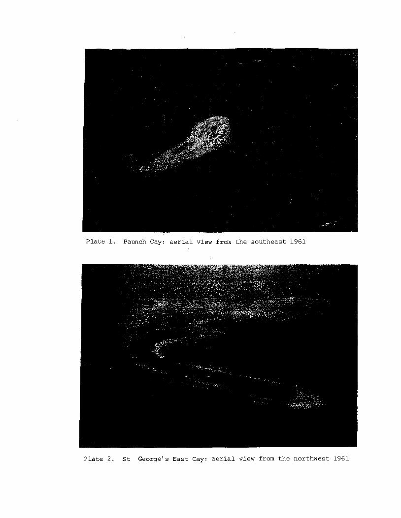
Pla te 1. Paunch Cay: a e r i a l view from t h e southeas t 1961
P l a t e 2 . S t George's Eas t Cay: a e r i a l view from t h e northwest 1961
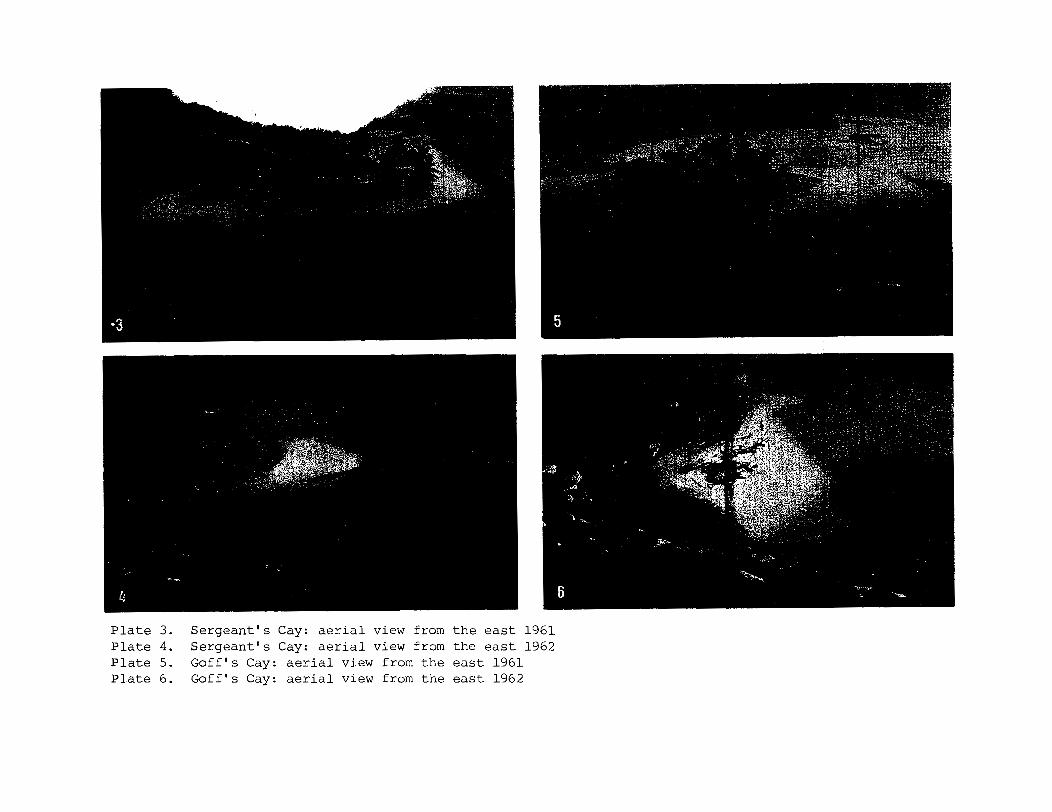
Plate 3. Sergeant's Cay: aerial view from the east 1961 Plate 4. Sergeant's Cay: aerial view from the east 1962 Plate 5. Goff's Cay: aerial view from the east 1961 Plate 6. Goff's Cay: aerial view from the east 1962
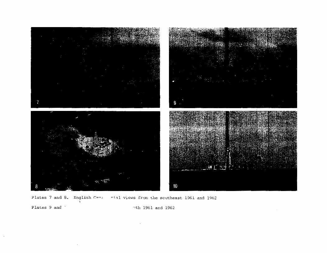
P l a t e s 7 and 8. English ra.7: ~ i a l views from t h e sou theas t 1961 and 1962 1
P l a t e s 9 and ' -1th 1961 and 1962
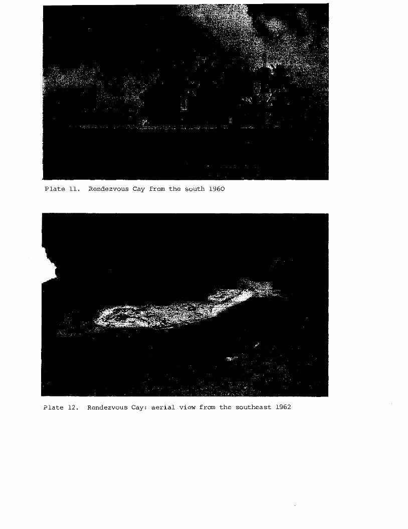
P l a t e 11. Rendezvous Cay from t h e south 1960
P l a t e 1 2 . Rendezvous Cay: a e r i a l view from t h e sou theas t 1962
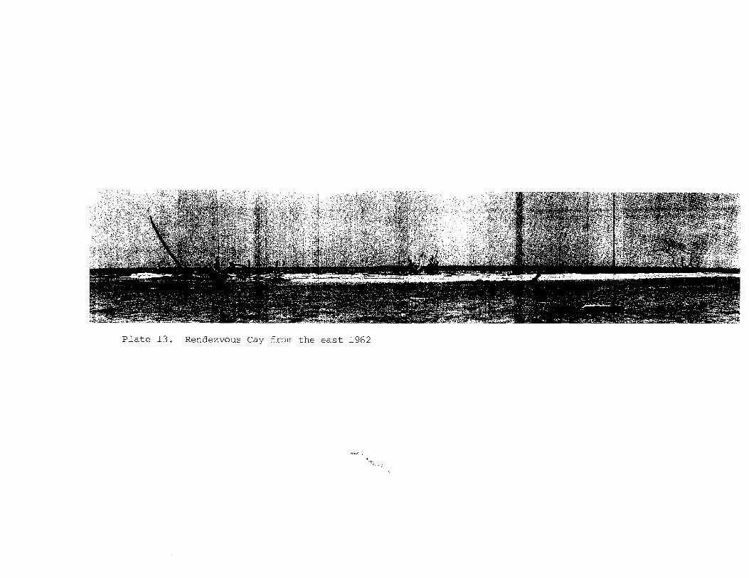
P l a t e 13. Rendezvous Cay from t he e a s t 1962
P l a t e 14. Rendezvous Cay from t h e west 1972 P l a t e 15. Rendezvous Cay from t h e southwest 1972 P l a t e 16. Cay Glory: a e r i a l view from t h e e a s t 1961
P l a t e 17. Rendezvous Cay: e r o s i o n on t h e east sho re 1972
P l a t e 18. Rendezvous Cay: aggrada t ion on t h e southwest sho re 1972
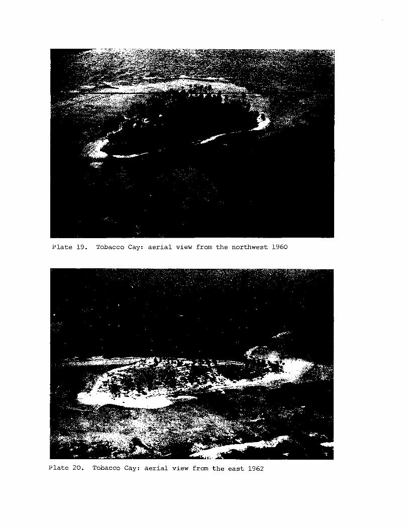
Plate 19. Tobacco Cay: ae r i a l view from the northwest 1960
Plate 20. Tobacco Cay: ae r i a l view from the eas t 1962
P l a t e 23. South Water Cay: aggrada t ion a t t h e southwest p o i n t 1972
P l a t e 24. South Water Cay: e r o s i o n on t h e nor thwes t s h o r e 1972
T o u r n e f o r t i a and S u r i a n a , and the ground cover included S e s u v i u m , Ipomoea, P o r t u l a c a and Hymenoca l l i s . There were th ree young coconuts. No beachrock was seen during e i t h e r survey. Altogether 13 species of p l a n t s have been recorded, 9 i n 1961 and 12 i n 1972. New records i n t h e second survey included P o r t u l a c a , H y m e n o c a l l i s , Cocos and Paspalum; E r i t h a l i s disappeared. The species recorded a r e a s follows:
Paspalum d i s t i c h u m 72C Cyperus p l a n i f o l i u s 72C Cyperus sp. 61s
*Cocos n u c i f e r a 72s Hymenoca l l i s l i t t o r a l i s 72C P o r t u l a c a o l e r a c e a 72C Sesuv ium p o r t u l a c a s t r u m 61s
72C
Middle S i lk Cay (16O28'~ , 8 8 ° 0 2 + ' ~ )
S u r i a n a m a r i t i m a 61s 72C Rhizophora mangle 61s 72C Conocarpus e r e c t u s 61s 72C Ipomoea macrantha 72C Ipomoea sp. 61s Tourne f o r t i a gnaphalodes 61s 72C A v i c e n n i a germinans 61s 72C E r i t h a l i s f r u t i c o s a 61s
Figure 13, P l a t e 34
Middle S i l k l i e s about 300 m southwest of North S i l k Cay. I n 1961 it was oblong i n shape, with maximum dimensions of 80 x 45 m and an area of 0.43 ha. I t was b u i l t of concentric sand r idges r i s i n g about 1 m above sea l eve l , with sand s p i t s extending t o southeast , nor theas t and northwest. It stands on a small patch r e e f , the windward c r e s t of which i s out l ined by emergent rubble. R e l i c t beachrock off t h e southern s i d e of the i s l and indicated northerly migration of a t l e a s t 50 m. The vegetat ion cover was r e s t r i c t e d t o a c l u s t e r of T o u r n e f o r t i a and S u r i a n a bushes a t the eas tern end of the cay, some sca t t e red shrubs of S u r i a n a , and a few coconuts, with a ground cover of Sesuv ium, Ipomoea and Euphorbia . By June 1972 t h e r e had been considerable changes. The is land was now t r i a n g u l a r , with a c l i f f e d southern shore and aggradation on t h e northern s i d e ; one l i n e of o ld beachrock was v i s i b l e , passing beneath the cay sands. The a rea was reduced t o 0.40 ha, but the vegetat ion cover had subs tan t i a l ly increased. I t was dominated by T o u r n e f o r t i a , S u r i a n a and Conocarpus bushes, with th ree t a l l coconuts and about 20 recent ly planted juveniles. The ground surface was covered with Euphorb ia , S e s u v i u m , Ipomoea, C y p e r u s , W e d e l i a and E r i t h a l i s . A temporary h u t had been constructed i n t h e middle of the i s land. Six species of p lan t s were seen i n 1961 and 7 more i n 1972, making a t o t a l f l o r a of 13 species:
E r a g r o s t i s p r o l i f e r a 72C Paspalum d i s t i c h u m 72C Cyperus p l a n i f o l i u s 72C
*Cocos n u c i f e r a 61s 72s S e s u v i um p o r t u l a c a s t r u m 61s
72C S u r i a n a mar i t ima 61s 72C Euphorbia m e s e m b r i a n t h e m i f o l i a
72C
Conocarpus e r e c t u s 72C Ipomoea macrantha 72C Ipomoea pes-caprae 72C Ipomoea s p . 61s T o u r n e f o r t i a gnaphalodes 61s
72C E r i t h a l i s f r u t i c o s a 72C W e d e l i a t r i l o b a t a 72C
South S i lk Cay (16O27+'~, 8 8 ° ~ 3 ' ~ ) Figure 14, P la tes 30 and 35
South S i l k Cay i s s i t u a t e d 460 m southwest of Middle S i l k Cay, and l i k e it i s b u i l t wholly of sand. In 1961 it was a lens-shaped i s l and 90 m long and up t o 32 m wide, with an area of 0.17 ha. Its surface stood about 1 m above sea l eve l . I t was covered by a scrub of S u r i a n a , with Hymenoca l l i s and Sesuv ium, and l e s s than a dozen sca t t e red coconuts. There was a s ing le Coccoloba t r e e a t the eas tern end. By June 1972 the i s l a n d was of s imi la r shape but had changed i t s o r ien ta t ion and locat ion. The vegetated a rea had been eroded and c l i f f e d a t i t s eas tern end, and then extended by a broad sandspit . The cay was then 110 m long and 30 m wide, with an area of 0.23 ha. The s ing le Coccoloba t r e e survived, and a s before the dominant vegetation was of S u r i a n a , Hymenoca l l i s and Sesuv ium. There were s i x coconuts. No beachrock was seen during e i t h e r survey. The ex ten t of Hymenoca l l i s i s of p a r t i c u l a r i n t e r e s t on t h i s cay. Five species of p lan t s were noted i n 1961 and a fu r the r four i n 1972, giving a t o t a l of 9 f o r the i s l and :
E r a g r o s t i s p r o l i f e r a 72C P o r t u l a c a o l e r a c e a 72C Cyperus p l a n i f o l i u s 72C Sesuv ium p o r t u l a c a s t r u m 61s 72C
*Cocas n u c i f e r a 61s 72s S u r i a n a mar i t ima 61s 72C Hymenoca l l i s l i t t o r a l i s 61s 72C Euphorbia m e s e m b r i a n t h e m i f o l i a Coccoloba u v i f e r a 61s 72C 72C
Samphire Cay (16'26$ I N , 88O03'W)
This was charted by Barnett i n 1840, 1.6 km south of South S i l k Cay, but had disappeared by 1913. I t has not been seen since. I t was apparently vegetated and must have resembled the S i l k Cays. "Samphire" usually denotes Sesuvium p o r t u l a c a s t r u m i n t h i s area.
Round Cay (16O25'~ , 8 8 ° 0 5 ' ~ ) Figures 15 and 17, P l a t e 31
Round Cay stands on a patch reef a t the inner edge of the b a r r i e r platform, about 1.6 km from the shel f edge. I n 1960 it was a lens- shaped i s l a n d 1 2 0 m long, up t o 45 m wide, and with an area of 0.25 ha. The northern and southern shores consisted of r idges of shingle and rubble, with c o r a l boulders up t o 0.3 m i n diameter. The r idges rose t o 1.8 m above sea l eve l ; the cent re of the i s l and , of sand and f i n e shingle, stood a t about 1.5 m. The eas tern end of the i s l and was formed by a broad sand beach, overlooking a zone of broken i n t e r t i d a l rubble. The i s l and was covered with a dense coconut woodland with marginal T o u r n e f o r t i a and S u r i a n a . Under the coconuts t h e r e was a th ick cover of Hymenocal l i s and grasses. There were two l i n e s of beachrock along the southern shore. By 1972 the i s l a n d had extended t o 110 x 40 m, and i t s area increased t o 0.31 ha. The southern shingle
shore had extended t o cover t h e beachrock, and t h e e a s t e r n sand beach t o l a r g e l y cover t h e rubble zone. The i s l a n d continued t o be covered with a coconut woodland wi th Hymenocal l i s beneath. The marginal T o u r n e f o r t i a was much l e s s ex t ens ive , however, presumably a s a r e s u l t of s u b s t r a t e e ros ion; and t h e r e was a l a r g e clump of Conocarpus a t t h e south p o i n t . Nine spec i e s were noted i n 1960 and 15 i n 1972, g iv ing a t o t a l f l o r a of 16 spec i e s ; only one ( C a k i l e l a n c e o l a t a ) had disappeared between t h e surveys. Species recorded a r e :
Paspalum d i s t i c h u m 72C Paspalum sp . 60s Cyperus p l a n i f o l i u s 72C C yper u s s p . 60s
* ~ o c o s n u c i f e r a 60s 72C Hymenocal l i s l i t t o r a l i s 60s F i c u s sp. 72C R i v i n a h u t n i l i s 72C Por tu laca o l e r a c e a 72C Sesuvium por tu lacas t rum 60s
Pompion Cay (16°241N, 88°06%1W)
C a k i l e l a n c e o l a t a 60s Sur iana mari t ima 60s 72C Euphorbia mesembrianthemi f o l i a
7 2C Euphorbia sp . 60s
72C Conocarpus e r e c t u s 72C Ipomoea macrantha 72C Ipomoea pes-caprae 72C Tournef o r t i a gnaphalodes 60s 72C
72C Morinda c i t r i f o l i a 72C
Figures 16 and 17 , P l a t e s 32 and 40
Pompion Cay, l i k e Round Cay, i s s i t u a t e d on a r ee f pa tch r i s i n g from t h e i n n e r edge of t h e b a r r i e r p la t form, 3.2 km southwest of Round Cay. I t s tands about 1 . 6 km from t h e seaward edge of t h e b a r r i e r platform, and with t h e except ion of fou r smal l pa tch r e e f s nearby it is t h e only r ee f t o reach t h e su r f ace between Round and Ranguana Cays, a d i s t a n c e of 11 .5 km. When t h e i s l a n d was mapped i n 1960 it was of simple o u t l i n e , 115 m long and up t o 50 m wide, wi th an a r e a of 0.35 ha. The e a s t e r n end of t h e cay was low and sandy; t h e nor thern and western shores a r e b u i l t o f s h i n g l e and rubble r i s i n g t o 1 . 3 m above sea l e v e l . There was no beachrock. On t h e northwest s i d e t h e beach c r e s t was co lonised by a mat of Sesuvium with s c a t t e r e d T o u r n e f o r t i a . To t h e no r theas t t h e r e i s a clump of Coccoloba, and along t h e south shore mature t r e e s of Bursera and Cord ia . The main p a r t of t h e cay was under coconut woodland wi th a ground cover of Hymenoca l l i s , E r i t h a l i s and C a k i l e . By 1972 t h e i s l a n d had expanded, both by sand a c c r e t i o n a t t h e e a s t end and s h i n g l e a c c r e t i o n a t t he west end, t o a t o t a l l eng th of 123 m; it was s l i g h t l y narrower (45 m maximum), and had an a r e a of 0.42 ha. The Coccoloba clump and t r e e s of Bursera and Cordia could s t i l l b e loca ted . The a r e a of Hymenocal l i s beneath t h e coconuts had expanded and coalesced; t h e r e s t of t h e vegeta ted su r f ace was covered wi th Sesuv ium, Cyperus and Euphorbia. The a r e a of coconut woodland was very s i m i l a r t o t h a t of 1960. Hydrographic c h a r t s mark a prominent "White Rock" t o t h e west of t h e cay. Th i s is a small s h i n g l e i s l a n d , 40 m i n diameter and 1 m above sea l e v e l , b u i l t of Acropora s t i c k s i n concent r ic r i d g e s , s i t u a t e d about 500 m t o t h e west of t h e cay. I t is n o t vege ta ted and owes i t s colour t o guano s t a i n i n g . Eleven p l a n t spec i e s were noted on Pompion i n 1960 and 19 i n 1972, g iv ing a t o t a l of 2 1 spec i e s . Of those noted i n 1960, C a k i l e and E r i t h a l i s were n o t found i n 1972. The spec i e s recorded a r e a s fol lows:
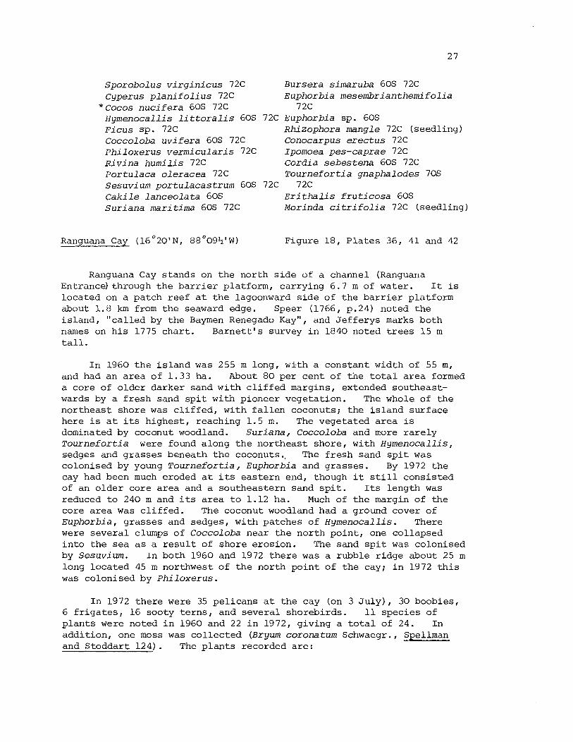
S p o r o b o l u s v i r g i n i c u s 72C Cyperus p l a n i f o l i u s 72C
* Cocos n u c i f e r a 60s 72C Hymenoca l l i s l i t t o r a l i s 60s 72C F i c u s Sp. 72C Coccoloba u v i f e r a 60s 72C P h i l o x e r u s v e r m i c u l a r i s 72C R i v i n a h u m i l i s 72C P o r t u l a c a o l e r a c e a 72C S e s u v i u m p o r t u l a c a s t r u m 60s 72C C a k i l e l a n c e o l a t a 60s S u r i a n a mar i t ima 60s 72C
Ranguana Cay (16 '20' N , 88'09+' W)
Bursera simaruba 60s 72C Euphorbia mesembrianthemi f o l i a
72C Euphorbia sp . 60s Rki zophora mangle 72C (seedling) Conocarpus e r e c t u s 72C Ipomoea pes-caprae 72C Cord ia s e b e s t e n a 60s 72C Tourne f o r t i a gnapha lodes 70s
7 2C E r i t h a l i s f r u t i c o s a 60s Morinda c i t r i f o l i a 72C (seedling)
Figure 18, P la tes 36, 41 and 42
Ranguana Cay stands on the north s ide of a channel (Ranguana Entrancelthrough the ba r r i e r platform, carrying 6.7 m of water. I t i s located on a patch reef a t the lagoonward s ide of the ba r r i e r platform about 1.8 km from the seaward edge. Speer (1766, p.24) noted the i s l and , "cal led by the Baymen Renegado Kay", and Jefferys marks both names on h i s 1775 char t . Barne t t ' s survey i n 1840 noted t r e e s 15 m t a l l .
I n 1960 the i s l and was 255 m long, with a constant width of 55 m, and had an area of 1.33 ha. About 80 per cent of the t o t a l area formed a core of o lder darker sand with c l i f f e d margins, extended southeast- wards by a f resh sand s p i t w i t h pioneer vegetation. The whole of the northeast shore was c l i f f e d , with f a l l e n coconuts; the i s l and surface here i s a t i t s highest , reaching 1.5 m. The vegetated area i s dominated by coconut woodland. S u r i a n a , Coccoloba and more ra re ly T o u r n e f o r t i a were found along t he northeast shore, with H y m e n o c a l l i s , sedges and grasses beneath t he coconuts.* The f resh sand s p i t was colonised by young T o u r n e f o r t i a , Euphorbia and grasses. By 1972 the cay had been much eroded a t i t s eas tern end, though it s t i l l consisted of an older core area and a southeastern sand s p i t . Its length was reduced t o 240 m and i ts area t o 1 .12 ha. Much of the margin of the core area was c l i f f ed . The coconut woodland had a ground cover of Euphorb ia , grasses and sedges, with patches of Hymenoca l l i s . There were several clumps of Coccoloba near the north point , one collapsed i n t o the sea a s a r e s u l t of shore erosion. The sand s p i t was colonised by Sesuv ium. In both 1960 and 1972 there was a rubble ridge about 25 m long located 45 m northwest of the north point of the cay; i n 1972 this was colonised by P h i l o x e r u s .
I n 1972 there were 35 pelicans a t the cay (on 3 J u l y ) , 30 boobies, 6 f r i ga t e s , 16 sooty t e rns , and several shorebirds. 11 species of p lan t s were noted i n 1960 and 22 i n 1972, giving a t o t a l of 24. I n addit ion, one moss was col lec ted (Bryum coronatum Sehwaegr., Spellman and Stoddart 124). The p lan t s recorded are :
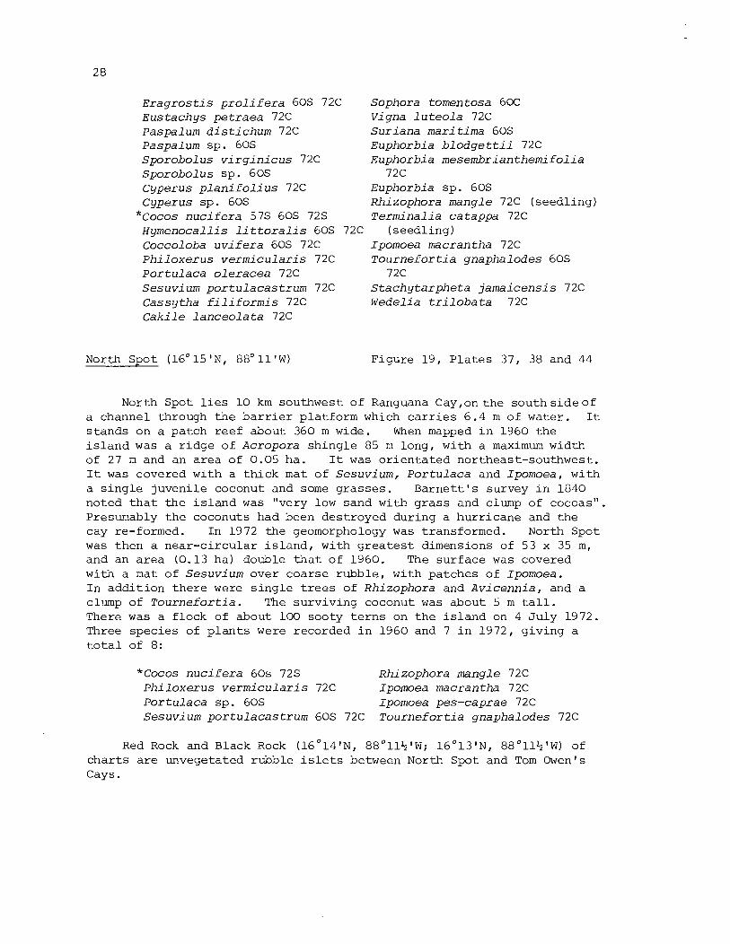
E r a g r o s t i s p r o l i f e r a 60s 72C Sophora tomen tosa 60C E u s t a c h y s p e t r a e a 72C Vigna l u t e o l a 72C Paspalum d i s t i c h u m 72C S u r i a n a mari t i m a 60s Paspalum sp . 60s Euphorbia b l o d g e t t i i 72C Sporobo l u s v i r g i n i c u s 72C Euphorbia m e s e m b r i a n t h e m i f o l i a S p o r o b o l u s s p . 60s 72C Cyperus p l a n i f o l i u s 72C Euphorbia sp . 60s C yperus s p . 60s Rhi zophora mangle 72C ( seed l ing )
* ~ o c o s n u c i f e r a 57s 60s 72s T e r m i n a l i a ca tappa 72C H y m e n o c a l l i s l i t t o r a l i s 60s 72C ( seed l ing ) Coccoloba u v i f e r a 60s 72C Ipomoea macrantha 72C P h i l o x e r u s v e r m i c u l a r i s 72C T o u r n e f o r t i a gnapha lodes 60s P o r t u l a c a o l e r a c e a 72C 72C S e s u v i u m p o r t u l a c a s t r u m 72C S t a c h y t a r p h e t a j a m a i c e n s i s 72C C a s s y t h a f i l i f o r m i s 72C W e d e l i a t r i l o b a t a 72C C a k i l e l a n c e o l a t a 72C
North Spot (16' 1 5 ' ~ ~ 88' 1 1 ' ~ ) Figure 19, P l a t e s 37, 38 and 44
North Spot l i e s 10 km southwest of Ranguana Cay ,onthe s o u t h s i d e o f a channel through t h e b a r r i e r p la t form which c a r r i e s 6 .4 m of water . I t s t ands on a pa tch r ee f about 360 m wide. When mapped i n 1960 t h e i s l a n d was a r i d g e of Acropora s h i n g l e 85 m long, wi th a maximum width of 27 m and an a r e a of 0.05 ha. I t was o r i e n t a t e d northeast-southwest . I t was covered wi th a t h i c k mat of S e s u v i u m , P o r t u l a c a and Ipomoea, with a s i n g l e juveni le coconut and some g r a s s e s . B a r n e t t ' s survey i n 1840 noted t h a t t h e i s l a n d was "very low sand with g r a s s and clump of cocoas". Presumably t h e coconuts had been des t royed dur ing a hu r r i cane and t h e cay re-formed. In 1972 t h e geomorphology was t ransformed. North Spot was then a nea r - c i r cu l a r i s l a n d , with g r e a t e s t dimensions of 53 x 35 m, and an a r e a (0.13 ha) double t h a t of 1960. The s u r f a c e was covered with a mat of S e s u v i u m over coarse rubb le , wi th pa tches of Ipomoea. I n a d d i t i o n t h e r e were s i n g l e t r e e s of Rhi zophora and A v i c e n n i a , and a clump of T o u r n e f o r t i a . The su rv iv ing coconut was about 5 m t a l l . There was a f l ock of about 100 sooty t e r n s on t h e i s l a n d on 4 J u l y 1972. Three spec i e s of p l a n t s were recorded i n 1960 and 7 i n 1972, g iv ing a t o t a l of 8:
*Cocos n u c i f e r a 60s 72s Rhizophora mangle 72C P h i l o x e r u s v e r m i c u l a r i s 72C Ipomoea macrantha 72C P o r t u l a c a sp . 60s Ipomoea pes-caprae 72C S e s u v i um p o r t u l a c a s t r u m 60s 72C T o u r n e f or t i a gnapha lodes 72C
Red Rock and Black Rock ( 1 6 ° 1 4 ' ~ , 8 8 ° 1 1 + ' ~ ; 16O13'N, 88"11+'W) of c h a r t s a r e unvegetated rubble i s l e t s between North Spot and Tom Owen's Cays.
"Tom Owen's Cay" ( 1 6 " 1 2 ' ~ , 8 8 ° 1 3 ' ~ ) Figures 20 and 2 1
South of 1 6 ' 1 5 ' ~ t h e h i s t o r y and nomenclature of t h e b a r r i e r reef cays becomes complex. Owen i n h i s 1835 survey charted t h r e e i s l ands near t h e major channel which i n t e r s e c t s t h e b a r r i e r platform i n l a t i t u d e 1 6 ° 1 1 % ' ~ . One on t h e nor th s i d e he named Tom Owen's Cay; it was described a s having "one Cocoa N. Tree & Shrubs". Two small un-named i s l ands on t h e south s i d e were described a s having "one l a r g e t r e e and high shrubs" (on the west) and "grass and bushes" (on t h e e a s t ) (Admiralty M s L45). The northern cay has now disappeared, though s t i l l marked on Admiralty Chart 1573, and t h e name Tom Owen's Cays i s now given l o c a l l y t o t h e two southern i s l ands . Both a r e conspicuous i s l ands , t h e eas tern cay with a c l u s t e r of t a l l coconuts, and the western with a l a rge r coconut woodland.
The e a r l i e r nomenclature of these i s l a n d s i s uncertain. Speer i n h i s s a i l i n g d i rec t ions (1766, p.24) mentions "a Kay c a l l e d Cohune's Kay; and a very remarkable small Kay, t h a t has many t a l l Palmetoe Trees on it; which look l i k e so many round b a l l s hanging i n t h e a i r " . He s t a t e s t h a t "Cohune's Kay, and t h e easternmost of the Sappa t i l l a Kays [ i . e . Northeast Sapodi l la cay] , a r e N. by E . and S. by W . of each o the r ; d is tance about 5 miles". This would br ing Cohune's Kay t o t h e pos i t ion of t h e former Tom Owen's Cay; Speer c a r e f u l l y described the deep channel lying between the two. "Cohune's Kay", he continues, " i s f u l l of bushes and t r e e s . A l i t t l e t o the eastward of Cohune's Kay the re a r e two Sand Boors; b u t they jo in t o one another , and t o Cohune's Kay by a Reef. You leave them on your s tarboard s i d e ; and on your larboard s i d e , you leave a Sand Boor t h a t has breakers a l l round it, and no bushes on it. And about two c a b l e ' s length t o the N.W. of t h i s Sand Boor t h e r e i s a small spo t of Rocks, which breaks when it blows f resh . And t o the eastwards of t h a t Sand Boor t h e r e i s another Boor. There is a channel between them of 2 1-hal f , and 3 fathom water" (1766, p.24). This would suggest t h e i d e n t i t y of Cohune's Kay with the present Tom Owen's West Cay, and t h a t i n t h e eighteenth century t h e present Tom Owen's Eas t Cay was one of t h e sandbores joined t o Cohune by a r ee f . In t h i s case t h e "very remarkable small Kay" with palmettoes was probably o l d Tom Owen's Cay, now disappeared. Je f fe rys marks Cohune Kay on h i s 1775 c h a r t , and immediately nor th of it, across a main channel, "Halls Key". Thus H a l l ' s may a l s o be t e n t a t i v e l y i d e n t i f i e d with o l d Tom Owen's. We have no information on when, a f t e r 1835, t h i s i s l a n d disappeared; t h e r e i s c e r t a i n l y no t r a c e of it now.
Tom Owen's Eas t Cay (16°11%'N, 8 8 ° 1 3 % ' ~ ) Figure 2 2 , P l a t e s 39, 43, 46 and 47
Tom Owen's Eas t Cay is t h e smaller of the two. When mapped i n 1960 it was t r i a n g u l a r i n shape, with s i d e s 35-45 m long. I t abuts on i ts nor th s i d e on the r ee f -c res t rubble zone, and the northwest and nor theas t shores were b u i l t of sh ingle . Most of t h e cay was b u i l t of sand, however, r i s i n g up t o 1 m above s e a l eve l . There were four
t a l l coconuts on t h e i s l a n d , and a number of sma l l e r ones, t oge the r wi th a s c rub of T o u r n e f o r t i a and Coccoloba and ex t ens ive Hymenoca l l i s and Sesuv ium. The i s l a n d had changed cons iderab ly by 1972. The o l d i s l a n d had been eroded and then extended southwards by a new sand s p i t . The a r e a had inc reased from 0.10 t o 0.12 ha. The a r e a of Coccoloba had g r e a t l y i nc reased , and t h e r e was a l s o a pa tch of Conocarpus . Otherwise t h e vege t a t i on resembled t h a t i n 1960. No beachrock was seen i n e i t h e r survey. I n 1972 t h e a r e a of rubb le a long t h e no r th shore was much more ex t ens ive than i n 1960, and probably r ep re sen t ed a hu r r i cane event .
Ten p l a n t s p e c i e s were recorded i n 1960 and 11 i n 1972, g iv ing a t o t a l of 15. The fol lowing a r e recorded:
Paspalum d i s t i c h u m 72C Sporobo l u s v i r q i n i c u s 72C Cyperus p l a n i f o l i u s 72C Cyperus sp . 60s
* ~ o c o s n u c i f e r a 60s 72s Hymenoca l l i s l i t t o r a l i s 60s Coccoloba u v i f e r a 60s 72C P h i l o x e r u s v e r m i c u l a r i s 72C P o r t u l a c a u l e r a c e a 72C P o r t u l a c a sp . 60s
Sesuv ium p o r t u l a c a s t r u m 60s 72C Bursera s imaruba 60s Euphorbia m e s e m b r i a n t h e m i f o l i a
72C Euphorbia sp . 60s
72s Conocarpus e r e c t u s 72C T o u r n e f o r t i a qnapha lodes 60s E r i t h a l i s f r u t i c o s a 60s Wede l ia t r i l o b a t a 60s
Tom Owen's West Cay (16°11%'N, 88O14'W) Figure 23, P l a t e s 45, 46 and 48
I n 1960 Tom Owen's West Cay was about 90 m long and 35 m wide; it had an a r e a of 0.26 ha. I t was f r i n g e d along i ts nor thern s i d e by a zone of c o r a l rubb le , and both n o r t h and south shores were formed of s h i n g l e . The i n t e r i o r was sandy wi th occas iona l b locks of c o r a l rubb le , and t h e r e were sand beaches a t bo th e a s t and west ends. The gene ra l s u r f a c e s tood about 1 m above s e a l e v e l . The i s l a n d was covered wi th coconut woodland, e s p e c i a l l y dense a t t h e western end, wi th an undercover of W e d e l i a , C a k i l e , Ambros ia , S e s u v i u m , Euphorb ia , sedges and g ra s se s . There was some marginal Cocco loba , Conocarpus and T o u r n e f o r t i a . No beachrock was seen. The i s l a n d remained very much t h e same i n 1972, wi th r a t h e r minor changes i n o u t l i n e ; t h e a r ea had decreased t o 0.24 ha. I t was s t i l l covered wi th coconut woodland, b u t Conocarpus and C a e s a l p i n i a appeared much more ex tens ive . Cordia surv ived from 1960 on t h e south shore . P o r t u l a c a was ex t ens ive on t h e windward beach c r e s t s . F i f t e e n spec i e s of p l a n t s were recorded i n 1960 and 17 i n 1972, g iv ing a t o t a l of 22:
Paspalum d i s t i c h u m 72C *Cocos n u c i f e r a 60s 72s Paspalum sp . 60s Coccoloba u v i f e r a 60s 72C Sporobo l u s v i r q i n i c u s 72C Iresine d i f f u s a 72C S p o r o b o l u s sp. 60s R i v i n a h u m i l i s 72C Cyperus p l a n i f o l i u s 72C P o r t u l a c a ul e r a c e a 72C Cyperus sp . 60s P o r t u l a c a sp . 60s
Sesuvium portulacastrum 60s 72C Ipomoea pes-caprae 72C Caki l e lanceola ta 60s Tournefortia gnaphalodes 60s Caesalpinia bonduc 72C 72C Canavalia rosea 60s Lippia nodif lora 72C Thespesia populnea 72C E r i t h a l i s f r u t i c o s a 60s Rhizophora mangle 60s 72C Ambrosia h i spida 60s Conocarpus e rec tus 60s 72C Wedelia t r i l o b a t a 60s Ipomoea macrantha 72C
One of t h e present Tom Owen's Cays was v i s i t e d by t h e Marshall F ie ld Expedition i n 1923, when K.P . Schmidt and L.L. Walters co l l ec ted two l i z a r d s ( A r i s t e l l i g e r georgeensis and Anolis sagre i ) (Schmidt 1941) .
Cays between Tom Owens Cays and Northeast Sapodil la Cay Figures 20 and 21
Owen i n 1835 (Admiralty MS L45) charted two small i s l ands ly ing respect ive ly 3.2 and 4 km southsouthwest of the present Tom Owen's Cays. The northern i s l a n d had "dry sand, one Cocoa N. Tree and Shrubs"; t h e o the r "Dry Sand, 2 Cocoa N. Trees, Shrubs & bushes". They were s i t u a t e d on t h e south s i d e of the main channel between Tom Owen's and Northeast Sapodi l la Cays, and a r e probably the "Sand Boors" r e fe r red t o by Speer (1766, p.24; quoted above). Both i s l a n d s have now disappeared, though s t i l l marked on char t s ; whenthey were destroyed is not known.
The Sapodi l la Cays Figures 20 and 21, P la te 49
The southern s i x ki lometres of the b a r r i e r reef cons i s t s of a s e r i e s of l a rge shoal patches i n t e r s e c t e d by deep channels. The s i x i s l a n d s now e x i s t i n g on these patches a r e termed the Sapodil la Cays (Admiralty MS L45, 1835) o r Zapo t i l l a Cays (Chart 15731, and the re is some informal suggestion of a t e r r i t o r i a l claim t o them by the Republic of Honduras (Aguilar Paz 1954). The main i s l ands a r e here r e f e r r e d t o a s Northeast Sapodi l la , Frank's , Nicolas, Hunting, Lime and Ragged Cays. Speer (1766, 24) r e f e r s t o them a s " s i x l a rge Champaign Kays" [champaign: "an expanse of l e v e l , open country. Unenclosed o r common land" (Shorter Oxford English Dict ionary, I (19331, p.28911.
Northeast Sapodil la Cay (16°08'N, 88O15'W) Figure 24,Plates 50,52 and 53
Northeast Sapodil la Cay, t h e most nor the r ly , is a rectangular i s l a n d with g r e a t e s t north-south and east-west dimensions of 300 m. I n 1960 i t s a rea was 4.79 ha. The seaward shore was formed by a sh ingle r idge r i s i n g 2 m above sea l e v e l , h ighes t near t h e nor theas t p o i n t and decl in ing southwards. The northwest and southwest beaches a r e formed by low sand r idges. The cen t re of t h e cay i s low-lying and poorly drained. The main dry land a r e a s were t o leeward of t h e seaward
s h i n g l e r i d g e and a t t h e west end of t h e cay. I n t h e sou theas t bay t h e r e a r e 8 , pos s ib ly 9 , l i n e s of r e l i c t beachrock, s tanding up t o 30 m from t h e p r e s e n t beach; t h e o u t e r l i n e s c a r r y up t o 1 m of water . I n 1960 t h e r e was a f u r t h e r pa tch of beachrock, 15 m long, poor ly cemented, on t h e southwest shore. The low-lying c e n t r e of t h e i s l a n d was occupied by hundreds of young coconut palms, surrounded by A c r o s t i c h u m aureum. The sandy a r e a s were occupied by t a l l e r coconut woodland. Coccoloba and T h r i n a x grew along t h e seaward beach c r e s t . A l a r g e pa tch of rubble a t t h e e a s t e r n p o i n t was co lonised by S e s u v i u m . L i t t l e morphological change had occurred by J u l y 1972 except f o r e ros ion along t h e northwest bay. This averaged 1 0 m and reached 20 m a t one p o i n t , l eav ing a c l i f f e d sho re with f a l l e n coconut t r e e s . The southwest sandy shore had been covered wi th s h i n g l e f o r i t s e n t i r e l eng th and t h e sma l l beachrock exposure hidden. On t h e n o r t h e a s t shore t h e beach i t s e l f was formed of sand over ly ing t h e f a c e of t h e high s h i n g l e r i d g e , and low beachrock was exposed f o r p a r t of i t s length . The vege t a t i on was observed i n g r e a t e r d e t a i l than i n 1960. I n t h e low-lying coconut woodland wi th A c r o s t i c h u m , t h e dominant woody spec i e s beneath t h e coconuts was E r i t h a l i s . Chrysoba lanus was common round t h e margins o f t h e a r e a on s l i g h t l y higher ground, and i n d i v i d u a l s were s c a t t e r e d through t h e woodland i t s e l f . Cocco loba , Conocarpus and S u r i a n a formed a l i t t o r a l hedge on t h e beach c r e s t round much of t h e windward s i d e of t h e cay, b u t T o u r n e f o r t i a was s u r p r i s i n g l y absent . Trees i n t h e coconut woodland included F i c u s , T e r m i n a l i a , H i b i s c u s t i l i a c e u s , and C i t h a r e x y l u m caudatum, t h i s l a s t forming t r e e s 3-6 m t a l l nea r t h e south p o i n t . The i s l a n d was i nhab i t ed i n 1960 b u t had been abandoned by 1972, when t h e main house was i n r u i n s and t h e j e t t y broken.
26 p l a n t spec i e s were recorded i n 1972, which wi th t h e s i x noted i n 1960 b r ings t h e t o t a l recorded t o 28:
A c r o s t i c h u m aureum 60s 72C E r a q r o s t i s p r o l i f e r a 72C E u s t a c h y s p e t r a e a 72C Paspalum b l o d q e t t i i 72C Paspalum d i s t i c h u m 72C S p o r o b o l u s j a c q u e m o n t i i 72C S t e n o t a p h r u m secundatum 72C Cyperus p l a n i f o l i u s 72C
* ~ o c o s n u c i f e r a 60s 72s T h r i n a x r a d i a t a 60s 72C
*Musa s a p i e n t u m 72C F i c u s sp. 72C Coccoloba u v i f e r a 60s 72C S e s u v i u m p o r t u l a c a s t r u m 60s
Frank ' s Cays ( 1 6 ' 0 8 ' ~ ~ 8 8 ' 1 5 ' ~ )
C a k i l e l a n c e o l a t a 60C Chrysoba lanus i c a c o 72C Sophora t o m e n t o s a 72C S u r i a n a m a r i t i m a 72C Euphorbia b l o d q e t t i i 72C Hippocra tea v o l u b i l i s 72C H i b i s c u s t i l i a c e u s 72C P a s s i f l o r a s u b e r o s a 72C Conocarpus e r e c t u s 72C
* ~ e r m i n a l i a ca tappa 72C C i t h a r e x y l u m caudatum 72C S t a c h y t a r p h e t a j a m a i c e n s i s E r i t h a l i s f r u t i c o s a 72C W e d e l i a t r i l o b a t a 72C
Figure 25, P l a t e 54
Owen i n 1835 char ted a s i n g l e i s l a n d 0.5 km south of Northeast Sapod i l l a Cay, named "Grass Cay", and t h i s i s marked on Admiralty Char t

1573. Three i s l a n d s now e x i s t a t t h i s p o i n t and a r e known a s F rank ' s Cays: a main i s l a n d (F rank ' s Cay) and two sma l l e r ones (Frank ' s Cay E a s t , F rank ' s Cay West). Whether t h e s e have formed by f ragmenta t ion of t h e e a r l i e r i s l a n d o r whether t h e smal l cays have formed s i n c e 1835 i s n o t known.
F rank ' s Cay i n 1960 was 230 m long and up t o 100 m wide. It was low and formed e n t i r e l y o f a dark sand. The beaches were low and uneroded. A t t h e e a s t e r n end of t h e cay t h e r e was a dense b e l t o f mangroves (Rh i zophora , Conocarpus, Laguncu lar ia , A v i c e n n i a ) . The r e s t of t h e i s l a n d was covered w i t h a dense coconut woodland w i t h h e r b s and g ra s se s . Conocarpus, Coccoloba and Thr inax were found around t h e shores . There were two pa tches of poor ly cemented beachrock a t t h e e a s t e r n end of t h e sou th shore . By 1972 much of t h e n o r t h shore was c l i f f e d and a s u b s t a n t i a l a r e a of mangroves a t t h e n o r t h e a s t p o i n t had been des t royed . The a r e a of t h e cay had d e c l i n e d from 1.94 ha t o 1.76 ha. The e a s t e r n mangrove f r i n g e was much narrower and c o n s i s t e d mainly of Conocarpus and Laguncu lar ia . Chrysobalanus , P i t h e c e l l o b i u m and T h r i n a x were common round t h e shores . The sou th sho re beachrock was s t i l l exposed.
F rank ' s Cay E a s t is sepa ra t ed from t h e main cay by a shal low channel 25 m wide. I n 1960 it was an a r c u a t e i s l a n d 120 m long , b u t by 1970 t h e wes te rn embayment had been i n f i l l e d and t h e shape of t h e i s l a n d was more r e g u l a r ; t h e a r e a had i nc r ea sed from 0 .5 t o 0 .57 ha. None o f t h e sho re s were undercut i n 1960, b u t t h e n o r t h e a s t and s o u t h e a s t shores were c l i f f e d i n 1972. Mangroves f r i n g e t h e w e s t s i d e of t h e cay. The r e s t is covered w i th coconut woodland, w i th much Conocarpus, Laguncular ia and T h r i n a x . A cont inuous b e l t o f Coccoloba a long t h e n o r t h e a s t shore i n 1960 had been reduced t o two clumps i n 1972, presumably by shore e ro s ion .
F rank ' s Cay West l i e s 75 m southwest o f t h e main cay, and i n 1960 was a lens-shaped sandy i s l a n d 70 m long wi th an a r e a of 0 .11 ha. It was covered wi th a t h i c k e t o f Conocarpus and coconut; a s i n g l e Avicenn ia was prominent on t h e nor thwes t shore . Th i s t r e e s t i l l e x i s t e d i n 1972 b u t t h e nor thwest sho re was c l i f f e d ; t h e s o u t h e a s t shore had been co lon i sed by Rhizophora immediately o f f sho re . T h r i n a x , F i c u s and Laguncular ia were no ted i n a d d i t i o n t o Cocos and Conocarpus.
31 p l a n t s p e c i e s have been recorded from t h e main i s l a n d (13 i n 1960, 30 i n 1972) . I n a d d i t i o n t h e moss Calymperes r i c h a r d i i C. ~ u l l . was c o l l e c t e d (Spellman and S todda r t 129a) . P l a n t s recorded a r e :
Andropogon glomerat u s 72C ~ r a g r o s t i s p r o l i f e r a 72C Eus tachys pe t raea 60C 72C Paspalum b l o d g e t t i i 72C Paspalum sp . 60s S p a r t i n a p a t e n s 72C Sporobo lus v i r g i n i c u s 72C Sporobol u s sp. 60.5
Stenotaphrum secundatum 72C Cyperus peruv ianus 60C 72C Cyperus p l a n i f o l i u s 72C F i m b r i s t y l i s cymosa 72C
* Cocos n u c i f e r a 60s 72s Thr inax r a d i a t a 60.5 72C F i c u s sp . 72C Coccoloba u v i f e r a 60.5 72C
C a k i l e l a n c e o l a t a 60s Rhi zophora mangle 60s 72C Chrysoba lanus i c a c o 72C Conocarpus e r e c t u s 60s 72C G l i r i c i d i a s ep ium 72C Laguncu lar ia racemosa 60s 7 2C P i t h e c e l l o b i u m k e y e n s e 72s * T e r m i n a l i a ca tappa 72C Sophora tomen tosa 72C A v i c e n n i a germinans 72C Euphorbia b l o d g e t t i i 72C L i p p i a n o d i f l o r a 72C Euphorbia m e s e m b r i a n t h e m i f o l i a S t a c h y t a r p h e t a j a m a i c e n s i s 72C
72C E r i t h a l i s f r u t i c o s a 72C Euphorbia sp. 60s W e d e l i a t r i l o b a t a 60s 72C P a s s i f l o r d s u b e r o s a 72C
Seventeen species a r e recorded from Frank's Cay East (12 i n 1960, 11 i n 1972). They include t h e uncommon orchid B r a s s a v o l a nodosa from the Rhizophora a t the easternmost point . Species recorded a re :
A c r o s t i chum aureum 72C Andropogon sp. 60s E u s t a c h y s p e t r a e a 60s Paspalum sp. 60s * Cocas n u c i f e r a 60s 72s T h r i n a x r a d i a t a 60s 72s B r a s s a v o l a nodosa 72C Coccoloba u v i f e r a 60s 72s
C a k i l e l a n c e o l a t a 60s P i t h e c e l l o b i u m k e y e n s e 72s Euphorbia sp . 60s Rhi zophora mangle 60s 72s Conocarpus e r e c t u s 60s 72s L a g u n c u l a r i a racemosa 60s 72s A v i c e n n i a germinans 60s E r i t h a l i s f r u t i c o s a 72s
Twelve species a r e recorded from Frank's Cay West (9 i n 1960 and 6 i n 1972). They are:
Andropogon sp. 60s Canava l ia r o s e a 60s Paspalum sp. 60s Euphorbia sp . 60s S p o r o b o l u s sp. 60s Rhi zophora mangle 60s 72s
* ~ o c o s n u c i f e r a 60s 72s Conocarpus e r e c t u s 60s 72s T h r i n a x r a d i a t a 72s L a g u n c u l a r i a racemosa 72s F i c u s sp. 72s A v i c e n n i a germinans 60s
Nicolas Cay ( 1 6 ' 0 7 ' ~ ~ 8 8 ' 1 6 ' ~ ) Figure 26, P l a t e s 51 and 57
Nicolas Cay l i e s 2 km southsoutheast of Frank's Cays, on t h e northern s i d e of a channel carrying 11 m of water. I t i s oval-shaped, and i n 1960 had maximum dimensions of 310 x 190 m. There was some beach erosion a t the north and southwest ends of t h e cay, but most of the shore i s formed by a broad sand beach. No beachrock was exposed. By 1972 the re had been considerable erosion, averaging 10-15 m, on a l l s ides of the cay except the south and southeast . Shores were c l i f f e d on t h e west and nor theas t s ides , and a s o f t r o o t f i l l e d l i t h i f i e d mater ia l ( ' r o o t rock ' ) was exposed on the west shore. The a rea had decl ined from 4.53 t o 3.86 ha. The cay i s densely vegetated wi th coconut woodland, with an understorey of P s y c h o t r i a n e r v o s a . On the seaward s i d e of t h e cay t h e beach c r e s t i s l ined by Cocco loba , Conocarpus , Cord ia and Sophora , with E r i t h a l i s and C h r y s o b a l a n u s ,
p a r t l y f ronted by a s t r i p of herbs and grasses with germinating d r i f t coconuts. A patch of Tourne fo r t i a growing a t t h e e a s t po in t i n 1960 had disappeared a s a r e s u l t of beach r e t r e a t by 1972, and t h i s removed t h e species from t h e i s l and . The l i t t o r a l hedge on the west shore i s l a rge ly formed by E r i t h a l i s and Conocarpus. Other species noted include Terminal ia and a l a rge Ficus . There a r e temporary f i s h i n g huts on the cay, bu t it i s uninhabited. Sherds of red Maya po t t e ry were eroding from s u p e r f i c i a l midden deposi t s i n t h e area of r o o t rock exposure on the w e s t shore i n 1972 (Stoddart 1980, p.162). When ma2ped by Owen i n 1835 the i s l and was inhabited and had f r e s h water.
32 species have been recorded from t h e cay (4 i n 1960, 31 i n 1972). In addi t ion four mosses were co l l ec ted i n 1972: Taxi the l ium planum (Brid.) M i t t . (Spellman and Stoddart 125b), C a l l i c o s t e l l a depressa (Hedw . ) Jaeg. (Spellman and Stoddart 125c) , Calyrnperes erosum C . ~fi11. (Spellman and Stoddart 126BO) , and Calymperes r i c h a r d i i C . ill. (Spellman and Stoddart 127a). The p l a n t species recorded a re :
Nephrolepis m u l t i f l o r a 72C Pol ypodi urn 1 ycopodioides 72C Pol ypodi um pol ypodioides 72C Andropogon glomeratus 72C Eragros t i s p r o l i f e r a 72C Eus t ach ys petraea 72C Paspalum b l o d g e t t i i 72C Paspalum d i s t i chum 72C Sporobol us v i r g i n i c u s 72C Cyperus peruvianus 72C Cyperus p l a n i f o l i us 72C F i m b r i s t y l i s cymosa 72C
* ~ o c o s n u c i f e r a 60s 72s Thrinax rad ia ta 72C Ficus sp. 72C Coccoloba u v i f e r a 60s 72C Chrysobalanus i c a c o 72C
Hunting Cay (16'07'N, 88'16'W)
Pithecellobiurn keyense 72C Sophora tornentosa 72C
* C i t r u s a u r a n t i i f o l i a 72C Euphorbia mesembri anthemif o l i a
72C P a s s i f l o r a suberosa 72C Conocarpus e r e c t u s 60s 72C
*Terminal ia catappa 72C Pouteria campechiana 72C
*Nerium oleander 72C Tourne fo r t i a gnaphalodes 60s Lippia n o d i f l o r a 72C Diodia s e r r u l a t a 72C E r i t h a l i s f r u t i c o s a 72C Ernodea l i t t o r a l i s 72C Psychotr ia nervosa 72C
Figure 27, P l a t e s 55, 56 and 58
Hunting Cay l i e s 0.6 km south of Nicolas Cay, on the south s i d e of t h e channel which d iv ides t h e b a r r i e r platform a t t h i s po in t . When mapped i n 1960 it had a maximum north-south length of 440 m and was up t o 220 m wide; i t s a rea was 5.79 ha. The west and south coas t s were formed by broad sand beaches. The e a s t coas t was more complex, with two projec t ions separated by a wide sandy bay fac ing a gap i n t h e r e e f . The nor theas t shore was b u i l t of sh ingle b u t the o t h e r seaward shores of sand. Both i n the bay and on the southern headland beachrock indica ted beach r e t r e a t . There was some undercutt ing near t h e north- west point . By 1972 the re had been erosion on the west and south shores a s wel l a s i n t h e e a s t bay. The west shore was c l i f f e d , with f a l l e n coconuts, f o r much of i t s length. More beachrock had been exposed on the eas te rn s ide .
The i s l and i s covered with a dense coconut woodland. Coccoloba formed an extensive l i t t o r a l hedge along t h e e a s t shores i n 1960 and again i n 1972. Grasses and juvenile Casuarina were colonising t h e f r e sh sand accumulations i n t h e south i n 1960 and 1972. Beach r e t r e a t i n the e a s t bay had destroyed t h e only colony of beach-crest T o u r n e f o r t i a between t h e two surveys, and t h i s species was not found i n 1972. Hymenocal l i s i s p a r t i c u l a r l y common i n the southeast p a r t of t h e i s l and . Vermeer (1959, p.90) mentions Manilkara zapota i n the coconut woodland, b u t this record has not been confirmed. The cay i s inhabi ted and has a l ighthouse. Craig (1966) mentions it a s one of the i s l ands with Maya remains, b u t these were not seen during our surveys.
58 species of p l a n t s have been recorded, 7 i n 1960 and 57 i n 1972. They a re :
A c r o s t i chum aureum 72C * E l e u s i n e i n d i c a 72C E r a g r o s t i s c i l i a r i s 72C E r a g r o s t i s p r o l i f e r a 72C Eus tachys pe t raea 72C Paspalum b l o d g e t t i i 72C Paspalum d i s t i c h u m 72C Sporobol u s v i r g i n i c u s 72C Sporobo lus sp. 60s Cyperus l i g u l a r i s 72C Cyperus peruv ianus 72C Cyperus p l a n i f o l i u s 72C F i m b r i s t y l i s cymosa 72C
*Cocos n u c i f e r a 60s 72s T h r i n a x r a d i a t a 72C Hymenocal l i s l i t t o r a l i s 60s Brassavo la nodosa 72C
* Casuarina e q u i s e t i f o l i a 60s F i c u s sp. 72C Coccoloba u v i f e r a 60s 72C Por tu laca o l e r a c e a 72C
(seedl ing) C a k i l e l a n c e o l a t a 72C * Kalanchoe p inna ta 72C Chrysobalanus i c a c o 72C Canaval ia r o s e a 72C G l i r i c i d i a sepium 72C P i t h e c e l l o b i u m k e y e n s e 72C Sophora tomentosa 72C v i g n a l u t e o l a 72C
* C i t r u s a u r a n t i i f o l i a 72C * Codiaeum var iega tum 72C
Euphorbia b l o d g e t t i i L 7 2 C ~ u p h o r b i a mesembr ian themi fo l ia
72C P h y l l a n t h u s amarus 72C Hippocratea v o l u b i l i s 72C H i b i s c u s t i l i a c e u s 72C P a s s i f l o r a suberosa 72C
*Cucumis me lo 72C Conocarpus e r e c t u s 60s 72C
* T e r m i n a l i a catappa 72C Eugenia sp. 72C
[ ~ a n i l k a r a zapota Vermeer ( 19 59, p.90) I
* ~ e r i u m o l e a n d e r 72C * Plumeria rubra 72C
72C Rhabdadenia b i f l o r a 72C T o u r n e f o r t i a gnaphalodes 60s
72C Ci tharexy lum caudatum 72C L i p p i a n o d i f l o r a 72C S t a c h y t a r p h e t a j a m a i c e n s i s 72C
* ~ u s s e l i a e q u i s e t i f o r m i s 72C Enallagma l a t i f o l i a 72C Diodia s e r r u l a t a 72C E r i t h a l i s f r u t i c o s a 72C Ernodea l i t t o r a l i s 72C
* I x o r a c o c c i n e a 72C Spermacoce a s s u r g e n s 72C Spermacoce p r o s t r a t a 72C Ageratum l i t t o r a l e 72C B i d e n s p i l o s a 72C Conyza c a n a d e n s i s 72C
Lime Cay (16°06'N, 88Ol6+' W ) F igure 28, P l a t e s 59-61
Lime Cay, t h e "Low Cay" of c h a r t s , l i e s nea r ly 1 krn south of Hunting Cay. I n 1960 t h e i s l a n d was 300 m long and up t o 110 m wide; it had an a r e a of 1.83 ha. The no r theas t e rn p o i n t was b u i l t of sh ing le and abu t t ed on a s emic i r cu la r r e e f - c r e s t rubble zone; t h e o the r shores were sandy. Much of t h e northwest-facing shore was c l i f f e d , and beachrock o f f sho re i n d i c a t e d p a s t beach r e t r e a t . The s h i n g l e hook a t t h e n o r t h e a s t p o i n t was apparent ly a r e c e n t l y formed and perhaps s t i l l mobile f e a t u r e . I n 1972 t h e hook had disappeared and t h e north- e a s t e r n and northwestern shores were c l i f f e d and eroding. The width of t h e i s l a n d i n t h i s s e c t o r had decreased from 75 t o as l i t t l e a s 35 m. Conversely t h e r e was a g r e a t d e a l of f r e s h sand forming two l a r g e s p i t s a t t h e southwest end ( i n July 19721, and a s a r e s u l t t h e i s l a n d had increased i n l eng th t o nea r ly 330 m and i n a r e a t o 2.07 ha.
The i s l a n d i s covered wi th a coconut woodland, which is most dense i n t h e southwest. I n t h e c e n t r e , on low-lying poorly-drained ground, t h e r e is an a r e a of Hymenoca l l i s , Thr inax and Acoelorrhaphe. Beach- c r e s t vege ta t ion c o n s i s t s of discont inuous E r i t h a l i s , Coccoloba, Conocarpus and Sophora; i n p a r t i c u l a r t h e smal l pa tch of Conocarpus noted on t h e sh ing le hook i n 1960 had g r e a t l y expanded by 1970. I n 1970 t h e r e was a l s o a small pa tch of Sesuvium on t h e seaward rubble.
T h i r t y spec i e s of p l a n t s have been recorded from Lime Cay, 5 i n 1960 and 28 i n 1972. The Rhizophora seedl ings co lonis ing i n s i d e t h e sh ing le hook i n 1960 had disappeared by t h e l a t e r survey. Spec ies recorded a r e :
Nephro lep i s m u l t i f l o r a 72C Hymenocal l i s l i t t o r a l i s 72C Andropogon g lomera tus 72C Coccoloba u v i f e r a 60s 72C Anthephora hermaphrodi ta 72C Sesuvium p o r t u l a c a s t r u m 60s 72s Cenchrus i n c e r t u s 72C P i t h e c e l l o b i u m k e y e n s e 72C E r a g r o s t i s p r o l i f e r a 72C Sophora tomentosa 72C Eus tachys pe t raea 72C Euphorbia mesembr ian themi fo l ia Panicum p i losum 72C 7 2C Paspalum b l o d g e t t i i 72C P a s s i f l o r a suberosa 72C Sporobo lus v i r g i n i c u s 72C Rhizophora mangle 60s ( seed l ings ) Stenotaphrum secundatum 72C Conocarpus e r e c t u s 60s 72C Cyperus peruv ianus 72C *Termina l i a ca tappa 7 2C Cyperus p l a n i f o l i u s 72C L i p p i a n o d i f l o r a 72C F i m b r i s t y l i s cymosa 72C S t a c h y t a r p h e t a jamaicens i s 72C Acoelorraphe w r i g h t i i 72C Diodia s e r r u l a t a 72C
*Cocos n u c i f e r a 60s 72s E r i t h a l i s f r u t i c o s a 72C T h r i n a x r a d i a t a 72C
I n add i t i on t h e moss Calymperes r i c h a r d i i C. ~ u l l . was a l s o c o l l e c t e d (Spellman and Stoddar t 128a) .
Ragged Cay (16°05'N, 88'17%'W) Figure 29, P l a t e s 62-63
Ragged Cay, t h e southernmost on the b a r r i e r r e e f , appears on c h a r t s a s "South Cay" and "Zapot i l la Cay". I t s tands on a small reef patch with deep channels t o e a s t and west. In 1960 it was t r i a n g u l a r , with s i d e s 40-70 m long, and with an area of 0.24 ha. I t was b u i l t e n t i r e l y of concentr ic r idges of coarse sh ingle , reaching about 1 m above sea l e v e l . By 1972 it had changed considerably, and was an oval i s l and , o r i en ta ted north-south, 75 m long and 35 m wide, with an a rea of 0.22 ha. I t was s t i l l b u i l t of sh ingle , with a small southern sand s p i t . Owen i n 1835 noted a "Small c l u s t e r o f c o c o a n u t t r e e s , g rasses and bushes". In 1960 t h e r e were f i v e Casuarina t r e e s , one a mature specimen 15 m t a l l , together with 10 coconuts. The ground surface was covered with a th ick mat of Sesuv ium with bushes of Conocarpus and R i v i n a . I n 1972 t h e vegetat ion remained dominated by t h e Casuarina and t h e coconuts, with Sesuv ium and R i v i n a . A f e a t u r e of t h i s i s l and is the g r e a t number of coenobit id hermit crabs inhabi t ing it. Only seven p l a n t species have been recorded from Ragged Cay ( 5 i n 1960 and 5 i n 1972) ; they a re :
Cyperus p l a n i f o l i u s 72C P o r t u l a c a o l e r a c e a 72C * ~ o c o s n u c i f e r a 1835s 60s 72s Sesuv ium p o r t u l a c a s t r u m 60C *Casuarina e q u i s e t i f o l i a 60s 72C 72C R i v i n a h u m i l i s 60C Conocarpus e r e c t u s 60s
Seal Cays ( 1 6 ° 1 0 ~ ' ~ , 88O20 '~) Figure 30, P l a t e s 64-65
A t Ragged Cay t h e b a r r i e r reef t rends westwards f o r 3.7 km and northwards f o r 9 km, forming a narrow hook. Where not occupied by surface r e e f s t h i s c a r r i e s 4-5 m of water over it; i n s i d e the hook t h e water depths a r e 29-33 m, and outs ide it 55 m. The reef i s uninterrupted by channels i n i t s north-south limb. Admiralty Chart 1573 shows Sea l Cays on t h i s reef a t 1 6 ° 0 8 ' ~ : these a re t h e "Observation Seal" Cays mapped by Owen i n 1835. They then comprised two i s l a n d s on an arcuate r e e f , one with a " c l u s t e r of cocoa-nut t r e e s " , t h e o the r with a "grove of cocoa-nut t r e e s , huts". Only an unvegetated sandbore occupies t h i s s i t e now; t h e cays a r e s a i d t o have been destroyed i n t h e 1945 hurricane. A t t h e northern end of t h e reef t h e r e a r e two large reef patches. The southernmost possessed a cay i n 1835, with "one bushy t r e e " ; t h i s , too , i s now an unvegetated sandbore. The o the r forms a p e r f e c t f a r ? o r c i r c u l a r reef enclosing a lagoon, about 150 m i n diameter, a t t h e end of the b a r r i e r reef . I t has a cay a t i t s nor theas t po in t , and Owen noted a "small c l u s t e r of cocoa-nut t r e e s " i n 1835. This i s t h e present Sea l Cay. A group of small sandbores l i e s nor th of t h e cay, bearing 335O, 0 0 3 ~ ~ 013 and 021' from i t s nor th point .
Seal Cay is a small sandy i s l a n d she l t e r ing i n the l e e of a rubble r idge which occupies t h e reef top on t h e windward s i d e of t h e faro . I t i s arcuate i n shape, about 65 m long and only 15-20 m wide, with an
a rea when mapped i n 1972 of 0.14 ha. Its main vegetat ion i s Rhizophora , with s i n g l e t r e e s of Cord ia , Coccoloba, A v i c e n n i a and Cocos. There a r e shrubs of Concarpus a t the west point . The ground cover cons i s t s of Hymenocal l i s , Ipomoea , S e s u v i urn and R i v i n a . The i s l a n d i s uninhabited b u t is used a s a f i s h i n g s t a t i o n : t h e leeward beach has been modified by conch s h e l l s t o form small boat harbours. Seal Cay was approached b u t not v i s i t e d i n 1960; t h e r e is a note on it i n Vermeer (1959, p.90). Sixteen species of p l a n t s a r e recorded:
Paspalum d i s t i c h u m 72C Cyperus p l a n i f o l i u s 72C Cocos n u c i f e r a 18358 57s 60s Hymenocal l i s l i t t o r a l i s 72C Coccoloba u v i f e r a 72C P h i l o x e r u s v e r m i c u l a r i s 72C R i v i n a h u m i l i s 72C P o r t u l a c a o l e r a c e a 72C
T h e s p e s i a populnea 72C Rhizophora mangle 72C
72s Conocarpus e r e c t u s 72C Laguncular ia racemosa 72C Ipomoea macrantha 7 2C Cordia s e b e s t e n a 72C Avicenn ia germinans 72C L i p p i a n o d i f l o r a 72C
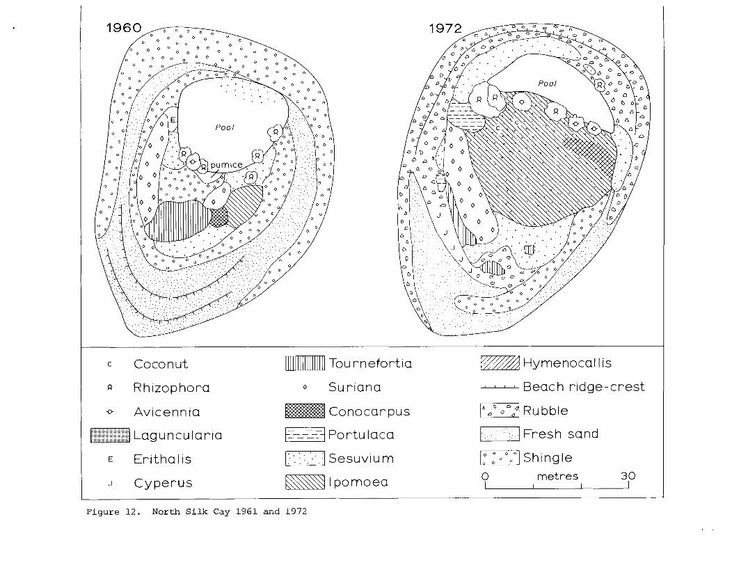
c Coconut
Q Rhizophora
Avicennia
J Cyperus
Tou rnefortia
Conocar pus
E-1 Portu Iaca
Kq I pomoea
vmA Hymenocal l is
- Beach ridge-crest
mf Rubble
/I Fresh sand
/.I Shingle
0 met re s 30
Figure 12. North Silk Cay 1961 and 1972
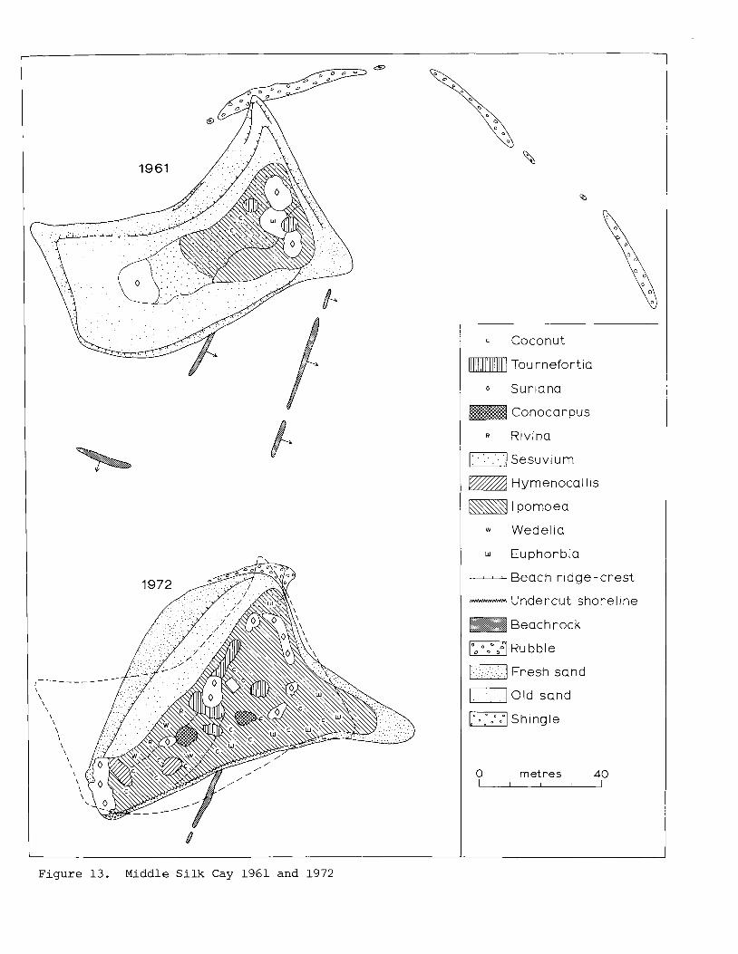
c Coconut
Tou rnefortia
Sur~ana
Conocarpus
R Rivina
FJ Sesuvi u m
w A Hymenocall~s
K y I pomoea
w Wedelia
w Euphorbia
- Beach r idge-crest - Undercut shorel~ne
Beach rock
I",] Rubble
m1 Fresh sand
Old sand
-1 Shingle
0 metres 40 - F i g u r e 13. Middle S i l k Cay 1961 and 1972
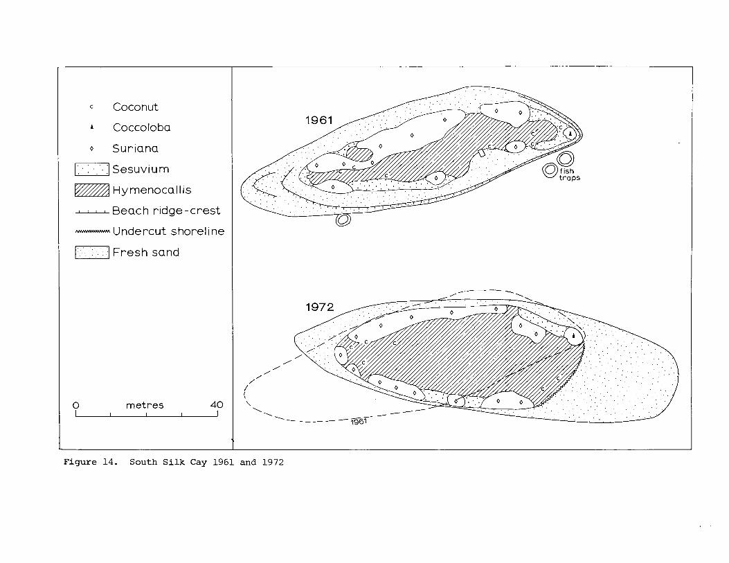
Coconut
Coccoloba
0 Suriana
r] Sesuvium
Hymenocallis - Beach ridge-crest - Undercut shore1 i ne
Fresh sand . .
0 metres 40
Figure 14. South Silk Cay 1961 and 1972
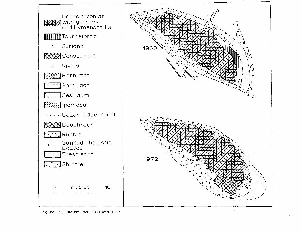
Dense coconuts with grasses and Hymenocal lis
Tou rnefortia
0 Suriana
Conocarpus
R Rivina
Herb mat
t__==j ----- Portu Iaca
---Beach r idge-crest
Beachrock
Rubble
L L Banked Thalassia Leaves
. . . . . . . . . : . Fresh sand
Figure 15. Round Cay 1960 and 1972
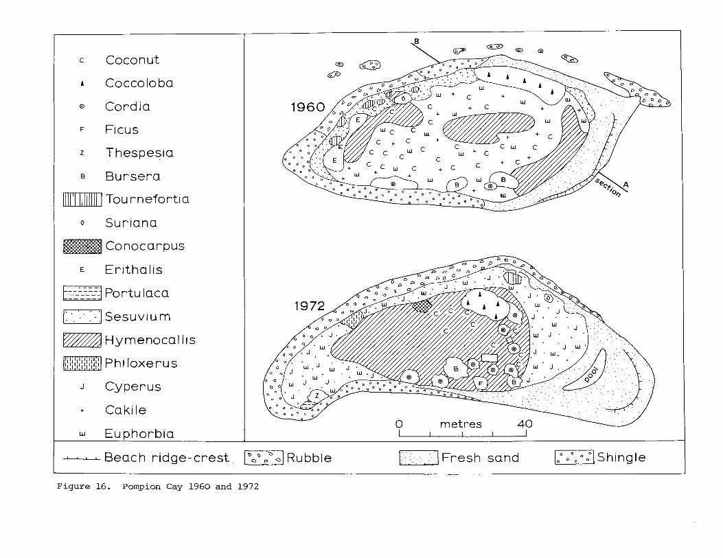
I c Coconut
I o Cordia
Ficus
z Thespesia
B Bursera
Tou rnefortia
0 Suriana
Conocarpus
E Erithalis
Portu lacs
sesuviu m . .
vmA Hymenocal Iis
mmJ Phi loxerus
J Cyperus
+ Cakile
Euphorbia
I - Beach ridge-crest. V l ~ u b b l e
Figure 16. Pompion Cay 1960 and 1972
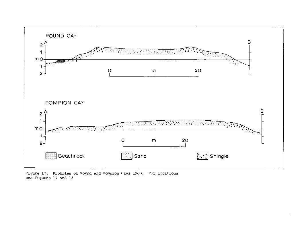
ROUND CAY
POMPION CAY
Beachrock r] Shingle
Figure 17. P r o f i l e s of Round and Pompion Cays 1960. For loca t ions see Figures 14 and 15
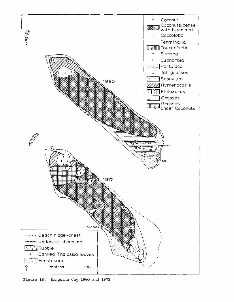
c Coconut Coconuts. dense. with Herb mat
T Terminalia Tou rnefortia
, 0 Suriana
LJ Euphorbia Ej Portulaca
1 TaI l grasses
(:-J Sesuviu m
w A Hymenocal l is
m] Ph iloxerus
F l Grasses Grasses under Coconuts
0 metres 100 1
Figure 18. Ranguana Cay 1960 and 1972
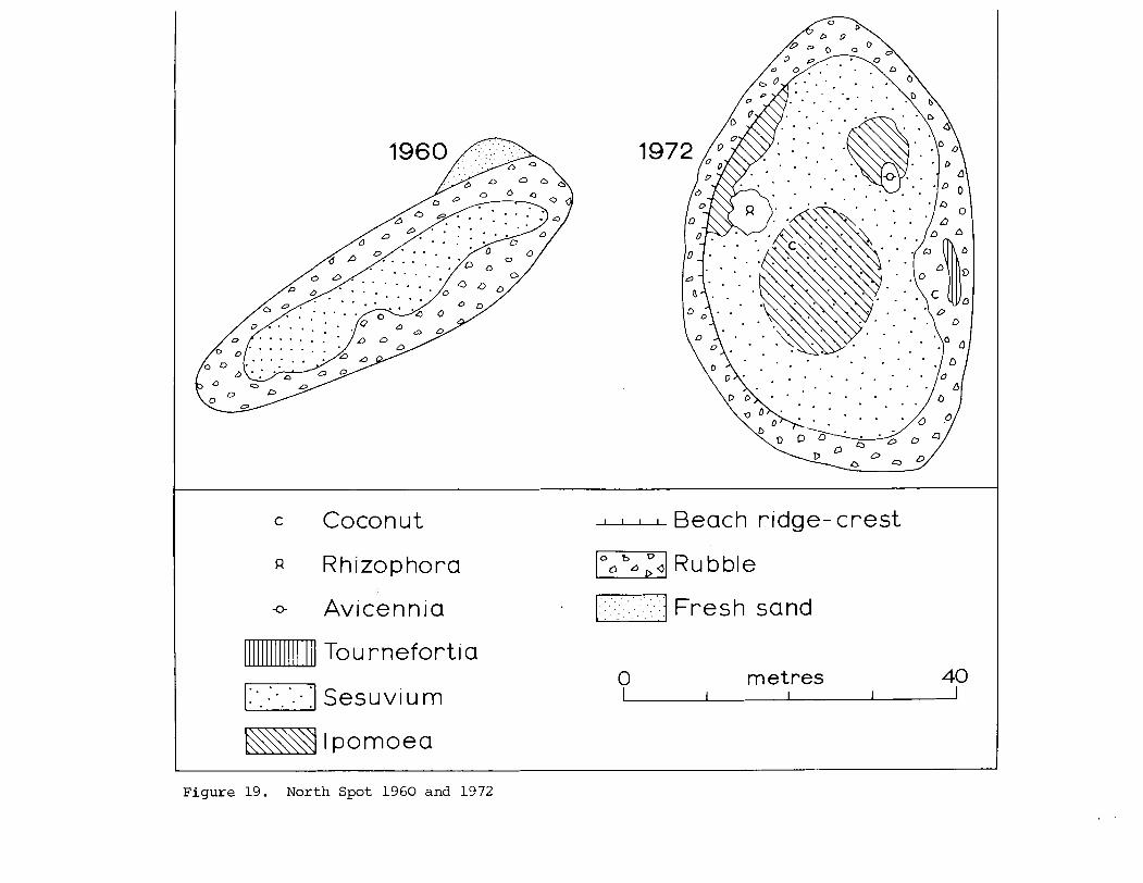
c Coconut - Beach r~dge- crest
a Rhizophora I",[ Rubble
0 Avicennia
Tou rnefortia
1:'. :..'. -1 Sesuviu m
I pomoea
0 metres 40 1 I 1
Figure 19. North Spot 1960 and 1972
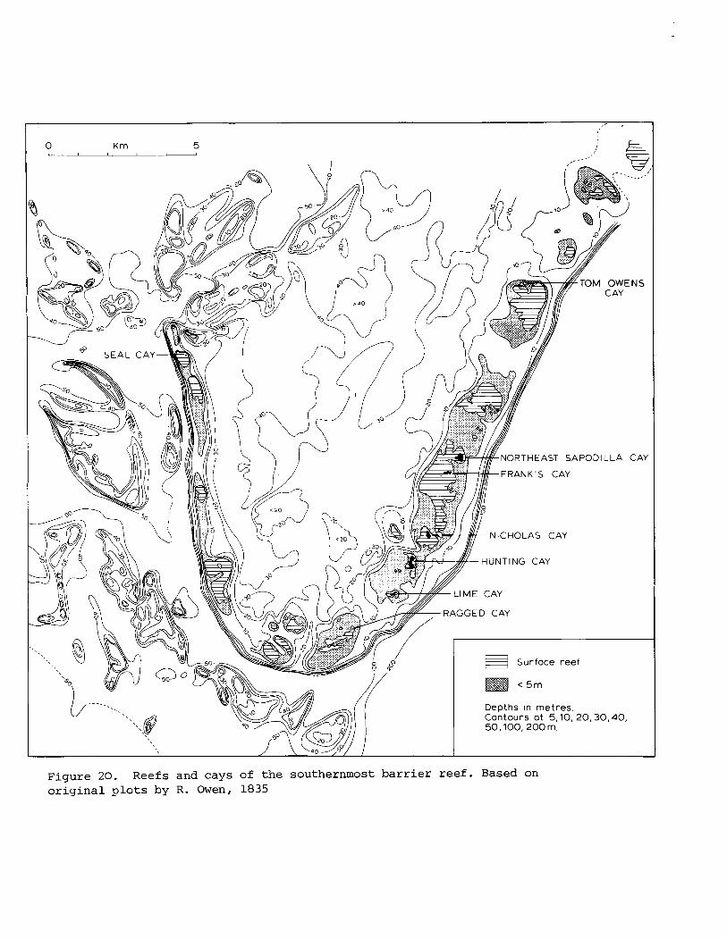
Surfoce reef
Depths in metres. Contours ot 5,10, 20,30,40, 50,100,200 m.
Figure 20. Reefs and cays of the southernmost barrier reef. Based on
original plots by R. Owen, 1835
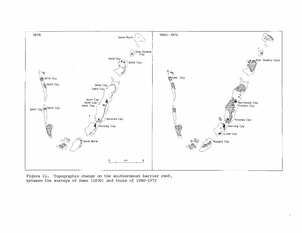
.-.. ',.,@,Sand Cay
\ ..
Sand
,.-. : ':Tom Owen's 9 Cay '...
!?, \ I
; '.... ,.$ ., , Sand cay,,,'?, /
Sand Cay,.'? : .:....,,
j 3; Sand Cay ,.:'
,-. ,.-. - . .- .+ ...-. ,,-:%'::sand ' Bore
.--::~&,,, , : 9; ::::p+.> , ,: 2; _..._.' ;' ,--.'
'-____/'
-.-. , '. , '2
": . y : : i ~ ~ m e Cay
Figure 21. Topographic change on the southernmost barrier reef, ~etween the surveys of Owen (1830) and those of 1960-1972
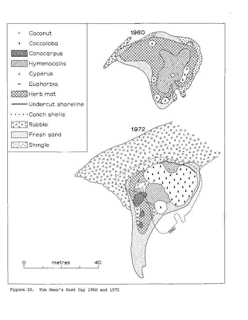
= Coconut
A Coccoloba
Conocarpus
Hy menoca I I is
J Cyperus
Euphorbia
Herb mat
- Undercut s
I_:l :. . : . . . . , Fresh sand
ml shingle
horel i ne
IS
0 metres 40
F i g u r e 22 . Tom O w e n ' s E a s t C a y 1 9 6 0 a n d 1 9 7 2
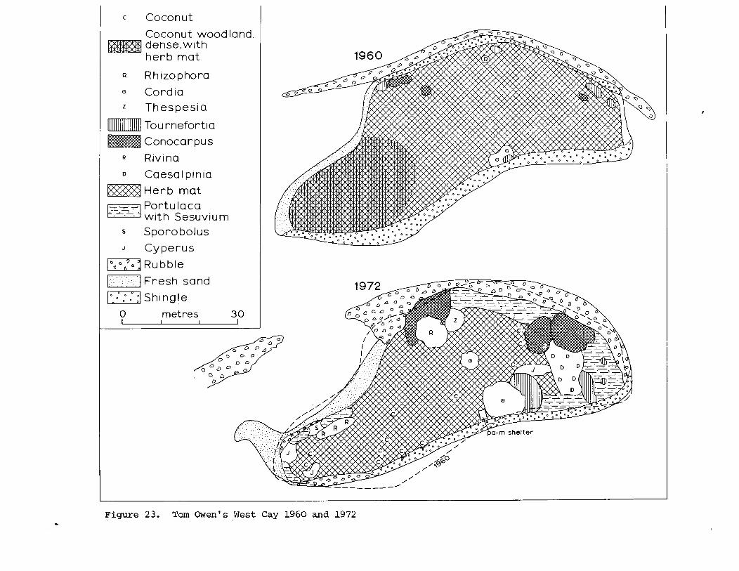
Coconut wood land. dense,with herb mat
Q Rhizophora
0 Cordia
z Thespesia
Tou rnefortia
Conocarpus
Rivina
D Caesalpinia
Herb mat I F j - -
Portulaca with Sesuvium
s Sporobolus I J Cyperus I
Figure 23. Tom Owen's West Cay 1960 and 1972
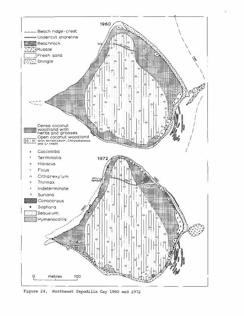
- Beach r~dge - crest - Undercut shorel~ne
Beac hroc k
md RU bble
shingle
c_- - - -i-
Dense coconut wood land with herbs and grasses Open coconut wood land
0 w ~ t h Acros t l chum. Chrysobolonus o r i Er i tho l i s
Fresh sand
Terminalia
F Ficus
Citharexylum
Thrinax
l ndeterminate
O Suriana
Conocarpus
louse- ruin):
Sophora
[:]:Sesuvi um
Hymenocal l is .'"
0 metres 100
F i g u r e 24. Northeast S a p o d i l l a Cay 1960 a n d 1972
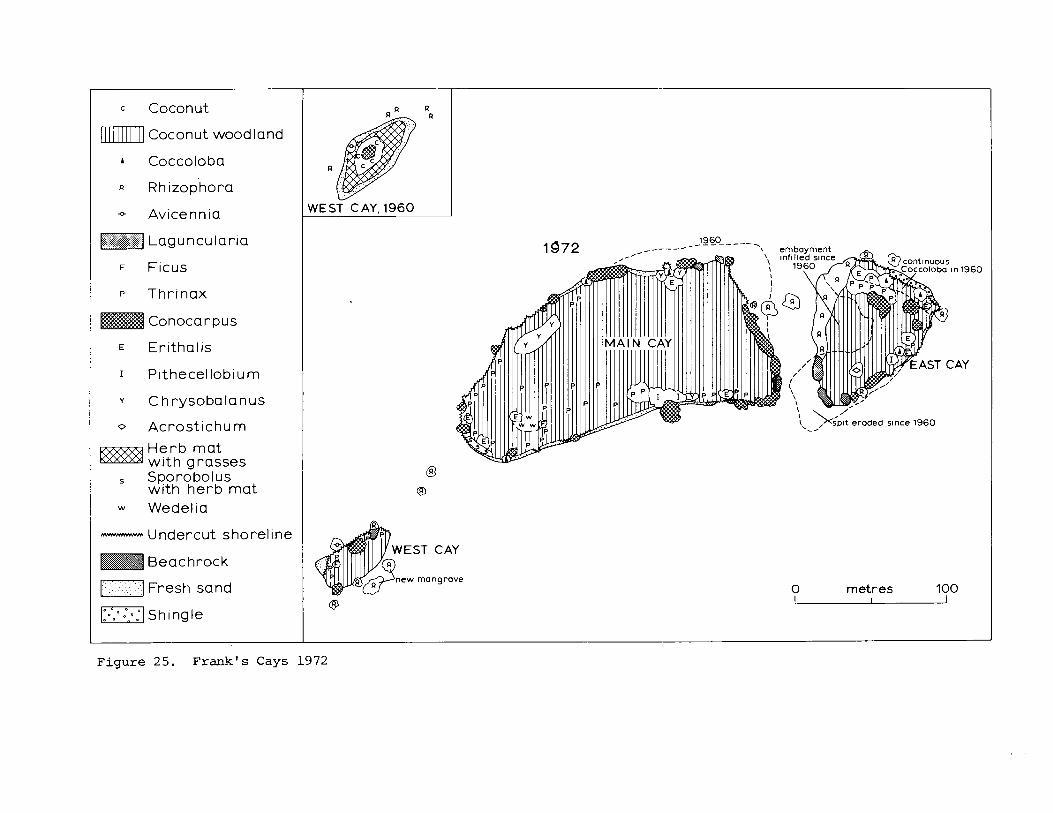
c Coconut
lml Coconut wood land
+ Avicennia
F Ficus
P Thrinax
Conocarpus
y Chrysobalanus
0 Acrostichum
Herb mat w i th grasses Sporobolus with herb mat
w Wedelia
- Undercut shoreline
Beachrock
r] Fresh sand
WEST CAY. 1960
EST CAY
new mangrove
'1 \/' \,-,, splt eroded slnce 1960
0 metres 100
Figure 25. Frank's Cays 1972
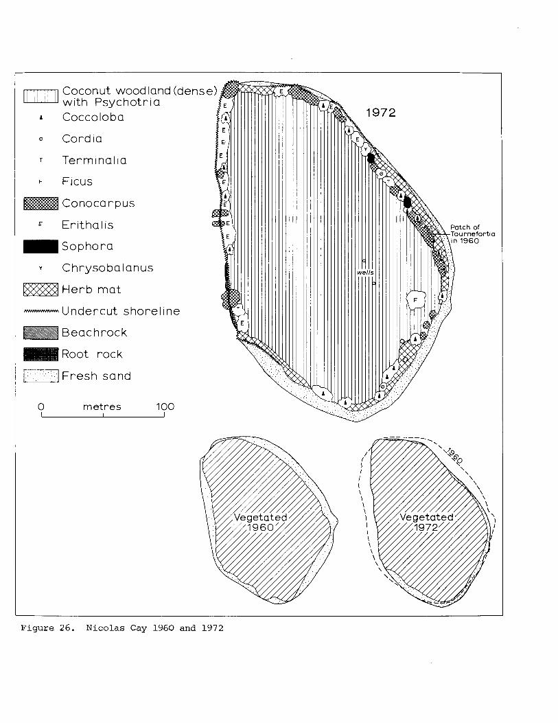
Coconut wood land (dens with Psychotria
T Te rm~na l~a
F FICUS
Conocarpus
Erithalis
Sophora
y Chrysobalanus
Herb mat
- Undercut shorel~ne
Beac hrock
Root rock
I:] Fresh sand
0 metres 100 I
Figure 26. Nicolas Cay 1960 and 1972
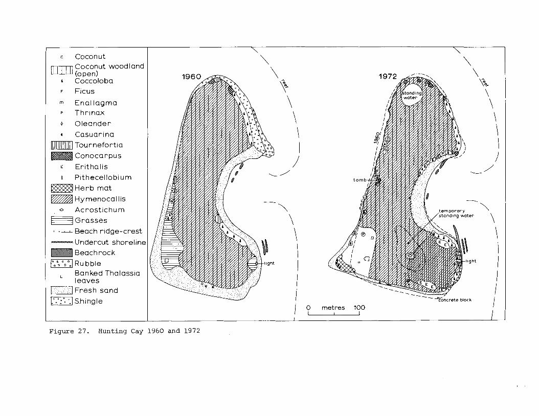
Coconut wood land (open, Coccoloba
F Ficus I
Enallagrna P Thrinax
4 Oleander
* Casuarlna
Tou rnefort ia
Conocarpus
E Er~tha l ls
r Pithecellob~urn
Herb mat
Hy rnenoca I I IS
0 Acrostichum
~ r a s s e s
----- Beach rldge-crest - Undercut shoreline
Beach rock
F I RU bble
L Banked Thalass~a leaves
r 1 Fresh sand
I.".'..: shingle
c Coconut
/ 0 metres 100 u
\
- ---CY concrete block I
F i g u r e 27. H u n t i n g Cay 1960 a n d 1972
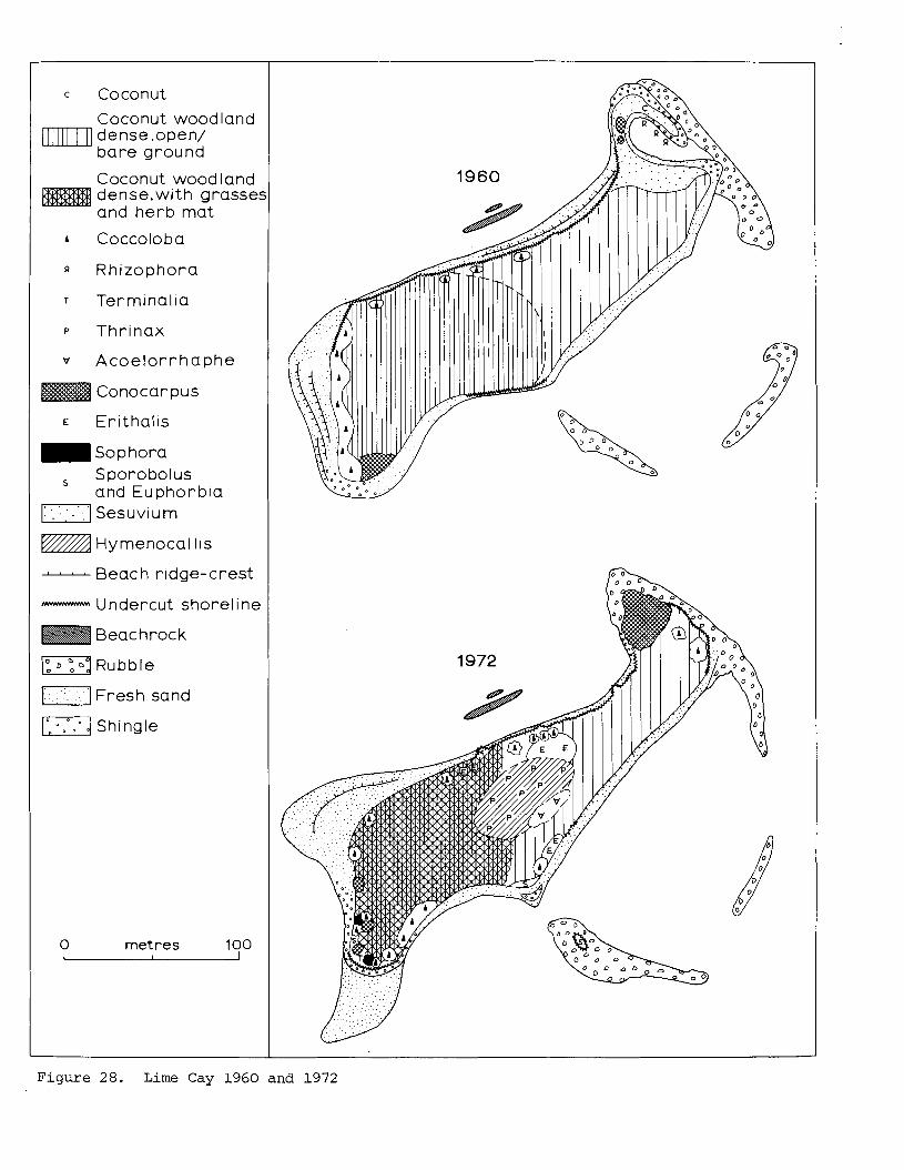
c Coconut
Coconut wood land M I densesopen/
bare ground
Coconut wood land dense.with grasse: and herb mat
Q Rhizophora
P Thrinax
Acoelor rhaphe
Conocar pus
E Erithalis
~ o p h o r a
s Sporobolus and Euphorbia Sesuvi u m
vrA Hymenocal lis
- Beach ridge-crest
- Undercut shoreline
Beac hroc k
)", Rubble
[] ~ r e s h sand
Shingle
0 metres 100
F i g u r e 28. Lime Cay 1 9 6 0 and 1972
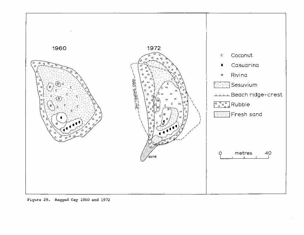
c Coconut
4 Casuarina
R Rivina
- Beach r idge-crest
Rubble
0 metres
Figure 29. Ragged Cay 1960 and 1972
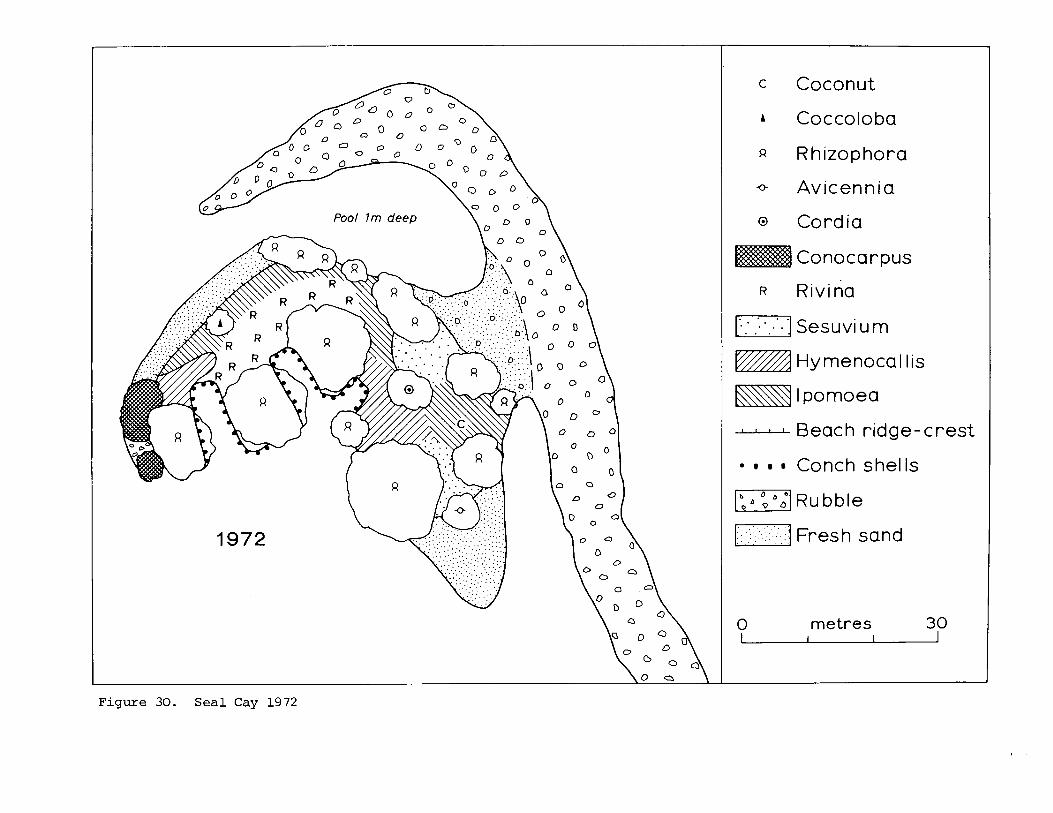
c Coconut
A Coccoloba
Rhizophora
o Avicennia
@ Cordia
Conocarpus
w A Hymenocal Iis
El 1 pomoea - Beach ridge-crest
Conch she1 Is
1-1 RU bble FI :: . . . - .- : - . . . :- . Fresh sand
0 metres 30 1 I
Figure 30. Seal Cay 1972
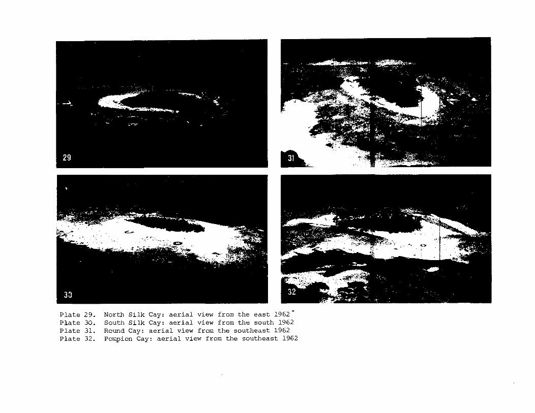
P l a t e 29. North S i l k Cay: a e r i a l view from the e a s t 1962- P l a t e 30. South S i l k Cay: a e r i a l view from the south 1962 P l a t e 31. Round Cay: a e r i a l view from the southeast 1962 P l a t e 32. Pompion Cay: a e r i a l view from the southeast 1962
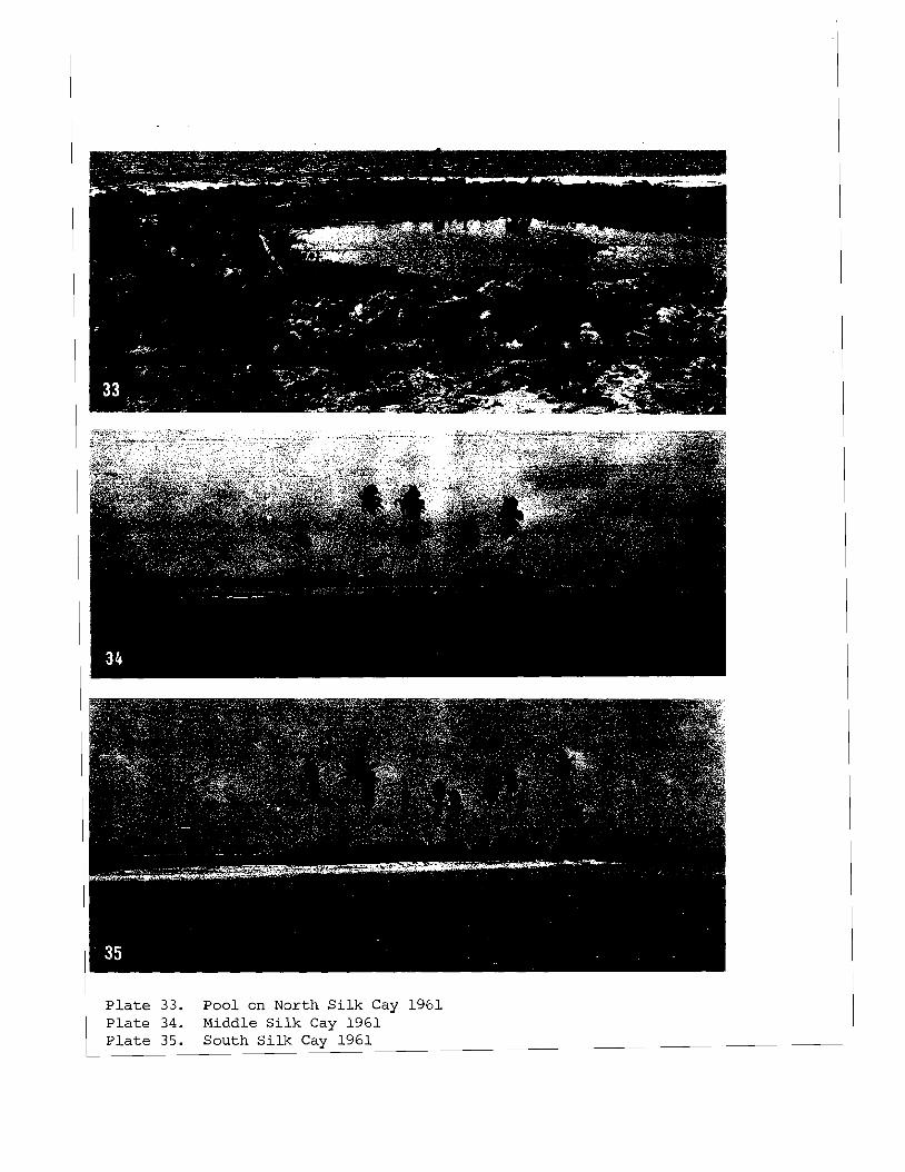
P l a t e 33. Pool on North S i l k Cay 1961 P l a t e 34. Middle S i l k Cay 1961 P l a t e 35. South S i l k Cay 1961
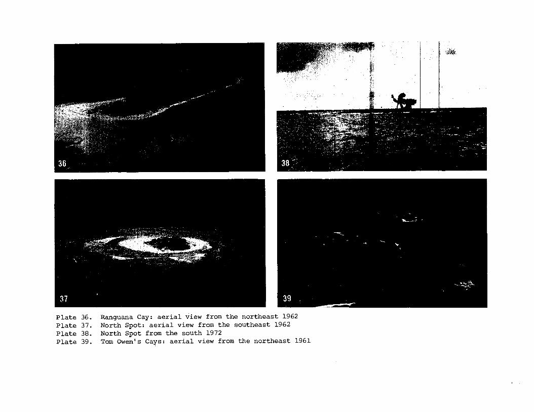
P l a t e 36. Ranguana Cay: a e r i a l view from t h e no r theas t 1962 P l a t e 37. North Spot: a e r i a l view from t h e sou theas t 1962 P l a t e 38. North Spot from t h e south 1972 P l a t e 39. Tom Owen's Cays: a e r i a l view from the nor theas t 1961
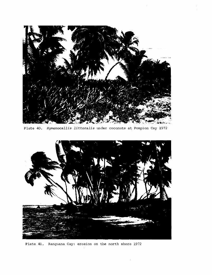
P l a t e 40. Hymenocallis littoralis under coconuts a t Pompion Cay 1972
P l a t e 41. Ranguana Cay: erosion on the nor th shore 1972
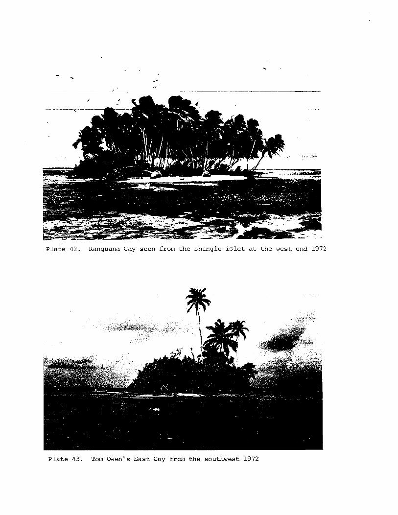
P l a t e 42. Ranguana Cay s e e n from t h e s h i n g l e i s l e t a t t h e wes t end 1972
P l a t e 43. Tom Owen's E a s t Cay from t h e sou thwes t 1972
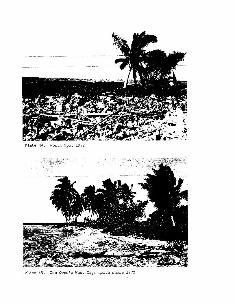
P l a t e 44. N o r t h Spot 1 9 7 2
P l a t e 45. Tom O w e n ' s West C a y : ~ o r t h shore 1 9 7 2
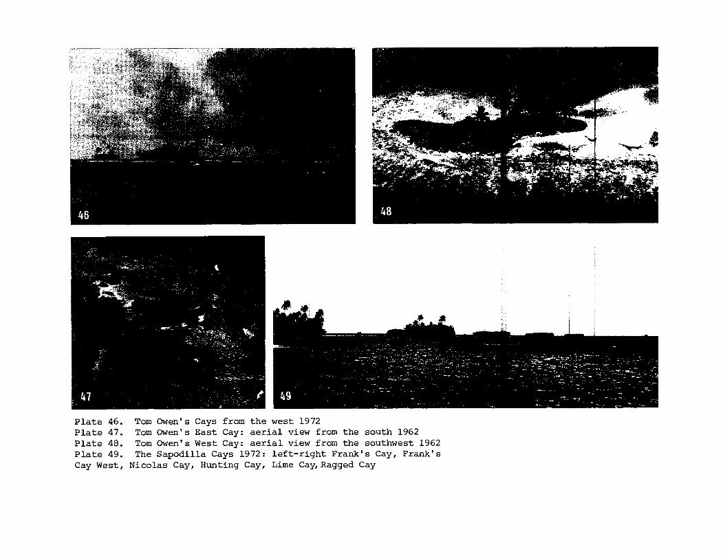
P l a t e 46. Tom Owen's Cays from t h e west 1972 P l a t e 47. Tom Owen's Eas t Cay: a e r i a l view from the south 1962 P l a t e 48. Tom Owen's West Cay: a e r i a l view from the southwest 1962 P l a t e 49. The Sapodi l la Cays 1972: l e f t - r i g h t Frank's Cay, Frank's Cay West, Nicolas Cay, Hunting Cay, Lime Cay,Ragged Cay
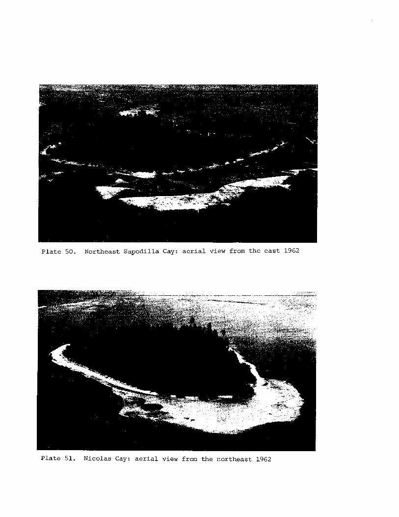
Plate 50. Northeast Sapodilla Cay: a e r i a l view from the ea s t 1962
Plate 51. Nicolas Cay: a e r i a l view from the sor theast 1962
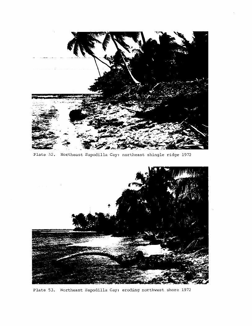
P l a t e 52. Northeast Sapodi l la Cay: nor theas t sh ingle r idge 1972
P l a t e 53. Northeast Sapodil la Cay: eroding northwest shore 1972
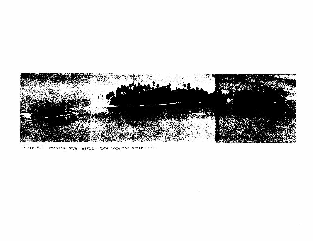
P l a t e 54. F r a n k ' s Cays: a e r i a l view from t h e sou th 1961
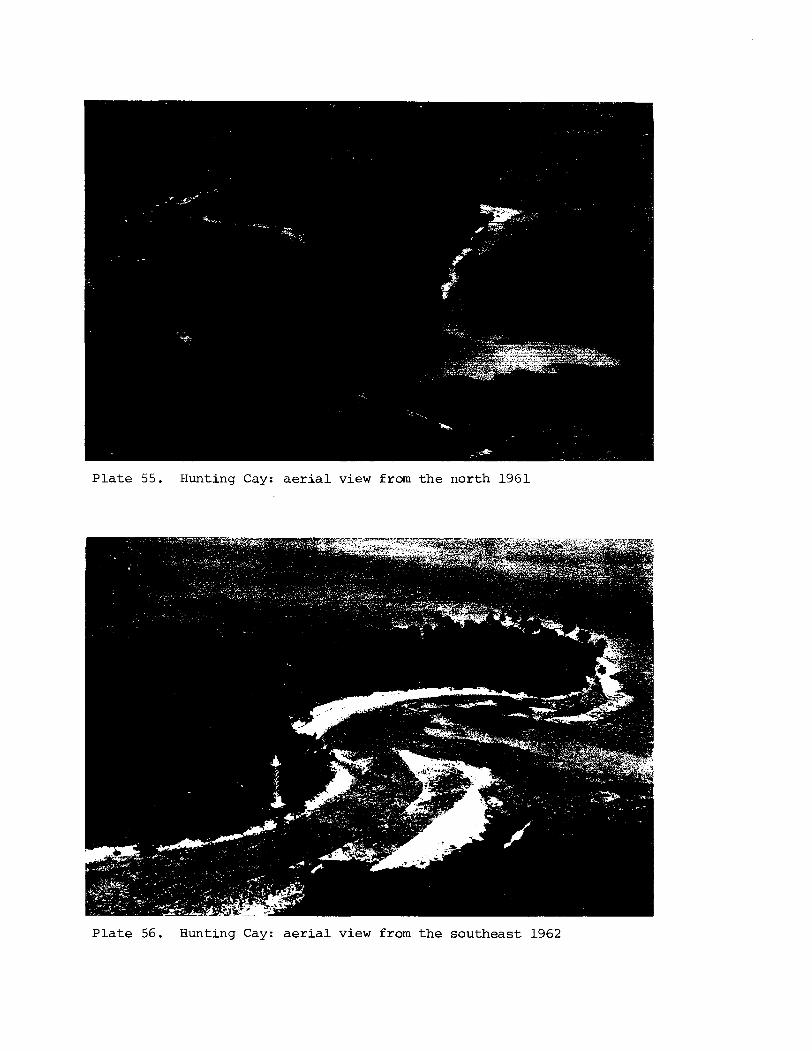
P l a t e 55. Hunting Cay: a e r i a l view from t h e no r th 1961
P l a t e 56. Hunting Cay: a e r i a l view from t h e s o u t h e a s t 1962
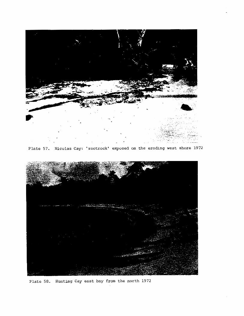
P l a t e 57. Nicolas Cay: ' root rock ' exposed on t h e eroding west shore 1972
P l a t e 58. Hunting Cay e a s t bay from t h e nor th 1972
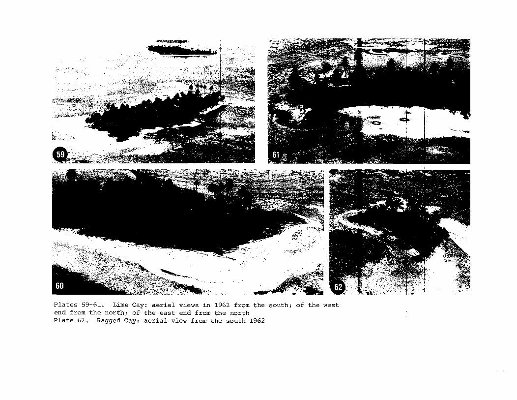
P l a t e s 59-61. Lime Cay: a e r i a l views i n 1962 from t h e south ; of t h e west end from t h e nor th ; of t h e e a s t end from t h e nor th P l a t e 62. Ragged Cay: a e r i a l view from t h e south 1962
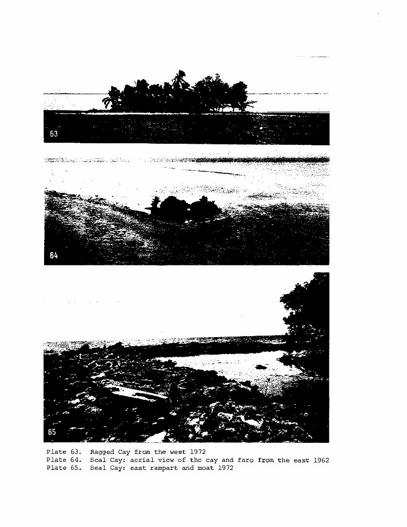
P l a t e 63. Ragged Cay from t h e west 1972 P l a t e 64. S e a l Cay: a e r i a l view of t h e cay and f a r 0 from t h e e a s t 1962 P l a t e 65. S e a l Cay: e a s t rampart and moat 1972
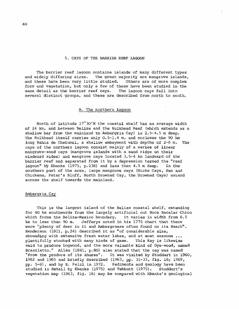
5. CAYS OF THE BARRIER REEF LAGOON
The ba r r i e r reef lagoon contains is lands of many d i f fe ren t types and widely d i f f e r i ng s izes . The g r ea t majority a re mangrove is lands , and these have been very l i t t l e studied. Others a r e of more complex form and vegetation, but only a few of these have been studied i n the same d e t a i l a s the b a r r i e r reef cays. The lagoon cays f a l l i n t o several d i s t i n c t groups, and these a r e described from north t o south.
A. The northern lagoon
North of l a t i t ude 17'30'N the coasta l shelf has an average width of 24 km, and between Belize and t he Bulkhead Reef (which extends a s a shallow bar from the mainland t o Ambergris Cay) i s 2.5-4.5 m deep. The Bulkhead i t s e l f c a r r i e s only 0.5-1.4 m , and encloses the 90 km long Bahia de Cheturnal, a shallow embayment with depths of 2-6 m. The cays of t he northern lagoon consis t mainly of a s e r i e s of l inear mangrove-sand cays (mangrove i s lands with a sand r idge on t h e i r windward s ides ) and mangrove cays located 3.5-4 k m landward of the ba r r i e r reef and separated from it by a depression termed the "reef lagoon" bbEbanks (1975, p.238) and l e s s than 4.5 m deep. I n t he southern p a r t of the a rea , large mangrove cays (Hicks Cays, Hen and Chickens, Pe t e r ' s Bluff , North Drowned Cay, the Drowned Cays) extend across the shelf towards t he mainland.
Ambergris Cay
This i s the l a rges t i s l and of t he Belize coasta l she l f , extending fo r 40 km southwards from the largely a r t i f i c i a l cu t Boca Bacalar Chico which forms the Belize-Mexico boundary. It var ies i n width from 6.5 km t o l e s s than 90 m. Je f fe rys noted i n h i s 1775 char t t h a t there were "plenty of deer i n it and Ambergrease of ten found on i t s Beach". Henderson (1811, p.24) described it a s "of considerable s ize , abounding with extensive f resh water lakes, and a t most seasons ... p len t i fu l l y stocked with many kinds of game. This Key is likewise s a id t o produce Logwood, and t he more valuable kind of Dye-wood, named Brasilet to." Allen (1841, p.80) a l so s t a t ed t h a t the cay was named "from the produce of i t s shores". It was v i s i t ed by Stoddart i n 1960, 1962 and 1965 and b r i e f l y described (1963, pp. 31-33, f ig . 16; 1969, pp. 5-6), and by H. Pe l z l i n 1972. Sediments and geology have been studied i n d e t a i l by Ebanks (1975) and Tebbutt (1975). Stoddar t ' s vegetation map (1963, f i g . 16) may be compared with Ebanks's geological
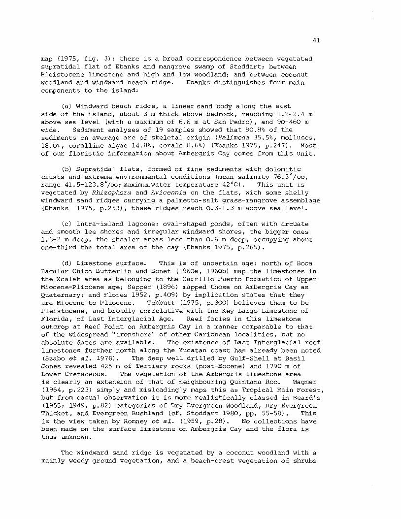
map (1975, f i g . 3 ) : t h e r e i s a broad correspondence between vegeta ted s u p r a t i d a l f l a t of Ebanks and mangrove swamp of S toddar t ; between P le i s tocene limestone and high and low woodland; and between coconut woodland and windward beach r idge . Ebanks d i s t i n g u i s h e s f o u r main components t o t h e i s l a n d :
( a ) Windward beach r i d g e , a l i n e a r sand body along t h e e a s t s i d e of t h e i s l a n d , about 3 m t h i c k above bedrock, reaching 1.2-2.4 m above sea l e v e l (with a maximum of 6.6 m a t San Pedro) , and 90-460 m wide. Sediment ana lyses of 19 samples showed t h a t 90.8% of t h e sediments on average a r e of s k e l e t a l o r i g i n (Halimeda 35.5%, molluscs, 18.0%, c o r a l l i n e a l g a e 14.8%, c o r a l s 8.6%) (Ebanks 1975, p.247). Most of our f l o r i s t i c information about Ambergris Cay comes from t h i s u n i t .
(b) Supra t ida l f l a t s , formed of f i n e sediments wi th dolomi t ic c r u s t s and extreme environmental condi t ions (mean s a l i n i t y 76.30/ooI range 41.5-123.8°/oo; maximumwater temperature 42OC). This u n i t is vegeta ted by Rhizophora and Avicennia on t h e f l a t s , wi th some s h e l l y windward sand r i d g e s ca r ry ing a pa lmet to-sa l t grass-mangrove assemblage XEbanks 1975, p. 253) ; t hese r idges reach 0.3-1.3 m above sea l eve l .
(c) In t r a - i s l and lagoons: oval-shaped ponds, o f t e n wi th a rcua te and smooth l e e shores and i r r e g u l a r windward shores , t h e b igger ones 1.3-2 m deep, t h e shoa le r a r e a s l e s s than 0 .6 m deep, occupying about one-third t h e t o t a l a r ea of t h e cay (Ebanks 1975, p.265).
(d) Limestone sur face . This is of uncer ta in age: n o r t h of Boca Bacalar Chico B u t t e r l i n and Bonet (1960a, 1960b) map t h e l imestones i n t h e Xcalak a r e a a s belonging t o t h e C a r r i l l o Puerto Formation of Upper Miocene-Pliocene age; Sapper (1896) mapped those on Ambergris Cay a s Quaternary; and F lo res 1952, p.409) by impl ica t ion s t a t e s t h a t they a r e Miocene t o Pl iocene. Tebbutt (1975, p.300) b e l i e v e s them t o be P le i s tocene , and broadly c o r r e l a t i v e wi th t h e Key Largo Limestone of F lo r ida , of Las t I n t e r g l a c i a l Age. Reef f a c i e s i n t h i s l imestone outcrop a t Reef Po in t on Ambergris Cay i n a manner comparable t o t h a t of t h e widespread " i ronshore" of o t h e r Caribbean l o c a l i t i e s , bu t no abso lu te d a t e s a r e a v a i l a b l e . The ex i s t ence of Last I n t e r g l a c i a l reef l imestones f u r t h e r no r th along t h e Yucatan coas t has a l r eady been noted (Szabo et a l . 1978). The deep w e l l d r i l l e d by Gulf-Shell a t B a s i l Jones revea led 425 m of T e r t i a r y rocks (post-Eocene) and 1790 m of Lower Cretaceous. The vege ta t ion of t h e Ambergris l imestone a r e a i s c l e a r l y an extension of t h a t of neighbouring Quintana Roo. Wagner (1964, p.223) simply and misleadingly maps t h i s a s Tropica l Rain Fores t , bu t from casua l observa t ion it i s more r e a l i s t i c a l l y c l a s s e d i n Beard 's (1955; 1949, p.82) ca t egor i e s of Dry Evergreen Woodland, Dry Evergreen Thicket , and Evergreen Bushland ( c f . S toddar t 1980, pp. 55-58). This is t h e view taken by Romney et a l . (1959, p.28) . No c o l l e c t i o n s have been made on t h e su r face limestone on Ambergris Cay and t h e f l o r a i s thus unknown.
The windward sand r i d g e i s vegeta ted by a coconut woodland with a mainly weedy ground vegeta t ion , and a beach-crest vegeta t ion of shrubs
and pioneer grasses and herbs. On the leeward s i d e t h e r idge i s abutted by mangroves. A t t h e small v i l l a g e of San Pedro t h e r e a r e introduced t r e e s , shrubs and herbs. I t i s worth noting t h a t the vegeta t ion of Ambergris Cay has been influenced by man s ince pre- European times (Stoddart 1980, pp. 160-161). I t has severa l Maya s i t e s , two of which were located by Romney e t a l . (1959, f i g . 10) and Hammond (1977, p.48). Several were excavated by Gann (1926, p.59). He found them t o be " f o r t h e most p a r t ki tchen middens, composed of enormous numbers of conch, cockle, whelk and oys ter s h e l l s , t u r t l e carapaces, crab and c rayf i sh s h e l l s , and v a s t q u a n t i t i e s of such f i s h a s i n h a b i t t h e surrounding waters. Amongst these were numerous potsherds, a l l of t h e coarse , red and gray, domestic v a r i e t i e s , broken f l i n t spear-heads i n g r e a t numbers, with a few broken obsidian knives, and greenstone c e l t s , many s tone and po t t e ry n e t s inker s , and a few broken hand corn m i l l s of Esquipulas stone. There were a l s o found the bones of a few small mammals, including the gibnut and armadil lo, bu t none of deer o r wild hog, such a s a r e usual ly found a t most Maya s i t e s on t h e mainland." Later Gann mentioned "innumerable b u r i a l and kitchen-midden mounds along the coast" (1927, p.95).
Only 22 species of p l a n t s have been recorded from Ambergris Cay so f a r ; undoubtedly a complete l i s t would be very much 1arge.r. Those, recorded a re :
Distichlis s p i c a t a West (1977) Sporobolus sp. 62s 65s Cyperus sp. 62s
" ~ o c o s n u c i f e r a 57s 60s 62s 65s Thr inax r a d i a t a 62s Hymenocal l i s li t t o r a l i s 65s Sesuvium por tu lacas t rum 62s Sophora tomentosa 65s Sur iana mar i t ima 65s E uphorbia s p . 6 5s R'hi zophora mangle 60s Bucida s p i n o s a 72C
~ e r m i n a l i a catappa 62s 65s Ipomoea macrantha 65s Ipomoea sp . 6 5s Cordia s e b e s t e n a 65s T o u r n e f o r t i a gnaphalodes 65s Avicenn ia germinans 60s Solanum b l o d g e t t i i 65C Hamelia pa tens 72C Ambrosia h i s p i d a 65s B o r r i c h i a arborescens 65C F l a v e r i a l i n e a r i s 65C
Mangrove cays i n t h e l e e of Ambergris Cay (Deer Cay, Swab Cay, Blackadore Cay, Mosquito Cay) have only been observed from t h e a i r . There a r e small mangrove i s l ands a t t h e southern t i p of Ambergris Cay, and a l s o Cay Cangrejo ( 1 7 ° 5 0 % ' ~ , 8 8 ° 0 3 ' ~ ) , a mangrove i s l and .
Cay Caulker
Cay Caulker ( t h e Cay Corker of J e f f e r y s (1775) and Owen ( 1 8 3 0 ) ) i s a l a r g e mangrove-sand cay 8 km south of Ambergris Cay and 1.5-2.4 km from t h e edge of t h e c o a s t a l she l f . I t has been described b r i e f l y by Vermeer (1959, pp. 55-58), Stoddart (1963, pp. 33-35, f i g . 17) and Stoddart (1969, p . 6 ) . I t i s 7.2 km long and 60 m t o 1 . 2 km wide. I ts windward s i d e i s formed by a sand r idge genera l ly l e s s than 1 m
high, b u t r i s i n g a t t h e v i l l a g e s i t e t o over 2 m. I n p l aces t h e r e a r e clumps of mangroves on t h e seaward s i d e of t h e r idge . On t h e western s i d e t h e r e a r e ex tens ive mangroves, wi th i n p l aces a low leeward sand r idge . Palm t h i c k e t occupies t h e i n t e r i o r a r e a s no t c l e a r e d f o r coconut woodland. During Hurricane H a t t i e t h e r e was much marginal e ros ion and su r face sand-str ipping and scouring on t h e seaward s i d e of t h e windward sand r idge. Some coconuts and o the r t r e e s were f e l l e d near t h e seaward shore , and exposed mangroves were de fo l i a t ed . But i n gene ra l , away from t h e c l ea red a r e a of t h e v i l l a g e , physiographic e f f e c t s were n e g l i g i b l e and vegeta t ion damage moderate. 34 spec ie s of p l a n t s have been recorded (30 of them i n 19651, and t h i s is undoubtedly a p a r t i a l l ist. They a r e :
E r a g r o s t i s p r o l i f e r a 65C H i b i s c u s t i l i a c e u s 65C Eus tachys pe t raea 65C S i d a a c u t a G5C Cyperus l i g u l a r i s 65C Turnera u l m i f o l i a 65C F i m b r i s t y l i s cymosa 65C R h i zophora mangle 60s
*Cocos n u c i f e r a 57s 60s 61s Bucida sp inosa 65C 62s 65s *Terminal id catappa 61s 65s * Musa parad i s iaca 57s "Catharanthus r o s e u s 65C * Casuarina e q u i s e t i f o l i a 62s 65C Ipomoea sp. 62s
Coccoloba u v i f e r a 62s 65C Cordia s e b e s t e n a 65C P h i l o x e r u s v e r m i c u l a r i s 65C Tournef o r t i a gnaphalodes 65C C r o t a l a r i a verrucosa 65C Lantana i n v o l u c r a t a 65C P i t h e c e l l o b i u m k e y e n s e 65C S t a c h y t a r p h e t a m u t a b i l i s 65C Vigna l u t e o l a 65C Solanum b l o d g e t t i i 65C Sur iana mari t ima 65C Ernodea l i t t o r a l i s 65C Euphorbia b l o d g e t t i i 65C Spermacoce s u a v e o l e n s 65C Euphorbia mesembr ian themi fo l ia Ageratum l i t t o r a l e 65C
6 5C B o r r i c h i a arborescens 65C *Mangifera i n d i c a 57s 60s Wedel ia t r i l o b a t a 65C
Cay Chapel ( 17 '41' N , 88 '02 ' W)
Cay Chapel l i e s 1.6 km south of Cay Caulker and 2.5 km from t h e s h e l f edge. I t i s 3.6 km long and up t o 460 m wide, and b u i l t of p a r a l l e l sand r i d g e s r i s i n g t o 2 m above s e a l eve l . The leeward mangrove i s n o t we l l developed, and most of t h e sand r i d g e s a r e covered by coconut woodland: mechanical c l e a r i n g has destroyed no t only t h e o r i g i n a l vegeta t ion b u t a l s o t h e su r face topography. This c l e a r i n g has taken p lace s i n c e 1775 when J e f f e r y s noted a s i n g l e " l a r g e cocoa t r e e " ; t h e g r e a t e r p a r t , however, took p lace i n 1960-61. During Hurricane H a t t i e it i s s a i d t h a t some 60% of t h e coconuts were f e l l e d , and t h e r e was much marginal e ros ion and su r face sand s t r ipp ing . For d e t a i l s s e e S todda r t (1963, pp. 35-36, f i g . 17) . By 1965 t h e windward shore had been extens ive ly colonised by Conocarpus, B o r r i c h i a , Sur iana and T o u r n e f o r t i a , with herbs and g r a s s e s beneath t h e coconut woodland. For an account of recovery from Hurricane Ha t t i e s e e S todda r t (1969, pp. 6-7). Eighteen spec ies of p l a n t s have been recorded, and many more must be present . The l ist is:
Cenchrus i n c e r t u s 62s 65s Cyperus sp. 62s
" ~ o c o s n u c i f e r a 1775s 62s 65s Thr inax r a d i a t a 62s Coccoloba u v i f e r a 62s 65s R i v i n a h u m i l i s 65C Cassytha f i l i f o r m i s 65s C a k i l e l a n c e o l a t a 65s Sur iana mar i t ima 62s 65s
Euphorbia sp. 62s 65s Rhizophora mangle 62s 65s Conocarpus e r e c t u s 65s Merremia d i s s e c t a 65C T o u r n e f o r t i a gnaphalodes 62C 65s Ernodea l i t t o r a l i s 65s Ageratum sp. 6 5S Con yza c a n a d e n s i s 65s Wedel ia t r i l o b a t a 65C
Craig (1966, p.21) descr ibes a mound faded with shaped s tone blocks, with broken po t t e ry and conch s h e l l s , on t h i s i s land.
S t . George's Cay ( 1 7 ' 3 3 4 ' ~ ~ 8 8 ' 0 4 ' ~ ) P l a t e s 66-68
S t . George's Cay i s an arcuate mangrove-sand cay standing 2.5 km from t h e she l f edge. The western p a r t i s about 1.6 km long and 90- 180 m wide, and cons i s t s e n t i r e l y of mangrove. A t t he nor theas t end i s a low sandy r idge 1.2 km long and 40-90 m wide, with some mangrove on i t s l e e s ide . The sandy area was c leared and s e t t l e d a t the end of t h e eighteenth century and'was e n t i r e l y devoted t o r e s i d e n t i a l use a t t h e time of Hurricane Hat t ie . It was overtopped by t h e storm surge during the hurricane and f i v e channels were c u t through t h e r idge. Most coconuts were f e l l e d and mangroves de fo l i a t ed , though ground vegetat ion survived i n patches. By 1965 two of t h e scoured channels had been blocked, some of t h e mangrove was s t i l l l i v i n g , and t h e r e was a luxur iant growth of herbs and grasses. Detai led accounts of t h e i s l and before and immediately a f t e r Hurricane Ha t t i e , and i n 1965, a r e given by Stoddart (1963, pp. 37-40, f i g s . 18 and 19; 1969, pp. 7-8, f i g . 3) . Romney et a l . (1959, f i g . 10) descr ibe t h e cay a s a s h e l l midden s i t e . 30 p l a n t species a r e recorded (16 during t h e e a r l i e r surveys and 21 by Spellman i n 1972). They a re :
Eus tachys p e t r a e a 72C Paspalum sp. 62s Sporobo lus sp. 65s Cyperus sp. 62s 65s
" ~ o c o s n u c i f e r a 60s 62s 65s 72s Hymenocal l i s l i t t o r a l i s 62s 65s Coccoloba u v i f e r a 62s 65s B a t i s mar i t ima 65s 72C P h i l o x e r u s v e r m i c u l a r i s 72C Por tu laca o l e r a c e a 72C S e s u v i um p o r t u l a c a s t r u m 60s
65s 72C C a k i l e l a n c e o l a t a 62s Canaval ia r o s e a 72C Euphorbia mesembr ian themi fo l ia
72C' Ewphor f ia - sp . 62s 6 5s Rhizophora mangle 625 65s
Conocarpus e r e c t u s 65s 72C Eustoma e x a l t a t u m 72C E c h i tes umbe l la ta 72C Ipomoea pes-caprae 62s Ipomoea stolonif e r a 72C Ipomoea sp. 65s Cordia s e b e s t e n a 72C T o u r n e f o r t i a gnaphalodes 72C S t a c h y t a r p h e t a jamaicens i s 65s
7 2C E r i t h a l i s f r u t i c o s a 72C Ernodea li t t o r a l i s 72C Spermacoce v e r t i c i l l a t a 72C Ageratum sp. 62s 65s Melanthera n i v e a 72C S y n e d r e l l a n o d i f l o r a 72C Wedel ia t r i l o b a t a 62s 65s 72C

Cays between Cay Chapel and Bel ize
There a r e numerous l a r g e mangrove i s l a n d s on t h e c o a s t a l she l f between 1 7 ' 3 0 ' ~ and 1 7 ' 4 5 ' ~ . They inc lude Long Cay ( t h e northernmost of t h a t name), Hicks Cays, Montego and Frenchman's Cays, Hen and Chicken Cays, R i d e r ' s Cays, and t h e northernmost Drowned Cays. Apart from a narrow seaward sand r idge wi th coconut woodland on Long Cay and on t h e Drowned Cays no r th of Gallows Po in t , t h e s e i s l a n d s c o n s i s t wholly of mangrove. Thus t h e Hicks Cays c o n s i s t of a dozen i s l a n d s , four of them l a rge , separa ted by deep meandering channels through which t i d a l c u r r e n t s s e t with g r e a t r a p i d i t y . The Drowned Cays t o o a r e i n t e r s e c t e d by a number of east-west t i d a l channels o r 'bogues ' , namely Shag Cay Bogue, Bannister Bogue, F a r l s Bogue and Goring Bogue, most of which c a r r y 5-7.5 m of water. For f u r t h e r d e t a i l s on these i s l a n d s , none of which have been s tud ied i n d e t a i l , s e e Vermeer (1959, pp. 58-59) and Stoddar t (1963, pp. 36-37).
Moho Cay ( 1 7 ° 3 1 3 ' ~ , 8 8 ' 1 2 ' ~ )
Moho Cay is a small i s l a n d immediately nor th of t h e Be l i ze d e l t a . Gann (1925, p.19) mentions "innumerable f l i n t spear-heads ... with thousands of c i r c u l a r p o t t e r y r i n g s , probably used a s n e t s inkers ." He suggested t h a t t h e i s l a n d had been used a s a Maya f i s h i n g s t a t i o n : "Many tons of manatee bones have been washed ou t from t h e northern end of t h e cay." Craig (1966, p.20) found hab i t a t ion s i t e s exposed by wave eros ion f o r 125 m along t h e shore , with "numerous p o t t e r y sherds , abundant c h e r t co res , f l a k e s , and s tone a r t i f a c t s , inc luding j a d e i t e c e l t s , and l a r g e (25 cm) fine-wrought p r o j e c t i l e po in t s . " I n add i t ion t o manatee bones, Craig a l s o found oys t e r and conch s h e l l s , and two human b u r i a l s i t e s . The i s l a n d was n o t v i s i t e d during our own surveys.
S take Bank ( 1 7 ' 2 8 ' ~ ~ 8 8 ' 0 7 % ' ~ )
This i s a mangrove i s l a n d approximately 400 m long and 120 m wide, s tanding on a shoal a r e a 2.3 km long and 1 . 4 km wide. There i s a widespread t r a d i t i o n t h a t t h e shoal was b u i l t wi th b a l l a s t depos i ted by s h i p s i n t h e harbour (Anderson 1958, p .95 ) , though t h i s could only account f o r a small p a r t of t h e shoa l volume. I n t h e survey of Be l i ze harbour by Anthony de Mayne i n 1828 t h e Bank had only one o r two mangrove seedl ings . The bank was descr ibed a s "dry i n some p a r t s " by Speer i n 1765, and w a s marked by J e f f e r y s i n 1775.
Spanish Lookout Cay (17 O24'N, 88O04 '~)
This very small i s l and a t t h e southern end of the Drowned Cays was v i s i t e d b r i e f l y i n 1965. I t is l a rge ly a r t i f i c i a l , b u i l t of conch s h e l l s co l l ec ted by fishermen, and surrounded by a c o r a l block wall . I t has no n a t u r a l vegetat ion.
Water Cay (17O23 '~ , 8 8 ° 0 3 3 ' ~ )
This l a rge mangrove i s l a n d i s immediately south of t h e Drowned Cays; it has a sand r idge along i ts windward side. J. Dwyer co l l ec ted Euphorbia m e s e m b r i a n t h e m i f o l i a , Lantana i n v o l u c r a t a and Conocarpus e r e c t u s t he re i n 1967. I t was not v i s i t e d by us.
B. The Southern Triangles
Though t h i s name no longer appears on c h a r t s it i s convenient t o use it f o r t h e groups of i s l ands a t t h e inner end of tho Belize Deepwater Channel: it was used on t h e c h a r t s of Speer (1765, 1771) and J e f f e r y s (1775) and a l s o i n t h e Anglo-Spanish T r e a t i e s of 1753 and 1783. Altogether t h e r e a r e some two dozen i s l a n d s standing on t h e f l a t tops of steep-sided shoals. On the nor th s i d e of the channel Robinson Point and Robinson I s l and both have dry-land vegetat ion i n addi t ion t o mangroves, b u t t h e o ther i s l ands (Grennels Cay, Ramseys Cay, One Man Cay) a r e e n t i r e l y of mangrove. On t h e south s i d e Spanish Cay i s a sand cay and t h e o the r s (Long, Crayfish, Simmonds and o ther unnamed cays) a r e Mangrove.
Robinson Point Cay (17°22'N, 88°11%' W )
This i s l and , t o t a l l i n g about 29 ha, has t h e l a r g e s t dry land a r e a i n the Southern Triangles. I t is described by Vermeer (1959, pp. 75- 79, f i g . 16) a n d s t o d d a r t (1963, pp. 46-47, f i g . 26). There i s a low narrow sand r idge along the e a s t and southwest s ides of t h e cay; it i s nowhere more than 50 m wide and about 900 m long. Before Hurricane Ha t t i e it was covered with a dense t h i c k e t of coconuts, Thr inax and other s t r and species , except a t t h e small set t lement near the l i g h t - house, b u i l t a t t h e western po in t i n 1939. During the storm most of t h e dry-land vegetat ion was destroyed and the mangroves de fo l i a t ed , and i n 1962 the i s l a n d had been abandoned by i t s inhab i t an t s . The ,following p l a n t species were noted i n 1961 before t h e storm:
Cyperus sp. 61s Hymenoca-llis l i t t o r a l i s 61.5- *Cocos n u c i f e r a 57s 61s Coccol oba u v i f e r a 6 1s
Thr inax r a d i a t a 61s Sur iana mari t i m a 6 1s
Euphorbia sp. 61s Cordia s e b e s t e n a 61s Rhizophora mangle 61s Avicenn ia germinans 61s Conocarpus e r e c t u s 61s S t a c h y t a r p h e t a jamaicens i s 61s
Robinson Is land ( 1 7 O 2 2 + ' ~ , 8 8 ° 1 0 % ' ~ )
There is a l e s s well-developed sand ridge along the south s ide of Robinson Island. The palm th icke t here was badly damaged during Hurricane Hat t ie , and the mangroves defol ia ted (Stoddart 1963, p.47). Only two species were noted i n passing i n 1961:
*Cocos n u c i f e r a 61s Rhi zophora mangle 6 1s
Spanish Cay ( l 7 O 2 1 ' N , 88°09%'W)
Spanish Cay when mapped i n 1961 was a low-lying sandy i s l and 100 m long and 10-18 m wide. The southern end of the cay was fr inged with Rhizophora, and the re were several t a l l d v i c e n n i a t r ees . I t appeared t h a t mangroves had previously been more extensive but had been cleared. There were several coconuts and a ground cover of sedges, grasses and ornamental p lants . Much of t h e vegetat ion disappeared during Hurricane Hat t ie ; t he i s l and has not been r ev i s i t ed since (see Stoddart 1963, p.47, f i g . 2 7 ) . I ts t o t a l area i n 1961 was 1260 sq m. The following p lan t species were recorded, but t h e l is t is ce r ta in ly p a r t i a l :
* ~ o c o s n u c i f e r a 61s 62s Conocarpus e r e c t u s 61s 62s Euphorbia sp. 61s Avicenn ia germinans 61s 62s Rhizophora mangle 61s 62s
C. Cays of the Central Lagoon
For 60 km southwards from the Southern Triangles t o t he l a t i t u d e of South Water Cay t he coasta l shelf has an extremely simple topography. The f loor shelves gradually eastwards from the mainland coast t o depths of 20-24 m, and the shelf i s edged by a ba r r i e r platform 5-8 km wide and 4-6 m deep. There a r e no patch r e e f s o r cays within t he lagoon. Near t he inner edge of t he ba r r i e r platform there i s a s e r i e s of l i nea r mangrove is lands , al igned north-south, and generally about 1.8 km from the lagoon edge and 3.4 km from the seaward edge of the platform. These i s l ands include Middle Long Cay, Bluefield Range, Al l igator Cay and Colson Cays. Others, such a s Southern Long Cay, Columbus Cay and Cross Cay, are l e s s regular i s lands c lose r t o the seaward margin of the platform. A l l a r e mangrove is lands; none has been invest igated i n d e t a i l . The l i nea r i s l ands occupy t h e same r e l a t i v e pos i t ion a s do the mangrove-sand cays of t he northern ba r r i e r reef (Cay Caulker, Cay
Chapel), but they lack t h e windward sand r idge and s t rand f l o r a . South of 1 7 O ~ t h e mangrove i s l a n d s near t h e inner edge of t h e b a r r i e r platform become more complex. Ins tead of simple l i n e a r cays they a r e complexes of smaller mangrove i s l ands , o f t en arranged i n an e l l i p s e , and known a s "ranges". These include Fly Range, Tobacco Range, South Water Range and Blue Ground Range. Some of these have been v i s i t e d and w i l l be described below. For f u r t h e r b r i e f notes on t h i s sec tor of t h e r e e f , see Vermeer (1959, pp. 59-71 and 79) and Stoddart (1963, pp. 51-52).
South of South Water Cay t h e b a r r i e r reef swings southeastwards i n a broad continuous a r c t o Gladden S p i t and then t u r n s sharply southwestwards. There a r e no sand cays on t h e southeast-trending sec to r , and only small patch r e e f s with small cays (already described) t o t h e south of it. A t Gladden S p i t t h e coas ta l shel f reaches i ts maximum width of nearly 40 km, and t h e g r e a t e s t lagoon depths reach 35 m. The b a r r i e r platform on t h e edge of the shel f becomes narrower and l e s s regular i n t h i s sec to r , and lacks mangrove is lands . Within t h e lagoon the topography is extremely i n t r i c a t e , with e i t h e r long arcuate r idges o r elongate e l l i p t i c a l r ing- l ike s t r u c t u r e s with deep c e n t r a l depressions, t h e l a r g e s t being up t o 13 km long. These r idges r i s e t o within 5 m of t h e surface; they a r e in te r rup ted by deep gaps; and t h e i r upper surfaces a r e o f t e n p i t t e d with deep holes; a c t i v e c o r a l r e e f s reaching t h e surface a r e comparatively r a r e . The inference from morphology t h a t these s t r u c t u r e s resu l t ed from kaxst erosion of o lde r reef limestones (Stoddart 1963, p.60) has been amply confirmed by Purdy (1974a, 1974b1, who terms them "shel f a t o l l s " . This i n t r i c a t e topography provides a wide range of subs t ra tes and exposure condit ions f o r i s l and development: a l l types of i s l a n d from t r u e sand cay t o mangrove i s l and a r e found.
The i s l ands of t h i s c e n t r a l lagoon a rea a r e described from nor th t o south, beginning with t h e Ranges of the northern area.
Tobacco Range (l6O 53'N, 88OO5' W ) P l a t e s 69-70
Tobacco Range i s an e l l i p t i c a l ar ray of mangrove i s l ands with a shallow c e n t r a l lagoon, standing near the middle of t h e b a r r i e r platform a t Tobacco Entrance; it i s roughly 4.8 km long north-south and 1.8 km wide. The l a r g e s t northeastern i s l a n d was v i s i t e d i n 1972 a t i t s northern and southern ends. A t i t s northern end t h e r e is a seaward sand r idge 0.6 m high and 18 m wide; a zone 60 m wide of low boggy ground with coconuts and no o the r ground vegetat ion; and a zone 90 m wide of B a t i s rnaritima, open pools, and standing dead mangrove trunks. These a r e 4-4.5 m t a l l and da te from Hurricane H a t t i e ' s e f f e c t s i n 1961. The mangrove zone i n t h e l e e is low and presumably regenerated s ince t h a t time. Beach shrubs include Tournefortia, Sophora, Suriana, Borrichia and Laguncularia, with some Rhizophora on t h e seaward shore. The ground cover includes Spar t ina , Ageratum, Cyperus and Euphorbia, with ca rpe t s of Sesuvium. Pithecellobiurn takes
t h e place of Conocarpus, and Pluchea s y m p h y t i f o l i a and E c h i t e s umbel la ta a r e a l so unusual addit ions t o t he f l o r a . Both north and south from the point of survey the coconut zone narrows u n t i l it i s only 2 m wide, separat ing the B a t i s zone from coas ta l Sesuvium. A t the southern end of the i s l and the seaward sand r idge i s 20 m wide, with Rhizophora and Avicenn ia clumps on i t s seaward side. Inland the re i s a zone of mangroves 20-30 m wide and then open standing water. The sand r idge i t s e l f supports a dense scrub of T h r i n a x , Conocarpus and coconuts, with Cyperus , B a t i s , S p a r t i n a , Sesuvium and B o r r i c h i a . Coconut boles 3-4 m offshore and outcropping lightly-cemented root rock on t h e shore ind ica te beach r e t r e a t . A t both of t h e s i t e s v i s i t e d t he e f f e c t s of Hurricane Hat t i e a r e sti l l very apparent. Before the storm t a l l mangrove presumably extended t o the beach r idge. The death of a zone of mangrove up t o 100 m wide, indicated by the standing dead t r e e s , has allowed colonisat ion by B a t i s mar i t ima , and because of the high l eve l of the subs t ra te , apparently r a r e ly flooded, the re is no opportunity fo r recolonisat ion by mangroves. One might expect colonisat ion i n due course by sedges, grasses , and shrubs such a s Conocarpus and P i t h e c e l l o b i u m .
Thir ty species of p lan t s were recorded i n 1972:
E r a g r o s t i s p r o l i f e r a 72C Eustachys pe t raea 72C Paspalum. d i s t i c h u m 72C Phragmites cf . a u s t r a l i s 72C S p a r t i n a s p a r t i n a e 72C Cyperus p l a n i f o l i u s 72C
* ~ o c o s n u c i f e r a 72s Thr inax r a d i a t a 72C Crinum amabi le 72C B a t i s mar i t ima 72C S a l i c o r n i a perenni s 72C Sesuvium por tu lacas t rum 72C P i t h e c e l l o b i u m k e y e n s e 72C Sophora tomentosa 72C Sur iana mari t ima 72C ~ u p h o r b i a b l o d g e t t i i 72C
Euphorbia mesembr ian themi fo l ia 72C
P a s s i f lord suberosa 72C Rhi zophora mangle 72C Conocarpus e r e c t u s 72C Laguncular ia racemosa 72C Bumelia r e t u s a 72C Echites umbe l la ta 72C T o u r n e f o r t i a gnaphalodes 72C Avicenn ia germinans 72C E r i t h a l i s f r u t i c o s a 72C Ernodea li t t o r a l i s 72C Ageratum li t t o r a l e 72C B o r r i c h i a a r b o r e s c e n s 72C Pluchea s y m p h y t i f o l i a 72C
Coco Plum Cay (16O53'~, 88O07'~)
Coco Plum Cay i s a l i nea r mangrove i s l and near t he inner edge of the ba r r i e r platform, immediately west of Tobacco Range. Like Tobacco Range it has a low beach-ridge area with s i m i l a r vegetat ion. Seventeen p l an t species a r e recorded:
Paspalum d i s t i c h u m 72C F i m b r i s t y l i s spad icea 72C S p a r t i n a s p a r t i n a e 72C T h r i n a x r a d i a t a 72C Sporobolus v i r g i n i c u s 72C B a t i s mari t ima 72C Cyperus p l a n i f o l i u s 72C Sur iana mari t i m a 72C
Euphorbia mesembr ian themi fo l ia T o u r n e f o r t i a gnaphalodes 72C 72C Avicennia germinans 72C
Rhizophora mangle 72C E r i t h a l i s f r u t i c o s a 72C Conocarpus e r e c t u s 72C Pluchea s y m p h y t i f o l i a 72C Laguncular ia racemosa 72C Wedel ia t r i l o b a t a 72C
P h i l l i p s Petroleum d r i l l e d a hole 91.5 m deep through Coco Plum Cay; t h e sub-Holocene unconformity was reached a t 9.2 m depth (Purdy 1974b, pp. 841, 853).
Man-0'-War Cay (16"525'N, 88O07'W)
This i s l a n d , one of seve ra l of t h e same name on t h i s coas t (e .g. a t 1 6 O 3 9 ' ~ , 88O12 '~) l i e s a t t h e southern end of Coco Plum Cay. I t i s a small mangrove i s l and , w i t h s p a r t i n a and succulents . Six p l a n t species a r e recorded:
S p a r t i n a s p a r t i n a e 72C Rhizophora mangle 72C B a t i s mari t ima 72C Laguncular ia racemosa 7 2C Sesuvium por tu lacas t rum 72C Avicenn ia germinans 72C
Water Range (16O50 '~ , 88O06' W )
This i s t h e group of mangrove i s l a n d s ( t h e Twin Cays of c h a r t s and Figure 1) 2.2 km northwest of South Water Cay. There i s a small sand patch measuring 100 x 18 m a t t h e south end on the seaward s i d e , and another of s h e l l sand on t h e l e e s ide . Both support a scrub of T h r i n a x , Conocarpus, Laguncu lar ia , S u r i a n a , E r i t h a l i s and B o r r i c h i a , with grasses , sedges and succulents. On t h e i r inner s i d e s they pass i n t o Rhizophora swamp through Laguncular ia and Avicenn ia . Twenty p l a n t species a r e recorded:
Eus tachys pe t raea 72C Paspalum dis t ichurn 72C Sporobolus v i r g i n i c u s 72C Cladi um jamaicense 72C Cyperus p l a n i f o l i u s 72C
*Cocos n u c i f e r a 725 ( juven i l e ) Thr inax r a d i a t a 72C
* ~ a s u a r i n a e q u i s e t i f o l i a 72C B a t i s mar i t ima 72C S a l i c o r n i a p e r e n n i s 72C Sur iana mari t i m a 72C
Euphorbia mesembrianthemi f o l i a 7 2C
Rhizophora mangle 72C Conocarpus e r e c t u s 72C Laguncular ia racemosa 72C Avicennia germinans 7 2C E r i t h a l i s f r u t i c o s a 72C Ageratum l i t t o r a l e 72C B o r r i c h i a arborescens 72C Wedel ia t r i l o b a t a 72C
Weewee Cay (16046'Nt 88°083'W)
Weewee Cay s tands on an i s o l a t e d patch reef 6.5 km southwest of South Water Cay. I t i s a small t r i a n g u l a r i s l a n d with s i d e s 90-140 m long, surrounded by dense Rhizophora, with a low-lying c e n t r a l sandy a rea about 70 m i n diameter. The dry-land vegetat ion is l imi ted t o coconuts with an undercover of g rasses and sedges. I t is used a s a f i s h i n g s t a t i o n . Hurricane H a t t i e i n 1961 k i l l e d some Rhizophora a t t h e south end and f e l l e d many coconuts; t h e i s l and has not been v i s i t e d s ince 1962. For a b r i e f account of it a t t h a t time see Stoddart (1963, p.61). S ix species of p l a n t s a r e recorded:
Eus tachys pe t raea 62C *Cocos n u c i f e r a 62s Cyperus peruv ianus 62C B a t i s mari t ima 62C F i m b r i s t y l i s cymosa 62C Rhizophora mangle 62s
Cat Cay ( 1 6 ° 4 0 ' ~ , 88O12 '~ )
This is one of the small cons t i tuen t i s l ands of t h e Pelican Cays, t h e northernmost she l f a t o l l of t h e c e n t r a l lagoon. I t was v i s i t e d i n 1962 (Stoddart 1963, p. 62) . It has a narrow f r inge of Rhizophora on i ts north and e a s t shores and much of t h e west shore. The c e n t r e of t h e i s l a n d i s low-lying and sandy, with a woodland of coconuts, T h r i n a x and T h e s p e s i a . Ospreys were nes t ing here i n 1962. Eight p l a n t species a r e recorded:
Cyperus sp. 62s * ~ o c o s n u c i f e r a 625
Thr inax r a d i a t a 62s Euphorbia sp. 62s
Thespes ia populnea 62C Conocarpus e r e c t u s 62s A v i cennia germinans 62s Wedel ia t r i l o b a t a 625
Lagoon Cays between Stewart Cay (16 " 4 6 ' ~ ~ 88Ol0' W ) and Baker' s Rendezvous (16 ' 3 4 ' ~ . 88O12 ' W )
These a r e b r i e f l y noted by Stoddar t (1963, pp. 61-62). They a r e mainly mangrove i s l a n d s and have not been s tudied i n d e t a i l . Pe ter Douglas Cay (16043'Nt 8 8 ° 1 ~ ' ~ ) and t h e adjacent L i t t l e Pe te r Cap both have an a rea of palm t h i c k e t with Sophora tomentosa. There a r e coconuts on Pe te r Douglas Cay and Baker 's Rendezvous.
Jack ' s Cay ( 1 6 ° 3 3 ' ~ , 8 8 ° 0 4 ' ~ )
Jack ' s Cay i s a mangrove i s l a n d on an i s o l a t e d reef patch i n the l e e of t h e Gladden S p i t r e e f , 5.5 km from t h e reef edge. It is dominated by mature Rhizophora t r e e s . Seven p l a n t species a r e recorded :
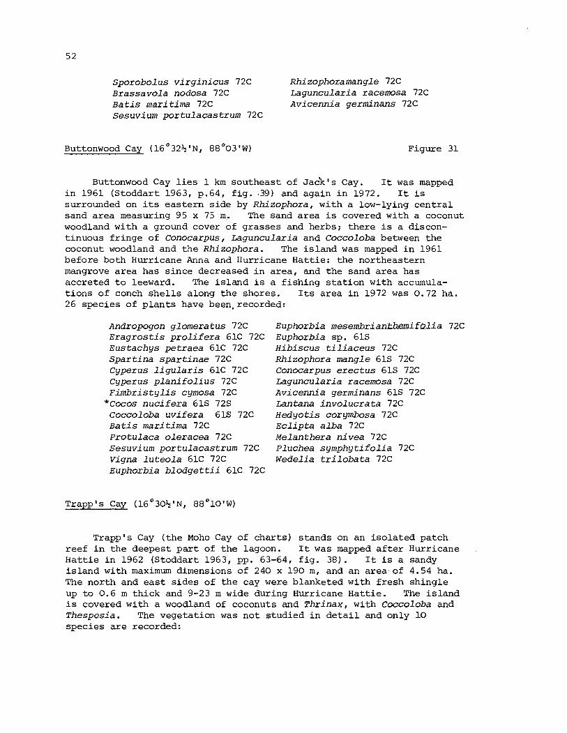
Sporobo lus v i r g i n i c u s 72C Rhizophoramangle 72C Brassavo la nodosa 72C ~ a g u n c u l a r i a racemosa 72C B a t i s mari t ima 72C Avicenn ia germinans 72C Sesuvium por tu lacas t rum 72C
Buttonwood Cay (16 I N , 88 '03 W ) Figure 31
Buttonwood Cay l i e s 1 k m southeas t of ~ a c k ' s Cay. I t was mapped i n 1961 (Stoddart 1963, p.64, f i g . 139) and again i n 1972. I t i s surrounded on i t s eas te rn s ide by Rhizophora, with a low-lying c e n t r a l sand a rea measuring 95 x 75 m. The sand a rea i s covered with a coconut woodland with a ground cover of grasses and herbs; the re i s a discon- t inuous f r inge of Conocarpus, Laguncular ia and Coccoloba between the coconut woodland and the Rhizophora. The i s l a n d was mapped i n 1961 before both Hurricane Anna and Hurricane Hatt ie: the northeastern mangrove a rea has s ince decreased i n a rea , and the sand a rea has accre ted t o leeward. The i s l a n d i s a f i s h i n g s t a t i o n with accumula- t i o n s of conch s h e l l s along t h e shores. Its area i n 1972 was 0.72 ha. 26 species of p l a n t s have beeqrecorded:
Andropogon glomeratus 72C E r a g r o s t i s p r o l i f e r a 61C 72C Eus tachys pe t raea 61C 72C S p a r t i n a s p a r t i n a e 72C Cyperus l i g u l a r i s 61C 72C Cyperus p l a n i f o l i u s 72C F i m b r i s t y l i s cymosa 72C
* ~ o c o s n u c i f e x a 61s 72s Coccoloba u v i f e r a 61s 72C B a t i s mari t ima 72C Protulaca o l e r a c e a 72C Sesuvium por tu lacas t rum 72C Vigna l u t e o l a 61C 72C Euphorbia b l o d g e t t i i 61C 72C
Euphorbia m e s e m b x i a n ~ i f ~ l i a Euphorbia sp. 61s H i b i s c u s t i l i a c e u s 72C Rhizophora mangle 61s 72C Conocarpus e r e c t u s 61s 72C Laguncularia racemosa 72C Avicenn ia germinans 61s 72C Lantana i n v o l u c r a t a 72C Hedyo t i s corymbosa 72C E c l i p t a a l b a 72C Melanthera n i v e a 72C Pluchea s y m p h y t i f o l i a 72C Wedel ia t r i l o b a t a 72C
Trapp's Cay ( 1 6 ° 3 0 $ ' ~ , 8 8 ° 1 0 ' ~ ) -
Trapp's Cay ( t h e Moho Cay of cha r t s ) s tands on an i s o l a t e d patch reef i n the deepest p a r t of t h e lagoon. I t was mapped a f t e r Hurricane H a t t i e i n 1962 (Stoddart 1963, pp. 63-64, f i g . 38). I t is a sandy i s l a n d with maximum dimensions of 240 x 190 m, and an a rea of 4.54 ha. The nor th and e a s t s i d e s of t h e cay were blanketed with f r e s h shingle up t o 0.6 m th ick and 9-23 m wide during Hurricane Hat t ie . The i s l a n d i s covered with a woodland of coconuts and T h r i n a x , with C o c c ~ l o b a and T h e s p e s i a . The vegetat ion was no t s tudied i n d e t a i l and only 10 species a r e recorded:
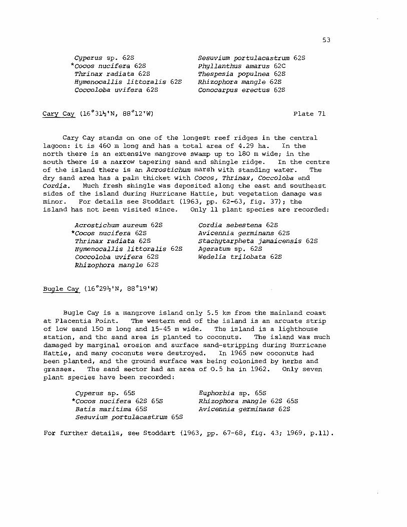
Cyperus sp. 62s Sesuv ium p o r t u l a c a s t r u m 62s * ~ o c o s n u c i f e r a 62s P h y l l a n t h u s amarus 62C
T h r i n a x r a d i a t a 62s T h e s p e s i a populnea 62s Hyrnenocall is l i t t o r a l i s 62s R h i z o p h o r a m a n g l e 62s Coccoloba u v i f e r a 62s Conocarpus e r e c t u s 62s
Cary Cay (16'31$'~, 8 8 ' 1 2 ' ~ ) P l a t e 71
Cary Cay s tands on one of t h e longest reef r idges i n t h e c e n t r a l lagoon: it is 460 m long and has a t o t a l a rea of 4.29 ha. I n t h e nor th t h e r e i s an extensive mangrove swamp up t o 180 m wide; i n t h e south t h e r e i s a narrow taper ing sand and shingle r idge. I n t h e cen t re of the i s l and t h e r e is an A c r o s t i c h u m marsh with standing water. The dry sand a rea has a palm t h i c k e t with Cocos , T h r i n a x , Coccoloba and C o r d i a . Much f resh shingle was deposi ted along t h e e a s t and southeas t s ides of the i s l a n d during Hurricane Ha t t i e , bu t vegetat ion damage was minor. For d e t a i l s see Stoddart (1963, pp. 62-63, f i g . 37 ) ; t h e i s l a n d has not been v i s i t e d s ince . Only 11 p l a n t species a r e recorded:
A c r o s t i c h u m aureum 62s Cordia s e b e s t e n a 62s *Cocos n u c i f e r a 62s A v i c e n n i a germinans 62s
T h r i n a x r a d i a t a 62s S t a c h y t a r p h e t a j a m a i c e n s i s 62s Hymenoca l l i s l i t t o r a l i s 62s Ageratum sp. 62s Coccoloba u v i f e r a 62s W e d e l i a t r i l o b a t a 62s Rhizophora mang le 62s
Bugle Cay (16 '29+ '~ , 8 8 ° 1 9 ' ~ )
Bugle Cay is a mangrove i s l a n d only 5.5 km from t h e mainland coas t a t P lacen t i a Point. The western end of t h e i s l a n d i s an arcuate s t r i p of low sand 150 m long and 15-45 m wide. The i s l a n d is a l ighthouse s t a t i o n , and t h e sand a rea is planted t o coconuts. The i s l and was much damaged by marginal erosion and surface sand-stripping during Hurricane Ha t t i e , and many coconuts were destroyed. In 1965 new coconuts had been p lanted , and t h e ground surface was being colonised by herbs and grasses . The sand sec to r had an a rea of 0 .5 ha i n 1962. Only seven p l a n t species have been recorded:
Cyperus sp. 65s Euphorbia sp. 65s *Cocos n u c i f e r a 62s 65s Rhizophora mangle 62s 65s
B a t i s m a r i t i m a 65s A v i c e n n i a germinans 62s Sesuv ium p o r t u l a c a s t r u m 65s
For f u r t h e r d e t a i l s , see Stoddart (1963, pp. 67-68, f i g . 43; 1969, p.11).
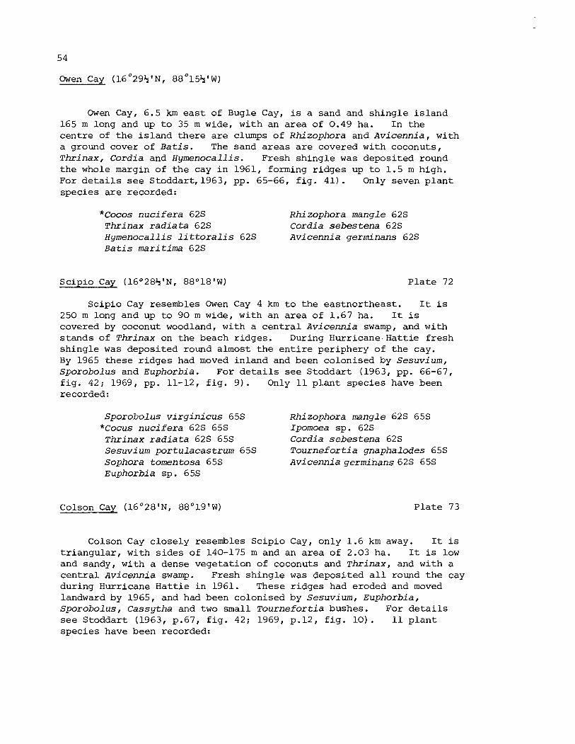
Owen Cay (16O29%'~, 88O15%'~)
Owen Cay, 6.5 km e a s t of Bugle Cay, is a sand and shingle i s l a n d 165 m long and up t o 35 m wide, with an area of 0.49 ha. In the cent re of t h e i s l and the re a r e clumps of Rhizophora and Avicennia , with a ground cover of B a t i s . The sand a reas a r e covered with coconuts, Thr inax , Cordia and Hymenocallis. Fresh shingle was deposited round the whole margin of t h e cay i n 1961, forming r idges up t o 1.5 m high. For d e t a i l s s e e Stoddart, 1963, pp. 65-66, f i g . 41) . Only seven p l a n t species a r e recorded:
* ~ o c o s n u c i f e r a 62s Rhizophora mangle 62s Thrinax r a d i a t a 62s Cordia sebestena 62s Hymenocallis l i t t o r a l i s 62s A v i cenni a germi nans 6 2s B a t i s marit ima 62s
Scipio Cay (16O28%'NI 88°18'W) P l a t e 72
Scipio Cay resembles Owen Cay 4 km t o the eas tnor theas t . I t i s 250 m long and up t o 90 m wide, with an area of 1.67 ha. I t i s covered by coconut woodland, with a c e n t r a l Avicennia swamp, and with s tands of Thrinax on the beach r idges. During Hur r i caneHat t i e f r e sh shingle was deposited round almost the e n t i r e periphery of the cay. By 1965 these r idges had moved inland and been colonised by Sesuvium, Sporobolus and Euphorbia. For d e t a i l s see Stoddart (1963, pp. 66-67, f i g . 42; 1969, pp. 11-12, f i g . 9 ) . Only 1 1 p l a n t species have been recorded :
Sporobolus v i r g i n i c u s 65s Rhizophora mangle 62s 65s *Cocus n u c i f e r a 62s 65s Ipomoea sp. 62s Thrinax r a d i a t a 62s 65s Cordia sebes tena 62s Sesuv i um portulacastrum 65s Tourne fo r t i a gnaphalodes 65s Sophora tomentosa 65s Avicennia qerminans 62s 65s Euphorbia sp . 6 5s
Colson Cay (16O28 '~ , 88O19'W) P l a t e 73
Colson Cay c lose ly resembles Scip io Cay, only 1.6 km away. It i s t r i a n g u l a r , with s i d e s of 140-175 m and an a rea of 2.03 ha. It i s low and sandy, with a dense vegetat ion of coconuts and Thr inax , and with a c e n t r a l Avicennia swamp. Fresh shingle was deposi ted a l l round t h e cay during Hurricane Ha t t i e i n 1961. These r idges had eroded and moved landward by 1965, and had been colonised by Sesuvium, Euphorbia, Sporobolus, Cassytha and two small Tourne fo r t i a bushes. For d e t a i l s see Stoddart (1963, p.67, f i g . 42; 1969, p.12, f i g . 1 0 ) . 11 p l a n t species have been recorded:
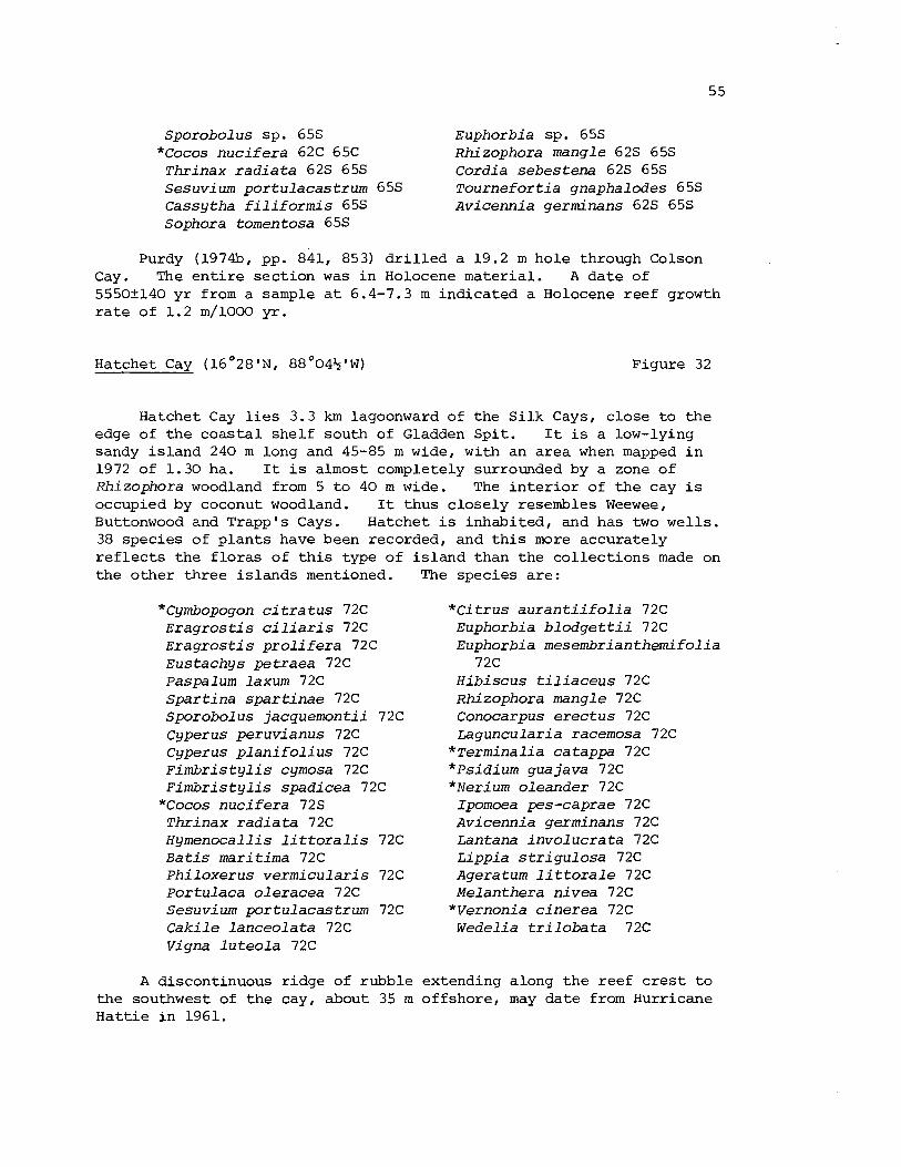
Sporobolus sp. 65s Euphorbia sp. 65s *Cocos n u c i f e r a 62C 65C Rhizophora mangle 62s 65s
Thr inax r a d i a t a 62s 65s Cordia s e b e s t e n a 62s 65s Sesuvium por tu lacas t rum 65s T o u r n e f o r t i a gnaphalodes 65s Cassytha f i l i f o r m i s 65s Avicenn ia germinans 62s 65s Sophora tomentosa 65s
Purdy (197433, pp. 841, 853) d r i l l e d a 19.2 m hole through Colson Cay. The e n t i r e sec t ion was i n Holocene material . A da te of 5550+140 y r from a sample a t 6.4-7.3 m indicated a Holocene reef growth r a t e of 1.2 m/1000 yr .
Hatchet Cay (16°28'N, 8 8 ° 0 4 $ 1 ~ ) Figure 32
Hatchet Cay l i e s 3.3 km lagoonward of the S i l k Cays, c lose t o t h e edge of t h e c o a s t a l shel f south of Gladden Spi t . I t i s a low-lying sandy i s l and 240 m long and 45-85 m wide, with an a rea when mapped i n 1972 of 1.30 ha. I t i s almost completely surrounded by a zone of Rhizophora woodland from 5 t o 40 m wide. The i n t e r i o r of t h e cay i s occupied by coconut woodland. I t thus c lose ly resembles Weewee, Buttonwood and Trappls Cays. Hatchet is inhabited, and has two wel ls 38 species of p l a n t s have been recorded, and t h i s more accurately r e f l e c t s the f l o r a s of t h i s type of the o ther th ree i s l ands mentioned.
*Cymbopogon c i t r a t u s 72C E r a g r o s t i s c i l i a r i s 72C E r a g r o s t i s p r o l i f e r a 72C Eus tachys pe t raea 72C Paspalum laxum 72C S p a r t i n a s p a r t i n a e 72C Sporobolus jacquemont i i 72C Cyperus peruvianus 72C Cyperus p l a n i f o l i u s 72C F i m b r i s t y l i s cymosa 72C F i m b r i s t y l i s spad icea 72C
*Cocos n u c i f e r a 72s T h r i n a x r a d i a t a 72C Hymenocal l i s l i t t o r a l i s 72C B a t i s mari t ima 72C P h i l o x e r u s v e r m i c u l a r i s 72C Portulaca o l e r a c e a 72C Sesuvium por tu lacas t rum 72C C a k i l e l a n c e o l a t a 72C Vigna l u t e o l a 72C
is land than the co l l ec t ions made on The species a r e :
* C i t r u s a u r a n t i i f o l i a 72C Euphorbia b l o d g e t t i i 72C Euphorbia mesembr ian themi fo l ia
72C H i b i s c u s t i l i a c e u s 72C Rhizophora mangle 72C Conocarpus e r e c t u s 72C Laguncular ia racemosa 72C
* ~ e r m i n a l i a catappa 72C * ~ s i d i u m guajava 72C * ~ e r i u m o leander 72C
Ipomoea pes-caprae 72C ~ v i c e m i a germinans 72C Lantana i n v o l u c r a t a 72C Lipp ia s t r i g u l o s a 72C Ageratum l i t t o r a l e 72C Melanthera n i v e a 72C
*Vernonia c i n e r e a 72C Wedel ia t r i l o b a t a 72C
extending along t h e reef c r e s t t o A discontinuous r idge of rubble the southwest of t h e cay, about 35 m offshore, may da te from Hurricane Ha t t i e i n 1961.
L i t t l e Water Cay (16O27k1~, 88O06 '~ ) Figure 33, P l a t e 75
L i t t l e Water Cay l i e s 3.7 km southwest of Hatchet Cay. I t is a t r i a n g u l a r i s l a n d 255 m long and up t o 170 m wide, with an a rea i n 1972 of 2.07 ha. Most of t h e i s l a n d i s covered wi th a dense coconut woodland, with an i n t e r i o r a rea of sedge marsh and narrow f r i n g e s of Rhizophora a t the west end and along t h e e a s t shore. There a r e some patches of Conocarpus along t h e shore, e spec ia l ly on the nor th s i d e , b u t genera l ly t h e coconut woodland extends t o t h e beach. The whole of t h e south shore i s c l i f f e d and eroding, with f a l l e n coconuts. There is an extensive zone of rubble on t h e reef c r e s t a t the e a s t end of the cay, which may da te from Hurricane Ha t t i e . The i s l and is uninhabited. 29 p l a n t species a r e recorded:
Eragrostis prolifera 72C Eustachys petraea 72C Paspalum blodgettii 72C Paspalum distichum 72C Spartina spartinae 72C Sporobol us virginicus 72C- Stenotaphrum secundatum 72C Cyperus ligularis 72C Cyperus planifolius 72C Fimbrist ylis cymosa 72C *Cocos nucifera 72s Batis maritima 72C Philoxerus vermicularis 72C Portulaca oleracea 72C Sesuvi um portulacastrum 72C
Vigna luteola 72C Suriana maritima 72C Euphorbia blodgettii 72C Euphorbia mesembrianthemifolia
72C Hibiscus tiliaceus 72C Rhizophora mangle 72C Conocarpus erectus 72C Laguncularia racemosa 72C *~erminalia catappa 72C Avi cennia germinans 72C Lippia strigulosa 72C Eclipta alba 72C Melanthera nivea 72C Wedelia trilobata 72C
Laughing Bird Cay (16°27'N, 88O12 '~ )
Laughing Bird Cay is t h e southernmost of the i s l a n d s i n the c e n t r a l lagoon. It s tands on an elongate reef r idge 23 km from the coas t and 14 km from the she l f edge: water depths t o the southeas t reach 45 m, b u t Purdy has shown t h a t the Holocene sequence beneath t h i s i s l a n d is 18.3 m th ick , giving a pre-Holocene r e l i e f above the p resen t lagoon f l o o r of about 20 m (Purdy 197433, p.841). The i s l and i t s e l f i s an elongate sand r idge about 460 m long and 9-40 m wide. During Hurricane Ha t t i e rubble and shingle were deposi ted a t the nor theas t and southwest ends of t h e cay, and along the southeast shore. When mapped i n 1962 the area of the cay was 1.36 ha; it has not been v i s i t e d s ince (Stoddart 1963, p.65, f i g . 40 ) . The i s l and i s covered with coconut woodland, with s c a t t e r e d coas ta l mangroves. Only seven p l a n t species have been recorded:
*Cocos nucifera 62s Rhizophora mangle. 62s Hymenocallis littoralis 62s Ipomoea sp . 62s Sesuvium portula~astrum 62s Avicennia germinans 62s Euphorbia sp. 62s
Placent ia Cay ( l . 6 ' 3 1 ' ~ ~ 88'213'W)
This i s a mangrove i s l and with a small a rea of s t r and vegetat ion and coconuts located 1 km e a s t of Placent ia Point on the mainland coas t ; It was mapped a s True Po in t Pat ience Kay of Speer (1966, p.23) and a s Patience Brother Is land of J e f f e r y s (1775). J e f f e r y s a l s o mapped the small mangrove i s l e t s a t t h e mouth of P lacen t i a Lagoon a s The Virgins, and Speer commented on these "severa l small Kays ... a t the mouth of a l a rge lagoon, where there i s plenty of Tur t l e passes morning and evening'' (1766, p . 23) . No p l a n t c o l l e c t i o n s have been made on these i s l ands , which a r e p a r t of t h e coas ta l quar tz and carbonate sand acc re t iona l sequences.
Harvest Cay ( 1 6 ' 2 9 ' ~ ~ 8 8 ' 2 4 ' ~ )
Harvest Cay, 5.5 km t o the southwest, i s the "Hobbe's Kay" of Speer (1766, p .23) . This and o t h e r nearshore i s l a n d s t o the south, such a s Palmetto Cay, a r e properly b a r r i e r beaches b u i l t of te r r igenous quar tz sand, backed by mangrove swamp, r a t h e r than t r u e c o r a l cays. Harvest Cay has a dense vegetat ion of coconuts, T h r i n a x and mangroves, with a t a l l undergrowth of C l a d i u m , together with succulents and grasses . The i s l and was b r i e f l y v i s i t e d i n 1962. Four species were noted:
C l a d i u m j a m a i c e n s e 62C T h r i n a x r a d i a t a 62s * C o c o s n u c i f e r a 62s B a t i s m a r i t i m a 62s
D. The Punta Gorda Cavs
The cays of the Por t Honduras Bight between Punta Gorda and Punta Ycacos, i n the southern p a r t of the b a r r i e r reef lagoon, s tand on numerous steep-sided kno l l s , r i s i n g from a shelving lagoon f l o o r i n from 8-24 m of water. The innermost cays, from S t u a r t Cay a t t h e mouth of the Rio Grande t o Bedford Cays a t t h e mouth of the Ycacos Lagoon, a l l surrounded by water l e s s than 10 m deep, a r e wholly mangrove. Further lagoonward t h e r e a r e some i s l ands with dry land i n addi t ion t o mangrove, notably Frenchman's Cay and Wild Cane Cay, b u t most of t h e i s l ands a r e un-named and wholly of mangrove. On many of them t h e mangrove i n 1961 was l e s s than 2 m t a l l , suggesting recent growth following hurricane damage. The Moho Cays a r e a l l mangrove, except f o r the ou te r one, which i s a sand cay. The outermost i s l ands , the Snake Keys, s tand on patches r i s i n g from a lagoon f l o o r 20-30 m deep; they a r e sand cays with sh ingle r idges ; only these patches have s i g n i f i - can t amounts of c o r a l on them. A l l of these i s l ands come under the influence of freshwater discharge from t h e Deep River and the Rio Grande; the r a i n f a l l i n t h i s a rea (4239 mm a t Punta Gorda) i s much higher than elsewhere on the c o a s t a l cays. The published c h a r t of the Gulf of Honduras da tes from surveys i n 1835-1841 and is r a t h e r general ised, and
t h e i s l a n d s a r e known only through a b r i e f reconnaissance v i s i t i n 1961. They would repay f u r t h e r i n v e s t i g a t i o n .
E a s t Snake Cay ( 1 6 ° 1 2 + ' ~ , 88O30+ '~ ) F igure 34, P l a t e s 76 and 79
E a s t Snake Cay c o n s i s t s o f a dense ly vege ta ted sand cay wholly surrounded by s h i n g l e r i d g e s which enc lose a shal low moat conta in ing mangroves. The t o t a l a r e a i s 1.94 ha , of which t h e main co re , excluding t h e moat and rampart , comprises 1.04 ha. The whole complex i s 260 m long and up t o 110 m wide, and t h e r e e f pa t ch on which it s t ands i s only s l i g h t l y l a r g e r . Vegetat ion on t h e s h i n g l e rampart i s l i m i t e d t o pa tches o f Ipomoea and Rhizophora. On t h e sand cay t h e r e i s a dense woodland of coconuts , T h r i n a x , Cord ia , Coccoloba, Termina l ia and Ficus . There is an automatic l i gh thouse on t h e i s l a n d . For a b r i e f account , see S todda r t (1965, p.138, f i g . 4 ) . 20 s p e c i e s of p l a n t s have been recorded:
Cyperus sp . 61s *Cocos n u c i f e r a 57s 61s
Thr inax r a d i a t a 61s Hymenocal l i s l i t t o r a l i s 61s Brassavo la nodosa 6 1 C Ficus sp. 61C Coccoloba u v i f e r a 6 1s E r y t h r i n a sp . 61C Sophora tomentosa 61C Euphorbia s p . 6 1s
R h i zophora mangle 61s Conocarpus e r e c t u s 61s
*Termina l ia catappa 61C Ipomoea s p . 6 1s Cordia s e b e s t e n a 61s T o u r n e f o r t i a gnaphalodes 61s A v i cenn ia germinans 6 1s S t a c h y t a r p h e t a jamaicens i s 61s E r i t h a l i s f r u t i c o s a 61s Wedel ia t r i l o b a t a 61s
Purdy (1974b. p.841) d r i l l e d a h o l e 39.7 m deep through E a s t Snake Cay. Recent r e e f m a t e r i a l gave way t o pre-Recent t e r r e s t r i a l sediments a t a depth of 25.9 m.
Middle Snake Cay (16 '12 I N , 88 "33'W) F igure 35
Middle o r Ragged Snake Cay comprises two i s l a n d s b u i l t o f s h i n g l e , each having an a r e a o f 0.66 ha. The no r theas t e rn i s l a n d i s about 275 m long b u t i s everywhere less than 40 rh wide. I t i s b u i l t of two l i n e a r sh ing l e r i d g e s wi th an i n t e rven ing p a r t l y w a t e r - f i l l e d depression. The o u t e r r i d g e s , presumably hurricane-formed, i nc lude c o r a l b locks 1 m i n diameter . The vege t a t i on i s l i m i t e d t o succu len t s and g r a s s e s , w i th low shrubs o f Coccoloba, S u r i a n a , T o u r n e f o r t i a and mangroves. 7 p l a n t spec i e s w e r e noted i n 1961:
Coccoloba u v i f e r a 61s Conocarpus e r e c t u s 61s Sesuvium por tu lacas t rum 61s Ipomoea s p . 6 1s Sur iana mari t ima 61s Avicenn ia germinans 61s Rhizophora mangle 61s
The southern i s l a n d i s a l s o b u i l t of shingle r idges , but is t r i angu la r , with s ides of 75-110 m. The i n t e r i o r is more sandy, and the concentric r idges enclose l i n e a r pools. There is a dense growth of Avicenn ia and Rhizophora along t h e north s i d e , with a woodland of coconuts, Thr inax and Coccoloba on the r e s t of t h e cay. 15 species of p lan t s were noted i n 1961:
Cyperus sp. 61.5 Sophora tomentosa 61s * ~ o c o s n u c i f e r a 61s Suriana mari t ima 61s
Thr inax r a d i a t a 61s Euphorbia sp. 61s Hymenocal l i s l i t t o r a l i s 61s Conocarpus e r e c t u s 61s Brassavola nodosa 61s Ipomoea sp. 61s Coccoloba u v i f e r a 61s ~ o u r n e f ~ r t i a gnaphalodes 61s S e s u v i um por tu lacas t rum 61s Wedel ia t r i l o b a t a 61s C a k i l e l a n c e o l a t a 61s
West Snake Cay ( 1 6 ° 1 1 4 ' ~ , 88O34 '~) Figures 36 and 37, P la tes 77 and 80
West Snake Cay i s a complex i s l a n d with a leeward sand area , a c e n t r a l mangrove swamp, a moat, and a windward shingle r idge , with a t o t a l a rea of 5.35 ha. I t has been described b r i e f l y by Stoddart (1965, p.137, f i g . 41, and r e c a l l s t h e fea tu res of low wooded i s l a n d s of t h e northern Great Barr ier Reef and of Djakarta Bay. The shingle rampart follows t h e eas tern edge of the reef patch f o r about 370 m , r i s i n g t o 1 m above sea l eve l . The moat enclosed by the shingle r idge is about 200 m long and up t o 100 m wide: it i s l e s s than 0.6 m deep; and with i t s enclosing shingle r idges has an area of 2.5 ha. There a r e many Rhizophora seedlings i n t h e moat and along t h e inner margin of the r idge , and t h e shingle r idge i t s e l f i s pa tch i ly covered with Sesuvium, T o u r n e f o r t i a , Coccoloba, mangroves and grasses . The most extensive vegetation u n i t is t h e mangrove swamp, consis t ing of Rhizophora, Av icenn ia and Acrost ichum, but much of it i s open standing water. The leeward dry sand area i s 15-30 m wide and r i s e s t o 1 m above sea level . I t i s under coconut woodland with Coccoloba and T o u r n e f o r t i a and a diverse ground cover. 13 species of p l a n t s were recorded i n 1961:
Acrost ichum aureum 61C Euphorbia sp. 61s Sporobolus v i r g i n i c u s 61C Rhizophora mangle 6 1s Cyperus sp. 61s Ipomoea macrantha 61C
* ~ o c o s n n c i f e r a 61s Ipomoea pes-caprae 61C Coccoloba u v i f e r a 61s T o u r n e f o r t i a gnaphalodes 61s Sesuvium por tu lacas t rum 61.5 Avi cenn ia germinans 61s C a k i l e l a n c e o l a t a 61C
150 m northwest of t h e main i s l and is a small shingle i s l and , West Is land. It is 140 m long, up t o 23 m wide, has an area of 800 s q m, and r i s e s 1 m above sea l eve l . Most of the i s l e t is covered with Sesuvium and Ipomoea, with some shrubby Coccoloba, Suxiana and Conocarpus. Six species were recorded i n 1961:
Sporobolus sp. 61s Suriana mari t ima 61s Coccol oba u v i f e r a 6 1s Conocarpus e r e c t u s 6 1s Sesuvium por tu lacas t rum 61s ~pbmoea sp. 61s
South Snake Cay ( 1 6 ° 1 1 ' ~ , 88O34 '~) Figure 38, P l a t e 78
South Snake Cay i s very s i m i l a r t o West Snake Cay, bu t the eas te rn shingle rampart i s uninterrupted and adjoins the main cay a t each end. The mangrove a rea i s smaller and t h e leeward sand a rea forms the l a r g e s t p a r t of t h e complex (Stoddart 1965, pp. 137-138, f i g . 4 ) . The sh ing le rampart is 20 m wide and 1.5 m high a t i t s southeas t end; it becomes narrower and lower northwards. The moat is shallow and completely enclosed, and contains much stranded pumice; t h e a rea of t h e moat and enclosing rampart is 1.05 ha. The rampart i t s e l f is not vegetated and t h e r e a r e no Rhizophora seedlings i n t h e moat. The dry sand a rea has maximum dimensions of 180 x 90 m , has an a rea of 1.7 ha, and is s t rongly undercut along its southwest shore, where t h e surface s tands a t 1 m above sea l eve l . Poorly cemented beachrock outcrops along t h i s shore l ine between t h e small b l u f f s formed by t h e boles of coconut t r e e s . The sand a rea i s covered with a dense t h i c k e t of coconuts and T h r i n a x . 11 species of p l a n t s were noted i n 1961:
Andropogon sp. 61s Sophora tomentosa 61s Cyperus sp. 61s Sur iana mari t ima 61s
"Cocos n u c i f e r a 61s Rhi zophora mangle 61s Thr inax r a d i a t a 61s Conocarpus e r e c t u s 61s Hymenocal l i s l i t t o r a l i s 61s Wedel ia t r i l o b a t a 61s Dalbergia ecas tophy l lum 61C
Wild Cane Cay ( 1 6 ° 1 2 + ' ~ , 8 8 ' 3 8 ' ~ ) Figure 39
This i s a mangrove i s l a n d 7.5 km southwest of Punta Ycacos. The whole i s l a n d i s about 1 km long. A t i t s southern end the re i s a rec tangular dry a rea measuring 300 x 100 m, with an a rea of 2.0 ha. Mangroves a r e growing a t seve ra l po in t s along i t s shores. The dry a rea is only about 0.6 m above sea l eve l ; t h e s o i l i s dark and humic and p a r t s a r e boggy. The vegetat ion cons i s t s of coconut woodland with marginal Conocarpus. The i s l and is inhabited and t h e r e a r e severa l introduced food and ornamental p lan t s . The most s t r i k i n g f e a t u r e of t h e cay, however, i s t h e presence of l a r g e stone-faced Maya b u r i a l mounds. One of these cons t i tu ted Mound 39 i n Gann's excavations (1918, pp. 135-1361. This was a mound 3 m high consis t ing of sand and blocks of reef limestone covering a surface bur ia l . Gann found po t t e ry , obsidian knives, the femur of a deer with an inc ised design, and copper ornaments ( r ings , gorgets , s tuds) which he suggested showed Spanish influence. I n another account (1927, p.238) Gann speaks of " g r e a t numbers of interments i n four l a rge mounds."
When mapped i n 1961 the four mounds s t i l l ex i s ted , the l a rge s t being 65 m long. They have, however, been much disturbed. In 1918 Gann noted t h a t they were used a s a source of stone, and i n 1927 (p. 238) he s t a t ed t h a t "when the Cabral family needs a l i t t l e ready money, they excavate a small area and s e l l the beads, pot tery , spear-heads, e tc . , which invariably turn up." I n 1 9 6 1 t h e ground surface was l i t t e r e d with obsidian f l akes up t o 4 cm long, and with fragments of coarse red pottery. A d r i l l e d jade bead and a p r o j e c t i l e po in t 16 cm long were a l s o found. Other remains included grey pot tery ne t s inkers and small animal f igures . The most remarkable object from Wild Cane Cay, however, i s an animal-shaped j a r 13.7 cm high of Plwnbate Ware. I t is described by Bray (1970, p.32, p l a t e 27): "The head is f rog- l ike , but the f e e t and stumpy t a i l belong t o a d i f f e r en t kind of animal. The creature wears a necklace, each end of which terminates i n a d i s c ornamented with s i x p i t s . The body of the pot is fu r t he r decorated with broad l i n e designs incised through the greenish-brown s l i p . " Plurnbate Ware was manufactured i n Guatemala and widely traded: the use of zoomorphic shapes began about 1000 A.D. and t h i s serves as a time- marker f o r the ea r ly Postc lass ic period. Bray dates t h i s pa r t i cu l a r object between 1000 and 1200 A.D.
F i f teen p l a n t species were noted i n 1961; undoubtedly more a r e present .
P i t yrogramma ca lome lanos 6 1C *Mangi f e r a i n d i c a 6 1s S p o r o b o l u s j a c q u e m o n t i i 61C S i d a a c u t a 61C F i m b r i s t y l i s s p a d i c e a 61C Opunt ia sp. 61s
*Cocos n u c i f e r a 61s Rhi zophora mangle 6 1s L a e l i a tibicinis 61C Conocarpus e r e c t u s 61s Coccoloba u v i f e r a 6 1s * ~ s i d i um qua java 6 1C
* C i t r u s sp. 61s S t a c h y t a r p h e t a j a m a i c e n s i s 6 1 C * P e d i l a n t h u s ti t h y m a l o i d e s 61C
Frenchman's Cay ( 1 6 ° 1 1 % ' ~ , 88 ' 38 '~ )
Frenchman's Cay i s very s imi la r t o Wild Cane Cay, though almost the whole shorel ine i s l ined by mangroves. The sandy i n t e r i o r i s covered with coconut woodland, and the centre is low-lying and swampy. There i s a freshwater well, severa l huts , and an area of cu l t iva ted plants . There a r e several bu r i a l mounds faced with limestone blocks, seen i n 1961. Gann (1927) reported the excavation of gold ornaments and other a r t e f x t s from these s i t e s . Only f i v e species of p lan t s were noted i n 1961; many must remain t o be recorded. They are :
*Saccharurn o f f i c i n a r u m 61s *Mangi fera i n d i c a 61s *Cocos n u c i f e r a 61s R h i zophora mangle 6 1s *Mum p a r a d i s i a c a 61s
6 2
Moho Cay ( 1 6 ° 3 0 5 ' ~ ,
Apart from coa
88O10 '~)
s t a l mangrove i s l e t .st Moho Ca:
Figure 40
y i s t h e southernmost cay i n the Punta Gorda group, and t h e only sand cay. I t i s a narrow i s l a n d 160 m long, with an average width of 18-35 m , and an a rea of 0.54 ha. Owen i n 1835 noted a s o l i t a r y coconut a t i t s northern end, b u t s ince then the vegetat ion has been c leared and t h e i s l and is now covered with coconut woodland, except f o r an a rea of dense woodland a t the south end. There is a var ied ground cover of herbs, g rasses and sedges beneath t h e coconuts. The dense woodland includes coconuts, T h r i n a x and some mangroves. The whole i s l a n d is sandy and low-lying, and t h e south and southeas t shores a r e undercut and eroding. There is a freshwater wel l and a small hut . Twenty species of p l a n t s were recorded i n 1961:
E r a g r o s t i s p r o l i f e r a 61C E u s t a c h y s pe t raea 61C Paspal um pan icu la tum 61C Sporobol u s v i r g i n i c u s 6 1 C S teno taphrum secundatum 61C Cyperus l i g u l a r i s 61C Cyperus peruv ianus 61C F i m b r i s t y l i s cymosa 61C F i m b r i s t y l i s s p a d i c e a 61C
*Cocos n u c i f e r a 61s
T h r i n a x r a d i a t a 61s Hymenoca l l i s l i t t o r a l i s 61s Coccoloba u v i f e ra 61s Sophora tomentosa 6 1 C Vigna l u t e o l a 61C ~ u p h o r b i a b l o d g e t t i i 61C B i d e n s c y n a p i i f o l i a 61C Conyza c a n a d e n s i s 61C Melanthera n i v e a 61C Wede l ia t r i l o b a t a 61C
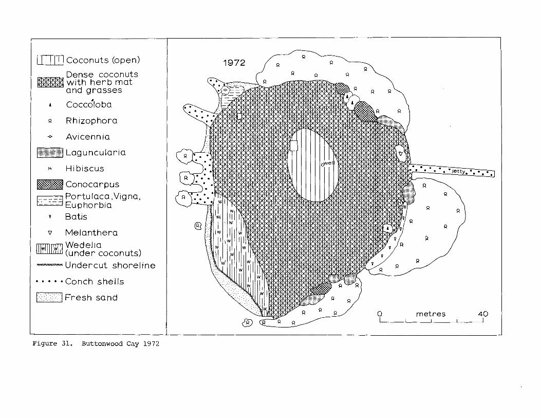
I Coconuts (open)
Dense coconuts with herb mat and grasses
Q Rhizophora - Avicennia
H Hibiscus
Conocarpus ---- Portulaca ,Vigna,
Euphorbia
v Batis
v Melanthera
Wedelia (under coconuts) - Undercut shoreline
.... *Conch shells
-1 . . . . . . . . . . . . - . : . - Fresh sand
Figure 31. Buttonwood Cay 1972
0 metres 40
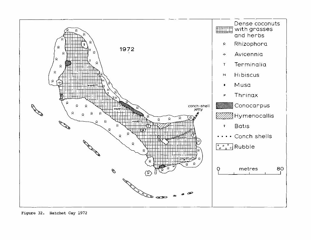
Dense coconuts wi th grasses and herbs
Q Rhizophora
+ Avicennia
T Terminalia
H Hibiscus
4 Musa
P Thrinax
Conocarpus
Hymenocal lis
.... Conch shells
1-1 RU bble
0 metres 80
Figure 32. Hatchet Cay 1972
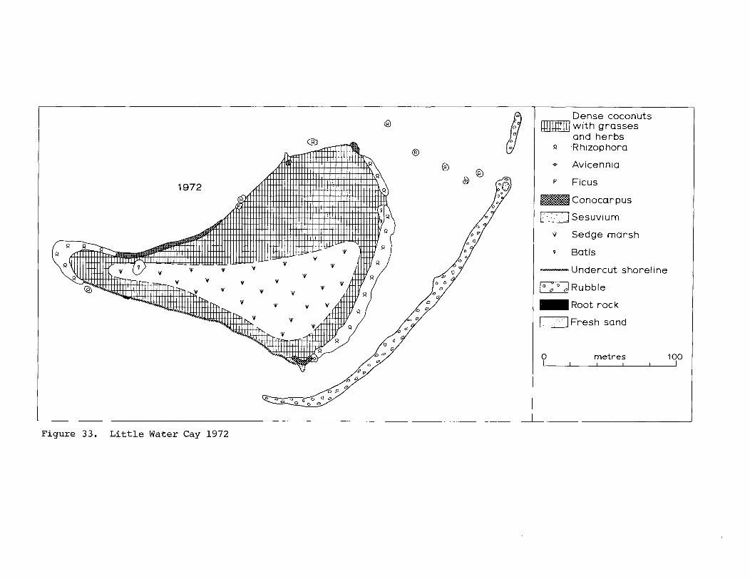
? i g u r e 33. L i t t l e Water Cay 1972
Dense cocon'uts wi th grasses and herbs
Q R h izop hora
* Avicennia
F Ficus
Conocarpus
I T ] Sesuvium
9 Sedge marsh
v Batis - Undercut shorel~ne
(Ol Rubble = Root rock
I] Fresh sand
0 metres 100 I I I I
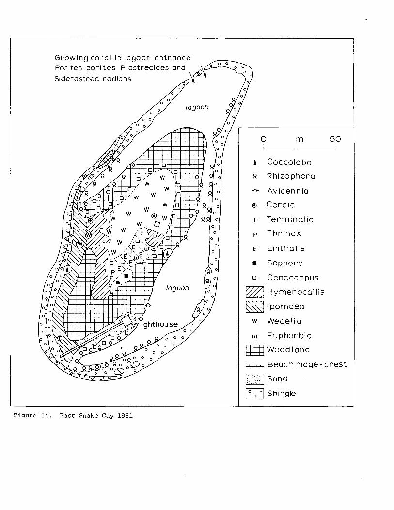
Growing cora l in lagoon entrance Porites por i t es P astreoides and
Siderastrea radians
A Coccoloba
9 Rhizophora
Avicennia
o Cordia
T Terminalia
p Thrinax
rn Sophora
Hymenocal lis
w Wedelia
w Euphorbia
mj Wood land
Beach r idge-crest
. . . , . . : . . . . . . Sand , . .:;:.
171 Shingle
Figure 34. E a s t Snake C a y 1961
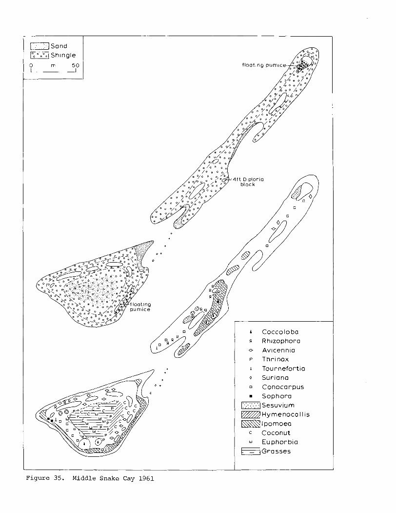
A Coccoloba n Rh~zophora
o Avicennia
P Thrinax 1 Tournefortia
0 Suriana
0 Conocarpus
Sophora 1-1 Sesuvium w d ~ y m e n o c a I I is
El I pomoea
c Coconut w Euphorbia
F / ~ r a s s e s
Figure 35. Middle Snake Cay 1961
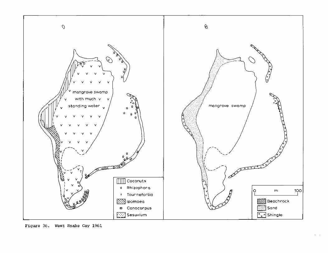
mn] Coconuts
Q Rhizophora
T Tournefortia
lpomoea
Conocarpus
Sesuvium
Beach rock
Sand
Shingle
Figure 36. West Snake Cay 1961
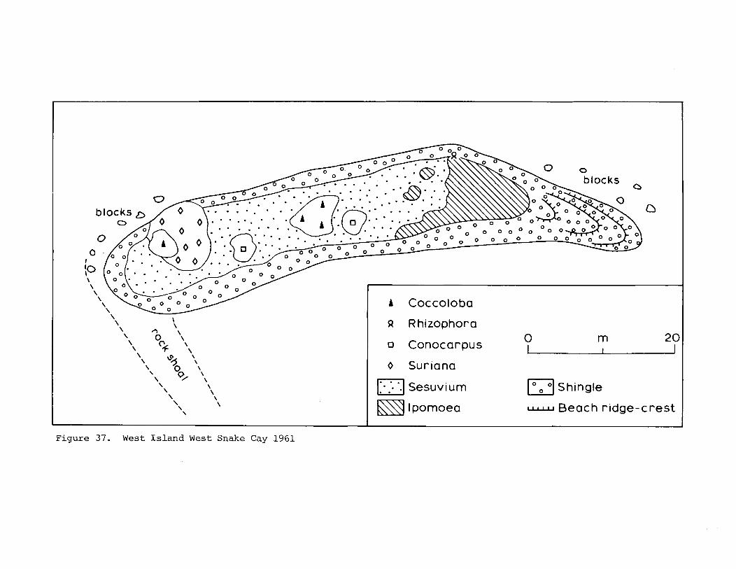
Q Rhizophora
o Conocarpus
0 Suriana
1.1 . . 1.1 Sesuvi um 1'. '1 Shingle
Beach r idge-crest
Figure 37. West I s l a n d West Snake Cay 1961
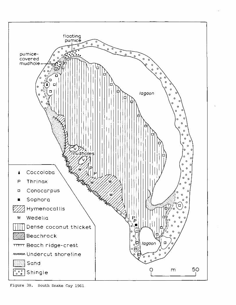
f loatinq
A Coccoloba
P Thrinax \ Conocar pus
Sophora \ vA Hymenocal lis \ 11 1 1 1 1 Dense coconut th icket
vA Beac hroc k
rrrrr Beach r idge-crest
MMW Undercut shoreline
I","." I Shingle L
Figure 38. South Snake Cay 1961
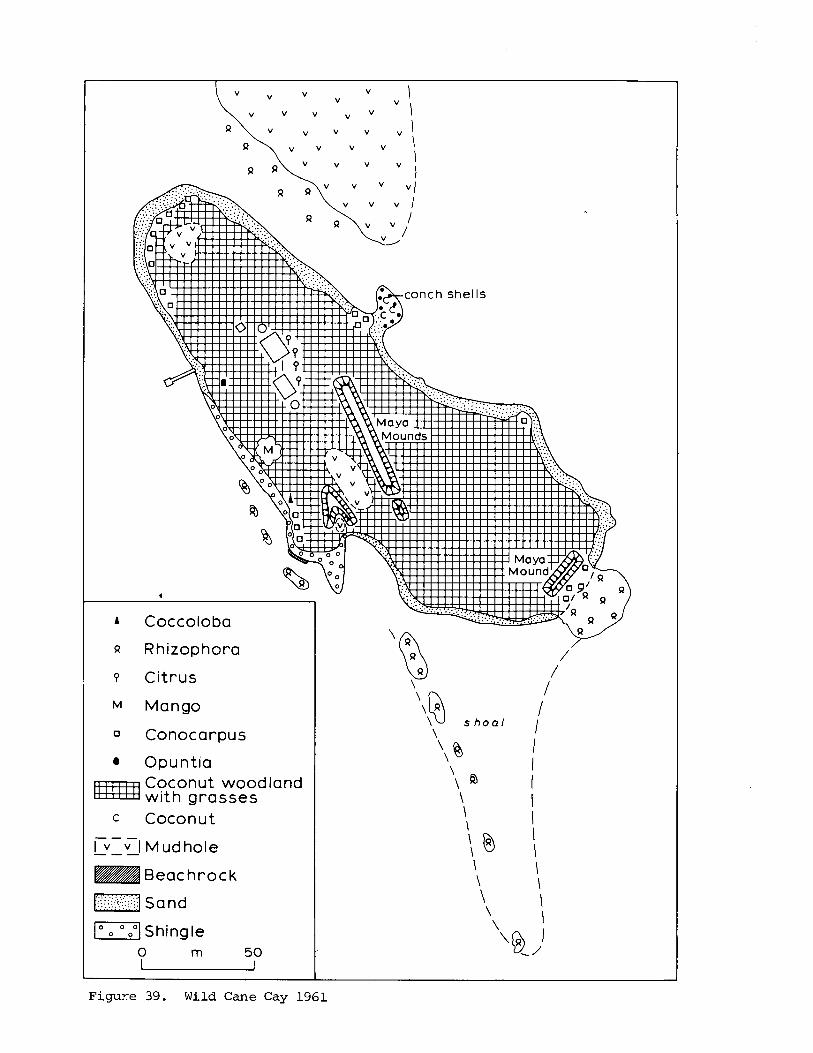
A Coccoloba
n Rhizophora
P Citrus
M Mango
a Opuntia Coconut woodland with grasses
c Coconut
v I Mud hole Lv- - Beachrock
\\N \ s h o a l
Figure 39. Wild Cane Cay 1961
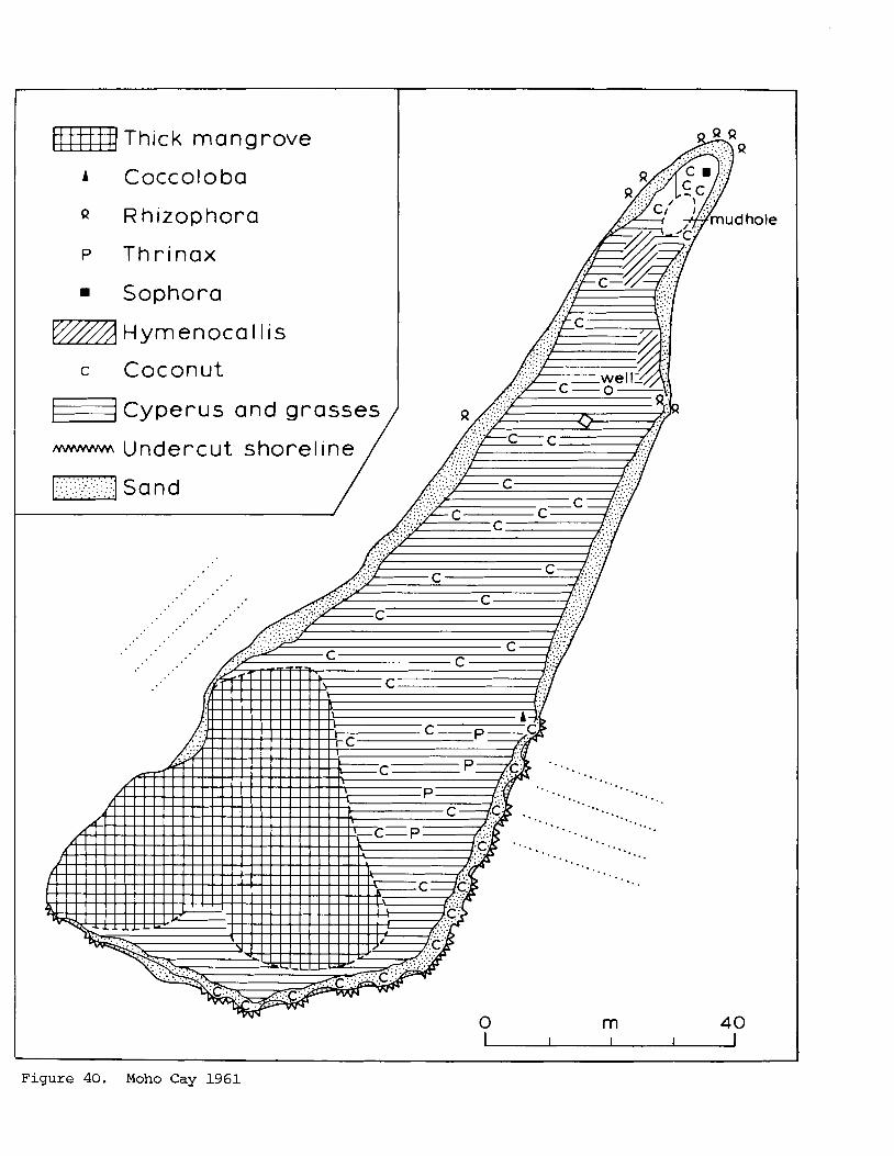
w~ Thick mangrove
A Coccoloba
Q Rhizophora
P Thrinax
Sophora
c Coconut
F] Cyperus and grasses / - Undercut shoreline / ml s
', . ; . . : ,' . ...' ; . , . . and
hole
I 1 I I I
Figure 40. Moho Cay 1961
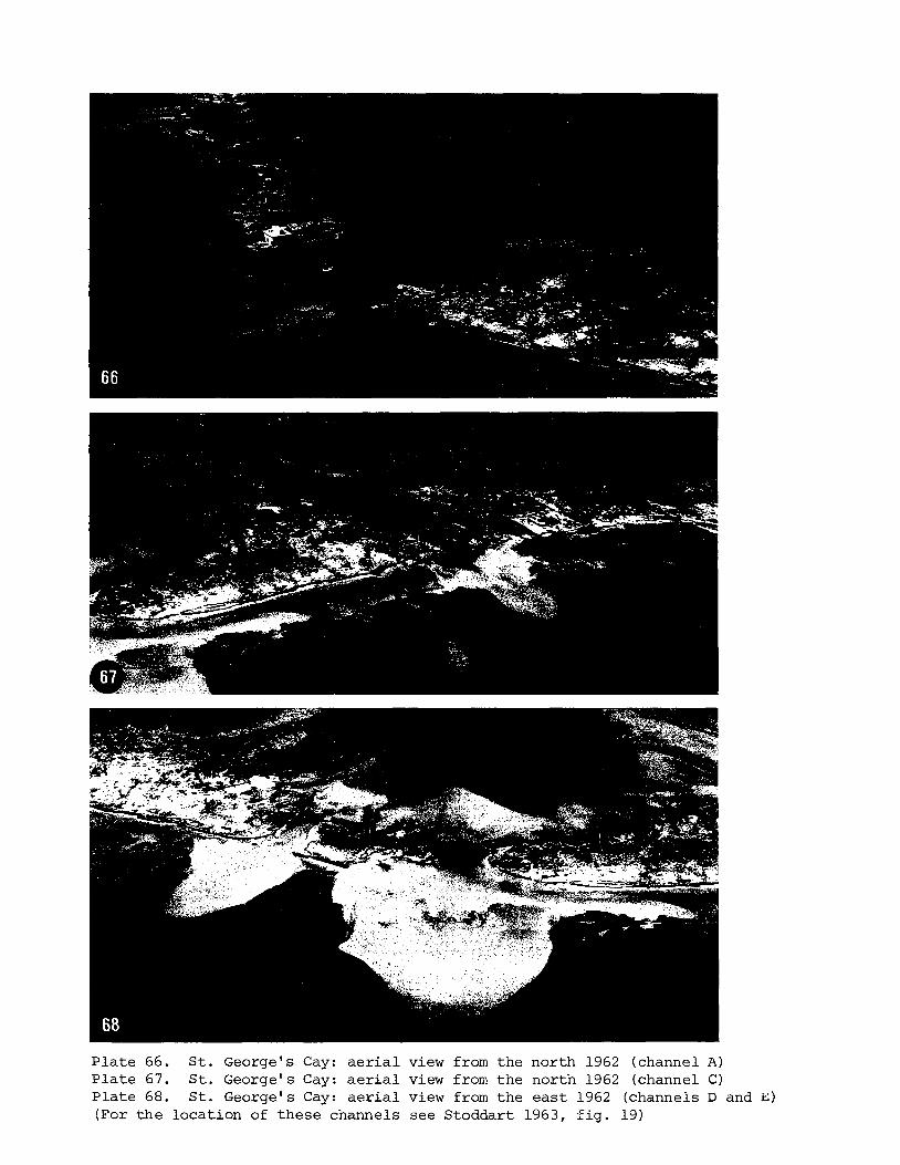
P l a t e 66. S t . George's Cay: a e r i a l view from t h e nor th 1962 (channel A ) P l a t e 67. S t . George's Cay: a e r i a l view from t h e north 1962 (channel C) P l a t e 68. S t . George's Cay: a e r i a l view from t h e e a s t 1962 (channels D and E ) !Fcr t h e locat ion of these channels see Stoddart 1963, E i g . 19)
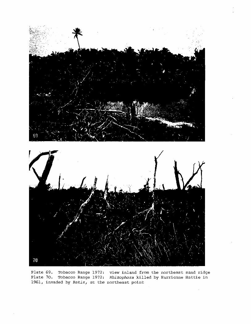
P l a t e 69. Tobacco Range 1972: view i n l a n d from t h e n o r t h e a s t sand r i d g e P l a t e 70. Tobacco Range 1972: Rhi zophora k i l l e d by Hur r icane H a t t i e i n 1961, invaded by B a t i s , a t t h e n o r t h e a s t p o i n t
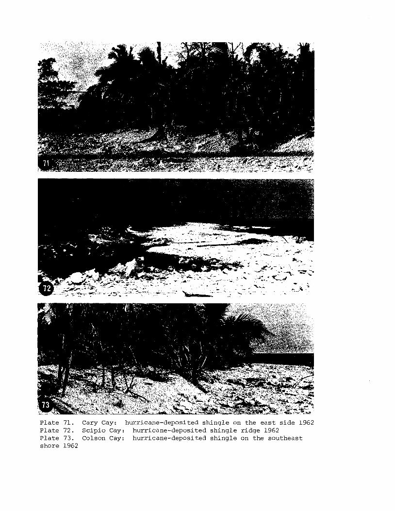
P l a t e 71. Cary Cay: hurr icane-deposi ted s h i n g l e on the e a s t s i d e 1962 P l a t e 72. S c i p i o Cay: hurr icane-deposi ted s h i n g l e r i d g e 1962 P l a t e 73. Colson Cay: hurr icane-deposi ted s h i n g l e on t h e sou theas t shore 1962
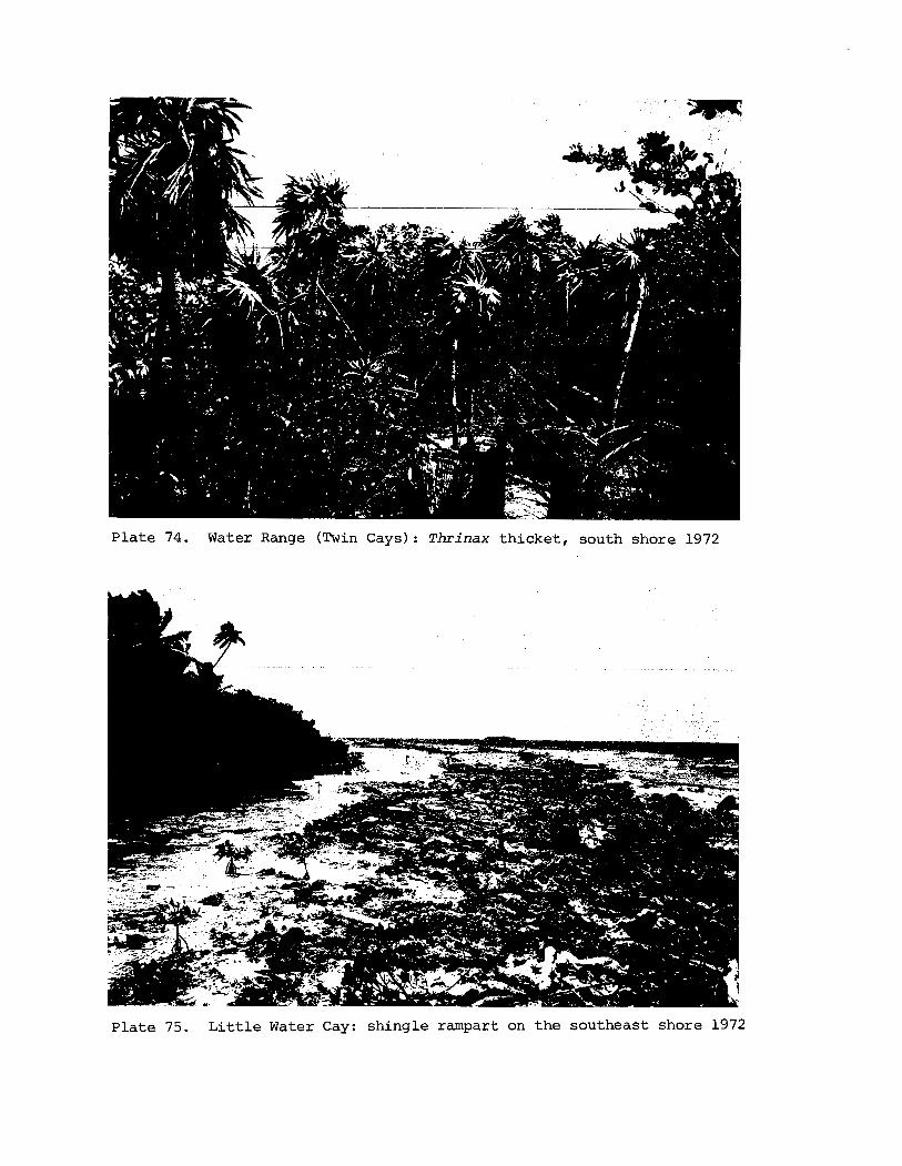
P l a t e 74. Water Range (Twin Cays): Thrinax t h i c k e t , south shore 1972
P l a t e 75. L i t t l e Water Cay: sh ing le rampart on t h e southeas t shore 1972
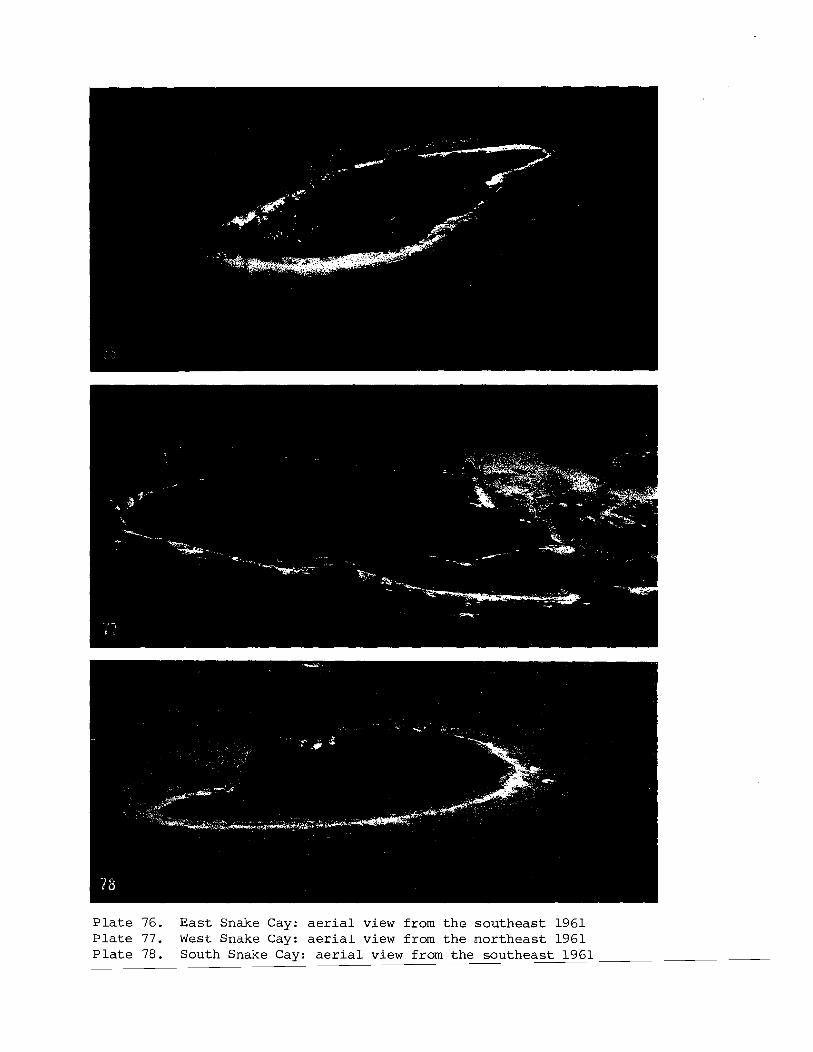
P l a t e 76. E a s t Snake Cay: a e r i a l view from t h e s o u t h e a s t 1961 P l a t e 77. West Snake Cay: aerial view from t h e n o r t h e a s t 1961 P l a t e 78. South Snake Cay: a e r i a l view from t h e s o u t h e a s t 1961
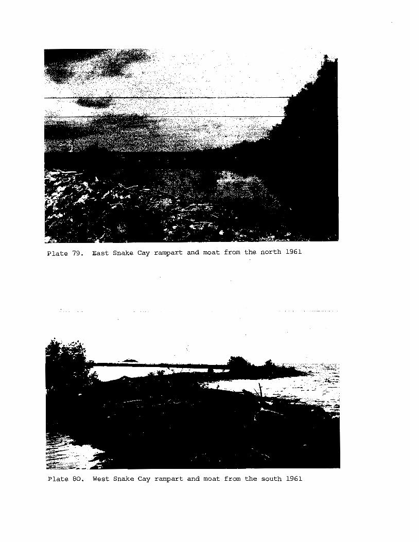
P l a t e 79. Eas t Snake Cay rampart and moat from the north 1961
P l a t e 80. West Snake Cay rampart and moat from t h e south 1961
6. SUMMARY AND CONCLUSIONS
A. Types of i s l a n d s
This cons idera t ion of t h e cays of t h e Belize b a r r i e r and s h e l f has ind ica t ed the v a r i a b i l i t y of r ee f i s l a n d types i n such an ex tens ive province. I n a previous paper (Stoddart 1965, pp. 134-1421! n ine types of i s l a n d were d i s t ingu i shed on t h e Be l i ze r e e f s a s a whole and t h e i r d i s t r i b u t i o n mapped. This c l a s s i f i c a t i o n can now be extended and t h e fol lowing types recognised:
1. Unvegetated sand cay. These a r e ephemeral i s l a n d s , u sua l ly l e s s than 50 m long and o f t e n overtopped by swash, and lacking contemp- orary beachrock. Many on t h e Bel ize r e e f s a r e second-generation f e a t u r e s which have re-formed fol lowing t h e des t ruc t ion of an e a r l i e r l a r g e r i s l a n d by hurr icane damage; t h e loca t ion and ex ten t o f t h e former i s l a n d can be recognised by r e l i c t beachrock. Examples a r e Paunch Cay and Curlew Cay.
2 . Vegetated sand cay. These a r e l a r g e r i s l a n d s wi th a vegeta t ion of s t r a n d scrub and s t r a n d woodland, though i n most cases t h e woodland has been removed f o r coconut p l a n t a t i o n s . Examples a r e Nicolas and Tobacco Cays. Smaller vegetated sand cays wi th maximum dimensions of about 100 m a r e s t i l l s u b j e c t t o major modif icat ion o r even des t ruc t ion during hurr icanes . Most vegeta ted i s l a n d s , however, p e r s i s t o r r a p i d l y re-form i n t h e same loca t ions (e.g. Se rgean t ' s , Gof f ' s , English and Rendezvous Cays). The l a r g e s t vegetated i s l a n d s t o d isappear completely i n t h e 1961 hurr icane were S t . George's Eas t Cay (110 m long, 0.3 ha) and Cay Glory (105 m long, 0.13 ha) .
3. Unvegetated sh ing le cay. These a r e small , ephemeral, and loca ted i n exposed s i t u a t i o n s . Often they may b e reef - top r idges ad jacen t t o a l a r g e r cay. They may from time t o time be colonised by patches of Phi loxerus o r Sesuvium and mangrove seedl ings .
4 . Vegetated sh ing le cay. These a r e a l s o small , l oca ted i n exposed s i t u a t i o n s , o f t e n on small pa tch r e e f s , and a r e topographica l ly mobile. Good examples showing s u b s t a n t i a l changes during 1960 and 1972 a r e North Spot and Ragged Cays.
5. Sand and sh ing le cays. These a r e l a r g e r and more s t a b l e i s l a n d s , i n more exposed s i t u a t i o n s than simple sand cays, and c o n s i s t of i s l a n d s wi th a windward sh ing le r i d g e and leeward sand a r e a , wi th o r without an in t e rven ing depression. Such i s l a n d s a r e lacking on t h e b a r r i e r r ee f i n t h e l e e of t h e o f f shore a t o l l s , where only simple sand
cays a r e found. Because of t h e i r s i z e and s t a b i l i t y these i s l ands a r e always vegetated. Strand woodland survives on Nicolas Cay, but e lse- where has been replaced by coconuts. Examples a r e Lime, Hunting and Northeast Sapodil la Cays, t h e l a t t e r with a l a rge i n t e r i o r depression. This type i s a l s o t y p i c a l of t h e windward s ides of t h e a t o l l s . Most such i s l a n d s have both modern and r e l i c t beachrock, t h e l a t t e r ind ica t ing beach r e t r e a t on t h e i r windward shores.
6. Mangrove cays. On t h e Belize shel f these a r e dominated by Rhizophora mangle; Jack ' s Cay is an example. Ebanks (1975, p.278) descr ibes them a s " l i t t l e more than mud mounds colonised by vegetat ion". They a r e found only within t h e lagoon and not on t h e b a r r i e r reef i t s e l f .
7. Shelf i s l ands . This term is introduced by Ebanks (1975, pp. 277-278) f o r i s l ands which "form by sediment accre t ion on a p a r t l y submerged topographic prominence" on a wide shallow s h e l f . These i s l a n d s a r e located on the shallow she l f nor th of Bel ize , 3.5-5 km back from t h e reef edge. They a r e elongate i s l ands , p a r a l l e l t o t h e she l f edge, with a windward sand r idge of va r i ab le he ight and width, genera l ly l e s s than 2 m above sea l e v e l bu t exceptionally reaching 6 m. Their leeward s i d e s a r e formed by mangroves, bays and i n t e r t i d a l f l a t s . Examples include Ambergris Cay, Cay Chapel and Cay Caulker, and Ebanks draws a t t e n t i o n t o s i m i l a r shel f i s l a n d s i n the Bahamas and Florida. Previously they had been included i n t h e general category of mangrove- sand cay by Vemeer (1959, pp. 35-39) and Stoddart (1965, p.139).
8. Mangrove cay w i t h dry sand areas . Many mangrove i s l a n d s have low-lying sand a reas , o f t en but not exclus ively on t h e windward s i d e , and usual ly f l a t and fea tu re less . These cays a r e found i n f a i r l y protec ted s i t u a t i o n s , and may be a l a t e s t age i n t h e evolut ion of ordinary mangrove cays. Frequently t h e dry-land a r e a s have been c lea red and planted t o coconuts. Examples a r e Weewee, Buttonwood, Hatchet, Wild Cane and Frenchman's Cays.
9 . Mangrove range. These a r e extensive and complex a r rays of mangrove i s l ands , o f t e n with i n t e r m i t t e n t low sand r idges on t h e i r windward s ides . They probably owe t h e i r locat ion and arrangement t o pre-exis t ing topographic v a r i a t i o n s i n t h e subs t ra t e . The i s l ands a r e separated by p a r t l y enclosed bays and lagoons, r a t h e r than by i n t e r - t i d a l f l a t s , and a l s o by sinuous, deep, narrow t i d a l channels known a s 'bogues' . Tobacco Range and Water Range a r e t y p i c a l mangrove ranges; bogues a r e p a r t i c u l a r l y well seen i n t h e Drowned Cays, a s wel l a s i n t h e extensive mangroves of Turneffe.
10. Moat i s l ands . This term has been applied t o c h a r a c t e r i s t i c a s soc ia t ions of leeward sand area , i n t e r i o r mangrove swamp, reef- top shallow lagoon o r moat, and windward-reef-edge sh ing le r idge formed on small patch r e e f s i n t h e southern shel f lagoon (Stoddart 1965). East and West Snake Cays a r e good examples. Topographically t h e s e i s l ands have f e a t u r e s i n common with reef i s l a n d s on the Queensland coas t (S tee r s 1937) and i n Djakarta Bay (Umbgrove 1928) . The Snake Cays owe
t h e i r d i s t i n c t i v e n e s s t o t h e i r r e l a t i v e l y exposed s i t u a t i o n i n deep water f ac ing t h e open southern s h e l f , which allows t h e formation of sh ing le r idges on t h e windward reef edges; t h e o t h e r f e a t u r e s have formed i n the l e e of these r idges .
11. Coas ta l b a r r i e r i s l ands . On t h e Bel ize c o a s t t h e term 'cay ' is app l i ed t o any i s l a n d , not only those of r ee f o r i g i n . Many i s l a n d s near t h e mainland c o a s t a r e b a r r i e r beaches o r detached cuspate head- lands, formed of t e r r igenous sediments (High 1975). Harvest Cay i s an example.
B. Topographic change
These surveys have shown considerable topographic change on almost a l l i s l a n d s o f t he c o a s t a l she l f and b a r r i e r reef f o r which we have comparative da ta . Of 24 i s l a n d s mapped i n 1960-61 and again i n 1972, 11 decreased i n a r e a and 13 increased. The g r e a t e s t percentage l o s s was 31 per c e n t a t Rendezvous Cay, and t h e g r e a t e s t percentage inc rease was 160 pe r c e n t a t North Spot. Aggregating a l l these i s l a n d s toge the r , t h e t o t a l a r e a decreased from 35.7 t o 33.3 ha , a decrease of 6.6 p e r c e n t ( c f . t h e changes on t h e i s l a n d s of Glover ' s Reef, where t h e t o t a l a r e a o f s i x i s l a n d s dec l ined from 33.6 t o 31.8 ha, a decrease of 5.4 p e r cen t : S toddar t et dl., 1981). A s might be expected, t h e percentage changes a r e most marked on t h e sma l l e s t cays. Four modes of topographic change may be d is t inguished:
1. Catas t rophic change caused by a s i n g l e event , i n t h i s case Hurricane H a t t i e of October 1961, which a f f e c t e d b a r r i e r r e e f i s l a n d s i n nor thern Bel ize . Small vegetated sand cays were spec tacu la r ly eroded and two (Cay Glory 'and Paunch Cay) disappeared. Recovery took p lace over the ensuing decade, so t h a t comparative f i g u r e s between 1961 and 1972 g ive a very conserva t ive ind ica t ion of change: Gof f ' s Cay gained 10 pe r c e n t , and Sergeant ' s , English and Rendezvous Cays l o s t 54, 25 and 31 p e r cen t r e spec t ive ly .
2. Severe marginal e ros ion by an unknown event , b u t probably by a s p e c i f i c hurr icane . This i s widespread on t h e cays of t h e southern b a r r i e r r e e f , e.g. Frank's , Lime and Nicolas Cays. This must be a f a i r l y common consequence.of hurr icanes of l e s s e r s e v e r i t y than Ha t t i e .
3. The re-working of small i s l e t s , notably of sh ing le i s l a n d s i n exposed s i t u a t i o n s . This may be accomplished by ord inary storms over per iods of years , o r it may r e s u l t from s i n g l e hurr icanes . A moderate example is given by North S i l k Cay, and more extreme examples by North Spot and Ragged Cay.
4. The accumulation, probably mainly on a seasonal b a s i s , of sand i n t h e form of s p i t s , lobes and b a r s during ordinary non-catastrophic condi t ions . This mostly r e s u l t s i n ephemeral topographic f ea tu res , b u t some become vegeta ted and s t a b i l i z e d .
There i s some suggestion i n t h e number of cays which have disappeared s ince Owen's surveys i n 1830, a s well a s i n the widespread erosion during 1960-1972, t h a t reef i s l ands i n the Belize province may be undergoing a period of diminution. I t i s no t poss ib le t o say whether t h i s r e l a t e s t o t h e r e s u l t s of f luc tua t ing sea l e v e l s , increased frequency of ca tas t rophic storms, o r both, b u t it has been argued (Stoddart 1964) t h a t an important f a c t o r i n the present d i s - equil ibrium is t h e d e s t a b i l i s i n g e f f e c t of the replacement of n a t u r a l s t rand woodland by coconut woodland during the p a s t century.
C. F lora and Veaetation
A t o t a l of 178 species of vascular p l a n t s has been recorded from the Belize cays, including 32 non-native species (18 per cent ) (Fosberg e t a l . 1981). Of these , 90 species a r e found only on t h e b a r r i e r reef and she l f i s l ands , and n o t on t h e a t o l l s ; these include 28 non-native species o r 31 per cent ; 15 a r e found only on the a t o l l s and not on t h e b a r r i e r reef and she l f (no non-native s p e c i e s ) ; and 73 a r e common t o the b a r r i e r and she l f cays and t o the a t o l l s ( 3 non-native species , o r 4 per c e n t ) .
The t o t a l f l o r a of t h e b a r r i e r reef and lagoon i s l ands comprises 164 species, including 31 non-native species (19 per c e n t ) . Of these , 61 a r e found only on t h e b a r r i e r reef i s l ands (17 of them non-native, o r 11 per c e n t ) , and 22 only on t h e shel f i s l ands (4 non-native, o r 7 per c e n t ) . 37 species a r e extremely widespread, and include s t r and grasses and sedges, s t r and shrubs, common weedy species of coconut woodland, and mangroves. They are :
Acros t i chum aureum E r a g r o s t i s p r o l i f e r a Paspalum d i s t i c h u m S p a r t i n a p a t e n s Sporobol u s v i r g i n i c u s Cyperus l i g u l a r i s Cyperus p l a n i f o l i u s F i m b r i s t y l i s cymosa Cocos n u c i f e r a T h r i n a x r a d i a t a Hymenocal l i s l i t t o r a l i s Coccoloba u v i f e r a B a t i s mar i t ima P h i l o x e r u s v e r m i c u l a r i s Por tu laca o l e r a c e a Sesuvium p o r t u l a c a s t r u m Canaval ia r o s e a Sophora tomentosa Vigna l u t e o l a
Euphorbia mesembr ian themi fo l ia Rhizophora mangle Conocarpus e r e c t u s Laguncular ia racemosa T e r m i n a l i a catappa Ipomoea macrantha Ipomoea pes-caprae Ipomoea s t o l o n i f e r a Cordia s e b e s t e n a T o u r n e f o r t i a gnaphalodes Av icenn ia germinans S t a c h y t a r p h e t a jamaicens i s E r i t h a l i s f r u t i c o s a Ernodea li t t o r a l i s Ageratum l i t t o r a l e B o r r i c h i a a r b o r e s c e n s E c l i p t a a l b a Wede l ia t r i l o b a t a
It i s c l e a r t h a t t h e na t ive woodland of t h e cays has been g r e a t l y d is turbed by p lan t ing of coconuts, and on most i s l ands has e n t i r e l y disappeared. Its main components probably included T h r i n a x r a d i a t a , Coccoloba u v i f e r a , F i c u s sp. , Neea c h o r i o p h y l l a , and B u r s e r a s imaruba . Strand shrubs a r e represented mainly by T o u r n e f o r t i a g n a p h a l o d e s , S u r i a n a m a r i t i m , Conocarpus e r e c t u s and B o r r i c h i a a r b o r e s c e n s . The complete absence of S c a e v o l a p l u m i e r i from these i s l ands is remarkable (it occurs on t h e north coas t of Yucatan, on Alacran and Cayo Arcas, and i n t h e Cayman Is lands t o windward), a s i s t h e r a r i t y of Chrysoba lanus i c a c o .
The p lan t s of t h e dry mangrove cays and t h e mangrove ranges a r e q u i t e d i s t i n c t i v e , with many more grasses , sedges and succulents than t h e sand cays of t h e reef edge. Species which a r e c h a r a c t e r i s t i c of t h e dry mangrove cays (but most of which a r e very widespread) a r e E r a g r o s t i s p r o l i f e r a , E u s t a c h y s p e t r a e a , Paspalum d i s t i c h u m , S p a r t i n a s p a r t i n a e , F i m b r i s t y l i s cymosa , F i m b r i s t y l i s s p a d i c e a , T h r i n a x r a d i a t a , B a t i s m a r i t i m a and Pluchea s y m p h y t i f o l i a . Two species ( S a l i c o r n i a p e r e n n i s , L i p p i a s t r i g u l o s a ) a r e found only on these i s l ands . Conversely, some species which a r e common on t h e reef-edge sand cays a r e absent from t h e dry mangrove cays. These include C a k i l e l a n c e o l a t a , C a n a v a l i a r o s e a , Bursera s imaruba , P o u t e r i a r i v i c o a , Morinda c i t r i f o l i a and Ambrosia h i s p i d a .
It is a l s o i n s t r u c t i v e t o compare the p l a n t s recorded on t h e two mangrove ranges v i s i t e d , Tobacco Range and Water Range. 33 species a r e recorded i n t o t a l , with 15 i n common. Apart from t h e mangroves, these a r e E u s t a c h y s p e t r a e a , Paspalum d i s t i c h u m , Cyperus p l a n i f o l i u s , T h r i n a x r a d i a t a , B a t i s m a r i t i m a , S a l i c o r n i a p e r e n n i s , S u r i a n a m a r t i m a , Euphorbia m e s e m b r i a n t h e m i f o l i a , E r i t h a l i s f r u t i c o s a and B o r r i c h i a a r b o r e s c e n s . A l a rge r sample would undoubtedly include a s character- i s t i c p lan t s of these i s l ands ~ r a g r o s t i s p r o l i f e r a , Phragmi t e s c f . a u s t r a l i s , S p a r t i n a s p a r t i n a e , C lad ium j a m a i c e n s e , S e s u v i u m p o r t u l a c a s - t r u m , P i t h e c e l l o b i u m k e y e n s e , Ernodea l i t t o r a l i s , and others . I t i s p a r t i c u l a r l y i n t e r e s t i n g t o observe t h e long term e f f e c t s of hurr icane damage on Tobacco Range, where mor ta l i ty of mangroves i n 1961 has l e d t o t h e i r replacement by B a t i s m a r i t i m a , even though the dead t r e e t runks s t i l l stand.
We have already noted the exis tence of a f a i r l y s t eep r a i n f a l l gradient from nor th t o south 'a long the Belize coas t . The e f f e c t s of t h i s appear i n t h e d i s t r i b u t i o n of f e rns and orchids. Ferns o ther than A c r o s t i c h u m aureum occur only on Nicolas Cay (3 s p e c i e s ) , Lime and Wild Cane Cays. Orchids have been recorded only on Frank 's , Hunting, Jack ' s , Eas t Snake and Middle Snake Cays (as wel l a s on North- e a s t Cay, Glover's Reef) . The climbing vine Rhabdadenia b i f l o r a is only recorded from t h e southern she l f (Hunting Cay) and Glover's Reef (Southwest Cay) .
Fina l ly , t h e ca tas t rophic damage caused t o some of t h e northern sand cays by Hurricane Ha t t i e has allowed t h e observation of success- iona l processes over t h e ensuing decade. The primary coloniser on
bare sand a f t e r the storm was Portulaca oleracea, together with Sesuvium portulacastrum and Euphorbia mesembrianthemifolia; these were well established as scattered colonies within f ive months of the storm. By 1965 Portulaca had greatly declined i n importance, and the main species present were Sesuvium, Euphorbia and Ipomoea pes-caprae. By 1972 many more species were present, including shrub species such a s Tournefortia, Conocarpus and Suriana. The following table gives the number of species recorded on the most damaged islands following Hurricane Hattie:
Island
Sergeant ' s Cay 4 1 2 14
Gof f ' s Cay
English Cay 2 5 18
Rendezvous Cay 16 16 1 7
The opportunity clearly exis t s to monitor vegetational changes on these islands i n the future, as well as topographic change i n general, t o establish the long-term response of islands t o normal as well a s t o extreme events.
We do not wish i n th is paper t o consider the f l o r i s t i c biogeography of the cays i n greater detai l . A preliminary paper has been prepared (Stoddart and Fosberg, i n press) , and a more detailed treatment is i n preparation. We can, however, note tha t there is a very close association between island area and number of species of vascular plants present, and tha t area appears t o be the major control of f l o r i s t i c diversity on islands of the Belize barr ier reef and shelf.
7. REFERENCES
Agassiz, A. 1894. Reconnaissance of the Bahamas and of t h e e levated r e e f s of Cuba. B u l l . Mus. comp. Zool. Harvard Univ. 26: 1-203.
Aguilar Paz, J. 1954. Mapa g e n e r a l d e l a R e p u b l i c a d e Honduras. 1:500,000. Tegucigalpa.
Allen, B. 1841. Sketch of t h e eas te rn coas t of Centra l America, compiled from notes of Captain Richard Owen and the o f f i c e r s of Her Majesty's Ship Thunder, and Schooner Lark. J. R. geogr . S o c . 11: 76-89.
Anderson, A.H. 1958. B r i e f sketch o f B r i t i s h Honduras. Belize: Government P r i n t e r . Revised ed i t ion , 106 pp.
Beard, J.S. 1949. The n a t u r a l vegetat ion of t h e Windward and Leeward Is lands . Oxford F o r e s t r y Mem. 21: 1-192.
Beard, J.S. 1955. The c l a s s i f i c a t i o n of t r o p i c a l American vegeta t ion types. E c o l o g y , 36: 89-100.
Bray, W . 1970. A n c i e n t Mesoamerica: Precolumbian Mexican and Maya a r t . Birmingham: Birmingham Museum and A r t Gallery. 35 pp., 33 p l .
Bu t t e r l in , J. and Bonet, F. 1960a. ~ o n n g e s nouvelles s u r l a ggologie de l a p a r t i e mexicaine de l a presqul ' l le de Yucatan. C. r . somm. ~ 6 a n c . Acad. S c i . ( P a r i s ) , 251: 1537-1539.
Bu t t e r l in , J. and Bonet, F. 1960b. Dgcouverte d 'une s 6 r i e Eocene dans l a presqul? le du Yucatan (Mexique) : s e s r e l a t i o n s avec l e s s g r i e s du mzme age dans l e s Grandes Ant i l l e s . T r a n s . 2nd C a r i b b . G e o l . C o n f . ( ~ a ~ a g u g z , Puerto Rico, 1959) : 33- 39.
Coues, E. 1864. Notes on c e r t a i n Central-American Laridae co l l ec ted by Mr. Osbert Salvin and Mr F. Godman. Ibis, (1) 6: 387-393.
Craig, A.K. 1966. Geography of f i sh ing i n B r i t i s h Honduras and adjacent c o a s t a l areas. L o u i s i a n a S t a t e U n i v e r s i t y , C o a s t a l S t u d i e s I n s t i t u t e , Tech . R e p t . 28: i-xv, 1-143.
Craig, A.K. 1969. The grouper f i s h e r y of Cay Glory, B r i t i s h Honduras. Ann. A s s . Am. Geog. 59: 252-263.
Darwin, C.R. 1842. On the s t r u c t u r e a d d i s t r i b u t i o n o f c o r a l r e e f s . London: Smith, Elder and Co. x i i , 214 pp.
Dil lon, W.P. and Vedder, J . G . 1973. S t ruc tu re and development of t h e cont inenta l margin of B r i t i s h Honduras. Geol. S o c . Am. B u l l . 84: 2713-2732.
Ebanks, W . J . , Jr. 1975. Holocene carbonate sedimentat ion and d i agenes i s , Ambergris Cay, Bel ize . I n K.F. Wantland and W.C. Pusey 111, eds. : B e l i z e S h e l f - c a r b o n a t e s e d i m e n t s , c l a s t i c s e d i m e n t s and e c o l o g y (Am. A s s . p e t r o l . G e o l . S t u d . G e o l . 2 ) : 2 34-296.
F lo re s , G. 1952. Geology of nor thern B r i t i s h Honduras. B u l l . Am. A s s . p e t r o l . G e o l . 36: 404-413.
Fosberg, F.R., S todda r t , D . R . , Sachet , M.-H., and Spellman, D.L. 1981. P l a n t s of t h e Bel ize cays. A t o l l R e s . B u l l .
Gann, T.W.F. 1918. The Maya Ind ians of southern Yucatan and nor thern B r i t i s h Honduras. B u l l . B u r . Am. E t h n o l . 64: 1-146.
Gann, T.W.F. 1926. A n c i e n t ci t ies and m o d e r n tribes: e x p l o r a t i o n and a d v e n t u r e i n Maya l a n d s . London: Duckworth. 256 pp.
Gann, T.W.F. 1927. Maya c i t ies: a r e c o r d o f e x p l o r a t i o n a n d a d v e n t u r e i n M i d d l e A m e r i c a . London: Duckworth. 256 pp.
Halley, R . B . , Shinn, E.A., Hudson, J . H . and Lidz, B. 1977. Recent and r e l i c t topography of Boo Bee Patch Reef, Bel ize . P r o c . 3 r d In t . C o r a l R e e f Symp. 2: 29-35.
Hammond, N. 1977. Ex Or ien te Lux: a view from Bel ize . I n R.E.W. Adams, ed. : T h e o r i g i n s o f Maya c i v i l i za t ion (Albuquerque: Univers i ty of New Mexico P res s ) : 45-76.
Henderson, G. 1811. An a c c o u n t o f the B r i t i s h s e t t l e m e n t o f Honduras : b e i n g a v i e w o f . i t s c o m m e r c i a l and a g r i c u l t u r a l r e s o u r c e s , so i l , c l i m a t e , n a t u r a l h i s t o r y , etc. London, second e d i t i o n ( f i r s t e d i t i o n , 1809: n o t seen) .
High, L.R. ,Jr . 1975. Geomorphology and sedimentology of Holocene c o a s t a l depos i t s , Bel ize . In K.F. Wantland and W.C. Pusey 111, eds.: B e l i z e s h e l f - carbonate s e d i m e n t s , c l a s t i c s e d i m e n t s and e c o l o g y (Am. A s s . p e t r o l . G e o l . S t u d . G e o l . 2 ) : 53-96.
Honduras Almanack 1829. T h e H o n d u r a s A lmanack f o r the y e a r o f o u r Lord 1 8 2 9 . Belize: Publ ished by a u t h o r i t y of t h e L e g i s l a t i v e Assembly. 198 pp.
Honduras Almanack 1830. T h e Honduras A lmanack f o r the y e a r o f o u r Lord 1 8 3 0 . Bel ize : Publ ished by a u t h o r i t y of t h e L e g i s l a t i v e Assembly. 185 pp.
James,N.P. andGinsburg, R . N . 1979. The s e a w a r d m a r g i n o f B e l i z e b a r r i e r a n d a t o l l r e e f s : morphology, sedimentology, organism d i s t r i b u t i o n a n d l a t e Qua te rna ryh i s to ry . S p e c . P u b 1 . 1 n t . A s s . S e d i m e n t . 3: i - x i , 1-191.
J e r r e r y s , T. 1775. The Bay of Hondurds. I n : T h e West I n d i a ~ t l a s or a g e n e r a l d e s c r i p t i o n o f the West I n d i e s . London.
King, J.E. 1956. The monk s e a l s (genus M o n a c h u s ) . B u l l . B r . Mus. ( n a t . H i s t . ) , Zool. 3: 201-256.
Mi l l e r , J . A , and Macintyre, I . G . 1977. F i e l d g u i d e b o o k t o the r e e f s o f B e l i z e . Miami Beach: A t l a n t i c Reef Committee. 36 pp.
m e n , R. 1838. A n a u t i c a l memoir d e s c r i p t i v e o f the s u r v e y s made i n H . M . S h i p s Blossom and Thunder from 1829 t o 1837. Dublin: Thorn. 172 pp.
P o r t i g , W.H. 1976. The c l i m a t e o f C e n t r a l America. I n W. Schwerdtfeger, ed. : C l i m a t e s o f C e n t r a l and S o u t h America (Amsterdam:! E l s e v i e r ) : 405-478.
Purdy, E.G. 1974a. Reef c o n f i g u r a t i o n s : cause and e f f e c t . S o c . econ. P a l e o n t o l . M i n e r a l . S p e c . P u b l . 18: 9-78.
Purdy, E.G. 1974b. Karst-determined f a c i e s p a t t e r n s i n B r i t i s h Honduras: Holocene ca rbona t e sed imenta t ion model. Am. A s s . p e t r o l . G e o l . B u l l . 58: 825-855.
Purdy, E.G., Pusey, W.C., 111, and Wantland, K.F. 1975. Con t i nen t a l s h e l f of B e l i z e - r e g i o n a l s h e l f a t t r i b u t e s . I n K.F. Wantland and W.C. Pusey 111, eds.: B e l i z e s h e l f - c a r b o n a t e s e d i m e n t s , c l a s t i c s e d i m e n t s and e c o l o g y (Am. A s s . p e t r o l . G e o l . S t u d . G e o l . 2) : 1-52.
Rornney, D.H. , Wright, A.C.S., Arbuckle, R.H. and V i a l , V.E . 1959. Land i n B r i t i s h Honduras: r e p o r t o f the B r i t i s h Honduras Land U s e S u r v e y Team. London: H.M.S.O. (Co lon i a l Res. Publ . 24 ) .
S a l v i n , 0. 1864. A f o r t n i g h t amongst t h e s ea -b i rd s of B r i t i s h Honduras. Ibis, (1) 6: 372-387.
Sapper , K. 1896. Sobre l a ~ e o ~ r a f i a f i s i c a y l a ~ e o l o ~ i a d e l a pen in su l a d e ~ u c a t s n . B o l . Inst . g e o l . Mex. 3: 1-57.
Schmidt, K.P. 1941. The amphibians and r e p t i l e s of B r i t i s h Honduras. F i e l d Mus. n a t . H i s t . , Zool. S e r . 22 (8) : 475-510.
Smith, T. 1842a. The c o a s t s of Yucatan and Honduras. N a u t i c a l Mag. 11: 729-735.
Smith, T. 1842b. The e a s t c o a s t of Yucatan. N a u t i c a l Magazine, 11: 334-338.
Speer , J .S . 1766, 1771. T h e W e s t - I n d i a P i l o t . C o n t a i n i n g p i l o t i n g d i r e c t i o n s ... from Jamaica t o B l a c k R i v e r on the Mosqu i to S h o r e , and f rom thence t o e v e r y Bay , Harbour, R i v e r , etc., i n the Bay o f Honduras. ... By a n O f f i c e r who h a s s e r v e d upwards o f Twen ty Y e a r s i n the West I n d i e s . London, e d i t i o n 1, 53 pp., c h a r t s ; e d i t i o n 2, 1771.
S t e e r s , J . A . 1937. The c o r a l i s l a n d s and a s s o c i a t e d f e a t u r e s of t h e Grea t Barrier Reefs. Geogr l J . 89: 1-28, 119-146.
S t o d d a r t , D.R. 1962a. Three Caribbean a t o l l s : Tu rne f f e I s l a n d s , Lighthouse Reef, and G love r ' s Reef , B r i t i s h Honduras. A t o l l R e s . B u l l . 87: 1-151.
S todda r t , D.R. 1962b. Phys iographic s t u d i e s on t h e B r i t i s h Honduras r e e f s and cays . Geogr l J . 128: 161-171; d i s c u s s i o n , 171-173.
S t o d d a r t , D.R. 1963. E f f e c t s o f Hur r icane H a t t i e on t h e B r i t i s h Honduras r e e f s and cays , October 30-31, 1961. A t o l l R e s . B u l l . 9 5 : i - i v , 1-142.
S todda r t , D.R. 1964. Storm c o n d i t i o n s and v e g e t a t i o n i n equ i l i b r i um of r e e f i s l a n d s . Proc . 9 t h C o n f . C o a s t a l E n g i n e e r i n g ( L i s b o n , 1964) : 89 3-906.
Stoddart , D.R. 1965. B r i t i s h Honduras cays and t h e low wooded i s l a n d problem. T r a n s . I n s t . B r . Geog. 36: 131-147.
Stoddart , D.R. 1969. Post-hurricane changes on t h e B r i t i s h Honduras r e e f s and cays: re-survey of 1965. A t o l l R e s . B u l l . 131: 1-25.
Stoddart , D.R. 1971. Coral r e e f s and i s l ands and ca tas t roph ic storms. I n J.A. S tee r s , ed.: A p p l i e d c o a s t a l geomorphology (London: Macmillan) : 155-197.
Stoddart , D.R. 1974. Post-hurricane changes on t h e B r i t i s h Honduras r ee f s : re-survey of 1972. Proc . 2nd Int . Cora l Ree f Symp. 2: 473-483.
Stoddart , D.R. 1980a. Vegetation of L i t t l e Cayman. A t o l l R e s . B u l l . 241: 53-70.
Stoddart , D.R. 1980b. Destruct ion of Maya remains by shore l ine erosion, Belize sand cays, Centra l America. Proc . Commission on C o a s t a l Environment F i e l d Symp., C o a s t a l Archaeo logy S e s s i o n (Shimoda, Japan, 1980) (Bellingham: Western Washington University) : 159-168.
Stoddart , D.R. and Fosberg, F.R. I n p ress . Species-area r e l a t ionsh ips on small i s l ands : f l o r i s t i c da ta from Belize sand cays, western Caribbean. S m i t h s o n . C o n t r . mar. S c i . 12: 1982.
Stoddart , D.R., Fosberg, F.R., and Sachet, M.-H. 1981. Ten years of change on t h e Glover's Reef cays. A t o l l R e s . B u l l . 257.
Stoddart , D.R. and S t e e r s , J . A . 1977. The nature and o r i g i n of co ra l reef i s l ands . I n O.A. Jones and R. Endean, eds.: ~ i o l o g y and g e o l o g y o f c o r a l r e e f s (New York: Academic P r e s s ) , 4: 59-105.
Szabo, B . J . , Ward, W.C., Weidie, A.E. and Brady, M.J. 1978. Age and magnitude of t h e l a t e Ple is tocene sea-level r i s e on t h e eas te rn Yucatan Peninsula. Geology , 6: 713-715.
Tebbutt, G.E. 1975. Paleoecology and diagenesis of Ple is tocene limestone on Ambergris Cay, Belize. I n K.F. Wantland and W.C. Pusey 111, eds. : B e l i z e s h e l f - c a r b o n a t e s e d i m e n t s , clastic s e d i m e n t s and e c o l o g y (Am. A s s . p e t r o l . G e o l . S t u d . G e o l . 2): 297-331.
Umbgrove, J.H.F. 1928. De Koraal r i f fen i n de Baai van Batavia. Wetensch. Meded. D i e n s t Mijnbouw N e d e r l a n d - ~ n d i g , 7 : 1-68.
Vaughan, T.W. 1919. F o s s i l co ra l s from Centra l America, Cuba and Puer to Rico, with an account of t h e American Ter t i a ry , P le is tocene and Recent c o r a l r ee f s . B u l l . U.S. nat . Mus. 103: 189-524.
Vermeer , D. E. 1959. The c a y s o f B r i t i s h Honduras. Berkeley : Department of Geography, Universi ty of Cal i fornia a t Berkeley. 127 pp.
Vermeer, D.E. 1963. E f f e c t s of Hurricane Ha t t i e , 1961, on t h e cays of B r i t i s h Honduras. Z . Geomorph. N.F. 7: 332-354.
Wagner, P.L. 1964. Natural vegetat ion of Middle America. In R. Wauchope, ed.: Handbook o f Middle American I n d i a n s (Austin: Universi ty of Texas P r e s s ) , 1: 216-264.
Wantland, K . F . and Pusey, W.C., 111, eds. 1975. B e l i z e s h e l f - carbona te s e d i m e n t s , c l a s t i c s e d i m e n t s and eco logy . Am. A s s . p e t r o l . G e o l . S t u d . Geol. 2: 1-599.
Wernstedt, F.L. 1972. World c l i m a t i c d a t a . Lemont, Pa.: Climatic Data Press. 522 pp.
Winzerling, E.O. 1946. The b e g i n n i n g s o f B r i t i s h Honduras 1506-1765. New York.
Appendix: Manuscript and published char t s , of t h e Belize she l f
De Mayne, A. 1829. Coast o f ~ r i t i s h Honduras, from B e l i z e t o luff
P o i n t , s o u t h o f Punta Ycacos . Recd. from M r de Mayne, Sept. 25th (18)23. Hydrographic Department, Ministry of Defence, Taunton, No E992.
Douglas, H.P. 1922. S o u t h e r n I n n e r S h i p Channel t o B e l i z e , Rugged Cay t o Middle Long Cay. Ib id . No C8925.
Frembly, J. 1830a. A diagrammatic s u r v e y o f the harbour o f B e l i z e on the c o a s t o f B r i t i s h Yucatan. Ib id . No G207.
Frembly, J. 1830b. A p l a n o f the anchorage a t t h e Sou thern T r i a n g l e s on the c o a s t o f B r i t i s h Yucatan. Ib id . No G208.
Glennie, R. W. 192 1. B r i t i s h Honduras, T u r n e f f e I s l a n d s , Cay Bokel Anchorage. Ib id .
Hydrographic Department, Ministry of Defence. 1839. West I n d i e s from B e l i z e t o Cabo Catoche. Surveyed by Commanders R. Owen and E . Barnett 1830 and 1837, with addi t ions and correc t ions t o 1931. London: e d i t i o n 1, 1839; ed i t ion 2, 1915. Admiralty Chart No 1204.
Hydrographic Department, Ministry of Defence. 1844. West I n d i e s , Honduras G u l f w i t h the Z a p o t i l l o s Cays ( surveyed 1835-41). London: e d i t i o n 1, 1844; new e d i t i o n s 1868, 1871, 1896, 1897, 1912, 1922. Admiralty Chart No 1573.
Hydrographic Department, Ministry of Defence. 1898. B r i t i s h Honduras, B e l i z e Harbour ( surveyed 1896-7). London: ed i t ion 1, 1898; new ed i t ion , 1924. Chart No 522.
Hydrographic Department, Ministry of Defence. 1929. B r i t i s h Honduras, Approaches t o B e l i z e ( f r o m s u r v e y s 1896-7 and 1921-2). London; e d i t i o n 1, 1929. Admiralty Chart No 959.
Hydrographic Department, Ministry of Defence. 1929. B r i t i s h Honduras, Sou thern Inner Channel t o B e l i z e , Ranguana Cay t o Columbus Cay i n c l u d i n g Glover Reef ( surveyed 1830-41 and 1922) . London: e d i t i o n 1, 1929; revised 1948. Chart No 1797.
Hydrographic Department, Ministry of Defence. 1960. C e n t r a l America , Br i t i sh Honduras, B e l i z e Harbour ( surveyed 1957-8) . London: ed i t ion 1, 1960. Admiralty Chart No 522.
I rv ing, E. G. 1957-58. C e n t r a l America , B r i t i s h Honduras, B e l i z e Harbour. 1:25,000. Hydrographic Department, Ministry of Defence, Taunton, Chart No K2254-55E.
Owen, R. 1830a. Par t o f the c o a s t o f B r i t i s h Yuca tan . From Jonathan P o i n t t o Ambergris Kay. October 1830. Ibid. No H57.
Owen, R. 1830b. Par t o f the c o a s t o f B r i t i s h Yuca tan . T h e G u l f o f Honduras and k a y s a d j a c e n t . November 1830. Ib id . No H61.
Owen, R. 1834a. (Cay Columbus t o S o u t h Water C a y ) . June 1834. Ibid. No L83.
Owen, R. 1834b. ( S o u t h Water Cay t o Quamino Cay) . Ju ly 1834. Ib id . No L84.
Owen, R. 1835a. S a p o d i l l a and S e a l Cays i n the Bay o f Honduras. September 1835. Ib id . No L458.
Owen, R. 1835b. T h e narrow p a r t o f the Main Channel t o the southward o f B e l i z e , be tween P o i n t P l a c e n t i a and Monkey River. September 1835. Ib id . No L459.
Smith, T. 1840a. V i c t o r i a Channel , Honduras. August 1840. Ibid. No L2481.
Smith, T. 1840b. P a r t o f the c o a s t o f B r i t i s h Yuca tan between Z a p o d i l l a Cays and Monkey River. August 1840. Ib id . No L2474.
INDEX OF ISLANDS
Page c i t a t i o n s a r e t o t h e main r e f e r e n c e t o each o f t h e i s l a n d s i n t h e t e x t .
A l l i g a t o r Cay 47 Ambergris Cay 40 B a k e r ' s Rendezvous 5 1 Bedford Cays 57 Blackadore Cay 42 Blue Ground Range 48 B l u e f i e l d Range 47 Brown's Cay 14 Bugle Cay 53 Buttonwood Cay 52 Cangrejo Cay 42 C a r r i e Bow Cay 20 Cary Cay 53 Ca t Cay 51 Caulker Cay 42 Cay Cangre j o 42 Cay Caulker 42 Cay Chapel 43 Cay Glory 16 Chapel Cay 43 Coco Plum Cay 49 Cohune's Kay 29 Colson Cay 54 Colson Cays 47 Columbus Cay 47 C r a y f i s h Cay 46 Cross Cay 47 Curlew Cay ( n o r t h ) 11 Curlew Cay ( sou th ) 21 Deer Cay 42 Drowned Cays 45 E a s t Snake Cay 58 E l l e n Cay 20 Eng l i sh Cay 12 F l y Range 48 F r a n k ' s Cay 33 F r a n k ' s Cays 32 F r a n k ' s Cay E a s t 33 F r a n k ' s Cay West 33 Frenchman' s Cay ( sou th ) 6 1 Frenchman's Cays ( n o r t h ) 45 Glory Cay 16 G o f f ' s Cay 11 Grass Cay 32 Grennels Cay 46 H a l l ' s Cay 29
Harves t Cay 57 Hatche t Cay 55 Hen and Chickens 45 H ick ' s Cays 45 Hobbe's Kay 57 Hunting Cay 35 Jack E l l i n ' s Cay 20 J a c k ' s Cay ( sou th ) 51 J a c k ' s Cays (nor th! 15 Laughing Bi rd Cay 56 Lime Cay 37 L i t t l e P e t e r Cay 51 L i t t l e Water Cay 56 Long Cay ( n o r t h ) 45 Long Cay (Southern T r i a n g l e s ) 46 Low Cay 37 Man-of-war Cay 50 Middle Long Cay 47 Middle S i l k Cay 24 Middle Snake Cay 58 Moho Cay ( n o r t h ) 45 Moho Cay ( sou th ) 62 Moho Cay (= Trapp ' s Cay) 52 Montego Cay 45 Mosquito Cay 42 Nico las Cay 34 North Drowned Cay 40 North S i l k Cay 23 North Spot 28 Nor thea s t S a p o d i l l a Cay 31 Observat ion S e a l Cay 38 One Man Cay 46 Owen Cay 54 P a t i e n c e Bro ther I s l a n d 57 Paunch Cay 9 Paunchgut Kay 9 P e l i c a n Cays 51 P e t e r Douglas Cay 51 P e t e r ' s B lu f f 40 P l a c e n t i a Cay 57 Pompion Cay 26 Punchgut Kay 9 Queen Cays 23 Ragged Cay 38 Ragged Snake Cay 58 Ramseys Cay 46
Ranguana Cay 2 7 Rendezvous Cay 14 Renegado Kay 27 Rider 's Cays 45 Robinson Is land 47 Robinson Point Cay 46 Round Cay 25 S t George's Cay 44 S t George's East Cay 9 Samphire Cay 25 Samphire Spot 14 Sapodil la Cays 31 Scipio Cay 54 Seal Cay (north) 1 2 Seal Cay 38 Seal Cays 38 Sergeant ' s Cay 10 S i l k Cays 23 Simmonds Cay 46 Skif f Sand 15 South Cay 38 South S i l k Cay 25 South Snake Cay 60 South Water Cay 18
Southern Long Cay 47 Southern Triangles 46 Spanish Cay 47 Spanish Lookout Cay 46 Stake Bank 45 Swab Cay 42 Tobacco Cay 16 Tobacco Range 48 Tom Gwen's Cay 29 Tom Gwen's East Cay 29 Tom Owen's West Cay 30 Trapp's Cay 52 True Point Patience Kay 57 Twin Cays 50 Virgins, The 57 Water Cay 46 Water Range 50 Weewee Cay 51 West Is land West Snake Cay 59 West Snake Cay 59 White Rock 26 Wild Cane Cay 60 Zapot i l la Cay 38 Zapot i l la Cays 31