aug update
TRANSCRIPT

Open letter to parties interested in the
2017 Lake Michigan Ozone Study
August 5, 2016
In an April 2016 white paper [Pierce et al., 2016], a field campaign addressing ozone and its precursors
over Lake Michigan was proposed. A combination of satellite remote sensing, aircraft remote sensing,
and ground‐based in situ monitoring will be conducted during the period May 15, 2017 to June 15, 2017.
This combination of measurements will provide critical observations for understanding several
unanswered questions1 and for evaluating a new generation of high resolution meteorology, chemical
transport, and coupled air quality models attempting to better simulate ozone episodes in the region.
As of July 21, 2016, many components necessary to make LMOS 2017 a reality are confirmed for
participation. This comes thanks to an enthusiastic response from many individuals and groups in the
atmospheric chemistry, atmospheric science, and air quality management communities.
The purpose of this letter is to document the aspects of the LMOS 2017 study that are confirmed, and to
list the measurement, modeling and funding needs that remain. Table 1 lists study components and
groups that are tentatively responsible for those components. In cases where participation is not yet
confirmed, the reasons vary; in some cases, participation is contingent on funding. In others it is
contingent on availability of instruments and personnel. And in others, principle investigators are
considering the scientific opportunity of participation.
Table 1 lists many measurements that will be conducted at the Zion site, and Figures 1‐3 show the map
location and photos of the Zion site.
For those with questions about the Lake Michigan Ozone Study, please contact one of the individuals
listed below.
Brad Pierce – [email protected]
Rob Kaleel –[email protected] Angela Dickens – [email protected]
Tim Bertram – [email protected] Charles Stanier – charles‐[email protected]
Donna Kenski – [email protected]
1 From [Pierce et al., 2016], (i) relative contribution of inter‐ and intra‐state NOx and VOC emissions and emissions sources on ozone production; (ii) influence of lake breeze circulations on O3; (iii) spatio‐temporal distribution of ozone and its precursors over Lake Michigan; (iv) how can remote sensed (NO2 and HCHO and related compounds) be best used to constrain ozone predictions; (v) model skill evaluation for ozone production chemistry and indicator ratios that reflect chemical sensitivity (e.g., H2O2:HNO3 ratio, HCHO:NOx ratio, NOy and VOC lifetime).

Study component Notes, such as status (confirmed; participation highly likely / likely / uncertain).
Aircraft and aircraft payload
Aircraft remote sensing dates May 15 – June 15, 2017 (confirmed) NASA Langley Beechcraft UC‐12 Jay Al‐Saadi, NASA Langley Research Center
Aircraft deployment location Madison, WI (MSN), Milwaukee, WI (MKE), or Gary IN (KGGY)
Aircraft payload Geostationary Trace gas and Aerosol Sensor Optimization (GeoTASO). GeoTASO is a UV‐Vis Spectrometer that is an airborne simulator for the future Tropospheric Emissions: Monitoring of Pollution (TEMPO) mission and is used to retrieve column NO2, HCHO, O3, and aerosols.
Forecast modeling / flight planning support
CMAQ and WRF‐Chem Forecasts
Spak Group, University of Iowa. Participation Likely
Weather analysis and ozone
forecasting Wisconsin Department of Natural Resources (confirmed)
Primary ground‐based chemistry and meteorological vertical profiling
Location Location confirmed Illinois Beach State Park EPA Site ID 17‐097‐1007; 42.4676 N 87.81 W
Routine measurements O3 (operational/confirmed). 10m meteorology (to be repaired by Illinois EPA)
Available space and power A collocated, air conditioned trailer with a 10m sampling tower is available. A dedicated breaker box is operational providing 110V (200 A) for instrument use.
Needed maintenance or upgrades
General maintenance to verify operation of air conditioning unit and extend/repair the inlet tower will need to be conducted prior to deployment.
Ozone Routinely monitored by Illinois EPA, UV absorption
NO, NOy Commercial monitors. Instrument needed. Will be calibrated and operated by Bertram group if a group that routinely measures this does not participate.
Meteorology Meteorology tower operated through 2013 by IEPA. Will be repaired or replaced by February 1, 2017 or before.
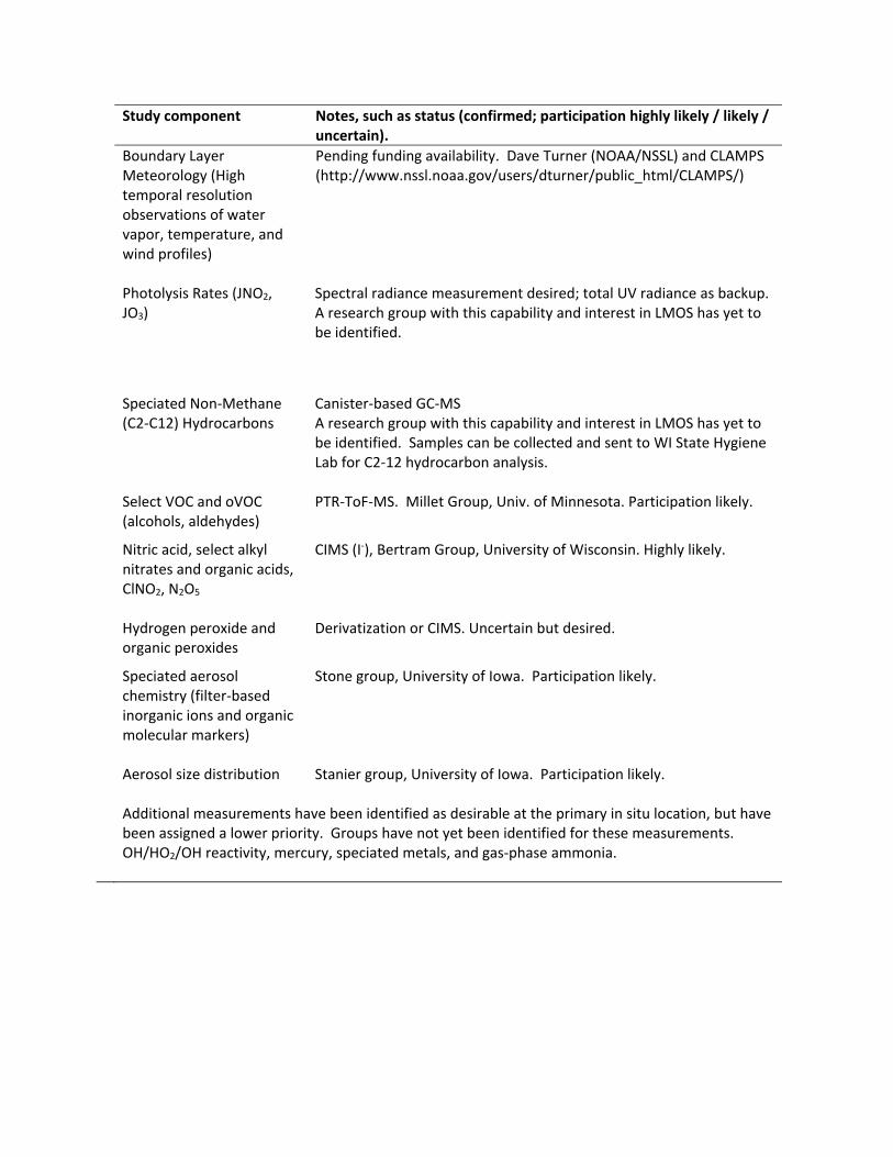
Study component Notes, such as status (confirmed; participation highly likely / likely / uncertain).
Boundary Layer Meteorology (High temporal resolution observations of water vapor, temperature, and wind profiles)
Pending funding availability. Dave Turner (NOAA/NSSL) and CLAMPS (http://www.nssl.noaa.gov/users/dturner/public_html/CLAMPS/)
Photolysis Rates (JNO2, JO3)
Spectral radiance measurement desired; total UV radiance as backup. A research group with this capability and interest in LMOS has yet to be identified.
Speciated Non‐Methane
(C2‐C12) Hydrocarbons Canister‐based GC‐MS A research group with this capability and interest in LMOS has yet to be identified. Samples can be collected and sent to WI State Hygiene Lab for C2‐12 hydrocarbon analysis.
Select VOC and oVOC (alcohols, aldehydes)
PTR‐ToF‐MS. Millet Group, Univ. of Minnesota. Participation likely.
Nitric acid, select alkyl nitrates and organic acids, ClNO2, N2O5
CIMS (I‐), Bertram Group, University of Wisconsin. Highly likely.
Hydrogen peroxide and organic peroxides
Derivatization or CIMS. Uncertain but desired.
Speciated aerosol chemistry (filter‐based inorganic ions and organic molecular markers)
Stone group, University of Iowa. Participation likely.
Aerosol size distribution
Stanier group, University of Iowa. Participation likely.
Additional measurements have been identified as desirable at the primary in situ location, but have been assigned a lower priority. Groups have not yet been identified for these measurements. OH/HO2/OH reactivity, mercury, speciated metals, and gas‐phase ammonia.

Secondary site ‐‐ ground‐based ozone and meteorological vertical profiling
Location Sheboygan Wisconsin Meteorology: 43.746 N 87.81 W North of EPA Site ID 551170006; 43.679 N, 87.716 W
Routine measurements O3 (operational/confirmed).
Boundary Layer Meteorology (Atmospheric Emitted Radiance Interferometer (AERI), HSRL Lidar, Doppler lidar wind profiler, in situ meteorology, radiosonde system)
Pending funding availability. Tim Wagner, Univ. of Wisconsin. SPARC: the SSEC Portable Atmospheric Research Center

Figure 1. Location of the Zion sampling location within the green area (Illinois Beach State Park and the
North Dunes Nature Preserve). The location of Wisconsin’s Chiwaukee Prairie monitor is shown for
reference.

Figure 2. Aerial image of the Zion sampling location (red box) relative to the coast.
Figure 3. Photographs of the operational O3 trailer used by Illinois EPA, and the vacant trailer proposed
for LMOS 2017 in situ sampling.
The white paper is available at:
http://ladco.org/reports/ozone/post08/Great_Lakes_Ozone_Study_White_Paper_Draft_v6.pdf
Pierce, B., R. Kaleel, A. Dickens, T. H. Bertram, C. Stanier, and D. M. Kenski (2016), White Paper: Lake Michigan Ozone Study 2017 (LMOS 2017).