aus 2015 rakali community survey 2014-2015 -...
TRANSCRIPT

Rakali Community Survey
2014-2015
2015
REPORTAUS
This reporT was produced in collaboraTion wiTh:

Rakali Community Survey contacts:
Dr Geoff Barrett
Regional Ecologist
Swan Region
Department of Parks and Wildlife
Corner Australia II & Hackett Drive
Crawley WA 6009
Email: [email protected]
Dr Sabrina Trocini
Rakali Community Survey Project Coordinator
WWF-Australia
Corner Flynn & Selby Streets
PO Box 4010
Wembley WA 6913
Email: [email protected]
This document can be referenced as: Trocini S., Barrett G., Howard K. and Ramalho C. (2015) Rakali Community Survey 2014-2015. Report prepared by WWF-Australia and the Western Australian Department of Parks and Wildlife. WWF-Australia, Perth, WA.
Cover Photograph: © David Judge
Editor: Chris Greenwood, Words in Time
Layout: SUBStitution Pty Ltd
© WWF-Australia 2015
This work is copyright. You may download, display, print and reproduce this material in unaltered form only (retaining this notice) for your personal, non-commercial use or use within your organisation. Apart from any use as permitted under the Copyright Act 1968, all other rights are reserved. Requests and inquiries concerning reproduction and rights should be addressed to WWF-Australia.
Acknowledgements
This project was generously supported by Lotterywest. We are thankful to the WWF communications staff and the many newspapers, radio stations and online media outlets that publicised the Rakali Community Survey. Furthermore, we greatly appreciate the assistance of the many individuals and organisations that promoted the Rakali Community Survey on their webpages, newsletters and on social media. We are also very grateful to Dr Peter Speldewinde (University of Western Australia [UWA]), Geoff Williams (Australian Platypus Conservancy), Karen Bettink (UWA) and Dr Matt Williams (Department of Parks and Wildlife) for their advice during the survey design and/or for sharing their expertise at other stages of the project. We are very grateful to Parks and Wildlife staff, Ken Atkins, Keith Morris, Dr Barbara Wilson, Karen Bettink and Dr Nicole Willers for their valuable comments and feedback on the report. Our sincere gratitude also goes to Tim Gamblin, Gary Muir (WOW Wilderness tours), Boyd Wykes and Caroline Hughes (Cape to Cape Conservation Council), Ruth Clark (Waterbird Conservation Group) and Ciara McIlduff (Yanchep NP volunteer coordinator) for their great help in the organisation of the Rakali Walk events. Last but not least, we would like to sincerely thank all the individuals and organisations that participated in the Rakali Walks, including the Yanchep National Park and Canning River Regional Park volunteers, Friends of the Paganoni Swamp, the Swan Estuaries Reserves Action Group and the Mount Henry Peninsula Conservation Group, and also all the people that participated in the Rakali Community Survey by reporting rakali sightings. This project would not have been possible without the enthusiastic response from the community.
Rakali Community SuRvey RepoRt 3
ContentS1. Summary 42. introduction 5 2.1 Background 5 2.2 Citizen science in wildlife research 9 2.3 the Rakali Community Survey 9
3. methods 10 3.1 Survey period 10 3.2 Survey promotion 10 3.3 Data collection and processing 10 3.4 Species identification 10 3.5 Sighting location and habitat 12 3.6 the Rakali Walk 13 3.7 Data analysis 16
4. Results 17 4.1 Survey participation 17 4.2 Sighting confidence 17 4.3 temporal and geographic distribution of the rakali sightings 18 4.4 Habitat 21 4.5 Rakali behaviour 22 4.6 Rakali mortality and perceived threats 22 4.7 the Rakali Walk 24
5. Discussion 26 5.1 Community engagement 26 5.2 Distribution 26 5.3 Comparison with historic records 27 5.4 Habitat 27 5.5 Rakali as indicators of healthy waterways 28 5.6 mortality and perceived threats 28 5.6 the Rakali Walk – a simple methodology to survey rakali 31
6. Recommendations 32 6.1 Future rakali community surveys 32 6.2 Research and management 32
References 34appendicesappendix 1: WWF media releases to promote the Rakali Community Survey 36appendix 2: media coverage 38appendix 3: poster for Wetland Conference – 2 February 2015 40appendix 4: Rakali Community Survey Datasheet 41appendix 5: Rakali Walk methodology 43appendix 6: Complete list of sites where rakali were recorded during the Rakali Community Survey 45appendix 7: Follow-up survey 47

4 Rakali Community SuRvey 2014-2015
Rakali or Australian water rat (Hydromys chrysogaster) is a cryptic native rodent that is perfectly adapted to the aquatic environment and can be found near fresh or brackish permanent waterbodies and sheltered coastal beaches. Rakali are common and widespread throughout Australia, but have suffered localised declines in Western Australia, in particular the Wheatbelt, due to habitat loss and degradation, drying climate, salinisation and predation by introduced predators.
WWF-Australia, in partnership with the Western Australian Department of Parks and Wildlife conducted a widely publicised community survey collecting sighting reports of rakali in Western Australia, in particular from the southwest of the state. Citizen science offers an opportunity to collect monitoring data on a large spatial and temporal scale and to detect changes in frequency and distribution of easily observable threats to wildlife species. Results obtained by citizen science projects such as the Rakali Community Survey can also provide essential baseline data to identify research and management priorities. The aim of this survey was to obtain rakali distribution data and to identify potential threats, while educating the community about this cryptic and understudied native rodent.
A total of 234 sightings were reported over four months (December 2014 to March 2015). Additionally, 49 transect surveys were carried out with the help of community volunteers, looking for characteristic rakali foot prints and feeding middens (the Rakali Walk). The described survey methodology was found to be a simple and effective way to monitor the presence of rakali. This technique in association with other survey methods, such as camera trapping, could be utilised to extensively survey sites over time and gather information on relative abundance.
The distribution of rakali sightings obtained from the Rakali Community Survey was found to largely overlap with the known species distribution, with the majority of
the sightings occurring in the south-west corner of the state and a limited number of sightings in the Wheatbelt. There was also anecdotal evidence of localised declines and extinctions in the Perth Metropolitan Region. For instance, historical rakali distribution data obtained from NatureMap showed that rakali were distributed along the Helena River in the 1960s, but no recent sightings were reported from this location. Besides, only scarce and localised evidence of rakali was found along this river and its tributaries during the transect surveys. The reduction in water levels and flow due to a dam built in the 1970s, in association with habitat degradation, may have contributed to a localised decline along this waterway north-east of Perth.
The main reported cause of rakali mortality was attributed to drowning in box or opera-house style traps used to catch freshwater crayfish (in particular marron, Cherax cainii). These crayfish traps, which are illegal to use for recreational marron fishing were also one of the main threats identified by survey participants. Predation by foxes and cats, habitat degradation and changes in hydrology were also identified as important threats.
Recommendations highlight the importance of further rakali monitoring in Western Australia and research into the effects of habitat degradation, introduced predators and changes in hydrology on rakali populations. Identified management recommendations include predator control at important sites and the protection and restoration of wetland habitat where the presence of rakali was confirmed. Increased monitoring of the illegal use of crayfish traps throughout Western Australia is also deemed a priority to reduce rakali mortality rates. Education of crayfish fishers and farmers, as well as retailers selling crayfish traps, in association with the promotion of a crayfish trap with an escape hatch recently developed by the Australian Platypus Conservancy will also play an important role in protecting this native species.
1. SummaRy©
Dav
iD Ju
Dg
e

Rakali Community SuRvey 2014-2015 5
2.1 BaCkgRounDThe rakali (Hydromys chrysogaster) (Geoffroy, 1804), also known as the Australian water rat, can be found in all Australian states and mainland federal territories, New Guinea and nearby islands1 (Figure 1) and belongs to the eutherian Order Rodentia. Twenty-five per cent of all Australian land mammals are rodents (66 species in total)2 but, in general, this diverse native taxa is still relatively understudied and poorly known.2-4 Australian native rodents all belong to the Family Muridae. They play an important role in ecosystems by, for example, dispersing fungi spores which in turn assist plants to extract water and nutrients from the soil, and by being an important part of the foodweb.5-7 On the other hand, the four introduced rodents (black rat, Rattus rattus; brown rat, Rattus norvegicus; Pacific rat, Rattus exculans; and house mouse, Mus musculus) are agricultural and conservation pests, as well as a public health risk.
Globally, rodents have suffered the highest extinction rate of all mammals, but have the smallest number of species currently classified as threatened.8 In Australia, seven rodent taxa have become extinct on the Australian mainland since European settlement (about 24% of
all Australian mammal extinctions in this time) and another 15 rodent taxa are regarded as threatened.2 While historical and recent declines and extinction of Australian marsupials are widely known and well described, the equally dramatic extinction rates in rodents have received very little attention.9 Of the 35 native rodents in Western Australia (WA), six are threatened and four are presumed extinct.10 The lack of research, awareness and interest in rodents nationally and internationally is related to the fact that rodents are often considered pests (even when they are native) and, in general, are less emotionally appealing than larger more charismatic species.8
2. intRoDuCtion
Rakali is the Aboriginal name from the Murray Darling Basin in New South Wales and Victoria and was adopted as the species common name by the Australian Department of Environment and Heritage in the 1990s. More than 50 different Aboriginal names are used for rakali, including Moytj in the Perth region, and Ngurju and Muritya in the other parts of Southwest Western Australia.
© D
aviD
JuD
ge

6 Rakali Community SuRvey 2014-2015
physical characteristicsRakali are the largest of all Australia’s native rodents (weight: 340-1275g; head to body length: 23-37cm). Anatomical features that make rakali well-suited to their amphibious life include: an elongated and streamlined body, webbed hind feet, dorsal nostrils, a flat head with small ears and eyes, and a waterproof coat.1
The coat colour varies from black, grey to brown with white to golden fur colour ventrally1, 12 (Figure 2). The tail is covered with fur and usually terminates with a white tip of variable length. The differences in fur colour throughout Australia may be adaptations to different environments, e.g. in Southwest Western Australia rakali are dark grey to black, which may be an adaptation to the dark tannin coloured rivers.12
Habitat and behaviourRakali live in rivers, estuaries, swamps, lakes, and also on protected coastal beaches and islands.1 In Western Australia, rakali are the only aquatic mammal in freshwater ecosystems, while in the eastern states rakali often co-exist with the platypus.13
Rakali are most active at sunset and at night,12 when they are mainly observed foraging along the water’s edge. As opportunistic top-predators, their diet is mostly carnivorous and includes fish, large aquatic insects, mussels, crustaceans, lizards, frogs and also small waterbirds and mammals. In winter, due to lower water temperatures, rakali tend to spend less time foraging in the water and shift to larger prey.1 Rakali consume their prey on flat feeding sites that are regularly used, such as logs, rocks or sheltered areas on the river bank1 (Figure 3). Rakali typically breed during spring and summer and females produce a litter of three to four young, usually once or twice a year. Dens in which the litter is raised are made at the end of tunnels in river banks or in logs14 (Figure 4).
Figure 1: Records of rakali (Hydromys chrysogaster) in Australia.11
© Tr
ac
y Oliv
er

Rakali Community SuRvey 2014-2015 7
Figure 2: Variation in Hydromys chrysogaster fur colouration in Australia: Top left: Southwest Western Australia; Top right: Victoria; lower left and right: Australian Capital Territory.
© K
ar
en
Be
TTinK
© Tr
ac
y Oliv
er
© D
aviD
JuD
ge
© D
Ha
nD
ley / a
us
Tra
lian
PlaTy
Pu
s c
On
se
rva
nc
y
Figure 3: Rakali mussel feeding midden on a log.
© g
eO
ff Ba
rr
eTT / D
PaW

8 Rakali Community SuRvey 2014-2015
Conservation status and threatsRakali are listed as ‘Least Concern’ on the IUCN Red List of Threatened Species,15 and nationally the species is widespread and considered secure.2,9 In Western Australia, while formerly distributed throughout the Wheatbelt,4 they are now restricted to the coastal areas of the south-west, Shark Bay and Pilbara Islands and the Kimberley.16 Due to the species’ localised decline in Western Australia (particularly in the southwest), rakali have been included on the State Priority Fauna list and are, therefore, considered a species at risk and in need of monitoring (i.e. Priority 4 species; Western Australian Department of Parks and Wildlife).
In general, the main identified causes for the decline of Australian rodents are: predation by introduced predators, particularly cats, and habitat degradation and loss.17 Rakali, are also threatened by salinisation, acidification, terrestrialisation and eutrophication of wetlands and waterways and by changes in hydrology.4,12,18 Due to their relatively short lifespan (2-3 years) and reproduction rate (1-2 litters/year, 2-4 pups in each litter),1,14 the combined effect of habitat loss/degradation and drought can very quickly cause localised declines.
In the 1930-40s, rakali were almost hunted to extinction for their prized waterproof fur.16 Nowadays, although a protected species across Australia, rakali are accidentally caught and killed in ‘opera-house’, box or cage style traps for freshwater crayfish (in particular marron, Cherax cainii). In Western Australia these traps are illegal to use for recreational marron fishing,19 but are inexpensive and still readily available.20
Freshwater ecosystems under threatAccording to WWF’s Living Planet Report 201421 freshwater fauna species declined globally by 74% between 1970 and 2010, almost double the rate of decline detected in terrestrial and marine ecosystems. Several studies worldwide have shown that the health of freshwater ecosystems is generally poor and that climate change poses additional stress and management challenges to the conservation of these threatened ecosystems.22-24 Rivers in the south-west are generally in poorer condition than other Western Australian rivers due to higher human population density, extraction of water and increased agricultural pressure.25 Additionally, rainfall has declined in Southwest Western Australia by 15-20% since the 1970s, with severe impacts on stream flow and reductions of up to 50% in runoff.26 Since European settlement an estimated 70-80% of the wetlands in the Swan Coastal Plain have disappeared as a result of drainage, vegetation clearing and infilling.27,28 Declining groundwater levels29,30 have also emerged as a significant threat to wetland-associated vertebrate fauna.18 It is predicted that in the future there could be an even greater decline in rainfall31 and under all but the most optimistic assumptions for climate, groundwater levels will decline.29
The threats faced by freshwater ecosystems globally and regionally make it imperative to monitor wildlife species that depend on these ecosystems. The rakali is the only top predator mammal in Western Australian freshwater ecosystems and has been identified as a potential indicator of ecosystems health and a species that is highly susceptible to climate change.18,32,33
Figure 4: Rakali burrow in a river bank.
© W
Wf-a
us
/ sa
Br
ina Tr
Oc
ini

Rakali Community SuRvey 2014-2015 9
2.2 Citizen SCienCe in WilDliFe ReSeaRCH
Citizen science (also known as community science) involves members of the community collecting the data necessary for scientific discovery and monitoring, integrating public outreach and the collection of scientific data on a local, regional or even global scale.34,35 Data collected by the community has been recognised as an invaluable source of information in biodiversity research36 and provides an opportunity to collect monitoring data on a temporal and spatial scale that would otherwise not be logistically feasible or affordable. The number of citizen science projects world-wide has dramatically increased in the past 15 years, particularly thanks to the internet and smart phone technology that facilitates ‘crowdsourcing’ for data collection.37
Citizen science has been successfully used for large-scale landscape ecological studies, including the detection of climate-change induced shifts in distribution and phenology (i.e. the timing of life cycle events, such as reproduction, migration).37-39 Community surveys have also been very effective in detecting rare or invasive species37 and are also an important, but underutilised tool, for conservation research and adaptive management in residential areas.35 The potential for citizen science to study and monitor wildlife in residential environments has recently been highlighted by the 2012 Community Quenda Survey,40 the highly successful annual Great Cocky Count,41 and the Australian Bird Atlas.42 In an urban environment, ecological data gathered by citizen scientists can be linked with information on urban practices, such as pet ownership, pesticide and water use and urban habitat management, to better understand their impact on urban ecosystems.35,37
2.3 tHe Rakali Community SuRveyBackgroundRakali are notoriously difficult to observe or trap in ecological surveys.12, 32 Collecting community-based sighting records, generated opportunistically through recreational activities such as bush walking, canoeing or fishing was identified as a possible way to map the species’ current distribution over a wide geographical range.
Rakali in Western Australia are considered to be less diurnal and more secretive than those in other states,12 but lower rakali abundance in Western Australia may also be responsible for the comparatively low number of rakali sighted and trapped during surveys.12,18 Given the difficultly in observing live animals in Western Australia, survey participants were also encouraged to report signs of rakali presence (i.e. tracks and/or feeding middens) along survey transects. A passive survey technique developed by the Western Australian Department of Parks and Wildlife (G. Barrett), the Rakali Walk, was trialled as a means to obtain presence/absence data and assess the level of rakali activity along the transects.
The public’s knowledge about rakali is limited and many people associate this species with introduced pests. Education of the public about this species and the threats faced by freshwater ecosystems was considered to be an essential part of the survey. The Rakali Walk was used as an additional tool to actively engage the local community in the search for rakali feeding middens and footprints while also educating the public about this cryptic native rodent.
aimsThis report describes the results obtained by the Rakali Community Survey in the context of available data and scientific knowledge about the species, providing recommendations for future research and species management. The advantages and limitations of citizen science to monitor this elusive and understudied species will also be discussed.
Specific aims of the Rakali Community Survey were to:
1. Collect spatially explicit data to improve the current knowledge about the species distribution in Southwest Western Australia, using:
a) reported sightings from the public
b) a passive survey method, the Rakali Walk.
2. Identify threats to Western Australian rakali populations.
3. Raise the profile of rakali in the broader community.

10 Rakali Community SuRvey 2014-2015
3.1 SuRvey peRioDThe Rakali Community Survey was officially launched on 2 December 2014 and closed on 31 March 2015; a small number of sightings received in April 2015 (n=9) were included in the database. The survey collected direct rakali sightings from the public as well as confirmed indirect signs of the species presence (i.e. tracks and/or feeding middens) that occurred both during the survey period and prior to December 2014. In addition to the opportunistic rakali sightings reported through the broader survey effort, WWF and Parks and Wildlife staff and community volunteers undertook targeted Rakali Walks, from January to March 2015, looking for evidence of rakali (i.e. feeding middens and tracks).
3.2 SuRvey pRomotion A media release promoting the Rakali Community Survey was distributed to all Western Australian news outlets on 2 December 2014 and again on 2 February 2015, in association with World Wetlands Day (Appendix 1). The survey was extensively promoted in the printed press (state-wide in The West Australian newspaper and in at least 17 regional newspapers), radio (interviews aired on four regional ABC radio programmes), newsletters (e.g. Parks and Wildlife Bushland News and the South West LINK newsletter) and the WWF webpage (www.wwf.org.au/rakali) (see Appendix 2 for a full list).
Various organisations, universities, clubs and agencies (e.g. Natural Resource Management groups, Canoeing WA, Murdoch University and Scistarter) were contacted and they generously promoted the survey on their webpages and/or social media (e.g. Facebook pages of the WA Naturalists’ Club, Australian Mammal Society, Shire of Murray and the Australian Platypus Conservancy). Posters advertising the Rakali Community Survey (Figure 5) were distributed to several tourism visitor centres (e.g. the Margaret River, Mandurah, Walpole and Denmark visitor centres) and other tourist facilities, as well as to various organisations and offices, including the Water Corporation, Kanyana and Native Ark Wildlife Rehabilitation Centres and the WA Museum. In February 2015 the project was presented at the Western Australian Wetland Management Conference (Appendix 3) and at the Western Australian Trout and Freshwater Angling
Association. Additionally, in January 2015 a wide range of local environmental community and government groups were contacted directly via phone or email to request their participation in the survey and in particular, the Rakali Walk (Appendix 5).
3.3 Data ColleCtion anD pRoCeSSingReports of rakali sightings were received by phone, email, mail and via an online SurveyMonkey questionnaire that was advertised on social media (Facebook and Twitter). The datasheet (Appendix 4) was available for download on the WWF website (www.wwf.org.au/rakali) and was e-mailed to all the participants that contacted WWF. Over the phone, all survey participants were asked the same questions as outlined in the rakali survey datasheet, which included: contact details of the participants, a description of the sighting and site, characteristics of the habitat and information on identified and perceived threats (Appendix 4). All data were stored in an Excel (Microsoft, 2010) database. To minimise data entry errors, data were entered and processed by one recorder and many of the data entry cells had restricted values and drop down menus.
In August 2015 using SurveyMonkey a short follow-up questionnaire was emailed to the survey participants that provided an email contact (n=125) to assess: age demographics, motivation to participate in the survey, knowledge on Australian flora and fauna, general knowledge on rakali and its conservation status (before and after the survey) and previous experience with other citizen science projects (Appendix 7).
3.4 SpeCieS iDentiFiCationThe ability of the observer to accurately identify rakali was assessed by the participants’ description of the animal’s anatomical features and behaviour. To limit misidentifications, photographs of rakali and a description of its main anatomical characteristics were included on all media releases, the project’s webpage, the datasheet, and also highlighted in some of the social media posts. The physical characteristics, such as the white tip to the tail, behaviour and habitat of the species make rakali reasonably easy to identify correctly. Whenever possible, the participants were asked to provide photographs of the animal sighted, to confirm its identification.
3. metHoDS

Rakali Community SuRvey 2014-2015 11
Take a Rakali Walk!
Become a citizen scientist and join WWF-Australia in the Australian water
rat (a.k.a. rakali) survey to help us gather important information about
these elusive and fascinating native animals.
Who: All interested members of the public including families, no
experience required
When: Sunday 1 March
Time: Morning survey - 8am at Rotary Park for a two hour walk
around the town pools
Afternoon survey – 3pm at Canebrake Reserve picnic ground for a
two hour walk and/or paddle (take your own kayak)
Cost: free Please wear suitable field clothes, i.e. hat, long trousers and closed in shoes.
Please register by the 26th of February via the Cape to Cape Catchments Group (CCG) website
www.capetocape.org.au/contact or contact the CCG office on 97572202.
For more information about the Rakali Community Survey, visit www.wwf.org.au/rakali or contact
WWF ([email protected], Tel: 62310223)
© Karen Bettink
Figure 5: Above: Poster distributed in Margaret River to advertise the Rakali Walk event on 1 March 2015.Right: Rakali Community Survey poster distributed to various tourism centres, agencies and clubs.

12 Rakali Community SuRvey 2014-2015
Photos of rakali footprints, which are much larger than those of a black or brown rat (Figure 7), were also included on the project’s webpage and datasheet. Additionally, training to identify footprints and feeding middens was provided in person during the Rakali Walks and/or via phone and educational material. Whenever participants observed footprints and/or feeding middens, but did not directly observe rakali, they were asked to provide a photo with a scale reference. When the participants could not provide photographic evidence of feeding middens and foot prints, these sightings were only included in the analysis when the observer was very familiar with the species and its indirect identification (e.g. Department of Parks and Wildlife officers).
Depending on the information provided, the sighting was then classified using a confidence scale from 1 to 5. Misidentifications and sightings that were judged to be uncertain (i.e. 1 on the confidence scale, ‘not rakali’ and 2 ‘probably not rakali’ due to insufficient information or inconsistent description of behaviour and/or anatomical features) were filtered out from the distribution analysis. Sightings were given a score of 3 in our confidence scale (‘possibly rakali’) if, for example, rakali was known to occur in the area, but some minor aspects of the participant’s description raised doubts, especially in locations where rakali are known to co-exist with introduced brown or black rats. In cases where behaviour and anatomical descriptions were consistent with those of rakali, but the participant lacked confidence in their sighting (e.g. when the animal was spotted from a distance), the sighting was classified as 4 (‘probably rakali’). Finally, whenever the sighting could be confirmed with a photo or when the participants’ description was very detailed and accurate, the sighting was classified as 5 (‘definitely rakali’). The observer was also asked how confident they felt about the species identification (i.e. not confident, quite confident, very confident).
3.5 SigHting loCation anD HaBitatOnly sightings from Western Australia were considered for mapping and data analysis and this study focused mostly on Southwest Western Australia. Sighting reports from other states were sent to the Australian Platypus Conservancy.13 The location of the sighting was provided either by submitting longitude and latitude coordinates, a street address and/or major landmarks (e.g. bridge, park, jetty). Whenever the location could not be clearly determined, observers were encouraged to submit a screen shot of the site marked on Google Maps, from which the coordinates were extracted. When longitude and latitude coordinates were provided these were verified by comparing them with the location description. Site accuracy was classified as ‘precise’ (i.e. site location was determined by GPS coordinates or street address and/or clear landmarks) for 94% of all the entries (n=201). Survey participants that could only give a general description of the location (n=13; classified as ‘general’ accuracy) were able to narrow down the area to ≤10km of a specified location. The sighting locations for the Rakali Community Survey were categorised into Parks and Wildlife Regions (Figure 6).
Participants were also asked to provide information on the habitat and/or photos of the sighting location, so that we could assess the habitat characteristics from a series of photos (see Appendix 4 for detailed description).
Figure 6: Map of the Western Australian Department of Parks and Wildlife management regions in Western Australia. The Southwest Western Australia Province Region is represented in green.

Rakali Community SuRvey 2014-2015 13
3.6 tHe Rakali WalkThe transect surveys were carried out by Parks and Wildlife or WWF staff, by volunteers under supervision of WWF staff or by volunteers that were previously trained in the transect survey technique. Training was delivered over the phone and by sending educational material (e.g. Appendix 5) or more commonly, in person during one of the publicly advertised Rakali Walks. Volunteers always sent photos of any tracks or middens they encountered so that they could be reviewed by WWF staff. Footprints were differentiated from the tracks of brown and black rat by the larger size, lack of visible plantar pads and the webbed hind feet (Figure 7). Feeding middens were defined as a discrete pile of mussel shells or remains of crabs, marron and occasionally bones (Figure 8).
To facilitate volunteer participation, the Rakali Walk transects could be of variable length (minimum 100m) and all volunteers were provided with a clear methodology description and photos of characteristic feeding middens and footprints (Appendix 5). Data recorded included:
• Start and finish point of the transect (GPS latitude/longitude, location description or Google Map with starting and end point marked on it).
• Start and finish time.
• Number of feeding middens and sets of prints along the transect.
• Four photos of a representative section of the transect.
Figure 7: A rakali front and hind footprint (circled with a 10 cent coin as a size reference) in comparison to introduced rat tracks in the top half of the photo. Note the webbed hind footprint and the lack of visible plantar pads.
Figure 8: Left: Rakali feeding midden with crab remains and bird bones. Right: Carter’s freshwater mussel feeding midden.
© Tim
ga
mB
lin
© W
Wf-a
us
/ sa
Br
ina Tr
Oc
ini
© W
Wf-a
us
/ sa
Br
ina Tr
Oc
ini

14 Rakali Community SuRvey 2014-2015
A total of 41 transects of variable length were surveyed between December 2014 and March 2015; of those, 14 were part of larger Rakali Walk events. Additionally, targeted surveys were carried out on the Helena River and its tributaries in July 2015 (8 transects) due to the lack of recent sightings in this area (Table 1). Of the total 49 transects carried out between December 2014 and July 2015, 14 were part of larger Rakali Walk events, 10 surveys were completed by community volunteers following training and the remaining 25 transects were done by WWF and Parks and Wildlife staff (Table 1). Rakali Walks with the engagement and training of volunteers from the local community and local environmental groups were organised along the Murray River, Margaret River, Moore River, Canning River in the Alfred Cove Reserve and Roleystone, at the Walpole Peninsula and the Folly Reserve (Table 1, Figure 9). A total of 96 volunteers participated in the Rakali Walks.
Where continuous signs of rakali activity were recorded along the transect, that site was classified as ‘high activity’ (identified by repeated detection of tracks and/or feeding middens). When only a small number of feeding middens were recorded along a transect (i.e. ≤1 midden/100m) the transect was classified as ‘low activity’.
River foreshore conditions were categorised into four categories as previously described by the Water and Rivers Commission (i.e. A: pristine-slightly disturbed; B: degraded; C: erosion prone-eroded; D: ditch).43 The river foreshore condition was assessed in situ and/or using the habitat photos submitted by the volunteers. The presence of logs and rocks in the water, overhanging vegetation and steep river banks (i.e. >45°, >1m high) was also recorded.
Figure 9: Photos of Rakali Walk events. WWF staff with the help of community volunteers surveyed transects from kayaks (top) and on foot (above). During the Walpole survey, volunteers had the opportunity to inspect rakali scats under the microscope kindly provided by WOW Wilderness tours (below).
© W
Wf-a
us
/ sa
Br
ina Tr
Oc
ini
© W
Wf-a
us
/ sa
Br
ina Tr
Oc
ini
© W
Wf-a
us
/ sa
Br
ina Tr
Oc
ini

Rakali Community SuRvey 2014-2015 15
table 1: Rakali Walk transect surveys undertaken by the Department of parks and Wildlife (DpaW) and WWF and/or citizen scientists (CS). * Rakali Walk events. Participants Number of participants Location Habitat Transect length
(m)DPaW 1 Treen Brook river 1600DPaW 1 lefroy Brook river 400DPaW 1 upper Warren river river 200DPaW 1 smith’s Brook river 250DPaW 1 Donelly river river 150DPaW 1 mcKnoe’s Brook river 600DPaW 1 serpentine river river 300DPaW 1 lefroy Brook river 400DPaW 1 lefroy Brook river 500
DPaW 1 lefroy Brook river 400WWf 1 serpentine river river 300WWf 1 Harvey estuary estuary 400WWf 10 lake leschenaultia lake 900WWf/cs* 14 margaret river river 1600WWf/cs* 2 margaret river river 400WWf/cs* 4 canebrake reserve river pool 400WWf/cs* 7 murray river river 1500WWf/cs* 3 folly reserve river 200WWf 1 lake goolelall lake 500WWf/cs* 6 canning river river 950WWf/cs* 15 moore river river 500WWf/cs* 3 moore river river 600WWf/cs* 15 moore river river 300WWf/cs* 15 moore river river 500WWf/cs* 6 canning river river 100WWf/cs* 10 Walpole coalmine beach estuary 150WWf/cs* 12 Walpole coalmine beach estuary 600WWf/cs* 22 Walpole Peninsula estuary 100WWf 2 canning river river 400cs 1 canning river river 250cs 1 canning river river 200cs 2 margaret river river 600cs 4 Helena river river 423cs 4 Paganoni swamp reserve wetland 500cs 4 Black swan lake lake 200cs 4 Paganoni lake lake 400cs 2 canning river river 550cs 2 canning river river 100cs 2 canning river river 250DPaW/cs 4 loch mcness lake 300DPaW/cs 4 lake yonderup lake 50WWf 1 Helena and swan river river 600WWf 1 Helena river river 200WWf 1 Helena river river 150WWf 1 Helena river river 4000WWf 1 Piesse gully river 1000WWf 1 Piesse gully river 900WWf 1 Helena river river 200WWf 1 Bending gully river 300

16 Rakali Community SuRvey 2014-2015
3.7 Data analySiSData were processed in Excel (Microsoft, 2010, Redmond, Washington) and statistical analyses were carried out in SPSS Inc. (IBM corp., 2013, Version 22.0, Armonk, NY). A chi-square test was used to test the association between habitat quality and presence and activity of rakali.
To complement the habitat description provided by the volunteers, we undertook a spatial analysis using Geographic Information Systems (GIS) (ArcGIS 10.1; ESRI, 2012) for characterisation of the sightings according to the type of geomorphic wetland they were located on, and the distance to remnant vegetation (if within 50 m from the sighting location). The latter was only calculated for the records from 2010-2015. The geomorphic wetlands and remnant vegetation corporate spatial layers from the Western Australian Department of Parks and Wildlife were used for this purpose.
The habitat type was classified as: coastal beach, river, river pool, estuary, creek (seasonally inundated channel), lake (permanently inundated basin), sumpland (or swamp; seasonally inundated basin), dampland (seasonally waterlogged basin), floodplain (seasonally inundated flat) and paluslope (seasonally waterlogged slope). Sightings in dams or reservoirs and at marron farms were separately categorised.
On the maps, data collected during the survey were compared with presence data stored in the NatureMap database (n=356 in total, n=269 sightings south of the Moore River) (http://NatureMap.dpaw.wa.gov.au/). NatureMap sightings included: sightings of live animals, trapping data and reports of dead rakali opportunistically collected by Parks and Wildlife staff and members of the public and specimens and fossils collected and identified as rakali by the Western Australian Museum. Due to the historical nature of the NatureMap database, the sightings’ location accuracy was over 10km for 40% (n=144) of the data.

Rakali Community SuRvey 2014-2015 17
4.1 SuRvey paRtiCipationOverall, 167 survey participants reported 234 sightings during the Rakali Community Survey, with 30 observers reporting sightings from multiple locations. The majority (90%) of the participants reported their sightings by email (n=71) and phone (n=79), with a minority reporting sightings in person (n=11), via social media (n=3) and post (n=3). Most participants reported having heard about the survey from regional and local newspapers or information sent out from Parks and Wildlife, WWF and other supportive organisations/agencies (e.g. through group emails, newsletters). Participants only rarely reported having heard about the Rakali Community Survey from social media and the WWF webpage (n=5) (Figure 10).
The follow-up SurveyMonkey questionnaire was responded to by 38% of the participants (n=48; Appendix 7). Nearly half the participants in this subgroup (48%) had previously participated in other citizen science projects. The majority of survey participants (77%) were 45 years old or older, while 0% were under 24 years. Of those participating in the survey 76% were motivated by their strong interest in wildlife and nature conservation 59% considered they had a good knowledge of Australian fauna/flora. Only 4% rated their previous knowledge of rakali as excellent and 48% felt that the survey improved their knowledge on the species (see Appendix 7 for full description of results).
Rakali were most commonly observed when participants were actively looking for rakali (19%), fishing (13%), bushwalking/walking (13%) or doing ecological surveys (12%). Less commonly observers were kayaking (4%), driving (3%) or swimming (1%). The majority of sightings (28%) however, occurred when participants were doing ‘other’ activities on their private property (17%) or near a public water-way (11%).
4.2 SigHting ConFiDenCeOf the 234 sightings, 20 were excluded from the analysis as 19 were misidentifications or probable misidentifications (n=16 ‘not rakali’ and n=3 ‘probably not rakali’) and one lacked sufficient information. In total, 89% of the sightings were categorised as confirmed (‘definitely rakali’) or probable (‘probably rakali’) (Figure 11). All of the sightings categorised as ‘probably not rakali’ and ‘possibly rakali’ were in the Swan Region, as well as the majority of confirmed misidentifications (n=9, 56%).
4. ReSultS
Figure 10: How did survey participants hear about the Rakali Community Survey?
Figure 11: Percentage of sightings categorised by sighting confidence, based on the participants’ description of the animal’s behaviour and anatomical characteristics and/or photos.
31%
6%
23%
30%
DPaW, WWF and other agency/group local paper other
social media webpage West Australian word of mouth
7%
1%2%
70%
19%
probably rakali
probably not rakali
de�nitely rakali
not rakali
possibly rakali
insu�cient information
7%
3%0% 1%

18 Rakali Community SuRvey 2014-2015
4.3 tempoRal anD geogRapHiC DiStRiBution oF tHe SigHtingS
As expected, the majority of the sightings (76%, n=162) occurred after 2010, but 10% of the participants (n=22) also reported rakali sightings from the 1990s or earlier (Figure 12). The oldest sightings reported are dated from the 1940s (n=2). Only 29% (n=61) of the total reported sightings were made during the survey period, December 2014 to March 2015. The majority of the data included in the NatureMap database are historical records from before the 1990s (n=122, Figure 12).
The most represented Parks and Wildlife regions were, in order, the Swan, Warren and South-West Regions, which totalled 90% (n=192) of all Rakali Community Survey sightings (Figure 13). Thirteen major rivers or water-bodies with five or more rakali sightings made up 57% of all reported sightings (n=121, Table 2, see Appendix 6 for full list) and the Swan-Canning and the
0
20
40
60
80
100
120
140
160
180
<1960 1960-1989 1990-1999 2000-2009 2010-2015
Rakali community survey
NatureMap
0
10
20
30
40
50
60
70
80
90
KimberleyRegion
MidwestRegion
South CoastRegion
South WestRegion
SwanRegion
WarrenRegion
WheatbeltRegion
total number of sightings
sightings during survey period
Figure 12: Temporal distribution of rakali presence data records of the NatureMap dataset in comparison with the Rakali Community Survey dataset.
Figure 13: Frequency of rakali sightings in Western Australian Parks and Wildlife regions.
table 2: major rivers and water bodies with five or more rakali sightings reported during the Rakali Community Survey. * the five sites with the largest number of sightings. Region Site <1960 1960-89 1990-99 2000-10 2010-15 Totalswan region canning river* 1 2 1 13 17
Peel-Harvey estuary* 1 10 11murray river* 11 11serpentine river 1 5 6swan river* 1 2 2 13 18
Warren region lefroy Brook 1 7 8Warren river 9 9Blackwood river 2 2Walpole-nornalup inlet * 19 19
south West region capel river 1 4 5collie river 5 5margaret river 5 5Blackwood river 3 2 5
Total 3 5 1 7 105 121
Peel-Harvey catchments alone contributed to more than half these sightings (n=63, Table 2).
Overall, the distribution of sightings from the Rakali Community Survey overlapped with the known rakali distribution in Southwest Western Australia (Figure 14). The most northerly record obtained during the Rakali Community Survey was one sighting in 2013 from a private dam in Dongara in the Midwest region (Figure 14) and to our knowledge, there have been no other recent sightings reported from this area. As expected, there were very few sightings reported in the Wheatbelt region (n=3). Furthermore, we also did not receive any recent sightings from the Helena River catchment (Figure 15), although on NatureMap the Helena River and Piesse Gully (a tributary of the Helena) have, after the Swan River (n=25), the highest number of rakali records (n=22). It is important to note that these records are dated before the 1990s (1933-1966, n=13) or their date was unknown (n=9).

Rakali Community SuRvey 2014-2015 19
Figure 14: Distribution of rakali sightings reported during the Rakali Community Survey, colour coded by sighting confidence. NatureMap records of rakali are represented in light grey.

20 Rakali Community SuRvey 2014-2015
Figure 15: Distribution of the rakali sightings reported during the Rakali Community Survey and NatureMap records colour coded by year of sighting.

Rakali Community SuRvey 2014-2015 21
4.4 HaBitatRakali were more commonly observed near estuaries (36%) and rivers & river pools (34%). Thirteen per cent of the sightings were reported from other types of wetlands, including lakes and sumplands. Four per cent of sightings were from coastal beaches and 12% from dams/reservoirs and marron farms (Table 3).
table 3: Habitat categories where the rakali were sighted during the Rakali Community Survey.Habitat Sample size (n) Percentage
estuary 76 35.5%river 47 22.0%river pool 26 12.1%Dam/reservoir 24 11.2%sumpland 11 5.1%lake 9 4.2%coastal beach
9 4.2%
floodplain 4 1.9%creek 4 1.9%marron farm 2 0.9%Dampland 1 0.5%Paluslope 1 0.5%
The distance to remnant vegetation was calculated for the most recent sightings (2010-2015, n=165). Forty per cent were in patches of remnant vegetation and 15% were located within 10 m of remnant vegetation cover and 21% were located >50 m away from remnant vegetation (Table 4).
table 4: Distance to remnant vegetation of the rakali sighting locations reported during the Rakali Community Survey (2010-2015).Distance to remnant vegetation
n Percentage
0 m 66 40.0%≤10 m 25 15.2%11-30 m 23 13.9%31-50 m 17 10.3%>50 m 34 20.6%
Half the participants who sighted rakali along or nearby a river recorded information about the river flow and presence of pools (>1 m deep). The majority reported that the river flow was slower than walking speed (n=54, 74%), 22% (n=16) reported that the river was flowing at ‘walking speed or faster’ and only 4% (n=3) reported no perceptible water flow. River pools were present in 85% of the riverine sightings (n=67).
Habitat photos were submitted for only 35 of the 214 sites where rakali were sighted, they were of variable quality and a disproportionally large number (n=16) of the submitted photos were from the same location (i.e. the Walpole-Nornalup Inlet). Additional habitat analysis using photos submitted by Rakali Community Survey participants was, therefore, not possible.
The habitat characteristics (presence/absence of rocks and logs in the water, overhanging vegetation, steep river bank, and thick ground cover vegetation) and the foreshore condition grade43 assessed during the Rakali Walks were compared between river sites with and without rakali and different levels of activity. A Chi-square test for independence found no significant association between the foreshore condition score and the presence of rakali at the site, likelihood ratio χ2
2df
=1.02, p>0.05. The only habitat characteristic that was significantly associated with evidence of rakali and rakali activity levels was the presence of logs in the river (χ2
1df =6.46, p=0.01 and χ2
2df =8.26, p=0.02, respectively). The presence of a steep bank angle was significantly associated with sites with higher rakali activity, χ2
2df =7.251, p=0.03, but there was no significant association between steep bank angles and presence of rakali.

22 Rakali Community SuRvey 2014-2015
4.5 Rakali BeHaviouR A total of 133 sightings (62%) were direct observations of a rakali (26%, n=55 of the participants reported feeding middens or tracks and 14%, n=30 dead rakali). The most commonly observed rakali behaviour was ‘swimming’ (47%), followed by ‘running/walking’ (28%) and ‘eating’ (11%). The remaining 15% of participants observed rakali ‘resting’ (4.6%), ‘diving’ (2.8%), ‘grooming’ (1%) and ‘other behaviours’ (6%).
Seventy one survey participants, who directly observed rakali, provided information on the time of the day when the rakali was sighted. As expected the majority (63%, n=45) observed rakali after 5pm, only 6% (n=4) at dawn (5am-7am), 20% (n=14) in the morning (7am-12pm) and 11% in the afternoon (12pm-5pm) (n=8).
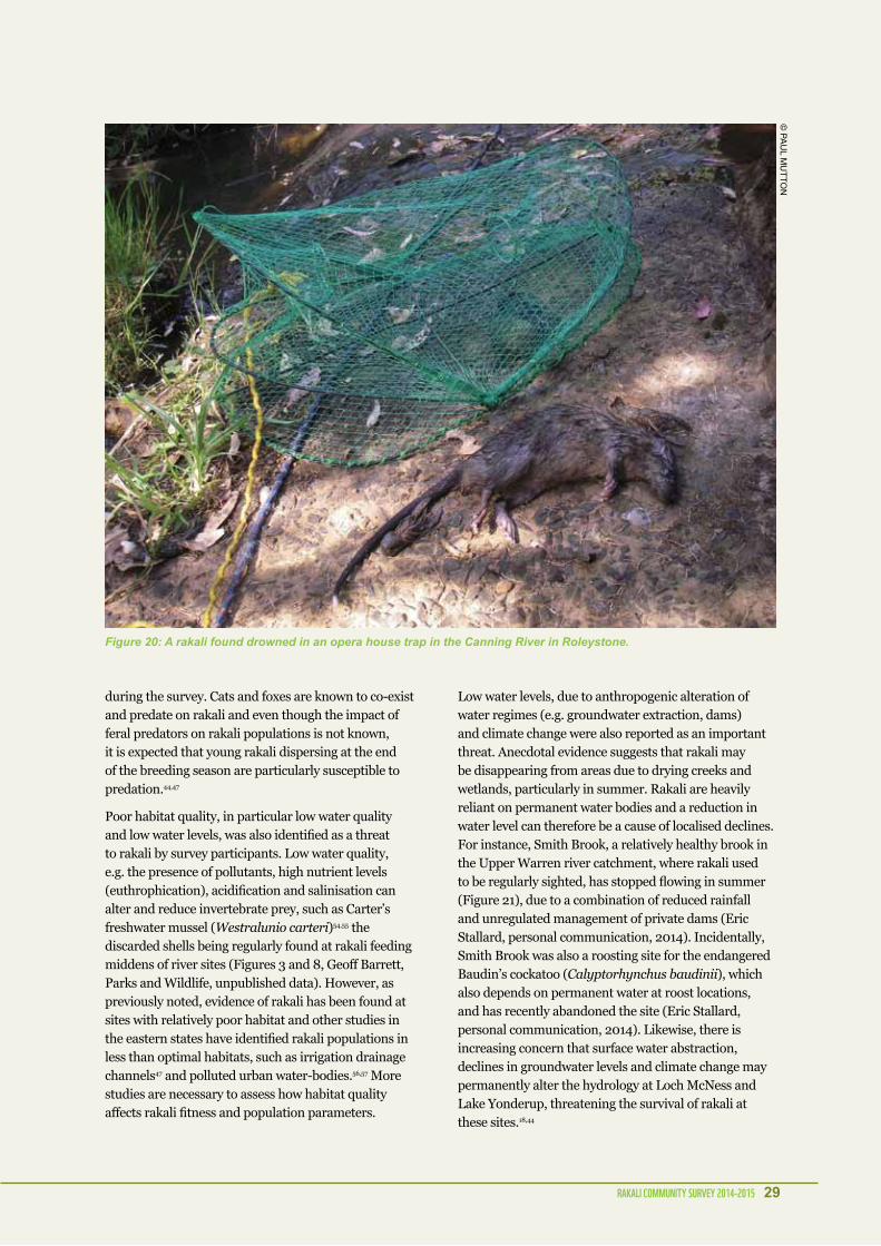
4.6 Rakali moRtality anD peRCeiveD tHReatS
The main reported cause of mortality was drowning in marron traps (n=13), followed by vehicle strike (n=6), unknown cause of mortality (n=5), drowning in half filled pools/ponds (n=3), predation (n=2) and suspected poisoning with rodenticide (n=1) (Figure 16). On the other hand, survey participants listed predation by cats and foxes as the main perceived threat (n=53), followed by fishing gear/trap related mortality (n=29) (Figure 17). Habitat degradation (i.e. low water quality and levels, changes to the vegetation and litter/rubbish) was also considered a major threat to rakali, accounting for 25% (n=37) of the reported perceived threats when combined. The majority of sites with marron trap related mortality and/or with marron traps reported (n=29) were located in the Swan, South-West and Warren regions (Figure 18). The Capel, Canning and Warren River were the only waterways with more than one marron trap reported (Table 5).
Figure 16: Causes of mortality reported during the Rakali Community Survey (n=30).
Figure 17: Perceived threats to rakali as reported by Rakali Community Survey participants (n=147).
43%
20%
unknown
predation
marron traps
other
vehicle strikedrowned
17%
10% 7% 3%
�shing gear/trapslow water levels no obvious threats
water quality
vehicle strike
predation
changes to vegetation other litter
7%7%
8%
6% 4%3%
9%
7%
36%
20%

Rakali Community SuRvey 2014-2015 23
0
1
2
3
4
5
6
7
8
9
10
South Coastregion
South-Westregion
Swan region Warren region
dead rakali in traps
marron traps found
Figure 18: Number of rakali found dead in marron traps and number of marron traps found in Parks and Wildlife regions and reported during the Rakali Community Survey.
table 5: location, year and number of marron traps reported during the Rakali Community Survey. DPaW Region Site name 1960-89 1990-99 2000-09 2010-15 Total
swan region canning river 1 3 4Hedges gold mine Dam 1 1loch mcness 1 1murray river 1 1southern river 1 1White gum gully creek 1 1
Warren region Big Brook Dam 1 1cowramup Dam 1 1Dam near cantebury river 1 1lefroy Brook 1 1Warren river 2 2Private dam-northcliffe 1 1Private dam-manjimup 1 1
south West region capel river 3 3capel Wetlands 1 1collie river 1 1glen mervyn Dam 1 1margaret river 1 1Blackwood river 1 1Private dam-Kirup 1 1
south coast region scotsdale Brook 1 1steere river 1 1Peaceful Bay wetland 1 1
Grand Total 3 2 4 20 29

24 Rakali Community SuRvey 2014-2015
4.7 tHe Rakali WalkSigns of rakali presence were found in 20 of the 49 transect surveys (41%) and 11 of those were classified as sites of ‘high activity’ (i.e. continuous presence of feeding middens and/or tracks) (Figure 19, Table 6). At some of the sites classified as ‘low activity’ (i.e. Canning River, Helena River, Folly Reserve), the feeding middens were not only scarce, but also appeared to be old. At three sites with low activity (Canning River, Folly Reserve, Loch McNess) and three sites with no evidence of activity (i.e. Lake Goolelall, Walpole-Nornalup Inlet, Swan River), the presence of rakali at the site were confirmed by recent studies18,32,44 or thanks to verified sightings obtained during the Rakali Community Survey (Table 6).
table 6: number of surveyed transects along sites, number of surveyed transects with evidence of rakali presence (feeding middens and tracks) and how many of those were classified as ‘high activity’ (i.e. continuous evidence of rakali). For some of the sites the presence of rakali was confirmed by live trapping, camera trapping, dead rakali or clear tracks between 2010 and 2015 (‘confirmed’). Site DPaW region Number of
transectsFeeding middens
Tracks High activity
Confirmed
serpentine river swan region 2 1 0 1 yesPeel-Harvey estuary swan region 1 1 1 1 yesmurray river swan region 1 1 1 1 yesfolly reserve swan region 1 1 0 0 yescanning river swan region 7 1 0 0 yesmoore river swan region 4 2 0 0 noloch mcness swan region 1 1 0 0 yeslake yonderup swan region 1 1 0 1 yesHelena river swan region 8 2 0 1 noswan river swan region 1 0 0 0 yesmcKnoe Brook swan region 1 0 0 0 nolake leschenaultia swan region 1 0 0 0 nolake goolelall swan region 1 0 0 0 yesPaganoni lake reserve swan region 3 0 0 0 noTreen Brook Warren region 1 0 0 0 nolefroy Brook Warren region 4 4 1 3 yesupper Warren river Warren region 1 1 0 0 noWalpole-nornalup inlet Warren region 3 2 2 2 yessmith Brook Warren region 1 0 0 0 noDonnelly river Warren region 1 0 0 0 nomargaret river south West
region4 2 0 1 yes
Grand Total 48 20 5 11

Rakali Community SuRvey 2014-2015 25
Figure 19: Distribution of rakali transects surveyed between January and July 2015. Transects are colour coded in relation to the presence and absence of feeding middens and rakali foot-prints and the level of activity (continuous presence is marked as ‘high activity’, while a low number of feeding middens is marked as ‘low activity’).

26 Rakali Community SuRvey 2014-2015
5.1 Community engagementWith 234 sightings received from a total of 167 volunteers, and 90 volunteers involved in the Rakali Walk surveys, this survey successfully collected sightings of rakali over a wide geographic range.
Unlike the quenda, which during the 2012 Community Quenda Survey was found to be already well-known by the general Perth community,40 rakali were less commonly recognised by people who did not have a biological sciences background. The majority of confirmed and possible misidentifications occurred in the Perth Metropolitan Region, probably because rakali in residential areas co-exist with introduced rat species and/or possibly because people living in urban areas may be less familiar with this cryptic native species. However, most of the sightings received were categorised as confirmed or probable rakali sightings.
The extensive media coverage (Appendix 2) received by the survey has certainly contributed to the aim of engaging and educating the community about Australian rodents, improving the general knowledge and recognition of the rakali. In fact, the follow-up questionnaire sent to the participants in August 2015 (Appendix 7), showed that close to 50% of all respondents improved their knowledge of rakali since the Rakali Community Survey and another 28% felt that their knowledge was slightly improved.
5.2 DiStRiBution The 2014 Rakali Community Survey data confirmed our understanding of rakali distribution in Southwest Western Australia. With the possible exception of a single northern sighting in Dongara, just south of Geraldton, all the recent 2014 sightings overlap with the known distribution of rakali. The majority of sightings were near the coast or on the Swan Coastal Plain, while there were only two recent sightings in the Wheatbelt Region, which is consistent with the reported localised declines and extinctions within this region. The most northerly sighting, in Dongara, was very interesting; to our knowledge, there have not been any recent records of rakali in the mainland of the Midwest Region. The sighting could not be confirmed with a photo, but the description was very accurate. A follow-up survey at suitable sites in the region to verify the presence of rakali at this northern site would be desirable.
In general, the Parks and Wildlife regions that reported more rakali sightings are also those with higher human population densities and important tourism areas (Swan Region and South Coast Region) or very engaged and committed communities that regularly surveyed local wetlands for the Rakali Community Survey (e.g. Walpole in the Warren Region). Due to the opportunistic nature of this survey, it is not possible to quantify survey effort. Consequently, the lack of sightings in some (less populated and accessible) sites may not necessarily reflect smaller or absent rakali populations.
5. DiSCuSSion

Rakali Community SuRvey 2014-2015 27
5.3 CompaRiSon WitH HiStoRiC ReCoRDS
It would appear that more recent sightings from the Rakali Community Survey were less abundant along the eastern and northern part of the rakali range, compared with the NatureMap data (Figure 15). This is consistent with other observations of Western Australian fauna distributions contracting to the south-west corner of the state, partly in response to a drying climate.45,46 There are a large number of historical sightings (n=22) around the Helena River and its tributaries, but none since the 1960s, which was surprising considering that a large part of the Helena River passes through remnant native vegetation and state forest, which should be indicative of good quality habitat. Access to the bank of the Helena River and tributaries is limited in Beelu National Park and it is possible that this could have also contributed to the lack of sightings from the community.
The Helena River and Piesse Gully to the north east of Perth, were targeted for additional rakali walk surveys to verify whether the absence of rakali could be confirmed. While high levels of activity were detected in Guildford, where the Helena River meets the Swan River, only one possible midden was found in the Helena River and Piesse Gully areas (reported near Pipehead Dam). The flow of the Helena River has been reduced by two dams: the Mundaring Dam that was constructed in the 1890s and the lower Pipehead Dam in the Shire of Kalamunda built in the 1970s. The reduction in flow and water levels upstream from the dams in association with habitat degradation in the residential areas, may have contributed to a reduction in rakali numbers north-east of Perth. Further surveys during winter (and increased water levels) and with other techniques, such as camera trapping, could help confirm this possible range reduction or local extinction.
Anecdotal accounts from some of the older survey participants indicate that in the past, rakali used to be much more well-known and common in the Perth Metropolitan Region. These observers were often very confident in their sighting and species identification, as they ‘used to see water rats all the time as children’. This anecdotal evidence of rakali being common in the metropolitan area in the past is further supported by the fact that the majority of historical sightings from the NatureMap database are in the Perth Metropolitan Region (Figure 15).
5.4 HaBitatThe identified habitat preference of estuaries and rivers and river pools, is associated with an increased number of reported sightings within the Swan Canning and Peel-Harvey catchments. The estuaries and rivers at these sites are highly populated and, as previously mentioned, the increased number of sightings may be associated with a higher number of opportunistic observers. However, the low number of sightings from wetland habitats, such as lakes and swamps, is probably a reflection of the degradation and fragmentation of wetlands in the Perth Metropolitan Region.18,32,33,44
This study suggests that rakali find slow flowing rivers (slower than walking speed), with deep pools, preferable to shallow, faster flowing rivers. Slow flowing rivers may facilitate foraging behaviour, but slow water flow may also facilitate the sighting of rakali. Most literature has described the importance of permanent water to rakali33,47 and deeper pools are often indicative of permanent waterways and provide refuge in the hot summer months.
The majority of the sightings were within remnant vegetation cover or within 50 m from vegetation cover. This is consistent with findings from other studies that reported that rakali prefer habitat with high vegetation density, in particular low-lying, dense vegetation, as this habitat provides shelter and protection from predators, as well as higher concentration of prey such as frogs and insects.32,47,48
Consistent with Smart et al.,32 river sites with steep banks were found to be associated with increased rakali activity. The majority of the surveys were done during the breeding season (i.e. September-March)14 and as such, steep river banks, that allow rakali to build their nests, are likely an important characteristic of a feeding site/territory. Our analysis also indicated that rakali activity was greater at sites with more woody debris in the waterway, a feature associated with vegetated waterways rather than poor quality habitat.

28 Rakali Community SuRvey 2014-2015
5.5 Rakali aS inDiCatoRS oF HealtHy WateRWayS
Rakali have been suggested as being potential bio-indicators of wetland health on the Swan Coastal Plain, due to their association with better quality wetland habitat 32. The Rakali Community Survey did find evidence of rakali being present in some highly modified landscapes in the Swan Canning and the Peel-Harvey Catchments, that have experienced intense pressures due to clearing for agriculture and urban development, increased nutrient load and changes in hydrology 49, 50. Additionally, the preliminary assessment conducted on riverine habitats during the Rakali Walks did not show any correlation between river habitat quality and presence of rakali, but a larger sample size and a more in depth study, looking at other habitat characteristics, including water quality, is necessary to fully understand any association. It should be noted, that while landscapes, river and wetland systems may be degraded, localised sites can still retain sufficient habitat to support rakali populations, as long as sufficient water depth, flows and water quality is maintained.
The association between habitat quality and the presence of rakali, identified by Smart et al.,32 could be due to their study focussing mostly on lake and swamp habitats in the Perth Swan Coastal Plain, which are under an enormous amount of pressure due to increasing urban development. Not only have ~70-80% of the wetlands been destroyed since European settlement, but the remaining wetlands have also been significantly altered18,27,49. Fragmentation of the remaining native vegetation and residential development on the Swan floodplain has resulted in a loss of connectivity between the wetlands, the floodplains and rivers.49 This may have made rakali more susceptible to habitat pressures in wetlands than in rivers, where rakali can more easily move along major rivers and tributaries to access more suitable habitat (e.g. in response to changes in hydrology or prey availability). The increased vulnerability of rakali populations surviving in isolated wetlands in Southwest Western Australia may have, consequently, resulted in a reduction in numbers or disappearance of rakali at these threatened habitats and resulted in a lower number of sightings at these sites.
5.6 moRtality anD peRCeiveD tHReatS
Of the 30 reports of rakali mortality the most commonly reported cause was drowning in marron traps followed by vehicle strike. These traps were also the second most commonly reported perceived threat by survey participants (21% of all reported threats, Table 5). However, it should be noted that both of these causes are more likely to be detected by members of the public than, for example, predation or poisoning, as carcasses are more visible and easily identified along a road or in a trap. In an experimental study a search crew could only find 12% of waterfowl carcasses placed in visible positions and none of the carcasses placed in low visibility positions.51 Animals killed and partially eaten by predators can be very difficult to identify without specific training. Also, animals that die from poisoning or diseases will often hide and be more difficult to detect. Similarly, the more common causes of admission at wildlife rescue centres are of anthropogenic origin, while infectious diseases and poisoning can be underrepresented.52,53 In fact, only one case of suspected poisoning was reported during the Rakali Community Survey. However, rakali may also not be attracted to typical rodent wax-based baits (Karen Bettink, UWA, personal communication, 2015).
With regard to marron traps, it is reasonable to assume that many people using them illegally would be unlikely to report the death of a native animal and in fact, the majority of reports of this nature were made by members of the public accidentally finding the trap (Figure 20). The large proportion of reported deaths by drowning in opera house traps is particularly concerning because of the expected under-reporting. Besides, marron traps have been previously identified as an important threat to rakali populations.20
We also received two reports of rakali being regularly observed (in 2006 and 2013) at two commercial marron farms located in the South-West and Warren Regions. These sightings were not reported by the marron farmers, but by community members visiting the farms. In both instances, survey participants mentioned that rakali were considered a pest by the marron farmers. Anecdotal evidence suggests that rakali may be trapped at some farms (Keith Morris and Geoff Barrett, DPaW, personal communication, 2015).
For the survey participants, the main perceived threat to the rakali was predation by cats and foxes (36%), although only two cases of predation were reported
Rakali Community SuRvey 2014-2015 29
during the survey. Cats and foxes are known to co-exist and predate on rakali and even though the impact of feral predators on rakali populations is not known, it is expected that young rakali dispersing at the end of the breeding season are particularly susceptible to predation.44,47
Poor habitat quality, in particular low water quality and low water levels, was also identified as a threat to rakali by survey participants. Low water quality, e.g. the presence of pollutants, high nutrient levels (euthrophication), acidification and salinisation can alter and reduce invertebrate prey, such as Carter’s freshwater mussel (Westralunio carteri)54,55 the discarded shells being regularly found at rakali feeding middens of river sites (Figures 3 and 8, Geoff Barrett, Parks and Wildlife, unpublished data). However, as previously noted, evidence of rakali has been found at sites with relatively poor habitat and other studies in the eastern states have identified rakali populations in less than optimal habitats, such as irrigation drainage channels47 and polluted urban water-bodies.56,57 More studies are necessary to assess how habitat quality affects rakali fitness and population parameters.
Low water levels, due to anthropogenic alteration of water regimes (e.g. groundwater extraction, dams) and climate change were also reported as an important threat. Anecdotal evidence suggests that rakali may be disappearing from areas due to drying creeks and wetlands, particularly in summer. Rakali are heavily reliant on permanent water bodies and a reduction in water level can therefore be a cause of localised declines. For instance, Smith Brook, a relatively healthy brook in the Upper Warren river catchment, where rakali used to be regularly sighted, has stopped flowing in summer (Figure 21), due to a combination of reduced rainfall and unregulated management of private dams (Eric Stallard, personal communication, 2014). Incidentally, Smith Brook was also a roosting site for the endangered Baudin’s cockatoo (Calyptorhynchus baudinii), which also depends on permanent water at roost locations, and has recently abandoned the site (Eric Stallard, personal communication, 2014). Likewise, there is increasing concern that surface water abstraction, declines in groundwater levels and climate change may permanently alter the hydrology at Loch McNess and Lake Yonderup, threatening the survival of rakali at these sites.18,44
Figure 20: A rakali found drowned in an opera house trap in the Canning River in Roleystone.
© Pa
ul m
uTTO
n

30 Rakali Community SuRvey 2014-2015
Figure 21: The Smith Brook in summer 2014-2015.
© e
ric
sTa
llar
D

Rakali Community SuRvey 2014-2015 31
5.7 tHe Rakali Walk – a Simple metHoDology to SuRvey Rakali
Due to the cryptic nature of the rakali, direct observations are rare and live trapping had only limited success as a technique to survey this species.12,32 Rakali are suspicious of traps, and it is therefore necessary to develop alternative techniques for monitoring populations. The use of remote cameras has been successfully employed to survey and monitor rakali,12,44 while other methods are yet to be trialled, e.g. environmental DNA.58 In this study, we utilised a survey technique to monitor rakali presence through the observation of feeding middens and tracks. We found this to be a simple way to monitor presence and activity levels at most locations. Passive survey techniques like this one can also be used to measure relative abundance when the same location is extensively surveyed.12
We found that although conducting surveys of rivers by kayak is possible, relying solely or largely on conducting the survey technique from the water may lead to a higher detection bias (i.e. feeding middens are not detected because of dense vegetation or survey conditions). Accessing sections of the surveyed transect on foot is necessary to detect feeding middens under low lying vegetation and to successfully identify tracks. Surveying of swamps and lakes has proven to be more challenging due to the difficulty of finding tracks and middens among dense vegetation. For example, a trapping survey of Lake Goollelal in 2008 found a high number of individuals (3 males, 3 females),18 but a subsequent survey has failed to find evidence of rakali.32 In the current project, surveys at Loch McNess and Lake Yonderup detected the presence of rakali, but detection of feeding middens was challenging, as most of the middens were located on islands and the use of waders was deemed necessary to properly survey the sites. Additionally, to facilitate the detection of fresh tracks and middens, surveys of estuaries and coastal beaches have to be planned during low tide and early morning.
An assessment of the detection sensitivity of the survey technique used was beyond the scope and timeframe of this study. However, as for all field survey techniques, it is critical to estimate the occurrence of false-negatives to establish the optimal sampling intensity (i.e. number of repeated visits and number of transects per location).59 Several studies have shown that failures to detect a species at occupied sites can lead to poorly formulated habitat models,59-62 which may tend to over-emphasise variables that are simply related to
the detection probability.59 In our study, we found a correlation between the presence of logs in the water and the presence of water rats. While rakali are known to use logs as a feeding platform and protection, feeding middens are also more easily detected on logs and the importance of this habitat variable may consequently be biased by the increased detection rate.
Substrate composition (that may or may not facilitate the detection of tracks, i.e. muddy soil versus wet sandy soil), rainfall in the days prior to the survey, type of vegetation, abundance and diet of rakali at the monitored sites may all impact in different ways on the probability that evidence of rakali will be detected. Spatial and temporal re-sampling may overcome the problem of false-negatives allowing an estimate of the detection probability and the implementation of a rigorous occupancy modelling approach.59,60 The results of remote camera repeat surveys12, 44 (and Wilson et al. unpublished data) could also help assessing the detection probability at various sites. Overall, the Rakali Walk has proven to be an easy and fast survey technique to facilitate the monitoring of this cryptic species.
© K
ar
en
Be
TTinK

32 Rakali Community SuRvey 2014-2015
6.1 FutuRe Rakali Community SuRveyS
In this study a large number of participants were readily engaged, providing simple presence data via a good media campaign. In future rakali surveys, the direct engagement and training of community groups and clubs may enable the collection of more detailed and complex data. Fishing and bushwalking were among the most common activities undertaken by opportunistic rakali observers and therefore fishing and bushwalking clubs have been identified as an ideal audience for any future targeted Rakali Community Surveys. Local environmental groups actively engaged in the management of specific wetlands and waterways also proved to be an enthusiastic and knowledgeable community during the Rakali Walks.
The Rakali Walk transect surveys were effective in detecting levels of rakali activity, particularly along rivers, however, we recommend that this and similar techniques are only implemented where there is sufficient time for face-to-face training of interested community groups and individuals. Commitment of volunteers to carry out rakali walks for several seasons is recommended to assess variation in rakali presence over the year and allow for a sufficient number of surveys to minimise the effect of detection bias. Finally, for a cryptic species that is distributed over a wide geographic range, including remote and less accessible areas, more standardised survey protocols are preferred to opportunistic surveys, so that biases such as observer density and site accessibility can be avoided (i.e. sampling bias). Such standardised survey protocols will then more easily allow estimating population trends while accounting for detection differences.37
6.2 ReSeaRCH anD managementThere is much that is still unknown about the biology and ecology of the rakali and further monitoring and research on this cryptic native species should be prioritised to gain a better understanding of the current conservation status of rakali. Several threats to rakali in Western Australia have been identified in this study, and anecdotal accounts from survey participants indicate that rakali are seen as pests by some groups, e.g. marron farmers and recreational marron fishers. Recommendations for future research and species management are provided here to aid the persistence and protection of this species.
Research priorities• Estimate detection bias of the Rakali Walk method
at different sites and compare it with other survey methods (e.g. camera and live trapping). Identify optimal survey methodologies and combination of different survey methodologies for different habitats.
• Monitor rakali abundance and behaviour at different sites with variable habitat quality to identify the effects of habitat degradation on rakali population size, fitness and movements.
• Identify how changes in hydrology due to water extraction and/or drying climate affect rakali populations (i.e. abundance, fitness, behaviour) and their prey.
• Monitor the effect of introduced predators on rakali abundance and distribution
• Survey for rakali in Dongara and the Wheatbelt to confirm the presence at the sites with a low number of sightings, taking into account factors that may affect the range of the species (e.g. seasonal differences in water levels).
• In combination with ecological data, use population genetics to assess and identify past population declines and movement.63-65
• At sites with difficult access or that are challenging to survey, environmental DNA (e.g. water samples)58 or alternative non-invasive sampling (e.g. stool, feeding middens)66 may be utilised as a first screening tool and to confirm rakali presence. Environmental DNA screening was recently utilised in a citizen science monitoring programme for freshwater species.67
6. ReCommenDationS

Rakali Community SuRvey 2014-2015 33
management priorities• Protect healthy waterways and wetlands and
prioritise habitat restoration at degraded sites where rakali are still present.
• Increase summer flows to southern Western Australian rivers to support rakali and other freshwater fauna populations by improving regulation of surface water extraction.
• Increase predator control at high priority sites.
• Raise awareness about rakali and the risks associated with the use of box or opera-house crayfish traps at popular marron fishing sites, e.g. through educational signs in key locations and/or e-mail bulletins to marron fishers during the licencing period.
• Increase monitoring and policing of the illegal use of traps in public and private waterways.
• Encourage retailers not to sell box and opera house traps or phase them out in favour of traps with an escape hatch developed by The Australian Platypus Conservancy68 (Figure 22).
• While traditional traps without an escape hatch are still commercially available, encourage retailers to put warning signs that educate buyers on the risks of by-catch and the potential for high fines (up to $5,000).19
• Educate marron fishers and farmers about rakali and test non-lethal deterrents for rakali, such as ultrasound and fences, at sites where rakali can enter in conflict with the community and businesses (e.g. marron farms, private properties).
Figure 22: Opera house crayfish trap with an escape hatch designed and developed by the Australian Platypus Conservancy.68
© a
us
Tra
lian
PlaTy
Pu
s c
On
se
rva
nc
y

34 Rakali Community SuRvey 2014-2015
1. Olsen PD. Water-rat, Hydromys chrysogaster. In: Van Dyck S and Strahan R, (eds.). The mammals of Australia. New Holland Pub Pty Limited, 2008, p. 662-4.
2. Woinarski J, Burbidge A and Harrison P. The Action Plan for Australian Mammals 2012. Melbourne: CSIRO Publishing, 2014.
3. Van Dyck S and Strahan R. The mammals of Australia. New Holland Pub Pty Limited, 2008.
4. Morris K. The status and conservation of native rodents in Western Australia. Wildlife Research. 2000; 27: 405-19.
5. Claridge AW. Ecological role of hypogeous ectomycorrhizal fungi in Australian forests and woodlands. Diversity and Integration in Mycorrhizas. Springer, 2002, p. 291-305.
6. Brown JH, Reichman O and Davidson DW. Granivory in desert ecosystems. Annual Review of Ecology and Systematics. 1979: 201-27.
7. CSIRO. Rodents in Australia. CSIRO Sustainable Ecosystems. 2015.
8. Ceballos G and Brown JH. Global patterns of mammalian diversity, endemism, and endangerment. Conservation Biology. 1995: 559-68.
9. Lee AK. The action plan for Australian rodents. Canberra: Australian Nature Conservation Agency, Endangered Species Program, 1995.
10. Department of Parks and Wildlife. Threatened and priority fauna rankings list. In: Department of Parks and Wildlife, (ed.). 2015, p. 1-23.
11. Atlas of Living Australia. Hydromys chrysogatser, Occurance records map. In: Australia NRIf, (ed.). http://bie.ala.org.au/species/Hydromys+chrysogaster#2015.
12. Bettink KA. Shedding light on rakali: Genetic and morphological differentiation in Hydromys chrysogaster, ecology within Barrow Island and Implications for its conservation status. School of Animal Biology. Perth: The University of Western Australia, submitted.
13. Australian Platypus Conservancy. The Australian Water-rat- Australia’s ‘otter’. 2015.
14. Olsen PD. Reproductive biology and development of the water rat, Hydromys chrysogaster, in captivity. Wildlife Research. 1982; 9: 39-53.
15. Aplin K, Copley P, Robinson T, et al. Hydromys chrysogaster. The IUCN Red List of Threatened Species. Version 2015.2, 2008.
16. Atkinson CA, Lund MA and Morris KD. BiblioRakali: the Australian water rat, Hydromys chrysogaster Geoffroy, 1804 (Muridae: Hydromyinae), a subject-specific bibliography. Conservation Science Western Australia. 2008; 7: 65-71.
17. Burbidge AA and McKenzie N. Patterns in the modern decline of Western Australia’s vertebrate fauna: causes and conservation implications. Biological Conservation. 1989; 50: 143-98.
18. Wilson BA, Valentine LE, Reaveley A, Isaac J and Wolfe KM. Terrestrial mammals of the Gnangara Groundwater System, Western Australia: history, status, and the possible impacts of a drying climate. Australian Mammalogy. 2012; 34: 202-16.
19. Western Australian Department Of Fisheries. Recreational fishing for marron guide 2015. In: Department Of Fisheries, (ed.). 2015, p. 1-6.
20. Bettink K. Opera house traps threaten rakali. Bushland News. 2012; 83: 10.
21. McLellan R, Iyengar L, Jeffries B and Oerlemans N. Living planet report 2014: species and spaces, people and places. WWF International, 2014.
22. Vörösmarty CJ, McIntyre P, Gessner MO, et al. Global threats to human water security and river biodiversity. Nature. 2010; 467: 555-61.
23. Sweeney BW and Newbold JD. Streamside forest buffer width needed to protect stream water quality, habitat, and organisms: a literature review. JAWRA Journal of the American Water Resources Association. 2014; 50: 560-84.
24. Hansen BD, Reich P, Cavagnaro TR and Lake P. Challenges in applying scientific evidence to width recommendations for riparian management in agricultural Australia. Ecological Management & Restoration. 2015; 16: 50-7.
25. Halse S, Scanlon M, Cocking J, Smith M and Kay W. Factors affecting river health and its assessment over broad geographic ranges: the Western Australian experience. Environmental monitoring and assessment. 2007; 134: 161-75.
26. Bates B, Hope P, Ryan B, Smith I and Charles S. Key findings from the Indian Ocean Climate Initiative and their impact on policy development in Australia. Climatic Change. 2008; 89: 339-54.
27. Balla SA, Davis JA and Australia W. Wetlands of the Swan Coastal Plain Volume 5: Managing Perth’s Wetlands to Conserve the Aquatic Fauna. Perth: Education Department of Western Australia, 1993.
28. Davis J and Froend R. Loss and degradation of wetlands in southwestern Australia: underlying causes, consequences and solutions. Wetlands Ecology and Management. 1999; 7: 13-23.
29. Vogwill RIJ, Mchugh SL, O’Boy CA and Yu X. PRAMS scenario modelling for water management of the Gnangara Groundwater Mound, HG 21. In: Water Do, (ed.). Perth2008.
30. Yesertener C. Assessment of the declining groundwater levels in the Gnangara groundwater mound, Western Australia. In: Department of Water, (ed.). Perth2007.
31. Preston BL and Jones RN. Climate change impacts on Australia and the benefits of early action to reduce global greenhouse gas emissions. CSIRO Australia, 2006.
32. Smart C, Speldewinde P and Mills H. Influence of habitat characteristics on the distribution of the water-rat (Hydromys chrysogaster) in the greater Perth region, Western Australia. Journal of the Royal Society of Western Australia. 2011; 94: 533-9.
33. Valentine LE, Wilson BA, Reaveley A, Huang N, Johnson B and Brown P. Patterns of ground-dwelling vertebrate biodiversity in the Gnangara Sustainability Strategy study area. Report prepared by Department of Environment and Conservation for the Gnangara Sustainability Strategy, Perth. 2009.
34. Mayer A. Phenology and Citizen Science BioScience. 2010; 60: 172-5.
35. Cooper CB, Dickinson J, Phillips T and Bonney R. Citizen science as a tool for conservation in residential ecosystems. Ecology and Society. 2007; 12: 11.
36. Theobald EJ, Ettinger AK, Burgess HK, et al. Global change and local solutions: Tapping the unrealized potential of citizen science for biodiversity research. Biological Conservation. 2015; 181: 236-44.
37. Dickinson JL, Zuckerberg B and Bonter DN. Citizen science as an ecological research tool: challenges and benefits. Annual review of ecology, evolution, and systematics. 2010; 41: 149-72.
ReFeRenCeS

Rakali Community SuRvey 2014-2015 35
38. Dickinson JL, Shirk J, Bonter D, et al. The current state of citizen science as a tool for ecological research and public engagement. Frontiers in Ecology and the Environment. 2012; 10: 291-7.
39. Abbott I and Le Maitre D. Monitoring the impact of climate change on biodiversity: The challenge of megadiverse Mediterranean climate ecosystems. Austral Ecology. 2010: 406-22.
40. Howard KH, Barrett G, Ramalho CE, et al. Community Quenda Survey 2012. In: Australia W, (ed.). Perth, Western Australia: WWF-Australia and the Department of Parks and Wildlife, 2014.
41. Finn H, Barrett G, Groom C, Blythman M and Williams M. The 2014 Great Cocky Count: a community-based survey for Carnaby’s Black-Cockatoos (Calyptorhynchus latirostris) and Forest Red-tailed Black-Cockatoos (Calyptorhynchus banksii naso). Floreat, Westaren Australia: BirdLife Australia Western Australian Branch, 2014.
42. Barrett G, Silcocks AF, Cunningham R, Oliver DL, Weston MA and Baker J. Comparison of atlas data to determine the conservation status of bird species in New South Wales, with an emphasis on woodland-dependent species. Australian Zoologist. 2007; 34: 37-77.
43. Water and Rivers Commission. Planning & Management: Foreshore Condition Assessment in Farming Areas of South-west Western Australia. Water and Rivers Commission Restoration Report. Water and Rivers Commission, 1999.
44. McIlduff C, Koeller K, Wilson B and Bleby K. Use of Remote Cameras to Survey and Monitor Mammal Fauna Occurrence at Loch McNess and Lake Yonderup, Yanchep National Park, Perth, Western Australia (2011-2013). Report for Department of Parks and Wildlife. Perth, Western Australia 2014.
45. Gibson L, McNeill A, de Tores P, Wayne AF and Yates C. Will future climate change threaten a range restricted endemic species, the quokka (Setonix brachyurus), in south west Australia? Biological Conservation. 2010; 143: 2453-61.
46. Barron O, Silberstein V, Ali R, et al. Climate change effects on water-dependent ecosystems in south-western Australia. Journal of Hydrology 2012; 434: 95-109.
47. Scott AC and Grant T. Impacts of water management in the Murray-Darling Basin on the platypus (Ornithorhynchus anatinus) and the water rat (Hydromys chrysogaster). Canberra: CSIRO Land and Water 1997.
48. Speldewinde PC, Close P, Weybury M and Comer S. Habitat preference of the Australian water rat (Hydromys chrysogaster) in a coastal wetland and stream, Two Peoples Bay, south-western Australia. Australian Mammalogy. 2013; 35: 188-94.
49. Environmental Protection Authority. State of the Environment Report: Western Australia 2007-Inland waters. Perth: Department of Environment and Conservation, 2007.
50. Environmental Protection Authority. Water Quality Improvement Plan for the Rivers and Estuary of the Peel-Harvey System - Phophorus Management. Perth, Western Australia: Environmental Protection Authority, 2008.
51. Stutzenbacher CD, Brown K and Lobpries D. Special report: an assessment of the accuracy documenting waterfowl die‐off in a Texas coastal marsh. In: Feierabend JS and Russell AB, (eds.). Lead Poisoning in Wild Waterfowl. Washington: National Wildlife Federation, 1986.
52. Molina-López RA, Casal J and Darwich L. Causes of morbidity in wild raptor populations admitted at a wildlife rehabilitation centre in Spain from 1995-2007: a long term retrospective study. PloS one. 2011; 6: e24603.
53. Wendell MD, Sleeman JM and Kratz G. Retrospective study of morbidity and mortality of raptors admitted to Colorado State University Veterinary Teaching Hospital during 1995 to 1998. Journal of Wildlife Diseases. 2002; 38: 101-6.
54. Klunzinger MW, Beatty SJ, Morgan DL, Allen MG and Lymbery AJ. Ecology of aquatic fauna in the Serpentine River in response to land use practices & recommendations for improving freshwater ecosystem health. Report to Lowlands Conservation Association, Serpentine River Group and the Government of Western Australia. Murdoch University, Centre for Fish & Fisheries Research, 2011.
55. Morgan DL, Beatty SJ, Klunzinger MW, Allen MG and Burnham QF. A guide to Freshwater Fishes, Crayfishes & Mussels of South-Western Australia. Perth: South East Regional Centre for Urban Landcare (SERCUL) and and Murdoch University Freshwater Fish Group and Fish Health Unit, 2011.
56. Watts CH and Aslin HJ. The rodents of Australia. Angus & Robertson, 1981.
57. Greig P. Wild about Sydney Harbour. Sydney: Department of Environment and Conservation NSW, 2005.
58. Bohmann K, Evans A, Gilbert MTP, et al. Environmental DNA for wildlife biology and biodiversity monitoring. Trends in ecology & evolution. 2014; 29: 358-67.
59. Gu W and Swihart RK. Absent or undetected? Effects of non-detection of species occurrence on wildlife–habitat models. Biological Conservation. 2004; 116: 195-203.
60. Reid N, Lundy MG, Hayden B, et al. Detecting detectability: identifying and correcting bias in binary wildlife surveys demonstrates their potential impact on conservation assessments. European journal of wildlife research. 2013; 59: 869-79.
61. Royle JA, Nichols JD and Kéry M. Modelling occurrence and abundance of species when detection is imperfect. Oikos. 2005; 110: 353-9.
62. MacKenzie DI. What are the issues with presence-absence data for wildlife managers? Journal of Wildlife Management. 2005; 69: 849-60.
63. Frankham R, Ballou JD and Briscoe DA. Introduction to conservation genetics. Cambridge: Cambridge University Press, 2002.
64. Allendorf FW and Luikart G. Conservation and the genetics of populations. Mass: Blackwell, Malden, 2007.
65. Pacioni C, Hunt H, Allentoft ME, et al. Genetic diversity loss in a biodiversity hotspot: ancient DNA quantifies genetic decline and former connectivity in a critically endangered marsupial. Molecular Ecology. in press.
66. Piggott MP and Taylor AC. Remote collection of animal DNA and its applications in conservation management and understanding the population biology of rare and cryptic species. Wildlife Research. 2003; 30: 1-13.
67. Biggs J, Ewald N, Valentini A, et al. Using eDNA to develop a national citizen science-based monitoring programme for the great crested newt (Triturus cristatus). Biological Conservation. 2015; 183: 19-28.
68. Serena M, Grant TR and Williams GA. Reducing Platypus By-Catch in Yabby Traps: Research Findings and Recommendations. Australian Platypus Conservancy, 2014, p. 9.

36 Rakali Community SuRvey RepoRt40 RAKALI COMMUNITY SURVEY REPORT
APPENDIX 1: WWF MEDIA RELEASES TO PROMOTE THE RAKALI COMMUNITY SURVEY
WWF Australia wwf.org.au
WWF – World Wide Fund For Nature
Media Release MMonday
3 December 2014 date
Citizen science to shed light on Australia’s elusive water rat
It’s a platypus! No, it’s an otter! Hang on, it’s a mouse! It’s been mistaken for all of these things but the little-known rakali is Australia’s own native water rat - and it needs your help. WWF and the WA Department of Parks and Wildlife today launched a new citizen science project to gather information about this elusive dweller of rivers, lakes and sheltered ocean beaches. “Rakali are mysterious, shy creatures, so it can be difficult to study them,” said WWF spokesperson Dr Sabrina Trocini. “We’re asking anyone who has seen a rakali or found evidence of their presence to get in contact with us. We hope to get hundreds of extra pairs of eyes on the ground and the water to help us get a better understanding of where they live and what threats they face.” Unlike introduced black rats that are so destructive to native wildlife, rakali are native rodents that occur naturally in all Australian states and territories. Little is known of their current distribution in southern Western Australia except that their range has declined in the Wheatbelt. This is thought to be largely due to salinity and habitat degradation. Rakali live near permanent bodies of both salt and fresh water, including rivers, wetlands, dams and sheltered coastline areas, and their presence is considered an indicator of healthy waterways. They are larger than introduced rats, have partially webbed feet and can be easily distinguished by their broad, blunt nose and the white tip on their long, thick tails. Their water-repellent fur is dark grey to black on their backs, with a cream to golden coloured bellies. “If you’re out on the rivers, lakes or beaches this summer, please keep your eyes peeled for signs of rakali. They are sometimes seen during the day but are especially active around sunset,” Dr Trocini said. “Signs to look for include footprints or tail drag marks in mud or sand, or feeding ‘middens’, a dense scattering of shell pieces left behind after their meals of crabs, crayfish, aquatic insects or mussels. “By making a phone call or sending an email to register a rakali sighting, participants will make a substantial contribution to the scientific knowledge of this species, its distribution and its habitat.”
appenDix 1: WWF meDia ReleaSeS to pRomote tHe Rakali Community SuRvey

Rakali Community SuRvey RepoRt 37RAKALI COMMUNITY SURVEY REPOR 41
WWF Australia wwf.org.au
WWF – World Wide Fund For Nature
Media Release MMonday
30 January 2015 date
Take a Rakali Walk for World Wetlands Day
WWF-Australia is urging all Western Australians to celebrate World Wetlands Day on 2 February by visiting their favourite river, lake or wetland and looking for evidence of the elusive rakali or native Australian water rat. “Rakali are secretive and hard to see but their presence can often be detected by footprints or tail drag marks in mud or sand,” said WWF spokesperson Dr Sabrina Trocini. “The presence of feeding ‘middens’ can also be a good indicator of their presence. These are dense scatterings of shell pieces left behind after their meals of crabs, crayfish or mussels.” Little is known of the current distribution of rakali in southern Western Australia except that their range has declined in the Wheatbelt. This is thought to be largely due to salinity and habitat degradation. To help protect the species, WWF and the WA Department of Parks and Wildlife are asking Western Australians to take part in a citizen science project designed to gather important information about their range and abundance. All sighting reports will be included in the Rakali Community Survey, which was launched on 1 December 2014 and will run until 31 March 2015. Over one hundred rakali sighting reports have been received to date but more are needed. “People are surprised to learn that rakali are native water rats occurring naturally in all Australian states and territories, and that their presence is considered an indicator of healthy waterways,” said Parks and Wildlife ecologist Dr Geoff Barrett. Rakali are larger than introduced black rats, have partially webbed feet and can be distinguished by their broad, heavily whiskered noses and the white tip on their long, thick tails. Their water-repellent fur is dark grey to black on their backs, with paler bellies. “Doing a Rakali Walk is easy. Starting at a bridge, boatramp or other landmark, just walk a hundred metres or more along the water’s edge. If you see anything that looks like a rakali footprint or a feeding midden, take a photo and send it with the date and location to us at [email protected] or call us on 08 6231 0223,” Dr Trocini said. “If you don’t find anything, that’s important information too. So if you can get out and do a Rakali Walk please let us know, even if there was no sign of the species.” The Rakali Community Survey has been made possible thanks to a grant from Lotterywest. For more information: Charlie Stevens, Senior Communications Specialist, 0424 649 689

38 Rakali Community SuRvey RepoRt
print and online media • West Australian print and online (3/12/2014):
‘hunt on for shy native water rat’ by Daniel Mercer; https://au.news.yahoo.com/thewest/wa/a/25671732/hunt-on-for-native-water-rat/
• Collie Mail print and online(3/12/2014): ‘Collie residents urged to report water rat sightings’ by Josh Del Pino; http://www.colliemail.com.au/story/2740300/collie-residents-urged-to-report-water-rat-sightings/
• Press (12/3/2015) ‘Walk like a rakali for survey’
• Esperance Express-press(3/12/2014): ‘Search on for elusive water rat’ and online (4/12/2014): ‘Water rat survey underway in Esperance’ by Molly Baxter; http://www.esperanceexpress.com.au/story/2736463/water-rat-survey-underway-in-esperance/
• Manjimup Bridgetown Times-print (3/12/2014): ‘Search is on for water rats’
• print (4/2/2015): ‘Help needed for rat survey’
• Denmark Now print and online (18/12/2014): ‘Rakali report wanted’ by Patricia Gill; http://denmarknow.com.au/_blog/News/post/rakali-reports-wanted/
• Avon Valley Advocate- print and online (15/1/2015): Where are the water rats in Margaret River? By Zannia Yakas; http://www.avonadvocate.com.au/story/2819556/where-are-all-the-water-rats/?cs=12
• Augusta-Margaret River Mail print (21/1/2015), online (15/1/2015): ‘Where are the water rats in Margaret River?’ by Zannia Yakas http://www.margaretrivermail.com.au/story/2819556/where-are-all-the-water-rats/?src=rss and print (25/2/2015): ‘Rakali rambles’
• Mandurah Coastal Times-print (11/2/2015) ‘On the trail of water rats: sign up to aid WWF science project’
• Donnybrook-Bridgetown Mail-print and online (12/2/2015 )‘Community water rat survey launched’, by Lyn Willett; http://www.donnybrookmail.com.au/story/2878796/community-water-rat-survey/?cs=12
• Yahoo 7 News Online (5/2/2015), ‘Help needed for native rat survey’. https://au.news.yahoo.com/a/26206757/help-needed-for-rat-survey/
• Canning Examiner, print and online 11/2/2015 ‘Rat trackers help species’.
• Southern Gazette (Belmont) print (17/2/2015) ‘Survey on water rats’
• Canning times (17/2/2015) ‘Report sightings of water rats’ by Natalie Nazzari
• Walpole weekly print and online (4/2/2015) ‘Help shed light on Australia’s elusive water rat’ by Tim Gamblin http://walpole.org.au/wp-content/uploads/2015/02/February-4-2015.pdf
• Print and online (1/4/2015) ‘Evidence of rats signals good health’ by Tim Gamblin http://walpole.org.au/wp-content/uploads/2015/03/April-1-2015-Walpole-Weekly.pdf
Survey respondents also reported seeing survey related articles in other local newspapers, including:
• Mandurah Mail
• South Western Times
• Dunsborough Busselton Times
• Murray Mail
RaDio• ABC Midwest and Wheatbelt, Geraldton 2/12/2014
• ABC Goldfields WA (Kalgoorlie) 2/12/2014
• ABC Kimberley, Broome2/12/2014
• ABC Geraldton, ~15/2/2015
The Rakali Community Survey was promoted via articles and interviews in the following print and online media. The estimated audience number for the print media was 470,607. The survey was also extensively advertised on the WWF and the Department of Parks and Wildlife websites, Facebook and Twitter sites. Several organisations, groups and agencies also supported the survey by advertising the survey on their own webpages and social media sites.
appenDix 2: meDia CoveRage

Rakali Community SuRvey RepoRt 39
neWSletteRS• Bushland News, issue 92 (summer 2014-2015)
‘ Ever seen a rakali?’ by Sue Pedrick and Issue 93, Autumn 2015,’ Ever seen a moyitj?’ by Dale Tilbrook,
• Freshwater- Journal of the Western Australian Trout and Freshwater Angling Association (Spring 2014) ‘Rakali- Australian Water Rat Survey’ by Geoff Barrett and Katherine Howard
• Perth Region NRM newsletter (688 subscribers)
• Wheatbelt NRM newsletter (1150 subscribers)
• Rangeland NRM newsletter
• South West LINK newsletter of the South West Catchments Council (500 subscribers) 22/1/2015: WANTED: Rakali 6/2/2015 Rakali-Australian Water Rat
• The Greens WA Announce (28/1/2015)
• Greenpage - Newsletter of the Mundaring and Kalamunda Friends Groups and Eastern Hills Catchment groups (June/July 2015) ‘Animal of the month: Water rat, rakali (Hydromys chrysogaster)’
• Eco-Watch, Busselton-Dunsborough Environment Centre Inc (March 2015): Seen evidence of water rats (rakali)?
• Conservation Council of WA email bulletin
• Cape to Cape Catchments Group email bulletin to members; (~400 subscribers)
• Baigup NEWS-Baigup Wetland Interest Group Newsletter No. 9 (February 2015): Seen a Rakali or Native Water Rat?
• Swan Estuary Reserve Action Group Newsletter, Volume 6, Issue 1, March 2015: Native Fauna Survey for Alfred Cove
WeBpageS• Perth NRM December 2014: http://www.
perthregionnrm.com/pr-nrm-programs/biodiversity/biodiversity-stories.aspx
• Citizen Science Centre http://www.citizensciencecenter.com/the-mysterious-rakali/
• Murdoch University Veterinary and Life Sciences Announcements http://www.murdoch.edu.au/School-of-Veterinary-and-Life-Sciences/Staff-Announcements/019---11-December-2014/
• Canoeing WA http://wa.canoe.org.au/2014/12/17/wwf-australia-and-wa-dpaw-need-your-help/ https://www.oximity.com/article/Citizen-science-to-shed-light-on-Austr-1
• Cape to Cape Catchment group: Wanted! Rakali (Australian Water rat) sightings http://www.capetocape.org.au/wanted-rakali-australian-water-rat-sightings/
• Scistarter: Rakali community survey http://scistarter.com/project/1079-Rakali%20community%20survey?tab=participate
• In my community website- City of Joondalup (North Coast Times): Report water rat activities http://northcoast.inmycommunity.com.au/news/Detail/ArticleDetail.aspx?id=7669885
• Friends of Yellagonga Regional Park Inc webpage: Have you seen a rakali or water rat? http://www.yellagonga.org/clubhouse/latest-news-updates/284-have-you-seen-a-rakali-or-water-rat
• SERCUL: Wanted: Information on the Australian water rat or rakali in WA. http://www.sercul.org.au/
• Blackwood Basin group webpage: http://www.blackwoodbasingroup.com.au/listevents/water-rat-survey/
FaCeBook pageS• Australian Platypus Conservancy
• WA Naturalists’ Club
• Kanyana Wildlife Rescue Centre
• Australian Mammal Society
• Conservation medicine (Conmed) Murdoch University
• Conservation Council of WA
• Australasian Wildlife Disease Association
• Cape to Cape Catchments Group
• Shire of Murray
• Wheatbelt NRM

40 Rakali Community SuRvey RepoRt44 Rakali Community SuRvey RepoRt
Have you seen a water rat? Please let us know!
The Rakali or Australian water rat (Hydromys chrysogaster)
Rakali are native Australian rodents and one of the few amphibious mammals that have successfully adapted to a semi-aquatic and semi-nocturnal lifestyle.
Where are rakali found? Wetlands, rivers, estuaries and sheltered beaches.
Threats: Habitat loss and degradation, salinisation, historical trapping for the fur trade, accidental drowning in crab traps, cats and foxes.
white tip
Wide, flat head small ears and eyes
~ 30 cm
© Karen Bettink
© Karen Bettink
© Tim Gamblin
© S Scott, Australian Platypus Conservancy
The Rakali Community Survey WWF-Australia and the WA Department of Parks and Wildlife are conducting a community survey to learn more about the distribution, habitat requirements and status of the elusive water rat in Western Australia.
The survey will run until the 31st of March 2015.
Please let us know WHEN and WHERE you have seen rakali or any signs of their presence (tracks, scats or characteristic feeding middens, i.e. piles of inedible food, such as bones, crabs, crayfish and mussel shells ) or take a RAKALI WALK and look for evidence along your favourite river or lake.
For more information go to wwf.org.au/rakali or contact us : [email protected] 08 6231 0223
Acknowledgements: This project is supported by Lotterywest.
© Sabrina Trocini
Feeding midden
Appendix 3: poster for WetlAnd ConferenCe-2 februAry 2015
appenDix 3: poSteR pReSenteD at tHe 2015 Wa WetlanD management ConFeRenCe – 2 FeBRuaRy 2015

Rakali Community SuRvey RepoRt 41
1
SEEN A RAKALI OR WATER RAT?
Please let us know!
The Rakali Community Survey is collecting information on the Australian water rat or rakali (Hydromys chrysogaster) in southern Western Australia. Your sighting report will contribute to the scientific knowledge of this species and help inform river and wetland conservation.
Please email completed forms to [email protected] or post to WWF-Australia, PO Box 4010 Wembley WA 6913; Fax: 08 9387 6180 Phone: 0862310223
Rakali or Australian water rat
Rakali tracks
Feeding midden
Water rat feeding on a log
Food is eaten on a feeding platform near the water, e.g. flat rock, log or jetty. Meal remains consist of inedible items e.g. shells, crustacean carapaces
CONTACT DETAILS Name: Phone: Email: How did you hear about the Rakali Survey? Observer activity at the time of sighting (circle one): Fishing Kayaking Swimming Bushwalking Looking for rakali Other: SIGHTING LOCATION (if possible, attach a google map image showing exact location of the rakali sighting) Site name and location Please include name of water body; street address & suburb; and nearest road or other landmark (e.g. bridge, caravan park, jetty, boat ramp) and distance to that landmark:
GPS coordinates: Are you attaching a Google map image? Yes No SIGHTING DETAILS (if you have seen rakali more than once at the same site, describe here the best or most recent sighting) Sighting date (If exact date unknown, estimate e.g. Jan 2014) and time: What did you see? (circle all that apply) Live rakali Dead rakali Feeding midden Droppings Tracks What did the animal(s) look like? What was it doing? How many rakali were seen on this occasion? How often have you seen rakali at this site in the past year? (circle one) Once <5 times 5-10 times >10 times
How confident are you that you have identified the species correctly? Not confident Quite confident Very confident
© T
racy
Oliv
er
Wide, flat head; Small ears and eyes
Haired tail with white tip
©Ti
m G
ambl
in
Smaller front feet with 4 toes
Partially webbed hindfeet with 5 toes
c©Ti
m G
ambl
in
Gam
blin
T.Ga
mbl
in
©
S S
cott
-APC
Ga
mbl
inT.
Gam
blin
appenDix 4: Rakali Community SuRvey DataSHeet

42 Rakali Community SuRvey RepoRt
46 Rakali Community SuRvey RepoRt
2
Are you supplying photo(s) of the sighting? Yes No If yes, what did you photograph? (circle all that apply) Rakali Feeding midden Tracks Habitat HABITAT DETAILS What habitat type was the rakali seen in? (circle best option) River River pool Narrow creek/stream Lake Wetland/swamp Coastal Beach Man-made dam or reservoir Other: What was the adjoining land use? (circle all that apply): Bushland Parkland Recreational site Farmland Housing Industrial site Port Other:
How fast was the water flow? (circle one) Walking speed or faster Slower than walking speed No movement
If in the river, were there deep pools (>1m deep)? Yes No THREATS If the rakali you saw was dead, were there any injuries on the body? If dead, please identify most likely cause of mortality (circle one) Unknown Predation Vehicle strike Fishing gear/ traps Other: Have you seen any cage, box or opera house traps for fish or marron at this location? Yes No If so, when? What do you think might be the threat(s) to rakali AT THIS SITE? (circle all that apply to this site only) No obvious threats Predation (Cats? Foxes? Dogs? Other?) Fishing gear/marron traps Water pollution Litter /Rubbish Algal blooms Changes to waterside vegetation Vehicle strike Low water levels Other:
PLEASE SEND PHOTOS!
Please send photo(s) of the rakali (if you can)! Or of any evidence that suggests rakali presence at the site (feeding midden, tracks or droppings).
We also need to know about important habitat features for rakali. Please also take four photographs of the site, standing as close as possible to where you saw the rakali (or evidence of rakali):
One photo facing the water and opposite bank, capturing the water, the water’s edge and the vegetation on the bank
One photo facing the vegetation on the bank you are standing on (with your back towards the water) Two photos by turning 90 degrees to your left and right (i.e. upstream and downstream along the length of the
river, coastline or edge of the lake), including the water, the water’s edge and the vegetation on the bank.

Rakali Community SuRvey RepoRt 43
Rakali WalkaimThe aim of a Rakali Walk transect survey is to record any evidence (or lack of evidence) of rakali and to measure rakali activity at a given site.
methodTravel along river or edge of wetland for at least 100 metres (longer is fine!)
• Mode of travel can be by walking, kayaking, while fishing etc.
• Count the number of rakali feeding middens and/or sets of rakali footprints seen.
What to record1. Record the start point and finishpoint of your
Rakali Walk (or kayak etc.) transect. These can be GPS latitude/longitudes or Easting/Northings, Google Map references or a clear location description, such as ‘200m walk starting from bridge where Southwest Hwy crosses Serpentine River’.
2. Record the start time and finishtime
3. Record the number of rakali feeding middens along the transect. If the evidence of feeding is not in discrete piles or middens, but is more or less continuous, record where and over how many metres the feeding remains are found (e.g. ‘mussel shells found scattered over approx. 30 metres starting near the old bridge, no discrete piles’).
4. Record the number of sets of rakali footprints you saw along your transect.
5. At a point along the transect that is representative of the river or wetland being surveyed, take four habitat photos (see instructions on page 2).
Important! Ifyoudon’tfindanyfootprints,feeding remains or other evidence of rakali, this is still important information. Please still record all other survey information and let us know.
Submitting your Rakali Walk dataPlease send your Rakali Walk data (the 5 points listed above) to us via Email: [email protected] Fax: 08 9387 6180 Post: WWF-Australia, PO Box 4010, Wembley WA 6913
We wish to remind you that you are responsible for your own safety while conducting rakali surveys. Please travel in pairs, carry a mobile phone, water and first aid kit, and let someone know where you are going and when you will be back.
DefinitionsA feeding midden will usually present as a small pile or area of crushed or opened shells of crayfish or mussels. There may also be distinctive rakali droppings among the shells (see images on page 2).
Hint: Rakali often take their prey to one or more regular ‘feeding platforms’, usually on the river bank or in, or over, the water, for example, a log lying across the river, a jetty or a partially submerged rock (see images).
Rakali droppings are long and tube-shaped and contain mostly fibre. The droppings are often found in small piles on the feeding stations.
Rakali tracks: the front foot track shows the claw marks of the four long toes. The larger and partly webbed hind feet leave behind a distinctive track in soft sand or mud, however, in firm, wet sand only the 5 sharp claws will leave an imprint (see photos on page 2).
appenDix 5: Rakali Walk metHoDology

44 Rakali Community SuRvey RepoRt
Rakali FeeDing miDDenS anD tRaCkS
Left top: Right top: Left – middle: RRight – middle: Bottom left: Bottom right:
Rakali droppings. Rakali tracks.
Rakali tracks. Mussels at rakali feeding midden.
Feeding midden, with wristwatch for scale.
Feeding midden.
© Tim
ga
mB
lin©
Ka
re
n B
eTTin
K
© K
ar
en
Be
TTinK
© Tim
ga
mB
lin
© g
eO
ff Ba
rr
eTT / D
PaW
© g
eO
ff Ba
rr
eTT / D
PaW

Rakali Community SuRvey RepoRt 45
DPaW Region <1960 1960-89 1990-99 2000-09 2010-15 Total
Kimberley cambridge gulf 1 1Walcott inlet 1 1Wyndham 1 1
Midwest Dorre island 1 1Private dam-Dongara 1 1
south coast Denmark 1 1Denmark Beach 1 1Kalgan river 1 1King river 1 1lake seppings 2 2Phillips river 1 1scotsdale Brook 1 1steere river 1 1Two People’s Bay 1 1Peaceful Bay wetland 1 1Denmark river 1 1Private dam-Denmark 1 1Private dam-scotsdale 1 1
south west capel river 1 4 5capel Wetlands 1 1collie river 5 5conto’s Beach 2 2ellensbrook creek 1 1glen mervyn Dam 1 1Hardy inlet 1 1Harris river 1 1Harris river state forest 1 1Harvey river 1 1 1 3margaret river 5 5marron farm-capel river 1 1mcatee Brook 1 1redgate Beach 1 1Toby inlet 1 1vasse river 1 1Wellesley river 1 1Blackwood river 3 2 5siesta Perk Wetlands 1 1Peppermint grove Beach 1 1Busselton Wetlands 2 2Private dam-Wokalup 1 1Private dam-Kirup 2 2
swan avon river 1 1Bayswater Drain 1 1canning river 1 2 1 13 17folly Pool reserve 3 3
appenDix 6: Complete liSt oF SiteS WHeRe Rakali WeRe ReCoRDeD DuRing tHe Rakali Community SuRvey

46 Rakali Community SuRvey RepoRt
Harvey river 1 1Harvey-Peel estuary 1 10 11Hedges gold mine Dam 1 1lake goollelal 1 1lake Joondalup 1 1lake yanderup 1 1loch mcness 3 3mcKnoe Brook 1 1moore river 1 1murray river 11 11neerigen Brook 1 1samson Brook 1 1serpentine river 1 5 6southern river 1 1swan river 1 2 2 13 18victoria reservoir 1 1White gum gully creek 2 2
warren Banksia camp Beach 1 1Big Brook Dam 1 1 2Big Bush Dam 1 1Broke inlet 1 1conspicous Beach 1 1cowramup Dam 1 1Dam near cantebury river
1 1
Diamond Tree gully creek
1 1
Donnelly lakes 1 1Donnelly river 2 2frankland river 1 1lake Jasper 1 1lefroy Brook 1 7 8marron farm 1 1middlesex Dam 1 1Peaceful Bay Beach 2 2shannon river 1 1smith Brook 1 1 2Tone river 2 2Treen Brook 1 1Warren river 9 9Blackwood river 2 2Walpole-nornalup inlet 19 19Private dam-northcliffe 1 1Private dam-manjimup 1 1
wheatbelt arthur river 1 1avon river 1 1
Quairading 1 1Grand Total 5 8 6 27 168 214
DPaW Region <1960 1960-89 1990-99 2000-09 2010-15 Total

Rakali Community SuRvey RepoRt 47
1. What is your age?Answer Choices
18 to 24 0.00%25 to 34 8.33%35 to 44 14.58%45 to 54 25.00%55 to 64 20.83%65 to 74 22.92%75 or older 8.34%
2. What motivated you to participate in the survey?Answer Choices
i have a strong interest in wildlife/nature conservation
76.19%
i like rakali 7.14%i wanted to support WWf 0.00%i wanted to know more about rakali 11.90%i wanted to participate in a citizen science project
4.77%
3. How would you rate your knowledge on australian fauna/flora?
Answer Choices
Poor 2.17%average 28.26%good 58.70%excellent 10.87%
4. How would you rate your knowledge on rakali prior to this survey?
Answer Choices
Poor 31.11%average 26.67%good 37.78%excellent 4.44%
5. Has your knowledge on rakali improved since the survey?
Answer Choicesyes 47.83%
a little 28.26%
no 23.91%
6. Have you participated in other citizen science projects?Answer Choices
yes 47.83%
no 52.17%
7. Which of the following statements best describes your view of the rakali before the survey?
Answer Choices
rakali are common and widespread 2.17%rakali are under threat 63.04%rakali are a pest 0.00%i don’t know much about rakali 17.39%Other 17.40%
8. Which of the following statements best describes your view of the rakali after the survey?Answer Choices
rakali are common and widespread 4.44%rakali are under threat 77.78%rakali are a pest 0.00%i don’t know much about rakali 2.22%Other 15.56%
In August 2015, a short follow-up SurveyMonkey questionnaire was emailed to survey participants who provided e-mail contacts (n=125). In total, 48 participants responded to this follow-up questionnaire.
appenDix 7: FolloW-up SuRvey
WWF in Numbers
+5MWWF has over5 million supporters
100+WWF is in over 100 countries, on 5 continents
+5,000WWF has over 5,000 staff worldwide
1961WWF was founded in 1961
© A
LEX
SL-IS
TOC
KP
HO
TO.C
OM
WWF-AustraliaNationalOfficeLevel 1/1 Smail Street, Tel:+1800 032 551Ultimo NSW 2007 [email protected] Box 528 @WWF_AustraliaSydney NSW 2001 wwf.org.au
© 2015 Panda symbol WWf® WWf is a registered trademark
WWF Rakali Community SuRvey 2014-2015
WWF in Numbers
+5MWWF has over5 million supporters
100+WWF is in over 100 countries, on 5 continents
+5,000WWF has over 5,000 staff worldwide
1961WWF was founded in 1961
© A
LEX
SL-IS
TOC
KP
HO
TO.C
OM
WWF.oRg.auAUS©
ale
xs
l-isTO
cK
PH
OTO
.cO
m