austrian inland navigation policy & the integrated river ... via-donau.vienna...robert tÖgel...
TRANSCRIPT

Robert TÖGEL & Markus SIMONER
Zagreb, June 9th, 2009
Austrian inland navigation policy & the Integrated River Engineering Project on the Danube East of Vienna

Austrian inland navigationpolicy

© via donau I 3
Austrian Action Plan Danube Navigation
• Comprehensive and dynamicplanning and decision-makinginstrument for the Austrianinland navigation policy until2015
• Austrian implementationstrategy of the European NAIADES Action Programme
• Catalogue of measures developed in cooperation with inland ports and the inland navigation sector

© via donau I 4
NAP - Catalogue of measures

© via donau I 5
2008 Implementation Status of the NAP

© via donau I 6
Conclusion
Inland waterway transport is an interlinked system with manyparameters to be taken intoconsideration
The river Danube is the mostinternational river of the worldwith 10 riparian countries
Integrated actions, international cooperation and active national policies areneeded to maintain and restore the Danube as a natural living space and habitat as well as a European transport axis!

Integrated River Engineering Project on the Danube East of Vienna
www.donau.bmvit.gv.at

© via donau I 8
via donau Österreichische Wasserstraßen-Gesellschaft mbH
The “Integrated River Engineering Project on the
Danube East of Vienna” is a project of …
• via donau - Österreichische Wasserstraßen-Gesellschaft mbH ...
• realized on behalf of the Austrian Ministry of Transport, Innovation and Technology (bmvit) ...
• as well as a priority project of the European Commission (Trans-European Transport Network - TEN-T, Corridor VII).

© via donau I 9
Project Area
Project area: stream-km 1.921,0 - 1.872,7from the Freudenau Power Plant to the Austrian-Slowak border

Danube East of ViennaExisting Deficits

© via donau I 11
Ecological Deficits (1)Deficits caused by river bed degradation
the most demanding task is the minimization of the continuous river bed degradation (2 - 3,5 cm per year)
� decoupling of river and floodplains� falling groundwater levels
Aim: sustainable stabilization of themean bed level maintaining thecharacter of the free flowing river
Source: Donau Consult
1950 1960 1970 1980 1990 2000
140,75
141,00
141,25
141,50
141,75
142,00
142,25
m ü
.A.
Today's river bed is approx. 1 m lower
than 50 years ago!

© via donau I 12
Ecological Deficits (2)
Heavily regulated river in a National Park region. Sidearms are cutted-off or have discharge only for a few days a year and slowly fall dry; heavily protected river banks; the habitats of typical local faunaand flora are at risk
Aim: Improvement ofecological functions ofthe river, the riverbanks and the floodplain

© via donau I 13
The Danube Corridor (1)Commercial Transport in the Austrian section 1994-2004
+58%
+75%
+232%
0
5
10
15
20
25
30
35
40
Road Rail Danube
Co
mm
erci
al t
ran
spo
rt [
in m
illi
on
s o
f to
ns]
1994
2004
Source: ÖIR / own illustration

© via donau I 14
The Danube Corridor (2)Transit in the Austrian section 1994-2007
Source: ÖIR / own illustration
+590%
+183%
+75%
0
1
2
3
4
5
6
7
8
9
10
Roadway Railway Waterway
Vo
lum
e o
f tr
ansp
ort
of
go
od
s [M
illi
on
to
ns]
1994
2007

© via donau I 15
Deficits for Inland Navigation (1)
• Inadequate water depth - during low-water periods the Danube riveris too shallow for navigation; limited competitiveness of inlandnavigation;
• high maintenance costs
Aims: Better minimum fairway depths during low-waterperiods; reduction ofmaintenance costs

© via donau I 16
Deficits for Inland Navigation (2)
Commercial transport in the Danube corridor will grow significantly
within the next years.
� Measures must be taken to cope with the growing traffic-volume in a social and environmental sustainable way
� Inland navigation can make asignificant contribution

© via donau I 17
National Action Plan (NAP)
The European Action Program NAIADES and the National Action
Plan (NAP) include measures to …
• to increase the efficiency and the competitiveness of inland navigation in order
• to benefit from the free capacities of the Danube river!
one element of NAP:
improvement of the insufficient and extremely varying fairway conditions on the Danube to the east of Vienna hand in hand with the ecological situation of the Danube Floodplain National Park by implementing the …
Integrated River Engineering Project on the Danube
East of Vienna

Integrative Planning

© via donau I 19
From the History Book …
1984 „Aubesetzung“ – the occupation of the construction site was the beginning of the end for a power plant near Hainburg
1985 The ecology commission was founded – the search for an environmental friendly method to compensate river bed degradation begun
1996 The Danube Floodplain National Park was founded
2002 The bmvit assigned the Wasserstraßendirektion (today via donau) with the planning of the Integrated River Engineering Project an initiated the interdisciplinary steering group
2006 Start of the Environmental Impact Assessment EIA

© via donau I 20
Steering groupExperts in river
engineering, navigation, ecology, spatial planning
and economics, representatives of
ministry, National Park Moderation process
moderated workshops:ministries, public
authorities, communities, NGOs, navigation,
National Park
Planning teamInterdisciplinary team
(river engineering, navigation, ecology, spatial planning and
economics)
BMVIT / via donau
Integrative Planning (1) - Structure

© via donau I 21
• Listing alternatives• Selection of options • Comparison of 11 different options• Development of planning principles• Preparation of the environmental impact statement
considering all relevant acts and directives (e.g. WFD)
Consequence:• Integrated ecological planning replaces the need for
measures to minimize impact on nature
Integrative Planning (2)Planning Process
• Moderation process
© via donau I 22
Integrative Planning (3)
Why is the Integrated River Engineering Project called “integrated”? Because of the 5 i’s !
• integration of all relevant disciplines and the Danube Floodplains National Park in the project design phase
• integration of ecological, nautical aims and aims related to water management into a single project
• integration of the public – e.g. via the moderation process
• integration of all relevant disciplines in the project planning phase (within the planning team)
• design of every single measure in an integrative way – e.g. new groyne shapes

© via donau I 23
Integrative Planning (4)Joint Statement
“Joint Statement on Guiding Principles for the Development of Inland Navigation and Environmental Protection in the Danube River Basin”
• initiative by the ICPDR in cooperation with the Danube Navigation Commission and the International Sava Commissionin 2007
• the integrated planning approach was honored as „best practice“

Aims & MeasuresThe Outcome of Integrative Planning

© via donau I 25
River bedstability
Improvement of ecologicalfunctions
Improvement of fairway conditions
Granulometric riverbed improvement
Aims and Measures
© via donau I 26
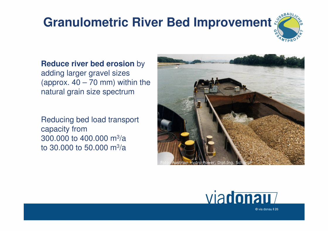
Granulometric River Bed Improvement
Foto: Austrian Hydro Power, Dipl.Ing. Schimpf
Reduce river bed erosion byadding larger gravel sizes(approx. 40 – 70 mm) within the natural grain size spectrum
Reducing bed load transportcapacity from300.000 to 400.000 m3/a to 30.000 to 50.000 m3/a

© via donau I 27
River bedstability
Improvement of ecologicalfunctions
Improvement of fairway conditions
Low water regulation
Granulometric riverbed improvement
Aims and Measures

© via donau I 28
Reconstruction of GroynesPilot Project Witzelsdorf
Construction of new groynes
Removal old groynes and river bank restoration
innovative groyne shapes -advantages for ecology and navigationby interdisciplinary planning
Smaller scour at the groyne head
By-pass as fish path for young fish and to cope with sedimentationin the groyne field
Downstream faced groynes >Higher dynamic along the river bank

© via donau I 29
Reconstruction of GroynesPilot Project Witzelsdorf
RNW+0,5
RNW+0,3

© via donau I 30
Low Water Regulation
Wasserspiegelanhebungdurch Granulometrie undNiederwasserregulierung
RNW
Improve navigation conditions, particularly during low flow periods, by raising water levels using modified groyne shapes andriver bed adjustments
RNWRNW
groynes

© via donau I 31
River bedstability
Improvement of ecologicalfunctions
Improvement of fairway conditions
Low water regulation
Granulometric riverbed improvement
River bankrestoration
Aims and Measures

© via donau I 32
River Bank RestorationPilot Project Thurnhaufen

© via donau I 33
River Bank RestorationPilot Project Witzelsdorf
after MW+1,5

© via donau I 34
River bedstability
Improvement of ecologicalfunctions
Improvement of fairway conditions
Low water regulation
Granulometric riverbed improvement
River bankrestoration
Side arm reconnectionand „Hinterrinner“
Aims and Measures

© via donau I 35
Higher, stabilizedwater level
Restoration of river banksconstruction of in-flows
Construction of out-flows
Reconstruction of traverses, if necessaryreplacement by bridges
Reconnection of Side Arms

© via donau I 36
River bedstability
Improvement of ecologicalfunctions
Improvement of fairway conditions
Low water regulation
Granulometric riverbed improvement
River bankrestoration
Side arm reconnectionand „Hinterrinner“
Aims and Measures

The Benefits of Integrative Planning

© via donau I 38
Benefits for the National Park (1)
• Linking of old meanders and branches to the main river, creating a connected river system• Improvement of the connectivity• Increase of the flow rate, increase of rheophile habitats
• Removal of reinforcement on certain sections of the river bank• Improvement of the flood dynamics• Increase of sediment relocation
• Stabilization of ground water conditions• Stabilization of the declining ground water table• Improvement of water balance
• Preservation of typical local fauna and flora habitats

© via donau I 39
• Slowdown of the negative trends caused by river beddegradiation
• Creation of new / reactivated aquatic habitats of high quality –especially in side arms
Benefits for the National Park (2)Preservation of typical local fauna and flora habitats
Out-flow of a side arm reconnection

© via donau I 40
• Creation of gravel banks, flat water zones and steep faces by river bank restoration and side arm reconnection
• Creation of undisturbed areas by reconnection of side arms and the construction of islands
Benefits for the National Park (3)Preservation of typical local fauna and flora habitats
steep face and gravel bankKingfisher Little ringed plover

© via donau I 41
Economical Benefits for Austria (1)
• Shift of traffic from roads to the Danube• Double the transport of goods along the Danube Corridor in
combination with means of logistics and telematics
• Reduction of traffic jams
• Increase of transport safety
• Reduction of emissions (noise, pollutants) and consumption of landscape
• especially important with regard to Kyoto goal

© via donau I 42
Economical Benefits for Austria (2)
• Promotion of the competitiveness of the national economy• Potential savings of transport costs
• Investment in the economic future of the national economy
• Reduction of maintenance costs• Costs for dredging fords
• Costs for fighting river bed erosion

© via donau I 43
Synopsis
The Integrated River Engineering Project …
... improves the ecological and nautical situation
of the Danube east of Vienna
… by means of river engineering
… meeting the requirements of the sensitive area of the National Park Donau-Auen.

© via donau I 44
via donau – Österreichische
Wasserstraßengesellschaft m.b.H.Donau-City-Straße 1 ���� A-1220 Vienna, Austria
www.via-donau.org
www.donau.bmvit.gv.at
Mag. Robert TÖGEL tel +4350 4321 – 2612; [email protected]