bangor university doctor of philosophy connections …
TRANSCRIPT
Bangor University
DOCTOR OF PHILOSOPHY
Connections between the hillforts of the Clwydian Range and the wider landscape
Lloyd Jones, Erin
Award date:2019
Awarding institution:Bangor University
Link to publication
General rightsCopyright and moral rights for the publications made accessible in the public portal are retained by the authors and/or other copyright ownersand it is a condition of accessing publications that users recognise and abide by the legal requirements associated with these rights.
• Users may download and print one copy of any publication from the public portal for the purpose of private study or research. • You may not further distribute the material or use it for any profit-making activity or commercial gain • You may freely distribute the URL identifying the publication in the public portal ?
Take down policyIf you believe that this document breaches copyright please contact us providing details, and we will remove access to the work immediatelyand investigate your claim.
Download date: 16. Dec. 2021

Connections between
the hillforts of the Clwydian Range
and the wider landscape
Erin Lloyd Jones
Thesis submitted for the degree of
Doctor of Philosophy
Bangor University
2017

2

3
In loving memory of
Eric Vinton Robinson
1948-2018
Dad, friend, Santa…

4
5
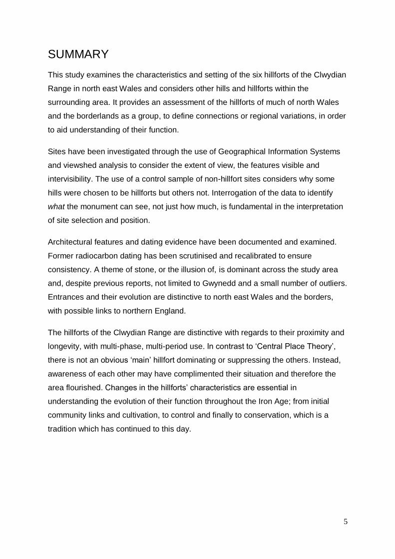
SUMMARY
This study examines the characteristics and setting of the six hillforts of the Clwydian
Range in north east Wales and considers other hills and hillforts within the
surrounding area. It provides an assessment of the hillforts of much of north Wales
and the borderlands as a group, to define connections or regional variations, in order
to aid understanding of their function.
Sites have been investigated through the use of Geographical Information Systems
and viewshed analysis to consider the extent of view, the features visible and
intervisibility. The use of a control sample of non-hillfort sites considers why some
hills were chosen to be hillforts but others not. Interrogation of the data to identify
what the monument can see, not just how much, is fundamental in the interpretation
of site selection and position.
Architectural features and dating evidence have been documented and examined.
Former radiocarbon dating has been scrutinised and recalibrated to ensure
consistency. A theme of stone, or the illusion of, is dominant across the study area
and, despite previous reports, not limited to Gwynedd and a small number of outliers.
Entrances and their evolution are distinctive to north east Wales and the borders,
with possible links to northern England.
The hillforts of the Clwydian Range are distinctive with regards to their proximity and
longevity, with multi-phase, multi-period use. In contrast to ‘Central Place Theory’,
there is not an obvious ‘main’ hillfort dominating or suppressing the others. Instead,
awareness of each other may have complimented their situation and therefore the
area flourished. Changes in the hillforts’ characteristics are essential in
understanding the evolution of their function throughout the Iron Age; from initial
community links and cultivation, to control and finally to conservation, which is a
tradition which has continued to this day.

6
DECLARATION AND CONSENT
I hereby declare that this thesis is the results of my own investigations, except where
otherwise stated. All other sources are acknowledged by bibliographic references.
This work has not previously been accepted in substance for any degree and is not
being concurrently submitted in candidature for any degree unless, as agreed by the
University, for approved dual awards.
Yr wyf drwy hyn yn datgan mai canlyniad fy ymchwil fy hun yw’r thesis hwn, ac
eithrio lle nodir yn wahanol. Caiff ffynonellau eraill eu cydnabod gan droednodiadau
yn rhoi cyfeiriadau eglur. Nid yw sylwedd y gwaith hwn wedi cael ei dderbyn o’r
blaen ar gyfer unrhyw radd, ac nid yw’n cael ei gyflwyno ar yr un pryd mewn
ymgeisiaeth am unrhyw radd oni bai ei fod, fel y cytunwyd gan y Brifysgol, am
gymwysterau deuol cymeradwy.

7
ACKNOWLEDGEMENTS
I’m not sure how surprising it is that this section may actually be the hardest part of
my thesis to write. Without the support of so many people, I wouldn’t be writing it at
all.
Firstly I would like to thank my main supervisor Raimund Karl. We first met during
the establishment of the University of Bangor’s excavation of Moel y Gaer Llanbedr
hillfort, through the Heather and Hillfort Project, of which I was then their
Interpretation Officer. Your belief, support, advice and, quite frankly, absolutely
fascinating stories have been invaluable. And your patience with my obsessive
planning and over-organisation is much appreciated too.
Secondly, I must thank my second supervisor Kate Waddington. Not only did you
introduce me to the wonderful site of Meillionydd double ringwork enclosure but you
have provided such helpful advice and direction.
Thank you also to Bangor University for accepting my application for the 125
Anniversary Bursary to begin my research.
My most heartfelt, sincere love and appreciation goes to the whole team at the
Clwydian Range and Dee Valley AONB. Without you employing me for the Heather
and Hillforts Project all those years ago, my enchantment with hillforts may never
have been realised. All of you- I am so glad we have stayed in touch and have gone
from colleagues to great friends. To Helen, Dave, Rhun and Nick, the years working
with you were over in a heartbeat- time flies when you’re having fun! To also learn so
much about the current ‘residents’ of the hills and hillforts and witness so many Black
Grouse leks on snowy hillforts at the crack of dawn is a magical experience I will
never forget. I am so glad I could stay on for a couple of years longer to see out the
extension of the project, and of the AONB! And to the kindest person I have ever had
the pleasure to meet, Fiona Gale. I feel incredibly lucky to have worked with you and
thank you for all of the knowledge you have passed on to me. Having you as a
mentor has helped me develop in so many ways, and to have you as a friend even
more so. Please let’s continue our hillfort jaunts for many years to come!

8
I’ve also been lucky enough to meet and spend time with many of the hillfort experts
I cite below and many more, through the Hillfort Study Group. Special mentions must
go to those who have allowed me to invade their excavations and encountered my
over-excitability when it comes to hillforts: Murray Cook and David Connolly at White
Castle, Dan Garner and the Habitats and Hillfort Project team, Ian Brown with the
Caer Drewyn Environs Project, Will Davies, Bob Sylvester and Caroline Pudney at
Hen Caerwys, Rachel Pope and Richard Mason at Eddisbury and Penycloddiau and
Gary Lock, Paul Riley and John Pouncett at Moel y Gaer Bodfari.
Many others have been kind enough to discuss theories, discoveries and other
events with me, including but not limited to Ian Brooks, Toby Driver, Ken Brassil,
Frances Lynch, John Collis, Dave Matthews, Graeme Guilbert, Ian Ralston and
others involved in the Hillfort Atlas. An avenue which I have returned to time and
time again for the discussion of new theories is the annual Iron Age Research
Student Seminar (IARSS) and I am grateful for them being a great sounding board
for my thoughts as my thesis developed over years and some super site visits too.
Without access to certain archives and additional information, I would have struggled
gaining all of the information I needed. To the team at National Museum Wales,
especially Jody Deacon, the Royal Commission on the Ancient and Historic
Monuments of Wales, especially Tom Pert, Flintshire Record Office, Jeff Davies at
Aberystwyth University, Andrew Packwood at Bangor University and the HER teams,
especially Rob Edwards in Cheshire and Jeff Spencer from CPAT who has just
joined us at Cadw, thank you for all of your advice and time. It has been priceless.
Thank you also to my employer Cadw, who allowed me to apply for a few extra days
off for my research. Studying on top of a full-time job (and a few extra-curricular
ventures!) has not been easy and those extra few days were incredibly helpful.
The life of a PhD student can be a pretty lonely one, but I have been extremely lucky
to meet fellow students, mainly through Michele Underwood at Bangor’s Academic
Development Unit, who were studying a range of really interesting subjects. To my
gorgeous group of ‘Bangor girls’, my darling Steph, Anna, Charlotte, Andrea, Helen
and Heather, you have made this journey achievable. I class you all as life-long
friends, even though we are now spread out across the globe. Thank you for your

9
listening skills, your dancefloor moves, all of the tea (and more importantly the
cocktails) and your laughter. We made it!
My other long-suffering friends deserve an apology- for the social events I’ve sent
my apologies for, for the constant yawning and for the sometimes months of silence.
I promise to be a better friend, aunty and godmother in 2018.
So, to my wonderful family. From the moment we moved in 1988 to the mill under
the Welsh castle on Offa’s Dyke at the site of the Battle of Crogen, perhaps it was
inevitable that I would become an archaeologist. You have seen me through my
most amazing ups and thankfully not too many downs, we have the most amazing
fun together and I didn’t realise how lucky I was to have an entire family I also class
as my friends. Mum and Dad, Melody and Eric, you are always there for me and I
have learned so much from you; Mum your imaginative way with words has been so
inspiring, and Dad your project management, time management and crash courses
in excel spreadsheets over a bottle of red wine are only the tip of the iceberg! My
brother Feritt’s creativity is inspirational and my Aunty Marjorie has always believed
in me. My sister and brilliant bestie Rebecca is my sounding board, my fellow
explorer, my advice-giver and one of my favourite people in the world. Thank you for
everything, you are ‘bester than the best’ and I honestly don’t know what I would do
without you. To my extended family, Anita & Bri, Gwyn & Margaret, Rich, Lynds,
Scarlett & Rupert, Andy and Shaz, thank you for accepting me and my hectic
lifestyle.
And, finally, saving the best until last: my husband Rhodri. Around eight years ago I
asked you if you’d mind if I studied towards a PhD qualification. “It’ll only be three
years”, I said. Sorry…
I can’t put into words what you mean to me. You have been my best friend, chief
comedian, DIY expert, you’ve looked after me, cleaned, cooked, been a mentor, an
advisor, a therapist, a coach and all on top of more than one full-time job and
business of your own too. I admire you so much. You mean the world to me. Thank
you for being everything and for being you. This thesis is dedicated to you.

10
CONTENTS
SUMMARY _______________________________________________________________ 5
DECLARATION AND CONSENT ____________________________________________ 6
ACKNOWLEDGEMENTS __________________________________________________ 7
LIST OF FIGURES _______________________________________________________ 14
LIST OF TABLES ________________________________________________________ 22
CHAPTER 1 _____________________________________________________________ 24
INTRODUCTION _________________________________________________________ 24
1.1 Research Objectives _____________________________________________________ 29
1.2 Data Collection __________________________________________________________ 30
1.3 Aims ____________________________________________________________________ 33
CHAPTER 2 _____________________________________________________________ 34
THE HILLFORTS’ STORY UP TO NOW _____________________________________ 34
2.1 Hillfort studies in Britain __________________________________________________ 34 2.1.1 Invasionary __________________________________________________________________ 34 2.1.2 New archaeology _____________________________________________________________ 36 2.1.3 Post-processual archaeology ___________________________________________________ 36 2.1.4 Research agendas ____________________________________________________________ 37
2.2 A chronological account of hillfort studies in the study area _________________ 38 2.2.1 Antiquity _____________________________________________________________________ 38 2.2.2 Folklore _____________________________________________________________________ 41 2.2.3 Antiquarians and geographers __________________________________________________ 42 2.2.4 The beginnings of archaeology _________________________________________________ 44 2.2.5 Modern excavation ____________________________________________________________ 50 2.2.6 21st Century research__________________________________________________________ 59
2.3 Conclusions _____________________________________________________________ 67
CHAPTER 3 _____________________________________________________________ 68
ARCHITECTURE _________________________________________________________ 68
3.1 Ramparts ________________________________________________________________ 68 3.1.1 Rampart architectural evidence from the Clwydian Range hillforts ___________________ 73
3.1.1.1 Moel Fenlli _______________________________________________________________ 74 3.1.1.2 Moel y Gaer Llanbedr _____________________________________________________ 74 3.1.1.3 Moel Arthur ______________________________________________________________ 75 3.1.1.4 Penycloddiau _____________________________________________________________ 77 3.1.1.5 Moel y Gaer Bodfari _______________________________________________________ 77 3.1.1.6 Moel Hiraddug ____________________________________________________________ 78
3.1.2 Method for comparison of rampart architecture in the wider area ____________________ 80 3.1.3 Rampart architecture results ____________________________________________________ 82
3.1.3.1 Wood ___________________________________________________________________ 82 3.1.3.2 Stone ___________________________________________________________________ 86 3.1.3.3 Additional material ________________________________________________________ 94
3.1.4 Discussion ___________________________________________________________________ 95
3.2 Entrances ______________________________________________________________ 105 3.2.1 Evidence from the Clwydian Range_____________________________________________ 108

11
3.2.1.1 Position ________________________________________________________________ 108 3.2.1.2 Inturns _________________________________________________________________ 115 3.2.1.3 ‘Guardchambers’ and Guard Huts __________________________________________ 115
3.2.2 Excavated entranceway results ________________________________________________ 121 3.2.2.1 Location and Aspect _____________________________________________________ 121 3.2.2.2 Types of Entrance _______________________________________________________ 123 3.2.2.3 Phasing ________________________________________________________________ 124
3.2.2.3.1 Gaps _______________________________________________________________ 126 3.2.2.3.2 Relocation __________________________________________________________ 126 3.2.2.3.3 Addition of inturns ____________________________________________________ 129 3.2.2.3.4 Addition of Guardchambers ___________________________________________ 131
3.2.2.4 Features ________________________________________________________________ 132 3.2.2.4.1 The Passageway ____________________________________________________ 132 3.2.2.4.2 Guardchambers _____________________________________________________ 134 3.2.2.4.3 Postholes ___________________________________________________________ 137 3.2.2.4.4 Grooves ____________________________________________________________ 145 3.2.2.4.5 Roads and approaches _______________________________________________ 147 3.2.2.4.6 Additional features/miscellaneous ______________________________________ 150
3.2.3 Discussion __________________________________________________________________ 152
3.3 Conclusions ____________________________________________________________ 166
CHAPTER 4 ____________________________________________________________ 167
DATING ________________________________________________________________ 167
4.1 Dating evidence for individual sites _______________________________________ 171 4.1.1 Dating evidence for the Clwydian Range hillforts _________________________________ 171
4.1.1.1 Moel Fenlli, Denbighshire _________________________________________________ 171 4.1.1.2 Moel y Gaer Llanbedr, Denbighshire ________________________________________ 172 4.1.1.3 Moel Arthur, Denbighshire ________________________________________________ 173 4.1.1.4 Moel Hiraddug, Denbighshire ______________________________________________ 173
4.1.2 Dating evidence for hillforts in the wider study area _______________________________ 178 4.1.2.1 Beeston Castle, Cheshire _________________________________________________ 178 4.1.2.2 Braich y Ddinas, Penmaenmawr, Conwy ____________________________________ 180 4.1.2.3 The Breiddin, Powys _____________________________________________________ 182 4.1.2.4 Bryn y Castell, Gwynedd __________________________________________________ 187 4.1.2.5 Castell Caer Seion, Conwy ________________________________________________ 188 4.1.2.6 Dinorben, Conwy ________________________________________________________ 188 4.1.2.7 Eddisbury, Cheshire ______________________________________________________ 194 4.1.2.8 Helsby, Cheshire ________________________________________________________ 196 4.1.2.9 Kelsborrow, Cheshire_____________________________________________________ 196 4.1.2.10 Llanymynech, Powys and Shropshire ______________________________________ 197 4.1.2.11 Llwyn Bryn Dinas, Powys ________________________________________________ 197 4.1.2.12 Maiden Castle, Bickerton Hill, Cheshire ____________________________________ 199 4.1.2.13 Moel y Gaer Llantysilio, Denbighshire______________________________________ 200 4.1.2.14 Moel y Gaer Rhosesmor, Flintshire ________________________________________ 201 4.1.2.15 Old Oswestry, Shropshire ________________________________________________ 202 4.1.2.16 Pendinas Llandygai, Gwynedd ____________________________________________ 204 4.1.2.17 Pen y Ddinas, Great Orme, Conwy ________________________________________ 204
4.2 Dating Results __________________________________________________________ 205 4.2.1 Enclosure ___________________________________________________________________ 205
4.2.1.1 Pre-rampart settlement and palisaded enclosures ____________________________ 206 4.2.1.1.1 OSL date ___________________________________________________________ 206 4.2.1.1.2 Radiocarbon dates ___________________________________________________ 206
4.2.1.2 Initial ramparts __________________________________________________________ 206 4.2.1.2.1 Artefactual dates _____________________________________________________ 206 4.2.1.2.2 Radiocarbon dates ___________________________________________________ 207

12
4.2.1.3 Modification to ramparts __________________________________________________ 210 4.2.1.3.1 Artefactual date______________________________________________________ 210 4.2.1.3.2 Archaeomagnetic dates _______________________________________________ 210 4.2.1.3.3 Radiocarbon dates ___________________________________________________ 210
4.2.2 Entrances ___________________________________________________________________ 212 4.2.2.1 Radiocarbon dates _______________________________________________________ 212
4.2.3 Roundhouses _______________________________________________________________ 212 4.2.3.1 Radiocarbon dates _______________________________________________________ 212
4.2.4 Four-post structures __________________________________________________________ 216 4.2.4.1 Radiocarbon dates _______________________________________________________ 216
4.3 Discussion _____________________________________________________________ 220
4.4 Conclusions ____________________________________________________________ 228
CHAPTER 5 ____________________________________________________________ 229
SETTING _______________________________________________________________ 229
5.1 Context _________________________________________________________________ 229 5.1.1 Geology ____________________________________________________________________ 229 5.1.2 Environment and climate ______________________________________________________ 230 5.1.3 The archaeological setting ____________________________________________________ 235 5.1.4 Water sources _______________________________________________________________ 241
5.2 Geographical characteristics _____________________________________________ 243 5.2.1 Height of hills ________________________________________________________________ 245 5.2.2 Logistics/practicalities ________________________________________________________ 251
5.2.2.1 Water sources ___________________________________________________________ 251 5.2.2.2 Size ____________________________________________________________________ 252 5.2.2.3 Aspect _________________________________________________________________ 252 5.2.2.4 Access _________________________________________________________________ 254
5.3 Visibility ________________________________________________________________ 256 5.3.1 Background _________________________________________________________________ 256 5.3.2 Issues ______________________________________________________________________ 259
5.3.2.1 Theoretical issues _______________________________________________________ 259 5.3.2.2 Computational issues_____________________________________________________ 263
5.3.2.2.1 Algorithms __________________________________________________________ 263 5.3.2.2.2 Curvature of the Earth ________________________________________________ 263
5.3.2.3 Experimental Issues ______________________________________________________ 263 5.3.2.3.1 The edge effect ______________________________________________________ 263 5.3.2.3.2 Reciprocity __________________________________________________________ 263 5.3.2.3.3 Digital Elevation Model (DEM) quality ___________________________________ 264 5.3.2.3.4 Sensitivity___________________________________________________________ 264
5.3.2.4 Substantive issues _______________________________________________________ 264 5.3.2.4.1 Palaeoenvironment & palaeovegetation _________________________________ 264 5.3.2.4.2 Contrast ____________________________________________________________ 265
5.3.3 Visibility analysis method _____________________________________________________ 265 5.3.3.1 Single point viewsheds ___________________________________________________ 266 5.3.3.2 Polyline viewsheds _______________________________________________________ 266 5.3.3.3 Aspect – non-numerical observations _______________________________________ 266 5.3.3.4 Other Considerations _____________________________________________________ 266
5.3.4 Visibility Results _____________________________________________________________ 269 5.3.4.1 Clwydian Range hillforts __________________________________________________ 269
5.3.4.1.1 Comparing visibility from summit points and rampart polylines______________ 269 5.3.4.1.2 Viewsheds from multi-phase ramparts __________________________________ 281 5.3.4.1.3 Comparing viewsheds from ‘tipped hillforts’ and their associated contour lines 285 5.3.4.1.4 Viewsheds from hillforts including interior points __________________________ 294 5.3.4.1.5 Viewsheds from entrances ____________________________________________ 295

13
5.3.4.2 Visibility from other hillforts in the surrounding landscape ______________________ 298 5.3.4.3 Visibility from non-hillforts _________________________________________________ 302 5.3.4.4 Intervisibility of hillforts ____________________________________________________ 305 5.3.4.5 Intervisibility of non-hillfort hills _____________________________________________ 308
5.4 Discussion _____________________________________________________________ 308
5.5 Conclusions ____________________________________________________________ 314
CHAPTER 6 ____________________________________________________________ 316
DISCUSSION ___________________________________________________________ 316
6.1 Prehistoric patterns? ____________________________________________________ 316
6.2 Lessons learned ________________________________________________________ 339
6.3 Connections of community, control and conservation _____________________ 340 6.3.1 Community _________________________________________________________________ 340 6.3.2 Control _____________________________________________________________________ 341 6.3.3 Conservation ________________________________________________________________ 341
6.4 Concluding remarks _____________________________________________________ 342 6.4.1 Reconnection _______________________________________________________________ 345
BIBLIOGRAPHY ________________________________________________________ 348
APPENDIX ONE ________________________________________________________ 386
A test study using a non-hillfort site. _________________________________________ 386
A1.1 Visibility from points at a summit _______________________________________ 386
A1.2 Visibility from contours ________________________________________________ 388
A1.3 Visibility of hillforts ____________________________________________________ 390
A1.4 Conclusion ____________________________________________________________ 391
APPENDIX TWO ________________________________________________________ 393
A test study using variables when computing viewsheds ______________________ 393
A2.1 Terminology ___________________________________________________________ 393
A2.2 Curvature of the earth __________________________________________________ 393
A2.3 Reciprocity ____________________________________________________________ 396
A2.4 Representing features to calculate viewsheds from: points and lines ______ 397
A2.5 Observer height and erosion ___________________________________________ 400 A2.5.1 The entranceway ___________________________________________________________ 400 A2.5.2 Approach __________________________________________________________________ 403
A2.6 Discussion ____________________________________________________________ 407
APPENDIX THREE ______________________________________________________ 410
Tables _____________________________________________________________________ 410

14
LIST OF FIGURES
Figure 1.1. Map showing the hillforts of the Clwydian Range (stars) and nearby towns (dots), with the coast line depicted as a black line and the Digital Elevation Model (coloured) presenting the topography & elevation
24
Figure 1.2. Simple line-drawn comparative plans of the Clwydian Range hillforts’ rampart circuits 26
Figure 3.1. Moel Arthur ramparts phasing, where solid black represents the first, univallate phase and hachered area depicts the secondary, inner rampart addition. After Brooks & Laws 2006b
76
Figure 3.2. Moel Hiraddug’s Main Inner entrance, first (blocked) simple gap entrance to the right and (relocated) final phase with inturns and guardchambers, to the left, and approximate location of two inhumations discovered beneath a metalled trackway. After Brassil et al 1982 & Bevan-Evans 1970b
110
Figure 3.3. Moel Hiraddug’s north western entrance phasing with initial simple gap, additional revetment creating an inturn and addition of a stone hut on the western terminal. After Houlder 1961
111
Figure 3.4. Moel y Gaer Bodfari possible blocked western entrance. After Stapleton 1909, no scale or alignment provided in original.
112
Figure 3.5. Aspect of known entrances on the hillforts of the Clwydian Range, showing a preference for entranceways to be orientated towards an easterly aspect
113
Figure 3.6. Entranceway features of Clwydian Range Hillforts showing those with guardchambers/huts confirmed by excavation, those with the features identified through unintrusive survey, those with possible associated features and those without guardchambers/huts/associated platforms apparent
116
Figure 3.7. Moel y Gaer Rhosesmor palisade showing gap at eastern edge and internal buildings including one hut with entrance aligned to the west facing the palisade entrance gap, where all other excavated huts were found to have entrances facing south east. After Guilbert 1977a
118
Figure 3.8. Excavated hillfort entrance locations, showing a high proportion of entrances being situated in an easterly location
122
Figure 3.9. Excavated hillfort entrance aspect, showing a preference for an easterly aspect 123
Figure 3.10. Building phases at hillfort entrances, suggesting that hillfort entrances were either built in one phase or had multiple (i.e. more than two) building phases
124
Figure 3.11. Initial simple gap entrance at Dinorben’s east entrance (in bold) with subsequent, relocated inturned entrance with guardchambers to the left (hachered). After Gardner & Savory 1964
127
Figure 3.12. Bryn y Castell entrances at north east (blocked) and north, internal ‘snail’ structure with underlaying hearth (hachered) and associated postholes. After Crew 1984; 1985
127
Figure 3.13. Eddisbury hillfort’s eastern entrance showing postholes and rectangular guardchambers excavated by Varley and additional curved area of southern guardchamber discovered by Garner, with stone lining in bold. After Varley 1950 & Garner 2012b
129
Figure 3.14. Penycorddyn Mawr north west entrance, showing inturn and postholes. After Gardner 1910.
130

15
Figure 3.15. Penycorddyn Mawr north east entrance showing inturns, guardchambers, postholes and ‘compound wall’. After Gardner 1910.
132
Figure 3.16. Entrance passage length at excavated hillforts for different entrances at different phases. The hillfort name is followed with the location of the entrance (e.g. N – north, SE – south east, MI – Main Inner) and the phase of the entrance (e.g. Ph2 – Phase 2)
133
Figure 3.17. Entrance passage width at excavated hillforts for different entrances at different phases. The hillfort name is followed with the location of the entrance (e.g. N – north, SE – south east, MI – Main Inner) and the phase (e.g. Ph2 – Phase 2)
133
Figure 3.18. Guardchamber area, calculated using Abπ. The hillfort name is followed with the location of the entrance (e.g. N – north, SE – south east), the phase (e.g. Ph2 – Phase 2) and where two guardchambers have been found/measured, the number depicting the guardchamber itself (e.g. GC1 – guardchamber 1). Figures can be found in Table A3.6
134
Figure 3.19. Dinorben south east entrance final phase showing approximate rampart line and trackway (hachered), stone wall lining (bold), postholes and guardchambers. After Gardner & Savory 1964.
135
Figure 3.20. Guardchamber dimensions, presenting the width and breadth of recorded excavated guardchambers in the wider study area. The hillfort name is followed with the location of the entrance (e.g. N – north, SE – south east), the phase (e.g. Ph2 – Phase 2) and where two guardchambers have been found/measured, the number depicting the guardchamber itself (e.g. GC1 – guardchamber 1). The graph shows two main clusters of measurements; between 2.7-3.3m for breadth and 3.7-3.8m for width.
136
Figure 3.21. Postholes within hillfort entrances; simple gap entrances, inturned/incurved entrances and those inturned with guardchambers
137
Figure 3.22. Penycorddyn Mawr south ‘skewed gap’ entrance with postholes and stone walling (bold). After Gardner 1910
139
Figure 3.23. Dinorben south east entrance, first phase following relocation, showing line of ramparts and trackway (hachered), postholes, stone wall lining, with additional inner wall in western guardchamber. After Gardner & Savory 1964.
140
Figure 4.1. Recalibrated radiocarbon dates for pre-rampart enclosures at Moel y Gaer Rhosesmor (HAR-606) and Dinorben (CAR-128)
206
Figure 4.2. Selected recalibrated radiocarbon dates for initial ramparts at Breiddin (BM-885, BM-879, HAR-1616, HAR-1761, HAR-1615, BM-878, QL-1080), Moel y Gaer Rhosesmor (HAR-606, HAR-604, HAR-1122), Dinorben (CAR-167, CAR-123, CAR-124), Eddisbury (NZA-36648, NZA-36593), Llanymynech (CAR-534, CAR-535) and Moel y Gaer Llanbedr (SUERC-30901, SUERC-30902, SUERC-30897)
209
Figure 4.3. Recalibrated radiocarbon dates for modified ramparts at Eddisbury (Beta-317521, NZA-36654, NZA-36593), Beeston (QL-1080, HAR-6464, HAR-6468, HAR-6469), Moel y Gaer Rhosesmor (HAR-603), Llwyn Bryn Dinas (CAR-708, CAR-800, CAR-798), Dinorben (CAR-131, CAR-132) and Pendinas Llandygai (HAR-1672)
211
Figure 4.4. Recalibrated radiocarbon dates for hillfort entrances at Moel Hiraddug (CAR-372, CAR-373, CAR-374) and Eddisbury (NZA-36592)
212
Figure 4.5. Recalibrated radiocarbon dates for roundhouses at Moel y Gaer Rhosesmor (HAR-1125, HAR-1126, HAR-1196, HAR-1197, HAR-1353), the Breiddin (BM-1160, BM-1161, BM-881, HAR-467, HAR-842), Pen y Ddinas (Great Orme) (Beta-254961), Castell Caer Seion (Beta-254607), Bryn y Castell (HAR-6234) and Moel y Gaer Llantysilio (SUERC-43981, SUERC-43982, SUERC-43983)
214
16
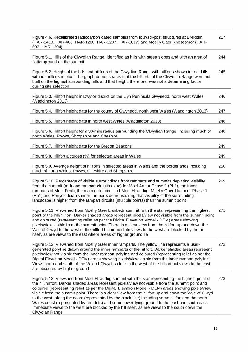
Figure 4.6. Recalibrated radiocarbon dated samples from four/six-post structures at Breiddin (HAR-1413, HAR-468, HAR-1286, HAR-1287, HAR-1617) and Moel y Gaer Rhosesmor (HAR-603, HAR-1294)
217
Figure 5.1. Hills of the Clwydian Range, identified as hills with steep slopes and with an area of flatter ground on the summit
244
Figure 5.2. Height of the hills and hillforts of the Clwydian Range with hillforts shown in red, hills without hillforts in blue. The graph demonstrates that the hillforts of the Clwydian Range were not built on the highest surrounding hills and that height, therefore, was not a determining factor during site selection
245
Figure 5.3. Hillfort height in Dwyfor district on the Llŷn Peninsula Gwynedd, north west Wales (Waddington 2013)
246
Figure 5.4. Hillfort height data for the county of Gwynedd, north west Wales (Waddington 2013) 247
Figure 5.5. Hillfort height data in north west Wales (Waddington 2013) 248
Figure 5.6. Hillfort height for a 30-mile radius surrounding the Clwydian Range, including much of north Wales, Powys, Shropshire and Cheshire
248
Figure 5.7. Hillfort height data for the Brecon Beacons 249
Figure 5.8. Hillfort altitudes (%) for selected areas in Wales 249
Figure 5.9. Average height of hillforts in selected areas in Wales and the borderlands including much of north Wales, Powys, Cheshire and Shropshire
250
Figure 5.10. Percentage of visible surroundings from ramparts and summits depicting visibility from the summit (red) and rampart circuits (blue) for Moel Arthur Phase 1 (Ph1), the inner ramparts of Moel Fenlli, the main outer circuit of Moel Hiraddug, Moel y Gaer Llanbedr Phase 1 (Ph1) and Penycloddiau’s inner ramparts demonstrating that visibility of the surrounding landscape is higher from the rampart circuits (multiple points) than the summit point
269
Figure 5.11. Viewshed from Moel y Gaer Llanbedr summit, with the star representing the highest point of the hill/hillfort. Darker shaded areas represent pixels/view not visible from the summit point and coloured (representing relief as per the Digital Elevation Model - DEM) areas showing pixels/view visible from the summit point. There is a clear view from the hillfort up and down the Vale of Clwyd to the west of the hillfort but immediate views to the west are blocked by the hill itself, as are views to the east where areas of higher ground lie
271
Figure 5.12. Viewshed from Moel y Gaer inner ramparts. The yellow line represents a user-generated polyline drawn around the inner ramparts of the hillfort. Darker shaded areas represent pixels/view not visible from the inner rampart polyline and coloured (representing relief as per the Digital Elevation Model - DEM) areas showing pixels/view visible from the inner rampart polyline. Views north and south of the Vale of Clwyd is clear to the west of the hillfort but views to the east are obscured by higher ground
272
Figure 5.13. Viewshed from Moel Hiraddug summit with the star representing the highest point of the hill/hillfort. Darker shaded areas represent pixels/view not visible from the summit point and coloured (representing relief as per the Digital Elevation Model - DEM) areas showing pixels/view visible from the summit point. There is a clear view from the hillfort up and down the Vale of Clwyd to the west, along the coast (represented by the black line) including some hillforts on the north Wales coast (represented by red dots) and some lower-lying ground to the east and south east. Immediate views to the west are blocked by the hill itself, as are views to the south down the Clwydian Range
273

17
Figure 5.14. Viewshed from Moel Hiraddug inner rampart. The yellow line represents a user-generated polyline drawn around the inner ramparts of the hillfort. Darker shaded areas represent pixels/view not visible from the inner rampart polyline and coloured (representing relief as per the Digital Elevation Model - DEM) areas showing pixels/view visible from the inner rampart polyline. Views north west and south west of the Vale of Clwyd is clear to the west of the hillfort alongside views down the coast (represented by a black line) including the hillforts located there (represented by red dots). Land immediately surrounding the hillfort is mostly visible from the ramparts but most of the Clwydian Range to the south of the hillfort is obscured
274
Figure 5.15. Topography surrounding Moel y Gaer Bodfari, with colours depicting relief from the Digital Elevation Model (DEM). The summit point of the hillfort is depicted as a green dot, with the ramparts as a red line. The Vale of Clwyd is instantly recognisable running north to south to the west of the hillfort, whilst the smaller Chwiler Valley runs east, just to the south of the hillfort, which sits on a spur where the two river valleys converge
275
Figure 5.16. Viewshed from Moel y Gaer Bodfari summit with the star representing the highest point of the hill/hillfort. Darker shaded areas represent pixels/view not visible from the summit point and coloured (representing relief as per the Digital Elevation Model - DEM) areas showing pixels/view visible from the summit point. There is a view from the hillfort up and down the Vale of Clwyd to the west, but with land immediately surrounding the hillfort blocked by the hill itself. Much of the view to the north and south east is obscured by higher ground, with patchy visibility to the north east. Much of the Chwiler valley is visible to the south, running east, apart from a small patch obscured by the slope of the hill
276
Figure 5.17. Viewshed from Moel y Gaer Bodfari inner ramparts. The yellow line represents a user-generated polyline drawn around the inner ramparts of the hillfort. Darker shaded areas represent pixels/view not visible from the inner rampart polyline and coloured (representing relief as per the Digital Elevation Model - DEM) areas showing pixels/view visible from the inner rampart polyline. Much of the views north west and south across the Vale of Clwyd is clear. Land immediately surrounding the hillfort is mostly visible from the ramparts, including the Chwiler Valley running east to the south of the hillforts. Most of the Clwydian Range to the north and south west of the hillfort is obscured
277
Figure 5.18. Viewshed from Moel Fenlli summit with the star representing the highest point of the hill/hillfort. Darker shaded areas represent pixels/view not visible from the summit point and coloured (representing relief as per the Digital Elevation Model - DEM) areas showing pixels/view visible from the summit point. There is a view from the hillfort up and down the Vale of Clwyd to the north west and south west, but with land immediately surrounding the hillfort is blocked by the hill itself. Much of the land to the north, east and south is shown to be not visible from the summit point, demonstrating the limits of viewshed analysis and the effect of human choice of input point location; Moel Fenlli is known to have much wider panoramic views from the true summit point
278
Figure 5.19. Viewshed from Moel Fenlli inner ramparts. The yellow line represents a user-generated polyline drawn around the inner ramparts of the hillfort. Darker shaded areas represent pixels/view not visible from the inner rampart polyline and coloured (representing relief as per the Digital Elevation Model - DEM) areas showing pixels/view visible from the inner rampart polyline. Much of the views north west and south west across the Vale of Clwyd is clear as is the pass of Bwlch Pen Barras which runs west to east through the Clwydian Range just to the north of Moel Fenlli. Much of the Clwydian Range to the north and south is obscured, but higher points and unobscured areas are visible in patchy areas surrounding the hill
279
Figure 5.20. Viewshed from Penycloddiau summit with the star representing the highest point of the hill/hillfort. Darker shaded areas represent pixels/view not visible from the summit point and coloured (representing relief as per the Digital Elevation Model - DEM) areas showing pixels/view visible from the summit point. Much of the land surrounding the hill is shown to be not visible from the summit point, demonstrating the limits of viewshed analysis and the effect of human choice of input point location; Penycloddiau is known to have much wider panoramic views from the true summit point
280

18
Figure 5.21. Viewshed from Penycloddiau inner ramparts. The yellow line represents a user-generated polyline drawn around the inner ramparts of the hillfort. Darker shaded areas represent pixels/view not visible from the inner rampart polyline and coloured (representing relief as per the Digital Elevation Model - DEM) areas showing pixels/view visible from the inner rampart polyline. Much of the views north west and south west across the Vale of Clwyd, as is a large area to the north east. Much of the Clwydian Range to the north and southeast is obscured although some higher summits and slopes of the Clwydian Range are visible
281
Figure 5.22. Percentage of surrounding area visible from Clwydian Range hillforts’ multi-phase ramparts, including visibility analysis undertaken using a polyline depicting different phases of multivallation (e.g. Ph1/Ph2 etc) and/or areas enclosed (e.g. inner rampart), showing negligible change in visibility of the surrounding landscape by adding multivallation and/or phases of rampart building at hillforts on the Clwydian Range, demonstrating that additional ramparts were not built to increase the amount of visible land
282
Figure 5.23. Moel Hiraddug primary ramparts shown with a red line depicting a user-generated polyline following the Inner Rampart on the western enclosure and a blue user-generated polyline (continues beneath but obscured by the northern and western extent of ‘Inner Rampart Polyline) following the entire main outer circuit of Moel Hiraddug. These overlie a coloured DEM showing relief and local Ordnance Survey map of the surrounding area showing ramparts and local features
283
Figure 5.24. Viewshed from Moel Hiraddug western enclosure. The yellow line represents a user-generated polyline drawn around the inner ramparts of the hillfort (those shown in red in Figure 5.23). Darker shaded areas represent pixels/view not visible from the inner rampart polyline and coloured (representing relief as per the Digital Elevation Model - DEM) areas showing pixels/view visible from the inner rampart polyline. Surrounding hillforts are shown as red dots and the north Wales coastline as a black line to the north west of the map
284
Figure 5.25. Viewshed from Moel Hiraddug outer ramparts. The red line represents a user-generated polyline drawn around the inner ramparts of the hillfort (those shown in blue in Figure 5.23). Darker shaded areas represent pixels/view not visible from the inner rampart polyline and coloured (representing relief as per the Digital Elevation Model - DEM) areas showing pixels/view visible from the inner rampart polyline. Surrounding hillforts are shown as red dots and the north Wales coastline as a black line to the north west of the map
285
Figure 5.26. Polylines depicting Moel Fenlli inner rampart and replicated on contours. The red user-generated polyline follows the inner ramparts of the hillfort, as seen on the underlying OS map. The green polyline is a replica of the inner rampart polyline, moved to the east to sit along the contours, which can also be seen on the underlying OS map
286
Figure 5.27. Polylines depicting Penycloddiau’s inner rampart and replicated on contours. The red user-generated polyline follows the inner ramparts of Penycloddiau hillfort, as seen on the underlying OS map. The blue polyline is a replica of the inner rampart polyline and moved to the north to sit across the contours, which can also be seen on the underlying OS map
287
Figure 5.28. Comparison of percentage of visible surroundings from ramparts and contours of ‘tipped hillforts’. A small increase in the total surrounding area visible is seen when generating a viewshed from the contour lines compared with the true ramparts. This indicates that the ‘tipped hillforts’ of Moel Fenlli and Penycloddiau were not built to sit on an angle across the contours of their hills to increase overall visibility
288
Figure 5.29. Viewshed from Moel Fenlli inner ramparts. Darker shaded areas represent pixels/view not visible from the inner rampart polyline and coloured (representing relief as per the Digital Elevation Model - DEM) areas showing pixels/view visible from the inner rampart polyline. The inner ramparts of Moel Fenlli are depicted as a blue user-generated polyline towards the centre of the map. To the hillfort’s west, a green and blue dot represent the locations of two undated enclosures, thought to be prehistoric, and clearly visible within this viewshed. Also visible is much of the hillfort of Moel y Gaer Llanbedr, depicted as a green polyline to the north west of
290

19
Moel Fenlli. The path from the pass of Bwlch Pen Barras to the north of Moel Fenlli, which leads up to the western edge and entrance to the hillfort, is also shown to be visible on this viewshed
Figure 5.30. Viewshed from Moel Fenlli contours. Darker shaded areas represent pixels/view not visible from the contour polyline and coloured (representing relief as per the Digital Elevation Model - DEM) areas showing pixels/view visible from the contour polyline. The contour polyline on Moel Fenlli is depicted as a light green polyline replicated from the rampart polyline, see Figure 5.26, towards the centre of the map. To the hillfort’s west, a green and blue dot represent the locations of two undated enclosures, thought to be prehistoric, and not visible within this viewshed from the contour polyline. The path from the pass of Bwlch Pen Barras, to the north of Moel Fenlli, which leads up to the western edge and entrance to the hillfort, is also obscured from view on this viewshed from the contours. Much of the hillfort of Moel y Gaer Llanbedr, depicted as a darker green polyline to the north west of Moel Fenlli is visible
291
Figure 5.31. Viewshed from Penycloddiau ramparts. Both the inner ramparts polyline and the ‘contours’ polyline are depicted here in red and blue, respectively, with this viewshed being calculated from the inner ramparts. Darker shaded areas represent pixels/view not visible from the inner rampart polyline and coloured (representing relief as per the Digital Elevation Model - DEM) areas showing pixels/view visible from the inner rampart polyline. Much of the surrounding landscape is visible in patches, with a stretch of land to the south of the southern entrance of the hillfort visible from the Vale of Clwyd to the west passing through the Clwydian Range to the north east
292
Figure 5.32. Viewshed from Penycloddiau contours. Both the inner ramparts’ polyline and the ‘contours’ polyline are depicted here in red and blue, respectively, with this viewshed being calculated from the replicated contours polyline. Darker shaded areas represent pixels/view not visible from the contours polyline and coloured (representing relief as per the Digital Elevation Model - DEM) areas showing pixels/view visible from the contours polyline. A stretch of land to the south of the southern entrance of the hillfort is shown as being obscured by nearby higher ground
293
Figure 5.33. Comparison of percentage of visibility of surrounding landscape from features from the summit point (blue), user-generated polyline depicting Whole (see Figure 5.23)/Inner/Phase 1 (Ph1) ramparts (red) and a user-generated polyline incorporating the entrance(s), the ramparts at the north, south, east and western edges and within the interior at the north west, north east, south west, south east and the summit and/or central point of the enclosure (green), for the six hillforts of the Clwydian Range, demonstrating that an increase in overall visibility is higher, and more representative, from a polyline representing more dispersed points across the hillfort than when limited to a single point at the summit or to a rampart circuit
294
Figure 5.34. Percentage of visibility of the surrounding 5km landscape from hillfort entrances at five of the Clwydian Range hillforts calculated from the height of a human (1.7m) and from the height of a human plus 3m to compare whether the increase in height of a tower or structure at the entrance would have an impact on the surrounding view, demonstrating that in all cases the total amount of landscape visible within 5km increased with the addition of height, but in only one case was there a significant increase in surrounding visibility; at Moel y Gaer Llanbedr’s complex, eastern entrance
296
Figure 5.35. Percentage of visibility of surrounding landscape from selected hillforts from the wider study area, including the six hillforts of the Clwydian Range, calculated from user-generated polylines incorporating the ramparts at north, south, east and west, at any entrances evident, on the interior of the hillfort at NE, SE, NW and SW and at either their central point or the high point within the hillfort, sorted from least visibility of the landscape to highest visibility of the surrounding landscape in a 25km radius, demonstrating that all six Clwydian Range hillforts fall within the top half of the results
299
Figure 5.36. Hillfort height and percentage of visibility of the surrounding landscape, showing a positive correlation between the height of a hillfort and the percentage of visibility of its surrounding landscape within a 25km radius, for the wider study area, see Figure 5.35, demonstrating that higher hillforts have higher visibility of the surrounding landscape
300

20
Figure 5.37. Clwydian Range hillforts size and percentage of visibility of the surrounding landscape, showing a positive correlation between the enclosed size of a hillfort and the percentage of visibility of its surrounding landscape within a 25km radius, for the six hillforts of the Clwydian Range, demonstrating that larger hillforts on the Clwydian Range have higher visibility of the surrounding landscape
301
Figure 5.38. Non Clwydian Range hillforts size and percentage of visibility of the surrounding landscape, showing a negative correlation between the enclosed size of a hillfort and the percentage of visibility of its surrounding landscape within a 25km radius, 12 hillforts nearby to the Clwydian Range see Figure 5.35, demonstrating that for these hillforts not on the Clwydian Range, the larger the hillfort, the lower the percentage of overall visibility of the surrounding landscape within a 25km radius
302
Figure 5.39. Percentage of visibility of surrounding landscape from hills and hill height, showing a strong positive correlation between hill height and percentage of visible surroundings within a 25km radius, demonstrating that higher hills generally have higher visibility of the surrounding landscape
303
Figure 5.40. Percentage of visibility of surrounding landscape from Clwydian Range hill summits, including those with hillforts (in red), demonstrating that the hillforts were built on some of the hills with higher visibility of the surrounding landscape and therefore overall visibility from a hill may have been a consideration when selecting a location for a hillfort
304
Figure 5.41. Hillfort intervisibility, showing the percentage of hillforts visible of hillforts located within a 25km radius of the site, for hillforts on the Clwydian Range and others in the wider study area
306
Figure 5.42. Hillforts surrounding and visible from other hillforts, showing the number of hillforts within a 25km radius of each hillfort and the number of visible hillforts from each hillfort within a 25km radius, for hillforts on the Clwydian Range and others in the surrounding area, demonstrating that the higher concentration of hillforts surrounding does not increase intervisibility
307
Figure A1.1. Input points on Moel Famau summit depicting the summit point of the hill (red), the Jubilee Tower monument (pink) and the location of the Moel Famau OS Trigpoint (grey), which were used as input points to generate a viewshed of the surrounding landscape
387
Figure A1.2. Percentage of surrounding landscape visible from three input points on Moel Famau summit, showing that the point with the highest visibility was the Jubilee Tower monument, followed by the Trigpoint. The ‘summit’/high point on the hill had the lowest percentage of its surrounding landscape, in comparison
388
Figure A1.3. Percentage of visibility of surroundings from Moel Famau summit points and contours, showing that the user-generated polyline used to calculate visibility on the contours of the hill had higher visibility of the overall landscape than those calculated using a single input point
389
Figure A2.1. Visible areas of Pen y Gaer Llanbedr y Cennin from Moel Arthur hillfort using ‘flat earth’. The input point from which the viewshed was calculated was the high point of Moel Arthur hillfort; this shows a section of the generated viewshed across the hillfort of Pen y Gaer hillfort, Llanbedr y Cennin with blue areas depicting areas which are ‘visible’ and beige as ‘not visible’ according to the viewshed calculations, with an underlay showing the details from the local OS map. This shows that approximately half the hillfort is visible from Moel Arthur hillfort, but does not take into consideration the curvature of the earth
394
Figure A2.2. Visible areas of Pen y Gaer Llanbedr y Cennin from Moel Arthur hillfort after taking into account the curvature of the earth. The input point from which the viewshed was calculated was the high point of Moel Arthur hillfort; this shows a section of the generated viewshed across the hillfort of Pen y Gaer, Llanbedr y Cennin with dark blue areas depicting areas which are ‘visible’ and a lighter colour as ‘not visible’ according to the viewshed calculations, with an underlay showing the details from the local OS map. In comparison to Figure A2.1, much less of
395

21
Pen y Gaer is visible from the same input point when taking into consideration the curvature of the earth. This demonstrates that the curvature of the earth has an effect on the viewshed results and should be considered in each calculation
Figure A2.3. Visibility of Moel Arthur hillfort from Pen y Gaer Llanbedr y Cennin. The input point from which the viewshed was calculated was a point within the ‘visible’ area of Pen y Gaer on the viewshed from Moel Arthur, see Figure A2.3; this shows a section of the generated viewshed across the hillfort of Moel Arthur with green areas depicted areas which are ‘visible’ and beige/pink as ‘not visible’ according to the viewshed calculations, with an underlay showing the details from the local OS map. This demonstrates reciprocity of visibility between the two hillforts
397
Figure A2.4. Overlaid viewsheds from Moel Arthur. This map shows three semi-transparent viewshed calculations overlaid to demonstrate subtle differences in results by using different input points/polylines depicting possible phases of architecture. The red line (ma_leas – Moel Arthur Line by EAS) and red/pink viewshed represents the input polyline and associated viewshed map for the outer rampart of Moel Arthur as mapped by EAS during their survey of the site. Blue (ma_lieas – Moel Arthur Line Inner EAS) is the circuit of the inner rampart and its associated viewshed. Green/grey (ma_lweas – Moel Arthur Line Whole EAS) represents the whole of the ramparts, including the inner rampart, as mapped by EAS in their topographical survey in 2006 and associated viewshed.
399
Figure A2.5. View from north guardchamber of Moel Arthur, with underlying OS map of north east Wales, the Wirral and Merseyside. The input polyline (ma_ngcl – Moel Arthur North Guardchamber Line) was drawn around the northern guardchamber as a user-generated seven-point polyline, using default values within ArcGIS for OFFSETA (the viewer) & OFFSETB (the view). The dark blue shows the area ‘visible’ and the lighter colour shows the area which is ‘not visible’. The calculations show that the view from the guardchamber location has wide views across much of north west England
402
Figures A2.6 & A2.7. Visibility of surroundings from the approach path to Moel Arthur hillfort from two locations on the path to the hillfort’s entrance (e.g. ma_p1 – Moel Arthur pathway 1), with underlying local OS map and hachered survey of the hillfort showing rampart detail. Blue represents the area ‘visible’ from the input point/s and green ‘not visible’, showing that as the input point moves towards the hillfort, no more of the interior becomes visible but the view outwards changes. This can also be seen in Figures A2.8 and A2.9
404
Figures A2.8 & A2.9. Visibility of surroundings from the entrance passage to Moel Arthur hillfort from two locations approaching the hillfort’s entrance (ma_ent1 – Moel Arthur entrance 1, ma_ent2 – Moel Arthur entrance 2), with underlying local OS map and hachered survey of the hillfort showing rampart detail. Blue represents the area ‘visible’ from the input points and green ‘not visible’, showing that as the input point moves within the hillfort entrance passage, less of the interior becomes visible but the view outwards increases
405
Figure A2.10. Visibility of surroundings from Moel Arthur inturned entrance passage. Visibility of surroundings from the entrance passage to Moel Arthur hillfort (ma_ent3 – Moel Arthur entrance 3), with underlying local OS map and hachered survey of the hillfort showing rampart detail. Blue represents the area ‘visible’ from the input point and green ‘not visible’. From this location, within the inturned entrance of the hillfort, little of the interior can be seen but there is a clear view down the entrance passage of the surrounding landscape to the north east
406

22
LIST OF TABLES
Table 1.1. Attributes of the hillforts of the Clwydian Range from north to south including their grid reference, height and the approximate area their ramparts enclose
25
Table 3.1. Evidence of wood in enclosure architecture for excavated hillforts in the wider study area. Enclosure Phase shows the interpreted phase of building the wood evidence is associated with. P depicts evidence for a palisade and R for wood used within a rampart. If there is evidence for wood in the inner face, outer face or the core of the rampart, this is noted with a Y for yes or P for possible evidence
83-84
Table 3.2. Evidence for ditches at earlier palisaded enclosures, listed interpreted associated phase and Y (yes) if there was also evidence for a palisade and/or a ditch
84-86
Table 3.3. Evidence for the use of stone within excavated ramparts, with rampart name, interpreted associated phase and Y (yes) or P (possible) for excavated evidence for stone facing and/or stone within the rampart core
87-94
Table 4.1. Dated roundhouses, stating the recorded building structure or evidence and associated recalibrated radiocarbon dates
216
Table 4.2. Selected, dated four- and six-post structures within hillfort interiors in the surrounding area. Where available, the number of associated posts with the structure is noted, alongside the depth of the postholes. The excavated post diameter and dimensions of the entire structure is listed, and associated recalibrated radiocarbon dates and/or artefactual evidence
219
Table A1.1. Visibility from summit locations on Moel Famau, showing the number of pixels visible and not visible from the three input points and the percentage of surrounding landscape visible from each
387
Table A1.2. Height and visibility from Moel Famau summit points and contours, showing that the user-generated polyline used to calculate visibility on the contours of the hill at 540m OD, at a lower height than the summit points at 554m OD, had higher visibility of the overall landscape
389
Table A1.3. Visibility of hillforts from Moel Famau, showing the hillforts within 25km of the hill which are visible (1) and not visible (0) from the summit and from the contour line, demonstrating that although the same number of hillforts are visible from the summit from the contour line, in some cases these numbers represent different hillforts and, therefore, there is a difference in view, despite no difference quantitatively
390-391
Table A3.1. Aspect of known entrances on the hillforts of the Clwydian Range 410
Table A3.2. Evidence (Y - yes or P - possible) for excavated evidence for palisades, ditches and of earth, wood and stone material used in the excavated hillfort ramparts in the wider study area
411-420
Table A3.3. Features of excavated entrances in the wider study area, including location (E – East etc), type and whether there is evidence for relocation, inturns, guardchambers (GCs) and/or amendment (Y – yes, N – No, Poss – possible)
421-427
Table A3.4. Excavated hillfort entrance locations and excavated hillfort entrance aspect from the wider study area
428-432
Table A3.5. Data from Figures 3.16 and 3.17. Entrance passage length and width at excavated hillforts.
432-434
Table A3.6. Data from Figures 3.18 & 3.20. Guardchamber dimensions, presenting the width and breadth and area, calculated using Abπ, of recorded excavated guardchambers in the wider study area. The hillfort name is followed with the location of the entrance (e.g. SE – south east), the
434-435

23
phase (e.g. Ph2 – Phase 2) and where two guardchambers have been found/measured, the number depicting the guardchamber itself (e.g. GC1 – guardchamber 1).
Table A3.7. Recalibrated radiocarbon dates, showing original reported dates with +/- year error, followed by recalibrated date range (where the ‘minus’ sign indicates BC) and confidence rating (%)
436-440
Table A3.8. Data from Figure 5.8. Hillfort altitudes (%) for selected areas in Wales. See also Tables A3.16, A3.17 and A3.18
441
Table A3.9. Data from Figure 5.9. Average height of hillforts in selected areas in Wales 442
Table A3.10. Data from Figures 5.10, 5.22 & 5.33. Comparison of percentage of visible surroundings from Clwydian Range hillforts
443
Table A3.11. Data from Figure 5.28. Comparison of visible surroundings from ramparts and contours of ‘tipped hillforts’
444
Table A3.12. Data from Figure 5.34. Visibility from hillfort entrances 444
Table A3.13. Data from Figures 5.35, 5.36, 5.37 & 5.38. Hillfort visibility, height and area 445-446
Table A3.14. Data from Figures 5.2, 5.39 & 5.40. Clwydian Range hill visibility and height 446-448
Table A3.15. Data from Figures 5.41 & 5.42. Hillfort intervisibility 448-449
Table A3.16. Hillfort height in north west Wales from Figure 5.5, including data for Dwyfor district, Figure 5.3 and Gwynedd, Figure 5.4
450-456
Table A3.17. Approx (known) height for hillforts within 30 miles of the Clwydian Range, Figure 5.6 457-461
Table A3.18. Hillfort height in the Brecon Beacons, Figure 5.7 462-463

24
CHAPTER 1
INTRODUCTION
The Clwydian Range was designated an Area of Outstanding Natural Beauty
(AONB) in 1985 and extended to include the Dee Valley in 2001. AONB
management plans have been compiled to assist the management of the AONB
alongside its historic importance (e.g. Clwydian Range AONB 2004; 2009). The
historic environment is listed as a ‘special feature’ of the landscape, with its six
hillforts specifically receiving note (Clwydian Range AONB 2004, 29 & 32; 2009, 20
& 32). The Clwydian Range was included within the Historic Landscape Register for
the Vale of Clwyd, which examined the historic character of areas defined by the
Register of Historic Landscapes in Wales.
Figure 1.1. Map showing the hillforts of the Clwydian Range (stars) and
nearby towns (dots), with the coast line depicted as a black line and the
Digital Elevation Model (coloured) presenting the topography & elevation

25
The six hillforts of the Clwydian Range sit on a ridge of hills situated near Rhyl and
Prestatyn in the north, running between the Welsh market towns of Ruthin,
Denbighshire and Mold in Flintshire towards Llandegla in the south. The Clwydian
Range runs a length of approximately 34 km, with the hillforts of Penycloddiau and
Moel Arthur, for example, less than 2 km apart.
This project is designed to explore the six hillforts of the Clwydian Range and their
setting, to investigate connections between the hillforts and other features in the
landscape. This will be referred to as the ‘core study area’.
These six hillforts are (from north to south):
Name National Grid
Reference
approx
height mOD
approx enclosed area
m2 (hectares)
Moel Hiraddug SJ063785 265 107378.30 (10.74)
Moel y Gaer
Bodfari
SJ095708 206 18741.21 (1.87)
Penycloddiau SJ128676 440 176960.94 (17.7)
Moel Arthur SJ145660 456 16214.65 (1.62)
Moel y Gaer
Llanbedr
SJ149618 339 25682.42 (2.57)
Moel Fenlli SJ163601 511 82639.65 (8.26)
Table 1.1. Attributes of the hillforts of the Clwydian Range from north to
south including their grid reference, height and the approximate area their
ramparts enclose

26
Figure 1.2. Simple line-drawn comparative plans of the Clwydian Range
hillforts’ rampart circuits
Despite these monuments now being comprehensively surveyed (Brassil et al 1982;
Jones 2004; Brooks & Laws 2006-2009; Brooks 2011; Lock & Pouncett 2011) the
hillforts of the Clwydian Range as a group remain poorly understood. Few modern
excavations have been carried out, little dateable material has been found and,
therefore, a chronology for these monuments remains enigmatic. Due to the few
dateable finds in the area (Hemp 1928; Gardner & Savory 1964; Savory 1971b) and
limited absolute dating samples (Brassil et al 1982; Karl et al 2015), the hillforts are

27
thought to date to sometime between the Late Bronze Age and the end of the Iron
Age.
In 2001, five strategic areas were identified as areas for future research into the
British Iron Age, covering England, Wales and Scotland, in a report prepared for the
Iron Age Research Seminar and the Council of the Prehistoric Society (Haselgrove
et al 2001):
• Chronological frameworks
• Settlement patterns and landscape history
• Material culture studies
• Regionality
• The nature of socio-economic changes
It was highlighted that even basic chronologies within the British Iron Age continued
to present a problem. Further research was required into the spatial relationship and
the understanding of Iron Age communities and their landscape and that evaluations
of regional variations should be a key objective in future research (Haselgrove et al
2001, iv-v). Certain areas were noted as ‘black holes’, which had seen relatively little
modern research beyond individual sites and listed Wrexham and Conwy in north
Wales as examples (Haselgrove et al 2001, 24-5).
In 2003, the Institute for Archaeologists (IFA), which received its chartered status in
2014, Wales/Cymru branch published the proceedings of their 2001 conference
under the title ‘Towards a Research Agenda for Welsh Archaeology’ (Briggs, C.S.
2003). Adam Gwilt presented a paper with emphasis on Welsh sites, research and
current trends, relating to the British Iron Age agenda (Gwilt 2003). Gwilt highlighted
the historical tendency for survey and excavation effort of Welsh Iron Age studies to
concentrate on hillforts and defended enclosures with an ‘invasionary’ thinking (Gwilt
2003, 107), that Welsh Iron Age archaeology was still regarded as ‘marginal’ in the
wider scope of British studies and that ‘serious thought should be given into raising
the profile of this subject area, over the coming years’ (ibid.). In addition, the need for
a move towards a wider concept of perceived ‘landscape’ and perceptions of space
and place was stressed (Gwilt 2003, 108). The use of individual small-scale
excavation reports and surveys for wider interpretation and reassessment was

28
encouraged (ibid.). Described as a “complex social mosaic of regionally constituted
societies”, Gwilt proposed that to be able to understand the period, careful
examination of regional evidence must be carried out and interpreted (Gwilt 2003,
112). He proposed that where a body of information is in existence, time should be
spent interpreting the information as opposed to simple data gathering. He used
hillfort studies as a specific example, with the need for reassessment with their
regional diversity in mind (Gwilt 2003, 113). The documents are currently under
review but underwent an initial review between 2011-2014. This exercise cited a
number of published studies across Wales, but despite this, many of the initial issues
were still outstanding (Karl & Gale 2014).
The most common practise of looking at groups of monuments in the past has been
a normative exercise; classifying data to common patterns such as distribution maps
(Chapman 2006, 18). In Wiltshire, for example, in the distribution of multivallate
hillforts enclosing over 12 acres, “a significant departure from randomness in the
direction of uniformity of spacing” was observed (Hodder 1977, 236). It was
concluded that the identification of this indicated their contemporaneity and the
competitive relationship between these sites would be worth examining in further
detail (Hodder 1977, 236). The same could be put forward for hillforts in north Wales
and the borders.
Past, modern approaches to landscape archaeology in the Clwydian Range include
non-destructive methods such as mapping and survey. Excavation has most usually
been undertaken when a site is at risk (Brassil et al 1982) or more recently for
university research projects (e.g. Karl & Butler 2009; Brown & Karl 2011).
Archaeological research into the Clwydian Range hillforts as a group includes site
comparison (Alcock 1965; Forde-Johnston 1964a; 1965; Gardner 1926; Guilbert
1979c; Hogg 1972; Savory 1976; Stanford 1972a; 1972b), perception (Gale 1999)
and visibility (Matthews 2006).
Common patterns that have been investigated in the Clwydian Range and hillforts in
the surrounding area include size (Alcock 1965) and similar architectural features
such as guardchambers within entrances (Guilbert 1979c). Qualitative aspects have
also been explored. In Gale’s 1999 study, she investigated ‘Perception and the
Clwydian Range’, exploring factors which may have influenced the location of the

29
hillforts and their positive relationship with earlier monuments such as Bronze Age
burial chambers (Gale 1999). More recently, the use of Geographical Information
Systems (GIS) in archaeology have become increasingly popular. In 2006, Matthews
studied the intervisibility between hillforts in the north Wales Marches; in Shropshire,
Powys, Cheshire and north east Wales (Matthews 2006). Using Line of Sight
analysis, he suggested that the most intervisible hillforts could have been tribal
centres, as the patterns of intervisibility showed a correlation between the suggested
confines of tribal boundaries known from contemporary Roman sources (Matthews
2006, 38).
These hillforts of the Clwydian Range received special note and attention between
2008 – 2012, being awarded a £2.3 million Heritage Lottery Funded Landscape
Partnership Scheme, which aimed to conserve and maintain and to reconnect
people to and increase their enjoyment of the heather moorland and hillforts of the
Clwydian Range and Llantysilio Mountains.
1.1 Research Objectives
The research includes enquiry into the transition between the Late Bronze Age and
early Iron Age, as noted in the Research Framework for the Archaeology of Wales
(Cadw 2008, 9) and follows themes highlighted by the final document and reviews,
such as chronology, settlement function, land-use and environment (Gale 2010, Karl
& Gale 2014). The aims of this study are directly linked to the research agenda for
the north east of Wales in the Late Bronze Age and Iron Age (Gale 2003; Karl &
Gale 2014) and the research agendas for the Iron Age in Britain and in Wales
(Haselgrove et al 2001; Briggs 2003) through a thorough assessment of a regional
body of research, additional research to ‘plug the gaps’ through landscape studies
and the inclusion of sites in the ‘black holes’ of Conwy and Wrexham.
The purpose of a comparative study of hillforts in north Wales and the English
borders is an attempt to find any potential connections between sites through their
physical remains and their setting. To do this, data for excavated hillforts within an
approximate 30-mile (48km) radius of the Clwydian Range, to be referred to as the
‘wider study area’, was collected through the Historic Environment Record, the
National Monument Record and excavation reports. After careful consideration of the
data, features such as architecture and dating evidence have been documented

30
within a database. Radiocarbon dating evidence has been scrutinised and
recalibrated to ensure consistency. Comparisons between sites has also been
carried out through the use of GIS, investigating view, intervisibility and the use of a
control sample of non-hillfort sites.
By including data from hillforts in the surrounding area of the Clwydian Range, a
much larger sample of excavated and surveyed information has been utilised when
investigating local and regional patterns. The radius of approximately 30 miles
(48km) from the six Clwydian Range hillforts has been chosen as the wider study
area to ensure a distance of maximum visibility and the approximate distance that
can be walked in one day. Within this wider area, over 100 hillforts are listed within
the Historic Environment Record (HER) and National Monuments Record (NMR), of
which 39 are known to have been excavated.
1.2 Data Collection
Initially, data was collected to identify hillfort sites within the wider study area by
utilising information available through HERs and the NMR of Wales. In the initial
stages of data collection, Wales launched its website ‘Archwilio’, and as such, was
the first country in the United Kingdom to have all archaeological records available
online. The Royal Commission on the Ancient and Historic Monuments of Wales
have also made available the NMR through the website ‘Coflein’ and in recent years
Cadw launched ‘Cof Cymru’, making available records of the National Historic
Assets of Wales online, such as scheduled monuments, listed buildings and
protected wrecks, under the provisions of the Historic Environment (Wales) Act
2016.
In addition, and prior to the launch of Archwilio, Clwyd Powys Archaeological Trust
(CPAT), which covers the majority of the wider study area, agreed to make records
easily available for downloading online by creating an individual user profile to their
records in order for me to access the HER as required and download records in .csv
format, as well as arranging visits in person. During this period, HER teams and
archaeology departments within local authorities were under much scrutiny and
pressure; HER posts within the Merseyside area were reallocated during the initial
period of data collection, for example. Data collection from Gwynedd Archaeological
Trust (GAT) and Shropshire Council proved to be more problematic, due to a lack of

31
accessibility online and a lack of perceived ‘trust’ from teams responsible for data,
especially from the local authority department. Many records were available from
Cheshire through websites such as ‘Heritage Gateway’ and the record was visited in
person, although these were physically moved to multiple locations around Cheshire
(Chester & Cheshire West and Cheshire East Councils) during the time of study
during relocations and restructuring within the local authorities.
In a handful of cases, more than one record was available for individual sites,
including separate records for individual phases/eras of use at the location. This also
included some sites which were included within both Welsh and English HERs due
to their location, such as Llanymynech hillfort straddling both countries. In these
cases, data was collected from as many sources as was available, but a decision
was made as to which record’s identification number to use to avoid accidental
duplication and therefore skewing of results when quantifying certain features in
groups. The differing naming conventions and spelling differences for hillforts and
their features also needed to be considered, as well as differentiating between hillfort
sites and those which had been logged under the hillfort category within the HER1
but since discounted.
This initial data collection from HERs and the NMR provided a basis for site
identification and locational data. It also provided preliminary signposting for related
publications and references in order to find more substantial data from reports,
surveys, excavations and other investigations, some of which were easily available
electronically within the HER, especially in Wales following the launch of Archwilio,
and/or in print within their archive.
Much use was made of libraries and archives at Bangor University, including the
utilisation of the interlibrary loans system and Linc y Gogledd, a reciprocal borrowing
scheme between north Wales’ public and academic libraries.
Archives held at the National Museum of Wales – Amgueddfa Cymru and Flintshire
Record Office in Hawarden, especially the Bevan-Evans archive, proved to be
particularly useful and intriguing whilst researching unpublished and partially
published excavations within Wales. Where possible, insightful conversations were
1 For example, some places had been recorded as possible hillfort sites due to field names including the word ‘caer’, meaning ‘fort’ in Welsh, prompting investigation.

32
held with the original excavators of the archaeological investigations, such as Dr Jeff
Davies at the University of Aberystwyth, Ken Brassil and Graeme Guilbert. Ongoing
excavations were visited in person and on occasion contributed to, such as Moel
Fodig and Moel y Gaer Bodfari hillforts.
The collection of original, uncalibrated radiocarbon dates for recalibration proved
problematic, as did the retrieval of archaeological context for some which rendered
those results useless. In many cases the original laboratories had closed and
therefore could not be contacted in order to search their archives. However, in many
cases, the original sources of data, such as lab reports, were found in the HER or
were available in publications such as Radiocarbon journal after some searching.
The addition of these references within the HER would make future investigations
and scrutiny much easier and data-collection much less time-consuming. Original
uncalibrated dates were recalibrated using OxCal version 4.2 and later re-examined
in version 4.3.2, developed by Oxford University’s Radiocarbon Accelerator Unit, to
ensure consistency.
Locational data was initially gathered using the National Grid Reference logged
within the HER and/or NMR. This was quickly realised to be inconsistent and
occasionally imprecise, especially considering the size of the monuments in question
covering a large area. When examining geographical data concerning the ‘high point’
of monuments and hills, this was user-generated by inspection of data on Ordnance
Survey (OS) maps, including contour data, and the Digital Elevation Model (DEM) of
the topography. When considering the whole monument, multiple points were also
selected by the user to create a user-generated polyline to represent the broader
area of the monument/s in question. These points were selected at certain features
across the monument including ramparts and entrances, found by scrutinising data
available from the OS in Edina Digimap and archaeological surveys, such as
topographical and geophysical surveys, geo-located as an overlying layer within
ArcGIS.
As data was collected, it was inputted into a Microsoft Access database recording
fields such as the data collected from excavations including dimensions and phases,
and any outputs and results from investigations and calculations within the study,
such as recalibrated radiocarbon dates and viewshed analysis results. When

33
scrutinising results, in most cases, it was exported from Access into a Microsoft
Excel document for ease of manipulation. These tables can be found in Appendix
Three.
1.3 Aims
This study will provide a considered and long-overdue assessment of the hillforts of
north Wales and the borderlands as a group.
• To investigate the hillforts, their landscape and their relationship one to
another.
• To review the features and dates of hillforts on the Clwydian Range and
surrounding area, to examine whether the hillforts of the Clwydian Range, or
within the wider area, form a distinctive group.
• To test whether the hillforts’ setting was a determining factor in site location.
To achieve these aims, I first look at the history of research on the hillforts within the
core study area and wider study area in chapter 2.
Thereafter, in chapter 3 I examine the main architectural characteristics of excavated
hillforts within the wider study area in detail in the form of their ramparts and their
entrances.
Subsequently, I re-examine dating evidence from excavations at the hillforts in
chapter 4, with particular emphasis on and recalibration of radiocarbon dating.
Following this, findings from and a discussion of research into the setting of the
hillforts, including an investigation into visibility, is reported on in chapter 5.
Finally, the findings and discussions from previous chapters are brought together
and considered as a whole in an overall discussion of the results in chapter 6. This
includes lessons learned and some concluding remarks and interpretations,
suggesting themes of function and engagement throughout the period/s the hillforts
were in actively in use, interacted with and/or modified.

34
CHAPTER 2
THE HILLFORTS’ STORY UP TO NOW
References to hillforts in north Wales and the borders have a varied history,
beginning with visiting and invading Romans in the First Century AD, to the first
historians’ artistic interpretations of battle and blood-shed on the ramparts. The term
‘hillfort’ itself suggests a defensive nature to the enclosures and its relevance is
debated. Although there have been a number of research projects into groups of
hillforts in recent years, large scale excavation is scarce and so interpretations must
be made through gathering information on all previous work, including historical
sources, small-scale excavation and survey.
This chapter will provide a brief introduction and history to approaches to the study of
hillforts in Britain, followed by an overview of written sources and work carried out
over the core study area of the Clwydian Range hillforts and those within the wider
study area across much of north Wales and the borders. This will begin with the
earliest written sources in the First Century AD and will include folklore associations,
interest by antiquarians and, ultimately, research by archaeologists as the study of
archaeology has itself developed.
2.1 Hillfort studies in Britain
2.1.1 Invasionary
During the latter half of the 19th Century to the mid-20th Century, studies into the
British Iron Age came of age. Stone’s large-scale excavations at the settlement sites
of Standlake, Oxfordshire (Riley 1946-7, 36) and Highfield, Salisbury (Cunliffe 2005,
4) took interest in pits and middens, highlighting the wealth of information that could
be gleaned from investigation of these features into the lives of the people who lived
there, not just the militant function of the architecture. During General Pitt Rivers’
excavations at a number of hillforts in southern Britain, he not only excavated the
ramparts, but also cleared out pits revealing a wealth of artefacts which helped him
to interpret the lives of the hillfort’s inhabitants (ibid.). His excavations at hillfort and
settlement sites, namely Caburn, Sussex in 1877-78 (Pitt Rivers Lane Fox 1881) and
Winklebury, Hampshire in 1888 (Corney & Payne 2006, 131) were revolutionary;
exceptionally detailed and highlighted the use of strata for dating as well as the need

35
for regional studies (Cunliffe 2005, 4). This work was to greatly influence
contemporary archaeologists, including Sir Mortimer Wheeler who introduced the
grid system for excavating, most notably during the great excavations at Maiden
Castle hillfort in Dorset in the 1930s (Roskams 2001, 13).
Up to this point, a number of theories had been made, all concluding that the change
in architecture, metal work, art and pottery (i.e. ‘culture’) was due to invasion and
immigration from the Continent. As the wealth of information grew, due to more sites
being excavated and more artefacts being found, this interpretation was becoming
increasingly difficult. In 1931, Hawkes proposed a new scheme for dating which was
to take the main elements of earlier invasion models, supplemented with new
information and additional proposals and the ‘ABC system’ of the Iron Age was born
(Hawkes 1931, 60-97). This model was to influence Iron Age studies in Britain for the
next thirty years. The system drew on the theories that the changes were due to
invasions, but that people came in large waves, the first beginning in the Seventh
Century BC, reaching its height in the Sixth Century BC which brought people from
central and northern Europe with the Late Hallstatt culture (Iron Age A peoples), the
second early in the Fourth Century BC as the La Tène I (Iron Age B peoples) and the
third wave of immigration in around 75BC, consisting of refugees from the Roman
advance (Iron Age C peoples) (Cunliffe 1991, 10).
Due to the wealth of sites now excavated across Britain and new information
gleaned, Hawkes revised his ABC system and presented this advanced model to the
Council for British Archaeology’s conference entitled ‘The Problems of the Iron Age
in Southern Britain’ in 1958, which was also published in the journal Antiquity
(Hawkes 1959, 170).
In 1960, Hodson presented some challenges to the ABC theory (Hodson 1960, 138-
40). Hodson’s criticisms of the inflexibility and complexity of the ABC structure
suggested that sites and the information they held should be looked at, primarily,
before defining them to a model that they would be said to fit into. Hodson put
forward the three chronological divisions; the first, being the earliest pre-Roman Iron
Age, the second or earlier pre-Roman Iron Age and the third or later pre-Roman Iron
Age, based on the presence of imported metalwork (Hodson 1960, 140).

36
2.1.2 New archaeology
In 1966, Graham Clark presented an attack on the invasion theory (Clark 1966),
which coincided with the advent of ‘new archaeology’, exemplified by David Clarke’s
use of systems theory and scientific, quantitative reasoning. Evidence to challenge
hypotheses and create testable theories around evidence was now favoured over
searching for evidence to confirm existing theories. Processual archaeology asked
not just ‘what’, but ‘what does it mean’, adopting a more interpretative approach to
explain the past and shifted away from individual site research to regions and
landscapes.
In 1971, Hill and Jesson brought together a series of papers presented to Sir
Mortimer Wheeler to mark his 80th birthday and by 1976, Harding had published
‘Hillforts: Later prehistoric earthworks in Britain and Ireland’ (Hill & Jesson 1971;
Harding 1976). These edited publications presented landscape research with the
inclusion of scientific methods. With the development of radiocarbon dating in the
post-war years and the increase in environmental dating, the methods of calibration
were able to place everything into perspective2.
Early use of the processual approach ‘sorted’ and categorised data in a scientific
approach. This guided the development of the use of Thiessen polygons, where
landscape was ‘measured’ and territories defined to illustrate regions of power and
‘central places’ (Hogg 1971; Cunliffe 1971). This led, in part, to the publication of the
first edition of Barry Cunliffe’s ‘Iron Age Communities in Britain’ in 1974, now in its
fourth edition (Cunliffe 2005, ix). Cunliffe’s work on and his interpretation of
Danebury hillfort put forward a model where high-status principal hillforts of elite
tribal chiefs centralised exchange and distribution in hierarchical, ‘clientship’
allegiances with subordinate members of the society (Cunliffe 1984).
2.1.3 Post-processual archaeology
Post-modernist perspectives shaped a number of new approaches in the 1980s and
1990s, often collectively termed post-processual archaeology. This placed emphasis
2 This was especially beneficial for north Wales due to the lack of pottery and coins in the area, the use of VCP (very coarse pottery), and an acidity of soils which makes survival of artefacts improbable. However, the time of study coincides with a large plateau in the calibration curve between 800 and 400 BC making dating accurately between these years difficult (Van der Plicht 2004, 45).

37
on the different, diverse social groups of the past and their individual experiences,
concepts and beliefs, including symbols and meanings. In relation to hillforts, this
new approach questioned defensive interpretations and the centralised, elite status
of the monuments. In 1995, J. D. Hill’s paper on Iron Age societies and hillforts
queried many popular theories by asking “What if” and questioned many popularly
held assumptions regarding Iron Age society at the time, including Cunliffe’s Central
Place Theory, hillforts’ use for defence, chiefdoms, and the ‘Celtic’ community (Hill
1995b). Societies and their communities alongside their beliefs was now a key
consideration in Iron Age studies. Hillfort ‘defences’ were now considered as
symbolic, the enclosure a place to gather socially and for communal activities. The
‘Celtic’ elite model was rejected in favour of an egalitarian society.
Hill contemplated ‘a different Iron Age’, questioning the significant divide between
‘monumental’ interpretations of Neolithic and Bronze Age societies compared to
such ‘practical’ interpretations of the Iron Age by archaeologists (Hill 1989).
Phenomenological approaches were also established during the 1990s, emphasising
personal ‘experiences’ of and within landscapes. Hillfort architecture was considered
through cosmology, orientation and meaning, rather than through a functional role.
Landscapes were considered subjective, created by people through their own
experience, through space and through time (Bender 1993).
Post-processual archaeology also argued for more regionally based research,
emphasised in the 1995 Theoretical Archaeology Group conference session theme
and subsequent publication Northern Exposure: Interpretative Devolution and the
Iron Age of the British Isles. The session highlighted the reliance of Iron Age
interpretations on data from sites in south east Britain and Wessex which may not be
accurate or relevant for central and northern Britain. A need for regional research
and models was stressed (Bevan 1999).
2.1.4 Research agendas
In 1996, English Heritage called for the development of regional research strategies
for England. The research agenda for the British Iron Age was produced to give a
detailed study of the topic and to identify research priorities and strategies for future
work across Britain (Haselgrove et al 2001).

38
Regionality was highlighted as one of five strategic themes for future research into
the British Iron Age, along with basic chronology, landscapes and settlement
patterns, material culture and socio-economic changes (Haselgrove et al 2001).
Similar themes were highlighted in Wales’ response towards a Welsh research
agenda, discussed above in chapter 1 (Briggs 2003). Following recent review, many
of these issues are still considered unresolved (Karl & Gale 2014).
This chapter will now outline previous research into the hillforts within the wider study
area. This is presented chronologically from the earliest contemporary sources up to
the 21st Century. Previous research activity has arisen in a number of guises,
adopting and being influenced by a number of theoretical perspectives highlighted
above and includes academic research, rescue archaeology and funded landscape
schemes.
2.2 A chronological account of hillfort studies in the study area
2.2.1 Antiquity
The first mention of the wider study area defined by the hillforts of the Clwydian
Range and their neighbouring hillforts could be said to overlie three different tribal
boundaries as highlighted by Roman sources.
In AD50, the annals of Tacitus describe the Roman attack on the tribal area of the
“Deceangi”3 of north east Wales by Publius Ostorius Scapula (Yardley 2008, 433-
434), governor of Britain AD47–52. Tacitus noted that the natives were unwilling to
‘risk battle’ so their “lands were plundered, and booty carried off in all areas… and
their trickery was punished if they tried to harass the column from concealed
positions” (Yardley 2008, 433). The final statement suggests some initial resistance
from the natives, making use of their knowledge of the topography of the land to use
guerrilla warfare on the attacking Romans.
The word ‘DECEANGL’ has been found on several pigs of lead found across
Cheshire and Staffordshire. These are thought to have originated from the lead
mines on Halkyn Mountain, Flintshire. The most intact Deceangl pig found at Tarvin
3 In this instance spelt without the ‘l’ but known as the ‘Deceangli’
39
Bridge, Cheshire, bears the inscription: IMP[ERATOR] VESP[ASIANVS] V
[CONSUL] T[ITVS] IMP III COS [= CONSUL]. DECEANGL (in the fifth consulship of
the Emperor Vespasian and the third Emperor Titus) (Davies 1949, 146) and has
been suggested that the local tribe’s name should read ‘Deceangli’ (Higham 1993,
32).
In the Second Century AD, Ptolemy notes certain towns, or civitates, in Britain in
relation to tribal areas. The Deceangli are not cited, but it is said that the area in
question was inhabited by the tribe of the Cornovii, with Chester and Wroxeter within
their country (Horsley 1732, 368). Higham believes that modern scholars may have
been ‘over hasty’ to dismiss this assumption. He suggests that as in the Medieval
period, the Marches, i.e. the boundary between England and Wales, would have
been a fluid boundary between the two tribes of the Ordovices, to the west and the
Cornovii (Higham 1993, 30). Savory (1980, 306) suggests that the Deceangli would
have been the subjects of the Cornovii, who would have had control of the copper
and lead ores which are present in north Wales. He suggests that as these
resources were exploited in both the Bronze Age and during the Romano-British
period, it is likely that this was also the case during the Iron Age.
Higham believes that the inclusion of Deva (Roman Chester) within Cornovian
territory by Ptolemy and the name he gives to the Mersey estuary, ‘Seteia’ relating to
the Setantii, would suggest that the Cornovian northern territory was bounded by the
Mersey (Higham 1993, 31). To the west of the Clwydian Range, in Gwynedd, the
tribe said to be present during the Late Iron Age/Romano-British transition, was
named as the Ordovices by Tacitus. Higham suggests that the Ordovices
“encompassed several local tribes among whom the Deceangli and the Gangani can
be identified” (Higham 1993, 33). This might also suggest that the Ordovices and its
tribal components including the Deceangli, could reflect the tribal identity of the study
area in the Late Iron Age.
In contrast to the north east of Wales, the lands attributed to the Ordovices are
mentioned in a number of texts written by the Romans and are said to have occupied
lands in Gwynedd and southern Clwyd. Tacitus’ Annals report that the exiled
Caratacus led the tribes of the Silures (of South Wales) and the Ordovices against
Pubilus Ostorius Scapula (Gordon 1737, 469). Caratacus was said to be defeated in

40
battle in AD51. Tacitus describes the scenes, where Caratacus chooses the site of
the battle to be in the territory of the Ordovices, an area where both advance and
retreat would be difficult for the Romans, but habitual for the natives. The natives
were located on a hill-top and are said to have built up boulders as a rampart
wherever the slope was less steep. It is described how the leaders of the tribes
encouraged and boosted morale of their tribes, whilst Caratacus (Caradoc/Caradog)
inspired courage by declaring that the battle would lead to their freedom and bring
the tribes together as one; “Never to yield to arms, nor wounds, nor aught save
death” (Gordon 1737, 470). The location is also described to have been by a river of
varying deepness and the sight of the tribes unified and resistant. The river, the
rampart and the hill were said to have daunted the Roman general. However, a
bloody battle continued; the ranks of the natives were broken, and the Romans took
victory. Two hillforts of the name ‘Caer Caradoc’ lie in the general area; one situated
at Cerrigydridion and another, often referenced when discussing Caratacus’ battle,
located near Church Stretton in Shropshire.
In late AD60, Mona (Anglesey) became the focus for the Romans. Tacitus describes
the island as having ‘a considerable population of its own’ and also as a haven for
refugees (Tacitus Annals XIV, xxix). It has been suggested that the Iron Age burial
found at Brynsiencin, buried with a sword, could have been one of these refugees
(Lynch, F. 2012, ’Anglesey in the Iron Age’ talk at Oriel Ynys Môn, 6 September).
Tacitus’ report on the attack of Mona describes how Suetonius Paulinus instructed
his men to construct a bridge of ‘flat-bottomed boats’, and as infantry and cavalry
approached the island, they were met by men, women and druids. Tacitus describes
a violent and bloody scene, followed by the destruction of groves growing on the
island which were used for ritual purposes, describing how the natives covered altars
with the blood and entrails of their captives to speak to their Gods (Tacitus Annals
XIV, xxix-xxx). However, as this was underway, Cassius Dio, in his History of Rome,
reports that the East Anglican tribe of the Iceni, led by Queen Boudicca4, were in
revolt and Paulinus was forced to withdraw from Anglesey (Foster 2004, LX11.7-8).
4 Local legend believes that Boudicca is buried within Gop Hill, the second largest prehistoric mound in
Britain located near Prestatyn, although apparently upon excavation no chamber nor finds were
revealed (Davies 1949, 156-62).

41
Tacitus reports of the Ordovices again in the AD70s, when they rebelled against and
massacred a Roman garrison in their lands. Agricola took the Twentieth Legion into
north Wales, massacred the Ordovices and conquered the stronghold of the druids
on Mona in a single campaign in the late summer of 78AD (Tacitus Agricola 18).
The writings of contemporary authors must be interpreted with caution because, not
only are the references fleeting and solely in relation to and in reference of warfare,
but also they were written during the Roman attack of Britain. These communities
and convergences could, potentially, have been formed specifically in preparation of
the Roman invasion. Therefore, the reports cannot be confidently used to describe
the social aspects of life at this time, nor for the whole of the Iron Age and the time
before this perceived ‘threat’. Nevertheless, these extracts do allow insight into the
politics during the First Century AD, providing the earliest references and thus an
initial basis for building an interpretation for life in the Iron Age in this area.
2.2.2 Folklore
Other early sources include poetry and folklore. Caer Drewyn, located in south
Denbighshire, on the western limits of Llantysilio Mountains south of the Clwydian
Range, is said to have been a cattle enclosure, noted in the Royal Commission on
the Ancient and Historical Monuments of Wales’ (RCAHMW) 1921 inventory. The
Royal Commission make note of the tale that “Drewyn Gawr made Caer Drewyn in
Deyrnion, the other side of the river from Corwen. And to his sweetheart he made
that Caer, to milk her cows within it.” (RCAHMW 1921, 13). A similar reference is
made to this end by Edward Lluyd in Parochialia, describing the enclosure as “a
round stone wall about an acre of ground where they kept their cattel in war time”
(Morris 1911, 44). As the hillfort proper measures over seven acres, these sources,
presuming they are referring to the same part of the fort for the use of cattle
enclosure, are referring to what is presently known as ‘the annexe’, which lies as a
separate enclosure to the main hillfort, abutting the eastern wall to the south of the
entranceway. Although the ditch and bank associated with this feature has been
attributed to an earlier phase of the hillfort, the stone wall which encloses the annexe
has been suggested as being later (Brooks & Laws 2006a, 5). Moel Fenlli hillfort,
located on the Clwydian Range, is also subject to tales of giants, being associated

42
with Benlli Fawr, a king of Iâl in the Fifth Century AD (Gardner 1921, 249) and the
sacking of the enclosure by fire.
2.2.3 Antiquarians and geographers
The geographers and the early antiquarians of the 17th Century, such as William
Camden in his 1607 Britannia (Gibson 1695) and Edward Lhuyd’s Parochialia in
1699 (Morris 1911), make reference to some of the hillforts, including a little
information as to their size. However, little useful interpretative information is gleaned
from these sources except that the hillforts are obvious features in the landscape. In
these early sources written by historians and geographers, they are recognised as
and referred to as ‘camps’.
Pennant, in his ‘Tours of Wales’ in 1783, begins to note features of the ‘camps’,
speaking of the ditches, their depth and even noting certain topographical features
and the functions they may have had. At Moel Arthur hillfort on the Clwydian Range,
he explains the ‘terrace’ on the west side of the hillfort as “a place of exercising the
possessors” (Rhys 1883, 60).
Interestingly, there is no mention of the large, stone hillfort of Moel Hiraddug in any
of the publications before the 18th century, even though the hill it sits upon, ‘Moel
Yriadug’, is mentioned in Parochialia as on the boundary of three parishes (Morris
1911, 63) and even earlier in Domesday appearing as ‘Raduch’ (Hemp 1928, 254).
Possibly the first mention of the hillfort itself is in Pennant’s Tours of Wales,
describing “the first that forms this chain [of camps] is Moel Hiraddug” (Rhys 1883,
61-62). He later refers to the neighbouring hill of Marian and its mineral wealth of iron
(Rhys 1883, 114-115). Ongoing exploitation of Moel Hiraddug’s own natural
resources were eventually to lead to the hillfort’s destruction in the 1970’s and 80’s
through quarrying.
It was through quarrying at this site that some of the best-preserved artefacts from
any of the Clwydian Range hillforts were discovered. In 1872, whilst building a new
road into the hillfort to the iron ore quarry, a hoard of metal items was discovered
within the eastern rampart collapse (Hemp 1928). The items have been described as
parts of a shield, metal plates of ‘Celtic design’ and two pieces of a sword blade
(Hemp 1928, 255). The hoard is thought to date from approximately the turn of the

43
First Century AD and, following re-excavation of the find site, proposed to have been
located between the inner and middle ramparts, sealed by collapse which must have
occurred soon after its deposition due to the preservation of the artefacts, possibly a
deliberate burial and linked to an attack on the fort (Houlder 1961, 9-10; 18-20).
A few years earlier, in 1833, Lewis published his Topographical Dictionary of Wales
(Lewis 1833a; 1833b). This publication went into greater detail about the camps and
speaks of their features as being ‘defensive’ structures. Penycloddiau is described
as the “principal and most extensive of the [Clwydian Range ‘military posts’ and]
occupies the summit from which its strong foundations were called Bryn y Cloddiau
or ‘the hill of the ditches’... and defended according to the facility or difficulty of
access by single, double or triple and quadruple entrenchments...” (Lewis 1833b,
see LLANDYRNOG).
Moel y Gaer Llanbedr is referred to as being “an outwork to the camp or principle
station of Moel Fenlli” (Lewis 1833b, see LLANBEDR), suggesting that Lewis
believed them to be contemporary and that Moel Fenlli was the ‘hillfort proper’. Moel
Fenlli boasts sweeping views over many counties in all directions (Matthews 2006,
31 Table 4). It is doubtful that Moel Fenlli would particularly need an outwork for
defensive reasons. Lewis himself describes “The ascent to this station, which is so
strongly guarded on every side as anciently to have been impregnable, is by a
circuitous path round the western side of the mountain” (Lewis 1833b, see
LLANBEDR). As Moel y Gaer Llanbedr is somewhat smaller and overlooked, it could
be that these two hillforts were built with different functions in mind.
When referring to Moel y Gaer Bodfari, Lewis explains its situation as “probably
constructed for the purpose of defending the pass through the Clwydian Mountains”
(Lewis 1833a, see ‘BÔDVARI’). Interestingly, many of the hillforts in the area, and
almost all of the hillforts of the Clwydian Range, could be said to be overlooking or
close to a pass and/or water course of some kind, so Lewis’s observation warrants
further investigation into its situation.
The work of the geographers and antiquarians of the 17th to mid-19th Century created
the backbone to hillfort studies in the area. Even though their interpretations of the
‘camps’ were certainly with a military function in mind, their initial explorations
recorded information regarding the sites and made them more widely accessible for

44
the first time, along with helping to preserve place names and inspire further study as
archaeology became an academic profession as the years progressed.
2.2.4 The beginnings of archaeology
Development of excavation techniques between the latter half of the 19 th Century
and the mid-20th Century resulted in more information becoming available to interpret
the social life within the hillforts. Alongside this, the means of accessing this
information progressed with the establishment of many journals, including the
publication of the first edition of the new Welsh journal, Archaeologia Cambrensis in
1846; the first archaeological journal in and for Wales. A short report on a coin hoard
found on the hillfort of Moel Fenlli was written in Archaeologia Cambrensis’ second
year of publication in 1847 (Jones & Williams 1847, 108-111). Archaeology was
beginning to flourish, especially in Wales and increasingly so for hillforts and their
social status.
Three of the Clwydian Range hillforts were subject to small excavations by Wynne-
Ffoulkes in 1849. His report, published in Archaeologia Cambrensis, begins with an
imaginative setting of the scene, describing the hilltops as “the natural barriers of this
part of Wales”, noting their setting with extensive views across Wales, Cheshire and
Lancashire, and their history as “a time when a race, brave and more hardy, whose
only toil was war, their home the camp, breathed their invigorating air” (Wynne-
Ffoulkes 1850a, 82). During his excavations of Moel Fenlli in the late summer of
1849, Wynne-Ffoulkes determined that the southern ‘entrance’ at Moel Fenlli was
not original, noted the spring in the centre of the fort “in front of which there appears,
from embankments still visible, to have been a circular reservoir”, uncovered what
seemed to be a roadway with artificial surface made up of “stones of some size, laid
flatways as a rude pavement” (Wynne-Ffoulkes 1850a, 83) and found a series of
artefacts. Most of his findings can be attributed to the Romano-British period, such
as Samian ware. He also found much of what he described as ‘coarse’, ‘peculiar’
and ‘ill-tempered’ pottery, some of which was white, some red, found throughout the
site, one piece of the white pottery found “just under the rampart and below the
original surface” (Wynne-Ffoulkes 1850a, 85). These artefacts have since been lost
and so cannot be studied today to determine a date, but at the time, these were also
attributed to the Romano-British period by Professor R. C. Bosanquet FSA of the

45
Royal Commission, during the time they were kept at Ruthin Castle after being
exhibited locally (RCAHMW 1914, 90-91). A ‘stone knife’, a corroded iron object,
glass, a leaden ornament, a brass or bronze ring and fragments of arrow heads were
also found (ibid.).
Wynne-Ffoulkes, taking into account his own findings and also the coin hoards
discovered on the site during the early 1800’s (Lewis 1833b; Jones & Williams 1847,
109-110) suggested that Moel Fenlli was a post held by the ‘natives’ built to defend
themselves from the Roman invasion. He also suggests, due to the dating of the
artefacts found, that Moel Fenlli could have been built by the Romans, or that they
managed to ‘take’ the fort. He describes Moel Fenlli as “of Cambro-British origin,
existing at the time of the Roman invasion” (Wynne-Ffoulkes 1850a, 88).
Wynne-Ffoulkes’s report on his excavations at Moel y Gaer Llanbedr and Moel
Arthur were published later that year in the Archaeologia Cambrensis July edition of
1850. Moel y Gaer, although overlooked on a spur from Moel Famau “like a
promontory”, was said to be of a ‘more advanced’ construction to Moel Fenlli and
particular attention was displayed upon the ditches; Moel y Gaer was found to have
flat bottomed ditches, Moel Fenlli V-shaped (Wynne-Ffoulkes 1850b, 175). All that
was found in the shape of artefacts was a piece of Roman pottery and this was
located at the bottom layer of the ditch infill, on the original ditch bottom, below a
layer of stone in some ashes. A piece of pottery “a lid for some vessel”, and also a
‘peculiar shape’ of limestone were also found (Wynne-Ffoulkes 1850b, 178-9). From
his findings, Wynne-Ffoulkes stated that Moel y Gaer Llanbedr was either not
contemporary with Moel Fenlli or that “they were made by different races”. He was
confident to state that Moel Fenlli was a post of the Ordovices, i.e. ‘native’, but
suggested, albeit with a certain amount of trepidation, that Moel y Gaer could be of
Roman date due to the uniformity of its construction and the pottery found. He does,
however, state that the pottery find was not evidence enough to say that the Romans
occupied, built or visited the camp.
Wynne-Foulkes concluded that Moel y Gaer, Llanbedr, would never have been
permanently occupied as there was no trace of spring or well inside the ramparts
(Wynne-Ffoulkes 1850b, 181). He also concluded that Moel y Gaer, Llanbedr, was a
later build than Moel Fenlli, due to its construction techniques being ‘more uniform’

46
(Wynne-Ffoulkes 1850a, 181). The lack of artefacts during the Iron Age in this area
of Britain is a trait, with no coins in circulation and pottery5 scarce; subtle clues to
any occupation or activity in the Iron Age could easily have been missed during
these early excavations.
Moel Arthur hillfort, a few miles north of Moel y Gaer, Llanbedr, and Moel Fenlli on
the Clwydian Range, was the final excavation that year carried out by Wynne-
Ffoulkes, although at the end of his paper he described the wealth of archaeological
sites that remained to be investigated to the north of the Clwydian Range and other
sites nearby. He compared Moel Arthur directly with Moel Fenlli, with both the
ramparts and the ditches being of “exactly the same character” and made a note that
from the summit, a number of other hillforts could also be seen in Flintshire but did
not go into detail into any suggestions of relevance for this (Wynne-Ffoulkes 1850b,
183). Artefacts recovered from Moel Arthur included two pieces of Roman pottery,
some fragments of worked flint, some corroded iron and two “curious pieces of stone
work”, measuring 6ft and 14ft in length, resting against the rampart. After their
destruction, he concluded that they were ‘a mere mass of stone walling’ and
regretted pulling them down. He was unsure whether they were ‘relics of antiquity’
but suggested that they could have been even older than the fort itself. This
insinuates that he believed there were different phases of use upon the hilltop, but
he does not venture into any interpretation as to why or what he thinks they may
have been (Wynne-Ffoulkes 1850b, 184). The author concludes his report on the
site as of ‘Cambro-British’ construction, as at Moel Fenlli, which he describes as a
‘counterpart’; Moel y Gaer, incidentally, is described as a ‘contrast’ to both (Wynne-
Ffoulkes 1850b, 186). He concludes that Moel Arthur had more traces of habitation
than at Moel y Gaer, was probably visited by the Romans, but not of permanent
dwelling due to the lack of a spring or well on the mountain. This fort was almost
certainly “made for the protection of the pass… on the southern side of the
mountain” (Wynne-Ffoulkes 1850b, 184-5).
During Stapleton’s 1908 excavation of Moel y Gaer, Bodfari, a few miles north of
Moel Arthur above the village of Bodfari, the western ditch was found to be ‘V-
shaped’ but of different depths across the site (Stapleton 1909, 235). A small gap
5 Apart from VCP (very coarse pottery) which would have been used to contain salt, brought from Cheshire.

47
existed in the ramparts in the south western rampart and an excavation at this point
revealed a line of stones across the gap, running into the rampart at either side
(Stapleton 1909, 236). Stapleton suggested that this was possible evidence of the
blocking up of an earlier entranceway. He concluded that due to the lack of finds, the
fort was never occupied by the Romans (Stapleton 1909, 237).
After its establishment by Royal Charter in 1908, the Royal Commission on the
Ancient and Historical Monuments of Wales, published itineraries to Flintshire,
Denbighshire and Merionethshire amongst others (RCAHMW 1912; 1914; 1921).
The itineraries included comprehensive lists of many of the monuments in the
counties. Moel Hiraddug hillfort is once again absent from the listings. However,
these publications go into detail; each site reported on individually. The hillforts of the
Clwydian Range (Moel Hiraddug excepted) and their neighbours are reported on in
detail, describing the features of the sites for the entire circumference, the approach,
the interior and also their environs, some with comprehensive plans of the sites.
Willoughby Gardner’s presidential address to the Cambrian Archaeological
Association in 1926 entitled ‘The native hillforts of North Wales and their defences’
(Gardner 1926) provides a comprehensive overview to the work and general thought
on north Welsh hillforts and their defences of the time, noting general features as
well as differences between sites. Gardner provided some new ideas and argued
against some earlier theories which he believed were unfounded. One of Gardner’s
initial statements was that “many people are in the habit of calling [the hillforts]
Roman” (Gardner 1926, 230) and continued to demonstrate that this may not be the
case, using a Roman fort as an example to highlight how Roman forts and hillforts
differ (Gardner 1926, 229-230). Note the use of the word ‘native’ within the paper’s
title. Gardner’s overall view on the hillforts was primarily defensive, using words such
as ‘command’, suggesting that the defences were sited where they were to make it
‘difficult for assailants to rush’, and even providing a wonderfully interpretative
description on what it would have been like to attack a hillfort, describing how the
features of the hillforts would have contributed to its overall defence from attack. This
included a note on the entrances mostly having right hand side approaches, to
ensure that any attacker would be unprotected by their shield, which would have
been worn on the opposite arm (Gardner 1926, 267).

48
Gardner also attempted a chronology for the hillforts based on the knowledge
available at the time, which was comprehensive despite the lack of archaeological
evidence compared to today. His general thoughts were that hillforts were developed
and improved over time and that hillforts with closely spaced ramparts and ditches
dated to earlier times than those which were spaced out; his logic being that this
‘improvement’ was something discovered by trial and error; that a ‘spaced out’
rampart and ditch provided a better defensive face and was therefore a later design.
Gardner quoted Caesar using this type of defence in Gaul and stated that the Gauls
would ‘copy’ things they saw and that those in Britain would have been no different
(Gardner 1926, 280). This comparison to Roman design is referred to several times
again in his address, including when considering rectangular guardchambers he had
excavated at Dinorben’s second-phase south eastern entrance, see Figure 3xxiv, the
north eastern entrance of Penycorddyn Mawr and also at Caer Drewyn, suggesting
that this design had been influenced by the Romans, and so must be later phases
(Gardner 1926, 267-273). An argument he put forward for this theory was that these
types of guardchambers are completely unknown in Ireland, and this was because
the Romans did not settle there (Gardner 1926, 273). However, as there are plenty
of examples in other places the Romans did reach that did not adopt this style.
Gardner’s logic, in this case, does not stand firm.
Gardner uses Caer Drewyn as an example of a stone hillfort in the area and makes
note of the earthen bank, suggesting it is a later feature, as stone hillforts generally
have no ditch and therefore, they could be said to be the most primitive design of
hillforts (Gardner 1926, 260-266). Gardner also suggests that some of the features of
stone hillforts, such as stone banquettes and wall walks, could have been copied
from Roman design and are therefore later features, such as the final phase of
Dinorben hillfort which he dated to the end of the Third Century AD (Gardner 1926,
260-266).
His final remarks on the hillforts of north Wales, after a section describing how the
hillforts of the area do not contain native pottery and are therefore a ‘backwards
civilisation’ (Gardner 1926, 278), he looks at the latest possible date for hillforts.
Gardner examines the artefacts which have been recovered, most of them Roman,
and suggests that contrary to former opinion, the presence of these does not mean
that the Romans necessarily lived on the site, but that this clearly shows that

49
‘natives’ were in contact and trading with the Romans, possibly in nearby Deva
(Chester) (Gardner 1926, 281). Using information from the coin finds, he suggests
that as no ‘minims’ were found on the sites, which would have been a very common
feature of a later date, the hillforts could not have been in use after the Fifth Century
AD (Gardner 1926, 279). He supports this information by stating that, as after the
Fifth Century AD, churches were being built and that if the hillforts were still in use at
this time, churches would have been established on the sites (ibid.).
Gardner concluded that, as we have no definitive proof for them being earlier, many
hillforts would have been built in preparation for the Roman invasion and used in the
Second, Third and Fourth Centuries, as in Gaul (Gardner 1926, 280). He poses the
thought that some hillforts were constructed later and were simply copies of earlier,
‘more primitive’ sites (ibid.). Gardner (1926, 281) accepts that from the artefacts
recovered, the sites were in use during the Romano-British period, but he is
confident that this was by ‘natives’. However, he puzzles over how the residents of
Dinorben, for example, could rebuild the fortified enclosure with strong defences so
close to the Roman military road from Chester to Caernarfon during the Romano-
British period (Gardner 1926, 281).
The publication of Canon Ellis Davies’s Prehistoric and Roman Remains in
Denbighshire (Davies 1929) and separately for Flintshire (Davies 1949) were able to
indulge even further than the Royal Commission’s itineraries from a few years
earlier, with comprehensive descriptions within the introduction of the publications
into the different ages, classifications and background into the names of some of
these sites; caer, din, castell, etc and the finds within the county at archaeological
‘sites’ and chance finds. In the Denbighshire edition in 1929, Davies explains how
the Iron Age began there in around 500BC and that the only artefactual evidence in
the county was for this time onwards, noting La Tène culture (Davies 1929, 22). By
1949, with the publication of the Flintshire edition, the Iron Age was then updated to
commence at 700BC and Davies coherently described the different periods within
the Iron Age; Hallstatt/La Tène/Late Celtic or ‘Early’, ‘Middle’ and ‘Late’ (Davies
1949, 19), following on from the publication of Hawkes’ ABC Iron Age in 1931
(Hawkes 1931), discussed below.

50
With each site described and classified within their ‘communities’, each site was
broken down into subheadings including the ramparts, the entrances, interior,
approach, finds etc (Davies 1949, 37; 96; 267; 270). He also included
comprehensive lists of past references to the sites, some also included detailed
plans. Davies was also keen to correct errors that had been published previously,
such as in the description of Moel Fenlli, where he was keen to confirm the area of
the hillfort to be 24 acres, whereas Lewis had stated it to be 63 acres, with
subsequent writers quoting this same error (Davies 1929, 183). He also states,
pointedly, in reference to prior writings, that simply because ‘Roman’ artefacts had
been found, such as the coin hoards and pottery, this did not mean that the Romans
possessed the site at any time, but it simply showed that the natives were in contact
and traded with them (Davies 1929, 185), just as Gardner had recently stated.
Most importantly, Davies questions the defensive theory for hillforts. He stated, for
example, that the walls at Hiraddug were nowhere near ‘formidable strength’ and
that the trenches “do not seem to have played an important part in the scheme of
defence” (Davies 1949, 96). However, with Moel y Gaer, Llanbedr, Davies explained
that if the outer rampart had not been constructed, the land it protected would have
been a weakness to attack: “had it had been left unfortified, would have afforded a
resting place for an enemy attacking the position”, which reflects back towards the
then more widely-held military context for the monuments (Davies 1929, 187).
Within the description of Moel y Gaer, Llanbedr, a comparison is made with Caer
Euni in southern Denbighshire, as burnt stone had been found at both sites (Davies
1929, 187). Davies compares the burnt stone evident at Moel y Gaer in the 1920s
with the similar deposit at Caer Euni which he describes to have led “certain
archaeologists to the erroneous conclusion that the ramparts were vitrified” (Davies
1929, 187); his theory confirmed during later excavations at Moel y Gaer (Karl &
Butler 2009, 13).
2.2.5 Modern excavation
Many hillfort excavations had been concentrated in southern Britain up to this point,
but the rest of the country soon followed, and a number of hillforts were excavated in
north Wales and the borderlands. Varley excavated Maiden Castle, Cheshire in
1934-5 (Varley 1935; 1936a), Castle Ditches, Eddisbury in 1936-8 (Varley 1950) and

51
Old Oswestry in 1939-40. His findings alongside other recent, local excavations,
enabled him to publish an overview of the hillforts in the Welsh Marches as a
regional study (Varley 1948), although the excavations at Old Oswestry were never
fully published by Varley himself (Hughes 1994). In his regional study, Varley
suggested that the fashion for contour forts began in Hampshire, Wiltshire and
Dorset, and over a period of time, before 100BC, it reached the Welsh Marches and
surrounding areas. His discovery of ‘Wessex Iron Age A’ pottery at Old Oswestry led
him to propose that univallate hillforts may have first appeared at the beginning of
the Third Century BC, and bivallate hillforts approximately 100 years later (Varley
1948, 57). He noted another ‘diffusion’ around 100BC from the south west and the
Bristol Channel (Varley 1948, 58).
Although only one hillfort on the Clwydian Range, Moel Hiraddug, was excavated
and published6 during the remainder of the 20th Century, (Houlder 1961; Brassil et al
1982), some major excavations took place within the surrounding areas of north
Wales and across the border into Cheshire and Shropshire (Kenyon 1942; Stanford
1984, Musson et al 1991; and others), most of which due to the risk to sites and
rescue operations.
Excavations by Kenyon in 1939 at the Wrekin, a large hillfort in Shropshire, were
undertaken on the defences (Kenyon 1942). Findings included that the inner rampart
had two phases of construction; the second following a period of destruction of the
initial phase. The south west entrance also had two phases; initially with a ‘revetted
inturn’ then lengthened and included an additional guardchamber, and a pre-rampart
occupation layer (Mudd 1998, 4-5). The Wrekin was also excavated in 1973 by
Stanford in a small area in advance of a transmission station being erected on the
hilltop (Stanford 1984). From the discovery of signs of occupation in the form of
hearths and four-post structures repeatedly being rebuilt as well as radiocarbon
dates, this led to the conclusions that the hillfort was initially occupied c.900BC; the
outer enclosure’s ramparts were destructed by “disastrous fire” (Stanford 1984, 83)
and deserted around 420BC, then reoccupied in the Second Century BC and then
finally destructed during the Romano-British occupation (Stanford 1984, 83-87).
These excavations were reported during the application for Scheduled Monument
6 Two hut platforms within Moel Fenlli were excavated in 1959, but the results were never published (Hayes 1959a; 1959b; 1959c; 1959d; 1959e)

52
Consent for the development of the transmitting station and it was noted that the
coarse pottery found, alongside the “lack of Malvernian ware and other typical Iron
Age fabrics... does not appear to support the sequence interpreted...” (Mudd 1998,
5). However, if these finds are compared with the hillforts north of the Wrekin, into
the northern Marches of Wales, a lack of these materials and a dependence on
coarse pottery and possibly perishable materials, such as wood or leather, may
indicate connections northwards.
Wooden artefacts including bowls and a sword were recovered from the hillfort of the
Breiddin, 20 miles (32km) west of The Wrekin also in the mid-Marches, in a pond
which was enlarged during the Iron Age to form a cistern (Britnell & Earwood 1991,
161-172). Other finds included pre-rampart deposits, a Late Bronze Age rampart
constructed of paired posts with a core of soil and stones, an Iron Age rampart with a
front facing of boulders (Musson et al 1991, 17-54) and evidence of pits, furnaces
and metalworking activity, as well as roundhouses, four-posters and a wealth of
radiocarbon dates (Musson et al 1991, 55-82).
The multivallate site of Llanymynech Hillfort, approximately 5 miles (8km) north of
the Breiddin, has been partially excavated several times, mainly due to the
establishment of a golf course which now sits on the hilltop (Musson & Northover
1989). These excavations revealed occupation debris pre-dating the innermost
rampart, and three ramparts at the point of excavation; the innermost, and previously
unknown rampart, being made up of loose limestone rubble and a ditch lying 15m in
front of the bank (Musson & Northover 1989, 17-19). Radiocarbon dates from a bowl
furnace 204BC-AD130 (CAR-534), suggest metal working, and a pit was dated to
384-52BC (CAR-535) (Musson & Northover 1989, 19-20). Excavation near to the
north gate in 1994, revealed a third rampart made of a dump of limestone blocks with
no associated ditch (Burnham et al 1995, 328). Human remains, dating to 753-
366BC7 (OxA-6824) were also discovered during excavation.
Six miles (9.7km) to the north of Llanymynech hillfort, the multivallate site of Old
Oswestry is to be found, excavated by Varley in 1939-40 (Hughes 1994). The full
findings of Varley’s work at the site was written up over 50 years after the excavation
by the Cambrian Archaeological Society (ibid.), praised by Havercroft “despite the
7 Recalibrated, see Chapter 4 for further details

53
variable quality of the archive” (ibid., 46). Varley was “painfully aware of the fact that
[his and O’Neil’s] work [at Old Oswestry had] not yet been completed” (Varley 1948,
4) and provides some tentative conclusions suggesting five periods of occupation
with four phases of defence building within his 1948 article on hillforts of the Welsh
Marches (ibid., 51). The conclusions made by Hughes after the writing up of Varley’s
report also included the five chronological phases of use alongside at least four
roundhouses, pits and coarse ware, with fragments of Cheshire VCP and Wessex
fine ware (Hughes 1994, 53-61).
Part of the interior and the hillfort’s ramparts at Beeston Castle was extensively
excavated between 1968-1973 by Keen and between 1975-1985 by Hough, and the
results of these were published by Ellis (Ellis 1993). Evidence was found for Late
Bronze Age occupation (ibid., 20-24) and subsequent rebuilding phases dating
throughout the Iron Age (ibid., 21-2). As many as 146 postholes were excavated in
the outer ward, associated with the Late Bronze Age or Iron Age, alongside Late
Bronze Age pottery and VCP (ibid., 35). During a desk-based assessment of the
hillfort, Oxford Archaeology North (OAN 2008) noted that these excavations were
carried out for management reasons on the site, primarily the impact of public
access and specifically to target the medieval remains; the investigations designed
for the prehistoric remains targeted the towers and outer gate, subsequently
damaged by the medieval architecture (ibid., 48).
The excavations from 1972 onwards at Moel y Gaer, Rhosesmor, Flintshire, have
been partially published in two articles (Guilbert 1975b; 1976b) alongside short
updates in Archaeology in Wales throughout the investigations (Guilbert 1972;
1973a; 1974a; 1975a; 1976a; 1978b; 1979b; 1981a) and Archaeology in Clwyd
(Guilbert 1978a; 1979a). The shorter updates published in the annual journals allow
identification of the general location of the trenches at Moel y Gaer after 1976 and
that they had discovered that the original palisaded enclosure, at 3.8ha, was larger
than the subsequent ramparted phase of 2.5ha at the site (Guilbert 1981a, 23) and
that it covered the whole of the hilltop (Guilbert 1978b). There was also a desire to
explore the eastern section more closely, as features identified were suggested as
either further remains of the unfinished outer defences previously found, or possibly
the remains of an earlier previously unknown entranceway (Guilbert 1981a, 23). It is
unclear whether this was ever examined in detail. Topographical survey has

54
continued intermittently since (Guilbert, G. 2012. Site visit with Erin Lloyd Jones, 19
June) and the publication of his results is keenly awaited.
The large-scale excavations at the now-destroyed hillfort of Dinorben, between
1912-22 by Gardner, and between 1956-61 and 1965-69 by Gardner and Savory,
discovered long, multi-phase occupation at the site (Gardner & Savory 1964; Savory
1971a; 1971b). The results of Gardner and Savory’s initial excavations were
published in 1964 (Gardner & Savory 1964) and initially, pre-rampart occupation
layers with associated hut-floors, assigned to c.300-200 BC by Savory were found at
the site, with the first rampart thought to date to c.200-100 BC (Gardner & Savory
1964, 75-78). Savory notes that the “regional system of cultural and chronological
classification... ‘ABC of the British Iron Age’ [had] been followed as far as possible...”
when discussing the findings (Gardner & Savory 1964, 75). This suggests that the
findings have been interpreted to fit into this model, rather than patterns being
discovered by the findings and this may have influenced the interpretation of the
discoveries when reporting on the excavations at Dinorben.
Further excavations between 1965 and 1969 obtained charcoal samples for
radiocarbon dating (Savory 1971b). These dates, alongside further exploration of hut
platforms and the ramparts, lengthened the chronology of activity at the site, with
evidence for activity in the Late Bronze Age, multiple dates from the Iron Age, an
‘open settlement’ in Romano-British period with associated coinage which followed
deliberate demolition of the rampart (Savory 1971a, 252; 254-256) and possible
evidence for ‘Dark Age’ activity with an aisled timber hall (Gardner & Savory 1964,
106-107). The recording of the excavations has been criticised, with many
inconsistencies in Savory’s report noted by Alcock, including stratigraphical
discrepancies being found in different figures and scepticism on the interpretations of
some features (Alcock 1972, 330). This included the designation of charcoal
samples dated to the Period I rampart; they were not found within the feature which
casts doubt on the validity of Savory’s dating of the rampart in this area (Alcock
1972, 330). Savory interpreted postholes to be a 60-foot roundhouse; Alcock
suggested that this could actually be evidence for Romano-British defence of the site
as a palisade and internal tower, thought to be absent from the site by Savory
(Alcock 1972, 330-331). However, the following year, Savory’s monograph received
high acclaim from Livens, praising Savory for the revisions to his findings from the

55
1964 edition and commenting on the importance of the dating results from Dinorben
for the wider field of hillfort studies (Livens 1973, 114). Despite allowing for the
inconsistencies within the report of the findings, the work at Dinorben provides a
detailed published report of the excavations, allowing readers access to the findings
and, as Alcock was able to do within the review, reinterpret the results. The
radiocarbon dates assisted in widening the date range for hillfort chronology and the
excavations at Dinorben have certainly helped increase the interest in hillfort studies
since their publication and since the hillfort’s entire destruction.
Other excavations within hillforts in the surrounding area of the Clwydian Range
include Pen y Gaer, Llanbedr-y-Cennin, which is the only hillfort in the area with
evidence of rare Chevaux-de-frise (Hughes 1906a), Penycorddyn Mawr which
underwent comprehensive excavation for its time by Willoughby Gardner, including
its entrances and large annexe (Gardner 1910), Braich-y-Ddinas where features
were excavated in haste, as it was being quarried away and from which a number of
artefacts were reported, including fragments of a late La Tène brooch and a number
of Romano-British items including a silver ‘convoluted snake’ bracelet (Hughes 1912;
1915; 1922; 1923a; 1923b; 1930; 1931; 1932; 1934), Dinas Camp Llanfairfechan
(Hughes & Bezant Lowe 1925), New Pieces, a defended enclosure or hillfort located
c240m south east of the Breiddin (O’Neil 1937), Craig Rhiwarth (Richards 1938;
Crew, Guilbert & Roe 2012), Castell Caer Seion excavated in 1951-2 and re-
examined in 2012 (Smith 2012), Pen y Ddinas on the Great Orme excavated in 1960
and reassessed in 2009 (Smith 2009; 2012), Caer Estyn near Wrexham (Hayes &
Sandford Evans 1960), Caer Caradog (Livens 1962; 1964; Smith & Livens 1991),
Bryn y Gaer Broughton (Guilbert 1974b), Pendinas Llandygai (White 1975; 1977;
1992), Bryn y Castell, where multi-phase use of the stone hillfort was discovered,
alongside metal-working activity and the first stake-wall roundhouses to be
discovered in north west Wales (Crew 1979; 1980; 1981b; 1983; 1984; 1985) and
Llwyn Bryn Dinas (Musson 1983; Musson, Britnell, Northover & Salter 1992).
Small scale excavations on the hillforts of the Cheshire Sandstone Ridge, include
Maiden Castle on Bickerton Hill in Cheshire, by Taylor in 1980, unpublished (Taylor
1980/81; 1985; Miln 1991; Taylor 1993; Pearson undated; Jope 1986; OAN 2008,
65), Woodhouse near Frodsham by Webster and Powell in 1949 (OAN 2008, 12-14),
Kelsborrow Castle near Kelsall by D. Coombes in 1973 (OAN 2008, 41-42) and
56
Helsby Hillfort by Bu’lock in 1955 (OAN 2008, 17) and followed by Forde-Johnston in
1963-4, (ibid.)
Most of these reports were published, but some, such as Forde-Johnston, were
described only in letters and plans found in archives (OAN 2008, 17). It was also
discovered during research on Eddisbury by Liverpool University, that Forde-
Johnston had also excavated at Eddisbury hillfort after Varley, and his archive has
recently been rediscovered (Mason & Pope, forthcoming). The fieldwork at the
Cheshire hillforts were summarised and critiqued by Oxford Archaeology North in
their desk-based assessment for the Habitats and Hillforts Project (OAN 2008).
Due to the threat of destruction by quarrying, Moel Hiraddug hillfort on the Clwydian
Range was excavated between 1954-55 (Houlder 1961), and in 1960-67 by Bevan-
Evans, Stead and Livens, 1969-72 by Davies and Bevan-Evans and by Brassil and
Guilbert for Clwyd Powys Archaeological Trust (CPAT) in 1979-80, by which time a
third of the hillfort at the northern end of the site had been destroyed by quarrying
(Brassil et al 1982, 24). Houlder published his 1954-55 findings in the Flintshire
Historical Society journal, where he explored the site where fragments of the Moel
Hiraddug shield were found in 1872 within the eastern defences (Houlder 1961, 6-
10) and also the ramparts on the eastern side, to investigate phases of construction
(Houlder 1961, 10-12). Houlder also excavated the north west gateway where he
found phases of construction including the narrowing of the passage, the thickening
of the wall and the addition of a ‘guard hut’ (Houlder 1961, 12-16).
Following Houlder’s excavations, the subsequent explorations were not fully
published until Brassil et al (1982) published results from all excavations as well as
their own, through CPAT, apart from the years between 1969-72, using notes from
interim publications in Archaeology in Wales, other archives such as field diaries
held at Flintshire Archives, Hawarden Record Office and correspondence with
excavators (Brassil et al 1982, 24-55). In the case of some of these excavations, the
exact locations of trenches could not be recognised, so their contents’ significance
was limited (ibid., 26). The 1969-72 excavations were commented upon within
Brassil et al’s report, with brief information gleaned, such as the general location of
‘four-posters’ and “[they refer to] post-built, probably rectangular houses in the
interim notes, though no record of these survives in the archive” (ibid., 88). The

57
radiocarbon dates taken from these excavations were quoted, but it was stressed
that the full significance of these results could not be accounted for until the true
contextual significance had been fully published (ibid., 84). This is also apparent
within Archaeology in Wales 10, where Davies noted the discovery of two inhumed
burials “at latest of Iron Age date” inside the main inner gate (Davies 1970a, 9-10),
but no more information was publicly reported on, so their significance remained a
mystery8.
In 2011, a member of the public found a number of photographs of the Moel
Hiraddug excavations in a ‘junk shop’. These were scanned and archived by CPAT
and are available online through the HER via Archwilio.org. The originals are also
available to view, deposited at Flintshire Record Office. Photographs held in the
archive, most of them dated with a brief description, range from 1960-64, plus a
number from 1969, including the (unpublished) Main Inner entrance at different
stages during its excavation in the September. The 1960-64 photographs also
included wider landscape shots of the excavation and may prove useful in aiding
more accurate location of the trenches.
Interpretations of groups of hillforts in the area has been attempted, but have only
concentrated on certain aspects of the hillforts to try to put them into groupings, such
as Chitty and inturned entrances (Chitty 1937), defences looked at by Varley (Varley,
1948) and Savory (Savory 1976), Alcock with function and population (Alcock 1965),
Hogg and Stanford exploring size distribution (Hogg 1972; Stanford 1972b) and
Stanford looking at ceramic and structural distribution (Stanford 1972a).
In 1964 and 1965, Forde-Johnston published two articles on the hillforts of north
Wales (Forde-Johnston 1964a; 1965), the former describing his research on
fieldwork on a selection of six hillforts in north east Wales, while the latter specifically
dealt with hillforts on the Clwydian Range. Forde-Johnston was successful in
comparing a number of features of the hillforts, such as siting, architecture such as
entranceway features and ramparts, and comparing them to other hillforts in the
area, such as the neighbouring hillforts in Cheshire (Forde-Johnston 1964a, 1-2; 5;
6). In 1965, his article on the ‘Hillforts of the Clwyds’ provided an in-depth, detailed
8 The 1969-72 archives, including the two skeletons, artefacts and plans are in storage in Aberystwyth University. Jeff Davies kindly made the plans available and discussed these with me in 2016. They are discussed further in Chapters 3 & 4
58
account of the surface remains of the hillforts alongside previous work but does not
provide a conclusion as to how they may relate to one another after looking at each
one in detail (Forde-Johnston 1965). However, he makes clear within his introduction
that this was not his aim, and he simply aimed to provide and make available a body
of work reporting the surface analysis for others to make use of (Forde-Johnston
1965, 146).
Hogg’s 1972 paper classified hillforts by size and distribution, identifying that distinct
groups of small (under 0.7ha) enclosures had a markedly different distribution to
larger hillforts (Hogg 1972). Stanford, within the same publication, published findings
on the ‘Central Marches’, concentrating on Shropshire and Herefordshire, mainly due
to the distinctive Malvernian ware of the area (Stanford 1972b). Using results from
then recent research, Stanford examined relative and scientific dating evidence and
gateway sequences, attempting a map of those which may have been contemporary
and their territories, in ratio to hillfort size, assuming water-supply and arable land to
be determining factors, and examining structural evidence such as roundhouses,
four-posters and terraces (ibid., 306-316). His conclusions speculatively proposed
population densities throughout the Iron Age, but still at this time, assumed invasion
as to the arrival and development of the sites, as well as the ‘Malvernian potters’
themselves (Stanford 1972b, 317-318).
In 1975 the National Committee for Rescue Archaeology of the Ancient Monuments
Board of Wales published a paper within Archaeology in Wales to assist those
assessing the importance of threatened monuments, namely hillforts and specifically
stating that information was to be relevant to sites on both sides of the border and
‘boundary’ on the Marches (Hogg 1975). The collection of information on sites, such
as gateway design and structural features, including their dates, was highlighted as
ultimately contributing to discovering their importance (Hogg 1975, 14). It was a sign
of the times that this paper, summarising how to deal with, recommendations for and
how to prioritise a site under threat, was published following the imminent destruction
of sites such as Dinorben and Moel y Gaer, Rhosesmor.
Savory’s approach introduced a ‘reappraisal’ of Welsh hillforts, considering recent
research including dating evidence, hillfort architecture including rampart evolution,
entrance layout and other features. He noted that although at the time of writing, only
59
two sites in Wales had evidence for Late Bronze Age origins, it was likely to be much
more widely spread, as evidenced by other sites in England (Savory 1976, 243-4).
He believed that inland promontory forts, generally, may be found to have their
origins by the end of the Late Bronze Age, noting Llanymynech and Craig Rhiwarth
as possible early sites (Savory 1976, 247-8).
Guilbert, however, warned of misinterpretation of features identified and using these
to explain the function of hillforts (Guilbert 1981c). He highlighted the importance of
ensuring the location and function of all structures and their construction sequence
before attempting hillfort population calculations (Guilbert 1981c, 104). He reminded
that the evidence found does not categorically show, for example, a ‘roundhouse’ or
a ‘granary’, and a structure that may not necessarily have a roof or possibly even
walls could as coherently be interpreted as ‘garages’, animal pens or even ‘corpse-
exposure scaffolds’ (Guilbert 1981c, 106-110). He continued that any ‘hut platforms’
identified are assumed to be building plots, but “often lacking surface signs of any
structure” (Guilbert 1981c, 112) and that the terms used in interpretation of hillfort
features should not be specific during interpretation of the evidence by the
archaeologist:
“a stricter adherence to some such non-committal term as ‘recessed
platforms’ might serve hill-fort studies better than the abundance of
presumptuous epithets now in common use” (Guilbert 1981c, 118)
2.2.6 21st Century research
In more recent years, due to funding and statutory protection of the sites, research
into the hillforts in the area has become less focused on excavation and more on
non-destructive techniques such as topographical and geophysical survey. With
student projects and landscape-scale schemes, more information regarding hillforts’
past is being uncovered without many being necessarily excavated, or through
targeted research excavation often re-evaluating previously opened trenches.
Although now only a small percentage is left of the original structure due to quarrying
and subsequent erosion, Crawford-Coupe’s 2005 research into the hillfort of Burton
Point on the Wirral, has provided new insights into the hillfort through survey. Ground
survey (on the ditch, rampart and area to the north of the earthwork), contour survey

60
(on the scheduled area) and a geophysical survey (on the area 150m north of the
settlement for any settlement or activity associated with the earthwork) were carried
out through the University of Chester in and around the fort. On the higher ground to
the north of the enclosure, a series of semi-circular platforms were revealed, but
these were attributed to either quarrying or natural features within the geology. A
trackway running through the fort was thought also to be associated with quarrying,
droving, associated with the history of the site when it was a port or to the nearby
farmhouse, but it was suggested that the location where the trackway truncated, the
rampart could have been the original entrance to the fort, although this could not be
determined without excavation (Crawford-Coupe 2005, 80). The contour survey of
the site enabled the interpretation of the rampart to be said to resemble a Glacis
style rampart (ibid., 81) and this may explain the dating of the hillfort to after 300BC
(ibid., 88). The proximity of Burton Point to Moel y Gaer hillfort at Rhosesmor, on the
opposite side of the Dee Estuary and overlooking Burton, is compared to Manx and
Irish promontory forts (ibid., 82; 84-85). Considering the small amount of the hillfort
that still remains and the fact that geophysical survey was limited to the area outside
the hillfort due to tree cover and root density, this research carried out as part of a
BA dissertation provides a coherent and thorough introduction to the site and
highlights both management and conservation issues as well as ideas for further
research.
David Matthews’s 2006 MA research provides an interpretation into the intervisibility
of many of the hillforts in the mid Marches, using the ‘Connectivity Index’ after
Hammond & McCullagh (1978). Matthews suggests that some of the more
intervisible hillforts could have been major tribal centres and that hillfort communities
within sight of each other could have shared a common socio-political identity as well
as a sense of collective well-being. He also suggests that they could have aided
transhumance of large groups of animals to summer pastures, or to aid the logistics
involved with commodities such as salt being moved into north Wales from Cheshire,
from evidence of VCP in the area (Matthews 2006). However, although many of the
sites were visited to test the geographical mapping system’s viewshed analyses on
intervisibility, those not visited were only measured from one static point on the
hillfort, which limits their visibility results accounted from different positions across
enclosures.

61
Other projects have received funding for larger site and landscape scale projects,
such as the Caer Alyn Archaeological & Heritage Project, which received both
Heritage Lottery Fund and European funding (Cox 2006; Rogers 2009), and the
Heather and Hillforts (Mrowiec 2005; Heather and Hillforts Partnership Board 2011)
and Habitats and Hillforts (OAN 2008; Chiverell, forthcoming; Garner, forthcoming)
Landscape Partnership Schemes, both funded by the Heritage Lottery Fund and
project partners, such as local authorities and conservation organisations.
The Caer Alyn Archaeological and Heritage Project began as part of the Time Team
Big Dig in 2002, and continued activity as a community archaeological project. The
project area includes a small promontory fort and its surrounding area in Wrexham
and volunteer work has provided more insights into the hillfort. Within the initial
interim report, the location of Caer Alyn was noted to be within an area of
concentration of hillforts, to the east of the Clwydian Range. They consider that this
area may have lain at the eastern border of the ‘Deceangli land’ and, therefore,
needed extra defence, noting other examples of Moel y Gaer, Rhosesmor, Caer
Alyn, Caer Estyn, The Rofft, Y Gardden and Dinas Brân hillforts. This ‘border-land’ is
also highlighted by this area showing high concentration of Bronze Age burial
mounds, motte-and-bailey castles and the remains of Watt’s Dyke as early boundary
markers (Cox 2006). It was suggested that The Rofft, located at Marford, and Caer
Alyn, just two miles (3.2km) south west, had many similarities and their proximity
was of some significance with the forts both defending promontories, but The Rofft
commands wider views of the surrounding countryside (Cox 2006, 9). A geophysical
survey in collaboration with Chester University in 2008, revealed the interior of the
hillfort to be ‘fairly quiet’ (Gondek 2008, 6). A square or rectangular enclosure with an
interior sub-rectangular feature orientated north east/south east within the centre of
the hillfort was interpreted as a possible Late Iron Age shrine (Gondek 2008, 6). The
first rock art on a hillfort in north east Wales was discovered as cup marks on a
boulder within the hillfort in 2008 dating to Early Bronze Age (Forster 2009, 5). A
monograph of the work carried out by the Caer Alyn Project was published in 2009
(Rogers 2009), but although most of the results of the archaeological work is
available via a website in blog format, it is difficult to access. A number of short
publications of work outside the fort are in circulation. The majority of excavations
carried out at Caer Alyn have been undertaken outside the ramparts (Rogers 2009,

62
9-10) and although this may appear limiting for discovering activity within the hillfort,
work on the area outside hillforts is generally not as common and it may lead to
discoveries identifying what was happening outside the ramparts, increasing our
knowledge of the use of the hills and the significance of the ditches and banks as a
‘boundary’.
The Heather and Hillforts Project based in north east Wales on the Clwydian Range
and Llantysilio Mountains included six hillforts within the project area, four of which
were located on the Clwydian Range. The planning and development phases of the
project began in 2005, and in 2007 a series of topographical surveys were
commissioned which unveiled many previously unseen features. Possible hut
platforms were revealed, and the topography highlighted the phasing of some of the
sites, such as Moel Arthur hillfort’s inner rampart as a second phase to an univallate
site (Brooks & Laws 2006b), see Figure 3i. The small ditch and bank at Caer Drewyn
were shown to be the earliest phase of the site, with a possible two phases to the
stone walled hillfort highlighted by a change in building techniques for the western
and eastern parts of the enclosure and the small annexe being a later addition to the
site (Brooks & Laws 2006a). The topographical surveys also suggested that Moel y
Gaer, Llanbedr’s annexe, was built at a later time to the main hillfort (Brooks & Laws
2007).
During the project inception phase (2008-2011), annual public geophysical
archaeology weeks, school hands-on events and community study days were
organised through the project in collaboration with Engineering Archaeological
Services Ltd, and these unveiled evidence for many possible roundhouses at all the
hillforts investigated, including some within enclosures (Brooks & Laws 2008, 5).
Erosion by Offa’s Dyke Path National Trail on a mound within Penycloddiau hillfort
prompted the commission of an excavation by CPAT to study its origins, unveiling it
to be a probable Bronze Age burial mound (Grant & Jones 2008). Major erosion by
illegal off-road use at Moel y Gaer, Llantysilio, and following geophysical survey of
the interior of the hillfort showing many possible features including houses, hearths,
rectangular structures and a possible trackway (Brooks & Laws 2009), the Heather
and Hillforts project commissioned an excavation by CPAT within its interior showing
many layers of occupation, two roundhouses and material for radiocarbon dating.

63
The shallow depth of the features below the topsoil highlighted their risk of
destruction and a major illegal off-road campaign was carried out in partnership with
North Wales Police to highlight the threat and encourage reporting by the public.
Survey work at Moel Arthur revealed previously unknown roundhouses including one
proposed on the exposed summit of the hillfort (Brooks 2010). Heather management
work in the spring of 2011 uncovered possible hut platforms on a plateau outside the
hillfort which were subject to excavation in 2011 by the Clwydian Range Archaeology
Group volunteers (Clwydian Range Archaeology Group 2011). No hut platforms
were evident from the excavation, but this led to further geophysical survey on the
site outside the hillfort, which showed more anomalies (Brooks 2011) which were
explored further in subsequent years through an ongoing volunteer project.
The inception phase of the Heather and Hillforts project was initially funded for three
years. Collaboration with universities allowed further research, such as additional
geophysical work at Penycloddiau hillfort (Mason & Pope 2012), an excavation at
Moel y Gaer, Llanbedr by Bangor University (Karl & Butler 2009), excavation and
research into two enclosures on the Clwydian Range as part of an undergraduate
dissertation at Bangor University9 and the Caer Drewyn Environs Project led by
Bangor and Oxford Universities (Karl & Brown 2010), many of which will be
discussed in further detail in subsequent chapters.
In 2010, the Heather and Hillforts project was awarded a two-year extension to
ensure the project had raised awareness with local residents and to ensure further
research could be carried out by local groups and institutions. This included a two-
year excavation at Moel Fodig hillfort (Williams et al 2012), the establishment of the
Liverpool University Field School at Penycloddiau hillfort (Mason & Pope 2012 etc)
and the excavation project at Moel y Gaer, Bodfari by Oxford University (Lock &
Pouncett 2012 etc).
Excavations in 2011 and 2012 at Moel Fodig, as part of the Caer Drewyn Environs
Project, were part-funded by the Heather and Hillforts project and the University of
Wales Centre for Advanced Welsh and Celtic Studies, were conducted in
collaboration with Oxford University, following a magnetometer survey carried out in
9 Unpublished, but visited during excavation.

64
2010 (Williams et al 2012). Excavations revealed Late Bronze Age pottery and
material for radiocarbon dating and that the site was a relatively short-lived univallate
site, possibly Ninth to Seventh Century BC (although radiocarbon dating is still to
take place), with a substantial ditch which appears to have been deliberately back-
filled (Williams et al 2012, 42-43).
Moel y Gaer, Bodfari was returned to in 2011 by Oxford University, to carry out a full
site survey, using a variety of geophysical survey methods, and in 2012, the team
returned to begin a multi-year excavation project on the site (Lock & Pouncett 2012).
In 2011, LiDAR survey enabled identification of the remains of a previously unknown
rampart on the steep eastern edge of the hillfort, the remains of the entranceway
showing inturns on either side of the passage and the extent of quarrying in and
around the site. Geophysical surveys showed anomalies that suggested the site of a
large roundhouse on a visible platform, just to the south and overlooking the
entranceway, with possible pits within the interior. The topographical survey led to
the interpretation that the gap in the western ramparts, identified by Stapleton as a
possible earlier blocked entranceway, see Figure 3iv, was probably a later
disturbance, possibly to make a trackway through to the fort for later quarrying
activity (Lock & Pouncett 2011), although this may now be contested.
In 2012, a series of trenches were opened up to explore the circular ‘pit-like’
anomalies located within the interior of the fort and the possible roundhouse to the
south of the entranceway. Many of the anomalies were found to be probably tree-
root holes, possibly dating from when the hill was covered in woods, as shown by
earlier Ordnance Survey maps. One of the anomalies appeared to have been a pit
dug into the ground. Although many of the anomalies were proven to be not of
antiquity, the exercise was able to show the strength and accuracy of the
geophysical techniques, and the interpretation of the data, used on site (Lock &
Pouncett 2013).
At the site of the roundhouse, excavations in 2012 determined the large cut into the
bedrock to create the platform and also identified a series of boulders which
surrounded the enclosure. Remains of daub were found, overlying the position of
where the roundhouse was expected to be, and a spindle whorl; one of two found
during the excavations to date, being the only two artefacts the hillfort has produced

65
during Oxford University’s investigations (Lock, G. 2016. Conversation with Erin
Lloyd Jones, 27 July).
At Penycloddiau, alongside the eastern rampart excavations discussed below,
Liverpool University excavated the nearby site of a proposed roundhouse. The site
was confirmed as a roundhouse, with a midden area between the house and the
back of the terraced area, producing material for radiocarbon dating. In addition, very
small pieces of pottery were found. 100% sampling of the material was undertaken
and results forthcoming (Pope, R. 2016. Conversation with Erin Lloyd Jones, 9
August).
Findings from Moel Fodig, Moel y Gaer, Bodfari and Penycloddiau hillfort ramparts
by Bangor, Oxford and Liverpool Universities will be returned to and discussed
further in subsequent chapters.
The Habitats and Hillforts Landscape Partnership Scheme began the year following
the inception of the Heather and Hillforts Project, its aims more focused on additional
research into its six hillforts on the Cheshire Sandstone Ridge. Four of the six
hillforts within the project area, Woodhouse, Helsby, Eddisbury and Kelsborrow,
were excavated during the project (Garner, forthcoming). These excavations were
carried out as training excavations for local students and members of the public and
followed the blueprints of prior excavations at the sites. Full reports are yet to be
published (Garner, forthcoming), but material was recovered for dating, including
material from Woodhouse Hillfort which was dated using Optically Stimulated
Luminescence (OSL) to 900BC (Garner 2009) and charred grain and oats from the
interior of Helsby hillfort dating to around 200BC (Chiverell, forthcoming). The
excavations at Eddisbury also uncovered a sandstone boulder with cup mark rock art
on it, dating between the Late Neolithic and the Early Bronze Age, found within the
entranceway to the hillfort (Garner, forthcoming).
Initially the project was given permission only to re-excavate what had been
uncovered in the previous century’s excavations but in some cases, small extensions
were allowed by English Heritage, such as the interior of Eddisbury just before it was
ploughed for its potato crop that year. The project also conducted surveys of many of
the sites, comprising a comprehensive volunteer programme throughout the year
(Garner, forthcoming). This work has shown that the promontory forts of Cheshire

66
may have much earlier origins than first thought, taking them back to the Late
Bronze Age and earlier.
Prior to its establishment on Penycloddiau hillfort on the Clwydian Range, Liverpool
University spent 2010 and 2011 for their Archaeology Field School on Eddisbury
hillfort, exploring Varley’s previous explorations on the east end of Eddisbury hillfort
in the area known as Merrick’s Hill (Mason & Pope, forthcoming).
These landscape-scale projects, such as Heather and Hillforts, although only running
for a limited number of years, have ensured that exit strategies are in place to
continue the work in the future. The Clwydian Range Archaeology Group continue to
work with the Denbighshire County Archaeologist to continue research into the
project area (Clwydian Range Archaeology Group 2011) and the Habitats and
Hillforts Project established ‘The Sandstone Ridge Trust Charity’ to “protect and
enhance the natural habitats and historical heritage of the Ridge” (Morris 2011). The
work the projects set up with local universities has seen the establishment of new
projects to continue work in the area into the future and they have also raised the
profile of the area’s hillforts and heritage on an international scale (Robinson &
Soper 2011, 19-20). The ‘Hillfort Glow’, for example, brought over 250 volunteers
together on ten hillforts across north Wales and the borders at dusk to conduct
intervisibility experiments. Although the aim of the research was to test intervisibility,
the lack of knowledge of their contemporaneity was fully acknowledged and the
outcome of the experiment demonstrated an increase of engagement with each
community’s local site. In addition to local communities, the event also brought
cross-border organisations together, including English Heritage, local county
councils and landowners. The experiment gained international press and as deviser
and organiser, I (then as ‘Robinson’), was interviewed on radio stations including
BBC Radio Wales, BBC Radio 4, Radio New Zealand, ABC Radio Perth Australia
and CBC Radio America. More recently, the Hillfort Glow was featured in an article in
the internationally renowned Archaeology Magazine, featuring the recent research
and excavation work on the hillforts of the Clwydian Range, initiated by the Heather
and Hillforts project (Powell 2015).

67
2.3 Conclusions
It is often stated that hillfort studies have been concentrated in southern England.
Historically this is typical, but by compiling all of the research into hillforts in north
Wales and the borderlands, a wealth of information is available. It is now time for the
results of these piecemeal studies to be considered as a whole. The Clwydian
Range hillforts must be discussed as a group to discover whether they are
connected in any way apart from proximity. The inclusion of research from other
hillforts within a 30-mile (48km) radius will supplement information on hillforts in their
environs and will also aid interpretation into the Clwydian Range hillforts and whether
they are typical for the area. The wealth of information available, once compiled, will
facilitate research into architecture, dating and setting and, upon interpretation, will
provide a new insight into the hillforts of the Clwydian Range and their surroundings.
This study will learn from these past approaches, bringing together former and new
research through a number of considerations and techniques in chapters 3, 4 and 5
before being discussed as a whole in chapter 6. These include examining individual
and regional features and patterns, related artefacts and scientific dating, and setting
and landscape through quantitative and qualitative considerations. It will consider
both functional uses and non-utilitarian meaning to the sites in an attempt to discover
an understanding of how these monuments were used and experienced in the past.
Chapter 3 will now bring together and discuss the architectural features of hillforts in
the study area. This will provide a comparison of the excavated information for the
core and the wider study area to discover any similarities, relationships, diversities
and variations within the group.

68
CHAPTER 3
ARCHITECTURE
Where chapter 2 provided an overview of the work carried out on hillforts to date and
a benchmark for this study, this next chapter will compare the architecture of the
hillforts, comparing and discussing excavated ramparts and excavated entrances in
the wider study area across much of north Wales and the borders.
In section 3.1, existing knowledge of the ramparts of the Clwydian Range hillforts will
be discussed, before providing a comparison of the excavated information for the
wider study area. A discussion will deliberate these results and their meaning.
Subsequently, section 3.2 will review the evidence for the entrances of the Clwydian
Range hillforts before reporting on and discussing the results of the comparison of
excavated entrances in the wider north Wales and borders area.
Section 3.3 provides some concluding remarks which consider the hillfort
architecture of the ramparts and entrances.
3.1 Ramparts
The roles and functions of hillforts in general have been much debated over the
years (Collis 1981; Bowden & McOmish 1987; 1989; Hill 1989; 1995b; Cunliffe 2005
etc). Alongside the debate on the function of the monuments, many have searched
for patterns within the hillforts, looking at size, location, development and dates,
some attempting a typology and models that they may fit into (Forde-Johnson 1976;
Varley 1948; Alcock 1965; Stanford 1972a; 1972b etc). This section will consider
previous studies into the architectural characteristics in the wider study area before
examining the architectural evidence from the six Clwydian Range hillforts. It will
then widen its scope to look at information gleaned from and bringing together
evidence from excavated examples from the wider study area. Results from
excavations will provide examples for comparison and consideration of rampart
architecture and development over time.

69
The architectural characteristics of the hillforts investigated in the wider study area
can be used to test theories and suggestions previously put forward by others. The
investigation into patterns of architectural characteristics of a number of the
monuments may provide additional data to aid understanding of their function. This,
and the possible lack of relationships, will also test models and ideas in hillfort
studies and prompt reinvestigation and further scrutiny.
Cunliffe’s “hillfort dominated zone” lies in central southern Britain stretching from
Wessex to north Wales, and to which he adds an ‘outlier’ in the north east of
England and the Scottish borders (Cunliffe 2005, 541). The large forts within this
central zone, he suggests, dominate territories they sit within and provide a central
function within these areas towards the end of the Middle Iron Age (ibid., 533).
Cunliffe created a typology for the development of hillforts in Wessex and defines
groups of the earliest hillforts dating to between c.800-600BC, and early hillforts
dating to between 600-c.400/300BC. There is a change to what he terms ‘developed
hillforts’ in the Middle Iron Age from c.400-300BC to 100BC, as many earlier hillforts
became abandoned and the ones remaining in use are modified and refortified
(Cunliffe 2005, 388).
Cunliffe uses the information gleaned from the limited excavations on the few sites in
the Welsh borderlands, such as Moel y Gaer Rhosesmor, the Breiddin and Dinorben,
to define patterns (Cunliffe 2005, 398). All three are examples of palisaded
enclosures replaced by ramparts, continuing to be in use to the second half of the
First Millennium BC and appearing to continue throughout the Middle and Later Iron
Age (ibid.). Taking into consideration information from excavations further south on
the borderlands of Wales, at sites such as the Wrekin, Cunliffe concludes that this
area can be directly compared with the hillforts of Wessex (Cunliffe 2005, 399-400).
He reports refortification and ‘development’ occurring in the Sixth or Fifth Centuries
BC at southern Welsh borderland hillforts but suggests that this development may be
restricted to this area. He proposes that ‘developments’ in the more northern
borderland hillforts are due to local pressures instead. Here he highlights a north-
south divide and suggests that this is also apparent in the material culture of the
Middle Iron Age (ibid.). Cunliffe proposes that “in those areas between which cultural
contacts were strong, a degree of uniformity and parallel development prevailed.

70
Where, however, areas of countryside were isolated by natural features, a greater
regionalisation is apparent.” (Cunliffe 2005, 377).
Cunliffe also believes that the availability of good building stone would have had an
effect on the structure and the form of hillforts. He states that the stone forts of
Gwynedd unite them as a regional type distinguishable from the hillforts of the north
east of Wales, which are more comparable with those on the Marches (Cunliffe
2005, 376-77). With regards to the stone forts within north east Wales, these are
mostly confined to the western limits, such as Caer Drewyn in Corwen, Conwy
Mountain (Castell Caer Seion) and Penycorddyn Mawr near Abergele. It must be
noted, however, that these examples also boast earthen banks in addition to stone
walls.
Studies of groups of hillforts and their architecture in and around the wider north
Wales area include the RCAHMW (1964), Davies & Lynch (2000), Smith (2005), and
Waddington (2013). Hogg and Savory also studied comparisons of hillfort
architecture in the local area in 1972 and 1980, respectively.
Although primarily concerned with the western area of the then county of
Caernarfonshire, the third volume of the RCAHMW’s Inventory of ‘Caernarvonshire’
[sic] in 1964 also included a ‘general survey’ of monuments for the whole county.
Broken down into periods/eras, hillforts dominate the section dedicated to the Iron
Age. The hillforts are stated to have two main periods of building and a classification
according to their architecture:
• Walled forts, ‘strong’
o and walled forts superimposed on a walled fort; stone with no ditches
• Bivallate forts
o and bivallate forts superimposed on a walled fort; also classed as
strong but with double ramparts of earthy rubble, usually accompanied
by ditches
• Weak double ringworks
• And ‘Others, mainly univallate forts’ (RCAHMW 1964, lxx-lxxxi).
Within their dedicated pages to hillforts within their text on Late Bronze Age and Iron
Age Wales, Davies & Lynch comment that the distribution of hillforts in relation to
size is uneven across Wales. However, they note that large and strongly defended

71
hillforts are more common in central and northern Marches and on the north Wales
coast. They group hillforts by size; under 1.2 ha, 1.2-6ha and over 6ha (Davies &
Lynch 2000, 147-8) although it is not clear if this represents the enclosed area only
or includes the ramparts. They report that the majority of ‘walled forts’ are univallate
and those which are multivallate are likely to have been enlarged over multiple
phases (ibid., 149).
George Smith researched prehistoric defended enclosures in north west Wales in
2005. His study found that hillforts were more likely to occur on high, inaccessible
hills and defended enclosures on lower hills. He grouped hillforts by size of their
inner area, (0-1.2ha, 1.2-3ha, 3-6ha and over 6ha), shape and defence type; stone
wall or bank. Most (38 out of 45) were within the size category 0-1.2ha. He noted
that some elements with regards to phase and architecture, such as timberwork and
earlier palisades, may no longer be visible so cannot be assumed absent in totality
(Smith 2005, 36). With regards to distribution, large areas of upland are found with
no defended sites, but significant examples of ‘undefended’ settlement are present.
Smith proposed that this distinction between lowland areas with access to better
resources had more focussed settlement and centres of authority/trade/community,
compared with the upland areas with scattered settlement and lack of these ‘centres’
(Smith 2005, 41).
Waddington’s study into Late Bronze Age to Early Medieval settlements of north
west Wales listed three main categories for hillforts; small, medium and large with
specific size classifications following Davies & Lynch’s; under 1.2ha, 1.2-6ha and
over 6ha. Waddington’s groups were divided further, using up to eight sub-
categories each, depending on multivallation and building materials. The majority of
hillforts within the study were found to sit within the two groups of ‘small univallate
embanked hillforts’ and ‘small univallate stone-built hillforts’. Only six ‘large’ hillforts
were reported in north west Wales. Waddington believes that this ‘reflects different
monument traditions’ (Waddington 2013, 54).
Hogg specifically studied the size distribution of hillforts in Wales and the Marches
which also took circuits of banks/ditches into consideration (1972). His study found
that there were at least 11 separate groups of small, under 0.7-hectare enclosures
which had a different distribution pattern from larger hillforts and therefore should be

72
considered a different class (Hogg 1972, 295). Using distribution, Hogg groups the
enclosures by size of small (under 0.7ha), medium (0.7-1.2ha and 1.2-2ha), and
large (2-6ha, 6-12 ha and over 12ha) breaking these size categories and sub-
categories down further to univallate or multivallate enclosures. In his 1960
publication reporting excavations at Garn Boduan and Tre’r Ceiri, other hillforts in
Caernarfonshire are discussed in relation including Castell Caer Seion on Conwy
Mountain, Pen y Gaer Llanbedr-y-Cennin and Dinas Camp Llanfairfechan (Hogg
1960, 19-24).
Pen y Gaer and Tre’r Ceiri are cited together again, alongside Caer Drewyn Corwen
and Craig y Ddinas near Barmouth, in relation to their stone construction and use of
‘compound walls’ by Hugh Pritchard (Pritchard 1887).
Gardner and Savory, with the further comparisons of Dinorben and Moel Hiraddug,
consider that this could be a cultural group centring on north west Wales and
influencing techniques in north east Wales (Gardner & Savory 1964, 80-81). Moel
Hiraddug sits on the Clwydian Range, its stone walls distinguishing it apart from the
other hillforts on the ridge, commonly thought to be earthen banked. Savory
suggests that the north west Wales ‘tradition’ of stone walled forts without ditches
stretched into north east Wales, such as Moel Hiraddug, Caer Drewyn and the
Breiddin, and was part of a process of reassertion of local traditions; the drovers
using the old Bronze Age trackways of north Wales to reach the Marches in peace
time (Savory 1980, 302).
In Cheshire, the Habitats and Hillforts project carried out research into six hillforts
along the Cheshire Ridge. The project undertook limited excavation, re-examining
trenches originally opened by Varley in the 1930’s (Varley 1935, 1936a, 1936b,
1950). Varley’s investigations into the Cheshire hillforts and some additional non-
excavation research into Welsh hillforts allowed him to compare sites, namely in his
publications on the origins of Cheshire hillforts (1936b) and hillforts of the ‘Welsh
Marches’ (1948). In the latter, Varley proposes a ‘Hillfort Province’, the northern stem
of which extended from the ‘Denbighshire plateau’ down to the Wye (Varley 1948,
41). His paper aimed to take information gleaned from excavation of hillforts within
this ‘stem’ and compared them as a group. The 12 sites included in his study were
Almondbury (Castle Hill), the Wrekin, Ffridd Faldwyn, Titterstone Clee, Bredon Hill,

73
Llanmelin, and those also included within the wider study area of this paper; namely
Penycorddyn Mawr, Dinorben, Eddisbury, Maiden Castle, Old Oswestry and the
Breiddin. Varley noted that a key comparison with regards to rampart design
included a period of elaboration and multivallation following their initial
establishment, with a preferred architectural building style of the ‘box rampart with
external flat berm’ (Varley 1948, 48). He also noted that ‘in stone country’, stone
revetment was used but timber was utilised in guardchambers, gates and external
wall bracing (ibid.).
These initial investigations into connections between hillforts in north Wales and the
borders hint at a north west/north east divide between the hillforts of north Wales,
and a north/south divide between hillforts on the England/Wales border. The reason
for the west/east divide may occur as a by-product of the confines of the areas the
authors have chosen to study. The extent of this study aims to bridge the divide to
include hillforts in north west Wales, north east Wales and along the border of
England. The comparison of excavated information from hillfort ramparts at a range
of sites across a broader area will attempt to highlight any trends or diversities which
may exist.
3.1.1 Rampart architectural evidence from the Clwydian Range hillforts
In 2011, Liverpool and Manchester Metropolitan Universities conducted electrical
resistivity tomography surveys on hillforts in north east Wales. This found
Penycloddiau’s inner rampart to be of dense reading suggesting a stone
construction, whilst the outer ramparts with less resistance suggest earthen banks
(See Edwards & Wilson, forthcoming and Mason & Pope 2012). Recent excavations
at Moel y Gaer hillfort, Bodfari, uncovered multiple phases of stone wall within the
middle rampart, previously thought to have been an earthen bank. It must be
considered that without intervention, the architecture and building materials of
ramparts cannot be identified by surface morphology.
Of those which have been excavated in the past but not in recent years, such as
Moel Fenlli by Wynne-Ffoulkes, it is harder to extract the finer detail of the
construction of these sites, but some information can be gleaned. For example, the
ditches of Moel Fenlli, Moel y Gaer Llanbedr and Moel Arthur were subject to
‘diggings’ by Wynne-Ffoulkes in 1849 (Wynne-Ffoulkes 1850a & 1850b). He

74
described Moel Fenlli and Moel Arthur as ‘fastigatae’ ditches, or of a ‘V’ shape
(Wynne-Ffoulkes 1850b 175 & 183). Moel y Gaer Llanbedr was described as having
a flat-bottomed ditch “with sides perpendicular to it, or nearly so” (Wynne-Ffoulkes
1850b, 175) at his excavation of the two outer ramparts on the eastern side of Moel y
Gaer (ibid., 175-6). Moel y Gaer’s ramparts are described as being built with ‘more
skill’ displayed when compared to Moel Fenlli (ibid., 177) and surmises that it “either
was not contemporaneous with that on Moel Fenlli, or that they were made by
different races”, feeling certain that Moel y Gaer was built at a time ‘much more
advanced’ than Moel Fenlli (ibid., 180). Some caution must be advised when
interpreting the findings of early ‘explorations’. For example, Wynne-Ffoulkes’
reasoning for the location of his excavation at Moel Fenlli is quoted as “cutting
trenches wherever the ground appeared inviting” (Wynne-Ffoulkes 1850a, 84)!
3.1.1.1 Moel Fenlli
Whilst excavating the ramparts of Moel Fenlli, Wynne-Ffoulkes described the ‘agger’
as “formed with earth and stones, heaped up promiscuously” (Wynne-Ffoulkes
1850a, 83). There is no reference to facing stones. It is unlikely that any evidence to
suggest original wooden lacing would have been recognised, especially considering
the length of time the exploration continued for; ‘about eight days’ (Wynne-Ffoulkes,
1850a, 86). Within this short timescale, “trench after trench was dug without
success” (ibid., 84), suggesting that looking for finds took precedence, as was
commonplace in these early days of archaeology and the importance of stratigraphy
was not realised. The evidence suggests from this early antiquarian excavation that
the ramparts could be of ‘dump’ construction.
3.1.1.2 Moel y Gaer Llanbedr
Here, in part, it is possible to compare Wynne-Foulkes’ findings with modern day
excavation. Wynne-Ffoulkes excavated sections of both the inner and outer
ramparts, reporting ‘flat bottomed ditches’ (Wynne-Foulkes 1850b, 175) and traces
of stone facing only on the inner rampart (ibid., 177). Bangor University determined
that the inner rampart was of single-phase dump construction with an outer stone
face of the same period (Karl & Butler 2009, 12).

75
Bangor University excavated the hillfort following topographical, magnetic
susceptibility, fluxgate gradiometer and resistivity surveys at the site through the
Heather and Hillforts Project (Brooks & Laws 2007; 2008a). The topographical
survey identified fifteen possible hut platforms and a series of quarry hollows,
suggested that Moel y Gaer, Llanbedr’s annexe, was built at a later time to the main
hillfort and identified a line of boundary bank extending from the annexe’s outer
rampart into the neighbouring field (Brooks & Laws 2007). Burnt stone had been
recorded just north of the eastern entrance previously (Wynne-Foulkes 1850b;
Davies 1929, 187) and this was proposed as a possible earlier entrance destroyed
by burning (Brown 2004, 72). During the 2007 survey, additional ‘vitrified’ material
was identified, exposed within sheep scrapes (Brooks & Laws 2007, 3). The
magnetic susceptibility survey found high areas of enhanced readings detecting high
temperatures just north of the eastern entrance (Brooks & Laws 2008a, 4). The
presence of an earlier entrance and/or of burning in situ to the north of the eastern
entrance was invalidated by the lack of evidence of phasing or an earlier passage,
and lack of evidence of the surrounding materials’ exposure to heat. The
concentration of burnt material within the rampart core, made up of pieces of ‘bubbly
flow slag’, indicated that the material had been taken from an earlier, external iron
smelting site and dumped on site during construction (Karl & Butler 2009, 13).
Upon excavation the rampart was found to have been 4 metres wide and would have
stood to at least 2 metres in height but no more than 3 metres within the area
excavated (Karl & Butler 2009, 12). Part of a dry-stone wall was discovered within
the hillfort at the base of the rampart, potentially acting as a foundation (Karl & Butler
2009, 7-8). Material for radiocarbon dating was also retrieved during excavations and
is discussed in chapter 4.
3.1.1.3 Moel Arthur
The ramparts were described at Moel Arthur to have “exactly the same character,
both in form and construction” as Moel Fenlli; earth and loose stones heaped up
‘promiscuously’ and ‘V-shaped’ ditches (Wynne-Ffoulkes 1850b, 183). However, two
stretches of stone work, described as “built in a solid mass (like a wall) without
cement of any kind, alongside the rampart” was found to the south of the gateway
(ibid., 183). They did not enclose a space and the larger piece measuring 14ft long

76
by up to 8ft wide, was of irregular form and was ‘gracefully rounded’ at each end,
resting its back against the rock which “here rises within a few feet of the rampart”
(ibid., 183-4). The second piece was of ‘triangular’ shape and sat around a foot in
front of this rock and as their purpose could not be recognised, they were pulled
down, which confirmed them to be “a mere mass of stone walling” (ibid., 184). It is
impossible to say what these structures could have been, whether contemporaneous
with the original hillfort or not, but it could indicate stone facing and/or buildings
within the hillfort.
Moel Arthur hillfort, although similar to the others in many ways as discussed above,
does reveal one unexpected construction technique, that it is the inner rampart that
is thought to have been built during a secondary building phase, see Figure 3.1. In
many cases it is seen that a primary phase of hillfort building would consist of a
univallate site, possibly with an outer counterscarp bank forming later in the hillfort’s
life and this counterscarp being added to later in order to create a secondary ‘bank
proper’. It appears to have been done ‘backwards’ at Moel Arthur (Brooks & Laws
2006b). Another example of the hillfort being made ‘smaller’ rather than being
extended/expanded is at the Wrekin, just south of the wider study area in Shropshire
(Stanford 1984).
Figure 3.1. Moel Arthur ramparts phasing, where solid black represents the
first, univallate phase and hachered area depicts the secondary, inner
rampart addition. After Brooks & Laws 2006b

77
3.1.1.4 Penycloddiau
Penycloddiau hillfort’s ramparts are not known to have been excavated before
Liverpool University undertook the task in a section in the north east of the hillfort
from 2012. Evidence of stone work on the banks are still visible to the naked eye
today which suggested that it may have a similar construction to Moel y Gaer
Llanbedr, with an earthen core with stone facing (Karl & Butler 2009, 12). The
ongoing excavations of the rampart (associated quarry scoop, inner rampart, ditch
and outer rampart) by Liverpool University have, to date, revealed that the core of
the inner rampart consisted of an external and internal stone face and that the
external stone face partially collapsed and was repaired and refaced (Mason & Pope
2015, 20-21, 24). Apparently, contemporary with and sitting between the inner
rampart and rock-cut v-shaped 1.9-metre-deep ditch, a kerb-lined walkway was
discovered (Mason & Pope 2015, 25).
The core of the inner rampart was found to have internal divisions and a mortar-like
lime capping was found on the surface of the core (Mason & Pope 2015, 22).
Evidence for a stone-packed ‘palisade-type feature’ with a silt fill was found on the
crest of the outer rampart, showing evidence for the timbers decaying in-situ before
collapsing inwards (Pope, R. 2016. Conversation with Erin Lloyd Jones, 9 August).
Evidence for construction within the outer bank found in 2016, has given rise to the
theory that the previously regarded ‘counterscarp’ was a deliberately built bank
(ibid.).
3.1.1.5 Moel y Gaer Bodfari
The hillfort was excavated in 1908 by local reverend Philip Stapleton, who opened
up ten trenches across the site (Stapleton 1909), with three having reported detail.
Trench 1 was cut across the middle rampart’s outer ditch, which was found to be v-
shaped (ibid., 235). Trench 5 also cut across a ditch, but lay between the inner
rampart and middle rampart, “exposing a rampart of some 5ft in height”, which
appears from the simple plan to be referring to the middle rampart, and a 4-5ft wide
ditch (ibid. 235-236). Trench 4 was placed across a gap in the ramparts at the south
west corner of the hillfort and revealed a line of stones across the gap and facing

78
stones on either side, see Figure 3.4, prompting Stapleton to conclude that this may
originally have been an entrance, which was subsequently blocked (ibid. 233, 236).
In 2016, Oxford University opened up a trench to re-examine Stapleton’s Trench 4
and possible original entrance. Preliminary findings include a possible posthole and
facing stones and will be returned to in the next season (Lock, G. 2016.
Conversation with Erin Lloyd Jones, 27 July).
Since 2011, Oxford University have been investigating the site with survey and
excavation. Their manipulation of LiDAR data has prompted the suggestion that the
‘precipitous topography’ on the eastern side would have originally had a previously
unidentified bank running along the edge, rather than the use of a promontory; the
ramparts therefore completely enclosing the site (Lock & Pouncett 2011).
Within Oxford’s Trench 3 at the southern end of the site, the now slight inner bank
was found to have had a foundation of rounded boulders. The middle rampart had
multiple periods of use and was dry-stone built from the local shale. An initial rampart
was overlaid by a period 2 rampart, which widened the bank and sat on a slightly
different alignment. A third phase of construction lay over the two earlier phases
(Lock & Pouncett 2013). Material for radiocarbon dating was also found. The
accompanying ditch, full of tumble from the middle rampart, was excavated and
found to be 3 metres deep, cut into the bedrock (Powell 2015, 62).
3.1.1.6 Moel Hiraddug
Moel Hiraddug’s construction from stone, making it appear different from the other
five hillforts on the Clwydian Range, may be explained by its underlying geology of
limestone, which lends itself to building much better than the shale mudstone
elsewhere on the range. However, alongside these stone walls, Moel Hiraddug also
boasts earthen banks.
Moel Hiraddug hillfort was extensively excavated prior to and during quarrying of the
northern section of the hill in the 1960s and 70s (Houlder 1961 and Brassil et al
1982) which found that the multivallate site had several phases (Brassil et al 1982,
80). The hillfort is made up of a number of dry-stone walls, earthen ramparts and

79
ditches to create a multi-enclosure site. There was no ‘convincing sign’10 for an
earlier palisaded enclosure on the site (Brassil et al 1982, 82). The counterscarp
bank was found to be of ‘dump’ construction with dry-stone front and back, the
middle and outer ramparts being constructed using ‘cellular’ divisions (Brassil et al
1982, 81). As a complex site, the excavations deduced that the hillfort’s first phase
was probably a single enclosure, but the relationship between the inner, middle,
outer and counterscarp banks, as well as ditches, could not be proven
stratigraphically (Brassil et al 1982, 81).
From the information available to us at this point, a few conclusions can be
attempted to be drawn as to how these six hillforts compare to one another
considering their ramparts. Many of the hillforts have evidence of multi-phase activity
and construction. They are all multivallate and these ramparts are generally closely
set. Field data also suggests that the earthen built hillforts may have had stone
facing on the outer edges of their ramparts.
Tomographical data provided by Liverpool University in 2012 has suggested that, for
Penycloddiau at least, the inner and outer ramparts may not have been constructed
in the same fashion. This is also suggested at Moel y Gaer Llanbedr, with stone
facing found on the inner rampart only (Wynne-Ffoulkes 1850b, 177).
The two sites of Penycloddiau and Moel Fenlli share particular similarities with
regards to their multivallation in one particular characteristic at the least-steep sides
of the fort. Here, the presence of smaller banks sitting within the main ramparts in
this area, identified through topographical survey, could be remains of earlier phases
of ramparts and not reused as part of the final phase of circuit. These two hillforts are
also similar as they are not true ‘contour forts’ but are tipped to cut along the
contours of the hill and also boast very obvious internal quarry scoops/ditches
(Jones 2004; Brooks & Laws 2006a).
Recent excavation projects at some of the Clwydian Range hillforts have begun to
re-examine the architecture of ramparts in this area for individual monuments. The
expansion of the core study area to include a wider area of hillforts within a 30 mile
or 48km radius from the Clwydian Range allows additional data from excavated
10 This does not provide ultimate evidence that a palisaded enclosure did not exist on the site

80
hillforts to be considered. The comparison of data between these hillforts will allow
scrutiny into the building practises of the hillfort builders when these monuments
were being built, added to and modified and whether this data, as a group, can be
considered as a whole.
3.1.2 Method for comparison of rampart architecture in the wider area
This project is designed to explore connections between the six hillforts of the
Clwydian Range and other hillforts in the landscape surrounding the core study area.
The purpose of a wider comparative study of hillforts in north Wales and the English
borders is to attempt to identify possible relationships and connections between
hillfort sites through their physical remains.
Data for 33 hillforts with excavated ramparts within the wider study area was
collected through the Historic Environment Record, the National Monument Record
and excavation reports.
The characteristics of the hillforts have been studied, considering information from
local excavated examples, to seek uniformity and correlations which could suggest
that the area has cultural contacts. If the results suggest that these hillforts do not
follow a standardised pattern or that uniformity is not apparent, this may indicate a
regionalisation within the area of north Wales and borderlands.
Out of all of the hillforts which surround and include the six hillforts of the Clwydian
Range, 33 sites have published/available information on excavations which have
taken place on their ramparts. The use of this information to compare rampart
architecture may reveal connections or, alternatively, differences between the
hillforts and will aid discussions of them as a group/s.
Some of the hillforts were excavated in antiquity and these will be treated with
caution but not ignored. Excavation within the area is not commonplace so, where
available, information from these early excavations can be utilised appropriately and
where necessary.
All known phases of each of the excavated ramparts for each hillfort have been
recorded. This is to ensure that the comparative study looks at more than just the
‘final phase’ of hillfort architecture. It will consider early structures on the site, such

81
as palisade fence enclosures, and the development of a site over time, such as the
addition of material to the rampart structure and revetment.
Where the evidence is available, the building material for each phase has been
recorded. This includes the use of wood and earth as well as stone. The properties
of wood inevitably lead to poor or non-existent survival in the archaeological record,
but clues to its prior location within ramparts are often now detected and recorded
within modern excavations. However, these records cannot be taken as definite and
can only suggest possible patterns with regards to wooden structures within
ramparts. Records for earth include soil, turf and sand. Results for stone include
slate, gravel and dry-stone walling.
Where multivallate sites have been dug, stratigraphy can be problematic when
interpreting phasing and relationships between features. For example, the point
where two ramparts merged was excavated in the north ramparts at Moel Hiraddug
in an attempt to discover their relationship, but the results were inconclusive and so
remain a mystery (Brassil et al 1982, 81). Furthermore, some ramparts display
different building techniques within a single, linear rampart, such as at Caer Drewyn
(Brooks & Laws 2006a, 4).
In many cases, only one rampart has been dug at multivallate sites. As with
Penycloddiau, different ramparts may have been built with different techniques
and/or at different times, so the information for one rampart at a site cannot suggest
the same is true for other ramparts enclosing the site. In addition, excavations only
account for a small percentage of the site and rampart area. Therefore, the results
from these excavations can only report on the area excavated. It provides material
for interpretation but cannot be used as evidence for the whole site. For example,
multiple building phases found within a section may account for large scale works
and may simply represent repair in a certain area. Ramparts excavated with only one
phase of activity may not expose other building activities elsewhere on the site. This
remains the case for relationships between free-standing structures and features on
the interior of the enclosure. Architecture of hillforts’ excavated ramparts specifically
will be compared in an attempt to interpret correlations between sites. Therefore, for
all following results, where evidence is recorded and interpreted, please read ‘for the
excavated section’.

82
3.1.3 Rampart architecture results
Rampart excavation records have been located and scrutinised for 33 hillforts in the
wider study area.
Of the 33 hillforts, to date, there is evidence for 61 ramparts which have been
excavated and from them 90 building ‘actions’ recorded, ranging from palisades to
building and modification of ramparts11.
Almost half of the hillforts (15 out of 33) have, to date, revealed evidence for single
phase building. This figure includes hillforts which have multiple circuits of ramparts,
such as Moel y Gaer Llanbedr, where its inner rampart was found to be single
phase, but its outer circuits and annexe may have been added at a later phase and
the stratigraphical relationship between the multivallation is unknown. In addition, the
inner, middle and outer ramparts at Pen y Gaer Llanbedr y Cennin were all found to
be single phase in their individual construction, but as their construction methods
differed (e.g. only the middle and outer were stone faced), it cannot be assumed that
they were all built at the same time as a multivallate site. Only five hillforts appear to
be single phase and univallate (with or without counterscarp).
The results show that on sites which have more than one rampart, evidence for
multiple building activity is most likely to be found on the inner rampart. However, in
many cases, the only rampart which has been dug is the inner bank, so this may not
be a true reflection of the evidence. The third rampart at Old Oswestry shows two
periods of building alongside the inner bank and at Moel y Gaer Bodfari the middle
rampart showed multiple building phases upon excavation.
3.1.3.1 Wood
Evidence has been recovered for seven palisades12, at five hillforts; Moel y Gaer
Rhosesmor, see Figure 3.7, Beeston, Eddisbury, Old Oswestry and three palisade
fences discovered at Dinorben (Guilbert 1979f), followed by the erection of ramparts,
see Table 3.1.
11 Entrance architecture discussed below 12 Not including the possible palisade slot found on the outer bank at Penycloddiau in recent excavations (Mason & Pope 2015)

83
Three of these five hillforts, Beeston, Dinorben and Moel y Gaer Rhosesmor, have
evidence for the use of wood within their later ramparts, following the enclosure of
the site by a palisade, also seen in Table 3.1. This was not discovered at Eddisbury
or Old Oswestry.
Nine hillforts out of all 33 excavated have so far revealed evidence for the use of
timber in their core or framing with their ramparts’ structure. The results show that it
is more likely that a hillfort contained wood within its rampart structure if it had
previously been enclosed by a wooden palisade fence. However, this result may
reflect preservation at the site with regards to wooden survival and the identification
of palisade postholes/slots.
Hillfort Enclosure
Phase Palisade (P) or
Rampart (R)? Wood Inner
Face? Wood Outer
Face? Wood
Core?
Beeston Castle 1 P
Beeston Castle 2 R Y
Beeston Castle 3 R Y
Beeston Castle 4 R Y
Breiddin 1 R Y
Dinorben 1a P
Dinorben 1b P
Dinorben 1c P
Dinorben 2 R Y
Eddisbury 1 P

84
Kelsborrow 1? R Y
Maiden Castle 1? R Y
Moel y Gaer
Rhosesmor 1 P
Moel y Gaer
Rhosesmor 2 R Y Y Y
New Pieces 1? R Y
Old Oswestry 1? P
Pendinas
Llandygai 1 R Y
Woodhouses 1 R P
Table 3.1. Evidence of wood in enclosure architecture for excavated
hillforts in the wider study area. Enclosure Phase shows the interpreted
phase of building the wood evidence is associated with. P depicts evidence
for a palisade and R for wood used within a rampart. If there is evidence for
wood in the inner face, outer face or the core of the rampart, this is noted
with a Y for yes or P for possible evidence
All five previously palisaded hillforts have evidence for ditches with ramparts
following this phase, see Table 3.2. Beeston shows evidence for the ditch appearing
during a second phase of rampart building and Dinorben’s ditch predates the initial
rampart.
Hillfort Rampart Name Rampart Phase A Palisade? Ditch?
Beeston Castle Only? 1 Y
Beeston Castle Only? 2

85
Beeston Castle Only? 3 Y
Beeston Castle Only? 4
Dinorben Inner 1a Y
Dinorben Inner 1b Y
Dinorben Inner 1c Y Y
Dinorben Inner 2
Dinorben Inner 3
Eddisbury Inner 1 Y
Eddisbury Inner 2 Y
Eddisbury Inner 3
Eddisbury Outer 1 Y
Moel y Gaer Rhosesmor Inner 1 Y
Moel y Gaer Rhosesmor Inner 2 Y
Moel y Gaer Rhosesmor Inner 3 Y
Old Oswestry Inner 1? Y
Old Oswestry Inner 1 Y
Old Oswestry Inner 2
Old Oswestry 2nd 1

86
Old Oswestry 3rd 1 Y
Old Oswestry 3rd 2
Old Oswestry 4th 1
Old Oswestry 5th Unknown
Table 3.2. Evidence for ditches at earlier palisaded enclosures, listed
interpreted associated phase and Y (yes) if there was also evidence for a
palisade and/or a ditch
Almost half (16 in total, 48%) of the hillforts show evidence for a rampart with an
inner face and all five hillforts which have evidence of an initial palisade phase were
then built with ramparts with an inner face, see Table A3.2. At all but Moel y Gaer
Rhosesmor, where the facing was wooden, the inner facing was made of stone.
In addition, the hillforts with an initial palisade construction were then followed by at
least two subsequent periods of rampart building, with Beeston and Dinorben having
at least three episodes of rampart construction within a single structure, also seen in
Table A3.2. Those with multivallation may be evidence for additional building
episodes but have either not been excavated (or the results are not accessible) or
the stratigraphy/relationship cannot be determined between the structures.
3.1.3.2 Stone
Over 70% (24 in total) hillforts report evidence for earth (soil, clay, sand, turf etc)
utilised within a rampart, see Table A3.2. In contrast, only one hillfort, Oakmere, a
promontory camp in Cheshire, has not reported use of stone within the rampart or as
inner or outer facing. The use of stone, whether as facing or as a building material
within the core of the rampart, dominates with 97% of hillforts showing evidence for
its use, also seen in Table A3.2.
85% of hillforts with excavated ramparts have been found to have at least one stone-
faced rampart (including those of dry-stone wall construction), listed in Table 3.3.
Three hillforts have not revealed evidence for stone-facing; Caer Caradog,

87
Kelsborrow and Oakmere, and the results reported at Moel Arthur and Moel Fenlli
from their 19th Century excavations are inconclusive.
There are some hillforts where at least one rampart has stone-facing but also other
ramparts without a stone face. For example, ramparts without evidence for a stone
face where other ramparts with this feature are present are Helsby’s outer rampart,
Pen y Gaer Llanbedr y Cennin’s middle rampart, Moel Hiraddug’s southern rampart,
Moel y Gaer Llanbedr’s second (middle) rampart, Old Oswestry’s second rampart (of
five) and Penycorddyn Mawr’s outer rampart, also seen in Table 3.3. This
demonstrates that it is not always the inner or the outer rampart which has a stone
face, if present. In addition, it does not necessarily mean that those with an inner
stone face have revealed evidence for an outer stone face, as at Llanymynech for
example. This was also reported at Moel y Gaer Bodfari’s middle rampart, where a
stone face was evident on the inner face of the rampart but not on the outer edge
(Lock & Pouncett 2013, 9-10); this may be explained by the amount of stonework
discovered which had fallen in the ditch immediately below. However, the use of an
inner stone face without the presence of an outer stone face highlights that an
alternative suggestion is needed to the proposal that the facing is applied for ‘show’
to those on the exterior of the rampart.
Nevertheless, 26 (79%) hillforts have evidence for an outer stone face, 41 of the
ramparts excavated (67%) have an outer face of stone, see Table 3.3. This includes
Penycloddiau’s inner rampart, which, until recent excavations by Liverpool
University, was not apparent/conclusive from the surface evidence.
Hillfort Rampart
Name
Rampart
Phase
Stone
Inner
Face?
Stone
Outer
Face?
Stone
Core?
Beeston Castle Only? 1
Beeston Castle Only? 2
Beeston Castle Only? 3

88
Beeston Castle Only? 4 Y Y
Breiddin Inner? 1 Y
Breiddin Inner? 2 Y Y Y
Breiddin ii 1 Y Y Y
Breiddin iii 1 P P
Bryn y Castell Only 1 Y Y
Bryn y Castell Only 2 Y Y
Bryn y Gaer Only 1 Y Y
Caer Caradog Only 1 Y
Caer Estyn Only 1 Y Y
Caer Estyn Only 2 Y Y
Castell Caer
Seion
Inner Bank
interior
Unknown Y
Castell Caer
Seion
Main east and
south
1 Y Y
Castell Caer
Seion
Main west
initial
1 Y

89
Castell Caer
Seion
West
Outer/outwork
1 Y Y Y
Castell Caer
Seion
West
Outer/outwork
2 Y
Castell Caer
Seion
Western
enclosure Inner
1 Y Y Y
Craig Rhiwarth Inner 1 Y
Craig Rhiwarth Inner 2 Y Y
Dinas
Llanfairfechan
Inner 1 Y Y
Dinas
Llanfairfechan
2nd 1 Y Y
Dinas
Llanfairfechan
Lower 1 Y Y
Dinorben Inner 1a
Dinorben Inner 1b
Dinorben Inner 1c
Dinorben Inner 2 Y Y Y
Dinorben Inner 3 Y Y

90
Eddisbury Inner 1
Eddisbury Inner 2 Y Y
Eddisbury Inner 3
Eddisbury Outer 1 Y Y
Helsby Inner 1 Y Y
Helsby Inner 2 Y
Helsby Outer 1?
Kelsborrow Only 1? Y
Llanymynech Inner 1? Y Y
Llwyn Bryn
Dinas
X 1 Y Y
Llwyn Bryn
Dinas
Y 2 Y
Llwyn Bryn
Dinas
Z 3 Y
Maiden Castle Inner 1? Y Y
Maiden Castle Outer Unknown Y

91
Moel Arthur Inner Unknown
Moel Arthur Outer Unknown Y
Moel Fenlli Inner Unknown Y
Moel Fodig Only 1 Y
Moel Hiraddug Eastern main
inner
1 Y Y Y
Moel Hiraddug Eastern middle 1 Y Y Y
Moel Hiraddug North 1 Y
Moel Hiraddug North 2 Y Y Y
Moel Hiraddug Outer 1 Y Y Y
Moel Hiraddug South 1
Moel y Gaer
Bodfari
Inner 1 Y Y
Moel y Gaer
Bodfari
Middle 1 Y Y
Moel y Gaer
Bodfari
Middle 2 Y Y
Moel y Gaer
Bodfari
Middle 3 Y
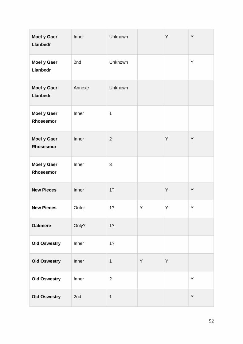
92
Moel y Gaer
Llanbedr
Inner Unknown Y Y
Moel y Gaer
Llanbedr
2nd Unknown Y
Moel y Gaer
Llanbedr
Annexe Unknown
Moel y Gaer
Rhosesmor
Inner 1
Moel y Gaer
Rhosesmor
Inner 2 Y Y
Moel y Gaer
Rhosesmor
Inner 3
New Pieces Inner 1? Y Y
New Pieces Outer 1? Y Y Y
Oakmere Only? 1?
Old Oswestry Inner 1?
Old Oswestry Inner 1 Y Y
Old Oswestry Inner 2 Y
Old Oswestry 2nd 1 Y

93
Old Oswestry 3rd 1 Y Y
Old Oswestry 3rd 2 Y
Old Oswestry 4th 1 Y
Old Oswestry 5th Unknown Y
Pen y Gaer
Llanbedr y
Cennin
Inner 1 Y Y
Pen y Gaer
Llanbedr y
Cennin
Middle 1 Y
Pen y Gaer
Llanbedr y
Cennin
Outer 1 Y
Pen y Gaer
Llangollen
Only? 1? Y Y
Pendinas
Llandygai
Only 1 Y Y Y
Pendinas
Llandygai
Only 2 Y
Penycloddiau Inner Unknown Y
Penycloddiau Outer Unknown

94
Penycorddyn
Mawr
Inner 1 Y Y Y
Penycorddyn
Mawr
Outer 1 Y
Penycorddyn
Mawr
Annexe Unknown Y Y
The Berth (main) Only? 1 Y
The Berth (main) Only? 2 Y Y
Woodhouses Only? 1 Y Y Y
Table 3.3. Evidence for the use of stone within excavated ramparts, with
rampart name, interpreted associated phase and Y (yes) or P (possible) for
excavated evidence for stone facing and/or stone within the rampart core
At New Pieces Enclosure, there was evidence of an outer stone face and a wooden
inner revetment. At Moel y Gaer Rhosesmor, the outer stone face also included a
wooden structure; “its front face was built in a combination of vertical timbers and
drystone walling” (Guilbert 1975b, 110). With its remarkable preservation and
excavation, these may present examples of a more widely used construction
technique but missed by early excavations or on sites where preservation was of a
much lesser standard.
3.1.3.3 Additional material
Four hillforts have evidence for a final phase of a dump of earth on top of an existing
structure; Old Oswestry, Moel y Gaer Rhosesmor, Pendinas Llandygai and
Eddisbury. Interestingly, the secondary dump of material at Pendinas was heavily
vitrified (White 1992, 159-166) which may suggest it reused earlier material. The
reuse of earlier vitrified material was found during the excavations of Moel y Gaer
Llanbedr within the main stone-faced rampart (Karl & Butler 2009).

95
Three ramparts, at the three separate sites of Old Oswestry, Moel y Gaer
Rhosesmor and Maiden Castle, have produced evidence for ‘capping’ on top of a
rampart, in stone, timber or both. In recent excavations, the inner rampart at
Penycloddiau has revealed a mortar-like lime capping on the inner rampart structure
(Mason & Pope 2015, 22).
3.1.4 Discussion
Of the 33 hillforts, there is evidence for around 90 phases or ‘instances’ of building
activity recorded to date, including palisades and ramparts, see Table A3.2. This
number will likely continue to rise as excavations, such as at Penycloddiau by
Liverpool University, reveal results. This was the case at Moel y Gaer Bodfari, where
the middle rampart was excavated recently to reveal at least three phases of
building.
The study has demonstrated that despite scant surface evidence, ramparts contain
highly complex development. For example, in 2016, the ‘counterscarp’ bank at
Penycloddiau was found to have elements of construction and a possible palisade
on top, this evidence ‘promoting’ the structure from ‘counterscarp’ to a purposefully
built outer bank of the hillfort. In addition, univallate sites can reveal development
and as complex stratigraphy as multivallate sites, despite appearing topographically
simpler with only one circuit of ramparts.
Where only one rampart has been excavated at multivallate sites in the past, the lack
of evidence for relationships between ramparts means that interpretation of their
phasing is almost impossible. Although this practise is less common in modern
investigations, where encountered, it makes identifying a sequence of activity at the
site problematic. However, the use of early excavation reports is still vital, and
attempts must be made to glean information from them as information on hillforts is
rare. As long as they are used appropriately, and their interpretations vigorously
critiqued, it is important not to disregard this scarce information.
The use of electrical resistance tomography at sites may prove to aid the
identification of the use of stone in ramparts across Wales, not just in Gwynedd, as
has been demonstrated. The identification of stone within the inner rampart at
Penycloddiau by tomography was realised upon excavation by Liverpool University.

96
The widespread use of stone on many hillforts may be demonstrated through survey
and without excavation.
In spite of this, the results of the study have shown that without excavation, it is
impossible to extend the typologies solely through identification through surface
evidence. In many cases, the results from excavation have revealed multifaceted
sites with evidence which could not have been predicted through topographical or
geophysical survey.
With over half of all of the hillforts revealing evidence for multiple building phases,
this suggests a pattern of continuity and renewal at site, whether part of a larger
programme of rebuilding or simply repair. Although information about the
relationships and phasing between multiple ramparts is often unavailable, the
presence of multivallation at many sites, coupled with the topographical
interpretation at sites such as Moel Arthur hillfort, can suggest that this indicates
different building periods surrounding a site. This result of just five hillforts showing
evidence for only one building event and being surrounded by one rampart,
highlights the complex structures and histories of the vast majority of the hillforts
demonstrated through their architecture. These findings are similar to Driver’s
discoveries in north Ceredigion and mid-Wales, where complex, monumentalisation
is consistently seen across the region, described as going “above and beyond the
requirements of basic enclosure and defence” and referred to as ‘prehistoric
architectural symbolism’ (Driver 2013, 129; 133). In fact, Driver highlights the
similarities between Moel Arthur hillfort and Castell Tregaron in north Ceredigion,
where both display “two sweeping and impenetrable façade ramparts blocking direct
access to a summit”, an example of his ‘Cors Caron’ façade, implying
communication of ideas and design concepts (Driver 2013, 133).
A result has been found that where multiple phasing is evident, it is most likely to
occur on the inner rampart, see Table A3.2. This may be due to the inner rampart
often being the favoured rampart to have been excavated and so this requires further
research. Nevertheless, this result may suggest that the inner rampart is either the
initial rampart on site which is later added to (with mass and/or by other ramparts) or
that it is regarded as the ‘prominent’ rampart and therefore undergoes more
development than the others on site.
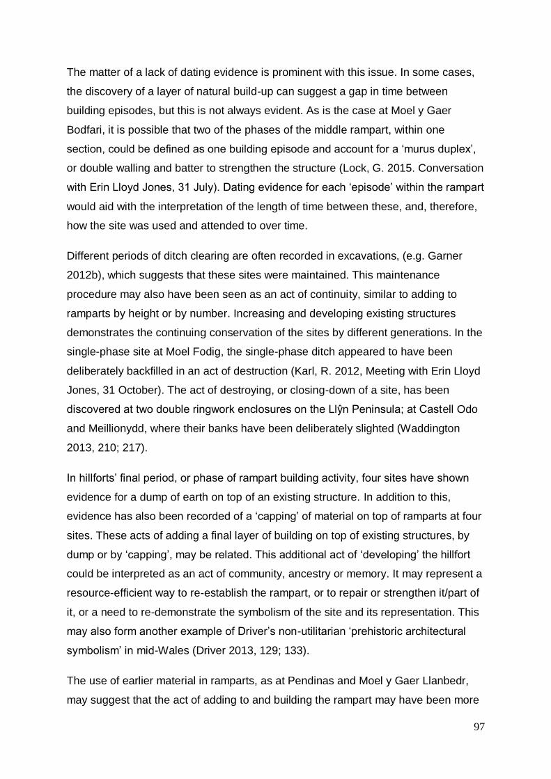
97
The matter of a lack of dating evidence is prominent with this issue. In some cases,
the discovery of a layer of natural build-up can suggest a gap in time between
building episodes, but this is not always evident. As is the case at Moel y Gaer
Bodfari, it is possible that two of the phases of the middle rampart, within one
section, could be defined as one building episode and account for a ‘murus duplex’,
or double walling and batter to strengthen the structure (Lock, G. 2015. Conversation
with Erin Lloyd Jones, 31 July). Dating evidence for each ‘episode’ within the rampart
would aid with the interpretation of the length of time between these, and, therefore,
how the site was used and attended to over time.
Different periods of ditch clearing are often recorded in excavations, (e.g. Garner
2012b), which suggests that these sites were maintained. This maintenance
procedure may also have been seen as an act of continuity, similar to adding to
ramparts by height or by number. Increasing and developing existing structures
demonstrates the continuing conservation of the sites by different generations. In the
single-phase site at Moel Fodig, the single-phase ditch appeared to have been
deliberately backfilled in an act of destruction (Karl, R. 2012, Meeting with Erin Lloyd
Jones, 31 October). The act of destroying, or closing-down of a site, has been
discovered at two double ringwork enclosures on the Llŷn Peninsula; at Castell Odo
and Meillionydd, where their banks have been deliberately slighted (Waddington
2013, 210; 217).
In hillforts’ final period, or phase of rampart building activity, four sites have shown
evidence for a dump of earth on top of an existing structure. In addition to this,
evidence has also been recorded of a ‘capping’ of material on top of ramparts at four
sites. These acts of adding a final layer of building on top of existing structures, by
dump or by ‘capping’, may be related. This additional act of ‘developing’ the hillfort
could be interpreted as an act of community, ancestry or memory. It may represent a
resource-efficient way to re-establish the rampart, or to repair or strengthen it/part of
it, or a need to re-demonstrate the symbolism of the site and its representation. This
may also form another example of Driver’s non-utilitarian ‘prehistoric architectural
symbolism’ in mid-Wales (Driver 2013, 129; 133).
The use of earlier material in ramparts, as at Pendinas and Moel y Gaer Llanbedr,
may suggest that the act of adding to and building the rampart may have been more

98
important than the physical function of the feature and representative of something
less tangible. The material which made up the north eastern rampart at Moel y Gaer
Llanbedr included burnt and vitrified stone with pieces of iron slag. It has been
proposed that this material was intentionally brought to build the rampart from an off-
site iron smelting midden, indicating the continuation or adoption of a Late Bronze
Age tradition of the deposition of metalworking debris (Karl & Butler 2009, 13-14).
Similarly, at Pendinas Llandygai, the foundation of the rampart included vitrified
material and may indicate a similar practise. Later, a dump of vitrified material placed
on top of the rampart could symbolise the significance of metalworking and/or
ancestry at hillforts after its establishment.
The discovery of a lime mortar at Penycloddiau hillfort provides additional evidence
for the ‘capping’ of ramparts, although this is thought to have been undertaken within
the same phase as the rampart core structure (any potential phases of building the
rampart are still to be determined). The existence of a mortar-like substance before
the Romano-British occupation of Britain is unusual in itself; the act of depositing it
may also represent a new sequence of rampart architecture and building process at
the site; an act representing the renewal of an already established hillfort undergoing
a new lease of life and restoration by a new generation.
This ongoing tradition of building on or adding to ramparts and ditch clearing
certainly represents an element of conservation. The continued development of the
ramparts, as shown in the archaeological record, clearly demonstrates a relationship
with the sites, whether continuous or returned-to. The conservation carried out on
hillforts and other archaeological and historic sites today demonstrates a similar
tradition of caring for places we share a heritage and cultural relationship with.
History and heritage sites are often used as an avenue and tool to reconnect with
our ancestors and learn for the future. Considering the generations of and multiple
phases of use of the hillforts, the hillfort builders - at any one phase - were
undoubtedly using and looking after the sites in the same vein. The hillforts may
have represented a site of cultural importance, as they still do today. The
preservation, conservation and regeneration of the ramparts acted as a continued
act of respect and responsibility towards their, and our, ancestors. The regeneration
of the sites may too be interpreted in a similar way to how we utilise historic sites in
regeneration in the 21st Century. The renewal of sites and change of use and

99
promotion as tools for economic regeneration may also aid interpretation of the
people developing hillforts in prehistory. The renewal of a site may have increased
its status in the community and aided its promotion and use after a period of neglect
or a lack of investment, in time or otherwise.
The use of timber does appear in the archaeological record. It is unclear as to
whether the low numbers of references to its use are due to poor survival and
identification or the fact that it was not as widely used as stone, for example. The
presence of palisades enclosing a site prior to ramparts may also aid this
interpretation. There is an increasing body of evidence indicating continuity of use
and development at hillfort sites. Five hillforts have revealed evidence for an initial
palisaded enclosure on the site, see Table 3.1. Interestingly, over half of these
hillforts then go on to build their ramparts using wood. Although the sample is not
large, it may suggest that these hillforts had a good supply of wood near to sites and
that this natural resource was utilised over many years. Mercer has demonstrated
that for Hayhope Knowe, later Iron Age palisaded enclosure of 12-15 houses in the
Bowmont Valley would have needed 1-2.5ha of woodland to construct, amounting to
a loss of around 2.5% of surrounding woodland, according to pollen analysis
(Tipping 2010, 186-187). Peat core analysis at Moel Llys y Coed on the Clwydian
Range demonstrates that towards the beginning of the Iron Age alder dominates, but
oak begins to decline, and hazel takes a sudden decline following a burning episode
seen at around 2600BP, around 650BC. By the turn of the millennium, hazel
recovers and encounters a low peak (Grant 2009, 18, 25). The Bronze Age had
already seen a widespread decline of shrub cover and trees, with woodland most
probably confined to steep valley slopes in this area, and this general trend is seen
to continue with a more open landscape predominating (Grant 2009, 24-25).
All these five hillforts also show evidence for the use of ditches either with or
following the palisade upon the erection of ramparts, see Table A3.2. Information on
ditches is not commonplace within the results of the excavated ramparts. The
development of a site from a simple (in relative terms) wooden enclosure to a hillfort
proper, and the reason behind this need, may have necessitated the requirement for
additional protection or show of a highly defended/visible site.
100
Intriguingly, all of these sites were then followed by at least two or more episodes of
rampart building and development, some with three episodes of building within a
single rampart structure, see Table A3.2. There appears to be development and
attention to the improvement or conservation of the hillfort architecture especially on
those sites which have early origins. This could suggest that the antiquity of an
‘original’ site warranted longevity by the communities. The prior, early establishment
of a site necessitated its continuation and maturity by future generations.
All five hillforts which were previously palisaded enclosures show evidence for an
inner face on at least one rampart as well as a ditch, see Table A3.2. The existence
of these two features at all sites with earlier origins may suggest a perception for an
additional architectural need. The identification of an inner face at hillforts in the
wider study area has only occurred at around half of the sites and is not always
accompanied by an outer face. It is possible that the presence of facing is to aid
strength and stability of a rampart bank, but an outer face is not always present
when a bank is built above a ditch; therefore, is not necessarily present to prevent
slump into the ditch. The occurrence of inner facing alone could suggest that the
facing or revetment of a rampart was for more than just strength or for show from the
exterior of the hillfort. The act of enclosure was an indication of marking out a
particular area, with appearance and display being just as important as the
functionality of enclosing a space; an act of monumentality (Smith 2005, 34). If a
facing was constructed for show, or to create the illusion of a great stone wall or an
impressive, sheer wooden barrage, could the same function for an interior rampart
apply for those on the inside of the hillfort? In which case, this interpretation
suggests that it was still important to demonstrate wealth, power and display to those
on the interior, or, alternatively, that once they were inside, the prospect of departure
may have been just as intimidating as their entry.
The use of revetment is common, even on sites where the surface evidence does
not reveal so and when good building material for stone revetment is not available
within the underlying geology. 85% of hillforts excavated have revealed evidence for
stone facing. This high percentage will aid interpretation for hillforts in general,
especially their depictions within the landscape. Many hillforts would have been seen
as being surrounded by large walls, not just ‘banks’, which would have added to their
significance in the landscape and their visual appearance and impact.

101
Stone is a key building component in most hillforts. Despite some sites being located
on poor building material, such as shale as is the case at Moel y Gaer Bodfari, stone
is still utilised. The use of stone prevailed, even on these sites with poor underlying
geology for building purposes. Furthermore, ramparts which have a stone face are
most likely to have also been built with a stony core.
Savory (1980) and Cunliffe (2005) have both suggested that the stone hillforts of
Gwynedd are of a certain united type and are distinguishable from the hillforts of
north east Wales. Where stone walled forts do occur in north east Wales, Cunliffe
lists those which are on the western limits. From the results, it has been
demonstrated that many hillforts which have been subject to excavation show a mix
of building materials and also a mix of rampart structures on multivallate sites. For
example, the hillfort on Conwy Mountain, Castell Caer Seion, combines a mixture of
stone wall with stone facing, earthen banks and ditches, and use of a promontory. A
mix of architecture can also be seen at Moel Hiraddug and Caer Drewyn. On the
Clwydian Range, it has been demonstrated that Penycloddiau and Moel y Gaer
Llanbedr utilised stone facing on their ramparts, which would have mimicked a stone
walled hillfort without necessarily the accessibility to good building stone. Moel y
Gaer Bodfari, within the middle rampart, utilised the local geology and had its middle
rampart made out of shale in a dry-stone wall technique, utilising boulder erratics for
its (earlier?) inner rampart.
The results show that across much of north Wales and the northern borders, most
ramparts use stone, see Table 3.3. Those which utilise an earthen rampart also has
preference for a stone facing. Rather than Gwynedd being united for having so many
examples of stone forts, this union appears to sweep over a much wider area. With
regards to those which utilise a stone facing against a bank, rather than the more
typical stone wall of Gwynedd, this could indicate an attempt to mimic a stone wall.
Gardner & Savory (1964) suggest that the walled hillforts of Gwynedd influenced the
building techniques in north east Wales, and it is possible that the addition of a stone
outer face on hillforts to the east demonstrates this. It may be that the lack of building
material from the underlying geology limited those in north east Wales to build the
stone walls and necessitated the use of a façade. The multiple building phases of
Moel y Gaer Bodfari’s middle rampart, and the amount of shale which was found in
its accompanying ditch, may represent unsuccessful attempts to build stone walls

102
using the local geology, instead, needing multiple phases of repair, batter and
rebuilding. Those which did have access to better underlying geology for building,
such as Moel Hiraddug and Caer Drewyn, do utilise stone walls.
However, this interpretation assumes that the hillforts in north east Wales are
attempting to imitate those in Gwynedd/north west Wales. The use of a rampart with
a wooden or stone facing may as well have been an initial building process, which
Gwynedd, with its stony geology, aspired to, but instead, had to utilise the time-
intensive dry-stone walls which are more common there. The early beginnings of
many of the forts in north east Wales and the borderlands, for example Eddisbury,
Old Oswestry and Moel y Gaer Rhosesmor, are examples of already established
enclosures, with multiple periods of activity both on the ramparts and within the
interior. This too can be said for Gwynedd, but it is the smaller double ringwork,
multi-phase enclosures of Meillionydd and Castell Odo which provide the early
evidence. Within Waddington’s study area, out of 18 excavated hillforts 10 are stone
built and eight embanked (Waddington 2013, 52-54), demonstrating that the
distribution of hillforts with stone-walled ramparts and faced ramparts may not have
as clear a divide as has been expressed and reported on in the past.
Returning to the stone-walled hillforts of Castell Caer Seion, Moel Hiraddug and
Caer Drewyn, the hillforts have evidence for both stone walls and stony/earthen
ramparts. Caer Drewyn, despite not being excavated, appears to change
architectural style half way around its circuit and be built half-and-half. Could the
hillforts which demonstrate both walls and banks be the missing ‘evolutionary’ link
between the two? This then raises the question of ‘which came first’, and therefore
which was the preferred style, and which was, potentially, the compromise?
Cunliffe proposed the theory of the rise of developed hillforts in Wessex, but many of
the sites in north Wales and borderlands show early activity with multiple phases of
activity and therefore development. This demonstrates that Cunliffe’s theory is not
represented fully within this area of Britain. Additionally, the term ‘developed hillforts’
requires review. The list of larger sites which have the addition of ramparts and
continued use can be accompanied by sites which may not have been multivallate,
such as Beeston Castle, but show periods of use from an early palisade and the
rampart being built upon throughout the Iron Age. The findings of multiple periods of

103
building activity in the middle rampart of Moel y Gaer Bodfari, only 3.6 hectares in
size, and the decrease in internal area at Moel Arthur in a secondary phase,
demonstrates that the ‘development’ of the sites may not be represented by large
sites nor of increasing the footprint. Many of these hillforts do not fit into the category
of ‘developed hillfort’ according to Cunliffe (2005, 388) but demonstrate a large
amount of activity on their rampart architecture over a period of time. The retrieval of
dating evidence to establish how long these periods were, and if they span the Iron
Age or were abandoned before the Middle/Late Iron Age, is vital to this
interpretation.
As Cunliffe highlights, the northern borderland of Wales may not be responding to
the same phenomenon of developing hillforts seen in Wessex and southern Welsh
borderlands at this time, but adjusting accordingly to local pressures, such as climate
change, external intervention, disease and population growth (Cunliffe 2005, 400;
582). It is possible that similar, local pressures in north Wales and its borderlands
were happening at an earlier stage to their southern neighbours, suggesting an
earlier date for their development of hillforts. Taking into consideration the early
dates from radiocarbon dates for the nearby sites in Wales and those in Cheshire
such as Eddisbury, Woodhouse and Helsby (see below, chapter 4), the hillforts of
the Clwydian Range alongside their developed architecture may have much earlier
beginnings altogether.
Waddington’s results, the area of which overlaps slightly with this wider study area,
lists six ‘large’ (over 6ha) hillforts, as with this study area. Other hillforts within her
study predominantly lie in the size category of under 1.2ha. Within this wider study
area, incorporating excavated hillforts within the surrounding area in north east
Wales and the Marches, the distribution between under 1.2ha sites and 1.2-6ha size
sites is much more evenly spaced. Waddington’s majority groups were small
univallate embanked hillforts and small univallate stone-built hillforts. The use of
stone, whether as a stone wall or the use of a stone wall as revetment, also
predominates this wider study area, but multivallation is much more common. The
fact that the presumed counterscarp bank at Penycloddiau has been found to be a
built structure in the north east corner, rather than a by-product of ditch clearing, also
highlights the issue of assumption without excavation and the complexity of the
rampart architecture. At Moel Fodig, a counterscarp was thought to exist alongside a

104
shallow ditch, but upon excavation no counterscarp bank was found; however, the
ditch was revealed to be 1.5m deep, around 3m wide and of the same, single phase
(Williams et al 2012, 43).
The key findings of this study are that, even where the geology is not ideal, stone
predominates, and, contrary to previous reports, this is not confined to Gwynedd.
The use of ‘earthen banks’ in north east Wales has been commonly reported due to
the surface evidence appearing so. From those hillforts which have been excavated,
the majority show evidence for a facing of the rampart, namely stone. Moel Arthur
and Moel Fenlli sit within the minority. During its 19th Century excavation, Moel
Arthur’s ramparts revealed evidence of a ‘dry-stone wall’, but this was not recognised
as revetment by the excavator, to the extent that it was pulled down, and not
reported on in detail. These early excavations could have revealed further
knowledge on the use of stone at sites such as these. In addition, during excavations
at Moel y Gaer Llanbedr, part of a dry-stone wall was discovered within the hillfort at
the base of the rampart and may have acted as a foundation (Karl & Butler 2009, 7-
8).
Multivallation within the area is common and within rampart structure multiple phases
of building are evident, see Table A3.2. This is seen throughout the record, across
the wider study area and is not confined to sites of a particular size. Although over
half of the hillforts have at least one rampart which appears to be single-phase, only
five hillforts are univallate and can truly be considered a single (rampart building)
phase site. For those hillforts with multiple circuits of single-phase ramparts, as
relationships between these additional circuits cannot be confirmed, it cannot be
assumed that multivallation occurred as a phased introduction to the hillfort, even
though Davies & Lynch suggest that this is so (Davies & Lynch 2000, 149). If these
multivallate hillforts are indeed all of a single phase, this again demands re-
interpretation of Cunliffe’s developed hillfort theory. Any information as to the date of
this single activity of building multivallate hillforts in this area would be key in
understanding this massive undertaking and the role of hillfort architecture in north
Wales and the borders. The fact that many of these examples have banks with
subtle yet apparent differences within their architecture, such as Moel y Gaer
Llanbedr, New Pieces enclosure, Pen y Gaer Llanbedr y Cennin and Maiden Castle,
suggests that these were not all built in a single episode nor by the same people.

105
Just as this study has commonalities with Varley’s 1948 comparative study and
Driver’s 2013 research, for example, with the progression of more fieldwork, future
research will continue to contribute to the knowledge of hillfort rampart architecture.
However, as research continues, it is important not to look at hillfort sites in isolation,
but as a group. The merging of results with other studies in similar, overlying
geographical areas will increase the capacity to compare sites across a wider area
and aid interpretation of hillforts as a whole.
The upcoming Hillfort Atlas will publish a compiled database of all hillfort sites in the
British Isles and will provide a single point of information to compare records. With
the complexities of, and threat to, individual Historic Environment Records (HERs) in
England, the correlation and assemblage of this data is important for the continuing
field of hillfort studies. As with the HER, it is important that the Hillfort Atlas is an
organic resource, which can be updated and maintained as and when new research
comes to light. It is also important that both HER and the Hillfort Atlas are clear to
acknowledge what has been found by excavation and what is understood following
non-invasive archaeological methods. It has been clearly demonstrated that the
results of excavation reveal a much more complex structure than can be recognised
from the surface evidence.
This section has provided a comparison of data from excavated ramparts from the
wider study area, highlighting the complexity of their construction and their
importance for more than just ‘function’. Another main architectural feature of
hillforts, and a subject of much interest to excavators in the past, is the hillfort’s
entrance. A comparative study of excavated entrances within the wider study area
will now be reported on.
3.2 Entrances
Hillfort entranceways have been the subject of much discussion within hillfort
studies. This section will bring together previous studies of hillfort entrances within
the wider study area, using data from excavated examples in a comparative study to
search for patterns, nuances and variations.
All the hillforts of the Clwydian Range have evidence of inturned entrances. Within
north east Wales specifically, Savory suggests that the defences and elaborate

106
gateways of these hillforts emphasise a highly organised and centralised community
from the beginning of the Early Iron Age (Savory 1980, 300). Ralston suggests that
an inturn would increase the hillfort’s defensibility, creating a long funnel with
increased control of any incomers, keeping visitors approaching in range for longer
and giving a height advantage to the defenders (Ralston 2006, 67). The ‘Pen Dinas’
façade identified in mid-Wales displays similar traits, with a long journey past
impressive horizontal defences to get to the gateway, thus heightening the visual
impact (Driver 2013, 137-138). In contrast, the ‘Cors Caron’ façade displays a more
direct sight of the gate but is still surrounded by elaborate vertical defences (ibid.).
Moel Hiraddug (10.7ha enclosed), Penycloddiau (17.7ha) and Moel y Gaer Llanbedr
(2.6ha) on the Clwydian Range have multiple entrances. Considering the area these
hillforts (in their final phase) enclosed, one could assume that the larger areas of
Moel Hiraddug and Penycloddiau could warrant multiple entranceways due to their
size. However, Moel y Gaer Llanbedr is one of the smaller hillforts of the Clwydian
Range and has two entrances, one of which demonstrates impressive outworks.
Moel Fenlli (8.3ha), encloses over three times the area and has only one inturned
entranceway with no additional features apparent, apart from a possible stock
enclosure utilising the berm between the inner rampart and the counterscarp south
of the entrance (Brooks & Laws 2006a, 9).
Forde-Johnston suggested that the use of guardchambers, or ‘large recesses’ within
the entrance passage, flourished in this area (1964, 5). In his paper on ‘The Hillforts
of the Clwyds’, he states that guardchambers are a ‘feature’ of north Wales and the
Welsh Marches (Forde-Johnston 1965, 152). Bowden has proposed that these
recesses might be sought on the north Wales coast (Bowden 2006, 424) and noted
that they have mainly been found on sites in north Wales and the Welsh Marches
(ibid., 423). Although most remain unexcavated, all six hillforts on the Clwydian
Range have at least one inturned entrance and most of these appear to have
‘guardchambers’ within the inturns13 for at least one phase of the hillfort’s use.
Bowden warns that guardchamber features themselves can be difficult to recognise
in terms of surface morphology and questions whether they could have been
13 Due to lack of excavation, possible guardchambers which stand separate from the inturn and gateway may not be accurately interpreted or identified. Where suggested, these will be termed ‘guard houses/huts’.

107
deliberately backfilled, giving Eddisbury and Penycorddyn Mawr as examples
(Bowden 2006, 426). This may be evidence of deliberate destruction or slighting of a
site, as proposed at the earlier phases of Dinorben (Gardner & Savory 1964, 40).
Nevertheless, some surface morphology is usually still identifiable by eye for those
entrances with skewed gaps, inturns and outworks, and associated features such as
hollow ways. On those hillforts made of dry-stone walling, previous entrances which
have since been blocked up can also be identified, such as at Castell Caer Seion
(Smith 2012), Bryn y Castell (Crew 1985) and Moel Hiraddug (Brassil et al 1982, 83).
This chapter will examine evidence for excavated entrance architecture and search
for any correlations between sites in the wider study area. Similarities between
gateways have been explored in the past, for example by Gardner & Savory (1964,
87-90), Guilbert (1979c) and Cunliffe (2005). Sites with noted comparable
entranceway development include Moel Hiraddug, Penycorddyn Mawr and Dinorben.
Any data available for the six sites of the Clwydian Range will be collated and
discussed, alongside any previous conclusions and theories.
Only Moel Hiraddug on the Clwydian Range has entrances which have been
comprehensively excavated14. Therefore, a thorough breakdown of all data collected
through published reports on excavated entranceways for hillforts in the wider study
area, within a radius of approximately 30 miles of the Clwydian Range, will be
compared and examined.
Following this, conclusions will be drawn as to whether the Clwydian Range and
area surrounding shows any trends and characterisation between hillfort entrances,
including whether guardchambers are indeed a ‘feature’ of north Wales and the
Marches and whether hillforts in this area can be described as ‘typical’ or otherwise.
14 Wynne-Foulkes (1850a; 1850b) excavated three hillforts in the Clwydian Range in the mid-19th Century, but without accurate information on exactly where this was carried out his results may only be used with due caution for accuracy. During his excavations of the site in the early 20th Century, Stapleton reported a possible blocked entranceway at the south west corner of the Moel y Gaer Bodfari, see Figure 3.4, (Stapleton, 1909, 236), currently being re-explored by Oxford University.

108
3.2.1 Evidence from the Clwydian Range
3.2.1.1 Position
A complex entranceway with a dog-legged approach is located at Moel y Gaer
Llanbedr at the access point to the enclosure on the arm of the spur which adjoins it
to the main ridge of the Clwydian Range (Brooks & Laws 2007, 3). The hillfort is
described “more highly developed than others on the Clwydian Range” (Brooks &
Laws 2007, 2).
Its western entrance is unusual with regards to its position; located on a steep slope
both overlooking the Vale of Clwyd and below a step face within the hillfort (Brooks &
Laws, 2007, 3) making it difficult to access. The entranceway itself appears to be a
simple inturned entrance creating a corridor of c.15m in length (Brooks & Laws 2007,
3). Brooks & Laws suggest that this entranceway could be secondary, due to the
inner rampart on its southern side appearing to turn inwards slightly before it reaches
the gateway. They suggest that an earlier, simpler gateway could have been located
here and that the inturned entrances, on both the western and the north eastern
entranceways, were a later addition during a more developed phase of the site
(Brooks & Laws 2007, 4). A similar arrangement is seen at the eastern entrance with
a slight break between the inturns and the ramparts suggesting they were added on
to a simpler gap (Brooks & Laws 2007, 4).
The question remains as to why an entranceway was built at the western position of
the site, at the top of such a steep slope where access is difficult. The entrance was
described as ‘clearly not functional’ during research of the site by Bangor University
(Karl & Butler 2009, 3). One suggestion could be to provide a focal point of the hillfort
from the valley below, making it appear inaccessible and formidable. Additional
evidence for where a hillfort’s entrance may have been used for display is seen at
Moel Arthur, where the ramparts appear to have been heightened “presumably to
create a more impressive gateway” (Brooks & Laws 2006b, 3). However, another
consideration for the location of Moel y Gaer Llanbedr’s western entrance would be
whether it would only appear inaccessible for approaching traffic but could be in a
prime position for anyone wanting to exit the fort and have rapid access down the
western slope to the Vale of Clwyd below.

109
A similar but less extreme arrangement can be seen at Moel Fenlli where the sole
original entranceway is located at the western edge of the hillfort overlooking the
Vale of Clwyd. The easiest approach to the hillfort is on the flatter, eastern side,
where the hillfort boasts multivallation, but there is no evidence apparent for there
ever having been an entranceway feature on the eastern edge of the hillfort,
although phasing has been suggested at this point (Brooks & Laws 2006a, 9). The
western entrance is currently accessed by the Offa’s Dyke Path National Trail which
leads from the pass of Bwlch Pen Barras to the north. This line of footpath was
reported by Wynne-Ffoulkes during his 1849 ‘exploration’ of the site, where he
undertook numerous ‘diggings’ and where he also refers to finding a metalled
trackway at the entrance (Wynne-Ffoulkes 1850a, 83).
The original entranceway would have been an obvious feature seen from the valley
below and has relatively easy access to the important pass through the Clwydian
Range at this point. The eastern edge would not have been as directly accessible to
the Bwlch Pen Barras pass to the north or the pass to the south, which could explain
the siting of the entranceway on the steeper western side.
Another feature which could have made the entranceway more obvious in the
landscape is the area to the south of the entrance, where the counterscarp bank
changes course away from the inner rampart to enclose a berm, which has been
interpreted as a possible stock enclosure (Brooks & Laws 2006a, 9).
In reference to the situation of the entrance, another feature of note on Moel Fenlli is
the Bronze Age burial mound which sits on the summit of the hillfort, close to the
eastern edge. The entranceway is at the furthest point from the burial chamber, and
this could suggest a respect or ritual, which meant that an entranceway at the
eastern edge would have been too close to this monument (Gale 1999, 92). This is
mirrored at Penycloddiau which also encloses a Bronze Age burial tomb at the
summit (Grant & Jones 2008), its two entranceways being located far away from this
feature. However, during a drone survey of the hillfort in 2015, Pope and Mason
suggested the possibility of a third entranceway, to be confirmed, located in the north
west corner of the hillfort, and much closer to the burial mound (Pope, R. 2016.
Conversation with Erin Lloyd Jones, 9 August).

110
Evidence for at least six entrances has been found at the multiple enclosure site of
Moel Hiraddug and multi-phase use of some of these has also been discovered
through excavation (Brassil et al 1982, 19). The Main Inner gateway shows at least
four phases, the first phase being a single gap in the wall later blocked and moved a
few metres to the west, see Figure 3.2, which appears to have been positioned
strategically to increase the visibility from the rampart to both approach tracks to the
entrance (Brassil et al 1982, 20).
Figure 3.2. Moel Hiraddug’s Main Inner entrance, first (blocked) simple gap
entrance to the right and (relocated) final phase with inturns and
guardchambers, to the left, and approximate location of two inhumations
discovered beneath a metalled trackway. After Brassil et al 1982 & Bevan-
Evans 1970b
The north west gateway shows at least three phases and is constructed at an offset
angle through the wall which, in itself, creates the illusion of its own longer passage
(Brassil et al 1982, 83, fig 29), see Figure 3.3.
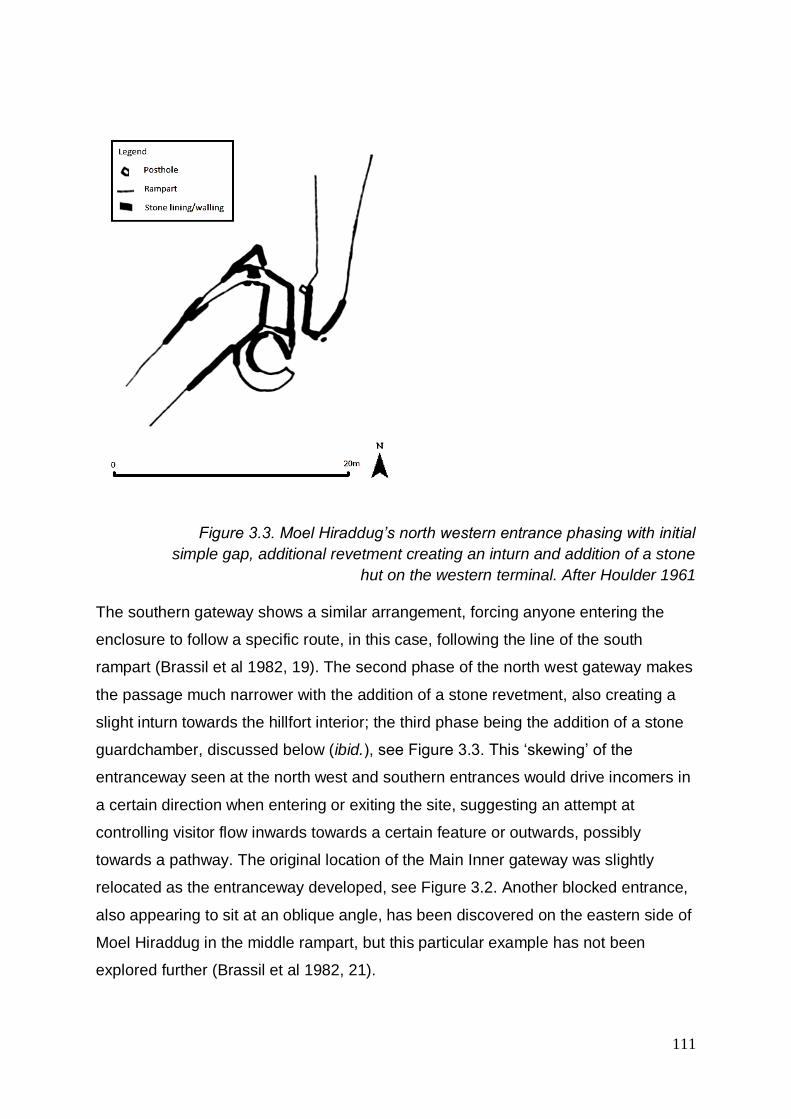
111
Figure 3.3. Moel Hiraddug’s north western entrance phasing with initial
simple gap, additional revetment creating an inturn and addition of a stone
hut on the western terminal. After Houlder 1961
The southern gateway shows a similar arrangement, forcing anyone entering the
enclosure to follow a specific route, in this case, following the line of the south
rampart (Brassil et al 1982, 19). The second phase of the north west gateway makes
the passage much narrower with the addition of a stone revetment, also creating a
slight inturn towards the hillfort interior; the third phase being the addition of a stone
guardchamber, discussed below (ibid.), see Figure 3.3. This ‘skewing’ of the
entranceway seen at the north west and southern entrances would drive incomers in
a certain direction when entering or exiting the site, suggesting an attempt at
controlling visitor flow inwards towards a certain feature or outwards, possibly
towards a pathway. The original location of the Main Inner gateway was slightly
relocated as the entranceway developed, see Figure 3.2. Another blocked entrance,
also appearing to sit at an oblique angle, has been discovered on the eastern side of
Moel Hiraddug in the middle rampart, but this particular example has not been
explored further (Brassil et al 1982, 21).

112
During his excavations of Moel y Gaer Bodfari in the early 20th Century, Stapleton
reported a possible blocked entranceway at the south west corner of the hillfort, see
Figure 3.4 (Stapleton 1909, 236). In 2011, Oxford University conducted an extensive
survey across the whole site, as well as looking at areas Stapleton had previously
explored (Lock & Pouncett 2013). These surveys were able to assist the conclusion
that the possible secondary entranceway on the western side of the hillfort, recorded
by Stapleton (1909, 236), may not have been an original gap in the ramparts.
However, upon excavation of this thoroughly disturbed area, initial investigations
revealed a number of structures previously unidentified and an earlier entranceway
may exist in the vicinity (Pouncett, J. 2015. Conversation with Erin Lloyd Jones, 31
July).
Figure 3.4. Moel y Gaer Bodfari possible blocked western entrance.
After Stapleton 1909, no scale or alignment provided in original.
Orientation data from the thirteen known entrances on the six hillforts of the
Clwydian Range (see Figure 3.5 below and Table A3.1) indicates that there is a
preference for entranceways towards an easterly aspect, as 7 entrances are
orientated with a north east, east or south east aspect. This takes into account the
oblique angles of some of the entrances such as Moel Hiraddug’s north western
entrance’s north aspect and its Main Inner entrance, which appears to have been
built on such an angle to have maximum view over approaching paths (Brassil et al
1982, 20) and to control visitor flow, as discussed above.

113
Figure 3.5. Aspect of known entrances on the hillforts of the Clwydian
Range, showing a preference for entranceways to be orientated towards an
easterly aspect
Interestingly, even though the north west gateway and Main Inner gateway of Moel
Hiraddug both have multi-phase construction, the earlier phases of simple gaps in
the ramparts still show this ‘skewing’ of the gap to create an angled approach to the
hillfort (Brassil et al 1982, 82-84). All of Moel Hiraddug’s entrances appear to have
been built at an oblique angle to the approach, following the contours, and it is
suggested that this was done strategically to increase control and surveillance of
those approaching (Brassil et al 1982, 20), where the design of the offset entrance
terminals is described as ‘clever’ and “similarly contrived... each designed to
lengthen, and thereby strengthen, the defended approach to the... gate itself, at the
same time producing reasonably graded approach tracks” (Brassil et al, 1982, 21).
At Moel y Gaer Bodfari, the entrance also utilises steep slopes by sitting closely to
the eastern edge of the hill (Brown 2004, 76) and is slightly offset to the main
ramparts. It is approached by a curving pathway, determined by an outer work to the
north of the entrance and a T-shaped club end to the inner rampart on the western
side of the entrance with a simpler inturn on the eastern side (Forde-Johnston 1976,
Figure 129; Lock & Pouncett, 2011, 4). This slight curve to the approach may have

114
inhibited the approacher’s view of the actual entrance of the hillfort and the large
roundhouse located on a cut platform directly opposite the entrance, discovered
during survey and excavations by Oxford University (e.g. Lock & Pouncett 2011).
Lengths of bank along the approach to hillfort entrances are also seen at Moel Arthur
and Penycloddiau’s eastern entrance. At Penycloddiau’s eastern entrance a length
of bank to the south of the entranceway appears to act as a hornwork to the
entrance and has been interpreted as an attempt to block access to the south of the
entrance; the reason for this potentially explained by a large deep cwm or gully in the
hillside a few metres from the entrance (Forde-Johnston 1976, 241). At Moel Arthur,
the entrance passage appears to curve slightly so that, on approach, the traveller is
made to follow the passage to the right, where the entrance proper is out of sight
around the corner. This may also have meant that the people inside the hillfort at the
entrance would not have been able to see the approachers, see Appendix Two.
Here, however, the ramparts at this location appear to have been heightened
(Brooks & Laws 2006b, 3) and this height would have increased the visibility of the
approach track from atop.
The approach to Moel y Gaer Llanbedr’s inturned eastern entrance is determined by
multivallation and approached through a 90-degree dog-leg turn to the left and then
another to the right to reach the entrance proper (Forde-Johnston 1976, 237). This
entranceway is the most complex on the Clwydian Range, but its location is
significant in the fact that the north eastern entranceway to the hillfort is along a
relatively flat spur from the main ridge of the Clwydian Range. Where other hillforts
have a relatively flat area surrounding the ramparts, such as to the north of
Penycloddiau hillfort or east of Moel Fenlli hillfort, we see the similarity of
multivallation in both cases, but their entranceways placed in much ‘less-accessible’
positions on the hills, with steeper approaches. It cannot be discounted that Moel y
Gaer Llanbedr’s north eastern entranceway is this complex in order to slow down
“enemies” as suggested in the Royal Commission’s Inventory in the early 20th
Century (RCAHMW 1914, 88). The question that then presents itself is why the
hillfort constructors built the entrance at this position. One possibility is that it may be
due to the incredibly steep slopes surrounding the site in all other locations,
rendering other directions of approach unusable or less functional, as is seen at the
western entrance.

115
3.2.1.2 Inturns
Following survey, 11 out of 13 known entrances in their final phase have been
identified as inturned and this high percentage, 85%, in the six hillforts of the
Clwydian Range demonstrates that this was a common feature in this particular
area.
There is the possibility that some of the hillfort entrances which display evidence of
inturns would have had earlier phases which may not have included inturns and that
these were a secondary phase, such as is suggested by Brooks & Laws at Moel y
Gaer Llanbedr (Brooks & Laws 2007, 4). This may indicate that those entrances
without inturns in the locale, i.e. the blocked entranceway within the eastern rampart
at Moel Hiraddug, are of an earlier phase. Incidentally, the two entrances which do
not have inturns are both at Moel Hiraddug.
Although the inturned entrance suggests some uniformity between these hillforts,
other features within these entrances show that they differed in style.
3.2.1.3 ‘Guardchambers’ and Guard Huts
Some entranceways of the Clwydian Range hillforts have been found upon
excavation to be multiphase features, such as the Main Inner gateway at Moel
Hiraddug, see Figure 3.2. Although most remain unexcavated, all six hillforts on the
Clwydian Range have at least one inturned entrance and most of these appear to
have ‘guardchambers’15 within the inturns for at least one phase of the hillfort’s use.
In addition to guardchambers, some topographical surveys of the sites have noted
platforms which could be associated with the entrances, possible evidence of huts or
structures associated with the entrance but not actually built into the entrance
structure itself16.
For the information available through excavation and non-invasive survey, the
amount of entrances with associated features, such as guardchambers, guard huts
and associated platforms, possibly for free-standing guard huts, can be considered,
15 For the purpose of this paper, the term guardchamber will be used although their use by a ‘guard’ is not assumed. 16 Due to lack of excavation, possible ‘guard huts’ which stand separately from the inturn and gateway may not be accurately interpreted or identified.
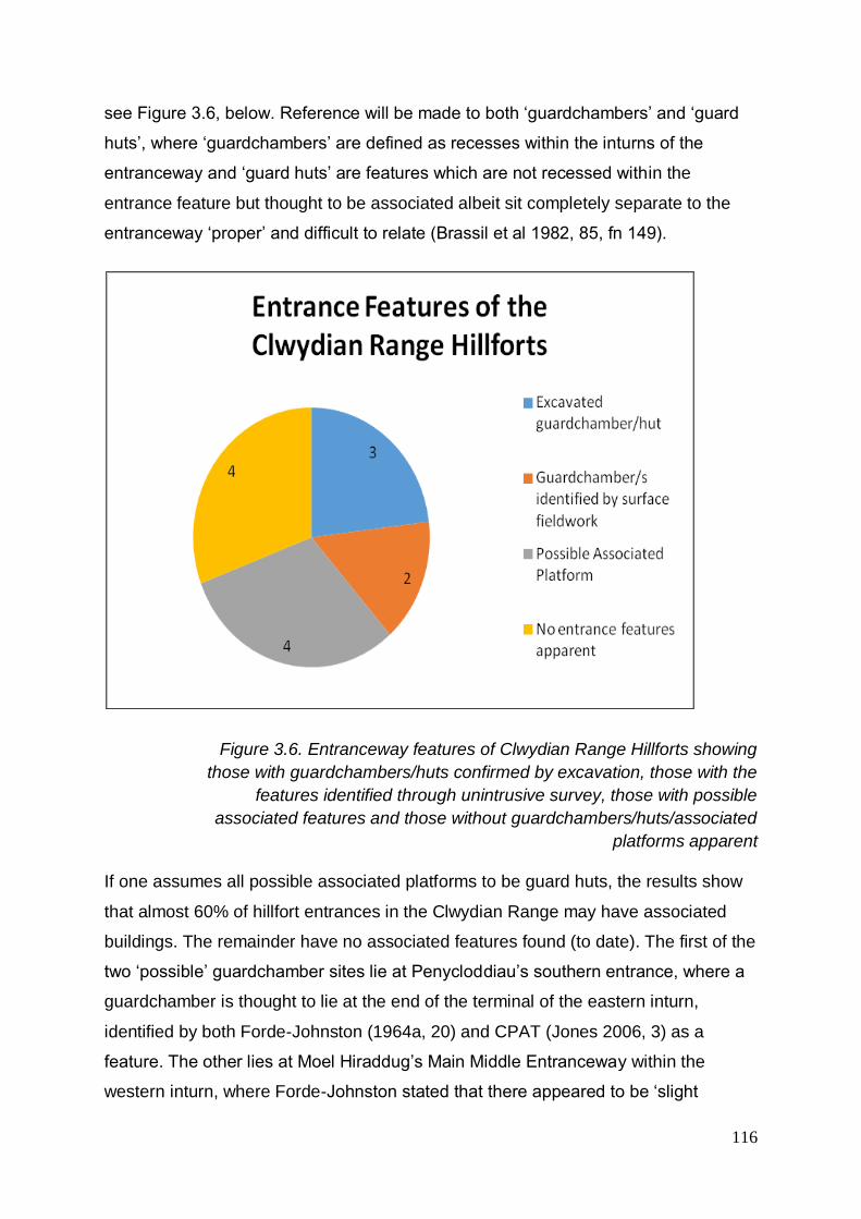
116
see Figure 3.6, below. Reference will be made to both ‘guardchambers’ and ‘guard
huts’, where ‘guardchambers’ are defined as recesses within the inturns of the
entranceway and ‘guard huts’ are features which are not recessed within the
entrance feature but thought to be associated albeit sit completely separate to the
entranceway ‘proper’ and difficult to relate (Brassil et al 1982, 85, fn 149).
Figure 3.6. Entranceway features of Clwydian Range Hillforts showing
those with guardchambers/huts confirmed by excavation, those with the
features identified through unintrusive survey, those with possible
associated features and those without guardchambers/huts/associated
platforms apparent
If one assumes all possible associated platforms to be guard huts, the results show
that almost 60% of hillfort entrances in the Clwydian Range may have associated
buildings. The remainder have no associated features found (to date). The first of the
two ‘possible’ guardchamber sites lie at Penycloddiau’s southern entrance, where a
guardchamber is thought to lie at the end of the terminal of the eastern inturn,
identified by both Forde-Johnston (1964a, 20) and CPAT (Jones 2006, 3) as a
feature. The other lies at Moel Hiraddug’s Main Middle Entranceway within the
western inturn, where Forde-Johnston stated that there appeared to be ‘slight

117
hollows’ within the inturns of both this entranceway and the Main Inner (Forde-
Johnston 1965, 177). These were found to be present at the Main Inner, see Figure
3.2, but not within the eastern inturn of the Main Middle, in its latest phase at least
(Brassil et al 1982, 20).
However, these results may be misleading. At the north west entrance of Moel
Hiraddug, a possible associated hut platform was identified to the north east
(Houlder 1961, 16). Upon excavation it was found to be a natural feature defined by
the limestone outcrop (ibid.). Care must be taken when attempting identification of
features prior to excavation due to the underlying geology.
Therefore, 40% of entrances have proposed guardchambers recognised by
excavation and topographical survey; but less than a quarter of entrances in the
Clwydian Range confirmed by excavation alone. This confirms the need for a wider
study area to utilise additional entranceway excavation results.
Brassil suggests that fewer guard huts are known compared to guardchambers
(Brassil et al 1982, 20), but this may simply be due to them being harder to identify.
Many ‘associated platforms’ have been reported as ‘platforms’ as there is no firm
evidence to suggest their role. One example of a potential ‘guard hut’ was excavated
at nearby Moel y Gaer Rhosesmor, relative to a gap in the palisade fence, see
Figure 3.7. It has been interpreted as a guard hut due to it being the sole
roundhouse within the cluster of huts whose entrance is orientated towards the gap
in the palisade rather than to the east as with the others present (Guilbert 1977a,
47).

118
Figure 3.7. Moel y Gaer Rhosesmor palisade showing gap at eastern edge
and internal buildings including one hut with entrance aligned to the west
facing the palisade entrance gap, where all other excavated huts were
found to have entrances facing south east. After Guilbert 1977a
Of the Clwydian Range hillforts, guardchambers have been reported at Moel
Hiraddug’s Main Inner gateway, see Figure 3.2 (Forde-Johnston 1965, 177; Brassil
et al 1982, 20). What is described as a ‘guard hut’ is located at the north western
entrance for its final phase, excavated in 1954-55 (Houlder 1961, 12-16; Brassil et al
1982, 84-85). It is described as a ‘guard hut’ rather than a guardchamber as it has
been ‘tacked on’ to the hillfort entranceway, rather than being recessed into the
inturn of the entrance, see Figure 3.3 (Brassil et al 1982, fn 149). Whilst guard huts
appear to be less common than guardchambers, another example is thought to exist
at nearby Conwy Mountain hillfort, Castell Caer Seion (Brassil et al 1982, fn 149).
Moel Arthur displays clear examples of ‘recesses’ within its entrance inturns which
can be identified by eye, corroborated by topographical survey (Brooks & Laws
2006b) but remain unexcavated.
Guardchambers are suggested at Penycloddiau; described as being present at the
southern entrance by Forde-Johnston but with no evidence for guard-chambers at
the eastern entrance (Forde-Johnston 1965, 166-7). This is questioned by Nigel
Jones who, during the topographical survey of the site, suggests that two levelled
areas on the north side of the track at this eastern entrance may have been positions
for round huts (Jones, 2006, 3) suggesting the presence of ‘guard huts’ rather than
‘guardchambers’.

119
The topographical survey at Moel Fenlli shows no sign of guardchambers within its
inturned entranceway but did reveal a possible associated platform just inside the
entrance passage (Brooks & Laws 2006a; 2007). A similar occurrence is seen at
Moel Hiraddug, where a recessed platform behind the western terminal of the South
Gateway could have been for a building and therefore may suggest the presence of
a guard hut at this position (Brassil et al 1982, 19 fn. 12).
In addition, there was no evidence for guardchambers apparent at either of the
entrances at Moel y Gaer Llanbedr (Brooks & Laws 2008a, Figures 2 & 7) and,
although it is seen that the ‘inturns’ at both entrances appear to be a secondary
phase to an original gap through the ramparts, the eastern entrance is both a
complex entranceway with a dog-leg turn and the addition of an ‘annexe’ at this
point. Therefore, although the entranceways do not boast guardchambers, this may
suggest an additional phase to the site that the other hillforts on the Clwydian Range
did not experience.
In recent years, the only entranceways and therefore guardchambers which have
been excavated on the Clwydian Range are some of those of Moel Hiraddug.
Excavation of the Main Middle gateway at Moel Hiraddug revealed limestone blocks
in the passage way which are proposed to have been in such a location they would
have prevented the presence of a guardchamber in at least the eastern inturn,
certainly for its final phase, as mentioned above (Brassil et al 1982, 20). The guard
hut of the north western gateway at Moel Hiraddug was explored by Houlder in 1954-
5 and was thought to have been built on to the entrance passage at the same time
as the narrowing of the passage (1961, 12-16). Houlder found that it was “of poor
construction” and, as it sat on a slope, the ground had been raised using rubble; the
occupation level “...consisted of a trodden layer of greyish clay, containing flecks of
charcoal, but with no trace of a hearth” (Houlder 1961, 14-16). It was thought that a
gap in the walling facing east-south east was probably where the entrance to the hut
lay (Houlder 1961, 16). A fragment of very rough, red, poorly fired pottery was found
below the guard hut (Houlder 1961, 17).
The published plan of the north west gateway was re-examined by Brassil et al
(1982). It was suggested that this third phase at the entranceway, with guard hut
following a second phase of narrowing, would match the addition of guardchambers

120
at the Main Inner gateway. This indicates that the radiocarbon dates, 430+/-60bc
(CAR-374) and 410+/-64bc (CAR-373)17, taken from the blocking of the earlier
period 1 passage at the Main Inner, provided a potential terminus post quem (TPQ)
for the introduction of guardchambers at both entrances (Brassil et al 1982, 84-85).
The Main Inner gateway at Moel Hiraddug was explored over four seasons by the
not fully published excavations of Bevan-Evans in the 1960s and Davies 1969-72
(Brassil et al 1982, 26). Davies suggests that the initial period 2 arrangement at the
Main Inner gateway comprised of just one sub-rectangular guardchamber recessed
into the eastern inturn which, like the north west gateway, would have sat on the
right-hand side when entering the passage (Davies 1972, 12-13). A hearth was
found, associated with the rear of the ‘guardchamber gate’ which sat on top of the
demolished western terminal of the earlier phase which would have sat 6m to the
east of the later gate (Davies 1971, 8-9). The hearth was multi-phase through each
development of the relocated phase 2 entrance (Davies, J. L. 2016. Meeting with
Erin Lloyd Jones, 25 November). Beneath this hearth, an iron swan’s neck pin was
found, which could date back as far as the Sixth Century BC, giving a TPQ for the
gateway pre-guardchambered phase (Davies 1971, 9). A ‘heavily metalled roadway’
was found to run from the Main Inner gate and which had sealed “two inhumed
burials immediately inside the gate and on the axis of the gate passage”, see Figure
3.2 (Davies 1970a, 9-10). Although there was no dating evidence for the
inhumations, they were believed to be contemporary and of Iron Age date at the
latest (Davies 1970a, 10)18. In a subsequent phase, the guardchamber was reduced
in size and then in its final phase, it was developed with the addition of a
guardchamber on the western terminal, ultimately comprising of two semi-circular
guardchambers (Davies 1972, 13).
This observation is particularly interesting as it has been stated that rectangular
recesses can sometimes replace sub-circular recesses, but never the other way
around (Bowden 2006, 426). This theory is disproved at this particular entrance at
Moel Hiraddug. Gardner and Savory suggest that there was a local evolution from
sites with semi-circular or rectangular chambers, such as those at Caer Drewyn and
Eddisbury Phase I, to rectangular chambers with wall-fronted ramparts as seen at
17 Recalibrated and discussed further in chapter 4 18 Discussed further in chapter 4

121
Penycorddyn Mawr and Dinorben III, and a still later date of sloping fronted ramparts
with guardchambers, as seen at Dinorben’s final phase and at the further afield
Wrekin Phase II (Gardner & Savory 1964, 90).
3.2.2 Excavated entranceway results
In total, nine hillforts within the wider study area have had entrances excavated and
published to a useable standard19. Of these nine hillforts, 15 entrances20 with 37
separate phases of entrance construction were identified, including in some cases
destruction, repair and relocation. Four of the hillforts have had more than one
entrance excavated, but Old Oswestry, for example, had its western entrance
excavated but not its eastern.
3.2.2.1 Location and Aspect
A high proportion of entrances, of excavated hillforts within the wider study area, are
located at an easterly location within the hillfort defences, see Figure 3.8 and Table
A3.4. Nine entrances were located in the north east, east or south east of the hillfort.
A further three were located at the north west, west and south entrances. The
hillforts with entrances which are placed in a south or westerly position also have
entrances in an easterly position. However, not all hillforts with eastern entrances
also display other entrances elsewhere within the site. In the case of hillforts which
have been excavated, this shows a preference for an entrance located in the east.
19 Wynne-Foulkes (1850a, 1850b) and Taylor (1980/81; 1993), for example, have not been classed as ‘useable’ for this exercise. 20 Entrances which have been found to have been relocated are classed as one ‘entrance’ with multiple phases. For this statement, the two entrances at Bryn y Castell have been treated as two separate entrances, although it is proposed that one replaced the other, relocated.

122
Figure 3.8. Excavated hillfort entrance locations, showing a high proportion
of entrances being situated in an easterly location
Despite locations of entrances being relatively clear by investigating simple maps of
sites, the aspects of the entrances differ. For example, some entrance passages
were angled or overlapped which altered the aspect from the entrance to a direction
different from its location within the ramparts.
Similarly, nine entrances had an easterly (north east, east, south east) aspect but
have a more even distribution across the compass points, see Figure 3.9 and Table
A3.4. The five remaining entrances had aspects of north, west, south and two north
west. As well as location, a preference for an easterly aspect from the site can be
seen.
Ralston 2006 discusses the choice of entrance orientation, such as the influence of
cosmology. Although in some cases, accessibility to route-ways, resources or
defensibility may be obvious reasons for the placing of an entranceway at a certain
position within the enclosure, he notes that this theory does not always correspond
with the evidence. Examples are given, notably in southern Britain and especially for
earlier Iron Age hillforts, of entranceways positioned on the east or the west, relating
to the sun, irrespective of the above factors. Other features within the landscape may
also be a factor, such as at Traprain Law, East Lothian, where the main entrance on

123
the north side of the inner defence is oriented directly with the neighbouring fort of
North Berwick Law (Ralston 2006, 40-41).
Figure 3.9. Excavated hillfort entrance aspect, showing a preference for an
easterly aspect
3.2.2.2 Types of Entrance
Three general types of hillfort entranceway can be categorised within the excavation
record; simple gap, inturned entranceway and inturns with guardchambers. Further
details can be offered within these themes, such as angled gaps, club ended
ramparts, incurved and overlapped ramparts at entranceways. Where a rampart is
seen to turn into the enclosure, whether as a curved or a sharp-angled inturn, this
will be described as an ‘inturned entrance’. Within a larger sample, these two
varieties may warrant separate categories.
Additional ‘types’ listed with the excavation results are the blocking and deliberate
destruction of entranceways as well as episodes of repair. Where entranceways are
seen to be blocked, some show evidence of being relocated to a nearby location
within the ramparts.

124
3.2.2.3 Phasing
Two thirds of entrances excavated showed evidence for at least two phases of
building and amendment, see Figure 3.10. Three of the nine hillforts, making up five
of the entrances within the study, reported single activity phase of building at the
entranceway.
Figure 3.10. Building phases at hillfort entrances, suggesting that hillfort
entrances were either built in one phase or had multiple (i.e. more than two)
building phases
Nine entrances showed at least three phases of building activity, including possible
fire destruction at Eddisbury, narrowing and blocking at Dinorben and relocation at a
number of sites.
Interestingly, entrances which showed more than one phase of building activity
showed at least three events, see Figure 3.10. Some of the phases of activity are
seen in the style of building and architecture. The time between these events is
unclear. Some architectural features can be seen to supersede but respect others,
but not being clearly different phases of use. In such cases, such as dry-stone
walling being inserted between postholes at Eddisbury’s eastern entrance, they have
been treated as one phase.

125
Amendments to existing entrances include the addition of features such as bastions,
inturns and guardchambers, blocking, reduction in size, repair, relocation and
apparent deliberate destruction.
In their corresponding chapter in their publication on prehistoric Wales, Davies &
Lynch suggest that in Wales, stone-walled forts tend to have multiple ‘posterns’ in
addition to main gates (Davies & Lynch 2000, 149). Although the definition of a
‘postern’ instead of an ‘entrance’ is not defined, this theory stands true for the
Clwydian Range hillforts. Moel Hiraddug has multiple entrances, some of which
appear to be less defined as other (main?) entrances. Following the excavation of its
middle rampart by Oxford University, Moel y Gaer Bodfari can now be included
within the category of ‘stone-walled hillforts’ (Lock & Pouncett 2013). Its original,
early 20th Century original excavation suggested that in addition to its north entrance,
a second, blocked entrance may have been situated on the western ramparts, see
Figure 3.4 (Stapleton 1909, 233, 236). This is being investigated again by Oxford
University and preliminary results suggest features in this location (Pouncett, J.
2016. Conversation with Erin Lloyd Jones, 27 July).
The discovery of a previously unrecorded entrance in this location will not only add to
the number of hillforts with blocked entranceways in this area, but also correspond
with Davies & Lynch’s suggestion regarding stone-walled hillforts having multiple
gateways. Whether this potential gap can be classed as a ‘main gate’ or a ‘postern’
remains to be seen. Penycloddiau and Moel y Gaer Llanbedr, with stone faced
ramparts are also of note within this discussion. Although not stone walled forts, their
stone revetment certainly gives the impression of stone-walled hillforts for those on
the exterior. Both have two entranceways, and each has one entranceway which
could be considered as a ‘main entrance’ over the other. Moel Fenlli and Moel
Arthur, whose ramparts were reported to be of dump construction without stone
facing upon excavation (Wynne-Foulkes 1850a, 1850b), have one main entrance
and no additional others known. Of others excavated within the wider study area a
mix of stone walled and stone-faced hillforts have multiple entrances, including
Eddisbury (stone-faced), Old Oswestry (stone-faced) and Penycorddyn Mawr (stone-
wall) and the blocked entrances at Castell Caer Seion (a mixture but mainly stone-
wall), Dinorben (stone-faced) and Bryn y Castell (stone-wall).

126
This, however, is not conclusive. Many hillforts’ ramparts have been found to have a
stone face and the result may simply show that hillforts in this area are likely to have
more than one entrance. Moreover, some hillforts with stone-faced ramparts still only
appear to have one entranceway, such as Beeston Castle (final phase, stone-
faced).
3.2.2.3.1 Gaps
Eight entranceways show evidence for having an initial or early phase of a simple
gap entranceway, without features such as inturns, see Table A3.3. All eight
demonstrate evidence for amendment at a later phase. However, all of these
amendments differ in some way.
Four gap entrances are eventually blocked, and three of these are said to relocate to
form a new entranceway nearby within the ramparts, also seen in Table A3.3. Two
additional entranceways show evidence for destruction, but this takes the form of
dismantlement at the Breiddin and possibly at Beeston Castle, rather than blocking.
The exact form of amendments to Beeston’s entrance is unclear due to later
medieval building of the castle, but a later phase of the proposed initial simple gap
entrance shows that large timber posts to the rear of the entranceway are removed
and the holes backfilled.
3.2.2.3.2 Relocation
Evidence for the relocation of entranceways within the hillforts show the blocking of a
relatively simple gapped entranceway. This is evidenced at Dinorben, Bryn y Castell
and Moel Hiraddug. At Moel Hiraddug’s Main Inner entrance, Dinorben and Bryn y
Castell, see Figures 3.2, 3.11 & 3.12, the entranceway has been moved
(approximately) to the west of the original gap; at Moel Hiraddug’s north west
entrance it has been moved east. Due to the orientation of the entranceways, this is
‘left’ (as you look at the hillfort) at Dinorben and both of Moel Hiraddug’s and ‘right’ at
Bryn y Castell so it is not clear whether the direction of the relocation has any
significance apart from, potentially, functionality.

127
Figure 3.11. Initial simple gap entrance at Dinorben’s east entrance (in
bold) with subsequent, relocated inturned entrance with guardchambers to
the left (hachered). After Gardner & Savory 1964
At Bryn y Castell the simple gap entrance is relocated 9 metres to the west by
another entrance which appears initially to take the form of a simple gap, see Figure
3.12. This is later repaired after drainage damage and other postholes are possibly
associated with an/other structures here.
Figure 3.12. Bryn y Castell entrances at north east (blocked) and north,
internal ‘snail’ structure with underlaying hearth (hachered) and associated
postholes. After Crew 1984; 1985

128
At Dinorben and Moel Hiraddug the relocation of the entranceway is superseded by
a more embellished structure with inturns and guardchambers, see Figures 3.2 &
3.11. Dinorben is relocated 5 metres to the west/left and Moel Hiraddug 6 metres to
the west/left. In both cases the entranceways are complex with a pair of
guardchambers and inturns. The blocked, relocated entrance at Dinorben (Gardner
& Savory 1964, 25) and Moel Hiraddug’s Main Inner entrance had not been
previously identified prior to excavation (Davies, J. L. 2016. Meeting with Erin Lloyd
Jones, 25 November).
A possible earlier entranceway phase was proposed at Moel y Gaer Llanbedr, after
burnt stone was found within the rampart (Brown 2004, 72) and subsequently
magnetic susceptibility survey found high areas of enhanced readings, detecting
high temperatures (Brooks & Laws 2008a, 4). However, following excavation the
high readings were attributed to burnt material brought into the site from elsewhere
to construct the rampart (Karl & Butler 2009).
In the case of the remaining six hillfort entrances which have not revealed evidence
for an earlier simple gap, see Table A3.3, the three at Penycorddyn Mawr are
reported to be single phase, as are Maiden Castle and Eddisbury north west.
Eddisbury’s eastern entrance shows evidence of an earlier phase, but this is
currently thought to have consisted of an inturn with one guardchamber, with a later
phase incorporating two guardchambers. This result could suggest that
entranceways which began as complex structures did not require the further
amendments in the future, as seen at simpler initial gaps, and therefore could be
later features overall.
However, the five entrances listed above, reported as single phase, were all dug
before 1940. It is possible that these early excavations did not identify or did not
excavate a large enough area to identify any earlier phases. At Eddisbury’s eastern
entrance, for example, Varley suggested the earlier phasing for the entranceway but
missed other elements, such as the larger footprint of the southern guardchamber,
discovered during Garner’s excavation in 2012, see Figure 3.13.

129
Figure 3.13. Eddisbury hillfort’s eastern entrance showing postholes and
rectangular guardchambers excavated by Varley and additional curved
area of southern guardchamber discovered by Garner, with stone lining in
bold. After Varley 1950 & Garner 2012b
At Maiden Castle, unpublished excavations by Taylor in the 1980’s appear to have
found evidence of a blocked entrance in the south west of the hillfort. Unfortunately,
data gathered from limited correspondence in the HER provides radiocarbon dates
but little context (Taylor 1980/81; 1985; Jope 1986; Taylor 1993; Miln 1994; Pearson
undated).
3.2.2.3.3 Addition of inturns
The addition of inturns onto an entranceway passage will inevitably increase the
length of the said passage. However, four entranceways show evidence for
reduction in size, namely width, of the passage through the ramparts, see Table
A3.3. In addition, two entranceways, at Moel Hiraddug and Dinorben, demonstrate
reduction and amendment to their guardchambers, see Figure 3.23. There is no
evidence for more complex entranceways to be destroyed in some way and

130
amended to become a simple gap, suggesting that more complex gateways were
thought of as an ‘improvement’. With the number of entranceways reduced in width,
narrowing of the passageway can also be suggested as a measure for improvement.
However, the lengthening of the passage and the narrowing of the passage does not
appear to be mutually exclusive. The evidence for both techniques at the same
entrance are only recorded at Dinorben’s south east entrance and then not within the
same phase of building activity. Therefore, it can be suggested that improvement, or
enhancement of an entranceway can take the form of lengthening or narrowing the
passage.
Eleven entranceways can be termed ‘inturned’ entranceways, see Table A3.3. Five
of these have evidence for an earlier phase of an entrance ‘gap’ and there is
evidence for an earlier layout at the eastern entrance at Eddisbury.
Three entrances, at three separate hillforts, show evidence for a single inturn, or
incurve, rather than a pair, and can be seen at entrances at The Breiddin (to the right
as you enter the fort), Penycorddyn Mawr (to the right), see Figure 3.14, and Moel
Hiraddug (to the right).
Figure 3.14. Penycorddyn Mawr north west entrance, showing inturn and
postholes. After Gardner 1910.

131
3.2.2.3.4 Addition of Guardchambers
Guardchambers, plus the built-in guard hut at Moel Hiraddug’s north west entrance,
have been found at five of the eleven excavated inturned entranceways, see Table
A3.3. Guardchambers are usually built as a later phase to the entranceway, but all
but one entrance (Penycorddyn Mawr north east) are entrances with more than one
phase of building and only Eddisbury’s eastern entrance currently suggests that it
was initially built with a single guardchamber (as opposed to Moel Hiraddug’s Main
Inner entrance which was originally a simple gap which was later relocated in a
second phase to include a single guardchamber, see Figure 3.2). However, the
possibility of an earlier structure underlying the phases excavated to date cannot be
ruled out altogether.
The provision of inturns and guardchambers are not mutually exclusive, but at four of
the five guardchamber entrances, see Table A3.3, the guardchambers are reported
to have been added at the same time as the inturns. This suggests that if
guardchambers are present, they are likely to have been added at the same time as
the inturns. Two of these demonstrate further developments of their guardchambers
at a later stage. The outlier is seen at Moel Hiraddug’s north west entrance, where
an early gap is amended to an inturned entrance and the ‘tacked on’ guard hut is
added at a later stage.
In only one example does a hillfort show a single phase inturned guardchambered
entrance, namely at Penycorddyn Mawr north east, see Figure 3.15. There are three
possible explanations for this; firstly, the hillfort is a late design and was able to
accommodate the ‘latest design’ in entrances when being built, secondly, the
excavation failed to identify an earlier building phase, or, thirdly, an earlier blocked
entrance gap is located outside of the excavated area.

132
Figure 3.15. Penycorddyn Mawr north east entrance showing inturns,
guardchambers, postholes and ‘compound wall’. After Gardner 1910.
3.2.2.4 Features
3.2.2.4.1 The Passageway
Simple gap entranceways have an average length through the ramparts of 2-3m.
The width of the gap ranges from 1m – 4.5m, with an average of 2.75m considering
different phases, some of which show narrowing of the passageway.
Inturn lengths vary between hillforts, individual entrances and phases of these
entrances. The length of the passageway the inturns create has an average of
approximately 9m and range from 3.7m – 16m at the final phase of Eddisbury’s
eastern entrance, see Figure 3.16 and Table A3.5. These results do not appear to
have other correlations with factors such as size or location of the hillfort.

133
Figure 3.16. Entrance passage length at excavated hillforts for different
entrances at different phases. The hillfort name is followed with the location
of the entrance (e.g. N – north, SE – south east, MI – Main Inner) and the
phase of the entrance (e.g. Ph2 – Phase 2)
There is less of a variation of width of entrances, see Figure 3.17 and Table A3.5,
showing an average of 2.7m and ranging from 1.5m at Moel Hiraddug north west to
4m at Penycorddyn Mawr, but with a cluster of widths between 2.7 and 3m.
Figure 3.17. Entrance passage width at excavated hillforts for different
entrances at different phases. The hillfort name is followed with the location
of the entrance (e.g. N – north, SE – south east, MI – Main Inner) and the
phase (e.g. Ph2 – Phase 2)

134
3.2.2.4.2 Guardchambers
Although there does not appear to be a standard size or design for guardchambers,
dimensions do not differ enormously, see Figure 3.18 and Table A3.6.
Figure 3.18. Guardchamber area, calculated using Abπ. The hillfort name is
followed with the location of the entrance (e.g. N – north, SE – south east),
the phase (e.g. Ph2 – Phase 2) and where two guardchambers have been
found/measured, the number depicting the guardchamber itself (e.g. GC1 –
guardchamber 1). Figures can be found in Table A3.6
The average size of guardchamber is 3.5 x 3.1m. These results, however, include
the three phases at Dinorben, as the guardchambers were made smaller in each
phase. Using data from the first/only phase of guardchamber, the average area is
calculated as 4 x 3.6m (11.3m2). Using data only from the final/only phase of
building, guardchambers have an average size of 3.6 x 3.2m (9m2). In Dinorben’s
final phase, the two guardchambers cover an area of 2.1 x 3m and 1.8 x 2.7m (4.9m2
and 3.8m2), see Figure 3.19. This is significantly less than any other phase of
guardchamber in any of others excavated within the wider study area.

135
Figure 3.19. Dinorben south east entrance final phase showing
approximate rampart line and trackway (hachered), stone wall lining (bold),
postholes and guardchambers. After Gardner & Savory 1964.
There is a cluster of dimensions measuring 2.7-3.3m for breadth and another
between 3.7-3.8m for width of excavated guardchambers within the wider study
area. The majority of breadths/widths range between the two extremes of 2.7m and
3.8m, see Figure 3.20 and Table A3.6. The two examples which are smaller than this
are from the two guardchambers built in Dinorben’s final phase, see Figure 3.19.
Three examples are larger than this average range, with Penycorddyn Mawr’s
guardchamber (single phase entrance) measuring 4.6 x 3m (10.8m2) and Eddisbury
East two guardchambers (single phase guardchambers within an entrance with
possible earlier phase) both measuring 4.6 x 3.7m (13.4m2).

136
Figure 3.20. Guardchamber dimensions, presenting the width and breadth
of recorded excavated guardchambers in the wider study area. The hillfort
name is followed with the location of the entrance (e.g. N – north, SE –
south east), the phase (e.g. Ph2 – Phase 2) and where two guardchambers
have been found/measured, the number depicting the guardchamber itself
(e.g. GC1 – guardchamber 1). The graph shows two main clusters of
measurements; between 2.7-3.3m for breadth and 3.7-3.8m for width.
The use of the word ‘guardchamber’ for these features conjures up an image of a
sentry guard or a porter’s lodge, but Ralston, amongst others, is unconvinced that
this term is correct (Ralston 2006, 74). He notes that these features generally only
appear in a single entrance even in forts having more than one entranceway. Moel
Hiraddug, for example, does not strictly fit this rule as guardchambers were found at
the Main Inner entrance and the guard ‘hut’ at the north western entrance (Brassil et
al 1982) but are certainly not present at all entranceways at the site.
An alternative explanation for ‘guardchambers’ is discussed by Bowden (Bowden
2006). He highlights the fact that the term assumes a military function (ibid., 424).
The orientation of these recesses is discussed, where he presents examples of
these features looking towards the inside the fort, including Dinorben, rather than
having a view of who is approaching the enclosure, see Figure 3.19 (Bowden 2006,
428; 433). He also refers to the Amba people in Uganda, who have a pair of ‘spirit
houses’ immediately inside each entrance to their thorn-hedge enclosed villages.
Bowden’s discussion reinforces the ritual or ceremonial aspects of hillfort entrances

137
rather than military, and other functional uses such as ‘porters’ lodges’ and
‘cloakrooms’, for the storage of items which may not have been permitted within the
enclosure proper (ibid., 433-4). In addition to this argument, Ralston also notes that if
defence was a main function of the hillforts, the entrances would need to be as
narrow as possible (Ralston, 2006, 68). Considering the pastoral community that
was present at the time, in the area and on the uplands surrounding the hillforts
(Grant, 2009), entrances may have had to have been wide enough to drive cattle
though without damaging the architecture (Ralston, 2006, 68).
3.2.2.4.3 Postholes
The number of postholes found located within the entrance passage varies from site
to site, see Figure 3.21. This could be due to preservation issues and possibly also
development of the site throughout phases. They have been found on simple gaps,
inturned entranceways and entrances with evidence for guardchambers.
Figure 3.21. Postholes within hillfort entrances; simple gap entrances,
inturned/incurved entrances and those inturned with guardchambers
In two instances, there is evidence for a central post located within the centre of the
passageway. One was discovered at Eddisbury’s north west entrance and a second
at the Breiddin. However, the Breiddin example differs again as this possible central
posthole, described by O’Neil as “an oval hollow (3 feet by 2 feet), 1 foot 6 in. deep
(Posthole No. 4)”, is sat within a 1-foot deep trench crossing the entrance passage

138
filled with stones and soil, connecting two postholes thought to have originally
contained double posts (O’Neil 1937, 103-104).
Postholes are not always found in pairs and, even when existing as an even number,
are not always located directly opposite each other.
Throughout the development of the entranceway at Moel Hiraddug’s north western
entrance, only one posthole was discovered at each phase; at the initial phase
located on the northern rampart terminal and at the second inturned and third
guardchambered phases show the reuse of a posthole located on the western
terminal.
Two postholes have been found within the third phase entrance passage at Bryn y
Castell21 and at the single-phase entranceways of the south and north west
entrances at Penycorddyn Mawr, see Figures 3.14 & 3.22. At Bryn y Castell, the two
postholes are both located on the western side of its northern entrance. They sit at
the two corners of this side of the passageway. At Penycorddyn Mawr, however, the
two postholes sit on either side of the passageway. Both are located towards the
inner end of the passageway; the southern entrance having postholes opposite each
other before the passageway turns to an angle towards the outer edge. The north
western entrance’s postholes are slightly offset from each other.
21 Two postholes, reused in a second phase, were located at either end of the entrance passage on the western side. An additional possible posthole was located at the inner edge of the passage on the eastern side. Four additional postholes were located just inside the entrance, but their relationship is unclear.

139
Figure 3.22. Penycorddyn Mawr south ‘skewed gap’ entrance with
postholes and stone walling (bold). After Gardner 1910
The evidence for three postholes is more common and seen at the first phase of
Bryn y Castell and at its relocated entrance, see Figure 3.12, phase 3 and 4 of
Dinorben’s south east entrance, see Figure 3.23 and Moel Hiraddug’s Main Inner
entrance, see Figure 3.2, during the first phase. These phases of entrance at
Dinorben both incorporate guardchambers and two of the postholes are located on
the outer corner of the guardchamber doorway, the third is located on the east
rampart towards the outer end of the passageway.

140
Figure 3.23. Dinorben south east entrance, first phase following relocation,
showing line of ramparts and trackway (hachered), postholes, stone wall
lining, with additional inner wall in western guardchamber.
After Gardner & Savory 1964.
Here, the position of the postholes could indicate a double-leafed door across the
entrance passage or, alternatively, doors across the guardchamber doorways. It is
possible, also, that they served a dual purpose and catered for both options, if the
doors at the passage were to open inwards, they would essentially block access to
the guardchambers and this could be intentional.
Following excavation, guardchambers across Britain have been found to have had
repaired floors, some with hearths inside, but some have been found to have been
completely obscured if the hillfort entrance gates had opened inwards (Ralston 2006,
74; Bowden 2006, 424). In reference to the opening of the gates to obscure the
‘guardchambers’, consideration must be taken into how these gates may have
opened. “It appears likely that even one leaf of a double-leafed gate, when opened,
would effectively block them, rendering them entirely ineffective as recesses in which
to position guards” (Ralston 2006, 75). This could suggest that these recesses were
only for use when the doors were shut and for letting people out not in.

141
The use of postholes at the outer corner of guardchambers for this purpose is
supported by the addition of posts, possibly for doors, added to some
guardchambers’ inner corner. The use of the posts on the outer corner posts as
doors for the guardchambers, and always present in this position when
guardchambers are present, is supported by additional postholes, possibly for doors
across the passage, always present towards the outer end of the passage.
Alternatively, the position of these posts could indicate additional structural works
within the passage, or a super-structure, such as a bridge, above the existing
surviving architecture.
Ralston (2006, 68) highlights the fact that reconstruction drawings usually depict
gates as opening outwards due to the sloping ground on the outside of the hillfort,
which would be a practical solution. If this was a common feature, instead of opening
inwards as is commonplace today, this would also ensure that these recesses would
not be hidden once the gates had been opened. This would also add strength; if
gates open outwards it is much harder to pull them open when attacking than it is to
push them open.
Ralston also suggests that gates could have been a temporary addition and only
hung when necessary (Ralston 2006, 72). For those without evidence of gateposts,
especially of those unexcavated sites, we may also consider that these gateways
may not have had gates upon them, at least possibly not permanently. Ralston refers
to a quote from Caesar that trees had to be felled as an emergency measure to
block an entrance to a hillfort in Kent as the Romans approached (Ralston 2006, 72).
The postholes at the initial phases at Bryn y Castell and Moel Hiraddug Main Inner
do not appear to have any pattern, as all show a slightly different variation within the
entrance passageway. Two of Moel Hiraddug’s postholes are located opposite each
other half way along the passage with the third located at the inner western corner.
At Bryn y Castell phase 1, two opposite postholes are located at the two inner
corners with the third at the outer eastern corner. In phase 2, the third posthole is
located on the western outer corner, see Figure 3.12. The only similarity in layout is
that two of the three postholes are always opposite each other at some position
within the entrance passageway.

142
The evidence for four postholes within an entrance passageway comes mainly from
simple gap entrances, see Figure 3.21. At Dinorben north east phase 1, see Figure
3.11, and south east phases 1 and 2, the four-postholes sit at each of the four
corners of the entrance gap. In the second phase of Dinorben’s north east entrance,
after being narrowed, the outer corners of the gap have evidence for posts and
another two opposite each other approximately half way along the passage/gap.
Four-postholes have also been located at Penycorddyn Mawr’s north eastern
guardchambered entrance, with two located opposite each other at the outer corners
of its guardchamber doorways and another two, again opposite each other, a little
further towards the outer end of the passage, see Figure 3.15.
Four ‘posts’ were discovered at Beeston Castle entranceway, within Period 3B.
However, these results differ from the rest as the posts as two were found within the
rampart itself and were the remains of charred posts of approximately 1.2m diameter
(Ellis 1993, 28). The additional evidence for posts was found towards the interior of
the hillfort to the west as two large flat based post pits. Due to later medieval
disturbance, the archaeology is not clear here, but it is possible that these represent
an entrance tower (Ellis 1993, 29-31). Alternatively, these could represent the
equivalent of an inturned entrance made from a wooden structure rather than earth
or stone. Additional posts were discovered just inside the hillfort at Bryn y Castell’s
relocated entrance. It is possible that these are associated with the feature, but the
relationship between these features and the entrance was not determined. Evidence
for all-timber guardchambers has been found at Midsummer Hill (Harding 2012, 83),
so the potential of wooden inturns existing and hitherto escaping the archaeological
record cannot be rejected.
In four instances, five or more postholes have been discovered within a hillfort’s
entranceway passage. Dinorben south east, see Figure 3.19, Eddisbury’s east, see
Figure 3.13 and Moel Hiraddug Main Inner are all the final phase of entranceway at
the location and all have double guardchambers, suggesting that the more complex
the entranceway, the more posts were used. All three have evidence for four
postholes slightly offset from each other but generally in a square layout before the
guardchamber gaps, towards the outer edge of the entrance passage. Moel
Hiraddug’s fifth posthole is located centrally within the guardchamber mouth, see

143
Figure 3.2. Dinorben’s four further postholes are located at each corner of its
guardchamber gaps.
At first glance, the set-up appears simple, albeit developed, at Eddisbury’s east
entrance, as reported by Varley (1950, 29). Eddisbury’s east entrance’s penultimate
phase was reported by Varley to have seven pairs of postholes and one
guardchamber before being developed to have a second guardchamber built and
one of the postholes filled in. However, further excavation by Garner (2012b)
revealed a small unexcavated area by Varley which highlighted a more irregular
arrangement, see Figure 3.13. Originally, as not all of the guardchamber had been
excavated, the entire passageway layout appeared more symmetrical. In fact, the
southern guardchamber mouth extended further to the east, revealing that the outer
side of the entrance passage had three postholes before reaching the four located at
each corner of the guardchamber gaps with one additional posthole located within
the centre of each guardchamber gap. Five further postholes were located towards
the inner end of the passage. Despite an even number of postholes (14) being found
at the location, all are slightly offset, and the entranceway was not a simple mirror
image on each side of the passageway architecture, as reported by Varley. Garner
concluded that due to this omission by Varley, the original south guardchamber
would have been larger, as seen on the excavated footprint.
It is possible to speculate, due to facing stones being visible on Varley’s plan of his
excavations, that the south guardchamber he excavated was the second phase with
stone facing, and that Garner located the original footprint of the original, rounded
single guardchamber, later to be reduced in size and squared off. This is supported
by the evidence that guardchambers are seen to reduce in size as development
occurred, e.g. the evidence from the guardchambers excavated at Dinorben were
made progressively smaller, see Figure 3.23, not originally stone lined and the
evidence that sub-circular roundhouses were usually replaced by sub-rectangular
ones (Bowden 2006, 426). Garner’s excavations extracted material suitable for
dating, and this sample may demonstrate the reason behind the redesign of the
entrance due to fire damage (Garner 2012b, 30). Subsequently, this appears to
provide a date for the remodelling of the eastern entrance from a single, sub-circular
guardchamber to a double, stone-lined, rectangular guardchambered entrance at
around 359-169 calBC (NZA-36592).

144
The north west entranceway at Eddisbury was reported to be single phase upon
excavation, reported to have seven postholes along the passageway sides and one
central post at the entrance mouth with no guardchambers. Varley also reported that
the entrance “…extended [inwards] for another ten yards beyond the point shown in
our plan” (Varley 1950, 20), but the discovery of any further postholes was not
published. This entrance has not been re-excavated.
Within those entrances with guardchambers, in every instance apart from one, a pair
of postholes is located at the outer corner of the guardchamber’s gap and at least
one additional posthole towards the outer side of the passageway. In two instances,
at Eddisbury east phase 3, see Figure 3.13, and Dinorben south east phase 5 (both
final phases of development), two further postholes are located at the inner corner of
the guardchambers’ gap. The anomaly is seen at Moel Hiraddug’s final phase at its
north west entrance where the “tacked on” guard hut did not reveal any evidence for
postholes within or surrounding the stone-built structure.
Further postholes are found within the guardchambers themselves at Moel Hiraddug
Main Inner phase 4, see Figure 3.2, Eddisbury east phase 3, see Figure 3.13, and at
Penycorddyn Mawr north east, see Figure 3.15, alongside a groove within the
masonry, possibly to accommodate room for a post to sit vertically.
Alongside the postholes already discussed above situated at corners and centrally
within the mouth of the guardchambers, a posthole was discovered within the curve
of the inside edge of one guardchamber of Moel Hiraddug, one within the wall of the
northern guardchamber and also two within the southern guardchamber at the final
phase of the east entrance at Eddisbury, see Figure 3.13. The postioning of these
additional postholes could suggest where a partition once stood, but a door at these
points would be redundant. Other suggestions include posts for roofs or additional
structures sitting above the guardchamber (Varley 1950, 33). It would be expected
that if this were the case, the layout of the posts would be almost identical between
two guardchambers within the same entrance. The two examples where two
guardchambers are present and have interior postholes show that the postholes are
not similar in layout. This is seen, however, at the two sites which suggest evidence
for a single guardchamber having a second added later; at Moel Hiraddug Main
Inner and Eddisbury East. The third example listed above, Penycorddyn Mawr’s

145
north east, has one posthole within the structure of only one of its two
guardchambers and is proposed as single phase, see Figure 3.15. It is unclear what
the purpose of this single post could have been.
3.2.2.4.4 Grooves
Many postholes have been reported to have been built recessed into the inturn walls
or entrance passageway. Some reports show that long grooves ran down the walling
on the sides of the passage below which postholes were found, such as at Dinorben
south east phase 2, at Penycorddyn Mawr’s three entrances and at Maiden Castle22
(Varley 1935, 103-4). This suggests that the posts were either in place when the
walling was built around them and/or that the walling was built as planned to
incorporate room for these posts when erected. In these cases, the posts which are
set within recesses/grooves within the walls are likely to be either earlier or
contemporary with the wall.
If the walling is secondary, the theory for postholes running into the interior of the
hillfort from the entranceway at Beeston and Bryn y Castell may be examples of this
earlier phase which were never developed further, especially when considering the
inconsistent arrangement of posts found across the sites’ entrances.
At Eddisbury’s eastern entrance, Varley’s excavations recovered posts in situ. He
concluded that the posts were original and the walling secondary, supporting the
above theory, and the theory that Garner’s discovery of additional floor area could be
from an original pre-stone-lined guardchamber, see Figure 3.13.
However, at Eddisbury’s east entrance, an additional ‘groove’ within the entrance
passage has been reported on, not associated with a posthole. A recess was
reported to be carved into the side of the hollow way between postholes (411) and
(410) which “has the appearance of being designed to accommodate a post of
similar size to the others in the alignment” (Garner 2012b, 29-30). Varley also
reported on a “square depression adjacent to posthole No.6” which is unidentifiable
on his published plan of the entrance, but he described as “may have been intended
22 The round holes found on either side of the floor of the entrance had been infilled before a causeway of large flagstones within entrance passage was laid. Varley suggested that this could be evidence for an earlier wooden entranceway which was dismantled and reconstructed (1935, 104) but later assigns the road surface to be associated with later, more modern quarrying (1936a, 101)

146
to carry a strut supporting the gate” (Varley 1950, 29). He attributed this to the
entrance phase before the reconstruction and adding of the second guardchamber
(ibid.). Garner identifies a square depression immediately west of the ‘recess’
reported on. However, it is currently unclear where this ‘square depression’ is
located. Plate 12 of Varley’s report is clearly labelled as the ‘south east’ (read east)
entrance but captioned as ‘area 4’ (which was in fact Merrick’s Hill area south east of
the hillfort)23. Within Varley’s photograph, it is possible to identify an angled face in
the dry-stone wall to the immediate left (west) of posthole 4/411. This may be a
tantalising glimpse of the recess which otherwise does not appear to be depicted
elsewhere. A square feature does appear to be visible within the ground below this
angle, but it is unclear whether this is a depression, a stone or something else
entirely.
This is close to the eastern wall of the northern guardchamber which has been
described above as possibly being an earlier phase of entranceway before later
modification. It is possible that these two elusive features are associated with this
earlier modified entranceway. In addition, these features display an alternative
element of the hillfort entrance. The groove within the wall not associated with a
posthole is uncommon. If not, an earlier feature modified to give the impression of a
post groove, could be an example of ‘future proofing’ architecture. The groove with
room for a post to sit comfortably at the wall was incorporated within the entrance
design when built, but a post deemed unnecessary, so the hole was never dug.
This could be an example of where the grooves within the walls were for a separate
use altogether; possibly for use when formal doors were not erected within entrance
passageways, or to make room for barricades to be erected and kept firm within the
grooves when needs arose. This could also account for the need for doors to be
easily removed, using posts which sat on top of the ground, not dissimilar to the
archaeology found at Moel y Gaer Rhosesmor and the use of ‘sleeper beams’ for
23 Earlier on this page, 29, Varley refers to the plan of the entrance as ‘Figure 10’, but Figure 10 is a plan of the hillfort, Figure 11 in fact depicting the plan of Area Three. Within the text Plates 12 and 13 are described within the Area Three (‘south east’ entrance) text, referencing the in situ post recovered in posthole 4. The accompanying posthole within the photograph must then be posthole 2 and to the left of posthole 4 (Garner’s 411), out of shot, posthole 6 (Garner’s 410).

147
buildings. This also provides an explanation for the square depression identified by
Varley.
Alternatively, but less likely, due to the good preservation of other features within this
location, it is possible that the trace of an earlier, filled posthole has not survived and
therefore, not identified.
The groove running across the width of the floor within the entrance of the Breiddin
may present further evidence for the use of temporary barricades; the groove
providing a ‘slot’ for a barricade to sit within, before it was subsequently filled in.
3.2.2.4.5 Roads and approaches
Many reports described a surface of some description within the entrance
passageway. These ranged from clay surfaces, to cobbles, to limestone pitching and
‘paving’. Only Dinorben’s south east entrance appears to show a change of roadway
surface and, in addition, a change of positioning and direction as phases of the
entrance develop, see Figures 3.23 & 3.19 respectively, for example. At Moel
Hiraddug’s north west entrance the passageway floor appears to have been made
level by paving on one side only and utilising the bedrock. Repair work was carried
out at Bryn y Castell’s second phase entranceway following damage.
Five entrances were reported to be located within ‘hollow ways’ or be associated
with a ‘hollow way approach’. It is possible that the hilltop was chosen for a hillfort
site as an access route was already formed, possibly leading to an existing structure
or a routeway. The hollow ways create an approach to the entrance, funnelling and
controlling movement into, and out of, the hillfort. Inturned entrances have a similar
effect, as does the joining of multivallation along the entranceway passage, blocking
access to the rampart and ditch lengths, as seen at Penycorddyn Mawr for example.
The five entrances, at the three hillforts of Eddisbury, Moel Hiraddug and
Penycorddyn Mawr, which are associated with hollow way approaches are all
inturned/incurved. This creates a longer passage and a continuation of the hollow
way into the inturned entrance route. The association of the hollow ways, either by
stratigraphy or dating – or geology if found to be natural features – would aid
interpretation of the entrance location chosen to utilise the existing passage or made

148
additionally monumental by carving out an approach leading to an inturned passage
before entering the enclosure itself.
Some evidence has been found for trackways and roads into the hillforts. Evidence
of repair can be found at Bryn y Castell’s relocated north entrance, where an erosion
gully formed from water flow was lined with stones on the side, possibly to prevent
undercutting of the rampart, the two postholes repaired, and the gully packed with
stones to create part of a new entrance passage floor (Crew 1983, 17).
Surviving evidence for the passage of wheeled vehicles is reported, such as at
Dinorben and wheel marks at Maiden Castle and Eddisbury (Gardner & Savory
1964, 25; Varley 1964, 92). Savory, (1980, 300) suggested that hillforts would be
maintained by professional military engineers, under the command of powerful
rulers, whose authority is reflected in the guardchambers and associated roads
between them, each renewed from time to time, as seen at Dinorben (Gardner &
Savory 1964, 24-25). The entranceway at Moel Fenlli was subject to excavation in
1846 by Wynne Ffoulkes (1850a). A “road way not more than a yard in width... [with]
an artificial surface, formed with stones of some size”, was described sited in
between the two inturns at the entrance and that this led to the ‘zig-zag road’ which
is presumably the route of today’s path leading to the pass of Bwlch Pen Barras
(Wynne-Ffoulkes 1850a, 83).
A “heavily metalled roadway” 2-3 metres wide was found during excavations at Moel
Hiraddug running from the Main Inner gate, following the course of the rampart on
the inner side and laid 5 metres from rear revetment (Davies 1970a, 9). Two
inhumations “at the latest of Iron Age date” were discovered sealed by a metalled
track immediately inside the Main Inner gate, see Figure 3.2 (Davies 1970a, 10). The
Phase 1 entrance was not known before excavation and was discovered because
the metalled track associated with the Phase 2 Main Inner entranceway appeared to
join another ‘road’ which appeared to run beneath the rampart, indicating the original
entrance gap (Davies, J. L. 2016. Meeting with Erin Lloyd Jones, 25 November)
Many of the entranceways at Moel Hiraddug are associated with a ‘hollow way’
leading to or from the entrance passage, but due to the amount of later quarrying
damage on the site, it is difficult to know whether these are contemporary (Brassil et
al 1982, 20-21). A “terrace way to the Main Inner Gate” is referred to as being

149
overlooked by an excavated rectangular hut where over 600 sling stones were found
in the interior (Davies 1970b, 3).
During his early excavations of Moel y Gaer Llanbedr, Wynne-Ffoulkes noted the
presence of what he originally thought to be a roadway at the eastern entrance
(1850b, 174-5). However, after unsuccessfully attempting to ‘follow’ the route of this
‘roadway’ from the inner entrance gap towards the dog-leg at the outer rampart, he
surmised that it must have been a later feature (ibid.). It is possible, however, that
this metalled surface, if this is what it was, dated back to an earlier phase of the
hillfort and an earlier, simpler entrance and the remaining undetected ‘roadway’
would lie hidden under the later, outer rampart instead of following the later, more
complex, dog-leg route. However, this cannot be proved without further excavation
and it is a great shame that the detail from Wynne-Ffoulkes’ exploration will not carry
us further with regards to this potential feature.
A track sitting on the exterior slope of Moel Arthur hillfort was discovered by the
Clwydian Range Archaeology Group, which also revealed what have been described
as ‘cart ruts’ running along the track (CRAG 2011). These lay under a layer of peat
which would have been formed from AD600 onwards, so it is possible that this
trackway is associated with the prehistoric use of the hillfort, although no firm dating
evidence was found in association with the track (ibid.).
A metalled trackway was also found at Eddisbury’s north western entrance in
Cheshire (Varley 1964, 97) amongst others in the area. The entrances at Maiden
Castle and Eddisbury in Cheshire were reported to only ‘cater’ for pedestrians at first
but were subsequently developed to show evidence of wheeled vehicles (Varley
1964, 97). Some hillforts may have suggested pathways within their interior which
have been found by archaeological survey, such as the geophysical interpretation of
Moel y Gaer Llantysilio (Brooks & Laws 2009) but there is no stratigraphical
evidence to suggest when it was in use and whether the results are correct in their
identification and interpretation. Additional research into trackways, including width
and therefore potential use, or constraints of use, could help to identify what could,
or could not, gain access into the hillforts and therefore suggests functions and/or
limitations of the use of the monuments.

150
The approach to the north eastern and southern entranceways of Penycorddyn
Mawr are flanked on either side by artificial banks creating a hollow way, taking
advantage of the natural craggy geology (Gardner 1926, 29-30). A feature which
could be interpreted as having a similar function to these hollow ways, as controlling
the route into the hillfort, is seen at Penycloddiau, where a singular hornwork is seen
on the southern side of the eastern entranceway (Forde-Johnston 1976, 241; Jones
2006, 3) and at Moel y Gaer Bodfari where the inturned entranceway turns both
inwards and outwards, forming a T-shaped feature (Forde-Johnston 1976, 230).
It is interesting that no routeway or metalled track was discovered during excavations
at Moel y Gaer Rhosesmor; a hillfort which has been described as a site where “the
‘prehistoric town-planner’ had a far greater opportunity to express his ideals”
(Guilbert 1976b, 304).
3.2.2.4.6 Additional features/miscellaneous
At Penycorddyn Mawr’s north east entrance, evidence was uncovered for the use of
a compound wall (Gardner 1910), see Figure 3.15. Gardner differentiates this feature
at the entrance as being different from a previously located ‘terrace’ on the inside of
the main rampart, due to the construction rising from a foundation on the rampart
core rather than from the ground (Gardner 1910, 113) which may indicate the
compound wall is a later addition to the rampart. It is unclear as to whether this was
utilised to strengthen the wall in this area, or as an additional barrier to maintain the
core within the structure itself, which it apparently sits upon or, despite Gardner’s
thoughts, a continuation of the ‘terrace’. Gardner later concludes that the irregularity
in which the ramparts of the hillfort were built, comparing sections surrounding the
site, suggests that they were constructed “somewhat hastily in short lengths by
different gangs of labourers working by different methods and with different degrees
of skills” (1910, 139).
Although unexcavated, compound walls were also uncovered during ‘clearings’ of
the walls of Caer Drewyn hillfort, Corwen, in the 19th Century “immediately below the
point where the flanking works of the gateway terminate” (Pritchard 1887, 244). At
this location, the ramparts are also made from stone walling and the use of ‘two or
more lines of masonry’ is suggested as for either of the two theories stated above or

151
as an access point to the walls themselves, creating a wall walk, or terrace (Pritchard
1887, 245-247).
Buttressing has been discovered at the north west entranceway of Moel Hiraddug.
After a phase one arrangement of an entrance gap, further features were added
including additional walling, a guard hut and a buttress to the right (west) of the outer
approach wall of the entranceway. The buttress appears to be an additional feature
to the additional walling and increased the width of the rampart at the entrance and
elongated the passageway.
Features projecting from entranceways, such as buttressing, take a number of forms.
Another example of the use of ‘joining up’ multivallate ramparts at inturned
entranceways can be seen at the Breiddin.
Penycorddyn Mawr’s north east entrance highlights an impressive merge of natural
topography, geology and artificial architecture to create a 43-metre-long passage
leading to the entrance gap through ‘hornworks’. Excavation here demonstrated that
the eastern wall creating this feature abutted the main rampart (Gardner 1910 129-
131), suggesting that this was a later feature to the original hillfort, despite the
entrance itself being described as single phase.
A single hornwork is also reported at the unexcavated, eastern entranceway at
Penycloddiau. The hillfort was subject to topographical survey in 2006 and this
hornwork was described as flanking the southern side of the approach at the top of a
‘steep-sided dry valley’ (Jones 2006, 3). The hornwork in question sits at 90 degrees
to the hillfort’s enclosing ramparts, jutting out and running alongside the approach to
the entrance, effectively restricting access to the south leading to the said dry valley.
In addition, at this point an additional, third (or second, alongside the substantial
‘counterscarp’) rampart appears on the opposite, north side of the entrance.
In both cases, the hornworks at Penycorddyn Mawr and Penycloddiau flank the
entranceways and provide a passage and direction for entering the hillforts, certainly
adding a sense of arrival at the site. However, the use of the hornwork at
Penycloddiau at this particular location suggests a second or alternative function for
the feature, to block access to a potentially dangerous geological feature further
south along the ramparts. At this point, the geological feature - a steep valley -

152
appears to have been utilised as a natural defence with the rampart appearing
slighter along this section (Jones 2006, 4).
A unique feature reported within the excavated examples is the so-called ‘squint’ at
Dinorben during Savory’s excavations (Gardner & Savory 1964). During later
phases, the guardchambers within the inturned south east entrance became smaller
and smaller as the outer wall of the guardchamber moved back further into the
interior of the chamber and hillfort, see Figure 3.23. Within its final phase, the south
west chamber was roughly half of its original depth. The outer wall of this chamber,
unlike its north eastern counterpart, was not straight but curved outwards to create a
small triangle of additional space within the interior at the eastern corner, see Figure
3.19. Savory admits this to be a feature hard to interpret but suggests that a “man
could be posted to command the entrance through a slit in the upper courses of the
south west wall of the entrance passage” (Gardner & Savory 1964, 21). This
presents a tantalising suggestion of the presence of windows and slits within the
masonry of hillforts, which has not seen to be discussed or suggested elsewhere.
3.2.3 Discussion
Despite Cunliffe’s statement that hillforts generally have one, and ‘less usually’ two,
entrances (Cunliffe 2005, 365), many hillforts within the wider study area have
evidence for two or more entrances. Davies & Lynch’s statement that walled forts
tend to have multiple ‘posterns’ in addition to a ‘main gate’ has not been positively
confirmed. Perhaps due to the high number of hillforts which utilised stone within
their ramparts (facing or walls), stone hillforts do, however, appear to prefer more
than one entrance.
It is not yet clear why some hillforts have more than one entrance and others do not.
The number of entrances does not have a positive correlation with regards to the
amount of area enclosed by the ramparts. In the example of Moel Hiraddug, it is
clear that multiple entrances are required to get from one enclosure to the next as
the ramparts are so widely spaced, creating their own individual enclosures.
Nevertheless, individual ramparts within the same circuit demonstrate more than one
entrance, for example the north western, southern and the main inner entrances all
lie on the inner rampart (western enclosure). What this suggests, however, is that
there were multiple aspects of approach to the hillfort.

153
A clear preference for easterly located entrance passageways is seen at the
Clwydian Range hillforts and substantiated by hillforts with excavated entranceways
within the 30-mile radius, see Figure 3.8 and Table A3.4. Almost all hillforts have an
entranceway with an easterly (north east, east or south east) entrance, despite some
having additional entrances elsewhere on the rampart circuit. A hillfort without an
eastern entrance is uncommon within the excavated examples.
These results are also valid for the entrances’ aspect, see Figure 3.9 and Table
A3.4. However, the aspect of an entrance does not always follow the same line of
where the entrance is located within the hillfort, due to the use of skewed gaps, dog-
legs and other features within the gap or corridor. Care must be taken to differentiate
between reports regarding the location of an entrance within a hillfort and its aspect
as these do differ. A stronger inclination for specifically east and south east aspects
is detected. Of the 75 hillfort entrances investigated by Hill, east and west entrances
predominate and a majority of ‘simple entrances’ have a western orientation, but the
majority of ‘complex’ entrances having an easterly orientation (Hill 1995b, 66). He
suggests that their orientation is a clear demonstration that ‘more than functional
factors’, i.e. cosmology, were considered when planning a hillfort entrance (Hill 1995,
53). The easterly preference for hillfort entrances in the wider study area could be
linked to celestial events, such as sunrise. Topography, access, view and sunlight,
e.g. functionality are equally valid theories for their aspect and location.
The access to some hillforts is defined by a hollow way passage leading to an
entrance/s. It is unclear whether these hollow ways have been manipulated to aid
ascent to the hilltop and existed before the monument was erected; the entrance
location predefined by the existing route way, or whether they have been enhanced
alongside the entranceway and hillfort as it was built and in use.
In north Ceredigion and mid-Wales, Driver found that complex architecture, siting
and approach had often been implemented at hillfort entrances, where natural
approaches had been blocked or avoided, thus requiring more work despite ‘easier’
options being available (Driver 2013, 132). Further research into hillfort approaches
in north Wales and the borders would help determine the significance between
hollow ways and hillforts and the importance of the approach to a site.

154
The route within entrance passageways has often been engineered in some fashion,
including metalled surfaces creating an, often crude, roadway. Repair to these
features is also evident. With the presence of at least three phases of roadway at
Dinorben and the discovery of two inhumations beneath a roadway running from the
entrance to the interior of the hillfort at Moel Hiraddug, published only within one
sentence in a short annual update within Archaeology in Wales, the exploration of
roadways, however basic, warrants more attention within the investigation of hillfort
entrances.
Overall, developments show a trend for narrowing the width of the entrance gap.
This may suggest a change of use or function. Harding suggests that the width and
length of an entrance can reflect the functions of their purpose; a narrower gap being
less vulnerable and a wider gap allowing access to wheeled vehicles whereas a
longer gap with inner gates would add to the defence of the site (Harding 2012, 78).
Within the wider study area, the approximate (known) entrance widths of those
excavated range from 1-4m. As entrances were made smaller, the use of hillforts
may have changed from a pastoral use, with groups of animals or wheeled vehicles,
to a more military function. However, at Eddisbury and Maiden Castle Varley
reported that the entrances initially ‘catered’ for pedestrians and in a later phase
showed evidence for wheeled vehicles (Varley 1964, 97) although the details are
unclear.
There are a number of different features seen within the entranceway architecture,
creating gaps, inturns and guardchambers as the three main characteristics.
For those entrances which have been excavated, it can be seen that most are of
multi-phase and are developed over time. All entrances which began as simple gaps
have been amended to some degree. Hill suggests that emphasising the passage
and threshold to hillforts was important and the development of this feature of the
site, such as ritual deposits, elaborate gateways and façades, would have been
symbolic (Hill 1995b, 51).
When excavating hillfort entrances, it is recommended that a larger area is
considered to ensure any previous, relocated hillfort entrances are identified, as well
as stratification between other features and structures can be associated even if not
‘attached’ to the entrance architecture.

155
Blocked entrances have been described as a ‘well-known feature’ of some Wessex
hillforts (Corney & Payne 2006, 138). It has been reported in univallate hillforts
where two entrances, originally opposing east and west, have one subsequently
blocked at Chiselbury, Liddington, Uffington, Danebury, Beacon Hill and Conderton
Camp (Corney & Payne 2006, 136). However, multivallate sites in the area appear to
retain their opposite entrances at sites such as Barbury and Oldbury, Maiden Castle
Dorset and Castle Ditches Tisbury (ibid.). These appear to be undergoing a different
phenomenon from that which may be happening in north Wales and the borders.
In north Wales and the Marches, those entrances which are blocked are generally
relocated and developed rather than one entrance being favoured overall, as in
Wessex. Those hillforts which do appear to have opposing entrances, such as Moel
y Gaer Llanbedr, are not blocked. However, if Liverpool University researchers are
correct in their identification of a possible blocked entrance on Penycloddiau hillfort
following a drone survey, this would have been placed in the west and roughly
opposite the eastern entrance. At Maiden Castle Cheshire, unpublished excavations
report that a blocked entrance was located to the south west of the promontory fort,
on the opposite side of the fort to the north eastern entrance (Taylor 1980/81; Jope
1986; Taylor 1993; Miln 1994; Pearson undated). These two examples have much
more in common with the Wessex trend and therefore additional research could
highlight two motives for blocking in the area; for relocation/development and for
termination/close-down in preference for (an)other existing entrance/s.
Inturned entrances are common within the area, and can appear following an initial,
simpler entrance gap. Where excavations have discovered only a single inturn, this
is placed on the right-hand side of the entrance, looking in from the outside.
Additional features within two particular ‘gap’ entrances at Bryn y Castell and
Beeston Castle could allude to more complex structural architecture within their
entrances, leaving less evidence within the archaeological record. Postholes found
within and inside of the eastern entrance at Bryn y Castell have also been suggested
to show multiphase features and a narrowing of the passage, due to two unlined
postholes sitting next to two stone-lined postholes; possibly later replacements. The
positioning of the postholes at both Bryn y Castell and Beeston Castle suggest the
presence of structures, if connected to the entranceway, leading from the entrance

156
gap itself towards the inside the hillfort. The remnants within the archaeology
suggest that these were wooden features. Wooden features within entranceways
could be interpreted to represent towers or walkways. It is possible to imagine that
these features, turning into the enclosure from the entrance gap, represent timber
additions or extensions to the entrance passage, perhaps the equivalent of rampart
inturns, made from wood.
For a larger cross-section of hillforts, distinction should be made between inturned
entrances and incurved entrances. Some of the hillforts within the wider study area
have a sharp 90-degree angle from the enclosing rampart to where it forms the
entrance passage. Others have a smoother curve inwards and appear to deliberately
have a different style of entrance. It may be found that some inturned ‘incurved’
entrances discussed above are more similar to a simple gap entrance in some
instances. With the small sample of excavated hillforts within the subject area, this
would need to be explored as part of a larger study.
The possibility of guard huts existing outside the entranceway architecture has been
alluded to, but, again, due to the extent of prior excavation, none have been
stratigraphically associated with entrances. If these possible features were to be
investigated in the future, the orientation of their entrances would be of interest,
considering the potential guard hut found at Moel y Gaer Rhosesmor, with its
entranceway orientated towards the entrance of the enclosure, rather than to the
south east - as all other (excavated) huts appear to be, see Figure 3.7.
Forde-Johnston noted that the use of guardchambers flourished in this area (1964a,
5) and in his paper on ‘The Hillforts of the Clwyds’ he stated that guardchambers are
a ‘feature’ of north Wales and the Welsh Marches (Forde-Johnston 1965, 152). This
is reiterated by Brassil et al (1982, 85 fn.149), noting that many of the numerous
guardchambers in southern Britain, i.e. south of Hadrian’s Wall, are located in the
hillforts of north east Wales, also by Harding who regards them as a ‘distinctive
feature of hillfort entrances, from north Wales through the Marches to Somerset and
Northamptonshire’ (Harding 2012, 83) and by Davies & Lynch, who suggest that they
may be a type fashionable in north Wales and the Marches and that ‘there is no
evidence that this type of gate exists elsewhere in Wales” (Davies & Lynch 2000,

157
154). Rather refreshingly, this consensus suggests that these features are not
‘Wessex-centred’.
Bowden has proposed that these recesses in hillfort entrances tend to date to
around the Sixth to Fourth Centuries BC and that they are typically built after an
initial phase, but abandoned before a final phase (Bowden 2006, 426). As discussed
above, he also suggests patterns such as rectangular recesses replacing sub-
circular recesses, but never the other way around, and also evidence for recesses
being made smaller, but never larger; the recess ‘doorway’ being made
progressively smaller and this occurring simultaneously with a lengthening of the
entrance passage (ibid., 428). The overall trend in this wider study area shows that
guardchambers were progressively made smaller and generally the new sub-
rectangular shape follows the sub-circular. These two aspects may be closely
related; the truncation of a sub-circular shape instantly giving the impression of a
sub-rectangular shape. The progression of a sub-rectangular singular guardchamber
at Moel Hiraddug’s Main Inner entrance to, in its final form, two sub-circular
guardchambers appears to be ‘bucking the trend’. This may be explained by the fact
that the entrance here is undergoing a slightly different evolution, beginning (after
relocation) with a singular guardchamber, then undergoing development and then,
ultimately, being redeveloped again to incorporate two sub-circular guardchambers.
Inturned entrances do not always have guardchambers within them, but if
guardchambers are present it is likely that these were built at the same time as the
inturns were added to the ramparts. Bowden’s investigation into guardchambers
notes that they are typically built after an initial entranceway phase which is seen in
this area, but he also notes that they are generally abandoned before a final phase
(Bowden 2006, 426), which has not been observed in this wider study area. On
occasion, the ‘developed’ entranceway of inturns and guardchambers within
excavated hillforts in the wider study area has been reported as a single-phase
building event, at Penycorddyn Mawr for example, see Figure 3.15. If these highly
developed structures are indeed single event cases, the evidence suggests that
these hillforts in their totality are an example of a later construction than those with
earlier gap entrances, due to the similarities between their developed entrances.
However, as it is unclear whether the excavations for these explored a wide area
158
encompassing lengths of the rampart to the left and right of the entranceway, the
possibility of other earlier blocked gaps, still unidentified, cannot be ruled out.
Without excavation of the Clwydian Range hillforts, topographical survey makes it
impossible to determine whether these possible guardchambers, if ‘chambers’ at all,
are rectilinear or curvilinear, but even with this information, without accurate dating it
would be unwise to suggest a chronology or typology using the shape of a
guardchamber, when the reason for its shape may simply be down to what topology
allows. Bowden makes reference to the fact that the features themselves are difficult
to recognise in terms of surface morphology, let alone size and shape, and questions
whether they could have been deliberately backfilled and further suggests that this
may be evidence of deliberate destruction or slighting of a site, as at the earlier
phases of Dinorben (Gardner & Savory 1964, 40) or the final phase at Moel y Gaer
Rhosesmor (Guilbert 1976b, 315). In 2011, Guilbert described possible ‘hollows’ at
the inturned entranceway, previously interpreted as evidence of guardchambers from
the surface evidence by Forde-Johnston (1976, 229), as features left behind from the
digging out of the gateposts as the hillfort was abandoned (Guilbert, G. 2012. Site
visit with Erin Lloyd Jones, 19 June).
Guilbert compared the guardchambers at Dinorben and Moel Hiraddug, the hillforts
sitting 10km apart, and considered that their similarities are the principle structural
link between the two (Guilbert 1979c, 516). He suggested the possibility of these
being built simultaneously, perhaps even through “the passage of a professional
hillfort architect” (Guilbert,1979c, 519). Both hillforts have similarities at their south
east and Main Inner gateways, respectively, having an early, simple, blocked portal
with a later inturned, dry-stone lined guardchambered gateway having been built to
the left of the earlier passage (Guilbert 1979c, 516). The north west gateway at Moel
Hiraddug also suggests a similar phasing, where a simple portal is modified to
include a single curvilinear chamber added on to the end (Houlder 1961, 12-16). This
curvilinear chamber is a reminder of the main difference between the said gateways
at Dinorben and Moel Hiraddug in the secondary phase, the shapes being rectilinear
and curvilinear respectively. Guilbert assigns this to perfect replicas being
improbable when it comes to human behaviour (Guilbert 1979c, 518).

159
Cunliffe recognises that in the hillforts of Wales and the west, guardchambers can be
seen either located immediately behind the rampart or located at the end of a long
corridor (Cunliffe 2005, 247). Those with guardchambers located behind the rampart,
he lists the local hillforts of Castle Ditches Eddisbury (Cheshire) and Dinorben
(Conwy), those with long corridors are listed as the Wrekin (Shropshire), Caer
Drewyn (southern Denbighshire) and Penycorddyn Mawr (Conwy) (ibid., 372-373).
This comparison was originally considered by Gardner and Savory following the
excavations of Dinorben (1964, 87-90). An initial comparison was made between the
Period II Dinorben and north west entrance of Moel Hiraddug, both using a single
‘rudimentary’ guardchamber on one side of the entrance (ibid., 81). The Period III
guardchamber at Dinorben was compared directly with those at Penycorddyn Mawr’s
north east entrance and apart from a pair of outer postholes at Penycorddyn
interpreted as possible supports for a bridge across the entrance, the parallels were
so close that “one might think of construction by one and the same military engineer”
(ibid., 87).
The guardchamber is described as “a new structural feature… hardly known outside
a limited area in the northern Marches” (ibid.) which corresponds with Forde-
Johnston’s earlier observation (1965) that this was a trend within a certain area
limited to north east Wales and its borderlands, albeit regarded as an extended area
from north Wales to Somerset by Harding (2012, 83) and Bowden (2006). The
single, or possibly double, guardchamber at Caer Drewyn’s deeply inturned eastern
entrance in Corwen is also directly compared alongside Castle Ditches Eddisbury
(Gardner & Savory 1964, 87). Varley found two phases at the eastern entranceway
at Eddisbury; the first, a timber construction with a single rectangular guardchamber
and the second, a dry-stone construction of two rectangular guardchambers (Varley
1964, 92; 97), see Figure 3.13. Garner’s discovery of the additional floor area of the
south guardchamber creating a curvilinear floor plan included materials recovered to
allow radiocarbon, OSL and archaeo-magnetic dating (Garner, forthcoming). The
additional floor plan recovered in these excavations has been discussed above and it
was suggested that this original area depicts the original single (curvilinear)
guardchamber and Varley uncovered the later (rectilinear) stone-lined structure. This
theory fits with Bowden’s results as well as most of the others within this study.

160
Of the unexcavated sites, Gardner and Savory report that fieldwork has suggested
guardchambers at Moel Arthur, a single rectangular chamber in the southern
entrance of Penycloddiau and at Castell Cawr in Abergele (Gardner & Savory 1964,
88), with foundations for the guardchamber at Castell Cawr being apparently partially
exposed at the time, ‘looking similar’ to Period III Dinorben (Gardner & Savory 1964,
111: 92).
Guilbert warns of the problem of dating guardchambers in this area. At the time of
his writing, only the two hillforts of Moel y Gaer Rhosesmor and Dinorben in the then
county of Clwyd had been accurately dated and these samples had not been taken
from entranceways (Guilbert 1979c, 519). As the earliest rampart on Moel y Gaer
Rhosesmor was dated to 260+/-70bc, this provides the earliest possible date for a
guardchambered gateway within the entranceway feature itself24, so the most
accurate date for ‘guardchambers’, if they are so, at the site would not provide a
definite date of construction (Guilbert 1979c, 519). Additionally, he has later
speculated that the hollows seen within the entrance topology may be evidence for
removed posts, rather than guardchambers (Guilbert, G. 2012. Site visit with Erin
Lloyd Jones, 19 June).
The dates that were obtained for Dinorben cannot be accurately related to the
entranceway context and so cannot be used with its interpretation either (Alcock
1972, 330). Samples for radiocarbon dating were taken from a rubbish deposit in the
Main Inner entranceway at Moel Hiraddug which preceded the construction of
guardchambers and this phase originally calibrated to Sixth to Fifth Centuries BC
(Brassil et al 1982, 84)25 although the stratigraphical context has not been fully
published.
Moel Hiraddug’s north western entrance shows evidence for an entranceway with a
single guardchamber, or guard hut, see Figure 3.3, rather than double
guardchambers at Moel Arthur, Penycorddyn Mawr, Dinorben, see Figure 3.19, and
Castle Ditches Eddisbury (Forde-Johnston 1964a, 5). The neighbouring sites of
Castell Cawr, Abergele and possibly Caer Drewyn, Corwen also have the
characteristic of a single chamber (ibid.). Forde-Johnston believes that the disparity
24 Not including a possible free-standing guard hut at Moel y Gaer Rhosesmor, see Figure 3.7 (Guilbert, 1977a, 47-8) 25 Recalibrated and discussed in chapter 4

161
in length of the two inturns at the entrance at Castell Cawr is due to it only having a
single guardchamber, the gate itself being located at the end of the opposite, shorter
inturn, leaving the chamber inside of the entrance on the opposite side (ibid., 14). If
other hillfort entrances display differences in the lengths of their inturns, or the
presence of a single inturn, this may suggest a single guardchamber masked by
collapse. Hillfort entrances within single inturns or incurves include Penycorddyn
Mawr north west, where no evidence for ‘masked’ guardchambers was recorded,
and Moel Hiraddug north west, where a potential platform for a guard hut, opposite
the inturn and ‘tacked on’ guard hut, was found to be natural (Houlder 1961, 16). At
the Breiddin, O’Neil reported ‘rough stone footings’ of a ‘small egg-shaped hut’
where burnt wattle-and-daub remains identified the location of a superstructure
(O’Neil 1937). However, later some of the daub was re-identified as VCP and as
O’Neil’s excavation took place over three separate trenches (Musson et al 1991, 9),
the identification cannot be confidently confirmed.
Excavated examples of single guardchambers include early phases of Eddisbury’s
eastern entrance and Moel Hiraddug’s Main Inner entrance. Unfortunately, lack of
evidence and information will not allow us to compare the excavated examples with
those speculated. However, with evidence at Eddisbury and Moel Hiraddug that
these were an earlier phase of an entrance with double guardchambers, it cannot be
ruled out that additional phases of single guardchambers are present elsewhere,
undiscovered beneath later developments.
The purpose of guardchambers, including the term itself, has been debated in
particular by Bowden, who investigated alternative suggestions, including the
significance of entrances and similar features within ethnographical examples
(Bowden 2006). Harding, however, suggests that to question their military function is
to misunderstand their purpose and suggests that ‘guards’ would have controlled the
traffic at the entrance, a fire, where present, providing warmth and light for off-duty
guards and that they would have accessed the hillfort walls via stairs or ladder from
inside the chamber (Harding 2012, 83). The existence of as yet unexplained grooves
and postholes within guardchambers may lend themselves to this theory.
This does, however, return us to the assumption of military function of hillforts.
Bowden & McOmish (1987) suggest that there is little evidence for hillforts being

162
under attack, but at the entrance to Eddisbury hillfort’s eastern entrance’s southern
guardchamber, near Beeston Castle’s entrance and not far from Moel Hiraddug’s
north western entrance just inside the north ramparts, hordes of sling stones were
discovered upon excavation (Varley 1950, 33; Ellis 1993, 87-89; Stead 1982)
suggesting the need for defence. The discovery of two human skeletons at Moel
Hiraddug, buried underneath the second phase development of the Main Inner
entrance, see Figure 3.2, (Davies 1970a, 9-10), part of a human skull at ‘one of the
guardchambers’ at Dinorben’s main entrance, a fragment of human lower jaw bone
on the rock surface in the south east entrance, a fragmentary human skull from the
‘upper road surface’ in the main south east entrance (Gardner & Savory 1964, 221-
222) and a Late Bronze Age socketed axe at the entrance at the Breiddin, for
example, suggest that further meaning must be attached to hillfort entrances, as Hill
has proposed for those in southern Britain (Hill 1995b, 51).
Many hillforts have evidence for single or an odd number of postholes within their
entrance, if it is assumed that preservation has allowed the archaeological record to
locate all that once were at the sites excavated. Postholes within entrance passages,
even when positioned in an even number, are not always aligned and so it appears
that symmetry may not have been of vast importance. However, the use of posts
within the entrance passages may not have been wholly functional. Some may have
been used to hang gates or for towers and some may have been utilised to secure
the structure of the passageway. It is also possible that some were used to hold
barriers across sections of the passage to create a more complex route into the
enclosure. Nevertheless, the more complex entranceway passages seen at
examples such as Dinorben’s south east, see Figure 3.19, and Eddisbury’s two
entrances at their final phases have evidence for eight or more postholes lining the
passage, which insinuates that this was an act of ostentation, see Figure 3.13.
Varley observed wooden gateposts preserved in situ, with iron ferrules also still
surviving at both entrances at Eddisbury, with unscaled photos included within his
report (Varley 1950, 33-34, 36), the postholes in the east entrance reported as being
around 800mm diameter (Varley 1950, 29). With the lack of evidence for gates in
British hillforts (Harding 2012, 77), the survival of these elements of the gateway
architecture will aid interpretation of the wider monument group despite having
limited analysis within the report.
163
Postholes are not always in the same positions, nor are they symmetrical within
entranceways. The consideration of postholes within entrance passageways which
have previously been compared suggests that they may not be similar enough to
suggest the same architect but certainly an element of trend and/or technique. If the
positioning of the postholes suggests that the posts were for different uses, such as
the difference between holding up a tower, walkway, roof or, more simply, holding
back a wall, the similarities between the ‘comparable’ entrances of hillforts in this
area become much further removed.
Where guardchambers are present, postholes are always found on the outer corners
of the guardchamber ‘entrance’/gap. If these postholes were utilised for a gate to the
hillfort, it shows that the chambers sat ‘inside’ the hillfort, after entry through the main
gate had been permitted. It is possible that the chambers were present to be utilised
before entry was permitted any further. Alternatively, the postholes found on the
outer corners of the chambers may have been utilised for the chambers themselves
and suggest that these features had doors and could be closed off from the entrance
passage.
Postholes found within guardchambers, often lining the guardchamber mouth
suggesting a door, are subjects for further examination. Those found within the
structure of the guardchamber, as seen at Penycorddyn Mawr’s north east, see
Figure 3.15, Moel Hiraddug’s Main Inner, see Figure 3.2, and Eddisbury’s east
entrance, see Figure 3.13 for example, are all located at different places within the
chamber sides and if present to support a roof or a structure above, are located
within peculiar, off-set positions. Further investigation into the location of these posts
could help aid interpretation of their function.
At Dinorben, the unusually shaped guardchamber in its final phase has been
interpreted as a possible ‘squint’ to users of the recess, see Figure 3.19 (Gardner &
Savory 1964, 21). The small triangular shaped corner could also justifiably be a by-
product of multiple reconstruction in this area and existing stones or architecture may
have warranted this line of stonework, instead of it having a function. However, this
presents a need for further work into the use of ‘guardchambers’ and whether there
was a need for sight into the passageway approach from inside the chambers. In
addition, it presents a possible piece of architecture unseen elsewhere, possibly due

164
to preservation issues rather than its absence; namely the window. Due to most
hillfort entrances only having their ground plan still in existence the preservation of
any features above ‘foot level’ is often subject to imagination. Postholes within the
masonry may also be a tool which can aid this interpretation. Other sites with more
substantial masonry can also offer tantalising glimpses into this unknown feature.
For example, at Tre’r Ceiri, the remains of a horizontal hole within the ‘main gateway
of the outer wall’ has been discovered and could be the remains of a draw-bar hole,
sitting opposite a jamb “2ft wide and 4ft thick for a door opening inwards” (Hogg
1960, 13).
In conclusion, the phasing of the hillfort entrances suggests that the more complex
the entranceway, the later the phase of entranceway. The ‘simple gap’ entrance
appears to be ‘phased out’ in favour of more developed entrances with inturns and
sometimes guardchambers. This suggests that the ‘simple gap’ is no longer
appropriate or functional and may indicate a change of function or priority of the site
overall. Where the entrance is single phase, yet complex, the entire monument may
be a later phase within the group. Additional, complex features include dog-leg
passageways, such as Moel y Gaer Llanbedr and, despite not being excavated, a
fine example of Chevaux-de-frise at Pen y Gaer, Llanbedr y Cennin. No other
examples of this particular feature are known in this area26.
By comparing the excavated entranceways in the area, guardchambers appear to be
present in north east Wales and the borderlands, but out of the excavated examples,
only a small sample have this evidence. All other examples have been ‘identified’ by
topographical survey or by eye. To examine fully whether guardchambers are indeed
a ‘feature’ of this area, more would need to be examined in much more detail than
those currently reported to have guardchambers ‘identified’ (read ‘interpreted’) solely
through topography. The comparison of archaeological surveying results of
guardchambers prior to and with excavation results in the future may provide more
substantial information on how to identify the presence of the features without
substantial ground penetration. Until that time, the ‘evidence’ for guardchambers is,
in essence, speculation and those identified, unless excavated, cannot be assumed.
26 This is despite Brown (2004, 72) reporting that Gardner identified these at Moel y Gaer Llanbedr on the Clwydian Range in his 1926 publication, but in fact Gardner references ‘Y Gaer, Llanbedr’ referring to Pen y Gaer Llanbedr y Cennin (Gardner 1926, 258).

165
Unexplained features within entrances highlight the amount of ‘missing data’ and
possibly even ‘missing features’ which make up the architecture of the passage into
the hillfort. Unexplained postholes, grooves and other characteristics could be long-
lost elements of now missing wooden inturns, barricades and staircases, or other
hypothetical attributes yet to be considered. Earlier phases may still lie undiscovered
outside of the limits of excavation.
With all features, a generic theme of ‘control’ can be observed, whether this is
through inhibiting or facilitating view, controlling movement, or the positioning of
architectural features. A similar trait has been found in mid-Wales, where defences
have been deliberately heightened, and work concentrated in certain areas to be
seen from particular approaches and in the most visible parts of the hillfort, for
maximum effect, possibly facing key lands and paths of approach/movement (Driver
2013, 135; 139). Whether this control of direction at the entranceway was for people
approaching the hillfort and hoping for entry or for those already within and
considering their exit is still to be determined. What can be concluded is that the
point of entry, or exit, to the hillfort was considered important. Items and human
remains were deposited within the junction, probably ritually. Resource such as time,
effort and human hours was time and time again invested into the passage,
developing and elaborating. The act of approaching and entering a hillfort would
have been filled with intimidation, trepidation, suspense and excitement. Once
inside, chambers on either side would have had a purpose, such as housing a
welcome, acknowledgement, reception or despatch, a place for safe storage of
personal or forbidden items, or where the visitor had to justify their presence and
purpose, perhaps through imparting goods or something of worth.
The amount of effort which had gone into initially building the hillfort entrance and of
those who approached and eventually gained or were granted access into the main
enclosure suggests that hillforts were an exclusive place. To be allowed passage
from the outside to within would not have been assumed for all. For those who were
allowed to flow freely to and from the enclosure still encountered the impressive
structures and ostensive, protective architecture on their journey. This passage from
outside to in must have been considered special. Hillforts must have been, to some
extent, considered a restricted, controlled place, and to gain entry and permission to

166
make the journey from the outside to within the encompassing walls would have
been seen as gaining acceptance by those ‘inside’.
3.3 Conclusions
This chapter has provided an overview of information collected through a study of
excavated ramparts and entrances in the wider study area. The overarching theme is
of highly complex developments, demonstrating longevity, renewal and
maintenance. Multiple phases show ongoing development and evolution, including,
on occasion, non-utilitarian building activity.
Stone was often used across the region, even in areas where it was not ‘functional’
to use. Stone facing was utilised on earthen banks to create a façade, adding to a
site’s prominence. Entrances were developed, blocked, narrowed and made more
complex as the use of a ‘simple gap’ was phased out.
In some cases, such as the stone walled hillforts of the west, the stone-faced hillforts
of the east and some which demonstrate use of both, the question still remains
‘which came first?’. Was one group simulating the other, and/or simply utilising
available materials in their location?
Developments and sequences, where available, are out of context in the timeline of
the hillforts’ existence. As sites, ramparts and entrances developed, is it a case of
complexity = later in date? The use of material culture and scientific dating will help
to contextualise some of the architectural features and developments seen in the
archaeological record. Despite ground conditions, some artefacts have been
discovered and may aid in the dating of a feature. Charcoal too has been subject to
scientific dating in the area since the advent of radiocarbon dating and can provide
useful data for placing hillforts’ features into a chronological sequence over time.
Chapter four will provide an overview of ‘dated hillforts’ in the wider study area and,
through a comparative study, will attempt to place hillforts, their features and their
complex developments into a chronological context.
167
CHAPTER 4
DATING
Having discussed the results of excavated architectural features within the hillforts,
the dating of these will provide additional and important information in order to
interpret the monuments and their use over time. This chapter discusses both
relative and scientifically dated hillforts from the wider study area.
It will begin by providing a brief introduction and will highlight issues surrounding
dating the hillforts. An overview of dated hillforts will then be discussed by site.
Following this and following a recalibration of radiocarbon dates available for the
wider study area, the results of which can be found in Table A3.7, a comparison of
dated features will be reported on by feature, including the enclosure, entrances, and
structures. The recalibrated results and their meanings will be discussed. All
radiocarbon dates listed below are reported as the recalibrated dates for this study.
These results and their original dates from their original reports can be found in
Table A3.7.
Despite ground conditions impeding artefact preservation at hillforts on the Clwydian
Range and in the surrounding areas, a number of items have been found, some of
which can be typologically dated to more precise periods than others. Where this is
possible, the artefacts and their relative contexts and stratigraphy will be discussed,
in an attempt to consider their impact on dating the site where they have been found
and any phases of activity. These results can subsequently be compared with and
related to radiocarbon dating evidence.
With the lack of artefactual information on many of the hillforts, radiocarbon dating is
a key process to aid in the interpretation of the sites. Although only limited
excavation has taken place in north Wales and the Marches, since the advent of
scientific dating techniques 60 years ago, a number of radiocarbon samples have
been submitted for analysis (Guilbert 1974a; 1975a; 1976a; 1977b; 1979e; 1980;
White 1977; Brassil et al 1982; Musson & Northover 1989; Musson et al 1991; Ellis
1993; Karl & Butler 2009; Garner 2012b; 2012c; Grant & Jones 2013). Since the
earliest of these submissions, for example Dinorben hillfort (Savory 1971a),
techniques have continued to develop to allow more accuracy, including the
168
innovation of calibration (Bayliss 2009, 123). This includes further research into the
calibration curve itself and increased caution when interpreting dates which fall
between 800 and 400BC due to the calibration curve plateau affecting the range of
potential dates (Bayliss 2009; Cunliffe 2005, 652-654).
These developments can be seen by examining the radiocarbon samples and dates
reported on for the hillforts of north Wales and the Marches over the last half a
century, which have been subject to different recording techniques. This includes the
publishing of the information in a number of different ways, as the process has
developed over the years. In some cases where material for radiocarbon dating has
been found and sampled, features and other related elements associated through
stratigraphy have been dated and a chronology attempted for the site (e.g. Savory
1971b; Musson et al 1991; Garner 2012b).
Where different hillforts contain similar features and structures, it is possible to
compare the dating evidence for said features to investigate whether they could be
attributed to the same period across a wider area. However, due to the nature of how
the dates have been calibrated, the method of acquiring the dates are not consistent
with one another and therefore cannot be compared with accuracy. Where raw,
uncalibrated results from radiocarbon samples can be gained and recalibrated in the
same way to ensure consistency, it is possible to compare dates and their
associated features from hillfort to hillfort. In turn, if relationships were found, this
could suggest a dating range for other features of the same type that have not
produced dating material and/or have not been excavated.
A general chronology for hillforts in Wales has been attempted, albeit with limited
scientific data (Davies & Lynch 2000). Davies & Lynch group hillforts into the
following categories:
• Late Bronze Age/Early Iron Age Transition: the earliest hillforts, c.800-550 cal
BC
They state that the northern and central Marches have the clearest evidence for
hillforts in this period, that the early hillforts have slighter defences than those later
and that the palisade fence was a common enclosing ‘defence’ (Davies & Lynch
2000, 150).

169
• Early Iron Age, c.550-400 cal BC
Davies & Lynch suggest that this period saw a ‘remarkable burst’ of renewed interest
in hillfort building and that sites chosen tended to be strongly naturally defended
promontories or spurs and on previously established sites, univallate, timber-framed
(although they make note of the stone-walled forts of Gwynedd) and not very large,
i.e. under 3 hectares (Davies & Lynch 2000, 152).
• Middle Iron Age, 400-150 cal BC
Within this period, Davies & Lynch report an evolution in Wales similar to that
reported in Wessex, namely enlargement and the adding of ramparts and inturned
entrances (Davies & Lynch 2000, 154-6).
• Late Iron Age, 150 cal BC to ‘the Roman Conquest’ (First Century AD)
Within this period, there is little evidence for hillfort activity available, but there is
some evidence that in north east Wales and the Marches, they continued to be used
and occupied (Davies & Lynch 2000, 156-7).
A wider chronology for hillforts of ‘southern Britain’ was attempted by Avery. He
suggests that ‘stockaded enclosures’ were developing between the 11th and Ninth
Centuries BC (Avery 1993, 120), few hillforts were built before 800BC, ‘wall-and-fill’
ramparts are earlier than dump ramparts and that there is a significant gap between
these two architectural features (Avery 1993, 109-112). He dates ‘wall-and fill’
ramparts to between c.800-500BC and most frequent after 600BC (Avery 1993, 122-
127). He suggests that dump ramparts have their origins in Wessex and the Welsh
Marches around 300BC and evolved as their geographical area expanded, up to the
Roman Conquest and in some cases beyond (Avery 1993, 126-139).
The following results attempt to correlate relative and radiocarbon dating information
from the hillforts which have produced scientific dates from the wider study area
within north Wales and the borders, an approximately 30-mile radius from the
Clwydian Range in north east Wales. Features such as ramparts, ditches,
roundhouses and other structures, where dates are available, have been compiled.

170
The list below should not be taken as a complete record of finds on hillforts in the
area, especially when comparing sites for collections of certain items to decipher
specific large-scale activity at a site, as items may not have been noted below if
dates and/or context are not available. Alongside dating evidence, artefacts may
present some clues as to what activity occurred on the hillforts, or at least the hills
the hillforts sit upon, in prehistory even without firm context information. For example,
the lack of animal bones may be testament to the soil properties, but items such as
loom weights and spindle whorls suggest the significance of sheep where their
physical remains have disappeared from the archaeological record (Davies & Lynch
2000, 176). The presence of VCP secures a trade link with Cheshire and Droitwich
at hillforts such as Moel Hiraddug, Old Oswestry and Dinorben, for example (Davies
& Lynch 2000, 206). Small-scale secondary metalworking can be seen at a number
of sites such as Dinorben, Old Oswestry, Breiddin and Llwyn Bryn Dinas (Davies &
Lynch 2000, 211). A large number of artefacts may present a wide typological date
range, such as flints, spindle whorls etc., and those found unstratified may include
impressive finds or of particular note for other discussions where relative dating
measures is not the aim of the study.
A list of hillforts which have produced radiocarbon dates was assembled through
gathering data from the Historic Environment Records, publications such as
excavation reports and Radiocarbon journal, and grey literature, in particular the
radiocarbon database assembled by English Heritage and published on
Archaeological Data Services online grey literature archive. Artefactual evidence
gathered in a similar fashion also includes the National Museum Wales’ ‘Celtic Art in
Britain’ archive.
In most cases, it was essential to source the original laboratory reports to access the
uncalibrated results. This was due to the lack of standardisation of the presentation
of published radiocarbon dates, resulting in a range of arrangements including ‘bc’,
‘BC’, ‘calBC’, ‘bp’ and ‘BP’, ‘BCC’ without clarity of what these referred to and a lack
of confidence as to whether they followed the standardised forms now generally
adopted. Although more recent dates sourced may have been subject to vigorous
analysis, all dates underwent the same calibration technique to ensure consistency
within this exercise.

171
In most, but not all, cases lab-codes were published alongside radiocarbon dates,
which allowed research into the original source of the data and the lab reports.
However, in a large number of cases the laboratories in question had ceased to
exist, which made accessibility to the information problematic.
Once the raw data from the radiocarbon samples had been gathered, the dates were
inputted into the radiocarbon programme OxCal, version 4.2 and later re-examined
to verify consistency in version 4.3.2, developed by Oxford University’s Radiocarbon
Accelerator Unit. This was done in order to standardise the calibration across all
dates from all hillforts in the area by calculating the probable date ranges for their
scientifically dated samples.
A summary of dating evidence will be reported on for each hillfort. This will be
followed by chronological discussions listed by feature, merging the results of all
sites.
4.1 Dating evidence for individual sites
4.1.1 Dating evidence for the Clwydian Range hillforts
All radiocarbon dates listed below are the recalibrated dates for this study. These
dates and their original forms as per their original reports can be found in Table A3.7.
All radiocarbon dates stated below are calibrated calendar dates at 95.4%
confidence levels. The ‘new’ recalibrated radiocarbon dates are presented as ‘BC’.
4.1.1.1 Moel Fenlli, Denbighshire
Although the material evidence has since been lost, Gardner describes the objects
studied following the excavation of Moel Fenlli by Wynne-Foulkes. Alongside two
hoards of 43 and 150 Roman coins found on the site following a heather burn in
1816 and 1845 respectively (Gardner 1921, 247), the remains inspected by Gardner
are attributed to the Roman era, including part of a Samian bowl “…showing semi-
circular panels, in one of which is a running dog” and dated to AD90-110 by
Professor Bosanquet (Gardner 1921, 246).
There are scant records of a subsequent excavation within the hillfort in 1959.
Permission was granted in early June to Peter Hayes of Flintshire Record Office by
C. J. Harries of the Ministry of Works to excavate two hut platforms out of a group

172
identified near the spring; one near the spring and the other to the south, on the
condition that “a report of your findings is published in the journal of the Flintshire
Historical Society” (Harries 1959). No record of the excavations was published with
the exception of one sentence within the annual report for 1959, hidden within a
larger paragraph reporting the year’s activity; “Mr Peter Hayes carried out a most
interesting excavation on Moel Fenlli of two huts occupied in Romano-British times.”
(Anon 1961, ix).
From other correspondence, it can be determined that they aimed to do the work
during weekends, planning to initially survey the site on 21st June before excavating
from the following weekend onwards (Hayes 1959b; 1959c). A subsequent letter
dated 22nd June 1959, states that “last Sunday we began with a very small
excavation on Moel Fenlli” (Hayes 1959d) and on Thursday 25th June Hayes wrote to
H. N. Savory stating “we have started on a circular hut site near the spring... as far
as taking the turf off one half of the hut. We will continue this coming Sunday...”
(Hayes 1959e).
The next reference to the work at Moel Fenlli can be found in a letter on 2nd
September from Bevan-Evans to members of the Flintshire Historical Society
regarding a trip to Moel Fenlli but stating that “there will be no digging at Moel Fenlli
on either of these days but there will be on the Sundays 5th and 13th September”
(Bevan-Evans 1959).
It is unclear exactly where was excavated and when, but the allusion to Romano-
British material being discovered during this ‘most interesting excavation’ which must
have been carried out over a number of months, possibly sporadically, appears to
complement the only other artefacts found on site to date; namely Romano-British.
4.1.1.2 Moel y Gaer Llanbedr, Denbighshire
The excavations by Bangor University at Moel y Gaer Llanbedr (Karl & Butler 2009)
produced five radiocarbon dates (Karl et al 2015). Two of which were described as
being found “below the body wall” and both produced a date and, by association, a
Terminus Post Quem (TPQ) for the single-phase rampart of 794-524 (SUERC-
30901, SUERC-30902). The body of wall itself, context 11, produced two dates of
788-486BC (SUERC-30897) and 507-235BC (SUERC-30895) which could be

173
therefore interpreted as lying between 507-486BC. The dry-stone wall which made
up the facing wall of the rampart gave a date of 782-433BC (SUERC-30896) but if
this was contemporary with the rampart body, this may also be suggested at a less
wide date range of 507-433BC.
4.1.1.3 Moel Arthur, Denbighshire
Three Bronze Age flat axes were discovered at Moel Arthur hillfort following a storm
which is reported to have loosened them from the soil (Forde-Johnston 1964b). They
were reported to have been found “within the ramparts of the hillfort, 6-9” down
exposed after a minor landslip” (Burgess 1962, 3). Two were of ‘thick-butt type’ and
the third of broad ‘Icklingham type’ (ibid.). It is unclear whether ‘within the ramparts’
refers to within the enclosure or within the actual rampart feature and out of context
these artefacts cannot confirm any evidence for dating the hillfort, only that there was
activity on the hill during the Early Bronze Age.
4.1.1.4 Moel Hiraddug, Denbighshire
The first recorded artefacts discovered at Moel Hiraddug were found during the initial
laying of a simple road to the quarry in 1872, the feature which would lead to around
a third of the hillfort being destroyed in its entirety (Hemp 1928, 253-284; Houlder
1961, 18). A number of iron and bronze objects were found including a shield boss
and other plates and parts of iron blade (Houlder 1961, 18), now on display in the
National Museum of Wales. The conditions in which these items were found means
that using them to stratigraphically date the rampart is impossible (Houlder 1961, 19)
and simply suggest activity occurring on the hill during the period they typologically
date from. The Moel Hiraddug ‘plaque’ is thought to date to c50BC-AD50 (Fox 1958)
and is made from copper from Llanymynech Hill (Davies & Lynch 2000, 208). It has
been suggested that through the limited knowledge of the context of these finds,
within ‘red silt’ and “most likely to have been sealed by material from the middle
rampart”, that these items pre-date the collapse of the middle rampart (Houlder
1961, 8).
No dateable finds were reported to have been discovered during excavations by
Houlder in the mid-1950s, which included the possible site of the 1872 metalwork
finds, close to ramparts and the north west entrance (Houlder 1961).

174
During the 1960s, excavations at Moel Hiraddug were led by Livens of Bangor
University, W. H. Stead and Bevan-Evans of Flintshire Record Office and ultimately
by J. L. Davies of Aberystwyth University from 1969-72 (Brassil et al 1982, 24).
Although these excavations were not fully published by the excavators, notes on the
years between 1960-7 were provided to Brassil for the publication on the
excavations of Moel Hiraddug, published in the Flintshire Historical Society
Transactions (ibid., 24-36) and annual updates from Davies were published in
summary within Archaeology in Wales (Davies & Bevan-Evans 1969; Davies 1970a;
1971; 1972).
A collection of items found during the excavation of the site in the 1960s were
discovered over a decade later after the excavation records were deposited at
‘Clwyd Record Office’ following the death of the excavator, Bevan-Evans (Guilbert
1982, 12-14; Brassil et al 1982, 36). Unfortunately, only the excavation areas were
able to be surmised and the context of the items was unable to be confirmed (ibid.).
The finds included collections of iron, bronze, lead, flint, stone, chert, antler and
bone, the latter two collections stated to be of particular interest and, at the time of
writing, rivalled only by the nearby hillfort of Dinorben which had been extensively
excavated (Brassil et al 1982, 37; 38).
The worked bone and antler at Moel Hiraddug and Dinorben only match in a few
cases out of the collection of items, which could suggest different activity at each site
and possibly at a different time. In addition, no ‘off-cuts’ or waste were reported to
have been found at Moel Hiraddug but detected collectively at Dinorben, suggesting
on-site manufacture at the latter but possibly not at the former (Brassil et al 1982,
38). However, in contrast, evidence of bronze working was evident at Moel Hiraddug
(ibid.).
A number of metal items found at Moel Hiraddug have been dated typologically,
including a decorated, bronze, La Tène I brooch, which was said to be found “under
tumble from the inner rampart” (Guilbert 1982, 12-14; Brassil et al 1982, 39, fn 68),
dated to around 400BC (Brassil et al 1982, 39-41). A curved neck, iron cup-headed
pin was found, the cup of which still containing ‘tufa’ upon discovery in 1960.
Comparisons were attempted with similar brooches in the 1982 publication, but few
parallels were found, especially with associated firm dates so dating remains an

175
issue (Brassil et al 1982, 42-45). A fragment of a thin, iron, openwork disc was found
in 1962, typologically attributed to La Tène Early style and dated to around 400BC
(Brassil et al 1982, 45-47). Many items cannot be typologically dated, but certainly
add to the narrative of the use of the enclosure, including items interpreted as
‘gaming pieces’ or counters and a gaming board (Brassil et al 1982, 47-55),
highlighting less ‘official’, entertaining, leisure activities which may have taken place
at the hillfort which may sometimes be forgotten when discussing activity at sites
such as this. Similar items described as ‘gaming pieces’ have been reported at Craig
Rhiwarth, Bryn y Castell and Dinorben (Crew et al 2012, 325-326; Crew 1981a;
Gardner & Savory 1964, 170).
The 1969-72 excavations are reported as ‘unpublished’ in the Moel Hiraddug
excavations report, published in 1982 (Brassil et al). However, a number of updates
were recorded and published in Archaeology in Wales. During the early 1970s, a
short piece in Archaeology in Wales reported the discovery of two human
inhumations, contemporary with one another and ‘at latest of Iron Age date’ were
found “immediately inside the (Main Inner) gate and on the axis of the gate
passage”, sealed by the track running from the gate along the line of the rampart on
the inner side (Davies 1970a, 9-10). It was stated that work would continue at the
location in the following year, but the inhumations are not referred to again in the
public record (Davies 1971, 8-9; 1972, 12-13)27.
In a report within the archives at the National Monuments Record (NMR), Davies
provides further detail:
27 The Bevan-Evans archive at Flintshire Record Office also reveals a fascinating story regarding the
skeletons. In Bevan-Evans’ 1970 diary, a reference is made to ‘the skeleton’ (singular) on 6th July and on 24th Bevan-Evans mentions “Jeff Davies taking up the skeleton…” (Bevan-Evans, 1970a). In a notebook of the same year, a sketch reveals the general location of the skeletons in relation to the double guardchamber entrance and other excavated sections in the vicinity (Bevan-Evans 1970b), see above, Figure 3.2. Letters which pre-date the survey and excavation of the two inhumations reveal that some of the leg bones were ‘stolen’ in what seems to be the period in between the 1969 season (which had run from August 18th for 6 weeks), when the bones must have first been identified, and before the site was returned to in 1970. In a letter from W. H. Stead, “Bill”, to Bevan-Evans he reports that two local boys reported and subsequently brought to him human bones from the site (Stead 1970a) which consisted of a right and left tibia, a left femur and a right and left fibula (Stead 1970b). Stead accompanied the ‘boys’ to the site to be shown the exact location of the extraction and his description of the site matches Davies’ description (Davies 1970b) and Bevan-Evans’ sketch (Bevan-Evans 1970b). Davies was able to subsequently retrieve these remains and the fully excavated remains of the skeletons, with plans and further notes, are currently held at the University of Aberystwyth (Davies, J. L. 2016. Meeting with Erin Lloyd Jones, 25 November)

176
“A feature of considerable interest was a heavily-metalled trackway which ran from
the gateway proper and followed the course of the rampart. This trackway was 2-3
metres in width, and it sealed two human skeletons which had been buried some 3
metres to the rear of the gate, and on the axis of the gate passage itself. The burials
were laid out side by side and appear to be contemporary. There was no trace of a
grave-pit, and the bodies appear to have been laid out with their heads immediately
below a step in the natural limestone. The burials were very shallow, 60-70cms.
below the present-day ground surface, and only some 30-40 cms. beneath the
surface of the Iron Age trackway. They lay W-E with the lower portions of their legs
flexed. Apart from two small fragments of pottery and a few chert flakes… there were
no associated grave goods.” (Davies 1970b)
Davies has commented that the skeletons were found underneath the Phase 2
entranceway road surface, but within the enclosure not underneath the Phase 1
rampart and therefore could be contemporary with Phase 1 or could be earlier still
(Davies, J. L. 2016. Meeting with Erin Lloyd Jones, 25 November). As these
skeletons, along with their associated plans and field notes, are still in the
possession of the University of Aberystwyth (ibid.), they present a rare opportunity to
examine two full prehistoric skeletons from a Welsh hillfort and also to provide dating
evidence and context.
Davies’ publications in Archaeology in Wales reported on the phasing of the
entrance passage and also provided samples for radiocarbon dating. Initially, it was
stated that work continued on the eastern guardchamber and this is when the
‘heavily metalled roadway’ was found, which sealed the inhumations (Davies 1970a,
9-10).
The Phase 1 entranceway was excavated the following year (Davies 1971, 8-9). A
second swan’s neck pin was found stratified under the eastern guardchamber’s
multi-phase hearth, which lay on top of the rubble of demolished Phase 1 gateway
(Davies 1971, 9; Davies, J. L. 2016. Meeting with Erin Lloyd Jones, 25 November).
The succeeding year it was discovered that the guardchamber entranceway was
also multiperiod, suggesting that the swan’s neck pin was found under the hearth of
the later location of the entranceway. Its final form had two semi-circular
guardchambers, termed 2c. These had replaced an earlier entranceway, in the same

177
position, with a singular sub-rectangular guardchamber, 2a (later also reduced in
size in a subsequent phase, 2b) and the pin may date from this period of use. All of
these phases sat upon the demolished rubble of the first phase, simple entranceway,
situated slightly to the right (Davies 1972, 12-13). It is possible to suggest that the
swan’s neck pin is certainly later than the first period of the entranceway and earlier
than the final phase and therefore may date period 2a or 2b to the Sixth Century BC,
stylistically (Davies 1971, 9). A ‘fine iron chisel’ and fragments of an iron sword were
also reported to have been found “in rubble at the rear of the gate in 1969” (Davies
1970b; Stead 1970a), the sword having been bent (Davies, J. L. 2016. Meeting with
Erin Lloyd Jones, 25 November).
Material for radiocarbon dating was found within the fill of the blocked early
entranceway (Davies 1972, 13; Davies, J. L. 2016. Meeting with Erin Lloyd Jones, 25
November) and provided dates of 728-193BC (CAR-372), 756-233BC (CAR-373),
756-368BC (CAR-374) and provide a date for the blocking of the phase one
entranceway to between the mid Eighth and Fourth Centuries.
Also excavated during 1969-72 was a circular hut at the summit of the hillfort, above
the Main Inner gate which overlay a four-poster, which were abundant on the
summit, and contained no hearth and around six spindle whorls (Davies, J. L. 2016.
Meeting with Erin Lloyd Jones, 25 November). Other finds included a possible ring-
headed pin, Cheshire VCP, and a rectangular building “overlooking the terraceway to
the Main Inner Gate” which contained a hoard of over 600 slingstones (Davies &
Bevan-Evans 1969, 10; Davies 1970b, 3). References to slingstones occur
elsewhere; around 200 in 1960-61 excavations by Stead along the rear face of the
north rampart (Brassil et al 1982, 28; Stead & Bevan-Evans 1961, 3) and during
excavations of the north and east grids by Bevan-Evans (Brassil et al 1982, 32).
Other items found during Davies’ excavations include a fragmentary bronze
penannular brooch within a circular ‘stone’ house on the summit (Davies 1972, 13)
and a blue glass bead found to the rear of inner rampart, near the quarry edge in
1970 (Davies 1970b, 2). Another blue glass bead was reported to have been found
in the East Grid during the 1962 excavations (Anon. 1964, ix; Brassil et al 1982, 38
fn.64). Pottery found at the rear of the inner rampart was said to be similar in form to

178
some found at the Breiddin hillfort from a late- or post-Roman deposit (Davies 1971,
8).
Other artefacts were found during the final28 1979-80 excavations, on the middle and
outer ramparts and ditches and counterscarp bank, including bronze, flint and stone,
but cannot be dated. In addition, three human teeth were found (Brassil et al 1982,
76-79).
4.1.2 Dating evidence for hillforts in the wider study area
4.1.2.1 Beeston Castle, Cheshire
The Outer Gateway and Outer Ward at Beeston Castle were excavated in 1968-85
by Keen and Hough and published in 1993 by Peter Ellis. Features found and dated
in the Outer Ward were problematic to associate with features within the Outer
Gateway and will not be discussed in detail.
Two very early dates were found at Beeston Castle’s Outer Gateway. A date of
4441-3948BC (HAR-6461) was found in an occupation layer (Ellis 1993, 85) and a
date of 4228-3711BC (HAR-6462) was found nearby from what was described as
the ‘Period 3A ditch’, the same layer containing Iron Age pottery. It was suggested
that this material had eroded into the ditch and had come from the same occupation
layer as the former date (Ellis 1993, 86).
The initial structure (termed Period 2A) thought to be present at the site was a
possible palisade, through evidence for postholes and slots at the Outer Gateway
and Outer Ward (Ellis 1993, 87). No dating evidence was found with these features,
but parallels were made between these and nearby hillforts at Eddisbury, Breiddin
and Old Oswestry (ibid.).
Pottery of ‘Late Bronze Age date’ was reported to be found within the rampart
(labelled Period 2B) and Ewart Park metalwork, including two Ewart Park axes found
attributed to the same phase layers (Ellis 1993, 22-25; 41-50). This second phase
was a slight bank on the scarp edge, made with ‘crossways timbers’; these ‘outlines
of carbonised wood’ being evidence for possible timber lacing within the rampart or
28 Subsequent excavations, such as watching briefs, have been carried out at the site, e.g. Thomas 1992.

179
the remains of a timber structure and parallels made with the Breiddin (Ellis 1993,
87). A date of 1260-837BC (HAR-4405) was from a sample lying on the surface of
this rampart and provides a Terminus Ante Quem (TAQ), although it was also stated
that this could have been taken from mature wood from earlier than the rampart
construction (Ellis 1993, 85). The layer also revealed two Ewart Park bronzes and
Late Bronze Age pottery (Ellis 1993, 22; 87). The rampart features were considered
to date to the same period as a simple entranceway with no inturn and no
accompanying ditch (Ellis 1993, 87).
Late Bronze Age pottery and Iron Age stony VCP were recorded within the next
phase of rampart construction, Period 3A, alongside metalworking debris such as
crucible and furnace lining fragments and in the upper layers, ironwork including a
possible La Tène dagger (Ellis 1993, 26) and a swan-necked pin (ibid., 53-54). This
subsequent phase (Period 3A) was seen as a ‘slight overlying bank’ which contained
VCP and ironwork, suggesting an Iron Age date. Samples for radiocarbon dating
were not found, but the phase was thought to date to the same period as the steep
sided ditch, a narrow entrance passage and a platform at said entrance, containing a
cache of slingstones, which had later been altered with a possible hearth added,
suggesting a ‘guardchamber’ (Ellis 1993, 87-89). The primary fill of the ditch
revealed a radiocarbon date of 782-414BC (HAR-8102), taken from below Tower 7,
which provides a latest date for the establishment of the ditch and by association the
secondary bank and ‘Period 3A’, although no indication of the nature of the bank was
found (Ellis 1993, 84-85, 87-89).
Later, a new rampart construction was found, using stone rubble, rather than the
previously used sand, as the core of the timber framework in a cellular construction,
possibly using a timber box frame, with an initial trenched front and a rear boulder
revetment which may be evidence for a taller dry-stone wall originally having been in
existence (Ellis 1993, 89). Postholes on top of this bank, a suggested timber
palisade on top of the stone rampart although possibly secondary (Ellis 1993, 89),
revealed radiocarbon dates of 750-166BC (HAR-6464), 728-171BC (HAR-6468),
770-231BC (HAR-6469), 755-210BC (HAR-6503) from one timber and 766-401BC
(HAR-6465) from another. An associated displaced fragment also gave a
radiocarbon date of 766-385BC (HAR-5609). These results date the timber palisade
on top of the stone rampart between 728 and 401BC if agreed that they are

180
contemporary. Alongside an archaeomagnetic date of 400-200BC at 2 sigma (AML
ref 873704-5) taken from two blocks of burnt sandstone within the rampart accepted
as being in situ and the presence of VCP within the rampart (Ellis 1993, 85), the
evidence correlates to dating the stone rampart and palisade to the Iron Age.
This third phase of rampart building and associated layers and features, Period 3B,
revealed an Iron Age vessel which has been interpreted to be leather with copper
alloy mounts (ibid. 31). A deposit representing a surface overlying the ‘Iron Age’
entrance track, containing Romano-British pottery, revealed a date of 745-183BC
(HAR-6504) and although a date of 405-270calBC was calibrated from the sample in
1993 it may be assumed that due to hillwash this may still represent “timber
fragments from the Period 3B rampart upslope” as suggested at the time of
publication (Ellis 1993, 86).
In the ditch, also associated with this period, a sherd of Iron Age pottery was located
in the deepest fill of the ditch terminal without any other pottery being present and
therefore suggests an Iron Age period should be assignable except for the fact that a
radiocarbon date from the same layer was dated to the Neolithic period (HAR-6462)
and therefore must be disturbed (ibid. 32).
Two postholes in the outer ward revealed dates of 996-434BC (HAR-4401) and 734-
111BC (HAR-4406), which demonstrate activity in this period but without association
to other features their relevance is weakened.
4.1.2.2 Braich y Ddinas29, Penmaenmawr, Conwy
A number of finds were recorded by the Cambrian Archaeological Association when
it became clear that quarrying on the site would lead to destruction of the monument
(Hughes 1912, 169). During the 1912 excavations, it was reported that an iron ring
and a bronze pin and spring of a late La Tène brooch were discovered within two of
the five ‘huts’, of varying design, excavated alongside other objects of indeterminate
date and charcoal (Hughes 1912, 174-5). In a third hut (‘Hut D’), a collection of
pottery was discovered (Hughes 1912, 177-181) and CH Read from the British
Museum identified all as being of being First Century AD Roman apart from one
29 Often incorrectly spelled Braich y Dinas, without the correct Welsh mutation following ‘y’

181
‘dark, rubbed surface’ sherd as being “more or less contemporary with the brooch”
(Hughes 1912, 180).
Subsequent excavations of other ‘huts’ revealed a second iron ring and an iron nail
(Hughes 1915, 25), a piece of Roman glass, a piece of jet (ibid., 30), a “long iron
object…in numerous fragments”, combined to a length of 14.5 inches (ibid., 31), and
a collection of bronze objects including part of a possible torc and the ring of a
penannular brooch (ibid., 34).
Following World War I, excavations continued and in 1921 a Romano-British silver
bracelet was recovered during excavation of one of the ‘huts’, described as in the
shape of a ‘convoluted snake’ upon examination by Mortimer Wheeler (Hughes
1922, 347). More corroded and unidentifiable iron objects were discovered ( ibid.,
348-357), alongside two separate segments, from different ‘huts’ which have been
interpreted as ‘armlets’ made of ‘rock’ (ibid., 352).
In 1922, 35 ‘huts’ were excavated, and items recovered included half a small blue
glass bead, a green bead and a fragment of red and yellow bead, a number of
Denarii, fragments of pottery including Samian ware and 135 pieces of amphorae
from more than one vessel together with a small fragment of patterned bronze plate
with holes for attachment elsewhere (Hughes 1923a, 248-263).
There were also a number of spindle whorls and other domestic items found
throughout the site (Hughes 1912; 1915; 1922; 1923a; 1923b).
In these early excavations, stratigraphy and context cannot be deciphered. The
information and detail on the finds and features of the site are, however, incredibly
important especially due to the site no longer being in existence. Without these
excavations this information would have been lost forever.
Charcoal was collected during the excavations, but without information on
provenance, the information gained from sampling would be extremely limited. From
Hughes’ excavations there is certainly evidence of activity in the Roman period but
whether the hillfort was in existence and/or use before then will remain a mystery.

182
4.1.2.3 The Breiddin, Powys
Both prehistoric and Romano-British artefacts were found during excavations of the
Breiddin, ranging from stone hand axes to coarse pottery to fine metal work and a
large number of samples eligible for radiocarbon dating (Musson et al 1991).
A collection of Bronze Age pottery and metalwork was found within a pre-rampart
occupation layer at the ‘Iron Age’ entrance to the hillfort during O’Neil’s 1930s
excavations (Musson et al 1991, 9-10; 177). This included a socketed axe fragment
and a fragment of a penannular bracelet with expanded terminal, typologically
dateable to the later phases of the Late Bronze Age, predating the addition of the
entrance inturn (ibid., 9; 137-138).
Much of the Bronze Age metalwork could be assigned to the ‘Bronze Age’ hillfort on
stratigraphical grounds and said to date to between the Eighth and Seventh
Centuries BC on typological grounds (Musson et al 1991, 178). Metallurgical
analysis has suggested that most of the Late Bronze Age items were cast from scrap
metal, originally derived from Ireland or France, and furnaces and moulds found on
site would have been for this purpose and not for large-scale primary smelting, which
was also suggested by the lack of large amounts of slag found on site (ibid.).
Around 2,000 sherds of probable Bronze Age pottery were found during the
excavations and were found throughout the contexts including within pre-rampart
deposits and within and beneath the rampart core (Musson et al 1991, 177).
The finds dating from the Iron Age, taken alongside radiocarbon dates, allowed
Musson to suggest that for the time between the Late Bronze Age hillfort falling into
disuse and the Iron Age occupation and, at some point, construction of a second
phase of rampart, the hilltop was simply used for grazing (Musson et al 1991, 180).
However, there are a number of instances where Late Bronze Age artefacts appear
in what are classed as Iron Age contexts. With a number of occurrences of Late
Bronze Age residual objects in later contexts, the question arises as to whether a
gap could have occurred between the two phases and early artefacts still remain on
site to be later used and/or brought back to the site. Late Bronze Age pottery was
found within a posthole of ‘six-post structure’ S1, but charcoal also taken from its
postpipes was dated to 330+/-70bc, now recalibrated to 748-198BC (HAR-1287); the

183
pottery being deemed residual (Musson et al 1991, 182). In addition, a Bronze Age
blade and tip of a leaf-shaped sword were found in the packing of the ‘Iron Age’ four-
poster F16 in the interior, the sword thought to be Ewart Park and the posthole
generating a radiocarbon date of 294+/-40bc, now recalibrated to 395-204BC (BM-
964). This posthole was later cut by another ‘Iron Age’ posthole containing a
socketed spearhead, typologically dated to the Late Bronze Age (Musson et al 1991,
134). Rather than residual remains, it could be suggested that this was deliberate
interment of the items, brought to the site when it was returned to, or that the site
was never fully abandoned.
Remarkably, the collection of artefacts recovered from the hillfort includes a
collection of wooden items found within Buckbean Pond on the interior (Musson et al
1991, 89-93; 163-172). Remains from the cistern cut within Buckbean Pond have
been dated to the same period as the construction of the Iron Age rampart and also
released evidence of the existence of beetles, indicative of human habitation and
indoor conditions alongside arable cultivation at this time (ibid., 179).
Two other finds of note are a large piece of daub from the hillfort entrance which has
cast the main wall-post or door-post and wattle, providing evidence for structural
architecture of the hillfort (Musson et al 1991, 132) and a decayed fragment of
human facial bone found incorporated within the initial rampart core (ibid., 23).
Five or possibly six Iron Age iron brooches were found, the most complete of which
attributed to La Tène and all of which found within Iron Age contexts behind the Iron
Age rampart (Musson et al 191, 141-144). Brooch 186 was found in four-poster F9,
which cut through the deposit which produced brooches 184 and 185 (ibid.). Other
pieces of iron work include a small length of rod found in a posthole of four-poster
F11, cutting through the Iron Age deposits behind the rampart and the probable tang
of a large knife from the edge of a posthole of four-poster F27 in the interior (ibid.).
Later Iron Age and early Romano-British dated objects and samples have not been
identified. The latest Iron Age find is in the form of a La Tène decorated bronze ring
and a blue glass bead, both of which could typologically date from around the First
Century BC. However, the bead could have been dropped at a later stage,
concurrent with the context in which it was found; above Romano-British occupation
(Musson et al 1991, 180).

184
Two radiocarbon dates were acquired from underneath the rampart (Musson et al
1991, 195), which provide an earliest possible date for the building of the rampart. A
series of bowl hearths underneath the rampart provided a radiocarbon date of 2134-
1562BC (HAR-470) and a layer of soil taken from beneath the ramparts provided a
date of 1427-1059BC (BM-885).
Upon excavation, the rampart itself was seen to have been built in two separate
phases; the later rampart, having no trace of timberwork sat upon an earlier timber-
laced rampart (Musson et al 1991, 17-54).
The initial, earlier rampart had a foundation gully placed at the front of the structure
(Musson et al 1991, 26-28), post-sockets of which provided dates of 1113-807BC
(BM-879) and 1107-802BC (HAR-1615) which suggests that the rampart was under
construction between the 11th and Ninth Centuries BC.
Within the rampart core, which had evidence of a number of paired postholes
running throughout (Musson et al 1991, 25), provided dates of 1035-571BC (HAR-
1761), 1018-766BC (HAR-1615) and 996-816BC (BM-878). This earlier, initial
rampart is thought to have been all of one phase following excavation (Musson et al
1991, 26-28) and therefore it can be suggested, using the three dates to provide one
range, that the rampart was built between the 10th and Ninth Centuries, supporting
the dating evidence taken from the foundation gully.
The later rampart, built on top of the original structure, revealed a band of stones
within charcoal soil within its core at the rear (Musson et al 1991, 35-36) and
provides a date for the rampart of 411BC-AD2 (QL-1080).
A number of roundhouses were excavated, but due to the multi-phase activity on site
in the area of excavation, samples may have become contaminated with earlier
and/or later activity (Musson et al 1991, 36-48).
The roundhouse labelled as R1, which sat behind the Iron Age rampart, was found to
be multi-phase, timber built, with at least six phases of construction or repair. It
measured up to 5m in diameter and comprised of wall gullies and stake holes. The
material for radiocarbon dating was taken as a bulk sample from locations
throughout the roundhouse and therefore may not be reliable. In addition, the date
185
for the wall-line and floor of R1 was calculated as 757-403BC (BM-881) and may
also have been affected by the calibration curve.
Roundhouse R2 also provided a wide range of dates within the 95.4% confidence
levels of 728-101BC (HAR-842) for its floor, hearth and wall gully. This structure was
seen to have been built at least four times, ranging in size from 5m to 7m across
comprising of timber walls and stake holes (Musson et al 1991, 38-39).
Roundhouse R3 similarly had at least three phases, ranging from 5-5.7m with
multiple wall gullies, a clay floor and a central hearth with entrance on the eastern
side (Musson et al 1991, 41). These features produced a radiocarbon date of 204-
45BC (BM-1160). The ground it sat upon was levelled and placed against the
rampart, so it could be said to be stratigraphically later than the Iron Age rampart and
therefore providing a date by which the rampart must have been built. An undated
four-post structure was found underneath R3 (ibid.).
An occupation deposit stratigraphically later than R3 produced a date of 357-61BC
and this itself was seen to be earlier than the four-post structures F4-F7, although
none of these produced material for sampling (Musson et al 1991, 39-44).
Between the roundhouse and the rampart, an area of refuse had built up and this
provided a date of 353-59BC (BM-1161). It contained artefacts including an iron ring
and a bronze ring (Musson et al 1991, 39-44). These dates correlate with the dating
evidence for the later, Iron Age rampart of Fifth - First Century BC, 411BC-AD2 (QL-
1080) referred to above.
A bulked sample for dating was taken from roundhouse R8’s porch postholes on its
east-facing entrance and dated to 797-235BC (HAR-467) (Musson et al 1991, 62). A
pit reported to be ‘within’ roundhouse R9, provides a date of 743-202BC (BM-963).
These long date ranges, together with a lack of stratigraphical relationship between
the pit and roundhouse R9 cannot add a great deal to the features’ and site’s
interpretation.
A large number of four- and six-post structures were found on the Breiddin and these
dated to different periods through both stratigraphy and radiocarbon dating. A
phasing plan of these buildings has been suggested by Musson using this

186
information and a simple, conjectured typology of the structures through posthole
size (Musson et al 1991, 74, 78 & figs 39 & 41).
With regard to the four- and six-post structures, some dates were taken from
throughout the postholes and some were taken from what have been interpreted as
‘digging out pits’ at the time of removal and destruction of the structure (Musson et al
1991, 76-79).
The six-poster S1, overlaid by a later, undated, four-poster, was dated to 748-198BC
(HAR-1287), the accuracy probably affected by the calibration curve. The sample
was taken from the posthole but made up of hawthorn, ash and hazel, i.e. not
structural timbers. The date of 748BC does, however, coincide with a piece of
Bronze Age pottery found in similar nearby six-poster S2, which was seen to be
petrologically similar to Late Bronze Age pottery found in the rampart (Musson et al
1991, 77).
A similarly wide-ranging date was found for the four-poster F41 with a date of 751-
196BC (HAR-1286). Within this, it was suspected that the postholes had more than
one period of use. The sample was taken from a ‘digging out pit’ and it was reported
that this could not have been a date far removed from the extraction of the posts
(Musson et al 1991, 79). This particular four-post structure was found to be larger
than the other structures in area, measuring 3.9x3m across (ibid.).
A combined sample from four-posters in excavation area 3-4-5 gave a date of 397-
51BC (HAR-468) and a posthole from which also revealed Bronze Age and sherds of
Iron Age pottery (Musson et al 1991, 62-64). A similar date was found for four-poster
F39 digging out pit (ibid., 77-79), producing a date of 396-46BC (HAR-1413).
A short date range of 395-204BC (BM-964) was sampled from a postpipe from four-
poster F16 which overlapped the earlier, undated four-post structure of F17. The
post-pipe of F16 was the only example where the post appeared to have been
squared (Musson et al 1991, 63).
Four-post structure F33, producing a date of 393-57BC (BM-804), but from a sample
not definitely in situ, was seen to be later than the undated roundhouse of R13,
overlying its wall gully, but in this area of the site, in particular, there was little
evidence the phasing of the distributions of the two structures. The only certain

187
conclusions were that one or more of the roundhouses in the area must have been
out of use at one time and that only two of them, R9 and R14, both undated, showing
any evidence of continuous existence (Musson et al 1991, 64). A similar situation is
seen with the possible incomplete four-poster F29 and roundhouse R11, where the
layout of the structures shows that the two cannot have been contemporary. A date
of 170 ± 70 bc, recalibrated to 363BC-AD5 (HAR-469) came from the post-pipes of
F29 but R11 was undated (ibid., 62-63).
Some of the postholes for a series of four-post structures located near to the
rampart, including those of F13, were found at the very top of Iron Age deposits and
so they have been assigned as a group to a later period of the underlying, undated
roundhouse of R5. Three of the post-pipes of F13 produced a combined date of 356-
39BC, but, once again, they were not definitely in-situ timbers (Musson et al 1991,
44-47). Others were found within and below Bronze Age occupation layers, but were
undated (ibid., 30-32).
The four-post structure F49 was seen to post-date four-poster F48 and pre-date F50
(Musson et al 1991, 77). The initial structure had what was described as ‘unusually
small’ postholes, similar in size to the six-post structures (Musson et al 1991, 79),
assigned in the conjectural phasing plan as the earliest structures, found with Bronze
Age pottery. F49 itself produced pieces of Iron Age vesicular pottery in its digging out
pit (Musson et al 1991, 79) as well as the radiocarbon date of 355BC-AD125 (HAR-
1617), corresponding with the artefactual and stratigraphical evidence and the
posthole typology tentatively suggested by Musson in the excavation report (Musson
et al 1991, 78, fig 41).
4.1.2.4 Bryn y Castell, Gwynedd
Bryn y Castell has gained recognition for its metalworking activity evidence. Slag
deposits within ‘Structure 1’, a stone-built roundhouse, referred to as ‘the snail’ due
to its spiral shape, were dated to 194BC-AD208 (HAR-4855) and 363BC-AD5 (HAR-
4856). The structure abuts and, therefore, is assumed to post-date the rampart, see
Figure 3.12.

188
Stake holes and a hearth from a round structure ‘Structure 0’, pre-dating Structure 1,
were dated to 411BC-AD51 (HAR-6234). Structure 0 also appears to respect the line
of the rampart, so it may be contemporary or later.
Although ‘finds’ were not plentiful during excavations, a major discovery at the site
was the presence of two stake wall roundhouses. These were the first of their kind to
be discovered in north west Wales; the nearest other examples being located much
further east at Moel y Gaer Rhosesmor, Flintshire and the Breiddin, Powys (Crew
1985, 22-23).
4.1.2.5 Castell Caer Seion, Conwy
The hillfort of Castell Caer Seion on Conwy Mountain was excavated in 1951-2 and
the results of this were re-examined and parts of the trenches re-excavated in 2012
(Smith 2012). No pottery or other dateable items were found in the 1950s
excavation, but the absence of any Romano British material found was interpreted
that the hillfort was occupied earlier and abandoned by the time of the Roman
occupation of north Wales (Smith 2012, 8).
Although no dateable artefacts were found in the 2012 excavation either, material for
radiocarbon dating was recovered (Smith et al 2012, 9-10).
Three samples have been published with associated context. Firstly, a sample found
underneath the interior ‘floating’ earthen rampart sitting to the right, east, of the
smaller stone enclosure, within the larger enclosure was dated to 751-401BC (Beta-
250542). Secondly, a sample taken from a posthole, possibly from a roundhouse,
which lay under the bank was dated to 511-214BC (Beta-250543).
The third sample which has been dated, came from a sample under the wall of and
predating Hut 4, but later than the wall of the smaller stone enclosure’s inner rampart
(Smith et al 2012, 9). This was dated to 393-204BC (Beta-254607) and indicates that
the wall was in place when the roundhouse was built and provides a date for when
the small fort was in use.
4.1.2.6 Dinorben, Conwy
Prior to its destruction by quarrying, Dinorben hillfort was excavated by Gardner in
the early 20th Century, along with Savory in the 1950s and 60s (Gardner & Savory

189
1964; Savory 1971a; 1971b) and by CPAT between 1977 and 1978 (Guilbert 1977b;
1978c; 1979c; 1979d; 1979e; 1979f; 1980) and radiocarbon dates were retrieved for
all but Gardner’s excavations. However, Savory’s inconsistent interpretation of the
site and context of the radiocarbon samples cast doubt on his conclusions (Alcock
1972) and therefore the context of some of the samples and suggested phasing
have been treated with caution. For where descriptions are preceded with words
such as ‘possibly’ with no further explanation as to context, such as V-122 and V-
125, the relevance of the dates has been lost. It was stated that the chief challenge
of the CPAT excavations was to resolve the issues posed by Alcock in his review of
Savory’s interpretation (Guilbert 1980, 336).
A number of artefacts from prehistory, Roman and medieval periods were
discovered at Dinorben hillfort. Perhaps the most celebrated are, in fact, from the
slope beneath the enclosure, which make up a collection of bronze horse bridal
ornaments such as jangles and harnesses dating from the Bronze Age. However,
due to the location of their discovery, the activity which led to the discarding of the
bronze ornamentation cannot be linked with the hillfort directly. These items present
early evidence for the importance and significance of the horse as a status symbol in
prehistory, these particular items dating to the Ninth Century BC, of French Urnfield
origin (Davies & Lynch 2000, 178). In addition, at the hillfort itself, an unstratified
fragment of an enamelled harness or fitting was discovered during excavations and
although recorded without context, the decoration can be dated to around the time of
the Roman conquest (Savory 1971b, 42).
Many other artefacts were discovered during the excavation of the hillfort which can
lead to interpretation at the site. 251 Roman coins were excavated by Gardner and
Savory and all of these were reported to “cover the century centring on 300” (Savory
1971b, 33). A lack of coins found from the early Third Century or earlier led them to
suggest that a coin-using occupation did not exist until the later periods (Gardner &
Savory 1964, 114; Savory 1971b, 33). Late Third and Fourth Century AD bracelets
were also found at the site along with a number of metal items which cannot be
typologically dated to a specific period (Gardner & Savory 1964; Savory 1971b).
Activity at the site during the first two centuries AD are represented by the discovery
of bow brooches, one of which was a trumpet brooch found “above the floor of Hut 4”
(Gardner & Savory 1964, 134-5).

190
Three ring-headed pins, two iron and one bronze, were found during excavations at
Dinorben by 1964 (Gardner & Savory 1964, 131-132) and the head of a fourth, iron,
ring-headed pin discovered later although deriving from a box of finds from an earlier
excavation at Dinorben in the 19th Century (Savory 1971b, 51). This discovery was
dated to the ‘Early Iron Age’, but without clear locational information (ibid.). The three
other pins were all found within huts and appear to have been located in undisturbed
stratigraphy (Gardner & Savory 1964, 132) and dating to ‘Iron Age A’ by Savory
(ibid., 131-132).
Evidence for three bronze cup-headed pins were reported to be found by 1971, with
the terminal containing red enamel or green glass, compared in type to the iron cup-
headed pin found on Moel Hiraddug, although the latter’s compartment was divided
into two halves (Savory 1971b, 43). The smallest of the three was found on surface
rubble, one from the primary deposit of ‘Hut 19’, later described as a ‘hut hollow’,
which has subsequently been interpreted as a working area (Guilbert 1979f), and the
other picked up by a quarry worker from the spoil from the same deposit (ibid.). It
was suggested that these two pins dated from no later than 200BC (ibid. 43-44).
An antler item thought to have been a component of a stringed instrument, possibly
a lyre, was found in the lower-hearth of Hut 3, stratigraphically indicating an Iron Age
‘A’ date for its provenance, according to Savory (Gardner & Savory 1964, 169-70).
As at Moel Hiraddug, although plain, an antler piece thought to be a gaming piece
was discovered in a layer also containing Romano-British material (Gardner &
Savory 1964, 170).
Although undated, a number of fragmentary human remains were discovered at
Dinorben. These included two ‘dismembered’ male skeletons “found together at the
bottom of the ditch at the northern end”, a fragmentary male skeleton “assigned to
the north ditch” (Gardner & Savory 1964, 211), a female skeleton and an infant
“found together on the steep northern slope of the [outer] rampart to the north of the
ditch” (ibid., 45). A fragment of lower jaw was found on the road surface of the south
east entrance, fragments of cranium in a number of hut floors and a fragment of skull
within one of the guardchambers in the main entrance (ibid., 221).
Two penannular brooches were found, one of iron found within an occupation layer
of Hut 16 and dated to the Early Iron Age and the other made of bronze, dated to the
191
Late Iron Age and found “in the occupation layer behind the main rampart…”
(Gardner & Savory 1964, 132-34).
An iron-tanged arrowhead was found on the top of the foundation of Savory’s ‘Period
III-IV’ rampart (Savory 1971b, 49-50), following a similar one found earlier but
unconnected with a feature and thought to be Roman (Gardner & Savory 1964, 157).
Elsewhere, in the body of the north east rampart, three small square bronze plaques
were discovered and have been dated to Early Iron Age (ibid., 149).
Described as “the most interesting and significant objects found at Dinorben”, two
ox-head escutcheons, interpreted to have come from the handles of ceremonial
stave-built pails, were found in 1912 and 1956 and although difficult to date, are
thought to resemble others from the Roman period (Gardner & Savory 1964, 144).
A number of artefacts described as ‘military equipment’ or weapons were found
during excavations of Dinorben, and all identified as Roman, connected with the later
phase of occupation at the site and many of which found along the line of the north
west rampart (Gardner & Savory 1964, 155). This leads to a tempting suggestion
that the items could have been lost in connections with an attack upon the hillfort, but
an alternative suggestion is that they were scrap metal which had worked its way
down the site and collected at the bottom of the slope of the rampart (ibid., 157).
The items found at Dinorben shed light on life at the site throughout a range of
periods, but it must be noted that their re-interpretation is needed with dedicated
study of the excavation reports, notes and plans and re-examination of the finds.
This will aid analysis of whether provenance is possible and if contexts can be
relatively dated following fifty years of archaeological advancement with regards to
identification and scientific dating techniques. This is especially evident with regards
to the possible early pottery found on site (Gardner & Savory 1964, 192-196; Savory
1971b, 58-60) which, with further identification and reference to contexts, could shed
light on the date of features.
This appears to have been the case during the excavations of the site during the
1970s where worked flint, 30 small sherds of prehistoric pottery, slag and charcoal
were found within a soil layer which underlay Bank 1, the innermost earthwork, but
spread downslope and continued above Ditch 1, possibly post-dating the slots

192
interpreted as possible, multiple, palisade trenches (Guilbert 1979f, 186). The pottery
found was reported to have been sent for petrographical analysis (ibid.) but
described as “coarse prehistoric pottery” (Guilbert 1977b, 19).
Later, overlying Bank 1 and its later addition of width between dry-stone walls, a thin
deposit of rubble was added to the feature containing Second to Fourth Century AD
Romano-British potsherds (Guilbert 1977b, 19; Guilbert 1979f, 186). In addition, in
1980 trial excavations outside of the by-then-destroyed hillfort were undertaken and
it was found that a ‘meandering’ boundary bank which followed the ridge to the south
of the hillfort may date into antiquity when a number of Romano-British pottery
sherds were found, ranging from Second to Fourth Century AD in date (Guilbert
1981d, 39). Within the interior, an assemblage of Fourth Century AD potsherds was
discovered high in the fill of a posthole of one of four four-post structures, providing a
TPQ for the structures, all apparently aligned and assumed contemporary (Guilbert
1979f, 187).
Charcoal was dated to 1381-843BC (V-123) underlying ‘rampart of Period I’- the
inner timber-laced stone-revetted rampart (Savory 1971a, 252). CPAT produced a
date of 772-413BC (CAR-167) from the pre-rampart horizon, also taken from the
inner defences area (Guilbert 1980, 336), demonstrating that the initial rampart was
built after 772BC.
At least three palisade structures, seen from ‘slots’ and Ditch 1 pre-date the initial
rampart found on site (Guilbert 1977b, 19; 1979f, 186). The square-sided ditch’s fill,
found by CPAT, was dated to 795-428BC (CAR-128). A radiocarbon date was
recalibrated to 1006-537BC (V-204), found by Savory in the upper fill of ‘ditch D’,
(Savory 1971b, 76).
Following this, a scoop was dug, thought to be for the initial rampart’s material, of
which the timber material was dated to between 750 and 409BC (CAR-122, CAR-
121, CAR-120, CAR-119). This suggests a construction date for the initial rampart
(Bank 1) if assumed contemporary. Bank 1 was shown to be multi-phase, initially at
least a 2-metre-wide timber-framed bank with timber-laced clay and rubble core
revetted front and back in stone.

193
Savory also retrieved dates for the rampart, although thought it to be from the
rampart’s second phase when it was enlarged. Savory describes (V-175) as being
from a piece of charred timber embedded in the inner foot of the lime-heap “derived
from Period II dry-stone revetted rampart”, described as being built after the
destruction of the initial Period I rampart (Savory 1971a, 254), and dates to 361BC –
AD53. V-124 and V-176 are also described to have come from the timber-lacing of
Period II dating to 792-411BC and 765-236BC respectively.
Following the initial radiocarbon dating calibration of these samples by Savory, the
three dates were seen to be not statistically distinguishable from each other. Savory
suggested that this may be due to later disturbance of the lime-heap for the first
sample of V-175 (Savory 1971a, 256). The recalibration of these dates still
demonstrates this difference and Savory’s interpretation holds. However, upon
excavation by CPAT, the initial rampart was found to be dry-stone revetted. This
could suggest that the evidence for the wooden structure Savory had thought to be
revetment for the initial rampart could even have been one of the since-discovered
early palisade slots. This would therefore mean that V-124 and V-176 are, in fact, for
Period I, accompanying and complimenting the dates subsequently recorded by
CPAT in sample CAR-128.
After the initial rampart was erected, Platform 38 was built, which showed no signs of
a structure but cut into the scoop which had provided material for the rampart.
Subsequently, material on the platform was burnt providing a radiocarbon date of
between 753 and 402BC (CAR-123 and CAR-124). The rampart was enlarged to
measure 7m between dry-stone revetments and incorporated back terracing but
yielded no material for sampling (Guilbert 1977b, 19).
CPAT reported that the outer rampart ‘Bank 2’ and Ditches 2 and 3 were divorced
stratigraphically from the inner defences but it was indicated that Bank 2 had been
built in dump style from the spoils from digging out Ditch 3 (Guilbert 1977b, 19).
Savory reported that through stratigraphy, it could be seen that the outer rampart
was built after the inner rampart within his section (Savory 1971a, 255 fig 1).
A quarried area lay beneath Bank 2 (Guilbert 1977b, 19) and produced two
complimentary dates of 378-56BC (CAR-131) and 341BC-AD74 (CAR-132). Bank 2
overlay the silt fill of this quarried area (Guilbert 1977b, 19) and the radiocarbon date

194
therefore determines that Bank 2 could not have been erected before 341BC. The fill
of Ditch 2 was radiocarbon dated to AD84-335 (CAR-133) and three sequential fills
of Ditch 3 were dated to 44BC-234AD (CAR-129), AD428-655 and AD259-606
(CAR-130 and CAR-203) and AD405-605 (CAR-204).
A hearth on platform number 39 which had housed a small stake-built structure
(Guilbert 1979, 188), dated to 538-198BC (CAR-125) and a pit in the interior dated to
between 728-201BC (CAR-126).
In addition, a series of possible four-post structures were found and interpreted to
have a TPQ of the Fourth Century AD at the earliest through potsherds dating to the
late Roman period found high in the fill of one of the postholes (Guilbert 1979f, 187-
88).
4.1.2.7 Eddisbury, Cheshire
In recent years, a number of excavations have taken place at Eddisbury hillfort, by
Cheshire County Council and Liverpool University. Upon their reports’ completion
and publication, additional information can be added to that below.
The hillfort was excavated by Varley in the 1930s and a cobbled surface, overlain by
“Iron Age A2 material”, roughly the La Tène II period, ash, bone and a broken bronze
pin was found within the hillfort, which appeared to be contemporary with the initial
rampart at the site (OAN 2008, 29). This information suggests a TPQ of around 200-
100BC for the initial rampart structure (ibid., 30). However, contradictions within
Varley’s reports on the hillfort, including within text and drawings, lead to confusion
as to which rampart he was referring to. Varley reported Eddisbury to be originally a
univallate hillfort consisting of the inner rampart and a ditch (Varley 1950, 28; 53),
but he also refers to “an initial outer rampart” (ibid., 24). It is possible that Varley was
suggesting that the inner rampart had been accompanied by a counterscarp bank,
as Garner now suggests (Garner 2012b, 37), but due to the nature of Varley’s
phasing being unclear, and therefore the location of his finds being untraceable, the
original artefactual dating evidence cannot be used with accuracy.
Varley also uncovered Romano-British ware within infilled ditches and the
guardchambers and this led him to believe that the second phase of the hillfort was
constructed during the First Century AD (Garner 2012b, 32). The presence of the
195
pottery may signify the time that the hillfort was destroyed or fell out of use. This may
also be evident in the southern guardroom in the eastern entrance, which was
subject to burning and which may indicate the destruction of the guardchamber
(ibid., 30).
This southern guardroom in the eastern entrance located within the inner rampart
was subject to burning between 359-169BC (NZA-36592). A pre-feature layer has
been dated to 771-515BC (NZA-36648) and so it can be assumed that the
guardchamber was built at some point between 771-169BC. The entrance
underwent at least one period of modification (Varley 1950, 29; Garner 2012b, 30)
and I have suggested above (see chapter 3) that the fire damage may have been the
reason behind, or a by-product of, the remodelling of the guardchamber. The layer of
burnt material was found within an unexcavated section of the guardchamber which I
suggest is part of the earlier sub-circular structure predating its conversion into a
sub-rectangular feature. Therefore, it can be suggested that a guardchamber was in
existence 771-169BC, but at some point, between 359 and 169BC, it was burned
and remodelled.
From draft publications of the more recent excavation reports, a pre-rampart
occupation layer in Trench 7 has been dated to 771-431BC (NZA-36648) by
association, providing a TPQ of 771BC for the inner rampart at Eddisbury. Through
OSL, an early hilltop enclosure by timber palisade and counterscarp bank has been
dated to 2560+/-25BP (Garner 2012b, 20) which corresponds to 635-585BC.
Following the construction of the inner rampart, secondary deposits were added to
the feature and when sampled dated to 396-210BC (NZA-36593). The inner ditch,
initially cut in segments and probably quarrying material for the bank, was re-cut,
likely to affect the outer rampart, at some time before 209BC with a period of
prolonged silting occurring between 397-209BC (ibid., 37).
A pre-rampart occupation layer in Trench 14 provides a date range for the building of
the outer rampart of 739-515BC (Beta-317521), offering a TPQ of 739BC for the
outer rampart and by association the outer ditch. The ditch had begun to fill in by
sometime between 392-209BC (NZA-36654) and this provides a TAQ for the ditch
itself and, by association, the outer rampart of 209BC. The outer ditch was re-cut
and had begun to fill by AD4-131 (Beta-319724).

196
The date of the outer rampart and ditch having been built some time before 392-
209BC, could suggest that it is contemporary with the enlargement of the inner
rampart dated to 396-210BC and it has been suggested that the initial outer rampart
could have acted as a counterscarp bank before being increased in size and the
outer ditch cut (Garner 2012b, 37).
4.1.2.8 Helsby, Cheshire
A deposit sealed beneath the rampart core material provided a very early date for
Helsby hillfort at 3945-3788BC (NZA-35504), demonstrating early pre-rampart
activity on the hill.
After the rampart had been built, a number of colluvial deposits built up against the
side of the structure, which have been suggested as providing dates and ultimately a
date for the hillfort’s rampart (Garner, D. 2011. Paper to Bronze Age Forum, 25
November). An early date of 1207-1055BC (NZA-35493) was produced for a deposit
against the primary stone rampart (Garner 2011, 34), but it is possible that these
colluvial deposits include hillwash from elsewhere on the hilltop containing earlier
deposits than the rampart’s origins (Waddington, K. 2011. Conversation with Erin
Lloyd Jones, 25 November).
Following the formation of the silts, evidence was seen for partial rebuilding of the
rampart with a stone retaining wall and the erection of a wooden post (Garner 2011,
34). The secondary fill of this posthole provided two dates of 203-94BC (NZA-35496)
and 196-53BC (NZA-35632), highlighting that the rebuild had occurred and the
posthole would have been filled by 94BC at the latest. The foundation cut for the
retaining wall was reported to cut upper colluvial deposits (Garner 2011, 38), dated
to AD392-533 (NZA-35494) highlighting much later activity at the site in addition to
its early beginnings. A secondary fill of a rock-cut slot provided a date of 405-264BC
(NZA-35495). At present these results and the phasing appears confused and
unclear. Additional information and interpretation will be achievable following the full
publication of Garner’s excavation results (Garner, forthcoming).
4.1.2.9 Kelsborrow, Cheshire
Similarly, a bronze palstave axe was found on Kelsborrow hillfort in Cheshire, and
although it was found in 1810, it has no accurate provenance (Garner 2012a, 27).

197
During excavations at the site by Cheshire West and Chester Council’s Habitats and
Hillforts, samples were taken for radiocarbon dating (Garner, forthcoming). Once
published, these dates will provide further details for activity at the site.
4.1.2.10 Llanymynech, Powys and Shropshire
At Llanymynech hillfort although four radiocarbon dates were processed, only two of
them appear to be accompanied by useful descriptions of their context in the
available literature.
A bowl-hearth behind the inner rampart was dated to between 204BC and AD130
(CAR-534) and a pit behind the inner rampart was dated to 384-52BC (CAR-535),
both of which were shown to post-date the inner rampart by stratigraphy (Musson &
Northover 1989, 18, fig 2) and therefore giving a TAQ for the hillfort’s innermost
rampart on the eastern side.
Two dates published in Archaeology in Wales following an excavation by CPAT
assisted by Lampeter University, produced dates of 10566-9670BC (CAR-1354) and
733-176BC (CAR-1353) and were described to have been taken from “peat deposits
revealed from within the defences of the hillfort… obtained from samples taken from
two points within the sequence” (Martin 2012) indicating, if nothing else, a long
period of peat formation on the hill.
During a watching brief at the time of the construction of a machinery store and a
greenkeeper’s office on the golf course, which lies within the hillfort, human bone
fragments of a child of around seven years old were found including cranial
fragments, two rib fragments and one pelvic fragment, radiocarbon dated to 2375 +/-
75 BP (OXA-6824) subsequently calibrated to 770-370BC at 95% confidence (Owen
1997, 61-62). This provides a date for human burial within the hillfort, but with very
limited information regarding context.
4.1.2.11 Llwyn Bryn Dinas, Powys
The hillfort of Llwyn Bryn Dinas was excavated in the 1950s and 1983 (Musson et al
1992, 265). An area across the ramparts, where a modern track ran through the
feature, was opened in reaction to planning consent for the construction of an official
farm track through the hillfort (ibid. 264-267). Alongside charcoal representing
timbers deposited around the time of rampart construction, which were radiocarbon

198
dated, a piece of possible Late Bronze Age pottery was found sitting on the surface
of the pre-rampart soil and a second piece of coarse pottery was found within a thin
turf line which sat above the surface of the pre-rampart layer. Both of these have
been interpreted to resemble the Late Bronze Age pottery found at the Breiddin
hillfort (ibid., 267). Samples from pre-rampart deposits were dated to 1075-798BC
(CAR-803) and 996-797BC (CAR- 802).
No dating evidence was found for the first phase of the rampart (termed ‘Rampart X’)
(Musson et al 1992, 267-9). However, an area of metalworking activity was found
behind and cut through the tail of this initial rampart. Charcoal samples for
radiocarbon dating were dated to 382-41BC (CAR-708). Two sherds of Iron Age
vesicular pottery, compared in type to material found at the Breiddin dated from the
Third Century BC, were also found amongst other metallurgical finds such as four
items of iron including a pin, a copper alloy ring-headed pin, and numerous crucible
fragments (Musson et al 1992, 268). Possible anvil and forge sites were discovered,
and, in addition, a series of bowl hearths revealed items including three iron objects
of a pin originally decorated with a tin disc, a possible awl and a thin bar (ibid., 269).
These deposits were covered during a second phase of rampart building (ibid.).
The secondary phase of rampart (‘Rampart Y’) contained coarse pottery, briquetage
or stony VCP, charcoal, metal working debris, suggesting that material had been
quarried from metalworking deposits beyond the confines of the trench (Musson et al
1992, 269). Charcoal from the body of this secondary rampart phase dated to 401-
63BC (CAR-800). The rampart also overlaid the metalworking section cut into
Rampart X, providing a date. Accumulations behind the rampart contained Iron Age
briquetage and occupation debris, suggesting that the hillfort remained in occupation
during this time (ibid., 270).
The rampart was added to for a third phase (‘Rampart Z’) by deposits to the rear of
the structure which included, again, briquetage and charcoal which dated this final
phase to the pre-Roman Iron age (Musson et al 1992, 270). Occupation soil partially
sealing the dumped material of this rampart was dated to 357BC-AD25 (CAR-798).
In total, 71 crucible fragments were found, representing a minimum of five vessels
(Musson et al 1992, 272) and their form was compared to a similar, but smaller,
crucible found at Old Oswestry which pre-dated the bivallation of the hillfort and was,

199
therefore, possibly quite early in date (Musson et al 1992, 274; Hughes 1994); later
Iron Age crucibles found elsewhere are of different form and have evidence of
slightly different use when heating (Musson et al 1992, 279). Copper analysis
suggested that copper was smelted on site but not produced (ibid., 275). A single
piece of pure copper found on one of the crucibles was described as ‘remarkable’
due to it being “the first from a British prehistoric context, and of likely British origin,
to show inclusions of iron in the microstructure” (ibid.). Crucibles have been found at
Old Oswestry (Hughes 1994, 75-79) and Llwyn Bryn Dinas and a distinctive zinc-
impurity within north Powys has been identified (Musson et al 1992, 179). This
suggests a specific community of metalworking and trade within this small area and
a call for further investigation into metalworking during the later prehistoric period in
this area.
4.1.2.12 Maiden Castle, Bickerton Hill, Cheshire
During Varley’s excavations of the main entranceway at the northern end of Maiden
Castle on Bickerton Hill in Cheshire, ‘relics’ were found on an occupation layer within
the possible southern ‘guard hut’, beneath an area of collapse. A prehistoric
potsherd and associated iron objects were included in these finds (Varley 1936a,
105). This layer has been interpreted to be Late Iron Age (OAN 2008, 71). Varley
concluded that the absence of Roman finds during the excavations suggested that
the development of the hillfort took place before the Roman occupation (ibid., 106).
Apart from samples for radiocarbon dating, it is not clear whether any artefactual
evidence was uncovered in later excavations by Taylor in the 1980s (Taylor
1980/81). A number of samples from Maiden Castle were radiocarbon dated but
sourcing the nature of their contexts is an issue, due to only letters and lab reports
being available within the Cheshire HER (Taylor 1980/81; 1993; Miln 1994; Pearson
undated), the context of the samples either not being available or, potentially, not in
existence. From the letters, lab reports and reference within one publication (Jope
1986), the following information can be deduced:
The south entrance in the outer rampart was excavated by J.J. Taylor and produced
dates of 767-402BC (UB-2615) and 366BC-AD2 (UB-2614), context unknown
(Pearson undated). The northern inner rampart was excavated by J.J. Taylor
(Pearson undated) and produced three dates; 998-431BC (UB-2619), 774-205BC

200
(UB-2618) and 755-210BC (UB-2617). Unfortunately, without context, this provides
only limited information about the site’s phasing and history.
However, other excavations and samples sent for radiocarbon dating by J.J. Taylor
have left a more substantial paper trail and can be traced to “burnt wood from the
outer rampart on south western end of the ramparts, immediately south and
downslope from the summit of the rampart” and appear to show the discovery of an
earlier entranceway (Taylor 1980/81; Taylor 1993). The four dates from these
samples, two of which being re-run samples, date the outer rampart from the Sixth to
the Fourth Century BC with dates of 400-260BC (UB-2725 No2), 405-383BC (UB-
2725 sample 2 re-run), 537-407BC (UB-2725 sample 3b re-run) and 538-406BC
(UB-2727 No3). Once again, further context would have aided interpretation of these
dates and whether or not this indicates a multi-phase rampart.
Other chance finds include two barbed and tanged flint arrowheads found to the
north east of the fort and a possible borer found close to the entranceway,
suggesting activity at the site during the Bronze Age (OAN 2008, 67).
4.1.2.13 Moel y Gaer Llantysilio, Denbighshire
Three dates were produced from the small excavation of two roundhouses at Moel y
Gaer Llantysilio (Grant & Jones 2013).
An occupation deposit pre-dating ‘Roundhouse 1’ (Grant & Jones 2013, 49) dated to
345-51BC (SUERC-43982) and the fill of Roundhouse 1’s drip gully (Grant & Jones
2013, 50) was dated to 360-171BC (SUERC-43981).
‘Roundhouse 2’ was sealed by an occupation deposit dating to 386-205BC (SUERC-
43983) and is stratigraphically later than Roundhouse 1 as the northern arc of the
gully surrounding Roundhouse 1 sits beneath the raised platform of Roundhouse 2
(Grant & Jones 2013, 52).
These dates provide a TPQ for both roundhouses of 345BC and a TAQ of 205BC
and so therefore they can be seen to both date to the mid-Fourth to Third Centuries
BC.

201
4.1.2.14 Moel y Gaer Rhosesmor, Flintshire
Although there are only a few references to artefactual finds in the published data on
the Moel y Gaer Rhosesmor excavations, Guilbert notes that “finger impressed early
Iron Age pottery”’ was seen to be in use during the first and the last phases of
occupation at the site (Guilbert 1973a, 24). Potsherds are reported to be found in the
‘yards’ during the final occupation layers (Guilbert 1976b, 304) and later the pottery
finds at Moel y Gaer Rhosesmor are described to have ‘little variation’ throughout the
occupation of the site (ibid., 305; 316).
The acidity of the soil at Moel y Gaer Rhosesmor lends itself to the explanation for
the lack of metalwork found on the hilltop (Guilbert 1976b, 316), but a small bronze
stud, assigned to the Late Bronze Age, was found lodged between stones of
‘Rampart B’ and therefore out of contact with the acidic soil (Guilbert 1975b, 115).
In addition, a dozen flint arrowheads, suggested as being Early Bronze Age and
associated with the pre-rampart layer, were reported but without context (Guilbert
1974a, 14).
The pre-rampart settlement at Moel y Gaer Rhosesmor can be dated by post-ring
roundhouses being present between 892-388BC (HAR-1197, HAR-606, HAR-1126,
HAR 1196) and at least one of these structures having a TPQ of 780-388 (HAR-
1196). During this ‘phase’ the post-ring roundhouses ground plans overlap in some
areas and not in others therefore causing Guilbert to suggest that this shows the
gradual growth of the settlement (Guilbert 1975c, 203), sometime between 892 and
388BC.
By association, the post-ring roundhouse sealed by Rampart A provides a date of
891-431 (HAR-606) and an earliest possible date for the building of the rampart,
assigned to Phase 2 of the site. The date of 820-408 (HAR-604) provides the date of
the rampart being built; the sample having been taken from the foundation trench. As
Phase 1 pre-dates the building of the rampart, if it is assumed that all of the post-ring
roundhouses are of the same (general) phase/era, the range of dates could be
reduced further to 780-408BC for this ‘gradual growth’ of an initial palisaded
enclosure post-ring roundhouse settlement on the hilltop, see Figure 3.7.
202
Following a foundation trench being dug by around 408BC (HAR-604), a date of 401-
63BC was attained from the core of Rampart A (HAR-1122). Rampart A has been
associated with Phase 2 of the site which features stake wall roundhouses and four-
post structures (Guilbert 1975c, 205). One four-post structure has been dated to
536-209BC (SRR-494) and a stake wall roundhouse dated to 840-197BC (HAR-
1125).
The removal of a post of a four-post structure has been dated to 769-263 (HAR-
1294) and a four-poster sealed by Rampart B of Phase 3 dating to 397-51BC (HAR-
603). These dates allow a date range of 401-263BC to be initially suggested for
Phase 2 settlement if the assumption is made that the four-post structures were not
regularly replaced. Assuming that the stake wall roundhouses and four-post
structures were established at a similar time to Rampart A, a date of 401-51BC for
activity during Phase 2, before being sealed by Rampart B in Phase 3, can be
proposed.
This could be assumed due to the layout of the site suggested as having a ‘planned
interior’ (Guilbert 1975c). Taking into account the gap of 7 years between the latest
date of the foundation trench of Rampart A and the earliest date of the core of
Rampart A, it may be assumed that a) the radiocarbon dating methods are subject to
only 95% accuracy and therefore dates cannot be assumed to be 100% accurate
and/or b) Rampart A itself was built over a number of years, suggested by Guilbert in
his interim report, albeit with no time-frame insinuated; “the coursed masonry was
built up progressively as the rampart was heightened and headers were frequently
employed in order to key the facing into the rampart core” (Guilbert 1975b, 110). If
one can assume that the foundation trench for the rampart was in existence before
the commencement of the building of the rampart proper, the layout of the site and
its buildings could easily have been established prior to the building of the rampart
yet in-keeping with the plan, due to the knowledge of where the boundaries would lie
set by the foundation trench.
4.1.2.15 Old Oswestry, Shropshire
Similarly, for the excavations at Old Oswestry hillfort by Varley between 1939 and
1940, the report on the excavations were never published until re-examined later,

203
after Varley’s death (Hughes 1994). The context record for the majority of the finds
did not survive and therefore the provenance has been lost (ibid., 64).
Dateable artefacts found included a collection of Early Iron Age pottery and four fine
ware bowls, stone implements and stony VCP (Hughes 1994, 69-70) but no
radiocarbon dating evidence.
A small pottery crucible was found, attributed to ‘Period 1’ and through investigation
of the type and its contents has been attributed to early La Tène, around the Fifth to
Third Centuries BC and possibly earlier (Hughes 1994, 75-79). Period 1 activity at
Old Oswestry was seen to have evidence for a feature interpreted as a possible
palisade trench, as seen at other sites in the surrounding area such as Moel y Gaer
Rhosesmor and Dinorben (ibid., 81).
Period 2 at the site, attributed to the Early Iron Age, is represented by an inner
stone-revetted rampart with no evidence for timber revetment, compared with the
Breiddin’s Iron Age rampart and Moel Hiraddug by Hughes (1994, 84). In addition,
the site’s ‘Period 2’ saw what were described as ‘stone kerbed roundhouses’, set in
gullies, features of which were again compared to similar features at the Breiddin
and Moel y Gaer Rhosesmor (ibid.). Early Iron Age pottery and four fine ware bowls
were noted as “the most significant pottery found at this site”, showing classic
examples of variation of the type which became popular in around the Seventh
Century BC and unusual to be found so far from Wiltshire, which may suggest long-
distance trade (ibid., 69-70).
Following the abandonment of the ‘stone-kerbed roundhouses’, Period 3 sees the
entranceway being altered to include an inturned entranceway and additions to the
ramparts (Hughes 1994, 85).
Stony VCP, or Cheshire salt containers, found at the site were determined to have
been from Varley’s’ “Period 4”, stated as of “at latest pre-Roman Iron Age date”
(Hughes 1994, 72). Hughes states that this is significant, as this evidence concurs
with previous findings from similar sites which show that the use of containers such
as these to transport Cheshire salt did not continue beyond the First Century AD,
even though Roman production of salt at the origin sites continued (ibid., 73). Period
4/5 saw the final phase of rampart construction in a glacis-style, this style also being

204
adopted at the Wrekin and Dinorben, and the construction of stone-founded circular
huts, the footings of which was where the Stony VCP was found. However, the
artefacts dating to this period were stated to come from a ‘considerably’ disturbed
context so must be treated with caution (ibid., 64; 86).
4.1.2.16 Pendinas Llandygai, Gwynedd
Two dates were obtained for the rampart at Pendinas in Llandygai. The date of
1222-827BC (HAR-1671) was produced from a sample taken from the ‘variegated
series of tips forming the foundation of the rampart’ (White 1977, 14) and a date of
353BC-AD79 (HAR-1672) from the ‘vitrified core’ of a full section of the rampart
(White 1977, 14). The rampart was built in one phase, apart from a later undated
dump of vitrified material on top. The earlier dated material formed a foundation or
levelling for the rampart and was made up of material previously burnt in the Bronze
Age.
4.1.2.17 Pen y Ddinas30, Great Orme, Conwy
A roundhouse on the hillfort of Pen y Ddinas on the Great Orme was excavated in
1960 and published as a report with re-examination in 2009 (Smith 2009). Upon re-
examination, the site records and archive from the excavation were found to be lost
without record, apart from a collection of objects held at Llandudno Museum (Smith
2009, 1-3). Three-dimensional locations were given for all objects, but as these could
not be attributed to the site plan, no stratigraphical information can be gleaned from
the information (ibid., 3).
However, the collection of objects found were indicative of dietary and economic
evidence, such as bone and marine shells, at the time the roundhouse was in use,
which is a rare occurrence and therefore noted (Smith 2009, 1). In addition, the
range of dietary evidence suggests a permanent, year-round settlement as the
remains of domestic animals, many of them young, suggest an agricultural
settlement and shellfish to be a seasonal supplement (ibid., 7; Smith 2012, 5-6).
30 Often incorrectly spelled Pen y Dinas, without the correct Welsh mutation following ‘y’

205
A single piece of Samian ware found during excavations at one of the roundhouses
at the site indicates Romano-British activity at the settlement, although the notes
from the 1960s excavation suggested that the roundhouses excavated may be
Bronze Age due to a lack of ceramic and iron finds (ibid.), which, in fact, is indicative
of an Iron Age site in north Wales. A piece of animal bone found 9 inches in depth
from the roundhouse deposits was dated to 403-206BC (Beta-254961). Earlier
deposits were reported to be as deep as 39 inches. It is not clear whether the bone
was found in an undisturbed context (Smith 2009, 7). Unfortunately, other surviving
finds are not dateable to a specific period (Smith 2009, 6).
This section has provided an overview of our knowledge of dated features of hillforts
to date. The following section will provide the results of a comparative study of dated
hillforts following a recalibration of radiocarbon dates. This comparison will look at
the hillforts as a group, discussing dated features and any consistencies or changes
over time.
4.2 Dating Results
Following recalibration using radiocarbon programme OxCal, version 4.2 and later
re-examined to verify consistency in version 4.3.2, developed by Oxford University’s
Radiocarbon Accelerator Unit, the recalibrated radiocarbon dates for hillfort features
is shown in Table A3.7. All radiocarbon dates stated below are calibrated calendar
dates at around 95% confidence levels.
4.2.1 Enclosure
Pre-rampart activity is presented by a number of dates. For example, pre-rampart
occupation at Llwyn Bryn Dinas can be attributed to the Late Bronze Age. At Old
Oswestry, the initial phase at the site was dated to around 500BC and suggested as
possibly being earlier.
With regards to dates specifically in relation to the existence of enclosure, such as
palisades and ramparts, disregarding any dates which may have been contaminated
or previous assumptions (e.g. HAR-4405, Beeston Castle initial rampart dated by

206
unprovenanced wood ‘on top’ of rampart), the results can be presented by feature,
as follows:
4.2.1.1 Pre-rampart settlement and palisaded enclosures
4.2.1.1.1 OSL date
• Eddisbury, palisade with counterscarp ditch
o OSL dated to 635-585BC (Garner 2012b, 20)
4.2.1.1.2 Radiocarbon dates
• Dinorben, ditch possibly associated with three palisades
o Built by 795-428BC (CAR-128)
• Moel y Gaer Rhosesmor, pre-rampart settlement, possibly associated with the
palisaded enclosure, see Figure 3.7
o Settlement evidence 891-431 (HAR-606)
Figure 4.1. Recalibrated radiocarbon dates for pre-rampart enclosures at
Moel y Gaer Rhosesmor (HAR-606) and Dinorben (CAR-128)
4.2.1.2 Initial ramparts
4.2.1.2.1 Artefactual dates
• Beeston Castle initial rampart
o Built around/after c800-700BC, artefactual
• Old Oswestry, initial inner rampart
207
o After c700BC, artefactual
4.2.1.2.2 Radiocarbon dates
• Breiddin, initial inner rampart
o Built after 1427-1059BC (BM-885)
o Rampart gully 1113-807BC (BM-879), 1107-802BC (HAR-1616)
o Core (one phase) 1035-571BC (HAR-1761), 1018-766BC (HAR-1615),
996-816BC (BM-878)
o Built before 411BC-AD2 (QL-1080)
• Castell Caer Seion, western enclosure, inner rampart (NB: may not be initial
rampart on site)
o Built before 393-204BC (Beta-254607)
• Dinorben, inner rampart, first phase
o Built after 772-413BC (CAR-167)
o Built before 753-402BC (CAR-123, CAR-124)
• Eddisbury, initial inner rampart
o After 771-431BC (NZA-36648)
o Built before 396-210BC (NZA-36593)
• Llanymynech, inner rampart
o Built by 204BC-AD130 (CAR-534), 384-52BC (CAR-535)
• Llwyn Bryn Dinas initial rampart, Rampart X
o Built after 996-797BC (CAR-802)
o Built before 382-41BC (CAR-708)

208
• Moel y Gaer Llanbedr, single phase inner rampart
o Built after 794-524BC (SUERC-30901, SUERC-30902)
o Core 788-486BC (SUERC-30897), 507-235BC (SUERC-30895)
o Wall face 782-433BC (SUERC-30896)
• Moel y Gaer Rhosesmor, initial inner rampart
o Built after 891-431BC (HAR-606)
o Foundation trench 820-408BC (HAR-604)
o Core 401-63BC (HAR-1122)
• Pendinas Llandygai, initial rampart
o Built after 1222-827BC (HAR-1671)
o Core 353BC-AD79 (HAR-1672)
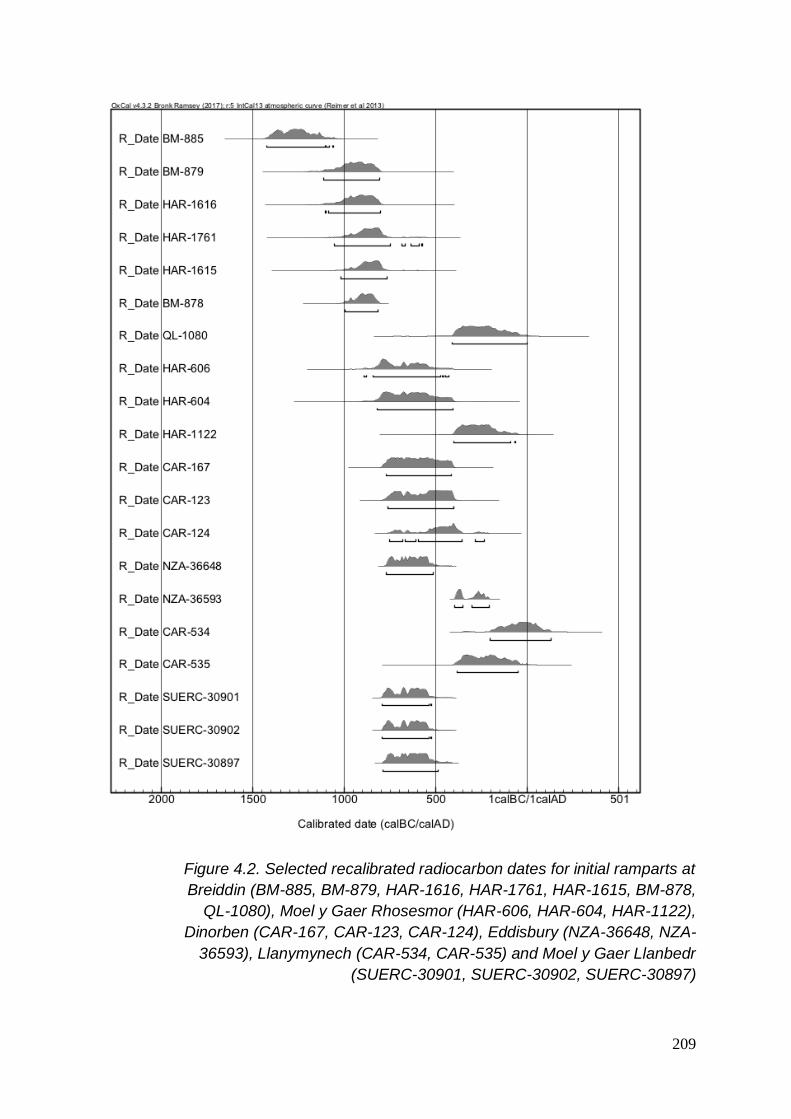
209
Figure 4.2. Selected recalibrated radiocarbon dates for initial ramparts at
Breiddin (BM-885, BM-879, HAR-1616, HAR-1761, HAR-1615, BM-878,
QL-1080), Moel y Gaer Rhosesmor (HAR-606, HAR-604, HAR-1122),
Dinorben (CAR-167, CAR-123, CAR-124), Eddisbury (NZA-36648, NZA-
36593), Llanymynech (CAR-534, CAR-535) and Moel y Gaer Llanbedr
(SUERC-30901, SUERC-30902, SUERC-30897)

210
4.2.1.3 Modification to ramparts
4.2.1.3.1 Artefactual date
• Beeston Castle, rampart phase 2
o Built after c500BC-AD47, artefactual
4.2.1.3.2 Archaeomagnetic dates
• Beeston Castle, rampart phase 3
o Core 400-200BC (AML ref 873704-5)
• Beeston rampart phase 4 (final)
o Built after 400-200BC (AML ref 873704-5)
4.2.1.3.3 Radiocarbon dates
• Beeston Castle, rampart phase 3
o Built by 728-231BC (HAR-6464, HAR-6468, HAR-6469)
• Breiddin, inner rampart phase 2
o Core 411BC-AD2 (QL-1080)
• Dinorben, outer rampart
o Built after 378-56BC (CAR-131), 341BC-AD74 (CAR-132)
• Eddisbury, outer rampart
o Built after 739-515BC (Beta-317521)
o Built before 392-209BC (NZA-36654)
• Eddisbury, inner rampart phase 2
o Core 396-210BC (NZA-36593)
• Llwyn Bryn Dinas, rampart phase 2 (Rampart Y)

211
o Built after 382-41BC (CAR-708)
o Core 401-63BC (CAR-800)
• Llwyn Bryn Dinas, rampart phase 3 (Rampart Z)
o Built before 357BC-AD25 (CAR-798)
• Moel y Gaer Rhosesmor, inner rampart phase 2
o Built after 397-51BC (HAR-603)
• Pendinas Llandygai rampart phase 2
o Built (dump) after 373BC-AD79 (HAR-1672)
Figure 4.3. Recalibrated radiocarbon dates for modified ramparts at
Eddisbury (Beta-317521, NZA-36654, NZA-36593), Beeston (QL-1080,
HAR-6464, HAR-6468, HAR-6469), Moel y Gaer Rhosesmor (HAR-603),
Llwyn Bryn Dinas (CAR-708, CAR-800, CAR-798), Dinorben (CAR-131,
CAR-132) and Pendinas Llandygai (HAR-1672)

212
4.2.2 Entrances
4.2.2.1 Radiocarbon dates
• Eddisbury, sub-circular, southern guardchamber
o 359-169BC (NZA-36592)
• Moel Hiraddug, phase 1 entrance blocking for relocation
o Core 728-193BC (CAR-372), 756-233BC (CAR-373), 756-368 (CAR-
374)
Figure 4.4. Recalibrated radiocarbon dates for hillfort entrances at Moel
Hiraddug (CAR-372, CAR-373, CAR-374) and Eddisbury (NZA-36592)
4.2.3 Roundhouses
4.2.3.1 Radiocarbon dates
• The Breiddin
o 204-45BC (BM-1160), 353-59BC (BM-1161), 757-403BC (BM-881),
797-235BC (HAR-467), 728-101BC (HAR-842)
• Bryn y Castell
o 411BC-AD51 (HAR-6234)
• Castell Caer Seion

213
o 393-204BC (Beta-254607)
• Moel y Gaer Llantysilio
o 360-171BC (SUERC-43981), 345-51BC (SUERC-43982), 386-205BC
(SUERC-43983)
• Moel y Gaer Rhosesmor
o 840-197BC (HAR-1125), 821-401BC (HAR-1126), 780-388 (HAR-
1196), 892-410 (HAR-1197), 782-259 (HAR-1353)
• Pen y Ddinas (Great Orme)
o 403-206BC (Beta-254961)

214
Figure 4.5. Recalibrated radiocarbon dates for roundhouses at Moel y Gaer
Rhosesmor (HAR-1125, HAR-1126, HAR-1196, HAR-1197, HAR-1353),
the Breiddin (BM-1160, BM-1161, BM-881, HAR-467, HAR-842), Pen y
Ddinas (Great Orme) (Beta-254961), Castell Caer Seion (Beta-254607),
Bryn y Castell (HAR-6234) and Moel y Gaer Llantysilio (SUERC-43981,
SUERC-43982, SUERC-43983)
Table 4.1 lists the roundhouses in hillforts in the surrounding area of the Clwydian
Range which have been excavated and for which dates were retrieved, along with
their understood building structure.
The remains of the roundhouses at Moel y Gaer Llantysilio revealed few surviving
features but did show evidence for surrounding gullies and that Roundhouse 1, with

215
an internal diameter of 7m and a possible internal division and a sole possible post-
pad, pre-dated Roundhouse 2, also around 7m in diameter but with no evidence for
postholes nor an entrance and built on a platform which sealed the gully of
Roundhouse 1 (Grant & Jones 2013, 49-52). Samples provide a date for both
roundhouses of 345BC at the earliest and at latest 205BC and so, therefore, they
can be seen to both date to the mid-Fourth to Third Century BC.
Remains of ‘stake hole’ roundhouses were excavated at the Breiddin and gave dates
of between 757-403BC and 728-101BC. In addition, roundhouses R3 and R8 were
both surrounded by wall gullies, R8 with evidence for a projecting porch (Musson et
al 1991, 39-43; 62), and dated to 204-61BC and 797-235BC respectively.
Remains of both post-ring roundhouses and ‘stake wall’ roundhouses were reported
at Moel y Gaer Rhosesmor and stratigraphically it was seen that the former pre-
dated the latter. The phase of the site which consisted of post-ring roundhouses was
dated to between 780-431BC. Phase 2 of the site, with stake wall roundhouses, was
dated to between c.401-51BC.
At Pen y Ddinas, Great Orme, a piece of animal bone found within a stone-walled
roundhouse deposit was dated to 403-206BC (Beta-254961). Stake holes of the
hearth associated with Bryn y Castell’s ‘Structure 0’, sealed by the stone-walled
‘Structure 1’, was dated to 411BC-AD51 (HAR-6234). At Castell Caer Seion, a
deposit beneath stone-walled Hut 4 dated to 393-204BC (Beta-254607).

216
Hillfort Roundhouse Features Date
The Breiddin Stake hole 757-403BC
728-101BC
Bryn y Castell Stone walled? 411BC-AD51
Bryn y Castell Stone walled Built after 411BC-AD51
Castell Caer Seion Stone walled Built after 393-204BC
Moel y Gaer Llantysilio Gully. Possible post-pad 345-205BC
Moel y Gaer Rhosesmor Post-ring 780-431BC
Moel y Gaer Rhosesmor Stake wall 401-51BC
Pen y Ddinas Great Orme Stone walled 403-206BC
Table 4.1. Dated roundhouses, stating the recorded building structure or
evidence and associated recalibrated radiocarbon dates
4.2.4 Four-post structures
4.2.4.1 Radiocarbon dates
• The Breiddin
o 396-46BC (HAR-1413), 397-51BC (HAR-468), 751-196BC (HAR-
1286), 748-198BC (HAR-1287), 355BC-AD125 (HAR-1617)
• Moel y Gaer Rhosesmor
o 397-51BC (HAR-603), 769-263BC (HAR-1294)

217
Figure 4.6. Recalibrated radiocarbon dated samples from four/six-post
structures at Breiddin (HAR-1413, HAR-468, HAR-1286, HAR-1287, HAR-
1617) and Moel y Gaer Rhosesmor (HAR-603, HAR-1294)
Moel y Gaer Rhosesmor, Dinorben and the Breiddin provided dated remains of four-
post structures (Guilbert 1975c; Guilbert 1977b; Musson et al 1991).
At Moel y Gaer Rhosesmor, posts of 50cm in diameter sunk over 60cm below the
ground in the south and west areas were reported for larger structures ranging from
3.4mx2.4m to 4mx4m (Guilbert 1976b, 310). Three structures to the north were
found to have smaller timbers of up to 20cm in diameter in post-pits averaging 30cm
in depth but with ‘widely differing floor areas’, two of 2.7m2 and 6m2 respectively and
a third, consisting of five postholes ‘identical’ in nature with the four postholes
surrounding a square of 3.2x3.2m, with its fifth posthole placed asymmetrically to the
square (Guilbert 1976b, 311).
The four-posters at the south and west of the excavations were thought to be of one
phase, due to the gridded layout of the structures and as one of these post-dated a
post-ring roundhouse, this entire group was assigned to a later period than the post-
ring roundhouse phase (Guilbert 1976b, 313).
218
The larger structures in the northern half of the excavation did not appear to conform
to the grid nor clash with the post-ring roundhouses, so it is possible that they date to
the earlier phase, even though it was concluded that their similarity suggested that
all of the four-post structures dated to the same phase plan (ibid.). If so, this provides
dates for their existence between 769-51BC or, if proposing that they were all in
existence at relatively the same time, a date of 401-263BC can be put forward.
Four-post structures were also discovered at Dinorben. Artefactual dating evidence
was only found in the upper fill of a posthole and therefore provides a date for the
end of the lifetime of the four-posters during the Romano-British period. However, it
is not clear whether their construction and use would have pre-dated this by any
amount of years (Guilbert 1977b). The structures found ranged from 2x2m to 3x2.3m
but the size of their postholes specifically was not reported (Guilbert 1979f, 187-188)
The structures at the Breiddin, including a number of six-post structures, were shown
to have a wide range of dates from 748BC-AD5. Musson suggested that through
radiocarbon dating, artefactual evidence and information such as width of posthole,
but not necessarily the size of the overall structure, a sequence of ‘typology’ could be
suggested (Musson et al 1991, 74, 78 & figs 39 & 41). This comprised of the six-post
structures and the four-post structures which had postholes of similar dimensions to
be of one general phase.
Six-post structures S1 and S2 had postholes measuring 40-60cm across and about
30cm deep (Musson et al 1991, 76) and F47 and F48 also had postholes measuring
40-60cm across (Musson et al 1991, 77). S1 provided a TPQ of 748-198BC and S2
provided a Late Bronze Age date through artefactual evidence. The four-posters F47
and F48 attributed to the same phase were not dated specifically themselves, but an
overlying four-poster provides the earlier structure of F48 with a latest possible date
of 355BC-AD125.
In addition, four-post structures were found by the Bronze Age rampart and deposits,
dated by association to the Bronze Age at the latest and these also comprised of
smaller postholes (Musson et al 1991, 30-32). The four-post structures with larger
postholes, generally between 80cm and 1.1m across, were thought to be of a later
date, lying between 751BC and AD125, most dates giving a Fourth to First Century

219
BC date, and additional phases seen due to re-use and replacement (Musson et al
1991, 74, 78).
Hillfort Structure Post Diameter
Structure Dimensions
Date
Breiddin Four-post 40-60cm - TAQ 355BC-AD125
Breiddin Six-post 40-60cm - TPQ 748-198BC + Late Bronze Age pottery 30cm depth
Breiddin Four-post 80-110cm - 751BC-AD125 Majority Fourth – First Century BC
Dinorben Four-post - 2x2m2
3x3.2m
No dates but artefactual evidence: Romano British period fill (post First Century AD)
Moel y Gaer Rhosesmor
Four-post 769-51BC
50cm 3.4mx2.4m
Gridded layout 4x4m2
60cm in depth
Moel y Gaer Rhosesmor
Four-post (possible five-post)
20cm 2.7m2 No dates but due to no overlap could be as early as initial phase of site: TPQ: 892-259BC
No conformity to grid layout
6m2
30cm depth
3.2m2 (five post)
Table 4.2. Selected, dated four- and six-post structures within hillfort
interiors in the surrounding area. Where available, the number of
associated posts with the structure is noted, alongside the depth of the
postholes. The excavated post diameter and dimensions of the entire
structure is listed, and associated recalibrated radiocarbon dates and/or
artefactual evidence
It was noted that larger postholes for four-posters at both the Breiddin and
Rhosesmor were thought to be later structures, dating to around 400-1BC, and

220
structures with smaller posts could possibly have been in existence during an earlier
phase.
These results have been brought together to examine groups of features within
hillforts and dating material found associated with them. These features, such as
palisades and ramparts, entrances, roundhouses and four-posters, have wide-
ranging dates but have begun to reveal groupings of activity. These will be discussed
and scrutinised further in the discussion.
4.3 Discussion
A number of research projects had provided dates from samples or artefacts from
hillforts from the wider study area to date. This study has recalibrated the numerous
results in order to compare them as a group to date activity within hillforts over time.
This discussion will attempt to interpret these results and their significance.
Some hillforts have evidence for a number of phases of modification to their
ramparts. Through further inspection of their individual dates, a stricter chronology
can be put forward for the hillforts’ architecture:
• Beeston Castle: The original site may have been enclosed by a palisade.
Through artefactual remains, it is likely that the initial rampart at Beeston
Castle was built c800-700BC. This infers that Beeston Castle presents an
example of early origins for a rampart and also an even earlier date for a
palisaded enclosure. The rampart was modified a number of times; firstly, (the
second phase of rampart) after c500BC, secondly, around 400-200BC (AML
ref 873704-5) and then thirdly, a final phase of building.
• The Breiddin: Breiddin’s initial rampart has provided dates for a rampart gully,
between 1107-807BC (BM-879, HAR-1615), as well as from the core 996-
816BC (BM-878). The rampart’s second phase’s core was dated to 411BC-
AD2 (QL-1080). These results suggest that the Breiddin was built with
ramparts very early, comparatively, but was not modified for at least 400
years until secondary building works occurred.
221
• Dinorben: A ditch and possibly three palisade fences were present at
Dinorben by 795-428BC (CAR-128). Its initial inner rampart was built after
772-413BC (CAR-167), but before 753-402BC (CAR-123, CAR-124),
providing us with a date range of 772-402BC. Its outer rampart was added
after 378BC (CAR-131).
• Eddisbury: As the palisade with ditch has been dated to 635-585BC, it is
unlikely that the initial rampart could be any earlier than this, confining its
construction to after c635BC. The results have shown that it must have been
in place by the time it was modified from c396-210BC (NZA-36593), giving
Eddisbury’s initial inner rampart a date range of between 635BC and 210BC,
with modification to the structure at 396-210BC. Its outer rampart was built
after 730-515BC (Beta-317521) and before its associated ditch had begun to
silt 392-209BC (NZA-36654), therefore, sometime between 730BC and
209BC. The silting of the outer ditch occurs within a similar time range of 180
years as the modification to the inner rampart, so it is possible that the two
construction activities are related.
• Llwyn Bryn Dinas: The initial rampart was built after 996BC but before 41BC
(CAR-802, CAR-708). As its second phase post-dated 382-41BC (CAR-708)
and its core dated to 401-63BC, it can be surmised that the initial rampart was
built at some time between 996BC and 382BC and the secondary phase
between this time and 63BC. A third phase was in place before 357BC-AD25.
• Moel y Gaer Rhosesmor: Pre-rampart settlement at this hillfort has been
dated to 891-431BC (HAR-606). An initial rampart at the site was built after
this, as it overlaid the roundhouse dated to this time. A foundation trench for
the rampart was constructed between 820-408BC (HAR-604) and the core of
the rampart was dated to 401-63BC (HAR-1122). I propose that this gap in
time between the foundation trench being constructed and the date of the
rampart core can be explained by the course of the rampart being laid out as
a foundation in advance of commencing the rampart proper. Excavation
demonstrated that this rampart was “built up progressively as the rampart was
heightened” (Guilbert 1975b, 110). Therefore, it can be put forward that the

222
initial rampart at Moel y Gaer Rhosesmor dates to around the Fifth Century
BC and may have taken some years to build following an initial layout
determined by a foundation trench. The rampart was then modified, and this
activity occurred after 397-51BC (HAR-603).
The Breiddin’s first phase of rampart, timber-laced with paired postholes and a core
of stones and soil, appears to have been built between c 996-816BC, the earliest
date recorded for the core of a rampart within the wider study area. A piece of wood
sitting on top of Beeston Castle’s first rampart phase, layers of sand with loose
stones and possible timber lacing and, associated with Late Bronze Age artefacts
(Ellis 1993, 22; 87), produced a date of 1260-837BC. At the time of reporting, Ellis
noted that this wood may have been mature wood predating the construction (Ellis
1993, 85). It is possible that, in some cases, the wood sampled for radiocarbon
dating was mature wood and/or reused in the building of the rampart. Nevertheless,
these two timber-framed ramparts, also constructed with a stone/rubble core,
present evidence for Late Bronze Age ramparts.
Another feature present around this time is the use of a palisade to enclose the site,
see Table 4.1. However, when scrutinising the firm results for palisaded enclosures
in this area, the dates may not be as early as the ramparts at Beeston and the
Breiddin. For example, a palisade and ditch enclosure at Eddisbury was OSL dated
to 635-585BC (Garner 2012b, 20), settlement activity thought to be associated with
the palisade at Moel y Gaer Rhosesmor appears to range from c891-431BC (HAR-
606) and an initial ditch at Dinorben possibly associated with one/two/three
palisade/s was in existence by 795-428BC (CAR-128). It is tempting to speculate
that these palisades date from an earlier period, especially considering they were
followed by subsequent phases of building activity at the site. However, Eddisbury’s
initial rampart dates to sometime in between 771-431BC (NZA-36648, NZA-36593),
Moel y Gaer Rhosesmor’s initial rampart to c820-63BC (HAR-604, HAR-1122) and
Dinorben’s stratigraphy between features is unclear. It is entirely possible that these
palisaded enclosures date to later into the Early Iron Age than their dated evidence’s
extremes could tantalisingly suggest.
With regards to rampart building activity, two main clusters have begun to emerge
from the results.

223
All of the initial ramparts built in this area date from after 900BC (with the exception
of the Breiddin which could have been earlier), see Figure 4.2, and most of these
also appear to date to after 800BC; Beeston Castle, Old Oswestry, Eddisbury, Moel
y Gaer Rhosesmor, Dinorben, Moel y Gaer Llanbedr, Pendinas Llandygai and Llwyn
Bryn Dinas. Many of these appear to be in position by or before c400-200BC and
presents a cluster of hillforts which are having initial ramparts built between c800-
400BC.
Later modification to ramparts at all sites with dating evidence cluster between c400-
200BC or perhaps towards the turn of the millennium, see Figure 4.3, (apart from
Pendinas, whose initial rampart falls within this date range), evident at Eddisbury,
Moel y Gaer Rhosesmor, the Breiddin, Dinorben, Beeston and Llwyn Bryn Dinas.
The Breiddin is the only hillfort in the area where there is a clear gap for building
activity on the ramparts. All other dates overlap in relation to rampart building
activity. The Breiddin may be exceptional; its initial early dates are testament to that.
In addition, a gap in time between rampart building episodes may not represent a
gap in activity within the enclosure. However, the remainder of the results for the
other hillforts present a pattern that an initial episode of rampart building occurred in
the Early Iron Age, between c.800-400BC. After an unknown, but not indefinite,
amount of time, a second building period developed in this area from 400BC to the
turn of the millennium, some taking place by c.200BC, and many having evidence for
multiple phases of building activity on their ramparts.
At Moel Hiraddug’s Main Inner entranceway, the first phase, simple gap entrance
was blocked around 728-368BC from radiocarbon dating evidence (CAR-372, CAR-
373, CAR-374) and replaced by an entrance to the left with one sub-rectangular
guardchamber, subsequently modified and then altered a third time to consist of two
semi-circular guardchambers, dating to no earlier than the Sixth Century BC, from
artefactual evidence. This evidence presents a date range for an episode where a
simple entrance gap was no longer considered suitable and a more elaborate
entranceway complex building project begun. The radiocarbon date dates not only
the blocking, but possibly the introduction and establishment of an initial, singular
sub-rectangular guardchamber at the site.

224
I have put forward that the burning episode at Eddisbury’s east entrance’s southern
guardchamber may be related to the modification from a sub-circular singular feature
into a double sub-rectangular stone lined feature. In which case, the burning
episode, dating to 359-169BC (NZA-36592) represents the date range in which a
singular guardchamber was modified and re-shaped, and possibly the introduction of
a second guardchamber to the entranceway. Notwithstanding this, the date is
representative of the existence of a guardchamber within the wider study area.
These two findings concur with Bowden’s study into guardchambers, despite meagre
wider evidence. Bowden reports three radiocarbon dates, around the late Fifth and
earlier Fourth Centuries, for guardchambers in Britain and that “most seem to fall
within the 6th – 4th centuries BC, though there are exceptions” (Bowden 2006, 426).
From the evidence available, Moel Hiraddug and Eddisbury do not appear to be
exceptions with regard to date, see Figure 4.4. However, their development and
modification suggest multiple phases of redesign and refashion which must have
entailed a number of years’ work during each conversion. This fact may still not
make these two hillforts exceptional but highlight the complexity and importance of
hillfort entranceway architecture in general.
When investigating the excavation reports to source the contexts for the radiocarbon
dates, other parallels became apparent, such as the existence of a number of initial
pre-rampart palisades, for instance at Dinorben and Moel y Gaer Rhosesmor, see
Figure 4.1, with only the latter providing a date for when this may have been in
existence.
Further research into other roundhouses without dating evidence but additional
feature description, relative dating and other associated information could help to
define periods in which certain building styles were used. In addition, research into a
wider context may aid interpretation (Ghey et al 2007).
Elsewhere in the surrounding area where there is evidence for four-/six-posters,
such as Dinorben and Moel Hiraddug, it would be useful to gain dimensions of the
postholes alongside radiocarbon dates and the use of relative dating techniques to
make further comparisons and subsequently relate these results to a wider context
such as four-post structures found at Croft Ambrey, Danebury and Collfryn (Gent
1983; Britnell 1989). From the initial evidence, see Table 4.2, it can be concluded

225
that, for this particular area, four- and six-post structures of undetermined function
were in use from the Late Bronze Age and fell out of use by the Romano-British
period, see Table 4.2 & Figure 4.6. Further research may allow a more valuable
interpretation, but the wide date range and longevity of these structures suggests
that they were well established; an important part and a significant feature of Iron
Age life on a hillfort.
Certain items found within hillfort excavations have also begun to suggest certain
patterns and areas of further research. Despite the general acidity of upland soils in
north Wales, items of metal work and bone have been discovered.
In 1992, 21 Iron Age burial sites in Wales were said to be known and 11 Welsh
hillforts were noted to have produced evidence of Iron Age burial (Murphy 1992, 28-
29). This figure included the Moel Hiraddug inhumations, but the Llanymynech
discovery had not yet been found and the human remains from Dinorben are not
noted.
Albeit without context, the Llanymynech hillfort ‘child burial’ does provide an Iron Age
date for the remains, 770-370BC (OxA-6824), earlier than the bowl hearths
previously dated at the site, 204BC-AD130 (CAR-534) and 384-52BC (CAR-535).
The discovery of part of a human facial bone at the Breiddin, some of the
fragmentary remains at Dinorben and the two inhumations beneath the road of the
developed Main Inner entranceway at Moel Hiraddug, see Figure 3.2, have
suggestive elements of deliberate, ritual deposition. The depth of the soils on Moel
Hiraddug make it almost impossible to consider that the builders of the new
entranceway and road were not aware of, or were involved in the deposition of, the
two skeletons inches beneath their feet. Other fragmentary pieces of human bones
could point towards excarnation.
Perhaps, in contrast to those which may appear more ‘deliberate’ deposits, some of
the remains found at Dinorben paint a much less considered committal and conflict.
Murphy states that there are two distinct locations for Iron Age burial in Wales; those
at Bronze Age ritual/funerary sites and those in or around hillforts, those at hillforts
being in or immediately outside defensive ditches (Murphy 1992, 28-29). The
discovery of two dismembered male skeletons, one with a skull “cleft in two”, at the
bottom of a ditch to the north of the site, a fragmentary skeleton in the north ditch

226
(Gardner & Savory 1964, 45; 221) and a female and infant found on a steep slope of
the outer rampart, to the north of the ditch (Gardner & Savory 1964, 45), do not
inspire imaginings of a ‘peaceful’ demise.
The discovery of hoards of slingstones at hillforts also inspires notions of defence
and conflict. Over 600 were found in a hut overlooking the routeway into the Main
Inner entrance at Moel Hiraddug (Davies & Bevan-Evans 1969, 10; Davies 1970b,
3), another 200 behind the northern rampart (Brassil et al 1982, 28). Another hoard
was found near the entrance at Beeston Castle (Ellis 1993, 87-89), around 400 in a
hut ‘next to the entrance’ at Castell Caer Seion (Smith 2012, 7), as well as others
elsewhere at the site (Smith 2012; 6; 10; 24) and a ‘heap’ of slingstones at the east
entrance at Eddisbury (Varley 1950, 33).
In contrast, the discovery of slingstones may present evidence for defence against
things other than people; namely wildlife. If the hillforts were used by a farming
community, with stock a valuable resource, these would need protecting from
predators. Additional evidence for ‘the every-day’ and domesticism appears in the
form of spindle whorls, quern stones etc. Trade is represented by the appearance of
VCP at a number of sites. What may be more significant for connecting the sites in
this area is the presence of metalwork and metalworking. Crucible fragments have
been found at Old Oswestry, Llwyn Bryn Dinas and Beeston Castle (Hughes 1994,
75-79; Musson et al 1992, 268; Ellis 1993, 26), metalworking areas and/or fragments
have been found at Bryn y Castell, Llwyn Bryn Dinas, Beeston Castle and the
Breiddin, and Guilbert has proposed that platforms at Dinorben are the remains of
working areas (Guilbert 1979f). North Powys is reported to have a ‘distinctive’ zinc
impurity (Musson et al 1992, 179) and the ‘plaque’ found at Moel Hiraddug was
made from Llanymynech copper (Davies & Lynch 2000, 208).
The presence of glass beads reported at some sites may indicate the use of glass
more widely in Britain before the Romano-British occupation, or that the hillforts
continued in use further into the new millennium.
A number of hillforts have revealed Romano-British items, in particular Dinorben,
where artefacts dating from the First to Fourth Centuries AD were present (Gardner
& Savory 1964). The only dated artefacts known to have been discovered at Moel
Fenlli derive from the Roman period and this appears to include the unpublished

227
1956 excavations. At Braich y Ddinas, Penmaenmawr, fragments of a late La Tène
brooch were found with other contemporary items, but also a number of Romano-
British items including a silver ‘convoluted snake’ bracelet (Hughes 1922, 349-357).
At present, many of the radiocarbon dates represent the Iron Age, with some hint at
continuation into the early new millennium. The (continuous?) use of these hillforts
into the First Century AD onwards, with specific reference to Eddisbury which was
used as an Anglo-Saxon burh in the early 10th Century (Shaw & Clark 2003),
demonstrates that the radiocarbon dates cannot be used in isolation. In particular
this demonstrates that whilst the use of dates for understanding the architecture and
phasing of rampart building can be useful in the development of a site, much more
was occurring within the confines of the site itself when ‘work’ on the ramparts had
been completed.
The calibration technique used within this exercise established a consistent
approach for calibrating radiocarbon dates for hillforts in the area. However, with
many of the dates returning as between 800-400BC, the plateau in the calibration
curve will continue to pose problems for accurate dating for many of the features.
In some cases, the recalibration of original dates has suggested solutions for original
queries. For example, at Beeston two fragments sampled within the same context
originally gave dates which did not overlap; rationalised by the problems arising from
the calibration curve plateau (Ellis 1993, 89). The recalibrated dates within this
exercise have revealed dates that coincide with each other. Additionally, a displaced
fragment of wood was originally dated to the Romano-British period 30calBC-AD250.
It was thought to have come from an earlier sample (Ellis 1993, 85-86) and the
recalibration of the sample to 173BC-AD396 presents this earlier potential.
The results have also highlighted a number of issues with the available evidence.
The use of phrases across the literature may be further standardised, if parallels
exist. For example, in a number of cases, timber-lacing and stone facing/revetment
is apparent but, as cases are reported on differing phrases, are used for what may
be a similar interpretation. This issue is most probably due to excavations conducted
at different times by different archaeologists, ranging over half a century and the
fashion of literature usage developing and changing over this period of time. If
accurate comparisons are to be made and parallels are to be found, in-depth

228
analysis of the context and features must be made. For example, the stake wall
roundhouses at Moel y Gaer Rhosesmor and the stake hole roundhouses at the
Breiddin may be compared further to investigate whether they use a similar
construction technique or whether these two phrases do, in fact, describe differing
structures, see Figure 4.5 and Table 4.1. The dates for the two hillforts’ structures
have produced dates which do not fully correlate so the result of the comparison
would be of interest. A compendium or glossary of standardised terms for features
such as these and for hillforts overall would be beneficial for the studies of the
archaeology in general, something it is hoped the forthcoming ‘Hillfort Atlas’ will
begin to attempt and introduce.
4.4 Conclusions
This chapter has highlighted a number of different themes of activity at hillfort sites,
including early enclosure by palisade or, in some examples, by early ramparts, and
later modification. Roundhouses and four-/ six-poster were used throughout the
period/s when the hillforts were in use. Additional dates and context reported in the
future, including dimensions and descriptions for both roundhouses and for hillfort
entrances, will increase potential to interpret building activity of these features within
a particular period.
Within this chapter, dated features have been discussed for the wider study area.
The study so far has examined the hillforts’ individual features and compared them
to others in the wider study area. It is now time to expand the study into the wider
context of setting. Chapter five will look at the hillforts in the landscape, reporting on
their geological, environmental and archaeological settings, the geographical
characteristics and their visibility of their surroundings, in order to attempt to
understand the hillforts, their setting and their site location.

229
CHAPTER 5
SETTING
So far, this study has looked at the excavated results from hillfort research and
compared them as a group. In order to attempt to understand the hillforts of the
Clwydian Range and their site location, it is important to look at the monuments
within their landscape setting as well as as a group. This chapter will look at the
context and geographical setting of the monuments through environmental data and
other features in the landscape. This will include an overview of the underlying
geology, the climate, surrounding resources, height, access and other archaeological
features.
Following this, the results of a visibility study will be reported on. The study looks at
the view from the Clwydian Range hillforts, the hillforts from the wider study area and
the view from hills without hillforts on the Clwydian Range. Thereafter, analysis
concerning the intervisibility of hillforts will be explored for the wider study area.
Finally, these results regarding the setting of the monuments will be discussed and
interpreted.
5.1 Context
5.1.1 Geology
The Clwydian Range is a prominent range of hills which sits in the heart of north east
Wales. The Irish Sea lies to the north and the Vale of Clwyd and Denbigh/Hiraethog
Moors lie to the west. The Vale of Clwyd, which the six hillforts of the Clwydian
Range overlook to the west, is a fertile plain made up of red desert sandstones
overlain by glacial sands, gravels and clays (Malpas 2007, 11). To the east, lies
firstly the carboniferous limestone of Halkyn Mountain which then leads on to the
fertile plane and sandstone hills of Cheshire in the distance. To the south, lie the
oldest rocks in north east Wales, being 490 million years old, found in the Dee
Valley, made up of deep-sea muds with layers of volcanic ash (ibid.).

230
The main ridge of the Clwydian Range is made up of Silurian mudstone31 and it is
here where five of the six hillforts are situated. In addition, elements and bands of
siltstone and sandstone can be found, all of which were deposited in the ‘Welsh
Basin’ 420 million years ago (Heather and Hillforts Landscape Partnership Board
2011, 5). Earth movements squeezed these together to make a slate/shale material
which is not well suited for building (Jenkins 1991, 15; Malpas 2007, 12). The five
southerly hillforts on the Clwydian Range appear on the surface to be made up of
earthen banks and ditches. Some appear to show stone facing on the banks.
Around 350 million years ago, the Lower Carboniferous period, the area was
covered in a tropical sea resulting in accumulations of organisms and lime-rich mud
leading to deposits of thick limestone, now seen in a number of limestone quarries in
the area (Heather and Hillforts Landscape Partnership Board 2011, 7). The northern
hills of the Clwydian Range are comprised of this Carboniferous Limestone (Malpas
2007, 64). This is where the northernmost hillfort, Moel Hiraddug, is located. Moel
Hiraddug is the only hillfort in the Clwydian Range to be visibly constructed of stone
walls, although earthen ramparts are also present. This may be due to the
accessibility of the limestone to quarry; the most economical building material to use;
still being a valuable resource and extensively quarried to this day (ibid., 65).
The Clwydian Range is bounded by two geological faults; the Vale of Clwyd Fault to
the west and the Alyn Valley Fault to the east, forming major valleys (Heather and
Hillforts Landscape Partnership Board 2011, 8). Earth movement related to these
faults and glaciation during the last Ice Age, 115,000-10,000 years ago, has shaped
and influenced the topography we see today, including the deposition of erratics
(ibid., 8-9). The movement of ice across the Clwydian Range has resulted in passes
such as Bwlch Pen Barras, directly to the north of Moel Fenlli, and Bwlch y Ffrainc,
immediately south of Moel Arthur hillfort (Brown 2004, 10).
5.1.2 Environment and climate
At the close of the Second and beginning of the First Millennium BC, Wales
experienced the onset of the Sub-Atlantic phase, with higher rainfall and much lower
31 The ‘Silurian Period’ was first named by geologist Roderick Impey Murchison in 1839, naming the rocks after the British tribe the Silures, who were said to have inhabited the southern Welsh borders (Malpas 2007, 63)

231
summer temperatures (Lynch et al 2000, 140). Generally, this wetter and cooler
climate occurred from around 2500BC-AD750 with a period of warmer climate at the
beginning of the First Millenium AD (Bigg 2003, 207; Huntley 2007, 140). It is argued
that climatic changes are the most crucial factor in bringing about major changes in
landscape and settlement pattern and these changes could have included a fall in
population in the later Bronze Age, with subsequent recovery during the Iron Age
(Davies & Lynch 2000, 140-141).
The Late Bronze Age across Britain is historically thought to have seen an
‘abandonment’ of the uplands (Lynch et al 2000, 141); a theory which has been
disputed in more recent years following studies across Britain. It has been thought
that the shift in climate would have made the upland and lowland divide most
apparent; the upland zone becoming more hazardous for cultivation and
communication (Megaw & Simpson 1992, 22). Whittle suggests that climate changes
at this time could have produced serious constraints on upland exploitation, leading
to a severe curtailment or abandonment of upland activity, with adjustment to varying
degrees including greater management of grazing or transhumance (Whittle 1982,
198-200); a management technique still in existence today of winter retreat and
lowland use with more intensive use of the uplands in the summer. Alcock suggested
that the hillforts in Wales and the Marches are sited just as conveniently for access
to the upland pastures as to fertile valleys and that hillforts could have played a part
in these seasonal movements of livestock as well as exploitation of arable land
(Alcock 1965, 188-189). The ‘four-posters’ found at a number of hillforts, including
Moel y Gaer Rhosesmor, the Breiddin and Moel Hiraddug have been suggested to
be storage units for winter fodder by Savory. The amount of sheep bones found at
the marcher hillfort of Croft Ambrey and Dinorben along with spindle whorls could
suggest that sheep were being kept for wool rather than meat (Savory 1980, 299).
Whittle suggests that cereal cultivation would have faced difficulties with these
harsher conditions; land usage would have had to have moved to lower altitudinal
limits with the threshold reduced by about 300m and growing season at higher
altitudes reduced by about 40 days. This would have produced “harsher conditions
for animal husbandry in the winter… [and] serious constraints on upland
exploitation”, although he notes that this change would have varied between
seasons and throughout regions (Whittle 1982, 198).

232
Studies in north east Scotland have identified relocation and restructuring of
agricultural activity from upland to lowland in later prehistory, but which do not
indicate settlement abandonment due to climatic stress (Tipping et al 2008). In
northern England, Van der Veen found that sites growing hardier crops well-suited to
upland locations and those growing crops better suited to warmer climates differed in
settlement type and location rather than being determined by changing climates or a
soil-type. This, therefore, may reflect social and cultural differences. She reported
that sites which grew predominately emmer suited to warm, dry climates represented
small-scale, intensive, traditional subsistence farming and had not developed further
due to social and political tensions. Those sites growing predominately spelt, a
hardier cereal which will grow at all elevations, worked with larger-scale production
and saw arable expansion which may represent a less pressured society, also
demonstrated by the lack of fortified settlements in the area they were located (Van
der Veen 1992). Young also highlights that the same soils and environment can
generate different potential according to the individuals/society and their capacity,
resources and/or needs (Young 2000, 73-74). Societies would have reorganised
their management and production techniques in order to deal with changes, rather
than abandoning their well-established ‘place’ (ibid., 77; Young & Simmonds 1995,
15).
Widespread evidence of bog regrowth is seen across Europe during the Iron Age
(Robinson & Henderson-Sellers 1999, 234) and that growing bog complexes were at
their most vast at the turn of the millennium (Barber 1993, 476). It is possible that
field systems became unusable due to bog growth, owing to the increase in rainfall
or possibly due to shorter, colder and wetter summers, providing insufficient time for
any crops to ripen (Megaw & Simpson 1992, 21). However, the prevention of blanket
peat spread through cultivation has been seen in Lairg, Scotland in the Iron Age; the
spread of blanket peat was a result of land abandonment, not vice versa (Tipping &
McCullagh 1998, 210). Evidence found in Northumberland indicates crop rotation
and/or moving of cultivation around the landscape to optimise soil fertility, on a local
scale (Huntley 2007, 140). Flexibility and active responses to change was reported
by Davies, observing that land-use was structured to take advantage of small,
dispersed areas of better ground as peat began to dominate in north west Scotland.
This appears to demonstrate resourcefulness and careful management allowing for

233
continued exploitation and resilience (Davies 2007). Further flexibility, shifts in
agricultural management practises and varying levels of intensity of pasture
maintenance are also seen in the northern Cheviot Hills and the Scottish uplands
(Tipping 2010, 178). Narrow ridged cultivation plots, known as ‘cord rig’, are found in
the Cheviot uplands and are associated with later prehistoric settlements, likely from
the Iron Age. As there is no evidence within pollen analyses for cereal cultivation in
the Iron Age in the upland valley, it is hypothesised that these plots could have been
garden plots used for growing vegetables (ibid., 182).
Evaluating 75 pollen sequences from across Britain, using both marginal and optimal
sites from the Late Bronze Age and the Early Iron Age, Dark concluded that no
widespread land desertion was apparent for Britain, but abandonment of upland
areas in Wales was one of a number of regional variants (Dark 2006). Five of the
nine sequences taken from Welsh sites show temporary woodland regeneration
phases in this period. Those with reduced agricultural activity are all sites above
150mOD, suggesting that Welsh marginal sites saw a shift away from the uplands
with higher levels of abandonment compared to the rest of Britain (ibid., 1391).
However, the results appear to be varied throughout the Iron Age in north Wales.
Cultivation activity at Cefn Graeanog in Gwynedd has been correlated with periods
when the hut group was occupied 315-85BC; buried soil and ditch deposits has
indicated woodland clearance, pastoral activity and cereal cultivation at Bryn Eryr
Iron Age/Romano-British farmstead, Anglesey; an increase in clearance is seen to
the north east of Bryn y Castell hillfort in Snowdonia c. AD 40 and various periods of
clearance and pastoral activity has been noted at the Breiddin hillfort, specifically
deforestation and continued grazing from the Late Bronze Age and throughout the
Iron Age (Caseldine 1990, 69-74).
The uplands of the Clwydian Range appear to have been continued to be in use
throughout the Late Bronze Age into the Iron Age (Grant 2009, 24) and may be
described as a local variant within the ‘regional variant’ of Wales described by Dark,
above. Peat core analysis at the hill of Moel Llys y Coed (grid ref: SJ1471 6493), a
small basin mire at around 445m OD, has suggested that during the Bronze Age,
woodland was probably confined to slopes and steeper valley sides, whilst
elsewhere was predominantly a more open landscape (ibid.). Grazing and cultivation

234
are suggested by the presence of ribwort plantain, yarrow, bugloss and barley (ibid.,
24-25). The pollen record in the Clwydian Range shows a continuation of Bronze
Age cultivation with an emphasis on increased grazing during the Iron Age.
Grant notes that at 2600BP (650BC) a clearing episode, including burning, may
indicate the start of a phase of renewed clearance linked to the development of the
hillforts. Wider-scale vegetation changes had already taken place in the Bronze Age
(Grant 2009, 25). These earlier changes, if linked to the development of the hillforts,
could suggest an earlier horizon for their establishment on the Clwydian Range, or
that these vegetation changes contributed to further pressure on the land (ibid.). The
renewed wood clearance noted by Grant may also have been sought to improve the
quality and extent of pasture if this resource was under pressure (Whittle 1982, 200).
The Late Iron Age in the Cheviot Hills in northern England saw rapid and whole-
scale clearance of woodland, probably for the extension of farming land (Tipping
2010, 183-184), with intensification of farming including maintenance of pasture,
growth of rye and barley, establishment of hay meadows and terracing, suggesting a
planned and organised landscape in the area, rich in hillforts and prehistoric
enclosures (Mercer & Tipping 1994, 14-17). Studies indicate that large- scale
clearance took place in much of north central Britain c200-100 calBC, with
Northumberland referred to as ‘an area of cereal cultivation’ throughout the Iron Age
by Huntley (2007, 136), spreading to the lowlands in the Later Iron Age.
Interestingly, Calluna, heather, was only present at very low levels in the Clwydian
Range at this time, which is not typical of other upland areas of Wales (Lynch et al
2000, 141). Heather dominated moorland, which favours poor, over-exploited soils,
was common in the Late Bronze Age to the west of the Clwydian Range at the
Brenig, Hiraethog (Hibbert 1993) and to the east on the Sandstone Ridge (Chiverell
et al, forthcoming). Grant suggests that the continued lack of Calluna throughout the
Iron Age in conjunction with fertility of the land and grazing pressure “may help
explain the importance of the Clwydian Hills to the Iron Age cultures of the area
during this period as evidenced by the hillforts... Many of the uplands were already
dominated by heather moorland, and as such, fertile land would have been a scarcer
and a valuable resource” (Grant 2009, 26).
235
5.1.3 The archaeological setting
Whittle suggests that whether the uplands were being exploited for localised
domestic production, with population overspill onto marginal land, or with the
creation of ‘regional economies’ linking lowland and upland, this prompted the
beginnings of social division. This was through division of land or division of labour
with interchange of products, showing communal involvement, hierarchies of control
and the creation of wealth, illustrating interaction through exchange links (Whittle
1982, 199). This is evident during the Bronze Age by the quality of finds recorded
during this time in this area, such as the harness hoard from Parc-y-Meirch,
Dinorben containing objects of Scandinavian origin (Piggott 1952-3, 184) and the
Caergwrle Bowl, with its symbolism of boats and waves (Green 1985, 116). It is
thought that the shale used to make the Caergwrle Bowl originates from Dorset (ibid,
117).
The hills have been occupied or exploited by humans since at least 30,000 BC, with
the cave sites of Ffynnon Beuno and Cae Gwyn near Tremeirchion providing
evidence of human activity from the Palaeolithic period (Grant 2009, 3). The area
also boasts Britain’s second largest artificial prehistoric mound, Gop Cairn at
Trelawnyd, dating to the Neolithic period (Brown 2004, 37).
During the transition between the Late Bronze Age to the Iron Age, ‘monumentality’
shifts from ‘ritual’ monuments, such as barrows, to the settlement record including
the hillforts (Karl 2007, 168). Lynch & Davies also suggest that climatic deterioration
would have led to conflict, which in turn led to a growing investment in physical
security for groups of families through the construction of fortified settlements
(Davies & Lynch 2000, 146). These occurrences, coinciding with an increase in
weapons, could suggest a period of social tension (Davies & Lynch 2000, 145).
Periods of different intensities are also evident in this monumentality, as in the
excavation record that ditches are seen to silt up, followed by subsequent clearing
out and re-cutting and different phases of building of the ramparts; an increase or
decrease in size, multivallation and additional works (Cunliffe 2005, 41; 46; 241; 260;
347 etc) also suggesting defences could have been as much for control and display
as for warfare (Davies & Lynch 2000, 139). Karl highlights that enclosure suggests
ownership and social status, as much as it does defence (Karl 2007, 169).

236
The continued use of monumentality, alongside the exploitation of the uplands with
regional and wider exchange links, suggests a highly organised and structured
society, one that has been present in the archaeological record in Britain from an
early stage in the Neolithic period (Burgess 1980). In 1958, Savory published an
overview of the (then) recent or unpublished finds of the Late Bronze Age in Wales
and how these distributions could indicate cultural groups that may be the precursors
of the tribal groups referenced by the Romans (Savory 1958). He suggests that the
area of the Cornovii-Deceangli, i.e. north east Wales and the Marches, had stronger
links with the east (Savory, 1958, 50), with ‘Yorkshire’ socketed axes being found
along with horse-harnesses, such as the hoard at Parc y Meirch from northern
Europe (Savory 1958, 48). Savory concludes that further investigation of the hillforts
may deepen knowledge of the “final stages of Bronze Age metalworking and the first
stages of occupation of such sites” (Savory 1958, 49).
Burgess suggests that territorial divisions may be apparent by looking at the
distribution of metal work (Burgess 1980, 249). Inspired by Savory’s 1958 work,
focusing on Late Bronze Age metal work, he finds that unlike south east Wales with
a majority of south welsh socketed axes, north west Wales with a high majority of
‘late’ palstaves, and the Marches’ spear hoards, the north east has a mixture of
socketed axe types and some from other parts of Britain, such as Irish bag-shaped,
Yorkshire and south Welsh ribbed (Burgess 1968; 1980, 249 & 272). He suggests
that the rapid spread of iron arriving too quickly for the bronze-working to develop
would have meant a collapse of the Ewart Park workshops. This, alongside climate
change, would have meant an unsettled society, shown by the burst of hillfort
construction, including the rebuilding of existing but decayed ramparts such as
Dinorben, the Breidden and Moel y Gaer Rhosesmor and new sites such as Moel
Hiraddug, alongside planned interiors (Burgess 1980, 275-6).
In 1980, Savory suggested that by the early Iron Age, comparing distribution of
important chance finds of early Iron Age metalwork and hillforts with the distribution
of Neolithic and Bronze Age chance finds and burial sites, the emphasis for
settlement in the First Millennium BC had shifted from the interior uplands to the
main river valleys and fertile seaboard (Savory 1980, 291-2). At this time, around the
middle of the First Millennium BC, the population was beginning to recover after a
237
decline from the end of the Middle Bronze Age through to the Late Bronze Age
(Davies & Lynch 2000, 142).
Some models for population densities have been attempted using hillfort evidence
(Stanford 1972b; Alcock 1965 etc). In his ‘sceptical viewpoint’ of hillfort functionality,
Guilbert attempts to estimate hillfort population, but warns that this can only be
attempted if there is confidence that all of the structures have been located, the
sequence of construction has been defined and the usage of these structures has
been established (Guilbert 1981c). The excavations at the Flintshire hillfort of Moel y
Gaer, Rhosesmor are used as an example. These found evidence of some buildings
with hearths, some without and one that has been interpreted with the role of a guard
hut due to its orientation towards the entrance, see Figure 3.7, even though its
ground plan mirrored other buildings interpreted as ‘houses’ (ibid, 106). Guilbert also
considers the four-post buildings, found on site at Moel y Gaer as well as other
hillforts in the area, suggesting that although these are often interpreted as grain
stores, this function has not been adequately proven and they could even be
interpreted as dwellings (ibid, 106-7). He continues that those structures interpreted
as ‘dwellings’ have no proof that they were roofed, and that hillforts were possibly not
even for human habitation; their internal structures considered with a number of
different functions, such as stabling, garaging of vehicles, mortuary structures or
shrines (ibid, 109-110). This highlights the care that must be taken when interpreting
monuments’ functions and that previous ‘interpretations’ should be considered as
such, and not proof.
In north east Wales, alongside the hillforts, the small amount of enclosures that have
been typologically dated to the Iron Age or Romano-British period in this area
(Manley 1990), including the discovery of an unenclosed Iron Age settlement at
Prestatyn (Blockley 1989), are testament to the amount of settlements yet to be
rediscovered, making population estimations during these periods ill-advised. From
a sample of 60 small settlements thought to date to the Iron Age or Romano-British
period in the then county of Clwyd (now parts of Conwy, Denbighshire, Flintshire and
Wrexham), Manley identified 13 enclosure sites with field systems which may be
contemporary. This included the enclosures of Bryn Teg, Cerrigydrudion and Tyddyn
Tudor Enclosure A, Llanfihangel Glyn Myfyr. Manley noted the probability of many of
the ‘undiscovered’ sites to have been destroyed and warns of unlikely concealment

238
of ‘Dark Age’ sites within his sample - an unresolved problem without excavation
(Manley 1991, 103-105).
Manley tentatively suggests that, in some cases, hillfort-enclosure pairings may
emerge in view of the spatial correlation between the two. However, he warns that
until further exploration and discoveries he could only conclude that both the hillforts
and enclosures were attracted to locations within or peripheral to good agricultural
land (Manley 1991, 107-8) During his sample of small settlements in Clwyd, Manley
noted that although the hillforts in the area, 37 in total, did not have an overall
preference for a particular altitude, the enclosures were entirely within the band 0-
400m OD, the hillforts occupying a slightly more elevated position between 50m and
500m OD. In relation to altitude, the settlements surveyed showed a greater affinity
to the hillforts than to the Roman sites which were mostly sited below 150m OD
(Manley 1991, 103-4).
On the Clwydian Range, by the end of the Iron Age and into the First Millennium AD,
clearance and grazing declined, with a reduction of grassland, regeneration of
woodland and scrub, and an increase in varieties of plants whose presence suggests
a reduction of cattle grazing due to lack of trampling (Grant 2009, 26-27).
During the onset of Romano-British occupation, the area was exploited for its mineral
wealth, highlighted by the earliest lead ingots found in north east Wales dating to AD
74 (Blockley 1991, 120) and a bronze-smithing site in Prestatyn, manufacturing
trumpet brooches and harness bits, dating from c.AD 90/100 to c.AD 160 (Blockley
1991, 121). Other working sites have been located at Flint and Ffrith, Wrexham
(Brown 2004, 86) as well as a pair of metalworking mould-stones found in a posthole
dated c. Fourth Century AD or later, found at Dinorben hillfort (Brown 2004, 88). With
the control of copper and lead ores in Wales in both the Bronze Age and the
Romano-British period, Savory proposes that these resources were also exploited, to
an extent, during the Iron Age (Savory 1980, 306).
In north east and mid Wales, 13 Roman forts have been confirmed (Silvester 2004,
1-2), including the ‘lost fort’ of Varis, thought to be located near to St Asaph (Blockley
1991, 117). In addition, a small number of fortlets and significantly more marching
camps have been identified (Silvester 2004, 3-5), such as Ty’n y Wern near Ruthin
(Waddelove 1991, 18-20).

239
During the early explorations of the hillforts on the Clwydian Range, a number of
Roman artefacts and coin hoards have been found, including two hoards of Roman
coins in the 1800’s, one of which totalling 1500 coins, within Moel Fenlli hillfort
(Davies 1983, 89). Mostly consisting of Samian ware, these finds were the reason
the hillforts were interpreted as dating to the Romano-British occupation, or to have
been built by the contemporary natives to protect their territory in the same period
(Wynne-Ffoulkes 1850a, 88).
The main hillfort evidence for Romano-British occupation, or use, comes from
Dinorben hillfort at St George Abergele, a few miles west of the Clwydian Range.
Although the hillfort is a multi-period site, with remains dating back to the Late
Bronze Age, the hillfort was utilised during the Romano-British period (Savory 1971b,
76), bull-headed bronze escutcheons found during excavations (Gardner & Savory
1964, 146-148) date from around the late First Century AD (Brown 2004).
During Stapleton’s excavations of Moel y Gaer hillfort in Bodfari, no Roman remains
were discovered, prompting him to conclude that the hillfort “was at least never
occupied by the Romans” (Stapleton 1909, 237). Other than a deer antler, the only
other ‘artefact’ found was a haematite ring (Stapleton 1909, 235). The hillfort in
question stands above a haematite mine in Tremeirchion and although early use of
the mine has never been proven, the amount of mineral exploitation in the
surrounding area by the Romans suggests that they would have been aware of this
resource. Close to Bodfari in the 19th Century a Roman cremation burial site was
found, the burials found within red and black urns (Davies 1949, 35-6).
One of the most obvious features of the Romano-British occupation in today’s
landscape are the roads; one linking Chester (the Roman fort of Deva) with St Asaph
and Caernarfon, running through Flint and through the Clwydian Range at Rhuallt
Hill, where the current A55 trunk road now runs. A smaller road is proposed along
Halkyn Mountain to Holywell running through Hawarden, leading on a minor road
from Northop Hall through Halkyn and Pentre Halkyn (Margary 1957, 79-82),
possibly running near to Moel y Gaer Rhosesmor hillfort. A further Roman road is
known linking the Legionary tile works in Holt (dated from c.AD90 to c.AD125) with
Watling Street (Blockley 1991, 119-120).

240
A road links Chester with Caer Gai in Bala running through Caergwrle past Caer
Estyn hillfort, Ffrith (at the meeting point of several deep valleys), north of Corwen
past Moel y Gaer hillfort on Llantysilio Mountains and the hillforts of Moel Fodig and
Caer Drewyn, on to Glan yr Afon running under Caer Euni hillfort, Cefnddwysarn and
onwards to Bala (Margary 1957, 77-78). Corwen sees a second road branch off here
up to the Vale of Clwyd to St Asaph, identified during the CPAT Roman Roads
project, 2002-03 (Silvester & Owen 2003).
Longueville Jones, in his list of early British remains of Wales, lists possible
prehistoric roads and trackways around the Clwydian Range, but it is unclear how he
has come to these conclusions other than looking at prehistoric remains and linking
them spatially. He specifically lists ‘ancient roads’ Bwlch Agricola, the road to the
south, and Bwlch Pen Barras, the road passing below the northern side of Moel
Fenlli hillfort and adds reference to it possibly being used by the Romans
(Longueville Jones 1855, 268-269) probably because of the Fourth Century AD
Roman coins found there (Brown 2004, 89). He also suggests that there “is every
reason to believe” the existence of two ancient roads running east and west of the
Vale of Clwyd, on higher ground, but does not specify what these ‘reasons’ are
(Longueville Jones 1855, 269). It is possible that the routes through the Clwydian
Range, running below the slopes of hillforts in many cases, would have been
exploited for millennia.
Roman shrines are relatively unknown in this area, but geophysical results by
Chester University during 2008 at Caer Alyn hillfort, Wrexham, produced a square or
rectangular enclosure with an interior sub-rectangular feature orientated NE-SE in
the centre of the hillfort, which could suggest such a structure (Gondek 2008, 6). A
possible temple site near Llanfair Dyffryn Clwyd, south of Ruthin has also been
found using aerial photography (Jones 1999, 23). However, neither of these sites
can be proven without excavation.
Six of the 40 hills of the Clwydian Range have hillforts upon them. Fifteen (37.5%) of
the 40 hills have probable Bronze Age cairns, barrows or tumuli on their summits,
with many more having a number of these on their lower slopes. Only two (33%) of
the hillforts currently have evidence of cairns on their summits, indicating that there

241
is no reason to suggest that the hills with hillforts upon them were chosen specifically
because of their Bronze Age burial heritage.
Many of the finds on the hillforts have been chance finds, such as the three Bronze
Age flat axes found on Moel Arthur after erosion, or through those which have been
excavated. Many chance finds have been recorded in the Historic Environment
Record, which shows that out of the 40 hills, ten of the hills have recorded prehistoric
artefact finds upon them, which includes all six hillforts. Interestingly, only one of the
hills/summits has artefact evidence but no hillfort or tumulus, which is Moel Llys y
Coed, where 3 prehistoric flint flakes were found on Offa’s Dyke Path in the 1970s
(Dunn 1970, 10).
However, it must be stressed that chance finds are simply that, and an absence of
evidence on the eighteen hills without any chance finds, no excavation nor evidence
of a burial cairn or smaller prehistoric enclosures, does not mean this provides
evidence of absence of prehistoric activity on these particular hills.
Finds and dating on the hillforts themselves are discussed in chapter 4.
5.1.4 Water sources
The pass through the Clwydian Range at Bodfari would have been an important
route for many years. The hillfort overlooks the confluence of the Afon (river) Chwiler
with the River Clwyd (Brown 2004, 77). Furthermore, the site of Ffynnon Deifer, a
well named after St Deifer, an early patron saint of Bodfari Church (RCAHMW 1912,
3), lies 200m north west of the Afon Chwiler, 600m south of the hillfort, possibly
signifying an earlier site.
In addition to the Afon Chwiler, many small streams flow from the watershed to both
the east and the west of the Clwydian Range, several of which provide passes
through the range (Grant 2009, 2). In the central section of the Clwydian Range,
Penycloddiau to Moel y Gaer Llanbedr, the spring line is approximately 350m (Gale
1999, 93), whereas the hillforts sit at 333m (Moel y Gaer), 422m (Moel Arthur) and
381m (Penycloddiau) OD. Without the necessary water source, it is argued that
these enclosures could not have been intended for warfare, as they would have
failed if under attack or siege due to the lack of water resources. However, it is
242
possible that water could have been stored and collected by gullies and drains.
Hollows in the defences of Old Oswestry have been posed as storage water tanks
(Brown 2009, 88); they still hold water today. Their creation for this use, however, is
not certain.
The nearest water courses, wells or springs for the Clwydian Range hillforts is never
more than 550m away, if not significantly less. It has been suggested that the south
eastern gap in the ramparts with “sloping path... down the face of a cliff on the east
side of the fortress” at Penycorddyn Mawr, to the west of the Clwydian Range, was
created as an easy access to the spring below and termed ‘the water gate’ by
Willoughby Gardner after his excavations there (Gardner 1910, 52). Certainly, this
was the nearest water supply for the hillfort and it warrants further investigation into
where the easiest approach to water supplies for other hillforts may be, currently
under investigation by Campbell, University of Liverpool (Campbell, forthcoming).
Moel Fenlli and Penycloddiau hillforts are the only hillforts of the six in the Clwydian
Range that have obvious water sources within the enclosure (Gale 1999, 92). At
Moel Fenlli, a series of earthworks were found surrounding the spring, the spring
pool thought to be scarped into the hillside with a large platform on the slope above
and a dam along the southern edge, a linear hollow suggested as a leat to drain
excess water (Brooks & Laws 2006a, 9). Two hut platforms were excavated but
remain unpublished (Hayes 1959a; 1959b; 1959c; 1959d; 1959e). A number of
possible hut platforms surrounding the pond at Penycloddiau hillfort were located
during magnetic susceptibility, fluxgate gradiometer and resistivity surveys in 2008
(Brooks & Laws 2008b).
From the Late Bronze Age into the Iron Age, the practise of deposition in watery
locations is seen, such as the finds at Llyn Cerrig Bach 50 miles (80km) to the west
on Anglesey (Fox 1946) and highlighted by possible ‘votive’ deposits at Llys Arwel
near Penycorddyn Mawr (Green 1985, 282). The hoard, thought to be votive
offerings dating to the Romano-British period, could suggest a shrine existed nearby
(Blockley 1991, 126-7). Wetland deposition has been interpreted as votive (Bradley
1990), which would suggest that watery places would be thought of as ‘special’.
Dinorben hillfort lies above what is still today known locally as a holy spring Ffynnon
Gygidog. A pattern may begin to emerge that that the hillforts are situated near to

243
places where rivers or streams converge, wells or springs, possibly signifying a place
that was revered (Brown 2004, 77), or if not for spiritual reasons, then simply for the
ability to survive by providing water.
5.2 Geographical characteristics
Contour data of the Clwydian Range was studied to identify a number of locations
with a distinct summit and similar topography to the hillforts of the Clwydian Range
for use in a comparative study. This study attempts to find suggestions as to why
particular hills within the Clwydian Range were chosen to build hillforts upon, but
others not. A total number of 40 hills were identified as hills with steep slopes32 and
with an area of flatter ground on the summit, see Figure 5.1. These included the six
hills in the Clwydian Range which have hillforts upon them.
32 Some of the hills included did not have steep slopes for the whole circumference of the summit but
sat on a spur. These have also been included as the hillforts of the Clwydian Range are not limited to summits, but also include sites like Moel y Gaer Llanbedr which sit on a hill which projects out from the main ridge of hills. Data has been collected to directly compare the hills which were chosen to build hillforts on with hills not chosen. This data will allow direct comparisons to be made with regards to features of the hills.
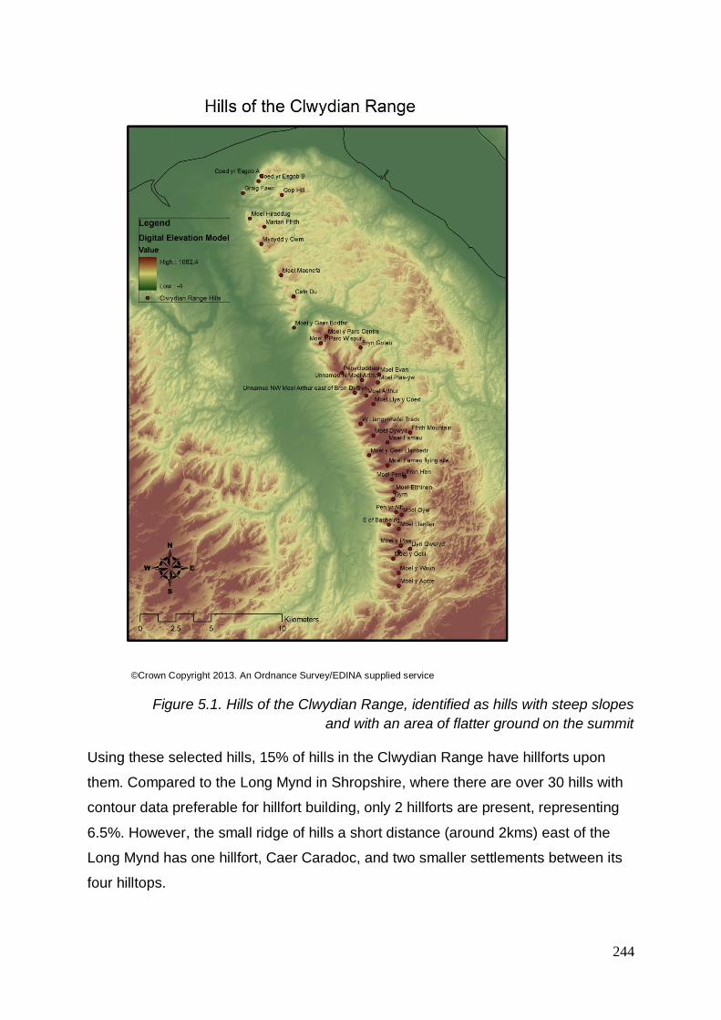
244
©Crown Copyright 2013. An Ordnance Survey/EDINA supplied service
Figure 5.1. Hills of the Clwydian Range, identified as hills with steep slopes
and with an area of flatter ground on the summit
Using these selected hills, 15% of hills in the Clwydian Range have hillforts upon
them. Compared to the Long Mynd in Shropshire, where there are over 30 hills with
contour data preferable for hillfort building, only 2 hillforts are present, representing
6.5%. However, the small ridge of hills a short distance (around 2kms) east of the
Long Mynd has one hillfort, Caer Caradoc, and two smaller settlements between its
four hilltops.

245
5.2.1 Height of hills
The hills chosen as hillforts appear to sit upon hills which are at average height
within the Clwydian Range, see Figure 5.2 & Table A3.14. The highest hillfort in the
Clwydian Range is Moel Fenlli at 511m OD33, close to the highest hill and a central
point on the range, Moel Famau at 554m OD.
Figure 5.2. Height of the hills and hillforts of the Clwydian Range with
hillforts shown in red, hills without hillforts in blue. The graph demonstrates
that the hillforts of the Clwydian Range were not built on the highest
surrounding hills and that height, therefore, was not a determining factor
during site selection
33 Despite the HER stating the height for Moel Fenlli is 500m

246
The two hillforts with the lowest altitudes are Moel Hiraddug and Moel y Gaer
Bodfari; the two most northerly hillforts, both sitting within a range of 201-250m OD.
These are placed within the northern sector of the Clwydian Range which itself sits
lower than the central and southerly sections of the range, from the Wheeler Valley
southwards.
To compare, the height range of hillforts within the Dwyfor district on the Llŷn
Peninsula reveals the majority of sites sit under 250m OD (Waddington 2013), see
Figure 5.3. No sites are higher than 500m; the highest hillfort on the Llŷn Peninsula
being Tre’r Ceiri hillfort, sitting at 480m OD.
Figure 5.3. Hillfort height in Dwyfor district on the Llŷn Peninsula Gwynedd,
north west Wales (Waddington 2013)
Looking at a wider range of data, using the whole county of Gwynedd, hillfort height
band data provides similar results to Llŷn data. Gwynedd provides a higher amount
sitting at higher altitudes, see Figure 5.4, probably due to the higher overall altitude
of Gwynedd as a county.
Gwynedd as a county sits at an overall higher altitude than the Clwydian Range, but
the hillforts of the Clwydian Range sit on a higher average altitude than the hillforts of
Gwynedd. The Clwydian Range does have hills which sit within the most popular

247
altitude bands for hillforts in Gwynedd, but in the Clwydian Range they have chosen
to build hillforts on higher hills.
Figure 5.4. Hillfort height data for the county of Gwynedd, north west Wales
(Waddington 2013)
For the whole of north west Wales (Waddington 2013) including Anglesey, Gwynedd
and parts of Conwy, using altitude data from definite hillforts, the results can be seen
in Figure 5.5. The only sites which sit above 501m OD within north west Wales are
unenclosed settlements (Waddington 2013, 69).

248
Figure 5.5. Hillfort height data in north west Wales (Waddington 2013)
Altitude data for hillforts within the 30-mile (48km) radius of the Clwydian Range,
taking in most of north Wales, Powys, Shropshire and Cheshire can be found in
Figure 5.6.
Figure 5.6. Hillfort height for a 30-mile radius surrounding the Clwydian
Range, including much of north Wales, Powys, Shropshire and Cheshire
To compare the results with a similar area, further south down the borderlands of
Wales, the Brecon Beacons hillforts show a less diverse result, but still a wide range
of heights for hillforts, as seen in Figure 5.7.

249
Figure 5.7. Hillfort height data for the Brecon Beacons
From the results above it can be seen that the hillforts of north west Wales and from
the wider study area surrounding the Clwydian Range have a fairly even distribution
of height categories, but the hillforts of the Clwydian Range and the Brecon Beacons
appear to favour higher hills, see Figure 5.8 and Table A3.8.
Figure 5.8. Hillfort altitudes (%) for selected areas in Wales
The Clwydian Range hillforts sit upon hills ranging from 205-511m OD, with a mean
average of 365m OD, median 379.5m OD and a range of 306m OD.

250
Hillforts within the north west Wales research area by Waddington sit upon hills
ranging from 10m OD to 480m OD with a mean 184.2m OD, median 180m OD and
range 470m OD.
Hillforts within the wider radius of the Clwydian Range hillforts, including the six
Clwydian Range hillforts themselves, sit upon hills ranging from 10m OD to 520m
OD with a mean of 234.5m OD, a median 215m OD and a range of 510m OD.
Hillforts of the Brecon Beacons sit upon hills ranging from 107m OD to 460m OD
with a mean of 318.7m OD, a median 320m OD and a range of 353m OD.
Figure 5.9. Average height of hillforts in selected areas in Wales and the
borderlands including much of north Wales, Powys, Cheshire and
Shropshire
From this information, it is demonstrated the hillforts of the Clwydian Range sit at a
higher than average altitude for this part of Britain, see Figure 5.9 and Table A3.9.
As the north west Wales hillforts and the hillforts within a 30-mile radius of the
Clwydian Range categories both include a number of hillforts sitting at a low altitude
of under 100m OD, these bring the average numbers down significantly.

251
5.2.2 Logistics/practicalities
5.2.2.1 Water sources
Out of all of the hills of the Clwydian Range chosen to sample by their contour data,
see Figure 5.1, only two of the hills have water sources within the enclosures. These
two hills are home to the hillforts of Moel Fenlli and Penycloddiau. This may suggest
that the addition of a fresh water source within the ramparts would have been a
reason for choosing these particular hills to build hillforts upon.
However, all hills on the Clwydian Range have water sources within walking
distances from their summits, most within 250 metres and many directly adjacent to
the summits on the slopes of the hills. It is not clear if these would have been
useable resources all year round.
The other four Clwydian Range hillforts’ sources, although within a short walk of the
site to reach water, would have had to have been accessed using the steep slopes
of the hill and may have been difficult to reach. For example, Moel y Gaer Bodfari
has a number of water resources surrounding the hill, including the Afon Chwiler, but
due to the almost promontory nature of the site, access to the river would have been
a longer walk to use an accessible route.
Both half of the hills and half of the hillforts have water sources on the summits or
directly adjacent to the summits on the slopes of the hills themselves. This suggests,
alongside the figures that only two out of the six hillforts have water sources within
the ramparts, indicating that the need to have a water source on site was not a major
factor when choosing the hills to build hillforts upon. Often, this is suggested as a
reason why hillforts could not have been intended for warfare, as the lack of water
within the defences would have been useless in a siege situation or even, in fact, for
simply living on the hills. The two roundhouses discovered during the excavation of
Moel y Gaer Llantysilio showed the traces of their drip gullies surrounding the house
(Grant 2010). It is possible that this water could have been collected and stored for
future use. It must also be considered that water is a luxury to have on site for many
communities even today, many of which have to walk for miles to collect their daily
water. It is more than feasible that the hillfort users collected water from outside the
hillfort on a regular basis, complimented by Penycorddyn Mawr’s eastern ‘water gate’

252
(Gardner 1910, 52). This also suggests that a water source inside a hillfort was not a
necessity and therefore questions the use of these enclosures for siege warfare.
5.2.2.2 Size
When identifying the hills to be included in this study, see Figure 5.1, a general
measurement was taken of the hilltop summits using OS contour data.
It was found that although a measurement around the summit of the hill did not
always define where the hillforts ramparts lay (such as Penycloddiau and Moel Fenlli
‘tipped’ forts), the areas of most of the ‘summits’ (i.e. flatter top, taken from contour
data) did generally match up with the area enclosed by the ramparts, albeit
sometimes a slightly different place on the hilltop.
There were two hillforts where this was not the case; at Moel Arthur hillfort, where
the conical hill does not appear to have a large amount of flat summit, and Moel
Fenlli hillfort, which alongside it being a ‘tipped’/ not a true contour fort (see below),
the hill itself is also quite tipped and sits at a westerly aspect. The area of flat top
upon the hilltop is roughly only 2.5ha, compared to approximately 8.3ha enclosed by
the hillfort’s ramparts. This shows that ramparts are not always defined by the break
in slope, contours or steepness surroundings the hill.
The summits on hills which were not chosen as hillforts range from around 1.2ha to
20ha, with the majority of sites falling below 5ha, as do the hillforts similarly ranging
from 1.6ha up to 17.7ha (enclosed) in the Clwydian Range, up to 37ha for those
wider afield. There are a small number of hills which have a large summit area, but
none are larger than the area enclosed by Penycloddiau hillfort, one of the largest
hillforts in Wales.Therefore, it can be concluded that the hills without hillforts would
not have been discounted as places to build hillforts just because of the size of their
summit area.
5.2.2.3 Aspect
Many of the hillforts lie on either flat-topped hills or do not appear to have an aspect
in one particular direction. However, Moel Fenlli and Penycloddiau’s ramparts,
although classed as contour hillforts, have not been built following the natural
contours of the hill, but sit on an aspect of the hill crossing the contours. This allows

253
Moel Fenlli to have a wide aspect to the west, overlooking the Vale of Clwyd and
Penycloddiau to face towards the south.
Moel y Gaer Bodfari also has a wide aspect to the south as, although the ramparts
closely follow the contours, the geology of the hill itself presents a large amount of
ground within the hillfort with a predominantly southern aspect.
Despite researching which hills may have been suitable hills for hillforts considering
contour data, see Figure 5.1, without any ramparts being present it is difficult to say
whether they would have had certain aspects. For example, the contours on the hills
of Penycloddiau is not overly biased towards the south but the hillfort has been built
to straddle the contours, exaggerating this ‘tilt’ towards its aspect. It is interesting,
therefore, that the ramparts of Moel y Gaer Bodfari are not built in the same way and
the site appears to be a true ‘contour fort’.
It is possible, however, that if some hills on the Clwydian Range did, and certainly
still do, have a southerly or easterly aspect, that they would have been deliberately
kept unenclosed as these would have been prime locations for arable usage.
A discussion must be held here regarding the visibility of the interior of the hillforts at
this point. With the ‘tipping’ of Penycloddiau and Moel Fenlli and a similar
arrangement at other forts including Caer Drewyn a few miles away in southern
Denbighshire, the deliberate building of the forts in this way may reveal some clues
as to their function.
This also highlights the inappropriateness of the term ‘hillfort’ when considering that
outsiders can see clearly the activities of the occupants of the site; not a defensive
factor. These sites have been specifically built to sit in this way, suggesting that they
wanted to be seen. This could be to attract people; the hillforts being places to
gather or to trade. Alternatively, these monuments could have been built to show off
power and status; whether this be of a powerful person or family, or for the whole
wider community, who would have been part of the process of building and
conserving the banks and ditches.

254
5.2.2.4 Access
Many of the passes through the Clwydian Range, from east to west, could be
thought to date back in use to earlier times. These include Bwlch Pen Barras where
alongside two hoards of Roman coins, a prehistoric black polished stone hammer
and ceramic hoards and have been found (Brown 2004, 89); the pass now forming
the route from Llangwyfan to Nannerch, overlooked by Penycloddiau hillfort and the
pass of Bwlch y Frainc, overlooked by Moel Arthur hillfort. Brown (2004, 79)
suggests that the hillfort is strategically located here specifically to control access
across the range from east to west. The hillfort of Moel y Gaer Llanbedr is sited on
the Clwydian Range but does not overlook a pass through the Range, the views to
the east obscured by the higher Moel Famau but sits on a spur overlooking the Vale
of Clwyd itself. It is possible, then, that this is strategically sited to control access
through the Vale.
A Roman road is thought to pass through the gap that Moel y Gaer Bodfari
overlooks, where the current A541 Mold-Denbigh road runs today. Because of this
Roman road’s location between the forts at Chester and Caernarfon and the name
‘Bodfari’ (the ‘f’ in Welsh pronounced as a ‘v’, to create ‘Bod-vari’, ‘bod’ generally
depicting a settlement), Pennant believed that the hillfort was the location of the ‘lost
fort of Varis’ (Rhys 1883, 138). In 1833, Lewis described the hillfort as “defending the
pass at Bodfari” (Lewis, 1833a BOD) and in 1909, Stapleton describes the location
of the hillfort as seen to “command the entrance to the valley” (Stapleton 1909, 232),
suggesting that early investigators looked upon the hillfort’s situation as being
strategic for controlling this pass.
The Clwydian Range has several “bwlchs” or passes east-west through the range.
Five, 83%, out of the six hillforts on the range directly overlook or sit adjacent to
these passes, with the other hillfort, Moel y Gaer Llanbedr, directly overlooking the
Vale of Clwyd. 79% of the 34 hills selected as ‘potential hillfort sites’ from their
contour data but which do not have hillforts overlook passes, suggesting that location
for access or domination over an access route through the Clwydian Range may
have been preferable. Six of these ‘potential hillfort site’ hills overlook the same
passes as some of the hillforts.

255
A small number of these ‘potential hillfort site’ hills overlook what are seen today as
‘main’ passageways through the Clwydian Range such as the North Wales
Expressway; the A55. This route has been heavily modified to build the dual
carriageway, but c.2000 years ago would have been a Roman road through the
range (Silvester & Owen 2003, 80). This lies ‘undefended’ by any hillfort. If one was
to suggest that the hillforts were built to overlook main passes through the range,
one would expect a hillfort to overlook this particular pass. This pass’ earlier origins
can be inferred by a number of prehistoric artefacts discovered along the route.
These include a looped bronze palstave found 1861 in Rhuallt wood (Davies 1949,
99-100) and a ‘developed flat axe’ the HER reports to have been found and recorded
in 1999.
Other prehistoric finds along routeways through the ridge of hills include two plano-
convex knives near Moel Hiraddug, (Silvester & Owen 2002, 60), two gold bracelets
and two Bronze Age “other gold objects” found in a field below the hillfort in Bodfari
(Davies 1949, 42). At Bwlch Pen Barras, the pass to the north of Moel Fenlli hillfort,
finds include a Neolithic polished stone hammer (Smith 1884). The eastern side of
Bwlch Pen Barras has been also been noted as a Roman Road, towards the villages
of Llanferres (Burnham et al 1993 271-273). A number of Roman finds have also
been located in the land surrounding Moel Hiraddug, including a fragment of a lead
lamp near Cwm found in 2003, recorded through the Portable Antiquities Scheme
(ID LVPL-850648). The land surrounding Moel y Gaer Bodfari and the pass which
follows the Afon Chwiler has also been a place of Roman activity, including the
discovery of cremation urns thought to be Roman in 1908 (Davies 1949, 35-37).
The routes which are overlooked or in close proximity to hillforts have yielded more
prehistoric finds than routes that do not have hillforts. This may indicate that the
passes with hillforts were in more use during prehistory than others, and therefore,
may indicate why the hillforts were built on hills overlooking them.
Seven of the 40 hills on the Clwydian Range are not in close proximity to a routeway
or pass through the hills and this includes Moel Famau. It is possible that Moel
Famau was not chosen as a hillfort because although it has steep contours with a
relatively flat area on the summit, it is too inaccessible to and from nearby passes.
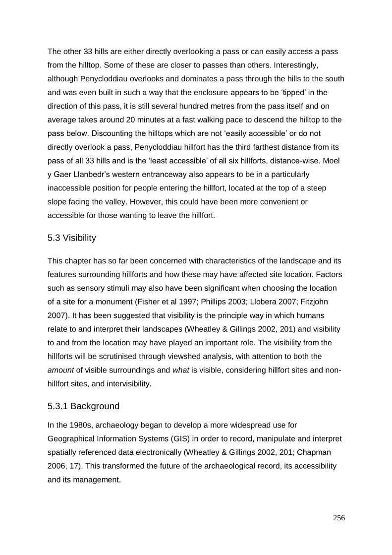
256
The other 33 hills are either directly overlooking a pass or can easily access a pass
from the hilltop. Some of these are closer to passes than others. Interestingly,
although Penycloddiau overlooks and dominates a pass through the hills to the south
and was even built in such a way that the enclosure appears to be ‘tipped’ in the
direction of this pass, it is still several hundred metres from the pass itself and on
average takes around 20 minutes at a fast walking pace to descend the hilltop to the
pass below. Discounting the hilltops which are not ‘easily accessible’ or do not
directly overlook a pass, Penycloddiau hillfort has the third farthest distance from its
pass of all 33 hills and is the ‘least accessible’ of all six hillforts, distance-wise. Moel
y Gaer Llanbedr’s western entranceway also appears to be in a particularly
inaccessible position for people entering the hillfort, located at the top of a steep
slope facing the valley. However, this could have been more convenient or
accessible for those wanting to leave the hillfort.
5.3 Visibility
This chapter has so far been concerned with characteristics of the landscape and its
features surrounding hillforts and how these may have affected site location. Factors
such as sensory stimuli may also have been significant when choosing the location
of a site for a monument (Fisher et al 1997; Phillips 2003; Llobera 2007; Fitzjohn
2007). It has been suggested that visibility is the principle way in which humans
relate to and interpret their landscapes (Wheatley & Gillings 2002, 201) and visibility
to and from the location may have played an important role. The visibility from the
hillforts will be scrutinised through viewshed analysis, with attention to both the
amount of visible surroundings and what is visible, considering hillfort sites and non-
hillfort sites, and intervisibility.
5.3.1 Background
In the 1980s, archaeology began to develop a more widespread use for
Geographical Information Systems (GIS) in order to record, manipulate and interpret
spatially referenced data electronically (Wheatley & Gillings 2002, 201; Chapman
2006, 17). This transformed the future of the archaeological record, its accessibility
and its management.

257
Spatial analyses and visibility investigations have been popular in archaeology for a
number of years, including use by antiquarians long before the computer and often
undertaken in a qualifiable approach and difficult to quantify (Wheatley & Gillings
2000). Visibility studies through the use of GIS have gained momentum since the
1990s with the advent of faster computers and viewshed analysis being easily
available on a number of GIS software packages (Wheatley 1995; Fisher et al 1997;
Lake et al 1998; Wheatley & Gillings 2000 etc). This enabled archaeologists to easily
and quickly conduct visibility studies through the use of a digital model of a
landscape terrain on a computer, without necessarily the need to visit the site/s in
question and generating quantifiable results.
This approach was met with criticism from theoretical archaeologists, such as those
developing approaches concerning landscape phenomenology developing at a
similar time, concerning the importance of immersion and experience (Tilley 2004).
Although it is accepted that ‘seeing (and experiencing) for yourself’ is an important
component in understanding a site and its views (Tilley 1993), the speed,
accessibility and quantifiable results gained from undertaking analysis such as this
through GIS reinforces its value (Gillings & Wheatley 2001). In addition, ‘seeing for
yourself’ can only occur in today’s landscape; certain features which still exist today
may not be as noticeable to the naked eye as they once were (Llobera 2007, 54).
There are a number of different methods which have developed over the years which
can be applied when conducting viewshed analysis through the use of GIS. A
selection is outlined below.
Line of sight analysis calculates whether visibility occurs between two individual
points on a map, or whether ‘obstructions’ occur in between the two points using an
underlying digital terrain model.
Single viewshed analysis is used to calculate the visibility of 360° of the landscape
surrounding the individual input point, using an underlying digital terrain model. This
then displays all pixels/cells which are visible from the input point.
Total viewshed analysis performs viewshed analyses from each individual pixel on
the digital terrain model and then calculates the most visible points in a landscape.

258
As this method essentially calculates an individual viewshed for each individual pixel,
it requires massive computational power and time.
Cumulative viewshed analysis includes multiple viewsheds from multiple, selected
input points, such as Neolithic long barrows, and combines them to create a single,
unified map. This method displays, between a selected group of points within an
area, whether and how often they are visible; the ‘summed result’ (Wheatley 1995).
This technique was utilised further to find, and subsequently investigate on the
ground, potential ‘significant places’ which may today be unknown, due to erosion for
example. This was done by calculating the most visible places from groups of
contemporary monuments through cumulative viewsheds, theorising that they may
have been positioned to have a view of a ‘significant place’ (Llobera 1996).
Investigations into views from cursus monuments found that an early cursus
monument, cursus A, in the Yorkshire Wolds had a visual connection with long
barrows which continued for the length of the extensive monument, and which may
explain its dog-leg design (Chapman 2006, 132-135).
The idea that sight could not be classed solely as ‘visible’ (1) or ‘not visible’ (0) led to
the development of the ‘fuzzy viewshed’. This calculated the values as distance from
the ‘viewer’/input point increased and subsequently the deterioration of view. Higuchi
viewshed analysis was developed in order to take into account visual indexes,
developed by Higuchi, within three visible zones and other physical and social
attributes. This considers perception; that sight of immediate, short-distance
surroundings, the ‘foreground’, would be near perfect (1) and that clarity declines
towards the ‘middle ground’ and subsequently objects become indistinguishable (0),
without a sense of depth towards the long-distance, or ‘background’, where only
pronounced landscape features can be made out (Wheatley & Gillings 2000).
Llobera developed this work further, utilising three visible ‘zones’ of foreground,
middle-ground and background. Whilst looking at the visibility of clusters of round
barrows in the Yorkshire Wolds, he extended on work into intervisibility, investigating
areas of ‘shared visibility’ from where multiple monument clusters are visible. He
distinguished different ranges of view of a monument depending on size and
appearance and included variability within investigations due to the uncertainty of
contemporaneity between monuments (Llobera 2007). Subsequently, Llobera called

259
for the wider use of visualisation in archaeology and highlighted the need for a new
speciality in archaeology, namely ‘Archaeological Information Science (AISc)’
(Llobera 2011).
More recently, with the ongoing advances in computer processing speed and
capability, 3D modelling, virtual reality and augmented reality are more widely used
for interpretation and learning. 3D modelling has been integrated into visibility
studies to investigate, and attempt to replicate and represent, visibility and
perception in archaeological landscapes. This can help to investigate impact on
architectural evolution, aids contextualisation and understanding of space and place
and has been argued to more closely replicate visual experience (e.g. Wilson 2012;
Sullivan 2017).
Developing this idea further, the use of ‘circuit-based modelling’ (varying and
potential options for movement, rather than point-to-point) and, as computers and
processing-power improve and become more accessible, multivariate total surface
modelling, intertwined with other techniques will help to discover connections and
variables in the future. This, it is hoped, will lead to exploring ‘potentials’ - possible
interpretations and new questions - rather than attempting to find (unattainable?)
definitive answers (Llobera 2012, 501; Howey & Brouwer Burg 2017).
The development of ‘viewsheds’, the term first introduced as an analogy to the
‘watershed’ (Nutsford et al 2015), has led to the development of other ‘sheds’, such
as ‘sound-sheds’ and ‘smell-sheds’ to investigate other sensory experiences
(Frieman & Gillings 2007, 5). However, the use of visual ‘shed’ analyses has been
criticised in the past.
5.3.2 Issues
The following issues have been considered:
5.3.2.1 Theoretical issues
A main criticism of viewshed and visibility analysis in archaeology is the emphasis of
the exercise being on sight, rarely taking into account the other senses such as
sound, smell, perception and ‘experience’ (Bender 1993; Tilley 1993; Wheatley &
Gillings 2000, 2; 13; Tschan et al 2000, 45-46; Conolly & Lake 2006). When

260
considering GIS analysis using visibility, other immeasurable factors may be an
issue, such as eyesight, mobility, simplification and causation (Wheatley & Gillings
2000; Frieman & Gillings 2007, 6; Gillings 2017). The primacy of vision over other
senses has been questioned (Frieman & Gillings 2007) and the relevance of
conducting GIS viewshed analysis has been doubted when compared to ‘experience’
and whether it, and the spatial points and ‘fixed’ locations it utilises, can be
considered representative (Howey & Brouwer Burg 2017); “the plan shape of a
viewshed depicted in a GIS map bears little resemblance to the experience of people
on the ground and is therefore of limited interpretive value” (Thomas 1993).
The sole use of GIS excludes influence of cultural factors or natural components
which could have affected site selection (Tilley 1993; Wheatley & Gillings 2002, 202).
It has been argued that “past populations could not analyse a landscape to find the
most suitable position in terms of visibility” (Chapman 2006, 23) and therefore there
may have been more ‘suitable positions’ which were just simply not known about on
the ground, but which a viewshed map could draw attention to.
However, visibility is suggested to be the primary way that humans relate to and
interpret landscape, according to studies in social science (Chapman 2006, 84).
Llobera argues that prehistoric monuments were built to be ‘noticeable’ in the
landscape and that without investigating and examining their setting and their
relation to other monuments we would fail to understand their role (Llobera 2007,
53). That being said, visual analysis and interpretation must also consider that our
perception today, through whichever individual or mix of sensory experience/s, will
be linked to our own past experiences and culture (Frieman & Gillings 2007, 12-13;
Howey & Brouwer Burg 2017, 7). It could, therefore, be considered an individual
encounter which cannot be replicated with or understood compared with one
experienced at the same location multiple centuries ago.
The viewshed itself has been considered a poor representation of human visibility
and has developed over time to take into account perception, see above. Perception
is influenced by the distance from viewer to view. Objects which are closer to the
viewer are “perceived as having more significance than distant objects” due to object
size and clarity (Nutsford et al 2015). The experience of confronting an ‘embodied
emotional encounter’ has an alternative impact to seeing a scaled depiction on paper

261
or a screen (Lock & Pouncett 2017, 131). Fuzzy viewsheds and Higuchi viewsheds
take this into account by applying a standardised index for clarity deterioration, see
above. Perception is also argued to be influenced by the vertical dimension, the
slope, aspect and elevation, of the terrain as well as the distance. The ‘Vertical
Visibility Index’ was developed to provide a more accurate representation of the
perception of view by calculating the visibility between a ‘viewer’ and the top (e.g. up-
slope) and bottom (e.g. down-slope) point of each visible cell instead of just from the
cell centre (Nutsford et al 2015).
Visual studies can often be considered environmentally-focussed and deterministic
and that they focus on measurable aspects which affect the interpretation and
therefore do not reflect reality (Chapman, 2006, 83). “…Maps are very susceptible to
subjective impressions; it is often easy to see the patterning that is desired in a
particular map” (Hodder & Orton 1976, 241). Work into the analysis of visibility from
Bronze Age cairns in Mull used viewshed and cumulative viewshed analysis34, with a
firm concentration on statistical theory and found that the cairn sites seemed to be
positioned in the landscape, so they had a large visible area of the sea, compared to
other ‘non-sites’ (Fisher et al 1997). The use of statistical theory within GIS enables
the user to state any relationships “with definite confidence, not merely suggested”
(Fisher et al 1997, 591). This had been a downfall of many previous archaeological
studies using GIS; that sites are tested for visibility but then not followed up by using
non-sites for comparison and statistical rigour (Fisher et al 1997, 583). Monuments
on hills may have been studied for visibility and intervisibility but hills without
monuments have not been studied and no control sample utilised. The possibility
that hills are intervisible rather than the monuments that sit upon them has not yet
been fully considered and will now be challenged.
Almost two decades ago, it was proposed that, instead of the archaeological use of
digital geographical-based tools being driven forward by technological advances of
34 Viewshed analysis shows all of the cells that are visible from a specified location (Conolly & Lake
2006, 300), combined or multiple viewshed analysis is the combination of two or more viewsheds
(Conolly & Lake 2006, 227) and cumulative viewshed analysis is the sum of multiple viewshed maps
where the cells are coded according to how many viewsheds they fall within (Conolly & Lake 2006,
291); occasionally referred to as the ‘number of times seen’ map (Fisher et al 1997, 588).

262
GIS-based research, archaeology should begin to develop its own discipline-specific
tools - ‘Archaeological Information Systems (AIS)’ - and to create unified frameworks
and approaches (Tschan et al 2000). Llobera calls for digital methods to work with
interpretative landscape archaeology complementarily – to find a middle-ground
between theory and practise – understanding a human’s view from a location to be a
‘situated perspective’ (Llobera 2012). Qualitative methods cannot serve an
interpretation of past experience alone and nor can quantitative.
Rather than a middle-ground and the use of GIS as a tool to apply to existing
theoretical concepts, Gillings proposes that the researchers working with GIS should
begin developing their own unique theoretical frameworks and introduced the
potential for an affordance-based framework for investigating past landscapes
(Gillings 2012). Most recently, following the years of development and investigation,
there has been a call for an agreed, coherent theory-driven approach to visibility
studies in archaeology, an agreed terminology and a clear theoretical framework
moving forward (Howey & Brouwer Burg 2017; Gillings 2017).
The investigation of visibility of or from sites can still be argued as valuable analysis.
Visibility can have a “central analytical role”; the visual characteristics of a site are
the ones most likely to be remembered and referred to (Gillings & Wheatley 2001).
Visibility of a landscape has an element of ‘permanence’ compared to the other
senses’ sources more difficult to retrieve (Wheatley & Gillings 2002, 201; Llobera
2007). Through archaeological excavation we may be aware of a location where the
‘clank’ and heat of metalworking once occurred, the smells and scraping sounds
where butchery was once performed or where a hearth and its crackles, smells and
indescribable feeling of ‘home’ and nostalgia once burned. But these insights only
represent a snapshot in time or a (potentially) temporary or intermittent event. A view
of a landscape presents a longer-term encounter, albeit only a partial representation
of human experience in a place and space, but one of the many factors nonetheless.
Viewshed analysis is a developing tool, one of many, providing useful data to aid
interpretation of landscapes and its features and how these may have been
perceived, experienced and interacted with in past times. This will continue to
develop as a bespoke theoretical agenda is established in the future.

263
5.3.2.2 Computational issues
5.3.2.2.1 Algorithms
Different GIS packages use different procedures for calculating the results and can
therefore produce different results (Conolly & Lake 2006, 228). For this research
ArcGIS ArcView 9.3.1 has been used solely for the analyses.
5.3.2.2.2 Curvature of the Earth
The wider study area is made up of the 30-mile (48km) radius from the most
northerly Clwydian Range hillfort, Moel Hiraddug, located at grid reference
SJ063784, and the most southerly Clwydian Range hillfort Moel Fenlli, SJ163601.
The study area spans such an area that the curvature of the earth must be taken into
account35, as “the effect of the curvature of the Earth’s surface is to reduce the
elevation of a target by approximately 7.86m for every 10km from the viewpoint”
(Conolly & Lake 2006, 228-9).
5.3.2.3 Experimental Issues
5.3.2.3.1 The edge effect
A viewshed may become truncated if some of the sites tested are nearer to the edge
of the viewshed and the visibility from them ‘cut off’ as it is ‘over the edge’ (Lake et al
1998, 37; Wheatley & Gillings 2000, 11-12; Conolly & Lake 2006, 229). The core
study area as the Clwydian Range hillforts will be surrounded by a wider ‘buffer’ of
the 30-mile radius of the core study area and it is these six sites which will be tested
in detail.
5.3.2.3.2 Reciprocity
The viewsheds generated from a point can suggest if the viewer can see the target,
but it is possible that the target may not be able to see the viewer and therefore the
viewshed is not reciprocal (Conolly & Lake 2006, 229-230). Where the viewshed is
calculated from the observer point, it is seldom tested to check if the view is
reciprocated; it must be stated whether the calculations are for the specific point
having visibility or being visible, preferably calculating both if this is possible (Fisher
35 The effect and importance of taking into account the curvature of the earth has been demonstrated in Appendix Two.

264
et al 1997, 584). This study will calculate the amount of surroundings visible from the
feature, i.e. the hillfort.
5.3.2.3.3 Digital Elevation Model (DEM) quality
The DEM used is at 10m resolution and will be acknowledged as an acceptable
representation of the elevation of the topography. However, viewsheds generated
can be tested for accuracy in the field.
5.3.2.3.4 Sensitivity
A number of parameters have been used within a test study, see Appendices One
and Two, to test the sensitivity of the data, including observer height, target height,
location of points within the hillfort and the usage of polylines as features to calculate
the viewshed from.
Also tested is the effect of the location of these points and features within the
monument using map information gained from EDINA Digimap OS collections, or
from using survey data created during topographical surveys of the hillforts.
As the monuments tested have suffered from thousands of years of erosion, banks
subsiding, ditches filling, and the possibility of palisade fences, walkways and towers
collapsing with no trace remaining by sight today, a number of variables have been
tested to seek the sensitivity of the height of the observer at a number of intervals.
5.3.2.4 Substantive issues
5.3.2.4.1 Palaeoenvironment & palaeovegetation
The issue of little acknowledgement of the palaeoenvironment and/or vegetation has
been highlighted as a key criticism for many archaeological visibility studies (e.g.
Tschan et al 2000). To consider potential obstruction and barriers to view, Llobera
created the ‘gradient viewshed’ which encoded these factors into calculations
(Llobera 1996).
Using the results from the peat core analysis from the Clwydian Range (Grant 2009),
it can be understood that the tops of the hills in this rural area were free from trees
and so the modern ‘barren’ DEM can be accepted as a representation of the

265
landscape in the Iron Age. A lack of knowledge of individual patches of vegetation is
accepted.
5.3.2.4.2 Contrast
As monuments in the landscape today, often with tree and heath cover, the sites
may blend into the background of the wider landscape and this is an example of
where GIS technology, especially the use of Higuchi viewsheds, can be of great use
in computing visibility, alongside the time benefits (Wheatley & Gillings 2000, 6;
Ogburn 2006).
When looking at the visibility of hillforts, as large monuments with possible activity
within them such as smoke rising and surrounding buildings, the targets can be
understood to have contrasted with the wider landscape when in use. The viewsheds
created are accepted as being a representation of view under certain conditions and
circumstances, requiring interpretation.
5.3.3 Visibility analysis method
Through viewshed analysis, this study examines whether the visibility of the
landscape from a hill was a main factor when taking into account its suitability for a
hillfort before the site was chosen and the hillfort subsequently built. The visibility
from the summit or from a circuit around the hill may have been considered in site
determination. Where multivallation and multiple-phases of sites occur, it will be
explored whether or not ramparts were added to increase visibility from the site.
Initially, a viewshed from each hillfort in the Clwydian Range has been calculated
using the 3D analyst viewshed feature on the ArcGIS 9.1 software. The viewshed
calculated all visible and non-visible cells on the Digital Elevation Model (DEM) from
the observation point (Chapman 2006, 83). Due to the size of the monuments at the
observation point, a polyline has been produced, following the line of the ramparts, to
become the observation feature, rather than a randomly chosen point within the
multiple-hectare sites. A viewshed has then been calculated using a polyline
generated using points from across the whole of the feature rather than one given
point.

266
5.3.3.1 Single point viewsheds
Visibility was calculated from the summit of hillforts as a single point viewshed.
These calculations are used to compare between other hillforts and non-hillfort hills.
The results from the single point viewsheds are compared with polyline viewsheds to
determine the accuracy of single point viewsheds for sites enclosing a large area.
Single point viewsheds are also used at particular features at different heights to
calculate whether the addition of structures could have helped increase visibility of
the surrounding landscape.
5.3.3.2 Polyline viewsheds
Polylines have been used to test visibility from a range of points within sites, such as
rampart lines, including multi-phase construction, and interior locations.
These calculations are used to compare the visibility from the Clwydian Range
hillforts to other hillforts in the wider area to test for correlations or differences in
results.
Polylines are also used to compare the visibility from sites built on a slope to their
contour lines to test whether they were built in this way to increase visibility of the
hillforts’ surroundings.
5.3.3.3 Aspect – non-numerical observations
In addition to collecting data as ‘number of pixels’ visible on the DEM from the point/s
inputted, which represent the amount of land or sea visible or not visible from the
input feature, non-numerical representation is also used.
Viewshed maps generated by the visibility calculations are studied to ensure
changes in direction of view and aspect is examined, as the use of quantitative
values solely fails to detect these.
5.3.3.4 Other Considerations
A number of studies have studied the view to hillforts - from the ‘outside’ to within -
and argued the impact of this on the hillforts’ defensibility or monumentality (Bowden

267
& McOmish 1987; 1989; Hamilton & Manley 2001). Considering hillfort function,
including warfare, symbolism and monumentality or control, view from a site outward
into the landscape may also have been considered an important factor (Gale 1999,
112; Matthews 2006). A view of a landscape could ensure approaching traffic would
be seen with forewarning, that potentially subservient communities were behaving
accordingly, that crops were growing, if floods were occurring and a view of the
surrounding landscape could potentially highlight boundaries and/or allow visibility of
neighbouring communities.
The method used, utilising single and multiple input points from a monument’s
topography, to generate a single viewshed of the surrounding landscape has been
chosen to give an overall viewshed map for each individual monument. Multiple
points have been used in most cases as it is acknowledged that one point/pixel can
only represent the view from that particular point in the landscape or pixel in a model.
View changes with movement and there are a vast number of different 360° ‘views’
that can be experienced from within/on/from a monument which covers an area
larger than a ‘stride’.
It is accepted that the input points chosen are selective and that these few select
points cannot be accurate for every point, pixel or footprint across an entire
monument, but that the output of a viewshed using multiple points can begin to
represent an understanding and appreciation of the different views from the
monument/s.
In this instance, single/binary viewshed maps have been created due to:
a) The viewshed analysis is to give an overall indication and calculation of
amount and aspect of view of the landscape from a monument to be
compared with others in the same way, and is not designed to test visibility of
particular items in the middle or distant landscape, apart from:
b) In intervisibility experiments, the size of the monuments including the addition
of original architecture, movement and activity, such as smoke from hearths
etc., would have increased the prominence and contrast of the monuments in
the landscape, making them easier to detect and/or identify (Gillings 2017,
123). The viewshed range has been set to no more than 25km; a distance

268
demonstrated as visible between hillforts in person during the Hillfort Glow
experiment (Robinson & Soper 2011).
A maximum viewing distance was required to be calculated to avoid the edge effect
(Conolly & Lake 2006, 229). During visibility tests from hillforts at night, the furthest
seen was approximately 25 miles, or 40km, between Penycloddiau hillfort on the
Clwydian Range to Maiden Castle in Cheshire (Robinson & Soper 2011, 11). During
intervisibility analysis in 2006, Matthews made reference to Meteorological Optical
Range which to have over 27 nautical miles visibility (approximately 31 miles, 50km)
and the weather would have to be ‘exceptionally clear’ (Matthews 2006, 36). The
radius of the viewshed was set at a limit of 25km, unless stated otherwise36.
Where viewshed analysis is concerned, most studies choose a height of 1.7m above
the ground for observation of a human (Chapman 2006, 85). For the purposes of this
study and using the results from these analyses, an average height of a human as
1.7m is accepted. Sensitivity in the viewshed has been understood through further
viewshed analyses at specific points using different heights at the monuments to
allow for erosion or features such as towers and bridges. Erosion of the monuments
will have affected the height the observer once stood above ground; the loss of any
features such as a wooden wall walk could deduct several metres from the
observers’ original height above ground. It is good practise to repeat visibility
analysis with a range of variables in order to understand whether the results are
robust or highly sensitive to small changes (Conolly & Lake 2006, 230-232).
Non-archaeological sites, e.g. hills without hillforts, see Figure 5.1, have also been
tested as a control sample.
As there is currently no evidence to suggest that the hillforts are contemporary, nor
dates of any phasing suggested at sites (Brooks & Laws 2006-2009; Brooks 2011),
spatial relationships between the sites may be affected by their lack of co-existence
(Hodder & Orton 1976, 18). The question of the sites being temporarily or
permanently occupied may also be an issue (ibid., 19), and possible differential site
function. However, even if not in use at the same time, at the last phase of hillfort
36 A test study was conducted using the non-hillfort site of Moel Famau and can be found in Appendix One. A number of techniques have been conducted using single input points in multiple locations and a polyline input feature.

269
use in the Clwydian Range, the newest hillforts would have been aware of the older
sites even if these would have been classed as ‘monuments’ themselves from this
time.
5.3.4 Visibility Results
5.3.4.1 Clwydian Range hillforts
5.3.4.1.1 Comparing visibility from summit points and rampart polylines
Figure 5.10. Percentage of visible surroundings from ramparts and summits
depicting visibility from the summit (red) and rampart circuits (blue) for Moel
Arthur Phase 1 (Ph1), the inner ramparts of Moel Fenlli, the main outer
circuit of Moel Hiraddug, Moel y Gaer Llanbedr Phase 1 (Ph1) and
Penycloddiau’s inner ramparts demonstrating that visibility of the
surrounding landscape is higher from the rampart circuits (multiple points)
than the summit point
Using the six hillfort sites in the Clwydian Range, conducting the viewshed analysis
using a polyline at the ramparts rather than a single point at the hill’s summit
increased the visibility of the landscape, see Figure 5.10 and Table A3.10. For
example, the summit of Moel Fenlli could see 3.39% of the landscape when tested
using the summit at the cairn on the hill and this rose to 5.8% when calculating the
visibility from the inner ramparts of the site.

270
In other cases, generally observed at the sites which enclose a much smaller area,
very little difference was seen between the visibility from the summit and the rampart
polyline viewshed. Moel y Gaer Llanbedr’s summit saw 2.67% from the summit of
the hill and this number rose by just 0.15% when calculating from the main circuit of
the ramparts, thought to be the first phase of the site. Moel y Gaer Bodfari’s summit
was calculated with a visibility of 3.07% compared with the ramparts’ visibility of
3.09%, a negligible difference of only 0.02%.
Moel Hiraddug’s point was taken at its summit at the highest point of the large hill
and the overall visibility at this point was calculated as 3.96%. For this exercise, the
polyline was plotted using the outer circuit of the hillfort as seen today, see Figure
5.23, and little change was observed between the polyline and the single point at the
summit despite its large size.
Moel Arthur’s summit achieved the highest visibility at 4.9%. Calculating the visibility
using the ramparts, results increased by 0.25% using the outer ramparts as a
polyline, thought to be the first phase of the site.
Neighbouring hillfort Penycloddiau’s summit, the highest point at the cairn, had
visibility of 2.83% of the landscape. Using a polyline of the hillfort’s inner ramparts,
this increased by 3.16% to 5.99%, the highest difference in visibility when comparing
the input feature as a point at the summit with a polyline depicting the ramparts. The
second highest difference in visibility between the summit and the line of the
ramparts was Moel Fenlli hillfort, both of these being the largest enclosed areas of
the six, respectively, and also being ‘tipped’ hillforts, where the ramparts enclose the
summit of the hill but do not strictly follow the contours.
All hillfort ramparts had a higher visibility percentage of the landscape than using
points at their summits, see Figure 5.10. Therefore, this shows that previous studies
using only points to calculate visibility for large features in the landscape are not
accurate. If generalisation has previously been made that viewshed results for a
single point applies to the entire feature, they must be reconsidered.
Numerical results can be generated to show change in values and amount of land
visible, see Figure 5.10. However, these figures may not represent changes that can
be seen by the naked eye. Small changes can be detected between the summit

271
viewsheds and the rampart viewshed by the amount of pixels visible. It will now be
explored whether these small changes in quantitative form represent impact on
aspect and features visible.
When comparing the aspect from the ramparts with the aspect from the summit,
change is visible. For example, Moel y Gaer Llanbedr, which sits on a western spur
of the Clwydian Range and surrounded by higher ground to its east, has a strong
westerly aspect with good command over the Vale of Clwyd. When comparing the
view from the summit to the ramparts, the rampart view has an increase in visibility
for the immediate surrounding landscape, see Figure 5.12. This is shown in the
maps showing visibility of the immediate surrounding landscape masked from the
summit by the rest of the hill itself, as seen in Figure 5.11.
Figure 5.11. Viewshed from Moel y Gaer Llanbedr summit, with the star
representing the highest point of the hill/hillfort. Darker shaded areas
represent pixels/view not visible from the summit point and coloured
(representing relief as per the Digital Elevation Model - DEM) areas
showing pixels/view visible from the summit point. There is a clear view
from the hillfort up and down the Vale of Clwyd to the west of the hillfort but
immediate views to the west are blocked by the hill itself, as are views to
the east where areas of higher ground lie
272
Figure 5.12. Viewshed from Moel y Gaer inner ramparts. The yellow line
represents a user-generated polyline drawn around the inner ramparts of
the hillfort. Darker shaded areas represent pixels/view not visible from the
inner rampart polyline and coloured (representing relief as per the Digital
Elevation Model - DEM) areas showing pixels/view visible from the inner
rampart polyline. Views north and south of the Vale of Clwyd is clear to the
west of the hillfort but views to the east are obscured by higher ground
In the case of Moel Hiraddug, much less of the immediate surrounding landscape of
the hillfort is visible from the summit than from the ramparts, see Figures 5.13 and
5.14. Moel Hiraddug shows an aspect looking down the Vale of Clwyd to the south
and also north towards the sea. From these tests, it appears that Moel y Gaer
Bodfari and Moel y Gaer Llanbedr are just visible from Moel Hiraddug according to
the viewshed from the ramparts, see Figure 5.14. Moel y Gaer Bodfari is the only
Clwydian Range hillfort visible through the viewshed at the summit point, see Figure
5.13. Moel Hiraddug also appears to have a clear view down the north Wales coast
to the west where other hillforts such as Castell Cawr, Dinorben and Penycorddyn
Mawr lie.

273
Figure 5.13. Viewshed from Moel Hiraddug summit with the star
representing the highest point of the hill/hillfort. Darker shaded areas
represent pixels/view not visible from the summit point and coloured
(representing relief as per the Digital Elevation Model - DEM) areas
showing pixels/view visible from the summit point. There is a clear view
from the hillfort up and down the Vale of Clwyd to the west, along the coast
(represented by the black line) including some hillforts on the north Wales
coast (represented by red dots) and some lower-lying ground to the east
and south east. Immediate views to the west are blocked by the hill itself,
as are views to the south down the Clwydian Range

274
Figure 5.14. Viewshed from Moel Hiraddug inner rampart. The yellow line
represents a user-generated polyline drawn around the inner ramparts of
the hillfort. Darker shaded areas represent pixels/view not visible from the
inner rampart polyline and coloured (representing relief as per the Digital
Elevation Model - DEM) areas showing pixels/view visible from the inner
rampart polyline. Views north west and south west of the Vale of Clwyd is
clear to the west of the hillfort alongside views down the coast (represented
by a black line) including the hillforts located there (represented by red
dots). Land immediately surrounding the hillfort is mostly visible from the
ramparts but most of the Clwydian Range to the south of the hillfort is
obscured
The viewshed of Moel y Gaer Bodfari, which sits on a lower hill overlooking the
Aberwheeler Valley which runs east to west through the Clwydian Range, has a
strong aspect of the Vale of Clwyd but less so in other directions mostly due to the
higher ground surrounding the hillfort. Figure 5.15 depicts the topography of the
surrounding area, including the clear pass through the hills at this location. Figure
5.17, which shows the ramparts’ viewshed from the inner rampart of Moel y Gaer
Bodfari, shows the visible areas along the pass running east to west to the south of
the hillfort. There is a clear section of the pass not visible from the summit point, see

275
Figure 5.16 and there are some patchy ‘blind spots’ from the inner rampart, as seen
in Figure 5.17.
Figure 5.15. Topography surrounding Moel y Gaer Bodfari, with colours
depicting relief from the Digital Elevation Model (DEM). The summit point of
the hillfort is depicted as a green dot, with the ramparts as a red line. The
Vale of Clwyd is instantly recognisable running north to south to the west of
the hillfort, whilst the smaller Chwiler Valley runs east, just to the south of
the hillfort, which sits on a spur where the two river valleys converge

276
Figure 5.16. Viewshed from Moel y Gaer Bodfari summit with the star
representing the highest point of the hill/hillfort. Darker shaded areas
represent pixels/view not visible from the summit point and coloured
(representing relief as per the Digital Elevation Model - DEM) areas
showing pixels/view visible from the summit point. There is a view from the
hillfort up and down the Vale of Clwyd to the west, but with land
immediately surrounding the hillfort blocked by the hill itself. Much of the
view to the north and south east is obscured by higher ground, with patchy
visibility to the north east. Much of the Chwiler valley is visible to the south,
running east, apart from a small patch obscured by the slope of the hill

277
Figure 5.17. Viewshed from Moel y Gaer Bodfari inner ramparts. The
yellow line represents a user-generated polyline drawn around the inner
ramparts of the hillfort. Darker shaded areas represent pixels/view not
visible from the inner rampart polyline and coloured (representing relief as
per the Digital Elevation Model - DEM) areas showing pixels/view visible
from the inner rampart polyline. Much of the views north west and south
across the Vale of Clwyd is clear. Land immediately surrounding the hillfort
is mostly visible from the ramparts, including the Chwiler Valley running
east to the south of the hillforts. Most of the Clwydian Range to the north
and south west of the hillfort is obscured
Comparing the aspect of the summit and the ramparts of Moel Fenlli in Figures 5.18
and 5.19, shows the largest difference in amount of land visible. Conducting the
viewshed from a polyline on the hillfort’s ramparts, Figure 5.19 increases the view to
the east substantially, enabling a view to the River Dee towards Chester and into
Cheshire as well as the Wirral and additional pieces of land within the current county
of Flintshire including Halkyn Mountain where the hillfort of Moel y Gaer Rhosesmor
is situated. However, this result from the summit, as seen in Figure 5.18, highlights
the sensitivity of viewshed analysis when using only one point in calculations. The
summit of Moel Fenlli is known to reveal wide views, including to the east to
Cheshire and beyond, as demonstrated during the Hillfort Glow experiment

278
(Robinson & Soper 2011) and therefore the ‘point’ at which the viewshed has been
calculated may not represent the true ‘summit’ at the site.
Figure 5.18. Viewshed from Moel Fenlli summit with the star representing
the highest point of the hill/hillfort. Darker shaded areas represent
pixels/view not visible from the summit point and coloured (representing
relief as per the Digital Elevation Model - DEM) areas showing pixels/view
visible from the summit point. There is a view from the hillfort up and down
the Vale of Clwyd to the north west and south west, but with land
immediately surrounding the hillfort is blocked by the hill itself. Much of the
land to the north, east and south is shown to be not visible from the summit
point, demonstrating the limits of viewshed analysis and the effect of
human choice of input point location; Moel Fenlli is known to have much
wider panoramic views from the true summit point

279
Figure 5.19. Viewshed from Moel Fenlli inner ramparts. The yellow line
represents a user-generated polyline drawn around the inner ramparts of
the hillfort. Darker shaded areas represent pixels/view not visible from the
inner rampart polyline and coloured (representing relief as per the Digital
Elevation Model - DEM) areas showing pixels/view visible from the inner
rampart polyline. Much of the views north west and south west across the
Vale of Clwyd is clear as is the pass of Bwlch Pen Barras which runs west
to east through the Clwydian Range just to the north of Moel Fenlli. Much of
the Clwydian Range to the north and south is obscured, but higher points
and unobscured areas are visible in patchy areas surrounding the hill
Figure 5.19 above shows the pass of Bwlch Pen Barras clearly visible running east
to west through the Clwydian Range to the north of the hillfort. The Vale of Clwyd
can also be clearly seen as a visible area. However, due to the size of the hillfort
blocking the immediate surrounding area when viewing from the summit point, as
seen in Figure 5.18, the view of two adjacent enclosures is blocked. Two enclosures
known as ‘Moel Fenlli enclosure west’ and ‘Halfway House’ sit on the lower slopes of
the hill to the west of the hillfort. These enclosures are shown to be visible from the
hillfort using the viewshed on the ramparts, see Figure 5.29 but would not be visible
from the summit point.

280
Penycloddiau, the largest hillfort of the six on the Clwydian Range, also shows a
significant difference between the viewshed from the ramparts, see Figure 5.21,
compared with just from the summit, Figure 5.20. From the ramparts there appears
to be an overall general distribution of visibility in most directions. From the summit
the view is limited including much less visibility to the Vale of Clwyd, probably due to
the sheer size of the hillfort itself blocking the view. However, this also presents
problems of ‘input point positioning’ as at Moel Fenlli demonstrated above seen in
Figure 5.18, as there are known to be wide views in all directions from the true
summit of Penycloddiau.
Figure 5.20. Viewshed from Penycloddiau summit with the star
representing the highest point of the hill/hillfort. Darker shaded areas
represent pixels/view not visible from the summit point and coloured
(representing relief as per the Digital Elevation Model - DEM) areas
showing pixels/view visible from the summit point. Much of the land
surrounding the hill is shown to be not visible from the summit point,
demonstrating the limits of viewshed analysis and the effect of human
choice of input point location; Penycloddiau is known to have much wider
panoramic views from the true summit point

281
Figure 5.21. Viewshed from Penycloddiau inner ramparts. The yellow line
represents a user-generated polyline drawn around the inner ramparts of
the hillfort. Darker shaded areas represent pixels/view not visible from the
inner rampart polyline and coloured (representing relief as per the Digital
Elevation Model - DEM) areas showing pixels/view visible from the inner
rampart polyline. Much of the views north west and south west across the
Vale of Clwyd, as is a large area to the north east. Much of the Clwydian
Range to the north and southeast is obscured although some higher
summits and slopes of the Clwydian Range are visible
5.3.4.1.2 Viewsheds from multi-phase ramparts
As well as Moel Fenlli, Penycloddiau and Moel y Gaer Bodfari’s inner ramparts, the
three multi-phase hillforts of Moel Hiraddug, Moel Arthur and Moel y Gaer Llanbedr
were tested using multiple polylines, see Figure 5.22 and Table A3.10. These
hillforts have had original univallate phases suggested after survey and/or
excavation (Brassil et al 1982; Brooks & Laws 2006b; Brooks & Laws 2007).
Polylines were tested on what has been considered to be the rampart line of the
initial phase of the hillfort followed by a secondary rampart line to test whether the
addition of multiple phases of ramparts could be explained as an exercise to
increase visibility.
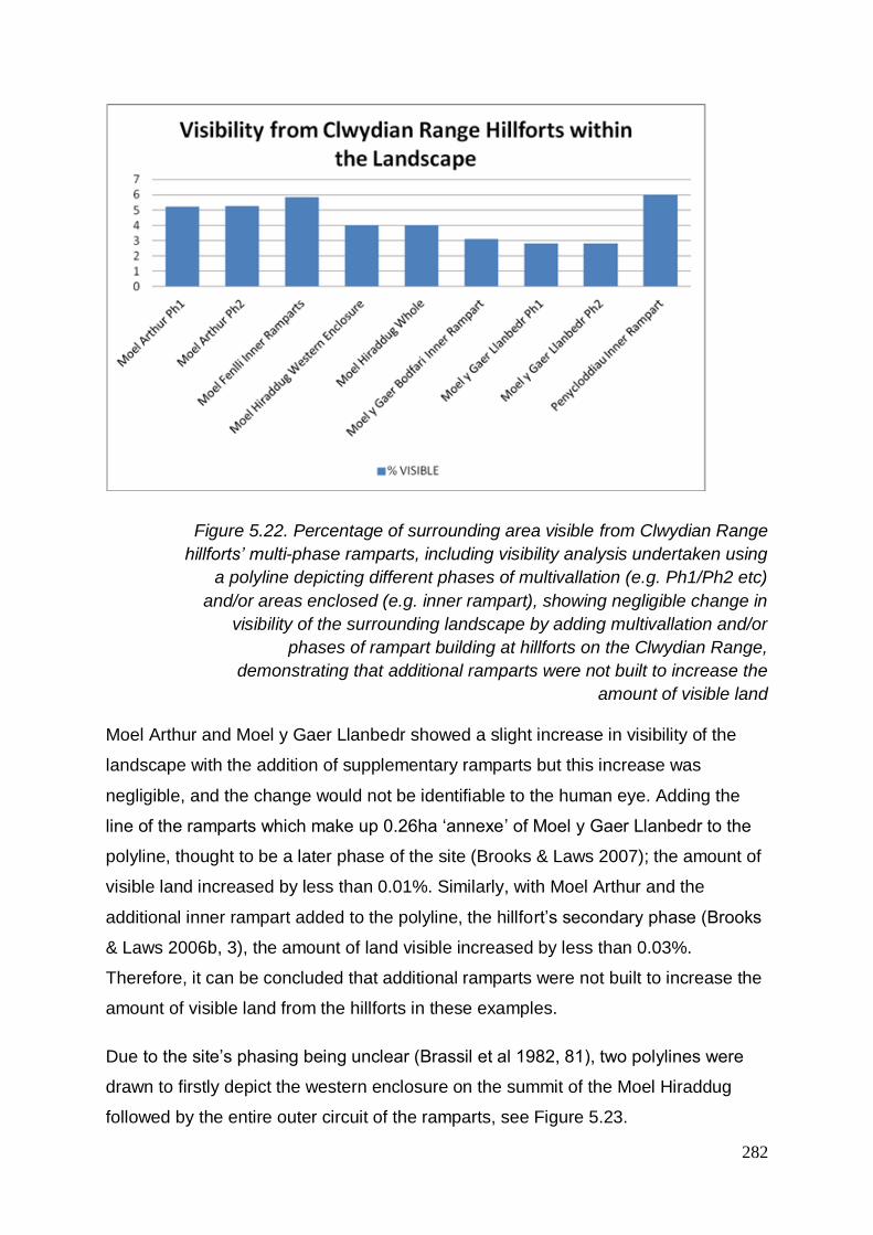
282
Figure 5.22. Percentage of surrounding area visible from Clwydian Range
hillforts’ multi-phase ramparts, including visibility analysis undertaken using
a polyline depicting different phases of multivallation (e.g. Ph1/Ph2 etc)
and/or areas enclosed (e.g. inner rampart), showing negligible change in
visibility of the surrounding landscape by adding multivallation and/or
phases of rampart building at hillforts on the Clwydian Range,
demonstrating that additional ramparts were not built to increase the
amount of visible land
Moel Arthur and Moel y Gaer Llanbedr showed a slight increase in visibility of the
landscape with the addition of supplementary ramparts but this increase was
negligible, and the change would not be identifiable to the human eye. Adding the
line of the ramparts which make up 0.26ha ‘annexe’ of Moel y Gaer Llanbedr to the
polyline, thought to be a later phase of the site (Brooks & Laws 2007); the amount of
visible land increased by less than 0.01%. Similarly, with Moel Arthur and the
additional inner rampart added to the polyline, the hillfort’s secondary phase (Brooks
& Laws 2006b, 3), the amount of land visible increased by less than 0.03%.
Therefore, it can be concluded that additional ramparts were not built to increase the
amount of visible land from the hillforts in these examples.
Due to the site’s phasing being unclear (Brassil et al 1982, 81), two polylines were
drawn to firstly depict the western enclosure on the summit of the Moel Hiraddug
followed by the entire outer circuit of the ramparts, see Figure 5.23.

283
Figure 5.23. Moel Hiraddug primary ramparts shown with a red line
depicting a user-generated polyline following the Inner Rampart on the
western enclosure and a blue user-generated polyline (continues beneath
but obscured by the northern and western extent of ‘Inner Rampart
Polyline) following the entire main outer circuit of Moel Hiraddug. These
overlie a coloured DEM showing relief and local Ordnance Survey map of
the surrounding area showing ramparts and local features
The western enclosure (inner rampart) at the summit of the hill calculated a visibility
of 4.028%, see Figure 5.24. Increasing the area of the polyline to include the entire
circuit of the outer ramparts to the east (not including outlying, satellite sections of
rampart on the southern side, or the possible annexe etc), see Figure 5.25, slightly
decreased the visibility from the ramparts to 4.025%. This indicates that the inner
rampart of the hillfort has higher visibility than the ‘outer’ ramparts as seen today.
Aspect does not appear to have been affected by the addition of multiple ramparts
as the map views are almost identical, see Figures 5.24 and 5.25.
Therefore, it can be concluded that the addition of extra ramparts and phases to the
site would not have been to increase visibility of the landscape.

284
Figure 5.24. Viewshed from Moel Hiraddug western enclosure. The yellow
line represents a user-generated polyline drawn around the inner ramparts
of the hillfort (those shown in red in Figure 5.23). Darker shaded areas
represent pixels/view not visible from the inner rampart polyline and
coloured (representing relief as per the Digital Elevation Model - DEM)
areas showing pixels/view visible from the inner rampart polyline.
Surrounding hillforts are shown as red dots and the north Wales coastline
as a black line to the north west of the map

285
Figure 5.25. Viewshed from Moel Hiraddug outer ramparts. The red line
represents a user-generated polyline drawn around the inner ramparts of
the hillfort (those shown in blue in Figure 5.23). Darker shaded areas
represent pixels/view not visible from the inner rampart polyline and
coloured (representing relief as per the Digital Elevation Model - DEM)
areas showing pixels/view visible from the inner rampart polyline.
Surrounding hillforts are shown as red dots and the north Wales coastline
as a black line to the north west of the map
5.3.4.1.3 Comparing viewsheds from ‘tipped hillforts’ and their associated contour lines
A viewshed was calculated using the outline of Penycloddiau, Figure 5.27 and Moel
Fenlli’s ramparts, Figure 5.26, on the true contours of the hills the hillforts sit upon.
This was done to compare whether the ‘tipped’ hillforts were built on a slope, rather
than as true ‘contour forts’, to increase visibility of the surrounding area, when
compared to a viewshed from the true ramparts, see Figure 5.28.
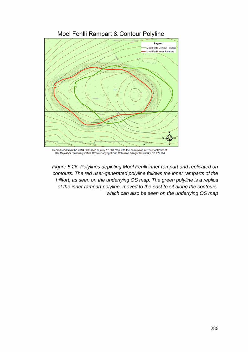
286
Figure 5.26. Polylines depicting Moel Fenlli inner rampart and replicated on
contours. The red user-generated polyline follows the inner ramparts of the
hillfort, as seen on the underlying OS map. The green polyline is a replica
of the inner rampart polyline, moved to the east to sit along the contours,
which can also be seen on the underlying OS map

287
Figure 5.27. Polylines depicting Penycloddiau’s inner rampart and
replicated on contours. The red user-generated polyline follows the inner
ramparts of Penycloddiau hillfort, as seen on the underlying OS map. The
blue polyline is a replica of the inner rampart polyline and moved to the
north to sit across the contours, which can also be seen on the underlying
OS map
Calculating the visibility of the surrounding landscape from Penycloddiau using a
replica polyline of the ramparts upon the contours, the results increased from 5.99%
to 6.22%. A similar result was witnessed at Moel Fenlli, where the land visible from
the ramparts was 5.82% compared with an increase to 5.99% when calculating the
viewshed from the polyline at the true contours of the hill.
These results suggest that in both cases, the tipping of the hillforts’ rampart lines had
a negative rather than positive effect on the total amount of visibility of the
surrounding landscape, see Figure 5.28 and Table A3.11.

288
When comparing the line of the ramparts with contour lines, it is apparent that the
‘tipping’ of the hillfort on Penycloddiau ensured that a flatter piece of ground to the
south of the hillfort was included within the enclosure. If this contour line had been
followed the whole way around the summit to make the ramparts, the hillfort would
have been incredibly large, possibly even doubling the already 20 hectares the
hillfort proper encloses. Where the northern ramparts cut across the contour line to
enclose the summit, multivallation has been constructed, possibly to further protect
this weaker, flatter side. A similar approach can be seen on the eastern ramparts of
Moel Fenlli.
Figure 5.28. Comparison of percentage of visible surroundings from
ramparts and contours of ‘tipped hillforts’. A small increase in the total
surrounding area visible is seen when generating a viewshed from the
contour lines compared with the true ramparts. This indicates that the
‘tipped hillforts’ of Moel Fenlli and Penycloddiau were not built to sit on an
angle across the contours of their hills to increase overall visibility
Although change appears to be slight numerically, visibility maps were scrutinised to
investigate, qualitatively, whether aspect and visibility of certain areas were affected
by the building of the hillfort on a slope, see Figures 5.29 to 5.32.
When comparing the viewshed from Moel Fenlli’s inner rampart with the same area
taken from the viewshed using the contour polyline, see Figures 5.29 and 5.30

289
respectively, an increase in visibility of certain nearby areas can be seen from the
ramparts proper that cannot be seen if the ramparts had been built on the contour
line.
For example, on the north side of the hillfort, a visible line following the current
pathway up the hill from the below “bwlch”/pass to the western entrance can clearly
be seen on Figure 5.29, but the view is masked from the contour polyline, see Figure
5.30.
Alongside this, areas of land to the west immediately below the hillfort and around
1km from the hillfort are only visible from the rampart line, not the contour polyline.
This is even though slightly more of the interior of the hillfort can be seen from the
contour lines as opposed to the rampart line proper.
In addition, the enclosures which sit to the west of the hillfort on the lower slopes are
not visible from the contour line but are just visible from the ramparts.

290
Figure 5.29. Viewshed from Moel Fenlli inner ramparts. Darker shaded
areas represent pixels/view not visible from the inner rampart polyline and
coloured (representing relief as per the Digital Elevation Model - DEM)
areas showing pixels/view visible from the inner rampart polyline. The inner
ramparts of Moel Fenlli are depicted as a blue user-generated polyline
towards the centre of the map. To the hillfort’s west, a green and blue dot
represent the locations of two undated enclosures, thought to be
prehistoric, and clearly visible within this viewshed. Also visible is much of
the hillfort of Moel y Gaer Llanbedr, depicted as a green polyline to the
north west of Moel Fenlli. The path from the pass of Bwlch Pen Barras to
the north of Moel Fenlli, which leads up to the western edge and entrance
to the hillfort, is also shown to be visible on this viewshed

291
Figure 5.30. Viewshed from Moel Fenlli contours. Darker shaded areas
represent pixels/view not visible from the contour polyline and coloured
(representing relief as per the Digital Elevation Model - DEM) areas
showing pixels/view visible from the contour polyline. The contour polyline
on Moel Fenlli is depicted as a light green polyline replicated from the
rampart polyline, see Figure 5.26, towards the centre of the map. To the
hillfort’s west, a green and blue dot represent the locations of two undated
enclosures, thought to be prehistoric, and not visible within this viewshed
from the contour polyline. The path from the pass of Bwlch Pen Barras, to
the north of Moel Fenlli, which leads up to the western edge and entrance
to the hillfort, is also obscured from view on this viewshed from the
contours. Much of the hillfort of Moel y Gaer Llanbedr, depicted as a darker
green polyline to the north west of Moel Fenlli is visible

292
Figure 5.31. Viewshed from Penycloddiau ramparts. Both the inner
ramparts polyline and the ‘contours’ polyline are depicted here in red and
blue, respectively, with this viewshed being calculated from the inner
ramparts. Darker shaded areas represent pixels/view not visible from the
inner rampart polyline and coloured (representing relief as per the Digital
Elevation Model - DEM) areas showing pixels/view visible from the inner
rampart polyline. Much of the surrounding landscape is visible in patches,
with a stretch of land to the south of the southern entrance of the hillfort
visible from the Vale of Clwyd to the west passing through the Clwydian
Range to the north east

293
Figure 5.32. Viewshed from Penycloddiau contours. Both the inner
ramparts’ polyline and the ‘contours’ polyline are depicted here in red and
blue, respectively, with this viewshed being calculated from the replicated
contours polyline. Darker shaded areas represent pixels/view not visible
from the contours polyline and coloured (representing relief as per the
Digital Elevation Model - DEM) areas showing pixels/view visible from the
contours polyline. A stretch of land to the south of the southern entrance of
the hillfort is shown as being obscured by nearby higher ground
When considering the same of Penycloddiau, although the amount of surrounding
landscape visibility is increased by using the contours rather than the ramparts
proper, see Figure 5.28, there appears to be a stretch of land near the southern
entrance which would not have been visible from the ramparts if they had been built
on the contours, see Figure 5.32 rather than in their real ‘tipped’ position, see Figure
5.31.
The results of these two comparisons at Moel Fenlli and Penycloddiau suggest that
tipped hillforts may have been positioned in this way in order to see specific features
in the landscape.

294
5.3.4.1.4 Viewsheds from hillforts including interior points
Calculating visibility from a single point at the summit or a number of points
surrounding the hillfort disregards views from other points within the interior of the
feature which may reveal additonal aspects.
To test whether including interior points had an impact on visibility, a series of user-
generated polylines (made up of points defined by the user) were drawn on to the
hillfort to include points at the entrance(s), the ramparts at the north, south, east and
western edges and within the interior at the north west, north east, south west, south
east and the summit and/or central point of the enclosure.
Figure 5.33. Comparison of percentage of visibility of surrounding
landscape from features from the summit point (blue), user-generated
polyline depicting Whole (see Figure 5.23)/Inner/Phase 1 (Ph1) ramparts
(red) and a user-generated polyline incorporating the entrance(s), the
ramparts at the north, south, east and western edges and within the interior
at the north west, north east, south west, south east and the summit and/or
central point of the enclosure (green), for the six hillforts of the Clwydian
Range, demonstrating that an increase in overall visibility is higher, and
more representative, from a polyline representing more dispersed points
across the hillfort than when limited to a single point at the summit or to a
rampart circuit
Comparing these results with summit single-point viewsheds and polyline rampart
viewsheds of the hillforts, an increase in visibility can be seen in all calculations even

295
though fewer ‘points’ overall were used for the viewshed including interior points, see
Figure 5.33 and Table A3.10. When comparing the summit point viewshed with the
polyline including interior points, the view and aspect increased in all cases.
However, in each case there does not appear to be a considerable difference in the
aspect of the view from the viewshed from the ramparts compared with the addition
of interior points.
It was considered whether hillforts which sit at a higher point in the landscape or
those which enclose a larger area have a higher visibility of the landscape. The
general trend appears to be positive considering such a small dataset. However,
there does not appear to be an outright correlation between height nor size of hillfort
with the visibility. Little increase can be seen between the visibility of Moel Fenlli
enclosing 8.3ha and Penycloddiau enclosing more than twice the area, around
17.7ha. Although larger, Penycloddiau sits almost 100m lower than Moel Fenlli.
5.3.4.1.5 Viewsheds from entrances
Viewsheds were conducted at hillfort entrances to explore whether different types,
styles or locations of entrances could be connected with visibility of the landscape. It
was tested whether the height of the entrance, potentially by the location of a bridge
at this point across the height of the entrance, would have an impact on the
viewshed results. For this exercise, five hillforts on the Clwydian Range with a total
of seven entrances were tested. Moel Hiraddug was excluded, due to the destruction
of a significant amount of the site through quarrying, including at least one
entranceway.

296
Figure 5.34. Percentage of visibility of the surrounding 5km landscape from
hillfort entrances at five of the Clwydian Range hillforts calculated from the
height of a human (1.7m) and from the height of a human plus 3m to
compare whether the increase in height of a tower or structure at the
entrance would have an impact on the surrounding view, demonstrating
that in all cases the total amount of landscape visible within 5km increased
with the addition of height, but in only one case was there a significant
increase in surrounding visibility; at Moel y Gaer Llanbedr’s complex,
eastern entrance
Initially, viewshed analysis was used at one point located at the entranceways, using
a height of an average human being at 1.7m, testing visibility on a radius of 5km and
then again in the same position with the addition of 3m height to represent a
hypothetical structure at the location, see Figure 5.34 and Table A3.12.
The entrance with the highest visibility was revealed as the western entrance of Moel
y Gaer Llanbedr, which overlooks the Vale of Clwyd, at 0.31%. This compared with
its eastern, much grander-designed counterpart with a result of just 0.02% of 5km of
the surrounding landscape, the lowest result of all seven entranceways.
Moel Fenlli’s sole entranceway, also located on the western slopes, had the second
highest visibility at 0.26%, closely followed by Penycloddiau’s southern entrance with
a result of 0.23%.
Penycloddiau’s eastern entranceway alongside Moel Arthur’s entrance, also facing
east, both revealed visibility results of just 0.1% of the surrounding landscape. Moel
y Gaer Bodfari’s sole entranceway, with a northern aspect, had a slightly higher
result with 0.12%.

297
By increasing the height of the point taken to calculate the viewshed, the visibility
results increased accordingly, but in most cases, not extraordinarily. The point was
increased to include 3m in height to represent a structure such as a bridge,
suggested as a characteristic of some Welsh border sites (Cunliffe 2005, 372), in
addition to the height of a human at 1.7m.
The order of the most visible hillfort entrances did not differ, although the impact at
each site did. Moel y Gaer Llanbedr’s western entrance again resulted in the highest
visible entranceway of the six hillforts’ entrances and increased by 0.02% to 0.33%.
The hillfort’s eastern entranceway, however, increased significantly with the added
height of 3m giving it six times more visibility of the landscape at 0.13%. Moel Fenlli’s
entrance on the western side of the hill, similarly to Moel y Gaer Llanbedr’s western
entrance, saw very little impact by the addition of height with an increase of visibility
of just 0.007% to 0.267%, although still the second most visible entranceway of the
seven entrances. Penycloddiau’s southern entrance increased from 0.232% to
0.248%, but its eastern entrance saw a larger impact, increasing its result by 0.02%
to 0.12% visible. Moel Arthur’s sole entranceway at its eastern edge increased by
0.018% to 0.12% and Moel y Gaer Bodfari’s northern aspect entrance increased by
a slightly larger amount from 0.12% to 0.136%, see Figure 5.34.
From these results it can be seen that the smallest impact of the addition of height at
the entrances was seen at the already highly visible sites on a western aspect. The
one entranceway with a significant change in visibility with the addition of height was
the complex eastern entranceway at Moel y Gaer Llanbedr.
Taking into account the view and aspect that the addition of height allows, certain
features become visible which may have previously been not visible. With the
addition of height at Moel Fenlli’s entraceway, the two enclosures which sit to the
west of the hillfort become entrirely visible. For example, the prehistoric enclosure to
the west of Moel Fenlli, Halfway House enclosure, would have only just have been
visible from the ramparts without the addition of height. The same applies to Moel y
Gaer Llanbedr’s eastern entrance which, with the addition of height, would have
been able to see a number of locations where enclosures are situated such as
Rhydonen and Llanynys. At Moel Arthur, only three enclosures are known to exist
within 5km of the hillfort, all of which are undated. None of these would have been

298
visible from the hillfort at human height or with the addition of height at the
entranceway. The same applies to Penycloddiau. Four enclosures are within 5km of
Moel y Gaer Bodfari, three of which are visible from human height from the hillfort
and the addition of 3m height at the entrance does not reveal the fourth. Six
enclosures are visible from Moel Hiraddug, only one sits out of sight.
It can be concluded that structures were not added to increase overall visibility of the
surrounding landscape. Due to the lack of dating evidence, it cannot be assumed
that any of the hillforts and enclosures are contemporary, but this exercise
demonstrates that with the addition of height, certain features in the landscape may
have been visible. It also highlights the need for consideration of the impact of
erosion on user height when conducting visibility calculations.
5.3.4.2 Visibility from other hillforts in the surrounding landscape
To compare whether the Clwydian Range hillforts are representative and show any
correlation or similarities in visibility with other hillforts in the surrounding area, a
number of tests were carried out on hillforts surrounding the Clwydian Range.
Twelve hillforts in the surrounding area were chosen to test visibility. It has been
shown that the most inclusive test uses a polyline which includes points on the
rampart, points on the interior and the high point or central point of the hill. Similarly
to when testing the Clwydian Range hillforts, points were taken as a polyline on the
ramparts at north, south, east and west, at any entrances evident, on the interior of
the hillfort at NE, SE, NW and SW and at either their central point or the high point
within the hillfort.
Out of the eighteen in total (six of which being the Clwydian Range hillforts), it was
observed that all six Clwydian Range hillforts fell into the top half of the results for
visibility of the surrounding landscape within 25km, and five of the six within the top
third, see Figure 5.35 and Table A3.13.

299
Figure 5.35. Percentage of visibility of surrounding landscape from selected
hillforts from the wider study area, including the six hillforts of the Clwydian
Range, calculated from user-generated polylines incorporating the ramparts
at north, south, east and west, at any entrances evident, on the interior of
the hillfort at NE, SE, NW and SW and at either their central point or the
high point within the hillfort, sorted from least visibility of the landscape to
highest visibility of the surrounding landscape in a 25km radius,
demonstrating that all six Clwydian Range hillforts fall within the top half of
the results
The Pearson correlation formula, below, has been used to analyse results between
visibility and the height and the size (enclosed area) of hillforts and height and
visibility from hills.
r = n(Ʃxy)-(Ʃx)(Ʃy) √[nƩx2-(Ʃx)2][nƩy2-(Ʃy)2]
There is a strong positive correlation of 0.595 between height and visibility for
hillforts in the wider study area, see Figure 5.36 and Table A3.13. Interestingly, for
the Clwydian Range hillforts alone, there is a very strong positive relationship of
0.845. For the wider study area, not including the Clwydian Range hillforts, the
relationship is still positive, but weak at 0.29. The Clwydian Range hillfort results,
therefore, increase the overall result.

300
Figure 5.36. Hillfort height and percentage of visibility of the surrounding
landscape, showing a positive correlation between the height of a hillfort
and the percentage of visibility of its surrounding landscape within a 25km
radius, for the wider study area, see Figure 5.35, demonstrating that higher
hillforts have higher visibility of the surrounding landscape
The general trend for the Clwydian Range hillforts suggests that the larger the area
enclosed, the larger the visible area in the surrounding landscape with a strong
positive relationship of 0.576 using Pearson correlation, see Figure 5.37 and Table
A3.13.

301
Figure 5.37. Clwydian Range hillforts size and percentage of visibility of the
surrounding landscape, showing a positive correlation between the
enclosed size of a hillfort and the percentage of visibility of its surrounding
landscape within a 25km radius, for the six hillforts of the Clwydian Range,
demonstrating that larger hillforts on the Clwydian Range have higher
visibility of the surrounding landscape
For the 12 hillforts not on the Clwydian Range, the correlation of size to visibility is
negligible at -0.163, using Pearson correlation, suggesting that unlike the Clwydian
Range hillforts, they do not have a wider view of the landscape the larger the area
they enclose, see Figure 5.38. As with the Clwydian Range hillforts, however, some
of the smaller hillforts have more visible surroundings than the larger ones.

302
Figure 5.38. Non Clwydian Range hillforts size and percentage of visibility
of the surrounding landscape, showing a negative correlation between the
enclosed size of a hillfort and the percentage of visibility of its surrounding
landscape within a 25km radius, 12 hillforts nearby to the Clwydian Range
see Figure 5.35, demonstrating that for these hillforts not on the Clwydian
Range, the larger the hillfort, the lower the percentage of overall visibility of
the surrounding landscape within a 25km radius
5.3.4.3 Visibility from non-hillforts
To test whether the hills the hillforts were built upon were chosen because of
increased visibility compared to other hills in the area, viewshed analysis was carried
out on the summits37 of the 40 hills (inclusive of the six hillforts) on the Clwydian
Range, shown in Figure 5.1, see Figure 5.39 and Table A3.14.
37 Summits were chosen as single input points for viewshed analysis as it was assumed that if considering visibility when choosing a site, the high point would have been used. It has been demonstrated that hillforts’ ramparts do not always follow the contour line or break in slope and therefore it cannot be assumed where they would have lain.

303
Figure 5.39. Percentage of visibility of surrounding landscape from hills and
hill height, showing a strong positive correlation between hill height and
percentage of visible surroundings within a 25km radius, demonstrating that
higher hills generally have higher visibility of the surrounding landscape
A strong positive relationship of 0.459, using Pearson correlation, was found
between height of hills and visibility of surrounding landscape, see Figure 5.39.
Interestingly, from their summits, the six hills with hillforts upon them had a weak
positive relationship as a group of 0.299, using Pearson correlation, whereas the
remaining 34 Clwydian Range hills which had not been chosen as hillforts sites had
a strong positive relationship of 0.515 between height and visible surroundings.
It was observed that five of the six of the Clwydian Range hillforts sat within the
most-visible half of the group, with the sixth hillfort, Moel y Gaer Llanbedr, having the
21st highest visibility out of the 40 hills, see Figure 5.40 and Table A3.14.
This demonstrates that hillforts were located on the more visible hills on the
Clwydian Range and, therefore, their visibility of the landscape may have been a
consideration when choosing the hills to build the monuments upon but is not likely
to have been the most important factor.

304
Figure 5.40. Percentage of visibility of surrounding landscape from
Clwydian Range hill summits, including those with hillforts (in red),
demonstrating that the hillforts were built on some of the hills with higher
visibility of the surrounding landscape and therefore overall visibility from a
hill may have been a consideration when selecting a location for a hillfort

305
5.3.4.4 Intervisibility of hillforts
Maps generated from polyline viewshed calculations were used to calculate
intervisibility between the six hillforts of the Clwydian Range and any other hillfort
within a 25km radius of the sites themselves.
The results from these have been compared with intervisibility calculations from
viewsheds generated for a number of other hillfort sites in the surrounding area, see
Figures 5.41 and 5.42 and Table A3.15. This is to test for distinctive patterns in
hillfort intervisibility within the six hillforts of the Clwydian Range and/or hillforts in the
area in general.
To explore whether or not intervisibility is distinctive to hillforts in particular,
intervisibility has been tested using single point viewsheds to compare results
between a hillfort site summit and a non-hillfort site summit. The sites were chosen
as two locations at a similar height, in a similar location and with similar percentage
of visible surroundings, taken from the results of the visibility study above.
A series of experiments were undertaken to test which hillforts of the Clwydian
Range were intervisible with others surrounding. A surrounding area of 25km was
used and calculations were made in relation to the number of hillforts visible from the
input points compared with the amount of hillforts located in the 25km radius. The
data used was from viewsheds calculated using interior and rampart input points.

306
Figure 5.41. Hillfort intervisibility, showing the percentage of hillforts visible
of hillforts located within a 25km radius of the site, for hillforts on the
Clwydian Range and others in the wider study area
Working with percentages of hillforts visible compared with the amount of hillforts
within a 25km radius, the results show that in all cases, approximately half the
hillforts are visible from the hillforts on the Clwydian Range, see Figure 5.41 and
Table A3.15. The largest hillforts on the Clwydian Range have the highest
percentage of hillforts visible and this suggests a correllation between hillfort size
and percentage of surrounding hillforts being visible from the site.
Moel y Gaer Llanbedr and Moel Fenlli both have 31 hillforts located within a 25km
radius, but Moel Fenlli can see 22 in total, almost one third more of them than Moel y
Gaer Llanbedr, which is only able to see 13, see Figure 5.42 and Table A3.15. This
exercise demonstrates that the hillforts with the highest amount of hillforts in their
surrounding area are not neccessarily the most intervisible hillforts.
However, the exercise raised key issue of viewshed analysis; namely reciprocity.
Some hillforts are visible from one to another but this is not reciprocated, for
example, Moel Hiraddug and Moel Fenlli. This is simply an outcome of chance as to
where the user chooses to place the point on the map to create the viewshed from.
Therefore, it can be concluded that with intervisibility studies from monuments larger

307
than a single point, the more points used to create a polyline across the ramparts
and interior, the less the errors encountered.
The Clwydian Range hillforts are the most intervisible out the eighteen tested hillforts
compared with other local sites within 25km. The top four intervisible hillforts are four
on the Clwydian Range. All six Clwydian Range hillforts sit in the higher sector for
intervisibility, see Figures 5.41 and 5.42 and Table A3.15.
Figure 5.42. Hillforts surrounding and visible from other hillforts, showing
the number of hillforts within a 25km radius of each hillfort and the number
of visible hillforts from each hillfort within a 25km radius, for hillforts on the
Clwydian Range and others in the surrounding area, demonstrating that the
higher concentration of hillforts surrounding does not increase intervisibility
As with the six Clwydian Range hillforts, for hillforts which are surrounded by the
highest number of hillforts, this does not necessarily mean that they are intervisible
with those hillforts. For example, Dinas Melin y Wig has a number of hillforts within a
25km radius but can only see itself from its own viewshed.
However, this again highlights the issue with user determination of points the
viewshed is calculated from. When conducting the viewshed from Moel Fenlli, it was
seen that a small section of Dinas Melin y Wig hillfort could be seen from the
southernmost ramparts, even though this view was not reciprocal. This is due to the
location of the ‘points’ chosen to conduct the viewshed from on each; an important

308
aspect to consider when exploring intervisibility using a small number of points
spread across an enclosed area, as this can lead to assumptions and errors being
made.
5.3.4.5 Intervisibility of non-hillfort hills
It is a possibility that the intervisibility of the hillforts is a by-product of the fact that
these monuments are generally siutated on hill summits, likely to have good vantage
points, see other hill summits and therefore see other hillforts. A test was conducted
to compare two neighbouring, similar height summits; one with a hillfort at Moel
Arthur, the other without a hillfort at Moel Llys y Coed. Both summits had the same
number of hillforts within a 25km radius.
Moel Arthur hillfort high point could see 4.9% of surrounding landscape at a height of
456m OD compared with the nearby site of Moel Llys y Coed non-hillfort high point,
which had an overall surrounding visibility of 4.7% at a height of 465m OD. The non-
hillfort site’s viewshed was able to view 3.2% more hillforts than the hillfort site. This
figure includes counting Moel Arthur hillfort in both cases, visible from Moel Llys y
Coed and, of course, from itself. These results suggest that hill summits are
intervisible with other hill summits. Therefore, hillforts may generally have good
intervisibility with other hillforts because they too are built on hill summits. In addition,
it demonstrates that hillforts were not built on hills which had the highest intervisibility
with other hillfort sites and therefore, intervisibility may not have been an important
factor in site selection.
This chapter has explored the landscape context of the Clwydian Range hillforts and
of those within the wider study area. This included their geographical and
archaeological setting, resources and visibility of their surroundings. These studies
and their results will now be considered as a whole in a wider discussion of the
importance of the setting of hillforts during initial site establishment and use.
5.4 Discussion
The Clwydian Range hillfort sites have been studied in their landscape setting, with
comparisons with other hillforts in the surrounding area and also with hills which
were not chosen to have hillforts built upon them, see Figure 5.1. Aspects such as

309
climate, vegetation and nearby resources have been considered, as well as their
visibility of the surrounding landscape.
A positive relationship between hillforts and earlier monuments, such as Bronze Age
burial chambers, has been investigated (Gale 1999). However, on the Clwydian
Range, it is no more likely that a hillfort will be built around a barrow than not. It may
be that these sites both favoured tops of hills and that is why their association has
been noted. However, the preference for the hillfort builders to choose hills to build
upon with earlier origins has not been disproven. In many cases, earlier activity is
represented by artefactual finds. These hills may have had a long association with
the local communities and represent an intangible heritage not visible in the
archaeological record.
The climate is seen to deteriorate at the end of the Late Bronze Age into the Early
Iron Age, just as this monument type is thought to originate. It is suggested that the
impact this had on agriculture and population could have led to an apparent need to
define territory and therefore the introduction of enclosed settlements. The question
remains, however, why build on the summits of hills when the upland zone was
becoming more hazardous?
With regards to vegetation and agriculture, activity on the Clwydian Range during the
Iron Age does not appear to be typical in the wider area, such as Mynydd Hiraethog
(Denbigh Moors) and the Cheshire Sandstone Ridge, both of which also have
hillforts. As heather begins to predominate on other hill ranges in Wales, the
Clwydian Range continues to be cultivated. This does not demonstrate relocation on
to these hills once other areas have become over-exploited, but that the hills have a
long-standing tradition of this practise. Grazing also increases on the range at this
time and this, in conjunction with the fertile land, would have made the Clwydian
Range a much sought-after resource.
This may explain the number of hillforts on the Clwydian Range. It may account for
the continued use of land throughout the centuries by the change of different hills’
use, perhaps on a rotation cycle. One hillfort and its associated grazing land may
have been in use for a certain period, from years to decades to centuries, before
changing to another hillfort with grazing land elsewhere. This would consider if the
hillforts themselves were used for grazing within, or if the sites had a different use

310
and the lands surrounding them were exploited for agriculture. That is to say, when
the rotation occurred, the ‘old’ hillfort may have been closed down in favour of it
becoming open grazing land for a time to maximise the benefits of the soil, not
dissimilar to the medieval three-field system. This would signify a sophisticated land
management system which would have needed buy-in from the community and
those farming the lands. If this were the case, the effort in devising this appears to
have paid off, as evidenced by the longevity of use.
The renewed burning and clearing of trees seen in the pollen record at around
650BC, may signify activity specifically being carried out in order to build the hillforts.
It may also signify an attempt to increase the fertile land. The climatic changes
occurring in this period would have added to the pressure and scarceness of what
the Clwydian Range continued to have to offer when surrounding areas were failing.
If the hillforts were found to be broadly contemporary and with a much longer
continuous use throughout the Iron Age, this again signals the importance of the
Clwydian Range as an agricultural commodity and the hillforts being a symbol of
ownership directly associated with specific areas of, and possibly protecting or
controlling this valuable land.
Investigating water sources on the summits or near to the summits of the hills does
not appear to have been a factor when choosing the hills to build hillforts upon. The
percentage of hillforts which have water sources within or nearby them is exactly the
same as hills which have water sources on their summits or close-by. This brings
into question the use of hillforts as fortresses, a theme much debated. The
requirement for water is a basic human need and the ability to withdraw access to it
is seen as a key weapon. The ability for any fort to withstand a siege without direct
access to water, no matter how much they would have been able to store and collect
through rainfall, would not have been a long-term solution. Access to water does
appear to have been important, with all hillforts located near to water sources, but
the majority of these are outside the ramparts.
With all six hillforts on the Clwydian Range either overlooking a pass through the hills
or overlooking the Vale of Clwyd itself, the fact that the hillforts were built on these
particular sites to dominate the passes is a suggestion which warrants further
exploration. It should also be noted that the passes which are overlooked by Moel y

311
Gaer Bodfari and Moel Hiraddug near Dyserth are the only two places within the
Clwydian Range where a river runs through the hills, with Afon Chwiler in Bodfari
and the River Ffyddion in Dyserth, both tributaries of and converging with the River
Clwyd to the west. Incidentally, the hill which is closest in distance to a “bwlch” –
being a pass or a gap - and a hill which also boasts a water source near to the
summit of the hill is Moel y Gelli, which interestingly is home to a ‘prehistoric
enclosure’. Other prehistoric enclosures are located along the pass of Bwlch Pen
Barras, overlooked by Moel Fenlli and along the route east of Moel Arthur hillfort. A
number of prehistoric sites are recorded in the immediate surroundings of the
Clwydian Range, including ones in the Vale of Clwyd, on the slopes of the Clwydian
Range itself and also enclosures on the limestone outcrop to the east of the hills.
After studying small enclosures in ‘Clwyd’, Manley suggested that further research
may provide a link between the hillforts and enclosures as ‘pairing’ (Manley 1991,
107-8). Initial visibility studies into ‘tipped’ hillforts and entrances suggest that the
location of the rampart line and the addition of height at entrances may have been
chosen in order to gain view to particular features in the landscape, including
enclosures.
Entrances built facing west had the best visibility of the surrounding landscape
regardless of the height they were built. Entrances built facing the east, despite
being more common, had the worst visibility of the surrounding landscape. Due to
the erosion of potential features which may have made up the hillfort, such as
walkways and towers as well as erosion of ramparts, additional height was added to
points at entrances to determine whether the addition of a high feature at this point
would have increased the view from the hillfort. In all but one case, there was little
impact. This was the eastern entranceway of Moel y Gaer Llanbedr, which is a
complex dogleg entranceway, facing the hill it is connected to on a spur. The
addition of height had the most impact on eastern entrances, an interesting result
due to the relationship between eastern entranceways on the Clwydian Range with
additional features. These include the long corridor ‘inturned’ entranceway at Moel
Arthur, the complex dogleg entranceway at Moel y Gaer Llanbedr and the additional
spur of rampart seen on the southern arm of the eastern entrance at Penycloddiau.
Easterly orientations are a common feature in roundhouses and hillfort entrances.
With the correlation of additional architectural features and the impact of view by the

312
addition of height, this easterly orientation may have further relevance, but the
impact on most entrances, including easterly ones, suggests that the addition of
height was not in order to increase view. In the cases where view did increase, it
may have been a by-product, not the main purpose. It was considered whether the
addition of ramparts may have been to increase visibility from a hillfort. Likewise, it
was seen that calculating viewsheds from ramparts including multivallation,
compared to the original univallate site, did not increase visibility. It is possible that
multivallation and the addition of features and height did increase visibility of a site
and/or draw attention to it in the wider landscape. This may have been to highlight a
sense of power, authority, and ostentation. It may also have acted as a symbol or a
beacon in the landscape for travellers to be guided towards, as visitors.
The overall aim for the investigations using viewshed analysis was to determine
whether hills may have been chosen for hillforts because of their view and their
visibility of land, other hillforts and other potentially contemporary features. It was
discovered that although calculating visibility from the summit did not often have a
great difference compared with using many points across the enclosure including the
ramparts and the interior, it did have an impact on the aspect and the ability to see
certain features within the landscape. In addition, it was seen that if only a small
number of locations within the feature were intervisible with other features, this could
often be missed by the user error of where the input points were located. When
conducting viewshed analysis, better accuracy will be gained by more points used as
input features, especially when considering large features. This shows that earlier
studies which use simple polylines or points to determine larger features, may not be
accurate regarding what can be seen from a feature. It is important to state that
where just one point within the feature has been measured, results can only be
stated for that particular point. If the feature is comprised of an area rather than one
single point/pixel, the results are not representative of the entire feature. It also
demonstrates that looking at the map of what the point/polyline can see, qualitatively,
is as important as the quantifiable numerical values, if not more so. Little change was
seen when calculating the results in numerical form, but change could be sometimes
seen in aspect on the maps and in the field and would be missed if looking at
numerical values alone.

313
It was considered whether hillfort sites had good visibility simply because they were
located on hills or whether the hillforts had been deliberately located on the hills
which had most visibility of their surrounding landscape. The hillforts of the Clwydian
Range were built on some of the hills with the highest visibility of the surrounding
landscape despite not being the highest hills, but not the hills with the most visibility.
With regards to size, studying the Clwydian Range on average, it was seen that the
hillforts had higher visibility of the surrounding landscape the larger they were. This
was not representative on other hillforts in the surrounding area. The third highest hill
on the Clwydian Range was selected to have a hillfort, Moel Fenlli, so height does
not appear to be an issue as to why the other hills were not chosen as hillfort sites.
Most hillforts in the surrounding area appear to have quite a generous view of their
surrounding landscape, but one site in particular presents an anomaly; namely Dinas
Melin y Wig. This hillfort sits on a rocky spur with steep slopes but is surrounded by
higher hills. Its viewshed measures just 0.2% of the surrounding 25km landscape,
compared to an average within the sample measured of 2.8%. Even more
surprisingly, Penycorddyn Mawr, enclosing approximately 11.5ha in size, only
revealed a viewshed of 0.9% despite taking nine points for the polyline inputted for
the calculations. These results demonstrate that the Clwydian Range hillforts and
their hills have better visibility on average for the surrounding area, but a wider view
does not appear to have been a leading priority for builders of hillforts in general in
the area.
Intervisibility studies, (using polylines including points on ramparts and the interior),
showed that hillforts which have the most hillforts surrounding them may not be the
most intervisible hillforts. The investigations also confirmed that this is not always
reciprocal. In these particular investigations, this was due to the human choice of
where to locate the points which made up the polyline. As discussed above, it was
shown that if only certain points were visible from, or to, the hillforts, this could be
easily missed if only a limited number of random points were used. Comparing
intervisibility, a study was undertaken between a hill with a hillfort and a neighbouring
hill of similar height. It has been demonstrated that with regards to intervisibility the
non-hillfort hill could, in fact, see more hillforts and it was confirmed that intervisibility
of hillforts may be due to the location of the hillforts on summits of hills and these
hills being prominent in the landscape. Taking the issue of contemporaneity into
314
account, it is possible to conclude that hillforts were not built on specific hills in the
Clwydian Range to be intervisible with other hillforts. In addition, hillforts are
intervisible because they sit on hill summits which are intervisible. More importantly,
it highlights the importance of control samples in any intervisibility study. Future
investigations utilising Higuchi viewsheds of Wheatley and Gillings (2000) and
Llobera’s areas of co-visibility and variables (2007) would be interesting to compare.
The hillforts which showed the largest change between measuring visibility from the
summit, from the ramparts and the most visibility overall were the two largest and the
two hillforts built off the contour lines on a slope. It was investigated whether the
process of building these hillforts on a slope may have been carried out to increase
their visibility of the surrounding landscape by calculating a viewshed for comparison
from the real contour lines. It was found that the process of ‘tipping’ the hillfort in fact
decreased the overall visibility from both hillforts. Although the change could be
interpreted as negligible, this still leads towards the conclusion that these hillforts
were not built as ‘tipped’ to increase the visibility of the overall surrounding
landscape. With regards to change of aspect of these two calculations, the ‘tipping’
of Penycloddiau allowed views of the approach to the south entrance. At Moel Fenlli,
‘tipping’ allowed visibility of the current pathway up to the entrance of the hillfort,
apparently invisible from the contours, and additional visibility to the immediate west
of the hillfort and an area of land where two enclosures of uncertain date are sited.
This suggests that hillforts may have been positioned in order to have view of
specific features in the landscape and may provide further evidence for Manley’s
suggested hillfort-enclosure pairings (Manley 1991, 107-8). More so, this
demonstrates that solely considering quantifiable values from visibility analysis can
lead to incorrect assumptions; qualitative values, i.e. aspect, has to be considered to
observe small but potentially significant changes in view. If this is to be investigated
further in the future, the distance from these ‘specific features’ from the input
point/monument must be taken into consideration and alternative methods, such as
Higuchi viewsheds, applied where appropriate.
5.5 Conclusions
In conclusion, the importance of the setting of hillforts during initial site establishment
is still to be determined.

315
The proximity of the Clwydian Range hillforts to the fertile land may be significant
and may explain the number of hillforts on this range of hills.
The Clwydian Range is unusual insofar as that there is a very strong positive
correlation between the heights of hillforts and their visibility of the landscape, much
more so than other hillforts in the wider study area. With regard the Clwydian Range
hillforts, there is also a positive correlation between the area enclosed and visibility,
with only a negligible correlation for this for other hillforts in the wider study area. The
amount of view, as a whole, does not appear to have been the main priority for
where these hillforts, or others in the wider study area, were built. However, the
aspect to and visibility of particular features in the landscape, such as pathways,
routeways, enclosures and rivers, may have been an important factor. Conversely,
direct access to water on site was not.
Hillforts do not appear to have been built on hills in order to see the maximum
number of other hillforts. It has been demonstrated that at least one non-hillfort hill is
able to see more hillforts from the summit than a similarly positioned hillfort and
suggests that intervisibility between a number of hillforts was not a consideration
during site location.
This chapter has explored the setting of the hillforts of the Clwydian Range and of
the wider study area. Previous chapters have reported on their architecture and
dating. It is now time to bring these aspects and their results together and consider
all three aspects in an integrated approach.

316
CHAPTER 6
DISCUSSION
The six hillforts on the Clwydian Range are regularly spoken about as a group due to
their proximity, but do other factors, such as architecture, their visibility in the
landscape and their dating evidence continue this trend? Hillforts in a wider area of
30 miles from the Clwydian Range hillforts have also been studied to search for
comparisons between the hillforts across most of north Wales and the English
border.
Information on excavated hillforts’ architecture, such as ramparts and entrances has
been collated and compared between the wider group of hillforts, as has their dating
evidence, mainly through radiocarbon dating. The use of GIS has examined the view
from hillforts and hills without hillforts and intervisibility between the hilltops and
features upon them.
This final chapter will bring together the results, themes and discussions from
previous chapters in an attempt to present a combined consideration of the hillforts
of the Clwydian Range and their surroundings, including the hillforts of the wider
study area. Patterns within the wider study area have begun to present themselves,
within architectural styles and dates. The integration of these results with GIS data,
such as location and viewshed analysis, enables additional scrutiny over the hillforts
and their potential connections.
6.1 Prehistoric patterns?
From the results, it is possible to conclude that hillforts most likely had multiple
phases of use and occupation. It has not been determined whether these episodes
had gaps of time between them when the enclosures were out of use, but a change
in architecture and activity certainly signifies a renewed interest, a change of
behaviour or possibly a change of function. Although some dates do fall victim to the
Iron Age recalibration curve plateau, a number of early dates suggest early
beginnings for some of the sites.
Much of the radiocarbon data available for the sites provides dates for pre-rampart
deposits, activity or occupation. However, some do originate from the ramparts

317
themselves or associated features and can allow a general chronology to be
considered. Dates from pre-rampart horizons can also aid more accurate dating
where these dates overlap, if the assumption of a rampart being built within a
general timeframe can be allowed.
Pre-rampart settlement includes Moel y Gaer Rhosesmor, where settlement
evidence was radiocarbon dated to 891-431BC (HAR-606) and Dinorben, where a
pre-rampart ditch, possibly associated with three palisades, was built by 795-428BC
(CAR-128). Although tempting to believe that these early settlements date to the
earlier horizons of their scientific dating evidence, their later existence must be
considered. Eddisbury’s palisade with counterscarp ditch was OSL dated to 635-
585BC (Garner 2012b, 20). Considering Moel y Gaer Rhosesmor’s initial rampart on
site was dated between 820-408BC (HAR-604) and Dinorben’s initial rampart to after
772 (CAR-167) but before 402 (CAR-123, CAR-124), it is possible that their previous
enclosure by palisade was nearer in time to Eddisbury’s OSL date in the Early Iron
Age, as a wide gap between these architectural styles of enclosure cannot be
assumed. On the Clwydian Range, upland clearing activity is seen in the pollen
record at around 650BC and may be linked to the building of these enclosures
(Grant 2009, 25).
Beeston Castle’s ramparts revealed examples of Late Bronze Age pottery -
interesting because the site had an ongoing history much further on throughout the
prehistoric period with an initial palisade enclosure and ultimately well into the
medieval period as a castle site too. Today’s archaeology of the site is currently
being formed, as it acts as a popular visitor attraction, in the care of and staffed by
English Heritage.
The Breiddin too has revealed very early dates for its initial rampart structure. These
two early hillforts, both having initial ramparts revealing material radiocarbon dated
between the 13th and Ninth and 12th and Sixth Centuries BC respectively, force
reconsideration of terming hillforts as ‘Iron Age’ as they push the initial
establishments of ramparted hillforts, not just palisaded enclosures, back towards
and into the Late Bronze Age. Considering the change in climate at this time, the
onset of the Sub-Atlantic phase dating to 1000-500BC (Davies & Lynch 2000, 140),
the establishment of these sites may be linked.

318
Leaving the results from the Breiddin to one side temporarily as an anomaly, the
early radiocarbon results from Beeston have been discussed previously and may not
be conclusive. Artefactually, the initial rampart was dated by two Ewart Park axes
found deposited within, dating to around 800-700BC. Other initial ramparts have
dating material which spans from around this time, including Old Oswestry from
c700BC (artefactual) and Dinorben built after 772-413BC (CAR-167) and before 753-
402BC (CAR-123, CAR-124). A cluster of early dates, between the Eighth Century
and Fourth Century do suggest a period of activity in the Early Iron Age where a
number of hillforts were being built.
Considering both the architectural and dating results from the study, almost all initial
ramparts found on site include a strong element of stone in their architecture. This
includes both stone walls and stone-faced banks. This predominance of stone walls,
or the perception of them through the use of facing demonstrates a trend across the
wider study area. The use of stone facing as an alternative to a stone wall to present
a façade demonstrates similarities with the hillforts of north Ceredigion. Here, hillforts
have been shown to sit within two main façade schemes, using complex, non-
utilitarian architecture to monumentalise architecture (Driver 2013, 129). Driver
reports that this pattern is consistently implemented in the construction or
remodelling of the hillforts (ibid.) implying regional organisation (ibid., 151); a similar
arrangement through the use of stone could be stated for the wider study area in
north Wales and the borders.
Interestingly, the preliminary results for structures on sites appear to follow the
opposite trend. Those roundhouses which utilise posts or stakes are generally dated
earlier, i.e. from Eighth Century BC, than those dated made from stone, all of which
date from the Fourth Century BC.
The second half of the millennium also records activity on a number of hillforts,
during the period around the Fourth Century BC to around the end of the Iron Age
and the period where Romano-British Britain is being established. Although care
must be taken not to generalise long ranges of single radiocarbon samples, four
hillforts report their ‘range’ of date to finish within around 80 years of each other, all
in the First Century AD.

319
Similarly, Moel y Gaer Rhosesmor’s initial rampart, following a palisaded enclosure,
dates to between the Third and the First Century BC. Its foundation trench for the
initial rampart was dated to between 820 and 408BC. A deposit showing vegetation
clearance which overlay the initial rampart but below the second rampart was dated
to between 346-43BC, providing a timeframe for the development of the site.
The rampart at Moel y Gaer Llanbedr revealed dates for the body and facing dating
between 788-486BC and 788-433BC respectively. A third date from the same
rampart gave results of 507-235BC, which could lead to a narrowing down of the
rampart being built at some time in the Fifth or early Sixth Century BC if the rampart
is indeed from one phase. From overlying deposits sampled, ramparts at Castell
Caer Seion had been built by the Third Century BC and Bryn y Castell in the latter
half of the First Millennium BC.
When referring directly to this area, Cunliffe described the Welsh Marches as
comparable to Wessex. However, he states that where the mid Borders may be
responding to similar influences as the Wessex hillforts, more northerly sites would
have been more influenced by local issues; one reason for this being the topography
of the region, and also being evidenced within material culture.
The evidence from the excavated examples shows that the two hillforts with very
early ramparts and a long period of use are both border hillforts, namely the Breiddin
and Beeston. All other hillforts which have been dated, and all within the First
Millennium BC and certainly having activity within the period termed the ‘Iron Age’,
are widely spread out across the region.
Those which show an ongoing (with or without gaps of time in between) level of
activity are also well distributed. Dinorben, Moel y Gaer Rhosesmor and Moel
Hiraddug are all within Wales and all lie within the northern edges of the country.
However, they all lie within a small cluster of a few miles. It is possible to single out
these as a group ‘responding to local pressures’. Alternatively, with the level of
complexity behind their ongoing maintenance and development and their similarities
in style, through use of materials or certain features, this could too show that these
were developing and responding to a larger more widespread issue than what
Cunliffe infers are confined to a much smaller area than ‘Wessex’ and the southern
Marches. This is not necessarily the case. With the north west in close proximity,

320
including Deva at Chester, the Isle of Anglesey to the west and a coastal edge
linking to Ireland and much farther communities, it does not make sense that the
‘pressures’ Wessex is responding to is any more important or vast than those which
may have affected these sites.
With regards to entrance types in mid Wales, Driver reports two main architectural
traditions for north Ceredigion. The Pen Dinas façade scheme, utilises a natural cliff
edge, with pronounced terracing along the length of the site and with gateways
located at the ‘narrow ends’ set back from the main façade. (Driver 2013, 96). The
Cors Caron façade scheme has a gateway and façade at the narrow end of a
prominent ridge, but without extensive artificial defences for the remainder of the
circuit, instead concentrating effort to elaborate the part of the circuit which would be
seen on approach, to have maximum impact (ibid., 104; 139). Wessex has also been
described as having two broad types; those similar to Hambledon Hill, with inturns
and complex outworks, and those like Beacon Hill with inturns but simple additional
outworks projecting from the main ramparts, the two groups distributed to the west
and east (Cunliffe 2005, 376; Payne et al 2006, 47; 154) although this grouping must
have simplified the results substantially, not taking into account simple, early gaps
etc. The hillforts in the wider study area of north Wales and the borders show a
broad and complex arrangement, with simple gaps, inturns, outworks, blocking,
relocation, development and guardchambers evident in a number of examples.
Guardchambers appear to be a feature of the area and are not widely seen outside
north Wales, the borderlands and south into Northamptonshire (Driver 2013, 72;
Cunliffe 2005, 369-373). The guardchambers in the wider study area of north Wales
and the borders show multiple instances of reformation and development. A
guardchamber at Eddisbury was in existence at some time from 771-169BC and
burned and remodelled between 359 and 169BC. At Moel Hiraddug, the first phase
of a guardchambered entranceway, succeeded by modification at least twice to the
guardchamber/s, took place around the time of the blocking of the initial simple
entrance dated to between the mid Eighth and Fourth Centuries. These dates
appear to coincide with the results elsewhere. The establishment of guardchambers
at Croft Ambrey and Rainsborough have been dated to Sixth – Fifth Century BC
(Cunliffe 2005, 372).

321
Generally, the results for hillforts in the wider study area show that the longer the
passageway, the more postholes evident. It is extremely unlikely that all of these
held doors blocking the passageway. It is possible, however, that some of these may
have been utilised to hold barriers to block part of the width of the passageway,
blocking the view to the interior, creating the need for someone or something
wanting entry to the enclosure to slow down, zig-zag and make a considered entry.
The grooves observed running up masonry above some postholes along entrance
passageways may also be a trace of a horizontal static structure such as this. This
could also go some way to explain the location of three postholes seen in a number
of cases, set in an almost right-angled triangle, and suggest the use of both doors
and screens.
With regards to guardchambers’ postholes at their point of entry, the entrances of
which run at right angles to the entranceway passage, it is often seen that a central
posthole sits within the gap. Here, it is easy to imagine a double leafed door, creating
a ‘room’ out of the recess. However, other explanations can be considered. For
instance, if horizontal ‘barriers’ were erected along the main hillfort entrance
passageway to restrict movement, a similar arrangement can be imagined running
from posthole to posthole utilising the central ‘doorway’ postholes of the
guardchamber. This would force people to fork and turn left or right into the
‘guardchamber’ to access the hillfort on the other side of the screen. For those
hillforts with two guardchambers may be for additional control - segregating groups;
men and women, rich and poor, or simply as an entry and exit point. Those which
evolved from one guardchamber to two may have done this as a response to need,
as more control was needed. This set-up is not dissimilar to a turnstile entry point
seen today at a visitor attraction or festival. The use of hillforts as sites for
celebration, markets and/or the coming together of groups has been widely
discussed. The need for ‘event control’ is not impossible.
Nevertheless, this theory only goes some way to attempt to explain a few of many
different complexes of postholes at entrances and guardchambers in hillforts. Where
guardchambers are present, there are postholes on the outer corner where the
passage meets the chamber in every instance. This includes on both sides of the
passage where there are two guardchambers present. A ‘screen’ here would be
unfeasible. A more likely explanation is that they are for a door/s whether for the

322
guardchambers or the entrance passage, supports for a roof structure or even simply
just single posts. At Moel Hiraddug’s Main Inner entranceway, a hearth was found in
both the west and east guardchambers, the east having multiple phases, most
probably used throughout the phases of development of the guardchamber (Davies,
J. L. 2016. Meeting with Erin Lloyd Jones, 25 November). The location of a hearth
within a guardchamber would make the theory of these features being thoroughfares
much less feasible.
For those with multiple postholes running along the passage, what was the need for
so many posts if they were not for doors, barriers or screens? The architecture at an
entrance, the first close-up impression a first-time visitor would see before entering
the enclosure, may have needed to look pleasing, to impress or impose, to show
wealth and the ability to spend for aesthetics not just practicality. The use of wood
lining an entranceway, creating columns and contrasts, would have created an
impression. The use of aesthetics to monumentalise entrances can be seen in mid
Wales. Many hillforts in north Ceredigion exhibit work above and beyond basic
enclosure and defence “for a higher symbolic purpose, often requiring more work”.
Reference is made to the Denbighshire hillfort of Moel Arthur for its similarities and
these parallels may be evidence of shared ideas and design concepts across
western Britain (Driver 2013, 129-133).
Another explanation for additional postholes at entrance passageways is that they
represent the remaining architecture for an overhead wooden structure such as a
bridge. At two hillforts with little evidence for complexity at their entrances, additional
postholes at the entranceway may reveal a similar set up. At Beeston, little evidence
for the entranceway survives, mostly due to the subsequent building of a medieval
castle. In addition, some posts at the entranceway were seen to have been removed
prior to a subsequent prehistoric building phase. These posts, sitting further back
inside the enclosure but which appear to be associated with the entrance have been
suggested as a possible location for a wooden tower. A ‘fighting platform’ has also
been suggested at the entrance. Earlier, it was theorised that the postholes could
also represent the wood within or making a wooden version of an inturned entrance
at this point. Postholes which may be associated with an otherwise simple (albeit
relocated) entrance gap have been found at Bryn y Castell.

323
Evidence elsewhere suggests that relocated entrances were more developed than
the ones they replaced. Two theories are that the posts here suggest some
additional structures to add to an otherwise simple entrance, or that the second
entrance at Bryn y Castell was not a replacement for the initial one which was later
blocked up. At present, there is no evidence to definitely state that the north east
entrance was blocked and then replaced by the north entrance. However, the
proximity of the two does lend itself to that theory, see Figure 3.12.
The blocking of entrances is a well-known feature in Wessex hillforts, often on
univallate sites at the stage they are developed and often at an opposing entrance
(Payne et al 2006, 138) rather than a replacement. The blocking of the south west
entrance at Danebury has been dated to the Fourth Century BC (Payne et al 2006,
58). In Northumberland, there is evidence for entrances being deliberately blocked
and recreated elsewhere, such as St Gregory’s Hill (Oswald et al 2006, 51). The
narrowing of passages is also recorded, such as Castle Hill (ibid., 52) and a possible
identification of one at Humbleton Hill and a pair reported during 19th Century
excavations at Yeavering Bell (ibid. 52-55). The blocking of the initial entrance gap at
Moel Hiraddug’s Main Inner entrance dated to between the mid Eighth to the Fourth
Centuries BC. It is possible that the hillfort and entrance architecture of north Wales
and the borders influenced those looking to develop their existing sites elsewhere, or
that there was more of a communication and link between Wales and the north of
England than those in the south.
The presence of relocated hillfort entrances in the area has given rise to some
discussion regarding the connections between the hillforts in north Wales. Moel
Hiraddug and Dinorben hillforts both have simple gap entrances later narrowed
and/or relocated and developed to include inturns and guardchambers. Moel
Hiraddug has evidence for this at its north west and Main Inner entrances, see
Figures 3.2 & 3.3, and Dinorben at its south east, see Figure 3.11. At Dinorben’s
north entrance its initial gap was narrowed only to be later blocked completely. At
Bryn y Castell evidence has been found for two simple gap entrances in close
proximity, one of which blocked, see Figure 3.12, the second with subsequent
amendment. At Eddisbury, there is certainly evidence for amendment due to the
presence of a ‘faced’ inner wall, possibly originally an outer wall. Upon excavation,
Varley reported that the south guardchamber had been modified and the entrance

324
had originally had a single guardchamber, the north chamber added on
subsequently. After more recent excavations, Garner found a larger footprint of the
guardchamber, unexcavated by Varley, see Figure 3.13. It is possible that this patch
can be assigned to the original guardchamber and Varley’s footprint was the later
stone lined chamber. A radiocarbon date taken from a sample within Garner’s
excavation in this location dated to 359-169BC.
There is evidence for one other possible ‘relocated’ entrance within the results. The
palisaded enclosure at Moel y Gaer Rhosesmor is thought to have had its entrance
gap in the west, see Figure 3.7, and the only known hillfort entrance within the
ramparts is located in the south east. The radiocarbon dates give a range of years
for roundhouses thought to be associated with the palisaded enclosure which do not
overlap with dates revealed from timber from within Rampart A, with at least 30
years between each other. However, the hillfort entrance has not been excavated
and it is not impossible that the original palisade, if it continued to the east on a
similar line as the later ramparts, also had an entrance gap in the south east. In
which case, the western palisade entrance gap could be classed as a ‘blocked’
entrance, rather than a relocated one.
The relocation of an entrance, especially when it is to be redeveloped completely,
may have been the most feasible and efficient option. Whilst the new complex was
under construction, access at the original point need not necessarily have been
disturbed. Once the new passage was open for business, the original defunct
passage could be blocked up without too much inconvenience to the users of the
fort. Trying to construct new inturns with incorporated guardchambers within an
existing entrance’s standing remains may have been more difficult, architecturally -
better to start from scratch, perhaps, or adapt one at a time. The hillforts do show
evidence for single inturns, single guardchambers and subsequent development to
incorporate two guardchambers. However, one of these instances is at Moel
Hiraddug at a relocated entranceway, not the development of an existing one. In
addition, if this were the case, it is puzzling why they would make the choice to
initially establish the eastern guardchamber in the first phase of redevelopment,
which was so close to the original gap entrance. The initial building of the western
guardchamber at this location would have caused least disturbance to access.

325
For those with developed entrances which were not relocated, but developed at the
original site, this could be down to the lack of an alternative option for access into the
fort. This may have been due to topography. Alternatively, the building works at this
point may not have caused inconvenience due to the fact that the fort was not at that
point being used, possibly being prepared for reoccupation after a period of disuse.
This could be undertaken over years or perhaps months if the site was for seasonal
use. However, if a workforce was assigned the task of redeveloping an entrance
while the site was in use, considering the logistics of the work including the
necessary materials, this may have only taken a few days. The need or want for a
newly developed entrance at a tried and tested, successful existing location, may
have outweighed the inconvenience of finding a temporary alternative access route
for this short period of time. Many hillforts also have evidence for multiple
entranceways. A diversion to a secondary entrance may have been in place as the
work was carried out.
The evidence of phased development or amendment of entrances is seen
throughout a number of sites. As well as the examples above where simple gap
entrances are relocated, those which are developed see the addition of hornworks,
inturns, guardchambers and more. The simple gap entrance appears to be phased
out across hillforts over time and elaboration is common. Some hillforts do not show
amendment of their entrances, but their (proposed) single phase passageways are
highly developed. Although no dating evidence is available for these, it is possible
that these ‘developed’ single phase entranceways and, therefore, the hillforts
themselves, are later than those with initial, subsequently developed, single gap
entrances.
The vision of these building works taking place on site, not dissimilar to a building
site today albeit without the mechanical aid and colour-coded hard hats38, may also
aid in interpreting the use of ‘odd’ postholes in these locations. Just as putlog holes
are still visible in medieval castles, some of the postholes, sometimes with evidence
for reuse, could be the remnants of scaffolding for original or remedial works at the
site.
38 That is not to say that the project manager was not distinguishable somehow from his/her labourers.
326
To return to Moel y Gaer Rhosesmor, the rampart which lay over the gap found in
the palisade perimeter showed no evidence for a gap in the ramparts. The hillfort
entrance within the ramparts lies in a completely different position from the palisade
gap. This may suggest a difference in use of the site by the palisaded enclosure
users compared with hillfort builders. The layout and size are not dissimilar, but the
complete change of access route into the hillfort to reach the entrance, if so, is a
large change in activity on the hill. From this, it is possible to propose that the
palisaded enclosure was used by a different group (read ‘generation’) than the hillfort
builders and may have been unusable by the time the hillfort plans were being
devised, therefore a completely new design was able to be proposed.
The palisade entrance faces west and leads on to the moorland of Halkyn Mountain,
see Figure 3.7. The hillfort entrance faces south east and leads down the hill to
slightly lower ground, by today the villages of Rhosesmor and Halkyn. This may also
suggest a different function for both the palisade and the hillfort proper, such as
pastoral and accessibility. It can also be suggested that a second palisade
gap/entrance was located nearer the hillfort entrance and not yet known about; the
palisade gap excavated could have been a secondary entrance which was not
recreated when the ramparts replaced the fence.
Returning, then, to the excavated Wessex hillforts with blocked entrances at
Danebury, Liddington and Segsbury, the east entrance continued in use whilst the
others were blocked. In each case in Wessex, the blocked entrance is directly
opposite the principle surviving and often developed example, reconfigured in the
Middle Iron Age (Payne et al 2006, 159). Ralston has suggested that some
entrances may have been temporarily blocked, even walled up in stone, when not in
service but otherwise left open (Ralston 2006, 72). The blocking of the entranceways
may be considered a temporary measure which subsequently became permanent in
some cases, perhaps in Wessex, but this does not appear to stand true in the
examples in north Wales. As discussed, many of them were relocated. In addition at
Dinorben, for example, the north entrance was first narrowed and then blocked
completely. The development, or perhaps more accurately termed ‘evolution’ of
entrances in north Wales was a deliberate and widespread act.

327
The many features discovered at hillfort entrances may go some way to explaining
the function of the hillfort, inasmuch as what was coming in and out, potentially
indicated by size and width of the passage, and abiding by what rules, if any,
encountering what manner of obstacles - whether physical or intangible. Examining
entrances and their function can certainly aid the interpretation of the function of the
hillfort itself.
Common features recorded at the hillforts could be explained by practicality. It has
been demonstrated that the orientation of some entrances may not concur with the
location of the entrance within the hillfort. Some entrances turn to an angle within the
passageways and some passageways are skewed to sit at an angle, the ramparts
almost overlapping. Brassil suggests that this skewing of the entrances at Moel
Hiraddug was an attempt to control visitor flow, encouraging movement along a path
or in a certain direction (Brassil et al 1982, 20). The skewing of the entrances would
have also increased the view from the hillfort down the pathway, rather than sitting at
a 90-degree angle to it. The pathway runs along the contour line, on a ridge which
looks to have been deliberately cut, allowing a gentler ascent to the hilltop compared
with a short but steep climb scaling the hill vertically. The use of a skewed gap
entrance in these positions, following the line of the pathway and with it the contour
of the hill, seems to be the most sensible design to use. The ridge cut into the hill
leads the path directly into the phase two (relocated) entrance at this point. This feat
of engineering may be contemporary with the development of the entranceway, and
if so this adds a great amount of complexity and project management on to what is
already seen to be massive building and construction works. For hillforts in mid
Wales, Driver identifies a similar arrangement where certain approaches were
developed, despite not being the easiest solution (Driver 2013, 132).
The location of the Clwydian Range hillforts, in association with passes through the
range, has been discussed and the location of their ramparts and entrances appear
to have been designed to have a view of these and the approach to the hillfort.
Driver also reported that hillforts in eastern, upland Ceredigion also appeared to
have a relationship with passes through the mountains (Driver 2013, 113).
The width of passage may signify a function for the hillfort, or alternatively eliminate
some suggestions. For example, the approximate (known) widths of excavated

328
entrances within the wider study area range from 1-4m; a vast contrast. The style of
entrance ranges throughout the different sizes; Moel Hiraddug’s north west entrance
is 1.5m across in its final, developed form as is Dinorben’s north east entrance’s
second phase simple gap, whereas Bryn y Castell’s (understood to be) initial simple
gap entrance is 4m from edge to edge, as is Penycorddyn Mawr’s complex inturned
guardchambered entrance.
Nevertheless, a correlation is seen where hillforts’ entrances are amended, widths
decrease in size. This could signal a change in use of the site as its use continued or
was returned to. An entrance width of 1m, not dissimilar to a single doorway today,
could adequately fit a single-file human through. However, this would create a pinch-
point if the hillfort was to welcome groups of animals or people. The average
entrance width is 2.6m. The axle length of ‘cart burial No1’ found at Wetwang slack
was 1.81m and ‘cart burial No 3’ axle at least 1.83m (Dent 1985) and so it can be
assumed that an entrance of 2m or wider would have been able to accommodate
people, animals and potentially vehicles too. As entrances’ widths reduce, this may
signify the change from the use of the hillfort. A large entrance could signify a
pastoral use, if animals were to enter through the passage. A wide entrance could
also accommodate groups of people as well as groups of animals. The use of carts
and wheeled vehicles would also have been possible. As entrances were made
smaller, the use of hillforts may have changed to something less concentrated, the
need only being for a single, relatively narrow passage. But the question remains as
to why it was necessary to deliberately block up entrances to make them narrower.
Even without the use of wheeled vehicles or large animals, the blocking of part of an
entrance passage suggests that these things were not allowed entry, otherwise a
wider entrance would still have served a purpose for less-concentrated single-file
users.
In contrast, upon excavation, Varley reported that the entrances at both Eddisbury
and Maiden Castle ‘catered’ for pedestrians initially and were later developed and
showed evidence for wheeled vehicles (Varley 1964, 97) suggesting the opposite.
Wheel ruts were also discovered at Dinorben (Gardner & Savory 1964, 25). Some
additional evidence is available for vehicles in the excavated hillforts, albeit limited.
In a wider area, but still within north Wales, the metalwork hoard of Llyn Cerrig Bach,
Anglesey contained fragments of iron wheels, horse bits, terrets and lynch pins, and

329
the crescentic-shaped decorated bronze plaque also found was possibly a
decorative element of a chariot. Two other plaques were found in the Tal y Llyn
hoard in Gwynedd, were trapezoid in shape and made of brass. A concave-sided
triangular plaque was also part of the metalwork hoard found at Moel Hiraddug
hillfort. Fragments of horse-bit were found near the hillfort Pen y Ddinas near Tal-y-
Bont, a lynch pin on the Breiddin (British Museum Celtic Art Database) and elaborate
Late Bronze Age horse harness and jangles were found on the western slopes of
Dinorben hillfort.
The use of metalling on roads and instances of repair may suggest heavy traffic and
the need for a more robust uniform surface. Seven excavated hillforts show evidence
for a surface of sorts within their entranceways, many of these at multiple entrances
and throughout different phases. These entrances also range in widths, ranging from
1-4m.
The skeleton, or ‘skeletons’ as reported in a brief publication just after the time of
discovery at Moel Hiraddug lay underneath a roadway which led from the Main Inner
relocated entranceway, see Figure 3.2. The blocking of the old entranceway and the
building of the new one was dated to between the Eighth and Fourth Centuries BC
and the inhumation/s date to somewhere before that time, as the roadway runs
through the relocated entrance and the club end of the relocated entrance sits over
the burials. A roadway at Beeston Castle has also been radiocarbon dated, which
dates the sealing of the final phase of the prehistoric road system to between the
Ninth and Second Century BC.
Single guardchambers and inturns are not necessarily always built on one particular
side of an entrance, nor is the presence of guardchambers mutually exclusive with
wider or narrower entrance passages. Guardchambers are associated with longer
passageways, but that is to be expected, to allow room for them within the entrance.
However, the modification of entranceways may still hold a key to the change of use
of the hillfort over time. Entrance gaps are phased out and are blocked or become
more elaborate but are also seen to get narrower. Entrance gaps develop an inturn,
usually two, and sometimes outworks. Where there is evidence of guardchambers,
these too get smaller and are occasionally built as a single feature but later develop
to house a pair. The function of these features is still to be discovered, but the

330
development and the need, in one guise or another, of these to be included and to
have a second built if not originally planned/built, demonstrates that they were
sought after. If the features were for a place to pay a ‘fee’ for entry or tax, for
example, this could suggest an increase in footfall, needing an additional ‘pay point’.
However, this does not explain why the actual area to pass through gets narrower
and why some entrances are taken out of use completely. If the features are true to
their name, this demonstrates a need for more control, and the need for two people
authorising entry to or exit from the site.
The narrowing of a gap, the decommissioning of entrances and the increase of
points of interaction within an entranceway exhibits a need for control. Even if large
groups were to visit the site, the pinch points may have been deliberately made to
slow down traffic, so that every head could be counted and accounted for or
interacted with.
Conversely, practicality for certain characteristics is not the only explanation. A clear
preference for both an easterly location and an easterly aspect can be seen
throughout the entrances excavated within the wider study area, see Figures 3.8 &
3.9. It is possible that these entrances were modified and developed over the years
as they were the most visited and used, and, therefore, the ones most likely to be
seen by approaching traffic and visitors, just as has been reported in north
Ceredigion (Driver 2013, 139). The eastern entrances do all appear to have multiple
features and developments within them, such as inturns or guardchambers, but the
‘east’ entrance does not always appear to have been the ‘main’ entrance to a site.
As an illustration, Old Oswestry’s west entrance is a highly developed example and
Moel Hiraddug’s North West entrance shows multiple phases of development and
amendment. On the Clwydian Range, for example, the hillforts had much better and
wider views to the west, but the eastern entrances are always present and appear to
be more developed than the non-easterly ones known. This suggests that the
easterly location of an entrance was more important than the view from it. The two
hillfort entrances where dates are available are both examples of amended designs
and entrances with an easterly aspect; Moel Hiraddug’s Main Inner between the
Eighth and Fourth Centuries BC and the southern guardchamber of Eddisbury’s East
entrance between the Fourth and Second Centuries BC.

331
At a number of hillforts, later modification is evident. Often, this is seen in the form of
amendment to the rampart by heightening and/or widening. In a number of cases,
hillforts’ entrances have been modified. As these monuments continue to be used
throughout the centuries, whether with or without gaps of time in their use and/or
occupation, some modification to make the enclosure functional is evident. However,
in some cases the modification witnessed may possess more meaning than pure
function.
For example, where capping of the rampart is seen, this could be for a functional
use, such as for securing the rampart, for making steady the top of the wall for
walking upon, or possibly for aesthetics. The ongoing excavations at Penycloddiau
hillfort have found an (undated) capping of limestone across the top of the rampart in
the eastern section, where excavated. At Moel y Gaer Rhosesmor, a stony capping
along the top of the final phase rampart was discovered upon excavation. Both of
these appear to have been later additions to the original rampart on site. These neat
additions to the rampart were a considered supplement to the structure, although the
exact purpose is unknown. These possibly ‘non-functional’ additions to the
architecture may have parallels with the hillforts in north Ceredigion, where defences
were often aggrandised in order to heighten their appearance from certain
approaches (Driver 2013, 135).
Often with multi-phased ramparts, a final dump of material on top of an existing
structure is seen. In some cases, this addition is not of significant extra height
(erosion notwithstanding) but may extend the rampart (usually) backwards to add
depth. It is possible to imagine that the addition of a dump of rampart material to an
existing rampart later in its life may signify much more than a reconsolidation of the
surrounding enclosure walls. Where dates are available, they show that these
existing structures, which had existed for some centuries, were still being used or
had been returned to. With the extra rampart material dumped on top not necessarily
adding to the ‘function’ of the rampart as a barrier, per se, this act of adding to a
rampart may have been that new generation’s way to mark their legacy, impact and
impression.
As with additional material on existing structures, the discovery of previously used,
burnt material at Moel y Gaer Llanbedr to create the north eastern rampart is not

332
unique. Two unique and divorced radiocarbon dates for Pendinas Llandygai suggest
that the single-phase rampart may have used earlier material in its makeup. Rather
than an addition to an existing rampart, this act of incorporating previously used
material may represent a memorial to an earlier generation’s existence within a new,
initial rampart where none had previously existed. The same theory may apply to the
vitrification of ramparts elsewhere.
Possible deliberate destruction has been proposed. At Moel y Gaer Rhosesmor, the
final phase of use at the site was seen to have used ‘sleeper beams’ which had been
removed following abandonment of the site. It has also been suggested that
depressions at the entrance represent holes where upright timbers have been
removed. Significant evidence of deliberate slighting of sites can be seen nearby on
the Llŷn Peninsula at Castell Odo and Meillionydd double ringwork enclosures. The
deliberate shutting down of the sites, destruction of ramparts on top of roundhouses,
and the subsequent building of structures on top of the ruins, has been seen to have
occurred at Meillionydd, which has evidence for more than eight main building
phases and was in use between the Late Bronze Age and the middle of the Middle
Iron Age. Woodhouse hillfort in Cheshire was originally thought to possibly be an
unfinished hillfort until excavation proved its slighting, albeit with no clear evidence
for when this occurred.
The action of undertaking such things, such as capping, dumping of material,
burning and slighting may be for a wider community activity. The monumentality of
hillforts may present more of an objective for these sites than practicality, occupation
or warfare. The act of communities coming together to create the monuments,
possibly through festivals or seasonal events, may be a continuation of the
metallurgical gift exchange seen in the Bronze Age, evolving into a symbolic gift
exchange of labour and resources in the Middle Iron Age through developed hillforts.
Continuing with this theme, Sharples argues that the creating of the ramparts was a
visible reminder to the groups of people who built them - creating a social
relationship between those who lived/spent time within the boundary with those who
lived/worked/spent time outside, dispersed in the surrounding countryside (Sharples
2010, 120-22). He argues that the construction and subsequent modification of the
rampart acted as the main means of integrating communities at this time ( ibid., 296)
and that, generally, the size of hillfort or its ramparts indicated the size of a

333
community involved and therefore territory (ibid., 305). However, in Wessex, by the
Second Century BC, the renewal and renovation of ramparts begins to decline, and
monumentality is replaced again by physical gift exchange through material culture
(ibid., 171).
In north Wales and the borders, a continued care for hillforts can be seen within the
record. This includes re-digging ditches and the modification and alteration which
may be termed ‘development’ or ‘improvement’ by significantly moving and/or
altering entrances and adding to ramparts. Today, these activities on sites may be
termed ‘maintenance’. On heritage sites, or sites of cultural importance, this would
be termed conservation.
It has been argued that the hillforts and ramparts may have first been built utilising
material as a memorial to past generations. The act of the maintenance of the
hillforts many years and generations after they were first built may also be so. The
continued conservation of these sites is not dissimilar to how we maintain and
conserve heritage sites today, for memory, culture, respect, community and tourism
etc. Many heritage sites today are reused in different ways. Often, cultural buildings
are converted into new establishments, such as bars and restaurants, often using
this historic link and features as a unique selling point. Historic houses have now
become popular visitor attractions. Many of these changes have all happened within
one generation. It is not beyond the realms of possibility that hillforts too changed
function throughout time and the modifications seen in the archaeological record
may reflect the new group not only respecting what came before but modifying it to
make a statement of a change of use, owner/s or generation.
Many of our historic sites in the 21st Century are under state care, whether listed
buildings, scheduled monuments or under guardianship of statutory bodies. These
are often open to the public to visit. But why? The tradition of our cultural importance
presents a sense of belonging and connects us to our ancestry and community. This
may simply be a continuation of the act of maintaining and conserving and reusing
hillfort sites over many hundreds of years as seen in the archaeological record. This
theory could also be applied to burial tombs with multiple burials, added cremations,
sometimes added architecture and chambers, such as Trefignath on Anglesey,
having two additional chambers built on to the original structure. These different

334
cycles of reuse and renewal may not just have been practical, but symbolic for a
community’s perceived responsibility and ownership.
A number of hillfort sites in north Wales and the border have seen reuse in later
years, after the Roman occupation. Eddisbury hillfort was established as a Saxon
burh. Beeston Castle hillfort in Cheshire and Castell Dinas Brân in Llangollen both
had medieval castles built upon the Iron Age ramparts. Dinorben hillfort produced a
wealth of material including Romano-British and medieval artefacts upon excavation.
Many hillforts, sadly, have also been utilised for quarries.
The use of hillfort sites as historical visitor attractions and for heritage tourism
continues today. Alongside a research project and original hillfort site, the
reconstructed site of Castell Henllys in Pembrokeshire also acts as a successful
visitor attraction and education centre. Maiden Castle is a key visitor attraction of the
English Heritage in Dorset and the multi-period site of Old Sarum sits within an Iron
Age hillfort near Salisbury. The Clwydian Range and Denbighshire County Council
utilise the hillforts and their landscape as a marketing and promotional tool for the
area.
The need for a connection with history does not appear to be a new desire. The
change from reuse of historic sites, such as hillforts to burhs to castles, altered in the
Victorian period with the establishment of the Grand Tour and tourism, and
subsequently the re-adoption of historic sites, antiquity and archaeology. The quest
for knowledge about our ancestors is ongoing. The continued connection with
hillforts sites throughout prehistory may present the Iron Age’s human’s response to
and a need for belonging, ancestry and tradition. The apparent careful respect of
earlier structures on hillfort sites, such as burial chambers, can also attest to this.
The re-digging of silted up ditches, the addition of rampart material to existing banks
and additional banks added to enclosures, possibly only in parts as repair, could all
be part of a wider need for human connection with the past – and, in the case of Iron
Age communities, the more tangible past, within memory and almost certainly kept
alive through oral history.
Similarly, the connection to community may go some way to explain the two
instances on the Clwydian Range where the hillforts are ‘tipped’ across the contours,
rather than the ramparts sitting neatly around the summit of the hilltop. Visibility

335
analysis calculated that the total amount of area seen from both Penycloddiau and
Moel Fenlli decreased from the ramparts and areas within the hillfort in their actual
positions compared with if the exact same points were taken but moved to sit on the
true contours of the hill. The hillforts were not built on a slope to increase the amount
of land seen from the enclosure. However, the viewshed of Moel Fenlli hillfort,
although slightly less vast, did reveal views of the pathway up to the hillfort entrance
and two (undated) enclosures on the lower slopes. The visibility of the enclosures,
although undated and therefore impossible to assume contemporaneity, could
suggest a relationship between them and the hillfort. This is not necessarily an elite
(hillfort)/lower class (‘outsider’) relationship, but may suggest a stronger tie or bond,
possibly an alliance. It provides an additional connection between them, not only
proximity.
Additional research into tipped hillforts and hillslope enclosures would help to
investigate whether this may have been a dedicated effort to increase the connection
between the hillfort and the enclosures and/or the approach. This could be explained
by the need for control; over land, over outlying settlements and over entry to the
hillfort. There is also a possibility that the hillforts were tipped to increase visibility
from the outside and transparency of activity within. The ‘tipping’ of hillforts such as
Moel Fenlli and Caer Drewyn in Denbighshire and many hillforts overlooked by
higher ground - a common feature of Welsh sites - may have provided a highly
visible interior but that does not mean they were also indefensible; their architecture
was a way to communicate strategic strength (Driver 2013, 135).
The view of the pathway seems logical; but wanting to know who and what was
approaching the hillfort need not be seen in a negative manner of control, authority
or defence, but one of common sense. However, more complex entrances, such as
the multi ramparted, double dog-legged approach to Moel y Gaer Llanbedr’s east
entrance does the opposite, for the approacher at least. The view of the actual
entrance gap to the hillfort is not revealed until the last minute. This is pre-
reminiscent of the large Georgian and Victorian manor houses whose owners would
create a landscaped driveway to approach the house but leave the ‘grand reveal’
until the last minute, building up suspense as the visitors approached. Similarly,
Driver describes this feature at hillforts in mid-Wales as having the “symbolic
purpose of heightening the visual impact of the monumental parts of the building”
336
and an ‘organised choreography’ (Driver 2013, 137). A more traditional view of the
complex hillfort entrance is about security and control. The narrowing of the long,
inturned passage corrals the visitor; a dog-leg turn would slow down and overlook
anyone attempting entry. The blocking of the view into the entrance of the hillfort
need only affect the person entering, not necessarily those on the inside looking out.
For example, the ramparts at Moel Arthur, on either side of the long inturned
entranceway with outworks, have been heightened. This height would have allowed
occupants to have a clear view of the approach from the ramparts, whilst keeping the
interior less visible to those outside.
The evidence collected from postholes at excavated entrances in the area may, at
this point, have additional meaning. It has been found that in many cases, postholes
do not stand in pairs, often appear in odd not even numbers and are frequently off-
set from each other in entrance passages. One Roman source which refers to a
hillfort entrance which had to be hastily blocked as the Romans approached (Ralston
2006, 72) may aid interpretation of these.
Evidence for links between the hillforts in additional ways to architectural features,
dates and views can also be seen. Although pottery is scarce, Cheshire VCP has
often been found, albeit often reported only in passing within excavation reports.
Crucibles for metalworking have been found at a number of sites. This ‘clear divide’
between the north and mid Welsh Marches, and the segregation of the northern part
from Wessex by Cunliffe is not a clear divide at all. Returning to Cunliffe’s model of
‘Developed Hillforts’, the patterns are seen throughout the area and within similar
periods but with early beginnings. The study of whether the Welsh Marches
influenced Wessex is a question worth further analysis.
The dating results of this study have shown that, although wide, a number of dates
for phases of activity on the hillforts have been found. Similar modification of
architecture at different sites have emerged in clusters of dates and it is proposed
that certain fashions can be seen within the wider study area over time. These
fashions may have arisen from a change in needs at the sites, and a change in
function.
A main criticism of intervisibility studies between monuments is a lack of knowledge
of whether the monuments are contemporary. This is especially so when looking at

337
prehistoric monuments such as ‘Bronze Age’ burial mounds or ‘Iron Age’ hillforts,
where their dates of use could span hundreds of years or any time within that
general period. However, it can still be assumed that these sites would have been
aware of one another, no matter how long a period had passed between the use of
them. In the 21st Century, we are still very much aware of these sites and their
architecture and topography. They are well visited monuments and walking to them
is a popular pastime, especially those on national walking routes such as the Offa’s
Dyke Path National Trail. The ramparts still stand to an impressive height at least
2000 years after their erection, so much so that they are still visible to the eye from
far and wide today. It has been shown that the early sites had ongoing activity on the
hills over many years. Some of this activity included additional rampart building. The
sites would have been aware of each other, whether they were in use at the same
time or not.
This returns us to the issue of reuse of sites over time. The results have found that
many hillforts have been used for hundreds of years throughout the Iron Age, with
levels of activity on either side of this era also. For those referred to above which
may have been ‘out of use’ when another was built nearby, but still aware of ‘the old
fort’, if ancestry and memory were important elements to these sites and their
selection and construction, why would a new site be chosen when an existing and
out of use site lay nearby? The choosing of a site and the connection with the past
may be relevant to the builders and the association of another site with another
family or ancestry may have been out of bounds. Alternatively, the site may not have
been fit for purpose, especially if the two functions of the sites were not the same.
Driver suggests that for north Ceredigion an arrangement of ‘mutual separation’ can
be observed, where derelict settlements and/or the ‘empty ground’ between hillforts,
contemporary or not, was respected. A state of dereliction could also have been
considered temporary (Driver 2013, 144).
Regarding spatial analysis alongside the results of the architecture studies and
dates, there do not appear, yet, to be clear groupings differentiating areas or types of
hillfort. Although the excavated hillforts’ sample size is relatively small, the trends
appearing are well spread out across the wider study area and are not confined to
other resources such as coastal edges or inland or the existence of a water source
on site, for example. It has been found that view from a site may have been a factor

338
in site location for hillforts, but not the determining factor. However, when merging
the results of view, architecture and dating, another trend has become evident. The
hillforts with the largest amount of view of their surrounding area are those which
have revealed evidence for ongoing or repeated use throughout the Iron Age.
Therefore, although their establishment may not have considered view from the hill a
deciding factor, the view appears to have been important in subsequent years. This
suggests a change in priorities of the hillfort users, and a change in use of the
hillforts themselves.
The study also showed that there are hills with higher visibility within the Clwydian
Range which were not chosen as hillfort sites. ‘How much’ you could see from a hill
appears to be less important than ‘exactly what’ you could see from a hill. This may
have included approach, certain land and surrounding settlements. Returning to
work undertaken in mid Wales, hillfort façades in north Ceredigion were developed to
have a high visual impact for symbolic or strategic purposes. The orientation and
location of this façade elaboration appears to have been carefully considered to be
positioned towards key lands and passing/approaching traffic (Driver 2013, 139),
demonstrating regional organisation (ibid., 151) and a shared appreciation of the
importance of the surrounding landscape. Driver also reports that the siting of
hillforts in north Ceredigion suggests that they had a ‘zone of influence’ and control,
and that this does not appear to have been a quantified, calculated area but defined
by topography; features in the landscape shaping, revealing, excluding and
concealing the view and therefore the extent of power (ibid., 145-6).
The idea of positioning a hillfort in order to have view of specific features in the
landscape is especially interesting for the hillfort of Dinas Melin y Wig in
Denbighshire. The hillfort sits within a saddle, on a sizeable solitary hill but
surrounded by higher hills within its own valley. There is a small gap which has a
narrow view on to the Clwydian Range and through this, the hillfort of Moel Fenlli is
just visible. The study showed that Dinas Melin y Wig’s viewshed is tiny compared
with all other hillforts. Once again, this demonstrates that the amount of view from a
hill was not a prime factor in site location. This hillfort may demonstrate that these
locations were solitary features and did not rely on the surrounding landscape on a
day to day basis. The view of Moel Fenlli hillfort may be significant as a connection
with the wider community, but similarly, this may be a simple coincidence. However,

339
Dinas Melin y Wig is overlooked by not only hills but a small enclosure of Iron Age
type which itself has very wide views. The visible links with these features may
indicate a connection with the wider community, even if it was not a daily exercise.
6.2 Lessons learned
The visibility studies on the hills and hillforts of the Clwydian Range and surrounding
hillforts have presented a number of considerations. With any visibility studies in the
future, on any monument, it is imperative that a number of factors are considered:
The amount of view may not be important, and therefore quantitative values
generated from viewsheds cannot stand alone in interpreting visibility from
monuments. Interrogation of viewshed maps to identify what the monument can see
may hold more information to aid interpretation of site selection and position.
Single point viewsheds are not accurate enough to be used solely for large
monuments. Multiple points on and within the monument, as a polyline for example,
will provide a more accurate viewshed for the entire monument.
User error with point selection for the input for viewshed studies will inevitably
include some inaccuracy. As computers become more powerful, it will be possible in
the future to select each pixel from a DTM within a monument to generate a
viewshed and give a much more accurate model of the view from the area selected
within a sensible processing time. Until then, the points chosen by the user to
generate a viewshed will not give a fully accurate representation of the view from the
whole of the monument. This must be considered when investigating intervisibility,
as false readings may be generated.
The reinvestigation of the radiocarbon samples from across a number of sites has
been worthwhile to gain an overview of features dated in the area and any
connections in style and period. The recalibration of all dates available has enabled
an equal comparison between all results.
As more radiocarbon dates come to light, whether through the processing of older
samples excavated but not previously investigated or if new samples are discovered
during the current excavations at Penycloddiau and Moel y Gaer Bodfari, for
example, the recalibration must be returned to if an overall comparison is required in

340
the future. As scientific techniques continue to evolve and improve, the recalibration
of all data must be calculated using the same parameters to ensure consistency if
comparisons are to be made.
6.3 Connections of community, control and conservation
The main aim of the study was to discover whether the hillforts of the Clwydian
Range were connected in further ways than only their proximity to one another and
whether the group of hillforts were distinctive from others in the area.
It can be concluded that with regards to the proximity and clustering of hillforts and in
particular considering their multi-phase, multi-period use, the hillforts of the Clwydian
Range are distinctive. Although material for dating is scarce, an issue which will not
resolve itself, the comparison of architecture between the sites and others in the
surrounding area, demonstrate that there was likely ‘overlap’ of the use of the
hillforts within the late prehistoric period. In contrast to ‘Central Place Theory’, there
is not obvious ‘central place’ or ‘main’ hillfort dominating or suppressing the others
on the Clwydian Range.
With regards to the architecture, the ramparts of the Clwydian Range hillforts do not
appear to be distinctive from the wider area. A general theme of stone, or the illusion
of stone ramparts, is seen across the wider study area, often developed and added
to, with a final phase of a dump of material on top, similar to many hillforts across
Britain. Entrances of the hillforts on the Clwydian Range are not distinctive to this
particular set of hills, but typical of a wider hillfort zone, more distinctive of north
Wales and the Welsh borders, with possible preliminary links to northern England.
Through scrutiny of previous studies and research into the hillforts and additional
information gathering, certain interpretations of the results can be made.
6.3.1 Community
Hillforts in this area of north Wales and the borderlands have early origins, some
initially palisaded enclosures, dating back to the Late Bronze Age and Early Iron
Age. Although height, size, view and proximity to certain resources, such as water,
appear to have been desirable, they were not the most important factors in initial site
location. Due to the climatic changes at this time and activity within the pollen record,

341
it can be surmised that this was an agrarian community. ‘Defence’, in a military
sense, does not appear to have been the key aim of the hillforts in their initial guise.
‘Protection’ of assets may have been. Protection may be interpreted as safeguarding
stock, crops, or even relationships; bringing together a community to uphold
affiliations, associations and identity. Many were built in stone, or with the illusion of
stone walls and often on sites with an earlier association with the past, sometimes
incorporating material and artefacts from these places. Foundation trenches were
laid initially, indicating where the enclosure boundaries would lie, demonstrating
planning and forward-thinking, also seen in the layout of structures within the interior.
The location of the sites was positioned in order to see certain things in the
landscape, which included route-ways and smaller farmsteads in the landscape,
tying in links with the wider landscape and community.
6.3.2 Control
Towards the Middle Iron Age, the hillforts with the widest views were renovated and
remodelled, signifying a change of priority and therefore use. Entrances were
blocked, relocated, narrowed and lengthened. Inturns were added to simple gaps
and chambers were built into the passages. Ramparts were added to in size, shape
and number. There appears to have been more pressure in developing the hillforts at
this time; the use of those with wider views suggests that it was of upmost
importance to be able to see activity further afield. This may indicate a breakdown in
the wider community and an increased pressure to ‘protect’ assets, now from other
humans, not just from loss of tradition or wild animals. This was done through
utilising existing enclosures, which, with some additional development to increase
control and access to what was held within, were ready to use without the need to
start from scratch.
6.3.3 Conservation
Towards the Late Iron Age, a period of building activity is evident again on those
hillforts which had continued (with or without a gap in time) in use. Ditches were
cleared, dumps of new material were placed on top of existing ramparts, and some
were carefully ‘capped’. It is this careful maintenance and addition to sites not
necessarily adding to the ‘defensibility’, which suggests more conservation than

342
development. The act of maintaining these places may be seen as a renewed
community interest, a way to keep a previously tumultuous group together and in
peace. This group act of changing the ‘defences’ may have also signified the end of
a certain use of the site and a new appearance to signify a new purpose. In addition,
the act of caring for these sites may be a return to or continuation of a perceived
importance of the past. As these sites had incorporated earlier features when first
built, their continued care was a respect for their history and ancestry, just as we
today protect, conserve and have an interest in.
6.4 Concluding remarks
Following the comparison of the excavated hillforts within the area, a number of
features for future archaeologists to be aware of have emerged. A certain amount of
‘trends’ have been observed, and any further information which proves or disproves
these potential links between the hillforts will help interpret the monuments in the
future.
The evidence for the apparent ‘capping’ of ramparts has been noted in a number of
examples. Guilbert reported this at Moel y Gaer Rhosesmor in stone and timber in its
final phase. A ‘stone capping’ was also reported at Maiden Castle, Bickerton Hill. In
Liverpool University’s investigation of Penycloddiau hillfort, a lime capping on the top
of the inner rampart was found in the north east corner currently being excavated.
This is especially interesting as the underlying geology on the hill is sandstone with
elements of mudstone, siltstone and sandstone. The capping of limestone on the
rampart is immediately obvious, mainly because of its colour against the bulk of the
earth and stone rampart which would have been more so when first installed. It was
seen to act as a capping for the inner core of the rampart and therefore prehistoric.
Samples for further analysis were taken (Mason & Pope 2015, 22-23). Further
evidence for ‘capping’ may also be considered at those hillforts where there is
evidence for additional ‘rampart material’ phases atop an earlier rampart structure,
such as Pendinas Llandygai. The act of ‘capping’ a rampart with wood or a mortar-
like deposit such as the one found at Penycloddiau may present evidence for
additional phases at a site, possibly by new generations or owners and/or a
deliberate act to change the site through appearance or practicality. Modern
excavation techniques will no doubt locate such subtle features, but older

343
excavations more than half a century ago, for example, may have missed delicate
features such as this.
The use of earlier material requires future attention when investigating hillforts’
ramparts. A number of sites have early beginnings at least as palisaded enclosures,
let alone earlier activity demonstrated by the discovery of evidence for early burning,
such as the radiocarbon results found at Helsby demonstrated in the colluvial
deposits formed at the rear of the rampart. Artefacts, such as flints, have also been
discovered on sites, but early artefacts within ramparts have also been found during
excavations. For example, three Bronze Age flat axes were discovered, out of
context, at Moel Arthur hillfort following storm damage. Bronze Age ‘Ewart Park’
axes were found within the first phase of rampart at Beeston Castle hillfort. A Late
Bronze Age socketed axe was found during excavations of the Breiddin’s
entranceway as well as a number of other bronze artefacts at the site alongside
radiocarbon dates. The deposition of artefacts, as well as their presence on site,
suggests an earlier association with the hills before they were chosen as hillfort sites.
It has been demonstrated that hills on the Clwydian Range were not necessarily
chosen to be hillforts because of the presence of a Bronze Age burial mound, but
this does not discount the importance of a location’s previous significance with the
past. The discovery of the use of earlier material at Moel y Gaer Llanbedr suggests
that the use of a previous deposit was significant, especially considering the
presence of slag within. It has been suggested that beneath the cairn on the
ramparts’ high point at Caer Drewyn hillfort lies an earlier mound. Earlier
associations with sites may have inspired site selection. This may also help to
explain the multiple phases of use and modification at sites across periods of time.
The discovery of two human skeletons underneath a roadway through a second
phase of entrance at Moel Hiraddug may also be an example of this. Although it was
not determined through excavation if the burials were associated with the earlier
phase one entrance or even an earlier context at the site, they were certainly
deposited before the construction of the phase two, relocated entrance at the Main
Inner entranceway, see Figure 3.2. This relocation has been dated to the period
between the Eighth and Fourth Centuries BC. Additionally, the deliberate destruction
of a site may be symbolic for the end of an association with past generations which
used the site. As such, evidence for the deposition of earlier material within ramparts

344
should be considered alongside evidence from other sites within the vicinity to
determine the significance of this practise.
The survival of artefacts may be determined by geology. Human bone has been
discovered at Moel Hiraddug and Llanymynech hillforts, both of which sit on
limestone hilltops. Dinorben too sat on a limestone hill, which ultimately led to its
demise as at Moel Hiraddug, through quarrying. Yet, the artefact preservation at
Dinorben was rich. Other excavated sites have not yielded as much as these sites
due to the acidic soils. Din Sylwy hillfort, or Bwrdd Arthur on Anglesey, has had
illegal metal detector activity reported on the site and too is made up a limestone and
preservation may therefore be better than at other sites. However, Roman coin
hoards have been reported at some sites which do not sit on limestone geology, and
therefore the presence of metal is surprising. Moel Fenlli, for example, has had two
occasions where Roman coin hoards have been discovered, yet sits on mainly
mudstone deposits. Penycorddyn Mawr, however, sits on limestone geology but no
finds were reported when it was excavated. Buckbean Pond within the Breiddin
hillfort revealed some highly preserved artefacts, mostly wooden, due to the perfect
conditions for preservation. Pottery and coins dating from the Iron Age are seldom
reported at the sites. VCP is often referred to but usually in passing and little
weighting put upon it, even though the presence of it does continue to strengthen the
known links between the hillforts and the salt regions, namely Cheshire. It is
accepted that pottery and coinage were not widely in use at the sites during the Iron
Age.
The lack of metalwork, apart from at a small number of sites where the underlying
geology may have increased the chance of survival, does not necessarily mean that
a significant amount more was in circulation but has not survived in the ground. The
metalwork ‘hoard’ at Moel Hiraddug was a chance find, for example. However, upon
excavation of the Main Inner entrance at the same site, a number of iron objects
were discovered including pins and a deliberately (?) bent sword, which were in
extremely poor condition and almost did not survive excavation, retrieval and
recording. Earlier excavations which have reported ‘corroded metal items’ may not
have had the knowledge to have identified items which may have had more
significance than they are currently given. Returning to Wessex, the renovation and
renewal of ramparts began to decline in the Second Century and was replaced by

345
gift exchange (Sharples 2010). The metal objects found at north Wales and borders
sites generally concur with these dates stylistically. Modification to ramparts,
however, seem to have continued according to radiocarbon dates. The geology of a
site will certainly aid future excavations if dating evidence is an objective of the
investigation. The geology of the site may also help interpretation for site location.
For example, both Moel Hiraddug and Llanymynech have evidence for mining and
have mineral veins running through the underlying geology.
The presence of two blocked and subsequently relocated entrances on Moel
Hiraddug, one on Dinorben and one of Bryn y Castell, see Figures 3.2, 3.11 & 3.12,
with a number of other blocked but not (known to be) relocated entrances at sites in
the region does begin to present a trend. The blocked and relocated entrances do
not appear to have a set pattern, as are not reported to be present at all developed
sites, but an awareness of their location is critical. If entranceways at hillforts are
explored in the future, the dimensions of the area to be excavated must take into
account the ability to explore and confirm/deny the presence of earlier structures
associated. This includes the presence of the elusive ‘guard hut’. These features
have been referred to and suggested by a number of people at a number of sites,
but there is currently no excavated evidence apart from the orientation of a
roundhouse aligned with a gap in the palisade at the pre-hillfort enclosure at Moel y
Gaer Rhosesmor, see Figure 3.7. If the ‘guard hut’ is to continue to be discussed as
a possibility, additional data must be pursued if investigations within the vicinity are
being carried out.
6.4.1 Reconnection
Excavating the hillforts today requires a great deal of patience, planning and project
management. The movement of the amount of soil and debris from massive ditches,
for example, takes a huge amount of labour. I can personally account for the
difficulty in extracting countless shovels of sharp shale stone from a steep hillside
searching for the cut of a ditch, as at Moel y Gaer Bodfari. The movement of already
loose stone takes only a fraction of the energy the original digging of these sites
would have taken. Getting the materials to site, dividing out labour and roles, feeding
the workforce and providing basic services all takes weeks of planning. The action of
being on a hillfort, taking part in a not-dissimilar activity to that which would have

346
been undertaken in creating the site, goes a long way to aid understanding of what
occurred there all that time ago.
The same can be said for the visibility studies. Although the landscape has changed
somewhat in 2000 years, such as field systems, built up areas, roads etc, the
topography has not significantly altered. Studying the view from hillforts, and the
effects of the weather, time of day and even sound, cannot be beaten by actually
visiting the sites.
Computer systems can provide an extremely resourceful method for calculating data,
but the act of visiting a site and ‘seeing for yourself’ advances interpretation and
experience. It will also result in less human error in calculations, as chosen pixels on
a Digital Terrain Model will inevitably be fewer than footsteps exploring a hillfort.
The use of the sites today may not be so far different from their original functions.
People walk along the hilltops today, some on a personal ‘pilgrimage’ to reach the
summit of a hilltop, some following a national walking route from start to finish, many
to watch fireworks on New Year’s Eve - a ritual for some. They have become
increasingly popular places to explore our past and discover history and our pre-
Roman ancestors.
All of these traditions - pilgrimage, gathering, ritual and ancestry - may have been
elements of and reasons for these monuments’ creation. The continued conservation
and preservation, using traditional skills and methods, is not a new activity on these
hilltops. The regular clearing of ditches and rebuilding can be seen in the
archaeological record. How we use and look after the sites today is from a continued
history stemming from the Late Bronze Age.
It is imperative that promotion and awareness of the sites continues to reconnect
local communities with their hillfort for this legacy to continue. Recent awareness-
raising activity by the ‘Hands Off Old Oswestry Hillfort’ (HOOOH) Group are a fine
example of this, formed after threat to the surrounding landscape by development
emerged. Old Oswestry hillfort has gained national press and media attention due to
this ongoing threat, but perhaps even most importantly, a reconnection with its
surrounding community.

347
Those hillforts which have been excavated but the reports written up and published
by second parties, such as Old Oswestry and Beeston Castle, hold a wealth of
information which has added greatly to this study. However, no amount of detail and
data held within site notes field diaries, plans and drawings can do justice for the
experience of actually digging the site oneself. That is why I urge those who have not
yet fully published their findings and their own experiences to do so.
Interim reports and notes within archives have been incredibly useful, but the
additional data not yet published will no doubt add considerable data to the study.
This data may not significantly change the results but will certainly contribute
additional missing pieces to the jigsaw. It is with hope that this information also
creates additional queries and areas to research and scrutinise in the future as the
study of this elusive monument - the hillfort - continues.

348
BIBLIOGRAPHY
Anon. 1961. ‘Report of the Council for the year 1959’. Flintshire Historical Society
Publications Journal 19-20: ix
Anon. 1964. ‘Report of the Council for the year 1962’. Flintshire Historical Society
Publications Journal 21: viii-x
Alcock, L. 1965. ‘Hillforts in Wales and the Marches’. Antiquity XXXIX: 184-195
Alcock, L. 1972. ‘REVIEW: H. N. Savory: Excavations at Dinorben, 1965-9’. Antiquity
46/184: 330-331
Allan, K. M. S., Green, S. W. & Zubrow, E. B. W. (Eds). 1990. Interpreting Space:
GIS and Archaeology (Applications of Geographic Information Systems). Taylor &
Francis: Bristol
Aston, M. 1997. Interpreting the Landscape: Landscape Archaeology and Local
History. London: Routledge
Avery, M. 1993. Hillfort Defences of Southern Britain. BAR British Series 231: Oxford
Aylwin Cotton, M. 1954. 'Camps with timber-laced ramparts', Archaeological Journal
111: 26-105
Barber, K. E. 1993. ‘Peatlands as scientific archives of past biodiversity’. Biodiversity
and Conservation 2: 474-489
Bayliss, A. 2009. ‘Rolling out Revolution: Using Radiocarbon Dating in Archaeology’
Radiocarbon. 51.1: 123-147
Bell, T. & Lock, G. R. 2000. ‘Topographic and cultural influences on walking the
Ridgeway in later Prehistoric times’. In G. R. Lock. Beyond the Map- Archaeology
and Spatial Technologies. IOS Press: Amsterdam: 85-100
Bender, B. 1993. Landscape - Politics and Perspectives. Berg: Oxford
Bender, B. 1993. ‘Landscape - Meaning and Action’. In. B. Bender. Landscape -
Politics and Perspectives. Berg: Oxford: 1-18

349
Bevan, B. (Ed). 1999. Northern Exposure: interpretative devolution and the Iron Ages
in Britain. School of Archaeological Studies: Leicester
Bevan-Evans, M. 1959. Letter dated 2nd September 1959 to members of the
Flintshire Historical Society. D/BV/46 Flintshire Record Office
Bevan-Evans, M. & Stead, W. H. 1962. ‘Moel Hiraddug’ Archaeology in Wales’ 2: 4
Bevan-Evans, M. 1963. ‘Moel Hiraddug, Dyserth’ Archaeology in Wales 3: 4
Bevan-Evans, M. 1964. ‘Moel Hiraddug hillfort, Dyserth, Flintshire’. Archaeology in
Wales 4: 5
Bevan-Evans, M. 1970a. 1970 Diary. D/BV/24 Flintshire Record Office
Bevan-Evans, M. 1970b. Exercise Book D/BV/277 Flintshire Record Office
Bezant Lowe, W. 1912. The Heart of Northern Wales as it was and is W E Owen:
Llanfairfechan
Bezant Lowe, W. 1927. The Heart of Northern Wales as it was and is, Vol II W E
Owen Caxton Press: Llanfairfechan
Bigg, G. R. 2003. The Oceans and Climate 2nd Edition.
Blockley, K. 1989. Prestatyn 1984-5 An Iron Age Farmstead and Romano British
Settlement in North Wales. BAR British Series 210: Oxford
Blockley, K. 1991. ‘The Romano-British Period’. In J. Manley, S. Grenter & F. Gale
(Eds). The Archaeology of Clwyd. Clwyd Archaeology Service: 117-128
Bowden, M. 2006. ‘” Guard Chambers”’: An Unquestioned Assumption in British Iron
Age Studies’ Proceedings of the Prehistoric Society 72: 423-436
Bowden, M. & McOmish, D. 1987. ‘The Required Barrier’. Scottish Archaeological
Review 4.2: 76-84
Bowden, M. & McOmish, D. 1989. ‘Little Boxes: More about hillforts’. Scottish
Archaeological Review 6: 12-15

350
Bradley, R. 1984. The Social Foundations of Prehistoric Britain: themes and variation
in the archaeology of power. Longman: New York
Bradley, R. 1990. The Passage of Arms: An Archaeological analysis of prehistoric
hoards and votive deposits. Cambridge University Press: Cambridge
Bradley, R. & Yates, D. 2007. ‘After “Celtic” Fields: the social organisation of Iron
Age agriculture’. In C. Haselgrove & R. Pope (Eds). The Earlier Iron Age in Britain
and the near Continent. Oxbow: Oxford. 94-102
Brassil, K. 1979. ‘Moel Hiraddug’. Archaeology in Wales 19: 15-16
Brassil, K. & Guilbert, G. 1980. ‘Hillfort studies in north-east Wales’ Clwyd-Powys
Archaeological Trust Review of Projects: 6-7
Brassil, K., Guilbert, G., Livens, R. G., Stead, W. H. & Bevan-Evans, M. 1982.
‘Rescue Excavations at Moel Hiraddug between 1960 and 1980’. Flintshire Historical
Society Journal 30: 13-88
Brassil, K. 1983. ‘Pen y Corddyn’ Archaeology in Wales 23:14
‘Brian’. 1959. Letter dated 28th September from ‘Brian’ of Mynydd Isa to Peter Hayes
D/BV/46 Flintshire Record Office
Briault, C. 2007. ‘Making mountains out of molehills in the Bronze Age Aegean:
visibility, ritual kits, and the idea of a peak sanctuary’ World Archaeology 39/1:122-
141
Briggs, C. S. (Ed). 2003. Towards a Research Agenda for Welsh Archaeology. BAR
British Series 343. Archaeopress: Oxford
Britnell, W. J. 1989. ‘The Collfryn hillslope enclosure, Llansantffraid Deuddwr,
Powys: excavations 1980-2’. The Proceedings of the Prehistoric Society of East
Anglia 55: 89-134
Britnell, W. J & Earwood, C. 1991. ‘Wooden artefacts and other worked wood from
Buckbean Pond’. In C. R. Musson, W. J. Britnell, & A. G. Smith. The Breidden
Hillfort: A later prehistoric settlement in the Welsh Marches. CBA Research Report
No 76: 161-172

351
Britnell, W. J. & Silvester, R. J. (Eds). 2012. Reflections on the Past: Essays in
honour of Frances Lynch. Cambrian Archaeological Association
Brooks, I. P. 2010. Moel Arthur Geophysical Survey. Denbighshire County Council
Brooks, I. P. 2011. Moel Arthur Geophysical Survey. Denbighshire County Council
Brooks, I. P. & Laws, K. 2006a. Heather and Hillforts Survey Report (Caer Drewyn &
Moel Fenlli). Denbighshire County Council
Brooks, I. P. & Laws, K. 2006b. Heather and Hillforts Survey Report: Moel Arthur.
Denbighshire County Council
Brooks, I. P. & Laws, K. 2007. Heather and Hillforts Survey Report: Moel y Gaer,
Llanbedr. Denbighshire County Council
Brooks, I. P & Laws, K. 2008a. Moel y Gaer Hillfort Survey. Denbighshire County
Council
Brooks, I. P. & Laws, K. 2008b. Penycloddiau Hillfort Survey. Denbighshire County
Council
Brooks, I. P. & Laws, K. 2009. Moel y Gaer, Llantysilio Geophysical Survey.
Denbighshire County Council
Brown, D. & Hughes, S (Eds). 2003. The Archaeology of the Welsh Uplands.
RCAHMW: Aberystwyth
Brown, I. 2004. Discovering a Welsh Landscape: Archaeology in the Clwydian
Range. Denbighshire County Council
Brown, I. 2009. Beacons in the Landscape: The Hillforts of England and Wales.
Oxbow Books: Oxford
Brown, I. & Karl, R. 2011. Caer Drewyn and its Environs: Site Surveys and analyses
2010-2011, Interim report. Bangor and Oxford Universities
Brown, I. & Karl, R. 2011. Excavations at Moel Fodig Hillfort, August 2011, Interim
report. Bangor and Oxford Universities

352
Bruce, J. R. 1921. ‘Pen y Gaer, Near Llangollen: An Investigation by a committee of
the Ruabon and District Field Club’. Archaeologia Cambrensis 76i: 115-143
Buckland, P. C., Parker Pearson, M., Wigley, A. & Girling, M. 2001. ‘Is There
Anybody Out There? A Reconsideration of the Environmental Evidence from the
Breiddin Hillfort, Powys, Wales’ The Antiquaries Journal 81: 51-76
Burgess, C. 1962. ‘Moel Arthur, 6 miles ENE of Mold’. Archaeology in Wales 2:3
Burgess, C. 1968. Bronze Age Metalwork in Northern England c1000 to c700BC.
Oriel Academic Publications: Newcastle Upon Tyne
Burgess, C. 1980. ‘The Bronze Age in Wales’. In J. A. Taylor. (Ed). Culture and
Environment in Prehistoric Wales. BAR British Series 76: 243-286
Burnham, B. C. Keppie, L. J. F., Esmonde Cleary, A. S., Hassall, M. W. C. & Tomlin,
R. S. O. 1993. ‘Roman Britain in 1992’. Britannia 24: 267; 269-322
Burnham, B. C., Esmonde Cleary, A. S., Hassall, M. W. C., Keppie, L. J. F. & Tomlin,
R. S. O. 1995. ‘Roman Britain in 1994’. Britannia 26: 325-390
Cadw. 2008. Introducing a research framework for the archaeology of Wales. IFA
Wales/Cymru
Campbell, L. Forthcoming. University of Liverpool PhD thesis on the Late Bronze
Age origins of hillfort sites in Atlantic western Britain
Caseldine, A. 1990. Environmental Archaeology in Wales. Saint David’s University
College: Lampeter
Champion, T. C. & Collis, J. R. (Eds). 1996. The Iron Age in Britain and Ireland:
Recent Trends. Department of Archaeology and Prehistory, University of Sheffield:
Sheffield
Chapman, H. 2000. ‘Understanding Wetland Archaeological Landscapes: GIS,
environmental analysis and landscape reconstruction.’ In G. R. Lock. Beyond the
Map- Archaeology and Spatial Technologies. IOS Press: Amsterdam: 49-59

353
Chapman, H. P. 2003. ‘Rudston ‘Cursus A’- Engaging with a Neolithic Monument in
its landscape setting using GIS’ Oxford Journal of Archaeology 22 (4): 345-356
Chapman, H. 2006. Landscape Archaeology and GIS. Tempus: Stroud
Chitty, L. F. 1937. 'How did the hill-fort builders reach the Breiddin? a tentative
explanation' Archaeologia Cambrensis 92: 129-150
Chiverell, R., Davies, H. & Marshall, P. Forthcoming. ‘Environmental changes in
lowland Cheshire: Hatchmere and Peckforton Mere’. In G. Garner. Hillforts of the
Cheshire Ridge Archaeopress: Oxford
Clark, G. 1966. `The invasion hypothesis in British archaeology' Antiquity 40: 172-89
Clark, R. M. 1975. ‘A calibration curve for radiocarbon dates’ Antiquity 49: 251-266
Clarke, D. L. 1977. ‘Spatial information in Archaeology’. In. D. L. Clarke. (Ed). Spatial
Archaeology. Academic Press: London
Clarke, D. L. (Ed). 1977. Spatial Archaeology. Academic Press: London
Clwydian Range AONB. 2004. Clwydian Range AONB Management Plan 2004.
Denbighshire County Council
Clwydian Range AONB. 2009. Clwydian Range AONB Management Plan 2009-
2014. Denbighshire County Council
Clwydian Range Archaeology Group (CRAG). 2011. Exploratory Excavation to
investigate a number of features identified by Geophysical Survey on Moel Arthur.
https://cragnorthwales.files.wordpress.com/2014/11/moel-arthur-report-2011.pdf
Accessed 23.08.2016
Collis, J. (Ed). 1977. The Iron Age in Britain - a review. University of Sheffield
Collis, J. 1981. ‘A theoretical study of hill-forts’. In G. Guilbert (Ed). Hill-fort Studies:
Essays for A. H. A. Hogg. Leicester University Press: 66-76

354
Collis, J. 1994. ‘Reconstructing Iron Age Society’. In K. Kristiansen & J. Jensen
(Eds). Europe in the First Millennium BC. Sheffield Archaeological Monographs 6. JR
Collis Publications: Sheffield. 31-39
Collis, J. (Ed). 2001. Society and Settlement in Iron Age Europe. J. R. Collis:
Sheffield
Conolly, J. & Lake, M. 2006. Geographical Information Systems in Archaeology.
Cambridge University Press
Corney, M. & Payne, A. 2006. ‘The Regional Pattern’. In A. Payne, M. Corney & B.
Cunliffe. The Wessex Hillforts Project: Extensive survey of hillfort interiors in central
southern England. English Heritage: London. 131-150
Cox, P. 2006. First Interim Report: An Archaeological and Historical Investigation.
Caer Alyn Archaeological Heritage Project.
Crawford-Coope, G. 2005. The Archaeology of Burton Point. Journal of the Chester
Archaeological Society 80: 71-90
Crew, P. 1979. ‘Bryn y Castell, Ffestiniog’ Archaeology in Wales 19:49-50
Crew, P. 1980. ‘Bryn y Castell, Ffestiniog’ Archaeology in Wales 20: 28-30
Crew, P. 1981a. ‘A Merels Board from Bryn y Castell, Ffestiniog’. Journal of the
Merioneth Historical and Record Society. 9:110-112
Crew, P. 1981b. ‘Bryn y Castell, Ffestiniog’ Archaeology in Wales 21:68-69
Crew, P. 1983. ‘Bryn y Castell’ Archaeology in Wales 23:17-19
Crew, P. 1984. ‘Bryn y Castell’. Archaeology in Wales 24:37-43
Crew, P. 1985. ‘Bryn y Castell, Ffestiniog’ Archaeology in Wales 25:20-24
Crew, P., Guilbert, G. & Roe, D. 2012. ‘Craig Rhiwarth hill-fort, Montgomeryshire’. In
W. J. Britnell & R. J. Silvester (Eds) Reflections on the Past: Essays in honour of
Frances Lynch Cambrian Archaeological Association: 303-336

355
Cunliffe, B. 1971. ‘Some aspects of hill-forts and their cultural environment’. In J. D.
Hill, J. D & M. Jesson (Eds). 1971. The Iron Age and its Hill-Forts. Papers presented
to Sir Mortimer Wheeler on the Occasion of his Eightieth Year at a Conference held
by the Southampton University Archaeological Society 5th – 7th March 1971.
Southampton University Archaeological Society: 53-69
Cunliffe, B. 1984. Danebury: An Iron Age Hillfort in Hampshire, Volume 1. Council for
British Archaeology
Cunliffe, B. 1991. Iron Age Communities in Britain: an account of England, Scotland
and Wales from the seventh century BC until the Roman Conquest. 3rd ed.
Routledge: London
Cunliffe, B. 2005. Iron Age Communities in Britain: an account of England, Scotland
and Wales from the seventh century BC until the Roman Conquest. 4th ed.
Routledge: London
Cunningham, C. 1964. ‘Order in the Atoni House’ in Bijdragen tot de Taal -, Land -
en Volkenkunde 120 Vol 1: 34-68
Dark, P. 2006. ‘Climate deterioration and land-use change in the first millennium BC:
perspectives from the British palynological record.’ Journal of Archaeological
Science 33: 1381-1395
Davies, A. L. 2007. ‘Upland agriculture and environment risk: a new model of upland
land-use based on high spatial-resolution palynological data from West Affric, NW
Scotland’. Journal of Archaeological Science 34: 2053-2063
Davies, E. 1929. The Prehistoric and Roman remains of Denbighshire University of
Wales: Cardiff
Davies, E. 1949. Prehistoric and Roman Remains of Flintshire University of Wales:
Cardiff
Davies, J. L. & Bevan-Evans, M. 1969. ‘Moel Hiraddug’ Archaeology in Wales 9: 9-
10
Davies, J. L. 1970a. ‘Moel Hiraddug’. Archaeology in Wales 10: 9-10

356
Davies, J. L. 1970b. Excavations at the hillfort of Moel Hiraddug, Dyserth, Flints.
1970. DBHC/002/052 D. B. Hague Collection, National Monument Record,
Aberystwyth
Davies, J. L. 1971. ‘Moel Hiraddug’. Archaeology in Wales 11: 8-9
Davies, J. L. 1972. ‘Moel Hiraddug’. Archaeology in Wales 12: 12-13
Davies. J. L. 1983. ‘Coinage and Settlement in Roman Wales and the Marches:
Some Observations’. Archaeologia Cambrensis 132: 78-94
Davies, J. L. & Lynch, F. 2000. ‘The Late Bronze and Iron Age’. In F. Lynch, S.
Aldhouse-Green & J. L. Davies. Prehistoric Wales, Sutton Publishing, 139-219
Davis, O., Sharples, N. & Waddington, K. (Eds). 2008. Changing Perspectives on the
first millennium BC. Oxbow Books: Oxford.
Dent, J. 1985. ‘Three Cart Burials from Wetwang, Yorkshire’. Antiquity 59: 85-92
Devereux, P. 1991. ‘Three-dimensional aspects of apparent relationships between
selected natural and artificial features within the topography of the Avebury complex’.
Antiquity 65: 894-8
Doughty, A., Brown, A. & Rogers, A. 2001. Geophysical Survey (Resistance)
Tumulus Field: Interim Report (Caer Alyn Hill Fort). Caer Alyn Archaeological and
Heritage Project
Driver, T. 2013. Architecture, Regional Identity and Power in the Iron Age
Landscapes of Mid Wales: The Hillforts of North Ceredigion. BAR British Series 583.
Archaeopress: Oxford
Dunn, C. J. 1970. ‘Moel Llys-y-coed’. Archaeology in Wales 10: 10
East Anglian Archaeology (EAA) 2014. EAA Notes for Authors
http://www.eaareports.org.uk/notes_for_authors.htm Accessed 15.08.2014
Edwards, B. & Wilson, A. Forthcoming. ‘Laying Lines: Revisiting Electrical
Resistance Tomography for Archaeology’

357
Ellis, P. 1993. Beeston Castle, Cheshire. Excavations by Laurence Keen & Peter
Hough, 1968–85. English Heritage Archaeological Report No. 23
Fisher, P., Farrelly, C., Maddocks, A. & Ruggles, C. 1997. ‘Spatial analysis of visible
areas from the Bronze Age cairns of Mull’. Journal of Archaeological Science 24:
581-592
Fitzjohn, M. 2007. ‘Viewing places: GIS applications for examining the perception of
space in the mountains of Sicily’ World Archaeology 39/1:36-50
Forde-Johnston, J. 1964a. `Field work on the Hillforts of North Wales' Journal of the
Flintshire Historical Society 21: 1-20
Forde-Johnston, J. 1964b. `A Hoard of flat axes from Moel Arthur' Journal of the
Flintshire Historical Society 21: 99-100
Forde-Johnston, J. 1965. `The Hillforts of the Clwyds'. Archaeologia Cambrensis
114: 146-78
Forde-Johnston, J. 1976. Hill Forts of the Iron Age in England and Wales: A Survey
of the Surface Evidence Liverpool University Press
Forster, D. 2009. Caer Alyn Archaeological and Heritage Project Trench 14 Update.
http://www.caeralyn.org/free_files/filetrench%2014%20update%20november%20200
9.pdf Accessed 12.1.2012
Foster, H. B. 2004. The Project Gutenberg EBook of Dio's Rome, Volume V., Books
61-76 (A.D. 54-211), by Cassius Dio. http://www.gutenberg.org/files/10890/10890-
h/10890-h.htm Accessed 22.10.2012
Foster, S. & Smout, T. C. (Eds). 1994. The History of Soils and Field Systems.
Scottish Cultural Press: Aberdeen
Fox, C. 1946. A find of the Early Iron Age from Llyn Cerrig Bach, Anglesey. Final
report. National Museum of Wales: Cardiff
Fox, C. 1958. Pattern and purpose: a survey of early Celtic art in Britain. National
Museum Wales: Cardiff

358
Fox, C. & Hemp, W. J. 1926. ‘Two Unrecorded Hillforts on Llanymynech Hill,
Montgomeryshire, and Blodwel Rock, Shropshire and their relation to Offa’s Dyke’
Archaeologia Cambrensis 81/6:395-400
Fraser, D. 1983. Land & Society in Neolithic Orkney. BAR British Series 117 (i & ii):
Oxford
Frere, S. S. (Ed). 1958. Problems of the Iron Age in Southern Britain. Papers given
at a CBA Conference held at the Institute of Archaeology December 12 to 14 1958.
University of London Institute of Archaeology: London
Frieman, C. & Gillings, M. 2007. ‘Seeing is perceiving?’ World Archaeology 39/1: 4-
16
Frodsham, P. & Hedley, I. 2005. People of the Breamish Valley: Discovering our
Hillfort Heritage. Northumberland National Park Authority: Hexham
Frost, P, 1995. Clwyd Small Enclosures Rapid Survey: project report, CPAT report
127.
Gaffney, V., Stancic, Z. & Watson, H. 1995. ‘The Impact of GIS on Archaeology: A
Personal Perspective’. in G. Lock & Z. Stancic (eds.) Archaeology and Geographical
Information Systems: A European Perspective. London: Taylor and Francis: 210-30
Gale, F. 1991. ‘The Iron Age’. In J. Manley, S. Grenter & F. Gale (Eds). The
Archaeology of Clwyd. Clwyd Archaeology Service: 82-96
Gale, F. 1999. Perception and the Clwydian Range, with particular focus on the Iron
Age Hillforts. Unpublished MA Thesis, University of Leicester
Gale, F. 2003. A Research Framework for the Archaeology of Wales: East and
Northeast Wales – Later Prehistoric 22/12/2003.
http://www.archaeoleg.org.uk/pdf/bronzeandiron/REGIONAL%20SEMINAR%20NE%
20WALES%20LATER%20BRONZE%20AGE%20AND%20IRON%20AGE.pdf Last
accessed February 2012

359
Gale, F. 2010. Summary of comments on Late Bronze Age/Iron Age Research
Agenda. http://www.archaeoleg.org.uk/pdf/reviewdocs/laterbronzereview.pdf Last
accessed January 2018
Gardner, W. 1906. ‘Note on the Defences of Penygaer’ Archaeologia Cambrensis
6:257-267
Gardner, W. 1910. The ancient hill-fortress on Pen-y-Corddyn, near Abergele.
(Archaeologia Cambrensis Offprint): London
Gardner, W. 1921. The ancient hillfort of Moel Fenlli, Denbighshire. Archaeologia
Cambrensis 76: 237-52
Gardner, W. 1922. ‘The Ancient Hillfort known as Caer Drewyn, Meirionethshire’
Archaeologia Cambrensis 77ii: 108-125
Gardner, W. 1926. The native hillforts of North Wales and their defences.
Archaeologia Cambrensis LXXXI: II Vol VI: 221-82
Gardner, W. 1937. ‘Y Gardden Hillfort, Ruabon, Denbighshire’ Archaeologia
Cambrensis 92:151-158
Gardner, W. & Savory, H. N. 1964. Dinorben: A Hillfort Occupied in Early Iron Age
and Roman Times. National Museum of Wales: Cardiff
Garner, D. 2009. Archaeological Evaluation Work at Woodhouse, Frodsham.
Cheshire West & Chester
Garner, D. 2011. Report on an archaeological excavation at Helsby Hillfort
(SM25689) Unpublished Report Cheshire West and Cheshire Historic Environment
Record
Garner, D. 2012a. Hillforts of the Cheshire Sandstone Ridge. Cheshire West &
Chester
Garner, D. 2012b. Report on an archaeological excavation at Eddisbury Hillfort (SM
25692) Unpublished Report Cheshire West and Cheshire Historic Environment
Record

360
Garner, D. 2012c. Report on an archaeological excavation at Kelsborrow Castle
Unpublished Report Cheshire West and Cheshire Historic Environment Record Ref
R3557
Garner, D. (Ed.) Forthcoming. Hillforts of the Cheshire Ridge Archaeopress: Oxford
Gent, H. 1983. ‘Centralised Storage in later Prehistoric Britain’ Proceedings of the
Prehistoric Society 49: 243-67
Ghey, E., Edwards, N., Johnstone, R. & Pope, R. 2007. ‘Characterising the Welsh
Roundhouse: chronology, inhabitation and landscape’ Internet Archaeology 23
Gibson, E. (Ed). 1695. Camden’s Britannia; newly translated into English with large
additions and improvements. Edmund Gibson: London
Gillings, M. 2012. ‘Landscape Phenomenology, GIS and the Role of Affordance’.
Journal of Archaeological Method and Theory 19: 601-611
Gillings, M. 2017. ‘Mapping liminality: Critical frameworks for the GIS-based
modelling of visibility’. Journal of Archaeological Science 84: 121-128
Gillings, M. & Wheatley, D. 2001. ‘Seeing is not believing: unresolved issues in
archaeological analysis.’ In B. Slapšak (Ed). On the good use of Geographical
Information Systems in archaeological studies. Proceedings of the COST G2
Working Group 2 round table. Office for Official Publications of the European
Communities: Luxembourg. 25-36
Gondek, M. 2008. Report on the Geophysical Survey at Bryn Alyn Fort, Llay,
Wrexham. Caer Alyn Archaeological and Heritage Project & University of Chester
Gordon, T. (Ed). 1737. The Works of Tacitus. In Four Volumes. To which are
prefixed, Political Discourses upon that Author by Thomas Gordon. The Second
Edition, corrected Vol. 2. London: T. Woodward and J. Peele.
http://oll.libertyfund.org/titles/785 Last accessed January 2018
Gosden, C. & Lock, G. 2007. ‘The aesthetics of landscape on the Berkshire Downs’.
In C. Haselgrove & R. Pope (Eds). The Earlier Iron Age in Britain and the near
Continent. Oxbow: Oxford. 279-292

361
Grant, F. 2009. Analysis of a Peat Core from the Clwydian Hills, North Wales. Royal
Commission on the Ancient and Historical Monuments of Wales
Grant, I. & Jones, N. W. 2008. Penycloddiau Cairn, Flintshire: Archaeological
Evaluation. Denbighshire County Council
Grant, I. & Jones, N. W. 2013. ‘The Investigation of Two Roundhouses within Moel-
y-Gaer Hillfort, Llantysilio, Denbighshire’ Archaeology in Wales 52: 49-55
Grant, I. 2010. Moel y Gaer Hillfort, Llantysilio, Denbighshire Archaeological
Excavation. Denbighshire County Council
Green, S. 1985. `The Caergwrle Bowl - not oak but shale' Antiquity 59: 116-17
Green, M. 2001. Dying for the Gods. Tempus: Stroud
Griffiths, W. E. & Hogg, A. H. A. 1956. ‘The Hill-fort on Conway Mountain,
Caernarfonshire’ Archaeologia Cambrensis 105: 49-80
Grimes, W. F. 1928. ‘Romano-British Brooch from Penmaenmawr’ Archaeologia
Cambrensis 83: 194-195
Guilbert, G. 1972. ‘Moel y Gaer Rhosesmor’. Archaeology in Wales 9: 13-14
Guilbert, G. 1973a. ‘Moel y Gaer Rhosesmor’. Archaeology in Wales 13: 22-24
Guilbert, G. 1973b. ‘Bryn y Gaer’ Archaeology in Wales 13: 16
Guilbert, G. 1974a. ‘Moel y Gaer’. Archaeology in Wales 14: 14
Guilbert, G. 1974b. ‘A Section of the Earthwork at Bryn-y-Gaer, Broughton,
Denbighshire’ Denbighshire Historical Society Transactions 23:65-69
Guilbert, G. 1975a. ‘Moel y Gaer’. Archaeology in Wales 15: 33
Guilbert, G. 1975b. ‘Moel y Gaer, 1973: an area excavation on the defences’.
Antiquity 49: 109-117
Guilbert, G. C. 1975c. `Planned hillfort interiors'. Proceedings of the Prehistoric
Society 41: 203-21
362
Guilbert, G. 1976a. ‘Moel y Gaer’. Archaeology in Wales 16: 23
Guilbert, G. 1976b. ‘Moel y Gaer (Rhosesmor) 1972-1973: An Area Excavation in the
Interior’. In D. W. Harding (Ed) Hillforts: Later Prehistoric Earthworks in Britain and
Ireland. Academic Press Inc: London: 303-318
Guilbert, G. 1977a. ‘The Northern Welsh Marches: some recent developments’. In J.
Collis (Ed). The Iron Age in Britain- a review. University of Sheffield: 41-50
Guilbert, G. 1977b. ‘Dinorben’ Archaeology in Wales 17: 19
Guilbert, G. 1978a. ‘Moel y Gaer Rhosesmor’. Archaeology in Clwyd 1: 3-4
Guilbert, G. 1978b. ‘Moel y Gaer Rhosesmor’. Archaeology in Wales 18: 36
Guilbert, G. 1978c. ‘Excavations at Dinorben, Abergele’ Archaeology in Clwyd 1:1-2
Guilbert, G. 1979a. ‘Moel y Gaer Rhosesmor’. Archaeology in Clwyd 2: 4
Guilbert, G. 1979b. ‘Moel y Gaer Rhosesmor’. Archaeology in Wales 19: 15
Guilbert, G. 1979c. ‘The Guardchamber Gateways at Dinorben and Moel Hiraddug
Hill-forts, and the problem of Dating the Type in North Wales’. Bulletin of the Board
of Celtic Studies 28:516-520
Guilbert, G. 1979d. ‘Radio Carbon dates from Dinorben, Abergele’. Archaeology in
Clwyd 2: 2
Guilbert, G. 1979e. ‘Dinorben’ Archaeology in Wales 19: 14
Guilbert, G. 1979f. ‘Dinorben 1977-8’ Current Archaeology 65: 182-188
Guilbert, G. 1980. ‘Dinorben C14 Dates’ Current Archaeology 70: 336-338
Guilbert, G. 1981a. ‘Moel y Gaer Rhosesmor’. Archaeology in Wales 21: 23
Guilbert, G. (Ed). 1981b. Hill-fort Studies: Essays for A. H. A. Hogg. Leicester
University Press
363
Guilbert, G. 1981c. ‘Hill-fort functions and populations: a sceptical viewpoint’. In G.
Guilbert (Ed). Hill-fort Studies: Essays for A. H. A. Hogg. Leicester University Press:
104-121
Guilbert, G. 1981d. ‘Dinorben’ Archaeology in Wales 21: 39-40
Guilbert, G. 1982. ‘Iron-Age artefacts from Moel Hiraddug’ Archaeology in Clwyd: 12-
14
Guilbert, G. 1983. ‘Craig Fawr’ Archaeology in Wales 23:12
Gwilt, A. & Haselgrove, C. 1997. Reconstructing Iron Age Societies: New
approaches to the British Iron Age. Oxbow Books: Oxford.
Gwilt, A. 2003. ‘Understanding the Iron Age: towards agenda for Wales’. In Briggs,
C. S. Towards a Research Agenda for Welsh Archaeology. BAR British Series 343.
Archaeopress: 105-122
Hamilton, S. & Manley, J. 2001. ‘Hillforts, Monumentality and Place: A Chronological
and Topographical Review of First Millenium BC Hillforts of South-East England’.
European Journal of Archaeology 4.1: 7-42
Hammond, R. & McCullagh, P. 1978. Quantitative techniques in geography: an
introduction. Clarendon Press: Oxford
Hanna, A. 2007. Excavation Interim Report Trench 14. Caer Alyn Archaeological and
Heritage Project
Hanna, A. 2008. Archaeological Landscape Survey at Caer Alyn, Gresford, near
Wrexham, Wales. Caer Alyn Archaeological and Heritage Project
Harding, A. (Ed). 1982. Climate Change in Later Prehistory. Edinburgh University
Press
Harding, D. W. (Ed). 1976. Hillforts: Later Prehistoric Earthworks in Britain and
Ireland. Academic Press Inc: London
Harding, D. W. 2012. Iron Age Hillforts in Britain and Beyond. Oxford University
Press: Oxford

364
Harding, J. & Johnston, R. (Eds). 2000. Northern Pasts. Interpretations of the Later
Prehistory of Northern England and Southern Scotland. BAR British Series 302.
Archaeopress: Oxford
Harries, C. J. 1959. Letter dated 3rd June 1959 granting permission to Peter Hayes
to excavate Moel Fenlli. D/BV/46 Flintshire Record Office
Harris, T. 2000. ‘Session 2 Discussion: Moving GIS: Exploring movement within
prehistoric cultural landscapes using GIS.’ In G. R. Lock. Beyond the Map-
Archaeology and Spatial Technologies. IOS Press: Amsterdam: 116-123
Harris, T. M. & Lock, G. R. 1990. ‘The Diffusion of a new technology: a perspective
on the adoption of geographic information systems within UK archaeology’. In K. M.
S. Allen, S. W. Green & E. B. W. Zubrow. Interpreting Space: GIS and Archaeology
(Applications of Geographic Information Systems) Taylor & Francis: Bristol
Harris, T. M. & Lock, G. 1995. ‘Toward an evaluation of GIS in European
archaeology: the past, present and future of theory and applications’. In G. Lock & Z.
Stancic (eds.) Archaeology and Geographical Information Systems: A European
Perspective. London: Taylor and Francis: 349-365
Haselgrove, C., Armit, I., Champion, T., Creighton, J., Gwilt., Hill, J. D., Hunter, F. &
Woodward, A. 2001. Understanding the British Iron Age: An Agenda for Action Trust
for Wessex Archaeology Ltd: Salisbury
Haselgrove, C. & Pope, R. (Eds). 2007. The Earlier Iron Age in Britain and the near
Continent. Oxbow: Oxford
Haselgrove, C. & Pope, R. 2007. ‘Characterising the Earlier Iron Age’. In C.
Haselgrove & R. Pope (Eds). The Earlier Iron Age in Britain and the near Continent.
Oxbow: Oxford. 1-23
Haselgrove, C. 2009. The Traprain Law Environs Project. Society of Antiquaries of
Scotland: Edinburgh
Hawkes, C. F. C. 1931. ‘Hill-forts’. Antiquity 5:17: 60-97
Hawkes, C. F. C. 1959. ‘The ABC of the British Iron Age’. Antiquity 33: 170-82

365
Hayes, P. 1957. ‘Moel y Gaer, Llanbedr’ Flintshire Historical Society Publications
17:88-89
Hayes, P. 1959a. Letter dated 17th June 1959 to G Hooson, Rhiwlas, Llanbedr in
relation to the excavation at Moel Fenlli. D/BV/46 Flintshire Record Office
Hayes, P. 1959b. Letter dated 17th June 1959 to C. J. Harries, Ministry of Works for
permission to excavate on ‘Moel Fenlli Camp’. D/BV/46 Flintshire Record Office
Hayes, P. 1959c. Letter dated 17th June 1959 to H. N. Savory on plans to excavate
Moel Fenlli. D/BV/46 Flintshire Record Office
Hayes, P. 1959d. Letter dated 22nd June 1959 to Mr Herbert Parker, Colomendy
Hall, Loggerheads regarding excavation at Moel Fenlli. D/BV/46 Flintshire Record
Office
Hayes, P. 1959e. Letter dated 25th June 1959 to H. N. Savory regarding excavation
at Moel Fenlli. National Museum Wales Archive
Hayes, P. & Sandford Evans, J. 1960. ‘Hope: Hillfort of Caer Estyn’ Flintshire
Historical Society Publications 18:171-175
Heather and Hillforts Landscape Partnership Board. 2011. Heather and Hillforts of
the Clwydian Range and Llantysilio Mountain. Denbighshire County Council
Hemp, W. J. 1928. ‘A La Tène Shield from Moel Hiraddug, Flintshire’. Archaeologia
Cambrensis LXXXXIII: 253-284
Hemp, W. J. 1942. ‘A Hill-fort Problem’ Archaeologia Cambrensis 97:93-95
Henderson, J. C. 2007. ‘The Atlantic West in the Early Iron Age’. In C. Haselgrove &
R. Pope (Eds). The Earlier Iron Age in Britain and the near Continent. Oxbow:
Oxford. 306-327
Hibbert, F. A. 1993. The Vegetational History. In F. Lynch. Excavations in the Brenig
Valley: A Mesolithic and Bronze Age Landscape in North Wales. Cardiff 10-15
Higham, N.J. 1993. Origins of Cheshire. Manchester University Press.
366
Hill, J. D. & Jesson, M. (Eds). 1971. The Iron Age and its Hill-Forts. Papers
presented to Sir Mortimer Wheeler on the Occasion of his Eightieth Year at a
Conference held by the Southampton University Archaeological Society 5th – 7th
March 1971. Southampton University Archaeological Society: Southampton
Hill, J. D. 1989. ‘Re-thinking the Iron Age’. Scottish Archaeological Review 6: 16-23
Hill, J. D. 1995a. ‘The Pre-Roman Iron Age in Britain and Ireland (ca. 800 B.C. to
A.D. 100): An Overview’. Journal of World Prehistory 9/1: 47-98
Hill, J. D. 1995b. ‘How Should We Understand Iron Age Societies and Hillforts? A
Contextual Study from Southern Britain’. In J. D. Hill & C. G. Cumberpatch (Eds)
Different Iron Ages: Studies on the Iron Age in temperate Europe. BAR International
Series 602. 45-66
Hill, J. D. & Cumberpatch, C. G. 1995. Different Iron Ages. Studies on the Iron Age in
Temperate Europe. BAR International Series 602
Hingley, R. 1989. ‘Boundaries surrounding Iron Age and Romano-British settlements’
Scottish Archaeological Review 7: 96-103
Hodder, I. 1977. ‘Some new directions in the spatial analysis of archaeological data
at the regional scale (macro)’. In D. L. Clarke. (Ed). Spatial Archaeology. Academic
Press: London
Hodder, I. & Orton, C. 1976. Spatial analysis in archaeology. Cambridge University
Press
Hodder, I. & Hutson, S. 2003. Reading the Past: Current approaches to
interpretation in archaeology. Cambridge University Press: Cambridge
Hodson, F. R. 1960. Reflections on ‘the ABC of the British Iron Age’. Antiquity 34,
138-40
Hogg, A. H. A. 1960. ‘Garn Boduan and Tre’r Ceiri, excavations at two
Caernarvonshire Hill-forts’. The Archaeological Journal 117: 1-39
Hogg, A. H. A. 1971. ‘Some applications of surface fieldwork’. In J. D. Hill, & M.
Jesson (Eds). The Iron Age and its Hill-Forts. Papers presented to Sir Mortimer

367
Wheeler on the Occasion of his Eightieth Year at a Conference held by the
Southampton University Archaeological Society 5th – 7th March 1971. Southampton
University Archaeological Society: 105-26
Hogg, A. H. A. 1972. ‘The Size-Distribution of Hill-forts in Wales and the Marches’. In
F. Lynch & C. Burgess. Prehistoric Man in Wales and the West. Adams & Dart: Bath:
293-306
Hogg, A. H. A. 1975. ‘Rescue Excavations and Research in Hill-forts in Wales’
Archaeology in Wales 15: 11-22
Horsley, J. 1732. Britannia Romana, or, the Roman antiquities of Britain in Three
Books. Osborn & Longman: London
Hough, P. 1984. ‘Beeston Castle’ Current Archaeology 91: 245-249
Houlder, C. H. 1961. `Rescue excavations at Moel Hiraddug: I. Excavations in 1954-
55'. Journal of the Flintshire Historical Society 19: 1-20
Howey, M. C. L & Brouwer Burg, M. 2017. ‘Assessing the state of archaeological
GIS research: Unbinding analyses of past landscapes’. Journal of Archaeological
Science 84: 1-9
Hughes, G. 1994. ‘Old Oswestry hillfort: excavations by W. J. Varley 1939–1940’.
Archaeologia Cambrensis 143: 46-91
Hughes, H. 1906a. ‘Exploration of Pen-y-Gaer, Llanbedr-y-Cenin’ Archaeologia
Cambrensis 6:241-256
Hughes, H. 1906b. ‘Pen-y-Gorddyn or Gorddyn Fawr’ Archaeologia Cambrensis
6:268-272
Hughes, H. 1912. ‘Prehistoric Remains on Penmaenmawr (Known as Braich y
Ddinas) Report on the Survey and Excavations’. Archaeologia Cambrensis 12ii: 169-
182
Hughes, H. 1915. ‘Prehistoric Remains on Penmaenmawr (Known as Braich y
Ddinas) Third Report on the Survey and Excavations’ Archaeologia Cambrensis 15i:
17-39

368
Hughes, H. 1922. ‘Prehistoric Remains on Penmaenmawr (Known as Braich y
Ddinas) Fourth Report on the Survey and Excavations’. Archaeologia Cambrensis
77ii: 346-359
Hughes, H. 1923a. ‘Prehistoric Remains on Penmaenmawr (known as Braich y
Ddinas). Fifth Report on the Survey and Excavations’ Archaeologia Cambrensis 78iii:
243-268
Hughes, H. 1923b. ‘Braich-y-Ddinas, Penmaenmawr’ Llandudno & District Field Club
Proceedings 1919-23 9:3-6
Hughes, H. 1930. ‘Mullers or Grinding Stones from Braich y Ddinas’ Archaeologia
Cambrensis 85: 202-203
Hughes, H. 1931. ‘Spindle-whorls from Braich y Ddinas, Penmaenmawr’
Archaeologia Cambrensis 86: 183-184
Hughes, H. 1932. ‘A Few Further Finds from Braich y Ddinas, Penmaenmawr’
Archaeologia Cambrensis 87: 399-401
Hughes, H. 1934. ‘A Bronze Mount from Braich y Ddinas, Penmaenmawr’.
Archaeologia Cambrensis 89: 174-176
Hughes, H. & Bezant Lowe, W. 1925. ‘Dinas, Llanfairfechan’. Archaeologia
Cambrensis 80/5:342-364
Huntley, J. P. 2007. ‘Environmental evidence from the Iron Age in north central
Britain: putting archaeology in its place’. In C. Haselgrove & R. Pope (Eds). The
Earlier Iron Age in Britain and the near Continent. Oxbow: Oxford. 135-143
IFA Wales. 2001. A Research Framework for the Archaeology of Wales, Version 01,
Final Paper, Later Bronze Age and Iron Age.
http://www.archaeoleg.org.uk/pdf/bronzeandiron/Version%2001%20Later%20Bronze
%20Age%20and%20Iron%20Age.pdf Accessed 02.2012
Jackson, D. 1999. Settlement and Society in the Welsh Marches during the First
Millennium BC Unpublished PhD thesis, Department of Archaeology, University of
Durham

369
Jackson, M. 1972. ‘Aspects of symbolism and composition in Maori Art’ in Bijdragen
tot de Taal -, Land - en Volkenkunde 128 Vol 1: 33-80
James, S. 2007. ‘A bloodless past: the pacification of Early Iron Age Britain’. In C.
Haselgrove & R. Pope (Eds). The Earlier Iron Age in Britain and the near Continent.
Oxbow: Oxford. 160-173
Jenkins, D. A. 1991. The Environment: Past and Present. In J. Manley, S. Grenter &
F. Gale (Eds). The Archaeology of Clwyd. Clwyd Archaeology Service: 13-25
Johnson, M. 2007. Ideas of Landscape. Blackwell: Oxford
Jones, H. L. & Williams, J. 1847. Roman Remains in Denbighshire and Flintshire.
Archaeologia Cambrensis 2.6 108-111
Jones, N. W. 1999. Small Enclosures in North-east Wales Project Report. CPAT
Report No. 290.
Jones, N. 2004. Penycloddiau Hillfort, Flintshire: archaeological survey. CPAT
Report No. 631.
Jones, N. 2006. Penycloddiau Hillfort, Flintshire: Topographical Survey. CPAT
Report No. 820.
Jope, E. M. 1986. ‘Sample Credentials Necessary for Meaningful High-precision c14
Dating’. Radiocarbon. 28.3: 1060-1064
Karl, R. 2007. From head of kin to king of a country. In R. Karl & J. Leskovar (Eds.),
Interpretierte Eisenzeiten 2, 153-84. Studien zur Kulturgeschichte von
Oberösterreich Folge 19, Linz: Oberösterreichisches Landesmuseum.
Karl, R. & Butler, H. 2009. Moel y Gaer, Llanbedr Dyffryn Clwyd. Bangor University
Karl, R. & Brown, I. 2010. Caer Drewyn and its environs Survey and desktop
analyses, 2009-2010 Preliminary Report. Bangor University School of History, Welsh
History and Archaeology
Karl, R. & Gale, F. 2014. A Research Framework for the Archaeology of Wales
Version 02, Final Paper November 2014 Later Bronze Age and Iron Age

370
http://www.archaeoleg.org.uk/pdf/bronzeandiron/version2laterbronzeandiron.pdf
Accessed June 2017
Karl, R., Möller, K. & Waddington, K. 2016. Characterising the Double Ringwork
Enclosures of Gwynedd: Meillionydd Excavations June & July 2015 Interim Report
Bangor University
Karl, R., Wallner, M., Trausmuth, T., Vonklich, A. & Butler, H. 2015. ‘Ausgrabungen
in der Höhensiedlung Moel y Gaer Llanbedr Dyffryn Clwyd’. Keltische Forschungen
6, 83-113
Kenyon, K. M. 1942. ‘Excavations on the Wrekin, Shropshire, 1939’. Archaeological
Journal. 99: 99-109
Kristiansen, K. & Jensen, J. (Eds) 1994. Europe in the First Millennium BC. Sheffield
Archaeological Monographs 6. JR Collis Publications: Sheffield
Lake, M. 2007. ‘Viewing space’. World Archaeology 39/1:1-3
Lake, M. W., Woodman, P. E. & Mithen, S. J. 1998. ‘Tailoring GIS software for
Archaeological Applications: An example concerning viewshed analysis’. Journal of
Archaeological Science 25: 27-38
Lamont, P. 2010. Messages from the past: Iron Age signalling in Argyll. Unpublished
paper. Available at:
https://www.academia.edu/7581085/Messages_from_the_past_Iron_Age_signalling_
in_Argyll Accessed 24.04.2017
Lewis, S. 1833a. A Topographical Dictionary of Wales Vol I. S Lewis: London
Lewis, S. 1833b. A Topographical Dictionary of Wales Vol II. S Lewis: London
Livens, R. G. 1961. ‘Moel Hiraddug, Cwm’. Archaeology in Wales 1: 3
Livens, R. G. 1962. ‘Pen y Gaer (Caer Caradog), Llanfihangel-glyn-Myfyr’
Archaeology in Wales 3: 4
Livens, R. G. 1964. ‘Caer Caradog, Llanfihangel-glyn-Myfyr’ Archaeology in Wales 4:
4-5
371
Livens, R. G. 1973. ‘REVIEW: Excavations at Dinorben, 1965-9 H. N. Savory’. The
Antiquaries Journal 53/01: 114
Llobera, M. 1996. ‘Exploring the topography of mind: GIS, social space and
archaeology’ Antiquity 70: 612-622
Llobera, M. 2007. ‘Reconstructing visual landscapes’ World Archaeology 39/1: 51-69
Llobera, M. 2011. ‘Archaeological Visualization: Towards an Archaeological
Information Science (AISc)’. Journal of Archaeological Method and Theory 18: 193-
223
Llobera, M. 2012. ‘Life on a Pixel: Challenges in the Development of Digital Methods
Within an “Interpretative” Landscape Archaeology Framework’. Journal of
Archaeological Method and Theory 19: 495-509
Lloyd-Morgan, G. 1976. ‘A Note on Some Celtic Discs from Ireland and the Province
of Lower Germany’. Proceedings of the Royal Irish Academy 76: 217-222
Lock, G. R. (Ed). 2000. Beyond the Map- Archaeology and Spatial Technologies.
IOS Press: Amsterdam
Lock, G. R. 2000. ‘Session 1 Discussion: a particular view’. In G. R. Lock. Beyond
the Map- Archaeology and Spatial Technologies. IOS Press: Amsterdam: 60-64
Lock, G. R. 2003. Using Computers in Archaeology. Towards virtual pasts.
Routledge: London
Lock, G. R. & Pouncett, J. 2011. Moel y Gaer Bodfari, Denbighshire: Survey in 2011
Unpublished Interim Report
Lock, G. R. & Pouncett, J. 2013. Excavation in 2012 and 2013 at Moel y Gaer
Bodfari, Denbighshire Unpublished Interim Report
Lock, G. R. & Pouncett, J. 2017. ‘Spatial thinking in archaeology: Is GIS the
answer?’. Journal of Archaeological Science 84: 129-135
Lock, G. R. & Stancic, Z. (Eds) 1995. Archaeology and Geographical Information
Systems. Taylor & Francis: London

372
Longueville Jones, H. 1855. ‘List of Early British Remains in Wales. No VI
Denbighshire’. Archaeologia Cambrensis 3/1:18-27
Lynch, F. & Burgess, C. (Eds). 1972. Prehistoric Man in Wales and the West. Adams
& Dart: Bath
Lynch, F. 1991. ‘The Bronze Age’. In J. Manley, S. Grenter & F. Gale (Eds). The
Archaeology of Clwyd. Clwyd Archaeology Service: 65-81
Lynch, F. 1993. Excavations in the Brenig Valley: A Mesolithic and Bronze Age
Landscape in North Wales. Cardiff
Lynch, F., Aldhouse-Green, S., & Davies, J. L. 2000. Prehistoric Wales. Sutton
Publishing: Stroud
Lynch, F. 2012. Iron Age Anglesey. Paper given at Oriel Ynys Mon, Anglesey, 6th
September 2012.
Magny, M. 1982. ‘Atlantic and sub-boreal: dampness and dryness?’ In A. Harding
(Ed). Climate Change in Later Pre-History. Edinburgh University Press
Malpas, J. 2007. Clwydian Range Area of Outstanding Natural Beauty Local
Geodiversity Action Plan. Denbighshire County Council
Manley, J. F. 1982. 'Finds from Llys Awel, Abergele', Archaeology in Clwyd 5: 6-7.
Manley, J. F. 1990. ‘A preliminary survey of some small undated settlements of north
east Wales’. Archaeologia Cambrensis 139: 21-55
Manley, J. 1991. Small Settlements. In J. Manley, S. Grenter & F. Gale (Eds) The
Archaeology of Clwyd. Clwyd Archaeology Service: 97-116
Manley, J., Grenter, S., & Gale, F. (Eds). 1991. The Archaeology of Clwyd. Clwyd
Archaeology Service
Margary, I. D. 1957. Roman Roads in Britain Vol II North of the Foss Way – Bristol
Channel (including Wales and Scotland). London
Martin, C. 2012. ‘Llanymynech Hillfort, Llanymynech’. Archaeology in Wales 32:64

373
Mason, R. & Pope, R. 2012. Excavations at Penycloddiau Hillfort Flintshire, North
Wales Interim Report 2012. Department of Archaeology, Classics and Egyptology,
University of Liverpool
Mason, R. G. & Pope, R. E. 2013. Excavations at Penycloddiau Hillfort: Interim
report 2013 Department of Archaeology, Classics and Egyptology, University of
Liverpool.
Mason, R. G. & Pope, R. E. 2014. Excavation and survey at Penycloddiau Hillfort:
Interim report 2014 Department of Archaeology, Classics and Egyptology, University
of Liverpool.
Mason, R. G. & Pope, R. E. 2015. Excavations at Penycloddiau Hillfort: Interim
report 2015 Department of Archaeology, Classics and Egyptology, University of
Liverpool.
Mason, R.G. & Pope, R. E. Forthcoming. ‘Finding W.J. Varley’s Lost Archive’. In D.
Garner (ed.) Hillforts of the Cheshire Ridge Archaeopress: Oxford
Matthews, D. J. 2006. Mapping hillfort intervisibility and its potential to define Iron
Age tribal areas in the northern and mid Marches. Unpublished MA Thesis
McCullagh, R. P. J. & Tipping, R. (Eds). 1998. The Lairg Project 1988-1996. The
Evolution of an Archaeological Landscape in Northern Scotland. Scottish Trust for
Archaeological Research: Edinburgh
Megaw, J. V. S. & Simpson, D. D. A. (Eds). 1992. Introduction to British Prehistory.
Leicester University Press
Meinig, D. W. (Ed). 1979. The Interpretation of Ordinary Landscapes. Oxford
University Press
Meinig, D. W. 1979. ‘The Beholding Eye: Ten versions of the same scene’. In D. W.
Meinig (Ed). The Interpretation of Ordinary Landscapes. Oxford University Press: 33-
48

374
Mercer, R. & Tipping, R. 1994. ‘The Prehistory of Soil Erosion in the Northern and
Eastern Cheviot Hills, Anglo-Scottish Borders’. In S. Foster & T. C. Smout (Eds) The
History of Soils and Field Systems. Scottish Cultural Press: 1-25
Mighall, T. & Chambers, F. 1989. ‘The Environmental Impact of Metal-working at
Bryn y Castell Hillfort, Meirioneth’. Archaeology in Wales 29:17-21
Mighall, T. & Chamber, F. 1997. ‘Early Ironworking and its Impact on the
Environment: Palaeoecological Evidence from Bryn y Castell Hillfort, Snowdonia,
North Wales’. Proceedings of the Prehistoric Society 63: 199-219
Miln, J. 1994. Maiden Castle, Bickerton Hill, Sampling and repair of an Iron Age
Hillfort SAM Cheshire No 23 The National Trust Unpublished Report. Cheshire West
and Chester Historic Environment Record Ref SCH7291
Morris, E. 1985. ‘Prehistoric Salt Distributions: Two Case studies from Western
Britain’. Bulletin of the Board of Celtic Studies 32: 336-379
Morris, E. 2011. Press Release: Sandstone ridge trust charity. Cheshire West and
Cheshire.
http://www.cheshirewestandchester.gov.uk/microsites/habitats_and_hillforts/about/n
ews/sandstone_ridge_trust.aspx Accessed 16.01.2012
Morris, E. M. & Gelling, P. S. 1991. ‘A Note on The Berth’. Transactions of
Shropshire Archaeological and Historical Society 67: 58-62
Morris, R. H. (Ed). 1911. Parochialia: being a summary of answers to "Parochial
queries in order to a geographical dictionary, etc., of Wales", issued by Edward
Lhwyd. Cambrian Archaeological Association
Morton Williams, S., Moller, K., Brown, I., & Karl, K. 2012. Hillforts of North Wales:
Moel Fodig Bangor Studies in Archaeology, Report No. 7
Mrowiec, H. 2005. Heather and Hillforts Partnership Scheme Business Plan.
Denbighshire County Council
Muckle, P. T. 1993. Pen y Ddinas Archaeological Survey. Gwynedd Archaeological
Trust Report No. 52

375
Mudd, A. 1998, The Wrekin, Shropshire: Application for Scheduled Monument
Consent Supporting Statement, Oxford Archaeological Unit
Murphy, K. 1992. ‘Plas Gogerddan, Dyfed: a multi-period burial and ritual site’
Archaeological Journal 149: 1-38
Murrieta-Flores, P. A. 2012. Travelling through past Landscapes: Analysing the
dynamics of movement during Late Prehistory in Southern Iberia with spatial
technologies. Unpublished PhD Thesis. School of Humanities, University of
Southampton
Musson, C. R. 1975. ‘Breiddin Hillfort’. Archaeology in Wales 15: 35-37
Musson, C. R. 1983. ‘Llwyn Bryn-Dinas, Llangedwyn’ Archaeology in Wales 23:13
Musson, C. R., Britnell, W. J., Northover, J. P. & Salter, C. J. 1992. ‘Excavations and
Metal-working at Llwyn Bryn Dinas Hillfort, Llangedwyn, Clwyd’. Proceedings of the
Prehistoric Society 58: 265-283
Musson, C. R., Britnell, W. J. & Smith, A. G. 1991. The Breidden Hillfort: A later
prehistoric settlement in the Welsh Marches. CBA Research Report No 76
Musson, C. & Northover, J. P. 1989. "Llanymynech hillfort, Powys and Shropshire”.
Montgomeryshire collections relating to Montgomeryshire and its border 77: 15-26.
Needham, S. 2007. ‘800BC, The Great Divide’. In C. Haselgrove & R. Pope (Eds).
The Earlier Iron Age in Britain and the near Continent. Oxbow: Oxford. 39-63
Nutsford, D., Reitsma, F., Pearson, A. L. & Kingham, S. 2015. ‘Personalising the
viewshed: Visibility analysis from the human perspective’. Applied Geography 62: 1-
7
Ogburn, D. E. 2006. ‘Assessing the level of visibility of cultural objects in past
landscapes’. Journal of Archaeological Science 33: 405-413
O’Neil, B. H. ST. J. 1937. ‘Excavations at Breiddin Hill Camp, Montgomeryshire,
1933-35’ Archaeologia Cambrensis 92:86-128
376
Oswald, A. 1997. ‘A doorway on the past; practical and mystical concerns in the
orientation of roundhouse doorways’. In A. Gwilt & C. Haselgrove (eds.)
Reconstructing Iron Age Societies Oxbow Monograph 71: 87-95
Oswald, A., Ainsworth, A. & Pearson, T. 2006. Hillforts: Prehistoric strongholds of
Northumberland National Park. English Heritage: Swindon
Owen, W. G. 1997. ‘Llanymynech Hillfort, Carreghofa’ Archaeology in Wales 37: 61-
62
Owen, W. G. 1999. 13th Green, Llanymynech Golf Club, Powys Archaeological
Assessment. CPAT Report No 336.
Owen, W. G. 1999. 15th Green, Llanymynech Golf Club, Powys Watching Brief.
CPAT Report No 339.
Owen, W. G. 2000. 10th and 16th Greens, Llanymynech Golf Club, Powys
Archaeological Watching Brief CPAT Report No 345.
Owen, W. G. 2002. Relaying of Two Greens at Llanymynech Golf Club, Shropshire
Archaeological Watching Brief. CPAT Report No 457.
Oxford Archaeology North (OAN). 2008. Habitats and Hillforts, Cheshire, Desk-
based Assessment. Cheshire West and Chester Council
Payne, A., Corney, M. & Cunliffe, B. 2006. The Wessex Hillforts Project: Extensive
survey of hillfort interiors in central southern England. English Heritage: London.
Pearson, G. W. 1985. Letter to J. J. Taylor regarding Radiocarbon Dates from
Maiden Castle, Cheshire, 28th January 1985 Cheshire West and Chester Historic
Environment Record Ref SCH3756
Pearson, G. W. Date Unknown. Letter to J. J. Taylor regarding Radiocarbon Dates
from Maiden Castle, Cheshire. Cheshire West and Chester Historic Environment
Record Ref SCH7289
Phillips, P. 2003. ‘Seascapes and landscapes in Orkney and northern Scotland’
World Archaeology 35/3:371-384

377
Picton, H. 1909. ‘Caer Seiont, Conwy Mountain’ Archaeologia Cambrensis 9: 500-
504
Piggott, S. 1952-3 `A Late Bronze Age hoard from Peeblesshire' Proceedings of the
Society of Antiquaries of Scotland 87: 175-86
Pitt Rivers Lane Fox, A. 1881. 'Excavations at Mount Caburn camp, near Lewes,
conducted in 1877 and 1878' Archaeologia 46: 423-95
Pollock, K. J. 2006. The Evolution and Role of Burial Practice in Roman Wales, BAR
British Series 426: Oxford
Pope, R. 2007. ‘Ritual and the roundhouse: a critique of recent ideas on the use of
domestic space’. In C. Haselgrove & R. Pope (Eds). The Earlier Iron Age in Britain
and the near Continent. Oxbow: Oxford. 204-228
Pope, R. 2011. Meeting 17.11.2011, Eddisbury Excavations 2011, School of
Archaeology Classics and Egyptology, University of Liverpool
Powell, E. 2015. ‘Letter from Wales; Hillforts of the Iron Age’ Archaeology 68:54-63
Pritchard, H. 1877. ‘Braich y Ddinas’ Archaeologia Cambrensis 8:220-235
Pritchard, H. 1887. ‘Compound walls in north Wales: Caer Drewyn, Pen y Gaer,
Craig y Ddinas and Tre’r Ceiri’. Archaeologia Cambrensis 4.16:241-259
Radvansky, G. A. & Copeland, D. E. 2006. ‘Walking through doorways causes
forgetting: Situation models and experienced space’ in Memory & Cognition 34/5:
1150-1156
Ralston, I. 2006. Celtic Fortifications. Tempus: Stroud
Rhys, J. (Ed). 1883. Pennant’s Tours in Wales, with notes, preface and copious
index, Vol II. H. Humphreys: Caernarfon
Richards, R. 1938. ‘Craig Rhiwarth’ Montgomeryshire Collections 45:196-200
Riley, D. N. 1946-7. ‘A Late Bronze Age and Iron Age Site on Standlake Downs,
Oxon.’ Oxoniensia 11 12: 27-43

378
Robinson, P. J. & Henderson-Sellers, A. 1999. Contemporary Climatology 2nd
Edition. Pearson Education Ltd: Harlow
Robinson, E. & Soper, E. 2011. The Hillfort Glow: An experiment to explore the
intervisibility between ten hillforts across north east Wales and Cheshire and their
connection with their local communities. Denbighshire County Council
Robinson, G. 2007. The Prehistoric Island Landscape of Scilly. BAR British Series
447. Archaeopress: Oxford
Robinson, G. E. 1880. ‘Hut-dwellings in Montgomeryshire’ Archaeologia Cambrensis
11: 25-30
Roe, D. & Crew, P. 1975. ‘Craig Rhiwarth’ Archaeology in Wales 15: 37
Roe, D. & Crew, P. 1977. ‘Craig Rhiwarth Hillfort’ Archaeology in Wales 17: 23
Rogers, A. 2009. Caer Alyn, a Border Landscape. Caer Alyn Publishing
Roskams, S. 2001. Excavation. Cambridge University Press
Rowley, T. 2001. The Welsh Border: Archaeology, History & Landscape. Tempus:
Stroud
Royal Commission on the Ancient and Historical Monuments Wales (RCAHMW).
1912. Inventory of the Ancient Monuments in Wales and Monmouth II - County of
Flintshire
Royal Commission on the Ancient and Historical Monuments Wales (RCAHMW).
1914. Inventory of the Ancient Monuments in Wales and Monmouthshire - IV County
of Denbigh
Royal Commission on the Ancient and Historical Monuments Wales (RCAHMW).
1921. Inventory of the Ancient Monuments in Wales and Monmouthshire- County of
Merioneth.
Royal Commission on the Ancient and Historical Monuments of Wales (RCAHMW).
1925. An Inventory of the Ancient Monuments in Wales and Monmouthshire; VII
County of Pembroke
379
Royal Commission on the Ancient and Historical Monuments of Wales (RCAHMW).
1964. An Inventory of the Ancient Monuments Caernarvonshire Volume III: West.
The Cantref of Lleyn together with the General Survey of the County
Sarjeantson, D. 2007. ‘Intensification of animal husbandry in the Late Bronze Age.’
In C. Haselgrove & R. Pope (Eds). The Earlier Iron Age in Britain and the near
Continent. Oxbow: Oxford. 80-93
Savory, H. N. 1958. ‘The Late Bronze Age in Wales: Some new discoveries and new
interpretations’. Archaeologia Cambrensis 107: 3-63
Savory, H. N. 1965. ‘Dinorben’. Archaeology in Wales 5: 5
Savory, H. N. 1967. ‘Dinorben’ Archaeology in Wales 7: 6
Savory, H. N. 1969. ‘Dinorben’ Archaeology in Wales 9: 9
Savory, H. N. 1970. ‘Dinorben’. Archaeology in Wales 10: 9
Savory, H. N. 1971a. ‘A Welsh Bronze Age Hillfort’. Antiquity 45: 251-261
Savory, H. N. 1971b. Excavations at Dinorben [Denbighshire] 1965-9. National
Museum of Wales: Cardiff
Savory, H. N. 1976. ‘Welsh Hillforts: A reappraisal of recent research’. In D. W.
Harding (Ed) Hillforts: Later Prehistoric Earthworks in Britain and Ireland. Academic
Press Inc: London: 237-291
Savory, H. N. 1980. ‘The Early Iron Age in Wales’. In J. A. Taylor (Ed). Culture and
Environment in Prehistoric Wales. BAR British Series 76: 287-310
Sayce, R. U. 1938. ‘The Stone Rings of Craig Rhiwarth’. The Montgomeryshire
Collections 45: 104-121
Sharples, N. 2007. ‘Building Communities and creating identities in the first
millennium BC’. In C. Haselgrove & R. Pope (Eds). The Earlier Iron Age in Britain
and the near Continent. Oxbow: Oxford. 174-184

380
Sharples, N. 2010. Social relations in later prehistory: Wessex in the First Millennium
BC. Oxford University Press: Oxford
Shaw, M. & Clark, J. 2003. Cheshire Historic Towns Survey. Eddisbury.
Archaeological Assessment. Cheshire Country Council: Chester
Silvester, B. 2004. Roman Military Sites in Mid and North-East Wales A Scoping
Study. CPAT Report No 598.
Silvester, B. & Owen, W. 2002. Early Prehistoric Settlement in Mid and North-East
Wales: The Lithic Evidence. CPAT Report No 467.
Silvester, B. & Owen, W. 2003. Roman Roads in Mid and North-East Wales. CPAT
Report No 527.
Slapšak, B. (Ed). 2001. On the good use of Geographical Information Systems in
archaeological landscape studies. Proceedings of the COST G2 Working Group 2
round table. Office for Official Publications of the European Communities:
Luxembourg
Smith, G. 2005. A Survey of Prehistoric Defended Enclosures in North West Wales
2004-2005: West Conwy, Gwynedd (Arfon) & Anglesey. Gwynedd Archaeological
Trust
Smith, G. 2009. Re-assessment of the archive of the excavation of a roundhouse in
Pen-y-Dinas Hillfort, Great Orme, Llandudno in 1960. Gwynedd Archaeological Trust
Smith, G. 2012. Re-assessment of two hillforts in north Wales: Pen-y-Ddinas,
Llandudno and Caer Seion, Conwy. A report for Archaeology in Wales. Gwynedd
Archaeological Trust
Smith, G., Caseldine, A. E., Griffiths, C. J., & Jenkins, D. 2012. Conwy Mountain
Hillfort Re-evaluation Excavation 2008 Final Report. Gwynedd Archaeological Trust
Smith, J. A. & Livens, R. G. 1991. ‘Excavations at Caer Caradog, Llanfihangel Glyn
Myfyr, Clwyd, 1963-64’. Archaeologia Cambrensis 140: 77-101
Smith, W. G. 1884. ‘Stone Hammer from Moel Fenlli’. Archaeologia Cambrensis 1:
305-308

381
Stanford, S. C. 1971. ‘Invention, Adoption and Imposition - The Evidence of Hillforts’.
in D. Hill & M. Jesson (Eds) The Iron Age and its Hillforts Southampton University
Archaeological Society: 41-52
Stanford, S. C. 1972a. ‘Welsh Border Hill-forts’. In C. Thomas (ed.) The Iron Age in
the Irish Sea Province. CBA Research Report 9: 25-36
Stanford, S. C. 1972b. ‘The Function and Population of Hill-forts in the Central
Marches’. In F. Lynch & C. Burgess (Eds). Prehistoric Man in Wales and the West.
Adams & Dart: Bath: 307-320
Stanford, S. C. 1984. ‘The Wrekin hillfort: excavations 1973’. Archaeological Journal
141: 61-90
Stapleton, P. 1909. ‘Exploration of Moel y Gaer Bodfari’. Archaeologia Cambrensis
9: 232-38
Stead, W. H. & Bevan-Evans, M. 1961. ‘Moel Hiraddug, Cwm’ Archaeology in Wales
1:3
Stead, W. H. 1970a. Letter dated April 5th from ‘Bill’ of ‘Boynton, Dyserth’ D/BV/242
Flintshire Record Office
Stead, W. H. 1970b. Letter dated April 17th from ‘Bill’ of ‘Boynton, Dyserth’ D/BV/242
Flintshire Record Office
Stead, W. H. 1982. Letter to Kenneth Brassil on ‘enclosing the tracing of section No
II made in 1961 from M.H. and some notes of excavation’ D/DM/803/1 Moel
Hiraddug Archive, Flintshire Record Office
Sullivan, E. A. 2017. ‘Seeking a Better View: Using 3D to Investigate Visibility in
Historic Landscapes’. Journal of Archaeological Method and Theory 24: 1227-1255
Tacitus. Agricola. Translated by A. J Church & W. J. Brodribb. 1877. London:
Macmillan. http://www.forumromanum.org/literature/tacitus/agricola_e.html Accessed
22.10.2012
Tacitus. Annals. Book xiv. Translated by Alfred John Church and William Jackson
Brodribb. http://classics.mit.edu/Tacitus/annals.10.xiv.html Accessed 22.10.2012

382
Taylor, J. A. (Ed). 1980a. Culture and Environment in Prehistoric Wales. BAR British
Series 76: Oxford
Taylor, J. A. 1980b. ‘Environmental Changes in Wales during the Holocene Period’.
In J. A. Taylor (Ed). Culture and Environment in Prehistoric Wales. BAR British
Series 76: 101-130
Taylor, J. A. 1980c. ‘Man-environment Relationships’. In J. A. Taylor (Ed). Culture
and Environment in Prehistoric Wales. BAR British Series 76: 311-36
Taylor, J. J. 1980/81. ‘Maiden Castle, Bickerton Hill, Interim Report’ Cheshire
Archaeological Bulletin 7: 34-36
Taylor, J. J. 1993. Letter to Adrian Tindall, County Archaeologist Chester requesting
radiocarbon dates for Maiden Castle, Cheshire 8th October 1993 Cheshire West and
Chester Historic Environment Record Ref SCH3756
Tilley, C. 1991. Metaphor and Material Culture. Blackwell: Oxford
Tilley, C. 1993. ‘Art, Architecture, Landscape (Neolithic Sweden)’. In B. Bender.
Landscape - Politics and Perspectives. Berg: Oxford: 49-84
Tilley, C. 2004. The Materiality of Stone: Explorations in Landscape Phenomenology.
Berg: Oxford
Timmins, C. 2011. Form and location of Iron Age enclosures in Wales. Unpublished
PhD thesis. Cardiff University
Tipping, R. 2010. Bowmont: An Environmental History of the Bowmont Valley and
the North Cheviot Hills, 10000 BC-AD 2000. Society of Antiquaries of Scotland
Tipping, R., Davies, A., McCulloch, R., & Tisdall, E. 2008. ‘Response to late Bronze
Age climate change of farming communities in north east Scotland.’ Journal of
Archaeological Science 35: 2379-2386
Tipping, R. & McCullagh, R. 1998. ‘A Dynamic Landscape’. In R. P. J. McCullagh &
R. Tipping (Eds). The Lairg Project 1988-1996. The Evolution of an Archaeological
Landscape in Northern Scotland. Scottish Trust for Archaeological Research:
Edinburgh. 202-214

383
Thomas, D. 1992. ‘Moel Hiraddug, Dyserth’. Archaeology in Wales 32: 59
Thomas, D. 1995. ‘Llanymynech hillfort, Carreghofa’ Archaeology in Wales 35: 47
Thomas, J. 1993. ‘The politics of vision and the archaeologies of landscape’. In B.
Bender. Landscape- Politics and Perspectives. Berg: Oxford: 19-48
Thomas, R. 1997. ‘Land, kinship relations and the rise of enclosure settlement in the
first millennium BC Britain’. Oxford Journal of Archaeology 16 (2): 211-218
Tschan, A. P, Raczkowski, W. & Latalowa, M. 2000. ‘Perception and viewsheds: are
they mutually inclusive?’ In G. R. Lock. Beyond the Map- Archaeology and Spatial
Technologies. IOS Press: Amsterdam: 28-48
Tuan, Y. 1979. ‘Thought and Landscape: The Eye and the Mind’s Eye’. In D. W.
Meinig (Ed). The Interpretation of Ordinary Landscapes. Oxford University Press: 89-
102
Van der Plicht, J. 2004. ‘Radiocarbon, the calibration curve and Scythian
chronology’. In E.M. Scott et al. (eds.), Impact of the Environment on Human
Migration in Eurasia: 45-61
Van der Veen, M. 1992. Crop Husbandry Regimes. An Archaeobotanical Study of
Farming in northern England 1000BC – AD500. J. R. Collis Publications: Sheffield
Varley, W. J. 1935. ‘Maiden Castle, Bickerton: Preliminary Excavations, 1934’
Liverpool Annals of Archaeology and Anthropology 22: 97-110
Varley, W. J. 1936a. ‘Further Excavations at Maiden Castle, Bickerton, 1935’.
Liverpool Annals of Archaeology and Anthropology 23: 101-112
Varley, W. J. 1936b. ‘Recent Investigations into the Origins of Cheshire Hill-Forts’
Transactions of the Lancashire and Cheshire Antiquarian Society 51: 51-59
Varley, W. J. 1948. ‘The Hill-forts of the Welsh Marches’. Archaeological Journal
105: 41-66
Varley, W. J. 1950 ‘Excavations of the Castle Ditch, Eddisbury, 1935-38'
Transactions of the Historical Society Lancashire & Cheshire 102: 1-68

384
Varley, W. J. 1964. Cheshire before the Romans. Cheshire Community Council:
Chester
Waddelove, E. 1991. Roman Dyffryn Clwyd: From Prestatyn to Rhûg Park. Coelion
Trust: Ruthin
Waddington, K. 2013. The Settlements of Northwest Wales from the Late Bronze
Age to the Early Medieval Period University of Wales Press: Cardiff
Wheatley, D. 1995. ‘Cumulative Viewshed Analysis: a GIS based method for
investigating intervisibility and its archaeological application’. In G. R. Lock & Z.
Stancic (Eds). Archaeology and Geographical Information Systems. Taylor &Francis:
London: 171-86
Wheatley, D. & Gillings, M. 2000. ‘Vision, perception and GIS: developing enriched
approaches to the study of archaeological visibility’. In G. R. Lock. Beyond the Map-
Archaeology and Spatial Technologies. IOS Press: Amsterdam: 1-27
Wheately, D. & Gillings, M. 2002. Spatial Technology and Archaeology: The
archaeological applications of GIS. Taylor & Francis: London
White, R. B. 1975. ‘Pendinas’. Archaeology in Wales 15: 29
White, R. B. 1977. ‘Pen Dinas, Llandygai’. Archaeology in Wales 17: 14
White, R. B. 1992. ‘Pendinas, Llandygai. A section through the Defences’. The
Bulletin of the Board of Celtic Studies. 39: 159-166.
Whittle, A. 1982. ‘Climate, Grazing and Man: notes towards the definition of a
relationship’. In A. Harding (Ed). Climate Change in Later Prehistory. Edinburgh
University Press: 192-203
Wigley, A. 2007. ‘Pitted Histories: early first millennium BC pit alignments in the
central Welsh Marches’. In C. Haselgrove & R. Pope (Eds). The Earlier Iron Age in
Britain and the near Continent. Oxbow: Oxford. 119-134
Williams, P. R. & Nash, D. J. 2007. ‘Sighting the apu: a GIS analysis of Wari
imperialism and the worship of mountain peaks’. World Archaeology 38/3:455-468

385
Williams, S. 2004. Heather and Hillforts Landscape Partnership. Desktop study of
the hillforts. Unpublished report by Denbighshire Countryside Services
Williams, S. Moller, K. Brown, I. Karl, R. 2012. Hillforts of North Wales: Moel Fodig.
Excavations 2011-2012 Interim Report. Bangor University
Wilson, A. 2012. Hybrid Approaches to Visual Analysis in Archaeological
Landscapes. Unpublished PhD Thesis. University of Liverpool
Wilson, A. T. & Edwards. B. ‘Laying Lines: Electrical Resistance Tomography for
Archaeological Survey’ Unpublished article
Wynne-Ffoulkes, W. 1850a. ‘Castra Clwydiana - Moel Fenlli’. Archaeologia
Cambrensis 1:2 (1850: Apr.): 81-89
Wynne-Ffoulkes, W. 1850b. ‘Castra Clwydiana II- Moel Gaer’ Archaeologia
Cambrensis 1:3 (1850: July.): 174-187
Yardley, J.C. (Translator). 2008. Tacitus, the Annals: The Reigns of Tiberius,
Claudius & Nero. Oxford University Press
Young, R. 2000. ‘Continuity and change: marginality and later prehistoric settlement
in the northern uplands’. In J. Harding & R. Johnston (Eds). Northern Pasts.
Interpretations of the Later Prehistory of Northern England and Southern Scotland.
BAR British Series 302: 71-80
Young, R. & Simmonds, T. 1995. ‘Marginality and the nature of later prehistoric
upland settlement in the north of England’. Landscape History 17: 5-16

386
APPENDIX ONE
A test study using a non-hillfort site.
Moel Famau is the highest hill of the Clwydian Range and can be regarded as one of
the most visible hills in the area, clearly seen from cities to the north and east such
as Chester and Liverpool. It is the highest hill in north east Wales at 554m OD, is
home to the Georgian monument of the Jubilee Tower, an Ordnance Survey
trigonometry point and has a relatively flat summit surrounded by steep sides.
Tests were carried out using Moel Famau to determine whether changes in the
positioning of a point on the summit of a hill would make an impact on a viewshed
calculated using GIS software. It was studied whether a single point viewshed could
be used to represent an entire ‘summit’ of a hill, or if positioning at different locations
across the flat summit and using a polyline representing a contour line could change
the amount of land visible or the aspect and/or parts of land visible.
A1.1 Visibility from points at a summit
Three points within 60m of each other were used as single point viewsheds at the
summit of the hill, sitting at 554m OD. In addition, a polyline representing a contour
line of the hill at 540m OD was used39.
39 Note that on this occasion, the contours were chosen by the user using Ordnance Survey data and not predefined by rampart line as will be the case with hillfort ramparts.

387
Figure A1.1. Input points on Moel Famau summit depicting the summit
point of the hill (red), the Jubilee Tower monument (pink) and the location
of the Moel Famau OS Trigpoint (grey), which were used as input points to
generate a viewshed of the surrounding landscape
The three single points were chosen at the centre of the hill’s six-figure grid
reference at the highest point visible on the digital elevation model (DEM); the
Ordnance Survey’s trigonometry point sitting to the south east of the summit, and
thirdly the location of the Jubilee Tower monument, see Figure A1.1.
The results will determine the method used for viewshed analysis on hillforts of the
Clwydian Range and others within wider study area within the main study.
Table A1.1. Visibility from summit locations on Moel Famau, showing the
number of pixels visible and not visible from the three input points and the
percentage of surrounding landscape visible from each
Jubilee Tower Trig point High Point
Pixels not visible 99336270 101548131 102776605
Pixels visible 7433225 5221364 3992890
Pixels TOTAL 106769495 106769495 106769495
% land visible from point 6.961937021 4.89031441 3.7397292

388
All three single points sit within the same contour line and lie within 30-60m of each
other but show a large difference in viewshed; the ‘Jubilee Tower’ point is almost
twice as visible as the high point located at the centre of the grid reference.
Figure A1.2. Percentage of surrounding landscape visible from three input
points on Moel Famau summit, showing that the point with the highest
visibility was the Jubilee Tower monument, followed by the Trigpoint. The
‘summit’/high point on the hill had the lowest percentage of its surrounding
landscape, in comparison
A1.2 Visibility from contours
When comparing the viewshed analysis results of the single input points at the
summit with the results from a user-generated polyline representing a contour line of
the hill, it was found that the contours of Moel Famau at 540m OD had more than
twice as much visibility of the surrounding landscape at 8.2% than the DEM’s high
point measuring at 3.7% and 1.3% more visibility than the Jubilee Tower single input
point which could see 6.9% of the surrounding landscape, see Table A1.2.

389
Table A1.2. Height and visibility from Moel Famau summit points and
contours, showing that the user-generated polyline used to calculate
visibility on the contours of the hill at 540m OD, at a lower height than the
summit points at 554m OD, had higher visibility of the overall landscape
This shows a difference between contour visibility and summit visibility and suggests
that the area of the summit of the hill itself may have a much broader view not
represented by a single point within the ‘interior’ of the contour line, see Figure A1.3.
Figure A1.3. Percentage of visibility of surroundings from Moel Famau
summit points and contours, showing that the user-generated polyline used
to calculate visibility on the contours of the hill had higher visibility of the
overall landscape than those calculated using a single input point
When considering that the polyline represents a number of points around the summit
located on the ‘edge’ of a summit, adjoining land will inevitably be more visible.
In conclusion, when calculating viewsheds from hillforts, points both within the
interior and upon the ramparts should be taken into consideration. This is especially
relevant when conducting similar experiments for monuments which consist of an
area of land rather than a single point.
Height (m OD) % visible
Moel Famau Summit High Point 554 3.739729
Moel Famau Summit Trig Point 554 4.89031441
Moel Famau Summit Tower 554 6.961937021
Moel Famau Contours 540 8.203222

390
A1.3 Visibility of hillforts
Using the viewsheds conducted for the above investigations, the results were used
to look for whether the number of hillforts visible increased by using a polyline at a
lower contour line compared with a viewshed from a single point at the summit of a
hill, see Table A1.3. The results suggest that there is no difference, with 60% of
hillforts within 25km visible from both the summit and the contours. Both summit and
contours are able to view the same 18 of the same 30 hillforts located within a 25km
radius of the point/s.
Hillforts within
25km
Visible from Moel Famau
summit
Visible from Moel Famau
Contours
Dinorben 1 1
Mynydd y Gaer 1 1
Bedd y Cawr 1 1
Moel y Gaer Bodfari 1 1
Moel Hiraddug 0 0
Moel Ffagnallt 1 1
Moel y Gaer
Rhosesmor
1 1
Penycloddiau 1 1
Moel Arthur 1 1
Burton Point 1 1
Moel Fenlli 1 1
Moel y Gaer
Llanbedr
1 1
Pwll y Clai
Earthwork
1 1
Pen y Gaer 1 1
Craig Adwy Wynt 1 1
Caer Drewyn 1 1

391
Moel Fodig 1 1
Moel y Gaer
Llantysilio
1 1
Bron Heulog 1 1
Caer Ddunod 0 0
Caer Caradog 0 0
Dinas Melin y Wig 0 0
Vivod 0 0
Dinas Bran 0 0
Pen y Gaer Trevor 0 0
Y Gardden 0 0
Bryn y Gaer 0 0
Bryn Alyn 0 0
Caer Estyn 0 0
Rofft 0 0
18 18
Table A1.3. Visibility of hillforts from Moel Famau, showing the hillforts
within 25km of the hill which are visible (1) and not visible (0) from the
summit and from the contour line, demonstrating that although the same
number of hillforts are visible from the summit from the contour line, in
some cases these numbers represent different hillforts and, therefore, there
is a difference in view, despite no difference quantitatively
A1.4 Conclusion
Considering the significant differences in results by using slight changes in location it
can be determined that, when measuring visibility from hill summits, a single point
viewshed may not give accurate results. This is especially relevant for visibility
studies conducted using multiple features in the landscape as single points using
recorded grid references. Information such as this can be found on the Historic
Environment Record (HER), but it must be taken into account that recorded grid

392
references may not represent the true summit or centre of a feature located there
and this itself may not be representative for the entire site.
It is recommended that the recorded grid references are used only as a guide and if
using a single input point, this should be subsequently chosen by the user after
studying the hill itself to determine the summit. It should also be stated that the
viewsheds calculated are only for the single input point on the map and may not be
representative of the entire hill’s summit or enclosure of an area.
In addition, a considerable difference was observed between single point viewsheds
and a polyline at the contours. The contour viewshed showed an increase in visibility
compared with all summit points despite being at a slightly lower height.
The contour line of Moel Famau was chosen as the input by the user and for hillfort
studies the input polyline is likely to be determined by the rampart line. Phasing and
multivallation of hillforts must also be considered. It is recommended that with multi-
phase sites, multiple viewsheds representing different phases should be conducted
to compare the results to note any changes which arise. In addition, non-contour
hillforts’ viewsheds, such as those situated on a slope, can also be compared to the
contours of the hills they sit upon to determine whether the building of a hillfort on a
slope increased visibility of the surrounding landscape. The addition of points within
the feature as well as the boundary will increase accuracy further, with regards to
visibility from the enclosure, not constrained to its physical boundary, i.e. the
ramparts.
The number of hillforts visible from Moel Famau’s summit (Jubilee Tower) and its
contours were identical. This may show that hillforts are visible from hills because
they sit on the summits of hills and enclose a specific area at the top of said hill. To
test this, it is recommended that a series of intervisibility studies using hillforts and
non-hillfort hills on the Clwydian Range and in the surrounding area are carried out,
to determine whether hillforts are highly intervisible with other hillforts and whether
this is more/less so than hills without hillforts.

393
APPENDIX TWO
A test study using variables when computing viewsheds
Before beginning the spatial analysis of the Clwydian Range hillforts using
viewsheds, there are a range of variables which need to be tested to assure the
correct parameters and features are being used, especially considering the above
issues.
Moel Arthur hillfort, located at grid reference SJ1452066030, was chosen to test a
number of variables within the viewshed analysis, including observer height, height
of the observed, curvature of the earth, location of points within the hillfort and the
usage of polylines and polygons.
Locating these points and features have been georeferenced, using information
gained from EDINA Digimap OS collections, or from using the survey created during
the topographical survey of Moel Arthur hillfort commissioned by the Heather and
Hillforts Project in 2006 (Brooks & Laws 2006b).
A2.1 Terminology
• OFFSETA - Observer height, height above the ground from which the
viewshed is being calculated from. Default value = 1m
• OFFSETB - Viewed feature height, the height above the ground of the feature
which is being viewed. Default Value = 0m
• Z factor - The conversion factor if the height units differ from the x, y units e.g.
feet and metres. All of the units within the study are measured in metres,
therefore the z factor for each test = 1
• Refractivity Coefficient - The coefficient refractivity of visible light in the air.
Default value = 0.13.
A2.2 Curvature of the earth
The initial experiment was to test whether the curvature of the earth would make an
impact within the confines of the study area; a 30-mile radius from the Clwydian
Range hillforts. Within the immediate landscape of Moel Arthur hillfort, viewsheds
using flat earth and curved earth, taken from a high point on the hillfort itself, the
results were almost identical with negligible difference. Towards the limits of the

394
25km viewshed, the impact of the curvature of the earth is clear and demonstrates
that it must be considered.
For example, Pen y Gaer Llanbedr y Cennin is a hillfort in the Conwy Valley, located
at grid reference SH750693. The viewshed from Moel Arthur using flat earth, see
Figure A2.1, shows that approximately half the hillfort is visible from the high point.
Figure A2.1. Visible areas of Pen y Gaer Llanbedr y Cennin from Moel
Arthur hillfort using ‘flat earth’. The input point from which the viewshed was
calculated was the high point of Moel Arthur hillfort; this shows a section of
the generated viewshed across the hillfort of Pen y Gaer hillfort, Llanbedr y
Cennin with blue areas depicting areas which are ‘visible’ and beige as ‘not
visible’ according to the viewshed calculations, with an underlay showing
the details from the local OS map. This shows that approximately half the
hillfort is visible from Moel Arthur hillfort, but does not take into
consideration the curvature of the earth

395
However, when comparing the viewshed taking into account the curvature of the
earth, much less of the hillfort at Llanbedr y Cennin is now visible, and only a small
number of the ramparts, see Figure A2.2.
Figure A2.2. Visible areas of Pen y Gaer Llanbedr y Cennin from Moel
Arthur hillfort after taking into account the curvature of the earth. The input
point from which the viewshed was calculated was the high point of Moel
Arthur hillfort; this shows a section of the generated viewshed across the
hillfort of Pen y Gaer, Llanbedr y Cennin with dark blue areas depicting
areas which are ‘visible’ and a lighter colour as ‘not visible’ according to the
viewshed calculations, with an underlay showing the details from the local
OS map. In comparison to Figure A2.1, much less of Pen y Gaer is visible
from the same input point when taking into consideration the curvature of
the earth. This demonstrates that the curvature of the earth has an effect
on the viewshed results and should be considered in each calculation

396
A2.3 Reciprocity
To test whether the view is reciprocal from Pen y Gaer hillfort back to the high point
at Moel Arthur, a viewshed was calculated from a ‘visible’ point within Pen y Gaer,
taken from the viewshed generated from Moel Arthur hillfort taking into account
curvature of the earth, see Figure A2.2.
Visible areas of Moel Arthur from the ‘visible’ input point at Pen y Gaer are shown in
light green and areas which are not visible from the Pen y Gaer’s input point are
shown in pink in Figure A2.3.
As part of Moel Arthur hillfort, including the high point, falls within the visible area
within the viewshed map, and has been generated from a point which has been
shown to be visible from Moel Arthur’s high point, see Figure A2.2, this demonstrates
reciprocity.

397
Figure A2.3. Visibility of Moel Arthur hillfort from Pen y Gaer Llanbedr y
Cennin. The input point from which the viewshed was calculated was a
point within the ‘visible’ area of Pen y Gaer on the viewshed from Moel
Arthur, see Figure A2.3; this shows a section of the generated viewshed
across the hillfort of Moel Arthur with green areas depicted areas which are
‘visible’ and beige/pink as ‘not visible’ according to the viewshed
calculations, with an underlay showing the details from the local OS map.
This demonstrates reciprocity of visibility between the two hillforts
A2.4 Representing features to calculate viewsheds from: points and lines
As the hillforts themselves are large monuments, a test was undertaken to look at
the impact of using polylines to calculate viewsheds from, compared to a singular
point within the monument. To ensure the accuracy of the polyline created, this was
drawn from overlaying and georeferencing the 10m survey of Moel Arthur hillfort by
Engineering Archaeological Services (EAS) (Brooks & Laws 2006b).

398
Polylines were created of the circumference of the hillfort using the outer rampart
‘ma_leas’ (Moel Arthur Line by EAS), using the inner rampart ‘ma_lieas’ (Moel Arthur
Line Inner by EAS) and using the whole of the ramparts, creating a line to include
both the inner and outer ramparts ‘ma_lweas’ (Moel Arthur Line Whole by EAS).
These were user-generated and made up of 30, 32 and 45 user-generated points,
respectively. Viewsheds were created enabling the inclusion of the curvature of the
earth.
The comparison of the three polylines, shown in Figure A2.4, clearly show
differences between the three viewsheds. It is also clear that the use of polylines
representing ramparts must depict a more accurate output for the whole monument,
rather than a single point within and, therefore, should be used for future viewshed
calculations where appropriate.

399
Figure A2.4. Overlaid viewsheds from Moel Arthur. This map shows three
semi-transparent viewshed calculations overlaid to demonstrate subtle
differences in results by using different input points/polylines depicting
possible phases of architecture. The red line (ma_leas – Moel Arthur Line
by EAS) and red/pink viewshed represents the input polyline and
associated viewshed map for the outer rampart of Moel Arthur as mapped
by EAS during their survey of the site. Blue (ma_lieas – Moel Arthur Line
Inner EAS) is the circuit of the inner rampart and its associated viewshed.
Green/grey (ma_lweas – Moel Arthur Line Whole EAS) represents the
whole of the ramparts, including the inner rampart, as mapped by EAS in
their topographical survey in 2006 and associated viewshed.
It must be considered that the view is dependent on the way the viewer is facing and
their movement through the landscape (Wheatley & Gillings 2000, 7); the use of a
polyline increases the likelihood of an accurate viewshed when taking this into
account.

400
A2.5 Observer height and erosion
To test whether the variation of the observer height would make a considerable
difference, a viewshed was computed at point ma_p1 (Moel Arthur pathway 1) to
compare the difference between an observer height (OFFSETA) using the default
value of 1m and OFFSETB = 0m with the observer and observed height (OFFSETA
& OFFSETB), both using a height value of an average human being at 1.7m. The
results of the comparison show a significant difference in the extent of the view.
In Karl & Butler’s excavation of Moel y Gaer Llanbedr, it was suggested that the
rampart excavated had been subject to much erosion and could have, at one time,
have stood up to 2-3m in height in the area excavated (Karl & Butler 2009, 12).
To take into account the possible original height of the rampart, including the height
of a human being atop the ramparts, a viewshed was computed from a point on the
northern inner rampart, with an observer height of 4m (taking into account a possible
rampart height of approximately 2.5m plus approximately 1.5m for the height of a
human being) and an ‘observed feature’ height of 0m.
With the observer height increased to 4m to ‘recreate’ the rampart height, compared
with an initial observer height of 1m, the views are increased to include additional
extent to the north and east and a new aspect to the west, previously not visible.
This demonstrates that the user height and erosion impacts on the viewshed
calculations and that within any viewshed analyses, the ‘offset’ must be considered.
A2.5.1 The entranceway
Two well defined ‘alcoves’ are easily recognised on the ground in the inturned
entrance at Moel Arthur and these have been described as ‘guardchambers’ (Forde-
Johnston 1964a; 1965; Brooks & Laws 2006b etc). Although the function of these
‘alcoves’ has been much discussed (Guilbert 1979c; Bowden & McOmish 1987), the
theory which led to the creation of the name by which they are commonly referred to,
is that they could have stationed a hillfort resident to control, or ‘guard’, the entrance
to the hillfort.

401
The entranceway passage to Moel Arthur is a well-defined ‘inturned entrance’, the
inturning of the rampart creating a ‘funnel-like’ passage into the enclosure. The
‘guardchambers’ are located at the inside end of these inturns.
Viewsheds were carried out to test whether the view from these guardchambers
would have been extensive enough to have been able to view anyone or anything
approaching the hillfort, and to what extent this may have been. Alternatively, due to
the location of the guardchambers, it was considered whether the inturned
passageway blocked the view out of the hillfort to any extent.
Both guardchambers allowed relatively extensive views to the north east from their
north-eastern aspect within the hillfort, which included views of most of the Wirral
peninsula and Cheshire, see Figure A2.5. The approach path to the hillfort is also
clearly visible from both north and south guardchambers.

402
Figure A2.5. View from north guardchamber of Moel Arthur, with underlying
OS map of north east Wales, the Wirral and Merseyside. The input polyline
(ma_ngcl – Moel Arthur North Guardchamber Line) was drawn around the
northern guardchamber as a user-generated seven-point polyline, using
default values within ArcGIS for OFFSETA (the viewer) & OFFSETB (the
view). The dark blue shows the area ‘visible’ and the lighter colour shows
the area which is ‘not visible’. The calculations show that the view from the
guardchamber location has wide views across much of north west England
Although the guardchambers gave an extensive view of their respective aspects, it
was tested to see if increased visibility would have been gained by a higher feature
running over the entrance passage, such as a bridge within a palisade at the
entranceway (Ralston 2006, 113-4).
To compute this, a viewshed was conducted from a point at the inside mouth of the
inturn, in between both guardchambers ‘ma_ent3’ (Moel Arthur Entrance 3), but set
at an observer height of 5m, to take into account the height of a potential feature to
403
view from above the entrance passage. Compared with the view from the
guardchambers using default offset heights, the extent of the view from the
entranceway using an observer height at the entrance of 5m to depict a possible
viewing platform, increased the view significantly.
A2.5.2 Approach
When examining the route of approach to a pair of contemporary Iron Age
enclosures, sited on either side of a paleochannel, connected by a causeway, near
Doncaster, South Yorkshire, a viewshed study was undertaken to assess the
visibility of the monuments as a user approached the site (Chapman 2000).
It was found that as the user approached the smaller, western enclosure, from the
west (the route to avoid the paleochannel and utilise the causeway) and continued
across the causeway, the view to the eastern enclosure was hidden until within the
monument itself, the view from inside the monument only showing the inside of the
eastern enclosure and little externally (Chapman 2000, 57). It was suggested that
this highlighted the separation between the monuments and the sense of place and
arrival and sense of becoming internalised when arriving within the larger, eastern
enclosure, only accessible by using this route (Chapman 2000, 58).
To determine whether the approach to Moel Arthur hillfort demonstrated a similar
sense of arrival by blocking the internal area until arrival within the entrance, a series
of viewsheds were computed using points on the approach to the hillfort entrance,
see Figures A2.6 to A2.10. The observer height (OFFSETA) was set at 1.7m for this
example, alongside an ‘observed’ height of 1.7m (Figures A2vi-A2x) as per
Chapman’s experiment with the enclosures of a similar period, computed using the
observer height and observed height as the average height of a human being today
at 1.7m (Chapman 2000, 56).

404
Figures A2.6 & A2.7. Visibility of surroundings from the approach path to
Moel Arthur hillfort from two locations on the path to the hillfort’s entrance
(e.g. ma_p1 – Moel Arthur pathway 1), with underlying local OS map and
hachered survey of the hillfort showing rampart detail. Blue represents the
area ‘visible’ from the input point/s and green ‘not visible’, showing that as
the input point moves towards the hillfort, no more of the interior becomes
visible but the view outwards changes. This can also be seen in Figures
A2.8 and A2.9

405
Figures A2.8 & A2.9. Visibility of surroundings from the entrance passage
to Moel Arthur hillfort from two locations approaching the hillfort’s entrance
(ma_ent1 – Moel Arthur entrance 1, ma_ent2 – Moel Arthur entrance 2),
with underlying local OS map and hachered survey of the hillfort showing
rampart detail. Blue represents the area ‘visible’ from the input points and
green ‘not visible’, showing that as the input point moves within the hillfort
entrance passage, less of the interior becomes visible but the view
outwards increases

406
Figure A2.10. Visibility of surroundings from Moel Arthur inturned entrance
passage. Visibility of surroundings from the entrance passage to Moel
Arthur hillfort (ma_ent3 – Moel Arthur entrance 3), with underlying local OS
map and hachered survey of the hillfort showing rampart detail. Blue
represents the area ‘visible’ from the input point and green ‘not visible’.
From this location, within the inturned entrance of the hillfort, little of the
interior can be seen but there is a clear view down the entrance passage of
the surrounding landscape to the north east
One limitation of Chapman’s study was that any subsequent erosion of the ramparts,
i.e. the loss of height from the banks themselves and with a possible fence on top,
was not taken into account and this may have obscured the view further.
The viewshed, see Figure A2.10, demonstrates that the majority of the hillfort interior
is obscured from view when standing at the inside of the entrance passage as well
as the approach.

407
A2.6 Discussion
The above test study has explored various variables to use when computing
viewsheds for a hillfort, to aid the methodology for applying this for a wider study
area using all six hillforts of the Clwydian Range and the wider study area.
The initial test to explore the effect of the curvature of the earth, seen in Figures A2.1
and A2.2, showed a significant difference between ‘flat earth’ and ‘curved earth’
results within a 30-mile radius from Moel Arthur and, therefore, all other tests must
take this into account. This is an automatic function within ArcGIS 9.3.1.
Another function in ArcGIS 9.3.1 available is the consideration of the coefficient
refractivity, the default value being 0.13. This has not been tested in the Moel Arthur
study, but the effect of the light, air, weather etc should be considered when using
visibility analysis and the scale to which is could affect sight should be taken into
account.
The test computing a viewshed from a single point on the hillfort ramparts compared
with using a polyline to define the entire ramparts showed a significant difference,
see Figure A2.4. For viewshed analysis from the ramparts themselves, it was seen
that using a user-generated polyline to define these features seemed to show the
quickest and most holistic results. Although the points provided positive results,
without knowing exactly where a user may have been standing to view outside the
hillfort, the use of the polyline enables us to see multiple possible ‘views’ from the
entire circumference rather than one random point picked by the user generating the
viewshed in 2012.
This led to the question of which banks to use, as some hillforts within the study area
are multivallate; some of these being suggested at secondary phasing. When testing
the difference of viewshed from the inner rampart, the outer rampart and a line
depicting the whole of the ramparts, as seen in Figure A2.4, although there was a
slight difference, it was seen that the second phase of rampart building with the
incorporation of the inner rampart, did not seem to increase visibility a great deal.
Therefore, a polyline depicting the entire hillfort in its latest phase (unless known to
be post-prehistoric) could be used. However, it is suggested that for additional
features, such as annexes, an additional viewshed for this feature would be advised.
408
For the interior of the hillfort, points/polylines will continue to be used, although the
use of a polygon as the ‘observer’ could also be explored but would require major
computer processing space and time. A key downfall of many landscape-scale
visibility analyses using viewshed analysis, especially those using multiple
monuments, is the use of singular points to represent the site itself. The quantifiable
values, calculating what is visible and not visible, is taken from whether the point
used to represent the observed feature is visible or not. However, the viewshed from
Moel Arthur hillfort to Llanbedr y Cennin, Figure A2.3, shows that the hillfort is
visible, but the point to locate the hillfort imported using x, y coordinates from the
HER record lies within the area which is not visible from Moel Arthur. If the result had
been taken using this point only to calculate the results, it would have been a
negative response, even though a high percentage of the hillfort gives a positive
result.
The investigation into using the observer height as a variable, showed changes in
the result, by making small changes in the observer height. From previous hillfort
studies, such as the excavation at Moel y Gaer hillfort, Llanbedr (Karl & Butler 2009),
the extent of the erosion on the ramparts has been suggested and this can be
postulated for other hillforts in the area. Therefore, if calculating a viewshed from a
polyline depicting the ramparts, an observer height of 4m could be used, to consider
any erosion of the ramparts themselves alongside the height of the human being
viewing the outlook. From the interior, it is harder to attempt to recreate any
obstacles, such as buildings, which may have altered the extent of view from the
hillfort, but we can be confident that the ground level has not been altered in any
significant way except in extreme circumstances, such as those which have been
subjected to extensive quarrying.
Ramparts and a possible palisade atop these may have offered a barrier to the
outside world to some extent, and this can only be factored in by modifying the DEM
or importing and amalgamating a model of how the hillfort may have looked. This
may also help where the monument is known to be severely eroded, such as the
quarry at Moel Hiraddug, or possibly where there may have been further outer
ramparts, such as those reported to have been ploughed away in the 1980s at Moel
y Gaer Llanbedr (Brown 2004, 71)

409
This is also the case from the view outside of the hillfort when attempting to look
inside, see Figures A2.6 to A2.10. The test to consider the approach to the hillfort to
establish whether the view of the interior increased as the user approached or
entered the hillfort, showed that even when inside the hillfort, the view of the interior
was minimal. However, the topography of the site would suggest that this would be
the case - the conical hill does not lend itself for easy viewing from anywhere but the
sky. The approach to hillforts should still be considered as a ‘flatter’ hill may have
meant that the visible areas increased as you approached the site and this may be
why the inturned and ‘staggered’ entrances were introduced; namely to limit visibility
to the interior until inside the hillfort itself and to increase the ‘grandeur’ of the
monument to allow a ‘big reveal’ when granted entrance. If this was the case, many
of the hillforts are overlooked by higher topography and views into the hillforts are
often more considerable the further away the user is standing, if this enables height.
When considering the view from the guardchambers, a number of factors similar to
the above must be kept in mind; such as if there were gates in the entranceway
where they were located and if they were kept open. Moel Arthur’s guardchambers
offer extensive views towards their aspect and the approaching pathway down the
inturned entrance, see Figure A2.5. However, those hillforts with ‘staggered’
entranceways, such as at Moel y Gaer Llanbedr, the view from a guardchamber
would be much less extensive; down a short corridor before a blind dog-leg turn to
the north/left.
The aspect of the entranceways and guardchambers can be explored further to
investigate whether the view from these features shows any patterns where there is
use of an inturned entrance, a staggered entranceway, whether it is a single inturn or
double and whether the hillfort has signs of a possible guardchamber, or two, and
phases of these. The addition of observer height at the entrance may increase the
vista significantly to suggest that the location of a walkway and/or tower at this point
would have been a significant piece of architecture, if the view from the hillfort was
considered important.
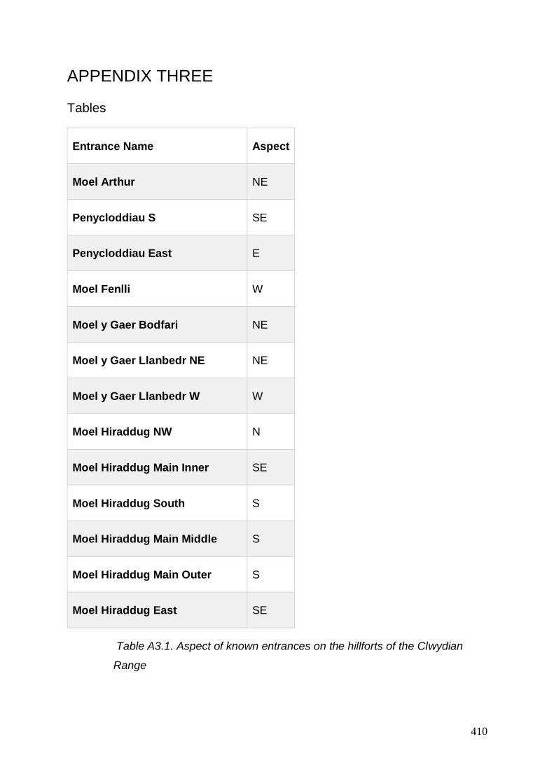
410
APPENDIX THREE
Tables
Entrance Name Aspect
Moel Arthur NE
Penycloddiau S SE
Penycloddiau East E
Moel Fenlli W
Moel y Gaer Bodfari NE
Moel y Gaer Llanbedr NE NE
Moel y Gaer Llanbedr W W
Moel Hiraddug NW N
Moel Hiraddug Main Inner SE
Moel Hiraddug South S
Moel Hiraddug Main Middle S
Moel Hiraddug Main Outer S
Moel Hiraddug East SE
Table A3.1. Aspect of known entrances on the hillforts of the Clwydian
Range

411
Hillf
ort
Ram
pa
rt N
am
e
Ram
pa
rt P
ha
se
Pa
lis
ad
e?
Sto
ne
In
ne
r F
ac
e?
Wo
od
In
ne
r F
ac
e?
Sto
ne
Ou
ter
Fa
ce?
Wo
od
Ou
ter
Fa
ce?
Sto
ne
Co
re?
Ea
rth
Co
re?
Wo
od
Co
re?
Dit
ch
?
Bee
sto
n
Cas
tle Only? 1 Y
Bee
sto
n
Cas
tle Only? 2 Y Y
Bee
sto
n
Cas
tle Only? 3 Y Y Y
Bee
sto
n
Cas
tle Only? 4 Y Y Y
Bre
idd
in
ii 1 Y Y Y
Bre
idd
in
iii 1 P P Y Y
Bre
idd
in
Inner? 1 Y Y Y
Bre
idd
in
Inner? 2 Y Y Y Y
Bry
n y
Cas
tell
Only 1 Y Y

412
Bry
n y
Cas
tell
Only 2 Y Y B
ryn
y
Ga
er Only 1 Y Y
Cae
r
Cara
do
g
Only 1 Y Y Y
Cae
r
Es
tyn
Only 1 Y Y
Cae
r
Es
tyn
Only 2 Y Y Y
Cas
tell
Cae
r
Se
ion
Inner Bank
interior Unknown Y Y
Cas
tell
Cae
r
Se
ion
Main east
and south 1 Y Y
Cas
tell
Cae
r
Se
ion
Main west initial
1 Y Y
Ca
ste
ll
Ca
er
Se
ion
West
Outer/ outwork
1 Y Y Y Y
Cas
tell
Cae
r
Se
ion
West Outer/ outwork
2 Y Y
Ca
ste
ll
Ca
er
Se
ion
Western
enclosure Inner
1 Y Y Y

413
Cra
ig
Rh
iwa
rth
Inner 1 Y Y C
raig
Rh
iwa
rth
Inner 2 Y Y
Din
as
Lla
nfa
irfe
ch
an
2nd 1 Y Y Y
Din
as
Lla
nfa
irfe
ch
an
Inner 1 Y Y Y
Din
as
Lla
nfa
irfe
ch
an
Lower 1 Y Y Y
Din
orb
en
Inner 1a Y
Din
orb
en
Inner 1b Y
Din
orb
en
Inner 1c Y Y

414
Din
orb
en
Inner 2 Y Y Y Y D
ino
rben
Inner 3 Y Y
Ed
dis
bu
ry
Inner 1 Y
Ed
dis
bu
ry
Inner 2 Y Y Y Y
Ed
dis
bu
ry
Inner 3 Y
Ed
dis
bu
ry
Outer 1 Y Y Y Y
Hels
by
Inner 1 Y Y
Hels
by
Inner 2 Y
Hels
by
Outer 1?
Kels
bo
rro
w
Only 1? Y Y Y
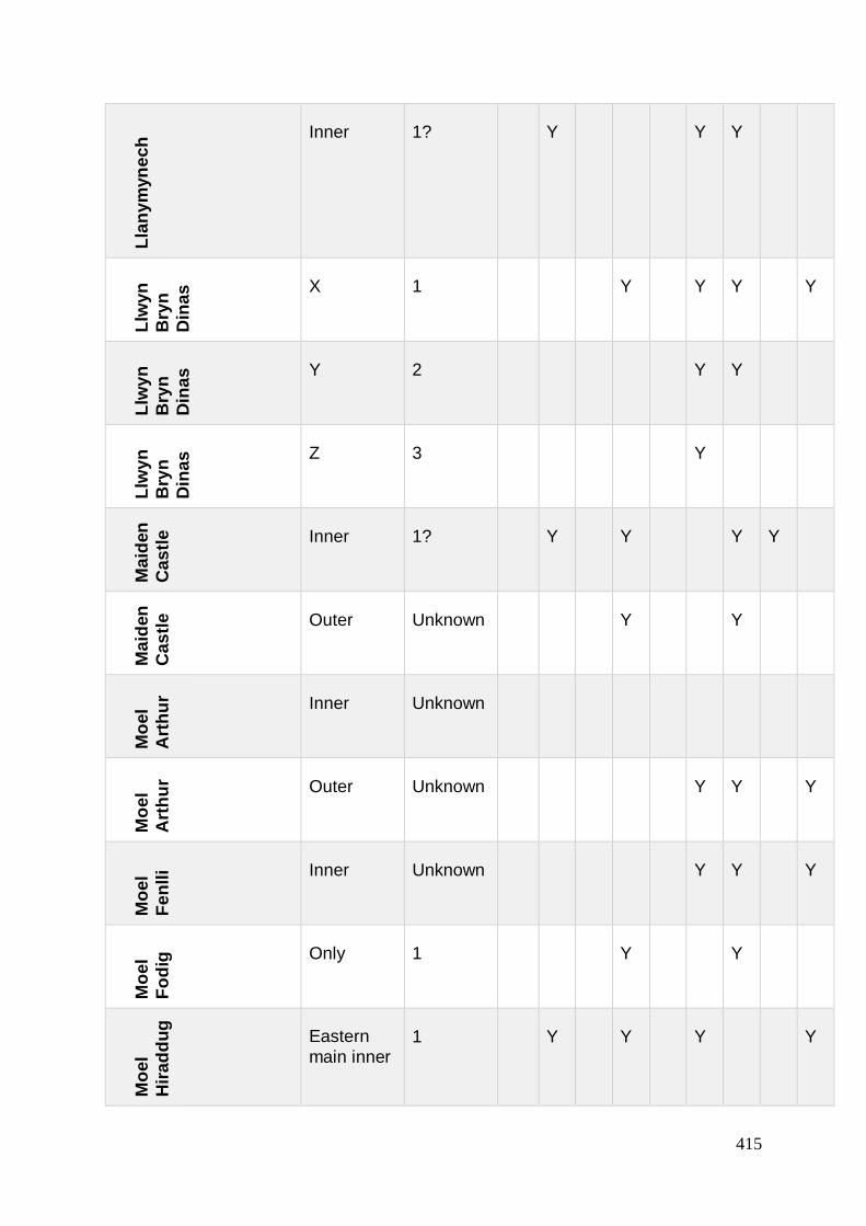
415
Lla
ny
myn
ec
h Inner 1? Y Y Y
Llw
yn
Bry
n
Din
as X 1 Y Y Y Y
Llw
yn
Bry
n
Din
as Y 2 Y Y
Llw
yn
Bry
n
Din
as Z 3 Y
Ma
iden
Cas
tle
Inner 1? Y Y Y Y
Ma
iden
Cas
tle
Outer Unknown Y Y
Mo
el
Art
hu
r Inner Unknown
Mo
el
Art
hu
r Outer Unknown Y Y Y
Mo
el
Fe
nll
i Inner Unknown Y Y Y
Mo
el
Fo
dig
Only 1 Y Y
Mo
el
Hir
ad
du
g
Eastern
main inner 1 Y Y Y Y
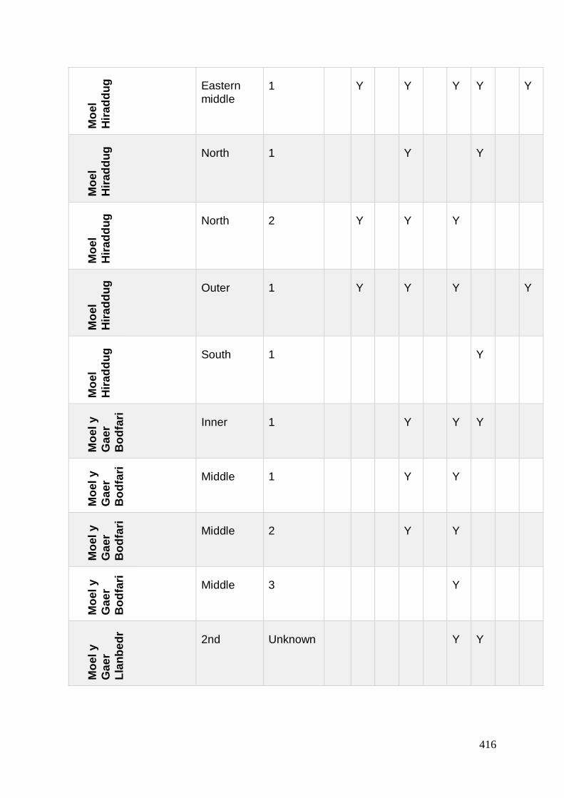
416
Mo
el
Hir
ad
du
g
Eastern
middle 1 Y Y Y Y Y
Mo
el
Hir
ad
du
g
North 1 Y Y
Mo
el
Hir
ad
du
g
North 2 Y Y Y
Mo
el
Hir
ad
du
g
Outer 1 Y Y Y Y
Mo
el
Hir
ad
du
g
South 1 Y
Mo
el
y
Ga
er
Bo
dfa
ri
Inner 1 Y Y Y
Mo
el
y
Ga
er
Bo
dfa
ri
Middle 1 Y Y
Mo
el
y
Ga
er
Bo
dfa
ri
Middle 2 Y Y
Mo
el
y
Ga
er
Bo
dfa
ri
Middle 3 Y
Mo
el
y
Ga
er
Lla
nb
ed
r
2nd Unknown Y Y
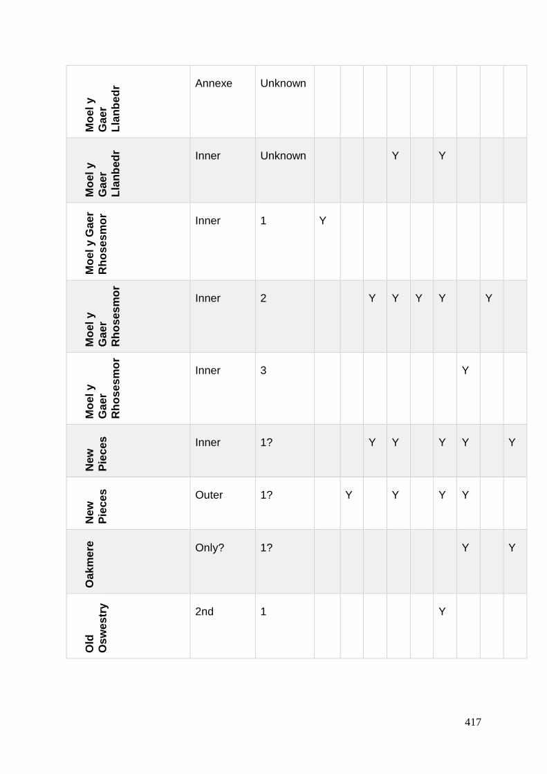
417
Mo
el
y
Ga
er
Lla
nb
ed
r Annexe Unknown M
oe
l y
Ga
er
Lla
nb
ed
r Inner Unknown Y Y
Mo
el
y G
ae
r
Rh
os
es
mo
r
Inner 1 Y
Mo
el
y
Ga
er
Rh
os
es
mo
r
Inner 2 Y Y Y Y Y
Mo
el
y
Ga
er
Rh
os
es
mo
r
Inner 3 Y
New
Pie
ce
s
Inner 1? Y Y Y Y Y
New
Pie
ce
s
Outer 1? Y Y Y Y
Oa
km
ere
Only? 1? Y Y
Old
Os
we
str
y
2nd 1 Y

418
Old
Os
we
str
y 3rd 1 Y Y Y Y
Old
Os
we
str
y
3rd 2 Y Y
Old
Os
we
str
y
4th 1 Y Y
Old
Os
we
str
y
5th Unknown Y Y
Old
Os
we
str
y
Inner 1 Y Y Y Y
Old
Os
we
str
y
Inner 1? Y
Old
Os
we
str
y
Inner 2 Y Y
Pe
n y
Ga
er
Lla
nb
ed
r
y C
en
nin
Inner 1 Y Y Y
Pe
n y
Ga
er
Lla
nb
ed
r
y C
en
nin
Middle 1 Y Y Y

419
Pe
n y
Ga
er
Lla
nb
ed
r
y C
en
nin
Outer 1 Y Y 2 P
en
y G
ae
r
Lla
ng
olle
n
Only? 1? Y Y
Pe
nd
ina
s
Lla
nd
yg
ai
Only 1 Y Y Y Y
Pe
nd
ina
s
Lla
nd
yg
ai
Only 2 Y
Pe
ny
clo
dd
iau
Inner Unknown Y
Pe
ny
clo
dd
iau
Outer Unknown
Pe
n y
Co
rdd
yn
Ma
wr
Annexe Unknown Y Y
Pe
n y
Co
rdd
yn
Ma
wr
Inner 1 Y Y Y

420
Pe
n y
Co
rdd
yn
Ma
wr
Outer 1 Y Y T
he
Bert
h
(ma
in) Only? 1 Y
Th
e
Bert
h
(ma
in) Only? 2 Y Y
Wo
od
ho
us
es
Only? 1 Y Y Y Y P
Table A3.2. Evidence (Y - yes or P - possible) for excavated evidence for
palisades, ditches and of earth, wood and stone material used in the
excavated hillfort ramparts in the wider study area

421
Hillf
ort
Ph
as
e (
as
kn
ow
n)
Ori
gin
al
En
tra
nc
e N
am
e
Lo
cati
on
Ty
pe
Relo
ca
tio
n?
Intu
rn/s
?
Gu
ard
Ch
am
be
rs?
Am
en
dm
en
t?
Bee
sto
n 1
Ph
ase
2B
E Gap N N N N
Bee
sto
n
2
Ph
ase
3A
E unknown N Poss Overlying bank
plus a platform to
the rear
Bee
sto
n
3
Ph
ase
3B
E unknown N Stylistically new
bank
Bee
sto
n
4
Ph
ase
3B
E unknown N Rear posts
removed and
filled
Bre
idd
in 1
En
tra
nce E Club Gap N N N
Bre
idd
in
2
En
tra
nce
E Club Inturn N 1 N Inturn added
North/ Right

422
Bre
idd
in
3
Dis
ma
ntle
d Destroyed N Dismantling OR
reconstruction of
inturn
Bry
n y
Ca
ste
ll
1 N
ort
h E
ast
NE Gap N N N
Bry
n y
Ca
ste
ll 2
Nort
h E
ntr
an
ce NE Relocated
Gap
moved
9m
west/
right
N N Blocked and
moved 9m west/
right
Bry
n y
Ca
ste
ll 3
Nort
h E
ntr
an
ce NE Repair N N N repair after being
washed away -
gully
Din
orb
en
1
1st
En
tra
nce
NE Gap N N N
Din
orb
en
2
2n
d E
ntr
an
ce
NE Gap N N N Narrowed
Din
orb
en
3
Blo
ckin
g
NE Blocked N Blocked
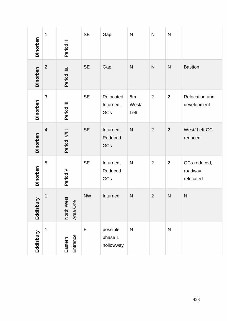
423
Din
orb
en
1
Pe
riod
II
SE Gap N N N D
ino
rben
2 P
eri
od
IIa
SE Gap N N N Bastion
Din
orb
en
3
Pe
riod
III
SE Relocated,
Inturned,
GCs
5m
West/
Left
2 2 Relocation and
development
Din
orb
en
4
Pe
riod
IV
/III SE Inturned,
Reduced
GCs
N 2 2 West/ Left GC
reduced
Din
orb
en
5
Pe
riod
V
SE Inturned,
Reduced
GCs
N 2 2 GCs reduced,
roadway
relocated
Ed
dis
bu
ry 1
Nort
h W
est
Are
a O
ne
NW Inturned N 2 N N
Ed
dis
bu
ry 1
Ea
ste
rn
En
tra
nce
E possible
phase 1
hollowway
N N

424
Ed
dis
bu
ry
2
Ea
ste
rn E
ntr
an
ce
Ph
ii E phase 2
inturn
single GC
N 1 E
dd
isb
ury
3
Ea
ste
rn E
ntr
an
ce
Ph
ase
iii E Inturned
GCs
N 2 2 Inturned GCs
Ed
dis
bu
ry
4
Ea
ste
rn E
ntr
an
ce
Ph
ase
iiib
E Destroyed
GC- fire (or
before
Phase 3?)
N N
Ma
iden
Ca
stl
e
1
En
tra
nce
NE inturned N 2 N
Ma
iden
Ca
stl
e
1
So
uth
En
tra
nce
S Later blocked
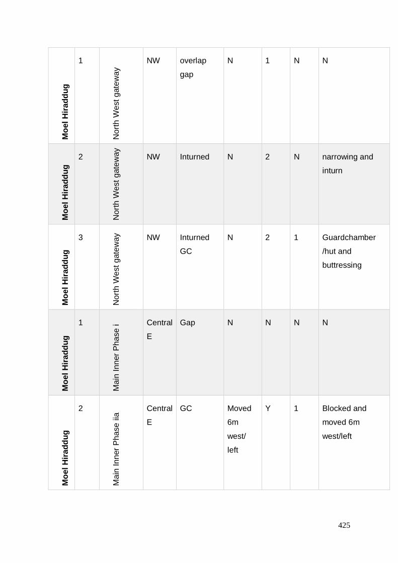
425
Mo
el
Hir
ad
du
g
1
Nort
h W
est
gate
way
NW overlap
gap
N 1 N N M
oe
l H
ira
dd
ug
2
Nort
h W
est
gate
way
NW Inturned N 2 N narrowing and
inturn
Mo
el
Hir
ad
du
g
3
Nort
h W
est
gate
way
NW Inturned
GC
N 2 1 Guardchamber
/hut and
buttressing
Mo
el
Hir
ad
du
g
1
Ma
in I
nn
er
Ph
ase
i Central
E
Gap N N N N
Mo
el
Hir
ad
du
g
2
Ma
in I
nn
er
Ph
ase
iia
Central
E
GC Moved
6m
west/
left
Y 1 Blocked and
moved 6m
west/left

426
Mo
el
Hir
ad
du
g
3
Ma
in I
nn
er
Ph
ase
iib
Central
E
GC
reduced
N 1 GC reduced in
size
Mo
el
Hir
ad
du
g
4
Ma
in I
nn
er
Ph
ase
iic
Central
E
GCs
(double
circular)
N Y 2
Old
Os
wes
try 1
We
st
Pe
riod
2 W Gap N N
Old
Os
wes
try
2
We
st
Pe
riod
3
W Inturned N 2
only
south
exca-
vated
Southern / right
inturn added
Old
Os
wes
try 3
We
st
Pe
riod
4/5
W Inturned N 1
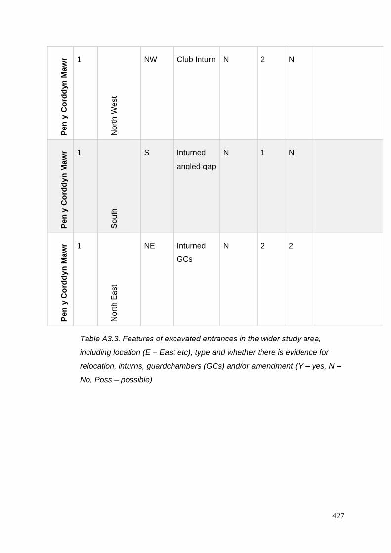
427
Pe
n y
Co
rdd
yn
Ma
wr 1
Nort
h W
est
NW Club Inturn N 2 N P
en
y C
ord
dy
n M
aw
r 1
So
uth
S Inturned
angled gap
N 1 N
Pe
n y
Co
rdd
yn
Ma
wr 1
Nort
h E
ast
NE Inturned
GCs
N 2 2
Table A3.3. Features of excavated entrances in the wider study area,
including location (E – East etc), type and whether there is evidence for
relocation, inturns, guardchambers (GCs) and/or amendment (Y – yes, N –
No, Poss – possible)

428
Hillf
ort
En
tra
nc
e
Nam
e
Ph
as
e (
as
kn
ow
n)
Ori
gin
al
En
tra
nc
e
Nam
e
Lo
cati
on
Asp
ec
t
Ty
pe
Relo
ca
tio
n?
Bee
sto
n
Entrance 1 Phase 2B E E Gap No
Bee
sto
n
Entrance 2 Phase 3A E E unknown No
Bee
sto
n
Entrance 3 Phase 3B E E unknown No
Bee
sto
n
Entrance 4 Phase 3B E E unknown No
Bre
idd
in
Entrance 1 Entrance E E Club Gap No
Bre
idd
in
Entrance 2 Entrance E E Club Inturn No
Bre
idd
in
Entrance 3 Dismantled Destroyed No
Bry
n y
Cas
tell
NE 1 North East NE NE Gap No
Bry
n y
Ca
ste
ll
N 2 North
Entrance
NE NE Relocated
Gap
moved
9m
west/
right

429
Bry
n y
Cas
tell
N 3 North
Entrance
NE NE Repair No D
ino
rben
NE 1 1st
Entrance
NE NE Gap No
Din
orb
en
NE 2 2nd
Entrance
NE NE Gap No
Din
orb
en
NE 3 Blocking NE NE Blocked No
Din
orb
en
SE 1 Period II SE SE Gap No
Din
orb
en
SE 2 Period IIa SE SE Gap No
Din
orb
en
SE 3 Period III SE SE Relocated,
Inturned,
GCs
5m
West/
Left
Din
orb
en
SE 4 Period IV/III SE SE Inturned,
Reduced
GCs
No
Din
orb
en
SE 5 Period V SE SE Inturned,
Reduced
GCs
No

430
Ed
dis
bu
ry
North
West
1 North West
Area One
NW NW Inturned No E
dd
isb
ury
East 1 Eastern
Entrance
E E possible
phase 1
hollowway
No
Ed
dis
bu
ry
East 2 Eastern
Entrance
Phii
E E phase 2
inturn
single GC
No
Ed
dis
bu
ry
East 3 Eastern
Entrance
Phase iii
E E Inturned
GCs
No
Ed
dis
bu
ry
East 4 Eastern
Entrance
Phase iiib
E E Destroyed
GC - fire
(or before
Phase 3?)
No
Ma
iden
Cas
tle
Entrance 1 Entrance NE E inturned No
Ma
iden
Cas
tle
South
Entrance
1 South
Entrance
S
Mo
el
Hir
ad
du
g
NW 1 North West
gateway
NW N overlap
gap
No
Mo
el
Hir
ad
du
g
NW 2 North West
gateway
NW N Inturned No

431
Mo
el
Hir
ad
du
g
NW 3 North West
gateway
NW N Inturned
GC
No M
oe
l
Hir
ad
du
g Main
Inner
1 Main Inner
Phase i
Central
E
SE Gap No
Mo
el
Hir
ad
du
g
Main
Inner
2 Main Inner
Phase iia
Central
E
SE GC Moved
6m west
/left
Mo
el
Hir
ad
du
g
Main
Inner
3 Main Inner
Phase iib
Central
E
SE GC
reduced
No
Mo
el
Hir
ad
du
g
Main
Inner
4 Main Inner
Phase iic
Central
E
SE GCs
(double
circular)
No
Old
Os
we
str
y
W 1 West Period
2
W W Gap No
Old
Os
we
str
y
W 2 West Period
3
W W Inturned No
Old
Os
we
str
y
W 3 West Period
4/5
W W inturned No
Pe
n y
Co
rdd
yn
Ma
wr
NW 1 North West NW NW Club Inturn No

432
Pe
n y
Co
rdd
yn
Ma
wr
S 1 South S S Inturned
angled gap
No P
en
y C
ord
dy
n
Ma
wr
NE 1 North East NE NE Inturned
GCs
No
Table A3.4. Excavated hillfort entrance locations and excavated hillfort entrance aspect from the wider study area
Hillfort Entrance Name
Phase (as known) Approx Length m
Approx Width m
Beeston Entrance 3 unknown 3
Breiddin Entrance 2 unknown 3.6
Bryn y
Castell NE 1 2 4
Bryn y
Castell N 2 2 1
Bryn y
Castell N 3 2 1
Dinorben NE 1 3 3
Dinorben NE 2 3 1.5
Dinorben SE 1 2 2.5

433
Dinorben SE 2 2 2.5
Dinorben SE 3 7.5 3
Dinorben SE 4 7.5 2.5
Dinorben SE 5 11 2.5
Eddisbury East 3 16 2.4
Eddisbury North West
1 unknown 2.3
Maiden
Castle Entrance 1 15.24 2.4
Moel
Hiraddug
Main
Inner 1 6 3.4
Moel
Hiraddug
Main
Inner 4 12 3
Moel
Hiraddug NW 1 3.7 3.7
Moel
Hiraddug NW 2 3.7 1.5
Moel
Hiraddug NW 3 3.7 1.5
Penycorddyn
Mawr NE 1 10.7 4
Penycorddyn Mawr
NW 1 10.7 3.4

434
Penycorddyn
Mawr S 1 8.2 2.7
Table A3.5. Data from Figures 3.16 and 3.17. Entrance passage length and
width at excavated hillforts.
Hillfort Entrance Phase
Width Length Area
Dinorben SE Ph3 GC1
SE 3
3.7 3 8.7135
Dinorben SE Ph3 GC2
SE 3
3.7 2.7 7.84215
Dinorben SE Ph4 GC1
SE 4
3 3 7.065
Dinorben SE Ph4 GC2
SE 4
3.7 2.7 7.84215
Dinorben SE Ph5 GC1
SE 5
2.1 3 4.9455
Dinorben SE Ph5 GC2
SE 5
1.8 2.7 3.8151
Pen y Corddyn Mawr NE
NE 1
3 3.7 8.7135
Pen y Corddyn
Mawr NE NE 1
4.6 3 10.833
Moel Hiraddug
NW NW 3
3.7 3.7 10.74665
Moel Hiraddug
MI Ph4 GC1 Main Inner 4
3.8 2.8 8.3524
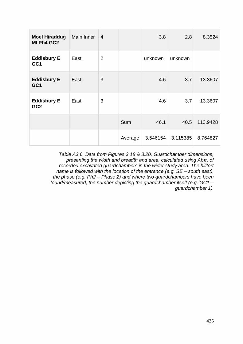
435
Moel Hiraddug
MI Ph4 GC2 Main Inner 4
3.8 2.8 8.3524
Eddisbury E
GC1 East 2
unknown unknown
Eddisbury E
GC1 East 3
4.6 3.7 13.3607
Eddisbury E
GC2 East 3
4.6 3.7 13.3607
Sum 46.1 40.5 113.9428
Average 3.546154 3.115385 8.764827
Table A3.6. Data from Figures 3.18 & 3.20. Guardchamber dimensions,
presenting the width and breadth and area, calculated using Abπ, of recorded excavated guardchambers in the wider study area. The hillfort
name is followed with the location of the entrance (e.g. SE – south east), the phase (e.g. Ph2 – Phase 2) and where two guardchambers have been
found/measured, the number depicting the guardchamber itself (e.g. GC1 – guardchamber 1).

436
Hillf
ort
C14
_ID
Pre
-re
ca
lib
rati
on
da
te
Err
or
(+/-
da
te)
Rec
ali
bra
tio
n d
ate
fro
m
Rec
ali
bra
tio
n d
ate
to
% c
on
fid
en
ce
Beeston HAR-6464
2300 80 -750 -166 95.4
Beeston HAR-6468
2290 70 -728 -171 95.4
Beeston HAR-
6469 2370 80 -770 -231 95.4
Breiddin BM-1160 2108 31 -204 -45 95.4
Breiddin BM-1161 2141 28 -353 -59 95.4
Breiddin BM-878 2750 41 -996 -816 95.4
Breiddin BM-879 2778 71 -1113 -807 95.4
Breiddin BM-881 2429 55 -757 -403 95.4
Breiddin BM-885 3024 62 -1427 -1059 95.5
Breiddin HAR-1286
2320 80 -751 -196 95.3
Breiddin HAR-1287
2320 70 -748 -198 95.5
Breiddin HAR-1413
2180 80 -396 -46 95.4

437
Breiddin HAR-
1615 2690 70 -1018 -766 95.4
Breiddin HAR-
1616 2760 70 -1107 -802 95.4
Breiddin HAR-
1617 2050 80 -355 125 95.4
Breiddin HAR-
1761 2690 80 -1055 -571 95.4
Breiddin HAR-467 2410 100 -797 -235 95.4
Breiddin HAR-467 2410 100 -797 -235 95.4
Breiddin HAR-468 2190 80 -397 -51 95.4
Breiddin HAR-842 2270 80 -728 -101 95.4
Breiddin HAR-842 2270 80 -728 -101 95.4
Breiddin QL-1080 2200 90 -411 2 95.4
Breiddin QL-1080 2200 90 -411 2 95.4
Bryn y
Castell
HAR-
6234 2180 100 -411 51 95.4
Castell Caer Seion
Beta-254607
2240 40 -393 -204 95.4
Dinorben CAR-123 2430 60 -761 -402 95.4
Dinorben CAR-124 2360 60 -753 -235 95.4
Dinorben CAR-128 2500 70 -795 -428 95.4

438
Dinorben CAR-131 2170 60 -378 -56 95.4
Dinorben CAR-132 2050 60 -341 74 95.4
Dinorben CAR-167 2470 60 -772 -413 95.4
Eddisbury Beta-317521
2410 30 -739 -401 95.4
Eddisbury NZA-36592
2176 25 -359 -169 95.4
Eddisbury NZA-36593
2260 25 -396 -210 95.4
Eddisbury NZA-
36593 2260 25 -396 -210 95.4
Eddisbury NZA-
36648 2483 25 -771 -515 95.4
Eddisbury NZA-
36654 2251 25 -392 -209 95.4
Llanymynech CAR-534 2020 70 -204 130 95.4
Llanymynech CAR-535 2170 70 -384 -52 95.4
Llwyn Bryn
Dinas CAR-708 2151 70 -382 -41 95.4
Llwyn Bryn
Dinas CAR-798 2100 60 -357 25 95.4
Llwyn Bryn Dinas
CAR-800 2210 70 -401 -63 95.4

439
Moel
Hiraddug CAR-372 2300 65 -728 -193 95.4
Moel
Hiraddug CAR-373 2360 65 -756 -233 95.4
Moel
Hiraddug CAR-374 2380 60 -756 -368 95.4
Moel y Gaer
Llanbedr
SUERC-
30897 2490 35 -788 -486 95.4
Moel y Gaer
Llanbedr
SUERC-
30901 2510 35 -794 -524 95.4
Moel y Gaer
Llanbedr
SUERC-
30902 2510 35 -794 -524 95.4
Moel y Gaer Llantysilio
SUERC-43981
2182 28 -386 -205 95.4
Moel y Gaer Llantysilio
SUERC-43982
2121 29 -345 -51 95.4
Moel y Gaer Llantysilio
SUERC-43983
2235 28 -360 -171 95.4
Moel y Gaer Rhosesmor
HAR-1122
2210 70 -401 -63 95.4
Moel y Gaer Rhosesmor
HAR-1125
2430 140 -840 -197 95.4
Moel y Gaer Rhosesmor
HAR-1126
2510 100 -821 -401 95.4
Moel y Gaer Rhosesmor
HAR-1196
2420 80 -780 -388 95.4

440
Moel y Gaer
Rhosesmor
HAR-
1197 2560 90 -892 -410 95.4
Moel y Gaer
Rhosesmor
HAR-
1294 2380 70 -769 -263 95.4
Moel y Gaer
Rhosesmor
HAR-
1353 2390 80 -782 -259 95.4
Moel y Gaer
Rhosesmor HAR-603 2190 80 -397 -51 95.4
Moel y Gaer
Rhosesmor HAR-603 2190 80 -397 -51 95.4
Moel y Gaer
Rhosesmor HAR-604 2530 90 -820 -408 95.4
Moel y Gaer Rhosesmor
HAR-606 2570 70 -891 -431 95.4
Moel y Gaer Rhosesmor
HAR-606 2570 70 -891 -431 95.4
Pen y Ddinas Great Orme
Beta-254961
2270 40 -403 -206 95.4
Pendinas Llandygai
HAR-1672
2060 70 -353 79 95.4
Table A3.7. Recalibrated radiocarbon dates, showing original reported
dates with +/- year error, followed by recalibrated date range (where the ‘minus’ sign indicates BC) and confidence rating (%)

441
Altitude Clwydian Range
North West Wales
30 Mile Radius from Clwydian Range
Brecon Beacons
001-50 0 12.9 1.20 0
051-100 0 14.9 6.02 0
101-150 0 14.9 15.66 6.7
151-200 0 19.8 19.28 3.3
201-250 33 8.9 15.66 13.3
251-300 0 11.9 19.28 16.7
301-350 16.75 7.9 7.23 26.7
351-400 16.75 7.9 7.23 10
401-500 16.75 0.9 4.82 23.3
>501 16.75 0 0.36 0
Table A3.8. Data from Figure 5.8. Hillfort altitudes (%) for selected areas in
Wales. See also Tables A3.16, A3.17 and A3.18

442
Mean Height Median
Height Range Height
Clwydian Range hillforts 349.6 333 306
North West Wales 184.2 470 180
30 miles of Clwydian Range 234.6 215 510
Brecon Beacons 318.7 320 353
Table A3.9. Data from Figure 5.9. Average height of hillforts in selected
areas in Wales

443
Input feature % Summit Visible % Ramparts
Visible
% from "total"
polyline
Moel Arthur Ph1 4.963701 5.217547
Moel Arthur Ph2
5.246158559 5.586547666
Moel Fenlli
Inner Ramparts 3.398163 5.83027 6.175743256
Moel Hiraddug
Western Enclosure
3.960227 4.0283
Moel Hiraddug Whole
4.025835 4.138248456
Moel y Gaer
Bodfari Inner Rampart
3.077959 3.097696 3.180619239
Moel y Gaer Llanbedr Ph1
2.676042 2.821045
Moel y Gaer Llanbedr Ph2
2.827601 2.890486614
Penycloddiau Inner Rampart
2.830216 5.99355 6.290188959
Table A3.10. Data from Figures 5.10, 5.22 & 5.33. Comparison of percentage of visible surroundings from Clwydian Range hillforts

444
% visible
Penycloddiau Inner Rampart 5.99355
Penycloddiau contours 6.204312
Moel Fenlli Inner Rampart 5.83027
Moel Fenlli contours 5.999504
Table A3.11. Data from Figure 5.28. Comparison of visible surroundings from ramparts and contours of ‘tipped hillforts’
Hillfort Entrance Human Height
(1.7m) % visible
Human Height (1.7m)
plus feature (3m) % visible
Penycloddiau South 0.232829 0.248847792
Penycloddiau East 0.109416 0.129070236
Moel y Gaer Llanbedr West
0.31818 0.330424787
Moel y Gaer Llanbedr East
0.020166 0.130157629
Moel y Gaer Bodfari 0.121646 0.13653973
Moel Arthur 0.108751 0.120680828
Moel Fenlli 0.260601 0.267131421
Table A3.12. Data from Figure 5.34. Visibility from hillfort entrances

445
Hillforts % visible height
(m)
Size
(ha)
Moel Arthur 5.586547666 456 1.62
Moel Fenlli 6.175743256 511 8.26
Moel Hiraddug 4.138248456 265 10.74
Moel y Gaer Bodfari 3.180619239 206 1.87
Moel y Gaer Llanbedr 2.890486614 339 2.57
Penycloddiau 6.290188959 440 17.70
Bryn Alyn 0.312655782 58 0.80
Caer Caradog 0.877242137 385 1.54
Caer Drewyn 0.856628572 294 2.93
Castell Caer Seion 2.688813879 244 2.94
Castell Cawr 2.554027253 180 1.58
Craig Adwy Wynt 0.847832052 180 1.67
Dinas Melin y Wig 0.208857408 260 4.74
Moel y Gaer Cefn (Llantysilio) 2.509687809 504 0.48
Moel y Gaer Rhosesmor 6.541295339 303 2.45
Mynydd y Gaer 2.985965233 270 3.35
Pen y Ddinas 1.563342601 100 2.33
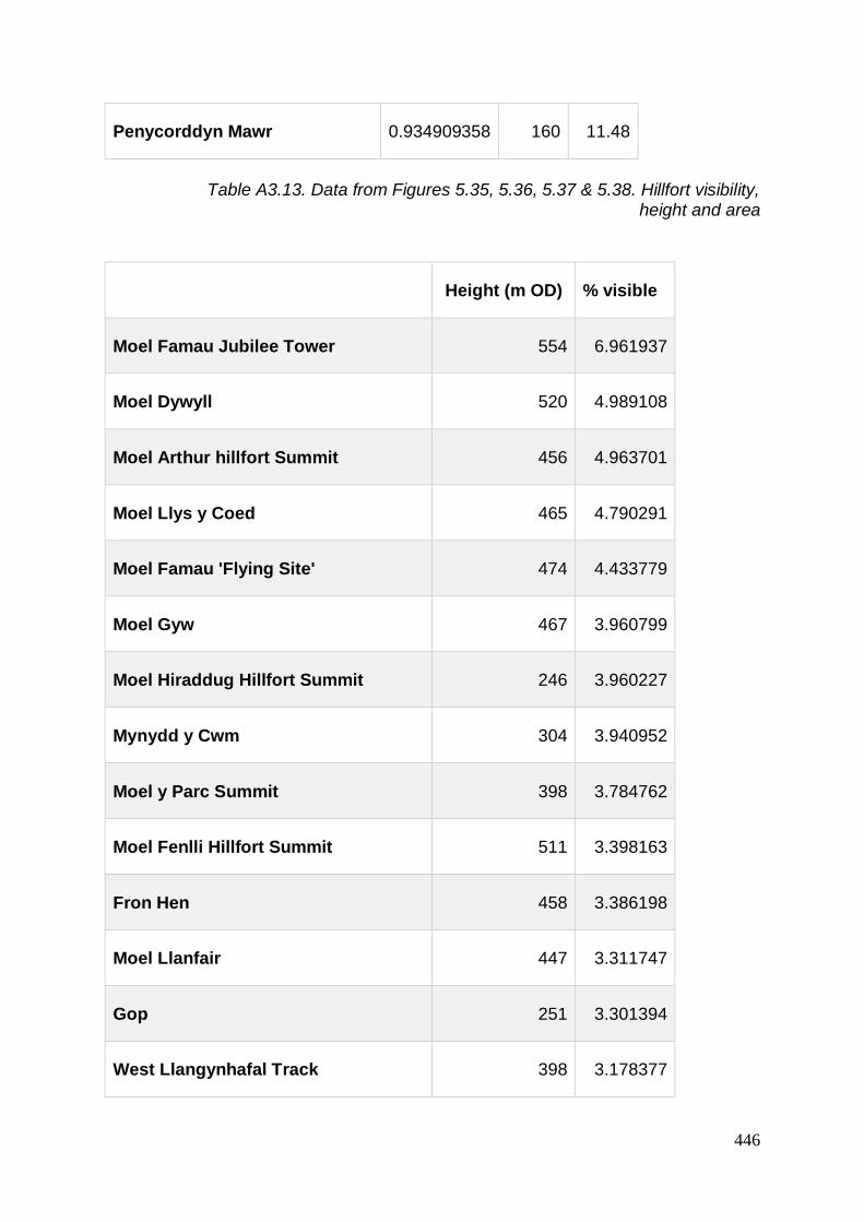
446
Penycorddyn Mawr 0.934909358 160 11.48
Table A3.13. Data from Figures 5.35, 5.36, 5.37 & 5.38. Hillfort visibility,
height and area
Height (m OD) % visible
Moel Famau Jubilee Tower 554 6.961937
Moel Dywyll 520 4.989108
Moel Arthur hillfort Summit 456 4.963701
Moel Llys y Coed 465 4.790291
Moel Famau 'Flying Site' 474 4.433779
Moel Gyw 467 3.960799
Moel Hiraddug Hillfort Summit 246 3.960227
Mynydd y Cwm 304 3.940952
Moel y Parc Summit 398 3.784762
Moel Fenlli Hillfort Summit 511 3.398163
Fron Hen 458 3.386198
Moel Llanfair 447 3.311747
Gop 251 3.301394
West Llangynhafal Track 398 3.178377

447
Coed yr Esgob A 211 3.170954
Moel y Gaer Hillfort Bodfari Summit 205 3.077959
Moel y Parc West Spur 317 3.042417
Moel Maenefa 286 2.895708
Moel Evan 358 2.894672
Penycloddiau Hillfort Summit 366 2.830216
Moel y Gaer Hillfort Llanbedr Summit 339 2.676042
Ffrith 370 2.646296
SW Moel y Plas 350 2.632257
Moel y Accre 400 2.557303
Coed yr Esgob B 211 2.336058
NW Moel Arthur 420 2.241715
Moel y Plas 390 2.15656
Marian Ffrith 230 2.075083
Gyrn 384 2.005421
Moel y Waun 412 1.955087
East Bacheirig 318 1.899699
Moel Eithinen 434 1.766784

448
Moel Plas-yw 419 1.678883
Graig Fawr 153 1.588075
Pen yr Allt 410 1.326264
N Moel Arthur 344 1.320903
Cefn Du 260 1.200407
Moel y Gelli 361 1.07176
Bryn Golau 302 0.708466
Llyn Gweryd 334 0.343264
Table A3.14. Data from Figures 5.2, 5.39 & 5.40. Clwydian Range hill visibility and height
Hillforts Hillforts within
25k
Visible hillforts
within 25km % intervisible
Bryn Alyn 27 5 18.51851852
Caer Caradog 22 3 13.63636364
Caer Drewyn 35 9 25.71428571
Castell Caer Seion 22 12 54.54545455
Castell Cawr 20 10 50
Craig Adwy Wynt 33 9 27.27272727
Dinas Melin y Wig 27 1 3.703703704

449
Moel Arthur 31 15 48.38709677
Moel Fenlli 32 23 71.875
Moel Hiraddug 19 12 63.15789474
Moel y Gaer Bodfari 23 13 56.52173913
Moel y Gaer Cefn
(Llantysilio) 40 17 42.5
Moel y Gaer Llanbedr 32 14 43.75
Moel y Gaer
Rhosesmor 22 12 54.54545455
Mynydd y Gaer 22 10 45.45454545
Pen y Ddinas 21 9 42.85714286
Penycloddiau 28 17 60.71428571
Penycorddyn Mawr 19 5 26.31578947
Table A3.15. Data from Figures 5.41 & 5.42. Hillfort intervisibility

450
Site name District Unitary
Authority / County
Height
mOD
Braich y Ddinas Hillfort (Destroyed), Penmaenmawr
ABERCONWY Conwy 350
Caer Bach Hillfort ABERCONWY Conwy 400
Camp, Erw Goch ABERCONWY Conwy 200
Cerrig y Dinas Hillfort, Llangelynin ABERCONWY Conwy 300
Conwy Mountain (or Castell Caer
Lleion) ABERCONWY Conwy 180
Dinas Allt Wen Hillfort, Above Dwygyfylchi
ABERCONWY Conwy 240
Dinas Camp Hillfort ABERCONWY Conwy 315
Hillfort, N of Cefn Coch ABERCONWY Conwy 280
Pen y Castell (Caer Oleu) Hillfort, Maenan
ABERCONWY Conwy 160
Pen y Ddinas Hillfort, Great Orme ABERCONWY Conwy 250
Pen y Gaer Hillfort, Llanbedr y Cennin ABERCONWY Conwy 300
Caer (Pen y Gaer) Hillfort, Llanddeiniolen
ARFON Gwynedd 150
Caer Carreg-y-Fran Hillfort, Above
Cwm y Glo ARFON Gwynedd 175
Castell Gron, S of Pant Ifan ARFON Gwynedd 150

451
Craig y Dinas Hillfort, Pontllyfni ARFON Gwynedd 60
Dinas Dinlle Hillfort, Llandwrog ARFON Gwynedd 25
Dinas Dinorwig Hillfort ARFON Gwynedd 160
Dinas Promontory Fort, Y Felinheli ARFON Gwynedd 15
Dinas Ty-du Hillfort, N of Maen-llwyd ARFON Gwynedd 320
Enclosure (Fortified), Gadlys, Llanwnda
ARFON Gwynedd 85
Hut Group (Enclosed), Llanllechid ARFON Gwynedd 270
Maes y Gaer Hillfort, Above Aber ARFON Gwynedd 226
Pen y Gaer Hillfort, Cilfodan, Bethesda ARFON Gwynedd 260
Pendinas Hillfort, Llandegai ARFON Gwynedd 115
Pier Camp Hillfort, Garth, Bangor ARFON Gwynedd 65
Small Fort Near Nantlle ARFON Gwynedd 210
Carn Fadryn Hillfort DWYFOR Gwynedd 350
Carn Pentyrch Hillfort, Llangybi DWYFOR Gwynedd 220
Carreg y Llam Hillfort, Site of, Pistyll DWYFOR Gwynedd 120
Castell - Hillfort, Pared Mawr DWYFOR Gwynedd 100
Castell Caerau Camp, Hillfort, Gyrn Goch
DWYFOR Gwynedd 220

452
Castell Hillfort, Above Llanengan DWYFOR Gwynedd 60
Castell Odo, Aberdaron DWYFOR Gwynedd 146
Circular concentric enclosure, E of
Conion DWYFOR Gwynedd 185
Circular concentric enclosure, Bwlch y
Ffordd Isa DWYFOR Gwynedd 65
Circular concentric enclosure, SE of
Meillionydd Bach DWYFOR Gwynedd 190
Circular/concentric enclosure,
Maesoglan Farm, Buan DWYFOR Gwynedd 55
Concentric Circle Enclosure, N of Bryn Rhydd
DWYFOR Gwynedd 50
Concentric circular enclosure, Bodgyri DWYFOR Gwynedd 35
Concentric circular enclosure, Castell
Caeron, N Slope of Mynydd Rhiw DWYFOR Gwynedd 190
Craig y Tyddyn Camp, Hillfort,
Dolbenmaen DWYFOR Gwynedd 130
Creigiau Gwineu Hillfort DWYFOR Gwynedd 220
Dinas Emrys Hillfort DWYFOR Gwynedd 130
Dinas Hillfort, Above Beddgelert DWYFOR Gwynedd 200
Dinas Promontory Fort, Porth Iago DWYFOR Gwynedd 20
Double ringwork enclosure, Pen-y-Gaer, SW of Llanbedrog
DWYFOR Gwynedd 75

453
Fortified Enclosure, Wyddgrug DWYFOR Gwynedd 85
Garn Boduan Hillfort DWYFOR Gwynedd 260
Hillfort, Garn Saethon DWYFOR Gwynedd 230
Moel y Gest Hillfort, W of Porthmadog DWYFOR Gwynedd 260
Nant y Castell Hillfort, SW of
Llanbedrog DWYFOR Gwynedd 73
Pen y Gaer Hillfort, Above Aberglaslyn DWYFOR Gwynedd 200
Pen y Gaer Hillfort, Llanaelhaearn DWYFOR Gwynedd 390
Pen y Garreg Hillfort, Clynnog DWYFOR Gwynedd 190
Pen-y-gaer Hillfort, Above Afon Soch DWYFOR Gwynedd 80
Possible Hillfort, Mynytho DWYFOR Gwynedd 160
Promontory Fort, Trwyn Porth Dinllaen DWYFOR Gwynedd 30
Promontory Fort? & Hut Circle (Possible), Ynys Enlli
DWYFOR Gwynedd 10
Tre'r Ceiri Hillfort, Llanaelhaearn DWYFOR Gwynedd 480
Y Foel Hillfort, Pontllyfni DWYFOR Gwynedd 220
Bryn Castell Hillfort, Uwch Mynydd MEIRIONNYDD Gwynedd 320
Bryn y Castell Hillfort, NW of Llyn Morwynio
MEIRIONNYDD Gwynedd 370
Caer Euni Hillfort MEIRIONNYDD Gwynedd 360

454
Caer Hillfort, Ystum-Gwadnaeth MEIRIONNYDD Gwynedd 320
Castell Mawr Hillfort, S of Rhoslefain MEIRIONNYDD Gwynedd 130
Coed Dol Fawr Promontory Fort MEIRIONNYDD Gwynedd 180
Craig y Castell Hillfort (Tyddyn y Coed Camp)
MEIRIONNYDD Gwynedd 252
Craig y Dinas Hillfort, Above Dyffryn Ardudwy
MEIRIONNYDD Gwynedd 350
Craig Yr Aderyn Hillfort, Dysynni MEIRIONNYDD Gwynedd 170
Enclosure (Remains of), Cefn Ddwysarn, Llandderfel
MEIRIONNYDD Gwynedd 290
Enclosure, Mynydd Mynyllod MEIRIONNYDD Gwynedd 370
Hillfort - Foel Caethle, Tywyn MEIRIONNYDD Gwynedd 165
Hillfort - Moel Faner, Above Nannau MEIRIONNYDD Gwynedd 300
Hillfort - Moel Offrwm Lower Camp,
Above Nannau MEIRIONNYDD Gwynedd 310
Hillfort (Poss), Dinas Oleu MEIRIONNYDD Gwynedd 115
Hillfort, Bwlch MEIRIONNYDD Gwynedd 120
Hillfort, Byrllysg MEIRIONNYDD Gwynedd 120
Hillfort, Castell Llanaber MEIRIONNYDD Gwynedd 300
Llechlwyd Promontory Fort, Tonfanau Quarry, Tywyn
MEIRIONNYDD Gwynedd 75
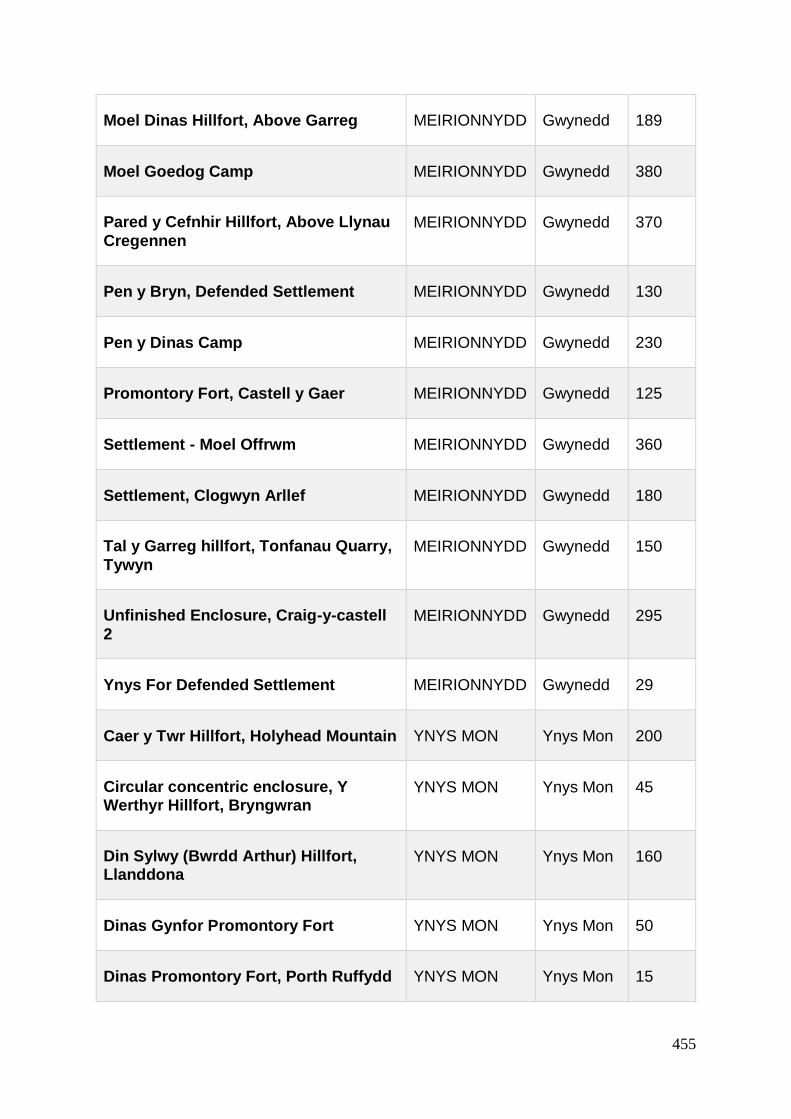
455
Moel Dinas Hillfort, Above Garreg MEIRIONNYDD Gwynedd 189
Moel Goedog Camp MEIRIONNYDD Gwynedd 380
Pared y Cefnhir Hillfort, Above Llynau
Cregennen MEIRIONNYDD Gwynedd 370
Pen y Bryn, Defended Settlement MEIRIONNYDD Gwynedd 130
Pen y Dinas Camp MEIRIONNYDD Gwynedd 230
Promontory Fort, Castell y Gaer MEIRIONNYDD Gwynedd 125
Settlement - Moel Offrwm MEIRIONNYDD Gwynedd 360
Settlement, Clogwyn Arllef MEIRIONNYDD Gwynedd 180
Tal y Garreg hillfort, Tonfanau Quarry,
Tywyn MEIRIONNYDD Gwynedd 150
Unfinished Enclosure, Craig-y-castell
2 MEIRIONNYDD Gwynedd 295
Ynys For Defended Settlement MEIRIONNYDD Gwynedd 29
Caer y Twr Hillfort, Holyhead Mountain YNYS MON Ynys Mon 200
Circular concentric enclosure, Y Werthyr Hillfort, Bryngwran
YNYS MON Ynys Mon 45
Din Sylwy (Bwrdd Arthur) Hillfort, Llanddona
YNYS MON Ynys Mon 160
Dinas Gynfor Promontory Fort YNYS MON Ynys Mon 50
Dinas Promontory Fort, Porth Ruffydd YNYS MON Ynys Mon 15
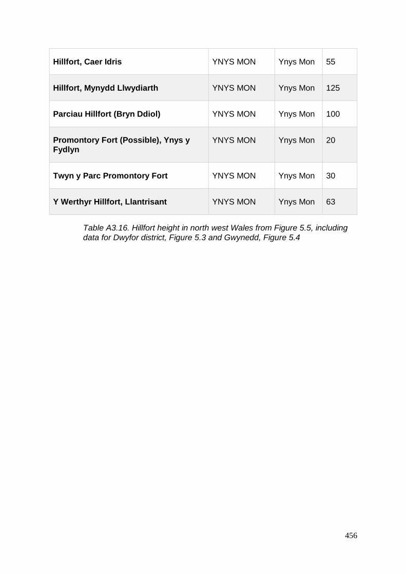
456
Hillfort, Caer Idris YNYS MON Ynys Mon 55
Hillfort, Mynydd Llwydiarth YNYS MON Ynys Mon 125
Parciau Hillfort (Bryn Ddiol) YNYS MON Ynys Mon 100
Promontory Fort (Possible), Ynys y Fydlyn
YNYS MON Ynys Mon 20
Twyn y Parc Promontory Fort YNYS MON Ynys Mon 30
Y Werthyr Hillfort, Llantrisant YNYS MON Ynys Mon 63
Table A3.16. Hillfort height in north west Wales from Figure 5.5, including
data for Dwyfor district, Figure 5.3 and Gwynedd, Figure 5.4

457
Site Name Approx height mOD
Bedd y cawr hillfort 150
Beeston 155
Blodwell Rock Camp 225
Bodfach hillfort 184
Breiddin 365
Bron Heulog Hillfort 365
Bryn Alyn promontory
fort 58
Bryn Euryn Camp,
hillfort 131
Bryn Y Gaer Hillfort 200
Bryngwyn Wood Hillfort 212
Burton Point 8
Bwlch y Cibau
enclosure 160
Bwrdd Arthur Hillfort,
Llanddona 164
Caer Bach Hillfort 410
Caer Caradog hillfort 385
Caer Ddunod hillfort 290

458
Caer Drewyn hillfort 294
Caer Estyn hillfort 150
Caer Euni Hillfort 365
Caer Pencraig 130
Castell Caer Seion 244
Castell Cawr hillfort 180
Castell Dinas Bran hillfort
320
Cerrig Gwynion hillfort 460
Cerrig y Dinas,
Llangelynin 312
Coed y Gaer Hillfort 355
Coed y Llan hillfort 231
Craig Adwy Wynt
hillfort 180
Craig Fawr enclosure 291
Craig Rhiwarth hillfort 532
Craig yr Ychain hillfort 270
Dinas Allt Wen Hillfort,
Dwygyfylchi 255
Dinas Llanfairfechan 320
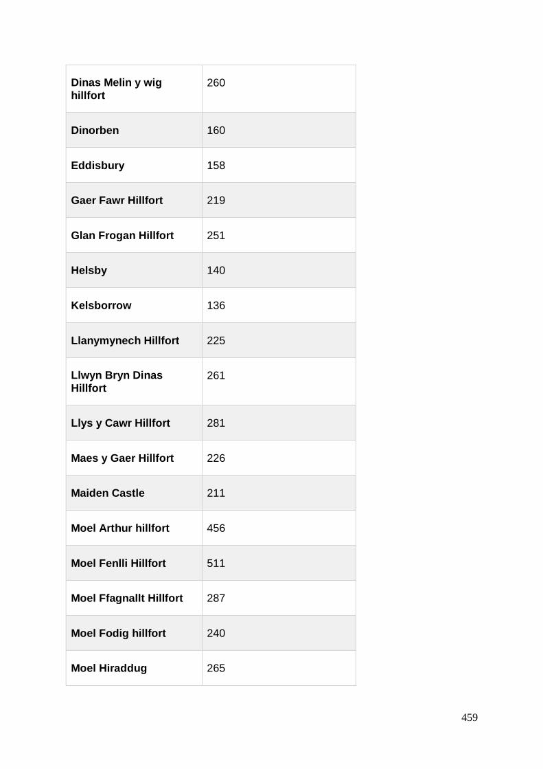
459
Dinas Melin y wig
hillfort 260
Dinorben 160
Eddisbury 158
Gaer Fawr Hillfort 219
Glan Frogan Hillfort 251
Helsby 140
Kelsborrow 136
Llanymynech Hillfort 225
Llwyn Bryn Dinas
Hillfort 261
Llys y Cawr Hillfort 281
Maes y Gaer Hillfort 226
Maiden Castle 211
Moel Arthur hillfort 456
Moel Fenlli Hillfort 511
Moel Ffagnallt Hillfort 287
Moel Fodig hillfort 240
Moel Hiraddug 265

460
Moel y Gaer Bodfari 206
Moel y Gaer Llanbedr 339
Moel y Gaer Llantysilio 504
Moel y Gaer Rhosesmor 303
Mynydd y Gaer Camp 270
New Pieces Enclosure 300
Oakmere promontory fort
75
Old Oswestry Hillfort 165
Olivers Point 140
Pen Llys Hillfort 220
Pen y Castell, Maenan 170
Pen y Ddinas, Great Orme
100
Pen y Gaer hillfort 232
Pen y Gaer hillfort (Llangollen)
290
Pen y Gaer, Llanbedr y Cennin
370
Pen y Gorddyn Hillfort 274
Pendinas, Llandegai 140

461
Penycloddiau 440
Penycorddyn Mawr 160
Perwlwyn Coppice
Hillfort 190
Plas Uchaf Enclosure 129
Pwll y Clai earthwork 208
Roft Promontory Fort 65
Soldier's Mount Hillfort 165
Soldiers Ring Hillfort 270
The Berth 97
Trefnanney Gaer Hillfort 125
Trewylan enclosure 148
Vivod hillfort 335
Winllan Enclosure 190
Woodhouse Hillfort 137
Y Gardden hillfort 179
Yr Allt hillfort 150
Table A3.17. Approx (known) height for hillforts within 30 miles of the Clwydian Range, Figure 5.6

462
Site Name Height mOD
Pen Ffawyddog Hillfort; Ffawyddog Gaer Hillfort 107
Cross Oak Hillfort 140
Pendre Hillfort 182
Llangenny Camp 220
Coed y Gaer Hillfort 229
Allt yr Esgair Enclosure 245
Slwch Tump Hillfort 247
Coed Mawr Hillfort 260
Penmyarth Hillfort/Myarth Camp 277
Coed Fennifach Camp 289
Coed y Caerau Hillfort 290
Plas y Gaer Hillfort 297
Coed Pentwyn Hillfort 305
Coed y Brenhin Hillfort 312
Tyle Clydach Hillfort 320
Twyn y Gaer Hillfort 320

463
Gelli Nedd hillfort 320
Craig y Rhiwarth Hillfort 325
Pen-y-crug hillfort 330
Twyn y Gaer Hillfort 343
Tump Wood Hillfort 356
Nant Tarthwyni Hillfort II 381
Allt yr Esgair Hillfort 395
Nant Tarthwyni Hillfort I 411
Dol y Gaer hillfort 426
Rhyd Uchaf Enclosure II 430
Bryn Melyn hillfort 440
Castell Dinas, hillfort 450
Crug Hywel Hillfort 455
Mynydd Llangorse Hillfort 460
Table A3.18. Hillfort height in the Brecon Beacons, Figure 5.7