basinresearch … · tionofoldfaults andthe appearance ofnewones inacon-text of reorganization of...
TRANSCRIPT

Late orogenic intramontane basin development: theGranada basin,Betics (southern Spain)J. Rodrıguez-Fernandez and C. Sanz de Galdeano
InstitutoAndaluz de Ciencias de laTierra (CSIC-Univ. Granada), Fac. Ciencias, Granada, Spain
ABSTRACT
The quantitative study of subsidence in the Granada basin, using decompaction and backstrippingtechniques, and contemporaneous relief development in the surrounding areas, especially in theSierra Nevada, provides a good case example of the development of an intramontane basin. In theGranada basin, according to the interpretation of the seismic pro¢les and results of the backstrippinganalysis, subsidence and sedimentation rates were at a maximum in the lateTortonian and decreasedprogressively; meanwhile, the neighbouring areas were uplifted forming important relief.Chronostratigraphical revisions of the marine sediments show that the marine incursion thatdeposited sediments in the Granada basin lasted only1.3Ma, between 8.5 and 7.2Ma.The gradualretreat of the sea in the Granada basin is not attributable to global eustatic £uctuations, but rather touplift in the Sierra Nevada and its adjacent areas. From latest Tortonian to earlyMessinian times, theregion became continental and the Granada basin acquired its present physiography andwasdi¡erentiated as such. From the lateTortonian onwards, NNW^SSE compression combinedwithENE^WSWextension a¡ected the cordillera. In the Granada basin, extension controlled faultmovements.There are two well-de¢ned fault sets: the ¢rst trends 701N^901E, with low angle faults(less than 301) dipping towards the north and south, de¢ning the subsiding areas which haveapproximately E^Wdirection; whereas the second set has aNW^SE direction, and cuts and displacesthe previous ones, de¢ning the main subsiding areas in the eastern part of the basin.Thereinterpretation of seismic pro¢les reveals that the subsiding axes within theGranada basin persistedfrom theTortonian to the present because of continued displacements of the main faults.
INTRODUCTION
The relationship between the formation of relief and thelate stages of mountain belt development is well estab-lished, particularly in the case of Alpine chains such asthe Himalayas, Andes, Alps, Betics or the Aegean area(Gansser,1982; tenVeen&Posma,1999a, b) owing to exten-sional, transcurrent or transtensional mechanisms, de-pending on the case. More recently, researchers haveundertaken the quanti¢cation of vertical displacementsin sedimentary basins as well as in the surrounding relief,for instance in the Mediterranean Sea and its peripheralchains (Ryan, 1976; tenVeen & Postma, 1999a, b).The BeticCordillera is not an outsider to these studies, and di¡erenttechniques of analysis have been used in order to quantifyits vertical displacements (Gime¤ nez et al., 2000; Braga etal., 2003; Sanz de Galdeano & Alfaro, 2004).
Not many models have been proposed to explain theformation of the Granada basin. Rodr|¤ guez-Ferna¤ ndez etal. (1989) emphasize the role of strike-slip faulting and un-
derline the coincidence of many patternswith that of pull-apart basins.The coexistence of compressional and exten-sional deformation as a consequence of strike-slip faultsis also described byMorales et al. (1990).
The quantitative analysis of subsidence of the sedimen-tary sequences ¢lling the basins, based on backstrippingand decompaction techniques, has likewise been appliedto di¡erent geologic domains of the Betic Cordillera, suchas the continental margins (Janssen et al., 1993;Watts et al.,1993; Geel, 1995; Hanne et al., 2003) in the Alboran Sea(Cloetingh et al., 1992; Banda et al., 1993; Rodr|¤ guez-Fer-na¤ ndez et al., 1999), or in its intramontane basins (Soria etal, 1998, 2001; Rodr|¤ guez-Ferna¤ ndez et al., 1999).Whereasthe analysis of the whole process of subsidence combinedwith the formation of relief is commented on by a numberof authors, to date no comparison and numeric analysis ofthe two processes has been documented.
TheGranada basin is situated at the western foot of theSierra Nevada and is one of the main intramontane basinsformed during the late orogenic stage in the Betic Cordil-lera. It is probably the most complex basin of the BeticCordillera, where noteworthy thicknesses of detritic sedi-ments were deposited from end Miocene to Pliocene-Quaternary times.The Sierra Nevada presents the highest
Correspondence: J. Rodr|¤ guez-Ferna¤ ndez, Instituto Andaluz deCiencias de la Tierra (CSIC-Univ. Granada), Fac. Ciencias,18071Granada, Spain. E-mail: [email protected].
BasinResearch (2006) 18, 85–102, doi: 10.1111/j.1365-2117.2006.00284.x
r 2006 The Authors. Journal compilationr 2006 Blackwell Publishing Ltd 85

peaks of theBeticCordillera (3482m), formed from the lateMiocene onward, whose slopes preserve late Miocenemarine sediments, up to nearly1900m a.s.l. A comparisonof the Granada basin and the Sierra Nevada enables us tocharacterize and quantify the processes of subsidence anduplift, in a context similar to that of other Alpine chains.
A sound knowledge of the main stratigraphic and sedi-mentologic characteristics of theGranada basin ^ togetherwith the existence of 29 seismic pro¢les, one borehole, andgravimetric data from oil research ^ allowed us to reinter-pret the structure of the basin and quantify the subsidenceas well as reconsider the geodynamic evolution of the ba-sin.The recent evolution of the relief can also be quanti-¢ed and compared with the subsidence inferred fromprevious and our own data. To this aim, we reinterpretseismic pro¢les from the northern and central part of thebasin. They were digitized to derive basement contourmaps, and for the ¢rst time we establish:
(1) isopach maps of the di¡erent sedimentary sequences,constructed to identify the morphology of di¡erentdepocentres and changes in their location and form;
(2) maps showing fault location, di¡erentiating betweenthose that a¡ect the basement, the sedimentary in¢ll-ing, or both;
(3) subsidence analysis, quantifying the sediment accu-mulation rates (mMa�1) for di¡erent ages and sectorsof the basin;
(4) chronologic revision of the marine sediments, throughnew studies of the palaeontological contents of severalcross sections, as well as a better knowledge of the evo-lution of the quanti¢ed processes.
With these analyses, the ¢nal objective of this workwas toassess subsidence in the Granada basin and uplift of therelief in the surrounding areas, determining how andwhenthese processes occurred, in the framework of the geody-namic mechanisms involved in the lateNeogene evolutionof the Betic Cordillera.
GEOLOGICAL SETTING
TheBeticCordillera is, together with theRif, the western-most Alpine mountain belt that surrounds theMediterra-nean Sea. It is made up of the external zone to the northand the internal zone to the south. The external zone(Fig. 1) corresponds to the mesozoic and tertiary sedi-ments of the Iberian palaeomargin and is divided intoPrebetic and Subbetic domains, the latter now locatedfurther to the south.
The internal zone comprises three tectonically super-imposed complexes that are, from the base to the top: theNevado-Filabride, the Alpujarride and the Malaguide.The Nevado-Filabride and Alpujarride are strongly af-fected by Alpine metamorphism. The internal zone wasdisplaced westwardly at the beginning of the Mioceneuntil colliding with the external zone, especially with theSubbetic, and was then strongly deformed (Durand-Del-ga,1980; Sanz deGaldeano,1990). Several phases of exten-sional tectonics during the early to middleMiocene andupto the beginning of the late Miocene contributed to de-nuding the internal zone, resulting in the exhumation ofthe previously superimposed complexes (Balanya¤ & Gar-c|¤ a-Duen� as, 1987; Monie¤ et al., 1991; Garc|¤ a-Duen� as et al.,
Fig.1. Location of the Granada and other Neogene basins in the Betic Cordillera.1. Granada basin, 2. Guadix basin, 3. Baza basin, 4.Tabernas basin, 5. Sorbas basin, 6. Lorca basin, 7. Fortuna basin.
r 2006 The Authors. Journal compilationr 2006 Blackwell Publishing Ltd,Basin Research, 18, 85^10286
J. Rodr|¤guez-Ferna¤ ndez and C. Sanz de Galdeano

1992; Watts et al., 1993; Platt & Whitehouse, 1999). Finally,from the lateTortonian, a NNW^SSE compression com-binedwith a near perpendicular extension a¡ected the Be-tic Cordillera (Sanz de Galdeano, 1988; Rodr|¤ guez-Ferna¤ ndez &Mart|¤ n-Penela, 1993; Galindo-Zald|¤ var et al.,1993, 1999; Buforn et al., 1995), facilitating the progressiveexhumation of theNevado-Filabride complex (the deepestof the three) between12 and 8Ma (Johnson et al.,1997).
Unconformably deposited on the Subbetic, AlpujarrideandMalaguide complexes are sediments of early andmiddleMiocene age, representing the remains of previous sedi-mentary basins that were later destroyed. During the lateMiocene new basins formed, including those of Guadix,Baza, Lorca, Fortuna and that of Granada (Fig.1), coveringpart of the contact between the internal and external zones.
These basins have a series of common stratigraphic char-acteristics: the presence of evaporites deposited in the latestTortonian and therefore before the ‘Messinian salinity crisis’of the Mediterranean (Rodr|¤ guez-Ferna¤ ndez et al., 1984;Garce¤ s et al., 1998; Dinare¤ s et al., 1999), an important accu-mulation of coarse clastic sediments located at the foot ofprominent reliefs, and ¢nally, fresh-water lacustrine depos-its at the end of the lateMiocene.These characteristics pro-vide evidence of a relatively rapid uplift and growth of reliefat the end of the lateMiocene (Montenat et al., 1990).
Previously, during the middleMiocene to the earlyTor-tonian, the region was subjected to a tectonic denudationprocess (Johnson et al., 1997) that did not produce impor-tant relief and did not contribute to the formation of intra-montane basins.
The creation of relief and the subsidence of associatedsedimentary basins is strongly in£uenced by the reactiva-tion of old faults and the appearance of new ones in a con-text of reorganization of the cordillera (Sanz de Galdeano& Alfaro, 2004), as a consequence of the collision betweenAfrica and Europe from the lateTortonian.
THE SEDIMENTARY RECORD OF THEGRANADA BASIN
The basement of the Granada basin is formed by meta-morphic rocks of the internal zone (in the southeasternhalf) and sedimentary rocks of the Subbetic (in the north-western half) of the Betic Cordillera, together with earlyand middleMiocene sedimentary remnants of older Neo-gene basins (Fig. 2). In the present paper, these sedimentsare considered to form part of the basement.
TheGranada basin ¢lling has a markedly molassic char-acter (Van Houten, 1981). Three depositional sequencescan be distinguished:
Sequence 1
It contains marine sediments of late Tortonian age lyingunconformably on the basement (Fig. 2). The transitionfrom coastal to platform conditions (Ferna¤ ndez & Rodr|¤ -guez-Ferna¤ ndez, 1991), testifying the sudden £ooding of
theTortonian sea, is observed in several places, for examplein the southwestern part of the basin, in the town of Alha-ma de Granada, an exceptional deepening upward se-quence is preserved.
The upperMiocene sedimentation beganwith bioclas-tic calcarenites, deposited in an epiric sea with temperatewaters that change distally to calcareous marl facies. Nearthe emergent high relief areas of the basement, the faciesare apron type, corresponding to the base of ancient cli¡s,whose sediments comprise large blocks or conglomerateswith a calcarenitic matrix. Overlying the previous sedi-ments are found:
� Along the eastern border, fan deltas, fed by a drainagenetwork that developed in adjacent relief and depos-ited thick accumulations of conglomerates. They evi-dence the important growth of relief, particularlyalong the eastern border.
� The western and southern borders of the basin weresites of carbonate sedimentationwith a platformwherecoralline reefs developed. Similar reefs colonized fandelta topsets.This change in sedimentation indicatesa con¢nement of the basin, which began to lose itsconnection to the open sea, as a result of the onset ofuplift of the entire region (Rodr|¤ guez-Ferna¤ ndez etal., 1984; Montenat et al., 1990; Braga et al., 1999). Suchuplift is compatible with the data presented by John-son (1993, 1997) and Johnson et al. (1997), who, fromapatite and zircon ¢ssion track, date the cooling of theNevado-Filabride complex near the surface at 9^8Main the western Sierra Nevada area, when the tectonicdenudation ceased. These authors indicate that ‘tec-tonic events at that time, which resulted in the initialstructuration of the intramontaneBetic basins and de-velopment of the modern topography, are somehowlinked to this change’
The base of marine sequence1contains the planktonic for-aminifer Neogloboquadrina humerosa (Blow) and the dis-coasterid Discoaster quinqueramus (Gartner). Bearing inmind that the biohorizon of the ¢rst appearance of bothis located at 8.5Ma (Okada & Bukry, 1980; Berggren et al.,1995), the marine incursion would have this age as themaximum. Discoaster quinqueramus (Gartner) is present inthe top of sequence1, whereas theGloborrotalia suterae zone(Okada & Bukry, 1980; Iaccarino, 1985), the latest Torto-nian, is absent; therefore the age of the top of this se-quence is situated in the ‘non-terminal late Tortonian’,before theTortonian^Messinian boundary (7.12Ma).
Sequence 2
This sequence overlies sequence1 (Fig. 2), conformably inthe centre and unconformably at the edges of the basin. Itwas deposited in a continental environment and varies incharacter and nature depending on location.The deposi-tion of thick evaporitic deposits (gypsum and salt) in thesouthern part of the basin signals the ¢nal retreat ofthe sea.
r 2006 The Authors. Journal compilationr 2006 Blackwell Publishing Ltd,Basin Research, 18, 85^102 87
Late orogenic intramontane basin

In the Sierra Nevada footslopes and in the northeasternSierras, coarse clastic sedimentswere deposited bylarge allu-vial fans in identical positions to those occupied by the fandeltas of the previous sequence.These alluvial fans evolvedinto a braided river system that deposited sands and micac-eous silts, and then into several deep lakes, some containingthick lacustrine turbiditic deposits (Dabrio etal.,1972).
These facies of ¢ne micaceous sands and silts containthe ¢rst fossil records of lacustrine environments in theGranada basin.They are micromammalian rodents (Occi-tanomis adroveri, Ruscinomis schaubi and Valerymys juniensis)that point to theNM12 zone ^ of lateTurolian age, equiva-lent to latest Tortonian in the marine chronology ^ for thelower part of sequence 2 (Dabrio et al., 1978; Ruiz-Bustos,2002).
Overlying the previous succession, terrigenous sedi-ments were deposited by braided rivers sourced fromsurrounding high relief areas. These rivers fed intolakes located in the deepest parts of the basin. In thelakes, ¢ne-detrital, marly and calcareous sediments,featuring thin lignite levels, were deposited (Dabrio&Fer-na¤ ndez, 1986). These lacustrine sediments contain a richvertebrate fauna that point to a latest Ventian age for thetop of sequence 2, equivalent to Messinian in continentalchronology (Ruiz-Bustos, 2002). The second sequenceculminates with the deposition of lacustrine limestones(Fig. 2).
Because the bottom of sequence1is lateTortonian in age(8.5Ma,Discoasterquinqueramus zone) and the bottom of se-quence 2 is latest Tortonian in age (7.2Ma, NM12 zone),
Fig. 2. Geological map of theGranada basin.1.Nevado-Filabride complex, 2. Alpujarride complex, 3.Malaguide complex, 4. Subbetic,5.Marls, sands and conglomerates (Serravallian^EarlyTortonian), 6^8: sequence1, 6. calcarenites (lateTortonian), 7.Marls andconglomerates (lateTortonian), 8. conglomerates, sands andmarls (lateTortonian ), 9 and10: sequence 2,9.marls, silts, sands and gypsum(Messinian), 10. Lacustrine limestone (lateMessinian), 11^13: sequence 3, 11. conglomerates, sands and clays (Pliocene^Pleistocene), 12.Alluvial fans (Pleistocene^Holocene), 13. Alluvial plain (Pleistocene^Holocene), 14. Alluvial sediments (recent), 15. town,16. lithologicalcontact, 17. fault, 18. normal fault, 19. reverse fault, 20. syncline, 21. anticline.The position of the ¢gure is marked in Fig.1.The squaredotted line marks the area covered by seismic lines (Fig. 3).The stars correspond to the boreholes cited in the text.
r 2006 The Authors. Journal compilationr 2006 Blackwell Publishing Ltd,Basin Research, 18, 85^10288
J. Rodr|¤guez-Ferna¤ ndez and C. Sanz de Galdeano

the marine incursion that deposited sequence1would cor-respond to a time span ranging between 8.5 and 7.2Ma, notlasting more than1.3Ma.
Sequence 3
A new network of braided rivers developed in the shallowareas of the basin, and lacustrine zones in the more de-pressed areas (Fig. 2). Sediment consists of: conglomer-ates, sands and clay of £uvial origin for the £uvial facies;and sand, silts, lignite and limestones for the lacustrine fa-cies. This endorheic phase lasted until the late Pliocene.The considerable thickness of the sediments (over 1000min some places) is clearly inferred from the seismic lines.The Pliocene sediments are dated indirectly with respectto the Miocene^Pliocene boundary at their base and theearly Pleistocene at their top (Ruiz-Bustos, 2002).
In the Pleistocene, the basin was captured by the drai-nage network of the Guadalquivir River. From this timeonward, a longitudinal £uvial system (the Genil River, tri-butary of the Guadalquivir River) developed, whose £oodplain is the present alluvial plain of Granada.
The important high relief created along the eastern bor-der of the basin was drained by alluvial fan systems. Someformations deposited at the end of the Miocene wereeroded and redeposited during the Pleistocene.
A borehole (Granada D-1) located near Lachar (LA)(Figs 3, 4, 6, 7 and 10) penetrated 834m, revealing frombottom to top: a basement of Subbetic character (233m),marly limestone sediments of middle Miocene age (21m),calcareous marls of Tortonian age (73m, corresponding tosequence 1), marly^sandy^silty sediments with gypsumand lacustrine limestones of late Miocene age (Ventian;253m, sequence 2), ending in detrital sediments of Plio-cene^Pleistocene age (254m, correlated with sequence 3).The three sequences di¡erentiated in the borehole maybe easily correlated with those described above. One of
the seismic pro¢les (S85^157) (Figs 3, 4 and10) passes overthis borehole, although nearby there are two short bore-holes for mining research (S6 and S7, Fig. 3). On the basisof data from the Granada D-1 borehole and knowledge ofthe depth of each of the three main seismic re£ectors (de-scribed in the next chapter) we calculated the seismic velo-city, used later to transform the seismic time (TWT) intodepths. These velocities also were used to elaborate themaps and cross sections, and in the numeric analyses ofthe data.The crossing of di¡erent seismic pro¢les, alwayswith the help of the seismic facies, permitted the identi¢ -cation of the main re£ectors that bound the di¡erentiatedsedimentary sequences.
SEISMIC STRATIGRAPHY
In the seismic pro¢les (Figs 3^5), the three depositionalsequences can be recognized, separated by prominent re-£ectors.The clearest re£ectors correspond to:
1. The contact between the basement and the sedimen-tary ¢ll of the basin, coinciding with the base of se-quence 1. The basement shows a homogeneouscharacter with re£ectors of low continuity and med-ium-high amplitude, and a non-strata pattern can beidenti¢ed. Somemore prominent re£ectors are di⁄cultto identify and interpret.
2. Re£ector 2 corresponds to the boundary between mar-ine and continental sediments of lateMiocene age. Be-tween sequences 1 and 2 in the deepest parts of thebasin, the paraconformity between the re£ectors of thetwo sequences demonstrates that the transition frommarine to continental sedimentation took place with-out erosion in these deep parts (Fig. 4a and b). In theseismic pro¢les, the continental sediments of the lateMiocene (sequence 2) appear as a homogeneous unitwithout internal discontinuities, with continuous andvery marked re£ectors of middle amplitude that clearlyonlap the basement highs.
3. Re£ector 3 represents the boundary between the conti-nental sediments of lateMiocene andPliocene age, thatis, between sequences 2 and 3. The continental sedi-ments of late Miocene age contain, toward the top,lacustrine limestone levels of Ventian (Messinian) age.These levels usually exhibit good contrast and a contin-uous re£ector with high amplitude whose upper limitcoincides with the base of the continental sedimentsof the Pliocene-Pleistocene (Este¤ vez et al.,1982).
Within the Pliocene^Pleistocene sequence, some wellmarked re£ectors with low continuity and high amplitudeexist. Toward the top, recent alluvial and colluvial sedi-ments are present, yet not well distinguished because oftheir minor thickness.
The seismic pro¢leswere used to prepare contour mapsof the basement as well as isopach maps (Fig. 9), and todraw several cross sections (A^D,Fig.8) of the di¡erent de-positional sequences.To obtain the isopach maps we used
Fig. 3. Contour map of the area covered by the 29 reinterpretedseismic lines showing the location of Granada D-1borehole andS6 and S7mining holes.Their positions are indicated by thesquare dotted line of Fig. 2.
r 2006 The Authors. Journal compilationr 2006 Blackwell Publishing Ltd,Basin Research, 18, 85^102 89
Late orogenic intramontane basin

Fig.4. Interpretation of part of seismic pro¢les S85^157 and S85^150.Their positions are marked in Fig. 3.Vertical dotted linescorrespond to the selected places for backstripping analysis. LA, Alto de Lachar; PP^FV, Pinos Puente^FuenteVaqueros depocentre.The cross points between pro¢les are indicated.
r 2006 The Authors. Journal compilationr 2006 Blackwell Publishing Ltd,Basin Research, 18, 85^10290
J. Rodr|¤guez-Ferna¤ ndez and C. Sanz de Galdeano
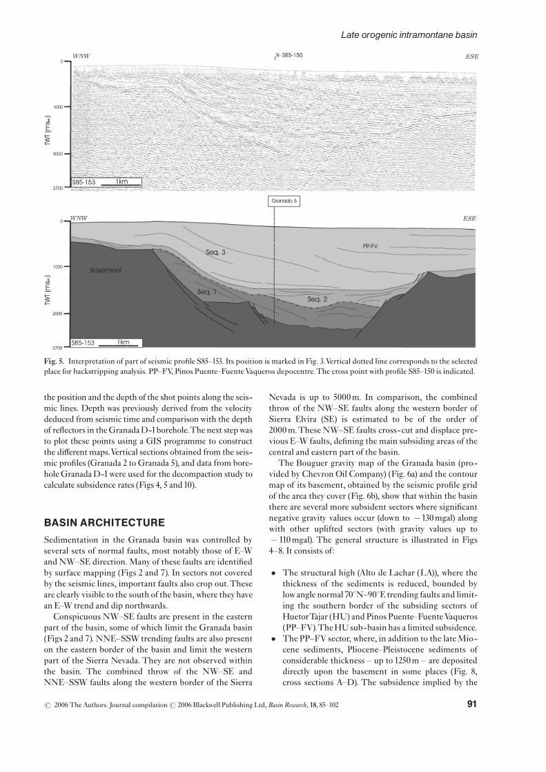
the position and the depth of the shot points along the seis-mic lines. Depth was previously derived from the velocitydeduced from seismic time and comparisonwith the depthof re£ectors in theGranadaD-1borehole.The next stepwasto plot these points using a GIS programme to constructthe di¡erent maps.Vertical sections obtained from the seis-mic pro¢les (Granada 2 to Granada 5), and data from bore-holeGranadaD-1were used for the decompaction study tocalculate subsidence rates (Figs 4, 5 and10).
BASIN ARCHITECTURE
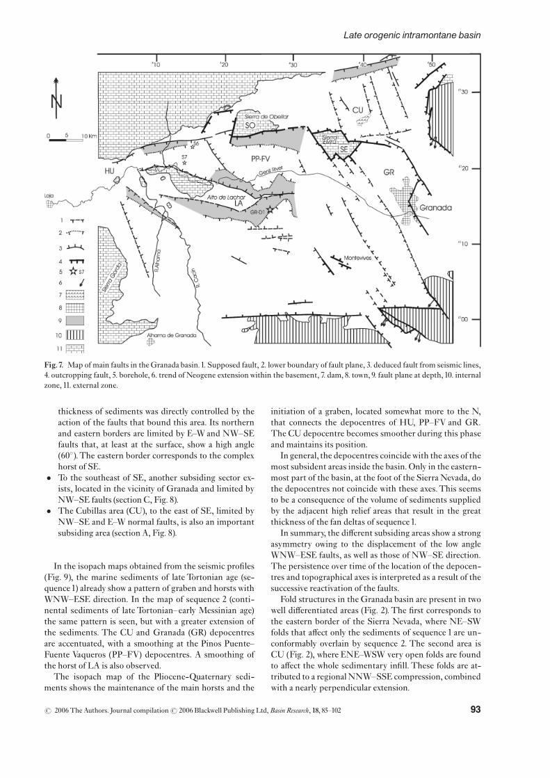
Sedimentation in the Granada basin was controlled byseveral sets of normal faults, most notably those of E^Wand NW^SE direction. Many of these faults are identi¢edby surface mapping (Figs 2 and 7). In sectors not coveredby the seismic lines, important faults also crop out.Theseare clearly visible to the south of the basin, where theyhavean E^W trend and dip northwards.
Conspicuous NW^SE faults are present in the easternpart of the basin, some of which limit the Granada basin(Figs 2 and 7). NNE^SSW trending faults are also presenton the eastern border of the basin and limit the westernpart of the Sierra Nevada. They are not observed withinthe basin. The combined throw of the NW^SE andNNE^SSW faults along the western border of the Sierra
Nevada is up to 5000m. In comparison, the combinedthrow of the NW^SE faults along the western border ofSierra Elvira (SE) is estimated to be of the order of2000m.These NW^SE faults cross-cut and displace pre-vious E^W faults, de¢ning the main subsiding areas of thecentral and eastern part of the basin.
The Bouguer gravity map of the Granada basin (pro-vided by Chevron Oil Company) (Fig. 6a) and the contourmap of its basement, obtained by the seismic pro¢le gridof the area they cover (Fig. 6b), show that within the basinthere are several more subsident sectors where signi¢cantnegative gravity values occur (down to �130mgal) alongwith other uplifted sectors (with gravity values up to� 110mgal). The general structure is illustrated in Figs4^8. It consists of:
� The structural high (Alto de Lachar (LA)), where thethickness of the sediments is reduced, bounded bylow angle normal 701N^901E trending faults and limit-ing the southern border of the subsiding sectors ofHuetorTajar (HU) and Pinos Puente^FuenteVaqueros(PP^FV).TheHUsub-basin has a limited subsidence.
� The PP^FV sector, where, in addition to the lateMio-cene sediments, Pliocene^Pleistocene sediments ofconsiderable thickness ^ up to 1250m ^ are depositeddirectly upon the basement in some places (Fig. 8,cross sections A^D). The subsidence implied by the
Fig. 5. Interpretation of part of seismic pro¢le S85^153. Its position is marked in Fig. 3.Vertical dotted line corresponds to the selectedplace for backstripping analysis. PP^FV, Pinos Puente^FuenteVaqueros depocentre.The cross point with pro¢le S85^150 is indicated.
r 2006 The Authors. Journal compilationr 2006 Blackwell Publishing Ltd,Basin Research, 18, 85^102 91
Late orogenic intramontane basin

Fig. 6. (a) Bouguer anomaly map of the Granada basin (density reference 2.438 g cm� 3, supplied by Chevron Oil Company. (b) Three-dimensional block of the basement in the areamarked in (a), showing the prominent elevated and depressed areas in the basement. Blackstar corresponds to the location of Granada-D1borehole. CU Cubillas; GR, Granada; HU, HuetorTajar; LA, Lachar; PP^FV, PinosPuente^FuenteVaqueros; SO, Sierra de Obeilar. Note the good agreement between (a) and (b).
r 2006 The Authors. Journal compilationr 2006 Blackwell Publishing Ltd,Basin Research, 18, 85^10292
J. Rodr|¤guez-Ferna¤ ndez and C. Sanz de Galdeano
thickness of sediments was directly controlled by theaction of the faults that bound this area. Its northernand eastern borders are limited by E^Wand NW^SEfaults that, at least at the surface, show a high angle(601).The eastern border corresponds to the complexhorst of SE.
� To the southeast of SE, another subsiding sector ex-ists, located in the vicinity of Granada and limited byNW^SE faults (section C, Fig. 8).
� The Cubillas area (CU), to the east of SE, limited byNW^SE and E^W normal faults, is also an importantsubsiding area (section A, Fig. 8).
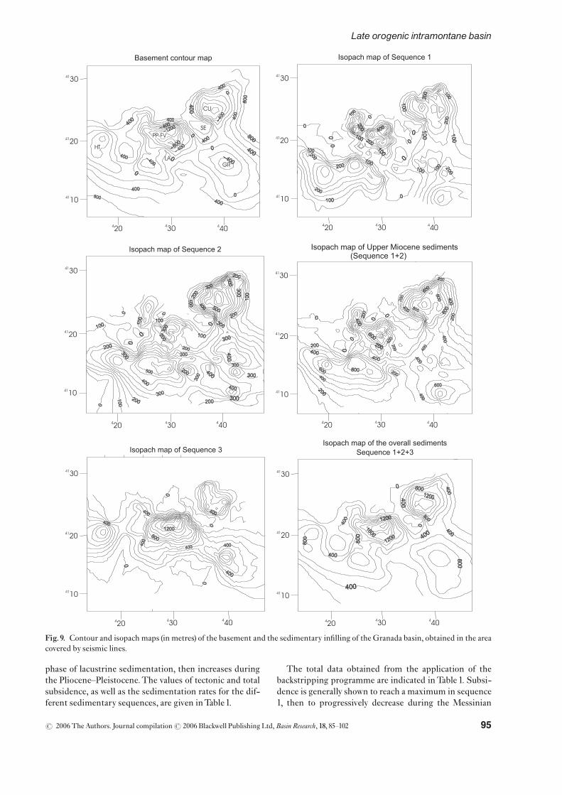
In the isopach maps obtained from the seismic pro¢les(Fig. 9), the marine sediments of late Tortonian age (se-quence1) already show a pattern of graben and horsts withWNW^ESE direction. In the map of sequence 2 (conti-nental sediments of late Tortonian^early Messinian age)the same pattern is seen, but with a greater extension ofthe sediments. The CU and Granada (GR) depocentresare accentuated, with a smoothing at the Pinos Puente^Fuente Vaqueros (PP^FV) depocentres. A smoothing ofthe horst of LA is also observed.
The isopach map of the Pliocene-Quaternary sedi-ments shows the maintenance of the main horsts and the
initiation of a graben, located somewhat more to the N,that connects the depocentres of HU, PP^FV and GR.The CU depocentre becomes smoother during this phaseand maintains its position.
In general, the depocentres coincidewith the axes of themost subsident areas inside the basin. Only in the eastern-most part of the basin, at the foot of the Sierra Nevada, dothe depocentres not coincide with these axes.This seemsto be a consequence of the volume of sediments suppliedby the adjacent high relief areas that result in the greatthickness of the fan deltas of sequence1.
In summary, the di¡erent subsiding areas show a strongasymmetry owing to the displacement of the low angleWNW^ESE faults, as well as those of NW^SE direction.The persistence over time of the location of the depocen-tres and topographical axes is interpreted as a result of thesuccessive reactivation of the faults.
Fold structures in the Granada basin are present in twowell di¡erentiated areas (Fig. 2). The ¢rst corresponds tothe eastern border of the Sierra Nevada, where NE^SWfolds that a¡ect only the sediments of sequence 1 are un-conformably overlain by sequence 2. The second area isCU (Fig. 2), where ENE^WSW very open folds are foundto a¡ect the whole sedimentary in¢ll. These folds are at-tributed to a regionalNNW^SSE compression, combinedwith a nearly perpendicular extension.
Fig.7. Map of main faults in theGranada basin.1. Supposed fault, 2. lower boundary of fault plane, 3. deduced fault from seismic lines,4. outcropping fault, 5. borehole, 6. trend of Neogene extensionwithin the basement, 7. dam, 8. town, 9. fault plane at depth, 10. internalzone, 11. external zone.
r 2006 The Authors. Journal compilationr 2006 Blackwell Publishing Ltd,Basin Research, 18, 85^102 93
Late orogenic intramontane basin

SUBSIDENCE ANALYSIS ANDSEDIMENTATION RATES
To calculate subsidence we used the backstripping pro-gramme of Allen & Allen (1990), which calculates totaland tectonic subsidence of the basement for decompactionof the di¡erentiated sedimentary sequences. The pro-gramme assumes a model of airy-type isostasy. The tec-tonic subsidence is calculated eliminating the e¡ect of thesediment load.
The values of the density and porosity of the sedimentswere taken from the standard value charts of Sclater &Christie (1980). Palaeobathymetric corrections were notapplied, given the continental character of most of the se-diments; nor were palaeoeustatics, given the minor rangeof sea level variation for the age of the marine sediments(see Hardenbol et al., 1998).
To estimate the thickness of the sedimentary ¢ll, start-ing from the seismic pro¢les, we took an average speed of1.9 km s�1. The stages that were di¡erentiated coincidewith the sedimentary sequences, and their chronologicallimits are: 8.5Ma for the beginning of the marine incur-sion; 7.2Ma for the transition from marine to continentalsedimentation; and 5.3Ma for the Miocene^Plioceneboundary.
For the calculation of subsidence values, ¢ve pointswere chosen (Fig.10), three of them along theS85^150pro-¢le, and two of them at the cross points with the pro¢lesS85^153 and S85^157, almost perpendicular to the ¢rstone.The other two points are located somewhat to the eastof the above pro¢les. One of these points corresponds tothe Granada D-1 borehole, where the sediment thicknessis known and was used by Rodr|¤ guez-Ferna¤ ndez et al.(1999).
Points Granada D-1 and Granada-3 are situated in theLA, whereas the three remaining (Granada-2, -4 and -5) arein the depocentres located to the north and south of theLA.In this way the subsidence can be analysed both in the dee-pest areas and in the relative highs inside the basin.
The calculations of tectonic subsidence and total subsi-dence (the sum of tectonic subsidence plus that due to thesediment load) are shown in Fig. 10. Points 1 and 3, in theLA, show moderate values of subsidence during theTorto-nian and Pliocene^Pleistocene, and slightly greater onesduring the Messinian. Point 2, located near HU, shows animportant phase of subsidence during the Miocene thatsubsidence decreases during the Pliocene^Pleistocene,with a value lower than that of LA. Points 4 and 5 exhibitrelative subsidence during deposition of sequence 1 (mar-ine sediments of Miocene age) that decreases during the
Fig. 8. Sections, obtained from seismic pro¢les, showing the morphology of the Granada basin and the in¢lling sedimentarysequences. Zero metres correspond to the present sea level.The di¡erent grey shades are equivalent to those of Figs 4 and 5. Location ofsections A^D can be seen in the annexed contour map.
r 2006 The Authors. Journal compilationr 2006 Blackwell Publishing Ltd,Basin Research, 18, 85^10294
J. Rodr|¤guez-Ferna¤ ndez and C. Sanz de Galdeano
phase of lacustrine sedimentation, then increases duringthe Pliocene^Pleistocene.The values of tectonic and totalsubsidence, as well as the sedimentation rates for the dif-ferent sedimentary sequences, are given inTable1.
The total data obtained from the application of thebackstripping programme are indicated inTable 1. Subsi-dence is generally shown to reach a maximum in sequence1, then to progressively decrease during the Messinian
Fig.9. Contour and isopach maps (in metres) of the basement and the sedimentary in¢lling of the Granada basin, obtained in the areacovered by seismic lines.
r 2006 The Authors. Journal compilationr 2006 Blackwell Publishing Ltd,Basin Research, 18, 85^102 95
Late orogenic intramontane basin

Fig.10.Backstripping
at¢vepo
intsoftheGranada
basin.Locationoftheselected
pointsin
theup
perleftcorner.
r 2006 The Authors. Journal compilationr 2006 Blackwell Publishing Ltd,Basin Research, 18, 85^10296
J. Rodr|¤guez-Ferna¤ ndez and C. Sanz de Galdeano

(sequence 2) to the Pliocene^Pleistocene (sequence 3). Asimilar process is observed with the sedimentation ratesduring sequence1,where the subsidence rate exceeds sedi-mentation.During deposition of sequences 2 and 3, the se-dimentation rates are slightly higher that those ofsubsidence mainly in the depocentre of PP^FV.
The previous values for subsidence are based on an un-derstanding that the Granada basin remained stable,which is not the case, since it has risen remarkably, thoughless than the surrounding areas. The obtained valuestherefore indicate only the absolute displacements. At thesame time, the basin contains several sectors where strongsinking took place, in some cases more than 1000m.Thissinking was controlled mainly by E^WandNW^SE faults.
The topographical height of the Granada D-1 boreholeis 640m and the basement is 580m deep, that is, about60m above the present sea level. During the depositionof the marine sediments (sequence 1), the basement wasnearly 250m deep, according to its facies.The sum of base-ment depth and posterior local tectonic subsidence werecompensated by regional uplift.
To the southeast, in the Sierra Nevada foothills, marinedeposits of lateMiocene age are preserved at an altitude of1830m (Sanz de Galdeano & Lo¤ pez Garrido, 1999) (Fig.12). To the east, in Sierra Harana, they reach a height of1623m, resting on a surface that dips toward the east.Va-lues a little lower can be measured at other points to thenorth and south of the Granada basin. On the whole theregion has risen, though the Granada basin has not risenas much (Fig. 12), some of its basement areas being1500m below the present sea level.
DISCUSSION
The Betic Cordillera has experienced important upliftfrom the late Miocene, whereas at the same time intra-montane basins have formed in a contemporary processof relief- and basin creation. Reviewing the regional data,the lateTortonian marine sediments are not limited to thecurrent Granada basin, but extend much further; hence,for this time period, we cannot refer to the existence ofthe basin as such. Inside the basin some positive reliefareas existed, such as the highs of SE, LA and Obeilar(SO), along with subsiding areas such as HU, CUandGR.
At the end of middle Miocene the more prominent re-liefs of the Betic Cordillera did notyet exist, although theircreation was underway. This is evidenced by the coarsedetritic character of late Serravallian^earlyTortonian sedi-ments, revealing the growth of relief exposed to erosion.They are sediments of a continental character, nourishedfrom the upper complexes of the internal zone (Malaguideand Alpujarride), yet they do not contain clasts derivedfrom the lower complex, the Nevado-Filabride (Rodr|¤ -guez-Ferna¤ ndez, 1982). In theTortonian, the topographi-cally lowest areas of the region were subjected to marineincursions, the most important of which taking place inthe lateTortonian (at 8.5Ma). The short range of the eu-static variations (less than 45m in the curve of Hardenboletal.,1998) for this time span do not explain the marine in-cursion in the region. Rather, it must be due to subsidenceas a consequence of faulting; similar features are describedby ten Veen & Postma (1999a, b) in Crete, Greece. Thedeposition of marine sequence 1 corresponds to thecited main marine incursion, when the Granada basinregistered its highest values in tectonic subsidence(217mMa�1) and the highest sedimentation rates (374.8mMa�1;Table 1).
The gradual decrease inwater depth, a result of regionaluplift, culminated in evaporite deposition (gypsum andsalt) in the marginal parts of the southern half of the basin.This represents the progressive and de¢nitive retreat ofthe sea. However, the sheet ofwater was not lost at its dee-pest parts, as is evidenced in the seismic pro¢les, where aparaconformity is observed between sequences1 and 2.
The progressively reduced bathymetry of the basincaused a change in the chemical quality ofwaters thatwentfrom marine to brackish, and ¢nally to freshwater, as de-monstrated by the sediment facies and fossil record (Dab-rio etal.,1972).During the time that marine sedimentationtook place in the Granada basin, the level of the ocean fellonly 10m, according to the eustatic curve of Hardenbolet al. (1998). In contrast, decompaction analysis of sedi-ments (Fig. 10), shows that the tectonic subsidence variesfrom area to area, roughly between 150 and 500m (evenmore in some points). Therefore, the gradual retreat ofthe sea in the Granada basin is not attributable to globaleustatic £uctuations but rather to regional uplift.
The onset of the important uplift of the region concurswith the end of the tectonic denudation (Johnson, 1993,
Table1. Subsidence and sedimentation rates in several points in the Granada basin (mMa�1)
Site
Tectonic subsidence rates Total subsidence rates Sedimentation rates
SEQ1 SEQ2 SEQ3 SEQ1 SEQ2 SEQ3 SEQ1 SEQ2 SEQ3
Granada D1 59.2 85.7 23.9 83.0 133.6 41.3 83 142.6 47.9Granada 2 274.6 159.4 18.4 410.0 287.3 35.8 410 357.3 50.9Granada 3 86.9 108.4 26.6 123.0 172.6 86.4 123 189.4 101.8Granada 4 404.6 63.1 83.7 623.0 116.8 174.9 629.2 170 225.8Granada 5 406.9 102.6 91.5 633.0 195.2 193.9 633 272.6 251.3Average 217.4 102.6 44.8 329.1 176.4 99.3 374.8 226.3 135.5
r 2006 The Authors. Journal compilationr 2006 Blackwell Publishing Ltd,Basin Research, 18, 85^102 97
Late orogenic intramontane basin
1997; Johnson et al., 1997); their data evidence the rapidcooling of the Nevado^Filabride Complex (105^200 1CMa�1) near the surface at12Ma in the eastern partof Sierra Nevada, and at 9^8Ma in the westernmostpart, next to theGranada basin.Uplift clearly began at thistime.
In fact, from the lateTortonian, the Sierra Nevada un-derwent signi¢cant uplift while sequence 1 was depositedin Granada basin, whose eastern border has been notablyuplifted and preserved in several small outcrops in theslopes of Sierra Nevada (Fig. 12). This sequence reveals,for the ¢rst time, pebbles inherited from theSierraNevadacore (Dabrio et al., 1978; Rodr|¤ guez-Ferna¤ ndez, 1982; Sanzde Galdeano & Vera, 1992). During the process of regionalrising, the area occupied by the Granada basin and otherproximal sectors was disconnected from the sea, then un-derwent continental sedimentation that continued to in-¢ll the subsiding areas.
In the Messinian-Pliocene passage, a new tectonicphase began, characterized by activity on NW^SE trend-ing faults. Movement along these faults, together with ac-tivity on other sets, de¢ned the Granada basinphysiography. At the same time, some areas inside the ba-sin began to sink and show a high sedimentation rate(135.5mMa�1), such as the PP^FV area, where thesemovements continue to the present. The abundant seis-micity and especially microseismicity (Sanz de Galdeanoet al., 2003) that marks the position of the NW^SE faultsand the thickness of the accumulated sediments (morethan1000m) support this interpretation.
Presently, the faults that form the eastern border of theGranada basin bound the Sierra Nevada and the SierraHarana located to theNE.The di¡erence in heights result-ing from these faults is substantial, with theGranada basinover 1000m lower than the Sierra Harana and over 2500mlower with respect to Sierra Nevada. The Sierra Gordamarks the western border of the Granada basin, whose se-diments onlap it.
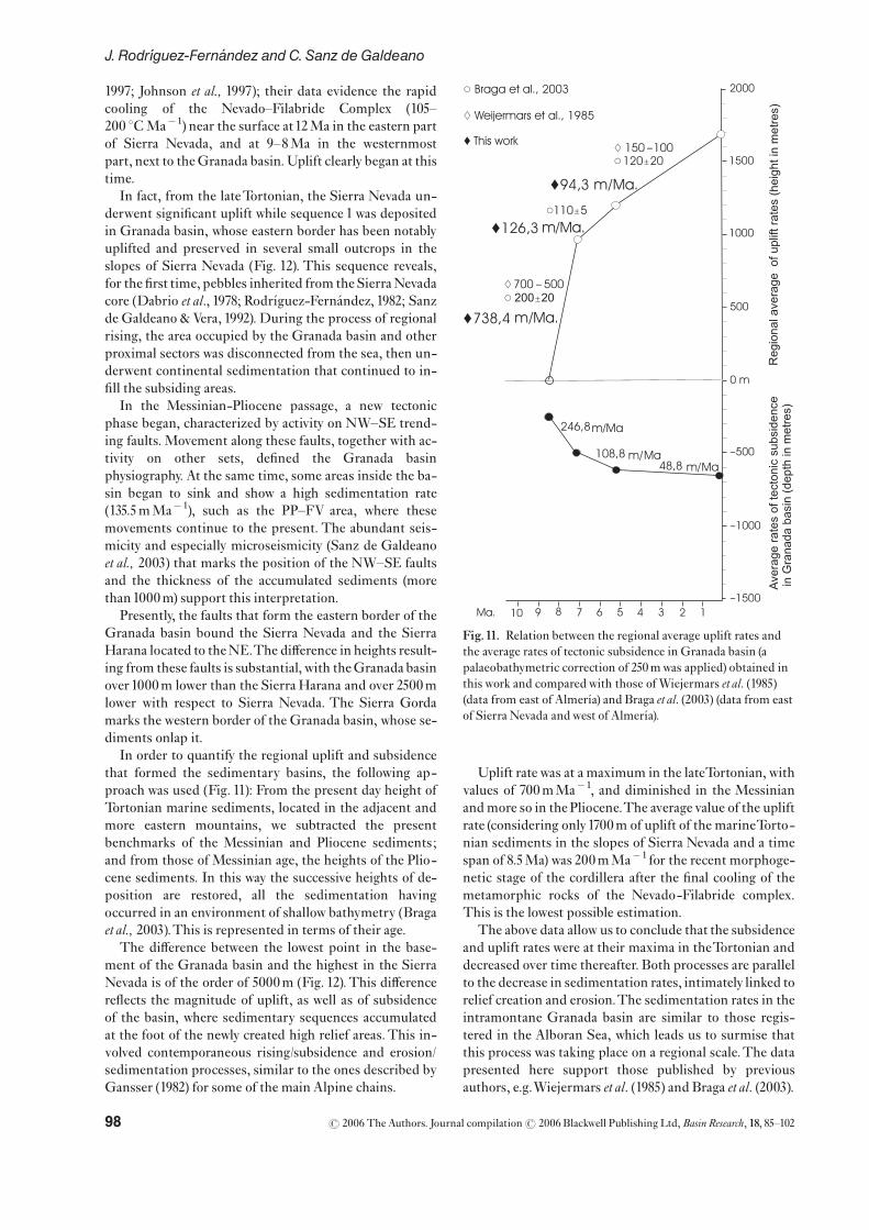
In order to quantify the regional uplift and subsidencethat formed the sedimentary basins, the following ap-proach was used (Fig. 11): From the present day height ofTortonian marine sediments, located in the adjacent andmore eastern mountains, we subtracted the presentbenchmarks of the Messinian and Pliocene sediments;and from those of Messinian age, the heights of the Plio-cene sediments. In this way the successive heights of de-position are restored, all the sedimentation havingoccurred in an environment of shallow bathymetry (Bragaet al., 2003).This is represented in terms of their age.
The di¡erence between the lowest point in the base-ment of the Granada basin and the highest in the SierraNevada is of the order of 5000m (Fig. 12).This di¡erencere£ects the magnitude of uplift, as well as of subsidenceof the basin, where sedimentary sequences accumulatedat the foot of the newly created high relief areas.This in-volved contemporaneous rising/subsidence and erosion/sedimentation processes, similar to the ones described byGansser (1982) for some of the main Alpine chains.
Uplift rate was at a maximum in the lateTortonian, withvalues of 700mMa�1, and diminished in the Messinianandmore so in the Pliocene.The average value of the upliftrate (considering only1700m of uplift of the marineTorto-nian sediments in the slopes of Sierra Nevada and a timespan of 8.5Ma) was 200mMa�1 for the recent morphoge-netic stage of the cordillera after the ¢nal cooling of themetamorphic rocks of the Nevado-Filabride complex.This is the lowest possible estimation.
The above data allow us to conclude that the subsidenceand uplift rates were at their maxima in theTortonian anddecreased over time thereafter. Both processes are parallelto the decrease in sedimentation rates, intimately linked torelief creation and erosion.The sedimentation rates in theintramontane Granada basin are similar to those regis-tered in the Alboran Sea, which leads us to surmise thatthis process was taking place on a regional scale.The datapresented here support those published by previousauthors, e.g.Wiejermars et al. (1985) and Braga et al. (2003).
Fig.11. Relation between the regional average uplift rates andthe average rates of tectonic subsidence in Granada basin (apalaeobathymetric correction of 250mwas applied) obtained inthis work and comparedwith those ofWiejermars et al. (1985)(data from east of Almer|¤ a) and Braga et al. (2003) (data from eastof Sierra Nevada andwest of Almer|¤ a).
r 2006 The Authors. Journal compilationr 2006 Blackwell Publishing Ltd,Basin Research, 18, 85^10298
J. Rodr|¤guez-Ferna¤ ndez and C. Sanz de Galdeano

In theAlboran Sea, as in theGranada basin, after a stra-tigraphic gap, sedimentation was renewed at 8.5Ma (lateTortonian).TheMessinian sediments are scarce and linkedto an important unconformity on a regional scale; whereasthe sediments of Pliocene and Pleistocene age are repre-sented by thick marly deposits with discontinuities at dif-ferent heights of the sections. The same occurs in theGranada basin, where subsidence and sedimentation ratesdecrease from the Tortonian to the Pliocene^Pleistocene(Rodr|¤ guez-Ferna¤ ndez et al.,1999).
From a tectonic point ofview, the situation in theAlbor-an Sea was very similar, with a compressive stage com-bined with a near perpendicular extension in the lateTortonian that produced a readjustment of thewhole basinand the reactivation of old faults in a transcurrent regime(Zahn et al., 1999).This readjustment compartmentalizedthe basin and enhanced structural features, such as theAl-boran High. During this time some strike-slip faults, in-cluding the Carboneras fault (Fig. 1), continued o¡shore(Rodr|¤ guez-Ferna¤ ndez & Comas, 1999).
The rising of the region is very substantial, yet di¡ersfrom place to place. The Sierra Nevada summit rose ofthe order of 5000m in relation to some points of the base-ment of the Granada basin that straggled behind. Theserising and sinking movements were facilitated by the dis-placement of the faults described.
Finally, other analyses of subsidence in theBeticCordil-lera likewise demonstrate that during the late Miocene^Pliocene the basins located in the Internal Zone and theValencia trough underwent important subsidence and up-lift processes (Janssen et al., 1993; Soria et al., 1998, 2001;Hanne et al., 2003).
The previous data draw a geodynamic scenario inwhichthe Granada basin was formed by tectonic subsidencebecause of cortical stretching. Very brie£y, the proposedscenario is:
During the middle Miocene to the earlyTortonian, theinternal zone of the Betic Cordillera was a¡ected by tec-tonic extension that produced subsidence, thereby facili-tating the marine invasion that occurred in the lateTortonian (8.5Ma). In the Granada basin, this subsidencewas more active in the depocentres controlled by 701N-901E faults.At the end of theTortonian, the situation chan-
ged because the approximately north^south convergencebetweenAfrica and Iberiawas renewed (Sanz deGaldeano,1988; Galindo-Zald|¤ var et al., 1993, 1999; Rodr|¤ guez-Fer-na¤ ndez & Mart|¤ n-Penela, 1993; Buforn et al., 1995; Rodr|¤ -guez-Ferna¤ ndez & Comas, 1999; Sanz de Galdeano &Alfaro, 2004). From this time, NNW to N^S compressionwas established in the Betics and the Alboran basin, com-binedwith an important, and nearly perpendicular, exten-sion.This compression produced antiforms in the internalzone (Galindo-Zald|¤ var et al., 2003; Sanz de Galdeano andAlfaro, 2004).The uplift of several areas, including SierraNevada itself, was contemporaneous with subsidence inGranada and other neighbouring intramontane basins.This process, enhanced by the displacement of NW^SEfaults in Granada basin, continues up to the present. Ac-cording to the previous data, the documented in£uenceof extensional faults, combined with the subsidence his-tory, we interpret that the Granada basin is an intramon-tane basin driven by extension, perpendicular to theNNW^SSE compression, linked to the tectonic denuda-tion of the surrounding areas.
CONCLUSIONS
As a result of reinterpreting the seismic pro¢les of theGranada basin, revising the micropalaeontological con-tent of the marine sediments and processing and quantify-ing all the available numeric parameters, we arrive at thefollowing conclusions, some of them put forth for the ¢rsttime:
The marine incursion that deposited sequence 1 can bedelimited in time from 8.5 to 7.2Ma ^ that is, lasting only1300 000 years. During this time the Granada basin waspart of another more extensive basin. The retreat of thesea in the Granada basin is not attributable to global eu-static £uctuations but rather to vertical readjustment ofthe basement as a consequence of the rising of Sierra Ne-vada and its adjacent areas. At the beginning of Pliocene^Pleistocene times, the Granada basin acquired its currentphysiography.
During the lateTortonian, aNNW^SSE direction com-pression and an ENE^WSWextension are registered.This
Fig.12. Section across the Sierra Nevada andGranada basin, indicating the complex distribution in the internal zone as well as themain tectonic contact in between.The di¡erent grey shades are equivalent to those of Figs 4, 5 and 8.Vertical scale is enhanced.
r 2006 The Authors. Journal compilationr 2006 Blackwell Publishing Ltd,Basin Research, 18, 85^102 99
Late orogenic intramontane basin

extension is clearly present in the Granada basin, and hascontrolled the sense of fault displacement.The persistenceof the depocentres and subsidence axes in an identical po-sition during the deposition of several sequences is in-ferred to be the result of the repeated displacements ofthe main faults.
The faults observed in the seismic pro¢les have thesame directions as those that crop out at the borders ofthe basin. In general, two well-de¢ned sets are observed,the ¢rst showing N 70^90 E direction, with fault planesslightly dipping toward north and south that de¢ne themain subsiding areas of approximate E^W direction.Thesecond set, with a NW^SE direction, cuts and displacesthe previous ones and de¢nes the main subsiding areas ofthe eastern part of the basin.
Subsidence was at a maximum in the lateTortonian, de-creased in the Messinian and was even less in the Plio-cene^Pleistocene. A similar process is observed with thesedimentation rates: during sequence 1 the subsidencerate became greater than that of sedimentation; andduring sequences 2 and 3 the sedimentation rate wasslightly greater than subsidence, seen mainly in the PP^FVarea.
The rising of the mountains varied in rate, roughly inaccordance with the subsidence in the Granada basin.The rate reached a maximum in the lateTortonian, dimin-ished in theMessinian and further diminished in the Plio-cene.
The formation of theGranada basin can thus be seen aspart of the morphogenetic and neotectonic evolution ofthe Betic Cordillera from the late Miocene to the presentand as a corollary, we propose that the mechanism ofsubsidence in Granada basin and the coeval upliftingof the surroundings relief, mainly Sierra Nevada,was consequence of faulting induced by crustal stretchingsubsequently to a period of tectonic denudation in a pro-cess in which a near N^S compression combined withan important and approximately perpendicular crustalextension.
ACKNOWLEDGEMENTS
We would like to thank Chevron Oil Company and Dr J.Morales for providing several seismic pro¢les,Dr J.Galin-do-Zald|¤ var for his help in digitizing data, and Dr J.A.Mart|¤ n-Pe¤ rez for the determination of the foraminiferaand calcareous nannoplankton; also to Drs J. Carlos Bragafrom the University of Granada and P. Friend from Cam-bridge University for their useful suggestions for improv-ing the manuscript. Our thanks to M. Pe¤ rez Arlucea fromVigo University, G. Postma from Utrecht University, M.Marzo from the University of Barcelona, and to Dr A.Hartley andDr P.Van der Beek for their criticism andveryhelpful comments. This study received funding throughprojects: CGL2004-03333/BTE and CGL2004-01636 ofthe DGESIC, and the RNM 0163 and RNM 217 groupsof the Junta de Andaluc|¤ a.
REFERENCES
Allen, P. & Allen, J.R. (1990) Basins Analysis Principles and Ap-plications. Blackwell Scienti¢c Publications, Oxford, London,451pp.
Balanya¤ , J.C.&Garc|¤ a-Duen� as,V. (1987)Les directions struc-turales dans le Domaine d’Alboran de parts et d’outre du De¤ -troit de Gibraltar.C. R. Acad. Sci. Paris, 304, 929^933.
Banda, E., Gallart, J., Garc|¤ a-Duen� as,V., Dan� obeitia, J.J.&Makris, J. (1993)Lateral variation of the crust in the IberianPeninsula ^ new evidence from the Betic Cordillera. Tectono-physics, 221, 53^66.
Berggren, W.A., Kent, D.V., Swisher, C.C. & Auby, M.P.
(1995) Revised cenozoic geochronology and chronostratigra-phy. SEMPSpec. Publ., 54, 129^212.
Braga, J., Mart|¤n, J. & Alcala¤ , B. (1999) Coral reef incoarse-terrigenous sedimentary environments (UpperTorto-nian, Granada Basin, southern Spain). Sediment. Geol., 66,135^150.
Braga, J.,Mart|¤n, J.&Quesada,C. (2003) Patterns and averagerates of late Neogene-Recent uplift of the Betic Cordillera, SESpain.Geomorphology, 50, 3^26.
Buforn,E.,Sanz deGaldeano,C.&Ud|¤ as,A. (1995)Seismo-tectonics of the Ibero-Maghrebian region.Tectonophysics, 248,247^261.
Cloetingh, S., Vanderbeek, P.A., Vanrees, D., Roep, T.B.,Biermann, C. & Stephenson, R.A. (1992) FlexuralInteraction and the dynamics of Neogene extensional basinformation in the Albora¤ n-Betic region. Geo-Mar. Lett., 12,66^75.
Dabrio, C., Garc|¤ a-Yebra, R., Gonza¤ lez Donoso, J.M. &Vera, J.A. (1972) Turbiditas asociadas a evaporitas (Mioceno,LaMala¤ , Depresio¤ n de Granada.Cuad. Geol., 3, 139^164.
Dabrio,C. & Ferna¤ ndez, J. (1986) Depo¤ sitos de r|¤ os trenzadosconglomera¤ ticos plio-pleistoce¤ nicos de laDepresio¤ n deGran-ada.Cuad. Geol. Ibe¤ r., 10, 31^53.
Dabrio, C., Ferna¤ ndez, J., Pen� a, J.A., Ruiz-Bustos, A. &Sanz de Galdeano, C. (1978) Interpre¤ tation se¤ dimentairedes mate¤ riaux ne¤ oge' nes dubord nord-est dubasin deGrenade(Espagne).C.R. Som. Soc. Ge¤ ol Fr., 121^123.
Dinare¤ s, J., Ort|¤ , F., Playa¤ , I. & Rosell, L. (1999) Paleomag-netic chronology of the evaporitic sedimentation in the Neo-gene Fortuna Basin (SE Spain): early restriction preceding the‘‘Messinian Salinity Crisis’’. Palaeogeogr. Palaeoclimatol. Palaeoe-col., 154, 161^178.
Durand-Delga,M. (1980) LaMe¤ diterrane¤ e occidentale: e¤ tapede sa gene' se et proble' mes structuraux lie¤ s a' celle-ci. Livre Ju-bilaire de la Soc. ge¤ ol. de France, 1830^1980. Mem. H. Se¤ r.S.G.F., 10, 203^224.
Este¤ vez, A., Lo¤ pez-Garrido, A.C., Rodr|¤ guez-Ferna¤ ndez,J., Alberdi, M.T. & Ruiz-Bustos, A. (1982) On the Mio-cene^Pliocene age of the detrital-series from the western partof theGranada Basin (South Spain).C.R.Acad. Sci. Se¤ r. Il, 294,1187^1190.
Ferna¤ ndez, J.&Rodr|¤ guez-Ferna¤ ndez, J. (1991)Facies evolu-tion of nearshore marine clastic deposits during the tortoniantransgression ^ Granada Basin, Betic Cordilleras, Spain. Sedi-ment. Geol., 71, 5^21.
Galindo-Zald|¤ var, J., Gil, A.J., Borque, M.J., Gonza¤ lez
Lodeiro, F., Jabaloy, A., Mar|¤n-Lechado, C., Ruano, P.& Sanz de Galdeano, C. (2003) Active faulting in the inter-nal zones of the central Betic Cordilleras (SE, Spain). J. Geo-dyn., 36, 239^250.
r 2006 The Authors. Journal compilationr 2006 Blackwell Publishing Ltd,Basin Research, 18, 85^102100
J. Rodr|¤guez-Ferna¤ ndez and C. Sanz de Galdeano

Galindo-Zald|¤ var, J.,Gonza¤ lez-Lodeiro, F. & Jabaloy, A.(1993) Stress and palaeostress in the Betic-Rif cordilleras(Miocene to the present).Tectonophysics, 227, 105^126.
Galindo-Zald|¤ var, J., Jabaloy,A., Serrano, I.,Morales, J.,Gonza¤ lez-Lodeiro, F. &Torcal, F. (1999) Recent and pre-sent-day stresses in the Granada Basin (Betic Cordilleras): ex-ample of a late Miocene-present-day extensional basin in aconvergent plate boundary.Tectonics, 18, 686^702.
Gansser,A. (1982) The morphogenic phase of mountain build-ing. In: Mountain Building Processes (Ed by J.K. Hsˇ), pp. 221^228. Academic Press, NewYork.
Garce¤ s,M.,Krijgsman,W. & Agust|¤ , J. (1998) Chronology ofthe lateTurolian deposits of the Fortuna basin (SE Spain): im-plications for the Messinian evolution of the eastern Betics.Earth Planet. Sci. Lett., 163, 69^81.
Garc|¤ a-Duen� as, V., Balanya¤ , J.C. & Mart|¤nez-Mart|¤nez,J.M. (1992) Miocene extensional detachments in the outcrop-ping basement of the northern Albora¤ n Basin (Betics) andtheir tectonic implications.Geo-Mar. Lett., 12, 88^95.
Geel,T. (1995) Oligocene to early Miocene tectono-sedimen-tary history of the Alicante region (SE Spain). Implication forwesternMediterranean evolution.Basin Res., 7, 313^336.
Gime¤ nez, J., Surinach, E. &Goula, X. (2000) Quanti¢cationofvertical movements in the easternBetics (Spain) by compar-ing levelling data.Tectonophysics, 317, 237^258.
Hanne,D.,White,N.&Lonergan,L. (2003) Subsidence ana-lyses from the Betic Cordillera, southeast Spain.Basin Res., 15,1^21.
Hardenbol, J.,Thierry, J., Farley, M.B., Jacquin,T., Gra-
ciansky, P.C. & Vail, P. (1998) Mesozoic and cenozoic se-quence chronostratigraphic chart. In: Mesozoic and CenozoicSequence Stratigraphy of Europen Basins (Ed by P.C. Graciansky,J. Hardenbol,T. Jacquin & P.Vail), SEMPSpec. Publ., 60.
Iaccarino, S. (1985) Mediterranean Miocene and Plioceneplanctonik foraminifera. In: Plankton Stratigraphy (Ed by H.M.Bolli, J.B. Saunders & K. Perch-Nielsen), pp. 283^314. Cam-bridge University Press, Cambridge.
Janssen,M.E.,Torne¤ ,M., Cloetingh, S. & Banda, E. (1993)Pliocene uplift of the eastern Iberian margin: inferences fromquantitative modelling of theValenciaTrough.EarthPlanet. Sci.Lett., 119, 585^597.
Johnson, C. (1993) Contrasted thermal histories of di¡erentnape complexes in S.E. Spain: evidence for complex crustal ex-tension. In: Late Orogenic Extension in Mountain Belts (Ed byBRGM EŁ ditions), document 219, p.103,Montpellier, France.
Johnson,C. (1997)Resolving denudational histories in orogenicbelts with apatite ¢ssion-track thermochronology and struc-tural data: an example from southern Spain. Geology, 25, 623^626.
Johnson, C.,Harbury,N. &Hurford, A.J. (1997) The role ofextension in the Miocene denudation of the Nevado-Fila¤ b-ride, Betic Cordillera (SE Spain).Tectonics, 16, 189^204.
Monie¤ ,P.,Galindo-Zald|¤ var, J.,Lodeiro,F.G.,Goffe,B.&Jabaloy, A. (1991) Ar-40/Ar-39 geochronology of alpine tec-tonism in the Betic Cordilleras (Southern Spain). J. Geol. Soc.,148, 289^297.
Montenat,C.,Rodr|¤ guez-Ferna¤ ndez, J.,Ott d’Estevou, P.& Sanz de Galdeano, C. (1990) Geodynamic evolution ofthe Betic Neogene intramontane basins (S and SE Spain). In:Iberian Neogene Basins. Mem. Spe. 2 (Ed by J. Agusti, R. Dome¤ -nech & R. Julia' ), pp. 6^59. Institut de Paleontolog|¤ a MiguelCrusafonf, Sabadell.
Morales, J.,Vidal,F., deMiguel,F.,Alguacil,G., Posadas,A.M., Iba¤ n� ez, J.M., Guzma¤ n, A. & Guirao, J.M. (1990)Basement structure of the Granada basin, Betic Cordilleras,southern Spain.Tectonophysics, 177, 337^348.
Okada,H.&Bukry,D. (1980) Supplementary modi¢cation andintroduction of code numbers to the low latitude cocolith bios-tratigraphic zonation (Bukry, 1973, 1975). Mar. Micropaleontol.,5, 321^325.
Platt, J. &Whitehouse,M.J. (1999) Early Miocene high-tem-perature metamorphism exhumation in the Betic Cordillera(Spain): evidence fromU-Pb zircon age. Earth Planet. Sci. Lett.,171, 591^605.
Rodr|¤ guez-Ferna¤ ndez, J. (1982) El Mioceno del SectorCentral de las Cordilleras Be¤ ticas. PhD Thesis, Granada,224 pp.
Rodr|¤ guez-Ferna¤ ndez, J. & Comas, M.C. (1999) The role ofthe strike-slip tectonics in the evolution of the Albora¤ n Sea,Western Mediterranean. 6Th International Congress of the Brazi-lian Geophysical Society, Rio de Janeiro, pp.1^3.
Rodr|¤ guez-Ferna¤ ndez, J., Comas, M.C., Soria, J., Mart|¤n-
Pe¤ rez, J.A. & Soto, J.I. (1999) The sedimentary recordof the Albora¤ n Basin: attempt of correlation and subsidenceanalysis. In: Proceedings of the Ocean Drilling Program, Scienti¢cResults (Ed by R. Zahn, M.C. Comas & A. Klaus).Vol. 61, pp. 69^76. College Station, Texas, EEUU OceanDrilling Program.
Rodr|¤ guez-Ferna¤ ndez, J., Ferna¤ ndez, J., Lo¤ pez-Garrido,A.C. & Sanz de Galdeano, C. (1984) The Central Sector ofthe Betic Cordilleras, a realm situated betwen the Atlanticand Mediterranean domains during the upper Miocene. Ann.Geol. Pays. Hell., 32, 97^103.
Rodr|¤ guez-Ferna¤ ndez, J.,Sanz deGaldeano,C.&Ferna¤ n-
dez, J. (1989)Genesis and evolution of theGranada Basin (Be-tic Cordillera, Spain). In: Proceedings of the InternationalSymposium on Intermontane Basins; Geology and Resources (Ed byT.Theerapongs & O. Prayote), pp. 294^305. ChiangMai,Thai-land.
Rodr|¤ guez-Ferna¤ ndez, J. &Mart|¤n-Penela, A. (1993) Neo-gene evolution of the Campo de Dalias and the surroundingo¡shore areas ^ (Northeastern Albora¤ n Sea). Geodyn. Acta, 6,255^270.
Ruiz-Bustos, A. (2002) Caracter|¤ sticas Clima¤ ticas y Estratigra¤ -¢cas de los Sedimentos continentales de la Cordilleras Be¤ ticadurante el Plioceno a partir de las Faunas de Mam|¤ feros. Plio-ce¤ nica, 2, 44^64.
Ryan,W.B.F. (1976) Quantitative evaluation of the depth of thewestern Mediterranean before, during and the Late Miocenesalinity crisis. Sedimentology, 23, 791^813.
Sanz de Galdeano,C. (1988) The fault system and theNeotec-tonic features of the Betic Cordilleras. In: Fifth E.G.T.Workshop‘‘The Iberia Peninsula’’. Estoril (Ed By E. Banda & V. Mendes),Eur. Sci. Found., 1, 99^109.
Sanz de Galdeano, C. (1990) Geologic evolution of the BeticCordilleras in thewesternMediterranean,Miocene to the pre-sent.Tectonophysics, 172, 107^119.
Sanz de Galdeano, C. & Alfaro, P. (2004) Tectonic signi¢ -cance of the present relief of the Betic Cordillera.Geomorphol-ogy, 63, 178^190.
Sanz de Galdeano,C.&Lo¤ pez-Garrido,A.C. (1999)Natureand impact of the Neotectonic deformation in the westernSierra Nevada (Spain).Geomorphology, 30, 259^272.
r 2006 The Authors. Journal compilationr 2006 Blackwell Publishing Ltd,Basin Research, 18, 85^102 101
Late orogenic intramontane basin

Sanz de Galdeano, C., Pela¤ ez, J.A. & Lo¤ pez, C. (2003) Seis-mic potentiality of the main active faults in the Granada Basin(south of Spain). Pure Appl. Geophys., 160, 1537^1556.
Sanz de Galdeano,C.&Vera, J.A. (1992) Stratigraphic recordand palaeogeographical context of the Neogene basins in theBetic Cordillera, Spain.Basin Res., 4, 21^36.
Sclater, J.G. & Christie, P.A.F. (1980) Continental stretchingand explanation of the post-mid-cretaceous subsidence of theNorth Sea basin. J. Geophys. Res., 85, 3711^3739.
Soria, J.M., Alfaro, P., Fernandez, J. & Viseras, C. (2001)Quantitative subsidence-uplift analysis of the Bajo Segura Ba-sin (eastern Betic Cordillera, Spain): tectonic control on thestratigraphic architecture. Sediment. Geol., 140, 271^289.
Soria, J., Viseras, C. & Ferna¤ ndez, J. (1998) LateMiocene^Pleistocene tectono-sedimentary evolution andsubsidence history of the central Betic Cordillera (Spain): acase study in the Guadix intramontane basin. Geol. Mag., 135,565^574.
ten Veen, J.H. & Postma,G. (1999a) Neogene tectonic and ba-sin ¢ll patterns in theHellenic outer-arc (Crete, Greece).BasinRes., 11, 223^241.
ten Veen, J.H. & Postma,G. (1999b) Roll-Back controlled ver-tical movement of outer-arc basins of the Hellenic subductionzone (Crete, Greece).Basin Res., 11, 243^266.
VanHouten,F.B. (1981)TheOdyssey ofMolasse. In:Sedimenta-tion and Tectonics in Alluvial Basins (Ed by A.D. Miall. Toronto.Geol. Assoc. Canada, Special Paper 23, 35^48.
Watts,A.B., Platt, J.P.& Buhl, P. (1993) Tectonic evolution ofthe Albora¤ n Sea basin.Basin Res., 5, 153^177.
Wiejermars,R.,Roep,T.,Van den Eeckhout, B., Postma,G.
& Kleverlaan, K. (1985) Uplift history of a Betic fold napeinferred from Neogene-Quaternary sedimentation and tec-tonics (in the Sierra Alhamilla andAlmeria, Sorbas andTaber-nas Basins of the Betic Cordilleras, SE Spain). Geol. Mijnbow,64, 397^411.
Zahn, R., Comas, M.C. & Klaus, A.), (eds) (1999) Science Results,161Proceedings of ODP (Ocean Drilling Program). Collage Station,Texas.
Manuscript received 6 September 2004; Manuscript accepted 23January 2006.
r 2006 The Authors. Journal compilationr 2006 Blackwell Publishing Ltd,Basin Research, 18, 85^102102
J. Rodr|¤guez-Ferna¤ ndez and C. Sanz de Galdeano