beaver creek snagging & clearing preliminary engineering ... · fallen t,rees, driftwood,...
TRANSCRIPT
PRELIMINARY ENGINEERING REPORT
BEAVER CREEKSNAGGING & CLEARINGEMMONS COUNTYSWC PROJECT NO. 558-1
LINTON
OAHERESERVOlR
cal
b
NORTH DAKOTA STATE WATER COMMISSIONJANUARY 1988
( \
-4À.^^-î.f^þa t)\
^ (ñì-^4 sìr)
o l¡t

lu Å^,¿t
PRH,II'IINARY ENGINEMING REPORT
BEAVER CREEKSNAGGilfG AND CLEABING PROJECT
EIUMONS COTJNTYsr{c PRoJEcr #558-L
North Dakota State Water CornmissÍonState Office Buildi¡rg
pOO East BoulevardBismarck, ND 58505-0187
E
Todd Sa¡rdoInvestigations Engineer
Director of Engineering
Prepared for theEmnons County I'laterResource Board
E
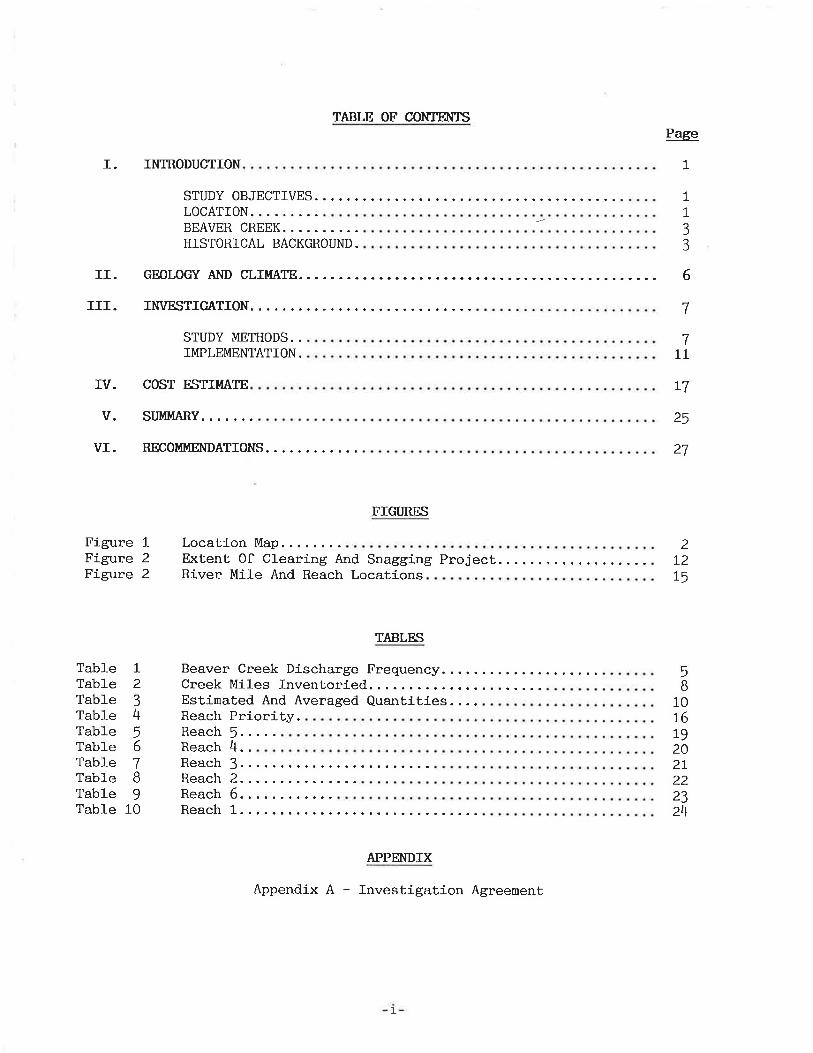
TABLE OF CONTENTS
I. INTRODUCTION
Page
1
STUDY OBJECTIVES.... 1133
LOCATION.BEAVER CREEK.HISTORICAL BACKGROUND.
II. GEOLOGY AND CLI!,IATE
III. INVESTIGATION..
STUDY METHODS..IMPLEMENTATION.
IV. COST ËSTIMATE
V. STJMMARY.
VI. RECOMMENDATIONS.
FIGURtrS
Figure 1Figure 2Figure 2
Location Map..Extent 0f Clearing And Snagging ProjectRiver Mile And Reach Locations
TABLES
6
7
711
L7
25
27
2T21,5
Table 1Table 2Table 3Table 4Table 5Table 6Table 7Table BTab1e 9Table 10
Beaver Creek Discharge FrequencyCreek Miles Inventoried.. .Estinated And Averaged Quantities. ...Reach Priority.Reach 5.....Reach 4..
5B
10I6L9202l222324Reach 1....
Reach 6....
APPENDIX
Appendix A - Investigation Agreenent
Reach 3....Reach 2....
1
I. INTRODUCTION
SI'TIDY OBJECTIVES
In April of 1987, the North Dakota State Water Conmission enLered into a¡r
agreement with the City of Linton and the Emmons Countylater Resource Board to
investigate and determine the feasibility of a snagging and clearing project on
Beaver Creek in Emmons County. A copy of the agreement is included in Appendix
A. The purpose of the investigation is to determine the condition of the riverchannel, aid in correcting stream flow problems caused by obstructions, and
evaluate the relative hydraulic effects of a snagging and clearing project.
As a part of the investigation, ground creh¡s ínspected. the project area and
inventoried the material that should be removed from the primary cha¡lnel. This
report contains a description of the study area and the proposed snagging and
clearing project, a suggested schedule for the project considering a phased
inplenentation, and a detailed cost estimate for each proposed phase of the
project.
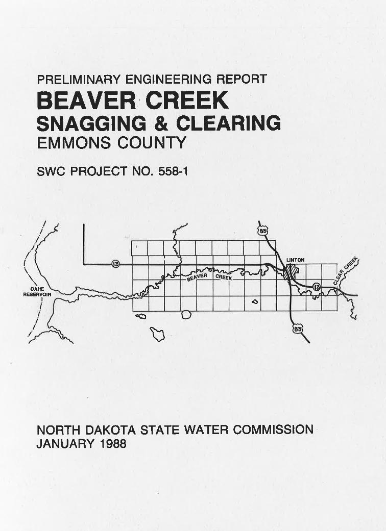
LOCATION
The project is located in south-central North Dakota. The project issituated in Emmons County, with the upstream portion of the project lying east
of Linton. The project limits start on the east side of the Corps of Engi-neers
property, 23 river niles downstream from the confluence of Beaver and Spring
Creek and foll-ow the creek approxinately 33 river miles. The project limits end
at the confluence of Beaver Creek and Clear Creek located east of Linton. The
project begins at the west edge of Section 14, Township 112 North, Range 78 l,r¡est
and follows the creek to the souLheast corner of Section 15, Township 112 North,
Range 76 t^lest. Figure l shows the l-ocation of the proposed project.
7

/ R78W R77W('¡0 R76W
//
//l
T 3 N
\.\
N)
\oA+{s,
RUâERVOì
lR,
I1I "CJ EMMONS COUNTY
BEAVER CREEKSnogging & Cleoring
Reoches lnventoried
F igure I Locotion Mo p
PRo,lærsY//t
N1
I
LI
ô
7
6
/\
ã
c
PROJECTotNOE
BEAVER CREEK
Beaver Creek flows in a westerly direction and enters Oahe Reservoir about
60 river miles downstream from Bisnarck. The Beaver Creek basin is about 30
nj-les wide and !l miles ì-ong with a total drainage area-of approximately 1,000
square miles. The toLal drainage area upstream from Linton is approximately J20
square miles, of which 453 niles contributes to peak runoff. Spring Creek,
which drains a 4t square mile area north of Linton, joins Beaver Creek at the
west edge of the city. The land areas upstrean from Linton are composed ofgently rolling grass range land and cultivated fields planted chiefly to small
grains.
Beaver Creek, which has a valley approximately I/Z-niLe wide, winds si-nuously through the southwest side of Lint,on. The channel averages a 2O-foot
bottom width and is 72 feeL deep. Beaver Creek has an average slope of 2.f feetper mile in the project area. Beaver Creek valley is bordered by steep bl-uffsrising roughly 300 feet above the valley floor. The valley contains a largeanount of trees v'rhich l-ine the river bank in most areas. The CiLy of Linton and
a number of rural dwellings and farns are also located along the rj-ver channel
in the project area.
HISTORICAL BACKffiOTJND
Spríng snowmelt and heavy rains often result in flooding on Beaver Creek.
The prinary source of the flood r,vaters is the winter's accunulation of snow-
fall. The depth of frost in the ground at break-up time and the condition ofthe river channel affect the stages of the spring floods. Frozen earth contri-butes to larger runoff by preventing infiltration. A channel in poor conditiondue to fall-en trees, stumps, snags and general debris has a reduced ability to
-3-

transport q¡ater. The obstructíons cause blockage
drifts of packed snow which result in higher stages.
tion of rains over a short period of time in the
provide conditions for floods during the warm season.
of the channel by ice or
Heavy rain or a combina-
late spring or summer can
Historically, floods in Linton happen only once a year. There is no record
of Linton experiencing both a large spring flood and a flood resulting from
heavy rainfall in the same year. It is not unusual for Linton to experience two
crests of flooding, one from Spring Creek and another from Beaver Creek. Fortu-nately, conditions that would cause Spring Creek and Beaver Creek to crest atthe s¿Ìne time occur infrequently. Spring Creek and Beaver Creek have peaking
tines of 6 hours and 48 hours, respectively.
Linton has experienced 20 floods fron 1!14 to L987. There were floods inrhe years t9r4, 19L6, 1926, L927, L934, 1939, 1943, L944, t94j, 1948, L95o,
t952, 1953, L956, 1969, 1972, L977,7978, 1987. Based on rhis informarion, rhe
frequency of a flood occurring in Linton is one approxinately every 3.7 years.
April of t952, is the year of the largest recorded flood in Linton. A flow of9,800 cfs was recorded.
A frequency analysis h¡as conputed on the Linton gaging station. This
analysis followed the guidelines of I4IRC Bulletin #I7B ald data obtained fronI4IATSTORE. The discharge frequency curve was computed for the 1950 through 1tB6
htater year gaging record. The resulting frequency curve was compared with the
1!80 flood Insurance Study (FIS) frequency curve and is shown in Table 1.
-4-
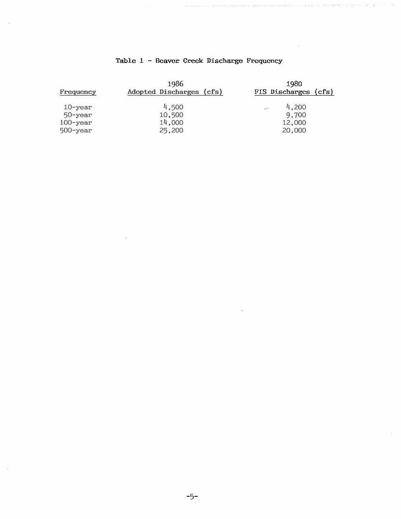
Tabl-e 1 - Beaver Cneek Discharge Frequency
lgBoFIS Discharges (cfs)
-5-
II. GEOLOGY AND CLIIT{ATE
Beaver Creek watershed is located on the southeast flank of the trrlillistonBasin, an intracratonic, structural basin consisting of a thíck sequence ofsedimentary rocks. The project lies within the Coteau Súpu, an area of rollingto hil1y plains east of the Missouri River. The Coteau Slope is characterized
by both erosional and glacial land forms. The topography of the Coteau Slope isa rolling to hiIly, mature plateau.
Through much of Beaver Creek Basin, the land is an u¡rdulating to rollingsurface of Fox HiIIs formation sand. Fox Hills bedrock sand i-s the nain surfacematerial with patches of glacial sedinent and wind blown naterial. In the
Linton area, Beaver Creek has eroded downward into the Pierre Fornation.
Summers are usually hot and dry with periods of prolonged high temperature
occurringi from May through Septenber. l{inters are cold and dry and subject tosevere blizzards. The extremes in temperature range from 116"F to a low of-52"F. The normal mean temperature in the basin is about 43"f'witn a January
normal ne¿m of 10'F and a July nornal mean of 72"F. The growing season iscomparatJ-vely short averaging about l2O days from the latter parts of May toSeptember.
The normal annual precipitation forwhich about 74.6 inches occur during the
the basin averages about 18 inches, of
Snowfall over the basin averages about 35
20 percent of the annual precipitation.
period from April through September.
inches per year and amounts to about
-6-

III. INVES'TIGATION
STT]DY METHODS
The fj-rst step in the creek survey began with an aerial survey over the
study area. The aerj-al survey was used to view the problen areas and aid indetermining ingress and egress routes. Still and video photography was taken
for documentation purposes during the flight. Once the aerial survey was con-
pleted a ground survey was init,iated along the study area. The purpose of the
ground survey h¡as to develop a field inventory of the number of standing and
fallen t,rees, driftwood, snags, brush, loose stumps and trunks found within the
established project boundaries.
.State Water Conmission personnel conducted the field inventory and recon-
naissa¡rce on August 11 and 12, and continued the week of August !7, f987.
Preselected reaches of the creek channel ranging fron those containing a sparse
anount of trees to areas having a very dense tree cover h¡ere inventoried. This
approach was used due to the length of the project and severity of the problems
involved. From the reaches that were invent,oried, a correlation was made be-
tween those reaches and the non-inventoried reaches. From this correlation, the
condition of non-inventoried reaches !úas estimated. The field inventory had
complete coverage through the Linton area and good coverage upstrean and
downstream of Linton. The field 1-nventory covered 18 of the 33 creek milesinvolved in the study area. Figure 1 and Table 2 show the inventoried niles.Due to the severity of problens along the creek a large port,ion of the creek was
unnavigable by canoe. The field inventory records, ground.-based photographs,
and the aerial videotape are available at the State l{ater ComnissÍon.
7
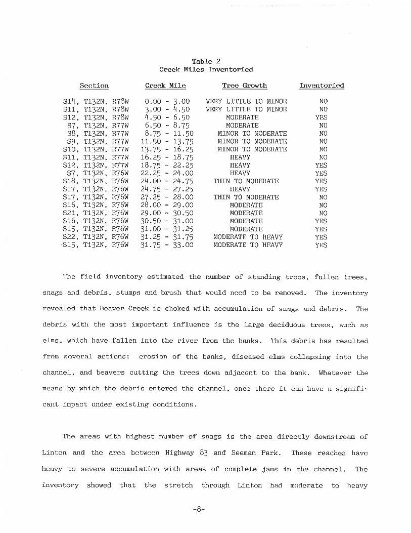
Table 2Creek l[iles Inventoried
Creek Mi].e Tr.ee Growth Inventoried
s14,s1l-,s12,
D/,SB,s9,
sl-O,s11,SLz,s7,
S1B,s17,s17,sl_6,s21,,s16,s15,s22,s15,
RTBI,\'RTBVtlR7BI4lR77l'tR77|,'R771yJR77wR77WR77\,1R76WR76v,]R76t4¡R76t4'R76vlR76l,JR76t''¡R76!'lR76lrlR76!ù
8.ls11 .50
Section
T132N,T132N,T132N,T132N,T132N,T132N,T132N,T132N,T132N,T132N,T132N,T132N,T132N,T132N,T132N,T132N,T132N,T132N,T132N,
0. o03.004 .¡o6.5o8.75
1_r-.5073.7576.2518.7522.2524.0024.7527.2528.0029.OO30.5031 .003r.253r.75
3.004.ro6.50
VERY LITTLE TO MINORVERY LITTLE TO MINOR
MODERATEMODERATE
MINOR TO MODERATEMINOR TO MODERATEMINOR TO MODERATE
HEAVYHEAVYHEAVY
THIN TO MODERATEHEAVY
THIN TO MODERATEMODERATEMODERATEMODERATEMODERATE
MODERATE TO HEAVYMODERATE TO HEAVY
NONO
YESNONONONONO
YESYESYESYES
NONONO
YESYESYESYES
13.75L6.2578.7522.2524.0024.7527.2528.0029.OO30.5031.003r.253r.7533.00
The field inventory estimated the number of standing trees, fallen trees,snags and debris, stumps and brush that would need to be removed. The inventoryrevealed that Beaver Creek is choked with accumulation of snags and debris. The
debris with the nost important influence is the large deciduous trees, such as
e1ms, which have fallen i-nto the river from the banks. This debris has resultedfrom several actions: erosion of the banks, diseased efms collapsing into the
channel, and beavers cutting the trees down adjacent to the bank. Whatever the
means by which the debris entered the channel, once there it can have a sígnifi-cant impact under existing conditions.
The areas with highest number of snags is the area directly downstream ofLinton and the area between Highway 83 and Seeman Park. These reaches have
heavy to severe accumulation with areas of complete jaus in the channel. The
inventory showed that the stretch through Linton had moderate to heav.y
B

accumulation of debris including !1 old car bodies within the banks of Beaver
Creek. The inventory also showed that Beaver Creek has a large abundance ofdead e1n trees still standing and in inminent danger of falling into the wat.er-
vûay. The rest of the inventory revealed substantial ac_cumulation of snags and
debris blockage but decreasing in magnitude as Beaver Creek approached the
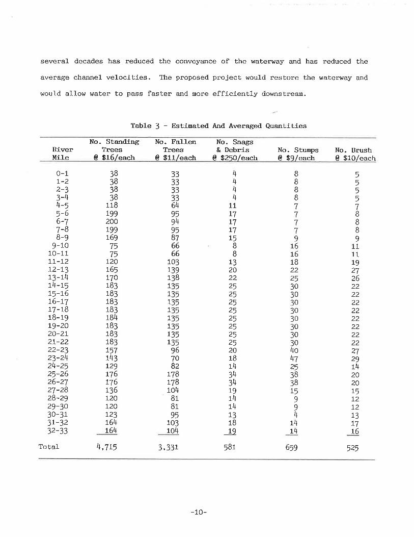
Missouri River system. Tab1e I shows the estimated quantities of materialneeded to be removed throughout the project.
HEC-2 backwater computer nodeling efforts were attenpted to evaluate the
relative benefits of the proposed project, but vvere considered inadequate toconpute lvater surface profiles. Additional cross-section data would need to be
obtained at several locations to determine the extent of reduction in hrater
surface profiles. Due to the nature of the agreement, time a¡rd funding did not
a1low additional refinenents to the backwater model.
ltlithout detailed computer mode1, the benefits of the proposed projec¡ could
not be shown in terns of flood stages. Although with the available flood insur-ance study data, effects and benefits of the proposed project could be general-
ized. The benefits would be substantial for the more frequent events. The
flood stage of large evenLs could also be reduced. The snags and debris provid.e
the opportunity for ice and debris jans to form in the spring runoflf. litith the
renoval of this material, the threat of increased stages would be reduced.
The need for a snagging and clearing project is evident from the springflood of L987. A naximum flow of 7,!BO cubic feet per second was recorded which
resulted in high water marks approxinately the same as Elne IjJZ flood of !,800cubic feet per second. The accumulation of the snags and debris over the last
-9-
several decades has reduced the conveyance of the waterway and has reduced the
average channel velocities. The proposed project would restore the waterway and
would allow water to pass faster and more efficiently downstrean.
Table 3 - Estinated And Averaged Quantities
RiverMi]-e
No. StandingTrees
@ S16/each
No. Fa].]-enTrees
No. Snags& Debris
@ $250leachNo. Stumps€ $9/each
No. Brush@ $lO/each0- srrleach
0-17-22-33-44-S5-66-77-BB-9
9-1010-r_1_rt-7272-1.313-14t4-L515-1,676-LT1-7-7818-19Lg-2020-2L21-2222-2323-2424-2525-2626-2727-2828-2929-3030-313L-3232-33
3B383838
118199200r-99r697575
720ß5770183183183183184183183183757143r29L76776t36I20720L23t64r64
3333333364959495Bl6666
103r39138L35735135r35135r35135L35967OBZ
778L7B104BrBr95
103104
4444
7L77t717t5I8
r.320222525252525252525201B1434341.9L414r31B
._958L
30303030303030304o4l253B38
BBIB77II9ß
L61B2225
55557BBB9
L711L9272622222222222222222729742020L572T2L377r6
525
t5994
1414
Total 4,7t5 3,33L
-10-
6¡g
Iì,TPLEMENTATION
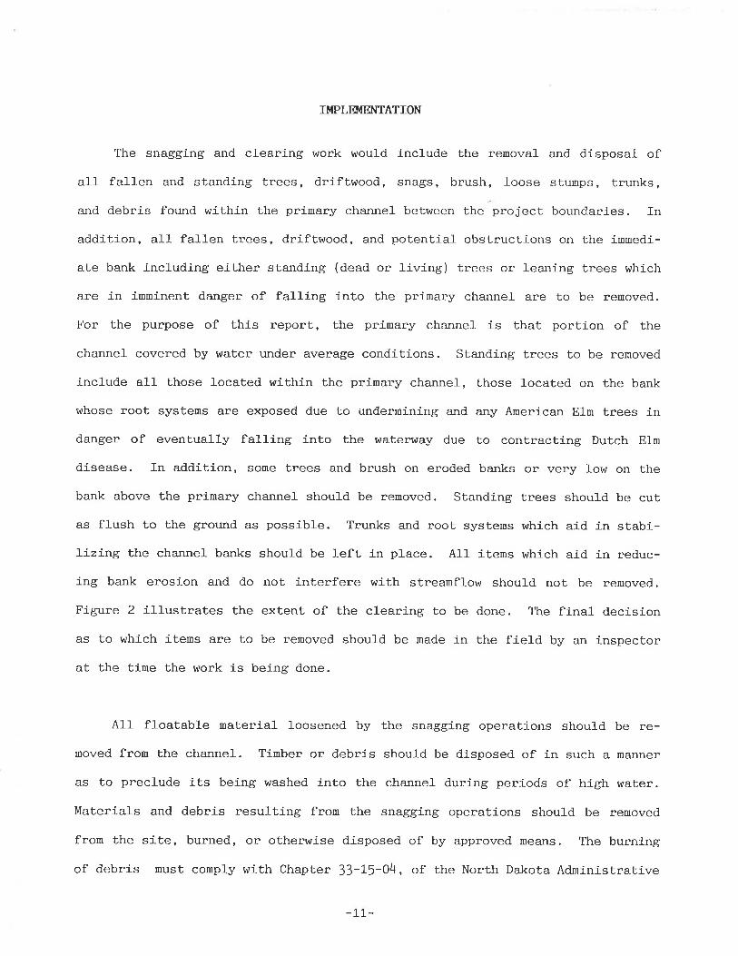
The snagging and clearing work woufd include the removal and disposal ofal1 fallen and standing trees, driftwood, snags, brush, loose stunps, trunks,and debris found within the primary channel between the project boundaries. Inaddition, all fa1Ien trees, driftwood, and potential obstrucLions on the immedi-
ate bank including either standing (dead or living) trees or leaning trees which
are in inninent danger of falling into the primary channel are to be removed.
For the purpose of this report, the primary channel- is thaL portion of the
channel covered by water under average conditions. Standing trees to be renoved
include all those located within the primary channel, those located on the bank
whose root systems are exposed due to underrnining and any American Ehn trees indanger of eventually falling into the waterway due to contracting Dutch E1n
disease. In addition, some Lrees and brush on eroded banks or very low on the
bank above the primary channel should be removed. Standing trees should be cutas flush to the ground. as possible. Trunks and root systens which aid j-n stabi-lizing the channel banks should be left in place. A1I items whích aid in reduc-
ing bank erosion and do not interfere with streamflow should. not be renoved.
Figure 2 illustrates the extent of the clearing to be done. The final decisionas to which items are to be removed should be made in the field by an inspectorat Lhe time the work is being done.
Alf floatable naterial loosened by the snagging operations should be re-moved fron the channel. Tinber or debris should be disposed of in such a manner
as to preclude its being washed into the channel during periods of high h/ater.
Materials and debris resulting from the snagging operations should be removed
from the site, burned, or otherwise disposed of by approved means. The burning
of debris must comply with Chapter 33-L5-O4, of the North Dakota Admínistrative
-LL-
ft\
Upper Limi tof Clearing
Possibly removeor thin brush
Primary Channel
tl
Primary Channel
Upper Limi tof Cìeari ng
/,tltl
( \
Io¡{ í1 l. t.
B rush
(Itt¡
(
t
Upper Limi tof Clearing
Possibly removeor thin brush
...f r,
Possibly rerlìove or thin brush
Dashed trees are to be renoved
EXTENT OF C LEAR I NG AI{D SI{AGG I ITG PROJECT
I
-12-FIGURE 2
Code. The State Health Department recommends no burning of material on the icedue to the increased carbon loadings to the waterway. The materials must be
hauled to an upland site according to the project's specificat,ions in order to
be burned. A burning pernit will be required.
Due to the interest j-n firewood, another strategy for removal is to permit
1ocal residents to cut down the trees for use as firewood.. Steps would need tobe taken to ensure that the proper trees are renoved. During the fall and
wi-nter local residents can help remove the trees. The proper permission must be
granted by landowners. One problem with this type of program for snagging and
clearing is that it is very difficult to supervise the activities of the many
people at the site during iruegular hours. This type of project has worked wellin gaining favorable public opinion, however, some type of project would be
needed to clear the areas left by the participants and remove material they leftbehind.
The State Forest Service has recommended special measures to prevent thespread of Dutch EIm disease during snagging and clearing operations. It isrecommended that the diseased trees be debarked íf rernoved from area. There isadditional recommendations if the wood is to be stored for firewood and will be
defined in project specifications.
The results of the field inventory indicate that numerous reaches of theriver channel contain excessive amounts of snags and debris so as to impairstreamflow in the cha¡rnel and cause increases ín the flood stage. Due to the
magnitude of problems encountered along Beaver Creek, a maintenance projectshould be initiated to remedy the restricted channel capacities. The project
-13-
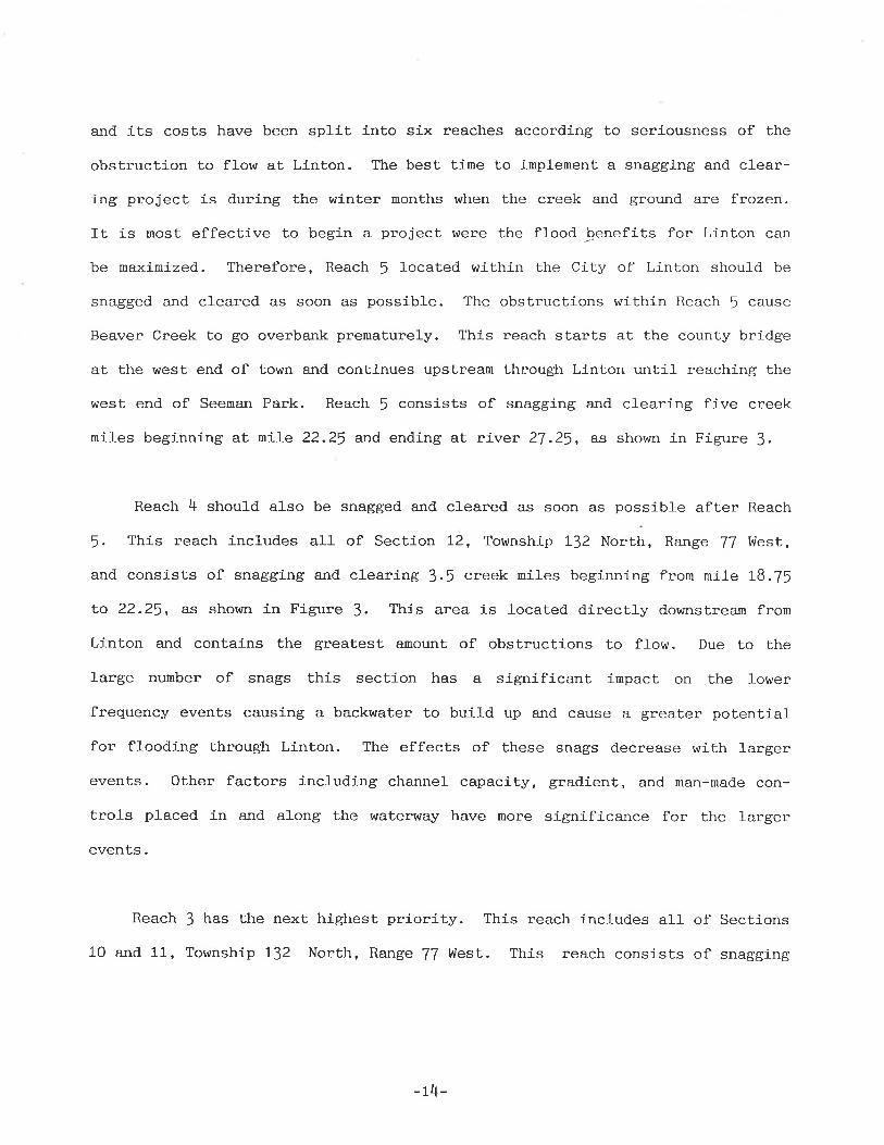
and its costs have been sp1ít into six reaches according to seriousness of the
obstruction to flow at Linton. The best time to implement a snagging arrd clear-ing project is during the winter months when the creek and ground are frozen.
It is most effective to begin a project were the flood J¡enefits for Linton can
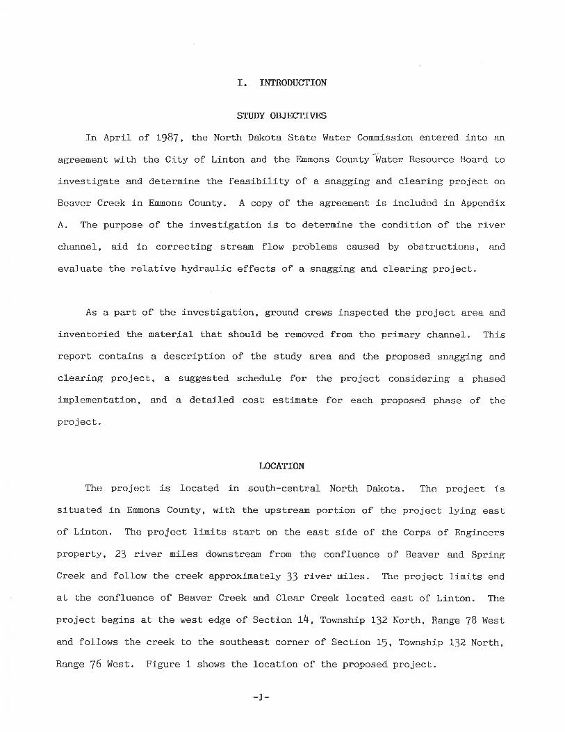
be maxinized. Therefore, Reach 5 located within the City of Linton should be
snagged and cleared as soon as possible. The obstructions wlthin Reach ! cause
Beaver Creek to go overba¡rk prematurely. This reach starts at the county bridge
at the west end of town and continues upstrean through Linton until reaching the
west end of Seenan Park. Reach I consists of snagging and clearing five creek
miles beginning at mile 22.25 and ending at river 2f.2J, as shown in Figure l.
Reach 4 should also be snagged and cleared as soon as possible after Reach
5. This reach includes all of Section 12, Township 112 North, Range J'l West,
and consists of snagging and clearing 3.1 creek miles beginning from nile 78.75
to 22.2J, as shown in Figure J. This area is located directly downstream from
Linton and contains the greatest amount of obstructions to flow. Due to the
large number of snags this section has a significant ímpact on the lower
frequency events causíng a backwater to build up and cause a greater potentialfor flooding through Linton. The effects of these snags d.ecrease with largerevents. Other factors including channel capacity, gradient, and man-made con-
trols placed in a¡rd along the hraterlvay have more significance for the largerevents.
Reach I has the next highest prioríty. This reach includes all of Sections
10 and 11, Township 132 North, Range 77 West. This reach consists of snagging
-14-

R 78W R 77W R76weoch I : Rivcrcoch2: Rivereoch 3: Riveroch 4 i River
eoch 5 : Rivereoch 6: River
o- 8.758.75 - r3.75t3.75- t8.75t8.75-"2.2522.25-?7.2627.25- 33.OO
Ðool)=
Ðoo=
MileMileMileMileMileMile
TT32 N
0
ÐoÞo=
Ð(Doo(¡
=l\)(¡l
=N--¡
I
\JlI
2 Miles
Scole
PROJæT
ù
EMMONS COUNTYBEAVER CREEK
Snogging I Cleoring
3 R ive r Mile And Reoch Locotions
¡Õoo=(¡
F igu revooo=o|
=(¡uüt8
I=
l\)(t
s3
/
sI
Õ
=
=õ
35
=
h;--,
=ñI
=õl\I
PROJECT
(¡ ol
àtNøE

and clearing five creek niles beginning from mile t3.75 to LB.7J, as shown in
Figure l. It is also recommended that this reach be snagged and cleared as soon
as possible. The obstructions impede flows causing a backwater effect and also
extend the travel time for the flows to enter the Míssouri River systen. Ifthis reach was not snagged and cleared, but Reach ! and 4 were completed, the
benefits of doing work around. Linton would be nininal. The water would pass
through town easily but would than be severely obstructed below town causing
water to back upstream through Linton. In order for Linton to receive benefits,the first three reaches nust be snagged and cleared.
Reaches 2, 6, and 1 should then be snagged and
der. Figure ] shows the location of these reaches.
priority and could be delayed if necessary. Table
reaches and their significance.
cleared in successive or-These reaches have lower
4 shows the breakdown of
In order to inplement a project of this magnitude it nay be necessary to
have a maintenance plan that spans several years. Once a stretch of Beaver
Creek has been restored, periodic reexaminations are necessary to assure thatpast work was adequaté to alleviate channel problems. The reexamination is also
necessary to deternine if any new work i-s needed. Reexaminations are particu-Iar1y important after periods of high water when erosive force of the waterwa.y
is the greatest.
Table 4 - Reach Priori-tyPriority Reach Number Creek Mile Reach Length
Miles5.3.5.5.5.B.
723456
Reach IReach 4Reach JReach 2Reach 6Reach 1
22.2578.7513.75B.ll
27.250.00
27.2522.25L8.7513.7533 .008.75
05007575
-ß-
IV. COST ESTIIT{ATE
The cost of snagging and clearing Beaver Creek is difficult to estimate.
The cost is dependent upon nany factors including the method. used for clearingthe area, the clinat,ic conditions, the amount of work tá Ue perforned, and the
difficulLy in moving the equipment,. The estimated snagging and cleari-ng quant,i-
ties and cost estimates for each river mile for each reach are given in Tables
5,6,7, B, 9, and 10. The total cost for each reach includes engineering,
adninist,rat,ive, and contingency costs amounting Eo 2J percent of the construc-
tion costs. Contingency costs include variable and unforeseen costs such as
increased costs for labor or fuel, accessibility to the project site, and land-
ohrner difficulties.
As stated in the description portion of the investigation, the reaches thatwere not estínated were correlated and averaged based on the inventoriedreaches. Reach l, which is given first priority has a cost estinate of $64,f54
for ! miles. Table I shows the cost estinate breakdown for Reach !. Reach 4
which is given second priority has a cost estinate of $50,470 for I 1/2 miles.
Table 6 shows the cost estinate breakdown for Reach 4. Reach ], which ís given
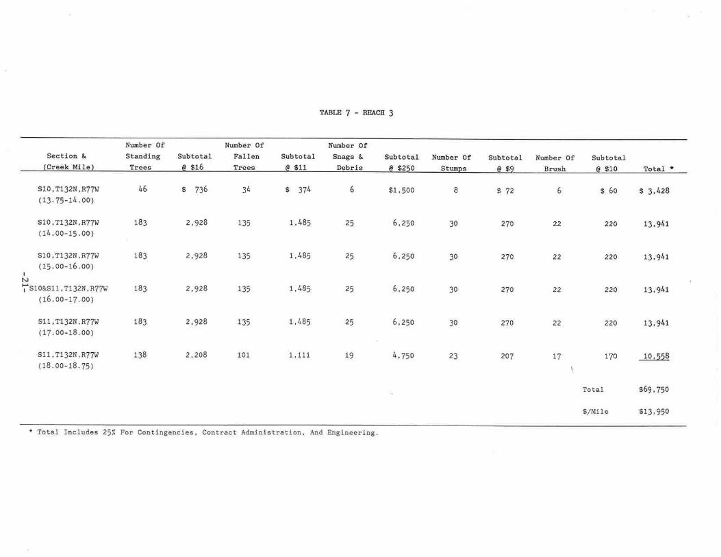
third priority, has a cost estimate of $69,750 for ! niles. Table J shows the
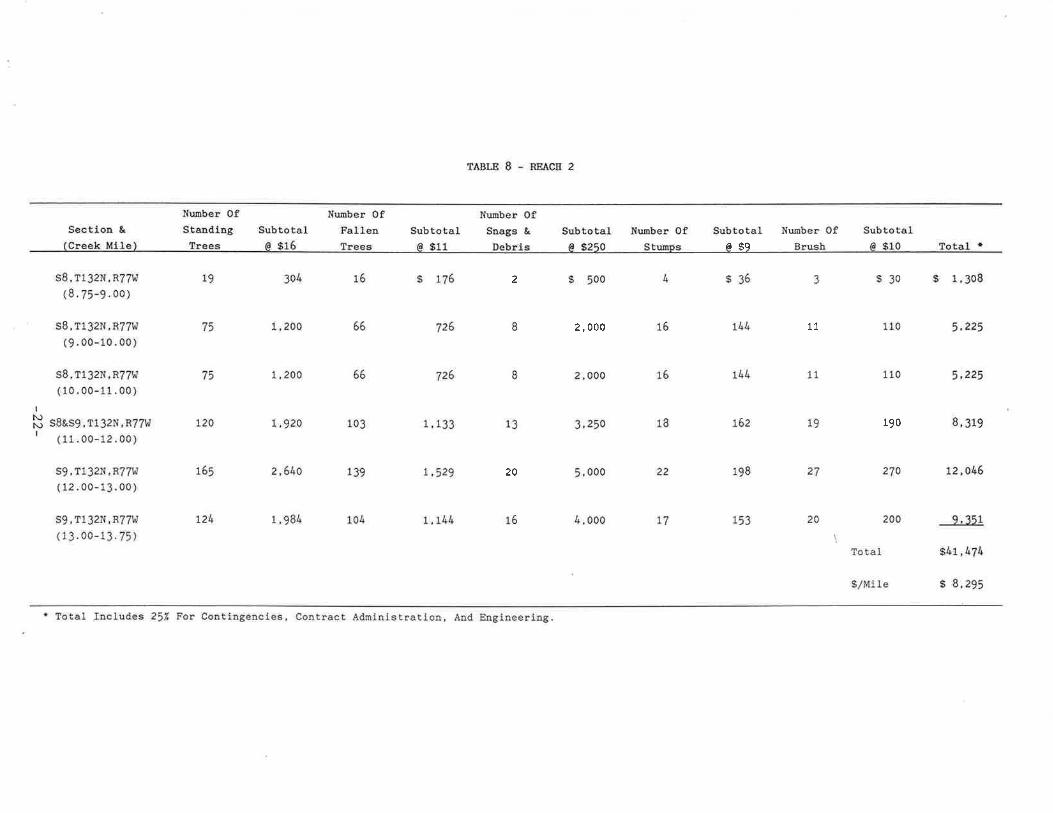
cost estimate breakdown for Reach l. Reach 2, which is given fourth priority,has a cost estimate of $4f,474 for ! miles. Table 8 shows the cost estimate
breakdown for Reach 2. Reach 6 is given the next priority and has a cost
estimate of $51-,)JJ for 5 3/4 miles. Table ! shows the cost estimate breakdown
for Reach 6. Reach t has the lowest priority, is given a cost estimate of$57,818 for B 3/4 niles. Table 10 shows the cost estimate breakdown for Reach
1.
-I7-

Nunber OfStandiBgTrees
Nurrber 0fFallenTrees
ÎABT,B5-NEACfr5
Surnber Of,Snags & Nunler 0f
StuññêSêcti.on &
lCreel< Ml I o\
s7, 11321{,876i{(22.25-4.0A)
s7 , 11 32N , R76W(23.00-24.0o)
Ê18&S17,t132N,R761t(24.00-25.00)
s17,T132N,R76W(25.00-26.00)
s17, 1132N,R761,r7(26.00-27.00)
s17, T132N,876r,ü(2V.Oa-27.25t
Subtotal6 s16
$1,360
2,288
2,06t+
2,816
2,816
720
SubtotaLÍ¡ *l 1
$
Tìê
r,958 34
484
ls
$2,75A
18 4,500
t4 3,500
8,500
8, 5oo
9 2,25A
Subtotalô ß10
TotaI
$,1Mt 1e
$180 * 6,259
290 10,339
Il+o 8,539
200 77,27A
2oo 17,270
50 __4¿9r
$64, 154
$12,831
Sr¡.btots16 9260
SubtotaL/â çq
9252
423
225
J:l+2
3ù.2
8r
l{umber 0fIlnrqL
18
29
4
20
2A
Totâl r
85
L43
L29
176
.r /o
42
70
82
L78
178
4l+
l14ô¿
770
902
28
4l
25
3B
38
9
ItsI 1,,9581 34
5t+5
t Total Lncludee 25'l por Oontingenciê , Contract AdrûinlÊtration, And Engi.ueering.

Nunber OfStaatllogTrees
Nr¡nber OfFallenTrees
TâBLE6-BEACE4
Nunber 0fSnage &f)eb?l ê
Nr¡nber 0f.stnrmiß
Sectlo¡ &(erçek Mile)
s12, f132N,R77u( 18. 75-19.00)
912,T13AN,n77rd(19 " 00-20. 00 )
S12 'T132N,R7nl(20.00-21.00)
c12,r132N,R7flJ(21.00-22.00)
912,T132N,R?n¡G2.A0-22.25)
3,0
30
30
t2
6
25
25
25
o.
3l+
135
t35
135
5t+
46
183
183
183
72
Subtotal6 916
$ 736
2,928
2,ge:8
2,928
L,L5'¿
Subtotal6 *1 1
$ 37i¡
1 ,485
1' /+85
1,485
591+
Subtqùa116 SPEO
$1,500
6,zsa
6,25a
6,25e
2,250
Subtotal6gq
Nunber 0fBrush
5
22
22
22
9
Subtotal6 S10
lotål
$/M11ê
7 $3
274
270
270
108
rôtâl I
$ 50 s 3,404
22Q 13,941
220 13,941
22s 13,941
90 5.2tt3
$50,470
$14,420
b)O
\
i Tqtal Xnclude.E 251 Fot Conti.flgencies, eontract .Àdmialstratlon, Aod Englneerlqg"
Numbe¡ OfStandlngTreee
Nr¡nbel 0fF,al1enTrees
TÀBI^87-REACE3
Nüriber Ofnags &Debrls
l{r¡mber OfS trrnnc
I
Sectl,Ön &(Creek Mlle)
s10 , 11 32N, n77H( 13 . 75-11+ . 00 )
910,T132¡r,A?nt(r¿..00-15 .00 )
sl0,1132¡{,R77rt( 15.00-16.00 )
o&s11 ,1132N, n77W(16.00-17.00)
s11,1132ï,R771ú(17. 00-18.00)
s11 , T132N,¡?7r¡¡(18.00-18.75)
SubtotalÊ s16
Subtotalñ $11
SubtotaLf¡ s26ô
6,25a
6,250
6,25A
lr,75a
Sub.totêlie ÊO
$72
270
270
270
270
201
Number Of Subtôta:./â êlô .Fnt¡1 r
6 $ 6o $ 3,428
220 t3,94L22
22
22
77 170
IN)ïsr
30
30
30
30
23
25
25
25
25
135
L39
101
46
183
183
r83
183
138
s 736 34
2,928 135
2,928 L35 1 ,485
2,928 1,485
2,928 r,485
2,2A8 1,111
s 374 6 $1 ,500
1,Å85 6,250
22A 13,941
?2a ß,94t
220 13,941
10,558
$69.,750
$13 '950
Total
$,uMi1e
* Total Tncludes 25'/, por Coatiagulcies, Contract Ad¡ninj.strÌatiou, And Engfneêring.
SectLon &lOreek MlLe)
s8, T132N, R 71,'r
(8.75-9.00)
s8, T132N"n-?nf(9 " 00-10.00 )
s8"T132I\t,R7nt(10.00-11.00)
s8&s9, T132N, R77tÌ( 11 .00-12.00)
89,1132N,n77W( 12.00-13.00 )
lir¡nber OfSterôiûglree.s
Nunber OfFall.enTFêêê
gubtotal6 916
TÀBXfr8-BEACE2
Nunber Of,Subtotal Saage & Subtotal Nrmber 0f Sub'totatra *11 fìa}¡rl c d *2ñô ç f:trnñe Í¡ *q
$ 176
Subtotal6 ß10 Total r
3 $ 30 $ 1,308
110 5,225
16
66
66
103
139
1,04
t9
75
75
120
L65
I2l+
301¡
1 ,200
1,200
1,920
2,640
8
8
726
726
2 $ 500
2,000
2,000
13 3,250
5,000
4, ooo
h
16
16
18
22
L7
$36
L4l+
t44
t62
198
153
N¡¡nber 0fBrr¡sh
11
x1
27
110 512'25
190 8, 319
2]0 !2,ø46
9,35L
$41,474
I 8,295
IN)t\)I
20020
t91,133
20
s9,T132N,R.?rur(13.00-13.75)
1 ,98¿, L,LLI+ rt)
$ Total, Includ.e,s 2$'/ For Contingenc,les, Ooatract Adnlnlstratlon, And Englneerlng.
1,529
Total
$/lr111e
Nr¡¡ber 0fStaûdíngTrees
T{r¡mber 0fFalLenTreeg
TABI.E9-BEAtr6
Nunber 0f$rags &Debri.e
Number OfStr:nÞg
Sr¡btotêI@ s260
Sectlon &(Creek Mitre)
s17, 1132N,R76W(2V.25 - 28.00)
s16,T132N,É7 1Â7
(28.00-29.00 )
s?1,"132N,R76rú(29.00-30,00)
6o
81
81
95
103
104
91
t20
120
123
164
164
Subtotâ1@ $16
tl,456
1,920
1,920
Subtotal@ $11
s 660
991
Subtoùa16gC
Number 0fB1rúêh
10
L2
rJ
II
16
Totâl r
10
tl+
1"4
t3
18
1g
$2,5oo
3,5oq 9
3,5.00
3,250
&, 500 L4
l+,750 th
6 $54
8r
8r
36
126
L26
Subt-otal6 s10
Total
$/M11e
s10o s 5,963
I r.40
8,140
8,036
160 11,005
û5r,975
$ 9,039
891 120
x,2a
r30
l29
l+¡l'rstþr,I
1,968 1,045
s15&922 , f1 32N , R761t(32 .00-31 . 00 )
2,62h 1, 133
s15:,,.r1rr"'"U,(32.00-33.'00)
2,62& t,t44
r lotaI Iûal-udes 25/, Yor Oontirtgenc.fes, CoDtract Ad¡tinlstratlon, And Englneering.
1&S16, 1132N,,87&t( 30 .00-31 . 00 )
na 10,691
Sectloû &(Crèek l\{ile)
sl4, 1132N, R78td(0,,00-1 .00)
s11+,t132N,R781d(1.,00-2.00)
914,T132N, R78W(2.00-3.00)
s11,T132N,R78!/(3.00-4.00)
g11&s12, 11321{,R78tt(4.00-5 .00)
s1.2, T132N,R7r81d(5.00-6.00)
s1 2&S7, 11 32N, R781d&R7nü(6.00-7.00)
Nunbe¡ 0Stand.iûETrees
Subtotalô $16
Number OfFaLLenT¡èê,s
Nunber OfR¡rrsh
ç
Subtstal/ô ß1
Total
Ò 'I¡t¡ I r
$50 $ a,616
"ït5?,818
$ 6"608
38
38
38
3B
11q
199
200
t99
150
$ 608
og
6CI8
,608
33
33
JJ
33
64
95
94
95
77
Þ
TABI,B 10 _ REACE 1
l{r¡nbor OfSubtotal Suags &
¡6, çl 'l lNe1r¡ì aSubtotaL Ni¡nber 0f Srrbbotal6 *rÃô Strrññé ôEq
$1 ,000
1,000
1. ,000
1,000 I
2,75s
4,250
l+,250 7
4,250
3 "250
ö
I
I
7
h
4
11
363
363
363
363
701+
l+
,4
ç72
72
l¿
72
63
63
6S
63
4\
50 2,6!6
50 2,576
50 2,6L6
70 6,8t+4
80 10,778
8o 10,784
80 t0,778
c
1 ,888 7
ö7t,Or+5
a
I
6o
7
E13
tñÞ¡
3,184
3,200
r7
1,034 LI
s7,fl32N,n77W.( 7.00-8. 0o),
3, 184 1,045 L7
s7, T132rÍ, BTnd(,8. o0-8. ?5)
2,4AA 781
\
6
å T¡ta.l Inclùdes 25t For Co;nt.ingencie.s, ConbracË Adrii¡riêtratioa, And Eaglneering,
$,tMite

V. STJMMARY
The results of the field inventory of the ll-mile segment on the Beaver
Creek reveal that marìy reaches are in extremely poor condition. Excessive
obstructions occur within the primary channel and its baríks, reducing the abilí-ty of the waterway to transport hrater. These obstructions include fallen and
standing trees, driftwood, snags, brush, loose stumps, trunks, car bodies and
debris. They have considerable hydraulic effects on Beaver Creek, causing nore
flrequent, more extensive, and prolonged flooding which have caused nonetary
flood damage in Linton as well as agricultural damages upstream and downstream.
The investigation indicates a snagging and clearing project should be imple-
nented within the project area ímnediately. This type of resLoration projectwould alleviate and minimize flood damages not only to the .City of Linton and
adjacent farmland but will protect the integrity of bridges and structures along
Beaver Creek.
The project and its costs have been divided into six prioritized reaches.
The cost esLinates were based on private contractors proposals and bids from
previous snagging and clearing projects. The estimates include administrative,engineering, and contingency costs. Reach f, located within and adjacent to the
City of Linton, was gíven highest priority and has a estinated cost of $64,154.
The priority of Lhe renaining reaches !üere as follows, Reach 4 esLinated cost
$50,470; Reach I estirnated cost 569,75O; Reach 2 estimated cost $41,474; Reach 6
estimated cost $51,975; and Reach 1 estimated cost $57,81-8. The total for the
six reaches is $335,64t. If the State of North Dakota and private contractorsbecome involved, the construction costs could possibly be cost-shared with the
State Water Comnission on a 75 percent local, 2J percent state basis. If the
project sponsors get assistance from the National Guard, the local costs would
-25-

be for the fuel required, which could possibly be cost-shared with the State
Water Commission on a J! percent 1ocal. 2J percent state basis.
-26-

VI. RECOIT{MENDATIONS
In order for a snagging and cl-earing project to provide nuch inprovement on
flood stages through Linton, a large-scale maintenance plan has to be imple-
nented. As stated, Beaver Creek's channel- condítions-are in extremely poor
condition. The work required to remedy these problens is excessive. Therefore,a maintenance plan based on reach lengths and priority is recommended. The
estímated construct,ion cost, including administrative, engineering and contin-gencies ís $335,641 for the 33 creek miles. A snagging and clearing project ísefficacj-ous and capable of decreasing flood. stages, buL it is lirnited in va1ue.
This point must be stressed, a snagging and clearing project will lessen the
severity, length, and recurrence interval of floods but will not prevent floodsfrom occurring. The decision to proceed with the project is the responsibilityof the Emmons County Water Resource Board and the City of Linton.
-27-
APPH.IDIX
Appendix A - Investígation Agreement
SWC Project H558-7April 1!, 1987
AGREEMENTPreliminary Investigation
of a Snagging and Clearing Projecton Beaver Creek
I. PARTIES
THIS AGREEMENT is between the City of Linton, hereinafter relerred to as
the Cíty, acting through its Mayor, Melvin Jahner; the Fmnons County Water
Resource Board, hereinafter referred to as the Board' acting through its
Chairnan, Glen Mc0rory; and the North Dakota State Water Comnission,
hereinafter referred to as the Commission, acting through the State Engineer,
Vernon Fahy.
II. PROJETI, LOCATION, AND PIIRPOSE
The City and the Board have jointly requested the Conmission to
investigate and determine the feasibility of a snagging and clearing project on
Beaver Creek in trmmons County. The project area extends three miles easE of
Highway 83 to the U.S. Army Corps of Engineers' land approxinately eight miles
west of Linton on Beaver Creek. The purpose of the investigation is to
deternine the condition of the river channel, prepare a cost estinate for a
snagging and clearing operation, and evaluate the relative hydraulic effects of
a snagging and clearing project.
III. PRELIII{INARY I}TVESTIGATION
The parties agree that further infornation is necessary
proposed projecE. Therefore, the connission shaIl conduct
investigation to provide the following:
concerning the
a preliminarY

-¿-
An inspection of all areas along the channel described in Section IIof this agreenenL with crews on the ground to inventory material Ehat,should be renoved from the prinary channel.
A hydraulic scudy which evaluaLes the relative benefits of theproposed project.
A written report documenting the findings of the inspection. anevaluation of relative benefits and a suggested schedule forimpleuentation of the proposed project.
A detailed cost estinate forphased inplenentation.
the project considering a possible
The inventory shall consist of only those itens outlined herein. Field
surveys and design work for Ehe construction phase of this project shall not be
includ.ed in this agreement.
IV. DEPOSIT-REFIJND
The City and/or Board shall deposit S750.00 with the Conrnission to
partially pay the costs of the investigation. Upon conpletion of the
investigation outlined herein, upon receipt of a request fron the City or the
Board to terminate Lhe investigation, or upon a breach of this agreenent by any
of the parties, the Comnission shall- provide the City and the Board with a
statenent of aII expenses incurred in the investigation and shall refund Eo the
City and/or the Board any unexpended deposit funds.
1
2
3
4
V. RIGTITS-OF-ENTRY
The City and/or Board agrees to obtain written pernission from
affected landowner allowing the Connission to enter upon their properEy
conduct field surveys which are required for the investigation.
any
to
-3-
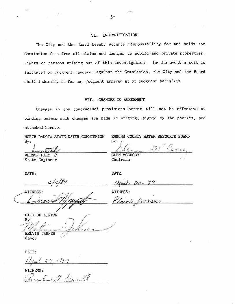
VI. INDEIIINIFICATION
The City and the Board hereby accepts responsibility for and holds Ehe
Connission free fron all clains and danages to public and privaEe properties,
rights or persons arising out of this investigation. In' the event a suit is
init,iated or judgnent rendered against the Connission, the City and the Board
shall indeunify it for any judgnent arrived at or judgnent satisfied.
VII. CHANGES TO AGREEIIÍENT
Changes in any contractual provisions herein will not be effective or
binding unless such changes are made in writing, sígned by the parties, and
atEached hereto.
NORTH DAKOTA STATE WATM. COMMISSION EMMONS COU}IIY T.¡ATER. RESOURCE BOARDBy: By:
))t' {.trn=,VERNON FÆIYState Engineer
DATE:
¿
CITY OF LINTONBy:
MCCRORYChairman
DATE:
WITNESS
7
(
¡{ELVINüuyot
DATE:
JAHNER /
f./n,( ,i t, /FttWITNESS:
(;*-l*',1. ,[L^*H