beetaloo regional reference group meeting
TRANSCRIPT

Department of ENVIRONMENT, PARKS AND WATER SECURITY
Beetaloo Regional Reference Group Meeting23rd March 2021

Department of ENVIRONMENT, PARKS AND WATER SECURITY
Strategic Regional Environmental and Baseline Assessment (SREBA)

3
Why a SREBA?In December 2016, the Northern Territory Government established the Scientific Inquiry into Hydraulic Fracturing in the Northern Territory. The final report found that:
“… provided all of the recommendations made in this Report are adopted and implemented in their
entirety, not only should the risks associated with an onshore shale gas industry be minimised to an
acceptable level, in some cases they can be avoided altogether."
frackinginquiry.nt.gov.au

4
Why a SREBA?In April 2018, the Northern Territory Government accepted all 135 recommendations of the Inquiry’s Final Report and commenced their implementation. This includes Recommendation 15.1:
“That a strategic regional environmental and baseline assessment (SREBA) be undertaken
prior to the granting of any further production approvals”
Environment
SocialCultural
Economic

5
Purpose and applicationThe SREBA is a set of six studies to address knowledge gaps and establish appropriate baselines against which the potential impacts of proposed onshore gas activities may be assessed.
Water quality and quantity
Aquatic ecosystems
Terrestrial ecosystems
Greenhouse gas emissions
Environmental health
Social, cultural and economic

6
Role of the BRRGBRRG members represent key stakeholders who live or have an interest in the SREBA region.
1. Key two way communication medium2. Provide local guidance and feedback3. Liaise with SREBA team members

7
Related projectsGISERA – Impact assessment CSIROAdvice on impacts of gas development on industry, environment and communities.
GBA – Bioregional Assessments Australian GovernmentGeological and environmental baseline assessment that synthesises current knowledge.
Mines and Energy, Department of Industry, Tourism and Trade, Northern Territory GovernmentResponsible for regulating all non-environmental aspects of the petroleum industry.

8
Reporting and applications
Baseline reports within each domain
Final SREBA report
Online information portal with datasets
Use in development planning and regulation
Use in other natural resource management
Regional planning

Maddison Clonan
Department of ENVIRONMENT, PARKS AND WATER SECURITY
SREBA Engagement Strategy

10
Why is engagement and consultation important for SREBA?There are over 1400 people living in the SREBA study area. Many of these are “affected stakeholders”. Over 700 are Aboriginal and/or Torres Strait Islander people.
People play an important role in the SREBA study process.
The findings of SREBA will empower everyone to have a say about development and natural resource management in the study region.

11
Strategy objectivesObjective 1. Identify affected stakeholders and provide meaningful, appropriate engagement prior and throughout the project activities.
Objective 2. Create community and stakeholder awareness and understanding of the SREBA project, activities and findings.
Objective 3. Enable stakeholder and community involvement in SREBA and incorporate feedback into decision making.

12
Seeking your feedback1. Who do you represent and how can I best
engage or communicate about SREBA with them?
2. Would you like to provide input to the SREBA Engagement Strategy?
3. How can I best communicate with you?

Lauren Young – Project Manager
Department of ENVIRONMENT, PARKS AND WATER SECURITY
Beetaloo SREBA –Terrestrial Ecosystems

14
• Vegetation
• Fauna
o Vertebrateo Invertebrate
• Environmental Values
Terrestrial Ecosystems

15
Vegetation• Preliminary Regional Ecosystems map (desktop)• 46 Full floristic surveys• 6,962 Rapid vegetation assessment sites• Refinement of Regional Ecosystems map (ongoing)
Terrestrial Fauna• 15 Camera-trapping sites – General fauna• Targeted threatened species survey
o Gouldian Fincho Crested Shrike-tit (Northern)o Greater Bilby
GBA Project

16
- Baseline vegetation – 550 sites- Five sites in each Regional Ecosystem- Vegetation structure- Landscape attributes- Full floristics – inventory of species
- No threatened species identified at this stage
- Rapid vegetation assessment - opportunistic
- Continuing refinement of Regional Ecosystems map
Vegetation

17
Regional Ecosystems Map NT Vegetation Map 1:1,000,000
Regional Ecosystems 1:100,000

18
• Baseline – vertebrate and invertebrate – 120 sites• Five sites in each aggregated habitat type
• Threatened specieso Targeted threatened species
o Crested Shrike-tit (Northern), Greater Bilby, Gouldian Finch, Ghost Bat
o Non-targeted threatened specieso Red Goshawk, Grey Falcon, Painted Honeyeater, Partridge
Pigeon, Princess Parrot, Merten’s Water Monitor, Mitchell’s Water Monitor, Plains Death Adder, Yellow-spotted Monitor
Terrestrial Fauna
• Live-trapping • Bird surveys• Motion-detecting cameras • Nocturnal searches• Acoustic recorders – bats • Invertebrate traps

19
• Waterbirds• Waterbird communities
• Resident• Nomadic• Migratory (listed and non-listed)
• Threatened species• Australian Painted Snipe, Curlew Sandpiper
WaterbirdsWater Observationsfrom Space

20
Environmental Values• Areas of high conservation value
• Concentration of threatened species• Concentration of endemic species• Wildlife aggregations• Botanical significance
• Sensitivity of significant species• Dependent on large areas of continuous vegetation• Habitat specialists/regionally restricted distributions• Significant overlap between core habitat and potential
development footprint
Bird species Endemic bird species Threatened species
1
51
1 1
19 12
E.g. Zafra-Calvo et al. 2010, Brazilian Journal of Nature Conservation, 8 27-33

Peter Dostine/Flora and Fauna Division
Department of ENVIRONMENT, PARKS AND WATER SECURITY
Introduction to SREBA Aquatic Biodiversity Studies

22
SREBA Aquatic studies Aquatic biotaTaxon group Work undertaken byPlants Flora and Fauna, MAGNT, Fisheries
Fish Flora and Fauna, MAGNT, Fisheries
Freshwater turtles Flora and Fauna, MAGNT, Fisheries
Macroinvertebrates Flora and Fauna, MAGNT, Fisheries
Zooplankton Flora and Fauna, MAGNT, Fisheries

23
SREBA Aquatic studies
• General comprehensive survey May to August 2021• Targeted survey for threatened species late 2021• Quarterly sampling of selected sites• Repeat sampling or additional sites 2022

24
SREBA Aquatic studies Study area
• 80,000 km2
• 4 river drainages
• Region poorly surveyed
• Target 100 sites

25
SREBA Aquatic studies Habitat mapping and classification
• Sites selected to include range of different habitat types in different catchments
• River channels, floodplain billabongs, shallow swamps, springs
• Sampleable sites identified from remote sensing of water in the landscape in dry season

26
SREBA Aquatic studies Aquatic biota: macroinvertebrates
• ‘’Macroinvertebrates’ includes familiar animals like mussels and crayfish
• Several orders of aquatic insects, molluscs, crustacea, mite and worms
• Potentially 100s of species
Order # NT species
COLEOPTERA 210
EPHEMEROPTERA 29
HEMIPTERA 68
ODONATA 109
TRICHOPTERA 157
573
27
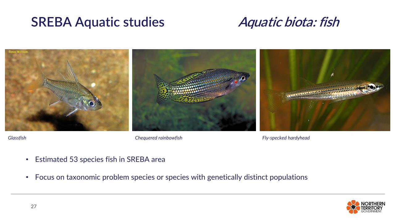
SREBA Aquatic studies Aquatic biota: fish
• Estimated 53 species fish in SREBA area
• Focus on taxonomic problem species or species with genetically distinct populations
Glassfish Chequered rainbowfish Fly-specked hardyhead

28
SREBA Aquatic studies Aquatic biota: turtles
• 5 or 6 freshwater turtles in region
• Gulf Snapping Turtle Endangered under Commonwealth EPBCA
• Targeted surveys for Gulf Snapping Turtle and Freshwater Sawfish

29
SREBA Aquatic studies Sampling methods for aquatic biota
Back-pack electro-fishing Boat-based electro-fishing Fyke net

30
SREBA Aquatic studies Sampling methods for aquatic biota

31
SREBA Aquatic studies Deliverables
• Aquatic biodiversity inventory
• Spatial patterns of diversity
• Identification of High Ecological Value Aquatic Ecosystems
• Identification of sensitive species and habitats

Michael Short, Senior HydrogeologistWater Resources Division
Department of ENVIRONMENT, PARKS AND WATER SECURITY
SREBA Water Quantity and Quality Scope of Work

33
Water Quantity and Quality: ScopeIn draft stage, divided into seven sub-projects
• Project 1: Identification of knowledge gaps
• Project 2: Baseline water level and water quality monitoring
• Project 3: Inter- and intra-aquifer connectivity
• Project 4: Surface water/groundwater interactions and recharge
• Project 5: Numerical model update
• Project 6: Surface water flow characterisation and mapping
• Project 7: Summary report

34
Project 1: Identification of knowledge gaps
• Assessment and report completed in late-2020
• Literature review of recent and historic studies
• Current level of knowledge for water balance components
• Describes types of studies that could be undertaken to
address key knowledge gaps
• Prioritizes specific studies for completion during SREBA

35
Project 2: Baseline monitoring• Draft monitoring plan completed in early-2021
• To be amended based on engagement with NTG and community stakeholders who will be able to assist with the monitoring networks
• Monitoring work to completed by Water Resources Division personnel and data made available on the online Water Data Portal
• Water level baseline obtained from a network of existing and planned Water Resources Division monitoring bores
• Barkly Highway to Mataranka Springs
• Buchanan Highway to Flora River/Djarrung• Water quality baseline to be obtained via existing-users – Power & Water borefields, Aboriginal land
trust domestic bores and pastoral bores
• Focused in the area of potential gas production and primary discharge areas (Flora and Roper)

36
Water quality monitoring

37
Water level monitoring

38
Project 3: Inter- and intra-aquifer connectivity
• Compile and analyse historic pump test data to establish known ranges for
aquifer parameters
• Identify existing bores for aquifer testing
• Install new groundwater bores to address data gaps identified
• Compile and review findings from existing environmental tracer studies
• Summarise the current the state of understanding of the inter- and intra-
connectivity of the region’s primary aquifers

39
Project 4: SW/GW interactions and recharge• Review and compile historic data and studies
• Install new monitoring infrastructure (bores and/or stream gauges) in areas
of interest (near sinkholes, rivers and inferred recharge zones)
• Undertake a baseline survey of the Flora River spring complex near
Djarrung (CDU researchers will be leading this study)
• Undertake field surveys of minor spring clusters near Top Springs and
northern Tanumbirini Station
• Identify sinkhole clusters to target for potential monitoring

40
Sinkholes and springs

41
Project 5: Numerical model update• Review existing model for deficiencies
• Incorporate conceptual understanding from Projects 2-4
• Update calibration datasets
• Extract natural water balance information
• Recommend monitoring deficiencies and priority datasets to improve
model performance

42
Project 6: Surface water flow characterisation and mapping
• Hydrological models of the surface water catchments overlying the Beetaloo Sub-basin.
• Hydraulic models for Lake Woods, Lake Tarrabool and Lake Sylvester including northern
drainage systems
• Report on model development, incorporating a description of the current understanding of
the surface water systems overlying the Beetaloo Sub-basin
• Undertake flood/inundation mapping where possible (may be limited by topographic data
accuracy)
• Assessment of risks to surface water/wetlands, groundwater recharge zones and sites of
conservation significance
• Define the ongoing monitoring program for further assessment of surface water resources

43
Project 7: Summary report• To be completed by end of December 2022
• Define the current conceptual understanding of primary water cycle
components for the Beetaloo
• Produce spatial files for public use
• Define water quantity and quality triggers
• Recommend ongoing monitoring requirements