regional planning panel panel reference ppshcc-24
TRANSCRIPT

- 1 -
REGIONAL PLANNING PANEL
(Hunter and Central Coast)
Council Assessment Report
Panel Reference PPSHCC-24
DA Number 49534/2016 S8.2(1)(a)
Local Government Area Central Coast Council
Proposed Development Residential Flat Building including 101 units and 3 levels of basement
parking and the demolition of existing structures on site (Integrated
Development)
Street Address LOT: 1 DP: 436706, Lot: 26 SEC: 6 DP: 1591, Lot: B DP: 357731, No. 9
Bent Street GOSFORD, No. 7 Bent Street GOSFORD, No. 11 Bent
Street GOSFORD
Applicant Albany Investments Aust Pty Ltd
Owner Albany Investments Aust Pty Ltd
Date of DA Lodgement 28 November 2019
Number of Submissions Seven (7)
Recommendation Deferred Commencement Approval - subject to conditions
Regional Development
Criteria - Schedule 7 of
the State Environment
Planning Policy (State and
Regional Development)
2011
Development application subject of review - Capital Investment
Value > $20M and lodged before 1 March 2018.
List of all relevant
4.15(1)(a) matters
Environmental Planning & Assessment Act 1979 (EP&A Act)
Local Government Act 1993 (LG Act)
Roads Act 1993 (Roads Act)
Rural Fires Act 1997 & Planning for Bushfire Protection
State Environmental Planning Policy (State and Regional
Development) 2011 (SEPP State and Regional Development)
State Environmental Planning Policy No 55 - Remediation of Land
(SEPP 55)
State Environmental Planning Policy No 65 - Design Quality of
Residential Apartment Development (SEPP 65)
State Environmental Planning Policy (Coastal Management) 2018
(SEPP Coastal Management)
State Environmental Planning Policy (Building Sustainability Index:
BASIX) 2004 (BASIX)
Central Coast Regional Plan 2036
Draft Central Coast Local Environmental Plan 2018 (CCLEP)
Gosford Local Environmental Plan 2014 (GLEP 2014)
Gosford Development Control Plan 2013 (GDCP 2013)
- 2 -
Apartment Design Guide (ADG)
List all documents
submitted with this report
for the Panel’s
consideration
Attachments:
1. Proposed Conditions of Consent
2. Architectural Plans prepared by ADG Architects
3. ADG Compliance Table
4. GDCP 2013 Compliance Table
5. Notice of Determination - Refusal
Supporting Documents:
Document Prepared by Date /
Issue
Apartment Design Guide
Compliance Report and
Verification Statement
Anthony Kelly
(registered architect
No.6999)
10.20
Rev H
Noise Assessment Spectrum Acoustics 02.2016
Proposed road, driveway
& drainage
DA plans Sheets 1 -19
Barker Ryan Stewart 02.04.19
Rev G
Traffic & Parking Impact
Assessment
Barker Ryan Stewart 15.10.19
Rev 8
Stormwater Management
Report
Barker Ryan Stewart 20.11.19
Rev 4
Waste Management Plan Barker Ryan Stewart 05.05.20
Rev 9
BASIX Certificate number:
713208M_05
Gradwell Consulting 27.08.20
NatHERS Ceretificate Gradwell Consulting 27.08.20
Assessor Certificate
Gradwell Consulting 03.05.19
Arboricultural
Impact assessment
ADVANCED TREESCAPE
CONSULTING
19.11.18
Flora and Fauna Impact
Assessment REF: GCC 15-
778
Keystone Ecological December
2015
Survey Plan
Alan Bardsley 16.08.15
Bushfire Assessment
Report
Advanced Bushfire
Performance Solutions
01.11.19
Rev 6
DA Access Audit Assistive Technology
Australia
21.12.18
Rev 1
Geotechnical Investigation Asset Geotechnical 09.10.15

- 3 -
Crime Prevention through
Environmental Design
Assessment
Barker Ryan Stewart 19.11.19
Rev 4
Report prepared by Christopher Ross
Report date 13 October 2020
Summary
An application has been received under Section 8.2 of the Environmental Planning and Assessment Act, 1979
(the Act) for the Regional Planning Panel (RPP) to review its decision on determination of DA49534/2016
for Residential Flat Building including 101 units and 3 levels of basement parking and the demolition of
existing structures on site (Integrated Development) on land at 7 – 11 Bent Street, Gosford.
The Application was refused by the RPP on 4 September 2019. The reasons for refusal at that meeting are
summarised below:
The Panel were not satisfied that the cl4.6 adequately justified the departures from the controls of
cl4.3 of Gosford Local Environmental Plan 2014 (GLEP 2014).
The proposal was found to be inconsistent with the objectives of cl4.3 of GLEP 2014, and further
found to be excessive for the site area and exacerbated by the elevation of the site relative to the
surrounds, and its prominent elevated position, surrounded by trees.
The proposal was found to be inconsistent with the principles of State Environmental Planning
Policy 65 (Design Quality for Residential Apartment Development), particularly Principle 1: Context
and neighbourhood character, Principle 2: Built form and scale, Principle 5: Landscape, Principle 6:
Amenity and Principle 9: Aesthetics. The proposal is also inconsistent with key guidelines in the
associated Apartment Design Guide related to building separation/setbacks, sunlight access and
cross ventilation.
The proposal was not an appropriate response for the site. The site characteristics such as the
land slope, location near the top of a ridge and longer axis to the west required a sensitive and
well-considered proposal.
The height and scale of the building will be made more visually abrupt within the surrounding
area by the proposed tree removal. The landscaped setting of the site would be compromised, to
the detriment of the visual qualities of the site and surrounds. The truck turning area for the street
within the road reserve, the extent of tree removal is more than required for this outcome, and
results in a compromised landscape outcome.
The requirements of an Asset Protection Zone to the east of the site are such that the future
ability for tree planting.
The proposal does not achieve design excellence and is unacceptable when considered against
the requirements of Clause 8.5 of GLEP 2014.
There is some ambiguity regarding the legal ability to determine the application due to a lack of
owner’s consent from the Council, noting the works involve more than ancillary roadworks, but
instead relying on bushfire protection and management measures over the adjoining Council land
to the east.
For the reasons above and noting concerns raised within submissions, granting consent would
not be in the public interest.

- 4 -
The application has been examined having regard to the matters for consideration detailed in section 4.15
and section 8.2 of the Environmental Planning and Assessment Act 1979 (EP&A Act) and other statutory
requirements with the issues requiring attention and consideration being addressed in the report.
In summary, the application refused sought approval for a 46.28m residential flat building of 101 units,
with basement car parking. The refused scheme did not comply with LEP HOB controls, nor did the plans
display compliance with the ADG.
The s8.2(1)(a) now proposes the construction of a 38.6m high residential flat building of 56 residential
units, with basement car parking. The revised plans indicate compliance with LEP HOB and FSR controls,
as well as general compliance with the ADG.
Further, the applicant has sought legal opinion regarding the reduction in size of the development under
assessment from that refused, and as to whether the revised plans can be considered as substantially the
same development. Council is satisfied that the legal opinion obtained addresses the merit of Cl8.3(3) of
the EP&A Act 1979. (Opinion included as Attachment 5).
RECOMMENDATION
A. In accordance with section 8.2-8.5 of the Environmental Planning and Assessment Act
1979, the Hunter and Central Coast Regional Planning Panel as the consent authority
agree to the deferred commencement approval of the application under clause 55 of the
Environmental Planning and Assessment Regulation 2000.
B. The applicant be advised of the Hunter and Central Coast Regional Planning Panel
decision and of their right to appeal in the Land and Environmental Court under section
8.7 and 8.10 of the Environmental Planning and Assessment Act 1979 six (6) months
after the date on which the applicant receives notice in respect to Council’s decision.
C. The those who have made written submissions be notified of the Panel’s decision.
D. The Public Authorities be notified of the Panel’s decision.
Precis
Delegation Level
Reason for Delegation Level
Regional Planning Panel
Development over $20 million
Property Lot & DP LOT: 1 DP: 436706, Lot: 26 SEC: 6 DP: 1591, Lot: B DP: 357731
Property Address No. 7-11 Bent Street GOSFORD
Site Area 1,793.5m2
Zoning B4 Mixed Use
Proposal Residential Flat Building including 56 units and 3 levels of
basement parking and the demolition of existing structures on
site (Integrated Development
Application Type Development Application – Integrated
Current Use Residential use and vacant land
Integrated Development Yes
S8.2(1)(a)Application Lodged 28/11/2019
Applicant Albany Investments Aust Pty Ltd
Estimated Cost of Works $TBD
- 5 -
Advertised and Notified /
Notified Only
Exhibition period Thursday, 19 December 2019 to Monday, 3
February 2020. Amended plans re-notified and advertised from
Friday 4 September to Friday 2 October 2020.
Submissions Seven (7)
Disclosure of Political
Donations & Gifts
No
Site Inspection 08/04/2020 and 11/08/2020
Recommendation Deferred Commencement Approval, subject to conditions
Variations to Policies
Policy Clause / Description / % Variance
GDCP 2013 Building Depth & Bulk – minor, 18% variation, supported
Vehicle access width – 32% variance to driveway access width - supported
Housing Choice and Mix –3.9% variation to 1 bed maximum %, supported
State Environmental
Planning Policy No.
65 (Apartment
Design Guide).
Loading/servicing bay – 1/50 units. Conditioned to allocate 1 space to this
purpose. Supported.
The Site and Surrounds
The site is located on the southern side of Bent Street (which is a cul-de-sac street). The closest
intersection is Watt Street to the west. The site has a total area of 1793.5sqm and is regular in shape with
a 38.4m frontage to Bent Street and a depth of 45.2m.
There is no formed kerb and gutter on the southern side of Bent Street at the subject site. The site slopes
from east to west, with a variation of approximately 8m. There are the following existing land uses:
No. 7 Bent Street contains a single dwelling;
No. 9 Bent Street contains a two-storey apartment building with ground level car parking; and
No. 11 Bent Street is a vacant lot located to the rear of No. 9 Bent Street, accessed by a right of
way adjacent to the site and Henry Parry Drive.
The site is generally cleared of significant vegetation, with one large tree and four small trees remaining
on the site. The site is identified as "bushfire prone land" on Council's bushfire maps.
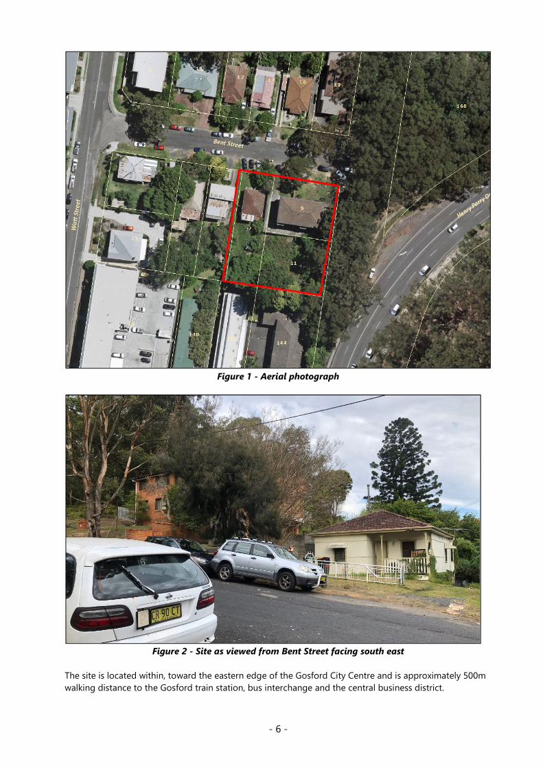
- 6 -
Figure 1 - Aerial photograph
Figure 2 - Site as viewed from Bent Street facing south east
The site is located within, toward the eastern edge of the Gosford City Centre and is approximately 500m
walking distance to the Gosford train station, bus interchange and the central business district.

- 7 -
The immediate area is characterised by a mix of low and medium density residential development.
To the east is the vegetated road reserve for Gertrude Street, with Henry Parry Drive beyond.
To the north and west are single storey dwelling housing and a two storey multi-unit residential
development.
To the south are 2-3 storey multi-unit residential developments on Faunce Street.
Figure 3 - Road reserve for Gertrude Street to the east of subject site
Figure 4 - 2-3 storey multi-unit residential developments on Faunce Street (subject site to the rear
of these units)
- 8 -
Background
This s8.2(1)(a) review is the result of DA49534/2016 having been refused development consent by the
Regional planning Panel at the meeting of 04 September 2019. The reasons for refusal and applicant’s
response to these reasons are included in Table 1.
The development that was eventually refused underwent a series of modifications from 2016 through to
2019. The initially submitted scheme intended to be a mixed use building of residential units and serviced
apartments. This application was subsequently reduced in height and unit numbers to result in a
development seeking approval for a residential flat building with no serviced apartment component. A
brief timeline of the refused development follows:
Originally lodged application
The original development lodged on the site, lodged on 24 March 2016, sought approval for a Mixed-Use
Development of 161 units and 20 serviced apartments.
The maximum building height on the site under the GLEP 2014 (including the 30% bonus provisions
under Clause 8.9) is 39m and the maximum FSR (including the 30% bonus provisions under Clause 8.9) is
6.175:1. The original application proposed a height of 62.78m (61% variation) and an FSR of 7.13:1 (15%
variation). The Joint Regional Planning Panel (JRPP) were briefed in May 2016 regarding the originally
submitted proposal.
Following discussions with JRPP, Council requested amended plans to address the significant non-
compliances and to address bushfire risk, as the NSW Rural Fire Service was not supportive of the
proposal in its original form.
Amendments May 2017
Amended pans were provided in May 2017, however significant issues remained outstanding.
Amendments April 2018 and Regional Planning Panel Briefing
Amended plans were lodged on 18 April 2018 that significantly reduced the height and FSR. As part of
these amended plans the applicant proposed use of the Council owned unformed Gertrude Street road
reserve on the eastern side of the site to be used as an Asset Protection Zone (APZ) to both address
bushfire issues and also provided access and manoeuvring for vehicles visiting the site.
The Joint Regional Planning Panel were briefed in June 2018 regarding the amended proposal and the
recommendation at that stage was that insufficient information had been provided to enable to matter to
be determined. The applicant was provided a period of three months to address the potential use of the
road reserve for bushfire APZ and access and address outstanding architectural and engineering issues.
Amendments December 2018
Amended documentation was received on 21 December 2018. This information addressed the majority of
concerns with the use of the road reserve proposed for the APZ and access. However, the plans did not
adequately address some engineering and waste issues, particularly in terms of levels and access. In
addition, the architectural plans did not align with the engineering plans.

- 9 -
Amendments May 2019
Further amended plans addressing these issues were provided in May 2019 and were the subject of the
RPP determination.
As compared to the original submission the final amended plans provided a reduction in building height
by 16.5m, resulting in a building of 46.28m which was a 19% variation to the 39m (including 30% bonus)
building height control.
The unit numbers were reduced from the originally lodged 181 to 101 units, with all serviced apartments
being removed from the scheme. A reduction in floor space ratio from 7.13:1 to 4.20:1 was proposed,
resulting in compliance with the 6.175:1 FSR control (inclusive of the 30% bonus). The proposal included
revisions that addressed bushfire protection and included the use of the Gertrude Street Road reserve.
The May 2019 amendments were the plans considered and refused by the Panel on 4 September 2019.
Further Relevant History
Council's records show no prior relevant or recent applications have been lodged on this site, aside from
that refused which forms the basis if this s8.2(1)(a) review.
The Proposed Development
The s8.2(1)(a) proposal lodged comprises the construction of a 10-12 storey residential flat building with
3-4 levels of basement car parking. The plans submitted in November 2019 were reviewed, and a briefing
to the Panel was undertaken. The proposal contained 69 residential apartments, 83 car parking spaces,
and had a proposed FSR of 3.45:1.
Post briefing Council sought amended plans from the applicant which were lodged on 24 August 2020
and are the subject of this assessment. A comparison of the refused development, the first lodged
s8.2(1)(a) plans, and the revised s8.2(1)(a) plans is included at Table 2.
The revised s8.2(1)(a) plans comprise:
56 residential units:
o 15 x 1 bedroom
o 39 x 2 bedroom
o 2 x 3 bedroom
6 accessible units
9 adaptable units
27 units designed to “silver standard”
Car parking across 3-4 levels of basement and lower ground floor level, accessed from Bent
Street:
o 65 car parking spaces
o 4 motorcycle spaces
o 23 bike spaces
Resident pool and gym in the basement and lower ground floor
Landscaping and communal open space provided on the majority of 7 Bent Street, as well as the
lower ground, ground and level 10
Discharge of stormwater from the site to Council’s piped drainage system in Faunce Street via
water retention, on-site detention, and nutrient control facilities within the site, and an
interallotment drainage system over downstream properties.

- 10 -
On-site detention tank located below ground at the south western corner of the site, including a
retention component for reuse in the development for irrigation of landscaping and provide for
capture of nutrients and pollutants to improve water quality
Roadworks including:
o A turning head T located at the intersection of Bent Street and Gertrude Street reserve to
provide manoeuvring area for vehicles, including waste and fire trucks
o Upgrades to the road surface, kerb drainage and guttering on Bent Street
o Extension of roadworks along Gertrude Street reserve for approximately 50% of the site’s
eastern boundary for access to the waste storage room
A general waste chute provided on each residential level with a temporary waste storage area
located on each floor for recycling. Bins will be transferred to the waste collection point on the
day of collection or the night prior. The waste collection vehicle will access the waste collection
point via the newly created Gertrude Street.
Works to and management of the Gertrude Street road reserve to comply with the APZ bushfire
requirements including:
o partial construction of Gertrude Road along approximately 50% of the site’s eastern
boundary
o layering of sandstone blocks within the Gertrude Road Reserve for the remaining extent
of the sites eastern boundary frontage
o removal of weeds and undergrowth
o the removal of a number of trees
Demolition of existing structure on site
Figures 5 to 7 below include photomontages of the proposal and the site plan.
Figure 5 - Photomontage view from Bent Street facing south east

- 11 -
Figure 6 - Photomontage view from top of Bent Street facing south west
Figure 7 - Site Plan

- 12 -
Applicant's Submission in Response to Refusal with Council Comment:
The applicant has provided a response to each of the grounds for refusal which have been summarised in
table 1, with Council’s comment as follows:
Table 1 – Reasons for refusal and applicant’s response.
Reason for Refusal
Applicants response
1. The panel was not satisfied the written
request from the applicant, made under cl 4.6 (3)
of the Gosford Local Environmental Plan 2014
(GLEP 2014) demonstrated that compliance with
Clause 4.3 of GLEP 2014 is unreasonable or
unnecessary in the circumstances of this case, nor
that there are sufficient environmental planning
grounds to justify contravening the development
standard. Many of the reasons given related to
generic considerations, as opposed to the site-
specific and contextual considerations around the
site.
The amended proposal achieves compliance with the provisions of Clause 4.3
and 8.5 that allows for the bonus height provisions that apply to the site. A
request for variation pursuant to the provisions of Clause 4.6 is therefore not
required for the review application.
Council comment:
The amended plans under consideration for the s8.2(1)(a) achieve compliance with Cl4.3 and 8.5 (bonus height) of GLEP 2014. No
Cl4.6 is required for the revised application.
2. The proposal is inconsistent with the
objectives relating to Building Height in Clause 4.3
of GLEP 2014, including objectives (b) and (d):
(b) to permit building heights that encourage high
quality urban form,
(d) to nominate heights that will provide an
appropriate transition in built form and land use
intensity
The building form and height is excessive for the
site and area, exacerbated by the elevation of the
site relative to the surrounds, and its prominent
elevated position, surrounded by trees. The height
transitions with the surrounding area is abrupt,
and this is likely to remain the case given the
significant land slope, surrounding planning
controls, subdivision patterns and strata title
buildings. The applicant’s argument about the
wider height context to the CBD and being lower
than buildings in the CBD core was not an
appropriate point of reference, and not the intent
of the height controls for the site and area, which
is on the fringe of the CBD.
The amended proposal now demonstrates compliance with the height
provisions pursuant to Clause 4.3 of the Gosford LEP 2014. The amended
application will achieve the objectives of the standard as the proposal
demonstrates a height that is compliant with the numerical standard.
It is disputed that the subject site is located on the fringe of the CBD. While the
height transitions in this location are difficult to assess as the prevailing
development in the immediate vicinity of this site are single dwellings or
medium density developments, the site is located within the immediate vicinity
of the commercial core.
The zone objectives encourage higher density development in this location,
which is appropriate for the context of the surrounding city centre, and CBD
core and the strategic objective for this location is to see high density
development replace the existing low-density development.
The abrupt nature of height transitions always occurs in areas subject to
transition between densities and where emerging development is at a greater
density than the existing. It seems incongruous to expect the height of the
development proposed on this site, would relate to existing low-density
developments. The amended design seeks relationship to emerging high
density buildings within the city centre as this is the strategic expectation of the
Council, as identified by the zone and height/scale provisions.
Similarly, the adopted SEPP (Gosford City Centre) 2018 provides current height
controls for the site and surrounding land varying between 24 – 48m, so the
proposed height of 38.6m will allow suitable transition to future redevelopment
in this location.
Council comment:
Council considers the amended plans to generally comply with the objectives relating to Building Height in Clause 4.3 of GLEP
2014. The amended design achieves a maximum height lower than the 30% bonus height provisions allow for and has been sited in
a manner that will afford a transitionary element from the Mann Street development envelopes to the Rumbalara Reserve hillside
beyond the site to the east.
Figure 8 of this report shows an East West Elevation indicating allowable heights that provided a visual context for the height
proposed.
- 13 -
3. The proposal is inconsistent with the
principles of State Environmental Planning Policy
65 (Design Quality for Residential Apartment
Development), particularly Principle 1: Context and
neighbourhood character, Principle 2: Built form
and scale, Principle 5: Landscape, Principle 6:
Amenity and Principle 9: Aesthetics. The proposal
is also inconsistent with key guidelines in the
associated Apartment Design Guide related to
building separation/setbacks, sunlight access and
cross ventilation. The building had a compromised
amenity outcome, internally and externally. The
design also borrowed much of its amenity from
adjoining private land, with many of the units
having sole orientation to adjoining private land.
This exacerbated the need to provide good
building separation, to consider future building
relationships.
A complete assessment of the provisions of the SEPP 65 Apartment Design
Guide has been undertaken and the compliance with the provisions is
identified therein.
The amended design demonstrates improvement in relation to the SEPP,
particularly in respect of deep soil areas, and setbacks.
The external aesthetics of the building have also been amended to respond to
the concerns raised in the reasons for refusal.
The amended design results in an improved internal amenity for the future
occupants of the site as well as reducing the impact on the amenity of the
adjoining property.
This results as a consequence of the increased separation provided to the
property boundaries, reducing the overall height of the building, and a
modification to the floor plate for the tower component of the building.
Council comment:
Council has reviewed the amended plans and supporting documentation, including the ADG report, and is of the opinion that the
design is consistent with the principles of State Environmental Planning Policy 65 (Design Quality for Residential Apartment
Development). Council’s Architect notes that the revised design is “now fully complies with the ADG setbacks on the west and south.
There remains non-compliance on the east though it is accepted that this elevation faces the road reserve” and that” the deep soil and
landscaped area now exceeds the ADG requirement of 7% of the site area and is located at natural ground level on the western and
southern setbacks where it provides outlook and visual separation to and from adjoining sites.”
Further, it is noted that the amenity of units is generally acceptable with all units receiving solar access between 9am and 3pm in
midwinter.
4. The proposal was not an appropriate
response for the site. The site characteristics such
as the land slope, location near the top of a ridge
and longer axis to the west required a sensitive
and well-considered proposal. The building would
be high, large and dominant. These factors also
did not favour the variation to the height standard.
The amended design provides a building of reduced scale to the previous
submission. The amended design supports an appropriate response to the
constraints and opportunities of the site and provides the following design
improvements;
• Reduced overall height;
• Greater separation to the western and southern boundaries; and
• An overall reduction in the scale of the proposal.
The amended proposal results in a complying height and a variation to the
height is no longer sought.
It is therefore considered that this reason for refusal is resolved.
Council comment:
The amended plans subject to this review propose a well-designed building that is responsive to the unique characteristics of the
site. As there is now no variation to the height standard this reason for refusal is to be considered on merit of content, and it is
considered that the plans under consideration display qualities that are considered an appropriate response to the site, including a
reduced overall height, a reduction in unit numbers, a greater western setback and subsequent increased deep soil and landscaping
element of the development, and general compliance with the principles of the ADG.
5. The height and scale of the building will be
made more visually abrupt within the surrounding
area by the proposed tree removal. The
landscaped setting of the site would be
compromised, to the detriment of the visual
qualities of the site and surrounds. While there is
some benefit in providing a truck turning area for
the street within the road reserve, the extent of
tree removal is more than required for this
outcome, and results in a compromised landscape
outcome, further diminished by the scale and
impact of the proposed building. Further, the
requirements of an Asset Protection Zone to the
east of the site are such that the future ability for
tree planting was also reduced and compromised.
The subject application proposes amendment to the original design that
reduces the height and scale of the building.
It is agreed that the site benefits from a highly valuable landscape setting,
however the assessment of this site must allow for the distinction that this
landscape setting is not directly connected to the tree planting on site or the
immediately adjoining land in the road reserve. The high position of the site
within the context of the city centre and the treed ridgelines of Rumbalara
Reserve contribute to the highly amenable setting of this site and the proposed
amended design seeks to maximise this amenity for the benefit of future
residents of the development and not denigrate these attributes.
Tree removal was discussed at length at the JRPP meeting and further
comments are provided in response to the reason for refusal as follows;
• The tree removal proposed under the previous and amended scheme will be
largely illegible to the public domain as those trees to be removed are located

- 14 -
such that the proposed building would screen these trees from key viewpoints
within the city centre. The nature of the topography of this location, the heights
permitted by the LEP and the surrounding built environment prevent this site
from being highly visible (at tree height) in the context of the city centre.
• The building will present as a tower within a treed setting afforded by the
backdrop of both the road reserve where trees are proposed to be retained and
further afield in Rumbalara Reserve.
• The trees proposed to be removed would not be highly visible elements of the
site when viewed from the Henry Parry Drive public spaces.
• The trees are located within an existing road reserve whereby the expectation
would be that these would all ultimately be removed to allow for the full
construction of the road.
The impact of the tree removal as suggested in the reason for refusal is
disputed when considering only 10 trees are proposed for removal in the
context of this heavily treed setting.
This is further emphasized by the fact that both Council’s Ecologist and Tree
Assessment Officer, along with the consultants Ecologist, supported the tree
removal.
The species in the road reserve are not identified for particular retention, and
within the context of the local environment, whereby this land area is
dislocated by Henry Parry Drive from Rumbalara Reserve, the particular
retention of these trees at the cost of allowing development that realises the
potential of the zone and value of land within proximity to the city centre,
would not be orderly use of the land.
Council comment:
Council supports the proposed proponents assertation that the trees marked for removal are both necessary and not highly viewed.
The trees within the road reserve could and would be removed if 11 Bent Street were to be developed independently of 7 and 9
Bent street, as this reserve is the only access to the landlocked site. Further, both Council’s Ecologist and Tree Officer have reviewed
the plans and support the removal of the trees indicated.
The trees to be removed are not considered to form a backdrop or view of any quality, and would likely be impossible to notice
missing against the backdrop of the heavily treed Rumbalara Reserve.
The revised plans also propose extensive deep soil and landscaping to the western and southern setbacks of the site, with over one
third of the site to be greenery of some form.
Council considers the proposed development to exhibit a suitable height and scale that is unlikely to appear an abrupt
development within the surrounding area.
6. The proposal does not achieve design
excellence and is unacceptable when considered
against the requirements of Clause 8.5 of GLEP
2014 (as applicable due to savings provisions). In
particular, the proposal lacks a unified design
aesthetic, is contextually inappropriate having
regard to its location and surrounding build form
(Clause 8.5 3 (a)) and results in a compromised
built form and landscaped outcome for the site.
The Applicants Architect has sought to respond to both the constraints and
opportunities of the site to produce a highly amenable building that sits
appropriately within the context of the Gosford city centre and the surrounding
natural attributes of this locality. The proposed building does not result in a
negative impact on the public domain and contributes positively to the
immediate locality through the road and footpath construction. The built form
has been amended to respond to some of the amenity concerns raised and
consequently has warranted design changes to the building.
The amended design is considered to be responsive to the constraints and
opportunities of the site and will result in an appropriate building that meets
the zone objectives, the desired character for this location, and complement the
existing landscape characteristics of this locality.
It is therefore considered that the amended design does achieve the design
excellence required by Clause 8.5 of the GLEP.
- 15 -
Council comment:
The revised development exhibits a unified design that is well considered and generally suitable for the unique site. The slope of
the land, orientation of the building, and siting of adjacent properties has been considered in the revised design, with a building
crafted that is now fully compliant with the ADG setbacks on the west and south. There remains non-compliance on the east
though it is accepted that this elevation faces the road reserve.
The amenity of units is generally acceptable with all units receiving solar access between 9am and 3pm in midwinter, there will be
over a third of the site landscaped, and the inclusion of common area gym, pool and rooftop courtyards helps further justify the
development as exhibiting design excellence.
7. There is some ambiguity regarding
the legal ability to determine the
application due to a lack of owner’s
consent from the Council, noting the
works involve more than ancillary
roadworks, but instead relying on bushfire
protection and management measures
over the adjoining Council land to the east.
However, this was not a determinative
matter and the panel would refuse the
application even if there is legal ability to
determine the application.
The legal ability for the consideration of the works identified above is understood when
the components of works proposed in this land are considered separately. There are
two key components of the works proposed, being the road construction and the
vegetation removal. These are addressed independently as follows;
• Road construction: The consent of Council as the land owner of the road reserve will
be sought as part of any development consent granted for these works pursuant to the
provisions of s138 of the Roads Act 1993. As Council is the road authority as referenced
in s138(1), owner’s consent is granted for this work when the application is approved.
As part of the development assessment, it is expected that Council would assess the
likely impacts of the proposed s138 application as part of the overall assessment.
• Vegetation removal: Vegetation removal is proposed as ancillary works to enabling
the construction of the road and sandstone retaining wall. Vegetation removal is not
required on an on-going basis in order to maintain this land as an asset protection
area. This road construction and the nature of the construction of the sandstone wall
will act as a preventative for the regeneration of ground cover etc. The sandstone wall
will enable the retention of some canopy tree species as identified in Appendix M.
The removal of any trees on public
Council comment:
The use of the unformed road reserve adjacent the site is supported in principle, however it is noted that owners consent for the
works would be required should the works be indicated on plans. It is recommended that the works to the road reserve be deleted
from plans prior to the issue of a construction certificate, and that all works within the road reserve be conditioned through a roads
Act Approval. (see Deferred Commencement point 2 and Condition 2.6)
In effect, the works indicated and detailed on the plans submitted serve to prove the concept is viable and that works can be
undertaken to Council’s satisfaction, however are not to be approved as part of this s8.2(1)(a) application
8. For the reasons above and noting
concerns raised within submissions,
granting consent would not be in the
public interest.
The items identified in the assessment report submitted for consideration by the JRPP
sufficiently addressed the objections raised by the adjoining land owners. The issues
raised in the meeting repeated these issues and are summarised as follows;
• Scale and bulk;
• Overshadowing;
• Impacts on the stormwater infrastructure in Faunce Street, and
• Increased traffic.
The scale and bulk of the proposal have been largely addressed by the amendments to
reduce the size of the proposed building.
The overshadowing issues for this location are difficult to resolve completely as a
consequence of the orientation of the lot, the topography of the land, surrounding
existing vegetation, and the zoning of the land. It is considered however, that the
adjoining properties will still achieve 3 hours of access to sunlight during the winter
period and is therefore in keeping with the provisions of SEPP 65 and DCP 2013.
Stormwater modelling provided as part of the development application proposed the
management of stormwater collected such that post development flows would be
consistent with pre-development rates, as is required by the Council DCP. This was
supported by Council’s Development Engineers in their comments in the Assessment
Report provided to the JRPP meeting. Drainage matters raised at the JRPP meeting that
are outside the matters of consideration for this application should be excluded from
the issues addressed.

- 16 -
Table 2 – Comparison table of refused development and development as amended
Comparison of:
DA49534 – Refused
S8.2(1)(a) (first plans)
S8.2(1)(a) (revised plans)
Units 101 residential units:
22 x 1 bedroom
7 x 1 bedroom (with
study)
63 x 2 bedroom
9 x 3 bedroom
69 residential units:
62 x 2 bedroom
7 x 3 bedroom
56 residential units:
15 x 1 Bedroom
39 x 2 bedroom
2 x 3 bedroom
Serviced Units None None None
Car Parking
127 car parking spaces
7 motorcycle spaces
43 bike spaces
(Parking across 3 basement levels
and at lower ground floor level,
access from Bent Street)
Waste access provided via new
road construction.
83 car parking spaces
5 motorcycle spaces
29 bike spaces
(Parking across 3 basement levels
and at lower ground floor level,
access from Bent Street)
Waste access provided via new
road construction.
65 car parking spaces
4 motorcycle spaces
23 bike spaces
(Parking across 3 basement
levels and at lower ground floor
level, access from Bent Street)
Waste access provided via new
road construction.
Landscaping Deep soil 292m2 (16%) Deep soil 389m2 (21%) Deep soil 663m2 (36%)
Building Height 46.28m 38.6m 38.6m
Floor Space
Ratio (FSR)
4.20:1 3.45:1 3.52:1
Setbacks Up to 12m in height:
Front: 635mm - 3.0m
West: 6m
East: 5.5m, with balconies
protruding
South: 6m
12m-24m in height:
Front: 6m, balconies protruding
with an encroachment Units Level
5 - 7.
West: 9m, with balconies
protruding.
East: 5.5m, with balconies
protruding.
South: 9m, 2 balconies protruding
with a 6m setback
Above 24m in height:
Front: 8m, encroachment Units
Level 8-11.
West: 12m, 3 apartments
protruding with a 6.7m setback
East: 5.5m, with balconies
protruding.
South: 12m, 4 apartments
protruding with setback 5.7m.
Up to 12m in height:
Front: Nil to basement, 3.0m
ground floor
West: 6m
East: Nil to basement, 5.5m ground
floor
South: 6m
Up to 12m-24m in height:
Front: 3m
West: 9m
East: 5.5m
South: 9m
Above 24m in height:
Front: 8m
West: 12m
East: 5.5m
South: 12m
Up to 12m in height:
Front: Nil to basement, 3.0m
ground floor
West: 12m
East: Nil to basement, 5.5m
ground floor
South: 8m
12m-24m in height:
Front: 3m
West: 12m
East: 5.5m
South: 9m
Above 24m in height:
Front: 8m
West: 12m
East: 5.5m
South: 12m
Council comment:
As detailed within this report and the subsequent recommendation for approval of the development, Council considers the reasons
for refusal, and the concerns raised within public submissions to be adequately addressed by the revised plans. The proposed
development subject of this review is therefore considered to be in the public interest and worthy of support.

- 17 -
ASSESSMENT
This application has been assessed using the heads of consideration specified under section 4.15 of the
EP&A Act, and relevant Council policies. The assessment has identified the following key issues, which are
elaborated upon for the Panel’s information.
s. 4.15 (1)(a)(i) of the EP&A Act: Provisions of any environmental planning
instruments/Plans/Policies
The relevant Environmental Planning Instruments are addressed below:
State Environmental Planning Policies (SEPP)
State Environmental Planning Policy (Gosford City Centre) 2018
This SEPP applies to land within the Gosford City Centre including the subject site. The subject application
was lodged in 2016, before the commencement of this Policy on 12 October 2018. In accordance with the
savings provisions under Clause 1.8A, the application must be determined as if this Policy had not
commenced.
State Environmental Planning Policy (Building Sustainability Index: BASIX) 2004
The application is supported by a BASIX certificate which confirms the proposal will meet the NSW
government's requirements for sustainability, if built in accordance with the commitments in the
certificate. The proposal is considered to be consistent with the requirements of State Environmental
Planning Policy (Building Sustainability Index: BASIX) 2004.
State Environmental Planning Policy (Coastal Management) 2018
The provisions of State Environmental Planning Policy (Coastal Management) 2018 require Council
consider the aims and objectives of the SEPP when determining an application within the Coastal
Management Area.
The State Environmental Planning Policy (Coastal Management) 2018 into effect on 3 April 2018. The
savings and transitional provisions contained within the State Environmental Planning Policy (Coastal
Management) 2018 state the State Environment Planning Policy No 71 Coastal Protection provisions
continue to apply if a Development Application is lodged and not finally determined prior to the
commencement of the SEPP Coastal Management.
The land did fall within land identified on maps for State Environmental Planning Policy No 71 - Coastal
Protection. However, Clause 1.9 of the Gosford Local Environmental Plan 2014, at the time of lodgement,
detailed that State Environmental Planning Policy No 71 - Coastal Protection does not apply to land
within the Gosford City Centre and therefore is not applicable to the current proposal.
State Environmental Planning Policy 55-Remediation of Land
Clause 7 of SEPP 55 requires Council to consider whether the land is contaminated when determining a
Development Application.
The site has previously been used for residential purposes and Council has no information to indicate that
the site may have any contamination. Therefore, a contamination report is not required.

- 18 -
State Environmental Planning Policy No 65 – Design Quality of Residential Apartment Development
The proposal is subject to the requirements of SEPP 65. The application is supported by a Design Verification
Statement prepared by Anthony Kelly of ADG Architects, NSW Reg. Architect No.6999 and an assessment
of compliance against the Apartment Design Guide (ADG) design criteria.
Council has assessed the proposal against the design quality principles which apply under SEPP 65 and
conclude that the proposal meets the principles to a satisfactory degree.
The proposal is considered acceptable having regard to the requirements of the ADG. For further
consideration, refer to the ADG Compliance Table contained within Attachment 3.
State Environmental Planning Policy (State and Regional Development) 2011
The aims of State Environmental Planning Policy (State and Regional Development) 2011 (the SEPP) are to
identify development that is State significant development, State significant infrastructure and critical State
significant infrastructure or regionally significant development and to confer functions on the relevant state
or regional planning panels to determine development applications.
Amendments to the Environmental Planning and Assessment Act 1979 (EP&A Act) came into force on 1
March 2018 and resulted in amendments to the SEPP. The categories of regionally significant development
are identified in schedule 7 of the SEPP. The threshold for general development has changed; development
that has a capital investment value (CIV) of more than $30 million is now considered regionally significant
development.
The application was lodged prior to the amendment of the EP&A Act. Transitional provisions apply in this
instance. Any development applications lodged but not determined before 1 March 2018 that met the
former CIV threshold of more than $20 million will remain with the Regional Planning Panel for
determination. The proposed development has a capital investment value of $28,231,962 and is identified
as regional development for the purposes of the SEPP. The Hunter and Central Coast Regional Planning
Panel is therefore the determining authority for this application.
Regional Strategies
Central Coast Regional Plan 2036
The Central Coast Regional Plan 2036 provides a 20-year framework and guiding strategic planning
document aimed at facilitating effective growth and services for the people of the region. It outlines a vision
for the Central Coast to 2036; the challenges faced, and the goals and directions to follow to address these
challenges and achieve the vision. It aims to build a strong economy capable of generating jobs, providing
greater housing choice, essential infrastructure, lively centres for shopping, entertainment and dining, and
protecting the natural environment.
The Central Coast Regional Plan 2036 identifies that population growth in the region will require the need
for approximately 41,500 new homes by 2038. The proposal has been assessed having regards to the
relevant goals and directions set out within the Central Coast Regional Plan 2036 and are considered to be
consistent with this Plan.
- 19 -
Draft Environmental Planning Instruments
Draft Central Coast Local Environmental Plan 2018
The Draft Central Coast Local Environment Plan applies to the wider Local Government Area, however
does not apply to this land as it is covered by State Environmental Planning Policy (Gosford City Centre)
2018.
Local Environmental Plans
Gosford Local Environmental Plan 2014 (GLEP 2014)
Zoning and Permissibility
The subject site is zoned B4 Mixed Use under GLEP 2014. The proposed development is defined as a
residential flat building which is permissible in the zone with consent of Council.
residential flat building means a building containing 3 or more dwellings but does not include an
attached dwelling or multi dwelling housing.
The subject site is zoned B4 Mixed Use under GLEP 2014.
The objectives for the B4 Mixed Use zone are:
• To provide a mixture of compatible land uses.
• To integrate suitable business, office, residential, retail and other development in accessible locations
so as to maximise public transport patronage and encourage walking and cycling.
• To encourage a diverse and compatible range of activities, including commercial and retail
development, cultural and entertainment facilities, tourism, leisure and recreation facilities, social,
education and health services and higher density residential development.
• To allow development in Point Frederick to take advantage of and retain view corridors while avoiding
a continuous built edge along the waterfront.
• To create opportunities to improve the public domain and pedestrian links of Gosford City Centre.
• To enliven the Gosford waterfront by allowing a wide range of commercial, retail and residential
activities immediately adjacent to it and increase opportunities for more interaction between public and
private domains.
• To protect and enhance the scenic qualities and character of Gosford City Centre.
The development is located in an accessible location relative to public transport, shopping and services. The
proposal provides a wholly residential development within the City Centre which will provide additional
residential accommodation set to contribute to the 10,000-population target to revitalise the city centre.
The development provides for a mix of apartment sizes and will increase the dwelling mix in the locality.
The proposed development is considered to meet the objectives of the zone.
Principal Development Standards
The table below summarises the compliance of the proposal with the relevant development standards of
GLEP 2014.
- 20 -
Development
Standard Required Proposed
Compliance with
Controls Variation
Compliance
with Objectives
Clause 4.3 Height of
Buildings
Base 30m Bonus
39m* 38.6m Yes - Yes
Clause 4.4 Floor Space
Ratio
Base 4.75:1
Bonus 6.175:1* 3.52:1 Yes - Yes
Clause 8.4 Minimum
Building street
frontage
24m 38.4m Yes - Yes
* Includes 30% bonus permitted under Clause 8.9 of GLEP 2014
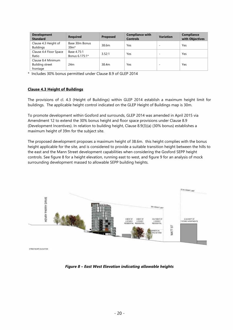
Clause 4.3 Height of Buildings
The provisions of cl. 4.3 (Height of Buildings) within GLEP 2014 establish a maximum height limit for
buildings. The applicable height control indicated on the GLEP Height of Buildings map is 30m.
To promote development within Gosford and surrounds, GLEP 2014 was amended in April 2015 via
Amendment 12 to extend the 30% bonus height and floor space provisions under Clause 8.9
(Development Incentives). In relation to building height, Clause 8.9(3)(a) (30% bonus) establishes a
maximum height of 39m for the subject site.
The proposed development proposes a maximum height of 38.6m. this height complies with the bonus
height applicable for the site, and is considered to provide a suitable transition height between the hills to
the east and the Mann Street development capabilities when considering the Gosford SEPP height
controls. See figure 8 for a height elevation, running east to west, and figure 9 for an analysis of mock
surrounding development massed to allowable SEPP building heights.
Figure 8 – East West Elevation indicating allowable heights

- 21 -
Figure 9 – Future development massing to SEPP Heights with subject site detailed
Clause 4.4 Floor Space Ratio
The provisions of Clause 4.4 (Floor Space Ratio) within GLEP 2014 establish a maximum floor space ratio
(FSR) for buildings. The applicable FSR control is 4.75:1. With the 30% bonus allowable under Clause 8.9
(Development Incentives) the subject site has a maximum FSR of 6.175:1. The proposed FSR is 3.52:1 and
complies with the base FSR control.
7.1 Acid sulfate soils
This land has been identified as being affected by the Acid Sulfate Soils Map and the matters contained in
clause 7.1 of Gosford Local Environmental Plan 2014 have been considered. The site contains Class 5 Acid
Sulfate Soils. In this instance, the proposal works are not considered to impact on Acid Sulfate Soils.
PART 8 – Additional Local Provisions – Gosford City Centre
8.1 Objectives.
The objectives of Part 8 for the Gosford City Centre are:
b. to promote the economic and social revitalisation of Gosford City Centre,
c. to strengthen the regional position of Gosford City Centre as a multi-functional and innovative centre
for commerce, education, health care, culture and the arts, while creating a highly liveable urban space
with design excellence in all elements of its built and natural environments,
d. to protect and enhance the vitality, identity and diversity of Gosford City Centre,
e. to promote employment, residential, recreational and tourism opportunities in Gosford City Centre,
f. to encourage responsible management, development and conservation of natural and man-made
resources and to ensure that Gosford City Centre achieves sustainable social, economic and
environmental outcomes,
g. to protect and enhance the environmentally sensitive areas and natural and cultural heritage of Gosford
City Centre for the benefit of present and future generations,

- 22 -
h. to help create a mixed use place, with activity during the day and throughout the evening, so that
Gosford City Centre is safe, attractive and efficient for, and inclusive of, its local population and visitors
alike,
i. to enhance the Gosford waterfront,
j. to provide direct, convenient and safe
The proposal complies with the above objectives. The development will aid in the provision of an increased
population within close, walking proximity to a major public transport route, that will support the economic
and social revitalisation of the Gosford City centre. The design generally meets the criteria for design
excellence and SEPP 65 requirements. Further, the proposal adds to housing choice in the locality.
8.4 Minimum building street frontage
This clause requires developments to have a minimum street frontage of 24m. The subject site has a 38.4m
total frontage and complies.
8.5 Design Excellence
The requirements for design excellence in Clause 8.5 of GLEP 2014 have been considered in the assessment
of the application. Assessment of the proposal against the matters attributed to design excellence under
Clause 8.5(3) concludes that Council is satisfied that the proposal exhibits design excellence.
Council’s Architect provided comments on the revised design and notes that the amended application now
complies with height and FSR controls and is a significant improvement on the earlier proposal and is
supported in principle.
The design is supported by a design verification statement which has been assessed and outlines a number
of reasons which confirm that the design incorporates appropriate features and methods which
demonstrate excellence.
The development provides for a mix of 1, 2 and 3 bedroom apartments which will add to housing mix in
the locality. The units have been assessed against the ADG and are considered to exhibit qualities sought
by the instrument.
The design is complimented by a BASIX certificate which confirms that the development is able to achieve
environmental sustainability criteria. The development is considered likely to establish a high standard of
design to be built upon by future developments in the locality as Gosford continues to grow and develop.
Clause 8.9 Development incentives
This clause applies to land identified as being within Gosford City Centre on the Development Incentives
Map. The site is within the Gosford City Centre and at the time that this development application was
lodged with Council, Clause 8.9 was applicable and allowed for a 30% bonus provision for both building
height and FSR.
s. 4.15(1)(a)(iii) of the EP&A Act: Provisions of any development control plan
Gosford Development Control Plan 2013 (GDCP 2013)
GCDP 2013 provides objectives, design criteria and design guidance on how development proposals can
achieve good design and planning practice. The proposal is considered acceptable having regard to the
requirements of GCDP 2013. For a detailed consideration, refer to the GDCP 2013 Compliance Table
contained within Attachment 4.

- 23 -
s. 4.15(1)(b) of the EP&A Act: Likely Impacts of the Development
Section 4.15 (1)(b) of the EP&A Act requires consideration of the likely impacts of the development including
environmental impacts on both the natural and built environments, and social and economic impacts in the
locality. The likely impacts of the development are addressed below:
a) Built Environment
The proposed built form is considered acceptable in the context of the site.
b) Access and Transport
The impact of the proposal on pedestrian access, parking and the road network has been considered by
Council’s engineer who supports the application subject to conditions. The site is within walking distance
of public transport, and a range of commercial, service and retail opportunities. The car parking provided
exceed the minimum requirements of the Roads and Maritime Services Guide to Traffic Generating
Development as required by the Apartment Design Guide.
c) Context and Setting
The site is located within the B4 Mixed Use zone of the GLEP 2014, which is currently in transition to include
higher density forms of development. The impacts of the proposal have been considered in the assessment
of the application. The residential development is considered to be in line with the desired future character
of the area.
d) Natural Environment
The site is within the established urban area and is currently developed for housing. The clearing
proposed within lands to the east of the development has been reviewed by Council’s Ecology and Tree
staff who have raised no issue with the works proposed. It is not considered that the development will
result in unacceptable impacts on the natural environment.
e) Economic Impacts
The proposed scale of the development continues to contribute to the economic revitalisation of Gosford.
The provision of additional dwellings proximate to the city centre contributes positively to the vibrancy
and commercial vitality of the centre.
f) Social Impacts
This site and the surrounding area in general is considered to be somewhat underdeveloped. Typical
buildings on Bent Street exhibit poor upkeep and low dwelling yields, with many single residential
dwellings present. The proposed development will revitalise the subject site and is likely to have a flow on
effect through increased activity to the area in general.
The improvement of properties along this street will encourage walkability, activation and patronage of
business within the city core and open spaces along the waterfront. Again, the increased local population
will also support local business and services

- 24 -
s. 4.15 (1)(c) of the EP&A Act: Suitability of the Site for the Development
The site is zoned B4 Mixed Use which permits a range of uses. The development is considered to be in
accordance with the desired future character of the area as envisaged by the GDCP 2013. The site is not
impacted by flooding, or flora and fauna constraints. As such the site is considered suitable for this type of
development.
Submissions from Public Authorities
s. 4.15 (1)(d) of the EP&A Act: Any Submission Made in Accordance with this Act or Regulations
Section 4.15 (1)(d) of the EP&A Act requires consideration of any submissions received during notification
of the proposal.
Public Submissions
The application was notified and advertised in accordance with Chapter 7.3 of Gosford Development
Control Plan 2013 (GDCP 2013) from Thursday, 19 December 2019 to Monday, 3 February 2020. Amended
plans were re-notified and advertised from Friday 4 September to Friday 2 October 2020.
Seven (7) public submissions were received in relation to the application.
The issues have been addressed in the assessment of the application pursuant to the heads of
consideration contained within section 4.15 of the Environmental Planning and Assessment Act 1979 and
as set out below.
Overshadowing of No. 140, 142, 144 Faunce St
Comment:
The revised plans subject to this 8.2(1)(a) review have been reduced in height to within the control limits,
and have located the single tower to the north east portion of the site, effectively allowing for a 12 metre
setback to the western boundary for the entire elevation of the building, and a 8 – 12 m setback,
increasing from ground level to the top storey, for the southern elevation of the building. While
overshadowing to the properties on Faunce Street occurs, given the existing topography and vegetation
within the area, these properties have limited solar access to their northern and eastern elevations at
present.
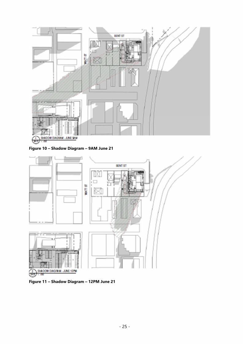
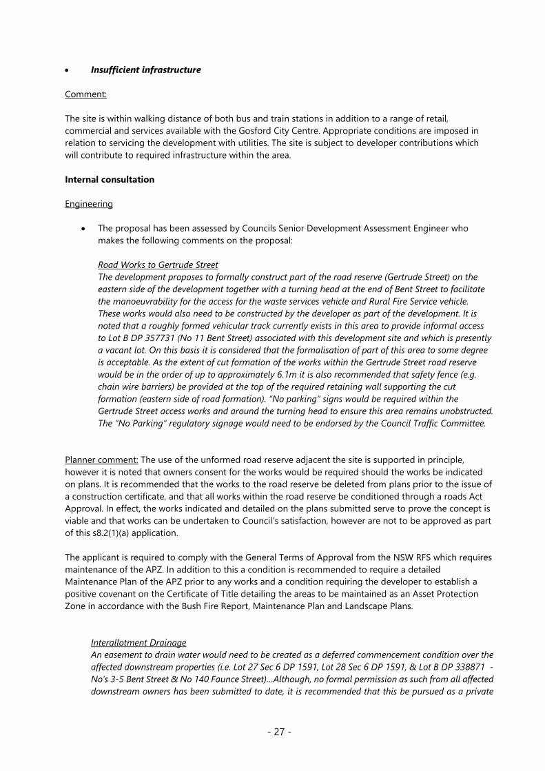
Shadow diagrams prepared (figures 10 – 12) indicate that 140 and 142 Faunce Street would achieve some
solar access from approximately 1pm onward at mid winter, with 144 Faunce Street being most affected;
however any redevelopment anywhere near approaching the controls applicable to the site would result
in a similar level of overshadowing to all properties, as indicated by the depth of the shadow being far
greater than the sites in question.
- 25 -
Figure 10 – Shadow Diagram – 9AM June 21
Figure 11 – Shadow Diagram – 12PM June 21

- 26 -
Figure 12 – Shadow Diagram – 3PM June 21
The proposed development is an overdevelopment of the site
Comment:
The proposed development generally meets the applicable height, FSR and setback controls, and has
reduced the number of units within the development from the originally refused 101 units to 56 units,
with adequate parking and landscaping and deep soil that exceed the applicable controls of the DCP and
the ADG.
Council considers the revised design to be a suitable design and development density for the subject site.
Traffic and parking impacts
Comment:
Adequate on-site car parking has been provided in accordance with the Roads and Maritime Services
Guide to Traffic Generating Development as required by the Apartment Design Guide. The development
application is supported by a Traffic and Parking Impact Assessment prepared by Barker Ryan Stewart
which has been reviewed by Councils Engineer. It is concluded that the street network can cater for the
additional traffic generated by the proposal.
- 27 -
Insufficient infrastructure
Comment:
The site is within walking distance of both bus and train stations in addition to a range of retail,
commercial and services available with the Gosford City Centre. Appropriate conditions are imposed in
relation to servicing the development with utilities. The site is subject to developer contributions which
will contribute to required infrastructure within the area.
Internal consultation
Engineering
The proposal has been assessed by Councils Senior Development Assessment Engineer who
makes the following comments on the proposal:
Road Works to Gertrude Street
The development proposes to formally construct part of the road reserve (Gertrude Street) on the
eastern side of the development together with a turning head at the end of Bent Street to facilitate
the manoeuvrability for the access for the waste services vehicle and Rural Fire Service vehicle.
These works would also need to be constructed by the developer as part of the development. It is
noted that a roughly formed vehicular track currently exists in this area to provide informal access
to Lot B DP 357731 (No 11 Bent Street) associated with this development site and which is presently
a vacant lot. On this basis it is considered that the formalisation of part of this area to some degree
is acceptable. As the extent of cut formation of the works within the Gertrude Street road reserve
would be in the order of up to approximately 6.1m it is also recommended that safety fence (e.g.
chain wire barriers) be provided at the top of the required retaining wall supporting the cut
formation (eastern side of road formation). “No parking” signs would be required within the
Gertrude Street access works and around the turning head to ensure this area remains unobstructed.
The “No Parking” regulatory signage would need to be endorsed by the Council Traffic Committee.
Planner comment: The use of the unformed road reserve adjacent the site is supported in principle,
however it is noted that owners consent for the works would be required should the works be indicated
on plans. It is recommended that the works to the road reserve be deleted from plans prior to the issue of
a construction certificate, and that all works within the road reserve be conditioned through a roads Act
Approval. In effect, the works indicated and detailed on the plans submitted serve to prove the concept is
viable and that works can be undertaken to Council’s satisfaction, however are not to be approved as part
of this s8.2(1)(a) application.
The applicant is required to comply with the General Terms of Approval from the NSW RFS which requires
maintenance of the APZ. In addition to this a condition is recommended to require a detailed
Maintenance Plan of the APZ prior to any works and a condition requiring the developer to establish a
positive covenant on the Certificate of Title detailing the areas to be maintained as an Asset Protection
Zone in accordance with the Bush Fire Report, Maintenance Plan and Landscape Plans.
Interallotment Drainage
An easement to drain water would need to be created as a deferred commencement condition over the
affected downstream properties (i.e. Lot 27 Sec 6 DP 1591, Lot 28 Sec 6 DP 1591, & Lot B DP 338871 -
No’s 3-5 Bent Street & No 140 Faunce Street)…Although, no formal permission as such from all affected
downstream owners has been submitted to date, it is recommended that this be pursued as a private

- 28 -
matter to be resolved with the required easement to drain water over these properties created prior to
the issuing of an operative development consent.
Council’s Engineer and Planner have walked the site and consider the interallotment drainage to be
manageable, however note that to assist with stormwater management of the site when under construction,
a condition is recommended that requires the interallotment drainage pipeline and drainage works within
Faunce Street to be constructed prior to commencement of building works on the site, see condition 3.22.
Trees
The proposal has been assessed by Council’s Tree Assessment Officer, who requests that two
additional trees be marked for removal due to their proximity to proposed cut and earthworks.
Trees to be removed within the subject site mostly consist of planted ornamentals, whereas the
majority of large native trees require removal from public land for the proposed access and
turning head. The removal of these trees is supported, subject to conditions.
It is noted that the revised Landscape Plan proposes a slight increase in numbers of new trees to
be planted consisting of larger Angophora costata to suitable smaller natives such as Water Gum,
Cheese tree, Quandong and Blueberry Ash, which are considered suitable for the site.
Ecology
The proposal has been assessed by Council’s Ecologist, who is supportive of the proposal, subject
to conditions. Council’s Ecologist has recommended a condition to limit the ecological impacts of
the clearing of the road reserve for the APZ. This recommended condition includes the
requirement of a meeting to be held on site between the bushfire consultant and project
ecologist to determine the locations and quantities of native vegetation islands within the APZ.
The maximum retention of vegetation as allowed under bushfire requirements will minimise the
ecological impact. To maintain ecological connectivity, islands of native vegetation are to be
retained within the APZ where possible.
Waste
The proposal has been assessed by Council’s Waste Management Assessment Officer and is
supported, subject to conditions.
Architect
The proposal has been assessed by Council’s Architect and is generally supported.
Councils Architects notes “The height has been reduced to a maximum of 39 metres and now
complies with the height control.
The ADG requires 6 metre setback to habitable rooms and balconies up to 4 levels, 9 metres up to 8
levels and 12 metres above this.
The application now fully complies with the ADG on the west and south. There remains non-
compliance on the east though it is accepted that this elevation faces the road reserve.
Below ground parking has been removed from the western and southern sides of the site allowing this
area to be allocated to deep soil zones, landscaping and communal open space.

- 29 -
The deep soil and landscaped area now exceed the ADG requirement of 7% of the site area and is
located at natural ground level on the western and southern setbacks where it provides outlook and
visual separation to and from adjoining sites.
Amenity of units is generally acceptable with all units receiving solar access between 9am and 3pm
in midwinter.
Most units have some cross ventilation and access to the gym, pool and outdoor area is now directly
from the lift lobby.”
Council’s Architects notes that “The aesthetics are acceptable with articulation and some variation
in materials though it is noted that lime green panels have not been favoured by the JRPP on previous
applications.”
It is again noted, as was the case in the original application, that Council’s Architect is not supportive
of the clearing of the existing mature vegetation with the adjacent Road Reserve, stating that “the
use of Council’s road reserve on the east as a parking area for garbage collection is not supported. It
will necessitate a 5-metre-deep cut with a high retaining wall within the road reserve and the removal
of a number of significant mature trees. These provide an important vegetated visual buffer to the
main road of Henry Parry Drive and should be preserved.”
These concerns are noted however, on balance, it is considered that the benefits of improving the
road reserve so as to facilitate the movements of Council’s waste collection vehicles, and also to
incorporate APZ within the road reserve to allow for the redevelopment of the site are warranted.
Councils Tree Officer, Development Engineer, and Ecologist are satisfied with the tree removal,
subject to conditions.
Building
The proposal has been assessed by Councils Building Surveyor, and is supported, subject to
conditions.
External Consultation
Integrated Approval Referral Body
NSW Rural Fire Service (RFS)
Supported, subject to General Terms of Approval
Submissions from Public Authorities
Roads and Maritime Services (RSM)
Supported
RMS “has reviewed the information provided and raises no objection to or requirements for the
proposed development as it is considered there will be no significant impact on the nearby classified
(State) road network.”
RMS also noted “the potential for road traffic noise to impact on development on the site, in
particular, noise generated by Henry Parry Drive, a classified State road (HW10). In this regard, the
developer, not Roads and Maritime is responsible for providing noise attenuation measures in

- 30 -
accordance with the NSW Road Noise Policy 2011, prepared by the department previously known as
the Department of Environment, Climate and Water.
If external noise criteria cannot feasibly or reasonably be met, Roads and Maritime recommends
that Council apply internal noise objectives for all habitable rooms with windows that comply with
the Building Code of Australia.”
The Noise Assessment provided addresses the noise from Henry Parry Drive and includes
recommendation to achieve compliance with relevant noise criteria. The recommendations of this
report are to be implemented at the required stages of construction, see Condition 2.15.
Ecologically Sustainable Principles
The proposal has been assessed having regard to ecologically sustainable development principles and is
considered to be consistent with the principles.
The proposed development is considered to incorporate satisfactory stormwater, drainage and erosion
control and the retention of vegetation where possible and is unlikely to have any significant adverse
impacts on the environment and will not decrease environmental quality for future generations. The
proposal does not result in the disturbance of any endangered flora or fauna habitats and is unlikely to
significantly affect fluvial environments.
Climate Change
The potential impacts of climate change on the proposed development have been considered by Council
as part of its assessment of the application.
This assessment has included consideration of such matters as potential rise in sea level; potential for
more intense and/or frequent extreme weather conditions including storm events, bushfires, drought,
flood and coastal erosion; as well as how the proposed development may cope, combat, withstand these
potential impacts. The proposed development is considered satisfactory in relation to climate change.
Other Matters for Consideration
Development Contribution Plan
The Gosford City Centre Special Infrastructure Contribution Determination came into effect on Friday 12
October 2018. A Special Infrastructure Contribution levy of two per cent on the cost of development is
required for new development within the Gosford City Centre. This applies to development located on
residential and business zoned land that has a cost of development of $1 million and over. See Condition
2.3.
Section 7.12 A contributions for the Gosford City Centre remains in place however the contribution levy
has been reduced from 4% to 1%. Condition 2.4 is recommended requiring the development contribution
to be paid prior to the issue of any Construction Certificate.
Planning Agreements
The proposed development is not subject to a planning agreement / draft planning agreement.
Political Donations
During assessment of the application there were no political donations were declared by the Applicant,
Applicant’s consultant, owner, objectors and/or residents.

- 31 -
Conclusion
This Section 8.2 – 8.5 review application has been assessed under the heads of consideration of section
4.15 of the Environmental Planning and Assessment Act 1979 and all relevant instruments and policies.
The additional information and amendments to the plans have reasonably addressed the reasons for
refusal, as detailed in Table 1 within this report. Subject to the imposition of appropriate conditions, the
proposed development is not expected to have any adverse social or economic impact. It is considered
that the proposed development will complement the locality and meet the desired future character of the
area.
Accordingly, the application is recommended for approval pursuant to section 4.16 of the Environmental
Planning and Assessment Act.
Attachments
1. Proposed Conditions of Consent
2. Architectural Plans prepared by ADG Architects
3. ADG Compliance Table
4. GDCP 2013 Compliance Table
5. Legal Opinion on Substantially the Same Development
- 32 -
ATTACHMENT 1
This consent does not operate until the following have been satisfied:
1) The submission of the following to allow the applicant to gain permission to undertake inter-
allotment drainage works:
a) Creation of an easement to drain water minimum 1m wide over Lot 27 Sec 6 DP 1591, Lot 28 Sec
6 DP 1591, & Lot B DP 338871 generally in accordance with the alignment indicated on the plan
prepared by Barker Ryan Stewart, Plan No CC150124E1.19 Rev G dated 2/04/2019. Documentary
evidence of the creation of this required easement to drain water shall be submitted to Council
b) Written permission to enter the site and construct the IAD system is to be obtained from the
owners of each of the burdened properties listed above.
2) All works to and within the Gertrude Extension road reserve are to be deleted from plans. Works are
to be undertaken through condition 2.6 of this consent.
3) A detailed cost report prepared by a registered quantity surveyor verifying the cost of the
development is to be submitted to Council.
Condition 2.4 of this consent will be modified upon receipt of a satisfactory cost report to reflect the
cost of works.
4) Detailed landscape plans prepared by a qualified landscape Architect are to be prepared to reflect the
draft landscape elements as shown on the plans provided for this review. The plans are to detail all
species, plant stock sizes and planting/maintenance requirements.
Evidence must be produced to the consent authority sufficient to enable it to be satisfied that above
conditions have been complied within twelve (12) months of the date of this approval, otherwise this
consent will lapse.
Upon compliance with the conditions of deferred commencement Council will issue an operative consent
(including stamped plans) that is subject to the attached conditions.
DEFERRED COMMENCEMENT
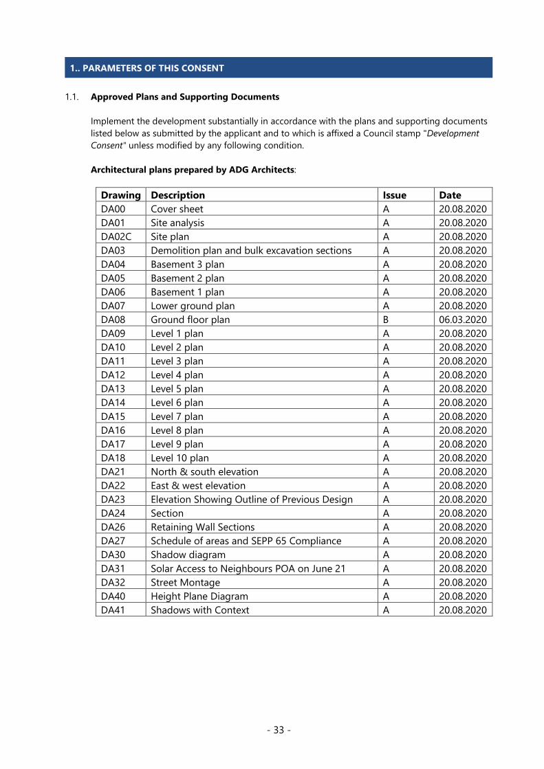
- 33 -
1.1. Approved Plans and Supporting Documents
Implement the development substantially in accordance with the plans and supporting documents
listed below as submitted by the applicant and to which is affixed a Council stamp "Development
Consent" unless modified by any following condition.
Architectural plans prepared by ADG Architects:
Drawing Description Issue Date
DA00 Cover sheet A 20.08.2020
DA01 Site analysis A 20.08.2020
DA02C Site plan A 20.08.2020
DA03 Demolition plan and bulk excavation sections A 20.08.2020
DA04 Basement 3 plan A 20.08.2020
DA05 Basement 2 plan A 20.08.2020
DA06 Basement 1 plan A 20.08.2020
DA07 Lower ground plan A 20.08.2020
DA08 Ground floor plan B 06.03.2020
DA09 Level 1 plan A 20.08.2020
DA10 Level 2 plan A 20.08.2020
DA11 Level 3 plan A 20.08.2020
DA12 Level 4 plan A 20.08.2020
DA13 Level 5 plan A 20.08.2020
DA14 Level 6 plan A 20.08.2020
DA15 Level 7 plan A 20.08.2020
DA16 Level 8 plan A 20.08.2020
DA17 Level 9 plan A 20.08.2020
DA18 Level 10 plan A 20.08.2020
DA21 North & south elevation A 20.08.2020
DA22 East & west elevation A 20.08.2020
DA23 Elevation Showing Outline of Previous Design A 20.08.2020
DA24 Section A 20.08.2020
DA26 Retaining Wall Sections A 20.08.2020
DA27 Schedule of areas and SEPP 65 Compliance A 20.08.2020
DA30 Shadow diagram A 20.08.2020
DA31 Solar Access to Neighbours POA on June 21 A 20.08.2020
DA32 Street Montage A 20.08.2020
DA40 Height Plane Diagram A 20.08.2020
DA41 Shadows with Context A 20.08.2020
1.. PARAMETERS OF THIS CONSENT

- 34 -
Supporting Documentation
Document Prepared by Date / Issue ECM
Document No:
Apartment Design Guide
Compliance Report and
Verification Statement
Anthony Kelly (registered
architect No.6999)
10.20
Rev H
14232038
Noise Assessment Spectrum Acoustics February 2016 26870218
Proposed road, driveway &
drainage
DA plans Sheets 1 -19
Barker Ryan Stewart 02.04.19
Rev G
26832126
Traffic & Parking Impact
Assessment
Barker Ryan Stewart 15.10.19
Rev 8
25427054
Stormwater Management
Report
Barker Ryan Stewart 20.11.19
Rev 4
ECMD25427052
Waste Management Plan Barker Ryan Stewart 05.05.20
Rev 9
14241319
BASIX Certificate number:
713208M_05
Gradwell Consulting 27.08.20 14229260
NatHERS Ceretificate Gradwell Consulting 27.08.20 14229262
Assessor Certificate Gradwell Consulting 03.05.19 26829844
Arboricultural
Impact assessment
ADVANCED TREESCAPE
CONSULTING
19.11.18 26540054
Flora and Fauna Impact
Assessment REF: GCC 15-778
Keystone Ecological December 2015 26540053
Survey Plan Alan Bardsley 16.08.15 26540066
Bushfire Assessment Report
Advanced Bushfire
Performance Solutions
01.11.19
Rev 6
25427043
DA Access Audit Assistive Technology
Australia
21.12.18
Rev 1
26540064
Geotechnical Investigation Asset Geotechnical 09.10.15 26540062
Crime Prevention through
Environmental Design
Assessment
Barker Ryan Stewart 19.11.19
Rev 4
25427047
1.2. Carry out all building works in accordance with the Building Code of Australia.
1.3. Comply with the General Terms of Approval from the NSW Rural Fire Service, letter reference
DA20191216001532-Original-1, dated 06 February 2020, as reproduced below:
Asset Protection Zones
The intent of measures is to provide sufficient space and maintain reduced fuel loads so as to
ensure radiant heat levels of buildings are below critical limits and to prevent direct flame
contact with a building. To achieve this, the following conditions shall apply:
1. At the commencement of building works, or the issue of a subdivision certificate (whichever
comes first) and in perpetuity, the entire property shall be managed as an Inner Protection Area
(IPA) as outlined within section 4.1.3 and Appendix 5 of 'Planning for Bush Fire Protection
2006' and the NSW Rural Fire Service's document 'Standards for asset protection zones'.

- 35 -
2. Prior to the issue of occupancy certificate the proposed landscaped area adjacent to Henry
Parks drive shall be completed in accordance with the “Ground Flood Landscape Plan 1 of 2”
prepared by Xeriscapes dated 28.11.18, Drawing No.L101. and be managed in accordance with
the same plan.
Water and Utilities
The intent of measures is to provide adequate services of water for the protection of buildings
during and after the passage of a bush fire, and to locate gas and electricity so as not to
contribute to the risk of fire to a building. To achieve this, the following conditions shall apply:
3. Water, electricity and gas are to comply with the requirements of section 4.1.3 of 'Planning
for Bush Fire Protection 2006'.
Access
The intent of measures for public roads is to provide safe operational access to structures and
water supply for emergency services, while residents are seeking to evacuate from an area. To
achieve this, the following conditions shall apply:
4. Public road access shall comply with section 4.1.3 (1) of ‘Planning for Bush Fire Protection
2006’.
The intent of measures for property access is to provide safe access to/from the public road
system for fire fighters providing property protection during a bush fire and for occupants faced
with evacuation. To achieve this, the following conditions shall apply:
5. The property access road shall comply with section 4.1.3 (2) of Planning for Bush Fire
Protection 2006.
Design and Construction
The intent of measures is that buildings are designed and constructed to withstand the
potential impacts of bush fire attack. To achieve this, the following conditions shall apply:
6. The Northern and Eastern elevations including all balcony’s and roof structures shall comply
with section 3 and section 6 (BAL 19) Australian Standard AS3959-2009 ‘Construction of
buildings in bush fire-prone area’ or NASH Standard (1.7.14 updated) ‘National Standard Steel
Framed Construction in Bushfire Areas – 2014’ as appropriate and section A3.7 Addendum
Appendix 3 of 'Planning for Bush Fire Protection' 2006’.
7. The Southern and Western elevations shall comply with Sections 3 and 5 (BAL 12.5)
Australian Standard AS3959-2009 'Construction of buildings in bush fire-prone areas' or NASH
Standard (1.7.14 updated) ‘National Standard Steel Framed Construction in Bushfire Areas –
2014’ as appropriate and section A3.7 Addendum Appendix 3 of 'Planning for Bush Fire
Protection 2006'.
Landscaping
8. Landscaping to the site is to comply with the principles of Appendix 5 of “Planning for Bush
Fire Protection 2006”.
1.4. Comply with all commitments listed in BASIX Certificate as required under clause 97A of the
Environmental Planning and Assessment Regulation 2000.

- 36 -
2.. PRIOR TO ISSUE OF ANY CONSTRUCTION CERTIFICATE
2.1. All conditions under this section must be met prior to the issue of any Construction Certificate.
2.2. No activity is to be carried out on-site until the Construction Certificate has been issued, other than:
a) Site investigation for the preparation of the construction, and / or
b) Implementation of environmental protection measures, such as erosion control and the like
that are required by this consent
c) Demolition approved by this consent.
2.3. Special Infrastructure Contribution – Gosford City Centre - Obtain a determination by the
Planning Secretary as to whether a special infrastructure contribution is required to be made under
the Environmental Planning and Assessment (Special Infrastructure Contribution - Gosford City Centre)
Determination 2018 (2018 Determination). The developer must do so before the time by which a
special infrastructure contribution, if made as a monetary contribution, would have to be paid under
the 2018 Determination.
To assist the Planning Secretary in making that determination, the developer is to provide the
Planning Secretary with an up-to-date estimate of the proposed cost of carrying out the
development, as referred to in the 2018 Determination.
If the Planning Secretary determines that a special infrastructure contribution is required to be made
under the 2018 Determination, a contribution must be made in accordance with that Determination
(as in force when this consent takes effect).
A person may not apply for a construction certificate in relation to development the subject of this
development consent unless the person provides, in connection with the application, written
evidence from the Department of Planning and Environment that the special infrastructure
contribution for the development (or that part of the development for which the certificate is sought)
has been made or that arrangements are in force with respect to the making of the contribution.
In this condition:
developer means the person having the benefit of this development consent, and
Planning Secretary means the Secretary of the Department of Planning and Environment.
More information - Please contact the Department of Planning and Environment by email to:
2.4. Pay to Council a contribution amount of $TBC that may require adjustment at time of payment, in
accordance with the Section 94A Development Contribution Plan - Gosford City Centre.
The total amount to be paid must be indexed each quarter in accordance with the Consumer Price
Index (All Groups index) for Sydney issued by the Australian Statistician as outlined in the contribution
plan.
Contact Council’s Contributions Planner on Tel 1300 463 954 for an up-to-date contribution payment
amount.
Any Construction Certificate must not be issued until the developer has provided the Accredited
Certifier with a copy of a receipt issued by Council that verifies that the contributions have been paid.
A copy of this receipt must accompany the documents submitted by the certifying authority to
- 37 -
Council under Clause 104/Clause 160(2) of the Environmental Planning and Assessment Regulation
2000.
A copy of the Contributions Plan may be inspected at the office of Central Coast Council, 49 Mann
Street Gosford or on Council’s website: Development Contributions - former Gosford LGA
2.5. Submit an application to Council under Section 305 of the Water Management Act 2000 to obtain a
Section 307 Certificate of Compliance. The Application for a 307 Certificate under Section 305 Water
Management Act 2000 form can be found on Council’s website www.centralcoast.nsw.gov.au. Early
application is recommended.
A Section 307 Certificate must be obtained prior to the issue of any Construction Certificate.
2.6. Obtain a Roads Act Works Approval by submitting an application to Council for a Section 138 Roads
Act Works Approval for all works required within the road reserve. The application is to be lodged
using an Application for Subdivision Works Certificate or Construction Certificate, Roads Act Works
Approval and other Development related Civil Works form.
The application is to be accompanied by detailed design drawings, reports and other documentation
prepared by a suitably experienced qualified professional in accordance with Council’s Civil Works
Specifications.
Fees, in accordance with Council’s Fees and Charges, will be invoiced to the applicant following
lodgement of the application. Fees must be paid prior to Council commencing assessment of the
application.
Design drawings, reports and documentation will be required to address the following works within
the road reserve:
a) Half width road works including kerb and guttering, subsoil drainage, footpath formation,
drainage and a minimum 6m wide road pavement across the full frontage of the site in Bent
Street.
b) Footway formation graded at +2% from the top of kerb to the property boundary, across the
full frontage of the site in Bent Street.
c) Road works in Gertrude Street including kerb and guttering (both sides), subsoil drainage,
1m wide footway formation graded at 2% on the eastern side, 3m wide footway formation
graded at 2% on the western side, drainage, and a minimum 6m wide road pavement across
the frontage of the site in Gertrude Street associated with the service road.
d) Intersection of Bent Street & Gertrude Street to provide a turning head for the waste services
vehicle and the NSW RFS emergency vehicle to enter and exit Bent Street in a forward
direction. The intersection shall be designed to accommodate the manoeuvrability for the
AS2890.2:2002 12.5m Heavy Rigid Vehicle (HRV), and facilitate the AS2890.2:2002 12.5m HRV
to reverse into the service road within the Gertrude Street frontage of the site. The footway
formation on the northern side of the intersection works shall be provided to accommodate
a guard rail in a location that will not conflict with the overhang of the AS2890.2:2002 12.5m
HRV.
e) 1.5m wide reinforced (SL72 steel fabric, 100mm thick) concrete footpath in an approved
location across the full frontage of the site in Bent Street.
f) 3m wide reinforced (SL72 steel fabric, 100mm thick) concrete footpath on the western side of
the road pavement works in Gertrude Street associated with the service road.
g) 1m wide reinforced (SL72 steel fabric, 100mm thick) concrete footpath on the eastern side of
the road pavement works Gertrude Street associated with the service road and the eastern

- 38 -
side of the pavement works associated with the intersection of Bent Street and Gertrude
Street.
h) Heavy-duty vehicle crossing in Gertrude Street associated with access to the bin holding area
that has a width of 5.5m and constructed with 200mm thick concrete reinforced with 1 layer
of SL72 steel fabric top and bottom.
i) Retaining walls around the southern and eastern sides of the proposed works within the
Gertrude Street road reserve (including the service road and intersection works). Retaining
walls must be designed by a practising Civil / Structural engineer in conjunction with the
recommendations from a practising Geotechnical engineer. Retaining walls must not conflict
with services. The design is to be certified by a registered practising Civil or Structural
engineer as being in accordance with Australian Standards.
j) A concrete catch drain on the high (eastern) side of the retaining walls within the Gertrude
Street road reserve (including the service road and intersection works), with a minimum
depth of 300mm and to connect to the proposed drainage pit within the northern end of the
turning head in Gertrude Street.
k) A safety fence (chain wire) with a minimum height of 1.8m on the high side of the retaining
walls around the southern and eastern sides of the proposed works within the Gertrude
Street road reserve (including the service road and intersection works).
l) all redundant vehicular crossings are to be removed and footway formation reinstated.
m) Connection of stormwater from the turning head at the intersection of Bent Street and
Gertrude Street, and the service road and associated catch drain in Gertrude to the existing
watercourse within the Gertrude Street road reserve on the northern side of the proposed
turning head works.
n) The piping of stormwater from within the site to Council’s existing piped drainage system in
Faunce Street.
o) Longitudinal street drainage (minimum 375mm RCP) along the northern side of Faunce
Street from where the proposed drainage pipeline from the development meets the kerb
alignment in Faunce Street to connect to the existing drainage pit on the northern side of
Faunce Street located near the intersection on Faunce Street and Watt Street. This will
require new kerb inlet pits at the start of the pipeline, reconstruction of the existing kerb inlet
pit associated with the pipeline connection of SP 91805 (No 19 Watt Street) to Faunce Street,
reconstruction of the existing kerb inlet pit in Faunce Street near the intersection of Faunce
Street and Watt Street, and new pipelines to suit.
p) Roadside furniture and safety devices as required eg. fencing, signage, guide posts, chevrons,
and/or guard rail in accordance with RMS and relevant Australian Standards
q) “No Parking’ signage within the service road within the Gertrude Street frontage of the site,
the turning head at the intersection of Bent Street and Gertrude Street, and within the
eastern end of Bent Street to ensure that the swept turning paths of the AS2890.2:2002
12.5m HRV are unobstructed at all times. The signage and line marking plan must be
approved by Council’s Traffic Committee.
r) Erosion and sedimentation control plan.
The design of the required works shall be generally in accordance with the plans prepared by Barker
Ryan Stewart, Reference CC150124E2-G, Sheets 1-8, & 17-19, all Rev G dated 2/04/2019.
- 39 -
The section 138 Roads Act Works Approval must be issued by Council and all conditions of that
approval must be addressed prior to occupying and commencing any works in the road reserve.
2.7. Submit to Council a dilapidation report detailing the condition of all Council assets within the
vicinity of the development. The report must document and provide photographs that clearly
depict any existing damage to the road, kerb, gutter, footpath, driveways, street trees, street signs,
street lights or any other Council assets in the vicinity of the development. The dilapidation report
will be required to be submitted to Council prior to the issue of the Section 138 Roads Act Works
approval or the issue of any construction certificate for works on the site. The dilapidation report
may be updated with the approval of Council prior to the commencement of works. The report will
be used by Council to establish damage to Council’s assets resulting from the development works.
2.8 Submit to the Accredited Certifier responsible for issuing the construction certificate for works within
the development site detailed design drawings and design reports for the following engineering
works:
a) driveways / ramps and car parking areas must be designed according to the requirements of
Australian Standard AS 2890: Parking Facilities for the geometric designs, and industry
Standards for pavement designs.
b) a stormwater detention system must be designed in accordance with Chapter 6.7 - Water
Cycle Management of the Gosford Development Control Plan 2013 and Council’s Civil Works
Specification. The stormwater detention system must limit post development flows from the
proposed development to less than or equal to predevelopment flows for all storms up to
and including the 1% Annual Exceedance Probability (AEP) storm event. A runoff routing
method must be used. An on-site stormwater detention report including an operation and
maintenance plan must accompany the design. On-site stormwater detention is not
permitted within private courtyards, drainage easements, and / or secondary flow paths. On-
site detention is to be designed generally in accordance with the Stormwater Management
Report prepared by Barker Ryan Stewart Project No CC150124 Rev 4 dated 20/11/19).
c) nutrient/pollution control measures must be designed in accordance with Chapter 6.7 -
Water Cycle Management of the Gosford Development Control Plan 2013. A nutrient /
pollution control report including an operation and maintenance plan must accompany the
design. Nutrient/pollution controls are to be designed generally in accordance with the
Stormwater Management Report prepared by Barker Ryan Stewart Project No CC150124 Rev
4 dated 20/11/19).
d) on-site stormwater retention measures must be designed in accordance with Chapter 6.7 -
Water Cycle Management of the Gosford Development Control Plan 2013. A report detailing
the method of stormwater harvesting, sizing of retention tanks for re-use on the site and an
operation and maintenance plan must accompany the design. On-site retention measures
are to be designed generally in accordance with the Stormwater Management Report
prepared by Barker Ryan Stewart Project No CC150124 Rev 4 dated 20/11/19).
e) interallotment drainage within Lot 27 Sec 6 DP 1591, Lot 28 Sec 6 DP 1591, & Lot B DP
338871 to connect stormwater from the development to Council’s drainage system in Faunce
Street. The interallotment drainage system must be designed in accordance with Council’s
Civil Works Specification and have a minimum capacity to accommodate the stormwater
flows associated with the site in the 1%AEP storm event. The interallotment drainage system
shall be generally in accordance with the plan prepared by Barker Ryan Stewart, Plan No
CC150124E1.19 Rev G dated 2/04/2019.

- 40 -
f) piping of all stormwater from impervious areas within the site to the required interallotment
drainage system to then connect to Council’s drainage system located in Faunce Street.
Detailed design drawings and design reports acceptable to the Accredited Certifier must be included
in the Construction Certificate documentation.
2.9 Submit a pavement investigation and report prepared by a practising Geotechnical Engineer for the
road works. This report must be submitted with the application for work under the Roads Act 1993.
The pavement depths must be determined in accordance with Council’s specifications and the
following traffic loadings:
Name of Street Traffic Loading (ESAs)
Bent Street 2 x 10⁶
Gertrude Street 2 x 10⁶
Gertrude St / Bent St Turning Head & Intersection 2 x 10⁶
2.10 Submit engineering details prepared and certified by a practising structural engineer that comply
with Council’s Building Over or Adjacent To Sewer and Water Main Guidelines to the satisfaction of
Council. Engineering details must be submitted to Council’s Water Assessment Team for approval.
Plan assessment fees apply.
2.11 Pay a security deposit of $100,000 into Council’s trust fund. The payment of the security deposit is
required to cover the cost of repairing damage to Council's assets that may be caused as a result of
the development. The security deposit will be refunded upon the completion of the project if no
damage was caused to Council's assets as a result of the development.
2.12 Submit to Council’s Environment Officer for approval, a Soil and Water Management Plan in
accordance with Section 6.3 of the Gosford Development Control Plan 2013 and the ‘Blue Book’
(Managing Urban Stormwater: Soils and Construction, Landcom, 2004). The plan shall be prepared by
a suitably qualified environmental/civil consultant and shall be adaptive to address all stages of the
construction.
2.13 Submit to Council, the Accredited Certifier and relevant adjoining property owners a dilapidation
report, prepared by a practising structural engineer, detailing the structural characteristics of all
buildings located on No. 5 Bent Street and No’s 142 and 144 Faunce Street. The report must
document and provide photographs that clearly depict any existing damage to the improvements
erected upon allotments immediately adjoining the development site and to the road, kerb, footpath,
driveways, water supply and sewer infrastructure, street trees and street signs or any other Council
asset in the vicinity of the development.
In the event that access to an adjoining property(s) for the purpose of undertaking the dilapidation
report is denied, the applicant must demonstrate in writing that all steps were taken to obtain access
to the adjoining property(s).
2.14 Submit amendments to the approved plans and reports to the accredited certifier pursuant to Clause
139 of the Environmental Planning Regulation 2000: Applications for construction certificates that must
detail:
a. Mail boxes:
i. Provide mail boxes for each residential building in one accessible location adjacent to
the main entrance to the development;

- 41 -
ii. They should be integrated into a wall where possible and be constructed of materials
consistent with the appearance of the building;
iii. Mail boxes shall be secure and large enough to accommodate articles such as
newspapers;
b. Locate satellite dish and telecommunication antennae, air conditioning units, ventilation stacks
and any ancillary structures:
i. Away from the street frontage;
ii. Integrated into the roof-scape design and in a position where such facilities will not
become a skyline feature at the top of any building;
iii. Adequately setback from the perimeter wall or roof edge of buildings;
c. A master antenna must be provided for residential apartment buildings. This antenna shall be
sited to minimise its visibility from surrounding public areas;
d. The reflectivity index (expressed as a percentum of the reflected light falling upon any surface)
of external glazing for windows, walls or roof finishes of the proposed development is to be
no greater than 20%;
e. Storage areas are to be provided in accordance with the following minimum rates:
i. 6m³ for studio and one bedroom units;
ii. 8m³ for two bedroom units;
iii. 10m³ for three plus bedroom units; and
At least 50% of the required storage areas are to be provided within each dwelling.
f. A minimum of one (1) loading /servicing bay is to be provided on Basement Level 1, nearby the
lift access.
g. The external colour schedule of the development must be consistent with the photomontage
referenced as supporting documentation in Condition 1.1 of this Consent.
2.15 The recommendations of the Noise Assessment, prepared by Spectrum Acoustics, dated 1 February
2016, must be included in the Construction Certificate, including, but not limited to:
a. all windows with a direct view of Henry Parry Drive should be upgraded to 6.5mm Vlam Hush
laminated glazing or equivalent.
3.. PRIOR TO COMMENCEMENT OF ANY WORKS
3.1. All conditions under this section must be met prior to the commencement of any works.
3.2. Appoint a Principal Certifying Authority for the building work.
a) The Principal Certifying Authority (if not Council) is to notify Council of their appointment
and notify the person having the benefit of the development consent of any critical stage
inspections and other inspections that are to be carried out in respect of the building work
no later than two (2) days before the building work commences.
- 42 -
b) Submit to Council a Notice of Commencement of Building Works or Notice of Commencement
of Subdivision Works form giving at least two (2) days notice of the intention to commence
building or subdivision work. The forms can be found on Council’s website
www.gosford.nsw.gov.au
3.3. Provide and maintain a garbage receptacle at the work site until the works are completed. The
garbage receptacle must have a tight fitting lid and be suitable for food scraps and papers.
3.4. Install run-off and erosion controls to prevent soil erosion, water pollution or the discharge of loose
sediment on the surrounding land by:
erecting a silt fence and providing any other necessary sediment control measures that will
prevent debris escaping into drainage systems, waterways or adjoining properties, and
diverting uncontaminated run-off around cleared or disturbed areas, and
preventing the tracking of sediment by vehicles onto roads, and
stockpiling top soil, excavated materials, construction and landscaping supplies and debris
within the lot.
Do not commence site works until the sediment control measures have been installed in
accordance with the approved plans / Gosford DCP 2013 Chapter 6.3 - Erosion Sedimentation and
Control.
3.5. Notify the intention to commence works by giving written notice to the owner of the adjoining
property affected by the proposed excavation and/or structural protective works. The required notice
must be accompanied by details of the proposed work at least seven (7) days prior to the
commencement of proposed excavation and/or structural protection works.
3.6. Disconnect, seal and make safe all existing site services prior to the commencement of any demolition
on the site. Sewer and water services must be disconnected by a licensed plumber and drainer with
a Start Work Docket submitted to Council's Plumbing and Drainage Inspector as the Water and Sewer
Authority.
3.7. Provide certification to the Principal Certifying Authority that the structural engineer's details have
been prepared in accordance with the recommendations of the geotechnical report(s) listed as
supporting documentation in this development consent.
3.8. Submit a dilapidation report to Council with the Roads Act application and / or Construction
Certificate application. The report must document and provide photographs that clearly depict any
existing damage to the road, kerb, gutter, footpath, driveways, street trees, street signs or any other
Council assets in the vicinity of the development. The dilapidation report may be updated with the
approval of the Principal Certifying Authority prior to the commencement of works.
3.9. Erect a sign in a prominent position on any work site on which building, subdivision or demolition
work is being carried out. The sign must indicate:
a) The name, address and telephone number of the Principal Certifying Authority for the work;
and
b) The name of the principal contractor and a telephone number at which that person can be
contacted outside of working hours; and
c) That unauthorised entry to the work site is prohibited.
d) Remove the sign when the work has been completed.

- 43 -
3.10. Submit both a Plumbing and Drainage Inspection Application, with the relevant fee, and a
Plumbing and Drainage Notice of Work in accordance with the Plumbing and Drainage Act 2011 (to
be provided by licensed plumber). These documents can be found on Council’s website at:
www.gosford.nsw.gov.au.
Contact Council prior to submitting these forms to confirm the relevant fees.
3.11. Provide toilet facilities at a ratio of one toilet plus one additional toilet for every 20 persons employed
at the site. Each toilet must:
a. Be a standard flushing toilet connected to a public sewer, or
b. Have an on-site effluent disposal system approved under the Local Government Act 1993, or
c. Be a temporary closet approved under the Local Government Act 1993
3.12. Prevent public access to the construction site as required by Clause 298 of the Work Health and
Safety Regulation 2011 when building work is not in progress or the site is unoccupied. Site fencing
specifications are outlined under Australian Standard AS1725.1-2010 - Chain-link fabric fencing -
Security fencing and gates. The use of barbed wire and/or electric fencing is not to form part of the
protective fencing to construction sites.
A separate application made under the Roads Act 1993 will need to be lodged with Council If a
hoarding or construction site fence must be erected on the road reserve or a public place.
3.13. Disconnect and cap the property’s sewer at the inspection shaft.
3.14. Undertake demolition involving asbestos in accordance with the Work Health and Safety Act 2011.
The person having the benefit of this consent must ensure that the removal of:
a. more than 10m2 of non-friable asbestos or asbestos containing material is carried out by a
licensed non-friable (Class B) or a friable (Class A) asbestos removalist, and
b. friable asbestos of any quantity is removed by a licensed removalist with a friable (Class A)
asbestos removal licence.
The licensed asbestos removalist must give notice to the regulator before work commences in
accordance with Clause 466 of the Work Health and Safety Regulation 2011.
3.15. Prepare a Construction Traffic and Pedestrian Management Plan (CTPMP) for all activities related to
works within the site. The plan must be prepared and implemented only by persons with Roads and
Maritime Service accreditation for preparing and implementing traffic management plans at work
sites.
The CTPMP must describe the proposed construction works, the traffic impacts on the local area and
how these impacts will be addressed.
The CTPMP must address, but not be limited to, the following matters:
Ingress and egress of construction related vehicles to the development site.
Details of the various vehicle lengths that will be used during construction and the frequency
of these movement.
Use of swept path diagrams to demonstrate how heavy vehicles enter, circulate and exit the
site or Works Zone in a forward direction.

- 44 -
Deliveries to the site, including loading / unloading materials and requirements for work
zones along the road frontage to the development site. A Plan is to be included that shows
where vehicles stand to load and unload, where construction plant will stand, location of
storage areas for equipment, materials and waste, locations of Work Zones (if required) and
location of cranes (if required).
Works Zones if heavy vehicles cannot enter or exit the site in a forward direction.
Control of pedestrian and vehicular traffic where pre-construction routes are affected.
Temporary Road Closures.
Where the plan identifies that the travel paths of pedestrians and vehicular traffic are proposed to be
interrupted or diverted for any construction activity related to works inside the development site an
application must be made to Council for a Road Occupancy Licence. Implementation of traffic
management plans that address interruption or diversion of pedestrian and/or vehicular traffic must
only take place following receipt of a Road Occupancy Licence from Council or the Roads and
Maritime Service where on a classified road.
Where a dedicated delivery vehicle loading and unloading zone is required along the road frontage
of the development site a Works Zone Application must be lodged and approved by Council. A
minimum of 3 months is required to allow Traffic Committee endorsement and Council approval.
The Construction Traffic and Pedestrian Management Plan must be reviewed and updated during
construction of the development to address any changing site conditions.
A copy of the Construction Traffic and Pedestrian Management Plan must be held on site at all times
and be made available to Council upon request.
3.16. Submit to Council, for approval, details of proposed haulage routes to and from the site. Approval
of haulage routes may be subject to the provision of a dilapidation report of all or part of the
approved haulage route.
3.17. Ensure that all parties / trades working on the site are fully aware of their responsibilities with
respect to tree protection conditions.
3.18. Tree Protection is to be as per the recommendations of the Arboricultural Impact Assessment by R
Kingdom 19/11/18.
3.19. A site meeting is to be held prior to works between the bushfire consultant and project ecologist to
determine the locations and quantities of native vegetation islands within the APZ. The potential
impacts will be mitigated by the maximum retention of vegetation as allowed under bushfire rules.
To maintain ecological connectivity, islands of native vegetation are to be retained within the APZ.
This is achieved by restricting the removal of native vegetation and by relocating native
understorey species that are characteristic of Narrabeen Coastal Blackbutt Forest (e.g. Themeda
australis Kangaroo grass) to replace weed species within those islands. The Arboriculture Report
and Landscape Plan is to be amended and submitted to Council Ecologist for approval.
3.20. Tree Qualified ecologist to attend the site no more than 3 weeks prior clearing. The ecologist must:
Mark trees for retention and removal
Supervise the installation of fencing around any conservation areas
Provide an environmental induction to civil contractors and subcontractors

- 45 -
Provide a nest box replacement strategy (hollow bearing tree inspection, monitoring and
management of fauna prior to clearing, replacement box locations).
Provide a written report to be to Councils Ecologist with the focus of Wildlife/ habitat
Management for the replacement hollow bearing trees.
3.21. A detailed Maintenance Plan of the APZ in accordance with RFS requirements and Inner Protection
Area (IPA) as outlined within section 4.1.3 and Appendix 5 of 'Planning for Bush Fire Protection 2006'
and the NSW Rural Fire Service's document 'Standards for asset protection zones’ in accordance with
the Arboriculture Report and Landscape Plan as amended by Condition 3.19 above shall be submitted
to the PCA prior to the issue of a Construction Certificate. The maintenance plan shall be prepared
by a suitably qualified person and include details on regularly scheduled checks and maintenance,
responses to weather and incidents as deemed appropriate as well as detailing responsible parties
for the ongoing maintenance.
The PCA, if not Council, shall forward a copy of the approved plans and maintenance schedule to
Council.
3.22 The interallotment drainage pipeline and required drainage works within Faunce Street are be
constructed prior to commencement of building works on the site.
4.. DURING WORKS
4.1. All conditions under this section must be met during works.
4.2. Carry out construction or demolition works during the construction phase of the development only
between the hours as follows:
7.00am and 5.00pm Monday to Saturday
No construction or demolition works associated with the development are permitted to be carried
out at any time on a Sunday or a public holiday.
4.3. During the construction phase of the development, if any Aboriginal object (including evidence of
habitation or remains), is discovered during the course of the work:
a) All excavation or disturbance of the area must stop immediately in that area, and
b) The Office of Environment and Heritage must be advised of the discovery in accordance with
section 89A of the National Parks and Wildlife Act 1974.
Note: If an Aboriginal object is discovered, an Aboriginal heritage impact permit may be required
under the National Parks and Wildlife Act 1974.
4.4. Implement and maintain all erosion and sediment control at or above design capacity for the
duration of the construction works and until such time as all ground disturbed by the works has
been stabilised and rehabilitated so that it no longer acts as a source of sediment. The controls
must comply with Council's Code of Practice of Erosion and Sedimentation Control.
4.5. Keep a copy of the stamped approved plans on-site for the duration of site works and make the
plans available upon request to either the Principal Certifying Authority or an officer of Council.
4.6. Demolish buildings in a safe and systematic manner in accordance with AS2601-2001: The demolition
of structures. Waste materials must be disposed of at a waste management facility.

- 46 -
4.7. Notify Council when plumbing and drainage work will be ready for inspection(s) and make the work
accessible for inspection in accordance with the Plumbing and Drainage Act 2011.
This condition only applies if installation / alteration of plumbing and / or drainage works are
proposed (excludes stormwater drainage).
4.8. Place all building materials, plant and equipment on the site of the development during the
construction phase of the development so as to ensure that pedestrian and vehicular access within
adjoining public roads, footpaths and reserve areas, is not restricted and to prevent damage to
public infrastructure. Further, no construction work is permitted to be carried out within the road
reserve unless the works are associated with a separate approval issued under the provisions of the
Roads Act 1993.
4.9. Action the following when an excavation extends below the level of the base of the footings of any
building, structure or work on adjoining land:
a. notify the owner of the adjoining land, and
b. protect and support the building, structure or work from possible damage from the excavation,
and
c. underpin the building, structure or work where necessary, to prevent any such damage.
These actions must be undertaken by the person having the benefit of the development consent at
their own expense.
4.10. Re-use, recycle or dispose of all building materials during the demolition and construction phase of
the development in accordance with the Waste Management Plan signed by Barker Ryan Stewart,
dated 5 May 2020.
4.11. The proposed turning head/waste vehicle servicing access road to be constructed out of reinforced
concrete and be capable of withstanding a truck loading of 22.5 tonnes.
4.12. Undertake the removal of any tree located on Council managed land due to works approved by a
Development Application at the full cost and responsibility of the developer / owner using a Pre-
qualified Tree Contractor.
Contact Central Coast Council on 1300 463 954 for the current list of relevant contractors.
4.13. Undertake the removal of trees as shown on the approved plans in a manner so as to prevent
damage to those trees that are to be retained.
4.14. Remove trees and ground stumps in a manner so as to not damage trees to be retained.
4.15. Suppress dust with the use of a water cart.
4.16. Fill material must only comprise of Virgin Excavated Natural Material (VENM) or Excavated Natural
Material (ENM).
Virgin Excavated Natural Material (VENM) is defined under Schedule 1 of the Protection of the
Environment Operations (POEO) Act 1997 as follows:
"virgin excavated natural material" means natural material (such as clay, gravel, sand, soil or rock
fines):

- 47 -
(a) that has been excavated or quarried from areas that are not contaminated with
manufactured chemicals, or with process residues, as a result of industrial, commercial,
mining or agricultural activities, and
(b) that does not contain any sulfidic ores or soils or any other waste,
Excavated Natural Material (ENM) that has been issued with an exemption under the Protection
of the Environment Operations (Waste) Regulation 2014 in accordance with the Excavated
Natural Material Order and Exemption 2014.
The placement of any other type of fill material other than that defined under VENM or ENM is
prohibited under this consent.
The applicant must provide Council with validation documents verifying and certifying that the
material placed on the land complies with:
the definition of VENM under Schedule 1 of the POEO Act 1997, or
an exemption issued under the Excavated Natural Material Order and Exemption 2014.
Any exposed soil surface areas must be grassed / landscaped to minimise soil erosion.
4.17. No fill other than as shown on the approved plans is permitted.
4.18. Submit a report prepared by a registered Surveyor to the Principal Certifying Authority at each floor
level of construction of the building (prior to the pouring of concrete) indicating that the finished
floor level is in accordance with the approved plans.
4.19. Implement all recommendations of the geotechnical report(s) listed as supporting documentation in
this development consent. Furthermore, the geotechnical engineer must provide written certification
to the Principal Certifying Authority that all works have been carried out in accordance with the
recommendations contained within the geotechnical report(s).
4.20. Incorporate the following Crime Prevention Through Environmental Design (CPTED) principles and
strategies to minimize the opportunity for crime:
a. Provide adequate lighting to common areas as required under AS1158: Lighting for roads and
public spaces.
b. Paint the ceiling of the car park white.
c. Design of landscaping, adjacent to mailboxes and footpaths, must not provide concealment
opportunities for criminal activity.
d. Design the development to avoid foot holes or natural ladders so as to minimise unlawful
access to the premises.
e. Provide signage within the development to identify all facilities, entry/exit points and direct
movement within the development.
4.21. Erect or install prior to the swimming pool being filled with water all the required swimming pool
safety barriers and gates in accordance with the approved plans and specifications and the provisions
of the Swimming Pools Act 1992, Swimming Pools Regulations 2018 and Australian Standard AS
1926.1-2012 including the display of an approved sign regarding pool safety and resuscitation
techniques that contains all of the following information:
(i) “Young children should be actively supervised when using this swimming pool”, and
- 48 -
(ii) “Pool gates must be kept closed at all times”, and
(iii) “Keep articles, objects and structures clear of the pool fence at all times”,
A simple flow sequence (which may be the flow sequence depicted in the Cardiopulmonary
Resuscitation Guideline) containing details of resuscitation techniques (for infants, children and
adults)
4.22. Do not fill the swimming pool with water until a boundary fence forming part of the pool enclosure
has been installed with a minimum height of 1.8 metres when measured inside the pool enclosure in
accordance with the provisions of Australian Standard AS 1926.1 2012. The maintenance and
effectiveness of the fence is the responsibility of the pool owner whilst ever the pool exists. The fence
is to provide separation of the swimming pool and the gym room, with no gym equipment permitted
within the fenced enclosure.
Alternatively, the pool must be fully enclosed by swimming pool safety fencing complying with the
provisions of Australian Standard AS 1926.1-2012 in lieu of any boundary fencing.
4.23. Dispose filter backwash and overflow to the sewer. The sewer connection must be completed prior
to the filling of the pool with water and in a manner that will not cause a nuisance, or where sewer is
not available, the disposal of filter backwash must be discharged into a rubble absorption trench to
the satisfaction of the Principal Certifying Authority.
4.24. Do not fill the swimming pool with water until each window which is capable of giving access to the
swimming pool enclosure has been protected with suitable security screens complying with the
provisions of Clause 2.6 of Australian Standard AS 1926.1-2012. This applies to all windows where
the height of the sill of the lowest openable portion of the window is less than 1.8 metres above the
adjoining ground surface level.
4.25. Supervision by a suitably qualified Ecologist is required for all vegetation clearing and construction
works. The Ecologist must:
Mark trees for retention and removal
Supervise the installation of fencing around any conservation areas
Provide an environmental induction to civil contractors and subcontractors
Supervise clearing, removal of habitat trees and earthworks
The Ecologist must provide updates in writing to Council’s Environment Officer/Ecologist upon
completion of the above environmental control measures.
4.26 A minimum 4.0 m vertical height clearance to be ensured in all waste vehicle manoeuvring area/s.
No obstruction of this minimum clearance is permitted.
4.27 The internal road strength to be constructed to withstand a truck loading of 23.0 tonnes.
5.. PRIOR TO ISSUE OF ANY OCCUPATION CERTIFICATE
5.1. All conditions under this section must be met prior to the issue of any Occupation Certificate.
5.2. Provide certification from a geotechnical engineer to the Principal Certifying Authority that all works
have been carried out in accordance with the recommendations contained within the geotechnical
report(s) listed as supporting documentation in this development consent.

- 49 -
5.3. Provide the Principal Certifying Authority with written certification from a qualified landscape
designer certifying that landscaping has been implemented in accordance with the approved
landscape plan as amended by any conditions of this consent including condition 3.19.
5.4. Provide to the Principal Certifying Authority a design verification statement from a qualified designer,
being a statement in which the qualified designer verifies that the residential flat development
achieves the design quality of the development as shown in the plans and specifications in respect
of which the Construction Certificate was issued, having regard to the Design Quality Principles set
out in Part 2 of State Environmental Planning Policy No 65 - Design Quality of Residential Flat
Development.
5.5. Consolidate LOT: 1 DP: 436706, Lot: 26 SEC: 6 DP: 1591 and Lot: B DP: 357731 into a single allotment
under one Certificate of Title.
Documentary evidence of the lodgement of the Consolidation Plan with the NSW Land and Property
Information can be accepted by the Principal Certifying Authority as satisfying this requirement.
5.6. Provide mail receptacles appropriately numbered for each dwelling unit in the development, as well
as for the managing body, in consultation with Australia Post.
5.7. Create and execute a documentary Public Positive Covenant under the Conveyancing Act 1919 to
establish a positive covenant on the Certificate of Title detailing the areas to be maintained as an
Asset Protection Zone in accordance with the Bush Fire Report prepared by Advanced Bushfire
Performance Solutions dated 13 December 2018. The restriction must ensure the owner continually
maintains the Asset Protection Zone, including land in the adjacent road reserve in accordance with
the recommendation and findings detailed in the Bush Fire Report and the Arboriculture Report and
Landscape Plan and modified by Condition 3.19 and Maintenance Plan as required by Condition 3.21.
The restriction must be created at the applicants cost with Council having the sole authority to release
or modify.
5.8. With regard to the requirements of condition 5.7, a bylaw shall be registered with any future strata
scheme, requiring that ongoing maintenance of the Asset Protection Zone is carried out in
accordance with the terms of the maintenance plan lodged with Council under condition 3.21. The
terms of the bylaw, shall be satisfactory to Council, and Council must be named as the authority with
the right to release, vary or modify the bylaw
5.9. Submit a Certificate of Compliance for all plumbing and drainage work and a Sewer Service
Diagram showing sanitary drainage work (to be provided by licensed plumber) in accordance with
the Plumbing and Drainage Act 2011.
5.10. Amend the deposited plan (DP) to include a Section 88B instrument under the Conveyancing Act
1919 to indemnity Council against claims for loss or damage to the pavement or other driving surface
and against liabilities, losses, damages and any other demands arising from any on-site collection
service, at the applicants cost.
5.11. Parking restriction signage to be permanently fixed and prominently displayed to restrict other
vehicles parking or stopping within the constructed roadway/accessway on residential waste
collection days.
5.12. Construct any additional civil works, where required by Council, to ensure satisfactory transitions to
existing site formations and pavements where designs contained in the Roads Act Works Approval
do not adequately address transition works.

- 50 -
5.13. Complete construction of the stormwater management system in accordance with the Stormwater
Management Plan and Australian Standard AS 3500.3-Stormwater drainage systems. Certification of
the construction by a suitably qualified consultant must be provided to the Principal Certifier.
5.14. Complete construction of all works within the road reserve in accordance with the Roads Act Works
Approval. Completion of works includes the submission and acceptance by Council of all work as
executed drawings plus other construction compliance documentation and payment of a
maintenance/defects bond to Council in accordance with Council’s Fees and Charges.
5.15. Repair any damage to Council’s infrastructure and road reserve as agreed with Council. Damage
not shown in the dilapidation report submitted to Council before the development works had
commenced will be assumed to have been caused by the development works unless the Developer
can prove otherwise.
5.16. Complete the civil engineering works within the development site in accordance with the detailed
design drawings and design reports plans within the construction certificate.
5.17. Amend the Deposited Plan (DP) for the site to:
1) Include an Instrument under the Conveyancing Act 1919 for the following restrictive
covenants; with Council having the benefit of these covenants and having sole authority to
release and modify. Wherever possible, the extent of land affected by these covenants must
be defined by bearings and distances shown on the plan. The plan and instrument must:
Create a ‘Restriction on the use of Land’ over all lots containing an on-site stormwater
detention system and / or a nutrient / pollution facility restricting any alteration to such
facility or the erection of any structure over the facility or the placement of any
obstruction over the facility.
2) Include an instrument under the Conveyancing Act 1919 for the following positive covenants;
with Council having the benefit of these covenants and having sole authority to release and
modify. Covenant(s) required:
a) To ensure on any lot containing on-site stormwater detention system and / or a
nutrient / pollution facility that:
i. the facility will remain in place and fully operational.
ii. the facility is maintained in accordance with the operational and
maintenance plan so that it operates in a safe and efficient manner.
iii. Council’s officers are permitted to enter the land to inspect and repair the
facility at the owner’s cost.
iv. Council is indemnified against all claims of compensation caused by the
facility.
Note: Standard wording, acceptable to Council, for covenants can be obtained by contacting Council
Subdivision Certificate Officer.
Submit to the Principal Certifier copies of registered title documents showing the restrictive and
positive covenants.
5.18. Undertake works in accordance with the approved Soil and Water Management Plan and update
the plan as required during all stages of the construction.

- 51 -
6.. ONGOING OPERATION
6.1. Maintain the on-site detention and nutrient / pollution control facilities in accordance with the
operation and maintenance plan.
6.2. Implement the required Asset Protection Zone to the perimeter of the asset. The Asset Protection
Zone must be fuel managed so as to maintain fuel loadings as detailed within Planning for Bush Fire
Protection Guidelines 2006 (NSW).
6.3. Load and unload delivery vehicles wholly within the site. Delivery vehicles must enter and exit the
site in a forward direction.
6.4. Do not obstruct loading bays when not in use.
6.5. Ensure the garbage / recycling bins do not encroach on the car parking or vehicle manoeuvring areas.
6.6. Maintain the site landscaping for the life of the development.
6.7. No obstructions to the wheel out of the waste bins are permitted including grills, speed humps,
barrier kerbs etc.
6.8. Waste vehicle manoeuvring to be in accordance with the Traffic and Parking Assessment dated 13
May 2020 by Barker Ryan Stewart.
6.9. Place the mobile green waste containers at a suitable location at the kerbside no earlier than the
evening prior to the collection day and return to the approved waste storage enclosure as soon as
possible after service, no later than the evening on collection day. The residents, caretaker, owner,
Owners Corporation are responsible for the placement and return of the mobile waste containers.
6.10. Store all waste generated on the premises in a manner so that it does not pollute the environment.
6.11. Comply with all commitments as detailed in the Waste Management Plan signed by Barker Ryan
Stewart, dated 5 May 2020.
6.12. Locate the approved waste storage enclosure/area as indicated on Project Number 15026, Drawing
Number DA08, Issue B dated 6 March 2020 prepared by ADG Architects
6.13. Construct and manage the waste storage enclosure in accordance with the provisions of Gosford
DCP 2013, Part 7: Chapter 7.2 - Waste Management, Appendix D and Appendix G, as applicable.
6.14. Construct and manage garbage chutes in accordance with the provisions of Gosford DCP 2013, Part
7: Chapter 7.2 - Waste Management, Appendix F.
6.15 Do not place or store waste material, waste product or waste packaging outside the approved waste
storage enclosure.
6.16 Transport all waste generated on the premises to a facility which is licensed to receive that material.
7. PENALTIES
Failure to comply with this development consent and any condition of this consent may be a criminal
offence. Failure to comply with other environmental laws may also be a criminal offence.

- 52 -
Where there is any breach Council may without any further warning:
Issue Penalty Infringement Notices (On-the-spot fines);
Issue notices and orders;
Prosecute any person breaching this consent, and/or
Seek injunctions/orders before the courts to retain and remedy any breach.
Warnings as to Potential Maximum Penalties
Maximum Penalties under NSW Environmental Laws include fines up to $1.1 Million and/or custodial
sentences for serious offences.
ADVISORY NOTES
Discharge of sediment from a site may be determined to be a pollution event under provisions of
the Protection of the Environment Operations Act 1997. Enforcement action may commence where
sediment movement produces a pollution event.
The following public authorities may have separate requirements in the following aspects:
a) Australia Post for the positioning and dimensions of mail boxes in new commercial and
residential developments
b) Jemena Asset Management for any change or alteration to the gas line infrastructure
c) Ausgrid for any change or alteration to electricity infrastructure or encroachment within
transmission line easements
d) Telstra, Optus or other telecommunication carriers for access to their telecommunications
infrastructure
e) Central Coast Council in respect to the location of water, sewerage and drainage services.
Carry out all work under this Consent in accordance with SafeWork NSW requirements including
the Workplace Health and Safety Act 2011 No 10 and subordinate regulations, codes of practice and
guidelines that control and regulate the development industry.
Dial Before You Dig
Underground assets may exist in the area that is subject to your application. In the interests of
health and safety and in order to protect damage to third party assets please contact Dial Before
You Dig at www.1100.com.au or telephone on 1100 before excavating or erecting structures. (This
is the law in NSW). If alterations are required to the configuration, size, form or design of the
development upon contacting the Dial Before You Dig service, an amendment to the development
consent (or a new development application) may be necessary. Individuals owe asset owners a duty
of care that must be observed when working in the vicinity of plant or assets. It is the individual's
responsibility to anticipate and request the nominal location of plant or assets on the relevant
property via contacting the Dial Before You Dig service in advance of any construction or planning
activities.
Telecommunications Act 1997 (Commonwealth)
Telstra (and its authorised contractors) are the only companies that are permitted to conduct works
on Telstra's network and assets. Any person interfering with a facility or installation owned by
Telstra is committing an offence under the Criminal Code Act 1995 (Cth) and is liable for
prosecution. Furthermore, damage to Telstra's infrastructure may result in interruption to the
provision of essential services and significant costs. If you are aware of any works or proposed
works which may affect or impact on Telstra's assets in any way, you are required to contact:
Telstra's Network Integrity Team on phone number 1800 810 443.

- 53 -
Install and maintain backflow prevention device(s) in accordance with Council’s WS4.0 Backflow
Prevention Containment Policy. This policy can be found on Council’s website:
www.centralcoast.nsw.gov.au
This condition only applies if installation / alteration of plumbing and / or drainage works are
proposed (excludes stormwater drainage).
Ensure the proposed building or works comply with the requirements of the Disability
Discrimination Act.
NOTE: The Disability Discrimination Act (DDA) is a Federal anti-discrimination law.
The DDA covers a wide range of areas including employment, education, sport and recreation, the
provision of goods, services and facilities, accommodation and access to premises. The DDA seeks to
stop discrimination against people with any form of disability including physical, intellectual, sensory,
psychiatric, neurological, learning, disfigurement or presence in the body of a disease-causing
organism. This development consent does not indicate nor confirm that the application complies
with the requirements of the DDA.
The inspection fee for works associated with approvals under the Roads Act 1993 is calculated in
accordance with Council's current fees and charges policy.
Payment of a maintenance bond may be required for civil engineering works associated with this
development. This fee is calculated in accordance with Council’s fees and charges.
It is an offence under the National Parks and Wildlife Act 1974 to knowingly disturb an Aboriginal
artefact without consent.

- 54 -
ATTACHMENT 2
Architectural Plans prepared by ADG Architects
ECM Document No: D14156771

- 55 -
ATTACHMENT 3
ADG Compliance Table
Design
Criteria Required Proposed Compliance
3D-1
Communal
Open Space
Minimum communal
open space area 25%
of the site
Communal open space has been provided at
573sqm or 43% of the site area.
Yes
50% direct sunlight to
principal usable part
for min 2 hrs between
9am and 3pm mid-
winter
The development will comply, with the required
50% of direct sunlight to the principle useable
area located on the rooftop terrace, receiving a
minimum of 3 hours direct sunlight on the 21
June between 9am and 3pm.
Yes
3E-1
Deep Soil
Zone
Minimum 7% of the
site, with minimum
dimension 6m for a
site greater than
1,500m2
Revised plans indicate that approximately 36%
of the site is to be deep soil zones with a
minimum width of 6m.
Yes
On some sites, it may
be possible to
provide a greater area
for deep soil zones.
Sites between greater
than 1500m2 15%
should be achieved, if
possible.
36% of the site is provided as deep soil zones. Yes
3F-1
Visual
Privacy
Separation from
boundaries
(habitable rooms and
balconies):
6m (up to 12m / 4
storeys in height)
9m (up to 25m / 5-8
storeys in height)
12m (over 25m / 9+
in height)
Southern (rear) boundary:
6m required
Up to 12m height – 8m
9m required
From 12 – 25m height – 9m
12m required
Above 24m height – 12m
Western (side) boundary:
6m required
Up to 12m height – 12m
9m required
From 12 – 25m height – 12m
12m required
Above 24m height – 12m
Eastern (side) boundary – fronts road reserve so
setback for privacy not required.
The proposed development meets all relevant
setbacks for boundaries capable of residential
development.
Yes

- 56 -
Design
Criteria Required Proposed Compliance
3J-1
Bicycle and
Car Parking
Minimum parking
provided in
accordance with the
RMS Parking Guide
for Metropolitan Sub-
Regional Centres.
0.6 spaces per 1-bedroom unit (15 units)
(9 spaces)
0.9 spaces per 2-bedroom unit (39 units)
(35.1 spaces)
1.40 spaces per 3-bedroom unit (2 units)
(2.8 spaces)
1 space per 7 units (visitor parking)
(8 spaces)
Vehicle parking is provided in excess of RMS
requirements: -
A minimum of 47 vehicle spaces are
required for residential units, 57 are
proposed.
A total of 8 visitor spaces are proposed, as
required.
Yes
Secure undercover
bicycle parking
should be provided
that is easily
accessible from both
the public domain
and common areas
23 bike parking spaces are provided in a
relatively accessible and consolidated area in
Basement Level 1.
4 motorcycle spaces are also provided
throughout the parking levels.
Yes
Supporting facilities
within car parks,
including garbage,
plant and switch
rooms, storage areas
and car wash bays
can be accessed
without crossing car
parking spaces
Complies in general.
The RMS Guidelines, the ADG and GDCP 2013
do not identify a requirement for car wash bays
in residential flat developments. However,
Objective 3J- 3 of the ADG states that a car wash
bay is a supporting facility within a car park. As
such, the applicant has provided a car wash bay.
It is also noted that the application proposes
loading and delivery vehicles use the new
service road and turning head in the road
reserve, however no loading space has been
provided within the site.
RMS Guidelines identify 1 servicing space per 50
flats. In this instance it is considered appropriate
that one (1) loading spaces is proved within the
lower ground floor car parking area, closest to
the lift lobby and lifts. Refer to Condition 2.14.
No, however
considered
acceptable
via condition
4A-1
Solar and
Daylight
Access
Living rooms and
private open space of
at least 70% of
apartments receive a
minimum of 3hr sun
between 9am and
3pm mid-winter
73% of apartments receive minimum 3 hours
direct sunlight on the 21 June between 9am and
3pm when assessing the building form.
It is noted that 98% of units receive 2 hours of
sunlight, and that only 2% receive 1 hour of solar
Yes
- 57 -
Design
Criteria Required Proposed Compliance
access mid-winter resulting in an acceptable
overall amenity outcome.
Maximum of 15% of
apartments receive
no direct sun
between 9am and
3pm mid-winter
0%. Yes
4B-3
Natural
Ventilation
Min 60% of
apartments cross
ventilated
All habitable rooms are naturally cross
ventilated. 78% achieve cross ventilation
through corner windows.
Yes
4C-1
Ceiling
Heights
Minimum 2.7m Complies. Yes
4D-1
Apartment
Size
1 bedroom: 50sqm
2 bedroom: 70sqm
3 bedroom: 90sqm
(5sqm per additional
bathroom)
All units comply with the minimum apartment
sizes. Plan sheet DA27 indicates unit sizes.
Yes
Every habitable room
must have a window
in an external wall
with a total minimum
glass area of not less
than 10% of the floor
area of the room.
Daylight and air may
not be borrowed
from other rooms
All habitable rooms have a window within the
external wall.
Yes
4D-2
Room
depths
Habitable room
depths and maximum
8m depth for open
plan layouts.
Maximum room depth proposed is 8m. Yes.
4D – 3
Layout
Bedroom and living
room sizes – 9 &
10m2 bedrooms with
min 3m width, 3.6m-
4m width living
rooms
Complies Yes
4E-1
Balconies
1 bedroom: 8m2, min
2m depth
2 bedroom: 10m2,
min 2m depth
3 bedroom: 12m2,
min 2.4m depth
All balconies are compliant. Yes.

- 58 -
Design
Criteria Required Proposed Compliance
Podium/ground level
private open space
minimum 15m2,
minimum depth 3m
Complies Yes
4F-1
Common
Circulation
Maximum of 8
apartments off a
circulation core
(although design
guidance allows up to
12 apartments)
Maximum number of apartments from a
circulation core is 6.
Yes.
4G-1
Storage
1 bedroom: 6m3
2 bedroom: 8m3
3 bedroom: 10m3
Note: Minimum 50%
within unit
Storage areas are proposed in both the
basement areas and individual dwellings.
A condition of consent is recommended
ensuring compliance with the stated storage
areas. Refer to Condition 2.13.
Yes
4H
Acoustic
Privacy
Noise transfer is
limited through the
siting of the buildings
and building layout
It is considered apartments have been
orientated so as to minimise noise from living
areas and outdoor terraces.
Yes
4J
Noise and
Pollution
The impact of
external noise
transfer and pollution
are minimised
through the siting
and layout of the
building.
Wet areas and utility rooms have been located
adjoining stair cores and lift wells.
Yes
4K
Apartment
Mix
A range of apartment
types are provided to
cater for different
household types, and
distributed
throughout the
building.
1 Bedroom: 26%
2 Bedroom: 70 %
3 Bedroom: 4%
Yes
4L
Ground
Floor
Apartments
Maximise street
frontage activation
and amenity.
Complies Yes
4M
Facades
Provide visual interest
whilst respecting the
character of the area.
Complies Yes
4N
Roof Design
Roof features are
incorporated in the
roof design, response
to the street and
provide sustainability
features.
Roof heights vary to provide points of interest
and roof spaces are utilised for private and
common open space.
Yes
4O
Landscape
Design
Landscape design is
viable, sustainable,
contributes to the
streetscape and
amenity.
Complies Yes
- 59 -
Design
Criteria Required Proposed Compliance
4P
Planting on
Structures
Appropriate soil
depths are provided
Complies Yes
4U
Natural
Ventilation
Adequate natural
ventilation minimises
the need for
mechanical
ventilation
78% of units are capable of corner window
ventilation.
4V
Water
Water Management
and Conservation is
achieved.
Complies Yes
4W
Waste
Waste storage
facilities are provided
to minimise impacts
on the streetscape,
building entry an
amenity of residents.
Complies Yes

- 60 -
ATTACHMENT 4
GDCP 2013 Compliance Table
Development
Control Required Proposed Compliance
4.1.1.4
City Centre
Character
Mixed Use Zone (City edge)
complements the commercial
core and allows for residential
units thereby providing for a
walkable city. The city centre’s
tallest buildings are located in
the mixed-use zone and
continue the sensation of an
amphitheatre formed by
Presidents Hill, the city centre
and Rumbalara. The height in
this area provided opportunity
for frequent views to
encourage residential and
commercial outcomes that
promotes investment with
benefits.
The proposal is reflective of the
desired future character
Yes
4.1.2.2
Building to
street
alignment
and street
setback
2-2.5m range to Bent Street
5-6m landscape setback to
eastern boundary/road reserve.
3m to building and 1m to outdoor
area/balcony to Bent Street
5.5m to eastern boundary/road
reserve
Yes
4.1.2.3
Street
Frontage
Height
The street frontage height of
buildings must comply with the
minimum and maximum
heights, being 10.5m- 16 m
Complies Yes.
4.1.2.4
Building
Depth & Bulk
Maximum floor plate 750sqm
above 16m
Maximum building depth
(excluding balconies) – 24m
All levels have a floor plates below
750sqm
Levels ground to 4 have a
maximum length of 29m and depth
of 18m. This represents an 18%
variance.
Levels 5 to 11 have a maximum
length of 27m and depth of 18m.
This represents an 11% variance.
The variation noted above are
considered acceptable as those
floors exceeding the depth and floor
plate criteria provide appropriate
side and rear setbacks, and
adequate internal amenity.
No, but
considered
acceptable in
this instance.
4.1.2.5
Setbacks
Front/street setbacks as per
4.1.2.2 above
Separation distances are as per the
Apartment Design Guide and are
Yes

- 61 -
Development
Control Required Proposed Compliance
Separation from side and rear
boundaries (habitable rooms
and balconies):
6m (up to 12m)
9m (up to 25m)
12m (over 25m)
detailed in the ADG Assessment
Table at Attachment 3.
4.1.2.7
Site Cover
60% 56%
Yes
4.1.2.7
Deep Soil
Zones
15% min.
Min. Dimension 6m
36%
Greater than 6m
Yes
4.1.2.8
Landscape
Design
Landscaped areas are to be
irrigated with recycled water.
A long-term landscape concept
plan must be provided for all
landscaped areas, in particular
the deep soil landscape zone.
The on-site detention tank includes
including a retention component for
landscape irrigation.
Yes
4.1.2.9
Planting on
Structures
Constraints on the location of
car parking structures due to
water table conditions may
mean that open spaces and
courtyards might need to be
provided over parking
structures.
Planting over the basement is in
addition to the extensive
landscaping and deep soil areas
proposed.
Yes
4.1.2.10
View
Corridors
Protect significant view
corridors
The site is not located in any
identified view corridor.
Yes
4.1.3.3
Street
Address
Clear Street address Units fronting Bent Street are
provided with balconies overlooking
the street. Primary access to the
building is provided via the ground
floor lobby on Bent Street.
Yes
Direct front door access for
ground floor units.
Access to the lobby is from the Bent
Street frontage at grade.
Yes
Residential buildings are to
provide not less than 65% of
the lot width as street address.
Extensive amounts of landscaping
are proposed fronting Bent Street,
with the carpark entry submissive in
its appearance compared to the
built form and the landscaped
setting proposed.
Yes
4.1.3.5
CPTED
Principles
Address Safer by Design and
CPTED principles
Passive surveillance is provided by
unit and balconies facing over Bent
Street.
Pedestrian access will be limited to a
single point and access to the lift will
be controlled via electronic swipe
cards.
Yes

- 62 -
Development
Control Required Proposed Compliance
Landscaping and paving features
have been utilised to highlight the
transition between public and
private domain.
Compliance with recognised CPTED
principles will be confirmed via the
imposition of Condition 4.20.
4.1.3.7
Vehicle
Access
One access point only.
Max. 2.7m width (or up to 5.4m
wide for safety reasons)
One vehicular crossing is provided,
7.5m wide. This is considered an
acceptable site response given the
location of the site not having high
pedestrian usage and the steep
topography of the street.
No, however
variation is
acceptable.
4.1.3.9
Building
Exteriors
Various controls, similar to
clause 8.5 of GLEP.
Details of materials and colours are
provided in the plans within the
development application
documentation and are generally
supported by Council staff.
Yes
4.1.4.2
Pedestrian
Access and
Mobility
Building Entry Points - Clearly
visible from street
Considered acceptable.
Appropriate conditions are
recommended for imposition
requiring compliance with the BCA.
Yes
Design for disabled persons
Barrier free access to not less
than 20% of dwellings
At least 1 main pedestrian
entrance with convenient
barrier frees access to ground
floor
Continuous access paths of
travel from all public roads
Access paths of durable
materials (slip resistant
materials, tactile surfaces and
contrasting colours)
4.1.4.3
Vehicle
Footpath
Crossings and
Vehicular
Driveways
and
Manoeuvring
Located 6m min. from the
perpendicular of any
intersection
The vehicle access crossing is
acceptable. Appropriate conditions
required by Councils Development
Engineer are recommended for
imposition.
Yes
Minimum driveway setback
1.5m from side boundary
Enter and leave in forward
direction
Compliance with Council’s
standard Vehicle Entrance
Design & subject to Roads Act
approval
Compliance with AS2890.1
Use semi-pervious materials for
driveways open car spaces
4.1.4.4
On-Site
Parking
ADG takes priority. See ADG
Compliance Report.
Minimum parking has been
provided in accordance with the
RMS Parking Guide for Metropolitan
Yes

- 63 -
Development
Control Required Proposed Compliance
Metropolitan Sub-Regional
Centres:
0.6 spaces per 1 bedroom
unit.
= 9
0.9 spaces per 2 bedroom
unit.
= 35
1.40 spaces per 3 bedroom
unit.
= 6
1 space per 5 units (visitor
parking)
= 11
Total
= 61
Sub-Regional Centres, which require
61 total spaces (65 provided).
The proposed development
indicates 10 visitor parking spaces
where the RMS Guide requires 11.
This is considered to be a minor
departure that is unlikely to cause
ongoing issues in the day to day
activities of the development or the
surrounding road network.
In this regard, no further objection is
raised.
For reference only, the GDCP
car parking requirements are
shown below:
1 space/1-bed (15 units)
= 15
1.2 space/2-bed (39 units)
= 47
1.5 space/ 3- bed (4 units)
= 6
Visitor parking (0.2 per
unit)
= 11
Disability accessible car
parking, Not less than 10% of
the required resident and
visitor spaces.
= 8
Motorcycle parking
1 space/15 dwellings (or part
thereof).
= 4
Total car parking spaces proposed is
65, inclusive 6 disabled parking
spaces and 10 visitor spaces.
4 Motorcycle parking spaces are
proposed.
23 bicycle parking spaces are
proposed.
There are minor variations to the
parking rates proposed and those
detailed within GDCP, however the
ADG takes priority and the
development is generally complaint
with the Guide to Traffic Generating
Developments from the RMS.

- 64 -
Development
Control Required Proposed Compliance
Bicycle parking:
1 resident's space per 3
dwellings + 1 visitor space/12
dwellings (or part thereof).
= 19 resident
= 5 visitor
Total = 24
Provided car parking wholly
underground unless unique site
conditions prevent
achievement.
Complies, with respect to the
topography of the site.
Yes.
Compliance with AS2890.1 Capable of complying via condition Yes
Uncovered parking areas are
prohibited
Not applicable Not
applicable
Bicycle parking secure and
accessible with weather
protection
Complies Yes
4.1.4.5
Site Facilities
Mail boxes in one location,
integrated into a wall, similar
building materials and secure
and of sufficient size
Capable of complying via condition.
Refer to Condition 2.14.
Yes
Locate ancillary structures (e.g.
satellite dish and air
conditioning units) away from
street. Integrated into roof
scape design. One master
antenna per residential
apartment buildings.
Size, location and handling
procedures for all waste to
satisfaction of Council’s Waste
& Emergency Staff
Considered acceptable.
Appropriate conditions required by
Waste Servicing are recommended
for imposition.
Yes
Waste storage not to impact on
neighbours in terms of noise,
and be screened from the
public and neighbouring
properties
Waste storage area well lit,
easily accessible and on level
grade, free of obstructions
Waste storage area behind
main building setback and
facade
4.1.4.5
Fire &
Emergency
Vehicles
Compliance with Fire Brigades
Code of Practice – Building
Construction – NSWFB Vehicle
Requirements
Considered acceptable. Yes
4.1.5.2
Energy
Efficiency and
Conservation
Compliance with BASIX Acceptable. Yes

- 65 -
Development
Control Required Proposed Compliance
4.1.5.3
Water
Conservation
Efficient best practice
management of water
resources
Water saving devices and recycling
within the landscaped areas is
proposed.
Yes
4.1.5.4
Reflectivity
Visible light reflectivity from
building materials used on the
facades of new buildings
should not exceed 20%.
It is considered glare will not pose a
problem to surrounding road users.
In any instance, in order to ensure
compliance, Condition 2.14 is
recommended for imposition.
Yes
4.1.5.5
Wind
Mitigation
Wind Effects Report for
buildings over 14m
The height of the proposed
development in location and
considering those surrounding
negate the requirement to prepare a
wind effects report.
No, not
considered
necessary.
4.1.5.6
Waste and
Recycling
Length of storage area 0.65 x
no of bins
Considered acceptable.
Appropriate conditions required by
Waste Servicing are recommended
for imposition.
Yes
Width of storage area 2.5m
min.
SEPP 65 & ADC
4.1.5.7
Noise and
Vibration
Effective management of noise
and vibration in a city centre
environment
A Noise Assessment report
accompanies the development
application, as supporting
information.
The recommendations of this report
are to be implemented at the
required stages of construction.
Refer to Condition 2.15.
Yes
4.1.6.2
Housing
Choice & Mix
1 bed units 10% min to max
25%
2 Bed not more than 75%
The proposed development
generates the following unit mix:
1 bed: 26%
2 bed: 70%
3 bed: 4%
No, however
considered
acceptable
on merit
15% of dwellings (for sites with
slope less 20%) capable of
adaption for disabled or elderly
residents = 15 accessible
dwellings
16 adaptable units.
Yes
Where possible provide
adaptable dwellings on the
ground level
Given the topography of the land
there are no true ground floor units.
Yes
Application to be accompanied
by an Access Consultant report
Complies. Yes
Car parking to adaptable
dwelling to comply with AS
Complies.
Yes
6.3
Erosion and
Sediment
Control
Plans required Complies.
Condition 3.22 requires the
interallotment drainage to be
Yes

- 66 -
Development
Control Required Proposed Compliance
constructed prior to the building
works on site in order to ensure no
downstream erosion or sediment
occurs during construction.
6.4
Geotechnical
Requirement
Investigations The subject site is located in a high
risk land slip area. A geotechnical
investigation was provided which
found that site disturbance can be
minimised through several
conditions of development consent.
These conditions would require the
submission of dilapidation reports,
and reports from appropriately
qualified and practicing structural
engineers, detailing the structural
adequacy of adjoining properties,
and certifying those properties
ability to withstand the proposed
excavation and any measures
required to be incorporated into the
work to ensure that no damage will
occur during the course of the
works.
Yes, via
condition.
6.7
Water Cycle
Management
Minimise the impact of the
development on the natural
predevelopment water cycle.
Council’s Development Engineer has
reviewed the development water
cycle management report and raised
no objection subject to the
imposition of conditions.
Yes

- 67 -
ATTACHMENT 5
Legal Opinion on Substantially the Same Development
ECM Document No: D14156765

- 68 -