joint regional planning panel - the hills shire · - part d section 7 – balmoral road ... by the...
TRANSCRIPT
Joint Regional
Planning
Panel
Thursday, 23 June 2016
THE H
ILLS S
HIR
E C
OU
NC
IL

JOINT REGIONAL PLANNING PANEL 23 JUNE 2016
PAGE 2
ITEM SUBJECT PAGE
ITEM-1 DA 920/2016/JPZ –
INTEGRATED HOUSING DEVELOPMENT AND
SUBDIVISION CREATING 57 COMMUNITY TITLE
RESIDENTIAL LOTS/ DWELLINGS AND ONE
COMMUNITY ASSOCIATION LOT INCLUDING
NEW ROAD AND DEMOLITION OVER EIGHT
STAGES - 30 MEMORIAL AVENUE, KELLYVILLE
NSW 2155
3

JOINT REGIONAL PLANNING PANEL 23 JUNE 2016
PAGE 3
ITEM-1 DA 920/2016/JPZ - JRPP REPORT
(Sydney West Region)
JRPP No 2015/SYW215
DA Number DA 920/2016/JPZ
Local Government Area THE HILLS SHIRE COUNCIL
Proposed Development
INTEGRATED HOUSING DEVELOPMENT AND
SUBDIVISION CREATING 57 COMMUNITY TITLE
RESIDENTIAL LOTS/ DWELLINGS AND ONE
COMMUNITY ASSOCIATION LOT INCLUDING NEW
ROAD AND DEMOLITION OVER EIGHT STAGES
Street Address 30 MEMORIAL AVENUE, KELLYVILLE NSW 2155
Applicant/Owner MR AND MRS SPITERI
Number of Submissions One
Regional Development
Criteria (Schedule 4A of
the Act)
CIV over $20 million – General Development
List of All Relevant
s79C(1)(a) Matters
List all of the relevant environmental planning
instruments: s79C(1)(a)(i)
- SEPP 55 Remediation of Lands
- SEPP 64 Advertising and Signage
- SEPP Building Sustainability Index: BASIX
- SEPP (State and Regional Development) 2011
- SREP 20 Hawkesbury/ Nepean River
- The Hills Local Environment Plan 2012
List any proposed instrument that is or has been the
subject of public consultation under the Act and that
has been notified to the consent authority:
s79C(1)(a)(ii)
- Nil
List any relevant development control plan:
s79C(1)(a)(iii)
- Part D Section 7 – Balmoral Road Release Area
- Part D Section 5 – Kellyville/ Rouse Hill Release Area
List any relevant planning agreement that has been
entered into under section 93F, or any draft planning
agreement that a developer has offered to enter into
under section 93F: s79C(1)(a)(iv)
- Nil
List any coastal zone management plan:
s79C(1)(a)(v)
- Nil
List any relevant regulations: s79C(1)(a)(iv) eg. Regs
92, 93, 94, 94A, 288
- Environmental Planning and Assessment Act
Regulation 2000

JOINT REGIONAL PLANNING PANEL 23 JUNE 2016
PAGE 4
List all documents submitted
with this report for the
panel’s consideration
Submissions
Recommendation Approval
Report by Senior Town Planner
Simon Turner
EXECUTIVE SUMMARY
The application is for an integrated housing development consisting of 57 community
title residential lots/ dwellings and one community association lot including new road and
demolition over eight stages.
The proposal is consistent with The Hills Local Environmental Plan 2012. The Balmoral
Road Release Area component of The Hills Development Control Plan does not have
controls for integrated housing and a merit based assessment has been carried out.
One submission was received raising concern with proposed retaining walls, access to
the development site, drainage and variations to the pre-planned road layout. In
response to the concern raised, amended plans were submitted to Council re-aligning
Rocks Street. This amended road pattern is considered reasonable. The other issues
raised have been addressed within the report and do not warrant amendment or refusal
of the development application.
The application is recommended for approval subject to conditions.
BACKGROUND MANDATORY REQUIREMENTS
Owner: Mr and Mrs Spiteri 1. LEP 2012 – Satisfactory
Zoning: R3 Medium
Density Residential
2.
SEPP 55 Remediation of Lands –
Satisfactory
3. SEPP 64 Advertising and Signage –
Satisfactory
Area: 2.855ha 4. SEPP Building Sustainability Index:
BASIX – Satisfactory
Existing Development: Dwelling house
and ancillary
structures
4. SEPP (State and Regional
Development) 2011 – Satisfactory
5. SREP 20 Hawkesbury/ Nepean River
– Complies
6. DCP 2012 – Part D Section 7 –
Balmoral Road Release Area –
Variation sought, see report
7. DCP 2012 – Part D Section 5 –
Kellyville/ Rouse Hill Release Area –
Variation sought, see report
8. Section 79C (EPA Act) – Satisfactory
9. Section 94 Contribution –
$1,680,000.00

JOINT REGIONAL PLANNING PANEL 23 JUNE 2016
PAGE 5
SUBMISSIONS REASON FOR REFERRAL TO JRPP
1. Exhibition: Yes (14 Days) 1. Capital Investment Value (CIV)
exceeding $20m.
2. Notice Adj Owners: Yes (14 Days)
3. Number Advised: 15
4. Submissions
Received:
1
HISTORY
11/12/2015 The application was lodged.
17/02/2016 The applicant was requested to provide additional information
addressing concerns relating to engineering and planning
concerns.
03/02/2016 The applicant was asked to consider issues raised in a
submission.
18/02/2016 An on-site meeting was held to give preliminary consideration
by the Joint Regional Planning Panel.
29/04/2016 The applicant provided additional information including
amended architectural and floor plans, site coverage
calculations, landscaping details and concept engineering plans
to address stormwater management, retaining walls and the
alignment of Rocks Street.
Site Description
The site is rectangular in shape and has an area of 28,540m² (2.85ha) with frontage to
Memorial Avenue (refer Attachment 1). The site contains a dwelling, shed and other
improvements. A small number of trees are present on the site with the majority being
cleared.
The properties to the east and west are currently vacant. The property to the east does
not have a development approved. The property to the west has recently been
subdivided to create two (2) residue lots to facilitate future residential development and
one (1) road widening lot for the future road widening of Memorial Avenue. The front
portion of the site (lot 2) is to be developed in the near future as an integrated housing
development. The rear portion (lot 3) contains the existing dwelling and is unlikely to the
developed in the near future as it contains the existing dwelling.
The properties to the south (rear) contain integrated housing developments and are
separated by a public recreational open space link.
Proposal
The proposal is an integrated housing development comprising 57 detached two storey
dwellings in a community title subdivision. Specifically, the development involves:
JOINT REGIONAL PLANNING PANEL 23 JUNE 2016
PAGE 6
1. Demolition works on proposed Lot 432 comprising of removal of the existing
dwelling, in-ground swimming pool, sheds, outbuildings, temporary structures
and stockpiles of materials associated with the current use of the property.
2. Erection of a detached two storey dwelling on each of the 57 proposed residential
lots (refer Attachments 2, 3 and 4).
3. Subdivision of the development under Community title comprising of 57
residential lots and one community lot for road purposes (private roads), over
eight (8) stages. (refer Attachment 5)
4. Construction and dedication of public roads and construction of private roads to
serve the development.
5. Installation of utility services including sewer mains, water mains, electrical,
telecommunications and gas mains.
ISSUES FOR CONSIDERATION
1. SEPP State and Regional Development 2011
Clause 20 of SEPP (State and Regional Development) 2011 and Schedule 4A of the
Environmental Planning and Assessment Act, 1979 provides the following referral
requirements to a Joint Regional Planning Panel:-
Development that has a capital investment value of more than $20 million.
The proposed development has a capital investment value of $26,254,899 therefore
requiring determination by a Joint Regional Planning Panel. In accordance with this
requirement the application is referred to the JRPP for determination.
2. The Hills Local Environmental Plan 2012
The subject site is zoned R3 Medium Density Residential. The objectives of the zone are:
To provide for the housing needs of the community within a medium density
residential environment.
To provide a variety of housing types within a medium density residential
environment.
To enable other land uses that provide facilities or services to meet the day to
day needs of residents.
To encourage medium density residential development in locations that are
close to population centres and public transport routes.
It is considered that the proposed integrated housing development has a built form that
is consistent with the desired future character of the locality and will not detract from the
amenity of existing and future nearby residents or the existing quality of the
environment.
The proposal is located in close proximity to Memorial Avenue, a classified road and
future bus transit way, and is approximately 600m from the Sydney Metro Northwest
Rail Corridor to the west.
The development has also had regard to the amenity of future residents, particularly in
relation to privacy, open space and solar access.
JOINT REGIONAL PLANNING PANEL 23 JUNE 2016
PAGE 7
The proposal is therefore considered satisfactory with respect to the zone objectives.
Clause 4.1 of the LEP states that the size of any lot resulting from a subdivision of land
to which this clause applies is not to be less than the minimum size shown on the lot size
map. The lot size map indicates that the minimum lot size for this site is 700m2. The
proposal provides for lots that do not comply with this control.
However, Clause 4.1B of the LEP relates to exceptions to the above control and states:
“(1) The objective of this clause is to encourage housing diversity without adversely
impacting on residential amenity.
(2) This clause applies to development on land in the following zones:
(i) R3 Medium Density Residential
(ii) R4 High Density Residential
(3) Development consent may be granted to a single development application for
development to which this clause applies that is both of the following:
(a) the subdivision of land into 3 or more lots,
(b) the erection of an attached dwelling or a dwelling house on each lot
resulting from the subdivision, if the size of each lot is equal to or greater
than:
(i) for the erection of a dwelling house 240m2 or
(ii) for the erection of an attached dwelling 240m2.”
The applicant seeks to take advantage of this exception:
The site is zoned R3 Medium Density Residential complying with sub-point (2)(i).
The proposal allows for diversity in housing without adversely impacting upon amenity,
complying with sub-point (1).
The proposal includes a single development application that includes three or more lots
and includes both the subdivision of land and the construction of dwelling houses,
complying with sub-point (3)(a).
Finally, all of the lots created are in excess of 240m² complying with sub-point (3)(b)(i).
Accordingly, the proposal complies with Clause 4.1B of the LEP, addressing the non-
compliance with the lot size map as per Clause 4.1 of the LEP.
Clause 4.3 of the LEP states that the height of any building must not exceed the
maximum height shown on the building height map. The building height map indicates
that the maximum building height for this site is 10m. The proposal provides for dwelling
houses that comply with this control as discussed in more detail later in this report.
Clause 6.1 requires that developments comprising subdivision within designated urban
release areas, which includes the Balmoral Road Release Area, are required to make
satisfactory arrangements with the Director-General for the provision of designated
State public infrastructure. Accordingly, the applicant will be required to make a Special
Infrastructure Contribution (SIC) payment which has been imposed by way of condition
of consent.

JOINT REGIONAL PLANNING PANEL 23 JUNE 2016
PAGE 8
Clause 6.2 requires that development consent must not be granted unless the Council is
satisfied that public utilities are available for future development. Services are available
in the locality with modification to the local network. Conditions of consent have been
recommended requiring a certificate from each service provider confirming that they are
satisfied that the services have been provided to their requirements.
The subject application is considered satisfactory with respect to the LEP.
3. The Hills Development Control Plan 2012
The following sections of the Baulkham Hills Development Control Plan apply to either
the subject site or the proposed form of development:
Part D Section 7 – Balmoral Road Release Area (BRRA DCP)
Part D Section 5 – Kellyville/ Rouse Hill Release Area (KRHRA DCP)
The BRRA DCP does not include controls relating to “integrated housing” developments.
The adopted approach that has been consistently applied throughout the assessment of
this form of development in the BRRA is:-
Use of the BRRA DCP for controls which establish the character of the locality
such as front and side setbacks (on public roads), corner setbacks and site
coverage
Use of the KRHRA DCP for controls which apply to “integrated housing” and
include, front, side and corner setbacks on (on private roads), rear setbacks (on
all lots), parking, landscaping, private open space and community open space.
In the absence of development controls, a merit based assessment is considered a
reasonable approach. However, in the interests of providing a complete assessment the
application has been considered against the development standards for “dwelling
houses” in the BRRA DCP as well as the development standards for “integrated housing”
in the KRHRA DCP:
Development
Standard
Lot No. Proposed Development Compliance
Front Building
Setback
Detached Dwelling
Lot:
(Public Road
Interface)
6m
(BRRA DCP)
60-65 All lots comply Yes
Front Building
Setback
Detached Dwelling
Lot:
(Private Road
Interface)
4.5m
(KRHRA DCP)
12, 16, 18,
19, 22, 32,
34, 38, 45-59
1-11, 13-15,
17, 20, 21,
23-31, 33,
35-37, 39-
44, 60-65
<4.5m
4.5m
Variation proposed,
see report
Yes

JOINT REGIONAL PLANNING PANEL 23 JUNE 2016
PAGE 9
Setbacks
Garage
5.5m
(KVRA DCP)
9-59 All lots comply Yes
Setbacks
Rear
3m
(KVRA DCP)
9-65 All lots comply Yes
Setbacks
Side
900mm
and / or
Zero lot line
(KVRA DCP)
9-65 All lots comply Yes
Setbacks
Corner Public Road
Interface
4m secondary
frontage
(BRRA DCP)
9, 28, 29, 39
to 44
Each lot complies Yes
Setbacks
Corner Private
Road Interface
2m secondary
frontage
(BRRA DCP)
63 and 64 Each lot complies Yes
Car Parking
Dwelling
Two (2) spaces per
dwelling
(KVRA DCP)
9-65 All lots comply Yes
Private Open
Space
Minimum 20% of
Lot and 24m²
(KVRA DCP)
9-64
65
Complies
19.7%
Yes
Variation proposed,
see report
JOINT REGIONAL PLANNING PANEL 23 JUNE 2016
PAGE 10
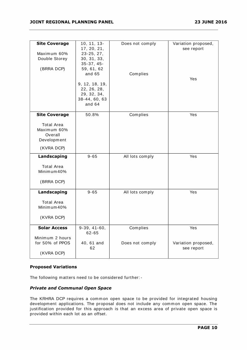
Site Coverage
Maximum 60%
Double Storey
(BRRA DCP)
10, 11, 13-
17, 20, 21,
23-25, 27,
30, 31, 33,
35-37, 45-
59, 61, 62
and 65
9, 12, 18, 19,
22, 26, 28,
29, 32, 34,
38-44, 60, 63
and 64
Does not comply
Complies
Variation proposed,
see report
Yes
Site Coverage
Total Area
Maximum 60%
Overall
Development
(KVRA DCP)
50.8% Complies Yes
Landscaping
Total Area
Minimum40%
(BRRA DCP)
9-65 All lots comply Yes
Landscaping
Total Area
Minimum40%
(KVRA DCP)
9-65 All lots comply Yes
Solar Access
Minimum 2 hours
for 50% of PPOS
(KVRA DCP)
9-39, 41-60,
62-65
40, 61 and
62
Complies
Does not comply
Yes
Variation proposed,
see report
Proposed Variations
The following matters need to be considered further:-
Private and Communal Open Space
The KRHRA DCP requires a common open space to be provided for integrated housing
development applications. The proposal does not include any common open space. The
justification provided for this approach is that an excess area of private open space is
provided within each lot as an offset.

JOINT REGIONAL PLANNING PANEL 23 JUNE 2016
PAGE 11
The KRHRA DCP requires a minimum area of private open space of 20% for each lot/
dwelling in an integrated housing development, excluding any areas narrower than 2m.
In addition, the principal private open space area must be 24m2, excluding any areas
narrower than 4m.
With the exception of lot 65, which has a variation of 0.3% or 2.55m², the proposal
complies with these controls. The majority of lots are provided with an area which
exceeds the minimum of 20% for each lot which is considered to be a better outcome
rather than providing an area of communal open space that may have limited use.
The site is located in relative close proximity to an area of public open space to the east
of the site (150m). There is opportunity for active and passive recreation within the
public open space area for the future residents.
No objections are raised to the proposal in respect to this matter.
Solar Access
The DCP requires that lots be capable of achieving 2 hours of sunlight to 50% of the
principle private open space. With the exception of lots 40, 61 and 62 the proposal
complies with this control.
Compliance with this control can be difficult given the permitted size of the dwellings and
the minimum lot size and the application is well designed to accomplish compliance to
the extent that has been achieved. The proposed dwellings, including lots 40, 61 and 62,
are largely compliant with the DCP control in relation to setbacks, site coverage,
landscaping and private open space. Given that 95% of the proposed dwellings comply
with this control, no objection is raised to a 5% non-compliance.
Site Coverage
The DCP requires that each lot be provided with site coverage of no greater than 60%
for two storey dwellings. Proposed lots 10, 11, 13-17, 20, 21, 23-25, 27, 30, 31, 33, 35-
37, 45-59, 61, 62 and 65 do not comply with the control.
The applicant has made the following comments in relation to the proposed non-
compliance:-
The variations to maximum site coverage are not considered to impact on the
appearance of the development or the suitability of individual sites for residential
accommodation. Council is requested to support the variations to the DCP site coverage
requirement, for the following reasons:
a) All dwelling sites except for Lots 42 and 43 comply with the minimum front, side
and rear setback requirements of Section 4.3 of KRHRA DCP. Lots 42 and 43
depart from the minimum secondary frontage setbacks by a minor extent.
b) All dwelling sites except for Lot 65 comply with the minimum Private Open Space
(POS) requirements of the KRHRA DCP. Lot 65 departs from the minimum POS
requirement by a minor extent.
c) All dwelling sites comply with the minimum Principle Private Open Space (PPOS)
requirements of the KRHRA DCP.

JOINT REGIONAL PLANNING PANEL 23 JUNE 2016
PAGE 12
d) All dwelling sites except for Lots 40, 61 & 62 comply with the minimum solar
access requirements of Section 4.8 of the KRHRA DCP. Lots 40, 61 & 62 exhibit
only minor deficiency in sunlighted POS areas.
e) The building sites are relatively small in terms of land area and allotment depth.
The slightly larger building footprints proposed are considered desirable to
achieve useable floor plan layouts that will appeal to the market place and be
useable for future residents.
f) The degree of exceedance in site coverage is limited to no more than 10% of the
DCP requirement for two storey construction. Apart from Lot 17, the site
coverage is still less than the DCP allowance of 65% permitted for single storey
construction.
g) The degree of exceedance in site coverage is unlikely to give rise to overlooking,
privacy loss or loss of amenity of any adjoining dwelling.
The comments offered by the developer are generally supported.
The intent of the control is to ensure that bulk and scale of residential development is
minimised, open space and separation is provided in the development and overland
stormwater flow issues are not created. The proposed development is consistent with the
intent of the control. Furthermore, the calculated site coverage for the overall site is
50.8% which is consistent with the DCP. No objection is raised to the proposed non-
compliance.
Front Setback (Private Road)
The DCP requires that dwelling be provided with front setbacks of 4.5m from a private
road. Proposed lots 12, 16, 18, 19, 22, 32, 34, 38, 45-59 do not comply with this
control.
In each instance the non-compliance is in the form of an open veranda or patio. The
main part of the dwelling is setback 4.5m in accordance with the DCP. The proposed
non-compliance results in a more varied streetscape rather than each dwelling being
located on the same building line. Furthermore, the encroachment is open and will not
present as significant bulk at the front elevation. No objection is raised to the proposed
non-compliance in this instance.
Pre-planned Road Layout
The BRRA DCP identifies a pre-planned Road layout for the site (refer to Attachment 8).
The application proposes to vary the pre-planned road layout as shown via an excerpt
from the applicant’s submission in (Also provided in Attachment 8).
The proposed location has been amended from what was originally lodged. The
amendment came about as a result of a submission from the adjoining eastern property
raising concern with the proposed location and the impact it would have upon their
property.
The amended plans were sent to the objector for comment. They have not made any
comment on the amended plans.
The amended plans are considered to be a reasonable compromise and no objection is
raised.

JOINT REGIONAL PLANNING PANEL 23 JUNE 2016
PAGE 13
Signage
The proposal seeks approval for an estate entry sign. The applicant has undertaken an
assessment against State Environmental Planning Policy No 64 – Advertising and
Signage. The assessment is acceptable and no objection is raised to the proposed estate
entry signage.
4. ISSUES RAISED IN SUBMISSION
The application was placed on exhibition for a period of 14 days from 19 January 2016 to
3 February 2016. During the exhibition period a sign was erected on site and 15 property
owners were notified in writing. One submission was received during the exhibition
period. The comments made within the submission are addressed below.
ISSUE/OBJECTION COMMENT OUTCOME
Concern that the proposed
road alignment of Rocks
Street is inconsistent with the
DCP pre-planned road layout.
The submission made the
following commentary:-
It is proposed to realign
Rocks Street which traverses
No. 28 east to west through
the middle of the site. The
shift will be about 4m north
on the western side of No. 28
and may impact on the
regular shaped lots and yield
you have proposed in your
site master plan and
feasibility undertaken for No.
28 last year.
The applicant was asked to consult
with the adjoining land owner to come
up with a mutually agreed upon road
pattern.
The applicant has provided an
amended road pattern which they
have suggested is a result of
discussions with the adjoining land
owner. The amended road pattern
was sent to the adjoining owner for
comment. A response has not yet
been received.
The amended road pattern seeks to
provide a road pattern which is more
consistent with the DCP than
originally proposed. The amended
road pattern will be unlikely to
detrimentally impact upon the
development potential of the
adjoining site. This is detailed in
Attachment 8. Accordingly, no
objections are raised.
Issue addressed.
Concern has been raised that
the community road on the
eastern boundary is to be in
cut of up to 1.2m which will
impact upon No. 28 Memorial
Avenue.
A 1.2m high (max) retaining wall is
proposed in cut on the eastern
boundary. A 1.8m high lapped and
capped timber fence is proposed on
the common boundary, at near
natural ground level, with the
objector’s property.
The proposed retaining will not result
in any privacy or overshadowing
impacts with the adjoining property.
Furthermore, the retaining wall will
partially screened along its length due
to a 2m wide landscape strip.
Issue addressed.

JOINT REGIONAL PLANNING PANEL 23 JUNE 2016
PAGE 14
ISSUE/OBJECTION COMMENT OUTCOME
No objections are raised to the
proposed retaining wall as it is
considered reasonable and will be
unlikely to detrimentally impact upon
the adjoining property.
Concern has been raised with
the proposed stormwater
associated with the
development affecting
adjoining properties.
The site is located at the top of the
catchment and slopes from back to
front in a northerly direction towards
Rutherford Avenue. The majority of
the stormwater runoff from the
development site is directed west to
Elizabeth Macarthur Creek further
west via road and drainage
infrastructure constructed as part of
adjoining developments. A small
portion of Rutherford Avenue falls
towards 28 Memorial Avenue to the
east and eventually to the existing
trapped low point in Rutherford
Avenue/ Memorial Avenue, before
being directed north to Strangers
Creek via road and drainage
infrastructure constructed as part of
adjoining development on the
northern side of Memorial Avenue.
Until such time as 28 Memorial
Avenue to the east is developed and
Rutherford Avenue extended as part
of the same, runoff from this part of
the subject site needs to be directed
away from that neighbour. The piped
drainage will be directed west as
noted earlier, and any overland flow
will be directed to Memorial Avenue.
Proposed condition 43 (i) and (j)
address the design detail required to
satisfy this intent.
Issue addressed.
Refer to Condition
43 below.
Concern has been raised with
how access is to be provided
to the development site given
there is no direct access from
Memorial Avenue to the site.
Access to the development site will be
provided when the adjoining sites are
developed. It must be noted that a
development has been provided which
constructs roads to the western
boundary thus providing access (DA
527/2016/ZE). A proposed condition
is recommended requiring registration
of DA 527/2016/ZE prior to the
release of the construction certificate.
Issue addressed.
5. Joint Regional Planning Panel Comments (JRPP)
A preliminary meeting was held with the JRPP on the 8 March 2012 to discuss the
proposal. During the meeting the JRPP raised points in relation to:-
JOINT REGIONAL PLANNING PANEL 23 JUNE 2016
PAGE 15
a. Interface of Privacy Road with Adjoining Properties
The JRPP requested advice on what treatment would be undertaken between the private
road and the adjoining eastern property.
A 1.2m high (max) retaining wall is proposed in cut on the eastern boundary. A 1.8m
high lapped and capped timber fence is proposed on the common boundary, at near
natural ground level, with the eastern property.
The proposed private road is located 2m from the boundary and is proposed to consist of
grasses which are capable of reaching 1.2m in height. Council’s Landscape Architect has
conditioned the use of shrubs in the location to aid in screening and provides some
variation to the landscaping.
b. Location of Private Road
The JRPP raised concern with the location of the private road being adjacent the
boundary of the adjoining eastern property. It was suggested that there may be some
benefit to allowing the adjoining property to access the private road to enable their
development to occur.
The applicant provided the following comments in relation to this matter:-
The adopted location of community roads as shown on the development plans will
optimise the development yield for 30 Memorial Avenue. The adjoining property,
28 Memorial Avenue, is currently being marketed for sale, for which a conceptual
development layout is included in the sales literature. The conceptual layout
shows lot layouts and internal road patterns considered by the current owners to
optimise site yield. The layout does not include access arrangements in regards to
the eastern boundary road within 30 Memorial Avenue.
Our clients would prefer to maintain dedicated access arrangements within their
site and avoid difficulties associated with other properties utilising privately
owned assets within a community scheme. Further, the height of the retaining
wall along the eastern boundary of the site is an indication of potential difficulties
in gaining property access from the east via this road.
The applicant’s comments in relation to this point are generally supported. Each site is of
a size and shape which can accommodate development on their own. It is considered
that there would be little benefit to the two development sites developing together in
this instance. No objections are raised in respect to this matter.
c. Submission and Pre-Planned Road Layout
The JRPP noted that a submission has been received which raised concern with the
variation to the pre-planned road layout.
The applicant provided the following comments in relation to this matter:-
A meeting was convened on 16th February, 2016 with David Cowdery of Baptist
Care to discuss a range of issues including the alignment of Rocks Street. Mr
Cowdery objected to the misalignment correction of Rocks Street being located
wholly within the boundaries of 28 Memorial Avenue.
Various options were considered and Mr Cowdery suggested that corrective
measures could be shared between the two properties. The amended
development plans are based on these discussions and show a compromise
position of Rocks Street.

JOINT REGIONAL PLANNING PANEL 23 JUNE 2016
PAGE 16
The amended road pattern was sent to the adjoining owner for comment based upon the
amended road pattern. A response has not yet been received.
The amended road pattern seeks to provide a road pattern which is more consistent with
the DCP than originally proposed. The amended road pattern will be unlikely to
detrimentally impact upon the development potential of the adjoining site. Accordingly,
no objections are raised.
BUILDING COMMENTS
The application has been considered by Council’s Building Certification Team who raised
no objections and recommended conditions.
SUBDIVISION ENGINEERING COMMENTS
The application has been considered by Council’s Subdivision Engineer who raised no
objections and recommended conditions.
LANDSCAPE ARCHITECT COMMENTS
The application has been considered by Council’s Landscape Architect who raised no
objections and recommended conditions.
TREE MANAGEMENT COMMENTS
Council’s Tree Management Team have considered the application and raised no
objections subject to conditions of consent
HEALTH AND ENVIRONMENTAL PROTECTION COMMENTS
Council’s Health Team have considered the professional reports submitted in relation to
noise, vibration, contamination and salinity and agreed with their recommendations and
recommended conditions of consent.
RESOURCE RECOVERY TEAM
Council’s Resource Recovery Team have considered the application and raised no
objections subject to conditions of consent.
HERITAGE COMMENTS
The applicant submitted a Due Diligence Aboriginal Archaeological Assessment in
accordance with the DCP. The assessment considered the likelihood of items of
Aboriginal significance being present based upon known information and a site
inspection. The report concluded that the site is highly disturbed and it is unlikely that
the proposal will have any detrimental impacts on any items of Aboriginal significance.
ROADS AND MARITIME SERVICE COMMENTS
The Roads and Maritime Service considered the application and raised no objections on
the basis that the proposal is confined to the R3 zoned land and not the land zoned SP2
“Classified Road” which they will acquire for future road widening in accordance with the
LEP.

JOINT REGIONAL PLANNING PANEL 23 JUNE 2016
PAGE 17
CONCLUSION
The development application has been evaluated against the matters for consideration
contained within Section 79C of the Environmental Planning and Assessment Act 1979,
The Hills Local Environmental Plan 2012 and The Hills Development Control Plan 2012.
All key issues have been identified, addressed or suitably conditioned and is considered
satisfactory.
IMPACTS:
Financial
This matter has no direct financial impact upon Council’s adopted budget or forward
estimates.
The Hills Future - Community Strategic Plan
The proposal is considered satisfactory in regard to The Hills Future Community Strategic
plan and will provide housing diversity within the Shire through the provision of a variety
of unit layouts and sizes in an appropriate location.
RECOMMENDATION
The Development Application be approved subject to the following conditions.
GENERAL MATTERS
1. Approved Plan
The development must be carried out in accordance with the approved plans and other
supporting documentation listed below, except where amended by other conditions of
consent:
Drawing: Description: Prepared: Sheet: Revision: Date:
229-
SUB-
Stage 1
to Stage
8
Plan of Subdivision –
Stage 1 to 8
Malcolm
Smith Pty
Ltd
1 to 8 1 08/03/2016
DA-B 00
to DA-B
22
Architectural Plans Zhinar
Architects
00 to 22 B Mar 2015
DA-B 23 Colour Schedule Zhinar
Architects
23 B Mar 2015
15/831 Landscape Plan Paul
Scrivener
Landscape
Architect
1 to 5 B 08/03/2016
Where a Construction Certificate is required, no work is to be undertaken before it has
been issued.
2. Compliance with NSW Roads and Maritime Services Requirements
Compliance with the requirements of the NSW Roads and Maritime Services throughout
all stages of the subdivision as outlined in their letter dated 28 January 2016 Ref
SYD15/01624(A11403524) attached to this consent as Appendix A.
JOINT REGIONAL PLANNING PANEL 23 JUNE 2016
PAGE 18
3. External Finishes
External finishes and colours must comply with the details submitted with the
development application and approved with this consent.
4. Australia Post Mailbox Requirements
Australia Post has specific requirements for mail deliveries on private roads. Separate
approval from Australia Post is required before installing individual mailboxes for this
development.
5. Provision of Parking Spaces
The development is required to be provided with 2 off street car parking spaces. These
car parking spaces must be available for off street parking at all times.
6. BCA Compliance
All building work must be carried out in accordance with the provisions of the Building
Code of Australia.
7. Zero Lot Line Dwellings – Easement Encroachment
No element of those dwellings located on the boundary line with an adjoining lot (zero
lot line dwellings) can be located within that adjoining lot. Construction tolerances should
be accounted for when surveying and constructing these dwellings.
Similarly, the dwellings on the lots adjacent, being those lots burdened by an easement
for repair; must be located wholly outside of the easement except where it is shown on
the approved plans that the encroaching eaves/ guttering does not impede maintenance
access to either dwelling and that the encroachment is no closer than 450mm to the
boundary.
8. Subdivision Certificate Preliminary Review
Prior to the submission of a Subdivision Certificate application a draft copy of the final
plan, administration sheet and Section 88B instrument (where included) must be
submitted in order to establish that all conditions have been complied with.
Street addresses for the lots within this subdivision will be allocated as part of this
preliminary check process, for inclusion on the administration sheet.
9. Demolition Notification
Both Council and any adjoining properties must be notified in writing five days before
demolition works commence.
10. Demolition Inspections
Before demolition works commence, a pre-demolition inspection must be arranged with
Council’s Development Certification team. All conditions required to be addressed before
works commence must be satisfied. Once demolition works are complete, a post
demolition inspection must be arranged with Council’s Development Certification team.
11. Construction Certificate
Before any works are carried out a Construction Certificate must be obtained. The plans
and accompanying information submitted with the Construction Certificate must comply
with the conditions included with this consent.
12. Proposed Street Naming – Private Roads
A written application for street naming must be submitted to Council for approval, along
with the applicable fee as per Council’s Schedule of Fees and Charges. The street names
proposed must comply with requirements of the NSW Geographical Names Board and
Council.
The application must nominate three suggested names per street, in order of preference,
and the source of the names proposed.

JOINT REGIONAL PLANNING PANEL 23 JUNE 2016
PAGE 19
13. Approved Street Naming – Public Roads
Street naming must comply with Council’s approved map which can be found on
Council’s website.
14. Street Trees
Street trees must be provided for the section of Rutherford Avenue, Rocks Street and
Hodges Road within or fronting the development site spaced between 7m and 10m apart
and with a minimum of one tree per lot frontage. The location of street trees must be
considerate of driveways, services, drainage pits and sight lines at intersections. The
species and size of street trees must comply with the requirements of Council. Details
demonstrating compliance with the above must be submitted for approval before any
street trees are planted.
The establishment of street tree planting is included in the maintenance bond required to
be paid. Alternatively, street trees can be planted by Council subject to payment of the
applicable fee as per Council’s Schedule of Fees and Charges.
15. Recycled Water
The subject site must be connected to Sydney Water’s Rouse Hill Recycled Water
Scheme, unless written evidence from Sydney Water is submitted advising that this
service is not available.
16. Road Opening Permit
Should the subdivision/ development necessitate the installation or upgrading of utility
services or any other works on Council land beyond the immediate road frontage of the
development site and these works are not covered by a Construction Certificate issued
by Council under this consent then a separate road opening permit must be applied for
and the works inspected by Council’s Maintenance Services team.
The contractor is responsible for instructing sub-contractors or service authority
providers of this requirement. Contact Council’s Construction Engineer if it is unclear
whether a separate road opening permit is required.
17. Protection of Public Infrastructure
Council must be notified of any damage to public infrastructure caused by the
development. Adequate protection must be provided prior to work commencing and
maintained during building operations. Any damage caused must be made good, to the
satisfaction of Council, before an Occupation Certificate can be issued. Public
infrastructure includes the road pavement, kerb and gutter, concrete footpaths, drainage
structures, utilities and landscaping fronting the site.
18. Staging Requirements
With respect to the staging of the development the following requirements apply:
a) The Subdivision Certificates for each stage need to be issued in order (or at the same
time as the preceding stage).
b) The Subdivision Certificate for stage one cannot be issued until the SP2 zoned road
widening along Memorial Avenue has been excised from the remainder of the subject
site under a separate process/ plan
c) The Construction Certificate for stage one (covering the construction of Rutherford
Avenue) cannot be issued until after a Construction Certificate has been issued over
either 28 or 32 Memorial Avenue for this road, connecting it to the existing road
network.
d) The Construction Certificate for stage four (covering the construction of Rocks Street)
cannot be issued until after a Construction Certificate has been issued over either 28
or 32 Memorial Avenue for this road, connecting it to the existing road network.

JOINT REGIONAL PLANNING PANEL 23 JUNE 2016
PAGE 20
e) The Construction Certificate for stage eight (covering the construction of Hodges
Road) cannot be issued until after a Construction Certificate has been issued over
either 28 or 32 Memorial Avenue for this road, connecting it to the existing road
network.
f) The Subdivision Certificate for stage one (covering the dedication of Rutherford
Avenue) cannot be issued until after a Subdivision Certificate has been issued over
either 28 or 32 Memorial Avenue for this road, connecting it to the existing road
network.
g) The Subdivision Certificate for stage four (covering the dedication of Rocks Street)
cannot be issued until after a Subdivision Certificate has been issued over either 28
or 32 Memorial Avenue for this road, connecting it to the existing road network.
h) The Subdivision Certificate for stage eight (covering the dedication of Hodges Road)
cannot be issued until after a Subdivision n Certificate has been issued over either 28
or 32 Memorial Avenue for this road, connecting it to the existing road network.
19. Construction Certificate
Prior to construction of the approved development, it is necessary to obtain a
Construction Certificate. A Construction Certificate may be issued by Council or an
Accredited Certifier. Plans submitted with the Construction Certificate are to be amended
to incorporate the conditions of the Development Consent.
20. Estate Signage
The estate signage is to be erected on common property.
21. Acoustic Requirements
The recommendations of the Acoustic Assessment and Report prepared by Acoustic Logic
Pty Ltd, referenced as 20151276.1/0210A/R1/JD, dated 02/10/2015 and submitted as
part of the Development Application are to be implemented as part of this approval. In
particular:
- 6.1 Glazed Windows and Doors
- 6.2 Roof/ Ceiling Construction
- 6.3 External Walls
- 6.4 Ventilation Requirements
22. Contamination Assessment and Site Remediation
The recommendations of the Site Assessment and Report prepared by GeoEnviro
Consultancy Pty Ltd, referenced as JE15598A – r1, dated September 2015 and submitted
as part of the Development Application are to be implemented as part of this approval.
23. Control of Noise from Trucks
The number of trucks waiting to remove fill from the site must be managed to minimise
disturbance to the neighbourhood. No more than one truck is permitted to be waiting in
any of the streets adjacent to the development site.
24. Salinity Requirements
The recommendations of the Salinity Assessment and Report prepared by GeoEnviro
Consultancy Pty Ltd Pty Ltd, referenced as JE15598A-r1, dated September 2015 and
submitted as part of the Development Application are to be implemented as part of this
approval.
25. Eastern Boundary Planting
Planting of Lomandra longifolia along the eastern boundary is to be replaced with a mix
of shrub species to provide landscape screening to the proposed wall and fence. These
plants are to be 5L pot size planted at 800mm centres or 2 per square metres and a
minimum of 700mm away from the kerb.

JOINT REGIONAL PLANNING PANEL 23 JUNE 2016
PAGE 21
Shrub species may be selected from the following list:
- Acmena smithii 'Sublime'
- Callistemon citrinus 'Endeavour'
- Grevillea 'Moonlight'
- Grevillea 'Ned Kelly'
- Raphiolepis umbellate
- Westringia fruticosa 'Naringa'
26. Tree Removal
Approval is granted for the removal of ninety three (93) trees marked in Arborist report
prepared by Redgum Horticultural dated 29 July 2015.
All other trees are to remain and are to be protected during all works. Suitable
replacement trees are to be planted upon completion of construction.
27. Planting Requirements
All trees planted as part of the approved landscape plan are to be minimum 45 litre pot
size. All shrubs planted as part of the approved landscape plan are to be minimum
200mm pot size. Groundcovers are to be planted at 5/m2.
28. Demolition Inspections
Before demolition works commence, a pre-demolition inspection must be arranged with
Council’s Development Certification team. All conditions required to be addressed before
works commence must be satisfied. Once demolition works are complete, a post
demolition inspection must be arranged with Council’s Development Certification team.
29. Building Work to be in Accordance with BCA
All building work must be carried out in accordance with the provisions of the Building
Code of Australia.
30. Demolition Notification
Both Council and any adjoining properties must be notified in writing five days before
demolition works commence.
31. Adherence to Waste Management Plan
All requirements of the Waste Management Plan submitted to and approved by Council
must be implemented during the construction and/ or demolition phases of the
development, as well as the ongoing management phase. The information submitted can
change provided that the same or a greater level of reuse and recycling is achieved as
detailed in the plan. Any material moved offsite is to be transported in accordance with
the requirements of the Protection of the Environment Operations Act 1997 and only to a
place that can lawfully be used as a waste facility. Receipts of all waste/ recycling tipping
must be kept onsite at all times and produced in a legible form to any authorised officer
of the Council who asks to see them.
32. Management of Construction and/or Demolition Waste
Waste materials must be appropriately stored and secured within a designated waste
area onsite at all times, prior to its reuse onsite or being sent offsite. This includes waste
materials such as paper and containers which must not litter the site or leave the site
onto neighbouring public or private property. A separate dedicated bin must be provided
onsite by the builder for the disposal of waste materials such as paper, containers and
food scraps generated by all workers. Building waste containers are not permitted to be
placed on public property at any time unless a separate application is approved by
Council to locate a building waste container in a public place. Any material moved offsite
is to be transported in accordance with the requirements of the Protection of the
Environment Operations Act 1997 and only to a place that can lawfully be used as a
waste facility. The separation and recycling of the following waste materials is required:

JOINT REGIONAL PLANNING PANEL 23 JUNE 2016
PAGE 22
metals, timber, masonry products and clean waste plasterboard. This can be achieved by
source separation onsite, that is, a bin for metal waste, a bin for timber, a bin for bricks
and so on. Alternatively, mixed waste may be stored in one or more bins and sent to a
waste contractor or transfer/sorting station that will sort the waste on their premises for
recycling. Receipts of all waste/recycling tipping must be kept onsite at all times and
produced in a legible form to any authorised officer of the Council who asks to see them.
Transporters of asbestos waste (of any load over 100kg of asbestos waste or 10 square
metres or more of asbestos sheeting) must provide information to the NSW EPA
regarding the movement of waste using their WasteLocate online reporting tool
www.wastelocate.epa.nsw.gov.au.
33. Disposal of Surplus Excavated Material
The disposal of surplus excavated material, other than to a licenced waste facility, is not
permitted without the previous written approval of Council prior to works commencing
on site. Any unauthorized disposal of waste, which includes excavated material, is a
breach of the Protection of the Environment Operations Act 1997 and subject to
substantial penalties. Receipts of all waste/ recycling tipping must be kept onsite at all
times and produced in a legible form to any authorised officer of the Council who asks to
see them.
34. Commencement of Domestic Waste Service
The property owners or agents acting for the owners must arrange the commencement
of a domestic waste service with Council. The service is to be arranged no earlier than
two days prior to occupancy and no later than two days after occupancy their unit. All
requirements of Council’s domestic collection service must be complied with at all times.
Please telephone Council on (02) 9843 0310 for the commencement of waste services.
35. Provision of Domestic Waste Storage Areas
Space must be allocated within the lot boundary of each property to store a minimum of
3 x 240L bins. The location must ensure that the bins are not visible from any adjoining
residential property or public place, and allows the bins to be wheeled to the street over
flat or ramped surfaces and not over steps or through the unit. The measurements (mm)
of the abovementioned bin are 735 (d) 580 (w) 1080 (h).
PRIOR TO THE ISSUE OF A CONSTRUCTION CERTIFICATE
36. Section 94 Contribution – Balmoral Road Release Area
The following monetary contributions must be paid to Council in accordance with Section
94 of the Environmental Planning and Assessment Act 1979, to provide for the increased
demand for public amenities and services resulting from the development.
Payments comprise of the following:
Stage 1
Stage 2
Stage 1 Purpose:
Subdivision Purpose: Credit No. of Lots: 17 No. of Credits: 1 Total S94
Open Space - Land 19,119.91$ 19,119.91$ 325,038.47$ 19,119.91$ 305,918.56$
Open Space - Capital 5,074.36$ 5,074.36$ 86,264.12$ 5,074.36$ 81,189.76$
Transport Facilities - Capital 3,613.20$ 3,613.20$ 61,424.40$ 3,613.20$ 57,811.20$
Community Facilities - Land 378.11$ 378.11$ 6,427.87$ 378.11$ 6,049.76$
Community Facilities - Capital 1,549.04$ 1,549.04$ 26,333.68$ 1,549.04$ 24,784.64$
Administration 265.38$ 265.38$ 4,511.46$ 265.38$ 4,246.08$
Total 30,000.00$ 30,000.00$ 510,000.00$ 30,000.00$ 480,000.00$
Stage 2 Purpose:
Subdivision Purpose: Credit No. of Lots: 10 No. of Credits: 1 Total S94
Open Space - Land 19,119.91$ 19,119.91$ 191,199.10$ 19,119.91$ 172,079.19$
Open Space - Capital 5,074.36$ 5,074.36$ 50,743.60$ 5,074.36$ 45,669.24$
Transport Facilities - Capital 3,613.20$ 3,613.20$ 36,132.00$ 3,613.20$ 32,518.80$
Community Facilities - Land 378.11$ 378.11$ 3,781.10$ 378.11$ 3,402.99$
Community Facilities - Capital 1,549.04$ 1,549.04$ 15,490.40$ 1,549.04$ 13,941.36$
Administration 265.38$ 265.38$ 2,653.80$ 265.38$ 2,388.42$
Total 30,000.00$ 30,000.00$ 300,000.00$ 30,000.00$ 270,000.00$

JOINT REGIONAL PLANNING PANEL 23 JUNE 2016
PAGE 23
Stage 3
Stage 4
Stage 5
Stage 6
Stage 7
Stage 8
Prior to payment of the above contributions, the applicant is advised to contact Council’s
Development Contributions Officer on 9843 0268. Payment must be made by cheque or
credit/ debit card. Cash payments will not be accepted.
This condition has been imposed in accordance with Contributions Plan 12.
Council’s Contributions Plans can be viewed at www.thehills.nsw.gov.au or a copy may
be inspected or purchased at Council’s Administration Centre.
37. Security Bond Requirements
A security bond may be submitted in lieu of a cash bond. The security bond must:
Stage 3 Purpose:
Subdivision Purpose: Credit No. of Lots: 10 No. of Credits: 1 Total S94
Open Space - Land 19,119.91$ 19,119.91$ 191,199.10$ 19,119.91$ 172,079.19$
Open Space - Capital 5,074.36$ 5,074.36$ 50,743.60$ 5,074.36$ 45,669.24$
Transport Facilities - Capital 3,613.20$ 3,613.20$ 36,132.00$ 3,613.20$ 32,518.80$
Community Facilities - Land 378.11$ 378.11$ 3,781.10$ 378.11$ 3,402.99$
Community Facilities - Capital 1,549.04$ 1,549.04$ 15,490.40$ 1,549.04$ 13,941.36$
Administration 265.38$ 265.38$ 2,653.80$ 265.38$ 2,388.42$
Total 30,000.00$ 30,000.00$ 300,000.00$ 30,000.00$ 270,000.00$
Stage 4 Purpose:
Subdivision Purpose: Credit No. of Lots: 6 No. of Credits: 1 Total S94
Open Space - Land 19,119.91$ 19,119.91$ 114,719.46$ 19,119.91$ 95,599.55$
Open Space - Capital 5,074.36$ 5,074.36$ 30,446.16$ 5,074.36$ 25,371.80$
Transport Facilities - Capital 3,613.20$ 3,613.20$ 21,679.20$ 3,613.20$ 18,066.00$
Community Facilities - Land 378.11$ 378.11$ 2,268.66$ 378.11$ 1,890.55$
Community Facilities - Capital 1,549.04$ 1,549.04$ 9,294.24$ 1,549.04$ 7,745.20$
Administration 265.38$ 265.38$ 1,592.28$ 265.38$ 1,326.90$
Total 30,000.00$ 30,000.00$ 180,000.00$ 30,000.00$ 150,000.00$
Stage 5 Purpose:
Subdivision Purpose: Credit No. of Lots: 5 No. of Credits: 1 Total S94
Open Space - Land 19,119.91$ 19,119.91$ 95,599.55$ 19,119.91$ 76,479.64$
Open Space - Capital 5,074.36$ 5,074.36$ 25,371.80$ 5,074.36$ 20,297.44$
Transport Facilities - Capital 3,613.20$ 3,613.20$ 18,066.00$ 3,613.20$ 14,452.80$
Community Facilities - Land 378.11$ 378.11$ 1,890.55$ 378.11$ 1,512.44$
Community Facilities - Capital 1,549.04$ 1,549.04$ 7,745.20$ 1,549.04$ 6,196.16$
Administration 265.38$ 265.38$ 1,326.90$ 265.38$ 1,061.52$
Total 30,000.00$ 30,000.00$ 150,000.00$ 30,000.00$ 120,000.00$
Stage 6 Purpose:
Subdivision Purpose: Credit No. of Lots: 5 No. of Credits: 1 Total S94
Open Space - Land 19,119.91$ 19,119.91$ 95,599.55$ 19,119.91$ 76,479.64$
Open Space - Capital 5,074.36$ 5,074.36$ 25,371.80$ 5,074.36$ 20,297.44$
Transport Facilities - Capital 3,613.20$ 3,613.20$ 18,066.00$ 3,613.20$ 14,452.80$
Community Facilities - Land 378.11$ 378.11$ 1,890.55$ 378.11$ 1,512.44$
Community Facilities - Capital 1,549.04$ 1,549.04$ 7,745.20$ 1,549.04$ 6,196.16$
Administration 265.38$ 265.38$ 1,326.90$ 265.38$ 1,061.52$
Total 30,000.00$ 30,000.00$ 150,000.00$ 30,000.00$ 120,000.00$
Stage 7 Purpose:
Subdivision Purpose: Credit No. of Lots: 5 No. of Credits: 1 Total S94
Open Space - Land 19,119.91$ 19,119.91$ 95,599.55$ 19,119.91$ 76,479.64$
Open Space - Capital 5,074.36$ 5,074.36$ 25,371.80$ 5,074.36$ 20,297.44$
Transport Facilities - Capital 3,613.20$ 3,613.20$ 18,066.00$ 3,613.20$ 14,452.80$
Community Facilities - Land 378.11$ 378.11$ 1,890.55$ 378.11$ 1,512.44$
Community Facilities - Capital 1,549.04$ 1,549.04$ 7,745.20$ 1,549.04$ 6,196.16$
Administration 265.38$ 265.38$ 1,326.90$ 265.38$ 1,061.52$
Total 30,000.00$ 30,000.00$ 150,000.00$ 30,000.00$ 120,000.00$
Stage 8 Purpose:
Subdivision Purpose: Credit No. of Lots: 6 No. of Credits: 1 Total S94
Open Space - Land 19,119.91$ 19,119.91$ 114,719.46$ 19,119.91$ 95,599.55$
Open Space - Capital 5,074.36$ 5,074.36$ 30,446.16$ 5,074.36$ 25,371.80$
Transport Facilities - Capital 3,613.20$ 3,613.20$ 21,679.20$ 3,613.20$ 18,066.00$
Community Facilities - Land 378.11$ 378.11$ 2,268.66$ 378.11$ 1,890.55$
Community Facilities - Capital 1,549.04$ 1,549.04$ 9,294.24$ 1,549.04$ 7,745.20$
Administration 265.38$ 265.38$ 1,592.28$ 265.38$ 1,326.90$
Total 30,000.00$ 30,000.00$ 180,000.00$ 30,000.00$ 150,000.00$

JOINT REGIONAL PLANNING PANEL 23 JUNE 2016
PAGE 24
a) Be in favour of The Hills Shire Council;
b) Be issued by a financial institution or other accredited underwriter approved by,
and in a format acceptable to, Council (for example, a bank guarantee or
unconditional insurance undertaking);
c) Have no expiry date;
d) Reference the development application, condition and matter to which it relates;
e) Be equal to the amount required to be paid in accordance with the relevant
condition;
f) Be itemised, if a single security bond is used for multiple items.
Should Council need to uplift the security bond, notice in writing will be forwarded to the
applicant 14 days prior.
38. Sediment and Erosion Control Plan
A sediment and erosion control plan prepared in accordance with Council’s Works
Specification Subdivision/ Developments must be submitted. The plan must include:
a) Lot boundaries;
b) Roads;
c) Contours;
d) Existing vegetation;
e) Existing site drainage;
f) Critical natural areas;
g) Location of stockpiles;
h) Erosion control practices;
i) Sediment control practices; and
j) A maintenance program.
39. Works on Adjoining Land
Where the engineering works included in the scope of this approval extend into adjoining
land, written consent from all affected adjoining property owners must be obtained and
submitted to Council before a Construction Certificate is issued.
40. Stormwater Discharge Acceptance
Where the engineering works included in the scope of this approval necessitate the
discharge of stormwater onto adjoining land, written consent from all affected adjoining
property owners must be obtained and submitted to Council before a Construction
Certificate is issued.
41. Security Bond – Road Pavement and Public Asset Protection
In accordance with Section 80A(6)(a) of the Environmental Planning and Assessment Act
1979, a security bond of $209,525.00 is required to be submitted to Council to
guarantee the protection of the road pavement and other public assets in the vicinity of
the site during construction works. The above amount is calculated at the rate of $85.00
per square metre based on the road frontage of the subject site (290m) multiplied by
the width of the road (8.5m).
The bond must be lodged with Council before a Construction Certificate is issued.
The bond is refundable upon written application to Council and is subject to all work
being restored to Council’s satisfaction. Should the cost of restoring any damage exceed
the value of the bond, Council will undertake the works and issue an invoice for the
recovery of these costs.

JOINT REGIONAL PLANNING PANEL 23 JUNE 2016
PAGE 25
42. Security Bond – External Works
In accordance with Section 80A(6)(b) of the Environmental Planning and Assessment Act
1979, a security bond is required to be submitted to Council to guarantee the
construction, completion and performance of all works external to the site. The bonded
amount must be based on 150% of the tendered value of providing all such works. The
minimum bond amount is $10,000.00. The bond amount must be confirmed with Council
prior to payment.
The bond must be lodged with Council before a Construction Certificate is issued.
The bond is refundable upon written application to Council and is subject to all work
being completed to Council’s satisfaction.
43. Engineering Works and Design
The design and construction of the engineering works listed below must be provided for
in accordance with Council’s Design Guidelines Subdivisions/ Developments and Works
Specifications Subdivisions/ Developments.
Engineering works can be classified as either “subdivision works” or “building works” as
categorised below:
1. Works within an existing or proposed public road, or works within an existing or
proposed public reserve. These works can only be approved, inspected and certified
by Council in accordance with the Roads Act 1993 and the Local Government Act
1993 respectively.
2. Works within the development site, or an adjoining private property, that relates to
existing or proposed Council infrastructure assets, such as the laying of a stormwater
pipeline or the formation of an overland flow path within a public drainage easement.
These works can only be approved, inspected and certified by Council because
Council will have an ongoing risk exposure and management/ maintenance liability
with respect to these assets once completed. A “compliance certificate” as per
Section 109(1)(a)(ii) of the Environmental Planning and Assessment Act 1979 can be
issued certifying that the detailed design for these works complies with the
requirements listed and the above documents. This “compliance certificate” can be
issued by Council’s Manager – Subdivision and Development Certification and not a
private certifier, as discussed. Once approved, the works must be carried out under
the supervision of Council’s Construction Engineer in accordance with the terms
attached to the issued “compliance certificate”. Post construction, a further
“compliance certificate” as per Section 109(1)(a)(i) of the Environmental Planning
and Assessment Act 1979 can be issued certifying that the as-built infrastructure and
associated works have been carried out to the satisfaction of Council’s Construction
Engineer. Alternatively, these works can be incorporated into any construction
approval granted under category (1) above.
3. Works within the development site, or adjoining private properties, that do not relate
to existing or proposed Council infrastructure assets, such as water sensitive urban
design elements or inter-allotment drainage pipelines. Such works can be approved,
inspected and certified by either Council or a private certifier, so long as the private
certifier is accredited to do so. This certification must be included with the
documentation approved as part of any Construction Certificate. The designer of the
engineering works must be qualified, experienced and have speciality knowledge in
the relevant field of work.
The following engineering works are required:
a) Full Width Road Construction
The full width construction of the roads listed below is required, including footpath
paving and other ancillary work to make this construction effective:

JOINT REGIONAL PLANNING PANEL 23 JUNE 2016
PAGE 26
Road Name: Formation:
(Footpath/ Carriageway/ Footpath) (m)
Rutherford Avenue Road Type:
Access Street
3.5m/ 8.5m/ 3.5m (15.5m)
Pavement Design:
Access/ Local (Design Guidelines Section 3.12)
Rocks Street Road Type:
Access Street
3.5m/ 8.5m/ 3.5m (15.5m)
Pavement Design:
Access/ Local (Design Guidelines Section 3.12)
Hodges Road Road Type:
Collector Road
3.5m/ 9.5m/ 3.5m (16.5m)
Pavement Design:
Collector (Design Guidelines Section 3.12)
Private Road 4 Road Type:
Community/ Private Road
2.5m/ 7m/ 2.5m (12m)
Pavement Design:
Access/ Local (Design Guidelines Section 3.12)
Private Road 5 Road Type:
Community/ Private Road
2.5m/ 7m/ 2.5m (12m)
Pavement Design:
Access/ Local (Design Guidelines Section 3.12)
The design must incorporate a standard kerb return radius of 7.5m based on a 4m splay
corner unless otherwise directed by Council.
Except where a modified kerb treatment is required, such as for roadside bio-retention
swales, roll kerb is to be used for all roads other than sub-arterial roads, collector roads
or roads fronting a park of creek corridor.
On the northern side of Rutherford Avenue a landscaped mound between Rutherford
Avenue and Memorial Avenue must be provided according to the above documents.
The design and grading of Rutherford Avenue must be considerate of the planned
upgrade of Memorial Avenue by the RMS, with a view to limiting re-work as much as
possible. The status of the design and construction of the upgrade of Memorial Avenue
by the RMS should be discussed with Council staff before the Construction Certificate
application/ detailed design is finalised.
Where the private roads intersect with the public roads, the crossing needs to delineate
the public road from the private road (through the inclusion of a gutter crossing rather
than a kerb return, pavement threshold treatment or similar).

JOINT REGIONAL PLANNING PANEL 23 JUNE 2016
PAGE 27
b) Street Names Signs
Street name signs and posts are required in accordance with the above documents and
Council’s Standard Drawing 37. Details for all signage and line-marking must be
submitted to Council for checking prior to works commencing.
All private roads must include a second sign underneath which reads “private road”.
c) Temporary Turning Heads
A temporary cul-de-sac turning head must be provided at the end of all roads that will
be extended into adjoining properties if/ when they are developed. The cul-de-sac must
have a diameter of 19m measured from the edge pavement.
Temporary turning heads are required at the southern end of roads four and five in stage
one extending into proposed lot 4 adjacent. Alternatively, a temporary 6m wide road
linking these two roads is required. These turning heads (or temporary road) will need to
be removed in stage four.
Temporary turning heads are required at the southern end of roads four and five in stage
four extending into proposed lot 8 adjacent. Alternatively, a temporary 6m wide road
linking these two roads is required. These turning heads (or temporary road) will need to
be removed in stage eight.
d) Concrete Footpath
A 1.2m wide concrete footpath, including access ramps at all intersections, must be
provided on one side of Rutherford Avenue, Rocks Street and Hodges Road in
accordance with the DCP and the above documents. The footpath must be located on the
same side of these roads as the existing sections of constructed road/ footpath further
east.
e) Driveway Requirements
The design, finish, gradient and location of all driveway crossings must comply with the
above documents and Council’s Driveway Specifications.
The proposed individual driveways must be built to Council’s residential standard.
For those driveways on the public roads, a separate driveway application fee is payable
as per Council’s Schedule of Fees and Charges.
f) Disused Layback/ Driveway Removal
All disused laybacks and driveways must be removed and replaced with full kerb and
gutter together with the restoration and turfing of the adjoining footpath verge area.
g) Service Conduits
Service conduits to each of the proposed new lots, laid in strict accordance with the
relevant service authority’s requirements, are required. Services must be shown on the
engineering drawings.
h) Earthworks/ Site Regrading
Earthworks are limited to that shown on the approved plans. Where earthworks are not
shown on the approved plan the topsoil within lots must not be disturbed.
Retaining walls are limited to those locations and heights shown on the concept
engineering plan prepared Malcolm Smith Pty Ltd dated 05/03/2016.
Retaining walls between lots must be located on the high side lot that is being retained,
save the need for easements for support on the low side lot adjacent.
JOINT REGIONAL PLANNING PANEL 23 JUNE 2016
PAGE 28
i) Stormwater Drainage – Temporary Works
Tail out drains over adjoining properties are required to be provided, where necessary,
of sufficient length and width to dissipate stormwater flows to an acceptable level from
the end of all stormwater outlets.
Grassed swale drains or temporary piped drainage must be installed to intercept, control
and redirect surface stormwater runoff from upstream undeveloped properties.
j) Stormwater Drainage – Pipe Extension/ Upsizing
Where runoff from the portion of Rutherford Avenue which falls east towards 28
Memorial Avenue is intended to be directed west towards 32 Memorial Avenue instead,
then the existing stormwater infrastructure in Rutherford Avenue needs to be upsized
generally in accordance with the detail/ notes included with the concept engineering plan
prepared Malcolm Smith Pty Ltd dated 05/03/2016.
k) Inter-allotment Stormwater Drainage
Piped inter-allotment stormwater drainage catering for the entire area of each lot must
be provided. Each lot must be uniformly graded to its lowest point where a grated
surface inlet pit must be provided. All collected stormwater is to be piped to an approved
constructed public drainage system.
44. Western Sydney Growth Areas – Payment of Special Infrastructure
Contribution
A special infrastructure contribution is to be made in accordance with the Environmental
Planning and Assessment (Special Infrastructure Contribution – Western Sydney Growth
Areas) Determination 2011, as in force when this consent becomes operative.
Information about the special infrastructure contribution can be found on the NSW
Department of Planning and Infrastructure website:
http://www.gcc.nsw.gov.au/sic-69.html
Please contact the NSW Department of Planning and Infrastructure regarding
arrangements for the making of a payment.
45. Rainwater Reuse/ Tank
The construction certificate issued for each dwelling must include a 3,000 litre rainwater
reuse tank as required by the DCP/ shown on the approved plans.
46. Acoustic Consultant – Traffic Noise
An appropriately qualified acoustic consultant shall be engaged to certify that the design
of the traffic noise affected portions of the building complies with the NSW Road Noise
Policy by Department of Climate Change and Water. A copy of this certification shall be submitted.
47. Biodiversity Offsetting Requirements
To offset the loss of biodiversity from the site, including the complete removal of
Cumberland Plain Woodland, the development must purchase and retire seven (7)
ecosystem credits from HN529, HN526 or HN528 vegetation types from within the
Cumberland – Hawkesbury/Nepean CMA sub-region (or any IBRA subregion that adjoins
the subregion in which the development occurs). A retirement certificate from the NSW
BioBanking Office to demonstrate compliance with this condition is to be provided to The
Hills Shire Council’s Manager – Environment and Health prior to issue of a Construction
Certificate.
48. Internal Pavement Structural Design Certification
Prior to a Construction Certificate being issued, a Certified Practicing Engineer (CPEng)
must submit a letter to Council confirming the structural adequacy of the internal
pavement design. The pavement design must be adequate to withstand the loads
imposed by a loaded heavy rigid waste collection vehicle (i.e. 28 tonne gross vehicle
mass) from the boundary to the waste collection point including any manoeuvring areas.
JOINT REGIONAL PLANNING PANEL 23 JUNE 2016
PAGE 29
PRIOR TO WORK COMMENCING ON THE SITE
49. Traffic Control Plan
A Traffic Control Plan is required to be prepared and submitted to Council for approval.
The person preparing the plan must have the relevant accreditation to do so. Where
amendments to the plan are required post approval, they must be submitted to Council
for further approval prior to being implemented.
A plan that includes full (detour) or partial (temporary traffic signals) width road closure
requires separate specific approval from Council. Sufficient time should be allowed for
this to occur.
50. NSW Roads and Maritime Services Design Approval
The design and construction of the relevant works must be approved by the NSW Roads
and Maritime Services (RMS) before any works commence on that road. A copy of the
RMS stamped approved construction plans must be submitted to Council.
51. Erection of Signage – Supervision of Work
In accordance with Clause 98A(2) of the Environmental Planning and Assessment
Regulations 2000, a sign is to be erected in a prominent position displaying the following
information:
a) The name, address and telephone number of the Principal Certifying Authority;
b) The name and telephone number (including after hours) of the person responsible for
carrying out the works;
c) That unauthorised entry to the work site is prohibited.
This signage must be maintained while the subdivision work is being carried out and
must be removed upon completion.
52. Contractors Details
In accordance with Section 109E(3) of the Environmental Planning and Assessment Act
1979, the contractor carrying out the subdivision works must have a current public
liability insurance policy with an indemnity limit of not less than $10,000,000.00. The
policy must indemnify Council from all claims arising from the execution of the works. A
copy of this insurance must be submitted to Council prior to works commencing.
53. Sediment and Erosion Control
The approved sediment and erosion control measures, including a stabilised all weather
access point, must be in place prior to works commencing and maintained during
construction and until the site is stabilised to ensure their effectiveness. For major
works, these measures must be maintained for a minimum period of six months
following the completion of all works.
54. Service Authority Consultation – Subdivision Works
Before subdivision works commence:
a) Documentary evidence must be submitted confirming that satisfactory arrangements
have been made for the relocation, undergrounding and provision of electrical
services for the non-residue lots created by the subdivision.
b) Documentary evidence must be submitted confirming that satisfactory arrangements
have been made for the provision of water and sewerage facilities.
c) Consultation with the relevant telecommunications provider regarding the installation
of telecommunication pits and pipes is required. The design and construction of these
works must comply with current NBN standards, where applicable. Development
within the area affected by the publically announced rollout maps by NBN must be
registered with NBN via their website.

JOINT REGIONAL PLANNING PANEL 23 JUNE 2016
PAGE 30
55. Builder and PCA Details
The builders name, address, telephone and fax numbers must be submitted to the
Principal Certifying Authority (PCA) before building works commence. Where Council is
not the PCA, Council must be notified of the PCA in writing two days before building
works commence in accordance with the Regulations.
56. Public Infrastructure Inventory Report
A public infrastructure inventory report must be prepared and submitted to Council
recording the condition of all public assets in the direct vicinity of the development site.
This includes, but is not limited to, the road fronting the site along with any access route
used by heavy vehicles. If uncertainty exists with respect to the necessary scope of this
report, it must be clarified with Council before works commence. The report must
include:
a) Planned construction access and delivery routes; and
b) Dated photographic evidence of the condition of all public assets.
57. Erosion and Sedimentation Controls
Erosion and sedimentation controls shall be in place prior to the commencement of site
works and maintained throughout construction activities, until the site is landscaped
and/or suitably revegetated. These requirements shall be in accordance with Managing
Urban Stormwater – Soils and Construction (Blue Book) produced by the NSW
Department of Housing.
This will include, but not be limited to a stabilised access point and appropriately locating
stockpiles of topsoil, sand, aggregate or other material capable of being moved by water
being stored clear of any drainage line, easement, natural watercourse, footpath, kerb or
roadside.
58. Tree Protection Signage
Prior to any works commencing on site a Tree Protection Zone sign must be attached to
the Tree Protection Fencing stating “Tree Protection Zone No Access” (The lettering size
on the sign shall comply with AS1319). Access to this area can only be authorised by the
project arborist or site manager.
59. Tree Protection Fencing
Prior to any works commencing on site Tree Protection Fencing must be in place around
trees or groups of trees nominated for retention. In order of precedence the location of
fencing shall be as per Tree Protection Plan as per Arborist report for project.
The erection of a minimum 1.8m chain-wire fence to delineate the TPZ is to stop the
following occurring:
Stockpiling of materials within TPZ;
Placement of fill within TPZ;
Parking of vehicles within the TPZ;
Compaction of soil within the TPZ;
Cement washout and other chemical or fuel contaminants within TPZ; and
Damage to tree crown.
60. Mulching within Tree Protection Zone
Prior to any works commencing on site all areas within the Tree Protection Zone are to
be mulched with composted leaf mulch to a depth of 100mm.
61. Trenching within Tree Protection Zone
Any trenching for installation of drainage, sewerage, irrigation or any other services shall
not occur within the Tree Protection Zone of trees identified for retention without prior
notification to Council (72 hours’ notice) or under supervision of a project arborist.

JOINT REGIONAL PLANNING PANEL 23 JUNE 2016
PAGE 31
If supervision by a project arborist is selected, certification of supervision must be
provided to the Certifying Authority within 14 days of completion of trenching works.
62. Demolition Works and Asbestos Management
The demolition of any structure is to be carried out in accordance with the Work Health
and Safety Act 2011. All vehicles transporting demolition materials from the site are to
have covered loads and are not to track any soil or waste materials on the road. Should
demolition works obstruct or inconvenience pedestrian or vehicular traffic on adjoining
public road or reserve, a separate application is to be made to Council to enclose the
public place with a hoard or fence. All demolition works involving the removal and
disposal of asbestos (of an area more than 10 square metres) must only be undertaken
by a licenced asbestos removalist who is licenced to carry out the work. Transporters of
asbestos waste (of any load over 100kg of asbestos waste or 10 square metres or more
of asbestos sheeting) must provide information to the NSW EPA regarding the movement
of waste using their WasteLocate online reporting tool www.wastelocate.epa.nsw.gov.au.
Asbestos removal must be carried out in accordance with the WorkCover, Environment
Protection Authority and Office of Environment and Heritage requirements. Asbestos to
be disposed of must only be transported to waste facilities licenced to accept asbestos.
No asbestos products are to be reused on the site.
63. Demolition Works and Asbestos Management
The demolition of any structure is to be carried out in accordance with the Work Health
and Safety Act 2011. All vehicles transporting demolition materials from the site are to
have covered loads and are not to track any soil or waste materials on the road. Should
demolition works obstruct or inconvenience pedestrian or vehicular traffic on adjoining
public road or reserve, a separate application is to be made to Council to enclose the
public place with a hoard or fence. All demolition works involving the removal and
disposal of asbestos (of an area more than 10 square metres) must only be undertaken
by a licenced asbestos removalist who is licenced to carry out the work. Transporters of
asbestos waste (of any load over 100kg of asbestos waste or 10 square metres or more
of asbestos sheeting) must provide information to the NSW EPA regarding the movement
of waste using their WasteLocate online reporting tool www.wastelocate.epa.nsw.gov.au.
Asbestos removal must be carried out in accordance with the WorkCover, Environment
Protection Authority and Office of Environment and Heritage requirements. Asbestos to
be disposed of must only be transported to waste facilities licenced to accept asbestos.
No asbestos products are to be reused on the site.
64. Discontinuation of Domestic Waste Services
Council provides a domestic waste service to the property subject to this Development
Application. This service must be cancelled prior to demolition of the existing dwelling or
where the site ceases to be occupied during works, whichever comes first. You will
continue to be charged where this is not done. No bins provided as part of the domestic
waste service are to remain on site for use by construction workers, unless previous
written approval is obtained from Council. To satisfy this condition, the Principal
Certifying Authority must contact Council on (02) 9843 0310 at the required time
mentioned above to arrange for the service to be discontinued and for any bins to be
removed from the property by Council.
DURING CONSTRUCTION
65. Standard of Works
All work must be carried out in accordance with Council’s Works Specification
Subdivisions/ Developments and must include any necessary works required to make the
construction effective. All works, including public utility relocation, must incur no cost to
Council.

JOINT REGIONAL PLANNING PANEL 23 JUNE 2016
PAGE 32
66. Critical Stage Inspections – Subdivision Works
The subdivision works must be inspected by Council in accordance with the schedule
included in Council’s Works Specification Subdivisions/ Developments. A minimum of 24
hours’ notice is required for inspections. No works are to commence until the first
inspection has been carried out.
67. Subdivision Earthworks – Lot Topsoil
Where earthworks are not shown on the engineering drawings, the topsoil within lots
must not be disturbed. Where earthworks are shown, a 150mm deep layer of topsoil
must be provided, suitably compacted and stabilised in accordance with Council’s Works
Specification Subdivisions/ Developments.
68. Aboriginal Archaeological Sites or Relics
If, during activities involving earthworks and soil disturbance, any evidence of an
Aboriginal archaeological site or relic is found, all works on the site are to cease and the
NSW Office of Environment and Heritage must be notified immediately.
69. National Parks and Wildlife Act 1974
Should any artefacts be uncovered in the course of any works, all works should cease
and comply with Part 6 of the National Parks and Wildlife Act 1974, in particular Section
90 regarding permits to destroy.
70. European Sites or Relics
If, during the earthworks, any evidence of a European archaeological site or relic is
found, all works on the site are to cease and the NSW Office of Environment and
Heritage must be contacted immediately. All relics are to be retained in situ unless
otherwise directed by the NSW Office of Environment and Heritage.
71. Working Hours
All work must be restricted to between the hours of 7.00am and 5.00pm, Monday to
Saturday. No work can occur outside the hours specified above on Sundays or public
holidays. The contractor must instruct sub-contractors regarding the hours of work.
72. Compliance with BASIX Certificate
Under Clause 97A of the Environmental Planning and Assessment Regulation 2000, all
commitments listed in the following BASIX Certificates (and any subsequent revisions of
the same certificate number) submitted with the application must be complied with:
Lot/ Dwelling No. BASIX Certificate No.
All lots 687794M
73. Confirmation of Compliance with Zero Lot Line
Prior to the installation of the external roof tiles or sheeting, written advice from a
registered surveyor must be provided to the Principal Certifying Authority confirming
that the constructed guttering and fascia to the wall for each property using a zero lot
line, is located wholly within the property boundary.
74. Location of Dwelling
The dwellings on lots burdened by an easement for repair in response to an adjacent
zero lot line dwelling must be located wholly outside of the easement except where
Council has permitted an encroachment (limited to eaves/ guttering). This includes all
services, equipment and utilities.
75. Compliance with Critical Stage Inspections and Inspections Nominated by
the PCA
Section 109E(d) of the Act requires critical stage inspections, prescribed by Clause 162A
of the Regulations, to be carried out for building work. Prior to allowing building works to
commence, the PCA must give notice of these inspections pursuant to Clause 103A of
the Regulations.

JOINT REGIONAL PLANNING PANEL 23 JUNE 2016
PAGE 33
An Occupation Certificate cannot be issued and the building may not be able to be used
or occupied where any mandatory critical stage inspection or other inspection required
by the PCA is not carried out. Inspections can only be carried out by the PCA unless
agreed to by the PCA beforehand and subject to that person being an accredited
certifier.
76. Construction Noise
The emission of noise from the construction of the development shall comply with the
Interim Construction Noise Guideline published by the Department of Environment and
Climate Change (July 2009).
77. Removal of Septic Tank and Effluent Disposal Area
The existing subsurface effluent disposal area and any associated wastewater
infrastructure is to be removed and back filled with Excavated Natural Material (ENM).
Any septic tank collection well or aerated waste water treatment system is to be
removed or reused in accordance with NSW Advisory Note 3 – Destruction, Removal or
Reuse of Septic Tanks, Collection Wells and Aerated Wastewater Treatment Systems
(AWTS) available from the NSW Health website (www.health.nsw.gov.au).
Note: Methods 1 & 5 (Demolition) are not permitted.
78. Contamination
Ground conditions are to be monitored and should evidence such as, but not limited to,
imported fill and/or inappropriate waste disposal indicate the likely presence of
contamination on site, works are to cease, Council’s Manager- Environment and Health is
to be notified and a site contamination investigation is to be carried out in accordance
with State Environmental Planning Policy 55 – Remediation of Land.
The report is to be submitted to Council’s Manager – Environment and Health for review
prior to works recommencing on site.
79. Stockpiles
Stockpiles of topsoil, sand, aggregate or other material capable of being moved by water
shall be stored clear of any drainage line, easement, natural watercourse, footpath, kerb
or roadside.
80. Asbestos Removal
Asbestos containing material, whether bonded or friable, shall be removed by a licenced
asbestos removalist. A signed contract between the removalist and the person having
the benefit of the development application is to be provided to the Principle Certifying
Authority, identifying the quantity and type of asbestos being removed. Details of the
landfill site that may lawfully receive the asbestos is to be included in the contract.
Once the materials have been removed and delivered to the landfill site, receipts
verifying the quantity received by the site are to be provided to the Principle Certifying
Authority.
Transporters of asbestos waste (of any load over 100kg of asbestos waste or 10 square
metres or more of asbestos sheeting) must provide information to the NSW EPA
regarding the movement of waste using their WasteLocate online reporting tool
www.wastelocate.epa.nsw.gov.au.
81. Dust Control
The emission of dust must be controlled to minimise nuisance to the occupants of the
surrounding premises. In the absence of any alternative measures, the following
measures must be taken to control the emission of dust:
Dust screens must be erected around the perimeter of the site and be kept in good
repair for the duration of the construction work;

JOINT REGIONAL PLANNING PANEL 23 JUNE 2016
PAGE 34
All dusty surfaces must be wet down and suppressed by means of a fine water
spray. Water used for dust suppression must not cause water pollution; and
All stockpiles of materials that are likely to generate dust must be kept damp or
covered.
82. Project Arborist
The Project Arborist must be on site to supervise any works in the vicinity of or within
the Tree Protection Zone (TPZ) of any trees required to be retained on the site or any
adjacent sites.
Supervision of the works shall be certified by the Project Arborist and a copy of such
certification shall be submitted to the Private Certifying Authority within 14 days of
completion of the works.
83. Tree Removal and Fauna Protection
Trees with hollows shall be lopped in such a way that the risk of injury or mortality to
fauna is minimised, such as top-down lopping, with lopped sections gently lowered to the
ground, or by lowering whole trees to the ground with the “grab” attachment of a
machine.
Any injured fauna is to be placed into the hands of a wildlife carer (note only
appropriately vaccinated personnel are to handle bats).
PRIOR TO ISSUE OF AN OCCUPATION AND/ OR SUBDIVISION CERTIFICATE
84. Compliance with NSW Roads and Maritime Services Requirements
A letter from the NSW Roads and Maritime Services must be submitted confirming that
all relevant works have been completed in accordance with their requirements.
85. Completion of Subdivision Works
A Subdivision Certificate cannot be issued prior to the completion of all subdivision works
covered by this consent.
86. Completion of Engineering Works
An Occupation Certificate must not be issued prior to the completion of all engineering
works covered by this consent, in accordance with this consent.
87. Public Infrastructure Inventory Report - Post Construction
Before an Occupation Certificate is issued, an updated public infrastructure inventory
report must be prepared and submitted to Council. The updated report must identify any
damage to public assets and the means of rectification for the approval of Council.
88. Works as Executed Plans
Works as executed (WAE) plans prepared by a suitably qualified engineer or registered
surveyor must be submitted to Council when the subdivision works are completed. The
WAE plans must be prepared in accordance with Council’s Design Guidelines
Subdivisions/ Developments.
The plans must be accompanied by pavement density results, pavement certification,
concrete core test results, site fill results, structural certification, CCTV recording,
signage details and a public asset creation summary, where relevant.
89. Performance/ Maintenance Security Bond
A performance/ maintenance bond of 5% of the total cost of the subdivision works is
required to be submitted to Council. The bond will be held for a minimum defect liability
period of six months from the certified date of completion of the subdivision works. The
minimum bond amount is $5,000.00. The bond is refundable upon written application to
Council and is subject to a final inspection.

JOINT REGIONAL PLANNING PANEL 23 JUNE 2016
PAGE 35
90. Confirmation of Pipe Locations
A letter from a registered surveyor must be provided with the WAE plans certifying that
all pipes and drainage structures are located within the proposed drainage easements.
91. Section 73 Compliance Certificate
A Section 73 Compliance Certificate issued under the Sydney Water Act 1994 must be
obtained from Sydney Water confirming satisfactory arrangements have been made for
the provision of water and sewer services. Application must be made through an
authorised Water Servicing Coordinator. The certificate must refer to this development
consent and all of the lots created.
Sydney Water’s guidelines provide for assumed concurrence for the strata subdivision of
a development approved by an earlier consent covered by a compliance certificate.
92. Provision of Electrical Services
Submission of a notification of arrangement certificate confirming satisfactory
arrangements have been made for the provision of electrical services. This must include
the under-grounding of the existing electrical services fronting the site and removal of all
redundant poles and cables, unless otherwise approved by Council in writing. The
certificate must refer to this development consent and all of the lots created.
93. Provision of Telecommunication Services
Submission of a telecommunications infrastructure provisioning confirmation certificate
issued by the relevant telecommunications provider authorised under the
Telecommunications Act, or a design compliance certificate and an as-built compliance
certificate from the company engaged to design and construct the pit and pipe infrastructure,
confirming satisfactory arrangements have been made for the provision, or relocation, of
telecommunication services including telecommunications cables and associated
infrastructure. This must include the under-grounding of the existing telecommunication
services fronting the site and removal of all redundant poles and cables, unless
otherwise approved by Council in writing. The certificate must refer to this development consent and all of the lots created.
94. Site/ Lot Classification Report
A site/ lot classification report prepared by a suitably qualified geotechnical engineer
must be prepared and submitted following the completion of all subdivision works
confirming that all residential lots are compliant with AS 2870 and are suitable for
development. The report must be accompanied by a table which summarises the
classification of all lots created as part of the subdivision.
95. Stormwater CCTV Recording
All piped stormwater drainage systems and ancillary structures which will become public
assets must be inspected by CCTV. A copy of the actual recording must be submitted
electronically for checking.
96. Public Asset Creation Summary
A public asset creation summary must be submitted with the WAE plans. A template is
available on Council’s website.
97. Final Plan and Section 88B Instrument
The final plan and Section 88B Instrument must provide for the following. Council’s
standard recitals must be used.
a) Dedication – New Road
The dedication of the proposed public roads must be included on the final plan in
accordance with the undertaking submitted relating to dedication.
b) Easement – Temporary Public Access
A temporary public access easement must be created over the temporary cul-de-sac
turning heads (or temporary roads) called for by this consent using the “temporary
public access easement” terms included in the standard recitals.
JOINT REGIONAL PLANNING PANEL 23 JUNE 2016
PAGE 36
c) Easement – Private Stormwater Drainage
Inter-allotment drainage easements must be created to ensure each and every lot is
provided with a legal point of discharge. Easement widths must comply with Council’s
Design Guidelines Subdivisions/ Developments.
d) Easement – Temporary Public Stormwater Drainage/ Outlet
Temporary drainage easements, minimum 5m wide and 30m long, must be created over
all temporary outlets within the property or on adjoining land using the “temporary
public stormwater outlet” terms included in the standard recitals.
e) Easement – Repairs/ Zero Lot Line Dwellings
A 900mm wide (minimum) easement for repairs is required over those lots adjacent to
the zero-lot line dwellings identified on the approved plan using the “zero lot line
dwellings” terms included in the standard recitals.
f) Restriction – Rainwater Tanks
All residential lots must be burdened with a restriction using the “rainwater tanks” terms
included in the standard recitals.
g) Restriction – Bedroom Numbers
All lots that contain a new dwelling home/ attached dwelling must be burdened with a
restriction using the “bedroom numbers” terms included in the standard recitals.
h) Positive Covenant – Onsite Waste Collection
Lot 1 must be burdened with a positive covenant relating to onsite waste collection using
the “onsite waste collection” terms included in the standard recitals.
99. Security Bond – Temporary Turning Head
A $20,000.00 security bond must be provided in order to guarantee the maintenance
and subsequent removal of the temporary cul-de-sac turning head. The bond is
refundable upon written application to Council and is subject to a final inspection. If
Council is required to maintain or remove the temporary cul-de-sac turning head these
costs will be deducted from the security bond. If these costs exceed the value of the
bond Council will issue an invoice for the recovery of the outstanding amount.
This bond is not required if the temporary cul-de-sac turning head is not required to be
constructed.
100. Subdivision Certificate Application
When submitted, the Subdivision Certificate application must include:
a) One copy of the final plan.
b) The original administration sheet and Section 88B instrument.
c) All certificates and supplementary information required by this consent.
d) An AutoCAD copy of final plan (GDA 1994 MGA94 Zone56).
101. Building Adjacent to Proposed Boundary
Where any part of an existing/ partially constructed building is located within 2m of a
proposed boundary the location of such must be determined by a registered surveyor
and shown on the final plan.
102. Building Services
A letter from a registered surveyor must be submitted certifying that all facilities
servicing the existing/ partially constructed buildings are located wholly within their
respective lot or are otherwise contained within a suitable easement.

JOINT REGIONAL PLANNING PANEL 23 JUNE 2016
PAGE 37
103. Landscaping
The landscaping of the site must be finalised as per the approved plan. Landscaping
must be maintained at all times.
104. Satisfactory Final Inspection
A final inspection must be carried out before an Occupation Certificate if issued. An
Occupation Certificate must be issued before the dwellings are occupied.
105. Maintenance of BASIX Commitments
All BASIX requirements must be implemented before an Occupation Certificate is issued
and maintained throughout the life of the proposed development in accordance with the
approved BASIX Certificates.
106. Rainwater Tanks
An Occupation Certificate must not be issued for each dwelling prior to the installation of
the rainwater reuse tank required by this consent.
107. Acoustic Compliance Report
The acoustic consultant shall progressively inspect the installation of the required noise
suppressant components as recommended in report titled 20151276.1/0210A/R1/JD
prepared by Acoustic Logic Pty Ltd dated 02/10/2015. Certification is to be provided.
108. Validation Report
A validation report shall be submitted to Council’s Manager – Environment and Health
and the Certifying Authority (if not Council). The validation report must include the
following:
- The degree of contamination originally present;
- The type of remediation that has been completed; and
- A statement which clearly confirms that the land is suitable for the proposed use.
109. Landscaping Prior to Issue of Occupation Certificate
Landscaping of the site shall be carried out prior to issue of the Final Occupation
Certificate (within each stage if applicable) in accordance with the approved plan. All
landscaping is to be maintained at all times in accordance with THDCP Part C, Section 3
– Landscaping and the approved landscape plan.
110. Internal Pavement Construction
Prior to an Occupation Certificate being issued, a Certified Practicing Engineer (CPEng)
must submit a letter to Council confirming that the internal pavement has been
constructed in accordance to the approved plans, and is suitable for use by a loaded
heavy rigid waste collection vehicle.

JOINT REGIONAL PLANNING PANEL 23 JUNE 2016
PAGE 38
APPENDIX A

JOINT REGIONAL PLANNING PANEL 23 JUNE 2016
PAGE 39

JOINT REGIONAL PLANNING PANEL 23 JUNE 2016
PAGE 40

JOINT REGIONAL PLANNING PANEL 23 JUNE 2016
PAGE 41
ATTACHMENTS
1. Locality Plan
2. Ground Floor Plan
3. First Floor Plan
4. Elevations
5. Subdivision Plan
6. Landscape Plan
7. Colour Schedule
8. Road Location
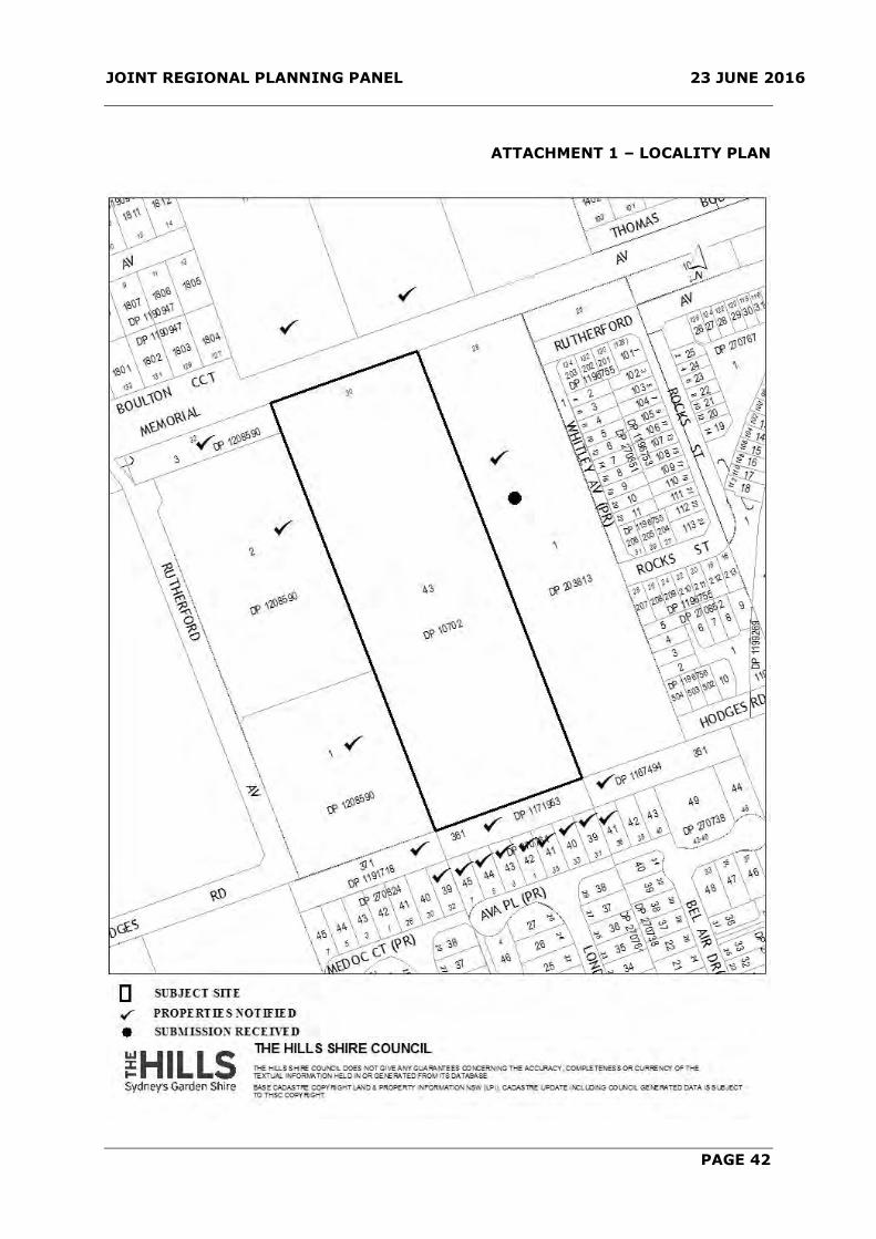
JOINT REGIONAL PLANNING PANEL 23 JUNE 2016
PAGE 42
ATTACHMENT 1 – LOCALITY PLAN

JOINT REGIONAL PLANNING PANEL 23 JUNE 2016
PAGE 43
ATTACHMENT 2 – GROUND FLOOR PLAN
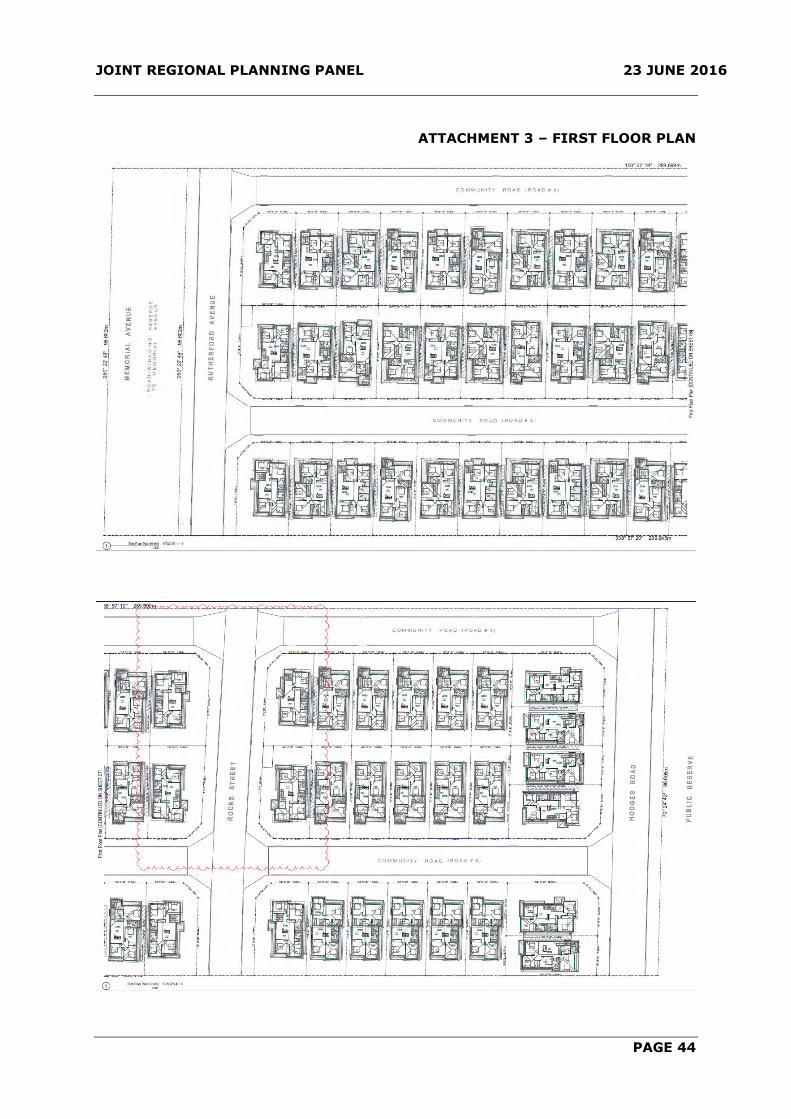
JOINT REGIONAL PLANNING PANEL 23 JUNE 2016
PAGE 44
ATTACHMENT 3 – FIRST FLOOR PLAN

JOINT REGIONAL PLANNING PANEL 23 JUNE 2016
PAGE 45
ATTACHMENT 4 – ELEVATIONS

JOINT REGIONAL PLANNING PANEL 23 JUNE 2016
PAGE 46

JOINT REGIONAL PLANNING PANEL 23 JUNE 2016
PAGE 47
ATTACHMENT 5 – SUBDIVISION PLAN
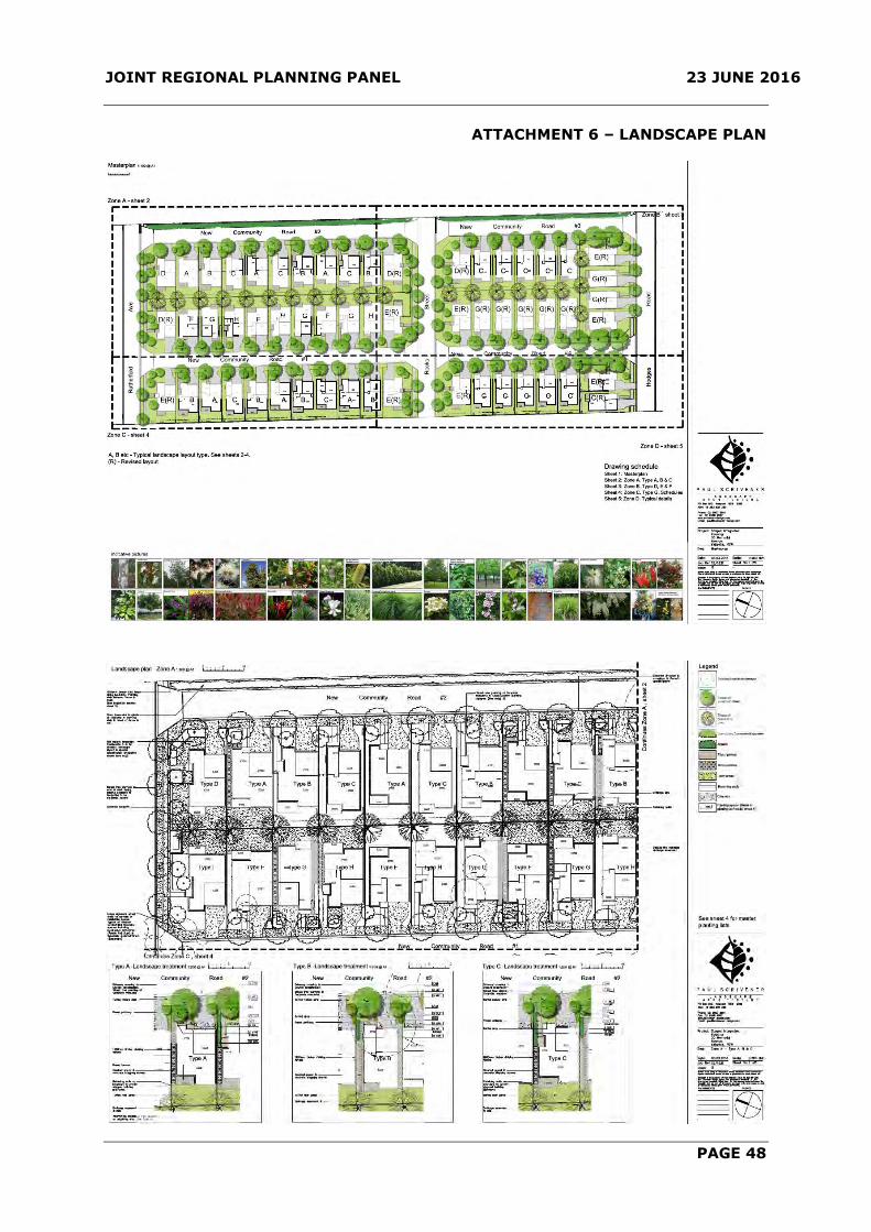
JOINT REGIONAL PLANNING PANEL 23 JUNE 2016
PAGE 48
ATTACHMENT 6 – LANDSCAPE PLAN
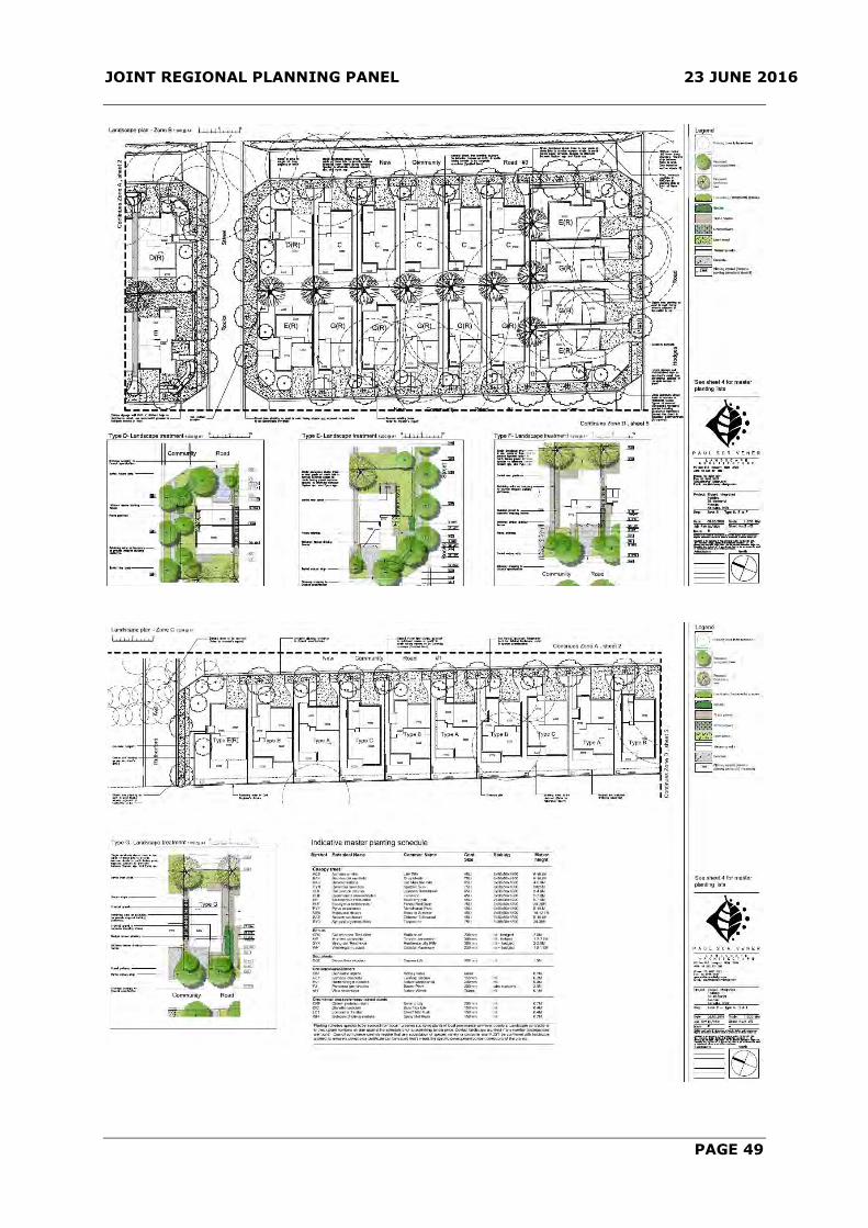
JOINT REGIONAL PLANNING PANEL 23 JUNE 2016
PAGE 49
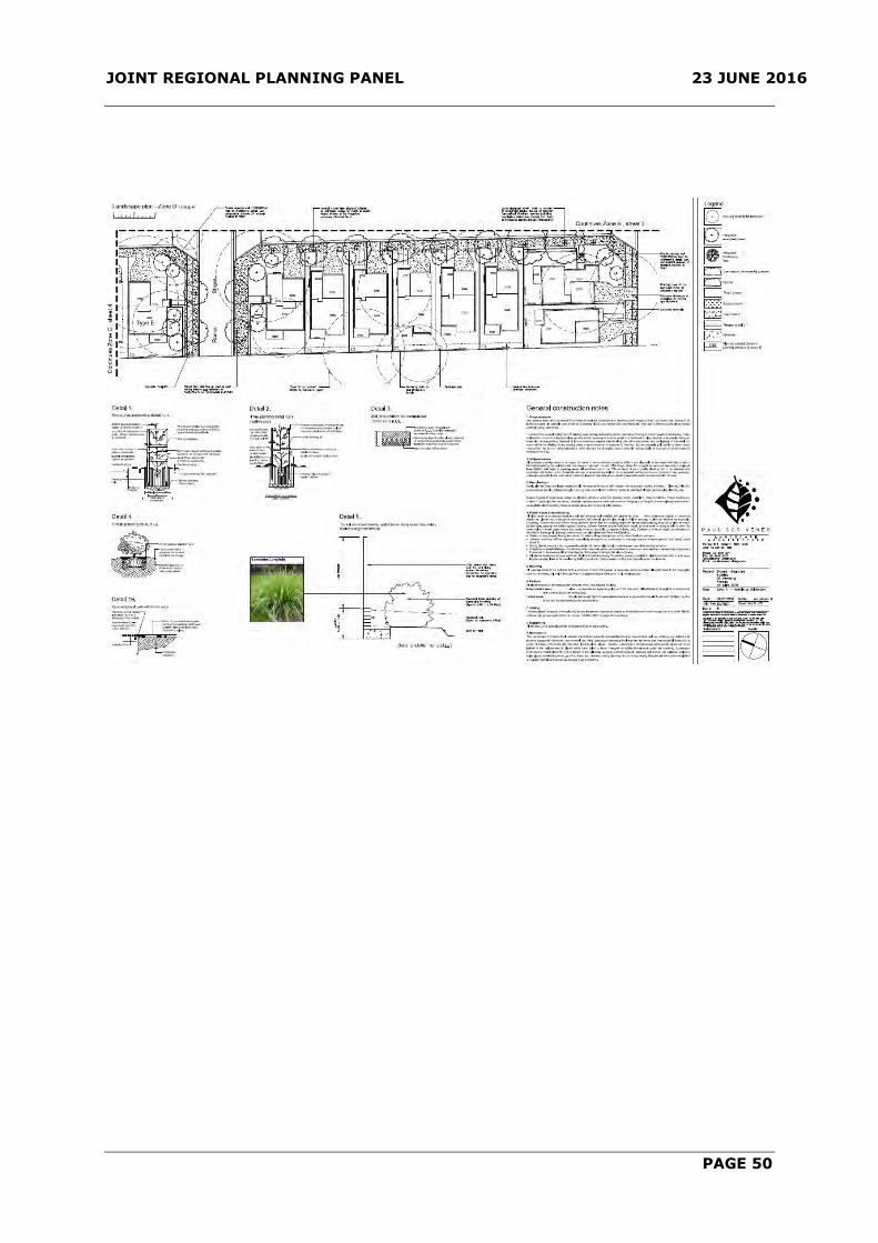
JOINT REGIONAL PLANNING PANEL 23 JUNE 2016
PAGE 50

JOINT REGIONAL PLANNING PANEL 23 JUNE 2016
PAGE 51
ATTACHMENT 7 –COLOUR SCHEDULE

JOINT REGIONAL PLANNING PANEL 23 JUNE 2016
PAGE 52
ATTACHMENT 8 – ROAD LOCATION