beit jala city profile - applied research …vprofile.arij.org/bethlehem/pdfs/vp/beit...
TRANSCRIPT

Beit Jala City Profile
Prepared by
The Applied Research Institute – Jerusalem
Funded by
Spanish Cooperation Azahar Program
2010
Palestinian Localities Study Bethlehem Governorate
1
Acknowledgments
ARIJ hereby expresses its deep gratitude to the Spanish agency for International Cooperation for Development (AECID) for their funding of this project through the Azahar Program. ARIJ is grateful to the Palestinian officials in the ministries, municipalities, joint services councils, village committees and councils, and the Palestinian Central Bureau of Statistics (PCBS) for their assistance and cooperation with the project team members during the data collection process. ARIJ also thanks all the staff who worked throughout the past couple of years towards the accomplishment of this work.

Palestinian Localities Study Bethlehem Governorate
2
Background This booklet is part of a series of booklets, which contain compiled information about each city, town, and village in Bethlehem Governorate. These booklets came as a result of a comprehensive study of all localities in Bethlehem Governorate, which aims at depicting the overall living conditions in the governorate and presenting developmental plans to assist in developing the livelihood of the population in the area. It was accomplished through the "Village Profiles and Azahar Needs Assessment;" the project funded by the Spanish Agency for International Cooperation for Development (AECID) and the Azahar Program. The "Village Profiles and Azahar Needs Assessment" was designed to study, investigate, analyze and document the socio-economic conditions and the needed programs and activities to mitigate the impact of the current unsecure political, economic and social conditions in Bethlehem Governorate with particular focus on the Azahar program objectives and activities concerning water, environment, and agriculture.
The project's objectives are to survey, analyze, and document the available natural, human, socioeconomic and environmental resources, and the existing limitations and needs assessment for the development of the rural and marginalized areas in Bethlehem Governorate. In addition, the project aims at preparing strategic developmental programs and activities to mitigate the impact of the current political, social, and economic instability with the focus on the agricultural sector. All locality profiles in Arabic and English are available online at http://proxy.arij.org/vprofile.

Palestinian Localities Study Bethlehem Governorate
3
Table of Content
Location and Physical Characteristics ____________________ 4 History _____________________________________________ 5 Religious and Archaeological Sites_______________________ 6 Population __________________________________________ 8 Education ___________________________________________ 9 Health Status _______________________________________ 11 Economic Activities __________________________________ 12 Agricultural Sector __________________________________ 13 Institutions and Services ______________________________ 16 Infrastructure and Natural Resources ___________________ 18 Environmental Conditions ____________________________ 21 Impact of the Israeli Occupation________________________ 23 Impact of the Israeli Occupation on Khallet Hamameh _____ 26 Development Plans and Projects________________________ 29 Implemented Projects ________________________________ 29 Proposed Projects____________________________________ 29 Locality Development Priorities and Needs _______________ 31 References:_________________________________________ 32

Palestinian Localities Study Bethlehem Governorate
4
Beit Jala City Profile
Location and Physical Characteristics Beit Jala is a Palestinian city in Bethlehem Governorate located at 1.8km (horizontal distance) west of Bethlehem City. Beit Jala is bordered by Bethlehem city to the east, Jerusalem city and Gilo settlement to the north, Al Walaja and Battir villages to the west, and Ad Doha city and Al Khader town to the south (See map 1).
Map 1: Beit Jala location and borders
Beit Jala is located at an altitude of 779m above sea level with a mean annual rainfall of 563mm. The average annual temperature is 16o C, and the average annual humidity is about 60.5 percent (ARIJ GIS, 2009).

Palestinian Localities Study Bethlehem Governorate
5
The present municipal council took office on May, 2005, consisting of 13 members. The Municipality has fifty-five employees in five major departments: Administration, Finance, Health and Environment, Engineering, and projects/development departments. The municipality owns a permanent headquarters, four vehicles to collect solid waste, two private cars, and a small Hummer for excavation works. It is the responsibility of the Municipality to provide a number of services to the residents of Beit Jala, including:
1. Infrastructure services such as water and electricity. 2. Solid waste collection, road construction and restoration, street cleaning, and
social development services. 3. Public markets. 4. Sewage network service. 5. Organization of the construction and licensing process. 6. Implementation of projects and case studies for the city. 7. Clean and sanitary slaughterhouses and the organization of the slaughter of
animals.
History The name of Beit Jala is originally an Aramaic name which means a grass carpet. The city dates back to 1912, and its residents originate from the neighboring Arab countries including: Iraq. Beit Jala city includes two other localities: Khallet Hamameh and Bir Onah.
Photo of Beit Jala

Palestinian Localities Study Bethlehem Governorate
6
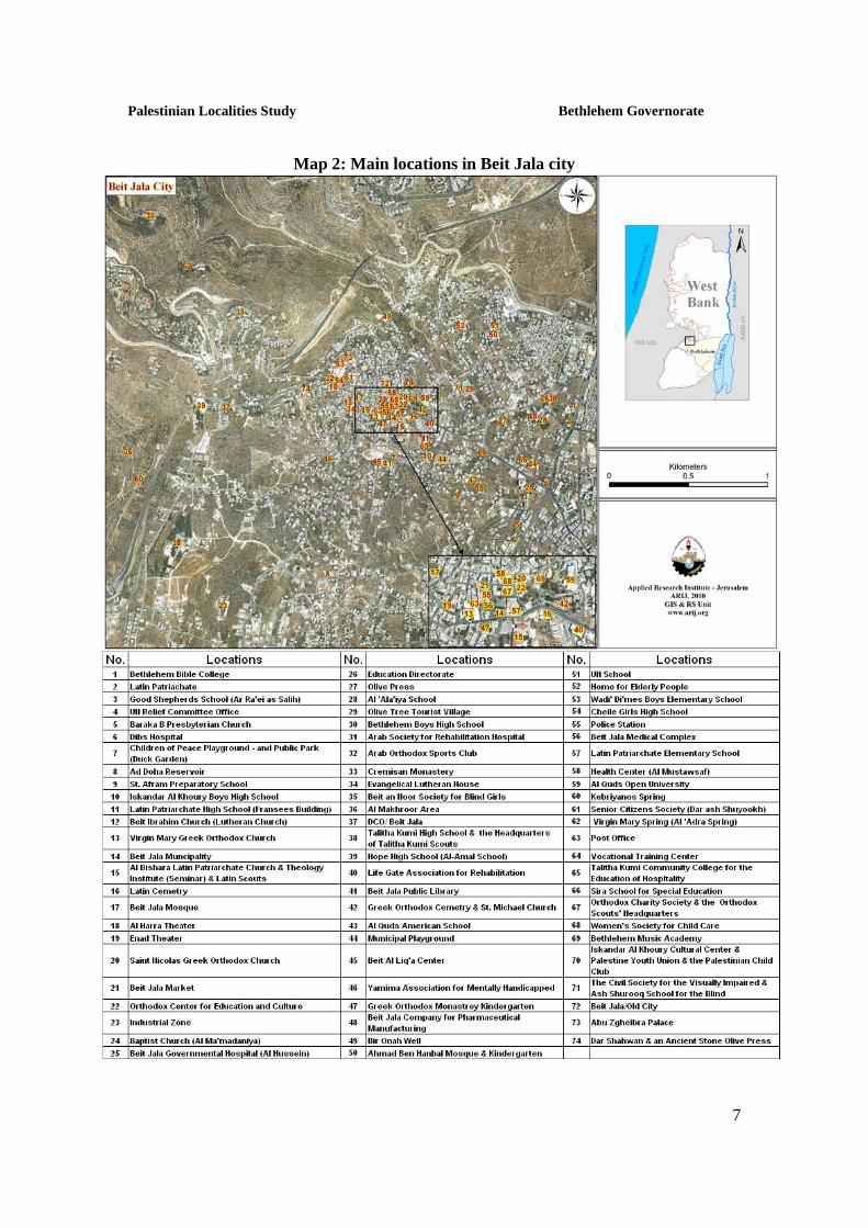
Religious and Archaeological Sites In terms of religious establishments, there are five churches in Beit Jala: Virgin Mary Greek Orthodox Church, Al Bishara Latin Church, St. Nicolas Greek Orthodox Church, St. Michael Greek Orthodox Church, and the Evangelical Lutheran Church, in addition to two mosques: Beit Jala Al Kabeer Mosque, and Al Imam Ahmad Ben Hanbal Mosque (See Map 2). As for the archaeological sites, Beit Jala city is full of significant historical and biblical sites. Ruins from Roman, Byzantine, Islamic and Crusader times can be found throughout the area. In addition, there are many sites of special importance to the followers of the three monotheistic religions, to whom this land is sacred, including: (Beit Jala City book, 1994)
1. Virgin Mary Greek Orthodox Church: located on the main street in the center of Beit Jala city. In term of architecture, the church is considered one of the largest churches in the area. In 1862, the church was constructed as a building at the expense of the Holy Tomb Monastery.
2. St. Michael Greek Orthodox Church: In the past, the church was an old building that included a chapel and two rooms to its western and northern sides, from which were the entrances to its garden.
3. Al Bishara Latin Church: Located at the eastern side of Beit Jala at a place called Iraq Al Jazza. The church was built in 1858 after obtaining a decree from the Turkish government.
4. Evangelical Lutheran Church: Located in a prominent place in Beit Jala, on a public street. According to the ancestors, in 1862, the Protestants were given a house in the town, and in 1866, a school was established; it included 25 students, whom later became the nucleus of the Lutheran community in Beit Jala.
Bir Onah
Palestinian Localities Study Bethlehem Governorate
7
Map 2: Main locations in Beit Jala city

Palestinian Localities Study Bethlehem Governorate
8
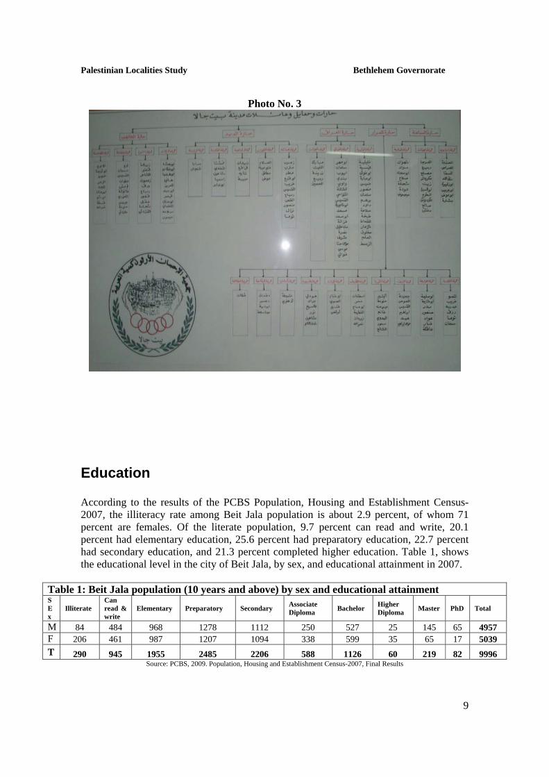
Population According to the Palestinian Central Bureau of Statistics (PCBS), the total population of Beit Jala in 20071 was 13,845; of whom 6,859 are males and 6,986 are females. There are 3,093 households living in 3,917 housing units. Age Groups and Gender The General Census of Population and Housing carried out by PCBS in 20072 showed that the distribution of age groups in Beit Jala is as follows: 31 percent are less than 15 years, 59.3 percent are between 15 - 64 years, 6.1 percent are 65 years and older, and 3.6 percent are unknown. Data also showed that the sex ratio of males to females in the city is 98.2:100, meaning that males constitute 49.5 percent of the population, and females constitute 50.5 percent of the population. Families Beit Jala city consists of five neighborhoods; each of which includes several families: (Arab Orthodox Charitable Society, 2010) (See also photo 3)
1. As Sama’na Neighborhood, which includes three families: As Sama’na, Al Hseinat, and Ath Tha’alba.
2. As Sarar Neighborhood which includes ten families: Ash Shamamsa, Al ‘Ararfa, Ar Rzooz, Al Khuwara, Ath Throof, Al Jirban, Al Mutasariboon, Al Khirfan, Ad Daqamqa, and Al Qatatna.
3. Al Iraq Neighborhood, which includes three families: An Nawawiya, Al Ghawali, and Hseinat Al Iraq.
4. Ad Deir Neighborhood, which includes five families: Al ‘Asatna, Al Ghneimat, Al Habahba, Al Mafadwa, and Al Marawna.
5. Al Knees Neighborhood, which includes four families: Al Gweijat, Ash Shamra, An Naqawla, and Al Qasasfa.
1 This data contains data of Beit Jala city in addition to Khallet Hamameh and Bir Onah localities 2 This data contains data of Beit Jala city in addition to Khallet Hamameh and Bir Onah localities
Palestinian Localities Study Bethlehem Governorate
9
Photo No. 3
Education According to the results of the PCBS Population, Housing and Establishment Census-2007, the illiteracy rate among Beit Jala population is about 2.9 percent, of whom 71 percent are females. Of the literate population, 9.7 percent can read and write, 20.1 percent had elementary education, 25.6 percent had preparatory education, 22.7 percent had secondary education, and 21.3 percent completed higher education. Table 1, shows the educational level in the city of Beit Jala, by sex, and educational attainment in 2007.
Table 1: Beit Jala population (10 years and above) by sex and educational attainment S E x
Illiterate Can read & write
Elementary Preparatory Secondary Associate Diploma Bachelor Higher
Diploma Master PhD Total
M 84 484 968 1278 1112 250 527 25 145 65 4957 F 206 461 987 1207 1094 338 599 35 65 17 5039 T 290 945 1955 2485 2206 588 1126 60 219 82 9996
Source: PCBS, 2009. Population, Housing and Establishment Census-2007, Final Results

Palestinian Localities Study Bethlehem Governorate
10
In regards to the basic and secondary educational institutions and schools in Beit Jala in the academic year 2008/2009, there are three public schools in the city, run by the Palestinian Ministry of Higher Education, six private schools that are run by religious institutions in the city, and one school run by the UNRWA (table 2). There is a total number of 4,012 students, 208 teachers, and 151 classes (Directorate of Education in Bethlehem, 2009). It should be noted here that the average number of students per teacher in the school is nearly 19, while the average number of students per class is approximately 27 (Directorate of Education in Bethlehem, 2009). In regards to the university education institutions, there is the main headquarters of Al Quds Open University, in Bethlehem governorate, in Beit Jala city. The university has a total of 3,498 students (Al Quds Open University - Bethlehem Educational Area - The University Website, 2010): http://www.qou.edu/englishIndexPage.do.) Also, there are two community colleges; Talitha Kumi Community College for the education of hospitality, and Bethlehem Bible College. There is also the theology Institute which is known as the Seminar. Beit Jala city also has a vocational training center and Bethlehem Music Academy (Beit Jala Municipality, 2010). Table 2: The Schools in Beit Jala by name, stage, sex, and supervising authority
School Name Supervising Authority Sex Wadi’ Di’mes Boys Elementary School Iskandar al Khoury Boys High School
Government
Beit Jala Boys Elementary School UNRWA
Male
Beit Jala Girls High School (Cheile) Government Ar Ra’ei as Salih Swedish School Private
Female
Talitha Kumi High School Latin Patriarch High School Al Quds American School Al Amal High School St. Ephram Syriac School
Private
Mixed
Source: Directorate of Education in Bethlehem, 2009 Furthermore, there are six kindergartens in Beit Jala; five are privately run and one is run by a charitable society in the city. Table 3 shows the kindergartens according to their names and supervising authority.

Palestinian Localities Study Bethlehem Governorate
11
Table 3: The Kindergartens in Beit Jala by name and supervising authority Kindergarten Name Supervising Authority
Cremisan Nunnery Kindergarten Private
Talitha Kumi Kindergarten Private St. Ephram Syriac Kindergarten Private The Greek Orthodox Monastery Kindergarten Private Beit al Liqa’ Kindergarten Private Al Imam Ahmad Ben Hanbal Kindergarten Charitable Society Source: Beit Jala Municipality, 2010
Health Status Medical services in Beit Jala city are considered rather well-developed, as the Ministry of Health and non-governmental and private institutions, which work in the health sector, supervise this sector and provide their services through hospitals, clinics, and primary health care centers. There is one governmental hospital in Beit Jala city; Beit Jala Governmental hospital (Al Hussein), which contains 113 beds, in addition to the specialized surgical hospital of the Rehabilitation Arab Society which contains 77 beds, and Dibs Maternity hospital for childbirth, which contains 10 beds. The Palestinian Ministry of Health also provides the city and surrounding towns and villages’ citizens with primary health care services, such as medical examination and treatment, through Bethlehem Health Directorate and the Motherhood and Childhood center in the city. In addition, there are many charitable societies, medical institutions, and private health clinics, which, upon their efforts, were able to perform multiple tasks in the areas of health care and social development. These institutions and societies include:
• The Rehabilitation Arab Society Center • Yamima Association for Mentally Handicapped: a Netherlands charitable
organization which takes care of children with mental disabilities. • Life Gate Association for Rehabilitation: a German charitable non-profit
organization specialized in the rehabilitation of people with physical disabilities and providing them with vocational training in order to facilitate their involvement and integration in the local community, in addition to helping people

Palestinian Localities Study Bethlehem Governorate
12
with special needs to get the necessary equipment, such as headphones, wheelchairs, and other tools.
• Beit ar Raja’ Association: Founded in 1962, and is interested in the affairs of people with mental and physical disabilities, and the visually impaired people.
Moreover, there is Beit Jala Medical complex in the city, which includes several medical clinics in various specialties, in addition to Asdiqa’ al Mareed Society – Beit an Noor clinics. Furthermore, the city has a number of laboratories, radiology centers, dental clinics, and private pharmacies. It is worth mentioning that all of these hospitals, institutions, clinics and medical centers, not only serve Beit Jala city, but also the surrounding towns and villages in Bethlehem governorate.
Economic Activities The economy in Beit Jala is dependent on several economic sectors, mainly: services sector, which absorbs 30 percent of the city workforce (See Figure 1). The results of a field survey for the distribution of labor by economic activity in Beit Jala are the following:
• Service Sector (30%) • Trade Sector (25%) • Industry (20%) • Government or Private Employees Sector (20%) • Agriculture sector (5%)
Figure 1: Economic Activity in Beit Jala City
Services Sector
30%
Trade Sector25%
Industry20%
Government or Other
Employees Sector
20%
Agriculture Sector
5%

Palestinian Localities Study Bethlehem Governorate
13
There are many economic and industrial activities in Beit Jala, mainly; religious artifacts and textile industry, in addition to 387 different workshops (blacksmith, carpentry, and aluminum), six butcheries, five bakeries, 54 different services stores, and 61 grocery stores. As a result of the Israeli occupation and restrictions, the economic status of the population has severely declined, as many citizens have lost their jobs and have become unemployed, thus forcing them to work in the service sector. The unemployment rate in Beit Jala has reached about 17 percent, and the economical groups most affected by the Israeli restrictions were:
1. Workers in the agricultural sector. 2. Workers in the trade sector. 3. Former workers in Israel.
Labor Force According to the PCBS Population, Housing and Establishment Census-20073, 39.9 percent of the Beit Jala labor force was economically active, of whom 88.3 percent were employed, 59.5 percent were not economically active, 50.2 percent were students, and 34.7 percent were housekeepers (See table 4).
Table 4: Beit Jala population (10 years and above) by sex and employment status-2007 S E X
Economically Active Not Economically Active
Employed Currently Unemployed
Unemployed (Never worked)
Total Students House- keeping
Unable to work
Not working & Not looking for work
Other Total
Total
M 2,585 221 157 2,963 1,469 9 359 68 58 1,963 4,957F 938 44 46 1,028 1,519 2,052 332 54 27 3,984 5,039T 3,523 265 203 3,991 2,988 2,061 691 122 85 5,947 9,996
Source: PCBS, March 2009. Population, Housing and Establishment Census-2007, Final Results
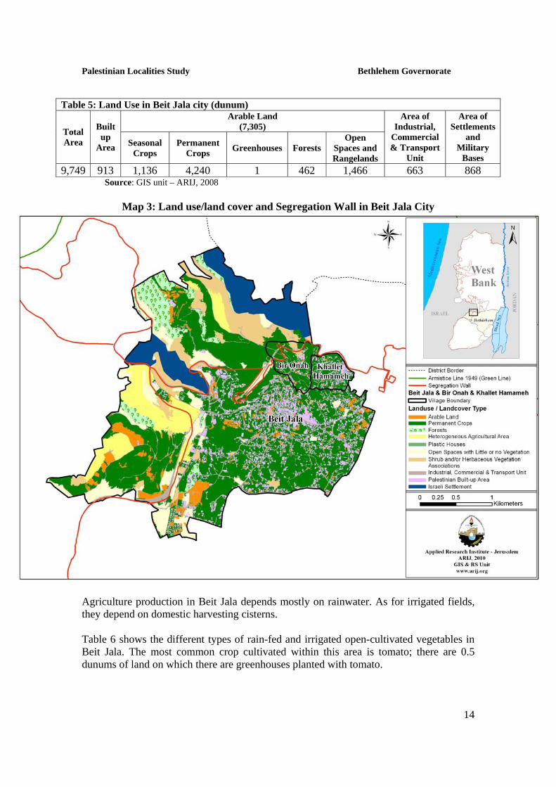
Agricultural Sector Beit Jala lies on a total area of about 9,749 dunums of which 7,305 dunums are considered arable land, and 913 dunums are residential land (See table 5 and map 3). 3 This data contains data of Beit Jala city in addition to Khallet Hamameh and Bir Onah localities
Palestinian Localities Study Bethlehem Governorate
14
Table 5: Land Use in Beit Jala city (dunum) Arable Land
(7,305) Total Area
Built up
Area Seasonal Crops
Permanent Crops Greenhouses Forests
Open Spaces and Rangelands
Area of Industrial,
Commercial & Transport
Unit
Area of Settlements
and Military
Bases 9,749 913 1,136 4,240 1 462 1,466 663 868
Source: GIS unit – ARIJ, 2008
Map 3: Land use/land cover and Segregation Wall in Beit Jala City
Agriculture production in Beit Jala depends mostly on rainwater. As for irrigated fields, they depend on domestic harvesting cisterns. Table 6 shows the different types of rain-fed and irrigated open-cultivated vegetables in Beit Jala. The most common crop cultivated within this area is tomato; there are 0.5 dunums of land on which there are greenhouses planted with tomato.

Palestinian Localities Study Bethlehem Governorate
15
Table 6: Total area of rain-fed and irrigated open cultivated vegetables in Beit Jala city (dunum)
Fruity vegetables
Leafy vegetable
Green legumes Bulbs Other
vegetables Total area
RF Irr. RF Irr. RF Irr. RF Irr. RF Irr. RF Irr. 21 21.5 0 6.5 0 1.5 0 0.5 0 6 21 36 Rf: Rain-fed, Irr: Irrigated Source: Palestinian Ministry of Agriculture, 2007 Table 7 shows the different types of fruit trees planted in the area. Table 7: Total area of fruit and olive trees in Beit Jala City (dunum) Olives Citrus Stone-
fruits Pome fruits
Nuts Other fruits
Total area
Rf Irr. Rf Irr. Rf Irr. Rf Irr. Rf Irr. Rf Irr. Rf Irr.3,020 0 0 0 605 0 221 0 0 0 261 0 4,107 0 Rf: Rain-fed, Irr: Irrigated Source: Palestinian Ministry of Agriculture, 2007 As for the field crops and forage in Beit Jala, cereals, in particular, wheat and barley are the most cultivated covering an area of about 45 dunums, while forage crops, such as bitter vetch and common vetch are the second most cultivated crops (See table 8). Table 8: Total area of field crops in Beit Jala city (dunum) Cereals Bulbs Dry
legumes Oil crops
Forage crops
Stimulating crops
Other crops
Total area
Rf Irr Rf Irr Rf Irr Rf Irr Rf Irr Rf Irr Rf Irr Rf Irr 45 0 0 0 20 0 0 0 24 0 0 0 0 0 89 0 Rf: Rain-fed, Irr: Irrigated Source: Palestinian Ministry of Agriculture, 2007 The field survey shows that most of the residents in Beit Jala are rearing and keeping domestic animals such as sheep, cows, goats, broiler and layer chicken, and bees (See Table 9). Table 9: Livestock in Beit Jala city Cows* Sheep
Goats Camels Horses Donkeys
Mules Broilers Layers Bee
Hives16 251 320 0 10 6 7 8,900 3,000 30 *Including cows, bull calves, heifer calves and bulls Source: Palestinian Ministry of Agriculture, 2007

Palestinian Localities Study Bethlehem Governorate
16
Institutions and Services Beit Jala has a number of local institutions and associations that provide services to various segments of society: children, youth, and women. The services are in the areas of culture, sports and others, including (Beit Jala Municipality, 2010):
• Orthodox Charity Society: Founded in 1907 with the goal of providing financial and all kinds of assistance to the poor, the needy and the sick people in the city, providing and maintaining the orphans, and burying the poors’ dead. The society’s administrative body consists of 11 members, each with a 3 year term of office, who represent the five neighborhoods in the city.
• Women Society for Child Care: Founded in 1944 and aiming at empowering women and promoting their health socially and culturally.. The Society also provides some assistance for the poor and the needy, in addition to granting loans for promoting industrial and agricultural work in the city. The Society has accomplished a number of achievements since its establishment until the present time, mainly: opening a medical center for child care, establishing a center for the revival of embroidery and employment of women in their homes, and establishing residential houses. Moreover, recently, the Society has established a unit for food production, which provided job opportunities for some women in the city.
• Senior Citizens Society (Dar ash Shuyookh): Founded in 1987 with the goal of addressing the elderly and retired people’s issues. The Society also aims at providing a daytime club for the elderly, social and health services, and the best possible services to ensure a dignified life for them. One of the main achievements of the society is the establishment of medical clinics, a food production unit, a heritage museum, and a public park. As for its income, the Society depends on foreign supports, contributions, and the profits of its activities.
• St. Mansoor Charitable Society: Founded in 1953 and aiming at providing assistance to the poor and widows and covering some of the needy students’ expenses, part of the expenses of childbirth for needy women, and others. Moreover, through this Society, Al Bishara Housing Society was established, which provided housing units for the city citizens. The Society participates in public activities in the city and has a scouts group called the Papal group.
• St. Nicolas House Society for the elderly: Founded in 1976 as a charitable society that aims at taking care and providing a shelter for the elderly.
• Arab Charitable Society – Al Manonit: Founded in 1962 as a preparatory school in Al ‘Ehsan Orthodox Society’s building. In 1976, the Arab Charitable Society was formed, which adopted the school that is still known as Al Amal High School. The Society provides educational and charitable services to a large number of students in the city.
• Al ‘Awda Charitable Society: Founded in 2000 as a charitable foundation aiming at strengthening the social and humanitarian ties in the city, promoting democratic concepts, and building capacities. The societies’ main activities are: the establishment of summer camps for the children in the city, conducting educational and computer training courses, and holding workshops on democracy
Palestinian Localities Study Bethlehem Governorate
17
and human rights, in addition to honoring the families of martyrs and wounded, providing assistance to students, and providing all kinds of medical assistance to the needy.
• Al Malha Charitable Society: an educational, charitable, and youth association which takes care of children, marginalized families and women, and works in the field of social work.
• Iskandar al Khoury Cultural Center: Founded in 1992 and aims at developing the cultural movement in the city. The center uses the late poet Iskandar al Khoury’s house as it headquarters.
• Orthodox Cultural Center: Founded in 2002 and aims at raising the cultural religious awareness among the Orthodox Church’s sons, deepening the youth and children’s Christian faith, encouraging those who are interested to study theology in colleges and universities in order to serve the parish, and urging the youth to stay in their countries and not to immigrate.
• Palestinian Youth Union: a voluntary, non-profit youth organization founded in 1992 by a group of youth volunteers from the city aiming at building the youth’s capacities in order to contribute in the development of the Palestinian society through purposeful programs and activities.
• Beit Jala Baladi Group: Founded in 1991 and aims at reviving the Palestinian cultural heritage through folk dance (folklore) and the Dabkah.
• ‘Enad Theater: Founded in 1987 under the name "Beit Jala Theatre Group" and aims at developing the theatrical movement in Palestine.
• Arab Orthodox Sports Club: Founded in 1923 and aims at developing the sports movement in the city. Over the past years, the club has managed to accomplish some special sports achievements and championships, in addition to the establishment of sports festivals and hosting foreign teams.
• Cremisan Club: a youth sports club. • Palestinian Child Club • Arab Orthodox Group: Founded in 1956 to serve the church and maintain order
in religious events. The group had a lead role in the establishment of the Scouts Groups Federation.
• Talitha Kumi Scouts Group: Founded in 1995 and aims at developing the scouts movement in the city.
• Beit Jala Papal Group: Founded in 1950 and is affiliated to the Latin Monastery. The Group aims at serving the youth and developing the scouts’ movement in the city.
• Environment Educational Center: Founded in 1998 in Talitha Kumi secondary school, aiming at spreading environmental awareness among the society members in order to promote a positive relationship between humans and their environment.
• Beit Jala Farmers Society: Founded in 2004. The society is interested in the farmers’ affairs as it helps them obtain agricultural guidance, finding possible ways to preserve their lands, and submitting projects for donor institutions. The Society also urges the farmers to reclaim their lands and to be present on them in order to defy the establishment of the racist segregation wall scheme in the city.

Palestinian Localities Study Bethlehem Governorate
18
• Yamima Association for Mentally Handicapped: a Netherlands charitable organization which takes care of children with mental disabilities.
• Life Gate Association for Rehabilitation: a German charitable non-profit organization specialized in the rehabilitation of people with physical disabilities and providing them with vocational training in order to facilitate their involvement and integration in the local community, in addition to helping the needed people with special needs to get the necessary equipment, such as headphones, wheelchairs, and other tools.
• Beit ar Raja’ Association: Founded in 1962, and is interested in the affairs of people with mental and physical disabilities, and visually impaired people.
• The Civil Society for the Visually Impaired – Ash Shurooq School for the Blind: Founded in 1964, which in turn established Ash Shurooq School in 1981. The Society aims at providing educational services and equal opportunities for the visually impaired, seeking to integrate them into society. The Society has also established a library for the production of "Braille" books, for the visually impaired.
• Al Harra Theater • Palestinian - Greek Friendship Society
Infrastructure and Natural Resources Electricity and Telecommunication Services: Beit Jala is connected to a public electricity network; served by Jerusalem Electricity Company, which is the main source of electricity in the city. Approximately 98.9 percent of the housing units in the city are connected to the network, and 0.2 percent are dependent on private generators, while the source of electricity is unknown for the remaining units (1.1%) (Central Bureau of Statistics, 2007). Furthermore, Beit Jala is connected to a telecommunication network and approximately 99 percent of the housing units within the city boundaries are connected to phone lines. Transportation Services: Taxis are considered the main means of transportation in Beit Jala, as there are 50 taxis in the city. As for the road network in the city; there are a total of 60km of paved roads, however, a part of these roads are in need of rehabilitation (Beit Jala Municipality, 2010).
Palestinian Localities Study Bethlehem Governorate
19
Water Resources:
Beit Jala is provided with water by the Palestinian Water Authority (PWA), through the public water network. About 97.7 percent of the housing units are connected to the water network, 0.7 percent are dependent on rainwater harvesting cisterns, 0.2 percent are dependent on purchase of water tanks, 0.3 percent are dependent on other water resources, while the source of water supply is unknown for the remaining units (1.2%) (Central Bureau of Statistics, 2007). Based on the PWA estimations, the rate of water supply per capita in the communities provided with water is about 100 liters per day, but this rate varies from one community to another. The quantity of water supplied to Beit Jala in 2006 was about 540,000 cubic meters/year, therefore the estimated rate of water supply per capita is about 89 liters/day (PWA, 2006). Here it should be noted that many Beit Jala citizens do not in fact consume this amount of water due to water losses, which are about 31 percent. The losses usually happen at the main source, major transport lines, distribution network, and at the household level (PWA, 2006), thus the rate of water consumption per capita in Beit Jala is 61 liters per day. This is a low rate compared with the minimum quantity proposed by the World Health Organization, which is 100 liters per capita per day. Sanitation: Beit Jala city has a 32.5km public sewage network, established between 1995 and 1999. The end of the network is connected to Bir Onah Pumping Station, which pumps the waste water into West Jerusalem private sewage network. According to the results of Community Survey conducted by the PCBS in 2007 and the data provided from PWA, the majority of Beit Jala housing units (74%) use the sewage network as a major means for wastewater disposal, 23.7 percent use cesspits, and 0.2 percent lack waste water collection and disposal service, while the means for waste water disposal in unknown for the remaining units (2.1%) (Central Bureau of Statistics, 2007). Based on the estimated daily per capita water consumption, the estimated amount of wastewater generated per day, is approximately 574 cubic meters, or 209 thousands cubic meters annually. At the individual level in the city, it is estimated that the per capita wastewater generation is approximately 49 liters per day. The estimated quantity of wastewater collected through the sewage network per day is about 425 cubic meters per day, or 155,000 cubic meters annually. Also, 50 thousands cubic meters of wastewater are collected annually by cesspits and are discharged by wastewater tankers. Here it should be noted that there is no wastewater treatment either at the source or at the disposal sites which poses a threat to the environment and the public health. Solid Waste Management: Beit Jala Municipality is considered the official body responsible for managing solid waste, i.e. solid waste collection and disposal, generated from the citizens and establishments in the city, which is currently represented by solid waste collection and

Palestinian Localities Study Bethlehem Governorate
20
disposal. Due to the fact that the process of solid waste management is costly, a monthly or yearly fee has been charged on the population serviced by domestic solid waste collection and transportation services which is about 33 JD/year per house, 100 JD/year per commercial store, 80 JD/year per factory, 600 JD/year per hospital, and 400 JD/year per school and university. However, the collected fees are not considered sufficient for a good management of solid waste; these fees are supposed to contribute to about 34 percent of the total annual waste management service’s costs, but due to the fact that most of the residents are not committed to paying their fees, they contribute to only 21 percent, thus, the municipality is obliged to cover the rest of the costs (79%) from its own operational budget (Beit Jala Municipality, 2010). Most of the population in Beit Jala benefits from the solid waste services, where waste is collected from households, institutions, shops, and public squares in plastic bags and then transferred to containers with a capacity of 800–1,000 liters and/or 5-6 cubic meters each, spread throughout the neighborhoods. The municipality collects the solid waste from the containers daily and transports it to the transition station, located in the city, to be compressed and then transferred in large pressure trucks or unloading trucks to Abu Dees dumping site, 26km from Beit Jala. The common method for solid waste treatment in Abu Dees dumping site is burial. According to the data provided by Beit Jala municipality; there are four trucks and vehicles for solid waste collection and transfer, and 394 containers spread throughout the city. It should be mentioned here that household waste, industrial, and medical solid waste are collected together and dumped into the same landfill, with the absence of any special system for separation and/or collection. The largest volume of solid waste is household waste which makes up around 45-50 percent of total capacity of solid waste. The daily per capita rate of solid waste production in Beit Jala is about 1.05kg. Thus the estimated amount of solid waste produced per day from the Beit Jala residents is nearly 14.5 tons, or 5,306 tons per year. The main component of household solid waste is composed of organic materials, followed by paper and cardboard, and then by plastic, as shown in the figure below:
Figure 2: The components of the household solid waste produced
59%15%
12%
4% 4% 6% Organic Materials
Cardboard & Paper
Plastic
Glass
Metal
Others
Palestinian Localities Study Bethlehem Governorate
21
Environmental Conditions Like other cities and villages in the governorate, Beit Jala experiences several environmental problems which must be addressed and solved; these problems can be identified as follows: Water Crisis: Water is cut off for long periods of time especially in summer for several reasons:
(1) Israeli domination over Palestinian water resources; which makes PWA dependent largely on water purchase from the Israeli company Mecerot to supply the Palestinian cities and villages, representing an obstacle in the organization of water pumping and distribution among populations. PWA distributes water to various areas at an interval-basis because the amount of water available is not sufficient for everyone at the same time.
(2) High rate of water losses, despite the fact that the Palestinian Water Authority has rehabilitated and renovated part of the water network, established new reservoirs, and changed the water meters, because of citizens’ practices, like creating illegal connections, water theft, and damaging water meters, increase the proportion of water losses.
Wastewater Management:
• The absence of a public sewage network, thus the use of cesspits for the disposal of wastewater, and the discharge of wastewater in the streets, especially in winter, because the citizens cannot afford the high cost of sewage tankers, causes environmental and health problems, and the spread of epidemics and diseases in the city. Moreover, the use of cesspits pollutes the groundwater due to the fact that most cesspits are built without lining, which allows wastewater to enter into the ground and avoids the need to use sewage tankers from time to time.
• Irresponsible practices by the citizens, such as: 1) Illegal connection to the sewage network, causing an increased flow of
wastewater into the network that exceeds its capacity, thus, leading wastewater to flow in the streets and causing environmental and health problems. Moreover, the poor implementation of the sewage network and manholes contributes to the problem as well.
2) The disposal of solid waste in public manholes and the sewage network, by some residents, causes a poor discharge of wastewater and thus it flows in the streets.
• Lack of treatment of waste water, which is collected by the sewage network in the city, before it flows into West Jerusalem private sewage network.
• The absence of wastewater treatment, resulting from industrial facilities at the source, where it is either discharged directly into a public sewage network or collected in cesspits.
• The rainwater drainage system does not cover all parts of the city and is also not effective, thus, increasing the burden on the sewage network.

Palestinian Localities Study Bethlehem Governorate
22
Solid Waste Management:
• The solid waste management’s limited role in waste collection and transfer to the transition station, located in the center of a residential area, where solid waste are compressed in order to reduce its size, and then transferred to Abu Dees landfill, which is located outside Bethlehem governorate boundaries, because the city lacks a central sanitary landfill. This is due mainly to the obstacles created by the Israeli authorities for local and national institutions, like granting licenses to establish such a landfill, because the appropriate land is within Area C, under the Israeli full control. In addition, the implementation of such projects depends on funding from donor countries. Thus, the lack of a sanitary landfill is a hazard risk for the health, a source of pollution to the groundwater and soil through the leachate produced from the solid waste, and it produces odors and distortion of the landscape.
• It should be noted here that a sanitary landfill is under construction, at the time, in Al Maniya area, south of Bethlehem governorate, to serve Bethlehem and Hebron governorates. The Joint Service Council for solid waste will be responsible for the management of this project.
• There is an absence of a system in the city and the governorate in general that separates household and industrial hazardous waste, consequently hazardous solid waste is collected with non-hazardous waste and transported to Abu Dees landfill for disposal by burial. With regard to medical waste, in 2005, Beit Jala municipality, in cooperation with the Arab Society for Rehabilitation, established a private incinerator, for the disposal of medical waste resulted from hospitals and health centers, which was funded by a grant from the Spanish Government (Beit Jala Municipality, 2010).
Other problems:
• Air pollution resulting from car exhaust, which has increased significantly due to the increasing number of trucks and vehicles using the main road, which connects Beit Jala and the Bethlehem area to the Hebron and Jerusalem governorates. Moreover, the Israeli occupying forces have closed other roads, aiming at restricting Palestinian movement. The pollution caused by stone quarries is also a serious problem in the city.
• Growth and urbanization in the city are not directed in a right and sustainable manner; it has become difficult to maintain reserved areas in light of the scarcity of land, constraints, and current determinants, imposed on land use.

Palestinian Localities Study Bethlehem Governorate
23
Impact of the Israeli Occupation Impact of Israeli Occupation on Beit Jala According to Oslo Interim Agreement, signed in September, 1995, between the Palestinian National Authority and the Israeli government, Beit Jala lands were classified into areas A, B, and C; 3175 dunums (34.6%) of which were classified as area A, where the Palestinian sovereignty is absolute, 2 dunums of which were classified as area B, in which public order falls under the Palestinian National Authority's responsibility, where Israeli has full control over security matters. It is worth mentioning that the majority of the population is concentrated in area A and B, which constitutes 34.6 percent of the total area of the city. The remaining part of Beit Jala lands, 6000 dunums (65.4 percent of the total area of the city), were classified as area C, an area that is under full control of the Israeli government. Since Israeli has control of this area, Palestinians are prevented from construction or benefiting from this land in any way possible, unless they get permission, which is extremely difficult, from the Israeli civilian administration in Bethlehem. It is worth mentioning that the majority of lands in Area C are agricultural lands and open spaces which constitute the major source of income for the city residents, after they lost their jobs inside the Green Line following the outbreak of the second Intifada in September 2000. Beit Jala city was also exposed to many Israeli confiscations of thousands of dunums of land for various Israeli purposes; after 1967 was the first confiscation of 3147 dunums (22 percent of the total area of the city) for the illegal re-drawing of Jerusalem municipal boundaries. More of the city land was confiscated for the construction of Gilo and Har Gilo Israeli settlements, in addition to the construction of Israeli bypass roads, in order to link the Israeli settlements to each other and with neighboring settlements, north and south of the city. Moreover, the racist Segregation Wall plan came to control more vast areas of the city land and to include many Israeli settlements to Israel, within a move that would impose new realities on the Palestinians, for example their inability to access their own lands are now on the opposite side of the Wall. Following are some of the Israeli land confiscations of Beit Jala city territories:
• The Israeli occupation forces confiscated a total area of 3,147 dunums (22 percent of the total area of the city) in order to expand Jerusalem municipal boundaries.
• The Israeli occupation forces also confiscated vast areas of the city’s land for the construction of the following settlements:
1. Gilo Settlement: which Israel began to construct in 1971 on lands that were confiscated after 1967’s war from Beit Jala city residents, Al Walaja village in Bethlehem governorate, and Sharafat and Beit Safafa cities in Jerusalem, in order to expand Jerusalem municipal boundaries. Nowadays, Gilo settlement is considered one of the largest Israeli settlements that have been built in the West Bank, with a total area of 2,738 dunums inhabited by approximately 40,000 Israeli settlers.
2. Har Gilo Settlement: which was established by Israel in 1972 is located on the Palestinian citizens’ lands in Beit Jala city and Al Walaja village which

Palestinian Localities Study Bethlehem Governorate
24
are located west of Bethlehem city. In 2003, Har Gilo settlement covered an area of 271 dunums of land confiscated from its Palestinian owners, and is inhabited today by more than 460 Israeli settlers. In November 2000, an Israeli plan to expand the urban area and the total area of the settlement was prepared; however, the plan was not implemented until 2004, at the time when the illegal process of expansion was ratified. Later, groups of settlers living in the settlement, under the protection of the Israeli occupation army, seized over 143 dunums of Palestinian land and surrounded it by barbed wire, as a result, the total area of Har Gilo settlement became 414 dunums. In addition, it should be noted that the Segregation Wall plan around Har Gilo settlement seized additional areas of about 95 dunums of land located between the current settlement boundaries and the racist Segregation Wall path, which is under construction.
Israeli Bypass Roads in Beit Jala Since the Israeli occupation of Palestinian lands in 1967, Israel has constructed bypass roads in the Palestinian territories in order to facilitate the movement of Israeli settlers and to link the Israeli settlements with each other. In Beit Jala city, the Israeli government constructed road no. 60, which links Gush Etzion settlements, south-west of Bethlehem city, and Har Homa settlement with Jerusalem settlements, as well as the tunnel road which is a section of the road no. 60 and which runs through the western part of Beit Jala city and its agricultural lands. This section consists of a bridge that passes over the city agricultural territories in addition to two tunnels at the beginning and the end of this section of the street. Moreover, the Israeli bypass road no. 436 cuts through Beit Jala lands, and the two Israeli bypass roads; no. 60 and no. 436, extend for 5km on the city territories. On December 15, 2005, the Israeli occupation forces issued a military order (an order on closed areas - areas of Judea and Samaria (no. 34) 5727-1967), which prevents the “non-Israelis,” from the West Bank from entering or exiting Israel, as now they can only go through border-crossing points, which Israel is currently constructing in the occupied Palestinian territories and which many have been launched in the previous months. The tunnel road is one of the bypass roads that this military order is applied on therefore Palestinians cannot use that part of the road. The Segregation Wall in Beit Jala Beit Jala city, like other Palestinian cities and villages, is exposed to the danger of losing a large part of its territory for the construction of the racist Segregation Wall. According to the updated Segregation Wall plan published on the web page of the Israeli Ministry of Defense in April 30, 2007; the Segregation Wall will extend for 8km into Beit Jala lands; thus isolating and confiscating 7 dunums of the city’s agricultural land, forests and open areas. The wall in Beit Jala city extends from the north-east alongside ‘Ayda refugees camp, continues along the northern side of the city, and then moves around the western city borders until it reaches bypass road no. 60.
Palestinian Localities Study Bethlehem Governorate
25
Israeli Military Orders in Beit Jala city The Israeli authorities issued a series of military orders to confiscate land for the construction of the racist Segregation Wall on Beit Jala city territories. Following are the phases of the issued orders:
• On October 16, 2002, the Israeli Military Order No. (02/08/T) was issued to confiscate a total area of 95 dunums of Beit Jala city lands for the construction of the racist Segregation Wall.
• On July 3, 2003, the Israeli Military Order No. (03/44/T) was issued to confiscate a total area of 23.8 dunums of Beit Jala city and Al Walaja village lands for the construction of the racist Segregation Wall.
• On March 25, 2004, the Israeli Military Order No. (04/32/T) was issued to confiscate a total area of 175.6 dunums of Beit Jala city and Al Walaja village lands for the construction of the racist Segregation Wall. This military order was modified in November 2005.
• On May 23, 2004, the Israeli Military Order No. (04/57/T) was issued to confiscate a total area of 11.8 dunums of Beit Jala city lands for the construction of the racist Segregation Wall. This military order is considered a complement to the military order no. 04/32/T.
• On August 8, 2004, the Israeli Military Order No. (36/04 (a)) was issued to confiscate a total area of 33 dunums of Beit Jala city lands for the construction of the racist Segregation Wall. This military order was modified in November 2005 by a new military order no. 62/06/T.
• On August 8, 2004, the Israeli Military Order No. (36/04 (b) was issued to confiscate a total area of 33 dunums of Beit Jala city lands for the construction of the racist Segregation Wall. This military order was modified in November 2005 by a new military order no. 62/06/T.
• On March 22, 2005, the Israeli Military Order No. (05/75/T) was issued to confiscate a total area of 9.2 dunums of Beit Jala city and Al Walaja village lands for the construction of the racist Segregation Wall. This military order was replaced by military order no. 25/06/T.
• On April 1, 2005, the Israeli Military Order No. (05/85/T) was issued to confiscate a total area of 14.3 dunums of Beit Jala city and Al Walaja village lands for the construction of the racist Segregation Wall.
• On August 22, 2005, the Israeli Military Order No. (05/157/T) was issued to confiscate a total area of 21 dunums of Beit Jala city lands for the construction of the racist Segregation Wall.
• On November 2, 2005, the Israeli Military Order No. (05/201/T) was issued to confiscate a total area of 94.3 dunums of Beit Jala and Al Khader lands for the construction of the racist Segregation Wall.
• On November 21, 2005, the Israeli Military Order No. (05/210/T) was issued to confiscate a total area of 85 dunums of Beit Jala, Al Khader, and Battir village lands for the construction of the racist Segregation Wall.
• On November 1, 2006, the Israeli Military Order No. (06/01/T) was issued to confiscate a total area of 9 dunums of Beit Jala lands for the construction of the

Palestinian Localities Study Bethlehem Governorate
26
racist Segregation Wall. This military order was replaced by two military orders; no. 04/32/T and no. 04/57/T.
• On February 19, 2006, the Israeli Military Order No. (06/24/T) was issued to confiscate a total area of 170 dunums of Beit Jala and Al Khader lands for the construction of the racist Segregation Wall.
• On February 9, 2006, the Israeli Military Order No. (06/25/T) was issued to confiscate a total area of 39.8 dunums of Beit Jala and Al Walaja lands for the construction of Har Gilo crossing.
• On March 19, 2006, the Israeli Military Order No. (06/62/T) was issued to confiscate a total area of 178 dunums of Beit Jala lands for the construction of the racist Segregation Wall. This military order was replaced by two military orders; no. 36/04 (a) and no. 36/04 (b).
• On March 2006, the Israeli Military Order No. (06/66/T) was issued to confiscate a total area of 90 dunums of Beit Jala and Al Walaja lands for the construction of a military road that extends from the northern part of Cremisan Monastery, along the eastern side of the wall, which will be constructed on Al Walaja village territory, in order to link it to Al Quds street, which is connected to Har Gilo settlement through bypass road no. 436, and to the Gush Etzion settlement bloc in Jerusalem.
• On December 30, 2004, the Israeli Military Order No. (04/99/T) was modified to confiscate an area of 0.3 dunums of Beit Jala city lands and parcel no. 2, in Bab ash Shurfa region, for the construction of a military road.
• On July 10, 2007, the Israeli Military Order No. (07/75/T) was issued to confiscate a total area of 23.3 dunums of Beit Jala city lands.
Impact of the Israeli Occupation on Khallet Hamameh According to the Oslo Interim Agreement, 161 dunums (65.7 percent of the total area of Khallet Hamameh) were classified as area A. As for the remaining part of Khallet Hamameh lands, 84 dunums (34.3 percent of the total area of Khallet Hamameh), were classified as area C (Table 10). Table 10: Land classification in Khallet Hamameh according to Oslo II Agreement in 1995
% of the Total Area Area (dunum) Land Classification 65.7 161 Area A
0 0 Area B 34.3 84 Area C 100 245 Total Area
Source: GIS database- ARIJ 2010 Confiscation of Khallet Hamameh land for re-drawing Jerusalem municipal boundaries Following its occupation of Jerusalem in 1967, Israel was illegally able to re-draw the boundaries of Jerusalem Municipality, at the expense of lands belonging to the

Palestinian Localities Study Bethlehem Governorate
27
neighboring Palestinian villages. Khallet Hamameh village was among other Palestinian localities, which lost part of its territory for the purpose of colonization. According to the analysis conducted by the Applied Research Institute - Jerusalem (ARIJ); Khallet Hamameh has lost 90 dunums of land (36.7 percent of the total area) to be included within Jerusalem municipal boundaries. The occupation forces had also uprooted about 400 olive trees, 145 grape vines and 200 stone-fruit trees from Khallet Hamameh territory. Impact of the Israeli Occupation on Bir Onah According to the Oslo Interim Agreement, 63 dunums (19.3 percent of the total area of Bir Onah) were classified as area A. As for the remaining part of Bir Onah lands, 263 dunums (80.7 percent of the total area of Bir Onah), were classified as area C (Table 11). Table 11: Land classification in Bir Onah according to Oslo II Agreement in 1995
% of the Total Area Area (dunum) Land Classification 19.3 63 Area A
0 0 Area B 80.7 263 Area C
0 0 Nature Reserves 100 326 Total Area
Source: GIS database - ARIJ 2010 Bir Onah village was also exposed to many Israeli confiscations of its lands for various Israeli purposes and benefits; after 1967, 241 dunums (74 percent of the total area of the village) were confiscated for the illegal re-drawing of Jerusalem Israeli municipal boundaries. The Segregation Wall in Bir Onah After its occupation of Jerusalem in 1967, Israel was able to re-draw the boundaries of Jerusalem Municipality, for the second time, through the construction of the racist Segregation Wall, which is being built around Jerusalem. The path of the racist Segregation Wall around Jerusalem shows the Israeli intentions and plans to control vast areas of Palestinian unpopulated lands and to include Israeli settlements within its new boundaries through the project scheme of 'Greater Jerusalem.' Through this plan Israel is seeking to connect Jerusalem with the Israeli settlements in and around Jerusalem, and at the same time, separating the Palestinian localities located east of Jerusalem from rest of the West Bank cities, in order to completely isolate them.

Palestinian Localities Study Bethlehem Governorate
28
According to the updated Segregation Wall plan published on the web page of the Israeli Ministry of Defense in April, 2007; the Segregation Wall will extend for 0.9km on Bir Onah lands; thus isolating and confiscating 81 dunums of the village territory (24.8 percent of the total area of the village) west of the wall within the separation area. Table 12 shows the lands isolated behind the wall in Bir Onah village:
Table 12: The impact of the Israeli Segregation Wall on Bir Onah Land Use/Land Cover areas
Item Total Area (in Dunums)
Arable Land 54.4 Artificial Surfaces 16.4 Forests & Open Spaces 10.2 Total 81
Source: ARIJ database- GIS, 2008 Also the Israeli bypass road no. 60 will cut part into Bir Onah territory and will extend on its territory for nearly 0.5km.
Palestinian Localities Study Bethlehem Governorate
29
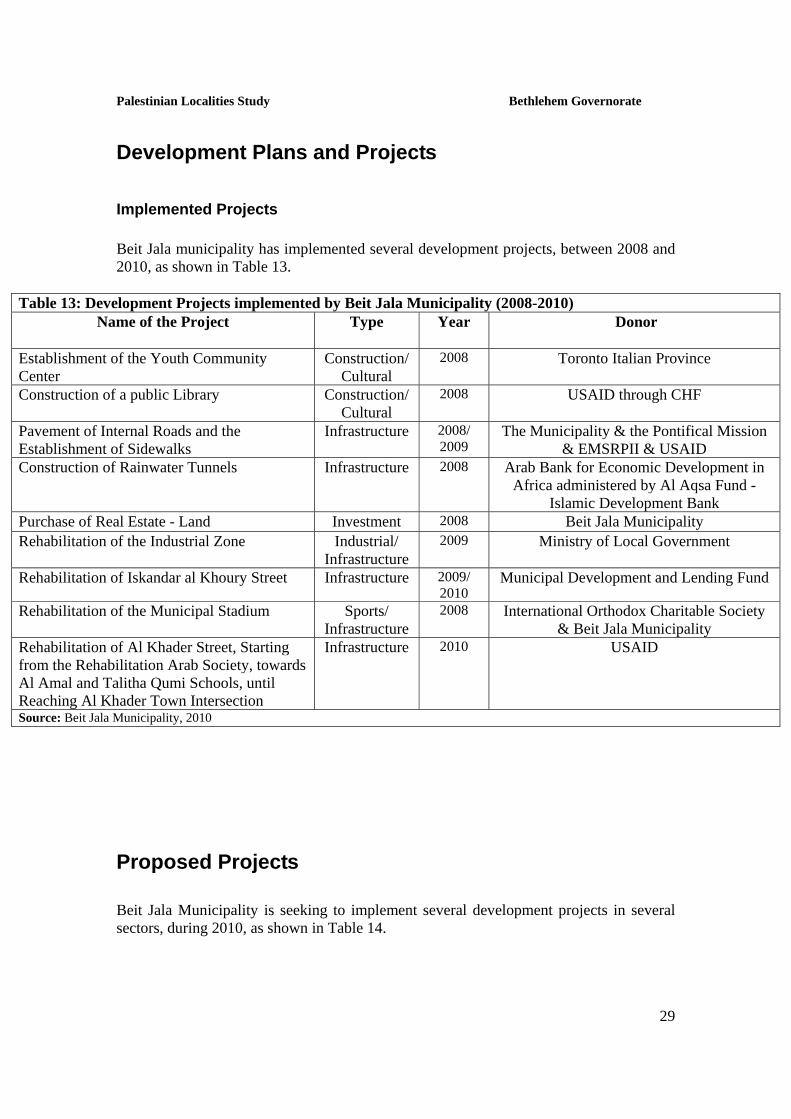
Development Plans and Projects
Implemented Projects Beit Jala municipality has implemented several development projects, between 2008 and 2010, as shown in Table 13.
Table 13: Development Projects implemented by Beit Jala Municipality (2008-2010) Name of the Project Type Year Donor
Establishment of the Youth Community Center
Construction/ Cultural
2008 Toronto Italian Province
Construction of a public Library Construction/ Cultural
2008 USAID through CHF
Pavement of Internal Roads and the Establishment of Sidewalks
Infrastructure 2008/ 2009
The Municipality & the Pontifical Mission & EMSRPII & USAID
Construction of Rainwater Tunnels Infrastructure 2008 Arab Bank for Economic Development in Africa administered by Al Aqsa Fund -
Islamic Development Bank Purchase of Real Estate - Land Investment 2008 Beit Jala Municipality Rehabilitation of the Industrial Zone Industrial/
Infrastructure 2009 Ministry of Local Government
Rehabilitation of Iskandar al Khoury Street Infrastructure 2009/ 2010
Municipal Development and Lending Fund
Rehabilitation of the Municipal Stadium Sports/ Infrastructure
2008 International Orthodox Charitable Society & Beit Jala Municipality
Rehabilitation of Al Khader Street, Starting from the Rehabilitation Arab Society, towards Al Amal and Talitha Qumi Schools, until Reaching Al Khader Town Intersection
Infrastructure 2010 USAID
Source: Beit Jala Municipality, 2010
Proposed Projects Beit Jala Municipality is seeking to implement several development projects in several sectors, during 2010, as shown in Table 14.

Palestinian Localities Study Bethlehem Governorate
30
Table 14: Development Projects sought to be implemented by Beit Jala Municipality within 2010 Name of the Project Donor
Type Project Status
Cremisan Neighborhood Sewage Network USAID Infrastructure The project was shut down by the Israeli authorities under the pretext that the region is located in area C
Construction of the Theater Hall Building on As Salam Park Land
Toronto Italian Province Cultural/ Infrastructure
Is expected to be completed within 2011
Establishment of a Municipality Headquarters on the Community Center Roof
Palestinian Council of Ministers
Construction/ Services
Is expected to be completed within 2010
Finishing the Outside Works around the Community Center
Proposed Funding by Toronto Italian Province
Infrastructure Awaiting funding
The Public Library Basement No Funding Construction/ Cultural
Awaiting funding
Construction of As Salam Park’s Kitchen Co-financed by Jina German Municipality & Aubergenville French
Municipality
Infrastructure Awaiting funding
Construction of an Additional Floor in Al Mughtaribeen School and Finishing Work around it
Japan through the UNDP Educational Awaiting funding
Finishing Work and Equipping the Motherhood and Childhood Clinic in the Clinics Building belonging to the Municipality
Proposed Funding by the USAID - ANERA
Health Awaiting funding
Rehabilitation of Mar Gerges Hosh in the Old City and Preparing it as an Olive Museum
No Funding Infrastructure/ Heritage
Under planning by the Heritage Conservation Center
Construction of the Charity Society’s Street – As Sider
Beit Jala Municipality Infrastructure Ready for implementation
Providing 3,050 meters of Secondary Sewage Lines to connect the Houses in the City Suburbs
Was Submitted to the ANERA
Infrastructure Ready for implementation
Construction of a 300m Rainwater Tunnel Was Submitted to the Italian Cooperation
Infrastructure Ready for implementation
Rehabilitation and Maintenance of Internal Streets, Sidewalks and Retaining Walls
Beit Jala Municipality Infrastructure Ready for implementation
Rehabilitation of Internal Streets Municipal Fund Infrastructure Ready for implementation Rehabilitation of Talitha Kumi Street ARD - CEP Infrastructure Ready for implementation Rehabilitation of Iskandar al Khoury Street
Municipal Fund Infrastructure Ready for implementation
Source: Beit Jala Municipality, 2010

Palestinian Localities Study Bethlehem Governorate
31
Locality Development Priorities and Needs Beit Jala suffers from a significant shortage of infrastructure and services. Table 15 shows the development priorities and needs in the city, according to the municipality’s point of view (Beit Jala Municipality, 2010):
Table 15: Development Priorities and Needs in Beit Jala No. Sector Strongly
Needed Needed Not a
Priority Notes
Infrastructural Needs
1 Opening and Pavement of Roads * 9.5km (9km in Beit Jala city & 0.5km in Khallet Hamameh)
2 Rehabilitation of Old Water Networks * 1km (in Khallet Hamameh) 3 Extending the Water Network to Cover New Built up
Areas *
4 Construction of New Water Networks * 5 Rehabilitation/ Construction of New Wells or
Springs *
6 Construction of Water Reservoirs * 7 Construction of a Sewage Disposal Network * 8 Construction of a New Electricity Network * 9 Providing Containers for Solid Waste Collection *
10 Providing Vehicles for Collecting Solid Waste * 11 Providing a Sanitary Landfill * Health Needs 1 Building of New Clinics or Health Care Centres * 2 (a health center in Beit Jala &
a clinic in Khallet Hamameh) 2 Rehabilitation of Old Clinics or Health Care Centres *
3 Purchasing of Medical Equipment and Tools * Educational Needs
1 Building of New Schools * construction of an 1000m2
area floor 2 Rehabilitation of Old Schools * 3 Purchasing of New Equipment for Schools * Agriculture Needs
1 Rehabilitation of Agricultural Lands * 2 Building Rainwater Harvesting Cisterns * 12 cisterns (in Khallet
Hamameh) 3 Construction of Barracks for Livestock * 4 (in Khallet Hamameh) 4 Veterinary Services * 5 Seeds and Hay for Animals * 6 Construction of New Greenhouses * 7 Rehabilitation of Greenhouses * 8 Field Crops Seeds * 9 Plants and Agricultural Supplies *

Palestinian Localities Study Bethlehem Governorate
32
References:
• Al Quds Open University - Bethlehem Educational Area. 2010. Al Quds Open University Website: http://www.qou.edu/englishIndexPage.do, 2010.
• Applied Research Institute - Jerusalem (ARIJ). 2008 - 2010. Bethlehem, Palestine: Geographic Information Systems and Remote Sensing unit Database.
• Applied Research Institute - Jerusalem (ARIJ). 2010. Bethlehem, Palestine: Urbanization Unit Database, 2010.
• Arab Orthodox Charitable Society. 2010. • Beit Jala City. 1st ed. Bethlehem, Palestine: Bethlehem Press, 1994. 36 - 50. • Beit Jala Municipality. 2010. • Directorate of Education - Bethlehem. 2008/2009. Bethlehem, Palestine: A
database of schools. • Palestinian Central Bureau of Statistics. 2009. Ramallah, Palestine: General
Census of Population and Housing Censuses, 2007. • Palestinian Ministry of Agriculture (MOA). 2007/2008. Bethlehem, Palestine:
Directorate of Agriculture data. • Palestinian Water Authority. 2007. Ramallah, Palestine: Quantities of Water
Supply in the West Bank Governorates, 2006.