benefits - conservation gateway · to cite: jeffrey j. opperman. 2014. a flood of enefits: using...
TRANSCRIPT

1
A FLOOD OF
BENEFITS
USING GREEN INFRASTRUCTURE
TO REDUCE FLOOD RISKS

2
A Flood of Benefits
Using Green Infrastructure to Reduce Flood Risks
The Nature Conservancy 2014
4245 North Fairfax Drive
Suite 100
Arlington, VA 22203
www.nature.org
To cite: Jeffrey J. Opperman. 2014. A Flood of Benefits: Using Green Infrastructure to Reduce Flood Risks.
The Nature Conservancy, Arlington, Virginia.
Cover photo credits: Top photo— by Jonathan Eisen at the Yolo Bypass; Bottom photo— Mark Godfrey,
2005, of the Mississippi River valley looking west toward Iowa.

1
1. Overview
Flooding is the most damaging natural disaster in the world,
with average annual losses exceeding $40 billion (Cooley 2006).
These damages have been increasing through time and flood
risk will continue to rise due to population growth in flood-
prone areas, climate change contributing to more intense
storms, and the aging of flood-management infrastructure.
This infrastructure—including dams, levees and floodwalls—
has been the traditional response to managing flood risk. How-
ever, the successful performance of this infrastructure neces-
sarily eliminates one of the most important ecological process-
es on Earth: the connection between rivers and floodplains.
This connection is what makes river-floodplain systems among
the most productive and diverse ecosystems on the planet
(Bayley 1995). Throughout Africa, Asia and Latin America, river
-floodplain systems support productive fisheries and
“Green infrastructure” encompasses natural fea-
tures, such as forests and wetlands, that provide
similar or complementary flood-management
benefits as engineered infrastructure. While en-
gineered infrastructure can degrade rivers and
the values they provide, green infrastructure
tends to support a diverse array of other bene-
fits. A sustainable and resilient approach to flood
-risk management will deploy a mix of green and
engineered infrastructure solutions, tailored to
specific challenges and objectives.
Highlights
The Mississippi Flood of 2011 had the
greatest volume of floodwater ever
recorded for that river. The flood-
management system was able to safely
convey that flood in large part
because, in multiple locations,
floodwaters were allowed to spread
out onto the historic floodplain,
relieving pressure on levees and
sparing cities like Baton Rouge and
New Orleans.
In several locations in California, flood
managers have concluded that setting
levees back from the river provided the
most effective method of reducing
local flood risk. While driven by flood-
risk reduction, these projects will
restore thousands of acres of
floodplain habitat
During major floods, the Yolo Bypass—
a 60,000 acre portion of the floodplain
that was reconnected to the river in
the 1930s—carries 80% of the volume
of floods of the Sacramento River and
is the key feature protecting the city of
Sacramento during floods. The Bypass
also supports productive agriculture
and, though built for flood
management, it is the best remaining
floodplain habitat in California’s
Central Valley for native fish and birds.
The US Army Corps of Engineers found
that acquiring and protecting
floodplain wetlands could reduce
Boston’s flood risk from the Charles
River for 1/10 the cost of a plan that
included new engineered
infrastructure.

2
2. Floods and flood-risk management
Rivers have always attracted people because they provide abundant benefits: fish, transportation, water for drinking
and, because the river continuously flows away from a community, a convenient place to dump waste. For much of
their length, most rivers are located within valleys that provide flat, fertile land for farming. Thus river valleys have
served as important places for settlement, with the first civilizations arising along the Nile, the Yangtze, and the Tigris
and Euphrates rivers.
The cornucopia of river benefits have always been twinned with a risk: periodic flooding. (In fact, that flooding is di-
rectly responsible for one of the advantages of floodplain settlement because floods, over centuries, are responsible
for depositing layers of nutrient-rich sediment, creating that flat, fertile valley land. Simple settlements could deal with
flooding by moving seasonally or restricting buildings to the very highest ground. But as civilizations grew more dense,
large populations with permanent buildings became vulnerable to floods. It is because of this intertwined fertility and
danger that the Yellow River is known as both China’s “cradle” and its “sorrow.” In stories, folk tales and songs the
Mississippi serves as a backdrop for romantic adventure, but also for inexorably rising floods.
The 1931 floods in China, along the Yellow, Yangtze, and Huai rivers, are estimated to be the deadliest natural disaster
ever: official statistics report 145,000 deaths but external estimates place the death toll at nearly 4 million (Kundzewicz
and Takeuchi 1999). Today, flooding remains the most damaging type of natural disaster. Since 1900, nearly 7 million
people have been killed in floods and 3 billion people have been negatively affected, such as being displaced or suffer-
ing economic losses. While flooding is still a major source of mortality, the frequency of flood events causing massive
mortalities appears to be decreasing, likely due to improved warning systems and improved delivery of medical care,
food and water to flood refugees. Most (90%) of the 7 million fatalities since 1900 occurred in just 5 individual flood
events in China, all before 1960. However, the number of people negatively affected by floods continues to increase
and has been rising steadily since the 1970s, with currently approximately 100 million affected annually. Over the past
20 years, annual flood damages have averaged $40 billion (Cooley 2006).
These rising damages have occurred even as massive investments have been made in flood-management infrastruc-
ture. Key types of flood-management infrastructure include:
agriculture, providing a primary food source for hundreds of millions of people in rural communities (UNEP 2010).
River basins with extensive flood-management infrastructure have lost this essential connection between rivers and
floodplains, resulting in dramatic declines in river productivity and biodiversity. In fact, freshwater species are endan-
gered at higher rates than either terrestrial or marine species, in large part to the fragmentation and changes in flow
from infrastructure (Richter et al. 1997, Ricciardi and Rasmussen 1999).
Thus, river floodplains present two great challenges to those seeking sustainable management of the world’s rivers: the
need for actions to reduce flood risk and the need to maintain or restore the connections between rivers and flood-
plains. At first glance, those objectives seem incompatible. In this report we describe how a “green infrastructure”
approach to flood-risk management can address both objectives. This approach incorporates natural features and pro-
cesses into flood-management projects. The techniques and approaches described here are intended to reduce flood
risk for people. However, unlike engineered infrastructure, green infrastructure approaches can also include restora-
tion or conservation of forests, wetlands, rivers and floodplains. When implemented as part of an overall strategy for
sustainable river and watershed management, these approaches provide not just the primary benefit of flood-risk re-
duction, but also support a diverse array of other benefits.

3
1. Flood-control dams and reservoirs. Dams can be
operated to reduce downstream flood levels. By
maintaining empty reservoir space behind the
dam, a flood-control dam and reservoir can cap-
ture incoming floodwaters and release a lower
flow rate downstream. A dam can store flood-
water, and thus reduce the downstream volume
and height of the flood, up until the reservoir is
full. After that the dam will “spill” water and the
rate of water leaving the dam will be the same
as the rate of water entering the reservoir. Thus
the ability to manage a flood is a function of the
empty storage space within the reservoir rela-
tive to the size of the floods the upstream wa-
tershed can produce. As described below, the
need to maintain empty storage space can com-
pete with other reservoir purposes that benefit
from storing water, such as water supply and
hydropower.
2. Levees. Levees are essentially walls that are con-
structed along one or both sides of a river .
These walls prevent rising floodwaters from in-
undating land behind the levee. The Chinese
began constructing levees along the Yangtze and
Yellow Rivers over 4000 years ago and levees
were constructed along major rivers in the US
and Europe, such as the Rhine and Mississippi, in
the 18th and 19th century (Sayers et al. in prepa-
ration). Levees can range from simple berms of
earth pushed up along a river to highly engi-
neered “super levees” intended to hold back
even the largest floods. It is estimated that
there are more than 100,000 km of levee in the
United States alone (National Levee Safety Com-
mittee 2009). An area protected by levees can
be flooded if the levee is overtopped (e.g., by a
flood that exceeds the level that the levee was
designed to protect against) or if it fails. Levee
failure can occur due to erosion and water seep-
ing under or “piping” through the levee (Figure
1).
Figure 1. High water against a levee (a) and three forms of levee
failure: (b) overtopping as floodwaters rise higher than the height
of the levee; (c) levee failure, e.g., due to erosion, at a water level
lower than overtopping; (d) piping, where floodwaters seep
through the levee, potentially undermining it and leading to levee
failure.
D.
C.
B.
A.

4
Figure 2. A floodwall in New Orleans, Louisiana © Kate Rosok
3. Floodwalls. Floodwalls serve a similar function as levees—a barrier to prevent floodwater from rising into and en-
tering the area behind the structure—but are vertical and constructed of material such as concrete (see Figure 2).
Levees, on the other hand, are generally made of soil and are sloping on both sides. Thus a floodwall takes up
much less space than a levee and so floodwalls are used to protect very dense or valuable real estate, such as the
downtown of a city.
4. Channel modifications. Flood-management projects often modify river channels. Modifications can include
“armoring” of banks to prevent rivers from changing course (e.g., meandering) and to reduce the erosion of stream
banks. Other modifications can include dredging and straightening of channels to increase the speed at which a
flood travels down the channel.
Developed countries have made massive investments in flood-management infrastructure, and this infrastructure has
certainly saved lives and reduced damages in many places. However, as described below, flood damages continue to
rise, suggesting the need for more innovative and resilient approaches. Further, to work, structural approaches neces-
sarily break the connection between rivers and floodplains. But it is this connection between rivers and floodplains
that drives a diverse array of benefits (see Box “Diverse benefits from river floodplains”). Clearly, structures play an
essential role in preventing floodwaters from inundating cities, towns and flood-vulnerable crops. However, structural
approaches can be a blunt tool that, while striving to prevent flood damage, eliminates most of the beneficial connec-
tions between rivers and floodplains. In large part due to the extensive proliferation of dams and levees, rivers are
among the most converted and degraded ecosystem types on earth and freshwater species are endangered at far high-
er rates than terrestrial or marine species (Richter et al. 1997, Tockner and Stanford 2002).
The decline and endangerment of freshwater species is a strong indicator of how structural modifications to river sys-
tems can cause significant harm to the other values and benefits that people derive from rivers. Due to widespread
floodplain disconnection and flow alteration, freshwater fish populations have declined dramatically in many rivers.
For example, the Missouri River commercial fish harvest declined 80% from the 1880s to the 1990s due to flow regula-
tion and levee construction (Galat et al. 1998). These declines in floodplain extent and function have had negative im-
pacts on millions of river-dependent people worldwide (Richter, Postel et al. 2010). For example, the loss of the flood
pulse due to flow regulation from dams has negatively impacted the agricultural livelihoods of people in rivers such as
the Tana, Senegal, and Niger (Opperman et al. 2013).

5
Watersheds and floodplains
A flood in a river is generated by heavy rainfall, snowmelt
or a combination of these sources of runoff in the
upstream watershed—all the land that eventually drains
into that river. Characteristics of a watershed, including
geology, topography, and land cover, all influence how
rainfall and/or snowmelt become runoff that generates a
flood. For example, certain features—such as forests,
deep soils, and wetlands—tend to retain water and slow
runoff, resulting in lower flood peaks. Conversely,
impermeable surfaces, such as pavement, prevent
infiltration of water in the soil, producing rapid and high
levels of runoff and thus higher flood peaks. Other
features that hasten runoff include channel straightening
and drainage systems for farm fields.
The channel network collects runoff from the land,
conveying floodwater downstream into streams and,
eventually, to a river. In addition to moving water, the
channel network also transports sediment (such as soil
that erodes from the land), wood and other biological
material.
Floodplains convey water when floods exceed the ability
of the river channel to transport the flood between its
banks (the “channel capacity”). Although people often
think of floods as rare events, the channel capacity of
natural rivers is exceeded fairly frequently, from
approximately every year to once every few years,
depending on the river. Thus, water on the floodplain is
not an unusual event but something that can be expected
on a fairly regular basis. During floods, floodplains
essentially increase the ability of a river to move or convey
floodwaters. Initially during a flood, the flood height rises
with increasing flood volume. When the flood exceeds the
channel capacity and spills out onto the floodplain, flood
height increases much more slowly with flood volume
because the additional volume of water moves out onto
the floodplain. Floodwaters move much more slowly on
floodplains, because they tend to be flat and vegetated,
and so very extensive floodplains can act something like a
reservoir that temporarily stores water, slowly releasing it
back to the river as the flood recedes. Proliferation of
levees, which prevent water from moving onto the
floodplain, hastens the movement of water downstream
and researchers have found that the levees throughout
the channel network of rivers like the Mississippi have
resulted in increased flood heights for a given volume
because the floodplain is no longer holding and then
slowly releasing floodwaters upstream (Criss and Shock
2001).
While most people view the river as “water” and the
floodplain as “land,” in reality the river and floodplain are
one integrated system for conveying water and sediment
downstream, with the floodplain being the component
that only carries water during floods. In fact, floodplains
tend to be flat and fertile precisely because they are built
up over time as centuries of floods deposit sequential
layers of soil. So, during floods, the floodplain carries
water from the river and the river “builds” land on the
floodplain
Floodplain ecosystem services include:
Sequestration of nutrients and sediments to improve
downstream water quality
Groundwater recharge
Reduction of flood risk
Productive fisheries
Wildlife habitat
Open space and recreation
© Jonathan Eisen

6
While this report emphasizes that floodplains can play a key role in reducing flood risk, they also provide a diverse
range of other values and benefits. These benefits can be characterized as ecosystem services – products and process-
es generated by functioning ecosystems that economically benefit society (Brauman, Daily et al. 2007). In their review
of the value of the world’s ecosystem services, Costanza et al. (1997) found that floodplains were the second ranked
ecosystem type, behind only estuaries, in terms of their per-hectare value to society. Despite representing <2% of
Earth’s terrestrial land surface area, floodplains provided approximately 25% of all ‘‘terrestrial’’ (i.e., non-marine) eco-
system service benefits. Other researchers have attempted to quantify the benefits provided by floodplains. For exam-
ple, Sheaffer et al. (2002) estimated that replacing the services provided by functioning floodplains (e.g. through con-
structed features) would cost approximately $150,000 per hectare.
During overbank flooding, floodwaters spread out on floodplains and, due to slower water velocities on the floodplain,
much of the sediment in transport is deposited there. Because nutrients such as phosphorous are largely adsorbed to
sediment particles, this deposition can reduce the loads of sediment and some nutrients in rivers and thus improve wa-
ter quality for downstream water bodies, such as estuaries and near-shore marine habitats (Noe and Hupp 2005). Bio-
geochemical processes within floodplain wetlands, such as denitrification, can also reduce nitrogen loads in river water
(Burt and Pinay 2005). Floodplain reconnection and restoration of floodplain wetlands is therefore recommended as a
strategy to reduce nutrient pollution to important waterbodies such as the Chesapeake Bay (Noe and Hupp 2005) and
the Gulf of Mexico (Mitsch, Day et al. 2001). Due to sediment deposition during recurrent overbank flooding, portions
of floodplains can have deep, fertile soil which can support productive forests. Thus, in addition to nutrient sequestra-
tion, floodplains can also sequester carbon within rapidly growing trees.
During overbank flooding, floodwaters can percolate into the shallow groundwater. The Yolo Bypass, a managed flood-
plain in California’s Sacramento Valley, is frequently inundated for long periods of time, recharging the groundwater.
The Bypass supported a valuable “groundwater bank” during a drought (Jercich 1997). Particularly in arid or semi-arid
climates, groundwater recharge on floodplains can support higher plant productivity than the surrounding land.
Groundwater recharge is often one of the most important ecosystem services provided by floodplains, supporting much
of the agriculture in parts of Africa (Barbier 2003) and along major rivers in Asia and Latin America.
River systems that are still hydrologically connected to extensive floodplains support the most productive freshwater
fisheries in the world, in large part because floodplain habitats often provide beneficial conditions for fish, including
slow velocity water with extensive cover. Floodplain habitats also offer abundant food resources for fish, including ter-
restrial items such as insects, seeds, fruits and leaves, and high productivity of aquatic plants and algae which, in turn,
supports concentrations of zooplankton and aquatic invertebrates that can be orders of magnitude greater than within
the adjacent river (Grosholz and Gallo 2006).
Rivers that exhibit annual flood pulses onto extensive floodplains have significantly higher productivity of fish per unit
area than water bodies that lack a dynamic flood pulse, including regulated rivers or reservoirs, a phenomenon charac-
terized as the ‘flood-pulse advantage’ (Bayley 1995). The Mekong River supports the largest freshwater fishery in the
world and its productivity is derived from the extensive floodplains and lakes inundated by the annual flood pulse; an-
nual harvest averages 2 million tons and provides the primary source of protein to tens of millions of people in South-
east Asia. In developing countries, small-scale freshwater fish harvests total 14 million tons, with 66% from Asia, 25%
from Africa and 4% from Latin America. These fisheries provide employment to 60 million people and are a primary
source of cash income to rural families in Africa and southern Asia (UNEP 2010).
Diverse benefits from river floodplains

7
3. Challenges for traditional structural flood management
Although flood management based on engineered structures has saved lives and allowed greater economic utilization
of floodplains in many areas (e.g., allowing flood-intolerant crops to be grown in rich floodplain soils), this path has also
resulted in many unintended negative consequences, including the decline of freshwater ecosystems and the loss of
productive floodplain fisheries and other values.
Further, dams and levees can create a false sense of security. Believing that all flood risk has been eliminated, people
begin to move into and make investments within areas where these structures have eliminated frequent small floods
(Mount 1995). However, dams and levees are generally not designed to stop all floods and, further, structures can fail
during a flood below the level they were designed to contain (see Figure 2). When this happens, the new development
behind the levees or below the dams is subject to flooding, and flooding from the failure of a structure can be rapid
and catastrophic (Tobin 1995). Because of this “hidden” risk that remains after flood-management structures are built,
the Association of State Floodplain Managers recommends that levees not be used as a method to facilitate new devel-
opment (Association of State Floodplain Managers 2007). Because development has increased on land that is imper-
fectly protected by structures, flood damages in the U.S. have continued to rise over the past century, from less than
$1B US annually in the 1930s to over $6B US currently (in constant dollars) (Pielke, Downton et al. 2002), even as bil-
lions have been spent to build and maintain dams and levees to manage floodwaters.
Structural approaches to flood management face a variety of new challenges:
Rising risk from changes in climate, population and structural integrity
Several trends suggest that flood risk will continue to increase in the U.S. and in other developed countries. First, de-
velopment continues in places vulnerable to flooding while upstream land-use changes, such as an increase in impervi-
ous surfaces, continue to alter runoff and downstream flood dynamics (Pinter 2005). Further, forecasts indicate that
climate change may lead to greater flood magnitudes and frequencies. Evaporation rates increase with air temperature
and warmer air can hold more water vapor, increasing the intensity of heavy precipitation events (Kundzewicz, Mata et
al. 2008). Beyond forecasts, scientists have already found a climate “fingerprint” on a rise in precipitation or flood fre-
quency and magnitude (Min et al. 2011, Pall et al. 2011). For example, the frequency of intense rainfall events in the
Midwestern US has approximately doubled over the past half century (Saunders et al. 2012). Based on both increased
flood frequency and magnitude and growing populations in flood-prone areas, a 2011 study by the US Federal Emer-
gency Management Agency (FEMA) predicted that the land area vulnerable to a “100-year flood” will increase by 45%
(Lehmann 2011) (see Box: flood frequency and the “100-year flood”).
Many of the nation’s dams require extensive rehabilitation, with an estimated five-year price tag of $12.5B US includ-
ing 1,743 high hazard dams in need of repair. Levee maintenance is chronically underfunded (Leavenworth 2004b), re-
quiring an estimated five-year investment of $50B US (American Society of Civil Engineers 2009).
Due to all of these trends—changing land use, population increases in flood-prone areas, a warmer climate generating
bigger floods, and aging infrastructure--flood risks are greater than commonly perceived and are growing.
Managing flood risk while conserving, or restoring, rivers’ diverse environmental values
In developed countries, social values and environmental legislation are challenging river managers to meet traditional
objectives, such as flood management or hydropower, while also restoring river ecosystems and their environmental,
cultural, and recreational values (Warner et al. 2011). For example, the US Endangered Species Act requires that those
charged with flood management, such as the US Army Corps of Engineers and the Federal Emergency Management
Agency (FEMA), consider the needs of endangered aquatic species, as reflected in a 2008 decision by the US National

8
Marine Fisheries Service that FEMA’s flood insurance program was negatively impacting the habitat of endangered
salmon (Le 2012).
In later-developing countries, river managers face the challenge of increasing outputs from rivers, such as hydropower
or flood-risk reduction, without compromising other values. In these countries, large rural populations may still de-
pend directly on the productivity of river-floodplain ecosystems, and so finding solutions that allow rivers to continue
to provide the broadest range of resources are urgently needed.
Conflicts with other water-management objectives
Reservoirs that provide flood control often also provide multiple purposes, such as water supply, hydropower and rec-
reation and these various objectives can compete with each other. Flood control is maximized by maintaining low res-
ervoir levels during periods of flood risk whereas hydropower generation is maximized by high reservoir levels. Water
supply risk can increase when reservoirs are lowered for flood control; for example if the basin enters a period of
drought after reservoir drawdown. These conflicts may be exacerbated by climate change, which is forecasted to in-
crease the “flashiness” of precipitation and runoff and thus may increase both flood and drought risk in many parts of
the world (Kundzewicz et al. 2008). Thus, providing flood management within reservoirs can come at the expense of
other reservoir benefits, including water supply and hydropower which are coming under increasing demand due to
growth and climate change.
4. Incorporating green infrastructure in flood-risk management
As described above, river and flood managers faced a broad range of challenges, from changing climate to aging infra-
structure to the growing imperative to reduce flood risk without degrading rivers’ many other values and resources.
One key way to address all of these challenges is through better integration of “green” and “grey” infrastructure. Grey
infrastructure refers to engineered structures such as dams and levees whereas green infrastructure refers to the abil-
ity of natural features—including forests, wetlands and floodplains—to replace or complement the services provided
by engineered infrastructure.
The integration of green infrastructure into flood management is a key thread of a larger trend. The way that people
deal with floods has been evolving, encompassing diversification of the approaches used to changes to the very name
of the discipline: the term “flood control” has gradually been replaced with terms such as “flood-risk management” or
“flood-risk reduction.” Flood control suggests mastery over rivers and the capacity to stop flooding, whereas the latter
terms acknowledge that risks can never be completely eliminated, although they can be managed and reduced.
Whereas flood control relies primarily on structures that attempt to determine where water should go, flood manage-
ment draws upon a broader range of tools, interweaving structural with nonstructural approaches. Nonstructural ap-
proaches encompass a broad range of tools, including zoning that avoids development in flood-prone areas, elevating
or flood proofing structures, insurance, forecasting and evacuation systems, and using natural features to manage
floodwaters (Freitag et al. 2009). Flood management generally draws upon a mix of structural and nonstructural ap-
proaches and, thus, a mix of keeping floods away from people and keeping people away from floods.
The integration of green infrastructure into flood management is an extension of this evolution of flood management
philosophies and tools. Integrating green infrastructure in flood management should be part of an overall comprehen-
sive and integrated approach to flood management predicated upon three basic principles:
1. To the extent possible, work with, not against natural processes. Green infrastructure methods rely on the natural
processes of how natural systems produce, store, and convey floodwaters (see box: watersheds and floodplains).

9
The term “100-year flood” commonly appears in the me-
dia in the United States. The term causes much confusion
because many people expect that a 100-year flood should
occur just once in a century; once such a flood has oc-
curred then people do not expect to see it again in their
lifetime. However, a 100-year flood is simply the result of
a statistical method called flood frequency analysis, which
uses existing data to predict the frequency with which vari-
ous sized floods will occur. Based on flood frequency anal-
ysis, over a period of a thousand years you’d expect ap-
proximately ten 100-year floods. However that expecta-
tion is not the same thing as the regular occurrence of this
flood on a once-in-a-century schedule – several 100-year
floods could be clustered within one century.
The “100-year floodplain” corresponds to the land that is
inundated by a 100-year flood. The designation of the
hundred year floodplain strongly influences patterns of
development in the United States. In order to receive a
federally backed mortgage, owners of property within a
mapped hundred year floodplain are required to hold a
policy with the National Flood Insurance Program (NFIP),
administered by the Federal Emergency Management
Agency (FEMA) (Sheaffer et al. 2002, Pinter 2005).
For calculating real risk statistics, a 100-year floodplain
simply means that a piece of land has a 1 in 100 chance of
flooding in any given year. Each year is a new, independ-
ent roll of the dice and, with unlucky rolls, “hundred-year
floods” could arrive in consecutive years. The term “100-
year floodplain” has led to widespread confusion among
citizens, who may assume that, following such an event,
they are safe for the next century. Because of the poten-
tial for misunderstanding, the U. S. Army Corps of Engi-
neers has begun to use the terminology of ‘percent ex-
ceedance’ (Hickey et al. 2002). Statistically, the ‘100-year
flood’ is equivalent to 1% exceedance probability. Howev-
er, the term ‘100-year flood’ is well established in planning
and the popular media and thus remains in common us-
age.
However, even expressing flood risk in terms of a percent
chance of annual flooding can seem somewhat abstract. A
1% annual chance of flooding may seem very small be-
cause most people find it hard to envision the cumulative
probability of flooding represented by this level of risk. To
make it more tangible, consider this: a house in a 100-year
floodplain has 26% chance of flooding during a 30-year
period (i.e., the common period for a mortgage), or more
than one-in-four.
Further, flood frequency analysis can provide numbers and
maps that are misleadingly precise. The estimate of a 100-
year flood is often based on a relatively short record of
floods and thus the number given to the 100-year flood is
a statistical result, not necessarily reality. In fact, the sta-
tistics of Flood Frequency Analysis can change considera-
bly after a large flood event; after the frequencies are re-
calculated based on the additional information provided
by the big flood, the statistical estimate of the 100-year
flood, and thus the size of the 100-year floodplain, can
grow.
Finally, the actual probability of a flood of a given size oc-
curring is not fixed, but can change as precipitation
patterns change. Over the past 7000 years, relatively small
changes in annual precipitation resulted in dramatically
different flood frequencies in the Upper Mississippi. What
is today considered to be a “500-year flood” was relatively
common during a period when annual precipitation was
only 10-20% higher than today (Knox 1993). Climate
change may already be shifting the frequency of extremely
large floods in the upper Midwest as the frequency of in-
tense precipitation events has increased (Saunders et al.
2012). Portions of the Midwest have now experienced
several 100 to 500-year flood events in the past twenty
years (Skopec 2010). While this is statistically possible, it
may be more likely that the true flood frequencies have
shifted, emphasizing the importance of building greater
resiliency into flood-management systems.
Flood frequency and the “100-year flood”

10
Traditional flood management methods often seek to contain or reverse natural processes, such as confining flood-
waters between narrow levees and modifying channels to maximize the speed that floods travel downstream.
Working against natural processes requires continuous vigilance (e.g., against levee failures) and invites constant
maintenance (e.g., to repair erosion sites). Working with natural processes can allow nature to do some of the
work and reduce long-term maintenance. Further, these natural processes are responsible for other diverse bene-
fits and resources from river-floodplain systems (see Box Diverse benefits from river floodplains), and so flood-
management methods that promote these natural processes can produce a much broader array of benefits than
can methods that prevent natural processes.
2. Plan and implement flood management within a river-basin perspective. Flood management is most effective
when implemented at the scale of the entire river basin. Flooding at a given site along a river is due to floodwaters
that are generated throughout the upstream watershed and that have moved along the entire upstream channel
network (see Box: watersheds and floodplains). Thus, the condition of the land and stream channels across the
whole river basin contribute to the flood risk at a given point: is upstream the land mostly forested or mostly
paved? Are streams flanked by wetlands and floodplains or have they been channelized and straightened to max-
imize the speed of drainage? Flood-management projects that do not consider these river-basin conditions and
processes are vulnerable to being overwhelmed by them. Although not all flood projects can be implemented at
the scale of an entire river basin (e.g, due to economic cost or institutional complexity), projects can at least ensure
that they fully understand how the specific site is influenced by basin-scale conditions.
3. Deploy a diverse portfolio of methods. Green infrastructure is not the solution for flood-risk management, rather
it can be a key part of an overall solution that draws upon diverse approaches. Because green infrastructure meth-
ods can produce diverse benefits and work with, not against, natural processes, flood managers should seek to
maximize their use. However, nature-based solutions will not be appropriate in all situations and their effective-
ness will vary with location and the size of the river or watershed: a method that may reduce flood risk for a small
watershed in New England will not necessarily be equally effective for the Mississippi River. Similar to an invest-
ment portfolio, a diversity of approaches to flood management can increase resiliency (Aerts et al. 2008, Dawson et
al. 2011). A sustainable and resilient approach to flood-risk management will deploy diverse approaches through-
out the river basin, with methods varying by local conditions while still reflecting the overall basin conditions.
These approaches can include a mix of structural (e.g., secure floodwalls protecting the downtown of a city, levees
protecting farmland) and non-structural tools (e.g., early-warning systems, insurance) and relying as much as possi-
ble on green infrastructure, such as forests and wetlands to retain runoff and using some floodplains as “relief
valves” to convey water during large floods.

11
Within the comprehensive approach to flood man-
agement described above, potential green infrastruc-
ture methods include:
Managing the land to retain runoff and floodwaters
Floodwaters are generated by rain falling on the land,
and/or snow melting, and becoming runoff at a suffi-
cient rate to produce a marked rise in the level of wa-
ter in streams and rivers that receive the runoff. A
key “green infrastructure” principle is that land can
be managed so that it retains, or slows down, that
runoff as much as possible. In other words, manage
the floodwaters where they are generated, which is
on the land surface throughout the watershed. Spe-
cific methods to do this vary by the setting:
Reforestation of watersheds can help to reduce
peak flows produced from those watersheds.
Forests have numerous features that help retain
water, beginning with the interception and stor-
age of precipitation on the leafy canopy. Forests
generally have a thick layer of organic matter on
the ground, such as leaves and wood, and this
layer serves as a sponge to hold water and also
protects the soil from the direct impact of
raindrops, reducing erosion. Finally, forests tend
to have soils that allow water to infiltrate and
much of the precipitation moves into the shallow
groundwater, a much slower path to the stream
than via surface runoff. In contrast a deforested
or overgrazed watershed is characterized by a
limited or absent organic layer and more com-
pacted soils. Lacking the water-retaining features
of the organic layer and permeable soils, much of
the precipitation that hits the ground is rapidly
converted to surface runoff. In fact, any feature
that tends to retain and slow water down, includ-
ing wetlands, wood in streams, or beaver dams
(essentially a combination of wood and wetlands)
can reduce peak flows (Nyssen et al. 2011).
Various best practices in agriculture, such as the
addition of wetlands and small detention ponds—
particularly wetlands that can retain the rapid
runoff from fields with tile drains—can also re-
Figure 3. (Top) An abandoned lot in the Slavic Village neighborhood
of Cleveland and an artist’s rendition (Middle) of a proposed park-
like stormwater detention area for the site to reduce rates of run-
off into the stormwater system. (Bottom) The photo below them
shows a “curb extension” or “green street” – vegetative features
that capture, filter, and slow down stormwater runoff from roads.
These photos illustrate how green infrastructure projects for flood
management in cities contribute to vibrant, livable neighborhoods.

12
duce the magnitude of runoff produced from farm fields. These features have the added benefits of improving wa-
ter quality by processing and removing excess nutrients from the farm runoff (Fiener et al. 2005, Mitsch and Day
2006, Magner and Alexander 2008) (Figure 4).
Because cities are characterized by impervious surfaces, such as roads, parking lots and rooftops, a high proportion
of rainfall swiftly becomes surface runoff, with a five-fold increase over an undeveloped watershed (Freitag et al.
2009). In urban settings various methods can be used to retain stormwater and prevent floods from overwhelming
storm drain systems and causing urban flooding. These methods can range from those deployed at the scale of in-
dividual buildings, including porous pavement, “green” (vegetated) roofs, rain gardens and rain barrels, to features
that can attenuate runoff for larger areas, including grassy swales, wetlands and detention basins (Freitag et al.
2009). Fortuitously, most methods for slowing runoff also help make cities greener, healthier, and cooler in the
summer with improved aesthetics and recreational value. Parks, greenways, daylighted creeks, and urban gardens
all contribute to a more vibrant city that also happens to slow and retain stormwater (Figure 3).
The ability of these methods to reduce peak flood levels varies by the size of the watershed and the magnitude of the
flood. Generally, techniques to retain water within forests and wetlands of a watershed are most effective at reducing
moderate floods of short duration and within small watersheds (Bathurst et al. 2011). During very large or very long
floods, the capacity of soils and wetlands to hold water is exceeded—they become full of water—and thereafter have
limited or no further influence on the flood (Pitlick 1997). While broad patterns suggest that more forested regions
experience lower flood damages (Bradshaw et al. 2007), land management to retain and slow floodwaters will be most
effective in small watersheds and/or to reduce vulnerability to short-duration floods. Because urban drainage systems
are characterized by small watersheds that can be overwhelmed by intense but very short storm events, these tech-
niques show promise in addressing urban flood challenges.
Figure 4. Green infrastructure features can produce multiple benefits
beyond flood management, such as these wetlands in an agricultural
landscape that can help reduce nutrient loading in rivers.

13
Large-scale preservation of floodplains
In addition to land management that aims to hold the rain where it falls, large-scale preservation of floodplains along a
river can reduce flood levels and risk in certain types of watersheds. The US Army Corps of Engineers has studied and
implemented this approach in Massachusetts, focused on “natural valley storage” which they define as wetlands or
floodplains along a river or stream that can temporarily store overflow from rising rivers and release it slowly back into
the river, thus reducing the flood peak (US Army Corps of Engineers 1993). In the 1970s, the Corps of Engineers stud-
ied alternatives for reducing flood risk for Boston from the Charles River and concluded that acquisition and protection
of floodplain wetlands could provide similar protection as new levees and a flood-control reservoir - for approximately
1/10 the cost. The Corps acquired 3440 ha in the Charles River floodplain for approximately $10 million (Postel 2005).
The Corps reports that the “total annual cost” of the project is $477,000 and estimates that annual benefits are
$722,000, with $125,000 of those benefits derived from recreational and environmental benefits (e.g., open space,
habitat, recreation) (US Army Corps of Engineers 1993). The Corps cautions that natural valley storage is most effective
at reducing flood peaks for floods of short duration, noting that during long-duration flooding the “storage capacity (of
floodplain wetlands) is maximized and inflow equals outflow.”
Connected floodplains (i.e., natural valley storage) can be maintained through real-estate transactions such as acquisi-
tion, easements or government funding programs, such as the Wetland Reserve Program. For example, to maintain
the potential for floodplains to be inundated along the Savannah River (Georgia/South Carolina, USA), The Nature Con-
servancy is working with willing landowners to acquire or place under easements floodplain land to maintain it in low-
intensity land uses (Figure 5; Opperman et al. 2010). In addition to acquisition or easements, emerging markets for
ecosystem services, including carbon and nutrient sequestration, floodwater storage, and recreation may be able to
provide revenue to landowners that maintain floodplains connected to rivers (Opperman et al. 2009, Opperman et al.
2010).
In addition to retaining and slowing floodwater, the protection of floodplains provides another important benefit: mini-
mizing economic damages from floods. Land that remains in forest, wetland, or other flood-tolerant land uses is gen-
Figure 5: Aerial view of the Savannah River below J. Strom Thurmond dam looking south
towards Augusta, Georgia, during a period of extra water release by the U.S. Army Corps of
Engineers. © Mark Godfrey/TNC.

14
erally not vulnerable to damage during floods.
The conversion and development of these lands,
conversely, transitions them into land uses that
become vulnerable to flood damages. Preventing
floodplains from becoming developed, and thus
vulnerable to future damages, can be a cost-
effective approach for flood-risk reduction, par-
ticularly when the multiple benefits of floodplains
are included, such as open space and improved
water quality. Using models that incorporate po-
tential flood risk, damage and land values, com-
munities can target the protection of those par-
cels that will provide the most reduction in future
flood damages for the lowest cost of acquisition
or easement (Kousky et al. 2011).
The benefits of maintaining floodplain in land
uses compatible with flooding (i.e. limiting devel-
opment of houses and other structures) can be
substantial. A comparison of the damages expe-
rienced by adjacent portions of Michigan and
Ontario, including urban areas, during a series of
storms and floods in the late summer of 1986
provides a clear illustration. While the floods
were actually more severe in Ontario, total dam-
age to property was only $500,000 while damag-
es in Michigan exceeded $200 million. The factor
most responsible for this dramatic difference in
flood damages was that Ontario had far fewer
structures in the floodplain due to a regulatory
policy that discouraged such development
(Brown et al. 1997).
Settling levees back from the river
Along many major rivers, such as California’s Sacramento, levees were constructed very close to the edge of the river
channel. This alignment of levees maximizes the amount of land protected by the levee. By placing levees close to the
channel, river managers were hoping to convert rivers into more effective conduits for drainage that could rapidly
flush floodwater and sediment through the system.
However, levees close to the channel can create a set of problems and challenges. Because they greatly narrow the
area available to transport floods, they do work to rapidly flush floodwaters through the system – but this means that
the levees are exposed to high-velocity water along their “wet” side (Figure 6). This can result in erosion and high
maintenance costs. In many places, the growing list of sites needing repair has outstripped the maintenance budget,
resulting in levees that are more likely to fail during a flood (Leavenworth 2004, American Society of Civil Engineers
2009). Levees close to a river also dramatically restrict the area of floodplain that benefits from periodic connections
with the river and constricts the ability of the river to meander and create new river-floodplain habitat. Because of the
Figure 6. The top image (a) shows levees that are located relatively close
to the channel. During a flood (pictured here), the levees are exposed to
high levels of fast-moving water, increasing the risk of erosion and the
need for maintenance. Further, there is limited area for natural river-
floodplain habitats and processes between the levees. The second image
(b) shows setback levees. For the same flood, the levees are exposed to
lower water levels and velocities, reducing erosion risks and maintenance
costs. The area that can support other floodplain benefits is greatly ex-
panded. The third image (c) shows how the type of vegetation within a
setback levee can influence flood levels. A mature forest (c) can have
greater hydraulic roughness (resistance to flow) than grasses, shrubs or
crops (b). Management of vegetation within levees can be influenced by
the need to maintain hydraulic roughness below a certain threshold.
15
vulnerability to erosion mentioned above, these levees often require armoring to prevent erosion and meandering,
further diminishing the natural habitat values of the river’s edge, which is generally the most biologically valuable habi-
tat.
Moving levees back away from the channel—often called “setback levees”—can address these problems. Setback lev-
ees increase channel capacity for carrying floodwaters, which is often the primary objective of moving or setting levees
back from the channel. However, setting levees back promotes several other benefits. The area exposed to periodic
inundation from the river increases thus increasing the variety of benefits from river-floodplain connectivity, such as
water-quality improvements. The expanded area on the “wet side” of the levee provides greater room for the channel
to meander and create floodplain habitat features, such as wetlands and forests. While levees close to the channel are
exposed to deep, high-velocity water during floods, setback levees are less frequently exposed to floodwaters because
of the increased channel capacity. Further, because flow over floodplains is generally much shallower and slower than
rivers, when setback levees are exposed to floodwaters they are less vulnerable to erosion (Figure 6).
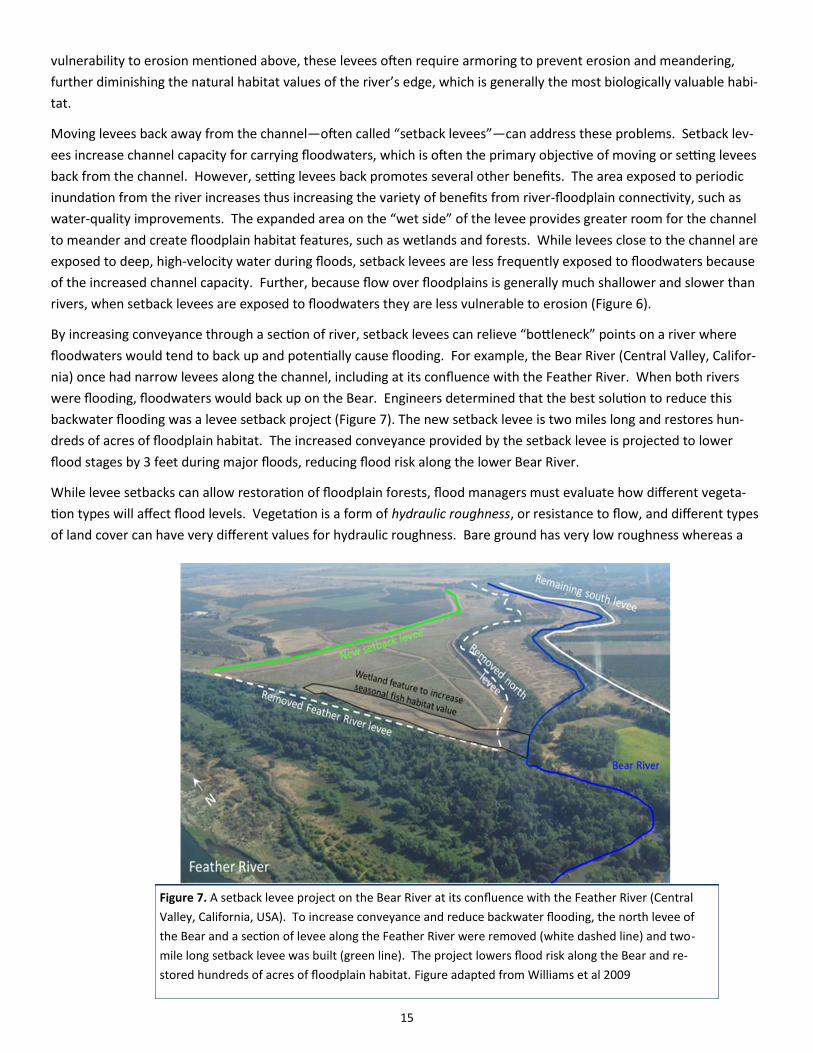
By increasing conveyance through a section of river, setback levees can relieve “bottleneck” points on a river where
floodwaters would tend to back up and potentially cause flooding. For example, the Bear River (Central Valley, Califor-
nia) once had narrow levees along the channel, including at its confluence with the Feather River. When both rivers
were flooding, floodwaters would back up on the Bear. Engineers determined that the best solution to reduce this
backwater flooding was a levee setback project (Figure 7). The new setback levee is two miles long and restores hun-
dreds of acres of floodplain habitat. The increased conveyance provided by the setback levee is projected to lower
flood stages by 3 feet during major floods, reducing flood risk along the lower Bear River.
While levee setbacks can allow restoration of floodplain forests, flood managers must evaluate how different vegeta-
tion types will affect flood levels. Vegetation is a form of hydraulic roughness, or resistance to flow, and different types
of land cover can have very different values for hydraulic roughness. Bare ground has very low roughness whereas a
Figure 7. A setback levee project on the Bear River at its confluence with the Feather River (Central
Valley, California, USA). To increase conveyance and reduce backwater flooding, the north levee of
the Bear and a section of levee along the Feather River were removed (white dashed line) and two-
mile long setback levee was built (green line). The project lowers flood risk along the Bear and re-
stored hundreds of acres of floodplain habitat. Figure adapted from Williams et al 2009

16
mature forest can have high roughness. Because roughness slows down floodwaters, it can contribute to higher flood
elevations for a given sized flood (see Figure 6). Hydraulic models can be used to understand the effect of different
vegetation types on roughness, and thus flood stage, and can guide how much forest restoration is possible and in
which locations forest will have greater or lesser effects on flood stage (Leyer et al. 2012). The Bear River levee setback
project was aligned such that the lower portion of the reconnected floodplain could be planted with floodplain forest
and the upper portion will be maintained as a grassland. Because long duration and frequent flooding can be particular-
ly important for river-floodplain ecosystems and native fish, a low wetland feature was added to ensure that portions
of the reconnected floodplain experienced this type of flooding (Figure 7; Williams et al. 2009).
Initial flood management on both the Mississippi and Sacramento rivers relied almost entirely on levees constructed
quite close to the channel. Both rivers experienced floods that overwhelmed those levees, exposing the vulnerability
of narrowly confining a river between levees, and both rivers have subsequently moved toward a more diverse flood-
management system, with flood bypasses and some levees set back further from the river. However, along these rivers
and throughout the world, much of the length of existing levees, or those planned, are quite close to the channel. Thus
there is great potential to reduce vulnerability and increase other benefits by setting levees back.
Floodways and flood bypasses: large-scale storage and conveyance of floodwater
Major lowland rivers, such as the Mississippi, Yangtze and Rhine, were once flanked by vast areas of floodplain that
annually flooded and drained. While the extent of inundation varied between years, these river channels never carried
the floods on their own, but rather the river and floodplain were an integrated system for moving water from the conti-
nental interiors to the ocean.
Along these great rivers, leaders attempted to control the flood to allow land to be settled and farmed with greater
certainty and security. The Chinese began building levees along the Yangtze and Yellow rivers thousands of years ago,
but floods continued to overwhelm these defenses, occasionally killing hundreds of thousands to millions of people. In
the late 19th century, both the Mississippi and Sacramento rivers became arenas in which engineers debated about
how best to manage flood risk. Both rivers had advocates for a “levees only” approach and both had advocates for an
approach that would allow the river to continue to access portions of its floodplain during major floods. The “levees
Figure 8. The Morganza Spillway (long line in center) during the 2011 Mississippi Flood. The Morganza Spillway was opened during
this flood, allowing the Mississippi River, on right, to begin to flow into the Morganza Floodway (fields and forests on the left).
© NASA

17
only” side won the debate in both rivers, in large part because that approach maximized the amount of land that could
be “reclaimed” from the river. However, great floods provided the final counter-argument for both rivers as extensive
levee failures exposed the vulnerabilities of a levees only approach.
For both rivers, the US Army Corps of Engineers responded to the levee failures by redesigning the flood-management
system to include areas designated as “floodways” or “flood bypasses.” These were portions of the historic floodplain
that, during major flood events, are reconnected to the river and become inundated. The Yangtze too has portions of
the historic floodplain, known as Flood Detention Areas, that can be reconnected during floods. Along the Rhine River
in the Netherlands, flood managers are pursuing a program called “Room for the River” which will include features that
allow the floodwaters to move into portions of the historic floodplains (Vis et al. 2003, Forster et al. 2005).
These connected portions of the floodplain are very large. For example, the Yolo Bypass encompasses 24,000 hectares
while the Birds Point-New Madrid Floodway is 130,000 acres. Because bypasses or floodways are only inundated dur-
ing floods, they serve as “relief valves” for the system, relieving pressure on levees. They act as relief valves in two
ways:
1. Conveyance. Bypasses can provide conveyance: they increase the cross-sectional area available to move floodwa-
ters safely through a particular stretch of river. This is analogous to opening up more lanes at a bridge toll crossing
during rush hour to manage intense traffic. For example, the Yolo Bypass conveys approximately 80% of the vol-
ume of major floods safely around the city of Sacramento. By increasing conveyance, strategically placed bypasses
or floodways can also reduce “backwater flooding,” which is caused by the “piling up” of floodwaters at and behind
a bottleneck, such as where bluffs constrict the river. Similar to levee setbacks, the vegetation within a bypass can
influence its hydraulic roughness and affect the ability to convey floodwaters. Thus, some bypasses are managed
for vegetation with low roughness.
2. Storage. These features can also detain and store water, functioning similarly to a flood-control reservoir. While
conveyance is analogous to adding lanes, a floodway providing storage can be viewed as a parking lot alongside a
major freeway. During a particularly heavy period of traffic, a large number of cars exit the highway and park in the
lot, staying there until traffic ebbs. The highway “downstream” of the parking lot will experience lower peak traffic
because of the cars parked in the lot. In flood management using a floodway for storage , this effect is known as
“peak shaving” — reducing the height of the flood peak experienced at some downstream point. The Jianjiang
Flood Detention Area along the Yangtze is intended to function in this manner with the capacity to hold 5 billion
cubic meters of water, reducing the height of the peak against the levees that protect cities with millions of people.
Flood bypasses can provide a mix of conveyance and storage benefits that vary with the size of the feature, its location
in the river system, and the characteristics of the flood. Bypasses also vary in the frequency with which they are used.
The Yolo Bypass is inundated relatively frequently—almost every year—while some of the floodways on the Mississippi
have been used only a few times in 80 years.
Because the floodways are only inundated during floods they can be used for a variety of economic activities, with land
use varying with the frequency of inundation. For example, the New Madrid Floodway has been used rarely (twice
since the 1930s) and is almost entirely farmed and includes 200 homes whereas the Bonnet Carre Spillway has been
used 10 times in that period and is uninhabited with land managed for fishing, hunting and recreation. Because in Cali-
fornia the flood season (winter to early spring) and the growing season (spring to fall) have little overlap, much of the
Yolo Bypass is in productive agriculture despite the fact that it is flooded nearly every year. The agriculture in the By-
pass is in annual crops that are not jeopardized by up to months of inundation (See Figure 9).
Bypasses can provide significant environmental benefits. Approximately 1/3 of the Yolo Bypass is in wildlife refuges,

18
including managed wetlands, and much of the land within the
three Mississippi River floodways that are in Louisiana are in natu-
ral vegetation and support abundant fish and wildlife. Even flood-
ways that are in agricultural land use can provide environmental
benefits, particularly during periods of inundation. The Yolo Bypass
is now recognized as the most valuable remaining floodplain habi-
tat in the Central Valley, and native fish and birds are abundant on
the flooded farm fields (Sommer et al. 2001). The agricultural land
of the New Madrid Floodway also likely provided favorable condi-
tions for fish during the several weeks it was inundated during the
flood 2011, based on observations that fish species capable of ex-
ploiting floodplain resources had very high growth during the 1993
flood on the Mississippi River, in which much of the flooded land
was in agriculture (Gutreuter et al. 1999, Jones and Noltie 2007).
The examples of flood bypasses described previously were planned
and implemented 50 to 80 years ago, during a time when scientific
understanding of river-floodplain systems was limited and society
expected a much narrower range of benefits from rivers. Scientists
now understand that connectivity between rivers and floodplains
drives processes that produce a broad range of resources and ben-
efits, and now society expects these benefits—including fish and
wildlife habitat, improved water quality, and recreation—from riv-
ers. Thus the design of future flood bypasses can more fully incor-
porate these scientific advances and expanded expectations to cre-
ate features that can produce a broader set of benefits. A portion
of a bypass could specifically be managed for frequent, long-
duration inundation, similar to the “fish wetland” in the Bear River
setback levee (Figure 7).
Further, existing bypasses can be modified or managed to increase
their output of benefits beyond flood-risk management. For exam-
ple, the Yolo Bypass provides important floodplain habitat and, alt-
hough it is inundated in most years, it is not always inundated dur-
ing the most important time of the year for native fish (the early to
mid-spring with warmer temperatures that drive productivity). Riv-
er managers and conservation organizations have been exploring
options for a control structure on the weir that shunts water from
the Sacramento River to the Bypass. This control structure would
allow for managed flooding of portions of the Bypass to maximize
benefits to native fish while still avoiding negative impacts to agri-
cultural management.
Map used with permission from T. Sommer.
Figure 9. (Top) Location of the Yolo Bypass (shaded
gray), within the lower Sacramento Valley, California.
Adapted with permission from Sommer et al. (2001).
(Middle) The red rectangle on the map corresponds to
the photo showing a mosaic of land uses in the
Bypass, including both agriculture and wetlands and
other natural habitats. In the photo, the levees on the
boundaries of the Bypass are highlighted in red.
(Bottom) The same area while flooded.

19
5. The case for green infrastructure: multiple benefits and overcoming constraints
Grey infrastructure generally provides a single benefit, such as a levee that prevents floodwaters from inundating
crops. Moreover, grey infrastructure often causes impacts to other benefits, such as a levee that moves water quickly
through a reach of river, increasing flood height and velocity downstream and negating the water-quality improve-
ments that arise from floodplain processes. Conversely, green infrastructure solutions often provide a broad range of
benefits beyond their primary purpose. For example, the Yolo Bypass was built in the 1930s strictly to reduce flood risk
for Sacramento. Without realizing it, river managers had created a feature that would later be recognized as providing
the best remaining floodplain habitat in the Central Valley, and one that also provided recreation, open space in a rap-
idly growing region, and a groundwater bank that proved important during a drought (Jercich 1997, Sommer et al.
2001). Similarly, levee setbacks increase the area available for habitat and recreation. Green infrastructure features
within a city double as parks, greenways, and recreational areas that make a city a more appealing place to live.
As described below, understanding and quantifying the multiple benefits of green infrastructure are key to overcoming
several of the constraints that have limited the adoption of these approaches.
Although green infrastructure approaches to flood management have numerous benefits, due to a variety of con-
straints they have been implemented far less frequently than traditional engineering approaches. First, green infra-
structure approaches are much less known among engineers and decision makers and this limits the extent to which
these approaches are even considered. Second, green infrastructure solutions, such as levee setbacks and flood by-
passes, require more land than structural approaches such as building (or rebuilding) levees close to the channel. Be-
cause land can be expensive, this can make green infrastructure solutions more expensive in the short run. Further,
taking land out of agricultural production can have negative economic consequences for rural communities, and thus
solutions that change floodplain land use can be controversial and require consideration of these economic impacts.
Finally, the diverse services that river-floodplain systems provide—such as improving water quality and supporting fish-
eries—can be difficult to quantify. The inability to quantify these services results in benefit-cost analyses that don’t
fully consider the negative impacts on these benefits from traditional approaches nor the secondary benefits resulting
from green infrastructure approaches. Finally, even if these services could be quantified, mechanisms, such as mar-
kets, may not exist to link the beneficiaries of the service with those whose land provides the service.
Below are potential solutions for overcoming these constraints.
1. Combining multiple sources of funding. Although, levee setbacks can lower flood risk and reduce long-term
maintenance costs, acquiring the necessary land can be expensive. Simultaneously, agencies and conservation or-
ganizations are trying to increase the amount of ecologically functional floodplains because of their multiple envi-
ronmental benefits. Because levee setbacks can also create new ecologically functional floodplain, this flood-
management tool can draw on sources of funding for flood-risk reduction and environmental restoration. Along
the rivers that drain to Puget Sound (Washington, USA), The Nature Conservancy is currently working with several
state and federal agencies, including US Fish and Wildlife and the Federal Emergency Management Agency, to iden-
tify areas of floodplain that if reconnected, such as through a levee setback, will produce significant benefits for
both flood-risk management and salmon restoration. By combining these objectives into their prioritization pro-
cesses, the agencies can identify areas that provide multiple benefits and can combine funding sources (e.g. flood
risk and restoration) to achieve floodplain reconnection. Tapping into restoration funding can potentially allow
flood-risk projects to go forward that would otherwise be unable to secure sufficient funding, as illustrated by
Hamilton City along the Sacramento River.
20
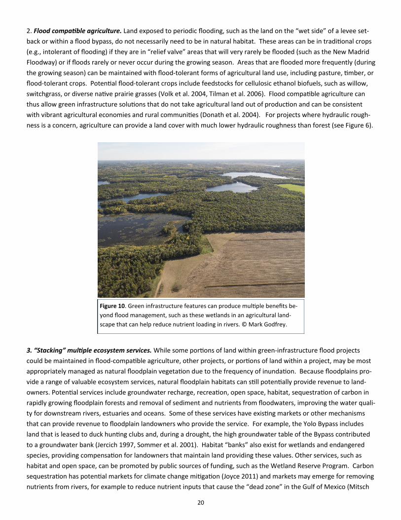
2. Flood compatible agriculture. Land exposed to periodic flooding, such as the land on the “wet side” of a levee set-
back or within a flood bypass, do not necessarily need to be in natural habitat. These areas can be in traditional crops
(e.g., intolerant of flooding) if they are in “relief valve” areas that will very rarely be flooded (such as the New Madrid
Floodway) or if floods rarely or never occur during the growing season. Areas that are flooded more frequently (during
the growing season) can be maintained with flood-tolerant forms of agricultural land use, including pasture, timber, or
flood-tolerant crops. Potential flood-tolerant crops include feedstocks for cellulosic ethanol biofuels, such as willow,
switchgrass, or diverse native prairie grasses (Volk et al. 2004, Tilman et al. 2006). Flood compatible agriculture can
thus allow green infrastructure solutions that do not take agricultural land out of production and can be consistent
with vibrant agricultural economies and rural communities (Donath et al. 2004). For projects where hydraulic rough-
ness is a concern, agriculture can provide a land cover with much lower hydraulic roughness than forest (see Figure 6).
3. “Stacking” multiple ecosystem services. While some portions of land within green-infrastructure flood projects
could be maintained in flood-compatible agriculture, other projects, or portions of land within a project, may be most
appropriately managed as natural floodplain vegetation due to the frequency of inundation. Because floodplains pro-
vide a range of valuable ecosystem services, natural floodplain habitats can still potentially provide revenue to land-
owners. Potential services include groundwater recharge, recreation, open space, habitat, sequestration of carbon in
rapidly growing floodplain forests and removal of sediment and nutrients from floodwaters, improving the water quali-
ty for downstream rivers, estuaries and oceans. Some of these services have existing markets or other mechanisms
that can provide revenue to floodplain landowners who provide the service. For example, the Yolo Bypass includes
land that is leased to duck hunting clubs and, during a drought, the high groundwater table of the Bypass contributed
to a groundwater bank (Jercich 1997, Sommer et al. 2001). Habitat “banks” also exist for wetlands and endangered
species, providing compensation for landowners that maintain land providing these values. Other services, such as
habitat and open space, can be promoted by public sources of funding, such as the Wetland Reserve Program. Carbon
sequestration has potential markets for climate change mitigation (Joyce 2011) and markets may emerge for removing
nutrients from rivers, for example to reduce nutrient inputs that cause the “dead zone” in the Gulf of Mexico (Mitsch
Figure 10. Green infrastructure features can produce multiple benefits be-
yond flood management, such as these wetlands in an agricultural land-
scape that can help reduce nutrient loading in rivers. © Mark Godfrey.

21
et al. 2001) (Figure 9). Revenue from the services described above may allow agricultural landowners to continue to
receive income from land in natural floodplain vegetation, particularly if revenue from multiple services can be
“stacked” together. In other words, while carbon sequestration revenue may not be competitive with crops, that ser-
vice plus recreation and nutrient sequestration may be comparable, particularly for marginal agricultural land—such as
land that is frequently too wet for successful cropping. With the Mollicy Farms project, The Nature Conservancy recon-
nected 18,000 acres of marginal farmland on the floodplain to the Ouachita River and is now implementing a research
program to better understand the potential for “stacked” ecosystem services to provide comparable revenue to agri-
culture on these marginal croplands (Opperman et al. 2010)
4.Improve valuation of floodplains’ ecosystem services. Methods to value floodplains’ ecosystem services are still be-
ing developed. Further, policies to evaluate the benefits and costs of alternate projects (e.g., green infrastructure ver-
sus traditional engineering) often focus on a narrow set of benefits and do not incorporate the diverse values provided
by floodplains. Additionally, structural projects’ long-term costs for maintenance, rehabilitation and replacement are
often underestimated, while green infrastructure projects tend to have lower long-term maintenance costs. Because of
these limitations of science and policy, processes to select among flood-management options generally fail to capture
the full value of benefits supported by green infrastructure projects and, similarly, do not reflect the full costs and im-
pacts from traditional engineering projects. Improvements in both the science of measuring services and policies can
thus “level the playing field” for green infrastructure projects. Improvements in valuation and policies governing cost-
benefit analysis will advance the strategies above, including the “stacking” ecosystem services and combining multiple
funding sources.
A flock of swans finds refuge in floodplain wetlands along the Cosumnes River, CA. Located
on the western slope of the Sierra Nevada, the Cosumnes River and its floodplain habitats
support large populations of birds and native fish as well as unique valley oak streamside
ecosystems. © Timothy Wolcott

22
6. Conclusions
Green infrastructure projects have great potential to reduce
flood risks for people while maintaining or restoring the
diverse benefits that river-floodplain systems provide. With
climate change, population growth and aging dams and lev-
ees contributing to rising flood risk, green infrastructure
solutions can play a key role in increasing communities’
safety and resilience to floods.
Green infrastructure cannot replace traditional infrastruc-
ture. Dams and levees will of course continue to play a piv-
otal role in keeping people safe. However, within already
developed river basins, green infrastructure projects can
increase the flexibility and resiliency of current water-
management systems and should be given full considera-
tion as flood-management systems are retrofitted, rehabili-
tated, rebuilt or re-operated. For example, in the wake of
flood damages to levees, managers should consider alter-
nate alignments of levees that include setting them back
from the river. Within river basins that are just beginning to
be developed for flood and water management, agencies
should explore alternatives that fully incorporate green in-
frastructure methods. This will allow these river basins to
“get it right” the first time, rather than pursuing strictly
structural approaches and later seeking to retrofit the sys-
tem, either because of structural failures or the desire to
restore broader river-floodplain benefits, or both.
Green infrastructure approaches, and flood management
generally, are most effective when implemented as part of
a diverse portfolio of tools that are deployed within a river-
basin perspective. This perspective allows green infrastruc-
ture approaches to be targeted to where they can be most
effective. Specific approaches are more or less appropriate
depending on the river system – and the location within
that river system. Natural valley storage may be an effec-
tive approach for reducing flood risk in a small watershed,
but the utility of this approach may diminish within larger
watersheds. Flood bypasses may provide either storage or
conveyance benefits, and the same feature may provide
storage benefits for small floods but not for large floods. In
some locations, levee setbacks may reduce flood risks for
areas up or downstream while, in other locations, the pri-
mary benefit of levee setbacks may be the flood damages
Traditional flood management during a large flood (e.g., 1 in
100 year frequency), levee breaches lead to urban flooding
and unplanned flooding of agricultural land.
Figure 11: Traditional flood management with levees close
to river.
Traditional flood management during a moderate flood
(e.g., 1 in 10 year frequency) with high velocity water
against levees; limited extent of inundated floodplain habi-
tat.

23
Aerts, J., W. Botzen, A. van der Veen, J. Krywkow, and S. Werners. 2008. Dealing with Uncertainty in Flood Management
Through Diversification. Ecology and Society 13.
American Society of Civil Engineers. 2009. Report Card for America's Infrastructure American Society of Civil Engineers,
Washington, DC.
Association of State Floodplain Managers. 2007. Levees: the double-edged sword. Madison, WI.
Barbier, E. B. (2003). Upstream dams and downstream water allocation: The case of the Hadejia-Jama'are floodplain,
northern Nigeria. Water Resources Research, 39, 1311-1319.
Bathurst, J. C., A. Iroume, F. Cisneros, J. Fallas, R. Iturraspe, M. G. Novillo, A. Urciuolo, B. de Bievre, V. G. Borges, C.
Coello, P. Cisneros, J. Gayoso, M. Miranda, and M. Ramirez. 2011. Forest impact on floods due to extreme rainfall and
snowmelt in four Latin American environments 1: Field data analysis. Journal of Hydrology 400:281-291.
Bayley, P. B. 1995. Understanding large river-floodplain ecosystems. Bioscience 45:153-157.
Bradshaw, C. J. A., N. S. Sodhi, K. S. H. Peh, and B. W. Brook. 2007. Global evidence that deforestation amplifies flood
risk and severity in the developing world. Global Change Biology 13:2379-2395.
Brown, D. W., S. M. A. Moin, and M. L. Nicolson. 1997. A comparison of flooding in Michigan and Ontario: 'soft' data to
support 'soft' water management approaches. Canadian Water Resources Journal 22:125-139.
Burt, T. P. and Pinay, G. (2005). Linking hydrology and biogeochemistry in complex landscapes. Progress in Physical Ge-
ography, 29, 297-316.
Cooley, H. 2006. Floods and Droughts. Pages 91-116 in P. Gleick, editor. The World's Water 2006-2007: the biennial re-
port on freshwater resources. Island Press, Washington, DC.
Costanza, R., dArge, R., deGroot, R., et al. (1997). The value of the world's ecosystem services and natural capital. Na-
ture, 387, 253-260.
Criss, R. E. and E. L. Shock. 2001. Flood enhancement through flood control. Geology 29:875-878.
Dawson, R. J., T. Ball, J. Werritty, A. Werritty, J. W. Hall, and N. Roche. 2011. Assessing the effectiveness of non-
structural flood management measures in the Thames Estuary under conditions of socio-economic and environmental
change. Global Environmental Change-Human and Policy Dimensions 21:628-646.
Donath, T. W., N. Holzel, S. Bissels, and A. Otte. 2004. Perspectives for incorporating biomass from non-intensively man-
aged temperate flood-meadows into farming systems. Agriculture Ecosystems & Environment 104:439-451.
Fiener, P., K. Auerswald, and S. Weigand. 2005. Managing erosion and water quality in agricultural watersheds by small
detention ponds. Agriculture Ecosystems & Environment 110:132-142.
References
Case studies
Case studies referenced throughout the report can be found on the web at: http://nature.ly/floodofbenefits

24
Figure 13. Mosaic of land use within the floodplain: Within
specific portions of the floodplain, land uses are matched to
the inundation frequency of that portion. Basin image from
Natural Heritage Institute.
Background watershed image used with permission of Natural Heritage Institute
Flood management with green infrastructure during a large
flood (e.g., 1 in 100 year frequency). Both bypass and flood
detention area are in use. Agricultural land is flooded but
primarily land planned to flood; either in flood-compatible
crops or with compensation mechanism.
avoided in the area reconnected to the river (e.g., a previously cropped area now in natural vegetation), lower mainte-
nance because the levee is less frequently exposed to high-velocity floodwaters, and natural resource benefits.
Through a river basin perspective, green infrastructure approaches can be effectively integrated with traditional flood
management—and water management more broadly. This integrated approach strives to create a mosaic of land uses
in the floodplain that provide the most benefits for society (see figures 11-13).
Figure 12: Flood management emphasizing green infra-
structure. In some locations, levees are set back from the
river; additional levees added to create a flood bypass and
a flood detention area, with weir or gates (yellow rectan-
gles) to control flooding of these features.
Flood management with green infrastructure during a mod-
erate flood (e.g., 1 in 10 year frequency). In many locations
floodwaters are not directly adjacent to levees. The bypass
is in use; greater extent of inundated floodplain habitat.

25
Forster, S., D. Kneis, M. Gocht, and A. Bronstert. 2005. Flood risk reduction by the use of retention areas at the Elbe Riv-
er. International Journal of River Basin Management 3:21-29.
Freitag, B., S. Bolton, F. Westerlund, and J. Clark. 2009. Floodplain Management: a new approach for a new era. Island
Press, Washington, D.C.
Galat, D. L., L. H. Fredrickson, D. D. Humburg, K. J. Bataille, J. R. Bodie, J. Dohrenwend, G. T. Gelwicks, J. E. Havel, D. L.
Helmers, J. B. Hooker, J. R. Jones, M. F. Knowlton, J. Kubisiak, J. Mazourek, A. C. McColpin, R. B. Renken, and R. D. Sem-
litsch. 1998. Flooding to restore connectivity of regulated, large-river wetlands - Natural and controlled flooding as com-
plementary processes along the lower Missouri River. Bioscience 48:721-733.
Grosholz, E. and E. Gallo. 2006. The influence of flood cycle and fish predation on invertebrate production on a restored
California floodplain. Hydrobiologia 568:91-109.
Gutreuter, S., A. D. Bartels, K. Irons, and M. B. Sandheinrich. 1999. Evaluation of the flood-pulse concept based on sta-
tistical models of growth of selected fishes of the Upper Mississippi River system. Can. J. Fish. Aquat. Sci. 56:2282-2291.
Hickey, J. T., R. F. Collins, J. M. High, K. A. Richardson, L. L. White, and P. E. Pugner. 2002. Synthetic rain flood hydrology
for the Sacramento and San Joaquin river basins. Journal of Hydrologic Engineering 7:195-208.
Jercich, S. A. 1997. California's 1995 Water Bank Program: Purchasing water supply options. Journal of Water Resources
Planning and Management-Asce 123:59-65.
Jones, B. D. and D. B. Noltie. 2007. Flooded flatheads: evidence of increased growth in Mississippi river Pylodictis olivar-
is (Pisces : Ictaluridae) following the great Midwest flood of 1993. Hydrobiologia 592:183-209.
Joyce, C. 2011. Can 'carbon ranching' offset emissions in California? National Public Radio, Washington, D.C.
Knox, J. C. 1993. LARGE INCREASES IN FLOOD MAGNITUDE IN RESPONSE TO MODEST CHANGES IN CLIMATE. Nature
361:430-432.
Kousky, C., S. Olmstead, M. Walls, A. Stern, and M. Macauley. 2011. The Role of Land Use in Adaptation to Increased
Precipitation and Flooding: A Case Study in Wisconsin’s Lower Fox River Basin. Resources for the Future, Washington,
DC.
Kundzewicz, Z. W., L. J. Mata, N. W. Arnell, P. Doll, B. Jimenez, K. Miller, T. Oki, Z. Sen, and I. Shiklomanov. 2008. The
implications of projected climate change for freshwater resources and their management. Hydrological Sciences Journal
-Journal Des Sciences Hydrologiques 53:3-10.
Kundzewicz, Z. W. and K. Takeuchi. 1999. Flood protection and management: quo vadimus? Hydrological Sciences -
Journal des Sciences Hydrologiques 44:417-432.
Le, P. 2012. Battle of building in Puget Sound flood plains. The Seattle Times.
Leavenworth, S. 2004. Rising risk. Page A1 Sacramento Bee, Sacramento, CA.
Lehmann, E. 2011. Flood-prone land likely to increase by 45% -- a major challenge to federal insurance program. Cli-
mate Wire.
Leyer, I., E. Mosner, and B. Lehmann. 2012. Managing floodplain-forest restoration in European river landscapes com-
bining ecological and flood-protection issues. Ecological Applications 22:240-249.
Magner, J. and S. Alexander. 2008. Drainage and nutrient attenuation in a riparian interception-wetland: southern Min-
nesota, USA. Environmental Geology 54:1367-1376.

26
Min, S. K., X. B. Zhang, F. W. Zwiers, and G. C. Hegerl. 2011. Human contribution to more-intense precipitation ex-
tremes. Nature 470:378-381.
Mitsch, W. J. and J. W. Day. 2006. Restoration of wetlands in the Mississippi-Ohio-Missouri (MOM) River Basin: Experi-
ence and needed research. Ecological Engineering 26:55-69.
Mitsch, W. J., J. W. Day, J. W. Gilliam, P. M. Groffman, D. L. Hey, G. W. Randall, and N. M. Wang. 2001. Reducing nitro-
gen loading to the Gulf of Mexico from the Mississippi River Basin: Strategies to counter a persistent ecological prob-
lem. Bioscience 51:373-388.
Mount, J. F. 1995. California Rivers and Streams: the Conflict between Fluvial Processes and Land Use. University of
California Press, Berkeley, CA.
National Levee Safety Committee. 2009. Recommendations for a national levee safety program (draft report to Con-
gress). National Levee Safety Committee, , Washington, DC.
Noe, G. B. and Hupp, C. R. (2005). Carbon, nitrogen, and phosphorus accumulation in floodplains of Atlantic Coastal
Plain rivers, USA. Ecological Applications, 15, 1178-1190.
Nyssen, J., J. Pontzeele, and P. Billi. 2011. Effect of beaver dams on the hydrology of small mountain streams: Example
from the Chevral in the Ourthe Orientale basin, Ardennes, Belgium. Journal of Hydrology 402:92-102.
Opperman, J. J., G. E. Galloway, and S. Duvail. 2013. The multiple benefits of river-floodplain connectivity for people
and biodiversity. Pages 144-160 in S. Levin, editor. Encyclopedia of Biodiversity, second edition, Volume 7. Academic
Press, Waltham, MA.
Opperman, J. J., G. E. Galloway, J. Fargione, J. F. Mount, B. D. Richter, and S. Secchi. 2009. Sustainable floodplains
through large-scale reconnection to rivers. Science 326:1487-1488.
Opperman, J. J., R. A. Luster, B. A. McKenney, M. D. Roberts, and A. W. Meadows. 2010. Ecologically functional flood-
plains: connectivity, flow regime, and scale. Journal of the American Water Resources Association 46:211-226.
Pall, P., T. Aina, D. A. Stone, P. A. Stott, T. Nozawa, A. G. J. Hilberts, D. Lohmann, and M. R. Allen. 2011. Anthropogenic
greenhouse gas contribution to flood risk in England and Wales in autumn 2000. Nature 470:382-385.
Pielke, J., R. A., Downton, M. W. and Barnard Miller, J. Z. (2002). Flood damage in the United States, 1926-2000: a rea-
nalysis of National Weather Service Estimates. Boulder, CO: University Corporation for Atmospheric Research.
Pinter, N. 2005. One step forward, two steps back on US floodplains. Science 308:207-208.
Pitlick, J. 1997. A reginoal perspective on the hydrology of the 1993 Mississippi River Basin floods. Annals of the Associ-
ation of American Geographers 87:135-151.
Postel, S. 2005. Liquid assets: the critical need to safeguard freshwater ecosystems. Worldwatch Institute, Washington,
D.C. .
Ricciardi, A. and J. B. Rasmussen. 1999. Extinction rates of North American freshwater fauna. Conservation Biology
13:1220-1222.
Richter, B. D., D. P. Braun, M. A. Mendelson, and L. L. Master. 1997. Threats to imperiled freshwater fauna. Conserva-
tion Biology 11:1081-1093.
Saunders, S., D. Findlay, T. Easley, and T. Spencer. 2012. Doubled Trouble: more midwestern extreme storms. The
Rocky Mountain Climate Organization and the Natural Resources Defense Council, Louisville, CO and New York.

27
Sayers, P. B., G. E. Galloway, E. Penning-Roswell, F. Shen, Y. Chen, and T. Le Quesne. in preparation. Flood risk manage-
ment: a strategic approach. UNESCO, London.
Sheaffer, J. R., J. D. Mullan, and N. B. Hinch. 2002. Encouraging the wise use of floodplains with market-based incen-
tives. Environment 44:33-43.
Skopec, M. 2010. Iowa floods: the "new normal?". Iowa Natural Heritage.
Sommer, T., B. Harrell, M. Nobriga, R. Brown, P. Moyle, W. Kimmerer, and L. Schemel. 2001. California's Yolo Bypass:
evidence that flood control can be compatible with fisheries, wetlands, wildlife, and agriculture. Fisheries 26:6-16.
Tilman, D., J. Hill, and C. Lehman. 2006. Carbon-negative biofuels from low-input high-diversity grassland biomass. Sci-
ence 314:1598-1600.
Tobin, G. A. 1995. The levee love affair: a stormy relationship. Water Resources Bulletin 31:359-367.
Tockner, K. and J. A. Stanford. 2002. Riverine floodplains: present state and future trends. Environmental Conservation
29:308-330.
UNEP. 2010. Blue harvest: inland fisheries as an ecosystem service. WorldFish Center, Penang, Malaysia.
US Army Corps of Engineers. 1993. Massachusetts natural valley storage investigation. US Army Corps of Engineers,
New England Division, Waltham, MA.
Vis, M., F. Klijn, K. M. De Bruijn, and M. Van Buuren. 2003. Resilience strategies for flood risk management in the Neth-
erlands. International Journal of River Basin Management 1:33-40.
Volk, T. A., T. Verwijst, P. J. Tharakan, L. P. Abrahamson, and E. H. White. 2004. Growing fuel: a sustainability assess-
ment of willow biomass crops. Frontiers in Ecology and the Environment 2:411-418.
Warner, A., J. J. Opperman, and R. Pietrowsky. 2011. A call to enhance the resiliency of the nation's water manage-
ment. Journal of Water Resources Planning and Management-Asce 137:305-308.
Williams, P. B., E. Andrews, J. J. Opperman, S. Bozkurt, and P. B. Moyle. 2009. Quantifying activated floodplains on a
lowland regulated river: its application to floodplain restoration in the Sacramento Valley. San Francisco Estuary and
Watershed Science 7.