blackstone river visioning · 2020-04-24 · blackstone river visioning 5 blackstone river...
TRANSCRIPT
Prepared for:
Massachusetts Audubon SocietyJohn H. Chafee Blackstone River Valley National Heritage Corridor
Prepared by:Dodson Associates, Ltd.
Landscape Architects and Planners463 Main Street
Ashfield, Massachusetts 01330
with Mullin Associates
206 North Valley RoadPelham, Massachusetts 01002
October, 2004
Blackstone River Visioning
1Blackstone River Visioning
Executive Summary..................................................................... 1
Introduction and Overview.......................................................... 3
The River Visioning Project........................................................ 5 Blackstone River Reawakening: The River Initiatives Study.. 7
Regional Issues and Opportunities............................................. 10
Mapping and Geographic Analysis............................................. 11
Results of the Initial Public Workshops...................................... 12
Demonstration Site Visioning Charrettes.................................... 15
Conclusion.................................................................................. 27 Appendix A: Current Initiatives Along the Blackstone Riverway............................. 29 Appendix B: Design Charrette Posters....................................... 31
Appendix C: Contacts and Resources....................................... 41
Table of Contents
1Blackstone River Visioning
The Blackstone River Visioning Project was developed in 2002 by a coalition of groups led by the John H. Chafee Blackstone River Valley National Heritage Corridor Commission (BRVNHCC) and the Massachusetts Audubon Society. The ultimate goal of the project was to guide the direction of growth along the main stem of the river and ensure that growth is complimentary, as well as sensitive, to the river environment.
The objectives of the project were to plan and visualize appropriate growth and economic revitalization, while at the same time demonstrating how to protect and rebuild the river’s sensitive environmental resources. The effort was consciously designed to avoid vague policy planning and instead focus on identifying solutions to real issues and challenges that Blackstone Valley towns are facing along the river corridor.
To meet these goals and objectives, the project proceeded in three phases. The first was research and outreach to identify past and present initiatives up and down the river valley. The second phase of the project was a series of public workshops held in eleven main stem communities. The workshops focused on gathering information on each community’s needs and planning issues, and identifying specific opportunities and constraints for areas along the river. The final phase involved detailed design charrettes for four key sites identified in the community workshops These demonstration sites were the subject of in-depth site analysis and exploration of future alternatives for both conservation and economic development. Landowners, town officials and local residents participated in an all-day charrette for each of the four sites. The results are described in this report, and illustrated in a series of posters that are attached as Appendix B.
While the four focus areas represent only a fraction of the potential redevelopment sites along the river, they provide lessons for all of the communities that share this remarkable resource. Along with many practical techniques for rebuilding village centers, accommodating parking in dense neighborhoods and renovating historic structures, the charrettes demonstrate the importance of involving local residents and business owners in planning projects.
While these specific planning and design ideas have immediate value, the project also demonstrated a long-term vision for a planning and design process that allows communities to plan more effectively for complex sites along the river. Often stymied by the complications of multiple ownership, sensitive natural resources, and potential industrial contamination, redevelopment of these sites can take decades – but with collective planning, focused on creating a tangible vision for the future, log jams can be broken and the necessary consensus reached to allow projects to move forward.
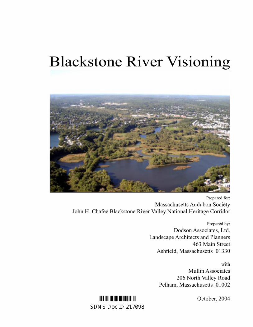
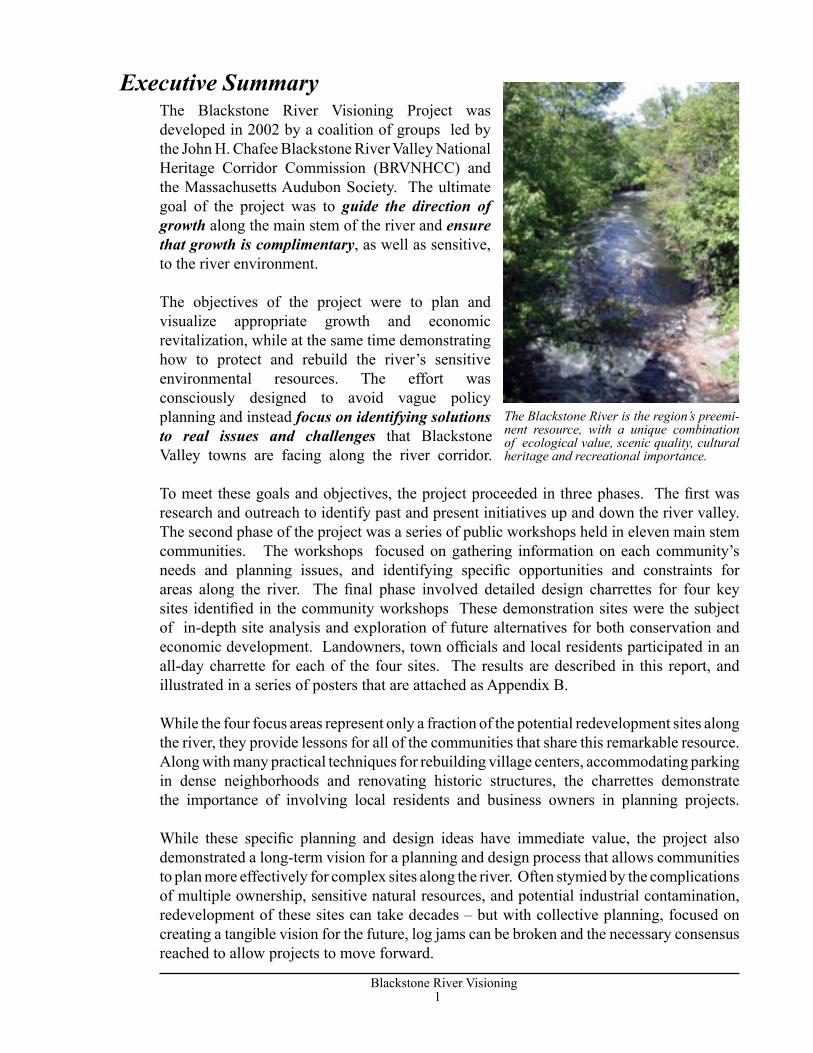
The Blackstone River is the region’s preemi-nent resource, with a unique combination of ecological value, scenic quality, cultural heritage and recreational importance.
Executive Summary
2Blackstone River Visioning
3Blackstone River Visioning
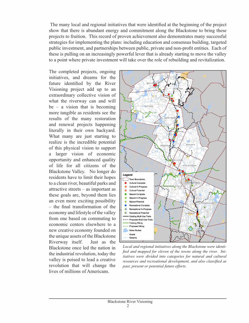
The many local and regional initiatives that were identified at the beginning of the project show that there is abundant energy and commitment along the Blackstone to bring these projects to fruition. This record of proven achievement also demonstrates many successful strategies for implementing the plans: including education and consensus building, targeted public investment, and partnerships between public, private and non-profit entities. Each of these is pulling on an increasingly powerful lever that is already starting to move the valley to a point where private investment will take over the role of rebuilding and revitalization.
The completed projects, ongoing initiatives, and dreams for the future identified by the River Visioning project add up to an extraordinary collective vision of what the riverway can and will be – a vision that is becoming more tangible as residents see the results of the many restoration and renewal projects happening literally in their own backyard. What many are just starting to realize is the incredible potential of this physical vision to support a larger vision of economic opportunity and enhanced quality of life for all citizens of the Blackstone Valley. No longer do residents have to limit their hopes to a clean river, beautiful parks and attractive streets – as important as these goals are, beyond them lies an even more exciting possibility – the final transformation of the economy and lifestyle of the valley from one based on commuting to economic centers elsewhere to a new creative economy founded on the unique assets of the Blackstone Riverway itself. Just as the Blackstone once led the nation in the industrial revolution, today the valley is poised to lead a creative revolution that will change the lives of millions of Americans.
Local and regional initiatives along the Blackstone were identi-fied and mapped for eleven of the towns along the river. Ini-tiatives were divided into categories for natural and cultural resources and recreational development, and also classified as past, present or potential future efforts.
2Blackstone River Visioning
3Blackstone River Visioning
Throughout its long, hardworking history, the Blackstone River has played an important role in transforming the lives of Americans. Dropping over 430 feet in just 46 miles from Worcester, Massachusetts to Providence, Rhode Island, the river powered the nation’s first industrial revolution. It spawned a process of technological advancement and economic exploration that continues today. In its heyday, the river fostered a chain of cities and towns as vital as any in New England. While the industries have largely moved on, the valley retains a legacy of mill complexes and main streets, rural villages and farms that enrich the lives of local citizens.
The story of the Blackstone also includes more troubled times: days when industries spilled pollutants into the river, and days when the industries closed and local families moved away. As the valley’s industrial economy shrank, the river started to recover, but years of environmental insults have left a troublesome legacy. Like most of the country’s waterways, communities turned their back on the Blackstone, but thanks to a long series of public investments since the 1960’s in wastewater treatment, flood control, and wetland protection and restoration, combined with the dedication of hundreds of local residents, the river has been improving.
One of the most important elements in this recovery has been the Blackstone River Valley National Heritage Corridor. Created in 1986, the Corridor was the second designated heritage area in the nation, an experimental type of national park managed as a unique collaboration of federal, state and local government, non-profit groups and private citizens. Ten years later, its success was affirmed when Congress extended the life of the corridor for ten more years and expanded the number of communities from 19 to 24. As part of this renewed effort, the Corridor Commission developed a second ten year plan, published in 1998, that guides its mission today. In that same year, the Blackstone was selected as one of fourteen nationally recognized American Heritage Rivers, recognizing the historic significance of the river, the opportunities for economic and historic revitalization and commitment to restoring the Blackstone River.
Introduction and Overview
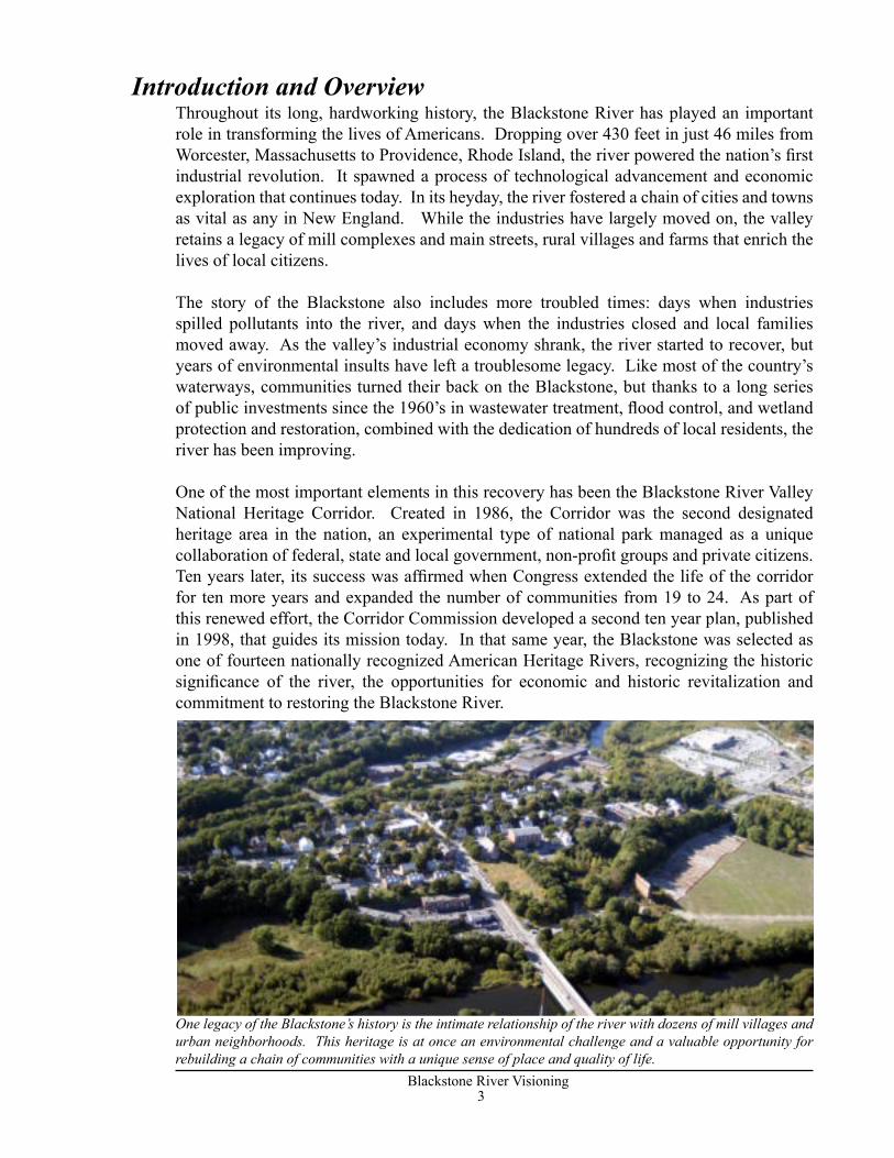
One legacy of the Blackstone’s history is the intimate relationship of the river with dozens of mill villages and urban neighborhoods. This heritage is at once an environmental challenge and a valuable opportunity for rebuilding a chain of communities with a unique sense of place and quality of life.
4Blackstone River Visioning
5Blackstone River Visioning
Working with a broad range of partners, the Commission drafted a set of Core Commitments that summarize the work accomplished in the first ten years and describe its current efforts:
• Telling the story of the river, and its role in American history.• Promoting preservation and adaptive reuse of the Valley’s mills, villages and other
historic resources.• Assisting towns in balancing conservation and growth• Promoting River Recovery, by improving the health of the river system.
To fulfill these commitments, the Commission adopted a strategic approach designed to make the most of limited human and financial resources. First, the Commission recognized that public education is fundamental to developing support for protection of the valley’s resources. Second, the use of public-private partnerships allows federal funds and assistance to leverage state and local energy in completing projects. Third, a policy of targeted investment allows the Commission to step in and jump start efforts where these will have the greatest effect.
This approach is targeted at a series of key elements of the ten year plan. These include heritage infrastructure and heritage programming, the hardware and software that help to preserve and tell the story of the valley; strategic design and planning assistance, to help communities manage growth and pursue redevelopment opportunities; The Blackstone Valley Institute, a resource center for helping citizens, business people and local officials understand and respond to conservation and development issues; preservation and enhancement programs, that provide funding for local projects; river recovery and recreational development, to heal the river ecosystem and provide public access; and finally, dealing with Commission Transition issues, looking at where the Heritage Corridor should go after 2006.
The major goals of the Commission, as defined in the ten year plan, include specific, practical objectives guided by an overarching regional vision. These practical goals are designed to create a critical mass of sites, programs and services that will help to tip the balance away from the slow decline and cycle of abandonment that once haunted the river toward a cycle of investment and renewal. To support creation of this critical mass, the Commission’s overall goal is to foster a regional vision “…to help residents envision the valley as a regional entity: an interdependent place linked by a common set of economic, natural and cultural resources.”
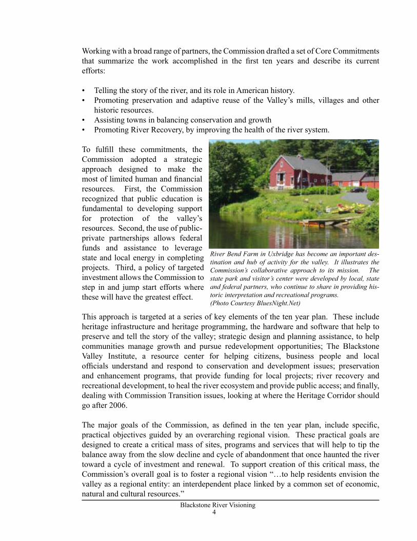
River Bend Farm in Uxbridge has become an important des-tination and hub of activity for the valley. It illustrates the Commission’s collaborative approach to its mission. The state park and visitor’s center were developed by local, state and federal partners, who continue to share in providing his-toric interpretation and recreational programs. (Photo Courtesy BluesNight.Net)
4Blackstone River Visioning
5Blackstone River Visioning
While much has been achieved, there is much left to do. In 2002, a coalition of groups led by the John H. Chafee Blackstone River Valley National Heritage Corridor Commission (BRVNHCC) and the Massachusetts Audubon Society initiated the River Visioning Project. Project partners included the American Heritage Rivers Initiative, the Blackstone River Watershed Council, Friends of the Blackstone, Blackstone Headwaters Coalition, the Chambers of Commerce, and the Blackstone Valley Tourism Council. The ultimate goal of the project is to guide the direction of growth along the main stem of the river and ensure that growth is complementary, as well as sensitive, to the river environment.
The River Visioning Project was designed to fulfill two major purposes:
• To identify completed projects and current initiatives in each town along the river to measure progress, and
• To show how river recovery, heritage conservation, and economic development can occur on real sites along the river, in order to demonstrate how growth can be guided to protect sensitive resources and enhance existing communities.
The planning process revolved around these purposes. The first element was a study of river initiatives, which identified an extraordinary range of efforts to heal the river, preserve its history, and promote revitalization. As described below, this process identified a reawakening of activity along the river involving partnerships at every level of government and a broad coalition of private organizations. It also highlighted a new entrepreneurial spirit shared by hundreds of dedicated individuals.
The second element of the project involved working with each of the river towns to define problems and opportunities for their stretch of the river. Based on this public input, four sites were selected for more detailed study. Each of these sites represents the type of planning challenges faced by many towns along the river.
In the third phase of the project, day-long design charrettes were held involving local residents, business owners and town officials in developing a vision for future redevelopment of these four key areas. Incorporated into a set of posters and described in this report, these case studies serve as a model of how resource conservation, recreational enhancement and economic development can be used to achieve a vision for a vibrant Riverway, one project at a time.
The River Visioning Project
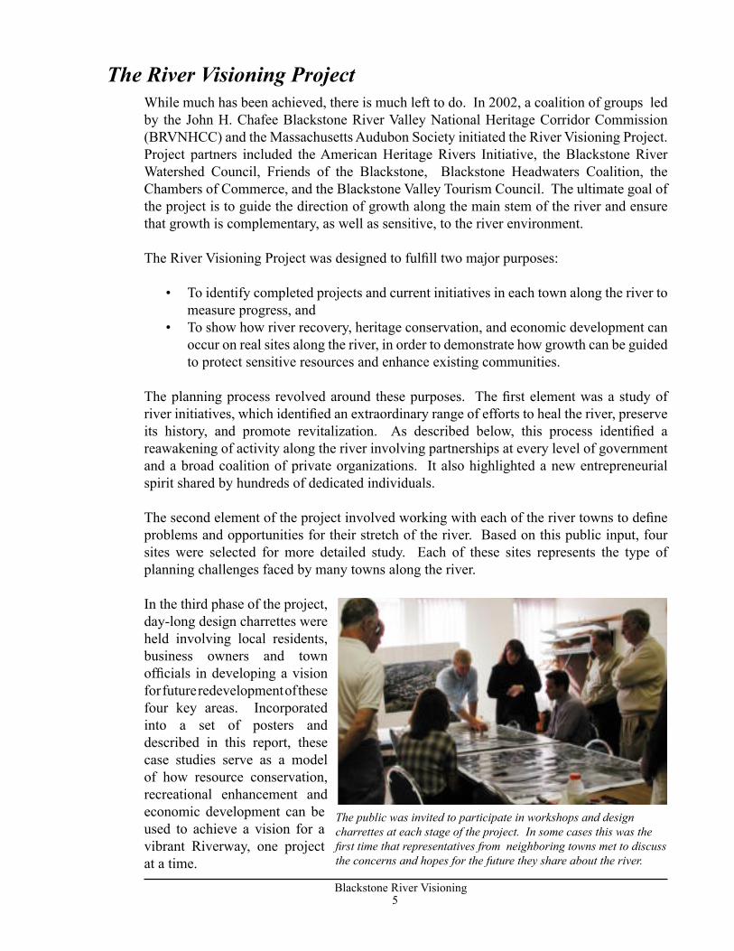
The public was invited to participate in workshops and design charrettes at each stage of the project. In some cases this was the first time that representatives from neighboring towns met to discuss the concerns and hopes for the future they share about the river.
6Blackstone River Visioning
7Blackstone River Visioning
With the leadership of the Corridor Commission, local governments, state and federal agencies and non-profit groups have completed dozens of projects along the river. At least $300 million in private investment has followed this public funding, resulting in renovation of mills and downtown properties throughout the valley. These projects demonstrate a unique entrepreneurial spirit, where success has been based on building partnerships to get things done, and thinking creatively about planning, financing, historic preservation and building. Collectively, the initiatives express a vision for the Blackstone Riverway as an interconnected system uniting the entire valley. At its core, the River Vision is focused on a clean, renewed river, connected by bike paths and trails linking historic sites and recreation areas. It also includes a rebirth of vibrant main streets and downtowns in each community along the river, balanced with protection of cultural landscapes and rural vistas throughout the region. The Corridor plays a key role in connecting these diverse activities into a unified strategy.
To begin the project, a list of current initiatives and activities was compiled from meetings with local and regional officials and the Corridor staff. These initiatives range from presentation of cultural sites, to development of river access points, to restoration of sensitive natural habitats and riparian areas. Initiatives were organized by type and divided into three categories: recreational, cultural and natural. They were further identified by the status of the project: whether it was complete, in-progress, or a future vision or opportunity. All initiatives were mapped by type and status to demonstrate the geographic extent of different project types. For a detailed list of initiatives and an illustrated map of select projects, see Appendix A.
Among more than eighty initiatives identified by the study, a number stand out as examples of the evolving vision for the Riverway. These illustrate the different themes defined by the Core Commitments. They also highlight another important aspect of the Corridor’s work which is part of each of these elements: making connections that bring people out into the river, trails and greenways.
Telling the story of the river begins with preserving the tangible evidence of that story for future generations. With renovation of key sites, construction of museums and visitor centers, and development of educational programming, important elements in this “heritage infrastructure” have been established. Some of these include:
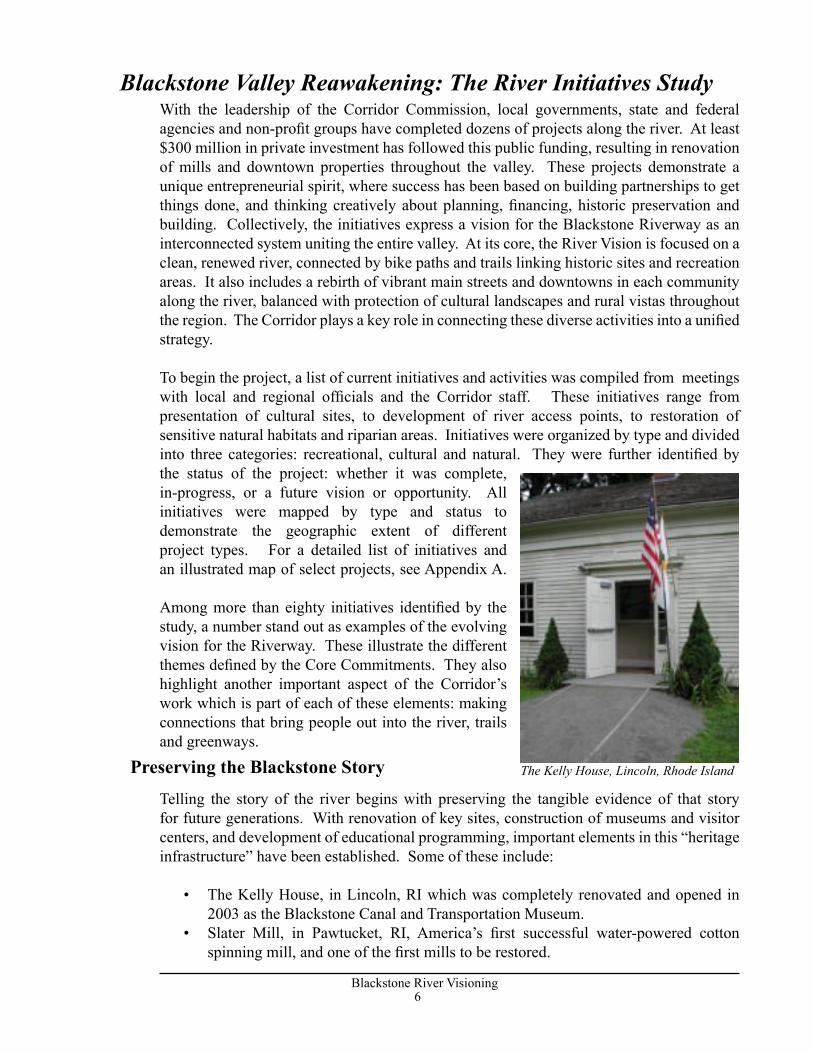
• The Kelly House, in Lincoln, RI which was completely renovated and opened in 2003 as the Blackstone Canal and Transportation Museum.
• Slater Mill, in Pawtucket, RI, America’s first successful water-powered cotton spinning mill, and one of the first mills to be restored.
Blackstone Valley Reawakening: The River Initiatives Study
Preserving the Blackstone Story The Kelly House, Lincoln, Rhode Island
6Blackstone River Visioning
7Blackstone River Visioning
• Riverbend Farm, in Uxbridge, Mass., now a state park and visitors center focusing on the Valley’s pre-industrial, agrarian society.
• The Museum of Work and Culture, in Woonsocket, RI, which tells the story of immigration, labor, and the lifestyle of people who traveled to the Blackstone to work in the mills.
• Interpretive programs: Heritage Corridor rangers run programs throughout the valley, including nature study, history and recreation.
• Education and Training: The Blackstone Valley Institute provides outreach and training to local officials through programs and a website. Leadership Blackstone Valley provides an annual training program to local leaders, with a focus on stewardship of the Blackstone’s unique resources.
While preservation of cultural resources and historic sites has been a major focus over the last two decades, recovery of ecosystems and natural habitats is becoming a more important part of the shared vision for the future. This is especially important as increasing numbers of people return to the river for recreation. Starting with the Clean Water Act thirty years ago, steady improvements in municipal wastewater treatment and control of industrial discharges has ended most of the ongoing point-source pollution. The Clean Water Act’s Phase I (1990) and Phase II stormwater management regulations (1999) require a better standard of treatment for stormwater that will provide great improvements in non-point-source pollution. Harder to deal with is the legacy of industrial contamination that plagues scattered sites along the river. Some of the important river recovery initiatives include:
• Natural Resource Inventory, which located the most important habitats and ecological resources along the length of the river.
• Fish Passages, planned for the first four dams on the river, which will begin the process of allowing fish to travel up the river to spawn.
• Lonsdale Marsh Restoration, in Lincoln, RI., where the US Army Corps of Engineers and RIDEM have restored wetlands on the site of an old drive-in theatre.
• Fishable/Swimmable Blackstone, a new initiative of the Blackstone River Coalition, whose goal is to make the Blackstone River Fishable and Swimmable by 2015, with the slogan: “Jump in … the water’s (going to be) fine.”
• Watershed-wide Volunteer Water Quality Monitoring Program, a collaborative effort of the Blackstone River Coalition, involves more than 70 volunteers in acquiring consistent and reliable water quality data.
• In 2003, the Blackstone was selected by the EPA and the Army Corps under its Urban River Restoration Initiative as a pilot to coordinate joint efforts in river restoration. The current pilot focus is on the Fisherville Pond and Fisherville Mill location.
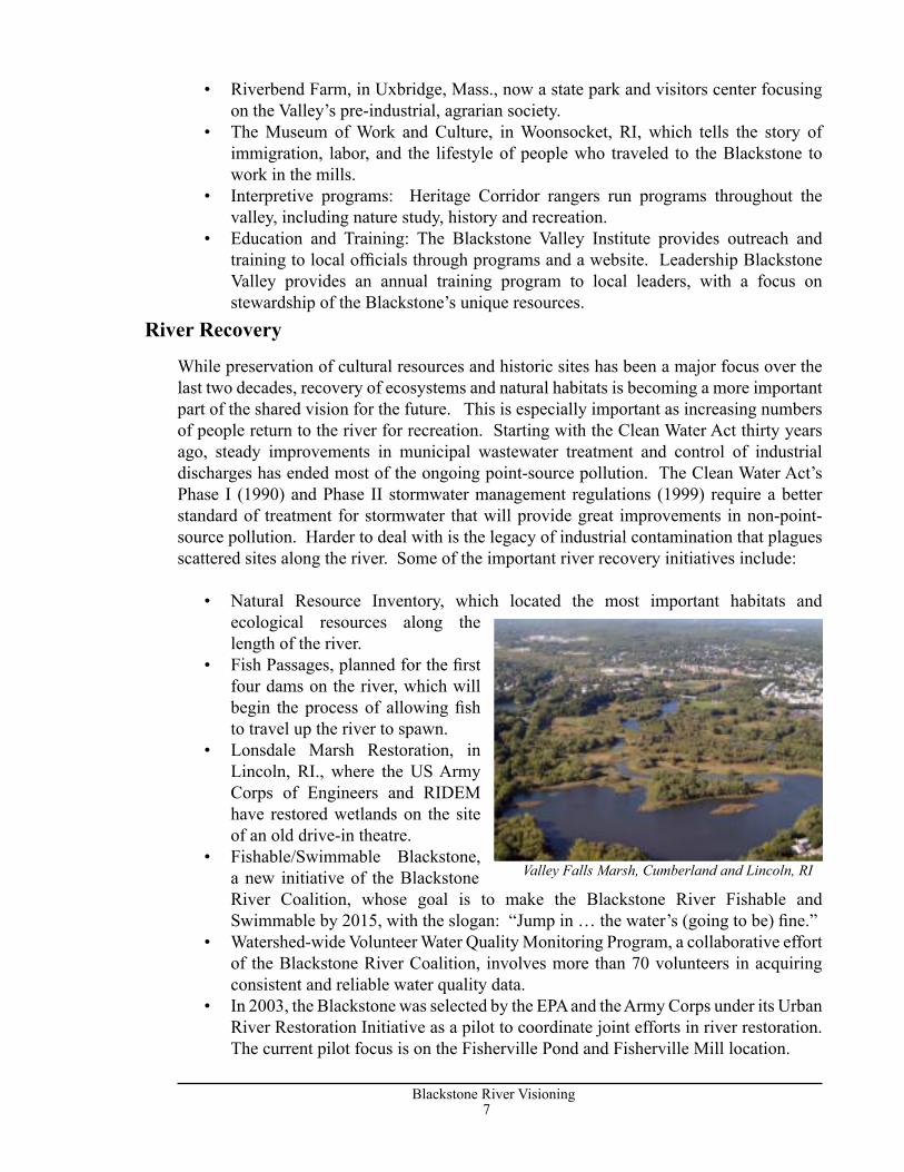
River Recovery
Valley Falls Marsh, Cumberland and Lincoln, RI
8Blackstone River Visioning
9Blackstone River Visioning
Preservation and enhancement of the natural and cultural resources of the valley has been joined by a growing list of public and private investments in redeveloping historic villages, mills, and downtowns. Whether in the large downtowns of Worcester, Woonsocket and Pawtucket, or in the smaller Main Streets in between, these efforts build on past investments in infrastructure to create new places to live and work. Ranging from feasibility studies to completed renovations, these initiatives include:
• Worcester Common Restoration, which will completely rebuild the landscape of this historic park, provide improvements to surrounding streets and pedestrian areas and add a visitor’s center and skating rink. To be funded by City and Federal funds estimated at $5.8 million.
• The Cordis Mill in Millbury, constructed in the 1870’s, has been restored for 112 apartments.
• Fisherville Mill, in Grafton, Mass., the site of a mill which burned down some years ago, now in planning stages for mitigation of industrial contamination and eventual rebuilding for housing, economic development and habitat restoration.
• Woonsocket and Manville Dam Landings, where design work has been completed and construction will soon begin which will provide river access.
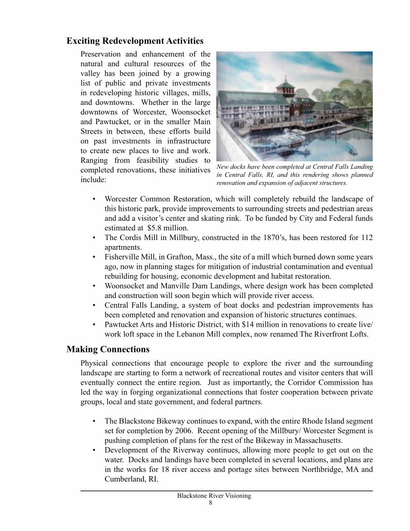
• Central Falls Landing, a system of boat docks and pedestrian improvements has been completed and renovation and expansion of historic structures continues.
• Pawtucket Arts and Historic District, with $14 million in renovations to create live/work loft space in the Lebanon Mill complex, now renamed The Riverfront Lofts.
Physical connections that encourage people to explore the river and the surrounding landscape are starting to form a network of recreational routes and visitor centers that will eventually connect the entire region. Just as importantly, the Corridor Commission has led the way in forging organizational connections that foster cooperation between private groups, local and state government, and federal partners.
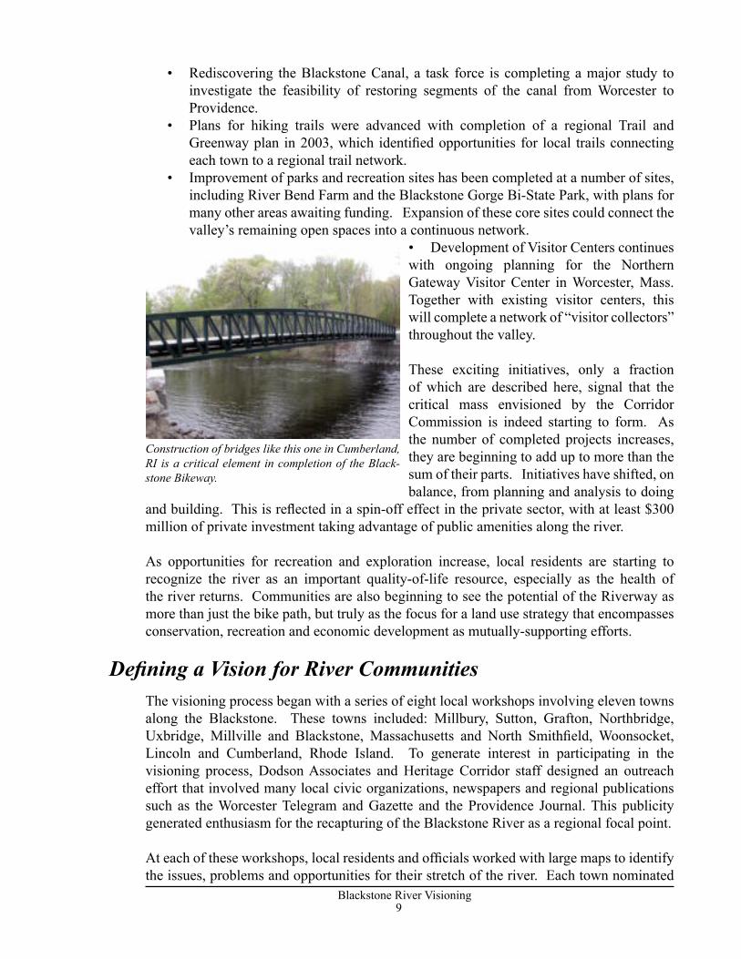
• The Blackstone Bikeway continues to expand, with the entire Rhode Island segment set for completion by 2006. Recent opening of the Millbury/ Worcester Segment is pushing completion of plans for the rest of the Bikeway in Massachusetts.
• Development of the Riverway continues, allowing more people to get out on the water. Docks and landings have been completed in several locations, and plans are in the works for 18 river access and portage sites between Northbridge, MA and Cumberland, RI.
Making Connections
Exciting Redevelopment Activities
New docks have been completed at Central Falls Landing in Central Falls, RI, and this rendering shows planned renovation and expansion of adjacent structures.
8Blackstone River Visioning
9Blackstone River Visioning
• Rediscovering the Blackstone Canal, a task force is completing a major study to investigate the feasibility of restoring segments of the canal from Worcester to Providence.
• Plans for hiking trails were advanced with completion of a regional Trail and Greenway plan in 2003, which identified opportunities for local trails connecting each town to a regional trail network.
• Improvement of parks and recreation sites has been completed at a number of sites, including River Bend Farm and the Blackstone Gorge Bi-State Park, with plans for many other areas awaiting funding. Expansion of these core sites could connect the valley’s remaining open spaces into a continuous network.
• Development of Visitor Centers continues with ongoing planning for the Northern Gateway Visitor Center in Worcester, Mass. Together with existing visitor centers, this will complete a network of “visitor collectors” throughout the valley.
These exciting initiatives, only a fraction of which are described here, signal that the critical mass envisioned by the Corridor Commission is indeed starting to form. As the number of completed projects increases, they are beginning to add up to more than the sum of their parts. Initiatives have shifted, on balance, from planning and analysis to doing
and building. This is reflected in a spin-off effect in the private sector, with at least $300 million of private investment taking advantage of public amenities along the river.
As opportunities for recreation and exploration increase, local residents are starting to recognize the river as an important quality-of-life resource, especially as the health of the river returns. Communities are also beginning to see the potential of the Riverway as more than just the bike path, but truly as the focus for a land use strategy that encompasses conservation, recreation and economic development as mutually-supporting efforts.
The visioning process began with a series of eight local workshops involving eleven towns along the Blackstone. These towns included: Millbury, Sutton, Grafton, Northbridge, Uxbridge, Millville and Blackstone, Massachusetts and North Smithfield, Woonsocket, Lincoln and Cumberland, Rhode Island. To generate interest in participating in the visioning process, Dodson Associates and Heritage Corridor staff designed an outreach effort that involved many local civic organizations, newspapers and regional publications such as the Worcester Telegram and Gazette and the Providence Journal. This publicity generated enthusiasm for the recapturing of the Blackstone River as a regional focal point.
At each of these workshops, local residents and officials worked with large maps to identify the issues, problems and opportunities for their stretch of the river. Each town nominated
Defining a Vision for River Communities
Construction of bridges like this one in Cumberland, RI is a critical element in completion of the Black-stone Bikeway.

10Blackstone River Visioning
11Blackstone River Visioning
sites which they considered the best candidates for more detailed study. Typically these included village centers and main streets, industrial areas along the river, mill centers, or complex combinations of all of these elements. From this list of candidates, the project team selected four sites that embody the full range of issues common to many towns along the Blackstone. While the plans for these sites will be most useful to the particular town involved, they were selected as the best demonstration of the larger visionary principles from which every town can learn.
The initial workshops brought out a number of issues that are shared by most of the communities along the river:
• Traffic: Every Blackstone Valley city and town struggles to accommodate the demands of twentieth century transportation in what is essentially a nineteenth century landscape.
• Loss of natural systems: local residents recognize that the river is much cleaner than it used to be, but this makes the need to fully restore the health of the river even more urgent.
• Need for recreational access and regional connections: as improvements are made in scattered sites along the river, towns are seeing the importance of the local links and access points that will allow them to connect to the growing regional recreation system.
• An evolving economy: each community still struggles to provide jobs and housing for all of its residents. Revitalization of mills for business growth and affordable housing is a universal need.
• Need for local education and outreach on the regional perspective. Participants emphasized the importance of reaching out to local residents and town officials to foster a shared consensus on the future of the region.
Along with the problems and challenges faced by river communities, participants in the initial workshops identified opportunities shared by all the towns along the Blackstone:
• Complete the Blackstone Bikeway, which is seen as an important shared goal.• Build the Riverway: the current inventory of parks, recreation areas and historic
sites should be celebrated and expanded into a regional system connected by the Bikeway and the river itself.
• Restore ecosystems and revitalize natural areas to improve water quality and enhance the natural beauty of the river.
• Economic development focused on walkable, mixed use growth centers must go hand in hand with resource conservation.
What people are looking for at the local level reflects the regional goals of the Corridor Commission: make the river healthy; tell the story of its people and places; balance conservation and growth; and find a way to preserve and reuse the old mills, main streets and neighborhoods. The River Visioning process thus reinforces the Core Commitments of the Corridor Commission, and confirms the importance of its mission.
Regional Issues
Regional Opportunities
10Blackstone River Visioning
11Blackstone River Visioning
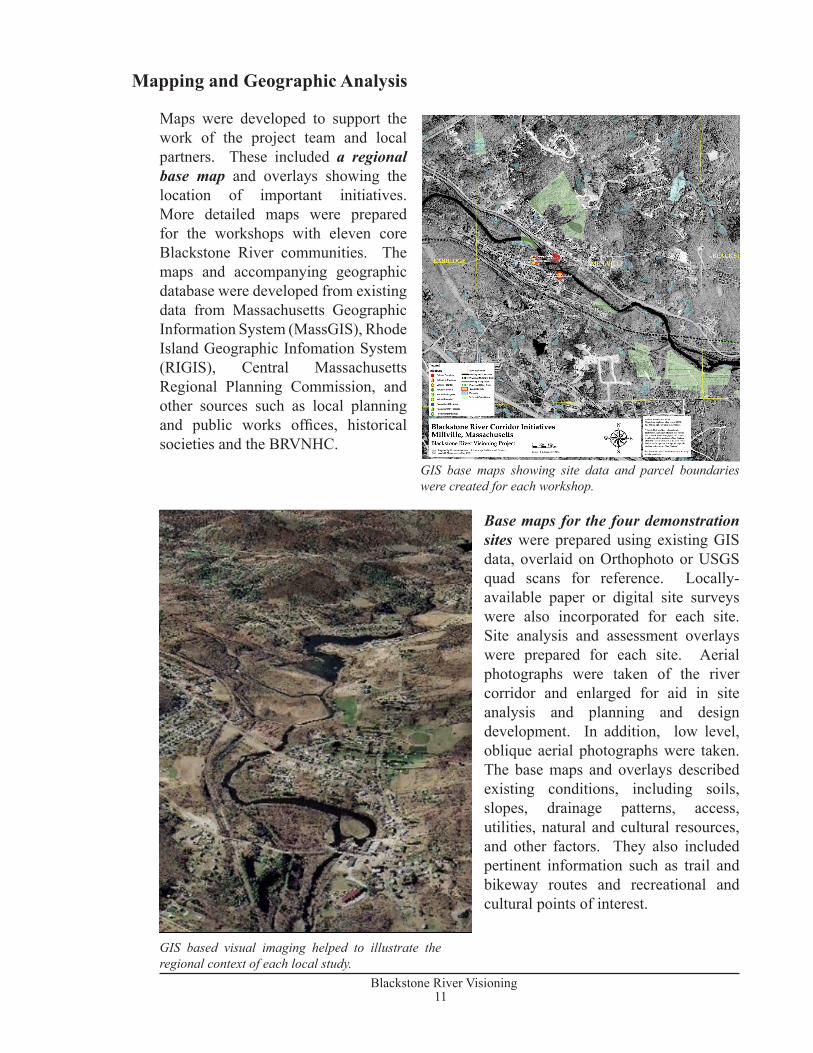
Maps were developed to support the work of the project team and local partners. These included a regional base map and overlays showing the location of important initiatives. More detailed maps were prepared for the workshops with eleven core Blackstone River communities. The maps and accompanying geographic database were developed from existing data from Massachusetts Geographic Information System (MassGIS), Rhode Island Geographic Infomation System (RIGIS), Central Massachusetts Regional Planning Commission, and other sources such as local planning and public works offices, historical societies and the BRVNHC.
Base maps for the four demonstration sites were prepared using existing GIS data, overlaid on Orthophoto or USGS quad scans for reference. Locally-available paper or digital site surveys were also incorporated for each site. Site analysis and assessment overlays were prepared for each site. Aerial photographs were taken of the river corridor and enlarged for aid in site analysis and planning and design development. In addition, low level, oblique aerial photographs were taken. The base maps and overlays described existing conditions, including soils, slopes, drainage patterns, access, utilities, natural and cultural resources, and other factors. They also included pertinent information such as trail and bikeway routes and recreational and cultural points of interest.
GIS base maps showing site data and parcel boundaries were created for each workshop.
GIS based visual imaging helped to illustrate the regional context of each local study.
Mapping and Geographic Analysis
12Blackstone River Visioning
13Blackstone River Visioning
During the initial phase of public workshops in eleven communities, eight possible case study sites were identified as potential charrette sites. The sites under consideration were key points along the river corridor and represented a range of typical issues and challenges faced by different towns. Each of these sites is described below. The four sites chosen for the detailed design charrettes are marked with an asterix.
Millbury/Sutton: Singing Dam AreaThe area around the Singing Dam was identified as a potential site. The area is rich in historical and natural resources and has many recreational links. The structural condition of the bridge is a constraint as is the private ownership of the Boria Farm which comprises a significant portion of the land adjoining this area. The Town of Sutton is currently completing plans for a Tricentennial Park near the Dam, with ground-breaking scheduled for October, 2004. The park should be completed in 2005.
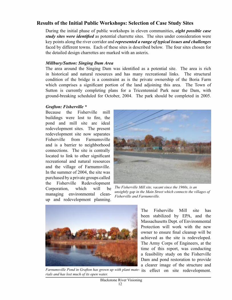
Grafton: Fisherville *Because the Fisherville mill buildings were lost to fire, the pond and mill site are ideal redevelopment sites. The present redevelopment site now separates Fisherville from Farnumsville and is a barrier to neighborhood connections. The site is centrally located to link to other significant recreational and natural resources and the village of Farnumsville. In the summer of 2004, the site was purchased by a private groups called the Fisherville Redevelopment Corporation, which will be managing environmental clean-up and redevelopment planning.
The Fisherville Mill site has been stabilized by EPA, and the Massachusetts Dept. of Environmental Protection will work with the new owner to ensure final cleanup will be achieved as the site is redeveloped. The Army Corps of Engineers, at the time of this report, was conducting a feasibility study on the Fisherville Dam and pond restoration to provide a clearer image of the structure and its effect on site redevelopment.
The Fisherville Mill site, vacant since the 1960s, is an unsightly gap in the Main Street which connects the villages of Fisherville and Farnumsville.
Results of the Initial Public Workshops: Selection of Case Study Sites
Farnumsville Pond in Grafton has grown up with plant mate-rials and has lost much of its open water.
12Blackstone River Visioning
13Blackstone River Visioning
NorthbridgeMany projects are currently underway or have been recently completed in Northbridge including a visioning project for Whitinsville and site development at Plummer’s Landing. Riverdale Mill is still in use and has potential recreational access to natural areas.
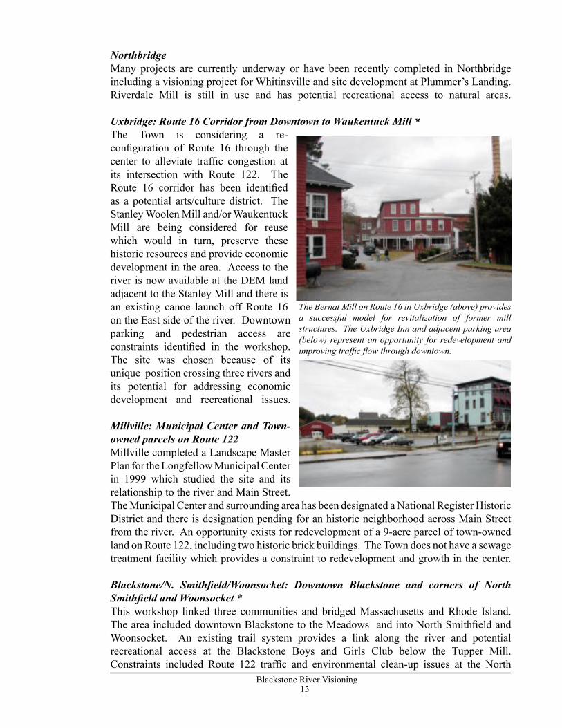
Uxbridge: Route 16 Corridor from Downtown to Waukentuck Mill *The Town is considering a re-configuration of Route 16 through the center to alleviate traffic congestion at its intersection with Route 122. The Route 16 corridor has been identified as a potential arts/culture district. The Stanley Woolen Mill and/or Waukentuck Mill are being considered for reuse which would in turn, preserve these historic resources and provide economic development in the area. Access to the river is now available at the DEM land adjacent to the Stanley Mill and there is an existing canoe launch off Route 16 on the East side of the river. Downtown parking and pedestrian access are constraints identified in the workshop. The site was chosen because of its unique position crossing three rivers and its potential for addressing economic development and recreational issues.
Millville: Municipal Center and Town-owned parcels on Route 122Millville completed a Landscape Master Plan for the Longfellow Municipal Center in 1999 which studied the site and its relationship to the river and Main Street. The Municipal Center and surrounding area has been designated a National Register Historic District and there is designation pending for an historic neighborhood across Main Street from the river. An opportunity exists for redevelopment of a 9-acre parcel of town-owned land on Route 122, including two historic brick buildings. The Town does not have a sewage treatment facility which provides a constraint to redevelopment and growth in the center.
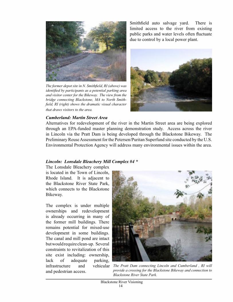
Blackstone/N. Smithfield/Woonsocket: Downtown Blackstone and corners of North Smithfield and Woonsocket *This workshop linked three communities and bridged Massachusetts and Rhode Island. The area included downtown Blackstone to the Meadows and into North Smithfield and Woonsocket. An existing trail system provides a link along the river and potential recreational access at the Blackstone Boys and Girls Club below the Tupper Mill. Constraints included Route 122 traffic and environmental clean-up issues at the North
The Bernat Mill on Route 16 in Uxbridge (above) provides a successful model for revitalization of former mill structures. The Uxbridge Inn and adjacent parking area (below) represent an opportunity for redevelopment and improving traffic flow through downtown.
14Blackstone River Visioning
15Blackstone River Visioning
Smithfield auto salvage yard. There is limited access to the river from existing public parks and water levels often fluctuate due to control by a local power plant.
Cumberland: Martin Street AreaAlternatives for redevelopment of the river in the Martin Street area are being explored through an EPA-funded master planning demonstration study. Access across the river in Lincoln via the Pratt Dam is being developed through the Blackstone Bikeway. The Preliminary Reuse Assessment for the Petersen/Puritan Superfund site conducted by the U.S. Environmental Protection Agency will address many environmental issues within the area.
Lincoln: Lonsdale Bleachery Mill Complex #4 *The Lonsdale Bleachery complex is located in the Town of Lincoln, Rhode Island. It is adjacent to the Blackstone River State Park, which connects to the Blackstone Bikeway.
The complex is under multiple ownerships and redevelopment is already occurring in many of the former mill buildings. There remains potential for mixed-use development in some buildings. The canal and mill pond are intact but would require clean-up. Several constraints to revitalization of this site exist including: ownership, lack of adequate parking, infrastructure and vehicular and pedestrian access.
The Pratt Dam connecting Lincoln and Cumberland , RI will provide a crossing for the Blackstone Bikeway and connection to Blackstone River State Park.
The former depot site in N. Smithfield, RI (above) was identified by participants as a potential parking area and visitor center for the Bikeway. The view from the bridge connecting Blackstone, MA to North Smith-field, RI (right) shows the dramatic visual character that draws visitors to the area.
14Blackstone River Visioning
15Blackstone River Visioning
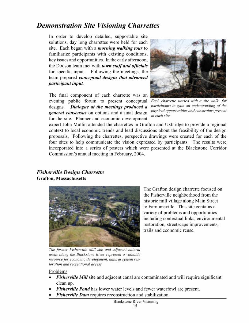
In order to develop detailed, supportable site solutions, day long charrettes were held for each site. Each began with a morning walking tour to familiarize participants with existing conditions, key issues and opportunities. In the early afternoon, the Dodson team met with town staff and officials for specific input. Following the meetings, the team prepared conceptual designs that advanced participant input.
The final component of each charrette was an evening public forum to present conceptual designs. Dialogue at the meetings produced a general consensus on options and a final design for the site. Planner and economic development expert John Mullin attended the charrettes in Grafton and Uxbridge to provide a regional context to local economic trends and lead discussions about the feasibility of the design proposals. Following the charrettes, perspective drawings were created for each of the four sites to help communicate the vision expressed by participants. The results were incorporated into a series of posters which were presented at the Blackstone Corridor Commission’s annual meeting in February, 2004.
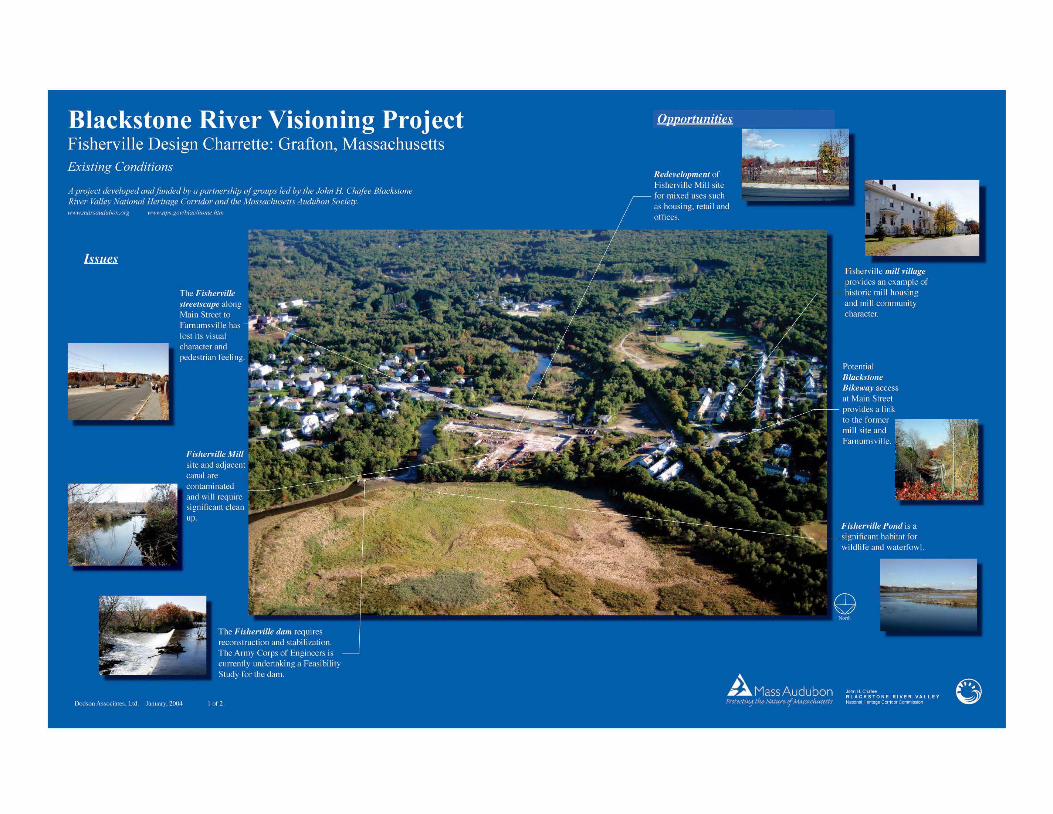
The Grafton design charrette focused on the Fisherville neighborhood from the historic mill village along Main Street to Farnumsville. This site contains a variety of problems and opportunities including contextual links, environmental restoration, streetscape improvements, trails and economic reuse.
Problems• Fisherville Mill site and adjacent canal are contaminated and will require significant
clean up.• Fisherville Pond has lower water levels and fewer waterfowl are present.• Fisherville Dam requires reconstruction and stabilization.
The former Fisherville Mill site and adjacent natural areas along the Blackstone River represent a valuable resource for economic development, natural system res-toration and recreational access.
Fisherville Design CharretteGrafton, Massachusetts
Each charrette started with a site walk for participants to gain an understanding of the physical opportunities and constraints present at each site.
Demonstration Site Visioning Charrettes
16Blackstone River Visioning
17Blackstone River Visioning
• The Fisherville streetscape along Main Street to Farnumsville has lost its visual character and pedestrian feeling.
• The Fisherville site is a desert that divides the village.
Opportunities• Redevelopment potential at the Fisherville Mill site through new ownership and environmental clean-up. This will provide a magnet to link the village back together. • Potential Fisherville Pond restoration will create a significant natural area and Waterfowl habitat.• Potential Blackstone Bikeway access at Main Street provides a link to the former mill site and Farnumsville.• Streetscape links to Farnumsville.• Fisherville mill village provides an example of historic mill housing and community character.
The Fisherville site is of particular importance to Grafton because it is one of the few areas in town that has close proximity to the River and provides an opportunity for public viewing of natural areas and access. The clean-up and potential redevelopment of the site under its new ownership can re-establish the connectivity of the community and create a viable economic solution. The design recommendations described below are provided to guide redevelopment and to ensure the integration of recreational activities, natural system restoration and economic development for South Grafton and the larger regional network.
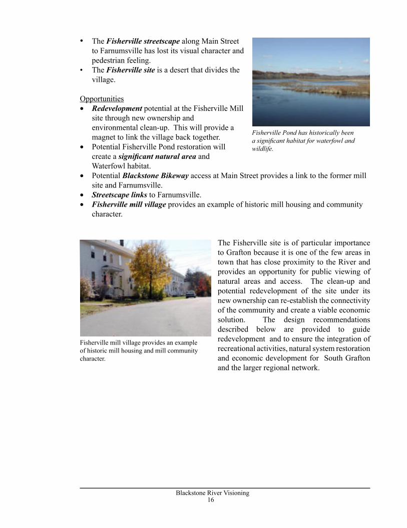
Fisherville Pond has historically been a significant habitat for waterfowl and wildlife.
Fisherville mill village provides an example of historic mill housing and mill community character.
16Blackstone River Visioning
17Blackstone River Visioning
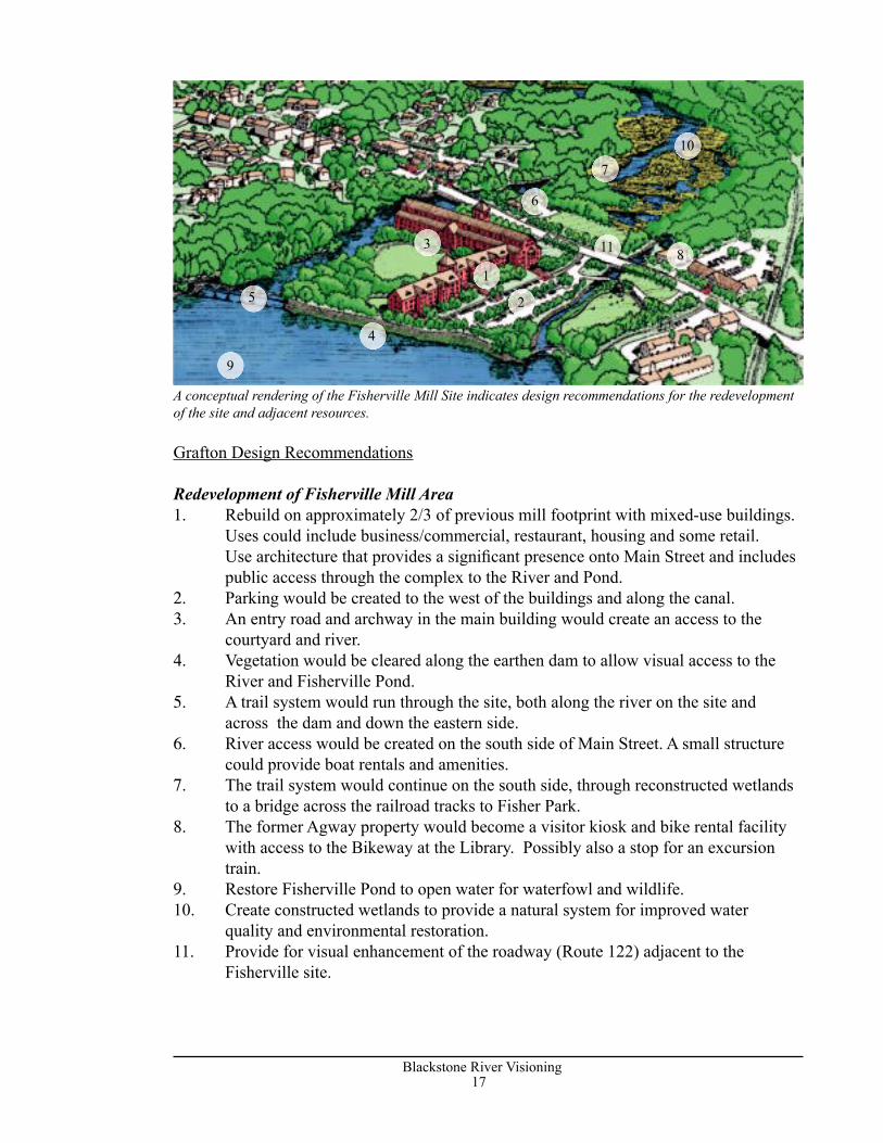
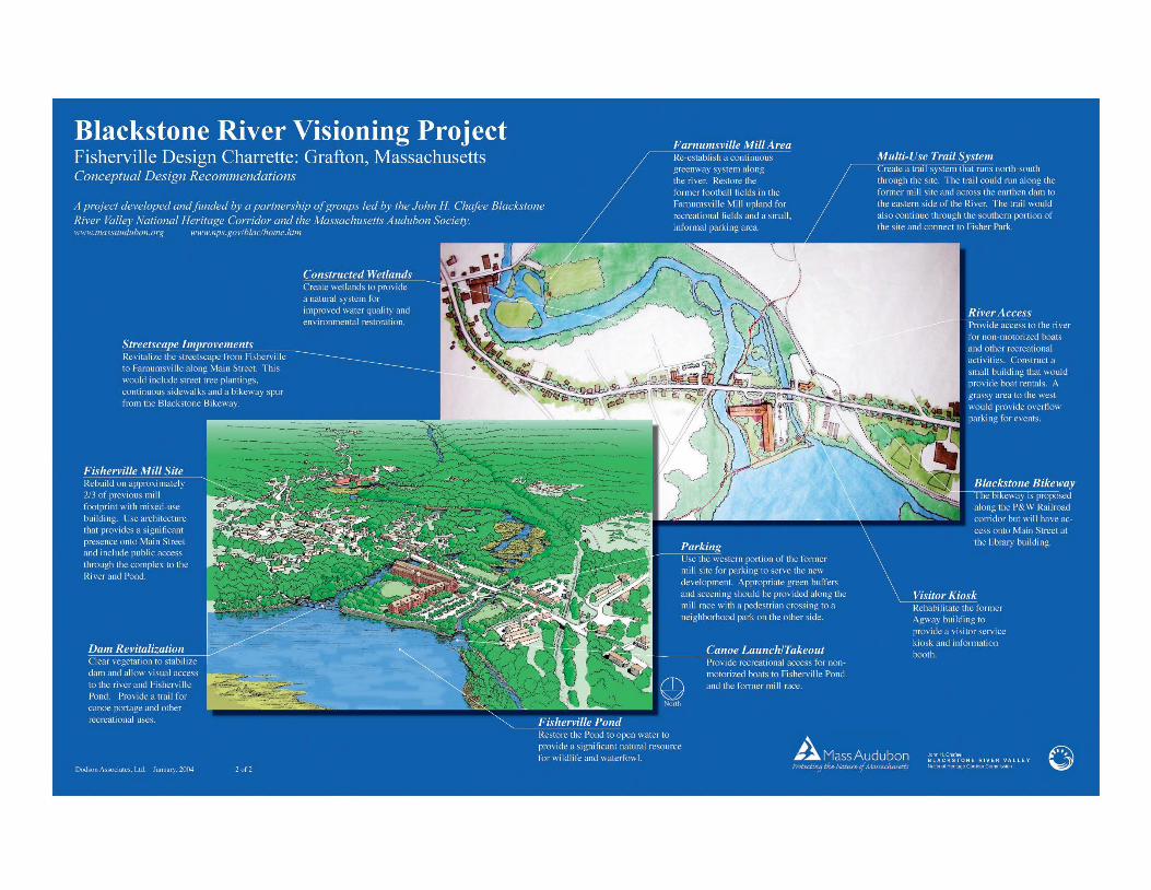
Grafton Design Recommendations
Redevelopment of Fisherville Mill Area1. Rebuild on approximately 2/3 of previous mill footprint with mixed-use buildings.
Uses could include business/commercial, restaurant, housing and some retail. Use architecture that provides a signifi cant presence onto Main Street and includes public access through the complex to the River and Pond.
2. Parking would be created to the west of the buildings and along the canal. 3. An entry road and archway in the main building would create an access to the courtyard and river.4. Vegetation would be cleared along the earthen dam to allow visual access to the
River and Fisherville Pond.5. A trail system would run through the site, both along the river on the site and
across the dam and down the eastern side.6. River access would be created on the south side of Main Street. A small structure
could provide boat rentals and amenities.7. The trail system would continue on the south side, through reconstructed wetlands
to a bridge across the railroad tracks to Fisher Park.8. The former Agway property would become a visitor kiosk and bike rental facility
with access to the Bikeway at the Library. Possibly also a stop for an excursion train.
9. Restore Fisherville Pond to open water for waterfowl and wildlife.10. Create constructed wetlands to provide a natural system for improved water
quality and environmental restoration.11. Provide for visual enhancement of the roadway (Route 122) adjacent to the
Fisherville site.
A conceptual rendering of the Fisherville Mill Site indicates design recommendations for the redevelopment of the site and adjacent resources.
1
2
3
4
5
6
7
8
9
10
11
18Blackstone River Visioning
19Blackstone River Visioning
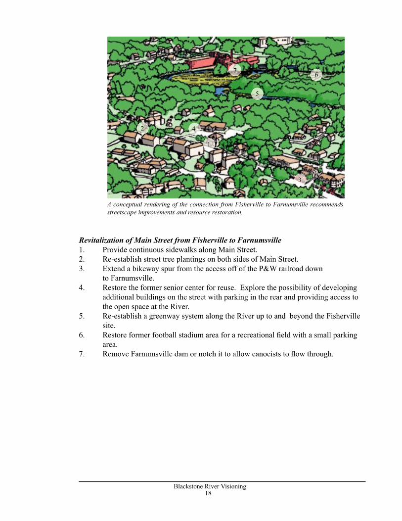
Revitalization of Main Street from Fisherville to Farnumsville1. Provide continuous sidewalks along Main Street.2. Re-establish street tree plantings on both sides of Main Street.3. Extend a bikeway spur from the access off of the P&W railroad down
to Farnumsville.4. Restore the former senior center for reuse. Explore the possibility of developing additional buildings on the street with parking in the rear and providing access to the open space at the River.5. Re-establish a greenway system along the River up to and beyond the Fisherville
site.6. Restore former football stadium area for a recreational fi eld with a small parking
area.7. Remove Farnumsville dam or notch it to allow canoeists to fl ow through.
A conceptual rendering of the connection from Fisherville to Farnumsville recommends streetscape improvements and resource restoration.
1
2
3
4
5
67
18Blackstone River Visioning
19Blackstone River Visioning
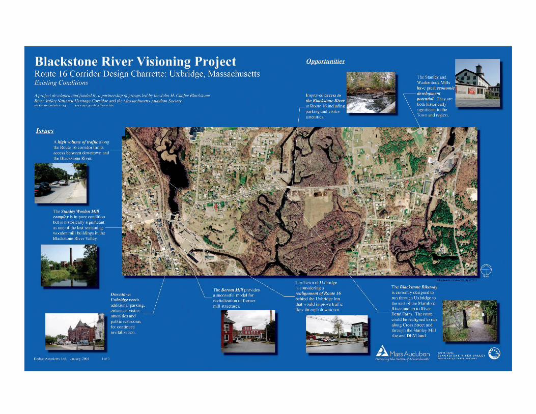
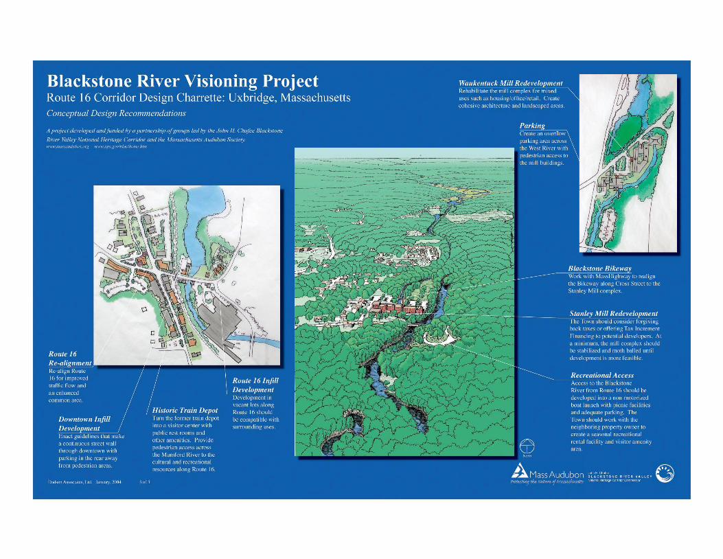
The Uxbridge charrette concentrated on the Route 16 corridor from downtown Uxbridge to the former Waukentuck Mill complex. This corridor includes the Stanley Woolen Mill complex and a potential river access/ canoe launch previously designed by the BRVNHC. This demonstration site illustrates some of the transportation and circulation issues that many communities are facing as well as economic development and river access.
Problems• Downtown Uxbridge needs to continue
to promote economic revitalization.• Stanley Woolen Mill, while in very poor condition, is historically significant as one of the last wooden mill buildings in the Blackstone Valley. • There is not enough parking in the downtown area. Additional visitor parking and amenities are needed.• A high volume of traffic along the Route 16
corridor limits access between downtown and the Blackstone River.
Opportunities• Uxbridge is currently undertaking a Community Development Plan focusing on the downtown and has identified the Route 16 corridor as a potential arts/cultural corridor.• Existing Route16 recreational access to the River and potential future enhancement.• Stanley Woolen Mill and Waukentuck Mill are available for redevelopment. The Bernat Mill provides a successful model for revitalization of former mill structures.• The Blackstone Bikeway is currently designed to run through the area but should be realigned to include the Stanley Mill site and the Blackstone
River.• The Town is considering a realignment of Route 16 at the Uxbridge Inn that will improve traffic flow
through the center, especially for trucks.
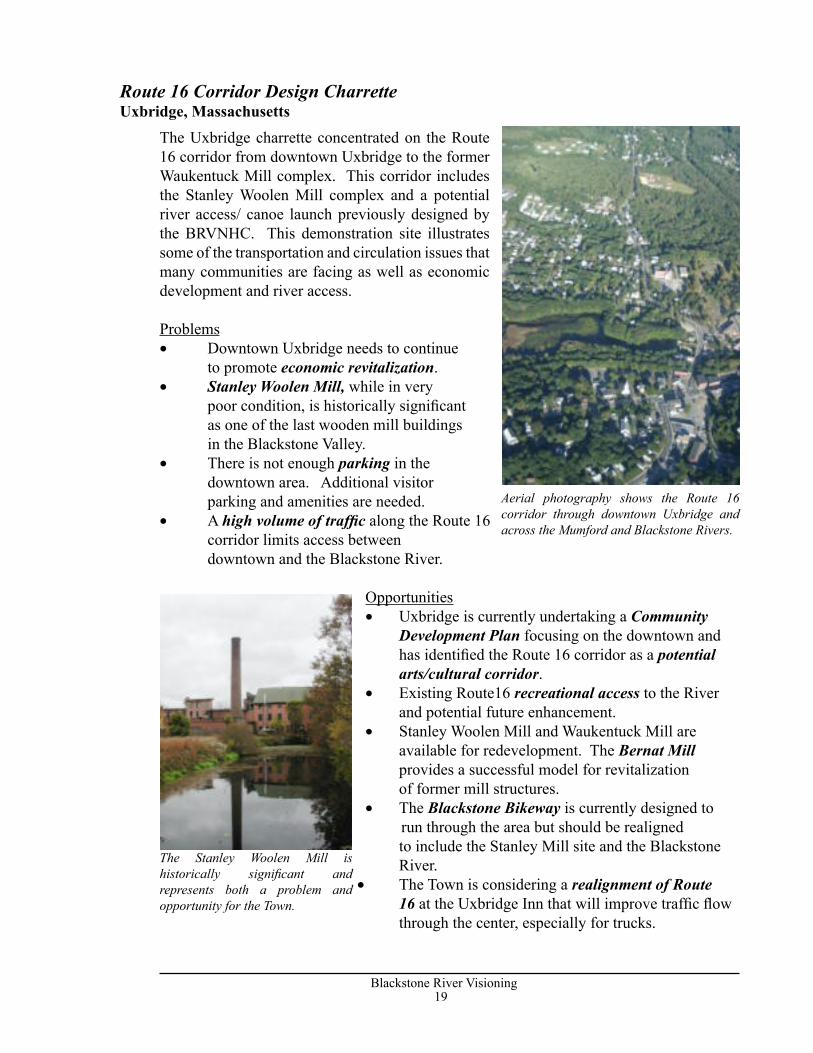
Aerial photography shows the Route 16 corridor through downtown Uxbridge and across the Mumford and Blackstone Rivers.
The Stanley Woolen Mill is historically significant and represents both a problem and opportunity for the Town.
Route 16 Corridor Design CharretteUxbridge, Massachusetts
20Blackstone River Visioning
21Blackstone River Visioning
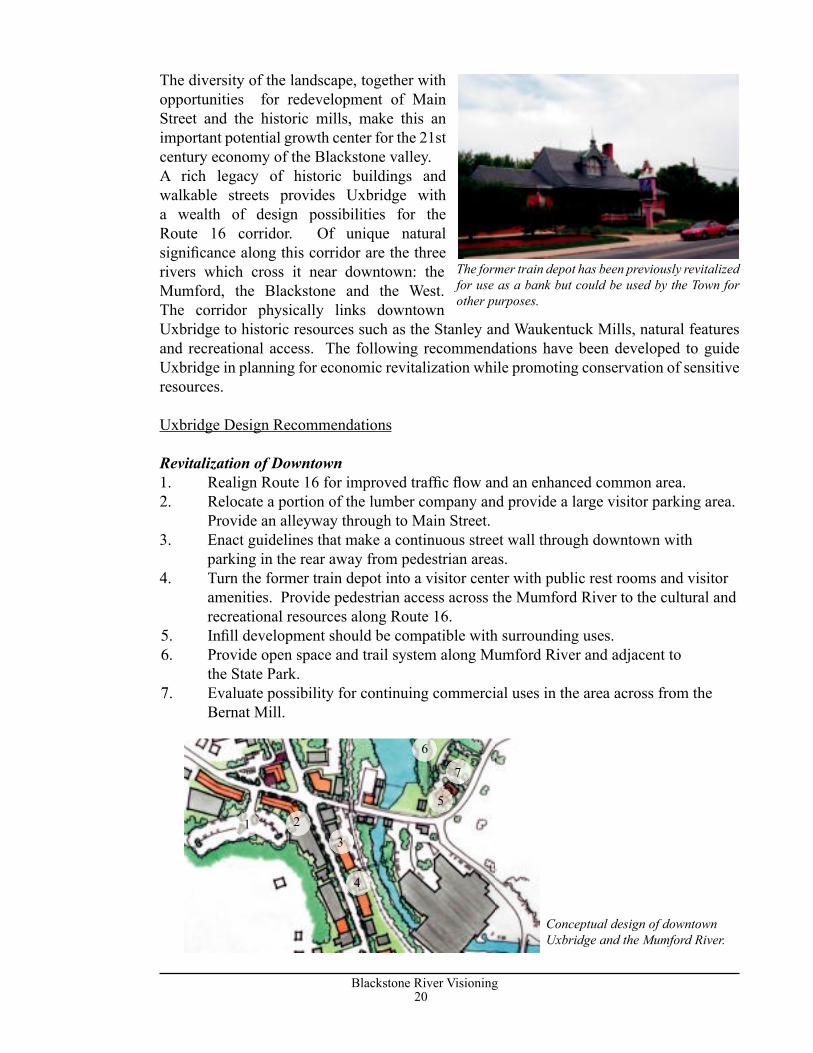
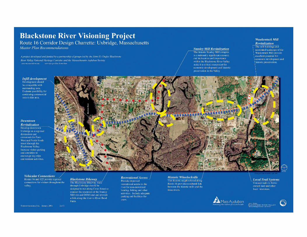
The diversity of the landscape, together with opportunities for redevelopment of Main Street and the historic mills, make this an important potential growth center for the 21st century economy of the Blackstone valley.A rich legacy of historic buildings and walkable streets provides Uxbridge with a wealth of design possibilities for the Route 16 corridor. Of unique natural signifi cance along this corridor are the three rivers which cross it near downtown: the Mumford, the Blackstone and the West. The corridor physically links downtown Uxbridge to historic resources such as the Stanley and Waukentuck Mills, natural features and recreational access. The following recommendations have been developed to guide Uxbridge in planning for economic revitalization while promoting conservation of sensitive resources.
Uxbridge Design Recommendations
Revitalization of Downtown1. Realign Route 16 for improved traffi c fl ow and an enhanced common area. 2. Relocate a portion of the lumber company and provide a large visitor parking area.
Provide an alleyway through to Main Street.3. Enact guidelines that make a continuous street wall through downtown with
parking in the rear away from pedestrian areas.4. Turn the former train depot into a visitor center with public rest rooms and visitor
amenities. Provide pedestrian access across the Mumford River to the cultural and recreational resources along Route 16.
5. Infi ll development should be compatible with surrounding uses. 6. Provide open space and trail system along Mumford River and adjacent to
the State Park.7. Evaluate possibility for continuing commercial uses in the area across from the
Bernat Mill.
The former train depot has been previously revitalized for use as a bank but could be used by the Town for other purposes.
Conceptual design of downtown Uxbridge and the Mumford River.
1 23
4
5
6
7
20Blackstone River Visioning
21Blackstone River Visioning
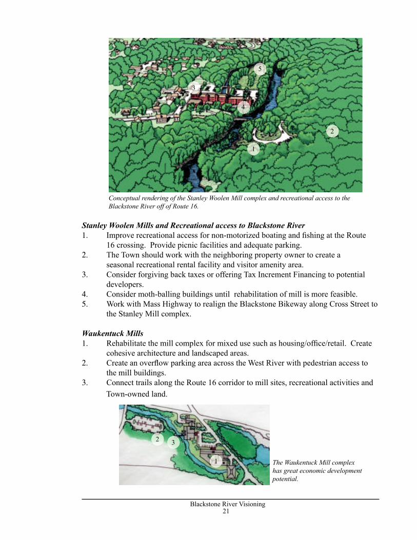
Stanley Woolen Mills and Recreational access to Blackstone River1. Improve recreational access for non-motorized boating and fi shing at the Route
16 crossing. Provide picnic facilities and adequate parking.2. The Town should work with the neighboring property owner to create a
seasonal recreational rental facility and visitor amenity area.3. Consider forgiving back taxes or offering Tax Increment Financing to potential
developers. 4. Consider moth-balling buildings until rehabilitation of mill is more feasible.5. Work with Mass Highway to realign the Blackstone Bikeway along Cross Street to
the Stanley Mill complex.
Waukentuck Mills1. Rehabilitate the mill complex for mixed use such as housing/offi ce/retail. Create
cohesive architecture and landscaped areas.2. Create an overfl ow parking area across the West River with pedestrian access to
the mill buildings. 3. Connect trails along the Route 16 corridor to mill sites, recreational activities and
Town-owned land.
Conceptual rendering of the Stanley Woolen Mill complex and recreational access to the Blackstone River off of Route 16.
1
2
3
4
5
The Waukentuck Mill complex has great economic development potential.
1
2 3
22Blackstone River Visioning
23Blackstone River Visioning
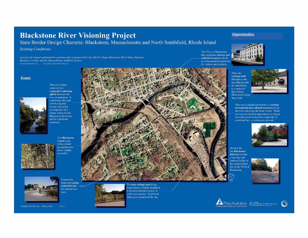
Problems• Τhe auto salvage yard along Canal Street in North Smithfield is an inappropriate
use as well as an eyesore. Significant clean-up is required at the site.• The Blackstone Canal needs to be cleaned up and become more visually
accessible.• There have been relatively few cooperative planning efforts between the two
communities. A continuing dialogue will be required for the successful development of a shared vision for the Blackstone Riverway and its significant resources.
• Industrial uses along the river’s edge impede redevelopment for recreational use.
Opportunities• Existing trails throughout the area provide an opportunity to connect to the existing Blackstone Gorge State Park.• Τhe Town of Blackstone has significant historic and cultural resources which provide potential attractions for visitors and residents.• These resources also provide an excellent
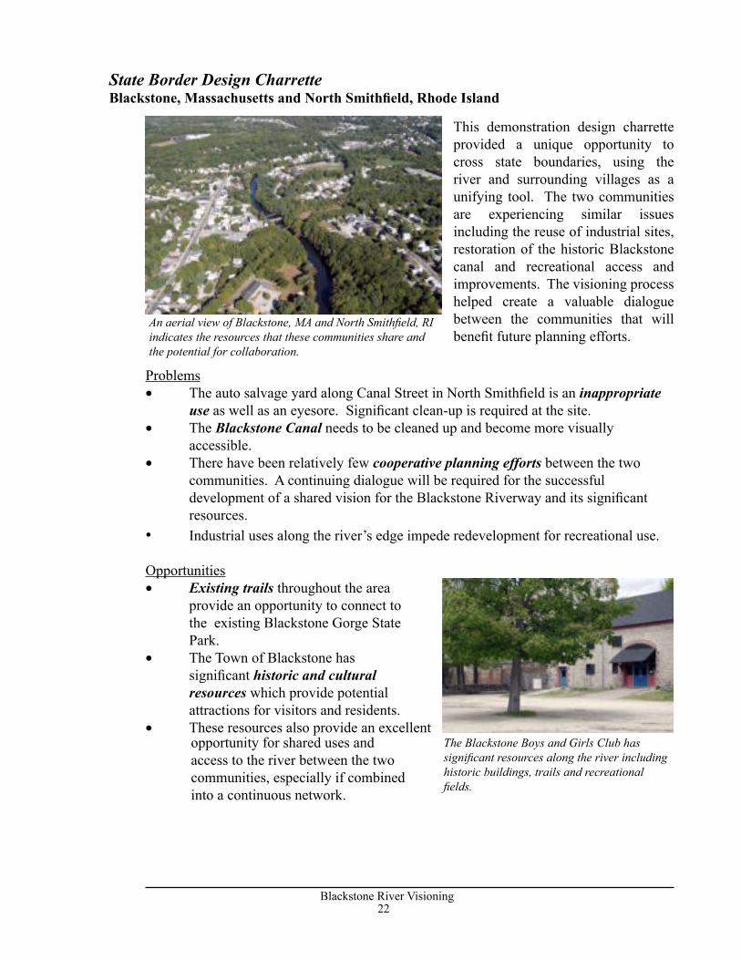
This demonstration design charrette provided a unique opportunity to cross state boundaries, using the river and surrounding villages as a unifying tool. The two communities are experiencing similar issues including the reuse of industrial sites, restoration of the historic Blackstone canal and recreational access and improvements. The visioning process helped create a valuable dialogue between the communities that will benefit future planning efforts.
State Border Design CharretteBlackstone, Massachusetts and North Smithfield, Rhode Island
An aerial view of Blackstone, MA and North Smithfield, RI indicates the resources that these communities share and the potential for collaboration.
The Blackstone Boys and Girls Club has significant resources along the river including historic buildings, trails and recreational fields.
opportunity for shared uses and access to the river between the two communities, especially if combined into a continuous network.
22Blackstone River Visioning
23Blackstone River Visioning
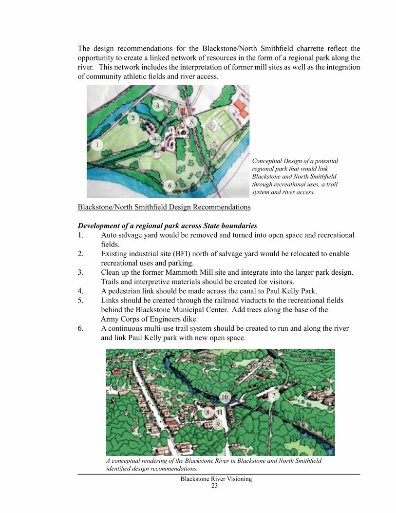
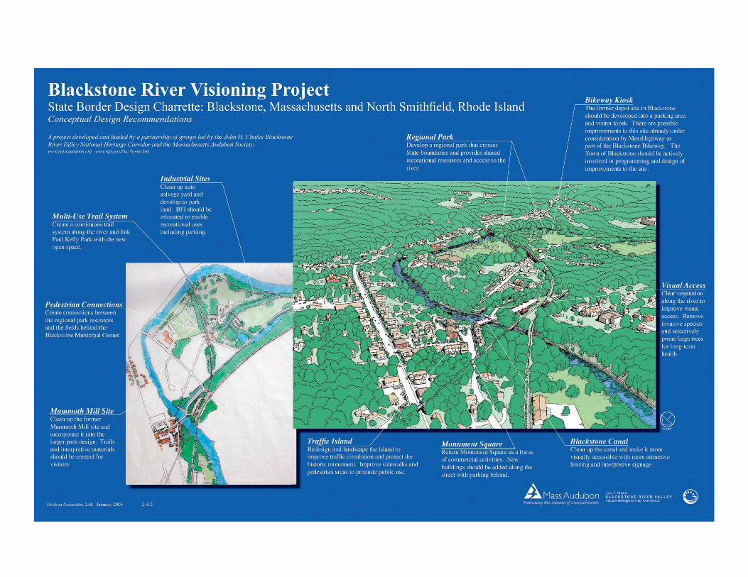
The design recommendations for the Blackstone/North Smithfi eld charrette refl ect the opportunity to create a linked network of resources in the form of a regional park along the river. This network includes the interpretation of former mill sites as well as the integration of community athletic fi elds and river access.
Blackstone/North Smithfi eld Design Recommendations
Development of a regional park across State boundaries1. Auto salvage yard would be removed and turned into open space and recreational
fi elds.2. Existing industrial site (BFI) north of salvage yard would be relocated to enable
recreational uses and parking.3. Clean up the former Mammoth Mill site and integrate into the larger park design.
Trails and interpretive materials should be created for visitors. 4. A pedestrian link should be made across the canal to Paul Kelly Park.5. Links should be created through the railroad viaducts to the recreational fi elds
behind the Blackstone Municipal Center. Add trees along the base of the Army Corps of Engineers dike.
6. A continuous multi-use trail system should be created to run and along the river and link Paul Kelly park with new open space.
Conceptual Design of a potential regional park that would link Blackstone and North Smithfi eld through recreational uses, a trail system and river access.
A conceptual rendering of the Blackstone River in Blackstone and North Smithfi eld identifi ed design recommendations.
7
8
9
10
11
1
2
3
4
5
6
24Blackstone River Visioning
25Blackstone River Visioning
access to the River.11. Redesign and landscape island for
better circulation and preservation of the monument.
Other• Redevelop the Tupper Mill to some form of elderly or affordable housing.
Both Towns expressed the need for senior housing. Details of access and infrastructure will need to be addressed between the two towns.
• Link local resources and regional trail and bikeway systems. Major East-West routes through communities converge at this point.
• A joint effort between towns should clean up the Canal and make it visually accessible to the public.
• Continue revitalization of Main Street in Blackstone.
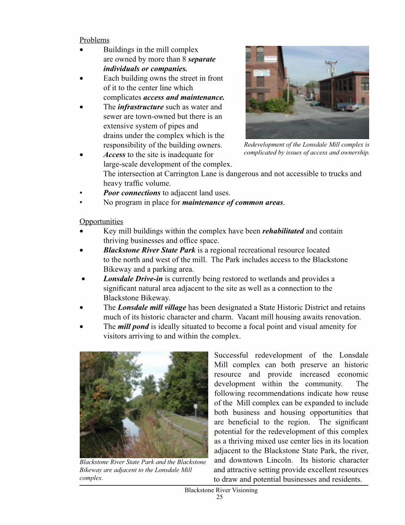
The demonstration design charrette in Lincoln focused on the former Lonsdale Bleachery mill buildings and their surroundings. The design problem is intriguing due to the complexity of issues such as ownership and infrastructure. Access to the site and river, as well as parking requirements for redevelopment also complicate the site. There are currently thriving businesses operating next to condemned buildings and no clear access to the river or Blackstone River State Park which is adjacent to the site.
Town of Blackstone: former depot site and Monument Square7. Τhe former depot site should be developed into a parking area and visitor kiosk. There are possible site improvements already under consideration by Mass Highway as part of the Blackstone Bikeway. Development could include a platform for some form of excursion train. The Town should develop designs and a program for the site in order to be proactive before the RFP from Mass Highway is prepared.8. Return area to commercial uses and provide a stronger hub that will connect to downtown and North Smithfield. 9. Replace buildings along the street with parking behind. 10. Clear out vegetation to provide visual
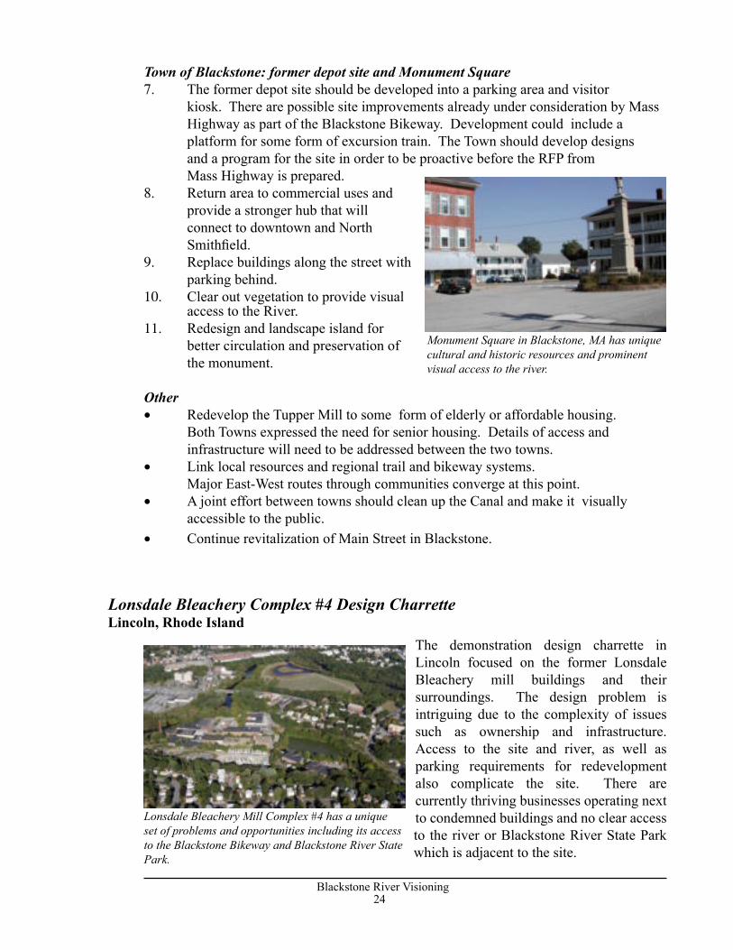
Monument Square in Blackstone, MA has unique cultural and historic resources and prominent visual access to the river.
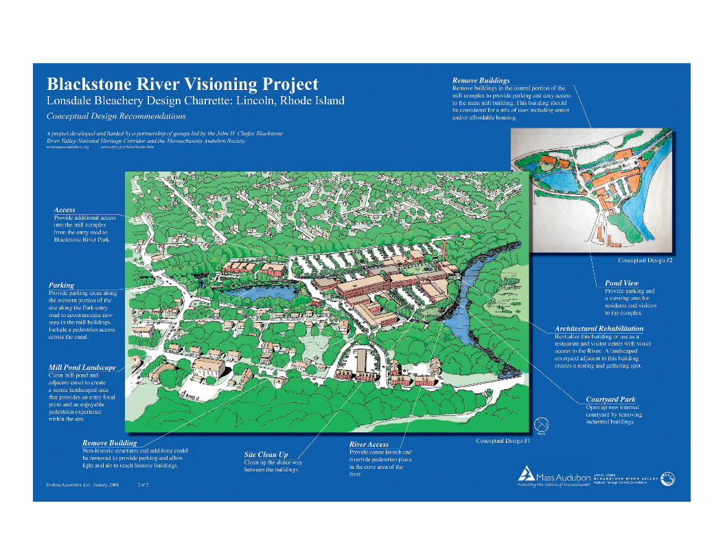
Lonsdale Bleachery Complex #4 Design CharretteLincoln, Rhode Island
Lonsdale Bleachery Mill Complex #4 has a unique set of problems and opportunities including its access to the Blackstone Bikeway and Blackstone River State Park.
24Blackstone River Visioning
25Blackstone River Visioning
Problems• Buildings in the mill complex are owned by more than 8 separate individuals or companies. • Each building owns the street in front of it to the center line which
complicates access and maintenance.• The infrastructure such as water and
sewer are town-owned but there is an extensive system of pipes and drains under the complex which is the
responsibility of the building owners.• Access to the site is inadequate for large-scale development of the complex.
The intersection at Carrington Lane is dangerous and not accessible to trucks and heavy traffic volume.
• Poor connections to adjacent land uses.• No program in place for maintenance of common areas.
Opportunities• Key mill buildings within the complex have been rehabilitated and contain
thriving businesses and office space. • Blackstone River State Park is a regional recreational resource located
to the north and west of the mill. The Park includes access to the Blackstone Bikeway and a parking area.
• Lonsdale Drive-in is currently being restored to wetlands and provides a significant natural area adjacent to the site as well as a connection to the Blackstone Bikeway.
• The Lonsdale mill village has been designated a State Historic District and retains much of its historic character and charm. Vacant mill housing awaits renovation.
• The mill pond is ideally situated to become a focal point and visual amenity for visitors arriving to and within the complex.
Successful redevelopment of the Lonsdale Mill complex can both preserve an historic resource and provide increased economic development within the community. The following recommendations indicate how reuse of the Mill complex can be expanded to include both business and housing opportunities that are beneficial to the region. The significant potential for the redevelopment of this complex as a thriving mixed use center lies in its location adjacent to the Blackstone State Park, the river, and downtown Lincoln. Its historic character and attractive setting provide excellent resources to draw and potential businesses and residents.
Redevelopment of the Lonsdale Mill complex is complicated by issues of access and ownership.
Blackstone River State Park and the Blackstone Bikeway are adjacent to the Lonsdale Mill complex.
26Blackstone River Visioning
27Blackstone River Visioning
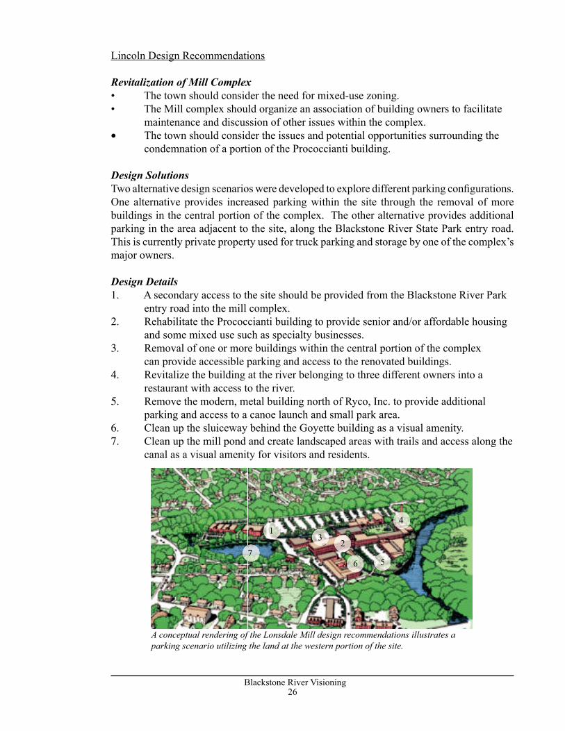
Lincoln Design Recommendations
Revitalization of Mill Complex• The town should consider the need for mixed-use zoning. • Τhe Mill complex should organize an association of building owners to facilitate maintenance and discussion of other issues within the complex.• The town should consider the issues and potential opportunities surrounding the
condemnation of a portion of the Prococcianti building. Design SolutionsTwo alternative design scenarios were developed to explore different parking confi gurations. One alternative provides increased parking within the site through the removal of more buildings in the central portion of the complex. The other alternative provides additional parking in the area adjacent to the site, along the Blackstone River State Park entry road. This is currently private property used for truck parking and storage by one of the complex’s major owners.
Design Details1. Α secondary access to the site should be provided from the Blackstone River Park
entry road into the mill complex. 2. Rehabilitate the Prococcianti building to provide senior and/or affordable housing
and some mixed use such as specialty businesses.3. Removal of one or more buildings within the central portion of the complex
can provide accessible parking and access to the renovated buildings.4. Revitalize the building at the river belonging to three different owners into a
restaurant with access to the river.5. Remove the modern, metal building north of Ryco, Inc. to provide additional
parking and access to a canoe launch and small park area. 6. Clean up the sluiceway behind the Goyette building as a visual amenity.7. Clean up the mill pond and create landscaped areas with trails and access along the
canal as a visual amenity for visitors and residents.
A conceptual rendering of the Lonsdale Mill design recommendations illustrates a parking scenario utilizing the land at the western portion of the site.
123
4
567
26Blackstone River Visioning
27Blackstone River Visioning
ConclusionIn addition to many specific ideas and design solutions developed for each of the sites, several themes emerged as common elements in each of the charrettes:
• It may never be possible to adapt modern standards for access, parking and circulation to historic areas. Redevelopment of these special places requires creative and flexible solutions, developed in a partnership of landowners, residents, businesses, and municipal officials.
• Preservation and celebration of natural, cultural and recreational amenities creates a strong sense of place, and builds the lifestyle that will attract new businesses and residents. These resources and shared community values should be identified at the start of the design process, and used as the core of the redevelopment concept, not retained as afterthoughts.
• Masterplanning that builds on shared values to unite multiple landowners – and even multiple jurisdictions – is the key to making the plans work. The dense pattern of roads, buildings, landuse and ownership in many areas along the river makes traditional zoning, planning and permitting more hindrance than help. For many such areas, the best approach may be planned district zoning with flexible dimensional requirements, guided by an overall vision and design guidelines that encourage new projects to fit into their natural and cultural context.
The four charrette sites demonstrate the tremendous potential for uniting the themes of ecological restoration, conservation of historic resources and recreational development into a single economic revitalization strategy. Constrained by complex issues of access, ownership, current land uses and potential contamination, these sites have a hard time competing with undeveloped sites. But what they have in abundance are the historic character and quality of life recognized as the key resources driving the new economy. While it was the river’s water power that originally attracted people to its banks, in the future the natural beauty, historic character and recreational opportunities of the Riverway will be the magnets that draw people and investment dollars to towns along the Blackstone. With a clear vision for areas such as these four sites, towns can harness this investment to protect and enhance these resources while encouraging economic growth and redevelopment.The Blackstone River Visioning Project was designed to place the exciting opportunities for redevelopment of specific riverfront sites into a regional context. By examining the broad range of initiatives that have been undertaken in recent years, the project demonstrated that there have been great strides made in identifying historic resources, restoring natural areas, and developing a regional recreational system, but that much remains to be accomplished.
Certain themes were repeated in many of the towns along the river:
• the completion of the Blackstone Bikeway is seen as an important shared goal; • the current inventory of parks, recreation areas and historic sites should be expanded and linked into a regional system connected by the Bikeway and the river itself; • restoration of the ecology, water quality, and natural beauty of the river is a key element of future success;
28Blackstone River Visioning
29Blackstone River Visioning
• and finally, economic development focused on walkable, mixed use growth centers must go hand in hand with resource conservation.
The workshops with each of the communities along the river identified sites with tremendous potential for uniting these themes of ecological restoration, conservation of historic resources, and recreational development into a single redevelopment strategy. The four sites studied in detail embodied this potential, and the plans and illustrations that resulted illustrate that successful redevelopment will only be possible by taking advantage of every opportunity to connect each project to the natural, cultural and recreational resources of the riverway. Constrained by complex issues of access, ownership, current land use, and potential contamination, many of these sites cannot hope to compete with undeveloped sites closer to the interstate for the kind of economic development projects that characterized the late 20th century. But what they have in abundance are the character and quality of life resources that will be the driving elements of the 21st century economy. While the river’s water power created the original impetus that drew people to its banks, in the future the natural beauty, historic character and recreational opportunities of the riverway will be the magnets that draw people and investment dollars to towns along the Blackstone.
Implementation of this vision will, of necessity, fall to each town, landowner and developer as, one by one, projects are planned, reviewed and constructed. The project demonstrated that even within relatively small areas, complex and sometimes conflicting patterns of land use and ownership create roadblocks to redevelopment. Yet the master plan for each focus site demonstrates the potential to overcome these obstacles and unite stakeholders behind a shared vision. Each of the riverway towns can use these techniques to improve the planning process for their reach of the river and specific redevelopment sites. The projects that result will each contribute to achieving the riverway vision.
28Blackstone River Visioning
29Blackstone River Visioning
Appendix A: Current Initiatives along the Blackstone Riverway
The first step in the Blackstone River visioning process was to identify the types of planning and design activities that are currently taking place within the valley. The following list, compiled from public agencies and individuals living and working in the valley, indicates the broad spectrum of initiatives that are actively cleaning, restoring and accessing the unique resources along the river.
Regional• Blackstone River Access Plan• Blackstone River Trails and Greenways Vision• Blackstone Bikeway• Urban River Visioning• Blackstone River Conservation Alliance• Route 146 Visioning• Develop ID signs for canal route• Identify Archeological Sites along the river• Fish passage-first four dams
MassachusettsGrafton• Waterways are signed at road crossings• Fisherville Mill site remediation and redevelopment• Fisherville- Project for Portage and Access• Fisherville Pond Restoration - Army Corps of Engineers Feasibility Study• Constructed wetlands adjacent to the Grafton wastewater treatment plant• Willard Clock Museum Visitor Information• Blackstone River Park• Farnumsville- potential for River access
Millbury• Downtown Plan and Facade Program• Riverlin Street Planned Access Site• Millbury Electric Dam Removal• Millville Rapids- portage/ bikeway planned next to River • Sewage Treatment Plant going offline
Sutton• Singing Dam River Access/Portage• Wilkinsville/Sutton- Dam Removal• Wilkinson/Sutton canal restoration below the Singing Dam
Northbridge• Rockdale Streetscape Plan• Plummers Landing River Access• Riverdale portage/access- Trail connection to Shining Rock
30Blackstone River Visioning
31Blackstone River Visioning
• Whitinsville Visioning• Lookout Rock Preservation• Riverdale- Grist Mill wayside east side of River• Plummer’s Landing Canal Restoration• Rockdale -River access/bikeway facility• Blackstone Canal and Tow Path• Riverdale Dam
Uxbridge• MADEM Sluice Gate Study @ Rice City Pond• Stanley Woolen Mills Redevelopment Feasibility Study• River Bend Farm-Restoration• Main Street Plan• Rte 16 River access• Hartford Ave. Access/portage Improvements• MA Highway bridge on Hartford Avenue- 2 stone arch historic bridge• River Bend Farm-Canal Locks• Bikeway Bridge Design• Dorr property gravel pits• Route 122 River access point
Millville• Municipal Center-Historic Landscape Plan• Chestnut Hill Meeting House• Millville Lock-State Park Program• Millville Lock Restoration
Blackstone• Main Street Plan• Headwaters Coalition-water quality monitoring• Blackstone Gorge Area- Existing DCP for both states• Blackstone Center- DEM pocket park, archeological site/ access potential• Blackstone Valley Boys and Girls Club potential river access, building restoration
Rhode IslandNorth Smithfield• North Smithfield- River landing Bikeway facility• “Meadows” Redevelopment RIDOT enhancement• Canal restoration Mammoth Mill Site
Cumberland• Cumberland/Lincoln-Peterson-Puritan EPA Superfund Project• Brown fields- Peterson-Puritan site• Growth Management Initiative• New rest area/bike path access• Manville Dam access site• Trail along the River
30Blackstone River Visioning
31Blackstone River Visioning
Once design recommendations for the four charrette sites were developed, posters were created to graphically illustrate the design process. Two posters were created for each site: Existing Conditions and Conceptual Design Recommendations. The existing conditions posters identified, through text and photographs, the problems and opportunities at each site. The design recommendations were graphically illustrated through the plans and renderings created during the charrette process. The Town of Uxbridge has a third poster that discusses master plan recommendations separately due to the size and complexity of the site area.
The results of the visioning process and final design recommendations are available in a Power Point presentation as well as in PDF format for easy dissemination to the public. The products created can be utilized via the world wide web and other public processes to educate people throughout the river corridor regarding the potential that exists for the Blackstone River to reprise its role as a primary focus for life in the region.
Appendix B: Design Charrette Posters
Lincoln• Kelly House Transportation Museum• Blackstone River Theatre• Cumberland/Lincoln-Peterson-Puritan EPA Superfund Project• Arnold House-SPNEA• Blackstone River State Park-Landscape Restoration Plan• Pratt Dam Bike path/canoe portage• Lonsdale US Fish and Wildlife, RIDEM• Albion Dam bike path/canoe portage• Lincoln- canal restoration• River landing• Tow path is potential trail system -connect to bike path
Woonsocket• Main Street Plan• Woonsocket Landing- RIDOT enhancement• Canal restoration Mammoth Mill Site• Restore Trail along the River and integrate into larger system
41B
lackstone River V
isioning
Appendix C: Contacts and Resources REGIONAL RESOURCES
American Heritage Rivers Initiative www.epa.gov/rivers/98rivers/blackstone.html c/o EPA New England, 1 Congress St. (CRI) Boston, MA 02114 Provides information about American Heritage Rivers including river facts and watershed health indicators and helps river communities seek federal assistance and other resources.
John H. Chafee Blackstone River Valley National Heritage Corridor Commission, Blackstone Valley Institute, www.nps.gov/blac/home.htm. Established by Congress in 1986,the Corridor is an affiliated area of the National Park System. Through the Blackstone Valley Institute, the Corridor provides heritage area and land use planning resources and support to communities in the Blackstone River Valley. The Institute facilitates forums and workshops for planners and community officials, provides information and research on planning techniques and models, and cultivates community leaders through a series of training sessions with Leadership Blackstone Valley.
MASSACHUSETTS
Blackstone Valley Chamber of Commerce, www.blackstonevalley.org Encourages business and industrial growth in the Blackstone Valley in Massachusetts while helping to preserve the unique community characteristics of the area.
Central Massachusetts Regional Planning Commission, www.cmrpc.org Assists local governments of the communities of Central and Southern Worcester County in transportation, community development, and geographic information systems.
Executive Office of Economic Development www.mass.gov/portal/index.jsp?pageID=econhome page&L=1&L0=Home&sid=Eecon The state’s main office focused on economic growth in the Commonwealth. Incorporating the resources of the Department of Business & Technology, the Office of Consumer Affairs and Business Regulation and the Departments of Labor and Workforce Development.
Massachusetts Audubon Society www.massaudubon.org Broad Meadow Brook Conservation Center and Wildlife Sanctuary 414 Massasoit Road Worcester, MA 01604
Massachusetts Historical Commission, www.state.ma.us/sec/mhc Established by the legislature in 1963 to identify, evaluate, and protect important historical and archaeological assets of the Commonwealth.
Executive Office of Environmental Affairs www.mass.gov/envir/eoea.htm EOEA contains four state agencies and nine offices that coordinate the management and protection of the environmental resources of the Commonwealth. These include the following:
Community Preservation Initiative, www.state.ma.us/envir/communitypreservation Tools and techniques to assess the effect of sprawl and achieve growth that is protective of natural resources and consistent with the traditional community character. Includes buildout analyses, Community Development Plans, the Community Preservation Act, and the Green Neighborhoods Project.
Department of Environmental Protection www.mass.gov/dep The Massachusetts Department of Environmental Protection is a state agency responsible for protecting human health and the environment by ensuring clean air and water, the safe management and disposal of solid and hazardous wastes, the timely cleanup of hazardous waste sites and spills, and the preservation of wetlands and coastal resources.
Department of Conservation and Recreation www.mass.gov/dcr/index.htm DCR is made up of three divisions, including State Parks and Recreation, Urban Parks and Recreation and The Division of Water Supply Protection. The Department manages over 300,000 acres of state parks and open space, and protects the drinking water supply watersheds for nearly 2.2 million residents of Massachusetts, primarily in Greater Boston.
Blackstone River Visioning 41
Department of Housing and Community Development, www.state.ma.us/dhcd. The Office administers the state’s public housing programs, coordinates its anti-poverty efforts, allocates federal community development programs and provides a variety of services to local government officials.
Massachusetts Geographic Information System (MASSGIS), www.state.ma.us/mgis Geographic and environmental data for Massachusetts.
RHODE ISLAND
Blackstone Valley Tourism Council, www.tourblackstone.com/council.htm Oversees development of a coordinated visitor industry in the Rhode Island Blackstone Valley communities through partnerships with intrastate, state, regional, and New England organizations. The visitor industry consists of the Valley’s public and private sectors, natural, historic, cultural, ethnic, industrial, educational, special events, and commercial resources.
Department of Environmental Management, www.state.ri.us/dem/topics/munic.htm To improve, maintain and preserve high environmental quality, DEM offers a number of programs that benefit communities –from help in creating wastewater management districts to providing grants for recreation. The goal of the Rhode Island Watershed Approach is to preserve, protect, and restore Rhode Island ’s environment through collaboration and consensus building. This is done by establishing broad-based partnerships, called watershed teams, to include all the key stakeholders within a watershed. This office also coordinates what have traditionally been separate government programs in order to use existing resources more effectively.
Grow Smart Rhode Island www.growsmartri.com/news.html Grow Smart Rhode Island is a statewide 501 (c)(3) public interest group representing a broad coalition of partners fighting sprawl by promoting innovative policies and programs to revitalize city and town centers, preserve cultural and natural resources and expand economic opportunities throughout Rhode Island.
Mill Revitalization Program, Statewide Planning Program www.planning.state.ri.us/ED/Default Provides tax incentives for rehabilitation or reuseof older mill buildings.
The Northern Rhode Island Chamber of Commerce www.nrichamber.com Strengthens the economic climate through business leadership programs, workforce development initiatives and public advocacy.
Statewide Planning Program, www.planning.state.ri.us Charged with preparing and maintaining plans for the physical, economic, and social development of the state; encouraging their implementation; and coordinating the actions of state, local and federal agencies and private individuals within the framework of the state ’s development goals and policies.
Rhode Island Economic Development Corporation www.ridec.com Provides policies, programs, and projects, which enhance and enrich the business environment for public and private sectors in order to create prosperity for all Rhode Islanders.
Rhode Island Geographic Information System, (RIGIS), www.planning.state.ri.us/GIS/GISHOME Monitors and coordinates activities related to the use of geographic information system technology in Rhode Island,supports initiatives to implement or use this technology, and provides access to a comprehensive data base of geographically referenced information.
Rhode Island Greenways Council, www.planning.state.ri.us/GreenCouncil/Default Coordinates state agency greenway efforts, assists local governments and private groups in greenway creation, and provides information to the public on the availability and usage of greenways in Rhode Island.
Rhode Island Historical Preservation &Heritage Commission, www.rihphc.state.ri.us Operates the statewide historical preservation program, which identifies and protects historic buildings, districts, and archaeological sites.
Blackstone River Visioning 42