blomquist residence - wa
TRANSCRIPT

Blomquist Residence
27
Blomquist Residence
Address: Shorebrook Dr. NW
Region: Eastern Shore of Hood Canal just south of
the Hood Canal Bridge
Designer: Bart Berg Landscape
Contractor: Bart Berg Landscape
Owner: G. Stenman
Shoreline Type: Historic Beach with stream
Project Type: Large Woody Debris
Minor Nourishment
Wave Energy: Medium
Tides: MHHW: +10.71
Extreme High: +14.0
Extreme Low: -4.5
Cost: ~ $15500 ($166/ft)
Date Completed: September 1999
Site History / Description
The site is located on Hood Canal just south of the Hood
Canal Bridge. It is unique in this report in that it is situated
such that a small creek passes down the north side of the
property adding to erosion concerns and the complexity of the
erosion protection. Kinman Creek may have once had a
healthy salmon run but at this time there are few returning fish
due to a culvert up the creek just past the site. The topography
offshore is shallow and is exposed at low tide for at least 100-
200 feet, marking the stream's delta. Finally, neighboring
properties to both sides are heavily armored and the beaches in front of these houses are significantly
damaged by scour. The rip-rap bulkhead to the north is of particular interest because wave energy
appears to reflect off of it onto the Blomquist beach.
The house on the site was built in 1993 relatively close to the water. In 1996, approximately ten feet of
beach/backshore was lost during storms. The homeowner at that time proposed to construct a rock
bulkhead, but the application was denied by the Department of Fish & Wildlife due to biological
Location: Blomquist in Puget Sound
Seattle
Kinman Creek
Location: Blomquist close up

Alternative Bank Protection Methods on Puget Sound
28
concerns. The home was sold the following year to Blomquist, who attempted to prevent further erosion
by placing riprap along the shoreline. This was done without permits and as a result, WDFW required its
removal, but allowed replacement with the softer solution described here.
Project Description
The project area begins at Kinman Creek and stretches south for 94’. This extends the project area into
the neighboring, undeveloped lot which the homeowner would like to purchase. The project entails
filling the beach with a 7/8” gravel mix and anchoring coarse woody debris to dissipate wave energy and
retain sediment. The logs are anchored with concrete parking curbs or ecology blocks depending on their
size. The ecology block can be used on this site because access to the beach by heavy machinery is not
limited and large blocks could be brought in. They allow the larger logs to be anchored with just two
cables (4 curbs would have been needed). The owner was concerned that the cables would ruin the
Action A
rea:
94’
Site Plan: Blomquist Residence

Blomquist Residence
29
natural effect the design was attempting to achieve. Using ecology block is a way to reduce the number
of visible cables by reducing the number of anchors per log.
Monitoring
There is no official monitoring plan for the site. The homeowner expects that the site will need periodic
renourishment and intends to maintain the level of access he now possesses so that this can be
accomplished easily and cost effectively in the future.
Success
The project just been completed and success can not be determined yet.
Alternatives Considered
Like on many other sites the first proposal was to build a rock bulkhead or revetment.
Contacts
Department of Fish and Wildlife : J. Brennan (now with King County DNR)
Bart Berg Landscape: B. Berg
Alternative Bank Protection Methods on Puget Sound
30
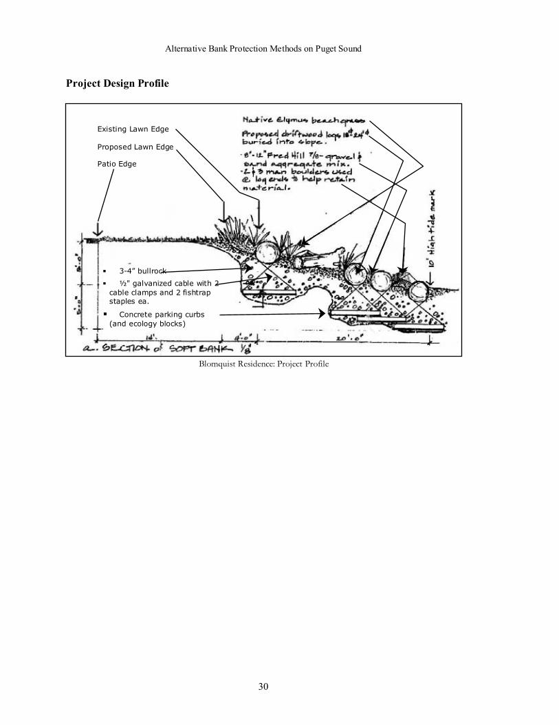
Project Design Profile
Existing Lawn Edge
Proposed Lawn Edge
Patio Edge
� 3-4” bullrock
� ½" galvanized cable with 2
cable clamps and 2 fishtrapstaples ea.
� Concrete parking curbs
(and ecology blocks)
Blomquist Residence: Project Profile

Blomquist Residence
31
Figure 1. View north toward mouth of Kinman Creek, prior to construction. Oneconcern was that waves reflecting off of bulkhead north of creek impacted theBlomquist beach.
Figure 2. Construction. Note minimal setback and broad gravelly beach.


Cormorant Cove
33
Cormorant Cove
Address: 3707 Beach Drive SW
Region: Alki Beach
Designer: Galloway & Barker
Contractor: Not Yet Built
Owner: Seattle Parks Dept.
Shoreline Type: Historic Beach
Project Type: Bulkhead redesign and relocation
Beach reconstruction
Wave Energy: High
Tides: MHHW: +11.40
Extreme High: +15.0Extreme Low: -4.5
Cost: $250,000 (projected)
Date Completed: Not yet built
Site History / Description
Cormorant Cove is a 1/3 acre site located on the west side of
Alki Beach. It has approximately 215 feet of marine
shoreline. There is a 5-9’ tall vertical rock bulkhead that runs
for 204’ from the north end of the site towards the south.
Below the bulkhead is a sandy beach with concrete rubble
strewn at the south end. Above the rockery there is a lawn
area that gently slopes from Beach Drive down to the top of
the rip-rap. The property is flanked by multi-family
residences to the north and south. The property to the north is protected by a vertical bulkhead while the
one to the south is a large condo complex built on pilings out over the water.
The Cormorant Cove project is a result of the citizens of Alki Beach, the Alki Community Council and
the Beach Drive Shoreline Parks Committee. Significant community involvement has gone into the
project at all levels. The site was purchased by the Seattle Parks Department in 1995 with funds from the
Shoreline Park Improvement Fund. Final permitting is pending and additional funds are being raised for
construction, which is hoped to occur in the summer of 2000.
Location: Cormorant Cove in PugetSound
Puget Sound
Seattle
Puget Sound
Location: Cormorant Cove on Alki Beach

Alternative Bank Protection Methods on Puget Sound
34
Project Description
The Cormorant Cove project will result in the creation of a perched, pocket beach by removing most of
the existing bulkhead, reestablishing the bankline landward of the existing bulkhead, and adding sand and
gravel to the regraded beach. The addition of a sloping, partially buried revetment along the bankline will
be added to prevent further toe erosion, and woody debris will be incorporated into the beach to add
stability and habitat structure. The bankline and uplands will be landscaped to include a path to the
beach, a narrow vegetative buffer at the top of the bank, and lawn and landscape plantings on the upland
portion of the site. A southern promontory will be maintained on the uplands as a view point and picnic
area.
The project will begin by removing all but the lowest tier of the existing vertical rock bulkhead. This last
level of rock, which is presently found below beach grade, will be left in place to act as a sill for the new
pocket beach. A new rip-rap revetment will be built up to 45’ landward of the present bulkhead. The
structure will be no more than 30” tall and the face will be angled at a minimum of 2H:1V.
Site Plan: Cormorant Cove
Relocated bulkhead –
not to exceed 30” in
height
Gravel beach resurfacing –
3/8” – 6”
First breakwater –
Remnant of existing
bulkhead
Cormorant Cove
35
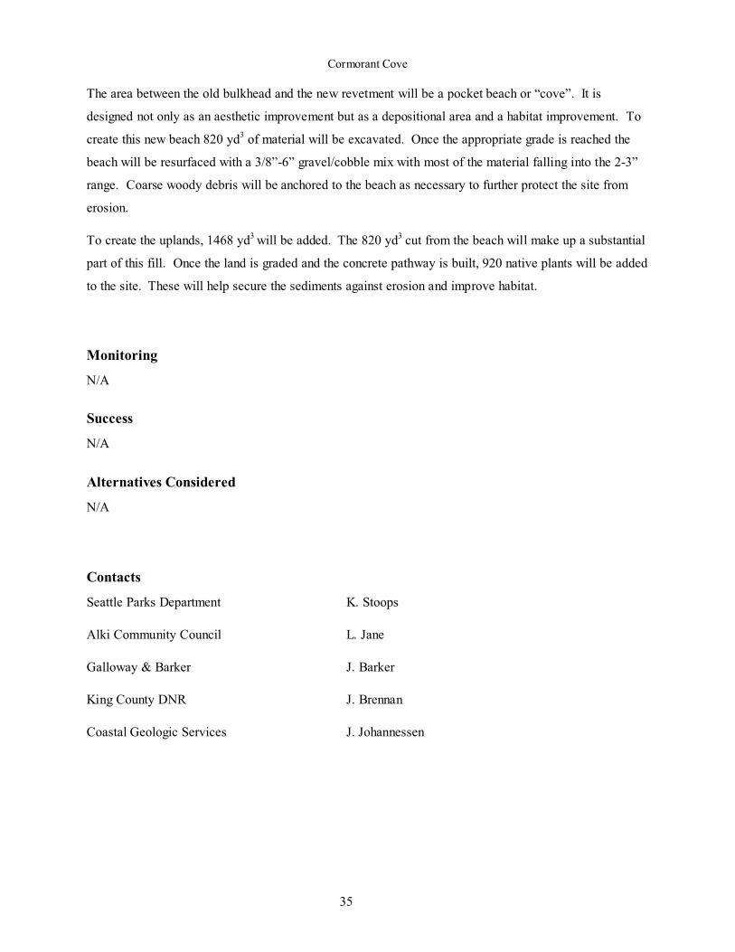
The area between the old bulkhead and the new revetment will be a pocket beach or “cove”. It is
designed not only as an aesthetic improvement but as a depositional area and a habitat improvement. To
create this new beach 820 yd3 of material will be excavated. Once the appropriate grade is reached the
beach will be resurfaced with a 3/8”-6” gravel/cobble mix with most of the material falling into the 2-3”
range. Coarse woody debris will be anchored to the beach as necessary to further protect the site from
erosion.
To create the uplands, 1468 yd3 will be added. The 820 yd3 cut from the beach will make up a substantial
part of this fill. Once the land is graded and the concrete pathway is built, 920 native plants will be added
to the site. These will help secure the sediments against erosion and improve habitat.
Monitoring
N/A
Success
N/A
Alternatives Considered
N/A
Contacts
Seattle Parks Department K. Stoops
Alki Community Council L. Jane
Galloway & Barker J. Barker
King County DNR J. Brennan
Coastal Geologic Services J. Johannessen

Alternative Bank Protection Methods on Puget Sound
36
Project Design Profiles
Typical Profile: North End.
Typical Profile: South End.
Rip-Rap Revetment: Three layer design with first breakwater
Cormorant Cove
37
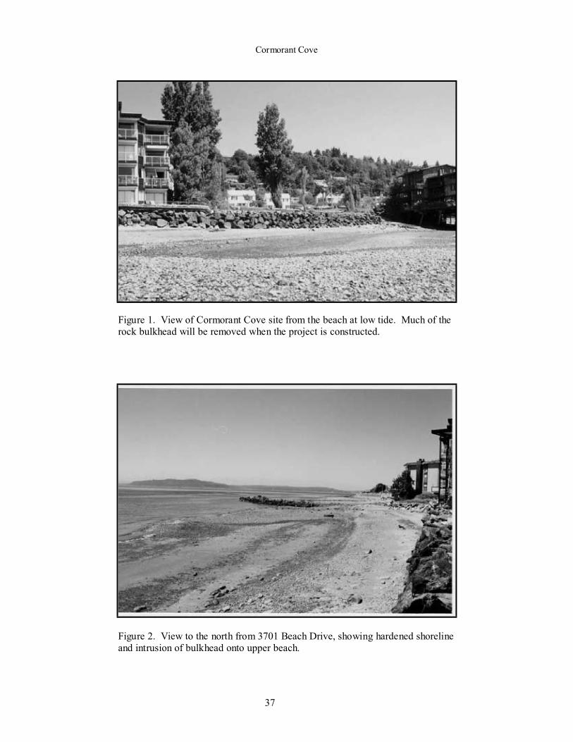
Figure 1. View of Cormorant Cove site from the beach at low tide. Much of therock bulkhead will be removed when the project is constructed.
Figure 2. View to the north from 3701 Beach Drive, showing hardened shorelineand intrusion of bulkhead onto upper beach.


Dick Residence
39
Dick residence
Address: Bergman Rd., Bainbridge Island
Region: NW side of Bainbridge Island, Manzanita Bay
Designer: Bart Berg Landscape
Contractor: Bart Berg Landscape
Owner: Lee & Elizabeth Dick
Shoreline Type: 14’ Bluff
Project Type: Fill undercut and add geotextile, spall,
logs and plants.
Wave Energy: Very Low
Tides: MHHW: +11.4
Extreme High: +15.5Extreme Low: -4.5
Cost: N/A
Date Completed: Summer 1998
Site History / Description
The Dick site runs for a total of 123’ along the shore of Little Manzanita Bay, on the northwest side of
Dick Residence: Bird’s Eye View of the Site.
Existing CarexSlump Area
Existing AlderMean High Water
Existing AlderExisting MadronaBank UndercutExisting Cedar
Edge of Soft Bank ProtectionExisting C.B.Existing StumpNew Drift Logs
Port
Orchard
BainbridgeIsland
Location: Dick Res. in Manzanita Bay

Alternative Bank Protection Methods on Puget Sound
40
Bainbridge Island. The steep, 14-foot bank is topped by several existing trees (cedar, madrone, and
alder). An existing riprap revetment, placed as an emergency action for bank failure on the adjacent
property several years earlier, lies to the north.
Prior to this project a short segment of the bank spanning the south property line was slumping and at
least two sections were being undercut by wave action. The property owner applied for a rock bulkhead,
but was persuaded by the Department of Fish and Wildlife to select a more environmentally sound
approach.
Project Description
The project was constructed in several stages. The undercut areas were protected with geotextile and
hand-packed 4-6 inch basalt quarry spalls. Bank protection was accomplished by burying and anchoring
logs into the beach. The beach and spalls were then capped with sand and gravel that slightly increased
beach slope and elevation. The logs helped retain the beach sediment. American dune grass (Elymus)
was planted to help stabilize the upper portion of the beach and the toe of the bank.
Where the bank had slumped onto the beach, existing vegetation was retained and the face of the
colluvium was lined with quarry spall and gravel to dissipate wave energy and reduce erosion. Finally, a
rock stair was added to provide the homeowner access to the beach.
Dick Residence: Project Proposal
Edge of Soft Bank Protection
Proposed Anchored DriftLogs
Bank Undercut Area
Little
Manzanita
Bay

Dick Residence
41
The project involved the placement of 70 cubic yards of mixed sand and gravel over approximately 70
lineal feet of shoreline.
Monitoring
There is no monitoring plan in place.
Success
The beach is quite natural in appearance and is protected sufficiently for the level of wave energy present.
The WDFW habitat biologist for the site was extremely pleased with the final result.
Alternatives Considered
N/A
Contacts
Washington Department of Fish and Wildlife: J. Brennan (now with King County DNR)
Bart Berg Landscaping: B. Berg

Alternative Bank Protection Methods on Puget Sound
42
Project Design Profile
Existing Cedar
New Drift LogElymus PlantingsGravel/Sand Mix
Existing Bank
Erosion Control Fabric2-3” Basalt Spall
Cable – 3/8”Deadman
Dick Residence: Project Profile

Dick Residence
43
Figure 1. The Dick residence is sited well back from the water and trees north ofthe house were left. The riprap bulkhead on the north end of the site was installedby neighbors as an emergency measure prior to construction of the Dick's home
(Photo: Jim Brennan).
Figure 2. The toe of the bank had been undercut prior to construction. Quarryspall was placed in undercut area and logs anchored into the beach. Anchor cablesare just visible.

Alternative Bank Protection Methods on Puget Sound
44
Figure 3. View southeast along beach shows anchored logs and added gravel.
Compare to Figure 4 below of property to the north.
Figure 4. Riprap bulkhead/revetment located on northern end of Dick propertyand neighboring property.

Driftwood Beach, Blakely Island
45
Driftwood Beach, Blakely Island
Address: Driftwood Beach, NE Blakely Island, WA
Region: West Shore of Rosario Strait,
San Juan Islands
Designer: Coastal Geologic Services, Inc., Bellingham
Contractor: JTC, Inc., Seattle
Owners: Blakely Island Maintenance Commission
Shoreline Type: Historic Barrier Berm
Project Type: Beach Nourishment
Wave Energy: Medium
Tides: MHHW: +8.2
Extreme High: +10.5-11.0
Extreme Low: -4.0
Cost: $90,000 + volunteer contributions.
($100/ft)
Date Completed: March 1999
Site History / Description
Driftwood Beach is located at the north end of Blakely
Island in San Juan County. The beach is 900 feet in
length. Six hundred feet are owned by BIMC while the
remaining 300 are divided between two individual
owners.
The site was historically a gravel barrier berm that fronted
a salt-water lagoon. The lagoon has been filled and is
now a grass field. The beach was originally mined for
road fill between 30 and 35 years ago. The beach was
partially filled ten to twenty years ago with stumps and
debris.
The wave energy at the site can be described as medium
to high for Puget Sound. This is especially true in the
winter months when severe northeast and southeast storm conditions are common.
Blakely IslandLocation: Driftwood Beach in Blakely Is.
Location: Blakely Island in San Juan Islands
Blakely Island
Rosario
Stra
ight
Orcas Island
Alternative Bank Protection Methods on Puget Sound
46
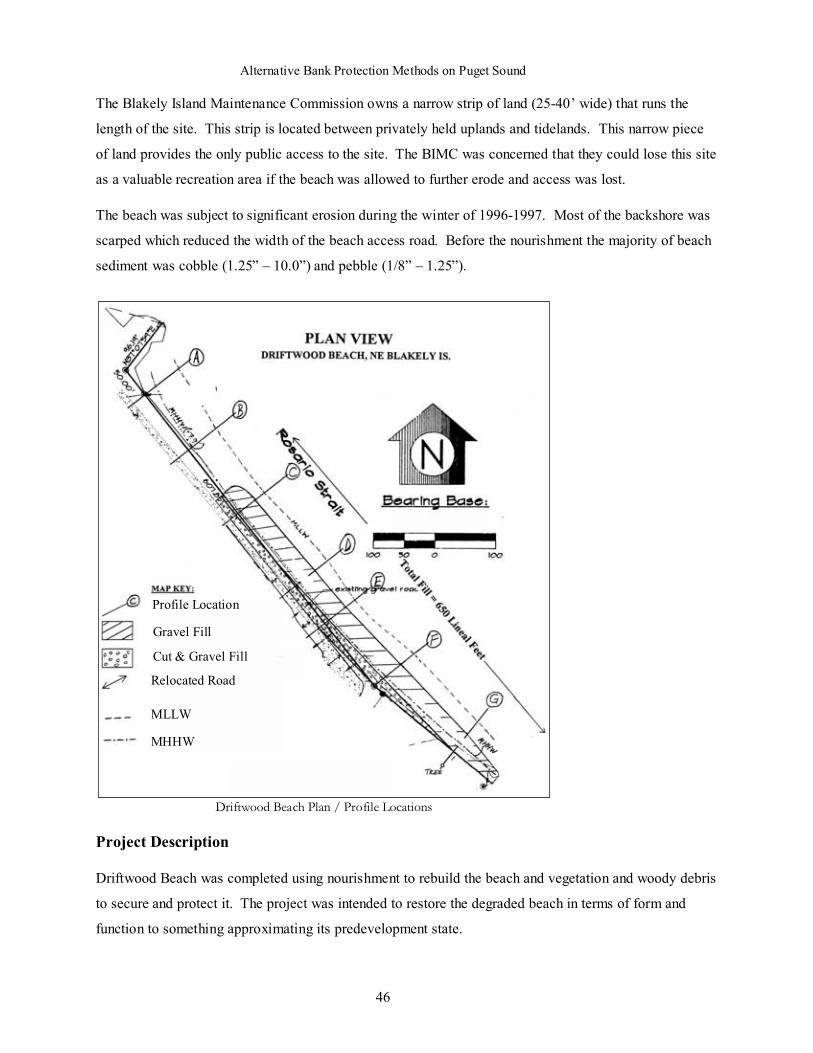
The Blakely Island Maintenance Commission owns a narrow strip of land (25-40’ wide) that runs the
length of the site. This strip is located between privately held uplands and tidelands. This narrow piece
of land provides the only public access to the site. The BIMC was concerned that they could lose this site
as a valuable recreation area if the beach was allowed to further erode and access was lost.
The beach was subject to significant erosion during the winter of 1996-1997. Most of the backshore was
scarped which reduced the width of the beach access road. Before the nourishment the majority of beach
sediment was cobble (1.25” – 10.0”) and pebble (1/8” – 1.25”).
Project Description
Driftwood Beach was completed using nourishment to rebuild the beach and vegetation and woody debris
to secure and protect it. The project was intended to restore the degraded beach in terms of form and
function to something approximating its predevelopment state.
Profile Location
Gravel Fill
Cut & Gravel Fill
Relocated Road
MLLW
MHHW
Driftwood Beach Plan / Profile Locations

Driftwood Beach, Blakely Island
47
Approximately 210 cubic yards of gravely, silty sand was cut from the waterward side of the existing
roadway and 1600 cubic yards of gravel were brought to the site by barge. These were added to the beach
and worked to create a berm and backshore area between 10 and 15 feet wide. The backshore was then
used to hold logs which in turn provided protection for vegetation (Salicornia and other salt tolerant
species). In addition the uplands were planted extensively with additional native species including
Douglas fir, shore pine, American dune grass, and ocean spray by community volunteers.
Monitoring
Both the profile and the sediments of the beach are being monitored yearly. This will occur for five years
in the month of June or July. The profile is measured along seven predetermined transects (see site plan).
Sediments are sampled at three elevations along transects B, D, & F (9 samples). This will:
• Provide information about changes in beach volume and sediment transport.
• Supply precise information about sediment size and composition along the site.
Coastal Geologic Services submitted the initial monitoring report to agencies in March, 2000, based on
surveys conducted in May and August of 1999. [Johannessen, J., 2000, 1999 Beach Monitoring Report
for Protective Berm-Beach, Driftwood Beach, Blakely Island Maintenance Commission, NE Blakely
Island, San Juan County, WA.]
Success
The project looks good. The construction had been completed for almost six month at the time photos for
this report were taken. However, the site has not passed through its first winter. The cobble was not
feathered into the beach at the ends as well as the designer had hoped and the site in general still needs to
be reworked. Winter storms should provide the energy to do both of these. Revegetation was carried out
promptly and with great diligence. The level of community involvement has been exceptional.
Alternatives Considered
In addition to nourishment, a rip rap revetment and no action were considered. There were problems with
both of these alternatives.
In this location a rip rap revetment, even if constructed of five foot rock, might not be stable. The beach
is pure sand and gravel and the rock would have been undermined. Failure would be likely in this
environment. A rip rap revetment would also increase erosion at the site. The hard surfaces would
increase turbulence at the base of the structure as well as increase reflected wave energy. Both of these
effects would combine to increase erosion and undermine the structure.

Alternative Bank Protection Methods on Puget Sound
48
No action would have allowed the continued, gradual erosion of the site. In other words, the problem
would have continued to worsen until something was done or the community beach access was lost.
Nourishment will increase the beach's capacity to absorb wave energy. It will create a "dynamic
revetment" that can shape itself to best dissipate incoming waves.
Contacts
Department of Fish and Wildlife: B. Williams
Department of Ecology: H. Shipman
United States Army Corp of Engineers: C. Quate
Blakely Island Maintenance Commission: L. Douglas
Coastal Geologic Services, Inc. J. Johannessen

Driftwood Beach, Blakely Island
49
Project Design Profiles: Transects C & F
Profile for Transect C
MHHW
Profile for Transect F

Alternative Bank Protection Methods on Puget Sound
50
Figure 1. Aerial view of Driftwood Beach. Upland revegetation and restorationextends entire length of beach, whereas beach nourishment was limited to areaindicated by arrows. Lawn area on right side of photo was marsh prior to filling
several decades ago.
Figure 2. Close up view of berm and backshore. Note coarse gravel berm anddrift logs. Also, a sandy berm has been created farther landward and planted withAmerican Beach Grass.

Driftwood Beach, Blakely Island
51
Figure 3. View north of completed gravel beach. Figure 4. View north showing gravel berm, drift logs,and vegetated backshore. Road has been relocatedlandward.
Figure 5. View north of project area prior to construction, showing erosionalscarp in old fill, damage to road, and riprap (Photo: provided by JimJohannessen, Coastal Geologic Services, and Blakely Island Maintenance
Commission).