boblme-2013-ecology-04boblme-2013-ecology-04 international union for conservation of nature...
TRANSCRIPT

BOBLME-2013-Ecology-04

The designations employed and the presentation of material in this publication do not imply the expression of any opinion whatsoever on the part of Food and Agriculture Organization of the United Nations concerning the legal and development status of any country, territory, city or area or of its authorities, or concerning the delimitation of its frontiers or boundaries. The BOBLME Project encourages the use of this report for study, research, news reporting, criticism or review. Selected passages, tables or diagrams may be reproduced for such purposes provided acknowledgment of the source is included. Major extracts or the entire document may not be reproduced by any process without the written permission of the BOBLME Project Regional Coordinator. BOBLME contract: LOAFAOBGD2012-008 For bibliographic purposes, please reference this publication as: BOBLME (2013) Marine Protected Areas in Bangladesh - a framework for establishment and management BOBLME-2013-Ecology-04

International Union for Conservation of Nature December, 2012
Marine Protected Areas in Bangladesh
a framework for establishment and management

LOA-FAO-BGD-2012-008
Marine Protected Areas in Bangladesh a framework for establishment and management
Submitted by
IUCN, International Union for Conservation of Nature Bangladesh Country Office
House 16, Road 2/3, Banani, Dhaka 1213 Phone: +8802 9890423, 9890395; Fax: +8802 9892854
Submitted to
Bay of Bengal large Marine Ecosystem (BOBLME) Project 77 Moo 7 Sakdidej Rd, Makham Bay, A.Muang Phuket 8300, Thailand
Phone: +66 76 391861; Fax: +66 76 391868
Of the
Food and Agriculture Organization (FAO) House 37, Road 8, Dhanmondi R/A, Dhaka 1205, Bangladesh
Research, Planning and Coordination Mohammad Shahad Mahabub Chowdhury
Technical Advisor
Professor Dr Md. Abul Hossain
Contributors Mizanur Rahman Saad Mahmood
Technical Reviewers
Dr Munir Hossain Dr Giasuddin Khan
Editor
Dr Istiak Sobhan
Institutional Advisor Ishtiaq Uddin Ahmad
December, 2012

Marine Protected Areas in Bangladesh - a framework for establishment and management
i
Executive summary This framework report is prepared by IUCN Bangladesh Country Office based on findings, discussions and suggestions from six regional workshops, six focus group discussions, various interviews of key informants at both regional and national level, two national level stakeholder consultation workshops (inception, where policy analysis was presented; and final national workshop where this document was validated together with other issues) and analysis of existing policies and documents on PA and MPA at home and elsewhere. The project was implemented in collaboration with the Bay of Bengal large Marine Ecosystem (BOBLME) Project of FAO from April-December 2012. Relevant ministries (MoFL and MoEF), their agencies (DoF, Bangladesh Fisheries Research Institute (BFRI) and FD), other concerned Government organisations (Navy, Coast Guard, DoE, NORI and Universities), local administration and civil society have been engaged in the preparation of this document. In addition to this framework report, IUCN has prepared three other documents with respect to Policy gap analysis (BOBLME-2013-Governance-06), Stakeholders analysis (Appendix IV) and Review of secondary literature (Appendix V), which are also part of this report.
The document is based on an analysis of the Bay of Bengal (BOB) basin, coastal configurations, ecosystem, habitats, and foreseen socio-economic and ecological benefits that may originate from the protection of Ecologically Critical Areas (ECA) and probable MPA declarations. Analysis was also done on current status and management of marine fisheries. Characteristics of coastal communities related to the protection and conservation of fragile natural habitat and resources, their organisations, livelihood dependency on marine resources, conservation initiatives, partnerships needed for MPA under public - private initiatives, coastal industries, land and sea based pollution sources, marine resources related knowledge gaps and probable international cooperation as part of the preliminary requirements for MPA initiatives are also discussed. Therefore, while formulating the document attempts were made to incorporate reviewed scientific findings on the BOB, information and knowledge gaps on marine ecosystem and its contents, marine resource use capabilities, abusive exploitation, pollution and socio-economic aspects of coastal inhabitants and other related matters.
Although the list of biotic entities in the Exclusive Economic Zone (EEZ) of Bangladesh is long, it is incomplete for many groups of organisms and needs further exploration. An initial attempt was made to discuss current status of renewable marine resources that are known to be commercially harvested or accidentally caught during commercial exploitations. Such groups include fish, shrimp and other crustaceans, molluscs, marine reptiles, sea birds, cetaceans and seaweeds. Their current status, within and between groups diversity and threats of extinction due to anthropogenic interventions and activities are discussed. This is important as probable protective measures under planned MPA initiatives could be undertaken in future based on available information complied now. Human activities including overexploitation are the main threats for many commercial and some non-commercial species. These also include species accidentally caught, destroyed and/or abused.
There is a reasonably good number of documents available on marine and estuarine fisheries, coastal zone and environment management, climate change, biodiversity and related matters. However, very few reports or data related to MPAs are found. Consequently, attempts were made to study and review existing documents on the Bay of Bengal with special emphasis on Bangladesh and its EEZ. Searches were made to accumulate documents from online sources on MPA related literature to understand how other countries are formulating or have formulated frameworks on MPAs or outlined steps needed to do so and to work out roadmaps and courses of actions for future MPAs in Bangladesh in line with BOBLME initiatives. It is factual to state that a preliminary outline sketching steps and actions needed to prepare a framework for MPAs itself is only the first step in the right direction and still a long way to go to demarcate, designate, declare and implement MPAs

Marine Protected Areas in Bangladesh - a framework for establishment and management
ii
in a sea area where so many stakeholders depend on its resources for their livelihoods. Nonetheless, a framework mostly prepared based on opinion of grass-root level stakeholders and some key informants (those who often have conflicting interests) may be considered as a loop inside which future expanded attempts may be taken under real world situations.
Under the prevailing situation mentioned above, attempts were made to outline an immediate course of action based on experiences of other countries, how they have done it or are trying to accomplish the establishment of MPAs. Replicating the processes taken by others, however, might not serve the purpose. Therefore, attempts were made to consider all the diverse elements while formulating the framework to be used under Bangladesh conditions. IUCN guidelines for protected areas and FAO Guidelines for “Marine protected areas and fisheries” can be followed during implementation of the proposed framework as guiding principle following the steps detailed out in Chapter 3.
The fisheries, marine fisheries and allied policies are needed to be amended so that it could be clear-cut and all-inclusive policy documents. Since, in the existing framework there is no specific marine environmental and/or ecosystem based policy, attempt should be taken to formulate a wide ranging policy documents with a provision for routine review and follow-ups. The modified marine policy papers need to be broadened to incorporate all necessary elements, reflecting sustainability based on long term perspectives and wider national marine development policy and planning framework. Declaration of MPAs can be done either jointly or independently by the Ministry of Fisheries and Livestock and Ministry of Environment and Forests. There should be a national committee for MPA declaration, possibly headed by Ministry of Fisheries and Livestock. Also, there should be regional committees to advise the National Committee. The Marine Fisheries Ordinance, 1983 although not incorporating provisions for the establishment of MPAs, has provision for protecting marine habitats and resources. Under these provisions the concept of MPA could be accommodated. However, designation of newly created MPAs will not be a problem as Bangladesh’ government is committed to establish MPAs in its EEZ. If such provisions are missing or weak in the ordinance, the rules may be derived from the existing Marine Fisheries Ordinance 1983 or by amending it. The designation process on MPA may proceed alongside the MPA management planning.
It may be mentioned that the general framework will be a broad outline, but individual MPAs should have their own specific guideline and pathway. To establish an individual MPA, following steps can form the framework:
Step 1: Identification of Area of Significance (AOS)
Step 2: Initial sieving of preliminary selected AOS
Step 3: AOS validation, assessments and suggestions
Step 4: Formulation of a Management Plan for a Candidate MPA Site
Step 5: Designation or titling of MPA
Step 6: Guidelines for management of MPA within a framework
Step 7: Declaration of MPA
Step 8: Code of Conducts (COC) for specialized MPA
Based on opinions and suggestions of grass-root level stakeholders from coastal regions as well as key-informants from governmental and non-governmental organisations and civic society members, a number of coastal interfaces, off-shore islands and open sea areas are suggested to be incorporated as future MPAs. The suggested sites with their inherent merits and demerits, human interference on its natural character, ecosystem, biodiversity and other relevant and related matters are also discussed for considerations as a MPA candidate. Roughly 70 odd sites are identified or suggested as probable MPAs, however, most are not well demarcated, and only longitude and

Marine Protected Areas in Bangladesh - a framework for establishment and management
iii
latitude are figured-out. All suggested places do not carry equal importance; hence, initially suggested sites are differentiated into 4 categories; Area of significance (AOS), Area of Interest (AOI); Area of Curiosity (AOC), and Area of Mind (AOM). But almost all proposed sites for future MPA incidentally are either in coastal areas and/or in territorial waters as those who participated in these workshops and FGDs were not very familiar with the high sea part of the EEZ.
Therefore, in the final workshop it was decided that among the proposed sites a few would be taken into consideration for MPA as pilot sites for the immediate future and based on outcome of pilot initiatives broader approaches will be taken afterward. A total of 14 sites were identified as AOS which again could be summarized mainly into four broad sites to be declared as MPAs. Those are: St Martin Island and its adjacent water area (approx. 100 sq. km), Nijum Dwip Island and its adjacent water area (approx. 300 sq. km), Marine Reserve area declared by DoF (approx. 5000 sq. km), and Sundarbans and its water territory. The workshop also came up with the following recommendations that are meant to be taken into consideration during implementation of this framework:
• Implementation of MPAs will need successful partnership and should assume responsibility of concerned public and private partners.
• A national approach is needed in detail on how Department of Fisheries and Department of Environment will work together with other departments and agencies.
• Declaration of an MPA can be done either jointly or independently by the Ministry of Fisheries and Livestock and Ministry of Environment and Forests. There should be a national committee for MPA declaration, possibly headed by Ministry of Fisheries and Livestock.
• Cooperative agreements and joint planning exercises between Bangladesh and her BOB neighbours are very important.
• Existing fisheries, marine fisheries and allied policies are needed to be amended so that those could be “clear-cut” or “all-inclusive” policy documents in support to the establishment of MPAs.
• The Marine Fisheries Ordinance, 1983 of Bangladesh though directly not incorporatingprovisions for the establishment of MPAs, has provisions for protecting marine habitats and resources. Under these provisions the concept of MPA could be accommodated.
• The designation process on MPAs can proceed alongside MPA management planning • Monitoring is vital for any programme of implementation; therefore it is essential to
establish an M&E system to conclude whether the objectives of a given MPA have been successfully achieved.
The indifferent attitude towards conservation of marine ecosystem and biodiversity, irrational and unsustainable resource utilization and abusive harvest of some commercial species, obnoxious overuse of some of the ECA has made designation of MPAs urgent, and their speedy implementation in Bangladesh with a commitment to protect the marine environment and ecosystem. To maintain international obligation, especially in the post Nagoya scenario, it has become highly essential to take initiatives to declare 10% of the sea area as MPAs by 2020.

Marine Protected Areas in Bangladesh - a framework for establishment and management
iv
Table of contents
1. Background ..................................................................................................................................... 1
1.1. Bay of Bengal........................................................................................................................... 1
1.2. Coastal area of Bangladesh ..................................................................................................... 1
1.3. Marine fisheries capability of Bangladesh .............................................................................. 2
1.4. Destructive fishing .................................................................................................................. 2
1.5. Marine pollution ..................................................................................................................... 2
1.6. Knowledge gap on the sea and its contents ........................................................................... 2
1.7. Joint initiative by BOBLME and IUCN to draft an MPA framework ........................................ 4
1.8. Purpose of this framework report .......................................................................................... 5
1.9. Framework development process .......................................................................................... 5
2. Concept of MPA in Bangladesh: Its status, potential and challenges ............................................. 6
2.1. Importance and benefits of MPA ............................................................................................ 7
2.2. Economic value of the MPA .................................................................................................... 7
2.3. History and current status of MPAs in Bangladesh ................................................................ 9
2.4. MPA legislation in Bangladesh .............................................................................................. 10
2.5. MPA governance in Bangladesh ........................................................................................... 10
2.6. Current management of marine fisheries & scope ............................................................... 11
2.7. Threats and challenges ......................................................................................................... 12
2.7.1. Governance and management challenges .................................................................... 12
2.7.2. Other local and transboundary threats ........................................................................ 13
2.8. Socio-economic considerations and perceptions of MPAs ................................................... 13
2.9. Effectiveness of MPAs ........................................................................................................... 14
2.10. Studies necessary to implement MPA .............................................................................. 15
2.11. Necessity for effective partnership ................................................................................... 15
2.12. Coastal communities and livelihoods ............................................................................... 16
2.13. Conservation organisations .............................................................................................. 16
2.14. Fishing and aquaculture interests ..................................................................................... 16
2.15. Coastal communities and organisations ........................................................................... 17
2.16. Sea and ocean industries .................................................................................................. 17
2.17. Coastal districts and municipal government agencies ...................................................... 18
2.18. Government ministries and field agencies ....................................................................... 18
2.19. International cooperation on MPA ................................................................................... 18
2.20. Information gap on knowledge base ................................................................................ 19
3. Framework to establish Marine Protected Areas in Bangladesh.................................................. 20
3.1. Framework to establish and manage individual MPA & MPAs and its steps ....................... 20

Marine Protected Areas in Bangladesh - a framework for establishment and management
v
3.1.1. Step 1: Identification of Areas of Significance (AOSs) ................................................... 21
3.1.2. Step 2: Initial sieving of preliminary selected AOSs ...................................................... 23
3.1.3. Step 3. AOSs validation, assessment and suggestions .................................................. 25
3.1.4. Step 4: Formulation of a management plan for a candidate MPA Site ........................ 29
3.1.5. Step 5: Designation or titling of an MPA ....................................................................... 33
3.1.6. Step 6: Guidelines of management of MPAs within a framework................................ 34
3.1.7. Step 7: Declaration of MPAs ......................................................................................... 35
3.1.8. Step 8. Code of Conduct (COC) for specialized MPAs ................................................... 36
3.2. Selection, designation and management of MPA under emergency situation .................... 36
3.2.1. Purpose ......................................................................................................................... 36
3.2.2. Limits on provisional or emergency MPA designation ................................................. 36
3.3. Community awareness and learning on MPAs ..................................................................... 37
3.4. Education-by-hands-on training and awareness building .................................................... 37
4. Proposed MPA sites ...................................................................................................................... 37
5. References .................................................................................................................................... 51
Renewable and non-renewable marine resources ....................................................... 54 Appendix I
1. Fishes............................................................................................................................................. 55
1.1. Fish resources ....................................................................................................................... 55
1.2. Fish diversity ......................................................................................................................... 55
1.3. Fish species under threat of extinction currently or in long run4 ......................................... 57
2. Crustacean .................................................................................................................................... 58
2.1. Shrimps and shrimp like creatures4b ..................................................................................... 59
2.2. Mantis shrimp ....................................................................................................................... 59
2.3. Mantis shrimp diversity ........................................................................................................ 59
2.4. Mantis species under threat of extinction immediately or in long run ................................ 59
2.5. Shrimps4b ............................................................................................................................... 59
2.6. Shrimps diversity4b ................................................................................................................ 60
2.7. Shrimp species under threat of extinction immediately or in long run ................................ 60
2.8. Lobster4b ................................................................................................................................ 60
2.9. Lobster diversity .................................................................................................................... 61
2.10. Lobster species under threat of extinction immediately or in long run ........................... 61
2.11. Hermit crabs4b ................................................................................................................... 61
2.12. Hermit crabs diversity ....................................................................................................... 61
2.13. Hermit crabs species under threat of extinction immediately or in long run .................. 61
2.14. Crabs4b ............................................................................................................................... 62
2.15. Crabs diversity ................................................................................................................... 62
2.16. Crabs species under threat of extinction immediately or in long run .............................. 62

Marine Protected Areas in Bangladesh - a framework for establishment and management
vi
3. Mollusks4c ...................................................................................................................................... 62
3.1. Molluscan diversity ............................................................................................................... 63
3.2. Molluscan species under Threat of extinction immediately or in long run .......................... 63
4. Cephalopods4c ............................................................................................................................... 64
4.1. Cephalopods diversity ........................................................................................................... 64
4.2. Cephalopods species under threat of extinction now or in long run ................................... 64
5. Marine reptiles4d ........................................................................................................................... 64
5.1. Marine reptiles diversity ....................................................................................................... 64
5.2. Marine reptiles species under threat of extinction immediately or in long run .................. 65
6. Marine birds4e ............................................................................................................................... 66
6.1. Marine birds diversity ........................................................................................................... 66
6.2. Marine birds species under threat of extinction now or in long run .................................... 66
7. Cetaceans (Marine mammals) 4f.................................................................................................... 67
7.1. Marine mammals diversity ................................................................................................... 68
7.2. Marine mammals’ species under threat of extinction now or in long run ........................... 68
8. Marine algae and seaweeds4g ....................................................................................................... 68
8.1. Algae and seaweeds diversity ............................................................................................... 68
8.2. Algae and weed species under threat of extinction now or in long run ............................... 68
9. Non-renewable marine resources ................................................................................................ 69
9.1. From sea bottom ................................................................................................................... 69
9.2. Beneath sea bottom.............................................................................................................. 69
Existing coastal and sea based PA, ESA or Fishing Ban ............................................... 70 Appendix II
Policy gap analysis (separate document) .................................................................... 74 Appendix III
Summary report on the stakeholder consultation and consensus building Appendix IVworkshops ................................................................................................................... 76
1. Preface .......................................................................................................................................... 77
2. Objectives...................................................................................................................................... 77
3. First regional workshop at noakhali: ............................................................................................. 77
4. Second regional workshop at Chandpur: ...................................................................................... 78
5. Third regional workshop at Patuakhali: ........................................................................................ 79
6. Fourth regional workshop/meeting at Khulna: ............................................................................ 81
7. The fifth regional workshop/meeting at Chittagong .................................................................... 83
8. The sixth regional workshop/meeting at Cox’s Bazar ................................................................... 85
Review of secondary literature ..................................................................................... 88 Appendix V
1. In Bangladesh - acts, policies and ordinances ............................................................................ 89
2. History and current status of MPAs in bangladesh .................................................................... 95
2.1. MPA Legislation in Bangladesh ............................................................................................. 96
2.2. MPA Governance in Bangladesh ........................................................................................... 97

Marine Protected Areas in Bangladesh - a framework for establishment and management
vii
2.3. Threats and challenges ......................................................................................................... 98
2.4. Coverage ............................................................................................................................... 98
2.5. Governance and management challenges............................................................................ 98
2.6. Other local and transboundary threats ................................................................................ 99
3. Socio-economic considerations and perceptions of MPAs ...................................................... 100
4. Effectiveness of MPAs .............................................................................................................. 101
4.1. Bottom topography ............................................................................................................. 101
4.2. Swatch of no ground ........................................................................................................... 102
4.3. Sunda Trench ...................................................................................................................... 102
4.4. Ninety East Ridge ................................................................................................................ 102
4.5. Eighty-five Ridge ................................................................................................................. 102
5. Biological characteristics .......................................................................................................... 102
6. Pollution .................................................................................................................................... 103
7. Coastal and marine ecosystem ................................................................................................. 103
8. The occurrence of coastal and marine species ......................................................................... 104
9. Geomorphological structure of the coastal and marine environment of bangladesh ............. 104
9.1. Three distinct geo-morphological regions .......................................................................... 105
9.1.1. The Western Region .................................................................................................... 105
9.1.2. The Central Region ...................................................................................................... 105
9.1.3. The Eastern Region ..................................................................................................... 105
10. Hydrometeorology of the marine environment ....................................................................... 105
10.1. The Southwest Monsoon: ............................................................................................... 106
10.2. The Northeast Monsoon: ................................................................................................ 106
10.3. Salinity ............................................................................................................................. 106
10.4. Air Temperature: ............................................................................................................. 106
10.5. Water temperature: ........................................................................................................ 106
10.6. Rainfall ............................................................................................................................ 106
10.7. Tides and waves: ............................................................................................................. 106
10.8. Current ............................................................................................................................ 107
10.9. Dissolved oxygen and pH: ............................................................................................... 107
11. Nutrients and plankton biomass: ............................................................................................. 107
12. Status of marine fishery resources and the marine environment of the BOB, Bangladesh at a glance: ....................................................................................................................................... 107
12.1. Area and structure: ......................................................................................................... 107
12.2. Fishing grounds and establishing of fish sanctuaries: ..................................................... 108
12.2.1. South patches.............................................................................................................. 108
12.2.2. South of south patches ............................................................................................... 108
12.2.3. Middle ground ............................................................................................................. 108

Marine Protected Areas in Bangladesh - a framework for establishment and management
viii
12.2.4. Swatch of no ground ................................................................................................... 108
12.3. Major fishery resources: ................................................................................................. 108
12.3.1. Standing stock: ............................................................................................................ 108
12.3.2. Landing of fish ............................................................................................................. 109
12.4. Marine fishery resources of Bangladesh and its potentiality: ........................................ 109
12.4.1. Species composition: .................................................................................................. 109
12.4.2. Demersal resources: ................................................................................................... 110
12.4.3. Pelagic Resources ........................................................................................................ 110
12.4.4. Demersal Fin fishes ..................................................................................................... 111
12.5. Exploitation of marine fisheries resources ..................................................................... 111
12.5.1. The industrial fishery................................................................................................... 111
12.5.2. Artisanal fishery .......................................................................................................... 111
12.5.3. Gears used................................................................................................................... 112
12.6. Turtle breeding ground ................................................................................................... 112
12.7. Dolphin ............................................................................................................................ 112
13. Elsewhere other than Bangladesh ............................................................................................ 113
14. References 1 ............................................................................................................................. 120
15. References 2 ............................................................................................................................. 123
Annex I The main objectives of the nishorgo support project are .............................................. 127
Annex II Protected area for in-situ conservation under the management of forest department 128
Annex III List of ecologically critical areas of Bangladesh .............................................................. 129
Annex IV Threats to biodiversity .................................................................................................... 130
Annex V Bangladesh: One of the most climates vulnerable Countries ......................................... 132
Annex VI Government ministries and agencies involved in responding to climate change .......... 133
Annex VII The main principles in ICZM approach would include: ................................................... 134
Annex VIII Sustainable management of natural resources ............................................................. 135
Annex IX Conservation and enhancement of critical ecosystems ................................................. 138
Annex X Declaration of Ecologically Critical Area ......................................................................... 140
Annex XI Declaration of sanctuary ................................................................................................. 141
Annex XII Types of protected areas in the coastal zone in Bangladesh and corresponding legislation ........................................................................................................................................ 142
Annex XIII Extent of EEZ and depth Distribution of the continental shelf of Bangladesh ............... 143
Annex XIV Fishing grounds in Bay of Bengal in BD EEZ .................................................................... 144
Annex XV Fishing ground of EEZ of Bangladesh .............................................................................. 145
Annex XVI Standing stock (MT) of demersal fish and shrimp of the Bay of Bengal. ....................... 146
Annex XVII Year-wise marine fish production (Mt.) of Bangladesh, 1991-1992 to 2000-2001. ....... 147
Annex XVIII Distribution of fish (%) in different depth strata of the Bay of Bengal, Bangladesh. ..... 148
Annex XIX Shrimps (penaeid) .......................................................................................................... 149

Marine Protected Areas in Bangladesh - a framework for establishment and management
ix
Annex XX Prawns (carideans) ................................................................................................. 150
Annex XXI Lobsters .................................................................................................................. 151
Annex XXII Crabs ....................................................................................................................... 152
Annex XXIII Cephalopods ........................................................................................................... 153
Annex XXIV Turtles ..................................................................................................................... 154
Annex XXV Anchovies, sardines and herrings ........................................................................... 155
Annex XXVI Carangids ................................................................................................................ 156
Annex XXVII Demersal fin fishes ................................................................................................. 157
Annex XXVIII Tunas and mackerels ............................................................................................... 158
Annex XXIX The most commercial or abundant species of sharks, skates and rays.................. 159
Annex XXX Characteristics of shrimp and fish trawlers operating in offshore trawling ground ................................................................................................................................ 160
Annex XXXI Fishing gear used in the coast/marine water in Bangladesh with target species and depth of operation.................................................................................................. 161
Annex XXXII Turtle breeding ground ........................................................................................... 162
Annex XXXIII Estimated water bodies and forest areas in Bangladesh ........................................ 163
Annex XXXIV List of Wildlife Sanctuaries (WS), National Parks (NP), and Game Reserves (GR) in Bangladesh .............................................................................................................. 164
Annex XXXV Flora and fauna recorded in Bangladesh ................................................................ 165
Annex XXXVI Wetlands areas by types ......................................................................................... 166
Annex XXXVII Protected areas ....................................................................................................... 167
Annex XXXVIII Categories and criteria used to select IBAs at the global level. Sites may qualify for multiple categories and criteria .............................................................................. 169
Annex XXXIX Type of marine IBA Bird Life Region ........................................................................ 170
Annex XL Category of protected areas ................................................................................... 171
Annex XLI Examples of sacred sites in IUCN categories .......................................................... 172
Annex XLII Marine Protected Areas – key lessons learnt ......................................................... 174
Annex XLIII Guiding principles for MPA ..................................................................................... 175
Annex XLIV The detail number of Marine species and their percentages ................................ 177
Proposal for next phase (outline only) ................................................................... 179 Appendix VI

Marine Protected Areas in Bangladesh - a framework for establishment and management
x

Marine Protected Areas in Bangladesh - a framework for establishment and management
1
1. Background
1.1. Bay of Bengal The Bay of Bengal is one of the world’s 64 Large Marine Ecosystems (LMEs). The Bay is located at the mouths of the three largest rivers in the Asian continent that drains huge amount of monsoon water. There are eight countries surrounding the Bay from north, east and west. The southern part is connected with the Indian Ocean. The eight countries are Bangladesh, India, Indonesia, Malaysia, Maldives, Myanmar, Sri Lanka and Thailand. The BOB countries are heavily populated; relatively poor economically and significantly dependent on the Bay and its resources for livelihoods. Understandably, because of lack of modern equipment and harvesting gears, the coastal dwellers of BOB countries overexploit in-shore coastal seas and probably underexploit open off-shore sea resources. Roughly 1.6 to 1.7 billon, constituting roughly 25% of the world population, people live in the eight countries.
Approximately 400 million live in the Bay’s catchment area, many subsisting at or below the poverty level. As mentioned earlier, the Bay is one of the large marine ecosystem and harbours coast lines of a total of eight countries in the region. Therefore, management of non-renewable resources in respective EEZ of each country is not an issue; so long the extractions methods follow responsible methods and create minimum pollution. However, the management accountability of all exploitable living and renewable resources and its habitats is not only the responsibility of a single country, but it should be a collective responsibility for all the neighbouring countries. The eight countries including Bangladesh have already realized the importance of cooperation and they are now working closer for sustainable management of the fisheries resources of the BOB and its large marine ecosystem.
The main problem is over exploitation of certain species and fishing communities face unsustainable harvesting of renewable resources. Besides, the coastal region and territorial waters are overexploited by artisanal fishers. They cannot go to deeper water due to the lack of engine power, inefficient fishing gears and lack of sufficient cooling system on board. Besides, open access to marine resources creates conflicts between professional fishers and others. Many of the fishery resources in the member countries of BOB, especially those harvested by small scale fishing in coastal areas are already heavily exploited; and these artisanal fisheriesneed to be brought under regulations for their sustainability. Otherwise unregulated fishing will turn the situation worse with adverse impacts on the large number of small-scale fishers dependent on these resources for their livelihoods and as a source of food security.
1.2. Coastal areas of Bangladesh The coastal areas in Bangladesh are less developed, disaster prone, and inhabited by poorr people, but have good access to marine and mangrove related natural resources. The rates of landless farmers in coastal areas are higher than in rest of the country. Besides, the coastal lands are relatively less productive due to salinity and in most areas a single field crop is harvested. The socio-economic condition of the fisher community of Bangladesh’ coastal areas is poor and unsustainable exploitation of fish by over fishing has decreased catch per unit efforts. Further, Bangladesh does not have adequate capacity to exploit deep sea fishing but illegal intrusions of foreign fishing fleets in Bangladesh’ EEZ are often reported. Bangladesh has a few large scale fishing vessels and instead of fishing in deeper seas they fish on the continental shelves within 40 m depth, which is supposed to be for artisanal fishing. This situation has increased antagonism and divergence between artisanal and large-scale fishing. Further, the bottom trawling (both finfish and shrimp) industrial fishing vessels undertake destructive fishing as these vessels destroy the coral beds and the benthic faunal community. Huge numbers of artisanal fishing boats continue the degradation of highly productive estuarine, coastal, mangrove and near shore marine habitats, migratory routes,

Marine Protected Areas in Bangladesh - a framework for establishment and management
2
vital fish spawning and nursery grounds. Irresponsible and abusive fishing practices are expected to lead to further decline marine landings, if corrective measures are not taken.
1.3. Marine fisheries capability of Bangladesh World fisheries are predominantly salt water based and food habits are adapted to marine fish, while Bangladesh fisheries mainly are fresh water and the nation as a whole has hardly any marine fish on the table. Fish produced in the country mainly comes from wild open fresh water sources and fresh water based aquaculture. This is one of the reasons why the authorities have not paid attention to the development of marine fisheries and marine fisheries have not developed n the same pace as fresh water fisheries.
The marine fisheries sub-sector has an estimated 22,500 non-mechanized, 21,400 mechanized fishing boats and more than 100 licensed industrial trawlers. Over 200,000 fishers and support staffs are employed in the sector. The sector earns foreign exchange through export of various marine products including shrimp, frozen, dried and salted fish and shark fins. Increase exploitation with high fishing efforts is the present trend of marine fishing in Bangladesh. There had been a 258% increase in fishing effort since the start of the mechanized fishing in 1975-764. The sector provides much needed animal protein to masses, earns foreign exchange through export of various marine products including shrimp, frozen, dried and salted fish and shark fins.
1.4. Destructive fishing Estuarine set bag-nets operate in large numbers in river mouths and estuaries and catch fry and juveniles of marine species, resulting in restriction of growth of commercially important species. Decline in Catch Per Unit Effort (CPUE) for motorized boats using large meshed gill nets has also been noticed. Shrimp trawlers are also experiencing declining CPUE and are currently concentrating in shallow waters in conflict with artisanal boats. Thee management of marine fisheries is highly focused on activities of the industrial trawl sector. There is no management and monitoring of the artisanal sector which operates from coastal areas, where fishing pressure increases alarmingly.
1.5. Marine pollution Bangladesh has not so many industries, but sea-based sources of pollution include oil spell outs, ship breaking debris, and offshore oil and gas exploration. Other concerns on marine fisheries include land conversion and reclamation, over-exploitation, sedimentation by river flows, sand washout towards sea during monsoon, city pollution towards sea by river flow, disparaging tourism, and shipping discards at sea. There are also the potential adverse impacts related to the future development of seabed minerals.
The cumulative effects of land based and sea based pollution are causing disruption of basic processes and functioning of the marine ecosystem. These include dilapidation and loss of fish habitat, breeding, spawning and nursery areas, may cause fish kills and possible changes of marine tropic structure. The fate and effect of pollutants have been studied extensively elsewhere but under Bangladesh condition studies are negligible. The immediate effect of land based and sea based pollution is growing evidence that supports that most of the pollutants are indeed deposited in estuarine and coastal sediments, while a smaller portion may flush out to deeper waters. We are not yet quite sure what is the pollution assimilating capacity of the ecosystem, though some argues that that the ecosystem's assimilative capacity as a whole has not been exceeded and that pollution problems are localized in nature. This may be true to some extent on land based pollution sources, but sea based pollution may not be localized.
1.6. Knowledge gap on the sea and its contents Bangladeshis are known to be skilled sailors and people from greater Chittagong, Noakhali and Barisal, three greater coastal districts have traditionally roamed the seas of the world working for

Marine Protected Areas in Bangladesh - a framework for establishment and management
3
many shipping companies of developed countries. Despite the long history of sea travels unfortunately, our knowledge and information on our backyard sea is scanty, there are many unknown elements, many uncertainties, many undiscovered species, habitats, breeding, feeding, nursing and migratory grounds and routes, ecosystem and environmental and biological, hydro biological functioning. An analysis of existing information of the marine resources are given in the Annex 1.
There are a number of institutions in the region supposed to gather data and information on the sea and its resources. Bangladesh has a few of these institutions, but unfortunately they are not been able to work properly; none of them appear to have the authority, capacity, organizational strength and scope to support an initiative based on a Large Marine Ecosystem or Marine Protected Area based approach. Simply we are not clear about common issues and barrier characteristic of the Bay of Bengal its biological and other important aspects, though recently the Bangladesh Navy has taken initiatives to explore the bottom characteristics of the EEZ. This is one step forward.
The Bay of Bengal Program (BOBP) in the past has done some studies for the management of marine resources, but the information related to BOBP cannot resolve the aforementioned issues in isolation. What is needed is to build on past information, knowledge and experiences of the existing institutions and professionals to maintain the synergies of information exchange of information and data related to estuarine, coastal and marine habitat, ecosystem and fisheries related issues, to accomplish any important long-lasting impact. Some institutional mechanism needs to be developed and we must know who is maintaining the records, continuously updating the information and who is generating the new knowledge and information. It is important to evaluate the gaps of knowledge which become impediments to progress in work on the MPA establishments.
The ongoing Bay of Bengal based Project, the BOBLME (Bay of Bengal Marine Large Ecosystem), give emphasis to the health, well-being and livelihoods of the millions of people living in the BOBLME region and tries to address their problems..
The BOBP was active for long and was conducting long and medium term regional fisheries programs. Therefore, the BOBP has done significant works in collaboration with Bangladesh, India, Indonesia, Malaysia, Maldives, Sri Lanka and Thailand as active partners and Myanmar as observer. Initially BOBP focused mainly to improve the socio-economic conditions of the coastal dwelling small-scale fishers. Their focuses were mainly to develop and promote latest and pioneering techniques and technologies suitable to local fishers. In the later stage, the Project intended to address more directly the vital management problems facing the fishers’ active in Bay of Bengal under different coastal countries. During the long lasting of works with BOBP, the countries recognized the necessity to manage the estuarine, coastal and marine resources. Initially, the environmental threats were not considered as important as socio-economic aspect but later, environmental issues also got serious thoughts to manage marine resources in a coordinated, comprehensive and integrated manner.
Bangladesh being a predominantly deltaic country with shallow and large continental shelves covering significant part of Exclusive Economic Zone (EEZ) is unique in nature among coastal and oceanic countries. EEZ of all coastal countries is not an identical entity. An EEZ is a sea zone prescribed by the UN over which a country has special rights over the exploration and use of marine resources, including energy production from water and wind. It stretches from the seaward edge of the country’s territorial sea out to 200 nautical miles from its coast. In colloquial usage, the term may include the territorial sea and even the continental shelf beyond 200 nautical mile limit.
Among eight countries under BOBLME (Bay of Bengal Large Marine Ecosystem), Bangladesh is different in terms of her land and coast line configurations as well as nature of her adjacent sea, especially EEZ. Being largely low floodplains, only a few meters above sea level, her territory interacts with Bay of Bengal (BOB) more closely compared to most other coastal nations and the BOB countries. Since the nature of the sea adjacent to Bangladesh is different, its ecosystem,

Marine Protected Areas in Bangladesh - a framework for establishment and management
4
habitat, marine and estuarine wild lives are also tends to differ. Very few coastal seas receive so much fresh water and top soil washouts as the Bangladesh part of the BOB, from the combined flows of Ganges, Brahmaputra, Meghna, Karnafuli and their tributaries.
1.7. Joint initiative by BOBLME and IUCN to draft an MPA framework A welcome initiative in this context is that eight Bay of Bengal (BOB) countries joined together under the umbrella of BOBLME (Bay of Bengal Large Marine Ecosystem) Project to lay foundations for a coordinated effort for regional management of the BOB for maintaining its environment and fisheries. One of the objectives of the BOBLME is to improve lives of the coastal populations through improved regional management.. There are several components of the BOBLME Project, and it outlined diverse objectives; the objective of Subcomponent 3.2 (Marine Protected Areas in the Conservation of Regional Fish Stocks) is to gain consensus on approaches to the establishment and management of marine protected areas and fish refugia for sustainable management and biodiversity conservation. The 2011, BOBLME Project Work plan adopted by the Project Steering Committee (PSC) in March 2011 has the following activities: A MPA workshop held to review the draft MPA status report to finalize it.
IUCN Bangladesh country Office has developed a proposal for the establishment of Marine Protected Areas combining objectives of marine biodiversity conservation and ensuring sustainable marine fisheries production. In a move that clearly links protected area development with fisheries management, Bangladesh began declaring Hilsa sanctuaries in recent years - four such sanctuaries are located in two of the country's most productive fishing grounds - the 'Middle Ground' and 'South Patch' areas. Hilsa fishing is banned in these sanctuaries during certain months of the year. Besides, the Department of Environment (DoE) has declared some protected areas situated in the coastal region. However, as such, no common understanding of MPAs exists in Bangladesh. The coastal zone is important for sustaining marine biodiversity and characterized as mangroves, estuaries, mud flats, saline/brackish water, protected bays and islands. It is also vital for other marine wildlife including sea birds, winter fowl, dolphins, turtles, coral reefs and aquatic weeds. The BOBLME Project is collaborating with IUCN on several activities, ranging from critical habitat management to Integrated Coastal Management (ICM). Support to Large Marine Ecosystem (LME) monitoring, assessment, management, and biodiversity conservation, through capacity building and socioeconomic studies, is one of the focal areas of IUCN’s Global Marine Programme. Through the current LoA, BOBLME intends to strengthen the cooperation between IUCN and the overall LME Programme for the benefit of the BOBLME Project implementation.
BOBLME participated in FAO's MPA Workshop to launch the Guidelines to nominate 1 or 2 MPA pilot (learning, best practices) sites per country, for BOBLME support and prepare proposals for project interventions (e.g. management effectiveness monitoring, awareness raising, and compliance generation). A Working Group of MPA experts (policy level) was constituted and convened to draft/endorse a work plan on the basis of the recommendations of the status review of the nominated pilot sites. Capacity development measures on MPA management are implemented in cooperation with Indonesian National Oceanic and Atmospheric Administration (NOAA) training experts. BOBLME participates in a (FAO-led) Regional Workshop to increase awareness on MPA guidelines and promote the use of MPAs as fisheries management tools. BOBLME contributes to existing databases on MPAs (UNEP-WCMC, SACEP, World Fish Reefbase, ICRI). A Working Group of practicing MPA managers was constituted for the meeting in 2012. For each BOBLME Project country, an allocation of around US$50 000 has been provided in 2011 to undertake MPA and ICM related activities in accordance to the BOBLME Project objectives.
The IUCN country office in Dhaka, Bangladesh, has an excellent network of researchers, research institutions, and coastal resources management practitioners, and BOBLME expects to benefit by connecting to this network. Therefore, IUCN is the logical implementation partner for BOBLME to undertake the MPA framework development activity covered by this LoA. BOBLME and IUCN have a

Marine Protected Areas in Bangladesh - a framework for establishment and management
5
solid track record of collaboration; including in Sri Lanka where IUCN produced a literature review and synthesis of findings on "Integrated Coastal Management (ICM) Best Practices and Lessons Learned" (Bangladesh. India, Maldives, Sri Lanka) and organized and implemented BOBLME's "ICM Best Practices Workshop" LOA/RAP/2010/23, and more recently in Bangladesh, where IUCN co-organized the Regional ICM Workshop with BOBLME. BOBLME also has a major partnership with IUCN's Mangroves for the Future (MFF) initiative (LOA/RAP/2010/26; LOA/RAP/2011/59 and 3 MFF-BOBLME collaborative communications workshops). BOBLME in 2010 has commissioned a review of the status of marine protected areas and fish Refuge in the Bay of Bengal Large marine ecosystem. The 10-page Country Profile Bangladesh contained in this report will be a major input for this activity. The profile contains information on legislation and governance, aspects also covered by the BOBLME's Draft Policy Review.
1.8. Purpose of this framework report The EEZ of Bangladesh is overexploited in some areas and underexploited elsewhere. The EEZ of Bangladesh has expanded recently by the verdict of the International Tribunal for the Law of the Sea (ITLOS) between Bangladesh and Myanmar. Bangladesh is committed to declare 10% of her EEZ as Marine Protected Areas (MPA) by 2020. That means roughly 12,000 km2 of EEZ in the Bay of Bengal needs to be protected based on internationally accepted criteria as MPA. There is no single habitat or important marine zone large enough to be a large MPA to fulfil the national commitment. Recognizing its importance and uniqueness, some land based sites has been declared as protected areas mostly by the Department of Environment and Department of Forest. Those include aquatic ecosystem both in freshwater and marine habitats, but the total areas of these are negligible.
One of the main objectives of establishing an MPA is to create Fish Refuge in marine environment. Fish Refuge is a shelter or sanctuary for a particular flagship species and is a place which supports its environmental needs. Fisheries management in the sea and large aquatic ecosystem must balance the interests of multiple jurisdictions, dependence of coastal communities on fisheries, over-fishing, destructive fishing practices, incidental capture of endangered species, and the inherently complex nature of the tropical multi-species fisheries. However, most marine fisheries in the BOB region are characterized by strong competitions among fishers, and as such suffer from the problems of over-capitalization and over-exploitation. Illegal, unregulated and unreported fishing is also emerging as a critical fisheries management issue.
Overall, the framework preparation activity will contribute to the goal to ensure sustainable marine fisheries production and protection of other wildlife through establishing Marine Protected Areas (MPAs) as a tool of biodiversity conservation and restoration of fish resources in the Bay of Bengal. It will also feed into the Aichi targets fixed at Nagoya COP of CBD in which as a signatory of this document Bangladesh pledged to declare 10% of its marine area as protected within 2020.
1.9. Framework development process This "Framework Development Phase" is considered the preparatory phase of a longer term initiative, to be followed by a development phase and consolidation phase (under separate funding). The main objective of the preparatory phase was to prepare a framework for establishing MPAs in the (Bangladesh waters) Bay of Bengal through developing consensus among relevant stakeholders. This has been achieved through participatory consultations and dialogue among key players of this sector in Bangladesh. IUCN has created a favorable common platform for all relevant stakeholders using its inherent strength of influencing policy makers, government - and non-government agencies, civil society, scientists, private sectors, resource users and politicians to develop consensus that fed into formulation of the MPA framework. Care has been taken to ensure ownership by the government agencies through mainstreaming the framework by involving them in all steps and also by advocacy. Intensive review and gap analysis exercises were another means of accumulating

Marine Protected Areas in Bangladesh - a framework for establishment and management
6
information and sharing those to appropriate levels to identify the hot spots that would need conservation measures.
2. Concept of MPA in Bangladesh: Its status, potential and challenges
As a signatory of Nagoya protocol, Bangladesh’ government is committed to declare 10% of her EEZ as MPAs by the year 2020. When the commitment was made the EEZ was roughly about 60,000 km2, but it increased to 111,672 km2 due to the favourable verdict by ITLOS on the conflicts of maritime boundary between Bangladesh and Myanmar. The expanded area of EEZ, has become important both from ecological, biodiversity and economic viewpoints. The EEZ part of Bay of Bengal is home to 405 species of fish, 17 species of marine reptiles, 11 species of marine mammals, 20 species of birds, 28 species of crabs (including brackish water and a few fresh water), 4 species of lobster, 33 species of shrimps, 437 species of marine and brackish water molluscs and 165 species of marine algae and sea weeds, which have been identified so far. However, it is needless to mention here that a large section of species remains out of bound and not yet identified. The mangrove ecosystem adjacent to coastal areas of south-western Bangladesh is very important as breeding and nursing grounds of many marine lives. In addition to providing habitats to numerous species, the EEZ of Bangladesh in the BOB also directly and indirectly supports livelihoods of about eleven million people living in the coastal zones.
The EEZ of Bangladesh is a relatively little studied habitat for biodiversity and there is virtually no administrative and management control and the renewable biological resources are exploited under nominal supervision from Department of Fisheries and mineral resources. Currently only natural gas survey and exploitation is ongoing under the Energy and Mineral Resources Division (EMRD) of Ministry of Power, Energy and Mineral Resources. However, the artisanal fisheries are overexploited, and often abusive. On the other hand, deep sea fishing from local fishers is negligible and remains underexploited. At the moment, the EEZ covers just over 111,000 km2 after the settlement with Myanmar, but it may expand further 20% more if dispute between Bangladesh and India comes in favour of Bangladesh from the International Court.

Marine Protected Areas in Bangladesh - a framework for establishment and management
7
2.1. Importance and benefits of MPA MPAs, like any other protected areas, are regions in which human activity has been placed under some restrictions in the interest of conserving the natural environment, its surrounding waters and the occupant ecosystems, and any cultural or historical resources that may require preservation or management. Marine protected areas' boundaries always include some area of the ocean, even if it is only a small fraction of the total area of the territory. Traditionally, marine resources are protected by local, state, territorial, native, regional, or national authorities and may differ substantially from nation to nation. This variation includes different limitations on development, fishing practices, fishing seasons and catch limits, mooring facilities, bans on removing or disrupting marine life of any kind.
Fish exploiters all over the world are always strong proponents of conserving the marine resources upon which they depend as they believe MPA will enrich their fishing grounds, but when it appears that they also need some scarifies, they object. In Bangladesh fisher groups also always raise objections whenever a protected area is proposed as it was observed during national workshops, regional meetings and focus group discussions. This is partly due to the lack of understanding on MPAs and their ultimate goal and partly due to the lack of awareness among the stakeholders. Whatever may be the cause, full support of marine and estuarine fishers would be needed for successful implementation of any MPA in shallow water of EEZ.
The coastal region is the most unstable, vulnerable and natural calamities prone area in the country. There are human settlements throughout the coastal regions except the areas covered by the Sundarbans. The coastal areas without mangrove or areas cleared of mangroves are now heavily populated and depends for their livelihoods on field crops and resources from sea. The coastal areas covered with mangroves and declared as reserved forest, and people are not allowed to live within reserved forest. However, thousands of people are involved in subsisting livelihoods by harvesting and collecting various resources from Sundarbans Reserved Forest (SRF). The coastal areas and mangrove forest resource consumers, particularly the primary users are from the 19 district and 51 upazilas in the coastal region under six greater districts. We have little information of land holding by the vulnerable groups living in coastal zones as newly formed chars are usually occupied by the local powerful. A detailed study covering whole of the coastal zone has not been done. Some studies by local and international development agencies have shown that in the peripheral areas of Sundarbans that average land holding of all SRF actors is less than one acre (88 decimals) and half an acre (49 decimals) on account of ownership and operation respectively (IUCN, 2012)1a. The poverty situation of coastal districts shows a dismal picture compared to rest of the country. Nabiul Islam (2010) 1b studied head count ratios (HCR) for the Sundarbans adjacent districts and upazilla (SIZ), and showed a much higher extreme poverty rates (0.42) compared to non-SIZ upazillas in Bangladesh (0.26). Although agriculture is still the mainstay of the economy in the region, the SRF provides varied sources of livelihoods to SIZ people which are not commonly available in other parts of Bangladesh.
Unfortunately, Bangladesh people’s vision on public or community resources are not positive for preservation and restoration; here, people consider public property as everybody’s property when it comes to exploitation, but consider public or community property as nobody’s property when it comes to preservation or restoration. This apathy in a densely populated country is not a positive sign for conservation of fragile natural resources and ecosystems, unless strict monitoring and stringent measures are taken against violators.
2.2. Economic value of the MPA Bangladesh is a land scarce country housing roughly over 160 million people on a landmass of only 14.4 million ha. Natural resource exploitation rate in Bangladesh is one of the highest in the world. If natural resources are not utilized in a sustainable manner then gradual decline of renewable natural resources can not be arrested. By a recent estimate, it was determined that roughly 17% of the

Marine Protected Areas in Bangladesh - a framework for establishment and management
8
country’s land mass is seasonally or perennially in contact with salt or hypo-saline water and this zone of roughly 2.5 million ha could be termed as coastal land. However, coastal people are not only dependent on land for their survival they also use natural resources from sea for their livelihoods. Economics is the overriding factor in any decision making and planning. Economic information on sea and its content to the wellbeing of Bangladesh’s coastal dwellers is not an easy task to quantify. Efficient and sustainable use of natural marine resources is important. There is a common assumption in Bangladesh that Bay of Bengal is a mine of resources and an unlimited source. This is off course not true; the unlimited resource Bay of Bengal contains is perhaps, the salt. Besides salt, all other living or non-living resources are finite and thus will end one day, if judicious planning of not done on a sustainable manner.
Prospect of Maximum Sustainable Yield (MSY), from EEZ under no-intervention plays an important role in formulating management plans for protection of ecosystem, conservation strategies for biodiversity, habitat and particular species. Besides, promoting programs for the conservation of biodiversity and ecosystem services is also important. Though the EEZ of the country used to constitute one third size of the country in the past and contributes about 23% of the total fisheries landings in the country combined.
The size of EEZ has expanded to almost 70% of the size of Bangladesh but fish landing constitutes the same 23%. There has been no organized evaluation of the probable exploitable quantity of fish and other marine products. The initiative of “Establishment and Management of Marine Protected Areas in Bangladesh” and preparation of the related document will be one step forward to get a clear idea on probable exploitable. The ntotal fish and fisheries production (in MT) benefits from the marine waters of the country as volume in ton is shown in Table 1.
Table 1 Total landing from EEZ of Bangladesh(2010-2011); Source DoF
Species/Group Volume in ton Hilsa 225,325 Other marine fish/shrimp 321,000 Total 546,333
This annual amount of biomass harvested represents a roughly 9.1 ton per square kilometre of EEZ by old sea area, and if current expanded sea area in EEZ is taken into consideration, unit area production will drastically decline (4.9 ton/km2). Though we know that territorial water in the is over-exploited and the rest of the EEZ is underexploited, the expanded EEZ may within a short time be explored and deployed to harvest the unexploited /under exploited marine resources to increase overall landings. What may be the cause, the yield per square kilometre is low. Surprisingly, costs of managing the EEZ based resources are almost negligible. Research or surveys by the Department of Fisheries or Bangladesh Fisheries Research Institute are not adequate and cost a negligible amount. The contribution of the marine landings to the total fish production in the country as mentioned earlier is only 23%. This is not surprising as Bangladesh is one of the few countries where freshwater fisheries play a more important part than marine fisheries. Therefore, expenditure for management of the marine sector in the Department of Fisheries is also very low.
The marine products can be broadly divided into six categories: fish, shrimp, crabs, shells, sea weeds and salts. The department of fisheries in its routine publications usually do not mention about salt as it is not considered as product of fisheries. A recent publication by DoF (Fish Fortnightly-2011, dossier) indicated that roughly 11.1 million people obtain all or part of their income from marine resources of EEZ in Bay of Bengal. Several million fishermen living at coastal areas have nothing but fishing as only livelihood options. The marine fishermen are virtually landless. With the introduction of shrimp farming in coastal area, a big numbers of the landless tenant farming family members are

Marine Protected Areas in Bangladesh - a framework for establishment and management
9
now engaged in seasonal harvest of shrimp, prawn and mullet fingerlings to be used as seeds in shrimp polyculture.
2.3. History and current status of MPAs in Bangladesh There is very little information available online about the status of protected areas in the marine environment in Bangladesh. While some of the country’s terrestrial protected areas encompass parts of the coastal zone, there are no explicit ‘marine protected areas’ as defined through legislation. As such, the following sections review information about Bangladesh’s terrestrial parks that contain marine components as well as other place-based marine conservation measures, drawing primarily upon journal articles and government reports.
The Bangladesh Wildlife Preservation Act of 1974 defines national parks and wildlife sanctuaries. There are examples of both of these protected area categories in the marine environment (Mukul 2007). In total, there are currently 15 national parks and 13 wildlife sanctuaries throughout the country, 7 of which encompass parts of the marine environment (notably mangrove ecosystems) (IUCN, personal communication 2010).
Another type of protected area in Bangladesh is the ‘ecologically critical area’ (ECA), which is declared under the Environmental Conservation Act of 1995. ECAs are typically declared in areas that have suffered from intense ecological destruction. Of the four ECAs in the marine zone, the most well known include St. Martin’s Island and the Teknaf Peninsula/Cox’s Bazaar (Mukul 2007). There are also ECAs within the Sundarbans. Bangladesh’s only coral reef communities are found in the former ECA ‘Jinjira Reefs’ (currently being considered for marine national park status), where they occupy an area less than 50km2 (Rajasuriya 2004). Of all protected areas with marine habitat in the country, only one – the Sundarbans – is recognized internationally for possessing unique ecological diversity and accordingly listed as both a World Heritage and a Ramsar Site (Mukul 2007). Information on status of exiting protected areas is furnished in Annex 2.
In a move that clearly links protected area development with fisheries management, Bangladesh began declaring ‘hilsa closed seasons’ in recent years. It began by declaring four of these areas, located in two of the country’s most productive fishing grounds – the ‘Middle Ground’ and ‘South Patch’ areas (Hussain 2009; Hossain 2004). These sanctuaries were established to “achieve the desired development of the hilsa fishery” (Mome 2007; Hussain 2009). Hilsa fishing is banned in these sanctuaries during certain months of the year (March to April in three sanctuaries, and November to January in the fourth). The country also regulates the hilsa fishery by imposing zone restrictions for artisanal and commercial and trawling operators, as well as banning hilsa catch outright during the peak spawning season in October in all major fishing grounds (Mome 2007). Bangladesh also declares closed seasons at key shrimp spawning sites (shrimp trawling is banned at certain points during the year).
Ecologically Critical Areas (ECAs) are geographically delineated areas which by themselves or in a network have distinguishing ecological characteristics, and are important for maintaining habitat heterogeneity or the viability of a species, or contribute disproportionately to an ecosystem's health, including its productivity, biodiversity, function, structure, or resilience.
Unfortunately due to the lack of adequate information and knowledge no area of the EEZ has been declared as ECA, though the entire length of Cox’s Bazar beach including Sonadia and Saint Martin islands fall in the category of the ECA as declared by the Department of Environment. There is a straightforward method of declaring a site as ECA based on criteria like legal boundary and a map for each of the ECA and it should be delineated and the government should develop a management plan for the ECA. In Bangladesh the declaration of an ECA at Sundarbans known as Sundarbans Reserve Forest (SRF) has been done. However, no map was prepared and there are no management plans, which are obligatory for an ECA. Nonetheless, some measures like harvest of natural resources, hunting and killing of wild animals, destruction of habitats, establishment of industries, which can pollute the environment are prohibited in the ECA and are right steps towards the goal.

Marine Protected Areas in Bangladesh - a framework for establishment and management
10
Environmental Conservation Act of 1995, which was amended 2010, states that the legal boundary and map for each land-bsedECA should be prepared. Now, we need similar initiatives f marine habitat, ecosystem and environments to protect biodiversity and judicious exploitation of natural resources with a proven sustainability.
2.4. MPA legislation in Bangladesh After signing the 1982 United Nations Convention on the Law of the Sea, Bangladesh sought new ways to responsibly manage and conserve its marine resources (Chowdhury 1998). It took the first steps towards this goal by introducing the Marine Fisheries Ordinance in 1983, which outlined rules that continue to provide the main legal framework for controlling activities, conservation and development in the marine zone (Chowdhury 1998). Among other things, the Ordinance allows for the establishment of protected areas in any part of the country’s exclusive economic zone (Chowdhury 1998). On an international level, Bangladesh is party to the five primary conventions with bearing on marine biodiversity conservation: Convention on Biological Diversity (CBD), Convention on International Trade in Endangered Species (CITES), Convention on Migratory Species (CMS), RAMSAR and Wild Life Habitat Council (WHC) (Mukul 2007).
As previously mentioned, many of Bangladesh’s ‘marine’ protected areas are actually terrestrial parks with marine components. These protected areas are typically declared under The Bangladesh Wildlife Preservation Act (1974). The Act uses a very narrow definition of ‘wildlife’ however, which includes only vertebrate species. As such, the Act fails to provide legal protection for a significant number of marine species, such as coral and mollusks (Mukul 2007).
Other relevant legislation and policies include:
• The National Conservation Strategy (NCS), which provides a country-level strategy for the conservation and sustainable use in eighteen different sectors. Efforts to protect the mangrove systems in St. Martin’s Island are implemented through the NCS (Mukul 2007);
• The National Environment Management Action Plan (NEMAP), which was developed collaboratively by the Ministry of Environment and Forests and local communities, Non-Governmental Organisations (NGOs), professional groups and others. It provides the policy framework for environmental development and broad sectoral guidelines to inform such development (Mukul 2007);
• The Bangladesh Environment Conservation Act (1995) and the Environment Conservation Rules (1997), which serve as the main legislative framework for environmental protection by setting requirements for environmental impact assessments among other things. The Act allows for the creation of Ecologically Critical Areas (Mukul 2007).
• The National Biodiversity Strategy and Action Plan (NBSAP), which outlines the country’s commitments and plans to meet goals under the Convention on Biological Diversity (Mukul 2007).
• The Coastal Zone Policy (2005). Described in greater detail in the following section. • Coastal Zone Strategy (2006) • Bangladesh Climate Change Strategic Action Plan (2008) • National Fisheries Policy (1998). In particular, the Marine Fisheries Sub-strategy addresses
marine fisheries spawning and nursery grounds. • National Water Policy (1999) National Tourism Policy (1992).
2.5. MPA governance in Bangladesh The primary government agency concerned with the declaration and management of marine protected areas is the Department of Environment (DoE), which operates under the Ministry of Environment and Forest (MoEF) (Bangladesh DoE Website 2010). The DoE has the authority to declare ecologically critical areas (ECAs) if it deems an area under threat. The Forest Department is responsible for declaring national parks and sanctuaries, while the Fisheries Department is

Marine Protected Areas in Bangladesh - a framework for establishment and management
11
responsible for identification and declaration of MPAs in other forms (such as hilsa closed seasons and fisheries sanctuaries).
Other agencies with a peripheral role in the management of marine protected areas (especially hilsa closed seasons) include:
• The Ministry of Fisheries and Livestock • The Bangladesh Fisheries Research Institute (runs the Marine Fisheries and Technology
Station in Cox’s Bazaar) • Academic Institutions such as the Institute of Marine and Fisheries Science at Chittagong
University • The Bangladesh Navy and Coast Guard, which are charged with enforcing regulations
governing marine resources more generally. • Fisheries and Marine Resource Technology School of Khulna Science and Technology
University, which is involved in academic research • Bangladesh Fishery Development Corporation (BFDC) is also important in marine fisheries
improvement (Hussain 2009; Hossain 2004; IUCN 2010, personal communication).
The DoE and MoEF are currently implementing an array of projects in the marine environment, including the United Nations Development Programme (UNDP) / Global Environment Facility (GEF)-funded Coastal and Wetland Biodiversity Management Project in Cox’s Bazaar and Hakaluki Haor. The goal of the Project is to design and implement an innovative system for managing Ecologically Critical Areas, and in doing so, serve as a demonstration site for other ECAs elsewhere in the country (DoE Website, 2010). In an attempt to protect Olive Ridley and Green sea turtle populations around St. Martin’s Island, the MoEF initiated a project in 1996, which subcomponents include monitoring nesting turtles, in situ conservation, and awareness-raising activities with local coastal communities. Furthermore, per the Department of Fisheries regulations and the Marine Fisheries Ordinance, all industrial trawlers in the Bay of Bengal (BOB) must use Turtle Excluding Devices (Bangladesh Marine Fisheries Ordinance).
The country also recently began bolstering its integrated coastal zone management policy, drawing funding from the World Bank and the Government of Netherlands for the endeavour (Mukul 2007). These efforts stem from recognition that “the lack of a clear-cut government policy was a bottleneck” (Iftekhar 2006). Though work is still underway, there is general consensus that the passing of the 2005 Coastal Zone Policy helped implement nationwide Integrated Coastal Zone Management (ICZM) (Mukul 2007; Iftekhar 2006). In regards to protected areas, this new policy outlines several goals, including:
• Attaining “meaningful” conservation in ECAs, heritage sites and marine reserve; • Supporting institutional strengthening/capacity building programs; • Fortifying the regulatory framework for environmental protection; • Expanding the role of the Coast Guard such that “it can be used on behalf of all relevant
institutions as a common resource for enforcement of different regulations applicable to the coastal zone”;
• Harmonizing existing environmental laws. (MoWR 2005)
2.6. Current management of marine fisheries and scope Some areas of the EEZ in Bangladesh are declared as protected areas, all of which are associated with hilsa and/or black tiger shrimp fisheries. Besides, reserve forest in Sundarbans mangroves contains huge brackish water ways (roughly 180,000 ha against total area of 600,000 ha of Sundarbans) that is also some sort of protections under department of forest and environment. Surprisingly, the limited water areas in the estuary that may be called as an area under limited protection is protected not by Department of Fisheries but by department of forest and environment under the World Heritage Site, inscribed in 1997. The total area of the World Heritage

Marine Protected Areas in Bangladesh - a framework for establishment and management
12
Site is about 1,400 km2, of which 490 km2 is water. Unfortunately, the management aspect of fisheries in the Sundarbans Reserve Forest only covers revenue collection, although some Acts and Regulations exist. The management of fisheries resources in SRF from a technical point of view was started in 1989 with the closing of 18 canals to accelerate fish breeding (IUCN, 2012)1. Closed season and wildlife sanctuary regulations were introduced recently. However, under the forest department illegal poaching has been effectively prevented.
2.7. Threats and challenges With widespread poverty and one of the highest rural population densities in the world, the biodiversity and protected areas of Bangladesh face enormous pressure from anthropogenic sources (Mukul 2006). The government has responded, in part, by setting aside protected areas encompassing both marine and terrestrial environments across the country. Nonetheless, there is a noticeable lack of information online about the status of protected areas in Bangladesh. While this may be due to the relatively small number of protected areas with marine components, it could also be due to the fact that many were established in recent years. Regardless, there seems to be a need for additional studies and better information dissemination. Having access to such information would help determine if such protected areas are meeting their objectives, as well as help identify success stories that might be replicated elsewhere (such as the hilsa closed seasons, which are reportedly responsible for increased fish catch) (Patkar 2004).
2.7.1. Governance and management challenges The government agencies of Bangladesh are closely aligned with the country’s main economic sectors. This has resulted in management that disproportionately values natural resources for their economic value over nonmonetary attributes such as contribution to overall ecosystem functioning (Islam 2003). Consequently, high-level government decisions do not always draw upon the best available information produced by the local marine science community (Islam 2003).
Historically, the government has tended to follow a single sector-single agency approach in protected area management (Iftekhar 2006). As elsewhere in the Bay of Bengal LME, this had led to challenges in the field of protected area management. Notable consequences include the implementation of unilateral actions based on departmental priorities; overlapping, redundant activities; and a failure to coordinate efforts (Iftekhar 2006; Mukul 2007). Cognizant of these limitations, multi-agency cooperation is becoming increasingly common (Iftekhar 2006).
Similarly, a lack of clear legislation and definitions create challenges in protected area management. ECAs are a relatively new category in Bangladesh, and there is uncertainty as to which legislation is applicable: “Until ECA regulations are formally acknowledged in Bangladesh law, all ECA management enforcement could become ineffective in reality, with no real benefit for biodiversity conservation” (Molony et al. 2006).
Throughout the country more generally, fishery resources are threatened by the overexploitation of inshore marine resources. The indiscriminate take of post larvae and juvenile shrimp/finfish in mangrove ecosystems is of particular concern (Hossain 2004; Mahmood et al. 2004). According to one study, the collection of tiger prawn seed for aquaculture farming results in massive by catch, with 97% of (other) shrimp fry and finfish larvae discarded on dry land (Hossain 2004).
Artisanal fisheries mostly occur close to the shoreline, within 10-20 meters of depth. Non-mechanized and semi-mechanized boats are used in this area, many of which use a destructive gear (marine set bag net) known as Behundi Jaal. According to IUCN, these artisanal fisheries exert tremendous pressure on numerous fish stocks (Personal Communication, 2010). Industrial fisheries also operate within 20-30 meters of depth, and are thought responsible for the decline of major species. Within fisheries management more generally, there are concerns over the introduction of policies despite insufficient scientific information: In recent years, twenty squid operators were
Marine Protected Areas in Bangladesh - a framework for establishment and management
13
granted licenses to operate in waters of 40 meter depths, despite a lack of information on stock size (Chowdhury 2005).
In an effort to address these as well as other unsustainable uses, priorities for the coastal zone with relevance to protected areas include:
• Incorporating conservation policies into management plans • Ensuring management of protected areas corresponds to their “multipurpose usefulness” • Strengthening local participation in natural resource management • Increasing research on local ecological processes and marine biodiversity, and identifying
threats to coastal resources (Kamal 2009)
At the moment, the government does not have the manpower necessary to enforce marine regulations, and lack of capacity and training are both pronounced issues facing protected areas throughout the country (Kamal 2009). As noted earlier, however, there are plans to extend the mandate of the Coast Guard to help numerous government agencies with enforcement efforts (MoWR 2005). There is also a marine wing within the Department of Fisheries, which has a marine surveillance team (developed during the last phase of the FAO BOBP).
2.7.2. Other local and transboundary threats Pollution from upstream sources threatens marine biodiversity in Bangladesh’s waters. Major sources of pollution include industrial waste, municipal waste, and agrochemical waste and oil pollution (Islam 2003; Mukul 2007). There are currently over 900 polluting industries, which directly or indirectly discharge untreated liquid and solid wastes into coastal rivers and other waterways that eventually make their way into the Bay of Bengal (Islam 2003). Nonetheless, there are few, if any reports on the direct effects of effluents on local fish stocks and post-larvae and juvenile marine species in nursery grounds (Islam 2003). According to IUCN (personal communication, 2010), control measures to prevent land-based and in situ marine pollution in the Bay of Bengal are largely ineffective, as are efforts to curb the discharge of ballast and bilge water. While the government has moved to ban certain noxious agrochemicals, problems persist (Islam 2003; Mukul 2007).
‘Upstream’ development activities also have serious effects upon the health of local marine ecosystems. Though such activities only have indirect bearing upon MPAs, they are nevertheless worthy of mention: The use of sluice gates and barrages in construction activities affect natural siltation processes, and in the past have been responsible for silting up rivers (Islam 2003). This in turn leads to blocked migration routes, as occurred in the case of hilsa populations in the Kumar River following the Ganges-Kobadak project (Islam 2003).
Like the Maldives, Bangladesh will likely suffer disproportionally from the effects of climate change. With its relatively low topographic profile, it is expected that a third of the country may become fully inundated. Taken together with salinity intrusion, this will have profound implications on existing coastal ecosystems like mangrove forests (Mukul 2007). Other impacts will likely include increased temperatures, higher rates of precipitationand more intense cyclones (Iftekhar 2006). While these concerns are not unique to Bangladesh, local experts posit that “conventional management approaches will not suffice and integrated long-term management is more appropriate” (Shi and Singh 2003; Iftekhar 2006).
2.8. Socio-economic considerations and perceptions of MPAs With much of the population dependent upon the extraction of natural resources for their livelihoods, there are profound difficulties in balancing biological conservation with socioeconomic development. Unsustainable resource extraction is an issue in and around the reefs of St. Martin’s Island for example, and there is mounting pressure on local reef systems from human activities, a growing tourism industry and increased shoreline construction (Kamal 2009; Rajasuriya 2004). There is reportedly indiscriminate harvesting of corals and associated fauna around St. Martin’s Island (Rajasuriya 2004), and the protected area is listed as “degraded” (Rajasuriya 2004). The St. Martin

Marine Protected Areas in Bangladesh - a framework for establishment and management
14
Pilot Program (2000 – 2001) sought to curb harmful activities by carrying out awareness-raising activities and better enforcement, resulting declines in the illegal collection of curios during peak tourism seasons (IUCN 2008). Problems persist, however, and the “management of wild collection and regulation of the trade at Cox’s Bazaar, together with increased awareness among visitors is essential to protect the remaining reef resources of Bangladesh” (IUCN 2008). It is also notable, that some of the products (notably coral skeletons) that appear in local markets may also come from Myanmar (Rajasuriya 2004).
Nevertheless, information about the positive and negative socioeconomic effects of protected areas on human populations is extremely limited. The literature does contain examples of attempts to increase community participation in marine management, however. Some such examples include:
• UNDP/GEF-funded “Community Mobilization for Biodiversity Conservation at Cox’s Bazar” Project (2006). Conducting in conjunction with the DoE and MoEF, this project entailed gathering feedback from community members on perceived problems, issue prioritization and consensus building in Cox’s Bazar (Bangladesh Poush 2006)
• Mainstreaming community participation and empowering coastal communities through the recently passed ICZM Policy (2005). Noteworthy tenets include (1) instituting co-management procedures which “bring decision-making power to the grassroots level” (2) Addressing the vulnerabilities of coastal communities (3) adopting initiatives that maintain the cultural heritage of coastal communities (MoWR 2005)
• Activities led by the Bay of Bengal Programme to promote the involvement of fishing communities in marine management through awareness-raising programs (Chowdhury 1998).
• The FAO and Department of Fisheries-sponsored Empowerment of Coastal Fishing Community (ECFC), which sought to increase coastal fishermen capacity at Cox’s Bazar (IUCN 2010, personal communication).
• Fourth Fisheries Project, which is a GEF study on coastal and hilsa biodiversity (DoF 2004) • Strengthening Marine Fisheries Capacity of Bangladesh, an ongoing project of the
Department of Fisheries, with funding through the Organization of Islamic Countries (IUCN 2010, personal communication).
• Integrated Coastal Zone Management Programme (Phase I) of the Water Resources Planning Organization (IUCN 2010, personal communication).
2.9. Effectiveness of MPAs There are reports on the success of the hilsa-closed seasons. According to one study, the production of hilsa increased following the institutions of such closed seasons and the ban on catching hilsa fry (Patkar 2004). It is worth pointing out that these closed seasons occur in both marine and freshwater zones. In other words, it is possible that the observed increases in biomass are due to a multi-pronged effort to conserve the species in its many habitats.
The St. Martin’s Island/Cox’s Bazaar ECA initially had relatively poor management as a direct result of a lack of resources (Rajasuriya 2004). This has started to change in recent years, however, in part thanks to the introduction of the UNDP/GEF funded program in the area. This program is putting a regulatory framework in place, and conducting ECA mapping and boundary definition activities. It is also conducting community mobilization efforts in conjunction with local NGOs, and performing ecological/economic baseline information (DOE website 2010).
Other programs in Cox’s Bazaar include the MOFL/FAO “Empowerment of Coastal Fishing Communities”, the MOEF “Conservation of Biodiversity, Marine Park Establishment and Eco-tourism Development Project at St. Martin’s Island” and the “Integrated Coastal Zone Management” program of the World Bank/Government of the Netherlands. Very little information is available on the effectiveness of protected areas with marine components elsewhere in the country.

Marine Protected Areas in Bangladesh - a framework for establishment and management
15
2.10. Studies necessary to implement MPA Throughout the world, many areas of the seas are declared as MPAs those have hardly any importance in context of conservation of biodiversity, habitat and/or ecosystem. Hence, before declaring a site as PA or MPA it is rational to outline why the site is important to be declared as PA or MPA and what benefit it will provide to the nation and to the society after the protection. Productive roles of biodiversity and ecosystem functions of any selected site should be considered in a participatory manner whether these are linked with livelihoods of local people that ultimately influence the enhance production in the long run once PA or MPA is declared. However, the functions of the complex ecosystem are less understood without detailed studies. Although vast but the EEZ of Bangladesh has not been studied adequately.
It is known that the coastal ecosystem incorporating mangroves, inter-tidal zones are rich in biodiversity. But this region is also facing unusual rates of exploitation due to human pressure and high rate of unemployment in coastal region. The shallow coastal region, specially the Sundarbans may be considered as ecologically critical zones (ECAs). Besides the coastal zone, rest of the EEZ of BOB is almost virgin of investigations. Recognizing the importance of the EEZ and need to ensure conservation of the existing biodiversity of the EEZ exploring habitant and ecological profile of the area, it is needed to support to design a comprehensive program that will address challenges of the EEZ to draft a framework. The IUCN supports for the preparation of the framework based on essential studies that would enable the concerned authorities to develop a framework for a strategic biodiversity management action plan that integrates all elements necessary for declaring of a MPA. Investigations of all parameters and criteria for defining the zonation for improvement of knowledge including critical habitat, migratory routes and spawning areas are needed for making decision for identifying of an MPA.
2.11. Necessity for effective partnership Even PAs on terrestrial environment are not widely accepted in Bangladesh and awareness to protect PAs is still inadequate. MPAs is new concept that needs support of national government agencies and local bodies and non-government organizations and most importantly coastal communities. Cooperation among all stakeholders should be encouraged in all steps of the framework. The concept of cooperation and partnership is vital to the MPA Program and its implementation and ultimately its success. To have a successful MPA various interest groups need to work together. Important program areas or sites are dependent on effective partnership, collection of information and knowledge on environment, ecosystem, biodiversity and all other related issues. It will necessities conducting of studies and planning and implementation of interventions and enforcements of regulations and codes of conducts.
The number and classification of stakeholders especially based on coastal areas, who rely upon living aquatic resources will vary with geographic locations, demographic distributions, regional needs, attitudes of coastal dwellers, awareness on importance of MPAs and biodiversity for future food security. The level of participation and responsibility of stakeholders depends on the purpose of the MPA, its proximity to commercial fishing grounds and its oceanographical location. However, in Bangladesh unlike various countries with many oceanic islands where specific pockets or habitats of seas and Bays creates fragile ecosystem for specific marine lives suitable for selection for MPAs. It was experienced during regional workshops that many participants without any real thought outright suggested apparent suitable sites for MPA outside the known fishing grounds and when enquired why s/he thinks its suitability, they just claim that it will protect livelihood of fishermen and women. Also, a group of people think that since government is committed to declare 10% of EEZ as MPA, so a declaration by government of offshore part of theEEZ as MPA would serve the purpose of international commitment. This is important to note that a mere declaration without its inherent quality to become a MPA will be a waste of time and energy. A MPA should be judiciously selected. The government declaration of an MPA is very important.However, implementation of MPA will

Marine Protected Areas in Bangladesh - a framework for establishment and management
16
need successful partnership and assuming responsibility by concerned public and private parties. When large areas are needed to be declared as MPAs, which often involve many interest groups and stakeholders, they must be dealt with caution.
2.12. Coastal communities and livelihoods Roughly, 17% of the territory of the country is considered as coastal region in Bangladesh, based on existence of salinity to a certain ppt (parts per thousand) in aquatic ecosystem at least seasonally. That comprises roughly 2.5 million ha in 16 coastal districts accommodating almost 25 million people. The coastal region is relatively more fraught with danger of natural calamities; cyclone, tidal bore, tsunamis, river erosion, and occasional floods. The people living in coastal region are prone to unstable livelihoods and their economic dividend is also low compared to rest of the country that was revealed during FGD and regional workshops. In Chandpur it was learned that almost half of Haimchar Upozilla is eroded to Meghna estuary making thousands of people landless during the last few years, thus, farmers are now opting for a subsistence living. The whole of Bangladesh coastal regions is similar, huge number of floating population virtually lives on coastal fisheries and coast based mangrove resources.
Though the MPA program provides opportunities for communities and resources users in the long run, they consider that a declaration of MPAs will deprive them from harvesting resources. The same words were repeatedly asked during specially focus groups discussion where mostly primary stakeholders dependent on sea and its contents participated. The assumption came also from dialogue among key stakeholders through regional meetings. Since, conservation in the sea is also needed where biodiversity is rich and those rich grounds are usually associated with fishing grounds. From project sides, repeatedly narrated that a well-managed MPA indeed will support more livelihoods by protecting biodiversity of renewable resources in a particular area in sea and will allow seepage to enrich areas outside the MPA for exploitation.
In coastal based MPA planning and management needs to be participatory, local government (LG) leader, local elected body members, local/regional organizations and coastal communities should have the opportunity to play lead and prominent role. Co-management of declared sites should be determined by consultation among all stakeholders and initiatives should be taken to create public awareness on designated programs. The organizations/agencies entrusted to nominate an MPA could become a partner/party for the management of the site. The parties of co-management would long-term partnering arrangement among themselves for managing and protecting the MPA.
2.13. Conservation organisations Unlike developed countries, Bangladesh lacks strong environmental organizations like “Greens” active in Western Europe. Though many consider some conservation organizations acts like extremists, but their role is praiseworthy in most of the case for PA or MPA. The local, regional and national conservation groups, if there are truly any, should be involved in conservation activities in the marine environment and demarcating Marine Protected Areas (MPA). However, there should be dialogue among conservation organizations, other stakeholders, NGOs and public agencies regarding MPA issues.
2.14. Fishing and aquaculture interests Fishing and aquaculture industries often have a conflicting interests and important investment in MPAs. Therefore, it is essential to involve all associated parties prior to declaration of an MPA. Also, clear-cut code of conduct regarding MPAs, fishing rights and rights of all vested groups including commercial and artisanal fish harvesters, recreational fishers, businesses, processing companies, and the fishing-dependent communities, should be introduced to play an active role in the MPA process management. Fish exploiters in many countries are always strong proponents of conserving the marine resources upon which they depend as they believe MPA will enrich their fishing grounds

Marine Protected Areas in Bangladesh - a framework for establishment and management
17
ultimately. Unfortunately, in Bangladesh fisher groups always raises objections whenever a protected area is discussed as it were also observed during national workshops, regional meetings and focus group discussions.
The fisheries and aquaculture group possesses information and knowledge to add to the scientific facts that shapes the approaches of management of MPAs. Reports and experience gained elsewhere suggests that for MPA implementation strong support from all types of fishing interests, particularly, if the MPAs will remove territory from fishing areas or restrict fishing is vital. Support for MPAs grows when harvesters see the results of a successful MPA, or when they become involved in the many stages of the MPA establishment process. The development of the Canadian Code of Conduct for Responsible Fishing Operations in Atlantic Canada complements the MPA process and encourages cooperative approaches to management of the fisheries resources process2. IUCN contribution on road mapping of MPA guidelines lead by Kelleher. & Kenchington, 19925c) is also a pioneering work in the area.
Aquaculture is a fast-growing industry in Bangladesh with annual growth rates of 4-5% and yearly landing over million ton, however, most of the aquaculture production comes from fresh and /or brackish water farming. Though, interest of aquaculture seldom conflicts with marine resources, except harvest of prawn and shrimp seeds from wild and resulting destruction of marine larval biodiversity. However, in the long run, like the fishing industry, aquaculture will be closely involved in the consideration of individual MPA sites with particular reference to generating alternative livelihoods for the partly or fully displaced fishers.
2.15. Coastal communities and organisations Many coastal communities like artisanal fishers, landless farmers harvesting shrimp and prawn seeds, day labourers working on fishing boats, labourers working at landing centres and fishing input sellers and traders’ communities and related organizations should have a strong interest in conserving marine resources for their livelihood, but while conducting FGDs in coastal regions opposition or lukewarm supports were received from these group of people mentioned above. While declaring some protected areas in estuaries and river mouth to protect migratory hilsa resources, affected hilsa fishing communities were provided with VGF (vulnerable group feeding) cards so that poor fisher families could get some staple food supports during harvest-banned period. This is a good step towards right direction. If the fishing communities are convinced that will create an opportunity to participate in the establishment and management of MPAs. Working closely with fisher communities will facilitate the sharing of scientific knowledge and skill mould with traditional knowledge to frame realistic MPA policies.
Special consideration will be always needed to traditional fishermen’s activities in marine areas in the planning and establishment of MPAs as implementation of MPA in sea areas will be dependent on the wills of the fishing community as law enforcement on marine fishing will be a difficult tasks’ for the Bangladesh Navy or coast guards. Partnering arrangements will be encouraged to integrate fishers’ interests into the MPA Program. Effective organization among coastal or marine fishing community is non-existent, some societies exists but these are led by non-fishing people some of whom are vested interest which prevent holding a fruitful and viable dialogue
2.16. Sea and ocean industries In many countries, there is ocean acts and implementation of Oceans Act as MPAs not exclusive for ecosystem or biodiversity protections may restrict human activities in some designated areas. The traditional uses of marine resources mainly used to concentrate on fisheries, however, seas are now not restricted for uses for fisheries or navigations, but also uses for many ocean industries, including oil and gas companies, marine mining interests, tourism, shoreline developers, shipping agencies, and other users, will have a direct interest in the development of an MPA program.

Marine Protected Areas in Bangladesh - a framework for establishment and management
18
If, MPAs are declared for ecosystem and biodiversity protections, some current users of sea for other purposes may have to be displaced in order to establish MPAs. As a result, The MPA selection procedures needs to discussion with other current or future potential uses, otherwise their interests may be threatened and essence of MPA declaration may not fulfil. Unless interest of the vested groups are considered during MPA planning and establishment, effective preservation of MPA status will be hampered. Many of these industries and users may wish to assume a long-term collaborative role in managing an MPA, assisting in activities such as enforcement and monitoring2.
2.17. Coastal districts and municipal government agencies In Bangladesh, yet district elected government does not exists, the so called Zilla Porishad are not elected bodies they have limited administrative powers, instead, district level administration under direct supervision of central government wield more power, therefore, while conducting regional meetings district level general and police administrations were invited and ensured their participations together with others. It was surprising in some places, where district level public officials were reluctant to participate in informal meetings where no conventional inaugural sessions accompanied by chief guest positions existed. Nonetheless, during formulation of MPA guidelines table based paper works may serve the purpose, but district and local level public official’s active participation will be vital during declaration and implementation of MPA. Coastal municipal authorities have unknown jurisdiction over the seabed in inshore waters under Bangladesh conditions.
The district and municipal authorities though are not in control of sea and ocean or even coastal water but their participations are vital as they are accountable for running most of the land-based actions that have an effect on the coastal and marine environment and potential MPAs like affluent discharge, city discharge, city based pollutions, water and sewerage systems, tourism, and shoreline development.
2.18. Government ministries and field agencies Bangladesh does not have a sea or ocean act; though there is a marine fisheries act that needs update. Bangladesh government through its field departments and agencies has direct commitments for the identification, designation and management of protected areas in the marine environment. There should be a document/s on future MPA Program/ Policy for the country where all associated departments/agencies should work together for Marine Protected Areas (MPA). A national approach is needed in details on how department of fisheries and department of environment will work together with other departments/agencies. Other agencies like department of maritime transport, department of shipping and department of energy. Navy, Coast guard and Police need to be consulted for assistance in addressing specific issues and in considering particular sites. In line with the stated approaches, the present initiative has initiated a dialogue with different stakeholders at national and regional levels on future MPA in EEZ of Bangladesh.
2.19. International cooperation on MPA Protected area concept in Bangladesh is not widespread and MPA concept is almost non-existent except declaring some breeding/nursing grounds and migratory routes of some important aquatic species on seasonal/weekly basis as protected areas in sea/estuary/river mouth. In MPA and related common conservation objectives in sea and ocean international cooperation/facilitation is needed. Cooperative agreements and joint planning exercises between Bangladesh and her BOB neighbours are very important and one such initiative is currently underway involving eight BOB countries.
There are many highly migratory marine fish, cetaceans, birds, turtles and cephalopods those does not confine their habitat in channel or a pocket of marine habitat, their migratory route may extend several hundred kilometre from Bangladesh EEZ to elsewhere. It may require a network of protected areas based on the spawning and recruitment areas, along their migratory routes with international
Marine Protected Areas in Bangladesh - a framework for establishment and management
19
cooperation. Some potential marine protected area sites in EEZ of Bangladesh may fall in close proximity to India and Myanmar, and cooperation between these countries should be vital. Bangladesh has cooperative agreements with India on protection of Bengal tiger. Similar agreements on marine protested areas will be helpful after careful studies.
In this context, IUCN initiatives through BOBLME and others is projects could be mentioned, where regional cooperation and coordination is praiseworthy and exemplary. Interagency cooperation among neighbouring countries in this part of the world for common resource management is few except programs like BOBP; consequently, IUCN is taking leading role in the areas in recent years.
2.20. Information gap on knowledge base Information is very important for selection and management of any MPAs; therefore, it is required to ensure that all available information on EEZ of Bangladesh is gathered. Sound management of MPAs will depend on how much information and knowledge has been gathered. The resident as well as migratory animals’ population dynamics is to be understood and its response to the dynamics of the anthropogenic activities need to be recorded. As part of its discipline based mandate, department of fisheries and department of environment together with other related agencies (if, there are any) should continue to collect data for understanding the EEZ of Bangladesh, Bay of Bengal it’s living, renewable and non-living resources, including fisheries, biological, mineral, hydrographic, sea bottom structure, sea currents, oceanography, and other marine data.
When different agencies are mandated to develop different resources, therefore, a number of coastal databases needs to be established but coordination among the performing agencies are must and that will be useful for decision-making for the management of MPAs. Based on effective coordination an effective coastal zone information management system could be established. Coastal communities who gathers natural resource for their livelihood and conservation groups may possesses vital information that may be very helpful in an MPA program and may become important tool in decision-making.
Most important limitation/constraints in proposing and planning for MPAs in Bangladesh EEZ are the limited information, knowledge and understanding of the dynamism of BOB in general and EEZ of Bangladesh in particular, it’s marine habitat, bottom topography, currents, ecosystems, diverse aquatic plants and animals thriving there. Since our information, knowledge and understanding on BOB and Bangladesh EEZ is limited; then planning and management decisions should be taken based on studies, analysing secondary data and grey records and information gathering and on a precautionary basis.
The MPA planning, implementable program and management should focus on followings and try to make a judicious decision:
• Focusing mainly on integrated coastal zone management taking into consideration on man, resource and nature
• Pursuing sustainable development of sea and its resources with upmost the precautionary measure
• Judicious selection of MPA sites with thoughtful considerations • Initial selection of MPAs should be considered as a learning chance by pertain and adaptive
management principle • Ensuring fruitful monitoring component as part of some MPA management • MPAs should be considered as living concepts not as an unchangeable document • MPAs should be considered as natural laboratories and should facilitate continuous
environment, habitat, resources, species and ecosystem based research.
Monitoring programs is vital for any program implementation; therefore it is essential to establish a Monitoring and Evaluation (M&E) system to conclude whether the objective/s of a given MPA has

Marine Protected Areas in Bangladesh - a framework for establishment and management
20
been successfully comprehended. Environmental and ecological parameters need to be scrutinizing to find-out normal and man-made changes in habitat and ecosystems systems. This information is necessary for signifying management achievements. If accomplishment is established or proved to be worthy, observance with regulations and government support for more MPAs establishment would get momentum.
3. Framework to establish Marine Protected Areas in Bangladesh
Marine Protected Area declaration should follow an established guidelines; and since, there is no guideline available for Bangladesh, the following step-wise framework has been drafted..
With the small number of marine protected areas (MPAs) compared with terrestrial protected areas, there is less experience and understanding of applying the categories to MPAs. Application of the categories to MPAs has often been inaccurate and inconsistent. This framework has been drafted so that it can be implemented following the IUCN’s guidelines and thus aimed at ensuring that the IUCN categories can be effectively applied to all types of MPAs as well as to any marine components of adjoining terrestrial protected areas, provided a site meets the IUCN definition of a protected area.30,
31
Since fisheries has been considered as the major renewable resources for Bangladesh from its EEZ, emphasis was given on the FAO Technical Guidelines for Responsible Fisheries No. 4, Suppl. 4 (FISHERIES MANAGEMENT.4. Marine protected areas and fisheries). 32 Hence, a synchronized approach has been followed during formulating the framework.
It needs to be understood that establishing MPAs may not follow a set formula by which all MPAs can be selected. Each MPA is an independent entity based on its special characteristics. At first a marine area may be selected as a candidate area of interest or area of significance (AOS) for a proposed/designated MPA. Since, Bangladesh does not have a Sea or Ocean act, it may be incorporated in the marine fisheries act for the time being until a Sea or Ocean act is proclaimed. Through this initiative, relatively good numbers of coastal and off-shore sites were suggested by stakeholders to be designated as MPA. However, through discussion in the stakeholder consultations, it was decided to categorize all listed /suggested sites in four different categories based on priority. Later, the initially selected sites and their category were vetted at National seminar and some corrections were also made. The prioritized groups in descending order are Area of significance (AOS), Area of Interest (AOI); Area of Curiosity (AOC), and Area of Mind (AOM). Since, at the first phase only a few sites would be brought under pilot program, understandably, AOS will get highest preference.
3.1. Framework to establish and manage individual MPA & MPAs and its steps It may be mentioned that the general framework will be a broad outline, but individual MPA should have its own specific guideline or pathway. Selection and implementation pathway can be summarized as indicated in the following flow chart:

Marine Protected Areas in Bangladesh - a framework for establishment and management
21
To establish an individual MPA, following steps can form the framework:
Step 1: Identification of Areas of Significance (AOSs)
Step 2: Initial sieving of preliminary selected AOSs
Step 3: AOSs validation, assessments and suggestions
Step 4: Formulation of a Management Plan for a Candidate MPA Site
Step 5: Designation or titling of MPA
Step 6: Guidelines of management of MPAs within a framework
Step 7: Declaration of MPA
Step 8: Code of Conducts (COC) for specialized MPA
This is a draft proposal, it does not necessarily means that the proposed steps are mandatory or sequences must be followed. A framework should be considered as a living document. Therefore, when new information and data surfaces theyshould be incorporated for that particular MPA and subsequent appropriate mediatory management measures should be undertaken. Concurrent decisions may be taken by management authority based on new information or happenings. MPA declaration by different countries is authorized to different authorities, in some countries, Minister of Fisheries is responsible for recommendation on MPA and concerned competent authority of the respective region/district/province or authorize council declare it. In case of Bangladesh, it is yet not decided who should declare the MPAs. It may be jointly vested to Ministry of Fisheries and Livestock and Ministry of Environment and Forests.
However, regional fishery officers, consulting with other departments, concerned non-government organizations, and civic groups may recommend a MPA to the appropriate/competent authority, who can take the responsibility of declaring a MPA after discussion with the all relevant agencies. There should be a national committee for MPA declaration, possibly headed by Minister of Fisheries and Livestock. Also, there should be regional committees. The MPAs in different parts should be guided with flexibility. To reflect the necessary flexibility, Department of fisheries in consultation with department of environment, if the designated sites is coastal land based, may develop specific guides for local marine conservation and protection needs. Regional guidelines to select a MPA must follow the National Framework and guidelines to be prepared in consultation of the respective sectoral policies and strategies of the government. It will also preserve all data and information on the steps and phases that were considered for the selection and declaration of an individual MPA.
3.1.1. Step 1: Identification of Areas of Significance (AOSs)

Marine Protected Areas in Bangladesh - a framework for establishment and management
22
The first stage in establishing a MPA is to identify potential sites depending on primary and secondary information, importance for species, habitat, ecosystem and or other environment factors that is vital for the protection of at least a an element mentioned above.
Identification
To identify a prospective site the participation/opinions of all relevant stakeholders is the key ingredient of success. In line with this approaches IUCN arranged 6 regional meetings in Noakhali, Chandpur, Patuakhali, Khulna Chittagong and Cox’s Bazar. After each regional meeting, a focus group discussion was followed with active participation of directly involved fishing industry people. Other related initiatives for identification of AOSs may include:
A. Ecosystem studies and overviews B. Marine fisheries regulation and management planning C. Past initiatives (Public and Private) D. Integrated coastal zone management proposal and processes E. Individual stakeholder suggestion F. Other appropriate approaches, if commensurate with the initiative
To designate a certain marine ecosystem or specific area as MPA, local/regional committee in collaboration with local stakeholders will propose nominations, citing reasons of its importance and how it is going to contribute protecting the species, habitat or ecosystem. This should initiate a logical chain of events and an opportunity for interested groups to work together within the country and elsewhere in identifying possible sites.
Once a few MPAs are already designated then it is also essential to follow a systematic approach to identify new locations to form a network of MPAs that will facilitate the management and scientific purposes identified in the marine fisheries ordinances and sub-strategy under the National Fisheries Strategy 2006.
Description of an AOS
The identification of an area is important but identification should also incorporate the detailed description of the area and the cause of its importance as candidate to be considered as AOS. The area of significance (AOS) may incorporate the following:
A. The proposing authority, organization, agency, or individual and its contact information. B. A statement of significance which should incorporate the followings:
o Why the proposed site and or area has merits as MPA sites and status o How the planned or projected area/site/spot meets the aims and objectives defined
as MPAs under the Bangladesh Marine Fisheries Ordinance 1983 (amended and MPA clause incorporated, if it is possible).
o Is the projected or proposed area meets the principles of other marine protected area legislation of the country, if there is any or , if it is applicable.
C. Recommended site/spot/ location, boundaries and current status of the area o Analysis of national, international, and stakeholders jurisdictions
D. Habitat, Biodiversity, Environment and ecology related data and information such as: o Presence of biologically important, endangered and or rare species, their conditions,
habitat integrity and requirements; o Promote ecological services; o Significant and vital ecosystem and habitat characteristics, including environmental
status and known stressors and threats; o Special marine/ oceanographic characteristics, appearance or features observed
(e.g., upwelling, rivers and estuaries, land-based runoff, and nutrient areas); o Imperative abiotic processes (e.g., physical, chemical, climatic, and geological
processes). E. Geophysical, social and economic characteristics within and near the area, such as:

Marine Protected Areas in Bangladesh - a framework for establishment and management
23
o Present and historic resources utilization; o All types of human activities with actual or potential impacts on the area such as oil
and gas activities, shipping, aquaculture, tourism, recreation, and food gathering; o All livelihoods options and subsistence population’s past and present commercial,
recreational, and coastal dwellers fishing activities and opportunities; o Presence of coastal dweller or ethnic groups land claims those who do not preserve
documents (frequently observed in Chittagong Hill Districts) o Potential socio-economic impacts from this designation.
F. Alternatives to MPA protection, such as: o Protection mechanisms already in place within AOS; o Other types of designation, e.g., park, conservation area, ecological reserve, wildlife
management area; o Other types of regulation or conservation measure, e.g., fisheries closure.
G. A list of groups and individuals interested in the development of the MPA, including proposed partnering arrangements
H. Proposed Management Strategies and Regulations Inside the MPA and Associated Rationale for each, such as:
o The strategy should incorporate suggestion/s on management objectives and priorities , zoning system and pattern, and other controls on AOS
o Proposition or arrangements for research and monitoring, surveillance and enforcement
o Suggestions for marking, signage and public awareness
3.1.2. Step 2: Initial sieving of preliminary selected AOSs Objectives
The initial screening or sieving phase associated with an evaluation of an AOS to conclude, if it needs to be evaluated in more detail. Recommended AOSs will be validated to ensure that the aims and objectives narrated for the proposed areas of significance indeed fit for MPAs under the Marine Fisheries act/ordinance; if such provisions are missing or weak in the ordnance, the rules may be formed under the existing Marine Fisheries Ordinance 1983 or by amending it.
Data required for screening the Proposed Site/s
At this phase, detailed data may not be necessary. However, types of data on the proposed site/s may be needed to comprise are as follows:
• The site and location of the preliminarily selected and proposed AOS; • A concise biological and physical explanation and socio-economic outline of the AOS and
neighbouring/adjacent areas; • The probable category of management actions and policy and rules to apply to the area to
make it effective MPA; • The focal person, group or agency leading or facilitating the MPA process; • A brief outline of the reason and underlying principle for establishing an MPA in this
site/location describe a rationale of the selection in terms of its contingent to the Marine Fisheries Sub-strategy of the National Fisheries Strategy 2006; relating to the principles of the Marine Fisheries Ordinance will follow;
• The active involvements of partners/ stakeholders or sponsors in the future management of the proposed MPA;
• Supplemental information, data sources, if it deems necessary.
Issues to be considered before selecting of significant areas are:

Marine Protected Areas in Bangladesh - a framework for establishment and management
24
AOSs list
Proposed areas of interest that may be considered significant and may qualify for MPA status based on: Reasons for Establishing MPAs under the existing Marine Fisheries Law of the country will be placed on a prospective AOS List. The AOS List will be made available to the main stakeholders, concerned public departments as well as to the general public and mass media for validation, reactions and suggestions.
The listed AOS will be scrutinized if their numbers are large and will be monitored to ensure that the ecological integrity of the proposed area remains undamaged/ unchanged while in anticipation of a final suggestion relating to MPA status/declaration of MPAs. It may happen that the ecological, biological, habitat and biodiversity related integrity of an AOS is being endangered by human activities, in those cases interim protection measures may be needed to put into practice, on an ad-hoc basis if MPA declaration need extra time due to administrative, procedural and/or logistic delays.
Interim protection and its purpose
The identification and preliminary selection of a prospective site as an AOS or even as MPA does not necessarily provide immediate protection to an area; law needs to be enacted first and then protective measure could be undertaken. If a significant site appears to be threatened / endangered at any step throughout the assessment of an AOS, the Government or concerned agencies may impose provisional actions to preserve and look after potentially affected resources, ecosystem and habitats. In Bangladesh this is more important as once a site is declared for protection as public actions are not always encouraging/ rewarding.
Probable interim protection measures
Governments can enact a variety of actions/measures to protect marine ecosystem, resources, biodiversity and habitats on a temporary, short, medium or longer-term basis before a final decision
Primary conservation goal
•Natural Heritage •Cultural Heritage •Sustainable Production
Level of Protection
•No Access •No Impact •No Take (Catch) •Zoned With No-Take Areas
•Zoned Multiple Use •Uniform Multiple Use
Permanence of Protection
•Permanent •Conditional •Temporary
Constancy of Protection
•Year-Round •Seasonal
Scale of Protection
•Ecosystem •Focal Resource
Allowed Extractive Activities
•Commercial Fishing •Recreational Fishing •Subsistence Hunting/Fishing
•Scientific/Educational Collecting
•Mineral/Energy Extraction
•Other

Marine Protected Areas in Bangladesh - a framework for establishment and management
25
is made as a law. As mentioned earlier, temporary measures are needed under socio-economic conditions of the country. Interim protective measures will be necessary, once a site is tentatively selected.
Type of some protective measures may be like followings:
• Wide circulated notification to all stakeholders to discourage uses of the preliminary sites in the EEZ of Bangladesh which conflict with the purpose of the AOS;
• Compliance of Bangladesh Marine Fisheries Act regulations and fisheries closures; • Implementing Bangladesh Shipping Act (if, there is any) regulations such as anchoring,
navigation, and pollution restrictions; • Wishes to other public agencies to defer establishment of tenures such as leases, licenses,
or other rights to area of significance/interest occupy the site; • Arrangements with fishing industry and other marine/sea related stakeholders to look after
the preliminary selected area/s; • Overall imposition of controls by public agencies on the preliminarily selected are or AOS.
3.1.3. Step 3. AOSs validation, assessment and suggestions Rationale
To classify and evaluate the environmental, ecological, biological and habitat quality, technical, and logistics support base, socio-economic merits of an AOS, to encourage public participation in the process to assess/evaluate the AOS, and to put forward whether the AOS should be established as an MPA in the EEZ of Bangladesh in BOB.
Evaluation related actions
Evaluation related action may comprise two or three actions:
a. Evaluation of the AOS b. Recommendation/suggestion c. Urgently required measures
Proposal on probable MPAs
In order to judge an AOS for a probable MPA status, a comprehensive and detailed proposal will be required, incorporating all necessary criteria. A proposal preparation should be done based on existing situations on the prospective and preliminary selected site/s, and it should involve a detail planning procedure that brings together associated agencies and interests. All available information on the prospective site/s should be evaluated for screening. The regional fisheries office should coordinate activities related to evaluation of prospective MPA sites/ AOS. Those stakeholders are interested should contact regional fisheries offices for further information on procedures for proposals and evaluation on proposed MPA sites.
Evaluation of AOSs and its purpose
The first step of evaluation is needed to determine the applicability of MPA. Therefore, it is essential to assess the merits of preliminarily selected AOS on technical and logistical aspects. Any AOS preliminarily selected should go through validation/evaluation process so that its relevancy is not questioned later.
The evaluation
In general evaluation is performed to determine the suitability of the proposed sites that are examined for a specific purpose. In this context, utilization of all available information, scientific, traditional, local knowledge and words of mouth should be taken into consideration. Also, all information should be evaluated and weigh based on the merits of an AOS. A basic discussion paper containing a guideline on how to develop a Marine protected area, and what types of queries are necessary should be considered in the assessments. All associated and interested parties should have an opportunity to participate in the evaluation process.

Marine Protected Areas in Bangladesh - a framework for establishment and management
26
A simple evaluation process is not enough; it should be followed by a brief summing up of information and knowledge relevant to the assessment, including a underlying principle for accommodating or refusing a candidate site (AOS) as an MPA. All prescribed designed format and content of evaluation documents should be formulated through pilot MPA reviews.
Assessment activities
The AOS appraisal will involve of the following judgment:
i. Environmental and Ecological Judgment ii. Scientific and technological Judgment
iii. Geophysical and Socio-economic Judgment
These Judgments may be done at the same time or in succession. Once all of these appear positive in favor of an AOS, undoubtedly it should be the principal candidate for selection for a future MPA.
Environmental and ecological judgment
The environmental and ecological judgments should be based on some specific criteria practiced elsewhere and appeared fruitful and replicable. However, answers of the following queries are helpful to determine to take a correct decision:
• Whether the preliminarily selected and draft proposed site for MPA complies with the true essence for MPAs stated in the conservation and protection of fragile ecosystem, habitat and biodiversity?
• Does it comply terms and conditions of Bangladesh Marine Fisheries Policy/Ordinance? Or not contrary to establish rules and regulations.
• Does the draft proposal have ecological merits sufficient enough to be considered it as a MPA under existing geophysical-socio-economic condition of the country?
• Is the draft proposal is made with adequate homework at grass root level? • Is the ecological, biodiversity and habitat based merits are significant enough for MPA? • Does the draft proposal is simply fulfilment international commitment of the government? • Ecological considerations contained in the UN Code of Conduct for Responsible Fisheries are
not ignored.
Besides available information and knowledge, the judgment should be based on visible activities of the people that may appear harmful to ecosystem, habitat, biodiversity and those may need to be controlled to protect the ecosystem and associated links.
If, any destruction has already been made that needs restoration, then the extent of damage should be quantified, if it is measurable and if the destruction is qualitative then assessments should be done how to mitigate those.
If environmental and ecological judgment is not deemed appropriate for a initially selected AOS site, the process should not go through any further evaluation or judgment.. MPA is very important but it should not go against the existing law or the social norms of the country that may create a social conflict. It is also necessary to make sure that the MPA declaration and establishment is done in a pro-poor context.
Scientific and technological judgment
It is essential to determine the scientific and technical Judgment on some queries that are practical, applicable, and implementable and fulfil the criteria based on which draft proposals are made. However, answers to the following queries are needed for the decision making of the process.
• Whether the draft proposal is feasible from the scientific and technical point of view? • Does the proposed site for MPA will be practical from management perspective? • Is the draft proposal has rooms for adjustments to the practical need? • Can the proposal will be able to improve viability and expediency? • Is the boundaries of the proposed AOS is definite or quantifiable?

Marine Protected Areas in Bangladesh - a framework for establishment and management
27
• Whether local public or stakeholders in the area supports the proposed AOS? If not, are their judgments/logics are valid from an ecological restoration point of view?
• Whether livelihood of local people, poor living on subsistence will be affected? If so what could be the alternative for their livelihoods?
The Scientific and technological Judgment determines the followings:
• It reveals the previous acknowledgment of the preservation value of the proposed site, as for example recognition by national, regional or civic body and/or professionals societies as of site's importance/significance;
• Whether there was any prior international recognition on the proposed site; • What would be the contributions of the proposed site for the existing or probable
integrated coastal zone management principles; • The probable nomenclature of the site based on area of recognition so that it could be
recognized as by a suitable name of designation; • The suitability of planned site borders in terms of management and regulations; • Whether the proposed site fulfils the proposed management objectives in line with the
National Fisheries Strategy and action plans; • The capacity of the local authority of the proposed site for adequate planning and
management; • The local /regional resource users of the propose site, general public and associated
stakeholder support on the draft proposal; • Whether there are any cooperative partnering or co-management arrangements, if there
are any, type and nature of cooperation agreements that may be helpful for running of the MPA;
• Probable disagreement or conflict with the resources users of proposed site, and mitigation measures to lessen the said disagreement or conflict so that effective running of the MPA could be materialized;
• How the conservation purposes will be served and whether there is any demonstration value of the site for conservation.
The technical judgment is also necessary to refine the draft proposal so that necessary modifications could be made to improve the document so that it becomes judicious and acceptable. The technical judgment also minimizes scientific and technical dilemma related to the design of the proposed MPA. It is also helpful to develop mutual partnerships, joint-management, or joint-designation with other agencies to meet site objectives. As a final point, the assessor must also examine whether other actions or convention/rules may be more suitable for preserving and defending the available resources (e.g., fisheries closures or harvest regulations).
Geophysical and Socio-economic judgment
A geophysical and Socio-economic Judgment responds the following queries:
• Whether proposed MPA, if implemented, in any way going to affect human activities, and if so, to what extent? How the influence on human activities could be minimized? So that general public antagonism against the proposed MPA will be lessen.
• One thing should be understood that MPA is for the protection of ecosystem and biodiversity that ultimately helps the community to enhance and sustain the resource base on which they depends and so creating awareness is essential among the public.
• How can socio-economic benefits of the MPA be enhanced or the costs reduced?
The geophysical and socio-economic appraisals also decide how the founding mechanism of an MPA may influence the followings:

Marine Protected Areas in Bangladesh - a framework for establishment and management
28
• Fishing rights, fishing on specific species, fishing harming non-target species like marine turtles, cetaceans, cephalopods, shell fish beds, corals and/or sea weed beds;
• Community beneficial activities or uses (collecting firewood, wax, honey, building materials, wild fruits from mangrove; wild fish, shrimps, crabs, shells and cephalopods, from rivers, creeks and inter-tidal zones inside mangroves, local recreation, anchoring, food gathering);
• Coastal dweller’s interests (claims on coastal natural resources, mangrove and mangrove related resources, fishing industry, hatcheries, cultural or traditional activities);
• Economic and financial activities ( transportation, shipping, oil and gas, minerals, sand and gravel, aquaculture, sea beaches, sea resort uses, ports, harbours, docks, Navy, 6coast guards, defence and maritime security interests, coastal based air ports and aircraft facilities);
• Recreational, cultural and tourism values and uses (mangrove based tourism, Sea beach based tourism, wildlife viewing, ship breaking yards, ship building yards, wrecks, educational opportunities, recreational seashores or water areas).
A geophysical socio-economic assessment may be conducted concurrently with the technical assessment or may be done step by step. Whatever may be the methods, both are essential to be done for successful designation of a MPA.
Priorities to designate AOS as first step for establishment of MPA
It needs to be understood that there is always possibilities of error while making a decision on a new site with a lot of unknown qualities and factors. Precaution must be taken but precaution does not necessarily guarantee faultless initiatives. We should understand that it is always difficult to take decisions about sensitive marine resources, biodiversity and habitats. This suggests that an Area of interest‘s (AOI) ecological values may be more important than technical and socio-economic considerations. In such areas, the overriding concern may be to provide special protection for these values5.
Recommendations
At the end of judgments/assessments/.evaluations, DoF of Bangladesh and concerned other public agencies will analyse the available data and information and formulate a recommendation either the site be chosen as a MPA candidate (choosing a site and MPA candidate will require formulation of a management plan) or it be lesser important than MPA but may be chosen for other form of preservation/protection.
The DoF has its strategy (if not the regulatory measures/ regulatory guidelines for establishment or management of MPAs) for fisheries conservation and protection. Under such scenario it is recommended that a new institutional framework is developed to work with DoF to review the DoF’s regulatory regime and to make amendments/ adjustments to translate them into MPA management perspective.
Stakeholders and Public Participation on MPA Initiatives
All concerned people and those who pay attention to these initiatives will be given chances to contribute in the appraisal of an AOS. They will be notified of any proposal concerning the AOS and encouraged to participate actively and pay attention to their comment on the issue so that they will feel comfortable to participate in all related activities. Public debate before enacting any declaration is always healthy; top down decision may not bring desired fruit. Based on the assessment procedure and all stakeholders and public input, proposal/suggestion may be made to accommodate the followings:
• Removal of the AOS from further contemplation is better, if it is already decided what to do, so next step may be taken;

Marine Protected Areas in Bangladesh - a framework for establishment and management
29
• Initiatives be taken to gear up other than MPA status for defending or safeguard the area's sensitive resources and habitats for which it is selected as candidate MPA;
• Submit the AOS to another agency expressing an interest in considering the site under their legislation;
• Adjourn further consideration of the AOS until more data is collected and access to additional info;
• Last but not least this stage will be right time to step forward to develop a MPA management plan that is executable.
Provisional Preservation/ Protection
Whenever an AOS is designated as an MPA contender list, provisional protection deems necessary.Unfortunately in Bangladesh when any area is declared as protected or sanctuary, no preservation or protection measures are usually taken except a declaration, as if simple declaration will be abide by law obeying people. In a resources scarce heavily populated country, simple declaration is not enough. It is vital to undertake some preliminary measures for newly designated MPA’s protection. The preliminary measures may be put into effect, as discussed earlier, to protect and conserve the site's resources and habitats until an effective and manageable MPA is established with a good planning.
3.1.4. Step 4: Formulation of a management plan for a candidate MPA Site Objective of management Plans
It should be self-explanatory why a management plan is necessary for MPA. The goals and objectives of MPA and how these goals and objectives will be achieved needs to be described. The result indicators by which success of the MPA will be measured will need to be described and explained as well. Usually separate management plan for each MPA is necessary as each MPA should be unique in its position and content. A management plan should be prepared based on draft proposals and appraisal reports, suggestions of all concerned stakeholders, the local people, and local concerned government agencies. The planning process should focus on all related issues and all apprehension of interested and associated stakeholders in line with stated objectives and goals of the designated MPA
Formulation management plan for the MPA
In fact, preliminary formulation processes of MPA management plan starts when AOS judgment and appraisal is completed. The implementation of a management plan is time consuming, therefore, while planning is being done, the capacity of implementer need to be assessed. It needs to be understood that effective planning will depend on a practical and implementable timetable, focusing on a specific site or habitat with few species at a time. The most important agenda should be to ensure cooperation of interested people and stakeholders associated with the program. Management planning should not be done only by an apex body seated in Dhaka. Local governments, district level as well as Upozilla level agencies should also be involved, local people and organizations, NGOs and general public should be involved as well.
It is essential and also helpful to define aims and objectives of MPA prior to formulation of the management plan. If, aims and objective are not well defined it will be difficult to formulate an effective management planning. Management planning approach may be prepared based on habitat, biodiversity and overall ecosystem overviews of the selected AOS; Management plan should also include, information and data gathered from primary and secondary sources on the biological, ecological, technical, and socio-economic studies; and inputs from available stakeholders and general public aware of or living adjacent to the designated MPA.
Code of Conduct (COC) of the Planning

Marine Protected Areas in Bangladesh - a framework for establishment and management
30
The Marine Protected Area as a whole is a new concept for Bangladesh; therefore, the management plan should contain elaborate discussion on MPA in general terms and will also provide details on how the MPA was selected and how it will be managed and what benefit out of the program may be expected. It will make available a number of parameters for effective management such as the location and tentative boundaries of the designated MPA, zoning mechanism, prohibited activities with the designated MPA, and other relevant regulations and specific code of conducts (COC). The MPA management plan may also provide additional policies, strategies, or other management tools for achieving the purposes stated for the MPA5.
The general conception is that declaration of a MPA is more important than the management; it is assume that declaration itself is enough to protect it for further deterioration of the ecosystem. However, this seems to be a wrong conception, declaration maybe done through paper based declaration, but management needs to be done in a real world situations. So, establishing an MPA may require implementing a variety of initiatives to manage the designated area, including studies on resource (inventories, research and monitoring), general awareness on MPA its benefits and necessity, education, surveillance, enforcement and resource use management. All of these elements should be included in the MPA management plan for its successful implementation.
The following checklist5 will provide guidelines on some of the elements that an MPA management plan should consider to address. These fundamentals may vary based on overall purposes of establishing the MPA, its location, partnering arrangements, and other factors.
purpose and scope of the plan background and history of the site location and boundaries of area and surroundings descriptive information, such as
i. physical, biological, social, and cultural resources ii. existing activities and uses in or near the MPA
iii. existing and potential threats to the MPA and how these might affect the MPA and its management
iv. existing legal and management framework management goals and objectives interpretation of regulations (e.g., details on zoning and activity prohibitions) core and special use zones management buffer areas and management of surrounding areas resource studies plans (inventory, research, monitoring) awareness, interpretation, and education markers, signs, buoys, and charting surveillance and enforcement resource enhancement or restoration proposals resource harvesting and use management visitor management continuing traditional Aboriginal or community uses participation, including advisory committees partnering agreements administration (staffing, training, facilities and equipment, budget) evaluation cycles and procedures for assessing MPA effectiveness and benefits planning cycles and update procedures
Partnering arrangement
In general, MPAs may be effectively managed unilaterally by a single agency or co-managed by one or more organizations. The way of management must be spelled out in detail in the management plan with the specific scope of work for each participating partner. The MPA management plan will describe in detail these proposed arrangements and detail the commitments, responsibilities and

Marine Protected Areas in Bangladesh - a framework for establishment and management
31
roles of the organizations, so that overlapping can be minimized and effective management procedures can be implemented in a coordinated manner. The involvement of the resource users and other stakeholders in the management entity may also be taken into consideration.
Source of finance
The implementation of the management plan, and some interventions, if that is necessary will require adequate financing. The proposed management plan should name and classify the sources of finance with line items of expenditure in detail. Besides, the predictable/projected management budget also should describe in detail how budgetary provision will support program interventions and activities under a time frame.
Surroundings and background information and resource analyses
The management plan for a specific MPA should incorporate a brief description of natural resources available in and around the site to the plan. The AOS proposal and assessment reports should also incorporate a great deal of other necessary data and information. Additional data and information may be obtained for detailed area planning from diverse sources; however, data/information sources should be validated to ensure its authenticity.
Designated Diverse Marine Zones
The EEZ of Bangladesh has some zoning based and depth of sea bottom not that much based on ecosystem, habitat or biodiversity. The marine fisheries ordinance has no bar for zoning, simply that was not incorporated in the document. However, zones defining levels of protection will be necessary to be established within MPAs. The MPA management plan will include all zoning provisions that specifies; which activities will be permitted or prohibited within each zone based on reality; demarcate a tentative boundaries for specific activities and permitted uses; and prescribe rules of use and restrictions on various activities.
The zoning system is not a fixed entity; it may be variable depending on circumstances. The number and type and category of zoning/ grouping will vary to depending on the purpose of an individual MPA.
Under a strict system there may be provisions for ‘no take' or 'no activity' areas, to protect and preserve the habitat, ecosystem and biodiversity where access to the MPA is severely restricted. On the other hand, there are areas where controlled use of habitat and ecosystem, limited resource exploitation, limited fishing activities, or other human intervention/ activities are allowed under specified rules and regulations. The temporary zoning categories are usually designed based on diverse ecological conditions. The temporary zoning may include variable provisions depending on seasons or climatic condition; other biological time periods, such as spawning, migration, breeding, nursing and feeding period of diverse groups of marine lives.
MPA and Adjacent Buffer Zones
It is essential to protect and preserve the MPA, however, protection and preservation of MPA alone would be difficult if there remains no buffer zone surrounding the MPA. Buffer zones are areas defined around the MPA to protect it from unnecessary encroachment of human activities that may damage important species or habitats of the MPA's ecosystem5. Buffer zone may be considered as first line of defence to MPA to protect and preserve its resources. Uses within buffer zones are managed in a manner that conserves and protects the marine resources and habitats within the MPA.
Banned or prohibited activities in MPA
The Marine Fisheries Ordinance empowers the government of Bangladesh to enact rules and regulations to preserve and protected areas, habitat, species and to establish marine protected areas and at the same time prohibiting interventions and activities within an MPA deems destructive to MPA. This power permits the government/agencies take comprehensive actions to exclude

Marine Protected Areas in Bangladesh - a framework for establishment and management
32
activities that would conflict with the purposes, aims and objectives of the AOS and MPA establishment.
MPA Protection and preservation standards
It is predictable and desired that each MPA management plan will be exclusive, based on the needs of its aims and objectives for its establishment. The kind of actions and intervention, which are banned or permissible, within an MPA are precise to each MPA based on the causes for its establishment. When the activities allowed or not allowed are specified, no additional protection and preservation standards are necessary.
Activities within the designated MPA
Where a new area is designated as MPA, there may be existing activities within the designated areas ear-marked. However, ongoing activities within newly designated MPAs and its proposed activities within or near an MPA may conflict with the conservation and protection aims and objectives of the MPA. Therefore careful scrutinizing will be necessary to accommodate existing and new rules and regulations. All on a sudden existing all activities could not be phase-out, therefore, the management plan should accommodate to provide opportunities for step by step for a phasing out of on-going activities.
However, it may happen that existing users have legal rights or fixed tenures permitting them to exploit marine resources of the area, and or digging rights for mineral resources on and beneath sea bottom, therefore, those legal matters should be taken in to considerations. There might have multinational involvements so MPA declaration should not create diplomatic bottlenecks. For example, a hydrocarbon exploration in sea bed by foreign companies, an aquaculture farm, a fishing company or a resort operator may have a mutual agreement for digging, lease to operate a business within the proposed MPA. In such scenario, agreements will be sought with the company, operator or other governments and responsible authority for protection of the area's resources, not altering physical configuration or destruction of habitat and exploitation of endangering and threatened species.
Open water and resource management agencies, including the Department of Fisheries, other related departments and agencies, and coastal area based local governments may have powers for regulating the use of resources, leasing some areas. Therefore, the selective MPA management plans can make available freedom for the appropriate paraphernalia according to existing geophysical and socio-economic conditions, in collaboration with resource consumer or those who have stake.
Formulation of set of laws for description of the MPA
The MPA management plan should incorporate different processes, whichmay provide important data, statistics, and information for decisive documentation on what should be included or omitted in the regulations designating an MPA. The description/designation regulations confirm requirements that will be restricted in the final MPA management plan, side by side with stated objectives, tentative geographical boundaries, zoning, and other regulatory requirements deemed necessary for an MPA.
It is quite natural that the general management plans of an MPA will incorporate operational details under a time frame and fixed geographical boundaries as well as awareness programs, which will not be included in initial designation regulations. One thing must be taken in consideration that like all policy documents, MPA management plans should be treated as living documents with a provision of update options periodically so that any correction , modification, alternation, change may be incorporated. This may not always necessarily require introducing new regulations, or amending existing ones.
Expected outcome of MPA management planning

Marine Protected Areas in Bangladesh - a framework for establishment and management
33
Once the MPA management plan has been developed, reviewed, validated and updated by concerned authorities, the corrected version should be forwarded to the highest approving authority with a strong recommendation so that MPA could be designated through regulation under the Bangladesh Marine Fisheries Ordinance or Bangladesh Fisheries Policy or any other rules and regulation, if there are any. Once a MPA becomes part of the country’s law, other MPA establishment will be relatively easier following the procedures followed in the first cases.
MPA regulatory bodies
This will describe the name and jurisdiction of the ‘authority’ for regulating an MPA. Please bear I mind that it may be impractical to think of a separate regulatory body; rather it has to go with the newly created/ amended rules under certain ordinance. The most direct and relevant agency under its existing ordinance (ordinance can’t be created under a shadowed organization/ institution) e.g. the additional rules and regulations may be created under MoFL/DoF and/ or the MoEF DoE or FD.
3.1.5. Step 5: Designation of an MPA Objectives
The Marine Fisheries Ordinance, 1983 of Bangladesh has provisions for protecting marine habitats and resources. Under these provisions the concept of MPA could be accommodated. However, designation and/or titling of newly created MPA will not be a problem as Bangladesh government is committed to establish MPAs in the EEZ. What will be needed is to pass rules and regulations in this regard. The designation process on MPAs may proceed alongside with the MPA management planning.
The designation process of MPA
An area of significance (AOS) is a marine area proposed for MPA designation under the “Marine Fisheries Ordinance of Bangladesh”. Once an AOS has been suggested for establishment, it will be referred to as a probable MPA designated site. To designate a MPA a series of different legal steps and procedures are necessary to complete the loop of laws of a particular country. In Bangladesh, the MPA management strategy, in line with the National Fisheries Strategy as well as the FAO UN Code of conduct for Responsibility (FAO UN CCRF) need to be outlined and shared with DoF and other related agencies and then passed through the MoFL. To facilitate this approval process by the Government, a working paper may be required on behalf of DoF and MoFL for discussion and endorsement by the Cabinet Division. Guideline for Protected Area (IUCN, 1994) could be the guiding principle in this respect. Under Bangladesh conditions the following steps are necessary to follow:
• The appropriate/competent authority with recommendation of Department of Fisheries (DoF) and the Ministry of Fisheries and Livestock (MoFL) will draft rules and regulations for designation
• Then, designating marine protected areas will be shared with the DoF and other sector agencies once it is passed by the designated professional forum/body
o The prescribing measures that may include but not to be limited to o Zoning of marine protected areas o Provision of programmed activities within marine protected areas o Any other matters consistence with the purpose of designation
Implementation of MPA and its provisions
Implementation of designation or tilting regulations and MPA management plans may require completion of partnership arrangements between department of fisheries and partnering organizations, if there are any. The agreement may be considered as public private partnerships as well when governments, private organizations and/or NGO are involved through allocation of financial, material, staffs and other promise. Community based implementation of a MPA is a possibility, when stakeholder sees direct benefit coming out of it. Best examples of such initiatives is

Marine Protected Areas in Bangladesh - a framework for establishment and management
34
Halda river protected area for indigenous carps species from genetic corruptions resulting from inbreeding through crossing among identical or similar genetic lines. Protection of genetic resources by nearby communities directly benefits the community of the area.
The Marine Fisheries Ordiance-1983 of Bangladesh has provisions for enforcement of violators of law and regulations though these are not effectively enforced. However, declines of some renewable resources from marine habitat have encouraged Bangladesh government to enforce law and regulations so that enforcing agencies with magisterial powers could fines for violations of regulations. The law enforcement authorities providing services to seasonal protection of hilsa breeding grounds and preventions of Jatka (juvenile hilsa) harvest. Similar enforcement of law and regulations may be done for concerning MPA and AOS. So the message is very much clear here that necessary amendments and/ or creation of rules would be fairly easy to do since the line agency has an ordinance in place and addition/amendment of rules under this ordinance are being done as deems necessary.
3.1.6. Step 6: Guidelines of management of MPAs within a framework MPA based area management
Selection, validation and designation of probable new MPA are usually table/workshop based paper works with a lot of debates, arguments and counter-arguments, but these are far from real world situations. MPA management is neither table nor paper works. MPAs will be managed using existing data, statistics, information, previous research findings, on-going research, and traditional ecological information from a variety of stakeholders and general public. Interventions and activities necessary for achieving the aims and objectives of the MPA may include site planning, on the spot inspections, research, sampling, if it is necessary, monitoring and evaluation, surveillance, enforcement, visitor management, and apprenticeship initiatives.
Responsibility of MPA management and execution of the plan
Each MPA should be looked after by a management team comprising representatives from all stakeholders and regional bodies and all of the team members should abide by the management plan, until it is amended by the competent authority. Initial management plan may appear inadequate as it proceeds for effective implementation. But it should be noted that even a faulty plan is always better than no plan. MPAs should be managed on a spot by spot as starting point, since aims and purposes of each MPA are unique by its nature.
This is clear that all MPA should have their own management plan. Each individual management plan will reflect the special quality of the site and the rationales for which it was recognized and designated. All MPAs should be operated and managed by mutual collaboration of other organizations associated/involved with the initiatives and interested voluntary and involved parties to run in an effective way.
Management plan for each MPA should be self-explanatory and guidance for management and operation will be provided by the rules and regulations designating the MPA when it was established. As mentioned earlier, the MPA management plan, and other conservation policies and regulations should be drafted prior to designations/titling of the MPAs and the MPA management strategy should be passed through the appropriate authority, in order to develop strong foundation for future support of relevant agencies/ institutions/ bodies
Research, monitoring and management plan of MPA
Terrestrial environment, ecosystem, biodiversity and habitat are known to people for generations; but many environmental processes and structures within marine ecosystems are unknown quality and often poorly studied and understood. Marine areas in comparison to terrestrial ecosystem are vast and there are areas where human penetration is recent and there are many sites human being has not reached yet or studied.
Marine Protected Areas in Bangladesh - a framework for establishment and management
35
However, sea exploration is not the aims and objectives of MPAs, but scientific research and monitoring is essential and should be conducted within and outside MPAs, where it deems possible and appropriate, to understand marine environment, habitat and ecosystems little better than what is known to us and to provide valuable data, information and knowledge on changes on environment, habitat, ecosystem and biodiversity.
Public awareness to protect and preserve MPA
No environmental initiative becomes successful, it does not matter how holistic it is, if human being living within periphery or loop of the area designated continue to put do harmful pressure on it. Best way of any compliance is active participation and cooperation of all stakeholders. Similarly, compliance with MPA regulations and management plans depends on the awareness and cooperation of the general public living or active within or peripheral areas of MPA designated.
Interpretation, information and knowledge dissemination on MPA and education programs on importance of preservation and protection of environment, habitat, ecosystem and biodiversity should be done so that public awareness is created and it is vital for the success of any MPA. It is necessary to explain in plain language the aims and objectives of MPA to general public, its expected benefits in short, medium and long term perspectives and to provide all information and appropriate activities within an area demarcated as MPA. Awareness should also be associated with plan for alternative AIGAs for the people to refrain from illegal/ destructive and provide support to management initiatives.
Periodic review and evaluation on MPAs
Each MPA should be evaluated periodically to monitor its progress in line with aims and objectives, with input from the public, to determine whether it is fulfilling its purposes. It is also important to monitor whether management plan is being followed or not. If purposes are not met or management are not properly executed; changes may be recommended to MPA implementations, rules and regulations or management team and management plans.
Proper review, examination, monitoring, observance, surveillance and evaluation can incorporate while reconsideration of the status of the MPA is anticipated. MPAs are not necessarily established in eternity, there is always scope for re-adjustments and remodelling. Climatic change alone can alter the aims and objectives of establishment of an MPA. Besides, many other factors can change, including changes in purposes, environmental conditions, as mentioned earlier - climate, and biodiversity. Periodic reviews will determine whether an existing MPA might be enlarged, sized-down, discontinued, relocated, or redesigned to serve the intended purposes for long run and changing scenario.
3.1.7. Step 7: Declaration of MPAs Once the framework of a MPA is formulated, validated and finalized, it actually indicates the accomplishment of technical matters only. Main aspects of declaration and the subsequent protection to achieve the stated objectives are not only technical but administrative issue as well. Technical team can only suggest possible MPAs based on reasons but declaration must be made by the competent authority. Formulation of MPA framework is important but declaration of MPA by competent authority is obligatory on legal point of view. Thus, appropriate measures are necessary to convince the competent authority to declare a MPA.
Legal and institutional framework for declaration of MPAs
The fisheries, marine fisheries and allied policies need amendments so that it could be “all clear-cut” or “an all-inclusive” policy documents. Since, in the existing framework there is no specific marine environmental and/or ecosystem based policy, attempt should be taken to formulate a wide ranging policy document with a provision of routine review and follow-ups. In the modified marine policy paper need to be broadened to incorporate all necessary elements, reflecting sustainability based on long term perspectives and wider national marine development policy and planning

Marine Protected Areas in Bangladesh - a framework for establishment and management
36
framework. Declaration of MPA can be done either jointly or independently by the Ministry of Fisheries and Livestock and Ministry of Environment and Forests. There should be a national committee for MPA declaration, possibly headed by Ministry of Fisheries and Livestock. Also, there should be regional committees. The Marine Fisheries Ordinance, 1983 of Bangladesh though directly did not incorporated provisions on establishing MPA, but it has provision for protecting marine habitats and resources. Under these provisions the concept of MPA could be accommodated. However, designation and/or titling of newly created MPA will not be a problem as Bangladesh government is committed to establish of MPA in EEZ of Bangladesh part of the BOB. If such provisions are missing or weak in the ordnance, the rules may be formed under the existing Marine Fisheries Ordinance 1983 or by amending it. The designation process on MPA may proceed alongside with the MPA management planning.
3.1.8. Step 8. Code of Conduct for specialized MPAs Code of conduct (COC) for a specialized MPAs may be a smart decision prior to declaration of a MPA, especially in countries like Bangladesh where population pressure is tremendous and COC is needed before declaration of specialized MPAs. MPAs associated with eco-tourism, commercial fishing grounds and popular sea beaches requires special attention. As mentioned earlier each MPA is a different entity and usually designated for a particular reason. Therefore, MPA specific COC will be helpful for its management. As it was observed that one of the best tourist attractions in the country is facing abusive tourism, the St. Martin’s Island, over populated and to make things worse, heavy pressure during tourist season is endangering the delicate ecosystem of the tiny island; tourist collect coral samples, discards waste and commercial enterprises constructed infrastructure and service facilities to accommodate tourist needs making it an ECA and also it lead to over exploitation of coral reef dwelling fishes. Therefore, COC is urgently needed to protect some ECA and future MPA.
3.2. Selection, designation and management of MPA under emergency situation 3.2.1. Purpose So far, MPAs for preservation and protection of marine ecosystem and biodiversity have been described based on which a conventional MPA selections, designation and management plan has been discussed for a generalized framework preparation. However, some emergency situations may arise that make is necessary to take initiatives under unforeseen conditions.
Under a natural disaster a drastic change in an ecosystem may occur, fishers’ greed on breeding ground of an endangered marine life or destruction of nesting ground of marine birds on an remote island may endanger a species’ existences, in such scenarios, government or any competent authority may designate an emergency MPA by order on an emergency basis, for short-term or medium term protection. This power may be used where the Minister is of the opinion that a marine resource, an ecosystem, or habitat is, or is likely to be, at risk.
This tool supplements others described earlier that could be used in emergency situations, such as fisheries closures for few days on migratory routes of hilsa in Bangladesh water during monsoon for a few days, or ban on disturbance to marine turtles when they come inshore to lay eggs on beaches.
3.2.2. Limits on provisional or emergency MPA designation An emergency or provisional MPA establishment order will remain in effect for a maximum of limits on days or weeks on year. The time limit can vary region to region, countries to countries. Say for example, Bangladesh banned fishing on gravid hilsa on its migratory route to breeding grounds for only 11 days. This period may be optimum to protect the resources from declining, however, this time period may be extended or decreased based on proper monitoring and evaluation.
Provisional or emergency MPA orders must be consistent with country’s law and should not contrary other claims or livelihood options, land or sea area claims agreements that have been ratified or approved by an appropriate/competent authority.

Marine Protected Areas in Bangladesh - a framework for establishment and management
37
3.3. Community awareness and learning on MPAs Community awareness and learning on any protected areas including MPAs is very important for its effective operation and maintenance. Fruitful public private partnership is essential to effective management of Marine Protected Areas. Successful partnering depends on frequent inter-change of information and knowledge among the partners.
Besides, the aims and objectives of the MPA programs should be clearly defined and it must be understood by all concerned stakeholders. For community and public awareness and mass learning/education part of the program would necessitate the development of diverse tools for diverse stakeholders including school children, community people, resource users, public officials and other public agencies, and non-public agencies. A variety of instructive gears /materials can be used, e.g., awareness enhancing group discussions, general mass meetings, advertising material like posters, booklets, leaflets and audio-visual materials, videos.
Effective learning and community/group/users support can lessen enforcement necessities with the help of encouraging active involvement by interested communities, groups, parties; generating an awareness and understanding among common masses that show the way for better observance and compliances. Besides, creating a forum through active and voluntary partnering arrangements to address the concerns regarding the protection of habitat, species and ecosystem will be helpful. Here the effective management of the MPAs should follow a thematically ‘community based co-management’ system. Such tools establishment and management of sanctuaries have been proved to be fruitful, certainly with variations depending on the time and efforts made by the public and private institutions. While the models would need to be customized but the lessons learned document of the IPAC (Integrated Protected Area Co-management) project could be a lesson to take into account.
3.4. Education-by-hands-on training and awareness building The main aim of formulating the MPA framework is to make it workable, implementable stage by stage so that the main objectives are fulfilled. Therefore, it is essential to arrange hands-on trainings information sharing sessions among the partners, stakeholders so that effective management of MPAs could be done. The design of the MPA framework should be routinely validated to facilitate methods of reorganization and adaptation to assemble the needs of site/s of MPAs and partners/stakeholders associated. A pilot project with MPA will be helpful to manage a real field level Marine Protected Areas actually designed to implement.
4. Proposed MPA sites
Some suggestions on MPA were received during stakeholder’s consultations. These are very preliminary suggestions; on the spot inspections, more information and screening are needed for further steps towards MPA designations. Nonetheless, suggestions made by people indeed a good inventiveness as success of any future MPA as that will depend on cooperation, activities and willingness to cope with the new situations of grass root people is important. It is necessary to create awareness on importance of creation of MPAs and how it is going to improve the quality of lives of the people who currently depends on natural resources in long run by local influential people. A large number of sites mentioned by the concerned people specially those who are directly engaged with fishing are mainly short sighted based on their experience on fishing and resource exploitation.
Almost all discussed wants protection of habitat, suggested sites for AOS but wants their fishing rights; fishing period should not be touched. Most of the suggested sites with rationales and brief comments, if there are any, are documented below. Since relatively large number of sites has been advocated /suggested/mentioned; all does not caries same or similar significance. However, to avoid

Marine Protected Areas in Bangladesh - a framework for establishment and management
38
top down approaches all areas mentioned by participants in the dialogue are listed through priority basis with their location by longitude and latitude. A few sites mentioned by FGD participants were not traced or synonymous with other sites were avoided. Therefore, the sites are categorized on priority basis as (a) Area of significance (AOS), (b) Area of interest (AOI), (c) Area of curiosity (AOC) and (d) Area of mind (AOM).
The small initiative tried to identify at least some potential areas where a few pilot scales MPA could be begin with. It will be first step towards right direction. It is difficult to forecast based on little information and facts to suggest 11,167 km2, as future MPA. It pilot initiative appears successful, outreach to could be expanded to enlarge the loop. Even current PA is not big enough to cover 11,167 km2; a mere declaration without judicious study/observation will not be praiseworthy. The initiative is expected to create awareness among coastal dwellers and stakeholders that MPA indeed will address the followings:
• MPAs are potentially powerful tool with both biodiversity conservation and fisheries management outcomes. To gain the most benefits, the two concepts need to be bridged.
• Need to create consciousness, support good practices and learn more. • Also information is needed on bio-ecological, socio-economic and governance aspects of the
MPA.

Marine Protected Areas in Bangladesh - a framework for establishment and management
39
Sl. No
Site/ Name of
Site
Categories* &
Comments Geographic
Location
Current Status
& Agency to be
vested**
Reason/s
Current specific threat (if, there is any)
Anthropogenic Natural
1 Nijhum Dweep
AOS
Noakhali 22° 3'25.92"N 90°59'57.63"E
PA DoF/DF/PC
This small island is already under PA by department of forestry. The peripheral water around the island is claimed to be breeding ground of some important commercial species like Hilsa (Tenualosa ilisha), over fished, breeding ground & nursing ground); Koral/Sea bass (Lates calcarifer) considered as Riverine & estuary based fish, currently overfished; Pangas (Pangasius pangasius), Riverine and estuarine fish, endangered in the red list of IUCN, Bangladesh (2000), Rita (Rita rita) critically endangered in the red list of IUCN, Bangladesh (2000) , Bagda (Penaeus monodon), its nursing ground; Golda,(Macrobrachium rosenbergii), important source of brood and breeding and nursing ground The site is already under PA by DF. Grass root level participants at Noakhali region advocated for the site as Area of Significance (AOS) for future MPA
A popular tourist site; bad tourist management and abusive collections of terrestrial & aquatic samples
Soil erosion
2 Submerged Island
AOS
20-25 km South of Nijhum Deep. 21°47'52.50"N 90°59'46.34"E
DoF
This site was also suggested by same participants of workshop and FGD group in Noakhali. The submerged char is reported to be habitat of many marine organisms (fish Tenualosa ilisha, Pangasius pangasius); (shrimp Penaeus monodon); (common bottlenose dolphin Tursiops truncatus). The char rise above sea level during low tide and submerge during high tide.
Over-fishing , irresponsible exploitation of fish & other aquatic organism
Not known
3 Karing Char -
AOS: SL# 1, 2 & 3 may be combined in one MPA
Noakhali 22°26'6.60"N 91°11'55.78"E
DoF
The site was also suggested by the same group mentioned above in Noakhali and reportedly important as nursing ground for many marine lives including some fish mentioned above ((Tenualosa ilisha, Penaeus monodon, Macrobrachium rosenbergii).
Over-fishing specifically on under sized
Not known

Marine Protected Areas in Bangladesh - a framework for establishment and management
40
Sl. No
Site/ Name of
Site
Categories* &
Comments Geographic
Location
Current Status
& Agency to be
vested**
Reason/s
Current specific threat (if, there is any)
Anthropogenic Natural
4 St. Martin Island AOS
Cox’s Bazar 20°36'50.30"N 92°19'36.07"E
PA DoF/DF/PC
This is the only coral reef based island in the country and a ECA, heavily populated and a tourist attraction. The island itself could be declared as a PA on ecotourism with strict restrictions on number and activities. There are 114 reported coral reef fishes in EEZ of BOB, and most of the species are available around this island. Surrounding sea, coral atoll is suggested to be AOS for future MPA. Important species using the surrounding sea of St, Martin island and its adjacent sea is habitat of: Loboster; Panulirus polyphagus, Panulirus versicolor, Thenus orientalis; many fishes; Topasha,; Tapsi; Paradise threadfin: Polyductylus paradiseus; Vola mach,(bhole korol) giant grouper. Epinephelus lanceolatus.Baila Poa,Amoy crocker; Argyrosomus amoyensis ; in red list of IUCN (2000), highly commercial boro poa; Tiger toothed croaker; Otolith ruber; in red list of IUCN (2000), once a highly commercial. Dhari poa; Goatee Croaker (Dendrophysa russelii ) minor commercial but in red list of IUCN (2000) Mete poa; sharpnose hammer poa; Johnius borneensis, minor commercial but in red list of iucn (2000) Table coral; Acropora parapharaonis; Lesser star coral: Goniastrea pectinata; large star coral: Favites complanata, Brain coral: Platygyra daedalea; Zebra coral: Oulastrea crispate Mushroom coral: Fungia echinata; Common sea fan: Gorgonia flabellum; common sea fan: Subergorgia mollis, Sea whip:Ellisela sp.; many coral reef dwelling lives like Cephalopholis formosa; C. sonnerati; Epinephelus malabaricus, E. latifasciatus; E. mera, E. morrhua, Cromileptis altivelis, Grammistes sexlineatus and Priacancanthus hamrur and many others; Sea weeds like brown alga (Padina sp.,), brown alga (Dictyota sp.,), red nori (Halymenia floridana), calcified red alga (Ligora sp.,); green alga (Ulva lactuca var. rigida).
Very popular tourist area. bad tourist management and abusive collections of terrestrial & marine samples
Heavy siltation from Naf river during monsoon

Marine Protected Areas in Bangladesh - a framework for establishment and management
41
Sl. No
Site/ Name of
Site
Categories* &
Comments Geographic
Location
Current Status
& Agency to be
vested**
Reason/s
Current specific threat (if, there is any)
Anthropogenic Natural
5 Shahparir dwip, AOS
Cox’s Bazar 20°45'25.50"N 92°19'40.91"E
DoF/DF
Sea area southern tip of Teknaf peninsula. Due to its proximity to coral reef based island most of the above mentioned species are reportedly available in this habitat at a lesser scale. Participants mentioned this area
Popular tourist site, over fishing on larval marine lives by collection of post larvae of shrimp
Sand deposition in coast area
6 Bangla Channel AOS
Cox’sBazar 20°42'6.23"N 92°19'33.78"E
DoF Same as above Heavy traffic of fishing & other boats
Sedimentation by river flow
7 Naf river Estuary
AOS SL# 4 to 7, may be combined in one MPA
Cox’sBazar 20°44'43.80"N 92°21'27.37"E
DoF/DF Same as above Same as above Same as above
8 Bakhkhali Estuary AOS
Cox’s Bazar 21°27'36.27"N 91°55'43.99"E
DoF/DF Estuary at the mouth of Bakhkhali river in Cox’s Bazar. Polluted by fishing boat discard. Important nursing ground for P. monodon and M. rosenbergii .
Same as above Same as above
9 Sonadia Island.
AOS
Cox’sBazar 21°28'34.25"N 91°55'17.62"E
DoF
Off shores island in Cox’s Bazar estuary adjacent to Moeshkhali Island. Seasonally used a huge dry fish yard. Southern part of adjacent sea is reportedly good bed of many shells Trochus niliticus, Anadara granosa, Lambis lambis) and echinoderms usually starfish etc.,( (Cenometra bella, Stephanometra monacantha, Astropecten euryacanthus, Ophiactis savigryi); nursing ground of many marine lives including many marine shrimps; tiger shrimp, P. monodon, white shrimp, P. indicus, banana shrimp, P. marguensis, green tiger shrimp, P. semisemisulcatus, speckled shrimp, Metapenaeus monocerous, yellow shrimp, M.brevicorni . South of Sonadia some important commercial species like Guzzia giant sea catfish; Arius thalassinus and Arius maclatus are also reportedly over-harvested.
Tourist site, Fish drying yard
Same as above

Marine Protected Areas in Bangladesh - a framework for establishment and management
42
Sl. No
Site/ Name of
Site
Categories* &
Comments Geographic
Location
Current Status
& Agency to be
vested**
Reason/s
Current specific threat (if, there is any)
Anthropogenic Natural
10 Ghoti-banga
AOS SL# 8 to10, may be combined in one MPA
Cox’s Bazar 21°34'2.95"N 91°51'35.10"E
DoF/DF
Southern tip of Moeshkhali island. Important nursing ground for many marine lives mentioned in Sonadia; besides it was once important shell fish ground, now with alarming rate of decline of species like Crab; Scylla olivacea, Scylla sp; Oyster: Placuna placenta; Clam: Perna viridis; Ornamental shell: Tonna tessellate, Oliva olive at off shore area. Reported as nursing ground for many marine species of fishes
Over-exploitation of aquatic resources
11
Rivers & Part of BOB at Sundar-bans (East)
AOS
Bager-hat 22°16'46.78"N 89°43'50.16"E
PA DoF/DF
Part of rivers, cricks and their tributaries flowing inside Sundarbans (East) and adjacent sea southward. Habitat for many marine lives and many of them are over fished and reportedly declining; salt water crocodile (Crocodylus porosus); different species of dolphins; Hump-backed dolphin (Sousa chinensis); Irrawaddy dolphin (Orcaella brevirostris ); spotted dolphin (Stenella attenuata); spinner dolphin (Stenella longirostris); different shrimp species (P. monodon, P. indicus, Parapenaeopis sculptilis, Metapenaeus monoceros; Sea Snake, 11 species of sea snakes common narrow-head sea snake (Hydrophis gracilis) pelagic sea snake (Pelamis platurus); Sea birds & Seagul,: 20 species. Mainly Gull; Larus brunnicephalus, ; Larus ridibundus; and tern (Sternna hirundo, Sterna bengalensis);different species of fish (Lates calcarifer, Harpadon nehereus, Epinephelus lanceolatus,), Polyductylus paradiseus, Epinephelus lanceolatus, Acanthopagrus latus, Pomadasys argenteus, Johnius borneensis shark;(kamot)Carcharinus melanopterus; milk shark kamot ‘ Rhizoparinodon acutus; Dog fish; Scoliodon laticaudus; hammer headed shark: Sphyrna zygaena; skate; Rhinobatos granulates;and many other brackish water and salt water species.
Over-exploitation of aquatic resources , often poisoning
Salinity increase
12
Rivers, part of BOB at Sunder-ban (West)
AOS
Khulna 22°17'35.53"N 89°28'41.68"E
PA DoF/DF
Part of rivers, cricks and their tributaries flowing inside Sundarbans (south) and adjacent sea southward. Important habitat of many important marine lives mentioned above for Sundarbans (East)
Same as above Same as above
13
Rivers, part of BOB at Sunder-ban (South)
AOS
Satkhira 21°54'19.67"N 89° 4'52.76"E
PA DoF/DF
Part of rivers, cricks and their tributaries flowing inside Sundarbans (West) and adjacent sea southward Important habitat of many important marine lives mentioned above for Sundarbans (East)
Same as above Same as above

Marine Protected Areas in Bangladesh - a framework for establishment and management
43
Sl. No
Site/ Name of
Site
Categories* &
Comments Geographic
Location
Current Status
& Agency to be
vested**
Reason/s
Current specific threat (if, there is any)
Anthropogenic Natural
14
Part of Swatch of no ground famous for Dolphin population
AOS G. Khulna 21°17'59.53"N 89°30'25.52"E
DoF/DF
This location is known breeding and feeding ground for dolphins and other cetaceans. This is also important fishing ground as well. Presence of many fish probably lures dolphins in the site. Therefore, part of it may be designated as MPA for cetaceans
Same as above Same as above
15 Chakaria Sundar-ban
AOI; SL# 12 to 14 may be combined in one MPA
Cox’s bazaar 21°38'22.32"N 92° 0'4.19"E
DoF/DF
This was second biggest mangrove forested area in Bangladesh after Sundarbans as single entity. Roughly 3000 ha of forested lands has been converted into shrimp farming sites. The mangrove forested area and its peripheral rivers are claimed to be nursing grounds for many marine lives. Surrounding sea, estuaries and rivers suggested to be AOS for future MPA, Reported to be habitat and nursing ground of many marine lives (Fish, Lates calcarifer, Epinephelus lanceolatus,, Polyductylus paradiseus, Acanthopagrus latus, Pomadasys argenteus, Setipinna breviceps, Eleutheronema tetradactylum); Fhasa,;anchovy; Setipinna breviceps; crab (Scylla olivacea, Scylla sp) shrimp and prawn Penaeus monodon ,Macrobrachium rosenbergii, Oyster: Placuna placenta , Clam: Perna viridi; , sea birds; Gull; Larus brunnicephalus, ; Larus ridibundus; and tern (Sternna hirundo, Sterna bengalensis
Converted to shrimp farms; over exploitation on coastal marine resources
Not known
16 Sea Parky beach area AOI
Chitta-gong 22°11'23.89"N 91°48'56.26"E
DoF This located Karnafuly river mouth to Potenga sea beach area reported to be breeding and nursing ground of some important marine species;
Sea pollution due to commercial activity
Not known
17 Sandip Channel AOI
Chitta-gong 22°35'29.11"N 91°33'5.64"E
DoF The sea between Chittagong coast line and Sandip island; reported to be breeding and nursing ground of some important marine species;
Same as above Soil erosion and siltation
18 Karnafuly Estuary AOI
Chitta-gong 22°13'18.51"N 91°48'14.57"E
DoF Estuary at the mouth of Karnafuly river at Chittagong coast; reported to be breeding and nursing ground of some important marine species;
Same as above Siltation

Marine Protected Areas in Bangladesh - a framework for establishment and management
44
Sl. No
Site/ Name of
Site
Categories* &
Comments Geographic
Location
Current Status
& Agency to be
vested**
Reason/s
Current specific threat (if, there is any)
Anthropogenic Natural
19
Sea & beach along Him-chori to Inani
AOI
Cox’s Bazar Sea & beach along Him-chori to Inani 21°20'6.38"N 92° 2'1.13"E
DoF/DF
Part of Cox’s Bazar to tip of Teknaf peninsula. Gradually becoming busy tourist site. This part of the beach was once known nesting ground for some marine turtles; loggerhead (Caretta caretta); green turtle (Chelonia myddas); hawksbill (Eretmochelys imbricata); and leatherback (Dermochelys coriacea), the adjacent part of the sea is reportedly good bed of many shells Trochus niliticus, Anadara granosa, Lambis lambis) and echinoderms usually starfish etc.,(Cenometra bella, Stephanometra monacantha, Astropecten euryacanthus, Ophiactis savigryi); nursing ground of many marine lives including many marine shrimps; tiger shrimp, P. monodon, white shrimp, P. indicus, banana shrimp, P. marguensis, green tiger shrimp, P. semisemisulcatus, speckled shrimp, Metapenaeus monocerous, yellow shrimp, M.brevicorni. Occasional landing of lobsters (Panulirus polyphagus, Panulirus versicolor,Thenus orientalis) in the beach is also seen. The beach is seen to harbor hundreds of shrimp post larvae (PL) collectors. However, fry collectors are unable for selective harvest and causes death of hundreds of species of larval marine lives.
Popular tourist site, abusive tourist management; over fishing on larval marine lives by collection of post larvae of shrimp
Soil erosion at beach area
20
Anadar Manik river Mouth
AOI
Barisal 21°51'30.51"N 90° 4'41.68"E
DoF/DF
It site was suggested by workshop and FGD groups in Chandpur areas. Chandpur being the hilsa harvesting and landing site, most suggestions for AOS are hilsa protection areas. Hilsa (Tenualosa ilisha), over fished, the sites is also breeding & nursing ground of hilsa; Koral/Sea bass (Lates calcarifer) considered as Riverine & estuary based fish, currently overfished; Pangas (Pangasius pangasius)is also overfished;, Haush pata: Dasyatis bennetti; Riverine and estuarine fish Rita, Rita rita , endangered and in red list of IUCN, Bangladesh (2000), Bacha: Eutropiichthys murius. mainly river and estuarine fish. Not in red list but Eutropiichthys vacha similar species and critically endangered and in red list.
Same as above Siltation
21 Jaillar Char AOI
Noakhali 22°25'32.34"N 91°15'22.52"E
DoF/DF
The site was suggested to be AOS for duel purposes of plantation and adjacent seas for the protection of marine lives. Reportedly habitat for Riverine and estuarine fishes mentioned above for Anadar Manik river Mouth
Same as above Siltation

Marine Protected Areas in Bangladesh - a framework for establishment and management
45
Sl. No
Site/ Name of
Site
Categories* &
Comments Geographic
Location
Current Status
& Agency to be
vested**
Reason/s
Current specific threat (if, there is any)
Anthropogenic Natural
22 Thengar Char. AOI
Noakhal 22°22'57.77"N 91°24'19.28"E
DoF/DF Same as above suggested as PA by Workshop and FGD groups. Reportedly habitat for Riverine and estuarine fishes mentioned above for Anadar Manik river Mouth
23 Moddhar Char. AOI
Noakhali-Monpura 22°15'48.92"N 91° 1'9.75"E
DoF/DF Same as above suggested as PA by Workshop and FGD groups. Reportedly habitat for Riverine and estuarine fishes mentioned above for Anadar Manik river Mouth
Same as above Siltation
24 Jahajja char AOI
Noakhali 22°32'44.73"N 91°19'18.97"E
DoF/DF Same as above suggested as PA by Workshop and FGD groups. Reportedly habitat for Riverine and estuarine fishes mentioned above for Anadar Manik river Mouth
Same as above Siltation
25 Dublar-Char AOI Bagerhat 21°45'35.53"N 89°32'28.08"E
DoF/DF Same or Similar to those of Sundarbans East, South and West suggested earlier in AOS
Fish drying yard. Marine discards
Siltation, salinity increase
26 Kotka AOI Bagerhat 21°50'48.29"N 89°49'2.45"E
DoF/DF Same or Similar to those of Sundarbans East, South and West suggested earlier in AOS
Tourist site and abusive tourist management
Salinity increase
27 Nilkomol AOI Khulna 21°44'35.97"N 89°25'30.90"E
DoF/DF Same or Similar to those of Sundarbans East, South and West suggested earlier in AOS Same as above Same as
above
28 Ranga Bali AOC Patuakhali 21°53'18.11"N 90°23'17.91"E
DoF/DF Same as above Same as above Same as above
29 Char Tupania AOC
Patuakhali 21°50'34.54"N 90°22'29.83"E Same as above Same as above Same as
above
30 Hanarchar AOC Chand-pur 23°8'32.81"N 90°38'41.99"E Same as above Same as above Same as
above
31 Tentulia, AOC Patua-khali 22°7'11.98"N 90°29'37.67"E
DoF
The site was suggested as an important area for breeding ground for some important Riverine and estuarine fish like; Hilsa, Tenualosa ilisha, Sea bass, vetki, koral; Lates calcarifer, mullets Liza sp., and prawn brood Macrobrachium rosenbergii raising ground
Over exploitation of resources by catching undersized fish and shrimps
Same as above

Marine Protected Areas in Bangladesh - a framework for establishment and management
46
Sl. No
Site/ Name of
Site
Categories* &
Comments Geographic
Location
Current Status
& Agency to be
vested**
Reason/s
Current specific threat (if, there is any)
Anthropogenic Natural
32 Sonar Char AOC Patuakhali 21°49'47.76"N 90°29'28.98"E
DoF Same as above Same as above Same as above
33 Burishar river AOC
Barguna 22°8'34.09"N 89°53'55.05"E
DoF Same as above Same as above Same as above
34 Matbaria AOC Pirojpur 22°18'44.21"N 89°52'31.17"E
DoF Same as above Same as above Same as above
35 Kolapara, AOC P.khali 21°58'35.79"N 90°13'56.87"E
DoF Same as above Same as above Same as above
36 Bish Khali AOC P.khali 21°59'8.10"N 89°59'40.03"E
DoF Same as above Same as above Same as above
37 Paira River AOC P.khali 22°21'11.84"N 90°15'59.36"E
DoF Same as above Same as above Same as above
38 Alekgender AOC
Bhola –laxmipur 22°36'21.45"N 90°55'11.19"E
DoF Same as above Same as above Same as above
39 Lolia River AOC P.khali 22°21'57.05"N 90°19'39.78"E
DoF Same as above Same as above Same as above
40 Chotobogi AOC BarisalP.khali 22° 2'54.66"N 90° 5'15.58"E
DoF Same as above Same as above Same as above

Marine Protected Areas in Bangladesh - a framework for establishment and management
47
Sl. No
Site/ Name of
Site
Categories* &
Comments Geographic
Location
Current Status
& Agency to be
vested**
Reason/s
Current specific threat (if, there is any)
Anthropogenic Natural
42 Chalna
AOC (Similar to 3 Sunderban sites )
Greater Khulna 22°36'3.54"N 89°31'39.44"E
DoF/DF
This sites was cited as important habitat, breeding and nursing ground for some important and over-exploited commercial fishes like Hilsa, Tenualosa ilisha; Pangas, Pangasius , pangasius, Riverine and estuarine fish in the red list of IUCN; Fhasa,;anchovy; Setipinna breviceps; Taposi; Paradise threadfin: Polyductylus paradiseus; Vola mach,(bhole korol) giant grouper. Epinephelus lanceolatus; Hangor; black fin shark;(kamot)Carcharinus melanopterus; milk shark kamot ‘ Rhizoparinodon acutus; Dog fish; Scoliodon laticaudus;different shrimp species (P. monodon, P. indicus, Parapenaeopis sculptilis, Metapenaeus monoceros;, hangor, Susuk dolphin (Sousa chinensis); Irrawaddy dolphin (Orcaella brevirostris ); spotted dolphin (Stenella attenuata); spinner dolphin (Stenella longirostris);Nunia mach; Photololigo duvaucelii; Sepia pharaonis; Crab; Scylla olivacea, Scylla sp.
The site is near heavily populated area and resources are being overexploited
Same as above
43 Mongla AOC Bagerhat 22°28'14.92"N 89°35'38.65"E
DoF/DF More or less same as Chalna Same as above Same as above
44 Chila AOC Bagerhat 22°24'11.60"N 89°37'10.07"E
DoF/DF More or less same as Chalna Same as above Same as above
45 Joymoni AOC Greater Khulna 22°21'55.31"N 89°38'54.03"E
DoF/DF More or less same as Chalna Same as above Same as above

Marine Protected Areas in Bangladesh - a framework for establishment and management
48
Sl. No
Site/ Name of
Site
Categories* &
Comments Geographic
Location
Current Status
& Agency to be
vested**
Reason/s
Current specific threat (if, there is any)
Anthropogenic Natural
46 Matamuhuri Estuary, AOC
Ctg-Cox coast 21°26'59.21"N 91°55'37.15"E
DoF/DF
Estuary at the mouth of Matamuhuri river at Chittagong coast was cited by some as important habitat for some commercial species and nursing ground for many marine lives;. Pangas, Pangasius, pangasius, Riverine and estuarine fish in the red list of IUCN; Taposi; Paradise threadfin: Polyductylus paradiseus; Tailla: Threadfin: Eleutheronema tetradactylum; Sada Chanda fry. / (silver Pomfret ); Pampus argenteus; Dog fish; Scoliodon laticaudus;different shrimp species (P. monodon, P. indicus, Parapenaeopis sculptilis, Metapenaeus monoceros;, hangor, Susuk dolphin (Sousa chinensis); Irrawaddy dolphin (Orcaella brevirostris ); spotted dolphin (Stenella attenuata); spinner dolphin (Stenella longirostris);Nunia mach; Photololigo duvaucelii; Sepia pharaonis; Crab; Scylla olivacea, Scylla sp.Gull; Larus brunnicephalus, ; Larus ridibundus; and tern (Sternna hirundo, Sterna bengalensis)
The site is near heavily populated area and resources are being overexploited, sea pollution by urban waste
Same as above
47 Sitakundu coast AOC
Chittagong 22°35'40.46"N 91°36'17.70"E
DoF/DF More or less same as Matamuhuri Estuary Same as above Same as above
48 Mirersharai Coast AOC
Chittagong 22°41'51.14"N 91°30'0.28"E
DoF/DF More or less same as Matamuhuri Estuary Same as above Same as above
49 Mohesk-hali channel AOC
Ctg-Cox coast 21°29'35.08"N 91°58'32.83"E
DoF/DF More or less same as Matamuhuri Estuary Same as above Same as above
50 Kutub-dia Channel AOC
Ctg-Cox coast 21°47'7.33"N 91°52'47.52"E
DoF/DF More or less same as Matamuhuri Estuary Same as above Same as above
51 Pechardwip AOC Cox’s Bazar 21°19'28.52"N 92° 1'53.64"E
PA DoF/DF
This small site is a coral atoll without human settlers adjacent to St. Martin Island, hence included in AOS mentioned earlier Same as above Same as
above
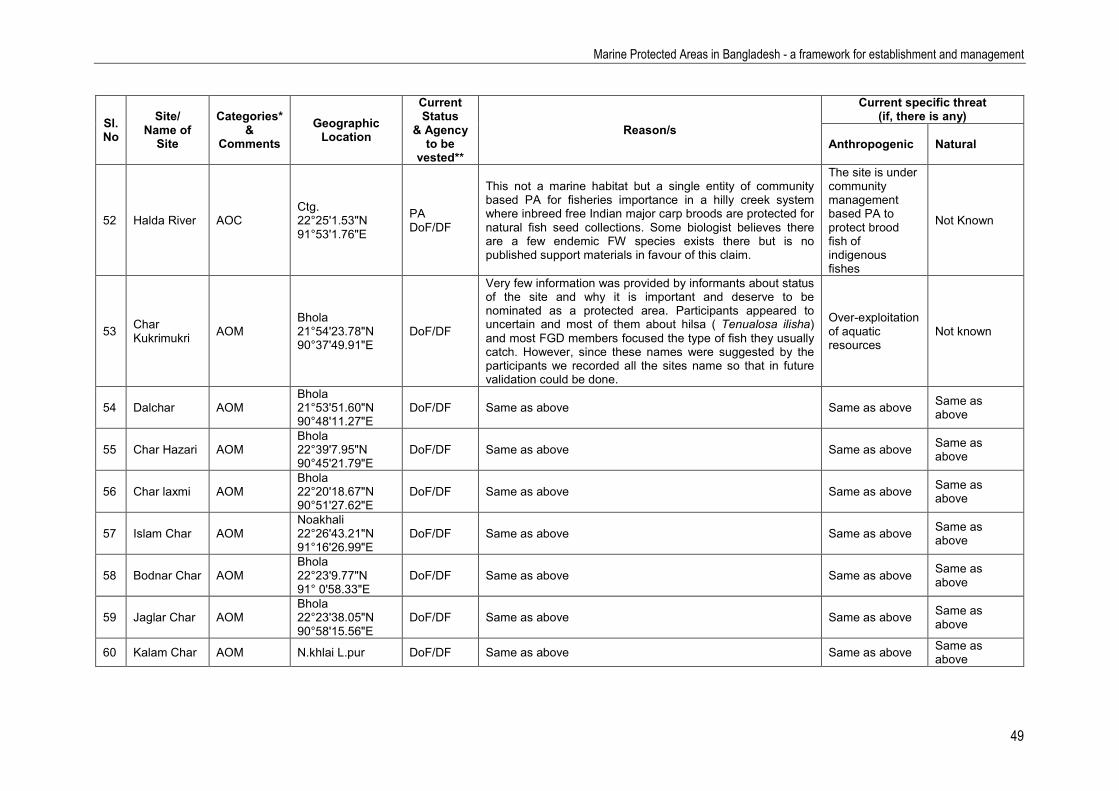
Marine Protected Areas in Bangladesh - a framework for establishment and management
49
Sl. No
Site/ Name of
Site
Categories* &
Comments Geographic
Location
Current Status
& Agency to be
vested**
Reason/s
Current specific threat (if, there is any)
Anthropogenic Natural
52 Halda River AOC Ctg. 22°25'1.53"N 91°53'1.76"E
PA DoF/DF
This not a marine habitat but a single entity of community based PA for fisheries importance in a hilly creek system where inbreed free Indian major carp broods are protected for natural fish seed collections. Some biologist believes there are a few endemic FW species exists there but is no published support materials in favour of this claim.
The site is under community management based PA to protect brood fish of indigenous fishes
Not Known
53 Char Kukrimukri AOM
Bhola 21°54'23.78"N 90°37'49.91"E
DoF/DF
Very few information was provided by informants about status of the site and why it is important and deserve to be nominated as a protected area. Participants appeared to uncertain and most of them about hilsa ( Tenualosa ilisha) and most FGD members focused the type of fish they usually catch. However, since these names were suggested by the participants we recorded all the sites name so that in future validation could be done.
Over-exploitation of aquatic resources
Not known
54 Dalchar AOM Bhola 21°53'51.60"N 90°48'11.27"E
DoF/DF Same as above Same as above Same as above
55 Char Hazari AOM Bhola 22°39'7.95"N 90°45'21.79"E
DoF/DF Same as above Same as above Same as above
56 Char laxmi AOM Bhola 22°20'18.67"N 90°51'27.62"E
DoF/DF Same as above Same as above Same as above
57 Islam Char AOM Noakhali 22°26'43.21"N 91°16'26.99"E
DoF/DF Same as above Same as above Same as above
58 Bodnar Char AOM Bhola 22°23'9.77"N 91° 0'58.33"E
DoF/DF Same as above Same as above Same as above
59 Jaglar Char AOM Bhola 22°23'38.05"N 90°58'15.56"E
DoF/DF Same as above Same as above Same as above
60 Kalam Char AOM N.khlai L.pur DoF/DF Same as above Same as above Same as above

Marine Protected Areas in Bangladesh - a framework for establishment and management
50
Sl. No
Site/ Name of
Site
Categories* &
Comments Geographic
Location
Current Status
& Agency to be
vested**
Reason/s
Current specific threat (if, there is any)
Anthropogenic Natural
61 Passur AOM G. Khulna 21°48'46.19" N 89°43'9.40"E
DoF/DF Same as above Same as above Same as above
62 Dacope AOM G. Khulna 22°24'46.49"N 89°26'52.07"E
DoF/DF Same as above Same as above Same as above
63 Rampal AOM G. Khulna 22°33'10.48"N 89°38'57.17"E
DoF/DF Same as above Same as above Same as above
64 Munshigonj AOM Satkhira 22°16'16.25"N 89°11'58.48"E
DoF/DF Same as above Same as above Same as above
65 Assasuni AOM Satkhira 22°31'42.82"N 89°10'48.16"E
DoF/DF Same as above Same as above Same as above
66 Koyra AOM G. Khulna 22°21'4.35"N 89°16'28.61"E
DoF/DF Same as above Same as above Same as above
67 Sipsha AOM G. Khulna 21°59'39.77"N 89°32'17.31"E
DoF/DF Same as above Same as above Same as above
68 Nolin AOC Greater Khulna 22°25'33.68"N 89°27'7.92"E
DoF/DF More or less same as Chalna Same as above Same as above

Marine Protected Areas in Bangladesh - a framework for establishment and management
51
5. References 1a.Environmental Management and Biodiversity Conservation Plan for Bangladesh Sundarbans’ Draft
Final Report, World Bank and IUCN. March, 2012. 1b.Nabiul Islam, K. M. 2010. A Study of the Principal Marketed Value Chains Derived from the
Sundarbans Reserve Forest. Volume 1: Main Report. Submitted to: USAID/Bangladesh.170 pp. (A report produced by IRG for review by the United States Agency for International Development under Contract No. EPP-1-00-06-00007-00 EPP-1-00-06-00007-00).
2.National Framework for Establishing and Managing Marine Protected Areas, Canada. Approach to DFO’s Marine Protected Areas Program.
3.Support to Sustainable Management of the Bay of Bengal Large Marine Ecosystem (BOBLME) Project. Progress Report. Bangladesh Fisheries Research Institute. 2012.
4a.Encyclopedia of flora and flora of Bangladesh, vol. 24. Marine Fishes. Asiatic Society of Bangladesh. Dhaka.
4b.Encyclopedia of flora and flora of Bangladesh, vol. 18. Arthropoda: Crustacea. Asiatic Society of Bangladesh. Dhaka
4c.Encyclopedia of flora and flora of Bangladesh, vol. 17. Molluscs. Asiatic Society of Bangladesh. Dhaka.
4d.Encyclopedia of flora and flora of Bangladesh, vol. 26. Amphibian and Reptiles. Asiatic Society of Bangladesh. Dhaka.
4e.Encyclopedia of flora and flora of Bangladesh, vol. 26. Birds. Asiatic Society of Bangladesh. Dhaka.. 4f.Encyclopedia of flora and flora of Bangladesh, vol. 27. Mammals. Asiatic Society of Bangladesh.
Dhaka. 485p. 4g.Encyclopedia of flora and flora of Bangladesh, vol. 3. Algae. Asiatic Society of Bangladesh. Dhaka. 4h. Fahrni, M. E. and R. M. Mansur 2012. Conserving cetacean diversity and abundance in the Bay of
Bengal’s northern estuarine, coastal and deep-sea canyon waters of Bangladesh. pp. 28-93. In: M. E. Hoq and A. K. Yousuf Haroon (eds.) 2012. National Consultation Meeting on the Sundarbans: Sundarbans fisheries of Bangladesh: Current Status and Potentialities. SBOBLME Pub./Rep. 6, 2012. Support to Sustainable Management of the Bay of Bengal Large Marine Ecosystem (BOBLME) Project, Bangladesh Fisheries Research Institute (BFRI), Bangladesh.56 p.
4i Islam, M.R. (eds.) 2004. Where Land Meets the Sea—A Profile of the Coastal Zone of Bangladesh. The University Press Ltd., Dhaka, Bangladesh.
4j Marufa, A. 2012. Present status, harvesting, management and legislation pertinent to the Sundarbans fisheries. pp. 1-13. In: M. E. Hoq and A. K. Yousuf Haroon (eds.) 2012. National Consultation Meeting on the Sundarbans: Sundarbans fisheries of Bangladesh: Current Status and Potentialities. SBOBLME Pub./Rep. 6, 2012. Support to Sustainable Management of the Bay of Bengal Large Marine Ecosystem (BOBLME) Project, Bangladesh Fisheries Research Institute (BFRI), Bangladesh.56 p.
5a. Khan M.G. 2008 Md. Giasuddin Khan 1. GoB/DANIDA/BOBP-IGO National Workshop onMonitoring, Control and Surveillance in Marine Fisheries – Bangladesh. Cox’s Bazaar, Bangladesh, 7 – 8 June 2008
5b. National Framework for Establishing and Managing Marine Protected Areas (Canada). Approach to DFO’s marine Protected Areas Program.

Marine Protected Areas in Bangladesh - a framework for establishment and management
52
5c. Kelleher, G. & Kenchington, R. (1992). Guidelines for Establishing Marine Protected Areas. A Marine
Conservation and Development Report. IUCN, Gland, Switzerland. vii+ 79 pp. ISBN: 2-8317-0105- 6. Islam, A.K.M.N. 1976. Contribution to the study of the marine alage of Bangladesh. Bibliotheca
Phycologia. 19, J. Cramer, Vaduz. 253pp 7 Haque, E. 2002. The Management and Conservation of fisheries in the mangrove forests of
Bangladesh. M.Sc. Thesis. University of Hull, UK. 197pp. 8 IUCN Bangladesh 2000. Red Book of Threatened Fishes of Bangladesh. IUCN –The World
Conservation Union. 116pp. 9Khan, S.M.H.K, Nishat., A. and Haque, R. 2008. Biodiversity Conservation in Bangladesh. InAhmed,
Z.U., Begum, Z.N.T., Hasan, M. A., Khondker, M., Kabir, S.M.H., Ahmed, M., Ahmed, A.T.A., Rahman, A.K.A., and Haque, E.U. (Eds.). Encyclopedia of Flora and Flora of Bangladesh Vol. 1. Bangladesh Profile. Asiatic society of Bangladesh, Dhaka.pp. 9-19.
10Begum, Z.N.T. 2008. The Sundarbans: World’s Largest Mangrove Forest. Ibid., pp. 26-36. 11Chowdhury, J.A. 2008. Bangladesh and International convention and treaties on biodiversity and
Environment. Ibid., pp. 60-72. 12Alam, M.K. 2008. Forests and Forestry in Bangladesh. Ibid., pp. 73-86. 13Ahmed, A.T.A.2008 . Marine Resources of Bangladesh. Ibid., pp. 144-168. 14Hasan , M.A. and Ahmed, A.T.A.2008 . Threat and extinction: Decline and demise of species
from Bangladesh. Ibid., pp. 188-201.. 15Ahmed, Z.U., Begum, Z.N.T., Hasan, M. A., Khondker, M., Kabir, S.M.H., Ahmed, M., Ahmed, A.T.A.,
Rahman, A.K.A., and Haque, E.U. (Eds.) 2008. Encyclopedia of Flora and Fauna of Bangladesh Vol.. 3. Algae: Chlorophyta (Aphanochaetaceae - Zygnemataceae). Asiatic society of Bangladesh, Dhaka.
16Ahmed, Z.U., Begum, Z.N.T., Hasan, M. A., Khondker, M., Kabir, S.M.H., Ahmed, M., Ahmed, A.T.A., Rahman, A.K.A., and Haque, E.U. (Eds.) 2008. Ibid., Vol.4. Algae : Chlorophyta-Rhodophyta. Asiatic society of Bangladesh, Dhaka.
17Ahmed, Z.U., Begum, Z.N.T., Hasan, M. A., Khondker, M., Kabir, S.M.H., Ahmed, M., Ahmed, A.T.A., Rahman, A.K.A., and Haque, E.U. (Eds.) 2008. Ibid., Vol.17 Mollusca: Asiatic society of Bangladesh, Dhaka.
18Ahmed, Z.U., Begum, Z.N.T., Hasan, M. A., Khondker, M., Kabir, S.M.H., Ahmed, M., Ahmed, A.T.A., Rahman, A.K.A., and Haque, E.U. (Eds.) 2008. Ibid., Vol.18.Arthopoda: Crustacea. Asiatic society of Bangladesh, Dhaka.
19Ahmed, Z.U., Begum, Z.N.T., Hasan, M. A., Khondker, M., Kabir, S.M.H., Ahmed, M., Ahmed, A.T.A., Rahman, A.K.A., and Haque, E.U. (Eds.) 2008. Ibid., Vol.23. Freshwater Fishes. Asiatic society of Bangladesh, Dhaka.
20Ahmed, Z.U., Begum, Z.N.T., Hasan, M. A., Khondker, M., Kabir, S.M.H., Ahmed, M., Ahmed, A.T.A., Rahman, A.K.A., and Haque, E.U. (Eds.) 2008. Ibid., Vol.25. Amphibian and reptiles. Asiatic society of Bangladesh, Dhaka.
21Ahmed, Z.U., Begum, Z.N.T., Hasan, M. A., Khondker, M., Kabir, S.M.H., Ahmed, M., Ahmed, A.T.A., Rahman, A.K.A., and Haque, E.U. (Eds.) 2008. Ibid., Vol.24. Birds. Asiatic society of Bangladesh, Dhaka.
22Ahmed, Z.U., Begum, Z.N.T., Hasan, M. A., Khondker, M., Kabir, S.M.H., Ahmed, M., Ahmed, A.T.A., Rahman, A.K.A., and Haque, E.U. (Eds.) 2008. Ibid, Vol.24. Mammals. Asiatic society of Bangladesh, Dhaka.

Marine Protected Areas in Bangladesh - a framework for establishment and management
53
23BOBLME (2010) Status of hilsa (Tenualosa ilisha) management in the Bay of Bengal. BOBLME-2010-Ecology-01. Report to FAO Bay of Bengal Large Marine Ecosystem Project 24Coastal zone policy. 2005. Ministry of Water Resources. Government of Bangladesh. 25MoEF, 2008. Bangladesh Climate Change Strategy and Action Plan 2008. Ministry of Environment
and Forests, Government of the People's Republic of Bangladesh, Dhaka, Bangladesh. xvi + 68 pp.
26Hussain, M.G. and Hoq, M.E. (eds.). 2010. Sustainable Management of Fisheries Resources of the Bay of Bengal - Compilation of national and regional workshop reports. Support to Sustainable Management of the BOBLME Project, Bangladesh Fisheries Research Institute. SBOBLMEP Pub./Rep. 2. 122 p.
26Environmental Management and Biodiversity Conservation Plan for Bangladesh Sundarbans’ Biodiversity. 2012. draft final report. VOLUME-2. IUCN-WB.
26Hoq, M.E., A.K. Yousuf Haroon and M.G. Hussain (eds.). 2011. Shark fisheries in the Bay of Bengal, Bangladesh: Status and potentialities. Support to Sustainable Management of the BOBLME Project, Bangladesh Fisheries Research Institute. (BFRI), Bangladesh. 76 p.
26BOBLME (2011) Assessments of the Indian mackerel (Rastrelliger kanagurta) and the Hilsa shad (Tenualosa ilisha) fisheries in the BOBLME countries. BOBLME-2011-Ecology-09
26BOBLME (2011) Marine Managed Areas workshop report Penang, Malaysia, 18-19 January, 2011. BOBLME-2011-Ecology-06
26BOBLME (2011) Fisheries catches for the Bay of Bengal Large Marine Ecosystem since 1950.BOBLME-2011-Ecology-16
27BOBLME (2011) Performance in managing marine resources in the Bay of Bengal BOBLME-2011-Ecology-17
28BOBLME (2011) Country report on pollution – India. BOBLME-2011-Ecology-07 29BOBLME (2011) Review of community-based ICM: Best practices and lessons learned in the Bay of Bengal - South Asia. BOBLME-2011-Socioec-01 29Sustainable Management of the Bay of Bengal Large Marine Ecosystem (BOBLME) GCP/ RAS/ 179/ WBG. Review of the Status of shared/common marine living resources stocks
and of stock assessment capability in the BOBLME region. 30IUCN, 1994 Guideline for Establishing Protected Areas 31IUCN, 2012 Guidelines for applying the IUCN Protected Area Management Categories to Marine
Protected Areas 32FAO Technical Guidelines for Responsible Fisheries. No. 4, Suppl. 4. Marine protected areas and
fisheries. Rome, FAO. 2011. 198p.

Marine Protected Areas in Bangladesh - a framework for establishment and management
54
Renewable and non-renewable marine resources Appendix I

Marine Protected Areas in Bangladesh - a framework for establishment and management
55
1. Fishes
Bangladesh coastline is broken and made with mostly silt and sand with almost not stony beaches. The coast line of the country is roughly 714 km long, the EEZ is occupied with extended hallow continental shelf. The EEZ of the country has been extended to 112,192.4 km2 after the verdict of ITLOS in 2012. The marine water and coastal waters of Bangladesh are rich in the diversity of fish and shellfish resources.
There is record of over 400 species (latest counts documented 402 marine species by Asiatic Society in 2009) of fin fish including sharks and rays, a number of shellfishes including 36 species of shrimp and a number of non-traditional species such as cuttle fish, octopus, oysters and mussels.
1.1. Fish resources More than 90 species are commercially important of which hilsa fish is most important contributing over 40% of coastal landing4a. Commercially, important species including the black-finned shark (Carchahinus melanopterus), Hammerheaded shark (Eusphyra blochii), Blue-spotted sting ray (Dasyatis kuhlii), Sawfish (Pristis microdon), and devil ray (Mobula diabolus) among cartilaginous fishes. Other commercially important bony fishes include Wolf herring (Chirocentrus dorab), Bombay-duck (Harpadon nehereus), Conger eel (Congresox telabonoides), Flat-head mullet (Mugil cephalus), Fourfinger threadfin (Eleutheronema tetradactylum), Giant-sea bass (Lates calcarifer), Lady-fish (Sillago sihama), Bluefin trevally (Caranax melampygus), Mackerel scad (Scomberoides commersonnianus), Triple-tail (Lobotes surinamensis), Long jewfish (Otolithoides pama), Panna croaker (Panna microdon), Indian mackerel (Rastrelliger kanagurta), King mackerel (Scomberomorus commerson), Pomphret (Pampus argenteus), Whipfin mojarra (Gerres filamentosus), Red grunter (Pomadasys argenteus) etc4a.
1.2. Fish diversity All fish available in Bangladesh EEZ is nutritionally edible, but not all of those are taken as food by majority of the population; sharks, rays, among fishes and many other sea foods like clams, oyster, abalone, crabs, other gastropods, and cephalopods are not eaten by main stream population. Not eaten locally but has demand elsewhere are currently harvested and exported. We do not know in detail the ecological, symbiotic or biodiversity related significances of most of the marine organisms available in EEZ of Bangladesh. As mentioned earlier, there are over 400 marine fish species in Bangladesh EEZ. Important among the marine fishes are sharks, skates and rays. There are 51 species of cartilaginous fishes recorded from Bangladesh of which 26 species are sharks4a (carpet shark, zebra shark, whale shark, requiem shark, hound shark and Hammerheaded shark) under 3orders and 9 families. There are 19 species of rays (butterfly rays, sting rays, eagle rays, devil rays, and cow nosed rays) under a single order and 5 families.
Electric rays (family: Narcinidae) include 3 species4a, saw fishes (family: Pristidae) include 3 species and guiterfishes (family: Rhinobattidae) include only 4 species. The whale shark is the largest shark in Bangladesh waters attaining a length of 50 feet, this is also the largest living fish in the world that is a filter feeder. This is sluggish shark feeding primarily on plankton that it collects on a sieve-like mesh over its gills. It may also fed on small other pelagic species those comes to it huge mouth when straining the water4a.
In the order Elopiformes, there exists a single family (Elopiade), a single genus and a single species, the big eye herring or Lady fish (Elops machnata). Little information is available on the species.
There are 12 species of marine eels in EEZ of Bangladesh under 4 families and 9 genera. Marine eels carry no commercial importance in Bangladesh and these are less studied fish species in the country.
Among the fish order Clupeiformes includes the most important marine fishes of the country, the herrings, anchovies and big eyes; including national fish hilsha. This group contributes roughly 40%

Marine Protected Areas in Bangladesh - a framework for establishment and management
56
of marine catch in Bangladesh. This group is rich with record 14 genera and 24 species under 4 families.
Siluriformes is another group of fishes (Order) including catfishes. This group under a single family with 9 genera and 18 species. All marine catfishes belong in this group of bottom dwelling fleshy fish. Highly commercial in the country.
Aulopiformes are commonly known as Grinners. Few species like Bombay Duck (Harpodon nehereus) are highly commercial in Bangladesh. This “Order”of fish includes a total of 8 species under three families.
Gadiformes with two families and only three species under three genuses is one of the smallest groups of fish. This group of fish has almost no commercial values.
Ophidiiformes is the family of Cusk eels, not commercial and having a few representative species in living conditions. So far in Bangladesh waters 2 species in one family and two genera were identified.
The fish belonging to the Order Lophiiformes though not commercials but strange group of deep sea fishes and popularly known as Monk fish. There are three families under the order with three families, three genera and only three species so far identified.
The flying fish, Garfishes and halfbeaks belongs to the order Beloniformes. There are three families in the order and 8 genera in those families. So far, a total of 11 species in 8 genera in this order has been identified in Bangladesh waters.
The Spinyfishes, Eequirrel fishes and Slimeeheads belongs to the order Beryciformes and have three families with 5 species. Some of these species carries economic significance like white tail seuirrelfish.
The Order, Zeiformes have only two families, two genera and only two species. These fish has no commercial importance and one of the less studied species.
The famous and popular sea horse fish falls in the category of Syngnathiformes with two families and three species.
The colorful and pretty Scorpion fishes and flatheads belong to the order, Scorpaeniformes. This group has 6 families and 11 species. These species has minor economic values but good species as large marine aquarium fish.
Perciformes is by far the biggest group of fish under Bangladesh waters. Almost half of recorded species in the EEZ of country belongs to this order. There are 53 families so far recorded in the family with over two hundred species. Many of them are commercially important. Among the commercial important families are; Serranidae, Theraponidae, Priacanthidae, Sillaginidae, Lacteriidae, Rachycentridae, carangidae, Coryphaenidae, Leiognathidae, Lutjanidae, Gerreidae, Haemulidae, Sparidae, Lethrinidae, Nemipteridae, Scaenidae, Serranidae, Pomacentridae, and Polynemidae.
Carangidae is the largest family of Perciformes fish which includes mackerels and scads. There are record 29 species in 16 genera. Most species of this group are fast moving highly predatory that hunts in the waters above reefs.
Groupers of the family Serranidae is a large family of Marine fishes characterized by an oblong body, more or less compressed, covered with adherent scales of moderate or small size. Most of the species in the group inhabits inshore coral reefs. There are 10 species under 4 genera.
Drums croakers (Family: Sciaenidae) are commercially important fishes known to produce drumming sound with aid of their swim bladder. There are about 14 species under 10 genera in EEZ of Bangladesh.
The demersal fishes of the family Pomacentridae are one of the most abundant groups of coral reef fishes. Few are more than 15 cm in length, and are typically highly coloured. They are deep bodied,

Marine Protected Areas in Bangladesh - a framework for establishment and management
57
active and aggressive with small mouth. They display remarkable diversity with regard to feeding habits and behaviour. There are 13 species under 10 genera in EEZ of Bangladesh.
Snappers of the family Lutjanidae have deep body, a continuous slightly notched dorsal fin, and a slightly forked tail fin. There are 10 species of fish in this family under a single genus. These are important food and sports fish in Bangladesh waters.
Scombridae is the family of the mackerels, tuna, and bonitos, including many of the most important and familiar food fishes. The family is represented by 10 species under 7 genera in Bangladesh part of Bay of Bengal.
Threadfins (Polynemidae) resemble mullets but are different group of fish. The Indian salmon (Leptomelansosoma indicum) was one of the most prized and important fish in Bangladesh and currently rare. There are records of existence of 6 species of this group of fish under 4 genera.
The Gobies, which are considered very prominent among the fish fauna of Bangladesh, are diversified group. The commonest of all gobies in Bangladesh is the Bele or Bailla. The mud skippers are also belongs to this group.
Scorpaeniformes with 6 families and 14 species in Bangladesh waters is also a fairly big group of fishes. They have large, heavily ridged and spined head and also possess venomous spine at dorsal side.
1.3. Fish species under threat of extinction currently or in long run4 A total of 402 marine fish species has been listed as marine fish fauna in Bangladesh waters of EEZ. Out of these species, 33 are listed as somewhat threatened for a reason or other. However, only are listed in IUCN red list (IUCN 2000)8 as endangered species those needs special protection measures.
There are certain marine fish those maybe threatened elsewhere but relatively available in good number in Bangladesh waters and vice versa. List of endangered, threatened and extremely rare and at the verge of exaction species in Bangladesh EEZ are listed below.
Table 3: List of fish species under threat of extinction currently or in long run
Species Common name Status in BD waters Presence in IUCN red list
Carcharhinus dussumineri Wide cheek shark Near Threatened Yes
Carcharhinus falciforms Silky shark Stickle shark
Vulnerable by overfishing No
Carcharhinus macloti Hardnose shark Near Threatened Yes
Ghyphis gangeticus Ganges Shark Critically endangered Yes
Rhizoprionodon acutus Milk shark Vulnerable by overfishing & pollution
No
Eusphyra blochii Winghead shark Near Threatened by harvest Yes
Sphyrna lewini Scalloped Hammerheaded
Threatened worldwide not in BD
No
Gymnura poecilura Long tail butterfly Ray
Vulnerable by overfishing No
Aetobatus narinari Spotted Eagle Ray Near Threatened No
Astomylaeus nichofii Banded Eagle Ray Vulnerable by overfishing No
Mobula japonica Spinetail Mobula Very high Vulnerability Yes

Marine Protected Areas in Bangladesh - a framework for establishment and management
58
Species Common name Status in BD waters Presence in IUCN red list
Anoxtaypristis cuspidate Saw shark Endangered Yes
Pristis microdon Lonftooth Sawfish Endangered Yes
Gymnothorax favagineus Leopard Moray Very rare No
Escualosa thoracata White sardine Overfishing by set bag-net No
Plotosus lineatus Striped catfish Overfishing No
Hippocampus kuda Sea-horse Threatened Yes
Epinephelus lanceolatus Giant grouper Threatened No
Epinephelus malabaricus Malabar grouper Overfishing No
Lutjanus gibbus Hampback snapper
Overfishing No
Pamadysys argentus Silver grunter Threatened by over fishing No
Pamadysys hasta Lined silver grunter
Threatened by over fishing No
Mulloidichthys vanicolensis Yellow-fin goatfish Threatened due to coral destruction
No
Upeneus sulphureus Sulphur goatfish Threatened due to coral destruction
No
Sphyraena barracuda Great Buarrakuda Rare in Bangladesh water No
Eleutheronema tetradactylum
Fourfinger threadfin
Overfishing No
Leptomelanosoma indicum Indian treadfin Overfishing No
Polyductylus sextarius Blaclsopt threadfin
Overfishing No
Thunnus obesus Bigeye Tuna Vulnerable Yes
Xiphias gladius Swordfish Rare in BD waters No
Makaira indica Sail fsih Rare in BD waters No
Pomp argenteus Silver Pompret Overfishing No
Pomp chinensis Chinese Pompret Overfishing No
2. Crustacean
Crustaceans are a large group of arthropods, comprising roughly 52,000 species4b. Majority are aquatic, living in either fresh water or marine environments, but few groups like terrestrial crabs , terrestrial hermit crabs and wood lice are adopted to terrestrial life. Majorities are free living but a few are parasitic and sessile. So far 185 (under 89 genera and 45 families) species of crustaceans have been identified and described in details from Bangladesh’s marine and brackish water ecosystem with their ecological importance. However, the list is incomplete.

Marine Protected Areas in Bangladesh - a framework for establishment and management
59
Most of the crustaceans are minute and smaller in sizes and are used as food organisms for other aquatic animals. Unfortunately, the ecological importance of most of the crustaceans species interns of their role in marine food chain, complex life cycles of associated organisms, their role within intra and inter-species relationships are not well understood as not so many detailed studies has been conducted, except their role as prey and predators, their importance as live food organisms. Beside some planktonic crustacean, notably copepods as live food organisms in hatcheries and some shrimps as sea food organisms farmed animals, biology and ecological relationships of the most of marine crustaceans has not studied yet.
Out of hundreds known crustaceans’ species, only a few are commercially harvested most of them from shrimps crab and lobster groups. Rests of the crustaceans are mostly unknown or mysteries creatures to us. Our knowledge on bulk of crustaceans is limited to their taxonomic nomenclature and their beneficial or harmful effects.
2.1. Shrimps and shrimp like creatures4b Most of the shrimps are edible. However exploitation and commercial harvesting of shrimps from marine environment s are depends on their body (tail usually) meat content and market value. There are different types of shrimps and shrimp like edible creatures as described below.
2.2. Mantis shrimp Mantis shrimps are elongated, flattened and shrimp-like or lobster like crustaceans. These groups of marine crustaceans are available on shallow bottom of sub-tropical sea including BOB. Mantis shrimp has minor economic value is Bangladesh but considers delicacy elsewhere. In Bangladesh these marine creature are non-target species and when harvested in bulk is used to produce fish-meal. It plays a predatory role in the stem.
2.3. Mantis shrimp diversity A few species of this group from Bangladesh EEZ is identified and described. Little work on this group of marine fauna has been studied in detail to know their true diversity. All Mantis Shrimp available in Bangladesh and has little economic importance other than raw materials for scrap metal (low quality fish meal). However, we do not know their ecological, symbiotic or biodiversity related significances.
2.4. Mantis species under threat of extinction immediately or in long run Sincerely speaking, we know so little about these creatures that their ecological relationship with other animals or their role on marine habitat and food chain is still mysterious. However, their presence in marine bottom by-catch indicates these creatures are not threatened in BOB or EEZ of Bangladesh. One reason is that like elsewhere mantis shrimps are not commercially exploited and their exploitable stock has not studied yet.
2.5. Shrimps4b As mentioned earlier, shrimps are perhaps most prized and most sought marine creatures as sea foods. Human interest on shrimps as edibles and delicacy is centuries old and their biology, ecology, habitat and reproductive cycles are well studied, at least for some commercial ones. Most commercial shrimps are in the order of decapods, like other important groups of crabs and lobsters. All shrimps are with well-developed rostrum and generally extending beyond eyes, always bearing more than three upper teeth. Marine shrimps are popularly known as penaeid shrimps and falls in eight families; Penaeidae, Solenoceridae, Sergstidae, Atyidae, Palaaemonidae, Alpheidae, Hippolytidae and Pandalidae.

Marine Protected Areas in Bangladesh - a framework for establishment and management
60
2.6. Shrimps diversity4b EEZ of Bangladesh is rich with shrimp fauna. As mentioned above shrimps, mostly marine are incorporated in 8 families, 18 genera and altogether roughly 58 species. Out of 58 species some shrimps also lives in freshwater and brackish waters but among some fresh water species their life cycles is not completed without salt water. All shrimp species are edibles and human interest on these species as sea foods is also centuries old, however, some species are relatively small in sizes and has little commercial values.
Most popular marine shrimp, penaeid is also extensively harvested. Among the penaeid shrimps, the genus Penaeus contains 9 species and all species are commercially important due to their sizes, meat texture and are considered as delicacy among sea foods. Due to its demand in world market, their protection need is more urgent and MPA can save some of these species from over fishing.
Another important penaeid shrimp genus is Metapenaeus that contain 6 species. These all are also relatively larger shrimps and important food organisms and are also over-fished. Some species of Metapenaeus and Penaeus are so much over fished that their demand can’t be meet with wild supply and extensive studies on their life cycles has lead to mass seed production in hatcheries and commercial framing of these species. Besides these two commercial genera, other six genera Parapeneopsis, contains 5 species, Metapenaeopsis one species.
The family Solenoceridae with its one genus contains four species; family Sergestidae contains one genus with four species. Similarly, family Atyidae mostly contains fresh water 4 species. Family Palaemonidae contains shrimp of freshwater and marine species. Fresh water giant prawn the largest shrimp among decapods belongs to this group. This family has 6 genera with the largest genus Macrobrachium with 12 species. Rest of the 7 genera each has a single species.
The family, Alpheidae has one genus and a single species. Similarly, family Hippolytidae is with a single genus and a species. The family, Pandalidae is also with a single genus and spices.
2.7. Shrimp species under threat of extinction immediately or in long run Out of 58 species of shrimp identified and studied in EEZ of Bangladesh, estuaries and river mouth most of these are commercial in nature and extensively harvested. Heavy fishing pressure on “Penaeus indicus, P. latisulcatus, P. monodon, P. penicillatus and Metapenaeus affinis are relatively larger sized shrimps and subjected to over fishing is evident by gradual decline their biomass in commercial landings. However, none of the species is listed as threatened or endangered though commercial harvest of the some species does not seems profitable. This is good sign of their protection.
However real danger lies with P. monodon, the black tiger shrimp that is commercially harvested, their broods are systematically caught for the hatcheries for seed production, their post larvae (PL) are indiscriminately harvested with mosquito nets in estuaries and sea beaches. Their existence is though not endangered or is not on red list of IUCN, but this species needs special protections for biological reasons as well as for the protection of livelihoods of fisher community. Metapenaeus and Parapanopsis genera also contain some species those are relatively smaller in sizes but have commercial importance and harvested but none of these species are threatened.
Besides, one major commercial important freshwater cum brackish water species Macrobrachium rosenbergii is subjected to over fishing due to brood, food and PL harvest from nature. But as a species they do not face danger of extinction biologically, but dangerously declining their stocks in natural habitat.
2.8. Lobster4b

Marine Protected Areas in Bangladesh - a framework for establishment and management
61
Bangladesh though has huge sea area under EEZ in BOB but the sea floor under Bangladesh sea areas is basically sandy in nature. There is no broken sea coast and stony beaches and sea bottom which can be defined as lobster bed. Therefore, lobster resources in EEZ of Bangladesh are few and commercially exploitable stocks are small. Therefore, the systematic lobsters harvesting method has not developed in the country and the lobsters landing in Bangladesh is considered as accidental catch with other bottom fish harvest. However, higher export price and increased demand has created situations that encourage fishermen to device new methods of lobster harvest in BOB.
2.9. Lobster diversity The available few species of lobster species in the country has been categories into two known families; Palinuridae (spiny lobster and langoustes) and Scyllaridae (Slapper lobster). The Palinuridae family has only one genus and three species, all are commercial in nature and whatever numbers are harvested are exported. Both spiny and mud lobsters from Bangladesh has good demand abroad. The beautifully coloured painted spiny lobster and its juveniles are recognized as aquarium specimen. The family Scyllaridae has a single genus and a single species.
2.10. Lobster species under threat of extinction immediately or in long run Out of 4 species of lobster identified and studied in EEZ of Bangladesh are scarce but not threatened in any respect as systematically these are not exploited. Low fishing pressure on all four species of lobsters in EEZ of Bangladesh is a good sign of their survival in the habitat. All four species are relatively lucrative in sizes and has high market demand and also fetch high market value. No lobsters are catered in any Bangladesh restaurants and all harvested specimens are usually exported. However, none of the species is listed as threatened or endangered though commercial harvest of the some species does not seem profitable. This is good sign of their protection.
2.11. Hermit crabs4b Hermit crabs are mysteries creature, appendages are like crabs, but their tail is fused and they make house inside a shell of mollusc by attached the fused tail parts inside the wall of the shell it make houses. These animals are though mostly marine, but some of the species lives on land and adapted to territorial life. These creatures are not eaten in Bangladesh and has no commercial value but accidental catch by bottom trawling sometime used in poultry feed as calcium sources. Therefore, it may not be considered as renewable resources. Their role aquatic ecosystem is not well understood. In this report only sea based hermit crabs are included though there are land based animals of this group.
2.12. Hermit crabs diversity In EEZ of Bangladesh there are two types of aquatic hermit crabs, shallow water and deep water types. There are two families, one in shallow water and the other in deep water habitat. Both families have one genus each and only one species in each genus. Since these creature finds and make housed inside the suitable shells of mollusc, in ancient times based on types of shells they were categorized in different species. Now, based on creature inside the shell, number of species has greatly reduced. There diversity in Bangladesh water now identified to only two species; Pagurus bernhardus (shallow water hermit crab) and Parapagurus nudus (deep water hermit crab). However, the number types of hermit crabs are not complete yet. Further studies are necessary as these were identified based on landings not by on the spot collection from sea bottom.
2.13. Hermit crabs species under threat of extinction immediately or in long run We actually know very little about these mysterious creatures, their actual life style, life cycles and how they find sufficient number of empty shells under opportunistic conditions and sustain their population and how they continue their lives when their body becomes bigger than the shells they
Marine Protected Areas in Bangladesh - a framework for establishment and management
62
used as home. The threats of the hermit crabs are not manmade except pollution, if there is any. Their complex life style may limit their population and ultimately endanger their lives and existences.
2.14. Crabs4b Crabs are one of the most important sea food and considered delicacy in some parts of the world. The crab meat is eaten by minority people in Bangladesh and the crabs were not extensively harvested earlier until export market opened. Still there is little demand domestically and most of the crabs harvested are indeed goes to export market either as live organism or under frozen conditions.
There is indication that some species of crabs especially those lives in inter-tidal zone or in mud in mangrove forested areas are over fished. Due to its commercial prospect, coastal dwellers currently practicing crab fattening; harvesting the young individuals from wild and keep them in coastal ponds for certain period of time and provide them natural supplemental feeding of animal origin and let them grow and fleshy. The practice is getting popularity among coastal dwellers as alternative livelihood options.
2.15. Crabs diversity Crabs are one of the dominant groups of decapods after shrimps. Bangladesh sea waters harbours a large variety of crabs. There are 11 different families of crabs in Bangladesh and most families includes species those are marine. Out of 11 families only 2 families are exclusively fresh water origin, rest are partly or wholly marine.
There are 36 species of crabs in Bangladesh under 22 genera; and most of them are marine as mentioned earlier. The largest crab families are Ocypodidae and Daldorfidae with 9 species under three genera and 9 species under 4 genera respectively. . The family, Portunidae has also 4 genera and 8 species. Rests of the crab families are less diverse with lesser number of genus and species. Family, Carpiliidae has a single genus and a single species. Similarly, Potamidae has two genera with only two species. Parathelusidae has one genus and one species; Varunidae with 2 genera and 2 species. The family Grapsidae has 4 genera but have only 5 species.
2.16. Crabs species under threat of extinction immediately or in long run
Crabs in Bangladesh water is not under danger of extinction though some species is under heavy fishing pressure like mud crab (Scylla olivacea) and mangrove crab (Scylla serrata). These two crabs are commercially collected from coastal muddy areas, Sundarbans and other mangrove forest shores. These species are vulnerable to human as they live near shore and inter-tidal zones and burrow holes in soft mud when water goes down with low tides. Fishers could easily identify their borrowing hole on exposed mud and collect them without any trouble. Habitat protection and species preservation by strict implementation of environmental regulations and proper stock management is needed. The forest department sometimes impose seasonal ban on crab harvest from the Sundarbans but that is not a permanent measure.
3. Mollusks4c
Molluscs are a large group of invertebrates, comprising thousands of species worldwide on land and in water. Some mollusc are famous and well sought sea food items like cephalopods (squid and cuttle fish), abalone, oysters, clams, mussels and scallop. Majority are aquatic, living in fresh water, brackish waters or marine environments. Majorities are sessile, but a few are parasitic. They constitute an important component of the marine biodiversity of Bangladesh. A total of 437 marine and brackish water molluscan species has been discovered in Bangladesh EEZ. They are divided in 20

Marine Protected Areas in Bangladesh - a framework for establishment and management
63
orders, 90 families and 185 genera. The mollusc falls in 4 major classes of which names of some important groups of different classes are incorporated.
As mentioned earlier, so far over 4 hundred species of molluscan species have been identified and described in details from our marine and brackish water ecosystem with their ecological importance. Unfortunately, the ecological importance of most of the molluscan species interns of their role in marine food chain, complex life cycles of associated organisms, their role within intra and inter-species relationships are not well understood as not so many detailed studies has been conducted, except their role as important sea foods.
Out of hundreds known molluscan’ species, only a few are commercially harvested most of them for human and or animal foods. Shrimp farming in Bangladesh uses molluscan meat; shells of mollusc are used to prepare moist calcium carbonate. In Bangladesh currently a thriving industry has been formed to crush and made powder of mollusc shells to be incorporate in poultry feed where high egg yielding poultry birds need adequate calcium sources for egg shells.
3.1. Molluscan diversity Molluscs are of 4 classes; polyplacophora, gastropoda, cephalopoda and bivalvia; and as mentioned above have 20 orders in 4 classes; 90 families and 437 species in Bangladesh marine and brackish water environments4c. By far, gastropoda and bivalvia are two largest groups with huge numbers of species. Some species of three classes of mollusks are edible and considered delicacy in many countries as sea foods and considered endangered due to over fishing. However, in Bangladesh local people except some tribal ones does not eat shell fishes and no species of he the molluscan group is considered endangered or threatened due to human action or fishing. A great numbers of molluscan fauna available in Bangladesh are terrestrial, mostly gastropods. All other mollusc of 4 different classes are available in aquatic environment also mostly in salt and brackish waters.
The genus, Cypraea with 30 species is the biggest genus of molluscs in Bangladesh waters, under the family of Cypraeidae, order Mesogastraopoda and class gastropoda. The second largest genus of mollusc is Conus with 14 species in the family of Conidae, order Neogastropoda under also in class gastropoda. Genus Oliva is also a large group with 12 species in the family of Olividae, also in the order Neogastropoda; followed by genus Thais with 11 species in sub-family of Thaidinae, family Muricidae and also in order of Neogastropoda. Genus Nerita under family Neritidae order gastrapoda contains 10 species. Other species rich genus are Strombus (9 species, family Vermetidae); genus Mitra (9 species, family Mitridae); genus Tellina (7 species, family Tellinidae); genus Nassarius (7 species, family Nassariidae); genus Mactra (7 species, family, mactridae ); genus Natica (6 species, family Naticidae); genus Crassostrea (6 species, family Ostreidae); genus Donax (6 species, family Donacidae). Besides, these families and their representatives’ genera and associated species, there are many others in the mollusc group.
3.2. Molluscan species under Threat of extinction immediately or in long run Mollusc is a big group of animals usually remains beyond eyes and since they are mostly sedentary in nature and lives mostly at sea bottom, beneath the mud, sand, gravels and other substratum their presence always remain almost unnoticed, if not explored properly. Unlike fish molluscs can’t be harvested by conventional nets. Special devices are needed to collect those. Since locally shell fishes are not usually consumed and no species is exported therefore, their numbers are not threatened by fishing pressure.
A few studies has been conducted on molluscan population, its biology, life cycle, habitat, ecosystem and biodiversity, so, it is difficult to say whether there is any other causes other than manmade ones that may threaten their existence.

Marine Protected Areas in Bangladesh - a framework for establishment and management
64
4. Cephalopods4c
Worldwide cephalopods are famous items in sea food dishes; octopus, squid and cuttlefish fisheries are in some countries are well developed and money earning enterprises. In Bangladesh mainstream population did not chose these marine animals as food items for unknown reasons, may be due to their appearance and fiction stories about these mystic marine creatures. Cephalopods are used as human foods by some tribal people and also used as animal feeds in shrimp and poultry farming industries. All cephalopods in Bangladesh are accidental catch with fish harvest.
4.1. Cephalopods diversity There are recorded 10 species of cephalopods in Bangladesh waters; commonly known nautilus one species in one genera (Nautilis); three cuttle fish species (2 species in the genera of Sepia and one species in Sepiella ), two species of squid (one each in Loliolus and Photololigo genera) is also available in EEZ of BOB. There are reported 4 species of octopuses in EEZ of BOB (one under Cistopus and three under Octopus).
4.2. Cephalopods species under threat of extinction now or in long run Cephalopods are a small group of mystic marine animals under Bangladesh conditions and almost no studies on this important group of commercially important has been done here. All information of this group of animals come s from elsewhere. Only the presence of 10 species in EEZ of Bangladesh is authenticated. Most the cephalopods are accidentally caught in fishing or trawl nets and usually dried on open beach to made scrap meals with trash fish to be used in poultry and shrimp industries. Since their stock is unknown and there is no organized fishing targeting these animals so it is difficult to ascertain their status of vulnerability.
5. Marine reptiles4d
There is a common assumption that reptiles are mostly terrestrial animals, but in fact there are many aquatic reptiles other than turtles and crocodiles. So far, it has been reported that there are 17 species of marine reptiles in the EEZ of Bangladesh. The marine/coastal reptiles in the country are categories into 3 families, of which only one crocodile species (Crocodylus porosus), family Crocodylidae is not true marine but lives in coastal swamp/estuary/coastal rivers/mangrove forest in mainly in Sundarbans.
Beside crocodiles, the other major group of reptiles appeals internationally for protection is green marine turtles, long headed turtles Hawksbill turtles etc. Beside crocodiles and turtles, other major marine reptiles are sea snakes.
5.1. Marine reptiles diversity The most famous marine reptiles in Bangladesh waters are salt water crocodiles (Crocodylus porosus), family Crocodylidae. Besides, crocodiles other famous marine reptiles are turtles, but unlike crocodiles, turtles illustrate little more diversity. There are two families of sea turtles in the sea areas of Bangladesh; family Cheloniidae contains 4 species under 4 genera. The other family, Dermochelidae contains a single genus and a species.
Out of these five species of marine turtles occur in the territorial waters of Bangladesh, only three species have been confirmed to nest in Bangladesh. Among them, olive ridleys (Lepidochelys olivacea) and green turtles (Chelonia mydas) are common, while hawksbills (Eretmochelys imbricata) are rare. However, there was an anecdotal nesting record of a loggerhead (Caretta caretta) also exists.

Marine Protected Areas in Bangladesh - a framework for establishment and management
65
Olive ridleys nest on sandy beaches all along the mainland coast and islands stretching from the Sunderban mangrove forests in the southwest (Dimerchar of Sundarban West Sanctuary and Dublar char of the Sunderbans, Bagerhat), to Dolghata of Moheshkhaili, Cox’s Bazar and Bordail area of Cox’s Bazar-Teknaf and St. Martin's Island in the southeast.
A total of 19 nesting sites have been identified in Bangladesh. Those are Bordal, Cox's Bazar-Teknaf Peninsula, Dubla Island (Dublar Char), Egg Island (Dimer Char), Hiron Point, Inani, Katka Beach, Kocchopia, Kutubdia Island, Mandarbaria, Moheskhali Island, Monkhali, Najirertek, Nijhum Dwip, Sandweep Island, Shahporir Dweep, Sonadia Island, Teknaf and St. Martins Island.
Harvesting marine turtles is illegal under the proposed Bangladesh Wildlife Preservation Act 2008, and also under the Environment Conservation Act 1995. Use of Turtle Exclusion Devices (TEDs) is limited at present. Amendment of Bangladesh Wildlife Preservation Act - 1974 is under consideration for inclusion of marine turtles in the list of protected animals. However the GoB has given a blanket protection to all wildlife including marine turtles. The Environment Conservation Act 1995 has restricted any killing or capturing of the marine turtles. Marine turtles have been included in the list of protected animals in the revised Bangladesh Wildlife Preservation Act 2008. It is currently in a draft form, yet to be approved by the Parliament.
• There should be one or two important nesting sites (among the 19 nesting sites) declared as protected area so that any future alterations of the nesting sites could be ensured.
The nesting area may be included in the proposed MPAs. If not they should highlighted and prioritized for protection.
Besides, crocodiles and turtles other important marine reptile groups are sea snakes. There are eleven species of sea snakes in Bangladesh water of EEZ in BOB. All sea snakes in EEZ of Bangladesh belong to a single family, Hydrophiidae.
Eleven sea snakes are in 5 genera of which the genus, Hydrophis contains maximum numbers, 7 species. Rest of 5 genera contains a single species each.
5.2. Marine reptiles species under threat of extinction immediately or in long run All Sea reptiles other than the sea snakes in BOB EEZ of Bangladesh are endangered animals. The number of marine crocodiles has declined so low that once it was considered also extinct or about to be extinct. Fortunately, efforts by forest department to artificial breeding and restocking the creature in Sundarbans creeks and river may remove the danger of their extinction. However, release of few dozens of crocodiles in an ecosystem of several thousand km2 is not enough to increase the population. The hatchery produced baby crocodiles are somewhat domesticated and they are not so familiar with their predators especially during early stages.
All sea turtles in Bangladesh waters are also endangered species. The causes of decline sea turtles are various; accidental catch by fishers in sea and their accidental death due to long submerged inside the nets suffocate them to die as turtles like all other reptiles are air breathing creature. Besides accidentally caught by fishers, natural population growth has greatly hampered by turtles egg collections by coastal dwellers as these eggs are considered as delicacy among tribal people in Bangladesh. Besides human dogs other land based reptiles and rodents systematically steals turtle eggs after laying on sea beaches by mother turtles and burring the eggs in sand holes.
It may be reported that turtles does not guard the eggs in incubation and loss is great. There were initiatives by some development organizations including IUCN to protect marine turtles by collecting fertilized eggs from sand holes on the beaches and incubating them to hatch and nursed them a while and then releasing these to open sea.
Besides, crocodiles and turtles sea snakes are not harvested commercially or intentionally. So sea snakes in Bangladesh water are not considered as endangered animals likes sea crocodiles and sea turtles. The use of sea snakes’ in any form is absent in Bangladesh and little works has been done on

Marine Protected Areas in Bangladesh - a framework for establishment and management
66
these marine creatures. It may be mentioned that all marine reptiles needs terrestrial habitat for reproduction and all of them burry fertilized eggs inside beach based sand dunes that makes their babies vulnerable to predators.
The use of sea snakes’ in any form is absent in Bangladesh and little works has been done to know their vulnerability.
6. Marine birds4e
The term marine birds are little bit confusing as all these birds though prey on marine other creatures but most of the sea birds spend most of the time on terrestrial environments specially on rocky or planted islands. However, the members of some sea bird families like, Laridae are generally considered sea birds as they spend most of the time on sea and exclusively prey on sea animals mostly fish. Other sea or marine birds uses their resting places on islands or seas coast on either trees or rocky shores, cliffs, side of mountains adjacent to sea.
Many birds are seen to circle and prey on fishing boat discards and always fishing boats and fish trawlers are surrounded by sea birds. Seagulls from ancient times were considered as friends of sailors as in absence of modern navigational equipment, the presence of sea gulls used to indicate to sailors that they are either near the ports or near the land.
6.1. Marine birds diversity The sea bird family, Laridae represents by medium to large seabirds with stout bill, webbed feet and generally rounded tails. Most of the species of the family is easy to identify by observing white belly, pale grey to black back and wings, some with dark hood during breeding season. The family Laridae contains 20 species in Bangladesh though it is reported that worldwide total number of bird species in the family is over 120 species.
There are 6 genera of sea birds with 20 species and one genus contains highest 9 species. Major types of sea birds in Bangladesh EEZ are Jaeger (Stercorarius parasiticus), Pomarine Skua (Stercorarius pomarinus), Indian Skimmer (Rynchops albicollis), brown headed gul (Larus brunnicephalus), yellow legged gull (Larus cachinnans), Heuglin’s gull (Larus heuglini), great black headed gull, (Larus ichthyaetus), common black-headed gull (Larus ridibundus), gull-billed tern (Gelochelidon nilotica), black headed gull (Sterna acuticauda), little tern (Sterna albifrons) , river turn (Sterna aurantia), lesser crested tern (Sterna bengalensis), swift tern (Sterna bergii), Caspian tern (Sterna caspia), common tern (Sterna hirundo), Sandwitch tern (Sterna sanvicensis), black-naped tern (Sterna sumatrana), whiskered tern (Chlidonias hybrida), and white-winged tern (Chlidonias leucopterus). Besides, Herons, egrets, diving ducks, fish-eagles, ibises, sandpipers, spoonbills, plovers and their allies , some of which are winter migrants to coastal marine habitats may also be included in the marine birds.
6.2. Marine birds species under threat of extinction now or in long run Work on birds in Bangladesh condition is very scarce, works on sea birds is almost nil. Therefore, status of sea bird’s on vulnerability is difficult to ascertain. Since, Bangladesh does not have any barren hilly island to become sanctuary for diverse kinds of birds; habitat destruction of sea birds due to dense demographic distribution in coastal areas may become prime causes of endangering sea birds. Detailed studies on sea birds their habitat, life style, reproductive cycle, migration is urgently needed.

Marine Protected Areas in Bangladesh - a framework for establishment and management
67
7. Cetaceans (Marine mammals) 4f
Marine mammals are whales, dolphin and porpoises and among them largest creatures on earth. Except sperm whales, killer whales and dolphins most cetaceans are not carnivore and can’t be blamed for livelihood of fishers like smaller cetaceans, dolphins which are often blamed for eating and driven away fish shoals thus affecting livelihoods of fishers. Though Bangladesh has a river dolphin (Ganges dolphin) a rare creature, but Bay of Bengal is not a rich ground for whales or dolphins. Information available on the occurrence of marine mammals in Bangladesh waters is scarce and insufficient. However, preliminary information on availability of marine cetaceans is not sufficient for their identification, mode of lives, ecological importance and effects on other marine lives.
The term marine mammals essentially include all mammals those thrive in sea water /sea and its adjacent habitats and on its contents for their whole lives. Here it may be mentioned that except cetaceans not all marine mammals spend their lives in water. Cetaceans can’t survive out of water though all marine mammals are air breathing. However, sea lion, seal, beavers spent considerable period of time on sea shore and only goes to sea when they need to prey for foods. The young marine mammals other than cetaceans spend whole of their childhood on shore and depends on their parents for milk and initial external foods. The rich mammal grounds are usually in colder regions of the seas and ocean.
The world’s second largest documented population of Indo-Pacific bottlenose dolphins (Tursiops aduncus) lives at the northern tip of the Swatch-of-No-Ground (SoNG) in Bangladesh. The Eastern Sundarbans Reserved Forest is the only location in the world where Asia’s two last remaining species of freshwater dolphins, the Ganges River dolphin (Platanista gangetica gangetica) or Shushuk and Irrawaddy dolphin (Orcaella brevirostris), are known to co-occur. The Sundarbans and adjacent estuarine waters provide habitat for the world’s largest population of Irrawaddy dolphins, estimated at about 6,000 individuals, with about 450 occurring in the mangrove forest. A population of about 190 Indo-Pacific humpbacked dolphins (Sousa chinensis) individually identified through photo-ID, occupying coastal waters off Sundarban might be a new third form or subspecies. A population of about 1,400 Finless porpoises (Neophocaena phocaenoides) occupies the coastal waters of Bangladesh with a small subpopoulation migrating into Sundarban forest in the winter. A possible year round population of Bryde‘s whale (Balaenoptera edeni) are present at the northern head of the SoNG (Fahrni & Mansur 20124h).
The Pantropical spotted dolphin (Stenella attenuata), spinner dolphin (S. longirostris), rough toothed dolphin (Steno bredonensis), and the false killer whale (Pseudorca crassidens) also reside at the SoNG (Fahrni and Mansur 20124h).
• Cetacean diversity in Bangladesh should be conserved right now, while the current population sizes of a number of species at global risk are known to be sufficient for long-term survival if threats can be reduced.
• Protected area network should be used as a mechanism for coping with and better understanding the ecological impacts of declining freshwater supplies and global climate change.
• The Bangladesh Cetacean Diversity Project (BCDP) team suggested the Government of Bangladesh to declare, three new Wildlife Sanctuaries to conserve freshwater dolphins in the eastern Sundarbans mangrove forest. In January 2012, BCDP’s work led to the declaration of those channel segments as Wildlife Sanctuaries under the current Bangladesh Wildlife (Preservation) (Amendment) Act of 1974 (Fahrni and Mansur 20124h).
• The exact description of the location and area coverage should be collected from the Forest Department and mentioned in the proposed MPA doc.

Marine Protected Areas in Bangladesh - a framework for establishment and management
68
7.1. Marine mammals diversity In Bangladesh water there reported 11 species of marine mammals, 8 of them belongs to the order Cetacea. As mentioned earlier all cetaceans are aquatic in their whole lives. Only the otters (order-Carnivora, family-Mustelidae) share both aquatic and terrestrial lives.
The marine mammals those which were reported from Bangladesh waters include Bryde’s whale (Balaenoptera brydei) and the Fin Whale (Balaenoptera physalus) belongs to the family-Balaenopteridae, and sperm whale (Physester macrocephalus) of family-Physesteridae. The occasional presence these massive creatures in Bangladesh water do not necessarily means the Bay is their feeding, breeding grounds or migratory routes, the occasional presence may be due to stray movement of the whales as fishermen did not confirm the regular/routine/seasonal presence of these whales in Bangladesh waters.
Other marine mammals reported from this part of the aquatic world include Irrawaddy Dolphin (Orcaella brevirostris), the indo-pacific hump-backed dolphin (Sousa chinensis), the Pantropical spotted dolphin (Stenella attenuata), the spinner dolphin (Stenella longirostris), and the common bottlenose dolphin (Tursiops truncatus) under the family Delphinidae.
Besides, Indian Ocean finless porpoise (Neophocaena phocaenoides) family-Phocoenidae, the short clawed otter (Aonyx cinerea) and the smooth coated otters (Lutra perspicillata) of the family Mustellidae are reported marine mammals, seen or their dead bodies washed ashore on Bangladesh coast.
7.2. Marine mammals’ species under threat of extinction now or in long run We have little information on marine mammals on Bangladesh waters. The presence of big whales in Bay of Bengal is not routine so it is difficult to say whether these are fauna of these parts of the seas or not. This is difficult to say the population of these massive creatures and their habitat, life cycles in Bangladesh waters to determine threat to these species or whether these are endangered or not. However, large cetaceans are threatened worldwide due to poaching by Japanese and Eskimos.
8. Marine algae and seaweeds4g
Though all southern parts of the country is exposed to sea but shoreline is devoid of stony formation or coral reef based hardy substratum except a few locations to provide substratum for extensive growth of algae and sea weeds. However, some areas in mangrove forest of Sundarbans where submerge tree roots and trees and in St. Martin islands few coral beds provide substratum for benthic algae and sea weed beds. Commercial prospect of exploitation of sea weeds is Bangladesh is limited as renewable resources. However, to protect the available marine algae and sea weeds is important as a few habitats of smaller sizes houses many species.
8.1. Algae and seaweeds diversity There are reportedly 165 species of marine algae and sea weeds in EEZ of Bangladesh7. 165 species belongs to 77 genera of Chlorophyta, Chrysophyta, Phaeophyta, Rhodophyta and Cyanophyta. Altogether there are 77 genera in above mentioned 5 groups.
8.2. Algae and weed species under threat of extinction now or in long run As mentioned earlier, suitable substratum for benthic algae and sea weed growth is limited and over exploitation and habitat degradation is threatening the existing algal and seed weed beds in coastal areas in the country. Besides increased turbidity in coastal water due to top soil washouts by rivers prevents transparency of coastal waters that is vital for sunlight penetration to shallow bottom for the growth of benthic algae and sea weeds.

Marine Protected Areas in Bangladesh - a framework for establishment and management
69
9. Non-renewable marine resources
All over the world, continental shelf and shallow sea bottom is extensively explored for the exploitation of mineral resources either from the bottom mud/sands and submerged mountains or sea bottom underground. Exploration for mineral resources mainly for oil & gas in EEZ is going on for some time now in a limited scale and it is expected that more and extensive exploration will be undertaken in near future.
9.1. From sea bottom Prospect of mineral extraction from sea bottom under Bangladesh EEZ has not been properly explored yet. In future, it is very likely to take place. This is important to take into consideration, so that proposed MPA in EEZ is not hampered or other way, important MPA sites should not be disturbed for sea bottom mineral exploration.
9.2. Beneath sea bottom Exploration for hydrocarbon, especially for natural gas and oil beneath the sea bottom is already underway in some blocks of EEZ and some others are under negotiations or already contracted with multinationals. MPA designation and exploration in identical sites may create conflict and while MPA sites are considered mineral exploration should be taken into considerations. When extensive drilling for exploration of natural gas or other hydrocarbons are done in future, precautionary measure should be taken to minimize the disturbance in habitat, ecosystem, sea pollution. Also whenever, a sea block is leased for mineral resource exploration, there should be a clause to quantify how much alteration in the ecosystem may occur to quantify and environment groups should be allowed to monitor the site/s of exploration.

Marine Protected Areas in Bangladesh - a framework for establishment and management
70
Existing coastal and sea based PA, ESA or Fishing Ban Appendix II

Marine Protected Areas in Bangladesh - a framework for establishment and management
71
As elsewhere in the country, most of the coastal protected areas in Bangladesh are also declared and mandated by forest department. Meanwhile, department of fisheries has also declared one marine sanctuary and some estuarine/river mouth based protected areas in the coast. The lists of PAs with sizes, location and are listed in table below.
Table 3: List of Protected Area
Name of PA Location Area (km2)/stretch
Agency Comments
Nijhum Dweep Noakhali 16.35 km2 FD National park
Sunderban (East) Bagerhat 31.23 km2 FD Wildlife sanctuary
Sunderban (South) Khulna 36.97 km2 FD Wildlife sanctuary
Sunderban (West) Satkhira 71.50 km2 FD Wildlife sanctuary
Char Kukri-mukri Bhola 0.40 km2 FD Wildlife sanctuary
Megha river Chandpur & Lakshmipur
100 km stretch DoF Hilsa catch ban*
Meghna Estuary Bhola 90 km stretch DoF Hilsa catch ban*
Tentulia river Bhola & Patuakhali 100 km stretch DoF Hilsa catch ban*
Andharmanik river Patuakhali. 40 km stretch DoF Hilsa catch ban**
Lower part of Padma river
Shariatpur 40 km stretch DoF Hilsa catch ban*
Cox’s Bazar offshore West of Cox’s Bazar
100 km2 DoF Black tiger breeding ground
* March to April, ** November to January
All permanent PA declared under the forest department of Bangladesh are protected throughout the year, some facultative/temporary area based ban on fishing is seasonal in nature especially during breeding season is effective for few months or days mostly for fish except peripheral water of a tiny small island. However, fish harvest is banned in a black tiger shrimp breeding ground throughout the year, except fishing for black tiger shrimp broods and gravid mother by bottom trawling.
Ecologically Sensitive Areas (ESAs): Based on the significance and ecological sensitivity, Ministry of Environment & Forest (MoEF) has declared a number of areas as Ecologically Sensitive Areas (ESAs) and Ecologically Critical Areas (ECAs) and Environmentally Protected Areas (EPAs), but there is not much information or study on the ESAs, ECAs and MPAs (Islam 20044i). Here is brief of the ESAs:
• Mangroves • Coral Reefs • Sandy Beaches and Sand Dunes • Mudflats • Marine Wildlife Protected Areas • Coastal freshwater bodies • Salt Marshes • Turtle Nesting Grounds • Horseshoe crab Habitats • Sea grass Bed • Seaweed bed • Birds Nesting Ground

Marine Protected Areas in Bangladesh - a framework for establishment and management
72
Ecologically Critical Areas (ECA’s): In 1999, Department of Environment (DoE), Government of Bangladesh declared some area as Ecologically Critical Areas (ECA’s) in marine and freshwater ecosystem. They are: i. Sundarbans, ii. Cox’s Bazar-Teknaf sea beach, iii. St. Martin’s Island, iv. Sonadia Island, v. Hakaluki Haor, vi. Tanguar Haor, vii. Marjat Baor, viii. Gulshan Lake and ix. Buriganga, Shitalakhya, Turag and Balu Rivers. Later on, Sundarbans was withdrawn from the list and instead outside of Sundarbans Reserve Forest an area of 10 km extent was declared as ECA. In addition, MoEF declared some area as Environmentally Protected Areas (EPA’s) with a view to save the natural habitat and to save the biotic flora and fauna of the area. The World Heritage Convention (WHC) declared "Sundarbans as natural and cultural sites of outstanding universal value" (Ramsar site no. 560). Considering the high biodiversity value of Bangladesh coast, some parts of the zone has been declared as protected areas. The Forest Department already declared 03 Wildlife Sanctuaries in the Sundarbans Reserve Forest (Table 3). There is prohibition of all kind of extraction, and fishing activities in the Wildlife Sanctuaries (Marufa 20124j).

Marine Protected Areas in Bangladesh - a framework for establishment and management
73

Marine Protected Areas in Bangladesh - a framework for establishment and management
74
Policy gap analysis (separate document) Appendix III
BOBLME-2013-Governance-04

Marine Protected Areas in Bangladesh - a framework for establishment and management
75

Marine Protected Areas in Bangladesh - a framework for establishment and management
76
Summary report on the stakeholder consultation and Appendix IVconsensus building workshops

Marine Protected Areas in Bangladesh - a framework for establishment and management
77
1. Preface
The EEZ of Bangladesh is over exploited in some areas and under exploited elsewhere. The EEZ of Bangladesh has expanded recently by the verdict of the International Tribunal for the Law of the Sea (ITLOS) between Bangladesh and Myanmar. Bangladesh is committed to declare 10% of her EEZ as Marine Protected Areas (MPA) by 2020. That means roughly 12,000 km2 of EEZ in Bay of Bengal needs to be protected based on internationally accepted criteria as MPA. There is no single habitat or important marine zone large enough to be a large MPA to fulfil the national commitment. Recognizing its importance and uniqueness, some land based sites has been declared as protected areas mostly by department of environment and department of forest those also includes aquatic ecosystem both in freshwater and marine habitat, but total areas of these are negligible. Bay of Bengal Large Marine Ecosystem (BOBLME) Program has initiated preparation of a framework for the establishment and management of Marine Protected Areas where mandate was to arrange six regional grass-root level meetings to build consensus among stakeholders on MPAs. This report includes proceedings of six regional meetings held throughout the coast of Bangladesh.
2. Objectives
The goal of the regional workshops/meeting is to provide specific recommendations on who will be key stakeholders and how the probable MPAs will be selected and managed. The EEZ extends up to 320 km from the coast line/territorial water. Government of Bangladesh (GoB) should preparing rules and regulations for MPAs and IUCN is facilitating to speed up the initiative.
3. First regional workshop at noakhali:
Arranging of 6 regional meetings/workshops is scheduled under proposed activities to achieve the part of the objectives of the project. The regional workshops are on, identification of stakeholders and consensus building MPAs and identifying probable sites/locations in the respective region/s for protection of habitat, ecosystem, biodiversity and marine resources. As a part of the approaches, IUCN Bangladesh Country Office organized the first workshop/meeting at Noakhali on at conference room of Noakhali Science and Technology University. The first workshop attended by 22 participants from the University, other local educational institute, local administration, forest and fisheries departments, regional research centres, local NGOs, local press and some key informants. The 3 hours workshop/meeting incorporated brief presentations, detailed discussion of multiple stakeholders identified the sites, locations based on threatened species, habitat, fish flocks livelihood, migratory rote of important species, newly emerging chars and mangrove forest, both natural and human created areas in Noakhali and adjacent coastal regions. In addition to the mentioned workshop/regional meeting combined with the focus group discussions helped in identifying a range of primary stakeholders and their relations with the resources of in Noakhali coastal areas, trends and its exploitation. Findings at the workshop and focus group discussion are documented as gist in Tabular form and detail will be incorporated in the final report:

Marine Protected Areas in Bangladesh - a framework for establishment and management
78
Item Workshop FGD
Date 24 May, 2012 24 May, 2012
Location NSTU, Sonapur, Noakhali Chairman Ghat, North Hatia, Noakhali
Venue Conference Room, NSTU at a resting room of a leading fishermen,
Participants 22 15
Professional areas of participants
Education, Administration, Law enforcement, research, extension, NGO, Mass media, local elites and fisher representative
Trawler owner, Fishermen, Whole seller, retail seller, input supplier, supply chin representative
Took part in discussion
18 15
Site mentioned for MPA
Carring Char-Crab breeding Ground; Jahaijjar Char-Crab Breeding Ground; Nijhum Deep-Fish, Forest, Crab, Turtle, Bird, Deer; Submerged Island 100km South of Nijhum Deep-Fish, Bird, Cetaceans; Jaillar Char - For afforestation, Fry living ground ; Thengar Char - For afforestation, Fry living ground; Char Kabira - For afforestation, Fry living ground; Domar Char - For afforestation, Fry living ground; Char Alim - For afforestation, Fry living ground; Char Jonak - For afforestation, Fry living ground; Char Tomiruddin-For afforestation, Fry living ground
Thangar char,
Islam Char,
Jahajjar char,
Jaglar char,
Bodnar char,
Tallar char,
Kalam char,
Domar char
Protection needed for Species
Hilsa, Pangas, Rita, Mangrove, Deer Hilsa, Sea bass, Pungas, Rita, Bagda, Golda
Responsibility for protection
Department of Fisheries & Department of Forest, local people
Government and Fishermen
Special Remarks MPA is essential but make sure Communities Alternate Livelihood option, Avoid all sorts of conflict, Coordination necessary from bottom level
Protection is needed but livelihood should not be threatened
4. Second regional workshop at Chandpur:
As mentioned earlier, arranging of 6 regional meetings/workshops is scheduled under proposed activities and accordingly, second regional workshop as part of the approaches, IUCN Bangladesh Country Office organized the second workshop/meeting at Chandpur on 26 May, 2012 at conference

Marine Protected Areas in Bangladesh - a framework for establishment and management
79
room of BFRI. The second workshop attended by 18 participants from the research institute, local administration, forest and fisheries departments, regional research centres, local NGOs, local press and some key informants. The 3 hours workshop/meeting incorporated brief presentations, detailed discussion of multiple stakeholders identified the sites, locations based on threatened species, habitat, fish flocks livelihood, migratory rote of important species, newly emerging chars. In addition to the mentioned workshop/ regional meeting combined with the focus group discussions helped in identifying a range of primary stakeholders and their relations with the resources of in Chandpur river adjacent and coastal areas, trends and its exploitation. Findings at the workshop and focus group discussion are documented as gist in Tabular form and detail will be incorporated in the final report:
Item Workshop FGD
Date 26 May, 2012 26 May, 2012
Location Baburhat, Chandpur Fish landing Ghat, Meghan, Chandpur
Venue Conference Room, BFRI, Riverine Station.
Primary School at Fish landing center,
Participants 18 19
Professional areas of participants
Fish Research, Fish Extension, Agril extension, Hilsa research, Education & training, NGO, Mass media, local elites and fisher representative
Fishing boat owner, Fishermen, seasonal fishermen, retired fishermen, Whole seller, retail seller, input supplier, supply chin representative
Took part in discussion
18 15
Site mentioned for MPA
Adhere Manik river Mouth - For Hilsha and other Species; Dharma gonj River; Ranga Bali; Rupsha ; Char Mesha - Aire Fish breeding ground; Moddhar Char; Ishan Bala; Haum Char; Rajrasejshar; Bhanga bazaar; Fatajang bazaar; Jahajmara; Shasta ghanda boro char; Char Kashim; Char Eliot
Rajrasejshar; Ishan Bala; Ranga Bali; Char Mesha - Aire Fish breeding ground; Moddhar Char; Haum Char; Bhanga bazaar, Rupsha;
Protection needed for Species
Hilsa, Pungas Hilsa, Pungas, Rita, Bacha
Responsibility for protection
Department of Fisheries, Local people
Government
Special Remarks Hilsa sanctuary is good but it could not implemented without awareness and alternative employments
Stop catching hilsa is no good. Not-netting should be for all, otherwise will not be successful
5. Third regional workshop at Patuakhali:
As mentioned previously, 6 regional meetings/workshops were planned to be arranged at different coastal regions of the country. Accordingly, two such meetings are already conducted at Noakhali and Chandpur during the month of May, 2012. Third regional workshop/meeting as part of the

Marine Protected Areas in Bangladesh - a framework for establishment and management
80
approaches, IUCN Bangladesh Country Office organized it at Patuakhali on 12 June, 2012 at conference room of Anirban Smaj Unnyan Shangstha (a local NGO working at grass-root level including fisher and fish farmer groups and has previous work experiences with IUCN).
The third workshop was attended by 20 participants from diverse professional areas and 2 female resources were also present. The professionals included persons from eeducational institute, Administration, Fisheries Extension, Environment and Forest, NGO, Mass media, Development Organization, local administration, fisheries survey units and some other local key informants. The 3 hour workshop/meeting incorporated brief presentation from IUCN hired short term consultant, short speech come suggestions by local district level administration official, district level fisheries officer and other key informants. After the presentation and comments, detailed discussion by multiple stakeholders were facilitated by the STC and documentations of the deliverables were done by two of IUCN resources, one program assistant and an internee. To avoid duplications participants were requested in discussion to go for less unrelated talks but to make concrete suggestion what should be done to demarcate and declare probable land cum coastal area based MPA and to protect biodiversity, habitat and ecosystem. The identified sites, locations based on threatened species, habitat, livelihood of fisher flocks, migratory rote of important species and newly emerging chars.
Compared to Noakhali and Chandpur regions, Patuakhali district town and adjacent areas are little far from estuaries and coast line and it is mainly Riverine areas and concern of people in the area is basically interested to protect fishing rights in peripheral rivers. Most of the people discussed with in regional meeting and FGD blamed river ser bag net operators for declaiming fish landings in the area. They blamed that the mesh sizes of the set bag nets are so small that it strains small and tiny fish fries as well. Instead of declaring protected areas most of the participants expressed their opinion to ban set bag nets from river system or strictly restrict mesh sizes so that small and juveniles could escape from the mesh.
As mentioned earlier, a focus group discussion (FGD) was followed by regional meeting. The FGD was also facilitated by the local NGO, Anirban at Paryagonj a ferry-ghat on the road that connects Patuakhali and Barisal and it is also a famous local fish landing centre. The FGD was attended by mostly hilsa fishers, boat operators and whole sellers. The group actively participated in discussion, question and answer session and willingly helped in identifying a range of primary stakeholders and their relations with the resources of in Patuakhali river adjacent and coastal areas, trends and its exploitation. It was apparent from the discussion that the fisher flocks has hazy ideas on protected areas and they feel that declaring a PA threatens their livelihood. However, after discussing the matter with the STC, program assistant and internee of IUCN they became convince that declaration of PA or MPA indeed will be helpful for their livelihood in long run. Findings at the workshop and focus group discussion are documented as gist in Tabular form and detail will be incorporated in the final report:
Item Workshop FGD
Date 12 June, 2012 12 June, 2012
Location Gorosthan Road , Patuakhali Gilabonia,Payragonj,Patuakhali
Venue Conference Room, Anirban Somaj Unnyan Shangstha,.
Primary School cum Shelter centre,
Participants 20 22
Female participants
2 0

Marine Protected Areas in Bangladesh - a framework for establishment and management
81
Professional areas of participants
Education, Administration, Fisheries Extension, Environment and Forest ,NGO , Mass media, Development Organization
Fishing boat owner, Fishermen, , retired fishermen, Whole seller, retail seller, input supplier, supply chin representative Arotdar, NGO active in Fisheries sector
Took part in discussion
20 22
Site mentioned for MPA
Adhere Manik river Mouth - Ranga Bali; Char Tapuria, whole Coastal belt up to 30-35 km seaward, All River Estuary, Baleshar, Matbaria, Burishar, Kakra Char, Kolapara, Bish Khali, Latachapali, Payra, Lalua River , Tentulia, Sonar Char, Kurkimurki, Alekgender, Adjacent Part of newly accreted land
Amtoli, Taltoli, Purakata, Kakrabonna, Titkata, Vikha Khali, Kalikapur, Lavukhali, Batbunia, Gulsakhali, Kalichenna, Patra Char, AndarChar, Sonar Char, Latar Char, Dhal Char, Jahajmara, Kassimer char, Rangabali, Payra
Protection needed for Species
Hilsa, Pungas, Fry of various fish species
Hilsa, Pungas, Rita, Bacha . all fry
Responsibility for protection
Department of Fisheries, Administration, local people, NGO
Government with more honest surveillance
Special Remarks AIGS,VGP during partial ban of Hilsha breeding, Awareness Increase
Current Net, ESBN should stop immediate for jatka and other fry of fish species
6. Fourth regional workshop/meeting at Khulna:
As routine procedure of arranging 6 regional meetings at 6 spots in coastal regions, fourth meeting was scheduled in Khulna and accordingly it was arranged on 14th June, 2012 together with a focus group discussion at peripheral area of Khulna city. Previous three meeting were held in Noakhali, Chandpur and Patuakhali during the month of May and first part of June, 2012. Fourth regional workshop/meeting as part of the approaches, IUCN Bangladesh Country Office organized it at Ava Centre with all logistics on 14 June, 2012 at conference room of the Centre (a local NGO working at grass-root level and has previous work experiences with IUCN). The NGO also provided accommodations for visiting team members from IUCN, Dhaka; refreshments for participants and vehicle to attend FGD at Botiagata by the side of Pashur River south of Khulna City Corporation.
The fourth workshop were attended by 24 participants from diverse professional resources from University, other educational institute, general administration, Police administration, Bangladesh Navy, Fisheries Extension, Environment and Forest, NGO, Mass media, Development Organization, fisheries survey units, processing plant owners, fish exporters and some local key informants. The 4 hour workshop/meeting incorporated brief presentation from IUCN hired short term consultant, short speech cum suggestions by local divisional level administration and police officials, district level fisheries and forest officers, university professors and other key informants. After the presentation and comments, detailed discussion by multiple stakeholders were facilitated the STC and documentations of the deliverables were done by two of IUCN staffs, one program assistant and an internee. It may be mentioned that Khulna region being host of Sundarbans is much concerned about its preservation, protection and restoration of its biodiversity. There was a social movement

Marine Protected Areas in Bangladesh - a framework for establishment and management
82
recently involving Sundarbans to designate as natural wonder of the world, and it got global image when Sundarbans was initially selected as one of 20 most important natural wonder of the world. “Vote for Sundarbans” got momentum worldwide in general where Bengali specking population are living in 6 continents and especially in Bangladesh and West Bengal state of India. So it has become an emotional issue to Khulna people. That is the reason when MPA was discussed protection of Sundarbans and its peripheral areas were mentioned repeatedly.
As time was short and participants were more than expectations, participants were requested to go for less unrelated talks but to make concrete suggestion that will be helpful to designate some areas as future MPA to protect biodiversity, habitat and ecosystem. The identified sites, locations based on threatened species, habitat, fish flocks livelihood, migratory rote of important species and newly emerging chars. Since, protected area concept is not new in this part of the country, the discussion was lovely and repeatedly Sundarbans ecosystem was mentioned that is protected forest for long and United Nations Educational, Scientific and Cultural Organization (UNESCO) declared human heritage.
Beside the regional workshop/meeting at Khulna, a FGD was also arranged at Botiagata, 40 minutes ride from the Ava centre. The aim of the FGD was to discuss in identifying a range of primary stakeholders and their relations with the resources of coastal belt including Sundarbans and adjacent coastal areas, trends and its exploitation. Findings at the workshop and focus group discussion are documented as gist in Tabular form and detail will be incorporated in the final report:
Item Workshop FGD
Date 14 June, 2012 14 June, 2012
Location Khulna City Botiaghata
Venue Conference Room, Ava centre, Rupsha Strand Road, Nutun Bazar, Khulna
By the bank of Pasur river adjacent to old Botighata ferry ghat
Participants
24 (2 females) 26 (18 females )
Professional areas of participants
Education, Administration, Police administration, Navy, Fisheries Extension, processing industry, exporters, Environment and Forest, NGO , Mass media, Development Organization
Fishing boat owner, Fishermen, retired fishermen, Fry collector, fish retailers, landless fisher flocks and subsistence gatherer
Took part in discussion
20 22
Site mentioned for MPA
Sundarbans and its shrouding rivers, Nilkamal, Kotka Koera, Paikgasa, Asasuni, Mongla, Rampal, Munsigonj, Dubla char, Swatch of no ground, Pasur, Shipsa, Kalabogi, Chalar Char, Narkal baria, Shipsum, Dharkup
Kalabogi, Chalna, Lolia, Chotokhali, Chunpuri, Mongla, Chilai, Shipsum, Joymoni, Kotka, Narikalbali, Koila Tola, Golakata, Champa, Balir gang, Chandabuni, Nolin

Marine Protected Areas in Bangladesh - a framework for establishment and management
83
Protection needed for Species
Hilsa, Pungas, Fry of various fish species
Fhasa, Lona Cingri, Shada Chingri, Misti Chingri, Topasha, Vola mach, Baila Poa, Chewa, Golda, Hangor, Suhuk and all other fry.
Responsibility for protection
Department of Fisheries, Administration, Local people, NGO
Government with more honest surveillance
Special Remarks
AIGS, VGP during partial ban of Fry Collection
Current Net, ESBN should stop immediate for jatka and other fry of fish species
7. The fifth regional workshop/meeting at Chittagong
As routine procedure of arranging 6 regional meetings at 6 spots in coastal regions, fifth meeting was scheduled in Chittagong and accordingly it was arranged on 16th July, 2012 together with a focus group discussion at Fishery Ghat of Chittagong city on the same day. The regional workshop/meeting was half day long and was held at Circuit House. Previous regional four meetings were held in Noakhali, Chandpur, Patuakhali and Khulna during the month of May and first part of June, 2012. Fifth regional workshop/meeting as part of the approaches, IUCN Bangladesh Country Office organized it at Circuit House of Chittagong in collaboration of local district authorities with all logistics on 16July, 2012 at the conference room of the Circuit House.
The Fifth workshop were attended by 26 participants from diverse professional resources from Chittagong University, other educational institute, general administration, police administration, navy, fisheries extension, environment and forest, NGO, mass media, development organization, marine fisheries survey unit, processing plant owners/representatives, fish exporters and some local key informants. Like in the previous 4 other workshop/meetings, Chittagong meet was also incorporated a brief presentation from IUCN hired short term consultant, short speech cum suggestions by local divisional level administration and police officials, district level fisheries and forest officers, university professors and other key informants. The workshop was attended and its aims and objectives were briefly narrated and the meet was lastly concluded by Programme Coordinator of IUCN, Bangladesh Country office. The whole programme was facilitated by and on the spot management was done by an IUCN Programme Assistant, an Intern and an Admin Assistant. After the presentation and comments, detailed discussion by multiple stakeholders were facilitated by the STC and documentations of the deliverables were done by the program assistant and the internee.
As time was short and participants were more than expectations, the STC requested those who participate in discussion to avoid unrelated talks but to make concrete suggestion that will be helpful to designate some areas as future sites for MPA; its usefulness to protect biodiversity, habitat and ecosystem. The identified sites were suggested on the basis of apparent threatened species, habitat, migratory route of important species, livelihood of fisher flocks and newly emerging chars and their adjacent areas. Since, protected area concept is not new in this part of the country, the discussion was lively.
Beside the regional workshop/meeting at Chittagong, a FGD was also arranged at Fishery Ghat, 25 minutes ride from the Hotel Golden Inn. The aim of the FGD was to discuss in identifying a range of primary stakeholders and their relations with the resources of coastal belt and adjacent coastal areas, trends and its exploitation. Findings at the workshop and focus group discussion are documented as gist in Table and detail will be incorporated in the final report.

Marine Protected Areas in Bangladesh - a framework for establishment and management
84
Workshop FGD
Date 16 July, 2012 (Morning, before lunch)
16 July, 2012 (afternoon, after lunch)
Location Chittagong City Fishery Ghat (A local fish landing centre where most of the fish trawlers gather for unload and supplies)
Venue Conference Room, Government Circuit House
By the bank of Karnafuli River, Upstream of Chittagong port
Participants
26 22
Professional areas of participants
Education, Administration, Police administration, Navy, Fisheries Extension, Environment and Forest, processing industry, exporters, NGO , Mass media, Development organization
Fishing boat owner, Fishermen, retired fishermen, Fry collector, fish retailers, landless fisher flocks and subsistence gatherer
# Took part in discussion
20 18
Site mentioned for MPA
Matamuhuri Estuary, Bakhkhali Estuary, Karnafuli Estuary, Halda River, Chakaria Sundarban, Parky beach area, Sandip Channel, Sitakundu coast, Muhuri River Estuary, Stakundu Mirersharai Coast
Some offshore islands south of Chittagong, channel between Sandip and Chittagong coast line,
Protection needed for Species
Lambu, Poa, Datina, Hilsha, Shrimp, Koral and many others fry of marine fin fish
(descriptions of fish and other marine organisms were listed in vernacular and local dialect and later validated to find scientific names and incorporated in final report )
Lotta, Chanda, Kailla, Lakha, Datina, Khaus,Turttle, Dolphin, sea Snake, Seagul, other shore based birds, and sea bird.
(descriptions of fish and other marine organisms were listed in vernacular and local dialect and later validated to find scientific names and incorporated in final report )
Responsibility for protection
Department of Fisheries, Administration, Navy, Coast Guard local people, NGO
Government with more honest surveillance
Special Remarks
AIGS,VGF during partial ban of Fry Collection,
Current Net, ESBN should stop immediately for jatka harvest and exploitation other fry of fish species

Marine Protected Areas in Bangladesh - a framework for establishment and management
85
8. The sixth regional workshop/meeting at Cox’s Bazar
As routine procedure of arranging 6 regional short workshops and six focus group discussion at 6 coastal locations in the country, the sixth such meeting/s were scheduled in Cox’s Bazar and accordingly it was arranged on 5th and 6th August, 2012. The workshop was arranged at a local hotel and the focus group discussion at BFDC Ghat of Cox’s Bazar town. All previous five meeting were held during non-fasting months for Muslims in Noakhali, Chandpur, Patuakhali, Khulna and Chittagong during the month of May, June and mid July 2012. However, the sixth meeting was during fasting month of Ramadan and had to arrange at afternoon and ended by Iftar (break of fasting) and brief dinar. The Sixth regional workshop/meeting as part of the approaches, IUCN Bangladesh Country Office organized it at Conference Room of Hotel Shaibal with all logistics on 5th August, 2012.
As this was the last of the series of regional workshops/meetings and the location was very important from ecological and tourism point of view, so, wide ranges of participation were ensured. The Sixth workshop were attended by 57 participants from diverse professional resources from University, other educational institute, research organizations, administration, Bangladesh Navy, Fisheries Extension, Environment and Forest, NGO, Mass media, Development Organization, fisheries survey units, processing plant owners, fish exporters and some local key informants. As this was the last regional workshop, country representative and project manager of IUCN, Bangladesh office were also participated. The 5 hour workshop/meeting incorporated brief outline of the program by country representative, short presentations from project manager, IUCN hired short term consultant, concise speech cum suggestions by local public officials and professionals, researchers and key informants. After the presentation and comments, detailed discussion by multiple stakeholders were facilitated the STC and documentations of the deliverables were done by two of IUCN staffs, one program assistant and an intern.
As time was short and participants were more than expectations, the STC requested those who participate in discussion to pin-point the issues and suggest concrete proposal that will be helpful to designate some areas as future MPA to protect biodiversity, habitat and ecosystem and protect the fragile ecosystem from tourist onslaught. The identified sites, locations based on threatened species, habitat, mangroves, migratory route of important species and newly emerging chars and adjacent areas with budding of naturally grown mangroves, fishers livelihoods Since, protected area concept is well known in Cox’s Bazar and Teknaf peninsula, the discussion was attractive and informative. The discussion session was concluded by the country representative and thanked all participants for their support and active participation.
Beside the regional workshop/meeting at Cox’s Bazar, a FGD was also arranged at BFDC Ghat, 20 minutes ride from the Hotel Shaibal on following day. The aim of the FGD was to discuss in identifying a range of primary stakeholders and their relations with the resources of coastal belt and adjacent coastal areas, trends and its exploitation. Findings at the workshop and focus group discussion are documented as gist in Tabular form and detail will be incorporated in the final report.
Workshop FGD
Date 5th August, 2012 6th August, 2012
Location Cox’s Bazar Town BFDC Ghat
Venue Conference Room, Hotel Shaibal By the bank of Banshkhali River
Participants
57 20

Marine Protected Areas in Bangladesh - a framework for establishment and management
86
Workshop FGD
Professional areas of participants
Education, Administration, Research, Police administration, Navy, Fisheries Extension, processing industry, exporters, Environment and Forest, NGO , Mass media, Development Organization
Fishing boat owner, Fishermen, retired fishermen, Fry collector, fish retailers, landless fisher flocks and subsistence gatherer
# Took part in discussion
35 14
Site mentioned for MPA
Matamuhuri Estuary, Bakhkhali Estuary, Karnafuly Estaury, Halda River, Chakaria Sundarban, Parky beach area, Sandip Channel, Sitakundu coast, Muhuri River Estuary, Stakundu Mirersharai Coast,Sonadia Island, Cox’s Bazar to Teknaf coast, Bangla Chanel, Shahparir dwip, Patchar dip, Naf river,
Moheskhali channel, Bakkhali estuary, Matamuhuri estuary, Bangla Channel, Shahparir dip, St Martin, 5-7 km west of St Martin, Chara dip, Sonadia Island etc.
Protection needed for Species
Lambu,Poa, Datina, Hilsha, Shrimpa, Koral,Red crab,Turttle, Shore birds,Dolphin, and many others fry of marine fin fish (the name mentioned in vernacular were validated to find scientific names and incorporated in final report in detail )
Fry, Lotta, Chanda, Kailla, Lakha, Datina, Khaus, Turttle, Dolphin, sea Snake, Seagul, Shore bird, Redcrab, oyster, Coral etc., (the name mentioned in vernacular were validated to find scientific names and incorporated in final report in detail )
Responsibility for protection
Department of Fisheries, Administration, Navy, Coast Guard local people, NGO
Government with more honest surveillance
Special Remarks
AIGS,VGP during partial ban of Fry Collection,
Current Net, ESBN should, Bihundi net stop immediate for jatka and other fry of fish species

Marine Protected Areas in Bangladesh - a framework for establishment and management
87

Marine Protected Areas in Bangladesh - a framework for establishment and management
88
Review of secondary literature Appendix V

Marine Protected Areas in Bangladesh - a framework for establishment and management
89
1. In Bangladesh - acts, policies and ordinances
The review of literature in the field protected areas in general and marine protected areas in particular were done as a first step towards preparation of a framework for the establishment and management of MPA project. This review is done on behalf of BOBLME Project, implemented by IUCN, Bangladesh.
The task forms an output of a component of the Terms Of Reference (TOR), and conducted based on hard and soft copies of diverse policy papers, policy acts, ordinances in fisheries, marine fisheries, environment, wildlife, coastal zone management, biodiversity, land and water based protected areas, climate change issues and related works mostly in Bangladesh, adjacent countries and/or similar work performed by other countries and international environment and conservation agencies. The main purpose of the task is to accumulate information, knowledge and experiences of others in the related areas so that a well-judged frame work for probable guidelines on Marine Protected Areas (MPAs) in Exclusive Economic Zone (EEZ) of Bangladesh in Bay of Bengal could be formulated.
Since, it is a time bound task, some hard copies were collected from concerned agencies, and the rest of the electronic copies were collected through internets. The existing literature was reviewed in an unbiased manner so that a judicious decision could be made.
The oldest literature related to conservation of natural resources in this part of the world is the than forest act (1927)1. This act empowered the government to declare any area of forested land as protected or reserved forest for conservation for all types of biodiversity in public forest not only plants or trees. The policy also empowered the government to establish its control over portions of a private forest or all of a private forest by announcing it as controlled or vested forests and conversely assign the village community to the management of portions of reserved forest. The forest act (1927) 1 declared it as punishable offence of any acts or fault harmful to the natural resources of reserve and/or protected forests. The acts those which are considered as criminal offences includes making fresh clearing of forest lands, removing timbers, setting fires, felling or otherwise damaging trees, clearing or breaking up any land for cultivation or any other purpose, hunting and poisoning water.
The Forest Act (1927) 1 was effective for long without amendments until April 2000 to provide for establishment of social forestry involving local community participation in the management regime. It is feared that unless conservation guidelines including those concerning alternative livelihood are framed properly, the community might be moved more by the needs for overexploitation of forest resources.
Most of the natural forest side by side harbours freshwater flows thus the fisheries resources of the water bodies of any reserve or protected forest are protected from illegal fishing, poisoning of water and setting traps and snares. Conformity in different management regime (e.g. forestry, fisheries, land) established in various water bodies is needed for better conservation of aquatic species and their habitats was outline in amended forest act of 2000.
The oldest fish related policy or acts is “protection and conservation of fish act, (1950)2 and the act was subsequently amended many times (during 1963, 70, 82, 95, 2002). The Act defines fish to cover a wide variety of aquatic species e.g. fish, amphibians, tortoises, turtles, frogs and explain fisheries as any water body of fish habitat. It empowers the government to make rules mostly for protection of fishes by, for example, prohibiting and regulating the process, period and size of fishing, pollution and other method of activities detrimental to fish population and fisheries. The execution of the law is rare partly due to absence of magisterial power and institutional weakness of the Fisheries Department. By mid 1980s the old fish act was updated in 19853 and subsequently it was amended in 1987. To provide provision of conservation of aquatic resources a new section was

Marine Protected Areas in Bangladesh - a framework for establishment and management
90
incorporated to older version of the act that empowered government to build any marine reserve in which fishing and any other detrimental activities can be prohibited.
In mid 1960s country boats were partially mechanized to provide it more distance coverage and limited fishing by non-mechanized local fishing vessels and local fishing with limited horsepower is allowed in specified zones. This necessitated the declaration of Marine Fisheries Ordinance (1983)4.
Under this act no entry of foreign fishing vessels into Bangladesh’s waters is allowed except under license. The Government may declare as a marine reserve any area in the territorial waters and EEZ of Bangladesh which requires special protection and regeneration of the aquatic life (in 2000, a marine park was established under the Act). The Act does not provide for specific preventive or precautionary measures for protection and conservation of aquatic life. Aquatic ecosystem is often polluted by pesticides used in field and horticulture crops through run-off and seepage and Agricultural Pesticide Ordinance (1971)5, empowered government to refuse registration of pesticides detrimental to vegetation, human or animal health. Adverse effects on fisheries or aquatic organisms, which are very vulnerable in particular in inundated flood plains and the surrounding habitats of agricultural lands, are not taken into account. Introduction of high yielding varieties of field crops required to use huge amount of chemical fertilizers to support rapid vegetative growth, but residual effects of chemical fertilizers on environment and aquatic ecosystem never studied properly. Thus, the Fertilizer Regulation Order (1995)6, made it mandatory to conduct environmental assessments of the impacts of new fertilizers and bio-fertilizers and make recommendations to the government regarding their production, importation, marketing and use. No provisions exist for already imported or produced harmful chemical fertilizers.
Islam (2004) reported that an analysis of the existing legal and policy regimes involving Laws and Policies. This investigation reproduced the need for integrating biodiversity concerns into the existing policies in the country, which have a straight or circuitous bearing on the biodiversity issues. This would enable the policies more effectively facilitate the conservation and sustainable and equitable use of biological resources (Islam (2004).
The non-binding action plan for a global partnership for sustainable development, underscored the necessity of formulation of national policies as well as laws for environmental protection and sustainable development following the guideline of world conservation strategy (1980)7, and Brundtland Report (1991)8. Most of the environmental related policies of Bangladesh have been formulated in the post-Rio era, when it became apparent that without a viable policy it will be difficult to implement development related works. Among those polices, the Environment Policy (1992)9 focuses solely on environment related issues and it may be considered as full document that incorporates most of the related elements. On the other hand, additional documents like the Forestry Policy (1994)10, mainly deals with sectoral aspects for sustainable development. In the environment and forest related policies, the conservation of ecosystem and biodiversity has mainly outlined piecemeal basis not as complete sets of documents covering whole sectoral aspects. Similarly, Land Use Policy (2001)11 also address sectoral feature in land related issues for formulate departmental projects for expansion work in their areas little by little. Most of the Policies in the country are not always suitable for implementation under existing situations. There are number of factors for non-implementation together with the lack of uniformity among them and the institutional weaknesses of the line agencies of the Government.
Anyway, other notable and important policies relating to the environment, protection of ecosystem, natural resource exploitation and viable management rules, other developmental policies in Bangladesh context take account of Fisheries Policy (1998)11, National Agriculture Policy (1999)12, Livestock Development Policy (1992)13 and National Water Policy (1999)14 It may be mentioned here that some provisions of the Fisheries Policy contradict that of the Agriculture, Land or Industrial Policy; The Agriculture Policy puts emphasis on increased irrigation from surface and ground water sources, without considering its impact on open water fisheries, navigational as well as

Marine Protected Areas in Bangladesh - a framework for establishment and management
91
non-navigational use of the surface water. This also contradicts the interest of other water-based sectors like fisheries, livestock and forestry.
Similarly, the environment policy does not obey the rules to the narrow objectives of the export policies etc. Beside the above mentioned policies, other important policies includes, Industry Policy (1999)15, Energy Policy (1995)16, Export Policy (1997-2002)17 and National Science and Technology Policy (1983)18. All these documents were formulated within a decade or so as if one department vied with other to have their own policy or it is nice to have a policy. However, all important sector in Bangladesh has not developed their own policies, some formulate their policies as draft and awaits years for its approval by this time it may become obsolete. There is a tendency in the country that policies should cover mainly natural resource management, however, a policy should cover wide range of issues in the area or sector.
As for example, the implementation of Environmental Policy is vested to the Department of Environment and they have the responsibility to implement the policies concerning safety forests and its contents and also demarcating and protecting of ecologically critical areas (ECA). Similarly, Forest department is accountable for running Protected Areas and wildlife, however, due to over population, many forest areas are actually occupied by others and now beyond the legal jurisdiction of Ministry of Environment and Forest (MoEF). It may be mentioned that most of the concerned institutions, departments, divisions and ministries lack institutional capacities in terms of skilled manpower, human resources, scientific, industrial and economic resources needed for proper implementation of the policies they own.
If all issues are not incorporated in a final policy documents, the formulated policy will have no direct impact in mass participation by people. Most of the formulated policy papers in Bangladesh, indeed, are rich in content, but very often does not see its implementations as if policies are formulated simply to have a policy. A policy must not be important documents to be stored in shelf, but be used to strengthen or supported by necessary interventions/actions for implementation for which it is drafted, usually mentioned in preamble. Besides, policies should be considered as living documents with provisions of frequent amendments to cope with changing scenario of the country, socio-economic-climatic conditions; there should be underline provision of amending existing laws and formulation of new laws to cope with time and requirement.
National Biodiversity action plan-2004 (NBSAP) has incorporated different program/actions on national conservation strategy (NCS), National Environment Management Action Plan (NEMAP), identified threats to biodiversity, biodiversity conservations, genetic diversity, and ecosystem conservation. In connection with NEMAP and NCS implementation activities, the Government of Bangladesh (GoB) took further steps to halt the loss of biodiversity by formulating the Coastal and Wetland Biodiversity Management Project (CWBMP) at Cox’s Bazar and Hakaluki Haor Project.
The Nishorgo is a Protected Areas Support Project by the Government of Bangladesh that aims to establish a ‘co - management’ model for the major stakeholders of the Forest Department with widespread participation of the local people. Nishorgo is supported by USAID and other international development partners and eventually envisages formulating a sustainable management system in the protected areas of Bangladesh. The project is operational in 5 selected areas: Lawacchara National Park, Rema Kalenga Wildlife Sanctuary, Satcchari Wildlife Sanctuary, Teknaf Game Reserve and Chunati Wildlife Sanctuary. The objectives of Nishorgo are incorporated in appendix-1.
There are 18 Protected Areas in Bangladesh, covering 2400km2 and representing 1.63% of the country’s surface area, but 9.14% of its forested area (Gani, 2003) Appendix-2 naming PAs). The Forest Department has the mandate for management of these protected areas. The Bangladesh Wildlife Preservation (Amendment) Act, 1974, recognizes three categories of Protected namely National Park, Wildlife Sanctuary and Game Reserve.

Marine Protected Areas in Bangladesh - a framework for establishment and management
92
The Bangladesh Environment Conservation Act 1995 (Act I of 1995) deals exclusively with environmental issues. When ecosystem of any area has reached a critical state due to degradation of environment, the Government by notification may declare the same as ‘ecologically critical area’ under the provision of this act, where restrictions on economic activities are imposed. There are eight “Ecologically Critical Areas” (ECA) in the country Appendix-3.
In the Biodiversity action plan-2004 (NBSAP) 19, threats to Biodiversity in Bangladesh are all documented as shown in Appendix-4.
The Climate Change Strategy and Action Plan20 have been developed by the Government of Bangladesh in consultation with civil society, including NGOs, research organizations and the private sector. It builds on the National Adaptation Programme of Action (NAPA), published in 2005. Bangladesh is widely recognized to be one of the most climate vulnerable countries in the world. It experiences frequent natural disasters, which cause loss of life Appendix-5, damage to infrastructure and economic assets, and adversely impacts on lives and livelihoods, especially of poor people. United Nation Development Programme (UNDP) has identified Bangladesh to be the most vulnerable country in the world to tropical cyclones and the sixth most vulnerable country to floods20.
Bangladesh is a land scarce country housing a huge population that is still increasing at an alarming rate. Bangladesh has one of the highest population densities of any country in the world. By 2050, the population will have grown from approximately 150 million, in 2008, to more than 200 million, with almost half of the people living in cities and towns. Dhaka will have become a mega city with a population of over 40 million. The impact of higher and more intense rainfall will be felt in urban areas, where drainage is already a serious problem and sewers frequently back-up in the monsoon season. The poor, who live in slums and informal settlements, often in low-lying parts of cities, will be worst affected. With rapid and unplanned urbanization in Bangladesh, this is going to become an even more urgent and pressing problem20
The climatic changes are likely to seriously affect agriculture (forest, social vegetation, crops, livestock and fisheries). Although agriculture now accounts for only 20% of Gross Domestic Product (GDP), over 60% of people depend on agriculture directly or indirectly for their livelihoods. The higher temperatures and changing rainfall patterns, coupled with increased flooding, rising salinity in the coastal belt and droughts are likely to reduce crop yields and crop production. Intergovernmental Panel on Climate Change (IPCC) estimates that, by 2050, rice production in Bangladesh could decline by 8% and wheat by 32% (against a base year of 1990)20.
Severe climatic change and resultant sea level rises and leading to submergence of low lying coastal areas and saline water intrusion up coastal rivers and into groundwater aquifers, reducing freshwater availability; damage to the Sundarbans mangrove forest, a World Heritage site with rich biodiversity; and drainage congestion inside coastal polders, which will adversely affect agriculture. Also, increased river bank erosion and saline water intrusion in coastal areas are likely to displace hundreds of thousands of people who will be forced to migrate, often to slums in Dhaka and other big cities. If sea level rise is higher than currently expected and coastal polders are not strengthened and/or new ones built, six to eight million people could be displaced by 2050 and would have to be resettled20.
The population thriving in this part of the world of Ganges delta have adapted over hundreds of years, generation after generation to survive the risks of floods, droughts, tidal bores, river erosion and cyclones. In areas where seasonal floods and inundation is a yearly phenomenon and often risk, people living on floodplain has raised their houses on heaps, above the normal flood level, and fiddle with their field and household based cropping patterns to take advantage of the flood waters. Community fishing in flood waters long had been a recreation during long monsoon. Farmers in all parts of Bangladesh traditionally adapted to localized seasonal flooding and seasonal rainfall prototype to cultivate local and high-yielding varieties (HYV) crops; rice, vegetables, fruits and other

Marine Protected Areas in Bangladesh - a framework for establishment and management
93
crops. Skill Bangladesh farmers was appreciated by recently visiting deputy premier of Japan who was astonished to learn that farmers here produced 3 rice crops a year under severe environmental and climatic stress. Not only the dwellings, Bangladeshis construct rural roads, passageway, footpath, embankments, flood protection enclosure and other road and rail network; infrastructures like schools, community centres, praying places, and playground are also raised above flood level, where it is possible. However, the mixture of frequent natural disasters, hard lifestyle, poor standard of living, high population density, inadequate things for comfort, poor infrastructure and low resilience to economic shocks, makes Bangladesh especially vulnerable to climatic risks. The high incidence of poverty and heavy reliance of poor people on agriculture, forestry, fisheries and other natural resources increases their vulnerability to climate change20. However, Bangladesh has more preparedness against known natural disasters compared to other nations. Appendix-6, shows different ministries of Bangladesh government that are associated with disaster management and probable/likely Climatic Change situations.
The coast of Bangladesh is known as a zone of vulnerabilities as well as opportunities. It is prone to natural disasters like cyclone, storm surge and flood. The combination of natural and man-made hazards, such as erosion, high arsenic content in ground water, water logging, earthquake, water and soil salinity, various forms of pollution, risks from climate change, etc. have adversely affected lives and livelihoods in the coastal zone and slowed down the pace of social and economic developments in this region. The coast has distinctive development opportunities that can be instrumental in reducing poverty and can contribute significantly to the development of Bangladesh as a whole. The zone has diversity of natural resources including coastal fisheries and shrimp, forest, salt and minerals. It has sites for Export Processing Zones, harbours, airports, land ports and tourism complexes and opportunity for other industries. This zone also has high potential for exploitation of both onshore and offshore natural gas. Some of these resources still remained untapped while there are opportunities for using many o them for their significant expansion potentials. The coast also contains several ecosystems that have important conservation values. Part of the Sundarbans, the world’s largest stretch of mangrove ecosystem, has been declared a World Heritage Site, whereas coral ecosystems are found around St Martin’s Island. The coastal zone has not only biodiversity hot spots, but also provides the ecological foundation for an important common property resource; A large portion of these resources is various types of fisheries the Bay of Bengal21.
Three indicators have been considered for determining the landward boundaries of the coastal zone of Bangladesh. These are: influence of tidal waters, salinity intrusion and cyclones/storm surges. 19 districts 2 of the country are being affected directly or indirectly by some of these phenomena. The districts are considered including all upazilas/thanas. A total of 48 upazilas/thanas are considered as ‘exposed’ directly to vulnerabilities from natural disasters. The exclusive economic zone (EEZ) is regarded as the seaward coastal zone. One-third of the country belongs to the coastal zone. According to 2001 population census, population of the coastal zone is 34.8 million21.
The Government Bangladesh has declared its intention of integrated coastal zone management following the principles of coastal zone policy. Following this policy, all concerned Ministries, Agencies, Local Government Institutions, NGOs, private sector and the civil society will put their efforts for the development of the coastal zone. While preparing policy and strategy it is important to take into account the conflict of interest in using the resources and the explored activities that are responsible for the adverse impact on the environment and the main principles of the ICZM is shown in appendix-7.
The coastal zone policy-2005, clearly demonstrated the action plan for Sustainable management of natural resources available in coastal 20 districts of Bangladesh and adjacent seas. It may be mentioned that whole of the mangrove forested areas that lies mainly in three coastal districts and some offshore chars. The main mangrove forest popularly known as Sundarbans is declared as human heritage. The details of the action plan for sustainable coastal natural resource management are presented in appendix-8, and conservation of critical ecosystem is also presented in appendix-9.

Marine Protected Areas in Bangladesh - a framework for establishment and management
94
In environment policy (1992)22, and in its sub-section on forest, wildlife and biodiversity it is clearly stated that to expand and extension of forest and plant/trees protection will be done under the context of natural environmental sustainability and socio-economic condition of the country. To expand green coverage and in all developmental works, plantation program will be encouraged; preventions of declining forest and forest resources; development of substitute of timber products and encouraging the use of alternate wood products; protection of wildlife, biodiversity and dissemination of information and knowledge on related matters and encouraging research and exchange of information; protection wetlands and local and migratory birds.
In case of fish and livestock, the same document22, stated that suitable environment should be created for protection and conservation of fish and livestock; water bodies as proven source of wild fish should be protected from destruction and renovation of fish habitat; precaution should be taken so that development activities related to fish and livestock should not destroy the ecosystem and mangroves under natural environment; while activities related to flood protection, water development are undertaken their effects on fish should be evaluated and alternative fish culture should be encouraged. In case of coastal and marine environment, resources of the off-shore and open marine ecosystem should be protected and preserved; protection against pollution from internal and external sources, promotion of research activities related to coastal environment and resource management, marine resource exploitation based on maximum sustainable yield (MSY). The same document22, it was stated that ministry of forest and environment should coordinate the activities outlined in the policy document, it also suggested that a national committee should be formed headed by chief executive of the government, forest and environment department should update the rules and regulation under existing socio-economic and climatic conditions, and department of environment should issue Environmental Impact Assessment (EIA) related and its evaluation. The Environment Conservation Rules (1997) 23, in its one clause outlined the Declaration of Ecologically Critical Area Appendix-10.
The Bangladesh Wildlife (Prevention) Order (1973, amended on 1974) 24 outlined the clauses that differentiated between domesticated and wild animal for their protection in the natural habitat and forest. This documents mainly deals with land based animals and wild life.
In Bangladesh Wildlife (Preservation) (Amendment) Act, 2008 the Government, after having consultation with the local community, may by notification, declare any Government forests or part of such forests or any Government land or the territorial waters as a sanctuary, specifying the boundaries or limits as such, if it considers that such area is of adequate ecological, faunal, floral, geomorphologic, natural or zoological significance, for the purpose of protecting, propagating or developing wildlife or its habitat and environment. The sanctuary to be declared under sub-section (1) may be named as wildlife sanctuary, bird sanctuary or wetland sanctuary in accordance with the object of management plan of the sanctuary. The determination of specifying the limits of the area of the territorial waters as sanctuary shall be done after taking adequate measures to protect the occupational rights of local boatmen and fishermen and the traditional and legal rights of the local community. In the amended Wildlife (Preservation) (Amendment) Act (2008) 25, declaration of protected areas/declaration of sanctuary was outlined in detailed presented in Appendix-11.
Bangladesh has a broken coastline of about 480 km, and is the world’s largest deltaic region (Mukul 2006; Mome 2007). The soil of the land is alluvium in nature, Most of the soils deposited by large rivers and tributaries make it highly fertile, and the coastal zone is characterized mangroves, estuaries, mud flats, saline/brackish water, protected bays and islands (Mukul 2006; Kamal 2009). An intricate network of rivers and channels cuts through the coastal zone, together covering approximately 10 percent of the total coastal area (Ifkethar 2009). With much of the country’s elevation under 40 meters, Bangladesh experiences annual flooding events, and possesses the largest flood-basin in South Asia (Mukul 2007). The area also houses extensive economic activity, and is home to urban and industrial areas, ports, and rural settlements (Ifkethar 2009; Mome 2007).

Marine Protected Areas in Bangladesh - a framework for establishment and management
95
The seasonal inundation of the much of the country during monsoon creates huge fresh water flood plains, natural depressions and ox-bow lakes.
Bangladesh has the largest single mangrove ecosystem in the world, the Sundarbans, which stretch across the country’s southwestern border into India (Ifkethar 2009). This area is one of the most biologically productive regions in the world, and houses the most significant nursing grounds for many commercially important marine species in the Bay of Bengal (Hussain 2009; Islam 2003). The adjacent offshore waters (known as “South Patches”) is one of the most productive fishing ground s in the Bay of Bengal, with an estimated standing stock of 11.4 – 16 mt per sq km (Mome 2007). The Sundarbans contains a rich array of marine and terrestrial biodiversity, and is the last standing habitat for the Bengal Tiger (Ifkethar 2009) and a good habitat for mangrove deer, wild boars, monkeys and many other wildlife.. St. Martin’s Island on the South-eastern coast contains the country’s only coral reefs, and the forested Teknaf Peninsula to the east along the Myanmar border has the longest, unbroken sandy beach in the world (Rajasuriya 2004; Ifkethar 2009).
The fisheries sector is vastly important to the country, and contributes about 5% of total GDP. Approximately 1.2 million people directly derive their livelihoods from fishing and fishery-based activities, and according to estimates, fish products account for 63% of total protein intake (Mome 2007). It is notable; however, that total fish production is higher in inland waters than in the marine environment (Chowdhury 1998). The majority of coastal fisheries in Bangladesh are small-scale: artisanal fisheries contribute 93.4% of total marine landings, while the industrial, trawl-based fishery contributes a mere 6.6% to overall fish landings (Hussain 2009).
The hilsa shad (Tenualosa ilisha) comprises the largest single fishery in Bangladesh’s marine waters, employing about 2% of the country’s total population and contributing 1% to total GDP (Ifkethar 2009; Mome 2007). Hilsa is commercially important and a major source of food security not only in Bangladesh, but also in neighbouring Myanmar and India (Mome 2007). Bangladesh produced the greatest quantity of the fish, however, providing an estimated 50-60% of global catch (Mohiudddin et al. undated). The anadromous fish alternates its life stages between freshwater rivers and the marine environment, and is known to spawn in six major breeding grounds in Bangladesh’s coastal waters (Mome 2007).
The majority of commercially important aquatic fish species of the Bay of Bengal are overexploited (including Tenualosa ilisha, Pangasius pangasius, Plotossus canius and Scylla serrata) (Ifkethar 2009; Canonizado and Hossain, 1998). As will be discussed in later sections, major threats include pollution of the coastal zone, habitat destruction through illegal harvesting, and rapid population growth/increased demand for natural resources (Ifkethar 2009; Islam 2004). There are also growing concerns over the potential impacts of sea level rise, and the increased intensity of storms during the cyclone period (worldwide, approximately 53% of human mortalities due to cyclones occur in Bangladesh) (Ifkethar 2009).
2. History and current status of MPAs in bangladesh
There is very little information available online about the status of protected areas in the marine environment in Bangladesh. While some of the country’s terrestrial protected areas encompass parts of the coastal zone, there are no explicit ‘marine protected areas’ as defined through legislation in the Bangladesh. As such, the following sections review information about Bangladesh’s terrestrial parks that contain marine components as well as other place-based marine conservation measures, drawing primarily upon journal articles and government reports.
The Bangladesh Wildlife Preservation Act of 1974 defines national parks and wildlife sanctuaries.1 There are examples of both of these protected area categories in the marine environment (Mukul

Marine Protected Areas in Bangladesh - a framework for establishment and management
96
2007). In total, there are currently 15 national parks and 13 wildlife sanctuaries throughout the country, 7 of which encompass parts of the marine environment (notably mangrove ecosystems) (IUCN, personal communication 2010).
Another type of protected area in Bangladesh is the ‘ecologically critical area’ (ECA), which is declared under the Environmental Conservation Act of 1995. ECAs are typically declared in areas that have suffered from intense ecological destruction. Of the four ECAs in the marine zone, the most well known include St. Martin’s Island and the Teknaf Peninsula/Cox’s Bazaar (Mukul 2007). There are also ECAs within the Sundarbans. Bangladesh’s only coral reef communities are found in the former ECA ‘Jinjira Reefs’ (currently being considered for marine national park status), where they occupy an area less than 50km2 (Rajasuriya 2004). Of all protected areas with marine habitat in the country, only one – the Sundarbans – is recognized internationally for possessing unique ecological diversity and accordingly listed as both a World Heritage and a Ramsar Site (Mukul 2007).
In a move that clearly links protected area development with fisheries management, Bangladesh began declaring ‘hilsa-closed seasons’ in recent years. It began by declaring four of these areas, located in two of the country’s most productive fishing grounds – the ‘Middle Ground’ and ‘South Patch’ areas (Hussain 2009; Hossain 2004). These sanctuaries were established to “achieve the desired development of the hilsa fishery” (Mome 2007; Hussain 2009). Hilsa fishing is banned in these sanctuaries during certain months of the year (March to April in three sanctuaries, and November to January in the fourth). The country also regulates the hilsa fishery by imposing zone restrictions for artisanal and commercial and trawling operators, as well as banning hilsa catch outright during the peak spawning season in October in all major fishing grounds (Mome 2007). Bangladesh also declares closed seasons at key shrimp spawning sites (shrimp trawling is banned at certain points during the year).
2.1. MPA Legislation in Bangladesh After signing the 1982 United Nations Convention on the Law of the Sea, Bangladesh sought new ways to responsibly manage and conserve its marine resources (Chowdhury 1998). It took the first steps towards this goal by introducing the Marine Fisheries Ordinance in 1983, which outlined rules that continue to provide the main legal framework for controlling activities, conservation and development in the marine zone (Chowdhury 1998). Among other things, the Ordinance allows for the establishment of protected areas in any part of the country’s exclusive economic zone (Chowdhury 1998). On an international level, Bangladesh is party to the five primary conventions with bearing on marine biodiversity conservation: Convention on Biological Diversity (CBD), Convention on International Trade in Endangered Species (CITES), Convention on Migratory Species (CMS), RAMSAR and Wild Life Habitat Council (WHC) (Mukul 2007). Types of MPAs are listed in Appendix-12
As previously mentioned, many of Bangladesh’s ‘marine’ protected areas are actually terrestrial parks with marine components. These protected areas are typically declared under The Bangladesh Wildlife Preservation Act (1974). The Act uses a very narrow definition of ‘wildlife’ however, which includes only vertebrate species. As such, the Act fails to provide legal protection for a significant number of marine species, such as coral and molluscs (Mukul 2007).
Other relevant legislation and policies include
• The National Conservation Strategy (NCS), which provides a country-level strategy for the conservation and sustainable use in eighteen different sectors. Efforts to protect the mangrove systems in St. Martin’s Island are implemented through the NCS (Mukul 2007);
• The National Environment Management Action Plan (NEMAP), which was developed collaboratively by the Ministry of Environment and Forests and local communities, NGOs, professional groups and others. It provides the policy framework for environmental development and broad sectoral guidelines to inform such development (Mukul 2007);

Marine Protected Areas in Bangladesh - a framework for establishment and management
97
• The Bangladesh Environment Conservation Act (1995) and the Environment Conservation Rules (1997), which serve as the main legislative framework for environmental protection by setting requirements for environmental impact assessments among other things. The Act allows for the creation of Ecologically Critical Areas (Mukul 2007).
• The National Biodiversity Strategy and Action Plan (NBSAP), which outlines the country’s commitments and plans to meet goals under the Convention on Biological Diversity (Mukul 2007).
• The Coastal Zone Policy (2005). Described in greater detail in the following section. • Coastal Zone Strategy (2006) • Bangladesh Climate Change Strategic Action Plan (2008) • National Fisheries Policy (1998). In particular, the Marine Fisheries Sub-strategy addresses
marine fisheries spawning and nursery grounds. • National Water Policy (1999) National Tourism Policy (1992).
2.2. MPA Governance in Bangladesh The primary government agency concerned with the declaration and management of marine protected areas is the Department of Environment (DoE), which operates under the Ministry of Environment and Forest (MoEF) (Bangladesh DoE Website 2010). The DoE has the authority to declare ecologically critical areas (ECAs) if it deems an area under threat. The Forest Department is responsible for declaring national parks and sanctuaries, while the Fisheries Department is responsible for identification and declaration of MPAs in other forms (such as hilsa-closed seasons and fisheries sanctuaries).
Other agencies with a peripheral role in the management of marine protected areas (especially hila-closed seasons) include:
• The Ministry of Fisheries and Livestock • The Bangladesh Fisheries Research Institute (runs the Marine Fisheries and Technology
Station in Cox’s Bazaar) • Academic Institutions such as the Institute of Marine and Fisheries Science at Chittagong
University • The Bangladesh Navy and Coast Guard, which are charged with enforcing regulations
governing marine resources more generally. • Fisheries and Marine Resource Technology School of Khulna Science and Technology
University, which is involved in academic research • Bangladesh Fishery Development Corporation (BFDC) is also important in marine fisheries
improvement (Hussain 2009; Hossain 2004; IUCN 2010, personal communication).
The DoE and MoEF are currently implementing an array of projects in the marine environment, including the UNDP/ Global Environment Facility (GEF)-funded Coastal and Wetland Biodiversity Management Project in Cox’s Bazaar and Hakaluki Haor. The goal of the project is to design and implement an innovative system for managing Ecologically Critical Areas, and in doing so, serve as a demonstration site for other ECAs elsewhere in the country (DoE Website, 2010). In an attempt to protect Olive Ridley and Green sea turtle populations around St. Martin’s Island, the MoEF initiated a project in 1996, whose subcomponents include monitoring nesting turtles, in situ conservation, and awareness-raising activities with local coastal communities. Furthermore, per Department of Fisheries regulations and the Marine Fisheries Ordinance, all industrial trawlers in the Bay of Bengal (BOB) must use Turtle Excluding Devices (Bangladesh Marine Fisheries Ordinance).
The country also recently began bolstering its integrated coastal zone management policy, drawing funding from the World Bank and the Government of Netherlands for the endeavour (Mukul 2007). These efforts stem from recognition that “the lack of a clear-cut government policy was a bottleneck” (Iftekhar 2006). Though work is still underway, there is general consensus that the

Marine Protected Areas in Bangladesh - a framework for establishment and management
98
passing of the 2005 Coastal Zone Policy helped implement nationwide ICZM (Mukul 2007; Iftekhar 2006). In regards to protected areas, this new policy outlines several goals, including:
• Attaining “meaningful” conservation in ECAs, heritage sites and marine reserve; • Supporting institutional strengthening/capacity building programs; • Fortifying the regulatory framework for environmental protection; • Expanding the role of the Coast Guard such that “it can be used on behalf of all relevant
institutions as a common resource for enforcement of different regulations applicable to the coastal zone”;
• Harmonizing existing environmental laws. (MoWR 2005)
2.3. Threats and challenges With widespread poverty and one of the highest rural population densities in the world, the biodiversity and protected areas of Bangladesh face enormous pressure from anthropogenic sources (Mukul 2006). The government has responded, in part, by setting aside protected areas encompassing both marine and terrestrial environments across the country. Nonetheless, there is a noticeable lack of information online about the status of protected areas in Bangladesh. While this may be due to the relatively small number of protected areas with marine components, it could also be due to the fact that many were established in recent years. Regardless, there seems a need for additional studies/better information dissemination. Having access to such information would help determine if such protected areas are meeting their objectives, as well as help identify success stories that might be replicated elsewhere (such as the hilsa closed seasons, which are reportedly responsible for increased fish catch) (Patkar 2004). Given the absence of information about marine protected area, the following section describes some of the challenges facing protected area management in Bangladesh more generally. It also explores the literature available on Cox’s Bazaar and St. Martin’s Island, as many of the ongoing marine conservation efforts are focused in these two ECAs.
2.4. Coverage According to personal communication with the Bangladesh IUCN office, there are a number of sensitive marine areas within Bangladesh’s Bay of Bengal region that are not adequately protected. Attempts should be made to protect such areas, which include the coral reefs around St. Martin’s Island, elephant points (shrimp breeding grounds), Naf River Estuary, Meghna River Estuary (contains hilsa and other fish breeding grounds), parts of swatch of no ground (important for dolphin and shrimp), the marine areas along the Chakaria Sundarbans (important nursery grounds), and the marine areas bordering the Sundarbans. The organization also recommends conducting surveys at marine sites in deeper waters; as such locations might also warrant protection.
2.5. Governance and management challenges The government agencies of Bangladesh are closely aligned with the country’s main economic sectors. This has resulted in management that disproportionately values natural resources for their economic value over nonmonetary attributes such as contribution to overall ecosystem functioning (Islam 2003). Consequently, high-level government decisions do not always draw upon the best available information produced by the local marine science community (Islam 2003).
Historically, the government has tended to follow a single sector/single agency approach in protected area management (Iftekhar 2006). As elsewhere in the Bay of Bengal LME, this had led to challenges in the field of protected area management. Notable consequences include the implementation of unilateral actions based on departmental priorities; overlapping, redundant activities; and a failure to coordinate efforts (Iftekhar 2006; Mukul 2007). Cognizant of these limitations, multi-agency cooperation is becoming increasingly common, however (Iftekhar 2006).

Marine Protected Areas in Bangladesh - a framework for establishment and management
99
Similarly, a lack of clear legislation and definitions create challenges in protected area management. ECAs are a relatively new category in Bangladesh, and there is uncertainty as to which legislation is applicable to ECAs: “Until ECA regulations are formally acknowledged in Bangladesh law, all ECA management enforcement could become ineffective in reality, with no real benefit for biodiversity conservation” (Molony et al. 2006).
Throughout the country more generally, fishery resources are threatened by the overexploitation of inshore marine resources. The indiscriminate take of post larvae and juvenile shrimp/finfish in mangrove ecosystems is of particular concern (Hossain 2004; Mahmood et al. 2004). According to one study, the collection of tiger prawn seed for aquaculture farming results in massive by catch, with 97% of (other) shrimp fry and finfish larvae discarded on dry land (Hossain 2004).
Artisanal fisheries mostly occur close to the shoreline, within 10-20 meters of depth. Non-mechanized and semi-mechanized boats are used in this area, many of which use a destructive gear (marine set bag net) known as Behundi Jaal. According to IUCN, these artisanal fisheries exert tremendous pressure on numerous fish stocks (Personal Communication, 2010). Industrial fisheries also operate within 20-30 meters of depth, and are thought responsible for the decline of major species. Within fisheries management more generally, there are concerns over the introduction of policies despite insufficient scientific information: In recent years, twenty squid operators were granted licenses to operate in waters of 40 meter depths, despite a lack of information on stock size (Chowdhury 2005).
In an effort to address these as well as other unsustainable uses, priorities for the coastal zone with relevance to protected areas include:
• Incorporating conservation policies into management plans • Ensuring management of protected areas corresponds to their “multipurpose usefulness” • Strengthening local participation in natural resource management • Increasing research on local ecological processes and marine biodiversity, and identifying
threats to coastal resources • (Kamal 2009)
At the moment, the government does not have the manpower necessary to enforce marine regulations, and capacity/lack of training are both pronounced issues facing protected areas throughout the country (Kamal 2009). As noted earlier, however, there are plans to extend the mandate of the Coast Guard to help numerous government agencies with enforcement efforts (MoWR 2005). There is also a marine wing within the Department of Fisheries, which has a marine surveillance team (developed during the last phase of the FAO BOBP).
2.6. Other local and transboundary threats Pollution from upstream sources threatens marine biodiversity in Bangladesh’s waters (and indeed beyond). Major sources of pollution include industrial waste, municipal waste, agrochemical waste and oil pollution (Islam 2003; Mukul 2007). There are currently over 900 polluting industries, which directly or indirectly discharge untreated liquid and solid wastes into coastal rivers and other waterways that eventually make their way into the Bay of Bengal (Islam 2003). Nonetheless, there are few, if any reports on the direct effects of effluents on local fish stocks and post-larvae/juvenile marine species in nursery grounds (Islam 2003). According to IUCN (personal communication, 2010), control measures to prevent land-based and in situ marine pollution in the Bay of Bengal are largely ineffective, as are efforts to curb the discharge of ballast and bilge water. While the government has moved to ban certain noxious agrochemicals, problems persist (Islam 2003; Mukul 2007).
‘Upstream’ development activities also have serious effects upon the health of local marine ecosystems. Though such activities only have indirect bearing upon MPAs, they are nevertheless worthy of mention: The use of sluice gates and barrages in construction activities affect natural siltation processes, and in the past have been responsible for silting up rivers (Islam 2003). This in

Marine Protected Areas in Bangladesh - a framework for establishment and management
100
turn leads to blocked migration routes, as occurred in the case of hilsa populations in the Kumar River following the Ganges-Kobadak project (Islam 2003).
Like the Maldives, Bangladesh will likely suffer disproportionally from the effects of climate change. With its relatively low topographic profile, it is expected that a third of the country may become fully inundated. Taken together with salinity intrusion, this will have profound implications on existing coastal ecosystems like mangrove forests (Mukul 2007). Other impacts will likely include increased temperatures and higher rates of precipitation/more intense cyclones (Iftekhar 2006). While these concerns are not unique to Bangladesh, local experts posit that “conventional management approaches will not suffice and integrated long-term management is more appropriate” (Shi and Singh 2003; Iftekhar 2006).
3. Socio-economic considerations and perceptions of MPAs
With much of the population dependent upon the extraction of natural resources for their livelihoods, there are profound difficulties in balancing biological conservation with socioeconomic development. Unsustainable resource extraction is an issue in/around the reefs of St. Martin’s Island for example, and there is mounting pressure on local reef systems from human activities, a growing tourism industry and increased shoreline construction (Kamal 2009; Rajasuriya 2004). There is reportedly indiscriminate harvesting of corals and associated fauna around St. Martin’s Island, and the protected area is listed as “degraded” (Rajasuriya 2004). The St. Martin’s Pilot Program (2000 – 2001) sought to curb harmful activities by carrying out awareness-raising activities and better enforcement, resulting declines in the illegal collection of curios during peak tourism seasons (IUCN 2008). Problems persist, however, and the “management of wild collection and regulation of the trade at Cox’s Bazaar, together with increased awareness among visitors is essential to protect the remaining reef resources of Bangladesh” (IUCN 2008). It is also notable, that some of the products (notably coral skeletons) that appear in local markets may also come from neighbouring Myanmar (Rajasuriya 2004).
Nevertheless, information about the positive and negative socioeconomic effects of protected areas on human populations is extremely limited. The literature does contain examples of attempts to increase community participation in marine management, however. Some such examples include:
• UNDP/GEF-funded “Community Mobilization for Biodiversity Conservation at Cox’s Bazar” Project (2006). Conducting in conjunction with the DoE and MoEF, this project entailed gathering feedback from community members on perceived problems, issue prioritization and consensus building in Cox’s Bazar (Bangladesh Poush 2006)
• Mainstreaming community participation and empowering coastal communities through the recently passed ICZM Policy (2005). Noteworthy tenets include (1) instituting co-management procedures which “bring decision-making power to the grassroots level” (2) Addressing the vulnerabilities of coastal communities (3) adopting initiatives that maintain the cultural heritage of coastal communities (MoWR 2005)
• Activities led by the Bay of Bengal Programme to promote the involvement of fishing communities in marine management through awareness-raising programs (Chowdhury 1998).
• The FAO and Department of Fisheries-sponsored Empowerment of Coastal Fishing Community (ECFC), which sought to increase coastal fishermen capacity at Cox’s Bazar (IUCN 2010, personal communication).
• Fourth Fisheries Project, which is a GEF study on coastal and hilsa biodiversity (DoF 2004) • Strengthening Marine Fisheries Capacity of Bangladesh, an ongoing project of the
Department of Fisheries, with funding through the Organization of Islamic Countries (IUCN 2010, personal communication).

Marine Protected Areas in Bangladesh - a framework for establishment and management
101
• Integrated Coastal Zone Management Programme (Phase I) of the Water Resources Planning Organization (IUCN 2010, personal communication).
4. Effectiveness of MPAs
There are reports on the success of the hilsa closed seasons. According to one study, the production of hilsa increased following the institutions of such closed seasons/the ban on catching hilsa fry (Patkar 2004). It is worth pointing out that these closed seasons occur in both marine and freshwater zones. In other words, it is possible that the observed increases in biomass are due to a multi-pronged effort to conserve the species in its many habitats.
The St. Martin’s Island/Cox’s Bazaar ECA initially had relatively poor management as a direct result of a lack of resources (Rajasuriya 2004). This has started to change in recent years, however, in part thanks to the introduction of the UNDP/GEF funded program in the area. This program is putting a regulatory framework in place, and conducting ECA mapping/boundary definition activities. It is also conducting community mobilization efforts in conjunction with local NGOs, and performing ecological/economic baseline information (DOE website 2010).
Other programs in Cox’s Bazaar include the MOFL/FAO “Empowerment of Coastal Fishing Communities”, the MOEF “Conservation of Biodiversity, Marine Park Establishment and Eco-tourism Development Project at St. Martin’s Island” and the “Integrated Coastal Zone Management” program of the World Bank/Government of the Netherlands. Very little information is available on the effectiveness of protected areas with marine components elsewhere in the country.
Bay of Bengal a northern extended arm of the Indian ocean, is located between latitudes 5°N and 22°N and longitudes 80°E and 100°E. It is bounded in the west by the east coasts of Sri Lanka and India, on the north by the deltaic region of the Ganges-Brahmaputra-Meghna river system, and on the east by the Myanmar peninsula extended up to the Andaman-Nicobar ridges. The southern boundary of the Bay is approximately along the line drawn from Dondra Head in the south of Sri Lanka to the north tip of Sumatra. The Bay occupies an area of about 2.2 million sq km and the average depth is 2,600m with a maximum depth of 5,258m. Bangladesh is situated at the head of the Bay of Bengal.
Bangladesh is one of the marginal coastal countries of the Bay of Bengal Large Marine Ecosystem with a land area of 144,054 km2, located on the northern tip of the Bay of Bengal and bounded by India on the west, north and north-east and by Myanmar on the east and south-east. Coast line of Bangladesh is about 710 km long stretching from south-west corner of the Sundarbans Mangrove Forest of Satkhira up to Sera deep of the St. Martin’s Island in the south-east. Total continental shelf area covers roughly 66,400 km2 and the exclusive economic zone (EEZ) spans 166,000 km2 towards open sea and its jurisdiction is up to 200 nautical miles from the beach baseline. The continental slope is about 100,000 km2. The coastal area is generally shallow where 10 m depth zone spans over 24,000 km2, 0-40 m depth zone spans around 37,000 km2 from the beach baseline and 40-100 m depth zone spans around 20,700 km2.The shelf area of 150 m depth appears to be smooth, few obstacles for bottom trawling, and the continental edge occurs at 160-180 m depths. The slope of continental edge is very steep and seems trawling is not possible in waters deeper than 180 m (Khan et al.1997).
4.1. Bottom topography Characterized by a broad U-shaped basin with its south opening to the Indian Ocean. A thick uniform abyssal plain occupies almost the entire Bay of Bengal gently sloping southward at an angle of 8°-10°. In many places underwater valleys dissect this plain mass. Continental Shelf the width of the continental shelf off the coast of Bangladesh varies considerably. It is less than 100 km off the south coast between Hiron Point and the swatch of no ground and more than 250 km off the coast of Cox's

Marine Protected Areas in Bangladesh - a framework for establishment and management
102
Bazar. Sediments are fine seaward and westward with the thickest accumulation of mud near the submarine canyon, the Swatch of no Ground. The shallow part (less than 20m) of the continental shelf off the coast of Chittagong and Teknaf is covered by sand and the intertidal areas show well-developed sandy beaches. The shallower part of southern continental shelf off the coast of the Sundarbans, Patuakhali and Noakhali is covered by silt and clay; and extensive muddy tidal flats are developed along the shoreline. Some of the shoals and sand ridges present on this part of the continental shelf show an elongation pattern pointed towards the Swatch of no Ground.
4.2. Swatch of no ground Also known as Ganga Trough. Swatch of no Ground has a comparatively flat floor 5 to 7 km wide and walls of about 12° inclination. At the edge of the shelf, depths in the trough are about 1,200m. The Swatch of no Ground has a seaward continuation for almost 2,000 km down the Bay of Bengal in the form of fan valleys with levees. The sandbars and ridges near the mouth of the Ganges-Brahmaputra Delta pointing toward the Swatch of no Ground showing sediments are tunnelled through this trough into the deeper part of the Bay of Bengal. The Swatch of no Ground is feeding the Bengal Deep Sea Fan by turbidity currents.
4.3. Sunda Trench Also known as Java Trench. Running parallel along the west side of the arc of the Nicobar and Andaman islands it is extended northward up to 10°N into the Bay and joins the eastern limit of the Himalayan range. It originated tectonically at the junction of the Indian and Myanmar plates.
4.4. Ninety East Ridge A major feature of the Indian Ocean which runs in a north-south direction approximately along the longitude 90°E. It lies at the immediate outboard of the Sunda Trench between the Bengal Fan and the Nicobar Fan. The Ninety East Ridge has existed since early in the formation of the Bay of Bengal. The ridge represents the trace of a hot spot formed during the northward flight of India and its associated oceanic lithosphere of the Bay of Bengal.
4.5. Eighty-five Ridge A ridge along 85°E longitude. More than 5 km thick sediments have been deposited on either sides of the ridge. The main turbidity current channel of the sub aerial drainage pattern lies immediately east of the buried ridge.
Bengal Deep Sea Fan the world's largest submarine fan, also known as Bengal Fan. Together with its eastern lobe, the Nicobar fan, it covers an area of 3106 sq. km. It is 2,800 to 3,000 km long, 830 to 1,430 km wide and more than 16 km thick beneath the northern Bay of Bengal. Sediments are tunneled to the fan via a delta-front trough, the Swatch of no Ground. It can be divided into three parts: upper fan, middle fan and lower fan. Rapid terrigenous sedimentation on an incipient Bengal fan began in the Eocene age (58 to 37 million years ago) as a response to the first intra plate collision and continued to the present, building the world's largest submarine fan. [Mahmood Alam]
5. Biological characteristics
The occurrence of marine species - both plants and animals - has largely been controlled by the physico-chemical properties of ocean water. Water discharges from the surrounding river catchments carry huge influx of sediments full of nutrients to the Bay, particularly along the near shore region. This has turned the Bay into a fertile marine fishing ground of the region. The near-shore up-welling zone not only has a high yield of nutrients, but also is a high primary production area for the phytoplankton and related zooplankton zones.

Marine Protected Areas in Bangladesh - a framework for establishment and management
103
6. Pollution
Marine environment of Bangladesh is directly or indirectly becoming polluted due to addition of so many polluting agents. To protect water pollution and control of mine drainage, large scale drilling and production of natural gas from the Sangu offshore gasfield, discovery of Kutubdia offshore gas field and exploration of beach sand placer deposits from the Offshore Islands of Chittagong and Cox's Bazar districts must follow standard regulations both from mine safety and environmental protection point of view. Sangu gas field is located about 50 km southwest of Chittagong City and stands at a depth of 10m water in the Bay of Bengal. Kutubdia gas field is about 92 km southwest of Chittagong Port
The coastal environment of Bangladesh is contaminated by oil tanker traffic, harbor operations and effluents discharged from petroleum processing. Sewage disposal by the Karnufhuly and pasur rivers into the Bay of Bengal contains higher concentration of Biochemical Oxygen Demand (BOD) and fecal coli form. Moreover, the coastal environment of Bangladesh has also been affected by industrial effluents, agricultural residues, some other human activities like deforestation and irrational expansion of coastal shrimp farming, etc. resulting in ecological degradation. Over fishing and dumping of discarded fishes in these areas are becoming a threat to the resourcefulness of the fishing grounds. Only proper management of the existing grounds and finding of new fishing grounds can ensure the continuous harvest of fisheries resources. [Sifatul Quader Chowdhury]
7. Coastal and marine ecosystem
The coastline of Bangladesh is 714 km long and can be broadly divided into three regions: the eastern region (Pacific type), the active delta of the central region, and the stable deltaic western region (Atlantic type). The Bay of Bengal occupies an area of about 2.2 million sq. km and the average depth is 2,600m with a maximum depth of 5,258m. Bangladesh is situated at the head of the Bay of Bengal. The coast is characterized by a vast network of rivers (24,000 km in length) covering an area of 9,380 square kilometres, a large number of islands between channels, a submarine canyon (Swatch of No Ground), the funnel shaped part of the northern Bay of Bengal, huge amount of sediment transportation (annually about 2.4 x 10⁹ m tons), low relief (1.2-4.5 m above mean sea level) and tropical cyclones. The area of the sea that makes up the Bangladesh Exclusive Economic Zone (EEZ) is estimated to be about 125,000 sq. km. and spreads up to 200 nautical miles from the coastline. The width of the continental shelf off the coast of Bangladesh varies considerably. It is less than 100 km off the south coast between Hiron Point and the Swatch of No Ground and more than 250 km off the coast of Cox's Bazar. Sediments are fine seaward and westward with the thickest accumulation of mud near the submarine canyon, the Swatch of No Ground. The shallow part (less than 20 m) of the continental shelf off the coast of Chittagong and Teknaf is covered by sand and the intertidal areas show well-developed sandy beaches. The shallower part of southern continental shelf off the coast of the Sundarbans, Patuakhali and Noakhali is covered by silt and clay; and extensive muddy tidal flats have developed along the shoreline. Some of the shoals and sand ridges present on this part of the continental shelf show an elongation pattern pointed towards the Swatch of No Ground.
Surface hydrology of the Bay of Bengal is basically determined by the monsoon winds and to some extent by the hydrological characteristics of the open part of the Indian Ocean. Fresh water from the rivers largely influences the coastal northern part of the Bay. The coast as a whole falls under the tracks of the cyclone forming over the Bay of Bengal and suffers almost annually from severe cyclone storms.

Marine Protected Areas in Bangladesh - a framework for establishment and management
104
8. The occurrence of coastal and marine species
The species diversity of coastal-marine ecosystems is controlled by the physico-chemical properties of seawater. Water discharges from the surrounding river catchments carry huge influx of sediments full of nutrients to the Bay, particularly along the near shore region. This has turned the Bay into a fertile marine fishing ground. The near-shore up-welling zone not only has a high yield of nutrients, but also is a high primary production area for the phytoplankton and related zooplankton zones. Although fisheries resources remain scattered in the Bay, but important fishing grounds with high productivity are concentrated in some places. Four fishing grounds have been identified so far. Of the three fishing grounds, the South Patches are the most productive one, with an estimated standing stock of 11.4-16.0mton per sq km. The biological resources of the Bay of Bengal not only comprise of fishes but also include crustaceans, elasmobranches, cetaceans, and highly significant habitats for wintering shorebirds. The coastal and pelagic waters of Bangladesh host a large diversity of cetaceans (dolphins, whales and porpoise), including eight globally threatened species. The highly productive tip of the Swatch of No Ground has been identified as a cetacean hotspot with a relatively high abundance of at least four small and one large cetacean species. The estuarine and coastal waters of Bangladesh have recently been discovered to host the world's largest population of the vulnerable Irrawaddy Dolphins. Out of 24 globally threatened species listed for this ecosystem in Table 1.1, eight are birds. Critically endangered two species: the Spoonbilled Sandpiper (which has rapidly fallen to a world population of only about 250 pairs the larger part of its population winter in the mudflats of the Bangladesh coast as well as neighbouring Myanmar; while about half of the world population of the vulnerable Indian Skimmer (Rynchops albicollis).
The intricate canal system of tidal waterways in the estuaries of Bangladesh is rich in different aquatic species and the resource is exploited by small-scale or subsistence fishers. The estuaries and mangroves are the nursery grounds for the development of post-larvae of several marine shrimps where they feed and grow to juveniles before returning to deep waters of the sea for maturity and breeding. Macrobrachium rosenbergii, the freshwater giant prawn, as an adult inhabits freshwater but returns to the brackish-waters of the estuaries to spawn.
Hussain (1969) listed 475 species of fishes belonging to 133 families from the marine and estuarine waters of Bangladesh. Quddus and Shafi (1983) identified 169 species of fishes from marine and brackish waters, of which, 148 species belonging to 59 families are bony fishes and 21 species belonging to 10 families are cartilaginous. Major fishes are sea perches (63 species under 30 families) followed by herrings and shads (21 species under 3 families), catfishes (19 species under 3 families), and flatfishes (16 species under 5 families). Hilsa alone makes up about 60% of the total catch from the sea. Sharks are represented by 10 species. About 65% of the marine fishes are of commercially important. Out of 56 species of prawns 37 are salt water and 12 are brackish water species. About 5 species of lobster occur in the Bay of Bengal but only two species, and are commonly found.
9. Geomorphological structure of the coastal and marine environment of bangladesh
The Bangladesh coastal zone includes coastal plains island, tidal flat, estuaries, neritic and offshore waters. It extends to the edge of a wide (about 20 km) continental shelf .The river net work, estuarine system and the drainage basin of Bangladesh cover also Myanmar, in addition to India, Nepal, Bhutan and China. The land area of the coastal zone is about 42,154 sq. km. The coast of Bangladesh can be broadly divided into

Marine Protected Areas in Bangladesh - a framework for establishment and management
105
9.1. Three distinct geo-morphological regions 9.1.1. The Western Region covering the coastline from the Tetulia river to the inter-national river at the Harbanga river. The western region includes the Sundarbon, world's largest patch of naturally occurring mangroves. The mangrove forest further stretches west into India. The coast as a whole falls under the tracks of the cyclone forming over the Bay of Bengal and suffers almost annually from severe cyclone storms (Mahmood et.al, 1994).
9.1.2. The Central Region is situated between eastern and western region from Tetulia river to Big Feni river estuary, including the mouth of Meghna river. Most of the combined flow of the GBM (Ganges-Brahmaputra-Meghna) system is discharged through this low-lying area. The lower Meghna river estuary is highly influenced by tidal interactions and consequential backwater effect. Heavy sediment inputs from the river result in a morphologically dynamic coastal zone.
9.1.3. The Eastern Region extending from big Feni River to Badar Mokam, the southern tip of the main land. This part is more or less unbroken, characterized by muddy flat and sandy beaches a degraded natural mangrove forest in the estuarine zone of the Matamuhuri River. Karnafulli, Sangu, Matamuhuri, Bakkhali and Naf Rivers discharge fresh water through the plains.
10. Hydrometeorology of the marine environment
The coastal zone of Bangladesh enjoys a tropical maritime climate. There are four distinct seasonal weather patterns governed by the monsoons, the southwest monsoon and the northwest monsoon. They are:
• the dry winter (Dec-Feb.) • the transition periods (March-May) (pre-monsoon) • the rainy season (June-September) • the second transition period (Oct-Nov) (post-monsoon).
The entire coastal zone is prone to violent storm and tropical cyclones during pre-monsoon and post monsoon seasons. Sometimes cyclones associated with tidal waves cause great loss of lives and property. The geo-climatic environment of the Bay of Bengal is dominated by three main factors: (i.) Wind direction, (ii) Precipitation and (iii). River discharge. These factors have a very strong influence on the marine environment, as they affect to various extent and time sequences, the water circulation, salinity, turbidity, productivity and bottom topography, which in turn influence fish distribution and abundance. The geo-climatic environment of the BOB is also influenced by wind velocity, tidal surge, negative surge, and earthquake and to a lesser extent by tsunami (As-Salek, 1997).
Winds: The effect of local winds appears to be more important to the marine biota, especially in terms of existing stress, than the broad scale wind systems. During summer (April-October) the southwest monsoon wind blows persistently, creating clockwise circulation. At the time the northern Indian Ocean wind system coupled with the Himalayas Mountains, creates the world’s highest rainfall. The rainwater drains into the Bay of Bengal and decrease salinity. During winter (November-March) the northeast monsoon wind blows and the surface water forms an anticlockwise circulation. In particular, the monsoon is a cold north-westerly wind that flows down from the mountain of the Himalayas.

Marine Protected Areas in Bangladesh - a framework for establishment and management
106
10.1. The Southwest Monsoon: It characterized by hot and humid winds blow from the Bay of Bengal during May-September, resulting heavy rainfall and about 80% of the total rainfall occur in this period. The monsoons are not unusual and more or less severe versions occur each year (Mahmood et. al., 1994).The influences of phenomena, like El Nino, La Nino and Southern oscillation from BOB have not found (As-Salek, 1997).
10.2. The Northeast Monsoon: The Northeast Monsoon blows during November-March bringing cool, dry air from the continental areas and between the two monsoons, wind is variable and unstable causing frequent cyclones and tidal surges (Mahmood et. al. 1994).
10.3. Salinity The salinity characteristic of offshore waters of Bangladesh is dominated by presence of a prolonged low saline regime mostly during the monsoon and post-monsoon seasons due to heavy precipitation. Evaporation is high in winter as well as in summer, maintaining raised salinity in coastal water. Winds throughout the year maintain strong evaporation and elevated salinity in the southern coast and in summer very high temperature may increase further. The surface salinity distribution varies from 10-29 ppt. and the salinity increases rapidly with depth in the upper 20-30 m. Highest salinity of 36 ppt. has been reported in March and 30 ppt. in February; the lowest salinity of 10.5 ppt. have been observed in September (Mustafa & Day, 1994).
Strong salinity gradients exist during March to July and September to October. However, hyper-saline conditions appear from October to July. Annually, the average surface salinity appears to display a similar trend of rise and fall. The freshwater influxes through three main river system (the Ganges, Brahmaputra and Meghna), which drain vast areas of India, Bangladesh and the Himalayas have significant influence on coastal environment of the Bay of Bengal boarded by Bangladesh.
10.4. Air Temperature: In the coastal zone of Bangladesh maximum air temperature is attained during March-April, which ranges from 31.1o C to 33.3o C. During November-December temperatures fall gradually within a range between 21o C and 29o C (Mahmood et. al., 1994).
10.5. Water temperature: Surface water temperature varies in different months from 22.8 o C to 32.9o C. The highest sea surface temperature (SST) is reported in September and the lowest during January and February. The vertical temperature distribution showed a subsurface maximum at about 10-30 m depth due to cooling of the surface layer and the depth of the thermocline varies from 30-70 m depth (Mahmood et. al., 1994).
10.6. Rainfall Mean annual rainfall in the southeastern part (Cox’s Bazar) is 3,558 mm and 1,638 mm in the southeast part (Satkhira). About 80-90% of annual rainfall is confined to the monsoon months (April-October) (Mahmood et. al., 1994).
10.7. Tides and waves: Tidal streams are important local mechanisms of water, nutrient and pollutant movement. Tides are semi-diurnal, showing two high and two low waters during a lunar day. Tidal behavior varies along the coast in terms of magnitude but not in pattern. The variation in such a short coastline might be attributed to the shallowness of the Bay and varying topography of coastal waters. The tidal range at

Marine Protected Areas in Bangladesh - a framework for establishment and management
107
the head of the Bay of Bengal is strong, ranging from 1.3 m at neap tides to about 4.83 m at spring tide near Sagardip, West Bengal, India (Mahmood et. al., 1994). Similarly 4.27 m neap tides and 6.10 m spring tides are observed in the Sandwip area (Satalkhal). This range is reduced toward the south along the eastern shore of the Bay of Bengal. The coastline configuration of the Bay of Bengal plays a significant role in the building up and intensity of cyclones and tidal surges in the Bay (As-Salek & Yasuda, 1995).
The bottom topography of the BOB plays a vital role in the generation, direction of movement and intensity of tidal surge in the Bay. The Swatch-of-No-Ground, a submarine canyon, along with other bottom topographical features, plays almost a decisive role in generation, intensity and landfall of cyclones and tidal surges in the Bay (As-Salek and Yasuda, 1995).The bottom topography and bathymetry of the Bay of Bengal can be seen from fig.2 and 3. During the lean period (April and May), the tide penetrates up to 170 km in the north (Khulna-Satkhira area) and to 340 km in the northeast region (Sylhet area). Along the east coast, the tide penetrates only from zero to 50 km depending on the topography and presence of channels in the area. Wave height in the marine water of Bangladesh varies from 6.5 - to 9.5 m. (Mahmood et. al., 1994).
10.8. Current The alternation of Northeast and Southeast Monsoons brings about a complete reversal of the surface current pattern, which is clockwise from January to July and counter clockwise from August to December, according to the direction of the wind (Lamboeuf, 1987). The main broad scale circulation in the marine water of Bangladesh is clockwise and anticlockwise rotation, which is created by the wind. Velocity of current varies from 4.5 to 5.5 knots during spring tide in the summer monsoon, while in the neap tide it is 2.3 - 3.9 knots.
10.9. Dissolved oxygen and pH: The oxygen content decreases rapidly with depth within the upper part of the thermocline. The isoclines for 1 ml/l are reached at about 80 m in May and 100 m in November-December. There seems to be a minimum zone of oxygen distribution at a depth between 200 - 400 m. pH ranges between 6.9 and 8.9. The lowest value has been recorded in September and highest in January (Lamboeuf, 1987).
11. Nutrients and plankton biomass:
No significant study has yet been conducted on the nutrients and productivity aspects of the Bay of Bengal in the Bangladesh coast. Recent studies made by Mahmood et al. (unpublished data) from the mouth of Karnafully river to St. Martin’s Island showed that concentrations of nitrate, phosphate and silicate vary from 0.16 to 8.98 μg-at/1, 0.08 to 2.33 μg-at/1 and 0.67 to 63.31 μg-at/1, respectively with the highest value during monsoon. The Chlorophyll a content varies from 0.19 to 12.62 μg/1. The primary productivity of the Bay is very high during northeast monsoon, 0.15-1.45 g C/m2/day (Sivasubramanium, 1985).
12. Status of marine fishery resources and the marine environment of the BOB, Bangladesh at a glance:
12.1. Area and structure: The coastline of Bangladesh comprises about 710 km extending from the tip of Teknaf in the Southeast to the west coast off Satkhira. Bangladesh declared an EEZ (Exclusive Economic Zone) in 1974. As a result, an area more than 166,000 sq. km falls under economic jurisdiction of Bangladesh

Marine Protected Areas in Bangladesh - a framework for establishment and management
108
for exploration, exploitation, conservation and management of its resources. The country's shelf area covers roughly 66,000 km2 and coastal waters are very shallow with less than 10-m depth covering about 24,000 km2 Appendix-13.
The entire shelf area of Bangladesh (up to 200 m depth contour) covers about 70,000 km2 (Khan, 1985). The shelf area down to about 150 m depth appears to be very smooth, congenial for bottom trawling, while the continental edge occurs at depth between 160 m and 180 m, where the bottom is very precipitous and trawling is not possible in this area (Khan et al. 1997).
12.2. Fishing grounds and establishing of fish sanctuaries: 12.2.1. South patches Located at 91.30ºE to 92.10ºE and 20.55ºS to 21.52ºS, having a total area of 3,662 sq km. Depth ranging from 10m to 100m, but 90% of the total area is less than 40m deep. Bottom sediment is sandy or slightly muddy sand. Nearest distance of the ground from Chittagong and Cox's Bazar is 40 km and 10 km respectively. Salinity in surface water ranges from 26% to 32% and 30% to 35% in bottom water. Water temperature varies between 20 and 28ºC.
12.2.2. South of south patches Located at 91.30ºE to 92.20ºE and 20.15ºS 20.50ºS, having an area of 2,538 sq km. The nearest boundary of this area is 5 km from Teknaf. Depth ranges from 10m to 100m. Within this ground 75% of the area is more than 40m deep. Bottom is sandy or muddy sand. Surface salinity ranges from 18% to 34% and bottom water salinity from 28% to 38%. Water temperature ranges between 22ºC and 30ºC. The location of fishing grounds in Bangladesh EEZ is shown in Appendix-14.
12.2.3. Middle ground Located at 90.20ºE to 91.30ºE and 20.25ºS to 21.20ºS, having a total area of about 4,600 sq km. The nearest distance from Cox's Bazar is about 65 km. The depth of 70% of the total area is more than 40m. Bottom sediment is soft mud or muddy sand. Surface salinity ranges from 22% to 34% and bottom salinity 28% to 35%. Water temperature is between 26ºC and 28ºC.
12.2.4. Swatch of no ground Located at 89.35ºE to 90.10ºE and 20.55ºS to 21.55ºS, about 30 km away from Dublarchar and 40 km from Sunarchar. Total area is about 3,800 sq km, of which 70% is more than 40m deep. Overall depth of the area ranges from 10m to 100m. Bottom sediment consists of muddy sand. Surface salinity is 28% to 34%, while the bottom salinity is 30% to 35%. Water temperature falls within 24ºC to 30ºC.
Shahidullah (1983) described four different areas in Middle ground and South patches have been declared as 'Fish sanctuaries' in the Bay of Bengal. But data on the detail oceanographic status of these areas are yet to the generated. These data are needed to determine the suitability of the areas as fish sanctuary. Particulars of 4 fishing grounds are shown in appendix-15.
12.3. Major fishery resources: 12.3.1. Standing stock: A number of surveys have been conducted to assess the standing crop of the marine resources. Significant works were carried out by West (1973), Saetre (1981), Penn (1982), Lamboeuf (1987) and Khan et al. (1997). All the surveys were confined to the demersal fisheries stocks. As shown in Table 2.5, the results of the surveys vary to a great extent. West (1973) estimated the standing stock of 264,000-374,000 MT of demersal stock of fish. The recent report made by Khan, (2000) based on the surveys conducted by R.V. Anusandhani during 1984-86 brought out an estimate of 176,160 MT of demersal fish and only 857 MT of shrimp. No exclusive survey has been conducted on the estimation of pelagic resources. During "R.V. Dr Fridtjof of Nansen" survey (Saetre, 1981), the pelagic fish stock was estimated as 90,000-160,000 MT through an acoustic study. The current consensus based on the reassessment of the previous and related studies showed a trawlable standing stock of

Marine Protected Areas in Bangladesh - a framework for establishment and management
109
150,000-160,000 MT in the coastal water of Bangladesh of which about 53% consists of commercially important demersal species and about 16% consists of commercially important pelagic fishes (Lamboeuf, 1987, Khan et al. 1997). Information of fishing pressure and sustainable stock is limited and very little information on catch statistics and status of exploitation in the coastal waters of Bangladesh is available (Chowdhury et.al. 1979, Khan et.al.1989, Mustafa, 1999, 2003). Standing crops determined by different surveys are shown in appendix-16.
12.3.2. Landing of fish The marine fisheries sector of Bangladesh is divided into two sub-sectors: industrial and artisanal. The average of last ten year’s production shows that the industrial fishery based on trawl fishery (Shrimp trawl and fish trawl) contributes only 4.9% of the total marine production and the artisanal small scale fisheries contributes 95% of the total marine landing. Besides, due to poor socio-economic conditions and lack of alternate income source of fisher folk, maintaining sustainable harvest of resource has become very difficult. Of late, an FAO sponsored project has been launched for the development of alternate livelihood in Cox's Bazar area for the coastal fisher folk. But the survey for the estimation of standing stock and identification of new fishing grounds has been stopped for quite some times, due to lack of research vessel and skilled manpower. Fish landing in Bangladesh is shown in appendix-17.
12.4. Marine fishery resources of Bangladesh and its potentiality: Tropical waters are well known for their rich variety of aquatic life and the Bangladesh continental shelf is no exception (West, 1973). A number of species are exploited by any single type of fishing operation particularly by those of demersal nature. Availability of the number of species as well as the density of fish has an indirect relation with the increased depth of water.
12.4.1. Species composition:
The Bay of Bengal is the multi-species fisheries resources reservoir. A total of about 475 fish species have been recorded from the marine waters of Bangladesh. The fish species that are presently exploited consists mainly of the demersal fishes, shallow water estuarine species and some mid-water species. These include about 100 commercial species of which the following 20 fish families are highly commercial, contributing about 82-87% of the total demersal exploitation. The three most important families are Ariidae (catfishes) contributes 11.99%, Sciaenidae (jewfishes) 10.37% and Nemipteridae (threadfin breams) 9% respectively. Mixed fish and trash represented 0.001% and 4.95% respectively (Mustafa, 2003).
A total of 46 species of prawn of both marine and fresh water habitats are known from Bangladesh waters (Ahmed, 2003). The same author in his recent survey identified a total of 59 species of prawn belonging to 17 genera and 7 families. Among them, 15 were new records from Bangladesh, including commercial important marine species like Acetes indicus (Ahmed, 2003). The author expects that a large number of species could be added to the present list through intensive investigation mainly in the very poorly explored and neglected marine environment, especially in the hill-streams and in the northern districts.
Several surveys have been conducted to assess and estimates the marine fisheries resources potential of Bangladesh since 1958 by National and International agencies with foreign collaboration. Rahman et.al. (1995) prepared a checklist of mostly occurring and commercially important fin and shell fishes from Bangladesh waters. They listed 74 species of fin fishes (68 species of bony fish and 6 cartililaginous fish), 9 species of commercially important penaeid shrimp, 2 species of caridean prawn, 2 species of lobster, 4 species of crab and 3 species of cephalopods (1 species of cuttlefish,1 species of squid and 1 species of octopus) Appendix-18. However, there is no recent study or published report available on the standing stock or list on the commercial

Marine Protected Areas in Bangladesh - a framework for establishment and management
110
importance marine species from Bangladesh waters, except the one, on the checklist of shrimp species.
12.4.2. Demersal resources: Shrimps (Penaeid):
About 36 species of shrimps (Appendix-19) have been recorded from the marine waters of Bangladesh. Among the penaeid shrimps P. mondon, P. semisulcatus, P. japonicus, P. indicus, P. merguensis, M. monoceros, M. brevicornis, M. spinulatus, P.stylifera, P. sculptils and S. indica are the major contributors. The brown shrimp M. monoceros contributed about 56% of the total shrimp catch. Tiger shrimp P. monodon is the targeted species, because of its price and export value, but a declining trend was evident with an average of 4.5 kg/hr until 1984 and 3.7 kg/hr thereafter - approximately 17% decline between 1980-81 and 1990-91 (Mustafa and Khan, 1992).
Prawns (Carideans):
Despite being fresh water habitat caridean prawns appear in the coastal estuarine waters at certain stages of their life cycle especially during the breeding period. M. rosenbergii and Nematopalaemon tenuipes are the most commercially important species Appendix-20.
Lobsters
There are about 5 species of lobsters appearing mainly in the rocky or sandy area in the drift gill net and also accidental trawl catches of the continental shelf of Bangladesh and are usually exploited in the vicinity of the St. Martin’s islands as by catch. The most commercial and abundant species are in appendix-21
Crabs
Among the crabs, most commercial or abundantly exploited species caught by traps from the coastal area of Bangladesh is Scylla serrata (Mud crab), because of its high price in international market. In our country, it is consumed by only a section of the people as because others are not habituated to eat them, mostly for religious reasons. The most commercial and abundant species are as shown in Appendix-22.
Cephalopods
Three major groups of Cephalopods e.g. squid, cuttle fish and octopus, which are abundantly available in the Bangladesh coast. Their high protein and low fat content make cephalopods an important element in the diet of human populations. They are not yet exploited by any specialized fishing gear. Though, Cephalopods are not yet eaten by the general mass, but due to its export value, some extent exported to different countries. The most abundant species are as shown in Appendix-23.
Turtles
Generally, the following 5 species of marine turtles travel in the Bangladesh marine territory Appendix-24. Among them, olive ridely is the major nesting species all over from Sundarbon to St. Martin's Island. Green turtle nest only in few places. St. Martin's Island is the only spot in Bangladesh where, Hawksbill comes to net. Fixed gill net and trawl net are mostly responsible for the mortality of turtle. With awareness and other preventive measures, turtle excluder nest device may be introduced to save their lives
12.4.3. Pelagic Resources The marine pelagic resources of Bangladesh are tuna and tuna like fishes, sardines, herrings, shad, scads and the so called non-conventional marine resources including sharks, which were mentioned in the work of different authors (Rahman et.al.1995, Ahmed, 2003 ). The Bangladesh - Thai joint survey in 1979 mentioned a good abundance of large pelagic fishes i.e., tuna and tuna like fishes and sharks in Bangladesh marine waters.
12.4.3.1 Shads

Marine Protected Areas in Bangladesh - a framework for establishment and management
111
Among the Pelagic fish species Hilsha shad/river shad are only exploited by drift gill net in the sea. Tenualosa ilisha is the dominant species in both inland and marine catches accounting 13% of inland, 46% of marine and 22% of the total production. Tenualosa ilisha accounts for 78% of the fish caught by mechanized gillnets.
12.4.3.2 Anchovies, sardines and herrings
There are about 15 species of anchovy, 4 species of Sardine and 2 species of herring reported from Bangladesh continental shelf, though most of them exploited as by catch or incidental catches. The commercial important species are in Appendix-25.
12.4.3.3 Carangids
There are about 30 species of carangid reported from the Bay of Bengal. They are not exploited or exploited as a by-catch or as incidental catches. The most commercial abundant species are shown in Appendix-26.
12.4.4. Demersal Fin fishes Demersal marine fin fishes include nearly 100 species. Most commercial or abundantly exploited demersal marine fishes are mainly shallow/brackish water estuarine and also some mid-water species Appendix-27.
12.4.4.1 Tunas and mackerels:
During the Bangladesh - Thai joint survey, the following 7 species of tuna and skipjack were identified, which contributed about 40% of the experimental drift gill net catches. Four species of mackerel were recorded from the Bangladesh marine water. These species are harvested as a by catch in the drift gill net and also as an accidental trawl catch. This group of fish is not popular for food to the local people but have high demand in the international market, because of their fatless taste and protein content. The most commercial species are listed in Appendix-28
12.4.4.2 Sharks, skates and rays:
There are 53 species of sharks, skates and rays reported from the Bay of Bengal. They are commercially important and appear to be abundant. Sharks fins and shark liver oil are exported from Bangladesh and have demand in the international market. They are not eaten by the common people but are consumed by only a cross-section of coastal population. The most commercial or abundant species are in Appendix-29.
12.5. Exploitation of marine fisheries resources The Bay of Bengal offers a great potential for marine fisheries production. Due to lack of development efforts in this sector, the production remained almost static during the last ten years (1990-2000), although some resources declined. Only the coastal aquaculture shows an increasing trend. Of the two sub-sectors of marine fishery (industrial and artisanal), the industrial fishery is based on trawl fishery (shrimp trawl and fish trawl).
12.5.1. The industrial fishery The introduction of trawler fleet by BFDC in the Bay of Bengal eventually acted as a pioneer and pathfinder for the private sector and contributed to exploitation of sea fish/shrimp resources. About 4,000 tons of shrimp are caught and exported; approx. 20,000 tons fish is marketed locally every year. Some 50 shrimp and 20 fish trawlers carry out the industrial fishing. Characteristics of that Trawler are in Appendix-30 (Mustafa, 2003).
12.5.2. Artisanal fishery Artisanal fisheries consist of about 22,000 motorized boats and 29,000 non-motorized boats that are operating in coastal waters (Mazid, 2002). The number is variable, since there is no definite data available to corroborate total numbers. Both the fisheries (industrial and artisanal) exploit coastal

Marine Protected Areas in Bangladesh - a framework for establishment and management
112
and offshore marine fishery resources without any appropriate management plan. This is due to the non-availability of scientific information and difficulties in implication of management strategies. Sea-ranching: Potentiality and feasibility study of sea ranching should be done.
12.5.3. Gears used In order to exploit multi-species marine resources in Bangladesh, fishers use different fishing gears. Table-2.8 reveals a summary of different fishing gears, their target species/group and depth of operation. The major fishing gears in operation in the coastal and offshore waters of the Bay of Bengal are gill nets (drift and fixed), Set bag nets (estuarine and marine), Trawl net (Shrimp and fish), Seine net, Push net, Trammel net, Hook and Line, Traps, etc. Drift gill nets are dominant in inshore areas and especially for fish T. ilisha species. Gill nets are operated by fixed out-boat engine. Horizontal as well as vertical opening of the drift gill nets are expanding day by day. This is due to depletion of T. ilisha sp. These boats are operated almost round the year. However, during monsoon (June-August), only few boats operate along the near-shore area. Fixed gill nets are also operated for T. ilisha sp. But only for a few months at the river mouth, when strong currents dominate in the Bay. There are two types of Set bag nets, larger one is operated in neritic water area with average depth of 8 to 40 m and smaller one is in the estuarine area as well as in rivers, where tidal effect is high. Area of operation of different fisheries in Bangladesh marine waters with the type of gears used Appendix-31.
Under the present level of exploitation, it is realized that most of the fishing gears are harmful to the growth, regeneration and maintenance of balance in the biological cycle of the marine community and there are some indications, that our coastal fish stocks are over-exploited year after year. Therefore, it is necessary to assess precisely the extent of fishing pressure and the level of exploitation by different gears in order to estimate the impact on sustainable management.
12.6. Turtle breeding ground Sea turtles in the territorial area of Bangladesh are on the verge of extinction, the population having declined sharply over the past two decades. Scientific conservation activity and protection is essential to save this magnificent ancient creature. Considering the above circumstances, MarineLife Alliance has been implementing this project along the southeast coast of Bangladesh, including Kalatali – Shahparir Dwip beach, Sonadia Island, and St. Martin Island. The turtle eggs collected by MarineLife in diverse areas in Cox’s Bazar region are presented in a table shown in Appndix-32.
12.7. Dolphin The northern waterways of the Sundarbans mangrove forest encompass the farthest downstream range of the endangered Ganges River dolphin or shushuk (Platanista gangetica). In a generally narrow geographic band, occurring within the same habitat is the farthest upstream distribution of a seasonally mobile population of the Irrawaddy dolphin (Orcaella brevirostris). Farther offshore but still occurring in habitat influenced by freshwater inputs is the Indo-Pacific humpback dolphin (Sousa chinensis) and finless porpoise (Neophocaena phocaenoides). Then, a relatively short distance from the fluvial habitat of shushuks is the Swatch-of-No-Ground where a burst of biological productivity created by upwelling currents supports large groups of Indo-Pacific bottlenose dolphins (Tursiops aduncus), pantropical spotted dolphins (Stenella attenuata) and spinner dolphins (Stenella. longirostris), as well as a possible resident population of Brydes whales (Balaenoptera edeni).
The diversity of cetaceans occupying this relatively small area is remarkable, and rigorous abundance estimates of shushuks, Irrawaddy dolphins and finless porpoises indicate that large populations of these species remain. In fact, the Irrawaddy dolphin population in Bangladesh is probably the worlds largest, possibly by an order of magnitude.
Marine Protected Areas in Bangladesh - a framework for establishment and management
113
However, optimism about the long-term survivability of cetaceans in these waters is tempered by increasing threats from incidental killing in gillnet fisheries, depletion of prey due to a loss of fish and crustacean spawning habitat and to massive non-selective catch of fish fingerlings and crustacean larvae in small mesh mosquito nets, and toxic contamination from large, upstream human population centres. An additional threat is declining freshwater flows from upstream abstraction in the Ganges-Brahmaputra-Meghna river system as well as sea-level rise caused by global climate change.
Nearly 6,000 Irrawaddy dolphins, which are related to orcas or killer whales, were found living in freshwater regions of Bangladesh's Sundarbans mangrove forest and the adjacent waters of the Bay of Bengal, the Wildlife Conservation Society announced.
Estimated Water Bodies within the Forest Areas in Bangladesh are listed by Ahmed & Ali, (1996)38
and the figures are incorporated in Appendix-33
The wildlife sanctuaries in the country are roughly covering an area of 227802.06 ha and the details of area in different locations are incorporated in Appendix-34. Khan, 1991; Ahmed and Ali, 1996; Alam 1967 in38 reported total flora and fauna in the country and the figure is shown in Appendix-35. Bangladesh has diverse types of wetlands scattered throughout the country the total area of wetland and types are shown in Appendix-36
Earthtrend39 in its country profile as headlined “Biodiversity and protected areas – Bangladesh” during 2003 reported that Bangladesh has a total protected areas of about 66,000 ha in a country of roughly 14.4 million ha. Thus it covers only 0.5% of the territory against 10-12% globally. Anyway, the protected area profile in Bangladesh is shown in Appendix-37.
Mukul et al. (2008), reported that presently, there are eighteen notified PAs – comprising ten national parks, seven wildlife sanctuaries and one game reserve - under the jurisdiction of the FD [27,28] . Other categories of PAs managed by the government include eco-parks, safari parks, ecologically critical areas (ECAs), World Heritage sites, and Ramsar sites. Presently, the PAs (IUCN categorized) of the country represents an area of 242,596 ha - covering a tiny proportion of total land mass (i.e. 55,598 sq. miles) of the country; which is as well the second lowest per capita area under Pas in any country. Mukul et al. (2008), also mentioned that Bangladesh initially had roughly 2.53 million ha of forest land that is roughly 17-18% of the territory that has declined sharply, may not the forest land but the trees in the forest. Bangladesh has roughly 18 declared PA in the country; 10 as national parks; seven as wildlife sanctuaries and one as game reserve. Ten national parks covers roughly 39,599 ha; 7 wild life sanctuaries covers roughly 191,382 ha and a single game park 11,615 ha.
Bangladesh among Bay of Bengal countries harvest lowest amount of fish and also covers less sea areas and less catch per unit compared to other countries, except Myanmar, information on which is not available. However, Bangladesh data appears incomplete as reported by the Bay of Bengal Programme (BOBP) (1980).
13. Elsewhere other than Bangladesh
Bay of Bengal Large Marine Ecosystem (BOBLME) 26 an on-going project incorporating 8 Bay of Bengal countries has undertaken approaches to strengthen governance, improve resource management and expanding knowledge and understanding on marine related matters and outlined 10 distinct areas of work;( i) identifying major transboundary issues and their causes, and developing a plan to address them, (ii) integrated coastal management, (iii) policy harmonization, (iv) fisheries resource assessment and management, (v) critical habitat management, (vi) ocean dynamics, productivity and climate change, (vii) marine protected areas, (viii) ecosystem health indicators, (ix) land based sources of pollution and (x) training and communication.

Marine Protected Areas in Bangladesh - a framework for establishment and management
114
BOBLME27, in its study reviews the status of marine protected areas (MPAs) and fish Refugia in the Bay of Bengal and recommends priority interventions. One of the goals of MPAs is to enhance and sustain fisheries productivity and maintain marine biodiversity. By conducting the first regional review of MPAs across the eight Bay of Bengal countries, this study seeks to (1) provide baseline information necessary to build support for a more comprehensive approach to the establishment and management of MPAs across the region and (2) where possible, discuss current and potential linkages between MPAs and fisheries management in hopes of one day more effectively linking food security and conservation objectives.
Birdslife International jointly with IUCN while designing networks of marine protected areas: linking and critical areas (2009) 28, identified important bird areas (IBAs) using a globally agreed standardized set of data-driven criteria and thresholds, ensuring that the approach can be used consistently worldwide. In the terrestrial environment more than 10,000 IBAs have been identified, and these have proved to be a useful tool for focusing conservation action. Since 2004, IBAs have been identified in the marine environment, and methodologies developed to identify sites in a consistent way both within and beyond territorial waters. The work may be considered as pioneering work linking birds with its habitat, though most of these are land based and we need to know more about sea based linkages between birds and their marine, off-shore based habitat.
Anyway, there is considerable overlap and congruence between the criteria used to identify marine IBAs and those adopted by the CBD1 to identify ecologically or biologically significant marine areas (EBSAs) in Areas Beyond National Jurisdiction (ABNJ). This is particularly so for criteria relating to vulnerability and irreplaceability. Marine IBAs (defined on the basis of seabird data) are likely to be strong candidates for the identification of, or inclusion within, EBSAs. Specifically, quantitative data (especially from remote-tracking studies) on seabird distributions at sea can make important contributions to identifying representative networks of marine protected areas that take account of annual life cycles, life history stages, migration routes and irreplaceability (rarity, global threat). Further analysis of seabird tracking and distribution data is needed to define additional IBAs in both Exclusive Economic Zones and international waters, and will be of key importance in defining EBSAs for seabirds in the latter28. The finding in the study28, can be an important guideline for IBAs in EEZ of Bay of Bengal under Bangladesh jurisdiction though ecologically or biologically significant marine areas (EBSAs) are considered as Areas Beyond National Jurisdiction. The categories of IBA and the criteria used to select them at the global level are listed in Appendix-38 .In 2007 Birdlife conducted an analysis of the existing IBA datasets to identify the IBAs which may be considered as candidate marine IBAs, on the basis of the seabird species they hold Which trigger IBA criteria (Howgate and Lascelles 2007 in28 ). This study found that across 158 Countries and territories worldwide, some 2,106 IBAs have been identified because they hold more than threshold numbers of one or more seabird species28. Worldwide distribution of IBAs is shown in Appendix-39.
In IUCN published Guidelines for Protected Area Management (2008) 29, described PA as Protected areas are the fundamental building blocks of virtually all national and international conservation strategies, supported by governments and international institutions such as the Convention on Biological Diversity. They provide the core of efforts to protect the world’s threatened species and are increasingly recognized as essential providers of ecosystem services and biological resources; key components in climate change mitigation strategies; and in some cases also vehicles for protecting threatened human communities or sites of great cultural and spiritual value. Covering almost 12 percent of the world’s land surface, the global protected area system represents a unique commitment to the future; a beacon of hope in what sometimes seems to be a depressing slide into environmental and social decline.
However, protected areas are by no means uniform entities worldwide; they have a wide range of management aims and are governed by many different stakeholders under diverse socio-economic, ecological and geographical conditions. At one extreme a few sites are so important and so fragile that no-one is allowed inside, whereas other protected areas encompass traditional, inhabited
Marine Protected Areas in Bangladesh - a framework for establishment and management
115
landscapes and seascapes where human actions have shaped cultural landscapes with high biodiversity. Some sites are owned and managed by governments, others by private individuals, companies, communities and faith groups. We are coming to realize that there is a far wider variety of governance than we had hitherto assumed 29.
The widely accepted guidelines are offered to help in application of the IUCN protected area management categories, which classify protected areas according to their management objectives. The categories are recognized by international bodies such as the United Nations and by many national governments as the global standard for defining and recording protected areas and as such are increasingly being incorporated into government legislation. For example, the CBD Program of Work on Protected Areas “recognizes the value of a single international Classification system for protected areas and the benefit of providing information that is comparable across countries and regions and therefore welcomes the ongoing efforts of the IUCN World Commission on Protected Areas to refine the IUCN system of categories.
The pioneering work on PA management was initiated by IUCN. The original intent of the IUCN Protected Area Management Categories system was to create a common understanding of protected areas, both within and between countries. This is set out in the introduction to the Guidelines by the then Chair of CNPPA (Commission on National Parks and Protected Areas, now known as the World Commission on Protected Areas), P.H.C. (Bing) Lucas who wrote: “These guidelines have a special significance as they are intended for everyone involved in protected areas, providing a common language by which managers, planners, researchers, politicians and citizens groups in all countries can exchange information and views” (IUCN 1994 in 29). As noted by Phillips (2007) the 1994 Guidelines also aimed to: “reduce the confusion around the use of many different terms to describe protected areas; provide international standards for global and regional accounting and comparisons between countries, using a common framework for the collection, handling and dissemination of protected areas data; and generally to improve communication and understanding between all those engaged in conservation” in29.
Worldwide declaration of PA has got a momentum by the activities mainly by IUCN and a few other international organisations. Today roughly a tenth of the world’s land surface is under some form of protected area. Over the last 40 years the global protected area estate has increased from an area the size of the United Kingdom to an area the size of South America. However, significant challenges remain. Many protected areas are not yet fully implemented or managed. Marine protected areas are lagging far behind land and inland water protected areas although there are now great efforts to rectify this situation. The vast majority of protected areas were identified and gazetted during the twentieth century, in what is almost certainly the largest and fastest conscious change of land management in history (although not as large as the mainly unplanned land degradation that has taken place over the same period). This shift in values has still to be fully recognized and understood. Protected areas continue to be established, and received a boost in 2004 when the Convention on Biological Diversity (CBD) agreed an ambitious Programme of Work on Protected Areas, based on the key outcomes from the 5th IUCN World Parks Congress (Held in Durban, South Africa in September 2003.), which aims to complete ecologically-representative protected area systems around the world and has almost a hundred time limited targets29.
Protected areas as such or marine protected areas with its new dimension are relatively new concepts in countries like Bangladesh. However, reserved forest concepts or protected forest idea is not new in this part of the world. It is well known since original forest act of India 1 is still active in Bangladesh In general protected areas in the modern sense were set up in one country after another during the twentieth century, each nation developed its own approach to their management and there were initially no common standards or terminology. One result is that many different terms are used at the national level to describe protected areas and there are also a variety of international protected area systems created under global conventions (e.g., World Heritage sites) and regional agreements (e.g., Natura 2000 sites in Europe). The first effort to clarify terminology

Marine Protected Areas in Bangladesh - a framework for establishment and management
116
was made in 1933, at the International Conference for the Protection of Fauna and Flora, in London. This set out four protected area categories: national park; strict nature reserve; fauna and flora reserve; and reserve with prohibition for hunting and collecting29. In 1942, the Western Hemisphere Convention on Nature Protection and Wildlife Preservation also incorporated four types: national park; national reserve; nature monument; and strict wilderness reserve (Holdgate 1999). In 1962, IUCN’s newly formed Commission on National
Parks and Protected Areas (CNPPA), now the World Commission on Protected Areas (WCPA), prepared a World List of National Parks and Equivalent Reserves, for the First World Conference on National Parks in Seattle, with a paper on nomenclature by C. Frank Brockman (1962). In 1966, IUCN produced a second version of what became a regular publication now known as the UN List of Protected Areas, using a simple classification system: national parks, scientific reserves and natural monuments. The 1972 Second World Parks Conference called on IUCN to “define the various purposes for which protected areas are set aside; and develop suitable standards and nomenclature for such areas” (Elliott 1974).
The term “protected area” is not cosmopolitan in its meanings, sometimes it is bewildering array of land and water designations, of which some of the best known are national park, nature reserve, wilderness area, wildlife management area and landscape protected area but can also include such approaches as community conserved areas. More importantly, the term embraces a wide range of different management approaches, from highly protected sites where few if any people are allowed to enter, through parks where the emphasis is on conservation but visitors are welcome, to much less restrictive approaches where conservation is integrated into the traditional (and sometimes not so traditional) human lifestyles or even takes place alongside limited sustainable resource extraction. Some protected areas ban activities like food collecting, hunting or extraction of natural resources while for others it is an accepted and even a necessary part of management. The approaches taken in terrestrial, inland water and marine protected areas may also differ significantly and these differences are spelled out later in the guidelines29. IUCN has designated some specific PA based on their inherent qualities incorporated in Appendix-40.
IUCN has published the guidelines for PA and since actively promoted the understanding and use of the categories system. IUCN has been involved in publications on how to apply the guidelines in specific geographical or other contexts (e.g., EUROPARC and IUCN 1999; Bridgewater et al. 1996 in29) and a specific volume of guidelines for category V protected areas (Phillips 2002 in29). The categories system was the cornerstone of a WCPA position statement on mining and protected areas, which was taken up in a recommendation (number 2.82) adopted by the IUCN World Conservation Congress in Amman in 2000. IUCN secured the endorsement of the system by the Convention on Biological Diversity, at the 7th Conference of the Parties to the CBD in Kuala Lumpur in February 2004. At the Durban Worlds Parks Congress (2003) and the Bangkok World Conservation Congress (2004), proposals were made to add a governance dimension to the categories. Finally, IUCN supported a research project by Cardiff University, UK on the use and performance of the 1994 system: Speaking a Common Language. The results were discussed in draft at the 2003 World Parks Congress and published for the 2004 World Conservation Congress (Bishop et al. 2004 in 29). A digest of papers was also published in PARKS in 2004 (IUCN 2004). This project helped to bring the WCPA Categories Task Force into being and to initiate the review process that has resulted in the new set of guidelines29.
Protected areas are not only areas of ecological, environmental or biodiversity related important areas. Many protected areas contain sites of importance to one, and sometimes more than one faith or spiritual value systems, including both sacred natural sites and built monuments such as monasteries, temples, shrines and pilgrimage trails. Even in systems of protected areas in the most secularized countries of Europe, which were established using only ecological criteria, it is estimated that between 20–35 percent include significant cultural or spiritual values29. In fact, the protected

Marine Protected Areas in Bangladesh - a framework for establishment and management
117
areas concept is related to sanctuary which was initially created by the church to provide shelter/refuge to unwanted/sinners/rebels from ancient times.
There are countries and territories where all nature is sacred and protected areas can form smaller entities as part of larger sacred landscapes. Managers have to ensure that these spiritual values are protected alongside natural heritage. However, sacred sites are currently not effectively reflected in protected area designations and management plans, and existing policy and legal frameworks do not adequately support sacred (natural) sites. There is sound and widespread evidence that sacred natural sites have been providing effective biodiversity conservation,
often for hundreds of years. Sacred sites may exist in more or less natural ecosystems, cultural landscapes or managed landscapes and when they occur in protected areas they need to be fully incorporated into management strategies in cooperation with the relevant faith and community groups29. Some examples are given in Appendix-41.
Protected areas (PA) on land long been practiced worldwide and considered as an effective method of conserving environment, ecosystem and biodiversity; but marine protected areas (MPAs) are essential to conserve the biodiversity of the oceans and seas and to maintain productivity, especially of fish stocks. Yet at present there are too few MPAs and not many of them are effectively managed30. These guidelines set out the various steps a country should take to establish an effective network of MPAs. IUCN has defined an MPA as “any area of intertidal or subtidal terrain, together with its overlying water and associated flora, fauna, historical and cultural features, which has been reserved by law or other effective means to protect part or all of the enclosed environment” 30. Mankind depends on the seas, yet throughout the world the seas are suffering degradation. Too many fish are caught, too much rubbish is dumped in the sea, too many pollutants from the land end up there. Bottom-trawling can change habitats over vast areas of the sea-bed: on average, under this practice over 80% of the catch is discarded, most of it dead. In many regions, unsustainable fishing practices are still common, for example using poisons or dynamite30. Though MPAs are relatively new concepts compared to terrestrial Pas, but experiences gained so far has been summarized by IUCN as lesson leaned listed in Appendix-42.
A lot of people think that conservation of the seas and its resources are important they understand and rational exploitations are also vital is appreciable then why MPAs are needed is being asked repeatedly. This question is important as all seas on earth surface id interconnected and terrestrial areas are isolated and surrounded by seas. Marine scientists also agree on the inter-connectivity of the seas. All living things in sea, fish, algae, nutrients, pollutants and dissolved materials move freely in the water column by the action of sea current and high and low tides. There are almost no natural obstacle in sea and ocean to stop movement of fish and sea animals. Declaring a specific sea area as marine protected zone does not necessarily stops movement of fish and other marine life to and away from the protected areas or pollutants are prevented to enter the marine protected zones. However, there are two principal reasons for MPAs: to protect habitat and biodiversity, and to help maintain viable fisheries30.
Overexploitation is detrimental for marine resources management, but destruction of habitat can destroy a species all together. By protecting habitats, MPAs safeguard the vital life-support processes of the sea, including photosynthesis, maintenance of food chains, movement of nutrients, degradation of pollutants and conservation of biological diversity and productivity. They protect both biodiversity and water quality. The protection of marine habitats in their natural state provides an essential foundation for sustainable, nature-based tourism, which is becoming a world industry and provides major benefits to local communities. MPAs act as an insurance policy for fisheries. The conventional method of conserving fish stocks is to attempt (often unsuccessfully) to control “fishing effort” total catch, the allowable levels of which are determined from a prediction of fish stocks. But many stocks are unstable and behave in ways that mathematicians term chaotic. For example, a small increase in fishing effort could lead to the collapse of a fishery. It also means that predicting fish stock levels over anything other than short periods will be unreliable. Thus controlling fishing

Marine Protected Areas in Bangladesh - a framework for establishment and management
118
effort and total catch has failed to prevent many fisheries around the world from degradation and even collapse30.
In OSPAR convention for the protection of the marine environment of the north-east Atlantic meeting of the commission held in Bremen on June 23-27, 2003; Guidelines for the Identification and Selection of Marine Protected Areas in the OSPAR Maritime Area (2003)31, were formulated. Previously, at Sintra, Portugal, in 1998 the Ministerial Meeting of the OSPAR Commission adopted a new Annex V ‘On the Protection and Conservation of the Ecosystems and Biological Diversity of the Maritime Area’ and an accompanying OSPAR Strategy. The objective of the Commission is to take the necessary measures to protect and conserve the ecosystems and the biological diversity of the maritime area which are, or could be, affected as a result of human activities, and to restore, where practicable, marine areas which have been adversely affected. This was a important development for marine protected areas and then a network of MPAs was established.
An area qualifies for selection as an MPA if it meets several but not necessarily all of the following criteria. The consideration and assessment of these criteria should be based on best available scientific expertise and knowledge; Threatened or declining species and habitats/biotopes, important species and habitats/biotopes, Ecological significance, High natural biological diversity, Representatively, Sensitivity and Naturalness. Also, for practical purposes the criteria for MPAs were sated as follows; Size, Potential for restoration, Degree of acceptance, Potential for success of management measures, Potential damage to the area by human activities and scientific value31.
The 5th World Parks Congress (WPC), held in Durban, South Africa, in 2003, made an important contribution to fulfilling the global goal to establish “comprehensive, effectively managed, and ecologically representative national and regional systems of marine protected areas” by 2012. This goal, accepted by the World Summit on Sustainable Development in 2002, was accepted by the Convention on Biological Diversity in 1994. In its Message to the Convention on Biological Diversity, the WPC underscored that MPAs provide “benefits beyond boundaries” and thus are essential to conserving marine biodiversity: “In accordance with the principles embodied in the Ecosystem Approach, ensure that protected area systems are linked to, supported by, and integrated with efforts to conserve and sustainably use biological diversity across the broader landscape/seascape32.” The important guidelines outlined in the text are incorporated in Appendix-43.
The original intent of the IUCN Protected Area Management Categories system was to create a common understanding of protected areas, both within and between countries. This is set out in the introduction to the Guidelines by the then Chair of CNPPA (Commission on National Parks and Protected Areas, now known as the World Commission on Protected Areas), P.H.C. (Bing) Lucas who wrote: “These guidelines have a special significance as they are intended for everyone involved in protected areas, providing a common language by which managers, planners, researchers, politicians and citizens groups in all countries can exchange information and views” (IUCN 1994)34. As noted by Phillips (2007) the 1994 Guidelines also aimed to: “reduce the confusion around the use of many different terms to describe protected areas; provide international standards for global and regional accounting and comparisons between countries, using a common framework for the collection, handling and dissemination of protected areas data; and generally to improve communication and understanding between all those engaged in conservation”.
Marine mammals are the most threatened group of species in sea and ocean, some nation like Japanese slaughter whales for consumptions and many nations kill dolphins to protect their fish. Most of the marine mammals are endangered species. The threats confronting marine mammals, such as fisheries by-catch, habitat degradation, chemical pollution, whaling, vessel strikes, and global warming, do not often occur in isolation. These threats may interact cumulatively or synergistically. For instance, human impacts on marine ecosystems such as overfishing, eutrophication, climate change and ultraviolet radiation interact to produce a magnified effect (Andre et al., 1997).

Marine Protected Areas in Bangladesh - a framework for establishment and management
119
While MPAs, if managed appropriately, are clearly among the most effective means to preserve cetacean habitat, there may be other, simpler means to protect cetaceans in the interim. Diverting shipping lanes or using time and area exclusions to regulate anthropogenic threats such as noise sources may be powerful tools in themselves and perhaps less cumbersome. Especially if immediate protection is necessary and desirable, such measures may be able to be put into practice sooner than waiting for designation of a MPA. In November 2004, for example, Spanish authorities announced a moratorium on the military use of sonar in the waters around the islands of Lanzarote and Fuerteventura out to a distance of 50 km, in response to the many beaked whale strandings that have been linked to military maneuvers involving sonar.2 This is the first time that a government has acted to prohibit all active naval sonar from waters that contain particularly sensitive species (Dolman, In Press). Similarly, as a result of a series of unusual strandings of adult humpback whales, Megaptera novaeangliae, near Abrolhos Bank, Brazil, that were coincident with seismic surveys in 2002 (Engel et al., 2004).
For MPAs to serve their function in protecting cetaceans and their habitat, regulations must be suitably strict and meaningful. Too often has the public been disappointed to find that marine reserves or sanctuaries have been so “in name only.” Ideally, in the case of anthropogenic noise, ambient levels should not be exceeded within MPA boundaries (where ambient levels are mostly the result of natural noise). In the Stellwagen Bank National Marine Sanctuary, noise pollution has recently been recognized as a potential factor limiting the growth of whale populations (Scheifele and Darre, 2005).
Also, fisheries must be carefully managed to preserve the ecosystem, as well as to protect the prey source for cetaceans. Safeguarding fish brood stocks, increasing fish production and preserving fish habitat will all indirectly contribute to cetacean conservation (Reeves, 2000). In the absence of such protection, however, it is unlikely that MPAs will be able to achieve the necessary conservation goals for cetaceans. Thus, it is important that no-take zones be an integral part of MPA management. Fisheries restrictions will not only directly benefit fish and invertebrate populations, but protect cetaceans against by-catch and disturbance from fishing vessels (Reeves, 2000), some of which will be acoustic in nature (e.g. bottom dragging, engine and gear noise, etc.).
Mazid (2002) in his book described Bangladesh fisheries in detailed and mentioned that the country has extensive and huge water resources all over the country as small ponds, ditches, lakes, canals, small and large rivers, and estuaries covering about 4.34 million hectares. The culture fisheries include freshwater ponds of 0.15 million ha, and coastal shrimp farms of 0.14 million ha. The country has a coastal area of 2.30million ha and a coastline of 714 km along the Bay of Bengal, which supports a large artisanal and coastal fisheries. In addition to this, the country has 166,000 km2 EEZ in the Bay of Bengal. The fisheries sector of Bangladesh is highly diverse in recourse types and species. There are about 795 (including 12 exotic species) species of fish and shrimp available in the both fresh and marine waters of Bangladesh. Bangladesh is one of the resourceful countries with its wide range of marine aquatic bio-diversities. There are about 1093 marine aquatic organisms where 44.35% are finfish, 32.23% shellfish, 15.10% seaweeds and only 8.32% are other organisms including shrimps. This list of group of species and their percentages are presented in Appendix 44.
The New Zealand Marine Protected Areas Classification, Protection standard and implementation guidelines was published by department of conservation of that country in 2008 in detail 35. And there are a number of different approaches to marine classification, and the one outlined here is designed to underpin planning for the protection of marine biodiversity. Their classification approaches includes a hierarchy of five layers which categories the physical environment
The first layer of the classification is the biogeographic region. Fourteen biogeographic regions have been identified in the classification. This approach assumes that physical habitats and ecosystems, if separated by enough space (100s to 1000s of kms), will contain different biological communities due to a combination of broad-scale factors. Such factors may include water temperature, oceanography, current dynamics, large-scale latitudinal gradients, climate or barriers to dispersal.

Marine Protected Areas in Bangladesh - a framework for establishment and management
120
The second layer of the classification is the environment: estuarine and marine. This recognises that there are fundamental differences in biology associated with estuarine and marine environments. The third, fourth and fifth layers of the classification are depth, exposure and substrate type. These three factors are thought to most strongly influence a site’s biology. Within each biogeographic region and environment type, combinations of depth, exposure and substrate type will represent habitats to be protected. This means that within each biogeographic region, there are 44 potential habitats that should be protected; however, not all of these will be present in every biogeographic region. This will be discussed further in the section on MPA implementation35.
A report of the regional symposium on marine protected areas and their management by BOBP36 summarized 16 papers presented in the meet at Alor Setar, Kedah, Malaysia on 1-4 November, 1999. The scope of the papers included Networks and Transboundary Management, Marine parks of Malaysia, Management options for marine protected areas and marine parks, Quantifying and showing fisheries benefits from marine protected areas and marine parks, How does the size of MPAs impact on bio-diversity? Need for movable boundaries and networks of protected areas and parks, Monitoring of coral reefs in marine protected areas and marine parks, Planning for performance assessment of marine protected areas and marine parks, Malaysian legislation on the management of marine protected areas and marine parks, Sustainable financing of marine protected areas and marine parks in Peninsular Malaysia, Sarawak and Labuan, Management of marine protected areas and marine parks at micro level and Enforcement in marine protected areas and marine parks
A report on Sri Lanka37, described diverse habitats that comprise the sea and coastal environment have historically provided invaluable tangible benefits to Sri Lanka and its people. The coastline of Sri Lanka is 1620 km, in length, while the coastal region which makes up 24 percent of the country’s entire land area of 65,510 sq. km, also accounts for 25 percent of the population, 70 percent of the tourist hotels, 67 percent of industrial units, 17 percent of agricultural lands and 20 percent of home gardens. The Coastal Zone of Sri Lanka is clearly defined in the Coast Conservation Act No:57 of 1981, while the set-back limits have now been identified in the Coastal Zone Management Plan based not only on vulnerability factors, but also on the post-tsunami situation of the beach front. The sandy beaches, estuaries, lagoons, sea grass beds, coral reefs mudflats, mangroves and, sand dunes have for centuries protected and buffered the coastal communities against the hazardous effects of storms, cyclones and hurricanes, and also filtered pollutants from discharges. Although storm surges that accompany cyclones have not been considered frequent phenomena in Sri Lanka, climate change resulting from global warming has in recent times changed this scenario. The harbour waves generated by the Tsunami of December 2004, which struck the Eastern, Southern and South Western coasts, was the worst calamity that Sri Lanka has ever faced in recent times. The magnitude of the destruction awakened the Nation to the reality of seeing the extent of unpreparedness, either to face and mitigate such calamities, or manage an expedient recovery plan. However, it has been recognized that the major causes that affected mitigation, are the nature and extent of coastal erosion and habitat degradation that have taken place over the last several decades37.
14. References 1
(Cited as numerical chronologically) 1. The Forest Act, 1927 (amended in 1990, 2000)
2. Protection and Conservation of Fish Act, 1950 (amendments in 1963, 70, 82, 95, 2002). DoF,
MoFL.

Marine Protected Areas in Bangladesh - a framework for establishment and management
121
3. Protection and Conservation of Fish Rules, 1985, (amendment 1987) 4. Marine Fisheries Ordinance-1983 5. Agricultural Pesticide Ordinance - 1971 6. The Fertilizer Regulation Order-1995 7 . World Conservation Strategy - 1980 8. The Brundtland Report - 1991 9. Environment Policy - 1992 10. Forestry Policy - 1994 11. Land Use Policy - 2001 12. National Agriculture Policy - 1999 13 Livestock Development Policy - 1992 14. National Water Policy - 1999 15. Industry Policy - 1999 16 . Energy Policy - 1995 17. Export Policy (1997-2002), 18. National Science and Technology Policy - 1983 19. National Biodiversity Strategy and Action Plan for Bangladesh - (2004) 20. Bangladesh Climate Change Strategy and Action Plan - 2008 21. Coastal Zone Policy - 2005. 22. The Environment Policy - 1992 23 . The Environment Conservation Rules - 1997 24. The Bangladesh Wildlife (Prevention) Order - 1973, (amended on 1974) 25. Bangladesh Wildlife (Preservation) (Amendment) Act,2008 26. Bay of Bengal Large Marine Ecosystem Project
27. BOBLME (2011) Status of Marine Protected Areas and Fish Refugia in the Bay of Bengal
Large Marine Ecosystem. BOBLME-2011-Ecology-10
28. Designing networks of marine protected areas: exploring the linkages between Important Bird
Areas and ecologically or biologically significant marine areas
29. Guidelines for Applying Protected Area Management Categories. Gland, Switzerland,-2008 30. Guidelines for Marine Protected Areas (1999). World Commission on Protected Areas of
IUCN – The World Conservation Union 31. Guidelines for the Identification and Selection of Marine Protected Areas in the OSPAR
Maritime Area-2003. 32. Incorporating Marine Protected Areas into Integrated Coastal and Ocean Management:
Principles and Guidelines (2003). World Commission on Protected Areas and IUCN.
33. Indigenous and local communities and protected areas: Towards Equity and Enhanced
Conservation (WCPA ^ IUCN). Best practice protected area guidelines, Series No. 11

Marine Protected Areas in Bangladesh - a framework for establishment and management
122
34. Guidelines for Applying Protected Area Management Categories-2008
35. Marine Protected Areas Classification, Protection standard and implementation guidelines.
Department of conservation. New Zealand. 2008.
36. BAY OF BENGAL PROGRAMME BOBP/REP/86 (1999)
37. Technical Guidelines for the Establishment of a Coastal Greenbelt-2007 in Sri Lanka. IUCN
38. Fourth National Report to the Convention on Biological Diversity-2010. DOE
39. Earthtrend - country profile: Biodiversity and protected areas - Bangladesh (2003)

Marine Protected Areas in Bangladesh - a framework for establishment and management
123
15. References 2
(Cited and arranged alphabetically)
Ahmed, K. M. 2003. A checklist of the prawn and shrimp fisheries of Bangladesh with some new records. Fresh Water Fisheries Research Station, Chadpur Res., Rep. No. 7-12pp.
Ahmed, A.T.A. and Ali, M. L. (1996). Fisheries Resources Potential in Bangladesh and Manpower Development for Fisheries Activities. In "Population Dimension of Fisheries Development And Management Policies Of Bangladesh". Dhaka, Bangladesh.
Alam, M.Z. (1967). A report on the survey of insect and mite fauna of Bangladesh (East Pakistan). Agricultural Research Institute. Dhaka, Bangladesh.
Andre, M., Kamminga, C. and Ketten, D. 1997. Are low-frequency sounds a marine hazard: a case study in the Canary Islands. Paper presented at the Underwater Bio-sonar and Bioacoustic Symposium, Loughborough University in 34.
As-Salek, J. A. 1997. Negative surges in the Maghna estuary in Bangladesh. Monthly weather Review, American Meteorological Society, 125 (7), 1638-1648.
As-Salek and T. Yasuda. 1995. Comparative study of storm surge models proposed for Bangladesh: last Development and Research need. J. of Wind Engineering and Industrial Aerodynamics. Elsevier 54/55, 99. 545-610.
BOBO (1980). Report of the Consultation on Stock Assessment for Small-Scale Fisheries in the Bay of Bengal. Development of small scale fisheries. BOBP/REP/10.1
Bangladesh Department of Environment Website. Accessed October 2010. Available online at http://www.doe-bd.org/cwbmp/index.html
Bishop, K., N. Dudley, A. Phillips and S. Stolton. 2004. Speaking a Common Language – the uses and performance of the IUCN. System of Management Categories for Protected Areas. Cardiff University, IUCN and United Nations Environmental Programme (UNEP)/ World Conservation Monitoring Centre (WCMC).
Bridgewater, P., A. Phillips, M. Green and B. Amos. 1996. Biosphere Reserves and the IUCN System of Protected Area Management Categories. Canberra: Australian Nature Conservation Agency.
Brockman, C.F. 1962. “Supplement to the Report to the Committee on Nomenclature”. In: Adams, A.B. (Ed.) First World Conference on National Parks. Washington, DC: National Park Service. (in 29)
Canonizado, J.A., Hossain, M.A., 1998. Integrated forest management plan for the Sundarbans Reserved Forest. Forest Department, Ministry of Environment and Forests, Government of Bangladesh
Chowdhury, DK et al. 1998. Country Report: Bangladesh. Country and regional papers presented at the Regional Workshop on Fisheries Monitoring, Control and Surveillance. GCP/INT/648/NOR. Kuala Lumpur and Kuala Terengganu, Malaysia. 29 June – 3 July 1998. 6pp.
Chowdhury, M.S.M, 2005. The Age-Old Profession of Coastal Fishing. Cover story of weekend “The Daily Independent” Pub. 14 October 2005. Page 4.
Chowdhury, M.S.M. and M.G. Khan, 2006. Holistic Assessment of the Faunal Changes; Impact on Fisheries Livelihoods in St. Martin's Coral Island. Abs. Proc. Biennial conf. BFRF, Jan 17-18.
Conwdlury, W. N., and Khan, M. G. Myklevoll and Saetre, R. 1979. Preliminary results from a survey on the marine fish research of Bangladesh. Nov-Vec. 1974. Institute of Marine Research, Bergen, Norway, 17p.

Marine Protected Areas in Bangladesh - a framework for establishment and management
124
DOF (Directorate of Fisheries), 2002. Fish Fortnight Compendium, 2002. Souvenir. Department of Fisheries, 87 pp.
Elliott, H.B. (Ed). 1974. Second World Conference on National Parks, Proceedings. Morges: IUCN. (in 29)
Engel, M.H., Marcondes, M.C.C., Martins, C.C.A, Luna, F.O., Lima, R.P. and Campos, A. 2004. Are seismic surveys responsible for cetacean strandings? An unusual mortality of adult humpback whales in Abrolhos Bank, northeastern coast of Brazil. Paper presented to the International Whaling Commission Scientific Committee, SC/56/E28.
EUROPARC and IUCN. 1999. Guidelines for Protected Area Management Categories – Interpretation and Application in Europe. Grafenau: EUROPARC.
Gani, M. O. 2003. Ex-situ and in-situ conservation of flora and fauna in Bangladesh. Concept Note on Bangladesh National Conservation Strategy and Action Plan. IUCN Bangladesh Country Office
Howgate E. and Lascelles B. (2007) Candidate marine Important Bird Areas (IBAs): global status and progress. Cambridge, UK: BirdLife International (unpublished report), in “Designing networks of marine protected areas: exploring the linkages between Important Bird Areas and ecologically or biologically significant marine areas” (in 28)
Holdgate, M. 1999. The Green Web. London: Earthscan. (in 29)
Hossain, Md. M. Maruf. 2004. National report of Bangladesh on sustainable management of the Bay of Bengal large marine ecosystem. Prepared under the BOBLME Programme of the UN FAO. 121 pages.
Hussain, M.G. et al. 2009. Marine and coastal fisheries resources, activities and development in Bangladesh: Relevance to BOBLME Project. Presentation for BOBLME Programme/FAO. 23 Slides
Hussain (1969). Pakistan Journal of Zoology.
Islam, Md. Nazrul 2004. Report on national biodiversity laws and policies. A Report for the Bangladesh National Conservation Strategy and Action Plan. IUCN Bangladesh Country Office. Gani, 2003
Ifkethar, M.S. 2006. Conservation and management of the Bangladesh coastal ecosystem: Overview of an integrated approach. Natural Resources Forum. (30) pp. 230 – 237.
Islam, Md. Shahidul. 2003. Perspectives of the coastal and marine fisheries of the Bay of Bengal, Bangladesh. Ocean and Coastal Management (46) pp. 763 – 796.
Islam, Md. Shahidul and Mahfuzul Haque. 2004. The mangrove-based coastal and near shore fisheries of Bangladesh: ecology, exploitation and management. Reviews in Fish Biology and Fisheries. (14). pp. 153-180.
IUCN Bangladesh Office. Personal communication, 2010.
IUCN, CORDIO and ICRAN. 2008. Managing Marine and Coastal Protected Areas: A Toolkit for South Asia. IUCN, Gland, Switzerland and Bangkok, Thailand; CORDIO, Kalmar, Sweden; and ICRAN, Cambridge, UK.
IUCN/WCMC. 1994. Guidelines for Protected Area Management Categories. Gland and Cambridge: IUCN. IUCN. 2004. PARKS 14. (includes 10 papers).
Kamal, Abu Hean M. and Mohd Ashraful A. Khan. 2009. Coastal and estuarine resources of Bangladesh: management and conservation issues. Maejo International Journal of Science and Technology. 3(02), pp. 313-342.
Khan, M. G. 2000. Report on status of the demersal fishery resources of Bangladesh. Paper presented at the National Consultative Workshop on Sustainable Management of Coastal Fish

Marine Protected Areas in Bangladesh - a framework for establishment and management
125
Stocks. (ADB Project) held at Dhaka during October 3-5, 2000, organized by Department of Fisheries and ICLARM. 56 pp
Khan, M.S. (1991). Towards Sustainable Development: Conservation of Genetic Resources of Bangladesh, p 35.Ministry of Environment and Forest and National Conservation Strategy of Bangladesh Agricultural Research Council. Dhaka, Bangladesh
Lamboeuf, M. 1987. Bangladesh-Demersal Fish Resources of the Continental Shelf. 86. Final Report. Vol.FAO, Rome. 26 pp.
Mahmood, N., M.G. Khan, M.U. Munna, and M.S.M. Chowdhury. 2004. Threats to aquatic biodiversity from shrimp fry fishing in Bangladesh coastal waters: Devising management measure to restore sustainability. Jour. Univ. of Chic. Press. Vol 19. In press.
Mahmood, N. 1994. (An Environmental Assessment of the Bay of Bengal Region. A book published bySwedish Center for Coastal Development of Management of Aquatic Resources (SWEDMAR). (Ed. by S. Holmgren, Bangladesh, CU. pp.75-129. With Mahmood et.al.) (Supported by BOBP/ Swedish International Development Cooperation Agency (SIDA)).
Mazid M A, 2002. Development of Fisheries in Bangladesh. World Bank, DANIDA, USAID, FAO, DFID, 2003. Fisheries Sector Review and Future Development
Mazid, M. A. 2002. Development of Fisheries in Bangladesh: Plans and Strategies for Income Generation and Poverty Alleviation. 176 pp.
Mohiudddin, M et al. Undated. Practical implementation of the ecosystem approach to fisheries and aquaculture in the APFIC Region – Bangladesh. Department of Fisheries, Bangladesh Fisheries Research Institute, Ministry of Fisheries and Livestock. 14pp.
Molony, Lee-Anne et al. 2006. St Martin’s Island ECA Draft Conservation Management Plan. Coastal and Wetland Biodiversity Management Project, BGD/99/G31. 168 pages.
Mome, Masud Ara. 2007. The potential of the artisanal hilsa fishery in Bangladesh: an economically efficient fisheries policy. Final project for the United Nations University Fisheries Training Programme. Reykjavic, Iceland. 57pp.
MoWR. 2005. The national coastal zone policy. Ministry of Water Resources, Dhaka.
Mukul, S.A, Uddin, M.B., Uddin, M.S., Khan, M.A.S.A and B. Marzan. 2006. Protected areas of Bangladesh: Current status and efficacy for biodiversity conservation. Proceedings of the Pakistan Academy of Sciences. 45(2). Pp. 59-68.
Mukul, S.A, M. B. Uddin, M. S. Uddin, M. A. S. A. Khan1 and B. Marzan (2008). Protected areas of Bangladesh: Current status and efficiency for biodiversity conservation. Proc. Pakistan Acad. Sci. S4.5 A(2. ) M: 5u9k-6u8l .e2t0 a0l8.
Mustafa, M.G. and Day, M. 1994. The effect of environmental factors in the ecosystem of the Bay of Bengal, Bangladesh Paper presented in the 9th National Zool. Conf of the Zoological Society of Bangladesh, 26-28 Jan. 1994. Souvenir Abstract No. 61.
Mustafa, M. G. 1999. Population dynamism of penaeid shrimps and demersal fin fishes from trawl fishery in the Bay of Bangladesh and implication for the management, Ph. D Thesis Dept. of Zoology, D. U. Bangladesh.
Mustafa, M. G. 2003. Demersal Fish Assemblage of the Bay of Bengal, Bangladesh. Sustainable
Mustafa, M.G. and Khan, M.G. 1992. Studies of interactive fisheries of Bangladesh. The bottom trawl fishery BOBP/WP/89. Pp. 89-106.

Marine Protected Areas in Bangladesh - a framework for establishment and management
126
Phillips, A. 2002. Management Guidelines for IUCN Category V Protected Areas: Protected Landscapes/Seascapes. Best Practice Protected Area Guidelines Series No. 9. Gland and Cambridge: IUCN.
Phillips, A. 2007. “A short history of the international system of protected area management categories”. Paper prepared for the WCPA Task Force on protected area categories.
“Padma to be declared new ‘Hilsa sanctuary’”. Tue, Jun 9th, 2009. Bangladesh Strategic and Development Forum. Available online at: http://www.bdsdf.org/forum/index.php?showtopic=33278
Patkar, Medha. 2004. “India-Bangladesh: 21st Century Battle for Water Sharing”. Published in “River Linking: A Millennium Folly?”. National Alliance of People’s Movements, Initiatives. Mumbai, India. January 2004. Available online at http://www.sos-arsenic.net/english/groundwater/waterbattle.html
Penn. J. W. 1982. An assessment on potential yields from the off-shore demersal and shrimp and fish stocks in Bangladesh waters, FAO/UNDP Fishery Advisory Services Project BGD/1/034
Rahman, A. Islam, M.A., Roy, I. Azad, L. and Islam, K. S. 1995: Shrimp Culture and Environment in The Coastal Region, Working paper New Series No.8, Bangladesh Institute of Development Studies, Dhaka, Bangladesh.
Reeves, R.R. 2000. The value of sanctuaries, parks, and reserves (protected areas) as tools for conserving marine mammals. Final Report to the Marine Mammal Commission, contract number T74465385. Marine SC/58/E25
Scheifele, P.M. and Darre, M. 2005. Noise levels and sources in the Stellwagen Bank National Marine Sanctuary and the St. Lawrence River Estuary. Marine Conservation Series MSD-05-1. U.S. Department of Commerce, National Oceanic and Atmospheric Administration, Marine Sanctuaries Division, Silver Spring, MD. 26pp.
Sivasubramaniam, K. 1985. Marine fishery resources of the Bay of Bengal., Bay of Bengal Programme, Madras, India. 66 pp.
Shahidullah, M. 1983. Review of the exploratory surveys undertaken to assess the marine fisheries of Bangladesh and the present status of exploitation, paper presented at the national symposium on Agriculture Research, BARC, Dec.
Weilgart, L.S. Managing Noise through Marine Protected Areas around Global Hot Spots
Bangladesh Poush and Prattaya. 2006. Participatory Action Plan Development for the St. Martin’s Island ECA. Coastal and wetland biodiversity management project: Community mobilization and Cox’s Bazar Component. Department of Environment, Ministry of Environment and Forests, Government of Bangladesh. 13 pp.
Shi, H., Singh, A., 2003. Status and interconnections of selected environmental issues in the global coastal zones. Ambio, 32(2): 145
Saetre, R. 1981. Survey of marine fish resources of Bangladesh Nov-Dec. 1979 and May 1980. Report surveys of the R.V. Dr Fridtjof Nansen. Institute of Marine Research, Bergen, Norway. 67 pp.
West, W. Q. B. 1973. Fisheries Resources of the Upper Bay of Bengal. IOFC /DEV/73/28.FAO, Rome. 44 pp.

Marine Protected Areas in Bangladesh - a framework for establishment and management
127
Annex I The main objectives of the nishorgo support project are
• Appendix- 2: Protected Area for In-situ Conservation under the Management of Forest Department
• Develop co – management model for protected areas and creating a synergy between the Forest Department and local stakeholders
• Create alternative income generating opportunities for the local people
• Proper implementation of laws and legislation for efficient management and building an Association for enforcing them
• Capacity building and institutional strengthening of the Forest Department and resource users sustaining the positive outcomes of the project
• Develop infrastructure and facilities for attracting and providing services to the tourists Formulation and implementation of biodiversity action plans for the protected areas

Marine Protected Areas in Bangladesh - a framework for establishment and management
128
Annex II Protected area for in-situ conservation under the management of forest department
Sl. No.
Name of PA National Category IUCN Category
Area (ha)
Year of Notification
1 Bhawal National Park V 5022 1982
2 Himchari National Park V 1729 1980
3 Lawachara National Park V 1250 1996
4 Madhupur National Park V 8436 1982
5 Kaptai National Park V 5465 1999
6 Ramsagar National Park Unassigned 52 1974
7 Nijhum Dweep National Park Unassigned 16352 2001
8 Chunati Wildlife Sanctuary IV 7764 1986
9 Pablakhali Wildlife Sanctuary IV 42087 1683
10 Rema-Kalenga Wildlife Sanctuary IV 1095 1981
11 Sundarbans East Wildlife Sanctuary X 31227 1996
12 Sundarbans South Wildlife Sanctuary X 36970 1996
13 Sundarbans West Wildlife Sanctuary X 71502 1996
14 Char Kukri Mukri Wildlife Sanctuary Unassigned 40 1981
15 Hazarikhil Wildlife Sanctuary Proposed 2903 1967
16 Rampahar-Stapahar Wildlife Sanctuary Proposed 3026 -
17 Hail Haor Wildlife Sanctuary Proposed 1427 1983
18 Teknaf Game Reserve VII 11615 1983

Marine Protected Areas in Bangladesh - a framework for establishment and management
129
Annex III List of ecologically critical areas of Bangladesh
Sl. No.
Name of Wetland District Area (ha)
1 Strip of 10 km outside the Sundarbans Reserved Forest
Khulna, Bagerhat, Satkhira
762,034
2 Sea Front of Cox’s Bazar and Teknaf Cox’s Bazar 10,465
3 St Martin’s Island Cox’s Bazar 590
4 Sonadia Island Cox’s Bazar 4,916
5 Hakaluki Haor Moulvibazar 18,383
6 Tanguar Haor Sunamganj 9727
7 Marjat Baor Jhenaidaha 200
8 Gulshan Lake Dhaka city 20

Marine Protected Areas in Bangladesh - a framework for establishment and management
130
Annex IV Threats to biodiversity Nature of threat/ underlying cause Examples of specific threats/underlying causes
Threats
Loss of habitat Deforestation (for agricultural expansion, creation of settlements)
Urbanization
Draining/filling water bodies
Destruction of fish breeding areas
Hill slope cultivation and associated silting of water bodies
Clear felling for plantation
Jhum cultivation
Forest fire
Alien and invasive species
Upstream withdrawal of water /salinization downstream
Over harvesting of resources Unregulated/unscientific logging
Indiscriminate collection of medicinal plants
Hunting/trafficking in wildlife
Destructive fishing gear/trap
Increasing productivity Indiscriminate breeding of livestock
Indiscriminate introduction of HYV
Introduction of hybrid fishes
Natural calamities Floods
Droughts
Earthquakes
Others
Underlying causes of threats
Pollution Disposal of untreated industrial wastes/oil spillage from ships
Indiscriminate use of pesticides/fertilizers
Awareness Major focus of policy makers is on development
Priority for poor stakeholders is financial improvement
Land tenure and user rights issues Conflicting and incomplete legislative measures
Conflicting sectoral policies
Legal instruments and policies do not conform with conservation science
Traditional land management systems are lost
Institutional capacity constraints Conflicting institutional mandates and responsibilities
Many protected areas essentially “paper parks”

Marine Protected Areas in Bangladesh - a framework for establishment and management
131
Expertise in many government agencies focused on production rather than conservation
Human population growth Increasing demand for space/resources
Change in agricultural practices and local culture

Marine Protected Areas in Bangladesh - a framework for establishment and management
132
Annex V Bangladesh: One of the most climates vulnerable Countries
Country Floods % Country Tropical cyclones %
Venezuela 4.9 Bangladesh 32.1
Afghanistan 4.3 India 20.2
Pakistan 2.2 Philippines 8.3
China 1.4 Honduras 7.3
India 1.2 Vietnam 5.5
Bangladesh 1.1 China 2.8
* Of major flood-affected countries reporting an average of over 200 deaths/year.
Source: UNDP (2004), A Global Report: Reducing Disaster Risk: A Challenge for Development
http://www.undp.org/bcpr

Marine Protected Areas in Bangladesh - a framework for establishment and management
133
Annex VI Government ministries and agencies involved in responding to climate change
• The Ministry of Environment and Forest is the focal ministry for all work on climate change, including international negotiations. It provides the Secretariat for the recently-established National Environment Committee, which ensures a strategic overview of environmental issues and is chaired by the Chief Adviser. Immediately after the Bali Conference (COP 13), the Government formed the National Steering Committee on Climate Change. It is headed by the Adviser, Environment and Forests and comprises secretaries of all relevant ministries and civil society representatives. It is tasked with developing and overseeing implementation of the national Climate Change Strategy and Action Plan. Five technical working groups were also constituted on adaptation, mitigation, technology transfer, financing and public awareness.
• In 2005, the Government of Bangladesh launched its National Adaptation Programme of Action (NAPA), in partnership with other stakeholders, which highlights the main adverse effects of climate change and identifies adaptation needs. The Climate Change Cell in DoE under the Ministry of Environment and Forests supports the mainstreaming of climate change into national development planning and has developed a network of 34 'focal points' in different government agencies, research and other organizations.
• The Natural Disaster Management Council (NDMC), headed by the Chief Adviser/Prime Minister, is the highest-level forum for the formulation and review of disaster management policies. The Inter-Ministerial Disaster Management Coordination Committee is in charge of implementing disaster management policies and the decisions of the NDMC, assisted by the National Disaster Management Advisory Committee.
• The Ministry of Food and Disaster Management is the focal ministry for disaster management. Its (DMB) is the apex organisation responsible for coordinating national disaster management interventions across all agencies. It is a technical arm of the Ministry of Food and Disaster Management. It oversees and coordinates all activities related to disaster management at national and local levels. In 2000, the Government published, which provide a detailed institutional framework for disaster risk reduction and emergency management and defines the roles and responsibilities of different actors. The Comprehensive Disaster Management Program (CDMP), a donor funded program, aims to strengthen the DMB and shifts the emphasis away from relief to disaster preparedness and risk reduction.
• The Meteorological Department and SPARRSO, under the Ministry of Defence, and the Flood Forecasting and Early Warning Centre of Bangladesh Water Development Board, under the Ministry of Water Resources, are two of the key institutions in this field.
• There are 35 or more other ministries also responsible for sectors that are vulnerable to the effects of climate change, including agencies responsible for water resources, health, agriculture, urban planning, roads and transport.

Marine Protected Areas in Bangladesh - a framework for establishment and management
134
Annex VII The main principles in ICZM approach would include: • integration through harmonization and coordination;
• adoption of a process approach;
• linkage to national planning mechanisms;
• implementation through respective line agencies;
• co-management and participatory decision;
• gender equality;
• participatory monitoring and evaluation;
• supporting national policy of decentralization and development of the private sector;
• interventions based on the best available knowledge; efforts to fill knowledge gaps;
• priority setting on issues of the coastal zone.
The 20 districts in Coastal zone of Bangladesh are Bagerhat, Barguna, Barisal, Bhola, Chandpur, Chittagong, Cox’s Bazar, Feni, Gopalganj, Jessore, Jhalkati, Khulna, Lakshmipur, Narail, Noakhali, Patuakhali, Pirojpur, Satkhira and Shariatpur

Marine Protected Areas in Bangladesh - a framework for establishment and management
135
Annex VIII Sustainable management of natural resources
Coastal zone is full of diverse natural resources: inland fisheries & shrimp, marine fisheries, mangrove and other forests, land, livestock, salt, minerals, sources of renewable energy like tide, wind and solar energy. Medium and long term Government policy to ensure sustainable management of both biotic and abiotic coastal resources will be as follows:
Every possible steps shall be taken to secure just share from all international rivers reaching the coastal zone and the Bay of Bengal;
Suitable measures will be taken for sustainable use of renewable resources and, to that
end, limit harvesting, extraction or utilization to the corresponding cycles of their regeneration; Sustainable use of coastal resources shall be ensured. Combination of resource use, e.g. agriculture, forestry and fishing including aquaculture is often the major economic activity. Efforts will be given to make this sustainable
Optimum utilization of resources will be ensured by taking advantage of the
complementarities and trade-offs between competing uses;
• Rigid enforcement of conservation regulations will affect the livelihoods of many people and such conservation efforts will be linked, as far as possible, with alternative opportunities of employment;
• Initiation of plan and its implementation will be ensured by participation of people of all
sectors.
Land
• Planning will be done under land use policy to control unplanned and indiscriminate use of land resources. Strategies for new chars will be developed. Zoning regulations would be formulated and enforced in due course;
• Through its responsible agencies, the Government will proper plan and implement schemes for reclamation of balanced land from the sea and rivers.
Water
• Adequate upland flow shall be ensured in water channels to preserve the coastal estuary ecosystem threatened by the intrusion of soil salinity from the sea;
• Small water reservoirs shall be built to capture tidal water in order to enhance minor irrigation in coastal areas. Appropriate water management system within the polder utilizing existing infrastructures will be established for freshwater storage and other water utilization;
• Rainwater harvesting and conservation shall be promoted;
• Ponds and tanks will be excavated for conservation of water and local technology for water treatment (such as, pond sand filtering - P.S.F.) will be used for the supply of safe water;
• Step will be taken to ensure sustainable use and management of ground water.
Capture fisheries
• Comprehensive policies, as dealt in the National Fish Policy, in relation to exploitation, conservation and management of marine fisheries resources will be followed;

Marine Protected Areas in Bangladesh - a framework for establishment and management
136
• Fishers’ rights will be established on open water bodies for sustainable fisheries management.
Aquaculture
• Environmentally adopted and socially responsive shrimp farming will be encouraged. In this regard, internationally accepted quality control measures will be introduced;
• b. All opportunities and potentials of aquaculture will be utilized in the coastal zone. Crab culture, pearl culture, sea grass will be encouraged.
Agriculture
• Programs for intensification of agriculture and crop diversification for improving the economic conditions of both male and female farmers and increasing food security at local and regional level shall be supported;
• Special development programs will be taken-up with a view to increasing the production of crops suitable for the coastal area with attention to maintenance of soil health;
• Use of chemical fertilizers and pesticides will be reduced, while organic manure and integrated pest management will be encouraged;
• Salt-tolerant crop varieties will be developed and extended along with possible measures to resist salinity;
• The scope of irrigation facilities will be explored and / or extended and a comprehensive water management for agriculture will be implemented.
Livestock
• Grazing land for livestock will be arranged. Facilities for livestock development will be enhanced;
• Facilities for rearing of poultry of different species including the local ones will be enhanced.
Afforestation
• Measures will be taken for afforestation in the coastal areas including newly accreted chars;
• Effective measures will be taken for conservation of forests;
• Social forestry will be encouraged and extended.
Energy
• Assessments shall be made on the prospect of tidal and wave power in coastal areas’ as potential energy source;
• An assessment of all types of energy resources (e.g., oil, gas, coal, nuclear minerals, hydropower, biomass fuels, solar, wind and tidal waves) will be undertaken on a regular/continuous basis by the appropriate authorities. Special measures will be undertaken for exploration and appraisal of petroleum resources in the offshore areas without undermining the nature;
• Potentials of area-based renewable sources of energy will be assessed;
• Remote and isolated areas including offshore islands, which are not likely to be brought under the networks of commercial fuels in a foreseeable future, are to be considered as potential sites for implementing renewable energy technologies, in spite of their high capital cost. Solar photovoltaic will be used for cyclone shelters;

Marine Protected Areas in Bangladesh - a framework for establishment and management
137
• Special projects will be identified, for example power plants in the offshore islands. Plans for the generation of electricity in isolated and remote areas like offshore islands will be prepared separately.

Marine Protected Areas in Bangladesh - a framework for establishment and management
138
Annex IX Conservation and enhancement of critical ecosystems Necessary measures will be taken to conserve and develop aquatic and terrestrial including all the ecosystems of importance identified by the Bangladesh National Conservation Strategy (Mangrove, coral reef, tidal wetland, sea grass bed, barrier island, estuary, closed water body, etc).
Coastal Zone Policy, 2005
Implementation of all laws for the protection of all special areas5 will be ensured for environmental balance. Government policy will be as follows:
Conserving the ecosystems
o Meaningful conservation shall be enforced of critical ecosystems including ECAs, heritage sites and marine reserves;
o Special measures will be taken for conservation and development of the natural environment of Sundarbans;
o The programs for institutional strengthening and capacity building shall be supported along with further development of the regulatory framework for the protection of the environment;
o The role of the Coast Guard will be acknowledged with emphasis and its capacity will be enhanced so that it can be used on behalf of all relevant institutions as a common resource for enforcement of different regulations applicable to the coastal zone;
o For activities that have direct adverse consequences on bio-diversity, steps will be taken to stop those activities and specific mitigation measures will be taken to minimize those effects;
o To protect the environment, all commitments shall be honoured as signatory to different international protocols and guidelines in planning and implementation;
o Efforts shall be made to harmonize in the provisions of different existing laws and enact new laws, where required, to protect and preserve the coastal environment and its resources;
o Special measures will be taken for bio-diversity conservation;
o Measures will be taken for hill management including prohibition of hill cutting.
Pollution control
o Zoning regulations will be established for location of new industries in consideration of fresh and safe water availability and effluent discharge possibilities;
o All industrial units will be required to install built-in safeguards against pollution within a given timeframe and will help them in obtaining financial support from international bodies to carry out the adjustments. Units failing to comply with the pollution standards will be required to pay “green tax” for clean-up of the environment polluted by them;
o Sewage treatment plants will be set up for the major cities like Chittagong, Khulna and Barisal and gradually in other urban centres;

Marine Protected Areas in Bangladesh - a framework for establishment and management
139
o Steps will be taken to handle the issue of discharge of bilge water from ships and oil-spill according to international conventions to which Bangladesh is a signatory;
o A review of the desirability of supporting ship breaking as an industry `will be done and, in the event of its continuation, environmental standards will be prescribed under which it has to conduct its activities.
Climate change
o Existing institutional arrangements for monitoring of climate change in Bangladesh will continue. Steps will be taken to support upgrading of technology and institutional strengthening for enhancing their capacity for generation of better data and more accurate long-term prediction and risk related to climate change;
o Implementation of adaptive measures identified in relation to climate change for coastal zone and resources shall be gradually undertaken;
o Efforts shall be made to continuously maintain sea-dykes along the coastline as first line of defence against predicted sea-level rise;
o An institutional framework for monitoring/detecting sea level rise shall be made and a contingency plans for coping with its impact.

Marine Protected Areas in Bangladesh - a framework for establishment and management
140
Annex X Declaration of Ecologically Critical Area
(1) The Government shall take the following factors into consideration while declaring any area as: Ecologically Critical Area under sub-section (1) of section 5
a) Human habitat; The definitions are re-arranged in English alphabetical order with reference to the relevant clause of rule 2 as in the Bangla text.
b) ancient monument;
c) archaeological site;
d) forest sanctuary;
e) national park;
f) game reserve;
g) wild animals habitat;
h) wetland;
i) mangrove;
j) forest area;
k) bio-diversity of the relevant area; and
l) other relevant factors.
(2) The Government shall, in accordance with the standards referred to in rules 12 and 13, specify the activities or processes which cannot be continued or initiated in an Ecologically Critical Area.

Marine Protected Areas in Bangladesh - a framework for establishment and management
141
Annex XI Declaration of sanctuary
(1) The Government, after having consultation with the local community, may by notification, declare any Government forests or part of such forests or any Government land or the territorial waters as a sanctuary, specifying the boundaries or limits as such, if it considers that such area is of adequate ecological, faunal, floral, geomorphological, natural or zoological significance, for the purpose of protecting, propagating or developing wildlife or its habitat and environment.
(1) The sanctuary to be declared under sub-section (1) may be named as wildlife sanctuary, bird sanctuary or wetland sanctuary in accordance with the object of management plan of the sanctuary.
(2) The determination of specifying the limits of the area of the territorial waters as sanctuary shall be done after taking adequate measures to protect the occupational rights of local boatmen and fishermen and the traditional and legal rights of the local community.
(3) In any sanctuary, no person other than the following persons, shall enter or reside-
i) An officer on duty; ii) A person who has a permit issued by the Chief Wildlife Warden or the authorized
Officer for special purpose; iii) A participant of any conservation program or member of the collaborative
Management council or committee as mentioned in subsection (2) of Section 19. iv) A person passing through the sanctuary along a public highway; v) a tourist within a designated area of a sanctuary used for the purpose of Eco-tourism ; vi) the dependants of the person referred to in clause (i),(ii) or (iii).

Marine Protected Areas in Bangladesh - a framework for establishment and management
142
Annex XII Types of protected areas in the coastal zone in Bangladesh and corresponding legislation
Bangladesh Wildlife Preservation Act (1974) National Park Wildlife Sanctuary Protection and Conservation of Fish Act of 1950 Hilsa ‘Closed Season’ Bangladesh Environment Conservation Act (1995) Ecologically Critical Areas (Mukul 2006; Mukul 2007; Mome 2007; Hussain 2009)

Marine Protected Areas in Bangladesh - a framework for establishment and management
143
Annex XIII Extent of EEZ and depth Distribution of the continental shelf of Bangladesh
Source: Khan et al (1997)
Depth Zone (m) Area (Km2)
0-10 24,000 10-24 8,400 25-49 4,800 50-74 5,580 75-99 13,410 100-199 10,250 All shelf 66,440 Total EEZ 166,000

Marine Protected Areas in Bangladesh - a framework for establishment and management
144
Annex XIV Fishing grounds in Bay of Bengal in BD EEZ

Marine Protected Areas in Bangladesh - a framework for establishment and management
145
Annex XV Fishing ground of EEZ of Bangladesh
South Patches (3400 km2) 10 km west of Cox’s Bazar 10-40 m (depth)
South of south Patches (2800 km2) 5 km south-west of Teknaf 10-100 m (depth)
Middle ground (4600 km2) 30 km south of Hatia 10-100 m (depth)
Swatch of no ground (3800km2) 29 km of Dubla Island 10-100 m (depth)

Marine Protected Areas in Bangladesh - a framework for establishment and management
146
Annex XVI Standing stock (MT) of demersal fish and shrimp of the Bay of Bengal.
* (−) means not available.

Marine Protected Areas in Bangladesh - a framework for establishment and management
147
Annex XVII Year-wise marine fish production (Mt.) of Bangladesh, 1991-1992 to 2000-2001.
Source: (DoF, 2002).

Marine Protected Areas in Bangladesh - a framework for establishment and management
148
Annex XVIII Distribution of fish (%) in different depth strata of the Bay of Bengal, Bangladesh.
Source: Lamboeuf (1987).

Marine Protected Areas in Bangladesh - a framework for establishment and management
149
Annex XIX Shrimps (penaeid)

Marine Protected Areas in Bangladesh - a framework for establishment and management
150
Annex XX Prawns (carideans)

Marine Protected Areas in Bangladesh - a framework for establishment and management
151
Annex XXI Lobsters

Marine Protected Areas in Bangladesh - a framework for establishment and management
152
Annex XXII Crabs

Marine Protected Areas in Bangladesh - a framework for establishment and management
153
Annex XXIII Cephalopods

Marine Protected Areas in Bangladesh - a framework for establishment and management
154
Annex XXIV Turtles

Marine Protected Areas in Bangladesh - a framework for establishment and management
155
Annex XXV Anchovies, sardines and herrings

Marine Protected Areas in Bangladesh - a framework for establishment and management
156
Annex XXVI Carangids

Marine Protected Areas in Bangladesh - a framework for establishment and management
157
Annex XXVII Demersal fin fishes

Marine Protected Areas in Bangladesh - a framework for establishment and management
158
Annex XXVIII Tunas and mackerels

Marine Protected Areas in Bangladesh - a framework for establishment and management
159
Annex XXIX The most commercial or abundant species of sharks, skates and rays

Marine Protected Areas in Bangladesh - a framework for establishment and management
160
Annex XXX Characteristics of shrimp and fish trawlers operating in offshore trawling ground

Marine Protected Areas in Bangladesh - a framework for establishment and management
161
Annex XXXI Fishing gear used in the coast/marine water in Bangladesh with target species and depth of operation.
Source: Khan et al. (1997).

Marine Protected Areas in Bangladesh - a framework for establishment and management
162
Annex XXXII Turtle breeding ground
Area Season Egg Season Egg Data Source 2005-2006 2006-2007
Sonadia Island East - - 26 3547 ex situ Sonadia Island West 16 2655 34 5211 Pechardwip 8 1310 14 1879 Samchari 7 1145 6 895 Shahporirdwip - - 7 955 Total 31 5110 12487 Sonadia Island - - 22 in situ

Marine Protected Areas in Bangladesh - a framework for establishment and management
163
Annex XXXIII Estimated water bodies and forest areas in Bangladesh
Category Hectares
Water bodies*
inland water l 4,395,966
rivers and canals l 479,735
marine water bodies l 16,607,000
Forest land**
forestland, including village forests and tea gardens
l 2,600,000 hectares (ca. 18% of total land surface)
evergreen forest l 670,000
deciduous forest l 123,000
natural l 601,700
coastal 130,000
mangrove forest 270,000
village forest l 40,000
social forest l 70,000
Ahmed & Ali, 1996** Department of Forest, Bangladesh

Marine Protected Areas in Bangladesh - a framework for establishment and management
164
Annex XXXIV List of Wildlife Sanctuaries (WS), National Parks (NP), and Game Reserves (GR) in Bangladesh
Sl.No. Status
Area Forest type
1 Sundarban East (WS) 1 31226.938 ha Mangrove forest
2 Sundarban South (WS) 36970.454 ha Mangrove forest
3 Sundarban West (WS) 71502.13 ha Mangrove forest
4 Rema Kalenga (WS) 1795.54 ha Mixed evergreen forest
5 Char-Kukrimukri (WS) 40 ha Mangrove forest
6 Pablakhali (WS) 42,087 ha Mixed evergreen forest
7 Teknaf (GR)(Elephant) 11,615 ha Mixed evergreen forest
8 Himchari (NP) 1,729 ha Mixed evergreen forest
9 Bhawal (NP) 5,022 ha Deciduous forest
10 Modhupur (NP) 8436 ha Deciduous forest
11 Chunati (WS) 7761 ha Mixed evergreen forest
12 Lawachara (NP) 1250 ha Mixed evergreen forest
13 Kaptai (NP) 5464.77 ha Mixed evergreen forest
14 Hazarikhil (WS)* 2903 ha Mixed evergreen forest
Total 227802.06 ha
•

Marine Protected Areas in Bangladesh - a framework for establishment and management
165
Annex XXXV Flora and fauna recorded in Bangladesh •
Category Total Number of Species
Flora
Angiosperms 5000
Gymnosperms 5
Algae/seaweed 168
Fauna
Sponges 3
Corals 66
(Marine + freshwater) Molluscs (336+26) 362
Insects 2493
Mites 19
Shrimp/prawns 56
(Marine + freshwater) Crabs (11+4) 15
Lobsters 3
Echinoderms 4
(Marine + freshwater) Fish (442+266) 708
Amphibians 22
(Marine + inland) Reptiles (17+109) 126
Birds 628
(Marine + inland) Mammals (3+110) 113

Marine Protected Areas in Bangladesh - a framework for establishment and management
166
Annex XXXVI Wetlands areas by types
Types of wetlands Area in Hectares
Open water wetlands Rivers 749,700
Estuarine and mangrove forest 610,200
Beels and haors 114,200
Inundable floodplains 548,6600
Kaptai lake 68,800
Closed water wetla nds Ponds 146,900
Baors (oxbow lake) 5,500
Brackish water farms 108,000
Total 7289,900
(Source: Akonda 1989 and Khan 1994, Asian Wetland Bureau)

Marine Protected Areas in Bangladesh - a framework for establishment and management
167
Annex XXXVII Protected areas
Total Land Area (000 ha)
14,400
Protected areas
Extent of Protected Areas by IUCN Category (000 ha), 2003:
Nature Reserves, Wilderness Areas, and
National Parks (categories I and II) X
Natural Monuments, Species Management
Areas, and Protected Landscapes and
Seascapes (categories III, IV, and V) 66
Areas Managed for Sustainable Use and
Unclassified Areas (category VI and "other") 0
Total Area Protected (all categories) 66
Marine and Littoral Protected Areas {a} 46
Protected Areas as a Percent of Total Land
Area, 2003 {b} 0.5%
Number of Protected Areas, 2003 11
Number of Areas >100,000 ha, 2003 X
Number of Areas > 1 million ha, 2003 X
Wetlands of International Importance (Ramsar Sites), 2002:
Number of Sites 2
Total Area (000 ha) 606
Biosphere Reserves, 2002
Number of Sites X
Total Area (000 ha) X
Number and status of species
Higher Plants
Total known species (number), 1992-2002 5,000

Marine Protected Areas in Bangladesh - a framework for establishment and management
168
Number of threatened species, 2002 12
Mammals
Total known species (number), 1992-2002 125
Number of threatened species, 2002 23
Breeding Birds
Total known species (number), 1992-2002 166
Number of threatened species, 2002 23

Marine Protected Areas in Bangladesh - a framework for establishment and management
169
Annex XXXVIII Categories and criteria used to select IBAs at the global level. Sites may qualify for multiple categories and criteria
Category A1 Globally Threatened Species The site regularly holds significant numbers of a globally threatened species, or other species of global conservation concern.
The sites qualifies if it is known, estimated or thought to hold a population of a species categorized on the IUCN Red List as globally threatened (Critical, Endangered and Vulnerable), Near Threatened or Data Deficient. The list of globally threatened species is maintained and updated annually by BirdLife International.
Category A2 Restricted-range Species The site is known or thought to hold a significant component of the group of species whose breeding distributions define an Endemic Bird Area (EBA) or Secondary Area (SA).
Endemic Bird Areas are defined as places where two or more species of restricted-range, defined as those whose global breeding distributions are of less than 50,000 km2, occur together—see Stattersfield et al. (1998). A Secondary Area (SA) supports one or more restricted-range species, but does not qualify as an EBA because fewer than two species are entirely confined to it.
Category A3 Biome-restricted Assemblages The site is known or thought to hold a significant component of the group of species whose distributions are largely or wholly confined to one biome.
Biome-restricted assemblages are groups of species with largely shared distributions which occur mostly or entirely within all or part of a particular biome.
Category A4 Congregations i) Site known or thought to hold, on a regular basis, ≥1% of a biogeographic population of a migratory water bird
species. ii) Site known or thought to hold, on a regular basis, ≥1% of the global population of a migratory seabird or terrestrial
species. iii) Site known or thought to hold, on a regular basis, ≥20,000 water birds or ≥10,000 pairs of seabirds of one or more
species. iv) Site known or thought to exceed thresholds set for migratory species at bottleneck sites.

Marine Protected Areas in Bangladesh - a framework for establishment and management
170
Annex XXXIX Type of marine IBA Bird Life Region
Total marine IBAs Total 1 2 3 4
Europe 842 638 314 6 10
North America 282 110 51 2 3
Asia 197 75 61 0 0
Africa 176 114 101 1 0
South America 160 105 20 0 1
Caribbean 137 137 8 0 0
Antarctica 101 23 0 0 0
Australia 81 80 2 0 0
Middle East 81 49 55 0 0
Mexico & C. America 38 25 21 0 0
Oceania 11 11 0 0 0
Total 2106 1376 633 9 14
(Number of candidate marine IBAs by Birdlife region as of 2008 Types of marine IBA refer to 1 = breeding colonies requiring seaward extensions, 2 = non-breeding (coastal) congregations, 3 = migratory bottlenecks, 4 = areas for pelagic species. Sums of types 1 to 4 may exceed totals in second column since sites may qualify for more than one type.)

Marine Protected Areas in Bangladesh - a framework for establishment and management
171
Annex XL Category of protected areas
Group A: Categories for which CNPPA will take special Responsibility
Areas managed mainly for:
I . Scientific reserve I. Strict protection [Ia) Strict nature reserve and Ib) Wilderness area]
II. Ecosystem conservation and protection (i.e., National park)
III .Conservation of natural features (i.e., Natural monument)
IV .Conservation through active management (i.e., Habitat/species management area)
V .Landscape/seascape conservation and recreation (i.e., Protected landscape/seascape)
VI .Sustainable use of natural resources (i.e., Managed resource protected area)
II . National park
III. Natural monument/national landmark
IV. Nature conservation reserve
V. Protected landscape
Group B: Other categories of importance to IUCN, but not exclusively in the scope of CNPPA
VI . Resource reserve
VII . Anthropological reserve
VIII . Multiple-use management area
Group C: Categories that are part of international Programmes
IX. Biosphere reserve
X . World Heritage site (natural)

Marine Protected Areas in Bangladesh - a framework for establishment and management
172
Annex XLI Examples of sacred sites in IUCN categories Ia Strict nature reserve: protected area managed mainly for science
Ia
Sri Lanka
Yala National Park
Significant to Buddhists and Hindus and requiring high levels of Protection for faith reasons.
Russian Federation
Yuganskiy Kanthy Significant to Christianity. The protected area has been created around Lake Numto – a Khanty and Nenets sacred place – in Beloyarsk region.
Ib. Wilderness area: protected area managed mainly for wilderness protection
Mongolia Bogd Khan Mountain The Mountain is significant to Buddhism and previously to Shamanism. The Mountain has been officially designated as a sacred mountain by the state. Evidence exists of wilderness area
Declaration dating from 1294.
Mongolia Dornod Mongol Significant to Buddhism. Vangiin Tsagaan Uul (White Mountain of Vangi) is a sacred Buddhist peak within the reserve.
II. National park: protected area managed mainly for ecosystem protection and recreation
Malawi Nyika National
Park
Large area containing four sacred sites, which local people can still use for rainmaking ceremonies.
Japan Kii Mountains National Parks and WHS
Several Shinto and Buddhist temples, sacred sites and pilgrimage Trails for both faiths in continuous use for over one millennium.
India Great Himalayan National Park
Includes many places of religious importance for Hinduism
III. Natural monument: protected area managed mainly for conservation of specific natural features
Cambodia Phnom Prich Wildlife Sanctuary
A small area within the sanctuary is a sacred forest and therefore a natural monument (another example are the Kaya forests of Kenya).
Russian Federation
Golden Mountains of Altai
Sacred to indigenous Altaians and many different faiths including Buddhist, Christian and Islamic.
Greece Mount Athos WHS peninsula
A stronghold of Orthodox Christianity including 20 monasteriescontained within a monastic state and hundreds of smaller monastic settlements, hermitages and caves with over one Millennium of continuous monastic activity.
Spain Montserrat Nature Reserve and Natural Park
Holy mountain containing ancient hermitages and a Christian monastery which have been a pilgrimage centre since the 14th Century. Today it is the most heavily visited protected area of Spain.

Marine Protected Areas in Bangladesh - a framework for establishment and management
173
Iv. Habitat/species management area: protected area managed mainly for conservation through management intervention
Lebanon Qadisha Valley and the Forests of the Cedars of God WHS
Sacred forest to the Christian Maronite Church, including a significant monastery, hermitages, and residence of religious authorities.
Borneo Tembawang gardens Some sacred sites will need continual intervention or even to beplanted, such as the tembawang gardens that contain high levels of biodiversity
Sri Lanka Peak Wilderness Park, (Sri Pada-Adams Peak)
Sacred natural site for Islam, Buddhism, Hinduism and Christianity, attracting many pilgrims of all these faiths.
v. Protected landscape/seascape: protected area managed mainly for landscape/seascape conservation and recreation
China Xishuangban na tional Park
Landscape with several sacred sites (groves and mountains),
which have long been managed by the community
Romania Vanatori Neamt Natural Park
The spiritual heart of Romania, including 16 Christian monasteries, along with outstanding wildlife: European bison, brown bear and Wolf populations.
vi. Managed resource protected area: protected area managed mainly for the sustainable use of natural ecosystems
Ecuador Cayapas Mataje Sustainable use area said to contain the world’s tallest mangroves and known for important spirit dwellers that are worshipped by local people.
USA San Francisco
Peaks National
Forest
Sacred to over one dozen Native American tribes.
Egypt St Catherine Area
WHS – Mt Sinai
Mount Sinai is sacred to Judaism, Christianity and Islam. The Ancient monastery of St Catherine is a World Heritage site.

Marine Protected Areas in Bangladesh - a framework for establishment and management
174
Annex XLII Marine Protected Areas – key lessons learnt
Almost all MPAs contribute to the maintenance or restitution of both biological diversity and abundance, both of which are relevant to sustainable fisheries;
It is not feasible in today’s marine environment to divorce the questions of resource use and conservation, because marine natural resources and their living space are all sought now by many different users for many different purposes;
The tendency in some areas to oppose the recognition of fishery reserves as MPAs seems to be counterproductive, inhibiting cooperation between fishers and environmentalists in creating and managing MPAs;
There has been a long history in almost all areas of the world of conflict and lack of cooperation between environmental and fisheries management agencies. This lack of joint action inhibits progress in establishing MPAs and managing them wherever it is manifest. Individual MPAs and system plans should be designed to serve both sustainable use and environmental protection objectives, and relevant agencies should work together in planning and management;
Local people must be deeply involved from the earliest possible stage in any MPA that is to succeed. This involvement should extend to them receiving clearly identifiable benefits from the MPA;
Socio-economic considerations usually determine the success or failure of MPAs. In addition to biophysical factors, these considerations should be addressed from the outset in identifying sites for MPAs, and in selecting and managing them;
It is better to have an MPA which is not ideal in the ecological sense but which meets the primary objective than to strive vainly to create the ‘perfect MPA’;
It is usually a mistake to postpone action on the establishment of an MPA because biophysical information is incomplete. There will usually be sufficient information to indicate whether the MPA is justified ecologically and to set reasonable boundaries;
Design and management of MPAs must be both top-down and bottom-up;
An MPA must have clearly defined objectives against which its performance isregularly checked, and a monitoring programme to assess management effectiveness.Management should be adaptive, meaning that it is periodically reviewedand revised as dictated by the results of monitoring;
There is a global debate about the merits of small, highly protected MPAs andlarge, multiple use MPAs. Much of this debate arises from the misconceptionthat it must be one or the other. In fact, nearly all large, multiple use MPAsencapsulate highly protected zones, which can function in the same way asindividual highly protected MPAs. Conversely, a small, highly protected MPAin a larger area subject to integrated management can be as effective as a large,multiple use MPA;
Because of the highly connected nature of the sea, which efficiently transmitssubstances and forcing factors, an MPA will rarely succeed unless it is embeddedin, or is so large that it constitutes, an integrated ecosystem managementregime.
Source: PARKS 8(2), 1998

Marine Protected Areas in Bangladesh - a framework for establishment and management
175
Annex XLIII Guiding principles for MPA
A. Strengthening linkages between MPAs and the wider coastal/marine area
Principle 1
Connectivity between the terrestrial and marine side of the coastal area and between MPAs and the surrounding coastal and marine area should be recognized and maintained. To this end, a good scientific understanding of the ecological, socioeconomic, and cultural linkages and connectivity between ecosystems and humans in the coastal zone has to be developed. This is essential for ensuring that management of MPAs and the wider coastal and marine area is well integrated.
Principle 2
MPA management should be based on the best available knowledge and information, and much of this information is relevant to, and should draw from, the basis of broader coastal and marine area management programs.
Principle 3
Successful integration of ICOM and MPAs depends on sustained management processes and programs that will produce perceived benefits and tangible outcomes that contribute to improved quality of life and ecosystem integrity.
B. Developing governance arrangements to incorporate MPAs into the broader framework of ICOM
Principle 4
Strengthened and more effective relationships – vertically and horizontally – are needed to allow appropriate stakeholder participation at every stage of development and implementation of MPAs, and to achieve adequate linkage of MPAs with ICOM institutional structures and planning processes.
Principle 5
MPA management should be an integral part of ICOM governance: in cases where no ICOM institutions have been put into place, MPA managers will need to relate to sectoral institutions concerned with watershed management, fisheries, tourism, maritime transportation, etc.
Marine Protected Areas in Bangladesh - a framework for establishment and management
176
Principle 6
Planning of individual MPAs should be participatory and integrated within broader spatial management and economic and social development frameworks to ensure their sustainability and promote creation of functionally connected networks of MPAs.
C. Fostering implementation of MPAs through enhanced policy and management tools
Principle 7
Mobilizing adequate resources and capacity is essential for successful implementation, sustainability, and integration of MPA and ICOM programs.
Principle 8
The effectiveness of MPAs and their incorporation into ICOM frameworks has to be assessed through appropriate tools, guidelines, and trained personnel. Evaluation of MPAs should be conducted at the individual site, subnational, national, and regional levels.
Principle 9
Ecologically coherent networks of MPAs, including geological and oceanographic considerations, provide a spatial management tool to prioritize biodiversity conservation and ensure maintenance and enhancement of environmental goods and services, which are essential objectives of ICOM

Marine Protected Areas in Bangladesh - a framework for establishment and management
177
Annex XLIV The detail number of Marine species and their percentages
Sl. No
Group of the Organisms Nos. of Species %
1 Finfish 486 44.35 2 Sharks, Rays, Skates and Dolphin 21 1,92 3 Shrimp 36 3.30 4 Lobster 6 0.54 5 Crab 16 1.43 6 Sea Turtle 3 0,27 7 Crocodiles 3 0.27 8 Squid and Cuttle Fish 7 0.64 9 Shellfish (Univalves and bivalves 350 32.23 10 Seaweeds 165 15.10 Total 1093 100

Marine Protected Areas in Bangladesh - a framework for establishment and management
178

Marine Protected Areas in Bangladesh - a framework for establishment and management
179
Proposal for next phase (outline only) Appendix VI

Marine Protected Areas in Bangladesh - a framework for establishment and management
180
Goal
Ensure sustainable marine fisheries production and protection of other wildlife through establishing Marine Protected Areas (MPAs) as a sustainable tool of biodiversity conservation and restoration in the Bay of Bengal.
Objectives
• Sustainable management of fisheries and other resources
• Conservation of vulnerable species and decreasing fish stock
• Strengthening national economy
• Coping climate change challenge
• Increase income and ensure livelihoods of the dependent communities
Project overview
The project will be conducted in three phases, as follows:
• Phase I: Preparatory phase (3-5 Years)
o Short term by 2015 in pilot Sites (6000 km2)
• Phase II: Development phase (6-10 Years)
o Midterm by 2020 in designated sites (12000km2)
• Phase III: Consolidation phase (11-15 Years)
o Long term by 2025 in expanded sites (15000km2)
Overall activities
• Develop a MPA framework for Bangladesh (Undertaken during current phase)
• Identify important areas to be brought under MPA status (Undertaken during current phase)
• Delineate proposed Marine Protected Areas (MPAs) in the Bay of Bengal
• Inventory of data and information and habitat profiling of proposed MPAs
• Policy analysis related with MPA declaration
• Define roles and responsibilities of relevant stakeholders to establish and enforcing MPAs
• Assist relevant government agencies in declaring and enforcing MPAs for marine biodiversity
• Develop guideline for MPA management and operation
• Capacity building of the relevant agencies in enforcing MPA
• Develop resource harvest mechanism for ensuring sustainable harvest from MPAs and
• Develop monitoring protocol for established MPAs
Specific activities in different phases
Phase I: Preparatory phase (3 Years) - short term by 2015 - pilot sites (Budget: US$2.5 million)
• Formulation of National Committee of MPA
• Delineate proposed MPAs for marine fishes
• Survey and inventory of data and information
• Habitat profiling of proposed MPAs
• Geographic Information System (GIS) mapping of selected MPAs
• Develop guideline for establishing MPA

Marine Protected Areas in Bangladesh - a framework for establishment and management
181
• Cross visit to learn and knowledge exchange of other MPA
• Provide training to relevant Govt. officials and technical persons by the WCPA (The World Commission on Protected Areas) of IUCN
Phase II: Development phase (3 Years) - by 2015-18(Budget: US$5.1 million)
• Develop guideline for establishing MPA
• Delineate proposed MPAs for marine fishes and wild lives
• Assist relevant govt. agencies in declaring and enforcing MPAs for marine fishes
• Capacity building of the relevant agencies in enforcing MPA
• Research and information hunting on the MPA
• Formation of National Committee for MPA management
Phase III: Consolidation phase (3-4 Years)-by 2022(Budget: US$4.2 million)
• Develop guideline for MPA management and operation
• Survey and inventory of data and information
• Habitat profiling of proposed MPAs
• GIS mapping of selected MPAs
• Develop resource sharing system for ensuring sustainable harvest of MPA resources
• Regular monitoring of MPA performance
Proposed Pilot Sites
• St Martin Island and its adjacent water area (approx. 100 sq. km)
• Nijum Dwip Island and its adjacent water area (approx. 300 sq. km)
• Already declared Marine Reserve area by DoF (approx. 5000 sq. km)
• Sundarbans and its water territory up to 10 nautical mile
Institutional arrangement
o Lead Ministry – MoFL (through engaging technical implementing organization)
o Associate Ministry – MoEF and Others
o Implementing Agency: IUCN
o Other agencies:
DoF : Enforcement and Management of fisheries
FD: Enforcement and Management of forest & wild life
BFRI: Research and survey NAVY and Coast Guard: Monitoring and Enforcement
DoE: Ensure environmental compliance
NORI and Universities: Research and data generation
Local administration: Execution
